hunting creek watershed assessment & best … with/watershed...hunting creek watershed...
TRANSCRIPT

Hunting Creek Watershed Assessment
& Best Management Practices Evaluation
November 2009
Submitted to: North Carolina Clean Water Management Trust Fund
Mini-Grant Final Report Project Number 2008S-005
Submitted by: Carolina Land and Lake RC&D
Report Developed by: Equinox Environmental Consultation & Design, Inc.


TABLE OF CONTENTS
1. Project Description & Objectives 1 2. Scope of Work & Assessment Findings 2
2.1. Land Use Analysis 2 2.2. Windshield Survey 6 2.3. Stream Walk 9 2.4. Stormwater BMP Evaluation 20 2.5. Stream Fish Community Assessment 24 2.6. Additional Work Not in Scope 26 2.7. Changes Made to Scope 28 3. Hunting Creek Partners 29 4. Outcomes & Water Quality Improvements 31
5. Lessons Learned 32 6. References 33 7. Appendices Appendix A: Land Use Classifications and Definitions 34 Appendix B: Windshield Survey Datasheet 36 Appendix C: Windshield Survey Data 38 Appendix D: Stream Walk Datasheets 42 Appendix E: Stream Walk Data 51 Appendix F: Stormwater BMP Evaluation Datasheet 60 Appendix G: Stream Fish Community Assessment Data 61 Appendix H: Press Release in Morganton News Herald 67


Hunting Creek Watershed Assessment CWMTF #2008S-005 1
1. Project Description & Objectives The Hunting Creek Watershed is an urban watershed in central Burke County comprised of 25.5 square miles draining eastern Morganton. Hunting Creek originates in the South Mountains and flows north into the Catawba River before entering Lake Rhodhiss, a public drinking supply that is impaired due to high levels of nutrients. Figure 1 shows the location of the Hunting Creek Watershed. Hunting Creek is on the North Carolina’s 303(d) list of impaired streams due to compromised ecological and biological integrity (NCDWQ, 2008). Fish community samples conducted by the North Carolina Division of Water Quality (NCDWQ) in 2002 and 2003 resulted in fair bioclassifications based on an absence of pollution intolerant fish and a high percentage of diseased fish. NCDWQ also noted easily erodable, vertical banks, a sandy substrate, and no true rock riffles in Hunting Creek (NCDWQ, 2003). Specific causes of impairment have not been determined and no other data exists for water quality in the Hunting Creek Watershed. This watershed assessment is intended to gather more information about water quality stressors leading to aquatic ecosystem decline. Assessing aquatic and riparian impacts throughout the watershed aids in the identification of non point sources of impairment. This assessment also explores opportunities for stormwater best management practices (BMPs) to address impacts from potential sources of pollution. BMPs capture and treat runoff before entering streams resulting in reduced stream pollutant impacts. An additional objective of this assessment includes outreach and education to local governments, land owners, and the general public about the importance of stormwater management on water quality. BMPs identified during this assessment will serve as demonstration projects. Once implemented, members of the community will learn about the water quality benefits of stormwater BMPs and through their engagement, behavior modification is anticipated. Furthermore, engaged citizens will advocate for the adoption of BMPs in their community. A final objective this watershed assessment initiates is the development of a local partnership of stakeholders. Local knowledge of stakeholders provides information about likely sources of water quality impacts. Furthermore, stakeholder participation contributes invaluable guidance and input to the development of a Watershed Restoration Plan. Local involvement is crucial for the adoption and implementation of plan recommendations. Assessment findings will contribute to the development of a Watershed Restoration Plan that addresses water quality stressors revealed in the assessment. Funded by NCDWQ’s 319 Program, the Hunting Creek Watershed Restoration Plan will conform to the US Environmental Protection Agency’s 9 Element Plan and will be completed in February 2011.

���40
tu70
��18tu64
tu70
��126
��181
���40
tu64
Morganton
Lenoir
L A K E R H O D H I S S
Jo
hns Rive
r
Silver
Cre e k H
unting
Cr
eek
Henry Fork
Canoe Creek
Wa
rrior F ork
Low
er
Cre
ek
South MountainState Park
³Streams
Roads
Lakes
Hunting Creek Watershed
Municipalities
County Boundaries
Forest Land
CALDWELL COUNTY
BURKE COUNTY
CA
TA
WB
A C
OU
NTY
B
UR
KE C
OU
NTY
Figure 1. Location of the Hunting Creek Watershed
M
C
DO
WELL COUNTY
BURKE CO
UN
TY
C a t a w
b a R i v e r
BurkeCounty
McDowellCounty
CaldwellCounty
RutherfordCounty Cleveland
County
LincolnCounty
CatawbaCounty
AlexanderCounty
AveryCounty
Mitchell County
YanceyCounty
PolkCounty
GastonCounty
0 2 4 61Miles

Hunting Creek Watershed Assessment CWMTF #2008S-005 3
2. Scope of Work & Assessment Findings Multiple methods were employed to identify potential water quality stressors and sources of impairment in this assessment. Because no water quality data other than NCDWQ’s fish community sampling exists for the watershed, this assessment establishes baseline data for future remedial recommendations. In addition to gathering information on potential water quality stressors, baseline data may be compared to future conditions to observe water quality improvements or decline overtime. 2.1. Land Use Analysis Land use data was developed for the Hunting Creek Watershed to spatially observe land use patterns and assist in the identification of stream impacts. Negative stream impacts may result from impervious surfaces, poor land use practices, and pollutant generating hot spots typically found within developed land uses. Spatially viewing land use distribution assists with the identification of needed stormwater BMP sites throughout the watershed. The land use data developed during this assessment is based on 2005 color aerial photos. Color aerial photos for Burke County were downloaded from NC OneMap (NC OneMap). Aerials were viewed in ArcGIS 9.2 and land use was determined according to classifications provided in Appendix A. This data set provides a baseline from which land use pattern changes can be observed over time. Based on this analysis, 37% of the Hunting Creek Watershed is developed. Residential development alone comprises 25% of the watershed and is concentrated within Morganton city limits. Commercial, institutional, and industrial land uses also occur within Morganton city limits and comprise 8% of the watershed. Forested land covers 49% of the watershed primarily in the southeastern portion, but also sporadically in the northern area of the watershed. Thirteen percent of the watershed is within agricultural uses which primarily includes pasture or hay lands. Table 1 lists the acreage and percentage of each identified land use occurring within the Hunting Creek Watershed. Figure 2 spatially illustrates these land use patterns across the watershed. Results of the land use data were presented to the Hunting Creek Partners at the second stakeholder meeting. Because the land use data was developed from 2005 aerial photos, land use changes have occurred within the past four years. Stakeholders identified these changes to the extent of their knowledge. These changes are indicated by cross hatches on the map and by parentheses in the table. Based solely on stakeholder feedback, developed land use increased by 195 acres, while agriculture land decreased by 97 acres and forest land decreased by 98 acres.

Hunting Creek Watershed Assessment CWMTF #2008S-005 4
Table 1. Land Use within the Hunting Creek Watershed
Total Land Use Acres % of
Watershed Developed 6,071 37%
Low Density Residential 3,101 19% Medium Density Residential 903 6% High Density Residential 62 0.4% Commercial 483 (565) 3% Industrial 263 2% Institutional 497 (609) 3% Transportation 178 1% Mixed Urban 197 1% Open Space 388 2%
Agriculture 2,102 13% Cropland 128 (76) 1% Pasture/Hay 1,948 (1,878) 12% Nursery 9 (34) 0% Livestock Operation 16 0%
Forest 7,924 49% Forest 6,483 40% Plantation 256 (230) 2% Shrub/Scrub 1,185 (1,114) 7%
Other 241 1% Water 39 0% Barren Land 202 1%
TOTAL 16,337 100%

³
Figure 2. Land Use within the Hunting Creek Watershed
§̈¦40
tu70
UV18
tu70
UV114
UV181
tu64
§̈¦40
Lake Rhodhis s
C a t a w b a R
i v e
r
Pee Dee B ranc
h
H u n t i n g
East Prong H
unting C
reek
tu64
Fiddlers Run
C r e e k
Land CoverResidential
Commercial
Industrial
Institutional Barren Land
Transportation
Mixed Urban
Open Space
Forest
Plantation
Shrub/Scrub
Water
0 0.75 1.5 2.25 30.375Miles
Nursery
Livestock Operation
Lakes
Streams
Roads
Hunting CreekWatershed
Cropland
Pasture/Hay

Hunting Creek Watershed Assessment CWMTF #2008S-005 6
2.2. Windshield Survey A windshield survey was conducted to provide a general impression of stream and watershed conditions. It was a rapid exercise designed to facilitate the early stages of watershed assessment and planning. One day was spent driving around the watershed observing streams at 30 bridge crossings. Water quality parameters such as temperature, dissolved oxygen, and specific conductance were collected with a portable YSI Model 85 instrument. Additional information such as riparian zone activity, bank stability, channel conditions, in-stream habitat, channel modification, and BMP potential was also observed and recorded on a datasheet. To view the Windshield Survey Datasheet, refer to Appendix B. The specific conductance readings and locations of the 30 bridge crossings where streams were observed can be viewed in Figure 3, Specific Conductance Readings. In general, specific conductance was elevated across the watershed with an average value of 65.3 µS/cm. Typical specific conductance values for mainly forested sites in the North Carolina mountain region are ≤30 µS/cm (Maas et al, 2004). During the windshield survey, specific conductance ranged from 29.4 to 104.2 µS/cm with lower specific conductance levels occurring in smaller, headwater streams and increasing further downstream. Although dissolved oxygen levels were normal, water temperature was higher than was expected for a field day in February. Temperatures ranged from 7.9 to 14.1°C with a median temperature of 11.1°C. Based on windshield survey observations, all streams appear to exhibit moderate incision. Impacts to riparian areas are evident at most sites. Activities commonly occurring in the riparian zone include roads, residential yards, pasture or hay, land in cultivation, as well as commercial, institutional, and industrial land uses. Sedimentation in Hunting Creek was observed to be widespread. Sand or silt substrate dominated 20 out of 30 sites and only 4 sites contained abundant coarse material with limited embeddedness. Sediment sources are uncertain, but are likely due to stream bank erosion that was also commonly observed in the windshield survey. Aquatic habitat including riffles, pools, and other features were extensively degraded. Seventy percent of sites observed in the windshield survey were rated as having ‘Poor’ aquatic habitat, while only 13% (4 sites) received a ‘Good’ rating. Livestock access to streams appears to be minimal. Most pastures observed have livestock fenced out of the stream, although the riparian zones were still narrow and usually less than 30 feet. All data collected during the windshield survey may be viewed in Appendix C. Based on the windshield survey, riparian plantings and landowner education and outreach would be a critical BMP component in this watershed. In addition, several institutions throughout the watershed contain campuses with large areas of imperviousness and would be good sites for stormwater BMPs. These institutions include, but are not limited to the North Carolina Correctional Facility, Western Piedmont Community College, Morganton High School and Middle School, Broughton Hospital, and Grace Hospital.

Hunting Creek Watershed Assessment CWMTF #2008S-005 7
Typical incised stream with riparian impacts from adjacent residence.
Sand substrate commonly observed in streams throughout the
watershed.
Stream bank erosion with encroaching pasture in riparian zone.

�)
�)
�)
�)
�)
�)
�)
�)
�)�)
�)
�)
�)�)
�)
�)�)
�)�)
�)
�)
�)
�)
�)
�)
�) �)
�)
�)
�)
#
#
#
#
#
#
#
#
#
*
*
*
*
*
*
*
*
*
##
##
##
##
#
#
#
#
#
#
###
#
#
##
**
**
**
**
*
*
*
*
*
*
***
*
*
**
!
!!!
!
!!
!
!
!
!
!!
!!!
!!
!!
!
!
!
!!
!!
!
!
!!
!!
!!!
!
!!!!!
!
!
(
(((
(
((
(
(
(
(
((
(((
((
((
(
(
(
((
((
(
(
((
((
(((
(
(((((
(
(
Figure 3. Specific Conductance Readings
South
Mountains
Gamelands
Miles0 0.75 1.5 2.25 3
LAKE RHO DH ISS
C a
t a w b a R
i v
e r
��40
��40
tu70
tu70
tu64
tu64
��18
��18
H u
n t
i n
g C
r e
e k
East
Pro
ng
Hunting C
ree
k
Streamwalk Conductivity (n=30)
#* <25
#* 25-50
#* 51-75
#* 75-100
#* >100
Outfall Conductivity (n=44)
!( <25
!( 25-50
!( 51-75
!( 76-100
!( >100
Windshield Survey Conductivity (n=30)
�) <25
�) 25-50
�) 51-75
�) 76-100
�) >100
Streams
Roads
Hunting Creek Watershed
Lakes
Morganton
State Forest Land ³

Hunting Creek Watershed Assessment CWMTF #2008S-005 9
2.3. Stream Walk To thoroughly investigate the main stem of Hunting Creek and identify in-stream problems and impacts, 8.6 miles of Hunting Creek were walked from Vine Arden Road at the northern extent of the watershed upstream to Poteat Street in the southern portion of the watershed. Twenty-nine stream reaches with an average length of 1500 feet were delineated in GIS prior to stream walking in order to divide Hunting Creek into manageable segments for field assessment and data management. Five days were spent documenting stormwater outfalls and drainage ditches, erosion sites, utility crossings, dump sites, channel modification, structural crossings, impacted buffers, and other potential stream impacts in Hunting Creek. When encountered, a datasheet was completed and the location was recorded with a Garmin 72 GPS unit. Latitude and longitude coordinates were uploaded into ArcGIS 9.2 to spatially view the location of these potential impacts on a watershed level. Photographs were taken at representative impacts as well as at the start and end of each reach to document typical conditions. Methods developed by the Center for Watershed Protection’s Unified Stream Assessment were used and adapted by Equinox to fit the objectives of the Hunting Creek Watershed Assessment (CWP, 2004). To view the datasheets used in the field assessment, refer to Appendix D. Stormwater Outfalls and Ditches Specific conductance, dissolved oxygen, and temperature readings were collected at all channel and pipe outfalls entering Hunting Creek to determine if any portion of the watershed was contributing higher inputs of pollutants. Outfall dimensions were recorded and an attempt to determine whether the origin was wastewater or stormwater was made. Eighty-three outfalls were documented during the stream walk, but only 44 were flowing at the time data was collected. The specific conductance of these outfalls ranged from 16.8 to 995.0 µS/cm with pipe outfalls having the highest readings. Because higher specific conductance may be an indicator of potential pollutant sources, the land area draining to outfalls with specific conductance greater than 200 µS/com were flagged for further investigation in the field during the stormwater BMP evaluation. Figure 3, Specific Conductance Readings, shows the locations and readings for all flowing outfalls.

Hunting Creek Watershed Assessment CWMTF #2008S-005 10
Erosion Sites Erosion sites were only recorded when erosion was observed to be active and severe. The location, dimension, and channel dynamics leading to bank erosion were noted. Areas that exhibited erosion typical for the watershed or that appeared stable were not individually evaluated. Eight sites were documented as having severe and active erosion during the stream walk. All but one site occurred within a meander bend in the stream and was a result of bank scour during high flow events. At all erosion sites, the riparian width was less than 10 feet on one or both banks.
Pipe outfall entering Hunting Creek.
Channel outfall tributary entering Hunting Creek
Erosion site along Hunting Creek. Erosion site along Hunting Creek.
Hunting Creek Watershed Assessment CWMTF #2008S-005 11
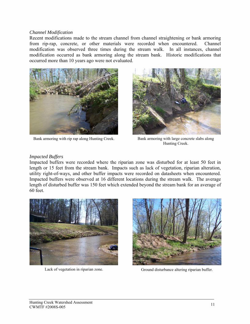
Channel Modification Recent modifications made to the stream channel from channel straightening or bank armoring from rip-rap, concrete, or other materials were recorded when encountered. Channel modification was observed three times during the stream walk. In all instances, channel modification occurred as bank armoring along the stream bank. Historic modifications that occurred more than 10 years ago were not evaluated.
Impacted Buffers Impacted buffers were recorded where the riparian zone was disturbed for at least 50 feet in length or 15 feet from the stream bank. Impacts such as lack of vegetation, riparian alteration, utility right-of-ways, and other buffer impacts were recorded on datasheets when encountered. Impacted buffers were observed at 16 different locations during the stream walk. The average length of disturbed buffer was 150 feet which extended beyond the stream bank for an average of 60 feet.
Bank armoring with rip rap along Hunting Creek. Bank armoring with large concrete slabs along Hunting Creek.
Lack of vegetation in riparian zone. Ground disturbance altering riparian buffer.

Hunting Creek Watershed Assessment CWMTF #2008S-005 12
Figure 4 shows the locations of all erosion, channel modification, and impacted buffer sites. Utility Crossings Where utilities occurred along the floodplain, stream bank, or stream bottom, their location was recorded. The type and condition of the observed utility was noted as well as potential concerns, if applicable. Fifty-one utilities were observed and documented along Hunting Creek during the stream walk including: 23 power line crossings, 10 sewer line crossings, 1 gas pipe, 1 manhole, and 16 unknown pipes. Several utilities were observed to be causing some degree of erosion where it crossed the stream corridor. Exposed pipes crossing the stream were also noted as being susceptible to damage during high flow events. Figure 5 shows the location and type of all utilities encountered during the stream walk.
Power line right-of-way parallel to stream impacting the buffer.
Impacted buffer from large tree removal along stream bank.
Pipe utility parallel to Hunting Creek along stream bottom.
Power lines crossing Hunting Creek overhead.

Hunting Creek Watershed Assessment CWMTF #2008S-005 13
Dumpsites Two dumpsites were recorded and the location, type of materials, and potential concerns were documented. Both sites appear to be historic with rusty, old appliances, tires, old weather stripping, and other miscellaneous debris. No immediate water quality concerns were noted for these sites.
Structural Crossings Bridges, culverts, and dams were recorded when they were observed to cross Hunting Creek. Potential concerns were also noted such as whether the crossing was a potential barrier to fish movement and whether or not the structures were aligned with the flow of the stream. Fourteen structural crossings were observed during the stream walk. Four crossings are not aligned with the stream flow and two crossings pose barriers to fish movement. Another concern identified at structural crossings was bank scour and erosion on the upstream and downstream side of the crossing.
Pipe utility crossing Hunting Creek above stream with debris pile behind pipe. Also note erosion
along stream bank
Pipe utility crossing Hunting Creek under US-70 bridge. Note dislodged footer causing sag in pipe
at joint.
Historic dumpsite with large appliances, empty 55-gallon drums, and other miscellaneous debris.
Historic dumpsite with weather stripping, large appliances, and other miscellaneous debris.

Hunting Creek Watershed Assessment CWMTF #2008S-005 14
Miscellaneous Impacts Other stream impacts not captured by the previous categories were noted as miscellaneous features. The only miscellaneous feature recorded during the stream walk was a chicken coop occurring along the banks of Hunting Creek. Figure 6 is a map of all dumpsites, structural crossings, and miscellaneous sites.
Bridge crossing not aligned with flow of stream causing stream bank erosion.
Structural crossing with double culverts creating a barrier to fish migration.

�)�)
�)
�)�)
�)�)�)
�)
�)�)
�)�)
�)�)
�)
!(
!(
!(
#*
#*#*
#*#*
#*
#*#*ER-8
ER-7
ER-6
ER-5
ER-4
ER-3
ER-2
ER-1
CM-3
CM-2
CM-1
IB-9
IB-8
IB-7
IB-6
IB-5IB-4
IB-3
IB-2
IB-1
IB-16
IB-15
IB-14
IB-13
IB-12
IB-11
IB-10
Figure 4. Erosion, Channel Modification, and Impacted Buffer Sites
South
Mountains
Gamelands
Miles0 0.75 1.5 2.25 3
LAKE RHO DH ISS
C a
t a w b a R
i v
e r
��40
��40
tu70
tu70
tu64
tu64
��18
��18
East
Pro
ng
Hunting C
ree
k
#* Erosion Sites (n=8)
!( Channel Modification (n=3)
�) Impacted Buffers (n=16)
Streams
Roads
Hunting Creek Watershed
Lakes
Morganton
State Forest Land
³

!
!
!
!!
!
!
!
!
!
!
!!!
!
!
(
(
(
((
(
(
(
(
(
(
(((
(
(
%,
!(
#
##
#
###
###
###
#
#
#
##
#
#
#
##
*
**
*
***
***
***
*
*
*
**
*
*
*
**
!
!
!
!
!
!
!
!
!
!
(
(
(
(
(
(
(
(
(
(
Figure 5. Utilities
South
Mountains
Gamelands
Miles0 0.75 1.5 2.25 3
LAKE RHO DH ISS
C a
t a w b a R
i v
e r
��40
��40
tu70
tu70
tu64
tu64
��18
��18
East
Pro
ng
Hunting C
ree
k
Streams
Roads
Utilities
#* electrical (n=23)
!( gas pipe (n=1)
%, manhole (n=1)
!( sewer (n=10)
!( unknown pipe (n=16)
Sewer Lines
UT-1
UT-45
UT-29
UT-32
UT-20
UT-7
UT-6
UT-2
UT-5
UT-24 UT-23
UT-22
UT-18
UT-17
UT-10
UT-9
UT-8
UT-38
UT-36
UT-34
UT-31
UT-30
UT-28
UT-51
UT-49
UT-48
UT-47
UT-46
UT-42
UT-43
UT-35
UT-27
UT-3
UT-4
UT-11
UT-25 UT-21
UT-19
UT-26
UT-33
UT-37
UT-39UT-40UT-41
UT-44
UT-50
UT-12UT-13
UT-15
UT-16
UT-14
³Hunting Creek Watershed
Lakes
Morganton
State Forest Land

�)
�)
�)
�)�)
�)
�)
�)�)
�)�)
�)
�)
�)
!(
#*
#*
SC-9
SC-8
SC-7
SC-6
SC-5
SC-4
SC-3
SC-2
SC-1
SC-14
SC-13
SC-12
SC-11
SC-10
DS-2
DS-1
MI-1
Figure 6. Dumpsites, Structural Crossings, and Miscellaneous Sites
South
Mountains
Gamelands
Miles0 0.75 1.5 2.25 3
LAKE RHO DH ISS
C a
t a w b a R
i v
e r
��40
��40
tu70
tu70
tu64
tu64
��18
��18
East
Pro
ng
Hunting C
ree
k
Streams
Roads
Hunting Creek Watershed
Lakes
Morganton
State Forest Land
³#* Dumpsites (n=2)
�) Structural Crossings (n=14)
!( Miscellaneous (n=1)

Hunting Creek Watershed Assessment CWMTF #2008S-005 18
In addition to documenting stream impacts, data for each of the 29 reaches was collected and included specific conductance and temperature at the start of each reach. Figure 3 shows the specific conductance readings and locations in Hunting Creek at the start of each reach. Specific conductance increased from upper Hunting Creek going downstream, but then stabilized below the confluence of East Prong Hunting Creek. The average specific conductance for Hunting Creek was 75.7 µS/cm. Water temperature in Hunting Creek consistently increased in the afternoon. For each of the five days stream walking occurred, the average temperature before noon was 11.3°C while afternoon temperatures averaged 15.3°C. A reach scale habitat assessment was also conducted for each reach utilizing the NCDWQ Biological Assessment Unit Protocol for Habitat Assessment of Mountain to Piedmont Streams to document in-stream aquatic habitats and adjacent terrestrial conditions (NCDWQ, 2006). Overall, aquatic habitat in Hunting Creek is poor. With a maximum possible score of 100, the average habitat score in Hunting Creek is 52. Figure 7 illustrates the habitat scores for all 29 reaches. Scoring categories include channel modification, in-stream habitat, bottom substrate, pool variety, riffles, bank stability, shading, and riparian width. Of these categories, substrate, riffle habitat, and riparian width received the lowest scores. Two fish barriers, which inhibit the migration of fish and fragment habitat, were also observed.
Appendix E includes all data collected during the stream walk. A full report analyzing the impacts of these activities will be presented in the Watershed Restoration Plan developed with 319 funding by February 2011.
Hunting Creek with no riparian zone. Typical conditions in Hunting Creek showing sandy substrate and lack of riffles, pools, woody
debris, leaf packs and other aquatic habitat.
Relic dam in Hunting Creek creating a barrier to fish migration.

�
�
9
6
2
8
28
12
25
4
29
1
18
7
19
27
24
14
11
17
10
16
26
22
3
23
15
13
5
20
21
Figure 7. Stream Reach Habitat Ratings
South
Mountains
Gamelands
Miles0 0.75 1.5 2.25 3
LAKE RHO DH ISS
C a
t a w b a R
i v
e r
���40
���40
tu70
tu70
tu64
tu64
��18
��18H
u n
t i n
g
C r
e e
k
East
Pro
ng
Hunting C
ree
k
� Fish Barrier
³Poor (<50)
Fair (50-64)
Moderate (65-85)
Good (>85)
Stream Reach Habitat Ratings
Streams Not Surveyed State Forest Land
Morganton
Lakes
Hunting Creek Watershed

Hunting Creek Watershed Assessment CWMTF #2008S-005 20
2.4. Stormwater BMP Evaluation To address impacts from potential sources of pollution and to improve the management of stormwater runoff in the Hunting Creek Watershed, opportunities for stormwater BMPs were explored. Land use data, aerial photos, and stormwater outfalls and ditches documented during the stream walk were utilized to guide and expedite field identification of stormwater BMP opportunities throughout the watershed. Aerial photos of commercial, institutional, and industrial land uses were examined in closer detail in GIS. Based on aerial photo analysis, areas containing large impervious surfaces, poor land use practices, and potential pollutant generating hot spots were flagged for field evaluation to assess potential impacts and opportunities for stormwater BMPs. The location of stormwater outfalls and ditches found during the stream walk were also viewed more closely in GIS. The area draining to outfalls with specific conductance greater than 200 µS/com were investigated in the field for potential sources of pollutants and for stormwater BMP opportunities. Through GIS analysis, 152 sites were identified as having opportunities for stormwater BMP retrofits. Of the 152 sites identified in GIS, 62 sites were evaluated in the field over three days. During the field assessment, observations were made on the land use draining to the site, existing stormwater management practices, and site constraints to determine whether or not a stormwater BMP retrofit is feasible. If a retrofit was determined to be feasible, a datasheet was completed and photographs were taken to document existing conditions. Site sketches were made of the site with the type of retrofit being proposed. To view the datasheet for the stormwater BMP evaluation, refer to Appendix F. Of the 62 sites assessed in the field, the field evaluation identified 34 sites with opportunities to treat stormwater. Twenty-eight sites were rejected because there was no available space to install a BMP or site constraints such as utilities, traffic flow, or structures made installation prohibitive. As sites were evaluated, a relative priority was given to sites that have the potential to cumulatively treat larger impervious areas. Priority was also given to sites with few observable constraints, sites that occur on public land, and sites with a greater likelihood for feasibility or acceptability. Table 2 lists sites with opportunities for stormwater best management practices identified in this assessment. It also includes the name of the facility where the site occurs, the proposed BMP type, its priority, and supplemental notes. The location of these sites can be viewed in Figure 8, Stormwater Best Management Practice Opportunities. Additional opportunities for stormwater BMPs in the Hunting Creek Watershed not identified in this assessment likely exist. Stormwater BMP opportunities will continued to be explored and evaluated for their potential with continued contributions from the Hunting Creek Partners. All potential BMP retrofit sites identified will undergo additional analysis to derive the site drainage area, the impervious acreage draining to the site, the property ownership, the purpose of proposed retrofit, and the estimated total cost. This information will assist in the development of conceptual BMP designs and will be presented in the Watershed Restoration Plan.

Hunting Creek Watershed Assessment CWMTF #2008S-005 21
Table 2. Sites with Opportunities for Stormwater Best Management Practices Map ID
Sub Watershed Name of Facility Proposed BMP Type Priority Notes
1 1 Intersection of US-70 & US-70 Business bioretention high invert island and plant with low
growing shrubs
2 5 Morganton Municipal Auditorium bioretention, bioswales high interior bioretention islands with shade trees
3 5 North Carolina School for the Deaf
extended detention, constructed wetlands, bioretention, bioswales
high several opportunities on site
4 5 North Carolina School for the Deaf
extended detention, constructed wetlands, bioretention, bioswales
high several opportunities on site
5 5 North Carolina School for the Deaf
extended detention, constructed wetlands, bioretention, bioswales
high several opportunities on site
6 5 North Carolina School for the Deaf
extended detention, constructed wetlands, bioretention, bioswales
high several opportunities on site
7 7 Foothills Health & Science Education Center bioretention high
8 7 Burke County Human Resources Center bioretention high
9 9 Burke County Recycling and Waste Center bioretention high
10 1 Viscotec extended detention, constructed wetlands, bioretention, bioswales
low
11 2 State Farm Insurance bioretention low
12 3 The Outreach Center bioretention low interior bioretention islands with shade trees
13 4 Burger King bioretention low
14 4 Roses, Shoe Show, Aaron's, Wachovia bioretention medium
interior bioretention islands with shade trees and at low point in parking lot
15 4 AC Delco Plaza Service Center bioretention medium
16 4 Griffin Contractors, Atomic Body Works Tattoo bioretention medium interior bioretention islands with
shade trees 17 4 Case Farms Chickens bioretention, filtration medium 18 4 NAPA Auto Parts & Auto Zone bioretention, filtration medium
19 4 Rite Aid bioretention medium utilize open space adjacent to parking lot
20 5 Carwash on West Fleming Drive bioretention medium
21 5 Burke Mission Station, Soup Kitchen, Habitat Store
constructed wetland, bioretention medium interior bioretention islands with
shade trees
22 5 Grace Hospital, Blue Ridge Health Care
constructed wetlad, bioretention, bioswales,
medium several opportunities on site
23 7 Fatz Café, Uptown BBQ bioretention medium 24 7 Uptown BBQ, The Rock Church bioretention medium
25 7 Rooster Bush Chevrolet Car Dealership bioretention medium
26 7 El Paso Mexican Restaurant bioretention, bioswales medium 27 7 Sage Brush Steakhouse bioretention medium
28 7 I-40 West Entrance Ramp at NC-18 constructed wetland medium

Hunting Creek Watershed Assessment CWMTF #2008S-005 22
29 7 Grace Hospital, Blue Ridge Health Care
constructed wetlad, bioretention, bioswales,
medium several opportunities on site
30 7 Rooster Bush Chevrolet Car Dealership bioretention medium
31 7 Wendy's, Arby's bioretention medium 32 7 Foothills Medical Park bioretention medium
33 8 Bethel Park constructed wetland, bioretention medium good educational opportunity
34 8 Mull School constructed wetland, bioretention medium

�)
�)
�)
�)�)
�)
�)
�)
�)
�)
�)�)
�)
�)
�)�)
�)
�)
�) �)
�)�)
�)�)
�)
�)�)
�)
�)�)
�)�)
�)
�)
�)
�)
�)
�)�)
�)
�)
�) �)�)�)�)
�)
�)�)�)
�)�)
�)
�)�)
�)
�)
�)
�)
�)
�)
�)
�)
�)
�)
�)
�)
�)
�)
�)
�)
�)
�)
�)
�)
�)
�)
�)
�)
�)
�)
�)�)
�)�)�)
�)
�)
�)
�)�)�)�)�)
�)
�)
�)
�)
�)�)�)
�)
�)�)�)
�)�)�)�)�)
�)
�)
�)�)
�)
�)
�)
�)
�)�)
�)
�)
�)
�)
�)�)
�)�)�)
�)
�)�)
�)�)�)
�)
�)�)
�)
�)
�)�)
�)�)
�)
�)�)
�)�)
�)
�)
�)
!(
!(
!(
!(
!(
!(
!(
!( !(
!(!(
!(
!(!(!(!(
!(
!(
!(
!(
!(
!(
!(
!(
!(
!(
!(
!(!(
!(!(
!(
!(
!(
!(
!(
!(
!(!(
!(
!(!(!(
!(
!(
!(
!(
!(
!(!(
!(
!(
!(
!(
!(
!(
!
!
!
!
!!
!!
!
(
(
(
(
((
((
(
17
19
32
1
34
7
8
5
6
2
9
34
31
30
22
1314
33
2324
25
26
20
21
15
1618
12
27
28
29
10
11
Figure 8. Stormwater Best Managment Practice Opportunities
South
Mountains
Gamelands
Miles0 0.75 1.5 2.25 3
LAKE RHO DH ISS
C a
t a w b a R
i v
e r
���40
���40
tu70
tu70
tu64
tu64
��18
��18H
u n
t i n
g
C r
e e
k
East
Pro
ng
Hunting C
ree
k
!( Field Assessed Non Feasible (n=28)
�) GIS Identified Sites (n=152)
³Sites with BMP Opportunities
!( High (n=9)
!( Medium (n=21)
!( Low (n=4)
State Forest Land
Morganton
Lakes
Hunting Creek Watershed
Streams

Hunting Creek Watershed Assessment CWMTF #2008S-005 24
2.5. Stream Fish Community Assessment To document current biological conditions within the watershed three fish community assessments were conducted in April and May 2009. Assessment locations included an upstream site (F1) on Hunting Creek, the NCDWQ site (F2) on the lower portion of Hunting Creek, and a site (F3) on East Prong Hunting Creek. Figure 9 shows the location of these sites in the map, Fish Community & Chemical Monitoring Sites. Sampling methodology was based on the NCDWQ stream fish community assessment program protocols (NCDWQ, 2006). Results reported for the biological integrity of the Hunting Creek stream fish communities were derived from the North Carolina Index of Biological Integrity (NCIBI) methods (NCDWQ, 2006). The NCIBI incorporates information about species richness and composition, trophic composition, fish abundance, and fish condition to summarize the effects of all classes of factors influencing aquatic faunal communities. Based on this information the biological integrity of a streams fish community is rated as Poor, Fair, Good-Fair, Good, or Excellent. A fish community rated as Excellent, Good, or Good-Fair is considered to be Fully Supporting its Aquatic Life Use Support stream classification. Conversely, a fish community rating of Fair or Poor is considered as Not Supporting its Life Use Support stream classification and water quality standards are not being met (NCDWQ, 2006). Based on the fish community assessment, both sites located on Hunting Creek resulted in Fair ratings indicating impaired conditions. Similar results were reported by NCDWQ for F2, the lower Hunting Creek site in 2002 and 2003. While the site located on East Prong Hunting Creek rated Good-Fair, it was at the lower end of this rating. Overall, the species richness, composition, and trophic structures were below normal at all sites and is likely associated with degraded habitat and water quality within the Hunting Creek Watershed. To view the datasheets for the fish community assessments, refer to Appendix G. Additional surveys will be conducted in 2010 to further assess the biological integrity within the watershed.


Hunting Creek Watershed Assessment CWMTF #2008S-005 26
2.6. Additional Work Not in Scope In addition to the activities included in the scope of work for this assessment, several complimentary activities occurred during this grant period. These activities add supporting data to the watershed assessment and assist in the identification of water quality stressors as well as add to the collection of baseline data that serves to document changes in water quality over time. Water Quality Sampling Chemical monitoring at 6 fixed sites located throughout the Hunting Creek Watershed occurred in June 2009. See Figure 9, Fish Community & Chemical Monitoring Sites for the locations of these sites. Grab samples were delivered to the Environmental Quality Lab at the University of North Carolina, Asheville for ammonia nitrogen, total nitrogen, total phosphorus, and total suspended solid analysis. Specific conductance, dissolved oxygen, and temperature were collected in the field with an YSI model 85 instrument. Table 3 shows the results of the water quality sampling. The nutrient levels for all parameters are elevated at each site. With the exception of the Pee Dee Branch site, total suspended solids are also elevated at each site. Water temperature appears high at all sites. Finally, although dissolved oxygen reveals normal levels, specific conductance at each site is also elevated.
Table 3. Water Quality Sampling Results Site ID Waterbody Location
NH3 (mg/L) *0.02
NO3 (mg/L)
*0.1
Total P (mg/L PO4)
*0.02
Total P (mg/L as P)
*0.01
TSS (mg/L)
*4.0
Temp (°C) Conductivity
(µS/cm)
DO (mg/L)
C1 Hunting Creek Poteat Street (SR1950) 0.12 1.0 0.13 0.04 6.0 20.5 73.9 7.15 C2 Hunting Creek Bethel Road (SR 1704) 0.11 1.0 0.16 0.05 4.0 21.7 97.2 7.82
C3 Hunting Creek Causby Quarry Road (SR 1571) 0.18 0.8 0.14 0.05 9.2 21.6 94.9 10.68
C5 East Prong Hunting Creek Bethel Road (SR 1704) 0.13 0.6 0.08 0.03 7.2 21.1 83.6 7.56
C4 Fiddlers Run Bethel Road (SR 1704) 0.11 1.3 0.13 0.04 8.8 20.6 101.5 7.9
C6 Pee Dee Branch Kirksey Drive (SR 1443) 0.07 0.7 0.12 0.04 1.6 20.2 79.0 7.75
*reporting limit
Additional water quality sampling will occur in December 2009, and twice in 2010. Funding for water quality sampling is provided by the NCDWQ 319 Non Point Source Control Initiative for the Hunting Creek Watershed Restoration Plan. As part of an in-kind contribution, NCDWQ has also collected fecal coliform bacteria sampling at the same 6 fixed sites. These sites were collected 5 times within 30 days and analyzed by NCDWQ laboratories. The reporting limit in North Carolina for safe levels of fecal coliform bacteria in surface water is 200 units. Table 4 shows the geometric mean of 5 grab samples at each fixed monitoring site. All sites report elevated fecal coliform bacteria levels well over the state safe level.

Hunting Creek Watershed Assessment CWMTF #2008S-005 27
Table 4. Fecal Coliform Bacteria Site ID Waterbody Location % over
400/100 ml Geometric
Mean C1 Hunting Creek Poteat Road (SR 1950) 100 928 C2 Hunting Creek Bethel Road (SR 1704) 100 2024 C3 Hunting Creek Causby Quarry Road (SR 1571) 80 1054 C4 East Prong Hunting Creek Bethel Road (SR 1704) 100 1018 C5 Fiddlers Run Bethel Road (SR 1704) 60 591 C6 Pee Dee Branch Kirksey Drive (SR 1443) 100 700
Community Outreach and Education Several efforts to educate the public and citizens living and working within the Hunting Creek Watershed occurred during the assessment period. A press release in the Morganton News Herald was printed in April 2009 describing assessment activities underway in the Hunting Creek Watershed. The article explained the reason for the assessment and how landowners can help improve water quality in Hunting Creek by implementing BMPs on their property. To view the press release printed in the Morganton News Herald, refer to Appendix H. Local government leaders were also informed about the Hunting Creek Watershed Assessment and Planning efforts. Presentations were given to the Morganton City Council and the Burke County Commissioners during their April meetings. After the presentation, representatives were given the opportunity to ask questions about the assessment and the planning process. An additional effort to provide the community with information about the Hunting Creek Watershed occurred at an Earth Day Festival in Morganton in April 2009. A booth was set up with visual poster displays about the impaired designation of Hunting Creek. Brochures about stormwater BMPs were distributed to approximately 100 participants. North Carolina Ecosystem Enhancement Program Phase IV Efforts The North Carolina Ecosystem Enhancement Program (EEP) is currently working on implementing stream, wetland, and riparian restoration projects within the Upper Catawba River basin. While the primary focus area is outside of the Hunting Creek Watershed, watershed assessment and planning efforts have encouraged EEP to identify the Hunting Creek Watershed as a Targeted Local Watershed (TLW) area. GIS site assessment and prioritization to identify potential stream, wetland, and riparian restoration project opportunities within the Hunting Creek Watershed are currently being conducted. Based on EEP’s project implementation requirements, this assessment has identified 18 stream restoration and enhancement opportunities and 5 preservation opportunities within the watershed. Initial project interest has been expressed for some identified sites. North Carolina Division of Water Quality Stream Walk In an effort to support EEP’s Phase IV objectives of providing ecological uplift through restoration projects in the Upper Catawba River basin, the NC Division of Water Quality’s Watershed Assessment Team (NCDWQ WAT) has contributed in-kind stream assessment activities to further assess existing conditions within the Hunting Creek Watershed. NCDWQ WAT staff walked 7.4 miles along East Prong Hunting Creek and its tributaries as well as 4.25

Hunting Creek Watershed Assessment CWMTF #2008S-005 28
miles along Fiddlers Run collecting similar data as described in the stream walk assessment (Section 2.3). Data collected during this stream walk is under going data management and will be presented in the Watershed Restoration Plan. 2.7. Changes Made to Scope Minimal changes were made to Hunting Creek Watershed Assessment scope. The decision to make changes was made by the project manager in good faith that it would benefit final project outcomes. One difference, as stated in the scope, included stream walk activities along the impaired section of Hunting Creek and its tributaries, as warranted. Although 8.6 miles of Hunting Creek were walked, its tributaries were not walked. The number of field days allocated in the budget for stream walking had expired and did not allow for stream walk activities to occur along tributaries to Hunting Creek. However, in-kind contributions from NCDWQ compensated for this loss. NCDWQ walked 11.7 miles of tributaries to Hunting Creek including East Prong Hunting Creek and Fiddlers Run. Finally, this assessment scoped four meetings with the Hunting Creek Partnership. Although only three meetings took place, regular correspondence and frequent communication with partners occurred on an individual basis. Outside of scoped partnership meetings, a meeting with Burke County Soil & Water Conservation District identified potential stormwater BMP opportunities on the campus of the Western Piedmont Community College. Furthermore, multiple outreach and education efforts occurred in place of the fourth partnership meeting such as presentations to the Morganton City Council, Burke County Commissioners, and the public at the Earth Day event. These outreach efforts increased public education about watershed planning efforts in place of the partnership meeting.

Hunting Creek Watershed Assessment CWMTF #2008S-005 29
3. Hunting Creek Partners A group of local stakeholders representing local governments, state agencies, institutions, and interested citizens was developed at the initiation of this project prior to performing assessment activities. This group, called the Hunting Creek Partners, met on three separate occasions to provide input to the assessment and watershed plan. The Hunting Creek Partners were given maps and other relevant information at each meeting and were made aware of all field activities, methods, and results. At the first meeting, partners were introduced to the project. The planning process was discussed as were assessment goals and activities. Partners identified local needs and reasons for their interest in the project. The meeting closed with a group visioning of project outcomes. The Hunting Creek Partners envision integrating economic, recreational, and educational opportunities with water quality improvements and community involvement throughout the watershed. Results of the land use analysis and windshield survey were presented to the Hunting Creek Partners at the second stakeholder meeting. Partners provided feedback on more recent land use changes and added their general impressions of watershed conditions. Additionally, methods for the stream assessment were presented and partners were asked if any issues would arise in regard to stream access during the assessment. Once access issues were discussed, a discussion of a public outreach and education strategy was initiated. Partners brainstormed avenues to engage the public in water quality issues in the Hunting Creek Watershed. The purpose, message, delivery, and audience were all components discussed during the meeting as part of the public outreach and education strategy. During the third and final meeting, results of the stream walk and fish inventory were presented. The Hunting Creek Partners discussed possible sources for stream impacts based upon their local knowledge. They also discussed opportunities to mitigate these impacts. To assist in the stormwater BMP inventory, the group was asked to utilize their local knowledge of the watershed to identify areas in need of stormwater management. Partners circled areas on aerial maps to investigate in the field. In addition to the invaluable input and feedback given during stakeholder meetings, individuals from organizations have provided additional support. The City of Morganton has provided a venue for meetings in their conference room at the Morganton City Hall. They have also provided GIS data on Morganton utilities which is useful to compare to utility data collected during the stream walk. Burke County Soil & Water Conservation District has assisted with the identification of stormwater BMP opportunities in the watershed and has sought grant funding for implementation. At the time of this report, they have secured Community Conservation Assistance Program monies for the construction of a bioretention area on the Western Piedmont Community College (WPCC) continuing education campus. Individuals from WPCC are working with college administration to facilitate the construction of the bioretention area. WPCC looks forward to utilizing the BMP as an educational opportunity for students and the community. The Hunting Creek Partners continue to provide valuable input to the watershed assessment and planning process.

Hunting Creek Watershed Assessment CWMTF #2008S-005 30
The Hunting Creek Partners have contributed over 76 hours of in-kind services and is primarily comprised of the following individuals:
Table 5. In-kind Contributions from the Hunting Creek Partners Name Organization Contributed
Hours Lee Anderson City of Morganton Development & Design 6 Russ Cochran City of Morganton Development & Design 6 Daniel Stines City of Morganton Parks and Recreation 2 Mark Collins/Susan Berley Burke County Planning & Development 6 Kevin Clark Burke County Soil & Water Conservation District 6 Pamela Bowman Burke County Soil & Water Conservation District 2 Damon Pollard Burke County NRCS 2 Russell Lyday NRCS-Morganton Field Office 6 Spring Williams-Byrd NC Cooperative Extension Service 2 Tony R. Gallegos Western Piedmont Council of Governments 2 Dan McClure Carolina Land & Lakes RCD 4 Donna Lichtenwalner Carolina Land & Lakes RCD 6 Jack Huss Carolina Land & Lakes RCD Board Member 4 Mary O'Neil CLLRCD Council Member 2 Jonathon Berry Broughton Hospital 2 Lee Kiser Western Piedmont Community College 6 Penny Peeler Western Piedmont Community College 4 Fred Falls Citizen 4 Pete Wallace Citizen 4 TOTAL 76

Hunting Creek Watershed Assessment CWMTF #2008S-005 31
4. Outcomes & Water Quality Improvements This project initiates planning for future stormwater improvements to help local jurisdictions reduce surface runoff pollutants to Hunting Creek and Lake Rhodhiss. Although measurable water quality improvements and reductions of surface runoff have yet to occur, the planning process has been initiated and is well under way. To assist in planning for stormwater improvements, stream impacts and potential sources of impairment were explored during this assessment. This project has established baseline data that only begins to identify potential water quality stressors leading to aquatic ecosystem decline in Hunting Creek. Because no other data exists for water quality in the Hunting Creek Watershed other than NCDWQ fish sampling, additional efforts are needed to determine the exact sources of impairment. As sources of impairment are identified, efforts to mitigate their impact can be made. This assessment has also begun to explore opportunities for stormwater BMPs to address stream impacts. Based on the stormwater BMP evaluation, there is a significant need for improved stormwater management throughout the watershed. Stormwater BMP evaluation conducted in this assessment has cataloged, mapped, and prioritized stormwater BMP opportunities in the Hunting Creek Watershed that may be explored for implementation as funding opportunities arise. As BMPs are implemented, reductions in stormwater runoff and surface pollutants will begin to occur, although improvements in water quality may not be observed for some time. More detailed conceptual plans for stormwater BMPs will be presented in the Watershed Restoration Plan. An additional outcome of this assessment is the formation of a solid group of local stakeholders who are engaged and involved in the planning process. The Hunting Creek Partners have contributed their time, services, and knowledge towards the identification of potential stressors to Hunting Creek and they have demonstrated commitment to developing solutions to address impacts via the planning process. Local involvement is crucial for the adoption and implementation of plan recommendations. The findings of this assessment will contribute to the development of a Watershed Restoration Plan for the Hunting Creek Watershed that addresses water quality stressors. Funded by NCDWQ’s 319 Program, the Hunting Creek Watershed Restoration Plan will conform to the US Environmental Protection Agency’s 9 Element Plan and will be completed in February 2011.

Hunting Creek Watershed Assessment CWMTF #2008S-005 32
5. Lessons Learned The experience gained from the Hunting Creek Watershed Assessment can be applied to future watershed assessments. As information is gathered about potential water quality stressors and sources of impairment, this assessment would have benefited from more biological and chemical monitoring sites to assist in scaling down areas in the watershed contributing the greatest stressors. This assessment consisted of 3 fish community and 6 chemical monitoring sites. Based on data collected at these sites, the entire watershed is degraded. Increasing the number of sample site locations and including additional biological monitoring such as benthic macro invertebrate sampling would provide additional data to assist in identifying specific areas of the watershed that are more impacted than others. BMP implementation within areas of the watershed that are more impacted would have a greater impact. In order to fully educate the public on the water quality benefits of stormwater BMPs, upfront funding to implement a demonstration project at a site with known stormwater management needs would prove beneficial to the overall project. Furthermore, this assessment identified 34 sites with opportunities to improve stormwater management. Additional sites not identified in this assessment likely exist. The stormwater BMP evaluation conducted in this assessment could have benefited from more field days to evaluate GIS identified sites. Of the 152 sites identified in GIS, only 62 were evaluated in the field. Additional sites will continue to be explored and evaluated beyond the period of this assessment. Finally, it is apparent that project coordination over the long-term will be a critical component to assuring that actions presented in the Watershed restoration Plan are taken to address stream impairment through stormwater management. Additional funds and in-kind contributions will be needed to assure quality designs are developed and installations are effective.

Hunting Creek Watershed Assessment CWMTF #2008S-005 33
6. References Center for Watershed Protection, 2004a. Unified Stream Assessment: A User’s Manual, Version
1.0, Manual 10. March 2004. Maas, Richard P, S.C. Patch, M.J. Westphal, T. Pandolfo and R.M. Shoemaker. 2004. Long-
Term Analysis of Water Quality Trends in the Nolichucky and Watauga River Watersheds. Technical Report #04-134. Environmental Quality Institute. University of North Carolina at Asheville.
North Carolina Center for Geographic Information and Analysis. “NC OneMap.” Accessed
February 2009 from http://www.nconemap.com/Default.aspx?tabid=286. North Carolina Division of Water Quality, 2003. Basinwide Assessment Report: Catawba River
Basin. North Carolina Division of Water Quality, 2006. Biological Assessment Unit Protocol for
Habitat Assessment of Mountain-Piedmont Streams. North Carolina Division of Water Quality. August 2006. Standard Operating Procedures Stream
Fish Community Assessment Program. Environmental Sciences Section Biological Assessment Unit. http://h2o.enr.state.nc.us/esb/BAU.html
North Carolina Division of Water Quality, 2008. North Carolina 303(d) List Draft for Public
Review, January 10, 2008

Hunting Creek Watershed Assessment CWMTF #2008S-005 34
7. Appendices
Appendix A: Land Use Classifications and Definitions Land cover categories were developed by Equinox integrating elements of the United States Geological Survey (USGS) Land Cover Institute Classifications (http://landcover.usgs.gov/pdf/anderson.pdf), the Tennessee Valley Authority (TVA) Integrated Pollutant Source Identification (ISPI) analysis, and the North Carolina Center for Geographic Information and Analysis (NCCGIA). While these agencies provide detailed land cover classifications, this level of detail was not required for the Hunting Creek watershed. More specific categories for developed areas were necessary to capture the essence of land use in this urban watershed. Land cover classifications and their definitions were as follows: Developed • Low Density Residential - < 2 dwellings per acre including lawns, driveways, small
gardens, and wooded lots where residences occur. • Medium Density Residential - 2-5 dwellings per acre including lawns, driveways, small
gardens, and wooded lots where residences occur. • High Density Residential - >6 dwellings per acre including lawns, driveways, small
gardens, and wooded lots where residences occur. • Commercial - Areas predominantly used for the sale of goods and services including
structures and areas supporting this use. Includes shopping centers, office buildings, warehouses, gas stations, auto repair garages, banks, and storage units.
• Industrial - Facilities associated with the manufacturing of goods including assembly, finishing, processing, and packaging of products. Includes the facility, grounds, parking, shipping/transportation loading, stock piles, storage, and vehicles associated with the facility.
• Institutional - Buildings and grounds associated with schools, colleges, churches, hospitals, correctional facilities, county services, city services, and other public service organizations.
• Transportation - Includes major interstate highways, four-lane highways, and railroad tracks. Two lane roads and private roads are included within the adjacent land uses.
• Mixed Urban - Developed areas where no single use predominates and land use cannot be distinguished. May include a combination of high density residential, commercial, and institutional uses. Includes utilities such as electricity generating facilities and towers, waste water treatment plants, North Carolina Department of Transportation (NCDOT) maintenance facilities, waste management service facilities, and other uses that support urban infrastructure maintenance.
• Open Space - Undeveloped land within an urban area characterized by large grassy areas which may contain sparse trees and landscaping utilized for open space and recreation. Includes sports fields, parks, cemeteries, managed grounds, and other undeveloped areas with managed vegetation.
Agriculture • Cropland - Land used for the cultivation of food and fiber including grains, vegetables, root
crops, large garden areas, etc. • Pasture/Hay - Areas used for grazing animals including hay fields.

Hunting Creek Watershed Assessment CWMTF #2008S-005 35
• Nursery - Horticultural crops with rows of trees and shrubs. This category also includes orchards and vineyards.
• Livestock Operations - Large confined feeding operations for raising livestock and/or poultry.
Forest • Forest - Mixed forest areas including deciduous and evergreen trees. This category does not
capture the type of forest community or the structure, age, quality, or integrity of the forested stand.
• Plantation - Forested areas that are actively managed and harvested for timber production. • Shrub/Scrub - Former pasture, cropland, or recently harvested forest that is in the process of
early succession. Includes fallow lots with small trees and shrubs, power line corridors, and NCDOT right-of-ways.
Other • Water - Surface waters including lakes, ponds, rivers, and streams that are large enough to
be identified. • Barren Land - Areas with little or no vegetation that have been altered through human
activity such as excavating, dredging, or grading. Includes quarries, road cuts, cleared lots, and other areas of exposed soil.

Hunting Creek Watershed Assessment CWMTF #2008S-005 36
Appendix B: Windshield Survey Datasheet Stream:_______________________ Site ID:__________ Site Location :_______________________________ Staff:________________________________ Date___________________ Time______________ AM PM
Tracking Information Waypoint No. ___________ Lat_______________________ Long_______________________ Photo number(s) and description_______________________________________________________________________ _________________________________________________________________________________________________ _________________________________________________________________________________________________
Water Quality Field Parameters and Observed Conditions Field Params: Specific conductance ________µS/cm Temperature_______0C DO__________mg/L Last Rainfall (if known)_________________________
Water Appearance: turbid clear other (list) _______________________ Flow Conditions: high normal low
> Site Characteristics < Upstream Downstream
Riparian Zone Activity Nature of activity (check all that apply, circle major): LB RB: LB RB::
None Resid. yards Roads Houses Industrial Apts Commercial Pasture/hay Institutional Cultivated land Construction Site Animal Oper Golf Course Nursery Other _____________________
Check if incidental Check if within 10 ft
Within 30 Feet of Stream Nature of activity (check all that apply, circle major): LB RB: LB RB::
None Resid. yards Roads Houses Industrial Apts Commercial Pasture/hay Institutional Cultivated land Construction Site Animal Oper Golf Course Nursery Other _____________________
Check if incidental Check if within 10 ft
Riparian Hot Spot ConcernsLB RB: LB RB:
Highly impervious Waste Manage. Gas station/car wash Junk yard Materials storage Nursery Vehicle maint/storage Livestock
Access Other_________________
Check if stream/storm drain inputs likely
(if Applicable) LB RB: LB RB:
Highly impervious Waste Manage. Gas station/car wash Junk yard Materials storage Nursery Vehicle maint/storage Livestock Access Other_________________
Check if stream/storm drain inputs likely
Bank StabilityLeft Bank: Right Bank:
Good Good Fair Fair Poor Poor Can’t Evaluate Can’t Evaluate
_____________________________________________
(Rate Each Bank) Left Bank: Right Bank:
Good Good Fair Fair Poor Poor Can’t Evaluate Can’t Evaluate
_____________________________________________ Channel Substrate
Good (abundant coarse material, limited embeddedness) Fair (some coarse material, but excessive sedimentation) Poor (dominated by sand and silt)
Obvious sediment sources (list) _______________________
and Sediment Sources Good (abundant coarse material, limited embeddedness) Fair (some coarse material, but excessive sedimentation) Poor (dominated by sand and silt)
Obvious sediment sources (list) _______________________

Hunting Creek Watershed Assessment CWMTF #2008S-005 37
InstreamRiffle habitat: Poor Fair Good
Excellent Pool habitat: Poor Fair Good
Excellent Other habitat: Poor Fair Good
Excellent (LWD, root mats, etc)
Habitat Riffle habitat: Poor Fair Good Excellent Pool habitat: Poor Fair Good Excellent Other habitat: Poor Fair Good Excellent (LWD, root mats, etc)
Channel ModificationChannel straightened: No Recent (< 10 years) Historic Bank hardening: None Minor Major Piped? Yes No Potential Fish Barrier Yes No Can’t Tell Other channel modification__________________________ Channel at least moderately incised Yes No
and Floodplain Access Channel straightened: No Recent (< 10 years) Historic Bank hardening: None Minor Major Piped? Yes No Potential Fish Barrier Yes No Can’t Tell Other channel modification__________________________ Channel at least moderately incised Yes No
Upstream Downstream BMP
Stormwater (follow up during retrofit survey) On-site Storage Other_____________
Probably Not Agricultural
exclusion conserve tillage Other_______
Potential Stormwater (follow up during retrofit survey)
On-site Storage Other_____________ Probably Not Agricultural
exclusion conserve tillage Other_______
Other Features Large tracts of mature forest Livestock fenced from stream Conservation tillage Major bank failure Active incision Recent clearcutting Other_____________________________________
____________________________________________
of Interest Large tracts of mature forest Livestock fenced from stream Conservation tillage Major bank failure Active incision Recent clearcutting Other_____________________________________
Notes:

Hunting Creek Watershed Assessment CWMTF #2008S-005 38
Appendix C: Windshield Survey Data
Site ID Stream Road # Road Name/Location Date Time Temp
(°C) Specific Conduct (µS/cm)
DO (mg/L)
Water Appearance
Flow Conditions
1 UT SR 1941 Williams Rd 2/10/2009 8:30am 8.2 104.2 13.42 clear normal 2 UT SR 2002 Western Ave 2/10/2009 9:00am 9.1 65.3 11.90 clear low 3 Hunting Ck SR 1950 Poteat Rd 2/10/2009 9:20am 9.0 60.5 9.86 clear low 4 Hunting Ck SR 1940 Pete Brittain Rd 2/10/2009 9:38am 8.8 67.7 9.25 clear low 5 UT Hunting Ck SR 1938 Oaktree Rd 2/10/2009 9:50am 7.9 36.9 9.55 clear low 6 UT Hunting Ck SR 1922 Enola Rd 2/10/2009 10:11am 9.4 29.4 9.00 clear low 7 Fiddlers Run SR 1940 Old Colony Rd 2/10/2009 10:25am 10.0 51.4 8.70 clear low 8 Fiddlers Run SR 1933 Skyland Dr 2/10/2009 10:40am 10.5 70.1 6.23 clear low 9 UT East Prong SR 1931 Mount Home Church Rd 2/10/2009 11:05am 10.2 68.3 9.26 clear low
10 East Prong SR 1931 Mount Home Church Rd 2/10/2009 11:10am 10.4 69.5 9.39 clear low 11 East Prong SR 1811 Zero Mull Rd 2/10/2009 11:25am 9.5 34.5 9.75 clear low 12 UT East Prong NC 18 NC 18 2/10/2009 11:30am 10.8 63.1 9.38 clear low 13 East Prong SR 1972 Brookwood Rd 2/10/2009 12:05pm 11.1 81.4 9.62 clear low 14 Fiddlers Run SR 1924 Old NC 18 2/10/2009 12:15pm 11.0 78.2 9.24 clear low 15 East Prong SR 1708 Parker Rd 2/10/2009 12:35pm 11.6 84.7 7.17 clear low 16 UT East Prong SR 1711 Blanton Rd 2/10/2009 12:40pm 10.2 94.2 9.11 clear low 17 UT Hunting Ck SR 1831 Parton Ave 2/10/2009 12:55pm 11.8 53.0 9.73 clear low 18 Fiddlers Run City of Morganton Park 2/10/2009 1:10pm 12.3 87.0 9.70 clear low 19 East Prong City of Morganton Park 2/10/2009 1:15pm 12.7 81.3 10.06 clear low 20 UT Hunting Ck US 70 US 70 2/10/2009 1:30pm 11.2 56.6 10.09 clear low 21 UT to UT to Hunting SR 1715 Watts St 2/10/2009 1:50pm 11.6 39.5 8.70 clear low 22 UT to UT to Hunting Eastbrook Circle 2/10/2009 2:00pm 14.1 61.8 8.45 clear low 23 UT to UT to Hunting SR 1713 Summers Rd 2/10/2009 2:15pm 11.4 54.9 9.59 turbid 24 PeeDee Branch SR 1443 Kirksey Dr 2/10/2009 2:30pm 11.3 64.3 10.31 clear low 25 Hunting Ck SR 1571 Causby Quarry Rd 2/10/2009 3:10pm 11.7 81.6 11.06 clear low 26 Hunting Ck SR 1312 Amherst Rd 2/10/2009 3:15pm 12.6 80.1 10.35 clear low 27 UT Hunting Ck SR1512 Amherst Rd 2/10/2009 3:25pm 10.9 34.5 9.26 clear low 28 Pee Dee Branch Hwy 70 Business 2/10/2009 3:40pm 12.2 45.0 9.06 clear low 29 Hunting Ck Coal Chute Rd 2/10/2009 4:00pm 13.1 70.7 9.89 clear low 30 Hunting Ck Bethel Rd 2/10/2009 4:15pm 12.1 89.1 10.22 clear low

Hunting Creek Watershed Assessment CWMTF #2008S-005 39
Upstream Site ID
Riparian Activity LB/RB¹
Activity within 10 ft
Hot Spot LB/RB²
Storm Drain Input
Bank Stability LB/RB
Substrate Sedime
nt Source
Riffle Habitat
Pool Habitat
Other Habitat
Channel Straight
Bank Hardened Piped Fish
Barrier Moderate Incision
BMP Potential³
Other Feature
s*
1 NA/Yard, O Yes NA/Mat, Veh No Good/Fair Fair Fair Poor Fair Historic None No No Yes No None
2 P, O/O No NA/NA No Good/Fair Poor Poor Poor Fair Historic None No No Yes Ag Other None
3 O/P No NA/NA Yes Poor/Fair Fair Poor Poor Fair Historic None No No Yes Ag Other None
4 P/P Yes NA/NA Yes Poor/Poor Poor Bank Erosion Poor Fair Fair Historic Minor No No Yes Ag Other
Bank Failure
5 Yard, P/NA Yes NA/NA Yes Fair/Fair Good Good Fair Fair Historic None No No Yes Ag Other None
6 Yard/Yard Yes NA/NA No Fair/Fair Fair Poor Poor Poor Historic None No No Yes Ag Other None
7 O/P No NA/NA Yes CE/CE Poor Poor Poor Fair Historic Minor No No Yes SW Other & Ag Other None
8 P/Yard Yes NA/NA No CE/CE Poor Fair Fair Fair Historic None No No Yes Ag Other None
9 O,Yard/Yard Yes Other/NA Yes Poor/Poor Poor Bank Erosion Poor Poor Fair Historic None No No Yes Ag Other None
10 P/Yard Yes NA/NA No Poor/Poor Poor Fair Poor Fair Historic None No No Yes Ag Other None
11 NA/Yard Yes NA/NA No Fair/Poor Good Good Fair Fair Historic None No No Yes Ag Other None
12 N/SR,Com, O Yes N/WM, O No CE/CE Good Good Fair Fair Historic None No No Yes
SW Other & Ag Other None
13 C/C, Yard No NA/NA No Fair/Fair Poor Poor Poor Fair Historic Minor No No Yes Ag Other None
14 NA/NA No NA/NA No CE/CE CE CE CE CE CE CE CE CE CE No None
15 O/O Yes NA/NA No Poor/Poor Poor Poor Poor Fair Historic None No No Yes Ag Other None
16 Yard/P Yes NA/NA No Poor/Poor Fair Fair Fair Fair Historic None No No Yes Ag Other Fenced
17 Yes No None
18 NA/O Yes NA/NA No Fair/Poor Poor Bank Erosion Poor Poor Fair Historic Minor No Yes
SW On-site & Ag Other
Bank Failure
19 O/O Yes NA/NA No Poor/Poor Poor Bank Erosion Poor Poor Fair Historic None No No Yes
SW On-site & Ag Other
Bank Failure
20 Com/Com, Yard No Imp/O Yes Fair/Fair Poor Poor Poor Fair Historic None No No Yes
SW On-site & Ag Other None
21 Yard/Yard Yes NA/NA No CE/CE CE CE CE CE Historic None No No Yes Ag Other None
22 NA/Yard Yes NA/NA Yes Fair/Fair Fair Good Good Fair No None No No Yes Ag Other None
23 O/Yard Yes NA/NA No Fair/Fair Fair Good Fair Fair Historic None No No Yes Ag Other None
24 NA/NA No NA/NA No CE/Fair Poor Poor Poor Fair No None No No Yes No None
25 NA/NA No NA/NA No Fair/Good Good Excellent Good Good No None No No Yes No Forest
26 NA/NA,P No NA/NA No Good/Fair Poor Poor Poor Fair No None No No Yes No None
27 O/Yard No NA/NA No Fair/Fair Fair Good Fair Fair No None No No Yes Ag Other None
28 Yes Yes

Hunting Creek Watershed Assessment CWMTF #2008S-005 40
29 O/Inst No NA/NA No Fair/Fair Poor Poor Poor Fair Historic None No No Yes SW On-site & Ag Other None
30 Ind/P Yes O/NA Yes Fair/Poor Poor Bank Erosion Poor Poor Fair Historic None No No Yes
SW On-site & Ag Other
Bank Failure
Downstream Site ID
Riparian Activity LB/RB¹
Activity within 10 ft
Hot Spot
LB/RB²
Storm Drain Input
Bank Stability LB/RB
Substrate Sediment Source
Riffle Habitat
Pool Habitat
Other Habitat
Channel Straight
Bank Hardened Piped Fish
Barrier Moderate Incision
BMP Potential³
Other Features*
1 NA/PVT No NA/NA No Fair/Good Poor Poor Poor Fair Historic None No Yes Yes No None
2 P/O No NA/NA Yes Fair/CE Fair Bank Erosion Good Fair Fair Historic None No No Yes
SW Other & Ag Other
Bank Failure
3 NA/O No NA/NA No Poor/Poor Fair Fair Poor Fair Historic None No No Yes No None
4 C/P Yes NA/NA No Poor/Poor Poor Bank Erosion Poor Poor Fair Historic Minor No No Yes
Ag Till & Ag Other
Bank Failure
5 P/NA Yes NA/NA Yes Poor/Poor Good Good Fair Good Historic None No Yes Yes Ag Other
Bank Failure, Fenced
6 Yard/SR No Veh/NA No Fair/Fair Fair Fair Fair Good No None No Yes Yes No None
7 O/P No NA/NA No Fair/Fair Fair Bank Erosion Poor Poor Poor Historic Minor No No Yes
SW Other & Ag Other None
8 Yard/NA Yes NA/NA No Fair/Fair Fair Fair Fair Fair No None No No Yes Ag Other None
9 P/P Yes NA/NA No Fair/Fair Poor Poor Poor Fair Historic None No No Yes Ag Other None
10 P/P Yes NA/NA Yes Poor/Poor Fair Bank Erosion Fair Fair Fair Historic None No No Yes Ag Other None
11 Yard/Yard Yes NA/NA No Poor/Poor Fair Fair Fair Fair Historic None No No Yes Ag Other None
12 C/SR Yes NA/NA No Fair/Fair Fair Poor Poor Fair Historic None No No Yes Ag Other None
13 C/C No NA/NA No Fair/Fair Poor Fair Poor Fair Historic None No No Yes Ag Other None
14 Yard/Yard No NA/NA Yes Fair/Fair Poor Poor Poor Fair Historic None No Yes Ag Other None
15 Yard/O No NA/NA No Poor/Poor Poor Poor Fair Fair Historic None No No Yes Ag Other None
16 P/Yard Yes NA/NA No Poor/Poor Fair Poor Poor Fair Historic None No Yes Yes Ag Other Fenced
17 P/P Yes Junk/NA No Poor/Poor Fair Fair Fair Fair No None No No Yes Ag Other None
18 O/O Yes NA/NA No Poor/Poor Poor Bank Erosion Poor Poor Fair Historic None No No Yes
SW on-site & Ag Other
Bank Failure
¹ Riparian Zone Activity: NA-None, SR-Roads, PVT-Private/Dirt/Gravel Road, Ind-Industrial, Com-commercial, Inst-Institutional, Yard-Residential Yard, P-Pasture/Hay, C-Cultivated land, N-Nursery, O-Other ² Riparian Hot Spot Concerns: NA-None, Imp-Highly Impervious, Mat-Materials Storage, Veh-Vehicle Maintenace/Storage, WM-Waster Management, Junk-Junk Yard, N-Nursery, O-Other ³ BMP Potential: SW On-site-Stormwater On-site, SW Other-Stormwater Other, No-Probably Not, Ag Till-Agricultural Conservation Tillage, Ag Other-Agricultural Other * Other Features: Forest-Large tracts of mature forest Fenced-Livestock fenced from stream Bank Failure-Major bank failure

Hunting Creek Watershed Assessment CWMTF #2008S-005 41
19 O/O Yes NA/NA No Poor/Poor Poor Bank Erosion Poor Poor Fair Historic None No No Yes
SW on-site & Ag Other None
20 Com/Com No NA/NA Yes Fair/Fair Poor Spoil Piles Fair Fair Fair Historic None No No Yes Ag Other None
21 P/P No NA/NA No CE/CE Poor CE CE CE Historic None No No Yes Ag Other None
22 NA/NA No NA/NA No Good/Good Fair Good Good Good No None No No Yes No None
23 SR/O, N No NA/NA No Fair/Fair Fair Fair Poor Fair Historic None No No Yes Ag Other None
24 NA/NA No NA/NA Yes Fair/Fair Poor Poor Poor Fair No None No No Yes No None
25 NA/SR No NA/O Yes Good/Good Poor Poor Poor Poor No None No No Yes SW Other Forest
26 NA/NA No NA/NA No Poor/Fair Poor Bank Erosion Poor Poor Fair No None No No Yes No None
27 NA/NA,O No NA/NA No Fair/Fair Fair Fair Good Good No None No No Yes No None
28 Com/Com,SR No O/NA Yes Fair/Fair Poor Poor Poor Fair Historic None No No Yes SW on-site None
29 O/NA No NA/NA No Fair/Fair Poor Poor Poor Fair Historic None No No Yes Ag Other None
30 NA/NA No NA/NA No Fair/Fair Poor Poor Poor Fair Historic None No No Yes No None
¹ Riparian Zone Activity: NA-None, SR-Roads, PVT-Private/Dirt/Gravel Road, Ind-Industrial, Com-commercial, Inst-Institutional, Yard-Residential Yard, P-Pasture/Hay, C-Cultivated land, N-Nursery, O-Other ² Riparian Hot Spot Concerns: NA-None, Imp-Highly Impervious, Mat-Materials Storage, Veh-Vehicle Maintenace/Storage, WM-Waster Management, Junk-Junk Yard, N-Nursery, O-Other ³ BMP Potential: SW On-site-Stormwater On-site, SW Other-Stormwater Other, No-Probably Not, Ag Till-Agricultural Conservation Tillage, Ag Other-Agricultural Other * Other Features: Forest-Large tracts of mature forest Fenced-Livestock fenced from stream Bank Failure-Major bank failure

Hunting Creek Watershed Assessment CWMTF #2008S-005
42
Appendix D: Stream Walk Datasheets Reach Level Assessment
SURVEY REACH ID: DATE: / / STAFF:
START TIME: : AM/PM END TIME: : AM/PM WP# ______ TO ______
REACH START CONDUCTIVITY _________umhos/c TEMPERATURE __________0C RAIN LAST 24 HOURS Heavy rain Steady rain Intermittent
Trace None PRESENT CONDITIONS Heavy rain Steady rain Intermittent
Clear Trace Overcast Partly cloudy
WATER CLARITY Clear Turbid (suspended matter) Stained (clear, naturally colored) Opaque (milky)
Other (chemicals, dyes)___________________________________________
ODOR None Sewage Gas Detergent Sour Sulfide Other_______________________________________
ADJACENT LAND USE: Industrial Commercial Urban/Residential Suburban/Res Forested Institutional Golf course Park Crop Pasture Other:_______________ DOMINANT RIPARIAN Paved Structures Bare Ground Turf/Lawn Tall Grass Shrub/Scrub Trees Other
COVER (50 FEET): LT Bank :_________ (Looking Downst) RT Bank :_________ Channel Dynamics Unknown Downcutting Widening Headcutting Aggrading Sed. deposition Bed scour Bank failure Bank scour Slope failure Channelized (recent) Re-establishing meander
OPTIMAL Suboptimal Marginal Poor
DEGREE OF ENTRENCHMENT
High flows (greater than bankfull) able to enter floodplain. Stream not deeply entrenched.
High flows (greater than bankfull) able to enter floodplain. Stream not deeply entrenched.
High flows (greater than bankfull) not able to enter floodplain. Stream deeply entrenched.
High flows (greater than bankfull) not able to enter floodplain. Stream deeply entrenched.
FLOODPLAIN ENCROACHMENT
No evidence of floodplain encroachment in the form of fill material, land development, or manmade structures
Minor floodplain encroachment in the form of fill material, land development, or manmade structures, but not effecting floodplain function
Moderate floodplain encroachment in the form of filling, land development, or manmade structures, some effect on floodplain function
Significant floodplain encroachment (i.e. fill material, land development, or man-made structures). Significant effect on floodplain function
Notes:
RCH

Hunting Creek Watershed Assessment CWMTF #2008S-005
43
Outfalls & Tributaries SURVEY REACH ID: DATE: / / STAFF:
WP #: PHOTO ID #: TIME: : AM/PM SOURCE Stream Outfall Unknown BANK LT RT Head
Type: Material: Dimensions:
CLOSED PIPE Concrete Metal PVC/Plastic Brick Other:____________ Diameter: (in)
Flow: None Trickle Moderate Substantial Other:
Open channel Concrete Earthen Other:____________
SPECIFIC COND. ________µmhos/cm
Color: Clear Brown Grey Yellow Green ORANGE RED OTHER:______________________
Flowing Only TEMP________0C TURBIDITY: None Slight Cloudiness Cloudy
OPAQUE OTHER:______________________
Origin of Outfall: Wastewater
Straight Pipe Industrial Facility List type if known:________________ Commercial Facility List type if known:________________ Other:_______________________
Stormwater Gutter Parking lot Street/Road Way Other:_______________________
Unknown
Odor: NONE Gas Sewage Rancid/Sour Sulfide Other::
DEPOSITS/STAINS: None Oily Flow Line Paint Suds Colors Floatables Algae Other
CAUSE OF EROSION: Yes
Discharge scour Outfall height excessive Outfall angle Other:_______________
No
DEGREE OF CONCERN:
High Medium Low Can’t Evaluate [If High or Medium, discuss:]_________________________________________________________________________ Follow up recommended Yes No
OT

Hunting Creek Watershed Assessment CWMTF #2008S-005
44
Severe Bank Erosion
SURVEY REACH ID: DATE: / / STAFF:
WP #: PHOTO # BANK OF CONCERN: LT RT Both (looking downstream) LOCATION: Meander bend Straight section Steep slope/valley wall Other:_______________________
Dimensions: Bank Ht LT_______ft and/or RT__________ft
Bank Angle LT________° and/or RT________° Est. Length LT_______ft and/or RT_________ft PROCESS:
Downcutting Widening Headcutting Aggrading Sed. Deposition Bed Scour Meander Re-establishment Currently unknown
TYPE: Bank slumping/failure during normal flow Bank scour during high flows Slope failure Active channelization Currently unknown
LAND COVER: Forest Field/Ag Developed Other:___________________________
EXISTING RIPARIAN WIDTH: <10 ft 10 – 25 ft 25 - 50 ft >50ft
THREAT TO PROPERTY/INFRASTRUCTURE: No Yes (Describe):
Recent Channel Modification
SURVEY REACH ID: DATE: / / STAFF:
WP #: PHOTO # Type:
Recent or Active Channelization Bank armoring Other:______________________
Dimensions: Height:_____________(ft) Length:_____________(ft)
Material: Concrete Rip rap Metal Gabion Earthen Other:_______
Degree of Incision: High Medium Low
IS CHANNEL CONNECTED TO FLOODPLAIN:
Yes No
ER
CM

Hunting Creek Watershed Assessment CWMTF #2008S-005
45
UT
Impacted Buffer
SURVEY REACH ID: DATE: / / STAFF:
WP #: PHOTO # Impacted Bank: (Looking Downstream)
LT RT Both
Left Bank: Length (ft): ______ Width (ft): _______ RT BANK: Length (ft): ______ Width (ft): _______
IMPACTS: Lack of vegetation Too narrow Structures Recently planted Paved Utility ROW parallel Utility ROW crossing Agriculture Other:
Utility Impacts SURVEY REACH ID: DATE: / / STAFF:
WP #: PHOTO # Potential Concerns:
None Evidence of discharge Susceptible to stream flow damage Fish barrier Causing bed/bank erosion Other:______________________
TYPE: Sewer line Manhole Electrical Unknown Pipe Other:_______
Location: Floodplain Stream bank Above stream Stream bottom Other:_____________________
CONDITION: Good Joint failure Pipe corrosion/cracking Protective covering broken Manhole cover absent Other:_________________________
Color None Clear Dark Brown Lt Brown Yellowish Greenish Other:______________________
ODOR None Sewage Oily Sulfide Chlorine Other:________ EVIDENCE OF DISCHARGE:
DEPOSITS None Tampons/Toilet Paper Lime Surface oils Stains Other:____________________________________________________
Dumpsites
SURVEY REACH ID: DATE: / / STAFF:
WP #: PHOTO #
IB
DP

Hunting Creek Watershed Assessment CWMTF #2008S-005
46
Type: Industrial Commercial Residential Other
Potential concerns: TOXIC INPUTS Other:
Location: Stream Riparian Area
Lt bank Rt bank
Description & Materials:
Stream Crossing
SURVEY REACH ID: DATE: / / STAFF:
WP #: PHOTO # TYPE
Road Crossing – Bridge Road Crossing – Culvert Railroad Crossing – Bridge Railroad Crossing – Culvert Manmade Dam Other:________________
Potential Concerns: None Potential fish barrier Failing embankment Downstream scour hole Improper alignment causing bank erosion Debris blockage Other:_______________
Alignment: Flow-aligned Flow- not aligned Could not determine
Cause of Fish Barrier: Drop too high Flow too shallow Excessive gradient OTHER:__________________________
Miscellaneous
SURVEY REACH ID: DATE: / / STAFF:
WP #: PHOTO # Describe:
SC
MI

Hunting Creek Watershed Assessment CWMTF #2008S-005
47
NCDWQ Biological Assessment Unit Protocol for Habitat Assessment of Mountain – Piedmont Streams (2006 version)
Adapted by Equinox Environmental Consultation and Design, February 2008
Instructions (consult SOP document for additional details):
1. Select the reach to be assessed based on project objectives and site selection procedures. 2. Assessment of a reach 200 yards in length is recommended. Reach length should be a minimum of 100 yards. 3. The assessment should be conducted by a team by two or more observers. 4. The Field Data Sheet should be completed only after walking and observing the entire reach. 5. The assessment should reflect average or most typical reach conditions. 6. Complete the information in the Reach Identification block on this cover page. 7. The Ancillary Information section on this cover page should generally be completed unless similar information is included on
other project field forms completed at the site. Status of this information is at the discretion of the project manager. 8. Complete the assessment of the eight component metrics on the Field Data Sheet. For each metric, select the description
which best fits the observed habitats and circle the score. 9. If the observed habitat falls between two descriptions, select an intermediate score. 10. The final score is determined by adding the scores of the component metrics.
Reach Identification: Project: _________________________________________________________ Date:________________ Stream: ______________________________________ Reach ID:____________ Staff:___________________________ Reach Location: ___________________________________________________ Drainage Area:___________________ Approximate Length of Reach Assessed:____________________________ Notes: ______________________________________________________________________________________________ _____________________________________________________________________________________________________ Ancillary Information: Lat.___________________________ Long.__________________________ Waypoint #_________ Width (ft): Stream (wetted)_________ Channel (at top of bank)_______ Water Depth: (ft) Avg______Max ____ Width variable Large river >25m wide Bank Height (from deepest part of channel (in riffle) to top of bank): (ft)________ Conditions (check all that apply):
Channelized Ditch Deeply incised-steep, straight banks Both banks undercut at bend Channel filled in with sediment Recent overbank deposits Bar development Buried structures Exposed bedrock Excessive periphyton growth Heavy filamentous algae growth Green tinge Sewage smell
Manmade Stabilization: N Y: Rip-rap, cement, gabions Sediment/grade-control structure Berm/levee Channel Flow Status High Normal Low A. Water reaches base of both lower banks, minimal channel substrate exposed ............................ B. Water fills >75% of available channel, or <25% of channel substrate is exposed........................ C. Water fills 25-75% of available channel, many logs/snags exposed............................................. D. Root mats out of water................................................................................................................... E. Very little water in channel, mostly present as standing pools..................................................... Turbidity: Clear Slightly Turbid Turbid Tannic Milky Colored (from dyes) Water Quality: Temperature_________0C DO _________mg/L Specific conductance (corrected)________µmhos/cm Weather Conditions:________________________ Photos: N Y #s________________________________________

Hunting Creek Watershed Assessment CWMTF #2008S-005 48
I. Channel Modification Score A. channel natural, frequent bends........................................................................................................ 5 B. channel natural, infrequent bends (channelization could be old)...................................................... 4 C. some channelization present.............................................................................................................. 3 D. more extensive channelization, >40% of stream disrupted............................................................... 2 E. no bends, completely channelized or rip rapped or gabioned, etc..................................................... 0
Evidence of dredging Evidence of desnagging=no large woody debris in stream Banks of uniform shape/height Remarks_____________________________________________ Subtotal____ II. Instream Habitat: Consider the percentage of the reach that is favorable for benthos colonization or fish cover. EG: 40% of the reach is rocks, mark as A; sticks and snags are 5% each mark as R; undercut banks A but only 10% coverage so circle 16. Definition: leafpacks consist of older leaves that are packed together and have begun to decay (not piles of leaves in pool areas). Mark as Rare, Common, or Abundant. ___Rocks ____Macrophytes ____Sticks and leafpacks ____Snags and logs ____Undercut banks or root mats AMOUNT OF REACH FAVORABLE FOR COLONIZATION OR COVER >70% 40-70% 20-40% <20% Score Score Score Score 4 or 5 types present................. 20 16 12 8 3 types present......................... 19 15 11 7 2 types present......................... 18 14 10 6 1 type present........................... 17 13 9 5 No types present....................... 0
No woody vegetation in riparian zone Remarks________________________________________ Subtotal_____ III. Bottom Substrate (silt, sand, detritus, gravel, cobble, boulder) look at entire reach for substrate scoring, but only look at riffle for embeddedness. A. substrate with good mix of gravel, cobble and boulders Score 1. embeddedness <20% (very little sand, usually only behind large boulders)......................... 15 2. embeddedness 20-40%.......................................................................................................... 12 3. embeddedness 40-80%......................................................................................................... 8 4. embeddedness >80%(rocks are almost completely buried)........................................................... 3 B. substrate gravel and cobble 1. embeddedness <20%............................................................................................................ 14 2. embeddedness 20-40%......................................................................................................... 11 3. embeddedness 40-80% ........................................................................................................ 6 4. embeddedness >80%............................................................................................................ 2 C. substrate mostly gravel 1. embeddedness <50%............................................................................................................ 8 2. embeddedness >50%............................................................................................................ 2 D. substrate homgeneous 1. substrate nearly all bedrock................................................................................................... 3 2. substrate nearly all sand ........................................................................................................ 3 3. substrate nearly all detritus.................................................................................................... 2 4. substrate nearly all silt/clay.................................................................................................. 1 Remarks__________________________________________________________________________________
Subtotal____

Hunting Creek Watershed Assessment CWMTF #2008S-005 49
IV. Pool Variety Pools are areas of deeper than average maximum depths with little or no surface turbulence. Water velocities associated with pools are always slow. Pools may take the form of "pocket water", small pools behind boulders or obstructions, in large high gradient streams.
A. Pools present Score 1. Pools Frequent (>30% of 200m area surveyed) a. variety of pool sizes........................................................................................................ 10 b. pools mostly the same size (may indicate pool is filling in)........................................... 8 2. Pools Infrequent (<30% of the 200m area surveyed) a. variety of pool sizes......................................................................................................... 6 b. pools mostly the same size............................................................................................................. 4 B. Pools absent 1. Runs present.................................................................................................................................... 3 2. Runs absent...................................................................................................................................... 0 Remarks___________________________________________________________________Subtotal_____
_ V. Riffle Habitats Definition: Riffle is area of reaeration-can be debris dam, or narrow channel area. Riffles Frequent Riffles Infrequent Score Score A. well defined riffle and run, riffle as wide as stream and extends 2X width of stream.... 16 12 B. riffle as wide as stream but riffle length is not 2X stream width .................................... 14 7 C. riffle not as wide as stream and riffle length is not 2X stream width ............................. 10 3 D. riffles absent................................................................................................................... 0 Channel Slope: Typical for area Steep=fast flow Low=like a coastal stream Subtotal_____ VI. Bank Stability and Vegetation FACE DOWNSTREAM Left Bank Rt Bank Score Score A. Banks stable 1. little evidence of erosion or bank failure(except outside of bends), little erosion potential.... 7 7 B. Erosion areas present 1. diverse trees, shrubs, grass; plants healthy with good root systems..................................... 6 6 2. few trees or small trees and shrubs; vegetation appears generally healthy........................... 5 5 3. sparse mixed vegetation; plant types and conditions suggest poorer soil binding................. 3 3 4. mostly grasses, few if any trees and shrubs, high erosion and failure potential at high flow.. 2 2 5. little or no bank vegetation, mass erosion and bank failure evident........................................ 0 0 Subtotal______ Remarks________________________________________________________________________________ VII. LIGHT PENETRATION (CANOPY IS DEFINED AS TREE OR VEGETATIVE COVER DIRECTLY ABOVE THE STREAM'S SURFACE. CANOPY WOULD BLOCK OUT SUNLIGHT WHEN THE SUN IS DIRECTLY OVERHEAD). Score A. Stream with good canopy with some breaks for light penetration ............................................. 10 B. Stream with full canopy - breaks for light penetration absent..................................................... 8 C. Stream with partial canopy - sunlight and shading are essentially equal.................................... 7 D. Stream with minimal canopy - full sun in all but a few areas....................................................... 2 E. No canopy cover and no shading.................................................................................................. 0 Subtotal______ Remarks______________________________________________________________________________________

Hunting Creek Watershed Assessment CWMTF #2008S-005 50
VIII. Riparian Vegetative Zone Width Definition: A break in the riparian zone is any area which allows sediment to enter the stream. Breaks refer to the near-stream portion of the riparian zone (banks); places where pollutants can directly enter the stream. Left Bank Rt Bank Score Score 1. Riparian zone intact (no breaks) a. zone width > 18 meters.....................................................................................5 5 b. zone width 12-18 meters...................................................................................4 4 c. zone width 6-12 meters.....................................................................................3 3 d. zone width < 6 meters.......................................................................................2 2 2. Riparian zone not intact (breaks) a. breaks rare i. zone width > 18 meters.........................................................................4 4 ii. zone width 12-18 meters......................................................................3 3 iii. zone width 6-12 meters.......................................................................2 2 iv. zone width < 6 meters.........................................................................1 1 b. breaks common i. zone width > 18 meters.........................................................................3 3 ii. zone width 12-18 meters......................................................................2 2 iii. zone width 6-12 meters.......................................................................1 1 iv. zone width < 6 meters.........................................................................0 0 Subtotal______ Remarks______________________________________________________________________________________
Total Score

Hunting Creek Watershed Assessment CWMTF #2008S-005 51
Appendix E: Stream Walk Data
Stream Reach Data Riparian Conditions Reach
ID Date Stream Time Start
Time End
Temp (°C)
Specific Conductance
(µS/cm) Rain Clarity
Left Bank Right Bank
Channel Dynamics Entrenchment Encroachment
1 4/16/2009 Hunting Creek 9:45 10:30 10.9 80.1 none clear trees shrub/scrub Re-establishing Meander Suboptimal Suboptimal 2 4/16/2009 Hunting Creek 10:30 11:00 10.9 79.4 none clear trees trees Re-establishing Meander Suboptimal Suboptimal 3 4/16/2009 Hunting Creek 11:00 11:30 11.5 79.0 none clear trees trees unknown Optimal Optimal 4 4/16/2009 Hunting Creek 11:30 12:10 12.0 78.8 none clear trees trees Re-establishing Meander Suboptimal Suboptimal 5 4/16/2009 Hunting Creek 12:10 12:30 12.7 76.6 none clear trees trees unknown Optimal Suboptimal 6 4/16/2009 Hunting Creek 1:00 2:00 13.2 76.6 none clear trees trees Re-establishing Meander Suboptimal Suboptimal 7 4/16/2009 Hunting Creek 2:00 2:25 14.7 76.5 none clear trees trees Re-establishing Meander Suboptimal Suboptimal 8 4/16/2009 Hunting Creek 2:25 3:00 15.4 76.8 none clear trees trees Re-establishing Meander Suboptimal Suboptimal 9 4/17/2009 Hunting Creek 9:35 10:40 10.1 78.5 none clear shrub/scrub trees Re-establishing Meander Suboptimal Suboptimal
10 4/17/2009 Hunting Creek 10:50 11:25 10.7 78.7 none clear shrub/scrub trees Re-establishing Meander Suboptimal Suboptimal
11 4/17/2009 Hunting Creek 11:30 12:15 11.8 81.8 none clear shrub/scrub bare ground unknown Marginal Poor
12 4/17/2009 Hunting Creek 12:30 1:30 12.5 85.3 none clear structures tall grass Re-establishing Meander Marginal Poor 13 4/17/2009 Hunting Creek 1:40 2:15 13.9 86.2 none clear trees trees Re-establishing Meander Marginal Marginal 14 4/16/2009 Hunting Creek 3:35 4:10 16.1 83.7 none clear trees tall grass Re-establishing Meander Marginal Marginal 15 4/16/2009 Hunting Creek 4:20 4:30 16.5 83.8 none clear shrub/scrub trees Re-establishing Meander Marginal Marginal 16 4/16/2009 Hunting Creek 4:40 5:10 17.0 83.4 none clear paved shrub/scrub unknown Marginal Marginal 17 4/16/2009 Hunting Creek 17.4 80.2 none clear paved paved piped Poor Poor
18 4/9/2009 Hunting Creek 1:54 3:00 14.6 84.0 trace opaque/milky tall grass, shrub/scrub shrub/scrub unknown Suboptimal Optimal
19 3/24/2009 Hunting Creek 10:00 12:45 10.3 77.8 none clear tall grass tall grass Sediment Deposition, Bank Failure, Bank Scour, Channelization, Re-establishing Meander
Marginal Marginal
20 3/24/2009 Hunting Creek 1:20 1:50 14.0 76.5 none clear tall grass shrub/scrub Sediment Deposition Marginal Marginal
21 3/24/2009 Hunting Creek 2:00 2:40 14.6 76.3 none clear tall grass, shrub/scrub trees Sediment Deposition Suboptimal Marginal
22 3/24/2009 Hunting Creek 2:40 3:45 15.0 61.9 none clear turf/lawn tall grass Sediment Deposition Suboptimal Suboptimal 23 4/3/2009 Hunting Creek 2:45 3:19 16.5 68.5 intermittent turbid tall grass tall grass unknown Marginal Marginal 24 4/3/2009 Hunting Creek 3:20 4:10 16.5 68.4 intermittent turbid trees trees Re-establishing Meander Suboptimal Suboptimal
25 4/9/2009 Hunting Creek 9:54 11:00 9.9 66.1 trace clear shrub/scrub, trees turf/lawn
Widening, Sediment Deposition, Bank Scour, Re-establishing Meander Suboptimal Optimal
26 4/9/2009 Hunting Creek 11:00 11:44 10.9 66.4 trace clear shrub/scrub, trees tall grass
Widening, Sediment Deposition, Re-establishing Meander Suboptimal Optimal
27 4/9/2009 Hunting Creek 12:00 12:48 11.9 66.8 trace clear tall grass tall grass
Widening, Sediment Deposition, Re-establishing Meander Suboptimal Optimal
28 4/3/2009 Hunting Creek 10:20 12:26 12.7 63.2 intermittent turbid tall grass tall grass Re-establishing Meander Suboptimal Suboptimal 29 4/3/2009 Hunting Creek 12:42 1:34 13.8 65.3 intermittent turbid shrub/scrub shrub/scrub Re-establishing Meander Suboptimal Suboptimal 29 4/3/2009 Hunting Creek 1:34 14.9 63.6

Hunting Creek Watershed Assessment CWMTF #2008S-005 52
Outfall Data OT ID Reach
ID Date Source Bank Flow Type Material Dimension (in)
Temp °C
Specific Conductance
(µS/cm) Color Turbidity Origin Origin
Type Odor Stains Erosion Concern
OT-1 1 4/16/2009 outfall RBD none channel earthen stormwater overland flow none none headcut low
OT-2 1 4/16/2009 unknown RBD trickle channel earthen 11.6 291.6 clear none unknown none none none high
OT-3 4 4/16/2009 stream RBD none channel earthen unknown none none headcut can't evaluate
OT-4 4 4/16/2009 stream RBD trickle channel earthen 12.9 773.0 clear none unknown none none headcut high
OT-5 4 4/16/2009 unknown LBD moderate pipe metal 24 11.6 464.4 clear none unknown unknown none none scour medium
OT-6 4 4/16/2009 unknown LBD moderate pipe metal 24 11.7 995.0 clear none unknown chemical suds scour high
OT-7 6 4/16/2009 unknown RBD trickle channel earthen 11.9 109.5 clear none unknown none none headcut medium
OT-8 6 4/16/2009 stream LBD moderate channel earthen 13.9 75.3 clear none stream none none none low
OT-9 6 4/16/2009 stream LBD trickle channel earthen 15.1 124.8 clear none unknown none none none medium
OT-10 8 4/16/2009 stream RBD moderate channel earthen 14.4 36.9 clear none stream none none none low
OT-11 8 4/16/2009 outfall LBD none channel earthen stormwater street none none headcut low
OT-12 9 4/17/2009 stream RBD moderate channel earthen 9.6 47.9 clear none stream none none none low
OT-13 9 4/17/2009 outfall LBD other channel earthen orange none unknown none colors headcutting can't evaluate
OT-14 9 4/17/2009 outfall LBD none channel earthen unknown none none headcutting can't evaluate
OT-15 10 4/17/2009 outfall LBD none channel rip rap stormwater street none none scour, headcut
can't evaluate
OT-16 10 4/17/2009 stream RBD moderate channel earthen 11.5 89.1 clear none stream none none headcutting medium
OT-17 10 4/17/2009 outfall LBD none channel earthen unknown none none headcutting can't evaluate
OT-18 10 4/17/2009 stream RBD moderate channel earthen 11.8 54.1 clear none stream none none none low
OT-19 11 4/17/2009 outfall RBD none channel earthen stormwater mobile home sale none none scour low
OT-20 11 4/17/2009 outfall RBD none pipe concrete 20 unknown none none scour can't evaluate
OT-21 11 4/17/2009 outfall RBD none channel rip rap stormwater street none none scour low
OT-22 11 4/17/2009 outfall LBD none channel rip rap stormwater street none none scour low
OT-23 11 4/17/2009 outfall LBD trickle pipe metal 20 12.7 772.0 clear none unknown none oily, suds scour high
OT-24 11 4/17/2009 stream RBD moderate channel earthen 13.0 78.5 clear none stream none none none low
OT-25 12 4/17/2009 outfall LBD none channel earthen stormwater commercial area none none scour low
OT-26 12 4/17/2009 outfall LBD none channel earthen stormwater none none scour low
OT-27 12 4/17/2009 outfall LBD none pipe metal 20 unknown none none scour can't evaluate

Hunting Creek Watershed Assessment CWMTF #2008S-005 53
OT-28 12 4/17/2009 unknown LBD moderate channel earthen 13.6 74.9 clear none unknown none none headcutting medium
OT-29 12 4/17/2009 unknown LBD other channel earthen 18.5 131.7 clear none unknown none none headcutting medium
OT-30 12 4/17/2009 outfall RBD trickle pipe metal 20 14.1 88.4 clear none unknown none none scour medium
OT-31 12 4/17/2009 outfall LBD none pipe metal 12 unknown none none scour can't evaluate
OT-32 12 4/17/2009 unknown LBD none channel earthen unknown none none scour can't evaluate
OT-33 13 4/17/2009 unknown LBD trickle channel earthen 16.3 227.1 orange none unknown none none headcutting medium
OT-34 14 4/17/2009 unknown LBD none pipe concrete 20 unknown none none headcut can't evaluate
OT-35 14 4/16/2009 unknown RBD trickle pipe PVC/plastic 4 12.1 68.3 clear none unknown none algae none medium
OT-36 14 4/16/2009 outfall LBD none pipe metal 14 unknown none none none can't evaluate
OT-37 14 4/16/2009 outfall RBD none pipe clay 10 unknown none none headcut, scour
can't evaluate
OT-38 14 4/16/2009 stream LBD moderate channel earthen 15.0 91.0 clear slightly cloudy stream none none none medium
OT-39 14 4/16/2009 unknown RBD trickle channel earthen 12.9 72.0 clear none unknown none none headcut can't evaluate
OT-40 15 4/16/2009 outfall RBD none pipe clay 20 unknown none none none can't evaluate
OT-41 16 4/16/2009 unknown LBD none pipe metal 24 unknown none none none can't evaluate
OT-42 16 4/16/2009 unknown LBD moderate pipe concrete 60 17.0 226.3 clear none unknown none none none high
OT-43 16 4/16/2009 outfall LBD none pipe metal 20 unknown none none none can't evaluate
OT-44 16 4/16/2009 outfall RBD none channel earthen stormwater parking lot none none none low
OT-45 16 4/16/2009 outfall RBD none channel earthen stormwater parking lot none none none low
OT-46 18 4/9/2009 stream LBD none channel earthen stormwater parking lot can't evaluate
can't evaluate none low
OT-47 18 4/9/2009 stream RBD moderate channel earthen 14.3 114.9 clear none stream none none none medium
OT-48 18 4/9/2009 stream LBD moderate channel earthen 14.3 86.3 clear slightly cloudy unknown none none none medium
OT-49 18 4/9/2009 stream RBD moderate channel earthen 19.6 143.0 clear none unknown none none none medium
OT-50 18 4/9/2009 stream LBD moderate channel earthen 16.4 146.8 clear none stream chlorine/soa none none high
OT-51 19 3/24/2009 outfall RBD none channel rock stormwater street none none discharge scour low
OT-52 19 3/24/2009 outfall RBD none channel rock stormwater parking lot none none discharge scour medium
OT-53 20 3/24/2009 unknown LBD none pipe clay 8 unknown none none none can't evaluate
OT-54 20 3/24/2009 outfall LBD none channel earthen unknown none none none can't evaluate

Hunting Creek Watershed Assessment CWMTF #2008S-005 54
OT-55 21 3/24/2009 stream RBD moderate channel earthen 20.4 55.5 brown slightly cloudy stream none none none low
OT-56 22 3/24/2009 stream LBD moderate channel earthen 13.2 108.7 clear none stream sulfide none none medium
OT-57 22 3/24/2009 outfall LBD none pipe concrete 18 unknown none none none can't evaluate
OT-58 24 4/3/2009 stream RBD moderate channel earthen 15.8 135.1 brown slightly cloudy stream none none none medium
OT-59 24 4/3/2009 stream LBD moderate channel earthen 16.8 84.7 other slightly cloudy stream none none none low
OT-60 25 4/9/2009 outfall RBD trickle pipe metal 12 11.5 93.2 clear none stormwater powerline ROW none algae none medium
OT-61 25 4/9/2009 stream RBD moderate channel earthen 10.8 100.2 clear none stream none algae none medium
OT-62 25 4/9/2009 stream RBD none channel earthen none stream none none none low
OT-63 26 4/9/2009 stream LBD trickle channel earthen 10.9 35.2 clear none stormwater powerline ROW & none none none low
OT-64 26 4/9/2009 stream RBD none channel earthen stormwater ag field can't evaluate
can't evaluate none low
OT-65 26 4/9/2009 stream LBD moderate channel earthen 11.0 25.2 clear none stream sulfide algae none low
OT-66 27 4/9/2009 stream RBD none channel earthen stream none none none low
OT-67 27 4/9/2009 stream LBD moderate channel earthen 14.4 25.5 clear none stream sulfide none none low
OT-68 27 4/9/2009 stream LBD moderate channel earthen 11.6 16.8 clear none stream none none none low
OT-69 28 4/3/2009 outfall RBD moderate channel earthen 11.3 61.2 clear none stormwater street, pasture none none none low
OT-70 28 4/3/2009 outfall RBD trickle channel earthen stormwater pasture none none headcut low
OT-71 28 4/3/2009 stream RBD moderate channel earthen 13.2 62.4 orange slightly cloudy stormwater pasture none none headcut low
OT-72 28 4/3/2009 outfall LBD trickle pipe PVC/plastic 4 clear none unknown none none none low
OT-73 28 4/3/2009 unknown LBD none pipe PVC/plastic 12 unknown none none scour low
OT-74 28 4/3/2009 outfall LBD none pipe PVC/plastic 4 unknown none none none low
OT-75 28 4/3/2009 outfall LBD unknown pipe PVC/plastic 3 unknown can't evaluate
can't evaluate none low
OT-76 28 4/3/2009 stream RBD moderate channel earthen 13.5 76.8 orange cloudy stream none none none low
OT-77 28 4/3/2009 outfall LBD trickle pipe PVC/plastic 2 12.1 100.0 clear none unknown none none none medium
OT-78 28 4/3/2009 outfall RBD moderate channel earthen 17.8 69.3 clear none stormwater pasture none none none low
OT-79 28 4/3/2009 stream RBD moderate channel earthen 14.1 55.6 brown cloudy stream none none none low
OT-80 29 4/3/2009 stream RBD moderate channel earthen 14.6 73.5 brown slightly cloudy stream none none none low
OT-81 29 4/3/2009 stream LBD moderate channel earthen 14.3 80.5 clear none stream none none none low
OT-82 29 4/3/2009 unknown LBD trickle channel earthen 12.9 58.4 brown slightly cloudy unknown none none headcut low
OT-83 29 4/3/2009 unknown RBD none channel earthen unknown none none headcut low

Hunting Creek Watershed Assessment CWMTF #2008S-005 55
Erosion Site Data
ER ID Reach ID Date Bank Location
Bank Ht (ft)
Bank Angle
(°) Length
(ft) Process Type Land Cover Riparian
Width (ft)
Property Threat
ER-1 12 4/17/2009 RBD straight section 10 80 70 Meander Re-establishment Bank Scour during high flows nursery <10 no ER-2 19 3/24/2009 RBD meander bend 7 90 100 Meander Re-establishment Bank Scour during high flows field <10 no
ER-3 19 3/24/2009 LBD meander bend 7 90 85 Meander Re-establishment Bank Slumping/failure during normal flow, Bank Scour during high flows field <10 no
ER-4 22 3/24/2009 LBD meander bend 6 80 25 Meander Re-establishment Bank Slumping/failure during normal flow, Bank Scour during high flows field <10 no
ER-5 22 3/24/2009 RBD meander bend 9 80 60 Meander Re-establishment Bank Slumping/failure during normal flow, Bank Scour during high flows field <10 no
ER-6 28 4/3/2009 RBD meander bend 6 70 60 Meander Re-establishment Bank Slumping/failure during normal flow, Bank Scour during high flows field <10 no
ER-7 28 4/3/2009 LBD meander bend 10 60 60 Meander Re-establishment Bank Slumping/failure during normal flow, Bank Scour during high flows low density residential <10 no
ER-8 28 4/3/2009 RBD meander bend 13 75 40 Meander Re-establishment Bank Slumping/failure during normal flow, Bank Scour during high flows horse pasture <10 yes
Channel Modification Site Data CM ID
Reach ID Date Type
Height (ft)
Length (ft) Material Incision Connected Notes
CM-1 9 4/17/2009 bank armoring 10 120 rip rap low yes modification at least 10 years old
CM-2 16 4/16/2009 bank armoring 15 800 rip rap high no impacting LBD floodplian connection, primarily associated with road
CM-3 25 4/9/2009 bank armoring 40 8 concrete, rip rap medium no

Hunting Creek Watershed Assessment CWMTF #2008S-005 56
Impacted Buffer Site Data
IB ID Reach
ID Date Bank Length
(ft) Width
(ft) Impacts Notes
IB-1 6 4/16/2009 LBD 50 50 riparian alteration, utility ROW crossing
IB-2 6 4/16/2009 RBD 50 50 riparian alteration, utility ROW crossing
IB-3 9 4/17/2009 LBD 100 50 other minor digging and ground disturbance IB-4 12 4/17/2009 LBD 100 50 other vegetation cut for utility rossing IB-5 12 4/17/2009 RBD 100 50 other vegetation cut for utility rossing
IB-6 15 4/16/2009 LBD 40 50 riparian alteration, utility ROW crossing
IB-7 16 4/16/2009 LBD 450 50 riparian alteration, paved, utility ROW parallel
IB-8 16 4/16/2009 RBD 450 50 riparian alteration, paved, utility ROW parallel
IB-9 19 3/24/2009 LBD 15
riparian alteration, utility ROW parallel, utility ROW crossing
IB-10 20 3/24/2009 LBD 150 20
riparian alteration, utility ROW parallel, utility ROW crossing
IB-11 20 3/24/2009 RBD 150 50
riparian alteration, utility ROW parallel, utility ROW crossing
IB-12 25 4/9/2009 LBD 80 30 utility ROW parallel
IB-13 25 4/9/2009 RBD 75 25 utility ROW parallel, structures
IB-14 28 4/3/2009 LBD 150 150 riparian alteration
bank erosion present but not classified as severe, adjacent land cover is turf/lawn
IB-15 28 4/3/2009 LBD 70 150 riparian alteration lawn manicured to bank
IB-16 29 4/3/2009 LBD 250 150 riparian alteration
yard manicured to edge of stream, there are still some large trees along the bank

Hunting Creek Watershed Assessment CWMTF #2008S-005 57
Utility Site Data UT ID
Reach ID Date Concern Type Location Condition Color Odor Deposits Notes
UT-1 1 4/16/2009
Susceptible to stream flow, Causing bed/bank erosion sewer
above stream weathered none none none condition of utility is weathered cement with weathered seam seals
UT-2 2 4/16/2009
Susceptible to stream flow, Causing bed/bank erosion sewer
above stream weathered none none none condition of utility is weathered cement with weathered seam seals
UT-3 2 4/16/2009
Susceptible to stream flow, Causing bed/bank erosion
unknown pipe
above stream weathered none none none condition is weathered iron pipe
UT-4 2 4/16/2009
Susceptible to stream flow, Causing bed/bank erosion
unknown pipe
above stream weathered none none none condition is weathered metal pipe
UT-5 4 4/16/2009 None electrical floodplain good none none none
UT-6 6 4/16/2009
Susceptible to stream flow, Causing bed/bank erosion sewer
above stream weathered none none none weathered cement pipe
UT-7 6 4/16/2009
Susceptible to stream flow, Causing bed/bank erosion sewer
above stream weathered none none none weathered cement pipe
UT-8 8 4/16/2009 None electrical
above stream good none none none
UT-9 9 4/17/2009 None electrical
above stream good none none none
UT-10 9 4/17/2009 None electrical
above stream good none none none
UT-11 9 4/17/2009 None
unknown pipe
above stream weathered none none none attached to bridge
UT-12 11 4/17/2009
Susceptible to stream flow, Causing bed/bank erosion sewer
above stream weathered none none none
UT-13 11 4/17/2009
Susceptible to stream flow sewer
above stream weathered none none none
UT-14 11 4/17/2009 None
unknown pipe
above stream weathered none none none attached to bridge
UT-15 11 4/17/2009 None electrical
above stream good none none none two lines: one upstream and one downstream from bridge
UT- 11 4/17/2009 Susceptible to unknown above dislodge none none none dislodged footer causing sagging pipe

Hunting Creek Watershed Assessment CWMTF #2008S-005 58
16 stream flow pipe stream footer UT-17 12 4/17/2009 None electrical
above stream good none none none
UT-18 12 4/17/2009 None electrical
above stream good none none none
UT-19 12 4/17/2009
Susceptible to stream flow
unknown pipe
above stream weathered none none none
UT-20 12 4/17/2009
Susceptible to stream flow sewer
stream bottom weathered none none none
UT-21 15 4/16/2009
Susceptible to stream flow
unknown pipe
above stream weathered none none none
UT-22 15 4/16/2009 None electrical
above stream good none none none
UT-23 15 4/16/2009 None electrical
above stream good none none none
UT-24 16 4/16/2009 None electrical
above stream good none none none
UT-25 16 4/16/2009
Susceptible to stream flow
unknown pipe
stream bottom weathered none none none
UT-26 18 4/9/2009
Susceptible to stream flow
unknown pipe
stream bottom good none none none
UT-27 18 4/9/2009 None manhole floodplain good none none none UT-28 18 4/9/2009 None electrical floodplain good none none none UT-29 18 4/9/2009
Susceptible to stream flow sewer
stream bottom good none none none
UT-30 19 3/24/2009 None electrical floodplain good none none none UT-31 19 3/24/2009 None electrical floodplain good none none none UT-32 19 3/24/2009
Susceptible to stream flow sewer
stream bank good none none none
UT-33 19 3/24/2009
Susceptible to stream flow
unknown pipe
stream bottom old none none none
Dumpsite Data
DS ID Reach ID Date Type Concern Location Notes
DS-1 2 4/16/2009 unknown several rusted out 55-gallon drums RBD several old metal appliances, does not appear to be active DS-2 11 4/17/2009 commercial RBD plastic material (old weather stripping?) and various old metal appliances, does not appear to be active

Hunting Creek Watershed Assessment CWMTF #2008S-005 59
Structural Crossing Data SC ID Reach
ID Date Type Concern Alignment Fish Barrier Notes
SC-1 2 4/16/2009 ford none flow aligned no SC-2 4 4/16/2009 road crossing - bridge none flow aligned no SC-3 8 4/16/2009 road crossing - bridge none flow aligned no SC-4 9 4/17/2009 road crossing - bridge none flow aligned no
SC-5 10 4/17/2009 railroad crossing - bridge improper alignment causing bank erosion flow not
aligned no
three crossings: one active railroad bridge, two historic crossings, footers from historic crossings casuing ersoion and debris blockage
SC-6 11 4/17/2009 road crossing - bridge bank scour flow aligned no drain holes from bridge scouring bank below, bank scour associated with scours
SC-7 13 4/17/2009 road crossing - culvert other flow aligned no 3 box culverts, one box filled with sediment
SC-8 18 4/9/2009 spillway potential fish barrier flow aligned yes SC-9 18 4/9/2009 road crossing - bridge none flow aligned no SC-10 24 4/3/2009 road crossing- culvert potential fish barrier flow aligned yes dependent on flows
SC-11 24 4/3/2009 road crossing - bridge debris blockage flow not aligned no sediment clogging 2 of 3 boxes
SC-12 27 4/9/2009 road crossing - bridge none flow not aligned no
SC-13 28 4/3/2009 road crossing - culvert debris blockage flow aligned no
SC-14 29 4/3/2009 road crossing - bridge improper alignment causing bank erosion flow not aligned no
Miscellaneous Data
MI ID Reach ID Date Notes MI-1 28 4/3/2009 chicken coop with 100+ chickens in confined pin adjacent to stream bank

Hunting Creek Watershed Assessment CWMTF #2008S-005 60
Appendix F: Stormwater BMP Evaluation Datasheet Subwatershed: __________ BMP (desktop) ID Type: __________ Staff:_________________ Date___________________ Site Location (Road):_____________________________________________
Tracking Information Waypoint ___________ Lat_______________________ Long_______________________ Photo number(s) and description________________________________________________________________ Reason for Assessment (check one; describe if further details are deemed appropriate)
Large developed area (eg, mall, large strip development, industrial complex, large mixed use area) ___________________________________________________________________________________________
Large area of land clearing or disturbance (note nature if obvious)____________________________________________ Pollution potential (list if any are observed, eg storage tanks, trash receptors, etc)
_________________________________________________________________________________________ Nature of Site Name of Facility/Area (if obvious)_____________________________________________________________ (Check all that apply)
Commercial Gov’t Pasture Land disturbance Institutional Transport-related Row crops Animal operation Other____________ Industrial Golf course Nursery Residential
Site Concerns (check all that apply): Developed uses: Vehicle Operations (circle): Fueled Washed Maintained Repaired Stored Sold None No Observation Uncovered Outdoor Material Storage: Yes No Unknown No Observation Describe: _________________________________________________________ Waste Management: Garbage Construction Hazardous None Other__________ No Observation Dumpsters: Leaking Near storm drain OK No Observation Impervious Surface Condition: Clean Stained Debris/Dirty Breaking Up No Observation Other___________________________________________________________ Impervious Surface Size: <1 acre 1-5 acres 5-10 acres >10 acres Type of impervious surface: Parking lot Rooftop Roadway Other…
Open space between outfall and property boundary Area drains directly to storm sewers Area drains directly to adjacent property Area in immediate proximity to stream or drainageway (with / with no controls)-circle one
Site Constraints: Possible conflicts with other site functions (eg traffic flow) No Yes (describe)_______________________________________________________________________________ Conflicts with existing utilities None Yes Possible
Sewer Water Gas Electric Overhead utilities Other__________________________________
Access Constraints (construction and maintenance) No Yes (describe-slopes, structures, etc)______________________________________________________________________________________ Possible Conflicts with Adjacent Land Use No Yes (describe)___________________________________________ ST Potential 1 2 3 4 5 6 7 8-specifically Other-explain on back

Hunting Creek Watershed Assessment CWMTF #2008S-005 61
Appendix G: Stream Fish Community Assessment Field Data
Site ID: F1 Date: 4/24/2009 Stream: Hunting Creek Time: 12:10 pm Location: Coal Chute Road No. of Shocking Units: 1 County: Burke Duration (sec): 5253 River Basin: Catawba Personnel: WT & SM Sub-basin: 03-08-31 Reach Location: Start at bridge crossing – End at 1st powerline
crossing upstream from bridge. Approximately 565 feet. Drainage Area (sq.mi.): 5.69 Seine Used (Y/N): NO Elevation: 1060 Avg Stream Width: 4.6 meters Avg Stream Depth: 6 inches Water Clarity (clear, turbid, etc): Clear Substrate Type(s): Sand Habitat Description: Small shallow pools primarily resulting from scour behind downed woody debris. Habitat limited to woody debris, snags, and tires providing some habitat. Riffles poor to non-existent. Upper portion of reach has better meanders with pools in bends. Decent root mats in areas providing additional habitat component. Notes (Abnormalities, YOY presence, etc): Bluehead chub with dorsal fin erosion. Creek chub with caudal fin erosion. Redbreast sunfish with leach. YOY – present for rosyside dace, greenhead shiner, white sucker, stoneroller Species Total # Length Length Length Length Length Length Length Length Length Length Rosyside Dace 102 70 92 67 63 80 60 41 83 78 90 85 48 77 63 85 67 62 70 48 60 52 47 50 85 72 63 57 62 87 40 55 48 47 50 47 44 48 50 57 47 70 45 45 45 42 67 67 70 45 50 Greenhead Shiner 33 57 57 68 65 60 62 65 55 60 55 55 58 64 60 55 45 48 55 52 55 52 52 58 55 47 48 50 40 55 40 55 57 48 Fantail Darter 113 57 55 48 37 47 45 65 68 47 58 60 62 50 52 38 47 45 52 52 50 45 35 47 52 52 42 40 45 50 35 35 35 38 40 50 70 68 55 63 68 35 35 45 55 50 38 55 60 38 65 Bluehead Chub 125 112 145 167 110 130 82 92 115 84 115 74 95 85 110 75 75 80 87 72 70 70 58 60 70 57 118 98 68 90 87 68 70 88 68 115 75 83 74 78 98 114 95 85 65 70 75 68 62 65 58 White Sucker 2 100 118 Creek Chub 10 95 110 115 92 88 90 55 60 45 50 Redbreast Sunfish 2 140 73 Stoneroller 17 75 87 68 60 60 65 76 67 60 85 80 85 60 60 65 70 63 57

Hunting Creek Watershed Assessment CWMTF #2008S-005 62
Site: Hunting Creek F1 Date: 4/24/09
Family Common Name Trophic Status Tolerance Multiple Age Number Catostomidae White Sucker Omnivore Tolerant No 2 Centrarchidae Redbreast Sunfish Insectivore Tolerant No 2 Cyprinidae Stoneroller Herbivore Intermediate Yes 17 Cyprinidae Rosyside Dace Insectivore Intermediate Yes 102 Cyprinidae Bluehead Chub Omnivore Intermediate Yes 125 Cyprinidae Greenhead Shiner Insectivore Intermediate Yes 33 Cyprinidae Creek Chub Insectivore Tolerant Yes 10 Percidae Fantail Darter Insectivore Intermediate Yes 113
Metric Value Score No. of Species 8 3 No. of Fish 404 5 No. Darter Species 1 3 No. Sunfish, Bass, & Trout 1 1 No. Sucker Species 1 3 No. Intolerant Species 0 1 Percent Tolerant Fish 3 5 Percent Omnivore + Herbivore 36 3 Percent Insectivores 64 5 Percent Piscivores 0 1 Percent Diseased Fish 0.99 3 Percent Species Multiple Ages 75 5 NCIBI Score 38 NCIBI Rating Fair

Hunting Creek Watershed Assessment CWMTF #2008S-005 63
Stream Fish Community Assessment Field Data Sheet Page 1 of 1 Site ID: F2 Date: 5/20/2009 Stream: Hunting Creek Time: 2:00 pm Location: Amherst Road – SR 1512 No. of Shocking Units: 1 County: Burke Duration (sec): 4960 River Basin: Catawba Personnel: WT & SM Sub-basin: 03-08-31 Reach Location: Start at bridge crossing and continued upstream
approximately 600 feet Drainage Area (sq.mi.): 23.4 Seine Used (Y/N): N0 Elevation: 1020 Avg Stream Width: 7.1 meters Avg Stream Depth: 8 inches Water Clarity (clear, turbid, etc): Clear Substrate Type(s): Dominant sand. Few areas of gravel and cobble along shoreline. Habitat Description: Good pool habitat in outside bends of relatively sinuous reach. LWD relatively common. Riffles poor to non-existent. Upper portion of reach has fewer meanders with pools in bends. Decent root mats and undercut banks in areas providing additional habitat component. Good riparian zone providing adequate shading. Notes (Abnormalities, YOY presence, etc): No abnormalities detected. YOY – observed for bluehead chub, white sucker, bluegill, redbreast, stoneroller, and tessellated darter. Species Total # Length Length Length Length Length Length Length Length Length Length Bluehead Chub 44 114 135 128 100 105 105 112 78 105 98 75 130 67 98 110 78 85 144 80 94 120 87 147 175 65 110 92 130 80 65 67 115 72 90 90 67 76 65 70 56 83 52 70 50 Rosyside Dace 17 79 90 80 102 65 74 49 48 52 55 45 57 68 52 55 45 47 Creek Chub 9 110 105 68 127 98 62 108 80 114 White Sucker 29 160 152 167 102 172 132 128 130 109 138 167 108 125 195 127 155 128 200 165 108 158 204 170 222 172 168 185 111 145 Bluegill 8 86 68 58 65 58 63 82 65 Redbreast Sunfish 8 122 88 95 98 72 92 94 90 Stoneroller 17 74 70 102 86 74 90 78 70 64 60 65 90 65 65 60 78 68 Spottail Shiner 19 105 94 93 90 95 90 85 90 83 70 98 95 105 87 88 87 98 100 92 Striped Jumprock 1 260 Tessellated Darter 61 63 40 50 55 59 41 50 70 57 41 47 65 60 54 54 47 54 55 55 53 57 62 55 41 42 42 55 47 44 42 50 47 50 47 52 44 57 57 40 42 42 42 55 52 40 42 44 55 44 47 Flat Bullhead 1 170 Fantail Darter 1 53

Hunting Creek Watershed Assessment CWMTF #2008S-005 64
Site: Hunting Creek F2 Date: 5/20/09
Family Common Name Trophic Status Tolerance Multiple Age Number Catostomidae White Sucker Omnivore Tolerant Yes 29 Catostomidae Striped Jumprock Insectivore Intermediate No 1 Centrarchidae Redbreast Sunfish Insectivore Tolerant Yes 8 Centrarchidae Bluegill Insectivore Intermediate Yes 8 Cyprinidae Stoneroller Herbivore Intermediate Yes 17 Cyprinidae Rosyside Dace Insectivore Intermediate Yes 17 Cyprinidae Bluehead Chub Omnivore Intermediate Yes 44 Cyprinidae Spottail Shiner Omnivore Intermediate Yes 19 Cyprinidae Creek Chub Insectivore Tolerant Yes 9 Percidae Fantail Darter Insectivore Intermediate No 1 Percidae Tessellated Darter Insectivore Intermediate Yes 61 Ictaluridae Flat Bullhead Insectivore Tolerant No 1
Metric Value Score No. of Species 12 3 No. of Fish 215 5 No. Darter Species 2 3 No. Sunfish, Bass, & Trout 2 3 No. Sucker Species 2 5 No. Intolerant Species 0 1 Percent Tolerant Fish 22 5 Percent Omnivore + Herbivore 51 1 Percent Insectivores 49 3 Percent Piscivores 0 1 Percent Diseased Fish 0 5 Percent Species Multiple Ages 75 5 NCIBI Score 40 NCIBI Rating Fair

Hunting Creek Watershed Assessment CWMTF #2008S-005 65
Stream Fish Community Assessment Field Data Sheet Page 1 of 1 Site ID: F3 Date: 5/20/2009 Stream: East Prong Hunting Creek Time: 10:00 am Location: Bethel Road – SR 1704 No. of Shocking Units: 1 County: Burke Duration (sec): 4071 River Basin: Catawba Personnel: WT & SM Sub-basin: 03-08-31 Reach Location: Located downstream of Bethel Road. Reach
extended from just downstream of sewer line crossing at cobble grade control and extended downstream approximately 600 feet
Drainage Area (sq.mi.): 8.98 Seine Used (Y/N): NO Elevation: 1040 Avg Stream Width: 4.9 meters Avg Stream Depth: 6 inches Water Clarity (clear, turbid, etc): Clear for upstream pass. Became
turbid during downstream pass due to unknown upstream disturbance.
Substrate Type(s): Dominant sand. Few areas of gravel. Habitat Description: Pool habitats primarily driven by scour below LWD. LWD relatively common. Riffles poor. Decent root mats and undercut banks in areas providing additional habitat component. Good riparian zone providing adequate shading. Notes (Abnormalities, YOY presence, etc): Abnormalities included 1 stoneroller with spinal deformity, 1 redbreast sunfish with leach, and 1 creek chub with lesion. YOY – observed for tessellated darter, white sucker, bluehead chub, stoneroller, and creek chub. Species Total # Length Length Length Length Length Length Length Length Length Length Redbreast Sunfish 9 83 78 125 117 90 110 75 83 72 Tessellated Darter 47 45 48 58 60 58 62 47 56 64 45 55 48 52 44 50 50 52 47 53 42 43 44 50 47 42 40 50 48 42 45 45 42 42 44 45 43 40 White Sucker 9 125 135 135 135 102 103 128 140 132 Fantail Darter 9 55 62 43 55 52 42 47 45 37 Bluegill 14 75 105 90 70 80 60 80 77 63 74 65 52 65 67 Bluehead Chub 55 115 90 75 74 63 87 78 80 75 57 90 50 55 105 110 110 115 147 160 80 85 147 184 103 108 68 67 80 85 78 66 70 128 114 75 87 114 98 97 90 68 139 80 115 84 70 80 66 75 63 Stoneroller 42 77 85 97 67 75 75 63 64 75 77 60 92 70 60 72 72 67 60 60 80 72 62 65 60 96 72 73 70 65 67 90 79 76 78 60 77 70 63 65 62 63 64 Creek Chub 35 78 60 57 68 65 67 125 83 57 85 82 55 72 62 95 72 58 57 57 93 110 65 68 69 92 63 63 77 67 63 65 60 60 55 52 Greenhead Shiner 16 68 55 63 55 58 58 60 62 62 58 47 54 45 70 60 50 Rosyside Dace 51 70 72 77 70 80 65 75 82 67 67 72 77 81 45 55 54 45 77 82 72 72 55 84 77 49 46 65 70 67 53 48 78 74 42 55 57 54 57 68 57 45 44 47 67 40 54 47 64 45 50

Hunting Creek Watershed Assessment CWMTF #2008S-005 66
Site: East Prong Hunting Creek F3 Date: 5/20/09
Family Common Name Trophic Status Tolerance Multiple Age Number Catostomidae White Sucker Omnivore Tolerant Yes 9 Centrarchidae Redbreast Sunfish Insectivore Tolerant Yes 9 Centrarchidae Bluegill Insectivore Intermediate Yes 14 Cyprinidae Stoneroller Herbivore Intermediate Yes 42 Cyprinidae Rosyside Dace Insectivore Intermediate Yes 51 Cyprinidae Bluehead Chub Omnivore Intermediate Yes 55 Cyprinidae Creek Chub Insectivore Tolerant Yes 35 Cyprinidae Greenhead Shiner Insectivore Intermediate Yes 16 Percidae Fantail Darter Insectivore Intermediate Yes 9 Percidae Tessellated Darter Insectivore Intermediate Yes 47
Metric Value Score No. of Species 10 3 No. of Fish 287 5 No. Darter Species 2 5 No. Sunfish, Bass, & Trout 2 3 No. Sucker Species 1 3 No. Intolerant Species 0 1 Percent Tolerant Fish 19 5 Percent Omnivore + Herbivore 37 3 Percent Insectivores 63 5 Percent Piscivores 0 1 Percent Diseased Fish 1.1 3 Percent Species Multiple Ages 100 5 NCIBI Score 42 NCIBI Rating Good-Fair

Hunting Creek Watershed Assessment CWMTF #2008S-005 67
Appendix H: Press Release in the Morganton News Herald Contact: Lindsay Majer Equinox Environmental Consultation & Design, Inc. 37 Haywood St. Suite 100 Asheville, NC 28801 828-253-6856 x206 [email protected] The Carolina Land and Lakes Resource Conservation and Development Council, City of Morganton, and Burke County are seeking interested citizens to participate on a local advisory committee for a watershed assessment and action plan that is being undertaken to improve stream quality and health in Hunting Creek. Hunting Creek originates on the side of the South Mountains in Burke County and flows through the City of Morganton before emptying into the Catawba River just upstream of Lake Rhodhiss. It is on the State of North Carolina’s list of impaired streams. Pollutants and their sources are relatively unknown at this point, but fish communities have been adversely impacted. In addition to improving water quality and stream health, the Hunting Creek watershed plan could benefit the region in several ways. First, improvements in water quality usually get translated into the restoration or maintenance of public health and quality of life standards that we have all come to expect. Second, reductions in water pollutants may also translate into cost reductions for the treatment of drinking water. Third, financial investments in conservation solutions and stormwater management can produce sizeable economic benefits at the local level with local contractors and suppliers participating in the construction of solutions identified in the plan. Citizen participants will be expected to serve in an advisory capacity over the course of the project period, which is expected to take 2 years. Eight meetings are anticipated spread over this timeline. There will be some additional opportunities that arise over the project duration that could benefit from citizen involvement as well, and these will become clearer as the plan is conceived. While a variety of skills can be useful in this project, citizens with science, engineering, education, public relations, and marketing backgrounds are especially encouraged to apply. Not more than 10 citizens will be selected to participate on the local advisory committee. Interested persons are encouraged to contact Lindsay Majer of Equinox Environmental, the technical consultant hired to develop and coordinate this project. Lindsay’s phone number is 828-253-6856 x206.
###