hurricane lili - national weather service · hurricane lili national weather service office lake...
TRANSCRIPT
HURRICANE LILI
National Weather Service Office
Lake Charles, Louisiana
by
Kent Kuyper, Senior Forecaster
Marty Mayeaux, Forecaster
Montra Lockwood, Service Hydrologist
Donovan Landreneau, Forecaster
Joe Rua, Senior Forecaster
Lance Escudé, Senior Forecaster
Roger Erickson, Warning Coordination Meteorologist


HURRICANE LILI
PRELIMIINARY STORM REPORT
PRELIMINARY STORM REPORT
HURRICANE LILI
NATIONAL WEATHER SERVICE LAKE CHARLES
OCTOBER 2002
HIGHEST WINDS
SOUTHEAST TEXAS REGIONAL AIRPORT...KBPT...ASOS
PEAK GUST...340 DEGREES 32 KT AT 1048 AM ON THE 3rd
2-MINUTE....330 DEGREES 27 KT AT 1048 AM ON THE 3rd
LAKE CHARLES REGIONAL AIRPORT...KLCH...ASOS
PEAK GUST...350 DEGREES 41 KT AT 1103 AM ON THE 3rd
2-MINUTE....340 DEGREES 31 KT AT 1104 AM ON THE 3rd
LAFAYETTE REGIONAL AIRPORT...KLFT...ASOS
PEAK GUST...150 DEGREES 63 KT AT 1159 AM ON THE 3rd
2-MINUTE....110 DEGREES 47 KT AT 1059 AM ON THE 3rd
ACADIANA REGIONAL AIRPORT...KARA...ASOS
PEAK GUST...110 DEGREES 79 KT AT 1012 AM ON THE 3rd
2-MINUTE....130 DEGREES 52 KT AT 1014 AM ON THE 3rd
NOTE: NO DATA AVAILABLE AFTER 1017 AM ON THE 3rd
SALT POINT...KP92...ASOS
PEAK GUST...090 DEGREES 23 KT AT 1253 AM ON THE 3rd
2-MINUTE....090 DEGREES 10 KT AT 1253 AM ON THE 3rd
NOTE: NO DATA AVAILABLE AFTER 1253 AM ON THE 3rd
ALEXANDRIA INTERNATIONAL...KAEX...ASOS
PEAK GUST...020 DEGREES 52 KT AT 353 PM ON THE 3rd
2-MINUTE....030 DEGREES 33 KT AT 354 PM ON THE 3rd
ESLER REGIONAL...KESF...ASOS
PEAK GUST...060 DEGREES 28 KT AT 1203 PM ON THE 3rd
2-MINUTE....050 DEGREES 14 KT AT 1119 AM ON THE 3rd
NOTE: NO DATA AVAILABLE AFTER 1213 PM ON THE 3rd
RECORDED WIND GUSTS
CAMERON PARISH.....CAMERON..............50 MPH AT TIME UNKNOWN
JEFF DAVIS PARISH..JENNINGS.............88 MPH AT TIME UNKNOWN
ST MARY PARISH.....CYPREMORT POINT.....101 MPH AT TIME UNKNOWN
VERMILION PARISH...ABBEVILLE...........100 MPH AT TIME UNKNOWN
VERMILION PARISH...DELCAMBRE............97 MPH AT 1008 AM ON THE 3rd
VERMILION PARISH...INTRACOASTAL CITY...120 MPH AT TIME UNKNOWN
WIND GUST ESTIMATES...BASED ON NWS SURVEY
ACADIA PARISH.......CHURCH POINT.....70 TO 80 MPH
ACADIA PARISH.......CROWLEY..........80 TO 90 MPH
ACADIA PARISH.......IOTA.............60 TO 70 MPH
ACADIA PARISH.......RAYNE...........100 TO 110 MPH
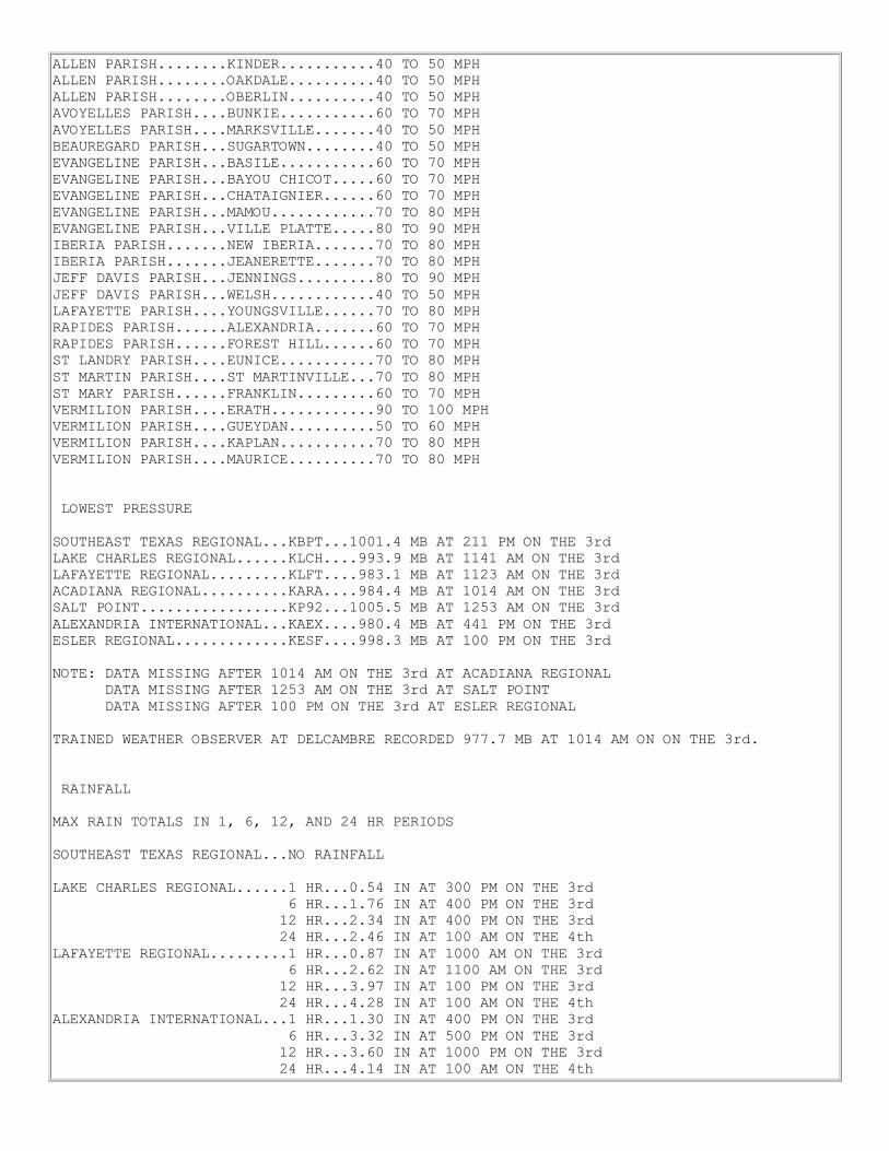
ALLEN PARISH........KINDER...........40 TO 50 MPH
ALLEN PARISH........OAKDALE..........40 TO 50 MPH
ALLEN PARISH........OBERLIN..........40 TO 50 MPH
AVOYELLES PARISH....BUNKIE...........60 TO 70 MPH
AVOYELLES PARISH....MARKSVILLE.......40 TO 50 MPH
BEAUREGARD PARISH...SUGARTOWN........40 TO 50 MPH
EVANGELINE PARISH...BASILE...........60 TO 70 MPH
EVANGELINE PARISH...BAYOU CHICOT.....60 TO 70 MPH
EVANGELINE PARISH...CHATAIGNIER......60 TO 70 MPH
EVANGELINE PARISH...MAMOU............70 TO 80 MPH
EVANGELINE PARISH...VILLE PLATTE.....80 TO 90 MPH
IBERIA PARISH.......NEW IBERIA.......70 TO 80 MPH
IBERIA PARISH.......JEANERETTE.......70 TO 80 MPH
JEFF DAVIS PARISH...JENNINGS.........80 TO 90 MPH
JEFF DAVIS PARISH...WELSH............40 TO 50 MPH
LAFAYETTE PARISH....YOUNGSVILLE......70 TO 80 MPH
RAPIDES PARISH......ALEXANDRIA.......60 TO 70 MPH
RAPIDES PARISH......FOREST HILL......60 TO 70 MPH
ST LANDRY PARISH....EUNICE...........70 TO 80 MPH
ST MARTIN PARISH....ST MARTINVILLE...70 TO 80 MPH
ST MARY PARISH......FRANKLIN.........60 TO 70 MPH
VERMILION PARISH....ERATH............90 TO 100 MPH
VERMILION PARISH....GUEYDAN..........50 TO 60 MPH
VERMILION PARISH....KAPLAN...........70 TO 80 MPH
VERMILION PARISH....MAURICE..........70 TO 80 MPH
LOWEST PRESSURE
SOUTHEAST TEXAS REGIONAL...KBPT...1001.4 MB AT 211 PM ON THE 3rd
LAKE CHARLES REGIONAL......KLCH....993.9 MB AT 1141 AM ON THE 3rd
LAFAYETTE REGIONAL.........KLFT....983.1 MB AT 1123 AM ON THE 3rd
ACADIANA REGIONAL..........KARA....984.4 MB AT 1014 AM ON THE 3rd
SALT POINT.................KP92...1005.5 MB AT 1253 AM ON THE 3rd
ALEXANDRIA INTERNATIONAL...KAEX....980.4 MB AT 441 PM ON THE 3rd
ESLER REGIONAL.............KESF....998.3 MB AT 100 PM ON THE 3rd
NOTE: DATA MISSING AFTER 1014 AM ON THE 3rd AT ACADIANA REGIONAL
DATA MISSING AFTER 1253 AM ON THE 3rd AT SALT POINT
DATA MISSING AFTER 100 PM ON THE 3rd AT ESLER REGIONAL
TRAINED WEATHER OBSERVER AT DELCAMBRE RECORDED 977.7 MB AT 1014 AM ON ON THE 3rd.
RAINFALL
MAX RAIN TOTALS IN 1, 6, 12, AND 24 HR PERIODS
SOUTHEAST TEXAS REGIONAL...NO RAINFALL
LAKE CHARLES REGIONAL......1 HR...0.54 IN AT 300 PM ON THE 3rd
6 HR...1.76 IN AT 400 PM ON THE 3rd
12 HR...2.34 IN AT 400 PM ON THE 3rd
24 HR...2.46 IN AT 100 AM ON THE 4th
LAFAYETTE REGIONAL.........1 HR...0.87 IN AT 1000 AM ON THE 3rd
6 HR...2.62 IN AT 1100 AM ON THE 3rd
12 HR...3.97 IN AT 100 PM ON THE 3rd
24 HR...4.28 IN AT 100 AM ON THE 4th
ALEXANDRIA INTERNATIONAL...1 HR...1.30 IN AT 400 PM ON THE 3rd
6 HR...3.32 IN AT 500 PM ON THE 3rd
12 HR...3.60 IN AT 1000 PM ON THE 3rd
24 HR...4.14 IN AT 100 AM ON THE 4th
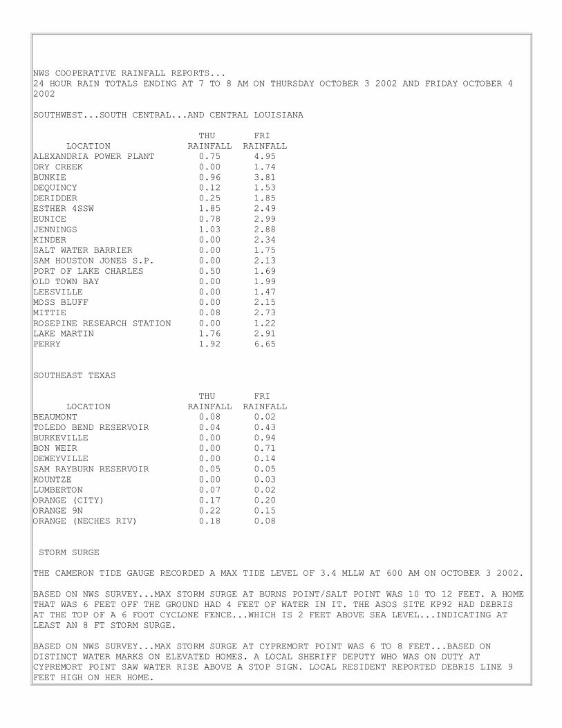
NWS COOPERATIVE RAINFALL REPORTS...
24 HOUR RAIN TOTALS ENDING AT 7 TO 8 AM ON THURSDAY OCTOBER 3 2002 AND FRIDAY OCTOBER 4
2002
SOUTHWEST...SOUTH CENTRAL...AND CENTRAL LOUISIANA
THU FRI
LOCATION RAINFALL RAINFALL
ALEXANDRIA POWER PLANT 0.75 4.95
DRY CREEK 0.00 1.74
BUNKIE 0.96 3.81
DEQUINCY 0.12 1.53
DERIDDER 0.25 1.85
ESTHER 4SSW 1.85 2.49
EUNICE 0.78 2.99
JENNINGS 1.03 2.88
KINDER 0.00 2.34
SALT WATER BARRIER 0.00 1.75
SAM HOUSTON JONES S.P. 0.00 2.13
PORT OF LAKE CHARLES 0.50 1.69
OLD TOWN BAY 0.00 1.99
LEESVILLE 0.00 1.47
MOSS BLUFF 0.00 2.15
MITTIE 0.08 2.73
ROSEPINE RESEARCH STATION 0.00 1.22
LAKE MARTIN 1.76 2.91
PERRY 1.92 6.65
SOUTHEAST TEXAS
THU FRI
LOCATION RAINFALL RAINFALL
BEAUMONT 0.08 0.02
TOLEDO BEND RESERVOIR 0.04 0.43
BURKEVILLE 0.00 0.94
BON WEIR 0.00 0.71
DEWEYVILLE 0.00 0.14
SAM RAYBURN RESERVOIR 0.05 0.05
KOUNTZE 0.00 0.03
LUMBERTON 0.07 0.02
ORANGE (CITY) 0.17 0.20
ORANGE 9N 0.22 0.15
ORANGE (NECHES RIV) 0.18 0.08
STORM SURGE
THE CAMERON TIDE GAUGE RECORDED A MAX TIDE LEVEL OF 3.4 MLLW AT 600 AM ON OCTOBER 3 2002.
BASED ON NWS SURVEY...MAX STORM SURGE AT BURNS POINT/SALT POINT WAS 10 TO 12 FEET. A HOME
THAT WAS 6 FEET OFF THE GROUND HAD 4 FEET OF WATER IN IT. THE ASOS SITE KP92 HAD DEBRIS
AT THE TOP OF A 6 FOOT CYCLONE FENCE...WHICH IS 2 FEET ABOVE SEA LEVEL...INDICATING AT
LEAST AN 8 FT STORM SURGE.
BASED ON NWS SURVEY...MAX STORM SURGE AT CYPREMORT POINT WAS 6 TO 8 FEET...BASED ON
DISTINCT WATER MARKS ON ELEVATED HOMES. A LOCAL SHERIFF DEPUTY WHO WAS ON DUTY AT
CYPREMORT POINT SAW WATER RISE ABOVE A STOP SIGN. LOCAL RESIDENT REPORTED DEBRIS LINE 9
FEET HIGH ON HER HOME.
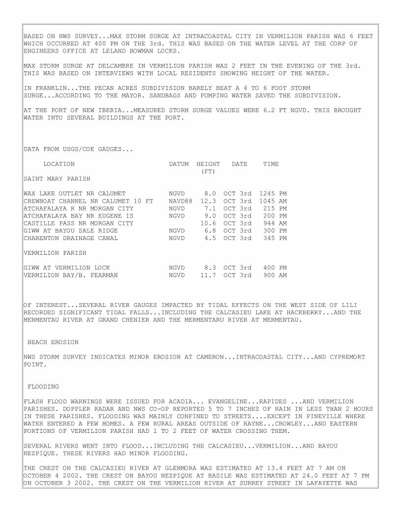
BASED ON NWS SURVEY...MAX STORM SURGE AT INTRACOASTAL CITY IN VERMILION PARISH WAS 6 FEET
WHICH OCCURRED AT 400 PM ON THE 3rd. THIS WAS BASED ON THE WATER LEVEL AT THE CORP OF
ENGINEERS OFFICE AT LELAND BOWMAN LOCKS.
MAX STORM SURGE AT DELCAMBRE IN VERMILION PARISH WAS 2 FEET IN THE EVENING OF THE 3rd.
THIS WAS BASED ON INTERVIEWS WITH LOCAL RESIDENTS SHOWING HEIGHT OF THE WATER.
IN FRANKLIN...THE PECAN ACRES SUBDIVISION BARELY BEAT A 4 TO 6 FOOT STORM
SURGE...ACCORDING TO THE MAYOR. SANDBAGS AND PUMPING WATER SAVED THE SUBDIVISION.
AT THE PORT OF NEW IBERIA...MEASURED STORM SURGE VALUES WERE 6.2 FT NGVD. THIS BROUGHT
WATER INTO SEVERAL BUILDINGS AT THE PORT.
DATA FROM USGS/COE GAUGES...
LOCATION DATUM HEIGHT DATE TIME
(FT)
SAINT MARY PARISH
WAX LAKE OUTLET NR CALUMET NGVD 8.0 OCT 3rd 1245 PM
CREWBOAT CHANNEL NR CALUMET 10 FT NAVD88 12.3 OCT 3rd 1045 AM
ATCHAFALAYA R NR MORGAN CITY NGVD 7.1 OCT 3rd 215 PM
ATCHAFALAYA BAY NR EUGENE IS NGVD 9.0 OCT 3rd 200 PM
CASTILLE PASS NR MORGAN CITY 10.6 OCT 3rd 944 AM
GIWW AT BAYOU SALE RIDGE NGVD 6.8 OCT 3rd 300 PM
CHARENTON DRAINAGE CANAL NGVD 4.5 OCT 3rd 345 PM
VERMILION PARISH
GIWW AT VERMILION LOCK NGVD 8.3 OCT 3rd 400 PM
VERMILION BAY/B. FEARMAN NGVD 11.7 OCT 3rd 900 AM
OF INTEREST...SEVERAL RIVER GAUGES IMPACTED BY TIDAL EFFECTS ON THE WEST SIDE OF LILI
RECORDED SIGNIFICANT TIDAL FALLS...INCLUDING THE CALCASIEU LAKE AT HACKBERRY...AND THE
MERMENTAU RIVER AT GRAND CHENIER AND THE MERMENTARU RIVER AT MERMENTAU.
BEACH EROSION
NWS STORM SURVEY INDICATES MINOR EROSION AT CAMERON...INTRACOASTAL CITY...AND CYPREMORT
POINT.
FLOODING
FLASH FLOOD WARNINGS WERE ISSUED FOR ACADIA... EVANGELINE...RAPIDES ...AND VERMILION
PARISHES. DOPPLER RADAR AND NWS CO-OP REPORTED 5 TO 7 INCHES OF RAIN IN LESS THAN 2 HOURS
IN THESE PARISHES. FLOODING WAS MAINLY CONFINED TO STREETS....EXCEPT IN PINEVILLE WHERE
WATER ENTERED A FEW HOMES. A FEW RURAL AREAS OUTSIDE OF RAYNE...CROWLEY...AND EASTERN
PORTIONS OF VERMILION PARISH HAD 1 TO 2 FEET OF WATER CROSSING THEM.
SEVERAL RIVERS WENT INTO FLOOD...INCLUDING THE CALCASIEU...VERMILION...AND BAYOU
NEZPIQUE. THESE RIVERS HAD MINOR FLOODING.
THE CREST ON THE CALCASIEU RIVER AT GLENMORA WAS ESTIMATED AT 13.4 FEET AT 7 AM ON
OCTOBER 4 2002. THE CREST ON BAYOU NEZPIQUE AT BASILE WAS ESTIMATED AT 24.0 FEET AT 7 PM
ON OCTOBER 3 2002. THE CREST ON THE VERMILION RIVER AT SURREY STREET IN LAFAYETTE WAS
12.0 FEET AT 7 PM ON OCT 3 2002.
TORNADOES
TORNADOES WERE REPORTED IN ACADIA...EVANGELINE... LAFAYETTE...RAPIDES...AND ST LANDRY
PARISHES. MOST OF THESE TORNADOES WERE SHORT-LIVED (LESS THAN 5 MINUTES) AND SHORT PATHS
(LESS THAN 3 MILES). F-SCALE DAMAGE WAS IN THE F-0 TO F-1 RANGE.
THE FOLLOWING TABLE SHOWS LOCATIONS OF TORNADOES ON OCTOBER 3:
TIME PARISH CITY
-DESCRIPTION OF EVENT
1106 AM LAFAYETTE LAFAYETTE
- LAFAYETTE O.E.P. REPORTED A TORNADO AT PINHOOK AND VEROT SCHOOL ROAD.
1108 AM ACADIA 2 miles SE of CROWLEY
- NWS STORM SURVEY SHOWED TORNADO DAMAGE IN EBENEZER COMMUNITY.
1125 AM ACADIA 2 miles N of RAYNE
- NWS STORM SURVEY SHOWED TORNADO DAMAGE NEAR ROBERTS COVE COMMUNITY.
1128 AM LAFAYETTE LAFAYETTE
- LAFAYETTE O.E.P. REPORTED A TORNADO AT THE CORNER OF JOHNSTON AND SOUTH COLLEGE
STREETS.
1143 AM ACADIA ESTHERWOOD
- NWS STORM SURVEY SHOWED TORNADO DAMAGE JUST EAST OF ESTHERWOOD.
1158 AM ACADIA 15 miles N of CROWLEY
- NWS STORM SURVEY SHOWED TORNADO DAMAGE NEAR MOWATA.
1201 PM LAFAYETTE 1 miles E of MIRE
- LAFAYETTE O.E.P. REPORTED A TORNADO AT THE ACADIA PARISH BORDER NEAR MIRE.
1219 PM EVANGELINE TURKEY CREEK
- NWS STORM SURVEY SHOWED TORNADO DAMAGE SOUTH OF TURKEY CREEK.
1228 PM ACADIA RICHARD
- NWS STORM SURVEY SHOWED TORNADO DAMAGE NEAR RICHARD.
115 PM EVANGELINE MAMOU
- POLICE OFFICER SAW A TORNADO TOUCH DOWN THAT CAUSED A ROOF TO CAVE IN ON A HOME. THE
PEOPLE THAT WERE TRAPPED INSIDE ESCAPED SERIOUS INJURY.
152 PM ST. LANDRY CHIMNEYVILLE
- HOMEOWNER REPORTED A TORNADO RIPPED THE ROOF OFF HOME.
300 PM RAPIDES 5 miles S of ALEXANDRIA
- SKYWARN SPOTTER SAW A TORNADO DAMAGING HOMES ALONG HIGHWAY 1.
330 PM RAPIDES WOODWORTH
- STATE POLICE SAW A TORNADO TOUCH DOWN, CAUSING MINOR TREE DAMAGE.
STORM EFFECTS
...NO DIRECT DEATHS OR LIFE-THREATENING INJURIES...
...ACADIA PARISH...
...ONE INDIRECT FATALITY...
...TWO INJURIES DURING THE STORM...

ONE ELDERLY WOMAN DIED FROM CARBON MONOXIDE POISONING FROM HER GENERATOR IN CROWLEY ON
SATURDAY OCTOBER 5 2002. SHE HAD BROUGHT HER GENERATOR INSIDE HER HOME...FEARING IT WOULD
BE STOLEN.
DURING THE STORM ON OCTOBER 3RD IN RAYNE...TWO CITY EMPLOYEES WERE TREATED AND RELEASED
FROM A LOCAL HOSPITAL AFTER THE BRICK FACADE COLLAPSED AT THE FOURTH STREET WATER PLANT.
THE ROOF OF THE BUILDING BLEW OFF BEFORE THE FACADE FELL. TWO CITY VEHICLES WERE ALSO
DAMAGED.
PRELIMINARY DAMAGE NUMBERS INDICATE 85 HOMES AND BUSINESSES WERE DESTROYED ACROSS ACADIA
PARISH...AND ANOTHER 2540 HOMES AND BUSINESSES RECEIVED MAJOR DAMAGE.
MANY HOMES AND BUSINESSES WERE DAMAGED IN CROWLEY AND RAYNE FROM FLYING DEBRIS OR FALLING
TREES. TREES AND POWER LINES WERE DOWN ALL ACROSS THE PARISH...BLOCKING SOME ROADS.
ACADIA PARISH SCHOOLS RECEIVED $1.6 MILLION WORTH DAMAGES.
...ALLEN PARISH...
SEVERAL TREES AND POWER LINES WERE BLOWN DOWN ALONG THE HIGHWAY 165 CORRIDOR...BETWEEN
KINDER...OBERLIN...AND OAKDALE.
FIVE HOMES WERE DAMAGED IN OBERLIN WHEN LARGE TREES FELL ON THEM.
...AVOYELLES PARISH...
THE HARDEST HIT AREA WAS AROUND BUNKIE. SEVERAL HOMES AND BUSINESSES HAD FLYING DEBRIS OR
FALLING TREES DAMAGE THEM. A FEW TELEPHONE POLES FELL ON A HIGHWAY SOUTHWEST OF BUNKIE.
A FEW HOMES AND BUSINESSES WERE DAMAGED AS FAR EAST AS MARKSVILLE FROM TREES FALLING OR
FLYING DEBRIS.
... BEAUREGARD PARISH...
ONE HOME IN THE SUGARTOWN-DRY CREEK AREA WAS DAMAGED WHEN A TREE FELL ON IT. A FEW TREES
ALSO FELL ACROSS OTHER SECTIONS OF EASTERN BEAUREGARD PARISH.
...CALCASIEU PARISH...
SEVERAL HOMES RECEIVED MINOR DAMAGE FROM THE HIGH WINDS...MAINLY IN THE MOSS
BLUFF...LEBLEAU SETTLEMENT...AND IOWA AREAS. SEVERAL TREES AND POWER LINES WERE BLOWN
DOWN.
...CAMERON PARISH...
IN DOWNTOWN CAMERON...SEVERAL HOMES AND BUSINESSES WERE DAMAGED FROM FLYING DEBRIS OR
FALLING TREES. A COUPLE OF HOMES NEAR GRAND LAKE WERE DAMAGED WHEN THE WIND BLEW THEIR
COVERED PORCHES OFF. BETWEEN CAMERON AND GRAND CHENIER...SEVERAL TREES WERE BLOWN ACROSS
THE ROAD. THE MOST TREE DAMAGE OCCURRED IN THE EASTERN SECTION OF CAMERON PARISH...ALONG
HIGHWAY 82.
...EVANGELINE PARISH...
...TWO INJURIES DURING THE STORM...
...ONE INDIRECT INJURY DURING RECOVERY...
ONE PERSON WAS INJURED DURING THE STORM ON OCTOBER 3RD WHEN THEY BROKE THEIR LEG
ACCORDING TO THE EVANGELINE PARISH 911 OFFICE.
A POLICE OFFICER IN VILLE PLATTE WAS INJURED DURING THE STORM ON OCTOBER 3RD WHEN A TREE
FELL ON HIS PARKED CRUISER. HE WAS TREATED AND RELEASED FROM A LOCAL HOSPITAL.
ON FRIDAY OCTOBER 4th, A VILLE PLATTE HOUSE WAS COMPLETELY DESTROYED BY FIRE WHEN THE

OWNER WAS TRYING TO REFUEL HIS GENERATOR AND SPILLED GASOLINE. HE RECEIVED MINOR
INJURIES.
IN CHURCH POINT...THE POLICE DEPARTMENT ROOF WAS BLOWN OFF.
IN VILLE PLATTE...AN ELEMENTARY SCHOOL HAD TWO BUILDINGS LOSE PART OF THEIR ROOFS. MANY
HOMES AND BUSINESSES RECEIVED DAMAGE TO THEIR ROOFS AND WINDOWS.
IN VIDRINE...THE HIGH SCHOOL WAS DAMAGED.
IN RURAL AREAS ACROSS THE PARISH...TREES AND POWER LINES WERE BLOWN DOWN...BLOCKING
SEVERAL ROADS. MANY BARNS WERE DESTROYED.
...IBERIA PARISH...
SEVERAL HOMES RECEIVED DAMAGE ACROSS THE PARISH DUE TO FALLING TREES OR FLYING DEBRIS.
SOME BUSINESSES IN NEW IBERIA RECEIVED DAMAGE TO WINDOWS.
AT ACADIANA REGIONAL AIRPORT...$100,000 DAMAGES OCCURRED TO THE HANGAR. A HELICOPTER
COMPANY HAD $50,000 DAMAGES TO ITS PROPERTY.
...JEFF DAVIS PARISH...
PRELIMINARY NUMBERS INDICATE 15 HOMES WERE DESTROYED AND 200 DAMAGED ACROSS JEFF DAVIS
PARISH...MAINLY FROM FALLING TREES AND FLYING DEBRIS.
IN LAKE ARTHUR...THE LARGE TREE ALONG THE LAKE WAS DAMAGED. SEVERAL HOMES HAD TREES FALL
ON THEM. SOME ROADS WERE BLOCKED FROM FALLING TREES.
IN JENNINGS...WIDESPREAD DAMAGE OCCURRED AS MANY TREES AND POWER LINES CAME DOWN...SOME
FALLING ON HOMES AND BUSINESSES.
BARNS WERE DAMAGED AND SHINGLES WERE BLOWN OFF SOME HOMES IN RURAL AREAS OF EASTERN JEFF
DAVIS PARISH...NORTH OF JENNINGS.
A LOW TO MODERATE FISH KILL WAS REPORTED ON TUESDAY OCTOBER 8 2002 ON THE MERMENTAU RIVER
NEAR LAKE ARTHUR.
...LAFAYETTE PARISH...
...ONE MINOR INJURY DURING THE STORM...
IN LAFAYETTE...A CABLE TV TOWER BLEW DOWN BETWEEN 10 AND 11 AM...AND FELL ON A
HOME...TRAPPING A WOMAN INSIDE. SHE RECEIVED AN ANKLE INJURY.
IN LAFAYETTE...A TV STATION TOWER FELL ON THE ROOF NEAR THE TV STUDIO...CAUSING WATER
DAMAGE INSIDE.
PLANTATION ELEMENTARY SCHOOL HAD THE LIBRARY ROOF COLLAPSE. BROUSSARD ELEMENTARY SCHOOL
HAD THE GYMNASIUM ROOF PEELED BACK.
SEVERAL WINDOWS WERE DAMAGED IN HIGH-RISE BUILDINGS IN DOWNTOWN LAFAYETTE.
NUMEROUS TREES AND POWER LINES WERE BLOWN DOWN ACROSS THE PARISH. SOME OF THIS DEBRIS
LANDED ON HOMES...DAMAGING ROOFS AND WINDOWS.
...RAPIDES PARISH...
...NUMEROUS TRAFFIC ACCIDENTS DURING THE STORM...
AROUND ALEXANDRIA...SEVERAL PEOPLE WERE INJURED IN TRAFFIC ACCIDENTS DURING THE HEIGHT OF
THE STORM.
ALEXANDRIA AND PINEVILLE HAD MINOR WIND DAMAGE...BUT RURAL AREAS AROUND
CHENEYVILLE...FOREST HILL...GLENMORA...LECOMPTE...AND WOODWORTH RECEIVED MORE SIGNIFICANT
DAMAGE. SEVERAL HOMES AND
BUSINESSES WERE DAMAGED FROM FLYING DEBRIS OR FALLING TREES. MANY HOMES LOST SHINGLES OR
TIN WAS PEELED FROM THE ROOF IN RURAL LOCATIONS.
MAJOR COTTON CROP LOSSES OCCURRED IN THE CHENEYVILLE AREA.
...ST. LANDRY PARISH...
SEVERAL SCHOOLS SUFFERED ROOF DAMAGE...INCLUDING SOUTHWEST...LAWTELL...AND ARNAUDVILLE
ELEMENTARY SCHOOLS.
IN EUNICE...A BUSINESS WAS COMPLETELY DESTROYED WHEN WIND PICKED UP THE ROOF AND BLEW
DOWN A BRICK WALL OF THE BUILDING WAS THAT BUILT IN THE EARLY 1900S.
WESTERN SECTIONS OF ST. LANDRY PARISH RECEIVED THE MOST DAMAGE. MANY TREES AND POWER
LINES CAME DOWN DURING THE STORM.
...ST. MARTIN PARISH...
IN BREAUX BRIDGE...A BRICK WALL ON THE BACK OF CITY HALL WAS BLOWN DOWN...CRUSHING A
POLICE CAR AND THE GENERATORS THE CITY WAS GOING TO USE TO POWER THE POLICE STATION.
TREES AND POWER LINES WERE BLOWN DOWN ACROSS THE PARISH...BLOCKING SOME STREETS. BARNS
WERE DAMAGED AND SOME TIN ROOFS WERE PEELED OFF HOMES.
...ST. MARY PARISH...
AT CYPREMORT POINT...THE ST. MARY O.E.P. REPORTS 80 PERCENT OF THE BUILDINGS WERE
DAMAGED. SEVERAL MOBILE HOMES WERE COMPLETELY DESTROYED...WHILE OTHER HOMES WERE LIFTED
OFF THEIR PILINGS AND
PUSHED BACK INTO THE WOODS. SOME HOMES THAT WERE ELEVATED 6 FEET ABOVE THE GROUND HAD
STORM SURGE ENTER THEM.
FRANKLIN HAD TREES AND POWER LINES BLOWN DOWN...BESIDES THE SCARE OF STORM SURGE IN THE
PECAN ACRES SUBDIVISION. OUTLYING AREAS AROUND CHARENTON AND BALDWIN ALSO HAD MINOR
DAMAGE FROM FALLING
TREES.
...VERMILION PARISH...
...ONE INDIRECT FATALITY...
...AT LEAST 20 CARBON MONOXIDE POISONINGS AFTER THE STORM...
A 79 YEAR OLD ERATH MAN DIED ON MONDAY OCTOBER 7 2002 WHEN HE FELL FROM A LADDER AT HIS
HOME CLEANING UP STORM DEBRIS.
AT LEAST 20 PEOPLE WERE TREATED AND RELEASED FROM THE LOCAL HOSPITAL FOR CARBON MONOXIDE
POISONING. EXHAUST FUMES FROM GENERATORS SENT PEOPLE FROM A LOCAL GROCERY STORE AND
NEWSPAPER TO
THE HOSPITAL.
PRELIMINARY DAMAGE ASSESSMENT NUMBERS INDICATE OVER 3700 HOMES AND BUSINESSES WERE
DESTROYED OR RECEIVED MAJOR DAMAGE ACROSS VERMILION PARISH.
ABBEVILLE HIGH SCHOOL...THE LARGEST SCHOOL IN THE PARISH...COULD BE CLOSED UP TO 2 MONTHS
DUE TO ROOF DAMAGE. A MOBILE HOME IN MAURICE CAUGHT ON FIRE AFTER ELECTRICITY CAME BACK
ON MONDAY
OCTOBER 7 2002.
THE HARDEST HIT AREAS INCLUDED ABBEVILLE AND INTRACOASTAL CITY. ABBEVILLE HAD MANY HOMES
AND BUSINESSES DAMAGED FROM FLYING DEBRIS OR FALLING TREES. INTRACOASTAL CITY HAD
WIDESPREAD FLOODING DUE TO STORM SURGE. WATER ENTERED SEVERAL BUSINESSES. STORM SURGE
ALSO FLOODED STREETS IN DELCAMBRE...AND WIND DAMAGED SEVERAL HOMES AND BUSINESSES IN
TOWN.
MANY HOMES ACROSS VERMILION PARISH RECEIVED ROOF DAMAGE...EITHER LOSING SHINGLES OR
PEELING TIN OFF. MANY BARNS WERE DESTROYED. ONE MOBILE HOME PARK COMMUNITY WEST OF
ABBEVILLE SUFFERED SEVERE
LOSSES...FROM FLOODING AND WIND DAMAGE.
IN KAPLAN...HIGHWAY 14 WAS BLOCKED DUE TO FALLEN TREES. SEVERAL HOMES AND BUSINESSES WERE
DAMAGED FROM FALLING TREES OR FLYING DEBRIS.
IN PECAN ISLAND...MANY HOMES RECEIVED MINOR DAMAGES SUCH AS PEELED TIN ROOFS OR PORCHES
RIPPED OFF. SEVERAL BARNS WERE DESTROYED.
AT INTRACOASTAL CITY...A HELICOPTER COMPANY LOST BETWEEN 15 AND 20 BUILDINGS USED TO
HOUSE CREW MEMBERS.
...CROP LOSSES...
STATEWIDE ACROSS LOUISIANA...EARLY CROP LOSS ESTIMATES INCLUDE BETWEEN $12 AND $25
MILLION FOR COTTON...$100 TO $200 MILLION FOR SUGARCANE...AND $3 TO $6 MILLION FOR
SOYBEAN.
...EVACUATIONS...
EVACUATIONS OCCURRED IN JEFFERSON...ORANGE...LOWER JASPER...AND LOWER NEWTON COUNTIES IN
SOUTHEAST TEXAS. PRELIMINARY ESTIMATES SHOW AROUND 200,000 PEOPLE EVACUATED THIS AREA.
THIS INCLUDED MOST NURSING HOMES AND HOSPITALS IN JEFFERSON COUNTY...AND SEVERAL
FEDERAL...STATE...AND LOCAL PRISONS. MOST OF THE PETROCHEMICAL INDUSTRIES WERE SHUT DOWN
IN THE PORT ARTHUR AREA...WHICH TOOK UP TO A WEEK TO RESTART IN SOME INSTANCES.
AT LEAST 6,500 PEOPLE SOUGHT SHELTER IN OFFICIAL SHELTERS IN LUFKIN AND NACOGDOCHES
TEXAS. FOR EVACUATION TIMING...THE NORMAL 2 HOUR DRIVE FROM BEAUMONT TO LUFKIN TOOK
BETWEEN 4 AND 5 HOURS DURING THE EVACUATION.
EVACUATIONS OCCURRED IN ACADIA...CALCASIEU...CAMERON... JEFF DAVIS...LAFAYETTE...ST
MARTIN...ST MARY...AND VERMILION PARISHES. MOST OF THE PETROCHEMICAL PLANTS IN THE LAKE
CHARLES AREA WERE SHUT DOWN...AND TOOK UP TO A WEEK TO RESTART IN SOME INSTANCES.
ACCORDING TO PRELIMINARY REPORTS...AROUND 7,000 PEOPLE SOUGHT SHELTER IN OFFICIAL
SHELTERS IN CENTRAL LOUISIANA.
...POWER OUTAGES...
ELECTRICITY WAS OUT AT ONE TIME TO AROUND 237,000 CUSTOMERS ACROSS SOUTH CENTRAL AND
CENTRAL LOUISIANA. WHILE MOST PLACES HAD POWER RESTORED WITHIN TWO TO THREE DAYS...SOME
RURAL LOCATIONS WERE STILL WITHOUT POWER NEARLY TWO WEEKS LATER.

Hurricane Lili's journey began as a tropical wave moving west across the central Atlantic Ocean. On September
21st
2002 at 4 PM CDT the tropical wave was upgraded to Tropical Depression Thirteen and was located about
955 miles west of the Lesser Antilles moving to the west at 17 mph. The complete track can be found here.
On Sunday, the 22nd
of September, Tropical Depression Thirteen increased
in forward speed to 23 mph and was located 90 miles east-southeast of the
Windward Islands with maximum sustained winds of 35 mph. As the
morning progressed, Tropical Depression Thirteen continued to intensify
and was upgraded to Tropical Storm Lili with maximum sustained winds of
50 mph. During the overnight hours, a still weak and clumsy Lili stumbled
across the Windward Islands leaving the islands unscathed. By sunrise, on
the morning of the 24th, Lili had moved into the Caribbean Sea.
Lili continued a westward movement across the Caribbean Sea on a crash course toward Jamaica. However, on
the 27th of September, Lili made a last minute jog to the right, sparing the island of Jamaica from the brunt of its
fury.
On Sunday, the 29th
of September, the Coastal Waters Forecast from the National Weather Service Forecast
Office in Lake Charles (WFO LCH) began to alert mariners to the possibility of hurricane conditions by
Thursday. This gave the marine interests four days to prepare. The word had been released that this storm was
not going to yield and it would move toward the Southeast Texas and Southwest Louisiana coasts. Its exact
location of landfall was still sketchy at this time, but local forecasters could not deny that it was definitely
becoming a threat.
At 10:00 AM CDT on the 30th of September, Lili was upgraded to a hurricane and was moving towards the
Cayman Islands, approaching the southwest tip of Cuba.
On the first day of October, interests along the northwest Gulf Coast awoke to find that Lili had emerged off the
western tip of Cuba and was now in the Gulf of Mexico. The morning Area Forecast Discussion and Hazardous
Weather Outlook issued from WFO LCH mentioned the first alert to residents along the southwest coast of
Louisiana to the potential for a major hurricane making landfall later in the week. By the late afternoon hours,
Lili had intensified to a Category II storm with winds of 100 mph, moving west-northwest across the Gulf of
Mexico.
A Hurricane Watch was posted for the northern Gulf Coast late in the afternoon on Tuesday, October 1st . This
watch extended from San Luis Pass, Texas to the mouth of the Mississippi River.
WFO LCH continued to issue products concerning this impending storm. The first Hurricane Local Statement
was issued at 5 PM CDT on the 1st, addressing residents along the coast with precaution and preparedness
information in the event that the storm was to make landfall in Southeast Texas or Southern Louisiana.
Some of the precautions taken by local emergency officials included a mandatory evacuation of Cameron
Parish, effective at 8 AM October 2nd
. Calcasieu Parish asked for an evacuation of low lying areas. In addition,
all schools were closed across these parishes for the remainder of the week.
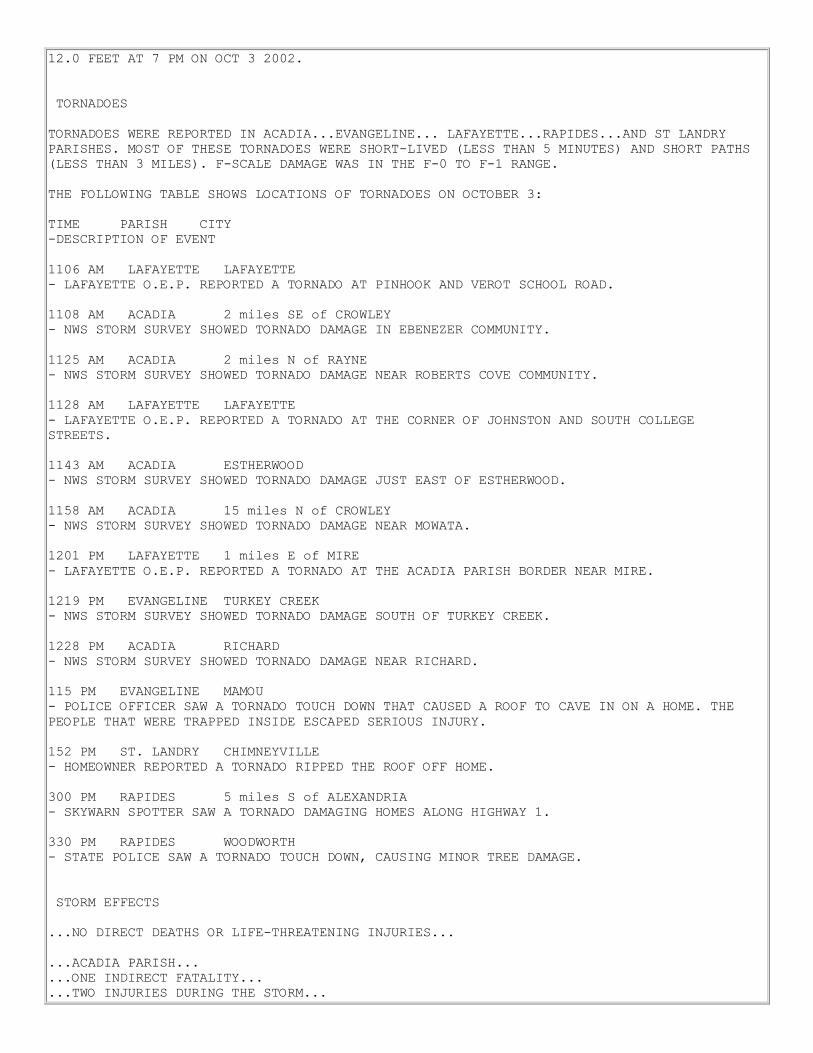
On Wednesday morning, the 2nd
of October, Lili was
upgraded to a Category III hurricane, which made it
the second major hurricane of the 2002 hurricane
season, after Isidore with winds of 120 mph.
Emergency management quickly responded with
mandatory evacuation orders along the entire coast
from Jefferson County in Southeast Texas to Iberia
Parish in South-Central Louisiana. At the same time, a
River Flood Warning was issued for the lower
Calcasieu and Vermilion rivers. This was to alert the
interests along these rivers to expect flooding as tidal
surge pushed waters upstream.
By the early afternoon hours on the 2nd
, the minimum central pressure dropped to 941 millibars or 27.79 inches
as winds increased to 135 mph. Flood Watches were posted across Southern and Central Louisiana. In
addition, at 3:45 PM, an Inland Hurricane Wind Warning was issued for Southern Louisiana and a Tropical
Storm Wind Warning was posted for Southeast Texas.
Lili countered preparedness moves with an unexpected and threatening intensification to winds of 145 mph,
making it a Category IV hurricane. With Lili located only 200 miles south of Intracoastal City, Louisiana,
officials had to act fast and brace for the worst. By the early evening hours on the 2nd
, the National Hurricane
Center adjusted the track of the storm with landfall 50 miles east of the previous forecast track. This put Lili on
a direct course into Vermilion Parish, potentially ushering in a deadly storm surge of 18 to 20 feet across
Vermilion Bay.
During the pre-dawn hours of the 3rd
, tensions ran high as Lili moved northwest as forecast. However, an
unexpected twist made all the difference between life and death as Lili began to weaken. Satellite imagery
began to reveal that the eyewall was filling. At daybreak on the 3rd
, Lili was downgraded to a Category II storm
with winds of only 100 mph. However, the worst was still yet to come for residents across Southern and
Central Louisiana.
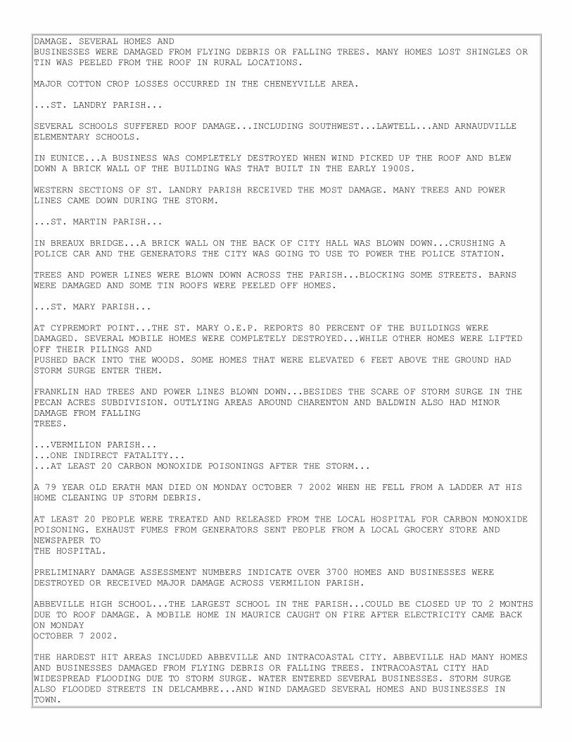
Hourly Short Term Forecasts issued by WFO LCH detailed Lili’s approach to the coast of Southern Louisiana.
WSR-88D Doppler radar images, such as the one on the left above, are the basis for these forecasts. As can be
seen in this image, outer bands were sweeping across Southern Louisiana. By 9 AM, short term forecasts
heralded the arrival of Lili in southern Vermilion parish. This can be seen in the image above at right. Notice
the eyewall moving near Marsh Island.
For a complete radar loop of Hurricane Lili making landfall, click here.
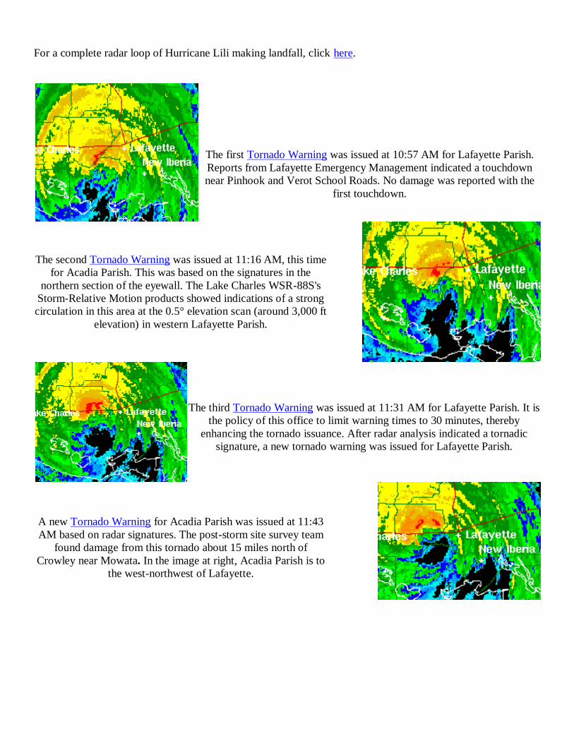
The first Tornado Warning was issued at 10:57 AM for Lafayette Parish.
Reports from Lafayette Emergency Management indicated a touchdown
near Pinhook and Verot School Roads. No damage was reported with the
first touchdown.
The second Tornado Warning was issued at 11:16 AM, this time
for Acadia Parish. This was based on the signatures in the
northern section of the eyewall. The Lake Charles WSR-88S's
Storm-Relative Motion products showed indications of a strong
circulation in this area at the 0.5° elevation scan (around 3,000 ft
elevation) in western Lafayette Parish.
The third Tornado Warning was issued at 11:31 AM for Lafayette Parish. It is
the policy of this office to limit warning times to 30 minutes, thereby
enhancing the tornado issuance. After radar analysis indicated a tornadic
signature, a new tornado warning was issued for Lafayette Parish.
A new Tornado Warning for Acadia Parish was issued at 11:43
AM based on radar signatures. The post-storm site survey team
found damage from this tornado about 15 miles north of
Crowley near Mowata. In the image at right, Acadia Parish is to
the west-northwest of Lafayette.

In all, a total of eleven tornado warnings were issued for storms
produced by Hurricane Lili across South-Central and Central Louisiana.
After landfall, Lili continued on a northward course at 16 mph. In
Evangeline Parish, a tornado touched down, causing a roof on a home to
collapse. Residents were trapped inside the home but escaped serious
injury from the damage. Below at left is an image from the WSR-88D in
Lake Charles at the time the tornado struck.
Flash flood warnings were issued for Vermilion, Acadia, Evangeline and Rapides parishes. Doppler radar
indicated 5 to 7 inches of rain had fallen in less than 2 hours across these parishes. Although flooding was
mainly confined to streets, a few rural areas outside of Rayne, Crowley and eastern portions of Vermilion Parish
had 1 to 2 feet of water. Rainfall totals reported by co-operative observers for the two-day period from 7 AM
Wednesday to 7 AM Friday include:
Location Total
Perry 8.57 in
Alexandria (Power Plant) 5.70 in
Bunkie 4.77 in
Lake Martin 4.67 in
Esther 4.34 in
Jennings 3.91 in
Eunice 3.77 in
DeRidder 2.10 in
Click to see a larger version
This image shows the total rainfall with Hurricane Lili. Most of the
rainfall was locked near the path of the center of the storm.
Four different tide gage sites heralded the arrival of Lili’s tidal surge. Bayou Sale Ridge near Franklin,
Louisiana recorded a max height of 6.78 feet around 10 AM. This was close to the location where Lili made
landfall.

Click for a larger view of Bayou Sale's tidal plot
Click for a larger view of Wax Lake's tidal plot
The highest storm surge occurred to the right of center near Wax Lake Outlet or Calumet, Louisiana with a
height of 12.45 feet around 8 AM. This site is located in eastern St. Mary Parish near the coast. This was
confirmed by a local damage survey team from WFO LCH.
One of the interesting features noted in the tidal graphs occurred on the west side of the storm.
Grand Chenier Lake was west of the eye passage. Note the tidal surge during the morning hours; however, what
catches the eye is the sudden falling tide of over two feet. This signature resulted after Lili moved onshore as
the strong north winds pushed the storm surge waters back out into the gulf.
Click for a larger view of Grand Chenier's tidal plot
Click for a larger view of Hackberry's tidal plot
The Hackberry gage site is located on the north end of Calcasieu Lake, southwest of Lake Charles. This area
has normal tidal influences, although located about 20 miles inland. A tidal surge cannot be noted with this site
just looking at the graph. A small tidal surge appears to have held tides to near normal. As the storm moved
onshore, the effects of the surge no longer supported water across the lake and with a very strong north wind,
water was allowed to rush out of the lake.

By the evening hours of October 3rd
, all watches and warnings for Lili were lifted.
Prior to Hurricane Lili making landfall, the electronics staff at WFO LCH completed advance field work. They
ensured equipment was online and working within established parameters. This equipment included river gages,
tidal gages and NOAA Weather Radio. They also installed a barograph and wind gust recorder at the Cameron
Parish courthouse, as Lili was anticipated to make landfall near this location. This was one of the few locations
in Cameron Parish that remained above Audrey’s tidal surge many years ago.
The office electronics staff conducted an extensive check of station equipment and resources needed to maintain
operations. This included evaluating the WSR-88D, Automated Surface Observation System (ASOS) sites, the
Upper Air Tracking Unit, and on-station computer systems.
Through hard work and early preparations, no direct deaths or serious injuries were associated with
Hurricane Lili as she passed through Southern Louisiana on her northward journey. Based on survey damage,
the highest storm surge was between 10 and 12 feet at Burns Point/Salt Point, where a home 6 feet above the
ground had 4 feet of water inundation. Debris was found on the top of an 8 foot cyclone fence at the the
National Weather Service’s ASOS at Salt Point. As a result of Lili, portions of Louisiana were declared a
federal disaster area. The amount of monetary damage is still unknown at this time, but the cleanup and
restoration efforts will continue for many years.
The highest wind gust of 120 mph was reported in Vermilion Parish at Intracoastal City. The highest wind gust
recorded at an ASOS site was 91 mph at the Acadiana Regional Airport outside New Iberia. The Louisiana
State University Agricultural Center reported a maximum wind gust of 68 mph in New Iberia and 67 mph just
south of Alexandria in Rapides Parish.
This was the first time since 1992 that a hurricane struck the southwest coast of Louisiana. It was on that
occasion that Andrew made landfall in St. Mary Parish.
Hurricane Lili was a unique storm in many ways. Unlike Isidore a week earlier, Lili’s strongest winds remained
close to the center of the storm. Lili also unexpectedly weakened as it approached the coastal waters of South-
Central Louisiana. These two factors along with preparedness inevitably saved lives.
This storm moved through Louisiana without a single life lost. A year earlier, Tropical Storm Allison claimed
around thirty lives, mainly from flooding. Through accurate forecasts by the National Weather Service, in
conjunction with emergency planners and the local media, residents were well equipped to make life-saving
decisions.

Hydrologic Effects of Hurricane Lili
Hurricane Lili made landfall along the south-central coast of Louisiana near Intracoastal City. The hurricane
was moving fairly rapidly north at around 15 mph. Due to the speed of the storm, flooding caused by heavy
rains was minimized.
Twenty-four hour radar-derived precipitation estimates from 7 AM Thursday October 3rd to 7 AM Friday
October 4th indicated a band of heavy rainfall from Central to South-Central Louisiana, where the center of the
storm crossed the state. Rainfall totals within this area ranged from about 4 to 8 inches, with locally higher
amounts in some areas. Rainfall totals reported by co-operative observers for the two-day period from 7 AM
Wednesday to 7 AM Friday include:
Location Total
Alexandria (Power Plant) 5.70 in
Bunkie 4.77 in
DeRidder 2.10 in
Esther 4.34 in
Eunice 3.77 in
Jennings 3.91 in
Lake Martin 4.67 in
Perry 8.57 in
Flash flood warnings were issued for Vermilion, Acadia, Evangeline and Rapides parishes. Doppler radar
indicated 5 to 7 inches of rainfall had fallen in less than 2 hours across these parishes. Although flooding was
mainly confined to streets, a few rural areas outside of Rayne, Crowley and over eastern portions of Vermilion
parish had 1 to 2 feet of water.
Several river sites located within the heavy rain area also went into flood. The Calcasieu River at Glenmora,
Bayou Nezpique near Basile, and the Vermilion River at Surrey Street in Lafayette did experience flooding.
Storm and flood surveys during the days following landfall revealed only minor flooding which was confined to
areas near the river. The following are crests for these river sites:
River/Location Flood Stage Crest Height Time/Date
Calcasieu River at Glenmora 12.0 ft 13.40 ft (Estimated) 7 AM 10/4
Bayou Nezpique near Basile 22.0 ft 24.00 ft (Estimated) 7 PM 10/3
Vermilion River at Lafayette (Surrey Street) 10.0 ft 12.03 ft 7 PM 10/3

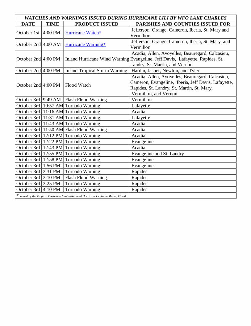
WATCHES AND WARNINGS ISSUED DURING HURRICANE LILI BY WFO LAKE CHARLES
DATE TIME PRODUCT ISSUED PARISHES AND COUNTIES ISSUED FOR
October 1st 4:00 PM Hurricane Watch* Jefferson, Orange, Cameron, Iberia, St. Mary and
Vermilion
October 2nd 4:00 AM Hurricane Warning* Jefferson, Orange, Cameron, Iberia, St. Mary, and
Vermilion
October 2nd 4:00 PM Inland Hurricane Wind Warning
Acadia, Allen, Avoyelles, Beauregard, Calcasieu,
Evangeline, Jeff Davis, Lafayette, Rapides, St.
Landry, St. Martin, and Vernon
October 2nd 4:00 PM Inland Tropical Storm Warning Hardin, Jasper, Newton, and Tyler
October 2nd 4:00 PM Flood Watch
Acadia, Allen, Avoyelles, Beauregard, Calcasieu,
Cameron, Evangeline, Iberia, Jeff Davis, Lafayette,
Rapides, St. Landry, St. Martin, St. Mary,
Vermilion, and Vernon
October 3rd 9:49 AM Flash Flood Warning Vermilion
October 3rd 10:57 AM Tornado Warning Lafayette
October 3rd 11:16 AM Tornado Warning Acadia
October 3rd 11:31 AM Tornado Warning Lafayette
October 3rd 11:43 AM Tornado Warning Acadia
October 3rd 11:50 AM Flash Flood Warning Acadia
October 3rd 12:12 PM Tornado Warning Acadia
October 3rd 12:22 PM Tornado Warning Evangeline
October 3rd 12:43 PM Tornado Warning Acadia
October 3rd 12:55 PM Tornado Warning Evangeline and St. Landry
October 3rd 12:58 PM Tornado Warning Evangeline
October 3rd 1:56 PM Tornado Warning Evangeline
October 3rd 2:31 PM Tornado Warning Rapides
October 3rd 3:10 PM Flash Flood Warning Rapides
October 3rd 3:25 PM Tornado Warning Rapides
October 3rd 4:10 PM Tornado Warning Rapides
* issued by the Tropical Prediction Center/National Hurricane Center in Miami, Florida

CALCASIEU PASS TIDE DATA
SABINE PASS TIDE DATA

BALDWIN TIDE DATA
CALUMET TIDE DATA
CHARENTON TIDE DATA
CREWBOAT CHANNEL TIDE
DATA
FRANKLIN TIDE DATA
GRAND CHENIER
TIDE DATA
HACKBERRY TIDE DATA
INTRACOASTAL CITY
TIDE DATA
JEANERETTE TIDE DATA
MERMENTAU TIDE DATA
MORGAN CITY TIDE DATA
MYETTE POINT
TIDE DATA
PERRY TIDE DATA VERMILION EAST
TIDE DATA

HURRICANE LILI PHOTOS
(click on image for larger version)

(1) ABBEVILLE
(2) BURNS POINT (3) CHENEYVILLE
(4) CROWLEY
(5) CYPREMORT POINT
(6) DELCAMBRE (7) ERATH

(8) EUNICE (9) HENRY
(10) INTRACOASTAL CITY
(11) JENNINGS
(12) KAPLAN (13) LAFAYETTE
(14) LAKE ARTHUR (15) LONEPINE
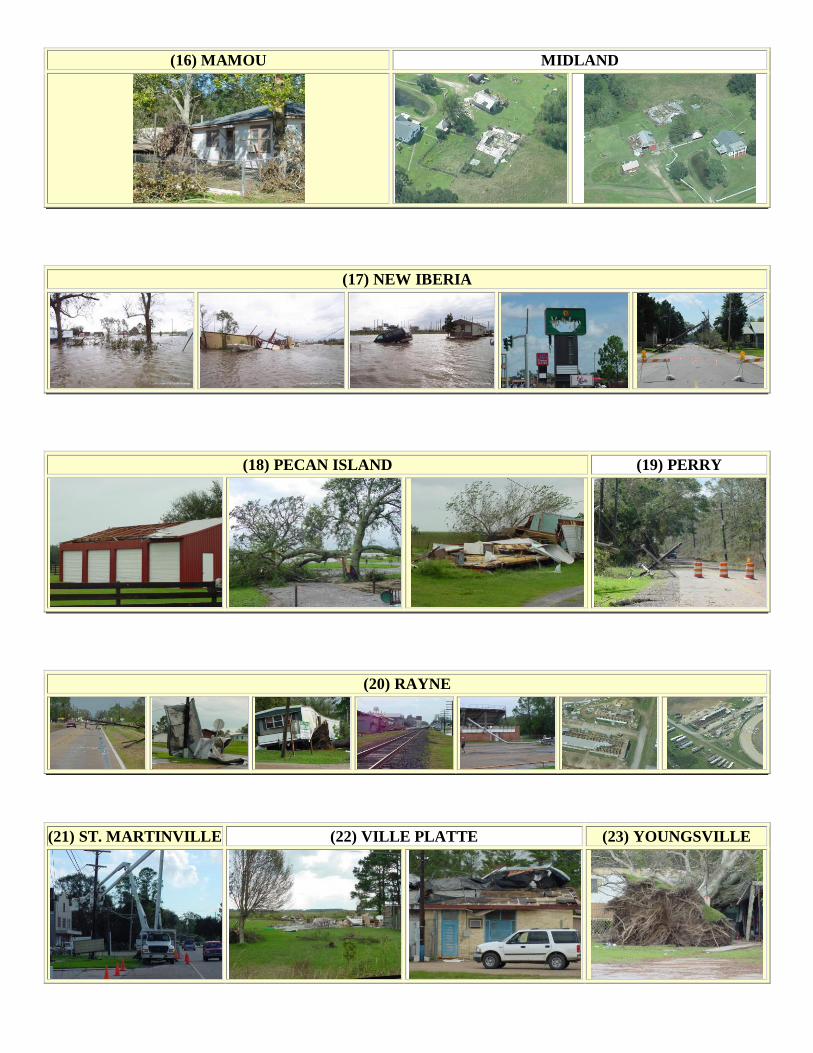
(16) MAMOU MIDLAND
(17) NEW IBERIA
(18) PECAN ISLAND (19) PERRY
(20) RAYNE
(21) ST. MARTINVILLE (22) VILLE PLATTE (23) YOUNGSVILLE

HURRICANE LILI RADAR & SATELLITE IMAGERY
Click on the image for a radar loop

Click on the image for a satellite loop