hurricanes and their tracks - pacific climate change · lesson plan 1 hurricanes and their tracks...
TRANSCRIPT

LLEESSSSOONN PPLLAANN 11
Hurricanes and TheirTracksChildren will know better what to expect of an approaching hurricaneif they understand what a hurricane is and the weather associated with it.
Key Terms and Concepts
condensationcoordinatedirectionevaporationeye
Purposes
To help students and their families define hurricanes, understandhow they form and identify seasonal weather patterns associatedwith hurricanes
Objectives
The students will—• Use Facts About Hurricanes to collect and share data on hurri-
canes and how hurricanes differ from other storms.
• Use a concept map that organizes information about hurricanes tocompare and contrast hurricanes to other severe weather in theirlocale.
• Work together to list questions raised by their original researchinto hurricanes and conduct research to answer those questionsand share new information in a short class presentation. (LinkingAcross the Curriculum)
• Use maps to illustrate and discuss why hurricanes occur in partic-ular areas and their potential impact.
• Interview family members to record stories about the historicalhurricanes found in the students’ research. (Home Connection)
• Create a booklet of historical hurricanes from actual weather dataand interviews.
• Use hurricane weather terms and concepts to write and illustratepoems in the form known as cinquains. (Linking Across theCurriculum)
• Collect, record and graph weather data to illustrate and analyzeweather patterns. (Linking Across the Curriculum)
Hurricanes 3–5
Hurricane Science
11Masters of Disaster® Hurricanes, Hurricane Science, Lesson Plan 1/Hurricanes and Their TracksCopyright 2007 The American National Red Cross
Visit the American Red Cross Web site at www.redcross.org/disaster/masters
eye wallhemispherehurricanelatitudelongitude
meteorologistprecipitationseasonstrackingwind speed

Hurricanes 3–5
LLEESSSSOONN PPLLAANN 11
Hurricanes andTheir Tracks
• Use Hurricane Tracking Vocabulary to describe the terms for trackinga weather system.
• Plot latitude and longitude coordinates on the Atlantic with HurricaneTracking Map.
• Continue plotting coordinates with Fact Sheet for Hurricane Georges.
• Conduct research on the Internet to compare tracks and statistics ofpast hurricanes with those of Hurricane Georges. (Linking Across theCurriculum)
Activities
“KWL Chart”
“Where Is the Weather?”
“Hurricane Tracking”
22Masters of Disaster® Hurricanes, Hurricane Science, Lesson Plan 1/Hurricanes and Their TracksCopyright 2007 The American National Red Cross
Visit the American Red Cross Web site at www.redcross.org/disaster/masters

Hurricanes 3–5
LLEESSSSOONN PPLLAANN 11
Hurricanes andTheir Tracks
33
Materials
• Facts About Hurricanes, 1 copy per student or group
• Chalkboard and chalk or chartpaper and markers
“KWL Chart”
SET UP 15 minutes CONDUCT 40 minutes
Language Arts: Research; Science: Earth Science and Problem Solving
1. Create a KWL chart on the chalkboard or a piece of chart paper.
Example:
Teacher: Today, we will talk about hurricanes. Someone tell me somethingabout hurricanes to put it in our chart.Student: I know hurricanes make big waves.
List what the students know and also what they want to know. After thelesson, go back to the chart and fill in what was learned.
Lead the students in a discussion of what they already know about hurri-canes.
2. As the students discuss what they know about hurricanes, add informa-tion to the chart.
3. Find out what questions the students have about hurricanes. When dothey form? How do they form? What hazards do they pose to life andproperty?
4. Distribute Facts About Hurricanes.
5. Group the students into small work teams to discuss and record whatmakes hurricanes different from other storms.
6. Have the groups share their notes to help you complete a concept mapon the board. Begin with hurricanes in a center circle and radiate theinformation from that center.
Masters of Disaster® Hurricanes, Hurricane Science, Lesson Plan 1/Hurricanes and Their TracksCopyright 2007 The American National Red Cross
Visit the American Red Cross Web site at www.redcross.org/disaster/masters
TEACHING NOTE The purpose of the KWL diagram (what you KKnow, what youWWant to know, what you have LLearned) is to gauge the level of the students’previous knowledge about a particular subject, in this case, hurricanes.
Know Want to know Learned
Hurricanes make bigwaves.

Hurricanes 3–5
LLEESSSSOONN PPLLAANN 11
Hurricanes andTheir Tracks
Wrap-Up
When your students have mapped all the informationthey learned in the KWL chart, ask them to use the
concept map to compare and contrast hurricanes with other severe weatherhazards. If your students do not live in a hurricane-prone region, ask themto analyze the severe weather hazards that are typical of their area. Whichone is most like hurricanes? How is it similar and how is it different?
Linking Across the Curriculum
Language Arts: ResearchTell students that most researchers find more questions than
answers as they delve deeper and deeper into a subject. Ask the followingquestions:
• Did your reading and class discussion raise more questions abouthurricanes?
• What more would you like to know?
• How would you find this information?
Challenge them to choose one or two questions from the discus-sion and independently research to complete a KWL chart forthose questions, using the Internet or other media. When theyhave completed their research, the students will share what they
have learned in a short presentation.
44Masters of Disaster® Hurricanes, Hurricane Science, Lesson Plan 1/Hurricanes and Their TracksCopyright 2007 The American National Red Cross
Visit the American Red Cross Web site at www.redcross.org/disaster/masters
Hurricane

Hurricanes 3–5
LLEESSSSOONN PPLLAANN 11
Hurricanes andTheir Tracks
55
Materials
• Map of the United States
• Daily access for each studentto weather reports via thenewspaper, radio, televisionor Internet
• Facts About Hurricanes, 1 copy per student
“Where Is the Weather?”
SET UP 10 minutes CONDUCT 30 minutes
Social Studies: Geography; Science: Earth Science; Language Arts:
Research and Writing
1. Use a large map of the United States to discuss the weather conditionsthe students would encounter in different regions of the country.
2. Help the students to use geographic terms (direction, terrain and prox-imity to large bodies of water) to explain differences in weatherpatterns.
3. How does weather change with the seasons? How would the studentsdescribe seasonal weather in their areas? Is the region affected by hurri-canes? When are hurricanes most likely to occur?
4. Distribute copies of Facts About Hurricanes. Based on informationfound on the handout, ask students: Which regions on the mainland ofthe United States experience hurricanes? (Hurricanes affect the EastCoast from Florida to Maine, and the Gulf Coast from Florida to Texas.Wind, rains and flooding from coastal hurricanes can affect states farinland as well.)
5. What do these regions have in common? What are the differences? (Theareas border the coast of the Atlantic Ocean or the Gulf of Mexico,which includes the countries of the Caribbean. Where a hurricane makeslandfall is dependent on its track, a path that is often difficult to predict.The possibilities of a storm’s path may be many: Meteorologists couldsee a diagonal stomp across the Florida peninsula, or a change in direc-tion to the northeast that skirts the South Coast or perhaps a headingstraight inland from the Gulf of Mexico that causes great damage ininland states. Inland areas may not experience the full brunt of the hurri-cane’s highest winds or the effects of the storm surge, but intense rainmay fall, causing rivers to swell as the ground becomes saturated, and thepotential for falling trees, flash floods and floods is great.)
Masters of Disaster® Hurricanes, Hurricane Science, Lesson Plan 1/Hurricanes and Their TracksCopyright 2007 The American National Red Cross
Visit the American Red Cross Web site at www.redcross.org/disaster/masters

Hurricanes 3–5
LLEESSSSOONN PPLLAANN 11
Hurricanes andTheir Tracks
Wrap-Up
Have the students research past major hurricanes:
• 1900, Galveston, Texas
• 1935, Florida Keys
• 1938, New England
• 1969, Hurricane Camille
• 1989, Hurricane Hugo
• 1992, Hurricane Andrew
• 1998, Hurricane Georges
• 1999, Hurricane Floyd
• 2005, Hurricane Katrina
Students will refer to maps to answer the following questions about eachhurricane:
• Where did it make landfall?
• What was the weather before and after the hurricane struck?
• How great was the impact?
• Which geographic factors affected the impact? Explain.
Students will share the results of their media weather search and comparethe data collected. Are specific weather patterns evident for differentregions of the country? As a class, compare data across regions most likelyto be affected by hurricanes. Can the students discern any commonfeatures? If a hurricane were approaching a region, what weather patternswould the students expect?
66Masters of Disaster® Hurricanes, Hurricane Science, Lesson Plan 1/Hurricanes and Their TracksCopyright 2007 The American National Red Cross
Visit the American Red Cross Web site at www.redcross.org/disaster/masters
TEACHING NOTES Some excellent sites for this research are— • Hurricane History (http://www.nhc.noaa.gov/HAW2/english/history.shtml)• NOAA Coastal Services Center
(http://maps.csc.noaa.gov/hurricanes/index.htm)• The National Weather Service: Hurricane History
(http://www.srh.noaa.gov/crp/docs/research/hurrhistory/)

Hurricanes 3–5
LLEESSSSOONN PPLLAANN 11
Hurricanes andTheir Tracks
77
Home Connection
Have students share with their families the information that theygathered in the Wrap-Up about historical hurricanes in the
United States. Ask them to interview family members and family friends torecord personal stories about these hurricanes.
• What was the weather like in the region affected by the hurricanebefore and after the hurricane hit?
• How did the person experience the hurricane—personally orthrough news sources?
• What event associated with the hurricane made it particularlymemorable?
Collect the stories at school and combine them with the data from theWrap-Up for a Hurricane History booklet or PowerPoint presentation.
Linking Across the Curriculum
Language Arts: Writing; Fine Arts: Visual Arts
Have the students write cinquains about hurricanes. Here is an exampleusing the term “cyclone”:
Cyclone
Ripping, raging
Need to get away from
Scary loud banging blowing storm
Big storm
After writing their verses in the cinquain form, have the class express theirweather observations as artwork. They could illustrate their verses or createvisual representations of regional weather occurrences, particularly ofstorms or hurricanes.
Mathematics:Have the students collect, record and graph weather readings across thecountry for a specified period of time. Then, have them analyze the dataand present it to the class.
Masters of Disaster® Hurricanes, Hurricane Science, Lesson Plan 1/Hurricanes and Their TracksCopyright 2007 The American National Red Cross
Visit the American Red Cross Web site at www.redcross.org/disaster/masters
TEACHING NOTE The cinquain construction consists of five lines, each of whichhas a special purpose. The first line states the title in two syllables. The second linedescribes the title in four syllables. The third line describes action in six syllables. Thefourth line expresses a feeling in eight syllables. The fifth line restates the title in twosyllables.

Hurricanes 3–5
LLEESSSSOONN PPLLAANN 11
Hurricanes andTheir Tracks
Materials
• Hurricane Tracking Vocabu-lary, 1 copy per group
• Atlantic Hurricane TrackingMap, 1 copy per group
• Fact Sheet for HurricaneGeorges, 1 copy per student
• Transparency of AtlanticHurricane Tracking Map
“Hurricane Tracking”
SET UP 30 minutes CONDUCT 45 minutes
Science: Earth Science; Social Studies: Geography; Language Arts:
Reading
1. Remind the students that meteorologists track the movementof a hurricane using the lines of latitude and longitude, just aswe use these lines to find locations on a map.
2. Divide the class into groups of two or three students. DistributeHurricane Tracking Vocabulary. When the students have completed thevocabulary assignment, go over the correct answers and ask them todescribe how each term is applied to track a weather system.
Answers to Hurricane Tracking Vocabulary
1. Latitude
2. Hemisphere
3. Longitude
4. Meteorologist
5. Hurricane
6. Tracking
3. Distribute Atlantic Hurricane Tracking Map.
4. Review the steps for using a coordinate grid.
5. Distribute Fact Sheet for Hurricane Georges and have the students plotthe path of Hurricane Georges using the coordinates on page 2 of theactivity sheet.
Wrap-Up
When the students have completed their tracking maps, havethem indicate the following on the transparency of the trackingmap:
• Where Hurricane Georges made landfall
• Which areas were most affected
Ask the students—Why is it important to track a hurricane accurately?What information would you need to predict where the hurricane is headedor when it will make landfall?
88Masters of Disaster® Hurricanes, Hurricane Science, Lesson Plan 1/Hurricanes and Their TracksCopyright 2007 The American National Red Cross
Visit the American Red Cross Web site at www.redcross.org/disaster/masters
TEACHING NOTE If you are teaching this unit in Hawaii, consider procuring mapsthat track hurricanes of the Pacific from your local chapter of the American RedCross and assign a local hurricane for your students to track.

Hurricanes 3–5
LLEESSSSOONN PPLLAANN 11
Hurricanes andTheir Tracks
99
Linking Across the Curriculum
Science: Technology; Social Studies: History
Assign the students to conduct research on theInternet about the paths of active or past hurricanes. Discuss the data gath-ered and compare the tracks and the statistics with those of HurricaneGeorges. Pose the questions—
• Have other hurricanes hit in the same areas?
• Do the hurricanes have common characteristics, for example,time of year, wind speed or storm surge?
Masters of Disaster® Hurricanes, Hurricane Science, Lesson Plan 1/Hurricanes and Their TracksCopyright 2007 The American National Red Cross
Visit the American Red Cross Web site at www.redcross.org/disaster/masters
TEACHING NOTE Some excellent sites for this research are—• Hurricane History
(http://www.nhc.noaa.gov/HAW2/english/history.shtml)• NOAA Coastal Services Center
(http://maps.csc.noaa.gov/hurricanes/index.htm)• The National Weather Service: Hurricane History
(http://www.srh.noaa.gov/crp/docs/research/hurrhistory/)
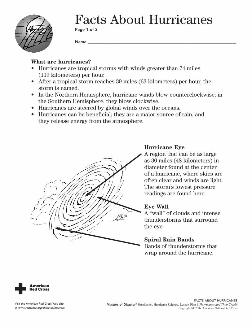
What are hurricanes?• Hurricanes are tropical storms with winds greater than 74 miles
(119 kilometers) per hour.• After a tropical storm reaches 39 miles (63 kilometers) per hour, the
storm is named.• In the Northern Hemisphere, hurricane winds blow counterclockwise; in
the Southern Hemisphere, they blow clockwise.• Hurricanes are steered by global winds over the oceans.• Hurricanes can be beneficial; they are a major source of rain, and
they release energy from the atmosphere.
Hurricane EyeA region that can be as largeas 30 miles (48 kilometers) indiameter found at the center of a hurricane, where skies areoften clear and winds are light.The storm’s lowest pressurereadings are found here.
Eye WallA “wall” of clouds and intensethunderstorms that surroundthe eye.
Spiral Rain BandsBands of thunderstorms thatwrap around the hurricane.
Facts About HurricanesPage 1 of 2
Name ________________________________________________________________________
FACTS ABOUT HURRICANESMasters of Disaster® Hurricanes, Hurricane Science, Lesson Plan 1/Hurricanes and Their Tracks
Copyright 2007 The American National Red Cross
Visit the American Red Cross Web site at www.redcross.org/disaster/masters

Facts About HurricanesPage 2 of 2
FACTS ABOUT HURRICANESMasters of Disaster® Hurricanes, Hurricane Science, Lesson Plan 1/Hurricanes and Their Tracks
Copyright 2007 The American National Red CrossVisit the American Red Cross Web site at www.redcross.org/disaster/masters
When and where do hurricanes form?• Atlantic hurricane season normally runs from June through November,
when the water temperature in these regions is relatively high.• Hurricanes form in the southern Atlantic Ocean, the Gulf of Mexico,
the Caribbean Sea and in the Pacific Ocean.
How do hurricanes form?• Hurricanes develop over warm tropical waters.• Hurricanes gather heat and energy through contact with warm ocean
waters.• Condensation of water vapor increases a hurricane’s power.• As warm air near the surface of the water moves toward the eye of
the hurricane, it converges, rises and fuels the storm.• A pronounced rotation develops around the eye of the hurricane.• This process then builds upon itself, developing a spiral band of
swirling clouds that is a hurricane.

Hurricane TrackingVocabularyPage 1 of 2
Name ________________________________________________________________________
HURRICANE TRACKING VOCABULARYMasters of Disaster® Hurricanes, Hurricane Science, Lesson Plan 1/Hurricanes and Their Tracks
Copyright 2007 The American National Red Cross
Visit the American Red Cross Web site at www.redcross.org/disaster/masters
Directions: Research to define these words. Use the words to completethe sentences that follow.
hemisphere latitude meteorologisthurricane longitude tracking
1. The lines that run parallel to the equator are called
_____________________________________________ lines.
2. The continents of North America, Europe and Asia are in the
Northern ______________________________________________.
3. _______________________________________________________
lines run from the North Pole to the South Pole.

Hurricane TrackingVocabularyPage 2 of 2
HURRICANE TRACKING VOCABULARYMasters of Disaster® Hurricanes, Hurricane Science, Lesson Plan 1/Hurricanes and Their Tracks
Copyright 2007 The American National Red CrossVisit the American Red Cross Web site at www.redcross.org/disaster/masters
4. A __________________________________ gives us current information
on weather.
5. A ___________________________________ is a huge storm that packs
strong winds and heavy rains. The word comes from the Spanish
word huracán.
6. _______________________ is something done by meteorologists to
help them make predictions about what direction a hurricane is headed.

Atl
anti
c H
urri
cane
Tra
ckin
g M
apP
age
1 o
f 2
Nam
e __
____
____
____
____
____
____
____
____
____
____
____
____
____
____
____
____
____
__
ATL
AN
TIC
HU
RR
ICA
NE
TRA
CK
ING
MA
PM
aste
rs o
f D
isas
ter®
Hur
rica
nes,
Hur
rica
ne S
cien
ce, L
esso
n Pl
an 1
/Hur
rica
nes
and
Thei
r Tr
acks
Cop
yrig
ht 2
007
The
Am
eric
an N
atio
nal R
ed C
ross
Visi
t th
e A
mer
ican
Red
Cro
ss W
eb s
ite
at w
ww
.red
cros
s.or
g/di
sast
er/m
aste
rs
95
o9
0o
85
o8
0o
75
o7
0o
65
o6
0o

Atlantic Hurricane TrackingMapPage 2 of 2
ATLANTIC HURRICANE TRACKING MAPMasters of Disaster® Hurricanes, Hurricane Science, Lesson Plan 1/Hurricanes and Their Tracks
Copyright 2007 The American National Red CrossVisit the American Red Cross Web site at www.redcross.org/disaster/masters
Directions: Using what you know about latitude and longitude, plot the following coordinates on the Atlantic Hurricane Tracking Map. Then, connectthe plots to make a line graph to show the path of Hurricane Georges.
DATE OF PLOT LATITUDE LONGITUDE
9/21/98 17˚ 62˚
9/22/98 18˚ 67˚
9/23/98 19˚ 72˚
9/24/98 21˚ 77˚
9/25/98 23˚ 80˚
9/26/98 26˚ 85˚
9/27/98 28˚ 88˚
9/28/98 31˚ 89˚
Coordinates for Hurricane Georges

September 13, 1998A tropical wave originates off the coast of Africa.
September 14The wave is upgraded to a tropical depression.
September 15The tropical depression is increasing in speed.
September 16The tropical depression is upgraded to a tropical stormmoving westward with wind speeds of 39 miles per hour(mph) (63 kilometers per hour [kph]). It receives its name—Tropical Storm Georges.
September 17Tropical Storm Georges is upgraded to Hurricane Georges and is predicted to be amajor category 4 storm by next week. Satellite imagery shows that an eye is beginningto form. Wind speeds are up to 75 mph (121 kph).
September 18The wind speed within Hurricane Georges picks up speed; it is now 90 mph (145 kph).Hurricane WATCHES are in effect for some of the islands.
September 19A hurricane WARNING is in effect for some of the islands. Wind speeds have increasedto 125 mph (201 kph).
September 20A hurricane WATCH is in effect for the Dominican Republic and Puerto Rico. Windspeeds decrease throughout the day, going from 135 mph to 115 mph (217 kph to 185kph).
Fact Sheet for HurricaneGeorgesPage 1 of 3
Name ________________________________________________________________________
FACT SHEET FOR HURRICANE GEORGESMasters of Disaster® Hurricanes, Hurricane Science, Lesson Plan 1/Hurricanes and Their Tracks
Copyright 2007 The American National Red Cross
Visit the American Red Cross Web site at www.redcross.org/disaster/masters

September 21A hurricane WARNING is in effect for the Dominican Republic and Puerto Rico. Windspeeds drop from yesterday’s 115 mph (185 kph) to 100 mph (161 kph).
September 22It is reported that five people were killed in Puerto Rico from Hurricane Georges.Flash floods and mudslides are reported in the Dominican Republic from yesterday’sstorm. The hurricane WARNING is discontinued on both these islands. A hurricaneWATCH is in effect for the Bahamas and southern Florida. By late evening, windspeeds decrease to 95 mph (153 kph) from 105 mph (169 kph) earlier in the day. In theevening, a hurricane WARNING is issued for the Bahamas and parts of Florida.
September 23Hurricane WARNINGS are still in effect for some of the islands and southern Florida.Wind speeds drop to 65 mph (105 kph).
September 24Hurricane Georges is headed for Florida—outer bands are now visible on local radar.Hurricane WARNINGS are still in effect for southern Florida. After hitting several ofthe islands, Hurricane Georges is back over water and is re-intensifying. Wind speedsincrease to 75 mph (121 kph).
September 25Wind speeds increase to 90 mph (145 kph) with a storm surge of 3 to 5 feet (0.9 to 1.5meters). Hurricane Georges is hitting the Keys and southern Florida hard. A tropicalstorm WARNING is in effect for the east coast of Florida. A hurricane WATCH is ineffect for the Gulf Coast.
September 26A hurricane WARNING is issued for the north Gulf Coast from Morgan City, Louisiana,to Panama City, Florida. A hurricane WATCH is issued from east of Panama City to St.Marks, Florida. There are dangerous flood threats from the storm surge and rainfall byearly morning. Wind speeds continue at 90 mph (145 kph).
Fact Sheet for HurricaneGeorgesPage 2 of 3
FACT SHEET FOR HURRICANE GEORGESMasters of Disaster® Hurricanes, Hurricane Science, Lesson Plan 1/Hurricanes and Their Tracks
Copyright 2007 The American National Red CrossVisit the American Red Cross Web site at www.redcross.org/disaster/masters

September 27The hurricane WATCH for east of Panama City to St. Marks, Florida, is discontinued. However, these areas are now under a tropical storm WARNING.
September 28Hurricane Georges makes final landfall at 4:00 a.m. near Biloxi, Mississippi, with windspeeds of 95 mph (153 kph). A hurricane WARNING remains in effect from MorganCity, Louisiana, to Panama City, Florida. The eye of the storm is passing over OceanSprings, Mississippi—stars can be observed. The storm drops 23 to 25 inches (58 to 64centimeters) of rain in southern Mississippi and Alabama; more is expected. HurricaneGeorges is downgraded to a tropical storm with wind speeds at 65 mph (105 kph).
September 29Tropical Storm Georges is downgraded to a tropical depression and is over Mobile,Alabama. Wind speeds decrease throughout the day from 50 mph (80 kph) to 30 mph(48 kph).
Fifteen people died as a result of Hurricane Georges in Puerto Rico and the U.S. main-land, and over 200,000 dwellings were damaged or destroyed.
Fact Sheet for HurricaneGeorgesPage 3 of 3
FACT SHEET FOR HURRICANE GEORGESMasters of Disaster® Hurricanes, Hurricane Science, Lesson Plan 1/Hurricanes and Their Tracks
Copyright 2007 The American National Red CrossVisit the American Red Cross Web site at www.redcross.org/disaster/masters