hydrogeologic data for the canal creek area, …
TRANSCRIPT

HYDROGEOLOGIC DATA FOR THE CANAL CREEK AREA,
ABERDEEN PROVING GROUND, MARYLAND,
APRIL 1986-MARCH 1988
By James P. Oliveros and Patrice Gernhardt
U.S. GEOLOGICAL SURVEY
Open-File Report 89-387
Prepared in cooperation with the
OFFICE OF ENVIRONMENTAL MANAGEMENT,
ABERDEEN PROVING GROUND, MARYLAND
Towson, Maryland
1989
DEPARTMENT OF THE INTERIOR
MANUEL LUJAN, JR., Secretary
U.S. GEOLOGICAL SURVEY
Dallas L. Peck, Director
For additional information write to:
District Chief U.S. Geological Survey 208 Carroll Building 8600 La Salle Road Towson, MD 21204
Copies of this report can be purchased from:
U.!f>. Geological SurveyBo<t»ks and Open-File Reports SectionBoX 25425, Federal CenterDenver, CO 80225

CONTENTS
PageAbstract............................................................... 1Introduction........................................................... 1
Description of study area......................................... 1Previous studies.................................................. 3Numbering system.................................................. 3Acknowledgments................................................... 3
Well construction...................................................... 4Data collection........................................................ 4Selected references.................................................... 7
ILLUSTRATIONS
Figure 1. Map showing location of the Canal Creek study area...... 22. Diagram showing typical well construction............... 53. Map showing site locations .............................. 6
4-11. Hydrographs showing water levels for4. Well 1A, April 1987 through March 1988 ........ 485. Well IB, September 1987 through March 1988 .... 486. Well 1C, July 1987 through March 1988 ......... 497. Well ID, June 1987 through March 1988 ......... 498. Well 7A, April 1987 through March 1988 ........ 509. Well 8C, April 1987 through March 1988 ........ 50
10. Well 16B, August 1987 through March 1988 ...... 5111. Well 18B, August 1987 through March 1988 ...... 51
12-20. Electric and gamma logs from borings drilled using the mud rotary method for12. Sites 1 and 2.................................. 5413. Sites 3 and 4.................................. 5514. Sites 5 and 6.................................. 5615. Sites 7 and 8.................................. 5716. Sites 11 and 15................................ 5817. Sites 29 and 104............................... 5918. Sites 117 and 121.............................. 6019. Sites 136 and TH1.............................. 6120. Sites TH2 and TH3.............................. 62
21-29. Gamma logs from borings drilled using the hollow-stem auger method for21. Sites 9, 10, 13, 14, 16, and 17................ 6322. Sites 18, 19, 20, 21, 22, and 23............... 6423. Sites 25, 26, 27, 28, 30, and 31............... 6524. Sites 32, 33, 34, 35, 36 and 37................ 6625. Sites 38, 39, 41, 43, 44, and 101.............. 6726. Sites 102, 106, 107, 108, 109, and 111......... 6827. Sites 112, 113, 114, 115, 118, and 120......... 6928. Sites 122, 123, 124, 126, 127, and 129......... 7029. Sites 130, 132, 133, 134, and 135.............. 71
iii
Table 1.2.3.
TABLES
Well-construction data..................................... 10Lithologic logs for well-cluster sites..................... 13Synoptic water-level measurements.......................... 44
For the convenience of readers who may prefer to use metric (International System) units rather than the inch-pound units used in this report, values may be converted by using the following factors:
Multiply inch-pound unit
inch (in.)
foot (ft)
by.
25.4
25,400.
0.3048
To obtain metric units
millimeter (mm)
micron
meter (m)
Sea level: In this report "sea level" defers to the National Geodetic Vertical Datum of 1929 (NGVD of 1929)--a geodetic datum derived from a general adjustment of the first-order level nets of both the United States and Canada, formerly called "Sea Level Datun} of 1929."
IV

HYDROGEOLOGIC DATA FOR THE CANAL CREEK AREA,
ABERDEEN PROVING GROUND, MARYLAND,
April 1986-March 1988
By James P. Oliveros and Patrice Gernhardt
ABSTRACT
This report is a compilation of hydrologic and geologic data collected for the period April 1986 through March 1988 for the Canal Creek area of Aberdeen Proving Ground, Maryland. Geologic data include lithologic logs for 73 sites and geophysical logs for 71 sites. Hydrologic data consist of hydro- graphs and synoptic water-level measurements. The hydrographs were taken from eight wells that were equipped with continuous water-level recorders, and the synoptic water-level measurements were made four times during the study. Well-construction data also are included for 149 observation wells.
INTRODUCTION
Description of Study Area
The Canal Creek study area is located in the Edgewood area of Aberdeen Proving Ground (APG), Harford County, Maryland (fig. 1). The study area lies within the Coastal Plain physiographic province and is underlain by uncon- solidated sediments which thicken to as much as 400 ft (feet). The sediments are primarily of the Potomac Group of Cretaceous-age, but a thin veneer of sediments of the Talbot Formation of Pleistocene-age overlie the Potomac Group sediments for most of the study area.
The sediments are divided into discrete aquifers and confining units that from the surface downward, are called the (1) surficial aquifer, (2) upper confining unit, (3) Canal Creek aquifer, (4) lower confining unit, and (5) lower confined aquifer (Don Vroblesky, U.S. Geological Survey, written commun., 1988). The Canal Creek and lower confined aquifers were pumped heavily between 1950 and 1968 to supply water for manufacturing activities. From 1968 until 1984, wells screened in the aquifers were used only as standby water-supply wells. In 1984, the Maryland Department of Health detected volatile organic contaminants in the ground water and the standby water-supply wells were no longer used for drinking water purposes. The U.S. Geological Survey (USGS) and the U.S. Department of Defense, Office of Environmental Management, began investigating the effects of ground-water contamination within the Canal Creek area in 1985.

PENNSYLVANIA
39 25'
39 20
Base from U.S. Geological Survey, .1: 100, 000.
3 Kl LOMETERS
Figure 1. Location of the Canal Creek study area

Previous Studies
Previous geologic data from the study area were limited to drillers' logs of the water-supply wells and lithologic logs from shallow (less than 35 ft) monitoring wells installed by the U.S. Army Toxic and Hazardous Materials Agency (THAMA). Geologic data as well as some hydrologic data are presented in a report published by THAMA (Nemeth and others, 1983). The USGS has collected water-level data from one of the standby water-supply wells since 1949.
Numbering System
Each test-boring and well-cluster site was assigned a sequential number based on the order in which the site was originally chosen for investigation. A distinction was made between first- and second-phase well-cluster sites. The first-phase sites were given a one- or two-digit number, with the first site being assigned number 1 and the last site being assigned number 44. The second-phase sites were given a three-digit number, with the first site being assigned number 101 and the last site mentioned in this report being assigned number 138. Some sites were eliminated after numbers were assigned; consequently, some numbers are missing from the sequences.
Three sites were chosen specifically as test-boring sites where only geophysical data were collected and no wells were installed. The sites were numbered TH1, TH2, and TH3. The borings were logged and then sealed with cement without emplacement of well casing.
Each well-cluster site contains one or more observation well. Individual wells are assigned a site number followed by a letter, with the letter corre sponding to the relative depth of each well. For example, site 1 contains six wells--1A, IB, 1C, ID, IE, and IF--with well 1A being the shallowest and well IF being the deepest. Two exceptions to this rule are wells 7A.1 and 12A.1. In both these cases, four wells were drilled in phase 1--7A, 7B, 12A, and 12B. A shallower well was added at each site in phase 2--7A.1 and 12A.1. Preceding each well number are the letters "CC" for Canal Creek. These letters are used in order to distinguish wells in the Canal Creek study area from wells in other study areas. Each well is also assigned a county well-permit number, but because the permits were obtained after the local numbers were assigned, the local numbers were retained. The permit numbers are listed in table 3; however, not all the wells were assigned a permit number by the time this report was written (November 1988).
Acknowledgments
Many people outside the U.S. Geological Survey facilitated the collection of lithologic and geophysical data during drilling operations. Thanks are given to Cynthia L. Couch of the Office of Environmental Management (OEM), Aberdeen Proving Ground, and David Parks, formerly of OEM, for their support of the study. Thanks are also given to the Technical Escort Unit for providing support during drilling operations, and to the U.S. Army Corps of Engineers for collecting core samples and providing geophysical logging equipment. Special thanks are given to John Bush, William Krynor, James Stefano, and Samuel Pastor of the U.S. Army Corps of Engineers for assisting in the collection of geophysical data.

WELL CONSTRUCTION
Detailed well-construction records (table 1) were kept for all monitoring wells, and uniform well-construction procedures were followed for the majority of the wells. All wells consist of a 4-in.-outside-diameter polyvinyl chloride (pvc) casing, and most contain a 4-in.-outside-diameter pvc screen that is 5 ft in length. A sand pack was installed around the screened interval up to 1 ft above the top of the screen (fig. 2). Bentonite pellets were placed above the sand pack 12 to 24 in. thick; a grout seal was placed around the outside of the casing from the top of the bentonite plug up to the land surface.
DATA COLLECTION
Data collection began in April 1986 with drilling of the observation wells. From April 1986 through March 1988, 149 observation wells were installed at 75 sites (fig. 3) in two phases of drilling. Detailed geologic data (table 2) were collected at each site during drilling except at sites 12 and 121. Synoptic water-level measurements (table 3) were made four times and water-level recorders were installed on Selected wells for recording water levels at 15-minute intervals (figs. 4-11). Additionally, geophysical logs were run at 71 sites (figs. 12-29).
There was a total of 78 sites where borings were made in conjunction with the study. Wells were only installed at 75 of the sites. The other three sites were only used for test borings. At 37 of the well sites, test borings were drilled prior to the installation of wells. Geologic and geophysical data were generally collected from the test borings; therefore, the depths of the geologic data and geophysical logs in table 2 do not necessarily corre spond with the well depths in table 1. In other cases, core samples were not taken to the total depth of the boring.
The hydrogeologic data presented in this report are only part of the overall data base from the study. Chemical data from the sampling of the first-phase wells also were collected (Michelle M. Lorah and Don A. Vroblesky, U.S. Geological Survey, written commun., 1988) and the collection of hydro- logic data is ongoing.

ll
12*-24"
< »
4-INCH O.D. FLUSH-JOINTED-
PVC CASING
4-INCH O.D. FLUSH-JOINTED
PVC SCREEN - C0.01 SLOT)
1T\
>WWNA/V%
^
TE (
I~-^~^
:-:;-'^
V PORTLAND CEMENT 3ROUT CTO SURFACE)
BENTONITE PELLETS
t 12"
QUARTZ SAND PACK
NOT TO SCALE
Figure 2. Typical well construction.

39° 25'
76°19'
39° 2/
39° 2^
Ba
se m
od
ified
from
E
dgew
ood m
ap. E
ngin
eerin
g
Pla
ns
and
Se
rvic
es
Div
isio
n,
Ab
erd
ee
n P
rovin
g
Gro
un
d,
1984
TH
2E
XP
LAN
AT
ION
Test
bo
ring
location and num
ber
0 5
00
1
00
0
20
00
F
EE
TI
'. '
.' f ' /
0 3
00
6
00
M
ET
ER
S
133ffi
Test boring lo
catio
n
and number w
here w
ell w
w
as late
r insta
lled.
Figure 3
. Site
loca
tions.
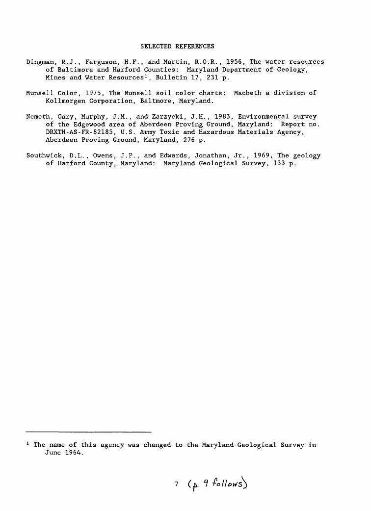
SELECTED REFERENCES
Dingman, R.J., Ferguson, H.F., and Martin, R.O.R., 1956, The water resources of Baltimore and Harford Counties: Maryland Department of Geology, Mines and Water Resources 1 , Bulletin 17, 231 p.
Munsell Color, 1975, The Munsell soil color charts: Macbeth a division of Kollmorgen Corporation, Baltmore, Maryland.
Nemeth, Gary, Murphy, J.M., and Zarzycki, J.H., 1983, Environmental survey of the Edgewood area of Aberdeen Proving Ground, Maryland: Report no. DRXTH-AS-FR-82185, U.S. Army Toxic and Hazardous Materials Agency, Aberdeen Proving Ground, Maryland, 276 p.
Southwick, D.L., Owens, J.P., and Edwards, Jonathan, Jr., 1969, The geology of Harford County, Maryland: Maryland Geological Survey, 133 p.
1 The name of this agency was changed to the Maryland Geological Survey in June 1964.

TABLES 1 THROUGH 3

Drilling method: Auger
Well installed using hollow-stem auger. Mud
rotary Well
installed using mud rotary with bentonite mud.
Aquifer: S
Surficial aquifer CC
Canal Creek aquifer LC
Lower confined aquifer I
Unidentified isolated sand lense
Local Site Permit Altitude Drilling Depth of Screened number
identification number of land method boring interval Aquifer number
surface (in feet) (depth in feet)
oo
ou
M O
O.J
.J
00000
r» CM CM * m
CM m r» m
r»i
i i
i i
00000
CM r» r» O) oo
CM * CO * CO
r» CM CM * m
CM m r» m
r»
hh
M
M
CO CO
M
M
M *3
4J 0)
0) 0)
O
O
W «
«C
M
f-t 333
<<
<*a
*a
II
«-i oo o m
*00
1*^ 00 00 00
m * m
co r»
O)
O) O
) O) O
) CM
CM CM
CM CM
1 1
1 1
100
00 00 00 001
1 1
1 1
&3 &3 &3 &3 &3
o o
o o
oCM
CM CM
CM CM
CM
CM CM
CM CM
CO
C
O
CO
C
O
CO
o o
o o
o
m m
m m
mCO
CO
CO CO
CO
CO
CO CO
CO CO
CM
CM CM
CM CM
O
) O
) O) O
) O)
CO
CO CO
CO CO
< PQ
O Q
Wi-H
i-H
r-l
r-l r-l
1 1
1 1
1
88888
o o
o o
o,J
OiJ
.J O
o o
o o
o
oo co m o
o00
CO
-4"
00
-4"
1 1
1 1
1
00
00
0
co «-i o m
m00
CO
*
!**
CO
oo co m r» o
o> co -a- oo *
^
>>>>>>W
M
M
M
CO
(0 (0
(04J
M
+J
+J
+J
O
0) O
O
O
M
60 M
M
U
3
*O <
! *O *O
*O
1 III
«-i oo co m oo
00 00 00 1*^ 00 r-l
00 O) O
CO
00 0
0 O
) O)
O) O
) O) O
) CM
01 0
1 0
11
1 1
1 1
00 00 00 001
1 1
1&
3 SB SB &3
o o
o o
o
CM r»
r» r»
o
CM CM
CM C
N m
r» oo oo oo coC
O
CO
C
O
CO
C
O
00000
m oo oo oo co
CO CM
CM C
N C
N
CO CO
CO
CO CO
CM
CM CM
CM CM
O
) O) O
) O) O
) CO
CO CO
CO CO
Pn <
03 O
<
r-l CM CM
CM CO
1 1
1 1
1
88
88
8
o o
o o
o
O O
O O
M O
000000
m co o
o> o o>
co oo o> o> CM m
1 1
1 1
1 1
o o
o o
o o
o oo oo m
m -4-
CO
r»
00
O> r-l
in
m co o>
o o>
ID
CO O
) CM
m
& &
CO CO
4J M
4J M
M
O
CO O
CO
CD M
60 M
O
O«0
3
33
TK
-O
< *
£
£
CM
CO CM
m
00
O) co *
r» corH
C
M
CM
«-H
tH
* co r» O
) oO
) O) O
) O
) O
O)
O) O
) O
) O
CM CM
CM
CM CO
III
II
00 00 00
00 00
III
II
tS tS a3 tS tS
o o
o
o o
o
co co m
m
m co co
m m
00
0
00
co
co co
r^
p^
CM CM
CM
CM CM
CO
CO
CO
CO CO
CM
CM CM
CM
CM
O)
O) O
) O
) O
) CO
CO
CO
CO
CO
n <! n
<! n
co * *
m m
III
II
888
88
o
o o
o o
O
O O
.J O
m m
o
o
om
CM m co co o
co r» oo oo co oo CM co
r-l1
1 1
1 1
1 1
m m
o o
o o
oco o
co oo <H m co
r» oo oo m oo rH
mrH
m
co co co cooo
co oo CM r»r-l
6O
00 0
0 6
0 0
0
^ 3
35
3
00
0 »
O
) 0
r^ co co in
oorH
C
M
CM
C
M
CM
«-H C
O -*
0o
o o
m
o
o o
o
CO
C
O
CO
«
^1
1 1
1 1
00 00 00
001
III
3 $$
3
o
o o
o o
m
CM CM CM CM
0
00
00
r» *
* *
CMC
M
* * *
CO
C
O
CO
C
O
CO
C
O
01
01 01 01 01
O>
O)
O)
O)
O)
CO
C
O
CO
C
O
CO
rH
o
< m
o <
in
co co co r»
1 1
1 1
1
800 o
o
o o
o o
oo
oO
O M
M O
o o
o o
mo r» CM o
* o> o
m oo o>
iH1
1 1
1 1
o o
o o
mm
CM co m o>
oo o * r^ oo
r-l
o r» CM o
in
o> o m
oo o>iH
6O
6O
bO 00 0
0
33333
co o m
* in00 00
00 00 00 CM
CM «-H r-l iH
in co r» oo O
) o o
o o
o
o o
o o
oC
O
CO
C
O
CO
C
O1
1 1
1 1
00 00 00 CO 00
1 1
1 1
1
tS tS
tS S3 S3
00000
00000
CO
C
O
CO
C
O
CO
C
O
CO
C
O
CO
C
O
0]
0]
0] 0
] 0]
O)
O)
O)
O)
O)
CO
C
O
CO
C
O
CO
<C
Q <
CQ
O
r^ r^ oo oo oo 1
1 1
1 1
oo o
o o
oo o
o o
o iJ tn o
M
o m
o o
om
r-i co co r»r-l
O r-l C
M r-l
iH 0]
r-l1
1 1
1 1
o m
o o
o
0
CO
00 00
CM
iH
O
) r-l
r-l iH
r-l
r-l
in CM co co r»
r-l O
r-l C
M r-l
«-ICM «-i
& &
CO CO
M 4J
M 4J
M
CD O
CD
O
CD 00 U
00
U
00 333
<*a
<*a
<1
1
CO CM
O) O
) *
r-l 0 O
) O
) 00
0 r-l 0
] C
O m
r-l r-l r-l r-l
r-l 00000
CO
C
O
CO
C
O
CO
1 1
1 1
100 CO
00 00 00
1 1
1 1
1 &3 &3 &3 &3 &3
a- m r-i CM r-t
o o
o o
oC
O
CO
C
M C
M O
00000
CO
C
O iH
iH
iH
C
O
CO
C
O
CO
C
O
CM
CM
CM
C
M
CM
O
) O
) O
) O
) O
) C
O
CO
C
O
CO
C
O<Q
W <
CQ 0
00 00 O
) O) r-l
1 1
1 1
1oo o
o o
oo o
o o
00
0
0
O O
M O
O
o o
o o
ooo r-t o> r» mC
O
CO
r-l
CO
C
O
r-l r-l
iH r-l
1 1
1 1
1
O O
O
O
O
co co -a- CM oC
O in
r-l
CO
C
O
r-l r-l
iH r-l
00 r-l
^-
in O
co co CM » r»
r-l r-l
r-l r-l
&&
&
&
CO CO
CO CO
4J
+J
M
+J
+J
O
O
CD O
O
14
W
00 W
W
a >a < *a *a II II
oo m r» -s- m
co co co r» co
r» oo O
) or-l r-l
r-l CM
00
00
C
O
CO
C
O
CO
1 1
1 1
1
00 00 00 00
II
II
&3 &3 &3 &3
r-l CM
C
O r-l
CM
O
O
O
O
O
O
) O
) C
O
CO
C
O
CO
<
rt (ft
(ft (ft
00000
01
CM
00 00
00
CO
C
O 0 0 0
CO
C
O
CO
C
O
CO
C
M 0
1
01 0
1 01
O)
O)
O)
O)
O)
CO
C
O
CO
C
O
CO
iH
2S
338
1 1
1 1
1o o
oo o
o o
oo o
00000
o o
oo
o
o o
o o
oo> co o
m «
CM m co m
CM1
1 1
1 1
o o
o o
o *
r-l
in O
O
)CM m
CM m r-t
o> co o m
* CM m
co m CM
GO ao BOM
BO33333
co co m »
r«.
oo oo r» r» in
in CM co * in
CM CM CM CM CM o o
o o
oC
O
CO
C
O
CO
C
O1
1 1
1 1
00 00 00 00 001
1 1
1 1
&3 &3 &3 &3 &3
r-l C
M
«-H CM
«-H
O O
O
O
O
*
*
O
O
O
C
M
CM
C
O
CO
C
O
00000
o o
o o
o
»
* *
» ^
CM
CM CM
CM CM
O
) O) O
) O)
O)
CO
CO CO
CO
CO
<m
<m
<
co co * « m1
1 1
1 1
o o
oo
o
o o
oo
o
88°i°i8
o o
o o
oCO
00 00 O
-4* CM
CO
00 CM CM
iH1
1 1
1 1
o o
o o
ooo co co in o)r-l
CO
00 r-l r-l r-l
CO
00
00 O
-4*
CM
C
O
00 C
M
CM
iH&
«
CD CD
CD O
CD
00 60
60 H
00
333-o3 1
r» 0
00 r-l
r-l
r-l CM
r-l C
M 0
r»
00
O) 0 iH
C
M C
M
CM
CO
CO
00000
CO
C
O
CO
C
O
CO
1 1
1 1
1
00 00 00 00 00
1 1
1 1
1
33
33
3
r-l CM CO
* r-l
00000
CM CM
CM CM
CMm
m m
m m
00000
m m
m m
mCO
CO CO
CO CO
CM
CM CM
CM CM
O
) O)
O) O
) O)
CO CO
CO CO
CO
<«
OQ
<
co co co co r»
1 1
1 1
1oo o
oo
OO
O O
O
O O
O O
O
.J O
O M
o o
o o
oin
CO
C
M 0 r-l
co o in
r» r-tiH
1
1 1
1 1
o o
m o
oo
oo r^ m co
CO
O
) *
C
O
m co CM o
r-i co o
m r» r-t
iH
MM
flOa
n M
33
33
3
CM CO
00 O
) -*
O O
O) O
) 00
CM co * m co
CO
C
O C
O C
O
CO
00000
CO
C
O
CO
C
O
CO
1 1
1 1
1
1 1
1 1
1 &3 &3 &3 &3 &3
CM CO
r-l CM r-l
O O
O O
O
CM
CM CO
CO *
m m
o o
r-iCO
00 00 00 00
00000
m m
o o
*CO
CO *
* CO
CM
CM CM
CM CM
O
) O) O
) O)
O)
CO CO
CO CO
CO
03 o <
m <
r^ r^ oo oo O
)
1 1
1 1
1
Bo o
o o
o o
o o

Table 1. Well-construction data Continued
[ , data not available]
Site identification number: Latitude and longitude plus a 2-digit sequence number.
Altitude: In feet above sea level.
Drilling method: Auger Well installed using hollow-stem auger.Mud rotary Well installed using mud rotary with bentonite mud.
Aquifer: S Surficial aquiferCC Canal Creek aquiferLC Lower confined aquiferI Unidentified isolated sand lense
Local number
CC-19BCC-20ACC-20BCC-20CCC-20D
CC-21ACC-22ACC-22B
CC-22CCC-23ACC-23BCC-25ACC-25B
CC-26ACC-26BCC-26CCC-27ACC-27B
CC-28ACC-28BCC-28CCC-29A
CC-29B
CC-30ACC-31ACC-32ACC-32BCC-33A
CC-33BCC-34ACC-35ACC-36ACC-36B
CC-36CCC-36DCC-37ACC-38ACC-39A
CC-39BCC-40ACC-41ACC-42ACC-43A
CC-44ACC-101ACC-101BCC-101CCC-102A
CC-102BCC-102CCC-104ACC-104BCC-104C
Site identification
number
392348076181402392341076175401392341076175402392341076175403392341076175404
392358076182401392337076175701392337076175702
392337076175703392339076181301392339076181302392338076182301392338076182302
392342076182601392342076182602392342076182603392343076183301392343076183302
392340076183401392340076183402392340076183403392328076180201
392328076180202
392355076182201392350076184301392311076161601392311076161602392314076161401
392314076161402392312076161501392307076162801392340076180201392340076180202
392340076180203392340076180204392415076180001392416076175001392416076180301
392416076180302392417076180101392417076180201392415076175701392414076175801
392405076183701392341076174001392341076174002392341076174003392339076172201
392339076172202392339076172203392333076170201392333076170202392333076170203
Permit number
HA-81-3037HA-81-3038HA-81-3039HA-81-3040HA-81-3041
HA-81-3043HA-81-3048HA-81-3049
HA-81-3050HA-81-3051HA-81-3052HA-81-3056HA-81-3057
HA-81-3058HA-81-3059HA-81-3060HA-81-3061HA-81-3062
HA-81-3063HA-81-3064
HA-81-3065
HA-81-3066
HA-81-3067HA-81-4076HA-81-4046HA-81-4047HA-81-4048
HA-81-4049HA-81-4045HA-81-4044HA-81-4075
--
HA-81-4043HA-81-4042HA-81-4041
HA-81-4040HA-81-4039HA-81-4038HA-81-4037
--
HA-81-4077 --
--
Altitude of land surface
28.411.210.910.410.8
14.211.711.9
12.320.420.412.112.1
12.913.013.611.411.2
10.910.810.36.5
6.6
21.49.113.314.114.3
14.214.614.214.514.3
14.214.232.131.631.4
31.531.234.633.830.0
11.912.312.311.623.4
23.025.812.412.713.0
Drilling method
AugerAugerAugerAugerAuger
AugerAugerAuger
AugerAugerAugerAugerAuger
AugerAuger
Mud rotaryAugerAuger
AugerAugerAugerAuger
Auger
AugerAugerAugerAugerAuger
AugerAugerAugerAugerAuger
AugerAugerAugerAugerAuger
AugerAugerAugerAugerAuger
AugerAugerAugerAugerAuger
AugerAugerAugerAugerAuger
Depth of boring (in feet)
5816345974
352750
7021572745
2040
1492340
2150
13715
47
4237194319
7022502644
6293434829
6334574957
3714285674
891188799
129
Screened interval
(depth in feet)
53.0 - 58.011.0 - 16.025.0 - 30.054.0 - 59.068.0 - 73.0
30.0 - 35.022.0 - 27.045.0 - 50.0
65.0 - 70.016.0 - 21.052.0 - 57.022.0 - 27.040.0 - 45.0
15.0 - 20.035.0 - 40.0144.0 -149.018.0 - 23.035.0 - 40.0
16.0 - 21.045.0 - 50.0120.0 -125.0
7.7 - 9.712.5 - 15.042.0 - 47.0
36.0 - 41.025.0 - 30.010.5 - 15.521.0 - 26.011.0 - 16.0
62.0 - 67.014.0 - 19.024.0 - 29.010.0 - 15.039.0 - 44.0
56.0 - 61.088.0 - 93.023.0 - 28.034.0 - 39.020.0 - 25.0
35.0 - 40.026.0 - 31.039.0 - 44.022.0 - 38.033.0 - 38.0
16.0 - 21.05.0 - 10.017.0 - 22.045.0 - 50.065.0 - 70.0
81.0 - 86.0100.0 -105.076.0 - 81.091.0 - 96.099.0 -129.0
Aquifer
CCSSCCCC
CCSCC
CCSCCCCCC
CCCCLCCCCC
CCCCLCSSCC
CCCCSSS
SSSSCC
CCCCCCCCCC
CCCCCCCCCC
CCSCCCCCC
CCCCCCCCCC
11

Table 1. Well-construction data Continued
[ , data not available]
Site identification number: Latitude and longitude plus a 2-digit sequence number.
Altitude: In feet above sea level.
Drilling method: Auger Well installed using hollow-stem auger.Mud rotary Well installed using mud rotary with bentonite mud.
Aquifer: S Surficial aquiferCC Canal Creek aquiferLC Lower confined aquifer
Local number
CC-106A CC-107A CC-107B CC-108A CC-108B
CC-109A CC-109B CC-110A CC-111A CC-111B
CC-112A CC-113A CC-113B CC-114A CC-114B
CC-114C CC-115A CC-117A CC-117B CC-118A
CC-118B CC-120A CC-120B CC-121A CC-121B
CC-122ACC-123ACC-123BCC-124ACC-124B
CC-126ACC-127ACC-128ACC-129ACC-130A
CC-130BCC-131ACC-132ACC-133ACC-133B
CC-134ACC-134BCC-135ACC-136ACC-136B
CC-138A
I
Site identification
number
392320076175601 392404076180301 392404076180302 392358076180001 392358076180002
392357076181401 392357076181402 392353076182001 392352076182601 392352076182602
392351076183101 392345076182701 392345076182702 392344076182401 392344076182402
392344076182403 392346076182401 392343076170201 392343076170202 392401076181601
392401076181602 392406076175701 392406076175702 392348076170401 392348076170402
392425076181501392316076181501392316076181502392355076173401392355076173402
392314076164601392316076170401392314076165901392312076170301392359076182301
392359076182302392310076164101392309076163901392343076175401392343076175402
392323076182401392323076182402392309076164501392340076165101392340076165102
392351076181401
Unidentified isolated
Permit Altitude number of land
surface
22. 29. 29. 29. 29.
17. 17. 22. 15. 16.
9. 15. 15. 18. 17.
17. 27. 9. 9.
14.
15. 32. 32. 10. 10.
28.27.27.17.17.
24.24.22.27.14.
14.12.16.23.23.
21.20.20.23.23.
32.
8 7 3 6 4
0 2 8 1 2
8 3 1 2 0
8 4 1 1 7
0 0 1 4 1
99743
04358
28763
06405
5
sand
Dri me
Au Au Au Au Au
Au Au Au Av Av
At Av Av Av AU
AU Au AU AuAU
Au AU Au Avj Ai
lense
lling thod
ger ger ger ger ger
ger ger ger ger ger
ger ger ger ger ger
ger ger ger ger ger
ger ger ger ger ger
AugerAugerAv^gerAugerAviger
AugerAugerAugerAugerAv»ger
AugerAugerAugerAugerAuger
Av^gerAtjigerAugerAtAt
At
gerger
ger
Depth of boring (in feet)
96 58 88 60 74
47 69 53 32 43
39 40 64 20 44
64 60 83
103 39
59 64 74 93
105
4391
1091974
2418143341
5418182474
799933
104144
12
Screened interval
(depth in feet)
90 51 66 55 68
36 59 40 25 31
29 30 51 12 36
53 43 78 95 32
51 55 65 68 91
2277
1011367
1366
1732
4711111560
70931498
, 133
5
0 0 0 0 0
0 0 0 0 0
0 0 0 0 0
0 0 0 0 0
0 0 0 0 0
00000
00050
05000
00000
0
- 95 - 56 - 71 - 60 - 73
- 41 - 64 - 45 - 30 - 36
- 34 - 35 - 56 - 17 - 41
- 58 - 48 - 83 -100 - 37
- 56 - 60 - 70 - 93 - 96
- 27- 82-106- 18- 72
- 18- 11- 11- 22- 37
- 52- 16- 16- 20- 65
- 75- 98- 19-103-138
- 10
0 0 0 00
0 0 0 0 0
0 0 0 0 0
0 0 0 0 0
0 0 0 00
00000
00050
05000
00000
0
Aquifer
CC CC CC CC CC
CC CC CC CC CC
CC CC CC S CC
CC CC CC CC CC
CC CC CC CC CC
CCCCCCSCC
SSSSCC
CCSSSCC
CCCCSCCCC
I
12

Table 2. Lithologic logs for well-cluster sites
[Alphanumeric codes enclosed in brackets, at selected horizons, refer to color designations as specified in the Munsell Soil Color Charts (1975)]
Sand grade scale
Grain size Term(in microns)
1,410-2,000 vcU1,000-1,410 vcL
710-1,000 cU500- 710 cL350- 500 mU250- 350 mL177- 250 fU125- 177 fL88- 125 vfU62- 88 vfL
Description
SITE 1
Fill material, sand and gravelCrystalline material, black; with black nodular crystalsSand, clayey, brown, (mL)Sand, brown-gray, wet; brown mU near top and gray (fU) near bottom, sorting moderate
to goodClay, gray, plastic; with patches of maroon sandy claySand, gray to brown, well-sorted (mL-mU)Sand, same as above with maroon irregular banding and small lenses of light gray
clay and purple nodulesSand, tan, well-sorted (mU-cL) , wetSand and gravel, white, poorly sorted (mL-vcU to 2 in.), lignitic; with isolated
maroon stainingNo sampleClay, gray to light pink, friableNo sampleSand and gravel, white to tan, poorly sortedNo sampleSand, white, poorly sorted (vfL-vcU); with patches of purpleSand, clayeyNo sampleSand, light brown, well-sorted (mL-mU)Clay, gray to light pink; with floating gravel and black nodulesSand, tan, well-sorted (mU); alternating with darker clayey sand and gravelClay, dark gray to silver, friable; with sand and gravel lensesClay, brown, friableClay, black, friable, ligniticClay, dark gray, plasticClay, light gray and brick red mottled, friable; with dark green blotches at borders
between gray and redClay, silty, green to gray, friableSand, gray, poorly sorted (vfL-mL) , micaceousClay, sandy, dark gray, ligniticLignite, massive; with well preserved plant fragmentsClay, multicolored (gray, green, brown, red), plasticNo sampleSand, gray (fu-mL), clean, micaceousNo sampleSand, light gray, clean, well-sorted (mU), micaceousNo sampleSand, grayish tan, well-sorted (mU), micaceous
Depth(ft)
2.32.95.0
15.316.035.0
40.057.0
61.063.065.067.069.071.072.473.075.079.680.084.486.087.590.093.1
99.0100.0106.2107.5108.9130.0170.6170.9181.5182.0186.4186.8
Thickness(ft)
2.30.62.1
10.30.7
19.0
5.017.0
4.02.02.02.02.02.01.40.62.04.60.44.41.61.52.53.1
5.91.06.21.31.4
21.140.60.3
10.60.54.40.4
13

Table 2. Lithologic logs for well-cluster sites Continued
[Alphanumeric codes enclosed in brackets, at selected horizons, refer to color designations as specified in the Munsell Soil Color Charts (1975)]
Sand grade scale
Grain size Term(in microns)
1,410-2,000 vcU1,000-1,410 vcL
710-1,000 ell500- 710 cL350- 500 mU250- 350 ml,177- 250 ftf125- 177 fl88- 125 vl62- 88 vJ
TJT,
Description
SITE 2
Soil zone, brownSand, clayey, orange and gray-brown mottled, poorly sortedClay, sandy, brown, wetSand, clayey, light gray, poorly sorted (vfU-mL)Clay, gray; with thin sand lensesSand and gravel, white, orange-stainedSand, light gray, black-stainedSand and gravel, white, coarseClay, silty, brick-red and gray mottling, friableSand, silty, light gray, well-sorted (fL-fU), micaceousClay, sandy, red, brown, yellow, and gray mottled; friableSand, silty, light gray, poorly sorted (fL~fU)Clay, silty, mottled as before, friable, lignitic, denseSand, clayey, light gray, poorly sorted
Depth(ft)
2.04.06.2
10.012.036.940.048.058.067.768.068.782.283.0
Clay, silty, mottled as before, friable, micaceous; with thin gray sand lenses 92.0No sample 96.0Clay, silty, mottled as before, friable, micaceous; with thin gray sand lenses 98.0No sampleSand, silty, light gray (fU-mL); with thin gray clay lenses
110.0138.0
Sand, light gray, clean, well-sorted (mL-cL) , lignitic; with small gravel 151.1No sampleClay, sandy, dark brown, maroon and gray, friableNo sampleClay, silty, dark gray, friable, micaceousSand, silty, silver-gray (fL) micaceousSand, light gray, clean, well-sorted (mU)
164.0165.2176.0176.5179.9181.2
Thickness(ft)
2.02.02.23.82.0
24.93.18.0
10.09.70.30.713.5
.89.04.02.012.028.013.112.91.2
10.80.53.41.3
Note: Beginning at 16 ft, sample cores were taken every other 2 ft; therefore, the data were interpolated unless more than 2 ft of sample were missing.
Description Depth (ft)
Thickness (ft)
SITE 3
No sampleClay, silty, light gray and red, micaceousSilt, clayey, light gray, micaceousNo s ampleSilt, clayey, red and olive mottledNo sampleClay, silty, dark gray, friable, lignitic, micaceousSand and gravel, white, clean, coarseClay, white, plasticSand and gravel, buff to white, coarseClay, white; with iron concretions at sharp upper contact
56.057.060.086.090.0120.0129.0145.0148.0176.0177.0
56.01.03.0
26.04.0
30.09.0
16.03.0
28.01.0
14

Table 2. Lithologic logs for well-cluster sites Continued
[Alphanumeric codes enclosed in brackets, at selected horizons, refer to color designations as specified in the Munsell Soil Color Charts (1975)]
Sand grade scale
Grain size Term(in microns)
1,410-2,000 vcU1,000-1,410 vcL710-1,000 cU500- 710 cL350- 500 mU250- 350 mL177- 250 fU125- 177 fL88- 125 vfU62- 88 vfL
Description
SITE 4
Soil, silty, gray-brown to orangeSilt, clayey, graySand, silty, gray to orangeSilt, clayey, grayClay, red-brown and light gray mottled, plasticSilt, sandy, gray, micaceous; sand up to (fU)Clay, silty, brown, friableSilt, sandy, gray, micaceous; sand up to (mU)Clay, silty, red-brown, friableClay, silty, gray-brown, friable, finely laminatedSand, silty, gray, finely laminated; interbedded with lignitic, micaceous layers of
clayey siltSand, tan, clean, well-sorted (mU)Sand, white to yellow; with ochre and lavender bandingSand, yellow-brown, well-sorted (mL-mU)Sand, silty, red-brown; with lenses of gray claySilt, multicolored, clayeySand and gravel, yellow-orange; with multicolored bandsClay, white; with orange-rust lenses and hard iron concretions at sharp upper contactNo sampleClay, dark gray, lignitic
Description
SITE 5
Soil, clayey, brownSand, clayey, brown, micaceous, ligniticSand, light brown, well-sorted (mL)Silt, clayey, gray and brown mottledSand, tan to orange, well-sorted (mU)Sand, pink to gray, well-sorted (mL-cU)Clay, gray, plasticClay, red and gray mottled, plasticSand, silty, pink-gray, poorly sorted (fU-clay)Sand, light gray, well-sorted (mL-mU), loose, wetClay, gray; with fine laminae of lignitic sandSand, gray; with fine laminae of lignite-rich sandClay, graySand, gray; with fine laminae of lignitic sandSand, silty, gray, poorly sorted (mL-silt), micaceous, ligniticClay, sandy, yellow-ochre, micaceous; with multicolored bandingSand, wet (poor recovery)Sand and gravel, clean, white to pink, well-sorted (mil-gravel)Sand and gravel, silty, orange, poorly sorted with black coatings at lower contactClay, dark gray to brown, friable, thinly laminated; with sharp upper contactClay, brown to red, plastic; (no core, based on cuttings)
Depth(ft)
4.09.7
12.919.045.545.846.448.649.950.7
77.478.479.385.085.586.0
105.9107.5118.0120.0
Depth (ft)
0.710.412.414.818.627.231.547.049.050.353.055.155.460.267.369.275.085.686.993.0120.0
Thickness(ft)
4.05.73.26.1
26.50.30.62.21.30.8
26.71.00.95.70.50.5
19.91.6
10.52.0
Thickness (ft)
0.79.72.02.43.88.64.3
15.52.01.32.72.10.34.87.11.95.8
10.61.36.1
27.0
15
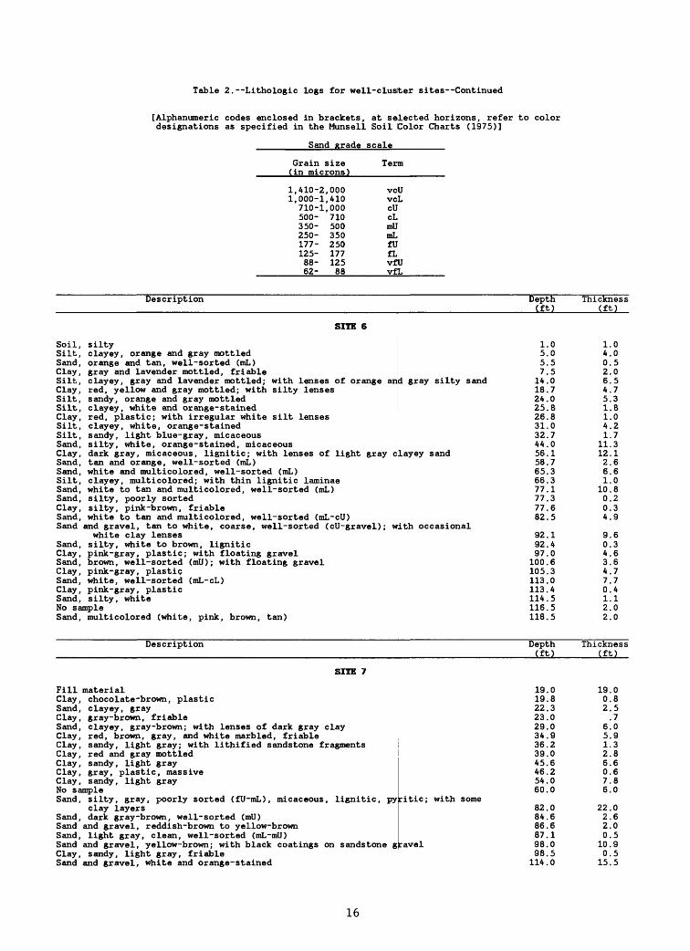
Table 2. Lithologic logs for well-cluster sites Continued
[Alphanumeric codes enclosed in brackets, at selected horizons, refer to color designations as specified in the Munsell Soil Color Charts (1975)]
Sand grade scale
Grain size Term(in microns)
1,410-2,000 vc1,000-1,410 vc
710-1,000 cU500- 710 cL350- 500 mU250- 350 mL177- 250 fU125- 177 fL88- 125 vf62- 88 vf
UL
UL
Description Depth(ft)
SITE 6
Soil, siltySilt, clayey, orange and gray mottledSand, orange and tan, well-sorted (mL)Clay, gray and lavender mottled, friableSilt, clayey, gray and lavender mottled; with lenses of orange anClay, red, yellow and gray mottled; with silty lensesSilt, sandy, orange and gray mottledSilt, clayey, white and orange-stainedClay, red, plastic; with irregular white silt lenses
1.05.05.57.5
d gray silty sand 14.018.724.025.826.8
Silt, clayey, white, orange-stained 31.0Silt, sandy, light blue-gray, micaceous 32.7Sand, silty, white, orange-stained, micaceous 44.0Clay, dark gray, micaceous, lignitic; with lenses of light gray clayey sand 56.1Sand, tan and orange, well- sorted (mL) 58.7Sand, white and multicolored, well-sorted (mL) 65.3Silt, clayey, multicolored; with thin lignitic laminae 66.3Sand, white to tan and multicolored, well-sorted (mL) 77.1Sand, silty, poorly sorted 77.3Clay, silty, pink-brown, friable 77.6Sand, white to tan and multicolored, well-sorted (mL-cU) 82.5Sand and gravel, tan to white, coarse, well-sorted (ell-gravel); with occasional
white clay lenses 92.1Sand, silty, white to brown, lignitic 92.4Clay, pink-gray, plastic; with floating gravel 97.0Sand, brown, well-sorted (mU); with floating gravel 100.6Clay, pink-gray, plastic 105.3Sand, white, well-sorted (mL-cL) 113.0Clay, pink-gray, plastic 113.4Sand, silty, white 114.5No sample 116.5Sand, multicolored (white, pink, brown, tan) 118.5
Description Depth (ft)
SITE 7
Fill material 19.0Clay, chocolate-brown, plastic 19.8Sand, clayey, gray 22.3Clay, gray-brown, friable 23.0Sand, clayey, gray-brown; with lenses of dark gray clay 29.0Clay, red, brown, gray, and white marbled, friable 34.9Clay, sandy, light gray; with lithified sandstone fragmentsClay, red and gray mottledClay, sandy, light grayClay, gray, plastic, massiveClay, sandy, light grayNo sampleSand, silty, gray, poorly sorted (fU-mL), micaceous, lignitic, py
clay layersSand, dark gray-brown, well-sorted (mU)Sand and gravel, reddish-brown to yellow-brownSand, light gray, clean, well-sorted (mL-mU)Sand and gravel, yellow-brown; with black coatings on sandstone g
36.239.045.646.254.060.0
ritic; with some82.084.686.687.1
ravel 98.0Clay, sandy, light gray, friable 98.5Sand and gravel, white and orange- stained 114.0
Thickness(ft)
1.04.00.52.06.54.75.31.81.04.21.7
11.312.12.66.61.0
10.80.20.34.9
9.60.34.63.64.77.70.41.12.02.0
Thickness (ft)
19.00.82.5.7
6.05.91.32.86.60.67.86.0
22.02.62.00.510.90.515.5
16

Table 2. Lithologic logs for well-cluster sites Continued
[Alphanumeric codes enclosed in brackets, at selected horizons, refer to color designations as specified in the Munsell Soil Color Charts (1975)]
Sand grade scale
Grain size Term(in microns)
1,410-2,000 vcU1,000-1,410 vcL710-1,000 cU500- 710 cL350- 500 mU250- 350 mL177- 250 fU125- 177 fL88- 125 vfU62- 88 vfL
Description
SHE 8
Silty soilClay, red, yellow and gray mottled, plastic, denseClay, red, plastic, dense; with irregular white, silty zonesClay, gray, friable, micaceous; mixed with red clay as aboveClay, red, plastic, dense; with irregular, white silty zones and an olive green,
mineralized front at the contactsSand, silty, light gray, poorly sorted, micaceousClay, red, plastic, dense; with irregular white zones, and green mineralization
as aboveSand, gray, well-sorted (fU-mL); with alternating lenses of dark gray, plastic claySand, gray to tan, well-sorted (mil)Sand, silty, gray, ligniticSand, gray, well-sorted (mL)Sand, silty, wet, brown; with red-black concretionsSand, clayey, white, (fU); with yellow and lavender laminaeSand, silty, multicolored, micaceousSand, brown, clean, well-sorted (mU); with multicolored laminae and gravel (1-4 in.)No sampleSand, gray (mL) cleanClay, gray and tan mottled, plastic, dense, micaceousNo sampleClay, sandy, dark gray, ligniticNo sampleClay, gray, micaceous, lignitic; with some floating gravel up to 0.5 in.
Description
SITE 9
Soil, brownSand, silty, gray and orange mottled, poorly sorted (fL-mlJ); with thin clay lensesClay, brown, red and gray marbled, plastic; with thin sand lensesClay, sandy, light gray; becoming more sandy with depthClay, sandy, chocolate-brown, friable; with thin sand lensesClay, marbled (gray, red, brown, yellow), hard, plastic; with sand lenses and
less distinct marbling near bottomClay and sand, thinly laminated, interbedded; with clayey, poorly sorted sand
and friable, sandy clayNo sample*Sand, clayey, light gray, micaceous; becoming more sandy with depthNo sampleSand, silty, light gray, micaceousNo sampleSand, pink to orange, clean, well-sorted (vfU-fL)No sampleSand and gravel, tan to orange, clean (fU-mL to gravel)No sampleSand and gravel as before
Depth(ft)
3.019.040.142.7
48.452.5
54.064.066.767.169.071.472.074.789.0168.4168.7170.7188.1190.1199.1199.8
Depth (ft)
0.49.7
12.429.035.0
83.7
94.0100.0102.8108.0108.9114.0115.0120.0121.0128.0128.8
Thickness(ft)
3.016.021.12.6
5.74.1
1.510.02.70.41.92.40.62.714.379.40.32.017.42.09.00.7
Thickness (ft)
0.49.32.716.66.0
48.7
10.36.02.85.20.95.11.05.01.07.00.8
* Moved boring location where land surface was at a slightly different altitude.
17
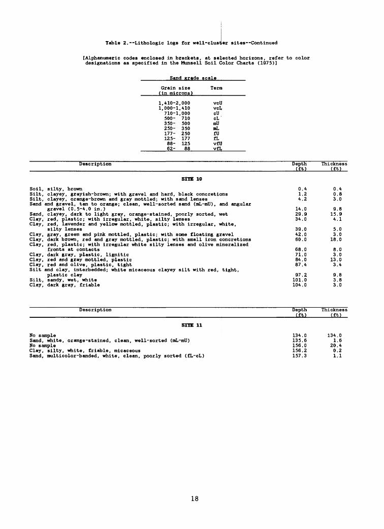
Table 2. Lithologic logs for well-clustler sites Continued
[Alphanumeric codes enclosed in brackets, at selected horizons, refer to color designations as specified in the Munsell Soil Color Charts (1975)]
Sand grade scale
Grain size Term(in microns)
1,410-2,000 vcU1,000-1,410 vcL710-1,000 cU500- 710 cL350- 500 mU250- 350 mL177- 250 fU125- 177 fL88- 125 vfU62- 88 vfL
Description
SITE 10
Soil, silty, brown
Depth(ft)
0.4Silt, clayey, grayish-brown; with gravel and hard, black concretions 1.2Silt, clayey, orange-brown and gray mottled; with sand lenses 4.2
Thickness(ft)
0.40.83.0
Sand and gravel, tan to orange; clean, well-sorted sand (mL-mU) , and angulargravel (0.5-4.0 in.) 14.0
Sand, clayey, dark to light gray, orange-stained, poorly sorted, wet 29.9Clay, red, plastic; with irregular, white, silty lensesClay, red, lavender and yellow mottled, plastic; with irregular, v
silty lensesClay, gray, green and pink mottled, plastic; with some floating giClay, dark brown, red and gray mottled, plastic; with small iron <Clay, red, plastic; with irregular white silty lenses and olive mi
fronts at contactsClay, dark gray, plastic, ligniticClay, red and gray mottled, plasticClay, red and olive, plastic, tightSilt and clay, interbedded; white micaceous clayey silt with red,
plastic claySilt, sandy, wet, whiteClay, dark gray, friable
Description
SITE 11
No sampleSand, white, orange-stained, clean, well-sorted (mL-mU)No sampleClay, silty, white, friable, micaceousSand, multicolor-banded, white, clean, poorly sorted (£L-cL)
34.0hite,
39.0avel 42 . 0oncretions 60 . 0neralized
68.071.084.087.4
tight,97.2101.0104.0
Depth (ft)
134.0135.6156.0156.2157.3
9.815.94.1
5.03.0
18.0
8.03.0
13.03.4
9.83.83.0
Thickness (ft)
134.01.6
20.40.21.1
18
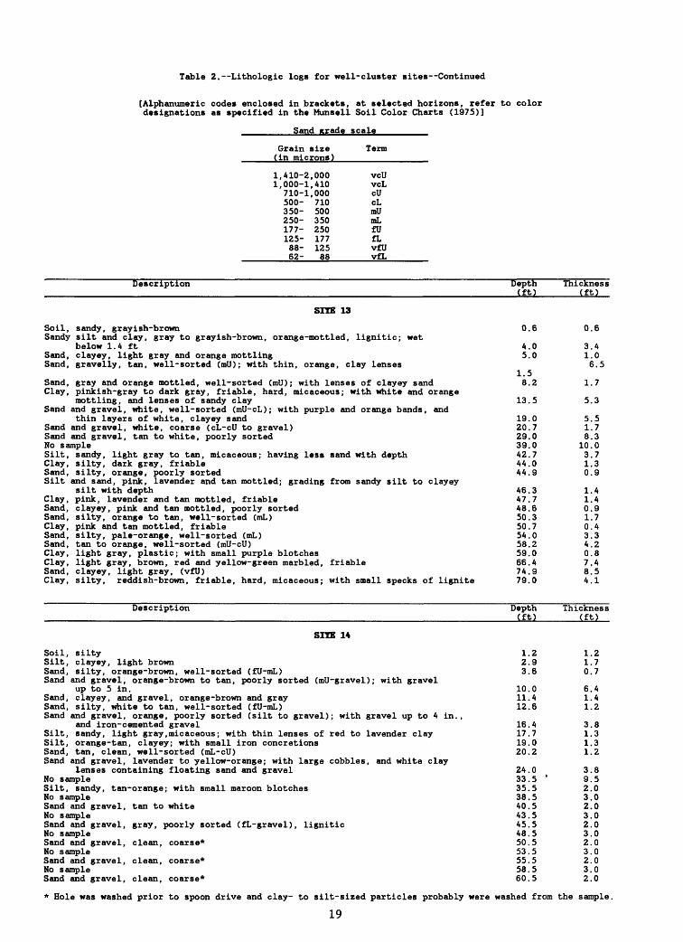
Table 2. Lithologic logs for well-cluster sites Continued
[Alphanumeric codes enclosed in brackets, at selected horizons, refer to color designations as specified in the Munsell Soil Color Charts (1975)]
Sand grade scale
Grain size Term(in microns)
1,410-2,000 vcU1,000-1,410 vcL
710-1,000 cU500- 710 cL350- 500 mU250- 350 mL177- 250 fU125- 177 fL88- 125 vfU62- 88 vfL
Description
SITE 13
Soil, sandy, grayish -brownSandy silt and clay, gray to grayish-brown, orange-mottled, lignitic; wet
below 1.4 ftSand, clayey, light gray and orange mottlingSand, gravelly, tan, well-sorted (mU); with thin, orange, clay lenses
Sand, gray and orange mottled, well-sorted (mU); with lenses of clayey sandClay, pinkish-gray to dark gray, friable, hard, micaceous; with white and orange
mottling, and lenses of sandy claySand and gravel, white, well-sorted (mU-cL); with purple and orange bands, and
thin layers of white, clayey sandSand and gravel, white, coarse (cL-cU to gravel)Sand and gravel, tan to white, poorly sortedNo sampleSilt, sandy, light gray to tan, micaceous; having less sand with depthClay, silty, dark gray, friableSand, silty, orange, poorly sortedSilt and sand, pink, lavender and tan mottled; grading from sandy silt to clayey
silt with depthClay, pink, lavender and tan mottled, friableSand, clayey, pink and tan mottled, poorly sortedSand, silty, orange to tan, well- sorted (mL)Clay, pink and tan mottled, friableSand, silty, pale-orange, well-sorted (mL)Sand, tan to orange, well-sorted (mU-cU)Clay, light gray, plastic; with small purple blotchesClay, light gray, brown, red and yellow-green marbled, friableSand, clayey, light gray, (vfU)Clay, silty, reddish-brown, friable, hard, micaceous; with small specks of lignite
Description
SITE 14
Soil, siltySilt, clayey, light brownSand, silty, orange-brown, well-sorted (fU-mL)Sand and gravel, orange-brown to tan, poorly sorted (mil-gravel); with gravel
up to 5 in.Sand, clayey, and gravel, orange-brown and graySand, silty, white to tan, well-sorted (fU-mL)Sand and gravel, orange, poorly sorted (silt to gravel); with gravel up to 4 in.,
and iron-cemented gravelSilt, sandy, light gray, micaceous; with thin lenses of red to lavender claySilt, orange-tan, clayey; with small iron concretionsSand, tan, clean, well-sorted (mL-cU)Sand and gravel, lavender to yellow-orange; with large cobbles, and white clay
lenses containing floating sand and gravelNo sampleSilt, sandy, tan-orange; with small maroon blotchesNo sampleSand and gravel, tan to whiteNo sampleSand and gravel, gray, poorly sorted (fL-gravel), ligniticNo sampleSand and gravel, clean, coarse*No sampleSand and gravel, clean, coarse*No sampleSand and gravel, clean, coarse*
Depth(ft)
0.6
4.05.0
1.58.2
13.5
19.020.729.039.042.744.044.9
46.347.748.650.350.754.058.259.066.474.979.0
Depth (ft)
1.22.93.6
10.011.412.6
16.417.719.020.2
24.033.5 '35.538.540.543.545.548.550.553.555.558.560.5
Thickness(ft)
0.6
3.41.06.5
1.7
5.3
5.51.78.3
10.03.71.30.9
1.41.40.91.70.43.34.20.87.48.54.1
Thickness (ft)
1.21.70.7
6.41.41.2
3.81.31.31.2
3.89.52.03.02.03.02.03.02.03.02.03.02.0
* Hole was washed prior to spoon drive and clay- to silt-sized particles probably were washed from the sample.
19
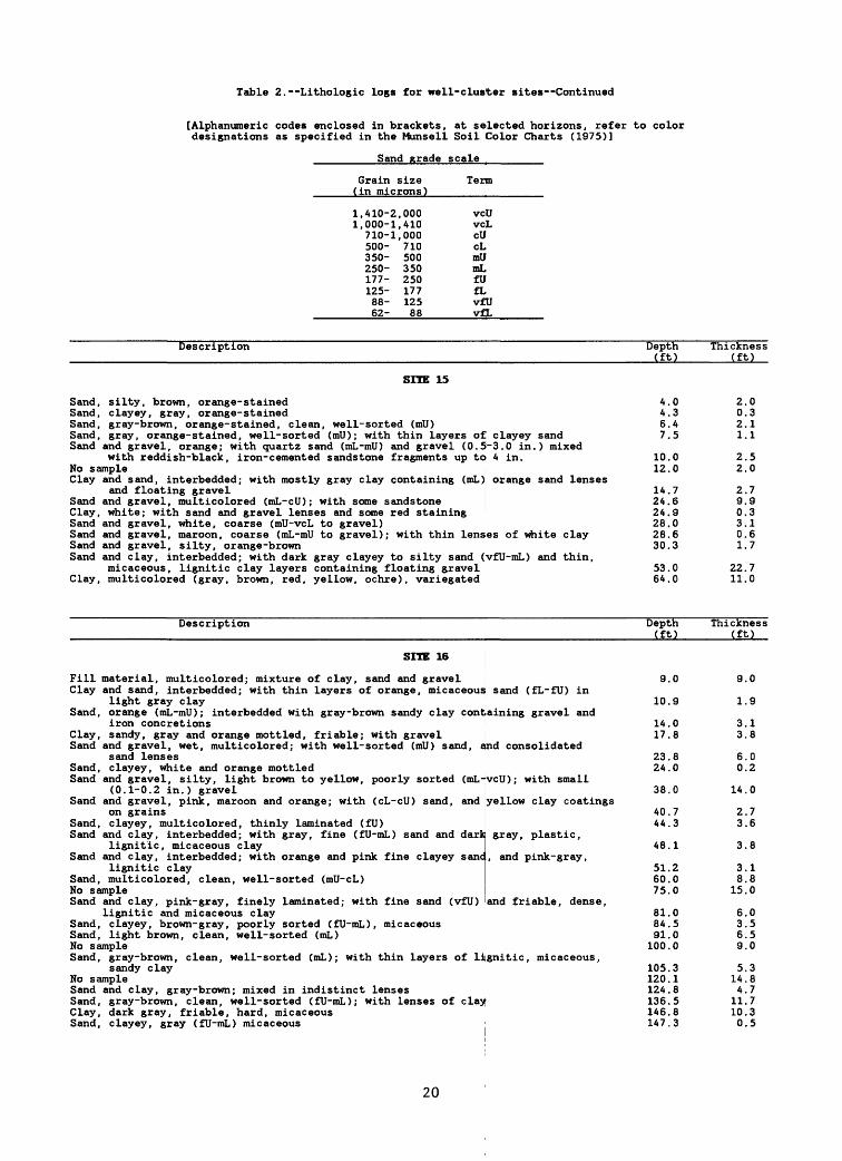
Table 2. Lithologic logs for well-cluster sites Continued
[Alphanumeric codes enclosed in brackets, at selected horizons, refer to color designations as specified in the Munsell Soil Color Charts (1975)]
Sand grade scale
Grain size Term (in microns)
1,410-2,000 vc 1,000-1,410 vc
710-1,000 cU 500- 710 cL 350- 500 mU 250- 350 mL 177- 250 fU 125- 177 fL 88- 125 vf 62- 88 vf
U L
U t
Description
SITE 15
Sand, silty, brown, orange-stainedSand, clayey, gray, orange-stainedSand, gray-brown, orange-stained, clean, well-sorted (mU)Sand, gray, orange-stained, well-sorted (mU); with thin layers of clayey sandSand and gravel, orange; with quartz sand (mL-mll) and gravel (0.5-3.0 in.) mixed
with reddish-black, iron-cemented sandstone fragments up to 4 in.No sampleClay and sand, interbedded; with mostly gray clay containing (mL)
and floating gravelSand and gravel, multicolored (mL-cU); with some sandstone
orange sand lenses
Clay, white; with sand and gravel lenses and some red stainingSand and gravel, white, coarse (mU-vcL to gravel)Sand and gravel, maroon, coarse (mL-mll to gravel); with thin lenses of white claySand and gravel, silty, orange-brownSand and clay, interbedded; with dark gray clayey to silty sand (yfU-mL) and thin,
micaceous, lignitic clay layers containing floating gravelClay, multicolored (gray, brown, red, yellow, ochre), variegated
Description
SITE 16
Fill material, multicolored; mixture of clay, sand and gravelClay and sand, interbedded; with thin layers of orange, micaceous sand (fL-fU) in
light gray clay Sand, orange (mL-mll); interbedded with gray-brown sandy clay containing gravel and
iron concretionsClay, sandy, gray and orange mottled, friable; with gravelSand and gravel, wet, multicolored; with well-sorted (mU) sand, and consolidated
sand lensesSand, clayey, white and orange mottledSand and gravel, silty, light brown to yellow, poorly sorted (mL-
(0.1-0.2 in.) gravelSand and gravel, pink, maroon and orange; with (cL-cU) sand, and
on grainsSand, clayey, multicolored, thinly laminated (fU)Sand and clay, interbedded; with gray, fine (fU-mL) sand and dark
lignitic, micaceous claySand and clay, interbedded; with orange and pink fine clayey sane
lignitic claySand, multicolored, clean, well-sorted (mU-cL)No sampleSand and clay, pink-gray, finely laminated; with fine sand (vfU)
veil); with small
yellow clay coatings
gray, plastic,
, and pink-gray,
and friable, dense,lignitic and micaceous clay
Sand, clayey, brown-gray, poorly sorted (fU-mL), micaceousSand, light brown, clean, well-sorted (mL)No sampleSand, gray-brown, clean, well-sorted (mL); with thin layers of lignitic, micaceous,
sandy clayNo sampleSand and clay, gray-brown; mixed in indistinct lensesSand, gray-brown, clean, well-sorted (fU-mL); with lenses of clayClay, dark gray, friable, hard, micaceousSand, clayey, gray (fU-mL) micaceous
Depth (ft)
4.4.6.7.
10.12.
14.24.24.28.28.30.
53.64.
0345
00
769063
00
Depth (ft)
9.
10.
14.17.
23.24.
38.
40.44.
48.
51.60.75.
81.84.91.
100.
105.120.124.136.146.147.
0
9
08
80
0
73
1
200
0500
318583
Thickness (ft)
2021
22
290301
2211
0311
50
793167
70
Thickness (ft)
9
1
33
60
14
23
3
38
15
6369
5144
11100
0
9
18
02
0
76
8
180
0550
387735
20
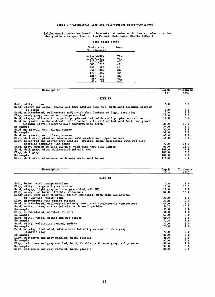
Table 2. Lithologic logs for well-cluster sites Continued
[Alphanumeric codes enclosed in brackets, at selected horizons, refer to color designations as specified in the Munsell Soil Color Charts (1975)]
Sand grade scale
Grain size Term(in microns)
1,410-2,000 vcU1, 000-1, A10 vcL
710-1,000 cU500- 710 cL350- 500 mU250- 350 mL177- 250 fU125- 177 fL88- 125 vfU62- 88 vfL
Description
SITE 17
Soil, silty, brownSand, clayey and silty, orange and gray mottled (vfU-fL); with sand becoming coarser
at depthSand, multicolored, well-sorted (mil); with thin laminae of light gray clayClay, sandy gray, maroon and orange mottledSand, clayey, white and orange to purple mottled; with small purple concretionsSand and gravel, white and multicolor banded; with well-sorted sand (mil), and gravel
becoming gravel becoming more abundant with depthNo sampleSand and gravel, wet, clean, coarseNo sampleSand and gravel, wet, clean, coarseClay, dark gray, plastic, micaceous; with gradational upper contactClay, brick-red and silver-gray mottled, friable, hard, micaceous; with red clay
becoming dominant with depthSand, gray, medium to fine (fU-mL); with dark gray clay lensesSand, dark gray, clean well-sorted (mL-mll), wetClay, dark grayNo sampleClay, dark gray, micaceous; with some small sand lenses
Description
SITE 18
Soil, brown; with orange mottlingClay, silty, orange and gray mottledSand, clayey, light gray and orange mottled, (fL-fU)Clay, sandy, red-brown, friable, micaceousSandy clay, dark gray to brown, thinly laminated; with thin laminations
of (vfU-fL), yellow sandClay, gray-brown; with orange streaksSand, multicolored, well-sorted (mL-mll), wet; with black-purple concretionsSand, white, clean, coarse (mU-cL); with small pebblesNo sampleClay, multicolored, mottled, friableNo sampleSand, silty, white, orange and red bandedNo sampleSand, silty, multicolor banded, mediumNo sampleSand and clay, laminated; with coarse (cL~cU) gray sand in dark gray
lignitic clayNo sampleClay, red-brown and gray marbled, hard, plasticNo sampleClay, red-brown and gray mottled, hard, friable; with some gray, silty zonesNo sampleClay, red-brown and gray mottled, hard, plastic
Depth(ft)
5.0
9.012.916.019.0
29.034.035.839.0A0.6Al.O
77.099.0
106.9107.0109.0115.0
Depth (ft)
1.917.018.83A.O
39.039.9AA.O5A.257.058.067.069.071.073.075.0
77.083.085.087.089.097.099.0
Thickness(ft)
5.0
A.O3.93.13.0
10.05.01.83.21.6O.A
36.022.07.90.12.06.0
Thickness (ft)
1.915.11.8
15.2
5.00.9A.I10.22.81.09.02.02.02.02.0
2.06.02.02.02.08.02.0
21

Table 2. Lithologic logs fox well-cluster sites Continued
[Alphanumeric codes enclosed in brackets, at selected horizons, refer to color designations as specified in the Munsell Soil Color Charts (1975)]
Sand grade scale
Grain size Term(in microns)
1,410-2,000 voU1,000-1,410 VQL710-1,000 cU500- 710 cl*350- 500 mU250- 350 mL177- 250 fU125- 177 fL88- 125 vfU62- 88 vfL
FillSoilSand,Clay,Sand,Clay,SandSand,Sand
Soil,Sand,
Description
SHE 19
material; containing sand, asphalt and concretezone (prior to filling); with gray loamy soil and rootssilty, light gray, poorly sorted (silt-mL)silty, blue-gray, slightly plasticsilty, light gray, poorly sorted (silt-cL); with thin claysilty, dark gray and brown-pink banded, ligniticand clay, interbedded; with multicolored silty sand and siltmulticolored, (mL-mU) ; with abundant gravel near baseand clay, interbedded; with multicolored silty sand and clay
Description
SHE 20
sandy; with some clay
Depth(ft)
2.34.04.96.0
lenses 20 . 829.0
y, multicolored clay 53.059.064.0
Depth (ft)
1.3
Thickness(ft)
2.31.70.91.1
14.88.2
24.06.05.0
Thickness (ft)
1.3white (fL-fU) clean; with large iron concretions (up to 2 in.), and sandbecoming orange near bottom
No sampleClay,Sand,
sandy, whitesilty; with some clay
No sampleSilt,Sand,
clayey, and sand, white and orangeorange-stained, coarse (cU)
No sampleSand,Clay,Sand
Sand,
Sand
gray-brown, coarse (cU)white, hard, plasticand gravel, dry, poorly sorted (vfU sand to 0.5 in. gravel);of hard, plastic, white claywhite, wet, well-sorted (fl)-mL); with small purple concreticoarser, gravelly, and multicolored with depthand clay, interbedded; with numerous thin, alternating bedsmulticolored sand and gravel; with friable, silty clay
Description
SoilClay,Clay,
Clay,Clay,Sand,Silt,
SHE 21
silty, gray-brown to orange mottled, friable
14.021.522.023.530.031.231.760.565.065.3
with lenses66.4
ons , becoming74.5
of poorly sorted,89.7
Depth (ft)
0.810.2
12.77.50.51.56.51.20.5
28.84.50.3
1.1
8.1
15.2
Thickness (ft)
0.89.4
silty, multicolored (brown, red, purple, yellow, pink), mottled, hard, friable;with dark brown concretions 18.4silty, light gray to white; mixed with (vcL) sand near bottom 20.8silty, white; with purple lenses 23.4silty, multicolored, fine; with purple lenses bordered by yellow 26.6clayey, white; with yellow mottling 29.0
8.22.42.63.22.4
22

Table 2. Lithologic logs for well-cluster sites Continued
[Alphanumeric codes enclosed in brackets, at selected horizons, refer to color designations as specified in the Munsell Soil Color Charts (1975)]
Sand grade scale
Grain size Term(in microns)
1,410-2,000 vcU1,000-1,410 vcL710-1,000 cU500- 710 cL350- 500 mU250- 350 mL177- 250 fU125- 177 fL88- 125 vfU62- 88 vfL
Description
SITE 22
Soil, light gray to brownSand, clayey, dark brown, (mL-mU)Sand, tan to buff,(mU), fairly cleanClay, white, plasticSand, white, (fL-fU), cleanNo sampleSand, tan, (mL), cleanNo sampleSand, tan,(mL), clean,; with some pebbles up to 0.3 in.No sampleSand, tan,(mL), cleanNo sampleSand, tan to gray, (mL-cU)No sampleSand, tan to gray, (mL-cU)No sampleSand, tan to gray,(vcU)No sampleSand and gravel, tan to gray; with medium sand and gravel up to 0.3 in.No sampleSand and gravel, tan to gray, coarseNo sampleSand and gravel, tan; coarse with cobbles up to 5 in. , and iron-cemented gravel
near bottom, coated with dark gray, plastic clayNo sampleClay, silver, soft, plastic; stuck to bottom of auger
Description
SITE 23
Soil, brown; with rootsClayey fill material, orange-brown; with asphalt and woodSand, clayey, orange to tan, (mL)Clay, silty, white, friable, micaceous; with abundant small red-purple concretionsSand, silty, multicolored, (mL-mU) ; with small lenses of white clay and small purple
concretionsSand, tan, wet, clean, (mL); with some orange staining and lenses of clayey silt
near bottomSand, clayey, light gray to orange, (fL-fU) ; with small, pink, silty clay lenses and
purple concretionsSand, pinkish-brown, poorly sorted (fU-mlJ); with green and ochre bands, and thin
lenses of white silty clay
Depth(ft)
1.35.9
18.519.020.523.025.027.532.537.539.541.545.949.251.254.556.559.661.664.766.770.0
73.090.090.0
Depth (ft)
0.47.8
10.311.1
14.0
29.3
34.0
39.0
Thickness(ft)
1.34.612.60.51.52.52.02.55.05.02.02.04.43.32.03.32.03.12.03.12.03.3
3.017.0
Thickness (ft)
0.47.42.50.8
2.9
15.3
4.7
5.0
23

Table 2. Lithologic logs for well-cluster sites Continued
[Alphanumeric codes enclosed in brackets, at selected horizons, refer to color designations as specified in the Munsell Soil Color Charts (1975)]
Sand grade scale
Grain size Term(in microns)
1,410-2,000 voU1,000-1,410 vqL710-1,000 cU500- 710 cL,350- 500 mU250- 350 mL177- 250 fU125- 177 fL88- 125 v£U62- 88 vfL
SoilFillSiltSandSand
Sand
Sand
SoilFillSiltClaySand
Description
SITE 25
, brownmaterial, brown to gray; with clay, sand and gravel
, clayey, orange-brown and gray mottled, clayey, light gray and orange mottled, (mL); with red-black, white to gray and orange, clean, well-sorted (mL-mll); withconcretions, and thin clay lenses
Depth(ft)
0.64.0
11.5concretions 14 . 0red-black
17.3
Thickness(ft)
0.63.47.52.5
3.3, clayey, light gray, (mU); with small red-black concretions and some clay coatingson grains 19.0 1.7
, tan, wet, clean, well-sorted (mU); with small, white clay lenses, and sandturning gray near bottom
Description
SITE 26
, dark brown; with roots
29.0
Depth (ft)
0.3material containing silt, quartz pebbles, and brick fragments 2.0
, clayey, orange, silty, brown, sltly plastic, orange to tan,(mL-cL)
No sampleSand , pink, clean, well-sorted, micaceous; with small iron concri
near bottomNo sampleSilt , clayey, whiteNo sampleClaySandClay
, silty, dark gray, lignitic, gray, coarse; with some pebbles, dark gray, lignitic
Description
FillSiltSiltSandSandClaySiltSandSand
ClaySandSand
SITE 27
material containing rock and industrial slag material, gray to orange-brown, dry, clayey, gray, sandy, micaceous, light gray, medium to coarse (mL-cL), light gray to orange-brown, poorly sorted (silt-vfU), gray, very plastic, gray to orange-brown, clayey; with some sand, tan to orange, clean, medium (mL-mll); with some gravel, gray to orange-brown, silty; with upper contact markedby iron concretion
, dark gray, plasticand silt, gray to orange, clayey
, orange to tan, fine to medium (fU-mll); with some largecobbles
3.75.59.9
35.0itions, and gravel
49.363.069.0114.0125.2125.5126.3
Depth (ft)
4.07.6
10.411.314.015.018.322.4
23.826.930.6
34.0
10.0
Thickness (ft)
0.31.71.71.84.4
25.1
14.313.76.0
45.011.20.30.8
Thickness (ft)
4.03.62.80.92.71.03.34.1
1.43.13.7
3.4
24
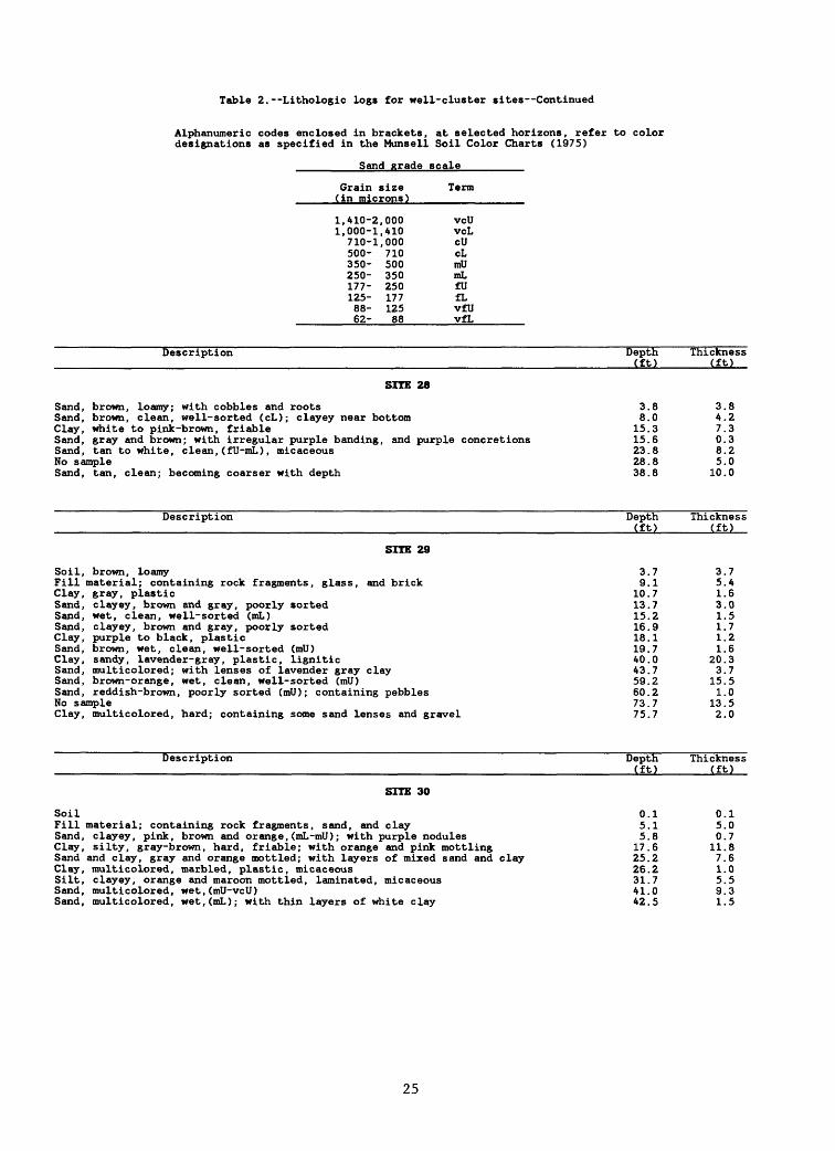
Table 2. Lithologic logs for well-cluster sites Continued
Alphanumeric codes enclosed in brackets, at selected horizons, refer to color designations as specified in the Munsell Soil Color Charts (1975)
Sand grade scale
Grain size Term(in microns)
1,410-2,000 vcU1,000-1,410 vcL
710-1,000 cU500- 710 cL350- 500 mU250- 350 mL177- 250 fU125- 177 fL88- 125 vfU62- 88 vfL
Description
SITE 28
Sand, brown, loamy; with cobbles and rootsSand, brown, clean, well-sorted (cL); clayey near bottomClay, white to pink-brown, friableSand, gray and brown; with irregular purple banding, and purple concretionsSand, tan to white, clean, (fU-mL) , micaceousNo sampleSand, tan, clean; becoming coarser with depth
Description
SITE 29
Soil, brown, loamyFill material; containing rock fragments, glass, and brickClay, gray, plasticSand, clayey, brown and gray, poorly sortedSand, wet, clean, well- sorted (mL)Sand, clayey, brown and gray, poorly sortedClay, purple to black, plasticSand, brown, wet, clean, well-sorted (ml))Clay, sandy, lavender-gray, plastic, ligniticSand, multicolored; with lenses of lavender gray claySand, brown-orange, wet, clean, well- sorted (mU)Sand, reddish-brown, poorly sorted (mU); containing pebblesNo sampleClay, multicolored, hard; containing some sand lenses and gravel
Description
SITE 30
SoilFill material; containing rock fragments, sand, and claySand, clayey, pink, brown and orange, (mL -mU); with purple nodulesClay, silty, gray-brown, hard, friable; with orange and pink mottlingSand and clay, gray and orange mottled; with layers of mixed sand and clayClay, multicolored, marbled, plastic, micaceousSilt, clayey, orange and maroon mottled, laminated, micaceousSand, multicolored, wet,(mU-vcU)Sand, multicolored, wet,(mL); with thin layers of white clay
Depth(ft)
3.88.0
15.315.623.828.838.8
Depth (ft)
3.79.1
10.713.715.216.918.119.740.043.759.260.273.775.7
Depth (ft)
0.15.15.8
17.625.226.231.741.042.5
Thickness(ft)
3.84.27.30.38.25.0
10.0
Thickness (ft)
3.75.41.63.01.51.71.21.6
20.33.7
15.51.0
13.52.0
Thickness (ft)
0.15.00.711.87.61.05.59.31.5
25

Table 2. Lithologic logs for well-cluster sites Continued
[Alphanumeric codes enclosed in brackets, at selected horizons, refer to color designations as specified in the Munsell Soil Color Charts (1975)]
Sand grade scale
Grain size Term(in microns)
1,410-2,000 vc1,000-1,410 vc710-1,000 ell500- 710 cl
UL
350- 500 mil250- 350 mL177- 250 fti125- 177 fL88- 125 v£U62- 88 vf|L
Description Depth(ft)
SITE 31
Soil 2.8Sand, brown to tan, clean, poorly sorted (cL-vcU); with some gravel and cobbles 5.0Clay, gray-brown, lignitic; with some brown, (cL-vcU) sand lenses 9.0Clay, brown-gray, plastic, lignitic 16.5Sand, clayey, gray-tan, poorly sorted (mL-cL); with gravel and aSand, gray and orange-stained, well-sorted (mL-mU)Sand and gravel, gray to tan; well- sorted in zones of different c
with depth
Description
SITE 32
sharp upper contact 18.519.0
oarseness, coarser29.0
Depth (ft)
Soil, clayey 0.4Clay, sandy, orange-brown and gray mottled 3.5Sand, gray and orange-brown mottled, (mL) ; with some small clay lenses and some lignite 14.0Sand and gravel, red-brown, poorly sorted, (cL)to cobbles 15.6Sand and clay, lavender; with plastic clay, and(fL)sand 17.5Sand, lavender to tan.(fU-mL), well-sorted 22.0Sand and clay, interbedded, lavender; with plastic clay and fineClay, silty, gray-brown, dense
Description
SITE 33
sand 34.244.0
Depth (ft)
Soil 0.6Clay, sandy, gray and orange-brown mottled sandy 5.0Sand, clayey, gray and orange-stained, (fU) , clayey 9.0Sand, tan to orange, well-sorted 11.5Clay, sandy, gray and orange-brown mottled 12.1Sand, tan to orange, well-sorted 13.0Sand, clayey, gray and orange-brown mottled 18.6Sand and clay, lavender; with some gravel and ligniteSand, tan to orange, (mil); with some large cobblesClay, sandy, lavender and orange-tan mottledSand, tan to orange, (mil), well-sorted, ligniticClay, lavender, dense, lignitic; with small sand layersSand, orange and lavender, (mil) , well-sorted, lignitic; with some
layers near bottom
19.022.224.025.228.0
distinct clay59.0
Thickness(ft)
2.82.24.07.52.00.5
10.0
Thickness (ft)
0.43.110.51.61.94.512.29.8
Thickness (ft)
0.64.44.02.50.60.95.60.43.21.81.22.8
31.0
26

Table 2. Lithologic logs for well-cluster sites Continued
[Alphanumeric codes enclosed in brackets, at selected horizons, refer to color designations as specified in the Munsell Soil Color Charts (1975)]
Sand grade scale
Grain size Term(in microns)
1,410-2,000 vcU1,000-1,410 vcL
710-1,000 cU500- 710 cL350- 500 mU250- 350 mL177- 250 flJ125- 177 fL88- 125 vfU62- 88 vfL
Description
SITE 34
SoilSilt, clayey, yellow-brown and orange mottled, with lenses of dark red-brown, hard,
friable claySand, gray and orange-brown mottled, (fU-mL) , clean, well-sorted; wet near bottomSand and gravel, reddish-black; with large cobbles (up to 6 in.)Sand, white, wet, clean, well-sorted (mL)Sand, clayey, white and orange laminated, (mL)Clay, lavender, hard, plasticSand and clay, interbedded; with gray, (fU-mL) sand, and lavender claySand, orange, clean, well-sorted (mL)
Description
SITE 35
SoilFill material; containing clay, sand, gravel, and fragments of ceramic materialSand, clayey, and silt, light gray and orange-stained, micaceous; with hard iron
concretions and wet near bottomSand, gray and orange-brown mottled, well-sorted (mL-mU), wet; with a few lenses
of clayey sandClay, sandy, lavender and orange-stained, micaceousSand, light pink to tan, well-sorted (mL-mU), wetSand, bright-orange, (mL) ; with red-black iron concretions
Description
SITE 36
SoilClay, brownSand, clayey, orange-brown, well-sorted (mL); becoming more sandy toward bottomSand, tan, poorly sorted (fU-mU); with gravel and cobbles and some red-purple nodulesSand, gray,(mL), micaceousSand and clay, interbedded, lavender and orange-stained; with (mL) sand and plastic claySand, tan, well-sorted (cU); with orange staining
Depth(ft)
0.2
7.015.416.417.920.622.123.624.0
Depth (ft)
0.22.2
16.6
19.522.228.629.0
Depth (ft)
0.52.53.512.017.022.029.0
Thickness(ft)
0.2
6.88.41.01.52.71.51.50.4
Thickness (ft)
0.22.0
14.4
2.92.76.40.4
Thickness (ft)
0.52.01.08.55.05.07.0
27

Table 2. Lithologic logs for well-cluster sites Continued
[Alphanumeric codes enclosed in brackets, at selected horizons, refer to color designations as specified in the Munsell Soil Color Charts (1975)]
Sand grade scale
Grain size Term(in microns)
1,410-2,000 vcU1,000-1,410 vet
710-1,000 cU500- 710 cL350- 500 mU250- 350 mL177- 250 fU125- 177 fL88- 125 vfU62- 88 vfL
Description
SITE 37
Fill materialSoilSand, silty, tan and gray mottled, (mU)
Depth(ft)
0.51.06.0
Thickness(ft)
0.50.55.0
Clay, sandy, lavender; containing thin sand lenses and becoming red, white andgray near bottom 19.0
Sand, tan to gray, poorly sorted (mL-cU); with some clay lenses and iron oxide layers 34.0Sand, silty, tan to gray, (fU-mU) 36.7Sand and clay, interbedded; with white to lavender sandy clay lenses 39.0Sand, pinkish- tan, poorly sorted (fU-mU) 42.0Sand and clay, interbedded; with tan sand and white, plastic, micaceous clay 43.0
Description
SITE 38
Fill material and soilClay, brown to gray, plastic, lignitic
Depth (ft)
2.06.0
Clay, sandy, lavender, gray and white; with distinct thin sand lenses 11.0Clay, dark gray, dense, plastic 18.5Sand and clay, interbedded; with lavender and orange sand, and dark gray, plastic clay 19.5Clay, dark gray, dense, plastic 32.5Clay and sand, interbedded; with lavender sand and dark gray-green, plastic clay 37.0Sand, tan and orange-stained, poorly sorted (mL-cU) 45.0
13.015.02.72.33.01.0
Thickness (ft)
2.04.05.07.51.0
13.04.58.0
Clay and sand, interbedded; with lavender and white, lignitic clay, and lavender,gray and white
Sand, clayey, gray to white and orange-stained, well-sorted (mU)
Description
SITE 39
Fill materialSoilSand, tan and orange-stained, (mlF-cL) ; with brown-gray clay
48.049.0
Depth (ft)
1.02.06.0
3.01.0
Thickness (ft)
1.01.04.0
Clay and sand, interbedded; with lavender, friable, thinly laminated clay andlavender to gray, fine to medium sand
Clay, lavender and white-streaked, massiveSand, tan and orange-stained, wet, well-sorted (mL-mll), micaceous
sparse clay lenses
Description
SITE 40
Fill materialClay, gray, plasticClay, sandy, gray and orange mottledClay, blue-gray to lavender, friable; with sand lensesClay, sandy, lavender and orange mottledClay, dark gray; with interbedded sand lensesSand, tan to lavender and orange-stained, well-sorted (mL-mU)Clay, lavender and orange mottled, dense; with sand lenses
14.018.5
and lignitic;49.0
Depth (ft)
1.02.14.08.2
19.024.033.034.0
8.04.5
30.5
Thickness (ft)
1.01.11.94.210.85.09.01.0
28

Table 2. Lithologic logs for well-cluster sites Continued
[Alphanumeric codes enclosed in brackets, at selected horizons, refer to color designations as specified in the Munsell Soil Color Charts (1975)]
Sand grade scale
Grain size Term(in microns)
1,410-2,000 vcU1,000-1,410 vcL
710-1,000 cU500- 710 cL350- 500 mU250- 350 mL177- 250 fU125- 177 fL88- 125 vfU62- 88 vfL
Description
SITE 41
SoilClay, brown, gray, and orange mottled, lignitic; with sand lenses and cobblesSand, tan.(cL-cU), well-sortedSand, silty, orange, ligniticSand and clay, interbedded; with tan to orange (mL-mU) sand and lavender to white
sandy clayClay, lavender, gray and orange mottled, dense; with iron nodules and iron-cemented
gravelSand, tan and lavender, orange-stained, poorly sorted (vfU-fU); with thin clay
lenses near bottomSand, tan to lavender, well-sorted (fU-mL), micaceous, lignitic; with thin clay
lenses near bottomClay and sand, interbedded; with lavender sandy clay, and orange-stained, lavender
(mL -mU) sandSand, lavender, orange-stained L-mU)
Description
SITE 42
SoilClay, brown; with some cobblesSand, clayey, tan to brown, (mL-mU)Sand, tan and brown-stained, fairly well-sorted (mU-cL)Clay, lavender and orange mottled; with some lenses of red-gray plastic clayClay, sandy, lavender and orange mottled; with thin sand lensesSand, lavender to tan, (mL -ml)); with thin clay lensesSand and clay, interbedded; with tan to lavender, (mL-mU) sand, and lavender
and orange mottled clay
Description
SITE 43
Fill materialSand and clay, interbedded; with tan, (fU-mL) sand and tan silty claySand, tan, orange-stained, well-sorted (mU-cL); with clay lenses that increase in
frequency and thickness with depth, also gravel and cobbles near bottomSand and gravel, yellow-orange, coarse; with cobbles up to 2 in. commonSand, tan and orange-stained, (cL-vclJ); coarsening upwards
Description
SITE 44
SoilSand and clay, interbedded with tan to orange clayey sand, and brown, micaceous
sandy clayClay, gray and orange mottledSand, tan, orange, and purple mottled, (cL-cU); with thin clay lensesSand and gravel, tan and orange mottled, poorly sorted; with numerous large cobbles
Depth(ft)
0.57.59.510.1
17.5
23.1
32.6
51.0
53.059.0
Depth (ft)
0.52.57.0
17.024.026.530.0
34.0
Depth (ft)
2.05.5
20.529.034.0
Depth (ft)
0.5
7.09.510.513.5
Thickness(ft)
0.57.02.00.6
7.4
5.6
9.5
18.4
2.06.0
Thickness (ft)
0.52.04.5
10.07.02.53.5
4.0
Thickness (ft)
2.03.5
15.08.55.0
Thickness (ft)
0.5
6.52.51.03.0
29

Table 2. Lithologic logs for well-cluster sites Continued
[Alphanumeric codes enclosed in brackets, at selected horizons, refer to color designations as specified in the Munsell Soil Color Charts (1975)]
Sand grade scale
Grain size Tern) (in microns)
1, A 10-2, 000 vctj 1,000-1,410 vcL
710-1,000 cU 500- 710 cL 350- 500 mU 250- 350 mL 177- 250 fU 125- 177 fL 88- 125 vfll 62- 88 vflj
Description
SIT! 101
Silt, sandy, brownFill material, sand and silt with large fragments of rock and smaller gravel,
orange-brown, rootsSilt, clayey, dark red-brown and brown mottling, with lenses of fine sand, roots,
and orange staining, moistSand, dark red to orange-brown, (fU-mU), wet; with sparse gravel (<0.2 in.)Sand, dark red to orange-brown, (fU-mU) , interbedded with sandy, light gray clayClay, sandy, dark gray, soft, friable, micaceous; with streaks of light gray
fine (fL) sand, grades to pinkish gray color in placesSilt, clayey, light gray to pink, hard; with fine (fL), micaceous j clayey sand
lenses, and orange silt lensesSand, dark brown-orange, micaceous, wet; with dark mineral grains and a
fragment of red sandstone at 16 ftSilt, clayey, pink, orange-streaked, soft, micaceousSand, dark brown-orange, poorly sorted, (fU-mU) (mainly mL)Sandstone, maroon, orange and red, fine-grainedSand, dark brown-orange, poorly sorted, (fU-mu) (mainly mL)Sand, multicolored, poorly sorted (fU-mU) (mainly mU), wet; with red to black
sandstone, and light gray, micaceous clayNo sample
Description
SITE 102
Soil zone, silty, brown-orange-tanClay, silty, orange-brown-tan mottledClay, silty, gray-green-orange mottledClay, silty, orange-tan mottled; with brick-red clay lensesClay, red, denseNo sampleClay, red, denseClay, red, dense; with white silt lenses, increasing with depthSilt, sandy, whiteSilt, sandy, white, micaceous; wet near bottomSand, clayey, light gray, yellow-orange stained, [10YR 7/1] (fL-fll), fairly tight,
micaceousSand, silty, light gray, light yellow, and red mottled, [10YR 7/1] (fL-mL)
(mostly fU), micaceous, wetNo sampleSand, silty, light gray, (fU-mL) (mostly fU); with clayey sand lenses, and
purple and orange bandingSand, dark gray, (fU-mL) (mostly mL), micaceous; with black staining and yellow
mottling; top 1.4 ft wet; lignite specks in thin bands near bottomClay, dark gray, friable; with light gray and orange, (fU-mL) , micaceous,
sand lenses, [10YR 3/]Sand, light gray and orange mottled, (fU-mL) , moistClay, dark gray, friable; with orange and light gray , ( fU-mL ) , sand lensesNo sampleSand, silty, multicolored, (fL-mU) , micaceous, wet; with well-rounded quartz grains,
dark mineral grains, and iron concretionsNo sampleSand, multicolored, (fL-mU) , wet
Depth (ft)
0.3
4.0
6.310.511.5
14.0
14.9
16.016.218.218.319.0
22.824.0
Depth (ft)
1.54.05.79.011.514.019.027.029.034.0
39.5
42.344.0
49.0
51.4
51.952.453.054.0
57.759.063.7
Thickness (ft)
0.3
3.7
2.34.31.0
2.5
0.9
1.10.22.00.10.8
3.81.2
Thickness (ft)
1.52.51.73.32.52.55.08.02.05.0
5.5
2.81.7
5.0
2.4
0.50.50.61.0
3.71.34.7
30
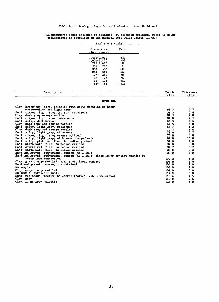
Table 2. Lithologic logs for well-cluster sites Continued
[Alphanumeric codes enclosed in brackets, at selected horizons, refer to color designations as specified in the Munsell Soil Color Charts (1975)]
Sand grade scale
Grain size(in microns)
1,410-2,0001,000-1,410
710-1,000500- 710350- 500250- 350177- 250125- 17788- 12562- 88
Description
SITE 104
Clay, brick-red, hard, friable; with silty mottling of brown,ochre-yellow and light gray
Sand, clayey, light gray, (fL-fU) , micaceousClay, dark gray-orange mottledSand, clayey, light gray, micaceousSand, silty, dark brownClay, dark gray and orange mottledSand, silty, light gray, micaceousClay, dark gray and orange mottledSand, silty, light gray, micaceousSand, clayey, light gray-orange mottledSand, silty, light gray; with some orange bandsSand, silty, pink- tan, fine- to medium-grainedSand, white-buff, fine- to medium-grainedSand, orange-red, fine- to medium-grainedSand, white-buff, fine- to medium-grainedSand and gravel, red-orange, coarse (to 2 in.)
Term
vcUvcLcUcLmUmLfUfLvfUvfL
Depth(ft)
58.759.561.564.064.567.568.770.371.074.089.091.094.094.797.099.0
Thickness(ft)
9.70.82.02.50.53.01.21.60.73.0
15.02.03.00.72.32.0
Sand and gravel, red-orange, coarse (to 2 in.); sharp lower contact bounded byrusty iron concretion
Clay, gray-orange mottled; with sharp lower contactSand and gravel, coarse, rust-stainedNo sampleClay, gray-orange mottledNo sample, (probably sand)Sand, red-brown, medium- to coarse-grained; with some gravelClay, grayClay, light gray, plastic
100.2103.0104.0106.0109.0114.0118.4119.0124.0
1.22.81.02.03.05.04.50.55.0
31
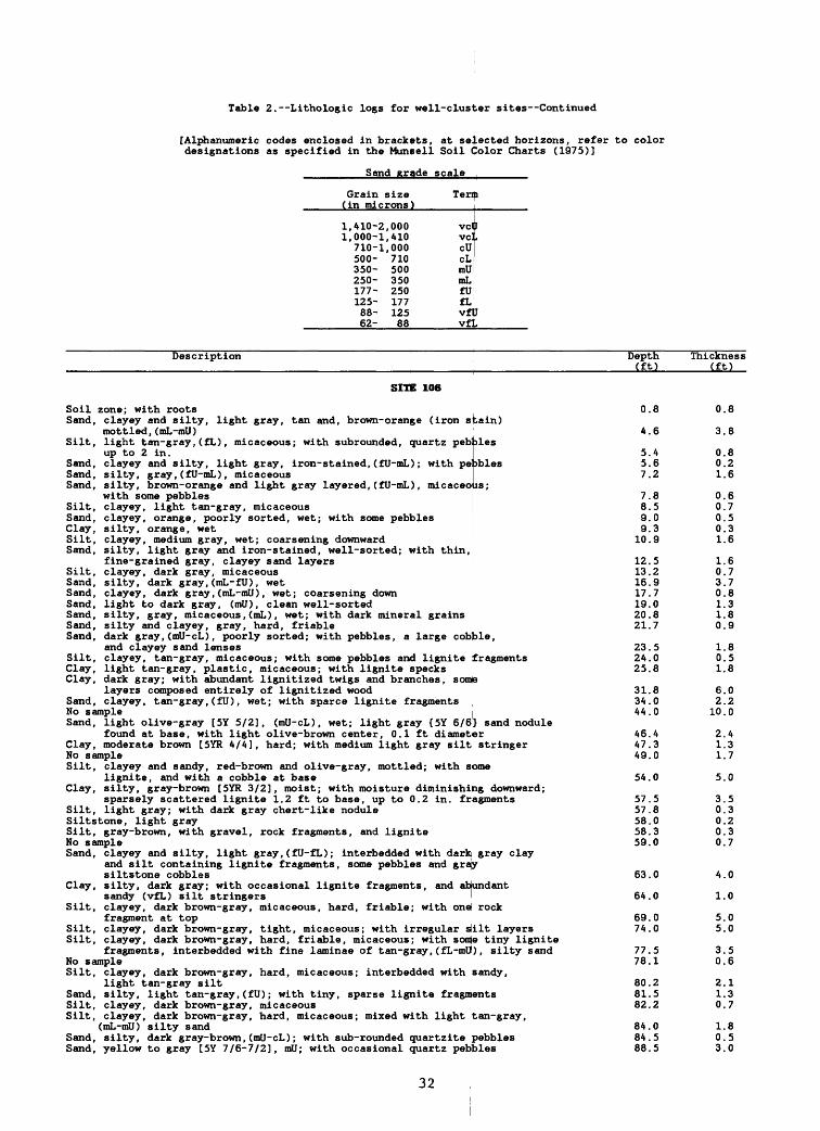
Table 2. Lithologic logs for well-cluster sites Continued
[Alphanumeric codes enclosed in brackets, at selected horizons, refer to color designations as specified in the Munsell Soil Color Charts (1975)]
Sand grade scale
Grain size (in microns)
1,410-2,0001,000-1,410
710-1,000500- 710350- 500250- 350177- 250125- 17788- 12562- 88
Term
vclvclcUcLmU
I
mLfUfLvfUvfL
Description Depth (ft)
Thickness (ft)
SITE 106
Soil zone; with rootsSand, clayey and silty, light gray, tan and, brown-orange (iron stain)
mottled,(mL-mU) Silt, light tan-gray,(fL), micaceous; with subrounded, quartz pebbles
up to 2 in.Sand, clayey and silty, light gray, iron-stained,(fU-mL); with peobles Sand, silty, gray,(fU-mL), micaceous Sand, silty, brown-orange and light gray layered,(fU-mL), micaceous;
with some pebblesSilt, clayey, light tan-gray, micaceousSand, clayey, orange, poorly sorted, wet; with some pebbles Clay, silty, orange, wetSilt, clayey, medium gray, wet; coarsening downward Sand, silty, light gray and iron-stained, well-sorted; with thin,
fine-grained gray, clayey sand layers Silt, clayey, dark gray, micaceous Sand, silty, dark gray,(mL-fU), wetSand, clayey, dark gray,(mL-mU), wet; coarsening down Sand, light to dark gray, (mil), clean well-sorted Sand, silty, gray, micaceous,(mL), wet; with dark mineral grains Sand, silty and clayey, gray, hard, friable Sand, dark gray,(mU-cL), poorly sorted; with pebbles, a large cobble,
and clayey sand lensesSilt, clayey, tan-gray, micaceous; with some pebbles and lignite fragments Clay, light tan-gray, plastic, micaceous; with lignite specks Clay, dark gray; with abundant lignitized twigs and branches, some
layers composed entirely of lignitized woodSand, clayey, tan-gray,(fU), wet; with sparce lignite fragments No sample Sand, light olive-gray [5Y 5/2], (mU-cL), wet; light gray {5Y 6/6} sand nodule
found at base, with light olive-brown center, 0.1 ft diameter Clay, moderate brown [5YR 4/4], hard; with medium light gray silt stringer No sample Silt, clayey and sandy, red-brown and olive-gray, mottled; with sbme
lignite, and with a cobble at base Clay, silty, gray-brown [SYR 3/2], moist; with moisture diminishing downward;
sparsely scattered lignite 1.2 ft to base, up to 0.2 in. fragments Silt, light gray; with dark gray chert-like nodule Siltstone, light graySilt, gray-brown, with gravel, rock fragments, and lignite No sample Sand, clayey and silty, light gray,(fU-fL); interbedded with dark gray clay
and silt containing lignite fragments, some pebbles and graysiltstone cobbles
Clay, silty, dark gray; with occasional lignite fragments, and abundantsandy (vfL) silt stringers
Silt, clayey, dark brown-gray, micaceous, hard, friable; with one rockfragment at top
Silt, clayey, dark brown-gray, tight, micaceous; with irregular silt layers Silt, clayey, dark brown-gray, hard, friable, micaceous; with some tiny lignite
fragments, interbedded with fine laminae of tan-gray,(fL-mU), silty sand No sample Silt, clayey, dark brown-gray, hard, micaceous; interbedded with sandy,
light tan-gray siltSand, silty, light tan-gray,(fU); with tiny, sparse lignite fragments Silt, clayey, dark brown-gray, micaceous Silt, clayey, dark brown-gray, hard, micaceous; mixed with light tan-gray,
(mL-mU) silty sandSand, silty, dark gray-brown,(mU-cL); with sub-rounded quartzite pebbles Sand, yellow to gray [5Y 7/6-7/2], mil; with occasional quartz pebbles
0.8
4.6
5.4 5.6 7.2
7.8 8.5 9.0 9.3
10.9
12.513.216.917.719.020.821.7
23.524.025.8
31.834.044.0
46.447.349.0
54.0
57.557.858.058.359.0
63.0
64.0
69.074.0
77.78.
80.281.582.2
84.8488.5
0.8
3.8
0.8 0.2 1.6
0.6 0.7 0.5 0.3 1.6
1.6 0.7 3.7 0.8 1.3 1.8 0.9
1.8 0.5 1.8
6.0 2.210.0
2.41.3 1.7
5.0
3.5 0.3 0.2 0.3 0.7
4.0
1.0
5.0 5.0
3.50.6
2.1 1.3 0.7
1.8 0.5 3.0
32

Table 2. Lithologic logs for well-cluster sites Continued
[Alphanumeric codes enclosed in brackets, at selected horizons, refer to color designations as specified in the Munsell Soil Color Charts (1975)]
Sand grade scale
Grain size (in microns)
1,410-2,0001,000-1,410710-1,000500- 710350- 500250- 350177- 250125- 17788- 12562- 88
Term
vcUvcLcUcLmUmLfUfLvfUvfL
Description Depth (ft)
Thickness (ft)
SITE 107
Soil zone, loamy, dark brown; with roots, organic material, recent debris,glass, and a A-in.-long piece of steel 0.5 0.5
Silt, yellow-brown, hard; with roots, sporadic white mineralized zones, andfine sand near bottom 7.0 6.5
Sand, gray-brown, orange-stained,(mL-mU), micaceous; with plant roots 8.5 1.5 Sand, dark brown,(mL); with black staining of unknown origin, and silt lense at base 9.0 0.5 Clay, pink-red, hard; with brown-red laminae that include black staining; stringers
of reduced light gray clay, and gray to mustard,(fL-fU), sand lenses 17.2 8.2 Clay, dark red, dense, plastic 19.0 1.8 Clay, brick-red, dense, tight; with some lignite, black staining, and white mottled
mineralized zones 25.0 6.0 Sand, silty, pink-gray, yellow-brown stained,(fL-fU) (mostly fL), quartzose, micaceous 28.3 3.3 Clay, brick-red, micaceous; with some white mottling 29.0 0.7 Clay, silty, red-brown, hard, dense, micaceous; with white reduced zones, and hard,
brown semiconsolidated inclusions 41.8 12.8 Silt, sandy, dark gray, laminated, fissile, micaceous; becoming more consolidated
with depth 45.0 3.2 Sand, medium gray,(mL-mU), micaceous; with lignite and silt lenses 45.8 0.8 Silt, sandy, gray, lignitic, micaceous; with gray,(fU fL), semiconsolidated
sand lenses 46.0 0.2 Sand, silty, red-orange to buff,(mU-cL), quartzose; with iron-cemented
sandstone-siltstone rock fragments, (0.2-3.0 in.), and clay inclusions 47.3 1.3 Clay, silty, light gray to white, highly plastic, micaceous, homogeneous 48.3 1.0 No sample 49.0 0.7 Sand, buff to orange,(cU), quartzose; with gravel as subrounded quartz fragments
(1.0-1.5 in.), and sparse iron-cemented conglomeratic sandstone 52.5 3.5 No sample 87.0 34.5 Silt, clayey, orange and light buff, friable; with sparse quartz gravel, and
interfingered with gray clay, sand lenses, and thick layers of lignite 89.0 2.0
33

Table 2. Lithologic logs for well-cluster sites Continued
[Alphanumeric codes enclosed in brackets, at selected horizons, refer to color designations as specified in the Munsell Soil Color Charts (1975)]
Sand grade scale
Grain size Term (in microns)
1,410-2,000 vc0 1,000-1,410 vcj.
710-1,000 cU 500- 710 cL 350- 500 mU 250- 350 mL 177- 250 fU 125- 177 fL 88- 125 vfU 62- 88 vfL
Soil,Sand,
Sand,
Silt,
Description
SITE 108
silty, zone, light gray; with roots
Depth (ft)
0 5
Thickness (ft)
0 5light orange, (mL-mU); becoming moist at 3 ft, with quartz pebbles (<0.2 in.),and small clay lenses 7 3 6 8clayey, orange and light gray, (mL-mU) , micaceous; with irregular color bands,maroon iron concretions, and quartz pebbles 9 0 1 7clayey, multicolored; with tight, micaceous, (mL-mU) , multicolored, sand inirregular lenses, and some clay; also with small maroon nodules
Sand,Sand,Sand,
No saiSand,
dark orange, red-stained, (fU-mL) , clean, wetsilty, orange to red-orange, (fU-mL) ; with iron-cemented red sandstone
131415
509
401
559
yellow to red-orange, (mU-cL) ; with 0.3 in. pebbles mixed with soft, micaceous,light gray and pink silty claynple
1819
light tan to orange, (mL-clI) (mostly mU), quartzose, micaceous; with some darkmineral grains
No sampleClay,Clay,Clay,
Clay,
Silt,Clay,Silt,Sand,
silty, multicolored; with small, hard, friable, micaceous, 'silty, multicolored; with small lenses of fine-grained lighsandy, light gray to pink, (fL-fU) , micaceous; with a gradatyellow to orange, red-stained, (fU-mL) sand in thin lensessandy, purple and light gray; mixed with micaceous, (fU-fL) ,clayey sand; sand diminished at bottom 2 ftclayey, mustard, red, brown and light gray mottled, micaceosilty, dark gray, dense, micaceous
white stringers. gray sand.onal contact with
brown-green mottled
CIS
sandy, olive gray and mustard, micaceous; with medium-grained sand layers
22242937
39
44484952
00
0003
0
0005
21
3258
1
5413
10
0003
7
0005
multicolored, (mU-vcU), conglomeratic, micaceous; with semiconsolidated maroonsandstone nodules, sparse clay lenses, and quartz pebbles up to 1.5 in. long 54 0 1 5
34

Table 2. Lithologic logs for well-cluster sites Continued
[Alphanumeric codes enclosed in brackets, at selected horizons, refer to color designations as specified in the Munsell Soil Color Charts (1975)]
Sand grade scale
Grain size Term(in microns)
1,410-2,000 vcU1,000-1,410 vcL
710-1,000 cU500- 710 cL350- 500 mU250- 350 mL177- 250 fU125- 177 fL88- 125 vfU62- 88 vfL
Description
SITE 109
Soil zone, medium brownFill material, light orange-brown; containing large pebbles, cobbles, and
organic-rich, orange-brown, clayey silt hard packNo sampleClay, red-brown and light gray mottled (light gray possibly due to reducing
conditions); gray increasing near base, and containing plant fragmentsClay, silt, and silty sands, multicolored, mottled, hard, tight; gradationally
coarsening downward, with sand lenses up to(fUrmL)Silt, mustard, gray-brown, and light olive-gray, soft, plasticSand, gray, (fU-mL), organic-rich, finely laminated; with fairly tight mustard
to red clay stringersSand, silty, gray, mustard, and purple, finely laminated, wet; with wet, lignitic,
micaceous clay stringersSilt, dark olive-gray, micaceous, hard, friable; with sparse orange staining
and ligniteSand, multicolored, mottled, (mL), quartzose; with black grains throughout (possibly
lignite or mineral grains), maroon stringers, and consolidated silt fragmentsSilt, clayey, brownSand, maroon, tan, mustard, (mU-cU) (coarsening downward), micaceous; with pebbles
at base, abundant small black fragments throughout, and consolidated siltfragments
No sampleClay, silty, dark gray, plastic; with lignite fragments up to 0.4 in.No sampleSandClay, dark gray to purple-gray, hard, plastic; with lignite up to 1.2 in. long
Description
SITE 110
Soil, silty, zone, dark brown to yellow-brown, orange-mottled; with abundant rootsSand, silty and clayey, light gray, orange-mottled, (fU-mU) (coarsening downward);
with dark gray clay lensesSilt, clayey, pink-gray, dark gray, and orange mottled; with small ,( fU-mL) ,
friable, bright-orange sand lensesClay, multicolored (hues darkening with depth), lignitic; with hard, friable,
micaceous, fine-grained sand lensesClay, sandy, mottled, (fL~fU); with irregular bands and thin layers of sand, and
some large lignite fragmentsClay, sandy, gray-red mottled, (fL-fU), lignitic, micaceous; becoming more sandy
and fairly clean with depthSand, light gray-tan, (fU-mL) , micaceous, moist; with some light brown clay lensesSilt, clayey, and sand, yellow-orange, micaceous; with (fU-mL) sandSand, white, (mL), wet, with sparse pebbles (0.2 in.), small balls of clayey sand,
and orange staining in thin bandsClay, white, micaceous, plastic; interlayered with white sand containing small
red-maroon nodulesSand, white, (mil), micaceous, wet; with patches of black staining, and thin layers
of micaceous, clayey sandSand, clayey, white, (mil), tight, micaceousSand, multicolored, (mll-cU), looseSand, silty, multicolored, (mL-mU), micaceous; with some thin clay layers, and
irregular multicolored banding
Depth(ft)
0.5
2.04.0
14.0
24.827.3
29.0
30.5
31.7
34.034.5
39.054.057.059.065.069.0
Depth (ft)
1.0
3.4
4.0
14.0
19.0
31.132.032.9
33.7
34.0
36.236.737.5
39.0
Thickness(ft)
0.5
1.52.0
10.0
10.82.5
1.7
1.5
1.2
2.30.5
4.515.03.02.06.04.0
Thickness (ft)
1.0
2.4
0.6
10.0
5.0
12.10.90.9
0.8
0.3
2.20.50.8
1.5
35

Table 2. Lithologic logs for well-cluster sites Continued
[Alphanumeric codes enclosed in brackets, at selected horizons, refer to color designations as specified in the Munsell Soil Color Charts (1975)]
Sand grade scale
SandySand,
Sand,Clay,
Clay,Silt,
Sand,Sand,Sand,
Sand,Sand,
SoilSilt,
Sand,Silt,
Clay
Grain size Term (in microns)
1, A 10-2, 000 VCU 1, 000-1, AID v<|:L
710-1,000 cO 500- 710 cl. 350- 500 mU 250- 350 ml. 177- 250 fir 125- 177 fl. 88- 125 vJtt 62- 88 vliL
Description
SITE 111
soil zone, medium brown, with grass rootssilty, orange-brown, (fU-mL); with numerous small (O.A in.] , mU, white sandlenses, red to gray discontinuous clay lenses, and abundant, quartzite pebblesorange-brown, (mU); with fragments of concrete (0.8-4.0 in,), and fill materialsilty, light gray, tight; with abundant maroon, orange-brovm, discontinuousclay stringerssilty, multicolored, mottled, tight, friable; generally coarsening downwardsandy, light gray; generally coarsening downward, with sand (fL-mL), andabundant yellow-brown stainingsilty, light gray, yellow-brown stained, (fL-mL); generally coarsening downwardlight gray, (mU-cL)silty, light gray, (fU-mU); with abundant orange-brown and maroon staining, andsome clay contentlight gray and maroon mottled, (mU)multicolored, mottled, (cL-vcL)
Description
SITE 112
zone, dark brownclayey, orange-brown; with medium-grained sand lenses, sparse pebbles, andsmall rootspale orange, (mL-mU), dry; with thin, white-pink silt lensesclayey, dark black and brown, organic-rich; with sharp upper contact; orangeto brown medium-grained sand stringers common, also some light gray silt
and silt, dark gray, micaceous, friable; with fine-grained, light gray sandlenses, and becoming more clayey near bottom
No sampleSilt,SandClay,
Soil
sandy, orange and gray, finely laminated, lignitic, micaceous; with some clayand gravel, white to pink, orange-stained, coarsewhite, plastic; bounded by hard, red iron concretions
Description
SITE 113
zone, brown; with roots
Depth(ft)
0.3
2.12.7
A.O6.3
9.01A.O15.0
2A.726.529.0
Depth (ft)
0.2
1.43.7
14. 0
23.024.029.031.532.0
Depth (ft)
0.2
Thickness(ft)
0.3
1.80.6
1.32.3
2.75.01.0
9.71.82.5
Thickness .(ft)
0.2
1.22.3
10.3
9.01.05.02.50.5
Thickness (ft)
0.2Fill material; with rock fragments, pebbles, (fL-mU) sand, and orange-brown mottled
Sand,Sand,
Silt,
Sand,
Sand,Sand,Silt,
Sand,
siltclayey, mottled orange-brown and gray-brown, (fL -mU) , micaceous, odd smellbright orange, (fU-cL), moist; with red, maroon, and black iron concretions,quartz cobblesclayey, tight; interbedded with thin layers of (fU-cL) sand, and claydecreasing with depthsilty, brown-orange, poorly sorted; with gravel lenses held together byclayey silt, and fragments of red-black sandstoneclayey, pink-tan, (fL-fU), micaceous; with thin orange bandinggray-tan; interbedded with dark gray clayey siltclayey, pink-tan, micaceous; interbedded with tan clay and fine-grained.light gray sand; contains some orange stainingsilty, bleached white, wet; with some thin purple, yellow, and orangebanding in upper 0.5 ft; sharp upper contact and iron concretions atbase
2.34.0
9.3
12.2
14.316.818.2
21.6
29.0
2.11.7
5.3
2.9
2.12.51.4
3.4
7.4
36

Table 2. Lithologic logs for well-cluster sites Continued
[Alphanumeric codes enclosed in brackets, at selected horizons, refer to color designations as specified in the Munsell Soil Color Charts (1975)]
Sand grade scale
Grain size Term(in microns)
1,410-2,000 vcU1,000-1,410 vcL710-1,000 cU500- 710 cL350- 500 mU250- 350 mL177- 250 fU125- 177 fL88- 125 vfU62- 88 vfL
Description
SITE 114
Soil zone, brownFill material; with brown, (mL-cL) sand, gravel, rock fragments, sandstone,
asphalt, and metalSand, light brown-gray, (fL-mU), with thin, black layer at top, and clayey,
brown silt lenseSand, multicolored, (fU-mU), wet; with irregular bsnding; and gray, clayey
sand lensesSand, light yellow-tan, (fU-cL), clean; with sparse light gray clay lensesNo sampleSand and gravel, purple, orange, and tan, (mil-ell); with white to light gray.
silty, micaceous claySilt, clayey, and sand, pink and orange-mottled, micaceous; sand (fL-fU), coarsening
downward
Description
SITE 115
Sandy soil zone, medium brown, (mU), hard; with some silt and fill materialNo sampleSilt, sandy, light tan-brown, with large slag pebblesSand, light yellow-gray, (mU-cL) ; with some clayey and silty zonesNo sampleSand, quartzose, light orange-tan, (mU-cL) , moist; with maroon silty stringers,
and consolidated clay stone pebbles at baseNo sampleSand, quartzose, orange-tan, (mU-cL) ; maroon mottling near baseSand, silty, light yellow-tan, (mU-cL) ; with some maroon silt layers, and
consolidated siltstone fragmentsNo sampleSand, silty, light tan to orange and gray, (mL-cL) , micaceous, wet; with some
silt layersNo sampleSand, light gray and tan, (mL-cL); with maroon staining, and clayey silt
stringers
Description
SITE 117
No sampleClay, yellow-red mottled [SYR 4/6], hard, friable; with thin, light gray silt
lenses, and thin, fine-grained partings of (mL) , yellow-red sand, also somethin lenses of wet, light gray, clayey sand
No sampleSand and gravel, light red-brown [SYR 6/4], (mL-vcU); sand has black staining and
contains red-yellow bands [7. SYR 6/8]No sample
Depth(ft)
0.1
7.7
9.0
10.817.019.0
24.0
29.0
Depth (ft)
2.04.05.0
13.214.0
18.419.022.1
28.329.0
41.244.0
48.0
Depth (ft)
34.0
44.079.0
83.898.8
Thickness(ft)
0.1
7.6
1.3
1.86.22.0
5.0
5.0
Thickness (ft)
2.02.01.08.20.8
4.40.63.1
6.20.7
12.22.8
4.0
Thickness (ft)
34.0
10.035.0
5.015.0
Sand and gravel, light red-brown [SYR 6/4], (mL-vcU); gravel disappears with depth
sand has black staining, and103.8 5.0
37
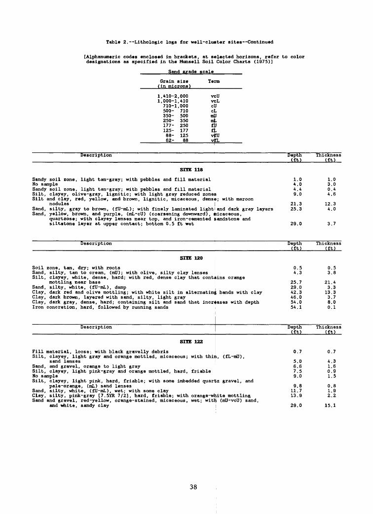
Table 2. Lithologic logs for well-cluster sites Continued
[Alphanumeric codes enclosed in brackets, at selected horizons, refer to color designations as specified in the Munsell Soil Color Charts (1975)]
Sand grade scale
Grain size Term(in microns)
1,410-2,000 vcU
Sandy
1,000-1,410 v710-1,000 c500- 710 c350- 500 m250- 350 m177- 250 f125- 177 f88- 125 v62- 88 v
Description
SHE 118
soil zone, light tan-gray; with pebbles and fill materialNo sampleSandySilt,Silt
Sand,Sand,
soil zone, light tan-gray; with pebbles and fill material
:LJ
J
J
bCL
Depth(ft)
1.04.04.4
clayey, olive-gray, lignitic; with light gray reduced zones 9.0
Thickness(ft)
1.03.00.44.6
and clay, red, yellow, and brown, lignitic, micaceous, dense; with maroonnodulessilty, gray to brown, (fU-mL); with finely laminated light
21.3and dark gray layers 25 . 3
12.34.0
yellow, brown, and purple, (mL-cU) (coarsening downward), micaceous,quartzose; with clayey lenses near top, and iron-cemented sandstone and
SoilSand,Silt,
Sand,Clay,Clay,Clay,Iron
siltstone layer at upper contact; bottom 0.5 ft wet
Description
SITE 120
zone, tan, dry; with rootssilty, tan to cream, (mil); with olive, silty clay lenses
29.0
Depth (ft)
0.54.3
3.7
Thickness (ft)
0.53.8
clayey, white, dense, hard; with red, dense clay that contains orangemottling near basesilty, white, (fU-mL), damp
25.729.0
dark red and olive mottling; with white silt in alternating bands with clay 42.3dark brown, layered with sand, silty, light gray 46.0dark gray, dense, hard; containing silt and sand that increases with depth 54.0concretion, hard, followed by running sands
Description
SITE 122
Fill material, loose; with black gravelly debrisSilt,
Sand,Silt,
clayey, light gray and orange mottled, micaceous; with thiisand lensesand gravel, orange to light grayclayey, light pink-gray and orange mottled, hard, friable
No sampleSilt,
Sand,Clay,Sand
54.1
Depth (ft)
0.7L, (fL-mU),
5.06.67.59.0
21.43.313.33.78.00.1
Thickness (ft)
0.7
4.31.60.91.5
clayey, light pink, hard, friable; with some imbedded quartz gravel, andpale-orange, (mL) sand lensessilty, white, (fU-mL), wet; with some clay
9.811.7
silty, pink-gray [7. SYR 7/2], hard, friable; with orange-white mottling 13.9
0.81.92.2
and gravel, red-yellow, orange-stained, micaceous, wet; with (mil-veil) sand,and white, sandy clay 29.0 15.1
38

Table 2. Lithologic logs fox well-cluster sites Continued
[Alphanumeric codes enclosed in brackets, at selected horizons, refer to color designations as specified in the Munsell Soil Color Charts (1975)]
Sand grade scale
Grain size Term(in microns)
1,410-2,000 vcU1,000-1,410 vcL
710-1,000 cU500- 710 cL350- 500 mU250- 350 mL177- 250 fU125- 177 fL88- 125 vfU62- 88 vfL
Description
SITE 123
Soil, silty, zone, gray-brown; somewhat clayeySilt, sandy, orange-brown [10YR 6/6], gray, and rust [2. SYR 4/7], dry; with
sparse clay lensesSand, orange-brown [10YR 6/3], fine-grained, wetSilt, mottled, dense, dry, sharp contact with sand above, iron concretions
with pebbles at contactSand, silty, gray, (vfL-mL), poorly sorted, micaceous, wet; intermixed with
clay near baseClay, silty, red [2. SYR 3/4], ochre, and light gray marbled, soft, plastic,
micaceousSand, clayey, light gray, (vfU-fU), micaceousClay, silty, multicolored marbled, soft, plasticClay, yellow-ochre, light gray, and red marbled, hard; with silt and sand
lenses, and iron concretionsSand, clayey, light gray, (vfU-fL), micaceous; intermixed with hard, olive-green
to gray, silty clay; with thin partings of clean, fU, orange-red sandNo sampleSand and gravel, multicolored, poorly sorted, micaceous; with iron-cemented
sandstone, small nodules of white silty claySand, multicolored, (fU-mL), micaceous, wet; color banded; includes silty fine
grained layers, and dark mineral grainsNo sampleSand, silty, white, (fU-mL), micaceous; multicolored at top, becoming predominantly
white towards bottomSilt, clayey, white, micaceous, banded; with small purple nodules and poorly
sorted, clean, micaceous, (fL-mL), white and orange sandSand, white, purple, and orange-brown, banded, (mL-mU), micaceous, wet; with some
dark mineral grains
Description
SITE 124
No sampleSand, silty, orange-brown, (fL-mL), micaceous; coarsening downwardSilt, sandy, gray, quart zose, micaceousSand and silt, orange, brown, tan, and maroon mottled, (mL), micaceous, poorly
sorted; with iron-cemented nodules at upper contactSand, orange and brown, (mL-mU), quart zose, wet; coarsening downward, iron-
cemented nodules, and small black mineral grains presentSand, orange-brown, (mll-cL), quart zose, wetNo sampleSand, orange-brown, (cL), quartzoseSilt, buff to brown, dense; with orange-brown sandy partingsSand, silty, buff and mustard, micaceous; with iron-cemented sand nodulesSilt, sandy, mustard and brown, (fL-mL), finely laminated, lignitic, micaceous;
with purple, semi-consolidated silt nodulesSilt, sandy, dark gray, (fL), micaceous, lignitic; with top marked by abundant
medium-grained, orange-brown sand laminaeSilt, sandy, dark gray, dense, medium grained, micaceousSand, silty, dark gray, (mL), micaceous; dark gray silt laminae in lower 0.3 ftSand, light gray to multicolored, (mL-mU), micaceous; with clayey lenses near
top, and semi -consolidated siltstone nodules in maroon zonesSand, multicolored, (ml)); with silt lenses, (0.3 ft thick)Sand, light gray, light tan, and orange-brown, (mL-cU), micaceous; coarsening
downward, iron-cemented sandstone nodules, and occasional clay lenses
Depth(ft)
0.8
18.223.7
26.1
43.5
46.948.049.0
64.0
71.874.0
79.0
85.089.0
99.0
99.6
102.7
Depth (ft)
4.07.08.0
9.0
14.017.319.021.523.724.0
33.2
34.037.840.0
49.054.0
64.0
Thickness(ft)
0.8
17.45.5
2.4
17.4
3.41.11.0
15.0
7.82.2
5.0
6.04.0
10.0
0.6
3.1
Thickness (ft)
4.03.01.0
1.0
5.03.31.72.52.20.3
9.2
0.83.82.2
9.05.0
0.0
39
Table 2. Lithologic Logs for well-cluster sites Continued
[Alphanumeric codes enclosed in brackets, at selected horizons, refer to color designations as specified in the Munsell Soil Color Charts (1975)]
Sand grade scale
Grain size Term(in microns)
1,410-2,000 vcU1,000-1,410 v
710-1,000 cl500- 710 c!350- 500 ml250- 350 m
:LJ.1
J.»
177- 250 fU125- 177 fL88- 125 vfU62- 88 vfL
Description
SITE 126
Soil, clayey, brown; with rootsSand, clayey, dark brown-orange [10YR 4/6], (fU), moistSilt, orange [10YR 4/6] and gray (5Y 6/1) mottled, hard, dry
Depth(ft)
0.73.34.0
Silt, clayey, green, brown, and orange mottled, (fU); with thin sand lenses 6.1Sand, white, yellow, and orange [10YR 7/8] mottled, dry 9.0
Thickness(ft)
0.72.60.72.12.9
Sand, white to pink, (mL-mU), orange- streaked, micaceous; increasing wetnesswith depth
Sand, light orange [10YR 7/6], (mL-mU), wetSand, orange [10YR 6/8], (mL-mU), micaceous, wetNo sample
13.114.017.519.0
Sand, orange [10YR 6/8], (mL); with thin, gray clayey sand lenses 19.6Sand, gray [2. SYR 4/0], (mL) , lignitic, clayey sand lenses 20.0Sand, clayey, dark gray [2. SYR 3/0], micaceous, lignitic, soft, wet 24.0
Description
SITE 127
Soil zoneSand, silty, orange-brown [7.5 YR 5/8], (mL-mU); moist near base
Depth (ft)
0.77.0
4.10.93.51.50.60.44.0
Thickness (ft)
0.76.3
Sand, pale brown [10YR 7/3] and orange mottled, (mU), well-sorted, subrounded;with large cobbles and sandstone fragments 8.8 1.8
Sand, silty, light gray and orange mottled, (fU-fL), micaceous, lignitic;with gradational color change to mottled pink-gray and pink-orangebottom 1.3 ft
Sand, light red-brown [SYR 6/3], (cU-mU)Silt, sandy, orange and light gray mottled, (fU-fL), micaceousSilt, clayey, and sand, dark gray, (fU-fL), micaceousClay, brown and light gray to mottled pink-gray, red, yellow and
Description
SITE 128
Sand, silty, light olive-brown [2.5Y 5/4], subrounded, quart zoseSand, clayey, yellow-brown [10YR 5/4] (mU), quartzoseSand, brown-yellow [10YR 6/6], (raL-fL), subrounded, quartzose
10.311.513.314.5
dark gray 19 . 0
Depth (ft)
1.62.63.8
1.51.21.81.24.5
Thickness (ft)
1.61.01.2
Sand light gray [10YR 7/1] and brown-yellow [10YR 6/6] mottled, (cL), subangular,quartzose, clean 6.0
Sand, yellow-red [SYR 5/8], (mL-fL), quartzose; with abrupt upper contact 6.2Sand, silty, yellow-red [SYR 5/8] and light gray [10YR 7/1] banded, quartzose 6.8Sand, dark gray [SYR 4/1], (fU), quartzose, micaceous; with abrupt upper contact 11.0
2.20.20.64.2
Clay, silty, light gray [10YR 8/1], red [10R 4/8], and olive-grefen, tight; withabrupt upper boundary, and thin sand lenses 19.0 8.0
40

Table 2. Lithologic logs for well-cluster sites Continued
[Alphanumeric codes enclosed in brackets, at selected horizons, refer to color designations as specified in the Munsell Soil Color Charts (1975)]
Sand grade scale
Grain size Term(in microns)
1,410-2,000 vcU1,000-1,410 vcL
710-1,000 cU500- 710 cL350- 500 mU250- 350 mL177- 250 fU125- 177 fL88- 125 vfU62- 88 vfL
Description
SITE 129
Sand, silty, dark yellow-brown [10YR 4/4], (fU), subrounded, quartzoseSand, clayey, brown [7. SYR 4/6], (mU), subroundedSand, yellow-brown [10YR 5/8] to pink-white [7. SYR 8/2], (mL-mU), quartzoseClay, silty, light gray [10YR 7/1], brown-yellow [10YR 6/8], (fU), quartzoseSand, brown-yellow [10YR 6/6], (mL), subangular, quartzoseSand, silty, brown-gray [10Y/R 6/2] and brown [7.5YR 5/6] banded, (fU), quartzoseClay, sandy, dark gray [5Y 3/1], (fU), quartzoseSand, silty, dark gray, (fU-mU), quartzoseSand, dark gray, (ell-veil), rounded, quartzose; with trace feldspar, and organic odorNo sampleClay, sandy, light gray [5Y 6/1], (fU), quartzose; distinct upper contact
Description
SITE 130
Soil zone, dark gray; with fill material containing large rock fragmentsSilt, light orange and white, (fU-fL), hard, drySilt, clayey, red, orange, light gray, and white marbled, (fL-fU); with small
maroon nodules, and thin sand lensesSand, white to light gray, orange-mottled, (fU-fL), micaceous; with sparse
clayey sand lensesClay, sandy, orange, brown, white, and gray marbled, (fL-fU), hard; with patches
of maroon sandSand, light gray-tan, (fL-fU), micaceous, moist; with thin, dark gray clay layersSand, clayey, light pink-tan, orange-stained, (fL-fU), micaceous, ligniticSand, white, yellow, purple, orange banded, (fU-mU), wet; with small sandstone
nodules
Description
SITE 131
Clayey and silty soil zone, dark brown [10YR 3/3]Sand, light brown-gray [10YR 7/1] and orange [10YR 6/8] mottled, (fU-mL);
interbedded with clayey sandNo sampleSand, clayey, and silt, interbedded, orange and gray mottled; with some bandingSilt, clayey, orange [.5YR 5/8], micaceousSand, clayey, dark grayish-brown [7.5 YR 4/0], wetSand, light gray, (mL), clean, micaceousSand, clayey, dark gray, (vfU-mL), micaceous; with some thin, brown laminae
Depth(ft)
1.03.08.59.0
12.013.614.017.019.021.034.0
Depth (ft)
0.73.1
6.3
9.9
22.928.229.3
34.0
Depth (ft)
0.4
1.84.08.29.0
12.312.819.0
Thickness(ft)
1.02.05.50.53.01.60.43.02.02.013.0
Thickness (ft)
0.72.4
3.2
3.6
13.05.31.1
4.7
Thickness (ft)
0.4
1.42.24.20.83.30.56.2
41

Table 2. Lithologic logs fox well-cluster sites Continued
[Alphanumeric codes enclosed in brackets, at selected horizons, refer to color designations as specified in the Munsell Soil Color Charts (1975)]
Sand grade scale
Grain size Term(in microns)
1,410-2,000 vbU1,000-1,410 v710-1,000 c500- 710 c350- 500 m
cL[)LU
250- 350 ml177- 250 fU125- 177 ft88- 125 vfU62- 88 v
Description
SITE 132
Soil
fL
Depth(ft)
0.1Sand, silty, brown [7. SYR 4/4], (fU) 1.8Sand, yellow [10YR 7/4], (fU-mL), dry; with some iron concretions 8.6Silt, clayey, and sand, light gray to orange, interfingered 14.0Sand, dark gray, (mU-mL) , soupy 15.7Sand, clayey, and gravel, dark gray, interfingered with dark graClay, silty, dark gray, micaceous, soft
Description
SITE 133
f silty clay 16.319.0
Depth (ft)
Soil 0.2Sand and gravel, brownish-orange, (fU-mU); with fill material 4.6Sand, yellow [10YR 7/6], (fU-cL), well-sorted; coarsening downward 24.0No sample 34.0Clay, silty, pinkish-white [2. SYR 6/0]; with small red concretions 40.1Sand, tan [7.5 YR 8/2], (fL-cL), poorly sorted 44.0
Description Depth (ft)
SITE 134
Soil, clayey, dark brown, plastic, organic-rich 1.2Silt, clayey, orange-brown, plastic; with some sand 4.3Silt, sandy, gray-orange-mottled 9.0Sand, tan to gray, (fU-cU), clean 11.0Sand, silty, orange to tan; with sand up to (cL) 14.0Clay, silty, dark gray, dense and plastic 25.7Sand and clay, orange-gray to light gray, interfingered 26.6Sand, multicolored, (fU-mL); with large iron concretions 32.2Clay, pinkSand, white multicolored-banded, (fU-mL), wetNo sampleClay, silty, dark gray [SYR 4/1] to reddish-brown [SYR 3/3], lig
with some fine sandSand, light gray, (mL-mll), well-sortedSand, clayey, white to light gray, multicolor-banded, micaceous,
32.639.844.0
litic, hard;51.553.2
hard 62 . 4Clay, sandy, white, hard 62.8Sand, multicolored, (mil), clean, soupy 67.2Sand, clayey, white, purple, and yellow, micaceous 67. 5
Description Depth (ft)
SITE 135
Soil, gray-brown [10YR 3/2], organic-rich 0.4Sand, silty and clayey, brown [7. SYR 5/8], (mU) 2.5Clay, sandy, light yellow-brown [10YR5/6], (mL) 3.8Sand, yellow-brown [10YR 6/8], (fU-mU), micaceous 17.7Sand, dark gray [5Y 4/1], (mU) , micaceous 21.3Sand, clayey and silty, dark gray, (fL-fU) 34.0
Thickness(ft)
0.11.76.85.41.70.62.7
Thickness (ft)
0.24.4
19.410.06.13.9
Thickness (ft)
1.23.14.72.03.0
11.70.95.60.47.24.2
7.51.79.20.44.40.3
Thickness (ft)
0.42.11.3
13.93.6
12.7
42

Table 2. Lithologic logs for well-cluster sites Continued
[Alphanumeric codes enclosed in brackets, at selected horizons, refer to color designations as specified in the Munsell Soil Color Charts (1975)]
Sand grade scale
Grain size (in microns)
1,410-2,0001,000-1,410
710-1,000500- 710350- 500250- 350177- 250125- 17788- 12562- 88
Term
vcUvcLcUcLmUmLfUfLvfUvfL
Description Deptn Thickness ______________________________________________________________________(ft)______(ft)
SITE 136
No sample 125.0 125.0Sand, gravelly, multicolor-banded, (mL-cL), soupy 140.5 15.5Clay, silver-gray, micaceous, hard, plastic 145.0 4.5
DescriptionDepthThickness ______________________________________________________________________(ft)______(ft)
SITE 138
Soil, dark brown 0.7 0.7Sand, silty, orange to orange-brown, (mil) 4.0 3.3Sand, buff, (fU-mU), clean 9.3 5.3Sandy silt and clay, orange and gray 19.0 9.7Clay, silty, dark gray; with large lignite fragments 57.5 38.5Silt, clayey, light gray, micaceous; with some sand 62.0 4.5
43

Table 3. Synoptic water-leveX measurements
[ , data not collected]
Local number
CC-1ACC-1BCC-1CCC-1DCC-1E
CC-1FCC-2ACC-2BCC-2CCC-3A
CC-3BCC-4ACC-4BCC-5ACC-5B
CC-5CCC-6ACC-6BCC-6CCC-7A
CC-7BCC-7CCC-8ACC-8BCC-8C
CC-8DCC-8ECC-9ACC-9BCC-10A
CC-11ACC-11BCC-12A.1CC-12ACC-12B
CC-13ACC-13BCC-14ACC-14BCC-15A
CC-16ACC-16BCC-16CCC-16DCC-17A
CC-17BCC-17CCC-18ACC-18BCC-19A
CC-19BCC-20ACC-20BCC-20CCC-20D
CC-21ACC-22ACC-22BCC-22CCC-23A
CC-23BCC-25ACC-25BCC-26ACC-26B
Hater levels,
11/18/86
5.015.415.467.357.08
8.471.497.135.073.84
4.234.694.727.424.74
4.775.11
4.80
4.81 4.784.794.81
4.835.88
13.414.823.82
0.082.73
6.406.525.685.555.40
2.552.5210.4810.502.64
2.6910.317.157.16
20.45
5.855.876.396.506.63
2.995.466.336.336.67
5.744.974.945.484.91
in feet above sea level
02/17/87
6.6.6.7.7.
8.1.6.6.3.
4.5.5.
11.5.
5.6.--
5.
5.-
5.5.5.
5.6.
14.12.12.
3!
4.4.
7.7.6.6.6.
3.2.
10.112.
21078
2970906871
7949134670
8344490165
6604--59
61-565358
6310481271
3239-2631
4459505910
9864878980
75703841
25.90
8 147.207.998.478.51
3.227.998.388.389.51
7.476.046.016.415.92
08/25/87
4.125.315.567.247.38
8.321.167.184.553.33
4.564.714.737.864.72
4.755.10
4.81
4.825.154.294.844.84
4.885.9212.994.8811.56
3.223.23
3.903.93
6.346.435.236.285.23
3.222.8710.0910.092.99
2.759.947.087.11
20.85
6.475.666.496.746.78
3.335.466.496.517.11
5.794.894.865.414.75
03/18/88
5.896.436.617.727.84
8.841.817.675.194.01
5.005.405.41
10.605.53
5.565.956.046.186.04
5.555.885.515.525.55
5.606.18
14.275.4512.82
3.563.569.734.304.34
7.417.566.437.516.17
3.672.9310.9110.933.01
2.9410.748.318.34
25.45
7.726.807.627.898.38
3.416.817.957.979.14
7.265.925.896.295.81
44

Table 3. Synoptic water-level measurements Continued
[ , data not collected]
Local number
CC-26CCC-27ACC-27BCC-28ACC-28B
CC-28CCC-29ACC-29BCC-30ACC-31A
CC-32ACC-32BCC-33ACC-33BCC-34A
CC-35ACC-36ACC-36BCC-36CCC-36D
CC-37ACC-38ACC-39ACC-39BCC-40A
CC-41ACC-42ACC-43ACC-44ACC-101A
CC-101BCC-101CCC-102ACC-102BCC-102C
CC-104ACC-104BCC-104CCC-106ACC-107A
CC-107BCC-108ACC-108BCC-109ACC-109B
CC-110ACC-111ACC-111BCC-112ACC-113A
CC-113BCC-114ACC-114BCC-114CCC-115A
CC-117ACC-117BCC-118ACC-118BCC-120A
CC-120BCC-121ACC-121BCC-122ACC-123A
Water
11/18/86
9.323.624.274.094.11
2.844.703.008.22
0.981.00.11.78.93
-4.07------
12.7012.9012.7412.8112.86
13.5613.7112.969.26--
----
--------
--------
----
---- --
--------
------
levels, in feet
02/17/87
9.714.174.984.764.81
3.675.603.299.34
.69
.70
.65
.29
.76
-3.389.30--
13.5714.7314.5414.6114.59
15.6015.7915.0210.56
----
------
--------
------
---- --
--------
__------
above sea
08/25/87
9.043.494.184.243.96
2.444.663.348.54
1.061.31.97
1.411.12
-3.816.71 --
13.7913.9713.7813.8613.94
14.6414.8213.959.49
--
----
4.17--
----
6.716.17
5.063.003.052.814.54
4.569.014.784.815.03
--
6.626.65
----
level
03/18/88
9.784.184.964.714.76
10.053.455.503.469.46
.79
.86
.69
.67
.73
-3.488.738.507.967.87
14.7614.8214.7214.7914.79
15.7915.9815.2410.357.11
6.776.325.888.399.00
3.625.175.164.988.41
8.438.548.487.877.19
3.983.033.032.675.60
5.5910.895.935.906.16
5.575.577.707.7610.89
10.885.575.58
21.153.83
45

Table 3. Synoptic water-level measurements Continued
[ , data not collected]
Local Water levels, in feet above sea level number ______________________________________
11/18/86 02/17/87 08/25/87 03/18/88
CC-123B 5.76CC-124A 12.59CC-124B 7.34CC-126A 14.29CC-127A 18.71
CC-128A 18.53CC-129A 17.06CC-130A 6.28 7.35CC-130B 12.00 7.26CC-131A 7.70
CC-132A 8.24CC-133A -- 9.64CC-133B -- 9.72CC-134A ~ 3.77CC-134B 3.76
CC-135A 10.56CC-136A 5.14CC-136B 5.14CC-138A -- dry
46

HYDROGRAPHS
(figures 4 through 11)
47

LU
LU
LU COLU
oQQ
LU LU
LU
LU _JC£ LU!<
I I I I I I I I I
Data not available
V1 1 1 1 1 1 1 1
AMJJASONDJFM 1987 1988
Figure 4. Water levels for well 1A, April 1987
through March 1988.
LU
LU
LU CO
oQQ
LU LU
LU
LU
SEP OCT NOV DEC JAN FEB MAR 1987 1988
Figure 5. Water levels for well 1B, September 1987 through March 1988.
48

LU
L±J
L±J CO
oCD
L±J U_
L±J
L±J
I \
I_____I
JUL AUG SEP OCT NOV DEC JAN FEB MAR 1987 1988
Figure 6. Water levels for well 1C, July 1987 through March 1988.
UJ
UJ
UJ COUJ
OCD
UJu_
UJ
UJ_)01 UJ
- - - Data not available
\_____]_____I_____I J____I
JUN JUL AUG SEP OCT NOV DEC JAN FEB MAR 1987 1988
Figure 7. Water levels for well 1D, June 1987 through March 1988.
49

LU
LU
LU COLU
OCD
LU LU U_
LU
LU
LU
I I I I I I I I I I T
- - - Data not available
i i i i i __ i___i___i___i___i___i
AMJJASONDJFM 1987 1988
Figure 8. Water levels for well 7A, April 1987 through March 1988.
LU
LU
LU COLU
OCD
LU LU
LU
LU
LU
7 i i i i
Data not available
I i I I I T
i i___i___i i i
AMJJASONDJFM 1987 1988
Figure 9. Water levels for well 8C, April 1987 through March 1988.
50

bJ
bJ
bJ"bJ
O
bJ
bJ 2
bJ
ffi 1
AUG SEP OCT NOV DEC JAN FEB MAR 1987 1988
Figure 10. Water levels for well 16B, August 1987 through March 1988.
LU
10LU 00bJ > O GO
R LU 8LU
LU
LU
LU
AUG SEP OCT NOV DEC JAN FEB MAR 1987 1988
Figure 11. Water levels for well 18B, August 1987 through March 1988.
51 . 53

GEOPHYSICAL LOGS
(figures 12-29)
53

bJ O Q 3 LJ m LJ
LJ Q_
LJ
Q
0 -
40
-
80
-
120
-
160
20
0
SP
ON
TAN
EO
US
P
OTE
NTI
AL
SP
ON
TA
NE
OU
S
PO
TEN
TIA
LR
ES
ISTA
NC
E
Ohm
s
- o
- 40
- so
- 12
0
- 160
20
0
Fig
ure
12. E
lectr
ic
and
g
amm
a lo
gs
fro
m
bo
rin
gs
dri
lle
d
usin
g th
e
mud
ro
tary
m
eth
od
fo
r s
ite
s
1 an
d
2.

Ui
Ui
LU
O 01 ID
Ul
Q 3 LU
CD LU
LU Q_
LU
Q
0
-
40
-
80
-
120
-
160
-
200
SP
ON
TAN
EO
US
P
OTE
NTI
AL
SIN
GLE
P
OIN
TS
PO
NT
AN
EO
US
P
OTE
NTI
AL
60 Mv
RE
SIS
TAN
CE
O
hms
35
Ohm
Site
4
GA
MM
A
Radia
tion i
ncr
ease
s
40 80
120
160
200
Fig
ure
1
3.
Ele
ctr
ic a
nd g
amm
a lo
gs
from
bo
rin
gs
dri
lled
usi
ng t
he
mud
ro
tary
m
eth
od
fo
r si
tes
3 an
d 4.
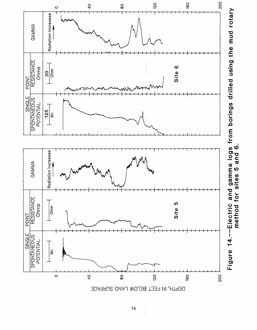
40
LU
O CO
Q 3 LU
LL_
Q_
LU
Q
80
12
0
160
200
SIN
GLE
P
OIN
TS
PO
NT
AN
EO
US
P
OTE
NTI
AL
Mv
RE
SIS
TAN
CE
O
hm
s
Ohm
Sit
e
5
GA
MM
A
Rad
iatio
n in
crea
ses
SIN
GLE
P
OIN
TS
PO
NT
AN
EO
US
P
OTE
NTI
AL
125
Mv
RE
SIS
TAN
CE
O
hm
s
20
Ohm
Site
6
GA
MM
A
Rad
iatio
n in
crea
ses
40 80 120
160
200
Fig
ure
1
4.
Ele
ctr
ic
and
gam
ma
log
s fr
om
bo
rin
gs
dri
lle
d u
sing
th
e m
ud
rota
ry
met
ho
d f
or
site
s 5
and
6.
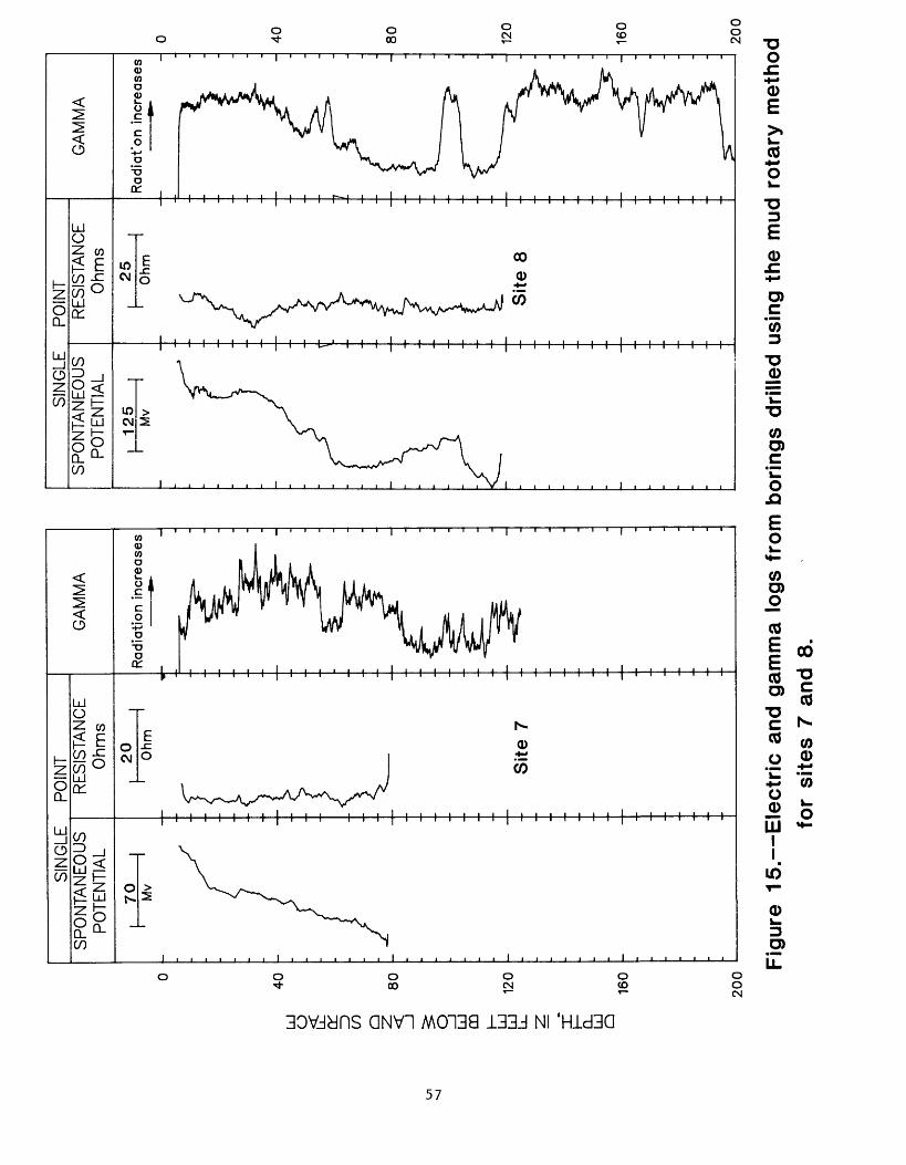
DEPTH, IN FEET BELOW LAND SURFACE
3! 5"cCD
O1
I I
-* m* 8 e/> q-* * " u*CD °C/> Q)
^ a§ CD
£§P° 30)o"(Q 0)
O3CJo2. 5'(Q 0)
Q.
CD Q.cCO5"(Q
CD
3
Q.^Ol-t-
^ <
CD
O Q.
K) O O
O) N> 00 ^ O O O O
S2 < o
CO!-» "
(D^1
o w3- O3
I I I I I I I I I I I I I I I I I I I I I I I I I I I
CO "°0
gi m^
?lCO
3J mOJ5 zr CO3 >!« 21
o m
CO~z. o r~ m
T)O
i i i i i i i | i i i i i i i | i i i i i i i I i ii i i I i i i i i i
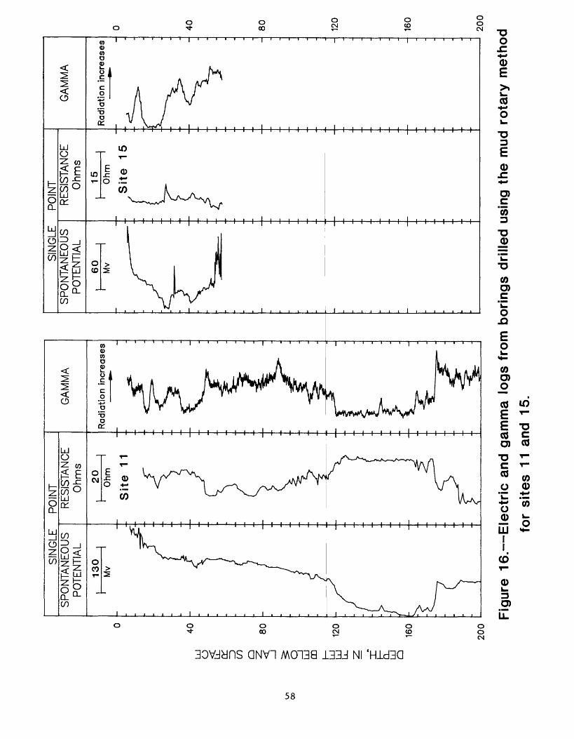
Ui
00
LU
O CO
Q LJ
DO LJ
Ld I Q
SP
ON
TAN
EO
US
P
OTE
NTI
AL
SP
ON
TAN
EO
US
P
OTE
NTI
AL
200
SIN
GLE
P
OIN
TR
ES
ISTA
NC
E
Ohm
s
15
Ohm
'
Sit
e
15
GA
MM
A
Rad
iatio
n in
crea
ses
40 80 120
160
200
Figu
re 1
6. E
lectr
ic a
nd g
amm
a lo
gs f
rom
bor
ings
dri
lled
usin
g th
e m
ud r
ota
ry m
etho
d
for
site
s 11
and
15.

vo
LU
O £ cr ID
CO Q 3 LU
DO LU
LU Q
- LU
Q
40
80
120
160
200
SIN
GLE
P
OIN
TS
PO
NTA
NE
OU
S
PO
TEN
TIA
L
40
Mv
RE
SIS
TAN
CE
O
hms
20
Ohm
Sit
e 2
9
GA
MM
A
Ra
dia
tion
in
cre
ase
s
SIN
GLE
P
OIN
TS
PO
NTA
NE
OU
S
PO
TEN
TIA
L
140
Mv
RE
SIS
TAN
CE
O
hms
85
Ohm
Sit
e 10
4 -
GA
MM
A
Ra
dia
tion
incr
ease
s
40
80
120
160
20
0
Figu
re 1
7. E
lectr
ic a
nd g
amm
a lo
gs f
rom
bor
ings
dri
lled
usin
g th
e m
ud r
ota
ry m
etho
d fo
r si
tes
29 a
nd
104.

DEPTH, IN FEET BELOW LAND SURFACE
i i i I i i i i i i i i i i i i i i i i i i i i i i i i i i ' i i i
I I I I I I I I I I I hH I I I I I I I-H I I I I I r H I I I I
I I I I I I I I II I I I I I I I I I I I I I I I I I I I

Q_
LU
Q
0 -
40
-
80
-
LU
O ID (n
Q 3 LU
LU
-i on
LU
'2
0
16
0
-
20
0
SP
ON
TAN
EO
US
P
OTE
NTI
AL
40
80
120
160
200
240
280
32
0
360
400
SIN
GLE
P
OIN
TS
PO
NTA
NE
OU
S
PO
TEN
TIA
L
Mv
RE
SIS
TAN
CE
O
hms
40
Oh
m
Sit
e T
H1
::
GA
MM
A
Rad
iatio
n in
crea
ses
Figu
re 1
9.
Ele
ctr
ic a
nd g
amm
a lo
gs f
rom
bor
ings
dri
lled
usin
g th
e m
ud r
ota
ry m
etho
d fo
r si
tes
136
and
TH
1.
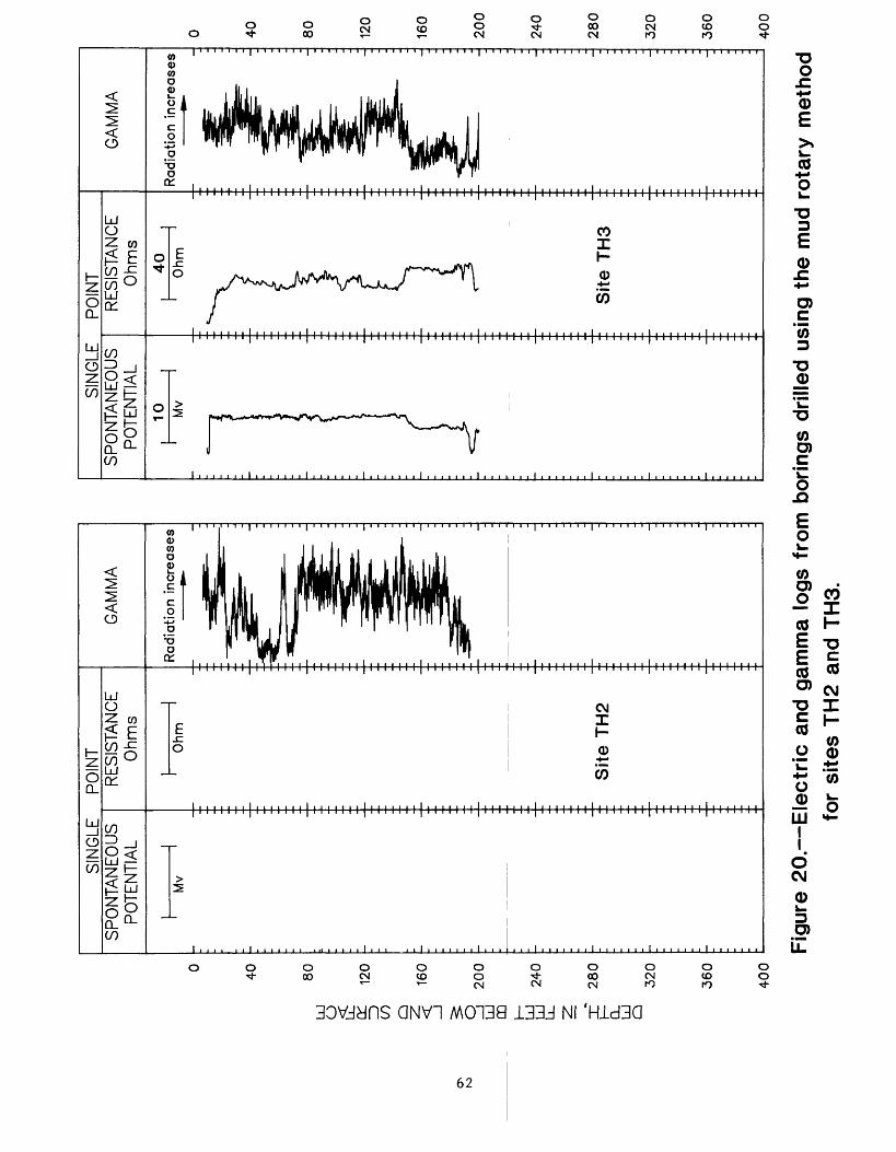
LU
O 00
Q LU
OQ
40
80
120
160
200
ft
240
U_ 31
280
CL
LU
Q320
360
400
SIN
GLE
P
OIN
TS
PO
NTA
NE
OU
S
PO
TEN
TIA
L
Mv
RE
SIS
TAN
CE
O
hms
Ohm
:: S
ite
TH
2
GA
MM
A
Rad
iatio
n in
crea
ses
SIN
GLE
P
OIN
TS
PO
NTA
NE
OU
S
PO
TEN
TIA
L
10 Mv
RE
SIS
TAN
CE
O
hms
40
Oh
m
Sit
e T
H3
GA
MM
A
Rad
iatio
n in
crea
ses
Figu
re 2
0.
Ele
ctr
ic a
nd g
amm
a lo
gs f
rom
bor
ings
dri
lled
usin
g th
e m
ud r
ota
ry m
etho
d fo
r si
tes
TH
2 an
d TH
3.

u>
LJ Z)
00 Q 3 LJ
CD
40
80
120
CL
LJ
Q16
0
200
GA
MM
A
Co
un
ts/s
eco
nd
Ra
dia
tion
incr
ease
s
Sit
e 9
GA
MM
A
Co
un
ts/s
eco
nd
Radia
tion i
ncr
ea
ses
Sit
e 10
GA
MM
A
Co
un
ts/s
eco
nd
Ra
dia
tion
in
cre
ase
s
Sit
e
13
GA
MM
A
Co
un
ts/s
eco
nd
Ra
dia
tion
in
cre
ase
s
Sit
e 14
GA
MM
A
Co
un
ts/s
eco
nd
Radia
tion i
ncr
ea
ses
Sit
e
16
GA
MM
A
Co
un
ts/s
eco
nd
Ra
dia
tion
incr
ease
s
Sit
e 17
40
80
120
160
20
0
Figu
re 2
1. G
am
ma l
ogs
from
bor
ings
dril
led
usin
g th
e ho
llow
-ste
m a
uger
met
hod
for
site
s 9,
10,
13,
14,
16
and
17.

0 -
40
-
80
Ld
O £ a: ID
CO < g Ld
DO a 120
Q_
Ld
Q16
0
200
GA
MM
A
Co
un
ts/s
eco
nd
Radia
tion i
ncr
ease
s
Sit
e 18
GA
MM
A
Co
un
ts/s
eco
nd
Radia
tion i
ncr
ea
ses
Sit
e 19
GA
MM
A
Counts
/seco
nd
Radia
tion i
ncr
ease
s
Sit
e 20
GA
MM
A
Co
un
ts/s
eco
nd
Ra
dia
tion
in
cre
ase
s
GA
MM
A
Counts
/seco
nd
Ra
dia
tion
incr
ease
s
Sit
e 21
--
S
ite
22
Sit
e 2
3
GA
MM
A
Counts
/seco
nd
Ra
dia
tion
incr
ease
s
40 80
120
160
200
Figu
re 2
2. G
am
ma l
ogs
from
bor
ings
dril
led
usin
g th
e ho
llow
-ste
m a
uger
met
hod
for
site
s 18
, 19
, 20
, 21
, 22
and
23.

N> O O
DEPTH, IN FEET BELOW LAND SURFACE
O) N> 00 ^ O O O O

LU
O £ o:
=) CO
40
80
3 LU
DO Ld
120
CL
LU
Q16
0
200
L -
GA
MM
A
Co
un
ts/s
eco
nd
Ra
dia
tion
incr
ease
s
Sit
e 32
GA
MM
A
Co
un
ts/s
eco
nd
Ra
dia
tion
incr
ease
s
Sit
e 3
3
GA
MM
A
Co
un
ts/s
eco
nd
Ra
dia
tion
incr
ease
s
Sit
e 34
GA
MM
A
Co
un
ts/s
eco
nd
Ra
dia
tion
incr
ease
s
Sit
e 3
5
GA
MM
A
Counts
/seco
nd
Ra
dia
tion
incr
ease
s
Sit
e 36
GA
MM
A
Co
un
ts/s
eco
nd
Ra
dia
tion
incr
ease
s
Sit
e 3
7
40
80
120
160
200
Figu
re 2
4.
Ga
mm
a l
ogs
from
bor
ings
dri
lled
usin
g th
e h
ollo
w-s
tem
aug
er m
etho
d fo
r si
tes
32.
33.
34.
35.
36 a
nd 3
7.

40
LU o ID
(/) Q 3 LU
00
80
120
Q_
LJ
Q16
0
200
GA
MM
A
Counts
/seco
nd
Ra
dia
tion
in
cre
ase
s
Sit
e 3
8
GA
MM
A
Co
un
ts/s
eco
nd
Radia
tion i
ncr
ea
ses
Sit
e 3
9
GA
MM
A
Counts
/seco
nd
Ra
dia
tion
incr
ease
s
Sit
e 41
GA
MM
A
Co
un
ts/s
eco
nd
Ra
dia
tion
in
cre
ase
s
Sit
e 4
3
GA
MM
A
Counts
/seco
nd
Ra
dia
tion
in
cre
ase
s
Sit
e 44
GA
MM
A
Co
un
ts/s
eco
nd
Ra
dia
tion
incr
ease
s
Sit
e 10
1
40
80
120
160
200
Fig
ure
25. G
am
ma l
ogs
from
bor
ings
dri
lled
usi
ng t
he
ho
llow
-ste
m a
uger
met
hod
for
site
s 38
, 39
, 41
, 43
, 44
and
10
1.

00
LoJ
O o: ID
00 Q LoJ
00 LU
LoJ z nf LoJ
Q
40
80
160
200
GA
MM
A
Co
un
ts/s
eco
nd
Ra
dia
tion
incr
ease
s
Sit
e 10
2
GA
MM
A
Counts
/seco
nd
Ra
dia
tion
incr
ease
s
Site
106
GA
MM
A
Co
un
ts/s
eco
nd
Ra
dia
tion
incr
ease
s
Sit
e 10
7
GA
MM
A
Co
un
ts/s
eco
nd
Ra
dia
tion
incr
ease
s
Site
108
GA
MM
A
Co
un
ts/s
eco
nd
Ra
dia
tion
incr
ease
s
Site
109
GA
MM
A
Co
un
ts/s
eco
nd
Ra
dia
tion
incr
ease
s
Site
111
40
80
120
160
200
Figu
re 2
6.
Ga
mm
a l
ogs
from
bor
ings
dri
lled
usin
g th
e h
ollo
w-s
tem
aug
er m
etho
d fo
r si
tes
102,
10
6,
107,
10
8, 1
09 a
nd 1
11.

UJ o & o: ID
00
40
80
3 UJ
DO a 120
LJ_ Q_
UJ
160
20
0
GA
MM
A
Counts
/seco
nd
Rad
iati
on
in
crea
ses
Sit
e 11
2
GA
MM
A
Co
un
ts/s
eco
nd
Rad
iatio
n in
crea
ses
Sit
e 11
3
GA
MM
A
Co
un
ts/s
eco
nd
Rad
iatio
n in
crea
ses
Sit
e 1
14
GA
MM
A
Counts
/seco
nd
Rad
iati
on
in
crea
ses
Sit
e 11
5
GA
MM
A
Co
un
ts/s
eco
nd
Rad
iatio
n in
crea
ses
Sit
e 11
8
GA
MM
A
Co
un
ts/s
eco
nd
Rad
iati
on
in
crea
ses
Sit
e 12
0
40
80
120
160
20
0
Fig
ure
27. G
am
ma l
ogs
from
bor
ings
dri
lled
usin
g th
e h
ollo
w-s
tem
au
ger
met
ho
d
for
site
s 11
2,
113,
11
4,
115,
11
8 an
d 12
0.

LU
O
40
CO
Q
<
80
DQ
120
Q_ LU
Q
160
200
GA
MM
A
Co
un
ts/s
eco
nd
Rad
iati
on
in
crea
ses
GA
MM
A
Co
un
ts/s
eco
nd
Rad
iati
on
in
crea
ses
Sit
e 1
22
-
Sit
e 1
23
GA
MM
A
Co
un
ts/s
eco
nd
Rad
iati
on
in
crea
ses
Sit
e
124
GA
MM
A
Counts
/seco
nd
Rad
iati
on
in
crea
ses
Sit
e 1
26
GA
MM
A
Co
un
ts/s
eco
nd
Rad
iati
on
in
crea
ses
GA
MM
A
Counts
/seco
nd
Rad
iati
on
in
crea
ses
Sit
e 12
7 S
ite
12
9
40
80 120
160
200
Figu
re 2
8. G
am
ma l
ogs
from
bor
ings
dril
led
usin
g th
e ho
llow
-ste
m a
uger
met
hod
for
site
s 12
2,
123,
124
, 12
6 12
7 an
d 12
9.

40
LU
O Z)
CO Q 3 LU
CD
80
120
Q_
LU
160
20
0
GA
MM
A
Co
un
ts/s
eco
nd
Ra
dia
tion
in
cre
ase
s
Sit
e
13
0
GA
MM
A
Co
un
ts/s
eco
nd
Radia
tion i
ncr
ea
ses
Sit
e 1
32
GA
MM
A
Co
un
ts/s
eco
nd
Radia
tion i
ncr
ea
ses
Sit
e
13
3
GA
MM
A
Co
un
ts/s
eco
nd
Radia
tion i
ncr
ea
ses
Sit
e
134
GA
MM
A
Co
un
ts/s
eco
nd
Ra
dia
tion
in
cre
ase
s
Sit
e
13
5
40
80
120
160
20
0
Figu
re 2
9. G
am
ma l
ogs
from
bor
ings
dri
lled
usin
g th
e h
ollo
w-s
tem
au
ger
met
hod
for
site
s 130,
132,
13
3,
13
4 a
nd
13
5.