hydrogeological sections of the pergamino … · 190 hydrogeological sections of the pergamino...
TRANSCRIPT

Research Article
Brazilian Journal of Geophysics, Vol. 18(2), 2000
Aquifers in the northeastern zone of the Buenos Aires Province, mainly used for agriculturalpurposes, were studied regionally by several authors, but local studies are necessary becausegreat variations may occur in different basins, and well data are limited. In this work, geophysicalexploration by means of Audio-magnetotelluric soundings and geochemical analyses of somewell data were carried out at the Pergamino rivulet basin. Depth and thicknesses of the upperhydrogeological section, the Epiparaniana, including the Pampeano and Puelches aquifers, weredetermined. Also, the hydro chemical evolution along the direction of regional groundwater flowwas studied. The depth of the very conductive layer corresponding to the salty Puelches and the�Green Miocene�, limiting the agricultural water usage, came out to be very variable dependingon the zone. Geochemical analyses showed that the Pampeano aquifer has bicarbonate sodiumwater, with an increase of electrical conductivity, sodium and bicarbonates contents at a localrecharge zone with impermeable and bad drainage soils and a topographical small slope.
Key words: Audio-magnetotellurics; Aquifers; Hydrochemistry; Pergamino basin.
SEÇÕES HIDROGEOLÓGICAS DA BACÍA DE PERGAMINO (PROVÍNCIA DE BUENOSAIRES, ARGENTINA): RESULTADOS AUDIOMAGNETOTELÚRICOS EGEOQUÍMICOS - Vários autores têm estudado regionalmente os aqüíferos na zona nordesteda provincia de Buenos Aires, principalmente aqueles usados na agricultura, mas, como osdados de poços são limitados, torna-se necessário efetuar pesquisas locais já que há grandesvariações segundo as diferentes bacías. Neste trabalho, realizaram-se explorações geofísicas(audio-magnetotelúricas) e análises geoquímicas na bacía de Pergamino. Pesquisou-se tambéma evolução hidroquímica na direção do fluxo regional da água no solo. Determinaram-se aprofundidade e espessura da seção superior hidrológica , a Epiparaniana, incluindo os aqüíferosPampeanos e Puelches. A profundidade do estrato condutivo correspondente aos Puelchessalgados e o �Green Miocene�, que limitam o uso da água na agricultura, resultou muitovariável segundo a zona. As análises geoquímicas mostraram que a água Pampeana ébicarbonatada sódica com um incremento na condutividade, com conteúdo de sódio e bicarbonatosna zona de recarga local, que tem solos impermeáveis, má drenagem e um leve declive.
Palavras-chave: Audio-magnetotelúrica; Aqüífero; Hidroquímica; Bacía de Pergamino.
HYDROGEOLOGICAL SECTIONS OF THE PERGAMINO BASIN(BUENOS AIRES PROVINCE, ARGENTINA): AUDIO
MAGNETOTELLURIC AND GEOCHEMICAL RESULTS.
C. Sainato1, M. C. Pomposiello2, A. Landini3, G. Galindo3 & H. Malleville1
Received March 23, 2000 / Accepted January 22, 2001
1Cátedra de Física. Fac. Agronomía - Fac. Agronomía. University of Buenos AiresAv. San Martín 4453 (1417). Buenos Aires. Argentina
Email: [email protected]. Argentina
3Depto de Geología. FCEN. UBA. - CONICET. Argentina
188 Hydrogeological Sections of the Pergamino Basin
Revista Brasileira de Geofísica, Vol. 18(2), 2000
INTRODUCTION
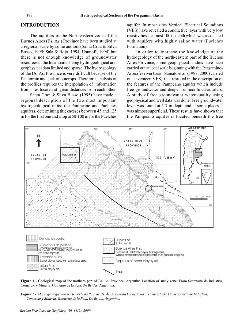
The aquifers of the Northeastern zone of theBuenos Aires (Bs. As.) Province have been studied ata regional scale by some authors (Santa Cruz & SilvaBusso, 1995; Sala & Rojo, 1994; Usunoff, 1994) butthere is not enough knowledge of groundwaterresources at the local scale, being hydrogeological andgeophysical data limited and sparse. The hydrogeologyof the Bs. As. Province is very difficult because of theflat terrain and lack of outcrops. Therefore, analysis ofthe profiles requires the interpolation of informationfrom sites located at great distances from each other.
Santa Cruz & Silva Busso (1995) have made aregional description of the two most importanthydrogeological units: the Pampeano and Puelchesaquifers, determining thicknesses between 45 and 125m for the first one and a top at 50-100 m for the Puelches
aquifer. In most sites Vertical Electrical Soundings(VES) have revealed a conductive layer with very lowresistivities at almost 100 m depth which was associatedwith aquifers with highly saline water (PuelchesFormation).
In order to increase the knowledge of thehydrogeology of the north-eastern part of the BuenosAires Province, some geophysical studies have beencarried out at local scale beginning with the Pergamino-Arrecifes river basin. Sainato et al. (1998; 2000) carriedout seventeen VES, that resulted in the description ofthe features of the Pampeano aquifer which includefree groundwater and deeper semiconfined aquifers.A study of free groundwater water quality usinggeophysical and well data was done. Free groundwaterlevel was found at 5-7 m depth and at some places itwas almost superficial. These results have shown thatthe Pampeano aquifer is located beneath the free
Figure 1 - Geological map of the northern part of Bs. As. Province. Argentina Location of study zone. From Secretaría de Industria,Comercio y Minería. Gobierno de la Pcia. De Bs. As. Argentina.
Figura 1 - Mapa geológico da parte norte da Pcia de Bs. Ás. Argentina.Locação da área de estudo. Da Secretaría de Industria,Comercio y Minería. Gobierno de la Pcia. De Bs. As. Argentina.

C. Sainato, M. C. Pomposiello, A. Landini, G. Galindo & H. Malleville 189
Brazilian Journal of Geophysics, Vol. 18(2), 2000
groundwater level and the observed changes inelectrical resistivity are influenced by lithology andwater quality. Its multilayer behaviour with intercalationof sand and clayey sediments (semiconfined aquifer)reflected average resistivities between 6 and 21 ohmm. The limit between fresh-salt water was thendetermined by the top of the high conductive layer andsome resistive intercalated layers were determined atsome sites whose thicknesses were doubtful becauseof the absence of sufficient well data.
The scope of this work was to have a betterdescription of this resistive layer and of the very highconductive one, trying to obtain deeper information,using Audio-Magnetotelluric Soundings (AMT). It isimportant to determine the thicknesses of the aquifersthat have good quality water which constitute a limitationin the available water for irrigation. Then, it wasnecessary to define more precisely the limit betweengood quality and salty water and to have a betterdescription of groundwater resources at the basin, aswell as to evaluate their chemical properties.
The studied zone is placed within the Rosario basinlimited by faults in a NW-SE direction (Irigoyen, 1975)at the NW of the Pergamino city (NE of Bs. As.Province, Argentina), along the basin of the river namedalike (Fig. 1, Fig. 2) . The main physiographicenvironment is the Pampean plain, characterized by
dissection troughs and terraces. The soft topographicslopes increase infiltration and/or evapotranspirationwhich hinder the superficial running off (Sala, 1975).
Twelve Audio-magnetotelluric soundings werecarried out and water samples were taken at theavailable wells for chemical analyses .
GEOLOGICAL AND HYDROGEOLOGICALSETTING
In Fig. 1 a geological map with the outcroppingssediments may be observed. As it has been pointed outthere are very few wells in the area and no geologicalcross-section within the study zone is available. At theRosario basin, where the Pergamino zone is placed (Fig.2), Irigoyen (1975) recognized the main stratigraphicsequences found at the Salado basin, although the lastone is deeper and has greater dimensions.
At the Rosario basin the sedimentary sequence isplaced over basalts equivalent to those of Serra Geralfound at the Argentine Mesopotamia. The top of thisFormation is deeper at our study zone, reachingapproximately 800 m depth (Fernández Garrasino &Urba, 1999).
Three main hydrogeological units are recognizedat the Pergamino zone, the so called the Northernenvironment: the Hipoparaniana, the Paraniana and the
Figure 2 - Structural map and Sedimentary basins . From Urien & Zambrano (1996).
Figura 2 - Mapa estruturale. Bacias sedimentares da Pcia. De Bs. Ás. De Urien & Zambrano (1996).

190 Hydrogeological Sections of the Pergamino Basin
Revista Brasileira de Geofísica, Vol. 18(2), 2000
Epiparaniana. The main features of these units aredescribed bellow, following Sala (1969) and Sala et al.(1983), among others.
Hipoparaniana section
These Tertiary sediments are placed above theimpermeable basement. The upper part of this sectionis called the �Red Miocene�. It is formed by sandstonesand red clays with an intercalation of ash and gypsum(Red Miocene) of continental origin with a thicknessof up to 250 m and its top at 400- 500 m depth, deepeningto the southwest. The recharge comes from the NW,and in some cases a vertical contribution is also added.The discharge is mainly at the littoral (Paraná riverbasin). The water is generally salty, except in the southof the Bs. As. Province, where it is an artesian aquiferwith better quality of water.
Paraniana section
The Paraniana section is formed by marinesediments called �Green Miocene� (Upper Miocene).It is formed by grey - blue and green clays with anintercalation of sand (Paraná Formation or Green
Miocene). Its thickness varies between 75 and 135m.At the west and northwest of the Bs. As.
Province, there is some intercalation of gypsum. Theclay sediments that formed the top cover sandy layersincrease their thickness towards the southeast (Saladoriver basin). This section has very saline water, ingeneral.
The water lodged in the aquifers of the Paranianasection presents saline values of 10 to 30 g/l(approximate conductivities of 16666 to 50000 mS/cm).
Epiparaniana section
This section is located over the �Green Miocene�with horizontal and vertical flows being the rechargeor discharge path of the deeper aquifers. It is formedby the Puelches Formation (Upper Tertiary-Quaternary) and the sediments of the Pampeano(Quaternary) and the Post- Pampeano.
The Puelches sands constitute a semiconfinedaquifer. They are quartziferous yellowish sands, ofmedium grain, with intercalation of gravel at greaterdepths and silt contents at shorter depths. Santa Cruz& Silva Busso (1995) reported a thickness which variesfrom 10 to 25 m and the top is between 50 and 100 m
Figure 3 - Study area. Sites of AMT soundings and well locations are shown. Profiles for AMT interpretation are plotted on a topographicmap.
Figura3 - Área de estudo e locação das sondagens AMT e dos poços. Os perfis são indicados para a interpretação dos resultados AMT nomapa topográfico.

C. Sainato, M. C. Pomposiello, A. Landini, G. Galindo & H. Malleville 191
Brazilian Journal of Geophysics, Vol. 18(2), 2000
depth approximately. The Pampeano whose thicknessmay vary between 20 and 120 m (Santa Cruz & SilvaBusso, 1995) contains the phreatic or free aquifer andsome deeper semiconfined aquifers. The Pampeanoaquifer has a sequence of permeable (with greatercontents of sand) and impermeable (more clayey)horizontally layered levels, which constitutes a multipleor multiunitary aquifer. It has particles in suspensionwith fractions of sand and clay. There are alsocalcareous nodules or continuous layers, which havegood permeability , formed by agglomerates withspherical shapes. In general, the direction of the regionalphreatic runoff at the northern part of Bs.As. Provinceis from W-NW to E-SE, with local variations at thedifferent hydrogeological basins. There is anautochthonous recharge (by means of precipitation),and indirect recharge by vertical infiltration (upwardflow) added to the regional horizontal component (SantaCruz & Silva Busso, 1995).
Water quality of the Puelches aquifer is worsetowards the west of the northern Bs.As. Province(Santa Cruz & Silva Busso, 1995), where values ofsaline residual are greater than 2g/l. To the east, betterquality conditions show values lower than 500 mg/l.Salinity grade varies with the zone (recharge anddischarge areas). In general, it is related to bicarbonatesodium water.
The Pampeano aquifer also shows an increase inwater salinity towards the west of the area, being thedry residue 800 mg/l in Arrecifes and 1000 mg/l at
Figure 4 - Lithological description of two wells at towns M.Alfonzo and M. Ocampo.
Figura 4 - Perfil litológico de dois poços nas cidades de M.Alfonzo e M. Ocampo.
Table 1 - Hydrochemical analysis. Sample locations are shown in Fig. 3.
Tabela 1 - Análise hidroquimica. A locação das amostras é mostrada na Fig. 3.
192 Hydrogeological Sections of the Pergamino Basin
Revista Brasileira de Geofísica, Vol. 18(2), 2000
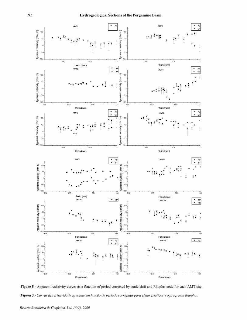
Figure 5 - Apparent resistivity curves as a function of period corrected by static shift and Rhoplus code for each AMT site.
Figura 5 - Curvas de resistividade aparente em função do período corrígidas para efeito estáticos e o programa Rhoplus.

C. Sainato, M. C. Pomposiello, A. Landini, G. Galindo & H. Malleville 193
Brazilian Journal of Geophysics, Vol. 18(2), 2000
Figure 6a - AMT Profile AA�. Model and normalized residualsafter RRI inversion of TE and TM modes.
Figura 6a - Perfil AA´. Modelo e resíduos normalizados depois dainversão dos modos TE e TM.
Figure. 6 b - AMT Profile BB�. Model and normalized residualsafter RRI inversion of TM mode.
Figura 6b - Perfil BB´. Modelo e resíduos normalizados depois dainversão do modo TM.
semiconfined Pampeano are of bicarbonate sodiumtype. Salinity of the this section increases at the floodplains of the rivers and rivulets and towards their beds(discharge zones) with values of conductivity s greaterthan 1000 mS/cm at the N and S of Pergamino city.
Values of Sodium absorption rate (SAR) between10 and 13 were registered in the zone. From theirrigation point of view, the Puelches and Pampeanoaquifers show in general, similar features with waterclassified as C3 S2 (moderate risk of sodium and high
of salinity) and C3 S3 (high risk of sodium and salinity)
(Sainato et al., 1998; 2000).
PREVIOUS GEOPHYSICAL RESULTS
Seventeen VES were performed at the studiedzone by Sainato et al. (1998; 2000), at the same siteswhere this work was carried out. The models of theresistivity distribution obtained enable to determine thedepth of the free aquifer, which is the hydraulicpotentiometric level. Isolines of these levels wereconstructed allowing to know the direction of hydraulicgradient. These results have shown that freegroundwater flow has a recharge coinciding withtopographic high zones whereas the discharge is mainlytowards the Pergamino river. As a result of theelectrical resistivities of free groundwater obtained fromthe soundings at the different sites, water conductivityhas been found greater at the bed of the river. Thismay be a consequence of being a discharge area, a
Pergamino. Free groundwater and water of the
194 Hydrogeological Sections of the Pergamino Basin
Revista Brasileira de Geofísica, Vol. 18(2), 2000
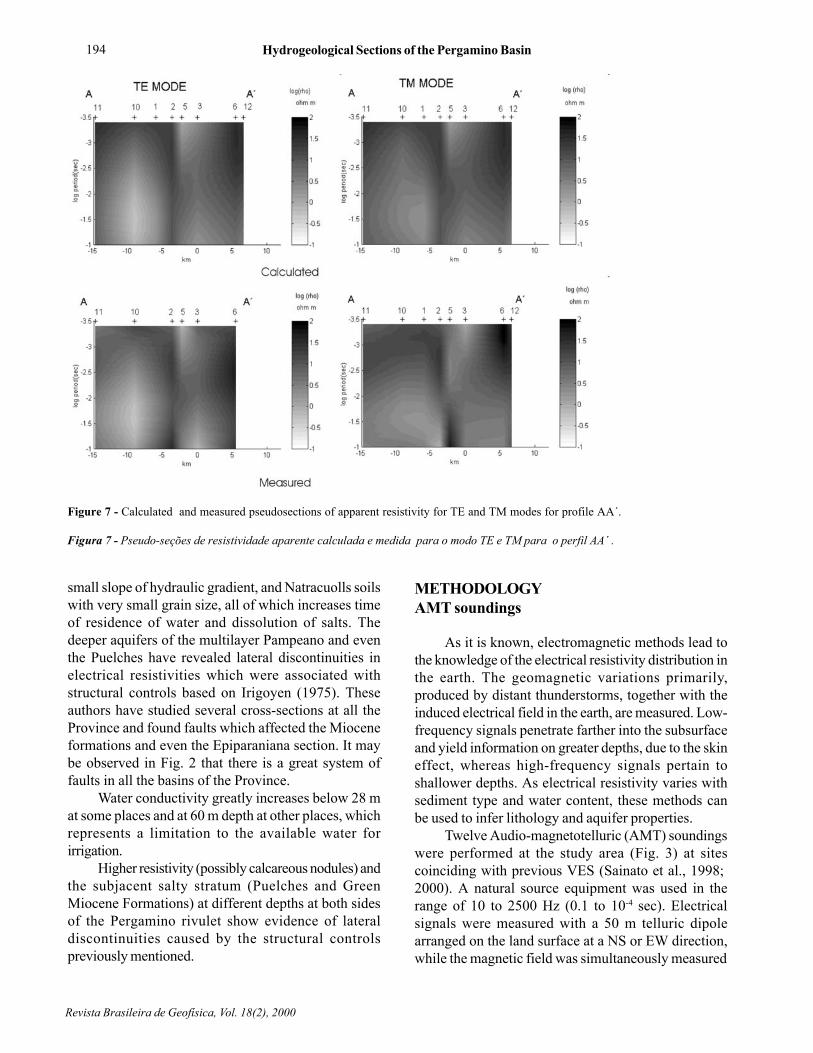
Figure 7 - Calculated and measured pseudosections of apparent resistivity for TE and TM modes for profile AA´.
Figura 7 - Pseudo-seções de resistividade aparente calculada e medida para o modo TE e TM para o perfil AA´ .
small slope of hydraulic gradient, and Natracuolls soilswith very small grain size, all of which increases timeof residence of water and dissolution of salts. Thedeeper aquifers of the multilayer Pampeano and eventhe Puelches have revealed lateral discontinuities inelectrical resistivities which were associated withstructural controls based on Irigoyen (1975). Theseauthors have studied several cross-sections at all theProvince and found faults which affected the Mioceneformations and even the Epiparaniana section. It maybe observed in Fig. 2 that there is a great system offaults in all the basins of the Province.
Water conductivity greatly increases below 28 mat some places and at 60 m depth at other places, whichrepresents a limitation to the available water forirrigation.
Higher resistivity (possibly calcareous nodules) andthe subjacent salty stratum (Puelches and GreenMiocene Formations) at different depths at both sidesof the Pergamino rivulet show evidence of lateraldiscontinuities caused by the structural controlspreviously mentioned.
METHODOLOGYAMT soundings
As it is known, electromagnetic methods lead tothe knowledge of the electrical resistivity distribution inthe earth. The geomagnetic variations primarily,produced by distant thunderstorms, together with theinduced electrical field in the earth, are measured. Low-frequency signals penetrate farther into the subsurfaceand yield information on greater depths, due to the skineffect, whereas high-frequency signals pertain toshallower depths. As electrical resistivity varies withsediment type and water content, these methods canbe used to infer lithology and aquifer properties.
Twelve Audio-magnetotelluric (AMT) soundingswere performed at the study area (Fig. 3) at sitescoinciding with previous VES (Sainato et al., 1998;2000). A natural source equipment was used in therange of 10 to 2500 Hz (0.1 to 10-4 sec). Electricalsignals were measured with a 50 m telluric dipolearranged on the land surface at a NS or EW direction,while the magnetic field was simultaneously measured

C. Sainato, M. C. Pomposiello, A. Landini, G. Galindo & H. Malleville 195
Brazilian Journal of Geophysics, Vol. 18(2), 2000
with an induction coil oriented at right angle to thetelluric line (EW or NS, respectively). Measured atdifferent frequencies, field amplitudes are digitized andused to calculate apparent resistivities.
The rho plus algorithm of Parker & Booker (1996)was used to determine the offset in gain at certain bandsat some sites in order to predict the apparent resistivitiesfrom values outside these bands. Downward bias,produced by static shifts was repaired comparing theexperimental AMT curves, in the range of shorterperiods, with the AMT theoretical response producedby the previous VES models. In case where a shift inthe experimental AMT curves were observed theywere corrected by the appropriate factor.
Strike direction may be considered nearly EWalong the Pergamino rivulet, taking into account thegeological environment of Fig. 2 and previous VESresults which have shown different resistivity distributionwith depth at both sides of the rivulet. Then, the TEmode corresponds to the EW telluric component (ryx)
and the TM mode (rxy) to the NS electrical field. Evenif the apparent resistivity curves for the two modeswere very similar at some sites, a 2D inversion wascarried out using the Smith & Booker ( 1991 ) program.
Geochemical analysis
There are no wells with geologic logs in the studyarea except at the city or towns, where two of them(M.Ocampo and M. Alfonzo) are located at a fewkilometers from sites AMT12 and AMT9 respectivelyand their lithological descriptions (Fig. 4) were comparedwith AMT results.
Fourteen water samples were collected in March1998, from wells distributed over the study area, reachingthe Pampeano aquifer, for rural use and irrigation (seeFig. 3). In general, water samples were taken below a25 m depth. Samples were refrigerated at 40 C andanalyzed for contents of: sodium, potassium, calcium,magnesium, chlorides, carbonates, bicarbonates,
Figure 8 - Calculated and measured pseudosections of apparent resistivity for TM mode for profile BB´.
Figura 8 - Pseudo-seção de resistividade aparente calculada e medida para modo TM, para o perfil BB´ .

196 Hydrogeological Sections of the Pergamino Basin
Revista Brasileira de Geofísica, Vol. 18(2), 2000
Figure 9a - Piper diagram from water samples obtained at wells distributed at the study area of Fig.3 b. Geochemical relationships inmeq/l.
Figura 9a - Diagrama de Piper das amostras obtidas de água dos poços distribuidos na área de estudo da Fig.3b. Relações geoquímicas emmeq/l.
sulfates, electrical conductivity , pH, and Total DissolvedSolids (TDS) (Tab. I). Water was then characterizedusing a Piper diagram.
The chemical evolution along the regional directionof groundwater flow (parallel to the Pergamino rivulet)was defined with an hydrochemical profile, taking intoaccount the main geochemical relationships: Ca/Mg,Ca/SO4 and Na/Cl.
AMT RESULTS
Apparent resistivity curves after applying staticshift corrections and Rhoplus program are shown inFig. 5.
The 2D inversion of MT apparent resistivity was
carried out taking to account an EW strike in twoprofiles crossing the Pergamino rivulet (AA� and BB�)shown in Fig. 3. TE and TM mode were inverted forprofile AA� whereas TM mode was used for profileBB�due to the absence of TE data for site AMT9. Fig.6a and 6b show the final model after inversion and theresiduals for profiles AA�and BB�, respectively. Thecalculated and measured pseudosections are shown inFigs. 7 and 8 for profile AA� and BB�, respectively.
In profile AA�, it may be observed a layer withresistivities of 30 ohm m approximately from AMT1 tothe north, being its base between 50 and 70 m depth.The resistivity increases towards the south reachingvalues greater than 100 ohm m and its base is at 25 mdepth. From M.Ocampo well (Fig. 4), this layer must

C. Sainato, M. C. Pomposiello, A. Landini, G. Galindo & H. Malleville 197
Brazilian Journal of Geophysics, Vol. 18(2), 2000
Figure10 - Distribution of water electrical conductivity (a) and water sodium content (b) from samples using kriging interpolation.
Figura 10 - Distribuição da condutividade elétrica (a) e o conteúdo de sódio (b) da água das amostras usando interpolação por krigagem.

198 Hydrogeological Sections of the Pergamino Basin
Revista Brasileira de Geofísica, Vol. 18(2), 2000
Figure 11 - Distribution of water bicarbonate content from samples using kriging interpolation.
Figura 11 - Distribuição do conteúdo de bicarbonato da água das amostras usando interpolação por krigagem.
be composed by clayey-silty sediments with calcareouscrust. This layer may be associated with the Pampeanoaquifer which has in its upper section free groundwaterand in the lower section there are up to five productivelevels, partially confined when clayey layers withaquitard behaviour are found at the bottom. This aquitardseparates the Pampeano and the lower Puelches sands(Fresina et al., 1993). The presence of calcareousintercalation (Sala & Rojo, 1994) as nodules orcontinuous plates, evidenced in Fig. 4, may increasethe resistivity of the layers. In general, from previousgeological information and well data there are no greatlithological variations in the Pampeano aquifer in all thezone (Clayey-silty sediments) so it may be supposedthat changes in resistivity are strongly affected by waterquality. Conductivity AMT results coincideapproximately with the ones obtained from geochemicalanalysis of water samples (Tab. 1).
It may also be observed that S16 and S2 watersamples have greater conductivities than S9, S11 andthe value of 1352 mS/cm (resistivity about 7 W m) fromwell M. Ocampo, which agree with the increase of
resistivity towards the southern part of the profile (AMTresistivities between 3 and 10 W m). Below, there is aconductive layer associated with the Puelches andGreen Miocene Formation which have a great contentof salts. The lateral variations in electrical resistivitiesat both sides of the Pergamino rivulet were alsorecognized in previous results (Sainato et al., 1998;2000). This may be an evidence of structural controls(Irigoyen, 1975) which also modify the direction of thePergamino rivulet course. The fluvial network may becontrolled by the morphology, the structure or both ofthem. Cross-sections at different places in the Provincehave shown fractures which have caused a stratigraphicthrow in the Red and Green Miocene formations. Therehave been reactivations of some faults which haveaffected shallower and more recent formations(Irigoyen, 1975).
In profile BB´, a conductive layer which reachesalmost 40 m depth increasing its conductivity fromAMT8 to the north is the Pampeano aquifer, withgreater values (AMT resistivities between 1 and 3 Wm)than the AA´profile. M. Alfonzo well shows thick silt
C. Sainato, M. C. Pomposiello, A. Landini, G. Galindo & H. Malleville 199
Brazilian Journal of Geophysics, Vol. 18(2), 2000
sediments, and water conductivity is 1300 mS/cm(resistivity of 7.7 Wm) very close to the resistivity atsite AMT9 (6 Wm). Water conductivity from wells S14,S10 and S13 is also higher than most of the wells locatednear profile AA´. Profile BB� is located at a swampzone, a recharge area of groundwater flow (Sainato etal., 1998; 2000) mainly by infiltration from precipitationevents. At this zone, Natracuoll soils with very lowpermeability and deficiency in drainage have a largetime of water residence, which helps the incorporationof salts to the shallower aquifers. A light increase ofresistivity with depth may be observed up to 100m atthe north of the profile and deeply at the south. Below,the conductivity increases probably showing the saltyPuelches and Green Miocene Formations.
GEOCHEMICAL RESULTS
In Fig. 9a, groundwater is characterized using aPiper diagram, resulting in 79 % of the samples ofbicarbonate sodium type and 21 % with no aniondominating.
The hydrochemical evolution along a profileparallel to the Pergamino rivulet (Fig. 9b) shows therelations Ca/Mg, Ca/SO4 and Na/Cl , from NW to SEcoinciding with regional groundwater flow observed inprevious studies (Sainato et al., 1998; 2000) . There isa slight tendency in Na/Cl in the last sample.
The distribution of water electrical conductivityand sodium content at the studied zone was obtainedby means of kriging interpolation (Trangmar et al., 1985)from water samples. These results are shown in Figs.10a and 10b respectively, together with the location ofthe wells.
An increase of conductivity and sodium contentat the swamp zone is observed characterized by lesspermeable soil with deficiency in drainage (Natracuollssoil) and a slight slope of phreatic level. This is inagreement with the higher values of conductivityobtained from AMT results at profile BB´ than the AA´,for the Pampeano aquifer.
As it has been mentioned before, at this zone,water moves more slowly with a larger time of contactwith the subsoil material, dissolving salts. Linearcorrelation between electrical conductivity and sodiumcontent was found to be very significant (r2 = 0.97).The results of kriging for bicarbonates are shown inFig. 11 with greater concentration in the swamp zone.Correlation between electrical conductivity andbicarbonates was also significant (r2 = 0.79).
CONCLUSIONS
The upper hydrogeological sections at thePergamino basin were characterized through AMTsoundings more accurately than in previous studies.
The Epiparaniana section, including the Puelchesand the Pampeano Formations, was sensed in twoprofiles crossing the Pergamino rivulet bed, one in thewest of the city and the other one in the rechargeswamp zone.
The AMT results were compared with well data,taking into account the geological and hydrogeologicalbackground. Resistivity from well data exploiting thePampeano aquifer is close to the AMT results.
The Pampeano aquifer has been identified in thefirst profile with a base at 50-70 m depth at the leftmargin of the rivulet and at 25 m depth with higherresistivity at the right margin. This increase in resistivityagrees with the better water quality found at the wellstowards the southern part of the profile. Below, thebad water quality aquifers of the Puelches and GreenMiocene Formations have been associated with a veryhighly conductive layer which deepens to the north.
At the second profile at the swamp zone, thePampeano aquifer has lower resistivities than theprevious profile with a base at 40 m depth approximately.Water conductivity from wells also showed greatervalues for this zone.
The areal distribution of conductivity and sodiumcontent obtained from well data in all the basin showsmaximum values at this swamp zone. Natracuolls soilswith very low permeability and deficiency in drainage,together with a soft topographic slope produce a greatertime of residence and water moves more slowly with alarger time of contact with the subsoil material,dissolving salts which may affect the shalloweraquifers.
Below, an increase in conductivity shows thepresence of the salty Puelches and Green MioceneFormations.
Lateral variations in electrical resistivities foundat both margins of the Pergamino rivulet which werealso recognized in previous results may be an evidenceof faults which also modify the direction of thePergamino rivulet course. Previous studies haverecognized, in geological cross-sections at differentplaces in the Province, the presence of fractures whichhave caused a stratigraphic throw in the Red and GreenMiocene Formations, and probably reactivations ofthese faults affecting even the shallower and morerecent Formations .

200 Hydrogeological Sections of the Pergamino Basin
Revista Brasileira de Geofísica, Vol. 18(2), 2000
The Pampeano aquifer has bicarbonate sodiumwater. Hydrochemical evolution along the course ofPergamino rivulet shows a slight increase in Ca/Mg,Ca/SO4 and Na/Cl relationships in the direction ofregional groundwater flow, to the SE.
ACKNOWLEDGEMENTS
The authors would like to thank Mrs. Amalia González for helpingwith the illustrations. This work was financially supported by theUniversity of Buenos Aires.
REFERENCES
FERNÁNDEZ GARRASINO, C. & URBA, A. � 1999 -Estructura del tope de la Formación Serra Geral(Neojurásico-Eocretácico) en la Mesopotamia argentinay adyacencias. Actas del XIV Congreso GeológicoArgentino. Salta. Argentina, 185-188.
FRESINA, M., LOPEZ, A.C. & DE LA TORRE, G.R. - 1993- Características hidrodinámicas de los nivelesproductivos de agua potable para la ciudad dePergamino. V Jornadas Pampeanas de CienciasNaturales. La Pampa. Argentina., p.19.
IRIGOYEN, M. � 1975 - Geología del subsuelo y plataformacontinental. Relatorio de la Pcia. De Bs. As. , VI CongresoGeológico Argentino, B. Blanca, 139-169.
PARKER, R. & BOOKER, J. � 1996 - Optimal one-dimensional inversion and bounding of magnetotelluricapparent resistivity and phase measurements, Phys.Earth.Planet. Int., 98: 269-282.
SAINATO, C., POMPOSIELLO,M., GALINDO, G. &MALLEVILLE, H. �1998- AMT and geoelectricalsoundings for groundwater prospecting at Pergaminobasin (Buenos Aires Province, Argentina). 14th
Workshop on Electromagnetic Induction in the Earth,Sinaia, Rumania.
SAINATO C. , LOSINNO B. , LANDINI A., GALINDO G. &POMPOSIELLO M.C. - 2000 - Prospección de losacuíferos subterráneos de la zona de Pergamino-Arrecifes, Provincia de Buenos Aires, mediante sondeos
geoelectricos. Actas del XVII Congreso Argentino dela Asociación de Ciencia del Suelo, Mar del Plata.Argentina.,CD-ROM, Com. IV-51.
SALA, J. M. - 1969 - El Agua subterránea en el NE de laProv. de Bs. AS. Argentina. In: Proceedings of theReunión Geológica del Agua subterránea. CIC. La Plata.Prov. de Bs. As. Argentina, 25-49.
SALA, J. M. � 1975 - Recursos hídricos. Relatorio de la Pcia.De Bs. As. , VI Congreso Geológico Argentino, B. Blanca,169-193.
SALA, J. M., GONZÁLEZ, N. & KRUSE, E. � 1983 -Generalización hidrológica de la Prov. de Bs. As. In: (Ed.)UNESCO. Coloquio internacional sobre hidrología degrandes llanuras, 973-1009.
SALA, J. & ROJO, A. � 1994 - Pasado, presente y futuro dela hidrología subterránea en la Pcia de Buenos Aires,Rep. Arg. In: Bocanegra, E. & Rapaccini, A. (Eds.),Temas actuales de la hidrología subterránea. CFI. UNMP,209-224.
SANTA CRUZ, J. & SILVA BUSSO, A. � 1995 -Disponibilidad del agua subterránea para riegocomplementario en las Pcias. de Bs. As., E. Ríos, Córdobay Santa Fe. Report. Programa de Servicios Agrícolasprovinciales. Secretaría de Agricultura, Ganadería y Pesca(Argentina), 16-27.
SMITH, J. T. & BOOKER, J. R. �1991- Rapid inversion oftwo-and three-dimensional magnetotelluric data. Journalof Geophysical Research, 96 (B3) : 3905-3922.
TRANGMAR, B.B., YOST, R.S. & UEHARA, G. �1985 -.Applications of geostatistics to spatial studies of soilproperties. Advances in Agronomy, 38: 45 -94.
URIEN, C. M. & ZAMBRANO, J. J. � 1996 � Estructura delmargen continental. XIII Congreso Geológico Argentinoy III Congreso de exploración de Hidrocarburos. Bs. As.Geología y recursos naturales de la Plataforma ContinentalArgentina. Ramos V. & Turic M. A. (Eds). Relatorio, 3:29 -65.
USUNOFF, E. J. � 1994 - Técnicas de estudios en llanuras.In: Bocanegra, E. & Rapaccini, A. (Eds.). Temas actualesde la hidrología subterránea. CFI. UNMP, Argentina,103-117.