hydrogeomorphic hazards in the british columbia coast ... · hydrogeomorphic events are especially...
TRANSCRIPT

Hydrogeomorphic Hazards in the British Columbia
Coast Mountains: Floods to Flows
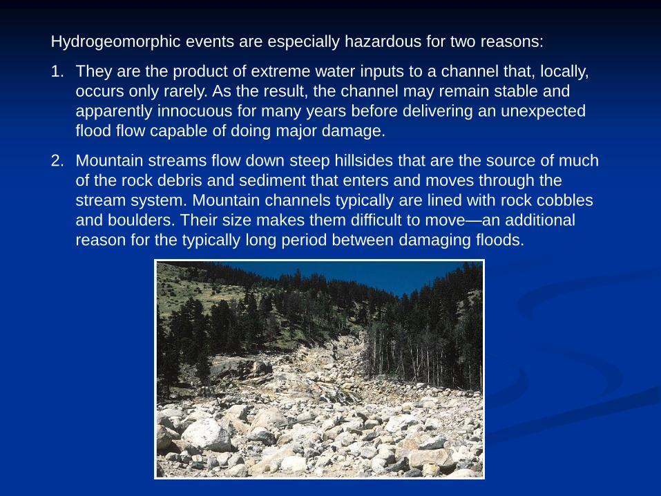
Hydrogeomorphic events are especially hazardous for two reasons:
1. They are the product of extreme water inputs to a channel that, locally,
occurs only rarely. As the result, the channel may remain stable and
apparently innocuous for many years before delivering an unexpected
flood flow capable of doing major damage.
2. Mountain streams flow down steep hillsides that are the source of much
of the rock debris and sediment that enters and moves through the
stream system. Mountain channels typically are lined with rock cobbles
and boulders. Their size makes them difficult to move—an additional
reason for the typically long period between damaging floods.

Coastal mountain drainage basins in British Columbia tend to:
• have low sediment storage capability and thus allow for less buffering of changes
in hillslope morphology or process.
• have strong structural control and high rates of incision.
• have experienced pronounced elevational shifts in vegetation, weathering
regimes, and major geomorphic processes due to Quaternary climatic change.
• have hydrological regimes commonly controlled by melt of snow and glacier ice.
• experience hydrological events due to orography, barotrophic, baroclinic, and
monsoonal conditions.
• rarely achieve graded or stable
conditions, but instead consist of step
pools, plane beds, and pool riffles in
which differential velocities, shear
stresses and sediment movement can
cause velocity reversals at bank full
flow.

Charles Creek and the village of
Strachan Creek. The upper parts of
the drainage system is
characterized by extreme slopes
and sparse vegetation. The houses
are built on an alluvial fan from
Charles Creek. The British
Columbia Railway (below) and the
Sea to Sky Highway (99) are visible.

• Steep mountain creeks are typically subject to a spectrum of events,
ranging from clear water floods to debris floods to debris flows.
• Central to hazard recognition is the need to identify the specific
hydrogeomorphic process because each process has different
associated hazard characteristics.
For example, debris flows can have peak discharges 5 to 40
times greater than floods, while debris floods have relative
peak discharges of only up to twice those of flood discharges.

Classification of flow and landslide processes by sediment
concentration, velocity, and flow behaviour.
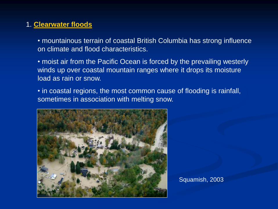
1. Clearwater floods
• mountainous terrain of coastal British Columbia has strong influence
on climate and flood characteristics.
• moist air from the Pacific Ocean is forced by the prevailing westerly
winds up over coastal mountain ranges where it drops its moisture
load as rain or snow.
• in coastal regions, the most common cause of flooding is rainfall,
sometimes in association with melting snow.
Squamish, 2003

In-SHUCK-ch
Flood Story
In the UCWALMICWTS (lower
Lillooet dialect), the name of this
mountain is pronounced In-SHUCK-
ch, meaning "split like a crutch"
(referring to the split precipice at its
peak.)
All the Lillooet people lived together around Green Lake. At the time
there came a great and continuous rain, which made all the lakes and
rivers overflow their banks, and deluge the surrounding country. When
the people saw the waters rise far above the ordinary high-water mark,
they became afraid.
A man called Ntci'nemkin had a very large canoe in which he took
refuge with his family. The other people ascended the mountains for
safety; but the water soon covered them too. When they saw that they
would probably be drowned they begged Ntci'nemkin to save their
children. As for themselves, they did not care. The canoe was too
small, however, to hold all their children: So Ntci'nemkin took one child
from each family, -a male from one, a female from the next, and so on.
The rain continued falling and the water rising, until all the land was
submerged except the peak of the high mountain called Split (Nci'kata).
The canoe drifted about until the water receded, and it grounded on
Smimelc Mountain. When the ground was dry again, the people settled
just opposite the present site of Pemberton. Ntci'nemkin with his wives
and children settled there, and he made the young people marry one
another. He sent out pairs to settle at all the good food places though
the country. Some were sent back to Green Lake and Green River;
others were sent down to Little Lillooet Lake and along the Lower
Lillooet River; and some were sent up to Anderson and Seton Lakes.
Thus was the country peopled by the offspring of the Green Lake
People.
(Teit, James. 1912. Traditions of the Lillooet Indians of British
Columbia. Journal of American Folklore 25:287-371)

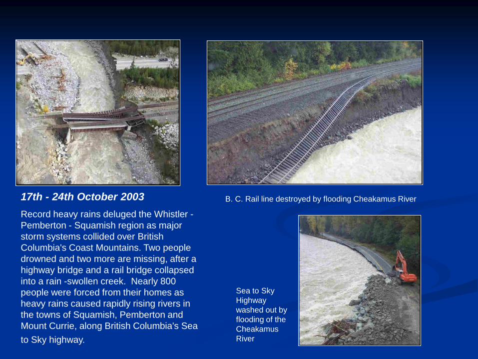
B. C. Rail line destroyed by flooding Cheakamus River
Sea to Sky
Highway
washed out by
flooding of the
Cheakamus
River
17th - 24th October 2003
Record heavy rains deluged the Whistler -
Pemberton - Squamish region as major
storm systems collided over British
Columbia's Coast Mountains. Two people
drowned and two more are missing, after a
highway bridge and a rail bridge collapsed
into a rain -swollen creek. Nearly 800
people were forced from their homes as
heavy rains caused rapidly rising rivers in
the towns of Squamish, Pemberton and
Mount Currie, along British Columbia's Sea
to Sky highway.


Logging is ongoing around Rutherford Creek, and
much of the valley is now covered by second-
growth forests.
Appa Glacier, headwaters of
Rutherford Creek

A major Pacific frontal system arrived on the coast on the evening of October
15th, developing into a full “Pineapple Express” as circulation became well
established and a series of moist impulses surged along the frontal stream as
the system stalled over southwestern BC for the next several days.

The Operational polar orbiting
microwave composite of total
moisture in the atmosphere for
October 16, 2003 over the North
Pacific Ocean. The plume of
moisture (deep red band in top
panel) entering the Pacific Northwest
is the Pineapple Express. [Black
areas are regions of non-coverage
during passes.]
The bottom panel is the GOES 6.7
micron water vapour channel images
from GOES-10 and GOES-9
satellites, showing moisture levels
mainly above 10,000 ft.
(Satellite Analysis Branch, NOAA.)

HOWE SOUND: 11:26 PM PDT FRIDAY 17 OCTOBER 2003
HEAVY RAINFALL WARNING FOR HOWE SOUND CONTINUED. FURTHER RAINFALL AMOUNTS OF
100 TO 150 MM FOR HOWE SOUND AND 50 TO 80 MILLIMETRES FOR THE REST OF THE REGIONS
TONIGHT AND SATURDAY. THIS IS A WARNING THAT HEAVY RAIN IS IMMINENT OR OCCURRING
IN THESE REGIONS. MONITOR WEATHER CONDITIONS..LISTEN FOR UPDATED STATEMENTS. A
NEARLY STATIONARY FRONT OVER THE SOUTH COAST WILL CONTINUE TO BRING HEAVY RAIN
TO MOST OF THE SOUTH COAST. PRECIPITATION AMOUNTS OF 60 TO 140 MM HAVE BEEN
RECORDED IN THE LAST 24 HOURS AT SOME STATIONS ON THE INNER COAST. FURTHER
AMOUNTS OF 50 TO 80 MM FOR THE INNER SOUTH COAST AND AS MUCH AS 100 TO 150 MM
FOR HOWE SOUND CAN BE EXPECTED TONIGHT AND SATURDAY. MEANWHILE RAIN HAVE
EASED OFF TONIGHT OVER THE EXTREME SOUTH COAST...BUT MORE RAIN IS EXPECTED WITH
AMOUNTS NEAR 30 TO 40 MM FOR VANCOUVER AND VICTORIA AND THE LOWER FRASER
VALLEY ON SATURDAY. RAIN WILL TAPER OFF IN ALL AREAS LATE SATURDAY AS THE FRONT
MOVES SOUTH AND WEAKENS.


The severe rainfall resulted in record breaking water levels and discharge
flow according to hydrometric station 08MG005 on the Lillooet River.
Water Level (m)
Oct. 16 - Oct. 22, 2003
Hydrometric Station: 08MG005
Flow Discharge (m3/s)
Oct. 16 - Oct. 22, 2003
Hydrometric Station: 08MG055

Flooding initiated a new cycle of
sediment deposition and
redistribution, which has resulted in
overbank flooding and bank erosion,
damaging property and threatening
structures

2. Debris floods are a very rapid, surging flow of water, heavily charged with
debris, in a steep channel. The sediment may, furthermore, be transported in
the form of massive surges, leaving sheets of poorly sorted debris ranging
from sand to cobbles or small boulders.
Sediment surges in debris floods are propelled by the tractive forces of water
overlying the debris, and flow velocities are comparable to those of water
floods. The discharge of debris floods is commonly 2 to 5 times higher than
that of 200-year return period water floods.
A debris flood deposit that
overwhelmed a channel

Britannia before and after flood of 1921. Thirty-seven people were killed and
about half the 170 houses in the town were destroyed.
The mining community of Britannia was devastated by a sudden flood on
October 28, 1921. This flood occurred when a blocked culvert caused a railway
embankment to temporarily dam Britannia Creek and then fail, releasing a
catastrophic flood.

Debris flood occurrence:
• debris floods are a poorly understood process because they are rarely directly
observed.
• can be caused by a variety of processes, the most commonly observed
processes are breaches of temporary stream blockages caused by tributary
debris flows or other landslide types.
• debris flood discharge depends strongly on the composition and geometry of
the landslide dam and the geometry of the floodplain downstream.
• the typical range for debris flood discharge is 2 to 5 times the 200-year return
period peak water flood (Q200).
• in extreme cases, debris flood discharge may be more than five times the
Q200.

Debris flood deposits include bars, fans, sheets, and splays, and stream
channels with large width-to-depth ratio.
The differentiation of floods and debris floods involves assessing the volume
of sediment deposits relative to the size of stream channel, and determining
the orientation of clasts.
• debris floods have sediment concentrations of 20 to 47% by volume and
characteristically have significant sediment deposits beyond the channel on the fan
(e.g., where the sediment load overwhelms the channel on the fan). Floods have
sediment concentrations of less than 20% by volume and commonly have limited or
localized sediment deposits beyond the channel on the fan (the channel can generally
contain the sediment load).
• A-axes of all clasts in flood deposits are oriented perpendicular to flow. Sediments in
flood deposits are well sorted and the clasts are usually well imbricated. Clast
orientation in debris-flood deposits are mixed, with the A-axes of large cobble to
boulder clasts usually perpendicular to the flow and pebbles to small cobbles usually
parallel to flow. Debris-flood deposits commonly have weak imbrication and collapse
packing.

Case Study 1:
Debris floods in Bertram Creek, Lebanon Creek, Rembler Creek and
around Jack Smith Lake.
• an intense storm event deposited 12 to 20 mm of rain on several of the
burned watersheds in Kelowna during a 20 to 45 minute period.
• flood flows and debris floods were triggered.
• drainage structures and stream channels were overtopped on Rembler
and Lebanon Creeks by these hazards, impacting residences, orchards
and infrastructure.


Case Study 2:
Debris Floods in Ostler Creek and Allan Creek, District of North
Vancouver.
Debris Flood – A flood that carries an unusually high amount of sediment
and/or debris, but not to the extent that the event character is transformed
from a flood to a debris flow. Debris floods may be visualized as an extension
of the flood process, whereas debris flows behave very differently than floods.
Mitigation of debris flow hazards requires a considerably different approach.
Lower reaches of Ostler Creek
and Allan Creek

Ostler Creek has a total watershed area of 1.2 km2. The watershed ranges in
elevation from the Mount Seymour Mountain ski area at 1,000 m to sea level.
The mainstem channel extends to an elevation of 675 m. Above this elevation,
the channel is not sufficiently defined to delineate on air photographs. The total
mainstem channel length is about 2.2 km with an average gradient of 17o. The
fan of Ostler Creek is relatively small with the creek flowing over steep slopes
within 50 m of Indian Arm. The creek is well incised into the steep slopes
before it reaches gentle terrain on the fan and flows between two houses.
Allan Creek is located immediately to the north of Ostler Creek and its upper
watershed also extends to the Mount Seymour Mountain ski area. The
watershed has an area of 1.0 km2 and its mainstem channel can be delineated
on air photographs to an elevation of approximately 900 m. The total length of
the mainstem channel is 3.2 km and its average gradient is 16o.
Geomorphology
There is little geomorphic activity in either watershed, evidenced by an
absence of debris slides, rockfall, and snow avalanche tracks. The upper
mainstem channels are completely overshadowed by a closed tree canopy.
In addition, field investigations showed little evidence of significant coarse
sediment movements. Except for the extreme upper slopes, a majority of the
area was logged in the early 1900’s and is now covered by second growth
forest. Soils in the area consist of glacial till overlain by organic matter.
A debris flow would likely only result from a large sideslope failure during an
extreme hydroclimatic event.

In contrast, debris floods are likely to occur on both creeks. Debris flood
magnitude on steep mountain creeks may be estimated reliably if there is
geomorphic or botanical evidence that allows the reconstruction of peak
discharge. Otherwise, magnitude may be assessed empirically using judgement
and experience. Because of a lack of suitable geomorphic or botanical
evidence, the latter approach was used for Ostler Creek and Allan Creek.
Estimated debris flow and debris flood magnitudes for various probability
classifications on Ostler Creek and Allan Creek (the estimates are the same for the
two creeks).

Assessing debris flow probability and magnitude:
1) debris supply sources:
- are no major debris supply sources along the mainstem channel of either
creek. Although debris slides could occur along some of the steeper
sideslopes, there is no evidence of previous debris slides.
2) debris flood initiation:
- debris floods would most likely be initiated by a debris slide impacting the
mainstem channel at an oblique angle. Landslide dam outbreak floods are
possible but channel blockages would likely be short in duration due to the
relatively narrow width of the mainstem channels. As such, only small
amounts of water could be impounded behind a landslide dam. Log jam
collapses are also considered to be potential sources of debris flood initiation
but large woody debris jams are generally lacking along both mainstem
channels.
3) debris flow initiation:
- a tributary to Allan Creek has the potential for debris flow initiation. If
significant flows from Ostler Creek were diverted into the channel that feeds
the gully, the concentrated drainage could scour significant volumes of
sediment (up to 1,000 m3) and thereby initiate a debris flow.

Assessing debris flow probability and magnitude: (continued)
4) Debris flow hazards are defined by a combination of probability and
magnitude. The probability or frequency of debris flows and are defined
as per the following table:

Dating Methods
Three dating methods can be used to determine the frequency of past creek
events: historic air photograph analysis, dendrochronology, and documented
events from newspapers and other reports.
In this case:
- historic air photographs dating back to the 1940s were reviewed. None of these photos
showed evidence of debris floods on the fan or along the channel of either creek. No large
sideslope failures were identified that would indicate a possible initiation of a debris flood.
From this evidence, it was concluded that neither creek had experienced a significant
debris flood in decades.
-debris floods can impact trees and leave scars, which subsequently overgrow. Cutting a
wedge from this scar tissue allows the reconstruction of the year of damage. Coring a tree
and counting back to a ring sequence that is very narrow enables a researcher to
determine the date of the event. Unfortunately, no suitable trees were found for analysis
along either creek.
- review of newspapers and other reports. Apart from the small debris flow in the North
Gully of Allan Creek in 1992/93, no other events appear to have been documented
Conclusion - there is an incomplete record for debris floods at both creeks. Even
though no significant debris floods appear to have occurred for several decades,
the potential for debris floods persists.

Debris Flood Magnitude
Determination of debris flood magnitude involves consideration of both the total volume of
a debris flood and the peak discharge. Total volume is important for those mitigative
structures that contain the debris, whereas peak discharge estimates are required for
mitigative structures that channelize the debris and for the design of creek crossings.
The design debris flood is defined as having a return period of approximately 500
years, which corresponds roughly to a 10% probability of occurrence in 50 years.
a) design debris flood volume - There are no reliable methods available to calculate
debris flood volumes. Even complex sediment transport equations can only provide
very rough estimates of the type and amount of gravel mobilized. The second unknown
is the distance to which gravel will be transported in a creek channel. Unlike debris
flows, where the majority of mobilized debris is deposited downstream of the fan apex,
debris floods entrain and deposit debris intermittently, depending on stream gradient,
degree of confinement and grain size. The distance of sediment transport is also
dependent on the duration and discharge of the debris flood, which in turn is a function
of the type and duration of the event that triggered the debris flood.
The order-of-magnitude estimate for the volume associated with a medium probability
debris flood is 200 m3. The volume is very approximate and depends on the peak flow
and duration of the flood, as well as whether and for how long debris jams and log jams
develop.

Debris Flood Magnitude (continued)
b) debris flood discharge volume - The second step in assessing debris flood
magnitude is an estimate of peak discharge. There are no commonly accepted
methods available to estimate the peak discharge of debris floods. Estimates are
possible where trees have been impacted by debris, enabling a reconstruction of the
cross-sectional flow area.
In B.C., it is often practical to double the Q200 to obtain an approximate discharge
estimate for debris floods. Jakob and Jordan (2001) have shown that this value may be
too low for debris floods of similar return intervals. However, higher ratios are more
often associated with landslide dam outbreak floods, which appear unlikely at Ostler
Creek or Allan Creek.
In light of the available information, a factor of three was adopted to extrapolate for
debris floods with a 500-year return period. The results are summarized below for this
case:
Debris flood volume and peak discharge at Ostler Creek and Allan Creek

Osler Creek looking down
Summary of findings:
• The mainstem channels of Ostler Creek and Allan Creek are subject to debris
floods. The design debris flood volume is estimated at 200 m3, with an associated
peak discharge of up to 24 m3/s.
• For the 500-year return period, larger debris flows may occur on these gullies,
yielding volumes of up to 1,000 m3 and peak discharges of 25 m3/s. Indian River
Drive and other downstream development would also be subject to damage during
the design events.

Mitigation:
The hazard at Ostler Creek can be mitigated by constructing a debris
barrier upstream and replacing a culvert. Check dams downstream of
could also be constructed to stabilize the channel.
Mitigation of the risk at Allan Creek would involve building upstream
debris barriers at the mainstem channel and two gully crossings,
installing check dams, replacing culverts at road crossings, and
performing minor channelization in the lower reaches.
The total cost of risk mitigation is
estimated at roughly $0.6 million for
Ostler Creek and $2.5 million at
Allan Creek, for a total of about $3.1
million.
Existng debris barrier at Ostler Creek
culvert inlet, Indian River Drive.

3. Debris flows
A form of rapid water-saturated channelized landslide. Debris flow velocity
typically ranges between 5 and 10 m/s, but some fine-grained debris flows
have been known to travel up to 20 m/s. They are most likely to occur on
small, steep creeks that have abundant sources of debris.

Debris flows are sometimes alternatively referred to as debris torrents where
they are particularly coarse in nature and carry large amounts of organic
debris or mudflows where they are particularly fine in nature.
1999

1. Torrential rainfall swells streams
along the mountain crest.
2. Sediment slumps into a raging
stream, forming a slurry (debris flow)
that surges down the channel.
3. The debris flow swells in volume
as it picks up additional sediment and
trees from the channel and canyon
walls.
4. The debris flow emerges from the
canyon onto a fan where it damages
houses, roads, bridges, and a rail
line.
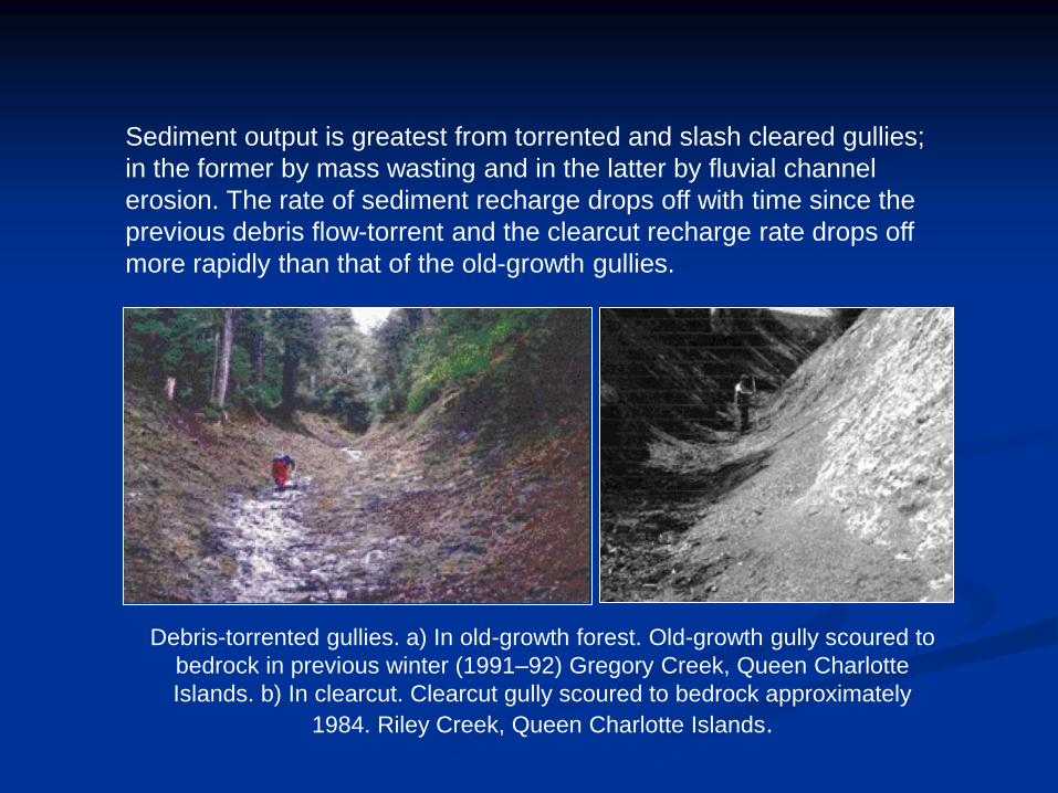
Debris-torrented gullies. a) In old-growth forest. Old-growth gully scoured to
bedrock in previous winter (1991–92) Gregory Creek, Queen Charlotte
Islands. b) In clearcut. Clearcut gully scoured to bedrock approximately
1984. Riley Creek, Queen Charlotte Islands.
Sediment output is greatest from torrented and slash cleared gullies;
in the former by mass wasting and in the latter by fluvial channel
erosion. The rate of sediment recharge drops off with time since the
previous debris flow-torrent and the clearcut recharge rate drops off
more rapidly than that of the old-growth gullies.

The February 11, 1983, debris flow at Lions Bay, near Vancouver. Triggered by a snow
avalanche, this flow entrained more than 10,000 m3 of debris and killed two people.
• Damage in creek fan areas during debris flow deposition can be catastrophic.
The nature of the deposited material is highly variable, but typically covers a
wide range from mud to boulders, and usually also includes a significant wood
debris component. Debris flow deposition may also result in flooding of adjacent
areas as a result of subsequent relocation of the creek channel.

Debris flow characteristics

In general, the frequency of debris flows on a particular creek is a function of:
• availability of debris supply sources that contribute materials to the main creek
channel and its tributaries (necessity to differentiate drainage basins between
material supply-limited vs. material supply-unlimited)
• degree of instability and level of activity of the debris supply sources
• characteristics of the debris supply source (fine vs. coarse material,
consolidated vs. unconsolidated)
• existence of potential triggers of debris flows (debris slides, rockfall,
avalanches)
• capability of a creek channel to transport a debris flow (gradient, channel
crosssection, longitudinal profile, channel roughness)
• frequency of hydroclimatic events that have the capability of triggering debris
flows. As debris accumulates, a system gradually becomes "ripe" for a debris
flow. The rate at which debris accumulates in a channel is a function of basin
type.

Debris flow probability:
• While significant floods occur virtually every year on a creek system, debris
flows are usually an intermittent occurrence.
• Typical debris flow recurrence intervals range from 5 to 50 years; however, this
is highly variable.
• Debris flow occurrence can be put into perspective by considering
geomorphological processes since the most recent glaciation about 10,000
years ago. In the centuries following glaciation, the landscape was unforested
and littered with glacial debris. Debris flow activity is believed to have been
considerably higher than today during this period. As the landscape became
forested and watersheds stabilized, debris production and debris flow activity
gradually decreased on a regional basis.
• However, debris flow activity may increase for any particular watershed as a
result of natural or anthropogenic watershed instability. There is also reason to
believe that if the present trend of increasingly wetter conditions in coastal areas
continues, debris flow occurrence will increase in frequency and possibly
magnitude.

Debris flow forms
a) Hillslope (Open-Slope) Debris Flows
These form their own path down valley slopes as tracks or sheets before
depositing material on lower areas with lower slope gradients or where flow
rates are reduced: e.g. obstructions, changes in topography. The deposition
area may contain channels and levees.

Debris flow forms
b) Channelised Debris Flows
These follow existing channel type features: e.g. valleys, gullies, depressions,
and hollows. The flows are often of high density, 80% solids by weight and
have a consistency equivalent to that of wet concrete. Hence, they can
transport boulders that are some metres in diameter.

DEBRIS FLOW OCCURRENCE
Debris flows in the B.C. Coast Mountains tend to occur in wet weather, but are
not necessarily coincident with record rainfall or flood events. Debris flow
occurrence can be described by three consecutive processes as follows:
• Initiation where a mass movement is triggered at the source area in the
creek headwaters. Possible trigger mechanisms include debris slides, log
jam release, flood surges, and creek bed instability.
• Transport of the debris flow down the creek channel. The transport
zone is typically scoured as the debris flow grows in size. A straight and
uniformly steep gradient channel represents the most favourable
transport condition.
• Deposition where either the channel becomes laterally unconfined, or
the creek gradient flattens to the point that there is insufficient energy for
continued movement. Depositional landforms are known as creek fans.

a) Debris flow initiation
Debris flow triggering factors
- the most significant triggering factor is likely to be the development of
transient high pore water pressures along pre-existing or potential rupture
surfaces. High pore water pressures are typically generated as a result of
extreme antecedent (long-duration) rainfall conditions and intense rainstorms,
both of which can result in high groundwater levels and perched groundwater
conditions. If the soil becomes fully saturated surface water flow may occur
which can result in erosion and triggering of hillside debris flows.
- the permeability of soils and the speed by which surface water can be
transmitted to potential rupture surfaces is a key factor in the initiation of
upland landslides. The interface between permeable soils and relatively
impermeable substrate can lead to the development of cleft water pressures
along soil and rock discontinuities and artesian pore water pressures along
potential rupture surfaces. Certain geological situations are particularly prone
to the effects of water infiltration, for example where permeable soil overlies
less permeable bedrock. In such circumstances rapid increases in pore water
pressures can trigger slope failure and mobilisation of landslides.

a) Debris flow initiation
Surficial deposits prone to debris flows:
Colluvium/hillwash: unconsolidated, heterogeneous soil mass deposited by
water run-off or slow down slope creep.
Talus: accumulation of angular rock fragments at the base of a cliff or steep rock
slope due to weathering, spalling/ravelling and rockfalls.
Fluvial: unconsolidated detrital material laid down by a stream, river or other
body of water
Glacial: unconsolidated heterogeneous soil mass (clay, silt, sand, gravel,
cobbles and boulders) in Proglacial ( e.g. glaciofluvial, glacio lacustrine and
glaciomarine) and Glacial (glaciofluvial, morainic and some till) deposits.
Regolith: mantle of unconsolidated rock fragments (gravel, cobble and boulder
sized), sand, silt and clay covering bedrock, and formed by the in situ, or nearly
in situ, weathering of bedrock.

Role of basin type:
Recent research has identified two distinctly different basin types.
A) One type, referred to as weathering-limited or supply-limited, is
characterized by those basins that have a limited source of sediment and
thus require recharge after a debris flow event for the next one to occur. In
other words, even an exceptionally intensive storm will not trigger a debris
flow if not enough sediment has accumulated to produce a debris flow.
B) The other basin type is referred to as transport-limited or supply-unlimited.
In those basins, there is a quasi-infinite amount of sediment available for
transport and a debris flow can be triggered as soon as a critical climatic
threshold (rainfall, rain-on-snow) is exceeded.
From the above descriptions, it is clear that transport-limited basins experience
a higher frequency of debris flows than weathering-limited basins. Examples
for transport-limited basins are young volcanic complexes that rapidly shed
material into the channel system, or basins with massive Quaternary
deposits in the source area of debris flows. Weathering-limited basins are
found primarily in slow weathering plutonic rock of the Coast Mountains.

a) Debris flow initiation
Causes of debris flows:
a) Hillside debris flows typically start as a sliding detachment of material
(upland debris slide, peat slide, rock slide etc.), usually initiated during
heavy rainfall, which subsequently breaks down into a disaggregated
mass in which shear surfaces are short-lived and usually not preserved.
The failure mass usually combines with surface water flow, which
typically results in high mobility and run-out.
- the prevailing theory proposed to explain debris flow mobilization
traces its roots to work done by Casagrande (1936) who found that,
if a drained soil is continually sheared, it will eventually attain a
critical-state (i.e., steady-state) porosity. Loose soils will contract to
reach the critical-state porosity and dense soils will dilate.
Sediment dilation

a) Debris flow initiation
1) debris flows that begin as rigid translational slides that liquefy.

a) Debris flow initiation
1) debris flows that begin as rigid translational slides that liquefy.
Longitudinal profiles of a
slump and debris flow
scar.
Inset: Sequence leading to
slumps and debris flows:
(A) Incipient landslide
(shaded) and failure
planes (dashed line).
(B) Failure begins at the upper
scarp.
(C) Mobilized as debris flows
completely evacuates the
scar.

A. During shear, both contractive
and dilative soils eventually
reach a constant critical porosity,
nc.
B. Under drained conditions, loose
soils collapse during shear,
whereas dense soils must dilate
to overcome the resistance from
the interlocking of grains.

Causes of debris flows: (continued)
b) channelised debris flows may develop as a result of the mobilisation and
entrainment of sediments by extreme flows confined within stream valleys,
which may include the collapse of natural landslide dams that may have partly
or completely blocked channels and stream valleys for some period prior to the
event. For this reason, it is particularly important to investigate entire
catchments in respect of channelised debris flow hazard and risk assessment.
Deroche Creek basin showing
locations of potential damming of the
main creek.
The basin has been clearcut and
dissected by logging roads during
several logging cycles. Failures from
logging road fills increased the
frequency of landslides by a factor of
10. Several landslides reached and
temporarily blocked the creek
causing outburst floods in some
cases with discharges greater than
those associated with 200-year flood
flows.

Causes of debris flows: (continued)
From the above, it may be concluded there are two principal causes of
debris flows:
1. The initiation of a source upland landslide that develops into a hillside
debris flow.
2. The mobilisation and entrainment of sediments by extreme flows within
stream valleys.
___________________________________________________________
Debris flow propagation:
Once the fall or slide is in motion and depending on the coherency of
the displaced mass, the failure breaks up on impact and as the slide
avalanches downslope. The failure may develop into a debris flow
when the debris comes into contact with surface water and stream
flow, dramatically decreasing the viscosity of the debris-water mix. As
a general rule, where the constituent particles of the slide debris cease
to be in contact and become supported by fluids, a change in
mechanism from debris slide to debris flow takes place. This transition
may be very rapid once the slide debris makes contact with surface
water or stream flow.

Debris flow propagating factors:
a) Debris Dams: formed when vegetation, landslide debris or previous flows
create "dams" behind which further debris can build up. Eventually these
dams become unstable, due to their size or the state of the vegetation,
and will fail catastrophically during debris flows. This additional sediment
charge increases the debris flow mass, erosive power and may create
flow pulses. Tree trunks and branches entrained in debris flows form
debris "dams" which are likely to trap large quantities of debris then fail
catastrophically releasing highly erosive debris flow pulse.
b) Rockmass: Rockhead inclined down slope tends to shed superficial
deposits relatively easily and does not tend to hold retain debris flow
material. Discontinuities within bedrock may be exploited by debris flow,
providing more rock debris and concentrating the erosive force.
Discontinuities dipping into the slope may form steps on rockhead where
debris can become trapped and lead to the formation of debris “

Debris flow propagating factors:
c) Convex Slopes: may form zone of tension within superficial deposits may
increase water infiltration leading to increased pore pressures, a
decrease in shear strength and the potential for further landsliding. At the
change in slope a "waterfall" like feature may form leading to scour and
the supply of more debris to the flow, further increasing its mass and
erosive power.

Debris flow propagating factors:
d) Drainage: drainage culverts may become blocked forming debris "dams".
Inadequate drainage designs may lead to erosion and scour: e.g.
inadequate wing walls, erosion down stream of culverts and bridges due
to venturi effect. Tracks and drainage may concentrate surface water
run-off.

b) Debris flow transport
Once the fall or slide is in motion and depending on the coherency of the
displaced mass, the failure breaks up on impact and as the slide
avalanches downslope. The failure may develop into a debris flow when
the debris comes into contact with surface water and stream flow,
dramatically decreasing the viscosity of the debris-water mix.
As a general rule, where the constituent particles of the slide debris cease
to be in contact and become supported by fluids, a change in mechanism
from debris slide to debris flow takes place. This transition may be very
rapid once the slide debris makes contact with surface water or stream
flow.

Debris flows usually comprise a
mixture of fine (clay, silt and
sand) and coarse (gravel,
cobbles and boulders) materials
with a variable quantity of water.
The resulting mixtures often
behave like viscous "slurries" as
they flow down slope. They are
often of high density, 60% to
80% by weight solids may be
described as being analogous to
"wet concrete".

Describing the physics of debris flows remains an active research topic. One of
the fundamental questions is the characterization of the material that composes
the flow. In other words, what is the rheology of debris flow material.
The problem: Debris flows are complex phenomena, involving highly unsteady
motion of heterogeneous material ranging from water and slurries to boulders and
timber remains. It is therefore very difficult to find a unique constitutive
relationship applicable to all parts of the flow.
The volume solids concentration in
the front part of such a flow varies
between about 30 and 65%, and
generally decreases toward the rear.
The flow depth is of the order of 1 to
several meters, mean velocities may
be as high as 15 m/s, and channel
gradients vary from about 40° in the
starting zones to about 3° in the
deposition zone.


Debris flows consist of grains which differ in
size, shape, etc. When such a material is
agitated or deformed in the presence of a
gravitational field, segregation or grading of the
particles can occur and particles having the
same or similar properties tend to collect
together. In a tear-drop like debris flow starting
from a uniform distribution of particle size,
shape etc. large particles tend with time to
accumulate at the front and at the free surface.

a) Debris flow depostion
After the onset of flow, debris masses are often
constrained to move down gullies or narrow
valleys in a channel-type flow whose thickness
may be comparable to its width, and both are
much smaller than its length. Upon reaching the
mouth of the gully or valley, however, this
constraint is removed, allowing the debris flow to
spread out into a fan whose thickness is
substantially smaller than its width or length.
Aftermath of a debris flow that
swept through Lions Bay in
February 1983.
Port Alice debris flow

Case Study:
Debris flow at Hummingbird Creek 11 July 1997, Mara Lake, BC
On July 11, 1997 a debris flow entered
Hummingbird Creek impacting Highway
97A and the downstream community of
Swansea Point. The debris flow caused
extensive damage to homes and cabins
on the upper fan east of Highway 97A. As
well, homes and businesses downstream
of the highway were inundated with water,
sand and gravel.
Approximately 92 000 m3 of sediment
was deposited during this event, which
makes it the largest nonvolcanic debris
flow recorded in British Columbia to date.

A 25 000 m3 debris
avalanche triggered a
debris flow that
destroyed several
homes, scoured roads,
and caused extensive
damage through
inundation by silts and
sands. Approximately
92 000 m3 of solid
material were
deposited during the
event.
Hummingbird Creek debris flow, July 11, 1997

Hummingbird Creek basin is a moderately steep forested watershed on the east side of Mara
Lake on the western slopes of the Monashee Mountains in south-central British Columbia.

• The creek follows a fault line that drains a 23
km2 basin that joins Hummingbird Creek
upstream of the developed area on the fan.
• Much of the basin of Hummingbird Creek
has moderately steep slopes ranging between
16° and 26°. Local slopes, particularly those
facing northwest and southeast in the vicinity
of the creek, are steeper than 35°. These
slopes are susceptible to landsliding because
of their steepness and shallow cover of
surficial material that can become saturated
during extended periods of high precipitation.
• Apart from the channel and its side slopes,
the basin is covered by a veneer of soil and
morainal material varying inthickness between
0.3 and 1.0 m. In the upper basin, several
small debris chutes leading into Hummingbird
Creek are lined with colluvium derived from
fractured bedrock along these gullies.

At around 19:00, a debris avalanche was triggered on
the forested northwest-facing slope of Hummingbird
Creek basin. The debris avalanche was initiated by
shallow (approximately 0.75 m) overburden sliding over
bedrock. The overburden is classified as a poorly drained
weathered till. The bedrock, which is smoothed by glacial
erosion, dips at 32–35°, supporting debris slide initiation
on steep slopes overlain by shallow overburden. The
debris avalanche scar has a triangular shape.

Looking upstream along creek channel near apex
of the fan.


The apex of the triangle located 35 m downslope
of the outfall of a 400 mm corrugated, metal pipe
culvert. This culvert discharged onto coarse road
fill. From there it infiltrated into the soil below. A
second 500 mm culvert is located 65 m northeast
of the first culvert and drains a 37.5 ha area
Estimated peak runoff at both culverts indicate
that the first culvert was flowing at about 40%
capacity at the time of debris-flow initiation. The
capacity of the second culvert was slightly less
than full capacity on 11 July. Although the road
was apparently not overtopped during the runoff
event of 11 July, piping through road fill was noted
adjacent to the culvert. Forest road construction
above the landslide initiation point increased
groundwater interception rates, concentrated
surface runoff, and caused an increase in the
drainage area to the first culvert by a factor of 3.3,
from 1.6 ha to 5.3 ha. Logging slash consisting of
branches, tree bark, and smaller trees found in
the stream draining to the second culvert resulted
in a partial diversion of flow to the basin draining
the first culvert.
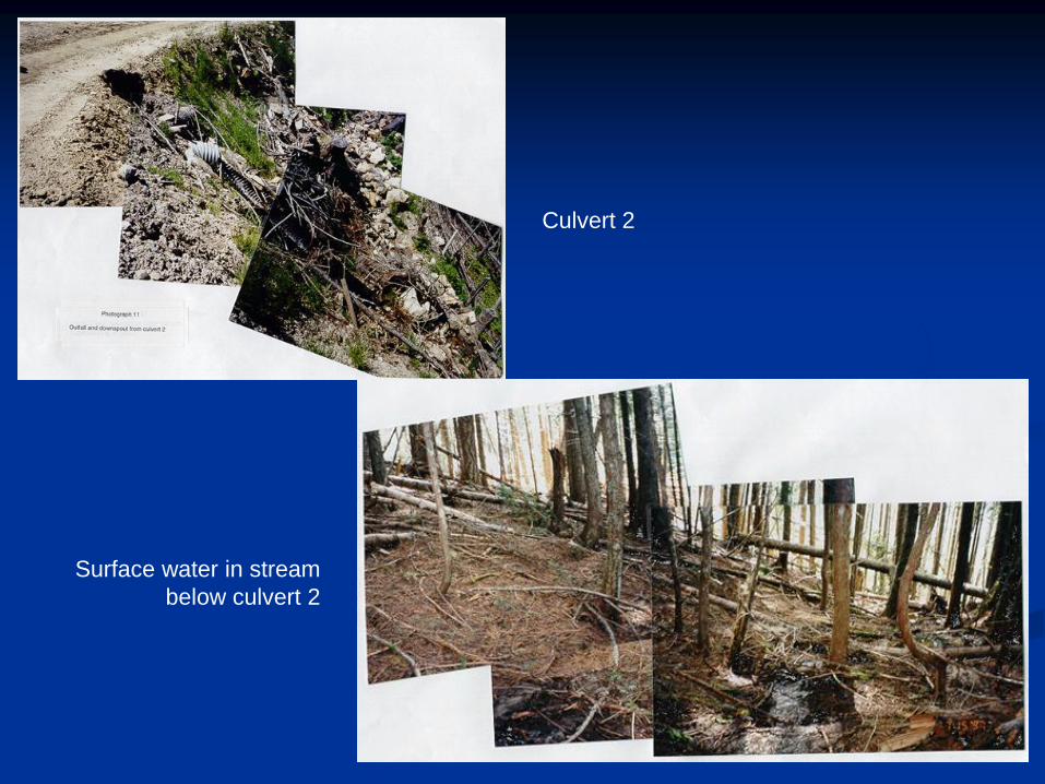
Culvert 2
Surface water in stream
below culvert 2

Debris flow initiation:
• 1997 was an abnormally wet year; snowpack was on average 25% higher in April-May.
Ttotal precipitation values were also above any previously recorded spring, summer, or
early fall maxima for a data record of 104 years. These observations indicate that
substantially higher than average antecedent moisture conditions prevailed before 11
July.
• In the period between 5 and 12 July, a strong low-pressure system, characterized by
two separate fronts, brought heavy precipitation on 5 July and frequent showers of
increasing intensity and duration between 7 July and the early hours of 12 July.

Rainfall intensity–duration curve showing the return intervals of the
5 July and 11 July storms.
• results show that the amount of rainfall preceding this event was rare, but
not extreme on a 4 or 7 day basis. However, the duration of the rainfall
period may be more significant than the amount, as this would have
provided more time to increase the degree of saturation of soils within the
failure zone.

Channelized debris flow transport:
Debris from the initiation zone flowed northwest and entered Hummingbird Creek
before running up the opposite bank about 9 m. It appears that the debris
spontaneously assumed true flow in the confined channel reach, as no sign of
abnormal ponding of creek flow was apparent. No evidence of ponding in the creek
also suggests that the debris slide was quite fluid as it entered Hummingbird Creek.
The channel of Hummingbird Creek from the slide entry point down to the fan apex,
a distance of approximately 2.5 km, has had its bedload scoured out. Creek banks
were scoured of forest soils, debris and trees up to a height of 5 to 7 m. It is
estimated that about 50,000 m3 of bedload, soil, rock, trees and forest debris was
scoured from the channel.

Debris flow depostion:
The volume of material transported to the
deposition zone is estimated at between 70,000
and 80,000 m3(slope debris at 20,000 to 30,000
m3 and channel scour at 50,000 m3). A wedge of
very coarse material raised and relocated the
creek in the levee zone upstream of Highway 97A.
The gradients in this zone range between 14 and
18 percent (8 to 10 degrees). The maximum
thickness of the wedge is difficult to estimate, but
appears to be in excess of 2 m. Boulders to 2 m
diameter were deposited in the levee zone.
Cabins along the north side of the creek
upstream of Highway 97A were directly
impacted, being pushed downslope
about 5 to 7 m and inundated with
coarse gravel, cobbles, boulders and
water to a depth of 1 to 1.5 m. Damage
to homes and property downslope of the
highway was primarily due to inundation
of water, sand and gravel

Factors contributing to debris flow initiation:
The failure is believed to have been debris flow initiation at the headscarp. This
interpretation is supported by:
a) removal of all surficial soil (stripped to bedrock) within the upper failure zone
b) splatter on the trees at the margins of the failure zone which suggests that
the upper slope was fully saturated at the time of initiation
c) the apparent excess water on the slope prior to initiation of the debris flow

Peak discharge is estimated to approximately 1000 m3/s. This value is 50 times
greater than the estimated 200 year flood of 20.1 m3/s, which emphasizes that
channel restoration aimed at flood hazard reduction is clearly inadequate to
convey debris flows of even low magnitude to Mara Lake
Debris-flow frequency:
Three methods were applied to date previous debris flows at the site:
a) Air photographs: 1928 air photographs indicated a debris flood or debris flow that had
recently occurred. An older deposit estimated between 1930 and 1940 was visible
north of the intersection of the highway and Hummingbird Creek.
b) Dendrochronology: dates were obtained for 1925–1926, 1948–1949, 1964–1965,
1971–1972, 1976–1977, and 1980–1981.
c) Anecdotal information: One person residing in Sicamous recalled that it occurred on
30 June in the early 1930s. Anewspaper article of 2 July 1935 reports a downpour in
Kamloops and several washed-out bridges, including four south of Sicamous. This
evidence indicates that the event most likely occurred in 1935.
Three different methods were used to reconstruct debris-flow occurrence on the
Hummingbird Creek fan. There is evidence that a debris flood occurred in the 1920s,
1935, 1946, 1964 or 1965, and 1976 or 1977. Air photograph evidence and witness
accounts are insufficient to estimate the volume of those events. The only known
debris flow occurred on 11 July 1997.
Conclusions:
• The slope failure which occurred on the northwest slope of Hummingbird Creek on July
11, 1997 was initiated by the saturation of shallow colluvium overlying bedrock on steep
terrain which has been classified as potentially unstable. It originated as a debris
avalanche below a forest road culvert. Drainage area above the culvert had been
artificially tripled.
• The slope failed as a debris flow which stripped an estimated 20,000 to 30,000 m3 of
surficial soils from the slope. Debris entered Hummingbird Creek where it became a
channelized debris flow and was transported to the alluvial fan on Mara Lake, where the
community of Swansea Point is located. It is estimated that 50,000 m3 of material was
scoured from the channel and transported downstream.
• The factors cited which contributed to initiation of the July 11, 1997 debris flow on
Hummingbird Creek are: steep slope gradient, adversely dipping bedrock, surficial soil
(colluvium) susceptible to shear strength lose when wet, long duration and at times
intense rainfall, high antecedent soil moisture, increased groundwater flow, and the
concentration of runoff onto the headscarp from culvert 1.
• The time at which the debris flow occurred is linked to the duration of the rainfall, its
increased intensity during the hours immediately preceding the slope failure, and the time
required for the buildup of porewater pressure to critical levels in shallow soils near the
headscarp. Rainfall during the week preceding the debris flow is characterized as rare
with a return period of about 60 years. This rainfall caused prolonged storm runoff from
the culvert (culvert 1) above the headscarp, and dispersal of runoff as a plume on the
forest floor below the culvert outfall.

Conclusions (continued):
• Bedrock geology and surficial geology both play a part in slope failures in the
Hummingbird Creek valley. Although the extent to which groundwater contributed to
porewater pressure rise in soil within the initiation zone during the period July 5 to 11,
1997 has not been evaluated, its contribution to porewater pressure rise within the failure
zone may be small in comparison to the contribution of water concentrated on the slope
from culvert 1 discharge.
• This event caused substantial damage to property within the community of Swansea
Point. This event also impacted and will continue to impact downstream environmental
values. These include the fishery, water quality and loss of productive land base. The
destabilized channel of Hummingbird Creek between the point of entry of the debris and
the fan will continue to produce excess sediment for a considerable time.
• The Hummingbird Creek alluvial fan has also been subjected to debris flow events in the
past. Similar adverse meteorological conditions coupled with site characteristics similar to
those in this study area could initiate similar events in the future at other locations.
• On this basis the factors contributing to initiation of the July 11, 1997 debris flow on
Hummingbird Creek are: concentration of discharge onto the steep slope from culvert 1;
long duration and, at times, high intensity rainfall; high antecedent soil moisture; increased
groundwater flow; thin surficial soil (colluvium) susceptible to shear strength loss when
wet; steep slope gradient; and adversely dipping bedrock;

Debris flow and flood risk mitigation:
There are two strategies for mitigating debris flow and debris flood hazards:
1. active measures to mitigate the hazard occurrence; or
2. passive measures to avoid the hazard, such as land use planning.
Active measures are usually needed when a debris flow or debris flood affects
a developed area. Passive measures can be used to preclude development
in high hazard areas, or can complement active measures to maximize
safety in high risk areas.
_______________________________________________________________
a) Landuse planning: zoning, land acquisition.
b) Warning systems: advance warning, post-warning systems
c) Watershed management actions: watershed stabilization, check dams etc.
d) Mitigation structures: debris basins, barriers, berms channelization.

a) Landuse planning: zoning, land acquisition:
Land use planning is the primary form of passive measure for natural hazard mitigation.
In a case where a fan is already developed, such measures are generally limited in
application, and are best considered for implementation in conjunction with active
measures to minimize risks.
i) ZONING In some cases, it is possible to delineate a fan into zones of varying
hazards, either with or without mitigative measures.
ii) LAND ACQUISITION. Acquisition of property along creek corridors may be beneficial
for future mitigation structures, so development activity in this area should be closely
scrutinized. In addition, the need for building setbacks, erosion protection works and
floodproofing measures should be considered on a site-specific basis. Provision of
maintenance access routes or easements along creekd should also be considered at
such time.

b) Warning systems: advance warning, post-warning systems
Systems can be installed to provide warning of an impending debris flow (advance
warning system), a debris flow occurring (event warning system), or after a debris
flow has occurred (post-event warning system).
i) ADVANCE WARNING SYSTEMS: Advance warning systems can involve real-time
monitoring of precipitation and creek flow data to determine when hydrological
conditions approach a threshold for regional landslide occurrence and debris flow
activity. Activities in high-risk areas may then be restricted and public notification
considered. The period of notice may range from a few hours to a day or two.
Warnings will typically apply to all creeks in a regional area as opposed to any
specific creek. False warnings may occur relatively often. An advance warning
system could also warn downstream residents and road users of high risk periods.
But given the high likelihood of false warnings, it would not provide an effective
means for temporarily relocating residents.
ii) POST-EVENT WARNING SYSTEMS: Post-event warning systems may be useful in
providing notice of a service disruption of critical infrastructure, such as bridges.
Such a system would have been effective in preventing multiple deaths in 1981 at M
Creek on the Squamish Highway, resulting from several vehicles driving
unknowingly into a gorge following a bridge washout, as occurred on Rutherford
Creek near Pemberton in October 2003.

c) Watershed management actions: watershed stabilization, check dams etc.
Some general and site-specific watershed actions that should be considered in
mitigating the risks associated with debris flows and debris floods: .
i) WATERSHED STABILIZATION: Watershed stabilization activities can be
considered to reduce the level of debris flow and debris flood hazard. Such
measures attempt to tackle the problem at the source area where debris is
generated and point source failures are most likely. Stabilization efforts in
upstrea gullies could involve bioengineering techniques forsideslopes, partial
removal of fill material and/or stabilization at toe of the potential failure slopes.
ii) CHECK DAMS: Check dams are weirs, typically constructed of concrete,
about 2 m to 3 m high that can be constructed in series along a creek channel.
Their primary purpose is to reduce debris production along creek channels.
This is accomplished by storing in-channel material, stabilizing sideslopes, and
directing the creek flow toward the centre of the channel. Check dams will not
significantly reduce the debris flood or debris flow risk.

d) Flood Mitigation Structures
i) Debris basins:
A debris basin is a constructed storage area
in which a debris flow is contained above a
critical area. A debris basin includes an outlet
structure that can be designed to allow
passage of debris below a certain size.
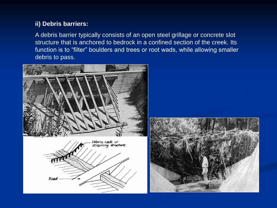
ii) Debris barriers:
A debris barrier typically consists of an open steel grillage or concrete slot
structure that is anchored to bedrock in a confined section of the creek. Its
function is to “filter” boulders and trees or root wads, while allowing smaller
debris to pass.

ii) Debris flow net:
Debris flow nets are a form of debris barrier that have been recently
developed for creeks where the expected debris volumes are small (less
than 1,000 m3). Debris flow nets are a derivative of rockfall nets, which
have been widely used to prevent rockfall from reaching development or
infrastructure. The nets consist of interconnected steel rings that are
positioned such that the net can expand dynamically to withstand impact
forces.
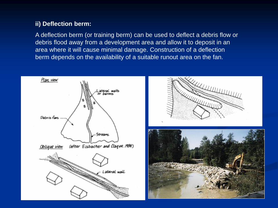
ii) Deflection berm:
A deflection berm (or training berm) can be used to deflect a debris flow or
debris flood away from a development area and allow it to deposit in an
area where it will cause minimal damage. Construction of a deflection
berm depends on the availability of a suitable runout area on the fan.
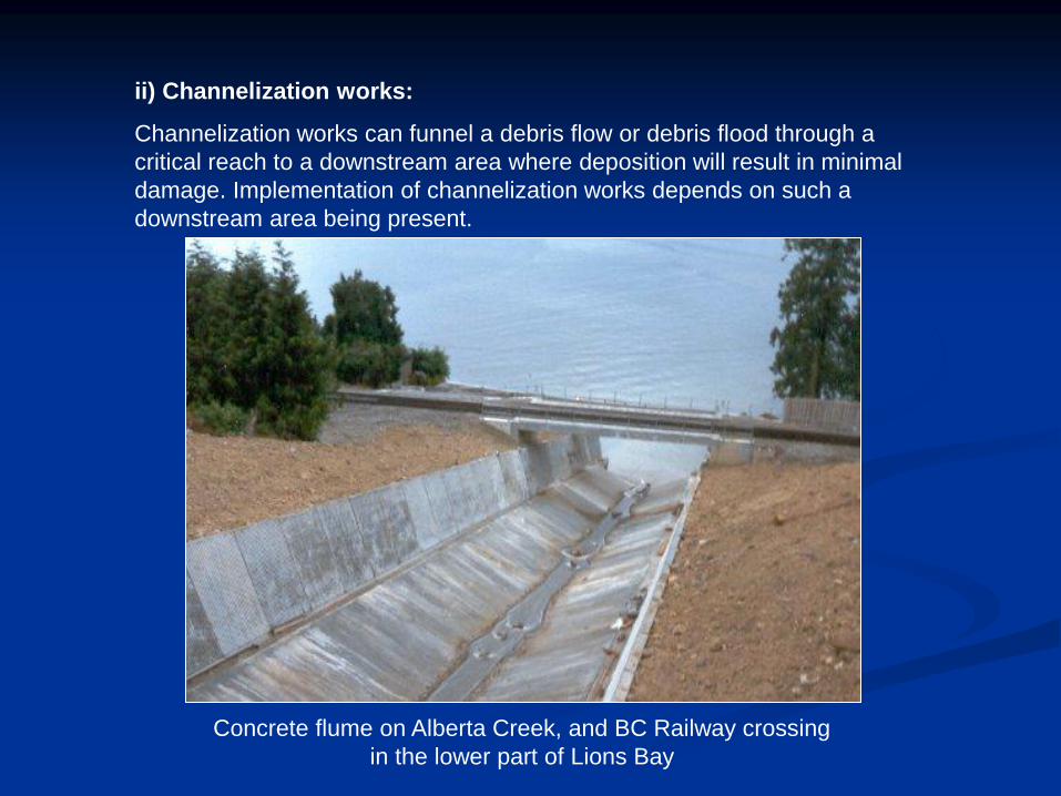
ii) Channelization works:
Channelization works can funnel a debris flow or debris flood through a
critical reach to a downstream area where deposition will result in minimal
damage. Implementation of channelization works depends on such a
downstream area being present.
Concrete flume on Alberta Creek, and BC Railway crossing
in the lower part of Lions Bay

Concrete flume on Alberta Creek in
the upper part of Lions Bay. The
flume is designed to allow water, mud
and debris to pass unimpeded during
major flooding events.

Mountain Flood Hazards: Summary comments
Mountain streams present significant hazards to human settlement and
activities.
• Floods that mobilise sediments as debris flows, or in sufficient quantity to
create a ‘debris flood,’ usually block mountain roads and railways at the
point of crossing.
• In confined valleys, structures are sometimes placed on debris cones.
Such sites are dangerous in the long term because of the high probability
that a debris flow or flood eventually will escape the current channel and
inundate the site.
• Structural defensive measures include isolation of an adequate
conveyance channel within high berms and provision of high-clearance
road and rail crossings. In extreme cases catch basins may be constructed
to contain expected debris flows. All these measures are expensive, the
last exorbitantly so. Communication routes are compelled to cross
mountain streams, but the most effective defensive strategy for settlement
or infrastructure is recognition and avoidance of exposed sites.
• In a distressing number of cases, the possibility for significant stream-
related damage has been ignored. In fact, it is easy to ignore the hazard
because of the possibly long inter-event period.
