hydrologic and hydraulic modeling for … · the staten island bluebelt program focuses on...
TRANSCRIPT
HYDROLOGIC AND HYDRAULIC MODELING FOR GREEN STORMWATER PRACTICES
Brian Henn1, Sandeep Mehrotra, P.E.
1, Jim Garin, P.E.
2, and Dana Gumb
2
1 Hazen and Sawyer, P.C., 498 7
th Ave., 11
th Floor, New York, NY, 10018
2 New York City Department of Environmental Protection, 59-17 Junction Blvd., Corona, NY, 11368
ABSTRACT
The Staten Island Bluebelt Program focuses on addressing flood problems that are a result of natural
landscape, tidal factors and a lack of drainage infrastructure. Using Best Management Practices
(BMPs), New York City Department of Environmental Protection (DEP) seeks to mitigate stormwater
flooding and improve water quality in a cost-effective manner by employing natural hydrologic features
in a gravity-driven system. To quantify the potential benefits of BMPs in Staten Island’s New Creek
watershed, a robust one-dimensional model was developed using United States Army Corps of
Engineers HEC software. The model was calibrated to historical rainfall and tidal data and supplied
with watershed information from a GIS land use database. It was then possible to test a variety of
improvements, and the model showed that incorporating BMPs could result in a significant decrease in
storm event peak water surface.
KEYWORDS: Stormwater Management, Best Management Practices, Low Impact Development,
Stormwater Modeling, Staten Island Bluebelt Program
INTRODUCTION
The effort to model Best Management Practices (BMPs) practices is part of a larger stormwater
management program, which represents latest paradigm in the evolution of stormwater management on
Staten Island. In the late 1960s, the opening of the Verrazano Narrows Bridge led to rapid new
development in this borough of New York City, causing a dramatic increase in impervious surface area.
The decrease of pervious area in various Staten Island watersheds, the lack of stormwater or sewer
infrastructure, and the tidal influence in low-lying areas combined to cause stormwater flooding. In
order to alleviate this, a stormwater management program needed to be implemented.
DEP’s Staten Island Bluebelt Program was started in 1997 to manage the stormwater problem. Many
options were considered to mitigate the stormwater and decrease flooding, one of which was to
implement an all-pipe network, as suggested in previous drainage plans. However, this proposed
solution would have eliminated some of the only remaining contiguous freshwater wetlands in New
York City.
The Bluebelt drainage plan was designed to augment the idea of the typical pipe and pond solution. For
the plan, an innovative use of BMPs was developed to connect the storm sewers beneath residential
streets with the existing natural waterways, including streams, wetlands and ponds. The unique
combination of sewers, BMPs and waterways was codified into new drainage plans, which were
developed at the watershed level.
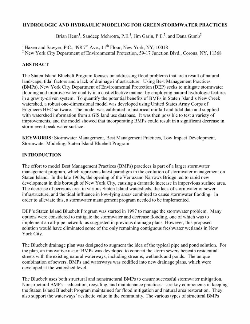
The Bluebelt uses both structural and nonstructural BMPs to ensure successful stormwater mitigation.
Nonstructural BMPs – education, recycling, and maintenance practices – are key components in keeping
the Staten Island Bluebelt Program maintained for flood mitigation and natural area restoration. They
also support the waterways’ aesthetic value in the community. The various types of structural BMPs
included in the New Creek drainage plan are outlet stilling basins, extended detention wetlands, and
meandering stream segments. Structural BMPs tie together the hard-pipe infrastructure with the region’s
streams and ponds. Where the storm sewers discharge to natural waterbodies, green infrastructure
reduces the erosive impacts of high-velocity flows, provides water quality benefits and safely attenuates
flood peaks (Figure 1).
Figure 1 – Typical Schematic of Bluebelt Drainage Plan with BMPs.
The success thus far of the Staten Island Bluebelt – more than 40 BMPs have been constructed across
nearly a dozen watersheds, with greatly reduced property and street flooding - demonstrates that
managing stormwater with small, cost-effective landscape features, as opposed to costly pipe and pond
facilities, not only saves money, but also helps protect and restore water quality while also providing
unique aesthetic enhancements to the area.
METHODOLOGY
Watershed Description and Project Goals
The New Creek watershed represents a significant new challenge for the DEP Bluebelt Program. While
the Bluebelt has proven to be a solution to localized flooding in many locations of South Richmond,
Staten Island, the demands for flood control are severe in the Mid-Island region. Indeed, some studies of
the Mid-Island area have recommended implementing a stormwater pumping system to combat its
disadvantageous topography and terrain (USACOE, 2003), but DEP is committed to using a functional
gravity-driven system, which is the goal of this planning project.
The constraints on a gravity-driven stormwater drainage system in the New Creek watershed are unique
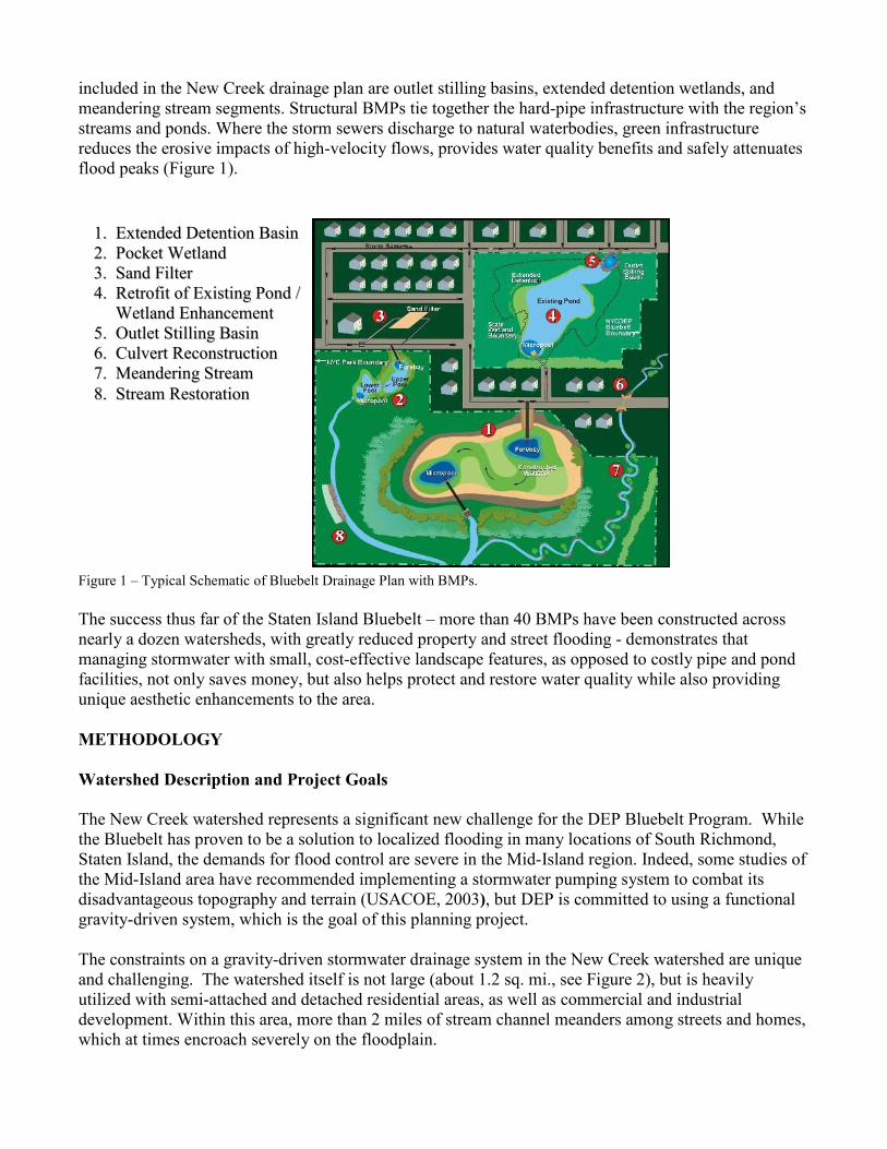
and challenging. The watershed itself is not large (about 1.2 sq. mi., see Figure 2), but is heavily
utilized with semi-attached and detached residential areas, as well as commercial and industrial
development. Within this area, more than 2 miles of stream channel meanders among streets and homes,
which at times encroach severely on the floodplain.
11.. EExxtteennddeedd DDeetteennttiioonn BBaassiinn
22.. PPoocckkeett WWeettllaanndd
33.. SSaanndd FFiilltteerr
44.. RReettrrooffiitt ooff EExxiissttiinngg PPoonndd //
WWeettllaanndd EEnnhhaanncceemmeenntt
55.. OOuuttlleett SSttiilllliinngg BBaassiinn
66.. CCuullvveerrtt RReeccoonnssttrruuccttiioonn
77.. MMeeaannddeerriinngg SSttrreeaamm
88.. SSttrreeaamm RReessttoorraattiioonn
In addition, more than half of the watershed is located at very low elevations – within five feet or less of
mean high tide in many locations. The close proximity of the neighborhood streams and the lack of
topographic relief make providing effective stormwater drainage a difficult task. To prevent inundation
of the neighborhood during high-tide events, a one-way flap gate only allows discharge from the stream
to Lower New York Bay when its water surface elevation is greater than that of the tide, effectively
blocking the neighborhood’s only stormwater outlet during extreme high tide events.
Exacerbating the situation, the neighborhood’s development pattern created extensive impervious areas
with strip commercial properties and dense single-family housing. The impervious fraction of the
watershed area is approximately 36 percent. In addition, the majority of the streets in the watershed lack
storm sewers, so the primary drainage mechanism during wet weather is sheet flow from streets and
buildings directly into streams or wetland areas.
Figure 2 – Map of the New Creek Watershed. The West Branch is to the left, the Main Channel to the right, and the East
Branch in the bottom right. Catchment boundaries are shown in red. The Creek drains to Lower New York Bay via a storm
sewer under Naughton Ave.
Not surprisingly, the area experiences frequent street and structure flooding. Homeowners and business
owners are frequently forced to pump out inundated basements and streets. The area’s pre-existing
drainage plan dates from the 1960s and remains largely unconstructed. Completing this plan is
impracticable today because it calls for a complete grid system of streets and large trunk sewers. Today,
these streets and sewers cannot be constructed because they would lie within the watershed’s 100-plus
acres of protected wetlands. These wetland areas are the low-lying corridors along the Creek’s branches
that DEP is now acquiring for the Bluebelt.
Indeed, the wetland areas, which stymied further development and prevented completion of the old
drainage plan, are now a major key to solving New Creek’s chronic flooding. As the last large open
spaces in the watershed, they can provide the detention and storage of stormwater necessary for
protecting streets and homes. A new drainage plan is being developed that will provide storm sewers to
the existing New Creek neighborhood; in turn the sewers will discharge to wetland BMPs. Using the
Bluebelt’s integration of green and gray infrastructure, DEP will provide a flood-control solution that
will enhance the environmental value of the neighborhood. In fact, through habitat restoration and
protection from development, the Bluebelt sites’ ecological resources will be enhanced.
Developing a drainage plan for this complex watershed requires an in-depth understanding of its
hydrologic, hydraulic and ecological characteristics. To understand the runoff and flooding response of
New Creek, an extensive modeling effort is being undertaken. To be successful, the model must be able
to correctly simulate the current behavior of the watershed, including its sensitivity to the tidal cycle.
Therefore it must be an unsteady hydraulic model. It also must be able to take into account the
traditional storage and detention wetland BMPs that will be a key component of flood protection,
including their discharge behavior.
To meet these demands, the HEC series of models from the United States Army Corps of Engineers’
Hydrologic Engineering Center was selected. These models are robust and widely used, capable of
modeling unsteady flow, and provide a wide range of runoff models. They possess an additional benefit
of having modest data requirements – for example, channel and floodplain cross sections and catchment
characteristics such as curve number (CN).
Model Development
To prepare for the development of the hydrologic and hydraulic models, DEP collected extensive data,
including several dozen channel and floodplain surveys, culvert surveys, flow and water surface
elevation measurements at various sites in the Creek, tidal water surface elevations at the outfall, and 5-
minute rainfall series data. Additionally, a GIS database was compiled of available data, such as edge-
of-pavement and structures layers, aerial topographical surveys and photos.
New Creek consists of a main channel and a western branch, each about a mile long, and a shorter
eastern branch. Together these are interrupted by 12 existing hydraulic structures, including an intake by
which the combined branches enter a storm sewer that carries flow through the tide gate and to the ocean
outfall. The original outlet of the Creek, which is likely to have once been a brackish tidal wetland area,
has been filled and replaced by an arterial street that runs along the shore.
The approximately 780-acre watershed has a variety of catchments, ranging from open wetland
vegetated with invasive Phragmites grasses; to complete development with impervious fractions over 50

percent; to hillier upland areas above Hylan Boulevard that are better drained. Some of the catchments
are drained and defined by existing storm sewers, but most are drained by sheet flow over streets.
To develop a runoff model, catchment boundaries were created through a detailed analysis of existing
grades and sewers. This generated approximately 40 catchments that would have their own outfalls
under a new drainage plan or were corridor areas flowing directly to the Creek. Three of these
catchments had observed runoff data for use in calibrating a watershed-wide runoff model. Using HEC-
Hydraulic Modeling System (HMS), our calibration exercise sought to match the observed runoff
hydrographs for these three watersheds to the model output by varying two parameters, Curve Number
(CN) and time of concentration (Tc). Once calibrated, the CN and Tc were correlated with the observable
parameters of impervious fraction and catchment size. For the remaining ungauged watersheds, these
correlations were used to develop runoff parameters despite the lack of flow data.
The second step in correlating the model was to match the observed and computed water surfaces. Flow
hydrographs from HEC-HMS for the 40 catchments were entered into the HEC-River Analysis System
(RAS) stream model, along with observed tidal tailwater conditions. The RAS model included all
geometric data from the surveys of channels and culverts. Calibration was done by adjusting the loss
factors to account for culverts being in good or poor condition, and adjusting Manning’s n values for
stream reaches, until a good fit was observed. The model can indeed replicate the observed stages that
show a strong tidal influence.
BMP Modeling
With a calibrated model, DEP was able to model the impact of BMPs and other design alternatives,
using a range of design storms. To meet DEP’s design 5-year, 24-hour duration storm, observed hourly
rainfall from September 21, 1966 was used, as it closely matched the statistical 5-year storm. Observed
tailwater tides were also available. This design storm was run through the HEC-HMS and HEC-RAS
models to generate runoff hydrographs and water surface elevations.
The purpose of the modeling was to evaluate stormwater management alternatives for their impact on
reducing peak water surfaces. The design goals were to reduce the peak water surfaces in the
downstream portions of the watershed, which are characterized by backwater conditions, below 3.0’
National Vertical Geodetic Datum (NVGD), the elevation of many of the low-lying streets. A further
reduction below 2.0’ would be preferred.
Several types of improvements were considered (Figure 3). Among these were upstream detention
BMPs, located at the head of the stream branches, to control runoff as it exits the storm sewer networks.
The model incorporated these as wide spots in the channel, with weirs to control the outflow.
Another control was the downstream storage wetlands, which would be located in the stream corridors
now acquired by DEP. These BMPs would be large but shallow due to the lack of relief. The model
assumed that excavation would occur to create more storage volume, down to approximately the low-
tide line. They were also modeled with outlet structures that release flow over a 6-hour period, to allow
for the tidal cycle.
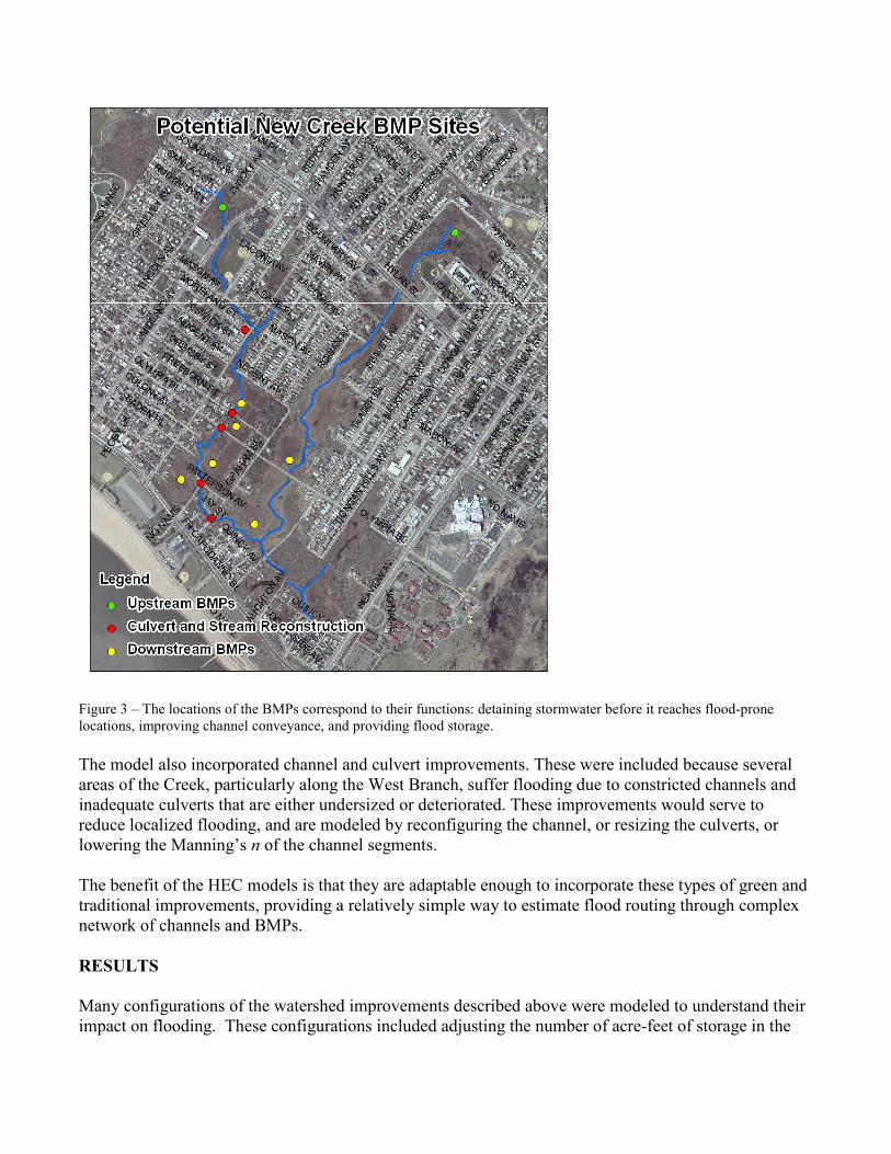
Figure 3 – The locations of the BMPs correspond to their functions: detaining stormwater before it reaches flood-prone
locations, improving channel conveyance, and providing flood storage.
The model also incorporated channel and culvert improvements. These were included because several
areas of the Creek, particularly along the West Branch, suffer flooding due to constricted channels and
inadequate culverts that are either undersized or deteriorated. These improvements would serve to
reduce localized flooding, and are modeled by reconfiguring the channel, or resizing the culverts, or
lowering the Manning’s n of the channel segments.
The benefit of the HEC models is that they are adaptable enough to incorporate these types of green and
traditional improvements, providing a relatively simple way to estimate flood routing through complex
network of channels and BMPs.
RESULTS
Many configurations of the watershed improvements described above were modeled to understand their
impact on flooding. These configurations included adjusting the number of acre-feet of storage in the
upstream BMPs in order to detain flow for at least one tidal cycle, and modifying the sizing of the
downstream storage BMPs.
Figure 4 exhibits the BMPs’ impacts over the course of the design storm. The water surface elevations
are given at Naughton Avenue, near flood-prone areas and the furthest downstream location of the creek
before it enters the outfall structure. Under existing conditions, the design storm produces a peak WSEL
of 3.0’ NGVD. Because of the flat topography in the watershed, small differences in the peak stage can
have large impacts on the severity of flooding.
By adding additional storage BMPs along the channel corridors, however, a marked reduction in peak
stage, down to 2.3’ NGVD, can be achieved. This alternative requires construction of significant
downstream storage volumes, likely in the low-lying wetland areas. The model gives an approximation
of how many acre-feet of storage may be necessary to bring peak water surfaces for the design storm
down below 3.0’ or to 2.0’. It is likely that 20 to 50 acre-feet will be necessary; given that the maximum
depth of these ponds is approximately 2 feet, 10-25 acres of constructed wetlands may be necessary.
DISCUSSION
The model has revealed several important aspects of watershed behavior that will assist in developing
the drainage plan moving forward. First, it gives an estimate of the amount of storage volume that will
need to be constructed in the system to bring flood peaks down. In doing so, the model confirmed that
the behavior of the watershed during storm events that occur at high tide is analogous to a bathtub – the
water level simply rises until the tide falls far enough to allow for gravity drainage to resume.
Second, the model indicates that providing storage only at the heads of the streams, where they emerge
from the storm sewer networks, is insufficient to prevent flooding downstream. A majority of the
stormwater runoff drains to the stream channels further downstream, and so storage needs to be provided
at these downstream locations.
Additionally, the modeling shows a tradeoff between improving channel capacity in constricted sections
and worsening downstream flooding. By widening or realigning the channel sections for better
conveyance, localized flooding is shown to be alleviated in the model. However, downstream stages are
noticeably higher, because the improved conveyance brings flows to the low-lying areas faster and
eliminates the natural detention that the constricted channels had provided.
CONCLUSIONS
The HEC hydrologic and hydraulic models have proven successful in modeling runoff and stream
flooding in the New Creek watershed. The models were able to mimic the observed behavior in the
watershed, including the impacts of urbanization and impervious surfaces on runoff volumes, the
backwater conditions created by constricted streams and strong tidal influence, and the unsteady cycling
of water surface elevations caused by the opening and closing of the tide gate.
In modeling BMPs, the programs have proven robust in routing floodwater through a BMP network with
logical results and straightforward parameter variation. For example, weir heights and outflow orifices
can easily be adjusted on the storage BMPs to change detention times and limit peak outflows. The
model has a complex weir and culvert package that can incorporate many outlet structure designs.
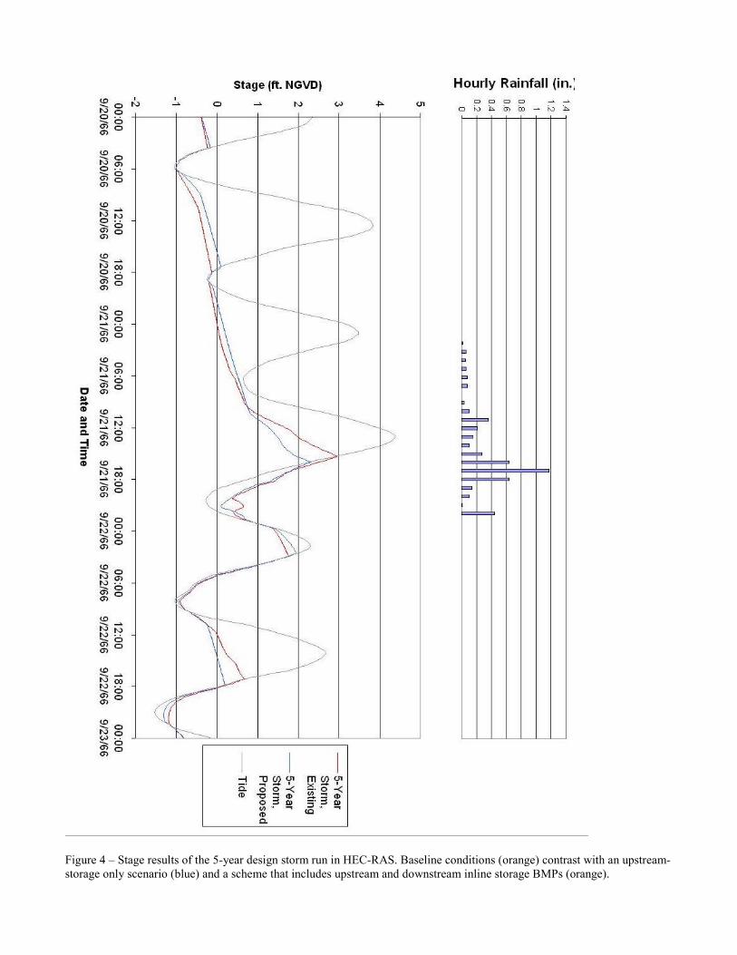
Figure 4 – Stage results of the 5-year design storm run in HEC-RAS. Baseline conditions (orange) contrast with an upstream-
storage only scenario (blue) and a scheme that includes upstream and downstream inline storage BMPs (orange).
However, some key features of the watershed planning process have not been incorporated into the
model. Specifically, the proposed storm sewer network is not explicitly modeled, due to the number of
closed conduit sections that would be required, which is beyond the intended use of HEC-RAS. Also,
the possibility of incorporating low impact development (LID) practices that emphasize decentralized
stormwater infiltration has not yet been included in the model. The HEC runoff models do provide
methods of simulating the enhanced infiltration and evapotranspiration that LID provides. However, we
have found that the small size of individual LID practices and their decentralized nature will require
future efforts to scale their impact up to the catchment level.
The Bluebelt approach to drainage planning utilizes a watershed approach, and this modeling exercise
proves why such an approach is valuable. For example, channel improvements that alleviate poor
drainage in one portion of the watershed may have negative impacts on downstream flooding.
Watershed planning must be a holistic process that takes into account multiple goals. As the process of
developing a new drainage plan advances, modeling will continue to be used to help develop an optimal
stormwater management strategy. And, as understanding of stormwater systems increases and new types
of mitigation strategies are advanced, the Staten Island Bluebelt Program will continue to evolve and
develop.
REFERENCES
Rosgen, Dave. (1996). Applied River Morphology. Pagosa Springs, Colorado: Wildland Hydrology.
United States Army Corps of Engineers. (2003). “South Shore of Staten Island Feasibility Study: Line of
Protection and Interior Drainage Alternatives Report.”