i fit .s- fileiowa department of natural resources geological survey bureau well record . 6 . 06 11...
TRANSCRIPT

Iowa Department of Natural Resources Geological Survey Bureau WELL RECORD 6 06 11 Permit No.109 Trowbridge Hall Iowa City, la. 52242-1319 PH (319) 335-1575
Site identification Drill method J&-ratal)' 0 auger 0 cable other
property~ner70w't1 or Ea c !t'dq WeIiNumber _ hole si.a contlnuad
Address /016 #4/':1 Sl1erT J Hole size
/O~ch from_O_1t to__1t _Inch from__1t lo__fl
_Inch from __1t to__11Tenant Eac I/Afjj :;;;'(04 .5: IS""..:? Q _inch from __It to __II
Well Depth f£- 3 It Date Compleled.l....!2..-1 ..1../!:-1~ Aecortl ali depth maasuremenls from ground level (GL). Use (+) fOf above GL maasuremenls.
Casing Driva shoe (yes f no ) Piliess adaplor ( yes I no ) Location County_.:-:~S"",-.:r;:..Ls:;.;-.iO/~ _'/"1V:-
Size (IDIDD) Type 1Wt Depth top Deoth bottom Amount (Ienathj __mi. Nand fit mi.@Of intersection of ~/ band /9/
s w .<)e,v1/4 of theSE\/4 of th~LVt/4 of Sec .s- lWP eD RNG~J,
W~~/~T~rW~--~---~---~--~--~ Show exact location of well in seclion grid with adol ( • ).
N Sl<Jlldl map 0' w.lllocallon QI1 propErly
I N
Perforated or slotted casing? (ye~
Perlorated 1stol1ed from fl to 11
10 11Perforaled I sloNed from It
Casing grouted?rfi£)no ) Type Depth Top AmountDepth Bot1om
Well screen? (yes 1no)
Diameter Slot size Depth Top Depth Bot1om Lenath Malerial
3f!f£?.A /p ~ l/..f.=.~ ~-~ Iq;-qy ~A,aj) ~/~y ., /5--..;-IAf~uJ AA,oJ; "..kv
SJ€~!
12~-t., Lt.I/-./?' I'sr,,,,,,: ~J] Clc1...V
51/-h?R-~ /3rCJ.; M PI Cktv d-hu1kvS'Cl { I."?.'t?-h ~7f-;2.~; I~~ Att:~ ~\h"f),i ~,,>o 14'-4-..:1 I~R'-2 -:ta~ l-z Pr1 t""~ v c/
/
Date __I__I __Pump Installed? (yes 1no )
Installer'sname _
Type ofpump _ Depth to intake It,
Pump diameter Rated capacity GPM
Water Information Aquifer: i:8Sandlgravel 0 limestone 0 sandstone
Main water-supply zone from J.:< ~(; f( to 7:3' ~g 11 "/9 r ,
Rnal water level ( static water level) ~ It (below 1above) GL. (~ ~I
Pumping waler level.W-f/' It below GL; ~ tape 0 airline 0 E·line
At yield at ftGPM; 0 ormcs ~volumetrlc Oestlmate Dale /0 '~2j"'7-o;1/ Use additional sheals as needed
Water quality test? (yes I no) Date tested __1__1__Reroilgs (including depth of lost dri~if)Jl.l!Yids, materi~s) or JPOls) Tested by _IJ'T/' - Y6,t:/?9/ WY''''' _:< ~1I/0
Test resultsY'~ ;}!)vtJ? lot: Well use o Domesllc .8; Municipal o Industrial o LIvestock o Public Supply o Monitoring o TestWeli o IrrigalJon o OOer_---,==__
(explain)
/7'd }COrt11J e.. while copy· Iowa DNR, Geological Survey Bureau blue copy - Well Contractor pink copy - Customer yellow copy - County Kasl1lt OffIcer
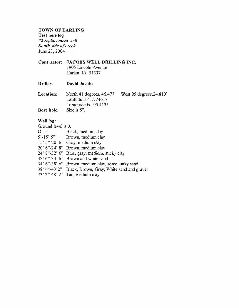
TOWN OF EARLING Test hole log #2 replacement well South side ofcreek June 23,2004
Contractor: JACOBS WELL DRn.LING INC. 1905 Lincoln Avenue Harlan, IA 51537
Driller: David Jacobs
Location: North 41 degrees,46.471' West 95 degrees,24.810' Latitude is 41.774617 Longitude is -95.4135
Bore hole: Size is 5".
Well log: Ground level is O. 0'-5' Black, medium clay 5'-15' 5" Brown, medium clay 15' 5"-20' 6" Gray, medium clay 20' 6"-24' 8" Bro~ medium clay 24' 8"-32' 6" Blue, gray, medium, sticky clay 32' 6"-34' 6" Brown and white sand 34' 6"-38' 6" Bro~ medium clay, some junky sand 38' 6"-43'2" Black, Bro~ Gray, White sand and gravel 43' 2"-48' 2" Tan, medium clay
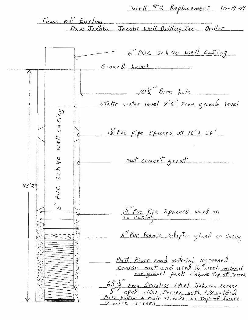
_~1L_ :R-;2. ._-.Ket1c....c£d1£..ci1.·· .IQ.=..J.!i::J).!L
10 vh1 0 £ f...a..r 1'71-."--" ...,r"~,_~~r_~ , •• ~'.'~~ ·.m._, -_., '.~...__ ,
.JkAJJ£...._~~M._ _Itt,'<-o~.. .~e.lL1JcJL(.~'!:J..JA.c. Or;1L5le;.Lc _
G rO<.l,.I\j), beve ItrI I
J II
SJ ....
t-., _ I e-v
r-. ! i"l -QJ
~j ll
-"/I~O~;Q,,,,--... _=IJ:;;::::o.!-r'.;::,e'----lhUJo>L.!....:Je.:=--_____ . __._
1 r
() I :)- I j,\i
\J -e
I : ;
Y3':-<~ Il ~
I !,\.J I I~ it
!">
I ~ Cl-
i
Y;j:---~-...C)__+>' : "J. .--.--L~<'----
v ~ ~ ...... :.,:.~i
' .... ':'"J .......:;...
i~:.' : ::.-"
:~::;' =t=-:::--;--~--="O'.;=c_+-b-":;.~'---;-: .-: ----- .._._.-._-_.-..~:-:
.; .. ,_~~ri; ""':j
:{(~~--~ :.~ j ...j;~_. 'f-~---- .P/aft !rive r roa.j.I2'I~-t'r.;o.,L __s~Ie~~!{d .. .. j ~ ~~R--'~_ '--_._~_.~ --__ 'I . _. ------., ...62_Q.£S_~ 0 u..t: d II d,__fd..sfld_4~~g.$.1J_ /Y)a1eo~1 , ;.. , ~------ ../:! !. I.,.~ ?,.~.____ ". __ :.' " 6> r j r~ l.1 eJ to. r...k-L!A..bfl.v.~_ ...T()I- __ o_f._S.c~~4t .~. ~~:~====::---._ _.. ~ 1,1,' ) r---- ------ . I 1/I ~-, ~~ ( .. , ---- 6.S ~ ). "t1j_~il1 Ie ss s te eL__Td~.£.~_.§£L~.~IJ._.(', /
~ / ~lto~ ·/OQ__s:.-c.r:t;?e...~_~.JY..j.tb...-! !2:-l..,Je Ld~1) fJ. e ~bo +- J?1,A.le.__ LIJ.CRf!..ds_._Qd. _.raf!.a.:f:..-.£.C:L~£/5 V Wire. S cree l1.-_. ,~__,,__ .....
.' ,.~. '
I '.k

TOWN OF EARLING #2 Replacement Well
Contractor: JACOBS WELL DRILLING INC. 1905 Lincoln Avenue Harlan,]A 51537
Driller: David Jacobs
This well was dug on October 19, 2004, and test pumped on October 25,2004 at 47 gallons per minute. The test pump intake was 40 feet from ground level.
Pumping test: Static water level was 9' 6" at 10:35 a.m., October 25, 2004 with all ofthe other wells pumping at the same time as this test was performed. The results are as follows: 10:36 a.m. 24' 6" 10:37 a.m. 27' 9" 10:38 a.m. 28' 10:50 a.m. 29' 10" I I :00 a.m. 31 ' 11 :05 a.m. 31' 9" 11 :20 a.m. 32' 11 :35 a.m. 32' 7" 11:50 a.m. 33' 3" 12:05 p.m. 34' 4" 12:20 p.m. 34' 8" 12:35 p.m. 35' 2:00 p.m. 37' 4" The pump was shut off at 2:00 p.m. 2:0 I p.m. the static water level was at 22' 2:03 p.m. the static water level was at 16' 2:05 p.m. the static water level was at 15' 2: 15 p.m. the static water level was 13' 4" 3:45 p.m. the static water level was 10' 4"