iclr supports announcement by the canadian council of ... · clusters of houses were left standing...
TRANSCRIPT

ICLR supports announcement by the Canadian Council of Forest Ministers to reaffirm a strong joint commitment to
wildland fire management
e-newsletter of the Institute for Catastrophic Loss Reduction Volume 10, Issue 3 May/June 2016
ICLR Board of Directors
Kathy Bardswick (Chair)
The Co-operators
Robert Andersen Western
Barbara Bellissimo
State Farm
Charmaine Dean
Western
Joseph El-Sayegh SCOR
Louis Gagnon
Intact
Andy Hrymak
Western
Paul Kovacs
ICLR
Kenn Lalonde
TD Insurance Sean Murphy
Lloyd’s Canada
Gene Paulsen
Peace Hills
Johnathan Turner
Swiss Re
In a formal release, the Institute for Catastrophic Loss Reduction (ICLR) announced its support of the announcement made on June 9 in Dawson City by the Canadian Council of Forest Ministers reaffirming the Council’s commitment to the Canadian Wildland Fire Strategy. Paul Kovacs, Executive Director of ICLR said, “This is a thoughtful plan to address the growing risk to Canadians from wildfire. Our research shows that the approach set out in the Strategy, with a focus on prevention, mitigation, and preparedness, holds great potential to reduce the risk of loss across Canada from wildfire.” Through the remainder of this century, research by the Institute predicts that millions of Canadians are expected to choose to live, work, and play in or near Canada’s forests. Over this period, wildfire experts predict that the area burned in Canada will double due to climate change. More people exposed to wildfire combined with more fire is a dangerous combination. Unless action is taken there will be an increase in devastating wildfire losses, like those experienced in Kelowna, Slave Lake, and Fort McMurray. In ICLR’s opinion, the Canadian Wildland Fire Strategy sets out an innovative and welcome approach to confront this growing challenge.
In ICLR’s opinion, the Canadian Wildland Fire Strategy sets out an innovative and welcome approach to confront this growing challenge. The Canadian Council of Forest Ministers issued a Canadian Wildland Fire Strategy Declaration in 2005. Over the past decade, the provincial and territorial governments have invested in programs to implement important aspects of the Strategy. These investments are well advanced, although the size of the problem warns that the provincial and territorial governments need to do more. The federal government did not implement the 2005 strategy. Indeed, in several areas, like research, federal efforts have been reduced despite the growing threat. A formal commitment between the federal government and the provincial and territorial governments is required if the Strategy is to become a truly national initiative. The Institute urges the federal, provincial, and territorial governments to invest in implementation of the Canadian Wildland Fire Strategy as announced. The Strategy sets out a comprehensive, national approach to reducing the risk of loss from the growing threat of wildfire. CT
Inside this issue
ICLR releases ‘build back better’ guidelines for Fort McMurray
2
ICLR investigates resilience of some homes in Fort McMurray
3,6
Scenario shakemaps for Montreal
4/5

2
The Institute for Catastrophic Loss Reduction has identified best practices for the design and construction of homes to reduce the risk of loss and damage from several natural hazards, including wildfire. These elements, part of ICLR’s ‘Insurers Rebuild Better Homes’ program, are actively encouraged when insurance companies respond to a total loss, and should be considered with a partial loss event. The program sets out three essential elements for each hazard (basement flooding, wildfire, extreme wind and hail) that provide the greatest impact on risk reduction, and several additional elements that would further improve resilience if funds are available. The wildfire elements of the program are recommended in all areas at risk of wildfire, and are particularly important in the wildland-urban interface.
Wildland fire Priority protection:
All roofing materials and installation requirements must be A, B or C rated fire resistant. Asphalt, clay tile or metal roofing should be given preference.
Use fire resistant siding, such as stucco, metal siding, brick or cement shingles. Sheath exterior walls from the ground level to the roofline with minimum ½” sheathing. Exterior walls should be free of gaps or openings that would allow embers to enter building envelope or become trapped behind siding. Heavy timber construction must provide a minimum 20-minute fire rating.
Ensure that exterior windows, windows within exterior doors and skylights are made of tempered glass, multi-layered glazed panels, glass block, or have fire resistance rating of no less than 20 minutes. Exterior doors shall be solid-core wood no less than 1 3⁄4” thick, approved non-combustible construction, or have a fire protection rating of no less than 20 minutes.
Enhanced protection:
Install non-combustible roof gutters, downspouts and connectors, with a cover to prevent accumulation of debris. Use a roof drip edge.
Screen vents and soffits with a corrosion-resistant, non-combustible wire mesh (mesh opening not to exceed ¼” in size).
Close in eaves, attics, decks and openings under floors with non-combustible materials or, as a minimum, all openings should be screened with corrosion-resistant, ¼” non-combustible wire mesh. Cover attic, foundation and vertical wall ventilation openings with ¼” mesh corrosion-resistant metal screen or other non-combustible material.
Install non-combustible mesh window screening to prevent the collection of firebrands and embers or their entry into open windows.
Exterior projections (e.g., decks, balconies, car port covers, etc.) should be constructed of non-combustible material, fire-retardant-treated wood, or other ignition-resistant materials, or be a 1-hour fire-rated assembly.
Non-combustible materials should be used for balcony and deck surfaces. Decks should be either sheathed with non-flammable materials with access to allow for clean out of flammable materials beneath decks, or have a non-combustible surface free of combustible material below the deck and out to 1 m horizontal from the edge of the deck. Stilts should be built from, or encased in non-combustible materials.
Install a spark arrester on every fireplace and wood stove chimney (minimum 12-gauge welded wire or woven wire mesh, openings not to exceed ½”).
No attic ventilation openings or ventilation louvers shall be permitted in soffits, in eave overhangs, between rafters at eaves, or in other overhanging areas on exposures facing hazardous vegetation.
ICLR’s ‘Insurers Rebuild
Stronger Homes’ is the first
program in the world setting out
the actions that insurance
companies can take to
strengthen the disaster
preparedness of homeowners by
building back better homes after
a disaster strikes. The insurance
industry provides the majority of
funds to support the recovery,
rehabilitation, and reconstruction
of homes damaged or destroyed
in Canada by natural hazards.
The recovery and rebuilding
process is a critical opportunity to
build back better, enhancing the
resilience of Canadian homes to
future hazards at little or no
additional cost. CT
ICLR releases ‘build back better’ guidelines for Fort McMurray

3
ICLR has been successful in gaining official authorization to allow a noted wildfire researcher behind police cordons to investigate the resilience to wildfire of certain homes in Fort McMurray, Alberta. Alan Westhaver is looking into the reasons why clusters of houses were left standing in areas that were otherwise decimated by fire, and is the only insurance industry-related researcher that has been allowed unfettered access to the evacuated city. Westhaver’s findings will be used to catalogue the key features of homes and properties that can reduce the risk of fire taking hold, allowing building code officials, homebuilders, insurers, homeowners and others to ensure that these features are included in rebuilds/new homes and in the maintenance practices of existing homes going forward. The results will also be used to corroborate the mounting evidence of the effectiveness of FireSmart as the primary wildfire mitigation program in Canada. Westhaver got settled into Fort McMurray on Friday, May 20 after spending close to two hours at the main checkpoint undergoing a medical examination and being fitted with a mandatory respirator. He was set to complete his data gathering and other research on May 27 or 28. Westhaver is Principal of ForestWise Environmental Consulting Ltd. of Fernie, B.C. He recently retired after 34 years of service to Parks Canada, 27 of them as a senior wildland fire manager. Westhaver authored the 2015 ICLR research paper Risk reduction status of homes reconstructed following wildfire disasters in Canada wherein he answered the research question: To what degree have homeowners actually adopted
and implemented FireSmart measures to mitigate the risk of future wildfire losses? Westhaver assessed the current wildfire hazard at 445 homes rebuilt after wildfires in Kelowna, B.C. in 2003 and Slave Lake, Alberta in 2011 and compared his observations against recommended FireSmart guidelines. ICLR believes that it was the first study of its kind conducted anywhere in the world. Westhaver’s findings in Fort McMurray will build on this important research and add to what already likely is the largest research database of homes lost to wildfire anywhere in the world. While considering the main query “Why did some structures survive (i.e. fail to ignite and burn)?” Westhaver will be looking at several specific questions, including: 1. To what extent were unburned homes compliant with recommended FireSmart guidelines? 2. What kind of fire activity occurred on the property surrounding homes that did not ignite and burn (i.e. within the home ignition zone)?
3. Is there evidence that burned homes adjacent to unburned homes, but subject to similar wildland fire behavior and ignition factors, were less compliant with recommended FireSmart guidelines than their unburned neighbours? 4. Based on residual evidence, what kind of ‘fire pathways’ are evident with regard to homes that burned at the ‘front row’ (i.e. those homes located directly adjacent to, and downwind of, burnt forested areas) of the wildland/urban interface? 5. Is there evidence to indicate that some types of vegetation (e.g. species, life forms, surface, ladder, crown, or landscaping ground covers) were more significant risk factors than others? 6. Is there evidence to show that homes which ignited and burned were more vulnerable than the surrounding vegetation? (i.e. that building materials or miscellaneous combustibles were the key vulnerability). ► 7. What were the relative
ICLR investigates resilience of some homes in Fort McMurray By Glenn McGillivray, Managing Director, ICLR

4
Shakemaps are maps that show the spatial distribution of recorded and estimated peak ground motions (velocity, acceleration, and response spectra) and estimate the corresponding felt intensity at locations throughout a region, for purposes of providing rapid public, planning and emergency response information in the immediate aftermath of local and regional earthquakes. Shakemaps were originally developed and implemented using a dense strong motion network in California as part of research and development efforts of the “TriNet” group (California Institute of Technology, the California Division of Mines and Geology, and the U.S. Geological Survey). Shakemaps use ground motion prediction equations (GMPEs) to estimate ground motion at locations over a spatial grid, and combines these calculated motions with actual observations to produce an interpreted map of the intensity of shaking. The GMPEs provide amplitudes as a function of the event’s magnitude and location, and are used to constrain interpolation between recording stations. Shakemaps combine the estimated ground motions with the recorded values, to produce contour maps of ground motion parameters. These parameters are also used to estimate the associated felt intensity, by using empirical correlations between instrumental ground motion and felt intensity.
For planning purposes and risk studies, scenario shakemaps, which predict the expected ground shaking patterns for a specified earthquake magnitude and location, are very useful. Scenario shakemaps have applications in earthquake engineering, seismological research, emergency response planning, reliability analysis of
utilities, public information, and education. While no scenario will prove accurate in every detail, scenario shakemaps are useful for providing a regional pattern of expected damage and give a more complete understanding of earthquake hazards; this is a first step toward developing earthquake response plans.
Based on the exposed population and on the probability of earthquake occurrence, Montreal ranks second in Canada after Vancouver for seismic risk. The seismic activity in the region is attributed to the reactivation of ancient normal rift faults along the St. Lawrence and Ottawa Rivers as well as the passage of an ancient hot spot beneath the region. The city is particularly vulnerable to seismic events since the city is largely built on recent unconsolidated marine and river deposits and much of its infrastructure is old and may have limited seismic resistance. Soft soil layers on the island of Montreal are mainly associated with thick Holocene age Champlain Sea sediments (known as “Leda clay”) and more recently sediments deposited from the Saint-Lawrence River. The island is located in a moderate seismic zone where several earthquakes of intensity higher than MMI VI occurred in the recent past. In 1988, the M5.9 Saguenay earthquake located 350 km from Montreal caused damage to the masonry cladding of the City Hall of Montreal-East. We constructed scenario shakemaps for Montreal using forecasts of most likely earthquake locations, combined with recently developed ground motion models validated with local recorded data and soil information specific to the region. To calibrate expected levels of ground shaking for the scenarios, we used three recent events in the study area that have both ground motion data and intensity
data (Modified Mercalli Intensity, MMI): M5.0 Val des Bois June 2010, M3.9 Montreal October 2012, and M4.5 Ladysmith May 2013. Shakemaps for MMI, based on the median PGV, are shown in Fig. 1, where the median motions for each event are as given by the Atkinson and Adams (2013) high, low, ►
This article summarizes a paper
that was published in the
Canadian Journal of Civil
Engineering (Vol: 42, Page: 463–
476, 2015), and which has been
awarded the Casimir Gzowski
Medal, the oldest engineering
award in Canada. The study was
conducted as part of the NSERC
Canadian Seismic Research
Network, which was supported by
ICLR.
As superintendent of public works
of the Province of Canada,
Colonel Sir Casimir Stanislaus
Gzowski (1813-1898) was
responsible for improving
waterways and canals and
constructing roads, harbours and
bridges. Later, he was involved in
railroad construction and the
design and construction of the
international bridge at Fort Erie.
A founder of the CSCE in 1887,
he served as president from 1889
to 1891. Established by Sir
Casimir in 1890, the Casimir
Gzowski Medal is awarded
annually for the best civil
engineering paper in surveying,
structural engineering or heavy
construction.
Scenario shakemaps for Montreal Hadi Ghofrani, Gail M. Atkinson, Luc Chouinard, Philippe Rosset, and Kristy F. Tiampo
5
and med GMPEs for VdB, Mtl, and Ldy earthquakes, respectively. The three recent events referenced in this study
were widely felt across Montreal, but caused no damage. After checking the accuracy of the shakemaps (on average) for the validation events, we generated shakemaps for scenarios involving stronger shaking and greater damage potential. The target probability level for the scenarios is near the 2%/50 year ground motions, as used for design of new structures in Montreal according to the National Building Code of Canada (NBCC 2010). The possible damage patterns are evaluated, considering several locations of hypothetical epicenters in and around the Montreal region. The NBCC (2010) indicates that Montreal can expect horizontal peak ground acceleration (PGA) of 0.43g with a probability of exceedance of 2% in 50 years, or a 2475-year return period; motions of this intensity could cause significant damage. Deaggregation from seismic hazard analysis shows that the main contribution to
seismic hazard at the 2% in 50 years probability level, for short-to-intermediate periods, comes from the potential for earthquakes
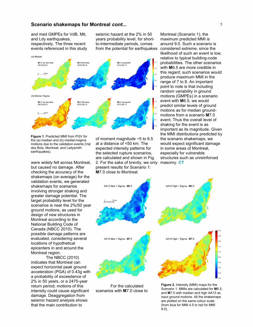
of moment magnitude ~5 to 6.5 at a distance of <50 km. The expected intensity patterns for the selected rupture scenarios, are calculated and shown in Fig. 2. For the sake of brevity, we only present results for Scenario 1: M7.0 close to Montreal.
For the calculated scenarios with M7.0 close to
Montreal (Scenario 1), the maximum predicted MMI is around 9.0. Such a scenario is considered extreme, since the likelihood of such an event is low, relative to typical building-code probabilities. The other scenarios with M6.5 are more credible in this regard; such scenarios would produce maximum MMI in the range of 7 to 8. An important point to note is that including random variability in ground motions (GMPEs) in a scenario event with M6.5, we would predict similar levels of ground motions as for median ground-motions from a scenario M7.0 event. Thus the overall level of shaking for the event is as important as its magnitude. Given the MMI distributions predicted by the scenario shakemaps, we would expect significant damage in some areas of Montreal, especially for vulnerable structures such as unreinforced masonry. CT
Scenario shakemaps for Montreal cont...
Figure 1. Predicted MMI from PGV for the (a) median and (b) median+sigma motions due to the validation events (Val des Bois, Montreal, and Ladysmith earthquakes).
Figure 2. Intensity (MMI) maps for the
Scenario 1. MMIs are calculated for M6.5,
and M7.0 with median and high AA13 as
input ground motions. All the shakemaps
are plotted on the same colour scale
(from blue for MMI 4.5 to red for MMI
9.0).

6
7. What were the relative characteristics and importance of structural, vegetation, and infrastructure hazard factors with regards to homes that survived? And to adjacent homes that ignited and burned? To best answer these questions, Westhaver examined houses that were located in areas where they were potentially exposed only to ignition factors emanating from the wildfire itself, such as radiant heat, convective flames, and embers; and not to confounding ignition factors related to multiple, surrounding structural fires (i.e. structure to structure spread of fire). The investigation will, therefore, focus on homes located downwind of, and on the fringe of forest/brush areas that burned, or on homes that survived in other locations. Westhaver noted in his research methodology that “…these situations would occur in the ‘front row’ of adjacent forest areas, although it is quite conceivable that several rows of fire-resistant homes could occur before the fire becomes established as an urban conflagration.” He commented that paired situations, where burned and unburned homes exist side-by-side, would be ideal situations for study. Westhaver noted that while satellite imagery would be helpful in zeroing in on general areas, it would likely not be detailed enough to reveal the micro-level details required to determine with a reasonable degree of confidence whether or not recommended FireSmart guidelines had been
implemented. Westhaver modified the data collection format he utilized successfully for the Slave Lake/Kelowna study in order to incorporate additional parameters and data fields required to answer the research questions listed above. The end result of this important research will be a paper summarizing Westhaver’s findings and making key recommendations centring around the reconstruction of homes in Fort McMurray, and the construction, landscaping and maintenance of all homes – new and existing – in the Wildland Urban Interface. ICLR plans to publish this paper in a timely fashion so that it may inform discussions into rebuilding the city of Fort McMurray. Stay tuned. CT
ICLR investigates resilience of some homes cont...
20 Richmond Street East Suite 210
Toronto, Ontario M5C 2R9
Tel: (416) 364-8677 Fax: (416) 364-5889
www.iclr.org www.basementfloodreduction.com
Mission To reduce the loss of life and property
caused by severe weather and earthquakes through the identification and support of sustained actions that improve society’s capacity to adapt to, anticipate, mitigate,
withstand and recover from natural disasters.
Western University Boundary Layer Wind Tunnel
1151 Richmond Street London, Ontario
N6G 5B9 Tel: (519) 661-3338 Fax: (519) 661-3339
www.iclr.org www.basementfloodreduction.com
Institute for Catastrophic Loss Reduction