id44-the lsts open-source communication and autonomy software
TRANSCRIPT
97instrumentation viewpOint- 19 - MARTECH 16 instrumentation viewpOint - 19 - MARTECH 16
ID44- THE LSTS OPEN-SOURCE COMMUNICATION AND AUTONOMY SOFTWARE: ENABLING NETWORKED VEHICLE SYSTEMS TO FIND, TRACK, AND SAMPLE DYNAMIC FEATURES OF THE OCEAN
J. Borges de Sousa136, J. Pereira137, A. Sérgio Ferreira135, M. Ribeiro141, J. Pinto138, P. Dias142, M. Costa140 and K. Rajan139
This paper discusses how the LSTS open-source communication and autonomy software (http://www.lsts.pt/toolchain) will enable networked vehicle systems to find, track, and sample dynamic features of the ocean. The software toolchain includes the following components:· Ripples – Web application including a communications hub and tools for re-mote visualization, tasking, and supervision enabling remote collaborative plan-ning and execution control, as well as outreach and education activities.· Neptus – Distributed off-board command and control framework supporting planning, execution control, and post-mission analysis for networked vehicle systems.· IMC – Protocol for networked vehicle systems operating in communications challenged environments. There is a discovery mechanism using different broadcasting mechanisms to identify end-points exposed in the network (over UDP, TCP, HTTP, acoustic modem, Iridium, etc.) The links among devices are dy-namically created during execution.· Dune – Onboard software framework providing logging, communications, nav-igation, and control functions for all supported vehicles, with a small memory and computational footprint to run virtually on any POSIX-compliant system.· TREX – Onboard deliberative planning software enabling autonomous de-cision-making without human intervention integrated with the LSTS-UP tool chain.· EUROPTus – Shipboard mixed-initiative planning and execution controller for
multi-vehicle oceanographic field experiments and Neptus front-end.These components endow a dynamic set of physical assets with system level properties targeted at adaptive volume observation and sampling of interact-ing ocean processes. The approach builds on experience in large ocean experi-ments with multi-vehicle systems and on advances in: 1) standardized vehicle onboard software, including autonomy software; 2) delay and disruptive tol-erant networking communications; 3) adaptive sampling of ocean features; 4) mixed initiative planning and execution control; 5) inter-operability protocols for heterogeneous vehicles; and, 8) visualization software for integrated situ-ational awareness and planning and control.The LSTS vehicles and software toolchain will, for the first time, allow effective inter-disciplinary study of fronts and other oceanographic features of high mo-bility at fine spatial and temporal scales. Field trials are being performed with the LSTS unmanned vehicle systems (http://www.lsts.pt/vehicles/): AUVs in sev-eral configurations equipped with several types of sensors (CTD, fluorometer, holographic camera, turbidity, O2, cameras, and micro-turbulence), WiFi and satellite communications, acoustic modems, and battery packs enabling up to 36h endurance; fixed-wing UAVs capable of up to 1h of flight time equipped with several types of video cameras (including IR), WiFi, and capable of bent Line of Sight (LOS) communications; and, multi-copters/vertical takeoff and landing (VTOL) equipped with WiFi communications and cameras, and capable of bent LOS, of deploying drifters, and of collecting water samples.
Abstract – The Galway Bay shallow-water observatory was installed in August 2015 and officially launched in July 2016. The observatory is located within the Galway Bay Marine and Renewable Energy Test Site at a depth of around 23m. The infra-structure has a core suite of scientific sensors monitoring a variety of marine pa-rameters as well as providing dedicated scientific ports (sockets) for marine research projects.
Keywords – ‘Marine’ ‘Research’ ‘Science’ ‘R&D’ ‘Technology’ ‘Subsea’ ‘Observatory’ ‘Galway’ ‘Ireland’ ‘EMSO’
I. CONTEXT AND OVERVIEWThe Galway Bay shallow-water observatory is part of a collaborative project be-tween the Sustainable Energy Authority of Ireland (SEAI), the Marine Institute (MI), University College Cork (Marine Renewable Energy Ireland - MaREI), Smart-Bay Ireland and Dublin City University (DCU) to upgrade existing facilities at the Galway Bay marine and renewable test site. The overall project was funded by Science Foundation Ireland (SFI)*.
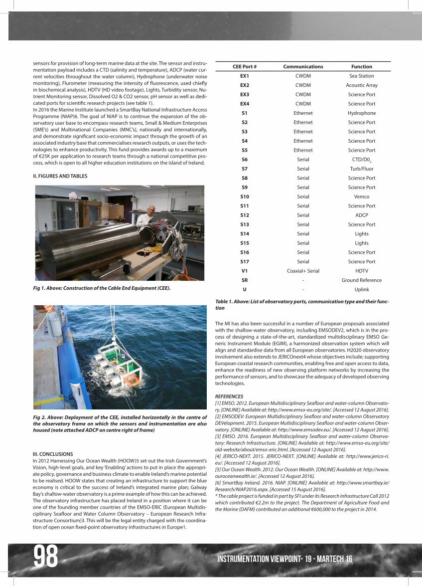
The Marine Institute had 4 main objectives to ensure a successful installation and completion of an operational marine observatory; 1) To procure and install main system components, 2) To apply for all relevant permissions (foreshore, planning, road-opening licence), 3) To procure and commission all onshore in-frastructure (ductwork and shore station) and 4) to ensure integration of the entire system.The culmination of the above steps led to the deployment of the Cable End Equipment (CEE) in August 2015 (fig. 2). The CEE is constructed of titanium hous-ing (fig. 1) and is 1.78m in length and has a diameter of 0.48m. It contains 17 science ports, 4 fibre ports and 1 video port (a full list of CEE port functions can be viewed in Table 1).The installation of the observatory also required terrestrial works (mainly civil) and included the cable landing site at a local pier, terrestrial duct work taking the cable ~1k underground to a specialised and fully equipped shore station. The shore station is located at a local second-level school and represents a suc-cessful partnership between the MI and the school. The dedicated shore facility was completely renovated and fitted out with a climate controlled server room.The shallow-water observatory has a core suite of environmental monitoring
ID45- GALWAY BAY SHALLOW-WATER OBSERVATORY: INSTALLATION, COMMISSIONING AND RESEARCH OPPORTUNITIESDiarmuid Gearóid Ó Conchubhair143, Dr Eleanor O Rourke144
98 instrumentation viewpOint- 19 - MARTECH 16
Fig 1. Above: Construction of the Cable End Equipment (CEE).
Fig 2. Above: Deployment of the CEE, installed horizontally in the centre of the observatory frame on which the sensors and instrumentation are also housed (note attached ADCP on centre right of frame)
sensors for provision of long-term marine data at the site. The sensor and instru-mentation payload includes a CTD (salinity and temperature), ADCP (water cur-rent velocities throughout the water column), Hydrophone (underwater noise monitoring), Flurometer (measuring the intensity of fluorescence, used chiefly in biochemical analysis), HDTV (HD video footage), Lights, Turbidity sensor, Nu-trient Monitoring sensor, Dissolved O2 & CO2 sensor, pH sensor as well as dedi-cated ports for scientific research projects (see table 1).In 2016 the Marine Institute launched a SmartBay National Infrastructure Access Programme (NIAP)6. The goal of NIAP is to continue the expansion of the ob-servatory user base to encompass research teams, Small & Medium Enterprises (SME’s) and Multinational Companies (MNC’s), nationally and internationally, and demonstrate significant socio-economic impact through the growth of an associated industry base that commercialises research outputs, or uses the tech-nologies to enhance productivity. This fund provides awards up to a maximum of €25K per application to research teams through a national competitive pro-cess, which is open to all higher education institutions on the island of Ireland.
II. FIGURES AND TABLES
III. CONCLUSIONSIn 2012 Harnessing Our Ocean Wealth (HOOW)5 set out the Irish Government’s Vision, high-level goals, and key ‘Enabling’ actions to put in place the appropri-ate policy, governance and business climate to enable Ireland’s marine potential to be realised. HOOW states that creating an infrastructure to support the blue economy is critical to the success of Ireland’s integrated marine plan; Galway Bay’s shallow-water observatory is a prime example of how this can be achieved.The observatory infrastructure has placed Ireland in a position where it can be one of the founding member countries of the EMSO-ERIC (European Multidis-ciplinary Seafloor and Water Column Observatory – European Research Infra-structure Consortium)3. This will be the legal entity charged with the coordina-tion of open ocean fixed-point observatory infrastructures in Europe1.
CEE Port # Communications Function
EX1 CWDM Sea Station
EX2 CWDM Acoustic Array
EX3 CWDM Science Port
EX4 CWDM Science Port
S1 Ethernet Hydrophone
S2 Ethernet Science Port
S3 Ethernet Science Port
S4 Ethernet Science Port
S5 Ethernet Science Port
S6 Serial CTD/D02
S7 Serial Turb/Fluor
S8 Serial Science Port
S9 Serial Science Port
S10 Serial Vemco
S11 Serial Science Port
S12 Serial ADCP
S13 Serial Science Port
S14 Serial Lights
S15 Serial Lights
S16 Serial Science Port
S17 Serial Science Port
V1 Coaxial+ Serial HDTV
SR - Ground Reference
U - Uplink
The MI has also been successful in a number of European proposals associated with the shallow-water observatory, including EMSODEV2, which is in the pro-cess of designing a state-of-the-art, standardized multidisciplinary EMSO Ge-neric Instrument Module (EGIM), a harmonized observation system which will align and standardise data from all European observatories. H2020 observatory involvement also extends to JERICOnext4 whose objectives include; supporting European coastal research communities, enabling free and open access to data, enhance the readiness of new observing platform networks by increasing the performance of sensors, and to showcase the adequacy of developed observing technologies.
REFERENCES[1] EMSO. 2012. European Multidisciplinary Seafloor and water‐column Observato-ry. [ONLINE] Available at: http://www.emso-eu.org/site/. [Accessed 12 August 2016].[2] EMSODEV: European Multidisciplinary Seafloor and water‐column Observatory DEVelopment. 2015. European Multidisciplinary Seafloor and water‐column Obser-vatory. [ONLINE] Available at: http://www.emsodev.eu/. [Accessed 12 August 2016].[3] EMSO. 2016. European Multidisciplinary Seafloor and water‐column Observa-tory: Research Infrastructure. [ONLINE] Available at: http://www.emso-eu.org/site/old-website/about/emso-eric.html. [Accessed 12 August 2016].[4] JERICO-NEXT. 2015. JERICO-NEXT. [ONLINE] Available at: http://www.jerico-ri.eu/. [Accessed 12 August 2016].[5] Our Ocean Wealth. 2012. Our Ocean Wealth. [ONLINE] Available at: http://www.ouroceanwealth.ie/. [Accessed 12 August 2016].[6] SmartBay Ireland. 2016. NIAP. [ONLINE] Available at: http://www.smartbay.ie/Research/NIAP2016.aspx. [Accessed 15 August 2016].* The cable project is funded in part by SFI under its Research Infrastructure Call 2012 which contributed €2.2m to the project. The Department of Agriculture Food and the Marine (DAFM) contributed an additional €600,000 to the project in 2014.
Table 1. Above: List of observatory ports, communication type and their func-tion