identification of permian palaeowind direction from...
TRANSCRIPT
Identification of Permian palaeowind direction fromwave-dominated lacustrine sediments (Lodeve Basin, France)
STEPHANE POCHAT1, JEAN VAN DEN DRIESSCHE, VALERIE MOUTON and FRANCOISGUILLOCHEAUGeosciences – Rennes, CNRS – UMR 6118, Universite Rennes 1, Campus de Beaulieu, 35042 Rennescedex, France (E-mail: [email protected])
ABSTRACT
Lacustrine environments are an excellent indicator of continental
palaeoclimate. In particular, the sedimentary record of waves in lakes may
be used to constrain atmospheric palaeocirculation. Wave ripples have been
identified in a Permian lacustrine basin (the Salagou Formation, 260–250 Ma,
Lodeve Basin) located in the southern French Massif Central, part of the
western European Hercynian mountain chain. Wave ripple patterns are
interpreted with regards to hydrodynamics and water palaeodepth. It is
shown that, in the case of the Salagou Formation, wave ripple orientations
were controlled by the direction of the prevailing palaeowind. The Late
Permian wind blew from between north and 20� east of north, possibly over
several millions of years and certainly throughout the period of deposition of
about 2000 m of strata in the Lodeve Basin. Permian lacustrine sedimentation
is widespread and well preserved on the Earth’s surface and so wave ripple
data may help constrain numerical modelling of the Earth’s past climates,
especially with regards to Permian times outside of desert regions.
Keywords Lacustrine environment, palaeoclimate, palaeowind, Permian,wave ripple.
INTRODUCTION
Global climate changes result from complex inter-actions between internal (atmosphere, hydro-sphere, cryosphere, biosphere and lithosphere)and external (e.g. variations of the Earth’s orbitalparameters, the solar constant or bolide impacts)parameters. At geological time scales, the historyof the Earth’s climate is characterized by major iceages (Cambrian, Ordovician, Permian-Carbonifer-ous and Quaternary) separated by periods ofwarmer climates. Three major parameters mayinfluence global climate changes over times of theorder of several millions years (e.g. Allen, 1997):plate tectonics (especially mountain building), thechemical composition of the atmosphere, andoceanic circulation. Significant uncertainties arise
from the complex interaction between the factorsthat govern the Earth’s climate, and from thedifficulty in reconstructing palaeoenvironmentsfrom geological data. Consequently additionalpalaeoclimatic data together with numerical mod-elling of atmospheric circulation are needed toprovide new insights on Earth’s past climates (e.g.Yemane, 1993; Kutzbach & Ziegler, 1994). Numer-ical models have already described palaeowindcirculation patterns on large surface grid squares(400 · 400 km: e.g. Crowley et al., 1987; Kutzbach& Gallimore, 1989; Fluteau et al., 2001), but todate, they have not been constrained by geologicalindicators of palaeowind flow.
The Late Permian (260–250 Ma) marks theend of the Permo-Carboniferous ice age (Ziegler,1990). In Europe, gravity collapse of the Hercy-nian mountain chain drove the development ofa ‘Basin and Range’ style province, character-ized by many intramontane continental grabens(e.g. Menard & Molnar, 1988; Becq-Giraudon &Van Den Driessche, 1994). Permian climate
1Present address: Stephane Pochat, Laboratoire de Plane-tologie et Geodynamique, UMR-CNRS 6112, Universitede Nantes, 2 rue de la Houssiniere, BP 92208, 44322 Nantescedex 3, France.
Sedimentology (2005) 52, 809–825 doi: 10.1111/j.1365-3091.2005.00697.x
� 2005 International Association of Sedimentologists 809
modelling has recently emphasized the role ofthe altitude of the Hercynian chain on thedistribution of humid and arid zones in theNorthern Hemisphere (Fluteau et al., 2001).
The sedimentary record of Permian palaeowindcirculation has been analysed using scatteredaeolian deposits, [Nevada (USA) and England:e.g. Glennie, 1990; Karpeta, 1990; Allen, 1994].However, such deposits are scarce and do notallow a global scale approach to palaeowindcirculation. This is in contrast to lacustrine depos-its that are extensively developed on the presentcontinental surface (e.g. Yemane et al., 1989; Ye-mane, 1993; Hamlin et al., 1996). Lacustrine envi-ronments can provide an excellent indicator ofcontinental palaeoclimate (Johnson, 1984; Talbot& Allen, 1996). As the wind can generate fair-weather and storm waves on lake surfaces (Allen,1997), the sedimentary record of such waves inlake bed deposits (e.g. Van Djik et al., 1978; Allen,1981a; Greenwood & Sherman, 1986; Aspler et al.,1994; Milroy & Wright, 2000) may provide a usefularchive of atmospheric palaeocirculation to com-pliment that derived from desert deposits.
The study reported in this paper considers howwind-influenced lacustrine deposits can supplydirect information on the palaeowind directionusing wave ripples identified in a lacustrinePermian basin in the southern French MassifCentral, part of the west European Hercynianmountain chain. Wave ripple patterns are inter-preted with regard to hydrodynamics and waterpalaeodepth, and then palaeowind circulation isdetermined from directional analysis of the waveripple forms in space and time. Finally, theimportance of such geological data to constrainnumerical models of Earth’s past climates isemphasized.
GEOLOGICAL SETTING
The Permian Lodeve Basin is located in thesouthern French Massif Central (Fig. 1A) and
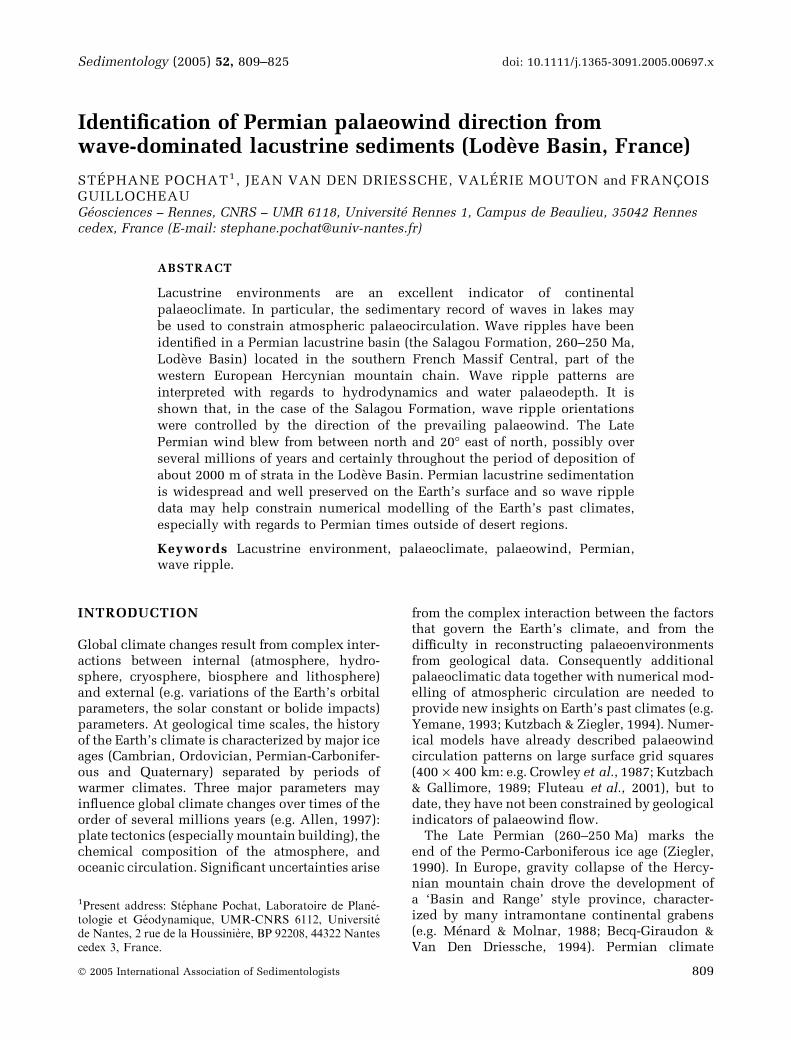
today forms an east-west elongated trough morethan 300 km2 across (Fig. 1B). The basin devel-oped in response to extensional tectonics thatoccurred during the gravity collapse of theHercynian mountain chain during Permian-Car-boniferous times (Menard & Molnar, 1988; VanDen Driessche & Brun, 1989; Malavieille, 1993;Becq-Giraudon & Van Den Driessche, 1994; Burget al., 1994a,b). To the south, the basin islimited by a system of E-W to NE-SW directed,N-dipping normal faults (the Aires and Cev-ennes faults, respectively; Fig. 1B). The AiresFault corresponds to the breakaway of a largenormal detachment fault (the Espinouse Detach-ment; Fig. 1A; Van Den Driessche & Brun, 1989,1992). These faults controlled the Permian basindevelopment, and are responsible for its half-graben geometry (Fig. 1C). The bed dip variesfrom 20� in the north to 5� to the south higherin the stratigraphy, reflecting a rollover geom-etry for the 3 km thick sedimentary succession(Fig. 1C). To the north, the Permian depositsonlap onto Cambrian metamorphosed sediments(Fig. 1C).
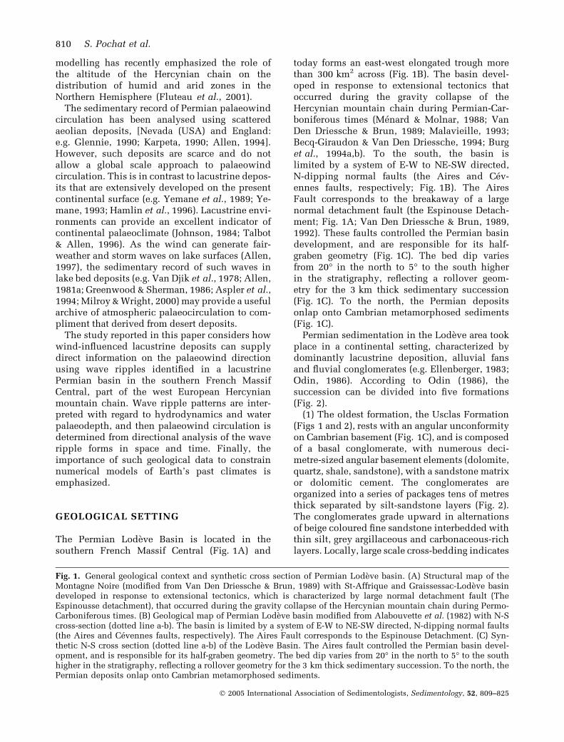
Permian sedimentation in the Lodeve area tookplace in a continental setting, characterized bydominantly lacustrine deposition, alluvial fansand fluvial conglomerates (e.g. Ellenberger, 1983;Odin, 1986). According to Odin (1986), thesuccession can be divided into five formations(Fig. 2).
(1) The oldest formation, the Usclas Formation(Figs 1 and 2), rests with an angular unconformityon Cambrian basement (Fig. 1C), and is composedof a basal conglomerate, with numerous deci-metre-sized angular basement elements (dolomite,quartz, shale, sandstone), with a sandstone matrixor dolomitic cement. The conglomerates areorganized into a series of packages tens of metresthick separated by silt-sandstone layers (Fig. 2).The conglomerates grade upward in alternationsof beige coloured fine sandstone interbedded withthin silt, grey argillaceous and carbonaceous-richlayers. Locally, large scale cross-bedding indicates
Fig. 1. General geological context and synthetic cross section of Permian Lodeve basin. (A) Structural map of theMontagne Noire (modified from Van Den Driessche & Brun, 1989) with St-Affrique and Graissessac-Lodeve basindeveloped in response to extensional tectonics, which is characterized by large normal detachment fault (TheEspinousse detachment), that occurred during the gravity collapse of the Hercynian mountain chain during Permo-Carboniferous times. (B) Geological map of Permian Lodeve basin modified from Alabouvette et al. (1982) with N-Scross-section (dotted line a-b). The basin is limited by a system of E-W to NE-SW directed, N-dipping normal faults(the Aires and Cevennes faults, respectively). The Aires Fault corresponds to the Espinouse Detachment. (C) Syn-thetic N-S cross section (dotted line a-b) of the Lodeve Basin. The Aires fault controlled the Permian basin devel-opment, and is responsible for its half-graben geometry. The bed dip varies from 20� in the north to 5� to the southhigher in the stratigraphy, reflecting a rollover geometry for the 3 km thick sedimentary succession. To the north, thePermian deposits onlap onto Cambrian metamorphosed sediments.
810 S. Pochat et al.
� 2005 International Association of Sedimentologists, Sedimentology, 52, 809–825

Permian palaeowind direction 811
� 2005 International Association of Sedimentologists, Sedimentology, 52, 809–825
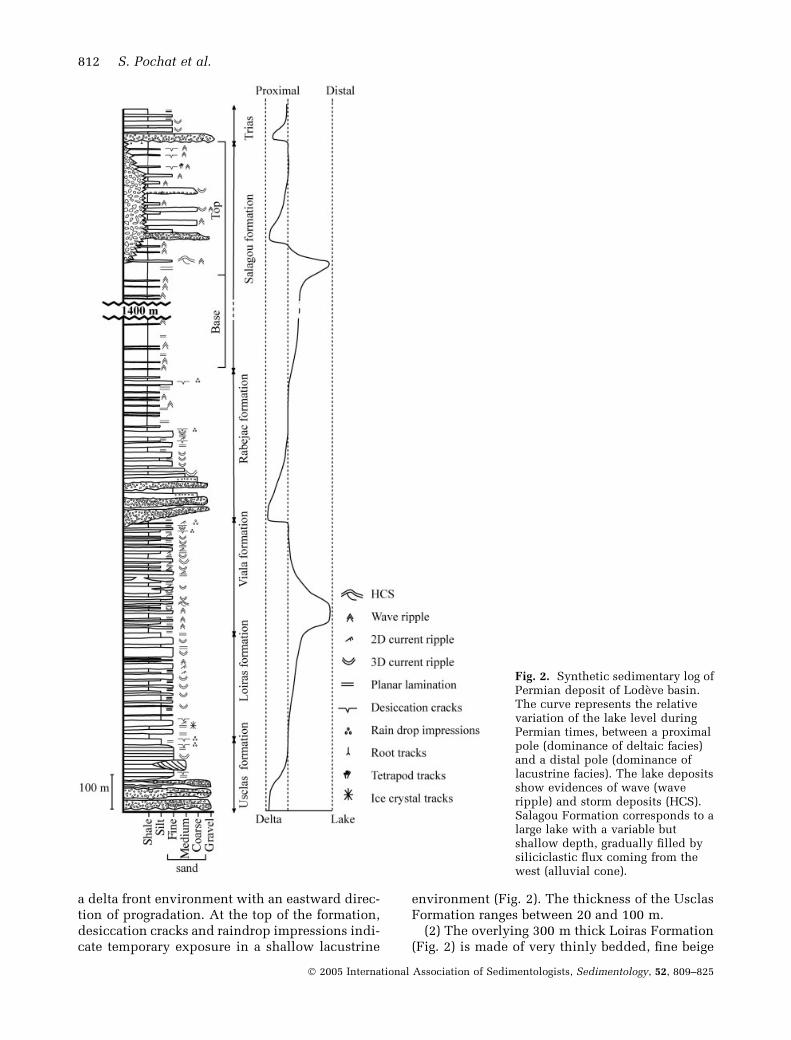
a delta front environment with an eastward direc-tion of progradation. At the top of the formation,desiccation cracks and raindrop impressions indi-cate temporary exposure in a shallow lacustrine
environment (Fig. 2). The thickness of the UsclasFormation ranges between 20 and 100 m.
(2) The overlying 300 m thick Loiras Formation(Fig. 2) is made of very thinly bedded, fine beige
Fig. 2. Synthetic sedimentary log ofPermian deposit of Lodeve basin.The curve represents the relativevariation of the lake level duringPermian times, between a proximalpole (dominance of deltaic facies)and a distal pole (dominance oflacustrine facies). The lake depositsshow evidences of wave (waveripple) and storm deposits (HCS).Salagou Formation corresponds to alarge lake with a variable butshallow depth, gradually filled bysiliciclastic flux coming from thewest (alluvial cone).
812 S. Pochat et al.
� 2005 International Association of Sedimentologists, Sedimentology, 52, 809–825
coloured sandstones, locally with current ripples,together with finely laminated siltstones and greyto red, variably calcareous claystones, locallywith layers of plant material (Fig. 2). The LoirasFormation formed in a shallow lacustrine envi-ronment with the sandstones corresponding toflood events.
(3) The Viala Formation is mainly composed ofsandstone and siltstone deposits with numerouswave ripples and evidence of storm deposition,such as hummocky cross-stratification (HCS;Fig. 2). The formation grades into shale towardsthe top. The abundance of desiccation cracks andraindrop impact impressions indicates a veryshallow lacustrine environment (Fig. 2). Currentripple and large scale cross-bedding show anorth-eastward palaeoflow direction. The thick-ness of the formation decreases from 330 to 50 mfrom east to west. The top of these fluvio-lacus-trine deposits is eroded by the Rabejac Formation(Fig. 2).
(4) The Rabejac Formation is about 500 m thick(Fig. 2). It is composed of a basal conglomeratewith centimetre to decimetre sized angular clasts,which originate from both the underlying Per-mian deposits and the pre-Permian basementrocks. This facies includes fine micaceous micro-conglomerate intercalations, the proportion ofwhich increases towards the top of the formation.The conglomerate evolves laterally into planarbedded and low-angle cross-bedded sandstone,and sandstone/shale alternations with desicca-tion cracks, raindrop impact impressions andtetrapod tracks. Palaeoflow criteria show east-ward sediment transport. Both the thickness andclast size of the basal conglomerate increase inthe western part of the basin, in the Tour-sur-Orbarea. Clasts originate from the metamorphic andmagmatic basement to the west whereas theyresult from the erosion of the earlier Permiandeposits to the east. This shows that denudationto the west was more important than to the east,implying the occurrence of higher relief in theTour-sur-Orb area (Fig. 2B).
(5) The Salagou Formation is the most exten-sive and thickest (up to 2000 m along the AireFault) formation filling the basin (Fig. 2C). It is amonotonous succession of red mudstones withan increasing occurrence of thin green silty-sandstone layers towards the top. The basal partof the formation is composed of numerousdecimetre thick siltstone units with desiccationcracks, wave ripples and basal gutter casts filledwith planar lamination, two-dimensional currentripples and micro HCS. This facies alternates
with finely-laminated red argillaceous deposits(Fig. 2). The top of the formation is characterizedby desiccation cracks associated with tetrapodtracks, wave ripples and increasingly commonintercalations of large lenticular quartz-richcoarse-grained cross-bedded fluvial sandstones,which cross-bed azimuths indicating north-east-ward flow. In the Tour-sur-Orb region (Fig. 2B),these lenticular deposits pass laterally into dec-imetre to metre thick units of silty red matrixconglomerate with millimetre to centimetre-scalepolygenic angular clasts (dolomite, quartz, shale,sandstone), intercalated with thin argillaceouslayers (Fig. 2). The Salagou Formation environ-ment corresponds to a large lake with shallowdepth that was progressively filled by detritalsediments coming mostly from the southern andwestern parts of the basin margin.
The abundant flora, especially microflora, andtetrapod tracks attest to the continental nature ofthe basin fill (e.g. Doubinger & Kruseman, 1965;Ellenberger, 1983; Gand, 1986; Doubinger et al.,1987). Explosive volcanism during the Permianwas responsible for numerous volcanic cinderdeposits (Odin, 1986).
The precise age of each formation is still debated(e.g. Broutin et al., 1992), but according to Odin(1986), the Usclas Formation and the base of theLoiras Formation is Upper Autunian in age, thetop of the Loiras Formation Saxonian in age andthe Viala, Rabejac and Salagou Formations areThuringian. In this paper, the focus is on thedeposits of the Salagou Formation (Fig. 2), the ageof which has been recently re-assessed as Kungu-rian to Tatarian (260–250 Ma; Gand et al., 1997).
WAVE RIPPLES AND STORM DEPOSITS
Wave ripple geometry
The analysis of both the morphology and theinternal structure of ripples in the Salagou For-mation reveals two types of small-scale, waveinduced- ripples (Boersma, 1970; Harms et al.,1982), characterized by two distinct ripple ampli-tudes.
Type 1 wave ripplesType 1 wave ripples are characterized by a meanwavelength ranging from 1 to 2 cm with ampli-tudes always lower than 0Æ2 cm (Fig. 3A). In cross-section, Type 1 ripples are symmetrical withrounded shapes, whilst in plan view they shownumerous tuning fork bifurcations (Fig. 3A).
Permian palaeowind direction 813
� 2005 International Association of Sedimentologists, Sedimentology, 52, 809–825
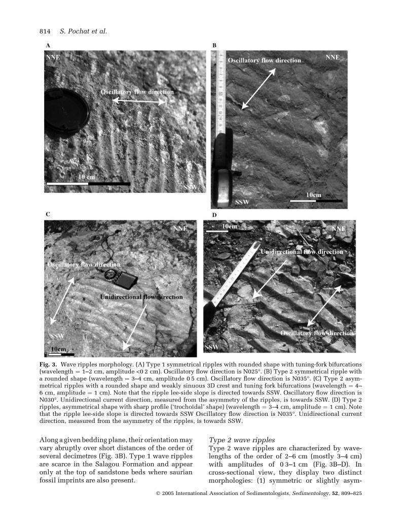
Along a given bedding plane, their orientation mayvary abruptly over short distances of the order ofseveral decimetres (Fig. 3B). Type 1 wave ripplesare scarce in the Salagou Formation and appearonly at the top of sandstone beds where saurianfossil imprints are also present.
Type 2 wave ripplesType 2 wave ripples are characterized by wave-lengths of the order of 2–6 cm (mostly 3–4 cm)with amplitudes of 0Æ3–1 cm (Fig. 3B–D). Incross-sectional view, they display two distinctmorphologies: (1) symmetric or slightly asym-
Fig. 3. Wave ripples morphology. (A) Type 1 symmetrical ripples with rounded shape with tuning-fork bifurcations(wavelength ¼ 1–2 cm, amplitude <0Æ2 cm). Oscillatory flow direction is N025�. (B) Type 2 symmetrical ripple witha rounded shape (wavelength ¼ 3–4 cm, amplitude 0Æ5 cm). Oscillatory flow direction is N035�. (C) Type 2 asym-metrical ripples with a rounded shape and weakly sinuous 3D crest and tuning fork bifurcations (wavelength ¼ 4–6 cm, amplitude ¼ 1 cm). Note that the ripple lee-side slope is directed towards SSW. Oscillatory flow direction isN030�. Unidirectional current direction, measured from the asymmetry of the ripples, is towards SSW. (D) Type 2ripples, asymmetrical shape with sharp profile (‘trochoıdal’ shape) (wavelength ¼ 3–4 cm, amplitude ¼ 1 cm). Notethat the ripple lee-side slope is directed towards SSW Oscillatory flow direction is N035�. Unidirectional currentdirection, measured from the asymmetry of the ripples, is towards SSW.
814 S. Pochat et al.
� 2005 International Association of Sedimentologists, Sedimentology, 52, 809–825
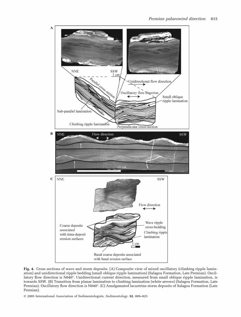
Fig. 4. Cross sections of wave and storm deposits. (A) Composite view of mixed oscillatory (climbing ripple lamin-ation) and unidirectional ripple bedding (small oblique ripple lamination) (Salagou Formation, Late Permian). Oscil-latory flow direction is N040�. Unidirectional current direction, measured from small oblique ripple lamination, istowards SSW. (B) Transition from planar lamination to climbing lamination (white arrows) (Salagou Formation, LatePermian). Oscillatory flow direction is N040�. (C) Amalgamated lacustrine storm deposits of Salagou Formation (LatePermian).
Permian palaeowind direction 815
� 2005 International Association of Sedimentologists, Sedimentology, 52, 809–825
metric, rounded shapes (Fig. 3B–C), and (2)asymmetric shaped ripples with peaked profiles(‘trochoıdal’ ripples; Fig. 3D). In plan view, crestlines are mostly straight (2D profile; Fig. 3D) butsome are sinuous (3D profile) with tuning forkbifurcations (Fig. 3C). Type 2 ripples occur insilty to fine grained (2–250 lm) sandy beds withthickness of varying from millimetres to centi-metres. They are abundant throughout the Sala-gou Formation.
When seen in vertical sections perpendicularto the crest lines, Type 2 ripples display climb-ing ripple laminations and small oblique ripplelaminations, whereas parallel to the crest lines,sub-parallel laminations are seen (Fig. 4A). Inplaces, vertical transitions from horizontal toclimbing ripple laminations occur (Fig. 4B).Stacking of trough wave-ripple laminations andclimbing ripple laminations are associated witherosional surfaces within or at the base of thebeds; these surfaces are marked by a coarsergrain-size (coarse sand, fine gravel). The contactsbetween beds are always erosive (Fig. 4C).
Storm deposits
Beside wave ripples, the Salagou Formation con-tains evidence of storm deposits such as hum-mocky cross stratification (HCS; Harms et al.,1982; Fig. 5A), numerous gutter-casts and smallfurrows (Aigner & Futterer, 1978; Aigner & Re-ineck, 1982; (Fig. 5B,C) and polygonal interferentwave ripples (e.g. Aigner & Futterer, 1978; Aigner &Reineck, 1982; Allen, 1982; Guillocheau & Hoffert,1988). The gutter-casts and furrows are 5–30 cm inwidth, with depths ranging from several centi-metres up to 20 cm. In cross section, they show aU-shaped morphology, with variably steep walls(Fig. 5B,C). They are either isolated within redmudstones (Fig. 5C) or they form highly irregularbeds (Fig. 5B). In plan view, their mean long axis issinuous with numerous branches.
HYDRODYNAMICS OF WAVE RIPPLES
In both marine and lacustrine settings, themorphology and internal structure of waveripples are controlled by the physical mecha-nisms of wave propagation that were respon-sible for their development, allowing in turn thedepositional environment to be characterizedwith regards to hydrodynamics and palaeodepth(e.g. Komar, 1974; Allen, 1981b; Harms et al.,1982).
Type 1 wave ripplesType 1 wave ripples are produced by windwaves inducing a low orbital speed in shallowwater with a maximum depth of some centimetres(Singh & Wunderlich, 1978). Their occurrencetogether with synapsid reptile tracks(Therapsida) in the Lodeve Basin (Ellenberger,1983; Fig. 5D) suggests a locally emergent margi-nal lacustrine environment.
Type 2 wave ripplesType 2 wave ripples are produced by windwaves of variable orbital speeds. The trochoıdalripples or ‘vortex ripples’ correspond to relat-ively low orbital speed (Bagnold, 1946; Clifton,1976). Rounded ripples or ‘post-vortex’ ripplesare characteristic of higher orbital speeds (e.g.Komar & Miller, 1975; Clifton, 1976; Miller &Komar, 1980). The presence of some asymmetricripples and of three-dimensional crest linestogether with the two-dimensional symmetricalripples show that the oscillatory flow wasinfluenced by a superimposed unidirectionalflow during the wave ripple development (e.g.Boersma, 1970; Clifton, 1976; Allen, 1984; Cheel,1990; Allen, 1997).
The climbing ripple lamination and the sub-planar to oblique lamination associated withType 2 wave-ripples were produced by domin-ant oscillatory flow and secondary laminar flow,respectively (e.g. Boersma, 1970; Allen, 1984;Cheel, 1990; Allen, 1997; Fig. 4A). The transitionfrom planar lamination to climbing ripple lam-ination (Fig. 4B) is interpreted as being due to anenergy decrease during a storm cycle, character-ized by the transition from high energy planarflow to an oscillatory flow (Aspler et al., 1994).The presence of (1) erosive surfaces at the baseof beds and within the different formations, (2)trough wave-ripple cross-lamination, (3) climb-ing ripple lamination and (4) pervasive erosivecontacts between these different components(Fig. 4C) are characteristic of mixed storm depos-its, corresponding to several storm events. Themixed surfaces are marked by the transition fromclimbing ripple lamination to wave-ripple cross-bedding and by the erosive surfaces that requirehigher flow regime conditions.
PALAEODEPTH ESTIMATE FROM RIPPLEWAVELENGTH
The following approach was used to estimate thewater palaeodepth, in order to assess its potential
816 S. Pochat et al.
� 2005 International Association of Sedimentologists, Sedimentology, 52, 809–825

influence on the hydrodynamic conditions thatprevailed during sedimentation of the SalagouFormation.
Following Komar (1974), Allen (1981b), Sund-quist (1982) and Diem (1985), palaeodepth can beestimated by analysis of the wave ripple mor-phology, ripple wavelength (k) and grain diameter(D). The method relies on the relation betweenthe oscillatory motion of the water and theassociated ripple wavelength. Such a relationshipallows the physical characteristics of the waves(orbital velocity, wave periodicity and height)responsible for the development of wave ripplesto be determined. Then, the depth at which waveripples developed is calculated from these para-meters. Good sorting and a fine grain-size for theripple sediment (silt to fine sand) allow any
compaction effects on ripple dimensions to beneglected (Allen, 1981b). The observed maximumwavelength of the wave ripples is 6 cm providinga calculated maximum depth of 15 m. Becausemost ripple wavelengths range between 3 and4 cm, typical depths are between 6 and 9 m(Komar; 1974; Allen, 1981b; Sundquist, 1982;Diem, 1985).
WAVE RIPPLE AND GUTTER-CASTORIENTATIONS
Orientation data for wave ripple crest orientationsfor the full 2000 m thickness of the SalagouFormation are summarized in rose diagramsshown in Fig. 6. Each data point used to construct
Fig. 5. Storm deposits and fossil tracks. (A) Hummocky cross-stratification in cross-section showing low-anglebounding surfaces and laminae parallel to the lower bounding surface. Oscillatory flow is NNW-SSE. (B) U-shapedgutter casts forming irregular bedding (20 cm wide, 5 cm deep). Unidirectional flow direction is N030� i.e. out of thepage. (C) Isolated small furrow, more or less symmetrical, (50 cm wide, 10 cm deep), filled by small-scale HCS.Unidirectional direction is N040� i.e. out of the page. (D) Synapsid reptile tracks (‘Therapsida’) of the SalagouFormation associated with Type 1 wave ripples showing highly variable flow direction. These ripples are producedby low orbital speed in shallow water with a maximum depth of some centimetres. Their occurrence together withsynapsid reptile tracks (Therapsida) suggests a locally emergent marginal lacustrine environment.
Permian palaeowind direction 817
� 2005 International Association of Sedimentologists, Sedimentology, 52, 809–825
the roses is a generalized strike for ripple crestson the surface of one bed, and each measurementsite contains several beds. For example, 528palaeoflow directions on the same number ofbedding surfaces for 13 sites have been measuredfor Type 2 wave-ripples. All ripple crest direc-tions are corrected for bedding surfaces dip andhave been analysed using circular statistics.
As Type 1 wave ripples do not occur withinopen lacustrine environments, they do not reflecthydrodynamics at the basin scale and theirorientation is highly variable (Fig. 6A). Type 2wave ripples have been analysed at 13 sites(Fig. 6C). Direction analysis shows a consistentpreferred orientation for ripple crests betweenN110�–N130� for the entire Salagou Formation(Fig. 6B), although some wave ripples have aN040�–N050� striking crests at the base of theformation (Fig. 6B). At the top of the SalagouFormation, ripple orientations are fairly constanteverywhere in the basin (Fig. 6B,C). Gutter castsdisplay a consistent N030�–N040� direction,which is perpendicular to the dominant orienta-tion of the wave ripples (Fig. 6D).
WAVE RIPPLES IN LACUSTRINEDEPOSITS: AN INDICATOR OFPALAEOWIND DIRECTIONS
Relationship between wave ripple directionsand palaeowind orientation
Waves may develop due to various processessuch as wind, tsunami and seiching. Tsunamisproduce large rare waves in response to large-scale, short duration disturbance of the bed or thewater body. Seiches result from a sudden rise orfall of water in enclosed or partially enclosedbodies, such as lakes, especially during localchanges in atmospheric pressure. They can pro-duce longshore drift effects. Waves produced bytsunamis and seiches vary in period from a fewminutes to several hours (Allen, 1997). In the caseof the Salagou Formation, palaeodepth calcula-tions provide a maximum 5 sec wave period.Such a small value argues for waves that aredriven by the wind (Allen, 1997), blowing acrossa limited fetch consistent with shallow lakes(Komar, 1974).
Wave ripples generally develop in a directionthat is perpendicular to the wind direction(Harms et al., 1982). However, currents andtopography may modify this relationship (seegeneral discussion in Allen, 1997). Three types of
currents may originate during a storm event(Allen, 1997): (a) wind-drift currents that propa-gate in the wind direction; (b) ‘Stoke currents’induced by water mass motion in the direction ofwave propagation, and (c) longshore, rip anddown-welling currents related to wave approachand set-up effects along shorelines. Longshorecurrents, and rip and down-welling currents areparallel and perpendicular to the coastline,respectively.
The Coriolis force due to the Earth’s rotationmay deflect wind-drift (Ekman transport) anddown-welling (or geostrophic) currents, to theright in the Northern Hemisphere. This forcedepends directly on the latitude, so that its effectis zero at the equator and a maximum at the poles.Geostrophic currents generally originate at depthsof more than 15 m (Swift et al., 1987). In thiscase, down-welling currents tend to be parallel tothe coast line (Allen, 1997). To summarize, waveripples may show variable orientations, paralleland perpendicular to the wind orientation, andparallel and perpendicular to the coast line whichdepends on their origin or upon geostrophiceffects. Beside hydrodynamics related to stormevents, the occurrence of tides within large lakes(Talbot & Allen, 1996) is also a potential compli-cation.
Salagou FormationThe analysis of the Salagou Formation waveripples shows that asymmetrical Type 2 waveripples are always associated with symmetricalones within the same bed. The Type 2 waveripple geometry is mostly two-dimensional andwave ripples with three-dimensional geometriesare always associated with the former withinthe same bed. Finally the internal structure ofthe Type 2 wave ripples (Fig. 4A–C) shows thatflow was dominantly oscillatory (Boersma, 1970;Harms et al., 1982). All these characteristicsstrongly suggest that the influence of unidirec-tional currents was negligible during thedevelopment of the wave ripples (Arnott &Southard, 1990; Myrow & Southard, 1991). Thepalaeodepth and sedimentological data con-strain which unidirectional currents were likelyto have been active during wave ripple forma-tion.
Geostrophic currents. In the Salagou Formation,the typical water depth was between 6 and 9 m.Moreover, during Permian times, the LodeveBasin was located at a latitude of 0�–10� north(Scotese & McKerrow, 1990; Becq-Giraudon et al.,
818 S. Pochat et al.
� 2005 International Association of Sedimentologists, Sedimentology, 52, 809–825
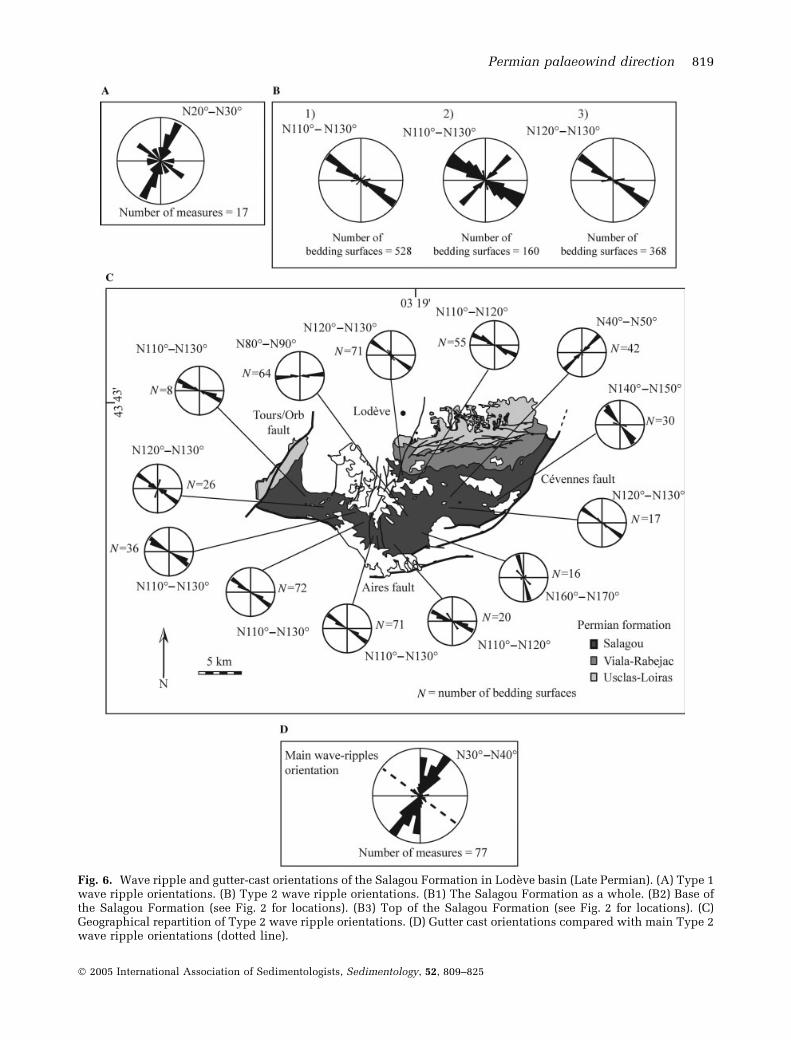
Fig. 6. Wave ripple and gutter-cast orientations of the Salagou Formation in Lodeve basin (Late Permian). (A) Type 1wave ripple orientations. (B) Type 2 wave ripple orientations. (B1) The Salagou Formation as a whole. (B2) Base ofthe Salagou Formation (see Fig. 2 for locations). (B3) Top of the Salagou Formation (see Fig. 2 for locations). (C)Geographical repartition of Type 2 wave ripple orientations. (D) Gutter cast orientations compared with main Type 2wave ripple orientations (dotted line).
Permian palaeowind direction 819
� 2005 International Association of Sedimentologists, Sedimentology, 52, 809–825
1996). These data indicate the absence of theCoriolis force effect and resulting geostrophiccurrents during the wave ripples development inthe Salagou Formation.
Tidal currents. No characteristic tidal depositsare associated with the wave-ripples, suchas herringbone cross-bedding or clay doubledrapes (evidence of ebb-flood tidal cycles:Visser, 1980; Allen & Homewood, 1984) havebeen observed, suggesting that tidal currentswere unimportant.
Rip and downwelling currents. When the Cor-iolis force does not act, rip and down-wellingcurrents are perpendicular to the coast. Nocharacteristic structures such as dunes, troughsor runnels (Reineck & Singh, 1980) are present.The influence of such currents, if they did occur,was most probably negligible. The only unidirec-tional currents that might have influenced thewave ripple development are induced currents(i.e. Stokes and wind-driven currents).
Stokes currents. The occurrence of asymmetricalwave ripples with three-dimensional geometries(Fig. 3C) and oblique laminations (Fig. 4A) mightreveal the influence of Stokes currents. Thesestructures are statistically orientated in the direc-tion of swell propagation (Allen, 1979; Aigner,1985). Therefore Stokes currents will not modifythe ripples direction.
Wind-driven currents. In the absence of theCoriolis force, wind-driven currents are parallelto the wind direction. These currents may bestrong during the peaks of storms. Their inter-action with the Stokes currents and the motionof waves results in the development of gutter-casts. The significance of gutter-cast orien-tation with respect to wind orientation isdiscussed below. In summary, unidirectionalcurrents do not seem to have modified theorientation of the wave ripples that developedduring Permian lacustrine sedimentation in theLodeve Basin.
Relation between wave ripple directions andbathymetry
The influence of bathymetry on wave ripplesorientation is still a matter of debate. It isgenerally acknowledged that the orientation ofwave-ripple crests in both marine and lacustrineenvironments mostly mirrors the orientation of
the coastline, with minor variations imposed byseabed irregularities (e.g. Leckie & Krystinik,1989; Duke et al., 1991; Aspler et al., 1994).However, Diem (1985) noted that along a tran-sect from offshore to shoreface, bathymetry hasmuch more influence on shoreface wave ripplesthan on offshore ripples because of refractioneffects along the coast. Thus, the orientation ofoffshore wave ripples reflects the direction ofswell, whereas the direction of shoreface waveripples is determined by the coastal geometry(Diem, 1985). Other studies have also shownthat wave ripples often are not parallel to thecoastline but relate to the prevailing winddirection (Tanner, 1963; Davis, 1965; Fox &Davis, 1976; Aigner, 1985; Boyd et al., 1988).
Salagou FormationThree issues imply that refraction effects areunimportant in the case of the Salagou Formationwave ripples. These relate to (1) lake hydro-dynamics (2) the palaeogeography and (3) theinferred wave periodicity.
Lake hydrodynamics. Wave development in alake requires that atmospheric phenomena are ofa scale comparable to or greater than that of thelake (Lemmin, 1995). The available fetch, whichcontrols wave development, is usually muchshorter in the lacustrine settings compared withthe oceans. Therefore significant waves will onlydevelop if the wind blows homogeneously on thewhole lake surface, with constant strength anddirection for several days. Contrary to the oceans,where persistent swells often occur far from thearea where they were generated (Allen, 1997),waves in lakes are induced by local wind systems(Lemmin, 1995). Consequently, the direction ofwave propagation and the resulting wave ripplesin lakes tend to reflect the direction of theprevailing wind (Davis, 1965) more closely.
Palaeogeography. The Permian Lodeve Basindeveloped during N-S directed extension due tothe gravity collapse of the Hercynian mountainchain. This extension resulted in an alternation ofE-W elongated basins and upstanding ranges,comparable to the ‘Basin-and-Range’ province ofthe United States (Coney & Harms, 1984; Menard& Molnar, 1988; Van Den Driessche & Brun, 1989;Malavieille, 1993; Becq-Giraudon & Van DenDriessche, 1994; Burg et al., 1994a,b). Subsidenceof the Lodeve half-graben was controlled by amajor E-W striking, N-dipping normal fault (theAires Fault) to the south, and NNE-SSW-directed
820 S. Pochat et al.
� 2005 International Association of Sedimentologists, Sedimentology, 52, 809–825
transfer faults to the east and to the west (theCevennes and La Tour-sur-Orb faults, respect-ively; Van Den Driessche & Brun, 1989). Theoccurrence in the southern part of the basin of alarge alluvial fan system in the La Tour-sur-Orbarea indicates the presence of significant relief(the Aires Fault footwall uplift) along the south-ern margin of the basin. To the north, the basin fillonlaps against basement suggesting an E-Wdirected northern margin to the Permian lake(Fig. 2B,C). Although later Alpine tectonics wereresponsible for minor, mainly strike slip faultreactivation (e.g. Santouil, 1980), no significantAlpine deformation has modified the geometry ofthe Permian basin. Consequently, the mainboundaries of the elongate Permian trough werealigned E-W in the south and the north of thebasin, and roughly N-S to the east and the west,with the mapped outcrop limits of the SalagouFormation largely reflecting the original shape ofthe Permian lake.
Wave ripple crests show a strong preferredorientation (N110�–N130� S. throughout the Sala-gou Formation, and this is oblique to the axis ofthe basin. There is no evidence for rotation ofripple crests close to the Aires and Tour-sur-Orbfaults (Fig. 6C). If refraction effects were occur-ring in the Permian lake, wave interference wouldhave been common especially close to the coast-lines and the wave ripples would show morevariable orientations.
Wave periodicity. Refraction effects result from arapid onshore decrease in the water depth. For agiven depth, refraction is mainly controlled bywave periodicity. Waves with periodicities higherthan 10 sec (storm swell) will undergo morerefraction than waves with lower periodicity(Diem, 1985). In the case of the Salagou Forma-tion, the estimated wave period to a maximum of5 sec is a factor limiting refraction effects (Diem,1985). The sedimentology of the lacustrine Sala-gou Formation indicates a semi-arid, continentalplaya environment (Odin, 1986). This impliesthat the depth of the Permian lake was bothshallow and relatively constant throughout themajor part of the basin. A constant depth wouldlimit wave refraction.
Relation between wave ripple and gutter-castdirections, and palaeowind orientation
Gutter casts and furrows are created during stormevent and result from either wave-generatedoscillatory flows or oscillation-dominated flow,
or storm-generated unidirectional currents (e.g.:Aigner & Futterer, 1978; Aigner & Reineck, 1982;Aigner, 1985; Martel & Gibling, 1994; Myrow &Southard, 1991, 1996; Myrow, 1992;). They canbe either parallel to the direction of the wavesduring the initial stage of storm, if they areinfluenced by geostrophic currents (Aigner,1985; Sarkar et al., 2002; Bhattacharya et al.,2004) or perpendicular to the direction of thewaves after intensification of current and waveenergies during culmination of storm conditions(Myrow, 1992; Bhattacharya et al., 2004). In bothcases, if the waves undergo refraction effects, dueto strong variation in shore slope, the gutter-castscan be perpendicular and/or parallel to the coast(Bhattacharya et al., 2004).
As noted before, in the case of Salagou Forma-tion, geostrophic currents were absent and thePermian lake was a playa-type lake with a nearlyconstant shallow depth. Therefore the orthogonalattitude of the gutter-casts with respect to thewave ripple crests (Fig. 6D) is rather attributableto culminating storm conditions, so that theirorientation corresponds to the oncoming direc-tion of storms, providing an additional indicatorof palaeowind orientation.
Wave propagation direction and palaeowinddirection
Wave propagation direction, and therefore winddirection, can be deduced from the asymmetry ofwave ripples and from the dip of their internalforesets that are induced by the superimposedunidirectional currents related to Stoke drift(Allen, 1979; Aigner, 1985). Indeed, both the leeside of wave ripples and the internal foreset dipin the sense of unidirectional current propagationand therefore in the wind direction. Preliminaryanalysis of wave ripples in the Salagou Formationshows that the lee sides of wave ripples and theinternal foresets are dipping towards the south-southwest (Figs 3C,D and 4A) indicating thepresence of a superimposed unidirectional flowtowards the south-southwest during wave devel-opment, induced by a northerly or northeasterlyLate Permian wind (Fig. 7C).
CONCLUSIONS
The systematic orientation of wave ripple creststhrough the 2000 m thick Late Permian Salagoulake succession cannot be explained by local laketopography and wave refraction, or any sort of
Permian palaeowind direction 821
� 2005 International Association of Sedimentologists, Sedimentology, 52, 809–825
combined flow. Therefore, the N110�–N130� ori-entation of the wave ripple crests is interpreted tohave been orthogonal to the direction of theprevailing wind during the Late Permian. Prelim-inary analysis of wave asymmetry and internalforeset attitude indicates that the Late Permianwind was blowing from the north-northeast(N020�–N040�) towards the south-southwest.
To compare this result with other data acrossthe world, wind direction must be corrected forpolar wandering since this period. As the LatePermian dipole field for Europe was orientated18� clockwise from the present-day one (Cogneet al., 1990; Besse et al., 1996), this means thatthe prevailing Late Permian wind was blowingfrom the north (N002� E to N022� E) towards thesouth in this part of Europe (Fig. 7). Studies onaeolian palaeodune patterns have provided pre-vailing wind directions from either the north (e.g.Clemmensen & Abrahamsen, 1983; Sneh, 1988;Clemmensen & Hegner, 1990) or the east (Sweet,1999) in areas that were located at similar palaeo-latitudes in northwestern Europe and from thenorth in northeastern Canada (e.g. Gibling et al.,1992).
The duration of Salagou Formation depositionis difficult to determine precisely, but it wasprobably of the order of millions of years. As waveripple crest orientations remain constant thissuggests rather stable, long-term climatic condi-tions during the Late Permian. Finally, remnantsof lacustrine and aeolian deposits are widespreadthroughout the world during Permian times. Thussedimentological data, carefully and properlyevaluated, may be a powerful tool to constrainmodels of Earth’s past Permian climate.
ACKNOWLEDGEMENTS
We are grateful to Martin Gibling, Paul Carling,Brian Haskell and Peter Haugthon for helpfulcriticisms and suggestions, which have greatlyimproved this paper.
REFERENCES
Aigner, T. (1985) Storm Depositional Systems: Dynamic Stra-
tigraphy in Modern and Ancient Shallow-Marine
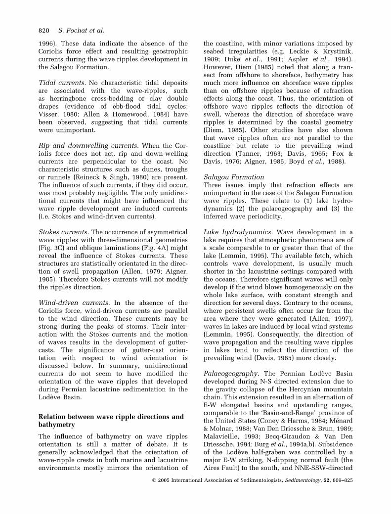
Fig. 7. Direction of the dominant wind during Late Permian in Lodeve Basin. Late Permian wind was blowing fromthe north-northeast (N020� to N040�) towards the south-southwest. This wind direction must be corrected for polarwandering since this period. As the Late Permian dipole field for Europe was orientated 18� clockwise from thepresent-day one (Cogne et al., 1990; Besse et al., 1996), this means that the prevailing Late Permian wind wasblowing from the north (N002� E to N022� E) towards the south in this part of Europe.
822 S. Pochat et al.
� 2005 International Association of Sedimentologists, Sedimentology, 52, 809–825
Sequences. Lecture Notes in Earth Sciences, Vol. 3. Sprin-
ger-Verlag, Berlin, 174 pp.
Aigner, T. and Futterer, E. (1978) Kolk-Topfe und Rinnen (pot
and gutter casts) in Muschelkalk Anzeiger fur Wattenmeer?
Neues Jb. Mineral. Abh., 156, 285–304.
Aigner, T. and Reineck, H.E. (1982) Proximality trends in
modern storm sands from the Helgoland Bight (North Sea)
and their implications for basin analysis. Senckenb. Marit.,14, 183–215.
Alabouvette, B., Aubague, M., Bambier, A., Feist, R. and
Paloc, H. (1982) Feuille Lodeve (989). Carte geol. France (1/50000). BRGM/SGN, Orleans, France.
Allen, J.R.L. (1979) A model for the interpretation of wave
ripple marks using their wavelength, textural composition,
and shape. J. Geol. Soc. London, 136, 673–682.
Allen, P.A. (1981a) Wave-generated structures in the Devonian
lacustrine sediments of south-east Shetland and ancient
wave conditions. Sedimentology, 28, 369–379.
Allen, P.A. (1981b) Some guidelines in reconstructing ancient
sea conditions from wave ripple marks. Mar. Geol., 43, 59–67.
Allen, J.R.L. (1982) Sedimentary Structures. Their Characters
and Physical Basis. Elsevier Scientific Publication,
Amsterdam, I, 593 pp. II, 663 pp.
Allen, J.R.L. (1984) Parallel lamination developed from upper-
stage plane beds: a model based on the larger coherent
structures of the turbulent boundary layer. Sed. Geol., 39,227–242.
Allen, J.R.L. (1994) Paleowind: geological criteria for direction
and strength. In: Paleoclimates and Their Modelling, with
Special Reference to the Mesozoic Era (Eds J.R.L. Allen, B.J.
Hoskins, B.W. Sellwood, R.A. Spicer and P.J. Valdes),
pp. 27–34. Chapman & Hall, London.
Allen, P.A. (1997) Earth surface processes. Blackwell Scien-
tific Publication, Oxford, 404 pp.
Allen, P.A. and Homewood, P. (1984) Evolution and
mechanics of a Miocene tidal sandwave. Sedimentology, 31,63–81.
Arnott, W.R. and Southard, J.B. (1990) Exploratory flow-duct
experiments on combined flow bed configurations, and
some implications for interpreting storm-event stratifica-
tion. J. Sed. Res., 60, 211–219.
Aspler, L.B., Chiarenzelli, J.R. and Bursey, T.L. (1994) Ripple
marks in quartz arenites of the Hurwitz group, Northwest
Territories, Canada: evidence for sedimentation in a vast,
early Proterozoic, shallow, fresh-water lake. J. Sed. Res.,A64, 282–298.
Bagnold, R.A. (1946) Motion of waves in shallow water.
Interaction between waves and sand bottom. Proc. Roy. Soc.London, 187A, 1–15.
Becq-Giraudon, J.F. and Van Den Driessche, J. (1994) Depots
periglaciaires dans le Stephano-Autunien du Massif Cen-
tral: temoin de l’effondrement gravitaire d’un haut plateau
hercynien. C. R. Acad. Sci. Paris, 318, 675–682.
Becq-Giraudon, J.-F., Montenat, C. and Van Den Driessche, J.(1996) Hercynian high-altitude phenomena in the French
Massif Central: tectonic implication. Palaeogeogr. Palaeo-climatol. Palaeoecol., 122, 227–241.
Besse, J., Theveniaut, V. and Courtillot, V. (1996) Apparent
polar wander paths for North America, Europe, Africa,
Laurasia and west Gondwana since the Upper Carbonifer-
ous. In: The Tethys Ocean (Eds A.E.M. Nairn, L.E. Ricou,
B. Vrielynck and J. Dercourt), The Ocean Basins and
Margins, pp. 8, 71–97, Plenum Press, New-York.
Bhattacharya, H.N., Bhattacharya, B., Chakraborty, I. and
Chakraborty, A. (2004) Sole marks in storm event beds in
the Permo-Carboniferous Talchir Formation, Raniganj
Basin, India. Sed. Geol., 166, 209–222.
Boersma, J.R. (1970) Distinguishing features of wave ripples
cross-stratification and morphology. Thesis, Utrecht, 65 pp.
Boyd, R., Forbes, D.L. and Heffler, D.E. (1988) Time-sequence
observations of wave-formed sand ripples on an ocean
shoreface. Sedimentology, 35, 449–464.
Broutin, J., Chateauneuf, J.-J. and Mathis, V. (1992) The
Lodeve Basin. In: Permian Basins in the French Massif
Central, 8th International Palynological Congress (Eds
CNRS, Paris), Cahiers de Micropaleontologie, 7, 107–122.
Burg, J.-P., Van Den Driessche, J. and Brun, J.-P. (1994a) Syn-
to post-thickening extension: mode and consequences. C.R.
Acad. Sci. Paris, 319, 1019–1032.
Burg, J.-P., Van Den Driessche, J. and Brun, J.-P. (1994b) Syn-
to post-thickening extension in the Variscan Belt of Western
Europe: modes and structural consequences. Geol. Fr., 3,33–51.
Cheel, R.J. (1990) Horizontal lamination and the sequence of
bed phases and stratification under upper-flow-regime
conditions. Sedimentology, 37, 517–529.
Clemmensen, L.B. and Abrahamsen, K. (1983) Aeolian strati-
fication and facies association in desert sediments,
Arran basin (Permian), Scotland. Sedimentology, 30, 311–
319.
Clemmensen, L.B. and Hegner, J. (1990) Eolian sequence and
erg dynamic: the Permian Corrie sandstone, Scotland.
J. Sed. Petrol., 61, 768–774.
Clifton, H.E. (1976) Wave-formed sedimentary structure – a
conceptual model. In: Beach and Nearshore Sedimentation(Eds R.A. Davies and R.L. Ethington), SEPM Spec. Publ., 24,126–148.
Cogne, J.-P., Brun, J.-P. and Van Den Driessche, J. (1990)
Paleomagnetic evidence for rotation during Stephano-Per-
mian extension in southern Massif Central (France). Earth
and Planet. Sci. Lett., 101, 272–280.
Coney, P.J. and Harms, T.A. (1984) Cordilleran metamorphic
core complexes: Cenozoic extensional relics of Mesozoic
compression. Geology, 12, 550–554.
Crowley, T.J., Mengel, J.G. and Short, D.A. (1987) Gond-
wanaland’s seasonal cycle. Nature, 329, 803–807.
Davis, R.A.J. (1965) Underwater study of ripples, southeastern
Lake Michigan. J. Sed. Petrol., 35, 857–866.
Diem, B. (1985) Analytical method for estimating paleowave
climate and water depth from wave ripple marks. Sedi-mentology, 32, 705–720.
Doubinger, J. and Kruseman, G.P. (1965) Sur la flore du Per-
mien de la region de Lodeve et de Bourbon-l’Archambault.
Bull. Soc. geol. Fr., 7, 541–548.
Doubinger, J., Odin, B. and Conrad, G. (1987) Les associations
sporopolliniques du Permien continental du basin de Lod-
eve (Herault, France). Caracterisation de l’Autunien sup-
erieur, du Saxonien et du Thuringien. Ann. Soc. geol. Nord.,
106, 103–109.
Duke, W.L., Arnott, R.W.C. and Cheel, R.J. (1991) Shelf
sandstones and hummocky cross-stratification: new insights
on a stormy debate. Geology, 19, 625–628.
Ellenberger, P. (1983) Sur la zonation ichnologiques du Per-
mien moyen (Saxonien) du bassin de Lodeve (Herault). C.R.Acad. Sci. Paris, 297, 553–558.
Fluteau, F., Besse, J., Broutin, J. and Ramstein, G. (2001) The
Late Permian climate. What can be inferred from climate
modelling concerning Pangea scenarios and Hercynian
range altitude? Palaeogeogr. Palaeoclimatol. Palaeoecol.,
167, 39–71.
Permian palaeowind direction 823
� 2005 International Association of Sedimentologists, Sedimentology, 52, 809–825

Fox, W.T. and Davis, R.A. (1976) Weather patterns and
coastal processes. In: Beach and Nearshore Sedimentation
(Eds R.A. Davis and R.L. Ethington), SEPM Spec. Publ., 24,1–23.
Gand, G. (1986) Interpretation paleontologique et paleoeco-
logique de quatre niveaux a traces de vertebras observes
dans l’Autunien du Lodevois (Herault). Geologie de la
France, 2, 155–176.
Gand, G., Lapeyrie, J., Garric, J., Nel, A., Schneider, J. and
Walter, H. (1997) Discovery of arthropods and bivalve shells
in continental Permian deposits (Lodevois, France). CRAcad. Sci. Paris, 325, 891–898.
Gibling, M.R., Calder, J.H., Ryan, R., van de Poll, H.W. and
Yeo, G.M. (1992) Late Carboniferous and Early Permian
drainage patterns in Atlantic Canada. Can. J. Earth Sci., 29,338–352.
Glennie, K.W. (1990) Rotliegendes sediment distribution; a
result of late Carboniferous movements. In: Tectonic Events
Responsible for Britain’s Oil and Gas Reserves (Eds R.F.P.
Hardman and J. Brooks), Geol. Soc. London Spec. Publ., 55,127–138.
Greenwood, B. and Sherman, D.J. (1986) Hummocky cross-
stratification in the surf zone: flow parameters and bedding
genesis. Sedimentology, 33, 33–45.
Guillocheau, F. and Hoffert, M. (1988) Zonation des depots
de tempetes en milieu de plate-forme: le modele des
plates-formes nord-gondwanienne et armoricaines a l’Ord-
ovicien et au Devonien. CR Acad. Sci. Paris, 307, 1909–
1916.
Hamlin, H.S., Dutton, S.P., Seggie, R.J. and Tyler, N. (1996)
Depositional controls on reservoir properties in a Braid
Delta Sandstone, Tirrawara oil field, South Australia. AAPG
Bull., 80, 139–156.
Harms, J.C., Southard, J.B. and Walker, R.G. (1982) Structures
and sequences in clastic rocks. SEPM Short Course, 9, 851.
Johnson, T.C. (1984) Sedimentation in large lakes. Annu. Rev.
Earth Planet. Sci., 12, 179–204.
Karpeta, W.P. (1990) The morphology of Permian palaeodunes
– a reinterpretation of the Bridgenorth Sandstone around
Bridgnorth, England, in the light of modern dune studies.
Sed. Geol., 69, 59–75.
Komar, P.D. (1974) Oscillatory ripple marks and the evalua-
tion of ancient wave conditions and environments. J. Sed.
Petrol., 44, 169–180.
Komar, P.D. and Miller, M.C. (1975) The threshold of sedi-
ment movement under oscillatory waterwaves. J. Sed. Pet-
rol., 43, 1101–1110.
Kutzbach, J.E. and Gallimore, R.G. (1989) Pangaean climates;
mega-monsoons of the mega-continent. J. Geophys. Res., 94,3341–3357.
Kutzbach, J.E. and Ziegler, A.M. (1994) Simulation of the Late
Permian climates and biomes with an atmosphere-ocean
model: comparisons with observations. In: Paleoclimates
and Their Modelling, with Special Reference to the Meso-
zoic Era (Eds J.R.L. Allen, B.J. Hoskins, B.W. Sellwood, R.A.
Spicer and P.J. Valdes), pp. 119–132, Chapman & Hall,
London.
Leckie, D.A. and Krystinik, L.F. (1989) Is there evidence for
geostrophic currents preserved in the sedimentary record
of inner to middle-shelf deposits? J. Sed. Petrol., 59, 862–
870.
Lemmin, U. (1995) Limnologie physique. In: Limnologie
Generale (Eds R. Pourriot and M. Meybbeck), pp. 60–114.
Masson, Paris.
Malavieille, J. (1993) Late orogenic extension in mountain
belts: insights from the Basin and Range and the late
Paleozoic Variscan belt. Tectonics, 12, 1115–1130.
Martel, T.A. and Gibling, M.R. (1994) Combined-flow gen-
eration of sole structures, including recurved groove casts,
associated with lower carboniferous lacustrine storm
deposits in Nova-Scotia, Canada. J. Sed. Res., A64, 508–
517.
Menard, G. and Molnar, P. (1988) Collapse of a Hercynian
Tibetan Plateau into a late Palaeozoic European Basin and
Range province. Nature, 334, 235–237.
Miller, M.C. and Komar, P.D. (1980) Oscillation sand ripples
generated by laboratory apparatus. J. Sed. Petrol., 50, 173–
182.
Milroy, P.G. and Wright, P. (2000) A highstand oolitic and
associated facies from a Late Triassic lake basin, south-west
England. Sedimentology, 47, 187–209.
Myrow, P.M. (1992) Pot and gutter casts from the Chapel Is-
land Formation, southeast Newfoundland. J. Sed. Petrol.,62, 992–1007.
Myrow, P.M. and Southard, J.B. (1991) Combined flow model
for vertical stratification sequence in shallow marine storm-
deposited beds. J. Sed. Petrol., 61, 202–210.
Myrow, P.M. and Southard, J.B. (1996) Tempestite deposition.
J. Sed. Res., 66, 875–887.
Odin, B. (1986) Les formations permiennes, Autunien superi-eur a Thuringienne, du ‘‘Bassin’’ de Lodeve (Herault,
France). These, Universite Aix-Marseille III, 392 pp.
Reineck, H.E. and Singh, I.B. (1980) Depositional Sedimentary
Environments with Reference to Terrigenous Clastics, 2nd
edn, 549 pp. Springer Verlag, Berlin.
Santouil, G. (1980) Tectonique et microtectonique comparee
de la distension permienne et de l’evolution post-triassiquedans les bassins de Lodeve, St Affrique et Rodez. These
doctorat, Universite Montpellier, 77 pp.
Sarkar, S., Banerjee, S., Chakraborty, S. and Bose, P.K. (2002)
Shelf storm flow dynamics: insight from the Mesoprotero-
zoic Rampur Shale, central India. Sed. Geol., 147, 89–104.
Scotese, M.R. and McKerrow, W.S. (1990) Revised world
maps and introduction. In: Paleozoic Paleogeography and
Biogeography (Eds M.R. Scotese and W.S. Mc-Kerrow),
Geol. Soc. London Spec. Publ., 12, 1–21.
Singh, I.B. and Wunderlich, F. (1978) On the terms wrinkle
marks (Runzelmarken), millimetre ripples, and mini-
ripples. Senckenb. Marit., 10, 75–83.
Sneh, A. (1988) Permian dune patterns in northwestern
Europe challenged. J. Sed. Petrol., 58, 44–51.
Sundquist, B. (1982) Paleobathymetric interpretation of wave
ripple-marks in a Ludlovian grainstone of Gotland. Geol.
Foren. Stockh. Forh., 104, 157–166.
Sweet, M.L. (1999) Interaction between aeolian, fluvial and
playa environments in the Permian Upper Rotliegend Group,
UK southern North Sea. Sedimentology, 46, 171–187.
Swift, D.J.P., Hudelson, P.M., Brenner, R.L. and Thompson, P.(1987) Shelf construction in a foreland basin: storm beds,
shelf sand-bodies, and shelf-slope depositional sequence in
the Upper Cretaceous Mesaverde Group, Book Cliffs, Utah.
Sedimentology, 34, 141–170.
Talbot, M.R. and Allen, P.A. (1996) Lakes. In: SedimentaryEnvironments: Processes, Facies and Stratigraphy, vol. 3
(Ed. H.G. Reading), pp. 83–124. Blackwell Scientific Publi-
cations, Oxford.
Tanner, W.F. (1963) Permian shoreline of central New Mexico.
AAPG Bull., 47, 1604–1610.
824 S. Pochat et al.
� 2005 International Association of Sedimentologists, Sedimentology, 52, 809–825
Van Den Driessche, J. and Brun, J.P. (1989) Un modele cin-
ematique de l’extension paleozoıque superieur dans le sud
du Massif Central. C.R. Acad. Sci. Paris, 309, 1607–1613.
Van Den Driessche, J. and Brun, J.P. (1992) Structure and
evolution of Late Variscan extensional gneiss dome
(Montagne Noire, southern Massif central, France). Geo-
dinamica Acta, 5, 85–99.
Van Djik, D.E., Hobbday, D.K. and Tankard, A.J. (1978) Permo-
Triassic lacustrine deposits in the Eastern Karoo Basin,
Natal, South Africa. In: Modern and Ancient Lakes Sedi-
ments (Eds A. Matter and M.E. Tucker), Int. Assoc. Sedi-mentol. Spec. Publ., 2, 225–239.
Visser, M.J. (1980) Neap-spring cycles reflected in Holocene
subtidal large-scale bedform deposits: a preliminary note.
Geology, 8, 543–546.
Yemane, K. (1993) Contribution of Late Permian palaeogeo-
graphy in maintaining a temperate climate in Gondwana.
Nature, 361, 51–54.
Yemane, K., Siegenthaler, C. and Kelts, K. (1989) Lacustrine
environment during Lower Beaufort (Upper Permian) Karoo
deposition in northern Malawi. Palaeogeogr. Palaeoclima-
tol. Palaeoecol., 70, 165–178.
Ziegler, A.M. (1990) Phytogeographic Patterns and Continental
Configurations During the Permian Period. In: Palaeozoic
palaeogeographyandbiogeography (EdsW.S.McKerrowand
C.R. Scotese), Geol. Soc. London Spec. Publ., 12, 363–379.
Manuscript received 1 August 2002;revision accepted 27 April 2005.
Permian palaeowind direction 825
� 2005 International Association of Sedimentologists, Sedimentology, 52, 809–825