ifcas capital spend project summary
TRANSCRIPT

1
Management of Marine Protected Areas
Defra Grant for the Purchase of Research Equipment for
Inshore Fisheries and Conservation Authorities – 2014/15
Summary
The purpose of the project: Management of Marine Protected Areas.
In 2014 Defra provided £407k to the Association of IFCAs and to England’s 10 IFCAs for the purchase of critical research and surveillance equipment; this allowed for comprehensive evidence gathering which was used to inform management plans for safeguarding Marine Protected Areas (MPAs). MPAs include Marine Conservation Zones (MCZ) which are designed to protect nationally important habitats and species designated under the Marine and Coastal Access Act 2009 (MaCAA). Alongside European Marine Sites (EMS), MCZs contribute to an ecologically coherent network of UK MPAs. The work which was undertaken using equipment purchased via this Defra grant followed on from the IFCAs’ previous work; in the period 2012/13 Defra supplied a grant to the IFCAs to evidence an informed, revised approach to the management of commercial fisheries in European Marine Sites (EMS) in English inshore waters to conserve important habitats and species in line with obligations under the EU Habitats and Birds Directive. Monitoring and assessment of the protected species and habitats in the MPAs included evaluation of levels of risk posed by fishing activities in these MPAs; this helped to augment the evidence base to allow for reasonable and meaningful management measures to be put in place This work furthered the IFCAs’ and Defra’s aim to make our inshore fisheries more sustainable while protecting the marine environment and resources. IFCAs are the lead regulator and delivery body for the implementation of MPAs in the 0-6 nautical mile zone. The IFCAs worked closely with their delivery partners to develop management measures for the first tranche of high risk sites. The equipment recently purchased will

2
continue to provide robust evidence to inform management of future tranches of MCZs. This will greatly assist the IFCAs to achieve a well- managed network of MPAs as detailed in the Defra Marine Policy. The Association project managed the purchase and audit trail to ensure all the available funds were utilised. Please see appendix 1 for details of individual IFCA purchases. The IFCAs each received funding up to £15,000 for individual purchases and the remainder of the grant was used by AIFCA for purchase of ‘shared’ equipment and its insurance (for use by all 10 IFCAs).

3
Case studies outlining how the IFCAs have utilised their 2014/15 grants
Association-owned items
It was agreed that the Association would use some of the grant monies to purchase some items of equipment on behalf of the IFCAs and for use by any of the 10 IFCAs.
1 x STR Edge Tech 4200 Sidescan Sonar System with accessories and Triton software held at Southern IFCA.
1 x STR Sea Spyder System with accessories held at Cornwall IFCA.
1 x STR Sea Spyder System with accessories held at Kent and Essex IFCA
1 x OMI Aris 3000 Sonar camera to be held at Eastern IFCA
In some of the summaries below are details of how this equipment is (or will be) used
Cornwall IFCA Funding was obtained by the Association to purchase equipment that could assist in the delivery of seabed habitat monitoring in Marine Protected Areas (MPAs) with the intention that the equipment would be for shared usage of the 10 IFCAs.
It was decided that 2 drop frame camera systems and a sidescan sonar would further the IFCAs surveying capacity.
Following consultation with CEFAS in March 2014, a Seaspyder shallow water camera system was trialled with CEFAS, from Cornwall IFCA’s patrol vessel. Subsequent review of the data captured on the day suggested that the Seaspyder would provide data of sufficient quality for the intended purpose. The Association then placed an order with STR for 2 Seaspyder shallow water camera systems.
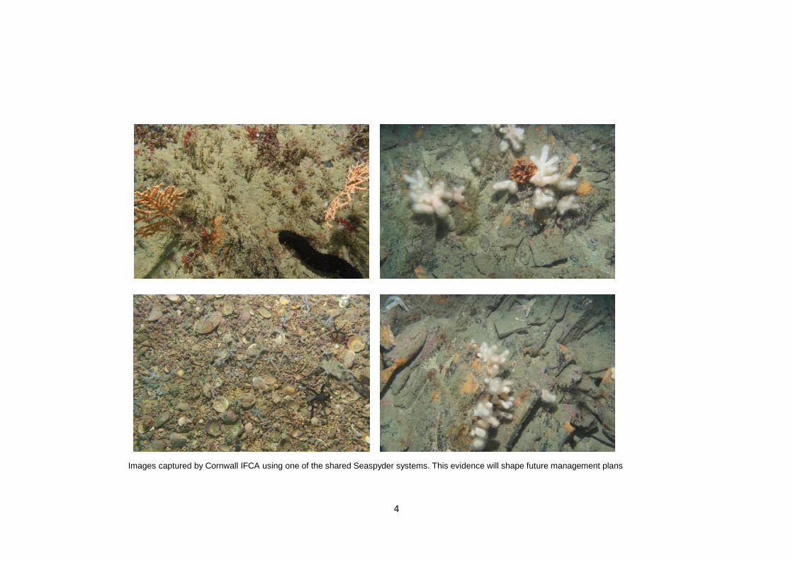
4
Images captured by Cornwall IFCA using one of the shared Seaspyder systems. This evidence will shape future management plans

5
Although the Seaspyder can be supplied as a complete system, it was felt that the frame used by the manufacturer was too big for most IFCA vessels to deploy. So the solution was to have a mounting rail system fabricated that would allow the camera to be fitted into other frames. Additional to the cost of the camera system was the design and fabrication of 2 cable drums to store the umbilical. These drums will prolong the service life of the umbilcals.
The other item purchased on behalf of the IFCAs by the Association was a sidescan sonar. CEFAS and Eastern IFCA have been using an Edgetech 4200 dual frequency sidescan system. It was felt that to maintain surveying consistency between partners, it would sensible to purchase another Edgetech 4200 system.
This equipment has enhanced Cornwall IFCAs capability to provide evidence to inform management measures
Devon and Severn IFCA
The £15,000 grant funding from Defra was used for the purchase and fitting of a 6kva generator set for the D&SIFCA survey vessel Black Jack. Following the purchase of equipment from the 2013/14 grant from Defra it became clear that with the increased sensitivity of the new electronic equipment, being used to undertake the additional survey work, there was a requirement for a stable source of electrical power for the cameras and computers. With the increased usage of power in a marine application there comes an increased danger of spikes in power output which can damage sensitive equipment leading to a loss of data or even more permanent damage to the camera or computers and their storage systems. The work involved fitting the new generator, replacing existing wiring looms, placing additional sockets in the wheelhouse, placing electrical surge protectors in-line and fitting additional cooling vents to the compartment containing the generator set.

6
Survey images and stills of management zones showing evidence of features which will help inform future management plans

7
With the successful fitting of the improved power supply the survey vessel was able to complete a full year’s survey programme with limited ‘down time’ as a result of issues with survey equipment. 37 days were spent on the IFCA’s research vessel Black Jack, undertaking underwater filming using the “flying array” camera system. Filming focussed on both the Start Point to Plymouth Sound and Eddystone SAC and the Skerries Bank and Surrounds MCZ. Filming of the different management zones within the Skerries Bank and Surrounds MCZ was used to determine the effects of the different management measures on the features of the MCZ. The work in the SPPSE SAC will be used to inform the IFCA funded Phd on the impacts of potting, as well as ground-truthing different habitats within the site. Seagrass beds were also mapped, using a drop-down camera, within the Salcombe Estuary and the Torbay MCZ to inform the Mobile Fishing Permit Byelaw. Eastern IFCA In order to enable effective monitoring of seabed features in MPAs, in 2013 Eastern IFCA utilised a Defra grant to purchase an Edgetech 2400 duel-pulse side scan sonar, with an associated laptop and data acquisition software. Funding was also used to purchase two GoPro cameras to help improve the collection of seabed images used for ground truthing. In 2014 Eastern IFCA benefited from a further Defra grant with which to purchase a bespoke desktop computer to analyse the large side scan files generated during surveys.
In 2014 Eastern IFCA introduced a new byelaw that was used to prohibit the use of beam trawls and dredges in areas that previous surveys had identified as supporting core Sabellaria spinulosa reef or cobble/boulder communities within MPAs. These closures required a two-year reporting period to assess their effectiveness. In 2014 Eastern IFCA commenced a two-year survey programme to the monitor the Sabellaria reefs and cobble/boulder communities in these closed areas (see chart). These surveys, which are still on-going, are making extensive use of the side scan sonar to identify seabed features.
The GoPro cameras are being used to supplement the main ground truth data that is being gathered using existing VideoRay ROV and grab samples. The Edgetech 2400 side scan sonar is enabling Eastern IFCA to map the seabed features much more accurately than was possible previously. The bespoke computer has also significantly increased the speed in which the side scan data can be processed.
Poor visibility in turbid water is a major problem Eastern IFCA and some other IFCAs encounter when attempting to gather ground truth data with underwater cameras. In 2015 Eastern IFCA trialled an ARIS 3000 sonar camera as a possible solution to this problem. The trials were successful, with the camera successfully showing it was capable of identifying Sabellaria clumps see images below) and patches of mussels within a mussel bed. The AIFCA was successful in securing Defra funding to purchase one of these cameras. It is anticipated that this piece of shared kit will significantly improve ground truthing abilities in turbid conditions.

8
Chart showing the planned extent of the 2014-2015 habitat mapping surveys

9
Sabellaria Spinulosa Image taken from ARIS 3000 sonar camera showing clumps of Sabellaria

10
Isles of Scilly IFCA
Equipment: A high definition GoPro Hero 3 camera has been mounted to the underwater array units and drop down cameras; it gives a clean and clearer image in and around areas of reef features within the Isles of Scilly. A new waterproof rugged laptop has enabled recording of data at sea directly from the sidescan sonar and drop down cameras. IMB SPSS statistics based software has been purchased to improve analysis, manipulation and interpretation of data. 4 x hand-held Garmin GPSMAP 78 have been used when carrying out intertidal surveys.
Ancillary items: Ropes, cables, wires, shackles, a generator and a trolley were purchased which allowed for the safe usage, movement and retrieval of the equipment being used from the seabed to the vessel. Academic books have been necessary for accurate and quick identification of the different marine life when using underwater cameras. Water proof paper and sea-writer pencils have improved recording of information when undertaking intertidal survey and also on-board vessel surveys.
Vessel Modifications: A hauler and mount were installed into the vessel along with a side mounting pole attached to the vessel ‘A’ frame, allowing for the either the sidescan sonar or the underwater camera to be deployed and towed along the vessel for shallow water applications. Vessel Day Shapes have been purchased which severely restrict the ability to deviate from a course when carrying out any underwater operations. These are being used on-board the vessel to comply with marine law. A flag pole and fixing was installed on-board the vessel to display the maritime signal flag ‘D’ – Della (keep clear) when carrying out underwater operations.
10ft Secure Container: For secure storage of all evidence gathering equipment in one location to allow for maximize usage of the equipment.
Usage of the equipment: The Isles of Scilly IFCA have used the custo- built video array to help quantify and assess different sites within their MPA. This site evidence will enable the Isles of Scilly IFCA to make informed decisions with regards to the different fishing impacts and their management inside the Isles of Scilly district. As the video array is a compact design it can be handled with ease and can be deployed from our 7.2m RIB, the array has 150m of umbilical allowing the unit to used anywhere in the district.

11
Kent and Essex IFCA Since 2010 KEIFCA have been developing the use of Geographic Information System (GIS) to manipulate data and spatially represent the survey, conservation and enforcement work that is carried out by the Authority. The use of GIS within MPA designation and management has been essential. Examples of its use can be seen within the Thanet Coast SAC byelaw and the Essex Estuaries SAC byelaw. Although it is possible to run the GIS software from a laptop the process is slow and costly (in man-hours). Switching to using a desktop computer with increased capacity was the preferred option to reduce officer hours spent on a slower device. The following upgraded computer equipment was purchased using the DEFRA grant and installed in the Ramsgate office: HP Business Display Z24i 24"LED LCD Monitor NVIDIA Quadro K620 Ram 2 GB HP Z230 Workstation Intel Xeon E3-1245v3 @ 3.4GHz - 16 GB RAM - 256 GB SSD - DVD-Writer - Intel HD P4600 Graphics - Windows 8 Professional 64-bit Since the systems installation the productivity of the GIS and Mapping officer has significantly increased. The software can now be run at full capacity and layouts are displayed on a 24” LED LCD monitor. Below is an example of the type of information which can now be produced by Kent and Essex IFCA using their new IT equipment.

12
SAC Sightings map

13
Northumberland IFCA At the time of the MPA capital spends project Northumberland IFCA were in the process of having a new vessel built for the future needs of the NIFCA, expected delivery time May 2015.
Taking in to account the changing role of NIFCA, there was more emphasis on being able to carry out survey operations, which were not possible with the previous vessel. With this in mind the project funded 2 sediment grabs, both 0.1msq, one day grab and one Van Veen. The vessel was then adapted during the build stage to include a damper for the safe deployment and recovery of the grabs as well as a holding table and sample table. This will be utilised for our European Marine Site “red risk” areas in which we are collecting data and ground truthing proposed fine ground fishing areas to permit mobile fishing activity within the site.
A further 2 cameras were purchased. There were difficulties experienced in controlling the drop camera in strong tidal areas, as well as more directional control of the camera, so it was decided to adapt a previously purchased camera frame onto a sledge system. A sea-pro housing with camera was also mounted, again to help with ground truthing works in Northumberland IFCAs European Marine Site. To tow this in depths of up to 60 metres, a further 160 metre umbilical including video signal amplifier and lighting system was also purchased. A further 2 laser pointers were purchased to aid scaling images captured. Due to the versatility of the Go-pro cameras and quality/value, a further camera including filters, batteries and data card was sought to mount to the sledge as a stills only device.
The purchase of a Dell laptop was required; this was used with Mapinfo Gis to work with data sets collected during camera surveys.
A Xylem Professional plus Multi-parameter Instrument was purchased; uses include testing temperature, conductivity, salinity and pH. This has enhanced juvenile fish surveys the Northumberland IFCA have been conducting within the Alnmouth MCZ. The equipment can also be used in monitoring environmental conditions over seagrass beds, a feature of our European Marine Site. A collection of identification books were also purchased, these are to aid our EUNIS work. Three 500GB hard drives were purchased for the safe storage of data collected. Northumberland IFCA has only just taken delivery of its new vessel the St Aidan, and is looking forward to using the newly purchased equipment effectively from the St Aidan.

14
Sussex IFCA
Sussex IFCA conducts a wide range of research activities and it was decided that the most recent Defra grant would be best spent on a range of small items that would enhance their ability to conduct a whole host of projects in MPAs. Video survey in Kingmere Marine Conservation Zone In May 2014, Sussex IFCA conducted a side scan sonar survey of Kingmere MCZ in collaboration with Cefas and Eastern IFCA to investigate the extent of black sea bream nests. The sonar used was an Edgetech 4200 which is jointly owned by Sussex, Eastern and Kent & Essex IFCAs and purchased under a previous MPA capital spend grant. Following the successful sonar survey, two days of underwater video surveys were conducted to ground truth the sonar data. Funding was used to repair the umbilical for the camera, enabling the continued use of the equipment. In addition, the survey was an informative process which led to the purchase of high specification portable lights, improved lasers for scaling objects in the footage and new secure brackets for attaching these to the sledge. GoPro Hero 3 cameras, purchased under a previous MPA capital spend grant, were used to obtain still images of the seabed. This grant has enabled the purchase of a range of accessories which has enhanced the capabilities of these cameras, including: extended life battery pack, LCD screen for playback of footage without a computer, anti-fog inserts, lens protectors and an accessory to enable the camera to float if accidentally dropped in the water.

15
Bream tagging in Kingmere Marine Conservation Zone Kingmere MCZ was designated for the spawning stock and preferred habitat of the black sea bream. In 2014, working in collaboration with recreational anglers and charter vessel skippers, Floy identification tags were attached to over 850 bream. By January 2015, there had been 20 recaptures of tagged fish, most of them within or close to the MCZ, but others were recaptured as far afield as France. This was a small scale pilot study to test the efficacy of the concept. Following the positive support of the local community, and engagement from further afield, it was decided to build on this project in 2015. Using the MPA capital spend grant, five thousand Floy tags have been purchased. It is hoped that further data can help inform bream site fidelity and temporal and spatial variations in their movements which can in turn help inform MCZ management decisions. Temperature data loggers were also purchased and will be used to monitor temperature trends within the MCZ which are theorised to be linked to bream migrations.

16
Habitat mapping in Kingmere Marine Conservation Zone and Beachy Head West Marine Conservation Zone A requirement for GIS for a range of projects necessitated the use of grant funding to procure ArcGIS software (complete with three years of updates and support) and updated computer hardware. With training and data support from Sussex Biodiversity Records Centre, this has been a fantastic increase in the capability of Sussex IFCA for a variety of projects. For Beachy Head West MCZ, this has enabled the production of engaging habitat maps for use during public consultations, using integrated data layers from Natural England and the Channel Coast Observatory. For Kingmere MCZ, this has enabled the production of informative maps, detailing the distribution of fishing activity, necessary for the management of these activities.

17
Small fish surveys in Chichester Harbour (Solent Maritime European Marine Site), Rye (Dungeness to Pett Level European Marine Site) and Cuckmere (adjacent to Beachy Head West Marine Conservation Zone) Sussex IFCA conducts small fish surveys in a range of protected and important sites. Monitoring of these fish populations is useful for assessing overall ecological status, spatial and temporal trends and juvenile stocks of commercially significant species. A variety of small items were purchased to make these surveys more efficient and to reduce undue stress on the fish. Useful items include a robust 12 volt air pump, waterproof digital camera with inbuilt GPS, hand nets, sample pots, magnifying glass and identification guides. In Rye, the surveys are conducted in collaboration with Natural England, Environment Agency and Rye Harbour Nature Reserve and aim to inform the food availability for the breeding terns within the EMS. These small items can make a big difference to the continued success of these surveys.

18
Video survey in Chichester Harbour (Solent Maritime European Marine Site) Sussex IFCA has conducted video surveys in Chichester Harbour to assess the condition of the seabed before and after oyster dredging. The survey was conducted from Sussex IFCA’s 8m jet drive RIB. Due to the size of the vessel, a small, portable video camera system was used. This included a hand hauled stainless steel sledge, purchased under a previous MPA capital spend grant. Attached to the sledge was a light, a pair of lasers, a GoPro camera and an underwater video camera with an umbilical up to a monitor and digital video recorder on the surface. This adaptable system was ideal for deployment in shallow sheltered conditions. The MPA capital spend grant has been used to purchase high specification portable lights, lasers, brackets and GoPro accessories. Three underwater video cameras that are supplied in a small case with a screen and battery were also purchased. With digital video recorders, they are convenient versatile camera systems for recording footage in sheltered conditions. They are easy and simple to use by IFCA staff or by stakeholders in collaborative and engaging projects.

19
GIS Computer The GIS computer and software has been integral with Sussex IFCA operations. The specialist marine software exports Adobe and Excel files to other Windows PCs. We have replaced 2 Windows XP PCs with Windows 7 PCs to respond faster and more successfully with the Adobe files and purchased newer MS Office software for use with the Excel files. Oyster stock monitoring in Chichester Harbour (Solent Maritime European Marine Site) There is a wild population of native oysters in Chichester Harbour that are the focus of a number of research projects. Stock monitoring is conducted monthly in collaboration with local Environmental Health Officers where catch per unit effort and length frequency data is collected. The purchase of a pair of waterproof digital callipers has made this work much more efficient. The use of waterproof digital cameras with GPS geo-referencing, purchased with this grant, has enhanced our ability to monitor seasonal changes in the dredge samples. We also monitor areas of re-laid broodstock and use a hand hauled van veen grab to collect samples from the pontoon.

20
Southern IFCA
Southern IFCA purchased a processing laptop, a survey laptop, a sidescan sonar processing computer, a GIS computer and an ARC GIS license. This equipment enabled Southern IFCA to undertake two Marine Conservation Zone verification surveys under contract for Cefas. Acoustic seabed data was gathered for two recommended tranche two Marine Conservation Zones, Norris to Ryde and Yarmouth to Cowes, on the north coast of the Isle of Wight. Under the guidance of experienced staff from Eastern IFCA data were gathered through the use of an Edgetech sidescan sonar device, previously purchased by the IFCAs as a shared resource using Defra funding. Data gathered were processed and delivered using specialist IFCA IT resources, including high speed processing computers and Triton Perspective software.
The surveys piloted the use IFCA assets to offer cost effective alternatives for inshore survey work and the results demonstrate that a range of government organisations are able to work together to produce high quality and cost effective data that can be used to inform management. This collaborative working approach facilitated the transfer of knowledge and skills between government organisations, in particular providing Southern IFCA staff with the capability to undertake sidescan sonar surveys and develop and work to standard operating procedures.
During March 2015 Southern IFCA undertook a seabed video survey within Poole Harbour under contract from Natural England. The aim of the survey was to map the presence and extent of the Peacock Worm (Sabella pavonina) as part of periodic SSSI feature condition monitoring. Through the use of specialist IT equipment and an HD underwater video camera, previously supplied through Defra funding, the Authority was able to gather high quality video footage. Footage will then be analysed and features map using ARC GIS. This data has again been gathered cost-effectively in partnership with government organisations and will be used to manage fishing and aquaculture operations within Poole Harbour to ensure that there is no adverse effect to the designated conservation features.

21
In May 2015 the Technical Advisory Group facilitated a Cefas training workshop in Poole to provide an introduction to acoustic data collection, processing and interpretation, together with advice on survey planning and the use of standard operating procedures. Training was provided by national experts to representative from eight IFCAs and will provide the skills to enable these organisations to make best use of Defra purchased shared survey equipment. Specialist IT training equipment and data processing licenses were jointly provided by Southern IFCA and Cefas.
North Eastern IFCA
Sieve Stack: The sieves have been used to support the rapid assessment of sediment composition in the field as part of the Broadscale Habitat Classification survey programme. Supporting ground truthing of the multibeam data, the sieves are used in conjunction with sediment grabs to look at the relative proportions of specific sediment size classes.

22
Laser Scalers: These have been built into the underwater towed camera system and provide a scale allowing for quantitative assessment of substrate and features. These have supported the assessment of cobble & boulder habitat in the Flamborough Head EMS and identification of features.

23
Fine scales: The scales were purchased to support NE IFCAs quayside sampling regime, sampling and capturing biometrics from commercial catches. The scales have been used to collect data on individual animal weights, which have been developed into length-weight keys informing stock assessments.
SBMS Extended Batteries: The batteries which were purchased to upgrade existing remote camera systems, have provided an extended recording period increasing capacity to 11 hours per charge.

24
Vernier Callipers: These have been issued to shore based enforcement staff and have supported an increase in ad-hoc sampling of commercial catches during routine patrols. This has provided further information on size compositions, sex ratios and abundances, which inform NE IFCA stock assessments.

25
Hamon Grab: This is used to undertake sediment sampling in coarse sediment areas; following sea trials NE IFCA are currently awaiting an equipment upgrade to support more efficient deployment and recovery.
60ft Otter Trawl & V-boards: This kit was delivered in February 2015 and is scheduled for survey deployments in September / October as part of a suite of finfish surveys to provide baseline information on abundance and distribution.
Fine mesh creels: Theses creels have been incorporated into offshore potting surveys which run from May - October, specifically to target pre-recruit populations allowing for the assessment of juvenile abundance and distribution.

26
Conclusion:
The case studies outlined above clearly demonstrate the value of the 2014/15 grant which has allowed the IFCAs to augment their evidence bases around MCZs, to inform appropriate and measured management of these sites and implement a well-managed network of MPAs by 2016. The responsibility of providing the evidence base for designated sites remains with the Statutory Nature Conservation Bodies (Natural England in the case of the English inshore waters) but the ability of the IFCAs to augment this evidence allows them to better achieve the balance of social, economic and environmental drivers as set out in the Marine Act and in the IFCA vision. The Association-owned equipment is being shared between individual IFCAs, and has greatly increased their capacity to provide accurate and meaningful evidence in a timely manner. In addition, the IFCA Technical Advisory Group (TAG) is working closely with CEFAS to ensure that the evidence gathered is to an appropriate standard and as such can meet the requirement of Defra’s policy to collect data once and use many times

27
Appendix 1: Summary of Individual IFCA purchases
IFCA Cost bid
to DEFRA £
IFCA Bid £
IFCA spend £
Paid to IFCA £ Details of purchases
Eastern IFCA 14000 14000 15197.00 14000 Post Processing Computer for Side Scan Data. Eastern IFCA purchased for itself Trition Imaging Software to allow analysis of the captured Data (on CEFAS advice). To easily analyse and manipulate the volume of data Eastern IFCA is expecting to process as part of the Habitat Mapping for EMS, a new computer is required. Working with a Chillblast Fusion Leviathan as a base model, with additional cooling, processing and RAM would be required to make the best of this machine.
Northumberland IFCA
15000 15543 17946.21 15000 Two bottom grabs - one for fine sediment and one for Coarse - detail to be agreed with Cefas
Kent and Essex IFCA
15000 15000 2201.22 2201.22 High spec computer with statistics software and post processing software (with licensing) for acoustic surveys data and ability to process large amounts of GIS data and statistics
Devon and Severn IFCA
15000 43700 15000.00 15000 Modifications to survey vessel to undertake survey work to a higher standard.
NW IFCA 15000 20162 15000.00 15000 Lasers, cable reel/winch, Smart Antenna, Camera clamp, Camera frame, Pelican case for power supply
Isles of Scilly 14036 14036 15261.93 14036 Hoist, rugged laptop, Go-pro camera. Cornwall 15000 15000 14053.98 14053.98 Modifications to camera frame to take Association owned camera system. Data
capture system. Survey GPS. Day grab, launching table and sieving table. Southern 15000 15000 15218.57 15000 Ruggedised laptop with software for use with side scan sonar (main shared item) NE IFCA 15000 15570 15570.04 15000 Sieve Stack (5 units), Laser scalers (12 units), Fine scales, SBMS extended batteries (4
units), Hamon Grab, Otter trawl and accessories Sussex 14978 14978 15094.96 14978 Drop down video modification and extra cameras. Small grab, GIS spec computer, Arc
GIS software, plus ancillary equipment for the above.