ih 35w public hearing csjs: 0014-16-179 and 0014 … · ih 35w public hearing csjs: 0014-16-179 and...
TRANSCRIPT

IH 35W Comment Response Report 1 CSJ’s: 0014-16-179 and 0014-16-268
IH 35W Public Hearing
CSJs: 0014-16-179 and 0014-16-268
COMMENT AND RESPONSE REPORT

IH 35W Comment Response Report 2 CSJ’s: 0014-16-179 and 0014-16-268
Public Hearing June 12, 2012
Comment and Response Report
IH 35W: From IH 820 to IH 30
(CSJs 0014-16-179 & 0014-16-268)
Name of Individual Representing Comment # Type
Keanan Halla Noble Crest Property Group 1 Written Ken Wimberly, CCIM Noble Crest Property Group 1 Written
Brad Motley Noble Crest Property Group 1 Written Aaron Wimberly Noble Crest Property Group 1 Written
Branson Blackburn Noble Crest Property Group 1 Written Marlene L. Beckman Kensington Properties 1 Written
Dalton Vann Self 1 Written Tom Galbreath Dunaway Associates, L.P. 1 Written
Kyle F. Salzman Self 1 Written Glen W. Hahn Innovative Developers, Inc. 1 Written
Senator Jane Nelson State Senate District 12 1 Written Brian E. Happel BBVA Compass 1 Written Mark C. Spear Self 1 Written
Rick W. Merrill Cook Children’s Health Care System
1 Written
Rachel Foster Valley Crest Landscape Maintenance
1 Written
S.A. Mundt Metroport Cities Partnership 1 Written Mark W. Barfield RadioShack Corporation 1 Written Todd Burnette Jones Lang LaSalle 1 Written
Lonnie Nicholson EECU 1 Written
Bill Thornton Fort Worth Chamber of Commerce
1 Written, Verbal
Robert W. Semple Bank Of Texas 1 Written
Mark G. Nurdin Bank of Texas 1 Written, Verbal
U.S. Representative Kay Granger 12th Congressional District 1 Written
Susan A. Halsey Jackson Walker, L.L.P. 1 Written William L. Conley, Jr. Bondurant Group 1 Written
Mayor Betsy Price City of Fort Worth 1 Written
Barney B. Holland, Jr. Barney Holland Oil Company 1 Written, Verbal
RTC and NCTCOG Metropolitan Planning Organization
1 Written
Vic Suhm Tarrant Regional Transportation Coalition
1 Written, Verbal
Mayor Gary Brinkley City of Saginaw 1 Written Mayor Henry J. Jeffries City of Watauga 1 Written
Darrell Thompson Self 1 Written Christopher Miranda Self 1 Written

IH 35W Comment Response Report 3 CSJ’s: 0014-16-179 and 0014-16-268
Name of Individual Representing Comment # Type Gerrit Spieker Self 1 Written
Mickey D. Nowell Self 1 Written
William L. Conley Genco-ATC 1 Written, Verbal
Brian Reinhardt Self 1 Written April Prevost Self 1 Written
Drew Kile Institutional Property Advisors
1 Written
Larry Anfin Coors Distributing Company 1 Written Eddie Gossage Texas Motor Speedway 1 Written
Mayor Connie White Town of Trophy Club 1 Written Allen R. Smith, Jr. Southeast Fort Worth, Inc. 1 Written
Gary Fickes Tarrant County Commissioner – Precinct 3
1 Written
Richard D. Minker, CCIM Commercial Real Estate Partners
1 Written
Richard H. Kuhlman Metroport Cities Partnership 1 Written Russell E. Fuller North Fort Worth Alliance 1 Written
Mayor Oscar Trevino City of North Richland Hills &
Mayors’ Council of Tarrant County
1 Written, Verbal
L. Russell Laughlin 35W Coalition 1 Written, Verbal
Brian Randolph Mercantile Center 1 Written, Verbal
Shawna Russell Fort Worth Transportation Authority
1 Verbal
Rosa Navejar Fort Worth Hispanic Chamber of Commerce
1 Verbal
Brad Gorrondona Fort Worth Hispanic Chamber of Commerce
1 Verbal
Mark Schluter Northwest ISD Board of Trustees
1 Verbal
Frank Bliss Cooper and Stebbins 1 Verbal Brinton Payne Self 1 Verbal
Aaron Hegeman BNSF Railway 1 Verbal Brooke Ligon Self 2 Written
Michael Rodriguez Self 3 Written Paul Allen PacLease 4 Written
Benard L. Hoff Self 1,5,27 Written Eric Niedermayer Recovery Resource Council 6 Written
Tony Williams Penske Truck Rental 7 Written Andrew Sherwood Interga Realty 8 Written
Robin Weddle Self 8 Written Mark McIlheran, P.E. Self 8 Written
Julie Jones Self 8 Written Adam Copeland Self 8 Written
Teresa Moore Clear Channel Outdoor 9 Written
Kerry Yoakum Outdoor Advertising Association of America
9 Written

IH 35W Comment Response Report 4 CSJ’s: 0014-16-179 and 0014-16-268
Name of Individual Representing Comment # Type Margaret DeMoss Scenic Fort Worth 10 Written
Joe Garner Self 10 Written
Andrew A. Corso Fort Worth Housing Authority 11 Written, Verbal
JP Shannon Self 12 Written Jan Buck Self 13, 14 Written
Noble Reed Self 8,15 Written, Verbal
Sarah Walker United Riverside Association 16 Written, Verbal
Charlie Levens Discount Auto Parts Exchange
17 Written
Brian Langdon Powers Southwest Plains, LLC
17 Written
George Muckleroy M&M Manufacturing Company & Blazing Trail LP
18 Written
Morris L. Sheats II Abra Realty, Inc. 18 Written Mitzi Mendez Self 19, 20, 32 Written
Ginger Bason Oakhurst Neighborhood Association
1,21,22,23,24,25,26,27
28,32,38
Written, Verbal
Michael K. Berry Hillwood Properties 1,24 Written, Verbal
Benjamin Compton Self 26 Written Kenneth Comon, Jr. Self 26 Written
Charles D. Witt Self 26,28 Written Louise Appleman Scenic Fort Worth 26,28 Written
Jerre Tracy Historic Fort Worth, Inc. 1,11,21,24,27,32
Verbal
Representative Lon Burnam
State Representative District 90
1,11,19,23,24,26,27,28
Written, Verbal
Unknown Self 27,28 Verbal Edward Scarbrough Self 1,27 Written
Lori Holt Self 1,27 Written Jeremy Holt Self 1,27 Written
Hanna Vanderstoel Self 1,27 Written Maarten Vanderstoel Self 1,27 Written
Janice Lambert Self 1,27 Written Maurice Lambert Self 1,27 Written
Brian Bibb Self 1,27 Written Larissa Bibb Self 1,27 Written Stan Baker Self 1,27 Written Glee Baker Self 1,27 Written Shelly Ellis Self 1,27 Written Chris Ellis Self 1,27 Written
Philip N. Baksley Self 1,27 Written Sharon K. McNiel Self 1,27 Written
Lemuel Thomas Self 1,27 Written
Trey Gunter Self 1,27 Written

IH 35W Comment Response Report 5 CSJ’s: 0014-16-179 and 0014-16-268
Name of Individual Representing Comment # Type Melissa Gunter Self 1,27 Written
Virginia Freeman Self 1,27 Written Shane Hodges Self 1,27 Written
Sharon L. Kutilek Self 1,27 Written
Sharon Buse Self 1,27,28 Written, Verbal
Pam Maurice Self 1,27 Written Mindi Morrow Self 1,27 Written
Wes & Mindi Morrow- Holley Self 1,27 Written
Cara Clark Self 1,27 Written Cathy Spitzenberger Self 1,27 Written Kenneth Comer, Jr. Self 1,27 Written
Suzanne Hoff Self 1,26,27,28 Written Tom Boullt Self 1,27 Written
Mary Hatton Self 1,27 Written Kristina Rutherford Self 1,27 Written
Dolores Crowley Self 1,27 Written Michael Crowley Self 1,27 Written Justin Maurice Self 1,27 Written
Babette Ronnebaum Self 1,27 Written Charles and Judy
Hamilton Self 1,27 Written
Sallie Littlepage Self 1,27 Written Brendan Ahern Self 1,27 Written
Kelli Ahern Self 1,27 Written
Fred R. Anglin Self 1,26,27,28 Written, Verbal
Phyllis S. Anglin Self 1,26,27,28 Written, Verbal
Leonard A. Fiorenza Self 1,27 Written Brian Barefield Self 1,27 Written Mary Huston Self 1,27 Written
Karen R. Gambrell Self 1,27 Written John M. Suggs Self 1,27 Written Frances Lopez Self 1,27 Written
Jessica Gonzales Self 1,27 Written Aaron Latchaw Self 1,27 Written Clark Jackson Self 1,27 Written
Amanda Vorwerk Self 1,27 Written
Aaron Vorwerk Self 1,21,27 Written, Verbal
Duffy Lee Self 1,27 Written Martha Ann Kollmorgen Self 1,27 Written
Wacel Harrison Self 1,27 Written Alec Ferrell Self 1,27 Written
Barbara Barto Self 1,27 Written Earl Martin Self 1,27 Written Jann Miles Self 1,27 Written
Charlie Boya Self 1,27 Written

IH 35W Comment Response Report 6 CSJ’s: 0014-16-179 and 0014-16-268
Name of Individual Representing Comment # Type Laurel Overby Self 1,27 Written
Kim McAdams-Baker Self 1,27 Written Scott Baker Self 1,27 Written
Virginia Bason Self 1,27 Written Jack Bowden Self 1,27 Written Weldon Lucas Self 1,27 Written Valerie Lucas Self 1,27 Written
Doyle H. Willis, Jr. Self 1,27 Written Elizabeth B. Willis Self 1,27 Written Margaret M. Hamm Self 1,27 Written James R. Leasley Self 1,27 Written
Mrs. James Leasley Self 1,27 Written
Eric & Deanna Simmons Self 1,26,27 Written, Verbal
Deanna Simmons Self 1,27 Written
Carl Wells Self 1,26,27,28 38
Written, Verbal
Helen Rightmire Self 1,27 Written G.R. Rightmire Self 1,27 Written John C. Molder Self 1,27 Written
Jim Molder Self 1,27 Written Donna Clark Self 1,27 Written Diana Jones Self 1,27 Written
Thelma Cayton Self 1,27 Written Alkie A. Kithas Self 1,27 Written
Rose Ann Poulsen Self 1,27 Written Dana Stanford Self 1,27 Written Allen Stanford Self 1,27 Written
Haskell Bob Ford Self 1,27 Written Peggy Ford Self 1,27 Written
Kristen Hadley Self 1,27 Written
Denise Bennett Self 1,24,26,27, 32
Written, Verbal
Kathryn Omarkhail Self 1,26,27 Written, Verbal
Megan A. Murphy, DVM Self 1,27 Written Sally Browning Self 1,27 Written
Liz A. Young Self 1,27 Written Holly E. Pils Self 1,27 Written Carol Ray Self 1,27 Written
Cindy Compton Self 1,27 Written Edward F. Lavandowski Self 1,27 Written
Mary Lou Jernigan Self 1,27 Written Casey and Mary Lopez Self 1,27 Written Brittany and Stephen
Rivers Self 1,27 Written
Lynn Sonsel Self 1,27,28 Written Miguel Rodriguez Self 1,27 Written
Erin Cofer Self 1,27 Written Dana L. Praytor Self 1,27 Written
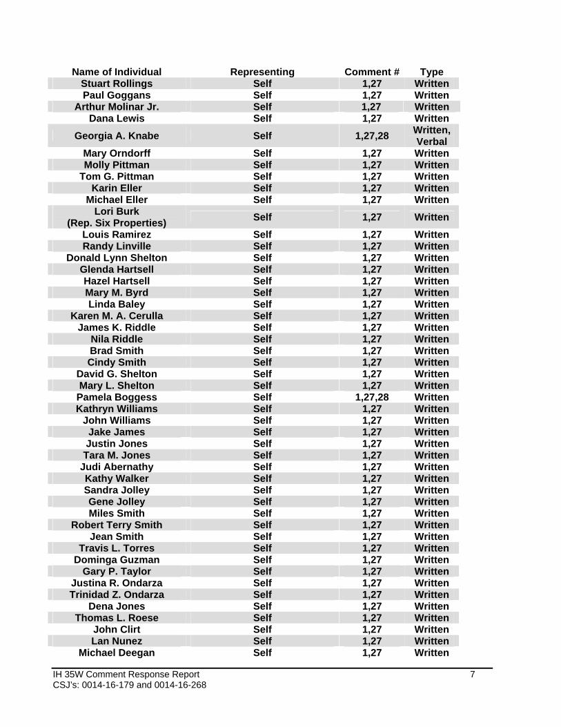
IH 35W Comment Response Report 7 CSJ’s: 0014-16-179 and 0014-16-268
Name of Individual Representing Comment # Type Stuart Rollings Self 1,27 Written Paul Goggans Self 1,27 Written
Arthur Molinar Jr. Self 1,27 Written Dana Lewis Self 1,27 Written
Georgia A. Knabe Self 1,27,28 Written, Verbal
Mary Orndorff Self 1,27 Written Molly Pittman Self 1,27 Written
Tom G. Pittman Self 1,27 Written Karin Eller Self 1,27 Written
Michael Eller Self 1,27 Written Lori Burk
(Rep. Six Properties) Self 1,27 Written
Louis Ramirez Self 1,27 Written Randy Linville Self 1,27 Written
Donald Lynn Shelton Self 1,27 Written Glenda Hartsell Self 1,27 Written Hazel Hartsell Self 1,27 Written Mary M. Byrd Self 1,27 Written Linda Baley Self 1,27 Written
Karen M. A. Cerulla Self 1,27 Written James K. Riddle Self 1,27 Written
Nila Riddle Self 1,27 Written Brad Smith Self 1,27 Written Cindy Smith Self 1,27 Written
David G. Shelton Self 1,27 Written Mary L. Shelton Self 1,27 Written
Pamela Boggess Self 1,27,28 Written Kathryn Williams Self 1,27 Written
John Williams Self 1,27 Written Jake James Self 1,27 Written Justin Jones Self 1,27 Written
Tara M. Jones Self 1,27 Written Judi Abernathy Self 1,27 Written Kathy Walker Self 1,27 Written Sandra Jolley Self 1,27 Written Gene Jolley Self 1,27 Written Miles Smith Self 1,27 Written
Robert Terry Smith Self 1,27 Written Jean Smith Self 1,27 Written
Travis L. Torres Self 1,27 Written Dominga Guzman Self 1,27 Written
Gary P. Taylor Self 1,27 Written Justina R. Ondarza Self 1,27 Written Trinidad Z. Ondarza Self 1,27 Written
Dena Jones Self 1,27 Written Thomas L. Roese Self 1,27 Written
John Clirt Self 1,27 Written Lan Nunez Self 1,27 Written
Michael Deegan Self 1,27 Written

IH 35W Comment Response Report 8 CSJ’s: 0014-16-179 and 0014-16-268
Name of Individual Representing Comment # Type Deborah Mitchell Self 1,27 Written
Deanine Woestman Self 1,27 Written Dorinda Floyd Self 1,27 Written
John Floyd Self 1,27 Written Yolanda Rodriguez Self 1,27 Written
Wayne Jones Self 1,27 Written Michael Garcia Self 1,27 Written
Lupe C. Martinez Self 1,27 Written Silver Escalante Self 1,27 Written
Dwight and Beverly Mason Self 1,27 Written
Dana Kennedy Self 1,27 Written Jerry R. McClellan Self 1,27 Written Jon David Porter Self 1,27 Written
Larry Shoff Self 1,27 Written Kelly L. McLean Self 1,27 Written
Nathan Massingill Self 1,27 Written Frank Tubbella Self 1,27 Written
Wendy Vana Self 1,27 Written
Rita Wilson Self 1,26,27,28 Written, Verbal
Brenda Bogan Self 1,27 Written Alfred Mendez Self 1,27 Written
Jeff and Angela Redding Self 1,27 Written Lisa Shannon Self 1,27 Written Pat Shannon Self 1,27 Written
Anna Beth Robinson Self 1,27 Written Oleta D. Lee Self 1,27 Written
Bailey Calabrese Self 1,27 Written Freda Calabrese Self 1,27 Written
Elsie E. Self Self 1,27 Written Laura McDowell Self 1,27 Written Paul McDowell Self 1,27 Written
Deb Brown (Rep. Two Properties) Self 1,27 Written
Robert Brown (Rep. Two Properties) Self 1,27 Written
Jack Toddlie Self 1,27 Written Connie Rodriguez Self 1,8,27 Written Martin Rodriguez Self 1,8,27 Written Bianca Rodriguez Self 1,8,27 Written
Linda Plemons Self 1,26,27,28 Written, Verbal
Mark Brewer Self 1,27 Written Jesse Aguilera Self 1,27 Written Terre Aguilera Self 1,27 Written
Carol Reiger Self 1,27 Written
Charles Boswell State Senator Wendy DavisDistrict 10
1,24,26,27 28
Written, Verbal

IH 35W Comment Response Report 9 CSJ’s: 0014-16-179 and 0014-16-268
Name of Individual Representing Comment # Type
Libby Willis Oakhurst Neighborhood Association
1,21,25,26,27 28 Verbal
Mark Makes Self 1,28,29 Verbal
Angela Redding Self 21,24,26,2738, 41
Written
Charles R. Prior Calvary Cathedral International
1,28,29,30 Written, Verbal
Dusty Anderson Chesapeake Energy 1,31 Written
Councilman Sal Espino Fort Worth City Council, District 2
1,24,26, 32,33,35
Written, Verbal
Randy Gideon Streams and Valley, Inc. 33 Written Shawna Russell Self 34 Verbal Ben D. Loughry,
MAI,FRICS Greater Fort Worth Real
Estate Council1,24,26,27,
35Written, Verbal
Ginger Bason Self 1,22,23,24,26,28,36,37 Verbal
Unknown Self 38 Verbal Thomas Henderson Self 38,39 Verbal
Michael Morris North Central Texas Council of Governments
1,23,24,28 32,38,40 Verbal
Cyndy Walters Self 41 Written Unknown Self 42 Written
Comment 1 Commenters expressed approval for the project and requested speedy implementation along with acknowledging TxDOT’s hard work, diligence, and being a good partner with the IH 35W community in developing solutions for IH 35W. Many commenters from the Oakhurst Neighborhood indicated they were in favor of the expansion of IH 35W which includes a noise/safety wall for the Oakhurst Neighborhood. Response 1 Comment noted. Comment 2 Does not believe HOV lanes are an effective way of supporting carpooling because many times HOV lanes are empty. The commenter states that highway funds would be better used if all the lanes could be fully used. Response 2 The North Central Texas Council of Governments (NCTCOG) Regional Transportation Council (RTC) is responsible for developing the regional managed lane policies. The proposed managed lanes would not be restricted to only high-occupancy vehicles (HOV). HOVs of two or more occupants would receive a 50 percent discount to use the managed lanes during the peak period. This discount would phase out after the air quality attainment maintenance period. The managed lanes would be available to single-occupancy vehicles (SOVs) if they elect to pay the toll. No discount would be available for SOV users. The managed lane policies may be adjusted by the RTC to meet regional goals. Any request for a change in the managed lane policy would need to be sent to NCTCOG.

IH 35W Comment Response Report 10 CSJ’s: 0014-16-179 and 0014-16-268
A managed lane facility increases freeway efficiency by packaging various operation and design actions to promote reliability of the system and provide for long-distance travel with few access points to disrupt traffic flows. In addition to maximizing the vehicle carrying capacity of the roadway, managed lane systems also maximize person moving capacity, provide travel options and increase flexibility, and achieve community and corridor goals. With the addition of managed lanes, fewer vehicles per lane would be expected to use the general purpose lanes for long-distance trips which provide better balancing of traffic movements, improved level of service and reduced congestion. Tolling helps much-needed facilities be implemented faster than if relying on traditional funding sources. Without tolling, this roadway expansion would be substantially delayed or not constructed. Comment 3 Expressed concern that Yucca Avenue is ruined because of the freeway and asks what the city is going to do. Response 3 Yucca Avenue would be reconstructed within Texas Department of Transportation (TxDOT) right-of-way (ROW) to accommodate future traffic volumes and tie back to the existing facility. Plans for future improvements to Yucca Ave outside of TxDOT’s ROW would be the responsibility of the City of Fort Worth. Comment 4 Requests TxDOT and their contractors consider heavy truck access to businesses, especially those between NE 28th Street and Meacham Boulevard. Turning movements for large tractor trailers need to be considered when placing temporary and permanent barricades. Response 4 The detailed traffic control plan/sequence of work for the reconstruction of IH 35W has not been developed at this time. Access to and from city streets, businesses and residential neighborhoods would be maintained during construction. For areas along the IH 35W corridor where heavy trucks serve local businesses, TxDOT and the Developer would incorporate designs accommodating larger turning radius used by heavy trucks in the detailed traffic control plan/sequence of work. Temporary closures during the day for construction activities may be required and most likely would occur during the evening hours and other non-peak periods to minimize the impact to the local residents and businesses, provide a safe and efficient facility during construction for the traveling public, and expedite the reconstruction of IH 35W. TxDOT and the Developer would work with local city staffs and business owners to develop traffic control plans/sequences of work to minimize construction impacts to the local communities, businesses and traveling public. Comment 5 Commenter would like to know if any FCC surveys of impacts on commercial radio links have been conducted. Also, asks whether studies on railroad microwave links or traffic light/river monitor links have been conducted. Response 5 No surveys or the studies requested have been performed during advance development efforts for this project. TxDOT has complied with all federal requirements contained in the National Environmental Policy Act (NEPA), and Federal Highway Administration (FHWA) and TxDOT guidelines for transportation projects. For information regarding communication facilities, studies, or impacts on commercial radio links, please contact the Federal Communications Commission (FCC) for further information.

IH 35W Comment Response Report 11 CSJ’s: 0014-16-179 and 0014-16-268
Comment 6 Request the closure of Blandin Street between the proposed northbound SH 121 (Airport Freeway) frontage road to Rouse Street when the expansion of SH 121 occurs. Commenter’s business is a non-profit agency providing prevention and intervention services to children, youth and families that have or are at risk to have a substance or alcohol abuse problem. Commenter owns five lots where the current building is located, three properties behind the building on Rouse Street, and a house located at the intersection of Nies Street and Blandin Street. Removal of access would allow the commenter to maximize rebuilding of their business. Response 6 TxDOT is required to maintain access to existing city streets where practicable and feasible for traffic operations, safety, and emergency service response. Blandin Street is a local city street under the jurisdiction of the City of Fort Worth. The authority to close city streets is with the City of Fort Worth. Street closure requests should be coordinated with the city’s Transportation and Public Works Department. Based on the layouts presented at the June 12, 2012 public hearing, additional ROW is needed along SH 121 with the commenter’s business located at 2700 Airport Freeway considered displaced by the expansion of SH 121. As a part of the right of way process, the needed land and any improvements within the proposed area would be appraised and an offer would be made. Property owners are compensated for right of way acquired based on the Uniform Relocation Assistance and Real Property Acquisition Act of 1970. Property is appraised at fair market value as determined by an independent appraiser and the property owner is offered this compensation. Compensation could include not only the fair market value for the land acquired but any improvements within the taking and damages, if any, to the remainder. In addition to fair market value, the owner/tenant would be eligible for relocation assistance for moving of personal property Comment 7 Requested a map of IH 35W from IH 30 to Northside Drive. The loss of the northbound Pharr Street exit would affect how his customers access his business and he would like to share with them the new way to access his business. Asked is there a way to keep the northbound Pharr Street exit. Response 7 Commenter was provided TxDOT’s website address where the public hearing displays could be viewed online. Displays presented at the public hearing depicting the proposed improvements for IH 35W from IH 820 to IH 30 are available for review at TxDOT’s Fort Worth District Office, the City of Fort Worth Transportation and Public Works Department, or online using the following TxDOT web address: http://txdot.gov/public_involvement/hearings_meetings/fort_worth/ih35w_061212.htm Due to close spacing of the IH 35W interchanges with US 287 and SH 121, a northbound exit to Pharr Street could not be maintained due to constrained horizontal geometry design concerns. An additional exit ramp to Pharr Street would introduce an undesirable traffic operation and safety concern due to providing insufficient weaving distances to accommodate the higher traffic volumes accessing IH 35W from US 287/Spur 280 versus the low volume desiring to access Pharr Street. Patrons desiring to access Pharr Street from northbound IH 35W would need to exit IH 35W to Northside Drive/Yucca Avenue, and take the U-turn to the southbound frontage road to access Pharr Street and the businesses located along the west side of IH 35W.

IH 35W Comment Response Report 12 CSJ’s: 0014-16-179 and 0014-16-268
Comment 8 Several attendees requested copies of the maps and public hearing presentation provided at the hearing. Response 8 All commenters requesting copies of the presentation received a copy via email or the U.S. postal service. Those requesting copies of the hearing displays were contacted by the District’s Open Records Coordinator and informed on how to obtain a copy through the Open Records Request process. The public hearing presentation for IH 35W from IH 820 to IH 30 is available for review at TxDOT’s web address: www.txdot.gov/public_involvement/hearings_meetings/fort_worth/ih35w_061212.htm Comment 9 The commenter’s request relocation of billboards impacted by the expansion of IH 35W in appropriate and compatible areas within the City of Fort Worth. Current city ordinance does not allow the relocation of off-premise signs within the corporate city limits or ETJ of Fort Worth. One commenter requests TxDOT’s assistance in encouraging a policy change in Fort Worth regarding off-premise signs that is practical and reasonable following the best practices implemented by other cities in similar situations. Another commenter requests TxDOT and the City of Fort Worth allow billboard owners to be included as stakeholders in the eminent domain process and consider allowing billboard relocation to assist in minimizing possible project delays, project costs and taxpayer expenditures. Response 9 Development of ordinances related to relocation of off-premise signs is the responsibility of city government and not TxDOT. TxDOT has no authority to assist local governments in development of ordinances or to encourage local governments to change ordinances related to the re-location of off-premise signs within the Extra Territorial Jurisdiction (ETJ) or city limits. TxDOT encourages all parties located along the IH 35W corridor to cooperatively work together to find solutions minimizing project delays and cost. Outdoor advertising signs are considered personal property (versus real estate). During the acquisition of right of way, the owners of outdoor advertising signs would be eligible for relocation expenses to relocate the sign to a conforming location. The relocation agent would explain those benefits to the interested parties during the acquisition process Comment 10 One commenter expressed concern related to removal and re-location of billboards along the IH 35W corridor during construction of the proposed facility. Reminded TxDOT IH 35W is designated a “scenic corridor” and current City of Fort Worth ordinances prohibit removed billboards from being replaced along the corridor. Requests specific documentation for the duration of the project on the billboards removed within the City of Fort Worth and its ETJ including the location and square footage of each sign, price paid by the State to which outdoor advertising agency, and date of transaction. Stated if their request does not meet the requirements to release this information to please provide the procedure and contact person to obtain the information. An additional commenter asked which entity TxDOT, City of Fort Worth, North Texas Tollway Authority (NTTA) or Tarrant County would be responsible for reimbursement for billboard removal and re-location associated with the proposed project and asked would the responsible entity be eligible for reimbursement from one of the above listed entities or from the federal government.

IH 35W Comment Response Report 13 CSJ’s: 0014-16-179 and 0014-16-268
Commenter assumes no relocation would be accepted by the billboard companies due to the lack of no Fort Worth relocation ordinance. Response 10 Outdoor advertising signs are considered personal property (versus real estate). During the acquisition of right of way, the owners of outdoor advertising signs would be eligible for relocation expenses to relocate the sign to a conforming location. The relocation agent would explain those benefits to the interested parties during the acquisition process. Requests for documentation related to removal and relocation of billboards located along the IH 35W corridor would need to be obtained through an open records request after the acquisition transaction is completed. Please contact Donna Fowler, Fort Worth District Open Records Coordinator at 817-370-6549 or e-mail at [email protected] . Since this project is located along the Interstate system, federal funds could be used for the acquisition of right of way, design and construction of the facility. Comment 11 One commenter requests pedestrian bridges over IH 35W and US 287 adjacent to Butler Place housing community be eliminated and not reconstructed. Commenter states limited or non-existent pedestrian activity observed on the existing pedestrian bridges, does not meet Crime Prevention Through Environmental Design (CPTED) guidelines, predators prefer the more remote locations of the bridges for their purposes, and offers the following specific concerns: IH 35W Pedestrian Bridge: Bridge is located in an isolated location and does not connect with or lead anything but another
isolated location. Previous road access (9th Street) across railroad tracks (BNSF main line, rail yard, TRE) has
been removed and blocked. No safe pedestrian access into the City using 9th Street. Current route of travel is either 19th Street or Luella Street. Both join and go safely under the
railroad tracks at Jones Street and routinely have vehicular, pedestrian traffic, and is a patrol route for the police and other emergency response vehicles.
Police indicate the bridge provides an easy escape route for criminals. US 287 Pedestrian Bridge: Pedestrian bridge as currently constructed leads directly to the Bertha Collins Center. The
center is open for operation with limited hours during most of the year. Bridge provides an unobserved entry and exit to the rear of the Butler Housing Center on
Chambers Street creating problems for police in catching burglars. Police are limited to foot chases and have to decide to leave vehicles unattended during the
process. Proposed bridge is higher than existing and less likely to be used for legitimate purposes. Commenter requests consolidation of pedestrian bridges into the Luella Street Bridge over IH 35W and the Cypress Street Bridge over US 287 for vehicle, bicycle and pedestrian traffic. States proper safety lighting, pathways and police patrols on Luella Street and Cypress Street would reduce risk, injury, and criminal activity by providing a well-traveled, well lit, more accessible and easily patrolled route. Requests are based on recommendations from local neighborhood police and patrol officers.

IH 35W Comment Response Report 14 CSJ’s: 0014-16-179 and 0014-16-268
Another commenter expressed concern about the loss of the IH 35W pedestrian bridge and it could be a critical safety issue. The commenter requests TxDOT to relook and re-evaluate this issue. A third commenter requested to learn more about the loss of the pedestrian bridge over IH 35W at Butler Housing. Commenter stated Butler Housing is in the National Register of Historic Districts and the quality of life for residents would be enhanced if a pedestrian bridge is included in the expansion of IH 35W. Response 11 TxDOT in coordination with the City of Fort Worth, the Fort Worth Housing Authority (FWHA), and Tarrant Regional Water District (TRWD) conducted two meetings with Butler Place to discuss the removal and potential replacement of the existing pedestrian bridges with community residents. The first meeting introduced the residents to the proposed project, discussed the removal and potential replacement of both pedestrian bridges, and explained the replacement of the pedestrian bridge over US 287 would impact Harmon Field Park. The proposed improvements to the Luella Street and Cypress Street bridges were explained and comment forms were provided for residents to voice their opinions. A show of hands at the meeting indicated a preference for the US 287 pedestrian bridge to be replaced but not the IH 35W pedestrian bridge. Based on the comment forms provided, approximately 75 percent of respondents indicated that they use the pedestrian bridges. Approximately 90 percent indicated they would use the proposed improved vehicular bridges even if the pedestrian bridges were replaced. To verify use of the existing pedestrian bridges, TxDOT contracted Texas Transportation Institute (TTI) to perform a pedestrian count study on November 5th and November 10th 2011 from 7 a.m. to 7 p.m.. The TTI count study indicated a total of 7 pedestrians used the IH 35W pedestrian bridge while a total of 661 pedestrians used the Luella Street Bridge. For the US 287 pedestrian bridge, 37 pedestrians used the US 287 pedestrian bridge while 30 pedestrians used the Cypress Street bridge. A second meeting at Butler Place was held to provide the residents with more detailed information regarding the proposed pedestrian bridges. An informational matrix was provided to the residents which included data on the existing and proposed bridges, pedestrian counts on the pedestrian bridges and vehicular bridges, height of the bridges, travel distance over the pedestrian bridges and vehicular bridges, and safety and crime data from FWHA and local police. Based on resident comments, FWHA recommendations, police/fire official input, and current counts across the pedestrian bridges, it was determined the pedestrian bridge crossing IH 35W would be removed and not replaced. To provide pedestrian access over IH 35W, TxDOT would provide improved bicycle and pedestrian facilities on the Luella Street. For US 287, the existing pedestrian bridge would be removed and replaced with an ADA-compliant bridge. The proposed pedestrian bridge would drop off pedestrians in approximately the same location for Butler Housing and the Bertha Collins Community Center as existing. Improved bicycle and pedestrian facilities on the proposed Cypress Street Bridge would also be provided. Both vehicular bridges would include a 14-foot wide trail that is barrier-separated from vehicular traffic and a six-foot wide sidewalk. The 14-foot wide trail on these bridges would extend into Butler Place the length of the TxDOT ROW. The trail on these bridges would allow pedestrians and cyclists to access downtown Fort Worth and the Trinity Trail.

IH 35W Comment Response Report 15 CSJ’s: 0014-16-179 and 0014-16-268
Comment 12 States sound barriers should cost $175-200 a square meter based on information from FHWA. Suggests removal of the proposed entrance ramp at Northside/Yucca would more than cover the cost of a noise barrier. Response 12 Determination of cost effectiveness is determined independently of project expenditures. The FHWA-approved TxDOT’s Guidelines for Analysis and Abatement of Roadway Traffic Noise April 2011, page 11 defines the process for determining cost effectiveness as part of the definition for reasonable as follows: “To determine cost effectiveness, the estimated cost of constructing a noise barrier would be divided among the number of benefitted receptors (those who would receive a reduction of at least 5 dB(A)). A cost of $25,000 or less per benefitted receptor (using a construction cost of $18 per square foot) is considered to be “cost effective”. This cost was arrived at in a study commissioned by TxDOT by the Center for Transportation Research (“Report 3965-1: Validation and Cost Effectiveness Criterion for Evaluating Noise Abatement Measures”, University of Texas at Austin, 1999.)” By using an indexed cost, real costs based on constructability and inflation are eliminated, and the determination of cost effectiveness can be determined uniformly regardless of project location. Comment 13 Requests dedicated truck lanes on IH 35W with tolls if necessary. Response 13 The purpose of the proposed project is to improve mobility within the IH 35W corridor. The addition of general purpose lanes (non-toll) and managed lanes (toll) would add capacity and improve mobility. The proposed improvements to IH 35W are consistent with the areas Metropolitan Transportation Plan (MTP) Mobility 2035. Dedicated truck lanes were not included in the current MTP. Recommendations to implement truck lane restrictions along the IH 35W corridor from downtown Fort Worth to SH 170 between 2015 and 2025 are included in the MTP Mobility 2035. Truck lane restrictions, if implemented would Increase travel speeds for non-truck traffic, reduce the annual number of accidents between trucks and non-trucks, improve mobility, and reduce Nitrous Oxide emissions (NOX) along corridors with truck lane restrictions. Based on NCTCOG RTC Managed Lane Policy, trucks would pay a higher toll to use the managed lane facility. For information about freight planning in the area, you can visit the NCTCOG website at: www.nctcog.org/trans/mtp/2035/index.asp . Comment 14 Suggests TxDOT obtain a waiver for the widened bike lanes proposed on the frontage roads because the City of Fort Worth has a comprehensive bike plan using city streets. Response 14 The federal policy statement by the US Department of Transportation on Bicycle and Pedestrian Accommodations, Regulations and Recommendations signed on March 11, 2010 emphasizes an increased commitment to and investment in bicycle facilities and walking networks to help meet goals for cleaner air, and less congested roadways.

IH 35W Comment Response Report 16 CSJ’s: 0014-16-179 and 0014-16-268
With stronger emphasis for multimodal transportation facilities, TxDOT is committed to include facilities accommodating bicyclists and pedestrians in the development of transportation facilities. Planning of bicycle and pedestrian facilities should incorporate local city and metropolitan planning organizations bicycle and pedestrian plans. For the IH 35W corridor, the 2010 City of Fort Worth Comprehensive Bicycle Transportation Plan, adopted February 9, 2010, was used to develop bicycle and pedestrian accommodations on cross streets. Design and construction of these facilities would be in compliance with the Texas Accessibility Standards, Americans with Disabilities Act Accessibility Guidelines (TAS/ADAAG), the American Association of State Highway and Transportation Officials Guide for the Development of Bicycle Facilities (AASHTO Bike Guide) and TxDOT’s Roadway Design Manual (RDM). Current TxDOT policy, based on the federal policy statement by the US Department of Transportation on Bicycle and Pedestrian Accommodations, Regulations and Recommendations requires full reconstruction projects where new right of way is acquired to provide the desired roadway, bicycle and sidewalk geometric values shown in the RDM, AASHTO Bike Guide and TAS/ADAAG. Desired values were used for bicycle and pedestrian elements in the development of the proposed IH 35W facility. Comment 15 Requests access be provided to the Greenway neighborhood from both northbound and southbound IH 35W. Currently the neighborhood can access southbound IH 35W from Carver Avenue. The commenter is also concerned about noise and the loss of 3 or 4 houses on the west side of the highway and requests TxDOT look at what can be done to lessen the impact on their neighborhood. Response 15 Proposed access to the Greenway neighborhood from southbound IH 35W would be provided along an exit ramp to Belknap Street. The proposed exit ramp ties to the southbound frontage road at Carver Avenue with access permitted to Glenmore Avenue. For northbound IH 35W, it was not feasible to maintain the existing northbound exit ramp to the Greenway neighborhood due to the close spacing of the southbound SH 121 direct connection to northbound IH 35W, the Belknap Street entrance ramp and the exit ramp to Northside Drive tying to IH 35W just south of the West Fork Trinity River. Access to the Greenway neighborhood from northbound IH 35W would be provided by taking the exit ramp to Northside Drive/Yucca Avenue, use the Texas Turnaround to travel under the IH 35W bridge to the southbound frontage road. Access to Carver Avenue from the southbound frontage road is provided. Access from Carver Avenue to southbound IH 35W would be provided by an entrance ramp located south of the Belknap Street/Weatherford Street southbound frontage road intersection. The traffic noise analysis performed for the proposed project recommended noise abatement measures to reduce the noise levels for adjacent residential properties near Delga Street, Portland Avenue, Carver Avenue, Glenmore Avenue and Greenfield Avenue. A proposed noise wall, approximately 14 feet in height along the right of way line from Delga Street to south of Greenfield Avenue would provide at least a 5 dBA reduction for adjacent residences. The noise barrier would have openings to provide access to local cross streets from the southbound frontage road. With right of way acquisition for the expansion of IH 35W, five single-family homes would be displaced. Residential vacant lots are available in the neighborhood for homeowners that would like to re-locate within the neighborhood. Property owners are compensated for right of way

IH 35W Comment Response Report 17 CSJ’s: 0014-16-179 and 0014-16-268
acquired based on the Uniform Relocation Assistance and Real Property Acquisition Act of 1970. Property is appraised at fair market value as determined by an independent appraiser and the property owner is offered this compensation. Compensation could include not only the fair market value for the land acquired but any improvements within the taking and damages, if any, to the remainder. In addition to fair market value, the owner would be eligible for relocation assistance for moving of personal property and the contents of the residence. In addition to moving of personal property, the owner may be entitled to a housing supplement if occupied by the owner. If the residence is occupied by a tenant, they could be entitled to a rent supplement as well as moving of personal property. Comment 16 Questioned why no proposed exit ramp from northbound SH 121 to Sylvania Street to access their neighborhood was included in the proposed project. Additionally, questioned why no further attempts were made to determine other entrances into the neighborhood with the widening of SH 121. The commenter believes the proposed project would ruin the United Riverside neighborhood with the omission of access to homes and business who helped grow the city. Response 16 Early in project development, proposed direct exit ramps to Sylvania Avenue from IH 35W northbound, US 287 northbound and Spur 280 were shown on the October 2006 public meeting display. Evaluation for inclusion of these ramps into the IH 35W preliminary design determined additional right of way impacts to adjacent property and additional bridge structures over the West Fork Trinity River would be required. The preliminary design of these ramps also resulted in three lanes converging together approximately 300 feet west of Sylvania Avenue. The proximity of the ramp lanes converging at Sylvania Avenue would create traffic operation and safety concerns with the function of the Sylvania Avenue/frontage road intersection. Based on traffic operations and safety concerns, costs to construct additional bridge structures over the West Fork Trinity River, and acquisition of additional right of way, inclusion of these ramps in the IH 35W schematic was not considered reasonable or practical. Alternatives to provide viable direct access to 4th Street from IH 35W northbound were found to not be feasible to incorporate into the IH 35W schematic due to the proximity of 4th Street to the Trinity Railway Express (TRE) railroad and the Spur 280 interchange. Currently, no direct access movement to 4th Street from IH 35W is available through the existing roadway system. Proposed layouts from 2007 and 2010 public meetings and the June 2012 public hearing display did not show direct access to and from Sylvania Avenue with SH 121 in the eastbound direction since no viable method was determined without creating additional proposed right of way impacts or without costly bridge structures crossing the West Fork Trinity River. Access ramps from Weatherford Street to Belknap Street and SH 121 are provided in this location in the eastbound direction. Indirect access for Sylvania Avenue from SH 121 in the eastbound direction would be available through the next interchange with Riverside Drive approximately ½ mile east of Sylvania Avenue. Comment 17 Two commenters who own property identified as Lots 47 and 49 along IH 35W expressed concern the placement of the proposed entrance ramp would not allow access to IH 35W from Berner Street and request the entrance ramp be re-located north to allow access as it exists today. Both commenters state a major part of the intrinsic value of the property is the ease of access both on and off the freeway. Both commenters state if the ramp is not re-located, local business traffic

IH 35W Comment Response Report 18 CSJ’s: 0014-16-179 and 0014-16-268
would need to travel through an adjacent residential neighborhood or drive an additional 2 miles to access northbound IH 35W. Response 17 Design of the existing IH 35W facility completed in the early 1960’s used less stringent criteria for separation distances between ramps and in determining locations for entrance and exit ramps along the corridor for access to adjacent property. Control of access (COA) along the IH 35W corridor from IH 820 to IH 30 was established when TxDOT purchased ROW for IH 35W in the late 1950’s and 1960’s as a new location facility. Where frontage roads were planned, access was not denied but was controlled through TxDOT’s police power commonly referred to as the driveway permit process. Where no frontage roads were planned, access was denied by statute since no access to IH 35W existed previously. For properties, Parcels 47 and 49 located adjacent to IH 35W, a frontage road was planned when the original ROW was purchased for IH 35W, therefore access was controlled through the driveway permit process. As planned improvements for IH 35W move forward, TxDOT understands the need for access to property adjacent to IH 35W to minimize impacts to businesses and reduce additional traffic on local residential streets. After further review of the planned improvements along IH 35W, the proposed entrance ramp from SH 183/NE 28th Street to IH 35W cannot be located further north to allow access to IH 35W from Berner Street. Revising the location of the proposed northbound entrance ramp from SH 183/NE 28th Street to IH 35W lengthens the ramp an additional 700 feet, requires the ramp to have a grade of 4.41% between the ramp gores, and would require an additional separate bridge structure over the Burlington Northern-Santa Fe (BNSF) Railroad. These features would introduce significant additional cost to the construction of the ramp. In coordinating with railroad companies during schematic development they have not indicated willingness in allowing additional bridge structures over their lines for rail operations and safety concerns. At this time, it is anticipated BNSF would not allow more bridge structures over their lines than currently exist today to accommodate the northbound IH 35W entrance ramp from SH 183/NE 28th Street. The guidelines governing the design of freeways and ramps are contained in TxDOT’s RDM. The RDM states the following on page 2-31 “The effects of rate and length of grade are more pronounced on the operating characteristics of trucks than on passenger cars and thus may introduce undesirable speed differentials between the vehicle types.” The RDM further explains on page 3-96 regarding grades on ramps “The tangent or controlling grade on ramps and direct connectors should be as flat as possible, and preferably should be limited to 4 percent or less. AASHTO’s A Policy on Geometric Design of Streets and Highways has additional discussion on ramp gradients.” The use of flatter grades for ramps is to reduce this undesirable speed differential. Based on visual observation, businesses in the area are predominantly commercial/light industrial with heavy trucks delivering and transporting goods and material. Heavy trucks desiring to travel north on IH 35W from businesses located north of Berner Street would enter the ramp, if relocated, from a stop condition on Berner Street and begin a slower rate of acceleration on the ramp than other lighter vehicles. This slower rate of acceleration for heavy trucks combined with an 830 foot 4.41% grade, and heavy traffic volumes from SH 183/NE 28th Street would create an undesirable speed differential resulting in traffic operations and safety concerns and would not be desirable.

IH 35W Comment Response Report 19 CSJ’s: 0014-16-179 and 0014-16-268
The RDM is available for viewing on line through TxDOT’s internet site using the following web address: www.txdot.gov/business/contractors_consultants/resources.htm. Please see the attached diagrams and excerpts from the RDM for further information. Access to the proposed entrance ramp from SH 183/NE 28th Street to northbound IH 35W is available by taking the northbound frontage road to the Texas “U” provided at Dooling Street under IH 35W, traveling along the southbound frontage road to the Texas “U” turn provided at SH 183/NE 28th Street bridge over IH 35W, and then entering the proposed northbound frontage road ramp. Comment 18 Commenters are concerned with access denial indicated along the southbound frontage road adjacent to properties 8, 12, and 16 and request access openings for commercial development. Response 18 The COA indicated across the frontage of the properties was established when the TxDOT purchased ROW for IH 35W in the late 1950’s and 1960’s as a new location facility. Where frontage roads were planned, access was not denied but was controlled through TxDOT’s driveway permit process. Where no frontage roads were planned, access was denied by statute since no access to IH 35W existed previously. For the Abra property, Parcels 8 and 12 and Blazing Trail L.P. property, Parcel 16 located adjacent to IH 35W, no frontage road was planned when the original ROW was purchased for IH 35W. As new ROW is purchased for the expansion of IH 35W, the COA line moves to the updated ROW. Where TxDOT retains access rights by statute, the Texas Transportation Commission (TTC) has the sole authority to release access rights back to adjacent property owners. As planned improvements for IH 35W move forward, TxDOT understands the need for access to undeveloped tracts of vacant property adjacent to IH 35W to facilitate development. The location of the proposed IH 35W exit ramp located adjacent to Parcel 16 was determined based upon TxDOT’s design guidelines in TxDOT’s RDM and a level of service (LOS) analysis. Access locations for Parcels 8 and 12 between Sta. 679+00 and Sta. 687+00 would be based on driveway spacing indicated on Figure 2-1 and Table 2-1 in the current version of TxDOT’s Access Management Manual (AMM) at the time of ROW acquisition. Using Table 2-1 with a one-way frontage road and a posted speed of 40 MPH, the minimum spacing between driveways and cross streets is 305 feet. Access locations for Parcel 16 between Sta. 701+20 and Sta. 714+10 would also be based on driveway spacing indicated on Figure 2-1 and Table 2-1 in the current version of TxDOT’s AMM at the time of ROW acquisition. Using Table 2-1 with a one-way frontage road with a posted speed of 40 MPH, the minimum spacing between driveways and cross streets is 305 feet. Access locations downstream of an exit ramp are possible and would be based on Figure 3-13 and Table 3-16 in the current version of the RDM. Using Table 3-16 with a total frontage road and ramp year 2035 design hourly volume less than 2500 VPH, an estimated driveway or side street year 2035 design hourly volume greater than 250 VPH but less than 750 VPH and two weaving lanes, the desirable spacing from the intersection of the ramp and frontage road travel lanes to a driveway or side street is 520 feet. Using Figure 3-13, the minimum spacing from the intersection of the ramp and travel lanes to a driveway or side street is 250 feet. TxDOT is committed to working with adjacent property owners during the ROW acquisition process to identify locations where access can be granted while providing safety and mobility along the

IH 35W Comment Response Report 20 CSJ’s: 0014-16-179 and 0014-16-268
corridor. TxDOT encourages property owners along the corridor to work with adjacent properties and the City of Fort Worth to develop cross access between properties which should reduce the number of driveways along the frontage road improving safety and mobility. Release of access rights from TxDOT back to the property owner can be discussed during ROW acquisition for the project provided the TTC approves the release and the access requested meets the requirements of the RDM and AMM. Access locations would be based on current versions of the RDM and AMM at the time of ROW acquisition. The manuals are available for viewing on line through TxDOT’s internet site using the following web address: http://www.txdot.gov/business/contractors_consultants/resources.htm. Based on the current version of these manuals, release of access rights back to the property owner during right of way acquisition for Parcels 8, 12, and 16 is possible pending TTC approval. At this time, the frontage road is expected to be constructed in the interim project by year 2018. Comment 19 One commenter requests no toll lanes, but only HOV lanes and the discount for HOV users would not expire once air quality improves. An additional commenter indicated their hatred of toll roads while acknowledging there is no money to fund transportation projects without tolls. Additionally stated the belief TxDOT does not give enough time and attention to other means of transportation to move goods and people. Response 19 The purpose of implementing concurrent managed lanes as part of the IH 35W project would be to provide congestion relief primarily within the peak hour travel times, as well as provide a revenue source to pay for the operational and maintenance costs of the facility and future rehabilitation or reconstruction of the facility. Historically, TxDOT has financed highway projects on a “pay-as-you-go” basis, using motor fuel taxes and other revenue deposited in the State Highway Fund. However, population increases and traffic demand have outpaced the efficiency of this traditional finance mechanism. The combination of traditional and toll funding would allow the proposed project to be completed earlier than previously programmed using traditional highway funds. The region’s MPO, the NCTCOG, is responsible for implementing the policies related to managed lanes. Any request for a change in the managed lane policy would need to be sent to NCTCOG. Under the current policy, the HOV discount would phase out after the air quality attainment maintenance period. Comment 20 The commenter would like a train system constructed along IH 35W for public transportation between high density population and work/shopping areas. They believe once the expansion of IH 35W is completed, the same problems would probably still exist that are present today. Response 20 The reconstruction and additional lanes proposed for the IH 35W corridor along with mass transit are required to meet mobility needs of the region. Based on the adopted RTC Managed Lane Toll Policies, transit vehicles would not be charged a toll to travel in the managed lanes. Mass transit for the City of Fort Worth is provided by The Fort Worth Transportation Authority (The T). For information on upcoming transit projects and request for mass transit locations you can visit their website at www.the-t.com. Commuter rail for the region is included in the MTP Mobility 2035. The RTC commissioned a Regional Rail Corridor Study (RRCS) of existing freight railroad corridors for possible passenger

IH 35W Comment Response Report 21 CSJ’s: 0014-16-179 and 0014-16-268
rail service. The Speedway Line, which would run from the Fort Worth Intermodal Transportation Center to the Texas Motor Speedway and be parallel to IH 35W is included in the MTP Mobility 2035 as a funded recommendation. Further information on regional rail studies can be viewed on the NCTCOG website at www.nctcog.org/trans/mtp/2035/index.asp . Additionally The T is currently developing plans for the TEX Rail, a southwest to northeast train route through Tarrant County. The proposed commuter route follows existing rail lines from Sycamore School Road in southwest Fort Worth, through downtown Fort Worth, northeast to downtown Grapevine and then into the north entrance of Dallas-Fort Worth Airport. Rail service is anticipated to begin in 2016. Please visit www.the-t.com for more information. Comment 21 Requests the proposed roadways be moved away from the Oakhurst neighborhood, Calvary Christian Academy and Calvary Cathedral International. Expresses concern over shifting the roadway closer to Oakhurst in order to decrease impacts to Chesapeake’s natural gas drill site and requests that TxDOT consider using a consultant to independently assess the cost of any impact on the tanks at Chesapeake’s site. Describes the long-term quality of life is more important than taking care not to impact gas wells that could be functionally obsolete in 20 years. Response 21 The preliminary design presented at the June 12, 2012 public hearing was determined to have the least impact on both the Oakhurst neighborhood and the Chesapeake Mercado gas wells while meeting the project’s need and purpose. The November 16, 2010 public meeting displays indicated the proposed roadways directly over the active gas well heads and significantly increased the cost of the project. The increase in cost for ROW acquisition potentially made the project financially not reasonable and feasible resulting in further delays in providing safety and mobility improvements along the IH 35W corridor. Therefore, the roadways were compressed and shifted away from the well heads to minimize impacts and decrease the total project cost. ROW would still be acquired from Chesapeake’s property, but the gas well heads would not be directly impacted by the proposed roadways. No ROW is required from the Oakhurst neighborhood, Calvary Christian Academy or Calvary Cathedral International. ROW would only be acquired on the west side of the highway in this area. Requests to move the IH 35W facility away from the Oakhurst neighborhood, Calvary Christian Academy and Calvary Cathedral International cannot be accommodated without additional impacts to the Chesapeake Mercado gas well site. The City of Fort Worth’s gas well ordinance at the time the Mercado wells were drilled required a 75 foot buffer from a public road to the nearest wellhead. While TxDOT is not required by law to meet or adhere to this ordinance, placement of the IH 35W facility closer than 75 feet from the nearest gas well head would place the Mercado gas well site into noncompliance with the ordinance and cause additional property damage to the site resulting in increased ROW costs. Minimizing ROW impacts and costs was the basis for TxDOT compressing the ROW footprint and shifting IH 35W closer to Oakhurst neighborhood, while remaining within the existing TxDOT ROW on the east side. The life expectancy of the gas wells at the Mercado site would be estimated during right of way acquisition by a real estate appraiser representing TxDOT who has knowledge of the oil and gas industry. As a part of the right of way acquisition process, the needed land and any improvements for the proposed IH 35W facility within the Chesapeake Mercado gas well site would be appraised and an offer made. Chesapeake Energy would be afforded the opportunity to provide their estimate on the life of the wells as part of the acquisition process. Per State Law, TxDOT can only acquire the necessary right of way needed for the construction of the IH 35W facility. Property owners are compensated for right of way acquired based on the Uniform Relocation Assistance and Real

IH 35W Comment Response Report 22 CSJ’s: 0014-16-179 and 0014-16-268
Property Acquisition Act of 1970. Property is appraised at fair market value as determined by an independent appraiser and the property owner is offered this compensation. Compensation could include not only the fair market value for the land acquired but any improvements within the taking and damages, if any, to the remainder. In addition to fair market value, the owner/tenant would be eligible for relocation assistance for moving of personal property. Comment 22 Concerned about gas, oil, and tire debris from cars washed off from the freeway during rain events. Asks whether coordination with the City of Fort Worth Stormwater Management staff has occurred to ensure that runoff from the proposed project would be adequately handled by the floodplain areas between Belknap Street and Watauga Road. Response 22 As a requirement of the Comprehensive Development Agreement (CDA) contract, the Developer would be required to design, place and maintain required storm water pollution prevention (SW3P) devices to be in compliance with the Texas Commission on Environmental Quality (TCEQ), Tarrant Regional Water District (TRWD) and the US Army Corps of Engineers (USACE) storm water prevention requirements to control storm water runoff from the project. Comment 23 Questioned the need for a new frontage road adjacent to Calvary Christian Academy and Calvary Cathedral International extending northbound from Northside Drive to 28th Street. Questioned why the proposed frontage road includes four lanes. Requested appropriate staging of frontage roads. Response 23 The proposed northbound frontage road is two lanes wide adjacent to Calvary Christian Academy and Calvary Cathedral International. Two auxiliary lanes are introduced north of the church to accommodate a two lane exit ramp to SH 183/NE 28th Street from northbound IH 35W to access SH 183. The auxiliary lanes are necessary to maintain safe traffic operations along the proposed northbound IH 35W general purpose lanes and frontage road. The addition of general purpose lanes (non-toll), managed lanes (toll) and frontage roads along the corridor would add capacity, improve mobility and air quality along the IH 35W corridor. The proposed improvements to IH 35W are consistent with the areas MTP Mobility 2035 including the addition of frontage roads. The proposed northbound frontage road is needed to provide access from Northside Drive/Yucca Avenue to IH 35W or SH 183/NE 28th Street. Additionally, the frontage road would provide access for vehicles in the event IH 35W is closed for traffic incidents or other emergencies. Currently no frontage road exists between Northside Drive/Yucca Avenue and SH 183/NE 28th Street. When traffic incidents along IH 35W reduce the number of lanes available to traffic or close the facility, vehicles are forced to exit to Northside Drive/Yucca Avenue and seek alternative routes along local city streets to bypass the incident. At this time, the proposed frontage road is expected to be constructed between the years of 2020 to 2030. Comment 24 Described appropriate or reduced lighting should be utilized. Reiterated the commitment to prohibit high mast lighting in the vicinity of Oakhurst neighborhood and comply with “Dark Sky” lighting regulations to reduce light spill beyond the roadway. Several commenters encourage consideration to quality of life issues and minimization of these concerns and impacts for the Oakhurst neighborhood.

IH 35W Comment Response Report 23 CSJ’s: 0014-16-179 and 0014-16-268
Response 24 In TxDOT’s September 8, 2011 Stakeholder Meeting with the Oakhurst Neighborhood Association (ONA) several members requested measures to reduce light from the roadway into the neighborhood. TxDOT made a commitment to ONA members in the audience no high mast illumination would be proposed for IH 35W near the Oakhurst Neighborhood. Only lighting along entrance and exit ramps for safety would be provided. In recognition of ONA’s ongoing concern to quality of life related to lighting along the IH 35W corridor, the following design commitments in the vicinity of the Oakhurst neighborhood would be memorialized in the facility agreement to establish formal constraints for the final detailed design to not use high mast illumination systems to comply with safety lighting standards and the lighting design to comply with Texas Health and Safety Code Title 5, Subtitle F, Chapter 425. The referenced code addresses appropriate use of cutoff luminaires i.e. “dark sky” lighting for state funded outdoor lighting. Comment 25 Expresses appreciation to TxDOT for consideration of previous requests to limit impacts to the Oakhurst Historic District. Noted an EPIC has been created to minimize visual-related impacts. In addition, noted previous statements and current beliefs the IH 35W expansion would have visual impacts to the Oakhurst Historic District under the Section 106 National Historic Preservation Act. Explains the visual impacts of the proposed road may alter the design and materials within Oakhurst Historic District if homeowners try to mitigate the views on their own and build tall fences or board windows. Provides questions and statements relative to the April 3, 2012 letter TxDOT coordinated with the Texas Historical Commission including asking why TxDOT included language stating that views out of the neighborhood were not in the National Register Nomination and if it is the job of the MOA/PA to look for adverse effects. They described that the view and impact of the expansion from 6 to 12 lanes would be much different and that TxDOT should consider indirect and cumulative impacts to the view shed outside of the Oakhurst Historic District. Describes TxDOT stated the Area of Potential Effects has drastically changed and unfortunately Oakhurst Historic District has no control over zoning of its neighborhood. They explain as for internal vistas, TxDOT is required to study the impacts and effects not just in the district but to the district. References that TxDOT states the Oakhurst National Register nomination references isolation of the district and explains this should be taken into account. They state it is not the purpose of the National Register nomination to anticipate the impacts of a multi-lane, international highway. States TxDOT seems to vacillate on whether the vegetation is heavy or not and whether it is important to shielding sound and impact. They described TxDOT discusses the feeling and setting outside the boundaries of the District do not count towards eligibility; however, they asks would the activities proposed have an adverse effect on the historic district. Describes TxDOT states the Oakhurst Neighborhood would retain overall integrity with the proposed project design; however, the question is not about integrity but about impact on the District. Notes Fort Worth is in non-attainment for air quality and asks what is the speed limit for non-attainment areas and why is the design speed 70 mph?

IH 35W Comment Response Report 24 CSJ’s: 0014-16-179 and 0014-16-268
Response 25 TXDOT historians assessed the setting of the Oakhurst Historic District because Oakhurst Neighborhood Association and State Historical Preservation Officer (SHPO) of the Texas Historical Commission raised concerns about impacts the project might have to views from inside the historic district looking out. SHPO concurred with TxDOT historians’ finding of no adverse visual effects on April 27, 2012. Also the National Register Bulletin, quoted on page 3 of TxDOT’s letter to SHPO of April 3, 2012, stated that “setting” also includes the surroundings.
TxDOT complied with all regulations assessing direct, indirect, and cumulative effects to the Oakhurst Historic District. SHPO concurred with TxDOT historians’ methodology and findings for all affects other than noise on April 27, 2012. SHPO accepted the mitigation TxDOT offered to resolve the adverse effect for increased noise levels - requiring the use of a registered landscape architect to develop the highway's landscaping. Oakhurst Neighborhood Association would be given the opportunity for involvement with the development of the landscaping plan and the overall project aesthetic plan. Probable home owner actions were considered as part of the coordination process with SHPO. The original marketing for the neighborhood focused on the rural, country setting as one of the selling points. As demonstrated to SHPO's satisfaction in the consultation letter, the notion that bucolic, isolated setting survived to current day is not true due to historic development patterns in the general area, the existence of the active railroad line and historic highway alignments and the upgrade to interstate in the 1960s. The international multilane highway was constructed beginning in 1963. The proposed expanded facility has long been in planning. All mentioned aspects were covered in the consultation and subsequent mitigation agreement arrived at by consensus with SHPO. TxDOT agrees with FHWA’s “Highway Traffic Noise: Analysis and Abatement Guidance” (December 2011) that states the following regarding the effectiveness of vegetation: Vegetation, if it is high enough, wide enough, and dense enough and opaque may reduce highway traffic noise. A 200-foot width of dense vegetation can reduce noise by 10 decibels. It is usually impossible, however, to plant enough vegetation along a road to achieve such reductions. Roadside vegetation may create a psychological effect, if not an actual lessening of highway traffic noise levels. Since a substantial noise reduction does not occur until vegetation matures, the FHWA does not consider the planting of vegetation to be a highway traffic noise abatement measure. The planting of trees and shrubs provides psychological benefits and by providing visual screening, privacy, or aesthetic treatment, but not highway traffic noise abatement. For IH 35W, in the vicinity of the Oakhurst neighborhood, the posted speed limit has been set at 60 mph as an environmental speed limit (ESL) to assist with reaching air quality goals in the region. This ESL may be lifted or adjusted to help meet regional goals. TxDOT’s normal procedures for establishing speed zones is based primarily upon the 85th percentile speed when adequate samples can be secured. The ESL may be used in non-attainment areas in place of the process of determining the 85th percentile speed. The 70 mph design speed was selected to ensure desirable geometric design criteria including horizontal alignments and vertical profiles were utilized. The use of desirable design speeds allows for flatter horizontal curvature and flatter grades with longer vertical curves. Use of higher than minimum design standards result in a driver environment which is fundamentally safer because it is more likely to compensate for driver errors. Frequently, a design including sight distances greater than minimum, flattened slopes, etc., costs insignificantly more over the life of the project, increases safety and usefulness substantially.

IH 35W Comment Response Report 25 CSJ’s: 0014-16-179 and 0014-16-268
Comment 26 Expressed concern over noise levels in the Oakhurst neighborhood and Calvary Christian Academy. Noted TxDOT stated that most contributing resources along the western edge of the Oakhurst Historic District would see an increase in noise beyond the current impacts. Requests TxDOT address how FHWA’s noise abatement regulations (23 CFR772) are relevant to mitigating noise increases in Oakhurst. Commented the Panama Canal improvements will result in increased truck traffic and asked it be considered in relation to noise impacts. Noted the Environmental Assessment states TxDOT proposes to add noise barriers to mitigate project freeway noise impacts at Butler Place, Greenway Neighborhood, Scenic Bluff Neighborhood and the United Riverside Neighborhood, but it does not propose noise barriers for Oakhurst Historic District. Requested consideration of mitigation measures including selection of certain types of pavements. Noted quality of life, viability of the historic Oakhurst neighborhood and housing values would be reduced due to noise levels. Described noise levels affect potential to obtain FHA loans. Provided noise ordinances adopted by the City of Fort Worth in April 2012, information showing several clients are uninterested in housing for sale due to backyard noise levels and a news article on a Swedish study related to noise and high blood pressure. Described predicted traffic noise levels reported in the EA show that highway traffic noise in the Oakhurst neighborhood could be above levels considered a nuisance in residential areas. Requested TxDOT work with the City of Fort Worth to install “No Jake Braking” signs along IH 35W. Response 26 TxDOT performed a noise analyses in accordance with 23 Code of Federal Regulations (CFR) Part 772 as TxDOT’s “Guidelines for Analysis and Abatement of Roadway Traffic Noise” implement the requirements of the FHWA Noise Standard. This guidance was developed by TxDOT and reviewed and concurred with by the Federal Highway Administration (FHWA). To prepare for the expansion, a Panama Canal Stakeholder Working Group comprised of a wide variety of entities with an interest in the expansion of the canal was created to gain input from them on promoting port activities in state transportation planning, tackling highway bottlenecks - bridges and links to terminals, and supporting rail investment, especially for exports. The partner organizations include TxDOT, Harris County Judge’s Office, Texas Association of Manufacturers, Texas Port Association, Texas Motor Transportation Association, Texas Farm Bureau, Economic Development and Tourism Division of the Governor's Office, Port of Houston Authority, Texas Economic Development Council, BNSF, Texas Oil and Gas Association, City of McAllen, Alliance Texas, Cameron County, Union Pacific and East Harris County Manufacturers Association. The group will produce a report assessing the state's readiness to maximize any opportunities the Canal's expansion might bring. Please use the following web address for further information related to TxDOT’s Panama Canal Stakeholder Working Group: www.txdot.gov/news/028-2012.htm or www.panamatexas.com . IH 35W is designated a North American Free Trade Agreement (NAFTA) Route. Regional planning and development of the projected traffic volumes for the Region’s approved Metropolitan Transportation Plan (MTP) Mobility 2035 would take into consideration increases in truck traffic along this corridor due to its NAFTA route designation along with anticipated economic growth for the North Texas region based on the expansion of the IH 35W corridor. In accordance with TxDOT guidelines, the traffic volumes utilized for the noise analysis near the Oakhurst neighborhood were approved by TxDOT Transportation Planning and Programming Division and consistent with volumes projected through Mobility 2035.

IH 35W Comment Response Report 26 CSJ’s: 0014-16-179 and 0014-16-268
Because the Oakhurst neighborhood and Calvary Christian Academy would be impacted by traffic noise, mitigation measures consisting of traffic management, alteration of horizontal and/or vertical alignments, buffer zones and noise barriers were evaluated. None of these FHWA approved abatement measures were found to be reasonable and feasible. Because representative receivers at Butler Place, Greenway Neighborhood, Scenic Bluff Neighborhood and the United Riverside Neighborhood would be impacted by noise, noise barriers were modeled to determine if they would provide reasonable and feasible means of mitigation. In order to maximize abatement through the corridor, costs were averaged among all proposed barriers. Viewed as stand-alone barriers, it was determined the average cost for noise barriers modeled for receivers within Butler Place, Greenway Neighborhood and the United Riverside Neighborhood were within the allowable criterion of $25,000 per benefitting receiver. Costs were averaged among all proposed barriers to determine if walls along the Scenic Bluff Neighborhood and Oakhurst Historic District could be included and meet the cost criterion. The proposed barrier for Scenic Bluff Neighborhood met the criterion when averaged with the other three walls meeting the criterion as stand-alone barriers. The noise barrier modeled for the Oakhurst neighborhood did not meet the cost criterion when evaluated as a stand-alone wall or when averaged with any combination of the other proposed walls. Porous/permeable friction course (PFC) pavements have been shown to reduce noise levels by reducing the level of sound generated at the tire-pavement surface. FHWA regulations, identify allowable noise abatement measures using federal funds. The use of porous pavement is not currently an approved noise abatement measure. TxDOT’s Guidelines for Analysis and Abatement of Roadway Traffic Noise also do not identify the use of porous pavement as a noise abatement measure. TxDOT and the Texas Transportation Institute are currently studying the performance of PFC pavement over time at approximately 20 test sites. Initial study results identify several factors that can affect PFC effectiveness, including functionality (noise, permeability), durability (raveling, possibly rutting and cracking), and safety (skid resistance, accident history). Issues decreasing the effectiveness of PFC include high levels of heavy truck use and stop-and-go traffic, which both result in high levels of raveling. In combination with reduced effectiveness of PFC as the pavement ages, these results demonstrate that this is not a long term design solution to noise considerations in the vicinity of the Oakhurst Historic District. TxDOT would continue to evaluate the use of PFC effectiveness throughout the project life and implement this practice in the future if it becomes a reasonable solution. The Oakhurst Neighborhood Association shared information concerning the impact that freeway noise could have on the economic value of houses in the western most part of the Oakhurst Historic District with TxDOT and with SHPO. In its April 27, 2012 letter, SHPO noted the neighborhood concerns on this point and concluded the predicted noise levels would have an adverse effect on the integrity of the Oakhurst Historic District. After reviewing multiple alternatives to mitigate the noise impacts, SHPO noted that none would be cost effective under the 2011 guidelines. SHPO accepted TxDOT alternative measures to resolve the adverse effect. Section 23-8 (e) item no. 6 of the Fort Worth City Ordinance specifically exempts vehicular transportation from regulation. TxDOT has conducted a noise study which determined noise levels adjacent to IH 35W. Noise abatement was investigated and determined to not be reasonable and feasible. Neither the Texas Transportation Code nor federal requirements make it illegal to use engine brakes. Therefore, TxDOT currently does not have legislative authority to ban the use of engine brakes. The Oakhurst neighborhood is located within the jurisdiction of the City of Fort Worth. City

IH 35W Comment Response Report 27 CSJ’s: 0014-16-179 and 0014-16-268
officials retain the authority to ban by ordinance the use of engine brakes. TxDOT recommends the Oakhurst Neighborhood express concerns surrounding engine brake usage to the City of Fort Worth. The City of Fort Worth should be able to assist the neighborhood on understanding local options, possibly through a traffic ordinance, to address this issue. Should the City of Fort Worth pass an ordinance that prohibits the use of engine brakes, TxDOT would consider installing signage on state facilities, including IH 35W in the vicinity of the Oakhurst neighborhood. Comment 27 Requests a noise wall be constructed along the Oakhurst neighborhood and Calvary Cathedral International property. Noted a TxDOT project proposed in Austin along Mopac would include 20-foot tall noise barriers which would also be around the height needed to be effective for the Oakhurst neighborhood. Response 27 Based on noise analyses performed in accordance with TxDOT’s Guidelines for Analysis and Abatement of Roadway Traffic Noise, a noise wall is not reasonable for the Oakhurst neighborhood. Because Oakhurst is located on top of a hill, a barrier of height necessary to achieve the required sound reductions is not cost effective to construct as not enough receivers benefit from the wall. The Mopac example is a shorter wall (less costly) and has many more benefited receivers due to a more level topography. Comment 28 Expressed concern for the safety of children and congregants at Calvary Christian Academy and Calvary Cathedral International due to the close proximity of the proposed roadways adjacent the church parking lot and school facilities. The church and school host hundreds of attendees each day and safety is a high priority for educators and congregants. Suggests options be explored, including construction of safety or noise walls, to ensure the safety of people attending school and church activities. Response 28 Standards identified in the TxDOT Roadway Design Manual and American Association of State Highway and Transportation Officials (AASHTO) Roadway Design Manual would be followed when designing the roadways and safety appurtenances adjacent the Calvary Christian Academy and Calvary Cathedral International. The placement of safety measures including curb and gutter would be provided along the low speed frontage roads just north of near Yucca Street. Concrete traffic barriers and railings have been identified along the high speed roadway components including ramps and main lanes. Comment 29 Expresses concern about accessibility at Calvary Cathedral International and Calvary Christian Academy. The church and school host hundreds of attendees each day and accessibility is a high priority for educators and congregants. Additionally, because numerous people access the church and school from IH 35W, it is important that access during construction remains comparable to the current condition. Response 29 The detailed traffic control plan/sequence of work for the reconstruction of IH 35W has not been developed at this time. Access to and from city streets, businesses and residential neighborhoods would be maintained during construction. TxDOT and the Developer would work with Calvary Cathedral International and Calvary Christian Academy to develop a traffic control plan and sequence of work to minimize impacts to church and school activities to the best extent possible.

IH 35W Comment Response Report 28 CSJ’s: 0014-16-179 and 0014-16-268
Temporary closures during the day for construction activities may be required and most likely would occur during the evening hours and other non-peak periods to minimize the impact to the local residents, businesses, schools and churches and provide a safe and efficient facility during construction for the traveling public, while helping to expedite the reconstruction of IH 35W. TxDOT and the Developer would work with local city staffs and business owners to develop traffic control plans/sequences of work to minimize construction impacts to the local communities, businesses and traveling public. Comment 30 Expresses concern about visibility at Calvary Cathedral International and Calvary Christian Academy. The church and school host hundreds of attendees each day and visibility of the church and school facilities and signs is important. Response 30 The proposed type of concrete safety rail to be included along the outside shoulder of the IH 35W general purpose lanes adjacent to Calvary Cathedral International and Calvary Christian Academy, and to separate the managed lanes from the general purpose lanes in both directions is 3 feet tall. Based on additional design visualizations to depict views from a vehicle located along northbound IH 35W at Northside Drive/Yucca Avenue and along southbound IH 35W located at the north end of the church property using an average eye height of 3.5 feet above the ground, it appears the churches sign and marque board would still be visible to vehicles traveling in both directions along IH 35W. Comment 31 Requests information concerning the most recent design revisions that affect Mercado natural gas well and compressor site (Mercado site). Describes the most current design does not leave adequate room as 75 feet minimum is required for safety, servicing, and maintaining existing wells and 150 feet minimum is required for drilling operations for new wells. Provided alternative layouts prepared during project development that included reduced right of way impacts and also an overlay with the current design. Requests information concerning construction timelines and distances from the furthest western proposed roadways to the nearest producing gas wells at the Mercado Site. Describes previous alternatives would have allowed all existing and proposed natural gas wells and compressor operation to remain active and that the revised plans would negatively affect the existing and future required safety maintenance, operations and mineral development of the Mercado site. Response 31 Schematic development and public involvement for the reconstruction of IH 35W has been ongoing since 1993. Coordination with local entities and stakeholders along the corridor has been conducted during development of the proposed improvements to IH 35W from IH 820 to IH 30 in the City of Fort Worth. TxDOT conducted several stakeholder group meetings and public meetings to provide updates on the project development and design changes and to receive additional comments and input on the project. After the public meeting held on November 16, 2010, TxDOT received a letter from Chesapeake Energy Corporation expressing concerns with the severe impacts on the Mercado gas well site based on the proposed IH 35W improvements presented at the public meeting. After receipt of the November 16, 2010 letter, TxDOT began working with our CDA procurement consultants and Chesapeake Energy Corporation to develop design alternatives for IH 35W to lessen impacts on the Mercado gas well site. The results of those meetings was the development of the “Option 2

IH 35W Comment Response Report 29 CSJ’s: 0014-16-179 and 0014-16-268
Shade 5U for Chesapeake 2-08-2011” and “Gas Well Option 3A for Chesapeake” alternatives referenced in your June 25, 2012 public hearing comment letter. The proposed improvements to IH 35W in the vicinity of the Mercado gas well site presented at the public hearing closely matched the “Gas Well Option 3A for Chesapeake” alternative. This alternative was developed to ensure all existing and future gas well heads would be outside the limits of the proposed right of way necessary for the expansion of IH 35W. In reviewing the “Gas Well Option 3A for Chesapeake” and the proposed improvements for IH 35W the following differences requiring the roadways be shifted west are noted:
The “Gas Well Option 3A for Chesapeake” was based on information provided by TxDOT prior to revisions to the location of the northbound IH 35W managed lane slip ramp. The managed lane slip ramp was relocated further to the south, over the Union Pacific Railroad.
Layouts provided to Chesapeake in developing the “Gas Well Option 3A for Chesapeake”
indicated the Northside Drive/Yucca Avenue exit ramp tying to the southbound frontage road at Watauga Road. Once more detailed horizontal and vertical alignments were developed, the ramp gore for the southbound exit ramp to Northside Drive/Yucca Avenue was located further south to allow for ramp and frontage road vertical profiles to meet the design requirements contained in TxDOT’s Roadway Design Manual (RDM).
Based on the proposed ultimate improvements for IH 35W presented at the public hearing, below are the approximate distances from the proposed and existing gas well heads to the proposed right of way line, edge of the southbound frontage road, and edge of the southbound IH 35W general purpose (GP) lanes:
Gas Well Head Identification
Approximate Distance From Proposed ROW
Line to Well Head
Distance From Prop.SB Frontage Road to Well Head
Distance From Prop. SB IH 35W GP Lanes
to Well HeadMercado 2H 85 feet 103 feet 157 feetMercado 3H 94 feet 112 feet 165 feetMercado 1H 105 feet 123 feet 177 feetMercado 10H 115 feet 133 feet 186 feetMt. Olivet 2H 68 feet 86 feet 140 feetMt. Olivet 1H 78 feet 96 feet 150 feetMercado 6H 87 feet 106 feet 159 feetSalazar 5H 98 feet 116 feet 170 feetMercado 5H 21 feet 39 feet 91 feetMt. Olivet 3H 31 feet 50 feet 101 feetMercado 4H 41 feet 59 feet 112 feetFuture 1H 51 feet 69 feet 121 feetFuture 2H 61 feet 79 feet 132 feet
The proposed IH 35W improvements presented at the public hearing represents the most compact horizontal alignments possible meeting the design guidelines contained in TxDOT’s RDM, while not requiring additional right of way to be purchased along the east side of IH 35W adjacent to Calvary Cathedral International, Calvary Christian Academy, and the Oakhurst neighborhood.

IH 35W Comment Response Report 30 CSJ’s: 0014-16-179 and 0014-16-268
Further revisions to shift the alignments east away from the Mercado gas well site would require additional right of way along the east side of IH 35W. The cost of additional right of way to be purchased from Calvary Cathedral International, Calvary Christian Academy, and the Oakhurst neighborhood along with further delays in reconstruction of IH 35W is not considered reasonable or practical. As a part of the right of way acquisition process, the needed land and any improvements for the proposed IH 35W facility within the Chesapeake Mercado gas well site would be appraised and an offer made. Property owners are compensated for right of way acquired based on the Uniform Relocation Assistance and Real Property Acquisition Act of 1970. Property is appraised at fair market value as determined by an independent appraiser and the property owner is offered this compensation. Compensation could include not only the fair market value for the land acquired but any improvements within the taking and damages, if any, to the remainder. During the appraisal process, the appraiser would visit with city officials about zoning, setbacks and ordinances impacting the subject property. By state law, TxDOT is not required to meet or adhere to local city ordinances regulating gas well permitting. The project construction is expected to occur in phases. At this time, construction of the proposed southbound frontage road and the two additional IH 35W southbound general purpose lanes is anticipated to occur between 2020 and 2030. Comment 32 Requests landscaping and plantings, including evergreens or types utilized along North Dallas Tollway such as cedars, ponytail grass, yucca and sage, be provided. Requests engagement with City of Fort Worth regarding local access elements including aesthetic treatments for the corridor. Thanked TxDOT for the commitment to require the use of a Registered Landscape Architect in the development of a landscaping plan for the proposed project. Response 32 Aesthetic and landscape plans would be developed along the IH 35W corridor with input from TxDOT, the City of Fort Worth, local stakeholders and the Developer. The aesthetic and landscape plans developed would most likely be similar to the plan currently under final negotiations with the local cities along the North Tarrant Express (NTE) corridor to ensure uniformity in the region and may include items listed above. The preliminary NTE aesthetic plans include treatments for bridges and retaining walls, and landscaping within the NTE ROW. Please use the following web address to view proposed noise wall treatments to be used on the NTE: www.northtarrantexpress.com/PhotoGallery.asp?ID=14 . Comment 33 Described concerns regarding the Trinity River corridor and Trinity Trails below the IH 35W and SH 121 crossings. Reiterated mitigation items presented to TxDOT including trail connection from Delga Park compliancy with Americans with Disabilities Act requirements, trail/trailhead amenities displaced or removed to be replaced with like or better improvements, detours to include hard surfaces and trail to remain open from 5:00 am to 10:00 pm. Other mitigation measures listed included beam placement to occur during hours trail is closed, underside of bridges to be lighted and provision for a future trail 12 feet in width along the north bank of the crossing at IH 35W. Requests favorable consideration of design features including open bridge railings, roadway signs alerting motorist they are crossing the river and riverbank stabilization allowing for continuity of typical landscaping be provided. Also described bridge piers should not interfere with trail use and that design of roadways and bridges should allow natural light to penetrate to trails and clear span

IH 35W Comment Response Report 31 CSJ’s: 0014-16-179 and 0014-16-268
the river as practical. Noted design enhancements under bridges are needed to not compromise the trail user’s experience. Response 33 Design of the realigned access trail connection from Delga Park would be in compliance with the Texas Accessibility Standards, Americans with Disabilities Act Accessibility Guidelines (TAS/ADAAG), the American Association of State Highway and Transportation Officials Guide for the Development of Bicycle Facilities (AASHTO Bike Guide) and TxDOT’s Roadway Design Manual (RDM). The location of the realigned access trail was developed in accord with Tarrant Regional Water District (TRWD). During construction, measures would be included to ensure the protection of existing trail amenities located along the Trinity Trail. Amenities located adjacent to the existing access trail connection or the Trinity Trail requiring relocation or replacement due to re-alignment of the access trail connection to Delga Park or construction of the IH 35W and SH 121 bridges over the West Fork Trinity River would be the responsibility of TxDOT. In the event a detour is necessary to provide access to the Trinity Trail during construction, the detour constructed would be in compliance with TAS/ADAAG, AASHTO Bike Guide, and the RDM guidelines to provide a hard weatherproof surface and safe access to the Trinity Trail. The Trinity Trail would remain open during normal operating hours. In a Section 4(f) concurrence letter dated March 29, 2012, TxDOT acknowledged TRWD’s hours of operation as between 6:00 a.m. to 10:00 p.m. for the Trinity Trail. Occasionally factors beyond the control of TxDOT may occur during the placement of bridge beams requiring additional time to complete. To ensure the safety and mobility of vehicles along the corridor and construction personnel, beam placement may be required to extend into hours the Trinity Trail is open for public use. In the event the Trinity Trail would need to be temporarily closed due to construction activities, TxDOT would coordinate with TRWD to provide information on when the Trinity Trail would re-open. To minimize impacts and inconvenience to trail users and maintain trail access, TxDOT has committed to TRWD in our letter dated March 29, 2012 to construct the realigned access trail connection to Delga Park prior to closing and removing the existing section of access trail.
Lighting the underside of the proposed IH 35W and SH 121 bridge structures over the West Fork of Trinity River along the Trinity Trail to ensure the safety of pedestrians and bicyclist would be provided. The design and construction of proposed IH 35W bridge structures over the West Fork Trinity River would not preclude future expansion of a 12 foot wide trail along the north bank of the river.
Open bridge railings similar to the traffic rail being constructed along Chisholm Trail Parkway would be incorporated into the design of the IH 35W and SH 121 main lane and frontage road bridge structures over the West Fork Trinity River. To help minimize the overall cost for the project, the open bridge rail would be used on the frontage road bridge structures and only along the outside of the IH 35W and SH 121 bridge structures over the river. TxDOT would ensure appropriate signage to indicate drivers are passing over the West Fork Trinity River would be placed during the construction of the facility. Construction of riverbank stabilization for the IH 35W and SH 121 bridge structures over the West Fork Trinity River would be performed in accordance with the current US Army Corps of Engineers (USACE) Criteria for Construction Within and Along the Limits of Existing Federal Flood Protection Projects and TRWD’s supplemental pamphlet Criteria for Construction Within and Along the Limits of Existing Federal Flood Protection Projects at the time of construction. Continuity of typical landscaping at the bridge crossings to match the exiting condition during the time frame of detailed design and construction would be provided.
IH 35W Comment Response Report 32 CSJ’s: 0014-16-179 and 0014-16-268
Design of the IH 35W and SH 121 bridges over the West Fork Trinity River would be based on the USACE’s West Fork Trinity River HEC River Analysis System (HEC-RAS) model, USACE and TRWD Criteria for Construction Within and Along the Limits of Existing Federal Flood Protection Projects. The current USACE’s model is based on the City of Fort Worth’s 2008 Central City Project. Final location of bridge piers in the channel and floodway would be determined during detailed design to ensure no net rise in the 100-year flood or the Standard Project Flood (SPF) elevation to meet the current Corridor Development Certificate (CDC) requirements for the West Fork Trinity River. TxDOT would ensure efforts are made to locate bridge piers to not limit use, safety or line of sight for bicyclist and pedestrians while meeting the requirements of the CDC, USACE and TRWD construction criteria. Aesthetic treatments would be coordinated with local stakeholders and TRWD. Comment 34 Requests general public consider the quality of life improvements toll roads bring. While living in Austin, commute time to work was improved both on days when she elected to use a new toll road to get to work and on days when she elected to use the existing road. Response 34 Comment noted. Comment 35 Expresses concerns about impacts to the community with regards to the arterial network system and utilities including water, sewer and storm water. Requests design and construction of the project ensure least disruption to these items including safety or congestion issues related to traffic being forced through neighborhoods. Response 35 Only minor traffic dispersion to neighborhood roadways during construction could be expected as constraints including cemeteries, railroad and river crossings only allow practicable time saving travel along the east-west city arterials to gain access to north-south arterials. The completed facility would also offer better travel time for motorists and make it less likely that motorists would leave the highway to find alternate routes on neighborhood streets. For example, the Oakhurst neighborhood is not situated in an area that lends itself to cut-through traffic. IH 35W is a north-south roadway but no streets through Oakhurst allow north-south movement between arterials because of the presence of a railroad and large cemetery directly north of the Oakhurst neighborhood. If motorists choose to use side streets instead of IH 35W, they are more likely to use the east-west arterial streets such as Yucca Avenue, NE 28th Street, E. Long Avenue to gain access to north-south arterials such as Sylvania Avenue and N. Riverside Drive rather than neighborhood streets. The detailed traffic control plan/sequence of work for the reconstruction of IH 35W has not been developed at this time. Access to and from city streets, businesses and residential neighborhoods would be maintained during construction. TxDOT and the Developer would develop a traffic control plan and sequence of work to minimize impacts to businesses and residential neighborhoods. Temporary closures during the day for construction activities may be required and most likely would occur during the evening hours and other non-peak periods to minimize impacts to the local residents, businesses, schools and churches and to provide a safe and efficient facility during construction for the traveling public, and expedite the reconstruction of IH 35W. TxDOT and the Developer would work with the City of Fort Worth to develop traffic control plans/sequences of work to minimize construction impacts to the local communities, businesses and traveling public.

IH 35W Comment Response Report 33 CSJ’s: 0014-16-179 and 0014-16-268
The identification and relocation of existing utilities within the IH 35W corridor would be the responsibility of the Developer. The relocation and adjustment of any utilities would be coordinated with the affected utility provider to ensure that no substantial interruption of service would take place. Comment 36 Expresses concern of what will happen to trees along the backside of the property near Oakhurst Scenic Drive and Yucca. Response 36 Trees adjacent to the Oakhurst community or the wooded area in front of the Oakhurst community would not be affected by the proposed project. No trees are proposed for removal along IH 35W at the location the proposed project is closest to Oakhurst Scenic Drive. However tree removal is proposed from TxDOT ROW located between the existing freeway lanes and Calvary Cathedral International and Calvary Christian Academy for construction of the proposed facility. There are no proposed improvements or ROW necessary in the vicinity of the intersection of Oakhurst Scenic Drive and Yucca Avenue for the proposed expansion of IH 35W. Oakhurst Scenic Drive and Yucca Avenue are local city streets under the jurisdiction of the City of Fort Worth. Any proposed improvements to these facilities would be the responsibility of the City of Fort Worth. Trees located in the vicinity of Oakhurst Scenic Drive and Yucca Avenue should not be impacted by the proposed expansion of IH 35W. Comment 37 Expresses concern about the impact to wildlife in the Oakhurst neighborhood from the proposed project. Response 37 No appreciable adverse impacts to wildlife or surrounding habitat resources are expected near the Oakhurst neighborhood. Clearing of minimal amounts of vegetation and trees within the existing ROW between the freeway and Oakhurst neighborhood would occur due to the proposed project. The vegetation is mowed and maintained grassland. The trees to be cleared are located between the freeway and Calvary Cathedral International Calvary Christian Academy. The project occurs in a highly developed urban area in which minimal wildlife habitat is available. Comment 38 Suggests the road not undulate as shown in the plans but that it be an even continuous smooth grade. Additional commenters requested the grades or elevations of the roadway near Oakhurst neighborhood be reduced and asked why it is necessary to raise the road seventeen feet above current elevations when the existing roadway clears the existing railroad tracks. Response 38 The proposed design complies with desirable TxDOT roadway design criteria for a 70 mph facility. Crossing features and multiple interchanges with extensive connections constrain the ability to use longer flatter grades along the main lanes. Roadway bridges are included to achieve minimum vertical clearance over the river, railroads and cross streets. The roadway between the bridges is designed as near as practicable as existing ground elevations in order to minimize impacts to adjacent property owners, amounts of necessary cut and fill material and heights of proposed retaining walls.

IH 35W Comment Response Report 34 CSJ’s: 0014-16-179 and 0014-16-268
TxDOT engineers have considered all reasonable options to limit the elevation of the roadway in the vicinity of the Oakhurst neighborhood. It is not prudent to reduce the overall height of the proposed design near Oakhurst between Northside Drive/Yucca Avenue and Watauga Road because of geometric constraints, local topography, traffic mix, and safety standards. The basic geometric constraints near the Oakhurst neighborhood require the roadways cross over the railroad to the north and Northside Drive/West Fork Trinity River to the south. It is not feasible for the roadway to go under these features. Since the proposed design includes additional lanes and an overall wider roadway and considering that cross slopes from the centerline would need to go down at 2.5%, the elevation of the roadway at the railroad must be higher than the existing roadway at the same location to provide minimum vertical clearance over the railroad and Northside Drive/Yucca Avenue bridge structures. The change in elevation of the proposed managed/main lane roadways over the railroad just north of the neighborhood varies from 4 to 9 feet and an increase of approximately 11 feet in elevation is proposed at Northside Drive/Yucca. Local topography creates both a difference in elevation, and a fairly steep existing grade of 4%, between these crossings. The proposed maximum grade for the managed/main lanes near Oakhurst neighborhood is 3%. This resulted in the proposed roadway being flatter than the existing roadway and prevents the proposed roadway from being lowered (or dipping down) near existing elevations in the location of the Oakhurst neighborhood. The further you travel southward away from the railroad the greater the change in elevation. The grade bottoms out adjacent the south end of Calvary Cathedral International where there is approximately 21' difference between the elevations of the existing and proposed roadways. This particular section of IH-35W also has a fairly high percentage of truck traffic. Since trucks respond to grades differently than passenger cars (i.e. slower up hills, faster down hills) the two types of vehicles can develop speed differences that are undesirable for safety reasons. Speed differences on the existing 4% grade are expected to approximate an undesirable 11 mph. TxDOT’s Roadway Design Manual has grade standards among other things, tied to roadway design speed. The Roadway Design Manual calls for a grade of no more than 3% given the 70 mph design speed proposed for IH-35W at Oakhurst. As a result of these and other considerations, the current low point between the railroad and Northside Drive crossings has to be raised to yield the 3% grade required for a much safer truck/car speed differentials of about 5 mph. Comment 39 Requested the right of way width of the proposed roadway. Response 39 The existing ROW width typically is approximately 320 feet wide. The proposed improvements to the roadway would typically require 130 feet of new ROW for a usual width of approximately 450 feet. The proposed ROW width would widen where intersections, ramps, managed lanes and auxiliary lanes are proposed and varies from approximately 370 feet to 840 feet in width throughout the entire corridor. Comment 40 Stated innovative financing options need to be considered to get this project completed sooner. Response 40 Local stakeholders and TxDOT chose to use innovative financing and partnerships with local officials and the private sector to broaden the options available for solving the traffic congestion, safety, and mobility issues that impact communities throughout the state. For this project along IH

IH 35W Comment Response Report 35 CSJ’s: 0014-16-179 and 0014-16-268
35W extending from IH 820 to IH 30, TxDOT is currently considering a negotiated Facility Agreement (FA). This is similar to the NTE executed CDA for IH 820 and SH 121/SH 183 now under construction. It is anticipated that this FA would be completed with a developer once the federal NEPA process has been completed. After that, final design work and construction is expected to be completed by the developer, subject to considerations defined by the FA. Comment 41 Requested further explanation as to how the proposed expansion would affect her property as she was told their property was numbered on the exhibits displayed at the Public Hearing. Response 41 The numbering of adjacent lots as observed on the Public Hearing materials is standard practice during data collection for proposed projects. The numbers identify adjacent property owners so that they can be contacted for public involvement activities. The commenter was contacted by telephone and provided the TxDOT webpage address so the public hearing presentation and layouts could be obtained. Comment 42 The commenter provided suggestions on how to keep the sign-in table easily accessible for the public. Response 42 Thank you for your suggestions.