iis water supply section (vol iii) - compare 3.4
TRANSCRIPT

Gunns Limited
Bell Bay Pulp Mill Integrated Impact Statement
Volume 3
Water Supply Pipeline from Trevallyn Dam
Effluent Pipeline from the Pulp Mill to Bass Strait and Ocean Outfall
Workers Accommodation Facility
July 2006

Contents 1. Introduction to Volume 3 1-1
1.1 General 1-1
1.2 Overview of Components Addressed in Volume 3 1-2
Water Supply Pipeline from Trevallyn Dam 1-4
2. Detailed Description of the Water Supply Pipeline 2-5
2.1 Overview 2-5
2.2 Water Demand 2-7
2.3 Pump Station 2-7
2.4 Balance Control Tank 2-15
2.5 Pipeline 2-16
3. Existing Environment 3-20
3.1 General 3-20
3.2 Land Use and Planning 3-20
3.3 Infrastructure and Services 3-27
3.4 Topography, Climate and Meteorology 3-38
3.5 Air Quality 3-38
3.6 Geology and Soils 3-40
3.7 Groundwater and Hydrology 3-48
3.8 Aquatic Ecology in Rivers, Streams and Estuaries 3-52
3.9 Terrestrial Flora and Ecological Communities 3-58
3.10 Terrestrial Fauna 3-101
3.11 Reserves and Protected Areas 3-125
3.12 Transport Infrastructure, Traffic and Access 3-131
3.13 Acoustic Environment 3-131
3.14 Visual Amenity 3-134
3.15 Aboriginal Heritage 3-136
3.16 Historic Heritage 3-138
Bell Bay Pulp Mill Preliminary Draft IIS Volume 3

3.17 Health Status 3-149
4. Impact Assessment Methodology 4-150
4.1 Introduction 4-150
4.2 Cumulative Impact Effect 4-150
4.3 Assessment Methodology 4-150
5. Potential Environmental Impacts and Management Measures 5-152
5.1 Introduction 5-152
5.2 Land Use and Planning 5-152
5.3 Infrastructure and Services 5-155
5.4 Topography, Climate and Meteorology 5-158
5.5 Air Quality 5-155
5.6 Geology and Soils 5-156
5.7 Groundwater and Hydrology 5-159
5.8 Aquatic Ecology 5-163
5.9 Terrestrial Flora 5-168
5.10 Terrestrial Fauna 5-179
5.11 Reserves and Protected Areas 5-190
5.12 Transport Infrastructure, Traffic and Access 5-193
5.13 Waste Management 5-194
5.14 Acoustic Environment 5-196
5.15 Visual Amenity 5-198
5.16 Aboriginal and Historic Heritage 5-204
5.17 Health 5-207
5.18 Greenhouse Gas and Ozone Depletion 5-207
6. Summary of Triple Bottom Line Assessment for the Water Supply Pipeline 6-208
Effluent Pipeline from the Pulp Mill to Four Mile Beach 6-213
8. Overview of the Effluent Pipeline 6-214
8.1 Overview 6-214
Bell Bay Pulp Mill Preliminary Draft IIS Volume 3

9. Detailed Description of the Effluent Pipeline 6-218
9.1 Sources of Effluent 6-218
9.2 Effluent Collection, Treatment and Disposal 6-218
9.3 Effluent Emission Limits 6-219
9.4 Pipeline Alignment 6-222
9.5 Climate Change Risks 6-222
9.6 Pipeline Design 6-225
9.7 Diffuser Design 6-228
9.8 Pipeline Materials 6-228
9.9 Construction of the Pipeline 6-231
10. Existing Environment 6-245
10.1 Land Use and Planning 6-245
10.2 Infrastructure and Services 6-251
10.3 Topography, Climate and Meteorology 6-256
10.4 Air Quality 6-257
10.5 Geology, Geomorphology and Soils 6-257
10.6 Groundwater and Hydrology 6-269
10.7 Estuarine Ecology 6-272
10.8 Oceanographic Dispersive Characteristics 6-282
10.9 Marine Environment 6-284
10.10 Marine Ecology 6-289
10.11 Marine Species of Conservation Significance 6-298
10.12 Use of the Marine Environment 6-313
10.13 Terrestrial Flora 6-321
10.14 Terrestrial Fauna 6-365
10.15 Reserves and Protected Areas 6-389
10.16 Transport Infrastructure, Traffic and Access 6-390
10.17 Acoustic Environment 6-391
10.18 Visual Amenity 6-392
10.19 Aboriginal and Historic Heritage 6-396
Bell Bay Pulp Mill Preliminary Draft IIS Volume 3

11. Potential Environmental Impacts and Management Measures 6-403
11.1 Introduction 6-403
11.2 Land Use and Planning 6-403
11.3 Planning Scheme Amendment 6-404
11.4 Infrastructure and Services 6-405
11.5 Topography, Climate and Meteorology 6-408
11.6 Air Quality 6-414
11.7 Geology and Soils 6-415
11.8 Groundwater and Hydrodynamics 6-418
11.9 Estuarine Ecology 6-434
11.10 Marine Ecology - Construction Phase 6-435
11.11 Marine Ecology - Operational Phase 6-443
11.12 Terrestrial Flora 6-453
11.13 Terrestrial Fauna 6-469
11.14 Reserves and Protected Areas 6-480
11.15 Health 6-481
11.16 Transport Infrastructure, Traffic and Access 6-487
11.17 Visual Amenity 6-489
11.18 Aboriginal and Historic Heritage 6-494
12. Summary of Triple Bottom Line Assessment for the Effluent Pipeline 6-497
Workers Accommodation Facility 6-502
13. Introduction 6-503
14. Detailed Description of the Workers Accommodation Facility 6-504
14.1 Background 6-504
14.2 Accommodation Facility Use 6-505
14.3 Accommodation Facility Specifications 6-508
15. Existing Environment 6-511
Bell Bay Pulp Mill Preliminary Draft IIS Volume 3

15.1 Land Use and Planning 6-511
15.2 Infrastructure and Services 6-515
15.3 Topography, Climate and Meteorology 6-515
15.4 Air Quality 6-515
15.5 Geology and Soils 6-516
15.6 Groundwater and Hydrology 6-517
15.7 Terrestrial Flora 6-517
15.8 Terrestrial Fauna 6-523
15.9 Reserves and Protected Areas 6-525
15.10 Transport Infrastructure, Traffic and Access 6-525
15.11 Noise and Vibration 6-527
15.12 Visual Amenity 6-527
15.13 Aboriginal and Historic Heritage 6-528
15.14 Natural Hazards Risk Assessment 6-528
16. Potential Environmental Impacts and Management Measures 6-529
16.1 Introduction 6-529
16.2 Land Use and Planning 6-529
16.3 Infrastructure and Services 6-530
16.4 Topography, Climate and Meteorology 6-533
16.5 Air Quality 6-533
16.6 Geology and Soils 6-534
16.7 Groundwater and Hydrology 6-534
16.8 Terrestrial Flora 6-537
16.9 Terrestrial Fauna 6-543
16.10 Reserves and Protected Areas 6-544
16.11 Transport Infrastructure, Traffic and Access 6-544
16.12 Noise and Vibration 6-546
16.13 Waste Management 6-555
17. Summary of Triple Bottom Line Assessment 6-559
18. Abbreviations 6-561
Bell Bay Pulp Mill Preliminary Draft IIS Volume 3

19. Glossary 6-573
20. References 6-579
Bell Bay Pulp Mill Preliminary Draft IIS Volume 3
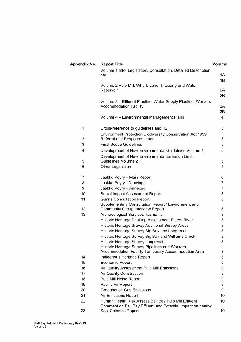
Appendix No. Report Title Volume
Volume 1 Into, Legislation, Consultation, Detailed Description etc 1A
1B
Volume 2 Pulp Mill, Wharf, Landfill, Quarry and Water Reservoir 2A
2B
Volume 3 – Effluent Pipeline, Water Supply Pipeline, Workers Accommodation Facility 3A
3B Volume 4 – Environmental Management Plans 4
1 Cross-reference to guidelines and IIS 5
2 Environment Protection Biodiversity Conservation Act 1999 Referral and Response Letter 5
3 Final Scope Guidelines 5 4 Development of New Environmental Guidelines Volume 1 5
5 Development of New Environmental Emission Limit Guidelines Volume 2 5
6 Other Legislation 5
7 Jaakko Poyry – Main Report 6 8 Jaakko Poyry - Drawings 7 9 Jaakko Poyry – Annexes 7 10 Social Impact Assessment Report 8 11 Gunns Consultation Report 8
12 Supplementary Consultation Report / Environment and Community Group Interview Report 8
13 Archaeological Services Tasmania 8 Historic Heritage Desktop Assessment Pipers River 8 Historic Heritage Sruvey Additional Survey Areas 8 Historic Heritage Survey Big Bay and Longreach 8 Histroic Heritage Survey Big Bay and Williams Creek 8 Historic Heritage Survey Longreach 8
Historic Heritage Survey Pipelines and Workers Accommodation Facility Temporary Accommodation Area 8
14 Indigenous Heritage Report 8 15 Economic Report 9 16 Air Quality Assessment Pulp Mill Emissions 9 17 Air Quality Construction 9 18 Pulp Mill Noise Report 9 19 Pacific Air Report 9 20 Greenhouse Gas Emissions 9 21 Air Emissions Report 10 22 Human Health Risk Assess Bell Bay Pulp Mill Effluent 10
23 Comment on Bell Bay Effluent and Potential Impact on nearby Seal Colonies Report 10
Bell Bay Pulp Mill Preliminary Draft IIS Volume 3

Appendix No. Report Title Volume 24 Marine Outfall Report 11 25 Wharf Report 11
26 Environmental Investigation at Proposed Tamar River Crossing for Water Supply Pipeline 11
27 Marine Monitoring Spring 05 11 28 Donovans Bay Assessment Report 11 29 Flora Report 12 30 Bell Bay Pulp Mill Fauna Report 13 31 Effluent Pipeline Forest Practices Plan 13 32 Pulp Mill Forest Practices Plan 13 33 Water Pipeline Forest Practices Plan 13 34 Workers Accommodation Forest Practices Plan 13 35 Eagle Nest Search Report 13
36 Survey for Tasmanian Masked Owl on Proposed Pulp Mill Site 13
37 Workers Accommodation Facility Report 14 38 Pulpwood Supply 14 39 Quarry Application Report 14 40 Subdivision Plan Report 14 41 Soil Baseline 2006 14 42 Lighting Assessment 14 43 Transport Assessment 15
44 Water Report - Concept Design for Water Supply from Lake Trevallyn 15
45 Effluent Pipeline Design Basis 15
46 Gas Pipeline Lateral and Station Report 15 47 Bell Bay Pulp Mill Wharf Facility Report 15 48 Preliminary Hazard Analysis 15 49 Blasting Risk Analysis 15
50 Gunns Pulp Mill Effluent Pipeline Four Mile Beach Dune Remediation and Revegetation 16
51 Geomorphological Assessment Proposed Shoreline Crossing Area Effluent Pipeline 16
52 Effluent Pipeline Ocean Outfall Investigation 16
53 Gunns Pulp Mill Effluent Pipeline Four Mill Beach Dune Crossing Geological Setting 16
54 Donovan’s Bay Construction Management Plan 16 55 Gunns Pulp Mill Solid Waste Landfill Conceptual Design 16 56 Tamar River Crossing report 16 57 Operational Monitoring Program 16 58 Toxicity of Effluent Pine Pulping 17 59 Toxicity of Effluent Eucalypt Pulping 17 60 Toxicity of Chlorate to Brown Algae 17 61 Onshore Geotechnical Investigation 18 62 Pulp Mill Geotechnical Investigations 18 63 Hydrodynamic modelling ocean outfall 18 64 Hydrodynamic modelling Tamar River 18
Bell Bay Pulp Mill Preliminary Draft IIS Volume 3

Table Index Table 2-1 Design Water Demand for the Pulp Mill 2-7
Table 2-2 Details of Proposed Pipe Diameter 2-16
Table 3-1 Land Ownership – Water Supply Pipeline 3-23
Table 3-2 Properties with Part V Rights Adjacent to Lake Trevallyn 3-30
Table 3-3 Summary of Trevallyn Dam Flow Data 3-32
Table 3-4 Waste Disposal Sites 3-37
Table 3-5 Summary of Geotechnical Information at Tamar River Crossing – Initial Investigations 3-42
Table 3-6 Summary of Geotechnical Information at Tamar River Crossing – Additional Investigations 3-42
Table 3-7 State conservation status and bioregional conservation priorities of vegetation communities, Water Supply Pipeline 3-68
Table 3-8 Vascular flora species of national or state conservation significance recorded, or predicted to occur within, 5 kilometres of the proposed Water Supply Pipeline 3-75
Table 3-9 Threatened species protected under the State and Commonwealth legislation previously recorded or predicted to occur in the water supply pipeline corridor – desktop review and field assessment 3-103
Table 3-10 Fauna species considered of conservation significance in Tasmania previously recorded or predicted to occur in the water supply pipeline study area 3-105
Table 3-11 Additional migratory and marine overfly species previously recorded or predicted to occur in the water supply pipeline study area 3-108
Table 3-12 Registered Aboriginal Sites along the Proposed Water Supply Pipeline Routes 3-136
Table 3-13 Summary of Site Based Searches 3-138
Table 3-14 Existing Items of Heritage Significance along the Water Supply Pipeline Route (located during survey) 3-147
Bell Bay Pulp Mill Preliminary Draft IIS Volume 3

Table 4-1 Key For Each Rating Used Within the Impact Assessment 4-151
Table 5-1 Approval Status - Water Supply Pipeline (George Town Planning Scheme) 5-152
Table 5-2 Approval Status - Water Supply Pipeline (Launceston Planning Scheme) 5-153
Table 5-3 Summary of potential impact rating and management measures – land use and planning 5-155
Table 5-4 Summary of potential impact rating and management measures – infrastructure and services 5-157
Table 5-5 Summary of potential impact rating and management measures – topography, climate and meteorology 5-154
Table 5-6 Summary of potential impact rating and mitigation measures – air quality 5-156
Table 5-7 Summary of potential impact rating and mitigation measures – geology and soils 5-158
Table 5-8 Impact of Mill Water Extraction on Lake Trevallyn 5-159
Table 5-9 Percentage Average Seasonal Impact on Net Power Station and Cataract Gorge Flows 5-160
Table 5-11 Main Water Crossings 5-161
Table 5-12 Summary of potential impact rating and mitigation measures – groundwater and hydrology 5-163
Table 5-13 Summary of potential impact rating and mitigation measures – aquatic ecology 5-168
Table 5-14 Summary of potential flora-related impacts and mitigation measures, including the overall rating if mitigation measures are fully implemented, Water Supply Pipeline 5-174
Table 5-15 Summary of potential impact rating and mitigation measures – terrestrial flora 5-178
Table 5-16 Summary of potential fauna-related impacts and mitigation measures, including the overall rating if mitigation measures are fully implemented, Water Supply Pipeline 5-186
Table 5-17 Summary of potential impact rating and mitigation measures – terrestrial flora 5-190
Bell Bay Pulp Mill Preliminary Draft IIS Volume 3
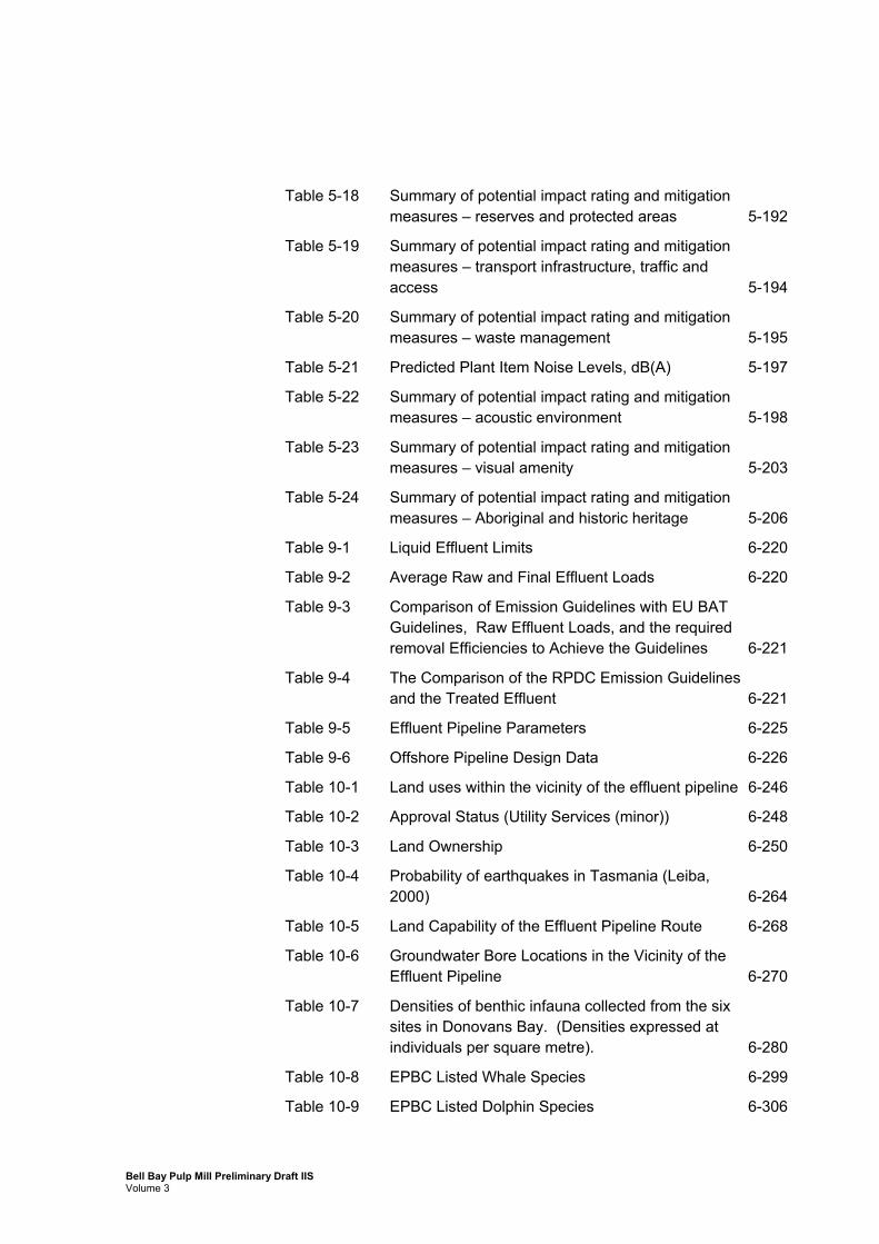
Table 5-18 Summary of potential impact rating and mitigation measures – reserves and protected areas 5-192
Table 5-19 Summary of potential impact rating and mitigation measures – transport infrastructure, traffic and access 5-194
Table 5-20 Summary of potential impact rating and mitigation measures – waste management 5-195
Table 5-21 Predicted Plant Item Noise Levels, dB(A) 5-197
Table 5-22 Summary of potential impact rating and mitigation measures – acoustic environment 5-198
Table 5-23 Summary of potential impact rating and mitigation measures – visual amenity 5-203
Table 5-24 Summary of potential impact rating and mitigation measures – Aboriginal and historic heritage 5-206
Table 9-1 Liquid Effluent Limits 6-220
Table 9-2 Average Raw and Final Effluent Loads 6-220
Table 9-3 Comparison of Emission Guidelines with EU BAT Guidelines, Raw Effluent Loads, and the required removal Efficiencies to Achieve the Guidelines 6-221
Table 9-4 The Comparison of the RPDC Emission Guidelines and the Treated Effluent 6-221
Table 9-5 Effluent Pipeline Parameters 6-225
Table 9-6 Offshore Pipeline Design Data 6-226
Table 10-1 Land uses within the vicinity of the effluent pipeline 6-246
Table 10-2 Approval Status (Utility Services (minor)) 6-248
Table 10-3 Land Ownership 6-250
Table 10-4 Probability of earthquakes in Tasmania (Leiba, 2000) 6-264
Table 10-5 Land Capability of the Effluent Pipeline Route 6-268
Table 10-6 Groundwater Bore Locations in the Vicinity of the Effluent Pipeline 6-270
Table 10-7 Densities of benthic infauna collected from the six sites in Donovans Bay. (Densities expressed at individuals per square metre). 6-280
Table 10-8 EPBC Listed Whale Species 6-299
Table 10-9 EPBC Listed Dolphin Species 6-306
Bell Bay Pulp Mill Preliminary Draft IIS Volume 3

Table 10-10 EPBC Listed Pinniped Species 6-307
Table 10-11 Species List of Pipefish, Sea Dragons and Seahorses 6-308
Table 10-12 EPBC Listed Seabird Species 6-310
Table 10-13 Maximum count of shorebird species, summer or winter, at George Town/Tamar Estuary 1992-1999 6-311
Table 10-14 Survey Information from Other Relevant Sites 6-313
Table 10-15 The distinguishing characteristics of each of the Bioregions 6-317
Table 10-16 State conservation status and bioregional conservation priorities of vegetation communities, Effluent Pipeline 6-328
Table 10-17 Vascular flora species of national or state conservation significance recorded, or predicted to occur within, 5 kilometres of the proposed Effluent Pipeline (and outfall area) 6-341
Table 10-18 Population estimate for Acacia ulicifolia (rare in Tasmania), Effluent Pipeline 6-350
Table 10-19 Population estimate for Calocephalus lacteus (rare in Tasmania), Effluent Pipeline 6-352
Table 10-20 Population estimate for Chorizandra enodis (rare in Tasmania), Effluent Pipeline 6-353
Table 10-21 Population estimate for Hypoxis vaginata var. brevistigmata (rare in Tasmania), Effluent Pipeline 6-354
Table 10-22 Population estimate for Juncus amabilis (rare in Tasmania), Effluent Pipeline 6-355
Table 10-23 Population estimate for Pimelea flava subsp. flava (rare in Tasmania), Effluent Pipeline 6-356
Table 10-24 Population estimate for Stylidium inundatum (rare in Tasmania), Effluent Pipeline 6-357
Table 10-25 Threatened species protected under the State and Commonwealth legislation previously recorded or predicted to occur in the effluent pipeline study region 6-367
Table 10-26 Fauna species considered of conservation significance in Tasmania previously recorded or predicted to occur in the effluent pipeline study region 6-369
Bell Bay Pulp Mill Preliminary Draft IIS Volume 3

Table 10-27 Additional migratory and marine overfly species previously recorded or predicted to occur in the effluent pipeline study region 6-372
Table 10-28 Registered Aboriginal Sites along the Proposed Effluent Pipe Corridor 6-398
Table 10-29 Aboriginal Heritage Items along the Proposed Effluent Pipeline 6-400
Table 11-1 Approval Status (Utility Services (minor)) 6-403
Table 11-2 Summary of potential impact rating and management measures – land use and planning 6-405
Table 11-3 Summary of potential impact rating and mitigation measures – infrastructure and services 6-407
Table 11-4 Summary of potential impact rating and mitigation measures – topography, climate and meteorology 6-413
Table 11-5 Summary of potential impact rating and mitigation measures – air quality 6-415
Table 11-6 Summary of potential impact rating and mitigation measures – geology and soils 6-417
Table 11-7 Diffuser Configuration 6-420
Table 11-8 Assumed Receiving Water Conditions 6-421
Table 11-9 Effluent Characteristics 6-423
Table 11-10 Maximum Predicted Concentration Above Ambient, Adopted WQO and WQO Exceedance at the Site of the Proposed Bleached Kraft Pulp Mill Outfall (cell #25) 6-424
Table 11-11 Summary of Effective Dilution and Concentration for the Substances in the Effluent 6-429
Table 11-12 Summary of potential impact rating and mitigation measures – groundwater and hydrology 6-433
Table 11-13 Summary of potential impact rating and mitigation measures – estuarine ecology 6-435
Table 11-14 Effects of Blasting Underwater (adapted from Ecos, 1996). 6-436
Table 11-15 Peak Pressure Due to Explosive Mass (Surface Blast) 6-437
Table 11-16 Peak Pressure Due to Explosive Mass (Drill Hole Blast) 6-437
Bell Bay Pulp Mill Preliminary Draft IIS Volume 3

Table 11-17 Summary of potential impact rating and mitigation measures – marine ecology 6-443
Table 11-18 Summary of toxicity test data for the pulp mill final effluent sample 6-448
Table 11-19 Summary of potential impact rating and mitigation measures – marine ecology 6-453
Table 11-20 Summary of potential flora-related impacts and mitigation measures, including the overall rating if mitigation measures are fully implemented, Effluent Pipeline 6-460
Table 11-21 Rehabilitation measures to be undertaken in the various vegetation zones 6-467
Table 11-22 Summary of potential impact rating and mitigation measures – terrestrial flora 6-468
Table 11-23 Summary of potential fauna-related impacts and mitigation measures, including the overall rating if mitigation measures are fully implemented, Effluent Pipeline and Workers Accommodation Facility 6-475
Table 11-24 Summary of potential impact rating and mitigation measures – terrestrial flora 6-479
Table 11-25 Summary of potential impact rating and mitigation measures – reserves and protected areas 6-481
Table 11-26 Summary of potential impact rating and management measures – health 6-487
Table 11-27 Summary of potential impact rating and mitigation measures – transport infrastructure, traffic and access 6-489
Table 11-28 Summary of potential impact rating and mitigation measures – visual amenity 6-494
Table 11-29 Summary of potential impact rating and mitigation measures – Aboriginal and historic heritage 6-496
Table 14-1 Anticipated accommodation mix 6-505
Table 14-2 Design specifications for the accommodation facility 6-508
Table 15-1 State conservation status and bioregional conservation priorities of vegetation communities, Workers Accommodation Facility 6-519
Table 15-2 Traffic Volume Morning Peak 6-526
Bell Bay Pulp Mill Preliminary Draft IIS Volume 3

Table 15-4 Environmental Noise Monitoring, Comalco, 1998 and 2002 6-527
Table 16-1 Summary of potential impact rating and management measures – land use and planning 6-530
Table 16-2 Summary of potential impact rating and mitigation measures – infrastructure and services 6-532
Table 16-3 Summary of potential impact rating and mitigation measures – air quality 6-533
Table 16-4 Summary of potential impact rating and mitigation measures – geology and soils 6-534
Table 16-5 Summary of potential impact rating and mitigation measures – groundwater and hydrology 6-537
Table 16-6 Summary of potential flora-related impacts and mitigation measures, including the overall rating if mitigation measures are fully implemented, Workers Accommodation Facility 6-541
Table 16-7 Summary of potential impact rating and mitigation measures – terrestrial flora 6-543
Table 16-8 Summary of potential impact rating and mitigation measures – transport infrastructure, traffic and access 6-546
Table 16-9: Proposed accommodation facility construction timetable 6-547
Table 16-10 Allowed operating hours for noisy equipment 6-549
Table 16-11 NSW and Victorian construction noise guidelines 6-550
Table 16-12 Predicted worst case sound pressure levels (Victoria St.) – assumes distance from source is 200 metres, therefore achieving 55 dB(A) attenuation 6-553
Table 16-13 Summary of potential impact rating and mitigation measures – noise and vibration 6-554
Table 16-14 Waste generation estimates based on literature 6-556
Table 16-15 Waste generation estimates based on mining sector (Rio Tinto) standards 6-557
Table 16-16 Summary of potential impact rating and mitigation measures – waste management 6-558
Bell Bay Pulp Mill Preliminary Draft IIS Volume 3
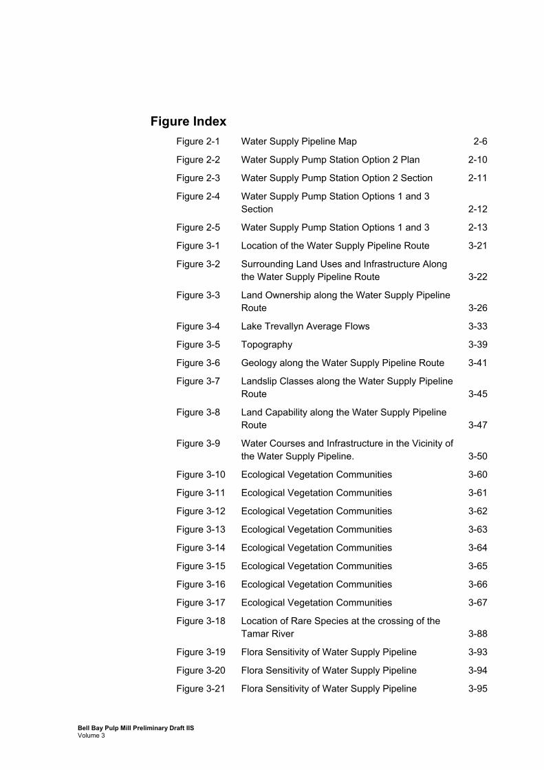
Figure Index Figure 2-1 Water Supply Pipeline Map 2-6
Figure 2-2 Water Supply Pump Station Option 2 Plan 2-10
Figure 2-3 Water Supply Pump Station Option 2 Section 2-11
Figure 2-4 Water Supply Pump Station Options 1 and 3 Section 2-12
Figure 2-5 Water Supply Pump Station Options 1 and 3 2-13
Figure 3-1 Location of the Water Supply Pipeline Route 3-21
Figure 3-2 Surrounding Land Uses and Infrastructure Along the Water Supply Pipeline Route 3-22
Figure 3-3 Land Ownership along the Water Supply Pipeline Route 3-26
Figure 3-4 Lake Trevallyn Average Flows 3-33
Figure 3-5 Topography 3-39
Figure 3-6 Geology along the Water Supply Pipeline Route 3-41
Figure 3-7 Landslip Classes along the Water Supply Pipeline Route 3-45
Figure 3-8 Land Capability along the Water Supply Pipeline Route 3-47
Figure 3-9 Water Courses and Infrastructure in the Vicinity of the Water Supply Pipeline. 3-50
Figure 3-10 Ecological Vegetation Communities 3-60
Figure 3-11 Ecological Vegetation Communities 3-61
Figure 3-12 Ecological Vegetation Communities 3-62
Figure 3-13 Ecological Vegetation Communities 3-63
Figure 3-14 Ecological Vegetation Communities 3-64
Figure 3-15 Ecological Vegetation Communities 3-65
Figure 3-16 Ecological Vegetation Communities 3-66
Figure 3-17 Ecological Vegetation Communities 3-67
Figure 3-18 Location of Rare Species at the crossing of the Tamar River 3-88
Figure 3-19 Flora Sensitivity of Water Supply Pipeline 3-93
Figure 3-20 Flora Sensitivity of Water Supply Pipeline 3-94
Figure 3-21 Flora Sensitivity of Water Supply Pipeline 3-95
Bell Bay Pulp Mill Preliminary Draft IIS Volume 3

Figure 3-22 Flora Sensitivity of Water Supply Pipeline 3-96
Figure 3-23 Flora Sensitivity of Water Supply Pipeline 3-97
Figure 3-24 Flora Sensitivity of Water Supply Pipeline 3-98
Figure 3-25 Flora Sensitivity of Water Supply Pipeline 3-99
Figure 3-26 Flora Sensitivity of Water Supply Pipeline 3-100
Figure 3-27 Water Supply Pipeline Habitat Types 3-117
Figure 3-28 Water Supply Pipeline Habitat Types 3-118
Figure 3-29 Water Supply Pipeline Habitat Types 3-119
Figure 3-30 Water Supply Pipeline Habitat Types 3-120
Figure 3-31 Water Supply Pipeline Habitat Types 3-121
Figure 3-32 Water Supply Pipeline Habitat Types 3-122
Figure 3-33 Water Supply Pipeline Habitat Types 3-123
Figure 3-34 Water Supply Pipeline Habitat Types 3-124
Figure 3-35 Location of Reserves and Protected Areas in the Vicinity of the Water Supply Pipeline 3-126
Figure 3-36 Trevallyn Dam and Surrounds 3-133
Figure 3-37 Location of Existing Cultural Heritage at East Arm 3-140
Figure 3-38 Location of Existing Cultural Heritage at Doctors Rise 3-141
Figure 3-39 Location of Existing Cultural Heritage at Dilston 3-142
Figure 3-40 Location of Existing Cultural Heritage at Lees Apples 3-143
Figure 3-41 Location of Existing Cultural Heritage near Alanvale 3-144
Figure 3-42 Location of Existing Cultural Heritage near Ti Tree Bend 3-145
Figure 3-43 Location of Existing Cultural Heritage near Lake Trevallyn 3-146
Figure 5-1 Long Section of the Water Supply Pipeline 5-159
Figure 8-1 Location of Proposed Effluent Pipeline 6-215
Figure 8-2 Location of Ocean Outfall and Pipe Laydown Area 6-216
Figure 9-1 Shore Crossing and Offshore Construction Method 6-232
Figure 9-2 Shore Crossing Plan Layout 6-233
Figure 9-3 Donovans Bay Crossing 6-238
Bell Bay Pulp Mill Preliminary Draft IIS Volume 3
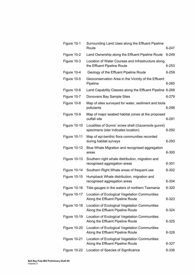
Figure 10-1 Surrounding Land Uses along the Effluent Pipeline Route 6-247
Figure 10-2 Land Ownership along the Effluent Pipeline Route 6-249
Figure 10-3 Location of Water Courses and Infrastructure along the Effluent Pipeline Route 6-253
Figure 10-4 Geology of the Effluent Pipeline Route 6-259
Figure 10-5 Geoconservation Area in the Vicinity of the Effluent Pipeline 6-265
Figure 10-6 Land Capability Classes along the Effluent Pipeline 6-268
Figure 10-7 Donovans Bay Sample Sites 6-279
Figure 10-8 Map of sites surveyed for water, sediment and biota pollutants 6-288
Figure 10-9 Map of major seabed habitat zones at the proposed outfall site 6-291
Figure 10-10 Localities of Gunns’ screw shell (Gazameda gunnii) specimens (star indicates location) 6-292
Figure 10-11 Map of epi-benthic flora communities recorded during habitat surveys 6-293
Figure 10-12 Blue Whale Migration and recognised aggregation areas 6-300
Figure 10-13 Southern right whale distribution, migration and recognised aggregation areas 6-301
Figure 10-14 Southern Right Whale areas of frequent use 6-302
Figure 10-15 Humpback Whale distribution, migration and recognised aggregation areas 6-304
Figure 10-16 Tide-gauges in the waters of northern Tasmania 6-320
Figure 10-17 Location of Ecological Vegetation Communities Along the Effluent Pipeline Route 6-323
Figure 10-18 Location of Ecological Vegetation Communities Along the Effluent Pipeline Route 6-324
Figure 10-19 Location of Ecological Vegetation Communities Along the Effluent Pipeline Route 6-325
Figure 10-20 Location of Ecological Vegetation Communities Along the Effluent Pipeline Route 6-326
Figure 10-21 Location of Ecological Vegetation Communities Along the Effluent Pipeline Route 6-327
Figure 10-22 Location of Species of Significance 6-336
Bell Bay Pulp Mill Preliminary Draft IIS Volume 3

Figure 10-23 Location of Species of Significance 6-337
Figure 10-24 Location of Species of Significance 6-338
Figure 10-25 Location of Species of Significance 6-339
Figure 10-26 Location of Species of Significance 6-340
Figure 10-27 Flora Sensitivity 6-360
Figure 10-28 Flora Sensitivity 6-361
Figure 10-29 Flora Sensitivity 6-362
Figure 10-30 Flora Sensitivity 6-363
Figure 10-31 Flora Sensitivity 6-364
Figure 10-32 Effluent Pipeline and Ocean Outfall Habitat Types 6-383
Figure 10-33 Effluent Pipeline and Ocean Outfall Habitat Types 6-384
Figure 10-34 Effluent Pipeline and Ocean Outfall Habitat Types 6-385
Figure 10-35 Effluent Pipeline and Ocean Outfall Habitat Types 6-386
Figure 10-36 Effluent Pipeline and Ocean Outfall Habitat Types 6-387
Figure 10-37 Transect Locations and Threatened Species Sightings at the Effluent Pipeline 6-388
Figure 10-38 Locations of Existing Cultural Heritage at Donovans Bay 6-401
Figure 10-39 Location of Existing Cultural Heritage at Four Mile Beach 6-402
Figure 11-1 Numerical monitoring stations adopted for the analysis of effluent concentrations at the site of the Outfall 6-423
Figure 11-2 Panel illustrating the various types of results 6-427
Figure 11-3 Light transmission percentage during typical passage of the turbid plume associated with the open water disposal of dredged sediments 6-441
Figure 14-1 Accommodation Facility Site Layout 6-506
Figure 14-2 Workers Accommodation Facility Amenities 6-507
Figure 15-1 Existing lot (PID 1882295) from which the accommodation camp lot will be subdivided 6-511
Figure 15-2 Land uses around proposed site 6-513
Figure 15-3 Land zoning around the workers accommodation facility 6-514
Figure 15-4 Accommodation Facility ECVs 6-520
Bell Bay Pulp Mill Preliminary Draft IIS Volume 3
1. Introduction to Volume 3
1.1 General
This volume (Volume 3) of the Draft Bell Bay Pulp Mill IIS considers the potential impacts of, and proposed management measures for, the construction and operation of the proposed:
Water supply pipeline;
Effluent pipeline and ocean outfall; and
Workers accommodation facility.
These components of the project have been considered separately from other project components given their significant spatial differences and the linear nature of the pipeline corridors.
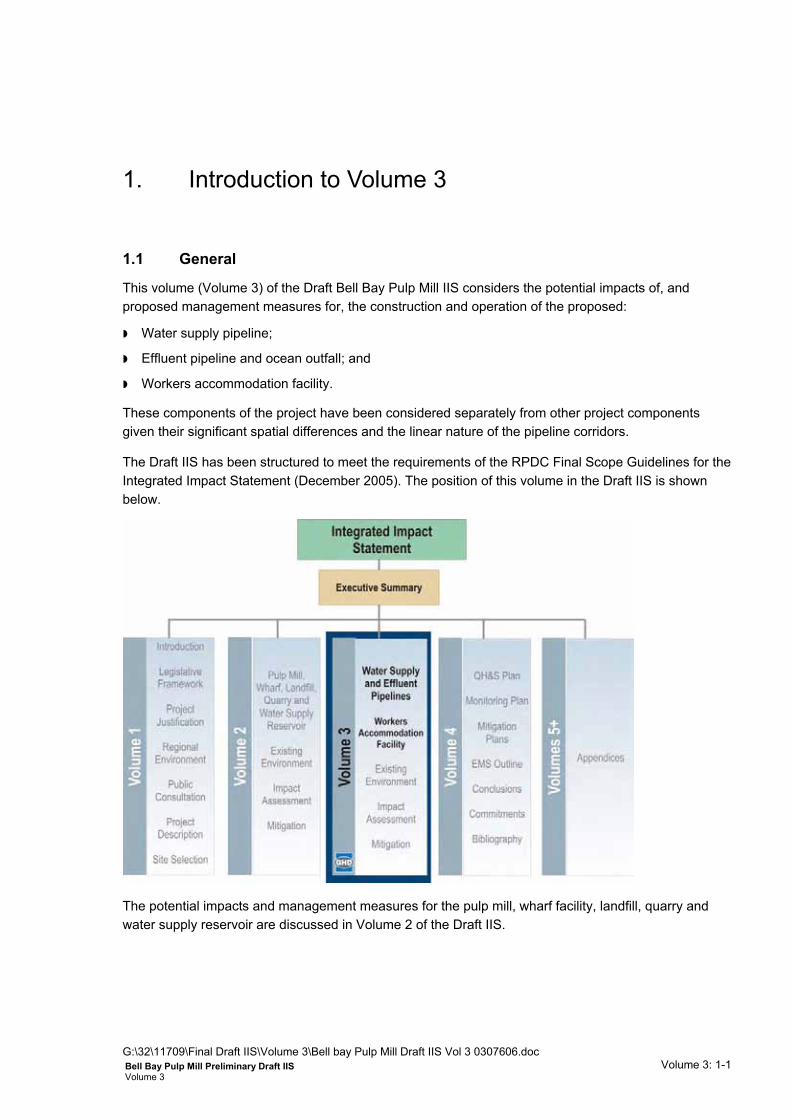
The Draft IIS has been structured to meet the requirements of the RPDC Final Scope Guidelines for the Integrated Impact Statement (December 2005). The position of this volume in the Draft IIS is shown below.
The potential impacts and management measures for the pulp mill, wharf facility, landfill, quarry and water supply reservoir are discussed in Volume 2 of the Draft IIS.
G:\32\11709\Final Draft IIS\Volume 3\Bell bay Pulp Mill Draft IIS Vol 3 0307606.doc Volume 3: 1-1 Bell Bay Pulp Mill Preliminary Draft IIS
Volume 3

1.2 Overview of Components Addressed in Volume 3
1.2.1 Water Supply Pipeline
Gunns proposes to construct and operate an underground water supply pipeline. The pipeline is essential to the operation of the pulp mill, as water will be used to for washing the pulp during the manufacturing process. It is also necessary for energy reuse and for potable water, amongst other uses.
The required water supply for the pulp mill when operating at its full capacity of 1,100,000 ADt/yr is approximately 26 gigalitres per year. Gunns has considered a number of sources for this water (as discussed in Chapter 10, Volume 1), and determined a preferred option of extracting water from the existing Trevallyn Dam near Launceston. The water will be pumped through a 41 km long underground pipe with a diameter ranging from 813 to 1,016 millimetres.
The water supply pipeline will commence near Lake Trevallyn. The proposed alignment from the pump station to the Tamar River follows Trevallyn Road to the balance/control tank near Reatta Road, then run along Reatta Road to Hydro Tasmania’s Trevallyn Power Station intake tunnel alignment. It will follow this line, across Pitt Avenue, the West Tamar Highway and Hydro Tasmania’s Trevallyn Offices to the Tamar River. It will cross the Tamar River at the northern end of the Tamar Cut and, from the Tamar River to the pulp mill site, will generally follow the East Tamar Highway alignment with several sections in private land or along the Esk Water easement.
1.2.2 Effluent Pipeline
An effluent pipeline is required to allow the disposal of treated liquid effluent produced during the pulping process and from biologically treated sanitary sewage.
Gunns proposes to construct and operate an underground effluent pipeline from the effluent treatment plant at the pulp mill to an ocean outfall in Bass Strait.
The effluent pipeline will be approximately 23 kilometres long, 904 millimetres in diameter and will extend from the pulp mill effluent treatment plant to an outfall, approximately 3 km off-shore of Four Mile Beach, on the northern coast of Tasmania. The estimated average final effluent load is 22.5 kL/Adt for optimum production of 1.1 million Adt/yr of pulp. This equates to an approximate daily discharge of 70.7 ML/day or 24,750 ML per annum (based on a 350 day working year).
It is proposed that the effluent pipeline will primarily follow the route of existing infrastructure, including adjacent to the Alinta gas pipeline, East Tamar Highway, rail, electricity transmission line and road corridors and for a short distances through private land.
The off-shore pipeline will extend approximately 3 kilometres into Bass Strait to a depth of approximately 25 m at the discharge point. A multi-port diffuser system will be provided to disperse effluent effectively in the water and allow it to mix and dilute (Jaakko Pöyry, 2005).
The onshore component of the pipeline will be constructed using an open cut trenching method, followed by towing out prefabricated concrete coated steel pipeline string sections.
The offshore component will be constructed using an open trench through the wave zone and ballasting.
G:\32\11709\Final Draft IIS\Volume 3\Bell bay Pulp Mill Draft IIS Vol 3 0307606.doc Volume 3: 1-2 Bell Bay Pulp Mill Preliminary Draft IIS
Volume 3

1.2.3 Workers Accommodation Facility
Jaakko Pöyry estimate that approximately 2,900 workers will be employed at the peak period of construction. This number will fluctuate depending on the construction activities occurring throughout the construction phase.
If required to assist in accommodating construction workers, Gunns propose to establish a temporary workers accommodation facility for 800 personnel at George Town.
The accommodation facility will be established at the southern approaches to the town off the East Tamar Highway.
The 800 residents will be housed in clustered layouts with ensuite accommodation, complete with site-contained services and amenities, and most emergency and operational services.
The workers accommodation facility will be dismantled after the pulp mill has been constructed.
1.2.4 Project Detail and Impact Assessment
This Draft IIS has been prepared based on the design information that was available at the time of writing. As is typical for major projects, the impact assessment process commences early in the project life so as to ensure that:
social and environmental considerations are taken into account by government decision-makers before deciding whether or not to approve the project; and
the outcomes of the assessment and approval process form part of the project development and design.
As a consequence, in some instances the assessment presented in this Draft IIS is based on preliminary design knowledge and the feasibility engineering undertaken by Jaakko Pöyry, GHD Pty Ltd, Pitt and Sherry Pty Ltd, Atteris Pty Ltd and Hargrave Pipeline Group.
The Draft IIS, provided the RPDC is satisfied that it complies with the Scope Guidelines, will contain sufficient information to allow the public and decision-makers to make an informed assessment of the project. It will also assist decision-makers in deciding whether or not to approve the project and, if so, what conditions should be imposed on those approvals. However, detailed engineering design will not occur until approvals have been granted.
Additional technical investigations will be undertaken either prior to or early in the detailed design phase, which may influence aspects of the design of various components. These investigations may include geotechnical studies (ocean outfall, wharf, pulp mill and landfill sites), bathymetric investigations (ocean outfall) and detailed topographical survey (pipeline alignments). Both the additional investigations and detailed design may result in some modifications to the project design from that described in Volume 1 and assessed in the Draft IIS. These studies and any associated design alterations will however be undertaken in accordance with any conditions of approval or the commitments given by Gunns in this Draft IIS, and to the satisfaction of relevant government agencies and Departments. Again, this is typical for such major projects, and such changes will need to be assessed in conjunction with the relevant approval agencies prior to any such works being undertaken.
G:\32\11709\Final Draft IIS\Volume 3\Bell bay Pulp Mill Draft IIS Vol 3 0307606.doc Volume 3: 1-3 Bell Bay Pulp Mill Preliminary Draft IIS
Volume 3

Water Supply Pipeline from Trevallyn Dam
G:\32\11709\Final Draft IIS\Volume 3\Bell bay Pulp Mill Draft IIS Vol 3 0307606.doc Volume 3: 1-4 Bell Bay Pulp Mill Preliminary Draft IIS
Volume 3