image-based place recognition on bucolic …(fig.) 1 illustrates the image retrieval pipeline with...
TRANSCRIPT

Image-Based Place Recognition on Bucolic Environment Across SeasonsFrom Semantic Edge Description
Assia Benbihi1, Stephanie Arravechia2, Matthieu Geist3 and Cedric Pradalier2
Abstract— Most of the research effort on image-based placerecognition is designed for urban environments. In bucolicenvironments such as natural scenes with low texture and littlesemantic content, the main challenge is to handle the variationsin visual appearance across time such as illumination, weather,vegetation state or viewpoints. The nature of the variations isdifferent and this leads to a different approach to describinga bucolic scene. We introduce a global image descriptioncomputed from its semantic and topological information. Itis built from the wavelet transforms of the image’s semanticedges. Matching two images is then equivalent to matching theirsemantic edge transforms. This method reaches state-of-the-artimage retrieval performance on two multi-season environment-monitoring datasets: the CMU-Seasons and the Symphony Lakedataset. It also generalizes to urban scenes on which it is onpar with the current baselines NetVLAD and DELF.
I. INTRODUCTION
Place recognition is the process by which a place thathas been observed before can be identified when revisited.Image-based place recognition achieves this task using im-ages taken with similar viewpoints at different times. This isparticularly challenging for images captured in natural envi-ronments over multiple seasons (e.g. [1] or [2]) because theirappearance is modified as a result of weather, sun position,vegetation state in addition to view-point and lighting, asusual in indoor or urban environments. In robotics, placerecognition is used for the loop-closure stage of most largescale SLAM systems where its reliability is critical [3]. It isalso an important part of any long-term monitoring systemoperating outdoor over many seasons [1], [4].
In practice, place recognition is usually cast as an im-age retrieval task where a query image is matched to themost similar image available in a database. The search iscomputed on a projection of the image content on muchlower-dimensional space. The challenge is then to computea compact image encoding such that images of the samelocation are near to each other despite their change ofappearance due to environmental changes.
Most of the existing methods start with detecting anddescribing local features over the image before aggregatingthem into a low-dimensional vector. The methods differon the local feature detection, description, and aggregation.Most of the research efforts have focused on environmentswith rich semantics such as cities or touristic landmarks [5],[6]. Early methods relied on hand-crafted feature descriptions
1 UMI2958 GeorgiaTech-CNRS, CentraleSupelec, Universite Paris-Saclay, Metz, Thales Group, [email protected]
2 GeorgiaTech Lorraine – UMI2958 GeorgiaTech-CNRS, Metz, France3 Google Research Brain Team
Fig. 1. WASABI computes a global image descriptor for place recognitionover bucolic environments across seasons. It builds upon the image seman-tics and its edge geometry that are robust to strong appearance variationscaused by illumination and season changes. While existing methods aretailored for urban-like scenes, our approach generalizes to bucolic scenesthat offer distinct challenges.
(e.g. SIFT [7]) and simple aggregation based on histogramsconstructed on a clustering of the feature space [8]. Recentbreakthroughs use deep-learning to learn retrieval-specificdetection [6], description [9] and aggregation [5]. Anotherline of work relies on the geometric distribution of the imagesemantic elements to characterize it [10]. However, all ofthese approaches assume that the images have rich semanticsor strong textures and focus on urban environments. On thecontrary, we are interested in scenes described by imagesdepicting nature or structures with few semantic or texturedelements. In the following, such environments, includinglakeshores and parks, will be qualified as ‘bucolic’.
In this paper, we show that an image descriptor basedon the geometry of semantic edges is discriminative enoughto reach State-of-the-Art (SoA) image-retrieval performanceon bucolic environments. The detection step consists ofextracting semantic edges and sorting them by their label.Continuous edges are then described with the wavelet trans-form [11] over a fixed-sized subsampling of the edge. Thisconstitutes the local description step. The aggregation is asimple concatenation of the edge descriptors and their labelswhich, together, make the global image descriptor. Figure(Fig.) 1 illustrates the image retrieval pipeline with ournovel descriptor dubbed WASABI1: A collection of images
1WAvelet SemAntic edge descriptor for BucolIc environment
arX
iv:1
910.
1246
8v3
[cs
.CV
] 2
6 Fe
b 20
20

is recorded along a road during the Spring. Global imagedescriptors are computed and stored in a database. Later inthe year, in Autumn, while we traverse the same road, wedescribe the image at the current location. Place recognitionconsists of retrieving the database image which descriptor isthe nearest to the current one. To compute the image distance,we associate each edge from one image to the nearest edgewith the same semantic label in the other image. The distancebetween the two edges is the Euclidean distance betweendescriptors. The image distance is the sum of the distancesbetween edge descriptors of associated edges.
WASABI is compared to existing image retrieval methodson two outdoor bucolic datasets: the park slices of theCMU-Seasons[2] and Symphony[1], recorded over a periodof 1 year and 3 years respectively. Experiments show thatit outperforms existing methods even when the latter arefinetuned for these datasets. It is also on par with NetVLAD,the current SoA on urban scenes, which is specificallyoptimized for city environments. This shows that WASABIcan generalize across environments.
The contribution of this paper is a novel global imagedescriptor based on semantics edge geometry for image-based place recognition in bucolic environment. Experimentsshow that it is also suitable for urban settings. The descrip-tor’s and the evaluation’s code are available at https://github.com/abenbihi/wasabi.git.
II. RELATED WORK
This section reviews the current state-of-the-art on placerecognition. A common approach to place recognition is toperform global image descriptor matching. The main chal-lenge is defining a compact yet discriminative representationof the image that also has to be robust to illumination,viewpoint and appearance variations.
Early methods build global descriptors with statistics oflocal features over a set of visual words. A first step definesa codebook of visual words by clustering local descriptors,such as SIFT [7], over a training dataset. Given an imageto describe, the Bag of Words (BoW) [8] method assignseach of its local features to one visual word and the out-put statistics are a histogram over the words. The FisherKernels [12] refine this statistical model fitting a mixture ofGaussian over the visual words and the local features. Thisapproach is simplified in VLAD [13] by concatenating thedistance vector between each local feature and its nearestcluster, which is a specific case of the derivation in [12].These methods rely on features based on pixel distributionthat assumes that images have strong textures, which isnot the case for bucolic images. They are also sensitive tovariations in the image appearance such as seasonal changes.In contrast, we rely on the geometry of semantic elementsand that proves to be robust to strong appearance changes.
Recent works aim at disentangling local features and pixelintensity through learned feature descriptions. [9] uses pre-trained Convolutional Neural Network (CNN) feature mapsas local descriptors and aggregates them in a VLAD fashion.Following work NetVLAD [5] specifically trains a CNN to
generate local feature descriptors relevant for image retrieval.It transforms the VLAD hand-crafted aggregation into anend-to-end learning pipeline and reaches top performanceson urban scenes such as the Pittsburg or the Tokyo timemachine datasets [14], [15]. DELF [6] tackles the problemof local feature selection and trains a network to sampleonly features relevant to the image retrieval through anattention mechanism on a landmark dataset. WASABI alsorelies on a CNNs to segment images but not to describethem. Segmentation is indeed robust to appearance changesbut bucolic environments are typically not diverse enough forthe segmentation to suffice for image description. Instead,we fuse this high-level information with edges’ geometricdescription to augment the discriminative power of thedescription.
Similar works also leverage semantics to describe images.Toft et al. [16] compute semantic histograms and Histogramof Oriented Gradients (HoG) over image patches and con-catenate them. VLASE [17] also relies on semantic edgeslearned in an end-to-end manner [18], but adopt a descriptionanalog to VLAD. Local features are pixels that lie on asemantic edge, and they are described with the probabilitydistribution of that pixel to belong to a semantic class, asprovided by the last layer of the CNN. The rest of thedescription pipeline is the same as in VLAD. WASABIdiffers in that it describes the geometric properties of thesemantic edges and neither semantic nor pixel statistics.
Another work [10] that leverages geometry and seman-tics converts images sampled over a trajectory into a 3Dsemantic graph where vertex are semantic units and edgesrepresent their adjacency in the images. A query image isthen transformed into a semantic graph and image retrievalis reduced to a graph matching problem. This derivationassumes that the environment displays enough semantic toavoid ambiguous graphs, which does not occur for bucolicscenes. This is what motivates WASABI to leverage theedges’ geometry for it better discriminates between images.
The edge-based image description is not novel [19] and theliterature offers a wide range of edge descriptors [20]. Butthese local descriptors are usually less robust to illuminationand viewpoint variations than their pixel-based counter-parts. In this work, we fuse edge description with semanticinformation to reach SoA performance on bucolic imageretrieval across seasons. We rely on the wavelet descriptorfor its compact representation while offering uniqueness andinvariance properties [11].
III. METHOD
This section details the three steps of image retrieval: thedetection and description of local features, their aggregation,and the image distance computation. In this paper, a localfeature is constructed as a vector that embeds the geometryof semantic edges.
A. Local feature detection and extraction.
The local feature detection stage takes a color image asinput and outputs a list of continuous edges together with

their semantic labels. Two equivalent approaches can beconsidered. The first is to extract edges from the semanticsegmentation of the image, i.e. its pixel-wise classification.The SoA relies on CNN trained on labeled data [21], [22].The second approach is also based on CNN but directlyoutputs the edges together with their labels [18], [23]. Thefirst approach is favored as there are many more publicsegmentation models than semantic edges ones.
Hence, starting from the semantic segmentation, a post-processing stage is necessary to reduce the labeling noise.Most of this noise consists of labeling errors around edgesor small holes inside bigger semantic units. To reducethe influence of these errors, semantic blobs smaller thanmin blob size are merged with their nearest neighbors.
Furthermore, to make semantic edges robust over longperiods, it is necessary to ignore classes corresponding todynamic objects such as cars or pedestrians. Otherwise, theywould alter the semantic edges and modify the global imagedescriptor. These classes are removed from the segmentationmaps and the resulting hole is filled with the nearest semanticlabels.
Taking the cleaned-up semantic segmentation as input,simple Canny-based edge detection is performed and edgessmaller than min edge size pixels are filtered out.
Segmentation noise may also break continuous edges.So the remaining edges are processed to re-connect edgesbelonging with each other. For each class, if two edge ex-tremities are below a pixel distance min neighbour gap,the corresponding edges are grouped into a unique edge.
The parameters are chosen empirically based on the seg-mentation noise of the images. We use the segmentationmodel from [21]. It features a PSP-Net [22] network trainedon Cityscapes [24] and later finetuned on the Extended-CMU-Seasons dataset. In this case, the relevant detection pa-rameters were min blob size=50, min edge size=50and min neighbour gap=5.
B. Local feature description
Among the many existing edge descriptor, we favor thewavelet descriptor [11] for its properties relevant to imageretrieval. It consits in projecting a signal over a basis ofknown function and is often used to generate a compact yetunique representation of a signal. Wavelet description is notthe only transform to generates a unique representation fora signal. The Fourier descriptors [25], [26] also providessuch a unique embedding. However, the wavelet descriptionis more compact than the Fourier one due to its multiple-scaledecomposition. Empirically, we confirmed that the formerwas more discriminative than the latter for the same numberof coefficients.
Given a 2D contour extracted at the previous step, wesubsample the edge at regular steps and collect N pixels.Their (x, y) locations in the image are concatenated into a 2Dvector. We compute the discrete Haar-wavelet decompositionover each axis separately and concatenate the output thatwe L2 normalize. In the experiments, we set N = 64 andkeep only the even coefficients of the wavelet transforms.
Fig. 2. Symphony. Semantic edge association across strong seasonal andweather variations.
This does not destroy information as the coefficients areredundant. The final edge descriptor is a 128-dimensionvector.
C. Aggregation and Image distance
Aggregation is a simple accumulation of the edge descrip-tors together with their label. Given two images and usingthe aggregated edge descriptors, the image distance is theaverage distance between matching edges. More precisely,edges belonging to the same semantic class are associ-ated across the images solving an assignment problem (seeFig. 2). The distance used is the Euclidean distance betweenedge descriptors and the image distance is the average ofthe associated descriptor distances. In a retrieval setting, wecompute such a distance between the query image and everyimage in the database and return the database entry with thelowest distance.
Fig. 3. Extended CMU-Seasons. Top: images. Down: segmentation insteadof the semantic edge for better visualization. Each column depicts onelocation from a i and a camera j that we note i cj. Each line depitcsthe same location over several traversals noted T.
IV. EXPERIMENTS
This section details the experimental setup and presentsresults for our approach against methods for which pub-lic code is available: BoW[8], VLAD[27], NetVLAD[5],DELF[6], Toft et al. [16], and VLASE [17]. We demonstratethe retrieval performance on two outdoor bucolic datasets:CMU-Seasons[2] and Symphony[1], recorded over a periodof 1 year and 3 years respectively. Although existing methodsreach SoA performance on urban environments, our approachproves to outperform them on bucolic scenes, and so, even
when they are finetuned. It also shows better generalizationas it achieves near SoA performance of the urban slices onthe CMU-Seasons dataset.
A. Datasets
a) Extended CMU-Seasons: The Extended CMU-Seasons dataset (Fig. 3) is an extended version of the CMU-Seasons [28] dataset. It depicts urban, suburban, and parkscenes in the area of Pittsburgh, USA. Two front-facingcameras are mounted on a car pointing to the left/right ofthe vehicle at approximately 45 degrees. Eleven traversals arerecorded over a period of 1 year and the images from the twocameras do not overlap. The traversals are divided into 24spatially disjoint slices, with slices [2-8] for urban scenes, [9-17] for suburban and [18-25] for the park scenes respectively.All retrieval methods are evaluated on the park scenes forwhich ground-truth poses are available [22-25]. The otherpark scenes [18-21] can be used to train learning approaches.For each slice in [22-25], one traversal is used as the imagedatabase and the 10 other traversals are the queries. In total,there are 78 image sets of roughly 200 images with ground-truth camera poses. Fig. 3 shows examples of matchingimages over multiple seasons with significant variations.
b) Lake: The Symphony [1] dataset consists of 121visual traversals of the shore of Symphony Lake in Metz,France. The 1.3 km shore is surveyed using a pan-tilt-zoom(PTZ) camera and a 2D LiDAR mounted on an unmannedsurface vehicle. The camera faces starboard as the boatmoves along the shore while maintaining a constant distance.The boat is deployed on average every 10 days from Jan6, 2014 to April 3, 2017. In comparison to the roadwaydatasets, it holds a wider range of illumination and seasonalvariations and much less texture and semantic features, whichchallenges existing place recognition methods.
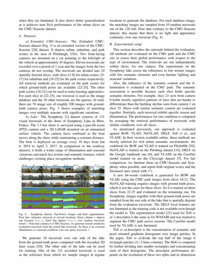
Fig. 4. Symphony dataset. Top-Down: images and their segmentation.First line: reference traversal at several locations. Each column k depictsone location Pos.k. Each line depicts Pos.k over random traversalsnoted T. Note that contrary to CMU-Seasons, we generate mixed-conditionsevaluation traversals from the actual lake traversals. So there is no constantillumination or seasonal condition over one query traversal T.
We generate 10 traversals over one side of the lakefrom the ground-truth poses computed with the recorded 2Dlaser scans [29]. The other side of the lake can be usedfor training. One of the 121 recorded traversals is usedas the reference from which we sample images at regular
locations to generate the database. For each database image,the matching images are sampled from 10 random traversalsout of the 120 left. Note that contrary to the CMU-Seasonsdataset, this means that there is no light and appearancecontinuity over one traversal (Fig. 4).
B. Experimental setup
This section describes the rationale behind the evaluation.All methods are evaluated on the CMU park and the CMUcity to assess their global performance with respect to thetype of environment. The retrievals are run independentlywithin slices, for one camera. The experiments on theSymphony lake assess the robustness to low texture imageswith few semantic elements and even harsher lighting andseasonal variations.
Also, the influence of the semantic content and the il-lumination is evaluated on the CMU park. The semanticassessment is possible because each slice holds specificsemantic elements. For example, slice 23 seen from camera0 holds mostly repetitive patterns of trees that are harder todifferentiate than the building skyline seen from camera 1 onslice 25. Slices with similar semantic content are evaluatedtogether. Similarly, each traversal exhibit specific season andillumination. The performance for one condition is computedby averaging the retrieval performance of traversals withsimilar conditions over all slices.
As mentioned previously, our approach is evaluatedagainst BoW, VLAD, NetVLAD, DELF, Toft et al., andVLASE. In their version available online, these methods aremostly tailored for rich urban semantic environments: thecodebook for BoW and VLAD is trained on Flickr60k [30],NetVLAD is trained on the Pittsburg dataset [14], DELF onthe Google landmark one [6], and VLASE on the CaseNetmodel trained on are the Cityscape dataset [?]. For faircomparison, we finetune them on CMU-Seasons and Sym-phony when possible, and report both original scores and thefinetuned ones noted with (*).
A new 64-words codebook is generated for BOW andVLAD, using the CMU park images from slices 18-21. TheNetVLAD training requires images with ground-truth poses,which is not the cases for these slices. So it is trained on threeslices from 22-25 and evaluated on the remaining one. OnSymphony, images together with their ground-truth poses aresampled from the east side of the lake that is spatially disjointfrom the evaluation traversals. The DELF local features arenot finetuned as the training code is not available even thoughthe model is. The segmentation model [21] used for Toft etal.’s descriptor is the same as for WASABI and was trained tosegment the CMU park across seasons. The CaseNet modelused by VLASE is not finetuned.
Toft et al.descriptor is the concatenation of semantic andpixel oriented gradients histograms over image patches. Inthe paper, Toft et al.divide the top half of the image 6rectangle patches (2×3 lines-column). The HoG is computedby further dividing into smaller rectangles and concatenatingeach of their histograms. The descriptor performance de-pends on the resolution of these two splits and its dimension

increases with it. A grid of parameters is tested and the bestresults are reached when it is the highest: this is expectedas such a resolution embeds more detail about local imageinformation which helps discriminate between image. The7506-dim descriptor is derived from the top two-thirds ofthe image divided into 6 × 9 patches, with into 4 × 4 sub-rectangles and the HoG has an 8-bin discretization. Furtherdimensionality reduction is out of the scope of this paper,and we report the results for both the high-resolution andthe original one.
A grid search is also run on VLASE to select the prob-ability threshold Te above which a pixel is a local feature,and the maximum number of features to keep in one image.The best results are reported for Te = 0.5 and 3000 featuresper image.
C. Metrics
The place recognition metrics are the recall@N and themean Average Precision (mAP)[31]. Both depend on a dis-tance threshold ε: a retrieved database image matches thequery if the distance between their camera center is below ε.The recall@N is the percentage of queries for which there isat least one matching database image in the first N retrievedimages. We set N ∈ {1, 5, 10, 20}, and ε to 5m and 2m forthe CMU-Seasons and the Symphony datasets respectively.Both metrics are available in the code.
D. Results
Overall, semantic-based methods are better suited thanexisting ones to describe bucolic scenes, even when they areoriginally tailored for urban environments such as VLASEand [16]. WASABI achieves better performance when thesemantic segmentation is reliable (CMU-Park) but is lessrobust when it exhibits noise (Symphony) (Fig. 5). It general-izes well to cities and appears to better handle the vegetationdistractors than SoA methods (Fig. 7) The rest of this sectiondetails the results.
1 5 10 20N - Number of retrieved images
0
10
20
30
40
50
60
70
80
90
100
Rec
all@
N(%
)
Ext-CMU-Seasons (park)
random
bow
bow tuned
vlad
vlad tuned
delf
netvlad
netvlad tuned
vlase
toft etal (834)
toft etal (7506)
wasabi
1 5 10 20N - Number of retrieved images
0
10
20
30
40
50
60
70
80
90
100
Rec
all@
N(%
)
Symphony-Seasons
1 5 10 20N - Number of retrieved images
0
10
20
30
40
50
60
70
80
90
100
Rec
all@
N(%
)
Ext-CMU-Seasons (city)
Fig. 5. Retrieval performance for each dataset measured with theRecall@N . Retrieval is performed based on the similarity of the descriptorsand no further post-processing is run for all methods. The high-resolutiondescription from [16] reaches the best score, followed by WASABI andcurrent SoA methods. These results suggest that a hand-designed descriptorcan compare with existing deep approaches.
a) Global Performance: Fig. 5 plots the Recall@Nover the three types of environments: the CMU park, theSymphony lake, and the CMU city. Overall, the method fromToft et al. [16] achieves the best results when it aggregateslocal descriptors at a high resolution (toft etal (7506)). Thenecessary memory overhead may be addressed with dimen-sionality reduction but this is out of the scope of this paper.
WASABI achieves the 2nd best performance of the CMUpark while only slightly underperforming the SoA NetVLADand DELF on urban environments. This is expected asthe SoA is optimized for such settings. Still, this showsthat our method generalizes to both types of environments.Also, this suggests that semantic edges are discriminativeenough to recognize a scene, even when there are fewsemantic elements such as in the park. This assumption iscomforted by the satisfying performance of VLASE, whichalso leverages semantic edges to compute local features. Notethat while it underperforms WASABI on the CMU-Park, itprovides better results on the Symphony data, as does [16].
Fig. 6. Segmentation failures. Left column: CMU-Seasons. A strongsunglare is present along survey 6 (sunny spring) or 8(snowy winter). Othercolumns: Symphony. The segmentation is not finetuned on the lake andproduces a noisier output. It is also sensitive to sunglare.
On Symphony, WASABI falls behind VLASE and Toft’sdescriptor. This is unexpected given the satisfying resultson the CMU-Park. There are two main explanations forthese poor results: the first is that the segmentation modeltrained for the CMU images generates noisy outputs on theSymphony images, especially around the edges (Fig. ??).So the WASABI wavelet descriptors can not be consistentenough across images. One reason that allows [16] andVLASE to be robust to this noise is that they do not relyon the semantic edge geometry directly: Toft et al. leveragesthe semantic information in the form of a label histogramwhich is less sensitive to noise than segmentation itself.A similar could explain VLASE’s robustness even tough itsamples local features from those same semantic edges. Thefinal histogram of semantic local feature is less sensitive tosemantic noise than the semantic edge coordinates on whichWASABI relies. The second explanation for WASABI’sunderperformance on WASABI is the smaller edge densitiescompared to the CMU data. This suggests that the geometricinformation should be leveraged at a finer scale than the
edge’s one. This is addressed in the next chapter along withthe scalability issues.
Finetuning existing methods to the bucolic scenes provesto be useful for VLAD only on CMU-Park but does notimprove the overall performance for BoW and NetVLAD.A plausible explanation is that these methods require moredata than the one available. Investigating the finetuning ofthese methods is out of the scope of this paper.
b) Semantic analysis: Fig. 7 plots the retrieval per-formance on CMU scenes with various semantics. Overall,WASABI exhibits a significant advantage over SoA onscenes with sparse bucolic elements (top-left). However,When the slices hold mostly dense trees along the road, allperformances drop because the images hold repetitive pixelintensity patterns, few edges and little semantic information.This limits the amount of information WASABI can relyon to summarize an image, which restrains the descriptionspace. As for VLASE, in addition to the few edges toleverage, the highly repetitive patterns lead to similar se-mantic edge probabilities. So their aggregation into an imagedescriptor is not discriminative enough to differentiate suchscenes. A similar explanation holds for the [16] descriptor ofwhich both the semantic histogram and SIFT-like descriptorsare similar across images. Once again, the main cause is theredundancy of the image information.
1 5 10 20N - Number of retrieved images
0
10
20
30
40
50
60
70
80
90
100
Rec
all@
N(%
)
Park Sparse Trees
random
bow
bow tuned
vlad
vlad tuned
delf
netvlad
netvlad tuned
vlase
toft etal (834)
toft etal (7506)
wasabi
1 5 10 20N - Number of retrieved images
0
10
20
30
40
50
60
70
80
90
100
Rec
all@
N(%
)
Park Dense Trees
1 5 10 20N - Number of retrieved images
0
10
20
30
40
50
60
70
80
90
100
Rec
all@
N(%
)
City and Vegetation
1 5 10 20N - Number of retrieved images
0
10
20
30
40
50
60
70
80
90
100
Rec
all@
N(%
)
City
Fig. 7. Ext-CMU-Seasons. Retrieval results on urban scenes with vegetationelements v.s. urban scenes with only city structures.
Note that this is also an open problem for urban environ-ments. One of the few works that tackle this specific problemis [14]. Torii et al. propose to weight the aggregation oflocal features so that repetitive ones do not dominate thesparser one. However, this processing can not be integratedas is since dense bucolic scenes are entirely dominated
by redundant patterns. So there is no other discriminativeinformation to balance them with. The integration of suchbalancing is the object of future work to tackle the challengeof repetitive patterns in natural scenes.
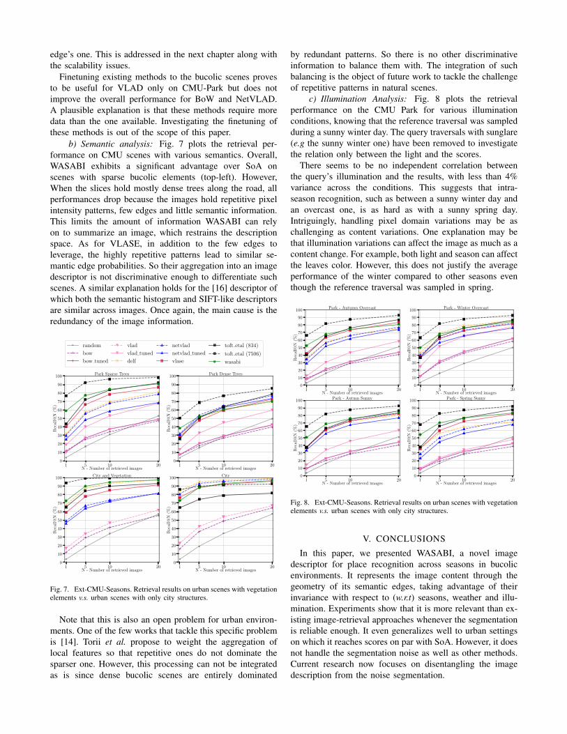
c) Illumination Analysis: Fig. 8 plots the retrievalperformance on the CMU Park for various illuminationconditions, knowing that the reference traversal was sampledduring a sunny winter day. The query traversals with sunglare(e.g the sunny winter one) have been removed to investigatethe relation only between the light and the scores.
There seems to be no independent correlation betweenthe query’s illumination and the results, with less than 4%variance across the conditions. This suggests that intra-season recognition, such as between a sunny winter day andan overcast one, is as hard as with a sunny spring day.Intriguingly, handling pixel domain variations may be aschallenging as content variations. One explanation may bethat illumination variations can affect the image as much as acontent change. For example, both light and season can affectthe leaves color. However, this does not justify the averageperformance of the winter compared to other seasons eventhough the reference traversal was sampled in spring.
1 5 10 20N - Number of retrieved images
0
10
20
30
40
50
60
70
80
90
100
Rec
all@
N(%
)
Park - Autumn Overcast
1 5 10 20N - Number of retrieved images
0
10
20
30
40
50
60
70
80
90
100
Rec
all@
N(%
)
Park - Winter Overcast
1 5 10 20N - Number of retrieved images
0
10
20
30
40
50
60
70
80
90
100
Rec
all@
N(%
)
Park - Autmn Sunny
1 5 10 20N - Number of retrieved images
0
10
20
30
40
50
60
70
80
90
100
Rec
all@
N(%
)
Park - Spring Sunny
Fig. 8. Ext-CMU-Seasons. Retrieval results on urban scenes with vegetationelements v.s. urban scenes with only city structures.
V. CONCLUSIONS
In this paper, we presented WASABI, a novel imagedescriptor for place recognition across seasons in bucolicenvironments. It represents the image content through thegeometry of its semantic edges, taking advantage of theirinvariance with respect to (w.r.t) seasons, weather and illu-mination. Experiments show that it is more relevant than ex-isting image-retrieval approaches whenever the segmentationis reliable enough. It even generalizes well to urban settingson which it reaches scores on par with SoA. However, it doesnot handle the segmentation noise as well as other methods.Current research now focuses on disentangling the imagedescription from the noise segmentation.

REFERENCES
[1] S. Griffith, G. Chahine, and C. Pradalier, “Symphony lake dataset,”The International Journal of Robotics Research, vol. 36, no. 11, pp.1151–1158, 2017.
[2] T. Sattler, W. Maddern, C. Toft, A. Torii, L. Hammarstrand, E. Sten-borg, D. Safari, M. Okutomi, M. Pollefeys, J. Sivic, et al., “Bench-marking 6dof outdoor visual localization in changing conditions,” inProceedings of the IEEE Conference on Computer Vision and PatternRecognition, 2018, pp. 8601–8610.
[3] M. Cummins and P. Newman, “Appearance-only slam at large scalewith fab-map 2.0,” The International Journal of Robotics Research,vol. 30, no. 9, pp. 1100–1123, 2011.
[4] W. Churchill and P. Newman, “Experience-based navigation for long-term localisation,” The International Journal of Robotics Research,vol. 32, no. 14, pp. 1645–1661, 2013.
[5] R. Arandjelovic, P. Gronat, A. Torii, T. Pajdla, and J. Sivic, “Netvlad:Cnn architecture for weakly supervised place recognition,” in Pro-ceedings of the IEEE conference on computer vision and patternrecognition, 2016, pp. 5297–5307.
[6] H. Noh, A. Araujo, J. Sim, T. Weyand, and B. Han, “Large-scale imageretrieval with attentive deep local features,” in Proceedings of the IEEEInternational Conference on Computer Vision, 2017, pp. 3456–3465.
[7] D. G. Lowe, “Distinctive image features from scale-invariant key-points,” International journal of computer vision, vol. 60, no. 2, pp.91–110, 2004.
[8] J. Sivic and A. Zisserman, “Video google: A text retrieval approachto object matching in videos,” in null. IEEE, 2003, p. 1470.
[9] A. Babenko, A. Slesarev, A. Chigorin, and V. Lempitsky, “Neuralcodes for image retrieval,” in European conference on computer vision.Springer, 2014, pp. 584–599.
[10] A. Gawel, C. Del Don, R. Siegwart, J. Nieto, and C. Cadena, “X-view: Graph-based semantic multi-view localization,” IEEE Roboticsand Automation Letters, vol. 3, no. 3, pp. 1687–1694, 2018.
[11] G.-H. Chuang and C.-C. Kuo, “Wavelet descriptor of planar curves:Theory and applications,” IEEE Transactions on Image Processing,vol. 5, no. 1, pp. 56–70, 1996.
[12] F. Perronnin, Y. Liu, J. Sanchez, and H. Poirier, “Large-scale imageretrieval with compressed fisher vectors,” in 2010 IEEE ComputerSociety Conference on Computer Vision and Pattern Recognition.IEEE, 2010, pp. 3384–3391.
[13] H. Jegou, M. Douze, C. Schmid, and P. Perez, “Aggregating localdescriptors into a compact image representation,” in IEEE Conferenceon Computer Vision & Pattern Recognition, jun 2010. [Online].Available: http://lear.inrialpes.fr/pubs/2010/JDSP10
[14] A. Torii, J. Sivic, T. Pajdla, and M. Okutomi, “Visual place recognitionwith repetitive structures,” in Proceedings of the IEEE conference oncomputer vision and pattern recognition, 2013, pp. 883–890.
[15] A. Torii, R. Arandjelovic, J. Sivic, M. Okutomi, and T. Pajdla, “24/7place recognition by view synthesis,” in Proceedings of the IEEEConference on Computer Vision and Pattern Recognition, 2015, pp.1808–1817.
[16] C. Toft, C. Olsson, and F. Kahl, “Long-term 3d localization and posefrom semantic labellings,” in Proceedings of the IEEE InternationalConference on Computer Vision, 2017, pp. 650–659.
[17] X. Yu, S. Chaturvedi, C. Feng, Y. Taguchi, T.-Y. Lee, C. Fernandes,and S. Ramalingam, “Vlase: Vehicle localization by aggregatingsemantic edges,” in 2018 IEEE/RSJ International Conference onIntelligent Robots and Systems (IROS). IEEE, 2018, pp. 3196–3203.
[18] Z. Yu, C. Feng, M.-Y. Liu, and S. Ramalingam, “Casenet: Deepcategory-aware semantic edge detection,” in Proceedings of the IEEEConference on Computer Vision and Pattern Recognition, 2017, pp.5964–5973.
[19] X. S. Zhou and T. S. Huang, “Edge-based structural features forcontent-based image retrieval,” Pattern recognition letters, vol. 22,no. 5, pp. 457–468, 2001.
[20] M. a. Merhy et al., “Reconnaissance de formes basee geodesiques etdeformations locales de formes,” Ph.D. dissertation, Brest, 2017.
[21] M. Larsson, E. Stenborg, L. Hammarstrand, M. Pollefeys, T. Sat-tler, and F. Kahl, “A cross-season correspondence dataset for robustsemantic segmentation,” in Proceedings of the IEEE Conference onComputer Vision and Pattern Recognition, 2019, pp. 9532–9542.
[22] H. Zhao, J. Shi, X. Qi, X. Wang, and J. Jia, “Pyramid scene parsingnetwork,” in Proceedings of the IEEE conference on computer visionand pattern recognition, 2017, pp. 2881–2890.
[23] D. Acuna, A. Kar, and S. Fidler, “Devil is in the edges: Learningsemantic boundaries from noisy annotations,” in Proceedings of theIEEE Conference on Computer Vision and Pattern Recognition, 2019,pp. 11 075–11 083.
[24] M. Cordts, M. Omran, S. Ramos, T. Rehfeld, M. Enzweiler, R. Be-nenson, U. Franke, S. Roth, and B. Schiele, “The cityscapes datasetfor semantic urban scene understanding,” in Proceedings of the IEEEconference on computer vision and pattern recognition, 2016, pp.3213–3223.
[25] C. T. Zahn and R. Z. Roskies, “Fourier descriptors for plane closedcurves,” IEEE Transactions on computers, vol. 100, no. 3, pp. 269–281, 1972.
[26] G. H. Granlund, “Fourier preprocessing for hand print characterrecognition,” IEEE transactions on computers, vol. 100, no. 2, pp.195–201, 1972.
[27] H. Jegou, F. Perronnin, M. Douze, J. Sanchez, P. Perez, and C. Schmid,“Aggregating local image descriptors into compact codes,” IEEEtransactions on pattern analysis and machine intelligence, vol. 34,no. 9, pp. 1704–1716, 2011.
[28] H. Badino, D. Huber, and T. Kanade, “The CMU Visual LocalizationData Set,” http://3dvis.ri.cmu.edu/data-sets/localization, 2011.
[29] C. Pradalier and F. Pomerleau, “Multi-session lake-shore monitoringin visually challenging conditions,” in Field and Service Robotics.Springer, 2019.
[30] H. Jegou, M. Douze, and C. Schmid, “Hamming embedding and weakgeometric consistency for large scale image search,” in Europeanconference on computer vision. Springer, 2008, pp. 304–317.
[31] J. Philbin, O. Chum, M. Isard, J. Sivic, and A. Zisserman, “Objectretrieval with large vocabularies and fast spatial matching,” in 2007IEEE Conference on Computer Vision and Pattern Recognition. IEEE,2007, pp. 1–8.