impacts of changing hydrology on permanent gully growth
TRANSCRIPT

Hydrol. Earth Syst. Sci., 22, 3261–3273, 2018https://doi.org/10.5194/hess-22-3261-2018© Author(s) 2018. This work is distributed underthe Creative Commons Attribution 4.0 License.
Impacts of changing hydrology on permanentgully growth: experimental resultsStephanie S. Day1, Karen B. Gran2, and Chris Paola3
1Department of Geosciences, North Dakota State University, Fargo, ND 58102, USA2Department of Earth and Environmental Sciences, University of Minnesota Duluth, Duluth, MN 55812, USA3Department of Earth Sciences, University of Minnesota, Minneapolis, MN 55455, USA
Correspondence: Stephanie S. Day ([email protected])
Received: 15 September 2017 – Discussion started: 10 October 2017Revised: 30 April 2018 – Accepted: 8 May 2018 – Published: 12 June 2018
Abstract. Permanent gullies grow through head cut propaga-tion in response to overland flow coupled with incision andwidening in the channel bottom leading to hillslope failures.Altered hydrology can impact the rate at which permanentgullies grow by changing head cut propagation, channel in-cision, and channel widening rates. Using a set of small phys-ical experiments, we tested how changing overland flow ratesand flow volumes alter the total volume of erosion and result-ing gully morphology. Permanent gullies were modeled asboth detachment-limited and transport-limited systems, us-ing two different substrates with varying cohesion. In bothcases, the erosion rate varied linearly with water discharge,such that the volume of sediment eroded was a function notof flow rate, but of total water volume. This implies thatefforts to reduce peak flow rates alone without addressingflow volumes entering gully systems may not reduce erosion.The documented response in these experiments is not typicalwhen compared to larger preexisting channels where higherflow rates result in greater erosion through nonlinear rela-tionships between water discharge and sediment discharge.Permanent gullies do not respond like preexisting channelsbecause channel slope remains a free parameter and can ad-just relatively quickly in response to changing flows.
1 Introduction
Permanent gullies are first-order, deeply incised, ephemeralstreams with steep head cuts. Also known as ravines (Poesenet al., 2003a), permanent gullies form part of a continuum be-tween ephemeral gullies and perennial channels. Permanent
gullies can be highly erosive, accounting for 10–94 % of thetotal sediment yield in a watershed (Poesen et al., 2003a, andreferences therein). Gullies pose a hazard to infrastructure,agricultural productivity, and human safety through rapidpropagation of head cuts in both rural and urban environ-ments, and they contribute to the rapid transport of sedimentand nutrients from the uplands to main-stem channels (Bulland Kirkby, 2002; Gran et al., 2011; Poesen et al., 2003a).
Permanent gullies initiate in places where concentratedflow can erode and move sediment (Mosley, 1974; Mer-ritt, 1984; Bennett et al., 2000; Bryan, 1990; Knapen andPoesen, 2010). These topographic lows may be subtle, butwhere they connect with incised river valleys, steep knick-points can rapidly form and propagate as head cuts. Gullyhead cut propagation occurs primarily by groundwater sap-ping or piping, overland flow, or a combination of these pro-cesses. Groundwater sapping typically forms amphitheater-type head cuts (Hinds, 1925; Howard, 1988; Lamb et al.,2006) which propagate as the soil is weakened through sat-uration at the water table, causing failure in the sedimentabove (Dunne, 1990). Where groundwater follows concen-trated flow paths, piping can trigger head cut initiation anddrive head cut retreat (Fox and Wilson, 2010; Nichols et al.,2017; Wilson, 2009, 2011). Overland flow erosion can alsocause head cut propagation in multiple ways including gran-ular erosion and slab failure. Slab failure relies on the con-stant wetting and drying experienced at the head cut betweenevents. Tension cracks form as the soil dries, and during wettimes water flows into these cracks, dislodging the slab (Di-etrich and Dunne, 1993; Istanbulluoglu et al., 2005). Anotherform of slab failure occurs in layered substrate, where a lower
Published by Copernicus Publications on behalf of the European Geosciences Union.
3262 S. S. Day et al.: Impacts of changing hydrology on permanent gully growth: experimental results
highly erosive layer is scoured away, leaving the upper resis-tant layer overhanging until it eventually breaks away (Chu-Agor et al., 2008; Holland and Pickup, 1976; Robinson andHanson, 1994; Stein and LaTray, 2002). In both of these slabfailure mechanisms, head cut retreat temporarily ceases af-ter slab failure with the slab protecting the head cut until theslab itself is eroded away (Robinson and Hanson, 1994; Is-tanbulluoglu et al., 2005). Granular erosion is driven by highshear stress at steep head cut slopes and can be enhancedthrough focused erosion of plunge pools and impinging jetscour (Alonso et al., 2002; Flores-Cervantes et al., 2006).The focus in this paper is on permanent gullies that growas a result of granular sediment transport in a homogeneoussubstrate driven primarily by overland flow.
Permanent gully initiation and growth have been found tobe a function of sediment texture and erodibility, slope, landuse, vegetation cover, soil moisture, head cut size, climate,and hydrology (Ambers et al., 2006; Chiverrell et al., 2007;Flores-Cervantes et al., 2006; Istanbulluoglu et al., 2005;Knapen et al., 2007; Nachtergaele et al., 2001; Poesen et al.,2003b, 2011; Stankoviansky, 2003; Vandekerckhove et al.,2000; Vanwalleghem et al., 2003, 2005), but understandingthe relative importance of each factor remains a challenge.Of the many variables impacting gully erosion, the two hu-mans most readily impact are hydrology and land cover. Herethe focus is on gully response to changes in hydrology.
Hydrology is altered in agricultural areas through complexchanges to the volume and/or rate at which water enters per-manent gully networks as overland flow, groundwater flow,or pipe flow. Agricultural development can involve directmodification of hydrology in the form of irrigation in dryclimates and sandy soils or artificial drainage in wetter cli-mates and less permeable soils. While irrigation has little im-pact on overland flow due to transpiration (Haddeland et al.,2005), combined changes to land cover and drainage associ-ated with conversion from native vegetation to row-crop agri-culture tend to increase the rate and volume of water enteringa stream network (Blann et al., 2009; Robinson and Rycroft,1999; Van der Ploeg et al., 1999; Wiskow and van der Ploeg,2003). Following harvest, fields are left bare for a portionof the year (1–6 months), which can lower evapotranspira-tion and increase the volume of overland flow, particularlyif the ground is frozen and infiltration cannot occur (Piersonet al., 2007). In addition, the removal of roughness elementswhen fields are bare can increase the rates of overland flowentering gullies (Abrahams and Parsons, 1991; Einstein andBarbarossa, 1951; Eitel et al., 2011; Farres, 1978; Römkensand Wang, 1987).
Although changes to hydrology in urban areas are differ-ent from those in agricultural areas, the impacts on perma-nent gully hydrology can be similar, with increased imper-vious surface area and rerouting of water through infrastruc-ture leading to more direct hydrologic connections betweenuplands and gullies. Although the presence of storm sew-ers and water retention ponds may mitigate the effect of in-
creased impervious area, many urban areas see an increasein overland flow rates and the overall volume of overlandflow (Arnold Jr. and Gibbons, 1996; Espey Jr. et al., 1965;Paul and Meyer, 2001; Seaburn, 1969). Increased gullyingis particularly of concern in urban areas with rapid popula-tion growth, intense rainfall, and infrastructure that promotesflow concentration into erodible areas (Adediji et al., 2013;Ebisemiju, 1989).
Permanent gullies evolve over shorter timescales thanlarger preexisting channels. Previous numerical and physi-cal experiments of gully evolution identified two stages togully growth: an early stage of rapid evolution and a laterstage of growth within a more static form (Parker, 1977;Kosov et al., 1978; Parker and Schumm, 1982; Sidorchuk,1999; Bennett et al., 2000). During this early phase, gul-lies should be more responsive to changes in hydrology asboth channel cross-sectional geometry and longitudinal pro-file geometry are more adaptable. During the latter phase,changes in hydrology would be accommodated through ero-sion focused on head cuts at the channel tips and channel in-cision and widening with ensuing adjustments to side slopes(Sidorchuk, 1999, 2006).
Because anthropogenic alterations to the landscape in-volve both changes in flow rate and volume, we chose toinvestigate those two aspects of hydrologic change using aphysical experimental basin. Two different experimental sub-strates were used to measure the effects of changing flowrates on both detachment-limited and transport-limited sys-tems. These two types of erosion represent a continuum,where the volume of sediment carried out of the system iscontrolled by the ability of the flow to dislodge sedimentfrom the substrate vs. the ability of the flow to carry easilyeroded sediment. Commonly “detachment-limited” is used todescribe bedrock rivers, while “transport-limited” is used todescribe alluvial rivers. Given that permanent gullies are inci-sional systems and may be down-cutting through nonalluvialsubstrate, the detachment-limited model may be more ap-propriate for permanent gully systems than classic transport-limited models for alluvial systems.
Physical experiments, like the ones we discuss here, of-fer a setting where most variables can be controlled andtimescales for channel evolution are greatly reduced. More-over, using experiments allows us to make measurements ata high spatial and temporal density to ensure that much ofthe variability in the system is captured. Such experimentsare not intended as scale models; rather, they are small sys-tems in which scale-independent processes can be studiedunder controlled conditions (Paola et al., 2009). As suchthe experiments presented here add to the body of litera-ture focused on channel formation across a continuum ofscales from rills over short timescales to head-cutting riversover much longer timescales (i.e., Stein and LaTray, 2002;Grovers et al., 2007). The discussion of this work focuses onpermanent gullies or ravines because these features tend toform over relatively short timescales geologically, but similar
Hydrol. Earth Syst. Sci., 22, 3261–3273, 2018 www.hydrol-earth-syst-sci.net/22/3261/2018/
S. S. Day et al.: Impacts of changing hydrology on permanent gully growth: experimental results 3263
timescales over which preexisting channel networks mightalso evolve, thus allowing for a comparison between the two.Permanent gullies can also cause deep and rapid incision, po-tentially having a significant effect on infrastructure. Here weutilize physical experiments of permanent gullies to focus ona basic question: how does changing the flow rate of a fixedquantity of water change the total volume of sediment re-moved and the morphology of the resulting permanent gully?
2 Methods
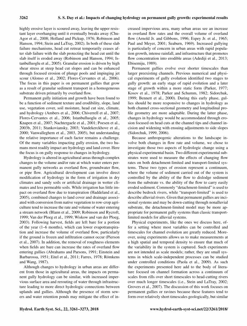
We performed experiments at the St. Anthony Falls Labo-ratory at the University of Minnesota, in Minneapolis, Min-nesota. These experiments tested how different overland flowrates affect erosion and permanent gully growth on a seriesof permanent gullies initiated through base level fall, a com-mon feature of post-glacial landscapes in the Upper Midwest,USA (Belmont et al., 2011; Gran et al., 2013; Lenhart et al.,2013). We represented a range of natural permanent gulliesusing two different substrates. These substrates varied in ma-terial and grain size, with one representing a more cohesivedetachment-limited system and the other a transport-limitedsystem. The fine-grained substrate was composed of 12 µmceramic spheres (Zeeospheres) with a density of 2.5 g cm−3
(Zeeospheres G series data sheet, 2018). The natural cohe-sion of this substrate caused it to behave as a detachment-limited system, as empirically shown in the results sectionof this paper. The coarser substrate was composed of quartzsand with a median grain size of 96 µm and a density of2.65 g cm−3 (AGSCO technical data, 2018). This sand lackedcohesion and behaved as a transport-limited system. The ex-perimental basin size varied for each material type; the basinused with the fine-grained substrate was 1× 1 m, while thebasin filled with the sand substrate was 2× 4 m, thus allow-ing room for the more rapid growth of the permanent gul-lies in the more easily erodible substrate. For both substrates,water flowed out through a 0.076 m wide notch at the down-stream end of the basin (Fig. 1). To initiate each run, wedropped the notch to 0.14 m below the surface of the sub-strate, thus creating a single abrupt base level drop. Duringeach run a knickpoint developed at this notch and propagatedupstream, carving a deep channel in the substrate.
To initialize each run, the substrate material was mixedwith water and smoothed into the basin to create a flat bed.Experiments began with a fully saturated bed to ensure thatwater flowed over the surface rather than infiltrating into it.We determined that the bed was at saturation and no longeroversaturated when there was no longer water on the sur-face of the sediment and water was no longer flowing outthe downstream outlet. We analyzed the bed saturation by vi-sual inspection rather than waiting a standard length of timebecause changes in humidity and temperature affected evap-oration rates. Beginning with a saturated substrate allowedus to assume that the net flow was relatively constant in the
Figure 1. The experimental setup shown here allows water to flowfrom a settling basin over an erodible substrate and out through a7.6× 14 cm notch. The flow rates entering the basin range from4× 10−6 to 311× 10−6 m3 s−1 and are controlled by a constanthead tank. For each run a constant volume of water either 190 or380 L is run over the erodible substrate. This figure shows the setupfor the fine-grained substrate. The sand substrate setup was similar,although the erodible substrate was larger.
cross-channel direction and no water was lost to infiltrationinto dry sediment.
For each experimental run, water flowed over the uni-form substrate as overland flow. We generated an even sheetflow by allowing water to flow over a broad crested weiras water was added to an upstream settling basin (Fig. 1).We controlled the flow rate of the water entering the set-tling basin with a constant-head tank, which received waterfrom a tank with a predetermined volume of water (190 or380 L). The flow rate was held constant through the entirerun when only 190 L of water were used. When 380 L ofwater were used, the flow rate was held constant for thefirst 190 L, then increased and held constant for the second190 L. Flow rates varied from 4 to 311 mL s−1 (4× 10⁻⁶ to311× 10−6 m3 s−1) in the fine-grained substrate and 55 to262 mL s−1 (55× 10−6 to 262× 10−6 m3 s−1) in the sand(Table 1; Fig. 2).
We collected topographic data before, during, and aftereach experimental run using a fully automated topographicscanner developed by engineers at the St. Anthony Falls Lab-oratory. The topographic scanner uses a standard laser thatcollects 2000 points per second in a gridded pattern. Data
www.hydrol-earth-syst-sci.net/22/3261/2018/ Hydrol. Earth Syst. Sci., 22, 3261–3273, 2018

3264 S. S. Day et al.: Impacts of changing hydrology on permanent gully growth: experimental results
Table 1. Experimental run parameters.
Run Substrate Water Total Flow 1st 190 L Flow 2nd 190 Lvolume time (× 10−6 m3 s−1) (× 10−6 m3 s−1)
(L) (min)
F-1 Fine 190 60.0 52.58F-2 Fine 190 32.0 98.58F-3 Fine 190 16.0 197.16F-4 Fine 190 21.25 148.45F-5 Fine 190 11.0 286.77F-6 Fine 190 872.0 3.62F-7 Fine 190 10.13 311.40F-8 Fine 190 21.5 146.72F-9 Fine 190 15.5 203.52F-10 Fine 380 91.5 71.69 66.41F-11 Fine 380 65.0 73.36 143.39F-12 Fine 380 54.5 76.94 233.67S-13 Sand 190 25.25 124.93S-14 Sand 190 56.5 55.83S-15 Sand 190 13.5 233.67S-16 Sand 190 12.0 262.88S-17 Sand 190 20.25 155.78S-18 Sand 380 56.0 80.88 185.56S-19 Sand 380 71.5 55.34 217.55S-20 Sand 380 89.0 42.06 225.32
Figure 2. These hydrographs show the range of flow rates tested. Each set of curves is for a separate set of experimental runs: (a) 190 L ofwater over the fine-grained substrate, (b) 380 L of water over the fine-grained substrate, (c) 190 L of water over the sand substrate, (d) 380 Lof water over the sand substrate.
were collected with 20× 25 mm point spacing and approxi-mately 0.5 mm vertical resolution. For each experiment, wecollected 2–5 topographic scans per 190 L of water. The ex-periment was paused at these intervals to complete the scans,
ensuring that no data were lost in areas where water waspresent.
Topographic data were gridded to form a digital elevationmodel (DEM). To determine the total volume of sedimentremoved during each experimental run, we subtracted the
Hydrol. Earth Syst. Sci., 22, 3261–3273, 2018 www.hydrol-earth-syst-sci.net/22/3261/2018/

S. S. Day et al.: Impacts of changing hydrology on permanent gully growth: experimental results 3265
DEM of the last scan from the DEM created from the ini-tial scan over the flat initial surface. At each cell the verticalchange was multiplied by the area of the cell to give a vol-ume change. The total volume change was summed for eachexperimental run. We also calculated the volume of sedimenteroded at intermediate scans to measure sediment flux overtime. Because these data only provide coarse temporal mea-surements of sediment flux, we sampled sediment flux outof the experiment for 5 s every minute during experimentalrun F-11 to measure sediment flux at higher time resolution.
We imported the DEMs into ArcGIS to measure chan-nel width and slope using the profile tool in the 3-D analysttoolbox. Channel width is defined as the distance betweenchannel banks on a cross section. Where multiple channelsformed, the cross section was selected just below the conflu-ence of these channels. In the fine-grained substrate, chan-nel width was roughly equal to the valley width along thefull channel length. In the sand substrate, channels mean-dered, and therefore we measured channel width in the mostupstream portion of the channel where migration had notyet occurred, and the valley width was equal to the channelwidth. We also measured the channel length and used thismeasurement to approximate knickpoint retreat rate. In bothsubstrates we measured the channel length from the outletto the break in slope at the flat upland surface. Slope wasmeasured along the channel profile. In the fine-grained sub-strate we measured channel slope three separate ways: alongthe bed, along the knickpoint, and the average channel slopealong the complete channel, including both channel bed andknickpoint zones. Where there was more than one knick-point, we measured the bed slope and knickpoint slope foreach section and averaged. Only one slope measurement, theaverage channel slope, was made on channels formed in thesand substrate because knickpoints were less prominent. Inboth substrates, average channel slope is a function of chan-nel length, because elevation change for each channel is thesame.
3 Results and analysis
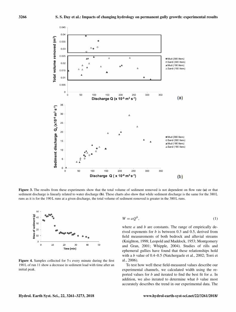
These experiments show that the total eroded volume showsno consistent trend with flow rate. For all 190 L experi-mental runs, the volume of sediment removed ranges from8.9× 10−3 to 2.4× 10⁻² m3 with no clear trend (Fig. 3a).This result was the same for both the sand and the fine-grained substrate. Similarly, there is no trend in the volumeof sediment removed in the 380 L runs, yet the volume oferoded sediment is greater (2.8× 10⁻² to 3.9× 10⁻² m3)than for the 190 L runs (Fig. 3). Put another way, thesediment discharge is linearly related to water discharge(Fig. 3b). For a natural system this implies that in a givenstorm event the amount of sediment eroded from a permanentgully is proportional to the amount of precipitation rather
than the storm intensity, assuming flow rate generates shearstresses that surpass the critical shear stress of the sediment.
In experimental run F-11, the sediment discharge peakedearly and rapidly decreased (Fig. 4). This pattern is also seenin several other experimental runs using the coarser resolu-tion erosion data collected from the topographic scans, mostprominently in run F-6 (Fig. 5). The experimental runs wherethis pattern was observed were also those where the chan-nel interacted with a wall (see Supplement). After a chan-nel touches a wall it is no longer able to widen, and flowpreferentially remains against that smooth surface. While itwas observed that the channels appeared to propagate mostrapidly early in the experiment and then slow with each suc-cessive time interval, the scan data suggest that the total vol-ume of sediment removed was relatively constant through-out the experiment except where the channel interacted witha wall. For the 380 L runs, where discharge was increased,there was a corresponding increase in sediment discharge,which was then maintained throughout the second half of theexperiment.
3.1 Channel morphology
While sediment volumes removed are roughly the same inthe fine-grained and sand channels, there are differences inhow they erode. Channels in the fine-grained substrate erodeprimarily via head cut propagation. In contrast channels inthe sand substrate erode due to head cut propagation as wellas lateral channel migration (see Supplement).
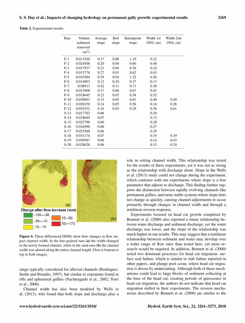
The experiments also demonstrate a relationship betweenchannel width and discharge. Generally, higher flows re-sulted in shorter, wider channels (Table 2). In particular, the380 L runs reveal both the importance the total flow volumehas for erosion volumes and how increasing flow rate affectschannel geometry. In the cohesive fine-grained substrate,higher flows in the second half of the experiment formed awider channel upstream of the already eroded gully, with-out altering the preexisting channel during the rest of the ex-periment (Fig. 6). Channel widths before the increased flowranged from 0.16 to 0.40 m for a flow rate of 73× 10−6 to77× 10−6 m3 s−1 and increased to 0.28 to 0.61 m for flowrates ranging from 143× 10−6 m to 234× 10−6 m3 s−1. Thechannels formed in the sand substrate responded differently;these channels widened along the entire channel length whenflow was increased (Fig. 6). In the sand channels widths var-ied from 0.14 to 0.19 m for initial flows which varied from42× 10−6 to 81× 10−6 m3 s−1, and the entire channel widthincreased to 0.24 to 0.43 m for the higher flows ranging from185× 10−6 to 225× 10−6 m3 s−1 (Table 2).
The hydraulic geometry equation for width developed byLeopold and Maddock (1953) was used to quantify the rela-tionship between width, W , and discharge, Q, for these ex-periments to determine how the experimental channels com-pare with natural channels:
www.hydrol-earth-syst-sci.net/22/3261/2018/ Hydrol. Earth Syst. Sci., 22, 3261–3273, 2018
3266 S. S. Day et al.: Impacts of changing hydrology on permanent gully growth: experimental results
Figure 3. The results from these experiments show that the total volume of sediment removed is not dependent on flow rate (a) or thatsediment discharge is linearly related to water discharge (b). These charts also show that while sediment discharge is the same for the 380 Lruns as it is for the 190 L runs at a given discharge, the total volume of sediment removed is greater in the 380 L runs.
Figure 4. Samples collected for 5 s every minute during the first190 L of run 11 show a decrease in sediment load with time after aninitial peak.
W = aQb, (1)
where a and b are constants. The range of empirically de-rived exponents for b is between 0.3 and 0.5, derived fromfield measurements of both bedrock and alluvial streams(Knighton, 1998; Leopold and Maddock, 1953; Montgomeryand Gran, 2001; Whipple, 2004). Studies of rills andephemeral gullies have found that these relationships holdwith a b value of 0.4–0.5 (Natchergaele et al., 2002; Torri etal., 2006).
To test how well these field-measured values describe ourexperimental channels, we calculated width using the re-ported values for b and iterated to find the best fit for a. Inaddition, we also iterated to determine what b value mostaccurately describes the trend in our experimental data. The
Hydrol. Earth Syst. Sci., 22, 3261–3273, 2018 www.hydrol-earth-syst-sci.net/22/3261/2018/

S. S. Day et al.: Impacts of changing hydrology on permanent gully growth: experimental results 3267
root mean square error (RMSE) was calculated for each dataset and is reported as a percentage of the average measuredwidth value.
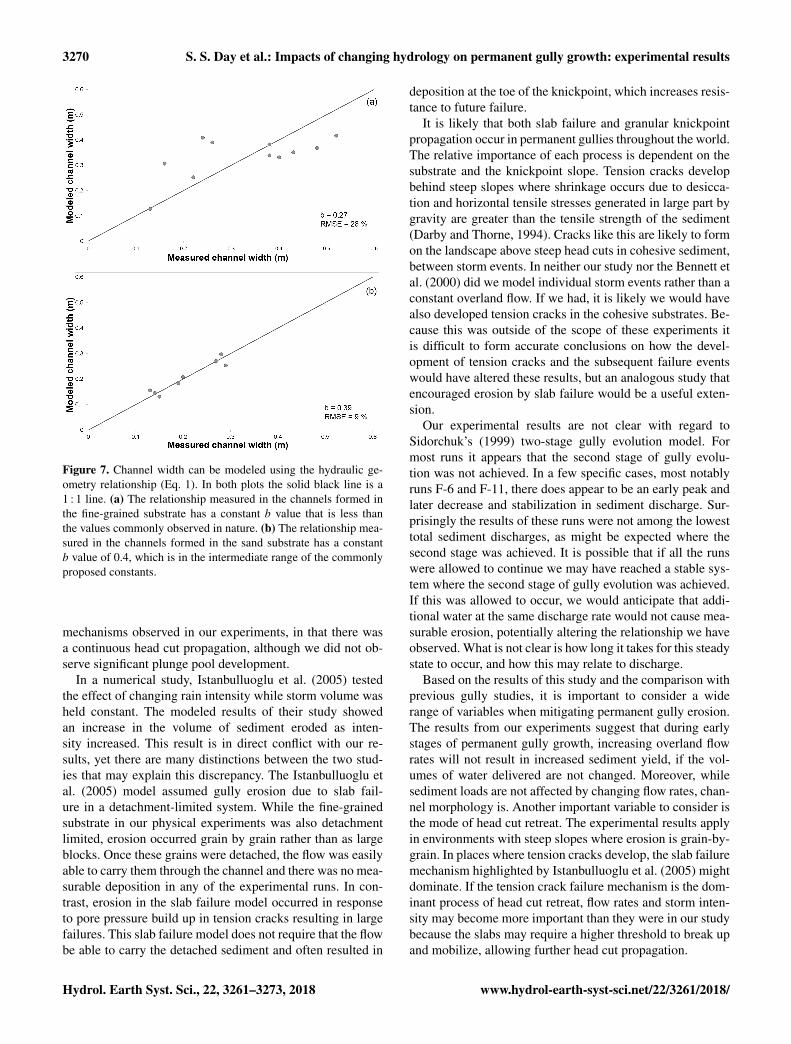
Using the field-derived b exponents ranging from 0.3 to0.5, the RMSE is 29–31 % of the average measured width inthe fine-grained substrate. The best fit for the experimentaldata results in a b value of 0.27, resulting in an RMSE of28.5 % (Fig. 7). In the sand substrate the best fit for the datafalls within the range of field-derived exponents. The erroris minimized when b is 0.39, resulting in an RMSE of 9 %(Fig. 7).
3.2 Modeled sediment transport
Results from these experiments appear to conflict with stan-dard sediment transport equations which generally predict anonlinear increase in sediment flux as discharge increases(e.g., Engelund and Hansen, 1967; Meyer-Peter and Müller,1948; Parker, 1990; Wilcock and Crowe, 2003), yet theseequations typically include an additional factor, often slope,which, if also varied, can account for changes in dischargeresulting in a linear increase in sediment flux. Below are ex-amples of commonly used sediment transport models that,when applied to these experiments, account for the linear na-ture of the sediment flux discharge relationship.
Commonly erosion in detachment-limited systems is mod-eled by the stream power incision model (Howard and Kirby,1983):
dz/dt = kQ(md )S(nd ), (2)
where k, md and nd are constants, dzdt−1 is vertical ero-sion rate, and S is the slope. In the detachment-limited fine-grained substrate, all erosion took place at the knickpoint andtherefore we consider only knickpoint retreat rate and use Sk ,knickpoint slope, in place of S. Because this rate is a hori-zontal retreat rate rather than vertical incision rate we mustconvert Eq. (2) appropriately:
U · Sk = dz/dt, (3)
U = kQ(m)d S
(n−1d )
k , (4)
where U is the knickpoint retreat rate. The exponents md
and nd have been derived for a variety of natural environ-ments. Typically the md / n−1
d ratio (concavity index) is ap-proximately 0.35–0.6 (Whipple and Tucker, 1999; Baldwinet al., 2003). The exponent nd ranges between two-thirdsand five-thirds depending on the erodibility of the substratewhere more easily eroded sediment has a lower value for theexponent nd (Foley, 1980; Howard and Kirby, 1983; Whip-ple et al., 2000). The exponents md and nd for uniformdetachment-limited landscapes (i.e., badlands) reported byHoward and Kirby (1983) are four-ninths and two-thirds, re-spectively. While the md / n−1
d ratio is slightly higher thanreported elsewhere, we used these values to model erosion in
our experiments because, like the badlands, our experimentalsetup was spatially homogeneous and easily eroded. RMSEwas measured between the calculated U and the measured U
and minimized by modifying the coefficient k. The RMSEwas 25 % of the measured average knickpoint retreat rate forthe fine-grained substrate. The detachment-limited equationis not appropriate for the sand substrate because there is bothheadward and lateral erosion, which is not captured by theequation. In addition, the knickpoint slope cannot be mea-sured in the sand substrate.
Sediment loads from the sand substrate were modeled withthe transport-limited equation (Pelletier, 2011):
qs = kQ(mt )S(nt ), (5)
where k, mt and nt are constants and qs is the volumet-ric unit sediment flux. This equation can be derived fromthe Engelund and Hansen (1967) equation where both mt
and nt equal five-thirds. The Engelund and Hansen (1967)equation is ideal because it does not have an incipient mo-tion threshold as many other sediment transport equations do.Here again the RMSE was measured between the measuredand calculated qs and minimized using the coefficient k. TheRMSE was 41 % of the average volumetric unit sediment dis-charge for the sand substrate. The transport-limited equationwas also tested with the fine-grained substrate. For this testthe average slope was used for S and the RMSE calculatedwas 86 % of the average volumetric unit sediment discharge.This high RMSE value supports the observation that the fine-grained substrate does not behave as a transport-limited sys-tem.
4 Discussion
Our experiments demonstrate that, over a range of condi-tions, the sediment volume eroded during permanent gullygrowth under application of a fixed volume of water is inde-pendent of the rate at which the water is supplied. Thus, sed-iment discharge is linearly related to water discharge in bothdetachment-limited and transport-limited systems. These re-sults contrast with data from many preexisting streams wherechanging flow intensity has resulted in increased erosion vol-ume (i.e., Boateng et al., 2012; Ma et al., 2010; Naik and Jay,2011), yet these data may not be directly applicable to early-stage gullies. We suggest that because gullies are activelyevolving in response to a given hydrology, the channel mor-phology that develops reflects that hydrology, with erosionbalanced by altering channel slope. This is supported by sed-iment transport Eqs. (4) and (5) which, when applied to ourexperiments, predict the measured sediment discharges byincluding the effects of both discharge and slope. In preexist-ing channels where channel slope may take tens of thousandsof years to adjust to changing flows, both equations wouldpredict a nonlinear increase in sediment discharge with in-creasing water discharge. Gullies evolve more rapidly in re-
www.hydrol-earth-syst-sci.net/22/3261/2018/ Hydrol. Earth Syst. Sci., 22, 3261–3273, 2018

3268 S. S. Day et al.: Impacts of changing hydrology on permanent gully growth: experimental results
Figure 5. In general, sediment discharge was near constant throughout the experiments, as indicated by the linear relationship betweenpercent time elapsed and percent of total sediment removed in the graphs above. This result was generally consistent between for both fine-grained substrate (a–d) and the sand substrate (e–h). Results from the 190 L runs are graphed in (a) and (e) and the 380 L runs are graphedin (b) and (f) with the first half broken out in (c) and (g) and the second half in (f) and (h).
sponse to the imposed discharge and can balance erosion byadjusting channel slope in response to a change in the hydro-logic regime.
Moreover, our findings suggest that anthropogenicchanges to the discharge regime could affect channel mor-phology (i.e., channel width), without changing sedimentoutput derived from permanent gullies. Where water dis-charge was increased in the 380 L runs, the channel quicklyevolved in response to the new discharge by creating a widerchannel. In these experiments the observed response to theincreased discharge differed for the fine-grained and sandsubstrate (Fig. 6), suggesting cohesion may be an importantfactor in how a channel initially responds to a new dischargeregime.
The results of our experiments follow the hydraulic geom-etry relationship for width in Eq. (1), although with lower
exponents than usually measured in field studies for alluvialand bedrock channels (Knighton, 1998; Leopold and Mad-dock, 1953; Montgomery and Gran, 2001; Whipple, 2004)and rills and ephemeral gullies (Nachtergaele et al., 2002;Torri et al., 2006). While this relationship is typically appliedto describing width or discharge changes in a single channel,it works here for these separate channels because each com-parable channel is carving through the same substrate. In thefine-grained substrate the empirical exponent b for these datais lower than has been derived for natural channels. This maybe a result of the steep channel walls developed in these ex-periments; in natural permanent gullies where near-verticalchannel walls are less common, we expect that this exponentwould be closer to the reported values. In the sand substratewhere steep channel walls could not develop, the empiricalexponent b is 0.39, which is only slightly lower than the
Hydrol. Earth Syst. Sci., 22, 3261–3273, 2018 www.hydrol-earth-syst-sci.net/22/3261/2018/
S. S. Day et al.: Impacts of changing hydrology on permanent gully growth: experimental results 3269
Table 2. Experimental results.
Run Volume Average Bed Knickpoint Width 1st Width 2ndsediment slope slope slope 190 L (m) 190 L (m)removed
(m3)
F-1 0.011920 0.17 0.06 1.19 0.22F-2 0.024506 0.20 0.04 0.60 0.48F-3 0.017937 0.21 0.04 0.36 0.24F-4 0.013776 0.27 0.03 0.62 0.43F-5 0.010384 0.29 0.04 1.22 0.26F-6 0.014903 0.12 0.10 0.27 0.13F-7 0.08913 0.42 0.11 0.71 0.38F-8 0.013908 0.37 0.06 0.67 0.43F-9 0.018645 0.22 0.07 0.58 0.52F-10 0.039053 0.15 0.05 0.81 0.40 0.49F-11 0.030158 0.14 0.05 0.56 0.16 0.28F-12 0.035532 0.16 0.03 0.29 0.38 0.61S-13 0.017762 0.06 0.20S-14 0.018649 0.07 0.13S-15 0.023796 0.06 0.28S-16 0.016590 0.06 0.27S-17 0.023569 0.06 0.29S-18 0.031174 0.07 0.19 0.39S-19 0.030587 0.06 0.14 0.43S-20 0.028028 0.06 0.15 0.24
Figure 6. These differenced DEMs show how changes in flow im-pact channel width. In the fine-grained runs (a) the width changedin the newly formed channel, while in the sand runs (b) the channelwidth was altered along the entire channel length. Flow is bottom totop in both images.
range typically considered for alluvial channels (Rodriquez-Iturbe and Rinaldo, 1997), but similar to exponents found inrills and ephemeral gullies (Nachtergaele et al., 2002; Torriet al., 2006).
Channel width has also been modeled by Wells etal. (2013), who found that both slope and discharge play a
role in setting channel width. This relationship was testedfor the results of these experiments, yet it was not as strongas the relationship with discharge alone. Slope in the Wellset al. (2013) study could not change during the experiment,which contrasts with our experiments where slope is a freeparameter that adjusts to discharge. This finding further sup-ports the distinction between rapidly evolving channels likepermanent gullies, and more stable systems where slope doesnot change as quickly, causing channel adjustments to occurprimarily through changes in channel width and through anonlinear erosion response.
Experiments focused on head cut growth completed byBennett et al. (2000) also reported a linear relationship be-tween water discharge and sediment discharge, yet the waterdischarge was lower, and the slope of the relationship wasmuch higher in our results. This may suggest that a nonlinearrelationship between sediment and water may develop overa wider range of flow rates than tested here, yet more re-search would be required. In addition, Bennett et al. (2000)noted two dominant processes for head cut migration: sur-face seal failure, which is similar to slab failure reported inother papers, and plunge pool scour, where head cut migra-tion is driven by undercutting. Although both of these mech-anisms could lead to large blocks of sediment collecting atthe base of the head cut, creating periods of quiescence inhead cut migration, the authors do not indicate that head cutmigration stalled in their experiments. The erosion mecha-nisms described by Bennett et al. (2000) are similar to the
www.hydrol-earth-syst-sci.net/22/3261/2018/ Hydrol. Earth Syst. Sci., 22, 3261–3273, 2018
3270 S. S. Day et al.: Impacts of changing hydrology on permanent gully growth: experimental results
Figure 7. Channel width can be modeled using the hydraulic ge-ometry relationship (Eq. 1). In both plots the solid black line is a1 : 1 line. (a) The relationship measured in the channels formed inthe fine-grained substrate has a constant b value that is less thanthe values commonly observed in nature. (b) The relationship mea-sured in the channels formed in the sand substrate has a constantb value of 0.4, which is in the intermediate range of the commonlyproposed constants.
mechanisms observed in our experiments, in that there wasa continuous head cut propagation, although we did not ob-serve significant plunge pool development.
In a numerical study, Istanbulluoglu et al. (2005) testedthe effect of changing rain intensity while storm volume washeld constant. The modeled results of their study showedan increase in the volume of sediment eroded as inten-sity increased. This result is in direct conflict with our re-sults, yet there are many distinctions between the two stud-ies that may explain this discrepancy. The Istanbulluoglu etal. (2005) model assumed gully erosion due to slab fail-ure in a detachment-limited system. While the fine-grainedsubstrate in our physical experiments was also detachmentlimited, erosion occurred grain by grain rather than as largeblocks. Once these grains were detached, the flow was easilyable to carry them through the channel and there was no mea-surable deposition in any of the experimental runs. In con-trast, erosion in the slab failure model occurred in responseto pore pressure build up in tension cracks resulting in largefailures. This slab failure model does not require that the flowbe able to carry the detached sediment and often resulted in
deposition at the toe of the knickpoint, which increases resis-tance to future failure.
It is likely that both slab failure and granular knickpointpropagation occur in permanent gullies throughout the world.The relative importance of each process is dependent on thesubstrate and the knickpoint slope. Tension cracks developbehind steep slopes where shrinkage occurs due to desicca-tion and horizontal tensile stresses generated in large part bygravity are greater than the tensile strength of the sediment(Darby and Thorne, 1994). Cracks like this are likely to formon the landscape above steep head cuts in cohesive sediment,between storm events. In neither our study nor the Bennett etal. (2000) did we model individual storm events rather than aconstant overland flow. If we had, it is likely we would havealso developed tension cracks in the cohesive substrates. Be-cause this was outside of the scope of these experiments itis difficult to form accurate conclusions on how the devel-opment of tension cracks and the subsequent failure eventswould have altered these results, but an analogous study thatencouraged erosion by slab failure would be a useful exten-sion.
Our experimental results are not clear with regard toSidorchuk’s (1999) two-stage gully evolution model. Formost runs it appears that the second stage of gully evolu-tion was not achieved. In a few specific cases, most notablyruns F-6 and F-11, there does appear to be an early peak andlater decrease and stabilization in sediment discharge. Sur-prisingly the results of these runs were not among the lowesttotal sediment discharges, as might be expected where thesecond stage was achieved. It is possible that if all the runswere allowed to continue we may have reached a stable sys-tem where the second stage of gully evolution was achieved.If this was allowed to occur, we would anticipate that addi-tional water at the same discharge rate would not cause mea-surable erosion, potentially altering the relationship we haveobserved. What is not clear is how long it takes for this steadystate to occur, and how this may relate to discharge.
Based on the results of this study and the comparison withprevious gully studies, it is important to consider a widerange of variables when mitigating permanent gully erosion.The results from our experiments suggest that during earlystages of permanent gully growth, increasing overland flowrates will not result in increased sediment yield, if the vol-umes of water delivered are not changed. Moreover, whilesediment loads are not affected by changing flow rates, chan-nel morphology is. Another important variable to consider isthe mode of head cut retreat. The experimental results applyin environments with steep slopes where erosion is grain-by-grain. In places where tension cracks develop, the slab failuremechanism highlighted by Istanbulluoglu et al. (2005) mightdominate. If the tension crack failure mechanism is the dom-inant process of head cut retreat, flow rates and storm inten-sity may become more important than they were in our studybecause the slabs may require a higher threshold to break upand mobilize, allowing further head cut propagation.
Hydrol. Earth Syst. Sci., 22, 3261–3273, 2018 www.hydrol-earth-syst-sci.net/22/3261/2018/

S. S. Day et al.: Impacts of changing hydrology on permanent gully growth: experimental results 3271
5 Conclusion
These experiments highlight how young incising channelslike permanent gullies can respond to changing hydrologydifferently than higher order channels that are later in theirevolution. A relevant future study should investigate how nat-ural gullies, which have a great deal more variability than thisexperimental system, respond to changing hydrology. Theconclusions from this project are outlined below:
– The experiments here suggest that water volume, ratherthan discharge, controls the total volume of erosion dur-ing permanent gully formation. This result holds true forboth transport-limited and detachment-limited systems.
– As long as slope is a free parameter in these rapidlyevolving systems, changes in flow rate can be accom-modated through an adjustment in both cross-sectionaland longitudinal channel geometry. Wider channelswere typically shorter and thus steeper.
– In both substrates, variations in channel width weredescribed by the hydraulic geometry relationship pro-posed by Leopold and Maddock (1953), with widerchannels forming in response to higher discharge.
– Sediment transport in sand and fine-grained substrateswas well described by the transport-limited sedimentflux equation and the detachment-limited stream powerequation, respectively.
Data availability. The data are provided in the Supplement.
Supplement. The supplement related to this article is availableonline at: https://doi.org/10.5194/hess-22-3261-2018-supplement.
Competing interests. The authors declare that they have no conflictof interest.
Acknowledgements. This work was funded in part by a GeologicalSociety of America Graduate student research grant and by theNational Center for Earth-surface Dynamics (NCED), which isfunded by the Office of Integrative Activities, National ScienceFoundation grant EAR-0120914. We appreciate comments andreviews from Robert Wells and two anonymous reviewers.
Edited by: Thom BogaardReviewed by: Robert Wells and two anonymous referees
References
Abrahams, A. D. and Parsons, A. J.: Resistance to overland flowon desert pavement and its implications for sediment transportmodeling, Water Resour. Res., 27, 1827–1836, 1991.
Adediji, A., Jeje, L. K., and Ibitoye, M. O.: Urban developmentand informal drainage patterns: Gully dynamics in SouthwesternNigeria, Appl. Geogr., 40, 90–102, 2013.
Agsco technical Data: http://www.agsco.com/assets/pdfs/Silica-Sands-Flours-Tech-Data-Sheet-06-04-2014.pdf, lastaccess: 7 February 2018.
Alonso, C. V., Bennett, S. J., and Stein, O. R.: Predicting head cuterosion and migration in concentrated flows typical of uplandareas, Water Resour. Res., 38, 39-1–39-15, 2002.
Ambers, R. K., Druckenbrod, D. L., and Ambers, C. P.: Geomorphicresponse to historical agriculture at Monument Hill in the BlueRidge foothills of central Virginia, Catena, 65, 49–60, 2006.
Arnold Jr., C. L. and Gibbons, C. J.: Impervious surface coverage:the emergence of a key environmental indicator, J. Am. Plan. As-soc., 62, 243–258, 1996.
Baldwin, J. A., Whipple, K. X., and Tucker, G. E.: Implications ofthe shear stress river incision model for the timescale of postoro-genic decay of topography, J. Geophys. Res., 108, 2156–2202,2003.
Belmont, P., Gran, K., Schottler, S., Wilcock, P., Day, S., Jennings,C., Lauer, J., Viparelli, E., Willenbring, J., Engstrom, D., andParker, G.: Large shift in source of fine sediment in the UpperMississippi River, Environ. Sci. Technol., 45, 8804–8810, 2011.
Bennett, S. J., Alonso, C. V., Prasad, S. N., and Römkens, M. J. M.:Experiments on headcut growth and migration in concentratedflows typical of upland areas, Water Resour. Res., 36, 1911–1922, 2000.
Blann, K. L., Anderson, J. L., Sands, G. R., and Vondracek, B.:Effects of agricultural drainage on aquatic ecosystems: a review,Crit. Rev. Environ. Sci. Tech., 39, 909–1001, 2009.
Boateng, I., Bray, M., and Hooke, J.: Estimating the fluvial sedimentinput to the coastal sediment budget: a case study of Ghana, Ge-omorphology, 138, 100–110, 2012.
Bryan, R. B.: Knickpoint evolution in rillwash, Catena, 17, 111–132, 1990.
Bull, L. J. and Kirkby, M. J.: Gully processes and modelling, Prog.Phys. Geogr., 21, 354– 374, 1997.
Bull, L. J. and Kirkby, M.: Channel heads and channel extension, in:Dryland Rivers: Hydrology and Geomorphology of Semi-AridChannels, edited by: Bull, L. J. and Kirkby, M. J., Wiley, Chich-ester, UK, 263–298, 2002.
Chiverrell, R. C., Harvey, A. M., and Foster, G. C.: Hillslope gul-lying in the Solway Firth–Morecambe Bay region, Great Britain:Responses to human impact and/or climatic deterioration?, Geo-morphology, 84, 317–343, 2007.
Chu-Agor, M. L., Fox, G. A., Cancienne, R. M., and Wilson, G.V.: Seepage caused tension failures and erosion undercutting ofhillslopes, J. Hydrol., 359, 247–259, 2008.
Darby, S. E. and Thorne, C. R.: Prediction of tension crack locationand riverbank erosion hazards along destabilized channels, EarthSurf. Proc. Land., 19, 233–245, 1994.
Dietrich, W. E. and Dunne, T.: The Channel Head, in: Channel Net-work Hydrology, edited by: Beven, K. J. and Kirkby, M. J., Wi-ley, Chichester, UK, 175–219, 1993.
www.hydrol-earth-syst-sci.net/22/3261/2018/ Hydrol. Earth Syst. Sci., 22, 3261–3273, 2018

3272 S. S. Day et al.: Impacts of changing hydrology on permanent gully growth: experimental results
Dunne, T.: Hydrology, mechanics, and geomorphic implications orerosion by subsurface flow, in: Groundwater Geomorphology:The Role of Subsurface Water in Earth-Surface Processes andLandforms, edited by: Higgins, C. G. and Coates, D. R., Geolog-ical Society of America as Special Paper 252, Geological Societyof America, Colorado, Boulder, 1–28, 1990.
Ebisemiju, F. S.: The response of headwater stream channels to ur-banization in the humid tropics, Hydrol. Process., 3, 237–253,1989.
Einstein, H. A. and Barbarossa, N. L.: River channel roughness, T.Am. Soc. Civ. Eng., 117, 1121–1132, 1951.
Eitel, J. U. H., Williams, C. J., Vierling, L. A., Al-Hamdan, O. Z.,and Pierson, F. B.: Suitability of terrestrial laser scanning forstudying surface roughness effects on concentrated flow erosionprocesses in rangelands, Catena, 87, 398–407, 2011.
Engelund, F. and Hansen, E., A monograph on sediment transportin alluvial streams, TEKNISKFORLAG, Copenhagen, Denmark,1967.
Espey Jr., W. H., Morgan, C. W., and Masch, F. D.: A study of someeffects of urbanization on storm runoff from a small watershed,Tech. Rep. 44D 07-6501 CRWR-2, Ctr. for Res. in Water Re-sour., Univ. Texas, Austin, 1965.
Farres, P. J.: The role of time and aggregate size in the crustingprocess, Earth Surf. Proc. Land., 3, 243–254, 1978.
Flores-Cervantes, J. H., Istanbulluoglu, E., and Bras, R. L.: Devel-opment of gullies on the landscape: A model of headcut retreatresulting from plunge pool erosion, J. Geophys. Res., 111, 2156–2202, 2006.
Foley, M. G.: Bed-rock incision by streams, Geol. Soc. Am. Bull.,91, 2189–2213, 1980.
Fox, G. A. and Wilson, G. V.: The role of subsurface flow in hills-lope and stream bank erosion: a review, Soil Sci. Soc. Am. J., 74,717–733, 2010.
Gran, K. B., Finnegan, N., Johnson, A. L., Belmont, P., Wittkop, C.,and Rittenour, T.: Landscape evolution, valley excavation, andterrace development following abrupt postglacial base level fall,Geol. Soc. Am. Bull., 125, 1068–1082, 2013.
Gran, K. B., Belmont, P., Day, S., Jennings, C., Lauer, J. W., Vipar-elli, E., Wilcock, P., and Parker, G.: An integrated sediment bud-get for the Le Sueur River basin, Final report Presented to theMinnesota Pollution Control Agency, Minnesota, 2011.
Grovers, G., Giménez, R., and Van Oost, K.: Rill erosion: Exploringthe relationship between experiments, modelling and field obser-vations, Earth-Sci. Rev., 84, 87–102, 2007.
Haddeland, I., Lettenmaier, D. P., and Skaugen, T.: Effects of ir-rigation on the water and energy balances of the Colorado andMekong river basins, J. Hydrol., 324, 210–223, 2005.
Hinds, N. E. A.: Amphitheatre valley heads, J. Geol., 33, 816–818,1925.
Holland, W. N. and Pickup, G.: Flume study of knickpoint devel-opment in stratified sediment, Geol. Soc. Am. Bull., 87, 76–82,1976.
Howard, A. D.: Groundwater sapping experiments and modeling,in: Sapping Features of the Colorado Plateau: A ComparativePlanetary Geology Field Guide, NASA, 491, 71–83, 1988.
Howard, A. D. and Kirby, G.: Channel changes in badlands, Geol.Soc. Am. Bull., 94, 739–752, 1983.
Istanbulluoglu, E., Bras, R. L., Flores-Cervantes, H., and Tucker, G.E.: Implications of bank failures and fluvial erosion for gully de-
velopment: Field observations and modelling, J. Geophys. Res.,110, 2156–2202, 2005.
Knapen, A. and Poesen, J.: Soil erosion resistance effects on rill andgully initiation points and dimensions, Earth Surf. Proc. Land.,35, 217–228, 2010.
Knapen, A., Poesen, J., Govers, G., Gyssels, G., and Nachtergaele,J.: Resistance of soils to concentrated flow erosion: A review,Earth-Sci. Rev., 80, 75–109, 2007.
Knighton, D.: Fluvial forms and processes, Edward Arnold, Lon-don, p. 377, 1998.
Kosov, B. F., Nikol’skaya, I. I., and Zorina, Y. F.: Eksperi-mental’nyye issledovaniya ovragoobrazovaniya, in: Eksperimen-tal’naya geomorfologiya, edited by: Makkaveev, N. I., Moscow,113–140, 1978.
Lamb, M. P., Howard, A. D., Johnson, J., Whipple, K.X., Dietrich, W. E., and Perron, J. T.: Can springs cutcanyons into rock?, J. Geophys. Res., 111, E07002,https://doi.org/10.1029/2005JE002663, 2006.
Lenhart, C. F., Titov, M. L., Ulrich, J. S., Nieber, J. L., and Suppes,B. J.: The role of hydrologic alteration and riparian vegetationdynamics in channel evolution along the lower Minnesota River,T. ASABE, 56, 549–561, 2013.
Leopold, L. B. and Maddock, T.: The hydraulic geometry of streamchannels and some physiographic implications, US Geol. SurveyProf. Paper 252, US Geological Survey, Washington, D.C., 1953.
Ma, H., Yang, D., Tan, S. K., Gao, B., and Hu, Q.: Impact of cli-mate variability and human activity on streamflow decrease inthe Miyun Reservoir catchment, J. Hydrol., 389, 317–324, 2010.
Merritt, E.: The identification of four stages during micro-rill devel-opment, Earth Surf. Proc. Land., 9, 493–496, 1984.
Meyer-Peter, E. and Müller, R.: Formulas for bed-load transport,IAHR, Stockholm, 1948.
Montgomery, D. R. and Gran, K. B.: Downstream variations in thewidth of bedrock channels, Water Resour. Res., 37, 1841–1846,2001.
Mosley, M. P.: Experimental study of rill erosion, T. ASAE, 17,909–913, 1974.
Nachtergaele, J., Poesen, J., Steegen, A., Takken, I., Beuselinck, L.,Vandekerckhove, L., and Grovers, G.: The value of a physicallybased model versus an empirical approach in the prediction ofephemeral gully erosion for loess derived soils, Geomorphology,40, 237–252, 2001.
Nachtergaele, J., Poesen, J., Sidorchuk, A., and Torri, D.: Predictionof concentrated flow width in ephemeral gully channels, Hydrol.Process., 16, 1935–1953, 2002.
Naik, P. K. and Jay, D. A.: Distinguishing human and climate influ-ences on the Columbia River: Changes in mean flow and sedi-ment transport, Hydrolog. Sci. J., 404, 259–277, 2011.
Nichols, M. H., Magirl, C., Sayre, N. F., and Shaw, J. R.: The geo-morphic legacy of water and erosion control structures in a semi-arid rangeland watershed, Earth Surf. Proc. Land., 43, 909–918,2017.
Paola, C., Straub, K., Mohrig, D., and Reinhardt, L.: The “unreason-able effectiveness” of stratigraphic and geomorphic experiments,Earth-Sci. Rev., 97, 1–43, 2009.
Parker, G.: Surface-based bedload transport relation for gravelrivers, J. Hydraul. Res., 28, 417–436, 1990.
Hydrol. Earth Syst. Sci., 22, 3261–3273, 2018 www.hydrol-earth-syst-sci.net/22/3261/2018/
S. S. Day et al.: Impacts of changing hydrology on permanent gully growth: experimental results 3273
Parker, R. S.: Experimental study of basin evolution and itshydrologic implications, PhD dissertation, Colo. State Univ.,Ft. Collins, 1977.
Parker, R. S. and Schumm, S. A.: Experimental study of drainagenetworks, in: Badland Geomorphology and Piping, edited by:Bryan, R. and Yair, A., Geobooks, Norwich, England, 153–168,1982.
Paul, M. J. and Meyer, J. L.: Streams in the urban landscape, Ann.Rev. Ecol. Syst., 32, 333–365, 2001.
Pelletier, J. D.: Fluvial and slope-wash erosion of soil-mantled land-scapes: detachment- or transport-limited, Earth Surf. Proc. Land.,37, 37–51, 2011.
Pierson, F. B., Bates, J. D., Svejcar, T. J., and Hardegree, S. P.:Runoff and erosion after cutting western Juniper, RangelandEcol. Manage., 60, 285–292, 2007.
Poesen, J., Nachtergaele, J., Verstaeten, G., and Valentin, C.: Gullyerosion and environmental change: importance and researchneeds, Catena, 50, 91–133, 2003a.
Poesen, J. W. A., Torri, D. B., and VanWalleghem, T.: Gully ero-sion: Procedures to adopt when modelling soil erosion in land-scapes affected by gullying, in: Handbook of Erosion Modelling,1st Edn., edited by: Morgan., R. P. C. and Nearing, M. A., Black-well Publishing Ltd., Hoboken, NJ, 360–386, 2003b.
Robinson, K. M. and Hanson, G. J.: A deterministic headcut ad-vance model, T. ASAE, 37, 1437–1443, 1994.
Robinson, M. and Rycroft, D. W.: Agricultural Drainage, in: Agron-omy Monograph 38, edited by: Skaggs, R. W. and van Schif-gaarde, J., ASA, CSSA, SSSA, Madison, WI, 767–800, 1999.
Rodriquez-Iturbe, I. and Rinaldo, A.: Fractal River Basins: Chanceand Self-Organization, Cambridge Univ. Press, New York,547 pp., 1997.
Römkens, M. J. M. and Wang, J. Y.: Soil roughness changes fromrainfall, T. Am. Soc. Civ. Eng., 31, 408–413, 1987.
Seaburn, G. E.: Effects of urban development on direct runoff toEast Meadow Brook, Nassau County, New York, USGS Prof. Pa-per 627-B, US Geological Survey, Washington, 1969.
Sidorchuk, A.: Dynamic and static models of gully erosion, Catena,37, 401–414, 1999.
Sidorchuk, A.: Stages in gully evolution and self-organized critical-ity, Earth Surf. Proc. Land., 31, 1329–1344, 2006.
Stankoviansky, M. I. L. O. Š.: Gully evolution in the Myjava HillLand in the second half of the last millennium in the context ofthe central-European area, Geogr. Pol., 76, 89–107, 2003.
Stein, O. R. and LaTray, D. A.: Experiments and modeling of headcut migration in stratified soils, Water Resour. Res., 38, 20-1–20-12, 2002.
Torri, D., Poesen, J., Borselli, L., and Knapen, A.: Channel width–flow discharge relationships for rills and gullies, Geomorphol-ogy, 76, 273–279, 2006.
Vandekerckhove, L., Poesen, J., Oostwoud-Wijdenes, D., Nachter-gaele, J., Kosmas, D., Roxo, M. J., and Figueiredo, T. D.: Thresh-olds for gully initiation and sedimentation in Mediterranean Eu-rope, Earth Surf. Proc. Land., 25, 1201–1220, 2000.
Van der Ploeg, R. R., Ehlers, W., and Sieker, F.: Floods and otherpossible adverse environmental effects of meadowland area de-cline in former West Germany, Naturwissenschaften, 86, 313–319, 1999.
Vanwalleghem, T., Van Den Eeckhaut, M., Poesen, J., Deckers, J.,Nachtergaele, J., Van Oost, K., and Slenters, C.: Characteristicsand controlling factors of old gullies under forest in a temperatehumid climate: a case study from the Meerdaal Forest (CentralBelgium), Geomorphology, 56, 15–29, 2003.
Vanwalleghem, T., Poesen, J., Van Den Eeckhaut, M., Nachter-gaelel, J., and Deckers, J.: Reconstructing rainfall and land-useconditions leading to the development of old gullies, Holocene,15, 378–386, 2005.
Wells, R. R., Momm, H. G., Rigby, J. R., Bennett, S. J., Bingner,R. L., and Dabney, S. M.: An empirical investigation of gullywidening rates in upland concentrated flows, Catena, 101, 114–121, 2013.
Whipple, K. X.: Bedrock rivers and the geomorphology of activeorogens, Annu. Rev. Earth Planet. Sci., 32, 151–185, 2004.
Whipple, K. X. and Tucker, G. E.: Dynamics of the stream-powerriver incision model: Implications for height limits of mountainranges, landscape response timescales, and research needs, J.Geophys. Res.-Solid Ea., 104, 17661–17674, 1999.
Whipple, K. X., Hancock, G. S., and Anderson, R. S.: River inci-sion into bedrock: Mechanics and relative efficacy of plucking,abrasion, and cavitation, Geol. Soc. Am. Bull., 112, 490–503,2000.
Wilcock, P. R. and Crowe, J. C.: Surface-based transport model formixed-size sediment, J. Hydraul. Eng., 129, 120–128, 2003.
Wilson, G.: Understanding soil-pipe flow and its role in ephemeralgully erosion, Hydrol. Process., 25, 2354–2364, 2011.
Wilson, G. V.: Mechanisms of ephemeral gully erosion caused byconstant flow through a continuous soil-pipe, Earth Surf. Proc.Land., 34, 1858–1866, 2009.
Wiskow, E. and van der Ploeg, R. R.: Calculation of drain spacingsfor optimal rainstorm flood control, J. Hydrol., 272, 163–174,2003.
Zeeospheres G Series data sheet: http://www.zeeospheres.com/wp-content/uploads/2015/12/G-Series.pdf, last access: 7 Febru-ary 2018.
www.hydrol-earth-syst-sci.net/22/3261/2018/ Hydrol. Earth Syst. Sci., 22, 3261–3273, 2018