imperial county mhmp update 2013pdfs...imperial county multi-jurisdictional hazard mitigation plan...
TRANSCRIPT
Ju
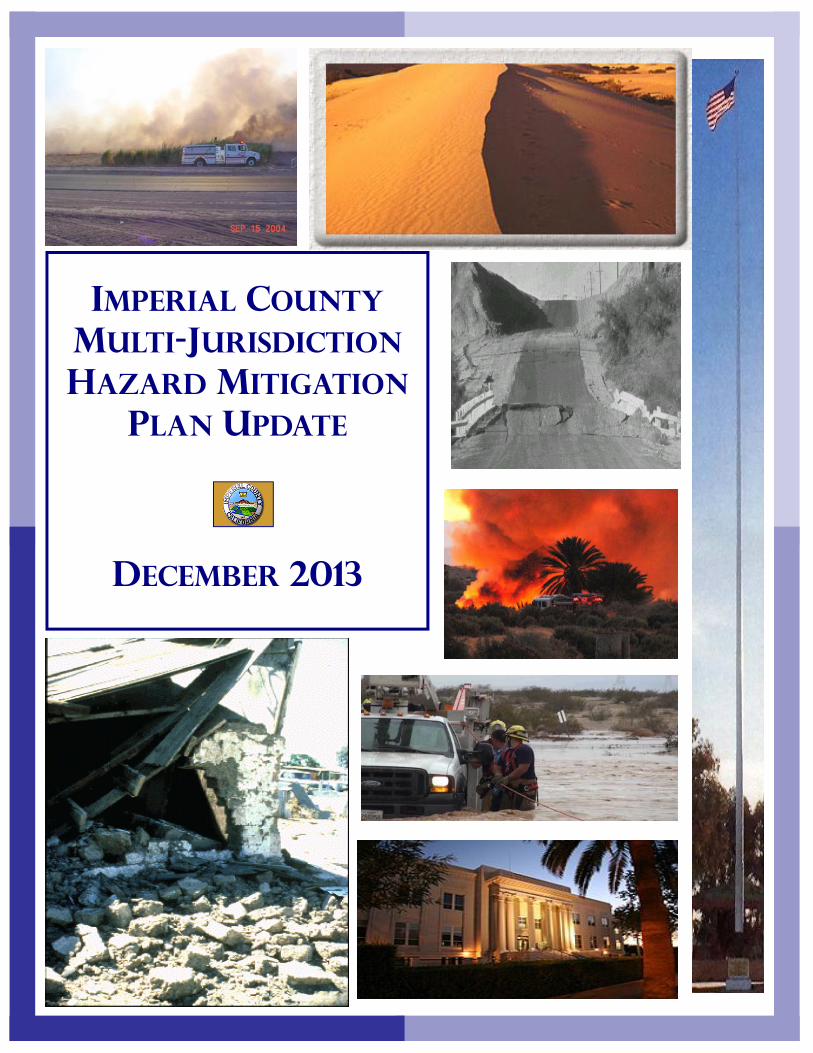
IMPERIAL COUNTY MULTI-JURISDICTION HAZARD MITIGATION
PLAN UPDATE
DECEMBER 2013
Imperial County Multi-Jurisdictional Hazard Mitigation Plan Update December 2013
i
Adoption by Local Governing Body: §201.6(c)(5) County of Imperial
RESOLUTION OF THE COUTY OF IMPERIAL BOARD OF SUPERVISORS ADOPTING A
MULTI-JURISDICTIONAL HAZARD MITIGATION PLAN UPDATE
RESOLUTION NO. __________ WHEREAS, the Disaster Mitigation Act of 2000 requires all jurisdictions to be covered by a Pre-Disaster All Hazards Mitigation Plan to be eligible for Federal Emergency Management Agency pre- and post-disaster mitigation funds; and WHEREAS, the County of Imperial recognizes that no community is immune from natural, technological or domestic security hazards, whether it be earthquake, flood, severe winter weather, drought, heat wave, wildfire or dam failure related; and recognizes the importance of enhancing its ability to withstand hazards as well as the importance of reducing human suffering, property damage, interruption of public services and economic losses caused by those hazards; and WHEREAS, the Federal Emergency Management Agency and California Emergency Management Agency have developed a hazards mitigation program that assists communities in their efforts to become Disaster-Resistant Communities that focus, not just on disaster response and recovery, but also on preparedness and hazard mitigation, which enhances economic sustainability, environmental stability and social well-being; and WHEREAS, Imperial County fully participated in the Federal Emergency Management Agency prescribed mitigation-planning process to prepare this Multi-Jurisdictional Hazard Mitigation Plan Update. NOW, THEREFORE, BE IT RESOLVED that the Imperial County Board of Supervisors adopts the “Imperial County Multi-Jurisdictional Hazard Mitigation Plan Update” as an official Plan; and BE IT FURTHER RESOLVED, the County of Imperial, through the Office of Emergency Services will submit this Adoption Resolution to the California Emergency Management Agency and Federal Emergency Management Agency, Region IX officials to enable the Plan’s final approval. PASSED AND ADOPTED by the Imperial County Board of Supervisors, State of California this ___ day of ___________ 20xx, by the following vote: Raymond Castillo, John Renison, Jack Terrazas, Michael W. Kelly and Ryan E. Kelley. Raymond Castillo, Chairman Imperial County Board of Supervisors Blanca Acosta, Interim Clerk of the Board County of Imperial, State of California
Imperial County Multi-Jurisdictional Hazard Mitigation Plan Update December 2013
ii
Adoption by Local Governing Body: §201.6(c)(5) City of Brawley
RESOLUTION OF THE CITY COUNCIL OF THE CITY OF BRAWLEY ADOPTING
A MULTI-JURISDICTIONAL HAZARD MITIGATION PLAN UPDATE
RESOLUTION NO. __________
WHEREAS, the Disaster Mitigation Act of 2000 requires all jurisdictions to be covered by a Pre-Disaster All Hazards Mitigation Plan to be eligible for Federal Emergency Management Agency pre- and post-disaster mitigation funds; and WHEREAS, the City of Brawley recognizes that no community is immune from natural, technological or domestic security hazards, whether it be earthquake, flood, severe winter weather, drought, heat wave, wildfire or dam failure related; and recognizes the importance of enhancing its ability to withstand hazards as well as the importance of reducing human suffering, property damage, interruption of public services and economic losses caused by those hazards; and WHEREAS, the Federal Emergency Management Agency and California Emergency Management Agency have developed a hazards mitigation program that assists communities in their efforts to become Disaster-Resistant Communities that focus, not just on disaster response and recovery, but also on preparedness and hazard mitigation, which enhances economic sustainability, environmental stability and social well-being; and WHEREAS, the City of Brawley fully participated in the Federal Emergency Management Agency prescribed mitigation-planning process to prepare this Multi-Jurisdictional Hazard Mitigation Plan Update. NOW, THEREFORE, BE IT RESOLVED that the City Council of the City of Brawley adopts the “Multi-Jurisdictional Hazard Mitigation Plan Update” as an official Plan; and BE IT FURTHER RESOLVED, the City of Brawley, through the Imperial County Office of Emergency Services, will submit this Adoption Resolution to the California Emergency Management Agency and Federal Emergency Management Agency, Region IX officials to enable the Plan’s final approval. PASSED AND ADOPTED by the City Council of the City of Brawley, State of California this ___ day of ___________ 20xx, by the following vote: Sam Couchman, Miguel Miranda, Don C. Campbell, Donald L. Wharton and George A. Nava. Sam Couchman, Mayor City Council of the City of Brawley Alma Benavides, City Clerk City of Brawley, State of California
Imperial County Multi-Jurisdictional Hazard Mitigation Plan Update December 2013
iii
Adoption by Local Governing Body: §201.6(c)(5) City of Calexico
RESOLUTION OF THE CITY COUNCIL OF THE CITY OF CALEXICO ADOPTING
A MULTI-JURISDICTIONAL HAZARD MITIGATION PLAN UPDATE
RESOLUTION NO. __________ WHEREAS, the Disaster Mitigation Act of 2000 requires all jurisdictions to be covered by a Pre-Disaster All Hazards Mitigation Plan to be eligible for Federal Emergency Management Agency pre- and post-disaster mitigation funds; and WHEREAS, the City of Calexico recognizes that no community is immune from natural, technological or domestic security hazards, whether it be earthquake, flood, severe winter weather, drought, heat wave, wildfire or dam failure related; and recognizes the importance of enhancing its ability to withstand hazards as well as the importance of reducing human suffering, property damage, interruption of public services and economic losses caused by those hazards; and WHEREAS, the Federal Emergency Management Agency and California Emergency Management Agency have developed a hazards mitigation program that assists communities in their efforts to become Disaster-Resistant Communities that focus, not just on disaster response and recovery, but also on preparedness and hazard mitigation, which enhances economic sustainability, environmental stability and social well-being; and WHEREAS, the City of Calexico fully participated in the Federal Emergency Management Agency prescribed mitigation-planning process to prepare this Multi-Jurisdictional Hazard Mitigation Plan Update. NOW, THEREFORE, BE IT RESOLVED that the City Council of the City of Calexico adopts the “Multi-Jurisdictional Hazard Mitigation Plan Update” as an official Plan; and BE IT FURTHER RESOLVED, the City of Calexico, through the Imperial County Office of Emergency Services, will submit this Adoption Resolution to the California Emergency Management Agency and Federal Emergency Management Agency, Region IX officials to enable the Plan’s final approval. PASSED AND ADOPTED by the City Council of the City of Calexico, State of California this ___ day of ___________ 20xx, by the following vote: Bill Hodge, Maritza Hurtado, John Moreno, Luis J. Castro and Joong S. Kim. Bill Hodge, Mayor City Council of the City of Calexico City Clerk City of Calexico, State of California
Imperial County Multi-Jurisdictional Hazard Mitigation Plan Update December 2013
iv
Adoption by Local Governing Body: §201.6(c)(5) City of Calipatria
RESOLUTION OF THE CITY COUNCIL OF THE CITY OF CALIPATRIA ADOPTING
A MULTI-JURISDICTIONAL HAZARD MITIGATION PLAN UPDATE
RESOLUTION NO. __________
WHEREAS, the Disaster Mitigation Act of 2000 requires all jurisdictions to be covered by a Pre-Disaster All Hazards Mitigation Plan to be eligible for Federal Emergency Management Agency pre- and post-disaster mitigation funds; and WHEREAS, the City of Calipatria recognizes that no community is immune from natural, technological or domestic security hazards, whether it be earthquake, flood, severe winter weather, drought, heat wave, wildfire or dam failure related; and recognizes the importance of enhancing its ability to withstand hazards as well as the importance of reducing human suffering, property damage, interruption of public services and economic losses caused by those hazards; and WHEREAS, the Federal Emergency Management Agency and California Emergency Management Agency have developed a hazards mitigation program that assists communities in their efforts to become Disaster-Resistant Communities that focus, not just on disaster response and recovery, but also on preparedness and hazard mitigation, which enhances economic sustainability, environmental stability and social well-being; and WHEREAS, the City of Calipatria fully participated in the Federal Emergency Management Agency prescribed mitigation-planning process to prepare this Multi-Jurisdictional Hazard Mitigation Plan Update. NOW, THEREFORE, BE IT RESOLVED that the City Council of the City of Calipatria adopts the “Multi-Jurisdictional Hazard Mitigation Plan Update” as an official Plan; and BE IT FURTHER RESOLVED, the City of Calipatria, through the Imperial County Office of Emergency Services, will submit this Adoption Resolution to the California Emergency Management Agency and Federal Emergency Management Agency, Region IX officials to enable the Plan’s final approval. PASSED AND ADOPTED by the City Council of the City of Calipatria, State of California this ___ day of ___________ 20xx, by the following vote: Raul Navarro, Peter Fuentes, Kay Hours, Fred R. Beltran, Romualdo J. Medina.
Peter Fuentes, Mayor City Council of the City of Calipatria Catherine J. Hoff, City Clerk City of Calipatria, State of California
Imperial County Multi-Jurisdictional Hazard Mitigation Plan Update December 2013
v
Adoption by Local Governing Body: §201.6(c)(5) City of El Centro
RESOLUTION OF THE CITY COUNCIL OF THE CITY OF EL CENTRO ADOPTING
A MULTI-JURISDICTIONAL HAZARD MITIGATION PLAN UPDATE
RESOLUTION NO. __________ WHEREAS, the Disaster Mitigation Act of 2000 requires all jurisdictions to be covered by a Pre-Disaster All Hazards Mitigation Plan to be eligible for Federal Emergency Management Agency pre- and post-disaster mitigation funds; and WHEREAS, the City of El Centro recognizes that no community is immune from natural, technological or domestic security hazards, whether it be earthquake, flood, severe winter weather, drought, heat wave, wildfire or dam failure related; and recognizes the importance of enhancing its ability to withstand hazards as well as the importance of reducing human suffering, property damage, interruption of public services and economic losses caused by those hazards; and WHEREAS, the Federal Emergency Management Agency and California Emergency Management Agency have developed a hazards mitigation program that assists communities in their efforts to become Disaster-Resistant Communities that focus, not just on disaster response and recovery, but also on preparedness and hazard mitigation, which enhances economic sustainability, environmental stability and social well-being; and WHEREAS, the City of El Centro fully participated in the Federal Emergency Management Agency prescribed mitigation-planning process to prepare this Multi-Jurisdictional Hazard Mitigation Plan Update. NOW, THEREFORE, BE IT RESOLVED that the City Council of the City of El Centro adopts the “Multi-Jurisdictional Hazard Mitigation Plan Update” as an official Plan; and BE IT FURTHER RESOLVED, the City of El Centro, through the Imperial County Office of Emergency Services, will submit this Adoption Resolution to the California Emergency Management Agency and Federal Emergency Management Agency, Region IX officials to enable the Plan’s final approval. PASSED AND ADOPTED by the City Council of the City of El Centro, State of California this ___ day of ___________ 20xx, by the following vote: Benjamin James Solomon III, Efrain Silva, Jason Jackson, Sedalia Sanders and Cheryl Viegas-Walker,
Benjamin James Solomon, III, Mayor City Council of the City of El Centro Diane Caldwell, City Clerk City of El Centro, State of California
Imperial County Multi-Jurisdictional Hazard Mitigation Plan Update December 2013
vi
Adoption by Local Governing Body: §201.6(c)(5) City of Holtville
RESOLUTION OF THE CITY COUNCIL OF THE CITY OF HOLTVILLE ADOPTING
A MULTI-JURISDICTIONAL HAZARD MITIGATION PLAN UPDATE
RESOLUTION NO. __________
WHEREAS, the Disaster Mitigation Act of 2000 requires all jurisdictions to be covered by a Pre-Disaster All Hazards Mitigation Plan to be eligible for Federal Emergency Management Agency pre- and post-disaster mitigation funds; and WHEREAS, the City of Holtville recognizes that no community is immune from natural, technological or domestic security hazards, whether it be earthquake, flood, severe winter weather, drought, heat wave, wildfire or dam failure related; and recognizes the importance of enhancing its ability to withstand hazards as well as the importance of reducing human suffering, property damage, interruption of public services and economic losses caused by those hazards; and WHEREAS, the Federal Emergency Management Agency and California Emergency Management Agency have developed a hazards mitigation program that assists communities in their efforts to become Disaster-Resistant Communities that focus, not just on disaster response and recovery, but also on preparedness and hazard mitigation, which enhances economic sustainability, environmental stability and social well-being; and WHEREAS, the City of Holtville fully participated in the Federal Emergency Management Agency prescribed mitigation-planning process to prepare this Multi-Jurisdictional Hazard Mitigation Plan Update. NOW, THEREFORE, BE IT RESOLVED that the City Council of the City of Holtville adopts the “Multi-Jurisdictional Hazard Mitigation Plan Update” as an official Plan; and BE IT FURTHER RESOLVED, the City of Holtville, through the Imperial County Office of Emergency Services, will submit this Adoption Resolution to the California Emergency Management Agency and Federal Emergency Management Agency, Region IX officials to enable the Plan’s final approval. PASSED AND ADOPTED by the City Council of the City of Holtville, State of California this ___ day of ___________ 20xx, by the following vote: Mike Goodsell, Jim Predmore, Richard Layton, Ginger Ward, Pete Mellinger and David Bradshaw. Mike Goodsell, Mayor City Council of the City of Holtville Glyn Snyder, City Clerk City of Holtville, State of California
Imperial County Multi-Jurisdictional Hazard Mitigation Plan Update December 2013
vii
Adoption by Local Governing Body: §201.6(c)(5) City of Imperial
RESOLUTION OF THE CITY COUNCIL OF THE CITY OF IMPERIAL ADOPTING
THE MULTI-JURISDICTIONAL HAZARD MITIGATION PLAN UDATE
RESOLUTION NO. __________
WHEREAS, the Disaster Mitigation Act of 2000 requires all jurisdictions to be covered by a Pre-Disaster All Hazards Mitigation Plan to be eligible for Federal Emergency Management Agency pre- and post-disaster mitigation funds; and WHEREAS, the City of Imperial recognizes that no community is immune from natural, technological or domestic security hazards, whether it be earthquake, flood, severe winter weather, drought, heat wave, wildfire or dam failure related; and recognizes the importance of enhancing its ability to withstand hazards as well as the importance of reducing human suffering, property damage, interruption of public services and economic losses caused by those hazards; and WHEREAS, the Federal Emergency Management Agency and California Emergency Management Agency have developed a hazards mitigation program that assists communities in their efforts to become Disaster-Resistant Communities that focus, not just on disaster response and recovery, but also on preparedness and hazard mitigation, which enhances economic sustainability, environmental stability and social well-being; and WHEREAS, the City of Imperial fully participated in the Federal Emergency Management Agency prescribed mitigation-planning process to prepare this Multi-Jurisdictional Hazard Mitigation Plan Update. NOW, THEREFORE, BE IT RESOLVED that the City Council of the City of Imperial adopts the “Multi-Jurisdictional Hazard Mitigation Plan Update” as an official Plan; and BE IT FURTHER RESOLVED, the City of Imperial, through the Imperial County Office of Emergency Services, will submit this Adoption Resolution to the California Emergency Management Agency and Federal Emergency Management Agency, Region IX officials to enable the Plan’s final approval. PASSED AND ADOPTED by the City Council of the City of Imperial, State of California this ___ day of ___________ 20xx, by the following vote: Rick Breland, Geoff Dale, Marlene D. Best, Doug Cox, Betty Sampson, and Mark Gran.
Rick Breland, Mayor City Council of the City of Imperial Debra Jackson, City Clerk City of Imperial, State of California
Imperial County Multi-Jurisdictional Hazard Mitigation Plan Update December 2013
viii
Adoption by Local Governing Body: §201.6(c)(5) City of Westmorland
RESOLUTION OF THE CITY COUNCIL OF THE CITY OF WESTMORLAND ADOPTING
A MULTI-JURISDICTIONAL HAZARD MITIGATION PLAN UPDATE
RESOLUTION NO. __________ WHEREAS, the Disaster Mitigation Act of 2000 requires all jurisdictions to be covered by a Pre-Disaster All Hazards Mitigation Plan to be eligible for Federal Emergency Management Agency pre- and post-disaster mitigation funds; and WHEREAS, the City of Westmorland recognizes that no community is immune from natural, technological or domestic security hazards, whether it be earthquake, flood, severe winter weather, drought, heat wave, wildfire or dam failure related; and recognizes the importance of enhancing its ability to withstand hazards as well as the importance of reducing human suffering, property damage, interruption of public services and economic losses caused by those hazards; and WHEREAS, the Federal Emergency Management Agency and California Emergency Management Agency have developed a hazards mitigation program that assists communities in their efforts to become Disaster-Resistant Communities that focus, not just on disaster response and recovery, but also on preparedness and hazard mitigation, which enhances economic sustainability, environmental stability and social well-being; and WHEREAS, the City of Westmorland fully participated in the Federal Emergency Management Agency prescribed mitigation-planning process to prepare this Multi-Jurisdictional Hazard Mitigation Plan Update. NOW, THEREFORE, BE IT RESOLVED that the City Council of the City of Westmorland adopts the “Multi-Jurisdictional Hazard Mitigation Plan Update” as an official Plan; and BE IT FURTHER RESOLVED, the City of Westmorland, through the Imperial County Office of Emergency Services, will submit this Adoption Resolution to the California Emergency Management Agency and Federal Emergency Management Agency, Region IX officials to enable the Plan’s final approval. PASSED AND ADOPTED by the City Council of the City of Westmorland, State of California this ___ day of ___________ 20xx, by the following vote: Henry Graham, Larry Ritchie, Stanley Brummett, Mary Ann Smith and Andy Cruz.
Henry Graham, Mayor City Council of the City of Westmorland Sally Traylor, City Clerk City of Westmorland, State of California

Imperial County Multi-Jurisdictional Hazard Mitigation Plan Update December 2013
ix
Adoption by Local Governing Body: §201.6(c)(5) Imperial Irrigation District
RESOLUTION OF IMPERIAL IRRIGATION DISTRICT ADOPTING
A MULTI-JURISDICTIONAL HAZARD MITIGATION PLAN UPDATE
RESOLUTION NO. __________
WHEREAS, the Disaster Mitigation Act of 2000 requires all jurisdictions to be covered by a Pre-Disaster All Hazards Mitigation Plan to be eligible for Federal Emergency Management Agency pre- and post-disaster mitigation funds; and WHEREAS, the Imperial Irrigation District recognizes that no community is immune from natural, technological or domestic security hazards, whether it be earthquake, flood, severe winter weather, drought, heat wave, wildfire or dam failure related; and recognizes the importance of enhancing its ability to withstand hazards as well as the importance of reducing human suffering, property damage, interruption of public services and economic losses caused by those hazards; and WHEREAS, the Federal Emergency Management Agency and California Emergency Management Agency have developed a hazards mitigation program that assists communities in their efforts to become Disaster-Resistant Communities that focus, not just on disaster response and recovery, but also on preparedness and hazard mitigation, which enhances economic sustainability, environmental stability and social well-being; and WHEREAS, Imperial Irrigation District fully participated in the Federal Emergency Management Agency prescribed mitigation-planning process to prepare this Multi-Jurisdictional Hazard Mitigation Plan Update. NOW, THEREFORE, BE IT RESOLVED that the Imperial Irrigation District Board adopts the “Multi-Jurisdictional Hazard Mitigation Plan Update” as an official Plan; and BE IT FURTHER RESOLVED, Imperial Irrigation District, through the Imperial County Office of Emergency Services, will submit this Adoption Resolution to the California Emergency Management Agency and Federal Emergency Management Agency, Region IX officials to enable the Plan’s final approval. PASSED AND ADOPTED by the Board of Directors, Imperial Irrigation District of Imperial County, State of California this ___ day of ___________ 20xx, by the following vote: Matt Dessert, James C. Hanks, Bruce Kuhn, Steve Benson, Norma Sierra Galindo.
Matt Dessert, President Imperial Irrigation District Gloria A. Rivera, Secretary Imperial Irrigation District

Imperial County Multi-Jurisdictional Hazard Mitigation Plan Update December 2013
x
Adoption by Local Governing Body: §201.6(c)(5) Imperial County Office of Education
RESOLUTION OF IMPERIAL COUNTY OFFICE OF EDUCATION ADOPTING
A MULTI-JURISDICTIONAL HAZARD MITIGATION PLAN UPDATE
RESOLUTION NO. __________
WHEREAS, the Disaster Mitigation Act of 2000 requires all jurisdictions to be covered by a Pre-Disaster All Hazards Mitigation Plan to be eligible for Federal Emergency Management Agency pre- and post-disaster mitigation funds; and WHEREAS, the Imperial County Office of Education recognizes that no community is immune from natural, technological or domestic security hazards, whether it be earthquake, flood, severe winter weather, drought, heat wave, wildfire or dam failure related; and recognizes the importance of enhancing its ability to withstand hazards as well as the importance of reducing human suffering, property damage, interruption of public services and economic losses caused by those hazards; and WHEREAS, the Federal Emergency Management Agency and California Emergency Management Agency have developed a hazards mitigation program that assists communities in their efforts to become Disaster-Resistant Communities that focus, not just on disaster response and recovery, but also on preparedness and hazard mitigation, which enhances economic sustainability, environmental stability and social well-being; and WHEREAS, Imperial County Office of Education fully participated in the Federal Emergency Management Agency prescribed mitigation-planning process to prepare this Multi-Jurisdictional Hazard Mitigation Plan Update. NOW, THEREFORE, BE IT RESOLVED that the Imperial County Board of Education adopts the “Multi-Jurisdictional Hazard Mitigation Plan Update” as an official Plan; and BE IT FURTHER RESOLVED, Imperial County Office of Education, through the Imperial County Office of Emergency Services, will submit this Adoption Resolution to the California Emergency Management Agency and Federal Emergency Management Agency, Region IX officials to enable the Plan’s final approval. PASSED AND ADOPTED by the Board of Education of Imperial County, State of California this ___ day of ___________ 20xx, by the following vote: Susan E. Manger, James L. Strain, Alicia Armenta, Herlinda Belcher, Sharon Anderholt
Susan E. Manger, President Imperial County Board of Education Anne J. Mallory, Secretary to the Board Imperial County Board of Education
Imperial County Multi-Jurisdictional Hazard Mitigation Plan Update December 2013
xi
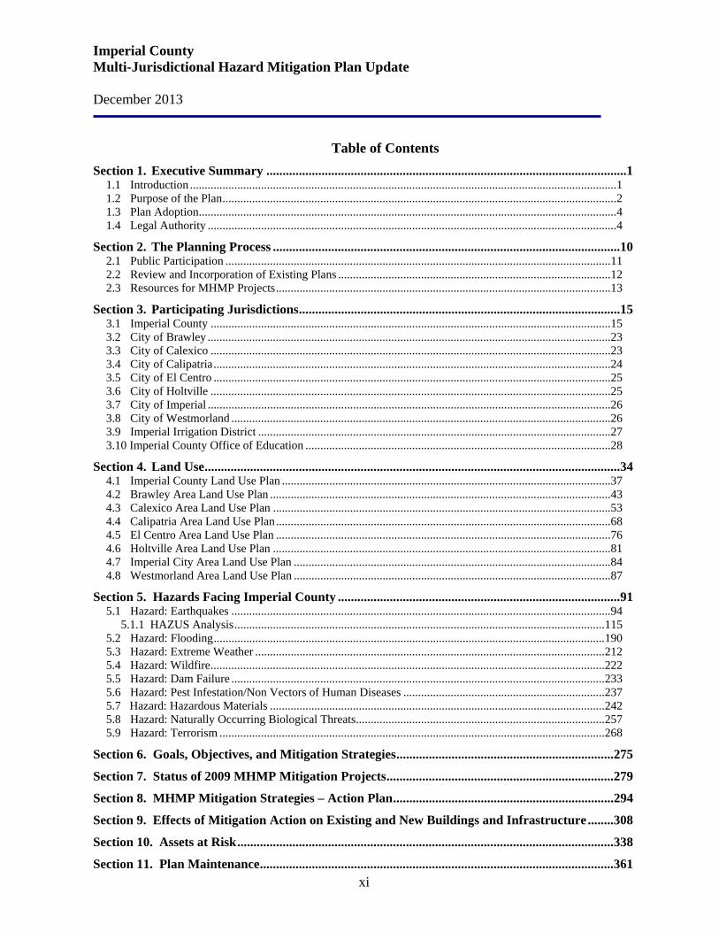
Table of Contents Section 1. Executive Summary ...............................................................................................................1
1.1 Introduction ................................................................................................................................................ 1 1.2 Purpose of the Plan ..................................................................................................................................... 2 1.3 Plan Adoption ............................................................................................................................................. 4 1.4 Legal Authority .......................................................................................................................................... 4
Section 2. The Planning Process ........................................................................................................... 10 2.1 Public Participation .................................................................................................................................. 11 2.2 Review and Incorporation of Existing Plans ............................................................................................ 12 2.3 Resources for MHMP Projects ................................................................................................................. 13
Section 3. Participating Jurisdictions ................................................................................................... 15 3.1 Imperial County ....................................................................................................................................... 15 3.2 City of Brawley ........................................................................................................................................ 23 3.3 City of Calexico ....................................................................................................................................... 23 3.4 City of Calipatria ...................................................................................................................................... 24 3.5 City of El Centro ...................................................................................................................................... 25 3.6 City of Holtville ....................................................................................................................................... 25 3.7 City of Imperial ........................................................................................................................................ 26 3.8 City of Westmorland ................................................................................................................................ 26 3.9 Imperial Irrigation District ....................................................................................................................... 27 3.10 Imperial County Office of Education ....................................................................................................... 28
Section 4. Land Use ................................................................................................................................ 34 4.1 Imperial County Land Use Plan ............................................................................................................... 37 4.2 Brawley Area Land Use Plan ................................................................................................................... 43 4.3 Calexico Area Land Use Plan .................................................................................................................. 53 4.4 Calipatria Area Land Use Plan ................................................................................................................. 68 4.5 El Centro Area Land Use Plan ................................................................................................................. 76 4.6 Holtville Area Land Use Plan .................................................................................................................. 81 4.7 Imperial City Area Land Use Plan ........................................................................................................... 84 4.8 Westmorland Area Land Use Plan ........................................................................................................... 87
Section 5. Hazards Facing Imperial County ....................................................................................... 91 5.1 Hazard: Earthquakes ................................................................................................................................ 94 5.1.1 HAZUS Analysis ............................................................................................................................. 115 5.2 Hazard: Flooding .................................................................................................................................... 190 5.3 Hazard: Extreme Weather ...................................................................................................................... 212 5.4 Hazard: Wildfire ..................................................................................................................................... 222 5.5 Hazard: Dam Failure .............................................................................................................................. 233 5.6 Hazard: Pest Infestation/Non Vectors of Human Diseases .................................................................... 237 5.7 Hazard: Hazardous Materials ................................................................................................................. 242 5.8 Hazard: Naturally Occurring Biological Threats .................................................................................... 257 5.9 Hazard: Terrorism .................................................................................................................................. 268
Section 6. Goals, Objectives, and Mitigation Strategies ................................................................... 275
Section 7. Status of 2009 MHMP Mitigation Projects ...................................................................... 279
Section 8. MHMP Mitigation Strategies – Action Plan .................................................................... 294
Section 9. Effects of Mitigation Action on Existing and New Buildings and Infrastructure ........ 308
Section 10. Assets at Risk .................................................................................................................... 338
Section 11. Plan Maintenance ............................................................................................................. 361
Imperial County Multi-Jurisdictional Hazard Mitigation Plan Update December 2013
1
Section 1. Executive Summary
1.1 Introduction Across the United States, natural and human-caused disasters have led to increasing levels of death, injury, property damage, and interruption of business and government services. The impact on families and individuals can be immense and damages to businesses can result in regional economic consequences. The time, money and effort to respond to and recover from these disasters divert public resources and attention from other important programs and problems. Hazard Mitigation is defined by the Disaster Mitigation Act of 2000 (DMA 2000) as “any sustained action taken to reduce or eliminate the long-term risk to human life and property from hazards.” For the purpose of this Multi-Jurisdiction Hazard Mitigation Plan (MHMP) Update, hazards are both natural and human-caused. A “hazard” is defined by FEMA as “any event or condition with the potential to cause fatalities, injuries, property damage, infrastructure damage, agricultural loss, environmental damage, business interruption, or other loss” (44 CFR Section 206 401). Hazard mitigation generally involves alteration of physical environments, significantly reducing risk and vulnerability to hazards by altering the built environment so that life and property losses can be avoided or reduced. Mitigation also makes it faster and less expensive to respond to and recover from disasters. The planning partners of the County of Imperial, City of Brawley, City of Calexico, City of Calipatria, City of El Centro, City of Holtville, City of Imperial, City of Westmorland, the Imperial Irrigation District and the Imperial County Office of Education (representing all of Imperial County’s School Districts) recognize the consequences of disasters and the need to reduce the impacts of natural and human-caused hazards. These planning partners shall be known in this Plan as the Planning Jurisdictions. The elected and appointed officials of the MHMP Planning Jurisdictions have chosen to carefully select mitigation actions in the form of projects and programs that can become long-term, cost effective means for reducing the impact of hazards. The original MHMP planning partners of the County of Imperial, City of Brawley, City of Calexico, City of Calipatria, City of El Centro, City of Holtville, City of Imperial, and the City of Westmorland prepared a Multi-Jurisdiction Hazard Mitigation Plan which was approved by FEMA in 2009. This document is a comprehensive update of the 2009 MHMP. For this MHMP Update the planning partners have included the Imperial Irrigation District (IID) and the Imperial County Office of Education (ICOE). Each section of the 2009 MHMP was reviewed and analyzed by the Planning Jurisdictions and revisions and updates were made including the identification and rating of local hazards; addition of new hazard incidents which have occurred since the last Plan was developed; description of mitigation progress and updates, goals, objectives and
Imperial County Multi-Jurisdictional Hazard Mitigation Plan Update December 2013
2
actions plans. Through the completion of this Plan the Planning Jurisdictions have made an effort that will continue with many years of commitment to the reduction of risks through hazard mitigation. This Plan will be shared in electronic format with regional jurisdictions to encourage and assist with a regional risk reduction effort. The Multi-Jurisdiction Hazard Mitigation Plan Update will guide the Planning Jurisdictions toward greater disaster resistance in cooperation and coordination with the character and needs of the community. Definition of Hazard Mitigation Hazard is defined by FEMA as “any event or condition with the potential to cause fatalities, injuries, property damage, infrastructure damage, agricultural loss, environmental damage, business interruption, or other loss.” sustained action taken to eliminate or reduce long term risk to human life, property and the environment posed by a hazard. Hazard Mitigation is defined by FEMA as “any action taken to reduce or eliminate the long-term risk to human life and property from natural hazards.” For the purpose of this MHMP, hazards are both natural and human-caused. Hazard Mitigation Planning is the process of developing a sustained course of action taken to reduce or eliminate long-term risk to people and property from both natural and human-caused hazards and their effects. The planning process includes establishing goals and recommendations for mitigation strategies. Hazard mitigation may occur during any phase of a threat, emergency or disaster. Mitigation can and may take place during the preparedness (before), response (during), and recovery (after) phases. The process of hazard mitigation involves evaluating a hazard’s impact and identifying and implementing actions to minimize or eliminate the impact.
1.2 Purpose of the Plan Imperial County has developed this Multi-Jurisdictional Hazard Mitigation Plan (MHMP) to create a safer community. The purpose of the MHMP is to significantly reduce deaths, injuries, and other disaster losses caused by natural and human-caused hazards in Imperial County. The MHMP describes past and current hazard mitigation activities and outlines goals, strategies, and actions for reducing future disaster losses. The Imperial County MHMP is the representation of the County’s commitment to reduce risks from natural and other hazards and serves as a guide for decision-makers as they commit resources to reducing the effects of natural and other hazards. While DMA 2000 requires that local communities address only natural hazards, the Federal Emergency Management Agency (FEMA) recommends that local comprehensive mitigation plans address man-made and technological hazards to the extent possible. Towards that goal, the Planning Jurisdictions have addressed an expansive set of hazards.

Imperial County Multi-Jurisdictional Hazard Mitigation Plan Update December 2013
3
Jurisdictions included in this MHMP Update are Imperial County, the cities of Brawley, Calexico, Calipatria, El Centro, Holtville, Imperial, and Westmorland, the Imperial Irrigation District and the Imperial County Office of Education. The Planning Jurisdictions are required to adopt a federally-approved Hazard Mitigation Plan to be eligible for certain disaster assistance and mitigation funding. The overall intent of this Plan is to reduce or prevent injury and damage from hazards in the County and participating jurisdictions. It identifies past and present mitigation activities, current policies and programs, and mitigation strategies for the future. This Plan also guides hazard mitigation activities by establishing hazard mitigation goals, objectives and an action plan. The MHMP is a “living document” that will be reviewed and updated annually to reflect changing conditions and improvements by new information, especially information on local planning activities. The MHMP is written to meet the statutory requirements of the Robert T. Stafford Disaster Relief and Emergency Assistance Act (Stafford Act) and Title 44 Code of Federal Regulations (CFR) 201.6 – Local Mitigation Plans. Goals Shared with State Multi-Hazard Mitigation Plan Imperial County’s MHMP supports the goals that it shares with the State of California Multi-Hazard Mitigation Plan, namely:
• Goal 1: Significantly reduce life loss and injuries. This goal involves reducing potential casualties from disasters through long-term physical changes that make places and buildings safer through mitigation investments and actions.
• Goal 2: Minimize damage to structures and property, as well as disruption of essential services and human activities. This goal includes structures as an important aspect of both life safety and property damage and reflects the desired outcome of minimizing disruption of essential services (e.g., police, fire, and medical response) as well as normal human activities after a disaster.
• Goal 3: Protect the environment. • Goal 4: Promote hazard mitigation as an integrated public policy. This goal suggests
both governmental and societal attention to the need for mitigation. Imperial County Vision
The Multi-Jurisdictional Hazard Mitigation Plan Update supports the broader vision and values of Imperial County as stated in the County’s Mission Statement. Imperial County Mission Statement To promote quality of life for the residents of Imperial County by providing superior County services in a timely, cost effective manner.

Imperial County Multi-Jurisdictional Hazard Mitigation Plan Update December 2013
4
Imperial County Goals/Objectives • To continue to explore creative funding strategies to balance budget in light of
reductions in State revenue. • To continue to improve County leadership, team building and coordination of services. • To continue to improve customer services. • To continue to encourage more public input on issues affecting the County. • To continue to streamline and improve efficiency of services. • To continue to improve a “team process” starting with Board Members and Department
Heads. 1.3 Plan Adoption This updated MHMP is a comprehensive description of the County of Imperial and participating jurisdictions commitment to reduce or eliminate the impacts of disasters. The Plan will be coordinated and maintained by the Planning Jurisdictions and is the culmination of input and recommendations from numerous stakeholders, citizens, private businesses and organizations.
Upon review and approval of the final draft Plan by the Planning Jurisdictions, the Plan will be forwarded to the California Office of Emergency Services for review and approval and then forwarded to FEMA for approval. After FEMA approval, the Plan will be sent to each participating jurisdiction for adoption by their governing body.
The Planning Jurisdictions will comply with all applicable state, federal and local statutes and regulations and will review and update the Plan at least every five years.
1.4 Legal Authority Assurances This Plan will comply with all principal federal, state and local laws guiding disaster management as applicable.
Federal Laws
1. Flood Insurance Act of 1968 2. Flood Disaster Protection Act of 1973 (PL-91-646) 3. Mitigation Planning of the Robert T. Stafford Disaster Relief and Emergency Assistance Act
of 1988 4. Disaster Mitigation Act of 2000 (DMA)
State Laws
1. AB 2140: Qualifying for Additional California Disaster Assistance Act (CDAA) 2. AB 162, AB156, SB 5: 2007 California Flood Bills 3. Standardized Emergency Management System (SEMS) 4. Un-reinforced Masonry Building Law

Imperial County Multi-Jurisdictional Hazard Mitigation Plan Update December 2013
5
5. California Earthquake Hazards Reduction Act of 1986 6. Caltrans Seismic Retrofit Program 7. California Fire Alliance 8. California Earthquake Authority’s Seismic Retrofit Program 9. NFIP, administered by the Department of Water Resources 10. State planning law and Office of Planning and Research’s general plan guidance
documents 11. California Department of Insurance (CDI) Residential Retrofit Program
Ordinances and Regulations In addition to the legal authorities listed above, the following are local and state ordinances and regulations which affect or promote disaster mitigation, preparedness, response or recovery for the Planning Jurisdictions.
Ordinances and Regulations
Title 9 Land Use Ordinance for the
County of Imperial
This Title (Title 9 inclusive) is hereby established and adopted pursuant to the authority vested in the County of Imperial by the State of California, including but not limited to the State Constitution, Government Code, Public Resources Code, the California Environmental Quality Act, the Subdivision Map Act, the Housing Act, and the Surface Mining and Reclamation Act. This ordinance shall be known as, and may be cited and referred to as, the "Land Use Ordinance" of the County of Imperial, hereinafter referred to as "Title".
Imperial County Codified Zoning
Ordinance
Contains provisions which act to reduce fire hazards. The Zoning Ordinance is a tool that helps prevent the construction of incompatible or hazardous structures. For example, the ordinance separates industrial, commercial and residential uses and provides for the isolation of land uses that may create excessive fire exposure to other properties. It also limits the height and bulk of buildings, specifies setbacks and distances between buildings.
Imperial County Subdivision Ordinance
Used to reduce the risk of fire by securing, as a condition of subdivision of land, water systems of adequate size and pressure for firefighting, and adequate roadway widths for emergency service vehicle access including maneuverability of fire trucks. As part of the review process, the Imperial County Planning Department seeks recommendations from fire and water districts wherever the proposed subdivision is located.
Imperial County Fire
Prevention and Explosives Ordinance
Section 53101-53300, contains provisions for the purpose of prescribing regulations governing conditions hazardous to life and property from fire or explosion. Such measures in this Ordinance include the following: Storage of flammable materials; Storage of Radioactive materials; Permit required for sale and use of fireworks; Abatement of weeds and other vegetation.
Imperial County Ordinance, Title 8 Health and Safety Section 8.36.010
Inspection by the agricultural commissioner. It is unlawful to sell, transport or ship, or have in possession for sale, transportation or shipment in amounts exceeding two standard containers for commercial purposes, any lettuce, broccoli, cabbage, cauliflower, corn, melons, market tomatoes, asparagus, market onions or salad products, without first obtaining from the agricultural
Imperial County Multi-Jurisdictional Hazard Mitigation Plan Update December 2013
6
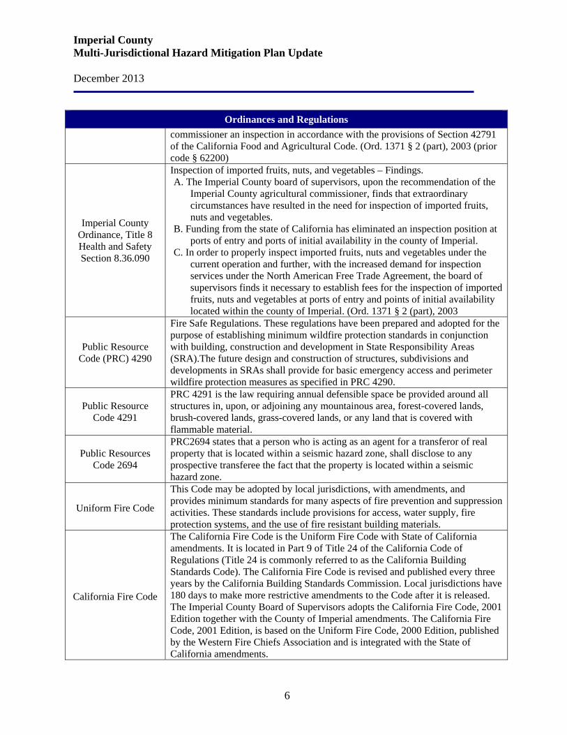
Ordinances and Regulations commissioner an inspection in accordance with the provisions of Section 42791 of the California Food and Agricultural Code. (Ord. 1371 § 2 (part), 2003 (prior code § 62200)
Imperial County Ordinance, Title 8 Health and Safety Section 8.36.090
Inspection of imported fruits, nuts, and vegetables – Findings. A. The Imperial County board of supervisors, upon the recommendation of the
Imperial County agricultural commissioner, finds that extraordinary circumstances have resulted in the need for inspection of imported fruits, nuts and vegetables.
B. Funding from the state of California has eliminated an inspection position at ports of entry and ports of initial availability in the county of Imperial.
C. In order to properly inspect imported fruits, nuts and vegetables under the current operation and further, with the increased demand for inspection services under the North American Free Trade Agreement, the board of supervisors finds it necessary to establish fees for the inspection of imported fruits, nuts and vegetables at ports of entry and points of initial availability located within the county of Imperial. (Ord. 1371 § 2 (part), 2003
Public Resource Code (PRC) 4290
Fire Safe Regulations. These regulations have been prepared and adopted for the purpose of establishing minimum wildfire protection standards in conjunction with building, construction and development in State Responsibility Areas (SRA).The future design and construction of structures, subdivisions and developments in SRAs shall provide for basic emergency access and perimeter wildfire protection measures as specified in PRC 4290.
Public Resource Code 4291
PRC 4291 is the law requiring annual defensible space be provided around all structures in, upon, or adjoining any mountainous area, forest-covered lands, brush-covered lands, grass-covered lands, or any land that is covered with flammable material.
Public Resources Code 2694
PRC2694 states that a person who is acting as an agent for a transferor of real property that is located within a seismic hazard zone, shall disclose to any prospective transferee the fact that the property is located within a seismic hazard zone.
Uniform Fire Code
This Code may be adopted by local jurisdictions, with amendments, and provides minimum standards for many aspects of fire prevention and suppression activities. These standards include provisions for access, water supply, fire protection systems, and the use of fire resistant building materials.
California Fire Code
The California Fire Code is the Uniform Fire Code with State of California amendments. It is located in Part 9 of Title 24 of the California Code of Regulations (Title 24 is commonly referred to as the California Building Standards Code). The California Fire Code is revised and published every three years by the California Building Standards Commission. Local jurisdictions have 180 days to make more restrictive amendments to the Code after it is released. The Imperial County Board of Supervisors adopts the California Fire Code, 2001 Edition together with the County of Imperial amendments. The California Fire Code, 2001 Edition, is based on the Uniform Fire Code, 2000 Edition, published by the Western Fire Chiefs Association and is integrated with the State of California amendments.
Imperial County Multi-Jurisdictional Hazard Mitigation Plan Update December 2013
7
Ordinances and Regulations
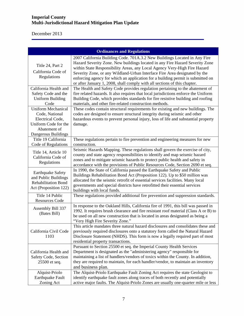
Title 24, Part 2 California Code of
Regulations
2007 California Building Code. 701A.3.2 New Buildings Located in Any Fire Hazard Severity Zone. New buildings located in any Fire Hazard Severity Zone within State Responsibility Areas, any Local Agency Very‐High Fire Hazard Severity Zone, or any Wildland‐Urban Interface Fire Area designated by the enforcing agency for which an application for a building permit is submitted on or after January 1, 2008, shall comply with all sections of this chapter.
California Health and Safety Code and the Uniform Building
Code
The Health and Safety Code provides regulation pertaining to the abatement of fire related hazards. It also requires that local jurisdictions enforce the Uniform Building Code, which provides standards for fire resistive building and roofing materials, and other fire-related construction methods.
Uniform Mechanical Code, National Electrical Code,
Uniform Code for the Abatement of
Dangerous Buildings
These codes contain structural requirements for existing and new buildings. The codes are designed to ensure structural integrity during seismic and other hazardous events to prevent personal injury, loss of life and substantial property damage.
Title 19 California Code of Regulations
These regulations pertain to fire prevention and engineering measures for new construction.
Title 14, Article 10 California Code of
Regulations
Seismic Hazards Mapping. These regulations shall govern the exercise of city, county and state agency responsibilities to identify and map seismic hazard zones and to mitigate seismic hazards to protect public health and safety in accordance with the provisions of Public Resources Code, Section 2690 et seq.
Earthquake Safety and Public Buildings Rehabilitation Bond
Act (Proposition 122)
In 1990, the State of California passed the Earthquake Safety and Public Buildings Rehabilitation Bond Act (Proposition 122). Up to $50 million was allocated for the seismic retrofit of essential services facilities. Many local governments and special districts have retrofitted their essential services buildings with local funds.
Title 14 Public Resources Code
These regulations provided additional fire prevention and suppression standards.
Assembly Bill 337 (Bates Bill)
In response to the Oakland Hills, California fire of 1991, this bill was passed in 1992. It requires brush clearance and fire resistant roof material (Class A or B) to be used on all new construction that is located in areas designated as being a “Very High Fire Severity Zone.”
California Civil Code 1103
This article mandates three natural hazard disclosures and consolidates these and previously required disclosures onto a statutory form called the Natural Hazard Disclosure Statement (NHDS). This form is now a legally required part of most residential property transactions.
California Health and Safety Code, Section
25500 et seq.
Pursuant to Section 25500 et seq. the Imperial County Health Services Department is designated as the "administering agency" responsible for maintaining a list of handlers/vendors of toxics within the County. In addition, they are required to maintain, for each handler/vendor, to maintain an inventory and business plan.
Alquist-Priolo Earthquake Fault
Zoning Act
The Alquist-Priolo Earthquake Fault Zoning Act requires the state Geologist to identify earthquake fault zones along traces of both recently and potentially active major faults. The Alquist-Priolo Zones are usually one-quarter mile or less

Imperial County Multi-Jurisdictional Hazard Mitigation Plan Update December 2013
8
Ordinances and Regulations in width and proposed development plans within these fault zones must be accompanied by a geotechnical report prepared by a geologist describing the likelihood of surface rupture and other seismically induced hazards.
California Environmental
Quality Act (CEQA) and Guidelines
The California Environmental Quality Act was adopted by the state legislature to provide public disclosure of the substantial adverse environmental effects of proposed development within the state. The CEQA Statutes and Guidelines (California Code of Regulations Title 14, Chapter 3, Section 15000, et. seq.) include disclosure of and mitigation for safety hazards as environmental impacts.
Cobey-Alquist Floodplain
Management Act
The Cobey-Alquist Floodplain Management Act encourages local governments to plan, adopt and enforce land use regulations for floodplain management in order to protect people and property from flooding hazards. This act also identifies requirements which jurisdictions must meet in order to receive state and financial assistance for flood control.
Flood Damage Prevention Code,
Earthquake Hazard Reduction in Existing
Building Code
These codes address safety issues associated with flooding and earthquakes directly.
In-progress/On-going/Completed Mitigation Projects and Programs Program or
Project Status Description
Multi-Jurisdictional Hazard Mitigation
Plan Update
In-Progress An Update Multi-Jurisdictional Hazard Mitigation Plan for Imperial County and the participating jurisdictions: Brawley, Calexico, Calipatria, El Centro, Holtville, Imperial City, Westmorland, Imperial Irrigation District and the Imperial County Office of Education. The overall goal of this Plan Update is to reduce or prevent injury and damage from hazards in the County. It identifies past and present mitigation activities, current policies and programs, and mitigation strategies for the future. This Plan Update also guides hazard mitigation activities by establishing hazard mitigation goals and objectives.
Multi-Jurisdictional Hazard Mitigation
Plan
Completed A Multi-Jurisdictional Hazard Mitigation Plan for Imperial County and the participating jurisdictions: Brawley, Calexico, Calipatria, El Centro, Holtville, Imperial City and Westmorland as well as the County Office of Education and the Imperial Irrigation District was completed and approved by FEMA in 2009. The overall of this Plan is to reduce or prevent injury and damage from hazards in the County. It identifies past and present mitigation activities, current policies and programs, and mitigation strategies for the future. This Plan also guides hazard mitigation activities by establishing hazard mitigation goals and objectives.
Imperial County Multi-Jurisdictional Hazard Mitigation Plan Update December 2013
9
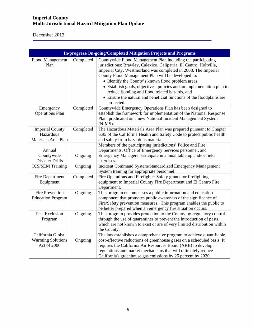
In-progress/On-going/Completed Mitigation Projects and Programs Flood Management
Plan Completed Countywide Flood Management Plan including the participating
jurisdictions: Brawley, Calexico, Calipatria, El Centro, Holtville, Imperial City, Westmorland was completed in 2008. The Imperial County Flood Management Plan will be developed to:
• Identify the County’s known flood problem areas, • Establish goals, objectives, policies and an implementation plan to
reduce flooding and flood related hazards, and • Ensure the natural and beneficial functions of the floodplains are
protected. Emergency
Operations Plan Completed Countywide Emergency Operations Plan has been designed to
establish the framework for implementation of the National Response Plan, predicated on a new National Incident Management System (NIMS).
Imperial County Hazardous
Materials Area Plan
Completed The Hazardous Materials Area Plan was prepared pursuant to Chapter 6.95 of the California Health and Safety Code to protect public health and safety from hazardous materials.
Annual
Countywide Disaster Drills
Ongoing
Members of the participating jurisdictions’ Police and Fire Departments, Office of Emergency Services personnel, and Emergency Managers participate in annual tabletop and/or field exercises.
ICS/SEM Training Ongoing Incident Command System/Standardized Emergency Management System training for appropriate personnel.
Fire Department Equipment
Completed Fire Operations and Firefighter Safety grants for firefighting equipment to Imperial County Fire Department and El Centro Fire Department.
Fire Prevention Education Program
Ongoing This program encompasses a public information and education component that promotes public awareness of the significance of Fire/Safety prevention measures. This program enables the public to be better prepared when an emergency fire situation occurs.
Pest Exclusion Program
Ongoing This program provides protection to the County by regulatory control through the use of quarantines to prevent the introduction of pests, which are not known to exist or are of very limited distribution within the County.
California Global Warming Solutions
Act of 2006
Ongoing
The law establishes a comprehensive program to achieve quantifiable, cost‐effective reductions of greenhouse gases on a scheduled basis. It requires the California Air Resources Board (ARB) to develop regulations and market mechanisms that will ultimately reduce California's greenhouse gas emissions by 25 percent by 2020.
Imperial County Multi-Jurisdictional Hazard Mitigation Plan Update December 2013
10
Section 2. The Planning Process
Imperial County Office of Emergency Services (OES) was responsible for the development of the MHMP Update. The County OES hired a consultant, Bluecrane, Inc., (bluecrane) to assist in the preparation of the Plan. Following the County Board of Supervisors’ approval of the project, the initial MHMP Update meeting was launched in April 2013 and provided a forum for engaging team members in the Plan Update and revision process. The OES formed a planning committee with representatives from the participating jurisdictions within the County which included the cities of Brawley, Calexico, Calipatria, El Centro, Holtville, Imperial, and Westmorland as well as the Imperial Irrigation District and the County Office of Education. The Planning Committee has participated actively in the MHMP’s update development, conferring every one to two weeks throughout the process to review draft documents and assess progress on the Plan. The following departments were designated as the lead agency for each participating jurisdiction. The individuals from these departments, as members of the Planning Committee, were responsible for communicating with and soliciting input from all applicable departments, offices and bureaus within their home jurisdiction as the MHMP Update progressed through the various stages of development. In this manner, all departments, offices and bureaus from each participating jurisdiction were fully involved in the development of the Plan.
• Imperial County Office of Emergency Services • Imperial County Fire Department • Imperial County Public Works Department • Imperial County Public Health Department • Imperial County Agricultural Commissioner’s Office • Imperial County Environmental Health Department • Imperial County Planning & Development Services • Imperial County Sheriff’s Office • City of Brawley Fire Department • City of Calexico Fire Department • City of El Centro Fire Department • City of Calipatria • City of Holtville • City of Westmorland • City of Imperial • City of Imperial Police Department • Imperial Irrigation District • Imperial County Office of Education
Imperial County Multi-Jurisdictional Hazard Mitigation Plan Update December 2013
11
• McCabe School District • San Pasqual Valley Unified School District • Central Union Unified School District • Brawley Elementary School • Southern California Gas Company • Union Pacific Rail Road HazMat
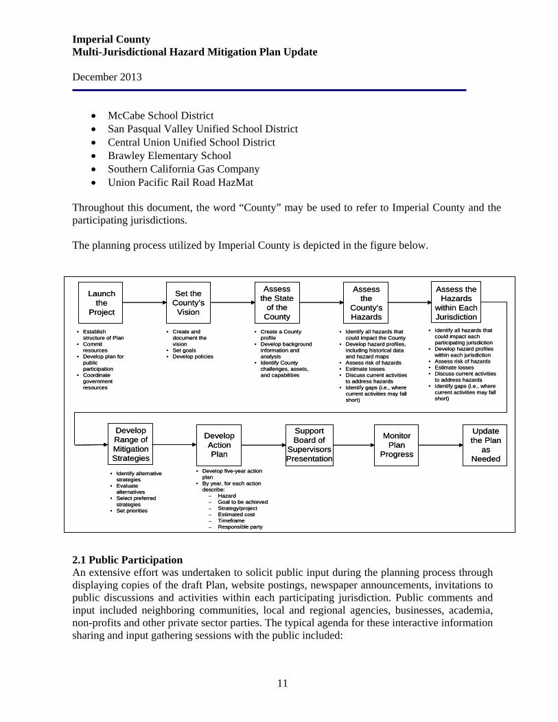
Throughout this document, the word “County” may be used to refer to Imperial County and the participating jurisdictions. The planning process utilized by Imperial County is depicted in the figure below. 2.1 Public Participation An extensive effort was undertaken to solicit public input during the planning process through displaying copies of the draft Plan, website postings, newspaper announcements, invitations to public discussions and activities within each participating jurisdiction. Public comments and input included neighboring communities, local and regional agencies, businesses, academia, non-profits and other private sector parties. The typical agenda for these interactive information sharing and input gathering sessions with the public included:
• Establish structure of Plan
• Commit resources
• Develop plan for public participation
• Coordinate government resources
Launch the
Project
• Create a County profile
• Develop background information and analysis
• Identify County challenges, assets, and capabilities
Assess the State
of the County
• Identify all hazards that could impact the County
• Develop hazard profiles, including historical data and hazard maps
• Assess risk of hazards• Estimate losses• Discuss current activities
to address hazards• Identify gaps (i.e., where
current activities may fall short)
Assess the
County’s Hazards
• Create and document the vision
• Set goals• Develop policies
Set the County’s
Vision
Develop Action Plan
Update the Plan
as Needed
Monitor Plan
Progress
Support Board of
Supervisors Presentation
• Develop five-year action plan
• By year, for each action describe:
– Hazard– Goal to be achieved– Strategy/project– Estimated cost– Timeframe– Responsible party
• Identify alternative strategies
• Evaluate alternatives
• Select preferred strategies
• Set priorities
Develop Range of Mitigation Strategies
• Identify all hazards that could impact each participating jurisdiction
• Develop hazard profiles within each jurisdiction
• Assess risk of hazards• Estimate losses• Discuss current activities
to address hazards• Identify gaps (i.e., where
current activities may fall short)
Assess the Hazards
within Each Jurisdiction
Imperial County Multi-Jurisdictional Hazard Mitigation Plan Update December 2013
12
Introductions An overview of the MHMP purpose and process A broad overview of the Draft Plan as it stood at that time A detailed interactive discussion of each hazard Solicitation of all comments An interactive discussion of the next steps
In addition to the ongoing effort to include the presentation, discussion and input gathering on the MHMP Update in all relevant internal government meetings and interaction by the Office of Emergency Services with the public, following is a list of the formally scheduled public outreach forums conducted in Imperial County.
Date Event April 22, 2013 Hazard Mitigation Planning Committee Meeting – Kickoff Session
May 20, 2013 Hazard Mitigation Planning Committee Meeting – Mitigation Workshop
June 3, 2013 Hazard Mitigation Planning Committee Meeting – Office of Education Mitigation Workshop
September 30, 2013 Hazard Mitigation Planning Committee Meeting – MHMP Update Review
November 14, 2013 Hazard Mitigation Planning Committee Meeting – MHMP Update Draft Review
Various Dates On-going telephone conversations and emails with the Planning Committee throughout the Planning process.
December 9 – 19, 2013 Public and Private Sector Review and Comments on Draft 2013 MHMP Update
2.2 Review and Incorporation of Existing Plans The County and participating jurisdictions’ most recent General Plans, Land Use Elements, Seismic and Public Safety Elements form the foundation of this integrated MHMP Update. Imperial County currently utilizes their General Plan which consists of ten Elements: Land Use, Housing, Circulation and Scenic Highways, Noise, Seismic and Public Safety, Agricultural, Conservation and Open Space, Geothermal Alternative Energy and Transmission, Water, and Parks and Recreation. Also included in the General Plan is a Land Use Map designating various land use categories which identify locations, and describes the type and anticipated maximum allowable density of ultimate development. The Land Use Element describes existing land uses within the County and the facilities and services which provide the public infrastructure to support these uses. The primary purpose of the Land Use Element is to identify the goals, policies and standards of the General Plan that will guide the physical growth of Imperial County, including the public facilities necessary to support such growth.
Imperial County Multi-Jurisdictional Hazard Mitigation Plan Update December 2013
13
The Seismic and Public Safety Element identifies goals and policies that will minimize the risks associated with natural and human-made hazards and specify land use planning procedures that should be implemented to avoid hazardous situations. The purpose of the Seismic and Public Safety Element is directly concerned with reducing the loss of life, injury, and property damage that might result from disaster or accident. For example, the risk associated with dangerous flooding can be avoided by not allowing development in floodplains and imposing strict safety standards on water transmission facilities. Imperial County has developed a Flood Management Plan (FMP) that identifies the County’s known flood problem areas; established goals, objectives, policies and implementation programs to reduce flooding and flood related hazards; and ensures the natural and beneficial functions of the floodplains are protected. This FMP provides guidance to agencies and the public responsible for and interested in protecting life, property, and agriculture; involved in land use planning; responsible for administering the FEMA National Flood Insurance Program (NFIP) and responsible for responding to flood emergencies within Imperial County. Imperial County had invited the cities of Brawley, Calexico, Calipatria, El Centro, Holtville, Imperial and Westmorland; and the Imperial County Office of Education, the Imperial Irrigation District, and the Salton Community Services District to participate and input into the Flood Management Plan. 2.3 Resources for MHMP Projects
Financial Resources for Hazard Mitigation Projects
General Fund Enterprise Fund (These funds are restricted to specific use, i.e., solid waste enterprise fund) Development fees (Restricted to expansion costs for new development) Building Permit fees Capital Improvements project funding Weed Abatement Penalty fees Fees for water, sewer, gas, or electric service Impact fees for homebuyers or developers for new developments/homes
State Funding Sources: Caltrans Commerce and Economic Development Program Infrastructure State Revolving Fund (ISRF) Program Rural Economic Development Infrastructure Program (REDIP) Proposition 13 California State Water Resources Control Board (SWRCB) Proposition 40 California State Water Resources Control Board (SWRCB) Proposition 50 Clean Water State Revolving Fund (SRF) Program Watershed Protection Program
Imperial County Multi-Jurisdictional Hazard Mitigation Plan Update December 2013
14
Financial Resources for Hazard Mitigation Projects
California Fire Alliance Pandemic Influenza State General Fund Grant California Fire Safe Council (Grants Clearinghouse – distributes some Federal National Fire Plan Grants in California)
Federal Funding Sources: FEMA Hazard Mitigation Grant Program (HMGP) Housing and Urban Development (HUD) Community Development Block Grant Program U.S. Army Corp of Engineers (USACE) U.S. Small Business Administration (SBA) Funding U.S. Department of Agriculture (USDA) Programs Natural Resources Conservation Service (NRCS) Environmental Quality Incentives Program (EQIP) Highway Bridge Program (HBP) Small Watershed Program Flood Prevention Program Emergency Watershed Protection (EWP) Program Homeland Security Grants (Terrorism) Homeland Security Grant (Staffing Adequate Fire and Emergency Response) Hospital Preparedness Program (HPP) Grant Public Health Emergency Preparedness Grant Bureau of Land Management (BLM) Programs National Fire Plan
Imperial County Multi-Jurisdictional Hazard Mitigation Plan Update December 2013
15
Section 3. Participating Jurisdictions
3.1 Imperial County In its one hundred year history, the Imperial County has emerged as one of the world’s leading agriculture production and export regions. The Pioneers from the Midwest settled in the Imperial Valley hoping to create a new life in the desert. Transporting Colorado River water through the All American Canal provided one of the necessary ingredients for successful farming. The water, along with 360 days of annual sunshine and mild winter climate transformed the desert into a rich producer of food and feeds for the world. Today we see economic growth through foreign investment, Fortune 500 companies, and now the development of renewable energy projects. Imperial County, originally part of San Diego County, was founded August 7, 1907. The area was visited as early as 1540 by Hernando de Alarcon, discoverer of the Colorado River. It was further explored by Spanish explorers and Catholic friars. Settlements existed along the Butterfield Stage Route as early as 1858, but no real development took place until water was brought into the area in 1901. Imperial Valley is surrounded by San Diego and Riverside Counties in California, the State of Arizona and the Municipality of Mexicali in the State of Baja California, Mexico. The Imperial County is rich in natural beauty, and a local history and economy based on agriculture and the cross-border family and trade relationships with our neighbors in Mexico. In 2011, there were estimated 31million overall annual crossings into the U.S. from Mexico through the U.S. Customs and Border Protection Agency's two busiest land ports of entry between Imperial County and Mexicali, Mexico at Calexico West/Mexicali I, and Calexico East/Mexicali II (by cars and as pedestrians) Ports of Entry (POEs). The Downtown Calexico POE provides pedestrian and passenger vehicle inspection facilities, expanding the port onto the site of the former commercial inspection facility Imperial County, located in the southeast corner of California, is bordered on the north by Riverside County, on the west by San Diego County, on the south by Mexico, and on the east by the Colorado River, which forms the boundary between California and Arizona. Imperial is the ninth largest county in California and covers an area of 4,597 square miles. The small community of Calipatria has the lowest elevation in the United States at 180 feet below sea level. The County’s strategic location adjacent to the City of Mexicali, the capital of Baja California Norte will continue to be strategic advantage. In addition to its importance as a state capital, Mexicali is also an education center with multiple universities and postsecondary educational opportunities. The City is also known for the wide range of medical services enjoyed by both Mexican and United States citizens. Lastly, the city hosts hundreds of factories or maquiladoras across a multitude of industries, including aerospace.
Imperial County Multi-Jurisdictional Hazard Mitigation Plan Update December 2013
16
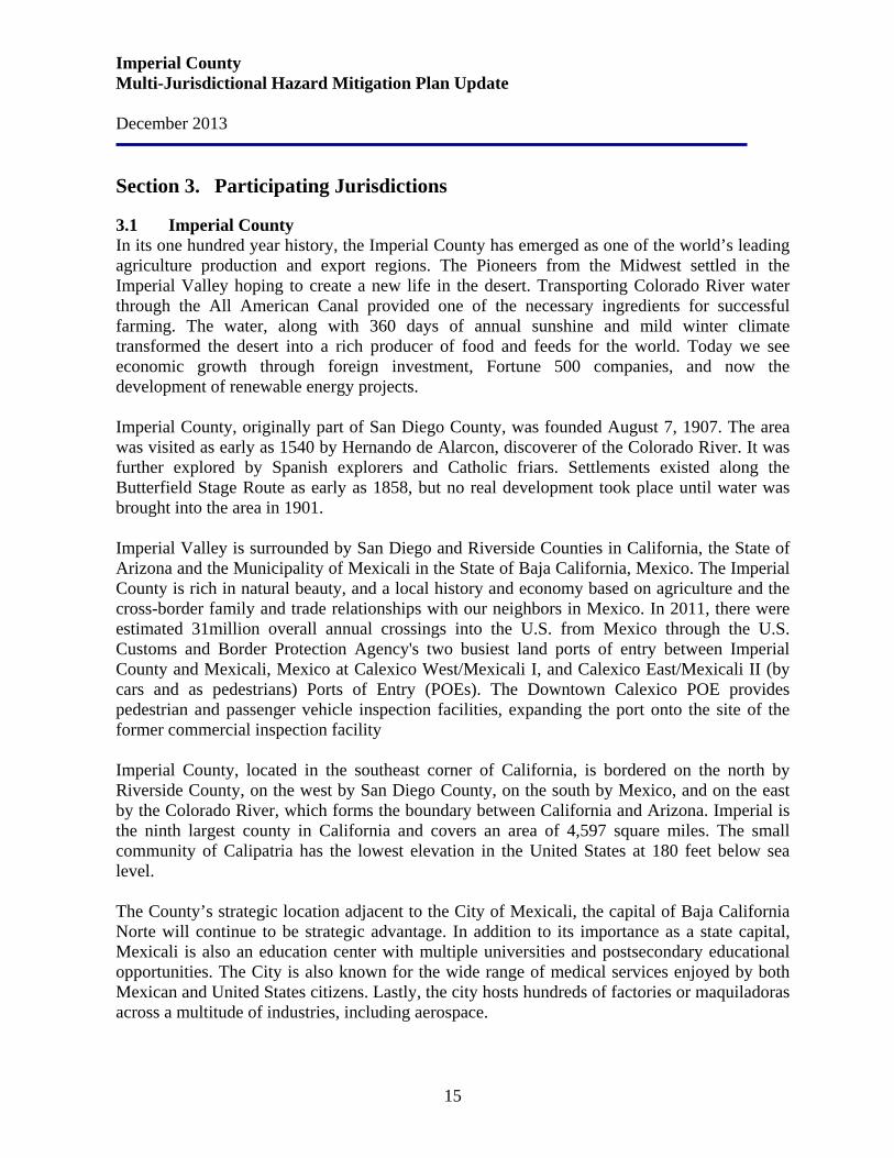
Imperial County is a rural area in southern California and covers 2.94 million acres in the southeast corner of California. Seventy-five percent of the county area is desert sand and rugged mountains with an average annual rainfall of less than three inches. Imperial County is one of California’s major agricultural producers. The main farming area is in the Imperial County, an 830- square-mile area that extends from the Mexico border north to the Salton Sea. An extensive irrigation system has been developed, and adequate water is supplied from the Colorado River through the All-American Canal. Imperial County has three international ports of entry. There are two ports of entry located in Calexico, and the third port is at Andrade in eastern Imperial County. Through these three ports travel over 35 million people and over 250,000 cargo trucks each year. The County contains seven incorporated cities: the County Seat of El Centro, Brawley, Calexico, Calipatria, Holtville, Imperial and Westmorland, plus several small unincorporated rural communities. Population
Jurisdiction 2011 / 2012* 2010** Imperial County 176,948 174,528 City of Brawley 25,335 24,953 City of Calexico 39,164 38,572 City of Calipatria 7,759 7,705 City of El Centro 43,242 42,598 City of Holtville 6,032 5,939 City of Imperial 14,987 14,758 City of Westmorland 2,261 2,225 ** Source: U.S. Census Bureau, Census 2000 * U.S. Census Bureau Estimates
The seven incorporated cities of Brawley, Calexico, Calipatria, El Centro, Holtville, Imperial, and Westmorland, account for 78 percent of the total population; and, in the past, have grown at a faster pace than the rural areas. Employment The number of jobs in Imperial County industries is projected to grow at a rate of 8.6% over a 10 year period (2008-2018). According to the Employment Development Department Labor Market Information Division, the total number of projected growth of job is 5,600. This projection falls short of the expected statewide growth rate of 9.7%.
Imperial County Multi-Jurisdictional Hazard Mitigation Plan Update December 2013
17
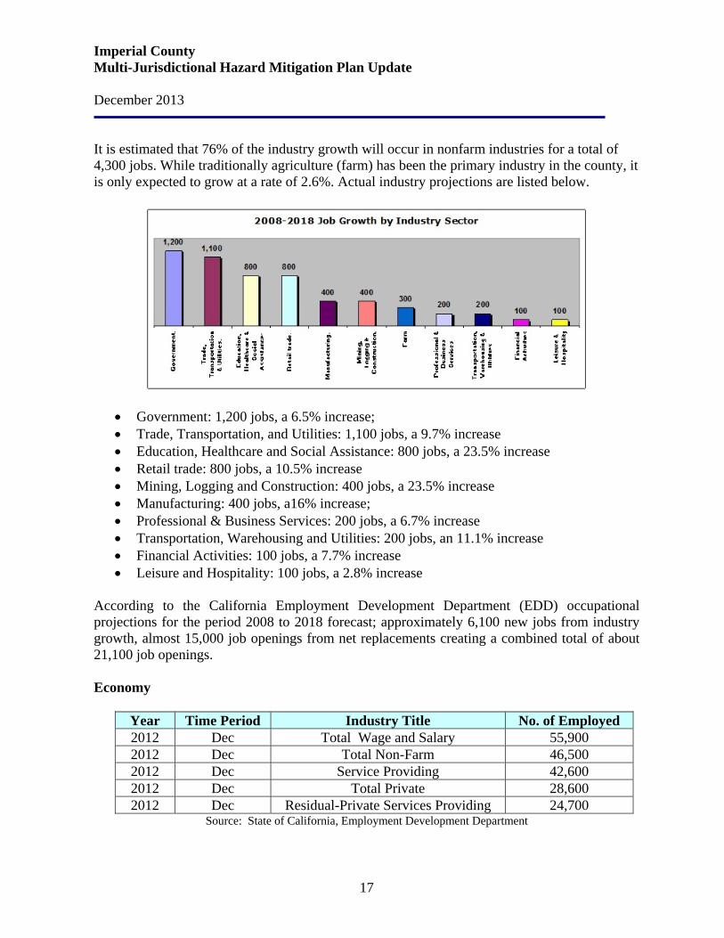
It is estimated that 76% of the industry growth will occur in nonfarm industries for a total of 4,300 jobs. While traditionally agriculture (farm) has been the primary industry in the county, it is only expected to grow at a rate of 2.6%. Actual industry projections are listed below.
• Government: 1,200 jobs, a 6.5% increase; • Trade, Transportation, and Utilities: 1,100 jobs, a 9.7% increase • Education, Healthcare and Social Assistance: 800 jobs, a 23.5% increase • Retail trade: 800 jobs, a 10.5% increase • Mining, Logging and Construction: 400 jobs, a 23.5% increase • Manufacturing: 400 jobs, a16% increase; • Professional & Business Services: 200 jobs, a 6.7% increase • Transportation, Warehousing and Utilities: 200 jobs, an 11.1% increase • Financial Activities: 100 jobs, a 7.7% increase • Leisure and Hospitality: 100 jobs, a 2.8% increase
According to the California Employment Development Department (EDD) occupational projections for the period 2008 to 2018 forecast; approximately 6,100 new jobs from industry growth, almost 15,000 job openings from net replacements creating a combined total of about 21,100 job openings. Economy
Year Time Period Industry Title No. of Employed 2012 Dec Total Wage and Salary 55,900 2012 Dec Total Non-Farm 46,500 2012 Dec Service Providing 42,600 2012 Dec Total Private 28,600 2012 Dec Residual-Private Services Providing 24,700
Source: State of California, Employment Development Department
Imperial County Multi-Jurisdictional Hazard Mitigation Plan Update December 2013
18
The 2008-2018 Imperial County Projections states that the Farm industry, which makes up 18 percent of the total employment, will climb to 11,700 by 2018, an increase of 300 new jobs. The largest number of new non-farm jobs is projected to occur in Government (1,200), Education Services, Health Care, and Social Assistance (800), and Retail Trade (800). These industry sectors will account for 65 percent of all job growth in non-farm employment. Information will remain flat. The fastest growing nonfarm industry sectors are: Mining, Logging, and Construction with Mining, generating the largest increase driven by the price of precious metals. Education Services, Health Care and Social Assistance, will continue to be driven by the aging and growing population. Other sectors that will exceed the region’s 9.2 percent nonfarm growth rate are Wholesale Trade (11.1 percent); Transportation, Warehousing, and Utilities (11.1 percent); Retail Trade (10.5 percent); and Other Services (10 percent). Agriculture and its related industries constitute the predominant economic base in Imperial County and is the largest employer with 35.1% of the work force. Government is the second largest employer with 21.3%, followed by retail trade with 15.2%. Due to the County's good soils, a year-round growing season, gently sloping topography and complex system of irrigation canals, it has become one of the most productive agricultural regions in the world. Other significant contributors to the local economy are government; retail trade; winter visitors or "snowbirds"; the construction of two state prisons in the County; the growth of the geothermal industry in the area; mining of gold, aggregate, and other mineral resources; the expansion of the Naval Air Facility; an additional U.S./Mexico border crossing; and approval of the North American Free Trade Agreement (NAFTA).
Transportation Systems Highways. For shipping and logistics, the highway system in Imperial County handles approximately 97% of total commodity flows across the county. There are four major north-south corridors handling freight within the county, Forrester Road, from I-8 to SR-78/86 in Westmorland; State Route 7 (SR- 7) from the Calexico East Port of Entry to I-8 Freeway; SR-111 from the Calexico West Border Crossing to SR-86 in Riverside County; and SR- 86, from SR- 111 to Riverside County where it connects with Interstate 10. Additionally, there are two major east-west corridors that also handle truck freight: the Interstate 8 freeway which originates in San Diego County to California/Arizona Border; and SR-98 which parallels Interstate 8 through most of the southern part of the county. This system is mostly complete and consists of the SR-7 expressway, the SR-111 expressway, the SR-78/111 Brawley Bypass Expressway, and the SR-86 Expressway north of Westmorland. This system facilitates the movement of goods from the international border with Mexico through Imperial County to Coachella Valley in Riverside County with connections west to Los Angeles/Long Beach Seaports and other key distribution centers throughout California.
Imperial County Multi-Jurisdictional Hazard Mitigation Plan Update December 2013
19
Ports of Entry. The County is connected to Mexico through three land Ports of Entry (POEs) at Calexico, Calexico East and Andrade, California. The Calexico POE is located in the City of Calexico and is the primary port for daily person crossings into the U.S. by car or as pedestrians. The Andrade POE is located near the California/Arizona border. The Andrade POE is an important gateway for tourism – U.S. visitors traveling into the small Mexican City of Algodones for shopping and medical services. Across the Imperial/Mexicali POEs there are approximately 80,000 people that cross the U.S. through these POEs daily for work school, shopping, entertainment and other social related trips. As with most U.S./Mexico border communities, the residents of Mexicali, Mexico are an important part of Imperial County’s community and economy. Mexicali is the state capitol of Baja California with an estimated population of nearly 1 million people. Regional Transit System. Imperial Valley Transit (IVT) operates 11 fixed routes. These routes roughly form a north-south axis along SR-86 and SR-111 corridors from Niland to Calexico, continuing along the SR-111 corridor to Niland (Bombay Beach on Thursdays), and an east-west axis along I-8 and Imperial County S80/Evan Hewes Highway corridors from Seeley to El Centro and Holtville, extending to Ocotillo on Tuesdays, Winterhaven on Wednesdays and Bombay Beach on Thursday. Public transit service in Imperial County includes the following:
• Urban circulator services, currently comprising the IVT Blue and Green Lines in El Centro
• Americans with Disabilities Act (ADA) complementary paratransit service, branded IVT Access
• Limited paratransit service, branded Med-Express • Dial-a-Ride service provides curb to curb transit service in five defined areas, including
El Centro, Calexico, Brawley, Imperial and the West Shores area (west side of the Salton Sea).
Rail Infrastructure. Imperial County is also served by rail connections from Mexico, Riverside County, and Arizona. Commodity flows by rail account for about 3% of total commodity flows in the county. The Union Pacific Rail Road (UPRR) owns and operates a line originating at the Calexico West border crossing, extending north to El Centro and ultimately connecting with other UPRR tracks at Niland, heading north to Riverside County and southeast to Arizona (Sunset Line). UPRR also owns and operates the section between Plaster City and El Centro. Airport Infrastructure. The Imperial County Airport is a 139 Commercial Airport as well as the largest general aviation airport in the county. It is centrally located within the jurisdictional boundaries of the City of Imperial, along Highway 86, owned and operated by the County of Imperial. The Imperial County Airport provides air service for private and commercial passenger and freight transportation. Currently freight is transported through the courier services of Federal Express (FedEx) and United Parcel Service (UPS). At the Imperial County Airport, there are daily scheduled airline flights, air cargo, military operations, Department of
Imperial County Multi-Jurisdictional Hazard Mitigation Plan Update December 2013
20
Homeland Security aircraft as well as several business jets and private general aviation flights. A hotel and several businesses are located on airport property providing additional revenue through land leases helping to fund the operation of the airport. Aviation services provided at the airport include: hangar rentals, aircraft fueling, flight training, business aircraft charters, aerial fertilizer and pesticide applications and aircraft maintenance. Tourism Each year, millions of people from San Diego, Los Angeles, and Riverside County and beyond visit the Imperial Sand Dunes to enjoy and experience the sand dunes. During the fall to spring months, visitors from colder northern climates migrate to Imperial County to enjoy our mild-winter weather and participate in activities such as golfing, cycling, water-skiing, fishing and shopping. The baby-boomers are reaching retirement age and many will have disposal income and are considered the most active retirees in history seeking sunny winter areas with outdoor activities. Expansion of tourism to winter visitors is an economic development strategy with tremendous economic potential. Imperial County is recognized as one of the “Best birding habitats in Southern California”. In the past years, thousands of bird watchers have traveled from as far away as British Columbia to attend the International Bird Festival featuring Salton Sea, Imperial County and in the Mexicali/San Felipe region. Major Recreation Areas Imperial Sand Dunes (formerly called the Algodones Dunes). The dunes are a well-known landmark to both local residents and the thousands of travelers who pass by them each year. It extends along the east perimeter of the Imperial Valley. This 40-mile dune system is one of the largest in the United States. The dunes were formed from the windblown beach sands of prehistoric Blake Sea. Some dune crests reach heights of more than 300 feet. The largest and tallest dunes are located in the central area and west side, while the east side contains smaller dunes and numerous washes. The three most popular areas are Glamis/Gecko, Buttercup Valley and Dunebuggy Flats. It is also a popular filming location. Anza Borrego Desert State Park. With over 600,000 acres, Anza-Borrego Desert State Park is the largest desert state park in the contiguous United States. 500 miles of dirt roads, two huge wilderness areas (comprising 2/3 of the park) and 110 miles of riding and hiking trails provide visitors with an unparalleled opportunity to experience the wonders of the Colorado Desert. The park features washes, wildflowers, palm groves, cacti and sweeping vistas. Visitors may also have the chance to see roadrunners, golden eagles, kit foxes, mule deer and bighorn sheep as well as desert iguanas, chuckwallas and four species of rattlesnake. Coyote Mountain Wilderness. Described as a fish hook shaped mountain range, the Coyote Mountains make up 40% of this wilderness. Part of the Carrizo Badlands lie within the northern portion of the wilderness, their narrow and twisting gullies giving the landscape its austere, forbidding appearance. A group of unusual sandstone rock formations, believed to be 6,000,000 years old, add to the character of this region.
Imperial County Multi-Jurisdictional Hazard Mitigation Plan Update December 2013
21
Desert Oasis (Hot Spring Spa and Long Term Visitor Area). This year-round hot springs attracts both local and winter visitors. Average water temperature is in the 100° F range. Desert View Tower. To honor the builders of the railroad and highway that made the journey so much easier, the tower was built in 1923 as a commemoration to the pioneers who crossed the desert and mountains. The tower is located at the edge of the mountains that overlook the southern area of Anza-Borrego Desert State Park and the desert of Imperial County. Fish Creek Mountains Wilderness. This wilderness area resembles a plateau rising as a great wall above the desert basin. Close up, you can see a land of jagged ridges and peaks that appear above twisting canyons and small valleys. The mountain slopes contain limestone outcrops that have resisted erosion. A gypsum mining operation in the western mountains provides raw Material for the U.S. Gypsum plant at Plaster City. Fossil Canyon. The weathering of copper, iron and sulfur within the rock has stained the multicolored canyon walls. The upper section of the gorge contains marine fossils. Mesquite Mine Overlook Trail. This one-mile trail leads to an overview of the second largest gold mine in California. Mud Pots and Mud "Volcanoes" (Freaks of Nature). The mud "volcanoes" are cones built up out of viscous mud that bubbles up through central vents. This area is near a formerly commercial carbon dioxide gas field. The age of these mud pots is not known, but survey reports in the late 1800's and early 1900's reported mud pots and steam vents in the area. These mud volcanoes can be found near the Salton Sea shore. The Wister mud pots are found on Hot Mineral Spa Road, just off Highway 111. The fluid level of these mud pots varies throughout the year. Several mud pots located next to each other will have different fluid levels and different colors in the mud. The temperature of the fluid is slightly higher than the ambient air temperature. Salton Sea. Salton Sea is the largest lake in California covering 380 square miles. It is 35 miles long and about 15 miles wide at its widest point and about 50 feet deep at its deepest point. Farther north the Salton Sea State Recreation Area encourages camping, fishing, bird watching and just plain relaxing. Salton Sea is a major stop for migratory birds on the Pacific Flyway. At least 375 different species of birds annually visit the wetlands along the shores of the Sea as well as the agricultural fields, canals and drains that feed it. The annual Salton Sea International Bird Festival attracts enthusiasts from all over the world. The Sea is considered one of the world’s most productive fisheries, attracting recreationists’ year around. Sonny Bono Wildlife Refuge. The Sonny Bono Salton Sea National Wildlife Refuge is a treasure of the Sea’s ecological systems, especially birds. With over 375 bird species, this refuge provides world class bird watching. Hundreds of thousands of birds use this refuge to winter and as a migration stop. Endangered species such as the Bald Eagle, the Peregrine

Imperial County Multi-Jurisdictional Hazard Mitigation Plan Update December 2013
22
Falcon, and the California Brown Pelican can be seen here. Other species that frequent the reserve are the Fulvous Whistling Duck, the Wood Stork, the Mountain Plover, the Borrowing Owl, and the Long Billed Curlew. In February the reserve is host to the Salton Sea International Bird Festival which draws thousands of visitors from around the world. Climate The climate in Imperial County is hot and dry, ranging from lows in the mid-30s in January to highs of 110+ in July and August (mean temperatures: low of 55.0 degrees; high of 89.6 degrees), with little moisture (average annual rainfall: 2.92 inches; 25 percent average relative humidity). Temperatures The lowest minimum temperature ever recorded was 16 degrees on January 22, 1937. The highest maximum temperature ever recorded was 121 degrees on July 28, 1995. The lowest maximum temperature was 42 degrees, recorded on January 24, 1949, and the highest minimum temperature was 92 degrees on June 30, 1946. The highest monthly mean temperature was 95.9 degrees, recorded in August 1969 and the lowest mean temperature was 42.3 degrees in February 1939. Rainfall The 85-year average annual rainfall is 2.92 inches with June being the driest month. Since 1914, there has only been measurable rainfall three times during the month of June: 0.04 of an inch on June 2, 1948; 0.01 of an inch on June 18, 1988; and 0.01 of an inch on June 7, 1997. The highest rainfall in one day was recorded on September 6, 1939, when 4.08 inches was measured. The total for the month, 7.06 inches, made September 1939 the month with the highest rainfall on record. The year 1939 was also the highest year on record with 8.52 inches. The lowest annual rainfall record was in 1956 with 0.16 of an inch. Snow The only recorded snowfall of consequence occurred on December 12, 1932. Snow began falling at 8:45 p.m. and by 5:00 a.m. the following day, 2½ inches had been recorded. In the southwest portion of Imperial Valley, four inches of snow was reported that day. This was the only snowfall of record to cover the entire Valley. Historical Setting Imperial County, originally part of San Diego County, was founded on August 7, 1907. The area was visited as early as 1540 by Hernando de Alarcon, discoverer of the Colorado River. It was further explored by Spanish explorers and Catholic friars. White settlements existed along the Butterfield State Route as early as 1858, but no real development took place until water was brought into the area in 1901.
Imperial County Multi-Jurisdictional Hazard Mitigation Plan Update December 2013
23
Imperial County is the youngest of California’s 58 counties. In 1907 San Diego County extended from the Pacific Ocean, on the west, to the Colorado River, Arizona border on the east, with Mexico being its southern border. By a vote of the people the County was divided in half, and the eastern portion became Imperial County. Governing Bodies The Imperial County Seat is El Centro. The governing body of the County is the Board of Supervisors, comprised of five members elected by the voters for four year terms in each of the five County districts. Normally, the Board meets every Tuesday, plus other special meeting times, to conduct the affairs and business of the County. Certain departments are administered by elected department heads, while others are administered by persons selected and appointed by the Board. 3.2 City of Brawley The City of Brawley was incorporated in 1908 and is a General Law municipality. The City is centrally located in the agriculturally rich Imperial Valley, 119 feet below sea level and covers an area of about 5.8 square miles. Brawley is located approximately 25 miles north of the International Border and 100 miles east of San Diego. State highways 111, 86, and 78 all intersect in Brawley. The City has a population of approximately 25,000 and includes services from the Imperial County School District and the Imperial Irrigation District. Brawley is a family-oriented community with good schools, and 14 parks beautifully landscaped. Brawley's features include a lighted class B baseball park, 13 public parks, an acoustically correct auditorium, a sizeable industrial park, a municipal airport, a world class rodeo arena, and an Olympic size swimming pool. Brawley also has an 18 hole golf course which features a large club house and tennis courts. Three lakes are located within fifteen minutes of town and the sand dunes are just twenty minutes away.
The winter climate in Brawley is some of the best in the country. Average daily temperatures are in the 70's all winter long. Average annual rainfall is around two inches per year.
3.3 City of Calexico The City of Calexico was incorporated in 1908. The City is a unique community and is located 230 miles southeast of Los Angeles and 125 miles east of San Diego. The City is situated directly along the U.S./Mexico International border, adjacent to the city of Mexicali, Baja California, Mexico. Calexico’s port of entry is a major entrance point for thousands of persons as well as large amounts of goods traveling between the two countries. Its economy reflects its proximity to the Mexican border and its location in an agriculturally-oriented California county.
Imperial County Multi-Jurisdictional Hazard Mitigation Plan Update December 2013
24
The City has a population of approximately 39,000 and includes services from the Imperial County School District and the Imperial Irrigation District. Economically and given its geographic location immediately adjacent to the international border crossing, the City largely functions as a suburb of the metropolitan complex of Mexicali, Baja California, Mexico. Calexico also functions as one of the Imperial Valley’s communities, surrounded by and supported by agriculture. Traditionally, Calexico has had a relatively strong retail sector, which is oriented to providing finished goods and services for the Mexicali market. Businesses in Calexico rely heavily on sales to Mexicali residents and merchants have greatly benefited from this reliance. Calexico is a blend of American and Mexican cultures, small-town lifestyle, combined with its convenient proximity to the metropolitan areas of Mexicali and San Diego. Calexico's climate is sunny year-round and offers little to inhibit outdoor recreation. Golfing, water sports, hunting, fishing and hiking are all available in the immediate area, and the beautiful beaches of San Diego and Baja California are easily accessible for day trips or vacations. Just across the border, Mexicali is a cultural and entertainment center offering ample opportunity for fine dining, theatre, music and more. 3.4 City of Calipatria The City of Calipatria was incorporated on February 28, 1918 as a General Law municipality. Since its incorporation, the City of Calipatria has developed as a semi-rural community with farming as its major industry. The City is a gateway for NAFTA and is ideally situated within an ever-growing corridor of commerce between Los Angeles and Mexico. Calipatria has excellent transportation opportunities and a projected growth that make it the premier place to do business. Calipatria is located in the northern part of Imperial County with a population of approximately 7,800, which includes 4372 prison population and includes services from the Imperial County School District and the Imperial Irrigation District. The Calipatria State Prison is annexed into the City limits located about three miles just outside of the City. Calipatria has a small town flavor and enjoys a multi-cultural ambience. The City’s elevation is 185 feet below sea level and is located 50 miles north of the Mexico Border. The area is predominately agricultural, but is surrounded by various recreational activity locations as well. The Glamis Dunes located about 40 miles from the City is home to many off- road enthusiasts. Rock collecting, deer and dove hunting are also nearby about 30 miles from the City in the Chocolate Mountain areas. Fishing, camping and bird watching are a big interest along the Salton Sea area. The Salton Sea is also home to the Sonny Bono Wildlife Refuge where bird watching enthusiasts can enjoy the various species of birds frequenting the area. Boat tours are available at the Salton Sea to view the various habitats of the migratory birds. Seven geothermal plants and three new mineral recovery plants are located along a seven-mile radius near the Salton Sea. The City of Calipatria is also a short hour's drive to the Colorado River.

Imperial County Multi-Jurisdictional Hazard Mitigation Plan Update December 2013
25
3.5 City of El Centro The City of El Centro is the County Seat and principal trading center of Imperial County. Covering approximately 25 square miles of land, El Centro is the largest City in Imperial County with a population of approximately 44,000 and includes services from the Imperial County School District and the Imperial Irrigation District. The City of El Centro is located near the Mexican border near Interstate 8 between Calexico and Brawley. El Centro shares its northern border with the City of Imperial, while the City of Mexicali is located 10 miles to the south just beyond the border, and the City of Yuma, Arizona is 60 miles to the east. El Centro is accessible via Interstate 8, State Highway 86 and State Highway 111. In 1906 W. F. Holt and C.A. Barker purchased the land on which El Centro was eventually built, and was incorporated on April 6, 1908. By the mid-1940s, El Centro had become the second largest City in the Imperial Valley, with a population of about 11,000. At this point in the City’s history, its economy revolved around agriculture as fruit and vegetable packing and shipping yards, ice plants, box factories, concrete pipe and brick yards, and a flax fiber plant were the major employment centers. El Centro also became the principal wholesale center of the area. By the 1970s, agriculture was still an important part of the City’s economic life. Imperial County had become one of the most agriculturally productive areas in the country and many growers and shippers still operated in El Centro. However, by the early 1980s, the two largest employment sectors in the El Centro labor market areas were government and wholesale/retail trade, reflecting El Centro’s emerging role as a regional administrative and commercial center. El Centro is operated by a council/manager form of government. It is strategically located in the Imperial economic base. Several state and federal government offices are located in El Centro, such as the Bureau of Land Management, Federal Bureau of Investigations, U.S. Border Patrol Headquarters, Social Security Administration, Employment Development Department and the Department of Agriculture. El Centro is 15 minutes from the international industrial complexes in Mexicali. There are two international border crossings nearby for commercial and noncommercial vehicles. 3.6 City of Holtville The City of Holtville is a small town with a population of approximately 6,000 and includes services from the Imperial County School District and the Imperial Irrigation District. It is conveniently located in the Imperial Valley near tourist, trade, and travel centers of the southwestern United States. The City of Holtville is located along the southern portion of Imperial County, along the eastern fringe of the irrigation areas. It is situated within ten miles of the Mexican Border, minutes from Mexico's Mexicali port of entry, and centrally located a few hours between Los Angeles, Phoenix, Tucson, and Las Vegas, one hour to the Colorado River, Palm Springs, or Yuma, and two hours to San Diego or Baja California.
Imperial County Multi-Jurisdictional Hazard Mitigation Plan Update December 2013
26
The City of Holtville or Holton as it was first called was founded by W.F. Holt. He had a vision of what the Imperial Valley would become, and in the process he was the first to envision a town east of the Alamo River. In 1903, the City of Holtville was born. Construction of the new town was slow in the beginning because of a town policy which only allowed brick construction; that policy was later changed. On June 20, 1908 the City of Holtville was incorporated.
The summer weather in Holtville has an average temperature of 105 degrees, but in the winter, the temperature averages about 70 degrees. The town is approximately 16 feet below sea level. Holtville has several different recreational facilities for members of the community as well as outside of the community.
3.7 City of Imperial The City of Imperial was incorporated in 1904 and is located in the south-central County area in the irrigated Imperial Valley along California's southernmost border. The City has a population of approximately 15,000 is located 13 miles north of the Mexican border and three miles north of the County Seat in El Centro, and includes services from the Imperial County School District and the Imperial Irrigation District. The City covers approximately 1,500 acres stretching along both sides of State Highway 89, the major north-south route through Imperial County. The 245-acre Imperial County Airport, the 97-acre California Mid-Winter Fairgrounds, 45 acres of Imperial Irrigation District facilities, and a 40-acre INS facility are located in the City of Imperial. Conveniently, the City of Imperial is located between major cities of California, Arizona and Mexico. State Route 111, which passes to the east of the City, is a major north, south corridor for the NAFTA shipping and travel route to the Calexico Port of Entry at the U.S./Mexican International border. In the near future it will also connect to the Brawley, California bypass, SR-86 and Interstate 10 to Los Angeles. The City has well established neighborhoods, new housing, multi-family housing, apartments, and nearby country living. Some neighborhoods have large parks nearby. All homes are close to parks and family recreation. The City of Imperial has that small town feel with lots of opportunities and growth. 3.8 City of Westmorland Strategically located in the Imperial Valley, Westmorland is set among one of the most fertile agricultural regions in the world. Highway 86 is a four-lane expressway connecting Westmorland to Coachella Valley and Interstate 10. Forrester Road connects Westmorland to Interstate 8. Westmorland is 87 miles southeast of Palm Springs, 122 miles east of San Diego, 192 miles southeast of Los Angeles, 261 miles west of Phoenix, Arizona, and 31 miles north of Mexicali, Mexico. It is 22 miles north of El Centro, the county seat.
Imperial County Multi-Jurisdictional Hazard Mitigation Plan Update December 2013
27
Surrounded by the desert and farmland areas of Imperial County, the City of Westmorland is home to approximately 2,200 residents and includes services from the Imperial County School District and the Imperial Irrigation District. The City of Westmorland lies in the northwest portion of the Imperial Valley and sits along State Highway 86. It is located approximately 12 miles south of the Salton Sea, 25 miles from the City of El Centro, and 30 miles north of the U.S./Mexico border. The City is a small rural community, primarily residential with some commercial establishments. The City of Westmorland was incorporated on June 30, 1934 under the laws of the State of California as a General Law City. It has a City Council form of government with seven elected positions, five Council members, one City Treasurer and one City Clerk. The mayor is appointed by the Council members and serves a one-year term, but may be re-selected to serve more than one term. 3.9 Imperial Irrigation District The Imperial Irrigation District (IID) is a public agency and was organized in 1911 under the California Irrigation District Act. It is governed by a five-member Board of Directors. Elected by the public, each Director represents one of five political divisions within the Imperial Valley.
Established by a vote of the people and led by a popularly elected board of directors, IID exists to serve the public. As such, its twofold mission of delivering water and electrical power to the communities that make up its service area is carried out with a public purpose. The business of IID is, by definition, the people's business. As a public agency that depends on the consent of the governed, the district's organizational structure and policy-making function are intended to be as open and transparent as possible.
IID Water: With more than 3,000 miles of canals and drains, IID is the largest irrigation district in the nation. As a public agency, IID strives to provide the highest level of service at the most economical price while still preserving the unique ecosystem associated with this working landscape. Water Rights - IID has a "present perfected" right to 2.6 million acre-feet (MAF) of water annually. A 1964 Supreme Court decree in California v. Arizona defined these district water rights. The district's present perfected rights were set at 2.6 MAF annually because that was the annual quantity being diverted by the district and used on the 424,145 acres under irrigation. These vested rights preempt the 1902 Reclamation Law and are not subject to reclamation law limitations. The significance of IID's present perfected right is that in times of shortage, present perfected rights must be satisfied first. IID Energy: IID entered the power industry in 1936. Today IID provides electric power to more than 145,000 customers in Imperial County and parts of Riverside and San Diego counties. As the sixth largest utility in California, IID Energy controls more than 1,100

Imperial County Multi-Jurisdictional Hazard Mitigation Plan Update December 2013
28
megawatts of energy derived from a diverse resource portfolio that includes its own generation, and long- and short-term power purchases. As a consumer-owned utility, IID Energy works to efficiently and effectively meet their customers’ demands at the best possible rates, tying their area’s low-cost of living directly with low-cost utilities. They accomplish this by producing 30 percent of their power supply locally, using efficient, low-cost hydroelectric facilities, steam generation facilities, as well as several natural gas turbines. IID emphasizes environmentally friendly operations by employing as many “green” resources as available. IID’s diverse resource portfolio provides their customers with some of the lowest cost rates in southern California. 3.10 Imperial County Office of Education The Imperial County Office of Education (ICOE) mission is to improve the quality of life in Imperial County by providing excellent educational service and leadership to children, school districts, and the community. The ICOE works closely with the County's 16 independent school districts, as well as its public service agencies, businesses, institutions of higher education, and elected officials to ensure that meeting the educational needs of children is a community priority. ICOE also provides direct services to students with specialized needs through its alternative education and special education programs. The ICOE has five Board Members and meets regularly every month. ICOE is a recognized educational leader in the State of California and is currently at the head of several statewide projects, including the K-12 High Speed Network, which provides network connectivity, Internet services, and videoconferencing coordination and support for California’s K-12 public schools. Following is a list of the Imperial County School District, followed by a map of the sites:
• Brawley Elementary School District • Brawley Union High School District • Magnolia Union Elementary School District • Mulberry Elementary School District • Calexico Unified School District • Calipatria Unified School District • Central Union High School District • El Centro Elementary School District • McCabe Union School District • Meadows Union School District • Heber Elementary School District • Holtville Unified School District • Imperial Unified School District • Seeley Union School District • Westmorland Union Elementary School District
Imperial County Multi-Jurisdictional Hazard Mitigation Plan Update December 2013
29
• San Pasqual Valley Unified School District • Calexico Community School • Del Rio Community Schools 1 & 2 • La Solana Community School • Valley Community Schools 1, 2 & 3
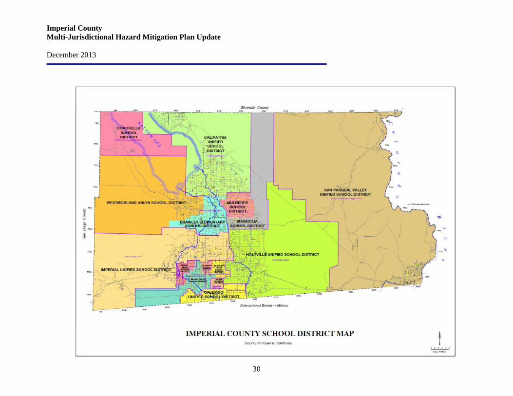
Imperial County Multi-Jurisdictional Hazard Mitigation Plan Update December 2013
30
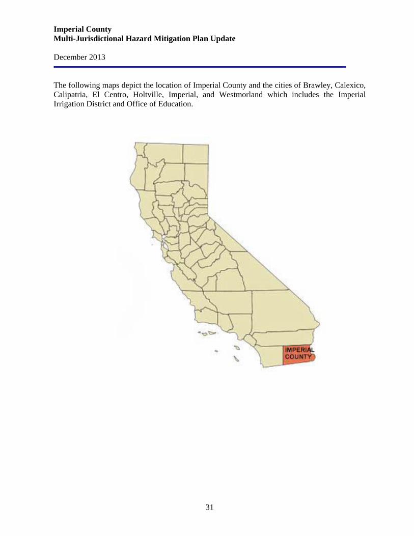
Imperial County Multi-Jurisdictional Hazard Mitigation Plan Update December 2013
31
The following maps depict the location of Imperial County and the cities of Brawley, Calexico, Calipatria, El Centro, Holtville, Imperial, and Westmorland which includes the Imperial Irrigation District and Office of Education.
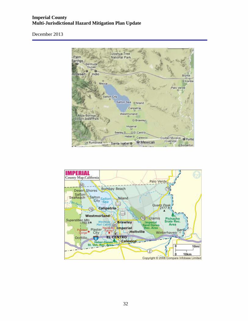
Imperial County Multi-Jurisdictional Hazard Mitigation Plan Update December 2013
32
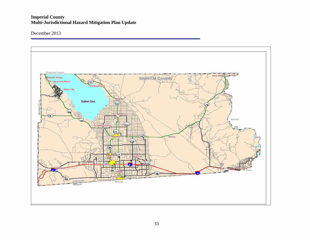
Imperial County Multi-Jurisdictional Hazard Mitigation Plan Update December 2013
33
Imperial County Multi-Jurisdictional Hazard Mitigation Plan Update December 2013
34
Section 4. Land Use
Imperial County’s Land Use Element designates the general distribution, general location, and extent (including standards for population density and building intensity) of uses of the land for housing, business, industry, open space, including agriculture, natural resources, recreation and enjoyment of scenic beauty, education, public buildings and grounds, solid and liquid waste disposal facilities, and other categories of public and private uses of land. The primary purpose of the Land Use Element is to identify the goals, policies, and standards of the General Plan that will guide the physical growth of Imperial County, including public facilities necessary to support such growth. Imperial County is, and will continue for the foreseeable future to be, a predominantly agricultural area; although in 2003 a significant increase in urbanization began to show. Presently, approximately one-fifth (534,328) of the nearly three million acres of the County is irrigated for agricultural purposes. In addition, approximately 50 percent of County lands are largely undeveloped and under federal ownership. The developed area where the County's incorporated cities, unincorporated communities, and supporting facilities are situated comprise less than one percent of the land. Imperial County has three international ports of entry. There are two ports of entry located in Calexico, and the third port is at Andrade in eastern Imperial County. Through these three ports travel over 35 million people and over 250,000 cargo trucks each year. The seven incorporated cities: Brawley, Calexico, Calipatria, El Centro, Holtville, Imperial, and Westmorland, account for 78.3 percent of the total population. In the past, incorporated cities have grown at a faster pace than the rural areas. Recently, residential development has increased in agricultural areas away from cities and communities. The Urban Area designation of the County’s Land Use Plan includes areas surrounding the seven incorporated cities: Brawley, El Centro, Westmorland, Holtville, Calipatria and Calexico. Urban Areas also include the unincorporated communities of Westmorland, Niland, Heber, Seeley, Winterhaven and West Shores/Salton City. These areas are characterized by a full level of urban services, in particular public water and sewer systems, and contain or propose a broad range of residential, commercial, and industrial uses. It is anticipated that these areas will eventually be annexed or incorporated and should be provided with the full range of public infrastructure normally associated with cities. Therefore, development in these areas shall provide for the extension of full urban services such as public sewer and water, drainage improvements, street lights, fire hydrants, and fully improved paved streets with curbs and, in many cases, sidewalks. If located within an urban area, such improvements shall be consistent with City standards as determined by the Director. In cases where the Urban Area is located in the unincorporated communities (i.e., Heber, Seeley, etc.) improvements shall be consistent with County standards as determined by the Director of Planning & Development Services. Development proposed outside of a designate Urban area
Imperial County Multi-Jurisdictional Hazard Mitigation Plan Update December 2013
35
shall either require an amendment to an existing Urban area or be designated as a new Specific Plan Area meeting full Urban area improvement standards. Increasingly, the local economy is becoming more diversified and less reliant on the economic cycles of agriculture. In addition to economic diversification, there are a number of other factors which may accelerate population growth in the future. For example, the construction of two State prisons in the area; the growth of the geothermal industry in the area; the expansion of the Naval Air Facility; an additional U.S./Mexico border crossing; and approval of the North American Free Trade Agreement (NAFTA) between the U.S., Mexico, and Canada. Specific Plans - Purpose and Content Specific Plans are “planning tools” used to implement the General Plan for large development projects such as a planned residential community, large scale commercial project, industrial park, etc., or to designate an area of the County where further studies are needed prior to development. Specific Plans should be utilized where existing conventional zoning regulations do not provide adequate controls over land use and development. Upon adoption, the Specific Plan serves as an amendment to the County General Plan for a very defined and detailed area. To be adequate, a Specific Plan must also be consistent with all aspects of the General Plan. Specific Plans may be adopted by Resolution of the County Board of Supervisors. Following adoption of the Specific Plan, all subsequent use or development of the property shall be in conformance with the Specific Plan. If the proposed Specific Plan is less than 640 acres in size, a finding shall also be made that the proposed project will provide a significant social or economic benefit to the County. Land Use / Population Imperial County Planning & Development Services Department bases its population estimates on building permits and housing unit change. From this annual compilation, the Population Research Unit of the California Department of Finance (DOF) estimates the annual change in population. The Federal government owns approximately one-half of all land in Imperial County, primarily the Department of the Interior's Bureau of Land Management (BLM) property and U.S. Military lands. Other Federal sites include National Wildlife Refuges at the south end of the Salton Sea and two sites on the Colorado River-Cibola near Palo Verde, and Imperial farther south. U.S. Border Patrol are located at the Mexicali/Calexico and Algodones/Andrade Ports of Entry, with Border Patrol inspection station also operating on Highway 86/78 south of Salton City, Highway 111 north of Bombay Beach, and Highway 78 south of Palo Verde.
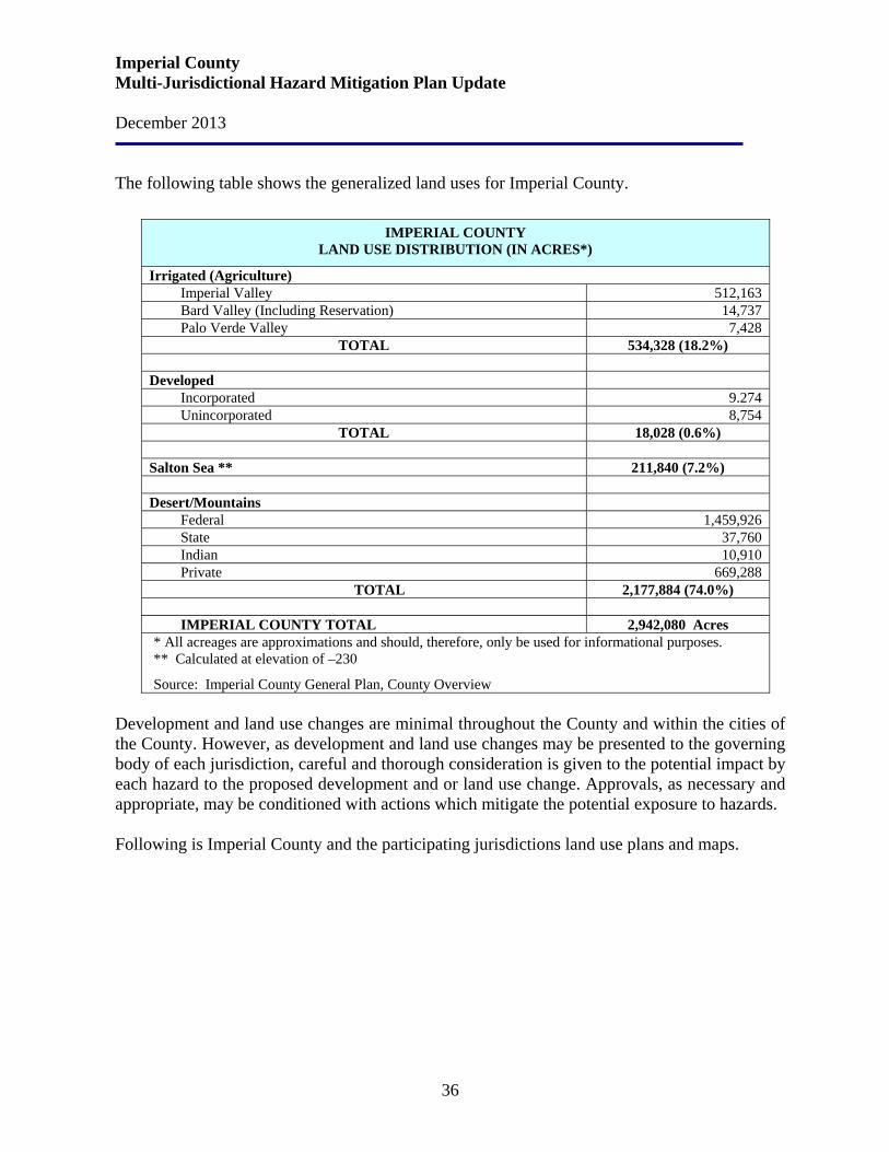
Imperial County Multi-Jurisdictional Hazard Mitigation Plan Update December 2013
36
The following table shows the generalized land uses for Imperial County.
IMPERIAL COUNTY LAND USE DISTRIBUTION (IN ACRES*)
Irrigated (Agriculture) Imperial Valley 512,163 Bard Valley (Including Reservation) 14,737 Palo Verde Valley 7,428
TOTAL 534,328 (18.2%)
Developed Incorporated 9.274 Unincorporated 8,754
TOTAL 18,028 (0.6%)
Salton Sea ** 211,840 (7.2%) Desert/Mountains
Federal 1,459,926 State 37,760 Indian 10,910 Private 669,288
TOTAL 2,177,884 (74.0%)
IMPERIAL COUNTY TOTAL 2,942,080 Acres * All acreages are approximations and should, therefore, only be used for informational purposes. ** Calculated at elevation of –230
Source: Imperial County General Plan, County Overview Development and land use changes are minimal throughout the County and within the cities of the County. However, as development and land use changes may be presented to the governing body of each jurisdiction, careful and thorough consideration is given to the potential impact by each hazard to the proposed development and or land use change. Approvals, as necessary and appropriate, may be conditioned with actions which mitigate the potential exposure to hazards. Following is Imperial County and the participating jurisdictions land use plans and maps.
Imperial County Multi-Jurisdictional Hazard Mitigation Plan Update December 2013
37
4.1 Imperial County Land Use Plan Following are Imperial County and participating jurisdiction’s Goals and Objectives relative to all land use within the unincorporated areas of the County. Goals and Objectives
Commercial Agriculture Goal 1: Preserve commercial agriculture as a prime economic force.
Objective 1.1 Encourage the continued agricultural use of prime/productive agricultural lands. Objective 1.2 Discourage the location of incompatible development adjacent to productive agricultural lands. Objective 1.3 Identify compatible agriculture-related uses appropriate for location in agricultural areas. Objective 1.4 Encourage the continued participation in the County Williamson Act Program. Objective 1.5 Encourage agricultural food processing or value added business to locate in Imperial County to further enhance the continued viability of the Agricultural Economy. Objective 1.6 Encourage the continued viability and growth of the agricultural industry to minimize dependence on foreign food supplies to the region and the county.
Economic Growth Goal 2: Diversify employment and economic opportunities in the County while preserving agricultural activity.
Objective 2.1 Achieve a balanced and diversified local economy with a variety of economic and employment opportunities. Objective 2.2 Provide adequate space and land use classifications to meet current and projected economic needs for commercial development. Objective 2.3 Continue to evaluate economic development strategies, including new industrial, commercial, and tourist-oriented land uses. Tourist-oriented uses must be compatible with BLM management goals in areas near BLM lands. Objective 2.4 Improve the “regional” economic development cooperation with the other agencies in the County through collaboration, partnerships, and the utilization of the public/private partnerships such as the current IVEDC (Imperial Valley Economic Development Corporation). Objective 2.5 Continue partnership efforts such as the Foreign Trade Zone JPA, or the Enterprise Zone JPA to obtain economy in scale, and the better utilization of public funds in promoting the County toward a healthier economy and a healthier quality of life area.
Imperial County Multi-Jurisdictional Hazard Mitigation Plan Update December 2013
38
Regional Vision Goal 3: Achieve balanced economic and residential growth while preserving the unique natural, scenic, and agricultural resources of Imperial County.
Objective 3.1 Maintain and improve the quality of life, the protection of property and the public health, safety, and welfare in Imperial County. Objective 3.2 Preserve agriculture and natural resources while promoting diverse economic growth through sound land use planning. Objective 3.3 Attain County growth and development patterns that are orderly, safe, and efficient utilizing appropriate financing resources. Objective 3.4 Protect/improve the aesthetics of Imperial County and its communities. Objective 3.5 Ensure safe and coordinated traffic patterns, contiguous growth, and promote a planned and consistent development around city/township areas. Objective 3.6 Recognize and coordinate planning activities as applicable with the Bureau of Land Management (BLM), and the California Desert Conservation Plan. Objective 3.7 Establish a continuing comprehensive long-range planning process for the physical, social, and economic development of the County. Objective 3.8 Utilize non-agricultural land as a resource to diversify employment opportunities and facilitate regional economic growth. Uses must be consistent with each site's resource constraints, the natural environment, and the County Conservation and Open Space Element Objective 3.9 Promote water recreation activities in Imperial County in suitable areas along the New, Alamo, and Colorado Rivers, and in the Salton Sea. Objective 3.10 Identify and pursue funding sources for cleanup of the New and Alamo Rivers and the Salton Sea. Objective 3.11 All zoning within the County of Imperial will be compatible with the General Plan. Objective 3.12 Plan the County urban areas to have physical features, such as urban green belts, parks, or geographic/topographic features that distinguish one community (city) from another to avoid the future bland mega-city such as the LA basin. Objective 3.13 Plan for more regional infrastructure systems to reduce the number of smaller treatment facilities to provide greater efficiency and opportunity to service areas that currently are unnerved or lack adequate services. Objective 3.14 Encourage more regional cooperation and thinking among the elected bodies of the County.
Towns and Communities Goal 4: Preserve and enhance distinctive historic desert towns and newer communities.
Objective 4.1 Preserve and enhance existing urban and rural communities. Objective 4.2 Encourage distinctive community identities.
Imperial County Multi-Jurisdictional Hazard Mitigation Plan Update December 2013
39
Objective 4.3 Maintain and require compatible land uses within the existing communities. Objective 4.4 Limit the establishment of non-residential uses in predominantly residential neighborhoods and require effective buffers when appropriate non-residential uses are proposed. Objective 4.5 Specific Plan Area designation should be used for outlying proposed growth areas in order to better determine appropriate land uses and the timing and financing for needed community facilities.
Housing Opportunities: Goal 5: Encourage the compatible development of a variety of housing types and densities to accommodate regional population projections and special housing needs.
Objective 5.1 Provide sufficient, suitable residential sites and housing supply to meet projected housing needs of all segments of the population. Objective 5.2 Promote affordable housing for residents of all income groups, including low and moderate income households.
Industrial Development: Goal 6: Promote orderly industrial development with suitable and adequately distributed industrial land.
Objective 6.1 Provide adequate space and land use classifications to meet current and projected economic needs for industrial development. Objective 6.2 Ensure that development in the areas surrounding military, public, and private airports are consistent with the Airport Land Use Compatibility Plans. Objective 6.3 Protect industrial zoned areas from incompatible adjacent land uses and from under-utilization by non-industrial uses.
Extractive Resources: Goal 7: Identify and protect areas of regionally-significant mineral resources which are in locations suitable for extractive uses.
Objective 7.1 Provide adequate space and land use classifications to meet current and projected economic needs for extractive activities. Objective 7.2 Require that extractive uses are designed and operated to avoid air and water quality degradation, including groundwater depletion, other adverse environmental impacts, and comply with the State Surface Mining and Reclamation Act and County Surface Mining Ordinance.
Public Facilities: Goal 8: Coordinate local land use planning activities among all local jurisdictions and state and federal agencies.
Imperial County Multi-Jurisdictional Hazard Mitigation Plan Update December 2013
40
Objective 8.1 Coordinate with federal, state, and municipal agencies when planning for the acquisition and improvement of public parks and assure compatibility with adjacent communities and private property. Objective 8.2 New developments shall provide improvements to meet the added demands for parks and recreational facilities. Objective 8.3 Ensure that school facilities are adequate to meet the existing and projected needs of the population. Objective 8.4 Ensure that all future proposed private and public facilities are adequate to meet expected population growth and the needed additional services around local cities. Objective 8.5 At a minimum, provide adequate sites for solid/liquid and hazardous waste facilities to meet the current and projected demands of the County population and consistent with the County Solid Waste and Hazardous Waste Management Plans. Objective 8.6 Ensure that land uses adjacent to or near existing waste disposal or storage facilities are compatible with those facilities. Objective 8.7 Ensure the development, improvement, timing, and location of community sewer, water, and drainage facilities will meet the needs of existing communities and new developing areas. Objective 8.8 Ensure that the siting of future facilities for the transmission of electricity, gas, and telecommunications is compatible with the environment and County regulation. Objective 8.9 Require necessary public utility rights-of-way when appropriate. Objective 8.10 Provide for the review of public transportation needs in order to accommodate countywide growth.
Protection of Environmental Resources: Goal 9: Identify and preserve significant natural, cultural, and community character resources and the County's air and water quality.
Objective 9.1 Preserve as open space those lands containing watersheds, aquifer recharge areas, floodplains, important natural resources, sensitive vegetation, wildlife habitats, historic and prehistoric sites, or lands which are subject to seismic hazards and establish compatible minimum lot sizes. Objective 9.2 Reduce risk and damage from flood hazards by appropriate regulations. Objective 9.3 Adopt noise standards which protect sensitive noise receptors from adverse impacts. Objective 9.4 Coordinate with the Republic of Mexico to clean up the polluted New River and Alamo River in order to ensure public health and safety as well as recreational resources. Objective 9.5 Establish policies and programs for maintaining salinity levels in the Salton Sea which enable it to remain a viable fish and wildlife habitat. Objective 9.6 Incorporate the strategies of the Imperial County Air Quality Attainment Plan (AQAP) in land use planning decisions and as amended.
Imperial County Multi-Jurisdictional Hazard Mitigation Plan Update December 2013
41
Objective 9.7 Implement a review procedure for land use planning and discretionary project review which includes the Imperial County Air Pollution Control District.
Following is the Imperial County Land Use Plan Map.
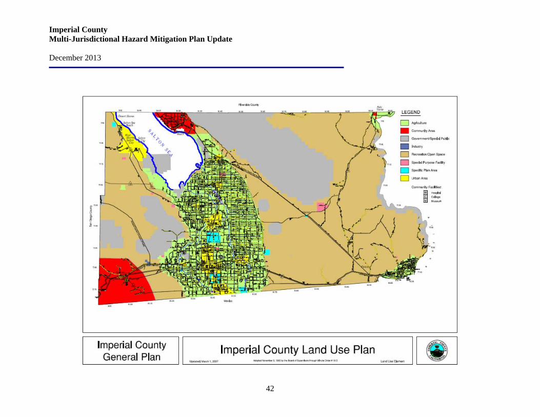
Imperial County Multi-Jurisdictional Hazard Mitigation Plan Update December 2013
42
Imperial County Multi-Jurisdictional Hazard Mitigation Plan Update December 2013
43
4.2 Brawley Area Land Use Plan The City of Brawley is located in central Imperial County, which is in the southeastern corner of California near the Mexican border. Brawley is located approximately six miles southeast of the City of Westmorland, approximately nine miles to the south of the City of Calipatria, nine and 12 miles north of the Cities of Imperial and El Centro respectively, and approximately 21 miles north of Calexico situated along the Mexican border. Within the context of the County, Brawley is located at the intersection of State Route 78 with State Route 86 and State Route 111. The New River flows from the southwest to the northern portion of the Brawley Planning Area and the Union Pacific Railroad generally extends north-to-south and bisects central Brawley. The City of Brawley has historically played a significant role in the agricultural economy that characterizes Imperial County. Brawley's strategic crossroads location at several major highways and the railroad facilitates easy access for residents and visitors, and regional shipping services. The City continues to provide a unique urban setting for residential, commercial, agribusiness, and industrial uses. The City is distinguished by a historic downtown commercial and civic center surrounded by a variety of distinct residential neighborhoods, parks, some industrial development, agriculture, and a municipal airport. The landscape around the urbanized areas is dominated by agricultural fields, scattered farmhouses, and related agricultural structures. Scenic views are enjoyed throughout Brawley including panoramic views of the stark topography of the Chocolate Mountains in the east and the foothills of the Peninsular Range in the west, the New River riparian corridor, and agricultural open space. The Brawley Planning Area consists of approximately 10,845 acres and encompasses the City’s incorporated areas and the City’s Sphere of Influence (SOI). The City’s incorporated areas and the SOI include approximately 4,902 acres and 5,943 acres respectively. The SOI includes areas that are currently under the jurisdiction of Imperial County but are expected to be annexed and incorporated into the City’s boundary. The Sphere of Influence was last approved by the Imperial Valley Local Agency Formation Commission (LAFCO) in 2006 as the City’s probable ultimate physical boundaries and service area and is to be updated at least once every five years.
Land Use Goals LUE Goal 1: Balanced Development LUE Objective 1.1: Provide for a well-balanced land use pattern that accommodates existing and future needs for housing, commercial and industrial land, open space, agricultural land, and community facilities and services, while maintaining a healthy, diversified economy capable of supporting future City services. LUE Policy 1.1.1: Preserve the quality of Brawley's existing low-density single-family neighborhoods while permitting compatible multi-family development to meet community
Imperial County Multi-Jurisdictional Hazard Mitigation Plan Update December 2013
44
housing needs where best suited from the standpoint of current development, accessibility, transportation and facilities. LUE Policy 1.1.2: Encourage an equitable distribution of affordable housing and public services and facilities throughout the City. LUE Policy 1.1.3: Provide for and encourage the development of neighborhood-serving commercial uses in areas of Brawley presently under-represented by such uses. Encourage the integration of retail or service commercial uses on the street level of office projects. Neighborhood-serving commercial centers should primarily provide convenience goods and services and be consistent with the scale of the surrounding neighborhood. LUE Policy 1.1.4: Facilitate the development of vacant and under-utilized highway parcels with commercial uses where appropriate and compatible with surrounding uses to capitalize on their highway access and visibility. LUE Policy 1.1.5: Support modification of present City boundaries in unincorporated areas within the City of Brawley's sphere of influence where they are irregular and create inefficiencies. LUE Policy 1.1.6: Maintain an updated Sphere of Influence for the City of Brawley. LUE Policy 1.1.7: Encourage in-fill of vacant parcels in areas already predominately developed. LUE Policy 1.1.8: Ensure an adequate supply of commercial and industrial land for potential commercial and industrial expansion and development. Businesses within a community or neighborhood should provide a range of job types. LUE Policy 1.1.9: As part of the City's attraction to business and industry, designate adequate residential land to house future employees. LUE Policy 1.1.10: Consider incentives (such as waiver of fees or expedited permit processing) to encourage lot consolidation and parcel assemblage to provide expanded opportunities for coordinated development and redevelopment if a positive fiscal impact will be experienced by the City as a result of said project. LUE Policy 1.1.11: Provide development of light industrial and business park uses. Encourage industrial and business parks as the preferred method of accommodating industrial growth. LUE Policy 1.1.12: Ensure that the distribution and intensity of land uses are consistent with the Land Use Plan and classification system contained in the Land Use Element. Development at an intensity or density between the effective and maximum levels can occur only where projects offer exceptional design quality or important public amenities or benefits above the standards required by the City's Zoning Ordinance and other regulatory documents. LUE Policy 1.1.13: Where feasible, increase the amount and network of public and private open space and recreational facilities which will be adequate in size and location to be useable for active or passive recreation as well as for visual enhancement. LUE Policy 1.1.14: Maintain sufficient flexibility in the types of uses allowed in commercially designated areas to address changes in market conditions and to encourage competition.
Imperial County Multi-Jurisdictional Hazard Mitigation Plan Update December 2013
45
LUE Objective 1.2: Ensure that future land use decisions are the result of sound and comprehensive planning. LUE Policy 1.2.1: Consider all General Plan goals and policies in evaluating proposed development projects for General Plan consistency. LUE Policy 1.2.2: Maintain consistency between the Land Use Element, Zoning Ordinances, and other City Ordinances, regulations and standards. LUE Policy 1.2.3: Endeavor to promote public interest in, and understanding of, the General Plan and regulations relating to it. LUE Policy 1.2.4: Encourage citizen participation in planning and development of land use programs. LUE Policy 1.2.5: Foster inter-governmental cooperation and coordination in order to maximize the effectiveness of land use policies. LUE Objective 1.3: Coordinate with other federal, state, and local public agencies and other community-oriented organizations to ensure that services to the public are effectively provided. LUE Policy 1.3.1: Participate in established networks of planning related organizations, such as the League of Cities, the Community Redevelopment Association, the American Planning Association, and others to continuously improve the City’s efficiency in providing for the public health, safety, and welfare of its residents. LUE Policy 1.3.2: Establish and maintain close contact with community-based organizations within the City to encourage coordinated approaches to address important issues and problems. LUE Policy 1.3.3: Maintain close coordination with the County of Imperial, the Southern California Association of Governments, and other local and federal agencies on issues affecting the future of the Imperial Valley. LUE Goal 2: Compatible and Complementary Development LUE Objective 2.1: Ensure that new development is compatible with surrounding land uses in the community and in adjacent unincorporated areas, the City's circulation network, availability of public facilities, existing development constraints and the City's unique characteristics and resources. LUE Policy 2.1.1: Coordinate and monitor the impact and intensity of land uses in adjacent jurisdictions on Brawley's transportation and circulation systems so that the City is able to provide efficient movement of people and goods with the least interference. LUE Policy 2.1.2: Encourage larger scale commercial uses in areas that are easily accessible to major transportation facilities. LUE Policy 2.1.3: Regulate development in identifiable hazardous areas or in areas that are environmentally sensitive to ensure the community’s public health and safety. LUE Policy 2.1.4: Encourage the preservation and enhancement of public vistas. LUE Policy 2.1.5: Encourage consolidation of parking and reciprocal access agreements among adjacent businesses.
Imperial County Multi-Jurisdictional Hazard Mitigation Plan Update December 2013
46
LUE Policy 2.1.6: For mixed-use development, ensure that parcels of adequate size are used. LUE Objective 2.2: Assure a safe, healthy and aesthetically pleasing community for residents and businesses. LUE Policy 2.2.1: Mitigate traffic congestion and unacceptable levels of noise, odors, dust and light and glare which affect residential areas and sensitive receptors. LUE Policy 2.2.2: Ensure a sensitive transition between commercial or industrial uses and residential land uses by employing techniques that include adequate buffering, landscaping and setbacks. LUE Policy 2.2.3: Where mixed uses are permitted such as in the Downtown Overlay Districts, ensure compatible integration with adjacent uses to minimize potential conflicts, such as aesthetics, noise, and traffic. Compatibility with existing neighborhoods is important and should be an important consideration. LUE Policy 2.2.4: Encourage the elimination of non-conforming land uses and nonconforming buildings. LUE Policy 2.2.5: Ensure adequate monitoring of uses that involve hazardous materials to avoid industrial accidents, chemical spills, fires and explosions and to ensure the community’s public health and safety. LUE Policy 2.2.6: Maintain and enhance the quality of healthy residential neighborhoods, and safeguard neighborhoods from intrusion by non-conforming and disruptive uses. LUE Objective 2.3: Ensure that development within the City’s Service Area Plan is compatible with both existing and planned land uses within the City’s boundaries. LU Policy 2.3.1: Identify appropriate uses within the Service Area Plan and discuss potential development strategies with the County Planning Department. LUE Policy 2.3.2: Review all applications for development in the Service Area Plan and ensure all development complies with the City of Brawley rules and regulations. LUE Goal 3: Revitalization of Aging Commercial, Industrial, and Residential Use and Properties LUE Objective 3.1: Revitalize aging commercial, industrial and residential properties. LUE Policy 3.1.1: Encourage and continue the use of redevelopment activities, including the provision of incentives for private development, joint public-private partnerships, and public improvements in the redevelopment project areas. LUE Policy 3.1.2: Encourage the rehabilitation of existing commercial arcades and signage. LUE Policy 3.1.3: Continue to provide rehabilitation assistance in targeted residential neighborhoods to eliminate code violations and enable the upgrading of residential properties. LUE Policy 3.1.4: Encourage the restoration and rehabilitation of properties in Brawley eligible for inclusion on the National Register of Historic Places (NRHP), California Register of Historic Resources (CRHR), or potentially eligible listed buildings, including historically sensitive restoration, as a means of preserving eligible structures.
Imperial County Multi-Jurisdictional Hazard Mitigation Plan Update December 2013
47
LUE Policy 3.1.5: Promote vigorous enforcement of City codes, including building, zoning, and health and safety, to encourage building and property maintenance. LUE Policy 3.1.6: Continue the graffiti removal program to facilitate prompt removal of graffiti on private and public property. LUE Policy 3.1.7: Establish incentives to improve edge conditions and buffer areas between residential neighborhoods and adjacent commercial, industrial, and agricultural uses and highways. LUE Policy 3.1.8: Re-establish the Brawley Central Business District as a major regional shopping, marketing, and office/commercial area for north Imperial County, while maintaining and encouraging a pedestrian friendly downtown “village” environment. LUE Policy 3.1.9: Encourage mixed-use of commercial, residential, and institutional uses within the Central Business District. Mixed uses may be located in the same building footprint or in separate buildings. LUE Goal 4: Improved City-wide Urban Design LUE Objective 4.1: Improve urban design in Brawley to ensure development that is both architecturally and functionally compatible and accessible by multimodal forms of transportation. LUE Policy 4.1.1: Develop citywide visual and circulation linkages through strengthened landscaping, pedestrian lighting, bicycle trails (where feasible) and public identity graphics along major street corridors. Establish gateways throughout the City that identify and highlight Brawley’s unique character. LUE Policy 4.1.2: Encourage and promote high quality design and physical appearance in all development projects. LUE Policy 4.1.3: Improve the image of major highways through the use of landscaping, lighting, graphics and/or streetscape treatments. LUE Policy 4.1.4: Preserve and enhance the City's “small town" character. Neighborhoods should be designed so that housing, jobs, daily needs and other activities are within easy walking distance of each other, while preserving the aesthetic character of the community. LUE Policy 4.1.5: Preserve historically significant structures and sites, and encourage the conservation and rehabilitation of older buildings, sites and neighborhoods that contribute to the City's historic character. Establish a strong architectural theme that represents the character and history of Brawley. LUE Policy 4.1.6: Improve the overall quality of Brawley's multi-family neighborhoods through: a) improved buffers between multi-family residences and adjacent highway edges, commercial and industrial uses; b) provision of usable private and common open space in multi-family projects; c) increased code enforcement; and d) improved site, building, and landscape design. LUE Policy 4.1.7: Emphasize the Brawley Central Business District as the focal point of community, civic, cultural and recreational activities.
Imperial County Multi-Jurisdictional Hazard Mitigation Plan Update December 2013
48
LUE Policy 4.1.8: Wherever possible, create an "office park" or "campus-like" environment for industrial and business park developments. LUE Policy 4.1.9: Upgrade the visual quality of edge conditions between industrial and residential uses through street tree planting and on-site landscaping. LUE Policy 4.1.10: Reinforce Brawley's community identity throughout the greater Imperial County area in order to encourage developments within the City that enhances its character. LUE Policy 4.1.11: Review and revise, as necessary, the City's development standards to improve the quality of new development in the City and to protect the public health and safety. LUE Policy 4.1.12: Develop and implement design guidelines for all new development. LUE Policy 4.1.13: Develop and implement design guidelines that will preserve and enhance the character of the City’s Brawley Central Business District and enhance downtown “village” environment. LUE Policy 4.1.14: Encourage entertainment opportunities such as restaurants, coffee shops, movie theatres, civic theatres, art, and water parks. LUE Policy 4.1.15: Encourage the undergrounding of utility lines in the central business district and urban area. LUE Policy 4.1.16: Consider the use of form-based codes as a useful tool for achieving certain general plan goals, such as walkable neighborhoods and integrated land uses. The City may choose to establish form-based codes where such codes would implement General Plan policies. LUE Goal 5: Economic Expansion and Diversification LUE Objective 5.1: Promote expansion of the City's economic base and diversification of economic activity. LUE Policy 5.1.1: Broaden the City's tax base by attracting businesses which will contribute to the City's economic growth and employment opportunities while ensuring compatibility with other General Plan goals and policies. LUE Policy 5.1.2: Coordinate efforts between the City's Chamber of Commerce and Economic Development Commission to actively market Brawley to prospective industries. LUE Policy 5.1.3: Work in conjunction with the Chamber of Commerce to inventory the available resources which lend themselves to attracting business. LUE Objective 5.2: Provide for an adequate amount of industrial land uses to serve the needs of Brawley residents, providing a full range of industrial activity and employment opportunities for City residents. LUE Policy 5.2.1: Establish standards for the location of industrial areas within the City of Brawley. LUE Policy 5.2.2: Encourage industrial development in areas that have readily available rail and truck access.
Imperial County Multi-Jurisdictional Hazard Mitigation Plan Update December 2013
49
LUE Policy 5.2.3: Encourage agriculturally related industrial land uses to be located in the Brawley Industrial Park. LUE Policy 5.2.4: Maintain sufficient flexibility in the types of uses allowed in industrially designated areas, provided these uses are environmentally safe and do not endanger the surrounding population. LUE Goal 6: Development Coordinated with Public Facilities and Services LUE Objective 6.1: Ensure that necessary public facilities and services are available to accommodate City needs. LUE Policy 6.1.1: Provide a wide range of accessible public facilities and community services including fire and police protection, flood control and drainage, educational, cultural and recreational opportunities and other governmental and municipal services. LUE Policy 6.1.2: Define needs and deficiencies in public facilities and services provided by the City, and introduce priority projects into the City's budget process. LUE Policy 6.1.3: Coordinate and collaborate with regional agencies providing public utility service to Brawley, such as the Imperial Irrigation District and the Southern California Gas Company, to define area-wide and regional needs, projects and responsibilities. LUE Policy 6.1.4: Coordinate the construction of all public utilities to minimize disruption of vehicular traffic and negative impacts on roadways. LUE Policy 6.1.5: Continue to make incremental improvements to the flood control and drainage system. LUE Policy 6.1.6: Encourage planned improvements to electricity, natural gas, and communication service systems. LUE Policy 6.1.7: To ensure an orderly extension of essential services and facilities, and preservation of a free-flowing circulation system, continue to require provision of essential facilities and services at the developer's expense where these systems do not exist or are not already part of the City's financed capital improvement program. LUE Policy 6.1.8: Maintain and improve, where necessary, the City's infrastructure and facilities. LUE Policy 6.1.9: Concentrate government legislative and administrative offices in or near the central business district to facilitate public access, public interaction among City agencies, and interaction among agency staff. LUE Policy 6.1.10: Ensure adequate paramedical, fire, and police facilities/personnel needed to service the entire City. LUE Policy 6.1.11: Include standards for storm drains, sewer lines, and water lines in the City's Subdivision Ordinance. LUE Policy 6.1.12: Development in the County-designated Urban Area surrounding the City will require the extension of City infrastructure and provision of public service. Coordinate the extension of infrastructure and the provision of public services to new development in the
Imperial County Multi-Jurisdictional Hazard Mitigation Plan Update December 2013
50
Urban Area with the appropriate agencies including but limited to Imperial County and the Imperial County Local Area Formation Commission. LUE Policy 6.1.13: Encourage "joint use" facilities for future parks and schools. New school and park facilities should share land when feasible and when the time frame for development is within three (3) years. LUE Policy 6.1.14: Require school districts requesting development mitigation to establish use standards and determine facility capacities and student generation yield rates so that the need for new facilities can be projected in advance of development. LUE Policy 6.1.15: Require school districts and other public agencies requesting development mitigation to identify current areas of the City which are inadequately served by their facilities and services or which may be inadequately serviced in the future. LUE Policy 6.1.16: Encourage the City, school districts and other public agencies to seek ways to reduce facility costs and to use alternative financing sources in order to encourage and accommodate new development. LUE Policy 6.1.17: Encourage the use of assessment districts, Mello-Roos districts, and other techniques for financing improvements serving existing and new development. LUE Policy 6.1.18: Encourage the Brawley School District and the Brawley Union High School District to seek additional and alternative funding for their capital outlay needs as a means of reducing the level of development fee exactions required by the districts. LUE Policy 6.1.19: Ensure the orderly construction of adequate permanent school facilities within the jurisdictions of the Brawley School District and the Brawley Union High School District in order to accommodate student enrollment generated from new development. LUE Policy 6.1.20: The City shall assist in coordinating school facility planning and siting efforts with local school districts and developers. LUE Policy 6.1.21: The City shall work closely with school authorities regarding funding mechanisms for new school facilities or to allow school districts to negotiate with project developers to minimize project impacts on the school districts. LUE Goal 7: Conservation of Agricultural Lands and Open Space LUE Objective 7.1: Identify and encourage conservation of prime agricultural lands adjacent to the City of Brawley. LUE Policy 7.1.1: Include a soils capability map in the General Plan showing the classifications of soils in and around the City and their value for agricultural uses. LUE Policy 7.1.2: Restrict uses on agriculturally designated land to agricultural uses, accessory uses, and appropriate conditional uses, where feasible, recognizing that the City could not substantially grow without removing some agricultural land from production. LUE Policy 7.1.3: Establish regulations to reduce conflicts between agricultural and adjacent or nearby non-agricultural uses resulting from the use of agricultural machinery, agricultural product or by-product processing, pest control techniques, etc., which does not conflict with the County's Right to Farm Ordinance.
Imperial County Multi-Jurisdictional Hazard Mitigation Plan Update December 2013
51
LUE Policy 7.1.4: Rezone non-urban reserve agricultural land for non-agricultural uses only after urban reserve lands have been developed. Agricultural lands should be developed only as a means of providing needed urban development land for City growth needs and to allow for a minimum five-year supply of developable land. LUE Objective 7.2: Designate appropriate locations and adequate acreage for nonagricultural open spaces. LUE Policy 7.2.1: Encourage common open space areas in planned developments (PDs). LUE Policy 7.2.2: Require new common open space areas in planned developments and new residential subdivisions to be privately maintained. LUE Policy 7.2.3: Public open spaces should be developed for multiple purposes to the extent that is economically, physically, and environmentally practical. Active recreation, wildlife habitat, and passive recreation are examples of such open space uses. Following is the City of Brawley’s Land Use Policy Map.
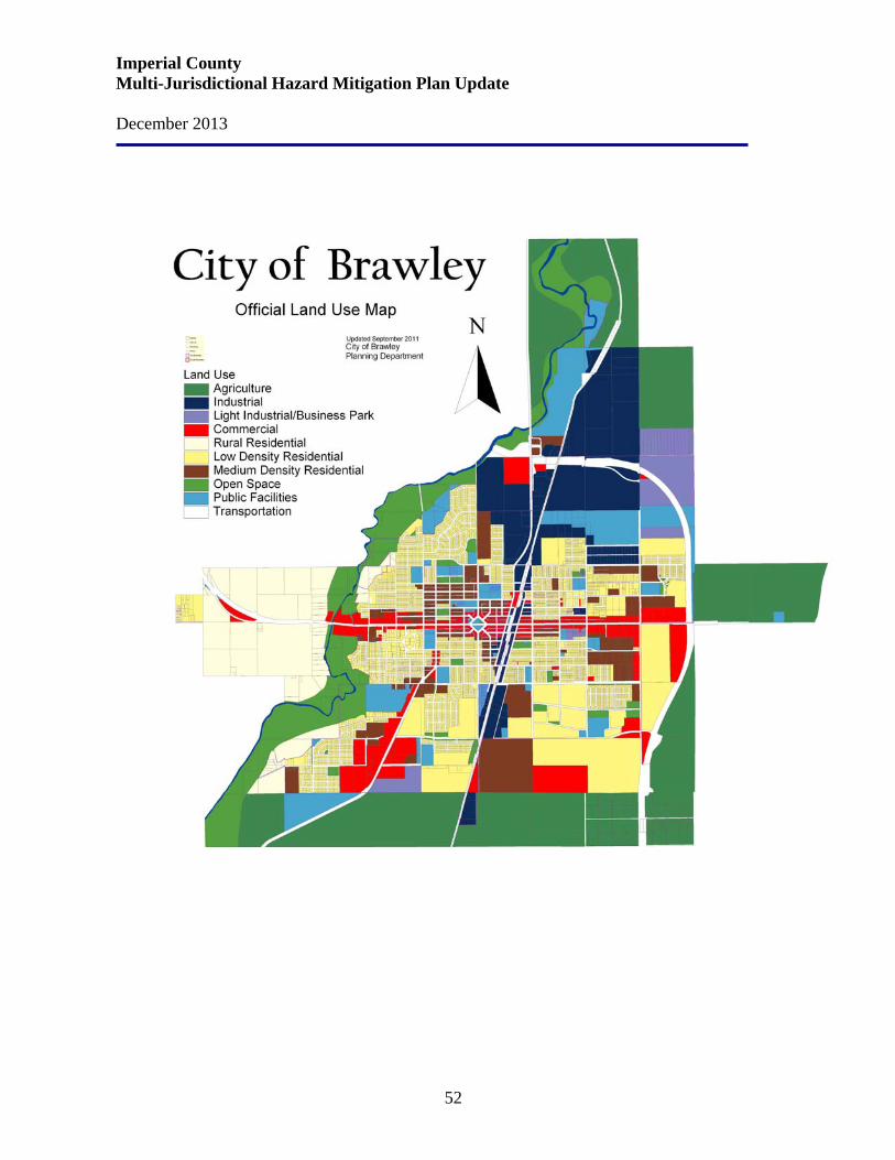
Imperial County Multi-Jurisdictional Hazard Mitigation Plan Update December 2013
52
Imperial County Multi-Jurisdictional Hazard Mitigation Plan Update December 2013
53
4.3 Calexico Area Land Use Plan The Land Use Element is a guide to future land use within Calexico and affects many of the issues addressed in the other General Plan elements. The Land Use Element identifies the type and location of future land uses within the City. The specific land uses and their location within the community in turn affect the remaining General Plan elements. For example, the location and type of land uses outlined in the Land Use Element affect the circulation system that is identified in the Circulation Element. Likewise, the land uses identified in the Land Use Element reflect the community’s goals and vision for its future form and character. In addition to land uses, the Land Use Element also addresses how growth will occur, with special attention given to the public services and facilities and how they will be funded. Implementation of the Land Use Plan will also assist in creating a balance between jobs and housing within the City. A balance between jobs and housing allows people to live and work within the same community, and often within the same neighborhood. Calexico is affected by several forces that are unique to its location adjacent to the international border with Baja California, Mexico. The City continues to relate to Mexicali, just across the border, as a boon to commercial activity in Calexico, but now is feeling the pressure of commuters who bring their children to private schools in Calexico, wealthy Mexican residents who are buying homes in Calexico because of safety concerns in Mexicali, and trucking and the potential for commercial trade due to the enactment of the North American Free Trade Agreement (NAFTA). In addition to impacts associated with Mexico, Calexico and other cities in the Imperial Valley are now experiencing unprecedented growth due to the higher cost of housing in San Diego and other counties along coastal California. The City of Calexico has approximately 2,060 acres of existing residential, 290 acres of commercial uses, 255 acres of industrial uses, and the remaining acreage within the City consist of vacant, parks, schools and agricultural/open space uses. Urban development and agricultural production in Calexico is entirely dependent upon water imported from the Colorado River. As the population of the southwest continues to grow, the competition for limited water supplies will escalate. The City of Calexico Zoning Ordinance establishes setbacks which provide for safe access around buildings associated with all types of land uses. The General Plan includes policies addressing local street design and appropriate access on major streets. The plan for streets is based on providing adequate cross sections of streets to accommodate through traffic. All new development is subject to these policies and standards. In older areas of the City where such requirements are substandard, the City is working to correct and improve less than ideal access. Land Use Goal, Objectives, and Policies Land use policies are fully detailed below and throughout the text of the General Plan and are applied on a citywide basis unless otherwise noted.
Imperial County Multi-Jurisdictional Hazard Mitigation Plan Update December 2013
54
Land Use Goal Land use should be planned and located to promote and retain the highest level of urban/rural-residential character of Calexico by continuing to provide quality urban-level services and uses in the developed areas while providing well planned development direction for the rural areas of the City. All development should be provided with adequate public services and facilities. Distribution of Land Use Objective 1 Land use distribution should be accomplished in a manner that protects the existing urban and rural areas of Calexico while meeting the goals, objectives, and policies of the General Plan; the land use distribution should be such that the integrity of the existing land use is maintained and/or enhanced, and the new land use is distributed to encourage the development of safe, efficient residential and employment uses. Policy 1 a. Appropriate densities shall be established for new development projects so that they will be compatible with the existing surrounding development and future expected development. b. New urban development shall be adjacent to existing urban development. Where questions of adjacency exist, it shall be determined by the City Council upon recommendation of the Planning Commission. c. New rural residential development shall be adjacent to existing rural development. Where questions of adjacency exist, it shall be determined by the City Council upon recommendation of the Planning Commission. d. New industrial land uses should be located such that trucks avoid the City center and in response to the eastern commercial border crossing. e. Schools and parks should be located in proximity to the residents served. Final school locations must be reviewed and approved by the local school district in accordance with state law. Land Use Compatibility Objective 2 Land use distribution should create a pattern which organizes land uses in order to maximize compatibility with adjacent land uses. Policy 2 a. Where land uses may result in conflicting activities, traffic, noise levels, visual character, etc., there shall be adequate buffering and/or setbacks required. b. The Land Use Compatibility Matrix (Table LU-G) shall be used to determine general levels of compatibility. c. In the event a question of compatibility exists between two uses/intensities, the lower intensity use shall take precedent.
Imperial County Multi-Jurisdictional Hazard Mitigation Plan Update December 2013
55
d. The City Council, upon recommendation of the Planning Commission, shall make the final determination in those areas of questionable land use compatibility. Public Services and Facilities Objective 3 Land use pattern and population of Calexico should be consistent with the capabilities of existing and planned public services and facilities. Policy 3 a. The number of dwelling units in the City shall be limited to those which can be adequately served by public services and/or facilities. b. The City shall maintain current information concerning the capacities of the public services and facilities it provides. c. The City shall encourage other public service agencies to keep their capacity information current. d. Land uses and development review applications that are inconsistent with the capability of any public service agency to provide cost-effective service shall not be approved. e. Major extensions of services or utilities to facilitate land use change shall not be approved without a thorough review of all social, economic, and environmental factors with appropriate mitigation measures implemented, if necessary. f. The City’s Service Area Plan shall be updated every 5 years. Natural Hazard Constraints Objective 4 The distribution and intensity of land uses should consider the health, safety, and welfare of the community in regard to man-made and natural hazards. Policy 4 a. Floodways shall be kept free and clear of any structure or other obstructions. b. Development that encroaches into a floodplain shall meet the Federal Emergency Management Administration (FEMA) requirements. c. Inappropriate existing land uses within a land use compatibility zone as defined by the Imperial County Airport Land Use Compatibility Plan, shall not be expanded or enlarged beyond the requirements permitted in the zone. d. Future land uses within land use compatibility zone A or B as defined by the Imperial County Airport Land Use Compatibility Plan, shall meet the guidelines of the zone. Future land uses located in zone C shall be reviewed for compatibility by the City prior to approval. e. Future residential land uses shall not be located immediately adjacent to the railroad tracks.
Imperial County Multi-Jurisdictional Hazard Mitigation Plan Update December 2013
56
Rural Character Objective 5 The rural character of the outlying areas of Calexico should allow for the development of rural residential homes as a means of preserving some of the rural history of the area and to provide housing for the upper income limits. Policy 5 a. In the development of the outlying land use in Calexico provisions shall be made in the development plans for large lot rural residential housing. b. The keeping of farm or ranch animals shall be restricted to the rural residential areas and any continuation of farm or ranching activity is strongly discouraged within the City limits. Rural Residential Objective 6 Rural Residential land use shall be provided for in the development of projects within the outlining areas of Calexico as part of a master plan or planned community development. Policy 6 a. Development of rural residential units shall be appropriately buffered from adjacent land uses so as not to cause problems from any keeping of farm or ranch animals. b. Existing rural residential land use areas shall be encouraged to provide the City with a conformance schedule for the elimination of the farm or ranch activity upon annexation into the City limits. c. One half acre lots shall be the minimum parcel size in rural residential areas. d. Neighborhood commercial activities may be located on the border of rural residential and urban land uses. e. Lots created as a result of a planned residential development shall not be further subdivided. f. Mobile homes certified under the provisions of the National Mobile Home Construction and Safety Standards may be allowed on permanent foundations in single-family residential areas where the mobile homes will be compatible with existing or future single family homes. Standards of placement on lots should be developed as specified in California State Law (Government Code Section 65852.3). g. Manufactured housing units may be allowed in rural residential areas. Single-Family Residential Objective 7 Low and medium density single-family residential land uses should be encouraged, in new and in-fill areas, to provide family oriented housing in a wide range of sizes and costs.
Imperial County Multi-Jurisdictional Hazard Mitigation Plan Update December 2013
57
Policy 7 a. Single-family residential land uses shall be located in areas adjacent to equivalent densities in in-fill situations. b. New single-family residential projects shall be encouraged to have a variety of housing types and styles. c. Manufactured housing units may be allowed in single-family residential areas. d. Mobile homes certified under the provisions of the National Mobile Home Construction and Safety Standards may be allowed on permanent foundations in single-family residential areas where the mobile homes will be compatible with existing future single family homes. Standards for placement on lots should be developed as specified in California State Law (Government Code Section 65852.3). e. Lots created as a result of a planned residential development (PRD) shall not be further subdivided. f. Lots in Low Density single-family residential areas shall be a minimum of 6,000 square feet. Multiple-Family Residential Objective 8 Multiple-family residential of varying types and densities are encouraged where compatible with existing land uses and the provision of public services. Policy 8 a. Multiple-family residential land uses shall be located in areas where compatible with existing land uses and in close proximity to circulation, transit availability, commercial areas, and provision of public services and facilities. b. Multiple-family residential projects should provide sufficient open space to balance the developed areas of the site. c. Multiple-family residential projects should provide recreational uses and activities such as playgrounds, picnic areas, and pools. d. Adequate parking based upon the number of bedrooms in individual units shall be provided as approved by the City Planning Department. e. Adequate access should be provided onto improved, City maintained roadways that can accommodate increased traffic. f. Condominium projects shall be limited to density not to exceed 20 dwelling units per gross acre. Approval of projects at the maximum density of this category shall be made on the basis of the findings by the Planning Commission and their recommendation to the City Council that the project under consideration meets and exceeds the standards of the General Plan and the zone. g. Condominium projects shall include enhanced design features such as garages, increased number of parking spaces, and recreational facilities such as pools, spas, and ball courts.
Imperial County Multi-Jurisdictional Hazard Mitigation Plan Update December 2013
58
h. Apartment projects shall be limited to 20 dwelling units per acre excepting provisions for affordable income housing as noted. Approval of the projects at the maximum density of this category shall be made on the basis of the findings by the Planning Commission and their recommendation to the City Council that the project under consideration meets and exceeds the standards of the General Plan and the Zoning Ordinance. i. A density bonus of up to 30 dwelling units per acre may be granted subject to affordability requirements and the granting of a Conditional Use Permit, in accordance with City policy. Apartment projects eligible for a density bonus of up to 30 units per acre shall be no less than one (1) acre in size. j. Multiple-family residential developments above 20 dwelling units per gross acre shall be for rental only and shall not be converted to units for sale. Approval of projects at the maximum density of this category shall be made on the basis of the findings by the Planning Commission and their recommendation to the City Council that the project under consideration meets and exceeds the standards of the General Plan and the zone. k. Apartments should be designed to accommodate both families and singles. l. Senior citizen apartments in the Multiple-Family Residential category may receive a bonus of up to 5 units per gross acre, to a maximum of 35 units per gross acre. Approval of projects at the maximum density of this category shall be made on the basis of the City Council that the project under consideration meets and exceeds the standards of the General Plan and the Zoning Ordinance. m. Multiple-family residential complexes may be eligible for a density bonus as a result of providing low and moderate income housing (see Housing Element Program). Planned Residential Developments Objective 9 Planned residential developments (PRD) may be used for any size property where design flexibility is desired and/or necessary and for the mitigation of on-site adverse physical conditions pursuant to Zoning Ordinance Section 17.09.200. Policy 9 a. The density allowed in planned residential development land use areas shall be set by conditional use permit or specific plan and shall be based upon the density of existing surrounding land uses, site conditions, and the availability of public services. b. The density of any planned residential development land use shall not exceed 20 dwelling units per net acre. c. Useable open space is desirable and shall comprise at least 30 percent of the total site area, excluding private yards, parking lot islands, and road medians.
Imperial County Multi-Jurisdictional Hazard Mitigation Plan Update December 2013
59
Mobile Home Parks Objective 10 Mobile home parks are encouraged in the Medium Density land use category where compatible with existing land uses and public services to provide alternative housing arrangements. Policy 10 a. Mobile home park land uses should be located in areas with similar existing uses and densities or in specific plan areas with appropriate design considerations included. b. Mobile home park land uses shall be located in close proximity to circulation, transit availability, commercial areas, and the provision of public services and facilities. Commercial Objective 11 Commercial land use that is balanced in regard to size and distribution of goods with the current and future needs of the City should be encouraged. Policy 11 a. Neighborhood commercial centers should be designed and located in such a manner so as to compliment and not conflict with adjoining residential areas. b. Specialty commercial uses such as swap meet sites, although typically transient in nature, should provide standard amenities such as paved parking lots, restroom facilities, shade structures, and food vendors if allowed to operate for longer than one week. c. The City should adopt an ordinance which would require a certain percentage of swap meet admission fees to the City's general fund. d. Highway commercial uses along Highway 111/Imperial Avenue should encourage roadway oriented retail activity such as automobile sales, shopping centers, hotels and restaurants. e. Retail uses within the highway commercial zone should be located within retail centers having centralized ingress and egress points and/or frontage road access in order to minimize curb cuts along Highway 111 and Highway 98. Industrial Objective 12 Industrial land uses that provide a full range of industrial and manufacturing services are encouraged where they are compatible with existing and other planned land uses. Policy 12 a. Industrial parks are encouraged within a specific plan area or planned development within a planned community. b. Industrial uses shall be located so as to not create adverse impacts on surrounding land uses and/or the City circulation system.
Imperial County Multi-Jurisdictional Hazard Mitigation Plan Update December 2013
60
c. Heavy industrial land uses should be primarily designed for manufacturing, assembly, packaging, processing, fabrication, and storage. Retail sales should be limited to 25 percent of overall floor area. d. Industrial land uses shall be adequately screened to reduce glare, noise, dust, and vibrations. e. Noise attenuation measures such as buffer zones or noise attenuation walls shall be used to reduce outside noise levels when existing residential developments are adjacent to new or existing industrial developments. Outside noise levels at the property line should be 65 dBA CNEL or less. f. All outside storage shall be completely screened from view with permanent walls or landscaping. g. Light industrial land uses shall be approved through a planned development within a planned community. h. The industrial park environment should blend well designed and functional buildings with landscaping. i. The types of activities allowed in industrial park land uses include: light industrial uses, office and administration facilities, research and development laboratories, warehousing, as well as support commercial services. j. Industrial and manufacturing uses should be located adjacent to the railroad to take advantage of transportation links and maquiladora businesses. Other than rail-served uses, industrial development should be discouraged west of the railroad tracks. k. Industrial uses should be located along the Cole Road and Heber Road corridors to encourage truck traffic to avoid other streets within the City. Business Park Objective 13 Business Parks shall be encouraged within the City to increase the diversity of employment opportunities and discourage heavy truck traffic. Policy 13 a. Business parks are encouraged within a specific plan of land use or planned development within a planned community. b. Business park uses shall be located so as to not create adverse impacts on surrounding land uses and/or the City circulation system. c. Business park uses should be designed for light manufacturing, assembly, packaging, fabrication, on-site sales, services, and offices with less need for trucking or distribution. Commercial and restaurant uses shall be allowed to support the needs of the businesses and employees. Warehousing shall be prohibited. d. Business parks should be developed in a well landscaped setting, with buildup not to exceed 50 percent lot coverage.
Imperial County Multi-Jurisdictional Hazard Mitigation Plan Update December 2013
61
Airport Land Use Objective 14 The City shall work with the Airport Management to encourage and attract compatible users and uses in and around the airport to promote airport safety and consider potential airport related noise. Policy 14 a. In the event that Airport Management receives a substantial number of complaints regarding increases in noise levels, the City of Calexico may request noise abatement procedures be established and implemented. b. Significant changes in land use in and around the airport (within 2 miles) shall be referred to the Imperial County Airport Land Use Commission for their comment and consideration. Land Use and Circulation Objective 15 Land use should not overburden the City circulation system (see also the Circulation Element). Policy 15 a. No land use should be approved that will increase the traffic on a City roadway above the roadway's existing design capacity at Level of Service "C." b. The City should continuously monitor the impact and intensity of land use on circulation to ensure that the circulation system is not overburdened. c. The land use pattern should encourage the use of public transportation by City residents and visitors. d. Schools should have direct access to collector streets or larger, but not to state highways. Local residential streets should not serve as the primary drop off and pick up location unless off-street drop off and pick up zones are provided. Agricultural Development Objective 16 The City should support and promote the continuation of ongoing agricultural uses which provide economic return to the City directly or indirectly. Policy 16 a. The City should encourage agricultural uses on vacant lands master planned for other land uses, as an interim use. b. The City should periodically evaluate the viability of the economics to continuing the agricultural use. c. Through the City’s review process, any proposed non-agricultural projects near existing agricultural areas shall require an assessment to determine potential impacts to agricultural production and potential impacts to the proposed land use.
Imperial County Multi-Jurisdictional Hazard Mitigation Plan Update December 2013
62
d. Agricultural land should not be annexed into the City until development is eminent. Agricultural uses should cease no later than 2 years after annexation of the property into the City of Calexico. Regional Land Use Planning Objective 17 The City should support and promote the efforts made to provide a reasonable regional land use planning program. Policy 17 a. The City should support and participate in the Southern California Association of Governments' (SCAG) regional land use planning programs. b. The City should evaluate the impact on regional land use planning when considering major changes to its land planning program. Intergovernmental Coordination Objective 18 The City should encourage the coordination of land use planning programs among local, regional, state, and federal jurisdictions. Policy 18 a. The City should evaluate the land use planning programs of neighboring jurisdictions when considering changes to its land use program. b. The City should notify affected jurisdictions of changes to the City's land use planning programs that may affect them. c. The City should cooperate with adjoining jurisdictions through review and comments on changes to land use plans that may affect Calexico. d. The City should work with Caltrans and the County of Imperial to identify, post, and enforce truck routes through and around the City. The completion of the SR098 realignment/bypass will encourage truck traffic to bypass the City interior. e. The City should coordinate with the railroads and Imperial Irrigation District regarding trails adjacent to their rights of way and use of abandoned rights of way. f. The City should work with the Calexico Unified School District, Heffernan Hospital Board, and other entities that provide public services to coordinate joint use, emergency services, etc. g. The City shall work with the Imperial Irrigation District to provide adequate land for substations that need to be located within the City.
Imperial County Multi-Jurisdictional Hazard Mitigation Plan Update December 2013
63
Sphere of Influence Objective 19 Through the update of the City’s Service Area Plan, the City should review its current sphere of influence area at appropriate intervals (a minimum of once every 5 years) to assure that the sphere continues to delineate the logical areas of future City growth. Policy 19 a. The City sphere of influence shall be the logical extension of the areas of future City growth. b. The City should work with the Local Agency Formation Commission (LAFCO) and the County of Imperial to maintain and establish sphere of influence boundaries. c. Sphere of influence boundaries should have physical or topographic boundaries easily discernible on the landscape. d. Expansion of the sphere of influence boundaries shall take into consideration the logical extension of Calexico's public services such as water, sewer, police protection, fire protection, schools, and commercial services. Implementation and Funding Objective 20 The City shall assure that funding for infrastructure and services needed to provide for the health, welfare and safety of the residents of Calexico is available. Policy 20 a. The City shall require developer fees that shall be reviewed every 5 years to assure adequate funds are being collected to service new development. b. The City should encourage the use of Community Facilities Districts to assist with funding and place the burden of infrastructure and services needed for new development on the residents and businesses located therein. Infill Development Objective 21 The City shall encourage infill and adjacent new development to provide for the efficient use of existing infrastructure, avoid “leap frog” new development and to reduce impacts to agriculture. Policy 21 a. The extension of water and sewer service facilities such as transmission lines or pumps to accommodate new development projects should be limited to one-quarter mile across an undeveloped area. b. The City should consider developing a policy to reduce certain development fees for infill projects consistent with the General Plan and Zoning Ordinance located on parcels that are surrounded by existing development.
Imperial County Multi-Jurisdictional Hazard Mitigation Plan Update December 2013
64
Cultural Resources and the Arts Objective 22 To identify and preserve significant structures, sites and life stories containing historic or cultural value for the enrichment and enjoyment of future generations. Policy 22 a. Identify historic sites through historic landmark plaques and, where appropriate, seek applicable designation with the proper State and/or federal historic preservation agency. b. Support private efforts to reinvest in and restore historic or architecturally significant structures and to continue their use in the community. c. Protect significant archaeological resources in accordance with the California Environmental Quality Act (“CEQA”). d. Encourage the use of the Mills Act (tax abatement program for owners of historic structures) to assist private owners in preserving and rehabilitating historic structures. e. The City should consider the development of a cultural center for the arts, possibly in an existing historic structure. f. The City shall continue to work with the Cultural Arts Commission and private parties to establish a museum. (See also policies related to public art in the Parks and Recreation and Economic Development Elements.) Following is the City of Calexico’s Land Use Maps.
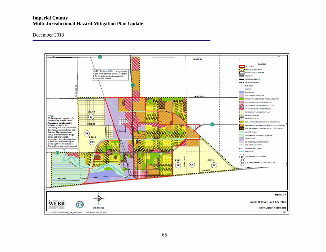
Imperial County Multi-Jurisdictional Hazard Mitigation Plan Update December 2013
65
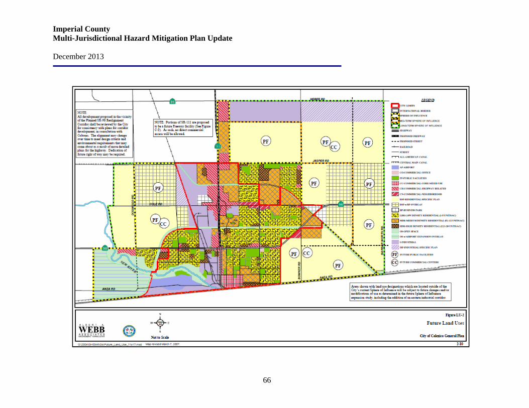
Imperial County Multi-Jurisdictional Hazard Mitigation Plan Update December 2013
66
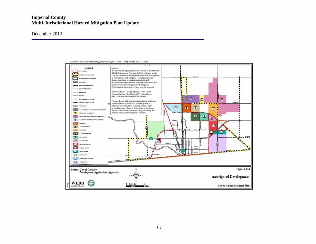
Imperial County Multi-Jurisdictional Hazard Mitigation Plan Update December 2013
67
Imperial County Multi-Jurisdictional Hazard Mitigation Plan Update December 2013
68
4.4 Calipatria Area Land Use Plan The City of Calipatria is located in rural Imperial County and has a population of approximately 7,800 residents (including 4,372 inmates at the State prison). The City’s last comprehensive General Plan update was in 1992. Since that time, a decline in agricultural opportunities has adversely affected the economy and the community. Calipatria has experienced little economic growth, high unemployment rates (approximately 20%), and a high poverty rate (approximately 33%). Calipatria encompasses about 3.7 square miles on a predominantly flat stretch of land in northern Imperial County just southeast of the Salton Sea. Two non-contiguous parcels are under city jurisdiction: the Calipatria State Prison site and the wastewater treatment facility. The Cliff Hatfield Memorial Airport occupies 200 acres in the northwest corner of the city. Calipatria is surrounded on all sides by agricultural land. While there are no agricultural lands within the city limits, agriculture lands surround the City and are a primary land use throughout Imperial County. The City is situated in one of the finest agricultural areas in the world. The reason for the agricultural success of the region is the large quality of water which is transported from many miles east via the All-American Canal and subsequently distributed to farm lands by similar canals. Calipatria is located on the gently sloping Imperial Valley floor, situated on a very deep alluvial fill deposited over many thousands of years from the Colorado River and other streams originating in the Superstition and Chocolate Mountains. Calipatria is approximately 180 feet below sea level.
Since its incorporation, the City of Calipatria has had a rich, eighty three year old history and developed as a semi-rural community with farming as its major industry. The City of Calipatria is an exciting gateway for NAFTA and is ideally situated within an ever-growing corridor of commerce between Los Angeles and Mexico. Calipatria has excellent transportation opportunities and a projected growth that make it the premier place to do business.
According to the Southern California Association of Governments’ (SAG’s) 2012 Regional Transportation Plan/Sustainable Communities Strategy the City of Calipatria is forecasted to add just over 1,900 residents in 379 households from 2012 to 2035. Jobs in the City are forecasted to more than double, from the current 2,300 to an estimated 5,000 by 2035. Calipatria’s vision is to promote social equality amongst all residents, infill development, a jobs/housing balance and increased economic development opportunities. Based upon this vision, the following land use goals, policies and implementation measures have been developed and sited into one of three categories: General Land Use, Downtown District, and Economic Development.
Imperial County Multi-Jurisdictional Hazard Mitigation Plan Update December 2013
69
General Land Use – Goals and Policies Goal LU-1 Facilitate development of vacant and under-utilized land. Policy LU-1.1 Allow for flexibility with respect to land use so as to not discourage development and redevelopment of vacant and underutilized land. Policy LU-1.2 Use the City’s Zoning Code and applicable residential, commercial, and open space design standards to guide the character of development and ensure compatibility with existing residential, commercial, and agricultural uses. Policy LU-1.3 Confine new growth to those areas that have adequate infrastructure to service new development or ensure concurrent infrastructure development.
Goal LU-2 Provide an adequate mix of low, medium, and high density residential land uses to house people of all socioeconomic levels. Policy LU-2.1 Encourage new residential development and the construction of a variety of housing types (such as single-family residential, townhomes, duplexes, etc.), including affordable housing, throughout the City to meet the needs of all existing and future Calipatria residents. Policy LU-2.2 Encourage development of a range of housing types that:
• Are visually attractive and compatible in intensity, dwelling unit size, and structural design with the need to protect the surrounding natural environment
• Meet the needs and suit the small town and rural lifestyles of present and future residents
• Are located in close proximity to jobs and services
Goal LU-3 Improve air and water quality and reduce energy consumption and greenhouse gas emissions. Policy LU-3.1 Promote land development practices that reduce energy and water consumption, air and water pollution, greenhouse gas emissions, and waste, incorporating such techniques as:
• Concentration of uses and design of development to promote walking and use of transit in lieu of the automobile
• Capture and re-use of stormwater on-site for irrigation • Orientation of buildings to maximize opportunities for solar energy use, daylighting,
and ventilation • Use of permeable paving materials • Shading of surface parking and walkways
Policy LU-3.2 Encourage new development to use “green” building technologies in accordance with a green building standard, such as Leadership in Energy and Environmental Design (LEEDTM), or other equivalent.
Imperial County Multi-Jurisdictional Hazard Mitigation Plan Update December 2013
70
Policy LU-3.3 Develop land uses that enhance the existing transportation network, minimize the impacts of vehicles in the City, and encourage the use of alternative modes of transportation. Policy LU-3.4 Require that new development include pedestrian access to enhance the community’s pedestrian character and pedestrian linkages between the urban center, residential neighborhoods, and open spaces.
Goal LU-4 Protect natural resources and agricultural lands. Policy LU-4.1 Minimize disruption of agriculture by maintaining a compact urban form and by directing new growth to areas containing the least productive agricultural land. Policy LU-4.2 Avoid disturbances of sensitive habitats and species by directing new growth to areas where native habitats are not present. Implementation Actions
• Update the City’s Zoning Code to reflect the Land Use map and policies of the General Plan Land Use Element (Implements Policies LU-1.1 through LU-4.2).
• Increase allowable housing densities throughout all residential zones as specified by the General Plan (Policy LU-1.2, 2.1, and 2.2).
• Require new development to demonstrate incorporation of techniques that reduce energy and water consumption, air and water pollution, greenhouse gas emissions, and waste (Policies LU-3.1 through 3.4).
Downtown District – Goals and Policies Goal LU-5 Make Calipatria’s Downtown District an economically successful part of the community by enhancing commercial uses and providing new residential opportunities. Policy LU-5.1 Make revitalization of the Downtown District a high priority. Policy LU-5.2 Permit high density and intensity development on vacant and underutilized properties in the Downtown District. Policy LU-5.3 Concentrate “mixed-use” type development in the Downtown District. Policy LU-5.4 Integrate multi-family housing into office and/or retail projects that are compatible with residential uses.
Goal LU-6 Revitalize and improve the physical quality of the Downtown District while maintaining its historic character. Policy LU-6.1 Enhance the streetscape in the Downtown District to increase the area’s attractiveness and foster private investment in the area. Policy LU-6.2 Require new development within the Downtown District to adhere to existing architectural themes and/or design standards identified in the Zoning Code.
Imperial County Multi-Jurisdictional Hazard Mitigation Plan Update December 2013
71
Policy LU-6.3 Require new development in the Downtown District to be pedestrian oriented, including pedestrian-oriented storefronts, entrances toward pedestrian ways, landscaping such as shade trees, benches, and other pedestrian amenities.
Implementation Actions • Establish a Downtown District zone along Highway 115/Main Street near Highway 111
and update the Zoning Code to allow high density residential and “mixed-use” development in the Downtown District (Implements Policies LU-5.1 through LU-5.4).
• Pursue a variety of funding approaches, including grants, impact fees, transportation funds, and other programs to fund Downtown District enhancement and beautification, which may include streetscape improvements and landscaping, in order to increase the area’s attractiveness and foster private development (Policies LU-6.1 through LU-6.3).
• Develop incentives, such as expedited permitting or financial incentives if available, for projects that would revitalize and improve the physical quality of the Downtown District, such as business loans, façade improvement and public improvement projects (Policies LU-6.1 through LU-6.3).
Economic Development – Goals and Policies Goal LU-7 Strengthen the community’s economy and provide employment opportunities for Calipatria residents. Policy LU-7.1 Pursue new developments and businesses that add to the City’s economic base, particularly those that general sales tax and transient occupancy tax. Policy LU-7.2 Pursue economic development opportunities from new and emerging industries such as alternative energy and tourist services. Policy LU-7.3 Promote the retention of existing and attraction of new commercial, office, light, and heavy industrial business and afford opportunities for their growth and expansion.
Goal LU-8 Promote manufacturing and industrial development that takes advantage of the railroad through the City. Policy LU-8.1 Allow for job-generating industrial uses near the railroad, provided that these uses are environmentally safe and do not endanger the surrounding population.
Goal LU-9 Promote commercial and mixed-use development that takes advantage of the highways passing through the City.
Policy LU-9.1 Allow for retail and other commercial uses along Highway 111/Sorenson Avenue and Highway 115/Main Street to provide services such as shops, food/grocery stores, gas stations, and restaurants (including to-go type restaurants) to residents, travelers passing through, and to attract visitors/tourists.
Imperial County Multi-Jurisdictional Hazard Mitigation Plan Update December 2013
72
Goal LU-10 Promote compatible job-generating businesses in the Airport Overlay District. Policy LU-10.1 Allow business park development and commercial uses in the airport area that is compatible with and complimentary to airport uses.
Goal LU-11 Capitalize on opportunities to attract tourists to Calipatria. Policy LU-11.1 Promote opportunities to enhance retail services and agritourism and attract tourists to recreational and natural attractions, such as the Salton Sea, Alamo River, Weist Lake, Finney Lake, and Ramer Lake. Implementation Measures
• Cooperate and coordinate business outreach programs with the Chamber of Commerce and other community organizations, and actively encourage business owners to engage City departments to address the business community’s needs (Implements Policies LU-7.1 and LU-7.3).
• Identify opportunities and incentives for new and emerging industries such as solar or geothermal energy industries (Policy LU-7.2).
• Revise the Zoning Code to allow high density industrial uses in sites adjacent to or in close proximity to the Southern Pacific Railroad tracks (Policy LU-8.1).
• Revise the Zoning Code to allow high density commercial development along Highways 111 and 115 and to allow for mixed-use development in the Downtown District (near the intersection of Highway 111/Sorenson Avenue and Highway 115/Main Street) (Policy LU-9.1).
• Revise the Zoning Code to define industrial and commercial development in the airport area, consistent with airport safety guidelines (Policy LU-10.1).
• Promote tourism opportunities related to retail, the City’s historic character and cultural resources, farm operations, recreation, and natural attractions by promoting cultural, historical and agricultural resources with posted signs and information on the City’s website (Policy LU-11.1).
Following are the City of Calipatria’s Land Use Maps.
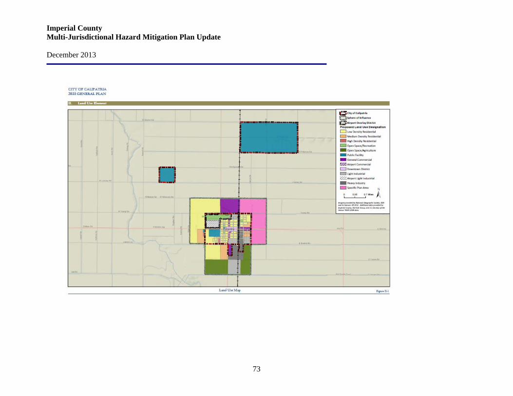
Imperial County Multi-Jurisdictional Hazard Mitigation Plan Update December 2013
73

Imperial County Multi-Jurisdictional Hazard Mitigation Plan Update December 2013
74

Imperial County Multi-Jurisdictional Hazard Mitigation Plan Update December 2013
75
Imperial County Multi-Jurisdictional Hazard Mitigation Plan Update December 2013
76
4.5 El Centro Area Land Use Plan The Land Use Element is a guide to land use planning within the City of El Centro and directly relates to many issues addressed in other General Plan elements. The Land Use Element identifies the type and location of future land uses within the City. The specific land uses and their location within the community in turn affect the remaining General Plan elements. For example, the location and type of land uses outlined in the Land Use Element affect the circulation system that is identified in the Circulation Element, and the open space facilities identified in the Land Use Element affect the Conservation/Open Space Element policies. The land uses identified in the Land Use Element also reflect the community’s goals for its future form and character. With a strong agricultural base, El Centro’s Land Use Plan has been designed to protect agricultural lands by concentrating growth within the current sphere of influence, as well as ensuring a healthy economy and good quality of life within El Centro to support the agricultural industry. The Land Use Plan has been designed to locate compatible land uses adjacent to each other, such as lower density residential uses next to existing lower density neighborhoods and using industrial and commercial uses to buffer residential area from potentially hazardous or noisy uses, such as the railroad and steam plant. The Land Use Plan focuses on the location of various land uses, as well as growth management techniques, and community design. The other elements within the General Plan expand on how the Land Use Plan will be implemented to create a compact and livable community. El Centro contains a fairly balanced mixture of land uses. While the City requires revenue generated by commercial and industrial uses to support the needs of the existing community, these non-residential land uses must be compatible with the existing community. Land uses such as open space areas can be used to buffer residential areas from non-residential uses. Land use designations can also limit the types of industrial and commercial activities to those which are most compatible with residential areas. El Centro, as well as the surrounding region, has experienced considerable growth over the past 25 years. New development brings change and a changing community character. While recognizing that change is inevitable, the community is still able to plan and guide future development so that it complements the existing community, and enhances the existing character found in El Centro. The City restricts land uses in areas determined to be subject to seismic hazards and adequate environmental review and mitigation measures for development proposed within a geological hazard area are required in the City. Additionally, the City will identify all earthquake-prone public buildings and buildings housing critical public functions and require these buildings to be upgraded and structurally retrofitted. In order to reduce the risk of impacts from seismic hazards, proper development engineering, building construction, and retrofitting is required of proposed development and redevelopment.
Imperial County Multi-Jurisdictional Hazard Mitigation Plan Update December 2013
77
Understanding that growth will occur in the future, directing how and where growth will occur is important, as it will have a great impact on the quality of life and economic well-being of the community as a whole. To prepare for population increases in the next 20 years, El Centro will continue to direct and control growth in the City and Sphere of Influence through the application of the City’s Urban Development Program to create a community that is compact and pedestrian and transit-oriented, avoids removing from production more valuable agricultural land than necessary, and is able to meet the public service and infrastructure needs of existing and future residents. The City will control and direct growth so that new development is compatible with existing development and occurs in appropriate locations where adequate public services and facilities are available. Additionally, future development in areas impacted by aircraft operation is consistent with the applicable Airport Land Use Plans. Issues, Goals and Policies
Balance of Land Uses El Centro contains a fairly balanced mixture of land uses. While the City requires revenue generated by commercial and industrial uses to support the needs of the existing community, these non-residential land uses must be compatible with the existing community. Land uses such as open space areas can be used to buffer residential areas from non-residential uses. Land use designations can also limit the types of industrial and commercial activities to those which are most compatible with residential areas. Land Use Goal 1: Provide planning and strategies for physical land use to create a healthy and aesthetically pleasing environment that balances the social and economic needs of the community.
General Policy 1.1: Ensure that new development is consistent and compatible with the existing character of the community and meets City development standards. Policy 1.2: Prevent the intrusion of incompatible land uses into existing developments, such as incompatible non-residential development in residential areas.
Residential Policy 1.3: Ensure that new residential development is compatible with surrounding existing residential development.
Commercial Policy 1.4: Achieve a balance of commercial uses that provides for the retail, business, professional and other service needs of City residents and which will attract customers from the greater Imperial Valley and other areas.
Imperial County Multi-Jurisdictional Hazard Mitigation Plan Update December 2013
78
Policy 1.5: Balance new commercial development elsewhere in the City with the need to maintain a financially viable downtown. Policy 1.6: Allow for commercial uses on the first floor and residential uses on the second floor in the downtown district on a project-by-project basis if the project will:
• Be compatible with the surrounding area; • Provide appropriately designed entrances for the commercial and residential uses; and • Comply with other requirements set forth by the City’s conditional use permit.
Policy 1.7: Encourage the development of neighborhood convenience shopping centers to serve the needs of adjacent residential neighborhoods. Policy 1.8: Improve the relationship between commercial areas and adjacent non-commercial uses through the use of landscape buffers and masonry walls for separation.
Industrial Policy 1.9: Prevent the intrusion of all incompatible uses that would negatively affect industrial areas and opportunities for industrial growth. Policy 1.10: Use lower intensity industrial uses as a transition between heavier industrial use and non-industrial use. Policy 1.11: Require new industrial development to provide adequate circulation and access that does not negatively impact adjacent residential areas. Where needed, industries should have access to railroad lines.
Community Facilities Policy 1.12: Ensure that facilities and services of public agencies are coordinated with City growth in their timing, location, and levels of service. Policy 1.13: Develop and expand public facilities in a manner that is compatible with existing and planned development. Policy 1.14: Continue to use the Parks and Recreation Facilities Master Plan as a guide for improvement of existing facilities and for the development of new facilities. Policy 1.15: Require new development adjacent to open drains and canals to underground these facilities to ensure the public safety. The undergrounding of facilities shall be done in concordance and coordination with the Imperial Irrigation District.
Direct and Control Growth El Centro, as well as the surrounding region, has experienced considerable growth over the past 25 years. New development brings change, and a changing community character. While recognizing that change is inevitable, the community is still able to plan and guide future development so that it complements the existing community, and enhances the existing character and found in El Centro.
Imperial County Multi-Jurisdictional Hazard Mitigation Plan Update December 2013
79
Land Use Goal 2: Control and direct growth so that new development is compatible with existing development and occurs in appropriate locations when adequate public services and facilities are available. Policy 2.1: Continue to direct and control growth in the City and sphere of influence through the application of the City’s Urban Development Program. Policy 2.2: Ensure that development corresponds with the provision of public facilities and services. Policy 2.3: Coordinate with the County and LAFCO during review and development of projects within the City’s sphere of influence to ensure that compatible development occurs and adequate public facilities are provided. Policy 2.4: Ensure that future development in areas impacted by aircraft operation is consistent with the airport land use plan to allow for the continued operation of local airports. Policy 2.5: Encourage infill development to occur within the urbanized community before expanding new development onto agricultural lands surrounding El Centro.
Community Design In an effort to enhance the City’s beauty and assure the quality and appearance of future development, adherence to urban design principles is necessary. El Centro’s buildings and structures are primarily in good physical condition; however, a number of residential and commercial structures are in need of rehabilitation or replacement. Land Use Goal 3: Improve the visual appearance of the community by targeting areas in need for rehabilitation and beautification. Policy 3.1: Develop and implement a city-wide enhancement plan that identifies target areas for beautification, enhancement, maintenance, and redevelopment. Policy 3.2: Encourage the improvement and maintenance of older residential areas in order to prevent decay, blight, and decline in property values. Policy 3.3: Promote and encourage an overall improvement in visual appearance for all commercial and industrial areas.
Related Goals and Policies The goals and policies found in the Land Use Element are related to and support subjects included in other General Plan elements. Likewise, many goals and policies from other elements are supportive of the subjects included in the Land Use Element. Following is the City of El Centro’s Land Use Policy Map.
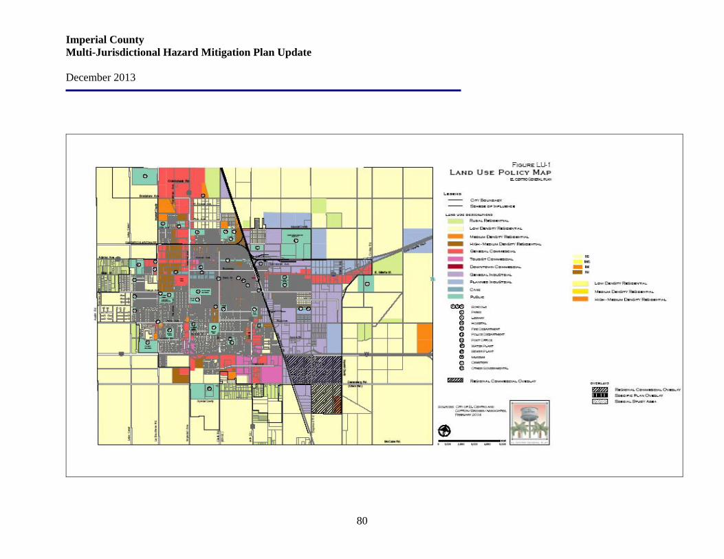
Imperial County Multi-Jurisdictional Hazard Mitigation Plan Update December 2013
80
Imperial County Multi-Jurisdictional Hazard Mitigation Plan Update December 2013
81
4.6 Holtville Area Land Use Plan This approximately 4,080 acre area surrounds the incorporated City of Holtville. It is bounded on the west by State Highway 115, Zends Road and Country Club Road, on the north by Kamm Road, on the east by Towland Road, and on the south by Haven Road, the Ash Main Canal, and Edwards Road for a distance of approximately 3,300 feet east of Orchard Road, thence north to a line 1,320 feet south of Haven Road then east 3,660 feet then north to Haven Road and east to Towland Road. The City of Holtville is surrounded by a mixture of small and large parcels of land under the direct regulatory control of Imperial County. The City is committed in promoting economic development in the community. Following are the Land Use Goals of the City of Holtville:
• Ensure that development in the unincorporated area surrounding the City is compatible and consistent with the City of Holtville and its long range plan for said areas. Furthermore, that these areas be provided with adequate services that are consistent with the City’s development standards.
• Provide and support downtown land uses complimenting economic, redevelopment, and General Plan goals.
• Change the natural obstruction to a cultural, recreational, and economic attraction that is beneficial to the City, and also encourages development expansion to the south as well as to the west.
• To provide comprehensive, clear, development, standards and guidelines for the entire City as well as its Sphere of Influence (Planning Area) where applicable.
• Ensure that development within this area is consistent and compatible with the General Plan and plan for annexation of the area.
• Encourage the development of a variety of desirable and compatible land uses within this area as designated within the General Plan.
• Ensure that sufficient residential planned areas for all economic sectors are available for growth of the City to the north and east.
• Ensure that sufficient commercial and industrial planned areas are available for growth of the City to the southeast and west.
• Encourage and promote the utilization of the currently vacant industrial land within the City.
• Ensure that some areas to the south and west within the Sphere of Influence when annex, are planned for rural residential uses.
• Provide a variety as well as a range of industrial sites and encourage the development of a broad range of industrial and manufacturing activities that are both economically feasible, environmentally acceptable, and provide employment in an attractive and convenient manner.
Imperial County Multi-Jurisdictional Hazard Mitigation Plan Update December 2013
82
• Ensure that the local as well as County systems/facilities are not adversely affected or overburdened by regional pressures brought about by out-of-county forces.
• Encourage and promote conservation, recycling, reuse and other environmentally desirable measures to provide for a cleaner and healthier environment.
Following is the City of Holtville’s Land Use Policy Map.
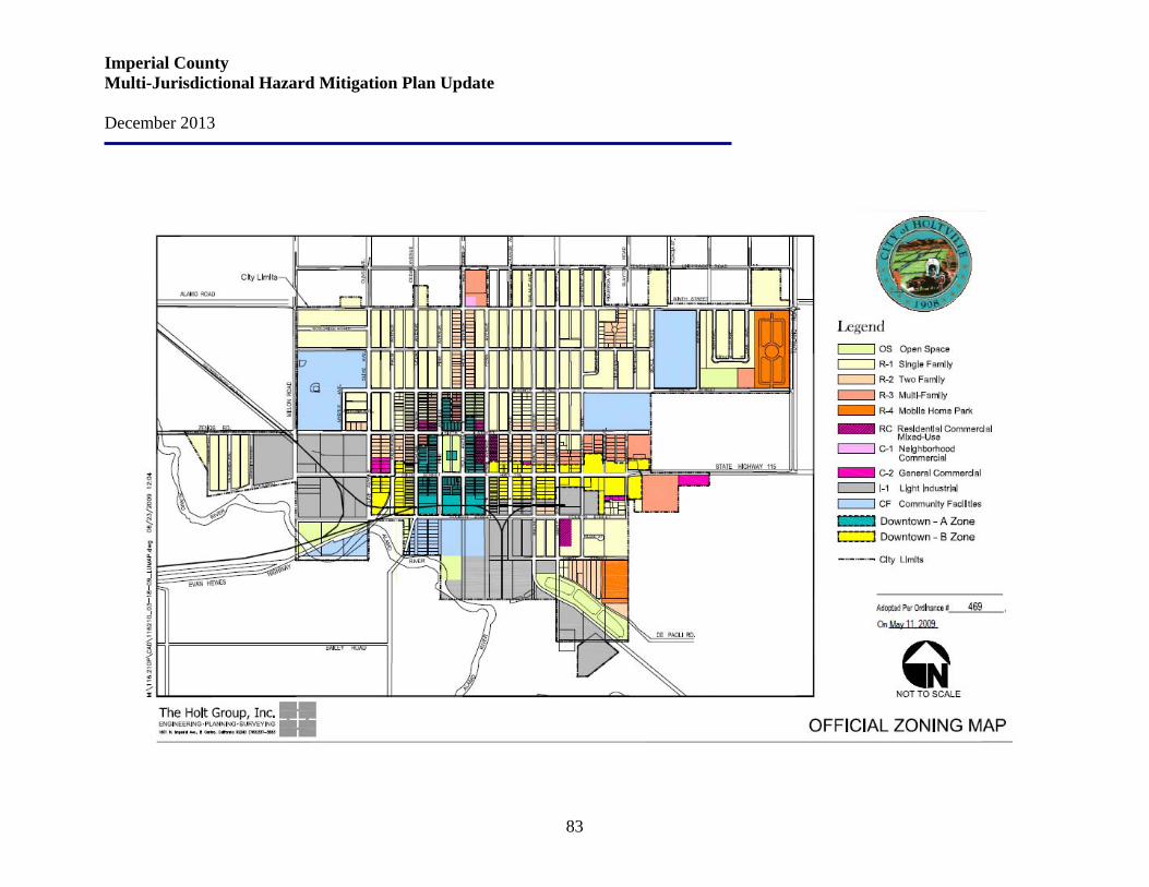
Imperial County Multi-Jurisdictional Hazard Mitigation Plan Update December 2013
83
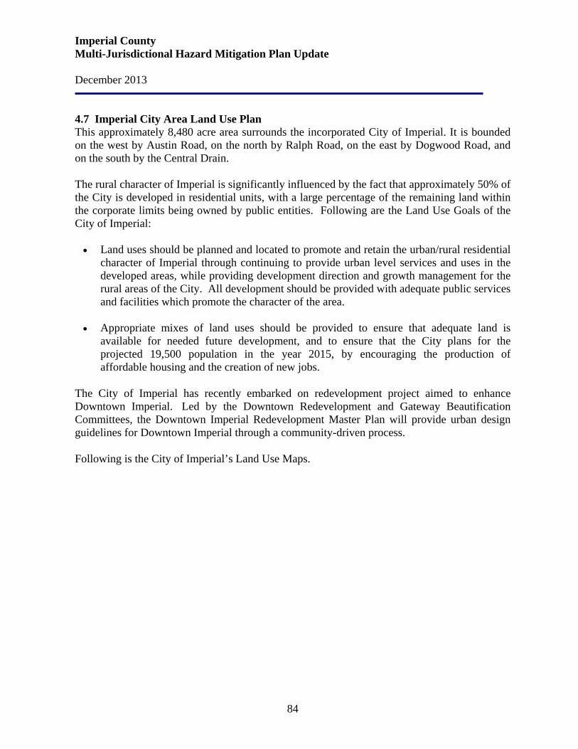
Imperial County Multi-Jurisdictional Hazard Mitigation Plan Update December 2013
84
4.7 Imperial City Area Land Use Plan This approximately 8,480 acre area surrounds the incorporated City of Imperial. It is bounded on the west by Austin Road, on the north by Ralph Road, on the east by Dogwood Road, and on the south by the Central Drain. The rural character of Imperial is significantly influenced by the fact that approximately 50% of the City is developed in residential units, with a large percentage of the remaining land within the corporate limits being owned by public entities. Following are the Land Use Goals of the City of Imperial: • Land uses should be planned and located to promote and retain the urban/rural residential
character of Imperial through continuing to provide urban level services and uses in the developed areas, while providing development direction and growth management for the rural areas of the City. All development should be provided with adequate public services and facilities which promote the character of the area.
• Appropriate mixes of land uses should be provided to ensure that adequate land is
available for needed future development, and to ensure that the City plans for the projected 19,500 population in the year 2015, by encouraging the production of affordable housing and the creation of new jobs.
The City of Imperial has recently embarked on redevelopment project aimed to enhance Downtown Imperial. Led by the Downtown Redevelopment and Gateway Beautification Committees, the Downtown Imperial Redevelopment Master Plan will provide urban design guidelines for Downtown Imperial through a community-driven process.
Following is the City of Imperial’s Land Use Maps.
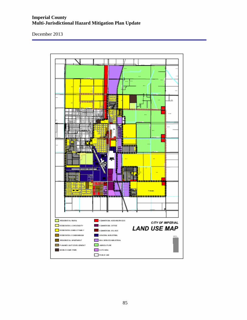
Imperial County Multi-Jurisdictional Hazard Mitigation Plan Update December 2013
85
Imperial County Multi-Jurisdictional Hazard Mitigation Plan Update December 2013
86

Imperial County Multi-Jurisdictional Hazard Mitigation Plan Update December 2013
87
4.8 Westmorland Area Land Use Plan The City of Westmorland is located in northwestern Imperial County in the southeast corner of California. Imperial County is bordered on the north, south, west and east by Riverside County, the U.S./Mexico International Border, San Diego County, and Arizona’s western boundary respectively. Westmorland is located on State Highway 86 and is approximately 30 miles from the U.S./Mexico International Border. It is expected to experience significant growth in the future mainly due to the volume of commercial trucking traffic that flows through the city to and from Calexico. Located on the U.S. Mexico Border near Mexicali is Gateway of the Americas, an industrially/commercially concentrated complex designed to sustain and maximize the activities of the International Port of Entry. As development of business and industry grows within Gateway of the Americas, so will the demand for housing and public facilities in the areas surrounding it, such as Westmorland. Land designated for residential use outside the city limits but within the sphere of influence is the most abundant, with approximately 784 acres. Approximately 184 acres are designated for commercial use, 215 acres have been designated for industrial use, and approximately and 18 acres in the northwestern quadrant of the sphere of influence are designated for open space. There are three major blocks of land designated for industrial use to the north, west, and east of the city. Residential areas exclusively within the sphere of influence are situated in every direction outward from the city limits, with major blocks reserved at the northeast, southwest and southeast quadrants of the sphere of influence. Westmorland’s entire sphere of influence consists of approximately 2,463 gross 1,410 acres of land. About 210,272 acres are located within the city limits, and 2,191 gross 1,200 acres are located outside the city limits. Following are the Land Use Goals, Objectives and Policies of the City of Westmorland: Goal #1: Maintain the rural small town atmosphere of the City of Westmorland. Objective 1.1: Provide a community where residential uses are predominantly low density and non-residential uses are predominantly low intensity. Policies: 1.1.1 Low density residential areas shall have a population density of 0-4 dwelling units per acre. 1.1.2 Medium density residential areas shall have a density not to exceed 12 units per acre. 1.1.3 High density residential areas shall have a density not to exceed 25 units per acre. 1.1.4 Commercial and Industrial designated areas shall have a maximum lot coverage of eighty percent (80%) and a floor area ratio (FAR) of 1.2.
Imperial County Multi-Jurisdictional Hazard Mitigation Plan Update December 2013
88
Goal #2: Plan and create an efficient urban form that maintains and promotes complementary relationship between the varying land uses. Objective 2.1: Encourage non-residential development to occur in and around activity centers and transportation corridors along Center Street and Highway 86. Policies: 2.1.1 Provide opportunities for various commercial activities which include retail sales and service oriented uses such as restaurants, banks, dry cleaning, etc. 2.1.1.1 Encourage and provide opportunities for future and existing commercial markets to serve the residential neighborhoods, especially along Center Street. 2.1.1.2 Restrict regional commercial activity (e.g. gas service stations, fast-food restaurants, etc.) to areas along Highway 86.
Objective 2.2: Ensure community facilities that will provide for the basic services needed by the residents of the City of Westmorland. Community facilities shall include but not be limited to senior citizens center, playgrounds, City Hall, library, youth hall, fire station, etc. Policies: 2.2.1 Provide opportunities for various neighborhood commercial activities, which include retail sales and service oriented uses, along and around Center Street and Highway 86. 2.2.2 Restrict regional, general commercial, activities to higher traffic volume areas along Highway 86. 2.2.3 Provide opportunities for light industrial activities away from the central business district, but along Highway 86 and any extension of City limits thereof.
Objective 2.3: Encourage new-residential development to occur on the South sector of the City near schools and other community facilities. Policies: 2.3.1 City shall pre-zone Sphere of Influence areas to the South of the City for residential uses prior to annexation. 2.3.2 The City’s Sewer Collection and Water Distribution Master Plans should address improvements/extensions of water and sewer mains to the South of the City. Goal #3: Establish and maintain a balanced distribution of public facilities to address the needs of the community. Objective 3.1: Maintain and improve the existing community facilities that provide for the basic services needed by the current and projected population in the Westmorland community. Policies: 3.1.1 The City shall seek funding opportunities for the construction of a locally operated and maintained Fire Station.
Imperial County Multi-Jurisdictional Hazard Mitigation Plan Update December 2013
89
3.1.2 The City shall continue to improve and rehabilitate, while financially feasible, all existing City owned public buildings including the Senior Citizen Center, City Hall, Police Station, Youth Hall, and City Pool. Objective 3.2: The availability of public services and facilities should be consistent with the existing projected populations. Policies: 3.2.1 The number of dwelling units allowed in the City shall be limited to those which can be adequately serviced by the existing planned public services and facilities. 3.2.2 The City shall maintain current information concerning the capacity of the public services and facilities it provides. Goal #4: Promote and encourage economic development for all sectors of the community. Objective 4.1: Ensure availability of land for commercial and industrial land uses to support the projected demands. Policies: 4.1.1 Prohibit and discourage residential land uses along the main transportation corridors. 4.1.2 Pre-zone Sphere of Influence land for commercial or industrial uses along Highway 86 and Forrester Road prior to annexation. 4.1.3 Improve and extend water distribution and sewer line at adequate standards to support new development or expansion within designated commercial and industrial zones. 4.1.4 Encourage the orderly conversion of legal, nonconforming land uses within commercial and industrial zones to commercial or industrial land uses.
Objective 4.2: Encourage businesses that cater to visitors and travelers along the Central Business District (Highway 86) in an effort to capture maximum tax revenue. Policies: 4.2.1 The City shall continue to provide, through Community Development Block Grants, business loans for expansion or start-up within the Central Business District. 4.2.1 Development standards off of the primary corridors shall be flexible while maintaining good planning practices. Following is the City of Westmorland’s Land Use Map.
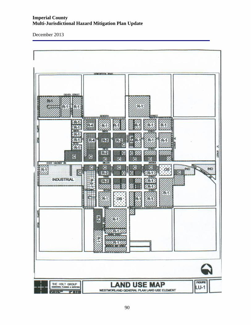
Imperial County Multi-Jurisdictional Hazard Mitigation Plan Update December 2013
90
Imperial County Multi-Jurisdictional Hazard Mitigation Plan Update December 2013
91
Section 5. Hazards Facing Imperial County
Identification of Hazards With its varying topography; mix of urban and rural areas; rapidly growing permanent, transient, and recreational populations, Imperial County is subject to potential negative impacts from a broad range of hazards and threats. There are three broad categories of hazards that threaten the County, namely:
• Natural hazards • Technological hazards • Domestic security threats
Natural hazards include:
• Earthquakes • Floods • Extreme Weather (thunderstorms/windstorms/sudden heavy rain/hailstorms/tornados/
extreme temperatures) • Wildfire • Pest Infestation/Non Vectors of Human Diseases • Naturally Occurring Biological Threats
Technological hazards include:
• Dam Failure • Hazardous Materials (Hazmat) Incidents
Domestic security threats include:
• Terrorism (CBRNE) ° Chemical ° Biological ° Radiological ° Nuclear ° Explosive
The following table describes how and why the hazards listed above were identified by Imperial County in preparing its MHMP.
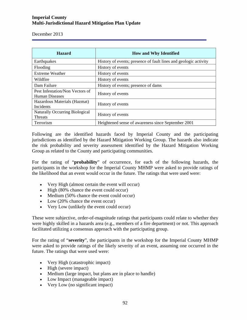
Imperial County Multi-Jurisdictional Hazard Mitigation Plan Update December 2013
92
Hazard How and Why Identified
Earthquakes History of events; presence of fault lines and geologic activity Flooding History of events Extreme Weather History of events Wildfire History of events Dam Failure History of events; presence of dams Pest Infestation/Non Vectors of Human Diseases History of events
Hazardous Materials (Hazmat) Incidents History of events
Naturally Occurring Biological Threats History of events
Terrorism Heightened sense of awareness since September 2001 Following are the identified hazards faced by Imperial County and the participating jurisdictions as identified by the Hazard Mitigation Working Group. The hazards also indicate the risk probability and severity assessment identified by the Hazard Mitigation Working Group as related to the County and participating communities. For the rating of “probability” of occurrence, for each of the following hazards, the participants in the workshop for the Imperial County MHMP were asked to provide ratings of the likelihood that an event would occur in the future. The ratings that were used were:
• Very High (almost certain the event will occur) • High (80% chance the event could occur) • Medium (50% chance the event could occur) • Low (20% chance the event occur) • Very Low (unlikely the event could occur)
These were subjective, order-of-magnitude ratings that participants could relate to whether they were highly skilled in a hazards area (e.g., members of a fire department) or not. This approach facilitated utilizing a consensus approach with the participating group. For the rating of “severity”, the participants in the workshop for the Imperial County MHMP were asked to provide ratings of the likely severity of an event, assuming one occurred in the future. The ratings that were used were:
• Very High (catastrophic impact) • High (severe impact) • Medium (large impact, but plans are in place to handle) • Low Impact (manageable impact) • Very Low (no significant impact)

Imperial County Multi-Jurisdictional Hazard Mitigation Plan Update December 2013
93
These were subjective, order-of-magnitude ratings that participants could relate to whether they were highly skilled in a hazards area (e.g., members of a fire department) or not. This approach facilitated utilizing a consensus approach with the participating group.
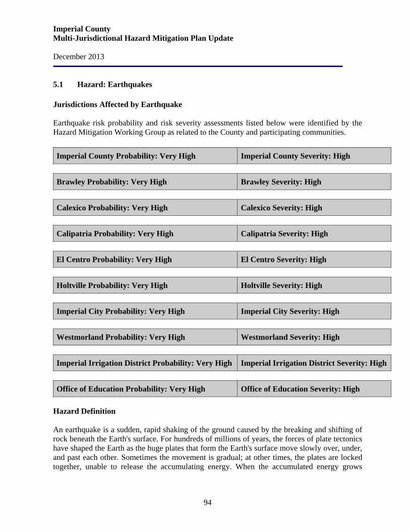
Imperial County Multi-Jurisdictional Hazard Mitigation Plan Update December 2013
94
5.1 Hazard: Earthquakes Jurisdictions Affected by Earthquake Earthquake risk probability and risk severity assessments listed below were identified by the Hazard Mitigation Working Group as related to the County and participating communities. Imperial County Probability: Very High Imperial County Severity: High
Brawley Probability: Very High Brawley Severity: High
Calexico Probability: Very High Calexico Severity: High
Calipatria Probability: Very High Calipatria Severity: High
El Centro Probability: Very High El Centro Severity: High
Holtville Probability: Very High Holtville Severity: High
Imperial City Probability: Very High Imperial City Severity: High
Westmorland Probability: Very High Westmorland Severity: High
Imperial Irrigation District Probability: Very High Imperial Irrigation District Severity: High
Office of Education Probability: Very High Office of Education Severity: High
Hazard Definition An earthquake is a sudden, rapid shaking of the ground caused by the breaking and shifting of rock beneath the Earth's surface. For hundreds of millions of years, the forces of plate tectonics have shaped the Earth as the huge plates that form the Earth's surface move slowly over, under, and past each other. Sometimes the movement is gradual; at other times, the plates are locked together, unable to release the accumulating energy. When the accumulated energy grows
Imperial County Multi-Jurisdictional Hazard Mitigation Plan Update December 2013
95
strong enough, the plates break free causing the ground to shake. Most earthquakes occur at the boundaries where the plates meet; however, some earthquakes occur in the middle of plates. The major form of direct damage from most earthquakes is damage to construction. Bridges are particularly vulnerable to collapse and dam failure may generate major downstream flooding. Buildings vary in susceptibility, dependent upon construction and the types of soils on which they are built. Earthquakes destroy power and telephone lines; gas, sewer, or water mains; which, in turn, may set off fires and/or hinder firefighting or rescue efforts. The hazards of earthquakes varies from place to place, dependent upon the regional and local geology. Ground shaking may occur in areas 65 miles or more from the epicenter (the point on the ground surface above the focus). Ground shaking can change the mechanical properties of some fine grained, saturated soils, whereupon they liquefy and act as a fluid (liquefaction). Where earthquakes have struck before, they will strike again. Earthquakes can strike suddenly, without warning. Earthquakes can occur at any time of the year and at any time of the day or night. Ground movement during an earthquake is seldom the direct cause of death or injury. Most earthquake-related injuries result from collapsing walls, flying glass, and falling objects as a result of the ground shaking, or people trying to move more than a few feet during the shaking. Much of the damage in earthquakes is predictable and preventable. With increasing magnitude (i.e., larger earthquakes) ground motions are stronger, last longer, and are felt over larger areas. Earthquake “intensity” refers to the effects of earthquake ground motions on people and buildings. Earthquake intensity is often more useful than magnitude when discussing the damaging effects of earthquakes. The most common intensity scale is the Modified Mercalli Intensity (MMI) scale, which ranges from I to XII. History Earthquakes are the principal geologic activity affecting public safety in Imperial County. They are a triggering event which permits the force of gravity to operate and create many secondary hazards from ground shaking, including:
• differential ground settlement, soil liquefaction, rock and mudslides, ground lurching, and avalanches;
• ground displacement along the fault; • floods from dam and levee failure, and seiches; • fires; and • various adverse results of disruption of essential facilities and systems - water, sewer, gas,
electricity, transportation, and communication and notably in Imperial Valley, the irrigation and drainage systems.
Imperial County Multi-Jurisdictional Hazard Mitigation Plan Update December 2013
96
Imperial County is a broad, flat, alluviated area that lies partly below sea level, cut off from the Gulf of California to the south by the Colorado River Delta. It is one of the most tectonically active regions in the United States. Branches of the San Andreas Fault form the eastern boundary of the basin (Salton Trough) and the western edge is defined by the San Jacinto-Coyote Creek and the Elsinore-Laguna Salada Faults. The Salton Trough is one of the most seismically active areas in the United States. The deep, sediment-filled geologic structure of the Trough makes the area particularly susceptible to severe earthquake damage. More small to moderate earthquakes have occurred in the area than along any other section of the San Andreas Fault System. During the current century, the areas has experienced eleven earthquakes of magnitude 6.0 or greater on the Richter scale with the strongest being a magnitude of 7.1 on the Imperial Fault in 1940. The 7.2 earthquake of April 4, 2010 cause extensive damage to the Imperial County Administration Center and its equipment, when the suspended ceiling system collapsed. Had the building been occupied at the time of the earthquake, there would have been a great likelihood of injury or death. The Cities of Brawley, Imperial, El Centro, and Calexico have experienced damage from the movements of major faults in the San Jacinto fault zone, which includes the Imperial and Superstition Hills Faults. A moderate to severe incident with intense ground shaking in the populated areas of Imperial County could reasonably be expected to cause numerous casualties, extensive property damage, fire, road closures, disruption of rail systems, communication systems (particularly telephone systems), the County's extensive canal system, and utilities. In addition, health hazards would be posed by damaged sewer systems, waste treatment facilities, and the possible contamination of the County's potable water supply. Medical treatment facilities would most likely be overtaxed. Theft and looting may also be a problem. The resultant disruption of the agricultural community would affect the local economy. The 1940 earthquake along the Imperial Fault registered a 7.1 on the Richter scale. The epicenter was located east of El Centro. The ground was ruptured for 40 miles from Volcano Lake in Baja California to a point near the City of Imperial. Seven deaths occurred and property loss was in excess of $5 million. Eighty percent of the buildings in Imperial were destroyed; fifty percent of Brawley's structures were damaged. Indirect damage to crops was substantial due to the subsequent disruption of drainage and flooding. Horizontal displacement across the completed but unfilled International Canal was 14 feet, 10 inches and the U.S.-Mexico boundary was permanently changed. The Alamo Canal in Baja California was also offset and a local flood resulted from water spilling out of the broken channel.
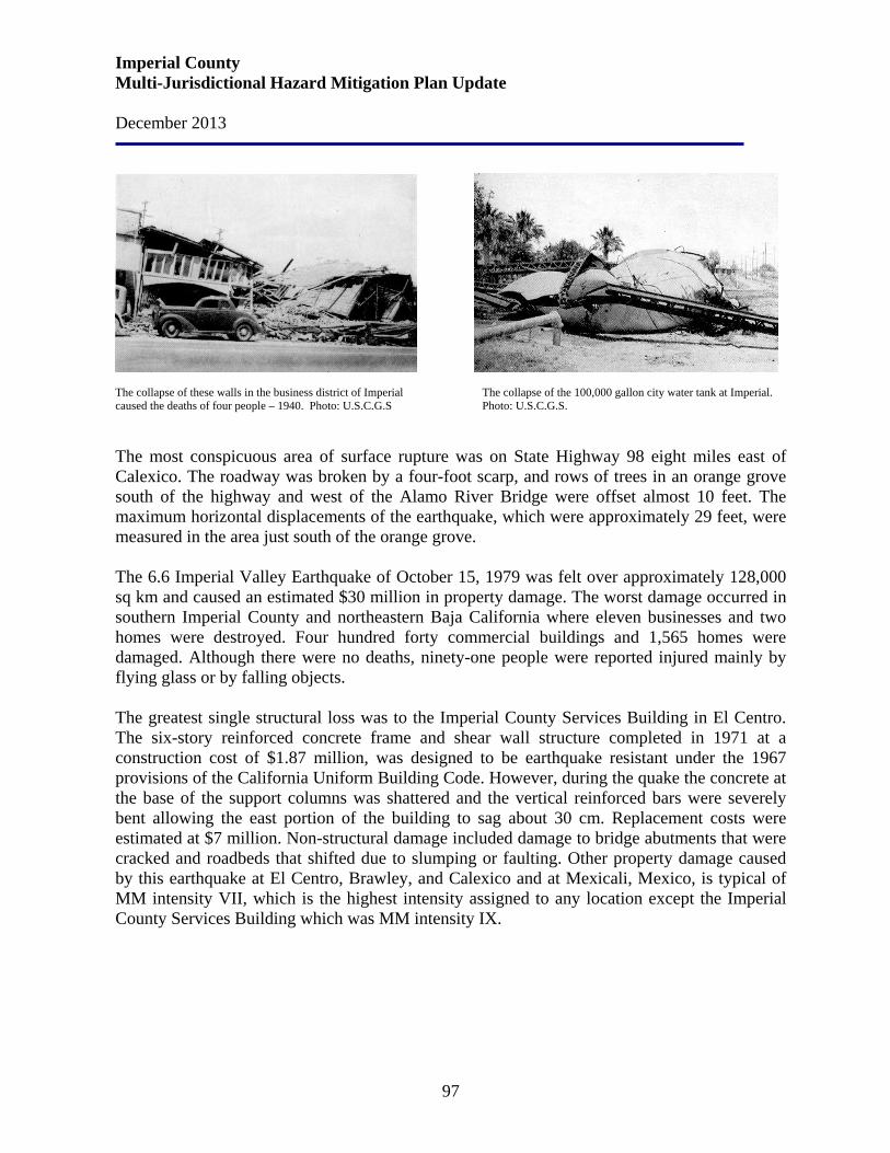
Imperial County Multi-Jurisdictional Hazard Mitigation Plan Update December 2013
97
The collapse of these walls in the business district of Imperial The collapse of the 100,000 gallon city water tank at Imperial. caused the deaths of four people – 1940. Photo: U.S.C.G.S Photo: U.S.C.G.S. The most conspicuous area of surface rupture was on State Highway 98 eight miles east of Calexico. The roadway was broken by a four-foot scarp, and rows of trees in an orange grove south of the highway and west of the Alamo River Bridge were offset almost 10 feet. The maximum horizontal displacements of the earthquake, which were approximately 29 feet, were measured in the area just south of the orange grove. The 6.6 Imperial Valley Earthquake of October 15, 1979 was felt over approximately 128,000 sq km and caused an estimated $30 million in property damage. The worst damage occurred in southern Imperial County and northeastern Baja California where eleven businesses and two homes were destroyed. Four hundred forty commercial buildings and 1,565 homes were damaged. Although there were no deaths, ninety-one people were reported injured mainly by flying glass or by falling objects. The greatest single structural loss was to the Imperial County Services Building in El Centro. The six-story reinforced concrete frame and shear wall structure completed in 1971 at a construction cost of $1.87 million, was designed to be earthquake resistant under the 1967 provisions of the California Uniform Building Code. However, during the quake the concrete at the base of the support columns was shattered and the vertical reinforced bars were severely bent allowing the east portion of the building to sag about 30 cm. Replacement costs were estimated at $7 million. Non-structural damage included damage to bridge abutments that were cracked and roadbeds that shifted due to slumping or faulting. Other property damage caused by this earthquake at El Centro, Brawley, and Calexico and at Mexicali, Mexico, is typical of MM intensity VII, which is the highest intensity assigned to any location except the Imperial County Services Building which was MM intensity IX.
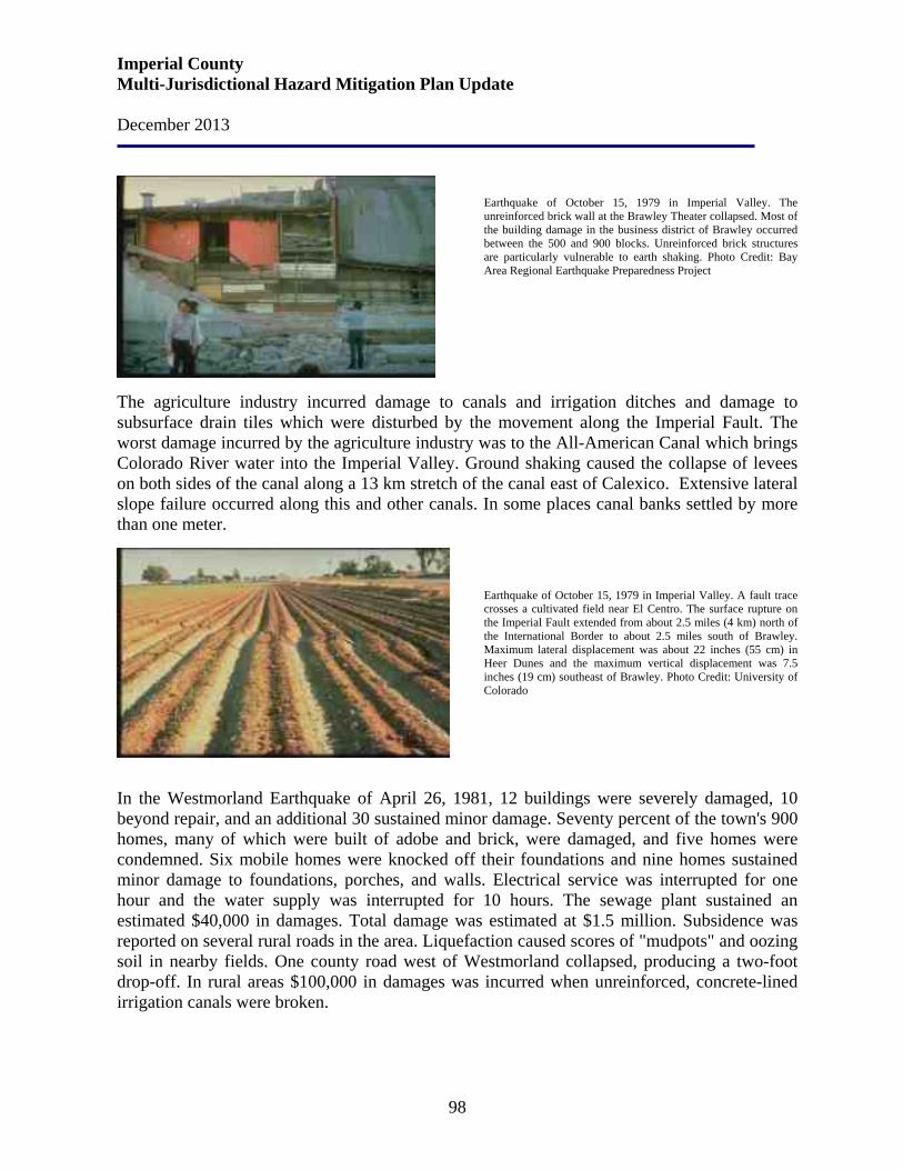
Imperial County Multi-Jurisdictional Hazard Mitigation Plan Update December 2013
98
Earthquake of October 15, 1979 in Imperial Valley. The unreinforced brick wall at the Brawley Theater collapsed. Most of the building damage in the business district of Brawley occurred between the 500 and 900 blocks. Unreinforced brick structures are particularly vulnerable to earth shaking. Photo Credit: Bay Area Regional Earthquake Preparedness Project
The agriculture industry incurred damage to canals and irrigation ditches and damage to subsurface drain tiles which were disturbed by the movement along the Imperial Fault. The worst damage incurred by the agriculture industry was to the All-American Canal which brings Colorado River water into the Imperial Valley. Ground shaking caused the collapse of levees on both sides of the canal along a 13 km stretch of the canal east of Calexico. Extensive lateral slope failure occurred along this and other canals. In some places canal banks settled by more than one meter.
Earthquake of October 15, 1979 in Imperial Valley. A fault trace crosses a cultivated field near El Centro. The surface rupture on the Imperial Fault extended from about 2.5 miles (4 km) north of the International Border to about 2.5 miles south of Brawley. Maximum lateral displacement was about 22 inches (55 cm) in Heer Dunes and the maximum vertical displacement was 7.5 inches (19 cm) southeast of Brawley. Photo Credit: University of Colorado
In the Westmorland Earthquake of April 26, 1981, 12 buildings were severely damaged, 10 beyond repair, and an additional 30 sustained minor damage. Seventy percent of the town's 900 homes, many of which were built of adobe and brick, were damaged, and five homes were condemned. Six mobile homes were knocked off their foundations and nine homes sustained minor damage to foundations, porches, and walls. Electrical service was interrupted for one hour and the water supply was interrupted for 10 hours. The sewage plant sustained an estimated $40,000 in damages. Total damage was estimated at $1.5 million. Subsidence was reported on several rural roads in the area. Liquefaction caused scores of "mudpots" and oozing soil in nearby fields. One county road west of Westmorland collapsed, producing a two-foot drop-off. In rural areas $100,000 in damages was incurred when unreinforced, concrete-lined irrigation canals were broken.

Imperial County Multi-Jurisdictional Hazard Mitigation Plan Update December 2013
99
Westmorland Earthquake of April 1981. Left photo: View of a two story building partially collapsed in earthquake. Note the undamaged one story building on the left. Twelve buildings were severely damaged and an additional 30 sustained minor damage. City officials ordered the demolition of 10 downtown buildings that were damaged beyond repair. Right photo: View of partially collapsed adobe building in Westmorland. Seventy percent of the 900 homes in Westmoreland were damaged. Most, like this structure, were constructed of adobe and/or brick. Photo Credit: Bay Area Regional Earthquake Preparedness Project Other seismic activity includes a Magnitude 4.0 earthquake in Brawley on May 23, 2003, and seismic activity in the Brawley Seismic Zone from August 31, 2005 through September 2, 2005. Renewed seismic activity in the Brawley Seismic Zone began late on August 28, 2005 but reached a sustained higher level of activity, announced by back-to-back M4.6 and M4.5 events at 3:47 p.m. and 3:50 p.m. on August 31, 2005. The swarm then intensified, with a M5.1 event on September 1, 2005. There was recorded a total of eight events of M 4.0+, 29 additional events of magnitude between 3.0 and 4.0, and 175 events between magnitude 2.0 and 3.0. In all, 554 events of M 1.0+ had occurred in the swarm.
The activity is reminiscent of similar swarms that occurred in the Brawley Seismic Zone throughout the 1970’s and 1980’s, during which time the zone was among the most active areas in all of California. The Brawley Seismic Zone is a north-striking zone of northwest and northeast-striking faults that extends from the southern end of the San Andreas Fault to the northern end of the Imperial Fault. The pattern of the Brawley swarms of the 1970’s was a large number of very small earthquakes (sometimes exceeding 10,000 events) with up to a dozen moderate events of Magnitude 4.0 or so, but no clear main shock larger than the other events. The 1970’s swarms would be highly active for a few days and then taper off over the next week or two. In 1999 and 2001, two other smaller swarms occurred on northeast-striking faults in the Salton Sea. Compared to those two sequences, the 2005 swarm had significantly more events, but also is located significantly farther away from the San Andreas Fault.
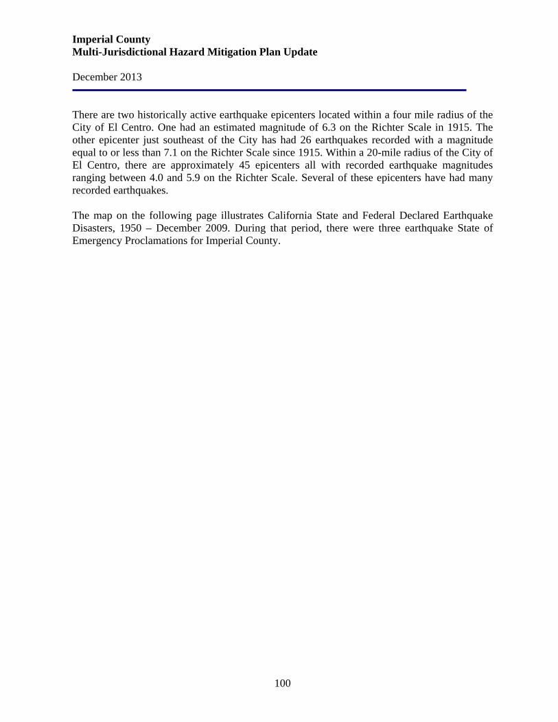
Imperial County Multi-Jurisdictional Hazard Mitigation Plan Update December 2013
100
There are two historically active earthquake epicenters located within a four mile radius of the City of El Centro. One had an estimated magnitude of 6.3 on the Richter Scale in 1915. The other epicenter just southeast of the City has had 26 earthquakes recorded with a magnitude equal to or less than 7.1 on the Richter Scale since 1915. Within a 20-mile radius of the City of El Centro, there are approximately 45 epicenters all with recorded earthquake magnitudes ranging between 4.0 and 5.9 on the Richter Scale. Several of these epicenters have had many recorded earthquakes. The map on the following page illustrates California State and Federal Declared Earthquake Disasters, 1950 – December 2009. During that period, there were three earthquake State of Emergency Proclamations for Imperial County.
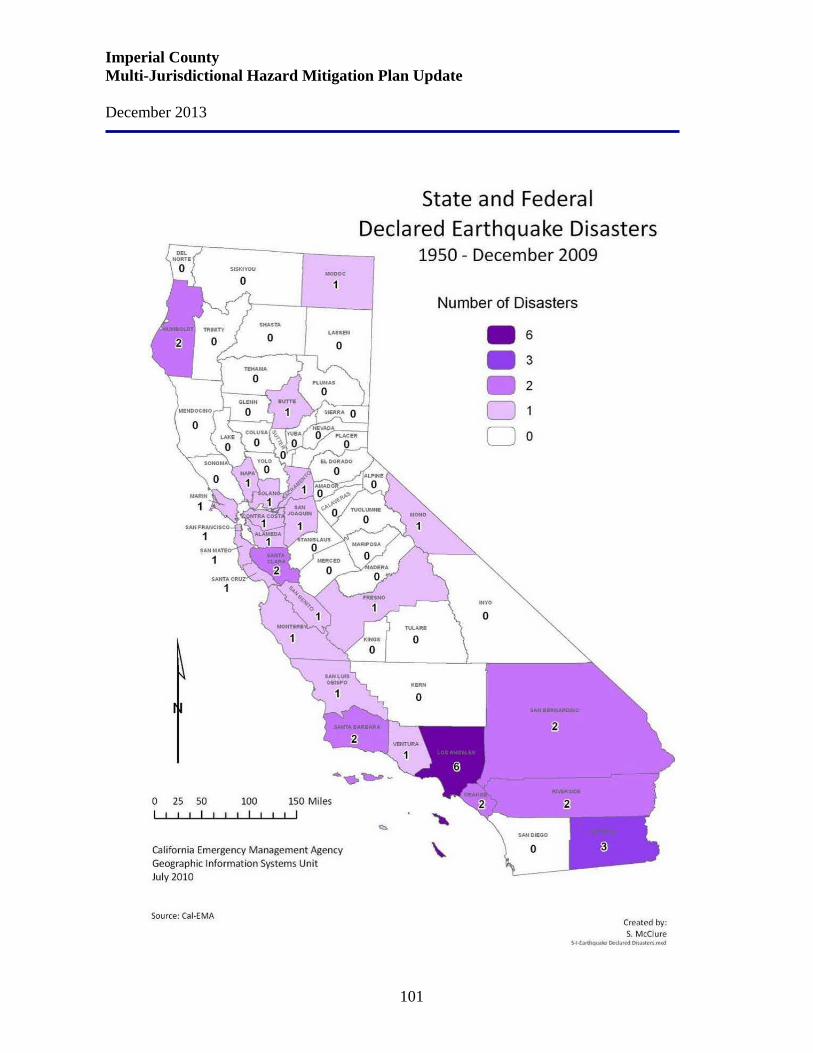
Imperial County Multi-Jurisdictional Hazard Mitigation Plan Update December 2013
101
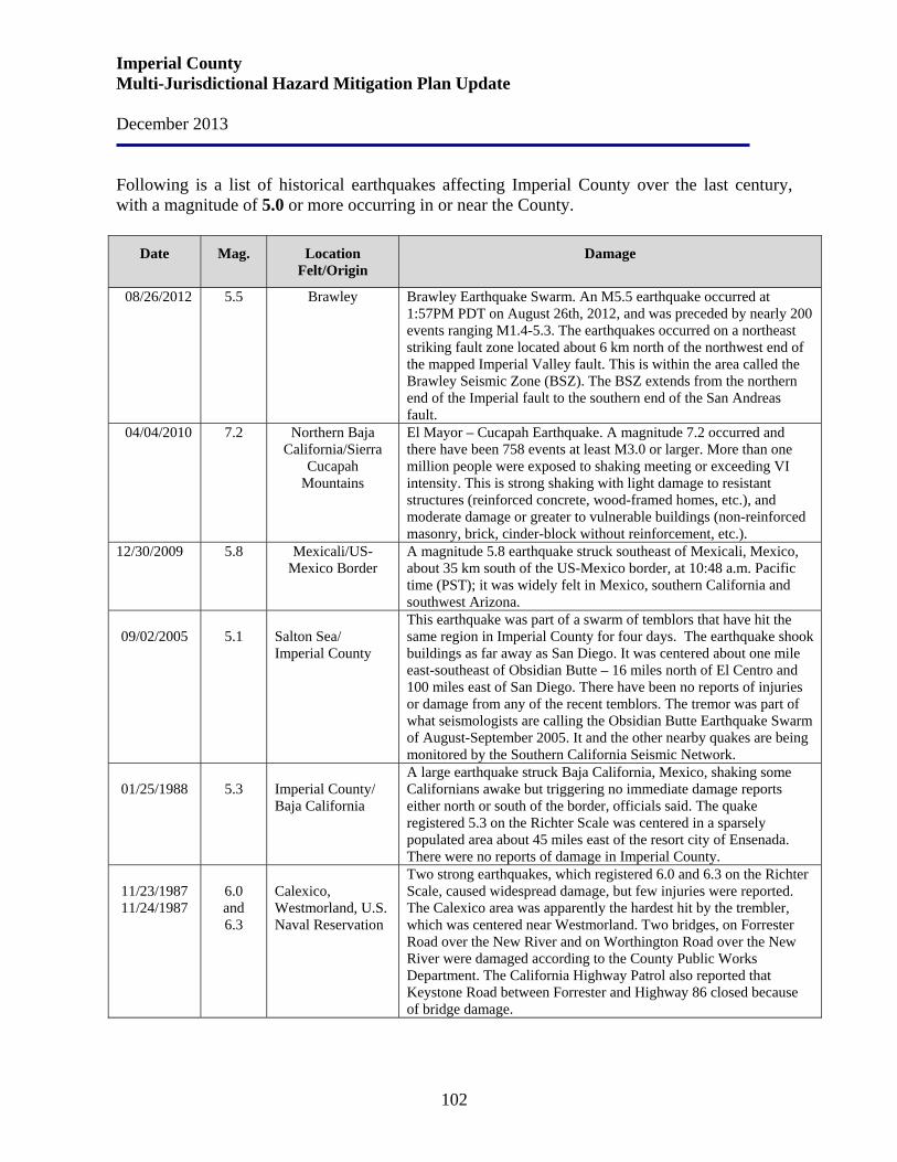
Imperial County Multi-Jurisdictional Hazard Mitigation Plan Update December 2013
102
Following is a list of historical earthquakes affecting Imperial County over the last century, with a magnitude of 5.0 or more occurring in or near the County.
Date Mag. Location Felt/Origin
Damage
08/26/2012 5.5 Brawley Brawley Earthquake Swarm. An M5.5 earthquake occurred at 1:57PM PDT on August 26th, 2012, and was preceded by nearly 200 events ranging M1.4-5.3. The earthquakes occurred on a northeast striking fault zone located about 6 km north of the northwest end of the mapped Imperial Valley fault. This is within the area called the Brawley Seismic Zone (BSZ). The BSZ extends from the northern end of the Imperial fault to the southern end of the San Andreas fault.
04/04/2010 7.2 Northern Baja California/Sierra
Cucapah Mountains
El Mayor – Cucapah Earthquake. A magnitude 7.2 occurred and there have been 758 events at least M3.0 or larger. More than one million people were exposed to shaking meeting or exceeding VI intensity. This is strong shaking with light damage to resistant structures (reinforced concrete, wood-framed homes, etc.), and moderate damage or greater to vulnerable buildings (non-reinforced masonry, brick, cinder-block without reinforcement, etc.).
12/30/2009 5.8 Mexicali/US-Mexico Border
A magnitude 5.8 earthquake struck southeast of Mexicali, Mexico, about 35 km south of the US-Mexico border, at 10:48 a.m. Pacific time (PST); it was widely felt in Mexico, southern California and southwest Arizona.
09/02/2005
5.1
Salton Sea/ Imperial County
This earthquake was part of a swarm of temblors that have hit the same region in Imperial County for four days. The earthquake shook buildings as far away as San Diego. It was centered about one mile east-southeast of Obsidian Butte – 16 miles north of El Centro and 100 miles east of San Diego. There have been no reports of injuries or damage from any of the recent temblors. The tremor was part of what seismologists are calling the Obsidian Butte Earthquake Swarm of August-September 2005. It and the other nearby quakes are being monitored by the Southern California Seismic Network.
01/25/1988
5.3
Imperial County/ Baja California
A large earthquake struck Baja California, Mexico, shaking some Californians awake but triggering no immediate damage reports either north or south of the border, officials said. The quake registered 5.3 on the Richter Scale was centered in a sparsely populated area about 45 miles east of the resort city of Ensenada. There were no reports of damage in Imperial County.
11/23/1987 11/24/1987
6.0 and 6.3
Calexico, Westmorland, U.S. Naval Reservation
Two strong earthquakes, which registered 6.0 and 6.3 on the Richter Scale, caused widespread damage, but few injuries were reported. The Calexico area was apparently the hardest hit by the trembler, which was centered near Westmorland. Two bridges, on Forrester Road over the New River and on Worthington Road over the New River were damaged according to the County Public Works Department. The California Highway Patrol also reported that Keystone Road between Forrester and Highway 86 closed because of bridge damage.
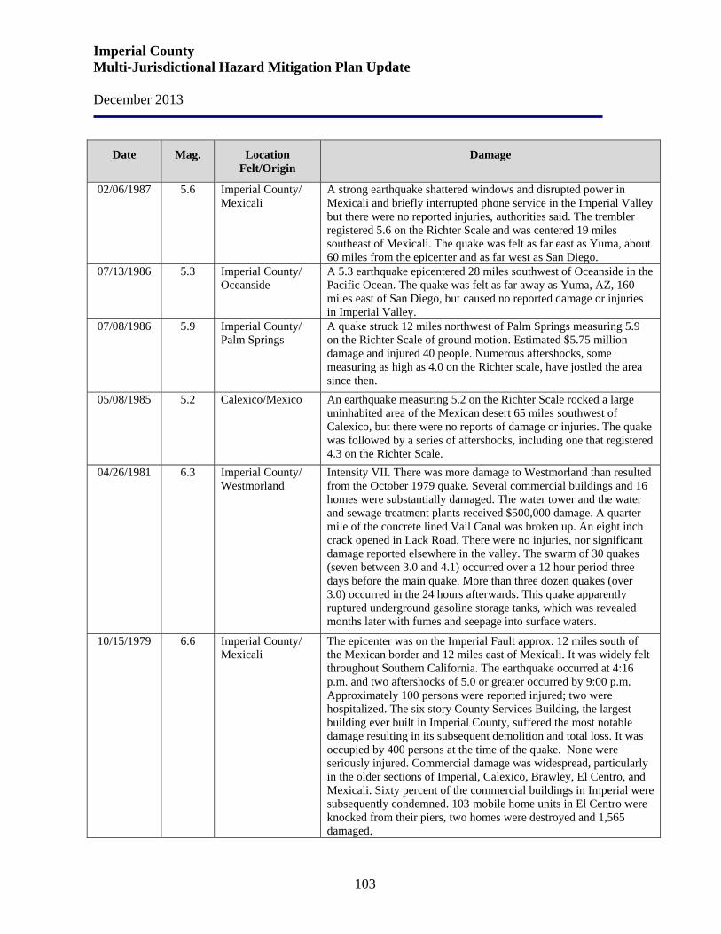
Imperial County Multi-Jurisdictional Hazard Mitigation Plan Update December 2013
103
Date Mag. Location Felt/Origin
Damage
02/06/1987
5.6
Imperial County/ Mexicali
A strong earthquake shattered windows and disrupted power in Mexicali and briefly interrupted phone service in the Imperial Valley but there were no reported injuries, authorities said. The trembler registered 5.6 on the Richter Scale and was centered 19 miles southeast of Mexicali. The quake was felt as far east as Yuma, about 60 miles from the epicenter and as far west as San Diego.
07/13/1986
5.3
Imperial County/ Oceanside
A 5.3 earthquake epicentered 28 miles southwest of Oceanside in the Pacific Ocean. The quake was felt as far away as Yuma, AZ, 160 miles east of San Diego, but caused no reported damage or injuries in Imperial Valley.
07/08/1986
5.9
Imperial County/ Palm Springs
A quake struck 12 miles northwest of Palm Springs measuring 5.9 on the Richter Scale of ground motion. Estimated $5.75 million damage and injured 40 people. Numerous aftershocks, some measuring as high as 4.0 on the Richter scale, have jostled the area since then.
05/08/1985
5.2
Calexico/Mexico
An earthquake measuring 5.2 on the Richter Scale rocked a large uninhabited area of the Mexican desert 65 miles southwest of Calexico, but there were no reports of damage or injuries. The quake was followed by a series of aftershocks, including one that registered 4.3 on the Richter Scale.
04/26/1981
6.3
Imperial County/ Westmorland
Intensity VII. There was more damage to Westmorland than resulted from the October 1979 quake. Several commercial buildings and 16 homes were substantially damaged. The water tower and the water and sewage treatment plants received $500,000 damage. A quarter mile of the concrete lined Vail Canal was broken up. An eight inch crack opened in Lack Road. There were no injuries, nor significant damage reported elsewhere in the valley. The swarm of 30 quakes (seven between 3.0 and 4.1) occurred over a 12 hour period three days before the main quake. More than three dozen quakes (over 3.0) occurred in the 24 hours afterwards. This quake apparently ruptured underground gasoline storage tanks, which was revealed months later with fumes and seepage into surface waters.
10/15/1979
6.6
Imperial County/ Mexicali
The epicenter was on the Imperial Fault approx. 12 miles south of the Mexican border and 12 miles east of Mexicali. It was widely felt throughout Southern California. The earthquake occurred at 4:16 p.m. and two aftershocks of 5.0 or greater occurred by 9:00 p.m. Approximately 100 persons were reported injured; two were hospitalized. The six story County Services Building, the largest building ever built in Imperial County, suffered the most notable damage resulting in its subsequent demolition and total loss. It was occupied by 400 persons at the time of the quake. None were seriously injured. Commercial damage was widespread, particularly in the older sections of Imperial, Calexico, Brawley, El Centro, and Mexicali. Sixty percent of the commercial buildings in Imperial were subsequently condemned. 103 mobile home units in El Centro were knocked from their piers, two homes were destroyed and 1,565 damaged.
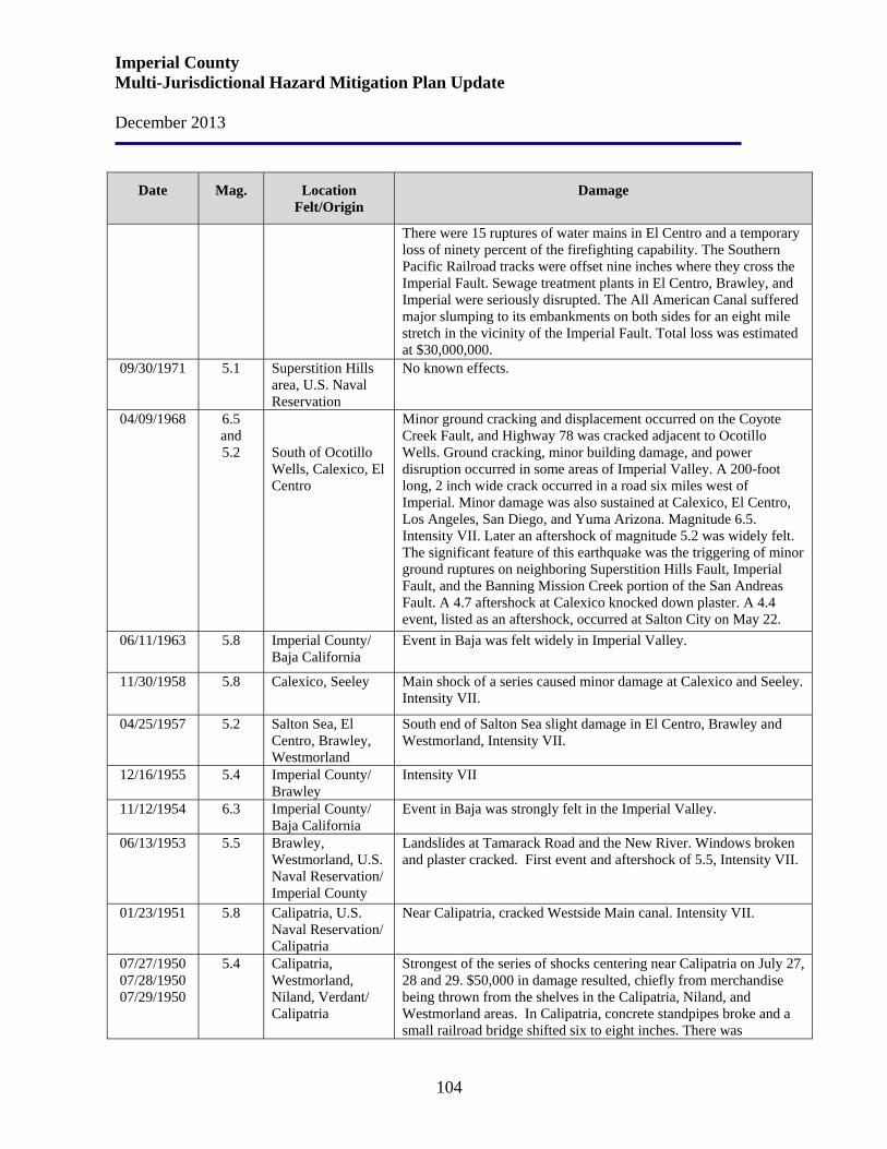
Imperial County Multi-Jurisdictional Hazard Mitigation Plan Update December 2013
104
Date Mag. Location Felt/Origin
Damage
There were 15 ruptures of water mains in El Centro and a temporary loss of ninety percent of the firefighting capability. The Southern Pacific Railroad tracks were offset nine inches where they cross the Imperial Fault. Sewage treatment plants in El Centro, Brawley, and Imperial were seriously disrupted. The All American Canal suffered major slumping to its embankments on both sides for an eight mile stretch in the vicinity of the Imperial Fault. Total loss was estimated at $30,000,000.
09/30/1971
5.1
Superstition Hills area, U.S. Naval Reservation
No known effects.
04/09/1968
6.5 and 5.2
South of Ocotillo Wells, Calexico, El Centro
Minor ground cracking and displacement occurred on the Coyote Creek Fault, and Highway 78 was cracked adjacent to Ocotillo Wells. Ground cracking, minor building damage, and power disruption occurred in some areas of Imperial Valley. A 200-foot long, 2 inch wide crack occurred in a road six miles west of Imperial. Minor damage was also sustained at Calexico, El Centro, Los Angeles, San Diego, and Yuma Arizona. Magnitude 6.5. Intensity VII. Later an aftershock of magnitude 5.2 was widely felt. The significant feature of this earthquake was the triggering of minor ground ruptures on neighboring Superstition Hills Fault, Imperial Fault, and the Banning Mission Creek portion of the San Andreas Fault. A 4.7 aftershock at Calexico knocked down plaster. A 4.4 event, listed as an aftershock, occurred at Salton City on May 22.
06/11/1963
5.8
Imperial County/ Baja California
Event in Baja was felt widely in Imperial Valley.
11/30/1958
5.8 Calexico, Seeley Main shock of a series caused minor damage at Calexico and Seeley. Intensity VII.
04/25/1957
5.2
Salton Sea, El Centro, Brawley, Westmorland
South end of Salton Sea slight damage in El Centro, Brawley and Westmorland, Intensity VII.
12/16/1955 5.4 Imperial County/ Brawley
Intensity VII
11/12/1954 6.3 Imperial County/ Baja California
Event in Baja was strongly felt in the Imperial Valley.
06/13/1953
5.5
Brawley, Westmorland, U.S. Naval Reservation/ Imperial County
Landslides at Tamarack Road and the New River. Windows broken and plaster cracked. First event and aftershock of 5.5, Intensity VII.
01/23/1951
5.8
Calipatria, U.S. Naval Reservation/ Calipatria
Near Calipatria, cracked Westside Main canal. Intensity VII.
07/27/1950 07/28/1950 07/29/1950
5.4
Calipatria, Westmorland, Niland, Verdant/ Calipatria
Strongest of the series of shocks centering near Calipatria on July 27, 28 and 29. $50,000 in damage resulted, chiefly from merchandise being thrown from the shelves in the Calipatria, Niland, and Westmorland areas. In Calipatria, concrete standpipes broke and a small railroad bridge shifted six to eight inches. There was
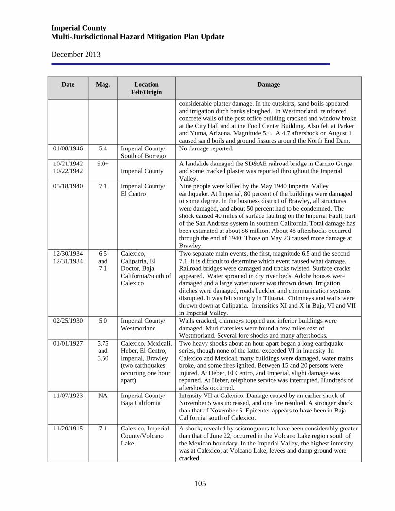
Imperial County Multi-Jurisdictional Hazard Mitigation Plan Update December 2013
105
Date Mag. Location Felt/Origin
Damage
considerable plaster damage. In the outskirts, sand boils appeared and irrigation ditch banks sloughed. In Westmorland, reinforced concrete walls of the post office building cracked and window broke at the City Hall and at the Food Center Building. Also felt at Parker and Yuma, Arizona. Magnitude 5.4. A 4.7 aftershock on August 1 caused sand boils and ground fissures around the North End Dam.
01/08/1946 5.4 Imperial County/ South of Borrego
No damage reported.
10/21/1942 10/22/1942
5.0+
Imperial County
A landslide damaged the SD&AE railroad bridge in Carrizo Gorge and some cracked plaster was reported throughout the Imperial Valley.
05/18/1940
7.1
Imperial County/ El Centro
Nine people were killed by the May 1940 Imperial Valley earthquake. At Imperial, 80 percent of the buildings were damaged to some degree. In the business district of Brawley, all structures were damaged, and about 50 percent had to be condemned. The shock caused 40 miles of surface faulting on the Imperial Fault, part of the San Andreas system in southern California. Total damage has been estimated at about $6 million. About 48 aftershocks occurred through the end of 1940. Those on May 23 caused more damage at Brawley.
12/30/1934 12/31/1934
6.5 and 7.1
Calexico, Calipatria, El Doctor, Baja California/South of Calexico
Two separate main events, the first, magnitude 6.5 and the second 7.1. It is difficult to determine which event caused what damage. Railroad bridges were damaged and tracks twisted. Surface cracks appeared. Water sprouted in dry river beds. Adobe houses were damaged and a large water tower was thrown down. Irrigation ditches were damaged, roads buckled and communication systems disrupted. It was felt strongly in Tijuana. Chimneys and walls were thrown down at Calipatria. Intensities XI and X in Baja, VI and VII in Imperial Valley.
02/25/1930
5.0
Imperial County/ Westmorland
Walls cracked, chimneys toppled and inferior buildings were damaged. Mud craterlets were found a few miles east of Westmorland. Several fore shocks and many aftershocks.
01/01/1927 5.75 and 5.50
Calexico, Mexicali, Heber, El Centro, Imperial, Brawley (two earthquakes occurring one hour apart)
Two heavy shocks about an hour apart began a long earthquake series, though none of the latter exceeded VI in intensity. In Calexico and Mexicali many buildings were damaged, water mains broke, and some fires ignited. Between 15 and 20 persons were injured. At Heber, El Centro, and Imperial, slight damage was reported. At Heber, telephone service was interrupted. Hundreds of aftershocks occurred.
11/07/1923 NA Imperial County/ Baja California
Intensity VII at Calexico. Damage caused by an earlier shock of November 5 was increased, and one fire resulted. A stronger shock than that of November 5. Epicenter appears to have been in Baja California, south of Calexico.
11/20/1915
7.1
Calexico, Imperial County/Volcano Lake
A shock, revealed by seismograms to have been considerably greater than that of June 22, occurred in the Volcano Lake region south of the Mexican boundary. In the Imperial Valley, the highest intensity was at Calexico; at Volcano Lake, levees and damp ground were cracked.

Imperial County Multi-Jurisdictional Hazard Mitigation Plan Update December 2013
106
Date Mag. Location Felt/Origin
Damage
06/23/1915
6.25 and 6.25
El Centro, Calexico, Mexicali (two earthquakes occurring one hour apart)
Two destructive shocks, nearly 1 hour apart. Heavy damage (about $900,000) in southern Imperial Valley was caused as much by poor quality buildings as by the intensity of shock. In El Centro, well-constructed buildings merely suffered cracks. At Mexicali, Mexico, people returned to buildings after the first shock; six were killed and many were injured by the second earthquake. Though a few cracks were formed in the alluvium, the irrigation ditches and works were damaged very little. The unstable banks of the New and Alamo Rivers slid down in many places. Several farmers observed that after the shocks, one-third more water was required for irrigation because of the cracks in the soil. Despite the rather high local intensity, the total energy was moderate.
04/19/1906 6.2 Brawley Chimneys fell. Banks of New River caved in; water tanks destroyed at Cocopah in Baja California. The published information is very limited, but H. O. Wood, on the basis of verbal information, reported this to be a very severe shock. It came just hours after the great San Francisco quake and most probably was related.
01/23/1903
7.0+
Imperial County/ Baja California
A strong earthquake, centering in the uninhabited region south of Imperial Valley, was felt throughout southern California, southern Nevada, and western Arizona. A similar shock under present conditions in the Imperial Valley would cause damage. Recorded by distant seismographs.
02/24/1892
7.8
Imperial County/ Baja California
The intensity of this shock probably reached X near the epicenter, which was apparently in the uninhabited region of northern Baja California. It was felt strongly along the Pacific coast of Baja California, as far as San Quentin, Mexico and as far north as Visalia, California. At Carrizo, all adobe buildings were destroyed; at Jamul, walls of stone kilns cracked. At Campo, there were 155 shocks in 12 hours. After shocks were numerous for several days.
11/15/1875
6.2
Imperial Valley to Colorado River
Unknown
11/1852
6.5
Northern Salton Trough
Unknown
Existing Faults in Imperial County There are nine fault zones, primarily northwest-trending, within Imperial County: San Andreas, Imperial, Algodones Sand Dunes, Calipatria, Boundary, Superstition Hills, Superstition Mountain, Laguna Salada, and Elsinore. The most significant fault within the County is the San Andreas, which extends from Mexico into northern California, and the maximum earthquake intensity predicted for this fault is a magnitude 8.3. This fault is located about 28 miles east of the Imperial Fault Zone. The geologic strain pattern in the Imperial Valley region is clearly defined. The primary strain features are the northwest-trending high-angle faults developed along the San Andreas, San
Imperial County Multi-Jurisdictional Hazard Mitigation Plan Update December 2013
107
Jacinto, and Elsinore Zones. Movements along these faults are predominantly right lateral, with relative south-eastward displacements of the northeast blocks, and vertical movements are local or only apparent. The cities of Brawley, Imperial, El Centro, and Calexico have, within the last 35 years, received damage from the movements of major faults in the San Jacinto Fault Zone. These are the Imperial and Superstition Hills Faults. In relation to the City of El Centro, the Imperial Fault is located approximately five miles to the east. It is a historically active fault associated with an earthquake of major proportions in 1940 and again in 1966, both of which have well documented reports indicating surface faulting. The May 18, 1940 Imperial Valley Earthquake exposed the exact line of the Imperial Fault, which is the only known section of the San Andreas system near the U.S./Mexico border. Within a few miles to the north of El Centro, there are several faults which have been active historically; some of these are associated with the recorded 1951 earthquake involving the Superstition Hills fault, a well-documented quake, showing surface faulting. Thirteen Official Maps of new and revised Alquist-Priolo Earthquake Fault Zones were released on September 21, 2012 to Imperial Alameda, Riverside, San Diego, and Ventura counties and the cities of Hayward, Oakland, and San Leandro by the California Geological Survey (CGS). These maps are released under the authority of the Alquist-Priolo Earthquake Fault Zoning (AP) Act that was passed following the 1971 San Fernando earthquake. The AP Act is a state law designed to reduce the hazard from surface fault rupture during an earthquake. Earthquake Fault Zones are regulatory zones that encompass surface traces of active faults that have a potential for future surface fault rupture. The index map shows the general location of maps delineating the new and revised Earthquake Fault Zones within the affected areas of Alameda, Imperial, Riverside, San Diego, and Ventura counties. The following maps depict the locations of known earthquake fault zones in Imperial County.
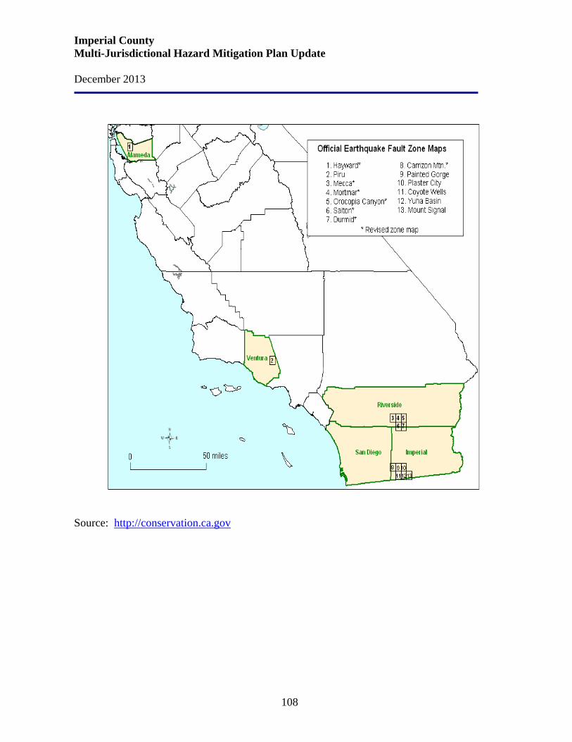
Imperial County Multi-Jurisdictional Hazard Mitigation Plan Update December 2013
108
Source: http://conservation.ca.gov
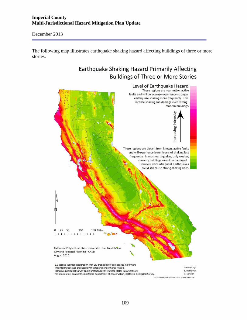
Imperial County Multi-Jurisdictional Hazard Mitigation Plan Update December 2013
109
The following map illustrates earthquake shaking hazard affecting buildings of three or more stories.
Imperial County Multi-Jurisdictional Hazard Mitigation Plan Update December 2013
110
Risk Assessment Earthquakes are the principal geologic activity affecting public safety in Imperial County. In the event of an earthquake, the location of the epicenter as well as the time of day and season of the year would have a profound effect on the number of deaths, casualties, property damage, agricultural and environmental damage, and disruption of normal government and community services and activities. The effects could be aggravated by collateral emergencies such as fires, dam failure, flooding, hazardous material spills, utility disruptions, landslides and transportation emergencies. The community needs would most likely exceed the response capability of the County’s emergency management organization, requiring mutual assistance from volunteer and private agencies, the Governor’s Office of Emergency Services, and the Federal Emergency Support Functions. Liquid petroleum products are delivered to and are transported through the County via the twenty-inch Santa Fe Pacific Pipe Line. A six-inch branch line distributes gas to the storage facility south of Imperial and a four-inch line serves the Naval Air Facility (NAF) near Seeley. The maintenance staff for the line anticipates no special problems from earthquakes or fault movement and are unaware of such a situation occurring in California in past years. A major break would take one to two days to repair. The petroleum storage facilities in Niland and Imperial are vulnerable to earthquakes. Storage capacity at Niland is 77,500 barrels and at Imperial 289,000 barrels. Storage tanks, however, are never full at one time but are normally filled 50 percent. The 1979 earthquake resulted in the rupture of one tank and a gasoline leak of 100 gallon per minute at the Imperial facility. The potential for a major disaster does exist; however, the probability of loss of all liquid petroleum in the County is low. Emergency service via tanker is readily available if required during an emergency situation. Natural gas is delivered by the Southern California Gas Company via twin ten-inch lines which generally run south through the County in Range 14 East. These lines serve Niland, Calipatria, Brawley, Imperial, El Centro, Heber, and Calexico and branch lines serve Holtville, Westmorland, Seeley, NAF, and Plaster City. Rural residents are served by laterals from the branch lines. The lateral lines typically do not exceed a quarter mile in length. The gas lines are less resilient to seismic stress than the liquid lines and the entire natural gas system is vulnerable to disruption. The lines were damaged from the 1979 earthquake. The north-south line was damaged in the area it crossed the fault. The line suffered compressive stress and a fitting buckled and resulted in a major leak. The leak was repaired without shutting down the line. The line to Holtville was stretched where it crossed the fault. The line did not break and was repaired without shutting down the line.
• Effects on people and housing. In any earthquake, the primary consideration is saving lives. Time and effort must also be dedicated to providing for mental health by reuniting families, providing shelter to displaced persons, and restoring
Imperial County Multi-Jurisdictional Hazard Mitigation Plan Update December 2013
111
basic needs and services. Major efforts will be required to remove debris and clear roadways, demolish unsafe structures, assist in reestablishing public services and utilities, and provide continuing care and temporary housing for affected citizens.
• Effects on commercial and industrial structures. After any earthquake,
individuals are likely to lose wages due to the inability of agriculture and businesses to function because of damaged facilities and/or goods. With agriculture and business losses, the Imperial County and the cities in Imperial County will lose revenue. Economic recovery from even a minor earthquake will be critical to the communities involved.
• Effects on infrastructure. The damage caused by both ground breaking and
ground shaking can lead to the paralysis of the local infrastructure: police, fire, medical and government services.
• Effects on agriculture. Earthquakes can cause loss of human life, loss of animal
life, and property damage to structures and land dedicated to agricultural uses. The most significant long-term impacts on agriculture from earthquakes are those that arise from the cascading effects of fire and flood.
Risk assessment conclusion. Imperial County is clearly at high risk for a significant earthquake causing catastrophic damage and strains on response and mitigation resources. Both property and human life are at high risk. The County experiences hundreds of minor quakes and tremblers each month from the myriad of faults in the area. It is difficult to predict the severity of casualties and property damage that could result from an earthquake. The severity of casualties and property damage depend on the intensity of the earthquake, location of the epicenter to populated areas and the time of day of the occurrence. Since Imperial County is subject to frequent seismic events, there are concerns related to ground shaking, soil liquefaction, and rock and mudslides. The composition of geologic strata (bedrock and soil) determines what can be expected from an area as a result of ground shaking. It is therefore important to know the soil makeup in order to determine the appropriate design of structures proposed for an area. Since the County is generally flat, landslides are not considered a major hazard. However, bluff failure and mudslides may occur along slopes and embankments of the rivers and canals. Existing information about earthquakes that have occurred in Imperial County suggest that an equal number of earthquakes of equal intensity may occur within the future. The County can expect injuries, casualties and property damage from earthquakes at some time in the future because of the past frequency of moderately high magnitude and intensity earthquakes; the distribution of active faults and epicenters; and the projected increase in population.
Imperial County Multi-Jurisdictional Hazard Mitigation Plan Update December 2013
112
Since 1933, public schools have been constructed in accordance with the Field Act, which requires thorough reviews of construction plans, strict inspections, and quality control. By 1977, nearly all public schools in Imperial County that were built before the Field Act had either been retrofitted or were no longer being used for instructional purposes. Relationship to Other Hazards – Cascading Effects While ground shaking may be the predominant agent of damage in most earthquakes, fires following earthquakes can also lead to catastrophic damage depending on the combination of building characteristics and density, meteorological conditions, and other factors. Earthquakes occurring in Imperial County are a triggering event which permits the force of gravity to operate and create many secondary hazards from ground shaking in addition to fires, including:
• differential ground settlement, soil liquefaction, rock and mudslides, ground lurching, and avalanches;
• ground displacement along the fault; • floods from dam and levee failure, and seiches; • various adverse results of disruption of essential facilities and systems - water, sewer,
gas, electricity, transportation, and communication (and notably in Imperial County, the irrigation and drainage system).
Unreinforced Masonry (URM) Buildings Unreinforced masonry (URM) buildings are made of brick, stone, or other types of masonry and have no reinforcing steel to keep them from falling down in earthquakes. Most URM buildings have features that can threaten lives during earthquakes. These include parapets, walls, and roofs that are poorly connected to each other. When earthquakes occur, inadequate connections in these buildings can allow masonry to fall. Floors and roofs can collapse, placing occupants and passersby in harm’s way. The risk to life from URM buildings can be significantly reduced by the regulation of alterations to existing buildings and seismic retrofits. Unreinforced masonry structures perform poorly under almost all earthquake conditions, and especially if located on poor ground areas. Nearby relatively small earthquakes can be very damaging because of the sharp motions they generate. Distant events, while more damaging to taller buildings, can also damage unreinforced masonry buildings because of the stresses caused by long-period motions. Evidence from past earthquakes shows that wood frame structures properly tied to their foundations perform very well, or if badly damaged cause few injuries and life loss even if located in poor ground areas. Older wood frame structures that have stone, brick, or cripple wall foundations, or that are not bolted to their foundations, do not perform well. Mobile homes generally perform very well because of their lightness, but failures of their weak foundation supports (usually flimsy metal stands or concrete blocks) can produce serious damage and
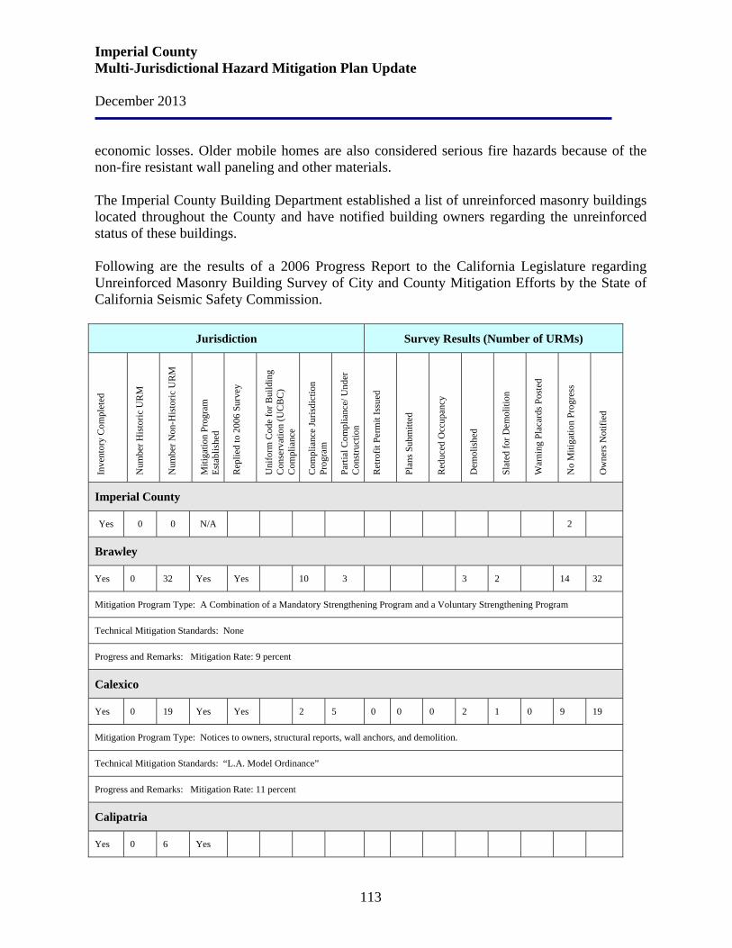
Imperial County Multi-Jurisdictional Hazard Mitigation Plan Update December 2013
113
economic losses. Older mobile homes are also considered serious fire hazards because of the non-fire resistant wall paneling and other materials. The Imperial County Building Department established a list of unreinforced masonry buildings located throughout the County and have notified building owners regarding the unreinforced status of these buildings. Following are the results of a 2006 Progress Report to the California Legislature regarding Unreinforced Masonry Building Survey of City and County Mitigation Efforts by the State of California Seismic Safety Commission.
Jurisdiction Survey Results (Number of URMs)
Inve
ntor
y C
ompl
eted
N
umbe
r His
toric
UR
M
Num
ber N
on-H
isto
ric U
RM
Miti
gatio
n Pr
ogra
m
Esta
blis
hed
Rep
lied
to 2
006
Surv
ey
Uni
form
Cod
e fo
r Bui
ldin
g C
onse
rvat
ion
(UC
BC
) C
ompl
ianc
e
Com
plia
nce
Juris
dict
ion
Prog
ram
Parti
al C
ompl
ianc
e/ U
nder
C
onst
ruct
ion
Ret
rofit
Per
mit
Issu
ed
Plan
s Sub
mitt
ed
Red
uced
Occ
upan
cy
Dem
olis
hed
Slat
ed fo
r Dem
oliti
on
War
ning
Pla
card
s Pos
ted
No
Miti
gatio
n Pr
ogre
ss
Ow
ners
Not
ified
Imperial County
Yes 0 0 N/A 2
Brawley
Yes 0 32 Yes Yes 10 3 3 2 14 32
Mitigation Program Type: A Combination of a Mandatory Strengthening Program and a Voluntary Strengthening Program
Technical Mitigation Standards: None
Progress and Remarks: Mitigation Rate: 9 percent
Calexico
Yes 0 19 Yes Yes 2 5 0 0 0 2 1 0 9 19
Mitigation Program Type: Notices to owners, structural reports, wall anchors, and demolition.
Technical Mitigation Standards: “L.A. Model Ordinance”
Progress and Remarks: Mitigation Rate: 11 percent
Calipatria
Yes 0 6 Yes
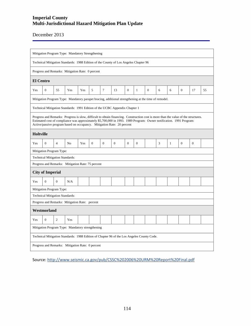
Imperial County Multi-Jurisdictional Hazard Mitigation Plan Update December 2013
114
Mitigation Program Type: Mandatory Strengthening
Technical Mitigation Standards: 1988 Edition of the County of Los Angeles Chapter 96
Progress and Remarks: Mitigation Rate: 0 percent
El Centro
Yes 0 55 Yes Yes 5 7 13 0 1 0 6 6 0 17 55
Mitigation Program Type: Mandatory parapet bracing, additional strengthening at the time of remodel.
Technical Mitigation Standards: 1991 Edition of the UCBC Appendix Chapter 1
Progress and Remarks: Progress is slow, difficult to obtain financing. Construction cost is more than the value of the structures. Estimated cost of compliance was approximately $5,700,000 in 1993. 1989 Program: Owner notification. 1991 Program: Active/passive program based on occupancy. Mitigation Rate: 20 percent
Holtville
Yes 0 4 No Yes 0 0 0 0 0 3 1 0 0
Mitigation Program Type:
Technical Mitigation Standards:
Progress and Remarks: Mitigation Rate: 75 percent
City of Imperial
Yes 0 0 N/A
Mitigation Program Type:
Technical Mitigation Standards:
Progress and Remarks: Mitigation Rate: percent
Westmorland
Yes 0 2 Yes
Mitigation Program Type: Mandatory strengthening
Technical Mitigation Standards: 1988 Edition of Chapter 96 of the Los Angeles County Code.
Progress and Remarks: Mitigation Rate: 0 percent
Source: http://www.seismic.ca.gov/pub/CSSC%202006%20URM%20Report%20Final.pdf
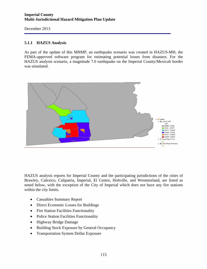
Imperial County Multi-Jurisdictional Hazard Mitigation Plan Update December 2013
115
5.1.1 HAZUS Analysis As part of the update of this MHMP, an earthquake scenario was created in HAZUS-MH, the FEMA-approved software program for estimating potential losses from disasters. For the HAZUS analysis scenario, a magnitude 7.0 earthquake on the Imperial County/Mexicali border was simulated.
HAZUS analysis reports for Imperial County and the participating jurisdictions of the cities of Brawley, Calexico, Calipatria, Imperial, El Centro, Holtville, and Westmorland, are listed as noted below, with the exception of the City of Imperial which does not have any fire stations within the city limits.
• Casualties Summary Report • Direct Economic Losses for Buildings • Fire Station Facilities Functionality • Police Station Facilities Functionality • Highway Bridge Damage • Building Stock Exposure by General Occupancy • Transportation System Dollar Exposure
Imperial County Multi-Jurisdictional Hazard Mitigation Plan Update December 2013
116
In addition, there are HAZUS analysis reports for the Imperial Irrigation District (water and utilities) and the Office of Education school facilities functionality. The results produced by HAZUS are reported by census tract. The summarized results for Imperial County and the participating jurisdictions are presented on the pages immediately following.
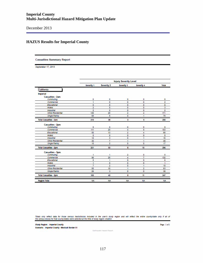
Imperial County Multi-Jurisdictional Hazard Mitigation Plan Update December 2013
117
HAZUS Results for Imperial County
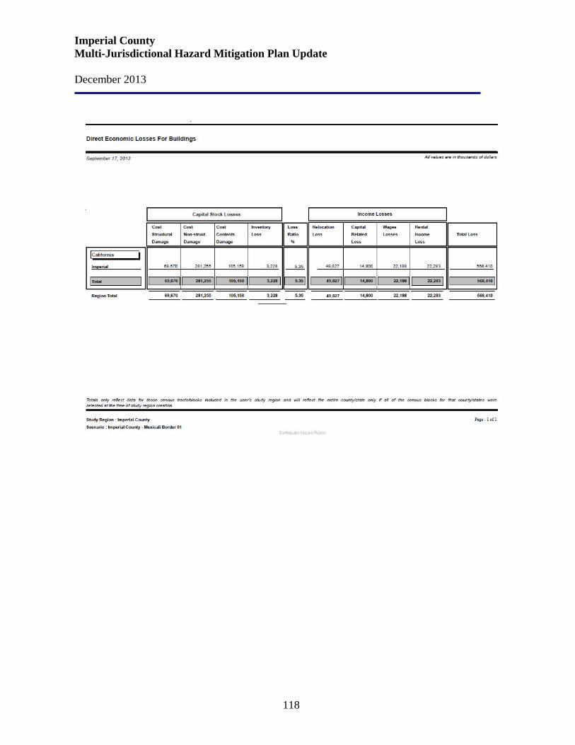
Imperial County Multi-Jurisdictional Hazard Mitigation Plan Update December 2013
118

Imperial County Multi-Jurisdictional Hazard Mitigation Plan Update December 2013
119
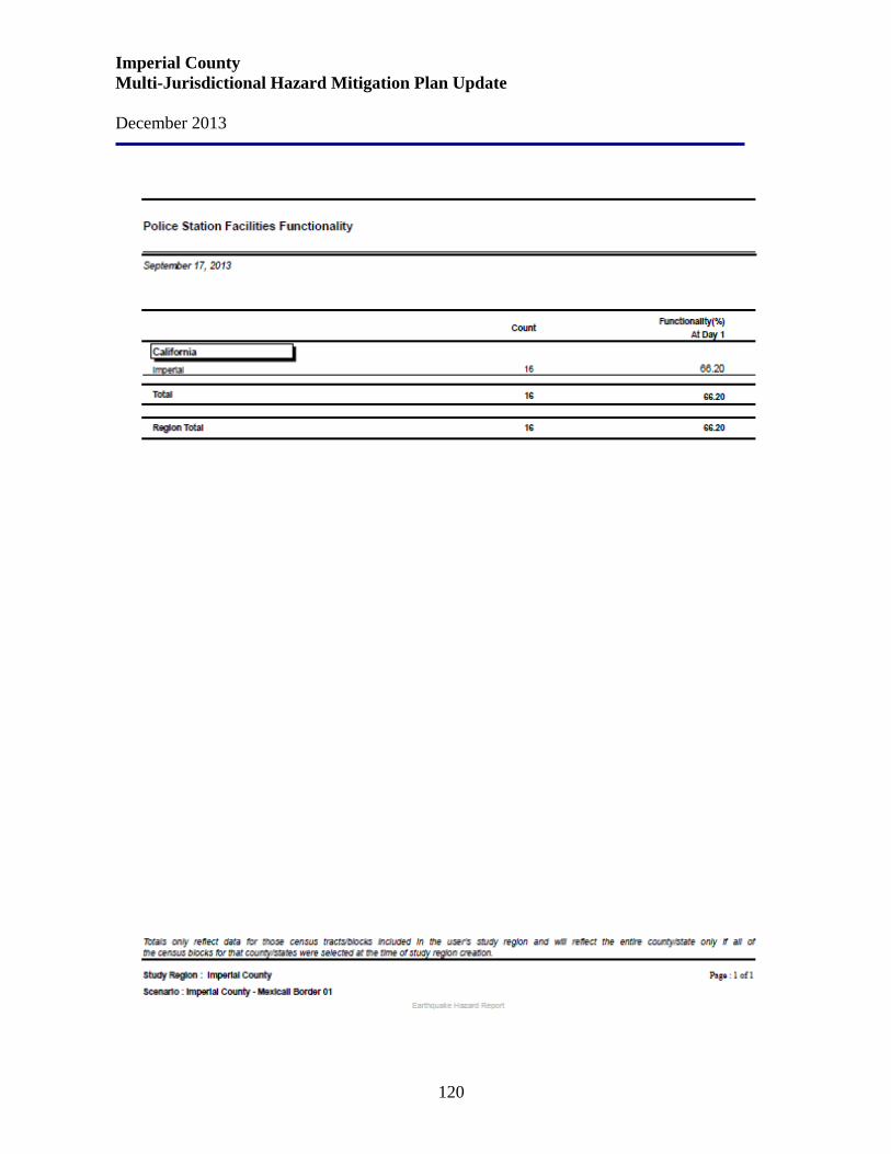
Imperial County Multi-Jurisdictional Hazard Mitigation Plan Update December 2013
120
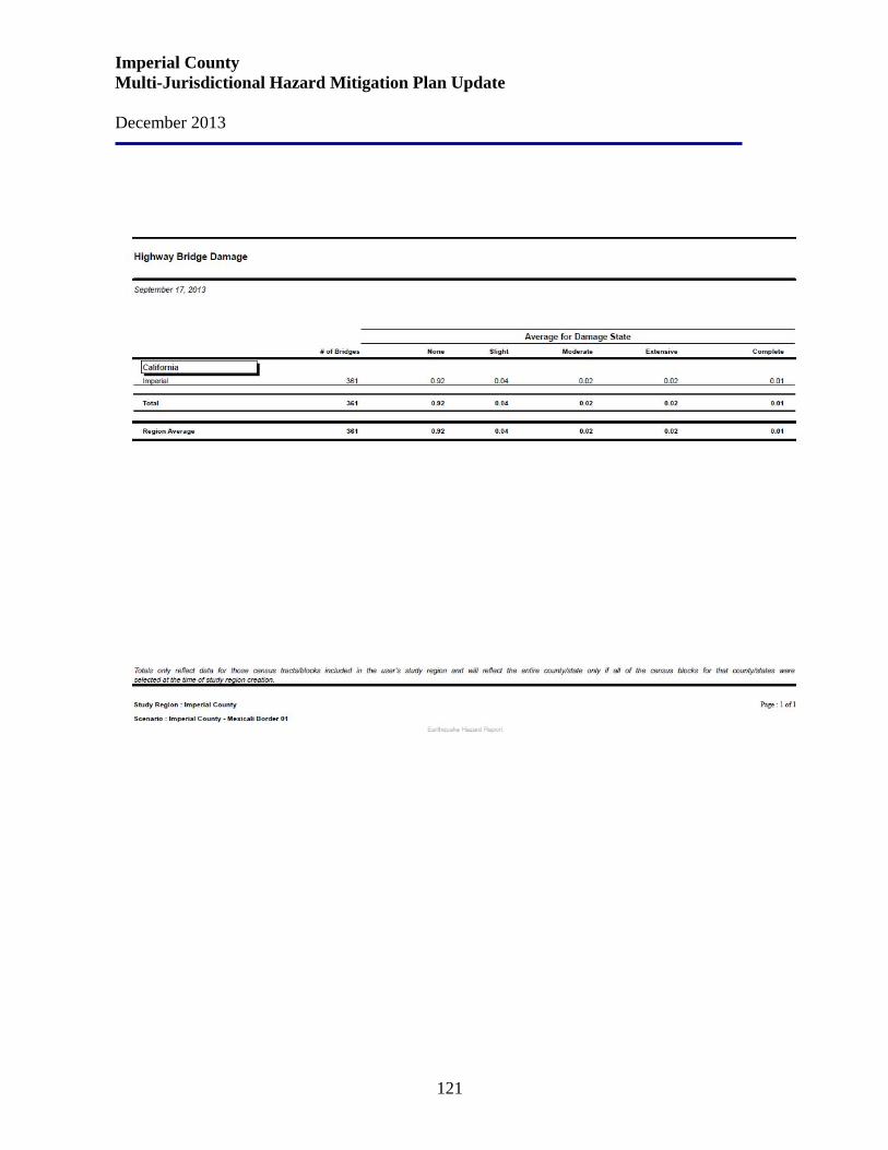
Imperial County Multi-Jurisdictional Hazard Mitigation Plan Update December 2013
121
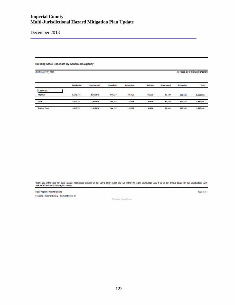
Imperial County Multi-Jurisdictional Hazard Mitigation Plan Update December 2013
122
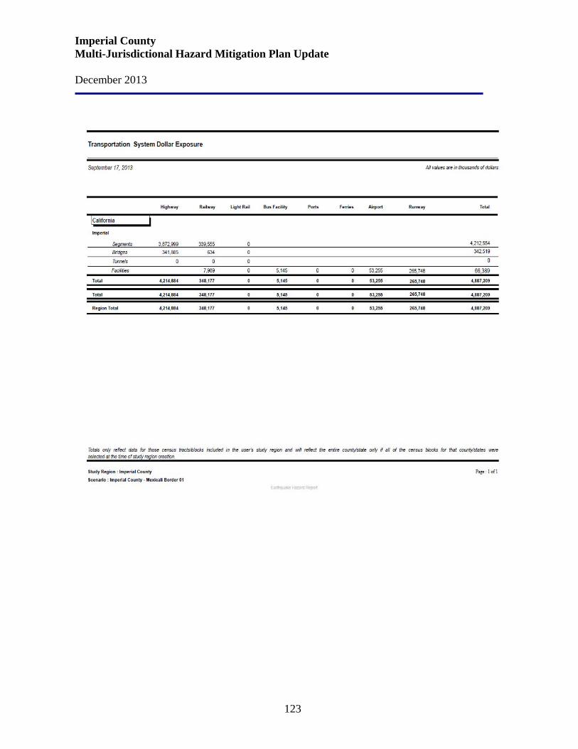
Imperial County Multi-Jurisdictional Hazard Mitigation Plan Update December 2013
123
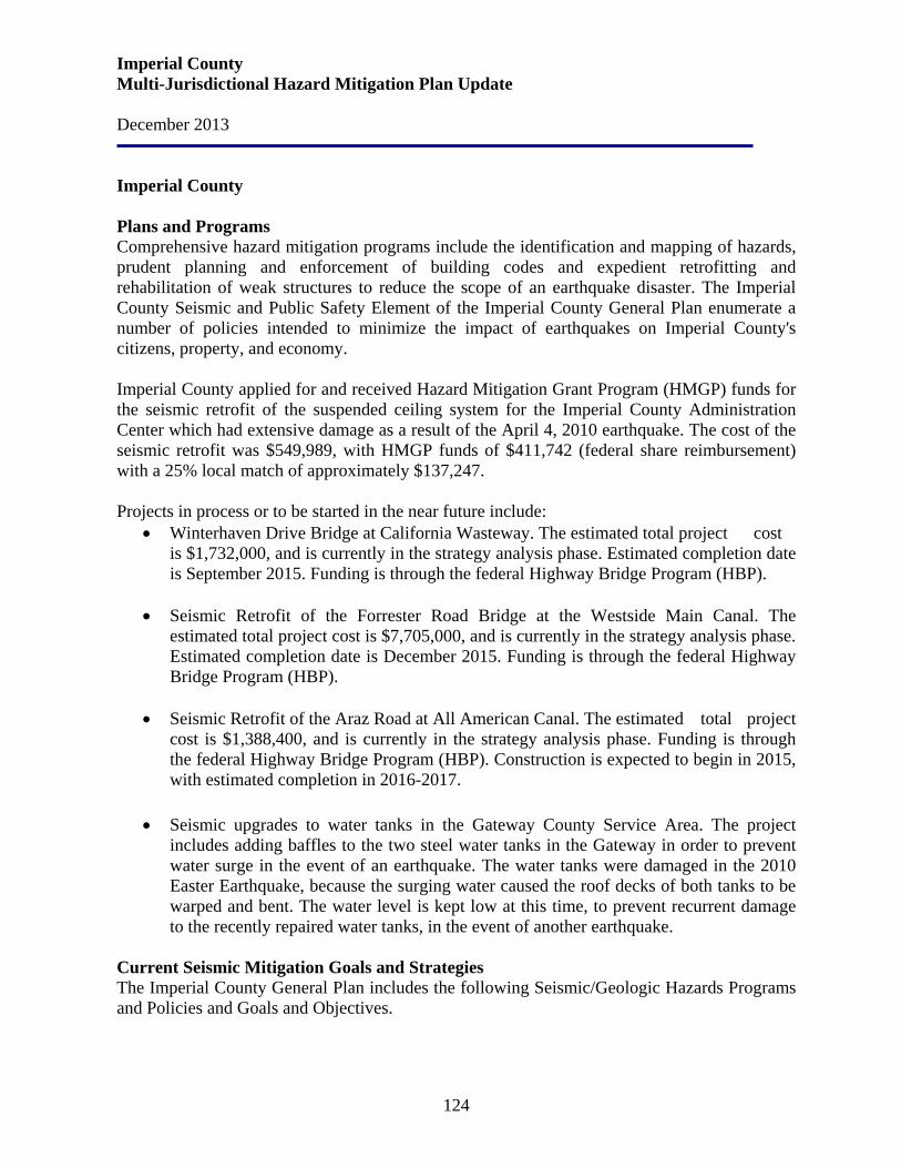
Imperial County Multi-Jurisdictional Hazard Mitigation Plan Update December 2013
124
Imperial County Plans and Programs Comprehensive hazard mitigation programs include the identification and mapping of hazards, prudent planning and enforcement of building codes and expedient retrofitting and rehabilitation of weak structures to reduce the scope of an earthquake disaster. The Imperial County Seismic and Public Safety Element of the Imperial County General Plan enumerate a number of policies intended to minimize the impact of earthquakes on Imperial County's citizens, property, and economy. Imperial County applied for and received Hazard Mitigation Grant Program (HMGP) funds for the seismic retrofit of the suspended ceiling system for the Imperial County Administration Center which had extensive damage as a result of the April 4, 2010 earthquake. The cost of the seismic retrofit was $549,989, with HMGP funds of $411,742 (federal share reimbursement) with a 25% local match of approximately $137,247. Projects in process or to be started in the near future include:
• Winterhaven Drive Bridge at California Wasteway. The estimated total project cost is $1,732,000, and is currently in the strategy analysis phase. Estimated completion date is September 2015. Funding is through the federal Highway Bridge Program (HBP).
• Seismic Retrofit of the Forrester Road Bridge at the Westside Main Canal. The
estimated total project cost is $7,705,000, and is currently in the strategy analysis phase. Estimated completion date is December 2015. Funding is through the federal Highway Bridge Program (HBP).
• Seismic Retrofit of the Araz Road at All American Canal. The estimated total project
cost is $1,388,400, and is currently in the strategy analysis phase. Funding is through the federal Highway Bridge Program (HBP). Construction is expected to begin in 2015, with estimated completion in 2016-2017.
• Seismic upgrades to water tanks in the Gateway County Service Area. The project includes adding baffles to the two steel water tanks in the Gateway in order to prevent water surge in the event of an earthquake. The water tanks were damaged in the 2010 Easter Earthquake, because the surging water caused the roof decks of both tanks to be warped and bent. The water level is kept low at this time, to prevent recurrent damage to the recently repaired water tanks, in the event of another earthquake.
Current Seismic Mitigation Goals and Strategies The Imperial County General Plan includes the following Seismic/Geologic Hazards Programs and Policies and Goals and Objectives.
Imperial County Multi-Jurisdictional Hazard Mitigation Plan Update December 2013
125
Programs and Policies 1. Implement codified ordinances and procedures which require the review and restriction of
land use due to possible natural hazards.
2. Monitor, evaluate, and analyze existing seismic and geological data as it pertains to Imperial County to determine future regulations and programs.
3. Implement the geologic hazards section of the County's Codified Ordinances pursuant to the requirements of the Alquist - Priolo Geologic Hazards Zone Act.
4. Ensure that no structure for human occupancy, other than one-story wood frame structures, shall be permitted within fifty feet of an active fault trace as designated on maps compiled by the State Geologist under the Alquist - Priolo Geologist Hazards Zone Act.
5. The County should require suppliers of all existing utilities which cross active faults to file with the County an operation plan describing the probable effects of failures at the fault and the various emergency facilities and procedures which exist to assure that failure does not threaten public safety.
6. Ensure that proposed highway construction which falls within an Alquist - Priolo Act Special Studies Zone shall be reviewed to ensure that grade-separated interchange structures are not located on or near an active fault.
7. Periodically update maps of existing faults, slide areas, and other geographically unstable areas in the unincorporated area of the County.
8. Support the safety awareness efforts of the Office of Emergency Services of Imperial County and other agencies through public information and educational activities.
9. Continue to implement the Alquist - Priolo requirements in designated special study zones in the Imperial County Ordinance.
Goals and Objectives Goal 1: Include public health and safety considerations in land use planning.
Objective 1.1 Ensure that data on geological hazards is incorporated into the land use review process, and future development process.
Objective 1.4 Require, where possessing the authority, that avoidable seismic risks be avoided; and that measures, commensurate with risks, be taken to reduce injury, loss of life, destruction of property, and disruption of service.
Objective 1.5 Encourage other governmental agencies and the private sector to pursue an objective similar to Objective 1.4.
Objective 1.6 Ensure environmental hazards are considered when siting critical facilities.
Objective 1.7 Require developers to provide information related to geologic and seismic hazards when siting a proposed project.
Imperial County Multi-Jurisdictional Hazard Mitigation Plan Update December 2013
126
Objective 1.11 Recognize that certain lands are unsuitable for high density development and that prohibition or restriction of such high density uses are in the public interest, health, and safety. Emergency Preparedness Goal 2: Minimize potential hazards to public health, safety, and welfare and prevent the loss of life and damage to health and property resulting from both natural and human-related phenomena.
Objective 2.1 Ensure the adequacy of existing emergency preparedness and evacuation plans to deal with identified hazards and potential emergencies.
Objective 2.2 Reduce risk and damage due to seismic hazards by appropriate regulation.
Objective 2.4 Support and assist in informing the public and other agencies of the hazards and risks of earthquakes and of techniques to employ to reduce those hazards.
Objective 2.5 Minimize injury, loss of life, and damage to property by implementing all state codes where applicable.
Objective 2.6 Maintain, utilize, and provide geologic and seismic information as furnished by the State Geologist as required.
Objective 2.7 When appropriate situations are identified, require rehabilitation of buildings that pose a public hazard due to inadequate seismic design, or presents a structural hazard.
Objective 2.8 Prevent and reduce death, injuries, property damage, and economic and social dislocation resulting from natural hazards including flooding, land subsidence, earthquakes, other geologic phenomena, levee or dam failure, urban and wildland fires and building collapse by appropriate planning and emergency measures.
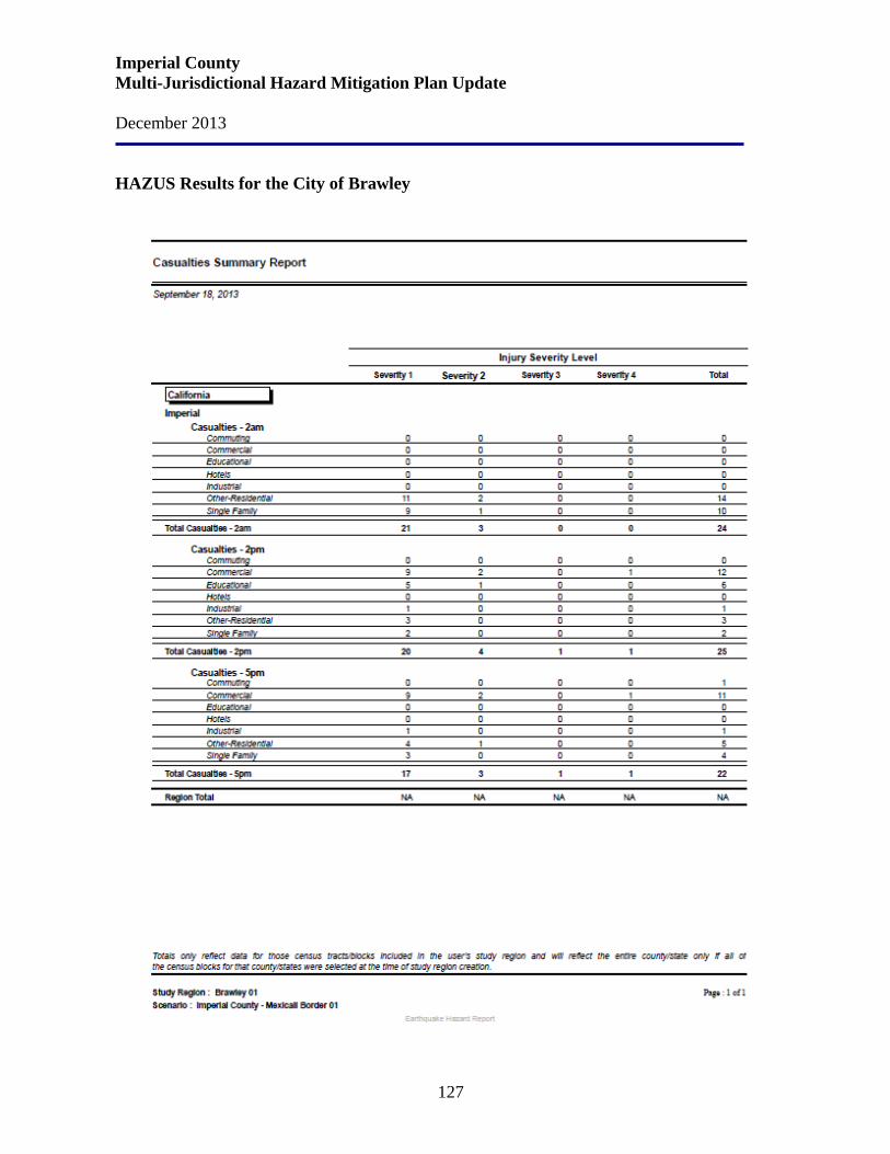
Imperial County Multi-Jurisdictional Hazard Mitigation Plan Update December 2013
127
HAZUS Results for the City of Brawley
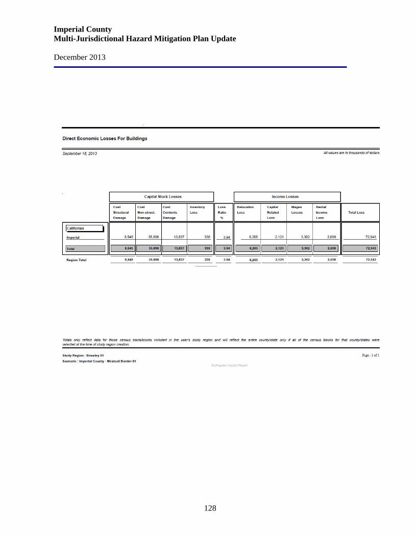
Imperial County Multi-Jurisdictional Hazard Mitigation Plan Update December 2013
128
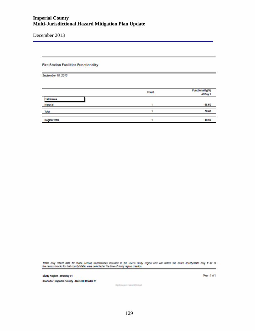
Imperial County Multi-Jurisdictional Hazard Mitigation Plan Update December 2013
129
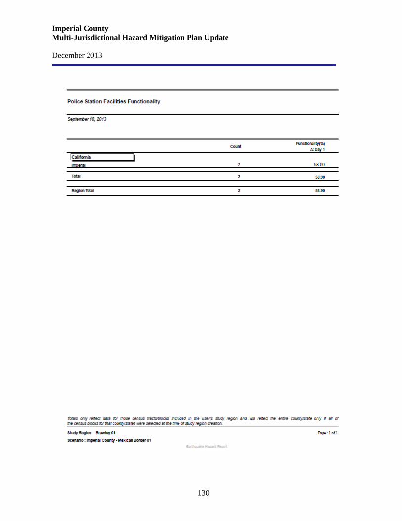
Imperial County Multi-Jurisdictional Hazard Mitigation Plan Update December 2013
130
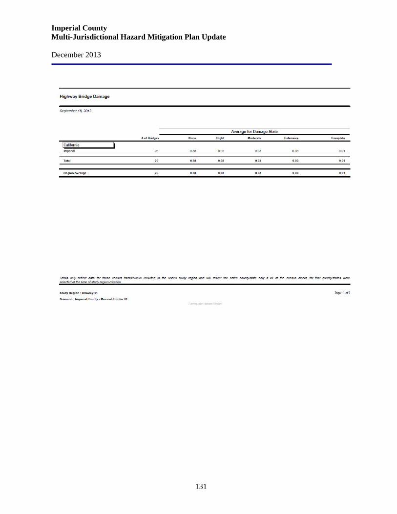
Imperial County Multi-Jurisdictional Hazard Mitigation Plan Update December 2013
131
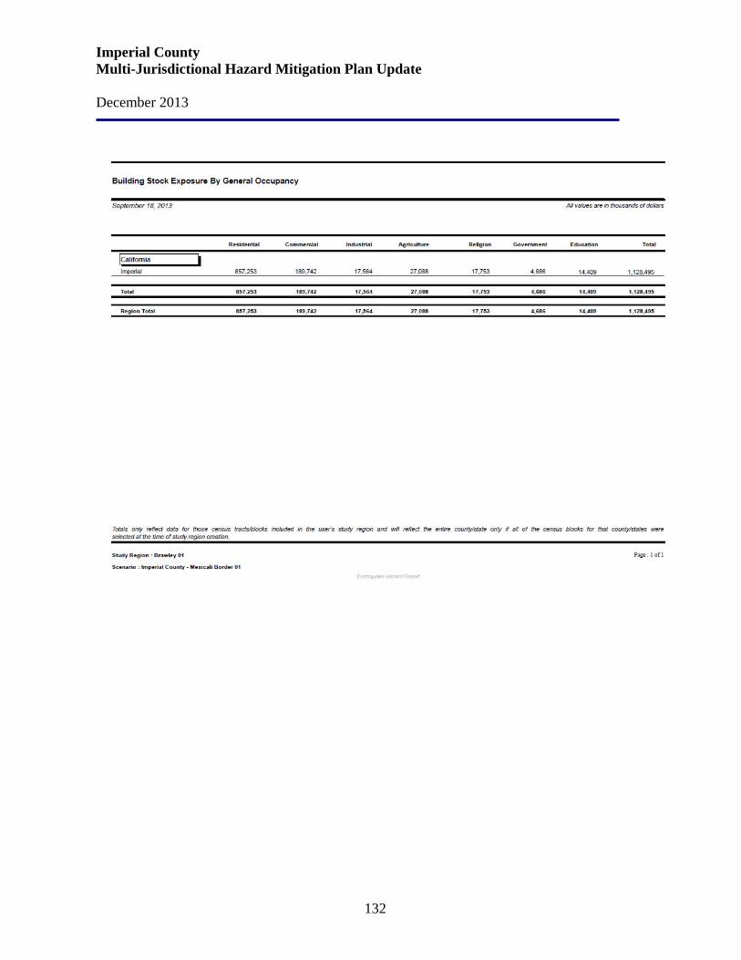
Imperial County Multi-Jurisdictional Hazard Mitigation Plan Update December 2013
132
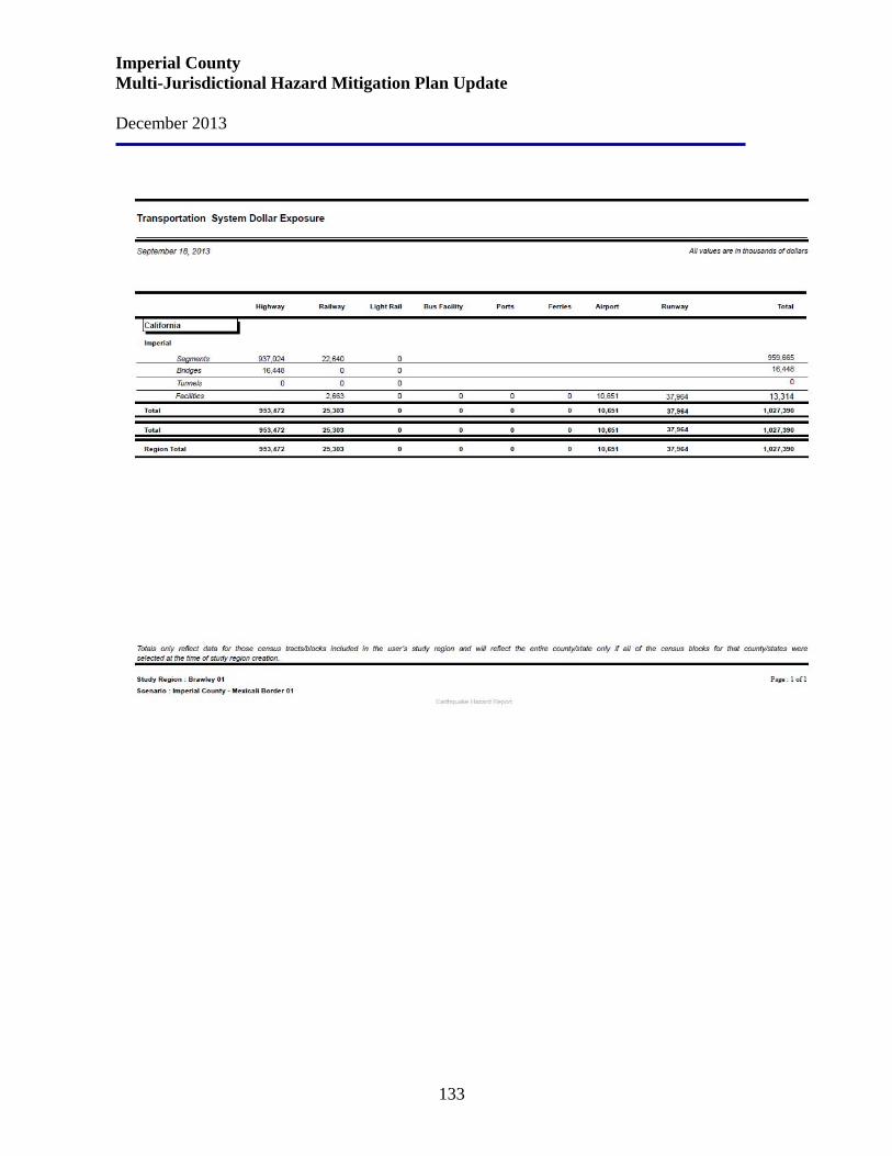
Imperial County Multi-Jurisdictional Hazard Mitigation Plan Update December 2013
133
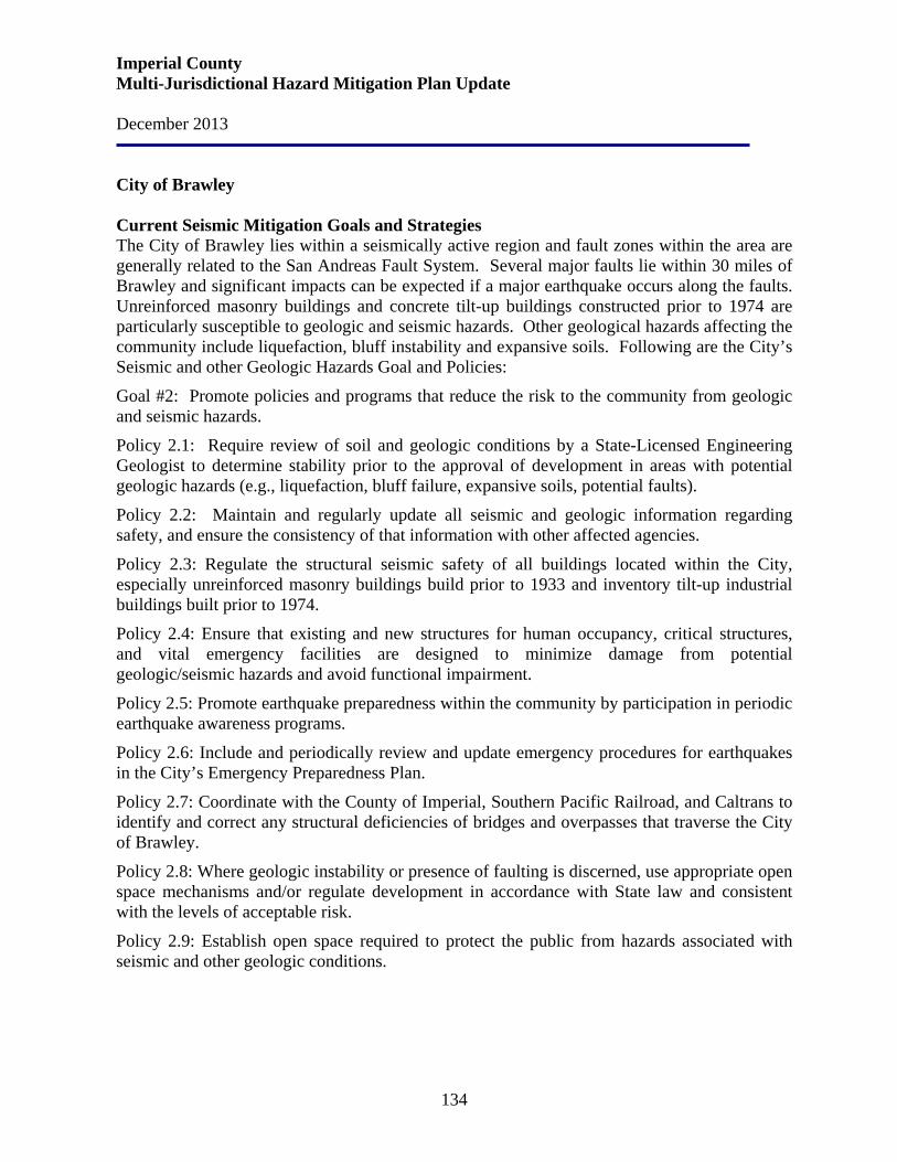
Imperial County Multi-Jurisdictional Hazard Mitigation Plan Update December 2013
134
City of Brawley Current Seismic Mitigation Goals and Strategies The City of Brawley lies within a seismically active region and fault zones within the area are generally related to the San Andreas Fault System. Several major faults lie within 30 miles of Brawley and significant impacts can be expected if a major earthquake occurs along the faults. Unreinforced masonry buildings and concrete tilt-up buildings constructed prior to 1974 are particularly susceptible to geologic and seismic hazards. Other geological hazards affecting the community include liquefaction, bluff instability and expansive soils. Following are the City’s Seismic and other Geologic Hazards Goal and Policies:
Goal #2: Promote policies and programs that reduce the risk to the community from geologic and seismic hazards.
Policy 2.1: Require review of soil and geologic conditions by a State-Licensed Engineering Geologist to determine stability prior to the approval of development in areas with potential geologic hazards (e.g., liquefaction, bluff failure, expansive soils, potential faults).
Policy 2.2: Maintain and regularly update all seismic and geologic information regarding safety, and ensure the consistency of that information with other affected agencies.
Policy 2.3: Regulate the structural seismic safety of all buildings located within the City, especially unreinforced masonry buildings build prior to 1933 and inventory tilt-up industrial buildings built prior to 1974.
Policy 2.4: Ensure that existing and new structures for human occupancy, critical structures, and vital emergency facilities are designed to minimize damage from potential geologic/seismic hazards and avoid functional impairment.
Policy 2.5: Promote earthquake preparedness within the community by participation in periodic earthquake awareness programs.
Policy 2.6: Include and periodically review and update emergency procedures for earthquakes in the City’s Emergency Preparedness Plan.
Policy 2.7: Coordinate with the County of Imperial, Southern Pacific Railroad, and Caltrans to identify and correct any structural deficiencies of bridges and overpasses that traverse the City of Brawley.
Policy 2.8: Where geologic instability or presence of faulting is discerned, use appropriate open space mechanisms and/or regulate development in accordance with State law and consistent with the levels of acceptable risk.
Policy 2.9: Establish open space required to protect the public from hazards associated with seismic and other geologic conditions.
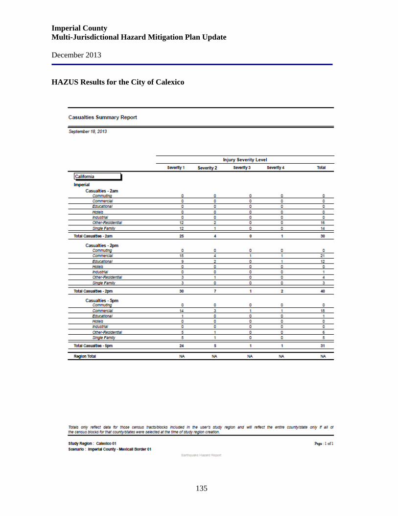
Imperial County Multi-Jurisdictional Hazard Mitigation Plan Update December 2013
135
HAZUS Results for the City of Calexico
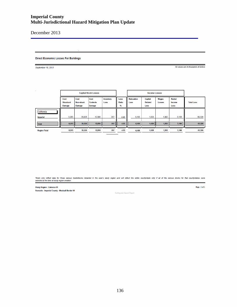
Imperial County Multi-Jurisdictional Hazard Mitigation Plan Update December 2013
136
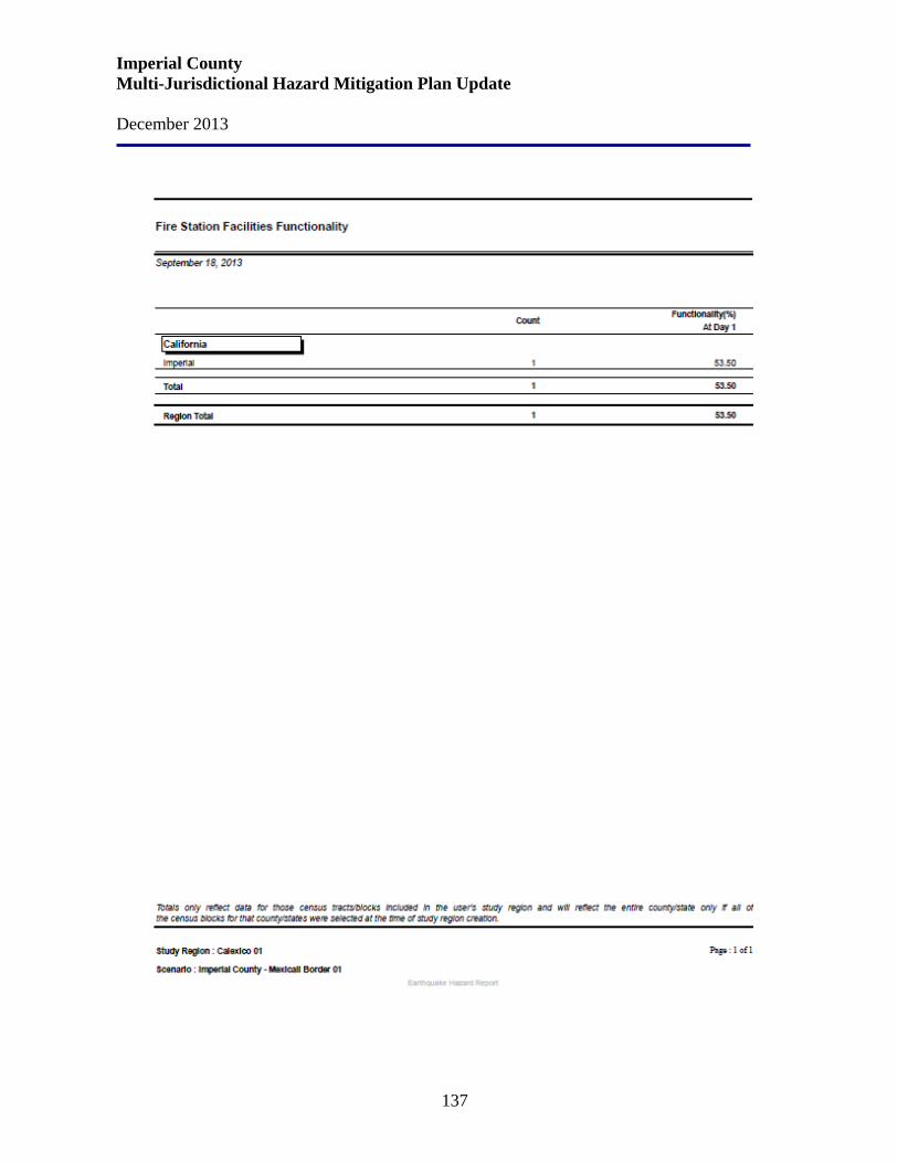
Imperial County Multi-Jurisdictional Hazard Mitigation Plan Update December 2013
137
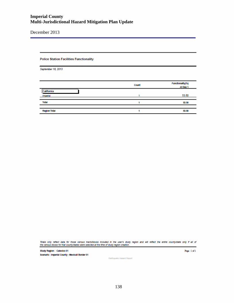
Imperial County Multi-Jurisdictional Hazard Mitigation Plan Update December 2013
138
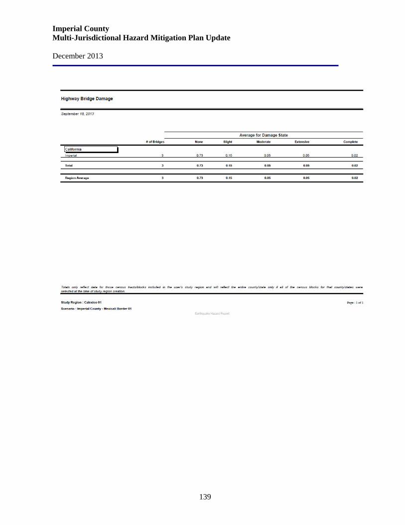
Imperial County Multi-Jurisdictional Hazard Mitigation Plan Update December 2013
139
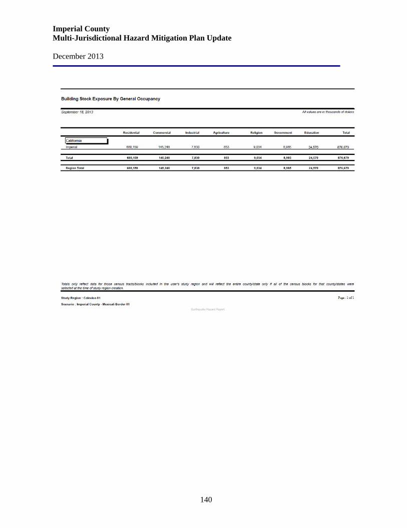
Imperial County Multi-Jurisdictional Hazard Mitigation Plan Update December 2013
140
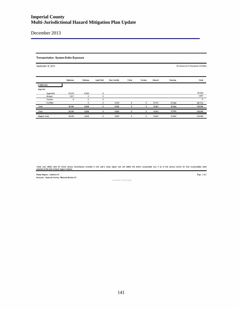
Imperial County Multi-Jurisdictional Hazard Mitigation Plan Update December 2013
141
Imperial County Multi-Jurisdictional Hazard Mitigation Plan Update December 2013
142
City of Calexico Current Mitigation Goals and Strategies The City of Calexico is particularly susceptible to geologic hazards such as earthquakes and the secondary hazards associated therewith. The primary hazard from earthquakes is significant because of the proximity of major faults and the soil composition of the Imperial Valley. The secondary impacts are related to the extensive irrigation and drainage as well as other consequences caused by earthquakes such as fires, ground displacement, soil liquefaction, and environmental contamination. Calexico has adopted an Earthquake Hazard Reduction in Existing Buildings Code to address safety issues associated with earthquakes directly. Following are the City’s Seismic Hazards Objective and Policies: Objective 2 All development in the City shall adhere to standards for grading and construction which reduce the potential of seismic hazards.
Policy 2 a. The City may consider design and construction standards that exceed the minimums set
forth in the uniform building code (UBC) due to the area’s high potential for seismic acceleration.
b. Consultation with a qualified engineering geologist shall be required for all development. c. The City shall maintain standards to identify and mitigate seismic hazards. d. The City shall continually inform the residents of the community of the potential seismic
hazards that exist and what the best methods are for reducing loss or injury caused by them.
Mitigation Measures:
MM Geo1: Prior the approval of any discretionary action presented to the City of Calexico for any development, a geotechnical investigation shall be conducted by a registered geotechnical engineer that discusses, at least, the following hazards:
1. Liquefaction 2. Subsidence 3. Expansion properties, shrink/swell potential 4. Distance to known fault rupture zones 5. Soil strength 6. Landslide potential
Common mitigation measures associated with minimizing impacts from these hazards include, (1) adherence to basic construction procedures pursuant to the Uniform Building Code, which includes the incorporation of seismic safety-related construction standards; (2) removal and recompaction of soils susceptible to settlement; and (3) reduction or control of erosion by retaining as much vegetation in place as possible throughout the development process; and (4) setbacks from fault zones. All geotechnical studies shall be submitted to the City of Calexico Building and Safety Department for review and approval. Mitigation measures recommended
Imperial County Multi-Jurisdictional Hazard Mitigation Plan Update December 2013
143
by these studies that reduce identified impacts to below a level of significance shall be included as conditions of future project approvals.
MM Geo2: To mitigate any potential impacts associated with erosion for any new development/redevelopment projects adjacent to the New River, drainage canals, or levees, the following design setbacks will be implemented:
1. A distance of 50 feet outside of the shaded 500-year flood zone areas delineated on the FEMA maps for the New and Alamo Rivers; and
2. A distance of one-half the canal bank height beyond the toe of the slope for all of the levee and canal banks.
MM Geo3: To mitigate any potential adverse effects related to use of septic systems in new development, prior to the approval of any discretionary action presented to the City of Calexico, an investigation shall be conducted by a registered geotechnical or soils engineer that addresses the site’s suitability for septic systems if such systems are proposed. This investigation shall take into consideration soil properties as well as the extensive tile drain system that currently underlies areas in agricultural land use.
MM Geo4: To mitigate any potential adverse effects related to subsidence in new development, prior to the approval of any discretionary action presented to the City of Calexico, an investigation shall be conducted by a registered geotechnical or soils engineer.
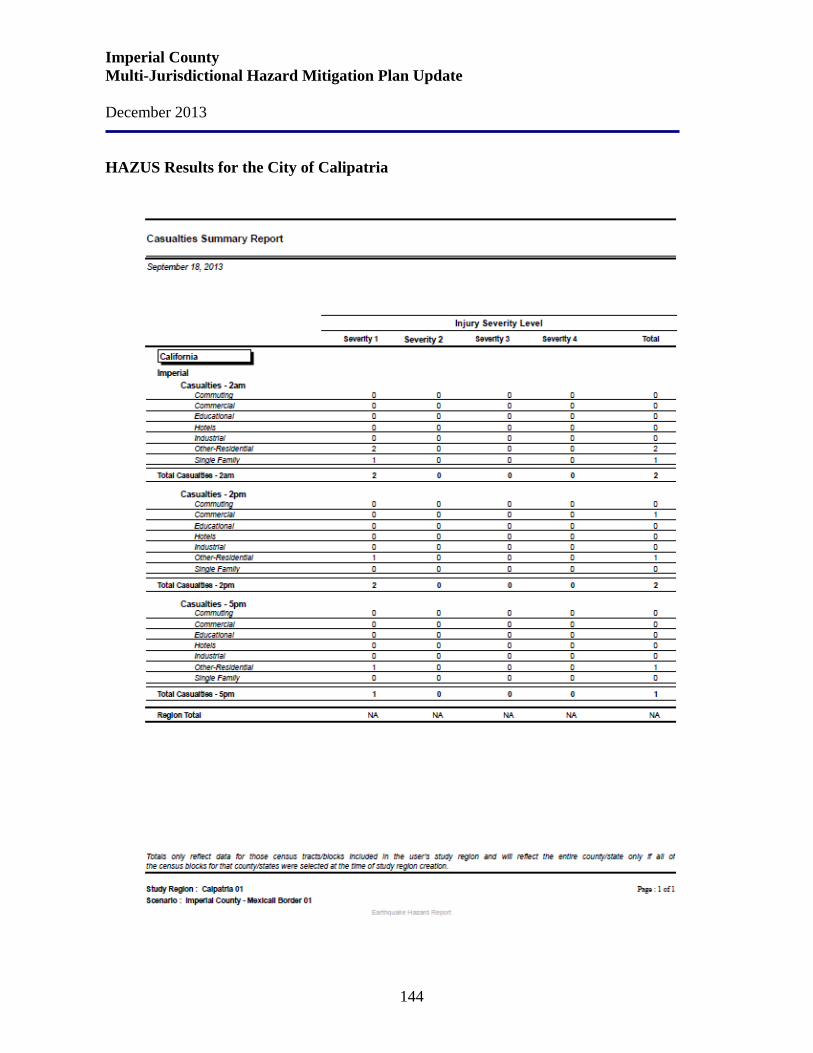
Imperial County Multi-Jurisdictional Hazard Mitigation Plan Update December 2013
144
HAZUS Results for the City of Calipatria
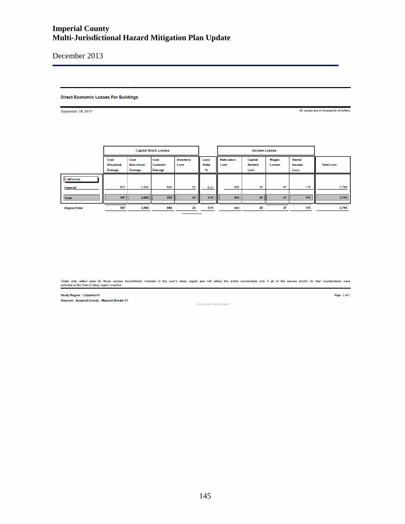
Imperial County Multi-Jurisdictional Hazard Mitigation Plan Update December 2013
145

Imperial County Multi-Jurisdictional Hazard Mitigation Plan Update December 2013
146
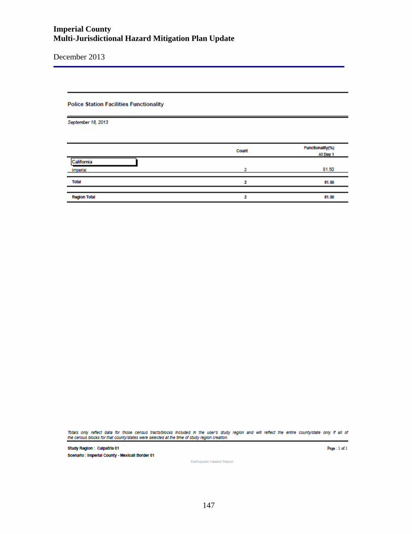
Imperial County Multi-Jurisdictional Hazard Mitigation Plan Update December 2013
147

Imperial County Multi-Jurisdictional Hazard Mitigation Plan Update December 2013
148

Imperial County Multi-Jurisdictional Hazard Mitigation Plan Update December 2013
149
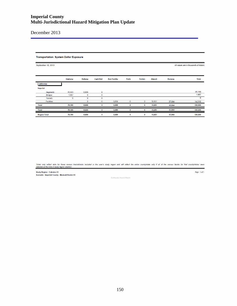
Imperial County Multi-Jurisdictional Hazard Mitigation Plan Update December 2013
150
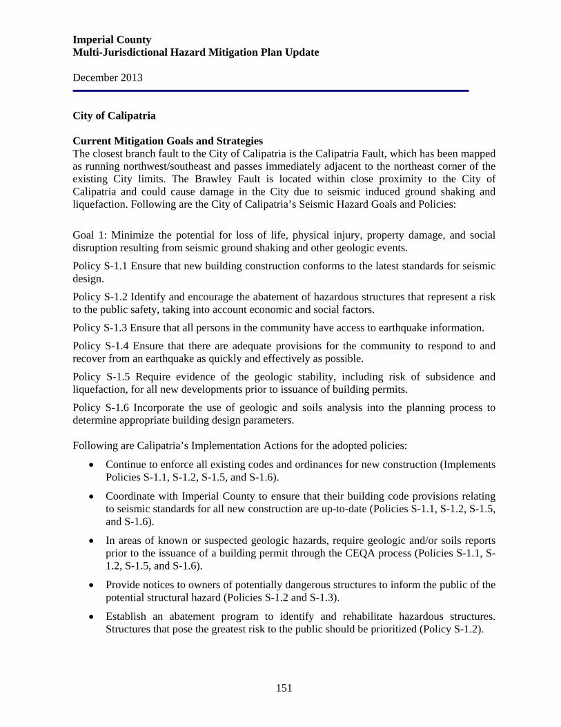
Imperial County Multi-Jurisdictional Hazard Mitigation Plan Update December 2013
151
City of Calipatria Current Mitigation Goals and Strategies The closest branch fault to the City of Calipatria is the Calipatria Fault, which has been mapped as running northwest/southeast and passes immediately adjacent to the northeast corner of the existing City limits. The Brawley Fault is located within close proximity to the City of Calipatria and could cause damage in the City due to seismic induced ground shaking and liquefaction. Following are the City of Calipatria’s Seismic Hazard Goals and Policies:
Goal 1: Minimize the potential for loss of life, physical injury, property damage, and social disruption resulting from seismic ground shaking and other geologic events.
Policy S-1.1 Ensure that new building construction conforms to the latest standards for seismic design.
Policy S-1.2 Identify and encourage the abatement of hazardous structures that represent a risk to the public safety, taking into account economic and social factors.
Policy S-1.3 Ensure that all persons in the community have access to earthquake information.
Policy S-1.4 Ensure that there are adequate provisions for the community to respond to and recover from an earthquake as quickly and effectively as possible.
Policy S-1.5 Require evidence of the geologic stability, including risk of subsidence and liquefaction, for all new developments prior to issuance of building permits.
Policy S-1.6 Incorporate the use of geologic and soils analysis into the planning process to determine appropriate building design parameters. Following are Calipatria’s Implementation Actions for the adopted policies:
• Continue to enforce all existing codes and ordinances for new construction (Implements Policies S-1.1, S-1.2, S-1.5, and S-1.6).
• Coordinate with Imperial County to ensure that their building code provisions relating to seismic standards for all new construction are up-to-date (Policies S-1.1, S-1.2, S-1.5, and S-1.6).
• In areas of known or suspected geologic hazards, require geologic and/or soils reports prior to the issuance of a building permit through the CEQA process (Policies S-1.1, S-1.2, S-1.5, and S-1.6).
• Provide notices to owners of potentially dangerous structures to inform the public of the potential structural hazard (Policies S-1.2 and S-1.3).
• Establish an abatement program to identify and rehabilitate hazardous structures. Structures that pose the greatest risk to the public should be prioritized (Policy S-1.2).
Imperial County Multi-Jurisdictional Hazard Mitigation Plan Update December 2013
152
• Institute an emergency response plan in the event of a major seismic event (Policy S-1.4).
• Continue to participate in the planning and development of the Imperial County Multi-Hazard Mitigation Plan and comply with the mitigation goals and strategies therein (Policy S-1.4).
• Disseminate information to the public regarding ways to reduce hazards within buildings and what to do in the event of an earthquake (Policies S-1.3 and S-1.4).
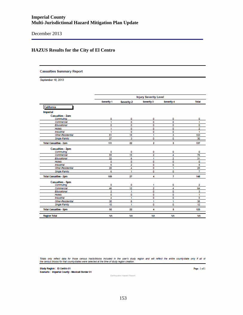
Imperial County Multi-Jurisdictional Hazard Mitigation Plan Update December 2013
153
HAZUS Results for the City of El Centro
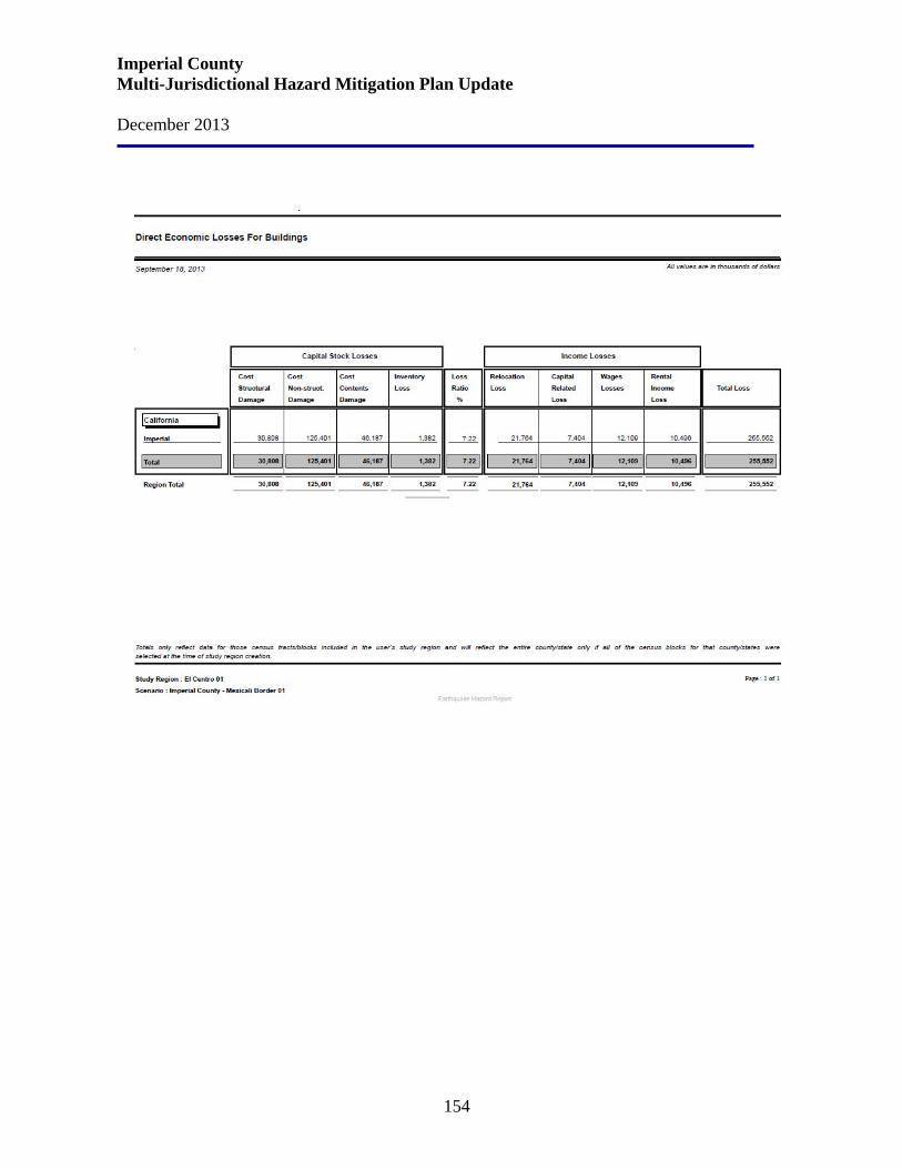
Imperial County Multi-Jurisdictional Hazard Mitigation Plan Update December 2013
154
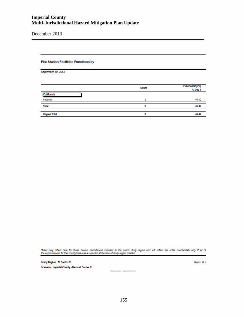
Imperial County Multi-Jurisdictional Hazard Mitigation Plan Update December 2013
155
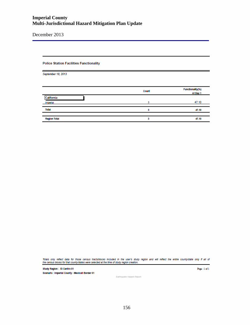
Imperial County Multi-Jurisdictional Hazard Mitigation Plan Update December 2013
156
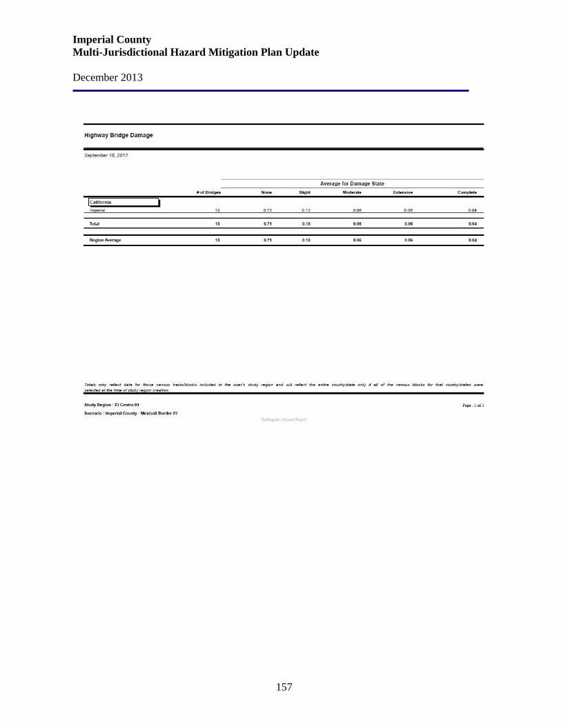
Imperial County Multi-Jurisdictional Hazard Mitigation Plan Update December 2013
157

Imperial County Multi-Jurisdictional Hazard Mitigation Plan Update December 2013
158
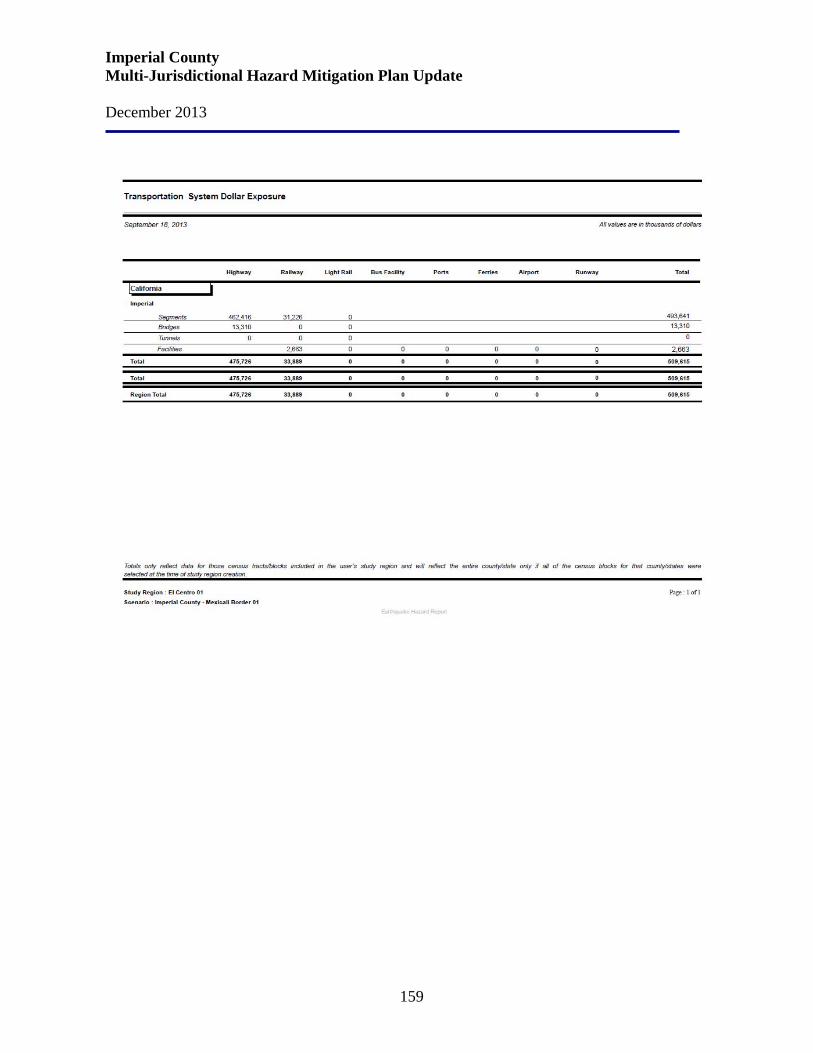
Imperial County Multi-Jurisdictional Hazard Mitigation Plan Update December 2013
159
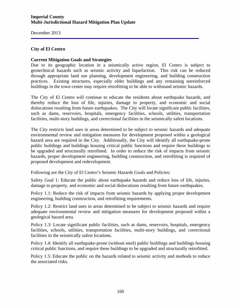
Imperial County Multi-Jurisdictional Hazard Mitigation Plan Update December 2013
160
City of El Centro Current Mitigation Goals and Strategies Due to its geographic location in a seismically active region, El Centro is subject to geotechnical hazards such as seismic activity and liquefaction. This risk can be reduced through appropriate land use planning, development engineering, and building construction practices. Existing structures, especially older buildings and any remaining unreinforced buildings in the town center may require retrofitting to be able to withstand seismic hazards. The City of El Centro will continue to educate the residents about earthquake hazards, and thereby reduce the loss of life, injuries, damage to property, and economic and social dislocations resulting from future earthquakes. The City will locate significant public facilities, such as dams, reservoirs, hospitals, emergency facilities, schools, utilities, transportation facilities, multi-story buildings, and correctional facilities in the seismically safest locations. The City restricts land uses in areas determined to be subject to seismic hazards and adequate environmental review and mitigation measures for development proposed within a geological hazard area are required in the City. Additionally, the City will identify all earthquake-prone public buildings and buildings housing critical public functions and require these buildings to be upgraded and structurally retrofitted. In order to reduce the risk of impacts from seismic hazards, proper development engineering, building construction, and retrofitting is required of proposed development and redevelopment. Following are the City of El Centro’s Seismic Hazards Goals and Policies:
Safety Goal 1: Educate the public about earthquake hazards and reduce loss of life, injuries, damage to property, and economic and social dislocations resulting from future earthquakes.
Policy 1.1: Reduce the risk of impacts from seismic hazards by applying proper development engineering, building construction, and retrofitting requirements.
Policy 1.2: Restrict land uses in areas determined to be subject to seismic hazards and require adequate environmental review and mitigation measures for development proposed within a geological hazard area.
Policy 1.3: Locate significant public facilities, such as dams, reservoirs, hospitals, emergency facilities, schools, utilities, transportation facilities, multi-story buildings, and correctional facilities in the seismically safest locations.
Policy 1.4: Identify all earthquake-prone (without steel) public buildings and buildings housing critical public functions, and require these buildings to be upgraded and structurally retrofitted.
Policy 1.5: Educate the public on the hazards related to seismic activity and methods to reduce the associated risks.
Imperial County Multi-Jurisdictional Hazard Mitigation Plan Update December 2013
161
Following are El Centro’s Implementation Program to implement the adopted policies: S-1: Seismic and Geologic Risk Reduction: Reduce the risk to the community from hazards related to seismic activity and geologic hazards by requiring feasible mitigation of such impacts on existing, new development and redevelopment. Assess development proposals for potential hazards pursuant to the California Environmental Quality Act. Require measures to mitigate all identified significant public safety hazards. Responsible Agency/Department: Development Services, Public Works Funding Source: Project proponent Time Frame: Ongoing Related Policies: 1.1, 1.2, 1.3, 1.4 S-2: Open Space Easements for Seismic Hazards: Use open space easements and other regulatory techniques to prohibit development and avoid public safety hazards where seismic hazards are identified and cannot be mitigated. Responsible Agency/Department: Development Services Funding Source: General Fund Time Frame: Ongoing Related Policies: 1.2 S-3: Structural Codes: Prevent injury loss of life, and substantial property damage by complying with the most recent Uniform Building Code, Uniform Mechanical Code, Uniform Fire Code, and the National Electric Code, which contain structural requirements for existing and new buildings. To protect public safety, all planned development in El Centro shall be subject to these structural codes. Responsible Agency/Department: Development Services Funding Source: Project proponent Time Frame: Ongoing Related Policies: 1.1, 1.4 S-4: Seismic Retrofitting: Implement a program to identify and retrofit any unreinforced masonry buildings and other potentially hazardous buildings within the City. The program may include the following: • Set a list of priorities and criteria by which strengthening of the buildings identified as
hazardous will be established and conducted; • Offer incentives to engender support among building owners, such as tax waivers, tax
credits and waivers of zoning restrictions; and • Adopt an educational program, such as informational mailings to encourage private
owners to seismically upgrade their houses. Responsible Agency/Department: Development Services Funding Source: General Fund Time Frame: 2003-2004 Related Policies: 1.4
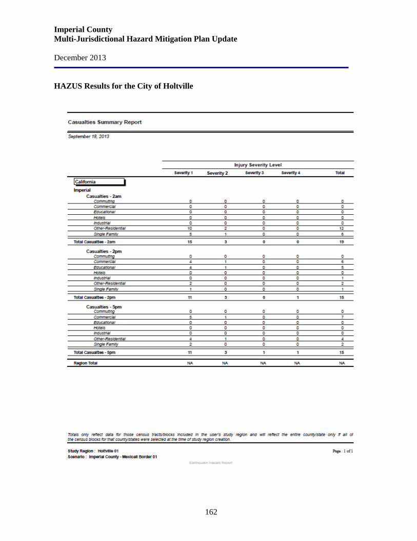
Imperial County Multi-Jurisdictional Hazard Mitigation Plan Update December 2013
162
HAZUS Results for the City of Holtville
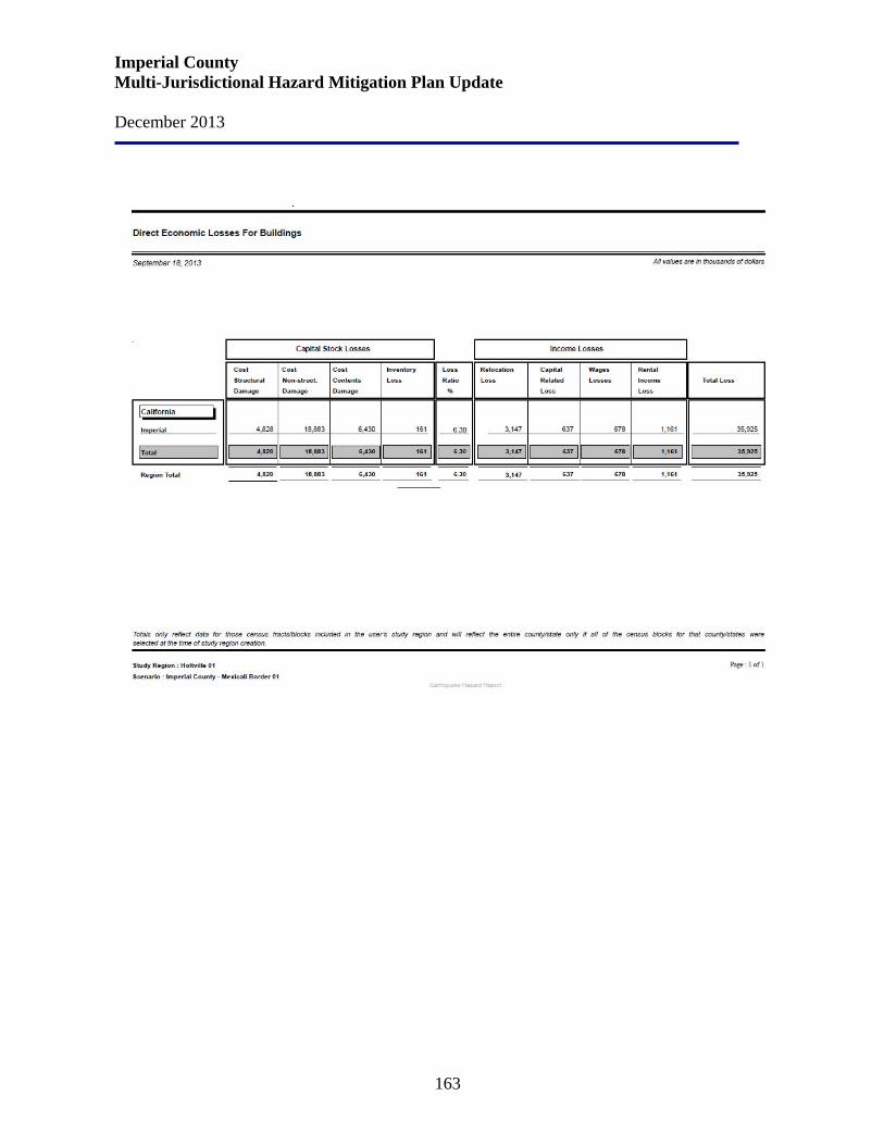
Imperial County Multi-Jurisdictional Hazard Mitigation Plan Update December 2013
163
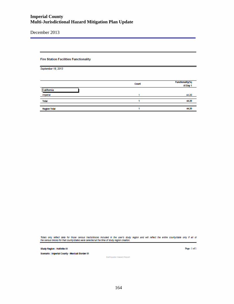
Imperial County Multi-Jurisdictional Hazard Mitigation Plan Update December 2013
164
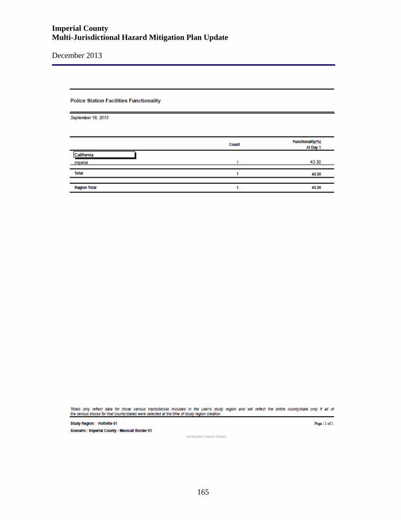
Imperial County Multi-Jurisdictional Hazard Mitigation Plan Update December 2013
165
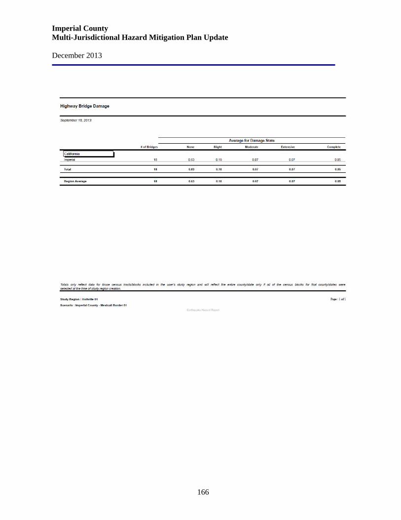
Imperial County Multi-Jurisdictional Hazard Mitigation Plan Update December 2013
166
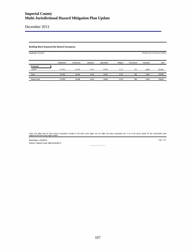
Imperial County Multi-Jurisdictional Hazard Mitigation Plan Update December 2013
167
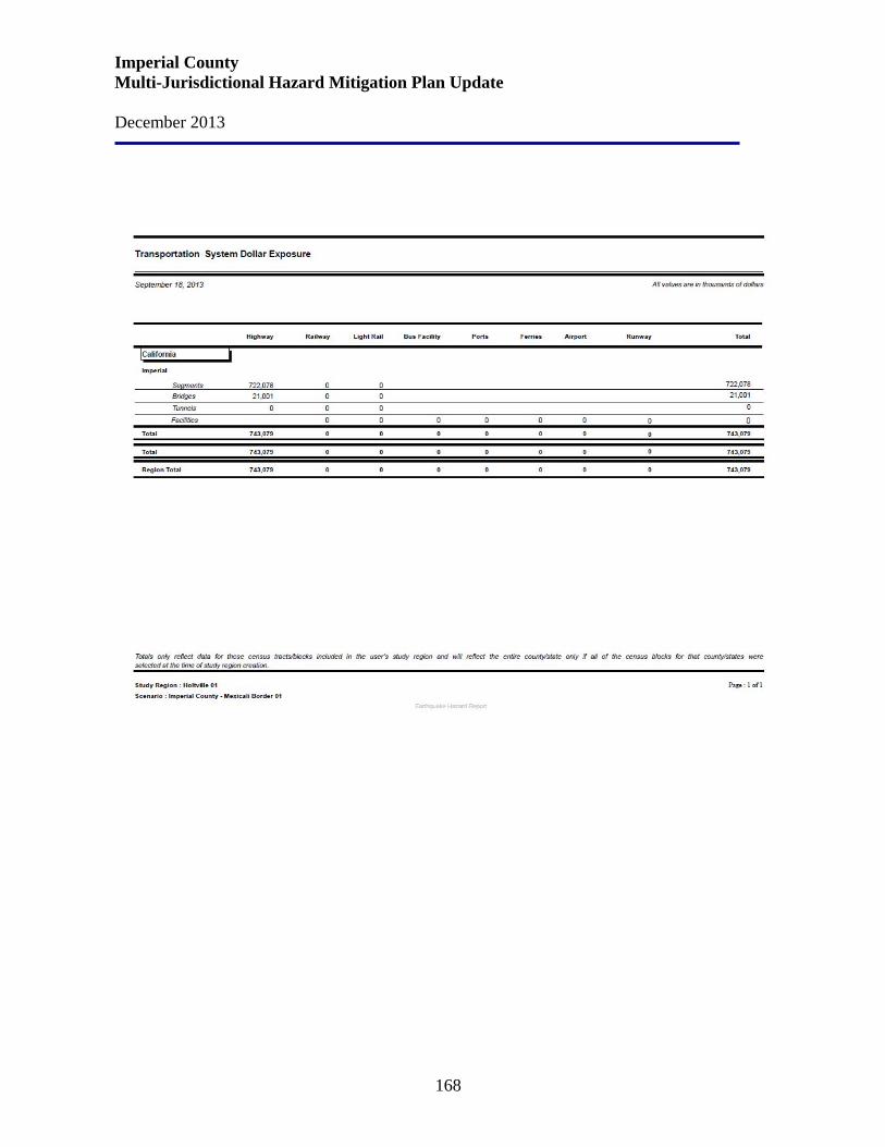
Imperial County Multi-Jurisdictional Hazard Mitigation Plan Update December 2013
168
Imperial County Multi-Jurisdictional Hazard Mitigation Plan Update December 2013
169
City of Holtville Current Mitigation Goals and Strategies Due to the City’s location and the Imperial Valley’s history of earthquakes, the City of Holtville is very likely to experience moderate to severe earthquakes within the next 20 years. In order to adequately guard and protect the safety of the citizens of Holtville, the City has identified the following programs that may be pursued:
• Hold public presentations and workshops on earthquake hazards/mitigations and publicize earthquake hazard information to all citizens, and particularly schools.
• Create land use and development standards for areas that are determined to have higher than acceptable risks to life and property due to seismicity.
• Attempt to locate significant public facilities, such as hospitals, emergency facilities, schools, police and fire stations, multi-story structures in the seismically safest locations.
• Require appropriate construction technology generally recommended by Registered Engineers and Architects for proposed developments in geological hazard areas require mitigation measures to be implemented on all projects for which the environmental review has indicated specific hazard areas.
• Maintain and upgrade all critical facilities such as police and fire stations, hospitals, etc., in an effort to assure their continued operation; particularly in their communications systems or post-disaster operations.
• Enter into joint-power agreements with nearby jurisdictions as well as private sector organizations to assist in disaster relief operations.
• Establish an emergency disaster relief plan that coordinates with police, ire, rescue, medical, as well as shelter and communication networks.
• Require soil investigations to be performed by geological engineers for all land areas suspected of having geological hazards including unstable soils, liquefaction, and/or other structural hazards.
• Require all earthquake prone buildings, (i.e., without steel reinforcement) including public buildings, housing, and commercial/industrial buildings to be identified, upgraded and structurally reinforced, or abated.
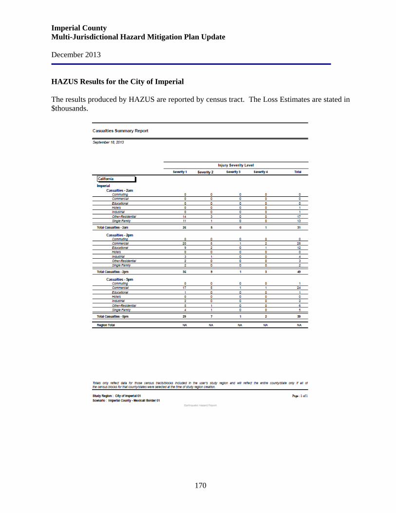
Imperial County Multi-Jurisdictional Hazard Mitigation Plan Update December 2013
170
HAZUS Results for the City of Imperial The results produced by HAZUS are reported by census tract. The Loss Estimates are stated in $thousands.

Imperial County Multi-Jurisdictional Hazard Mitigation Plan Update December 2013
171
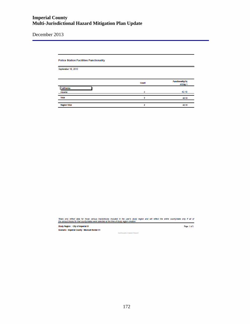
Imperial County Multi-Jurisdictional Hazard Mitigation Plan Update December 2013
172

Imperial County Multi-Jurisdictional Hazard Mitigation Plan Update December 2013
173
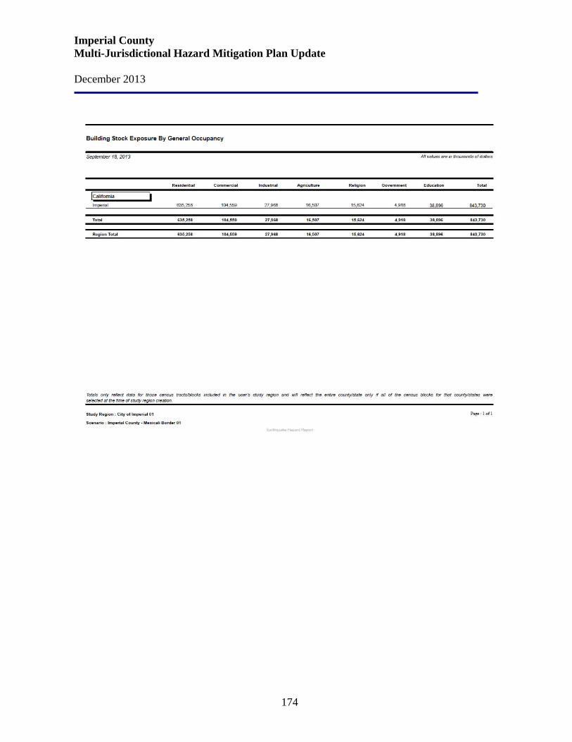
Imperial County Multi-Jurisdictional Hazard Mitigation Plan Update December 2013
174
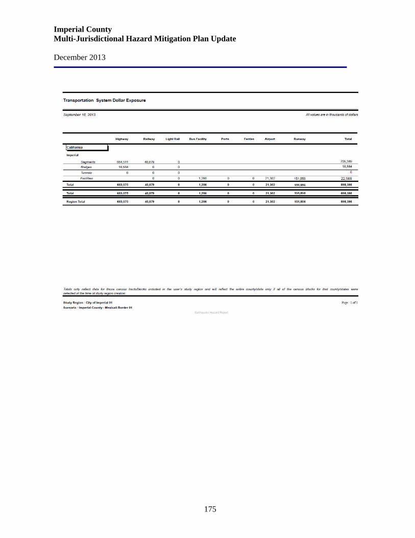
Imperial County Multi-Jurisdictional Hazard Mitigation Plan Update December 2013
175

Imperial County Multi-Jurisdictional Hazard Mitigation Plan Update December 2013
176
City of Imperial Current Mitigation Goals and Strategies The entire Imperial Valley, including the City of Imperial, is located within a seismically active area. In the City of Imperial, seismic disturbances occur on a relatively frequent basis with various magnitudes. Based upon the available information and historical records, the City of Imperial has a significant risk from faults due to the relatively high earthquake activity along the major fault systems in Southern California. It can be expected that major damage could result from seismic activity. Following are the City of Imperial’s Seismic Hazards Goal, Objectives and Policies:
Safety Goal: Seismic hazards should be controlled to a level of acceptable risk through the identification and recognition of potentially hazardous conditions and areas.
Objective 1: The risk level to the residents should be controlled to an acceptable level through proper land u se and public facilities planning.
Policy 1
A. The Scale of Acceptable Risk for New Structures shall be used when determining the location of future land uses.
B Land uses should not be subjected to risks greater than the level suggested in the scale unless no other alternative exists.
C. The City shall require that all geologic/geotechnical investigations for all “essential” and “low risk” projects contain a site-specific evaluation of peak horizontal ground acceleration.
Seismic Hazard Mitigation
Objective 2: Standards for grading and construction should be maintained which provide for the mitigation of potential seismic hazards.
Policy 2
A. Due to the high seismic accelerations possible within the area, the City may wish to consider design and construction standards beyond the minimum Uniform Building Code (UBC) standards for certain projects.
B. The City shall maintain appropriate ordinances to identify and mitigate seismic hazards such as ground shaking, ground failure, liquefaction, and structural hazards.
C. Investigations by a qualified engineering geologist shall be required for all development projects.
D. The City shall regularly inform community residents of the potential seismic hazards that can exist and the best methods of reducing injury, property damage or loss of life in the home or business establishment.
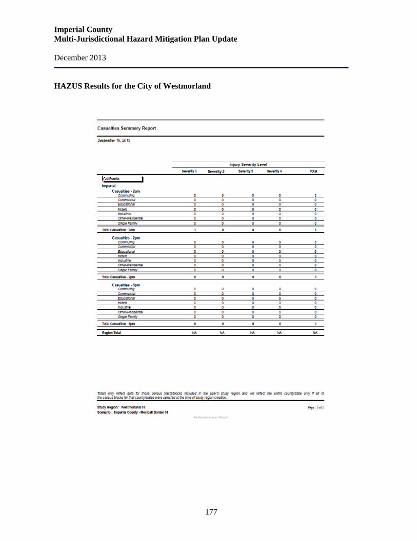
Imperial County Multi-Jurisdictional Hazard Mitigation Plan Update December 2013
177
HAZUS Results for the City of Westmorland

Imperial County Multi-Jurisdictional Hazard Mitigation Plan Update December 2013
178
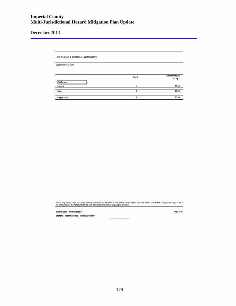
Imperial County Multi-Jurisdictional Hazard Mitigation Plan Update December 2013
179
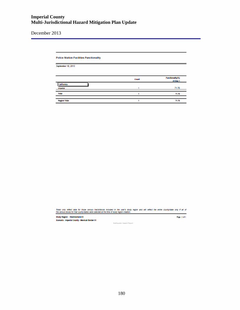
Imperial County Multi-Jurisdictional Hazard Mitigation Plan Update December 2013
180

Imperial County Multi-Jurisdictional Hazard Mitigation Plan Update December 2013
181
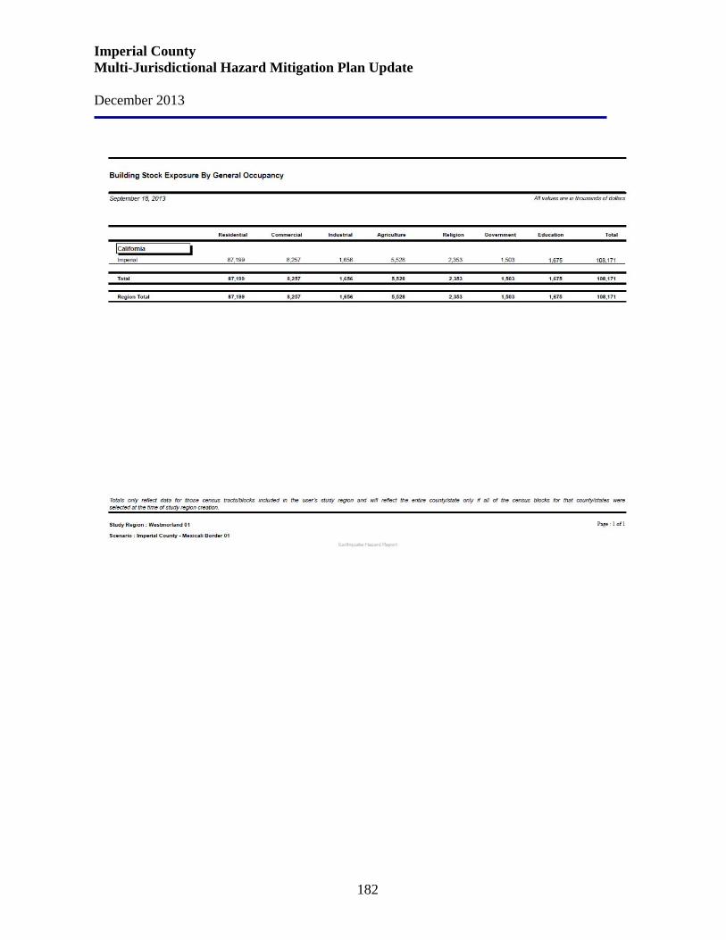
Imperial County Multi-Jurisdictional Hazard Mitigation Plan Update December 2013
182

Imperial County Multi-Jurisdictional Hazard Mitigation Plan Update December 2013
183
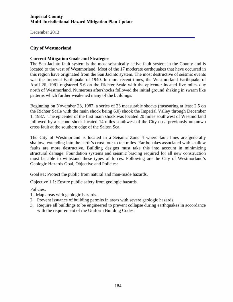
Imperial County Multi-Jurisdictional Hazard Mitigation Plan Update December 2013
184
City of Westmorland Current Mitigation Goals and Strategies The San Jacinto fault system is the most seismically active fault system in the County and is located to the west of Westmorland. Most of the 17 moderate earthquakes that have occurred in this region have originated from the San Jacinto system. The most destructive of seismic events was the Imperial Earthquake of 1940. In more recent times, the Westmorland Earthquake of April 26, 1981 registered 5.6 on the Richter Scale with the epicenter located five miles due north of Westmorland. Numerous aftershocks followed the initial ground shaking in swarm like patterns which further weakened many of the buildings. Beginning on November 23, 1987, a series of 23 measurable shocks (measuring at least 2.5 on the Richter Scale with the main shock being 6.0) shook the Imperial Valley through December 1, 1987. The epicenter of the first main shock was located 20 miles southwest of Westmorland followed by a second shock located 14 miles southwest of the City on a previously unknown cross fault at the southern edge of the Salton Sea. The City of Westmorland is located in a Seismic Zone 4 where fault lines are generally shallow, extending into the earth’s crust four to ten miles. Earthquakes associated with shallow faults are more destructive. Building designs must take this into account in minimizing structural damage. Foundation systems and seismic bracing required for all new construction must be able to withstand these types of forces. Following are the City of Westmorland’s Geologic Hazards Goal, Objective and Policies: Goal #1: Protect the public from natural and man-made hazards.
Objective 1.1: Ensure public safety from geologic hazards.
Policies: 1. Map areas with geologic hazards. 2. Prevent issuance of building permits in areas with severe geologic hazards. 3. Require all buildings to be engineered to prevent collapse during earthquakes in accordance
with the requirement of the Uniform Building Codes.
Imperial County Multi-Jurisdictional Hazard Mitigation Plan Update December 2013
185
HAZUS Results for the Imperial Irrigation District
Imperial County Multi-Jurisdictional Hazard Mitigation Plan Update December 2013
186
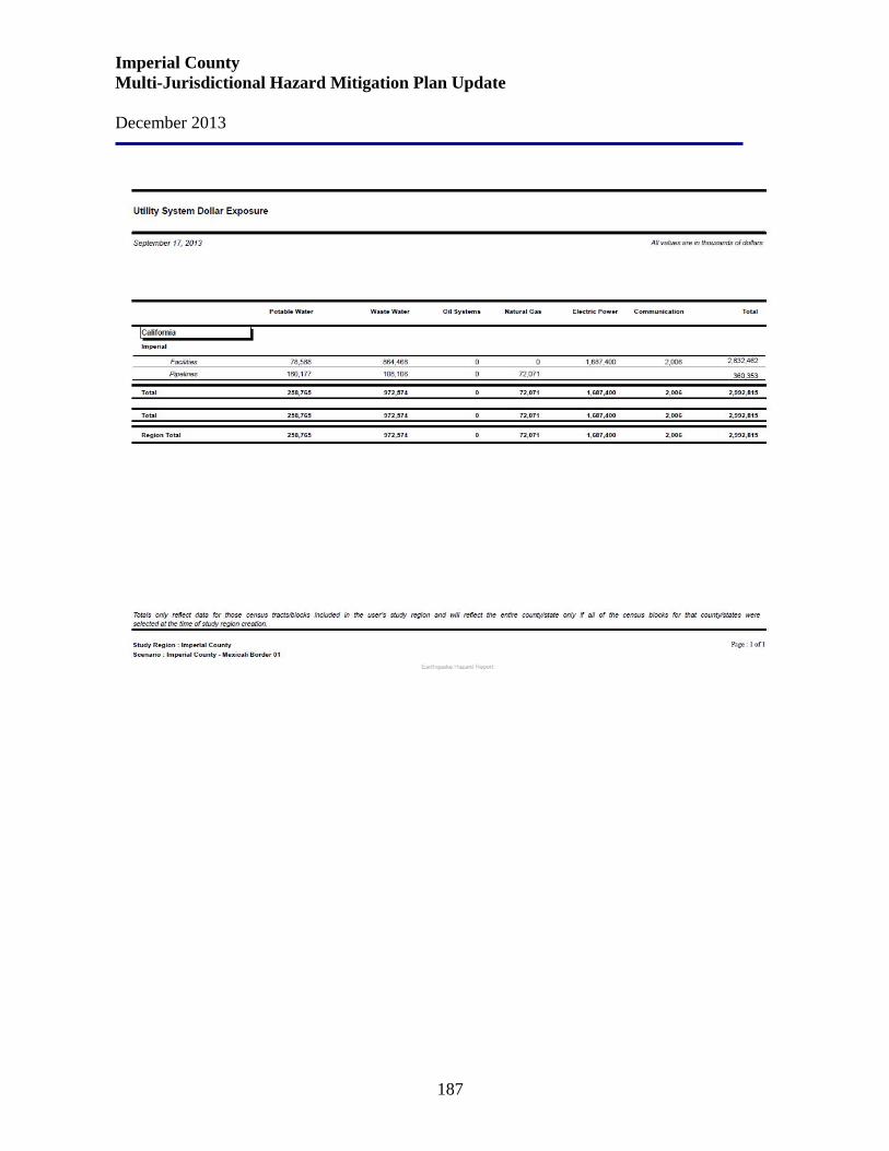
Imperial County Multi-Jurisdictional Hazard Mitigation Plan Update December 2013
187
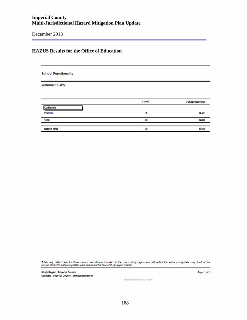
Imperial County Multi-Jurisdictional Hazard Mitigation Plan Update December 2013
188
HAZUS Results for the Office of Education
Imperial County Multi-Jurisdictional Hazard Mitigation Plan Update December 2013
189
Imperial County Office of Education Since 1933, public schools have been constructed in accordance with the Field Act, which requires thorough reviews of construction plans, strict inspections, and quality control. By 1977, nearly all public schools that were built before the Field Act had either been retrofitted or were no longer being used for instructional purposes. The Field Act did not begin to regulate nonstructural systems and building contents in schools until the 1970s. Many schools, particularly older public schools, contain falling hazards that can injure occupants.
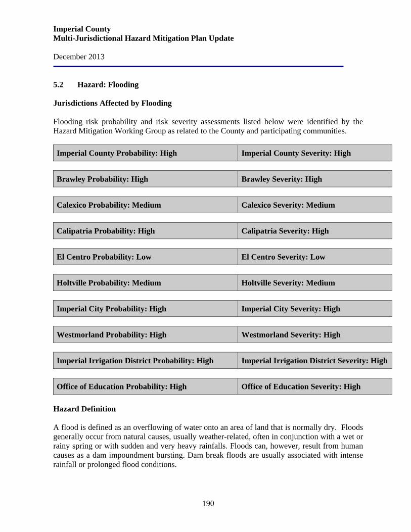
Imperial County Multi-Jurisdictional Hazard Mitigation Plan Update December 2013
190
5.2 Hazard: Flooding Jurisdictions Affected by Flooding Flooding risk probability and risk severity assessments listed below were identified by the Hazard Mitigation Working Group as related to the County and participating communities. Imperial County Probability: High Imperial County Severity: High
Brawley Probability: High Brawley Severity: High
Calexico Probability: Medium Calexico Severity: Medium
Calipatria Probability: High Calipatria Severity: High
El Centro Probability: Low El Centro Severity: Low
Holtville Probability: Medium Holtville Severity: Medium
Imperial City Probability: High Imperial City Severity: High
Westmorland Probability: High Westmorland Severity: High
Imperial Irrigation District Probability: High Imperial Irrigation District Severity: High
Office of Education Probability: High Office of Education Severity: High
Hazard Definition A flood is defined as an overflowing of water onto an area of land that is normally dry. Floods generally occur from natural causes, usually weather-related, often in conjunction with a wet or rainy spring or with sudden and very heavy rainfalls. Floods can, however, result from human causes as a dam impoundment bursting. Dam break floods are usually associated with intense rainfall or prolonged flood conditions.

Imperial County Multi-Jurisdictional Hazard Mitigation Plan Update December 2013
191
Dam failure may also be caused by faulty design, construction, and operational inadequacies. The cause can also be due to a flood event or earthquake larger than the dam was designed to accommodate. The degree and extent of damage depend on the size of the dam and circumstances of failure. A small dam retaining water in a stock pond may break resulting in little more damage that the loss of the structure itself. In contrast, a dam break could result in the loss of irrigation water for a season causing extreme financial hardship to many farmers. An even larger dam failure might bring about considerable loss of property; destruction of cropland, roads, and utilities; and loss of life. Other consequences can include loss of income, disruption of services, and environmental devastation. Floods are generally classed as either slow-rise or flash floods. Slow-rise floods may be preceded by a warning time lasting from hours to days, or possibly weeks. Evacuation and sandbagging for a slow rise flood may lessen flood-related damage. Conversely, flash floods are the most difficult for which to prepare due to the extremely short warning time, if there is any at all. Flash flood warnings usually require immediate evacuation. On some occasions in the desert areas, adequate warning may be impossible. National Flood Insurance Program (NFIP) The standard references for establishing the location of flood hazards are the Flood Insurance Rate Map (FIRM) designated floodplains, part of a national insurance system maintained under the National Flood Insurance Program (NFIP). The FIRM maps not only identify the flood hazard zones for insurance and floodplain management purposes, but also provide a statement of probability of future occurrence. For example, a 500-year flood has a 0.2 percent chance of occurring in any given year; a 100-year flood has a 1-percent chance, a 50-year flood has a 2-percent chance, and a 10-year flood has a 10-percent chance of occurrence. Although the recurrence interval represents the long-term average period between floods of specific magnitude, significant floods could occur at shorter intervals or even within the same year. The 100-year flood, which is the standard used by most federal and state agencies, is used by the National Flood Insurance Program (NFIP) as the standard for floodplain management and to determine the need for flood insurance. A structure located within a special flood hazard area shown on a map has a 26 percent chance of suffering flood damage during the term of a 30-year mortgage. Floodplain management is the key component to effective flood control within Imperial County. The Federal Insurance Administration delineates areas of special flood hazards, the risk premium zones, and floodways through official maps: Flood Insurance Rate Map (FIRM); and Flood Boundary and Floodway Map. These maps form the basis for Imperial County's Flood Ordinance which is intended to be applied to those areas which are subject to periodic flooding and accompanying hazards. These official maps show all canals, drains, and rivers, and at 1"-1000' are a useful reference map.
Imperial County Multi-Jurisdictional Hazard Mitigation Plan Update December 2013
192
Most of Imperial County’s irrigated valley is designated Zone "C" – area of minimal flood hazard, usually depicted on FIRMs as above the 500-year flood level. Imperial County and participating jurisdictions do not have NFIP insured structures within the jurisdictions that have been repetitively damaged by floods. The following FEMA FIRM map identifies components of the 100-year floodplains.
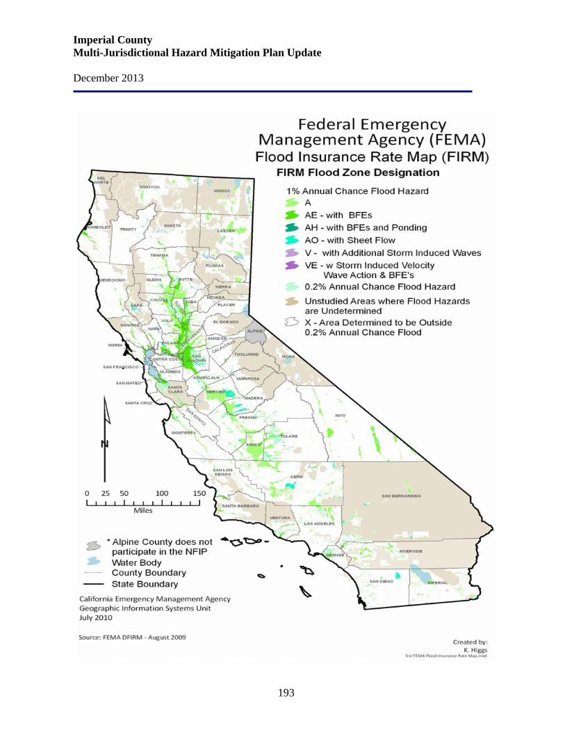
Imperial County Multi-Jurisdictional Hazard Mitigation Plan Update December 2013
193
Imperial County Multi-Jurisdictional Hazard Mitigation Plan Update December 2013
194
History Imperial County is located in the southeastern corner of California and was organized in the wake of disastrous floods and water-control projects along the Colorado River in 1905 and 1907 that diverted waters into the then-dry Salton Sink and created the Salton Sea. The Salton Sea is largely below sea level and is the largest inland body of water in California and remains the heart and soul of Imperial County (over 2/3 of the Salton Sea is within Imperial County; the north end is in Riverside County). From north to south, the sea is 35 miles long. Today the Imperial Valley at the south end of the Sea is a rapidly growing agricultural region. Where not irrigated, most of Imperial County is barren, sandy, low desert, stretching east to the State's border along the Colorado River. Although the County is located in a desert with very low precipitation, it is sometimes subject to heavy rains and subsequent flooding. The entire County is subject to various degrees of flooding in the form of flash floods or slow floods caused by heavy precipitation. Flash flooding is not infrequent in desert areas. Such flooding occurs when sudden downpours over the mountains and/or desert tend to create instantaneous peak flows which roughly follow empty stream beds and mountain washes. Flooding could occur either in floodplains or floodways. Floodplains are generally located adjacent to rivers and other bodies of water and in low lying areas near a water source. The external boundary of floodplains is defined by the predicted extent of inundation that would result from the most intense storm that occurs once every 100 years. Floodways are defined by discernible drainage channels. Floodways are more hazardous due to the anticipated velocities of the flood waters and expected damage to life and property. Such designations occur along the Myer Creek (through Ocotillo) and within the levees along the Colorado River. Flooding could also result from damage to the All American Canal and associated transmission aqueducts. A few hazardous waste facilities are located in the County and accidents could dangerously pollute air and water. Within the County jurisdiction, the communities of Bombay Beach and Ocotillo are considered to be the most likely to experience significant flooding. In El Centro, the Gillett/Cannon Roads area receives the heaviest flooding. It is at a low elevation east of El Centro and south of East Evan Hewes Highway. Bombay Beach is located in a pocket created by the Salton Sea on the west and the Chocolate Mountains on the east. Severe flooding could isolate the community. In the event of a major flood, approximately 300 to 1,000 residents would have to be evacuated. The communities of Ocotillo and Nomirage are at risk due to their location at the base of an alluvial fan originating at the base of Myer Creek. More specifically, Myer Creek is located in the southwestern part of Imperial County and flows in a northeasterly direction through the townsites of Ocotillo and Nomirage, draining over 21.8 square miles.

Imperial County Multi-Jurisdictional Hazard Mitigation Plan Update December 2013
195
The following map shows the California flood disaster declarations from 1950 – December 2009. Imperial County has had 14 declared flooding disasters.
Imperial County Multi-Jurisdictional Hazard Mitigation Plan Update December 2013
196
The following table depicts a history of flood events in Imperial County.
Location Date Type Death/Injuries Reported Property Damage Central Imperial
Valley, Alamora,
Calipatria and Brawley
09/09/2012 Flash Flood 0 Thunderstorms developed across portions of central Imperial county during the evening hours. They affected the communities of Calipatria and Brawley, as well as motorists on Highway 78. Radar indicated that over 1.5 inches of rain fell near Weist between 7 and 8 p.m., and the heavy rain led to flash flooding. A Flash Flood Warning for central Imperial county was issued at 8:10 p.m., and the warning continued past 11 p.m. According to local law enforcement, the flooding caused the closure of Highway 78 east of Brawley. Fortunately, no injuries or accidents occurred due to the flash flooding.
Eastern Imperial County,
Palo Verde
09/05/2012 Flood 0 Thunderstorms developed across portions of eastern Imperial county during the afternoon hours. Due to the humid and unstable nature of the atmosphere, the storms generated locally heavy rainfall. In addition, the storms were slow moving, which enhanced the amount of rain with the stronger thunderstorms. At 5:30 p.m., radar estimated that over one inch of rain had fallen southwest of Palo Verde, and shortly afterward a Small Stream Flood Advisory was issued. At 6:15 p.m., the California Highway Patrol reported flooding across State Route 78 approximately three miles southwest of Cibola. Additionally, lane closures were reported near Mitchells Camp Road south of Palo Verde. No accidents or injuries were reported with the flooding, and no swift water rescues were needed.
Southwest Imperial Valley,
Mt. Signal
08/30/2012 Flash Flood 0 Scattered thunderstorms developed across portions of southwest Imperial county, primarily south and west of El Centro, during the late morning hours on August 30th. Due to the very humid and unstable nature of the atmosphere, the thunderstorms produced excessive rainfall with peak rain rates in excess of two inches per hour. The heavy rains prompted the issuance of a Flash Flood Warning for southwest Imperial county, running from 11:25 a.m. until 1:30 p.m. At 11:45 a.m., local law enforcement personnel reported a
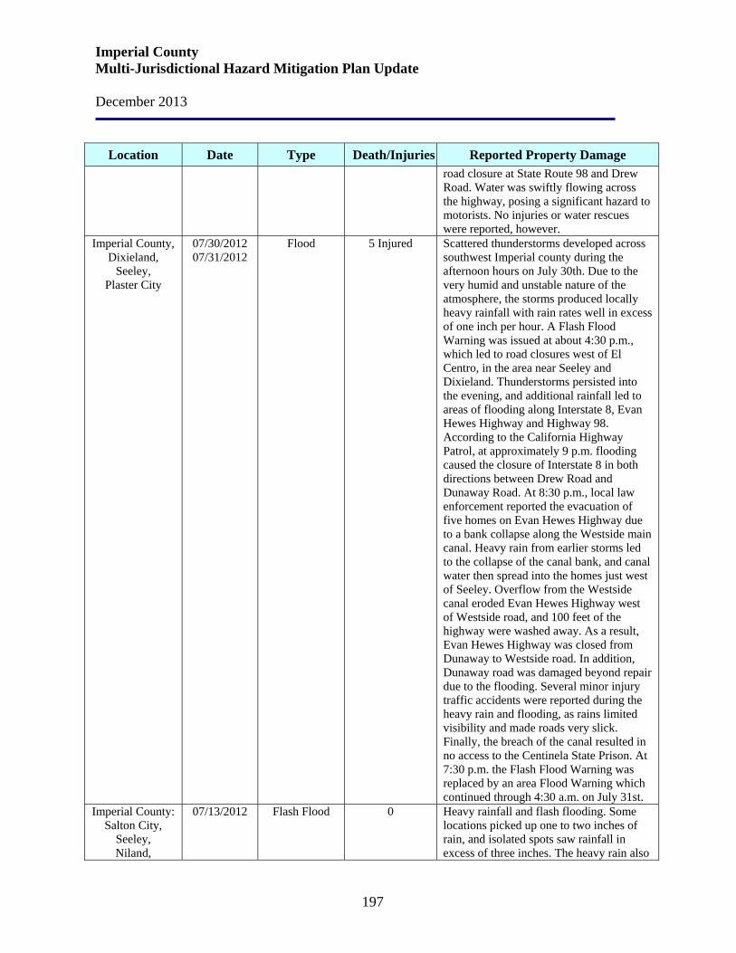
Imperial County Multi-Jurisdictional Hazard Mitigation Plan Update December 2013
197
Location Date Type Death/Injuries Reported Property Damage road closure at State Route 98 and Drew Road. Water was swiftly flowing across the highway, posing a significant hazard to motorists. No injuries or water rescues were reported, however.
Imperial County, Dixieland,
Seeley, Plaster City
07/30/2012 07/31/2012
Flood 5 Injured Scattered thunderstorms developed across southwest Imperial county during the afternoon hours on July 30th. Due to the very humid and unstable nature of the atmosphere, the storms produced locally heavy rainfall with rain rates well in excess of one inch per hour. A Flash Flood Warning was issued at about 4:30 p.m., which led to road closures west of El Centro, in the area near Seeley and Dixieland. Thunderstorms persisted into the evening, and additional rainfall led to areas of flooding along Interstate 8, Evan Hewes Highway and Highway 98. According to the California Highway Patrol, at approximately 9 p.m. flooding caused the closure of Interstate 8 in both directions between Drew Road and Dunaway Road. At 8:30 p.m., local law enforcement reported the evacuation of five homes on Evan Hewes Highway due to a bank collapse along the Westside main canal. Heavy rain from earlier storms led to the collapse of the canal bank, and canal water then spread into the homes just west of Seeley. Overflow from the Westside canal eroded Evan Hewes Highway west of Westside road, and 100 feet of the highway were washed away. As a result, Evan Hewes Highway was closed from Dunaway to Westside road. In addition, Dunaway road was damaged beyond repair due to the flooding. Several minor injury traffic accidents were reported during the heavy rain and flooding, as rains limited visibility and made roads very slick. Finally, the breach of the canal resulted in no access to the Centinela State Prison. At 7:30 p.m. the Flash Flood Warning was replaced by an area Flood Warning which continued through 4:30 a.m. on July 31st.
Imperial County: Salton City,
Seeley, Niland,
07/13/2012 Flash Flood 0 Heavy rainfall and flash flooding. Some locations picked up one to two inches of rain, and isolated spots saw rainfall in excess of three inches. The heavy rain also
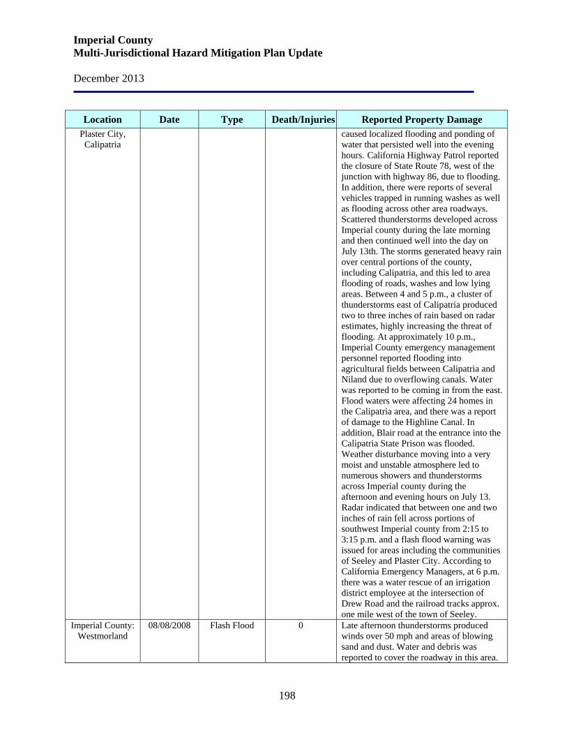
Imperial County Multi-Jurisdictional Hazard Mitigation Plan Update December 2013
198
Location Date Type Death/Injuries Reported Property Damage Plaster City, Calipatria
caused localized flooding and ponding of water that persisted well into the evening hours. California Highway Patrol reported the closure of State Route 78, west of the junction with highway 86, due to flooding. In addition, there were reports of several vehicles trapped in running washes as well as flooding across other area roadways. Scattered thunderstorms developed across Imperial county during the late morning and then continued well into the day on July 13th. The storms generated heavy rain over central portions of the county, including Calipatria, and this led to area flooding of roads, washes and low lying areas. Between 4 and 5 p.m., a cluster of thunderstorms east of Calipatria produced two to three inches of rain based on radar estimates, highly increasing the threat of flooding. At approximately 10 p.m., Imperial County emergency management personnel reported flooding into agricultural fields between Calipatria and Niland due to overflowing canals. Water was reported to be coming in from the east. Flood waters were affecting 24 homes in the Calipatria area, and there was a report of damage to the Highline Canal. In addition, Blair road at the entrance into the Calipatria State Prison was flooded. Weather disturbance moving into a very moist and unstable atmosphere led to numerous showers and thunderstorms across Imperial county during the afternoon and evening hours on July 13. Radar indicated that between one and two inches of rain fell across portions of southwest Imperial county from 2:15 to 3:15 p.m. and a flash flood warning was issued for areas including the communities of Seeley and Plaster City. According to California Emergency Managers, at 6 p.m. there was a water rescue of an irrigation district employee at the intersection of Drew Road and the railroad tracks approx. one mile west of the town of Seeley.
Imperial County: Westmorland
08/08/2008 Flash Flood 0 Late afternoon thunderstorms produced winds over 50 mph and areas of blowing sand and dust. Water and debris was reported to cover the roadway in this area.
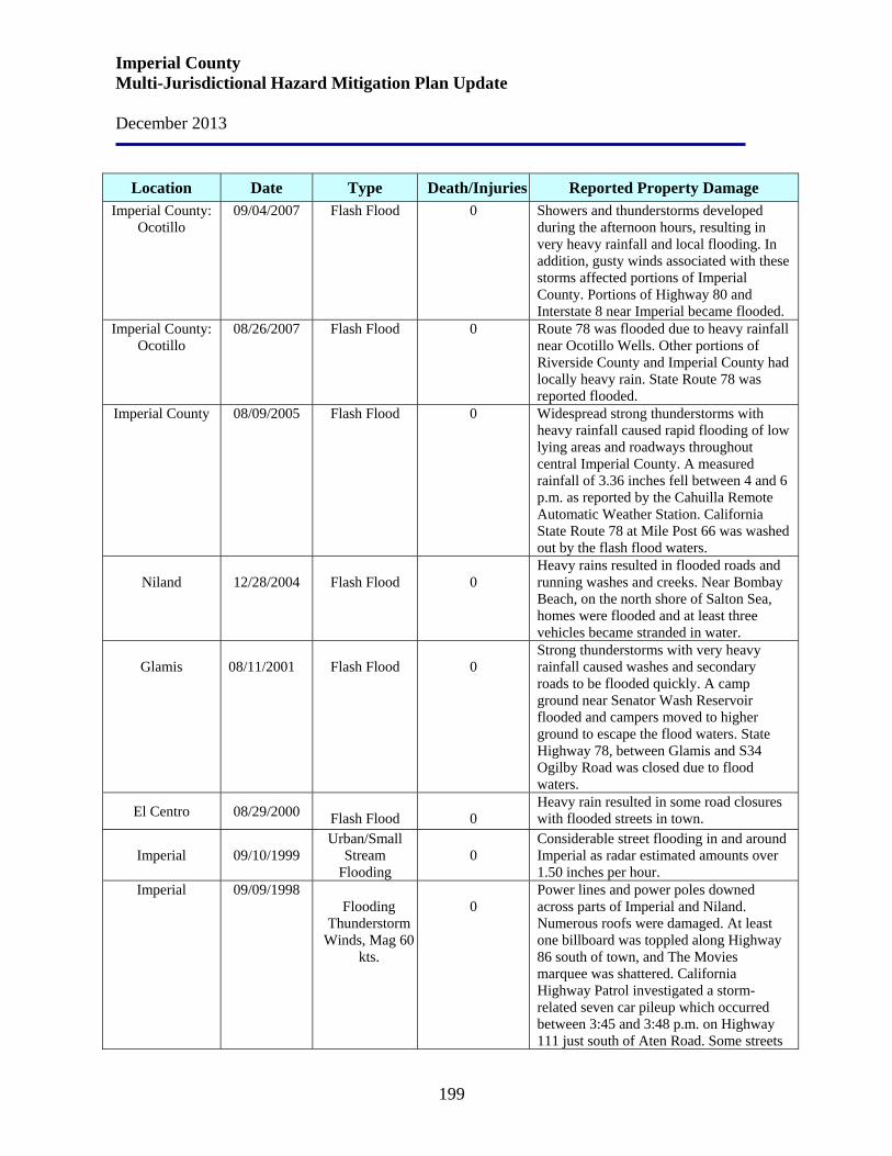
Imperial County Multi-Jurisdictional Hazard Mitigation Plan Update December 2013
199
Location Date Type Death/Injuries Reported Property Damage Imperial County:
Ocotillo 09/04/2007 Flash Flood 0 Showers and thunderstorms developed
during the afternoon hours, resulting in very heavy rainfall and local flooding. In addition, gusty winds associated with these storms affected portions of Imperial County. Portions of Highway 80 and Interstate 8 near Imperial became flooded.
Imperial County: Ocotillo
08/26/2007 Flash Flood 0 Route 78 was flooded due to heavy rainfall near Ocotillo Wells. Other portions of Riverside County and Imperial County had locally heavy rain. State Route 78 was reported flooded.
Imperial County 08/09/2005 Flash Flood 0 Widespread strong thunderstorms with heavy rainfall caused rapid flooding of low lying areas and roadways throughout central Imperial County. A measured rainfall of 3.36 inches fell between 4 and 6 p.m. as reported by the Cahuilla Remote Automatic Weather Station. California State Route 78 at Mile Post 66 was washed out by the flash flood waters.
Niland
12/28/2004
Flash Flood
0
Heavy rains resulted in flooded roads and running washes and creeks. Near Bombay Beach, on the north shore of Salton Sea, homes were flooded and at least three vehicles became stranded in water.
Glamis
08/11/2001
Flash Flood
0
Strong thunderstorms with very heavy rainfall caused washes and secondary roads to be flooded quickly. A camp ground near Senator Wash Reservoir flooded and campers moved to higher ground to escape the flood waters. State Highway 78, between Glamis and S34 Ogilby Road was closed due to flood waters.
El Centro 08/29/2000
Flash Flood 0
Heavy rain resulted in some road closures with flooded streets in town.
Imperial 09/10/1999 Urban/Small
Stream Flooding
0
Considerable street flooding in and around Imperial as radar estimated amounts over 1.50 inches per hour.
Imperial
09/09/1998
Flooding
Thunderstorm Winds, Mag 60
kts.
0
Power lines and power poles downed across parts of Imperial and Niland. Numerous roofs were damaged. At least one billboard was toppled along Highway 86 south of town, and The Movies marquee was shattered. California Highway Patrol investigated a storm-related seven car pileup which occurred between 3:45 and 3:48 p.m. on Highway 111 just south of Aten Road. Some streets
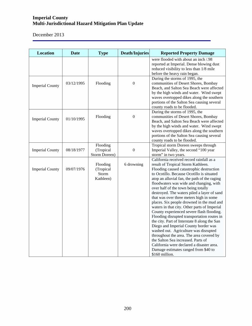
Imperial County Multi-Jurisdictional Hazard Mitigation Plan Update December 2013
200
Location Date Type Death/Injuries Reported Property Damage
were flooded with about an inch /.98 reported at Imperial. Dense blowing dust reduced visibility to less than 1/8 mile before the heavy rain began.
Imperial County
03/12/1995
Flooding
0
During the storms of 1995, the communities of Desert Shores, Bombay Beach, and Salton Sea Beach were affected by the high winds and water. Wind swept waves overtopped dikes along the southern portions of the Salton Sea causing several county roads to be flooded.
Imperial County
01/10/1995
Flooding
0
During the storms of 1995, the communities of Desert Shores, Bombay Beach, and Salton Sea Beach were affected by the high winds and water. Wind swept waves overtopped dikes along the southern portions of the Salton Sea causing several county roads to be flooded.
Imperial County 08/18/1977 Flooding (Tropical
Storm Doreen)
0
Tropical storm Doreen sweeps through Imperial Valley, the second “100 year storm” in two years.
Imperial County
09/07/1976
Flooding (Tropical
Storm Kathleen)
6 drowning
California received record rainfall as a result of Tropical Storm Kathleen. Flooding caused catastrophic destruction to Ocotillo. Because Ocotillo is situated atop an alluvial fan, the path of the raging floodwaters was wide and changing, with over half of the town being totally destroyed. The waters piled a layer of sand that was over three meters high in some places. Six people drowned in the mud and waters in that city. Other parts of Imperial County experienced severe flash flooding. Flooding disrupted transportation routes in the city. Part of Interstate 8 along the San Diego and Imperial County border was washed out. Agriculture was disrupted throughout the area. The area covered by the Salton Sea increased. Parts of California were declared a disaster area. Damage estimates ranged from $40 to $160 million.
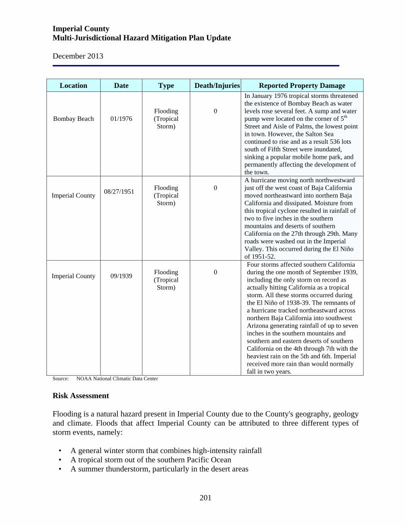
Imperial County Multi-Jurisdictional Hazard Mitigation Plan Update December 2013
201
Location Date Type Death/Injuries Reported Property Damage
Bombay Beach
01/1976
Flooding (Tropical Storm)
0
In January 1976 tropical storms threatened the existence of Bombay Beach as water levels rose several feet. A sump and water pump were located on the corner of 5th Street and Aisle of Palms, the lowest point in town. However, the Salton Sea continued to rise and as a result 536 lots south of Fifth Street were inundated, sinking a popular mobile home park, and permanently affecting the development of the town.
Imperial County
08/27/1951
Flooding (Tropical Storm)
0
A hurricane moving north northwestward just off the west coast of Baja California moved northeastward into northern Baja California and dissipated. Moisture from this tropical cyclone resulted in rainfall of two to five inches in the southern mountains and deserts of southern California on the 27th through 29th. Many roads were washed out in the Imperial Valley. This occurred during the El Niño of 1951-52.
Imperial County
09/1939
Flooding (Tropical Storm)
0
Four storms affected southern California during the one month of September 1939, including the only storm on record as actually hitting California as a tropical storm. All these storms occurred during the El Niño of 1938-39. The remnants of a hurricane tracked northeastward across northern Baja California into southwest Arizona generating rainfall of up to seven inches in the southern mountains and southern and eastern deserts of southern California on the 4th through 7th with the heaviest rain on the 5th and 6th. Imperial received more rain than would normally fall in two years.
Source: NOAA National Climatic Data Center Risk Assessment Flooding is a natural hazard present in Imperial County due to the County's geography, geology and climate. Floods that affect Imperial County can be attributed to three different types of storm events, namely:
• A general winter storm that combines high-intensity rainfall • A tropical storm out of the southern Pacific Ocean • A summer thunderstorm, particularly in the desert areas
Imperial County Multi-Jurisdictional Hazard Mitigation Plan Update December 2013
202
There are three principal types of flood hazards that may affect Imperial County, namely: • Stream flooding (including bridge scour and stream erosion) • Flash flooding (including debris and mud flows) • Sheetflow flooding (including alluvial fan flooding)
Storms with high volumes of precipitation in a short period of time have occurred in the County causing flash floods. In addition, land that has been stripped of foliage and trees due to fire or human activity has experienced serious erosion. Excessive precipitation can inundate soil in slopes causing mudslides and landslides. This activity can destroy homes, block highways, and destroy power lines. Imperial County is vulnerable to this type of flood damage. Heavy storms also can strand individuals playing near or crossing streams, rivers, flood control channels and intersections. Areas subject to flooding are located throughout the County. The topography of the County varies from several thousand feet above sea level to areas actually below sea level. Areas subject to flooding drain either naturally into flood controls or rivers, washes, and creeks. Most can handle normal flows. In the desert areas, flooding can be rapid and quite severe during the period of July and August. Winter rains are generally more widespread in the desert, but flashflood potential is less due to steady-state rain fall. Winter rains are nonetheless flood-prone, but may be slightly more predictable. There is a danger to motorists who may attempt to drive through flooded washes. Most flooding in the areas other than the desert is predictable and will provide time for evacuation and mitigation measures such as sandbags.
• Effects on people and housing. Direct impacts of flooding can include injuries and loss of life, damage to property and health hazards from ruptured sewage lines and damaged septic systems. Secondary impacts include the cost and commitment of resources for flood fighting services, clean-up operations, and the repair or replacement of damaged structures.
• Effects on commercial and industrial structures. Depending on the geographic
area involved and the economic and demographic characteristics of the area, the effects on industry and commerce may be significant.
• Effects on infrastructure. A slow-rising flood situation will progress through a
series of stages, beginning with minor rainfall and evolving to a major event such as substantial flooding. Once flooding begins, personnel will be needed to assist in rescuing persons trapped by flood waters, securing utilities, cordoning off flood areas, and controlling traffic. These actions may overtax local agencies, and additional personnel and resources may be required. It is anticipated that existing mutual aid resources would be used as necessary to augment local resources. Flooding can cause damage to roads, communication facilities and other infrastructure.
Imperial County Multi-Jurisdictional Hazard Mitigation Plan Update December 2013
203
• Effects on agriculture. Flooding can cause damage to vegetation, crops, livestock and dairy stock. In addition to the obvious impacts on animals and crops, flooding can have deleterious effects on soil and the ability to reinvigorate the agricultural activities impacted once the flood waters recede.
Relationship to Other Hazards – Cascading Effects Although the County is located in a desert with very low precipitation, it is sometimes subject to heavy rains and subsequent flooding. Flooding could also result from damage to the All American Canal and associated transmission aqueducts. A few hazardous waste facilities are located in the County and accidents could dangerously pollute air and water. Fire can break out as a result of dysfunctional electrical equipment. In many instances during a flood, the drinking water supply will be contaminated. Flooding, erosion and debris flows can also occur in the months and years following large fires since wildfires greatly reduce the amount of vegetation, which in turn reduces the amount of rainwater absorption, allowing excessive water runoff. Risk Assessment Conclusion Flooding is a natural hazard present in Imperial County due to the County's geography, geology and climate. There are various facets to flooding; all of which are relevant to Imperial County. Flood hazards include: natural floodplains, seiches, and dam failure. Flooding due to heavy precipitation or dam failure is a potential hazard in Imperial County with the resultant possibilities for damage to property and loss of life. Severe flooding can be particularly costly. In a relative sense, flooding due to precipitation does not present the degree of danger posed by other hazards such as major earthquakes. On the other hand, if there is flooding due to dam failure, the danger could be cataclysmic. Flooding, due to dam failure, is a factor which could seriously affect eastern Imperial County, however, inundation of communities is considered unlikely and hazard analysis suggest that dam failure would likely occur only if heavy precipitation was coupled with significant seismic activity near the dam. Plans and Programs Floodplain management is the key component to effective flood control within Imperial County. The Federal Insurance Administration delineates areas of special flood hazards, the risk premium zones, and floodways through official maps: Flood Insurance Rate Map (FIRM); and Flood Boundary and Floodway Map. These maps form the basis for Imperial County's Flood Ordinance which is intended to be applied to those areas which are subject to periodic flooding and accompanying hazards. These official maps show all canals, drains, and rivers, and at 1"-1000' are a useful reference map. Most of the irrigated valley is designated Zone "C" - indefinite minor flooding - reflecting the flat terrain and the canal system.
Imperial County Multi-Jurisdictional Hazard Mitigation Plan Update December 2013
204
Since the publication of the 2009 MHMP, the Imperial County Department of Public Works has developed Master Drainage Plans for the unincorporated communities of Seeley, Niland, and Heber. Additional projects include:
• Drainage improvements for the Township of Seeley. This project will consist of construction of drainage infrastructure to convey storm water away from the Community. Over past storm events, Seeley has suffered road and shoulder structural damage on each side of its streets due to flooding. When it rains, water drains toward the center of the streets and accumulates in the streets. The flooding causes hazards for pedestrians and drivers, and causes severe damage to the roads. The estimated cost of the project is $1,916,795. The County has made it a top priority to obtain funding for this project, and has applied for HMGP funds. The most recent attempt to gain funding was an application for Proposition 84 funds through the Imperial Integrated Regional Water Management Plan (IRWMP). Application was submitted in March 2013, and announcement of grant award is expected in October 2013.
• Various Road Infrastructure Improvements for Flood Hazard Mitigation. This project includes storm water crossings for five (5) County roads: 1) Azure Road between Treadwell and Coombs, 2) Azure Road north of Marina Drive, 3) Noffsinger Road, 4) Stallard Road at Palo Verde Road, and 5) Wilkins Road north of Beal Road. The estimated total project cost is $2,109,650. The County has applied for HMGP funds, and has thus far been unsuccessful. The project remains a priority and the County will continue to seek funding for these much-needed improvements.
• Storm Crossing Improvements to Ogilby Road. Ogilby Road experiences some of the most severe flooding of road locations in Imperial County. Because it is a Federal Highway Administration (FHWA) road, Ogilby is not eligible for FEMA HMGP funds. The County continues to seek funding opportunities for drainage improvements for this road.
Imperial County The Imperial County General Plan includes the following Flood Hazards mitigation measures. Flood Hazards Programs and Policies:
1. Provide technical and policy information regarding flood hazards to developers, interested parties, and the general public.
2. Regulate and restrict development near major water courses and floodplains through application of appropriate land use measures.
3. Both the ground floor elevation of any building for human occupancy and the driving surface, if designated evacuation routes within the 100-year floodplain, shall be constructed above the projected profile of a 100-year flood event.
Imperial County Multi-Jurisdictional Hazard Mitigation Plan Update December 2013
205
4. Require all new development for human occupancy within the 100-year floodplain to be adequately flood-proofed.
5. Establish technical design criteria which minimizes or mitigates impacts associated with crossing of floodplains by development. Unless such engineering alternatives are implemented, development in floodplains is to be restricted or prohibited.
City of Brawley Although the City of Brawley is located within an arid climate, flooding of the New River can occur during intermittent heavy rains. As growth occurs in Brawley, new development will increase the amount of impervious surface, resulting in greater surface water run-off and the need for an adequate flood control system. The risk of flood damage in the City can be reduced through proper land use planning and actions related to new development and redevelopment of land. Following are the City of Brawley’s Flooding Hazards Goal and Policy:
Goal #1: Promote policies and programs that reduce the risk to the community’s inhabitants from flood hazards.
Policy 1.1: Identify flood hazard areas and provide appropriate land use regulations for areas subject to flooding.
Policy 1.2: Coordinate with the appropriate agencies to assure that existing bridges are constructed according to accepted standards to avoid damage by flooding.
Policy 1.3: Consider participating in the National Flood Insurance Program.
Policy 1.4: Cooperate with the Imperial Irrigation District to plan for and make needed improvements to drainage infrastructure depositing runoff in the New River.
Policy 1.5: Require detention basins as a flood control measure where applicable to reduce the risk from flood hazards.
Policy 1.6: Design future development located near water storage facilities to minimize damage caused by leak, rupture, or flooding from a water storage facility.
Policy 1.7: Establish open space required to protect the public from flood hazards.
Policy 1.8: Coordinate with Caltrans and road builders to ensure proper roadway design for drainage purposes.
Policy 1.9: Prevent cross-lot drainage between and within developments.
Policy 1.10: Prepare a master plan of drainage for the planning area.
Policy 1.11: New development within the Planning Area must contain onsite 100% of the stormwater run-off of a 100 year storm. City of Calexico Flooding is unlikely to affect the City of Calexico under normal rain and run-off conditions. The FEMA hazard area map of the Calexico area shows that the 500-year floodplain of the
Imperial County Multi-Jurisdictional Hazard Mitigation Plan Update December 2013
206
New River within the City is contained within the area north of the Calexico International Airport that is currently zoned as Open Space land. Conditions upstream in Mexico do affect the river. As the Mexicali area becomes more urbanized, and very little has been done to control urban runoff there, the potential for flooding could increase in downstream areas such as Calexico. Flooding could also result from seismic damage to a major IID canal. The City of Calexico is traversed by two major canals: the All American and the Central Main. Following are the City of Calexico’s Flood Hazards Goals, Objectives and Policies: Policy 3 a. The City shall ensure the adequacy of existing emergency preparedness plans to handle
effectively and efficiently known hazards and emergencies. b. The City shall review evacuation procedures to make sure that in case of an evacuation, the
residents of Calexico will be quickly notified and that the evacuation will be orderly. c. The City shall require the heads and staff of each department to participate in the
maintenance of a city-wide emergency preparedness plan. d. The City shall cooperate with the Imperial Irrigation District (IID) to prepare or update an
emergency plan for the rapid removal and repair of downed power lines and/or damaged/breeched water facilities in the event of an earthquake.
Calexico has also adopted a Flood Damage Prevention Code to address safety issues associated with flooding directly. Following is the City of Calexico’s Emergency Preparedness Goal, Objective and Policies:
8.5 Goal, Objectives, and Policies
8.5.1 Goal: To identify and minimize, to the extent possible or feasible, the risks to persons and property caused by natural and human-induced hazards.
8.5.1.1 Levels of Risk
Objective 1: To maintain acceptable risk levels when conducting land use planning.
Policy 1
a. The Scale of Acceptable Risk for New Structures shall continue to be used to determine the type and location of future land use.
b. Land uses should not be subjected to greater risk than the level the scale suggests unless no other alternative exists.
8.5.1.3 Emergency Preparedness
Objective 3: Minimize the potential hazards to public health, safety, and welfare and prevent the loss of life and property damage from natural and human induced phenomena. Policy 3 a. The City shall ensure the adequacy of existing emergency preparedness plans to handle
effectively and efficiently known hazards and emergencies.
Imperial County Multi-Jurisdictional Hazard Mitigation Plan Update December 2013
207
b. The City shall review evacuation procedures to make sure that in case of an evacuation, the residents of Calexico will be quickly notified and that the evacuation will be orderly.
c. The City shall work with the Calexico Water Department to ensure that an adequate supply of water will be available in the event of an emergency and to help create and maintain an emergency water supply.
d. The City shall require the heads and staff of each department to participate in the maintenance of a city-wide emergency preparedness plan.
City of Calipatria The only area within the vicinity of Calipatria that is identified as a floodplain is along the Alamo River located approximately one mile west of the city limits. The majority of the area within the city limits is within the Federal Emergency Management Agency (FEMA) Flood Zone X, which is characterized by a minimal risk of flooding and located outside the 100-year flood hazard area. While the area within the city limits is located in Zone X, the area surrounding the Alamo River to the southwest and west of the City is located in Zone A, which is an area subject to inundation by a 100-year flood FEMA flood. Localized flooding of streets within the City occurs during periods of severe storms. However, floodwaters are generally contained within the streets and typically do not affect structures such as residential units or commercial buildings. In addition, the City requires building pads for new structures to be at least 16 inches above the top of the adjacent curb. This requirement is intended to ensure that if floodwaters breach existing curbs, they will not impact the interior of residential units. All new projects within the City are also required to have grading and drainage plans approved by the City Engineer prior to the issuance of permits in order to ensure adequate control of floodwaters. Despite this, there is a localized flood concern on the eastern portion of the City (east of the rail road tracks). The cause of flooding is not completely known and occurs when substantial from the mountains flows eastward towards the city and combines with agriculture water. Streets and some residential structures have been damaged as a result of flooding in the eastern portion of the City. Following are the flooding hazard mitigation Goals and Policies of the City of Calipatria:
Goal S-2: Minimize the potential for loss of life, physical injury, property damage, and social disruption resulting from flooding.
Policy S-2.1 Ensure that new development projects evaluate potential flooding hazards and incorporate design elements, such as storm drains, catch basins, and retention basins, to minimize or eliminate flooding hazards, as necessary.
Policy S-2.2 Encourage the formation of a Countywide Flood Control District to manage County-wide flooding issues.
Policy S-2.3 Promote multi-jurisdictional emergency coordination and planning for flood events.
Imperial County Multi-Jurisdictional Hazard Mitigation Plan Update December 2013
208
Policy S-2.4 Determine the cause of localized flooding in the eastern portion of the City and implement infrastructure improvements to alleviate the flooding concern. Following are the City of Calipatria’s Implementation Actions for the adopted policies:
• Continue to enforce the local, state, and federal regulations regarding the construction of buildings within flood hazard areas (Implements Policies S-2.1).
• Comply with the Imperial County Flood Management Plan and participate in the planning and development of future flood management plans (Policy S-2.2).
• Continue to participate in the planning and development of the Imperial County Multi-Hazard Mitigation Plan and comply with the mitigation goals and strategies therein (Policy S-2.3).
• The City shall work with the Imperial Irrigation District, Imperial County Public Works Department, and Caltrans to determine the cause of localized flooding in the eastern portion of the City, to identify infrastructure improvements to reduce the likelihood of flooding, and to implement the infrastructure improvements (Policy S-2.4).
City of El Centro Floodplains located in and around El Centro present a potential natural hazard to the City. Proper land use planning can limit the risk of exposure. The City will continue to fund needed infrastructure improvements, identify new funding sources as necessary and also promote programs and actions that educate the public about flood hazards and reduce the risk of flood losses. Following are El Centro’s Safety Goal and Policies related to Flooding Hazards: Safety Goal 2: Promote programs and actions that educate the public about flood hazards and reduce the risk of flood losses.
Policy 2.1: Identify and evaluate potentially hazardous flood risks in the community and educate the public about how best to minimize the safety hazards associated with these risks.
Policy 2.2: Maintain all drainage and flood control facilities so that they function correctly.
Policy 2.3: Improve drainage ways and flood control facilities to lessen recurrent flood problems and include necessary improvements in the City’s Capital Improvement Program.
Policy 2.4: Review all new proposed development to ensure that it will not aggravate poor drainage conditions and will, to the extent possible, improve poor drainage conditions.
Policy 2.5: Require all proposed development projects to submit a hydrological analysis of a project’s expected runoff that will enter the City’s drainage system, as well as the cumulative impact of the project and surrounding development (existing and planned) on the drainage system and flood prone areas.
Policy 2.6: Avoid new development that would create runoff volumes or velocities that may cause the City’s existing drainage system to exceed its design capacity until appropriate site design and mitigation steps are taken.
Imperial County Multi-Jurisdictional Hazard Mitigation Plan Update December 2013
209
Policy 2.7: Continue to fund needed infrastructure improvements, identifying new funding sources as necessary. Following are the City of El Centro’s Implementation Program to implement the adopted policies:
S-5: Flooding Risk Reduction: Reduce the risk to the community from hazards related to flooding by requiring feasible mitigation of such impacts on existing, new development and redevelopment. Assess development proposals for potential hazards pursuant to the California Environmental Quality Act. Require measures to mitigate all identified significant public safety hazards. Responsible Agency/Department: Development Services, Public Works Funding Source: Project proponent Time Frame: Ongoing Related Policies: 2.4, 2.5, 2.6
S-6: Storm Drainage Facilities: Enforce the City’s Public Works Standards, which give specific requirements for design of drainage facilities to ensure that they are properly sized to handle storm runoff and flash floods. Require new development to provide adequate flood control facilities, if needed, to control runoff generated by the project. Identify new public and private funding sources to fund needed improvements. Responsible Agency/Department: Public Works Funding Source: Project proponent, General Fund Time Frame: Ongoing Related Policies: 2.2, 2.3, 2.4, 2.5, 2.6, 2.7 S-7: Flood Hazard Education: Promote programs and actions that educate the public about flood hazards and how to reduce the risks and losses associated with flooding. Responsible Agency/Department: Development Services, Public Works Funding Source: Project proponent Time Frame: Ongoing Related Policies: 2.4, 2.5, 2.6 City of Holtville While the City of Holtville has generally not experienced substantial adverse flooding impacts, the City acknowledges that they should be prepared for disasters resulting from floods. The City of Holtville has identified the following programs: • Conduct City-wide drainage study to identify anticipated problem areas and mitigation
measures. • Encourage continued efficiency with the Public Works Department and support the
expansion and maintenance of all sewer, water and drainage facilities. • Maintain and improve all drainage and flood control facilities to be sure that they function
as required; and mitigate or disallow development that increases the City’s drainage
Imperial County Multi-Jurisdictional Hazard Mitigation Plan Update December 2013
210
system to exceed design capacity, unless mitigation steps are implemented by the developer.
• Identify and evaluate hazardous flood locations, inform the public, and particularly proposed developers.
City of Imperial There are no identified floodplains within the City of Imperial. The nearest floodplains are located along the New and Alamo Rivers and neither of these rivers are located within the City’s planning area. Flooding within the City of Imperial would be mostly localized and would be concentrated in streets and intersections within low lying area. Flooding hazards can be minimized by ensuring adequate drainage systems are constructed and maintained. Following are the Flood Hazards Objective and Policies for the City of Imperial Objective 7: Minimize exposure of the public to flooding hazards caused by severe storms, earthquakes or other phenomena.
Policy 7 A. Require the finished floor elevation of new structures to be built a minimum of 12 inches
above the top of the adjacent curbs for flood protection. B. Require all new development projects to contain a grading and drainage plan based upon
the requirement to adequately accommodate storm waters from a 100 year flood in order to prevent flooding of structures.
C. Utilize flood hazard maps produced by the Federal Emergency Management Agency to determine flood hazards within the planning area.
D. Establish a storm drain system for flood control when feasible. City of Westmorland The City of Westmorland is located a significant distance away from the Salton Sea and is not prone to annual changes in lake levels, however, failure of any of the dam systems (Imperial and Hoover) can result in flooding of Westmorland. Prolonged periods of heavy rain can also contribute to flooding conditions, but overall flood risk seems to be minimal, as the Alamo River and New River floodplains are located many miles east of the City. Localized flooding of City streets will occur during periods of severe storms, but flood waters are mostly contained within the streets thus not impacting dwelling units. New construction projects are required to address grading and proper drainage of storm runoff, thereby minimizing flood water breach. Following are the City of Westmorland’s Flooding Hazards Goal, Objective, and Policies: Goal #1: Protect the public from natural and man-made hazards.
Objective 1.2: Ensure public safety from flooding hazards.
Policies: 1. Map flood hazard areas. 2. Prevent issuance of building permits for residences in flood hazard areas.
Imperial County Multi-Jurisdictional Hazard Mitigation Plan Update December 2013
211
3. Require storm drains, catch basins, retention basins and other flood control facilities in new development to control flooding during periods of severe storms.
4. Encourage the formation of a Countywide Flood Control District to deal with Countywide flooding issues.
Imperial County Irrigation District Following is a summary of work the Irrigation District has recently undertaken to mitigate flooding risk within the County:
• Relocation of an Existing Headwall and Pipe: In order to raise the bank to build the dike, the west bank would need to be widened. The structure and pipe that connect to the D Drain to the E Drain needs to be moved east.
• Backflow preventer valves at Sump (S-477): In order to avoid rising water in the D Drain to go back into the field.
• Tail Ditch Berm: Place and compact approximately 4500 cubic yards of native fill material on Tail Ditch road. Native fill material to be obtained at the O Lateral pit. Road is approximately ½ mile long by 16’ wide. Approximately 320 loads are needed.
• Calipatria Dike: Building a dirt dike approximately 3’ tall, 16’ wide for a total of approximately 1 ½ miles. The dike would start at the intersection of Southeast Avenue and Bowles Road and go north to State Highway, and then continue north along Northeast Avenue to Young Road, then head west along Young Road to the railroad tracks.
o In the ½ mile between Bowles and State Highway, the dike would be built between the power lines and the fields.
o In the ½ mile between the State Highway and Young Road, the dike would be built on top of existing west bank of the D Drain.
o In the ½ mile along Young Road, between Northeast Avenue and the railroad tracks, the dike would be built on top of the existing south bank of E Drain.
o A relocation of an existing headwall and pipe at the intersection of D and E Drain, pipe and box would need to be relocated in order to widen the west bank of D Drain.
o Backflow preventer valves at Sump (S-477) in order to avoid rising water in the D Drain to go back into the field
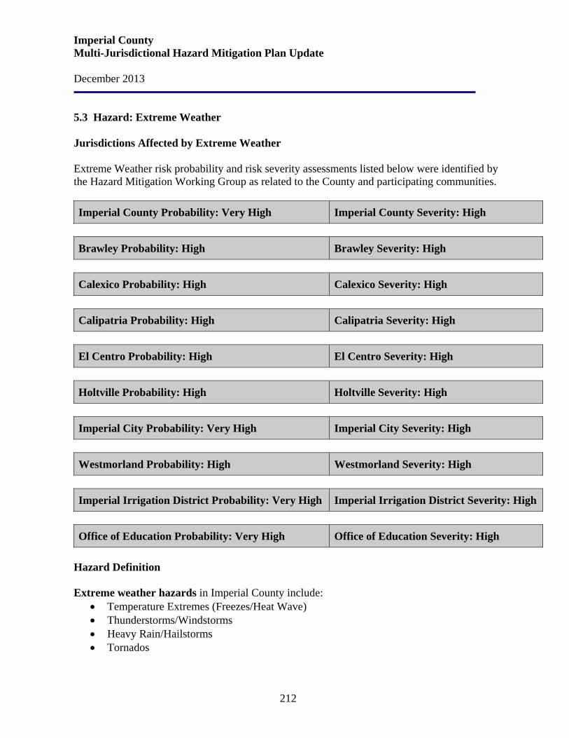
Imperial County Multi-Jurisdictional Hazard Mitigation Plan Update December 2013
212
5.3 Hazard: Extreme Weather Jurisdictions Affected by Extreme Weather Extreme Weather risk probability and risk severity assessments listed below were identified by the Hazard Mitigation Working Group as related to the County and participating communities. Imperial County Probability: Very High Imperial County Severity: High
Brawley Probability: High Brawley Severity: High
Calexico Probability: High Calexico Severity: High
Calipatria Probability: High Calipatria Severity: High
El Centro Probability: High El Centro Severity: High
Holtville Probability: High Holtville Severity: High
Imperial City Probability: Very High Imperial City Severity: High
Westmorland Probability: High Westmorland Severity: High
Imperial Irrigation District Probability: Very High Imperial Irrigation District Severity: High
Office of Education Probability: Very High Office of Education Severity: High
Hazard Definition Extreme weather hazards in Imperial County include:
• Temperature Extremes (Freezes/Heat Wave) • Thunderstorms/Windstorms • Heavy Rain/Hailstorms • Tornados
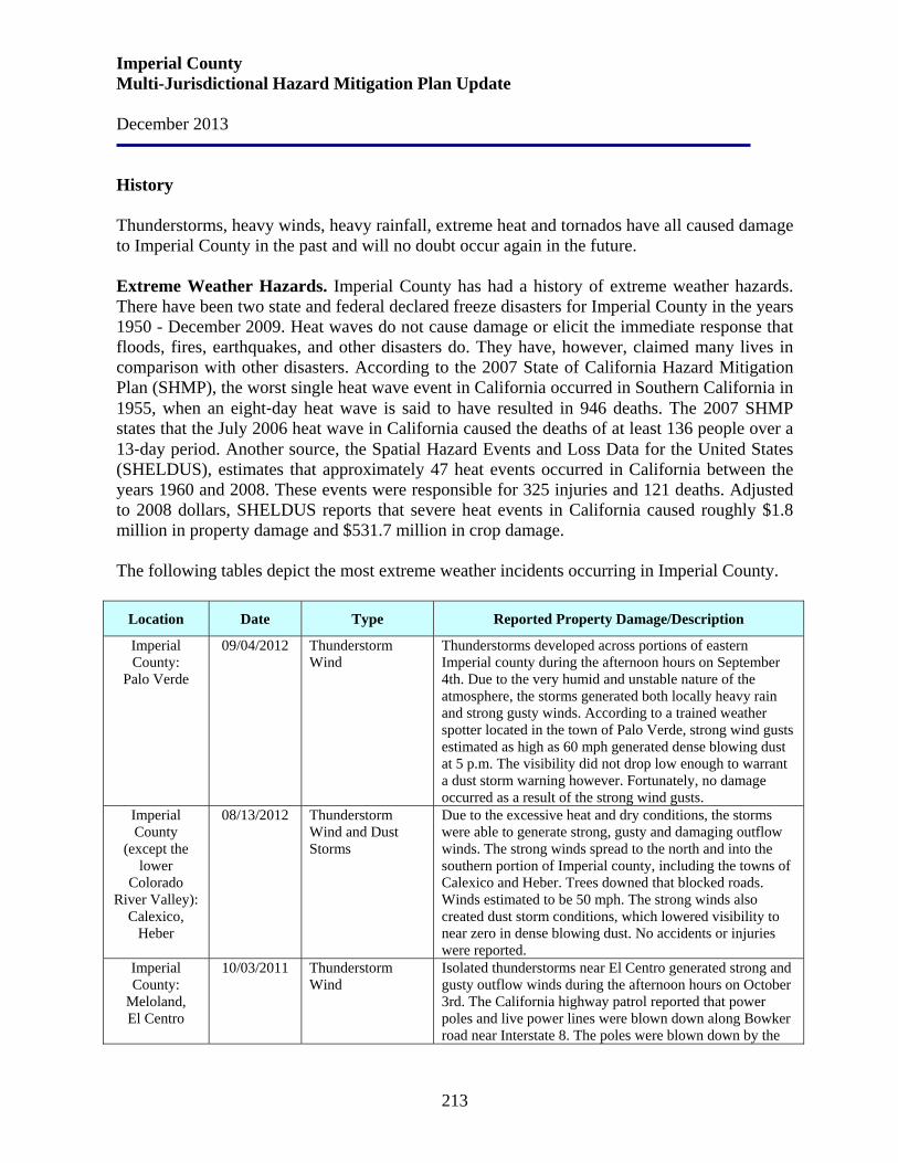
Imperial County Multi-Jurisdictional Hazard Mitigation Plan Update December 2013
213
History Thunderstorms, heavy winds, heavy rainfall, extreme heat and tornados have all caused damage to Imperial County in the past and will no doubt occur again in the future. Extreme Weather Hazards. Imperial County has had a history of extreme weather hazards. There have been two state and federal declared freeze disasters for Imperial County in the years 1950 - December 2009. Heat waves do not cause damage or elicit the immediate response that floods, fires, earthquakes, and other disasters do. They have, however, claimed many lives in comparison with other disasters. According to the 2007 State of California Hazard Mitigation Plan (SHMP), the worst single heat wave event in California occurred in Southern California in 1955, when an eight‐day heat wave is said to have resulted in 946 deaths. The 2007 SHMP states that the July 2006 heat wave in California caused the deaths of at least 136 people over a 13‐day period. Another source, the Spatial Hazard Events and Loss Data for the United States (SHELDUS), estimates that approximately 47 heat events occurred in California between the years 1960 and 2008. These events were responsible for 325 injuries and 121 deaths. Adjusted to 2008 dollars, SHELDUS reports that severe heat events in California caused roughly $1.8 million in property damage and $531.7 million in crop damage. The following tables depict the most extreme weather incidents occurring in Imperial County.
Location Date Type Reported Property Damage/Description
Imperial County:
Palo Verde
09/04/2012 Thunderstorm Wind
Thunderstorms developed across portions of eastern Imperial county during the afternoon hours on September 4th. Due to the very humid and unstable nature of the atmosphere, the storms generated both locally heavy rain and strong gusty winds. According to a trained weather spotter located in the town of Palo Verde, strong wind gusts estimated as high as 60 mph generated dense blowing dust at 5 p.m. The visibility did not drop low enough to warrant a dust storm warning however. Fortunately, no damage occurred as a result of the strong wind gusts.
Imperial County
(except the lower
Colorado River Valley):
Calexico, Heber
08/13/2012 Thunderstorm Wind and Dust Storms
Due to the excessive heat and dry conditions, the storms were able to generate strong, gusty and damaging outflow winds. The strong winds spread to the north and into the southern portion of Imperial county, including the towns of Calexico and Heber. Trees downed that blocked roads. Winds estimated to be 50 mph. The strong winds also created dust storm conditions, which lowered visibility to near zero in dense blowing dust. No accidents or injuries were reported.
Imperial County:
Meloland, El Centro
10/03/2011 Thunderstorm Wind
Isolated thunderstorms near El Centro generated strong and gusty outflow winds during the afternoon hours on October 3rd. The California highway patrol reported that power poles and live power lines were blown down along Bowker road near Interstate 8. The poles were blown down by the
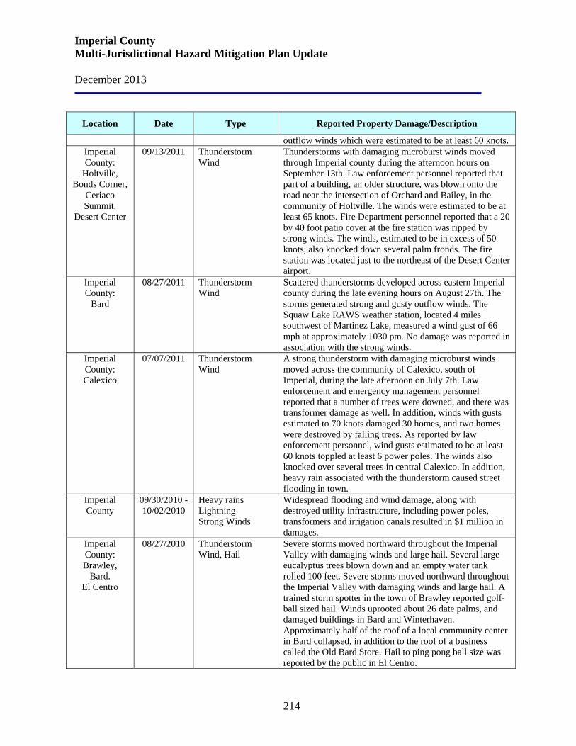
Imperial County Multi-Jurisdictional Hazard Mitigation Plan Update December 2013
214
Location Date Type Reported Property Damage/Description
outflow winds which were estimated to be at least 60 knots. Imperial County:
Holtville, Bonds Corner,
Ceriaco Summit.
Desert Center
09/13/2011 Thunderstorm Wind
Thunderstorms with damaging microburst winds moved through Imperial county during the afternoon hours on September 13th. Law enforcement personnel reported that part of a building, an older structure, was blown onto the road near the intersection of Orchard and Bailey, in the community of Holtville. The winds were estimated to be at least 65 knots. Fire Department personnel reported that a 20 by 40 foot patio cover at the fire station was ripped by strong winds. The winds, estimated to be in excess of 50 knots, also knocked down several palm fronds. The fire station was located just to the northeast of the Desert Center airport.
Imperial County:
Bard
08/27/2011 Thunderstorm Wind
Scattered thunderstorms developed across eastern Imperial county during the late evening hours on August 27th. The storms generated strong and gusty outflow winds. The Squaw Lake RAWS weather station, located 4 miles southwest of Martinez Lake, measured a wind gust of 66 mph at approximately 1030 pm. No damage was reported in association with the strong winds.
Imperial County: Calexico
07/07/2011 Thunderstorm Wind
A strong thunderstorm with damaging microburst winds moved across the community of Calexico, south of Imperial, during the late afternoon on July 7th. Law enforcement and emergency management personnel reported that a number of trees were downed, and there was transformer damage as well. In addition, winds with gusts estimated to 70 knots damaged 30 homes, and two homes were destroyed by falling trees. As reported by law enforcement personnel, wind gusts estimated to be at least 60 knots toppled at least 6 power poles. The winds also knocked over several trees in central Calexico. In addition, heavy rain associated with the thunderstorm caused street flooding in town.
Imperial County
09/30/2010 - 10/02/2010
Heavy rains Lightning Strong Winds
Widespread flooding and wind damage, along with destroyed utility infrastructure, including power poles, transformers and irrigation canals resulted in $1 million in damages.
Imperial County: Brawley,
Bard. El Centro
08/27/2010 Thunderstorm Wind, Hail
Severe storms moved northward throughout the Imperial Valley with damaging winds and large hail. Several large eucalyptus trees blown down and an empty water tank rolled 100 feet. Severe storms moved northward throughout the Imperial Valley with damaging winds and large hail. A trained storm spotter in the town of Brawley reported golf-ball sized hail. Winds uprooted about 26 date palms, and damaged buildings in Bard and Winterhaven. Approximately half of the roof of a local community center in Bard collapsed, in addition to the roof of a business called the Old Bard Store. Hail to ping pong ball size was reported by the public in El Centro.
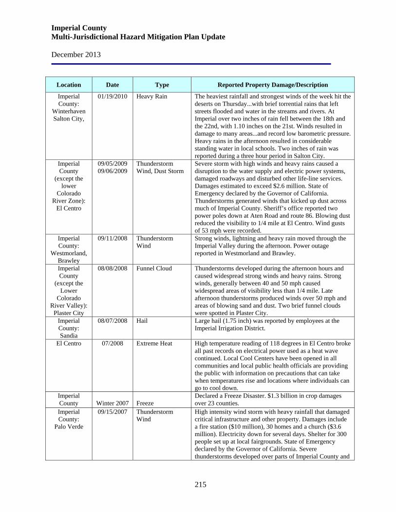
Imperial County Multi-Jurisdictional Hazard Mitigation Plan Update December 2013
215
Location Date Type Reported Property Damage/Description
Imperial County:
Winterhaven Salton City,
01/19/2010 Heavy Rain The heaviest rainfall and strongest winds of the week hit the deserts on Thursday...with brief torrential rains that left streets flooded and water in the streams and rivers. At Imperial over two inches of rain fell between the 18th and the 22nd, with 1.10 inches on the 21st. Winds resulted in damage to many areas...and record low barometric pressure. Heavy rains in the afternoon resulted in considerable standing water in local schools. Two inches of rain was reported during a three hour period in Salton City.
Imperial County
(except the lower
Colorado River Zone):
El Centro
09/05/2009 09/06/2009
Thunderstorm Wind, Dust Storm
Severe storm with high winds and heavy rains caused a disruption to the water supply and electric power systems, damaged roadways and disturbed other life-line services. Damages estimated to exceed $2.6 million. State of Emergency declared by the Governor of California. Thunderstorms generated winds that kicked up dust across much of Imperial County. Sheriff’s office reported two power poles down at Aten Road and route 86. Blowing dust reduced the visibility to 1/4 mile at El Centro. Wind gusts of 53 mph were recorded.
Imperial County:
Westmorland, Brawley
09/11/2008 Thunderstorm Wind
Strong winds, lightning and heavy rain moved through the Imperial Valley during the afternoon. Power outage reported in Westmorland and Brawley.
Imperial County
(except the Lower
Colorado River Valley):
Plaster City
08/08/2008 Funnel Cloud Thunderstorms developed during the afternoon hours and caused widespread strong winds and heavy rains. Strong winds, generally between 40 and 50 mph caused widespread areas of visibility less than 1/4 mile. Late afternoon thunderstorms produced winds over 50 mph and areas of blowing sand and dust. Two brief funnel clouds were spotted in Plaster City.
Imperial County: Sandia
08/07/2008 Hail Large hail (1.75 inch) was reported by employees at the Imperial Irrigation District.
El Centro 07/2008 Extreme Heat High temperature reading of 118 degrees in El Centro broke all past records on electrical power used as a heat wave continued. Local Cool Centers have been opened in all communities and local public health officials are providing the public with information on precautions that can take when temperatures rise and locations where individuals can go to cool down.
Imperial County
Winter 2007
Freeze
Declared a Freeze Disaster. $1.3 billion in crop damages over 23 counties.
Imperial County:
Palo Verde
09/15/2007 Thunderstorm Wind
High intensity wind storm with heavy rainfall that damaged critical infrastructure and other property. Damages include a fire station ($10 million), 30 homes and a church ($3.6 million). Electricity down for several days. Shelter for 300 people set up at local fairgrounds. State of Emergency declared by the Governor of California. Severe thunderstorms developed over parts of Imperial County and
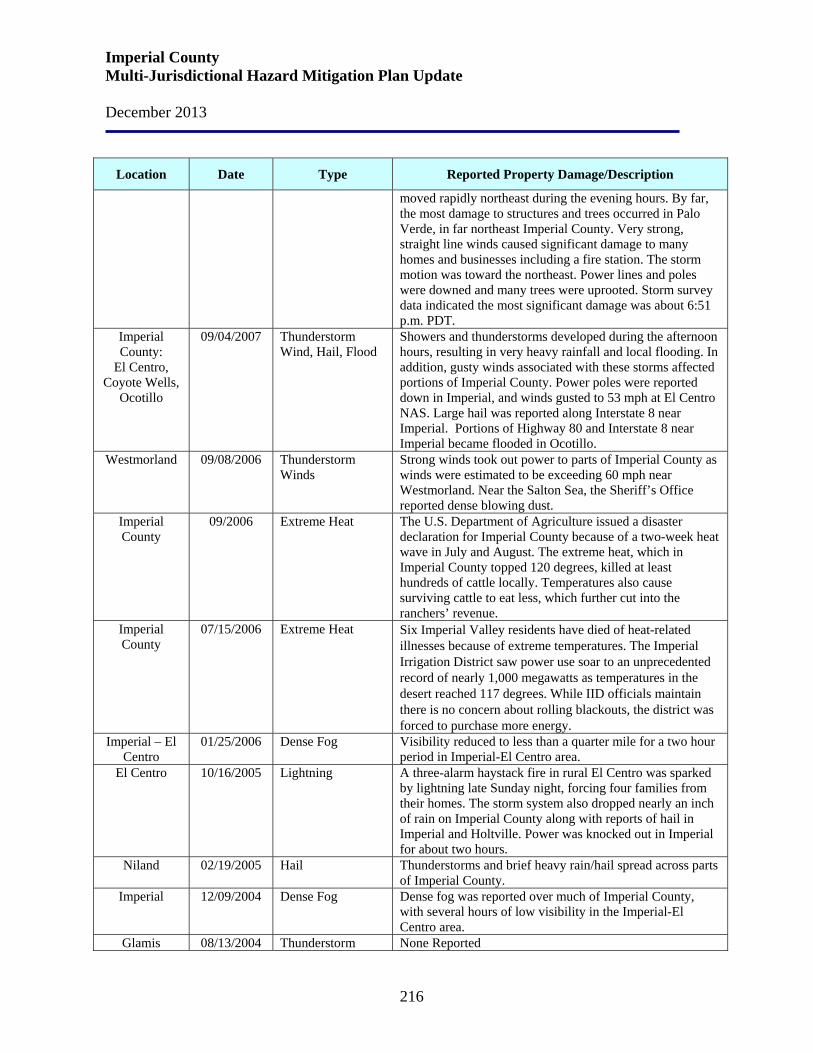
Imperial County Multi-Jurisdictional Hazard Mitigation Plan Update December 2013
216
Location Date Type Reported Property Damage/Description
moved rapidly northeast during the evening hours. By far, the most damage to structures and trees occurred in Palo Verde, in far northeast Imperial County. Very strong, straight line winds caused significant damage to many homes and businesses including a fire station. The storm motion was toward the northeast. Power lines and poles were downed and many trees were uprooted. Storm survey data indicated the most significant damage was about 6:51 p.m. PDT.
Imperial County:
El Centro, Coyote Wells,
Ocotillo
09/04/2007 Thunderstorm Wind, Hail, Flood
Showers and thunderstorms developed during the afternoon hours, resulting in very heavy rainfall and local flooding. In addition, gusty winds associated with these storms affected portions of Imperial County. Power poles were reported down in Imperial, and winds gusted to 53 mph at El Centro NAS. Large hail was reported along Interstate 8 near Imperial. Portions of Highway 80 and Interstate 8 near Imperial became flooded in Ocotillo.
Westmorland 09/08/2006 Thunderstorm Winds
Strong winds took out power to parts of Imperial County as winds were estimated to be exceeding 60 mph near Westmorland. Near the Salton Sea, the Sheriff’s Office reported dense blowing dust.
Imperial County
09/2006 Extreme Heat The U.S. Department of Agriculture issued a disaster declaration for Imperial County because of a two-week heat wave in July and August. The extreme heat, which in Imperial County topped 120 degrees, killed at least hundreds of cattle locally. Temperatures also cause surviving cattle to eat less, which further cut into the ranchers’ revenue.
Imperial County
07/15/2006 Extreme Heat Six Imperial Valley residents have died of heat-related illnesses because of extreme temperatures. The Imperial Irrigation District saw power use soar to an unprecedented record of nearly 1,000 megawatts as temperatures in the desert reached 117 degrees. While IID officials maintain there is no concern about rolling blackouts, the district was forced to purchase more energy.
Imperial – El Centro
01/25/2006 Dense Fog Visibility reduced to less than a quarter mile for a two hour period in Imperial-El Centro area.
El Centro 10/16/2005 Lightning A three-alarm haystack fire in rural El Centro was sparked by lightning late Sunday night, forcing four families from their homes. The storm system also dropped nearly an inch of rain on Imperial County along with reports of hail in Imperial and Holtville. Power was knocked out in Imperial for about two hours.
Niland 02/19/2005 Hail Thunderstorms and brief heavy rain/hail spread across parts of Imperial County.
Imperial 12/09/2004 Dense Fog Dense fog was reported over much of Imperial County, with several hours of low visibility in the Imperial-El Centro area.
Glamis 08/13/2004 Thunderstorm None Reported
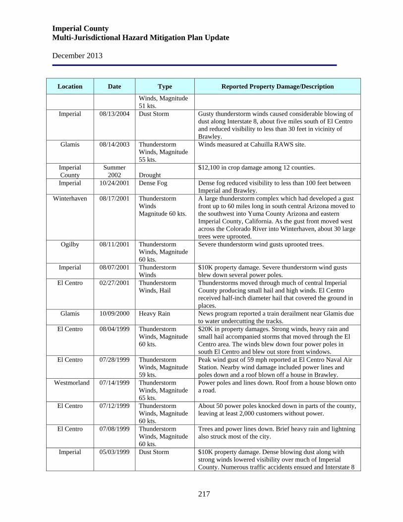
Imperial County Multi-Jurisdictional Hazard Mitigation Plan Update December 2013
217
Location Date Type Reported Property Damage/Description
Winds, Magnitude 51 kts.
Imperial 08/13/2004 Dust Storm Gusty thunderstorm winds caused considerable blowing of dust along Interstate 8, about five miles south of El Centro and reduced visibility to less than 30 feet in vicinity of Brawley.
Glamis 08/14/2003 Thunderstorm Winds, Magnitude 55 kts.
Winds measured at Cahuilla RAWS site.
Imperial County
Summer 2002
Drought
$12,100 in crop damage among 12 counties.
Imperial 10/24/2001 Dense Fog Dense fog reduced visibility to less than 100 feet between Imperial and Brawley.
Winterhaven 08/17/2001 Thunderstorm Winds Magnitude 60 kts.
A large thunderstorm complex which had developed a gust front up to 60 miles long in south central Arizona moved to the southwest into Yuma County Arizona and eastern Imperial County, California. As the gust front moved west across the Colorado River into Winterhaven, about 30 large trees were uprooted.
Ogilby 08/11/2001 Thunderstorm Winds, Magnitude 60 kts.
Severe thunderstorm wind gusts uprooted trees.
Imperial 08/07/2001 Thunderstorm Winds
$10K property damage. Severe thunderstorm wind gusts blew down several power poles.
El Centro 02/27/2001 Thunderstorm Winds, Hail
Thunderstorms moved through much of central Imperial County producing small hail and high winds. El Centro received half-inch diameter hail that covered the ground in places.
Glamis 10/09/2000 Heavy Rain News program reported a train derailment near Glamis due to water undercutting the tracks.
El Centro 08/04/1999 Thunderstorm Winds, Magnitude 60 kts.
$20K in property damages. Strong winds, heavy rain and small hail accompanied storms that moved through the El Centro area. The winds blew down four power poles in south El Centro and blew out store front windows.
El Centro 07/28/1999 Thunderstorm Winds, Magnitude 59 kts.
Peak wind gust of 59 mph reported at El Centro Naval Air Station. Nearby wind damage included power lines and poles down and a roof blown off a house in Brawley.
Westmorland 07/14/1999 Thunderstorm Winds, Magnitude 65 kts.
Power poles and lines down. Roof from a house blown onto a road.
El Centro 07/12/1999 Thunderstorm Winds, Magnitude 60 kts.
About 50 power poles knocked down in parts of the county, leaving at least 2,000 customers without power.
El Centro 07/08/1999 Thunderstorm Winds, Magnitude 60 kts.
Trees and power lines down. Brief heavy rain and lightning also struck most of the city.
Imperial 05/03/1999 Dust Storm $10K property damage. Dense blowing dust along with strong winds lowered visibility over much of Imperial County. Numerous traffic accidents ensued and Interstate 8
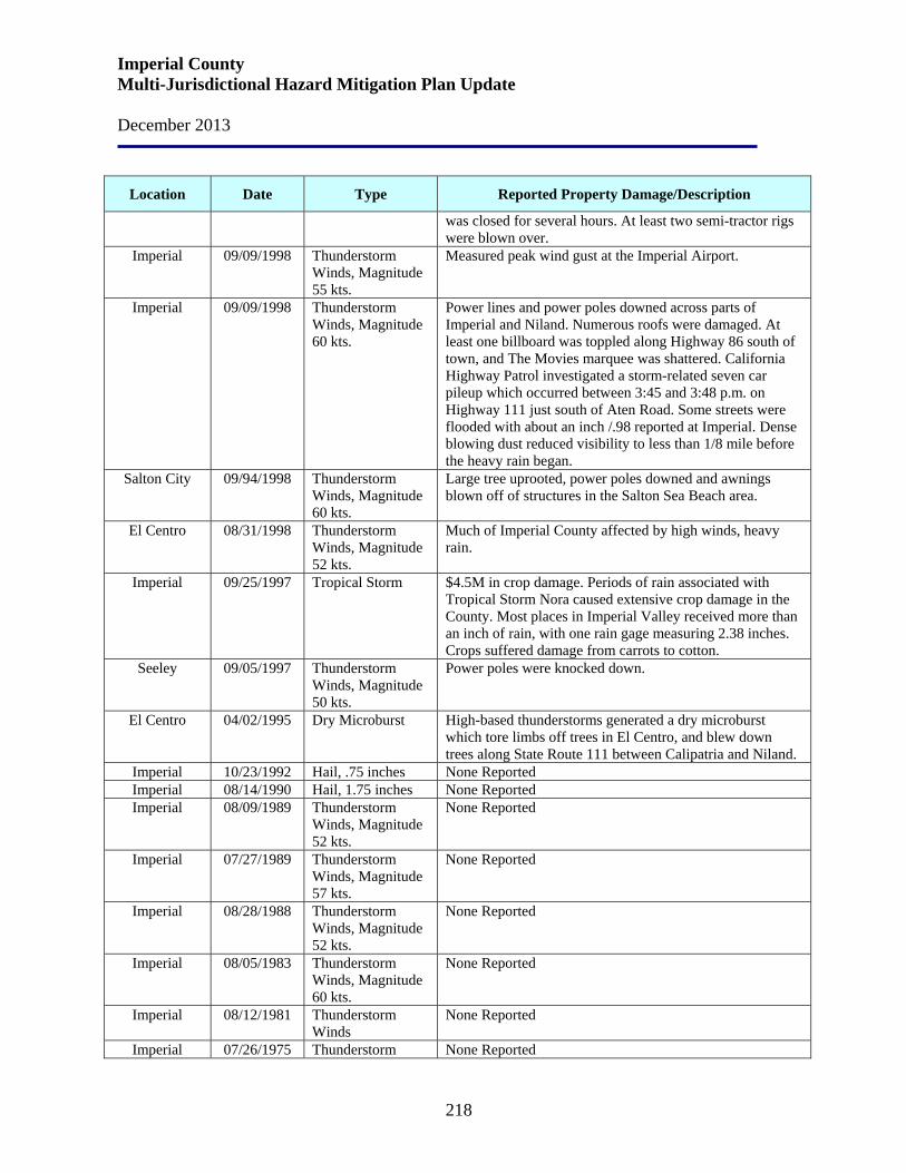
Imperial County Multi-Jurisdictional Hazard Mitigation Plan Update December 2013
218
Location Date Type Reported Property Damage/Description
was closed for several hours. At least two semi-tractor rigs were blown over.
Imperial 09/09/1998 Thunderstorm Winds, Magnitude 55 kts.
Measured peak wind gust at the Imperial Airport.
Imperial 09/09/1998 Thunderstorm Winds, Magnitude 60 kts.
Power lines and power poles downed across parts of Imperial and Niland. Numerous roofs were damaged. At least one billboard was toppled along Highway 86 south of town, and The Movies marquee was shattered. California Highway Patrol investigated a storm-related seven car pileup which occurred between 3:45 and 3:48 p.m. on Highway 111 just south of Aten Road. Some streets were flooded with about an inch /.98 reported at Imperial. Dense blowing dust reduced visibility to less than 1/8 mile before the heavy rain began.
Salton City 09/94/1998 Thunderstorm Winds, Magnitude 60 kts.
Large tree uprooted, power poles downed and awnings blown off of structures in the Salton Sea Beach area.
El Centro 08/31/1998 Thunderstorm Winds, Magnitude 52 kts.
Much of Imperial County affected by high winds, heavy rain.
Imperial 09/25/1997 Tropical Storm $4.5M in crop damage. Periods of rain associated with Tropical Storm Nora caused extensive crop damage in the County. Most places in Imperial Valley received more than an inch of rain, with one rain gage measuring 2.38 inches. Crops suffered damage from carrots to cotton.
Seeley 09/05/1997 Thunderstorm Winds, Magnitude 50 kts.
Power poles were knocked down.
El Centro 04/02/1995 Dry Microburst High-based thunderstorms generated a dry microburst which tore limbs off trees in El Centro, and blew down trees along State Route 111 between Calipatria and Niland.
Imperial 10/23/1992 Hail, .75 inches None Reported Imperial 08/14/1990 Hail, 1.75 inches None Reported Imperial 08/09/1989 Thunderstorm
Winds, Magnitude 52 kts.
None Reported
Imperial 07/27/1989 Thunderstorm Winds, Magnitude 57 kts.
None Reported
Imperial 08/28/1988 Thunderstorm Winds, Magnitude 52 kts.
None Reported
Imperial 08/05/1983 Thunderstorm Winds, Magnitude 60 kts.
None Reported
Imperial 08/12/1981 Thunderstorm Winds
None Reported
Imperial 07/26/1975 Thunderstorm None Reported
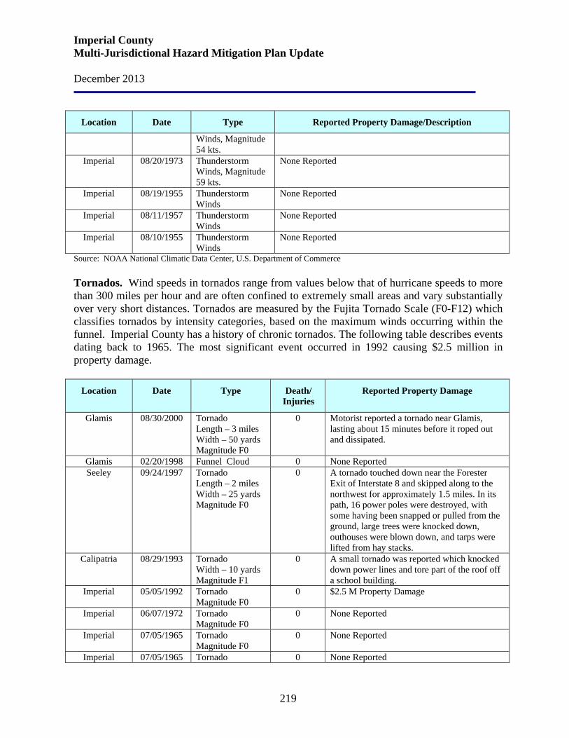
Imperial County Multi-Jurisdictional Hazard Mitigation Plan Update December 2013
219
Location Date Type Reported Property Damage/Description
Winds, Magnitude 54 kts.
Imperial 08/20/1973 Thunderstorm Winds, Magnitude 59 kts.
None Reported
Imperial 08/19/1955 Thunderstorm Winds
None Reported
Imperial 08/11/1957 Thunderstorm Winds
None Reported
Imperial 08/10/1955 Thunderstorm Winds
None Reported
Source: NOAA National Climatic Data Center, U.S. Department of Commerce Tornados. Wind speeds in tornados range from values below that of hurricane speeds to more than 300 miles per hour and are often confined to extremely small areas and vary substantially over very short distances. Tornados are measured by the Fujita Tornado Scale (F0-F12) which classifies tornados by intensity categories, based on the maximum winds occurring within the funnel. Imperial County has a history of chronic tornados. The following table describes events dating back to 1965. The most significant event occurred in 1992 causing $2.5 million in property damage.
Location Date Type Death/ Injuries
Reported Property Damage
Glamis 08/30/2000 Tornado Length – 3 miles Width – 50 yards Magnitude F0
0 Motorist reported a tornado near Glamis, lasting about 15 minutes before it roped out and dissipated.
Glamis 02/20/1998 Funnel Cloud 0 None Reported Seeley 09/24/1997 Tornado
Length – 2 miles Width – 25 yards Magnitude F0
0 A tornado touched down near the Forester Exit of Interstate 8 and skipped along to the northwest for approximately 1.5 miles. In its path, 16 power poles were destroyed, with some having been snapped or pulled from the ground, large trees were knocked down, outhouses were blown down, and tarps were lifted from hay stacks.
Calipatria 08/29/1993 Tornado Width – 10 yards Magnitude F1
0 A small tornado was reported which knocked down power lines and tore part of the roof off a school building.
Imperial 05/05/1992 Tornado Magnitude F0
0 $2.5 M Property Damage
Imperial 06/07/1972 Tornado Magnitude F0
0 None Reported
Imperial 07/05/1965 Tornado Magnitude F0
0 None Reported
Imperial 07/05/1965 Tornado 0 None Reported
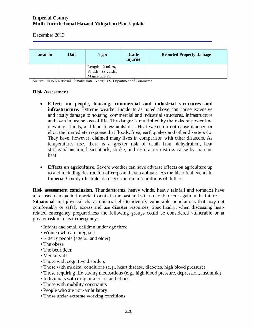
Imperial County Multi-Jurisdictional Hazard Mitigation Plan Update December 2013
220
Location Date Type Death/ Injuries
Reported Property Damage
Length - 2 miles, Width - 33 yards, Magnitude F1
Source: NOAA National Climatic Data Center, U.S. Department of Commerce Risk Assessment
• Effects on people, housing, commercial and industrial structures and infrastructure. Extreme weather incidents as noted above can cause extensive and costly damage to housing, commercial and industrial structures, infrastructure and even injury or loss of life. The danger is multiplied by the risks of power line downing, floods, and landslides/mudslides. Heat waves do not cause damage or elicit the immediate response that floods, fires, earthquakes and other disasters do. They have, however, claimed many lives in comparison with other disasters. As temperatures rise, there is a greater risk of death from dehydration, heat stroke/exhaustion, heart attack, stroke, and respiratory distress cause by extreme heat.
• Effects on agriculture. Severe weather can have adverse effects on agriculture up
to and including destruction of crops and even animals. As the historical events in Imperial County illustrate, damages can run into millions of dollars.
Risk assessment conclusion. Thunderstorms, heavy winds, heavy rainfall and tornados have all caused damage to Imperial County in the past and will no doubt occur again in the future. Situational and physical characteristics help to identify vulnerable populations that may not comfortably or safely access and use disaster resources. Specifically, when discussing heat-related emergency preparedness the following groups could be considered vulnerable or at greater risk in a heat emergency:
• Infants and small children under age three • Women who are pregnant • Elderly people (age 65 and older) • The obese • The bedridden • Mentally ill • Those with cognitive disorders • Those with medical conditions (e.g., heart disease, diabetes, high blood pressure) • Those requiring life‐saving medications (e.g., high blood pressure, depression, insomnia) • Individuals with drug or alcohol addictions • Those with mobility constraints • People who are non‐ambulatory • Those under extreme working conditions
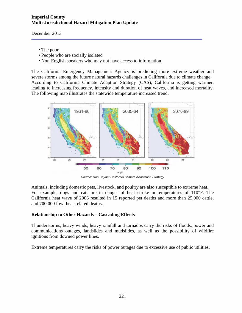
Imperial County Multi-Jurisdictional Hazard Mitigation Plan Update December 2013
221
• The poor • People who are socially isolated • Non‐English speakers who may not have access to information
The California Emergency Management Agency is predicting more extreme weather and severe storms among the future natural hazards challenges in California due to climate change. According to California Climate Adaption Strategy (CAS), California is getting warmer, leading to increasing frequency, intensity and duration of heat waves, and increased mortality. The following map illustrates the statewide temperature increased trend.
Source: Dan Cayan; California Climate Adaptation Strategy
Animals, including domestic pets, livestock, and poultry are also susceptible to extreme heat. For example, dogs and cats are in danger of heat stroke in temperatures of 110°F. The California heat wave of 2006 resulted in 15 reported pet deaths and more than 25,000 cattle, and 700,000 fowl heat‐related deaths. Relationship to Other Hazards – Cascading Effects Thunderstorms, heavy winds, heavy rainfall and tornados carry the risks of floods, power and communications outages, landslides and mudslides, as well as the possibility of wildfire ignitions from downed power lines. Extreme temperatures carry the risks of power outages due to excessive use of public utilities.

Imperial County Multi-Jurisdictional Hazard Mitigation Plan Update December 2013
222
5.4 Hazard: Wildfire Jurisdictions Affected by Wildfire Wildfire risk probability and risk severity assessments listed below were identified by the Hazard Mitigation Working Group as related to the County and participating communities. Imperial County Probability: High Imperial County Severity: Medium
Brawley Probability: Medium Brawley Severity: Low
Calexico Probability: Medium Calexico Severity: Low
Calipatria Probability: Medium Calipatria Severity: Low
El Centro Probability: Very Low El Centro Severity: Very Low
Holtville Probability: Medium Holtville Severity: Low
Imperial City Probability: Low Imperial City Severity: High
Westmorland Probability: Medium Westmorland Severity: Low
Imperial Irrigation District Probability: Medium Imperial Irrigation District Severity: Low
Office of Education Probability: Low (However, some schools near crop production/ haystack fire areas may have a High Probability rating.)
Office of Education Severity: Low (However, some schools near haystack fire areas can cause severe consequences and may have a High Severity rating.)
Hazard Definition A wildfire is an uncontrolled fire spreading through vegetative fuels, posing danger and destruction to property. Wildfires can occur in undeveloped areas and spread to urban areas where structures and other human development are more concentrated (wildland-urban interface [WUI] fire).
Imperial County Multi-Jurisdictional Hazard Mitigation Plan Update December 2013
223
Fires that occur within the urban-wildland interface areas affect natural resources as well as life and property. This type of fire is described as “a fire moving from a wildland environment, consuming vegetation for fuel, to an environment where structures and buildings are fueling the fire” (California Resources Agency, 1996). While some wildfires start by natural causes, humans cause four out of every five wildfires. Wildfires started by humans are usually the result of debris burns, arson, or carelessness. As a natural hazard, a wildfire is often the direct result of a lightning strike that may destroy personal property and public land areas, especially on state and national forest lands. The predominate dangers from wildfires are:
• the destruction of timber, property, wildlife; and • injury or loss of life to people living in the affected area or using the area for recreational
facilities History The potential for wildfire or a major fire in the unincorporated areas of Imperial County is generally low. Fire hazards exist, however, at two different sites in the County: at the fuel storage farms located south of the City of Imperial and east of Niland. In the event of a fire, assistance from various fire departments within the County would be required. The threat of fire spreading and causing major problems to other areas of the County are minimal due to the isolated locations of the fuel storage farms. Risk Assessment In the event of wildland fires impacting Imperial County, the County’s Air Pollution Control District and the California Air Resources Board will immediately disallow and stop all agricultural and residential burning in Imperial County to ensure that no additional emissions are added to the emissions from the unwanted wildland fires.
• Effects on people and structures. In addition to damaging natural environments and health hazards of wildfire smoke, wildfires can injure and kill residents and firefighters, as well as damage or destroy structures and personal property.
• Effects on infrastructure. In addition to damaging residences and structures and
injuring and killing residents and firefighters, wildfires also deplete water reserves, down power lines, disrupt telephone service, and block roads. They can also indirectly cause floods, if flood control facilities are inadequate to handle an increase in storm runoff, sediment, and debris that is likely to be generated from barren, burned-over hillsides.
Imperial County Multi-Jurisdictional Hazard Mitigation Plan Update December 2013
224
• Effects on agriculture. Effects on agriculture can be devastating. In addition to the obvious impacts on animals and crops, wildfire can have deleterious effects on soil and water that will impact agriculture for an extended period of time.
Risk assessment conclusion. The potential for wildfires in Imperial County is very low due to the desert and agriculture topography of the County. The potential for loss of life and property from urban fire hazards is greatest in places where large groups of people gather, such as offices, stores, hotels, and theaters. Uses which may suffer large monetary losses due to a major fire include businesses, factories, and shopping areas. Relationship to Other Hazards – Cascading Effects Flooding, erosion and air pollution. Major wildfires can completely destroy ground cover. If heavy rains follow a major fire, flash floods, heavy erosion, landslides and mudflows can occur. Agricultural pesticides in storage that are affected by wildfire could cause severe consequences. Wildfires can also affect the air quality throughout the County. These cascading effects can have ruinous impacts on people, structures, infrastructure, and agriculture. Plans and Programs Imperial County In the event of wildland fires impacting Imperial County, the County’s Air Pollution Control District and the California Air Resources Board will immediately disallow and stop all agricultural and residential burning in Imperial County to ensure that no additional emissions are added to the emissions from the unwanted wildland fires. The most significant regulatory codes from the standpoint of fire safety for Imperial County are fire prevention and building codes. The County implements the Uniform Building Code (UBC) and the Uniform Fire Code (UFC). These uniform codes are intended to serve only as minimum standards. Therefore, it is important that these minimum fire safety standards be strictly enforced by fire and building agencies in the unincorporated County. The Imperial County Codified Zoning Ordinance also contains provisions which act to reduce fire hazards. The Zoning Ordinance is a tool that helps prevent the construction of incompatible or hazardous structures. For example, the ordinance separates industrial, commercial and residential uses and provides for the isolation of land uses that may create excessive fire exposure to other properties. It also limits the height and bulk of buildings, specifies setbacks and distances between buildings. The Imperial County Subdivision Ordinance is also used to reduce the risk of fire by securing, as a condition of subdivision of land, water systems of adequate size and pressure for firefighting, and adequate roadway widths for emergency service vehicle access including maneuverability of fire trucks. As part of the review process, the Imperial County Planning
Imperial County Multi-Jurisdictional Hazard Mitigation Plan Update December 2013
225
Department seeks recommendations from Fire and Water Districts wherever the proposed subdivision is located. The County of Imperial Fire Prevention and Explosives Ordinance, Section 53101-53300, contains provisions for the purpose of prescribing regulations governing conditions hazardous to life and property from fire or explosion. Such measures in this Ordinance include the following:
• Storage of flammable materials • Storage of radioactive materials • Permit required for sale and use of fireworks • Abatement of weeds and other vegetation
The Fire Prevention Education Program encompasses a public information and education component that promotes public awareness of the significance of Fire/Safety prevention measures. This program enables the public to be better prepared when an emergency fire situation occurs. City of Brawley The City of Brawley is subject to both wildland fire and urban fire hazards which results from a number of causes, including arson, carelessness, home or industrial accidents, or from ignorance of proper procedures for home or business repairs. Fire is a potential hazard which requires adequate firefighting and fire protection services, and adequate water pressure. Following are the City of Brawley’s Fire Hazards Goal and Policies: Goal #4: Promote policies and programs that reduce the risk to the community’s inhabitants from fires or explosions.
Policy 4.1: Work closely with the City Fire Department to continue to operate an education program regarding fire hazards for residential, commercial, industrial and agricultural uses.
Policy 4.2: Encourage the use of fire retardant roofing materials.
Policy 4.3: Establish and maintain mutual aid agreements with surrounding jurisdictions for fire protection.
Policy 4.4: Enforce building code requirements that assure adequate fire protection.
Policy 4.5: Study alternatives for upgrading emergency water line capacities in deficient areas.
Policy 4.6: Maintain service agreements with the Imperial County Fire Department, if financially feasible.
Policy 4.7: Continue to enforce the weed abatement program.

Imperial County Multi-Jurisdictional Hazard Mitigation Plan Update December 2013
226
City of Calexico The City of Calexico has a low risk of damage from wildfires. The undeveloped areas around and outside of the City are either irrigated farm land or sparsely vegetated desert land. Therefore there is little risk from wildfires due to lack of fuel. The City currently has two existing fire stations; of note is that these fire stations are located on either side of the Union Pacific railroad tracks. There is currently a proposal to build a new station. The City of Calexico has a fire hazard rating of 5 from the ISO (Insurance Service Office) Commercial Risk Services, Inc. The rating is based on a 1 to 10 scale with 10 being the greatest risk and considers many factors, including adequate water pressure and supply (in addition to the City’s maximum rate of consumption for purposes other than firefighting), fire equipment, personnel, response time, etc. Downtown Calexico is susceptible to fires because many of the structures were built in the early 1900’s and are constructed of wood and some buildings lack space between them, thus increasing the chances that a fire could spread to numerous buildings. Also, many of the buildings in downtown Calexico have not been retrofitted for seismic activity and do not contain sprinkler systems. The City’s emergency services providers, such as fire and police, are currently cooperating with the Imperial Valley Emergency Communications Authority (IVECA) and Regional Communications System (RCS) for the coordinated efforts valley-wide to integrate communication within Imperial County and between the County and San Diego County. The Calexico Fire Department is a member of the Imperial Valley Firefighters Strike Force which is responsible to respond to fire emergencies throughout California. The Department is also a member of the Imperial Valley Hazardous Materials Response Team and is available to respond to hazardous materials emergencies throughout Imperial County. The Department also has a Fire Prevention Bureau headed by the inspector and administers inspections, occupancy permits, and various safety programs throughout the City. Following are the City of Calexico’s Fire Hazards Objectives and Policies: Objective 3: Minimize the potential hazards to public health, safety, and welfare and prevent the loss of life and property damage from natural and human induced phenomena. Policy 3
a. The City shall ensure the adequacy of existing emergency preparedness plans to handle effectively and efficiently known hazards and emergencies.
b. The City shall review evacuation procedures to make sure that in case of an evacuation, the residents of Calexico will be quickly notified and that the evacuation will be orderly.
c. The City shall work with the Calexico Water Department to ensure that an adequate supply of water will be available in the event of an emergency and to help create and maintain an emergency water supply.
Imperial County Multi-Jurisdictional Hazard Mitigation Plan Update December 2013
227
d. The Calexico Fire Department should review an update the need for additional fire hydrants and shall work with the Calexico Water Department to ensure that adequate water pressures for fire flows are maintained.
e. The City shall require the heads and staff of each department to participate in the maintenance of a city-wide emergency preparedness plan.
City of Calipatria Fire is a unique hazard in that it can result both from natural processes and from the intentional or accidental actions of people. There are three main types of fire hazards:
1. Wildfires, which affect open space and development on the urban fringe; 2. Structural fires, which occur in buildings; and 3. Commercial/industrial fires, which generally result from the ignition of flammable materials.
The California Department of Forestry and Fire Protection designates portions of Calipatria as moderate fire hazard zones, according to the Local Responsibility Area map. The Calipatria Fire Department provides fire suppression services to the City, as well as the unincorporated areas of Imperial County surrounding the City. The department renews its contract with the county each year to cover approximately 250 square miles of unincorporated county land. In addition, the department has aid agreements with El Centro and Niland Fire Districts. The department has established a minimum fire flow of 500 gallons of water per minute for all hydrants in the City. When new development projects are proposed, the water systems are reviewed by the City Engineer and Fire Chief. The developer must demonstrate that the water system can provide at least a 500 gallon per minute fire flow. Fire hydrants are required in all new development projects and water main systems are required to be looped to provide a steady pressure. Generally, 8-inch water mains are required in all new developments. The Fire Department is also responsible for the identification and correction of fire hazards throughout the City. Following are Calipatria’s fire hazards Goals and Policies:
Goal S-3 Minimize the potential for loss of life, physical injury, property damage, and social disruption resulting from fires.
Policy S-3.1 Require all new development within Calipatria to comply with applicable provisions of the Uniform Fire Code and National Electrical Code.
Policy S-3.2 Require Fire Department review and approval of all new development projects within Calipatria to ensure minimum fire access and safety standards are met.
Policy S-3.3 Require that new development be supplied with adequate water supply and street dimensions are standardized to meet emergency access requirements.
Policy S-3.4 Monitor and measure fire-flow capability for Calipatria’s water system and improve water availability to those sections of the City with inadequate fire flow protection.
Imperial County Multi-Jurisdictional Hazard Mitigation Plan Update December 2013
228
Policy S-3.5 Continue and enhance as necessary the provisions of mutual aid agreements for fire protection.
Policy S-3.6 Require design elements in new development projects that enhance fire protection capability, such as sprinklers, fire resistive materials, and other appropriate features.
Policy S-3.7 Promote fire prevention as the City’s preferred management strategy; facilitate programs that are aimed at the prevention of fires, such as monitoring abandoned and vacant structures/sites for excessive weeds, brush, trash, and other combustible materials.
Policy S-3.8 Promote multi-jurisdictional emergency coordination and planning for fire events. Following are the City of Calipatria’s Implementation Actions for the adopted policies:
• Work closely with Imperial County Division of Building and Safety during the development review process to ensure that any new and existing developments adhere to applicable provisions of the Uniform Fire Code and National Electrical Code, verifying that projects comply with requirements such as street widths, access areas, and maneuvering areas sufficient to allow fire protection and emergency vehicles access to structures (Implements Policies S-3.1, S-3.2, S-3.3, S-3.4, S-3.6 and S-3.7).
• Work closely with Golden State water Company to ensure that sufficient water supplies are available for protection of structures (Policies S-3.3, S-3.4, and S-3.6).
• Continue to participate in the planning and development of the Imperial County Multi-Hazard Mitigation Plan and comply with the mitigation goals and strategies therein (Policies S-3.5 and S-3.8).
City of El Centro Loss of life and damage to structures and open space due to fire constitutes a hazard to public safety. Fire risks can be reduced through proper land use planning, enforcement of the building standards and through public education. Following are El Centro’s Fire Hazards Goals and Policies. Safety Goal 3: Ensure that the Fire Department continues to protect the health, safety, and general welfare of the citizens of El Centro by educating the public about fire hazards and reducing the risk associated with fire hazards.
Policy 3.1: Identify and evaluate potentially hazardous fire risks in the community and educate the public about the safety hazard associated with these risks.
Policy 3.2: Maintain fire prone areas to lessen recurrent fire problems and include necessary improvements in the City’s Capital Improvement Program.
Policy 3.3: Avoid new development that would create major increases in fire risk that may cause the City’s existing firefighting capacity to be exceeded.
Imperial County Multi-Jurisdictional Hazard Mitigation Plan Update December 2013
229
Policy 3.4: Maintain efficient, 24-hour fire protection by providing the Fire Department with adequate funding, facilities, equipment, and training, and identify new funding sources as necessary. Following are the City of El Centro’s Implementation Program to implement the adopted policies. S-8: Fire Risk Reduction: Reduce the risk to the community from hazards related to brush and structural fires by requiring feasible mitigation of such impacts on existing development, new development and redevelopment. Assess development proposals for potential hazards pursuant to the California Environmental Quality Act. Require measures to mitigate all identified significant public safety hazards. Responsible Agency/Department: Development Services, Fire Department Funding Source: Project proponent Time Frame: Ongoing Related Policies: 3.2, 3.3 S-9: Promote Fire Prevention: Promote Fire Prevention in El Centro in the following ways:
• Direct the El Centro Fire Department to implement fire hazard education and fire prevention programs, including weed abatement programs;
• Coordinate with the City’s Planning Department, Imperial Irrigation District;
(IID), and the El Centro Fire Department to ensure that water pressure for existing developed areas and sites to be developed is adequate for firefighting purposes;
• Adopt and implement the most recent Uniform Fire Code provisions and appropriate amendments to reflect the unique El Centro topography, vegetation and urban form; and
• Review and revise the Fire Department budget, as necessary, to ensure adequate protection.
Responsible Agency/Department: Fire Department, Community Services, IID Funding Source: General Fund Time Frame: Ongoing Related Policies: 3.1, 3.4 S-10: Signal Preemption Program: Continue to implement the signal preemption program allowing emergency vehicles to preempt signalized traffic lights in order to reduce response time to emergencies. Responsible Agency/Department: Public Works Funding Source: General Fund Time Frame: Ongoing Related Policies: 3.4
Imperial County Multi-Jurisdictional Hazard Mitigation Plan Update December 2013
230
City of Holtville Fire damage and fire safety tend to be the most visible to the local citizens; therefore, the City of Holtville has established the following programs.
• Identify and evaluate hazardous fire situations and hazardous locations. Make such information available to the public and/or property owners.
• Continue to identify and analyze fire department workload and efficiency.
• Provide 24 hour-per-day fire protection for all emergencies, to establish and maintain optimum fire insurance rating.
• Conduct a City-wide study of fire generation and response behavior near various disaster conditions.
• Encourage and continue the efficiency of the fire department by upgrading equipment, facilities and training.
• Coordinate a joint-powers agreement between other emergency service providers and establish a well-coordinated emergency response program.
• Obtain special “hazardous material” handling training for all fire protection personnel.
City of Imperial The potential for a major fire in the unincorporated areas of the County is generally low. Fire hazards exist, however, at two different sites in the County at the fuel storage farms located south of the City of Imperial and east of Niland. In the event of a fire, assistance from various fire departments within the County would be required. The threat of fire spreading and causing major problems to other areas of the County are minimal due to the isolated locations of the fuel storage farms. Following are the City of Imperial’s Wildland and Urban Fire Hazards Objectives and Policies. Objective 8: Minimize exposure to the public to wildland and urban fires and protect the public to the maximum extent possible when fires do occur. Ensure the City has adequate firefighting capability. Policy 8
A. Establish and maintain an active fire hazard inspection program through the fire department.
B. Require property owners to keep vacant lots and land parcels within the City clear of excessive brush and other combustible debris.
C. Ensure new development projects contain adequate water systems and fire hydrants for fire protection.
D. Ensure abandoned buildings and structures are properly boarded up to prevent access and the possibility of fire.
Imperial County Multi-Jurisdictional Hazard Mitigation Plan Update December 2013
231
E. Consider the need for a new fire station to serve areas of the City east of the Southern Pacific railroad tracks.
F. Maintain mutual aid agreements with other cities and agencies to help ensure adequate assistance to extinguish major fires.
G. Ensure that farmers burning agricultural fields within the City’s planning area have the proper burn permit and personnel/equipment to control the fire and prevent hazards to the public.
H. Report illegal burning activities to the County Agricultural Commissioner and Air Pollution Control Officer. Primary responsibility for this activity would be undertaken by the police department and/or fire department.
Objective 9: Ensure adequate road widths and clearances around structures to enable emergency vehicles to obtain fast and efficient access to all areas of the City during fires, earthquakes, and other emergencies. Policy 9
A. Maintain a minimum design standard for residential streets that dictates a 40 foot street width, face of curb to face of curb.
B. Ensure cul-de-sac streets have an adequate radius to allow for maneuvering of fire trucks and other emergency vehicles.
C. Prohibit angle parking in cul-de-sacs and ensure all vehicles park parallel to the curb, thereby allowing adequate room for emergency vehicles.
D. Ensure that setbacks for structures on corner lots are at least 10 feet in order to provide adequate clearance for large fire fighting vehicles.
E. All multiple family development projects shall provide two unobstructed fire access lanes at least 12 feet in width with at least a 35 foot radius for all curb returns.
F. All multiple family development projects shall have direct access to a public street at least 40 feet in width to ensure adequate emergency vehicle access.
G. Ensure that cul-de-sac streets are a maximum length of 600 feet and that they are clearly delineated on the official City map provided to the police and fire departments.
H. All alleys within the City shall be kept free of obstacles and debris and shall provide at least a 12 foot unobstructed access for emergency vehicles.
Imperial County Multi-Jurisdictional Hazard Mitigation Plan Update December 2013
232
City of Westmorland Following are the City of Westmorland’s Wildfires, Structure Fires and Other Fires Hazards Goal, Objective and Policies. Goal #1: Protect the public from natural and man-made hazards.
Objectives 1.5: Protect the public from wildfires, structure fires and other fires.
Policies:
1. Implement zoning and subdivision regulations which require street widths, access areas and maneuvering areas sufficient to allow fire protection and emergency vehicles access to structures.
2. Implement fire-flow requirements for new developments and improve water availability to those sections of the City with inadequate fire flow protection.
3. Incorporate design elements in development projects that enhance fire protection capability. Such items would include smoke alarms, fire sprinklers, fire resistive materials and other appropriate features.
4. Continue and enhance as necessary the provisions of mutual aid agreements for fire protection.
5. Ensure that abandoned and vacant structures/sites are kept free from excessive weeks, brush, trash and other combustible materials thereby reducing fire hazards.
6. Vigorously enforce the provisions of the Uniform Fire Code and National Electrical Code to ensure structures do not become fire hazards.
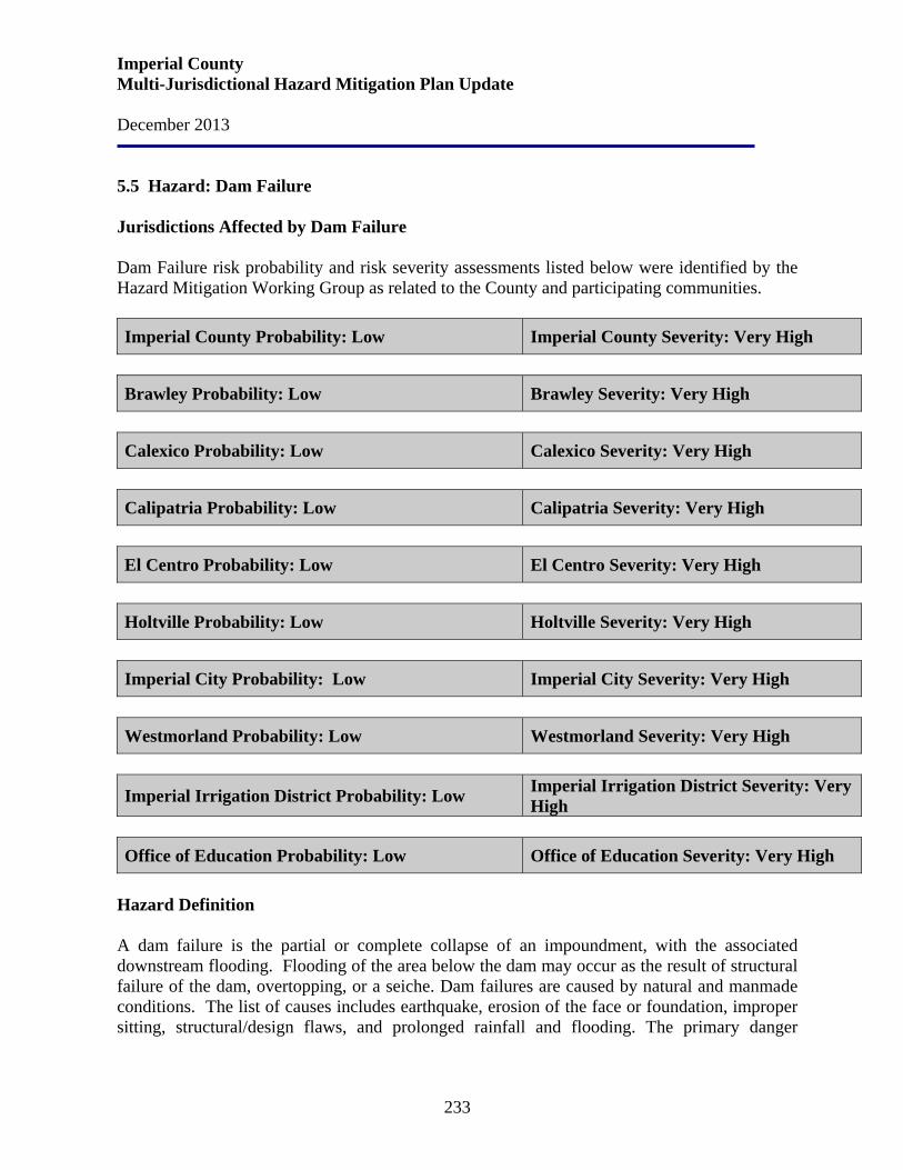
Imperial County Multi-Jurisdictional Hazard Mitigation Plan Update December 2013
233
5.5 Hazard: Dam Failure Jurisdictions Affected by Dam Failure Dam Failure risk probability and risk severity assessments listed below were identified by the Hazard Mitigation Working Group as related to the County and participating communities. Imperial County Probability: Low Imperial County Severity: Very High
Brawley Probability: Low Brawley Severity: Very High
Calexico Probability: Low Calexico Severity: Very High
Calipatria Probability: Low Calipatria Severity: Very High
El Centro Probability: Low El Centro Severity: Very High
Holtville Probability: Low Holtville Severity: Very High
Imperial City Probability: Low Imperial City Severity: Very High
Westmorland Probability: Low Westmorland Severity: Very High
Imperial Irrigation District Probability: Low Imperial Irrigation District Severity: Very High
Office of Education Probability: Low Office of Education Severity: Very High
Hazard Definition A dam failure is the partial or complete collapse of an impoundment, with the associated downstream flooding. Flooding of the area below the dam may occur as the result of structural failure of the dam, overtopping, or a seiche. Dam failures are caused by natural and manmade conditions. The list of causes includes earthquake, erosion of the face or foundation, improper sitting, structural/design flaws, and prolonged rainfall and flooding. The primary danger
Imperial County Multi-Jurisdictional Hazard Mitigation Plan Update December 2013
234
associated with a dam failure is the swift, unpredictable flooding of those areas immediately downstream of the dam. There are three general types of dams: earth and rock fill, concrete arch or hydraulic fill, and concrete gravity. Each of these types of dams has different failure characteristics. The earth and rock fill dam will fail gradually due to erosion of the breach; a flood wave will build gradually to a peak and then decline until the reservoir is empty. A concrete arch or hydraulic fill dam will fail almost instantaneously; with a very rapid build-up to a peak and then a gradual decline. A concrete gravity dam will fail somewhere in between instantaneous and gradual, with corresponding build-up of flood wave. History In Imperial County, there are three major dams - Imperial, Laguna, and Senator Wash, located on the Colorado River; and in the irrigated area, several large, earth fill impoundment reservoirs; hundreds of miles of above ground level earth levee canals, and hundreds of check dams, drops and gates.
The Imperial Dam owned by the Department of the Interior but operated by the Imperial Irrigation District, is a dam near Yuma, Arizona, built in the 1930s. It diverts Colorado River water into three different canals and held the river water until it could be directed into a desilting plant before being released into the All-American Canal, the Gila River, and the Yuma project aqueduct. Imperial Dam is a diversion facility without the capacity to store and hold flows back. A concrete slab and buttress type of structure with a floating overflow weir section 3,485 ft. long including the dike. Water level of the river is raised 23 feet at the dam.
Laguna Dam provides water to irrigate towns in Imperial County and Arizona. The Laguna Dam is located on the Colorado River 13 miles northeast of Yuma, Arizona, and about five miles downstream from Imperial Dam. When completed in 1909 the Laguna Dam diverted water from the Colorado River for irrigation of about 109,000 acres of desert. Since 1948, irrigation water has been diverted at Imperial Dam. Laguna Dam now serves to protect the toe of Imperial Dam and for partial regulation of river flows. This was the first dam on the Colorado River and has a structural height of 43 feet and contains 486,800 cubic yards of material.
Senator Wash Dam and Reservoir is located two miles above Laguna Dam. It is a 470 acre reservoir, with a usable capacity of 12,250 acre feet of water. Water levels are managed by the Bureau of Reclamation and operated by the Imperial Irrigation District. Land based recreational use is managed by the Bureau of Land Management. Due to seepage problems with the Squaw Lake face of the dam, the Senator Wash facility is being operated at lower than designed elevations. The Bureau of Reclamation has undertaken a 15-year study to resolve the issue.
Imperial County Multi-Jurisdictional Hazard Mitigation Plan Update December 2013
235
The All American Canal/Desalting Works is located at Imperial Dam. Comprised of six settling basins, each 270 feet wide and 770 feet long, arranged in pairs, and provides for the removal of sediment from the water as it leaves the dam, thus preventing silt from entering and clogging the canals.
The Colorado River is not a known seismically active zone and, to date, there have been no reported cases of earthquake damage to the dams there. Within the irrigated area, there have been a number of instances of levee failure from earthquakes and resultant flooding. Because of the comparatively small volumes of water involved, low head, variety of options to check or divert flows in the canals, and the ubiquitous drainage network, the flooding hazard is not great. Nevertheless, some hazard does exist and even minor flooding could be an incremental contribution to the other disruptions an earthquake might cause. Risk Assessment Flooding, due to dam failure, is a factor which could seriously affect eastern Imperial County. The California Office of Emergency Services is charged with keeping on file the "inundation map" and "dam failure response plan" for each dam in the State. The dam owner/operator is, however, responsible for map and plan preparation. Failure of any of the dams in Imperial County would certainly cause inundation of the downstream shorelines, all of the Bard - Winterhaven area, and possibly would flush large quantities of water through Mexico into the New and Alamo Rivers. Inundation of the community, however, is considered unlikely. Hazard analysis suggests that dam failure would likely occur only if heavy precipitation was coupled with significant seismic activity near the dam. With major disruptions in power and communications systems, warning may not be received from dam or reservoir sites in time to initiate an organized evacuation or broadcast warnings via emergency radio stations. If a credible prediction is initiated, then preparation for a damaging earthquake could begin and residents and business owners within dam inundation areas could be directed to assembly areas to wait for official word regarding safe re-entry. This method of direction and control could substantially reduce potential loss of life if enough warning were available.
• Effects on people and housing. The effects on people and housing can be significant. Loss of life and loss of property are very real risks. The shelter requirements for displaced persons can be enormous.
• Effects on commercial and industrial structures. Similarly, commercial and
industrial structures face risks running the gamut from significant damage to total loss.
Imperial County Multi-Jurisdictional Hazard Mitigation Plan Update December 2013
236
• Effects on infrastructure. Dam failure may be a direct or indirect cause of power outages. These outages can be extensive in geographic area and numbers of persons affected.
• Effects on agriculture. Downstream flooding caused by dam failure can cause
damage to vegetation, crops, livestock and dairy stock. In addition to the obvious impacts on animals and crops, flooding can have deleterious effects on soil and the ability to reinvigorate the agricultural activities impacted once the flood waters recede.
Risk assessment conclusion. Dam failure incidents have not been a problem in Imperial County. However, due to the seepage problems of the Senator Wash Reservoir the dam could experience an incident. Seasonal flooding with failure of run-off storage reservoirs and canals could seriously compound the risks of dam failure and additional flooding. Although Dam Failure has been assessed as a LOW probability, the impact of severity should it occur would be catastrophic. Relationship to Other Hazards – Cascading Effects Dam failure obviously causes downstream flooding. It may also lead to power failures and downed power lines. The secondary effects of dam failure can include the disruption of the local and state economies by damage to agriculture, buildings and roads, the severance of communications, the disruption of supply and delivery mechanisms, additional welfare, and emergency aid to the recovering economy. Earthquakes can endanger dams in several ways, including failure of the foundations or dams themselves due to ground failures, or through secondary effects such as seiches and landslides in the reservoir. Normal operations of dam facilities can also cause failure if any part of the dam is not operating according to the original design specifications or due to aging of the site. Any interruptions to water distribution and other water infrastructures could create a cascading effect and the disruption of the local and state economies by affecting agriculture, buildings and roads, the severance of communications, the disruption of supply and delivery mechanisms, additional welfare, and emergency aid to the recovering economy.
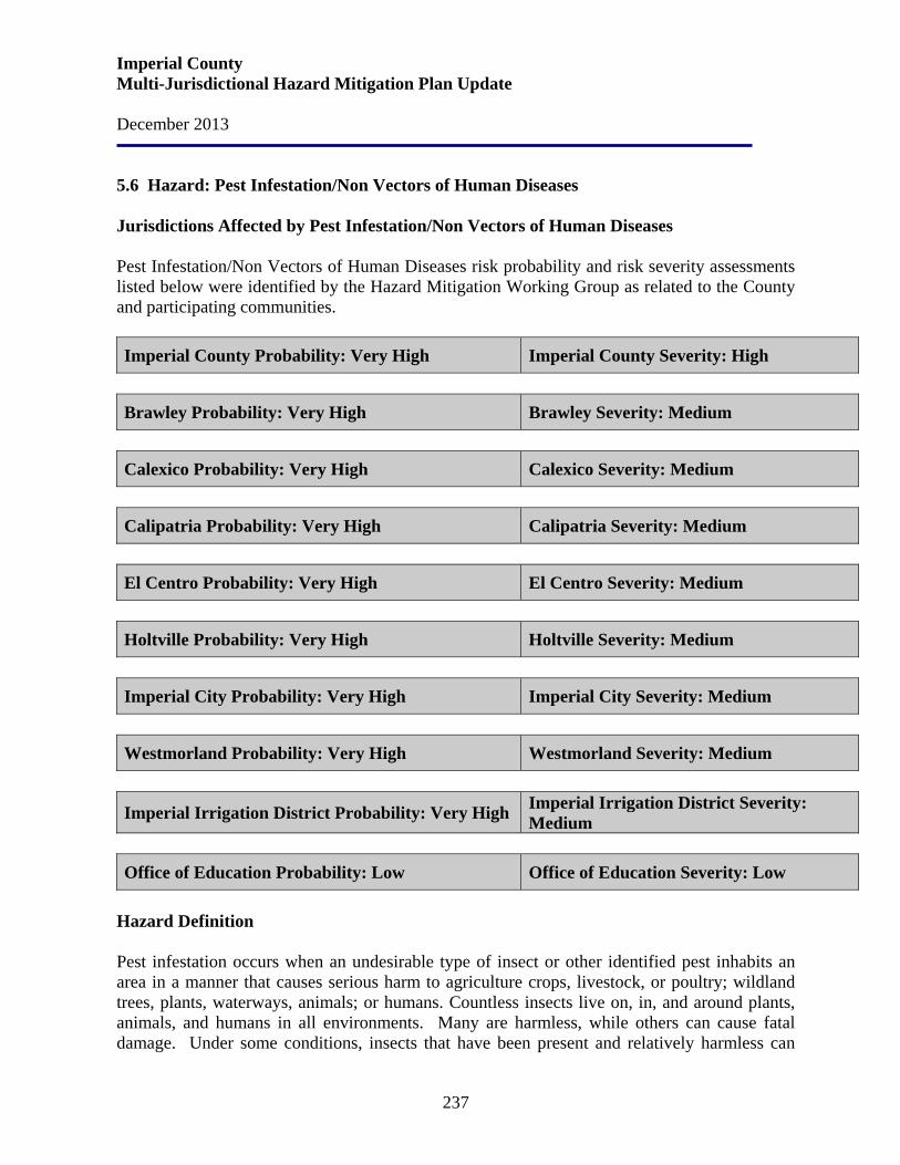
Imperial County Multi-Jurisdictional Hazard Mitigation Plan Update December 2013
237
5.6 Hazard: Pest Infestation/Non Vectors of Human Diseases Jurisdictions Affected by Pest Infestation/Non Vectors of Human Diseases Pest Infestation/Non Vectors of Human Diseases risk probability and risk severity assessments listed below were identified by the Hazard Mitigation Working Group as related to the County and participating communities. Imperial County Probability: Very High Imperial County Severity: High
Brawley Probability: Very High Brawley Severity: Medium
Calexico Probability: Very High Calexico Severity: Medium
Calipatria Probability: Very High Calipatria Severity: Medium
El Centro Probability: Very High El Centro Severity: Medium
Holtville Probability: Very High Holtville Severity: Medium
Imperial City Probability: Very High Imperial City Severity: Medium
Westmorland Probability: Very High Westmorland Severity: Medium
Imperial Irrigation District Probability: Very High Imperial Irrigation District Severity: Medium
Office of Education Probability: Low Office of Education Severity: Low
Hazard Definition Pest infestation occurs when an undesirable type of insect or other identified pest inhabits an area in a manner that causes serious harm to agriculture crops, livestock, or poultry; wildland trees, plants, waterways, animals; or humans. Countless insects live on, in, and around plants, animals, and humans in all environments. Many are harmless, while others can cause fatal damage. Under some conditions, insects that have been present and relatively harmless can
Imperial County Multi-Jurisdictional Hazard Mitigation Plan Update December 2013
238
become hazardous. For example, severe drought conditions can weaken trees and make them more susceptible to destruction from insect attacks. The major forms of insects are: Chewing insects are defoliating insects. They generally strip plants of green matter such as leaves. Caterpillars and beetles make up the largest proportion of chewing insects. Under normal conditions, trees can usually bounce back from an attack of these defoliators, though repeat infestation will weaken a tree and can eventually kill it by starving it of energy. Boring, or tunneling, insects cause damage by boring into the stem, roots, or twigs of a tree. Some lay eggs which then hatch and the larvae burrow more deeply into the wood, blocking off the water-conducting tissues of the tree. Boring insects generally feed on the vascular tissues of the tree. If the infestation is serious, the upper leaves are starved of nutrients and moisture, and the tree can die. Signs of borer infestation include entry/exit holes in the bark, small mounds of sawdust at the base, and sections of the crown wilting and dying. Sucking insects do their damage by sucking out the liquid from leaves and twigs. Many sucking insects are relatively immobile, living on the outside of a plant and forming a hard protective outer coating while they feed on the plant’s juices. Quite often they will excrete a sweet, sticky substance known as honeydew which contains unprocessed plant material. Honeydew can cause sooty mold to form on leaves and can become a nuisance. Signs of infestation include scaly formations on branches, dieback of leaves, and honeydew production. In conjunction with the above outlined problems, insects can carry and spread disease to plants, animals, and people. Other Identified Pests Hydrilla (Hydrilla Verticillata) is a plant menace, invisible that is until it fills the lake or river that it infests, "topping out" at the surface. Hydrilla can grow an inch a day. When Hydrilla invades, ecologically-important native submersed plants such as pondweeds (Potamogeton spp.), tapegrass (Vallisneria americana) and coontail (Ceratophyllum demersum) are shaded out by Hydrilla's thick mats, or are simply outcompeted, and eliminated. Hydrilla greatly slows water flow and clogs irrigation and flood-control canals and large mats of fragments collect at culverts and clog essential water control pumping stations. Dense Hydrilla infestations can alter water chemistry and oxygen levels. Quagga mussels (Dreissena Bugensis) is an invasive freshwater mollusk found in all reservoirs, lakes and watersheds receiving raw Colorado River water. Quagga mussels accumulate organic pollutants within their tissues to levels more than 300,000 times greater than typical concentrations in the environment. The mussels’ wastes significantly lower the oxygen levels, lowering the pH to an acidic level and generating toxic byproducts. The mussels have also been associated with outbreaks of botulism poisoning in wild birds. Dreissena species ability to rapidly colonize hard surfaces causes serious economic problems. These
Imperial County Multi-Jurisdictional Hazard Mitigation Plan Update December 2013
239
major biofouling organisms can clog water intake structures, such as pipes and screens, therefore reducing pumping capabilities for power and water treatment plants, costing industries, companies, and communities. Fungi. Pathogens such as fungi can kill large stands of trees. For example, Phytopthora ramorum, the cause of Sudden Oak Death, which is devastating not only for oaks, but for many other species of trees as well, is spreading rapidly. History The number one industry in Imperial County is agriculture, which provides a very significant base to the County’s economy. The total gross agricultural production value in 2004 was $1,187,254.00. Imperial County ranks as one of the top 10 agricultural counties in the State of California.
The pink hibiscus mealybug (PHM) was first detected in Imperial Valley during August 1999. This represented the first North American record for the PHM. Population densities of PHM on mulberry, silk oak, hibiscus and natal plum were determined to be high in several communities in southern Imperial Valley. A 100-square mile area in urban Imperial County was infested, including parts of El Centro and Calexico. The PHM feeds on both plants and crops, and it threatens nearly 30 different crops produced in Imperial County.
The citrus leafminer (CLM) is a small moth native to Asia. In California, CLM was found in backyard citrus in a few locations in January 2000 in Imperial County adjacent to the Mexican border. By the fall of 2001, CLM had spread to other areas of Imperial Valley and is now found from Winterhaven to Niland, attacking nursery stock; commercial groves of lemons, grapefruit, and oranges; and backyard citrus. It is expect to move northward from Imperial County and eventually infest citrus in all areas of the State. In 1991, silverleaf whitefly became a devastating pest of melon and squash crops, destroying 96% of Imperial County's fall melon crop and resulting in an estimated loss to growers of $12.5 million dollars. In succeeding years, the County's fall melon production dropped from approximately 12,000 acres annually to under 2,000 acres. In the late 1990's a related problem arose - a virus plant disease transmitted by the sweet potato whitefly resulted in $12.7 million crop damage. In Imperial County the pink bollworm caterpillar has caused the amount of land planted with cotton to drop from 140,000 acres to only 7,000 acres during the past 17 years. Imperial County alfalfa growers occasionally suffer losses to spring and summer hay cuttings due to leafhopper infestations. Three species have been found damaging alfalfa in California: the southern garden leafhopper (Empoasca solona), the potato leafhopper (E. fabae), and the Mexican leafhopper (E. mexara). All three species cause identical injury. Plants may become
Imperial County Multi-Jurisdictional Hazard Mitigation Plan Update December 2013
240
stunted and have very short intermodes. Stunting and yellowing may persist into the next cutting cycle, even in the absence of leafhoppers. The prevalent species in the Imperial Valley are E. solana and E. mexara and damage may occur from May through September. Hydrilla (Hydrilla Vertcillanta) was brought to the United States as an aquarium plant in the late 1950’s. It continues to be sold through aquarium supply dealers and over the Internet, even though the plant is on the U.S. Federal Noxious Weed List. Quagga mussels (Dreissena Bugensis) were discovered in Lake Mead in Nevada on January 6, 2007, and later throughout Lake Mead’s lower basin. It was the first discovery of either of these mussels west of the Continental Divide. Subsequent surveys found smaller numbers of Quagga mussels in Lakes Mohave and Havasu in the Colorado River, and in the Colorado River Aqueduct System which serves Southern California. Risk Assessment The climate in Imperial County makes it possible for insects to reproduce with little natural hindrance to their proliferation. Probability of infestation is very high, across the board, because it is a constant occurrence as much of Imperial County is agricultural.
• Effects of agriculture and commercial and industrial structures. If a given
insect is particularly hazardous to crops, livestock, forest, or property, it can cost the County millions of dollars in lost revenue in eradication and replacement.
• Effects on waterways. Other pest infestations (Hydrilla and Quagga Mussels)
can affect waterways and water infrastructure causing disruption to water distribution flow and negatives affects to the overall quality of the water.
Relationship to Other Hazards – Cascading Effects Insect infestation to wildland trees not only leaves dead stands of trees but, as a result, also increases the fuel available to wildfires, thereby exacerbating the negative effect on ecotourism. Risk assessment conclusion. Insect and other pest infestation is an ongoing threat to agriculture and public health in Imperial County. The effects on people and property can be disastrous and costly. Plans and Programs
In response to the Imperial Valley infestation, two parasitoid species were released at 10 infested sites in September of 1999. Approximately 3,000 parasitoids of each species from USDA insectaries were released. These initial releases were followed by additional shipments of parasitoids that were used for release and also the set-up of a PHM parasitoid rearing facility
Imperial County Multi-Jurisdictional Hazard Mitigation Plan Update December 2013
241
in Imperial Valley. The rearing facility, under the direction of the California Department of Food and Agriculture in cooperation with USDA and the Imperial County Agricultural Commissioner’s Office began producing and releasing large numbers of parasitoids by late June of 2000. The two biological control agents released against the PHM have become widely established throughout infested areas of Imperial Valley, and at least one species has had considerable impact to date.
Following are Imperial County’s Plans and Programs related to Pesticide Use Enforcement; Pest Detection and Eradication and Quarantine; and Exclusion, Nursery, Seed and Phytos.
• Permitting and monitoring of pesticide use to ensure legal and safe use of products.
• Investigation of illnesses, environmental damage, and property damage caused by pesticides.
• Detection, control, and eradication of a wide variety of exotic pests that could impact agriculture, urban landscaping and gardens, and local residents. Current programs include exotic fruit flies, red imported fire ants, Africanized honey bees, whitefly, noxious weeds, and cotton pests.
• Bee safety education.
• Growing season inspection of seed crops to facilitate foreign export of seed
• Work on a variety of biocontrol programs to control or eradicate weed and insect pest, such as puncture vine, silverleaf whitefly, and pink hibiscus mealybug, in both agricultural and urban areas.
• Help with a variety of urban landscape and garden problems, such as plant selection, planting instructions, plant care, identification and control of insect and disease pests.
• Identify and delimit new insect and disease pests that could affect local agriculture and urban landscaping and gardens.
• Fruit, vegetable, and egg quality control inspections.
• Quarantine and Pest Exclusion Inspections to keep out exotic pests that could impact local agriculture and urban landscaping and gardens.
• Nursery inspections to ensure quality and pest cleanliness of nursery stock.
• Seed certification services to limit seed-borne diseases, to maintain seed quality, and to facilitate export of seed.
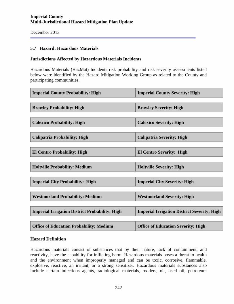
Imperial County Multi-Jurisdictional Hazard Mitigation Plan Update December 2013
242
5.7 Hazard: Hazardous Materials Jurisdictions Affected by Hazardous Materials Incidents Hazardous Materials (HazMat) Incidents risk probability and risk severity assessments listed below were identified by the Hazard Mitigation Working Group as related to the County and participating communities. Imperial County Probability: High Imperial County Severity: High
Brawley Probability: High Brawley Severity: High
Calexico Probability: High Calexico Severity: High
Calipatria Probability: High Calipatria Severity: High
El Centro Probability: High El Centro Severity: High
Holtville Probability: Medium Holtville Severity: High
Imperial City Probability: High Imperial City Severity: High
Westmorland Probability: Medium Westmorland Severity: High
Imperial Irrigation District Probability: High Imperial Irrigation District Severity: High
Office of Education Probability: Medium Office of Education Severity: High
Hazard Definition Hazardous materials consist of substances that by their nature, lack of containment, and reactivity, have the capability for inflicting harm. Hazardous materials poses a threat to health and the environment when improperly managed and can be toxic, corrosive, flammable, explosive, reactive, an irritant, or a strong sensitizer. Hazardous materials substances also include certain infectious agents, radiological materials, oxiders, oil, used oil, petroleum
Imperial County Multi-Jurisdictional Hazard Mitigation Plan Update December 2013
243
products, and industrial solid waste substances. Hazardous materials can pose a threat where they are manufactured, stored, transported or used. They are used in almost every manufacturing operation and by retailers, service industries, and homeowners. A hazardous material accident could occur in Imperial County due to the agricultural economy, proliferation of fuel tanks and transmission facilities, intricate canal system, and the confluence of major surface arteries and rail systems. Although a hazardous material accident can occur almost anywhere, particular regions are more vulnerable. The potential for an accident is increased in regions near roadways that are frequently used for transporting hazardous material, and in regions with agricultural or industrial facilities that use, store, handle, or dispose of hazardous material. Hazardous material incidents are one of the most common technological threats to public health and the environment. Incidents may occur as the result of natural disasters, human error, and/or accident. Hazardous materials incidents typically take three forms:
• Fixed facility incidents
o It is reasonably possible to identify and prepare for a fixed site incident, because laws require those facilities to notify state and local authorities about what is being used or produced there.
• Transportation incidents
o Transportation incidents are more difficult to prepare for because it is impossible to know what material(s) could be involved until an accident actually happens.
• Pipeline incidents
o Pipelines carry natural gas and petroleum. Breakages in pipelines carry differing amounts of danger, depending on where and how the break occurs, and what is in the pipe.
History The Union Pacific railway travels through many of the County’s jurisdictions and its cargo at times consists of hazardous liquids. Interstate 8 also travels through the jurisdictions and the many semi-trucks cargo is hazardous. Liquid petroleum products are delivered to and are transported through the County via the twenty-inch Santa Fe Pacific Pipe Line. This line is generally located within the Southern Pacific Railroad right-of-way. The right-of-way follows the northwest to southeast trend of Imperial Valley and subsequently parallels the major faults. It passes near the east side of the Salton Sea and serves the storage facility at Niland. Southeast
Imperial County Multi-Jurisdictional Hazard Mitigation Plan Update December 2013
244
of Ogilby, the line turns east and travels to Yuma. A six-inch branch line distributes gas to the storage facility south of Imperial and a four-inch line serves the Naval Air Facility near Seeley. The maintenance staff for the line anticipates no special problems from earthquakes or fault movement and are unaware of such a situation occurring in California in past years. A major break would take one to two days to repair. The petroleum storage facilities in Niland and Imperial are vulnerable to earthquakes. Storage capacity at Niland is 77,500 barrels and at Imperial is 289,000 barrels. Storage tanks, however, are never full at one time but are normally filled fifty percent. The 1979 earthquake resulted in the rupture of one tank and a gasoline leak of 100 gallon per minute at the Imperial facility. The potential for a major disaster does exist. The probability of loss of all liquid petroleum in the County is low. Emergency service via tanker is readily available if required during an emergency situation. Natural gas is delivered by the Southern California Gas Company via twin ten-inch lines which generally run south through the County in Range 14 East. These lines serve Niland, Calipatria, Brawley, Imperial, El Centro, Heber, and Calexico and branch lines serve Holtville, Westmorland, Seeley, NAF, and Plaster City. Rural residents are served by laterals from the branch lines. The lateral lines typically do not exceed a quarter mile in length. The gas lines are less resilient to seismic stress than the liquid lines and the entire natural gas system is vulnerable to disruption. The lines were damaged from the 1979 earthquake. The north-south line was damaged in the area it crossed the fault. The line suffered compressive stress and a fitting buckled and resulted in a major leak. The leak was repaired without shutting down the line. The line to Holtville was stretched where it crossed the fault. The line did not break and was repaired without shutting down the line. The natural gas network is much more extensive than the liquid petroleum system. Leaks are more insidious. The risk of an explosion or fire is greater. The most serious potential hazards are at the customer service connections. Gas connections to hot water heaters are notably vulnerable to seismic shaking. The use of pesticides in agriculture operations is a large source of hazardous materials since the County is surrounded by agricultural operations. Much of the most productive farmlands lie on the fringe of developing areas. Residential land uses adjacent to farmlands are potentially subject to health and safety conflicts. For example, unsupervised children often have easy access to the irrigation canals, and airborne drift of chemicals from pesticide and crop dusting may adversely affect the residential population. Although there is an increase in the number of organic farming operations in the area, which will help to reduce the total amount of pesticides used, residents will still be subject to hazards associated with pesticide use. The use, storage, and transport of pesticides are strictly regulated by the state of California. The County Agricultural Commission, the California Environmental Protection Agency, and the
Imperial County Multi-Jurisdictional Hazard Mitigation Plan Update December 2013
245
Department of Pesticide Regulation are the major enforcement agencies responsible for controlling and monitoring pesticide use. Following is a summary of the largest concentrations of hazardous material and the obvious sources of massive leaks or spills in Imperial County. Santa Fe Pacific Pipe Line Tank Farm. The Santa Fe Pacific Pipe Line Tank Farm is located at Aten Road and the Southern Pacific Railroad junction in the southeast quadrant of the City of Imperial. This facility is a component of the Santa Fe Pacific Pipe Line network that delivers gasoline, diesel, and jet fuel to Southern California and Arizona. The tank farm contains 16 storage tanks, in varying sizes, with a total storage capacity of approximately ten million gallons. Naval Air Facility (El Centro). The Naval Air Facility (El Centro) is serviced by a four-inch fuel line directly from the Santa Fe Pacific Pipe Line Tank Farm. Safety devices include manual and automatic shutoff valves, as well as pressure regulators. The facility also stores one million gallons of fuel, which is predominantly jet fuel, in underground tanks. Munitions storage is limited to aircraft and small arms training ammunition. ST Services. ST Services is located south of the Santa Fe Pacific Pipe Line Tank Farm and has the capacity to store 70,000 gallons of fuel. Brea Agricultural Service. Brea Agricultural Service is located at 89 East Main Street in the City of Heber and serves as a chemical and fertilizer storage facility. United Agriculture Products. United Agriculture Products is located at 2415 Clark Street in the City of Imperial. This facility handles hazardous wastes, chemicals, insecticides, and pesticides. Puregro Company. The Puregro Company is located at 10th Street and River Drive in the City of Brawley. This facility handles chemicals and fertilizers. Rockwood Chemical Company. Rockwood Chemical Company is located at 47 West Rutherford Road in Brawley. This facility handles chemical and fertilizers. Helena Chemical Products. Helena Chemical Products is located at 101 East Carey Road in the City of Brawley. This facility handles chemicals, fertilizers, insecticides, and pesticides. Wilbur Ellis Company. The Wilbur Ellis Company is located at 45 West Danenberg Road in the community of Heber. This facility handles chemicals, fertilizers, insecticides, and pesticides.
Imperial County Multi-Jurisdictional Hazard Mitigation Plan Update December 2013
246
Pipelines. There are 89.92 miles of pipeline in Imperial County that transport hazardous material. Pipe sizes vary in size from 12 to 20 inches and the average size is 12 inches. Pipelines are located adjacent to the Southern Pacific tracks from the Arizona border at Yuma to the Niland tank farm, north to the Riverside County Line, and south to the Imperial tank farm. The pipeline system has section fuel control valves. The following map depicts the hazardous material sites in Imperial County
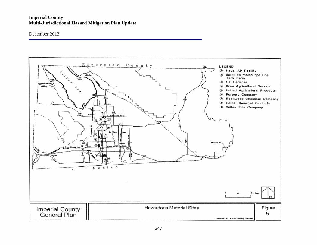
Imperial County Multi-Jurisdictional Hazard Mitigation Plan Update December 2013
247
Imperial County Multi-Jurisdictional Hazard Mitigation Plan Update December 2013
248
Risk Assessment If a railway derailment or hazardous spill on the Interstate should occur, the County’s concerns would be evacuation of the neighboring communities, water canal contaminations, and the containment of escaping gases or liquids. September 11 and subsequent news reports indicating that some terrorists in the United States have obtained drivers licenses for transporting hazardous materials, including hazardous wastes, called attention to a new form of hazmat threat unique to the border region. Increased wait times at ports of entry have resulted in increased vehicular emissions in border communities.
• Effects on people and housing. People may be evacuated when a Hazmat incident occurs. Relative to some of the other natural hazards assessed earlier in this MHMP, the numbers of people affected by Hazmat incidents are usually less.
• Effects on commercial and industrial structures. There may be economic
consequences due to Hazmat incidents, but the damage is generally limited to clean-up of facilities and grounds, or simply interruption of business due to evacuation.
• Effects on infrastructure. Hazmat incidents involving transportation may result
in downed power lines. Also, Hazmat materials may impact waterways and drainage systems, and incidents can lead to the evacuation of schools, business districts, and residential areas.
• Effects on – and of - agriculture. As noted previously, there is a long history of
agricultural production in Imperial County. Agricultural activities typically include the storage and periodic application of pesticides, herbicides, and fertilizers, as well as the storage and use of toxic fuels and solvents. The infiltration of these substances may leach into local groundwater supplies, presenting an elevated risk of groundwater contamination.
Risk assessment conclusion. Accidents can occur in the production, use, transport, and disposal of hazardous materials. A hazardous material accident could occur in Imperial County due to the agricultural economy, proliferation of fuel tanks and transmission facilities, intricate canal system, and the confluence of major surface arteries and rail systems. Although a hazardous material accident can occur almost anywhere, particular regions are more vulnerable. The potential for an accident is increased in regions near roadways that are frequently used for transporting hazardous material, and in regions with agricultural or industrial facilities that use, store, handle, or dispose of hazardous material.
Imperial County Multi-Jurisdictional Hazard Mitigation Plan Update December 2013
249
Relationship to Other Hazards – Cascading Effects The release of hazardous material into the environment could cause a multitude of problems. The release of explosive and highly flammable materials have cause fatalities and injuries, required large-scale evacuations, and destroyed millions of dollars’ worth of property. Toxic chemicals in gaseous form have caused injuries and fatalities among emergency response teams and passerby. Serious health problems have occurred where toxins have entered either surface or groundwater supplies. Releases of hazardous chemicals have been especially damaging when they have occurred in highly populated areas, or along heavily traveled transportation routes. The decree of threat posed to life and property is dependent on the type, location, and concentration of the material released, in addition to prevailing weather conditions such as precipitation, wind speed, and wind direction. Plans and Programs The Laidlaw Environmental Services hazardous waste facility located west of Westmorland is unique in the sense that a major wash traverses the site. Substantial engineering design was utilized to minimize flooding, and channel maintenance requirements have been implemented. While the facility does pose a potential risk, the continued monitoring and stringent design standards imposed on the facility have minimized the probability of a serious failure. Special reports on design requirements and risk concerns are on file at the Planning Department. A second type of facility which is more predominant and more difficult to assess is the chemical handling and storage facilities and include distributors, transporters, and crop dusting firms. These firms are not permitted to store the various chemicals in open areas, or in buildings not adequately protected from flood conditions. During severe flooding the potential for these chemicals to be mixed with the flood water can pose a potentially serious health concern. Pursuant to Section 25500 et seq. of the California Health and Safety Code, the Imperial County Health Services Department is designated as the "administering agency" responsible for maintaining a list of handlers/vendors of toxics within the County. In addition, they are required to maintain, for each handler/vendor, an inventory and business plan. This information is also available to the County Fire Marshal and City Fire Departments. The Imperial County Emergency Plan lists the ten largest concentrations of toxics in the County as:
1. Naval Air Facility El Centro 2. Santa Fe Pacific Pipe Line Tank Farm 3. ST Services 4. 89.92 miles of fuel pipelines 5. Brea Agricultural Service 6. United Agriculture Products 7. Puregro Company
Imperial County Multi-Jurisdictional Hazard Mitigation Plan Update December 2013
250
8. Rockwood Chemical Company 9. Helena Chemical Products 10. Wilbur Ellis Company
Mitigation Goals and Strategies Imperial County Through its membership in the Southern California Hazardous Waste Management Authority (SCHWMA), the County of Imperial has agreed to work on a regional level to solve problems involving hazardous waste. SCHWMA was formed through a joint powers agreement between Santa Barbara, Ventura, San Bernardino, Orange, San Diego, Imperial, and Riverside Counties and the cities of Los Angeles, and San Diego. Working within the concept of “fair share”, each County has agreed to take responsibility for the treatment and disposal of hazardous waste in an amount that is at least equal to the amount generated within that County. Imperial County has no direct authority to regulate the transport of hazardous materials on the Interstate/State highways and rail lines. Transportation of hazardous materials by truck and rail is regulated by the U.S. Department of Transportation (DOT). DOT regulations establish criteria for safe handling procedures. Federal safety standards are also included in the California Administrative Code. The California Health Services Department also regulates the haulers of hazardous waste, but does not regulate all hazardous materials. These agencies ultimately have the responsibilities for ensuring hazardous materials transported through the County is safe. Following are Imperial County’s Hazardous Materials Goals, Objectives and Policies. Control Hazardous Materials Goal 3: Protect the public from exposure to hazardous materials and wastes.
Objective 3.1 Discourage the transporting of hazardous materials/waste near or through residential areas and critical facilities.
Objective 3.2 Minimize the possibility of hazardous materials/waste spills.
Objective 3.3 Discourage incompatible development adjacent to sites and facilities for the production, storage, disposal, and transport of hazardous materials/waste as identified in the County General Plan and other regulations.
Objective 3.4 Adopt and implement ordinances, policies, and guidelines that assure the safety of County ground and surface waters from toxic or hazardous materials and wastes. Protection of Water Resources from Hazardous Materials Goal 4: The County will adopt and implement ordinances, policies, and guidelines that assure the safety of County ground and surface waters from toxic or hazardous materials and wastes.
Imperial County Multi-Jurisdictional Hazard Mitigation Plan Update December 2013
251
Objective 4.1 The development and implementation of infrastructure and regulatory policies in the Republic of Mexico, which reduce contamination of the New River, Alamo River, and the Salton Sea.
Objective 4.2 The provision of safe and efficient community wastewater treatment facilities which adequately service the present and future needs of residential, commercial, and industrial development within the Imperial Irrigation District service area. Policy Adoption and implementation of ordinances, policies, and guidelines which assure the safety of County ground and surface waters from toxic or hazardous materials and/or wastes. Programs
• The County of Imperial shall make every reasonable effort to limit or preclude the contamination or degradation of all groundwater and surface water resources in the County.
• All development proposals brought before the County of Imperial shall be reviewed for potential adverse effects on water quality and quantity, and shall be required to implement appropriate mitigation measures for any significant impacts.
• The County of Imperial shall coordinate with the California Regional Water Quality Control Board and incorporated cities is to assure that discharge from community wastewater treatment plants meet or exceed applicable State and Federal standards.
• The County of Imperial shall play an active role in assuring the advance planning necessary to provide community and/or industrial wastewater treatment facilities which keep pace with continued urbanization in the County.
• The County of Imperial shall support the investigation of innovative methods of wastewater treatment which reduces discharge of contaminants into County surface waters, while enhancing the ruderal and riparian habitats of the County.
• The County of Imperial shall direct staff of the County Health Department, Planning/ Building Department, and other appropriate departments, as well as the County Agricultural Commissioner, to review existing ordinances, policies, and guidelines and determine their adequacy in protecting groundwater and surface water from contamination by hazardous materials and/or waste.
• The Imperial County Health Department, as the Local Enforcement Agency, shall continue monitoring operations at the various landfills across the County and shall periodically report on the impacts or potential impacts of these landfills on ground and surface water resources in the County.
• The County of Imperial shall confer and coordinate with the California Department of Health, Regional Water Quality Control Board, and the U.S. Environmental Protection
Imperial County Multi-Jurisdictional Hazard Mitigation Plan Update December 2013
252
Agency to assure that these agencies are taking active steps to protect and reclaim groundwater and surface waters from contamination.
City of Brawley Hazardous materials used, stored, or transported through the City of Brawley represent potential hazards. A number of properties in the City are suspected of hazardous materials contamination. Exposure to hazardous and toxic materials can be avoided through proper land use planning and implementation of policy to reduce risks associated with the use, transport, and disposal of such materials. Following are the City of Brawley’s Hazardous and Toxic Materials Hazards Goal and Policies. Goal #3: Promote policies and programs that reduce the risk to the community’s inhabitants from exposure to hazardous materials and wastes.
Policy 3.1: Cooperate with the County to implement applicable portions of the County’s Hazardous Waste Management Plan.
Policy 3.2: Cooperate with railroad and truck transport operations to ensure that transported hazardous materials do not pose a threat to life or property.
Policy 3.3: Support regulations requiring land uses involved in the production, storage, transportation, handling, or disposal of hazardous materials to be located a safe distance from other land uses that may be adversely affected by such activities.
Policy 3.4: Establish defined transportation routes for the conveyance of hazardous materials.
Policy 3.5: Adopt a Hazardous Household Waste Plan, and encourage and support the proper disposal of hazardous household waste and waste oil.
Policy 3.6: Cooperate with responsible agencies to ensure that dry cleaners, film processors, auto service establishments, agricultural operations and industries, and other service businesses generating hazardous waste materials are complying with approved disposal procedures.
Policy 3.7: Minimize the amount and toxicity of hazardous waste and materials generated in Brawley by encouraging recycling, source reduction technologies and educational assistance to local residents, and commercial, industrial, and agricultural handlers.
Policy 3.8: Consider regular household hazardous waste disposal programs to enable residents to bring back yard pesticides, cleaning fluids, paint cans and other common household toxics to a centralized collection center for proper disposal.
Policy 3.9: Support efforts to enforce State “right to know” laws which outline the public’s right to information about local toxics producers.
Policy 3.10: Establish development standards for storage of industrial chemicals and other potentially hazardous substances to minimize damage caused by leaks or ruptures.
Imperial County Multi-Jurisdictional Hazard Mitigation Plan Update December 2013
253
Policy 3.11: Coordinate with the County of Imperial in the implementation of the National Pollution Discharge Elimination System Permits (NPDES) regulations.
Policy 3.12: Where new residential develop is proposed next to agricultural uses, assess the threat of resident exposure to agricultural toxic materials and require development designs that minimize exposure.
Policy 3.13: Participate in County and State efforts to identify contaminated sites within the Brawley Planning Area and encourage County and State clean-up activities. City of Calexico Hazardous materials are used in the City of Calexico for a variety of purposes including manufacturing, service industries, small businesses, agriculture, medical clinics, schools, and households. Hazardous materials pass through the City of Calexico en route to other destinations via the Interstate/State Highway system, rail, and surface street system. Calexico is linked to other cities in Imperial Valley and to other parts of California by a freeway and a number of highways. Interstate 8 provides for east-west travel which is approximately three miles to the north of the City. Local highways include: State Highway 111, a north-south route from the Mexican border to Brawley, Calipatria and Niland; State Highway 98 runs east-west from Coyote Wells (west of Calexico) to Bonds Corner (east of Calexico) connecting to Interstate 8 at both ends. One railway line serves the City of Calexico - the Southern Pacific Railroad. This major line connects to the main line in Niland. The main line primarily serves the Los Angeles area. This line is used extensively for agricultural shipments. While train derailment can occur at any time, it is during an earthquake that a derailment and hazardous materials would pose the greatest risk to people and the environment in Calexico. Following are the City of Calexico’s Hazardous Materials Mitigation Measures.
Goal # 5: To ensure the health, safety, and welfare of the residents and guests of Calexico through strict regulation and planning for the safe transport, storage and usage of hazardous material in the Calexico area.
Policy 5.1: Discourage the transport of hazardous materials through residential areas and critical facilities and limit transport through heavily developed areas as much as possible.
Policy 5.2: Prohibit incompatible land uses near sites that use, store or product hazardous materials.
Policy 5:3: Plan future parks to the east, north, and northeast of the City such that the industrial uses, along with the Port of Entry (East Border Crossing), United States and Mexico International Border, will reduce traffic, especially those containing hazardous materials, as they will be diverted from the center of the City.
Imperial County Multi-Jurisdictional Hazard Mitigation Plan Update December 2013
254
City of Calipatria Hazardous materials are not a substantial concern in Calipatria as there are no large-scale generators or users of hazardous materials in the City. Nevertheless, some industrial operations located along Industrial Avenue, agricultural operations in the vicinity of the City, and operations at the airport may utilize hazardous materials as part of daily operations. In addition, the City seeks to encourage additional industrial/manufacturing development in order to provide local jobs and take advantage of the regional transportation facilities (highways and railroad) that pass through the City. Safety measures at these facilities and at other industrial and agricultural facilities in Calipatria are required to follow state and federal protocol. This includes adherence to Imperial County Air Pollution Control District (APCD) Rule 216, which requires all owners and operators of stationary sources that emit hazardous air pollutants (HAPs) to install best available control technology for toxics (T-BACT) to any constructed or reconstructed major source. The APCD requires owners and operators of stationary sources that emit HAPs to obtain and maintain permits to operate. In addition, any future large-scale activities with the potential to generate or use hazardous materials in the City would be required to obtain a permit and comply with applicable federal, state, and local regulations. Based on the age of many buildings in Calipatria, the presence of asbestos-containing materials (ACMs) and lead-based paint in structures is likely. Such materials could be disturbed by demolition and renovation activities on older structures; however, any activities with the potential to release asbestos or lead into the atmosphere would be required to comply with applicable federal, state, and local regulations. The residential sector is a smaller-scale generator of hazardous wastes, such as paints, cleaners, oils, batters and pesticides that contain potentially hazardous ingredients and require special disposal care. Improper disposal of such household hazardous wastes can include pouring them down the drain, on the ground, into storm sewers, or in some cases putting them out with the trash. The dangers of such disposal methods might not be immediately obvious, but improper disposal of these wastes can pollute the environment and pose a threat to human health. Following are the City of Calipatria’s Hazardous and Toxic Materials Hazards Goal and Policies.
Goal S-4 Protect life and property from potential short- and long-term adverse effects associated with the transportation, storage, treatment, and disposal of hazardous materials.
Policy S-4.1 Ensure residential units are not constructed in close proximity to hazardous materials areas or sites.
Policy S-4.2 Require that a Conditional Use Permit be obtained for all land uses which may involve hazardous materials.
Imperial County Multi-Jurisdictional Hazard Mitigation Plan Update December 2013
255
Policy S-4.3 Coordinate with the County Emergency Services Department to mitigate the effects of spills and for evacuation of residences.
Policy S-4.4 Identify toxic disposal or leakage sites and pursue expeditious cleanup of these sites through actions by appropriate County, State, and Federal agencies.
Policy S-4.5 Ensure that hazardous materials sites are appropriately buffered from sensitive uses (e.g., residences, schools, and daycare facilities) and are properly fenced to prevent access by unauthorized persons.
Policy S-4.6 Manage activities within Calipatria involving the transport, use, storage or disposal of hazardous materials in a responsible manner that protects public health, safety, and the environment.
Policy S-4.7 Promote the availability of safe and legal options for the management and disposal of hazardous wastes generated by businesses and households within Calipatria.
Policy S-4.8 Promote community education and understanding of sound management practices for the storage, handling, use and disposal of hazardous materials. Following are the City of Calipatria’s Implementation Actions for the adopted policies:
• Identify hazardous material areas and sites (Policies S-4.1, S-4.4, and S-4.5). Continue to enforce applicable federal, state and local regulations pertaining to the transportation, storage, treatment, and disposal of hazardous materials within Calipatria (Implements Policies S-4.4, S-4.5, S-4.6, and S-4.7).
• Develop and implement household hazardous waste collection and disposal programs (Policies S-4.6, S-4.7, and S-4.8).
• Require risk assessments for new or expanded users of large quantities of hazardous materials within the City (Policies S-4.2 and S-4.6).
• Develop an emergency response plan for hazardous materials spills (Policy S-4.3). City of El Centro Following are the City of El Centro’s Implementation Program for Hazardous Materials. S-14: Hazardous Materials: Minimize public health risks and environmental risks from the use, transport, storage, and disposal of hazardous materials by:
• Cooperating with federal, state, and county agencies to effectively regulate the management of hazardous materials and hazardous waste;
• Cooperating with the County of Imperial to implement the applicable portions of the County Hazardous Waste Management Plan;
Imperial County Multi-Jurisdictional Hazard Mitigation Plan Update December 2013
256
• Identifying roadway transportation routes for conveyance of hazardous materials (the City does not exercise jurisdictional over transportation of freight along railroad right-of-way or state highways);
• Implementing the City’s Standardized Emergency Management System (SEMS) Multi-hazard Functional Plan for accidents involving hazardous materials; and
• Cooperating with the Certified Unified program Agency (CUPA) for El Centro and the El Centro Fire Department to administer Risk Management Plans for businesses within the City.
Responsible Agency/Department: Police Department, Fire Department, CUPA, County of Imperial Funding Source: General Fund Time Frame: Ongoing Related Policies: 6.1, 6.2
City of Westmorland Following are the Hazardous Materials Spills Goal, Objective and Policies.
Goal #1: Protect the public from natural and man-made hazards.
Objective 1.4: Protect the public from injury due to hazardous materials spills.
Policies:
1. Develop and implement an emergency response plan for hazardous materials spills.
2. Map areas with potential for hazardous materials movement or storage.
3. Coordinate with the County Emergency Services Department to mitigate the effects of a spill and for evacuation of residences.
4. Ensure residential units are not constructed in close proximity to hazardous materials areas or sites.
5. Require that a Conditional Use Permit be obtained for all land uses which may involve hazardous materials.
6. Identify toxic disposal or leakage sites and pursuer expeditious cleanup of these sites through actions by appropriate County, State and Federal Agencies.
7. Ensure that hazardous materials used in business and industry are properly stored and handled and that information on their storage, handling and use is available to the Fire Department, Public Works Department and other safety oriented departments/agencies.

Imperial County Multi-Jurisdictional Hazard Mitigation Plan Update December 2013
257
5.8 Hazard: Naturally Occurring Biological Threats Jurisdictions Affected by Naturally Occurring Biological Threats Naturally-Occurring Biological Threats risk probability and risk severity assessments listed below were identified by the Hazard Mitigation Working Group as related to the County and participating communities. Imperial County Probability: High Imperial County Severity: High
Brawley Probability: High Brawley Severity: High
Calexico Probability: High Calexico Severity: High
Calipatria Probability: High Calipatria Severity: High
El Centro Probability: High El Centro Severity: High
Holtville Probability: High Holtville Severity: High
Imperial City Probability: High Imperial City Severity: High
Westmorland Probability: High Westmorland Severity: High
Imperial Irrigation District Probability: High Imperial Irrigation District Severity: High
Office of Education Probability: High Office of Education Severity: High
Hazard Definition Public health-related hazards may be the result of a naturally occurring event or terrorism. Key hazards of concern to Imperial County today are described below.
Imperial County Multi-Jurisdictional Hazard Mitigation Plan Update December 2013
258
Dengue Fever also known as breakbone fever is an infectious tropical disease caused by the dengue virus. Symptoms include fever, headache, muscle and joint pains, and a characteristic skin rash that is similar to measles. In a small proportion of cases the disease develops into the life-threatening dengue hemorrhagic fever, resulting in bleeding, low levels of blood platelets and blood plasma leakage, or into dengue shock syndrome, where dangerously low blood pressure occurs. Dengue is transmitted by several species of mosquito within the genus Aedes, principally A. aegypti. The virus has four different types; infection with one type usually gives lifelong immunity to that type, but only short-term immunity to the others. Subsequent infection with a different type increases the risk of severe complications. As there is no commercially available vaccine, prevention is sought by reducing the habitat and the number of mosquitoes and limiting exposure to bites. The incidence of dengue fever has increased dramatically since the 1960s, with around 50–100 million people infected yearly. Early descriptions of the condition date from 1779, and its viral cause and the transmission were elucidated in the early 20th century. Dengue has become a global problem since the Second World War and is endemic in more than 110 countries. Apart from eliminating the mosquitoes, work is ongoing on a vaccine, as well as medication targeted directly at the virus.
Yellow Fever, also known as Yellow Jack or "Yellow Rainer" is an acute viral hemorrhagic disease. The yellow fever virus is transmitted by the bite of female mosquitoes (the yellow fever mosquito, Aedes aegypti, and other species). Yellow fever presents in most cases in humans with fever, chills, anorexia, nausea, muscle pain (with prominent backache) and headache, which generally subsides after several days. In some patients, a toxic phase follows, in which liver damage with jaundice (inspiring the name of the disease) can occur and lead to death. Because of the increased bleeding tendency (bleeding diathesis), yellow fever belongs to the group of hemorrhagic fevers. The World Health Organization estimates that yellow fever causes 200,000 illnesses and 30,000 deaths every year in unvaccinated populations.
Novel Influenza A (H1N1) is a novel flu virus that is currently circulating in the U.S. and other parts of the world and is a unique combination of swine and human flu viruses. This virus is transmitted from person to person, not from pigs to humans. The symptoms of novel flu are similar to the symptoms of regular seasonal flu and include fever, cough, sore throat, rhinnorhea (runny nose), nasal congestion, body aches, headache, chills and fatigue. Some people have reported diarrhea and vomiting along with respiratory symptoms. Like seasonal flu, this novel flu may be more severe in those who have chronic medical conditions. The current novel influenza virus spreads the same way as seasonal flu. Flu viruses are spread by an ill person coughing or sneezing. Sometimes people can become infected by touching something with flu viruses on it (such as a door knob) and then touching their mouth or nose. People with novel flu are potentially contagious as long as they have symptoms and possibly for up to 7 days after they become ill. Children, especially younger children, might be contagious for longer than 7 days.
Coronaviruses are species in the genera of virus belonging to the subfamily Coronavirinae in the family Coronaviridae. Coronaviruses primarily infect the upper respiratory and
Imperial County Multi-Jurisdictional Hazard Mitigation Plan Update December 2013
259
gastrointestinal tract of mammals and birds. Four to five different currently known strains of coronaviruses infect humans. The most publicized human coronavirus, SARS-CoV which causes SARS, has a unique pathogenesis because it causes both upper and lower respiratory tract infections and can also cause gastroenteritis. Coronaviruses are believed to cause a significant percentage of all common colds in human adults. Coronaviruses cause colds in humans primarily in the winter and early spring seasons. The significance and economic impact of coronaviruses as causative agents of the common cold are hard to assess because, unlike rhinoviruses (another common cold virus), human coronaviruses are difficult to grow in the laboratory. Coronaviruses can even cause pneumonia, either direct viral pneumonia or a secondary bacterial pneumonia. Coronaviruses also cause a range of diseases in farm animals and domesticated pets, some of which can be serious and are a threat to the farming industry.
H1N1 Influenza Virus (swine flu) is a new influenza (flu) virus that was first detected in people in the United States in April 2009. The new virus is spreading from person-to-person worldwide, probably in much the same way that regular seasonal flu viruses spread. A flu pandemic occurs when a new influenza A virus emerges for which there is little or no immunity in the human population; the virus causes serious illness and spreads easily from person-to-person worldwide. Flu viruses are spread mainly from person to person through coughing or sneezing by people with flu. Sometimes people may become infected by touching something such as a surface or object, with flu viruses on it and then touching their mouth or nose. The symptoms of flu virus include fever, cough, sore throat, runny or stuffy nose, body aches, headache, chills, and fatigue. Many people who have been infected with the H1N1 virus also have reported diarrhea and vomiting. Severe illnesses and death have occurred as a result of illness associated with influenza viruses. On June 11, 2009, the World Health Organization (WHO) declared that a global pandemic of H1N1 flu is underway.
Tuberculosis (TB) is an infectious disease caused by the bacterium Mycobacterium tuberculosis, which most commonly affects the lungs (pulmonary TB) but can also affect the central nervous system (meningitis), lymphatic system, circulatory system (miliary tuberculosis), genitourinary system, bones and joints. Tuberculosis is one of the top four infectious killing diseases in the world and most common major infectious diseases today.
West Nile Virus (WNV) is a mosquito-borne virus that has been found in parts of Asia, Eastern Europe, Africa, and the Middle East. The virus arrived in the Western Hemisphere in 1999 in New York City. The more severe forms of West Nile virus are West Nile encephalitis, West Nile meningitis, and West Nile meningoencephalitis. Encephalitis refers to an inflammation of the brain, meningitis is an inflammation of the membrane around the brain and the spinal cord, and meningoencephalitis refers to inflammation of the brain and the membrane surrounding it. Bovine Spongiform Encephalopathy (BSE) is widely referred to as "mad cow disease." It is a chronic degenerative disease that affects the central nervous system of cattle. BSE is named because of the spongy appearance of the brain tissue of infected cattle examined under a
Imperial County Multi-Jurisdictional Hazard Mitigation Plan Update December 2013
260
microscope. BSE belongs to a family of diseases known as the transmissible spongiform encephalopathies (TSEs). TSE animal diseases found in the United States include scrapie in sheep and goats, chronic wasting disease in deer and elk, transmissible spongiform encephalopathy in mink, feline spongiform encephalopathy in cats, and in humans: kuru, both classic and variant Creutzfeldt-Jakob disease, Gerstmann-Straussler-Scheinker syndrome, and fatal familial insomnia. There is no evidence to date that BSE emanated from TSEs in other animals. Regarding feeding practices, it is known that cattle can become infected with BSE by eating feed contaminated with the infectious BSE agent. This is why in 1997 the U.S. Food and Drug Administration (FDA) prohibited the use of most mammalian protein in the manufacture of animal feed intended for cattle and other ruminants. BSE is not a contagious disease. There is no evidence that the disease is transmitted through direct contact or animal-to-animal spread. The primary means by which animals become infected is through consumption of feed contaminated with the infectious BSE agent. Lyme Disease (Borrelia burgdorferi) is a systemic, tick borne disease with protean manifestations, including dermatologic, rheumatologic, neurologic, and cardiac abnormalities. The best clinical marker for the disease is an initial skin lesion that occurs in 60%-80% of patients. Botulism is a serious paralytic illness caused by a nerve toxin that is produced by the bacterium Clostridium botulinum. There are three main kinds of botulism. Food borne botulism is caused by eating foods that contain the botulism toxin. Wound botulism is caused by toxin produced from a wound infected with Clostridium botulinum. Infant botulism is caused by consuming the spores of the botulinum bacteria, which then grow in the intestines and release toxin. All forms of botulism can be fatal and are considered medical emergencies. Food borne botulism can be especially dangerous because many people can be poisoned by eating a contaminated food. Campylobacter jejuni (Pronounced "camp-e-low-back-ter j-june-eye") was not recognized as a cause of human food borne illness prior to 1975. Now, the bacterial organism is known to be the most common cause of food borne illness in the U.S. (Salmonella is the second most common cause). Food is the most common vehicle for the spread of Campylobacter and poultry is the most common food implicated. Some case-control studies indicate that up to 70% of sporadic cases of campylobacteriosis are associated with eating chicken. Surveys by the USDA demonstrated that up to 88% of the broiler chicken carcasses in the U.S. are contaminated with Campylobacter while a recent Consumer Reports study identified Campylobacter in 63% of more than 1000 chickens obtained in grocery stores. Other identified food vehicles include unpasteurized milk, undercooked meats, mushrooms, hamburger, cheese, pork, shellfish, and eggs. E. coli is found in the family of bacteria named Enterobacteriaceae, which is informally referred to as the enteric bacteria. Most forms of E. coli are harmless; however, there are strains
Imperial County Multi-Jurisdictional Hazard Mitigation Plan Update December 2013
261
that cause serious illness. Other enteric bacteria are the Salmonella bacteria (also a very large family, with many different members), Klebsiella pneumoniae, and Shigella, which many people consider to be part of the E. coli family. Hantavirus infection is caused by a group of viruses that can infect humans with two serious illnesses: hemorrhagic fever with renal syndrome (HFRS) and Hantavirus pulmonary syndrome (HPS). Hantaviruses are found without causing symptoms within various species of rodents and are passed to humans by exposure to the urine, feces, or saliva of those infected rodents. Ten different Hantaviruses have been identified as important in humans. Hepatitis A is one of five human hepatitis viruses that primarily infect the human liver and cause human illness. The other known human hepatitis viruses are hepatitis B, C, D, and E. Hepatitis A is relatively unusual in nations with developed sanitation systems such as the U.S. Nevertheless, it continues to occur here. Each year, an estimated 100 persons die as a result of acute liver failure in the U.S. due to hepatitis A. Approximately 30,000 - 50,000 cases occur yearly in the U.S. and the direct and indirect costs of these cases exceed $300 million. Hepatitis A is totally preventable, and need not occur. Listeria monocytogenes is a pathogenic (disease-causing) bacterium that is food-borne and causes an illness called listeriosis. It is frequently overlooked as a possible cause of illness due to its unique growth capabilities. First, it is somewhat difficult for laboratories to grow, and when they do so, Listeria can be confused with common harmless contaminants and disregarded. Second, most bacteria grow poorly when temperatures fall below 40°F, while Listeria survives at in temperatures from below freezing (20°F) to body temperature and it grows best at O°F to 50°F, including the temperature range that we use for refrigeration. As a result, Listeria may be transmitted in ready-to-eat foods that have been kept properly refrigerated. Monkeypox is a rare viral disease that occurs mostly in central and western Africa. It is called “monkeypox” because it was first found in 1958 in laboratory monkeys. Monkeypox was reported in humans for the first time in 1970. In early June 2003, monkeypox was reported among several people in the U.S. Most of these people got sick after having contact with pet prairie dogs that were sick with monkeypox. This was the first time that there had been an outbreak of monkeypox in the U.S. The disease is caused by Monkeypox virus. It belongs to a group of viruses that includes the smallpox virus (variola), the virus used in the smallpox vaccine (vaccinia), and the cowpox virus. In humans, the signs and symptoms of monkeypox are like those of smallpox, but usually they are milder. Another difference is that monkeypox causes the lymph nodes to swell. Norwalk virus is a virus that attaches to the outside of cells lining the intestine. Once attached, it transfers its genetic material into that cell. There it reproduces, finally killing the human cell to release new copies of it that attach to more cells of the intestine's lining. Common names of the illness caused by the Norwalk and other small round structured or caliciviruses are viral
Imperial County Multi-Jurisdictional Hazard Mitigation Plan Update December 2013
262
gastroenteritis, acute nonbacterial gastroenteritis, food poisoning, and food borne infection. This illness occurs worldwide. Humans are the only known hosts. The viruses are passed in the stool of infected persons. Of viruses, only the common cold is reported more often than viral gastroenteritis. Norwalk and Norwalk-like viruses are increasingly being recognized as leading causes of food-borne disease in the United States. People most often get Norwalk virus infection by swallowing infected food or water. Outbreaks in the U.S. are often linked to eating raw shellfish, especially oysters and clams. Steaming does not kill the virus or prevent its transmission. Plague is a disease caused by Yersinia pestis (Y. pestis), a bacterium found in rodents and their fleas in many areas around the world. Pneumonic plague is different from the bubonic plague. Both are caused by Yersinia pestis, but they are transmitted differently and their symptoms differ. Pneumonic plague can be transmitted from person to person; bubonic plague cannot. Pneumonic plague affects the lungs and is transmitted when a person breathes in Y. pestis particles in the air. Bubonic plague is transmitted through the bite of an infected flea or exposure to infected material through a break in the skin. Symptoms include swollen, tender lymph glands called buboes. Buboes are not present in pneumonic plague. If bubonic plague is not treated, however, the bacteria can spread through the bloodstream and infect the lungs, causing a secondary case of pneumonic plague. Patients usually have fever, weakness, and rapidly developing pneumonia with shortness of breath, chest pain, cough, and sometimes bloody or watery sputum. Nausea, vomiting, and abdominal pain may also occur. Without early treatment, pneumonic plague usually leads to respiratory failure, shock, and rapid death. Salmonella is a type of bacteria that causes typhoid fever and many other infections of intestinal origin. Typhoid fever, rare in the U.S., is caused by a particular strain designated Salmonella typhi. But illness due to due to other Salmonella strains, just called "salmonellosis," is common in the U.S. Today, the number of known strains of this bacteria total over 2300. SARS is a respiratory illness of unknown cause that has recently been reported in a number of countries. According to the World Health Organization (WHO), the main symptoms and signs of SARS include a fever greater than 100.5° F (38° C), and cough, shortness of breath, or difficulty breathing. The cause of SARS is not known at this time. Researchers at CDC and around the world are working to find the cause of SARS At this early stage of the investigation, it seems more likely that SARS is caused by an organism that we have less experience with rather than a commonly occurring, known organism. The Shigella germ is a bacterium that can cause sudden and severe diarrhea (gastroenteritis) in humans. Shigella lives in the human intestine and is commonly spread both through food and by person-to-person contact. The illness is also known as "bacillary dysentery." About 25,000 or so laboratory confirmed cases of shigellosis are reported each year in the U.S. However, many cases go undiagnosed and/or unreported, and the best estimates are that 450,000 cases of Shigella infection actually occur annually in the U.S.
Imperial County Multi-Jurisdictional Hazard Mitigation Plan Update December 2013
263
Tularemia is a potentially serious illness that occurs naturally in the U.S. It is caused by the bacterium Francisella tularensis found in animals (especially rodents, rabbits, and hares). Tularemia is also known as “rabbit fever.” Tularemia is usually a rural disease and has been reported in all U.S. states except Hawaii. Tularemia is a widespread disease in animals. About 200 human cases of tularemia are reported each year in the U.S. Most cases occur in the south-central and western states. Canine Distemper is a viral disease of young dogs characterized by high fever and respiratory inflammation. It can affect wild animals and County pets. Other animal diseases which can affect humans include rabies and toxoplasmosis (an opportunistic infection caused by the microscopic parasite Toxoplasma gondii, found in raw or undercooked meat and cat feces), as well as parasites such as roundworms, whipworms, hookworms, ringworms, and mange. Exotic Newcastle Disease (END) is a contagious viral disease affecting many species of birds including poultry and wild birds. This is probably one of the most infectious diseases of poultry in the world with a death rate of almost 100 percent in unvaccinated poultry flocks and so virulent that many birds die without showing any clinical signs. The disease can even infect and cause death in vaccinated poultry. END is extremely contagious. The spread is primarily through direct contact between healthy birds and the bodily fluids of infected birds. It can be transmitted through infected bird droppings as well as secretions from the nose, mouth and eyes. It spreads rapidly among confined birds…like commercially raised chickens. The disease is also easily spread by virus-bearing material picked up on shoes and clothing and carried from an infected flock to a healthy one. END can also spread from poultry flocks to wildlife as wild birds come into contact with infected poultry, possibly when wild birds enter a pen to feed on spilled grain. Although experiments have documented that several wild species including ducks and pheasants can develop the disease, widespread illness and death has only been documented in double-crested cormorants in the United States and Canada. This disease affects the respiratory, nervous and digestive systems, with an incubation period ranging from two to 15 days.
The available information suggests that Newcastle disease can affect people; however, it does not pose a significant health risk. In humans, the disease is usually limited to conjunctivitis, which is a mild inflammation of the tissues around the eyes and is seen in persons associated with infected birds or facilities where infected birds are housed. It should be noted that poultry products in the Arizona marketplace, including eggs and meat, continue to be safe to consume.
History In 2003 the first evidence of West Nile virus (WNV) in California has been found in mosquitoes collected in Imperial County near the Salton Sea. Several flocks of sentinel chickens from the same region were also positive for WNV. In 2006, Imperial County had one case of West Nile Virus identified. Since 2003, two human cases infected with the West Nile
Imperial County Multi-Jurisdictional Hazard Mitigation Plan Update December 2013
264
virus have been detected. The two mosquito species most likely to spread WNV in Imperial County are Culex tarsalis and Culex pipiens. Tuberculosis (TB) incidences in the U.S. states bordering Mexico which include Imperial County have been increasing due to Mexico’s higher TB rate and frequent border crossings and travel in the U.S. for employment, commerce, health services and leisure. Imperial County has also had at least one case of Hantavirus and Lyme disease. A 9-year-old girl from Imperial County was among 14 people in the nation who had been infected during 2006 – 2009 by a rare strain of the swine influenza virus. Risk Assessment Given the existence of naturally occurring biological agents in Imperial County, without enhanced public outreach, monitoring and control, the potential exists for one or more of these virulent diseases to dramatically affect the life, health and safety of County citizens.
• Effects on people and housing. Humans are susceptible to the effects of most naturally-occurring biological threats.
• Effects on agriculture. Certain naturally-occurring biological threats can cause
severe damage to livestock. Risk assessment conclusion. Because the risk for a pandemic outbreak of a lethal disease does exist, preparedness should be maintained at a high level. In addition to insect pest causing health risks to humans, they also can have significant impacts on the agriculture industry. Plans and Programs Influenza viruses have caused epidemics and pandemics for centuries. Because these viruses have the propensity to mutate and change from season to season, a vaccine providing long-term protection is not available. Therefore, the best way to prepare for the next pandemic strain is early detection. In Imperial County, influenza surveillance is conducted in a number of ways. Three sentinel influenza surveillance sites in out-patient clinics in Brawley, El Centro, and Calexico participate in year-round surveillance for patients with symptoms of influenza-like illness (ILI). All case-patients are given a rapid influenza test, and samples are collected for additional virologic and bacteriologic testing at the Naval Health Research Center (NHRC) laboratory in San Diego. In 2009, surveillance for Severe Acute Respiratory Infections began in both hospitals. Samples are collected from hospitalized patients who meet the criteria (fever, cough and/or sore throat, or pneumonia in children <5 years) and sent to NHRC lab for testing. In addition, Syndromic
Imperial County Multi-Jurisdictional Hazard Mitigation Plan Update December 2013
265
surveillance is conducted in the emergency departments of both local hospitals (Pioneers Memorial Hospital and El Centro Regional Medical Center) for patients with influenza-like illness to monitor the frequency and distribution of ILI. This information is reported weekly or biweekly in a report that is distributed to key stakeholders and posted on the website. Integrating hospital-based surveillance into the existing influenza surveillance system complements and strengthens overall surveillance activities. Both clinic and hospital-based surveillance for influenza and other respiratory viruses enhances Imperial County Public Health Department’s ability to detect strains currently in circulation and monitor mortality due to pneumonia and other severe respiratory diseases. Overall, this allows a clearer epidemiological picture of influenza activity in the community and enables the Public Health Department in collaboration with other community stakeholders to build on strategies for preparedness and control measures should a new virus subtype with pandemic potential be detected. Other enhanced surveillance projects currently being conducted in Imperial County include: Syndromic Surveillance Syndromic surveillance has been used for early detection of outbreaks, to follow the size, spread, and tempo of outbreaks, to monitor disease trends, and to provide reassurance that an outbreak has not occurred. Although syndromic surveillance does not replace traditional public health surveillance, it allows tracking of disease indicators in near real-time by capturing hospital data, parsing chief-complaint text strings into syndrome groupings, and analyzing data for abnormalities by applying multiple temporal and spatio-temporal outbreak-detection algorithms. In 2008, Imperial County Epidemiology began collaborating with San Diego County to extend an automated syndromic surveillance program to emergency departments at both hospitals in Imperial County (El Centro Regional Medical Center and Pioneers Memorial Hospital). This project provides surveillance report summaries on a variety of selected syndromes, which can be used as markers for increased activity for influenza-like illnesses, fever, rash, and symptoms indicative of gastrointestinal illness and botulism, among others. This project provides the ability to identify increases in symptom frequency that may indicate an infectious disease outbreak; monitor syndrome trends; and obtain aggregate data for various surveillance projects. Other surveillance projects for diseases and conditions include Coccidioidomycosis Surveillance (aka Valley Fever) and heat-related illnesses and death. Mexicali Binational Tuberculosis (TB) Projects Imperial County’s activities for 2013-2014 include a variety of objectives, beginning with a sweeping TB education campaign. First, they will target the medical provider community, starting with hospitals and physicians, offering on-site education related to screening and treating Latent TB Infection and Active TB cases.
Imperial County Multi-Jurisdictional Hazard Mitigation Plan Update December 2013
266
To launch the campaign, Imperial County Public Health Department hosted an event on March 26, 2013 in recognition of World TB Day. The conference targeted local private provider, hospital, and clinic physicians that screen, treat, and discharge binational TB patients. Next, in an effort to educate community hospitals on screening, treating, discharge planning, and laws pertaining to reporting TB Suspects and TB Cases, the TB Controller is conducting on-site training and education sessions, including the opportunity for questions and answers. Both local hospitals admit TB patients from Mexico, creating the need for ongoing and updated TB education. Following TB education at the hospitals, the TB Control Program is targeting corrections agencies and detention facilities, schools, homeless shelters, and addiction rehabilitation centers. All of these facilities treat binational patients. Eventually, there are plans for a binational conference in order to increase collaborative and timely TB reporting and effective treatment efforts with Mexicali, Baja California. CURE TB (a referral and continuity of care program for tuberculosis patients and their contacts that travel between the United States and Mexico), United States – Mexico Border Health Commission (created to provide international leadership to optimize health and quality of life along the U.S.-México border), the Mexican Consultant, and the California State TB Control Branch, as well as TB counterparts from Mexico have expressed interest and are expected to participate in the conference. Imperial County Public Health Department TB Control Program attended the San Diego – Imperial – Baja California TB Cross Jurisdictional Sharing Retreat on May 31, 2013. The event was hosted by the non-profit International Community Foundation and was designed to review the Puentes de Esperanza program and best practices in cross jurisdictional sharing arrangements in public health. In addition, a draft mutual aid agreement was presented for discussion to encourage cross jurisdictional coordination of TB care. Public Health According to the California Code of Regulations, the County Health Officer (CHO) will take whatever measures are necessary to investigate and control reported or suspected diseases and conditions. Such measures include, but are not limited to, confirmation of a clinical or laboratory diagnosis, determination that an unusual disease or disease outbreak exists, determination and investigation of the source, and the prevention and control of the disease. Various functions within County Public Health assist the CHO, depending on the issues being addressed. The Imperial County Public Health Department coordinated a number of vaccination clinics in Imperial County in the fall with the assistance of partner agencies. In addition, information on flu prevention to local school, clinics and the public has been made available. The Public Health Department conducts year-round monitoring of influenza-like illness at sentinel clinic sites in the county. A surveillance system is also in place at both local hospitals to monitor severe influenza-like illness among hospitalized patients. This provides health-care providers
Imperial County Multi-Jurisdictional Hazard Mitigation Plan Update December 2013
267
with up-to-date information about the type of viruses that are circulating in our community to assist with treatment decisions. Immediate Disease Control Measures Among other responsibilities, the CHO is authorized under the California Health and Safety Code to take measures as may be necessary to prevent the spread of communicable disease. Generally, actions may include obtaining information pertaining to the incident, assess the health risk to the community, notify appropriate agencies, and coordinate disease prevention and control with community, local, regional, state and federal agencies. Should it be necessary, the CHO will also initiate Quarantine measures within the County. Notification of First Responders, Medical Community and Public Sector If, after consultation with appropriate local, regional, state or federal agencies, the CHO determines that an imminent or actual health threat exists, local response will be initiated in accordance with emergency response and notification protocols. Depending on the nature of the event, potential responders may include local, state and/or federal emergency/disaster, law enforcement and health agencies.
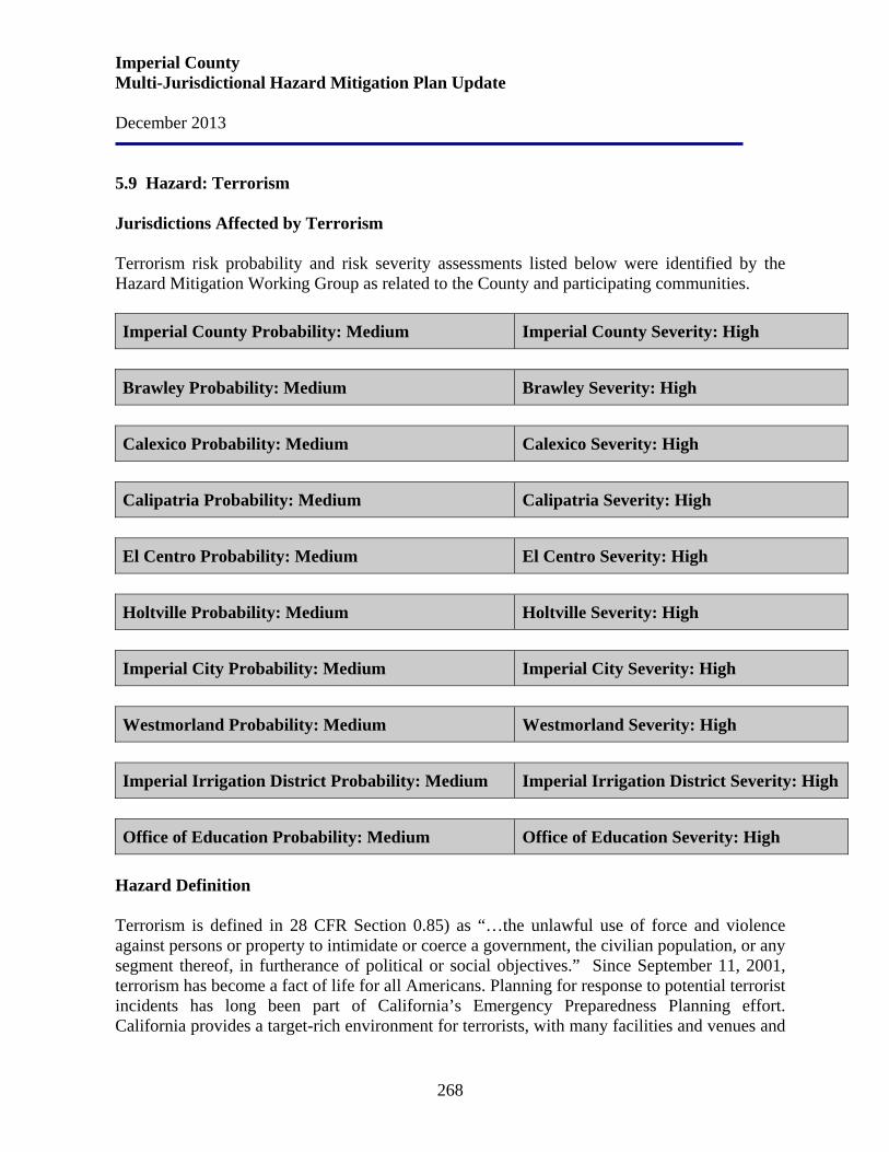
Imperial County Multi-Jurisdictional Hazard Mitigation Plan Update December 2013
268
5.9 Hazard: Terrorism Jurisdictions Affected by Terrorism Terrorism risk probability and risk severity assessments listed below were identified by the Hazard Mitigation Working Group as related to the County and participating communities. Imperial County Probability: Medium Imperial County Severity: High
Brawley Probability: Medium Brawley Severity: High
Calexico Probability: Medium Calexico Severity: High
Calipatria Probability: Medium Calipatria Severity: High
El Centro Probability: Medium El Centro Severity: High
Holtville Probability: Medium Holtville Severity: High
Imperial City Probability: Medium Imperial City Severity: High
Westmorland Probability: Medium Westmorland Severity: High
Imperial Irrigation District Probability: Medium Imperial Irrigation District Severity: High
Office of Education Probability: Medium Office of Education Severity: High
Hazard Definition Terrorism is defined in 28 CFR Section 0.85) as “…the unlawful use of force and violence against persons or property to intimidate or coerce a government, the civilian population, or any segment thereof, in furtherance of political or social objectives.” Since September 11, 2001, terrorism has become a fact of life for all Americans. Planning for response to potential terrorist incidents has long been part of California’s Emergency Preparedness Planning effort. California provides a target-rich environment for terrorists, with many facilities and venues and
Imperial County Multi-Jurisdictional Hazard Mitigation Plan Update December 2013
269
an easy place to hide in California’s diverse population. Effective hazard mitigation that reduces risk to terrorism must be based upon technical expert information and analysis of actual terrorist events. Terrorists often use threats to create fear among the public, to try to convince citizens that their government is powerless to prevent terrorism, and to get immediate publicity for their causes. Terrorist acts or acts of war may cause casualties, extensive property damage, fires, flooding, and other ensuing hazards. Terrorism takes many forms, including: Chemical. Chemical weapons have been used primarily to terrorize an unprotected civilian population and not as a weapon of war. This is because of fear of retaliation and the likelihood that the agent would contaminate the battlefield for a long period of time. Some analysts suggest that the possibility of a chemical attack would appear far more likely than either the use of nuclear or biological materials, largely due to the easy availability of many of the necessary precursor substances needed to construct chemical weapons. Additionally, the rudimentary technical knowledge needed to build a working chemical device is taught in every college level chemistry course in the world. Some chemical agents are odorless and tasteless and are difficult to detect. They can have an immediate effect (a few seconds to a few minutes) or a delayed effect (several hours to several days). A terrorist would not have to build a complicated chemical release device. During favorable weather conditions an already existing chemical plant could be sabotaged or bombed releasing a toxic cloud to drift into a populated area. The result could be just as dangerous as having placed a smaller chemical device in a more confined space. This type of incident would cause the maximum amount of fear, trepidation, and potential panic among the civilian population, and thus achieve a major terrorist objective. Biological. Biological weapons are defined as any infectious agent such as a bacteria or virus used to produce illness or death in people, animals, or plants. This definition is often expanded to include biologically-derived toxins and poisons. Biological agents can be dispersed as aerosols or airborne particles. Terrorists may use biological agents to contaminate food or water because the agents are extremely difficult to detect. The agents are cheap, easy to make, and simple to conceal. Even small amounts, if effectively deployed, could cause massive injuries and overwhelm emergency rooms. The production of biological weapons can be carried out virtually anywhere — in simple laboratories, on a farm, or even in a home. However, experts say it remains very difficult to transform a deadly virus or bacterium into a weapon that can be effectively dispersed. A bomb carrying a biological agent would likely destroy the germ as it explodes. Dispersing the agents with aerosols is challenging because biomaterials are often wet and can clog sprayers. Most agree that, while a biological attack could be devastating in theory, in reality, the logistical challenges of developing effective
Imperial County Multi-Jurisdictional Hazard Mitigation Plan Update December 2013
270
agents and then dispersing them makes it less likely a terrorist could carry out a successful widespread assault. Radiological. A radioactive material is a material made up of unstable atoms which give off excess energy in the form of radiation through the process of radioactive decay. Radiation cannot be detected by human senses. Wherever radioactive materials are used, transported, or stored there is a potential for a radiological accident to occur. Under extreme circumstances an accident or intentional explosion involving radiological materials can cause very serious problems. Consequences may include death, severe health risks to the public, damage to the environment, and extraordinary loss of, or damage to, property. Some of their most common uses include use:
• by doctors to detect and treat serious diseases • by educational institutions and companies for research • by the military to power large ships and submarines • by companies in the manufacture of products • as a critical base material to help produce the commercial electrical power that is
generated by a nuclear power plant • as one of the critical components in nuclear weapons, which are relied upon to help
deter the threat of war Nuclear. The possibility exists that a terrorist organization might acquire the capability of creating a small nuclear detonation. A single nuclear detonation in the United States would likely produce fallout affecting an area many times greater than that of the blast itself. There is also the possibility that a terrorist will construct a “dirty bomb”, a bomb that is used to distribute nuclear contaminated materials. It would have less of an effect than a “traditional” nuclear bomb, but the terror effect on the population would be great. Explosive. The possibility exists that a terrorist may attack with conventional explosives, particular in a public setting. Innumerable incidents have occurred around the world involving car bombs, truck bombs, and bombs attached directly to terrorist individuals. Explosive terrorist attacks may have consequences including death and damage to property. Cyber-terrorism. Cyber-terrorism is the use of computer network tools to shut down critical government infrastructures such as energy, transportation, and government operations, or to coerce or intimidate a government or civilian population. The premise of cyber-terrorism is that as nations and critical infrastructure became more dependent on computer networks for their operation, new vulnerabilities are created. A hostile nation or group could exploit these vulnerabilities to penetrate a poorly secured computer network and disrupt or even shut down critical public or business operations.
Imperial County Multi-Jurisdictional Hazard Mitigation Plan Update December 2013
271
The goal of cyber-terrorism is believed to be aimed at hurting the economy of a region or country, and to amplify the effects of a traditional physical terrorist attack by causing additional confusion and panic. History The threat of terrorism has a unique effect on boarder communities such as those of Imperial County. Rather than just a mere geopolitical line separating the United States and Mexico, the boarder has been redefined as a line of defense against terrorism. The terrorist attacks of September 11 on New York City and Washington, D.C., resonated far away along the U.S.-Mexican border. The immediate results of the attacks and the security measures that followed were social and economic disruptions. People can no longer live and businesses can no longer operate as they once did in the border region. Prior to September 11, 2001, the regions of Imperial County and Northern Baja California economically functioned in a semi-contiguous manner. With the implementation of NAFTA in 1994, and the subsequent movement of business and industry to both sides of the border, the region experienced an increase in economic activity. In 1997, the Calexico-East Port-of-Entry was opened, creating a separate port for commercial use and dedicating the downtown Calexico port to noncommercial traffic. The existing Andrade port still handles both commercial and noncommercial crossings. The ports of entry in Imperial County are among the busiest on the U.S.-Mexican border with more than 250,000 trucks and 35 million persons crossing annually. Approximately 186 foreign manufacturing companies, or maquiladoras, are operating across the border in Mexicali taking advantage of the benefits derived from locating in this northern border region of Mexico. September 11 and subsequent news reports indicating that some terrorists in the United States have obtained drivers licenses for transporting hazardous materials, including hazardous wastes, called attention to a new form of hazardous material threat unique to the border region. Increased wait times at ports of entry have resulted in increased vehicular emissions in border communities. Further aggravating the situation was the implementation on October 1, 2005 of the biometric laser visa requirement for Mexican nationals crossing into the United States. An estimated two million Mexicans have not yet obtained their laser visas and are prohibited from crossing.
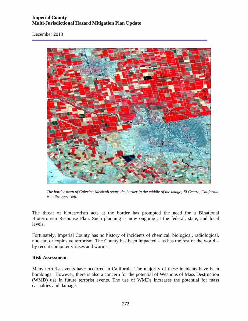
Imperial County Multi-Jurisdictional Hazard Mitigation Plan Update December 2013
272
The border town of Calexico-Mexicali spans the border in the middle of the image; El Centro, California is in the upper left.
The threat of bioterrorism acts at the border has prompted the need for a Binational Bioterrorism Response Plan. Such planning is now ongoing at the federal, state, and local levels. Fortunately, Imperial County has no history of incidents of chemical, biological, radiological, nuclear, or explosive terrorism. The County has been impacted – as has the rest of the world – by recent computer viruses and worms. Risk Assessment Many terrorist events have occurred in California. The majority of these incidents have been bombings. However, there is also a concern for the potential of Weapons of Mass Destruction (WMD) use in future terrorist events. The use of WMDs increases the potential for mass casualties and damage.
Imperial County Multi-Jurisdictional Hazard Mitigation Plan Update December 2013
273
One of the special considerations in dealing with the terrorist threat is that it is difficult to predict. One must know the minds and capabilities of various terrorists and terrorist groups. These are characteristics terrorist organizations strive to conceal. Because all terrorists are not the same, the calculation is even more difficult. Two things are clear from the perspective of hazard mitigation. The most often used weapon of terrorists is bombs and the greatest potential for loss is from WMDs. It must be dutifully noted, however, that Imperial County is a port of entry from a foreign country, Mexico, which may create a greater risk purely based on demographics. Since September 11, the concern lies on the border crossings into Imperial County. Some type of extreme militant foreign or domestic attack on the water sources, populated areas, agriculture chemicals and local military bases whether it is a direct attack or some type of contamination could occur. Because of the dynamic nature of the terrorist threat and the open nature of California society, all jurisdictions within California are vulnerable to the following terrorist attack.
• Effects on people, economics and housing. Depending on levels of contamination and exposure, effects could range from minimal to devastating. The terrorist attacks of September 11 prompted the United States to put Border Patrol and Customs agents on "Level 1" alert, meaning agents check every car and person entering the country. Because of this intense scrutiny, long backups of up to several hours exist at many border crossing points. This has crippled trade and commerce, depressing local border economies During the first two months following the terrorist attacks, fear of travel and increased congestion at the border reduced drastically the flow of traffic between the United States and Mexico. This reduced flow has undermined commercial and tourist activity on which border communities depend and caused serious problems for families that work, shop and attend school on both sides of the border. Mexican border residents spend up to $3 billion on products and services annually in Southern California alone
• Effects on commercial and industrial structures. Depending on levels of
contamination and exposure, effects could range from minimal to devastating.
• Effects on infrastructure. Nuclear, radiological, and cyber-terrorism can have profound effects on infrastructure.
• Effects on agriculture. As peak produce season arrives on the U.S.-Mexico
border, the agriculture sector is facing increased import barriers and labor shortages.

Imperial County Multi-Jurisdictional Hazard Mitigation Plan Update December 2013
274
Risk assessment conclusion. Due to events such as the 9/11 attack and the declared war against terrorism, national and local governments have assigned high priority to terrorist attack preparedness.
Imperial County Multi-Jurisdictional Hazard Mitigation Plan Update December 2013
275
Section 6. Goals, Objectives, and Mitigation Strategies
The Imperial County Hazard Mitigation Planning Committee held a workshop to review and analyze the risk assessments from the 2009 MHMP and updated their goals, objectives, and mitigation strategies to reflect changes in development. The Planning Committee developed the following goals and objectives based on the risk assessment studies and selected those that were determined to be of greatest benefit in hazard reduction to the County. The goals, objectives and strategies for Imperial County and the participating jurisdictions are as follows: Earthquake Goal 1 Earthquake Warning System Objective 1 To mitigate access issues and improve survivability Goal 2 Redundant Communications Objective 1 To mitigate access issues and improve survivability Goal 3 Additional Back-up Generators Objective 1 To mitigate access issues and improve survivability Goal 4 Retrofit Bridges Objective 1 To mitigate access issues and improve survivability Objective 2 To minimize disruption to transportation routes when bridges are affected Objective 3 To minimize the additional cost of fuel for school districts when detour routes
are implemented Goal 5 Upgrade Water Tanks Objective 1 To improve survivability Goal 6 Upgrade/Retrofit Critical Facilities (includes URM) Objective 1 Bring critical facilities up to current building standards Objective 2 To mitigate access issues and improve survivability Goal 7 Secure/Relocate Transformers Objective 1 To mitigate access issues and improve survivability Goal 8 Erosion Control Objective 1 To mitigate access issues and improve survivability Goal 9 Develop a Plan for Supporting the Prison Objective To improve survivability
Imperial County Multi-Jurisdictional Hazard Mitigation Plan Update December 2013
276
Flooding Goal 1 Drainage Improvements Objective 1 Increase capacity of storm drains (West and North End) Objective 3 Minimize the impact of a flood event Goal 2 Road Improvements Objective 1 To mitigate access issues and improve survivability Goal 3 Develop a Master Drainage Plan Objective 1 To mitigate access issues and improve survivability Objective 2 Minimize the impact of a flood event
Extreme Weather Goal 1 Public Education Objective 1 Improve public education regarding survivability and continuing functionality
during a weather event Objective 2 Inform public on Heat Centers Objective 3 Inform public on protection of animals Goal 2 Enhancement of Power Infrastructure Objective 1 To mitigate access issues and improve survivability Goal 3 Drought Mitigation Objective 1 Groundwater storage Objective 2 To improve public education regarding survivability and continuing
functionality during a weather event Goal 4 Storm Water Management Plan Objective 1 To minimize the impact of a flood event Objective 2 To improve public education regarding survivability and continuing
functionality during a weather event
Wildfire Goal 1 Vegetative Maintenance and Cleaning Objective 1 Reduce impact of wildland fire to infrastructures Objective 2 To mitigate access issues and improve survivability
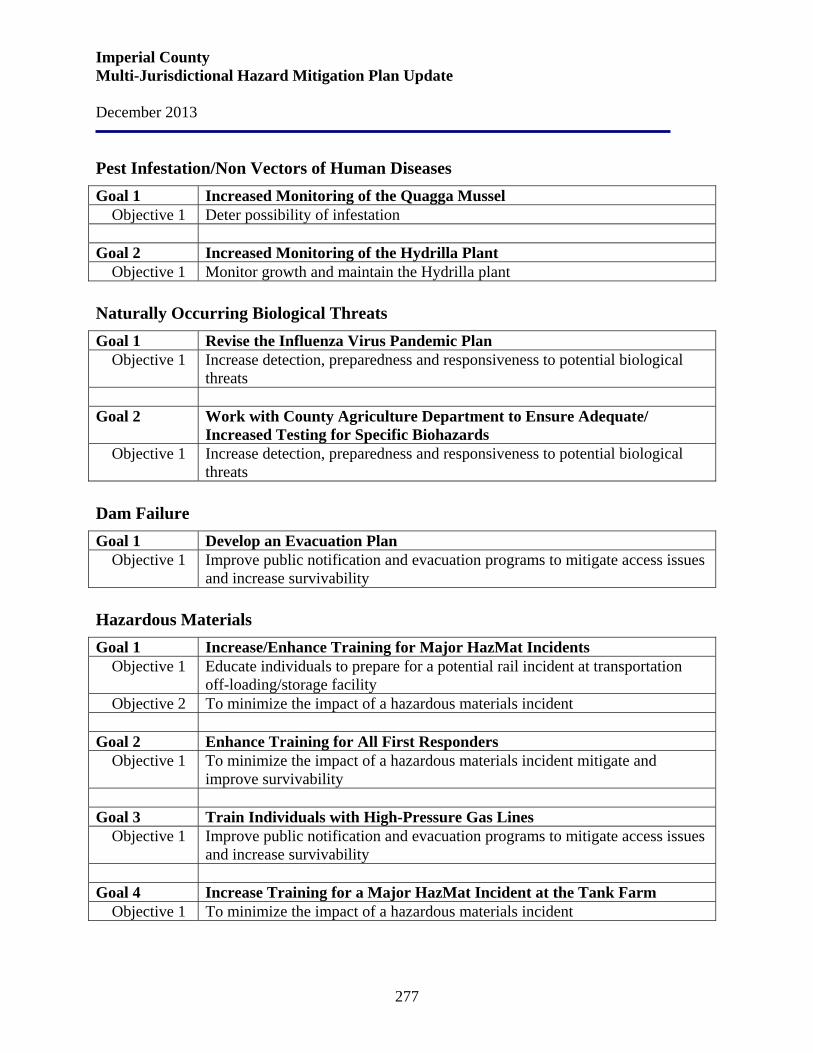
Imperial County Multi-Jurisdictional Hazard Mitigation Plan Update December 2013
277
Pest Infestation/Non Vectors of Human Diseases Goal 1 Increased Monitoring of the Quagga Mussel Objective 1 Deter possibility of infestation Goal 2 Increased Monitoring of the Hydrilla Plant Objective 1 Monitor growth and maintain the Hydrilla plant Naturally Occurring Biological Threats Goal 1 Revise the Influenza Virus Pandemic Plan Objective 1 Increase detection, preparedness and responsiveness to potential biological
threats Goal 2 Work with County Agriculture Department to Ensure Adequate/
Increased Testing for Specific Biohazards Objective 1 Increase detection, preparedness and responsiveness to potential biological
threats Dam Failure Goal 1 Develop an Evacuation Plan Objective 1 Improve public notification and evacuation programs to mitigate access issues
and increase survivability Hazardous Materials Goal 1 Increase/Enhance Training for Major HazMat Incidents Objective 1 Educate individuals to prepare for a potential rail incident at transportation
off-loading/storage facility Objective 2 To minimize the impact of a hazardous materials incident Goal 2 Enhance Training for All First Responders Objective 1 To minimize the impact of a hazardous materials incident mitigate and
improve survivability Goal 3 Train Individuals with High-Pressure Gas Lines Objective 1 Improve public notification and evacuation programs to mitigate access issues
and increase survivability Goal 4 Increase Training for a Major HazMat Incident at the Tank Farm Objective 1 To minimize the impact of a hazardous materials incident
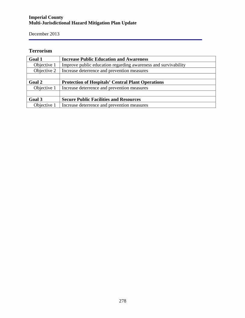
Imperial County Multi-Jurisdictional Hazard Mitigation Plan Update December 2013
278
Terrorism Goal 1 Increase Public Education and Awareness Objective 1 Improve public education regarding awareness and survivability Objective 2 Increase deterrence and prevention measures Goal 2 Protection of Hospitals’ Central Plant Operations Objective 1 Increase deterrence and prevention measures Goal 3 Secure Public Facilities and Resources Objective 1 Increase deterrence and prevention measures
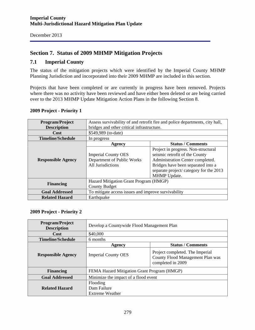
Imperial County Multi-Jurisdictional Hazard Mitigation Plan Update December 2013
279
Section 7. Status of 2009 MHMP Mitigation Projects 7.1 Imperial County The status of the mitigation projects which were identified by the Imperial County MHMP Planning Jurisdiction and incorporated into their 2009 MHMP are included in this section. Projects that have been completed or are currently in progress have been removed. Projects where there was no activity have been reviewed and have either been deleted or are being carried over to the 2013 MHMP Update Mitigation Action Plans in the following Section 8. 2009 Project - Priority 1
Program/Project Description
Assess survivability of and retrofit fire and police departments, city hall, bridges and other critical infrastructure.
Cost $549,989 (to-date) Timeline/Schedule In progress
Responsible Agency
Agency Status / Comments
Imperial County OES Department of Public Works All Jurisdictions
Project in progress. Non-structural seismic retrofit of the County Administration Center completed. Bridges have been separated into a separate project/ category for the 2013 MHMP Update.
Financing Hazard Mitigation Grant Program (HMGP) County Budget
Goal Addressed To mitigate access issues and improve survivability Related Hazard Earthquake
2009 Project - Priority 2
Program/Project Description Develop a Countywide Flood Management Plan
Cost $40,000 Timeline/Schedule 6 months
Responsible Agency
Agency Status / Comments
Imperial County OES
Project completed. The Imperial County Flood Management Plan was completed in 2009
Financing FEMA Hazard Mitigation Grant Program (HMGP) Goal Addressed Minimize the impact of a flood event
Related Hazard Flooding Dam Failure Extreme Weather
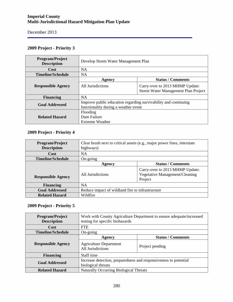
Imperial County Multi-Jurisdictional Hazard Mitigation Plan Update December 2013
280
2009 Project - Priority 3
Program/Project Description Develop Storm Water Management Plan
Cost NA Timeline/Schedule NA
Responsible Agency Agency Status / Comments
All Jurisdictions
Carry-over to 2013 MHMP Update: Storm Water Management Plan Project
Financing NA
Goal Addressed Improve public education regarding survivability and continuing functionality during a weather event
Related Hazard Flooding Dam Failure Extreme Weather
2009 Project - Priority 4
Program/Project Description
Clear brush next to critical assets (e.g., major power lines, interstate highways)
Cost NA Timeline/Schedule On-going
Responsible Agency
Agency Status / Comments
All Jurisdictions Carry-over to 2013 MHMP Update: Vegetative Management/Cleaning Project
Financing NA Goal Addressed Reduce impact of wildland fire to infrastructure Related Hazard Wildfire
2009 Project - Priority 5
Program/Project Description
Work with County Agriculture Department to ensure adequate/increased testing for specific biohazards
Cost FTE Timeline/Schedule On-going
Responsible Agency Agency Status / Comments
Agriculture Department All Jurisdictions Project pending
Financing Staff time
Goal Addressed Increase detection, preparedness and responsiveness to potential biological threats
Related Hazard Naturally Occurring Biological Threats
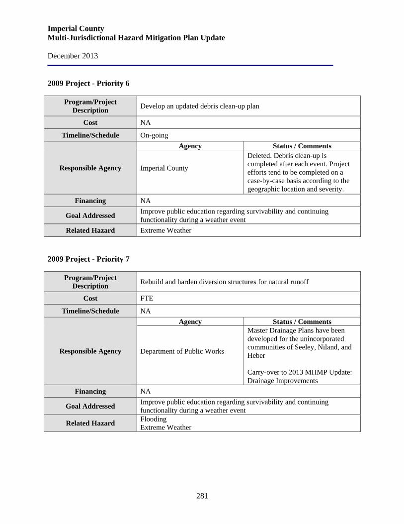
Imperial County Multi-Jurisdictional Hazard Mitigation Plan Update December 2013
281
2009 Project - Priority 6
Program/Project Description Develop an updated debris clean-up plan
Cost NA
Timeline/Schedule On-going
Responsible Agency
Agency Status / Comments
Imperial County
Deleted. Debris clean-up is completed after each event. Project efforts tend to be completed on a case-by-case basis according to the geographic location and severity.
Financing NA
Goal Addressed Improve public education regarding survivability and continuing functionality during a weather event
Related Hazard Extreme Weather 2009 Project - Priority 7
Program/Project Description Rebuild and harden diversion structures for natural runoff
Cost FTE
Timeline/Schedule NA
Responsible Agency
Agency Status / Comments
Department of Public Works
Master Drainage Plans have been developed for the unincorporated communities of Seeley, Niland, and Heber Carry-over to 2013 MHMP Update: Drainage Improvements
Financing NA
Goal Addressed Improve public education regarding survivability and continuing functionality during a weather event
Related Hazard Flooding Extreme Weather

Imperial County Multi-Jurisdictional Hazard Mitigation Plan Update December 2013
282
2009 Project - Priority 8
Program/Project Description Protection of hospitals' central plant operations
Cost NA Timeline/Schedule NA
Responsible Agency
Agency Status / Comments Imperial County OES Police Department Sherriff’s Department
Carry-over to 2013 MHMP Update: Protection of Hospitals’ Central Plant Operations Project
Financing NA Goal Addressed Increase deterrence and prevention measures Related Hazard Terrorism
2009 Project - Priority 9
Program/Project Description Secure all public facilities and resources
Cost NA Timeline/Schedule NA
Responsible Agency
Agency Status / Comments Imperial County OES Police Department Sherriff’s Department
Carry-over to 2013 MHMP Update: Secure All Public Facilities and Resources Project
Financing NA Goal Addressed Increase deterrence and prevention measures Related Hazard Terrorism
2009 Project - Priority 10
Program/Project Description Improve evacuation plans
Cost NA Timeline/Schedule NA
Responsible Agency
Agency Status / Comments
All Jurisdictions Carry-over to 2013 MHMP Update: Develop Evacuation Plan
Financing NA Goal Addressed Improve public notification and evacuation programs Related Hazard All Hazards
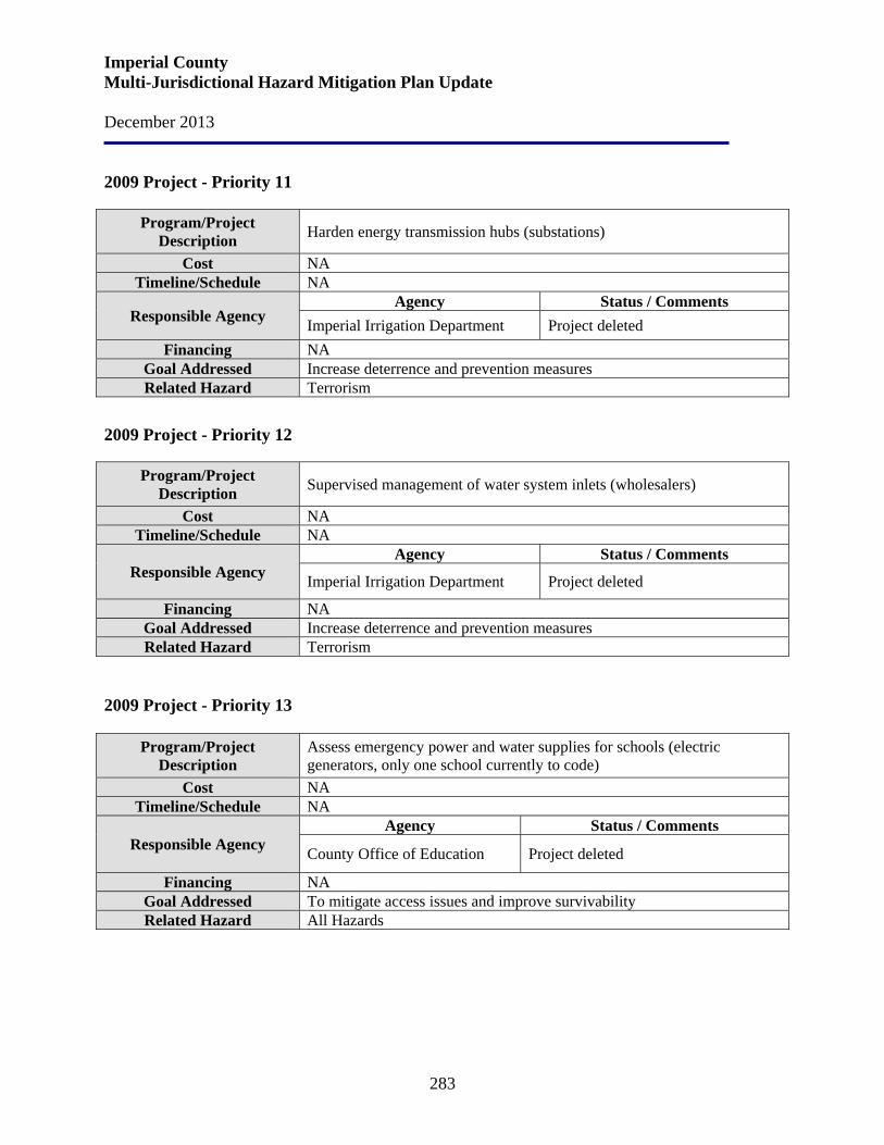
Imperial County Multi-Jurisdictional Hazard Mitigation Plan Update December 2013
283
2009 Project - Priority 11
Program/Project Description Harden energy transmission hubs (substations)
Cost NA Timeline/Schedule NA
Responsible Agency Agency Status / Comments
Imperial Irrigation Department Project deleted Financing NA
Goal Addressed Increase deterrence and prevention measures Related Hazard Terrorism
2009 Project - Priority 12
Program/Project Description Supervised management of water system inlets (wholesalers)
Cost NA Timeline/Schedule NA
Responsible Agency Agency Status / Comments
Imperial Irrigation Department Project deleted
Financing NA Goal Addressed Increase deterrence and prevention measures Related Hazard Terrorism
2009 Project - Priority 13
Program/Project Description
Assess emergency power and water supplies for schools (electric generators, only one school currently to code)
Cost NA Timeline/Schedule NA
Responsible Agency Agency Status / Comments
County Office of Education Project deleted
Financing NA Goal Addressed To mitigate access issues and improve survivability Related Hazard All Hazards
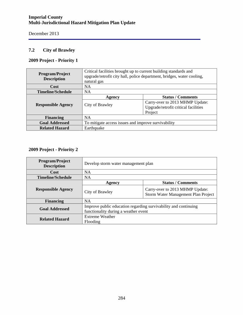
Imperial County Multi-Jurisdictional Hazard Mitigation Plan Update December 2013
284
7.2 City of Brawley
2009 Project - Priority 1
Program/Project Description
Critical facilities brought up to current building standards and upgrade/retrofit city hall, police department, bridges, water cooling, natural gas
Cost NA Timeline/Schedule NA
Responsible Agency
Agency Status / Comments
City of Brawley
Carry-over to 2013 MHMP Update: Upgrade/retrofit critical facilities Project
Financing NA Goal Addressed To mitigate access issues and improve survivability Related Hazard Earthquake
2009 Project - Priority 2
Program/Project
Description Develop storm water management plan
Cost NA Timeline/Schedule NA
Responsible Agency Agency Status / Comments
City of Brawley Carry-over to 2013 MHMP Update: Storm Water Management Plan Project
Financing NA
Goal Addressed Improve public education regarding survivability and continuing functionality during a weather event
Related Hazard Extreme Weather Flooding
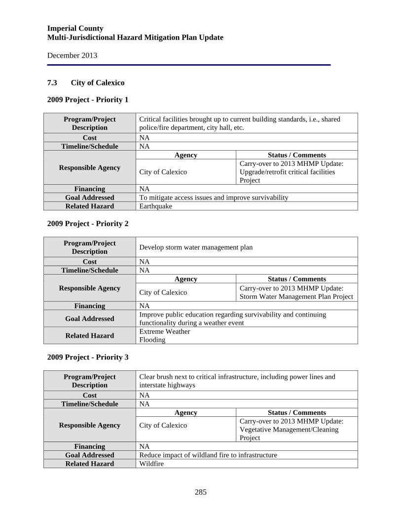
Imperial County Multi-Jurisdictional Hazard Mitigation Plan Update December 2013
285
7.3 City of Calexico
2009 Project - Priority 1
Program/Project Description
Critical facilities brought up to current building standards, i.e., shared police/fire department, city hall, etc.
Cost NA Timeline/Schedule NA
Responsible Agency
Agency Status / Comments
City of Calexico Carry-over to 2013 MHMP Update: Upgrade/retrofit critical facilities Project
Financing NA Goal Addressed To mitigate access issues and improve survivability Related Hazard Earthquake
2009 Project - Priority 2
Program/Project
Description Develop storm water management plan
Cost NA Timeline/Schedule NA
Responsible Agency Agency Status / Comments
City of Calexico Carry-over to 2013 MHMP Update: Storm Water Management Plan Project
Financing NA
Goal Addressed Improve public education regarding survivability and continuing functionality during a weather event
Related Hazard Extreme Weather Flooding
2009 Project - Priority 3
Program/Project
Description Clear brush next to critical infrastructure, including power lines and interstate highways
Cost NA Timeline/Schedule NA
Responsible Agency
Agency Status / Comments
City of Calexico
Carry-over to 2013 MHMP Update: Vegetative Management/Cleaning Project
Financing NA Goal Addressed Reduce impact of wildland fire to infrastructure Related Hazard Wildfire
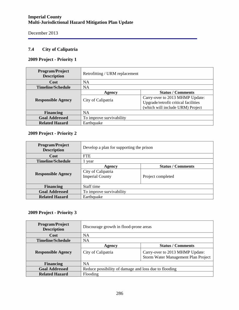
Imperial County Multi-Jurisdictional Hazard Mitigation Plan Update December 2013
286
7.4 City of Calipatria
2009 Project - Priority 1
Program/Project Description Retrofitting / URM replacement
Cost NA Timeline/Schedule NA
Responsible Agency
Agency Status / Comments
City of Calipatria
Carry-over to 2013 MHMP Update: Upgrade/retrofit critical facilities (which will include URM) Project
Financing NA Goal Addressed To improve survivability Related Hazard Earthquake
2009 Project - Priority 2
Program/Project
Description Develop a plan for supporting the prison
Cost FTE Timeline/Schedule 1 year
Responsible Agency
Agency Status / Comments City of Calipatria Imperial County
Project completed
Financing Staff time Goal Addressed To improve survivability Related Hazard Earthquake
2009 Project - Priority 3
Program/Project
Description Discourage growth in flood-prone areas
Cost NA Timeline/Schedule NA
Responsible Agency Agency Status / Comments
City of Calipatria
Carry-over to 2013 MHMP Update: Storm Water Management Plan Project
Financing NA Goal Addressed Reduce possibility of damage and loss due to flooding Related Hazard Flooding
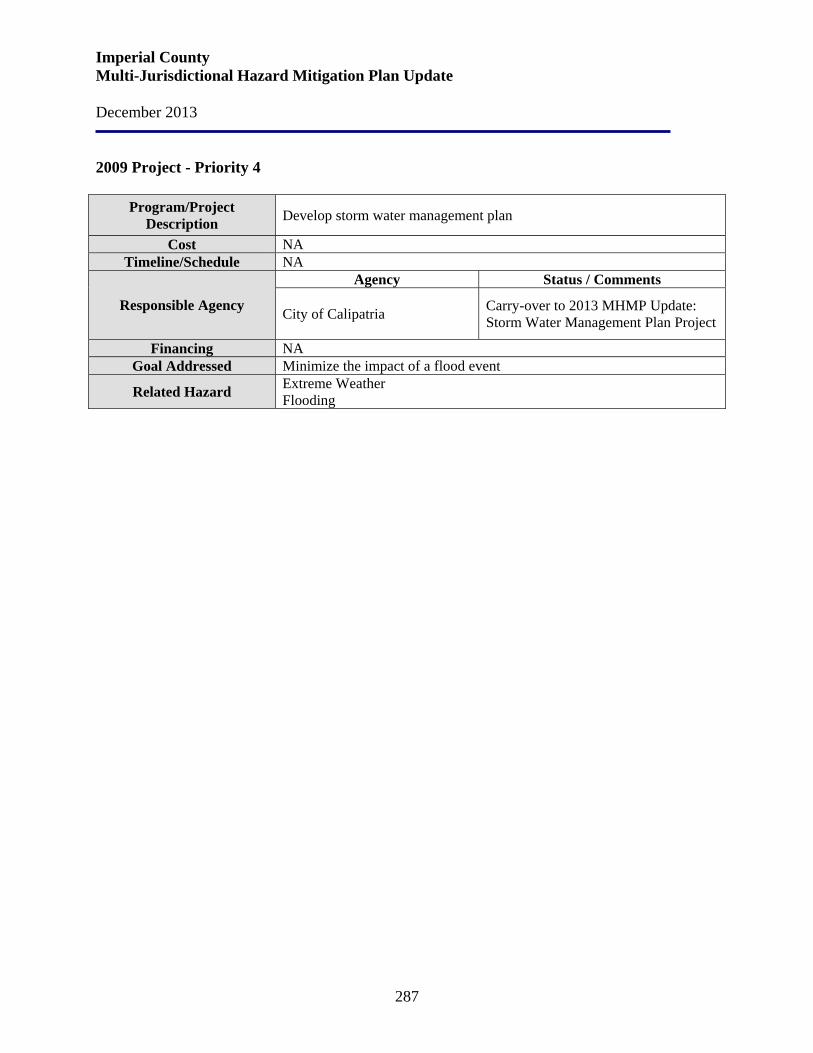
Imperial County Multi-Jurisdictional Hazard Mitigation Plan Update December 2013
287
2009 Project - Priority 4
Program/Project Description Develop storm water management plan
Cost NA Timeline/Schedule NA
Responsible Agency
Agency Status / Comments
City of Calipatria Carry-over to 2013 MHMP Update: Storm Water Management Plan Project
Financing NA Goal Addressed Minimize the impact of a flood event
Related Hazard Extreme Weather Flooding
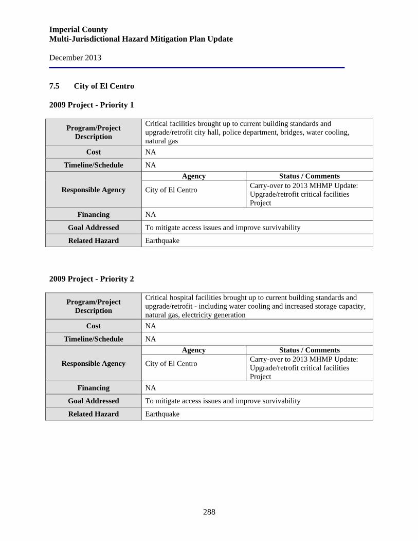
Imperial County Multi-Jurisdictional Hazard Mitigation Plan Update December 2013
288
7.5 City of El Centro 2009 Project - Priority 1
Program/Project Description
Critical facilities brought up to current building standards and upgrade/retrofit city hall, police department, bridges, water cooling, natural gas
Cost NA
Timeline/Schedule NA
Responsible Agency
Agency Status / Comments
City of El Centro
Carry-over to 2013 MHMP Update: Upgrade/retrofit critical facilities Project
Financing NA
Goal Addressed To mitigate access issues and improve survivability
Related Hazard Earthquake 2009 Project - Priority 2
Program/Project Description
Critical hospital facilities brought up to current building standards and upgrade/retrofit - including water cooling and increased storage capacity, natural gas, electricity generation
Cost NA
Timeline/Schedule NA
Responsible Agency
Agency Status / Comments
City of El Centro
Carry-over to 2013 MHMP Update: Upgrade/retrofit critical facilities Project
Financing NA
Goal Addressed To mitigate access issues and improve survivability
Related Hazard Earthquake
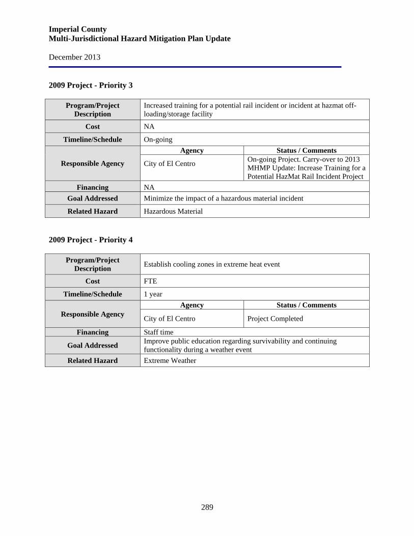
Imperial County Multi-Jurisdictional Hazard Mitigation Plan Update December 2013
289
2009 Project - Priority 3
Program/Project Description
Increased training for a potential rail incident or incident at hazmat off-loading/storage facility
Cost NA
Timeline/Schedule On-going
Responsible Agency
Agency Status / Comments
City of El Centro
On-going Project. Carry-over to 2013 MHMP Update: Increase Training for a Potential HazMat Rail Incident Project
Financing NA Goal Addressed Minimize the impact of a hazardous material incident
Related Hazard Hazardous Material 2009 Project - Priority 4
Program/Project
Description Establish cooling zones in extreme heat event
Cost FTE
Timeline/Schedule 1 year
Responsible Agency Agency Status / Comments
City of El Centro Project Completed
Financing Staff time
Goal Addressed Improve public education regarding survivability and continuing functionality during a weather event
Related Hazard Extreme Weather
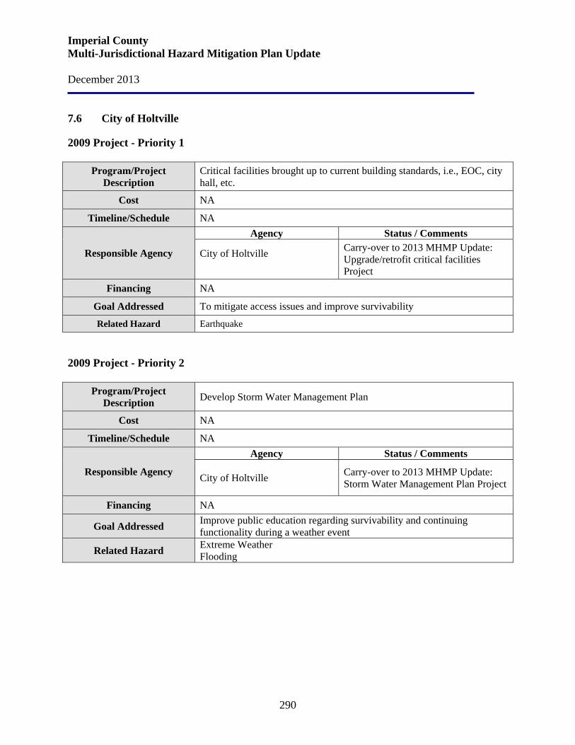
Imperial County Multi-Jurisdictional Hazard Mitigation Plan Update December 2013
290
7.6 City of Holtville
2009 Project - Priority 1
Program/Project Description
Critical facilities brought up to current building standards, i.e., EOC, city hall, etc.
Cost NA
Timeline/Schedule NA
Responsible Agency
Agency Status / Comments
City of Holtville
Carry-over to 2013 MHMP Update: Upgrade/retrofit critical facilities Project
Financing NA
Goal Addressed To mitigate access issues and improve survivability
Related Hazard Earthquake 2009 Project - Priority 2
Program/Project
Description Develop Storm Water Management Plan
Cost NA
Timeline/Schedule NA
Responsible Agency
Agency Status / Comments
City of Holtville Carry-over to 2013 MHMP Update: Storm Water Management Plan Project
Financing NA
Goal Addressed Improve public education regarding survivability and continuing functionality during a weather event
Related Hazard Extreme Weather Flooding
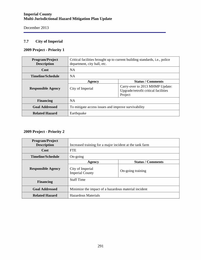
Imperial County Multi-Jurisdictional Hazard Mitigation Plan Update December 2013
291
7.7 City of Imperial
2009 Project - Priority 1
Program/Project Description
Critical facilities brought up to current building standards, i.e., police department, city hall, etc.
Cost NA
Timeline/Schedule NA
Responsible Agency
Agency Status / Comments
City of Imperial
Carry-over to 2013 MHMP Update: Upgrade/retrofit critical facilities Project
Financing NA
Goal Addressed To mitigate access issues and improve survivability
Related Hazard Earthquake 2009 Project - Priority 2
Program/Project
Description Increased training for a major incident at the tank farm
Cost FTE
Timeline/Schedule On-going
Responsible Agency
Agency Status / Comments
City of Imperial Imperial County On-going training
Financing Staff Time
Goal Addressed Minimize the impact of a hazardous material incident
Related Hazard Hazardous Materials
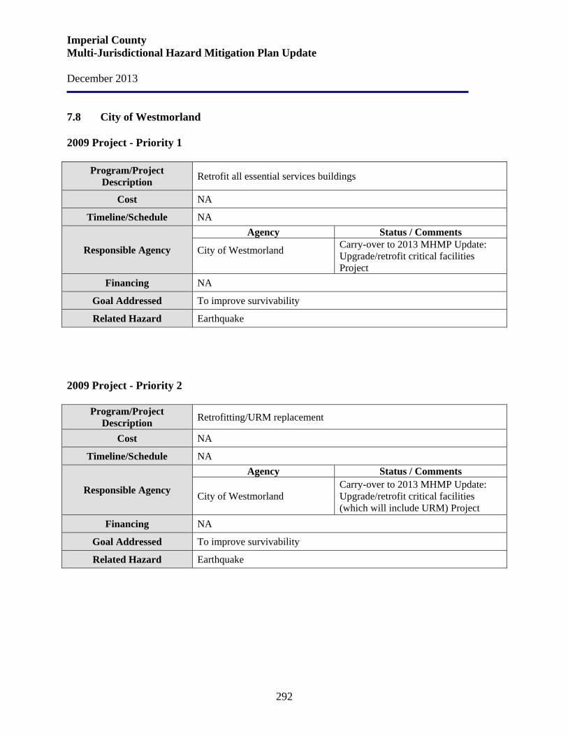
Imperial County Multi-Jurisdictional Hazard Mitigation Plan Update December 2013
292
7.8 City of Westmorland
2009 Project - Priority 1
Program/Project Description Retrofit all essential services buildings
Cost NA
Timeline/Schedule NA
Responsible Agency
Agency Status / Comments
City of Westmorland
Carry-over to 2013 MHMP Update: Upgrade/retrofit critical facilities Project
Financing NA
Goal Addressed To improve survivability
Related Hazard Earthquake 2009 Project - Priority 2
Program/Project
Description Retrofitting/URM replacement
Cost NA
Timeline/Schedule NA
Responsible Agency
Agency Status / Comments
City of Westmorland Carry-over to 2013 MHMP Update: Upgrade/retrofit critical facilities (which will include URM) Project
Financing NA
Goal Addressed To improve survivability
Related Hazard Earthquake
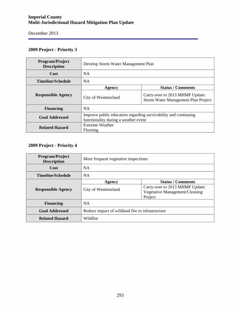
Imperial County Multi-Jurisdictional Hazard Mitigation Plan Update December 2013
293
2009 Project - Priority 3
Program/Project Description Develop Storm Water Management Plan
Cost NA
Timeline/Schedule NA
Responsible Agency
Agency Status / Comments
City of Westmorland Carry-over to 2013 MHMP Update: Storm Water Management Plan Project
Financing NA
Goal Addressed Improve public education regarding survivability and continuing functionality during a weather event
Related Hazard Extreme Weather Flooring
2009 Project - Priority 4
Program/Project
Description More frequent vegetative inspections
Cost NA
Timeline/Schedule NA
Responsible Agency
Agency Status / Comments
City of Westmorland
Carry-over to 2013 MHMP Update: Vegetative Management/Cleaning Project
Financing NA
Goal Addressed Reduce impact of wildland fire to infrastructure
Related Hazard Wildfire
Imperial County Multi-Jurisdictional Hazard Mitigation Plan Update December 2013
294
Section 8. MHMP Mitigation Strategies – Action Plan
The process used to prioritize mitigation strategies involved lengthy discussions with various jurisdictional stakeholders, followed by citizen and community reviews. The end result is a hazard mitigation Action Plan with a prioritized list of mitigation projects that Imperial County and the participating jurisdictions expect to carry out during the next five years. Prioritizing Strategies The process used was to first prioritized goals and their respective objectives based on priority maps created during the risk assessments. Available resources and public input were also considered. The County and participating jurisdictions next assessed each strategy listed under the prioritized list of goals. Imperial County and participating jurisdictions collectively prepared a prioritized mitigation Action Plan. In assessing and evaluating each strategy, Imperial County and the participating jurisdictions considered the following factors:
1. The cost was justified 2. Financial resources were available; local or outside resources 3. Staff resources were adequate 4. Minimal impact on County department functions 5. Strategies mitigate risks for the riskiest hazard events 6. Strategies reflect the goals and objectives
Implementation/Administration The Action Plan includes the principal contact and cooperating parties, timeframe and estimated cost involved in carrying out the strategy. The use of FEMA’s Benefit Cost Analysis (BCA) software (FEMA Mitigation BCA Toolkit Version 4.8) will be used to identify the cost-effectiveness of each activity or project undertaken and to perform benefit cost analysis for applications submitted under FEMA’s HMA Grant Programs. Each year the Action Plan will be revisited and the first year will be dropped as those activities are completed and another year will be added so that the Action Plan always reflects a five-year timeframe and remains current. Strategies undertaken and completed will be evaluated as to their effectiveness. For the planning areas subject to flood hazards, the mitigation actions and projects that reduce flood risk and deal with repetitive loss structures will be in compliance with the NFIP. Those activities not completed during the first year will be re-evaluated and included in the first year of the new Action Plan if still appropriate.
Imperial County Multi-Jurisdictional Hazard Mitigation Plan Update December 2013
295
Even though individual strategies will be assigned a principal contact to ensure implementation, overall responsibility, and oversight, the general monitoring of the Action Plan has been assigned to County OES. County OES will provide periodic updates to the County Board of Supervisors. This Action Plan serves as a guide to spending priorities but will be adjusted annually to reflect current needs and financial resources. Some strategies will require outside funding for implementation. If outside funding is not available, then the strategy will be set aside until new sources of funding can be identified. Following are Imperial County and participating jurisdictions’ prioritized 2013 Mitigation Action Items.
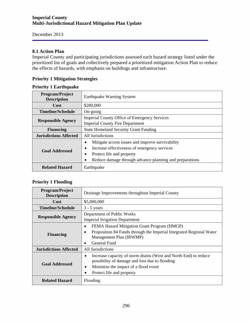
Imperial County Multi-Jurisdictional Hazard Mitigation Plan Update December 2013
296
8.1 Action Plan Imperial County and participating jurisdictions assessed each hazard strategy listed under the prioritized list of goals and collectively prepared a prioritized mitigation Action Plan to reduce the effects of hazards, with emphasis on buildings and infrastructure.
Priority 1 Mitigation Strategies
Priority 1 Earthquake Program/Project
Description Earthquake Warning System
Cost $280,000 Timeline/Schedule On-going
Responsible Agency Imperial County Office of Emergency Services Imperial County Fire Department
Financing State Homeland Security Grant Funding Jurisdictions Affected All Jurisdictions
Goal Addressed
• Mitigate access issues and improve survivability • Increase effectiveness of emergency services • Protect life and property • Reduce damage through advance planning and preparations
Related Hazard Earthquake
Priority 1 Flooding
Program/Project Description Drainage Improvements throughout Imperial County
Cost $5,000,000 Timeline/Schedule 3 - 5 years
Responsible Agency Department of Public Works Imperial Irrigation Department
Financing
• FEMA Hazard Mitigation Grant Program (HMGP) • Proposition 84 Funds through the Imperial Integrated Regional Water
Management Plan (IRWMP) • General Fund
Jurisdictions Affected All Jurisdictions
Goal Addressed
• Increase capacity of storm drains (West and North End) to reduce possibility of damage and loss due to flooding
• Minimize the impact of a flood event • Protect life and property
Related Hazard Flooding
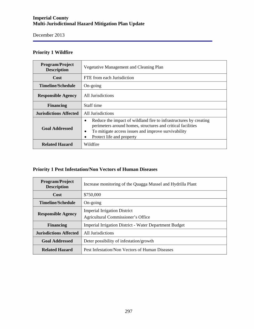
Imperial County Multi-Jurisdictional Hazard Mitigation Plan Update December 2013
297
Priority 1 Wildfire
Program/Project Description Vegetative Management and Cleaning Plan
Cost FTE from each Jurisdiction
Timeline/Schedule On-going
Responsible Agency All Jurisdictions
Financing Staff time
Jurisdictions Affected All Jurisdictions
Goal Addressed
• Reduce the impact of wildland fire to infrastructures by creating perimeters around homes, structures and critical facilities
• To mitigate access issues and improve survivability • Protect life and property
Related Hazard Wildfire
Priority 1 Pest Infestation/Non Vectors of Human Diseases
Program/Project Description Increase monitoring of the Quagga Mussel and Hydrilla Plant
Cost $750,000
Timeline/Schedule On-going
Responsible Agency Imperial Irrigation District Agricultural Commissioner’s Office
Financing Imperial Irrigation District - Water Department Budget
Jurisdictions Affected All Jurisdictions
Goal Addressed Deter possibility of infestation/growth
Related Hazard Pest Infestation/Non Vectors of Human Diseases

Imperial County Multi-Jurisdictional Hazard Mitigation Plan Update December 2013
298
Priority 1 Naturally Occurring Biological Threats
Program/Project Description Update/revise the Flu Pandemic Plan
Cost $67,000
Timeline/Schedule 1 year then on-going
Responsible Agency Department of Public Health
Financing Pandemic Influenza State General Fund Grant
Jurisdictions Affected All Jurisdictions
Goal Addressed
• Increase detection, preparedness and responsiveness to potential biological threats
• Protect life and improve survivability • Reduce damage through advance planning and preparations
Related Hazard Naturally Occurring Biological Threats
Priority 1 Dam Failure
Program/Project Description Update/revise Evacuation Plan
Cost FTE from each Jurisdiction
Timeline/Schedule On-going
Responsible Agency Imperial County Office of Emergency Services All Jurisdictions
Financing Staff time
Jurisdictions Affected All Jurisdictions
Goal Addressed
• Improve public notification and evacuation programs • Mitigate access issues and improve survivability • Protect life and property • Reduce damage through advance planning and preparations
Related Hazard
Dam Failure Earthquake Flooding Wildfire Hazardous Materials Terrorism
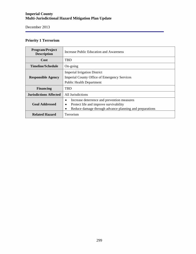
Imperial County Multi-Jurisdictional Hazard Mitigation Plan Update December 2013
299
Priority 1 Terrorism
Program/Project Description Increase Public Education and Awareness
Cost TBD
Timeline/Schedule On-going
Responsible Agency Imperial Irrigation District Imperial County Office of Emergency Services Public Health Department
Financing TBD
Jurisdictions Affected All Jurisdictions
Goal Addressed • Increase deterrence and prevention measures • Protect life and improve survivability • Reduce damage through advance planning and preparations
Related Hazard Terrorism
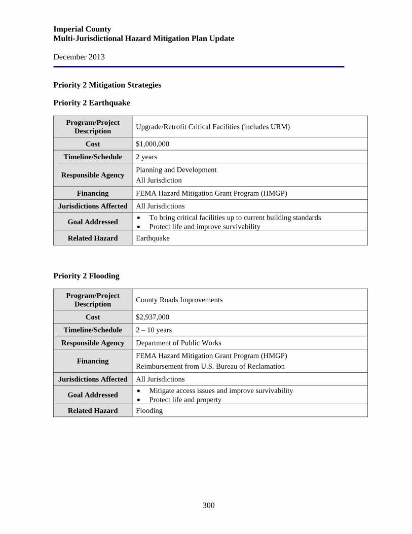
Imperial County Multi-Jurisdictional Hazard Mitigation Plan Update December 2013
300
Priority 2 Mitigation Strategies Priority 2 Earthquake
Program/Project Description Upgrade/Retrofit Critical Facilities (includes URM)
Cost $1,000,000
Timeline/Schedule 2 years
Responsible Agency Planning and Development All Jurisdiction
Financing FEMA Hazard Mitigation Grant Program (HMGP)
Jurisdictions Affected All Jurisdictions
Goal Addressed • To bring critical facilities up to current building standards • Protect life and improve survivability
Related Hazard Earthquake Priority 2 Flooding
Program/Project Description County Roads Improvements
Cost $2,937,000
Timeline/Schedule 2 – 10 years
Responsible Agency Department of Public Works
Financing FEMA Hazard Mitigation Grant Program (HMGP) Reimbursement from U.S. Bureau of Reclamation
Jurisdictions Affected All Jurisdictions
Goal Addressed • Mitigate access issues and improve survivability • Protect life and property
Related Hazard Flooding
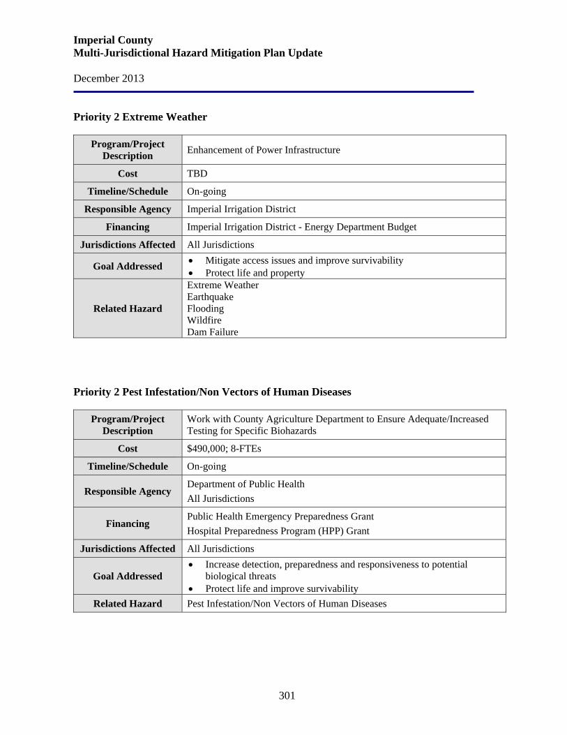
Imperial County Multi-Jurisdictional Hazard Mitigation Plan Update December 2013
301
Priority 2 Extreme Weather
Program/Project Description Enhancement of Power Infrastructure
Cost TBD
Timeline/Schedule On-going
Responsible Agency Imperial Irrigation District
Financing Imperial Irrigation District - Energy Department Budget
Jurisdictions Affected All Jurisdictions
Goal Addressed • Mitigate access issues and improve survivability • Protect life and property
Related Hazard
Extreme Weather Earthquake Flooding Wildfire Dam Failure
Priority 2 Pest Infestation/Non Vectors of Human Diseases
Program/Project Description
Work with County Agriculture Department to Ensure Adequate/Increased Testing for Specific Biohazards
Cost $490,000; 8-FTEs
Timeline/Schedule On-going
Responsible Agency Department of Public Health All Jurisdictions
Financing Public Health Emergency Preparedness Grant Hospital Preparedness Program (HPP) Grant
Jurisdictions Affected All Jurisdictions
Goal Addressed • Increase detection, preparedness and responsiveness to potential
biological threats • Protect life and improve survivability
Related Hazard Pest Infestation/Non Vectors of Human Diseases
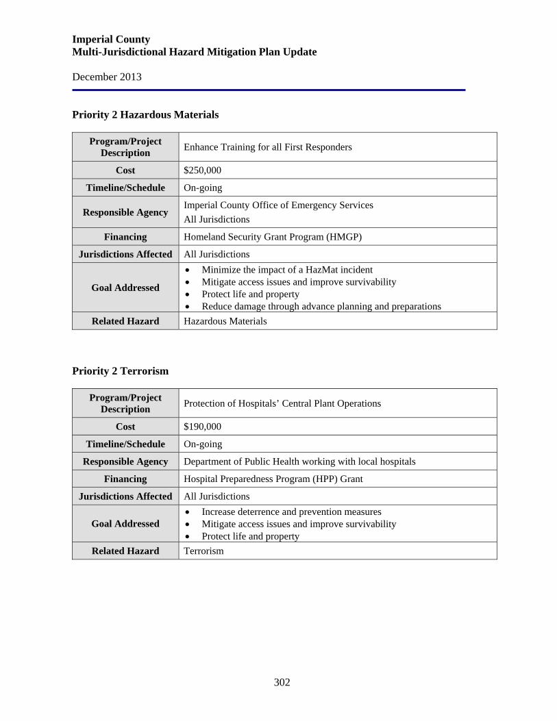
Imperial County Multi-Jurisdictional Hazard Mitigation Plan Update December 2013
302
Priority 2 Hazardous Materials
Program/Project Description Enhance Training for all First Responders
Cost $250,000
Timeline/Schedule On-going
Responsible Agency Imperial County Office of Emergency Services All Jurisdictions
Financing Homeland Security Grant Program (HMGP)
Jurisdictions Affected All Jurisdictions
Goal Addressed
• Minimize the impact of a HazMat incident • Mitigate access issues and improve survivability • Protect life and property • Reduce damage through advance planning and preparations
Related Hazard Hazardous Materials Priority 2 Terrorism
Program/Project Description Protection of Hospitals’ Central Plant Operations
Cost $190,000
Timeline/Schedule On-going
Responsible Agency Department of Public Health working with local hospitals
Financing Hospital Preparedness Program (HPP) Grant
Jurisdictions Affected All Jurisdictions
Goal Addressed • Increase deterrence and prevention measures • Mitigate access issues and improve survivability • Protect life and property
Related Hazard Terrorism
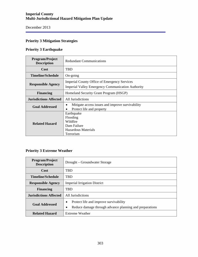
Imperial County Multi-Jurisdictional Hazard Mitigation Plan Update December 2013
303
Priority 3 Mitigation Strategies Priority 3 Earthquake
Program/Project Description Redundant Communications
Cost TBD
Timeline/Schedule On-going
Responsible Agency Imperial County Office of Emergency Services Imperial Valley Emergency Communication Authority
Financing Homeland Security Grant Program (HSGP)
Jurisdictions Affected All Jurisdictions
Goal Addressed • Mitigate access issues and improve survivability • Protect life and property
Related Hazard
Earthquake Flooding Wildfire Dam Failure Hazardous Materials Terrorism
Priority 3 Extreme Weather
Program/Project Description Drought – Groundwater Storage
Cost TBD
Timeline/Schedule TBD
Responsible Agency Imperial Irrigation District
Financing TBD
Jurisdictions Affected All Jurisdictions
Goal Addressed • Protect life and improve survivability • Reduce damage through advance planning and preparations
Related Hazard Extreme Weather

Imperial County Multi-Jurisdictional Hazard Mitigation Plan Update December 2013
304
Priority 3 Hazardous Materials
Program/Project Description Train Individuals with High-Pressure Gas Lines
Cost TBD
Timeline/Schedule On-going
Responsible Agency Imperial County Office of Emergency Services All Jurisdictions
Financing TBD
Jurisdictions Affected All Jurisdictions
Goal Addressed
• Educate individuals to prepare for a potential HazMat incident • Protect life and improve survivability • Protect property • Reduce damage through advance planning and preparations
Related Hazard Hazardous Materials Priority 3 Terrorism
Program/Project Description Secure Public Facilities and Resources
Cost TBD
Timeline/Schedule On-going
Responsible Agency
Sheriff’s Office Police Department Imperial County Office of Emergency Services All Jurisdictions
Financing TBD
Jurisdictions Affected All Jurisdictions
Goal Addressed • Increase deterrence and prevention measures • Protect life and improve survivability • Protect property
Related Hazard Terrorism

Imperial County Multi-Jurisdictional Hazard Mitigation Plan Update December 2013
305
Priority 4 Mitigation Strategies
Priority 4 Earthquake
Program/Project Description Additional Emergency Back-up Generators for County Facilities
Cost $135,000
Timeline/Schedule 2 – 5 years
Responsible Agency Department of Public Works
Financing County Facilities Maintenance
Jurisdictions Affected All Jurisdictions
Goal Addressed • Mitigate access issues and improve survivability • Protect life and property
Related Hazard
Earthquake Flooding Extreme Weather Wildfire Dam Failure Hazardous Materials Terrorism
Priority 4 Extreme Weather
Program/Project Description Storm Water Management Plan
Cost $60 million
Timeline/Schedule On-going
Responsible Agency Imperial Irrigation District County Planning Department City and County Public Works
Financing Imperial Irrigation District – Water Department Budget
Jurisdictions Affected All Jurisdictions
Goal Addressed
• Minimize the impact of a flood event • Mitigate access issues and improve survivability • Protect life and property • Reduce damage through advance planning and preparations
Related Hazard Extreme Weather Flooding Dam Failure
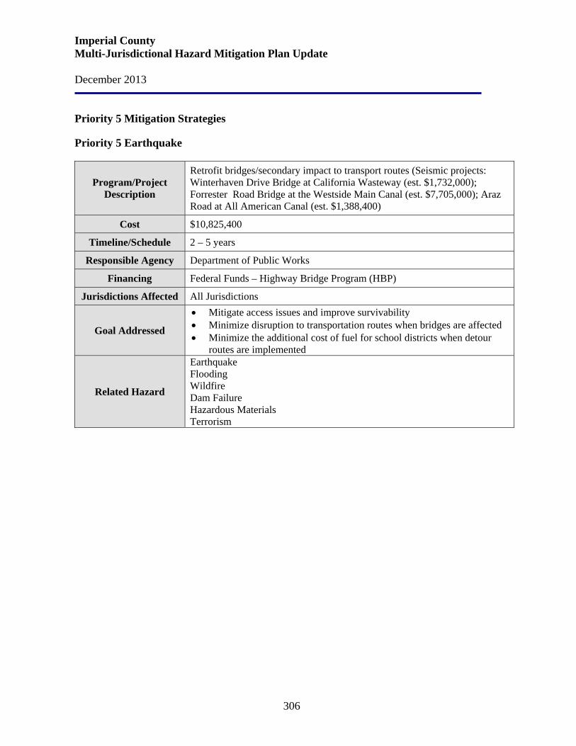
Imperial County Multi-Jurisdictional Hazard Mitigation Plan Update December 2013
306
Priority 5 Mitigation Strategies
Priority 5 Earthquake
Program/Project Description
Retrofit bridges/secondary impact to transport routes (Seismic projects: Winterhaven Drive Bridge at California Wasteway (est. $1,732,000); Forrester Road Bridge at the Westside Main Canal (est. $7,705,000); Araz Road at All American Canal (est. $1,388,400)
Cost $10,825,400
Timeline/Schedule 2 – 5 years
Responsible Agency Department of Public Works
Financing Federal Funds – Highway Bridge Program (HBP)
Jurisdictions Affected All Jurisdictions
Goal Addressed
• Mitigate access issues and improve survivability • Minimize disruption to transportation routes when bridges are affected • Minimize the additional cost of fuel for school districts when detour
routes are implemented
Related Hazard
Earthquake Flooding Wildfire Dam Failure Hazardous Materials Terrorism
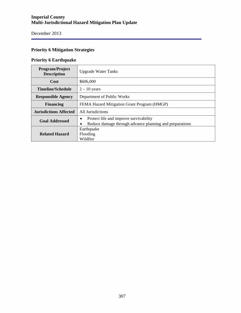
Imperial County Multi-Jurisdictional Hazard Mitigation Plan Update December 2013
307
Priority 6 Mitigation Strategies
Priority 6 Earthquake
Program/Project Description Upgrade Water Tanks
Cost $606,000
Timeline/Schedule 2 – 10 years
Responsible Agency Department of Public Works
Financing FEMA Hazard Mitigation Grant Program (HMGP)
Jurisdictions Affected All Jurisdictions
Goal Addressed • Protect life and improve survivability • Reduce damage through advance planning and preparations
Related Hazard Earthquake Flooding Wildfire
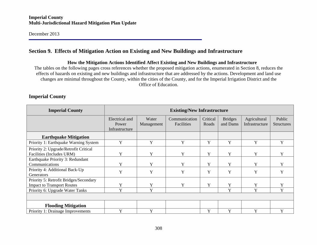
Imperial County Multi-Jurisdictional Hazard Mitigation Plan Update December 2013
308
Section 9. Effects of Mitigation Action on Existing and New Buildings and Infrastructure
How the Mitigation Actions Identified Affect Existing and New Buildings and Infrastructure The tables on the following pages cross references whether the proposed mitigation actions, enumerated in Section 8, reduces the effects of hazards on existing and new buildings and infrastructure that are addressed by the actions. Development and land use
changes are minimal throughout the County, within the cities of the County, and for the Imperial Irrigation District and the Office of Education.
Imperial County
Imperial County Existing/New Infrastructure
Electrical and Power
Infrastructure
Water Management
Communication Facilities
Critical Roads
Bridges and Dams
Agricultural Infrastructure
Public Structures
Earthquake Mitigation
Priority 1: Earthquake Warning System Y Y Y Y Y Y Y Priority 2: Upgrade/Retrofit Critical Facilities (Includes URM)
Y
Y
Y
Y
Y
Y
Y
Earthquake Priority 3: Redundant Communications
Y
Y
Y
Y
Y
Y
Y
Priority 4: Additional Back-Up Generators Y Y Y Y Y Y Y
Priority 5: Retrofit Bridges/Secondary Impact to Transport Routes
Y
Y
Y
Y
Y
Y
Y
Priority 6: Upgrade Water Tanks Y Y Y Y Y
Flooding Mitigation
Priority 1: Drainage Improvements Y Y Y Y Y Y
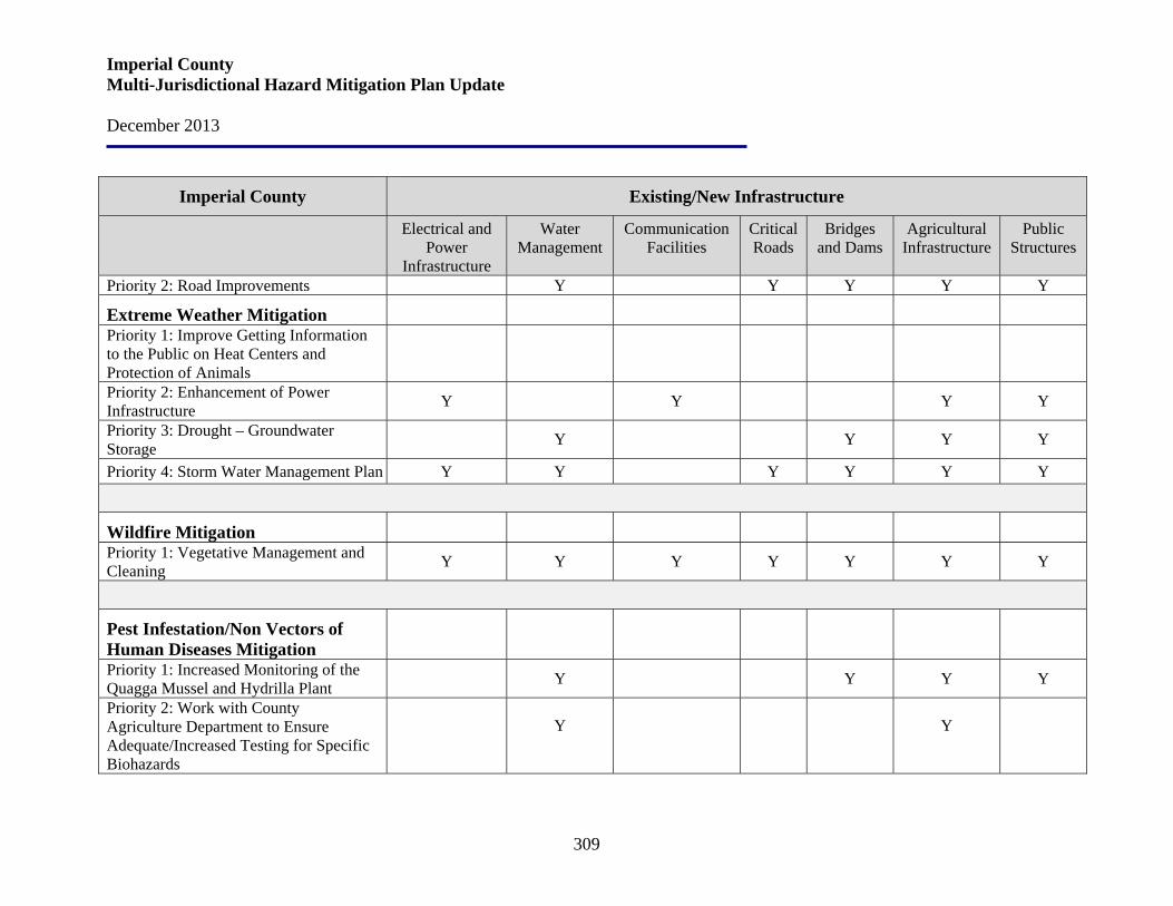
Imperial County Multi-Jurisdictional Hazard Mitigation Plan Update December 2013
309
Imperial County Existing/New Infrastructure
Electrical and Power
Infrastructure
Water Management
Communication Facilities
Critical Roads
Bridges and Dams
Agricultural Infrastructure
Public Structures
Priority 2: Road Improvements Y Y Y Y Y
Extreme Weather Mitigation Priority 1: Improve Getting Information to the Public on Heat Centers and Protection of Animals
Priority 2: Enhancement of Power Infrastructure Y Y Y Y
Priority 3: Drought – Groundwater Storage Y Y Y Y
Priority 4: Storm Water Management Plan Y Y Y Y Y Y
Wildfire Mitigation Priority 1: Vegetative Management and Cleaning Y Y Y Y Y Y Y
Pest Infestation/Non Vectors of Human Diseases Mitigation
Priority 1: Increased Monitoring of the Quagga Mussel and Hydrilla Plant Y Y Y Y
Priority 2: Work with County Agriculture Department to Ensure Adequate/Increased Testing for Specific Biohazards
Y Y
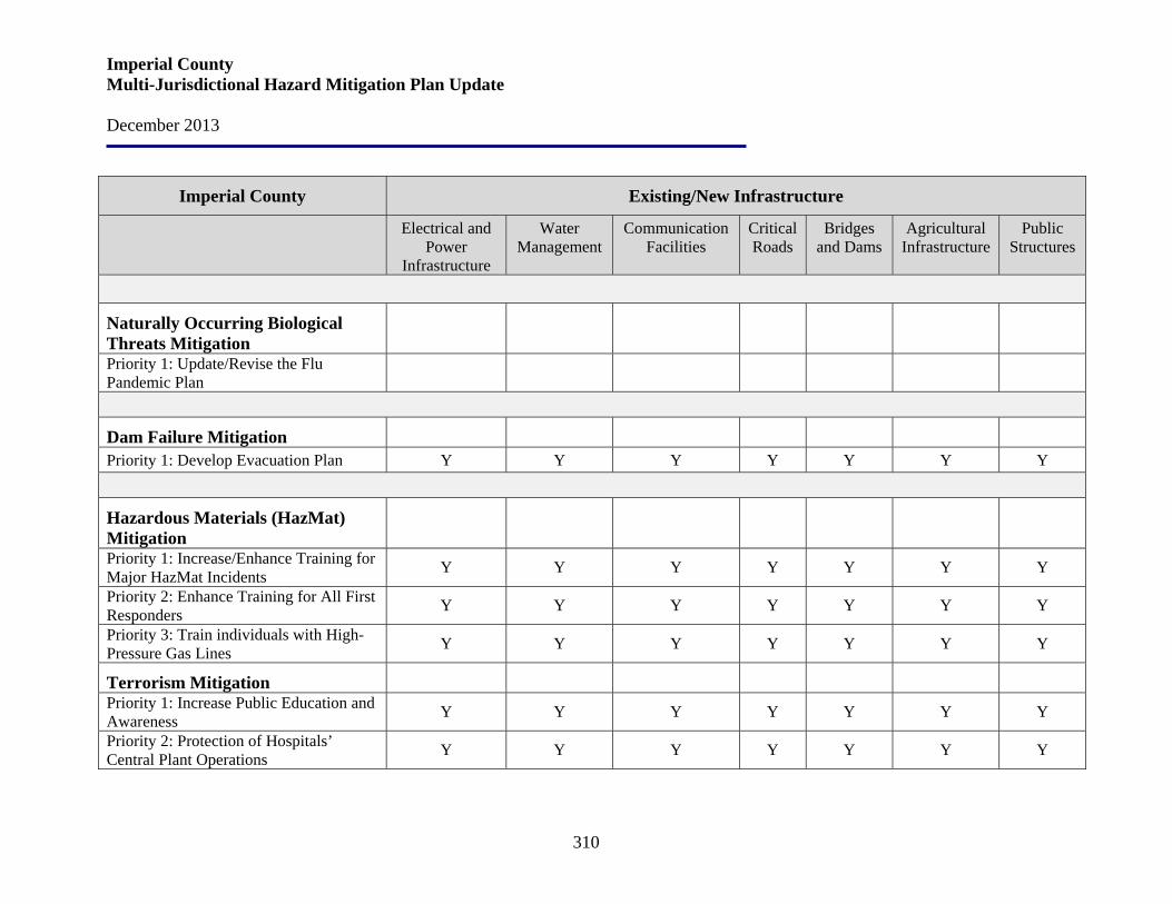
Imperial County Multi-Jurisdictional Hazard Mitigation Plan Update December 2013
310
Imperial County Existing/New Infrastructure
Electrical and Power
Infrastructure
Water Management
Communication Facilities
Critical Roads
Bridges and Dams
Agricultural Infrastructure
Public Structures
Naturally Occurring Biological Threats Mitigation
Priority 1: Update/Revise the Flu Pandemic Plan
Dam Failure Mitigation Priority 1: Develop Evacuation Plan Y Y Y Y Y Y Y
Hazardous Materials (HazMat) Mitigation
Priority 1: Increase/Enhance Training for Major HazMat Incidents Y Y Y Y Y Y Y
Priority 2: Enhance Training for All First Responders Y Y Y Y Y Y Y
Priority 3: Train individuals with High-Pressure Gas Lines Y Y Y Y Y Y Y
Terrorism Mitigation Priority 1: Increase Public Education and Awareness Y Y Y Y Y Y Y
Priority 2: Protection of Hospitals’ Central Plant Operations Y Y Y Y Y Y Y

Imperial County Multi-Jurisdictional Hazard Mitigation Plan Update December 2013
311
City of Brawley
City of Brawley Existing/New Infrastructure
Electrical and Power
Infrastructure
Water Management
Communication Facilities
Critical Roads
Bridges and Dams
Agricultural Infrastructure
Public Structures
Earthquake Mitigation
Priority 1: Earthquake Warning System Y Y Y Y Y Y Y Priority 2: Upgrade/Retrofit Critical Facilities (Includes URM)
Y Y Y Y Y Y Y
Priority 3: Redundant Communications Y Y Y Y Y Y Y Priority 4: Additional Back-Up Generators
Y
Y
Y
Y
Y
Y
Y
Priority 5: Retrofit Bridges/Secondary Impact to Transport Routes
Y
Y
Priority 6: Upgrade Water Tanks Y Y Y
Flooding Mitigation
Priority 1: Drainage Improvements Y Y Y Y Y Priority 2: Road Improvements Y Y Y Y Y
Extreme Weather Mitigation Priority 1: Improve Getting Information to the Public on Heat Centers and Protection of Animals
Priority 2: Enhancement of Power Infrastructure
Y
Y
Y
Y
Y
Y

Imperial County Multi-Jurisdictional Hazard Mitigation Plan Update December 2013
312
City of Brawley Existing/New Infrastructure
Electrical and Power
Infrastructure
Water Management
Communication Facilities
Critical Roads
Bridges and Dams
Agricultural Infrastructure
Public Structures
Priority 3: Drought – Groundwater Storage
Y
Y
Y
Y
Priority 4: Storm Water Management Plan Y Y Y Y Y Y Y
Wildfire Mitigation Priority 1: Vegetative Management and Cleaning
Y
Y
Y
Y
Y
Y
Y
Pest Infestation/Non Vectors of Human Diseases Mitigation
Priority 1: Increased Monitoring of the Quagga Mussel and Hydrilla Plant
Y
Y
Y
Y
Y
Y
Y
Priority 2: Work with County Agriculture Department to Ensure Adequate/Increased Testing for Specific Biohazards
Y
Y
Y
Y
Y
Y
Y
Naturally Occurring Biological Threats Mitigation
Priority 1: Update/Revise the Flu Pandemic Plan
Dam Failure Mitigation Priority 1: Develop Evacuation Plan Y Y Y Y Y Y Y

Imperial County Multi-Jurisdictional Hazard Mitigation Plan Update December 2013
313
City of Brawley Existing/New Infrastructure
Electrical and Power
Infrastructure
Water Management
Communication Facilities
Critical Roads
Bridges and Dams
Agricultural Infrastructure
Public Structures
Hazardous Materials (HazMat) Mitigation
Priority 1: Increase/Enhance Training for Major HazMat Incidents
Y
Y
Y
Y
Y
Y
Y
Priority 2: Enhance Training for All First Responders
Y
Y
Y
Y
Y
Y
Y
Priority 3: Train individuals with High-Pressure Gas Lines
Y
Y
Y
Y
Y
Y
Y
Terrorism Mitigation Priority 1: Increase Public Education and Awareness
Y
Y
Y
Y
Y
Y
Y
Priority 2: Protection of Hospitals’ Central Plant Operations
Y
Y
Y
Y
Y
Y
Y

Imperial County Multi-Jurisdictional Hazard Mitigation Plan Update December 2013
314
City of Calexico
City of Calexico Existing/New Infrastructure
Electrical and Power
Infrastructure
Water Management
Communication Facilities
Critical Roads
Bridges and Dams
Agricultural Infrastructure
Public Structures
Earthquake Mitigation
Priority 1: Earthquake Warning System Y Y Y Y Y Y Y Priority 2: Upgrade/Retrofit Critical Facilities (Includes URM) Y
Y Y
Priority 3: Redundant Communications Y Y Y Y Y Y Y Priority 4: Additional Back-Up Generators
Y
Y
Y
Y
Y
Y
Y
Priority 5: Retrofit Bridges/Secondary Impact to Transport Routes
Y
Y
Y
Y
Y
Priority 6: Upgrade Water Tanks Y Y
Flooding Mitigation
Priority 1: Drainage Improvements Y Y Y Y Y Priority 2: Road Improvements Y Y Y Y Y
Extreme Weather Mitigation Priority 1: Improve Getting Information to the Public on Heat Centers and Protection of Animals
Priority 2: Enhancement of Power Infrastructure
Y
Y
Y
Y
Y
Y
Y

Imperial County Multi-Jurisdictional Hazard Mitigation Plan Update December 2013
315
City of Calexico Existing/New Infrastructure
Electrical and Power
Infrastructure
Water Management
Communication Facilities
Critical Roads
Bridges and Dams
Agricultural Infrastructure
Public Structures
Priority 3: Drought – Groundwater Storage
Y
Y
Y
Y
Priority 4: Storm Water Management Plan Y Y Y Y
Wildfire Mitigation Priority 1: Vegetative Management and Cleaning
Y
Y
Y
Y
Y
Y
Y
Pest Infestation/Non Vectors of Human Diseases Mitigation
Priority 1: Increased Monitoring of the Quagga Mussel and Hydrilla Plant
Y
Y
Y
Y
Y
Y
Y
Priority 2: Work with Agriculture Department to Ensure Adequate/ Increased Testing for Specific Biohazards
Y
Y
Y
Y
Y
Y
Y
Naturally Occurring Biological Threats Mitigation
Priority 1: Update/Revise the Flu Pandemic Plan
Dam Failure Mitigation Priority 1: Develop Evacuation Plan Y Y Y Y Y Y Y

Imperial County Multi-Jurisdictional Hazard Mitigation Plan Update December 2013
316
City of Calexico Existing/New Infrastructure
Electrical and Power
Infrastructure
Water Management
Communication Facilities
Critical Roads
Bridges and Dams
Agricultural Infrastructure
Public Structures
Hazardous Materials (HazMat) Mitigation
Priority 1: Increase/Enhance Training for Major HazMat Incidents
Y
Y
Y
Y
Y
Y
Y
Priority 2: Enhance Training for All First Responders
Priority 3: Train individuals with High-Pressure Gas Lines
Y
Y
Y
Y
Y
Y
Y
Terrorism Mitigation Priority 1: Increase Public Education and Awareness
Y
Y
Y
Y
Y
Y
Y
Priority 2: Protection of Hospitals’ Central Plant Operations
Y
Y
Y
Y
Y
Y
Y
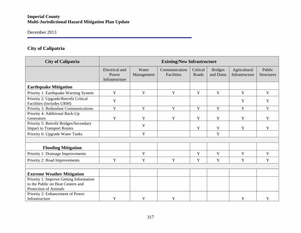
Imperial County Multi-Jurisdictional Hazard Mitigation Plan Update December 2013
317
City of Calipatria
City of Calipatria Existing/New Infrastructure
Electrical and Power
Infrastructure
Water Management
Communication Facilities
Critical Roads
Bridges and Dams
Agricultural Infrastructure
Public Structures
Earthquake Mitigation
Priority 1: Earthquake Warning System Y Y Y Y Y Y Y Priority 2: Upgrade/Retrofit Critical Facilities (Includes URM) Y Y Y
Priority 3: Redundant Communications Y Y Y Y Y Y Y Priority 4: Additional Back-Up Generators
Y
Y
Y
Y
Y
Y
Y
Priority 5: Retrofit Bridges/Secondary Impact to Transport Routes
Y Y
Y
Y
Y
Priority 6: Upgrade Water Tanks Y Y
Flooding Mitigation
Priority 1: Drainage Improvements Y Y Y Y Y Priority 2: Road Improvements Y Y Y Y Y Y Y
Extreme Weather Mitigation Priority 1: Improve Getting Information to the Public on Heat Centers and Protection of Animals
Priority 2: Enhancement of Power Infrastructure
Y
Y
Y
Y
Y

Imperial County Multi-Jurisdictional Hazard Mitigation Plan Update December 2013
318
City of Calipatria Existing/New Infrastructure
Electrical and Power
Infrastructure
Water Management
Communication Facilities
Critical Roads
Bridges and Dams
Agricultural Infrastructure
Public Structures
Priority 3: Drought – Groundwater Storage
Y
Y
Y
Y
Priority 4: Storm Water Management Plan Y Y Y Y Y Y Y
Wildfire Mitigation Priority 1: Vegetative Management and Cleaning
Y
Y
Y
Y
Y
Y
Y
Pest Infestation/Non Vectors of Human Diseases Mitigation
Priority 1: Increased Monitoring of the Quagga Mussel and Hydrilla Plant
Y
Y
Y
Y
Y
Y
Y
Priority 2: Work with County Agriculture Department to Ensure Adequate/Increased Testing for Specific Biohazards
Y
Y
Y
Y
Y
Y
Y
Naturally Occurring Biological Threats Mitigation
Priority 1: Update/Revise the Flu Pandemic Plan
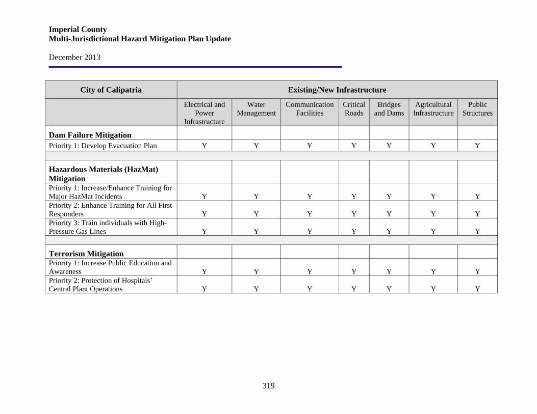
Imperial County Multi-Jurisdictional Hazard Mitigation Plan Update December 2013
319
City of Calipatria Existing/New Infrastructure
Electrical and Power
Infrastructure
Water Management
Communication Facilities
Critical Roads
Bridges and Dams
Agricultural Infrastructure
Public Structures
Dam Failure Mitigation Priority 1: Develop Evacuation Plan Y Y Y Y Y Y Y
Hazardous Materials (HazMat) Mitigation
Priority 1: Increase/Enhance Training for Major HazMat Incidents
Y
Y
Y
Y
Y
Y
Y
Priority 2: Enhance Training for All First Responders
Y
Y
Y
Y
Y
Y
Y
Priority 3: Train individuals with High-Pressure Gas Lines
Y
Y
Y
Y
Y
Y
Y
Terrorism Mitigation Priority 1: Increase Public Education and Awareness
Y
Y
Y
Y
Y
Y
Y
Priority 2: Protection of Hospitals’ Central Plant Operations
Y
Y
Y
Y
Y
Y
Y

Imperial County Multi-Jurisdictional Hazard Mitigation Plan Update December 2013
320
City of El Centro
City of El Centro Existing/New Infrastructure
Electrical and Power
Infrastructure
Water Management
Communication Facilities
Critical Roads
Bridges and Dams
Agricultural Infrastructure
Public Structures
Earthquake Mitigation
Priority 1: Earthquake Warning System Y Y Y Y Y Y Y Priority 2: Upgrade/Retrofit Critical Facilities (Includes URM) Y
Y Y
Priority 3: Redundant Communications Y Y Y Y Y Y Y Priority 4: Additional Back-Up Generators
Y
Y
Y
Y
Y
Y
Y
Priority 5: Retrofit Bridges/Secondary Impact to Transport Routes
Y
Y
Y
Y
Y
Priority 6: Upgrade Water Tanks Y Y
Flooding Mitigation
Priority 1: Drainage Improvements Y Y Y Y Y Priority 2: Road Improvements Y Y Y Y
Extreme Weather Mitigation Priority 1: Improve Getting Information to the Public on Heat Centers and Protection of Animals
Priority 2: Enhancement of Power Infrastructure Y Y Y Y Y Y Y

Imperial County Multi-Jurisdictional Hazard Mitigation Plan Update December 2013
321
City of El Centro Existing/New Infrastructure
Electrical and Power
Infrastructure
Water Management
Communication Facilities
Critical Roads
Bridges and Dams
Agricultural Infrastructure
Public Structures
Priority 3: Drought – Groundwater Storage
Y
Y
Y
Y
Priority 4: Storm Water Management Plan Y Y Y Y Y Y Y
Wildfire Mitigation Priority 1: Vegetative Management and Cleaning
Y
Y
Y
Y
Y
Y
Y
Pest Infestation/Non Vectors of Human Diseases Mitigation
Priority 1: Increased Monitoring of the Quagga Mussel and Hydrilla Plant
Y
Y
Y
Y
Y
Y
Y
Priority 2: Work with County Agriculture Department to Ensure Adequate/Increased Testing for Specific Biohazards
Y
Y
Y
Y
Y
Y
Y
Naturally Occurring Biological Threats Mitigation
Priority 1: Update/Revise the Flu Pandemic Plan
Dam Failure Mitigation Priority 1: Develop Evacuation Plan Y Y Y Y Y Y Y

Imperial County Multi-Jurisdictional Hazard Mitigation Plan Update December 2013
322
City of El Centro Existing/New Infrastructure
Electrical and Power
Infrastructure
Water Management
Communication Facilities
Critical Roads
Bridges and Dams
Agricultural Infrastructure
Public Structures
Hazardous Materials (HazMat) Mitigation
Priority 1: Increase/Enhance Training for Major HazMat Incidents
Y
Y
Y
Y
Y
Y
Y
Priority 2: Enhance Training for All First Responders
Y
Y
Y
Y
Y
Y
Y
Priority 3: Train individuals with High-Pressure Gas Lines
Y
Y
Y
Y
Y
Y
Y
Terrorism Mitigation Mitigation Priority 1: Increase Public Education and Awareness
Y
Y
Y
Y
Y
Y
Y
Mitigation Priority 2: Protection of Hospitals’ Central Plant Operations
Y
Y
Y
Y
Y
Y
Y

Imperial County Multi-Jurisdictional Hazard Mitigation Plan Update December 2013
323
City of Holtville
City of Holtville Existing/New Infrastructure
Electrical and Power
Infrastructure
Water Management
Communication Facilities
Critical Roads
Bridges and Dams
Agricultural Infrastructure
Public Structures
Earthquake Mitigation
Priority 1: Earthquake Warning System Y Y Y Y Y Y Y Priority 2: Upgrade/Retrofit Critical Facilities (Includes URM) Y
Y Y
Priority 3: Redundant Communications Y Y Y Y Y Y Y Priority 4: Additional Back-Up Generators
Y
Y
Y
Y
Y
Y
Y
Priority 5: Retrofit Bridges/Secondary Impact to Transport Routes
Y
Y
Y
Y
Y
Priority 6: Upgrade Water Tanks Y Y Y Y
Flooding Mitigation
Priority 1: Drainage Improvements Y Y Y Y Y Priority 2: Road Improvements Y Y Y Y Y Y Y
Extreme Weather Mitigation Priority 1: Improve Getting Information to the Public on Heat Centers and Protection of Animals
Priority 2: Enhancement of Power Infrastructure
Y
Y
Y
Y
Y
Y
Y

Imperial County Multi-Jurisdictional Hazard Mitigation Plan Update December 2013
324
City of Holtville Existing/New Infrastructure
Electrical and Power
Infrastructure
Water Management
Communication Facilities
Critical Roads
Bridges and Dams
Agricultural Infrastructure
Public Structures
Priority 3: Drought – Groundwater Storage
Y
Y
Y
Y
Priority 4: Storm Water Management Plan Y Y Y Y Y Y Y
Wildfire Mitigation Priority 1: Vegetative Management and Cleaning
Y
Y
Y
Y
Y
Y
Y
Pest Infestation/Non Vectors of Human Diseases Mitigation
Priority 1: Increased Monitoring of the Quagga Mussel and Hydrilla Plant
Y
Y
Y
Y
Y
Y
Y
Priority 2: Work with County Agriculture Department to Ensure Adequate/Increased Testing for Specific Biohazards
Y
Y
Y
Y
Y
Y
Y
Naturally Occurring Biological Threats Mitigation
Priority 1: Update/Revise the Flu Pandemic Plan
Dam Failure Mitigation Priority 1: Develop Evacuation Plan Y Y Y Y Y Y Y

Imperial County Multi-Jurisdictional Hazard Mitigation Plan Update December 2013
325
City of Holtville Existing/New Infrastructure
Electrical and Power
Infrastructure
Water Management
Communication Facilities
Critical Roads
Bridges and Dams
Agricultural Infrastructure
Public Structures
Hazardous Materials (HazMat) Mitigation
Priority 1: Increase/Enhance Training for Major HazMat Incidents
Y
Y
Y
Y
Y
Y
Y
Priority 2: Enhance Training for All First Responders
Y
Y
Y
Y
Y
Y
Y
Priority 3: Train individuals with High-Pressure Gas Lines
Y
Y
Y
Y
Y
Y
Y
Terrorism Mitigation Priority 1: Increase Public Education and Awareness
Y
Y
Y
Y
Y
Y
Y
Priority 2: Protection of Hospitals’ Central Plant Operations
Y
Y
Y
Y
Y
Y
Y
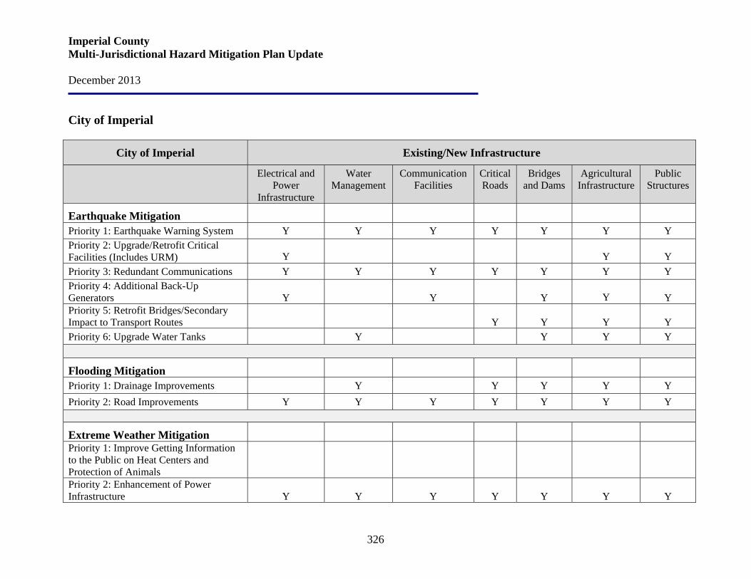
Imperial County Multi-Jurisdictional Hazard Mitigation Plan Update December 2013
326
City of Imperial
City of Imperial Existing/New Infrastructure
Electrical and Power
Infrastructure
Water Management
Communication Facilities
Critical Roads
Bridges and Dams
Agricultural Infrastructure
Public Structures
Earthquake Mitigation
Priority 1: Earthquake Warning System Y Y Y Y Y Y Y Priority 2: Upgrade/Retrofit Critical Facilities (Includes URM) Y
Y Y
Priority 3: Redundant Communications Y Y Y Y Y Y Y Priority 4: Additional Back-Up Generators
Y
Y
Y Y
Y
Priority 5: Retrofit Bridges/Secondary Impact to Transport Routes
Y
Y
Y
Y
Priority 6: Upgrade Water Tanks Y Y Y Y
Flooding Mitigation
Priority 1: Drainage Improvements Y Y Y Y Y Priority 2: Road Improvements Y Y Y Y Y Y Y
Extreme Weather Mitigation Priority 1: Improve Getting Information to the Public on Heat Centers and Protection of Animals
Priority 2: Enhancement of Power Infrastructure
Y
Y
Y
Y
Y
Y
Y
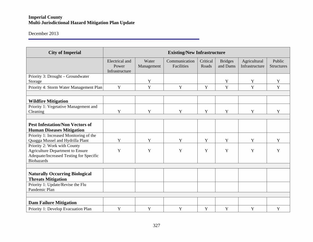
Imperial County Multi-Jurisdictional Hazard Mitigation Plan Update December 2013
327
City of Imperial Existing/New Infrastructure
Electrical and Power
Infrastructure
Water Management
Communication Facilities
Critical Roads
Bridges and Dams
Agricultural Infrastructure
Public Structures
Priority 3: Drought – Groundwater Storage
Y
Y
Y
Y
Priority 4: Storm Water Management Plan Y Y Y Y Y Y Y
Wildfire Mitigation Priority 1: Vegetative Management and Cleaning
Y
Y
Y
Y
Y
Y
Y
Pest Infestation/Non Vectors of Human Diseases Mitigation
Priority 1: Increased Monitoring of the Quagga Mussel and Hydrilla Plant
Y
Y
Y
Y
Y
Y
Y
Priority 2: Work with County Agriculture Department to Ensure Adequate/Increased Testing for Specific Biohazards
Y
Y
Y
Y
Y
Y
Y
Naturally Occurring Biological Threats Mitigation
Priority 1: Update/Revise the Flu Pandemic Plan
Dam Failure Mitigation Priority 1: Develop Evacuation Plan Y Y Y Y Y Y Y
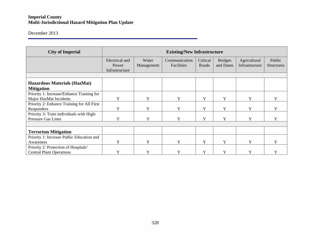
Imperial County Multi-Jurisdictional Hazard Mitigation Plan Update December 2013
328
City of Imperial Existing/New Infrastructure
Electrical and Power
Infrastructure
Water Management
Communication Facilities
Critical Roads
Bridges and Dams
Agricultural Infrastructure
Public Structures
Hazardous Materials (HazMat) Mitigation
Priority 1: Increase/Enhance Training for Major HazMat Incidents
Y
Y
Y
Y
Y
Y
Y
Priority 2: Enhance Training for All First Responders
Y
Y
Y
Y
Y
Y
Y
Priority 3: Train individuals with High-Pressure Gas Lines
Y
Y
Y
Y
Y
Y
Y
Terrorism Mitigation Priority 1: Increase Public Education and Awareness
Y
Y
Y
Y
Y
Y
Y
Priority 2: Protection of Hospitals’ Central Plant Operations
Y
Y
Y
Y
Y
Y
Y

Imperial County Multi-Jurisdictional Hazard Mitigation Plan Update December 2013
329
City of Westmorland
City of Westmorland Existing/New Infrastructure
Electrical and Power
Infrastructure
Water Management
Communication Facilities
Critical Roads
Bridges and Dams
Agricultural Infrastructure
Public Structures
Earthquake Mitigation
Priority 1: Earthquake Warning System Y Y Y Y Y Y Y Priority 2: Upgrade/Retrofit Critical Facilities (Includes URM) Y
Y Y
Priority 3: Redundant Communications Y Y Y Y Y Y Y Priority 4: Additional Back-Up Generators
Y
Y
Y
Y
Priority 5: Retrofit Bridges/Secondary Impact to Transport Routes
Y
Y
Y
Y
Priority 6: Upgrade Water Tanks Y Y Y Y
Flooding Mitigation
Priority 1: Drainage Improvements Y Y Y Y Y Priority 2: Road Improvements Y Y Y Y Y Y Y
Extreme Weather Mitigation Priority 1: Improve Getting Information to the Public on Heat Centers and Protection of Animals
Priority 2: Enhancement of Power Infrastructure
Y
Y
Y
Y
Y
Y
Y

Imperial County Multi-Jurisdictional Hazard Mitigation Plan Update December 2013
330
City of Westmorland Existing/New Infrastructure
Electrical and Power
Infrastructure
Water Management
Communication Facilities
Critical Roads
Bridges and Dams
Agricultural Infrastructure
Public Structures
Priority 3: Drought – Groundwater Storage
Y
Y
Y
Y
Priority 4: Storm Water Management Plan Y Y Y Y Y Y Y
Wildfire Mitigation Priority 1: Vegetative Management and Cleaning
Y
Y
Y
Y
Y
Y
Y
Pest Infestation/Non Vectors of Human Diseases Mitigation
Priority 1: Increased Monitoring of the Quagga Mussel and Hydrilla Plant
Y
Y
Y
Y
Y
Y
Y
Priority 2: Work with County Agriculture Department to Ensure Adequate/Increased Testing for Specific Biohazards
Y
Y
Y
Y
Y
Y
Y
Naturally Occurring Biological Threats Mitigation
Priority 1: Update/Revise the Flu Pandemic Plan
Dam Failure Mitigation Priority 1: Develop Evacuation Plan Y Y Y Y Y Y Y

Imperial County Multi-Jurisdictional Hazard Mitigation Plan Update December 2013
331
City of Westmorland Existing/New Infrastructure
Electrical and Power
Infrastructure
Water Management
Communication Facilities
Critical Roads
Bridges and Dams
Agricultural Infrastructure
Public Structures
Hazardous Materials (HazMat) Mitigation
Priority 1: Increase/Enhance Training for Major HazMat Incidents
Y
Y
Y
Y
Y
Y
Y
Priority 2: Enhance Training for All First Responders
Y
Y
Y
Y
Y
Y
Y
Priority 3: Train individuals with High-Pressure Gas Lines
Y
Y
Y
Y
Y
Y
Y
Terrorism Mitigation Priority 1: Increase Public Education and Awareness
Y
Y
Y
Y
Y
Y
Y
Priority 2: Protection of Hospitals’ Central Plant Operations
Y
Y
Y
Y
Y
Y
Y
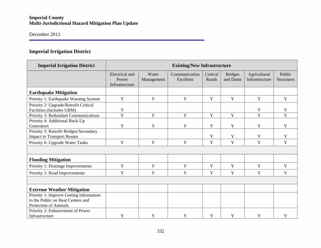
Imperial County Multi-Jurisdictional Hazard Mitigation Plan Update December 2013
332
Imperial Irrigation District
Imperial Irrigation District Existing/New Infrastructure
Electrical and Power
Infrastructure
Water Management
Communication Facilities
Critical Roads
Bridges and Dams
Agricultural Infrastructure
Public Structures
Earthquake Mitigation
Priority 1: Earthquake Warning System Y Y Y Y Y Y Y Priority 2: Upgrade/Retrofit Critical Facilities (Includes URM) Y
Y Y
Priority 3: Redundant Communications Y Y Y Y Y Y Y Priority 4: Additional Back-Up Generators
Y
Y
Y
Y
Y
Y
Y
Priority 5: Retrofit Bridges/Secondary Impact to Transport Routes
Y
Y
Y
Y
Priority 6: Upgrade Water Tanks Y Y Y Y Y Y Y
Flooding Mitigation
Priority 1: Drainage Improvements Y Y Y Y Y Y Y Priority 2: Road Improvements Y Y Y Y Y Y Y
Extreme Weather Mitigation Priority 1: Improve Getting Information to the Public on Heat Centers and Protection of Animals
Priority 2: Enhancement of Power Infrastructure
Y
Y
Y
Y
Y
Y
Y

Imperial County Multi-Jurisdictional Hazard Mitigation Plan Update December 2013
333
Imperial Irrigation District Existing/New Infrastructure
Electrical and Power
Infrastructure
Water Management
Communication Facilities
Critical Roads
Bridges and Dams
Agricultural Infrastructure
Public Structures
Priority 3: Drought – Groundwater Storage
Y
Y
Y
Y
Y
Y
Priority 4: Storm Water Management Plan Y Y Y Y Y Y Y
Wildfire Mitigation Priority 1: Vegetative Management and Cleaning
Y
Y
Y
Y
Y
Y
Y
Pest Infestation/Non Vectors of Human Diseases Mitigation
Priority 1: Increased Monitoring of the Quagga Mussel and Hydrilla Plant
Y
Y
Y
Y
Y
Y
Y
Priority 2: Work with County Agriculture Department to Ensure Adequate/Increased Testing for Specific Biohazards
Y
Y
Y
Y
Y
Y
Y
Naturally Occurring Biological Threats Mitigation
Priority 1: Update/Revise the Flu Pandemic Plan
Dam Failure Mitigation Priority 1: Develop Evacuation Plan Y Y Y Y Y Y Y
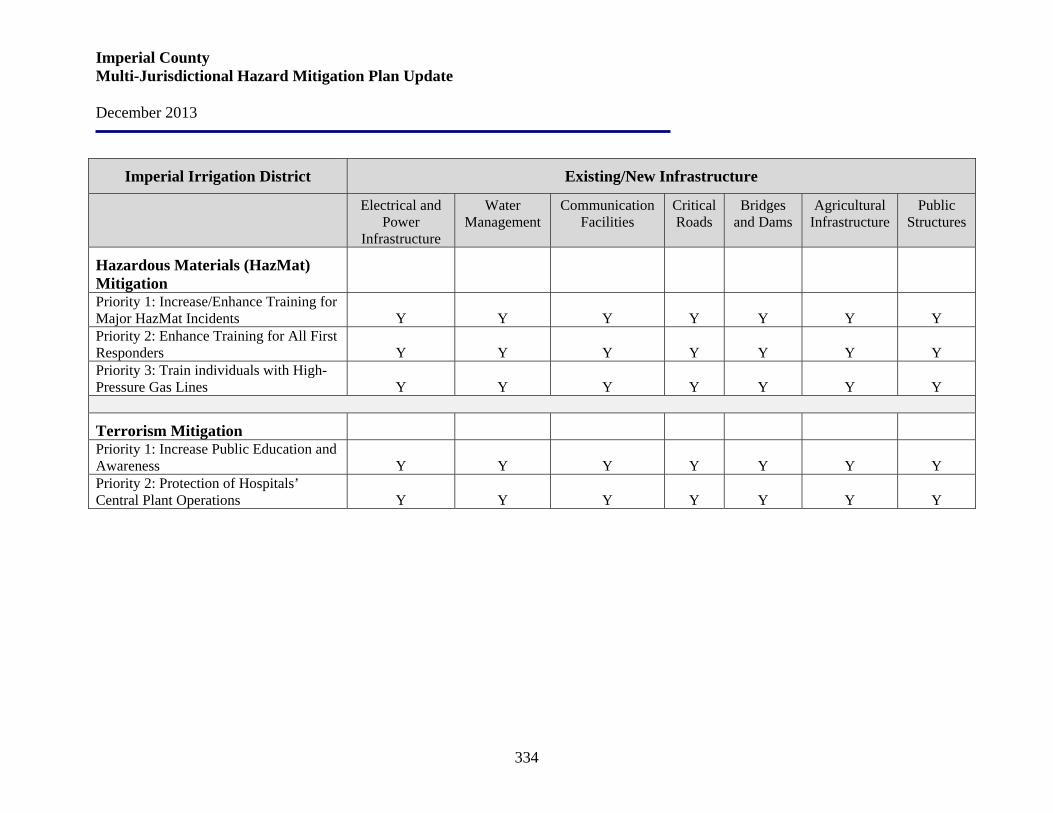
Imperial County Multi-Jurisdictional Hazard Mitigation Plan Update December 2013
334
Imperial Irrigation District Existing/New Infrastructure
Electrical and Power
Infrastructure
Water Management
Communication Facilities
Critical Roads
Bridges and Dams
Agricultural Infrastructure
Public Structures
Hazardous Materials (HazMat) Mitigation
Priority 1: Increase/Enhance Training for Major HazMat Incidents
Y
Y
Y
Y
Y
Y
Y
Priority 2: Enhance Training for All First Responders
Y
Y
Y
Y
Y
Y
Y
Priority 3: Train individuals with High-Pressure Gas Lines
Y
Y
Y
Y
Y
Y
Y
Terrorism Mitigation Priority 1: Increase Public Education and Awareness
Y
Y
Y
Y
Y
Y
Y
Priority 2: Protection of Hospitals’ Central Plant Operations
Y
Y
Y
Y
Y
Y
Y
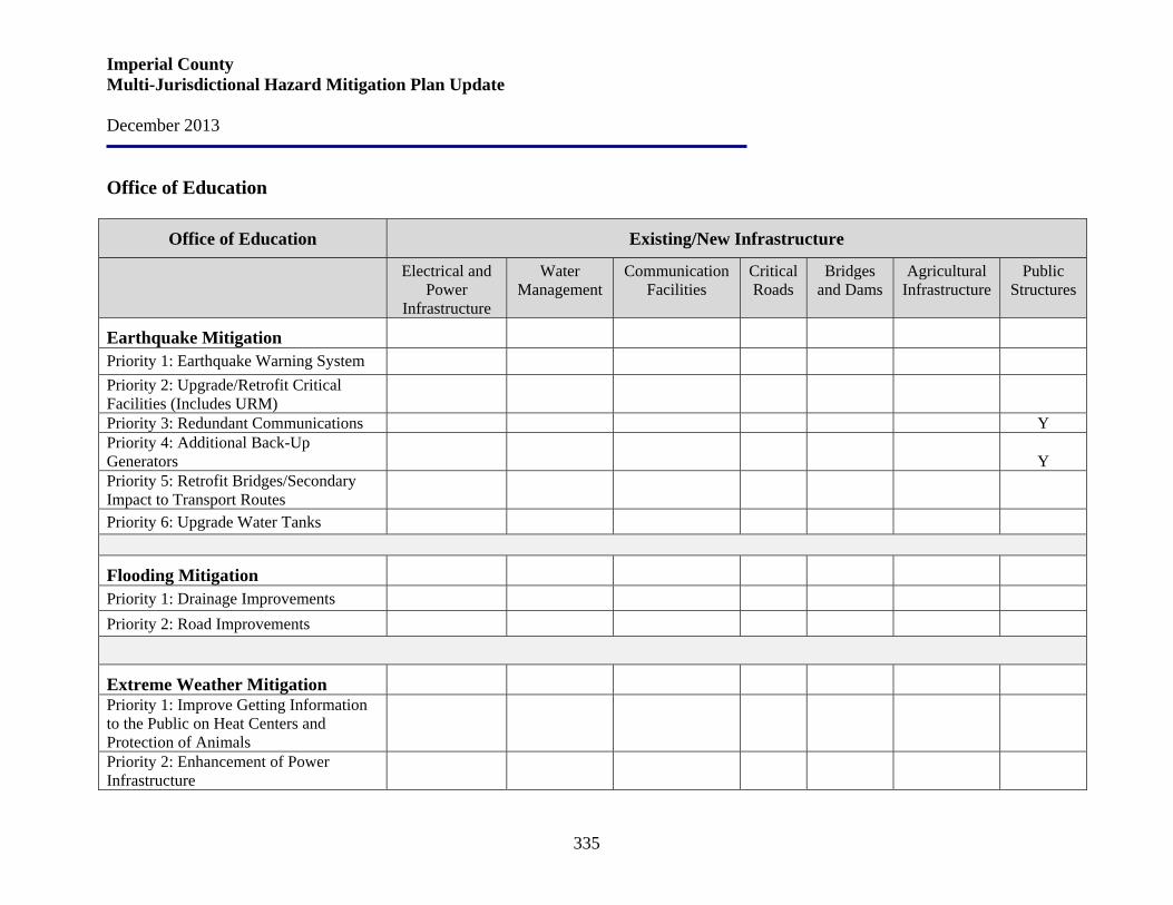
Imperial County Multi-Jurisdictional Hazard Mitigation Plan Update December 2013
335
Office of Education
Office of Education Existing/New Infrastructure
Electrical and Power
Infrastructure
Water Management
Communication Facilities
Critical Roads
Bridges and Dams
Agricultural Infrastructure
Public Structures
Earthquake Mitigation
Priority 1: Earthquake Warning System Priority 2: Upgrade/Retrofit Critical Facilities (Includes URM)
Priority 3: Redundant Communications Y Priority 4: Additional Back-Up Generators
Y
Priority 5: Retrofit Bridges/Secondary Impact to Transport Routes
Priority 6: Upgrade Water Tanks
Flooding Mitigation
Priority 1: Drainage Improvements Priority 2: Road Improvements
Extreme Weather Mitigation Priority 1: Improve Getting Information to the Public on Heat Centers and Protection of Animals
Priority 2: Enhancement of Power Infrastructure
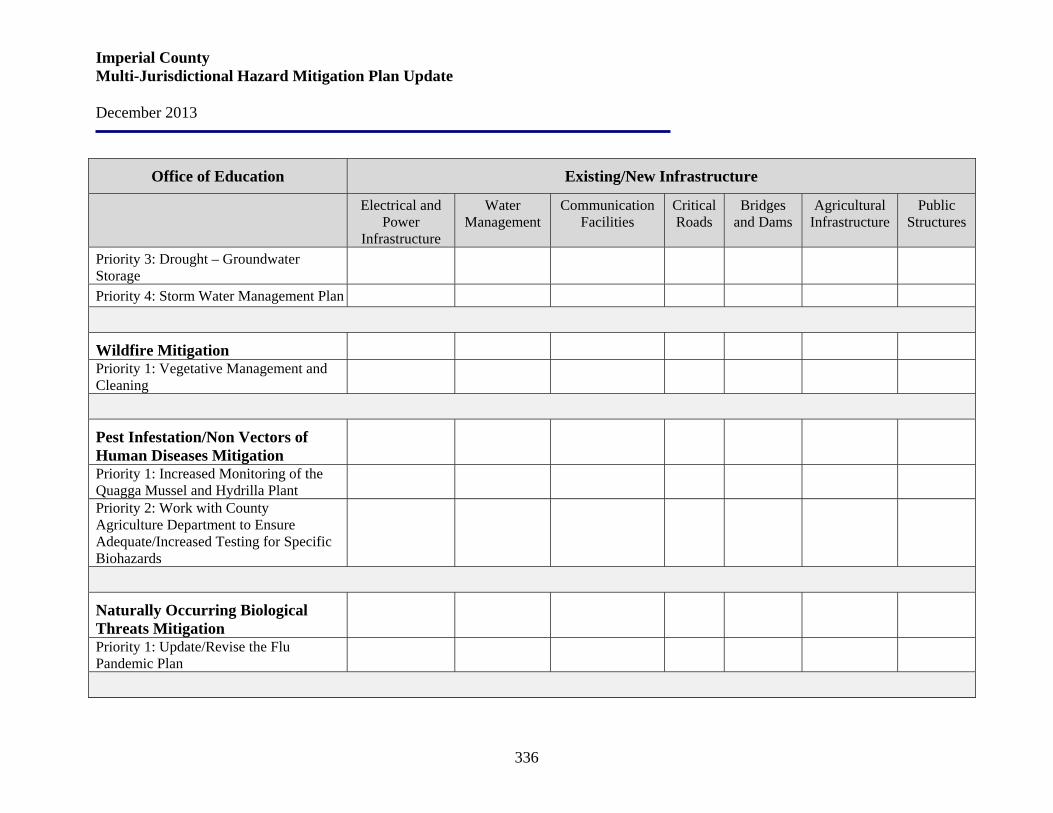
Imperial County Multi-Jurisdictional Hazard Mitigation Plan Update December 2013
336
Office of Education Existing/New Infrastructure
Electrical and Power
Infrastructure
Water Management
Communication Facilities
Critical Roads
Bridges and Dams
Agricultural Infrastructure
Public Structures
Priority 3: Drought – Groundwater Storage
Priority 4: Storm Water Management Plan
Wildfire Mitigation Priority 1: Vegetative Management and Cleaning
Pest Infestation/Non Vectors of Human Diseases Mitigation
Priority 1: Increased Monitoring of the Quagga Mussel and Hydrilla Plant
Priority 2: Work with County Agriculture Department to Ensure Adequate/Increased Testing for Specific Biohazards
Naturally Occurring Biological Threats Mitigation
Priority 1: Update/Revise the Flu Pandemic Plan

Imperial County Multi-Jurisdictional Hazard Mitigation Plan Update December 2013
337
Office of Education Existing/New Infrastructure
Electrical and Power
Infrastructure
Water Management
Communication Facilities
Critical Roads
Bridges and Dams
Agricultural Infrastructure
Public Structures
Dam Failure Mitigation Priority 1: Develop Evacuation Plan
Hazardous Materials (HazMat) Mitigation
Priority 1: Increase/Enhance Training for Major HazMat Incidents
Priority 2: Enhance Training for All First Responders
Priority 3: Train individuals with High-Pressure Gas Lines
Terrorism Mitigation Priority 1: Increase Public Education and Awareness
Priority 2: Protection of Hospitals’ Central Plant Operations
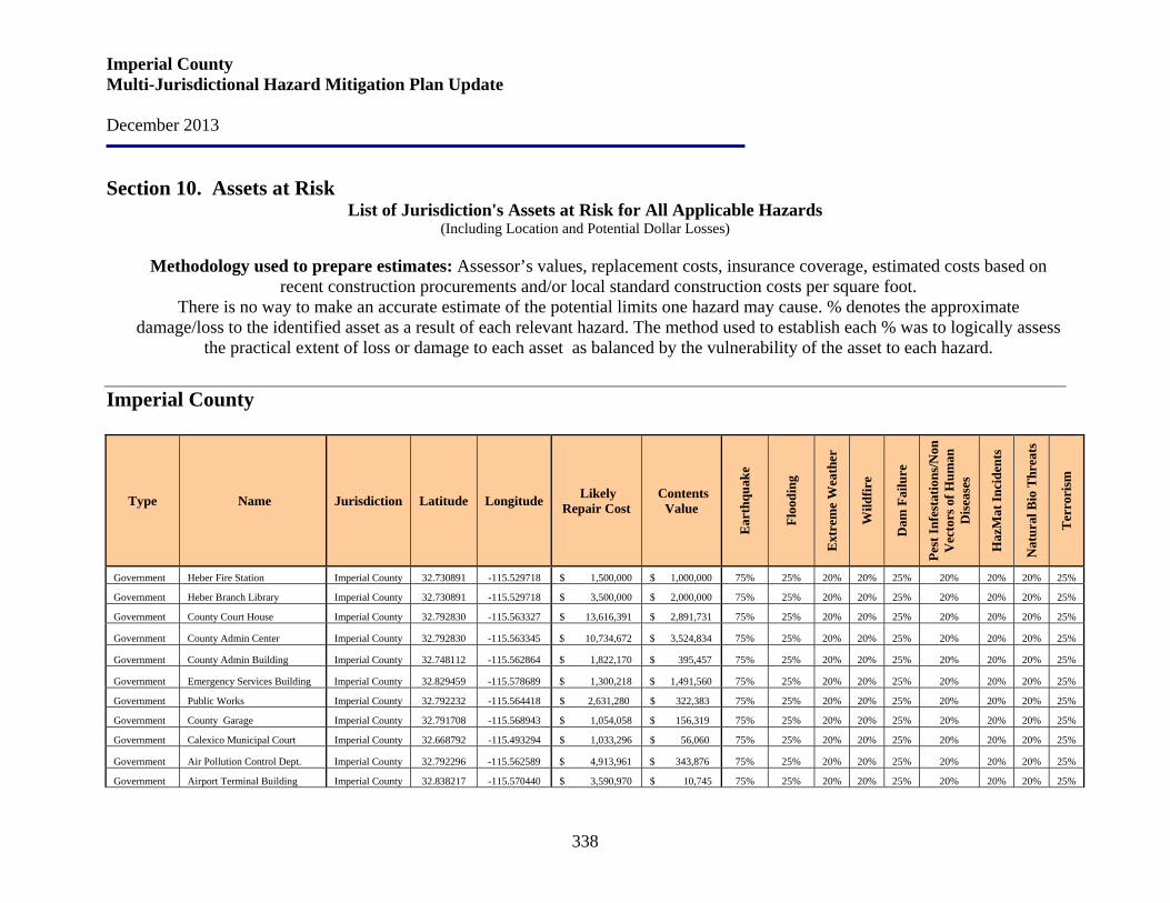
Imperial County Multi-Jurisdictional Hazard Mitigation Plan Update December 2013
338
Section 10. Assets at Risk List of Jurisdiction's Assets at Risk for All Applicable Hazards
(Including Location and Potential Dollar Losses)
Methodology used to prepare estimates: Assessor’s values, replacement costs, insurance coverage, estimated costs based on recent construction procurements and/or local standard construction costs per square foot.
There is no way to make an accurate estimate of the potential limits one hazard may cause. % denotes the approximate damage/loss to the identified asset as a result of each relevant hazard. The method used to establish each % was to logically assess
the practical extent of loss or damage to each asset as balanced by the vulnerability of the asset to each hazard.
Imperial County
Type Name Jurisdiction Latitude Longitude Likely Repair Cost
Contents Value
Ear
thqu
ake
Floo
ding
Ext
rem
e W
eath
er
Wild
fire
Dam
Fai
lure
Pest
Infe
stat
ions
/Non
V
ecto
rs o
f Hum
an
Dis
ease
s
Haz
Mat
Inci
dent
s
Nat
ural
Bio
Thr
eats
Ter
rori
sm
Government Heber Fire Station Imperial County 32.730891 -115.529718 $ 1,500,000 $ 1,000,000 75% 25% 20% 20% 25% 20% 20% 20% 25%
Government Heber Branch Library Imperial County 32.730891 -115.529718 $ 3,500,000 $ 2,000,000 75% 25% 20% 20% 25% 20% 20% 20% 25%
Government County Court House Imperial County 32.792830 -115.563327 $ 13,616,391 $ 2,891,731 75% 25% 20% 20% 25% 20% 20% 20% 25%
Government County Admin Center Imperial County 32.792830 -115.563345 $ 10,734,672 $ 3,524,834 75% 25% 20% 20% 25% 20% 20% 20% 25%
Government County Admin Building Imperial County 32.748112 -115.562864 $ 1,822,170 $ 395,457 75% 25% 20% 20% 25% 20% 20% 20% 25%
Government Emergency Services Building Imperial County 32.829459 -115.578689 $ 1,300,218 $ 1,491,560 75% 25% 20% 20% 25% 20% 20% 20% 25%
Government Public Works Imperial County 32.792232 -115.564418 $ 2,631,280 $ 322,383 75% 25% 20% 20% 25% 20% 20% 20% 25%
Government County Garage Imperial County 32.791708 -115.568943 $ 1,054,058 $ 156,319 75% 25% 20% 20% 25% 20% 20% 20% 25%
Government Calexico Municipal Court Imperial County 32.668792 -115.493294 $ 1,033,296 $ 56,060 75% 25% 20% 20% 25% 20% 20% 20% 25%
Government Air Pollution Control Dept. Imperial County 32.792296 -115.562589 $ 4,913,961 $ 343,876 75% 25% 20% 20% 25% 20% 20% 20% 25%
Government Airport Terminal Building Imperial County 32.838217 -115.570440 $ 3,590,970 $ 10,745 75% 25% 20% 20% 25% 20% 20% 20% 25%
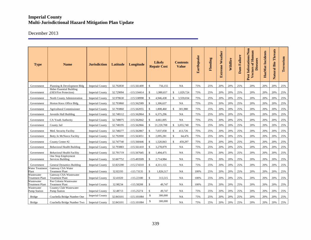
Imperial County Multi-Jurisdictional Hazard Mitigation Plan Update December 2013
339
Type Name Jurisdiction Latitude Longitude Likely Repair Cost
Contents Value
Ear
thqu
ake
Floo
ding
Ext
rem
e W
eath
er
Wild
fire
Dam
Fai
lure
Pest
Infe
stat
ions
/Non
V
ecto
rs o
f Hum
an
Dis
ease
s
Haz
Mat
Inci
dent
s
Nat
ural
Bio
Thr
eats
Ter
rori
sm
Government Planning & Development Bldg Imperial County 32.792830 -115.561400 $ 756,155 NA 75% 25% 20% 20% 25% 20% 20% 20% 25%
Government Heber Essential Building (OES/Fire Protection) Imperial County 32.729094 -115.534414 $ 1,980,657 $ 1,029,724 75% 25% 20% 20% 25% 20% 20% 20% 25%
Government North County Administration Imperial County 32.978630 -115.538998 $ 4,946,438 $ 3,559,034 75% 25% 20% 20% 25% 20% 20% 20% 25%
Government Horton Knox Office Bldg. Imperial County 32.793860 -115.562589 $ 1,306,637 NA 75% 25% 20% 20% 25% 20% 20% 20% 25%
Government Agricultural Commissioner Imperial County 32.793860 -115.562055 $ 1,808,460 $ 301,980 75% 25% 20% 20% 25% 20% 20% 20% 25%
Government Juvenile Hall Building Imperial County 32.748112 -115.562864 $ 6,375,296 NA 75% 25% 20% 20% 25% 20% 20% 20% 25%
Government CA Youth Authority Imperial County 32.748075 -115.562842 $ 4,661,005 NA 75% 25% 20% 20% 25% 20% 20% 20% 25%
Government County Jail Imperial County 32.748195 -115.562866 $ 21,220,708 $ 3,055,740 75% 25% 20% 20% 25% 20% 20% 20% 25%
Government Med. Security Facility Imperial County 32.748277 -115.562867 $ 7,037,058 $ 413,726 75% 25% 20% 20% 25% 20% 20% 20% 25%
Government Betty Jo McNeece Facility Imperial County 32.792000 -115.563051 $ 2,095,281 $ 64,476 75% 25% 20% 20% 25% 20% 20% 20% 25%
Government County Center #2 Imperial County 32.747740 -115.560446 $ 1,520,843 $ 459,297 75% 25% 20% 20% 25% 20% 20% 20% 25%
Government Behavioral Health Building Imperial County 32.793883 -115.561410 $ 3,278,879 NA 75% 25% 20% 20% 25% 20% 20% 20% 25%
Government Behavioral Health Facility Imperial County 32.791719 -115.567645 $ 1,494,475 NA 75% 25% 20% 20% 25% 20% 20% 20% 25%
Government One Stop Employment Services Building Imperial County 32.667752 -115.493509 $ 2,714,984 NA 75% 25% 20% 20% 25% 20% 20% 20% 25%
Government General Dynamics Building Imperial County 32.825590 -115.574310 $ 4,311,155 NA 75% 25% 20% 20% 25% 20% 20% 20% 25% Water Treatment Plant
Gateway CSA Water Treatment Plant Imperial County 32.82193 -115.73135 $ 1,826,517 NA 100% 25% 20% 20% 25% 20% 20% 20% 25%
Wastewater Treatment Plant
Gateway CSA Wastewater Treatment Plant Imperial County 32.41020 -115.22180 $ 313,515
NA 100% 25% 20% 20% 25% 20% 20% 20% 25%
Wastewater Treatment Plant
Poe Colonia Wastewater Treatment Plant Imperial County 32.98234 -115.58208 $ 49,747
NA 100% 25% 20% 20% 25% 20% 20% 20% 25%
Wastewater Pump Station
Country Club Wastewater Pump Station Imperial County 32.48713 -115.25274 $ 49,747
NA 75% 25% 20% 20% 25% 20% 20% 20% 25%
Bridge Coachella Bridge Number One Imperial County 32.843101 -115.101084 $ 300,000 NA 75% 25% 20% 20% 25% 20% 20% 20% 25%
Bridge Coachella Bridge Number Two Imperial County 32.843101 -115.101084 $ 300,000 NA 75% 25% 20% 20% 25% 20% 20% 20% 25%
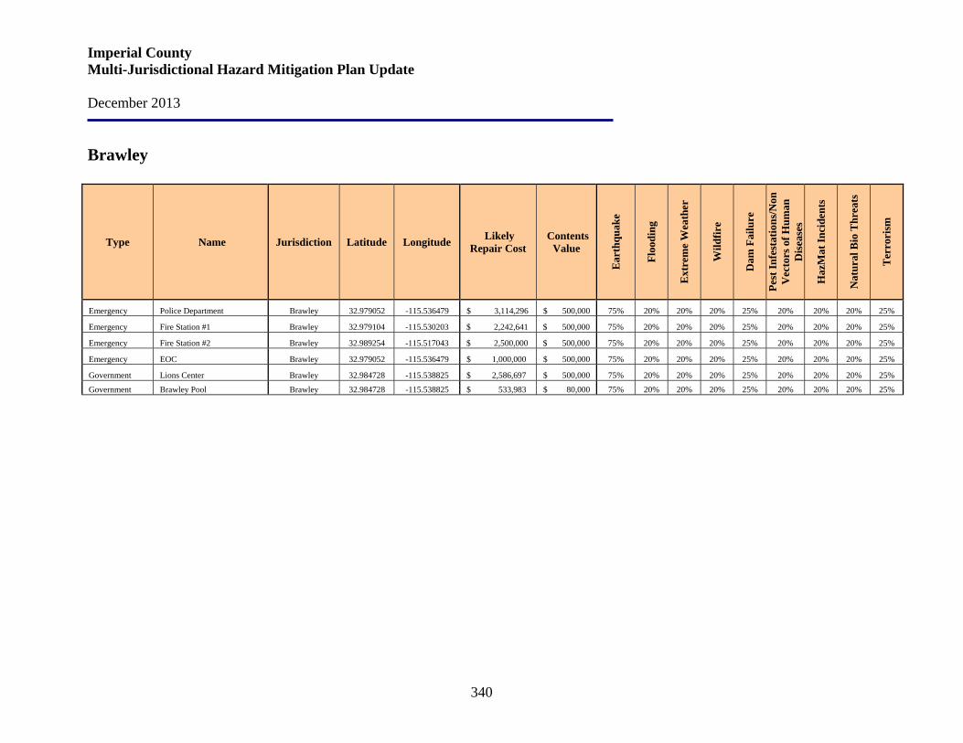
Imperial County Multi-Jurisdictional Hazard Mitigation Plan Update December 2013
340
Brawley
Type Name Jurisdiction Latitude Longitude Likely Repair Cost
Contents Value
Ear
thqu
ake
Floo
ding
Ext
rem
e W
eath
er
Wild
fire
Dam
Fai
lure
Pest
Infe
stat
ions
/Non
V
ecto
rs o
f Hum
an
Dis
ease
s
Haz
Mat
Inci
dent
s
Nat
ural
Bio
Thr
eats
Ter
rori
sm
Emergency Police Department Brawley 32.979052 -115.536479 $ 3,114,296 $ 500,000 75% 20% 20% 20% 25% 20% 20% 20% 25%
Emergency Fire Station #1 Brawley 32.979104 -115.530203 $ 2,242,641 $ 500,000 75% 20% 20% 20% 25% 20% 20% 20% 25%
Emergency Fire Station #2 Brawley 32.989254 -115.517043 $ 2,500,000 $ 500,000 75% 20% 20% 20% 25% 20% 20% 20% 25%
Emergency EOC Brawley 32.979052 -115.536479 $ 1,000,000 $ 500,000 75% 20% 20% 20% 25% 20% 20% 20% 25%
Government Lions Center Brawley 32.984728 -115.538825 $ 2,586,697 $ 500,000 75% 20% 20% 20% 25% 20% 20% 20% 25%
Government Brawley Pool Brawley 32.984728 -115.538825 $ 533,983 $ 80,000 75% 20% 20% 20% 25% 20% 20% 20% 25%

Imperial County Multi-Jurisdictional Hazard Mitigation Plan Update December 2013
341
Calexico
Type Name Jurisdiction Latitude Longitude Likely Repair Cost
Contents Value
Ear
thqu
ake
Floo
ding
Ext
rem
e W
eath
er
Wild
fire
Dam
Fai
lure
Pest
Infe
stat
ions
/Non
V
ecto
rs o
f Hum
an
Dis
ease
s
Haz
Mat
Inci
dent
s
Nat
ural
Bio
Thr
eats
Ter
rori
sm
Emergency Police/Fire Station Calexico 32.669833 -115.493202 $ 2,026,854 $ 906,584 75% 20% 20% 20% 20% 20% 20% 20% 20%
Emergency Fire Station #2 Calexico 32.674038 -115.516239 $ 572,668 $ 14,520 75% 20% 20% 20% 20% 20% 20% 20% 20%
Airport Airport Terminal & Hangars Calexico 32.666006 -115.505238 $ 1,488,100 $ 8,762 75% 20% 20% 20% 20% 20% 20% 20% 20%
Water Plant Water Treatment Plant Calexico 32.671922 -115.505172 $ 542,992 $ 3,069,285 75% 20% 20% 20% 20% 20% 20% 20% 20%
Sewer Plant Sewer Treatment Plant Calexico 32.664459 -115.568652 $ 171,220 $ 1,534,645 75% 20% 20% 20% 20% 20% 20% 20% 20%
Reservoir Eastside Reservoir Calexico 32.693918 -115.448526 $ 7,000,000 NA 75% 20% 20% 20% 20% 20% 20% 20% 20%
Government Calexico 10 Calexico 32.696426 -115.501216 $ 1,700,000 NA 75% 20% 20% 20% 20% 20% 20% 20% 20%
Government City Hall Calexico 32.671191 -115.493517 $ 3,421,369 $ 2,494,229 75% 20% 20% 20% 20% 20% 20% 20% 20%
Government City Hall Mexican Consulate Calexico 32.667559 -115.493326 $ 672,022 $ 204,266 75% 20% 20% 20% 20% 20% 20% 20% 20%
Government Library Calexico 32,674734 -115.488275 $ 1,884,393 $ 174,836 75% 20% 20% 20% 20% 20% 20% 20% 20%
Government Carnegie Technology Library Calexico 32.669483 -115.492811 $ 527,665 $ 10,737 75% 20% 20% 20% 20% 20% 20% 20% 20%
Government Community - Senior Center Calexico 32.672382 -115.486743 $ 2,039,108 $ 79,803 75% 20% 20% 20% 20% 20% 20% 20% 20%
Government Day Care Center Calexico 32.671887 -115.487084 $ 1,186,062 NA 75% 20% 20% 20% 20% 20% 20% 20% 20%
Government Street Department/City Shops Calexico 32.672438 -115.505206 $ 226,353 $ 125,963 75% 20% 20% 20% 20% 20% 20% 20% 20%
Government Office Facility Calexico 32.672471 -115.505209 $ 27,434 NA 75% 20% 20% 20% 20% 20% 20% 20% 20%
Government Utility Service Office (Modular) Calexico 32.671922 -115.505172 $ 164,039 NA 75% 20% 20% 20% 20% 20% 20% 20% 20%
Government Animal Shelter Calexico 32.672501 -115.505249 $ 43,886 $ 614 75% 20% 20% 20% 20% 20% 20% 20% 20%
Government UFW Building Calexico 32.667036 -115.495735 $ 696,243 NA 75% 20% 20% 20% 20% 20% 20% 20% 20%
Government Armory Calexico 32.677147 -115.501848 $ 222,000 NA 75% 20% 20% 20% 20% 20% 20% 20% 20%
Government Cultural Arts Center Calexico 32.669226 -115.494891 NA $ 10,000 75% 20% 20% 20% 20% 20% 20% 20% 20%
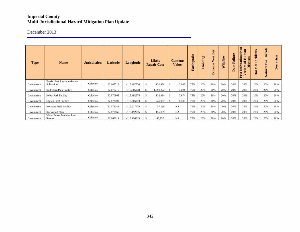
Imperial County Multi-Jurisdictional Hazard Mitigation Plan Update December 2013
342
Type Name Jurisdiction Latitude Longitude Likely Repair Cost
Contents Value
Ear
thqu
ake
Floo
ding
Ext
rem
e W
eath
er
Wild
fire
Dam
Fai
lure
Pest
Infe
stat
ions
/Non
V
ecto
rs o
f Hum
an
Dis
ease
s
Haz
Mat
Inci
dent
s
Nat
ural
Bio
Thr
eats
Ter
rori
sm
Government Border Park Restroom/Police Substation Calexico 32.665716 -115.497526 $ 132,438 $ 3,069 75% 20% 20% 20% 20% 20% 20% 20% 20%
Government Rodriguez Park Facility Calexico 32.677216 -115.505248 $ 1,091,272 $ 4,604 75% 20% 20% 20% 20% 20% 20% 20% 20%
Government Heber Park Facility Calexico 32.670865 -115.492975 $ 132,434 $ 7,674 75% 20% 20% 20% 20% 20% 20% 20% 20%
Government Legion Field Facility Calexico 32.672109 -115.505213 $ 245,957 $ 6,138 75% 20% 20% 20% 20% 20% 20% 20% 20%
Government Nosotros Field Facility Calexico 32.673049 -115.517979 $ 57,139 NA 75% 20% 20% 20% 20% 20% 20% 20% 20%
Government Rockwood Plaza Calexico 32.670865 -115.492975 $ 155,839 NA 75% 20% 20% 20% 20% 20% 20% 20% 20%
Government Water Tower Modular Rest Rooms Calexico 32.665614 -115.494815 $ 49,757 NA 75% 20% 20% 20% 20% 20% 20% 20% 20%
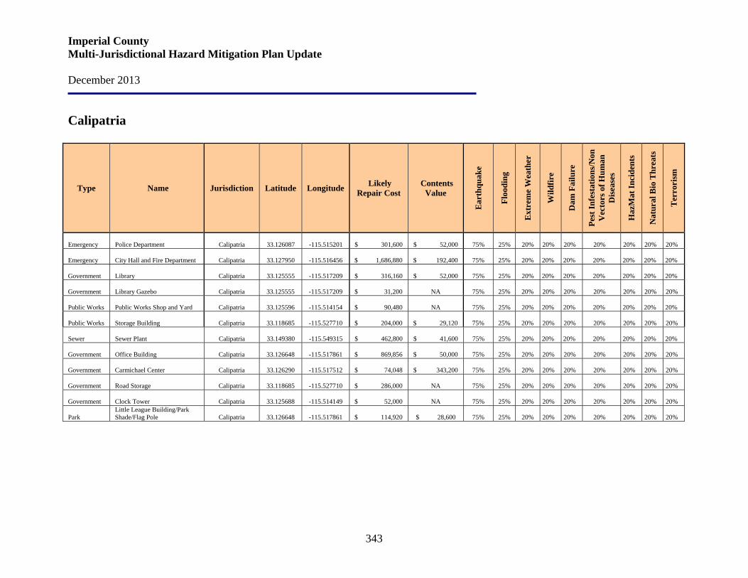
Imperial County Multi-Jurisdictional Hazard Mitigation Plan Update December 2013
343
Calipatria
Type Name Jurisdiction Latitude Longitude Likely Repair Cost
Contents Value
Ear
thqu
ake
Floo
ding
Ext
rem
e W
eath
er
Wild
fire
Dam
Fai
lure
Pest
Infe
stat
ions
/Non
V
ecto
rs o
f Hum
an
Dis
ease
s
Haz
Mat
Inci
dent
s
Nat
ural
Bio
Thr
eats
Ter
rori
sm
Emergency Police Department Calipatria 33.126087 -115.515201 $ 301,600 $ 52,000 75% 25% 20%
20%
20%
20%
20%
20%
20%
Emergency City Hall and Fire Department Calipatria 33.127950 -115.516456 $ 1,686,880 $ 192,400 75% 25% 20%
20%
20%
20%
20%
20%
20%
Government Library Calipatria 33.125555 -115.517209 $ 316,160 $ 52,000 75% 25% 20%
20%
20%
20%
20%
20%
20%
Government Library Gazebo Calipatria 33.125555 -115.517209 $ 31,200 NA 75% 25% 20%
20%
20%
20%
20%
20%
20%
Public Works Public Works Shop and Yard Calipatria 33.125596 -115.514154 $ 90,480 NA 75% 25% 20%
20%
20%
20%
20%
20%
20%
Public Works Storage Building
Calipatria 33.118685 -115.527710 $ 204,000 $ 29,120 75% 25% 20%
20%
20%
20%
20%
20%
20%
Sewer Sewer Plant Calipatria 33.149380 -115.549315 $ 462,800 $ 41,600 75% 25% 20%
20%
20%
20%
20%
20%
20%
Government Office Building
Calipatria 33.126648 -115.517861 $ 869,856 $ 50,000 75% 25% 20%
20%
20%
20%
20%
20%
20%
Government Carmichael Center
Calipatria 33.126290 -115.517512 $ 74,048 $ 343,200 75% 25% 20%
20%
20%
20%
20%
20%
20%
Government Road Storage
Calipatria 33.118685 -115.527710 $ 286,000 NA 75% 25% 20%
20%
20%
20%
20%
20%
20%
Government Clock Tower
Calipatria 33.125688 -115.514149 $ 52,000 NA 75% 25% 20%
20%
20%
20%
20%
20%
20%
Park Little League Building/Park Shade/Flag Pole
Calipatria 33.126648 -115.517861 $ 114,920 $ 28,600 75% 25% 20%
20%
20%
20%
20%
20%
20%
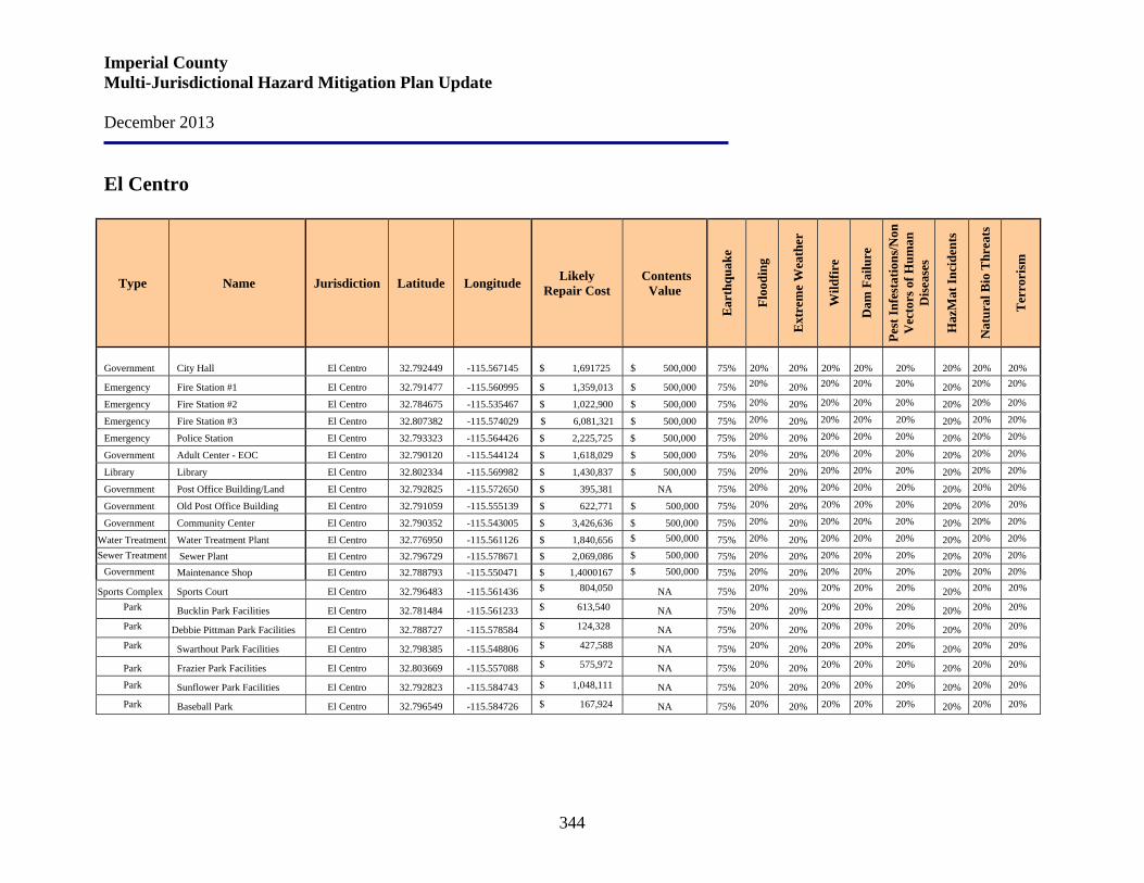
Imperial County Multi-Jurisdictional Hazard Mitigation Plan Update December 2013
344
El Centro
Type Name Jurisdiction Latitude Longitude Likely Repair Cost
Contents Value
Ear
thqu
ake
Floo
ding
Ext
rem
e W
eath
er
Wild
fire
Dam
Fai
lure
Pest
Infe
stat
ions
/Non
V
ecto
rs o
f Hum
an
Dis
ease
s
Haz
Mat
Inci
dent
s
Nat
ural
Bio
Thr
eats
Ter
rori
sm
Government City Hall El Centro 32.792449 -115.567145 $ 1,691725 $ 500,000 75%
20% 20%
20%
20%
20% 20%
20%
20%
Emergency Fire Station #1 El Centro 32.791477 -115.560995 $ 1,359,013 $ 500,000 75% 20% 20% 20% 20% 20% 20% 20% 20%
Emergency Fire Station #2 El Centro 32.784675 -115.535467 $ 1,022,900 $ 500,000 75% 20% 20% 20% 20% 20% 20% 20% 20%
Emergency Fire Station #3 El Centro 32.807382 -115.574029 $ 6,081,321 $ 500,000 75% 20% 20% 20% 20% 20% 20% 20% 20%
Emergency Police Station El Centro 32.793323 -115.564426 $ 2,225,725 $ 500,000 75% 20% 20% 20% 20% 20% 20% 20% 20%
Government Adult Center - EOC El Centro 32.790120 -115.544124 $ 1,618,029 $ 500,000 75% 20% 20% 20% 20% 20% 20% 20% 20%
Library Library El Centro 32.802334 -115.569982 $ 1,430,837 $ 500,000 75% 20% 20% 20% 20% 20% 20% 20% 20%
Government Post Office Building/Land El Centro 32.792825 -115.572650 $ 395,381 NA 75% 20% 20% 20% 20% 20% 20% 20% 20%
Government Old Post Office Building El Centro 32.791059 -115.555139 $ 622,771 $ 500,000 75% 20% 20% 20% 20% 20% 20% 20% 20%
Government Community Center El Centro 32.790352 -115.543005 $ 3,426,636 $ 500,000 75% 20% 20% 20% 20% 20% 20% 20% 20%
Water Treatment Water Treatment Plant El Centro 32.776950 -115.561126 $ 1,840,656 $ 500,000 75% 20% 20% 20% 20% 20% 20% 20% 20%
Sewer Treatment Sewer Plant El Centro 32.796729 -115.578671 $ 2,069,086 $ 500,000 75% 20% 20% 20% 20% 20% 20% 20% 20% Government Maintenance Shop El Centro 32.788793 -115.550471 $ 1,4000167 $ 500,000 75% 20% 20% 20% 20% 20% 20% 20% 20%
Sports Complex Sports Court El Centro 32.796483 -115.561436 $ 804,050 NA 75% 20% 20% 20% 20% 20% 20% 20% 20%
Park Bucklin Park Facilities El Centro 32.781484 -115.561233 $ 613,540 NA 75% 20% 20% 20% 20% 20% 20% 20% 20%
Park Debbie Pittman Park Facilities El Centro 32.788727 -115.578584 $ 124,328 NA 75% 20% 20% 20% 20% 20% 20% 20% 20%
Park Swarthout Park Facilities El Centro 32.798385 -115.548806 $ 427,588 NA 75% 20% 20% 20% 20% 20% 20% 20% 20%
Park Frazier Park Facilities El Centro 32.803669 -115.557088 $ 575,972 NA 75% 20% 20% 20% 20% 20% 20% 20% 20%
Park Sunflower Park Facilities El Centro 32.792823 -115.584743 $ 1,048,111 NA 75% 20% 20% 20% 20% 20% 20% 20% 20%
Park Baseball Park El Centro 32.796549 -115.584726 $ 167,924 NA 75% 20% 20% 20% 20% 20% 20% 20% 20%
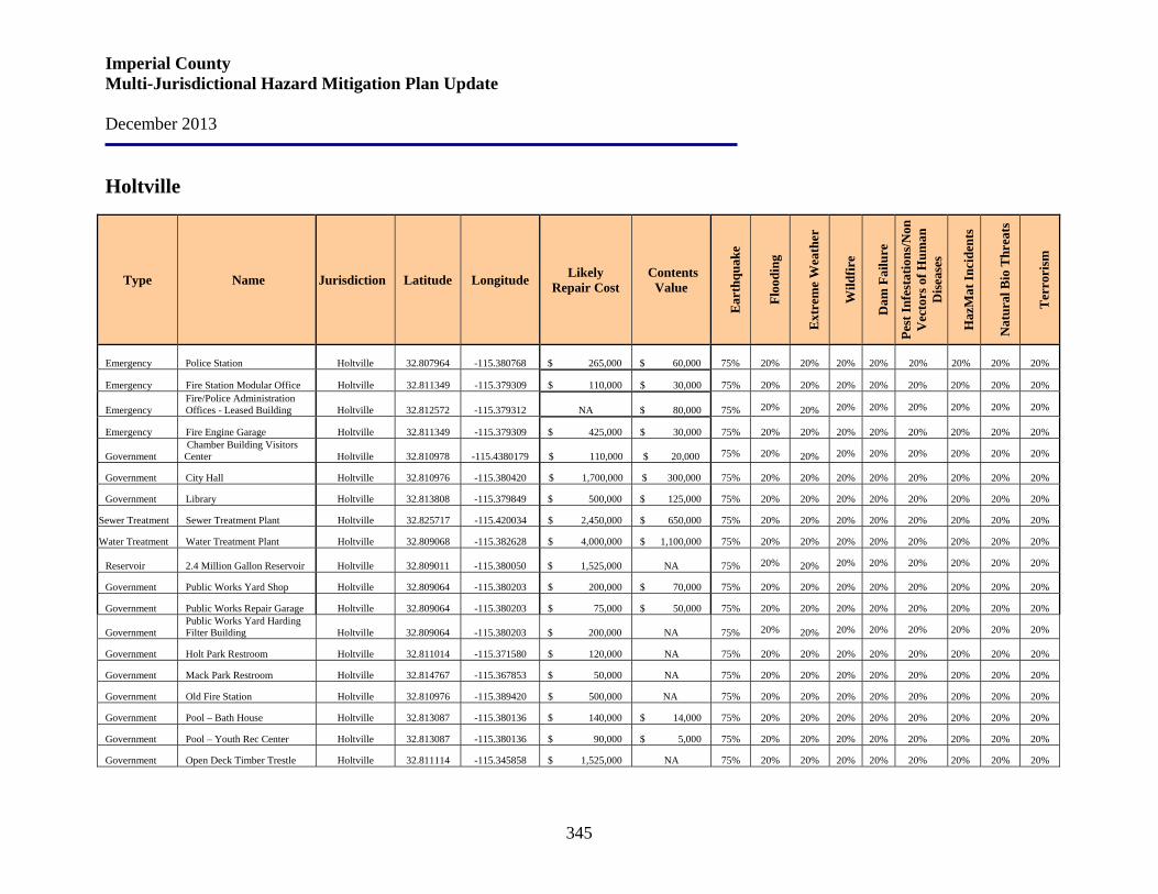
Imperial County Multi-Jurisdictional Hazard Mitigation Plan Update December 2013
345
Holtville
Type Name Jurisdiction Latitude Longitude Likely Repair Cost
Contents Value
Ear
thqu
ake
Floo
ding
Ext
rem
e W
eath
er
Wild
fire
Dam
Fai
lure
Pest
Infe
stat
ions
/Non
V
ecto
rs o
f Hum
an
Dis
ease
s
Haz
Mat
Inci
dent
s
Nat
ural
Bio
Thr
eats
Ter
rori
sm
Emergency Police Station Holtville 32.807964 -115.380768 $ 265,000 $ 60,000 75%
20% 20%
20%
20%
20%
20%
20%
20%
Emergency Fire Station Modular Office Holtville 32.811349 -115.379309 $ 110,000 $ 30,000 75% 20% 20% 20% 20% 20% 20% 20% 20%
Emergency Fire/Police Administration Offices - Leased Building Holtville 32.812572 -115.379312 NA $ 80,000 75% 20% 20% 20% 20% 20% 20% 20% 20%
Emergency Fire Engine Garage Holtville 32.811349 -115.379309 $ 425,000 $ 30,000 75% 20% 20% 20% 20% 20% 20% 20% 20%
Government Chamber Building Visitors Center Holtville 32.810978 -115.4380179
$ 110,000 $ 20,000 75% 20% 20% 20% 20% 20% 20% 20% 20%
Government City Hall Holtville 32.810976 -115.380420 $ 1,700,000 $ 300,000 75% 20% 20% 20% 20% 20% 20% 20% 20%
Government Library Holtville 32.813808 -115.379849 $ 500,000 $ 125,000 75% 20% 20% 20% 20% 20% 20% 20% 20%
Sewer Treatment Sewer Treatment Plant Holtville 32.825717 -115.420034 $ 2,450,000 $ 650,000 75% 20% 20% 20% 20% 20% 20% 20% 20%
Water Treatment Water Treatment Plant Holtville 32.809068 -115.382628 $ 4,000,000 $ 1,100,000 75% 20% 20% 20% 20% 20% 20% 20% 20%
Reservoir 2.4 Million Gallon Reservoir Holtville 32.809011 -115.380050 $ 1,525,000 NA 75% 20% 20% 20% 20% 20% 20% 20% 20%
Government Public Works Yard Shop Holtville 32.809064 -115.380203 $ 200,000 $ 70,000 75% 20% 20% 20% 20% 20% 20% 20% 20%
Government Public Works Repair Garage Holtville 32.809064 -115.380203 $ 75,000 $ 50,000 75% 20% 20% 20% 20% 20% 20% 20% 20%
Government Public Works Yard Harding Filter Building Holtville 32.809064 -115.380203 $ 200,000 NA 75% 20% 20% 20% 20% 20% 20% 20% 20%
Government Holt Park Restroom Holtville 32.811014 -115.371580 $ 120,000 NA 75% 20% 20% 20% 20% 20% 20% 20% 20%
Government Mack Park Restroom Holtville 32.814767 -115.367853 $ 50,000 NA 75% 20% 20% 20% 20% 20% 20% 20% 20%
Government Old Fire Station Holtville 32.810976 -115.389420 $ 500,000 NA 75% 20% 20% 20% 20% 20% 20% 20% 20%
Government Pool – Bath House Holtville 32.813087 -115.380136 $ 140,000 $ 14,000 75% 20% 20% 20% 20% 20% 20% 20% 20%
Government Pool – Youth Rec Center Holtville 32.813087 -115.380136 $ 90,000 $ 5,000 75% 20% 20% 20% 20% 20% 20% 20% 20%
Government Open Deck Timber Trestle Holtville 32.811114 -115.345858 $ 1,525,000 NA 75% 20% 20% 20% 20% 20% 20% 20% 20%
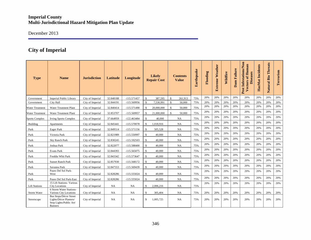
Imperial County Multi-Jurisdictional Hazard Mitigation Plan Update December 2013
346
City of Imperial
Type Name Jurisdiction Latitude Longitude Likely Repair Cost
Contents Value
Ear
thqu
ake
Floo
ding
Ext
rem
e W
eath
er
Wild
fire
Dam
Fai
lure
Pest
Infe
stat
ions
/Non
V
ecto
rs o
f Hum
an
Dis
ease
s
Haz
Mat
Inci
dent
s
Nat
ural
Bio
Thr
eats
Ter
rori
sm
Government Imperial Public Library City of Imperial 32.848188 -115.571457 $ 387,595 $ 261,913 75% 20% 20% 20% 20% 20% 20% 20% 20%
Government City Hall City of Imperial 32.844191 -115.569956 $ 7,530,991 $ 50,000 75% 20% 20% 20% 20% 20% 20% 20% 20%
Water Treatment Water Treatment Plant City of Imperial 32.840414 -115.571490 $ 20,000,000 $ 50,000 75% 20% 20% 20% 20% 20% 20% 20% 20%
Water Treatment Water Treatment Plant City of Imperial 32.853707 -115.569957 $ 21,000,000 $ 50,000 75% 20% 20% 20% 20% 20% 20% 20% 20%
Sports Complex Irving Sports Complex City of Imperial 37.664959 -122.463484 $ 40,000 NA 75% 20% 20% 20% 20% 20% 20% 20% 20%
Building Apartments City of Imperial 32.845441 -115.570078 $ 1,018,916 NA 75% 20% 20% 20% 20% 20% 20% 20% 20%
Park Eager Park City of Imperial 32.849514 -115.571156 $ 505,528 NA 75% 20% 20% 20% 20% 20% 20% 20% 20%
Park Victoria Park City of Imperial 32.821989 -115.550997 $ 40,000 NA 75% 20% 20% 20% 20% 20% 20% 20% 20%
Park Sky Ranch Park City of Imperial 32.830245 -115.592503 $ 40,000 NA 75% 20% 20% 20% 20% 20% 20% 20% 20%
Park Joshua Park City of Imperial 32.822077 -115.588400 $ 40,000 NA 75% 20% 20% 20% 20% 20% 20% 20% 20%
Park Evans Park City of Imperial 32.844393 -115.565075 $ 40,000 NA 75% 20% 20% 20% 20% 20% 20% 20% 20%
Park Freddie Whit Park City of Imperial 32.843342 -115.573647 $ 40,000 NA 75% 20% 20% 20% 20% 20% 20% 20% 20%
Park Sunset Ranch Park City of Imperial 32.857930 -115.568172 $ 40,000 NA 75% 20% 20% 20% 20% 20% 20% 20% 20%
Park Savanna Park City of Imperial 32.847553 -115.569439 $ 40,000 NA 75% 20% 20% 20% 20% 20% 20% 20% 20%
Park Paseo Del Sol Park-West City of Imperial 32.828286 -115.555024 $ 40,000 NA 75%
20% 20% 20% 20% 20% 20% 20% 20%
Park Paseo Del Sol Park-East City of Imperial 32.828286 -115.555024 $ 40,000 NA 75% 20% 20% 20% 20% 20% 20% 20% 20%
Lift Stations 15 Lift Stations- Various City Locations City of Imperial NA
NA $ 2,006,216 NA 75%
20% 20% 20% 20% 20% 20% 20% 20%
Storm Water 6 Storm Water Stations-Various City Locations City of Imperial
NA
NA $ 305,404 NA 75%
20%
20%
20%
20%
20%
20%
20%
20%
Streetscape
Bus Stops/Décor Street Lights/Décor Planters/ Stop Lights/Public Art/ Banners
City of Imperial
NA
NA $ 1,005,725
NA
75%
20%
20%
20%
20%
20%
20%
20%
20%
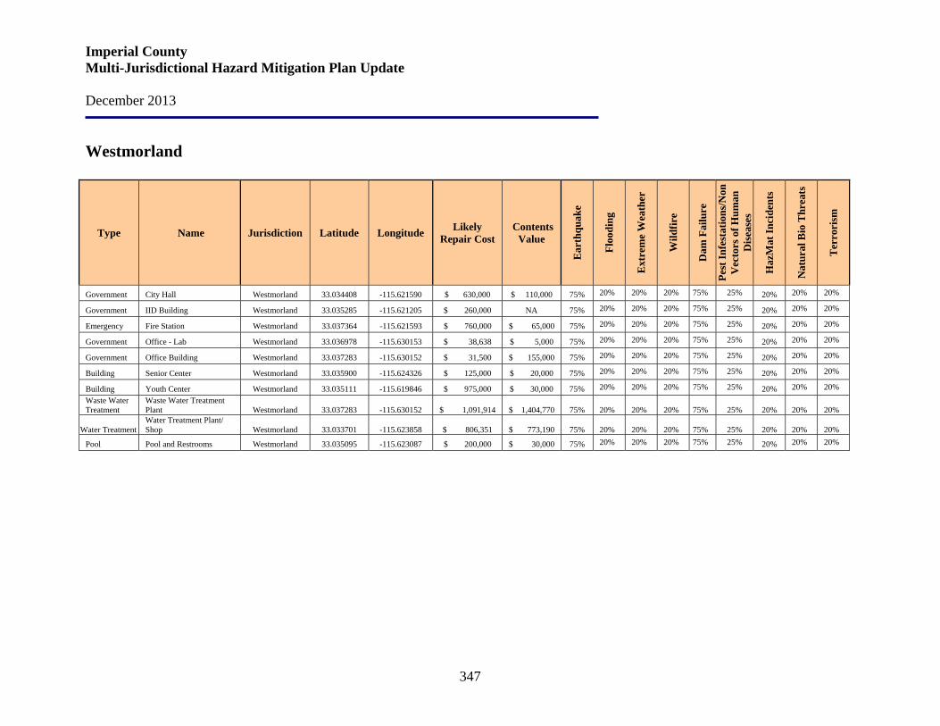
Imperial County Multi-Jurisdictional Hazard Mitigation Plan Update December 2013
347
Westmorland
Type Name Jurisdiction Latitude Longitude Likely Repair Cost
Contents Value
Ear
thqu
ake
Floo
ding
Ext
rem
e W
eath
er
Wild
fire
Dam
Fai
lure
Pest
Infe
stat
ions
/Non
V
ecto
rs o
f Hum
an
Dis
ease
s
Haz
Mat
Inci
dent
s
Nat
ural
Bio
Thr
eats
Ter
rori
sm
Government City Hall Westmorland 33.034408 -115.621590 $ 630,000 $ 110,000 75% 20% 20% 20% 75% 25% 20% 20% 20%
Government IID Building Westmorland 33.035285 -115.621205 $ 260,000 NA 75% 20% 20% 20% 75% 25% 20% 20% 20%
Emergency Fire Station Westmorland 33.037364 -115.621593 $ 760,000 $ 65,000 75% 20% 20% 20% 75% 25% 20% 20% 20%
Government Office - Lab Westmorland 33.036978 -115.630153 $ 38,638 $ 5,000 75% 20% 20% 20% 75% 25% 20% 20% 20%
Government Office Building Westmorland 33.037283 -115.630152 $ 31,500 $ 155,000 75% 20% 20% 20% 75% 25% 20% 20% 20%
Building Senior Center Westmorland 33.035900 -115.624326 $ 125,000 $ 20,000 75% 20% 20% 20% 75% 25% 20% 20% 20%
Building Youth Center Westmorland 33.035111 -115.619846 $ 975,000 $ 30,000 75% 20% 20% 20% 75% 25% 20% 20% 20% Waste Water Treatment
Waste Water Treatment Plant Westmorland 33.037283 -115.630152 $ 1,091,914 $ 1,404,770 75%
20%
20%
20%
75%
25% 20%
20%
20%
Water Treatment Water Treatment Plant/ Shop Westmorland 33.033701 -115.623858 $ 806,351 $ 773,190 75%
20%
20%
20%
75%
25% 20%
20%
20%
Pool Pool and Restrooms Westmorland 33.035095 -115.623087 $ 200,000 $ 30,000 75% 20% 20% 20% 75% 25% 20% 20% 20%
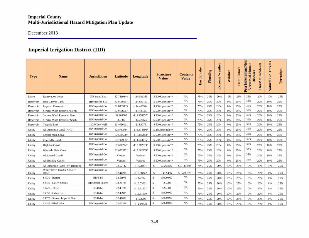
Imperial County Multi-Jurisdictional Hazard Mitigation Plan Update December 2013
348
Imperial Irrigation District (IID)
Type Name Jurisdiction Latitude Longitude Structure Value
Contents Value
Ear
thqu
ake
Floo
ding
Ext
rem
e W
eath
er
Wild
fire
Dam
Fai
lure
Pest
Infe
stat
ions
/Non
V
ecto
rs o
f Hum
an
Dis
ease
s
Haz
Mat
Inci
dent
s
Nat
ural
Bio
Thr
eats
Ter
rori
sm
Levee Reservation Levee IID/Yuma East 32.7419444 -114.596389 $ 500K per site** NA 75% 25% 20% 0% 25% 35% 20% 10% 25%
Reservoir Bear Canyon Tank IID/Picacho SW 33.0166667 -114.669167 $ 500K per site** NA 75% 25% 20% 0% 25% 35% 20% 10% 25%
Reservoir Imperial Reservoir IID/Imperial Co. 32.8833333 -114.466944 $ 500K per site** NA 75% 25% 20% 0% 25% 35% 20% 10% 25%
Reservoir Senator Wash Reservoir North IID/Imperial Co. 32.9166667 -114.483333 $ 500K per site** NA 75% 25% 20% 0% 25% 35% 20% 10% 25%
Reservoir Senator Wash Reservoir East IID/Imperial Co. 32.909782 -114.478357° $ 500K per site** NA 75% 25% 20% 0% 25% 35% 20% 10% 25%
Reservoir Senator Wash Reservoir South IID/Imperial Co. 32.905 -114.476667 $ 500K per site** NA 75% 25% 20% 0% 25% 35% 20% 10% 25%
Reservoir Tadpole Tank IID/Wiley Well 33.4036111 -114.9075 $ 500K per site** NA 75% 25% 20% 0% 25% 35% 20% 10% 25%
Utility All American Canal (AAC) IID/Imperial Co. 32.875379° -114.474396° $ 23M per mile** NA 75% 25% 20% 0% 25% 35% 20% 10% 25%
Utility Central Main Canal IID/Imperial Co. 32.686698° -115.455453° $ 500K per site** NA 75% 25% 20% 0% 25% 35% 20% 10% 25%
Utility Coachella Canal IID/Imperial Co. 32.712955° -114.943215° $ 500K per site** NA 75% 25% 20% 0% 25% 35% 20% 10% 25%
Utility Highline Canal IID/Imperial Co. 32.696774° -115.282619° $ 500K per site** NA 75% 25% 20% 0% 25% 35% 20% 10% 25%
Utility Westside Main Canal IID/Imperial Co. 32.653372° -115.662274° $ 500K per site** NA 75% 25% 20% 0% 25% 35% 20% 10% 25%
Utility All Lateral Canals IID/Imperial Co. Various Various $ 500K per site** NA 75% 25% 20% 0% 25% 35% 20% 10% 25%
Utility All Heading Canals IID/Imperial Co. Various Various $ 500K per site** NA 75% 25% 20% 0% 25% 35% 20% 10% 25%
Utility All American Canal Div. (Housing) IID/Imperial Co. 32.52142 -115.28891 $ 2,726,066 $ 3,115,504 75% 25% 20% 10% 25% 0% 20% 10% 25%
Utility Winterhaven Trouble Shooter Office
IID/Imperial Co.32.44298 -115.38242 $ 412,456 $ 471,378 75% 25% 20% 10% 25% 0% 20% 0% 25%
Utility S1030 - Barrett IID/Bard 32.51976 -114.294 $ 5,000,000 NA 75% 25% 20% 10% 25% 0% 20% 0% 25%
Utility S2040 - Desert Shores IID/Desert Shores 33.24724 -116.03031 $ 25,000 NA 75% 25% 20% 10% 25% 0% 20% 0% 25%
Utility S1220 – Heber IID/Heber 32.43731 -115.31427 $ 126,903 NA 75% 25% 20% 10% 25% 0% 20% 0% 25%
Utility S5050 - Heber Geo. IID/Heber 32.42905 -115.31019 $ 5,000,000 NA 75% 25% 20% 10% 25% 0% 20% 0% 25%
Utility S5070 - Second Imperial Geo. IID/Heber 32.42861 -115.3206 $ 5,000,000 NA 75% 25% 20% 10% 25% 0% 20% 0% 25%
Utility S1045 - Black Mtn. IID/Imperial Co. 32.03329 -114.49728 $ 5,000,000 NA 75% 25% 20% 10% 25% 0% 20% 0% 25%
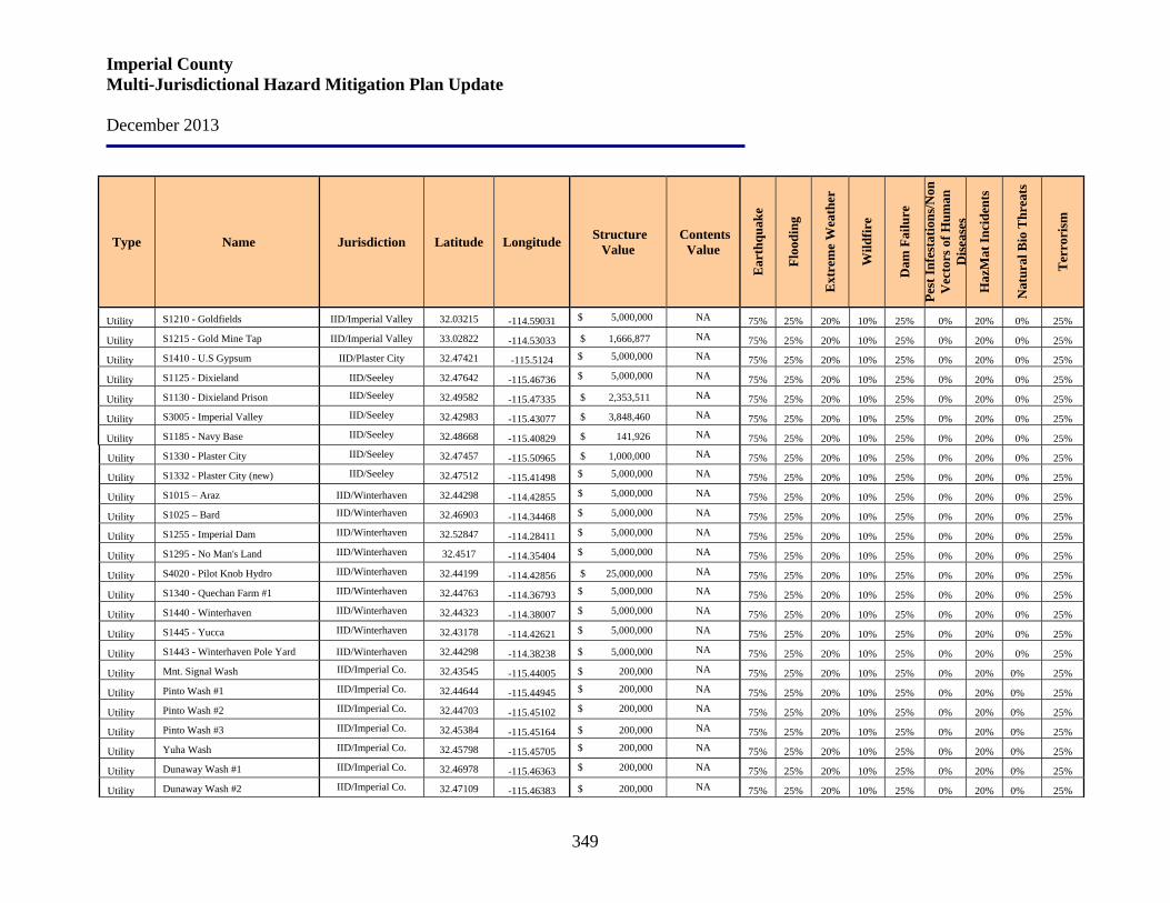
Imperial County Multi-Jurisdictional Hazard Mitigation Plan Update December 2013
349
Type Name Jurisdiction Latitude Longitude Structure Value
Contents Value
Ear
thqu
ake
Floo
ding
Ext
rem
e W
eath
er
Wild
fire
Dam
Fai
lure
Pest
Infe
stat
ions
/Non
V
ecto
rs o
f Hum
an
Dis
ease
s
Haz
Mat
Inci
dent
s
Nat
ural
Bio
Thr
eats
Ter
rori
sm
Utility S1210 - Goldfields IID/Imperial Valley 32.03215 -114.59031 $ 5,000,000 NA 75% 25% 20% 10% 25% 0% 20% 0% 25%
Utility S1215 - Gold Mine Tap IID/Imperial Valley 33.02822 -114.53033 $ 1,666,877 NA 75% 25% 20% 10% 25% 0% 20% 0% 25%
Utility S1410 - U.S Gypsum IID/Plaster City 32.47421 -115.5124 $ 5,000,000 NA 75% 25% 20% 10% 25% 0% 20% 0% 25%
Utility S1125 - Dixieland IID/Seeley 32.47642 -115.46736 $ 5,000,000 NA 75% 25% 20% 10% 25% 0% 20% 0% 25%
Utility S1130 - Dixieland Prison IID/Seeley 32.49582 -115.47335 $ 2,353,511 NA 75% 25% 20% 10% 25% 0% 20% 0% 25%
Utility S3005 - Imperial Valley IID/Seeley 32.42983 -115.43077 $ 3,848,460 NA 75% 25% 20% 10% 25% 0% 20% 0% 25%
Utility S1185 - Navy Base IID/Seeley 32.48668 -115.40829 $ 141,926 NA 75% 25% 20% 10% 25% 0% 20% 0% 25%
Utility S1330 - Plaster City IID/Seeley 32.47457 -115.50965 $ 1,000,000 NA 75% 25% 20% 10% 25% 0% 20% 0% 25%
Utility S1332 - Plaster City (new) IID/Seeley 32.47512 -115.41498 $ 5,000,000 NA 75% 25% 20% 10% 25% 0% 20% 0% 25%
Utility S1015 – Araz IID/Winterhaven 32.44298 -114.42855 $ 5,000,000 NA 75% 25% 20% 10% 25% 0% 20% 0% 25%
Utility S1025 – Bard IID/Winterhaven 32.46903 -114.34468 $ 5,000,000 NA 75% 25% 20% 10% 25% 0% 20% 0% 25%
Utility S1255 - Imperial Dam IID/Winterhaven 32.52847 -114.28411 $ 5,000,000 NA 75% 25% 20% 10% 25% 0% 20% 0% 25%
Utility S1295 - No Man's Land IID/Winterhaven 32.4517 -114.35404 $ 5,000,000 NA 75% 25% 20% 10% 25% 0% 20% 0% 25%
Utility S4020 - Pilot Knob Hydro IID/Winterhaven 32.44199 -114.42856 $ 25,000,000 NA 75% 25% 20% 10% 25% 0% 20% 0% 25%
Utility S1340 - Quechan Farm #1 IID/Winterhaven 32.44763 -114.36793 $ 5,000,000 NA 75% 25% 20% 10% 25% 0% 20% 0% 25%
Utility S1440 - Winterhaven IID/Winterhaven 32.44323 -114.38007 $ 5,000,000 NA 75% 25% 20% 10% 25% 0% 20% 0% 25%
Utility S1445 - Yucca IID/Winterhaven 32.43178 -114.42621 $ 5,000,000 NA 75% 25% 20% 10% 25% 0% 20% 0% 25%
Utility S1443 - Winterhaven Pole Yard IID/Winterhaven 32.44298 -114.38238 $ 5,000,000 NA 75% 25% 20% 10% 25% 0% 20% 0% 25%
Utility Mnt. Signal Wash IID/Imperial Co. 32.43545 -115.44005 $ 200,000 NA 75% 25% 20% 10% 25% 0% 20% 0% 25%
Utility Pinto Wash #1 IID/Imperial Co. 32.44644 -115.44945 $ 200,000 NA 75% 25% 20% 10% 25% 0% 20% 0% 25%
Utility Pinto Wash #2 IID/Imperial Co. 32.44703 -115.45102 $ 200,000 NA 75% 25% 20% 10% 25% 0% 20% 0% 25%
Utility Pinto Wash #3 IID/Imperial Co. 32.45384 -115.45164 $ 200,000 NA 75% 25% 20% 10% 25% 0% 20% 0% 25%
Utility Yuha Wash IID/Imperial Co. 32.45798 -115.45705 $ 200,000 NA 75% 25% 20% 10% 25% 0% 20% 0% 25%
Utility Dunaway Wash #1 IID/Imperial Co. 32.46978 -115.46363 $ 200,000 NA 75% 25% 20% 10% 25% 0% 20% 0% 25%
Utility Dunaway Wash #2 IID/Imperial Co. 32.47109 -115.46383 $ 200,000 NA 75% 25% 20% 10% 25% 0% 20% 0% 25%
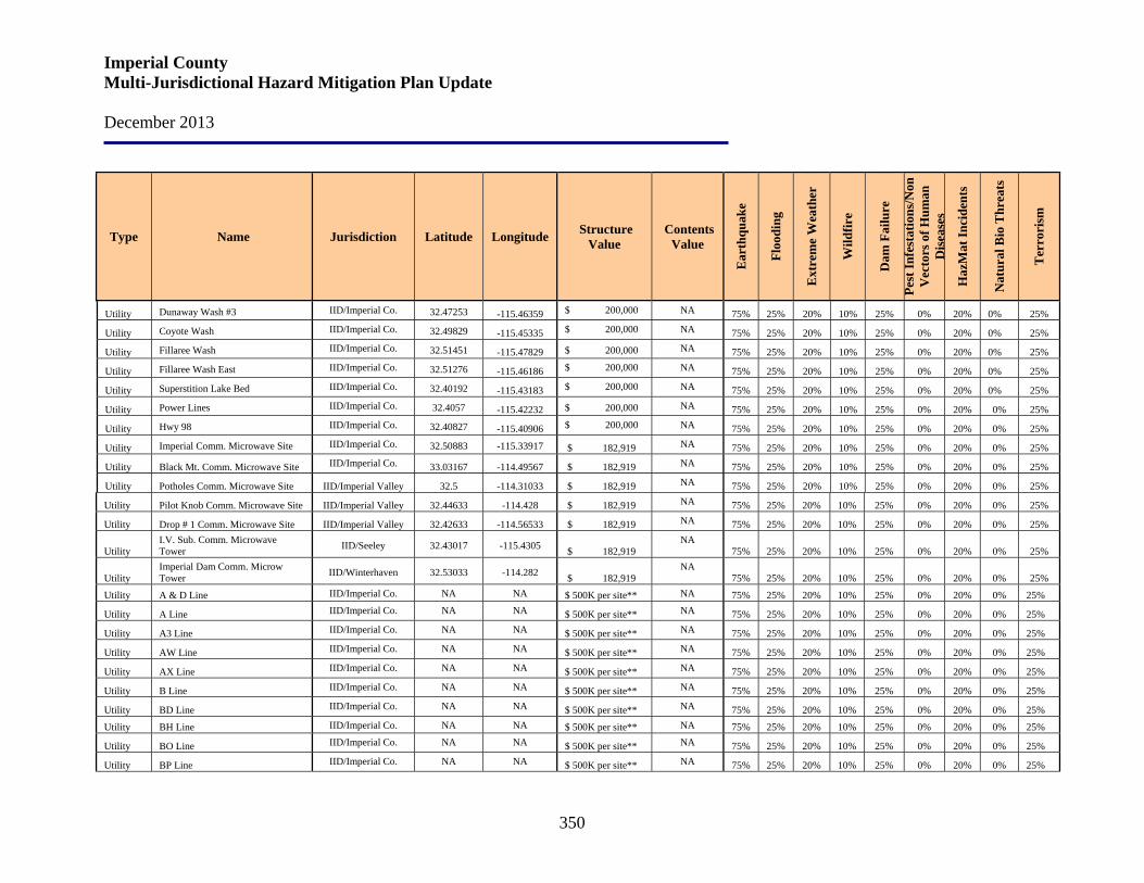
Imperial County Multi-Jurisdictional Hazard Mitigation Plan Update December 2013
350
Type Name Jurisdiction Latitude Longitude Structure Value
Contents Value
Ear
thqu
ake
Floo
ding
Ext
rem
e W
eath
er
Wild
fire
Dam
Fai
lure
Pest
Infe
stat
ions
/Non
V
ecto
rs o
f Hum
an
Dis
ease
s
Haz
Mat
Inci
dent
s
Nat
ural
Bio
Thr
eats
Ter
rori
sm
Utility Dunaway Wash #3 IID/Imperial Co. 32.47253 -115.46359 $ 200,000 NA 75% 25% 20% 10% 25% 0% 20% 0% 25%
Utility Coyote Wash IID/Imperial Co. 32.49829 -115.45335 $ 200,000 NA 75% 25% 20% 10% 25% 0% 20% 0% 25%
Utility Fillaree Wash IID/Imperial Co. 32.51451 -115.47829 $ 200,000 NA 75% 25% 20% 10% 25% 0% 20% 0% 25%
Utility Fillaree Wash East IID/Imperial Co. 32.51276 -115.46186 $ 200,000 NA 75% 25% 20% 10% 25% 0% 20% 0% 25%
Utility Superstition Lake Bed IID/Imperial Co. 32.40192 -115.43183 $ 200,000 NA 75% 25% 20% 10% 25% 0% 20% 0% 25%
Utility Power Lines IID/Imperial Co. 32.4057 -115.42232 $ 200,000 NA 75% 25% 20% 10% 25% 0% 20% 0% 25%
Utility Hwy 98 IID/Imperial Co. 32.40827 -115.40906 $ 200,000 NA 75% 25% 20% 10% 25% 0% 20% 0% 25%
Utility Imperial Comm. Microwave Site IID/Imperial Co. 32.50883 -115.33917 $ 182,919 NA 75% 25% 20% 10% 25% 0% 20% 0% 25%
Utility Black Mt. Comm. Microwave Site IID/Imperial Co. 33.03167 -114.49567 $ 182,919 NA 75% 25% 20% 10% 25% 0% 20% 0% 25%
Utility Potholes Comm. Microwave Site IID/Imperial Valley 32.5 -114.31033 $ 182,919 NA 75% 25% 20% 10% 25% 0% 20% 0% 25%
Utility Pilot Knob Comm. Microwave Site IID/Imperial Valley 32.44633 -114.428 $ 182,919 NA 75% 25% 20% 10% 25% 0% 20% 0% 25%
Utility Drop # 1 Comm. Microwave Site IID/Imperial Valley 32.42633 -114.56533 $ 182,919 NA 75% 25% 20% 10% 25% 0% 20% 0% 25%
Utility I.V. Sub. Comm. Microwave Tower IID/Seeley 32.43017 -115.4305 $ 182,919
NA 75% 25% 20% 10% 25% 0% 20% 0% 25%
Utility Imperial Dam Comm. Microw Tower IID/Winterhaven 32.53033 -114.282 $ 182,919
NA 75% 25% 20% 10% 25% 0% 20% 0% 25%
Utility A & D Line IID/Imperial Co. NA NA $ 500K per site** NA 75% 25% 20% 10% 25% 0% 20% 0% 25%
Utility A Line IID/Imperial Co. NA NA $ 500K per site** NA 75% 25% 20% 10% 25% 0% 20% 0% 25%
Utility A3 Line IID/Imperial Co. NA NA $ 500K per site** NA 75% 25% 20% 10% 25% 0% 20% 0% 25%
Utility AW Line IID/Imperial Co. NA NA $ 500K per site** NA 75% 25% 20% 10% 25% 0% 20% 0% 25%
Utility AX Line IID/Imperial Co. NA NA $ 500K per site** NA 75% 25% 20% 10% 25% 0% 20% 0% 25%
Utility B Line IID/Imperial Co. NA NA $ 500K per site** NA 75% 25% 20% 10% 25% 0% 20% 0% 25%
Utility BD Line IID/Imperial Co. NA NA $ 500K per site** NA 75% 25% 20% 10% 25% 0% 20% 0% 25%
Utility BH Line IID/Imperial Co. NA NA $ 500K per site** NA 75% 25% 20% 10% 25% 0% 20% 0% 25%
Utility BO Line IID/Imperial Co. NA NA $ 500K per site** NA 75% 25% 20% 10% 25% 0% 20% 0% 25%
Utility BP Line IID/Imperial Co. NA NA $ 500K per site** NA 75% 25% 20% 10% 25% 0% 20% 0% 25%
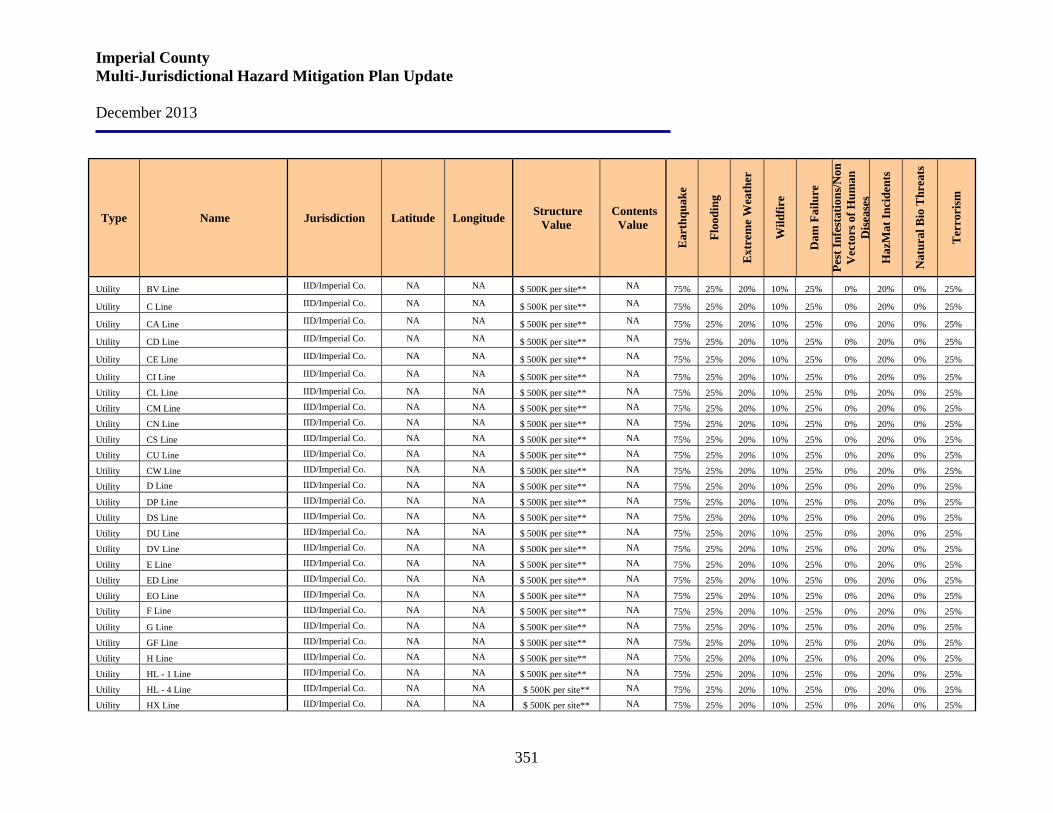
Imperial County Multi-Jurisdictional Hazard Mitigation Plan Update December 2013
351
Type Name Jurisdiction Latitude Longitude Structure Value
Contents Value
Ear
thqu
ake
Floo
ding
Ext
rem
e W
eath
er
Wild
fire
Dam
Fai
lure
Pest
Infe
stat
ions
/Non
V
ecto
rs o
f Hum
an
Dis
ease
s
Haz
Mat
Inci
dent
s
Nat
ural
Bio
Thr
eats
Ter
rori
sm
Utility BV Line IID/Imperial Co. NA NA $ 500K per site** NA 75% 25% 20% 10% 25% 0% 20% 0% 25%
Utility C Line IID/Imperial Co. NA NA $ 500K per site** NA 75% 25% 20% 10% 25% 0% 20% 0% 25%
Utility CA Line IID/Imperial Co. NA NA $ 500K per site** NA 75% 25% 20% 10% 25% 0% 20% 0% 25%
Utility CD Line IID/Imperial Co. NA NA $ 500K per site** NA 75% 25% 20% 10% 25% 0% 20% 0% 25%
Utility CE Line IID/Imperial Co. NA NA $ 500K per site** NA 75% 25% 20% 10% 25% 0% 20% 0% 25%
Utility CI Line IID/Imperial Co. NA NA $ 500K per site** NA 75% 25% 20% 10% 25% 0% 20% 0% 25%
Utility CL Line IID/Imperial Co. NA NA $ 500K per site** NA 75% 25% 20% 10% 25% 0% 20% 0% 25%
Utility CM Line IID/Imperial Co. NA NA $ 500K per site** NA 75% 25% 20% 10% 25% 0% 20% 0% 25%
Utility CN Line IID/Imperial Co. NA NA $ 500K per site** NA 75% 25% 20% 10% 25% 0% 20% 0% 25%
Utility CS Line IID/Imperial Co. NA NA $ 500K per site** NA 75% 25% 20% 10% 25% 0% 20% 0% 25%
Utility CU Line IID/Imperial Co. NA NA $ 500K per site** NA 75% 25% 20% 10% 25% 0% 20% 0% 25%
Utility CW Line IID/Imperial Co. NA NA $ 500K per site** NA 75% 25% 20% 10% 25% 0% 20% 0% 25%
Utility D Line IID/Imperial Co. NA NA $ 500K per site** NA 75% 25% 20% 10% 25% 0% 20% 0% 25%
Utility DP Line IID/Imperial Co. NA NA $ 500K per site** NA 75% 25% 20% 10% 25% 0% 20% 0% 25%
Utility DS Line IID/Imperial Co. NA NA $ 500K per site** NA 75% 25% 20% 10% 25% 0% 20% 0% 25%
Utility DU Line IID/Imperial Co. NA NA $ 500K per site** NA 75% 25% 20% 10% 25% 0% 20% 0% 25%
Utility DV Line IID/Imperial Co. NA NA $ 500K per site** NA 75% 25% 20% 10% 25% 0% 20% 0% 25%
Utility E Line IID/Imperial Co. NA NA $ 500K per site** NA 75% 25% 20% 10% 25% 0% 20% 0% 25%
Utility ED Line IID/Imperial Co. NA NA $ 500K per site** NA 75% 25% 20% 10% 25% 0% 20% 0% 25%
Utility EO Line IID/Imperial Co. NA NA $ 500K per site** NA 75% 25% 20% 10% 25% 0% 20% 0% 25%
Utility F Line IID/Imperial Co. NA NA $ 500K per site** NA 75% 25% 20% 10% 25% 0% 20% 0% 25%
Utility G Line IID/Imperial Co. NA NA $ 500K per site** NA 75% 25% 20% 10% 25% 0% 20% 0% 25%
Utility GF Line IID/Imperial Co. NA NA $ 500K per site** NA 75% 25% 20% 10% 25% 0% 20% 0% 25%
Utility H Line IID/Imperial Co. NA NA $ 500K per site** NA 75% 25% 20% 10% 25% 0% 20% 0% 25%
Utility HL - 1 Line IID/Imperial Co. NA NA $ 500K per site** NA 75% 25% 20% 10% 25% 0% 20% 0% 25%
Utility HL - 4 Line IID/Imperial Co. NA NA $ 500K per site** NA 75% 25% 20% 10% 25% 0% 20% 0% 25%
Utility HX Line IID/Imperial Co. NA NA $ 500K per site** NA 75% 25% 20% 10% 25% 0% 20% 0% 25%
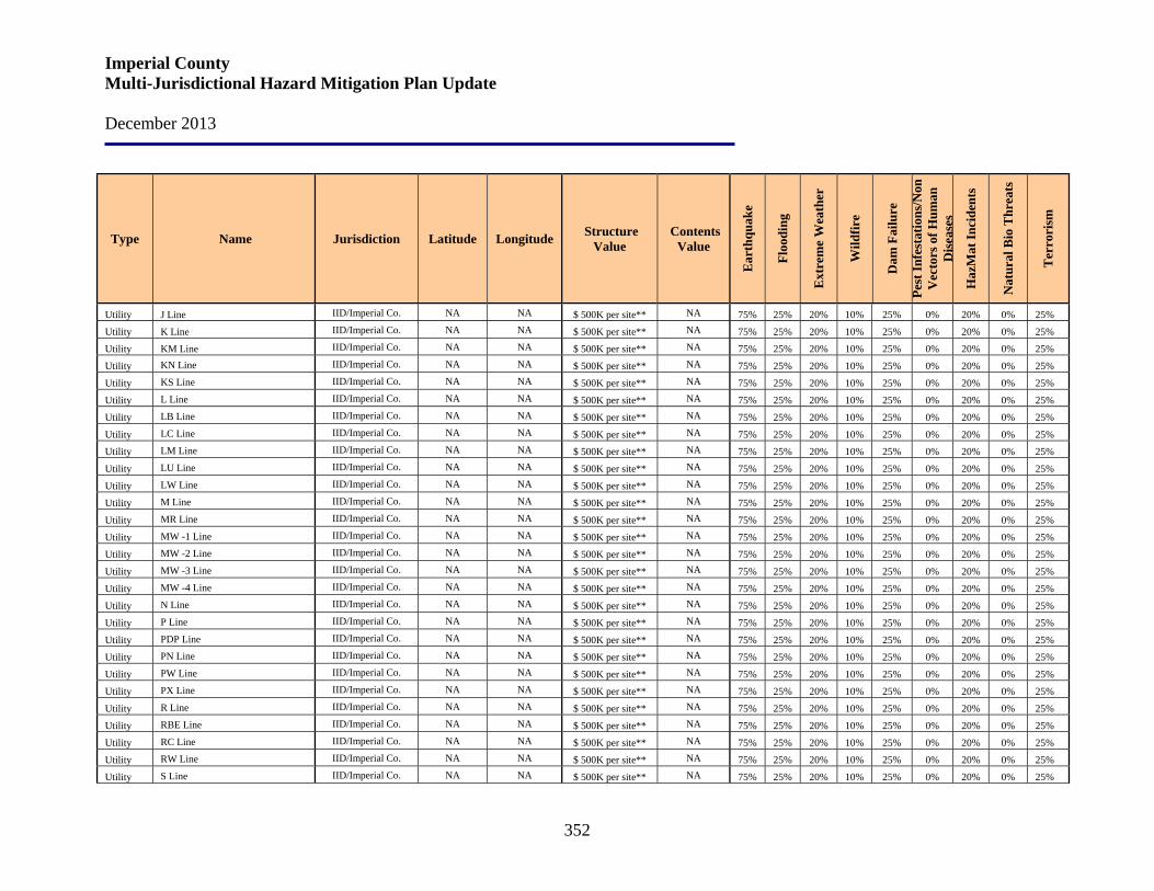
Imperial County Multi-Jurisdictional Hazard Mitigation Plan Update December 2013
352
Type Name Jurisdiction Latitude Longitude Structure Value
Contents Value
Ear
thqu
ake
Floo
ding
Ext
rem
e W
eath
er
Wild
fire
Dam
Fai
lure
Pest
Infe
stat
ions
/Non
V
ecto
rs o
f Hum
an
Dis
ease
s
Haz
Mat
Inci
dent
s
Nat
ural
Bio
Thr
eats
Ter
rori
sm
Utility J Line IID/Imperial Co. NA NA $ 500K per site** NA 75% 25% 20% 10% 25% 0% 20% 0% 25%
Utility K Line IID/Imperial Co. NA NA $ 500K per site** NA 75% 25% 20% 10% 25% 0% 20% 0% 25%
Utility KM Line IID/Imperial Co. NA NA $ 500K per site** NA 75% 25% 20% 10% 25% 0% 20% 0% 25%
Utility KN Line IID/Imperial Co. NA NA $ 500K per site** NA 75% 25% 20% 10% 25% 0% 20% 0% 25%
Utility KS Line IID/Imperial Co. NA NA $ 500K per site** NA 75% 25% 20% 10% 25% 0% 20% 0% 25%
Utility L Line IID/Imperial Co. NA NA $ 500K per site** NA 75% 25% 20% 10% 25% 0% 20% 0% 25%
Utility LB Line IID/Imperial Co. NA NA $ 500K per site** NA 75% 25% 20% 10% 25% 0% 20% 0% 25%
Utility LC Line IID/Imperial Co. NA NA $ 500K per site** NA 75% 25% 20% 10% 25% 0% 20% 0% 25%
Utility LM Line IID/Imperial Co. NA NA $ 500K per site** NA 75% 25% 20% 10% 25% 0% 20% 0% 25%
Utility LU Line IID/Imperial Co. NA NA $ 500K per site** NA 75% 25% 20% 10% 25% 0% 20% 0% 25%
Utility LW Line IID/Imperial Co. NA NA $ 500K per site** NA 75% 25% 20% 10% 25% 0% 20% 0% 25%
Utility M Line IID/Imperial Co. NA NA $ 500K per site** NA 75% 25% 20% 10% 25% 0% 20% 0% 25%
Utility MR Line IID/Imperial Co. NA NA $ 500K per site** NA 75% 25% 20% 10% 25% 0% 20% 0% 25%
Utility MW -1 Line IID/Imperial Co. NA NA $ 500K per site** NA 75% 25% 20% 10% 25% 0% 20% 0% 25%
Utility MW -2 Line IID/Imperial Co. NA NA $ 500K per site** NA 75% 25% 20% 10% 25% 0% 20% 0% 25%
Utility MW -3 Line IID/Imperial Co. NA NA $ 500K per site** NA 75% 25% 20% 10% 25% 0% 20% 0% 25%
Utility MW -4 Line IID/Imperial Co. NA NA $ 500K per site** NA 75% 25% 20% 10% 25% 0% 20% 0% 25%
Utility N Line IID/Imperial Co. NA NA $ 500K per site** NA 75% 25% 20% 10% 25% 0% 20% 0% 25%
Utility P Line IID/Imperial Co. NA NA $ 500K per site** NA 75% 25% 20% 10% 25% 0% 20% 0% 25%
Utility PDP Line IID/Imperial Co. NA NA $ 500K per site** NA 75% 25% 20% 10% 25% 0% 20% 0% 25%
Utility PN Line IID/Imperial Co. NA NA $ 500K per site** NA 75% 25% 20% 10% 25% 0% 20% 0% 25%
Utility PW Line IID/Imperial Co. NA NA $ 500K per site** NA 75% 25% 20% 10% 25% 0% 20% 0% 25%
Utility PX Line IID/Imperial Co. NA NA $ 500K per site** NA 75% 25% 20% 10% 25% 0% 20% 0% 25%
Utility R Line IID/Imperial Co. NA NA $ 500K per site** NA 75% 25% 20% 10% 25% 0% 20% 0% 25%
Utility RBE Line IID/Imperial Co. NA NA $ 500K per site** NA 75% 25% 20% 10% 25% 0% 20% 0% 25%
Utility RC Line IID/Imperial Co. NA NA $ 500K per site** NA 75% 25% 20% 10% 25% 0% 20% 0% 25%
Utility RW Line IID/Imperial Co. NA NA $ 500K per site** NA 75% 25% 20% 10% 25% 0% 20% 0% 25%
Utility S Line IID/Imperial Co. NA NA $ 500K per site** NA 75% 25% 20% 10% 25% 0% 20% 0% 25%
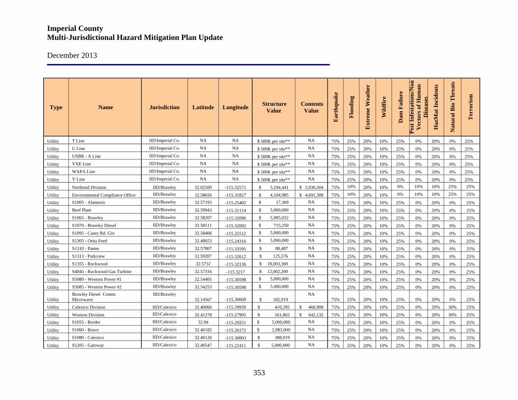
Imperial County Multi-Jurisdictional Hazard Mitigation Plan Update December 2013
353
Type Name Jurisdiction Latitude Longitude Structure Value
Contents Value
Ear
thqu
ake
Floo
ding
Ext
rem
e W
eath
er
Wild
fire
Dam
Fai
lure
Pest
Infe
stat
ions
/Non
V
ecto
rs o
f Hum
an
Dis
ease
s
Haz
Mat
Inci
dent
s
Nat
ural
Bio
Thr
eats
Ter
rori
sm
Utility T Line IID/Imperial Co. NA NA $ 500K per site** NA 75% 25% 20% 10% 25% 0% 20% 0% 25%
Utility U Line IID/Imperial Co. NA NA $ 500K per site** NA 75% 25% 20% 10% 25% 0% 20% 0% 25%
Utility USBR - A Line IID/Imperial Co. NA NA $ 500K per site** NA 75% 25% 20% 10% 25% 0% 20% 0% 25%
Utility VXE Line IID/Imperial Co. NA NA $ 500K per site** NA 75% 25% 20% 10% 25% 0% 20% 0% 25%
Utility WAPA Line IID/Imperial Co. NA NA $ 500K per site** NA 75% 25% 20% 10% 25% 0% 20% 0% 25%
Utility Y Line IID/Imperial Co. NA NA $ 500K per site** NA 75% 25% 20% 10% 25% 0% 20% 0% 25%
Utility Northend Division IID/Brawley 32.02500 -115.32571 $ 5,194,441 $ 5,936,504 75% 10% 20% 10% 0% 10% 10% 25% 25%
Utility Environmental Compliance Office IID/Brawley 32.58656 -115.31827 $ 4,104,985 $ 4,691,308 75% 10% 20% 10% 0% 10% 10% 25% 25%
Utility S1005 - Alamorio IID/Brawley 32.57193 -115.25402 $ 17,369 NA 75% 25% 20% 10% 25% 0% 20% 0% 25%
Utility Beef Plant IID/Brawley 32.59943 -115.31114 $ 5,000,000 NA 75% 25% 20% 10% 25% 0% 20% 0% 25%
Utility S1065 - Brawley IID/Brawley 32.58207 -115.32096 $ 5,985,032 NA 75% 25% 20% 10% 25% 0% 20% 0% 25%
Utility S1070 - Brawley Diesel IID/Brawley 32.58111 -115.32092 $ 715,250 NA 75% 25% 20% 10% 25% 0% 20% 0% 25%
Utility S1095 - Casey Rd. Gin IID/Brawley 32.58406 -115.25512 $ 5,000,000 NA 75% 25% 20% 10% 25% 0% 20% 0% 25%
Utility S1305 - Orita Feed IID/Brawley 32.48653 -115.24316 $ 5,000,000 NA 75% 25% 20% 10% 25% 0% 20% 0% 25%
Utility S1310 - Panno IID/Brawley 32.57807 -115.33595 $ 88,487 NA 75% 25% 20% 10% 25% 0% 20% 0% 25%
Utility S1313 - Parkview IID/Brawley 32.59207 -115.32612 $ 125,576 NA 75% 25% 20% 10% 25% 0% 20% 0% 25%
Utility S1355 - Rockwood IID/Brawley 32.5732 -115.32136 $ 18,003,300 NA 75% 25% 20% 10% 25% 0% 20% 0% 25%
Utility S4045 - Rockwood Gas Turbine IID/Brawley 32.57316 -115.3217 $ 12,002,200 NA 75% 25% 20% 10% 25% 0% 20% 0% 25%
Utility S5080 - Western Power #1 IID/Brawley 32.54405 -115.30598 $ 5,000,000 NA 75% 25% 20% 10% 25% 0% 20% 0% 25%
Utility S5085 - Western Power #2 IID/Brawley 32.54253 -115.30598 $ 5,000,000 NA 75% 25% 20% 10% 25% 0% 20% 0% 25%
Utility Brawley Diesel Comm. Microwave
IID/Brawley 32.14567 -115.30069 $ 182,919
NA 75% 25% 20% 10% 25% 0% 20% 0% 25%
Utility Calexico Division IID/Calexico 32.40066 -115.29939 $ 410,295 $ 468,908 75% 25% 20% 10% 25% 0% 20% 30% 25%
Utility Western Division IID/Calexico 32.41278 -115.27905 $ 561,865 $ 642,132 75% 25% 20% 10% 25% 0% 20% 30% 25%
Utility S1055 - Border IID/Calexico 32.94 -115.29251 $ 5,000,000 NA 75% 25% 20% 10% 25% 0% 20% 0% 25%
Utility S1060 - Bravo IID/Calexico 32.40182 -115.26172 $ 2,983,000 NA 75% 25% 20% 10% 25% 0% 20% 0% 25%
Utility S1080 - Calexico IID/Calexico 32.40126 -115.30003 $ 388,019 NA 75% 25% 20% 10% 25% 0% 20% 0% 25%
Utility S1205 - Gateway IID/Calexico 32.40547 -115.22411 $ 5,000,000 NA 75% 25% 20% 10% 25% 0% 20% 0% 25%
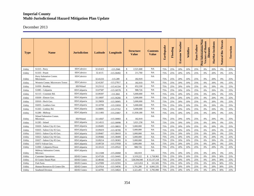
Imperial County Multi-Jurisdictional Hazard Mitigation Plan Update December 2013
354
Type Name Jurisdiction Latitude Longitude Structure Value
Contents Value
Ear
thqu
ake
Floo
ding
Ext
rem
e W
eath
er
Wild
fire
Dam
Fai
lure
Pest
Infe
stat
ions
/Non
V
ecto
rs o
f Hum
an
Dis
ease
s
Haz
Mat
Inci
dent
s
Nat
ural
Bio
Thr
eats
Ter
rori
sm
Utility S1315 - Perry IID/Calexico 32.41423 -115.2946 $ 2,521,668 NA 75% 25% 20% 10% 25% 0% 20% 0% 25%
Utility S1335 - Pruett IID/Calexico 32.4115 -115.30492 $ 211,760 NA 75% 25% 20% 10% 25% 0% 20% 0% 25%
Utility Perry Substation Comm. Microwave
IID/Calexico 32.41233 -115.289 $ 182,919
NA 75% 25% 20% 10% 25% 0% 20% 0% 25%
Utility Western Comm. Microwave Tower IID/Calexico 32.41267 -115.27817 $ 182,919 NA 75% 25% 20% 10% 25% 0% 20% 0% 25%
Utility S1050 - Bombay IID/Niland 33.23112 -115.41334 $ 652,330 NA 75% 25% 20% 10% 25% 0% 20% 0% 25%
Utility S1085 - Calipatria IID/Calipatria 33.07587 -115.30578 $ 988,726 NA 75% 25% 20% 10% 25% 0% 20% 0% 25%
Utility S1115 - Crummer Rd. IID/Calipatria 33.09397 -115.3841 $ 5,000,000 NA 75% 25% 20% 10% 25% 0% 20% 0% 25%
Utility S5030 - Elmore Geo. IID/Calipatria 33.10697 -115.36266 $ 5,000,000 NA 75% 25% 20% 10% 25% 0% 20% 0% 25%
Utility S5010 - Hoch Geo. IID/Calipatria 33.29859 -115.36905 $ 5,000,000 NA 75% 25% 20% 10% 25% 0% 20% 0% 25%
Utility S5055 - Leathers Geo IID/Calipatria 33.10709 -115.33959 $ 5,000,000 NA 75% 25% 20% 10% 25% 0% 20% 0% 25%
Utility S1265 - Lindsey Rd. IID/Calipatria 33.08895 -115.37352 $ 5,000,000 NA 75% 25% 20% 10% 25% 0% 20% 0% 25%
Utility S1280 - Midway IID/Calipatria 33.11493 -115.23067 $ 11,930,180 NA 75% 25% 20% 10% 25% 0% 20% 0% 25%
Utility Niland Substation Comm. Microwav IID/Niland 33.14567 -115.30083 $ 182,919
NA 75% 25% 20% 10% 25% 0% 20% 0% 25%
Utility S1285 - Inland IID/Calipatria 33.14515 -115.30098 $ 3,921,258 NA 75% 25% 20% 10% 25% 0% 20% 0% 25%
Utility S5020 - Salton City #1 Geo. IID/Calipatria 33.09495 -115.38833 $ 5,000,000 NA 75% 25% 20% 10% 25% 0% 20% 0% 25%
Utility S5025 - Salton City #2 Geo. IID/Calipatria 33.09419 -115.38789 $ 5,000,000 NA 75% 25% 20% 10% 25% 0% 20% 0% 25% Utility S5015 - Salton City #3 Geo. IID/Calipatria 33.09407 -115.38410 $ 5,000,000 NA 75% 25% 20% 10% 25% 0% 20% 0% 25% Utility S5023 - Salton City #4 Geo. IID/Calipatria 33.09466 -115.38408 $ 5,000,000 NA 75% 25% 20% 10% 25% 0% 20% 0% 25% Utility S5027 - Salton City #5 Geo. IID/Calipatria 33.09214 -115.38383 $ 5,000,000 NA 75% 25% 20% 10% 25% 0% 20% 0% 25% Utility S5075 Vulcan Geo. IID/Calipatria 33.09729 -115.37058 $ 5,000,000 NA 75% 25% 20% 10% 25% 0% 20% 0% 25% Utility S1090 - Calipatria Prison IID/Calipatria 33.10123 -115.29522 $ 988,726 NA 75% 25% 20% 10% 25% 0% 20% 0% 25%
Utility Midway Substation Comm. Microwv
IID/Calipatria 33.11508 -115.26068 $ 182,919
NA 75% 25% 20% 10% 25% 0% 20% 0% 25%
Utility Customer Operations IID/El Centro 32.47526 -115.34445 $ 3,319,222 $ 1,758,963 75% 25% 20% 10% 25% 0% 20% 30% 25% Utility El Centro Steam Plant IID/El Centro 32.48166 -115.32354 $ 528,594,940 $ 15,137,118 75% 25% 20% 10% 25% 0% 20% 30% 25% Utility Fish Farm IID/El Centro 32.47899 -115.32593 $ 1,015,053 $ 101,505 75% 25% 20% 10% 25% 0% 20% 30% 25% Utility Human Resources El Centro Div IID/El Centro 32.47614 -115.34036 $ 5,701,280 $ 6,841,535 75% 25% 20% 10% 25% 0% 20% 30% 25% Utility Southend Division IID/El Centro 32.44785 -115.34824 $ 3,321,491 $ 3,795,990 75% 25% 20% 10% 25% 0% 20% 30% 25%
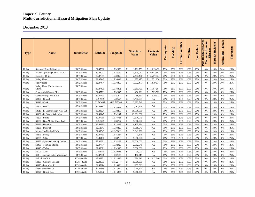
Imperial County Multi-Jurisdictional Hazard Mitigation Plan Update December 2013
355
Type Name Jurisdiction Latitude Longitude Structure Value
Contents Value
Ear
thqu
ake
Floo
ding
Ext
rem
e W
eath
er
Wild
fire
Dam
Fai
lure
Pest
Infe
stat
ions
/Non
V
ecto
rs o
f Hum
an
Dis
ease
s
Haz
Mat
Inci
dent
s
Nat
ural
Bio
Thr
eats
Ter
rori
sm
Utility Southend Trouble Shooters IID/El Centro 32.47302 -115.32979 $ 1,761,753 $ 2,013,432 75% 25% 20% 10% 25% 0% 20% 30% 25% Utility System Operating Center "SOC" IID/El Centro 32.48001 -115.32162 $ 3,875,062 $ 6,642,963 75% 25% 20% 10% 25% 0% 20% 30% 25% Utility Executive Office IID/El Centro 32.47655 -115.34099 $ 2,443,406 $ 3,257,874 75% 25% 20% 10% 25% 0% 20% 30% 25% Utility Valley Plaza IID/El Centro 32.47445 -115.34349 $ 1,375,477 $ 1,571,974 75% 25% 20% 10% 25% 0% 20% 30% 25% Utility Valley Plaza IID/El Centro 32.47474 -115.34408 $ 1,592,477 $ 1,819,974 75% 25% 20% 10% 25% 0% 20% 30% 25%
Utility Valley Plaza (Environmental Office)
IID/El Centro 32.47435 -115.34401 $ 1,561,791 $ 1,784,904 75% 25% 20% 10% 25% 0% 20% 30% 25%
Utility Commercial (Corner Bld.) IID/El Centro 32.47701 -115.32945 $ 486,261 $ 529,522 75% 25% 20% 10% 25% 0% 20% 0% 25% Utility Commercial (Green Bld.) IID/El Centro 32.47700 -115.3297 $ 486,261 $ 529,522 75% 25% 20% 10% 25% 0% 20% 0% 25% Utility S1100 - Central IID/El Centro 32.4909 -115.34694 $ 1,483,089 NA 75% 25% 20% 10% 25% 0% 20% 0% 25% Utility S1110 - Clark IID/El Centro 32.763655 -115.565364 $ 2,982,546 NA 75% 25% 20% 10% 25% 0% 20% 0% 25%
Utility S1120 - Dahlia IID/El Centro 32.46882 -115.34691 $ 2,982,546 NA 75% 25% 20% 10% 25% 0% 20% 0% 25%
Utility S4015 - El Centro Steam Plant Sub IID/El Centro 32.48224 -115.32409 $ 50,000,000 NA 75% 25% 20% 10% 25% 0% 20% 0% 25% Utility S1190 - El Centro Switch Stn. IID/El Centro 32.48147 -115.32147 $ 19,961,636 NA 75% 25% 20% 10% 25% 0% 20% 0% 25% Utility S1200 - Euclid IID/El Centro 32.47966 -115.34731 $ 1,570,075 NA 75% 25% 20% 10% 25% 0% 20% 0% 25% Utility S1040 - Gios Mobile Home Park IID/El Centro 32.4532 -115.34707 $ 5,000,000 NA 75% 25% 20% 10% 25% 0% 20% 0% 25% Utility S1235 - Holtville IID/El Centro 32.48763 -115.23289 $ 4,175,564 NA 75% 25% 20% 10% 25% 0% 20% 0% 25% Utility S1250 - Imperial IID/El Centro 32.51347 -115.33828 $ 5,519,645 NA 75% 25% 20% 10% 25% 0% 20% 0% 25% Utility Imperial Valley Mall Sub. IID/El Centro 32.45543 -115.3207 $ 7,049,900 NA 75% 25% 20% 10% 25% 0% 20% 0% 25% Utility S1375 - Seeley IID/El Centro 32.47493 -115.41684 $ 1,179 NA 75% 25% 20% 10% 25% 0% 20% 0% 25% Utility S1385 - Silsbee IID/El Centro 32.45180 -115.38268 $ 5,000,000 NA 75% 25% 20% 10% 25% 0% 20% 0% 25% Utility S1395 - System Operating Center IID/El Centro 32.47991 -115.32163 $ 25,000,000 NA 75% 25% 20% 10% 25% 0% 20% 0% 25% Utility S1405 - Terminal Station IID/El Centro 32.47774 -115.32928 $ 2,982,546 NA 75% 25% 20% 10% 25% 0% 20% 0% 25% Utility S1415 - Valley IID/El Centro 32.46021 -115.32315 $ 5,000,000 NA 75% 25% 20% 10% 25% 0% 20% 0% 25% Utility S1020 - Aten IID/El Centro 32.4922 -115.30588 $ 25,000 NA 75% 25% 20% 10% 25% 0% 20% 0% 25% Utility S.O.C Communication Microwave IID/El Centro 32.47986 -115.32196 $ 182,919 NA 75% 25% 20% 10% 25% 0% 20% 0% 25% Utility Holtville Office IID/Holtville 32.48731 -115.22876 $ 889,910 $ 1,017,040 75% 25% 20% 10% 25% 0% 20% 30% 25% Utility S1105 - Chestnut Cooling IID/Holtville 32.48599 -115.2244 $ 5,000,000 NA 75% 25% 20% 10% 25% 0% 20% 0% 25% Utility S1175 - East Mesa II IID/Holtville 32.47214 -115.14923 $ 955,593 NA 75% 25% 20% 10% 25% 0% 20% 0% 25% Utility S1180 East Mesa III IID/Holtville 32.46486 -115.15872 $ 955,593 NA 75% 25% 20% 10% 25% 0% 20% 0% 25% Utility S5040 - Gem 2 Geo. IID/Holtville 32.4653 -115.15805 $ 5,000,000 NA 75% 25% 20% 10% 25% 0% 20% 0% 25%
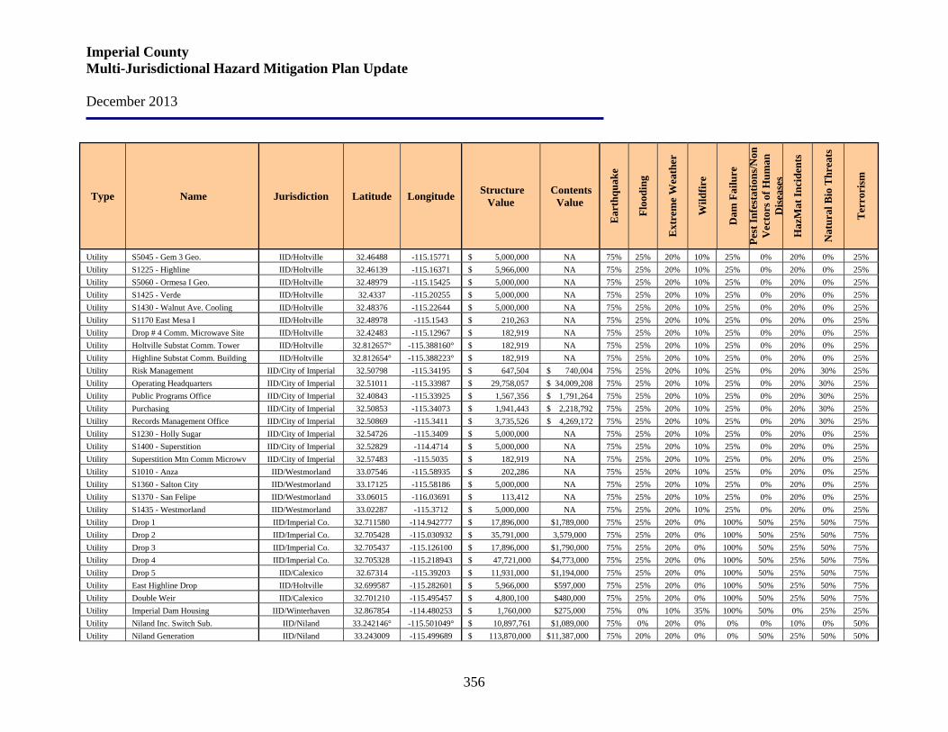
Imperial County Multi-Jurisdictional Hazard Mitigation Plan Update December 2013
356
Type Name Jurisdiction Latitude Longitude Structure Value
Contents Value
Ear
thqu
ake
Floo
ding
Ext
rem
e W
eath
er
Wild
fire
Dam
Fai
lure
Pest
Infe
stat
ions
/Non
V
ecto
rs o
f Hum
an
Dis
ease
s
Haz
Mat
Inci
dent
s
Nat
ural
Bio
Thr
eats
Ter
rori
sm
Utility S5045 - Gem 3 Geo. IID/Holtville 32.46488 -115.15771 $ 5,000,000 NA 75% 25% 20% 10% 25% 0% 20% 0% 25% Utility S1225 - Highline IID/Holtville 32.46139 -115.16371 $ 5,966,000 NA 75% 25% 20% 10% 25% 0% 20% 0% 25% Utility S5060 - Ormesa I Geo. IID/Holtville 32.48979 -115.15425 $ 5,000,000 NA 75% 25% 20% 10% 25% 0% 20% 0% 25% Utility S1425 - Verde IID/Holtville 32.4337 -115.20255 $ 5,000,000 NA 75% 25% 20% 10% 25% 0% 20% 0% 25% Utility S1430 - Walnut Ave. Cooling IID/Holtville 32.48376 -115.22644 $ 5,000,000 NA 75% 25% 20% 10% 25% 0% 20% 0% 25% Utility S1170 East Mesa I IID/Holtville 32.48978 -115.1543 $ 210,263 NA 75% 25% 20% 10% 25% 0% 20% 0% 25% Utility Drop # 4 Comm. Microwave Site IID/Holtville 32.42483 -115.12967 $ 182,919 NA 75% 25% 20% 10% 25% 0% 20% 0% 25% Utility Holtville Substat Comm. Tower IID/Holtville 32.812657° -115.388160° $ 182,919 NA 75% 25% 20% 10% 25% 0% 20% 0% 25% Utility Highline Substat Comm. Building IID/Holtville 32.812654° -115.388223° $ 182,919 NA 75% 25% 20% 10% 25% 0% 20% 0% 25% Utility Risk Management IID/City of Imperial 32.50798 -115.34195 $ 647,504 $ 740,004 75% 25% 20% 10% 25% 0% 20% 30% 25% Utility Operating Headquarters IID/City of Imperial 32.51011 -115.33987 $ 29,758,057 $ 34,009,208 75% 25% 20% 10% 25% 0% 20% 30% 25% Utility Public Programs Office IID/City of Imperial 32.40843 -115.33925 $ 1,567,356 $ 1,791,264 75% 25% 20% 10% 25% 0% 20% 30% 25% Utility Purchasing IID/City of Imperial 32.50853 -115.34073 $ 1,941,443 $ 2,218,792 75% 25% 20% 10% 25% 0% 20% 30% 25% Utility Records Management Office IID/City of Imperial 32.50869 -115.3411 $ 3,735,526 $ 4,269,172 75% 25% 20% 10% 25% 0% 20% 30% 25% Utility S1230 - Holly Sugar IID/City of Imperial 32.54726 -115.3409 $ 5,000,000 NA 75% 25% 20% 10% 25% 0% 20% 0% 25% Utility S1400 - Superstition IID/City of Imperial 32.52829 -114.4714 $ 5,000,000 NA 75% 25% 20% 10% 25% 0% 20% 0% 25% Utility Superstition Mtn Comm Microwv IID/City of Imperial 32.57483 -115.5035 $ 182,919 NA 75% 25% 20% 10% 25% 0% 20% 0% 25% Utility S1010 - Anza IID/Westmorland 33.07546 -115.58935 $ 202,286 NA 75% 25% 20% 10% 25% 0% 20% 0% 25% Utility S1360 - Salton City IID/Westmorland 33.17125 -115.58186 $ 5,000,000 NA 75% 25% 20% 10% 25% 0% 20% 0% 25% Utility S1370 - San Felipe IID/Westmorland 33.06015 -116.03691 $ 113,412 NA 75% 25% 20% 10% 25% 0% 20% 0% 25% Utility S1435 - Westmorland IID/Westmorland 33.02287 -115.3712 $ 5,000,000 NA 75% 25% 20% 10% 25% 0% 20% 0% 25% Utility Drop 1 IID/Imperial Co. 32.711580 -114.942777 $ 17,896,000 $1,789,000 75% 25% 20% 0% 100% 50% 25% 50% 75% Utility Drop 2 IID/Imperial Co. 32.705428 -115.030932 $ 35,791,000 3,579,000 75% 25% 20% 0% 100% 50% 25% 50% 75% Utility Drop 3 IID/Imperial Co. 32.705437 -115.126100 $ 17,896,000 $1,790,000 75% 25% 20% 0% 100% 50% 25% 50% 75% Utility Drop 4 IID/Imperial Co. 32.705328 -115.218943 $ 47,721,000 $4,773,000 75% 25% 20% 0% 100% 50% 25% 50% 75% Utility Drop 5 IID/Calexico 32.67314 -115.39203 $ 11,931,000 $1,194,000 75% 25% 20% 0% 100% 50% 25% 50% 75% Utility East Highline Drop IID/Holtville 32.699587 -115.282601 $ 5,966,000 $597,000 75% 25% 20% 0% 100% 50% 25% 50% 75% Utility Double Weir IID/Calexico 32.701210 -115.495457 $ 4,800,100 $480,000 75% 25% 20% 0% 100% 50% 25% 50% 75% Utility Imperial Dam Housing IID/Winterhaven 32.867854 -114.480253 $ 1,760,000 $275,000 75% 0% 10% 35% 100% 50% 0% 25% 25% Utility Niland Inc. Switch Sub. IID/Niland 33.242146° -115.501049° $ 10,897,761 $1,089,000 75% 0% 20% 0% 0% 0% 10% 0% 50% Utility Niland Generation IID/Niland 33.243009 -115.499689 $ 113,870,000 $11,387,000 75% 20% 20% 0% 0% 50% 25% 50% 50%
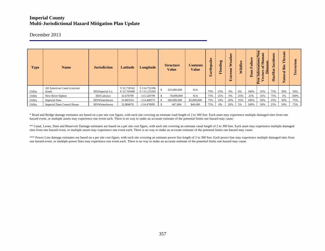
Imperial County Multi-Jurisdictional Hazard Mitigation Plan Update December 2013
357
Type Name Jurisdiction Latitude Longitude Structure Value
Contents Value
Ear
thqu
ake
Floo
ding
Ext
rem
e W
eath
er
Wild
fire
Dam
Fai
lure
Pest
Infe
stat
ions
/Non
V
ecto
rs o
f Hum
an
Dis
ease
s
Haz
Mat
Inci
dent
s
Nat
ural
Bio
Thr
eats
Ter
rori
sm
Utility All American Canal (concrete lined) IID/Imperial Co.
S 32.718162 E 32.705490
S 114.752206 E 115.125205 $ 325,000,000 N/A 75% 25% 0% 0% 100% 35% 75% 50% 50%
Utility New River Siphon IID/Calexico 32.670799 -115.520799 $ 78,690,000 N/A 75% 25% 0% 25% 25% 35% 75% 5% 100% Utility Imperial Dam IID/Winterhaven 32.883554 -114.468575 $ 260,000,000 $5,000,000 75% 10% 20% 25% 100% 50% 25% 50% 75% Utility Imperial Dam Control House IID/Winterhaven 32.884076 -114.470095 $ 467,684 $46,000 75% 0% 20% 5% 100% 50% 25% 50% 75%
* Road and Bridge damage estimates are based on a per site cost figure, with each site covering an estimate road length of 2 to 300 feet. Each asset may experience multiple damaged sites from one hazard event, or multiple assets may experience one event each. There is no way to make an accurate estimate of the potential limits one hazard may cause. ** Canal, Levee, Dam and Reservoir Damage estimates are based on a per site cost figure, with each site covering an estimate canal length of 2 to 300 feet. Each asset may experience multiple damaged sites from one hazard event, or multiple assets may experience one event each. There is no way to make an accurate estimate of the potential limits one hazard may cause. *** Power Line damage estimates are based on a per site cost figure, with each site covering an estimate power line length of 2 to 300 feet. Each power line may experience multiple damaged sites from one hazard event, or multiple power lines may experience one event each. There is no way to make an accurate estimate of the potential limits one hazard may cause.
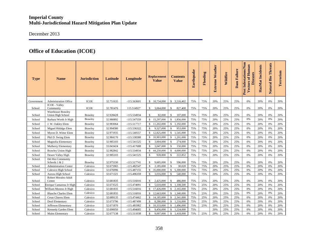
Imperial County Multi-Jurisdictional Hazard Mitigation Plan Update December 2013
358
Office of Education (ICOE)
Type Name Jurisdiction Latitude Longitude Replacement Value
Contents Value
Ear
thqu
ake
Floo
ding
Ext
rem
e W
eath
er
Wild
fire
Dam
Fai
lure
Pest
Infe
stat
ions
/Non
V
ecto
rs o
f Hum
an
Dis
ease
s
Haz
Mat
Inci
dent
s
Nat
ural
Bio
Thr
eats
Ter
rori
sm
Government Administration Office ICOE 32.751635 -115.563601 $ 10,734,000 $ 3,516,402 75% 75% 20% 25% 25%
0% 20%
0% 20%
School ICOE - Valley Community ICOE 32.781476 115.514927 $ 3,064,000 $ 827,400 75% 75% 20% 25% 25%
0% 20%
0% 20%
School Warehouse Brawley Union High School Brawley 32.928428 -115.534934 $ 82,000 $ 107,000 75% 75% 20% 25% 25%
0% 20%
0% 20%
School Barbara Worth Jr High Brawley 32.980892 -115.547559 $ 15,297,000 $ 1,856,000 75% 75% 20% 25% 25% 0% 20% 0% 20% School J. W. Oakley Elem Brawley 32.983064 -115.517717 $ 11,202,000 $ 1,192,000 75% 75% 20% 25% 25% 0% 20% 0% 20% School Miguel Hidalgo Elem Brawley 32.994580 -115.536322 $ 9,327,000 $ 953,000 75% 75% 20% 25% 25% 0% 20% 0% 20% School Myron D. Witter Elem Brawley 32.971935 -115.540557 $ 12,825,000 $ 1,545,000 75% 75% 20% 25% 25% 0% 20% 0% 20% School Phil D. Swing Elem Brawley 32.984170 -115.538388 $ 10,903,000 $ 1,201,000 75% 75% 20% 25% 25% 0% 20% 0% 20% School Magnolia Elementary Brawley 32.985103 -115.541525 $ 3,004,000 $ 274,000 75% 75% 20% 25% 25% 0% 20% 0% 20% School Mulberry Elementary Brawley 33.043424 -115.417688 $ 3,047,000 $ 150,000 75% 75% 20% 25% 25% 0% 20% 0% 20% School Brawley Union High Brawley 32.982842 -115.534934 $ 44,250,000 $ 4,000,000 75% 75% 20% 25% 25% 0% 20% 0% 20% School Desert Valley High Brawley 32.985103 -115.541525 $ 928,800 $ 222,852 75% 75% 20% 25% 25% 0% 20% 0% 20% School Del Rio Community
Schools 1 & 2
Brawley 32.975330 -115.517741 $ 9,605,000 $ 596,000 75% 75% 20% 25% 25%
0% 20%
0% 20% School Administration Center Calexico 32.675965 -115.482547 $ 2,185,000 $ 30,020 75% 75% 20% 25% 25% 0% 20% 0% 20% School Calexico High School Calexico 32.676996 -115.487155 $ 35,000,000 $ 5,300,000 75% 75% 20% 25% 25% 0% 20% 0% 20% School Aurora High School Calexico 32.671321 -115.496359 $ 3,016,000 $ 540,000 75% 75% 20% 25% 25% 0% 20% 0% 20%
School Robert Morales-Adult Center
Calexico 32.681835 -115.516016 $ 2,425,000 $ 486,000 75% 25% 20% 25% 25%
0% 20%
0% 20%
School Enrique Camarena Jr High Calexico 32.673525 -115.474091 $ 5,610,000 $ 1,108,500 75% 25% 20% 25% 25% 0% 20% 0% 20% School William Moreno Jr High Calexico 32.681835 -115.516016 $ 17,426,000 $ 2,165,000 75% 25% 20% 25% 25% 0% 20% 0% 20% School Blanche Charles Elem Calexico 32.681835 -115.516016 $ 12,663,000 $ 1,340,000 75% 25% 20% 25% 25% 0% 20% 0% 20% School Cesar Chavez Elem Calexico 32.689135 -115.474462 $ 14,185,000 $ 2,341,000 75% 25% 20% 25% 25% 0% 20% 0% 20% School Dool Elementary Calexico 32.673796 -115.487499 $ 8,280,000 $ 1,216,000 75% 25% 20% 25% 25% 0% 20% 0% 20% School Jefferson Elementary Calexico 32.671870 -115.481982 $ 10,333,000 $ 1,496,000 75% 25% 20% 25% 25% 0% 20% 0% 20% School Kennedy Garden Elem Calexico 32.690050 -115.494685 $ 9,456,000 $ 1,224,000 75% 20% 25% 25% 0% 20% 0% 20% School Mains Elementary Calexico 32.677138 -115.511038 $ 9,007,000 $ 1,418,000 75% 25% 20% 25% 25% 0% 20% 0% 20%
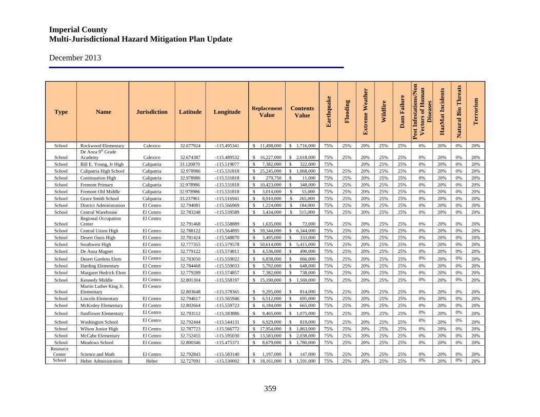
Imperial County Multi-Jurisdictional Hazard Mitigation Plan Update December 2013
359
Type Name Jurisdiction Latitude Longitude Replacement Value
Contents Value
Ear
thqu
ake
Floo
ding
Ext
rem
e W
eath
er
Wild
fire
Dam
Fai
lure
Pest
Infe
stat
ions
/Non
V
ecto
rs o
f Hum
an
Dis
ease
s
Haz
Mat
Inci
dent
s
Nat
ural
Bio
Thr
eats
Ter
rori
sm
School Rockwood Elementary Calexico 32.677924 -115.495341 $ 11,498,000 $ 1,716,000 75% 25% 20% 25% 25% 0% 20% 0% 20%
School De Anza 9th Grade Academy
Calexico 32.674387 -115.489532 $ 16,227,000 $ 2,618,000 75% 25% 20% 25% 25%
0% 20%
0% 20%
School Bill E. Young, Jr High Calipatria 33.120870 -115.519077 $ 7,382,000 $ 322,000 75% 20% 25% 25% 0% 20% 0% 20% School Calipatria High School Calipatria 32.978986 -115.531818 $ 25,245,000 $ 1,068,000 75% 25% 20% 25% 25% 0% 20% 0% 20% School Continuation High Calipatria 32.978986 -115.531818 $ 279,750 $ 11,000 75% 25% 20% 25% 25% 0% 20% 0% 20% School Fremont Primary Calipatria 32.978986 -115.531818 $ 10,423,000 $ 348,000 75% 25% 20% 25% 25% 0% 20% 0% 20% School Fremont Old Middle Calipatria 32.978986 -115.531818 $ 3,014,000 $ 55,000 75% 25% 20% 25% 25% 0% 20% 0% 20% School Grace Smith School Calipatria 33.237961 -115.516941 $ 8,910,000 $ 265,000 75% 25% 20% 25% 25% 0% 20% 0% 20% School District Administration El Centro 32.794081 -115.566969 $ 1,224,000 $ 184,000 75% 25% 20% 25% 25% 0% 20% 0% 20% School Central Warehouse El Centro 32.783248 -115.539589 $ 3,434,000 $ 515,000 75% 25% 20% 25% 25% 0% 20% 0% 20%
School Regional Occupation Center
El Centro 32.791468 -115.558889 $ 1,635,000 $ 72,000 75% 25% 20% 25% 25%
0% 20%
0% 20%
School Central Union High El Centro 32.788122 -115.564895 $ 39,344,000 $ 6,344,000 75% 25% 20% 25% 25% 0% 20% 0% 20% School Desert Oasis High El Centro 32.781424 -115.548870 $ 3,495,000 $ 333,000 75% 25% 20% 25% 25% 0% 20% 0% 20% School Southwest High El Centro 32.777355 -115.579578 $ 50,614,000 $ 5,415,000 75% 25% 20% 25% 25% 0% 20% 0% 20% School De Anza Magnet El Centro 32.779122 -115.574811 $ 4,536,000 $ 490,000 75% 25% 20% 25% 25% 0% 20% 0% 20% School Desert Gardens Elem El Centro 32.783050 -115.559022 $ 6,838,000 $ 666,000 75% 25% 20% 25% 25% 0% 20% 0% 20% School Harding Elementary El Centro 32.784468 -115.559033 $ 5,792,000 $ 648,000 75% 25% 20% 25% 25% 0% 20% 0% 20% School Margaret Hedrick Elem El Centro 32.779289 -115.574857 $ 7,382,000 $ 738,000 75% 25% 20% 25% 25% 0% 20% 0% 20% School Kennedy Middle El Centro 32.801304 -115.558197 $ 15,190,000 $ 1,569,000 75% 25% 20% 25% 25% 0% 20% 0% 20%
School Martin Luther King Jr. Elementary
El Centro 32.803648 -115.578365
$ 9,295,000 $ 814,000 75% 25% 20% 25% 25%
0% 20%
0% 20%
School Lincoln Elementary El Centro 32.794617 -115.565946 $ 6,512,000 $ 695,000 75% 25% 20% 25% 25% 0% 20% 0% 20% School McKinley Elementary El Centro 32.802664 -115.559723 $ 6,184,000 $ 665,000 75% 25% 20% 25% 25% 0% 20% 0% 20%
School Sunflower Elementary El Centro 32.793512 -115.583886 $ 9,465,000 $ 1,075,000 75% 25% 20% 25% 25% 0% 20% 0% 20%
School Washington School El Centro 32.792444 -115.544131 $ 6,929,000 $ 819,000 75% 25% 20% 25% 25% 0% 20% 0% 20% School Wilson Junior High El Centro 32.787723 -115.566772 $ 17,954,000 $ 1,863,000 75% 25% 20% 25% 25% 0% 20% 0% 20% School McCabe Elementary El Centro 32.752455 -115.595030 $ 13,583,000 $ 2,038,000 75% 25% 20% 25% 25% 0% 20% 0% 20% School Meadows School El Centro 32.800346 -115.475371 $ 8,679,000 $ 1,780,000 75% 25% 20% 25% 25% 0% 20% 0% 20%
Resource Center Science and Math
El Centro 32.792843 -115.583140 $ 1,197,000 $ 147,000 75% 25% 20% 25% 25%
0% 20%
0% 20%
School Heber Administration Heber 32.727091 -115.530002 $ 18,161,000 $ 1,591,000 75% 25% 20% 25% 25% 0% 20% 0% 20%
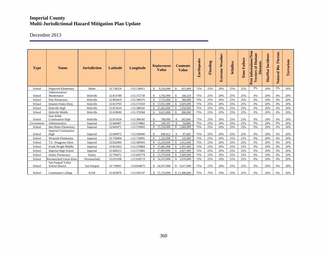
Imperial County Multi-Jurisdictional Hazard Mitigation Plan Update December 2013
360
Type Name Jurisdiction Latitude Longitude Replacement Value
Contents Value
Ear
thqu
ake
Floo
ding
Ext
rem
e W
eath
er
Wild
fire
Dam
Fai
lure
Pest
Infe
stat
ions
/Non
V
ecto
rs o
f Hum
an
Dis
ease
s
Haz
Mat
Inci
dent
s
Nat
ural
Bio
Thr
eats
Ter
rori
sm
School Dogwood Elementary Heber 32.738224 -155.538411 $ 9,316,000 $ 815,000 75% 25% 20% 25% 25% 0% 20% 0% 20%
School Administration/ Maintenance Holtville 32.813788 -115.372730 $ 3,792,000 $ 160,250 75% 25% 20% 25% 25%
0% 20%
0% 20%
School Pine Elementary Holtville 32.893419 -115.380375 $ 3,725,000 $ 380,000 75% 25% 20% 25% 25% 0% 20% 0% 20% School Emmett Finley Elem Holtville 32.813793 -115.371010 $ 13,912,000 $ 1,605,000 75% 25% 20% 25% 25% 0% 20% 0% 20% School Holtville High Holtville 32.815634 -115.386542 $ 21,663,000 $ 1,950,000 75% 25% 20% 25% 25% 0% 20% 0% 20% School Holtville Middle Holtville 32.818000 -115.370268 $ 9,615,000 $ 906,000 75% 25% 20% 25% 25% 0% 20% 0% 20%
School Sam Webb Continuation High
Holtville 32.815634 -115.386542 $ 780,000 $ 183,000 75% 25% 20% 25% 25%
0% 20%
0% 20%
Government Administration Imperial 32.849497 -115.574862 $ 339,107 $ 50,866 75% 25% 20% 25% 25% 0% 20% 0% 20% School Ben Hulse Elementary Imperial 32.845471 -115.576093 $ 15,316,000 $ 1,664,000 75% 25% 20% 25% 25% 0% 20% 0% 20%
School Imperial Continuation High
Imperial 32.849972 -115.569940 $ 849,412 $ 97,402 75% 25% 20% 25% 25%
0% 20%
0% 20%
School Westside Elementary Imperial 32.758404 -115.734091 $ 1,322,000 $ 141,000 75% 25% 20% 25% 25% 0% 20% 0% 20% School T.L. Waggoner Elem Imperial 32.822084 -115.589303 $ 15,250,000 $ 1,412,000 75% 25% 20% 25% 25% 0% 20% 0% 20% School Frank Wright Middle Imperial 32.855433 -115.570864 $ 15,481,000 $ 1,951,000 75% 25% 20% 25% 25% 0% 20% 0% 20% School Imperial High School Imperial 32.848212 -115.575882 $ 27,893,000 $ 2,827,000 75% 25% 20% 25% 25% 0% 20% 0% 20% School Seeley Elementary Seeley 32.794472 -115.692774 $ 13,379,000 $ 2,669,000 75% 25% 20% 25% 25% 0% 20% 0% 20% School Westmorland Union Elem Westmorland 33.035108 -115.618713 $ 14,333,000 $ 1,676,000 75% 25% 20% 25% 25% 0% 20% 0% 20%
School San Pasqual Valley School District San Pasqual 32.739491 -114.634675 $ 24,107,000 $ 3,617,000 75% 25% 20% 25% 25%
0% 20%
0% 20%
School Community College ICOE 32.825870 -115.505147 $ 71,174,000 $ 11,496,000 75% 75% 20% 25% 25%
0% 20%
0% 20%
Imperial County Multi-Jurisdictional Hazard Mitigation Plan Update December 2013
361
Section 11. Plan Maintenance
The MHMP is subject to regular review and systematic, ongoing updates. Because the Plan is a “living” document that reflects Imperial County’s ongoing hazard mitigation commitment, planning, and implementation actions, the process of monitoring, evaluating, and updating it will be critical to the effectiveness of hazard mitigation in the County. Imperial County OES has the responsibility for maintaining, evaluating, monitoring, and updating the Plan. County OES has developed a method to ensure that regular review and update of its Multi-Jurisdictional Hazard Mitigation Plan (MHMP) occurs. FEMA regulations require an update every five years. Imperial County OES will utilize the Hazard Mitigation Working Group to poll agencies to see if they want to continue to participate and if their elements of the plan are up-to-date. Factors that will be considered in evaluating whether a Plan update or revisions are required are:
• Relevance of MHMP goals and objectives to the evolving situation in Imperial County (i.e., significant changes in the landscape due to implementation of hazard mitigation projects)
• Consistency of MHMP goals and objectives with changes in local, state and federal laws, regulations or policies
• Relevance of MHMP goals and objectives to current and expected conditions • New technologies • New information, i.e., identification of barriers or obstacles to successful
implementation or completion of mitigation actions The risk assessment portion of the Plan will be reviewed to determine if the information should be updated or modified. The parties responsible for the various implementation actions will report on:
• Status of their projects • Implementation processes that worked well • Any difficulties encountered • How coordination efforts are proceeding • Which strategies should be revised based on evaluating future conditions (i.e., socio-
economic, environmental, demographic, change in built environments, etc.); how changing conditions and opportunities could impact community resilience in the long term)
Imperial County is committed to involving the public in the continual reshaping and updating of the MHMP. The Hazard Mitigation Working Group members are responsible for the annual review and update of the Plan. Although they represent the public to some extent, the public will be able to directly comment on and provide feedback about the Plan.
Imperial County Multi-Jurisdictional Hazard Mitigation Plan Update December 2013
362
Imperial County currently uses comprehensive land use planning, capital improvements planning, and building codes to guide and control development within the County. The hazard mitigation strategies of the Imperial County and participating jurisdiction’s General Plans, Flood Management Plan, and Seismic and Public Safety Elements have been integrated into this MHMP. This MHMP will be provided to those responsible for the County and its participating jurisdiction’s General Plan development and update mechanisms to insure that consistency is maintained. The County has initiated a comprehensive update to its General Plan and Zoning Ordinance. This update is expected to take approximately three years. The seven cities within the County have recently updated or are in the early stages of updating their General Plans. This MHMP will serve as an important document in the General Plan update processes particularly as it relates to the Seismic, Safety and related elements. Copies of the Plan will be kept on hand at County OES and the County Libraries. These copies will include the address and phone number of the County OES staff member responsible for tracking public comment.