implementation of gis for - pmgsy home page · implementation of gis for software requirements...
TRANSCRIPT


Implementation of GIS for
Software Requirements Specifications
(SRS) Document
Version 1.01
CENTRE FOR DEVELOPMENT OF ADVANCED COMPUTING
2 | P a g e
SRS Version 1.01
cONTENTS
1. Introduction 4
1.1 Purpose 6
1.2 Scope 6
1.2.1 Objective 6
1.2.2 Study Area 7
1.3 Abbreviations 7
1.4 References 9
1.5 Overview 9
2. The Overall Description 10
2.1 Approach 10
2.2.1 Preparation of GIS base layers 10
2.2.2 QC for GIS layers 11
2.2.3 Integration with OMMAS database 12
2.2.4 Development of Web GIS for PMGSY 12
2.2.5 Activities involved in the implementation 13
2.2.6 User Characteristics 13
2.2.7 Use Cases 14
3. Specific Requirements 17
3.1 Data Requirements 17
3.1.1 Spatial Data 17
3.1.2 Attribute Data 19
3.2 Web-GIS Functionality 20
3.3 System Requirements 32
3.3.1 Client Side 32
3.3.2 Server Side 33
3.3.3 GIS data preparation 35
3.4 Software Requirement 41
3.4.1 GIS data preparation 41
3.4.2 Web GIS Server 45

3 | P a g e
SRS Version 1.01
3.5 Software System Attributes 49
3.6.1 Reliability 49
3.6.2 Availability 49
3.6.3 Security 49
3.6.4 Maintainability 50
3.6.5 Portability 50
3.6.6 Usability 50
3.6 Testing Requirements 50
3.7 Training Requirements 51
4. GIS Implementation Status and Action Plan 52
4.1 Rajasthan 52
4.2 Himachal Pradesh 52
4.3 Punjab 53
4.4 Uttarakhand 53
4.5 Jharkhand 54
4.6 Meghalaya 54
4.7 Uttar Pradesh 54
4.8 Bihar 55
4.9 Gujarat 55
Risks & Contingency 56
ANNEXURE 57
ANNEXURE I : Procurement of Digital Topographic Data from Survey of India 57
ANNEXURE II: Spatial Database Creation (Digitization) 59
ANNEXURE III: Outsourcing Jobs 61
ANNEXURE IV: Quality Assurance 63
ANNEXURE V: Spatial data creation for nine states (approx. cost) 64
ANNEXURE VI: Web-GIS development for PMGSY (approx. cost) 65
ANNEXURE VII: Software for states (optional) 66
ANNEXURE VIII: Project cost (approx. Cost) 67
ANNEXURE IX: GRIMMS 68
ANNEXURE X: Tool for preparation/ updation of GIS data 69
ANNEXURE XI: Replies to the questionnaires by states 72

4 | P a g e
SRS Version 1.01
1. iNTRODUcTiON Pradhan Mantri Gram Sadak Yojana (PMGSY) was launched on 25thDecember 2000 as a fully funded Centrally Sponsored Scheme to provide all weather road connectivity in rural areas of the country. The programme envisages connecting all
habitations with a population of 500 persons and above in the plain areas and 250 persons and above in hill States, the tribal and the desert areas. National Rural Roads Development Agency (NRRDA), Ministry of Rural Development (MRD), Government of India is implementing agency for this programme.
OMMAS, a web based application software (www.omms.nic.in), has been established by the NRRDA to effectively manage various activities under PMGSY and
flow of information at all levels. OMMAS has been developed with the assistance of C-DAC. It facilitates the officials involved in the Programme in managing the enormous data that will be engaged at various stages of the PMGSY. The software has been designed to data entry at a single point so as to eliminate repetitive and time-consuming tasks of data compilation and aggregation at various levels. This site is open to citizens maintaining transparency and access to information.
Through OMMAS, for the first time, a nation-wide programme is being managed and monitored online; OMMAS envisages that the District Project Implementation Units (DPIU) will upload the data regarding the road proposals and construction progress comprising both physical and financial data on to the PMGSY website. The data will be used for decision-making, and for transactional decisions, monitoring and analysis. From 2003-04 onwards, updating the website is a pre-requisite for availing funds under the Programme.
GIS interface to OMMAS will help in presenting information in the form of maps and charts in an integrated manner for more transparency and accountability. Impact assessment of PMGSY can be effectively monitored using GIS. Depiction of socio-economic data vis-à-vis road network within GIS will help monitoring various parameters including growth, employment and change in demographic profile, which ultimately will improve the socio-economic condition of rural masses.
Everything that happens happens somewhere. Knowing “what” is “where,” and “why” it is there, can be critically important for making decisions in personal life as well as in an organization. GIS is the technology as well as the science for handling the “where” type of questions and for making intelligent decisions based on space and location. GIS can produce more than just pretty maps although GIS is conventionally used to make a myriad of maps using different scales, themes and
symbols. More importantly, GIS has powerful analytical functions that turn data into useful information. GIS can relate otherwise disparate data on the basis of common

5 | P a g e
SRS Version 1.01
geography, revealing hidden relationships, patterns, and trends that are not readily apparent in spreadsheets or statistical packages, and create new information that can support informed decision making.
The Web changes everything, and GIS is no exception. Web GIS, as the combination of the Web and geographic information system(s) or science (GIS), has grown into a rapidly developing discipline. The vast majority of Internet users use simple mapping or other spatially enabled applications over the Web at some point, though many are not aware of it. GIS has benefited greatly from the Internet paradigm of broad connectivity and the momentum that the Web has generated. The Web has unlocked the power of GIS, from offices to laboratories. It has put GIS in the homes
of millions and in the hands of billions, and made it usable across all industries, from government and business to education and research.
Fig. Web-GIS
Web GIS facilitate the sharing, communication, interoperability, collaboration, and integration of geospatial information on the Web. Web GIS for PMGSY will help to monitor progress of the PMGSY on GIS maps. It includes showing connectivity status of the habitation on a GIS map. Using web GIS can provide following benefits
A global reach
A large number of users
Better cross-platform capability
Low cost as averaged by the number of users
Easy to use for end users
Unified update
Diverse applications
Web GIS is able to perform all GIS functions involving spatial information, including capture, storage, editing, manipulation, management, analysis, sharing, and visualization. Some of the strengths of Web GIS include the following:
Mapping (visualization) and query
Collection of geospatial information
Dissemination of geospatial information
Geospatial analysis

6 | P a g e
SRS Version 1.01
1.1 Purpose
The purpose of this Software Requirements Specifications (SRS) document is to provide a detailed description of the requirements for the Web-GIS for Pradhan Mantri Gram Sadak Yojana (PMGSY). This SRS will allow a complete understanding of what is to be expected of the Web-GIS tool. The clear understanding of the Web-GIS tool and its’ functionality will allow for the correct software to be developed for the end users and will be used for the development of the future stages of the project. This SRS will provide the foundation for the project. From this SRS, the Web-GIS tool can be designed, constructed, and finally tested.
This SRS will be used by NRRDA, state road departments, software engineers and GIS consultants for developing the Web-GIS tool. The software engineers and GIS consultants will use the SRS to fully understand the expectations from this Web-GIS tool to develop the appropriate software. The end users will be able to use this SRS as a ‘test’ to see if the software engineers and GIS consultants are developing the
system as per their expectations. If it is not as per their expectations the end users can specify how it is not to their liking and software engineers and GIS consultants will change the SRS to fit the end users’ needs.
1.2 Scope
The primary objective of the PMGSY is to provide connectivity by way of an all
weather road to the eligible un-connected habitations in the rural area as well as upgradation of the existing roads. Effective implementation of the PMGSY needs a system that will monitor the progress of the programme as well as help planning next phases of implementation.
Geographic Information System (GIS) is the obvious tool to achieve this
because it provides visual representation showing habitation connectivity status on
GIS map. An important part of every web-based GIS tool is its mapping or
visualization technology, which makes it possible to show various geographic features like habitations, roads in the form of maps. It helps in identifying the connectivity of the habitations with the road as well as planning new roads for unconnected habitations.
1.2.1 Objective
To conduct system requirement specification study for GIS implementation project
under PMGSY.

7 | P a g e
SRS Version 1.01
Study current status of GIS at State level which includes understanding the
availability of spatial data with states, NRRDA and other agencies like Survey of India (SOI) etc.
Define approach and methodology for preparation/ capture spatial data where it’s
not available along with estimate of the financial implications of data creation/capture at State level
1.2.2 Study Area
For developing & implementing the Web-GIS tool, nine states have been considered which include Himachal Pradesh, Rajasthan, Uttarakhand, Punjab, Uttar Pradesh, Meghalaya, Jharkhand, Bihar and Gujarat.
1.3 Abbreviations
SRS System requirement Specification
GIS Geographic Information System
PMGSY Pradhan Mantri Gram Sadak Yojana
NRRDA National Rural Road Development Agency
OMMAS Online Monitoring and Management and Accounting System
C-DAC Centre for Development of Advanced Computing
SoI Survey of India
CN Core Network
DRRP District Rural Road Plan
MP Member of Parliament
MLA Member of Legislative Assembly
PWD Public Works Department
MOD Ministry of Defense
DVD Digital Versatile Disc / Digital Vector Data

8 | P a g e
SRS Version 1.01
LCC Lambert Conformal Conic
MDR Major District Roads
ODR Other District Roads
VR Village Roads
BT Bituminous
WBM Water Bound Macadam
MIS Management Information System
SQL Structured Query Language
GRIMMS GIS enabled Road Information Management and Monitoring system
HQ Head Quarters
PDF Portable Document Format
COTS Commercial off-the-shelf
UTM Universal Transverse Mercator
TM Transverse Mercator
RDBMS Relational database management system
MS Microsoft
WMS Web Map Server
QC Quality Checking
DPIU District Project Implementation Units

9 | P a g e
SRS Version 1.01
1.4 References
1. Letter for preparing System Requirement Specifications (SRS) to be conducted by C-DAC for GIS
implementation project under PMGSY from NRRDA
2. Proposal for Development of Web-GIS enabled Road Information, Management and Monitoring
System for PMGSY - II
3. http://www.pmgsy.nic.in
4. http://www.omms.nic.in
5. Integrated use of Standalone and Web GIS Software - A Case Study. International Conference on b-GIS, 7-8 December 2006, Technopark, Trivandrum.
6. Development of a GIS-based Decision Support System for Prime Minister’s Rural Roads Programme in India. MapAsia 2006.
7. Development through GRIMMS Web. Geospatial Today. August 2006. Vol. 4, Issue 11, pp 30 – 32.
8. GRIMMS Web -Connecting India,Geospatial Today 11/2012
9. Rural road management gets on fast track with GIS, India Geospatial Digest October 2013
10. www.esri.com
11. www.mapinfo.com
12. www.qgis.org
13. http://www.rolta.com/
14. http://geoserver.org
15. http://mapserver.org/
1.5 Overview
The SRS is organized into two main sections. The first is ‘The Overall Description’ and the second is `the Specific Requirements’. The Overall Description will describe the requirements of the GIS implementation for PMGSY project from a general high level perspective. The Specific Requirements section will describe in detail the requirements of the system.
10 | P a g e
SRS Version 1.01
2. ThE OvERAll DEScRiPTiON
The general factors which affect the product and its requirements are described here. This section does not describe specific requirements. Instead, it provides a background for those requirements, which are defined in specific requirement section, and makes them easier to understand.
2.1 Approach
The approach starts with creation of GIS layers from the maps/ digital data available with the respective implementing agencies. Taking into consideration these data as base, various GIS layers required for the GIS implementation of PMGSY project will be digitized. The digitization work can be outsourced to
vendors. The quality checking of the digitized data may be carried out by the implementing agency. Geo database will be created using the final GIS layers. Geo database will be integrated with OMMAS database based on common attribute. Finally, Web-GIS system will be developed which will use the same Geo database and serve customized user specific queries along with various GIS functionalities. Implementation of GIS for PMGSY includes following tasks
Study of existing OMMAS for execution of various activities within GIS frame-work
To prepare GIS database for the nine states specified in study area section. The preparation of GIS database includes creation of various GIS layers including habitation and road layers.
To integrate the GIS layers with the corresponding attributes in the OMMAS database.
To develop a high performing and flexible Web-GIS tool to monitor the
implementation of PMGSY programme using GIS technologies.
2.2 Detailed Methodology
The methodology of the proposed study is elaborated in the steps below
2.2.1 Preparation of GIS base layers
Spatial layers (1:50,000 scale) along with required associated attribute information (Habitation id, CN Number, DRRP Number, Package ID etc) will be provided by states, which will be considered as base for creation of GIS database.

11 | P a g e
SRS Version 1.01
Creation of GIS database does not simply means the digitization of maps. In order to make digitized maps available in GIS domain, many other components are involved such as layer-wise data formatting; feature coding, map projection, edge matching, topology building and accuracy. Preparation of various GIS layers involves following
1. Information regarding forest boundary, land use, river, water bodies and railway lines, if required, may be picked from available source.
2. Administrative boundaries of blocks, districts, states, MP/MLA constituency, and PWD Circle/Division from paper maps will be converted to digital format
3. Rural roads (DRRP including Core network) and habitation will be converted from paper maps to digital format
4. PMGSY layer (Package layer), if required, may be created
2.2.2 QC for GIS layers
After creation of GIS database various GIS layers in the database will be checked for its quality. For quality assurance of the GIS, various GIS layers and features in layers need to be checked for following
1. File format and naming: GIS layers shall be in predefined format, e.g. .shp format. The file names shall be checked for if the naming convention is followed.
2. Map projection: Each GIS layer shall be checked for correct projection parameters
3. Positional accuracy: Shape and location of the features in GIS layer shall be checked for the closeness to the actual GIS objects on the map.
4. Attribute accuracy: Attribute fields related to each feature in GIS layer shall be
checked for correct data type and value
5. Topological consistency: Topological consistency has to be maintained For example polygon feature shall be closed, line feature shall be continuous.
6. Compatibility with OMMAS database: The number of features in GIS layers shall match corresponding number of records in the OMMAS for each state, district and block. For polygon features sliver polygons should not be present. Each feature in the layer will follow the same ID fields as in OMMAS
Refer annexure IV for the steps to be followed for acceptance of digitized maps

12 | P a g e
SRS Version 1.01
2.2.3 Integration with OMMAS database
For dynamic linking of attribute data in OMMAS with GIS features, common field will be required. During digitization these fields will be added to the GIS layers as attributes. In OMMAS views, procedure, functions will be created with geographic feature ids along with corresponding attributes attached to it. These database views, procedures, functions will be referenced while performing attribute query in the Web-GIS tool.
2.2.4 Development of Web GIS for PMGSY
Web GIS tool will be developed to monitor habitation connectivity on GIS map. Web GIS tool available on Internet, will allow performing basic GIS functions (display and query) to the remote user through conventional Web browser (Mozilla, Internet Explorer, Google Chrome). The GIS Web Map Server will be used as a back engine for processing and displaying predefined queries executed by user. Utility and query tools arranged on the Web page will allow user to execute the desired queries and display the results.
Methodology Flowchart
SRS Digital database creation
Ancillary data/ maps from states, Toposheets
Quality Control of Digital Data
OMMAS Database
GIS data Integration with OMMAS data
Edit GIS layers GIS Server
Web Server
Web Browser
Client Application
GIS Database

13 | P a g e
SRS Version 1.01
2.2.5 Activities involved in the implementation
Activity Responsibility
Funding NRRDA,States
Procurement of data (maps, toposheets etc.) States (refer annexure I)
Clearance from MOD to host GIS maps on web NRRDA,States
Data processing involved Geo-referencing, Ortho rectification, mosiacing, etc.
States (these activities can be outsourced. Refer annexure III for guidelines of outsourcing the activities)
Digitization of layers States (this activity can be outsourced. Refer annexure II for guidelines of digitization activity)
Quality checking of digitized data States,Implementing agency
GIS data integration with OMMAS data Implementing agency Development of Web-GIS Implementing agency
OMMAS data updation DPIU
GIS layers updating States
2.2.6 User Characteristics
System shall have three types of users. Each user has a specific role in the system and this SRS appropriately mentions ‘user type’ for against each requirement.
User Roles
Administrator For creating and deleting users as per the user type and access rights
database administrator and overall hardware and software system administrator
Public user /Citizens These users includes citizens as well as policy makers
These users will have access to the system for the following purpose
View GIS map of all the states Use GIS functionality to navigate the GIS maps Use information tool to access information about GIS
features(habitation, road etc) Make query (attribute as well as spatial)

14 | P a g e
SRS Version 1.01
Authorized user These users includes authorized users from states
These users shall have access to the system as public user
In addition these users shall have access to the system for editing GIS data of its own state
2.2.7 Use Cases
Use Case 1

15 | P a g e
SRS Version 1.01
Use Case 2
Use Case 3

16 | P a g e
SRS Version 1.01
Use Case 4

17 | P a g e
SRS Version 1.01
3. SPEcific REqUiREmENTS
3.1 Data Requirements
3.1.1 Spatial Data
SR_Data_01
If map data not available, 1:50,000 digital topographic data, containing the following layers
may be procured. The procedure for procurement of data and the list of toposheets are given in
Annexure I.
o Administrative boundaries (International/ State/ District boundaries)
o Forest boundary
o River & Stream
o Water body
o Landuse
o Railway network
o Road network
o Habitation
o Quarry
SR_Data_02
Quality checks on data (SR_Data_01) shall be carried out before accepting it.
Data format
Latitude/longitude of 4 corners of a topo map
Projection parameters
Number and type of layers
Continuity of layers

18 | P a g e
SRS Version 1.01
SR_Data_03
The digital data (SR_Data_01) shall be converted to .shp format which will be used in database
creation. This format is also supported by all leading GIS software available in the industry.
SR_Data_04
The participating states shall trace the following features on tracing sheet in 1:50000 or larger
scale using toposheet and/or other relevant maps.
o District/Block boundary
o MP/MLA constituency
o PWD Division/Circle
o National/State highways
o Core Network
o DRRP
o Habitation
o Bridge (Major & Minor)
o Level crossing (Manned & Unmanned)
o Religious and Tourist places
o Quarry site (Stone & Sand)
o Market centre
o District/Block/Revenue headquarters
SR_Data_05
Tracing sheets containing the layers shall be scanned and used in GIS database creation in Tiff/a
suitable format.
SR_Data_06
Geo-coding of Tiff data shall be done using LCC/a suitable Projection before digitizing.

19 | P a g e
SRS Version 1.01
SR_Data_07
New layers for the following features shall be created by digitizing from the geocoded tracing
sheets. The detailed procedure is explained in Annexure II.
o Block Boundary
o MP/MLA constituency
o PWD Division/Circle
o Tourist / Religious / market places
o Major / Minor bridges
o Manned / unmanned railway crossings
o State / District / Block / Revenue Headquarters
SR_Data_08
Map layers mentioned in SR_Data_01 shall be updated based on the satellite data.
SR_Data_09
Quality checking of digitized data shall be carried out as described in methodology section
SR_Data_10
State-wise mosaic of toposheets shall be created for seamless digital map on 1:50,000 scale.
3.1.2 Attribute Data
SR_Data_11
During digitization attributes (required for GIS data integration with OMMAS data) shall be
attached to the map layers.
SR_Data_12
OMMAS data in SQL on the central server shall be linked with spatial data using unique IDs of
map features for Web GIS application.

20 | P a g e
SRS Version 1.01
SR_Data_13
The current system of online updation of the central OMMAS database from the DPIUs shall
continue.
3.2 Web-GIS Functionality
SR_Fn_ 01
Home Page shall be required for website. Home page contains information about NRRDA, PMGSY, OMMAS, and GRIMMS etc. The home page shall also contain the GIS map of India from which required state can be selected
SR_Fn_02
Page with GIS map of the state selected by the user shall be displayed. It should have map
control which contains various GIS layers of information in the form of raster and vector layers
SR_Fn_ 03
Various vector layers such as shown in the table should be integrated into the map control.
No. Map layers Type
1 Habitations Point
2 State Boundary Polygon
3 District Boundary Polygon
4 Block Boundary Polygon
5 MP Constituency Boundary Polygon
6 MLA Constituency Boundary Polygon
7 PWD Division Boundary Polygon
8 PWD Circle Boundary Polygon
9 Forest Boundary map Polygon
10 International Boundary Line
11 DRRP Road Line
12 CN Road Line
13 Bridges Point

21 | P a g e
SRS Version 1.01
14 Level crossing (Manned & Unmanned) Point
15 Quarry (Stone & Sand) Point
16 Market Centre Point
17 Administrative HQ (Revenue, Block, District, Panchayat) Point
18 Water body Polygon
19 Tourist Place Point
20 Railway Line
21 Drainage Line
SR_Fn_04
Tool shall be required to navigate the map which includes
1) PAN : This tool shall able to panning the map;
2) Zoom In : This tool shall zoom in the map;
3) Zoom Out : This tool shall zoom out the map;
4) Full Zoom : This tool will zoom out the map at full extent.
SR_Fn_05
GIS layers shall be integrated to the MIS data in OMMAS database to link the attributes in MIS to the GIS features.
SR_Fn_06
There shall be a tool which will identify the features (vector data) such as, district, block habitation, roads on to the map.

22 | P a g e
SRS Version 1.01
Fig. Info Popup
Following details shall be populated into an Info-Window for corresponding features:
Layer Feature Information District Boundary
District Habitations benefitted Road length completed Total expenditure No of road works
cleared
New connectivity Upgradation Completed road works Completed Length(Kms) In-progress road works
Block Boundary
Block Habitations benefitted Road length completed Total expenditure No of road works
cleared
New connectivity Upgradation Completed road works Completed Length Kms) In-progress road works
Habitation Habitation Name Population Connectivity status Facilities like school,

23 | P a g e
SRS Version 1.01
PHC etc. DRRP Roads
Road Road name Road length Road category Land , Carriageway &
formation widths
Surface type Traffic intensity( Total
& commercial vehicles)
CD works Habitations mapped
CN Roads Road Road name Road length
Road from Road to Road type(through/link) Habitations mapped
There shall be provision to close the identify pop-up
SR_Fn_07
Layer tree shall be required. Layer tree shall list all the layers displayed on the GIS map. It should have facility to enable/ disable (visible /invisible) the layers.
Fig. Layer Tree
SR_Fn_08
There shall be facility to label GIS features in the GIS layer. The user shall be given option to put label to the selected layer.

24 | P a g e
SRS Version 1.01
Fig. Map with labels
SR_Fn_09
Legend shall be provided along with the map control representing symbology followed for all the GIS layers in the map control. The GIS features displayed on map shall exactly match with the corresponding symbol in the legend.
Fig. Legend
SR_Fn_10
Selection of map size
The system shall have option to select the size of the GIS map. This facility will help in increase/ decrease the size of the map displayed on the screen according to the need of the user.
25 | P a g e
SRS Version 1.01
SR_Fn_11
Boundary selection
System shall provide facility for boundary selection. This will be required before the performing any query.
Scenario1: State selection
System shall have facility to select the state boundary
Scenario2: Selection district within selected state
After selection of the state user shall have facility to select district of interest
Scenario3: Selection block/s within selected district
Finally system shall have facility to select boundaries of the blocks of interest
Scenario4: Clip selected boundary
System shall have facility to clip the selected boundaries where only the selected blocks will be visible on the GIS map
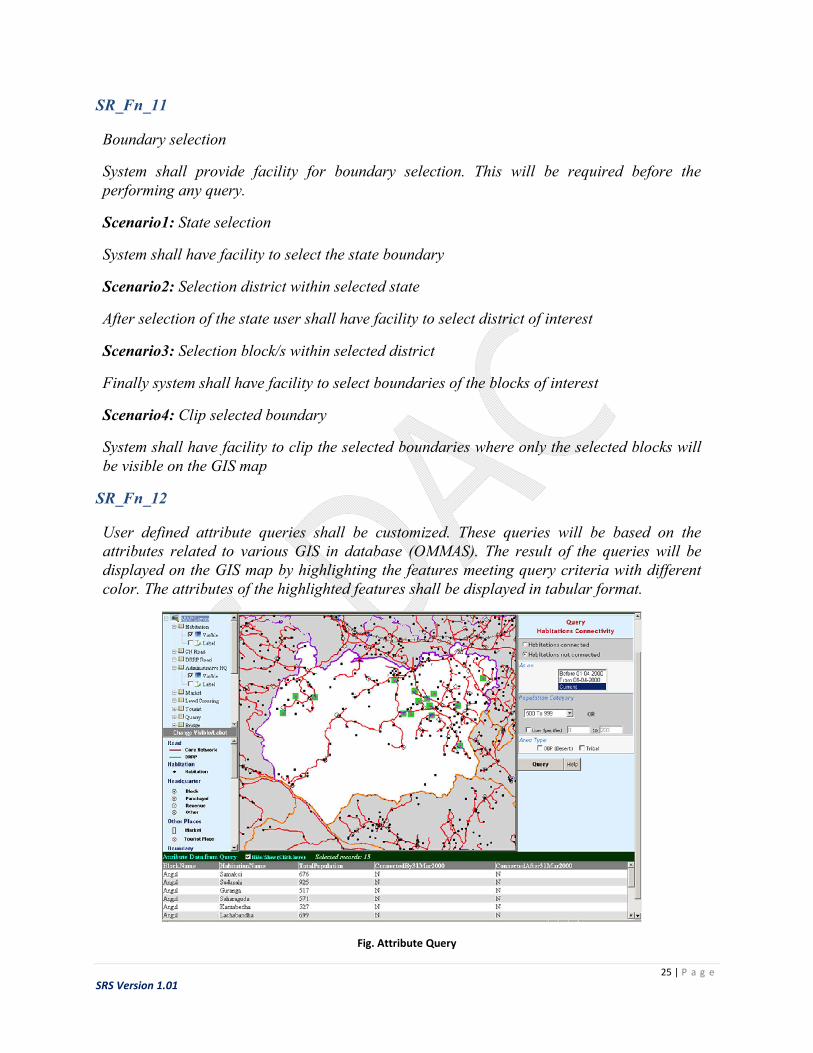
SR_Fn_12
User defined attribute queries shall be customized. These queries will be based on the attributes related to various GIS in database (OMMAS). The result of the queries will be displayed on the GIS map by highlighting the features meeting query criteria with different color. The attributes of the highlighted features shall be displayed in tabular format.
Fig. Attribute Query

26 | P a g e
SRS Version 1.01
SR_Fn_13
System shall have facility to query on habitation classification
Scenario1: population
System shall have facility to show/ highlight habitations on GIS map based on population range selected by the user. The option shall be provided to enter user specific population range along with some predefined population ranges.
Scenario2: area type
System shall have facility to show/ highlight habitations on GIS map based on area type (desert, tribal) selected by the user.
SR_Fn_14
System shall have facility to query on habitation connectivity
Scenario1: population
System shall have facility to show/ highlight connected/ not connected habitations on GIS map based on population range selected by the user. The option shall be provided to enter user specific population range along with some predefined population ranges.
Scenario2: area type
System shall have facility to show/ highlight connected/ not connected habitations on GIS map based on area type (desert, tribal) selected by the user.
Scenario3: Before /after PMGSY started
System shall have facility to show/ highlight connectivity status of the habitations on GIS map before and after PMGSY started
SR_Fn_15
System shall have facility to query on Panchayat Headquarters
Scenario1: classification
System shall have facility to show/ highlight panchayat headquarters on GIS map based on the classification (Population, Area type) similar to the habitation classification
Scenario2: connectivity
System shall have facility to show/ highlight connectivity status panchayat headquarters on GIS map similar to the habitation connectivity

27 | P a g e
SRS Version 1.01
SR_Fn_16
System shall have facility to query on connectivity of tourist places
System shall have facility to show/ highlight connectivity status of tourist places on GIS map.
SR_Fn_17
System shall have facility to search habitation on GIS map
System shall have facility to search and highlight habitation/s based on the search input provided by the user. Search will be based on
Habitation name exactly matching with the text provided by the user Habitation name starting with the text provided by the user Habitation name ending with the text provided by the user Any part in habitation name matching with the text provided by the user
Fig. Habitation Search
SR_Fn_18
System shall have facility to show/highlight habitation along the selected road
System shall have facility to select road of user’s interest with feature selection tool.

28 | P a g e
SRS Version 1.01
Fig. Habitation Along Road
System shall provide dialog box to input the buffer distance. On submitting the buffer distance system shall show/highlight habitations along the selected road which falls in a buffer of distance entered by the user.
SR_Fn_19
System shall have facility to display geo-tagged images on the GIS map.
Geotagging (also written as GeoTagging) is the process of adding geographical identification metadata to various media such as photograph or video. In PMGSY geotagging will be useful in finding out the road condition with the help of geotagged images of the road condition.
Fig. Geotagged image showing road condition

29 | P a g e
SRS Version 1.01
Scenario 1: All photos
System shall display all the photos (showing road condition) for the selected road
Scenario 2: Latest photo
System shall display the latest photos (showing road condition) for the selected road
Scenario 3: Photos taken between range of dates
System shall display all the photos (showing road condition) for the selected road which are taken between the dates entered by the user
SR_Fn_20
User defined spatial queries, consider the spatial relationship between these geometries, may be
incorporated.
SR_Fn_21
System shall have facility to show roads based on type of the road.
Scenario1: Through Routes
Selecting this option all through routes shall be highlighted on the map
Scenario2: Link Routes
Selecting this option all link routes shall be highlighted on the map
SR_Fn_22
System shall have facility to show information about the roads whether the roads are verified
from the toposheets.
SR_Fn_23
System shall have facility to show roads based on quality grading
Scenario 1: NQM
In this scenario system shall highlight the roads according to the grades given by national quality agency. The grade can be Satisfactory or Unsatisfactory
Scenario 2: SQM
In this scenario system shall highlight the roads according to the grades given by state quality agency. The grade can be Satisfactory or Unsatisfactory
Scenario 3: NQM and SQM

30 | P a g e
SRS Version 1.01
In this scenario system shall highlight the roads according to the grades (Satisfactory or Unsatisfactory) given by state quality agency as well as by national quality agency
SR_Fn_24
System shall have facility to show roads based on sponsoring stream.
The system shall have option to select the sponsoring agency (e. g. World Bank, Asian
Development Bank, PMGSY etc.).
User shall be able to select year of sanction.
SR_Fn_25
System shall have facility to show roads based physical and financial progress.
Scenario 1: Physical Progress
Physical progress refers to the length of the road completed. The system shall highlight the roads completed in terms of percentage length (selected by the user) to the actual length of the road
Scenario 2: Financial Progress
Financial progress refers to the payment done towards the work out of the sanctioned amount.
User shall be able to select year of sanction. The scenario 1 & 2 will be applied to the
roads which are sanctioned in this year.
SR_Fn_26
System shall have facility to highlight the roads under / due for maintenance.
Scenario 1: Under maintenance
System shall highlight all the roads which are under maintenance.
Scenario 2: Due for maintenance
System shall highlight all the roads which will be due for maintenance. The system shall provide option to select the date from which roads will become due for maintenance.
SR_Fn_27
The information about the web site shall be provided. The user shall be able to know product features available into the website

31 | P a g e
SRS Version 1.01
SR_Fn_28
User should able to get online help, and user manual (both web-based and documented in PDF) to execute each functionalities of the Web-GIS tool.
SR_Fn_29
Important web-links should be provided for further communication to the authorized nodal agencies or, company details for installation of systems or, any specific query.
SR_Fn_30
If required, the system shall provide facility to edit (add new features/ edit existing features / delete) spatial data to the authorized users. Authorization can be given to the state road department to update the spatial data of its own state.
Scenario: Add new features
System should have facility to add new features like habitations and roads to the existing GIS layers .Adding new feature should also include attaching attributes required for linking it to the OMMAS data.
Scenario: Edit existing features
System should have facility to edit existing features (habitations, roads) .Editing includes editing spatial features as well as attributes attached to it.
Scenario: Delete existing features
System should have facility to delete existing GIS features (habitations, roads) in GIS layers
SR_Fn_31
System shall have facility to measure distance on the GIS map. This facility will be give option to measure distance on GIS map which will be very useful while calculating distance between a habitation and nearby road.

32 | P a g e
SRS Version 1.01
Fig. Distance Masuring
SR_Fn_32
The system should have provision for authorized user to take printout of the maps as well as query results on GIS map for its own state
SR_Fn_33
Maps will be hosted on Web subject to permission from MOD.
SR_Fn_34
Web GIS for PMGSY may have multilingual interface as per the data available in OMMAS.
3.3 System Requirements
3.3.1 Client Side
Following are the minimum system requirements in order to use this Web-GIS tool at the client-side:

33 | P a g e
SRS Version 1.01
Specification Description
Web Browser Microsoft Internet Explorer v 8.0 or, higher, Mozilla Fire-Fox v 12.0 or, higher, Google Chrome v27.0.1453.116m or, higher.
Internet Browsing Speed 512 kbps
Registration will be required for accessing Web-GIS tool for printing purpose
User has to provide the valid credentials (such as, User ID, Password) to register on to the Web-GIS tool
User can change/modify his or, her credentials after successful log-in.
3.3.2 Server Side
Minimum system requirement for hosting the Web-GIS for PMGSY will depend on GIS server selection as well as number of concurrent users to be supported by the system. Commonly used GIS servers for Web-GIS are
Esri ArcGIS MaXtreme from MapInfo GeoServer
Minimum System Requirements for various GIS servers are as follows
MapXtreme 2008 ArcGIS 10.2.x GeoServer
Platforms Windows Server 2003: 256 megabytes (MB) RAM
Windows Server 2003 Web: 256 MB RAM
Windows XP: 256 MB RAM
Windows 2000: 256 MB RAM
Windows 2000 Server: 256 MB RAM
Windows 2000 Advanced Server:256 MB RAM
Windows Vista: 1 gigabyte (GB) RAM
Windows Server 2012 R2 Standard and Datacenter*
Windows Server 2012 Standard and Datacenter
Windows 2008 R2 Server Standard, Enterprise, and Datacenter (SP1)
Windows(XP and newer),
Linux(any modern distribution),
Mac(10.5 and newer)
Memory : 512MB minimum dedicated To GeoServer(1GB
recommended)

34 | P a g e
SRS Version 1.01
Windows 2008 Server Standard, Enterprise, and Datacenter(SP2)
Windows 8.1 Professional and Enterprise*
Windows 8 Professional and Enterprise
Windows 7 Ultimate, Enterprise, Professional(SP1)
Windows Vista Ultimate, Enterprise, Business(SP2)
Red Hat Enterprise Linux Server 6
Red Hat Enterprise Linux Server 5
SUSE Linux Enterprise Server 11
(RAM: 4 GB or more)
Processor 600 MHz Pentium III-class processor
4 cores for 100 concurrent users
-
Others Graphics card that supports at least 256 colors
Disk space: 50 GB or more
Disk space :100MB
Minimum (plus data)
Display:A GUI is recommended

35 | P a g e
SRS Version 1.01
For administration
(800x600 orlarger)
Recommended System Requirements for GIS server is as follows
Processor 2 x Intel Xeon 8 core processor with at least 12 Mb L3 cache
Memory 8 X 8 GB DDR3, 1600 Mhz
Hard Disk 2 X 300 GB 15000 rpm SAS SFF
Platforms Windows Server 2012 R2
Other Dual port 10G/Gigabit ethernet , Dual port 8 Gbps FC HBA
Note:- For data centre setup two half height Dell servers are recommended as blade enclosure and servers are configured for failover load balancing and redundancy
Approximate hardware server cost for GIS servers is Rs. 15 Lacs. This cost is exclusive of GIS Software licenses and any additional software required.
3.3.3 GIS data preparation
The systems for digitization shall have minimum configuration depending up on the COTS /Open Source GIS software selected and the amount of data to be handled. Popular GIS software used for GIS data preparation are
ArcGIS Geomatica QGIS GeoMedia MapInfo

36 | P a g e
SRS Version 1.01
Sr. No. Software Hardware/Software Requirement
1. ArcGIS Supported platforms
Windows 8.1 Basic, Professional and Enterprise (32 bit and 64 bit [EM64T])**
Update: April 2014***
Windows 8 Basic, Professional and Enterprise (32 bit and 64 bit [EM64T])
Windows 7 Ultimate, Enterprise, Professional, Home Premium (32 bit and 64 bit [EM64T])
SP1
Windows Vista Ultimate, Enterprise, Business, Home Premium (32 bit and 64 bit [EM64T])
SP2 SP2
Windows XP Professional Edition, Home Edition (32 bit)
SP3 SP3
Windows XP Professional Edition, Home Edition (64 bit [EM64T])
SP2 SP2
Windows Server 2012 R2 Standard, and Datacenter (64 bit [EM64T])**
Update: April 2014***
Windows Server 2012 Standard, and Datacenter (64 bit [EM64T])
Windows Server 2008 R2 Standard, Enterprise, and Datacenter (64 bit [EM64T])
SP1

37 | P a g e
SRS Version 1.01
Windows Server 2008 R2 with Citrix XenApp 6 and XenApp 6.5*
SP1 SP1
Windows Server 2008 Standard, Enterprise, and Datacenter (32 bit and 64 bit [EM64T])
SP2 SP2
Windows Server 2003 Standard, Enterprise, and Datacenter (32 bit and 64 bit [EM64T])
SP2 SP2
Windows Server 2003 Terminal Services
SP2 SP2
Hardware requirements
CPU Speed
2.2 GHz minimum ; Hyper-threading (HHT) or Multi-core recommended
Processor
Intel Pentium 4, Intel Core Duo, or Xeon Processors; SSE2 minimum
Run this Microsoft utility from your Windows command prompt to check your processor.
See Dual or dual-core support policy.
Memory/RAM 2 GB minimum
Display properties
24-bit color depth
Screen 1024 x 768

38 | P a g e
SRS Version 1.01
resolution recommended minimum at normal size (96 dpi)
Swap space Determined by the operating system; 500 MB minimum.
Disk space
2.4 GB
In addition, up to 50 MB of disk space may be needed in the Windows System directory (typically, C:\Windows\System32). You can view the disk space requirement for each of the 10.1 components in the Setup program.
If using ArcGlobe, additional disk space may be required. ArcGlobe will create cache files when used.
Video/Graphics adaptor
64 MB RAM minimum, 256 MB RAM or higher recommended. NVIDIA, ATI, and Intel chipsets supported.
24-bit capable graphics accelerator
OpenGL version 2.0 runtime minimum is required, and Shader Model 3.0 or higher is recommended.
Be sure to use the latest available driver.
Networking Simple TCP/IP, Network

39 | P a g e
SRS Version 1.01
Hardware Card, or Microsoft Loopback Adapter is required for the license manager.
2 PCI Geomatica
Supported platforms:
Windows XP/ Windows 7/Windows 8, Server 2003 / Server 2008,Server
2012.
Hardware requirements:
Processor: 2.2 GHz or higher Multiple core
processors strongly recommended, Memory: 4 GB minimum, 8 GB or higher recommended,
Graphics Cards: 4-bit Windows graphics card or accelerator running
at 1280x1024 pixels 128 MB RAM
minimum, 256 MB or higher recommended.
Disk Space: 1 GB free hard disk space for software installation
1 GB for installing all demonstration
datasets. Customer data storage requirements vary by project
3 QGIS Supported platforms:
Windows/ Mac OS X/ Linux/ Android
Hardware requirements:
Processor: 2.2 GHz or higher Multiple core
processors strongly recommended,
40 | P a g e
SRS Version 1.01
Memory: 4 GB minimum, 8 GB or higher recommended,
Graphics Cards: 4-bit Windows graphics card or accelerator running
at 1280x1024 pixels 128 MB RAM
minimum, 256 MB or higher recommended.
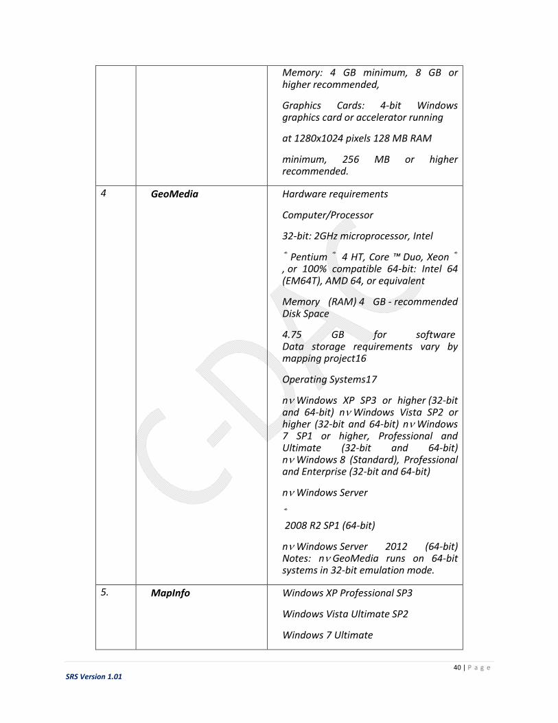
4 GeoMedia
Hardware requirements
Computer/Processor
32-bit: 2GHz microprocessor, Intel
® Pentium ® 4 HT, Core ™ Duo, Xeon ® , or 100% compatible 64-bit: Intel 64 (EM64T), AMD 64, or equivalent
Memory (RAM) 4 GB - recommended Disk Space
4.75 GB for software Data storage requirements vary by mapping project16
Operating Systems17
n Windows XP SP3 or higher (32-bit and 64-bit) n Windows Vista SP2 or higher (32-bit and 64-bit) n Windows 7 SP1 or higher, Professional and Ultimate (32-bit and 64-bit) n Windows 8 (Standard), Professional and Enterprise (32-bit and 64-bit)
n Windows Server
® 2008 R2 SP1 (64-bit)
n Windows Server 2012 (64-bit) Notes: n GeoMedia runs on 64-bit systems in 32-bit emulation mode.
5. MapInfo Windows XP Professional SP3
Windows Vista Ultimate SP2
Windows 7 Ultimate

41 | P a g e
SRS Version 1.01
Windows 7 Ultimate 64-bit
with
256 MB RAM,
400 MHz Pentium
processor (1 GHz Pentium processor
recommended),
1.5 gigabytes (GB) disk space,
16- or 24-bit color graphics,
800x600 Display
Windows 2008 Server
Windows 2008 Server with XenServer
With
512 MB of RAM ,
400 MHz Pentium processor (1 GHz
Pentium processor recommended),
2.9 gigabytes (GB) disk space,
16- or 24-bit color graphics,
800x600 Display
3.4 Software Requirement
3.4.1 GIS data preparation
COTS / Open Source GIS products will be used for implementation GIS for PMGSY programme. The GIS products will be used for creating various GIS layers. The product selected should have following in-built capabilities

42 | P a g e
SRS Version 1.01
Digitization & vector editing
Cut/copy/paste vector layer/segment
Vector and raster geocoding
Reprojection of data to LCC/UTM/ PC/TM/ a suitable projection
Edge matching of maps
Topology building
External RDBMS (MS Access/SQL Server/ Oracle) table linking
External RDBMS (MS Access/SQL Server/ Oracle) table join
Map generation in desired scale
Multiple maps product-ion with standard layout
Automatic updation of the map layout
Facility to edit map layout features like scale, north arrow, legend, etc
Facility to automatically generate labels on map features from the attribute table
Annotation of map features
Creation of new cartographic symbols
Generating buffers on selected point/line/area features
Multi-layers query
Dynamic segmentation of linear features
Customization using standard development languages
One to many relation in the attribute database
Import/Export from/to standard GIS & image formats
Clipping/subsetting irregular study area on raster and vector data
Splitting & merging (dissolving) polygons
View vector layers only in user-specified zoom scale
Distance/area measurement on map
Pop-up window showing details of selected features on map
Spatial, attribute and conditional queries
43 | P a g e
SRS Version 1.01
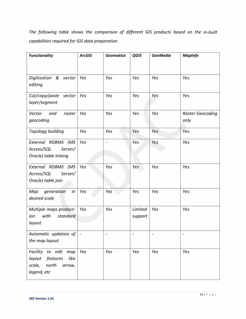
The following table shows the comparison of different GIS products based on the in-built
capabilities required for GIS data preparation
Functionality ArcGIS
Geomatica
QGIS
GeoMedia
MapInfo
Digitization & vector
editing
Yes Yes Yes Yes Yes
Cut/copy/paste vector
layer/segment
Yes Yes Yes Yes Yes
Vector and raster
geocoding
Yes Yes Yes Yes Raster Geocoding
only
Topology building Yes Yes Yes Yes Yes
External RDBMS (MS
Access/SQL Server/
Oracle) table linking
Yes - Yes Yes Yes
External RDBMS (MS
Access/SQL Server/
Oracle) table join
Yes Yes Yes Yes Yes
Map generation in
desired scale
Yes Yes Yes Yes Yes
Multiple maps product-
ion with standard
layout
Yes Yes Limited
support
Yes Yes
Automatic updation of
the map layout
- - - - -
Facility to edit map
layout features like
scale, north arrow,
legend, etc
Yes Yes Yes Yes Yes
44 | P a g e
SRS Version 1.01
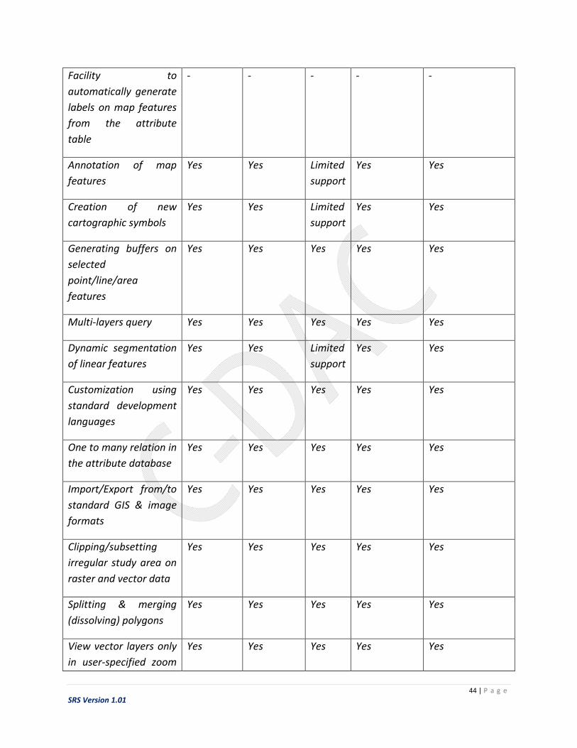
Facility to
automatically generate
labels on map features
from the attribute
table
- - - - -
Annotation of map
features
Yes Yes Limited
support
Yes Yes
Creation of new
cartographic symbols
Yes Yes Limited
support
Yes Yes
Generating buffers on
selected
point/line/area
features
Yes Yes Yes Yes Yes
Multi-layers query Yes Yes Yes Yes Yes
Dynamic segmentation
of linear features
Yes Yes Limited
support
Yes Yes
Customization using
standard development
languages
Yes Yes Yes Yes Yes
One to many relation in
the attribute database
Yes Yes Yes Yes Yes
Import/Export from/to
standard GIS & image
formats
Yes Yes Yes Yes Yes
Clipping/subsetting
irregular study area on
raster and vector data
Yes Yes Yes Yes Yes
Splitting & merging
(dissolving) polygons
Yes Yes Yes Yes Yes
View vector layers only
in user-specified zoom
Yes Yes Yes Yes Yes

45 | P a g e
SRS Version 1.01
scale
Distance/area
measurement on map
Yes Yes Yes Yes Yes
Pop-up window
showing details of
selected features on
map
No No No No No
Spatial, attribute and
conditional queries
Yes Yes Yes Yes Yes
3.4.2 Web GIS Server
The COTS / Open Source tool selected as web GIS server shall have following capabilities
GIS functionalities like zoom in, zoom out, Pan, Full View etc.
Digitization & vector editing
Distance measurement tool
Map printing functionality
Capability to integrate / link GIS data with attribute data in database specially with
MSSQL server
Geo-tagging capability
Inbuilt SQL query facility in Web GIS at client site (database in SQL Server)
Spatial query/analysis capability
Facility to display query results as map (highlighted features) and table in the same
Window
Facility to save the query results at the client end in jpeg/gif format
Following table shows different Web-GIS servers along with the availability of the required
capabilities

46 | P a g e
SRS Version 1.01
Sr.
N
o
Feature MapXtreme ArcGIS Server Geoserver MapServer
1 GIS
functionalitie
s like zoom
in, zoom out,
Pan, Full
View etc
Yes Yes Yes Yes
2 Digitization
& vector
editing
Limited functionality
need Mapinfo for the
same
Yes, using ArcGIS
Desktop. Web editing
is available in
Standard & Advance
version
Yes -
3 Distance
measuremen
t tool
Yes
Yes Yes Yes
4 Map printing
functionality
Yes Yes Yes Yes
5 Capability to
integrate /
link GIS data
with
attribute
data in
database
specially with
MSSQL
server
Yes Yes Yes Yes (not much
info available)
6 Geo-tagging
capability
Yes Yes
(through
GeORASS
API )
Yes (Using
flickr)

47 | P a g e
SRS Version 1.01
7 Inbuilt SQL
query facility
in Web GIS at
client site
(database in
SQL Server)
Yes Yes Yes Yes
8 Spatial
query/analys
is capability
Yes Yes Yes Yes
9 Facility to
display query
results on
map
(highlighted
features) and
table in the
same
Window
Yes Yes Yes -
10 Facility to
save the
query results
at the client
end in
jpeg/gif
format
Yes Yes Yes Yes
11 Support for
spatial
databases
Yes (Microsoft
SQL Server 2008,
2012, Oracle 11g,
10g,)
Yes
(IBM DB2 and IBM
Informix Dynamic
Server
Microsoft SQL Server,
Microsoft SQL Server
Express, and
Yes Yes
48 | P a g e
SRS Version 1.01
Microsoft SQL Azure
Netezza
Oracle
PostgreSQL)
12 S/W
development
support (like
.net, JAVA)
Yes Yes Yes
(JAVA)
-
13 Other
Features
Complies with both geospatial and IT industry standards ensuring interoperability
Incorporation of location capabilities such as geocoding and routing within your application
New extensible architecture enables you to write your own data provider, extending data access to virtually any source
Built-in extensible user interface toolbars and dialogue facilities for rapid development
Additional functionality through improved granularity
Enhanced flexibility of display options
Support for
Spatially Enabled
Databases
Geodatabase
Management
GIS Web Services
Image Services
Web Mapping
Applications
Smartphone and
Tablet
Applications
Web Editing
Geoprocessing
Advanced
Geoprocessing
Real-Time Data
Support
Mapcentric
Content
Management
- -
49 | P a g e
SRS Version 1.01
including curved labeling, improved symbology and fill patterns
New grid capabilities allow you to create continuous grids using a writable grid handler and new
IDW and TIN interpolators
New API and Dialog additions allow modifications to inflection points for continuous grids
System
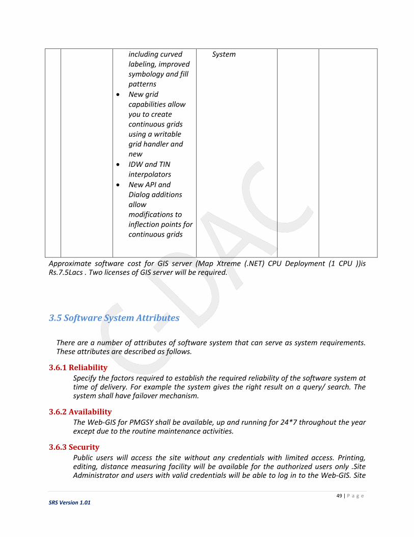
Approximate software cost for GIS server (Map Xtreme (.NET) CPU Deployment (1 CPU ))is Rs.7.5Lacs . Two licenses of GIS server will be required.
3.5 Software System Attributes
There are a number of attributes of software system that can serve as system requirements. These attributes are described as follows.
3.6.1 Reliability
Specify the factors required to establish the required reliability of the software system at time of delivery. For example the system gives the right result on a query/ search. The system shall have failover mechanism.
3.6.2 Availability
The Web-GIS for PMGSY shall be available, up and running for 24*7 throughout the year except due to the routine maintenance activities.
3.6.3 Security
Public users will access the site without any credentials with limited access. Printing, editing, distance measuring facility will be available for the authorized users only .Site Administrator and users with valid credentials will be able to log in to the Web-GIS. Site

50 | P a g e
SRS Version 1.01
Administrator will have access to the database structures at back-end. Site Administrator will have the rights for modifications as well as any updation work for the datasets and website. Access to the various subsystems will be protected by a user log in screen that requires a user name and password. The system shall automatically log out all users after a period of inactivity.
3.6.4 Maintainability
The application should be easy to extend. The code should be written in a way that it favors implementation of new functions.
3.6.5 Portability
The Web-GIS for PMGSY shall run in any computer environment (such as, Microsoft Windows) which is having Web Browser and Internet connection
3.6.6 Usability
The Web-GIS for PMGSY should be easy to use for common people. It should provide a uniform look and feel between all the web pages.
3.6 Testing Requirements
Software testing is an investigation conducted to provide stakeholders with information about the quality of the product or service under test. It involves the execution of a software component or system to evaluate one or more properties of interest. In general, these properties indicate the extent to which the component or system under test:
meets the requirements that guided its design and development responds correctly to all kinds of inputs performs its functions within an acceptable time is sufficiently usable can be installed and run in its intended environments achieves the general result its stakeholders desire
Detail the testing levels expected to be applied and who has primary (P) and secondary (S) responsibility for performing this testing
Test Level Implementing Agency NRRDA/States Unit Testing P Integration Testing P System Testing P S User Acceptance Testing S P
Apart from the software testing quality checking of the GIS layers shall be carried out as explained in the methodology section (ref. 2.2.2 QC for GIS layers).

51 | P a g e
SRS Version 1.01
3.7 Training Requirements
SR_Tr_01
A specialized training on Web GIS system for a period of one week shall be conducted at NRRDA, New Delhi
SR_Tr_02
Implementing agency shall prepare a training programme in consultation with NRRDA and states, which will include all components of Web-GIS for PMGSY
SR_Tr_03
Detailed operational and maintenance manuals for the proposed system, and training materials for use of NRRDA and States, shall be prepared by the implementing agency, which will be the property of NRRDA.
SR_Tr_04
The training would cover following topics:
Basics in GIS
Data processing involved Geo-referencing, Ortho rectification, mosiacing etc.
Spatial data creation(digitization) Database management and updation Quality assurance and quality control Map visualization GIS query and analysis Web GIS (architecture and application) Backup/restore of GIS database General troubleshooting

52 | P a g e
SRS Version 1.01
4. giS imPlEmENTATiON STATUS AND AcTiON PlAN
GIS implementation status in nine States, while creating SRS, is as follows
4.1 Rajasthan
Rajasthan was one of the pilot states selected for the GIS implementation of PMGSY. Standalone
version of GIS-enabled Road Information Management and Monitoring System (GRIMMS-S) was
developed for Rajasthan. GRIMMS-S uses ESRI Shape file for spatial data and has the option to
access/ link SQL Server (OMMAS) as well as MS Access for attribute data. This standalone
version helps in executing any user specific query and for displaying massive attribute data
apart from the customized queries and taking printouts. Web version (GRIMMS-Web) was also
implemented for Rajasthan where customized queries were available to monitor the progress of
PMGSY.
Most of the layers required for the GIS implementation of PMGSY are available (in shape format
and using Transverse Mercator/WGS84 projection) with the state. Spatial Data is available with
SRRDA on the scale of 1:50000. GT Sheets, Remote sensing imageries, blue prints, tracings are
also available. GIS softwares like ESRI ArcEditor 9.1, ArcPad 7.0, Autodesk Civil 3D – 2007 are
being used by the state apart from the MS SQL Server 2005 Std. Edition as a database server.
One person with Master degree in Geoinformatics from ITC Netherlands; three persons with
master degree and PG diploma in GIS and RS hired trough outsourcing
Action Plan: Updation of features especially road network (Spatial Data) may be required for
the state. The updation may be carried out by the SRRDA through outsourcing or SRRDA Itself.
Refer annexure II for spatial data updation and annexure III for outsourcing the jobs.
4.2 Himachal Pradesh
HP was one of the pilot states selected for the GIS implementation of PMGSY. Standalone
version of GIS-enabled Road Information Management and Monitoring System (GRIMMS-S) was
developed for HP. GRIMMS-S uses ESRI Shape file for spatial data and has the option to access/
link SQL Server (OMMAS) as well as MS Access for attribute data. This standalone version helps
in executing any user specific query and for displaying massive attribute data apart from the
customized queries and taking printouts. Web version (GRIMMS-Web) was also implemented
for HP where customized queries were available to monitor the progress of PMGSY. Apart from

53 | P a g e
SRS Version 1.01
the standalone and web versions of GRIMMS one database in MS-Access was developed to
maintain segment (500 meters) wise data.
Most of the layers required for the GIS implementation of PMGSY are available (in shape format
and using Transverse WGS84 projection) with the state but not updated since 2008. ArcGIS 9.1
is available with state as a GIS software. 1:50,000 survey of India , Topo sheets are available
with the state but not updated since 2008. GIS trained staff is not available with the state.
Action Plan: Updation of features especially road network (Spatial Data) may be required for
the state. The updation may be carried out by the SRRDA through outsourcing or SRRDA Itself.
Refer annexure II for spatial data updation and annexure III for outsourcing the jobs. GIS trained
person may be hired for managing the activity.
4.3 Punjab
GIS implementation for PMGSY is under progress. As per discussions with Project Manager, GIS,
PRBDB - All requisite layers are available in standard format (*.Shp )with WGS 84 projection.
Toposheets at scale of 1:25,000 and satellite images (Cartosat-I)are available with the state 106
sheets of maps are also available with the state . ArcGIS 10.1 is used as GIS software .Project
manager GIS is available full time with PRBDB.
Action Plan: The spatial data created need to be made compatible to PMGSY/OMMAS data so
as to link it to the attribute data. Refer annexure II for spatial data updation and annexure III for
outsourcing the jobs.
4.4 Uttarakhand
As per discussions with IT Nodal Officer, UKRRDA - The project needs to be started from scratch,
requisite layers in digital or hardcopy format, GIS software are not available with UKRRDA
Action Plan: The activity needs to be started right from procurement of digital data (refer
annexure I for guidelines for procurement of digital data).Spatial data creation activity may be
carried out by the SRRDA through outsourcing or SRRDA Itself. The spatial data created need to
be made compatible to OMMAS data so as to link it to the attribute data. Refer annexure II for
spatial data creation and annexure III for outsourcing the jobs. GIS trained person may be hired
for managing the activity.

54 | P a g e
SRS Version 1.01
4.5 Jharkhand
As per response from the state, GIS implementation for PMGSY is under progress. Requisite
layers in digital format not available. GIS software is being procured. Maps available with
1:50,000. A GIS expert is appointed recently.
Action Plan: The activity needs to be started right from procurement of digital data (refer
annexure I for guidelines for procurement of digital data).Spatial data creation activity may be
carried out by the SRRDA through outsourcing or SRRDA Itself. The spatial data created need to
be made compatible to OMMAS data so as to link it to the attribute data. Refer annexure II for
spatial data creation and annexure III for outsourcing the jobs.
4.6 Meghalaya
As per discussions with Chief Engineer, Meghalaya SRRDA - the project need to be started from
scratch, requisite layers in digital or Hardcopy format, GIS software are not available with
Meghalaya RRDA (Although SOI toposheets hardcopy are available for the state except
international border areas).
Action Plan: Toposheets which are not available need to be procured and whole activity of
spatial data creation has to be carried out. The spatial data created need to be made
compatible to OMMAS data so as to link it to the attribute data. Refer annexure I (for
procurement of the data), annexure II (for spatial data creation) and annexure III (for
outsourcing the jobs). GIS trained person may be hired for managing the activity.
4.7 Uttar Pradesh
GIS implementation for PMGSY is under progress. As per response received from UP & further
discussions with concerned officer layers (habitation and village road) are available in standard
format (*.shp) with WGS 84 UTNI – 44 NORTS projection. Hardcopy maps are available at scale
of 1:1000 at local PIO Level (UPRRDA is not having possession of any Maps) and map sheets
show latitude and longitude. Maps have been updated on Google earth. ArcGIS 10.0 is available.
Trained GIS staff is not available with the state. However the maps are not linked with OMMAS.
Action Plan: The layers (except habitation and village roads) need to be created freshly with
1:50,000 scale and compatibility with OMMAS data. The available layers have to be modified for
compatibility with OMMAS. The activity may be carried out by the SRRDA through outsourcing
or SRRDA itself. Refer annexure II for spatial data updation and annexure III for outsourcing the
jobs. GIS trained person may be hired for managing the activity.

55 | P a g e
SRS Version 1.01
4.8 Bihar
GIS implementation for PMGSY is under progress Road, Administrative boundary, habitation,
Water- feature, Railway line layers are available with state in shape format and having
GCS_WNS_1984(projection), Datum (WNS 1984). Maps are available with 1:50000 scale with no
latitude and longitude marked. Maps available consists of PMGSY Core Network maps. ArcGIS
10.0 is used as GIS software. No GIS system is developed for PMGSY or which links with OMMAS
data. 12 people, 2 GIS expert and 10 GIS operator are available with the state.
Action Plan: The remaining layers need to be created freshly with 1:50,000 scale and
compatibility with OMMAS data. The available layers have to be modified for compatibility with
OMMAS. The activity may be carried out by the SRRDA through outsourcing or SRRDA itself.
Refer annexure II for spatial data updation and annexure III for outsourcing the jobs.
4.9 Gujarat
As per response received from Gujrat, GIS implementation for PMGSY is completed. Data
collection of habitation, road alignment completed. Georeferencing for PMGSY roads
completed. GIS layers are available in .shp, kml kmz formats with WGS84 projection. All the
layers are as per guideline of NRRDA. Q-GIS Version 2.2, AutoCAD, Google being used as GIS
softwares. Firstly, Layers were created in Autocad format then converted to .Shp file and
updated on Google Map. GIS data is available in hardcopy with 1cm : 500 meter scale. Map
sheets show latitude and longitude. DRRP/ CORENET / Road showing PMGSY work available as
maps. Standalone system is available with DRRP showing 2011 population. A separate Excel file
has been created to store attribute data. GIS trained manpower is available with state.
Action Plan: The Spatial data needs to be formatted for compatability with OMMS; the activity
may be carried out by the GSRRDA through outsourcing or SRRDA itself. Need to create
remaining GIS layers with OMMAS compatibility. This activity also may be carried out by the
GSRRDA through outsourcing or SRRDA itself. Refer annexure II for spatial data creation and
annexure III for outsourcing the jobs.
For approximate cost of spatial data creation for nine states along with the response to the
questionnaire refer annexure V.

56 | P a g e
SRS Version 1.01
RiSkS & cONTiNgENcy S.N. Risk Factor Impact Description Contingency Plan
1. Procurement of
Toposheets (Unrestricted
/Restricted )
High Project cannot be
executed beyond
submission of system
study documentation
-
2 Permission from MOD for
publishing maps on Web
Medium Web implementation
will be affected
Web development
will be continued.
Web hosting will
be done only after
permission from
MOD
3. Procurement of Hardware Medium It will put more
pressure on existing
resources
Existing resources
will be utilized
4. Procurement of Software
(GIS data generation)
High Activities cannot start -
5. Procurement of Software
(Web development)
Medium Activities cannot start Web development
will continue with
evaluation version
of selected
software
6. Availability of all Maps
from States
High Outsourcing activity
will not start
-
7. Late changes to
requirements
Medium Difficult to include the
new requirements at
last stage
Only feasible
requirements can
be incorporated
while other can be
kept for next
version

57 | P a g e
SRS Version 1.01
ANNEXURE
ANNEXURE I : Procurement of Digital Topographic Data from Survey of
India
Digital Data
The digital data is of confidential nature and is normally issued to only officers in government
services and officials in local and administrative bodies when required by them for execution of
their official duties. Procurement of digital topographic data of restricted area needs security
clearance from Ministry of Defence (MOD). User has to obtain a prior ‘No Objection Certificate’
from MOD before approaching for data procurements. The agencies like Survey of India (SOI)
can be approached for the digital data procurements which provides digital topographical data
for whole India
States/ NRRDA will obtain MOD’s security clearance certificate for the toposheets to be
procured. List of toposheets along with the MOD’s clearance certificate will be submitted by
NRRDA for the procurement of the data.
States will carry out the following quality checks on DVD data before accepting it from the
providing agency (e.g. SOI Dehradun).
Data format
Latitude/longitude of 4 corners of a topo map
Projection parameters
Number and type of layers
Standard SOI symbol attachment with layers
Continuity of layers

58 | P a g e
SRS Version 1.01
Once digital data is procured, states have to submit an annual certificate of safe custody of data
(restricted) to the agency from where data is procured. The certificate is to be submitted by 31st
December every year.
On the other hand, Open Series Maps (OSM) are prepared on 1:250,000; 1:50,000 and
1:25,000 scales for the use of general public/civilians for supporting development activities in
the country. Technically maps of this series are based on WGS-84 Datum and UTM Projection.
They do not contain grid and classified information; therefore, they are kept under unrestricted
category. They can be obtained from all map sale centre and other authorized agents deputed
all over the country.

59 | P a g e
SRS Version 1.01
ANNEXURE II: Spatial Database Creation (Digitization)
1. Ensure correctness of the projection parameters of the digital maps.
2. Tracing sheets containing the layers will be scanned and stored in Tiff format.
3. LCC/ a suitable Projection will be used for geocoding the Tiff data before digitizing.
4. Road layer will be created for Core Network as well for DRRP roads.
Instruction for digitization work
Nodes and vertices should be minimum to the extent possible.
If road marked on the tracing sheets follows the roads of any category on toposheets,
alignment on toposheet should be picked-up.
Special care should be taken while assigning the feature code. If needed, an arc should
be divided into two by adding extra node to ensure separate road arc for each road code.
On tracing sheet, road codes are written along the road (above or below the road).
Proper care should be taken while entering the code.
All the features mentioned above should be digitized with utmost care to ensure the
location accuracy.
Feature coding should be done carefully to ensure correctness of entry. It must be
crosschecked thoroughly.
File naming convention must be strictly followed.
Association with OMMAS should be checked.
Output should be provided in Shape (.shp) format.
Output should be in different layers as specified below.
Layer (topological) type should be as follows –

60 | P a g e
SRS Version 1.01
Layers Topology
a. International / State / District / Block Boundary - Polygon & Line
b. M.P. / M.L.A. Boundary - Polygon
c. P.W.D. Circle / Division Boundary - Polygon
d. Forest Boundary - Polygon
e. Land use - Polygon
f. Water body - Polygon
g. River - Polygon
h. River - Line
i. Road / Railway - Line
j. Bridge - Point
k. Railway Crossing - Point
l. Habitation - Point
m. Quarry - Point
n. Market Centres - Point
o. State / District / Block / Revenue Headquarters - Point
p. Tourist / Religious place - Point
Digitization work can be carried out using another approach where GPS points are collected
using actual field visit. These Tabular GPS coordinates can easily be added and displayed as
points in GIS softwares like ArcGIS. In this approach a spreadsheet is prepared with X and Y
coordinates in two columns in EXCEL (or other program). Additional columns of data can be
included in the spreadsheet as well. Save the file as .dbf file. Add this dbf file to the GIS software
(e.g. ArcMap),right-click on the table and select Display XY Data.
Note: The GPS data must be in the same coordinate system as base maps and data frame for
correct display

61 | P a g e
SRS Version 1.01
ANNEXURE III: Outsourcing Jobs
Following jobs can be outsourced –
1. Geocoding of scanned tracing sheets. The tracing sheets received from the States will be
scanned by states and provided to vendors for digitization.
2. Reprojection of digital SOI toposheets.
3. Checking accuracy of toposheet with corresponding tracing received from States.
4. Creation of separate files for each feature from the digital SOI data. States will convert SOI
DVD toposheet data into ‘.shp’ file, which will be provided to vendors).
5. Digitization of new / missing features from the scanned tracing sheets.
6. Edge Matching and Mosaicking of maps.
7. Feature encoding of digitized features.
Maps from States
Participating States will trace relevant information regarding both DRRP and Core Network, on
tracing film. The tracing provided by the states will be the backbone of the project.
Vendor Selection
Following procedure will be adopted –
1. World Bank norms will be followed to invite vendors for outsourced activity.
2. State will award the contract
3. A letter will be sent to all vendors describing the job and the fixed price per toposheet
4. Briefing meeting will be organized for vendors at state level to explain the requirement.
5. Interested vendors will be requested to send their consent to carry out the job at respective
states as per the terms and conditions and rate specified in the letter.
6. Jobs will be distributed one PWD zone at a time. Further job will be awarded only after
successful completion of the allotted job.
7. Jobs will be distributed equally, to the extent possible, among the vendors.

62 | P a g e
SRS Version 1.01
8. State will constitute a committee to evaluate the job executed by the vendors which will
recommend to State for release of payment.
9. Payment will be released only after successful edge matching and mosaicking of toposheets,
which may or may not be assigned to the same vendor.
10. Unsatisfactory work, found at any stage, will be returned back to vendor, and vendor will
have to redo the job at no extra cost.
11. The job has to be completed in stipulated time. If job is not completed in time, LD (Late
Delivery) clause will be applied. Penalty will be imposed @ 2% per week with maximum of
10% of the total order value to the vendor.
12. Vendors who fail to deliver the quality output will not be assigned more work.

63 | P a g e
SRS Version 1.01
ANNEXURE IV: Quality Assurance
For quality assurance of any digitized map, certain standard procedures need to be adopted.
The steps followed for acceptance of digitized maps are given below:
1. File naming convention has been followed.
2. Projection parameters are correctly defined.
3. For polygon features, like administrative boundaries, following checks should be performed
a. There should not be any sliver polygon.
b. Total number of polygons should match the number of units wherever possible.
c. Shape and location of polygon should be checked for randomly selected polygons.
d. Feature code should be checked.
4. For line features, like road network, following checks should be performed –
a. Feature coding should be checked.
b. Linear feature is checked for alignment and location for randomly selected arcs.
5. For point features, like habitation, following checks should be performed –
a. Feature coding should be checked.
b. Point feature is checked for location for randomly selected points.
6. Softcopy Output should be in predefined formats, e.g. .shp format.
7. Association with OMMAS should be checked

64 | P a g e
SRS Version 1.01
ANNEXURE V: Spatial data creation for nine states (approx. cost)
S.No. Name of State Status Approx. Number
of Toposheets *
Approx. Cost @ 15k
per sheet
1 Himachal
Pradesh
Completed 080 Available –
Requires Updation
2 Rajasthan Completed 489 Available –
Requires Updation
3 Punjab Completed as per
Nodal Person for
GIS
Implementation
072 Available –
Requires Data
conversion as per
PMGSY/OMMAS
format
4 Gujarat Completed 280 Available –
Requires Data
conversion as per
PMGSY/OMMAS
format
5 Uttar Pradesh Under process 348 Rs. 52,20,000/-
6 Bihar Under process 135 Rs. 20,25,000/-
7 Meghalaya Not Available 032 Rs.04,80,000/-
8 Uttarakhand Not Available 076 Rs. 11,40,000/-
9 Jharkhand Not Available 114 Rs. 17,10,000/-
Total (for 5 States**) Rs. 01,05,75,000/-
* Represents approx. number of toposheets. Data creation cost as per the proposal

65 | P a g e
SRS Version 1.01
ANNEXURE VI: Web-GIS development for PMGSY (approx. cost)
Option 1 (Fresh Development)
This will be a totally fresh development of Web-GIS for PMGSY. All the modules will be developed from the scratch and new proposed features will be incorporated.
Component Approx. Cost
Web- GIS development
consultancy charges
Rs 3,07,20,000/-
Hardware server cost Rs 15,00,000/-
GIS Software license cost Rs 15,00,000/-*
Total Rs 3,37,20,000/-
Option 2 (Upgradation MapXtreme software)
Old GRIMMS-Web will be upgraded with new version of MapXtreme software. Some new features may be added to the system agreed by NRRDA and the implementing agency.
Component Approx. Cost
Web- GIS development
consultancy charges
Rs 1,63,20,000/-
Hardware server cost Rs 15,00,000/-*
GIS Software license cost Rs 15,00,000/-*
Total Rs 1,93,20,000/-
*Hardware and GIS software cost will be on actual in option 1 and option 2. NRRDA will be
procuring the h/w and s/w for the project. In case C-DAC procures the same on behalf of NRRDA,
C-DAC will charge 10% as facilitation/procurement process cost
Note: For annual maintenance 2 manpower will be required and cost per manpower will be decided by the implementing agency

66 | P a g e
SRS Version 1.01
ANNEXURE VII: Software for states (optional)
Component Cost
Spatial Road Information
System (SRIS)- Stand Alone
customized GIS System
Rs 3,00,000/-
Training on SRIS Rs 2,00,000/-
Total per state Rs 5,00,000/-

67 | P a g e
SRS Version 1.01
ANNEXURE VIII: Project cost (approx. Cost)
Component Option 1 (Fresh Development) Option 2 (Upgradation of
MapXtreme software)
Data creation & QC for 5
states
Rs. 01,05,75,000/- Rs. 01,05,75,000/-
Web-GIS development,
Hardware & GIS software
Rs 3,37,20,000/- Rs 1,93,20,000/-
SRIS for 9 states (Optional
for states)
Rs 45,00,000/- Rs 45,00,000/-
Total Rs 4,87,95,000/- Rs 3,43,95,000/-

68 | P a g e
SRS Version 1.01
ANNEXURE IX: GRIMMS
GIS Enabled Road Information Management and Monitoring System was developed by C-DAC
for NRRDA. This implementation of the GIS system for PMGSY coined as “GRIMMS” for two
States – Rajasthan and Himachal Pradesh. The PMGSY GIS project involved generation of spatial
database, customisation of a standalone system (GRIMMS-S) and development of web GIS
(GRIMMS Web, http://omms.nic.in/grimms) application.
For this GIS project, the non-spatial data was from OMMAS, which was available in SQL Server
2000 and was for the entire country. GRIMMS contained a range of user-friendly menus for
various queries and it highlighted the query result on the map and on the attribute data table.
The queries run on various spatial layers such as Habitation, Core Network road, DRRP road, by
having a live link with OMMAS database.
GRIMMS Web 2 was an extension to GRIMMS Web for PMGSY and implemented in the states of
Odisha, Tripura, Mizoram and Manipur; with additional functions and better interfaces. Using
the data standards/consultancy provides by C-DAC, Odisha and Mizoram states along with
respective state remote sesing agencies, created better quality GIS data. GRIMMS Web 2, that
was operational till 2014, received two awards, one in 2013 and the other in 2014.
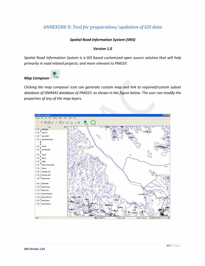
69 | P a g e
SRS Version 1.01
ANNEXURE X: Tool for preparation/ updation of GIS data
Spatial Road Information System (SRIS)
Version 1.0
Spatial Road Information System is a GIS based customized open source solution that will help
primarily in road related projects; and more relevant to PMGSY.
Map Composer
Clicking the map composer icon can generate custom map and link to required/custom subset
database of OMMAS database of PMGSY; as shown in the figure below. The user can modify the
properties of any of the map layers.

70 | P a g e
SRS Version 1.01
Map Printing
This customised functionality can be used to take printout of the GIS map as well as save it as a
tiff image. With a single click, it captures all the components visible on the canvas and
print/save the map.
GIS functionalities
Once the map is loaded user can use all GIS functionalities provided by the base open source
software. Some of the basic functions that may be used for the PMGSY are as follows:
GIS functionalities like (zoom in), (zoom out), (info button), make the layers visible/
invisible, enable/disable labels for features such as names for habitations can be used. The
software can be used to add/delete/update features in the map and to create new layers.
Google map or any other available service can also be used in the background.
User can also make queries similar to the customized queries found in GRIMMS. The image
(below) shows a query example to find the habitations having population more than 500. The
habitations meeting the criteria are highlighted in green colour.

71 | P a g e
SRS Version 1.01

72 | P a g e
SRS Version 1.01
ANNEXURE XI: Replies to the questionnaires by states
State:Himachal Pradesh Date: 20/08/2014
1. Status of GIS programme implemented for PMGSY in the state – Completed / Not Completed /Under Process-Himachal Pradesh& Rajasthan was part of Pilot Project forGRIMMS project prepared by CDAC but could not be updated since 2008.Base layer of Core network& DRRP in 1:50,000 survey of India , Topo sheets
2. List of GIS software (along with version)used/available-ArcGIS 9.1
3. GIS layers available in softcopy
a. Format used (e.g – .shp / .tab/ etc.)- .shp
b. Datum &projection used for GIS database-WGS84
c. List of layers- Core network & DRRP
4. GIS data available in hardcopy-Not updated
a. Specify the Scale of map: 1:50,000 survey of India , Topo sheets
( Not updated since 2008)
b. Specify whether the map sheets show latitude and longitude-Yes
c. List of maps available-Core Network &DRRP( But not updated)
5. Any GIS programme(s) implemented / GIS system(s) developed
If Yes, Details
a. Name/Title :GRIMMS WEB
b. Features :Integrated with OMMS data base
c. Standalone /Web based :Both d. Linked with OMMAS data :Yes e. Database (Spatial /Non spatial)used :
Part of Pilot Project forGRIMMS project prepared by CDAC but could not be updated since
2008.Base layer of Core network in 1:50,000 survey of India , Topo sheets.Now the online page
is also not available( URL: www.omms.nic.in/grimms)
6. Expert / trained manpower available with the agency for GIS implementation
No special trained staff is available
73 | P a g e
SRS Version 1.01
7. Contact person details for the GIS implementation for PMGSY Name : Lalit Kumar Pandey, Nodal Officer(IT)
E-mail : [email protected]
Phone : 09418108484 , 0177-2629315

74 | P a g e
SRS Version 1.01

75 | P a g e
SRS Version 1.01
Status of GIS Implementation in the State
State: Rajasthan Date: 26/ 08 /2014
1. Status of GIS programme implemented for PMGSY in the state – Completed
8. List of GIS software (along with version)used/available : ESRI ArcEditor 9.1 -3 Licenses ESRI ArcPad 7.0 MS SQL Server 2005 Std. Edition (5 User) Customized Stand Alone GIS Software –GRIMMS Autodesk Civil 3D – 2007 - 2 Licenses ILWIS 3.0 QGIS SAGA
9. GIS layers available in softcopy
d. Format used (e.g – .shp / .tab/ etc.) .shp, .mdb
e. Datum & projection used for GIS database : Transverse Mercator/WGS84
f. List of layers 1. Revenue Villages 2. Habitations 3. Head Quarters administrative 4. Market centers 5. Tourist places 6. Quarry sites 7. All road network 8. Core Network roads 9. DRRP Road network 10. Railway line 11. Level Crossing Major CD works 12. District Boundaries 13. Block boundaries 14. Tehsil boundaries 15. Village boundaries 16. PWD Zone, Circle, District boundaries 17. MP/MLA constituencies boundaries 18. Drainage layer 19. Forest boundaries 20. Water bodies.

76 | P a g e
SRS Version 1.01
10. GIS data available in hardcopy (All data has been digitized)
a. Specify the Scale of map 1:50000
b. Specify whether the map sheets show latitude and longitude: yes
c. List of maps available GT Sheets, Remote sensing imageries, blue prints, tracings
11. Any GIS programme(s) implemented / GIS system(s) developed
If Yes, Details
f. Name/Title : GRIMMS
g. Features : Web GIS for performing queries
h. Standalone /Web based :Web Based and Standalone both i. Linked with OMMAS data : Yes j. Database (Spatial /Non spatial)used : Spatial layers and OMMAS data backup
12. Expert / trained manpower available with the agency for GIS implementation One person with Master degree in Geoinformatics from ITC Netherlands and
three person with master degree and PG diploma in GIS and RS hired trough outsourcing
13. Contact person details for the GIS implementation for PMGSY Name : Kamal Kant Mishra
E-mail : [email protected]
Phone : +919829885321

77 | P a g e
SRS Version 1.01

78 | P a g e
SRS Version 1.01
Status of GIS Implementation in the State
State: Uttarakhand Date: 19 / 08 /2014
14. Status of GIS programme implemented for PMGSY in the state – Completed / Not Completed /Under Process Under Process
15. List of GIS software (along with version)used/available Not available
16. GIS layers available in softcopy Not available
g. Format used (e.g – .shp / .tab/ etc.)
h. Datum & projection used for GIS database
i. List of layers
17. GIS data available in hardcopy Nill
a. Specify the Scale of map
b. Specify whether the map sheets show latitude and longitude
c. List of maps available
18. Any GIS programme(s) implemented / GIS system(s) developed Nill
If Yes, Details
k. Name/Title :
l. Features :
m. Standalone /Web based : n. Linked with OMMAS data : o. Database (Spatial /Non spatial)used :
19. Expert / trained manpower available with the agency for GIS implementation -Nill-
20. Contact person details for the GIS implementation for PMGSY Name : Arvind singh Jyala
E-mail : [email protected]
Phone : 01352608125, 9760456256

79 | P a g e
SRS Version 1.01

80 | P a g e
SRS Version 1.01
Status of GIS Implementation in the State
State: Bihar Date: 14.11.2014
1 Status of GIS programme implemented for PMGSY in the State –Completed
/Not completed/Under Process
Under process
2 List of GIS Software (along with version)used /available Arc GIS 10.0 (ESRI)
3 GIS layers available in softcopy
a. Format used (e.g- shp/ tab/ etc.) b. Datum & projection used for GIS database
c. List of layers –
.Shp
GCS_WNS_1984(projection), Datum
(WNS 1984)
Road, Administrative boundary,
habitation, Water- feature, Railway line.
4 GIS data available in hardcopy
a. Specify the Scale of map b. Specify whether the map sheets show latitude and longitude – c. List of maps available –
1 : 50000
No
PMGSY Core Network maps
5 Any GIS programme(s) implemented / GIS system (s) developed
If Yes, Details
a. Name/Title :
b. Features :
c. Standalone/Web based :
d. Linked with OMMAS data :
e. Database(Spatial / Non spatial) used:
No
6 Expert / trained manpower available with the agency for GIS
implementation
NIC , Patna(12 Person, 2 GIS expert and
10 GIS operator)
7 Contract person details for the GIS implementation for PMGSY
Name : Shailesh Kumar Shrivastva
E-mail : [email protected]
Phone : 9431432962

81 | P a g e
SRS Version 1.01
Status of GIS Implementation in the State
State: Uttar Pradesh Date: / /2014
21. Status of GIS programme implemented for PMGSY in the state – Completed / Not Completed /Under Process : Under Process
22. List of GIS software (along with version)used/available
1.) ARC-GIS-ARC Info 10.0 version
23. GIS layers available in softcopy
j. Format used (e.g – .shp / .tab/ etc.) : .shp
k. Datum & projection used for GIS database : WGS 1984 UTNI – 44 NORTS
l. List of layers : a) Habitation Layer , b) Village road Layer
24. GIS data available in hardcopy
a. Specify the Scale of map :- 1:1000
b. Specify whether the map sheets show latitude and longitude : YES
c. List of maps available : No maps available
25. Any GIS programme(s) implemented / GIS system(s) developed
If Yes, Details
p. Name/Title :
q. Features :
r. Standalone /Web based : s. Linked with OMMAS data : t. Database (Spatial /Non spatial)used :
26. Expert / trained manpower available with the agency for GIS implementation : NO
27. Contact person details for the GIS implementation for PMGSY Name : MOHAMMAD MURTAZA
E-mail : [email protected]
Phone : 09956223307

82 | P a g e
SRS Version 1.01
Status of GIS Implementation In The State
State : JHARKHAND Date : 13 / 11 / 2014.
1. Status of GIS programme implemented foe PMGSY in the state – Completed / Not completed / Under
Process - Under Process.
2. List of GIS Software (along with version) used/ available - GIS software is being procured.
3. GIS layers available in softcopy.
a. Format used (e.g.-.shp/.tab/etc) - N.A.
b. Datum & projection used for GIS database - N.A.
c. List of layers - N.A.
4. GIS data available in hardcopy
a. Specify the Scale of map - 1:50,000
b. Specify whether the map sheets show latitude and longitude - Yes
c. List of Maps available -
5. Any GIS programme (s) implemented / GIS System (s) developed
If yes, Details
a. Name/ Title :
b. Features :
c. Standalone / Web based :
d. Linked with OMMAS data :
e. Database (Spatial / Non Spatial ) Used :
6. Expert / trained manpower available with the agency for GIS implementation :
A GIS expert is appointed recently.
7. Contact person details for the GIS implementation for PMGSY -
Name : SHRI PRAVEEN KUMAR
E- Mail : [email protected].
Phone : 0651-2446175.

83 | P a g e
SRS Version 1.01
National Rural Roads Development Agency
(NRRDA)
No 15 NBCC Tower 5th Floor,
Bhikaji Cama Place, Near Hyatt Regency,
Delhi – 110066
Centre for Development of Advanced
Computing (C-DAC)
Spatial Sciences and Disaster Management (SS&DM) Group
Westend Center III, S.No. 169/1, Sector II, Aundh,
Pune - 411007

Page 1 of 6
GIS DATA STANDARDS FOR SPATIAL DATA CREATION
Apart from the guidelines in SRS, the following should be followed by all states for the national
implementation of GIS for PMGSY.
DATA FORMAT
States should provide GIS layers in .shp format.
PROJECTION
States should provide all GIS layers in a single map projection; WGS84 datum and latlong.
GIS DATA MOSAIC
All spatial features should be finally captured to the WGS84 datum and they should be verifiable
as per GPS. That means the accuracy should be verifiable on the ground as per GPS and not
directly as per SoI toposheets. Therefore, any corrections on the data required should be carried
out by States. This activity may be done in Spatial Road Information System (SRIS) procured
from C-DAC. As soon as SRIS is procured, States will be trained by C-DAC for the activities.
States will provide spatial data as a mosaic of all blocks/districts. In other words, there can not
have more than one layer of same map layer (eg, only one Habitation layer on the mosaic). Once
the spatial data of adjoining States are completed, if any editing/shifting, on feature or feature
boundary required, shall be carried out by States.
UNIQUE ID TO FEATURES IN BLOCK
As per PMGSY guidelines features such as
habitation and road have a unique Id within its
Block. For example, in a Block there should
be only one habitation having id 50. The same
way, there should be only one CN road having
id L055 within a Block. If a road (same road
id) is disconnected within a Block, then those
should be joined together. Similarly all the
roads should be disconnected at the Block boundary (i.e., start node and end node of road line
within the block only). Figure shows two blocks of Rajasthan selected. Info of a NH is shown in
a Window on right side. The NH is a single entity/feature within the block. The same NH
continues as a separate entity in the next Block.
Fig: Unique ID for feature within block

Page 2 of 6
GIS LAYERS AND NAMING CONVENTIONS
All the GIS layers should be created as per the PMGSY guidelines. For example, the
name/location of habitation may not always match with that of the habitation from other sources
such as toposheets. The naming convention of each layer should be as given in the table. All the
layers are compulsory and if there is no feature in a layer, it can be kept empty.
No. File name Map layers Type
1 Habitation Habitation Point
2 Bound_District District Boundary Polygon
3 Bound_Block Block Boundary Polygon
4 Bound_MPConst MP Constituency Boundary Polygon
5 Bound_MLAConst MLA Constituency Boundary Polygon
6 PWD_Division PWD Division Boundary Polygon
7 PWD_Circle PWD Circle Boundary Polygon
8 Bound_Forest Forest Boundary Polygon
9 Bound_InterNational International Boundary Line
10 Road_DRRP DRRP Road Line
11 Road_CN CN Road Line
12 Road_Package* Package of Road* (optional/Future layer) Line
13 Bridge Bridges Point
14 LevelCrossing Level crossing (Manned & Unmanned) Point
15 Const_Material Construction Material Sites Point
16 Waste_Material Waste Material Sites Point
17 Market Market Centre Point
18 HQ_Administrative Administrative HQ (Revenue,Block,District,Panchayat) Point
19 WaterBody Water body Polygon
20 Tourist Tourist Place Point
21 Drainage_Line
Drainage_Poly
Drainage Line &
Polygon
22 Railway Railway Line
Table: Naming conventions of spatial layers
*Road_Package layer was not created/implemented in GRIMMS Web. If the layer is provided, certain
queries can be implemented more efficiently. Moreover, CN code for certain entries is not entered in
Sanctioned Project details table of OMMAS. Thus, if CN code is missing in the OMMAS table, the
corresponding entities of road in spatial layer will not be linked to OMMAS data. This will result in
incomplete graphic representation of roads in project related queries. For each new road package in
OMMAS, a new road feature should be created in Road_Package layer. This activity may be done in
(SRIS) procured from C-DAC.

Page 3 of 6
TABLE STRUCTURE
All the spatial layers should have standard fields with data as entered in OMMAS.
1. Habitation
Field Name Type Field width Remark
DIST_ID Integer 2 District Code
BLOCK_ID Integer 2 Block Code
HAB_ID Integer 4 Habitation Code
2. Bound_District
Field Name Type Field width Remark
DIST_ID Integer 2 District Code
3. Bound_Block
Field Name Type Field width Remark
DIST_ID Integer 2 District Code
BLOCK_ID Integer 2 Block Code
4. Bound_MPConst
Field Name Type Field width Remark
MP_CON_ID Integer 3 MP Constituency code
5. Bound_MLAConst
Field Name Type Field width Remark
MLA_CON_ID Integer 3 MLA Constituency code
6. PWD_Division
Field Name Type Field width Remark
DIV_ID Integer 2 PWD Division Code
DIV_NAME String 20 PWD Division Name
7. PWD_Circle
Field Name Type Field width Remark
CIR_ID Integer 2 PWD Circle Code
CIR_NAME String 20 PWD Circle Name
8. Bound_Forest
Field Name Type Field Width Remark
FB_Type String 1 R/P (Reserved/Protected)
Page 4 of 6
9. Bound_InterNational
Field Name Type Field Width Remark
INTNAME String 20 Name of Neighbour
10. Road_DRRP
Field Name Type Field width Remark
DIST_ID Integer 2 District Code
BLOCK_ID Integer 2 Block Code
ER _ID String 10 ER_ROAD_ CODE
11. Road_CN
Field Name Type Field width Remark
DIST_ID Integer 2 District Code
BLOCK_ID Integer 2 Block Code
ER _ID String 10 ER_ROAD_CODE
PLAN_RD_ID String 10 PLAN_RD_NUMBER
12. Road_Package *(Optional)
Field Name Type Field width Remark
DIST_ID Integer 2 District Code
BLOCK_ID Integer 2 Block Code
PACKAGE_ID String 10 Package Id as in OMMS
ROAD_ID String 10 Road Id as in OMMS
13. Bridge
Field Name Type Field width Remark
DIST_ID Integer 2 District Code
BLOCK_ID Integer 2 Block Code
ER _ID String 10 ER_ROAD_ CODE**
BRIDGE_ID Integer 4 MAST_CD_NUMBER**
**ER_ID and BRIDGE_ID are not entered in database and not used in any of the queries. If the data is
entered, it can be used for future implementations.
14. Level Crossing
Field Name Type Field width Remark
DIST_ID Integer 2 District Code
BLOCK_ID Integer 2 Block Code
LC_Type String 1 M/U (Manned/Unmanned)

Page 5 of 6
15. Construction Material Site
Field Name Type Field width Remark
DIST_ID Integer 2 District Code
BLOCK_ID Integer 2 Block Code
M_Type String 1 Material Type
S_Name String 20 Material Site Name
* Construction material list/detials to be provided by NRRDA
16. Waste Material Site
Field Name Type Field width Remark
DIST_ID Integer 2 District Code
BLOCK_ID Integer 2 Block Code
W_Type String 1 Material Type
S_Name String 20 Material Site Name
* Waste material list/details to be provided by NRRDA
17. Market
Field Name Type Field Width Remark
DIST_ID Integer 2 District Code
BLOCK_ID Integer 2 Block Code
MarketName String 25 Name
MarketDays Integer 1 Number of market days
18. HQ_Administrative
Field Name Type Field Width Remark
AHQ_Type String 1 AHQ Type (R/B/D/P)
AHQ_Name String 25 HQ Name
Administrative Headquarter Types are R/B/D/P (Revenue, Block, District, Panchayat)
19. WaterBody
Field Name Type Field Width Remark
WB_Type String 10 WB Type
20. Tourist
Field Name Type Field Width Remark
DIST_ID Integer 2 District Code
BLOCK_ID Integer 2 Block Code
TP_Name String 25 Name

Page 6 of 6
21. Drainage_Line/ Drainage_Poly
Field Name Type Field Width Remark
D_Name String 20 Name (Major)
22. Railway
Field Name Type Field Width Remark
blank