implementation of sustainable land use in … · slovenian partners at work!.....12 lumat meets the...
TRANSCRIPT

LUMATNewsletter #2
www.interreg-central.eu/LUMAT.htmlMAy 2016 - ApriL 2019
yeAr 2 | MAy 2017
iMpLeMeNTATiON OF SUSTAiNABLe LAND USe iN iNTeGrATeD eNVirONMeNTAL MANAGeMeNT OF FUNCTiONAL UrBAN AreAS
Cooperation in land management for more livable places

LUMAT NewSLeTTer #2 | 2
The LUMAT project has finished the first year of its life.
This has been a period of intensive development of the common understanding and knowledge of the project substance – the strengthening of sustainable land and soil resources management in functional urban areas. The discussions at project meetings (see the report from Dresden and Bratislava at p.3 and 5) and through internet were aiming at the creation of common documents of primary importance: the methodology for integrated Functional Urban Areas (FUAs) environmental management plans, the strategy of FUA environmental management and the concept of action plans for the implementation of this strategy in 7 project FUAs. At the same time the works for the preparation of two investments in Ruda Śląska (see p.15) and Trnava (see p.16) have been started. In Ruda the full analysis of the pilot site from
the environmental risk point of view has been performed together with the selection of the phytostabilisation technology which would guarantee the safe use in the future of a public space newly created by the inhabitants. Trnava is preparing the documentation on the technical solutions for turning the “green brownfield” into an area which will ensure a continuity of green infrastructure in the functional urban area of Trnava region. It will also serve as an attractive place for recreation for the inhabitants.
Partners have started to involve local stakeholders with multiple initiatives (see p.7) to share the Lumat approach and develop Functional Areas Management Strategies.
what’s goiNg oNLUMAT prOjeCT yeAr 1
Numbers aNd facts iNdex
prOjeCT TOOL...............................................................19
CONTACTS......................................................................20
piLOT ACTiONS...............................................................14
Ruda Śląska................................................................15Trnava.......................................................................16
ThirD prOjeCT pArTNerS MeeTiNG.................................5
SeCOND prOjeCT pArTNerS MeeTiNG...............................3
anna starzewska-sikorska Project coordinator
institute for ecology of industrial areas (ietu)
MeeTiNGS wiTh DeCiSiON MArKerS Or CiTiZeNS
13
Meeting of regional mayors in Voitsberg........................8
Discussion with the regional policymakers in the Moravian-Silesian Region.....................................7
Public hearing concerning the investment in Ruda Śląska.............................................................9
Slovenian partners at work!.........................................12
Lumat meets the Covenant of Chieri Carmagnola Area.......................................................10
District of Voitsberg - Graz: a workshop with decision-makers.................................................11
NewS FrOM The pArTNerS..............................................7
NewSLeTTerS2
preSeNTATiONS TO SeMiNArS/CONFereNCeS6
prOjeCT pArTNerS MeeTiNGS3
pUBLiCATiONS (LOCAL preSS, TV, SCieNTiFiC ARTICLeS)
19
PartNers meetiNg SeCOND prOjeCT
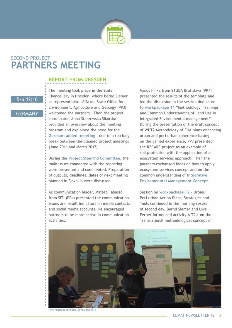
The meeting took place in the State Chancellery in Dresden, where Bernd Siemer as representative of Saxon State Office for environment, Agricolture and Geology (PP3) welcomed the partners. Then the project coordinator, Anna Starzewska-Sikorska provided an overview about the meeting program and explained the need for the german– added -meeting – due to a too long break between the planned project meetings (June 2016 and March 2017).
During the Project steering committee, the main issues connected with the reporting were presented and commented. Preparation of outputs, deadlines, dates of next meeting planned in Slovakia were discussed.
As communication leader, Matteo Tabasso from SiTI (PP4) presented the communication issues and result indicators on media contacts and social media accounts. He encouraged partners to be more active in communication activities.
Maroš Finka from STUBA Bratislava (PP7) presented the results of the template and led the discussion in the session dedicated to workpackage t1 “Methodology, Trainings and Common Understanding of Land Use in Integrated environmental management” During the presentation of the draft concept of WPT2 Methodology of FUA plans enhancing urban and peri-urban coherence basing on the gained experience, PP3 presented the ReCARe project as an example of soil protection with the application of an ecosystem services approach. Then the partners exchanged ideas on how to apply ecosystem services concept and on the common understanding of integrative environmental management concept.
Session on workpackage t2 – Urban/Peri-urban Action Plans, Strategies and Tools continued in the morning session of second day. Bernd Siemer and Uwe Ferber introduced activity A T2.1 on the Transnational methodological concept of
rePort from dresdeN
5-6|12|16
GerMANy
uwe feber iN dresdeN, december 2016
LUMAT NewSLeTTer #2 | 3

action plans for integrated environmental management.
Then partners discussed on the framework of action plans – universal approach – identification of threats, evaluating of potentials of individual pilot areas using ecosystem services approach. Uwe Ferber coordinated an interactive session in which partners developed initial concept of action plan in their pilot areas. For each pilot area, the partners presented identification of threats and potentials
Indication of actions. A discussion on comprehensive approach to compensation followed.
During the next part of the morning, comments focused on the role of compensation in Functional Urban Areas: it can be one of the tasks of the management structure established for integrated environmental management of FUAs.Partners discussed the possibilities of establishing management structures and their status and nature.
Continued from previous page
5-6|12|16
GerMANy
shots from the workiNg sessioNs iN dresdeN, december 2016
LUMAT NewSLeTTer #2 | 4

LUMAT NewSLeTTer #2 | 5
The meeting started with the Project Steering Committee meeting and discussion on current issues concerning the project management, communication issues and project reporting. Participants reported the situation with the First Level Control (FLC) certification in the partner countries, communication issues were reported by Matteo Tabasso from Italian Project Partner (PP4) SiTI and the project leader Anna Starzewska-Sikorska summarized the main points concerning smooth running of the project.
The meeting was dedicated to Work Package WPT1 “methodology, trainings and common understanding of land use in integrated environmental management” and to WPT2 “urban/Peri-urban action Plans, strategies and tools” issues.
In the frame of WPT1, the key issues were the training seminars. The first training seminar focused on ecosystem services
approach to planning and designing urban areas, which was prepared by PP7 (STUBA, SK).
Maroš Finka explained the approach to ecosystem services in the field of land-use planning and management and during the interactive workshops this approach was trained with the participants under supervision of the PP7. The whole session was summarized in the discussion on the possible approaches based on partners’ experiences and visions.
The second part of the training wasfocused on fuas identity. Justyna Gorgoń, from IeTU (LP, PL) presented the approach to FUA in the respective LUMAT countries, based on deliverable D.T1.1 “transnational report on Policy framework related to fuas” and then interactive workshop and training seminar have started, where the main features of FUA were explained and specified in the interactive workshop.
PartNers meetiNgThirD prOjeCT
rePort from bratislava - trNava
lumat PartNers iN trNava, march 2017
20-22|03|17
SLOVAKiA

LUMAT NewSLeTTer #2 | 6
Conclusions on further steps in building fuas identity were summarized at the end of the session.
Part of the meeting was dedicated to visiting the pilot site in Trnava. Tomáš Guniš made a presentation on Trnava city development and the need of greenery for the city future development. The pilot area trnava-Štrky, Trnava investment site planned within the LUMAT project, is focused on green park development for recreation in the fua area of trnava city. This approach was also highly appreciated by the Mayor of Trnava, Peter Bročko, during the welcome meeting at the
Local Council of Trnava.In the WPT2 session, Bernd Siemer, as representative of German Partner LfULG (PP3), explained the transnational concept of action plans and opened the discussion on transnational format of action plans with the goal of enhancing integrated environmental management.
In the ending session of the meeting, Anna Starzewska-Sikorska presented the next steps and deadlines of the LUMAT project and the dates of the next lumat project meeting were agreed: it is planned to take place in torino, Italy on September 25th-27th, 2017.
Continued from previous page
20-22|03|17
SLOVAKiA
PartNers visitiNg the Štrky site iN trNava
Prof. maroŠ fiNka at stuba, exPlaiNiNg ecosystem services

LUMAT NewSLeTTer #2 | 7
Project partners from the Moravian-Silesian region started the discussion with the local policymakers, regarding LUMAT project activities in the region.
The Regional Development Agency in Ostrava and the institute for sustainable development of settlements (iurs) organised their first meeting with the policymakers on the regional level. On February 8th, 2017 they met Jan krkoška, Deputy Governor of the Region responsible for regional development, tourism, european funds and operational programmes and also martin radvan, head of Regional Development and Tourism Department section of the Moravian-Silesian Regional Authority.
The aim of the meeting was to introduce the lumat project, its activities, as well as future benefits of the project for the Moravian - Silesian Region in terms of urban planning, sustainable spatial development, also involving experts and the wide public into decision processes.
The most important part of this meeting was the discussion on first proposals of brownfield areas, to be planned and assessed within the Ostrava Functional Urban Area Brownfields management plan. This plan, part of WPT2 Urban/peri-Urban Action plans, Strategies and Tools, will include priority evaluation of underused and abandoned land, including recommendations for future use of land also considering the carbon footprint. It will ensure the interaction of project outputs with the regional effort to improve air quality in ostrava functional urban area. Representatives of the Region proposed a number of brownfield areas to be included in the project activities.
This proposal will also be discussed with experts from the department of Zoning, Building Regulations of the Regional authority, with which the project partners maintain regular contacts. Discussion and involvement of regional policymakers will continue in forthcoming LUMAT project activities in year 2017.
discussioN with the regioNal Policymakers iN the moraviaN-silesiaN regioN
08|02|17
CZeCh repUBLiC
from the PartNersNewS
iurs- PP9

LUMAT NewSLeTTer #2 | 8
The project partner energy center on February 15th, 2017 organized a meeting with the mayors of the pilot region to present the LUMAT project and discuss the planned activities.
The focus was:• land-management use of “brownfields”• improvement of the use of
underdeveloped areas• the implementation of sustainable land• use pilot projects
in the seven functional project urban areas of LUMAT within the framework of an integrated environmental management system.
The involvement of the regional and local policy and decision-makers was effective, and the discussions will continue permanently in the next period.
meetiNg of regioNal mayors iN voitsberg
15|02|17
AUSTriA
ec-PP6

LUMAT NewSLeTTer #2 | 9
The consultation took place on February 23rd, 2017 in Ruda Śląska.
The meeting was chaired by the deputy Mayor of Ruda Śląska – Mr. Michał Pierończyk. The concept for the investment was presented - introducing the issue to a public of 30 inhabitants of the neighbouring settlements - by prof. Krzysztof Rostański. Then Dr. Marta Pogrzeba from IeTU presented the fitostabilization technology which will be applied on the site in order to reduce the exposure of people to risks connected with contamination of the area: this technology will stabilize heavy metals, which will be immobilized in the ground.
The participants have expressed their satisfaction for the fact that the degraded area in their neighbourhood will be turned into a place for rest and recreation. The place will improve the aesthetics of the surroundings, and will become a visible sign that it is possible to create a new public space from an abandoned and polluted area in the middle of the city.
The Ruda Śląska investment will be a positive example of using a contaminated abandoned area for a new function, meeting social, environmental and climatic requirements. it will also be the largest contaminated site in Silesia which will be re-used into a safe public green space.
Public heaRing conceRning the investment in Ruda Śląska
23|02|17
pOLAND
ietu-lP; um ruda slaska-PP2

LUMAT NewSLeTTer #2 | 10
The italian partners siti and città metropolitana di torino met with the members of the Covenant of Chieri-Carmagnola Area, a low-density hilly area in the southeast of Turin. More than 30 small and medium-sized cities were invited to participate into an innovative experience for the integrated management of functional urban areas within the LUMAT framework.
The representatives of the municipalities agreed on the necessity to work together in order to define an integrated strategy, where
single resources can be valorized and better opportunities for development can be jointly seized.
Great interest was shown by the administrators about the LUMAT project and the interactive visualization tool - invito, the tool developed by siti (see p.19 to know more) to collect, manage and visualize a large amount of spatial data.
Next operative meeting will take place in Chieri, on May 17th, 2017.
lumat meets the coveNaNt of chieri-carmagNola area
09|03|17
iTALy
siti-PP4; cmto-PP5

LUMAT NewSLeTTer #2 | 11
A workshop with the local policy- and decision makers took place on April 4th, 2017 in Voitsberg focusing on the forthcoming LUMAT activities in the Region.
The participants were the mayors and the heads of administration of the cities bärnbach, köflach, voitsberg, Rosental and maria lankowitz, as well the chamber of commerce, the regional labour-market administration and regional development agencies. Also two regional media representatives joined this event.
The aim of the workshop was to present the running activities, the concept of the
“Functional Urban Area” (FUA) and the next steps for the development of the specific integrated FUA plan for the region. especially the cooperation between the municipalities regarding the action plan for the harmonization of the city and the hinterland (district of Voitsberg / Graz), combining these two areas into one functional urban area. The improvement of the city/urban-hinterland cooperation represents a very important step forward for the region.
In an active session the participants of the workshop were invited to present and discuss ideas for the pilot action.
district of voitsberg - graz: a workshoP with decisioN-makers
04|04|17
AUSTriA
ec-PP6

LUMAT NewSLeTTer #2 | 12
Since the beginning of the LUMAT project, three Slovenian project partners, the urban Planning institute of the republic of slovenia, the ministry of environment and spatial planning of slovenia and the city of kranj, decided to do bi-weekly co-ordination meetings in order to make their work efficient and quality.
Slovenian partnership is represented by a research organisation, policy makers and end users of LUMAT expected results.
In WPT1 we already identified municipalities representing the Functional Urban Area of the City of Kranj. As we knew from the beginning of the project, the most difficult part will be establishing an efficient and long-term management structure for functional urban area of the city of kranj. For this reason
we identified the Regional Development Agency of Gorenjska Region - BSC Kranj as a potential institution for implementation of the Functional Urban Area Action plan in the Functional Urban Area of the City of Kranj.
On April 7th, 2017 the first meeting with the regional development agency of gorenjska region - BSC Kranj was devoted to the presentation of their potential role in the development and implementation of the Functional Urban Area of the City of Kranj. They expressed their interest in taking a role in the management structure of the functional urban area of the city of kranj and they expect that the LUMAT project results will tackle real problems they are facing in the Gorenjska region.
sloveNiaN PartNers at work!
07|04|17
SLOVeNiA
uirs-PP11moP-PP12mok-PP13
LUMAT NewSLeTTer #2 | 13
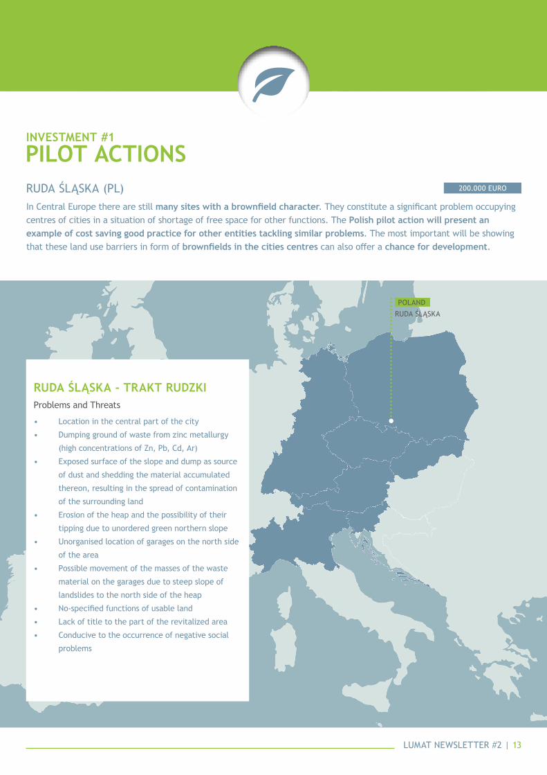
in Central europe there are still many sites with a brownfield character. They constitute a significant problem occupying centres of cities in a situation of shortage of free space for other functions. The Polish pilot action will present an example of cost saving good practice for other entities tackling similar problems. The most important will be showing that these land use barriers in form of brownfields in the cities centres can also offer a chance for development.
200.000 eUrORUDA ŚLąSKA (PL)
Pilot actioNsiNvestmeNt #1
RUDA ŚLąSKApOLAND
• Location in the central part of the city
• Dumping ground of waste from zinc metallurgy
(high concentrations of Zn, Pb, Cd, Ar)
• exposed surface of the slope and dump as source
of dust and shedding the material accumulated
thereon, resulting in the spread of contamination
of the surrounding land
• erosion of the heap and the possibility of their
tipping due to unordered green northern slope
• Unorganised location of garages on the north side
of the area
• Possible movement of the masses of the waste
material on the garages due to steep slope of
landslides to the north side of the heap
• No-specified functions of usable land
• Lack of title to the part of the revitalized area
• Conducive to the occurrence of negative social
problems
Problems and Threats
Ruda Śląska - tRakt Rudzki

LUMAT NewSLeTTer #2 | 14
The Pilot area is located in the municipality and county of Ruda Śląska, administratively situated in Silesian Voivodeship in southern Poland. Ruda Sląska (77,73 km²) is a postindustrial city, which was developing during the XIX and the beginning of XX century, mainly through the growth of coal mine and ironworks. It had a strong input on the local communities origination. Most of all, the industrial heritage influenced development of the specific culture of working people, which became a tradition in the Silesian region and in Ruda Śląska as well.
The rapid transformation of Ruda Śląska as an industrial city in the nineties of XX century, due to geopolitical changes in eastern europe, caused not only economic and in industrial changes, but influenced also the local working class with other problems in the city connected with unemployment. During 1996 – 2014 the amount of inhabitants in Ruda Śląska decreased from 163.800 to 136.500 inhabitants (in the last 17 years, 27.382 inhabitants moved away from Ruda Śląska, which is the 16,71% of the city population). Wirek district, with its population of 17.929 inhabitants is 13,13% of the city area. Wirek district is a part of Ruda Śląska with a significant number of social problems, like alcoholism, unemployment and depopulation, which can be observed in the significant number of families using social assistance.
CON
TexT
The project area is a previous post-industrial dumping ground, located in the central part of the city of Ruda Slaska, district Wirek north of the junction of 1 Maja St. and the Westerplatte St. It is located in a highly urbanized area of the city - in the valley with a gentle slope lowering in the south direction. The pilot area constitutes the zinc-lead melting waste pile. On average it contains 0,11% of arsenic, 2,79% of zinc, and 0,36% of lead as well as 0,11% of barium and 0,01% of cadmium. Currently, most of the area is covered with grassy vegetation, only the eastern edge of the site being covered with forest. The site is recorded in Silesian Brownfields Spatial Database.
The size of the plot area is about 5,23ha. From the west building directly adjacent to the residential development, north and east surrounds the access road to the objects KWK “Pokój”. Dumping ground has been reclaimed in the past in the center and southern part. The surface of the heap is covered with grassy vegetation: because of its origin, the pilot area is covered with metallophyte plants such as silene vulgaris and arabidopsis arenosa.
In the north - west there is a small stand. escarpment in southern and western dump is gently inclined towards the adjacent housing. Facing east heap flattens along the road leading to the technological objects of KWK “Pokój”.The northern escarpment dump adjacent to the area of the Tolstoy street is steep, in places vertical, also at the bottom of the escarpment has been in the past undercut by garages located there gathered material on dumping ground.
LOC
ATiO
N,
SiZe
, ph
ySiC
AL C
hAr
ACTe
riST
iCS

LUMAT NewSLeTTer #2 | 15
The site was used as a dumping place for wastes from zinc smelter owned by Liebe – Hoffnung company whose operation in Ruda was terminated and the smelter closed in 1925. The company does not exist anymore. After the World War II as a result of the nationalization process, the site was owned by the municipality (entailed by the State Treasury). Therefore the "polluter pays" principle is solved by the take of responsibility by the city. In 2009 investigations on the level of contamination have showed increased level of heavy metals. in the 70es reclamation activities have been already implemented to cover the area with a soil layer 1 m thick. As a preparatory work for the investment, ground examinations will be made to assess the present exposure to environmental hazards. There is a risk associated with no go decision: as the investment will minimize the possible negative impact of heavy metals, therefore the risk will be minimized by remediation actions implemented in the investment framework.
The groups benefitting from the investment will be the inhabitants of the district, the city and the whole region. They will take advantage of having an attractive place for recreation which will also create an alternative for public transportation offering shorter access to get to schools, work etc. The investment tackles the problem of sustainable management of sites located inside the cities. They offer a potential which should be used for new social, environmental and economic functions.
The investment will be implemented with involvement of the public – inhabitants who are already using the site (with wild vegetation – trees and bushes) for walking and biking. Therefore there is a pressure to arrange the site according to the social expectations and to make it safe for further use. The inhabitants will be informed on the city website about the investment with the possibility of notifying their questions and comments. In addition, a public meeting will be organized with participation of the inhabitants of the district where the investment is located. During this meeting a concept of the area re-use will be presented including proposed forms of recreation and aesthetics improvement. Then there will be a possibility for the participants to comment and formulate their ideas.
The pilot action in Ruda Śląska will include an investment of 200.000 € on the area of the previous post-industrial wastes dumping site.
The investment implementation will create an available open space of a natural, “half-wild” character; due to the progressive greening it will achieve the character of a sub-regional park. The place will become the walking and biking route connection of two districts as key element of the peri-urban infrastructure. The site constitutes one of the elements of a wider project on public spaces system and clearing functional and communication connections between central districts of the city. The project is called “Trakt Rudzki” – “Ruda Route”.
MAi
N p
rOBL
eMS
STAK
ehO
LDer
Sw
hAT
wiL
L LU
MAT
DO

LUMAT NewSLeTTer #2 | 16
Within Investment priority 2 of the LUMAT project (64.500 €), PP8 City of Trnava aims to restore a neglected natural park - “Strky” - currently suffering from many burdens, for which it could be considered as a “green brownfield”. Through the restoration of the Strky site, City of Trnava seeks to find a new value for this pilot area in the Trnava FUA by renewing and preserving its environmental value on the one hand, and by providing it – after restoration – as a place available and attractive for recreation, relax and sporting activities for the Trnava city/region inhabitants on the other hand.
64.500 eUROTRNAVA (SK)
• Old unofficial municipal and construction waste
dumps scattered on the site
• Local ecosystems deteriorating for a long time,
due to the overall no maintenance of the site,
spread of invasive wood species (up to 50%)
• Local infrastructure (i.e. access path, parking
place, etc.) outdated and rusty
• Industrial and warehousing places generating
environmental pollution through emissions,
solid waste and waste waters, located in the
surrounding area
• Heavily polluted water in Trnavka river
• Abandoned cottages used by homeless people,
decreasing the recreational potential of the area
Problems and threats
trNava - strky Park
CiTy OF TrNAVA
SLOVAK repUBLiC
Pilot actioNsiNvestmeNt #2

Trnava is a town in Slovakia, the capital of the district and the homonymous region. Located northeast of the capital Bratislava, 50 km away, covers a surface of 71,54 km² and counts more than 67.000 inhabitants. After the formation of Czechoslovakia in 1918, trnava was one of the most industrialized cities in slovakia. The Trnava region still faces substantial lack of publicly accessible natural areas suitable for leisure activities such as parks, forest parks, etc. Moreover, as a “heritage of the past” there are lots of green brownfields and brownfields in the Trnava city and its surrounding, which need to be restored in line with sustainable development and sustainable practises of land use, ensuring preservation of their environmental values and using their environmental services.
CON
TexT
The pilot area strky is situated in a rural area, outside the Trnava city, on its north edge. From north it is determined by existing place of shooting range, from east by arable land, from south by outer urban road ring and from west by water flow of the Trnavka river. The area of Strky is of app. 4,3 ha and in the valid Land Use Plan of the Trnava city it has been defined as the area assigned for urban recreation activities. currently strky is abandoned, unkept for long time with many scattered unofficial waste dumps.
In the past a gravel had been exploited in the area (“Strky” means in the Slovak language “gravel”) leaving many terrain depressions there, which had slowly been stuffed with municipal and construction waste, kicked out by inhabitants from the city or adjacent villages. Gradually the area had deteriorated significantly and become “green brownfield”.
Moreover, a value of the local ecosystems has been decreasing for rather long time, suffering mainly from dry and invasive wood species and from overall lack of maintenance. In such a state the area is not suitable for public use, it “attracts” homeless people and its environmental value is decreasing rapidly. Since 2015 the trnava city has started with cleaning activities implemented step by step, depending on the available financial resources of the city. The Strky pilot site belongs to valuable natural localities because of its important ecological and environmental value coming from the rest of floodplain forest remaining there and because of its significant recreational potential. Moreover, the trnavka river represents over-regional bio-corridor important for water and to water linked animals.
LO
CAT
iON
, Si
Ze,
phyS
iCAL
Ch
ArAC
Teri
STiC
S
LUMAT NewSLeTTer #2 | 17

The pilot area has been abandoned and unkept for rather long time. The key reason is the fact that this area is out of the city residential area and mainly due to limited financial sources of the city it was not included in investment priorities in the past.
in the site, there are many scattered unofficial municipal and construction waste dumps, which could be up to 40 years old. The local ecosystems have been deteriorating for a long time due to the overall no maintenance of the site, spread of invasive wood species (up to 50%) and the above mentioned waste dumps.
Furthermore, in the neighbourhoods, there are industrial and warehousing places generating environmental pollution through emissions, solid waste and waste waters. the trnavka river, which bounds the pilot area from west, is heavily polluted, what represents another burden for the area, especially for related underground water. Also right beside the area there are small weekend houses (cottages) from which some are abandoned and used by homeless people, what represents another “burden” and lowers recreational potential of the area.
MAi
N p
rOBL
eMS
The trnava city, as owner of the pilot area strky, is the main decision-making body responsible for defining the future role and shape of the site. The city has started with some cleaning activities and felling of invasive trees in 2013 continuing to present days, however, their progress strongly depends on the city available financial resources. The Trnava city is also responsible for the site maintenance with regard to sustainability of the project results as well as with regard to period beyond the project sustainability.
The Administration will involve some local bodies to define together the future of the Strky site:• ZOMOT Zdruzenie obci mestskej oblasti Trnava (Association of Municipalities of Trnava FUA)• Management of Cultural and Sports Facilities of Trnava (Administrator of neighbouring shooting range)• Slovak Shooting Federation (User of neighbouring shooting range)
STAK
ehO
LDer
S
The proposed solution for the Strky pilot area includes building up a network of unpaved footpaths from gravel or milled ballast (app. 1000 – 1200 m); small water surface of app. 2000 sq.m and creation of a small natural relax zone consisting of wooden resting shelter,concrete floor, wooden benches with table and small circular stone grill. Moreover, complete revitalization of greenery in the pilot area together with cleaning of the site will be realised within the project investment activity.
After revitalisation the pilot area is supposed to become a leisure time and recreational place for inhabitants of the trnava city and some other villages from trnava fua (Spacince, Bohdanovce and Trnavou…). Some of these villages will be connected with the pilot area directly by cycling route. Broad public which will be influenced by the Strky revitalisation within 10 km radius contain ~70.000 inhabitants.
wh
AT w
iLL
LUM
AT D
O
LUMAT NewSLeTTer #2 | 18

LUMAT NewSLeTTer #2 | 19
The Interactive Visualization Tool (InViTo) is an instrument conceived as a toolbox for visually supporting the analysis, the exploration, the visualization and communication of both spatial and non-spatial data in order to facilitate policy and decision making.
InViTo focuses on data sharing and visualisation of information as a vehicle for the social inclusion in the planning processes. InViTo produces maps, where the correlation between information and their localization generates an essential instrument for the knowledge of urban dynamics and resilience in answering to specific policies. A higher knowledge enhances the decision-making process, providing opportunities for better choices. In particular, InViTo does not provide spatial solutions, but it aims at facilitating people in playing with data in order to increase the level of knowledge on spatial issues among both expert and non-expert people. Thus, invito can be classified within the category of spatial decision support system (sdss) as a web-gis tool.
The InViTo structure was conceived as open as possible in order to avoid constraints in the use of the tool. It can be used for dealing with different case studies, various purposes and afferent to various disciplines. Furthermore, as a non-profit research institute, SiTI decided for an open source instrument, based on open source software and initiatives, especially on GNU General Public Licence. In order to be usable, InViTo proposes a web interface where people can easily decide which information to visualize. All data can be selected and filtered through checkbox windows, dropdown menu or sliding cursors. Specific buttons provide possibilities for customise the visualisation or for enabling particular elements such as tables, charts, analysis grids or background maps.
Furthermore, invito combines data visualisation with a simplified multicriteria analysis. Through the possibility to weight maps, spatial elements can be overlapped and weighted on the basis of their priority. The outputs of the tool will provide maps illustrating how users’ choices will
impact on the area, providing a shared basis for, firstly, discussing the localisation and distribution of specific functions and, secondly, evaluating costs and benefits falling on a specific area.
Filtered and weighted maps can be exported to different formats (*.csv; *.pdf; *.jpg), so that the outcomes can be re-used for many other purposes.
In addition, InViTo can be part of instrumental equipment for collaborative working sessions, such as meeting or workshops, thanks to its interactive and dynamic usability. It can be used by a single person or collectively during discussion sessions. In this case, the displayed map can become the interface for sharing opinions and reasoning. In fact, its quick responses and visual interface can improve the discussion among people, offering a shared basis for enhancing the debate. The interactive map can also be used for generating a dynamic collective scenario which changes according to the “what if” questions generated during the discussion. In this way, the tool can provide a support for producing one single future option which includes the interests and calibration of many actors involved in the map building.
toolprOjeCT
more iNfo: www.urbaNtoolbox.it

LUMAT NewSLeTTer #2 | 20
matteo tabassositi - higher iNstitute oN territorial systems for iNNovatioNwp Communication responsable partner
This newsletter is edited by SITI. For more information, please contact:
P. 039 011.1975.1548
coNtact us+48 32 2546 031 ext. 258 lumat Project
www.interreg-central.eu/lumat @lumat_Project
Part
Ner
s
coordinatordr. anna starzewska-sikorska
lead Partner ietu - institute for ecology of industrial areas
The City Hall of Ruda Slaska
Saxon State Office for environment, Agriculture and Geology
higher institute on Territorial Systems for Innovation
Metropolitan City of Turin
eC energy Center Lipizzanerheimat LTD
Slovak University of Technology in Bratislava
City of Trnava
Institute for Sustainable Development of Settlements
Regional Development Agency, ltd
Urban Planning Institute of the Republic of Slovenia
Ministry of the environment and Spatial Planning
City of Kranj
IeTU - Institute for ecology of Industrial Areas