implementing inspire in environmental ikar...
TRANSCRIPT

CRACOW, 22-25 JUNE 2010
INSPIRE 2010 Conference – INSPIRE as a framework for cooperation
Implementing Implementing INSPIREINSPIRE Objectives in Objectives in EnvironmentalEnvironmental IKAR Geoportal IKAR Geoportal ––
the Wide Open Tool for the Wide Open Tool for CooperationCooperation
Tomasz NAŁĘCZ, Waldemar GOGOŁEK, Urszula STĘPIEŃ
www.pgi.gov.pl
Polish Geological InstituteNational Research Institute
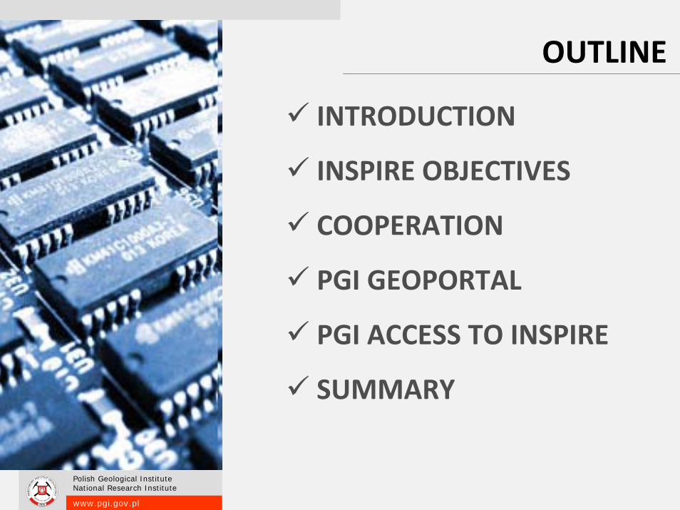
OUTLINE
INTRODUCTION
INSPIRE OBJECTIVES
COOPERATION
PGI GEOPORTAL
PGI ACCESS TO INSPIRE
SUMMARY

www.pgi.gov.pl
Polish Geological InstituteNational Research Institute
INSPIRE OBJECTIVES
That spatial data are made available under
conditions which do not unduly restrict their extensive use;
… that it is easy to discover available spatial data, to evaluate their suitability for the purpose and to know the conditions
applicable to their use
That spatial data are made available under
conditions which do not unduly restrict their extensive use;
… that it is easy to discover available spatial data, to evaluate their suitability for the purpose and to know the conditions
applicable to their use
That spatial data are made available under
conditions which do not unduly restrict their extensive use;
… that it is easy to discover available spatial data, to evaluate their suitability for the purpose and to know the conditions
applicable to their use
INSPIRE DIRECTIVE 2007/2/EC

www.pgi.gov.pl
Polish Geological InstituteNational Research Institute
INSPIRE OBJECTIVES
INSPIRE lays down general rules to establish an infrastructure for spatial
information in Europe for the purposes of Community
environmental policies and policies or activities which may have an impact on the environment.

www.pgi.gov.pl
Polish Geological InstituteNational Research Institute
The infrastructures for spatial information in the MemberStates should be designed to ensure that spatial data are
stored, made available and maintained at the mostappropriate level; that it is possible to combine spatialdata from different sources across the Community in a
consistent way and share them between several users andapplications ...
… benefit from the state of the art and actualexperience of information infrastructures, it is appropriatethat the measures necessary for the implementation of thisDirective should be supported by international standards
04.2002European Union initiative to archive common geoinformation infrastructure
INSPIREINfrastructure for SPatial InfoRmation in Europe
15.05.2009INSPIRE Directive transformation to the national law
15.05.2007Directive establish spatial information infrastructure in European Union (INSPIRE)
ROAD TO INSPIRE
2008 - 2010Preparing of Implementing Rules (IR)
2019Data and Services accessible

www.pgi.gov.pl
Polish Geological InstituteNational Research Institute
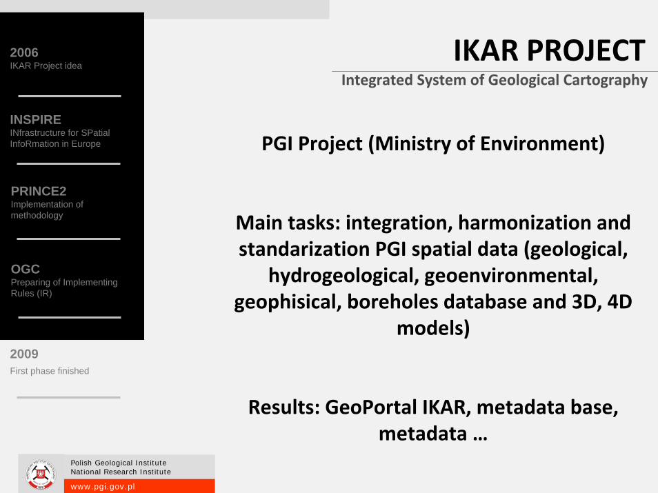
www.ikar.gov.pl
www.pgi.gov.pl
Polish Geological InstituteNational Research Institute
IKAR PROJECTIntegrated System of Geological Cartography
PGI Project (Ministry of Environment)
Main tasks: integration, harmonization and standarization PGI spatial data (geological,
hydrogeological, geoenvironmental, geophisical, boreholes database and 3D, 4D
models)
Results: GeoPortal IKAR, metadata base, metadata …
2006IKAR Project idea
INSPIREINfrastructure for SPatial InfoRmation in Europe
2009First phase finished
PRINCE2Implementation of methodology
OGCPreparing of Implementing Rules (IR)

www.pgi.gov.pl
Polish Geological InstituteNational Research Institute
GEOLOGY in SDI
SPATIAL SPATIAL DATA DATA
INFRASTRUCTUREINFRASTRUCTURE

www.pgi.gov.pl
Polish Geological InstituteNational Research Institute
Thematic Distribution
30
41
30 31
2025
3734
11
56
69
30
2318
26
3734
2630
33
12
1916
4
1217
7
21
28 29
21
5146
15
0
10
20
30
40
50
60
70
80
Elevatio
nLa
nd C
over
Ortho-im
gGeo
logy
Stcal U
nits.
Buildin
gs SoilLa
nd U
seHh &
Safe
tyUtilit
y & G
B
Env.M
onito
ring
Produc
ction
Agricu
ltural
Demog
raphy
Area M
gmen
t.Nat.
Risk
Atms.C
ond.
Meteoro
log.
Ocean
ograh.
Sea R
eg.
Bio Reg
.Hab
it & Biot
.
Specie
s Dist
.E.R
.Min.
RCoo
r.Sys
tem
Geogra
ph G
rid
Geogra
ph N
ames
Admin.
Units.
Addres
sCad
astra
lTrans
port
Hydrog
raphy
Protec
ted S
ites
Units
.
Annex.II Annex.III Annex.I

www.pgi.gov.pl
Polish Geological InstituteNational Research Institute
WHAT WE NEED TO BE INSPIRED?
COORDINATION
COLABORATION
COOPERATION

www.pgi.gov.pl
Polish Geological InstituteNational Research Institute
Members
Structures
Community
Management
COOPERATION

www.pgi.gov.pl
Polish Geological InstituteNational Research Institute
Cooperatives are based on the values of self‐help, self‐responsibility, democracy, equality,
equity and solidarity.
In the tradition of their founders, cooperativemembers believe in the ethical values of
honesty, openness, social responsibility and caring for others
COOPERATION

www.pgi.gov.pl
Polish Geological InstituteNational Research Institute
Geoportal – MULTILEVEL COOPERATION
Anyone who needs,up‐to‐date environmental databenefits from …
PUBLIC ACCESS, user can view and discover geological and
environmental data by the use of internet services
INTERNATIONAL COMMUNICATION, accomplish commitments of EU directives (INSPIRE, Water Framework Directive) delivering data for EU
Commission
NATIONAL INFRASTRUCTURE, provide data for institutions involved in NSDI,
BILATERAL EXCHANGE, of INSPIRE idea to other countries. Delivering good practice for The Eastern
Partnership.
EDUCATION, organise workshops, technology development
INTERNAL EXCHANGEof spatial data among
organisation departments and partner companies

www.pgi.gov.pl
Polish Geological InstituteNational Research Institute
PUBLIC ACCESSWMS 1.3SLD 1.0CSW 2.0.1(WMC) 1.0Filter Encoding 1.1WCS 1.1 (server)KML

www.pgi.gov.pl
Polish Geological InstituteNational Research Institute
VARIETY OF TOOLS
www.pgi.gov.pl
Polish Geological InstituteNational Research Institute
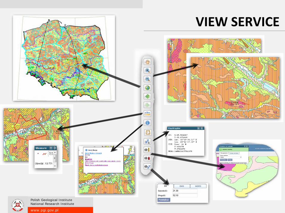
VIEW SERVICE

www.pgi.gov.pl
Polish Geological InstituteNational Research Institute
MAP INDEXES

www.pgi.gov.pl
Polish Geological InstituteNational Research Institute
DISCOVERY SERVICE

www.pgi.gov.pl
Polish Geological InstituteNational Research Institute
METADATA (CSW)

www.pgi.gov.pl
Polish Geological InstituteNational Research Institute
INTERNAL DATA EXCHANGE
NSPIREIEB GISWAPSM1994
First use of GIS applications
Assumption of CGDB
1995‐1997
Start of the three national mapping projects
DGMP, HMP, GMP
ISG2005 –
Working access in INSPIRE
SDIC
EuroGeoSurvey
2003 ‐ 04
INTERNET spatial data presentation

www.pgi.gov.pl
Polish Geological InstituteNational Research Institute
GEOINFORMATION RESOURCESCentral Geological Database
Mining Areas Registry
Landslide Protection System
Polish Hydrogeological Survey Portal
Geo-environmntal Map
Infogeoskarb
Thermal and Mineral Waters
Engineering-geology Atlases
Groundwater Monitoring
Geochemical Atlases
…
IKAR – PGI GeoportalNaional Geology Geoportal

www.pgi.gov.pl
Polish Geological InstituteNational Research Institute
MAPS

www.pgi.gov.pl
Polish Geological InstituteNational Research Institute
MAPS
WMS 1.3WFS 1.1SLD 1.0CSW 2.0.1WMC 1.0Filter Encoding 1.1WCS 1.1 (server)KML

www.pgi.gov.pl
Polish Geological InstituteNational Research Institute
ARE WE INSPIRED ENOUGH?
POLAND

www.pgi.gov.pl
Polish Geological InstituteNational Research Institute
PGI ACCESS TO NSDI
•• Representative of Ministry of Environment in INSPIRE implementation works
• Cooperation with Head Office Geodesy and Cartography (GUGiK)
‐Metadata Team
‐ Polish Council for INSPIRE Implementation
‐ spatial data reference (normative) –topographic and thematic data

www.pgi.gov.pl
Polish Geological InstituteNational Research Institute
PGI ACCESS TO NSDI
•• Testing of national metadata profile
• Participation in testing Data Specification for INSPIRE Directive Annex I
• Active participation in Ministry of Environment working group of data harmonization
• Organizing of INSPIRE workshops and seminars
• Participant of Geoinformation Scientific Network

www.pgi.gov.pl
Polish Geological InstituteNational Research Institute
NSDI ‐ Poland
7th June 2010 ‐ SDI Act of Polish Parliament entered into force
www.pgi.gov.pl
Polish Geological InstituteNational Research Institute
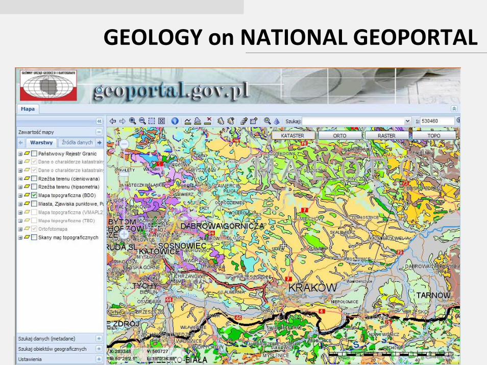
GEOLOGY on NATIONAL GEOPORTAL

www.pgi.gov.pl
Polish Geological InstituteNational Research Institute
GEOLOGY on EU GEOPORTAL

www.pgi.gov.pl
Polish Geological InstituteNational Research Institute
OneGeology
Making digital geological spatial data more easily discoverable, accessible and useable

www.pgi.gov.pl
Polish Geological InstituteNational Research Institute
INTERNATIONAL COOPERATION

www.pgi.gov.pl
Polish Geological InstituteNational Research Institute
NSDINSDI
EU EU ‐‐ INSPIREINSPIRE
www.pgi.gov.pl
Polish Geological InstituteNational Research Institute
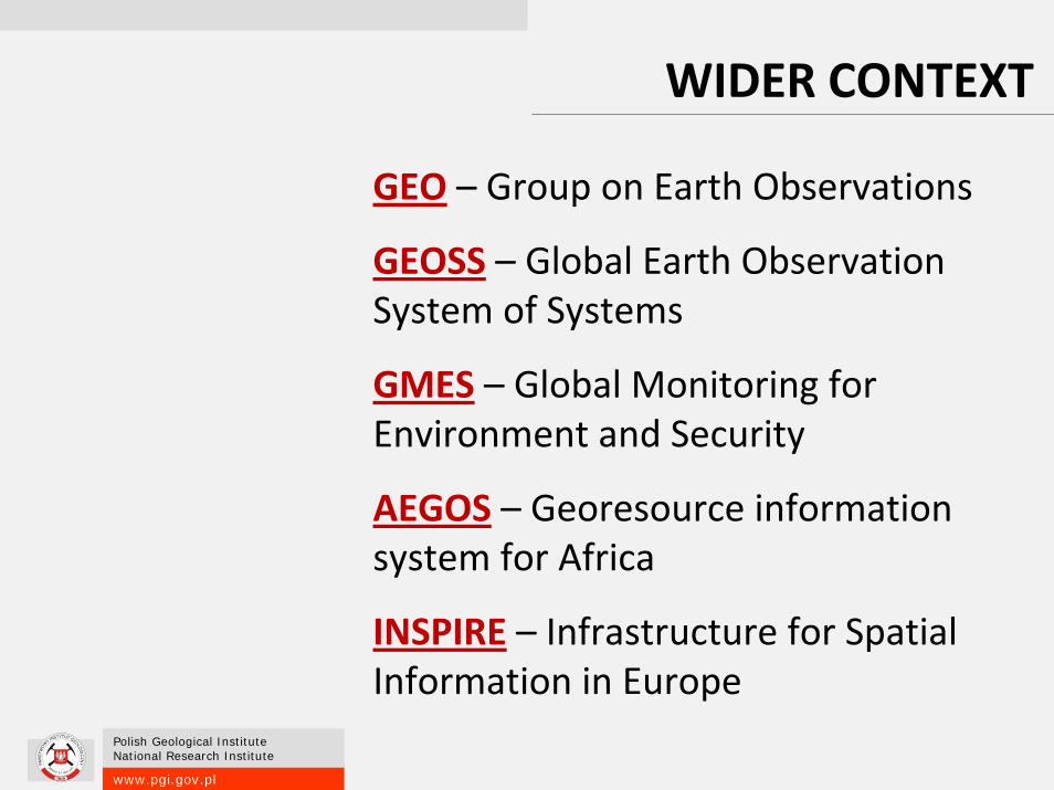
GEO – Group on Earth Observations
GEOSS – Global Earth Observation System of Systems
GMES – Global Monitoring for Environment and Security
AEGOS – Georesource information system for Africa
INSPIRE – Infrastructure for Spatial Information in Europe
WIDER CONTEXT

www.pgi.gov.pl
Polish Geological InstituteNational Research Institute
NO BORDERSEnvironmental issues do not stop at borders
NEIGHBORS60 million EU citizens live at less than 25 km form the borders
POLICYAt least 12% of the EU citizens (492 million) are concerned by trans-boundary environmental policies
TRANSBOUNDARY ASPECTS
WATER70% of all fresh water bodies in EUROPE are part of trans-boundary river basin

www.pgi.gov.pl
Polish Geological InstituteNational Research Institute
INSPIRE IMPLEMENTATION PROBLEMS
Area Not all country covered for many data
Data ModelsMany data formats and models being used
Scale Different details in the same scale
Data access Height costs and not fully
accessible
Cooperation Rare cooperation between different government and
local institution
CoordinatesLack of harmonization
ConcisenessLow geoinformational
knowledge and low popularity of geoinformation
standards
DuplicationLack of compatibility between source data

www.pgi.gov.pl
Polish Geological InstituteNational Research Institute
CONCLUSION
• Geoportal – tool for data exchange
• Quick access to information
• Overcome barriers
• Transfer of knowledge and technology
• Development of information society

www.pgi.gov.pl
Polish Geological InstituteNational Research Institute