in a (linc) freetown port rico neighborhood plan … · members of the community from the klu klux...
TRANSCRIPT

Lafayette City‐Parish Planning Commission Freetown‐Port Rico Neighborhood Plan Amended Lafayette Consolidated Government Project No. 50036_#7_PLAN_ADOPTION Planning Division
1 Final Version – Amendment 2
Lafayette IN a Century (LINC) Freetown – Port Rico Neighborhood Plan Introduction The Freetown – Port Rico LINC Designated Neighborhood Plan #7 is part of the neighborhood planning effort that is a goal of the comprehensive plan for Lafayette Parish. This neighborhood is a historically significant area northeast of the University of Louisiana at Lafayette, bounded by East University Avenue, Johnston Street, the railroad track, and Pinhook Road. These boundaries encompass several traditional residential neighborhoods that are separated by Jefferson Street, a primary retail street, McKinley Street, a strip that has become home to a series of bars and clubs and bisected by a Southern Pacific Railroad line. Among the residential neighborhoods is “Freetown”, an original subdivision called the “Mouton Addition”. Prior to the Civil War many freed slaves in Lafayette settled in this subdivision, along with a heterogeneous mixture of lower and middle class Caucasians. Over the years Freetown, as it became known, has had residents from various cultures, including, among others, African, Cajun, Lebanese and Middle Eastern, Greek, Spanish, and Irish peoples. As a community, the residents of Freetown took care of each other. They formed an organization called the “True Friends Society” in an effort to protect members of the community from the Klu Klux Klan. In the 1920’s, residents gathered at the Good Hope Hall to listen to jazz performers who came to the neighborhood from around the country to perform. African‐Americans only were permitted inside the Hall, but a white audience would gather outside to listen to the music. This was truly a unique occurrence in the United States at this time. Historically, Freetown represents the assimilation of diverse cultures into a neighborhood that effectively protected and sustained this diversity. The second historically significant neighborhood is “Port‐Rico”, a corruption of “Porto‐Rico”. Porto Rico was the type of sugar cane grown in the fields when the area was all farmland. The third residential neighborhood surrounds Gordon Street between University Avenue and Jefferson Street. Traditionally, this area has been home to university professors and their families. Both neighborhoods supported and sustained a diverse population, a tradition that continues today. The vision of the neighborhood plan is to build upon the local neighborhood traditions, to identify, respect and maintain the positive features that exist in the area, and to suggest enhancements to the quality of life and work in the area without disrupting those positive features. Ultimately, the plan represents a design for the future of this vital area of Lafayette that reflects the ideas and vision of the residents and business owners in the neighborhood.
The History of the Freetown ‐ Port Rico Neighborhood Plan The First Plan In the late nineties, University of Louisiana at Lafayette’s Community Design Workshop engaged the public through a design process. Both charrettes and public meetings were used to facilitate public

Lafayette City‐Parish Planning Commission Freetown‐Port Rico Neighborhood Plan Lafayette Consolidated Government Project No. 50036_#7_PLAN_ADOPTION Planning Division
2 Final Version – Amendment 2
input. Charrettes are short, intensive design‐generation sessions. Their function is to advance the design process through quick visualization of the main themes of various projects. Many of the ideas incorporated in the final plan have their origin in the charrettes. The public meetings provided more formal opportunities for the students to present ideas about urbanism and to inform and educate the public regarding the design process and progress of the project. They also provide a forum for the public to respond to the project proposals. The plan was project based and also included streetscape improvements. In 2006, the same plan was presented again to the neighborhood in 2006 prompted by development pressures. A public meeting was held and the community supported the adoption of the plan. The City‐Parish Planning Commission adopted the Neighborhood Plan in July 2006. A neighborhood coterie was elected at a subsequent public meeting and began meeting in September 2006. In 2010, the Freetown – Port Rico Coterie decided to revisit their plan and the projects. The main addition is the development of a future Land Use Plan to guide decision making. The projects were revisited and either left on the plan, kept but were not location specific, or they were deleted. The plan adopted in 2006 did not have official text but instead had artist renderings of the projects with short descriptions. The following text includes parts of these descriptions. It is the goal of the neighborhood planning process to eventually have applications for development, building, land divisions, land reassembly, variances, etc. be circulated to the coterie for comment and review for conformity with the Neighborhood Plan. Site Conditions The Freetown – Port Rico neighborhood area has a distinctly residential character and includes two historically significant neighborhoods, identified as “Freetown” and “Port‐Rico.” Bounding the entire area are primarily commercial or industrial land uses, while there are two main commercial roads that run through the area’s center and separate the residential neighborhoods. One of these roads, the historic “Emma K. Lane,” (present‐day Jefferson Street), runs the length of the project area and connects two of the commercial boundary streets: Pinhook Road and Johnston Street. The shorter McKinley Street runs perpendicularly between Jefferson and East University Avenue. Also known as “The Strip,” this street is home to a number of clubs and bars that are frequented primarily by university students. Problem Identification In the early charrettes, the need for greater connectivity emerged as one of the primary issues to be addressed. This need for connection encompassed several different, but related issues. First, there was the need to more closely link the diverse residential neighborhoods to each other. Next, there was the need to reinforce connections to the larger contexts of the community, mainly downtown Lafayette and the University of Louisiana at Lafayette. Finally, there was a perceived need to revive social and cultural connections within the residential community. In addition to the connection issue, the charrettes also identified the need to modify the impact of commercial development of the residences in the area. The analysis of existing conditions revealed a negative interaction between commercial establishments, especially along the McKinley Street “Strip”,

Lafayette City‐Parish Planning Commission Freetown‐Port Rico Neighborhood Plan Lafayette Consolidated Government Project No. 50036_#7_PLAN_ADOPTION Planning Division
3 Final Version – Amendment 2
and the nearby residents. Residents complained of noise and litter generated by the patrons of the bars and clubs along this street. One of the biggest challenges is to address the interface between industrial/commercial uses with residential housing. The proximity to downtown and the university has attracted developments of increased densities, or multi‐family units. This plan is challenged with how these developments integrate with the primarily single family/duplex housing in the area. In addition, there was a desire for more public space and amenities.
Freetown Port‐Rico Neighborhood Plan
1. Neighborhood Identity & Character – Positively impact the neighborhood’s identity, character, and historical value.
Freetown Port‐Rico has a rich cultural texture that should be enhanced as well as preserved and protected. Civic improvements will add to a new generation of community pride and history.
Entry features can also be used to increase the connectivity between the traditional neighborhoods.
Establish a gateway at the corners of Vermilion Street and Johnston Street and at General Mouton Avenue and Pinhook Road to identify where the Atakapas ‐ Ishak Trail transverses the neighborhood.
Establish neighborhood signage or gateway at Jefferson Street at Pinhook Road and Johnston Street.
Establish a gateway along McKinley Street through the use of arcades.
Create a neighborhood identity through the existing and future commercial stores by consolidating commercial uses in one area.
The center of the community is located at McKinley and Jefferson St. Concentrated commercial offers the relative ease of parking solutions. Shared parking and on‐street parking are options to reduce the parking requirement.
Neighborhood signage could be concentrated in this area to create interest and identity.
Objective 1. Develop entry way features to delineate key entrances to the neighborhood and establish linkages with the downtown and the university.
Objective 2. Develop a neighborhood center and main street to consolidate commercial development.

Lafayette City‐Parish Planning Commission Freetown‐Port Rico Neighborhood Plan Lafayette Consolidated Government Project No. 50036_#7_PLAN_ADOPTION Planning Division
4 Final Version – Amendment 2
Street lighting, trash receptacles, benches, street tree planting, crosswalks, etc. could be used to identify the commercial area.
2. Heritage – Highlight the historical aspects of the neighborhood through the preservation of significant buildings, districts, corridors, and places.
As well as bringing new investment into Freetown Port‐Rico, the significant investments of the past should be celebrated and preserved. The Lafayette Public Library has access to several subscription genealogical databases. The
reference librarians are also highly knowledgeable in this field and can assist residents in developing their family histories.
Historic buildings like the Good Hope Hall and the Martin’s Hat Shop are important for the
neighborhood’s cultural and historical memory and should be recognized and celebrated. Consider the former Dr. Butler’s House on the corner of Gordon Street and Main Street as a
cultural center. Dr. Butler was the first African‐American pharmacist in the neighborhood.
A cultural center in the neighborhood would provide a venue for group activities, social support, public information, and other opportunities for community converging. A cultural center would celebrate the various cultures that contributed to the development of Freetown‐Port Rico, including the French, Lebanese, Spanish, African‐ American, Irish, Italian, Dutch, Chinese, and others. For example, the
Objective 1. Establish resources for genealogical and family history investigation.
Objective 2. Identify culturally or historically significant buildings or properties.
Objective 3. Create a cultural center that would act as a repository for documents and memorabilia relating the neighborhood, and would serve as a reference/resource center for genealogical and local history.

Lafayette City‐Parish Planning Commission Freetown‐Port Rico Neighborhood Plan Lafayette Consolidated Government Project No. 50036_#7_PLAN_ADOPTION Planning Division
5 Final Version – Amendment 2
Oakland Asian Cultural Center hosts as “Bubble Tea Chats” which encourages dialogue over tea about three particular blocks in Oakland Chinatown currently in the public forefront. Universities around the country are a major source of resources for the development of local cultural centers. Partner with the University of Louisiana at Lafayette to create a cultural center for the
neighborhood, similar to a project in Syracuse, NY, with Syracuse University (Syracuse is a partner city in SESAME, an Economic Development Partnership Network).
Markers are the easiest way of imparting historical information to the general public, in addition to providing a source of tourist interest. For a low cost, a historical narrative would be woven through the neighborhood. A historical property walking tour, possibly bilingual, similar to ones found in the Garden District
in New Orleans could be developed for tourists. The Atakapas‐Ishak trail offers an opportunity to highlight historical places/people along the
trail. Locate an installation in a public space that includes written text about neighborhood stories.
Public performance spaces allow for cultural enrichment and tourism opportunities. Freetown‐Port Rico could capitalize on the vibrant festival culture in Lafayette by providing for such a space. There are two major festivals within walking distance of Freetown‐Port Rico, Festival International and Festival Acadiens et Creole. The amphitheater could host segments of the festivals, increasing pedestrian traffic and commercial activity in the community. Community Development Block Grant funds or other grant funding could be utilized for the
development of an amphitheater.
Oral histories are an important aspect in the preservation of an area’s culture. Cultural centers
typically serve as a place for residents to gather to have their stories told. For example, during the spring and summer of 2007, the Oakland Asian Center organized 11 high school youth to interview 10 elders who lived or worked in Oakland Chinatown throughout the 1940s‐1970s, when Chinatown faced intense change. The cultural center will provide a venue for the recording of the histories as well as serving as a repository for the recorded files.
Participate in LCG’s Planning Division’s oral history project.
Objective 4. Display markers for historic or historically significant structures or sites.
Objective 5. Locate a terraced amphitheater for live music, performances, and story telling.
Objective 6. Promote the ongoing effort to capture oral histories on tape.

Lafayette City‐Parish Planning Commission Freetown‐Port Rico Neighborhood Plan Lafayette Consolidated Government Project No. 50036_#7_PLAN_ADOPTION Planning Division
6 Final Version – Amendment 2
3. Housing – Ensure housing affordability and housing choice.
A greater density and variety of residential types provide a range of affordable and attractive housing that expands the housing stock in the area. The proposed designs respond in scale and style to the traditional character of the existing residences of the neighborhood. McKinley Street has a lot of opportunities for targeted infill. McKinley Street holds many of the existing commercial properties in the Freetown‐Port Rico area. Pedestrian activity would be encouraged by the development of mixed‐use townhouses. Focusing the built environment on a low density, mixed use streetscape will build a vibrant urban community.
Work with the University of Louisiana at Lafayette to plan for student housing development that
is integrated into the neighborhood. Incentives can be used to attract a signature mixed used commercial development in this area
that would spur other developments of its kind in the urban core. Currently, the neighborhood has a high rate of rental housing (72% ‐see appendix) units mainly due to the student population. An opportunity for student housing has to be balanced with the investment of owner occupied housing. Housing choice offers people opportunities for housing in all age groups. Developers should be encouraged to consider the Freetown‐Port Rico neighborhood for
homeowner‐centered developments, such as through a booth at the Blueprints Show or the Parade of Homes.
The Coterie should work with LCG and other agencies to promote a program whereby a family could own and live in a duplex and rent out the other side of the duplex. This promotes both options for renting with an ownership component to ensure maintenance.
Multi‐family developments catering to seniors should be supported by the Coterie. These projects should be planned in conjunction with American Disability Act, eg. ADA compliant sidewalks.
Objective 1. McKinley Street should be targeted for in‐fill of multi‐level townhouses with courtyard gardens and mixed‐use buildings with small businesses on the ground level and residences above.
Objective 2. Encourage developments that create more opportunities for homeownership and increase housing choice.

Lafayette City‐Parish Planning Commission Freetown‐Port Rico Neighborhood Plan Lafayette Consolidated Government Project No. 50036_#7_PLAN_ADOPTION Planning Division
7 Final Version – Amendment 2
The Coterie proposes nine architectural styles for single family and multi‐family residential construction in the neighborhood. These styles include Plains Cottage, Gabled Shotgun House, Bungalow, Hipped Bungalow, Bungalow Cottage, English Cottage and Gambrel, Creole, and Acadian. The Coterie should promote these nine architectural styles through the development review
process. During the building permit process, a brochure could be provided with the building permit
application. The Coterie will continue its Pride Award program to showcase homes in these styles that have
been renovated or well maintained. In keeping with the eclectic nature of the community, unique, well‐planned styles not included
in the above mentioned are encouraged on their own merit. Partner with UL’s various departments to promote Freetown – Port Rico as a place for building
designer homes like the energy efficient Beau Soleil House.
Freetown Port‐Rico is a typical historical neighborhood, developed on a pedestrian scale and designed so that a resident would not have to drive away to work, live, or play. As such, the current suburban zoning model is insufficient for achieving the objectives outlined in this plan. Performance based zoning is a tool to preserve the positive aspects of the diverse land uses within the neighborhood while working to mitigate the negative aspects of varied property uses. The Coterie has undertaken a time consuming two year review of ways to address new development and redevelopment in the neighborhood. After extensive review and consideration of performance based land use tools the Coterie has recommended that these standards be applied either as an overlay to the existing zoning in the neighborhood or as performance based zoning districts. Performance based zoning will be utilized to protect, preserve, and develop the diverse mix of
land uses within the Freetown Port‐Rico neighborhood. The Coterie should work with LCG in their development of urban zoning districts or an overlay
district that will achieve desirable outcomes.
Objective 3. Establish some method to encourage that new homes and substantial renovation are consistent with the architectural concepts seen throughout the neighborhood while still promoting eclectic architecture.
Objective 4. The land use plan recognizes the neighborhood as urban with opportunities for commercial, mixed use, and multi‐family land uses.

Lafayette City‐Parish Planning Commission Freetown‐Port Rico Neighborhood Plan Lafayette Consolidated Government Project No. 50036_#7_PLAN_ADOPTION Planning Division
8 Final Version – Amendment 2
4. Public Realm – Strengthen alternative transportation modes to create a safe environment for the pedestrian and vehicular traffic within the neighborhood and connections outside.
Typical strategies focus on the establishment of clearly defined public spaces such as parks and plazas. The enhancement of streetscapes through the introduction of trees and landscaped walkways separated from vehicular traffic in order to enhance the pedestrian experience. The neighborhood plan for the Freetown – Port Rico Neighborhood proposes public spaces that serve to connect between the various residential areas of the community and the commercial areas within and beyond the neighborhood. While these spaces service both recreational and social functions, they also create opportunities for the development of supportive commercial enterprises.
As part of the Johnston Street redevelopment effort, the Coterie has considered the section of Johnston Street that borders the neighborhood planning area as an urban streetscape. The concepts for the redevelopment of Johnston Street are planned to be in the existing right‐of‐way and are proposed as follows:
A boulevard strip from Cypress Street and Garfield Street to Vermilion Street due to the drop in
grade along Johnston Street from the future underpass for the I‐49 Connector project and also to provide some protected lefts.
The boulevard is eliminated between Vermilion Street and University Avenue except for a protected left at Convent Street and Jackson Street
Additional dedicated left turn lanes at Jefferson Street and Vermilion Street Improvements at intersections, both audio for the blind and increased markings for pedestrian
crossings. Urban sidewalks, generally 10 ft wide sidewalks are desirable but may be less depending on
building locations. The sidewalk should extend right to the curb with planter boxes. Improvement considerations on side streets, like Vermilion Street where the Atakapas‐ Ishak
Trail is planned across Johnston Street. Add a protected left at University Avenue and Johnston Street and a right turn only lane from
General Mouton Avenue to Johnston Street. The Coterie should promote their plan as part of the overall Johnston Street redevelopment
effort. The continuation of the Jefferson streetscape plan is essential for maintaining the continuity of the design. The plan calls for an enhanced pedestrian environment throughout the project area. The streetscape improvements that currently exist on Jefferson Street on the downtown side of Johnston
Objective 1. Redevelop the Johnston streetscape as an urban complete street.
Objective2. Continue the Jefferson streetscape plan through the neighborhood to Pinhook Road.

Lafayette City‐Parish Planning Commission Freetown‐Port Rico Neighborhood Plan Lafayette Consolidated Government Project No. 50036_#7_PLAN_ADOPTION Planning Division
9 Final Version – Amendment 2
should be continued recognizing the unique characteristics of Jefferson Street through the neighborhood.
LCG should utilize a variety of funding sources, such as the Local Road Safety Program, the
Transportation Enhancement Grants, and Community Development Block Grants, to improve the streetscapes.
Develop a streetscape plan with phasing opportunities for gradual implementation.
Build a roundabout at the intersection of General Mouton Avenue and Taft Street. A roundabout will improve safety for motorists and pedestrians while providing a showcase for public art or landscaping. This area was selected due to the high rate of vehicle crashes at the intersection.
Review the traffic calming process with LCG’s Department of Traffic and Transportation for the employment of traffic calming devices.
Pursue innovative ways of traffic calming like painting intersections.
5. Open Space & Recreation – Improve and enhance the quality and extent of both passive and active recreational opportunities for residents of all ages and abilities.
Part of this Plan will include a geographic inventory of Live Oaks from the Live Oak registry in order for the Coterie to work toward preservation of these historic trees.
A linear park with a raised berm and rows of trees along the railroad is proposed. The berm provides a buffer between the train tracks and the nearby residential neighborhood. A proposed bike path begins at Garfield Street, runs along this berm to Taft Street where it continues all the way to Girard Park.
Objective 1. Utilize the green area along the railroad tracks on Garfield Street for a linear trail /park and to buffer noise.
Objective 3. Employ traffic calming devices where necessary.

Lafayette City‐Parish Planning Commission Freetown‐Port Rico Neighborhood Plan Lafayette Consolidated Government Project No. 50036_#7_PLAN_ADOPTION Planning Division
10 Final Version – Amendment 2
Enter into an agreement with the Burlington Northern Santa Fe Railway in order to mitigate
concerns about safety and noise. The project will start with plantings, and other features will be added as funding becomes
available. Work to integrate this portion of this trail with efforts to connect other parts of the downtown
neighborhoods along the tracks. A number of smaller green spaces should be scattered throughout the residential area to provide places for sitting, relaxing, and socializing. These enhancements increase the livability of the neighborhood and its attractiveness to visitors as well as residents. Pocket parks are proposed but not limited to the university owned property on the corner of Gordon Street and General Mouton Avenue and at the corner of General Mouton Avenue and Wilson Street. Community gardens provide the opportunity for providing fresh produce to lower income residents and builds community. LCG should utilize a variety of funding sources, such as Transportation Enhancement Grants and
Community Development Block Grants, to develop the pocket parks throughout Freetown‐Port Rico.
The Coterie should begin by working towards a catalyst project for a community park that will set the standard for the development of future parks. It will reconcile issues such as liability, maintenance, and funding.
The targeted corner of Gordon Street and General Mouton Avenue could include a kiosk of historical information for bikers along the trail and users of the pocket park.
Vacant lots will be identified for leased use for a community garden. Work with LCG, Earthshare, and the Sheriff to develop a community garden.
The multi‐purpose Atakapas‐Ishak Trail that begins at the Parc Sans Souci transverses the length of the neighborhood from Vermilion Street to Gordon Street and down General Mouton Avenue to Pinhook
Objective 3. Beautify the multi‐purpose Atakapas ‐ Ishak Trail with street trees, promotion, signage, and other efforts.
Objective 2. Develop pocket parks and community gardens in the neighborhood.

Lafayette City‐Parish Planning Commission Freetown‐Port Rico Neighborhood Plan Lafayette Consolidated Government Project No. 50036_#7_PLAN_ADOPTION Planning Division
11 Final Version – Amendment 2
Road. The route of the trail through the neighborhood includes plans for signage and street markings, streetscape considerations, traffic calming devices, pocket parks, kiosks, and heritage markers. The trail will ultimately connect downtown Lafayette with downtown Breaux Bridge and St. Martinville. The Trail will be an important component for spurring future investment in the neighborhood by attracting businesses that cater to bikers and other recreation enthusiasts. A Louisiana example of this type of project is the Tammany Trace, a bike trail that has brought a diverse number of businesses to a typically suburban area in the Northshore of New Orleans. Along the trail, one can visit a farmer’s market, a brew pub, an art gallery, an amphitheater, a movie theater, and camping facilities. LCG should utilize a variety of funding sources, such as Transportation Enhancement Grants and
Community Development Block Grants, to develop the enhancement of the Atakapas‐Ishak Trail.
Street tree planting catalyst projects can be implemented along the trail to provide shade for bicyclists and pedestrians.
6. Economic Development – Increase neighborhood amenities to ensure accessibility to residents’ daily needs and job opportunities.
The economy is the backbone for any community. Having a strong employment base builds on the other segments of the community, as well as providing a structure for residents to stay within their community to work, live, and play. The proliferation of parking in the neighborhood is a concern of the Coterie. Increased residential densities and commercial development will require parking solutions. Streetscape projects will incorporate opportunities for public parking and street parking. Pursuing an overlay district or more urban zoning that reduces parking requirements cannot happen without a street parking plan. Currently there is a proliferation of suburban‐style commercial lots that are disruptive to the pedestrian flow of the residential character. Integrating these spaces into the streetscape would be the optimal solution to building a true live‐work community. In the development of an overlay district or new urban zoning the mitigation of a parking area
should be addressed. That is how the parking lot addresses the street and the adjacent properties.
Locate parking facilities inside the commercial blocks and along the street on Jefferson Street. This strategy separates the parking from the residential areas and allows the commercial activity to have a vital presence on the street.
Identify appropriate areas for commercial development and for parking in districts that are least disruptive to the residential areas.
Objective 1. Prepare and implement a parking management strategy.

Lafayette City‐Parish Planning Commission Freetown‐Port Rico Neighborhood Plan Lafayette Consolidated Government Project No. 50036_#7_PLAN_ADOPTION Planning Division
12 Final Version – Amendment 2
Incorporate on‐street parking in streetscape planning where practical.
A central plaza that incorporates public and park space with retail and/or office uses is the centerpiece of this plan. The McKinley Plaza concept is for demonstration purposes and is not to exclude other opportunities that may be appropriate. There are several actions that could be undertaken to achieve this objective: Locate the “McKinley Plaza” at the targeted corner of Jefferson Street and McKinley Street
stimulating redevelopment of a mixed commercial and industrial land uses. Close off the section of McKinley between Jefferson Street and Cleveland Street in order to
increase the Jefferson frontage and the land assembly. Jefferson Square, on the Jefferson Street side of the Plaza, would be an open public space
bordered by family‐oriented stores. Incorporate into the development a passive park into the McKinley Plaza and Jefferson Square.
The McKinley streetscape will be a mixed use, commercial/residential Street with pocket parks and an arcade. An arcade should be built along McKinley Street to McKinley Plaza to shelter shoppers/residents
from the weather but also to act as a gateway or a focal point. Investment on McKinley Street is critical to attract a developer of the McKinley Plaza concept.
Objective 2. Encourage the development of “McKinley Plaza” as a hub of the neighborhood.
Objective 3. McKinley Street is an important entry way from the University into the neighborhood and should be targeted for improvements.

Lafayette City‐Parish Planning Commission Freetown‐Port Rico Neighborhood Plan Lafayette Consolidated Government Project No. 50036_#7_PLAN_ADOPTION Planning Division
13 Final Version – Amendment 2
The University of Louisiana at Lafayette has expressed interest in expanding along McKinley Street. The Freetown‐Port Rico Coterie should work closely with the University of Louisiana at Lafayette to ensure that the residents’ interests are represented in this process.
There are commercial buildings throughout the neighborhood. Residents value proximity to stores and a walkable neighborhood. There are certain types of retail that are less desirable within the residential areas. Neighborhood friendly businesses are desirable, for example, music related businesses, bakeries, day care centers, supermarket, etc. The small businesses in the incubators should be aware of the many advantages they could
enjoy by locating in Freetown‐Port Rico. The small business incubator at the University of Louisiana at Lafayette should be utilized.
The Land Use Plan has concentrated the industrial land use between E. Convent Street, Taft Street and Guidry Street (based on the expansion of the neighborhood area). The industrial part of the neighborhood has declined over the years for several reasons. Manufacturing as a part of the local economic mix has fallen to only 7.37% (Bureau of Labor Statistics, 2008) of the employment base of Lafayette Parish. In addition, with the rise of the trucking industry, most of the freight movements in Lafayette have shifted to Highway 90/I‐49 corridor. This has left a an over concentration of industrial zoning in the neighborhood. The new Future Land Use Plan shows an expansion of residential land use in the former industrial zoning areas that are closest to existing residential properties. Some current industrial zoning should be preserved, primarily along the railroad track. Existing industrial buildings should be encouraged for redevelopment like artist live/work space. The Planning Commission should concentrate industrial zoning away from the residential area
and adjacent to the industrial infrastructure, like the railroad tracks. Utilize LEDA for advertising and attracting neighborhood friendly uses like artist’s workplace,
industrial workshops, etc.
This predominate corner in the neighborhood with adequate road capacity and should be targeted for a higher density development. A transitional use and/or building form needs to be incorporated to buffer the development from the adjacent single family residential homes.
Objective 4. Encourage family‐orientated businesses with the neighborhood.
Objective 5. Promote the use of existing industrial buildings for more neighborhood friendly uses.
Objective 6. Encourage the development of a showcase mixed‐use commercial development at the corner of Pinhook Road and University Avenue.
Lafayette City‐Parish Planning Commission Freetown‐Port Rico Neighborhood Plan Lafayette Consolidated Government Project No. 50036_#7_PLAN_ADOPTION Planning Division
14 Final Version – Amendment 2
The Planning Commission should support a mixed‐use commercial development and encourage the approval of a showcase development at this corner.
Incentives can be used to attract a signature mixed used commercial development in this area that would spur other developments of its kind in the urban core.
The Future Land Use Plan encourages general businesses uses on Johnston Street and Pinhook Road. A transition between these uses and the residential uses is essential. This could be a mixed use development or some type of mitigation measures.
Work with LCG to insure that the urban zoning districts or overlay district address some type of buffering between land uses. This could include step back requirements, landscaping, façade treatment, etc.
Transitional uses could buffer residents from industrial or intensive commercial uses.
7. Neighborhood Safety – Improve neighborhood safety through crime reduction.
A feeling of safety is needed in a community for it to truly flourish. This can be achieved by working towards other goals of the plan, such as improving the streetscape, eliminating blight, and building a sense of neighborhood pride.
Increase coordination between code enforcement, health inspectors, police and the city attorneys.
Undertake a Community Needs Assessment that will include an inventory of the neighborhood. An inventory will determine and document when overgrowth of vegetation needs to be managed, abandoned cars removed, trees cut, proper street lighting installed, owners of abandoned and/or dilapidated housing notified and/or requiring boarding or destruction.
Support and promote the Community Development Department’s program of acquisition and rehabilitation of vacant and/or boarded up houses.
Increase funding for Community Development’s housing rehabilitation program that provides for low interest loans to assist elderly homeowners.
Encourage ‘template leases’ to control illegal activities of landlords.
Undertake a CPTED audit to determine implementable actions.
Objective 7. Buffer commercial land uses with transitional land uses.
Objective 1. Develop a Housing Improvement Program.
Objective 2. Employ Crime Prevention Through Environmental Design (CPTED) strategies.

Lafayette City‐Parish Planning Commission Freetown‐Port Rico Neighborhood Plan Lafayette Consolidated Government Project No. 50036_#7_PLAN_ADOPTION Planning Division
15 Final Version – Amendment 2
Literature regarding Crime Prevention through Environmental Design (CPTED) strategies should be provided to commercial and single family detached development applicants when a building permit or development application is made.
Encourage residents to request a CPTED review of their properties through the use of a CPTED checklist.
Utilizing Community Development Block Grants, fund a White Picket Program for the Freetown‐
Port Rico neighborhood. Fashioned after a successful program in Paramount, California, a White Picket Fence Program would pay 75% of the purchase and installation cost to replace chain‐link fences or dilapidated fencing.
Property owners and community organizations should be encouraged to initiate community beautification projects. LCG’s Community Development Department could sponsor an annual beautification project at a city‐owned site, and volunteers from the community would maintain it over time.
Utilizing the Coterie and Community Development Block Grants, develop and fund a Freetown‐Port Rico community beautification program.
The Coterie should work with the LCG Police Department adjacent to the neighborhood, to
develop a public safety or neighborhood watch program. This would serve to identify problem areas, create a dialog between neighbors, and keep more eyes on the street.
A student liaison with the neighborhood and police department could review security to increase safety for students.
Continue working with LCG’s Planning Division and the Police Department to implement a neighborhood security plan that includes more active foot patrol in neighborhoods.
Overall Plan Objectives The Coterie will pursue expanding the neighborhood boundaries to include the area on the other side of the tracks bounded by Johnston Street, the Evangeline Thruway Southbound, and Pinhook Road. This area is not currently represented by a Coterie and falls in between the Freetown Port‐Rico neighborhood area and the McComb Veazey neighborhood area. Circulation of development applications and rezoning applications to the Coterie for comment. The complete Freetown Port‐Rico Neighborhood Plan includes a Future Land Use Plan. This written portion of the Plan must be considered jointly with the Future Land Use Plan.
Objective 3. Develop a community beautification program.
Objective 4. Enforce building codes, liquor laws, littering violations, and anti‐trespassing laws.

Lafayette City‐Parish Planning Commission Freetown‐Port Rico Neighborhood Plan Lafayette Consolidated Government Project No. 50036_#7_PLAN_ADOPTION Planning Division
16 Final Version – Amendment 2
This page is intentionally left blank.
Lafayette City‐Parish Planning Commission Freetown‐Port Rico Neighborhood Plan Lafayette Consolidated Government Project No. 50036_#7_PLAN_ADOPTION Planning Division
17 Final Version – Amendment 2
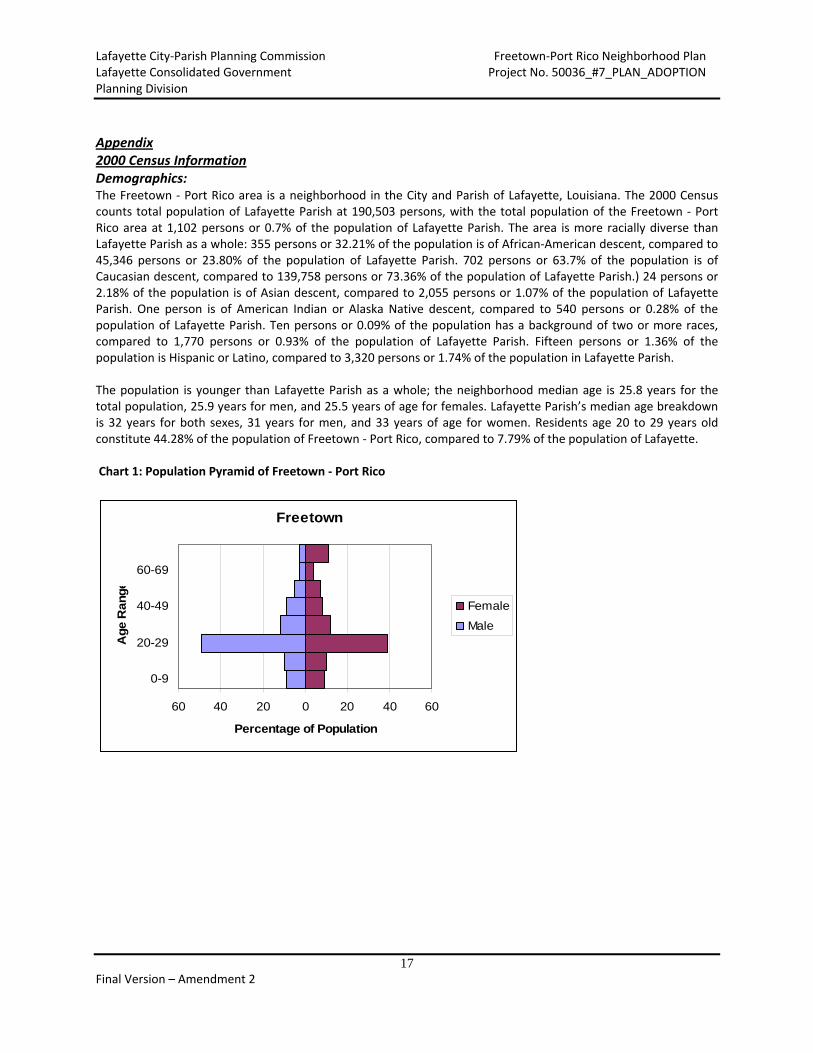
Appendix 2000 Census Information Demographics: The Freetown ‐ Port Rico area is a neighborhood in the City and Parish of Lafayette, Louisiana. The 2000 Census counts total population of Lafayette Parish at 190,503 persons, with the total population of the Freetown ‐ Port Rico area at 1,102 persons or 0.7% of the population of Lafayette Parish. The area is more racially diverse than Lafayette Parish as a whole: 355 persons or 32.21% of the population is of African‐American descent, compared to 45,346 persons or 23.80% of the population of Lafayette Parish. 702 persons or 63.7% of the population is of Caucasian descent, compared to 139,758 persons or 73.36% of the population of Lafayette Parish.) 24 persons or 2.18% of the population is of Asian descent, compared to 2,055 persons or 1.07% of the population of Lafayette Parish. One person is of American Indian or Alaska Native descent, compared to 540 persons or 0.28% of the population of Lafayette Parish. Ten persons or 0.09% of the population has a background of two or more races, compared to 1,770 persons or 0.93% of the population of Lafayette Parish. Fifteen persons or 1.36% of the population is Hispanic or Latino, compared to 3,320 persons or 1.74% of the population in Lafayette Parish. The population is younger than Lafayette Parish as a whole; the neighborhood median age is 25.8 years for the total population, 25.9 years for men, and 25.5 years of age for females. Lafayette Parish’s median age breakdown is 32 years for both sexes, 31 years for men, and 33 years of age for women. Residents age 20 to 29 years old constitute 44.28% of the population of Freetown ‐ Port Rico, compared to 7.79% of the population of Lafayette. Chart 1: Population Pyramid of Freetown ‐ Port Rico
Freetown
60 40 20 0 20 40 60
0-9
20-29
40-49
60-69
Age R
ange
Percentage of Population
Female
Male

Lafayette City‐Parish Planning Commission Freetown‐Port Rico Neighborhood Plan Lafayette Consolidated Government Project No. 50036_#7_PLAN_ADOPTION Planning Division
18 Final Version – Amendment 2
Chart 2: Population Pyramid of Lafayette Parish
Lafayette
20 15 10 5 0 5 10 15 20
00-10
10-19
20-29
30-39
40-49
50-59
60-69
70-79
80+
Ag
e R
ang
e
Percentage of Population
Female
Male
There are 566 households and 639 housing units in Freetown ‐ Port Rico. Lafayette Parish has 72,372 households and 78,122 housing units. Freetown ‐ Port Rico constitutes 0.78% of Lafayette’s households and 0.82% of Lafayette’s housing units. 566 or 88.58% of the housing units are occupied, and 73 or 11.42% are vacant. The vacancy rate of Freetown ‐ Port Rico is slightly higher than the rate of Lafayette Parish, which has 72,372 occupied housing units or 92.64% of the total housing units and 5,750 vacant units or 7.36% of the total. Of the occupied units in, 158 or 27.91% is owner occupied and 408 or 72.08% are renter occupied. This shows a considerably lower owner occupancy level than Lafayette Parish, which has 47,798 owner occupied units or 66.04% of all occupied housing units. Lafayette Parish has 24,574 renter occupied units, or 33.95% of all housing units. Of the vacant units in Freetown ‐ Port Rico, 35 or 47.95% are for rent, one unit or 1.37% is for sale only, one or 1.37% is rented or sold but not occupied, four or 5.48% are for seasonal, recreational or occasional use, and 32 or 43.84% are unclassified vacant properties. Of the occupied housing units, 389 properties are comprised of Caucasian head of households, or 68.73% of the total housing units. 154 units have African‐American head of households, or 27.21% of total housing units. Thirteen properties, or 2.29% of the total, have an Asian head of household. One property has an American Indian or Alaska Native head of household. Finally, five properties have a head of a household of two or more races, or 1.29% of the total. Housing age is another important factor when assessing an area’s housing stock. Freetown housing stock median age was 42 years in 2000; the median year that the housing structures were built is 1958. For Lafayette Parish, the median age of the housing stock is 23 years in 2000; the median year that the housing structures were built is 1977.
Table 1: Lafayette Parish ‐ Housing Age by Tenure
Owner occupied 47,803 100.00% Renter occupied 24,569 100.00%
Owner occupied; Built 1999 to March 2000 1,612 3.37%
Renter occupied; Built 1999 to March 2000 285 1.16%
Owner occupied; Built 1995 to 5,274 11.03% Renter occupied; Built 1995 to 1,349 5.49%

Lafayette City‐Parish Planning Commission Freetown‐Port Rico Neighborhood Plan Lafayette Consolidated Government Project No. 50036_#7_PLAN_ADOPTION Planning Division
19 Final Version – Amendment 2
1998 1998
Owner occupied; Built 1990 to 1994 3,761 7.87%
Renter occupied; Built 1990 to 1994 1,081 4.40%
Owner occupied; Built 1980 to 1989 10,854 22.71%
Renter occupied; Built 1980 to 1989 7,053 28.71%
Owner occupied; Built 1970 to 1979 10,993 23.00%
Renter occupied; Built 1970 to 1979 7,028 28.61%
Owner occupied; Built 1960 to 1969 6,883 14.40%
Renter occupied; Built 1960 to 1969 3,660 14.90%
Owner occupied; Built 1950 to 1959 4,750 9.94%
Renter occupied; Built 1950 to 1959 2,034 8.28%
Owner occupied; Built 1940 to 1949 1,898 3.97%
Renter occupied; Built 1940 to 1949 967 3.94%
Owner occupied; Built 1939 or earlier 1,778 3.72%
Renter occupied; Built 1939 or earlier 1,112 4.53%
As one can see from Tables 1 and 2, Freetown ‐ Port Rico appears to be missing out on some key periods of investment in Lafayette Parish.
Table 3: Mortgage Status
MORTGAGE STATUS Freetown ‐ Port Rico Lafayette Parish
Total: 100.00% 100.00%
Housing units with a mortgage, contract to purchase, or similar debt: 25.17% 65.12%
Table 2: Freetown ‐ Port Rico – Housing Age by Tenure
Owner occupied 160 100.00% Renter occupied 413 100.00%
Owner occupied; Built 1999 to March 2000
0 0.00% Renter occupied; Built 1999 to March 2000
0 0.00%
Owner occupied; Built 1995 to 1998
0 0.00% Renter occupied; Built 1995 to 1998
5 1.21%
Owner occupied; Built 1990 to 1994
7 4.38% Renter occupied; Built 1990 to 1994
13 3.15%
Owner occupied; Built 1980 to 1989
13 8.13% Renter occupied; Built 1980 to 1989
23 5.57%
Owner occupied; Built 1970 to 1979
6 3.75% Renter occupied; Built 1970 to 1979
97 23.49%
Owner occupied; Built 1960 to 1969
0 0.00% Renter occupied; Built 1960 to 1969
110 26.63%
Owner occupied; Built 1950 to 1959
22 13.75% Renter occupied; Built 1950 to 1959
54 13.08%
Owner occupied; Built 1940 to 1949
54 33.75% Renter occupied; Built 1940 to 1949
26 6.30%
Owner occupied; Built 1939 or earlier
58 36.25% Renter occupied; Built 1939 or earlier
85 20.58%
Lafayette City‐Parish Planning Commission Freetown‐Port Rico Neighborhood Plan Lafayette Consolidated Government Project No. 50036_#7_PLAN_ADOPTION Planning Division
20 Final Version – Amendment 2
Of housing units with a mortgage: With either a second mortgage or home equity loan, but not both: 7.48% 12.58%
Of housing units with a mortgage: Second mortgage only 7.48% 6.60%
Of housing units with a mortgage: Home equity loan only 0.00% 5.98%
Of housing units with a mortgage: Both second mortgage and home equity loan 0.00% 0.27%
Of housing units with a mortgage: No second mortgage and no home equity loan 17.69% 80.26%
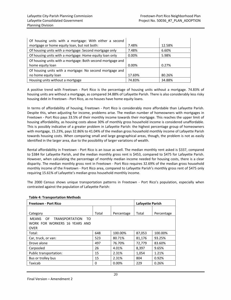
Housing units without a mortgage 74.83% 34.88%
A positive trend with Freetown ‐ Port Rico is the percentage of housing units without a mortgage. 74.83% of housing units are without a mortgage, as compared 34.88% of Lafayette Parish. There is also considerably less risky housing debt in Freetown ‐ Port Rico, as no houses have home equity loans. In terms of affordability of housing, Freetown ‐ Port Rico is considerably more affordable than Lafayette Parish. Despite this, when adjusting for income, problems arise. The median number of homeowners with mortgages in Freetown ‐ Port Rico pays 33.5% of their monthly income towards their mortgage. This reaches the upper limit of housing affordability, as housing costs above 30% of monthly gross household income is considered unaffordable. This is possibly indicative of a greater problem in Lafayette Parish: the highest percentage group of homeowners with mortgage, 15.23%, pays 32.86% to 41.04% of the median gross household monthly income of Lafayette Parish towards housing costs. When comparing small and large geographical areas, though, the problem is not as easily identified in the larger area, due to the possibility of larger variations of wealth. Rental affordability in Freetown ‐ Port Rico is an issue as well. The median monthly rent asked is $337, compared to $384 for Lafayette Parish, and the median monthly gross rent is $453, compared to $475 for Lafayette Parish. However, when calculating the percentage of monthly median income needed for housing costs, there is a clear disparity. The median monthly gross rent in Freetown ‐ Port Rico requires 32.69% of the median gross household monthly income of the Freetown ‐ Port Rico area, compared to Lafayette Parish’s monthly gross rent of $475 only requiring 15.61% of Lafayette’s median gross household monthly income. The 2000 Census shows unique transportation patterns in Freetown ‐ Port Rico’s population, especially when contrasted against the population of Lafayette Parish:
Table 4: Transportation Methods
Freetown ‐ Port Rico Lafayette Parish
Category Total Percentage Total Percentage
MEANS OF TRANSPORTATION TO WORK FOR WORKERS 16 YEARS AND OVER
Total: 648 100.00% 87,053 100.00%
Car, truck, or van: 523 80.71% 81,176 93.25%
Drove alone 497 76.70% 72,779 83.60%
Carpooled 26 4.01% 8,397 9.65%
Public transportation: 15 2.31% 1,054 1.21%
Bus or trolley bus 15 2.31% 804 0.92%
Taxicab 0 0.00% 229 0.26%

Lafayette City‐Parish Planning Commission Freetown‐Port Rico Neighborhood Plan Lafayette Consolidated Government Project No. 50036_#7_PLAN_ADOPTION Planning Division
21 Final Version – Amendment 2
Motorcycle 0 0.00% 57 0.07%
Bicycle 37 5.71% 373 0.43%
Walked 48 7.41% 1,212 1.39%
Other means 8 1.23% 925 1.06%
Worked at home 17 2.62% 2,256 2.59%
Freetown ‐ Port Rico’s population has a far more varied means of transportation to work than Lafayette Parish, and this demonstrates that the area has different transportation priorities than the parish. Only 76.7% of Freetown ‐ Port Rico residents rode alone to work, compared to 83.60% of Lafayette Parish residents. 2.31% of residents took public transportation to work, compared to 0.92% of Lafayette Parish’s population. Non‐motorized transportation also had a strong showing in Freetown ‐ Port Rico: 5.71% of residents bicycled to work, compared to 0.43% of Lafayette Parish residents and 7.41% of residents walked to work, compared to 1.39% of Lafayette Parish residents.
Table 5: Commute Time
Freetown ‐ Port Rico Lafayette Parish
TRAVEL TIME TO WORK FOR WORKERS 16 YEARS AND OVER
Total: 648 100.00% 87,053 100.00%
Did not work at home: 631 97.38% 84,797 97.41%
Less than 5 minutes 32 4.94% 2,564 2.95%
5 to 9 minutes 164 25.31% 9,809 11.27%
10 to 14 minutes 167 25.77% 15,371 17.66%
15 to 19 minutes 159 24.54% 18,435 21.18%
20 to 24 minutes 49 7.56% 14,617 16.79%
25 to 29 minutes 24 3.70% 4,096 4.71%
30 to 34 minutes 15 2.47% 9,513 10.93%
35 to 39 minutes 0 0.00% 986 1.13%
40 to 44 minutes 0 0.00% 1,291 1.48%
45 to 59 minutes 7 1.08% 2,688 3.09%
60 to 89 minutes 7 1.08% 2,246 2.58%
90 or more minutes 7 1.08% 3,181 3.65%
Worked at home 17 2.62% 2,256 2.59%

Lafayette City‐Parish Planning Commission Freetown‐Port Rico Neighborhood Plan Lafayette Consolidated Government Project No. 50036_#7_PLAN_ADOPTION Planning Division
22 Final Version – Amendment 2
Chart 3: Commute Time
Travel Time to Work
0%
5%
10%
15%
20%
25%
30%
Less
than
5 m
inutes
5 to 9
min
utes
10 to
14 m
inute
s
15 to
19
minu
tes
20 to
24
minu
tes
25 to
29 m
inutes
30 to
34 m
inutes
35 to
39
minu
tes
40 to
44 m
inute
s
45 to
59 m
inutes
60 to
89
minu
tes
90 o
r more
min
utes
Wor
ked
at h
ome
Travel Time to Work
Perc
enta
ge o
f C
om
mute
r
Freetown
Lafayette
Travel time to work for Freetown ‐ Port Rico residents varies significantly from the travel time of Lafayette Parish residents; the commuting time appears to be considerably shorter for Freetown ‐ Port Rico residents than Lafayette Parish residents in most travel time periods. In economic terms, the Freetown ‐ Port Rico neighborhood has some distinct challenges when compared to Lafayette Parish. The median household income for the area is $16,628, 45.53% of Lafayette Parish’s median household income of $36,518. The picture isn’t much brighter when examining the poverty statistics:
Table 6: Poverty Status
POVERTY STATUS IN 1999 BY AGE Freetown ‐ Port Rico Lafayette Parish
Total Percentage Total Percentage
Total: 1,123 100.00% 185,805 100.00%
Income in 1999 below poverty level: 342 30.45% 29,216 15.72%
Under 5 years 20 1.78% 2,792 1.50%
5 years 0 0.00% 510 0.27%
6 to 11 years 0 0.00% 3,017 1.62%
12 to 17 years 6 0.53% 3,212 1.73%
18 to 64 years 274 21.99% 17,046 9.17%
65 to 74 years 6 0.53% 1,385 0.75%
75 years and over 36 3.21% 1,254 0.67%
Income in 1999 at or above poverty level: 781 69.55% 156,589 84.28%
Under 5 years 28 2.49% 10,697 5.76%

Lafayette City‐Parish Planning Commission Freetown‐Port Rico Neighborhood Plan Lafayette Consolidated Government Project No. 50036_#7_PLAN_ADOPTION Planning Division
23 Final Version – Amendment 2
5 years 8 0.71% 2,385 1.28%
6 to 11 years 54 4.81% 13,950 7.51%
12 to 17 years 31 2.76% 14,679 7.90%
18 to 64 years 583 51.91% 100,551 54.12%
65 to 74 years 14 1.25% 8,903 4.79%
75 years and over 63 5.61% 5,424 2.92%
Freetown ‐ Port Rico has double the poverty rate of Lafayette Parish, 30.42% of the population compared to 15.72%. The problem is especially pronounced for individuals aged 18 to 64 years, 21.99% of Freetown ‐ Port Rico’s population compared to 9.17% Lafayette’s population.