in search of nobby's tunnels - hunter living histories · pdf file3 5.8 closer view of...
TRANSCRIPT

1
CONTENTS
PREFACE 4
COVER IMAGES 4
ACKNOWLEDGEMENTS 4
DATES FOR MACQUARIE PIER, NOBBYS’ TUNNELS ANDNOBBYS LIGHTHOUSE 5
NOBBYS’ TUNNELS - 1852 to 1854 6
1. INTRODUCTION 8
2. NIBBLING COAL AT NOBBYS 9
3. CONNECTING NOBBYS 10
4. BLASTING FOR A NEW LIGHTHOUSE 11
5. THE TUNNELS 17
5.1 EARLY TUNNEL IMAGES 17
5.2 GEOLOGICAL ASPECTS OF TUNNEL EXCAVATION 18
5.3 ENTRANCE TO TUNNEL 1 19
5.4 ENTRANCE TO TUNNEL 2 20
5.5 INSIDE THE TUNNELS 20
6. CONCLUSIONS 23
REFERENCES 24
APPENDIX 1: TUNNEL STORIES 28
2
FIGURES
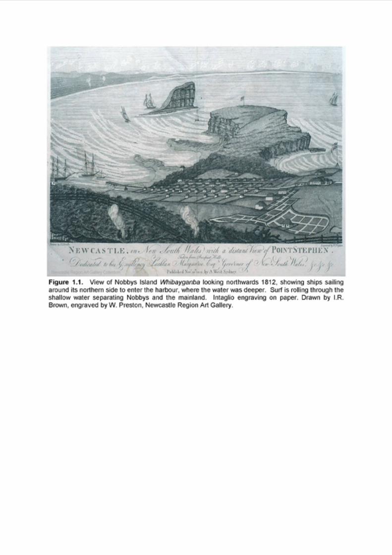
1.1 View of Nobbys Island Whibayganba looking northwards 1812.
1.2 Part of Barrallier’s 1801 chart of Coal Harbour.
1.3 Sketch of Nobbys Island Whibayganba by Sir Thomas Mitchell 1828 withNewcastle Coal Measures stratigraphy and rock types added.
1.4 Stratigraphy of the Newcastle Coal Measures.
1.5 Cross section of the Shepherds Hill Anticline defined by the Nobbys Tuff.
3.1 Southern side of Nobbys Head showing remnant of a quarry excavated for rockto build Macquarie Pier.
3.2 View of Nobbys Island Whibayganba looking northwards showing quarriedsoutheastern side 1851.
3.3 Western side of Macquarie Pier showing blocks of Waratah Sandstone coveringthe original convict-built structure.
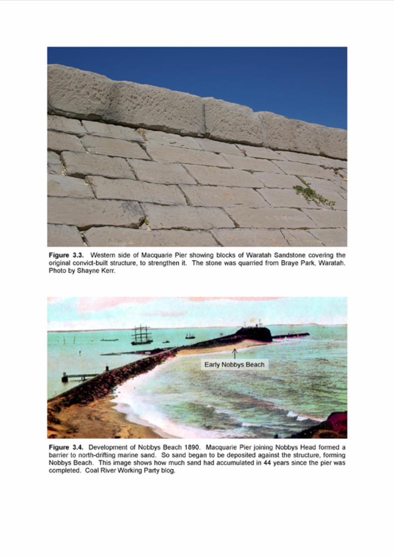
3.4 Development of Nobbys Beach.
4.1 North-south cross section of Nobbys Head by Captain Bull 1852.
5.1 William Keene’s stratigraphical sketch of Nobbys Island 1854.
5.2a Entrance to Tunnel 1 looking southwest, Pittman 1901.
5.2b Current view showing estimated position of Tunnel 1 entrance, compared toFigure 5.2a.
5.3a Entrance to Tunnel 1 looking southwest, David 1907.
5.3b Current view showing estimated position of Tunnel 1 entrance, compared toFigure 5.3a.
5.4a Dyke cutting through Nobbys Head looking northwest 1890.
5.4b Current view showing estimated position of Tunnel 2 entrance, compared toFigure 5.4a.
5.5 Geological sketch of southeastern face of Nobbys Island by Dana in 1840.
5.6 Gully eroded in weathered basalt dyke on the river side of Nobbys Head.
5.7 Outcrop of Nobbys dyke visible at low tide on the river side of the breakwater.

3
5.8 Closer view of resistant baked margin beside the dyke on the river side ofNobbys Head.
5.9 Flow structure in baked coal on the river side of Nobbys Head.
5.10 Monteath & Powys’ Survey of Nobbys Tunnels July 2008.
5.11a Entrance to Tunnel 2 looking northwest in early 1900s.
5.11b Current view showing estimated position of Tunnel 2 entrance, compared toFigure 5.11a.
5.12 Sketch map of Nobbys Tunnels, redrawn from sketch of Maurie Lynch’smemories 1994.
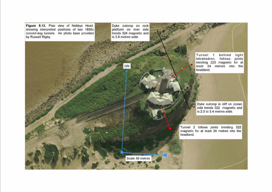
5.13 Plan view of Nobbys Head showing interpreted positions of the two 1850sconvict-dug tunnels.
5.14 Sketch map of Nobbys Head showing the two tunnels as described by D.H.Stokes 1939.

4
PREFACE
This work began as a brief report to accompany the Coal River Working Party’sproposal to the BBC Time Team in the UK in 2008. Since then I have carried outfurther research and field work to relate the history of quarrying of Nobbys IslandWhibayganba for breakwater material, the tunnels dug for blowing up Nobbys and thefinal levelling to provide a platform for the lighthouse, to the geology.
COVER IMAGES
Lower image: Part of a sketch of Nobbys Island Whibayganba by William Swainson,August 1851, after quarrying had removed some rock for building Macquarie Pier,visible in the foreground. From Coal River Working Party blog. The bulk of Nobbys iscomposed of tuff: layers of consolidated volcanic ash, the products of violent, explosiveeruptions from a distant volcano 250 million years ago.
Upper image: Superimposed on top of the lower image is a section of a photo of MtYasur volcano erupting, on the island of Tanna, Vanuatu, taken by Shayne Kerr duringour visit in 2007. The combined images represent a vision that some governmentofficials had back in the 1850s, to reduce the height of Nobbys. A lighthouse wasplanned to be built on top of the remains!
ACKNOWLEDGEMENTS
Shayne Kerr, my husband, who accompanied me on field trips to Nobbys and took finephotographs for the report.
Colleagues of the Coal River Working Party for providing much of the historicalinformation used in the report, in particular: Gionni di Gravio (Chair), Cynthia Hunter,Russell Rigby, Doug Lithgow, John Fryer and Brenda Sullivan.
5
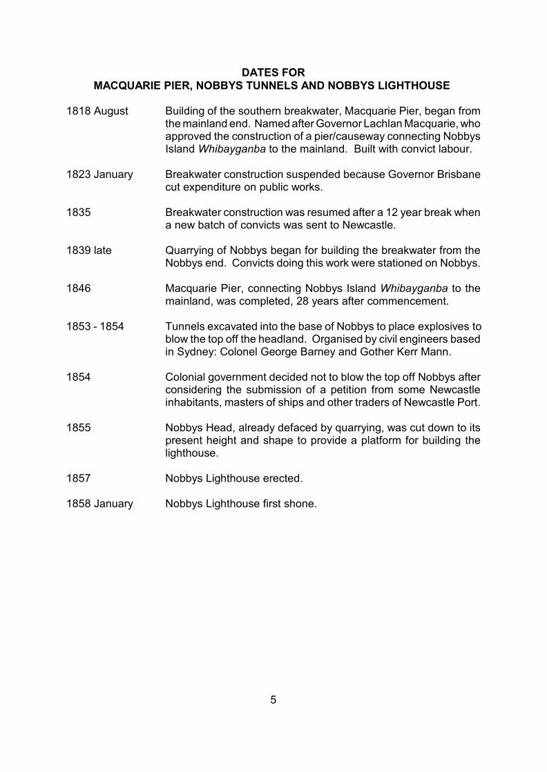
DATES FORMACQUARIE PIER, NOBBYS TUNNELS AND NOBBYS LIGHTHOUSE
1818 August Building of the southern breakwater, Macquarie Pier, began fromthe mainland end. Named after Governor Lachlan Macquarie, whoapproved the construction of a pier/causeway connecting NobbysIsland Whibayganba to the mainland. Built with convict labour.
1823 January Breakwater construction suspended because Governor Brisbanecut expenditure on public works.
1835 Breakwater construction was resumed after a 12 year break whena new batch of convicts was sent to Newcastle.
1839 late Quarrying of Nobbys began for building the breakwater from theNobbys end. Convicts doing this work were stationed on Nobbys.
1846 Macquarie Pier, connecting Nobbys Island Whibayganba to themainland, was completed, 28 years after commencement.
1853 - 1854 Tunnels excavated into the base of Nobbys to place explosives toblow the top off the headland. Organised by civil engineers basedin Sydney: Colonel George Barney and Gother Kerr Mann.
1854 Colonial government decided not to blow the top off Nobbys afterconsidering the submission of a petition from some Newcastleinhabitants, masters of ships and other traders of Newcastle Port.
1855 Nobbys Head, already defaced by quarrying, was cut down to itspresent height and shape to provide a platform for building thelighthouse.
1857 Nobbys Lighthouse erected.
1858 January Nobbys Lighthouse first shone.
6
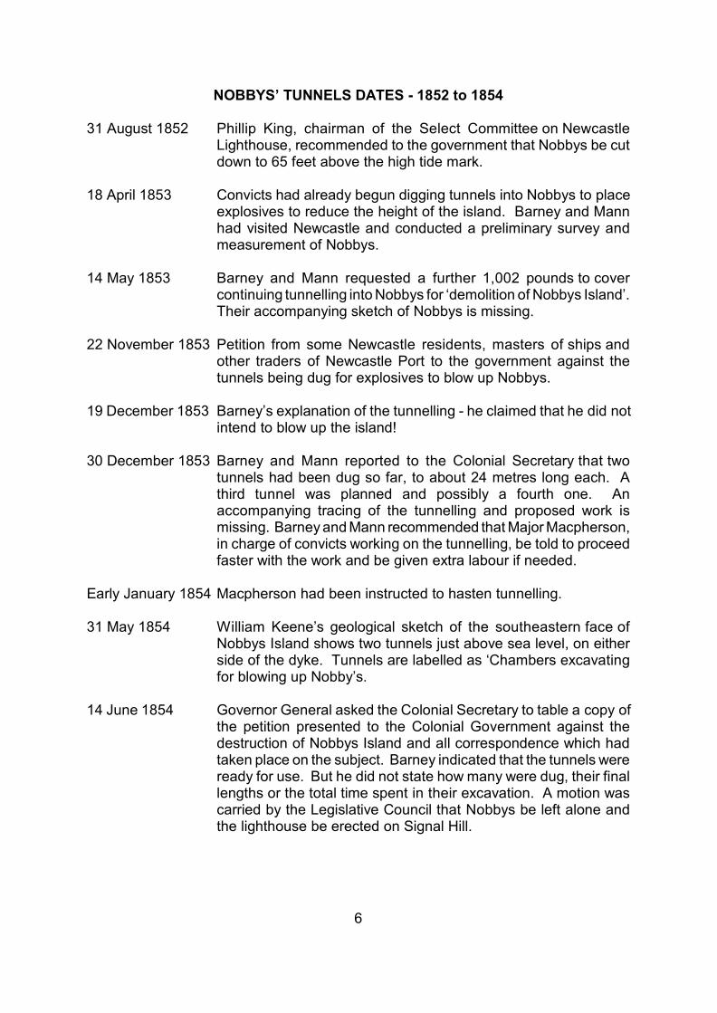
NOBBYS’ TUNNELS DATES - 1852 to 1854
31 August 1852 Phillip King, chairman of the Select Committee on NewcastleLighthouse, recommended to the government that Nobbys be cutdown to 65 feet above the high tide mark.
18 April 1853 Convicts had already begun digging tunnels into Nobbys to placeexplosives to reduce the height of the island. Barney and Mannhad visited Newcastle and conducted a preliminary survey andmeasurement of Nobbys.
14 May 1853 Barney and Mann requested a further 1,002 pounds to covercontinuing tunnelling into Nobbys for ‘demolition of Nobbys Island’.Their accompanying sketch of Nobbys is missing.
22 November 1853 Petition from some Newcastle residents, masters of ships andother traders of Newcastle Port to the government against thetunnels being dug for explosives to blow up Nobbys.
19 December 1853 Barney’s explanation of the tunnelling - he claimed that he did notintend to blow up the island!
30 December 1853 Barney and Mann reported to the Colonial Secretary that twotunnels had been dug so far, to about 24 metres long each. Athird tunnel was planned and possibly a fourth one. Anaccompanying tracing of the tunnelling and proposed work ismissing. Barney and Mann recommended that Major Macpherson,in charge of convicts working on the tunnelling, be told to proceedfaster with the work and be given extra labour if needed.
Early January 1854 Macpherson had been instructed to hasten tunnelling.
31 May 1854 William Keene’s geological sketch of the southeastern face ofNobbys Island shows two tunnels just above sea level, on eitherside of the dyke. Tunnels are labelled as ‘Chambers excavatingfor blowing up Nobby’s.
14 June 1854 Governor General asked the Colonial Secretary to table a copy ofthe petition presented to the Colonial Government against thedestruction of Nobbys Island and all correspondence which hadtaken place on the subject. Barney indicated that the tunnels wereready for use. But he did not state how many were dug, their finallengths or the total time spent in their excavation. A motion wascarried by the Legislative Council that Nobbys be left alone andthe lighthouse be erected on Signal Hill.

7
21 June 1854 Public meeting in the Court House to petition the LegislativeAssembly to inquire into the particulars of Barney’s intention toblow up Nobbys.
18 July 1854 The papers tabled on 14 June 1854 for the Governor Generalwere printed by the Government.
22 August 1854 Three tunnels had been driven into the base of Nobbys.
3 November 1854 The Select Committee on the Navigation of the River Hunterrecommended that the top of Nobbys be prepared by levelling toprovide a base for placing a lighthouse, instead of makingexplosions. So Barney’s plan to blow up Nobbys, which hadcaused so much apprehension among the residents of Newcastle,was finally abandoned.

8
1. INTRODUCTION
In the 1850s tunnels were dug into the side of Nobbys Head to place gunpowder, forblasting the top off the headland. The tunnel entrances are no longer visible. But wherewere they located? How many tunnels were excavated for this purpose? And was thegunpowder ever ignited?
When Europeans first arrived, Nobbys Head stood as a rocky island at the mouth of theHunter River. On his chart of Coal Harbour in 1801, surveyor Ensign Francis Barrallierestimated the island to be 203 feet (62 metres) high. Rigby and Fryer (2010) haveestimated that the original height of Nobbys was actually less than this, at about 142feet (43 metres). The height of Nobbys Head is now only 98 feet (30 metres).
Plans, paintings and sketches from the early 1800s depict rocky reefs and sandy shoalslying between the island and the southern shore of the river at Signal Hill (now toppedby Fort Scratchley). Surf rolled through this shallow area. There was a narrow channelnear the middle of the gap, suitable only for small craft. In 1818 Governor Macquariesounded this channel at 7 feet (2.1 metres) deep at low tide, with a width of only abouta quarter of a mile (400 metres). Sailing ships generally sailed around the northern sideof the island to enter the river, by way of a deeper channel close to Nobbys Island(Figure 1.1).
Barrallier’s chart of 1801 (Figure 1.2) shows that in plan view, Nobbys Island wastriangular in shape with a large wave-cut rock platform extending and taperingsouthwestwards into the river. Part of this rock platform is visible today, below thebreakwater on the harbour side, where it comprises mostly sandstone.
In the late 1700s/early 1800s, European traders and explorers referred to the island asCoal Island, as they could see two coal seams clearly (Figure 1.3). A lower seamoutcropped at the base of the island close to sea level (Nobbys Coal Seam), whereasanother seam was visible in the upper part of the cliff (Victoria Tunnel Coal Seam).
The sedimentary rock succession of the Newcastle Coal Measures, which makes upNewcastle’s rocky coast, is illustrated in Figure 1.4. The rocks are Late Permian in age,250 million years old. They originated as river gravels, sands and muds, peat swampsand volcanic ash. On burial and compaction they became conglomerate, sandstone,shale, coal and tuff respectively.
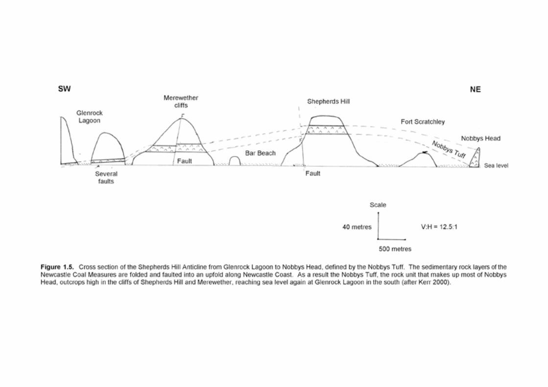
Along Newcastle’s coast the coal measures are folded into an anticline (upfold) fromGlenrock Lagoon to Nobbys Head. This structure is called the Shepherds Hill Anticlineand has some faulting associated with it. As a result of the folding and faulting theNobbys Tuff, which makes up the rocks of Nobbys Head from sea level to just belowthe top of the headland, appears much higher in the coastal cliffs of Shepherds Hill andMerewether. The tuff outcrops at sea level again further south at Glenrock Lagoon(Figure 1.5).


9
2. NIBBLING COAL AT NOBBYS
The early European settlers took coal from an outcrop of the Nobbys Seam that formeda tongue just above sea level on the southwestern side of the island. The coal probablyformed the top layer of the tapering rock platform visible on Barrallier’s chart (Figure1.2). Coal was easily laden into small boats anchored on the river side of the island.However, eddies from the surf crashing against the cliff and strong tidal currents couldsometimes make this a risky venture. Another hazard was the presence of boulderslying on the rock platform and reefs, which rolled around like giant marbles in strongsurges.
A tunnel was dug to follow the seam into the island. But no record has been found ofwhere it was located or how far it penetrated. We do know that the tunnel was dugsometime before 1852. Coal from the Nobbys Seam was of poor quality, so only alimited amount of coal was removed.
By contrast, coal of superior quality was mined extensively and more easily from splitsof the Dudley Coal Seam outcropping at Colliers Point on the river side of Signal Hill,at low tide level on the rock platform at the base of the hill, and in the undergroundconvict mine beneath the hill. Loose lumps of coal eroded from coastal outcrops werealso collected along the shoreline.
Explosives were not used for mining. Beneath Signal Hill convict miners dug coal outwith picks. Convict labourers then shovelled the coal into wheelbarrows and pushedthem from the coal face to the mine entrance, where it was loaded into baskets carryingone hundredweight (51 kilograms) each. With a basket on their backs, other convictslugged the coal almost half a mile (800 metres) to the lumber yard.
10
3. CONNECTING NOBBYS
To make the river mouth safer and easier for sailing ships to enter the port, abreakwater was built joining Nobbys Island to the southern shore. The breakwater,named Macquarie Pier after Governor Macquarie who approved its construction, wasbuilt by convicts between 1818 and 1846.
Both sides of Signal Hill were quarried to provide stone for the southern part of thebreakwater. The main rock type was sandstone. One quarry was located on theseaward, southern side of Signal Hill at the current level of Fort Drive and extendingdown onto the rock platform.
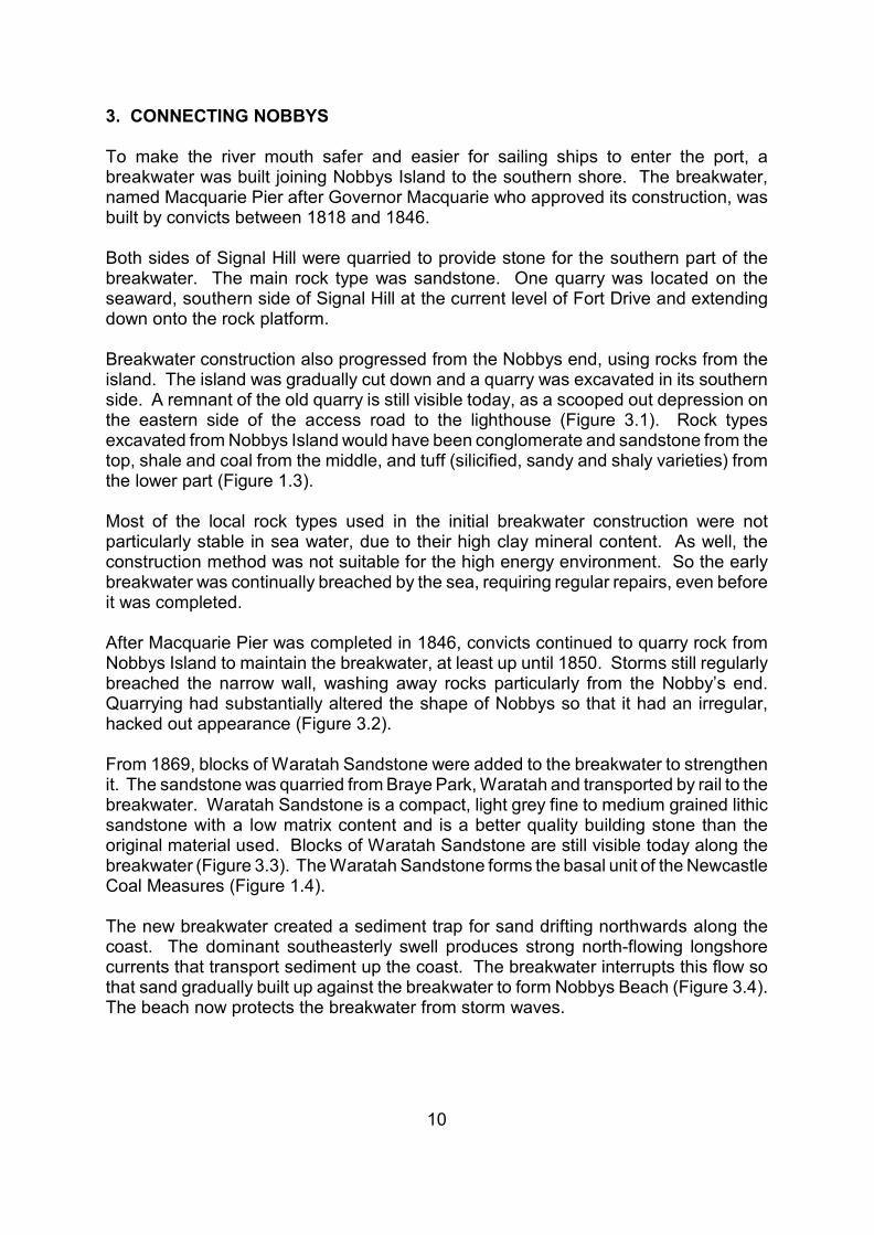
Breakwater construction also progressed from the Nobbys end, using rocks from theisland. The island was gradually cut down and a quarry was excavated in its southernside. A remnant of the old quarry is still visible today, as a scooped out depression onthe eastern side of the access road to the lighthouse (Figure 3.1). Rock typesexcavated from Nobbys Island would have been conglomerate and sandstone from thetop, shale and coal from the middle, and tuff (silicified, sandy and shaly varieties) fromthe lower part (Figure 1.3).
Most of the local rock types used in the initial breakwater construction were notparticularly stable in sea water, due to their high clay mineral content. As well, theconstruction method was not suitable for the high energy environment. So the earlybreakwater was continually breached by the sea, requiring regular repairs, even beforeit was completed.
After Macquarie Pier was completed in 1846, convicts continued to quarry rock fromNobbys Island to maintain the breakwater, at least up until 1850. Storms still regularlybreached the narrow wall, washing away rocks particularly from the Nobby’s end.Quarrying had substantially altered the shape of Nobbys so that it had an irregular,hacked out appearance (Figure 3.2).
From 1869, blocks of Waratah Sandstone were added to the breakwater to strengthenit. The sandstone was quarried from Braye Park, Waratah and transported by rail to thebreakwater. Waratah Sandstone is a compact, light grey fine to medium grained lithicsandstone with a low matrix content and is a better quality building stone than theoriginal material used. Blocks of Waratah Sandstone are still visible today along thebreakwater (Figure 3.3). The Waratah Sandstone forms the basal unit of the NewcastleCoal Measures (Figure 1.4).
The new breakwater created a sediment trap for sand drifting northwards along thecoast. The dominant southeasterly swell produces strong north-flowing longshorecurrents that transport sediment up the coast. The breakwater interrupts this flow sothat sand gradually built up against the breakwater to form Nobbys Beach (Figure 3.4).The beach now protects the breakwater from storm waves.


11
4. BLASTING FOR A NEW LIGHTHOUSE
Up until Macquarie Pier was completed in 1846, Newcastle Harbour’s navigationalsignal system comprised a heap of ignited coal on top of Signal Hill. Now that NobbysIsland was joined to the mainland and the port was becoming busier, a better signallingsystem was needed.
Following a government survey in 1851, a select committee of the Legislative Councilwas appointed on 18 June 1851 ‘to inquire into and report as to the best position andth
means for the erection of a lighthouse at the entrance of the Harbour of Newcastle’.The committee was named the Select Committee on Newcastle Light House. ColonelBarney, who features in this story, was a member of the committee. Nobbys Island wasthe preferred site for the new lighthouse. However, there was disagreement about theheight to which Nobbys should be cut down and levelled, to provide a platform for thelighthouse. The report of the Select Committee was published on 31 August 1852.st
Relevant parts of the report are summarised below.
When questioned by Mr Phillip King, the chairman of the Committee, Mr AlexanderLivingstone, Harbour Master at Newcastle, said that the height of Nobbys blockedsouthwesterly to southerly winds from ships coming into Newcastle. They weresuddenly becalmed and drifted towards the Oyster Bank, about 123 yards (112 metres)away. To prevent this inconvenience to vessels entering the harbour, he thought thatNobbys should be cut down to 25 to 30 feet (8 to 9 metres) above sea level. This wasthe height at which the inclined plane began to descend, and there was a small placecut where there was a tramroad.
In contrast, Captain John Bull, who supervised breakwater maintenance and hadworked with the rocks from the island, recommended to the Select Committee that theisland only be levelled to a maximum height of 92 feet (28 metres). He considered thatthis would be enough to remove the inconvenience to ships entering the harbour andto provide a proper foundation for a lighthouse. Conglomerate (MerewetherConglomerate) and the underlying coal and shale layers (Victoria Tunnel Seam) wouldbe removed from the top of the island. This would leave a base of solid stone, nowknown as Nobbys Tuff, for the lighthouse.
Captain Bull presented two cross sections of Nobbys, one north-south, the other east-west, illustrating the strata and profiles of the island at that time. The north-south crosssection shows that the top of Nobbys was 142 feet (43 metres) above sea level (Figure4.1). Conglomerate made up the uppermost 37 feet (11 metres). It was underlain by12 feet (3.6 metres) of coal and shale. Therefore a total thickness of 49 feet (15metres) of rock - conglomerate, shale and coal - would have to be removed to exposethe top of the Nobbys Tuff for a lighthouse platform. Nobbys Tuff made up theremaining 93 feet (28 metres) of the island down to sea level.
Although Captain Bull considered that the Nobbys Tuff would provide a solid base insitu for building a lighthouse upon, he described the rock as friable when added to thebreakwater, where ‘it falls to pieces after a shower of rain’. He also indicated that thestone that would be removed in levelling Nobbys was not suitable for building.

12
Committee member Mr Lamb asked Captain Bull if Nobbys were cut down to 65 feet(20 metres) above sea level, to the lower inclined plane (Figure 4.1), would this beenough to provide a foundation for the lighthouse? Captain Bull replied that it wasunnecessary to cut Nobbys down to 65 feet as the foundation would be in the samerock type with the same stability if it were cut down to only 92 feet above sea level. Inaddition, the lighthouse would need to be taller if its base were at 65 feet above sealevel, presuming the light was to be the current height of Nobbys, 140 feet.
In spite of this explanation, Mr Lamb still considered that Nobbys should be reduced to65 feet above sea level. He may have chosen this height as it is about half waybetween Mr Livingstone’s suggestion of 25 to 30 feet and Captain Bull’s 92 feet.
To save on labour, Mr Lamb suggested that the rock be blasted. Captain Bull repliedthat more material would need to be removed after blasting down to 65 feet above sealevel. Colonel Barney suggested that the blasted rock could be pushed eastwards ontothe rocks below.
Mr Phillip King, chairman of the Select Committee, also ignoring Captain Bull’sinformation, recommended to the government on 31 August 1852 that Nobbys be ‘cutst
down to the level of 65 feet above the high tide mark, leaving or erecting, as may befound desirable, a parapet of six feet high round the edge of the rock to protect thedwelling and the base of the Light-house from the effects of the wind’.
So what happened to Nobbys after this recommendation? The story of what followedis taken from the 1854 document on Nobby’s Island published by the LegislativeCouncil of the New South Wales Parliament, as well as from newspaper articles in theMaitland Mercury and the Sydney Morning Herald published at the time. Transcriptionsof the newspaper articles are given in Appendix 1.
In response to the feasibility of the recommendation to cut Nobbys down to 65 feetabove sea level, the Superintendent of the Breakwater, Macpherson, informed theColonial Secretary in Sydney early in 1853 that levelling Nobbys for a lighthouseplatform was estimated to take 30 convicts nearly 3 years. The rock removed would beused for plugging up holes in the breakwater. There was already a building on Nobbysthat could be used as a cookhouse for the convicts, and also a mess shed. A coupleof boilers was all that was needed to prepare meals for the convicts, so that they didn’thave to return to the jail on the mainland to eat during work time.
Three years to prepare the platform for a new lighthouse seemed a long time to theColonial Secretary. So he suggested to two civil engineers based in Sydney, LieutenantColonel George Barney then the Chief Commissioner of Crown Lands and Gother KerrMann, that the work to reduce Nobbys Island to 65 feet high could be hastened byblasting the rock off the top. Barney and Mann enthusiastically embraced the idea ofapplying gunpowder. Barney, with teams of convicts, had already blasted the island ofPinchgut in Sydney Harbour to level it for the construction of Fort Denison.
By 18 April 1853 Barney and Mann had visited Newcastle and conducted a preliminaryth
survey and measurement of Nobbys. They were preparing plans and calculations for

13
the Colonial Secretary. Groups of convicts had already begun digging tunnels into theisland for placing explosives! As accuracy was most important, the convicts neededcareful supervision. Barney and Mann requested 50 pounds for wires and otherapparatus for constructing blasting equipment.
A month later, 14 May 1853, Barney and Mann requested a further 1,002 pounds toth
cover continuing tunnelling into Nobbys for the ‘demolition of Nobby’s Island’. Anaccompanying sketch of Nobbys was enclosed with their request, but unfortunately ithas not been found. They estimated that the tunnelling would be completed in fourmonths, providing there were no unforeseen difficulties or delays. The requisitionincluded an amount for ‘procuring the services of some steady men for charging themines (tunnels) and in the laboratory’ (to prepare the explosive devices). The mostexpensive item requested was 17 tons of blasting powder, at 765 pounds. The workerswere to be lubricated by ‘2 gallons spirits of wine’. The Colonial Secretary granted1,000 pounds worth of the requisition.
However, while tunnelling was proceeding under Nobbys, some Newcastle inhabitants,masters of ships and other traders of Newcastle Port became rather concerned. Theyhad been informed that Nobbys was going to be totally destroyed by gunpowder, andthat two tunnels had already been excavated for that purpose. They believed that thenarrow channel into the port could be obstructed by its destruction. Nobbys also serveda most important role in sheltering ships entering the port in southerly gales, andNobbys was the most suitable place for a lighthouse. John Bingle Esquire J.P. from theconcerned citizens sent a petition to the Governor General, signed by 49 people, on22 November 1853.nd
In reply to the petition Barney explained on 19 December 1853 that the entire removalth
of Nobbys was not planned. It was only proposed to cut Nobbys down to 60 feet (18.3metres) above high water mark. The erection of a new lighthouse on this reducedheight had already been authorized. The work would not destroy the shelter Nobbysprovided to ships sailing into the port in southerly gales, nor would the rock removedobstruct the port’s entrance.
At the end of 1853, 30 December, Barney and Mann reported on the progress of theth
work to the Colonial Secretary. They had chosen three places within the island to lodgethe explosives and considered they would probably need a fourth spot. These locationswere plotted on a tracing, which has not been found. The tracing showed the locationsof the tunnels and how much of the planned tunnels had been dug, and how muchremained to be done. After almost 9 months of digging with picks, convicts had driventwo tunnels into the rock face, one to a distance of 77 feet (23.5 metres) and the otherto 79 feet (24 metres). As tunnel digging progressed into the island, the rock becameincreasingly dense and hard. With the convicts also being inexperienced at mining,tunnel excavation was slow. Materials for wiring and the battery for igniting theexplosives had been obtained, ready for assembling. Barney and Mann recommendedthat Major Macpherson, in charge of convicts working on the project, should beinstructed to expedite the tunnelling by ‘every available means in his power’ and begiven extra labour if needed. The Colonial Storekeeper had a sufficient supply ofgunpowder for the job.
14
In early January 1854 the Colonial Secretary informed Barney and Mann thatMacpherson had been instructed to hasten the tunnelling work!
In the Legislative Council of New South Wales on 14 June 1854 the Governor Generalth
asked the Colonial Secretary to table a copy of the petition presented to the ColonialGovernment against the destruction of Nobbys Island in preparation for building alighthouse on it, plus all correspondence between the Government, the petitioners andother parties on the matter. These papers were printed on 18 July 1854.th
The parliamentary proceedings and report at this time generated several lengthynewspaper articles on the topic (Appendix 1). From an article published in the MaitlandMercury on 17 June 1854 of the Legislative Council meeting of 14 June is Colonelth th
Barney’s explanation to the petitioners of his intentions:
‘The Chief Commissioner of Crown Lands (Colonel Barney) stated that it was notintended to blow Nobby’s up, but the operation of gunpowder was preferredbecause it would reduce the amount of labour required for cutting it down, andfor accelerating the work. It was correct that, by use of gunpowder, work couldbe performed in six or seven months which would extend over three or four yearsby the tedious process of cutting down. The mines were at present in a fit statefor use. The operation was intended to lower Nobby’s to sixty feet above highwater mark, and to make that the base of the lighthouse. By mining the lowerportion of the promontory, which would be blown seaward, the upper part wouldfall down, but a base perfectly sound and untouched would remain, affordingsufficient space for the erection of a dozen lighthouses. The action of thegunpowder had been too well calculated to admit of the possibility of the massforced by the blast being blown into the harbour, but on the contrary, it wouldprove highly beneficial in reducing the expense of labour, and also affordmaterials for the protection of the breakwater. In fact, the intended process didnot offer the slightest chance of damaging the harbour.......Colonel Barneyrecommended the use of gunpowder as more speedy and less costly. Hebelieved that by the blasting process about a third of the island would be shakenseaward, leaving a sufficient base, while the stuff cast out seaward would addto the solidity of the breakwater in course of formation. He thought that thepetitioners must be under a misapprehension, and that no injury would accrueto the harbour by the process intended.
Mr. Cowper, after the explanation made, was inclined to think the petitionersmust have laboured under a misapprehension, as he had himself, that the wholeisland was to be blown up. Still he hoped time would be given to the people ofNewcastle to express their opinions further upon the matter, for he had beenassured, not only by masters of vessels, but by engineers, that danger to theport was to be dreaded. Mr. Livingstone appeared now also to be of opinion itwould be better to leave Nobby’s alone, and place the light-house where thebeacon was now placed.
The motion was then put and carried.’
15
So by June 1854, Barney indicated that the tunnels were ready for use, but he did notstate how many were dug, their final lengths or the total time spent in their excavation.
However, a long article of 22 August 1854 in the Sydney Morning Herald, explainingnd
the objections to the plan to blow up Nobbys, indicates that three tunnels had beendriven into Nobbys just above the high water mark.
According to John Bingle in his Past and Present Records of Newcastle, New SouthWales (1873, pp14-15), a public meeting was held in the Court House on 21 Junest
1854 to petition the Legislative Assembly to inquire into the particulars of ColonelBarney’s intention to blow up Nobbys. The citizens were hoping that the tunnelling andproposed explosions would be stopped. John Bingle had previously sent a petition onthis issue, signed by 49 concerned citizens to the Governor General in November 1853.However, Barney was still not deterred. A few days before the gunpowder was due tobe ignited and Nobbys therefore demolished, Mr Thorn visited John Bingle, agreeingthat Nobbys should not be blown up. On his return to Sydney, Mr Thorn, at Bingle’srequest, called upon the Governor inducing him to postpone the explosions.
This Mr Thorn was actually Mr George Thorne of Claremont House, Rose Bay, aSydney business man and merchant who had a number of business interests inNewcastle (Gionni Di Gravio 29 September 2011 CRWP blog).th
Unfortunately, John Bingle does not give the date that Mr Thorn consulted the GovernorGeneral, convincing him to stop Nobbys being blown up. Surprisingly, Mr Thorn’simportant visit to the Governor General and the Governor subsequently stoppingNobbys being blown up is not mentioned in the 1850s newspaper articles examined sofar.
The Select Committee of the Legislative Council on the ‘Navigation of the River Hunter’,appointed on 4 July 1854, ‘to inquire into the best means of facilitating the navigationth
of the river Hunter and the improvement of the harbour of Newcastle’ considered theNovember 1853 petition opposing the cutting down of Nobbys Island and reducing itsheight by blowing it up, from some Newcastle inhabitants and others concerned with thepreservation of the Port of Newcastle. The committee personally examined some of thepetitioners, namely Mr Lodge, a master mariner and Mr Mulhall, master of the steamerCollaroy. Captain Moriaty the port master and Mr Livingstone, the harbour master ofNewcastle, also gave evidence. The committee’s report, dated 3 November 1854 andrd
published in the Maitland Mercury 11 November 1854, recommended:th
‘that the proposed lighthouse should be erected on the top of Nobby, and thatthat island should be merely prepared by levelling and thus making a ledge a fewfeet below its present summit. The adoption of this course will, it is believed,combine all the advantages which have been suggested as desirable byretaining the island for a landmark, and by placing the lighthouse not only in themost conspicuous place, but as preventing the necessity for making explosions,the idea of which has caused so much apprehension among the residents atNewcastle.’

16
After this recommendation was made in late 1854 the plan to reduce the height ofNobbys by explosions, to be initiated in tunnels dug into its base, was finallyabandoned.
In April 1855 Mr Wright, the contractor for the Hunter River Railway works, accepted thecontract to cut about 25 feet (7.6 metres) off the top of Nobbys to make a flat surfaceon which the lighthouse could be built (Sydney Morning Herald 26 April 1855, Maitlandth
Mercury 28 April 1855). The work was complete in July 1855 (Hunter 2001).th
According to Captain Bull’s cross section of Nobbys Head in 1852, the headland was142 feet (43 metres) high before levelling (Figure 4.1). Nobbys now stands 30 metreshigh. Therefore levelling to provide a base for building the lighthouse removed athickness of 13 metres. This is close to the thickness sensibly recommended byCaptain Bull but rejected by the government in 1852. The government decided thatNobbys should be cut down further to 65 feet (19.8 metres) above sea level, requiringthe removal of about 23 metres. The 13 metres of rock finally scraped off for thelighthouse platform comprised Merewether Conglomerate plus the upper part of theVictoria Tunnel Coal Seam. The conglomerate, sandstone, shale and coal wereprobably pushed seaward to add material to the breakwater.
Nobbys Lighthouse was erected in 1857 on a base of shale, within the lower part of theVictoria Tunnel Coal Seam (Figure 5.3a). Its light first shone in January 1858.
In spite of George Barney’s ill-conceived and costly project to blow up Nobbys beingstopped, he was rewarded with the appointment of Surveyor-General in succession ofSir Thomas Mitchell in October 1855.


17
5. THE TUNNELS
5.1 EARLY TUNNEL IMAGES
Only one image from the 1850s of the tunnels has been found. The stratigraphicsketch of Nobby’s Island dated 31 May 1854 by William Keene, Examiner of Coalst
Mines, shows the entrances to two tunnels on either side of the dyke, just above sealevel on the southeastern side of the headland, with the caption ‘Chambers excavatingfor blowing up Nobby’s’ (Figure 5.1).
Unfortunately, a sketch of Nobbys accompanying Barney and Mann’s request in May1853 for further funds to continue tunnelling into Nobbys has not been found. Alsomissing is a tracing by Barney and Mann that accompanied their progress report to theColonial Secretary in December 1853. The tracing showed three or possibly fourplaces that they had chosen within the island to place explosives. The progress of twotunnels already underway and how much remained to be dug were also illustrated.
Photographs of Nobbys Head taken in the late 1800s and early 1900s show two tunnelentrances at the base of Nobbys. The tunnels are located on either side of the dyke,but a lot further from it than illustrated by Keene. It appears that on Keene’s sketch thelocations of the tunnel entrances are not accurate, but just indicated that they existed.
One of the early photographs was taken by E.F. Pittman, Government Geologist, of thenortheastern face of Nobbys, showing a tunnel entrance at the base of the cliff (Pittman1901, facing page 309), (Figure 5.2a herein). The same tunnel is visible in a differentphotograph in Edgeworth David’s 1907 Memoir, plate xiii, (Figure 5.3a herein). Davidnoted that ‘the tunnel at the base of the cliff is on the Nobbys Coal Seam’. So thetunnel probably follows the top of the Nobbys Seam into the cliff. Engel (1966, p34)stated that the Nobbys Seam is exposed at high water level at the northern end ofNobbys Head. Scree and sand cover the top of the seam today. However, afterperiodical beach erosion, the author has observed the Nobbys Seam at low tide on therock platform beneath the beach, adjacent to the breakwater.
The tunnel entrance in the northeastern face is also visible in photographs taken bySnowball in 1880 and 1892. In an undated (maybe 2001) catalogue of historical photosof Newcastle and the Hunter, presented to the Newcastle Region Art Gallery by TheNewcastle Herald to commemorate the newspaper’s 125 years of service, photo no. 49shows the tunnel in the northeastern face of Nobbys. It is titled ‘The mysterious NobbysTunnels’ and is undated. The same photograph is recorded in Newcastle City Council’sHunter Photobank as no.10200017.
In this report, the tunnel in the northeastern face of Nobbys is referred to as Tunnel 1.
A photograph of the southeastern face of Nobbys taken in 1890 shows the dyke assketched by Keene, but no sign of any tunnel entrances beside the dyke. There is noevidence of back-filled tunnels as the strata are continuous across the width of thephoto (Figure 5.4a).

18
Digital copies of the historical photos used in Figures 5.2a, 5.3a and 5.4a were obtainedby Russell Rigby from David Barnes, Geological Survey of NSW.
All of the old photographs show very little scree at the base of the headland. Today,a large apron of scree (composed of clay and rocks fallen from the cliff above) masksthe old tunnel entrances. Grass and bitou bush have grown over large parts of thescree surface. The most recent rock fall debris is not yet vegetated.
5.2 GEOLOGICAL ASPECTS OF TUNNEL EXCAVATION
The Nobbys Tuff, the geological unit that makes up most of the headland, overlies theNobbys Coal Seam. The tuff consists of many layers of consolidated volcanic ash ofdiffering grainsizes, textures and susceptibility to weathering. There are three mainvarieties of tuff: sandy tuff, shaly tuff and extremely fine grained silicified tuff. Silicifiedtuff layers (enriched in silica and referred to in early publications as ‘chert’) are hard andresistant to weathering and tend to jut out from the cliff. Shaly tuff layers are clay rich,making them soft and crumbly on weathering. Faster erosion of the crumbly shaly tufflayers undercuts overlying layers of blocky silicified tuff and sandy tuff, producingoverhangs. Further undercutting of the overhangs causes unsupported blocks to fall.As a result, fallen blocks and soft clays accumulate around the base of the cliff as scree(Figures 5.3b & 5.4b).
Vertical joints (cracks) slice through the rocks. They are easily observed in the thicker,harder layers where they give the rock a blocky appearance. The spacing between thejoints in a particular layer determines the width of the blocks produced. Weatheringopens up the joints, forming planes of weakness in the rock layers. Exposed joint facesare generally coated with ‘rust’ - the brown and yellow secondary mineral limonite(hydrated iron oxide). Limonite is deposited by groundwater moving along the joints.
The prominent joint directions are NE-SW (about 043 magnetic) and NW-SE (314 to322 magnetic). From its position on the northeastern side of Nobbys, it is probable thatTunnel 1 was excavated along NE-SW joints.
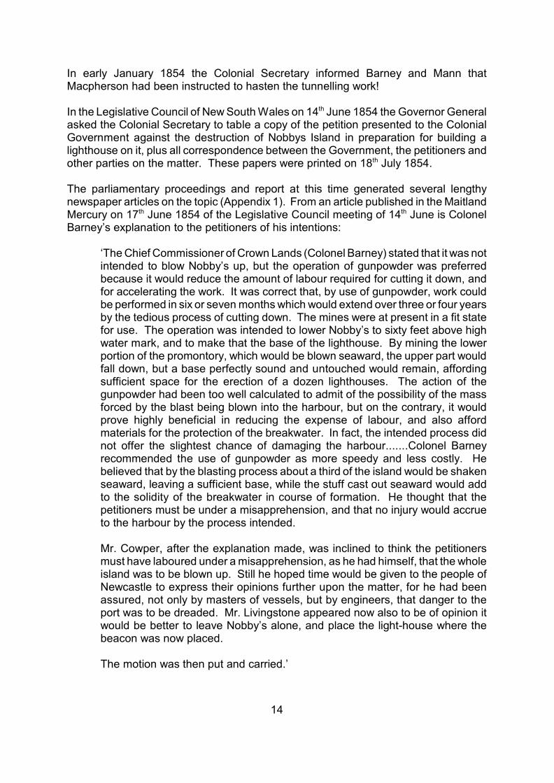
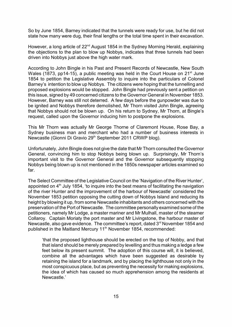
The vertical basalt dyke, standing prominently in the cliff on the ocean side, intruded thesedimentary layers along a NW-SE joint (Figures 5.4a & b). The dyke in this outcropis about 3 metres wide and trends 322 magnetic. It is chemically weathered to a lightgreen clayey rock speckled with white clay replacing feldspar crystals. Both Dana’ssketch of 1840 and the 1890s photo show a ridge of harder rock parallel to the dykeoutcrop on the beach (Figures 5.5 & 5.4a). This is interpreted as a baked margin ofcoal of the Nobbys Coal Seam, which is more resistant to erosion than the basalt.Today scree and beach sand cover the outcrop.
The dyke can be traced through the headland to the river side, where it has beeneroded to form a gully behind the concrete fort (Figures 5.2b & 5.6). At very low tides,the dyke is visible on the rock platform below the breakwater on the river side (Figures5.7 & 5.8). Here it is composed of fresh, dark grey basalt, 3.8 metres wide and trending324 magnetic. A hard, baked margin of black coal lies on both sides of the basalt dyke.The zones of baked coal, about 2 metres in width, are more resistant to erosion than

19
the adjoining basalt and stand 0.5 metres above it (Figures 5.7, 5.8 & 5.9). The coalis the Nobbys Coal Seam, which has been eroded and mined from the top of the rockplatform elsewhere.
Tunnel 2, thought to be located southwest of the dyke on the ocean side, would mostlikely have been excavated along NW-SE joints, parallel to the dyke (Figure 5.4b).
If Tunnels 1 and 2 were excavated along sets of NE-SW and NW-SE joints respectively,then the tunnels were dug in directions at approximately 90 degrees to each other.
If the dyke maintains its thickness of 3 to 4 metres through the headland and iscomposed of unweathered basalt within the headland, it would have been very hard forthe convicts, who were inexperienced at mining, to excavate using hand picks. Thedyke would have appeared as a solid, thick, hard vertical wall to the tunnel diggers. Inthis case, from a geological perspective, it appears unlikely that Tunnel 1 penetratedthe dyke and that the two tunnels, dug on opposite sides of the dyke, meet inside theheadland.
Alternatively, if the dyke is weathered right through the headland, then it may not havepresented such a problem to the tunnellers.
The lower part of the Nobbys Tuff, below the dashed pink line in Figures 5.3a & b, 5.4a& b, is more thinly bedded and contains a higher proportion of shaly tuff beds than thesection above. Combined with closer-spaced joints, these thin, fissile layers would havebeen less difficult to excavate than the thicker layers higher in the cliff. The interbeddedhard, silicified tuff layers are also thinner in the lower section. The hard, siliceousnature observed in outcrop is a weathering feature, found where the rock is exposedto the atmosphere, at or close to the Earth’s surface. In drill core and underground coalmines, silicified tuffs are less common. Therefore, as tunnelling progressed into theheadland, the silicified tuff layers may have become softer.
However, after 8 months of digging, Barney reported in December 1853 that the rockbecame increasingly hard and dense as tunnelling progressed and that excavation bythe convicts was slow (Section 4).
5.3 ENTRANCE TO TUNNEL 1
Peter Sherlock and Adrian, surveyors from Monteath & Powys, Roslyn Kerr, geologist,and Shayne Kerr, photographer, carried out a field inspection to locate possible tunnelsites at Nobbys Head on Friday 11 July, 2008. By studying historical photos of theth
northeastern cliff face in the field, the location of Tunnel 1 entrance is interpreted to liebehind the second light tetrahedron from the breakwater, behind the scree (Figures5.2a & b, 5.3a & b, 5.10).
From David’s 1907 photo, the tunnel is estimated to have been about 3 metres high atthe entrance. However, there may have been a step just inside the entrance, so thatthe tunnel had a reduced height inside the cliff.

20
5.4 ENTRANCE TO TUNNEL 2
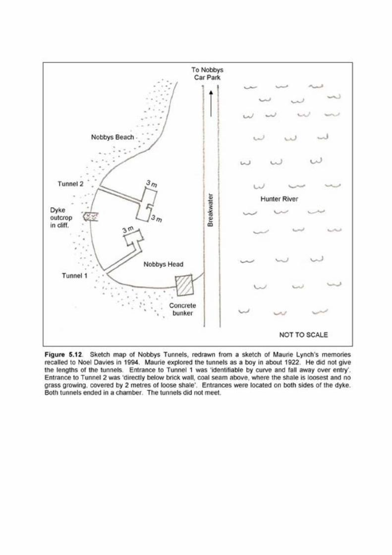
According to Keene’s sketch of 1854 (Figure 5.1), Tunnel 2 was located on thesouthwestern side of the dyke. In Figure 5.4a the photo of 1890 shows no indicationof this tunnel. Noel Davies (personal communication to the Coal River Working Partymeeting 7 July 2008, reproduced in Appendix 1), whose informant Maurie Lynch hadth
played in both tunnels as a boy in the early 1920s, indicated that Tunnel 2 lay beyondthe scope of the photo of 1890, that is, beyond the left-hand edge of the photo.Comparing the present cliff face with the 1890 view, the entrance to Tunnel 2 must liesouthwest of the vertical pink line and the light tetrahedron, at the base of the cliffbeneath the scree and beach sand (Figures 5.4a & b).
In May 2009, while viewing some historical photographs obtained by Russell Rigby fromDavid Barnes of the Geological Survey of NSW, the author recognised the possibleentrance to Tunnel 2 in a print of a glass lantern slide taken in the early 1900s. Theslide may have been taken by Pittman in 1908 or 1916. The tunnel entrance lies at thebase of the cliff, well south of the dyke, and falls within the zone that the authorpredicted for the entrance in Figure 5.4b. Comparing the photo showing the tunnelentrance with the current view of the cliff face, the entrance to Tunnel 2 is interpretedto be behind a large pile of scree, beneath two closely spaced old brick walls exposedin the top of the cliff (Figure 5.11).
This location matches the description Maurie Lynch gave to Noel Davies during a fieldinspection in 1994. Mr Lynch stated that the entrance to the tunnel was ‘directly belowbrick wall’ (Figure 5.12). The dark staining visible on the rocks below the brick wallstoday suggest the structures may be the relics of a toilet built on the cliff edge,associated with early lighthouse dwellings.
5.5 INSIDE THE TUNNELS
How long are the tunnels and what are they like inside?
In December 1853 Colonel Barney, reporting to the Colonial Secretary on the progressof the tunnelling, stated that two tunnels had been driven into the island for a distanceof about 24 metres each. Figure 5.13 plots the interpreted positions of the tunnels onan air photo plan, assuming they started from the entrances already described andfollowed the trend of the major jointing in the rocks for 24 metres into the headland.Tunnelling continued into 1854, but there is no official report of their final length. If thetunnels did not progress much past these distances, then they do not meet. However,Tunnel 1 appears to intersect the dyke!
From tunnel stories in the newspapers and Maurie Lynch’s account, young people wereable to enter and explore inside the tunnels from the early 1880s until the early 1920s,over a period of 40 years or more (Appendix 1). Sometime between the early 1920sand 1939, scree and beach sand deposits gradually built up to cover the entrances,becoming too thick for individuals to penetrate. Did the damaging Newcastle-HunterValley earthquake of 1925, described by Cynthia Hunter (1991), shake loose manyblocks of rock on Nobbys? This may have lead to substantial cliff failure and rock falls,

21
producing large amounts of scree that now hide the tunnel entrances.
An article in the Sydney Morning Herald of 13 May 1939 by G.A. King describes ath
tunnel that extended under Nobbys for about 35 feet (10.7 metres) in about 1914. Aman could stand upright at the entrance and for a short distance in, but it becamesmaller toward the end.
This article sparked the memories of others who had ventured inside the tunnels. In thesame paper a week later, 20 May, D.H. Stokes of Cremorne described two tunnels thatth
he and his companions explored many times in the early 1880s. The tunnels wereapproximately at right angles to each other. He gave estimates of the dimensions ofthe tunnels and the chambers at their ends. Tunnel 1 was about 80 feet (24.4 metres)long and Tunnel 2 was about 100 feet (30.5 metres) long. Figure 5.14 shows hisinformation plotted on a sketch map of Nobbys Head. The tunnels do not meet.
Another memory recalled in the same article of 20 May 1939 was that of Mr Davidth
Williams of Waverley. While working for the Department of Public Works he exploredthe two tunnels, but does not give the year. He said that the tunnels are of uniformheight 4 feet 6 inches (1.4 metres) and about 4 feet (1.2 metres) wide. The name‘Lieutenant Sutherland’ was written with red crayon on the face of Tunnel 1.
Mr Williams recalled his tunnel exploration again for an article in the Newcastle Herald25 August 1945. This later story is longer and slightly different from his first account.th
Again, he does not give the year he entered the tunnels. He had little difficulty enteringTunnel 1, and found that the end of the tunnel ended like a capital T with a chamberconstructed on each side. There was ample space to pack explosives and othermaterials. ‘Lieut. Shortland’ was inscribed on the face of the tunnel. He had to dighimself into Tunnel 2 as the entrance was almost blocked. The inside was finished offin the same way as Tunnel 1. Both tunnels were excavated into:
‘the same bed of rock, above high-water mark about 4 feet high and 5 feet wide.The drives were damp, but there was no water on the floor of either. I saw nocoal’.
Two local men, Maurie Lynch and Hec Scott, played in the tunnels in the early 1920swhen they were 12 or 13 years old. Hec Scott remembered:
‘the walls being flat and smooth and some kind of seating arrangements in thechambers. The tunnels were level and well formed.’ (Barney 1984)
‘...the surface was well hewn, not rough and there appeared to be a chamberthere with a table. It seemed to be too well finished to be only a tunnel boredthere to place explosives to blow the rock up. I assumed people had slept in thattunnel.’ (Scanlon’s article Newcastle Herald 20 June 1994)th
Maurie Lynch, in his visit to Nobbys with Noel Davies in 1994, recalled that theentrances to the tunnels were 8 to 10 feet (2.4 to 3 metres) above sea level, both at thesame level, and both tunnels ended in a chamber 3 metres across. The tunnels do not

22
meet (Figure 5.12 and Appendix 1).


23
6. CONCLUSIONS
1. During 1853 and 1854 convicts, using hand tools, excavated three tunnels into thebase of Nobbys Head. The tunnels, authorised by the Colonial Government, weredesigned for placing explosives to blow up Nobbys. This was deemed the quickest andmost efficient way to reduce its height to improve navigation into Newcastle Harbourand to provide a site for a new lighthouse.
2. The tunnels were planned by two civil engineers: Colonel George Barney, the ChiefCommissioner of Crown Lands and Gother Kerr Mann.
3. Prolonged public protest against the plan, for practical and environmental reasons,eventually lead the Government to abandon the proposed blasting.
4. Historical photographs indicate the location of the entrances to two of the tunnels.The entrances are just above the high tide mark at the base of Nobbys, in the NobbysTuff. Scree and beach sand now cover the entrances. A long armed excavator wouldbe required to remove this loose material to reveal the entrances. It is believed that thetunnels were never officially sealed.
5. Tunnel 1 is in the NE face and Tunnel 2 is in the SE face of Nobbys, both on theseaward side. The tunnels were dug at approximately 90 degrees to each other,following prominent SW and NW trending joints in the Nobbys Tuff. Tunnel 1 mayintersect the basalt dyke.
6. Both tunnels are at least 24 metres long, and up to 1.8 metres high and 1.5 metreswide. They open out into larger chambers at the end. The tunnels do not meetbeneath Nobbys.
7. The third tunnel may lie on the river side, its entrance covered by the breakwater,or on the southern side beneath the access road to the top of Nobbys.
8. Suggestions to find and open up the tunnels to the public have been made in thepast, for Newcastle’s 1988 bicentenary celebrations and for the city’s bicentenarycelebrations in 1997. Cynthia Hunter also recommended opening up one of the tunnelsin her report on the Coal River Historic Site, for Newcastle City Council’s Coal RiverTourism Project in 2001. The suggestions have not been followed up.

24
REFERENCES
Barney, N. 1984. The secrets of Nobbys. Newcastle Herald 3 March 1984.
Barney, N. 1993. Harbour’s ‘small clump of an island’ shines on. Newcastle Herald13 November 1993.
Bingle, J. 1873. Past and Present Records of Newcastle, New South Wales. Bayley,Son and Haywood.
Branagan, D.F. 1972. Geology and Coal Mining in the Hunter Valley 1791-1861.Newcastle History Monograph No. 6, Newcastle Public Library, New SouthWales.
Branagan, D. & Diessel, C. 1992. Newcastle Region History of Geology and MiningExcursion. 26 Newcastle Symposium on Advances in the Study of the Sydneyth
Basin, Department of Geology, University of Newcastle, New South Wales.
Branagan, D.F. & Packham, G.H. 2000. Field Geology of New South Wales.Department of Mineral Resources New South Wales, Sydney, Australia.
Comerford, J. 1997. Coal and Colonials. The Founding of the Australian Coal MiningIndustry. United Mineworkers Federation of Australia, Aberdare, New SouthWales.
Dana, J.D. 1848. Geology. United States Exploring Expedition during the years 1838- 1842 under the command of Charles Wilkes, New York.
David, T.W.E. 1907. Geology of the Hunter River Coal Measures. Memoir of theGeological Survey of NSW, 4.
Davies, N. 1996. Convict Nobbys. The Story of the Convict Construction ofMacquarie’s Pier and the Reconstruction of Nobbys Island. Noel Davies,Belmont, NSW, 51pp.
Delaney, J. 2004. Newcastle. Its First Twenty Years. The Irish Rebellion and theSettlement of Newcastle, NSW, 1804. Jack Delaney, Stockton, NSW.
Diessel, C.F.K., Warbrooke, P.R. & Roach, M. 1987. The Depositional Environmentof the Waratah Sandstone and the Borehole Seam Excursion. 21 Newcastlest
Symposium on Advances in the Study of the Sydney Basin, Department ofGeology, University of Newcastle, New South Wales.
Engel, B.A. 1966. Explanatory Notes for the Newcastle 1:250,000 Geological SeriesSheet SI/56-2. Geological Survey of NSW.

25
Hawley, P.S. & Brunton, J.S. 1995. Newcastle Coalfield. Notes to accompany theNewcastle Coalfield Geology Map. Department of Mineral Resources,Geological Survey Report GS1995/256.
Herbert, C. 1997. Relative sea level control in the Late Permian Newcastle CoalMeasures of the Sydney Basin, Australia. Sedimentary Geology 107, pp167-187.
Hunter, C. 1991. The Earth was raised up in waves like the sea... EarthquakeTremors felt in the Hunter Valley since White Settlement. Hunter HousePublications, Newcastle, New South Wales, Australia. 120pp.
Hunter, C. 2001. Coal River Tourism Project. Coal River Historic Site, Stage One.Historical analysis of sites and related historical and cultural infrastructure.Report to Newcastle City Council.
Kelly, M. 2011. Sizing up one of Nobbys tall stories. Newcastle Herald 11 January2011.
Kerr, R. 2000. The Bathers Way Geology & Landscape. Report to NewcastleTourism/City Strategy, Newcastle City Council. NCC library referenceQ559.442/KERR.
Mitchell, T. 1828. Sir Thomas Mitchell’s 1828 field book. Coal River bloghttp://coalriver.files.wordpress.com/2008/09/whibayganba_1828.jpg.
Newcastle Herald. ?2001 Hunter History Collection, catalogue of exhibition tocelebrate the newspaper’s 125 years of service. The Newcastle Herald.
New South Wales Parliament. Legislative Council Select Committee. 1852. Reportfrom the Select Committee on Newcastle Light House with Appendix andMinutes of Evidence. Ordered by the Council to be printed 31 August 1852.st
Sydney: Government Printing Office. Coal River Working Party blog.
New South Wales Parliament. Legislative Council. 1854. Nobby’s Island. A Copy ofany Petition presented to the Colonial Government against the destruction ofNobby’s Island, at the entrance to the Harbour of Newcastle, preparatory toerecting a Light House upon it; and of all Correspondence which may have takenplace between the Government and the Petitioners, or any other parties, uponthe subject. From 31 January 1853 to 31 December 1853. Laid upon thest st
Council Table by the Colonial Secretary, and ordered by the Council to beprinted 18 July 1854. Coal River Working Party blog.th
Pittman, E.F. 1901. The Mineral Resources of New South Wales. Geological Surveyof NSW, 487 pp.
Rigby, R. & Fryer, J. 2010. A small round rock or island - Reshaping Nobbys.http://coalriver.files.wordpress.com/2011/01reshapingnobbys_version2.pdf.

26
Sherlock, P. 2008. Survey Investigation 11/7/2008 of Nobbys Tunnels. Monteath &Powys. For Coal River Working Party.
Sutherland, L. & Graham, I. 2003. Geology of Barrington Tops Plateau. Its Rocks,Minerals and Gemstones, New South Wales, Australia. The Australian MuseumSociety, 56pp.
Turner, J. 1997. Joseph Lycett. Governor Macquarie’s convict artist. Hunter HistoryPublications, Newcastle, NSW, 146pp.
Unknown compiler. 2002. Nobbys Headland, The Bathers Way. Extracts fromprevious reports. For Newcastle City Council. NCC library referenceQ994.42/BAT.
Online Resources
Australian Dictionary of Biography, Online Edition. Barney, George (1792-1862)Australian National University http://www.adb.online.anu.edu.au/biogs/A010058b.htm
Australian Trove digitised newspapers and more (eg Sydney Morning Herald)http://trove.nla.gov.au
Coal River Working Party http://coalriver.wordpress.com/
Maitland Mercury Online http://www.nla.gov.au/ferguson
Newspaper Articles referring to Nobbys’ Tunnels, transcribed in Appendix 1.
Sydney Morning Herald 4 August 1853th
Maitland Mercury 17 June 1854th
Maitland Mercury 1 July 1854st
Sydney Morning Herald 5 July 1854th
Sydney Morning Herald 22 August 1854nd
Maitland Mercury 11 November 1854th
Sydney Morning Herald 26 April 1855th
Maitland Mercury 28 April 1855th
Newcastle Sun 2 May 1918nd
Sydney Morning Herald 13 May 1939th

27
Sydney Morning Herald 20 May 1939th
Newcastle Morning Herald 25 August 1945th
Newcastle Herald 20 June 1994th
28
APPENDIX 1 - TUNNEL STORIES
Newspaper articles and an eye witness account referring to Nobbys tunnels arepresented below. Unless otherwise stated, the articles were transcribed by the author.
1853 NEWSPAPER ARTICLE IN SYDNEY MORNING HERALD 4 AUGUST pageth
2.Extract from ‘Legislative Council. Wednesday’ August 3, 1853.
Mr. Cowper found there were three public works progressing at Newcastle,performed by convict labour, - the breakwater, the erection of a light-house onNobby’s Island, and the wharfs: he wished to know under whose directions theconvicts were instructed for these three works; and whether the convicts soemployed were all under the superintendence of the superintendent of convicts?He also wished to know whether the works at Nobby’s had been commenced,and what progress had been made in them?
The Colonial Secretary could offer no definite answer to the last question of thehon. member without further inquiry. A report on the subject had been requiredfrom Major Macpherson at Newcastle, who stated that to cut down Nobby’s tothe extent necessary would require large gangs of convicts. In consequence ofthis report, the Superintendent of Convicts and the Civil Engineer went down toNewcastle at the request of the Government, and had reported that the labourmight be greatly decreased by blasting the rock, by forming chambers in it, anddepositing large charges in them, to be fired by electricity. The rock so blastedwould be thrown out eastward, and thus would form a support to the breakwater.He supposed the work of forming these chambers was going on. The dispositionof the convicts was, of course, under the authority of the Superintendent; but hesupposed the greater number were employed in the completion of thebreakwater.
1854 NEWSPAPER ARTICLE IN MAITLAND MERCURY 17 JUNE.th
Extract from ‘Legislative Council. Wednesday, June 14, 1854. (Abridged from theSydney papers.)’
LIGHT-HOUSE AT NEWCASTLE
Mr. Cowper moved for returns of any petition presented to the governmentagainst the destruction of Nobby’s Island at the entrance to the harbour ofNewcastle, preparatory to erecting a light-house upon it; and for allcorrespondence on the subject. In making this motion Mr. Cowper remarkedthat he was a member of the committee which recommended that Nobby’sIsland should be cut down to sixty feet above high-water mark, so as to make abase for the erection of the light-house. But the inhabitants of Newcastle andthe masters of vessels trading to the port were alarmed to find that instead ofbeing content with this, the engineer superintending the works was boringchambers with the intention of blowing up the whole mass with gunpowder. Andfurther consideration had indeed induced many masters of vessels frequentingthe port, and other competent persons, to believe that it would be better not to
29
cut down Nobby’s at all, but to erect the light-house upon Beacon Hill. And hebelieved that in December last a petition was forwarded to the Governor Generalfrom the inhabitants of Newcastle and the masters of vessels, praying that anenquiry might be made before Nobby’s was blasted, and suggested that thelight-house should be placed on Beacon Hill instead of Nobby’s. He believedthat the chambers for blasting were nearly completed. They had occupied amuch longer time than the whole process was expected to take, and the workwould cost far more than anticipated, 2000 pounds being the total estimate,while the gunpowder alone would cost 1000 pounds. But how ever the factsstood, it was evident that it was essential that the intentions of the governmentshould be ascertained. While on the subject, he would urge on the governmentthe duty of taking immediate measures for the improvement of the port ofNewcastle, the trade of which was rapidly growing, and where forty or fiftyvessels were lying. Yet the wharves were left in a disgracefully dilapidated andinefficient condition, and the masters of vessels complained that great damagewas being done to the harbour by the sand coming down and drifting into it.
Captain King seconded the motion.
The Colonial Secretary, in replying, read the petition referred to. It stated thatthe entrance to the port was indicated to mariners by the remarkablepromontory, formerly an island, known as Nobby’s, which was most important insheltering vessels from southerly gales, and a most eligible site for a light-house;that the memorialists had heard that it was intended to destroy the saidpromontory by means of gunpowder, which they believed would obstruct theentrance to the port, the channel being already exceedingly narrow, and theyprayed enquiry, in order that the promontory might be preserved, for thepurposes of shelter, and for erecting a light house thereon. This petition wasreferred to Colonel Barney, who in reply pointed out that it was not intended toentirely remove Nobby’s, as appeared to be apprehended, but only to cut it downto sixty feet above high water mark; that the works in progress would not tend todestroy the shelter now afforded to vessels entering the port, nor to obstruct theentrance. The Colonial Secretary proceeded to explain that the use ofgunpowder had been resorted to, because it would be much quicker and lesscostly than the process of cutting down; blasting taking six months, and cuttingdown three or four years.
The Chief Commissioner of Crown Lands (Colonel Barney) stated that it was notintended to blow Nobby’s up, but the operation of gunpowder was preferredbecause it would reduce the amount of labour required for cutting it down, andfor accelerating the work. It was correct that, by use of gunpowder, work couldbe performed in six or seven months which would extend over three or four yearsby the tedious process of cutting down. The mines were at present in a fit statefor use. The operation was intended to lower Nobby’s to sixty feet above highwater mark, and to make that the base of the lighthouse. By mining the lowerportion of the promontory, which would be blown seaward, the upper part wouldfall down, but a base perfectly sound and untouched would remain, affordingsufficient space for the erection of a dozen lighthouses. The action of the
30
gunpowder had been too well calculated to admit of the possibility of the massforced by the blast being blown into the harbour, but on the contrary, it wouldprove highly beneficial in reducing the expense of labour, and also affordmaterials for the protection of the breakwater. In fact, the intended process didnot offer the slightest chance of damaging the harbour.
Captain King thought the explanation just made was satisfactory as to the cuttingdown Nobby’s only to the desired height for the lighthouse, and removed theapparent apprehension that the whole island was to be removed. As to the otherpoints, of the loss of shelter to vessels by Nobby’s being cut down, and thedanger of blocking up the channel by fragments thrown out by the blasts, hewould say a few words. On the first point, the angle formed by Nobby’s was sosmall, that it was dangerous for vessels to anchor within it, and when compelledto do so by necessity, they ought to warp up into the harbour, particularly duringa gale from the south-east, when the swell was heavy. So Mr. Livingstone, theharbour master, whose long experience entitled his opinion to respect, said inhis evidence, referring to the inconvenience caused to vessels entering, from theheight of Nobby’s, that with the wind at south-west, south-south-west, or south,they were down on the Oyster Bank before they got a true wind. Mr. Livingstonealso was of the opinion that Nobby’s was the best place for the light-house, andthe Flag Staff Hill for a battery - although this latter position it had beensuggested would not command some points where a ship might lie off and onand throw shot into the town, although it commanded the entrance. The reportof the committee (of which he was chairman) was very brief, and simplyrecommended Nobby’s to be cut down to sixty-five feet, leaving a parapetround; and this he thought from observations elsewhere made, would have beena very simple work. But the engineer superintending the works stating that itwould take three or four years to cut down forty feet, Colonel Barneyrecommended the use of gunpowder as more speedy and less costly. Hebelieved that by the blasting process about a third of the island would be shakenseaward, leaving a sufficient base, while the stuff cast out seaward would addto the solidity of the breakwater in course of formation. He thought that thepetitioners must be under a misapprehension, and that no injury would accrueto the harbour by the process intended.
Mr. Cowper, after the explanation made, was inclined to think the petitionersmust have laboured under a misapprehension, as he had himself, that the wholeisland was to be blown up. Still he hoped time would be given to the people ofNewcastle to express their opinions further upon the matter, for he had beenassured, not only by masters of vessels, but by engineers, that danger to theport was to be dreaded. Mr. Livingstone appeared now also to be of opinion itwould be better to leave Nobby’s alone, and place the light-house where thebeacon was now placed.
The motion was then put and carried.
31
1854 NEWSPAPER ARTICLE IN MAITLAND MERCURY 1 JULY, page 4.st
Extract from ‘Legislative Council. Tuesday, June 27, 1854 (Abridged from theSydney papers)’
NOBBY’S ISLAND
Mr Cowper presented a petition from certain inhabitants of the city of Newcastle,masters of vessels, and others trading the port of Newcastle, praying thatNobby’s Island may not be destroyed or reduced until further investigation.Petition received.
1854 NEWSPAPER ARTICLE IN SYDNEY MORNING HERALD 5 JULY, page 4.th
Extract from ‘Legislative Council. Tuesday, July 4, 1854.’
Mr Cowper enquired if the Government intended to take any steps inconsequence of the petition which he had on the former day presented againstthe destruction of Nobby’s Island?
The Colonial Secretary was unaware of any intention on the part of theGovernment to swerve from the course they were at present pursuing withregard to Nobby’s Island. In the course of proceedings going on they had beenguided by the advice of their own officers.
1854 NEWSPAPER ARTICLE IN SYDNEY MORNING HERALD 22 AUGUST.nd
Extract from ‘Newcastle, Burwood, and Stockton, No. 1'.
Inasmuch, as in the various plans suggested for the improvement of thenavigation of the harbour of Newcastle, and the affording safer means of ingressand egress, the partial destruction of Nobby Island appears to be stronglyrecommended by some influential officers of the Government; (by whose orders,indeed, exploding chambers have already been constructed at its base on theseaward side) - it may be desirable to inquire into the expediency of thisthreatened proceeding which is contemplated with almost universaldisapprobation, not only by the inhabitants, but by every well-informedshipmaster who trades with the port, and whose experience in respect to itsnavigation renders his opinion valuable. We will premise our remarks upon thisisland by reminding our readers that the Colonial Secretary, lately, in his placein Council, stated, that the officer who had recommended the partial destructionof Nobby desired only to reduced it to within 65 feet of the water level; or, merelyto blow off the sea front of the island. Now, we will set out by expressing ourutter inability to understand how any part of the island can possibly be leftstanding after the explosion of the large quantity of powder which it has beenproposed to place in the three chambers, driven at a level, very little above highwater mark. We feel perfectly assured, that by such an explosion as iscontemplated, the whole mass of rock of which the island is formed must,necessarily, be so reft and rent, as to end in its entire demolition for anypurposes of light-house foundation. Our reasons for expressing so unqualifiedan opinion, we proceed to explain; observing that the remarks we are about to
32
offer, are the result of a careful personal examination of the island.
The original formation of Nobby was mainly flinty Chert ......The Chert of Nobbyis compact, and in many places laminar; of crystalline hardness; splintery, andconchoidal in its fracture; sharp in its fragments; opaque, but translucent on theedges; grey, green; red, and black in color..........When split into parallel laminaethe Chert of Nobby makes an excellent slate, freely taking the lead pencil. Somespecimens which we procured promise to make serviceable hones.....fromNobby and the rocks on the seaboard from Newcastle to Burwood - the line towhich our inspection was limited, and which presents an interesting series ofgeological phenomena - most remarkable and valuable specimens may beprocured.
...we return to our argument against the demolition of Nobby Island.
Having shown that its original formation was (nearly in whole) chert, or keralite,we have now to describe a more modern and a most important feature in itspresent composition, namely, the interesting geological phenomenon of a dykeof trachyte completely intersecting the rock from its base to the conglomerate atits summit. This dyke, whilst its invasion cut the island into two several parts,has made no sensible derangement of the planes of its stratification, butpresents the appearance of a vertical and massive wall of masonry, running ina direct course, N. to E., across the island, which in all probability owes to thistrappean invasion its preservation from the destroying cause which the seawaves, ever rolling at its base, presents. “There is nothing,” says Sir CharlesLyell, “which affords so much protection to a mass of strata against theundermining action of running water as a perpendicular dyke of hard rock”; andthis protection is, in every respect, afforded to Nobby by the dyke we aredescribing, and which consists of far harder materials than the strata which ittraverses.
That dykes, or walls of trap-rock, such as this, are analogous to volcanicproducts, and distinctly referable to former submarine eruptions, no one, wepresume, can for a moment doubt. The trap dyke, dividing Nobby, then, is ofigneous origin, injected, it must be assumed, in a melted state through the olderstrata, but since forming a compact wall of lava, the parallelism of the oppositesides of which correspond almost as regularly as the two opposite faces of amassive artificial structure. In altitude, it is about 200 feet, in vertical extentabout 300 feet at the base, diminishing, upwards, to 150 feet; in breadth 6 feetfrom the base to the summit. A coal-black coating, something like pitch-stone,is found at the contact of the dyke with the invaded strata; whilst the blackcompact lava, long since cooled down under the pressure of the sea, may betraced far into the water on both sides of the rock.
Such, then, is the composition of the strata and the intercalating dyke of Nobby,the sea-front of which, only, the Colonial-Secretary assured the Council itintended to blow down! Now, if the powder chambers had been driven only onthe sea-side of the dyke, we can understand that the effect of the explosion

33
might be as desired. But, as there are chambers on each side of this volcanicwall, their explosion would so rupture the whole of the island that the remainswould have to be taken down to the level of the chambers, and thus the nowproud Nobby would present the same ludicrous appearance which Pinchgutalready exhibits in the harbour of Port Jackson. The gallant officer, whose rock-destroying penchant we are considering, appears to regard all rocks as liftingtheir intrusive heads only to be “blown down”; just as a certain high legalfunctionary declares that his clerks exist only to be “blown up”.
....We have many precedents in England of the demolition of large masses ofchalk cliff; but those rocks were of a much more homogeneous character thanthat of the thin layers of the chert of Nobby, which by such an explosion, orrather explosions, as proposed, would be shaken to pieces like a drystone wall.And cui bono! let us ask, if the result of the explosions were to equal theexpectations of the engineer. In the first place, one of most picturesquelandmarks of the Australian coasts would be wantonly destroyed and effacedfrom the charts of their navigation. Secondly, another foundation for alighthouse would have to be sought, whilst now a most eligible one exists.Thirdly, the shelter from the south winds, which Nobby now affords to hundredsof vessels, annually, that safely anchor under the rock until the tide allows themto enter the port - would no longer be afforded; and, where one vessel is nowdriven on the Oyster Bank, in consequence of running too far to make the shelterof Nobby available, a hundred will (it is too probable) be driven there when theprotecting rock no longer exists.
Having thus, at some length, referred to an important question, upon which veryconflicting opinions have been submitted to the Legislature, we shall concludeby observing that, not only in our deliberate judgment is the site of Nobby thebest that Newcastle possesses for the construction of a light-house, but frompersonal inspection we do not hesitate to say, that a sufficiently securefoundation is now ready for the erection of a shaft (say 100 feet high), on theplatform at the end of the breakwater tramway....
In connexion with our protest against the destruction of Nobby, we wouldsuggest, that the summit of the rock is naturally the most eligible site for the flag-staff and the signal station; as the platform already described is the most properand legitimate foundation for the light-house. On the summit, according to actualmeasurement, an area of 150 square feet can be railed in - a space sufficient forall purposes of signal manoeuvering; and this, which is the highest point on thispart of our coast line, would become much more prominent by the shaft andlantern of the light-house towering high above it. The connecting closely, by thismeans, the two establishments would be economical in the financial sense;seeing that the attendants of both would be under the surveillance of onesuperintendent.

34
1854 NEWSPAPER ARTICLE IN MAITLAND MERCURY SAT 11 NOVEMBER,th
SUPPLEMENT.Council Papers. Navigation of the River Hunter.Report from the Select Committee on the Navigation of the River Hunter.By chairman of the committee, Mr. George R. Nichols, Legislative CouncilChamber and member for the Northumberland Boroughs, Sydney, 3 Novemberrd
1854.
The select committee of the Legislative Council, appointed on the 4 July, 1854,th
“to inquire into the best means of facilitating the navigation of the river Hunterand the improvement of the harbour of Newcastle,” and to whom were referredtwo petitions, one from certain inhabitants of the city of Newcastle, masters ofvessels and others trading to the port of Newcastle, praying that Nobby’s Islandmay not be destroyed or reduced without further investigation; and one fromcertain inhabitants of the Hunter River district and others interested in itsprosperity, praying that measures may be taken for improving the navigation ofthe river Hunter - have agreed to the following report:-
Your committee considered it proper to examine personally some of thepetitioners who had expressed themselves as opposed to the cutting downNobby’s Island, and still more to the reducing its height by blowing it up - forwhich preparation had been made by the Colonial Government. They thereforerequested the attendance of Mr. Lodge, of Newcastle, who has been for manyyears engaged in the trade of the port as a master mariner, and of Mr. Mulhall,master of the steamer Collaroy. Their evidence will be found appended to thisreport. The committee have also taken the evidence of Captain Moriaty the portmaster, and of Mr. Livingstone, the harbour master of Newcastle. The evidencethus given is unquestionably conflicting, but having duly considered the variouspoints urged by these gentlemen, and the opinions expressed by themrespectively, your committee have determined to recommend that the proposedlighthouse should be erected on the top of Nobby, and that that island should bemerely prepared by levelling and thus making a ledge a few feet below itspresent summit. The adoption of this course will, it is believed, combine all theadvantages which have been suggested as desirable by retaining the island fora landmark, and by placing the lighthouse not only in the most conspicuousplace, but as preventing the necessity for making explosions, the idea of whichhas caused so much apprehension among the residents at Newcastle.
1855 NEWSPAPER ARTICLE IN SYDNEY MORNING HERALD THURS 26 APRILth
page 5.
Mr. Wright has accepted a contract for reducing the conical point on Nobby’sIsland, at the entrance to Newcastle, preparatory to the erection of a lighthousethereon. The work will be commenced immediately.

35
1855 NEWSPAPER ARTICLE IN MAITLAND MERCURY SAT 28 APRILTH
SUPPLEMENT page 2.
Mr Wright, the contractor for the Hunter River Railway works, has entered intoa contract with the Government to cut about 25 feet off the top of Nobby’s island,to make a flat surface on which a light-house can be erected. The soil is to bethrown out seaward, to strengthen the breakwater. The work was to becommenced yesterday morning, a number of the men who arrived for the HunterRiver Railway being employed on it.
1918 NEWSPAPER ARTICLE IN NEWCASTLE SUN 2 MAY.nd
Extract from ‘Newcastle Streets. History and Nomenclature. Great namesrecalled’.
Bingle Street: Named after Captain James Bingle, who led a deputation toSydney to preserve Nobbys. Captain Barney, then military commandant, hadcaused two tunnels each 150 ft long, with chambers for explosives to be driveninto the landmark, which he desired to demolish so as not to rob of the windsailing vessels approaching the port. The name of Lieutenant Sutherland iscarved at the end of the tunnels where they met. Probably he was in charge ofthe working gangs.
1939 NEWSPAPER ARTICLE IN SYDNEY MORNING HERALD 13 MAY page 13.th
Extract from ‘NOBBY’S ESCAPE A Gunpowder Plot of the Fifties. By G A King.’
That the proposal to remove Nobby’s was regarded seriously is certain from thefact that a public meeting, held at Newcastle on June 21, 1854, protestedagainst the scheme. An old book in which Newcastle is described says; “TheGovernment at one time, acting upon the suggestion of Colonel Barney, of theRoyal Engineers, intended to remove Nobby’s by blasting”.
About 25 years ago the tunnel extended under Nobby’s for about 35 feet. At theentrance, and for a short distance in, it was high enough for a man to standupright, but toward the end it was much smaller. In recent years rocks anddebris have fallen from the cliff face, sand has been washed from the sea, andall trace of the tunnel has been obliterated. The entrance has been entirelyobscured.
1939 NEWSPAPER ARTICLE IN SYDNEY MORNING HERALD 20 MAY, page 13.th
NOBBY’S TUNNELS.
Mr. D. H. Stokes, Cremorne, writes:-I read with great interest Mr. G. A. King’s notes on the tunnel in Nobby’s,Newcastle. There were two tunnels in the lower part of this rock. The onereferred to by Mr. King as being on the seaward (eastern face) penetrated in awesterly direction for about 100 feet, midway of which was a branch to the leftof about 30 feet, which terminated in a chamber. At the far end, the main tunnelturned to the right for about 30 feet, and terminated in a chamber.

36
The other tunnel was approximately at right angles to the first, and, entering thenorthern face passed in a southerly direction for about 80 feet, finishing with ashort turn to the left and a chamber. The tunnels were not more than 5 feet wideand 6 feet high. The terminal chambers were about 15 feet long by 8 feet wide,of oval shape, and about 7 feet high.
With a candle, matches, one or two companions, something to eat, a toy cannonand some gunpowder, I explored these tunnels many times in the early eighties.I have no recollection of seeing any coal faces in the tunnels or indications ofcoal strata in the external faces of the rock at the level of the tunnels.
There were somewhat similar tunnels in a coal seam in what was then known asAllan’s or Signal Hill.
The story current about the intention of blowing up Nobby’s is correct, I believe,the reason given being that its removal would be an aid to navigation in and outof the port. Fortunately, wiser counsels prevailed.
Mr. David Williams, Waverley, writes:-At the age of 25 years I was employed by the Public Works Department atNewcastle, when Mr. J. Walker, an official of the department, asked me toexplore the tunnels, as the superintendent wanted some information regardingthem. The entrance was almost closed by debris. After removing some dirt, Ientered the eastern tunnel and, taking my time, walked to the face with the aidof a lighted candle. The drives are of the uniform height of 4 feet 6 inches andabout 4 feet wide.
On the face of the eastern drive was the name, “Lieutenant Sutherland”, writtenwith red crayon. It is evident, to my mind, that the work was done for thepurpose of blowing up the nob.
1945 NEWSPAPER ARTICLE IN NEWCASTLE MORNING HERALD 25 AUGUSTth
page 5.When Nobbys was Tunnelled.
Mr D. Williams, of Bondi, recalled recently an attempt that was made to drive atunnel under Nobbys, the conspicuous headland at the entrance to the HunterRiver. This is his story.
‘I was for years employed in the Harbours and Rivers Department. At the timeI speak of, Mr. Percy Allan was Superintendent of Public Works, and theforeman engineer under him was Mr. John Walker. It was popular talk thattunnels had been driven into Nobbys base. Mr Allan wished to know what theywere, and whether they were driven above or below the coal, which is still to beseen in the outcrop there and in the hills running along in a southerly direction.I accepted the job to find out, being a practical miner. Armed with a pick andcandles, I had little difficulty in entering the tunnel driven from the eastern faceof Nobbys. After I got my eyesight I proceeded to the face, sounding the roof as
37
I proceeded. On the face of the tunnel there had been inscribed 'Lieut.Shortland', the name of the discoverer of the Coal (Hunter) River. Each side ofthe tunnel face chamber was constructed. The end of the drive resembled thecapital letter T. Ample space was provided to pack explosives and othermaterials.
I had to dig myself into the drive, going into Nobbys from the south. It wasalmost blocked up at the entrance, but inside it was constructed and finished offjust the same as was the other drive from the east. I found that the drives weredriven in the same bed of rock, above high-water mark about 4 ft. high and 5 ft.wide. The drives were damp, but there was no water on the floor of either. I sawno coal. That mined from Nobbys was probably got from a tunnel down on theNewcastle side of the knob.’
This newspaper article was transcribed and supplied by Gionni Di Gravio.Article brought to our attention and provided courtesy of Mr Frank Maxwell.
1994 NOTES BY NOEL DAVIES OF VISIT WITH MAURIE LYNCH TO NOBBYS 16th
FEBRUARY.
Visit to Nobbys with Maurie Lynch age 85 from 41 Stanley St Hamilton on 16-2-1994, 10 am. Day overcast, still, tide low.
Maurie’s memory was perfect. Demonstrated by the location of prickly pears,harbour and coal seam. Both tunnels instantly located, pictures taken. Born inZaara St. Lived in Shepherd St. Identified with ‘Sandhills’ - mentioned memorialslab at Baptist tabernacle as an address ‘Sandhills’.
Visited caves at age 12-13 with his mate Hec. Scott. Had to dig away 2 holend
to enter, said 2 hole was best. Stated that he thought the harbour blastingnd
would have caused cave ins. ‘I knew every rock by its first name’.
Fiesty old gentleman, did his time as a cabinet maker with David CohensFurniture, put off during the depression. Keen Newcastle Surf Club (ski) man allhis life. Fished and surfed Nobbys area.
Adamant about the tunnels and the fact that Barney was going to blow itcompletely up. Entrance about 8 to 10 feet above sea level, both at same level.Maurie insisted that the chambers existed. He did suggest that perhaps therewere others from the breakwater side, but he did not see them.
Noel included a sketch plan of the two tunnels with labels (Figure 5.12).
1994 NEWSPAPER ARTICLE IN NEWSPAPER HERALD 20 JUNE.th
Extract from ‘Time to unlock secrets of Nobbys tunnels: historian’ by MikeScanlon.
A prominent Newcastle historian is promoting the idea of opening up three

38
mystery tunnels beneath Nobbys headland as a way of generating greater publicinterest in Newcastle’s bicentenary celebrations in 1997.
Dr John Turner said on site on Friday that the sealed tunnels, possibly from thecity’s convict past, had tantalised history buffs for generations....
He said he could not take credit for the idea of opening the tunnels, which wasfirst mooted in 1988 by fellow history sleuth and author Mr Terry Callen, ofStockton.
Mr Callen said that in 1988 he had been warned that bureaucratic red tape mightstrangle a Nobbys tunnel project, but he did not believe it.
‘Any suggestion we’d be opening the tunnels and I think we’d have half ofNewcastle there,’ Mr Callen said.
‘Back then, the mines rescue people even volunteered to go in first once anytunnel was opened.
‘And it might only take a bulldozer five minutes to remove debris from a tunnelmouth.’
Mr Callen said a 1892 photograph showed a tunnel ‘cave’ at the base of the rockdirectly beneath Nobbys Lighthouse.
Another tunnel was said to face south. The position of the third was unknown.
‘Why the tunnels were there is all very mysterious,’ he said.
‘The late Mr Hec Scott, a Newcastle surfing identity, told me he onceremembered going into one.
‘He said the surface was well hewn, not rough and there appeared to be achamber there with a table.
‘It seemed to be too well finished to be only a tunnel bored there to placeexplosives to blow the rock up.
‘I assumed people had slept in that tunnel.’