in the matter of canterbury...
TRANSCRIPT

IN THE MATTER OF section 71 of the Canterbury Earthquake
Recovery Act 2011 and the Canterbury
Earthquake (Christchurch Replacement
District Plan) Order 2014
AND
IN THE MATTER OF proposals notified for incorporation into a
Christchurch Replacement District Plan
Date of hearing: 30 and 31 March, 1, 2, 8, 10, 14, 16, 17, 20–23 April 2015
Date of decision: 10 December 2015
Hearing Panel: Hon Sir John Hansen (Chair), Environment Judge John Hassan
(Deputy Chair), Dr Philip Mitchell, Ms Sarah Dawson
___________________________________________________________________________
DECISION 10
RESIDENTIAL (PART)
(AND RELEVANT DEFINITIONS AND ASSOCIATED PLANNING MAPS)
___________________________________________________________________________
Outcomes: Proposals changed as per Schedule 1
Directions to update Planning Maps made as per [452]
Clause 13(4) directions made as per [454]
2
Residential (Part) — Stage 1
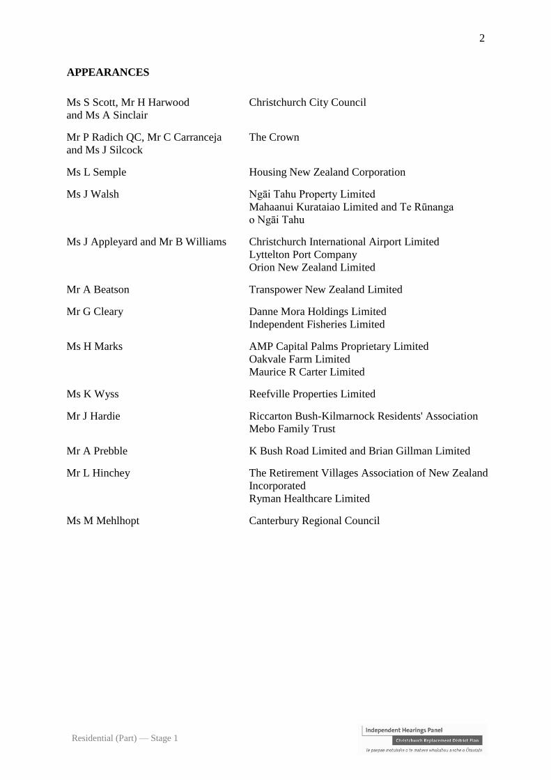
APPEARANCES
Ms S Scott, Mr H Harwood
and Ms A Sinclair
Christchurch City Council
Mr P Radich QC, Mr C Carranceja
and Ms J Silcock
The Crown
Ms L Semple Housing New Zealand Corporation
Ms J Walsh Ngāi Tahu Property Limited
Mahaanui Kurataiao Limited and Te Rūnanga
o Ngāi Tahu
Ms J Appleyard and Mr B Williams Christchurch International Airport Limited
Lyttelton Port Company
Orion New Zealand Limited
Mr A Beatson Transpower New Zealand Limited
Mr G Cleary Danne Mora Holdings Limited
Independent Fisheries Limited
Ms H Marks AMP Capital Palms Proprietary Limited
Oakvale Farm Limited
Maurice R Carter Limited
Ms K Wyss Reefville Properties Limited
Mr J Hardie Riccarton Bush-Kilmarnock Residents' Association
Mebo Family Trust
Mr A Prebble K Bush Road Limited and Brian Gillman Limited
Mr L Hinchey The Retirement Villages Association of New Zealand
Incorporated
Ryman Healthcare Limited
Ms M Mehlhopt Canterbury Regional Council

3
Residential (Part) — Stage 1
INTRODUCTION.................................................................................................................... 5
Effect of decision and rights of appeal .................................................................................. 5
Identification of parts of existing district plans to be replaced ............................................. 6
Conflicts of interest ................................................................................................................ 6
REASONS ................................................................................................................................. 7
STATUTORY FRAMEWORK .............................................................................................. 7
Issues raised by submissions .................................................................................................. 8
Statutory documents and our obligations in regard to them ................................................. 8
THE COUNCIL’S S 32 REPORT ........................................................................................ 13
SECTION 32AA EVALUATION ......................................................................................... 16
Introduction.......................................................................................................................... 16
The choice of zones and their purposes ............................................................................... 17
The objectives....................................................................................................................... 18
The policies .......................................................................................................................... 19
The range of activity classes including the addition of controlled activities ....................... 24
Approach to public and limited notification and non-notification of consent applications 27
Intensification and the extent of RMD and RSDT zoning .................................................... 28
Whether Council decisions to reduce originally identified areas of RMD zoning
appropriate .......................................................................................................................... 34
Incentivising amalgamation for high quality comprehensive development ......................... 46
Other changes have been made also mindful of assisting intensification ........................... 49
Constraints of the airport noise contours for sensitive housing and other development .... 49
National Grid and electricity distribution lines and proximate activities and structures ... 68
Older persons’, social and affordable housing and student accommodation ..................... 78
Education and health and veterinary care and emergency services and temporary training
.............................................................................................................................................. 99
Community correction and community welfare facilities .................................................. 100
Places of worship and spiritual facilities........................................................................... 104
Other non-residential activities in the residential zones ................................................... 105
Residential design assessment and control ........................................................................ 106
Controls as to the visual transparency of fences ............................................................... 111
Built form standards for the various zones ........................................................................ 114
Policy 14.1.5.5 deferred ..................................................................................................... 114
Carlton Mill Road height limits – Richard Batt................................................................. 115

4
Residential (Part) — Stage 1
Other rezoning requests and miscellaneous mapping errors corrected ............................ 117
Amendments to Decision 3 on the Repair and Rebuild of Multi-unit Residential Complexes
............................................................................................................................................ 119
Definitions .......................................................................................................................... 120
Replacement of provisions ................................................................................................. 120
Directions for consequential changes to Planning Maps and specified Figures and
Appendices ......................................................................................................................... 121
Timetabling and other cl 13(4) directions ......................................................................... 122
Overall evaluation and conclusions................................................................................... 123
Schedule 1 ............................................................................................................................. 124
Schedule 2 ............................................................................................................................. 252
Schedule 3 ............................................................................................................................. 254

5
Residential (Part) — Stage 1
INTRODUCTION
[1] It can be observed that this decision is issued some eight months after the conclusion of
the hearing. Given the direction in cl 12 of the OIC1 that we deliver decisions as soon as
practicable, that delay is regrettable. A significant contributor to that was our need to
substantially restructure and rewrite much of the Notified Version such that we could be
satisfied that it met a sufficient standard of drafting clarity and coherence, including in relation
to other chapters.
[2] This decision concerns part of the notified Stage 1 proposal for Chapter 14 Residential
(which part we refer to as the ‘Notified Version’).2 It does not concern the provisions of the
Notified Version set out in Schedule 2, as the hearing and determination of these has been
deferred to Stages 2 and 3 of our inquiry.
[3] In its closing submissions, the Council proposed a revised set of provisions in response
to issues raised in submissions and evidence (‘Revised Version’). We have made a significant
number of substantive and structural changes to the Revised Version, for the reasons we set
out. These are set out in Schedule 1 (‘Decision Version’). Our Decision Version will become
operative upon release of these decisions and the expiry of the respective appeal periods.
Effect of decision and rights of appeal
[4] The procedures that will now apply for implementation of this decision as part of the
replacement district plan for Christchurch City (including Banks Peninsula) (‘CRDP’) are as
set out in our earlier decisions.3
[5] Under the OIC, any person who made a submission (and/or further submission) on the
Notified Version, the Council, and the Ministers4 may appeal our decision to the High Court
(within the 20-day time limit specified in the OIC) on questions of law (and, in the case of a
submitter, only in relation to matters raised in the submission).
1 Canterbury Earthquake Recovery (Christchurch Replacement District Plan) Order 2014 (‘OIC’). 2 Further background on the review process, pursuant to the OIC, is set out in the introduction to the Panel’s decision
on Strategic directions and strategic outcomes (and relevant definitions) (‘Strategic Directions decision’), 26 February
2015. 3 See in particular Strategic Directions decision at [5]–[9]. 4 The Minister for Canterbury Earthquake Recovery and the Minister for the Environment, acting jointly.
6
Residential (Part) — Stage 1
Identification of parts of existing district plans to be replaced
[6] The OIC requires that our decision also identifies the parts of the existing district plans
(‘Existing Plan’)5 that are to be replaced by the Chapter. We return to this later.
Conflicts of interest
[7] We posted notice of any potential conflicts of interest on the Independent Hearings Panel
website.6 In the course of the hearing, it was identified on various occasions that submitters
were known to members of the Panel. In some cases, that was through previous business
associations. In other cases, it was through current or former personal associations. Those
disclosures (and, on some matters, member recusals) were recorded in the transcript, which
was again available daily on the Hearings Panel’s website. No issue was taken by any
submitter. After the hearing, and prior to our deliberations, panel member John Sax was
reported in the Christchurch Press (and associated electronic print media) as criticising the
Council’s performance in the handling of resource management matters. While the comments
were made in his personal capacity and were not directly about the matters in issue in the
hearing, Mr Sax decided he should recuse himself, and took no part in our deliberation or in
the making of this decision.
5 Comprising the Christchurch City District Plan and the Banks Peninsula District Plan. 6 The website address is www.chchplan.ihp.govt.nz.

7
Residential (Part) — Stage 1
___________________________________________________________________________
REASONS
___________________________________________________________________________
STATUTORY FRAMEWORK
[8] The OIC directs that we hold a hearing on submissions on a proposal and make a decision
on that proposal.7
[9] It sets out what we must and may consider in making that decision.8 It qualifies how the
Resource Management Act 1991 (‘RMA’) is to apply and modifies some of the RMA’s
provisions, both as to our decision-making criteria and processes.9 It directs us to comply with
s 23 of the Canterbury Earthquake Recovery Act 2011 (‘CER Act’).10 The OIC also specifies
additional matters for our consideration.
[10] Our Strategic Directions decision, which was not appealed, summarised the statutory
framework for that decision. As it is materially the same for this decision, we apply the analysis
we gave of that framework in that decision as we address the various issues in this decision.11
On the requirements of ss 32 and 32AA RMA, we endorse and adopt [48]–[54] of our Natural
Hazards decision.12
7 OIC, cl 12(1). 8 OIC, cl 14(1) . 9 OIC, cl 5. 10 Our decision does not set out the text of various statutory provisions it refers to, as this would significantly lengthen
it. However, the electronic version of our decision includes hyperlinks to the New Zealand Legislation website. By
clicking the hyperlink, you will be taken to the section referred to on that website. 11 At [25]–[28] and [40]–[62]. 12 Natural Hazards (Part) (and relevant definitions and associated planning maps), 17 July 2015, pp 20-21.
8
Residential (Part) — Stage 1
Issues raised by submissions
[11] We have considered all submissions and further submissions received on the Notified
Version. The significant number of issues raised make it impractical to address all submissions
individually, and the OIC does not require that we do so.13 Instead, in many cases, we have
grouped submissions according to relevant provisions.14 As the issues raised generally pertain
to the substance of the Notified Version and/or how it applies or ought to apply to particular
land or other submitter interests, we deal with the issues in the context of our s 32AA evaluation
later in this decision.
[12] As directed at the pre-hearing meeting, the Council filed a Statement of Issues for the
Residential Proposal.15 A number of the issues it identified were resolved between the parties
prior to, and during the course of, the hearing. We also received and considered various
memoranda in relation to those agreed issues. We have also had regard to the Council’s
recommendations in its filed ‘Accept/Accept in Part/Reject Table’. Except where our decision
has departed from those recommendations, we have accepted them and find them supported by
the evidence. Although we were assisted by those documents, we record that our inquiry is,
necessarily, broader. Our function is to hold a hearing on submissions on a proposal, and to
make a decision on a proposal.16 In making a decision on a proposal, we are directed to address
those matters we have outlined at [8]–[10] above.
[13] Schedule 3 lists witnesses who gave evidence for various parties, and submitter
representatives.17
Statutory documents and our obligations in regard to them
[14] On the matter of the relevant statutory documents (‘Higher Order Documents’) and our
obligations in regard to them, we endorse and adopt [39]–[45] of our Strategic Directions
decision.18
13 OIC, Schedule 3, cl 13(3). 14 OIC, Schedule 3, cl 13(2). 15 [Updated] Statement of Issues for the Residential Proposal, 23 February 2015 and Memorandum of counsel for the
Crown requesting additional matters be added to Christchurch City Council’s updated Statement of Issues for the
Residential Proposal, 4 March 2015. 16 OIC, cls 10(1)(a) and (b), 12(1)(a) and 13(1). 17 Counsel appearances are recorded on page 2. 18 We note that changes were made to the CRPS and Regional Coastal Environment Coastal Plan to enable the Council
to either avoid or mitigate new development in urban areas located within high hazard areas and in relation to the
responsibilities for managing coastal hazards which took effect from 12 June 2015. They do not affect this decision.

9
Residential (Part) — Stage 1
Land Use Recovery Plan
[15] The Land Use Recovery Plan (‘LURP') specifies an overall target of 20,742 new
households to be provided through infill and intensification across the Greater Christchurch
area by 2028. It also specifies related targets for the proportion of intensification growth to
total household growth during specified phases through to 2028.
Canterbury Regional Policy Statement 2013
[16] The Canterbury Regional Policy Statement 2013 (‘CRPS’), which was modified through
the LURP, gives related directions, most notably as follows.19
[17] Objective 6.2.1 — ‘Recovery framework’ sets an overall direction that recovery,
rebuilding and development are enabled within Greater Christchurch through a land use and
infrastructure framework that delivers 12 specified outcomes. These are about enabling urban
development according to specified priorities and attributes.
[18] Objective 6.2.2 — ‘Urban form and settlement’ has particular bearing on how much
provision should be made in district plans in Greater Christchurch for population growth, where
intensification should be allowed for, and what choices of housing type should be provided for.
Its introductory words express an intended overall outcome, namely that the “… urban form
and settlement pattern in Greater Christchurch is managed to provide sufficient land for
rebuilding and recovery needs and set a foundation for future growth, with an urban form that
achieves consolidation and intensification of urban areas, and avoids unplanned expansion of
urban areas”. This is to be “by” the means identified in the following seven subparagraphs.
Specific to the consideration of the Notified Version are paragraphs (1) and (2):
(a) Paragraph (1) addresses “intensification”, meaning “an increase in the residential
household yield within existing urban areas”.20 It sets intensification percentage
targets, as proportions of overall growth, for three specified “recovery” time
periods (35 per cent averaged over the period 2013–2016, 45 per cent over the
period 2016–2021, 55 per cent over the period 2022–2028). These are soft targets,
in that they are aims to be achieved. They do not allocate particular district
19 Leaving aside those provisions of particular relevance to the NNZ provisions to be heard at a later stage. 20 CRPS, definitions, page 202.
10
Residential (Part) — Stage 1
proportions, but are instead for the Greater Christchurch area as a whole. However,
this is further addressed in Policy 6.3.7 below.
(b) Paragraph (2) concerns an aspect of intensification, i.e. “higher density living
environments including mixed use developments and a greater range of housing
types”. Notably, it states that these are to be “particularly in and around the Central
City, Key Activity Centres and larger neighbourhood centres and in greenfield
priority areas, and brownfield sites”.
[19] The explanation to Objective 6.2.2 gives some further indication of the intention. It reads
(our highlighting on aspects of greater relevance to intensification):
Principal reasons and explanation
The rebuilding and recovery of Greater Christchurch rely on appropriate
locations, quantity, types, and mixes of residential and business development to
provide for the needs of the community.
Consolidation of existing urban settlements is the form of development most likely
to minimise the adverse effects of travel for work, education, business and
recreation, minimise the costs of new infrastructure and avoid adverse effects of
development on sensitive landscapes, natural features and areas of high amenity.
This will enable Greater Christchurch to build back better, and support the recovery of
central Christchurch. Greater intensification within Christchurch’s urban area
through infill (particularly in the Central City, and around Key Activity Centres,
and neighbourhood centres) and brownfield redevelopment will reduce the need for
further expansion of peripheral areas, and some intensification of the centres of smaller
towns is also expected to meet changing needs. A significant proportion of
intensification will take place in the city rather than Selwyn and Waimakariri;
however, the contribution of these areas to the overall growth pattern is important. The
objective sets targets for the contribution of infill and intensification as a
proportion of overall growth, and aligns with the growth management approach
in the Greater Christchurch Urban Development Strategy. Where monitoring
indicates that these levels are not being achieved, further policy responses may be
required to increase intensification within existing urban areas
Changing demographic patterns, including an ageing population and smaller
households, are expected to increase the desirability of higher density housing. The
demolition and ageing of housing stock provides an opportunity for redevelopment
at higher densities and an increased range of housing types that provides not only
choice for those needing to relocate, but also for future generations. Increased
intensification is anticipated to occur over time as rebuild opportunities are
realised, requiring appropriately located and designed greenfield development
that also provides for medium density housing during the time of transition.
Following the earthquakes and the subsequent damage and red zoning of properties, a
number of Māori have sought to return to and live on the Māori Reserves set aside by
the Crown in the 19th century for the then present and future needs of local Ngāi Tahu.

11
Residential (Part) — Stage 1
Providing for development opportunities on those reserves will enable the descendants
of the original grantees to return and realise the original intent of those reserves...
[20] Policy 6.3.7 — ‘Residential location, yield and intensification’ gives more specific
direction on intensification, particularly the following in paragraphs (2), (4) and (6):
(a) Paragraph (2) states that “Intensification in urban areas of Greater Christchurch is
to be focussed around the Central City, Key Activity Centres and neighbourhood
centres commensurate with their scale and function, core public transport routes,
mixed-use areas, and on suitable brownfield land”; and
(b) Paragraph (4) specifies that “Intensification development within Christchurch City
[is] to achieve an average of: … 50 household units per hectare … within the
Central City; … 30 household units per hectare … elsewhere”;
(c) Paragraph (6) specifies how “[h]ousing affordability” is to be addressed, including
“by providing sufficient intensification and greenfield priority area land to meet
housing demand during the recovery period” and “providing for a range of lot
sizes, densities and appropriate development controls that support more intensive
developments such as mixed use developments, apartments, townhouses and
terraced housing”.
[21] Policy 6.3.5 — ‘Integration of land use and infrastructure’ directs that “Recovery of
Greater Christchurch is to be assisted by the integration of land use development with
infrastructure” and specifies how this is to be achieved. It gives direction relevant to the
consideration of ‘new development’ (which we read to encompass both residential greenfield
and intensification development). Those directions are given in relation to both the choice of
locations for, and the controls that should be applied to, new development so as to assist land
use and infrastructure integration. Amongst the directions given are directions as to “avoiding
noise sensitive activities within the 50dBA Ldn airport noise contour for Christchurch
International Airport”, subject to stated exceptions. We return to the consideration of this
policy later in this decision.

12
Residential (Part) — Stage 1
[22] Policy 6.3.2 — ‘Development form and urban design’ applies, amongst other things, to
residential development. It directs that effect be given to its specified principles of “good urban
design” and to the principles of the NZ Urban Design Protocol.
Strategic Directions objectives and OIC Statement of Expectations
[23] The Strategic Directions objectives are now part of the CRDP. We must be satisfied that
the relevant policies and rules of the Notified Version will implement them: ss 75(1) and 76(1)
RMA. Several have some bearing on our consideration of the Notified Version.
[24] Paragraphs (a), (b) and (i) of the Statement of Expectations pertain to the clarity, focus
and efficiency of regulation. These matters are also explicitly addressed in Strategic Directions
Objective 3.3.2, which has the intended pre-eminence specified in the Interpretation provision
of that chapter. As we later discuss in our s 32AA evaluation, the Notified Version was
deficient in several respects, in terms of these matters. Also, as we later explain, our Decision
Version makes several structural and substantive changes to the Revised Version so as to better
implement Objective 3.3.2, and better respond to the Statement of Expectations.
[25] Specifically, on the substance of this decision, we note Objective 3.3.4 concerning
housing capacity and choice. It specifies:
(a) For the period 2012 to 2028, an additional 23,700 dwellings are enabled through a
combination of residential intensification, brownfield and greenfield development;
and
(b) There is a range of housing opportunities available to meet the diverse and
changing population and housing needs of Christchurch residents, including:
(i) a choice of housing types, densities and locations; and
(ii) affordable, community and social housing and papakāinga.
[26] The Statement of Expectations in Schedule 4 to the OIC includes paragraphs (c)–(e), on
the effective functioning of the urban environment in light of the earthquakes, facilitating an
increase in the supply of housing, and ensuring sufficient and suitable development capacity.
13
Residential (Part) — Stage 1
We have considered these expectations and are satisfied that they are essentially subsumed by
the specific directions in the CRPS and in Objective 3.3.4 of the CRDP as noted above.
THE COUNCIL’S S 32 REPORT
[27] The Council’s s 32 RMA report21 (‘s 32 Report’/‘Report’) provides an evaluation of the
Notified Version, including a summary of the strategic context, a discussion of identified
issues, and a description of the “scale and significance” evaluation undertaken and its
conclusions. It also includes a summary of consultation undertaken, and an extensive set of
appendices including staff and consultant reports relied on for the evaluation. We find it is
sufficient to cover the requirements of s 32 RMA.
[28] However, the quality of its evaluation is revealing, especially on two matters where the
Council’s ultimate position before us was significantly different from what it proposed in the
Notified Version. One matter concerns the absence of any controlled activity class under the
Notified Version. The other concerns the inclusion in the Notified Version of rules on “life-
stage inclusive and adaptive design for new residential units” (‘Life Stage and Adaption
Rules’).
[29] Relevant to these matters, we note that the Report includes a qualification that the “s 32
[evaluation] has not focussed on those provisions that reduce the level of regulatory control
unless reducing the level of regulatory control is likely to give rise to adverse effects on the
community.” We do not read that qualification as saying that the Council gave no attention to
the importance of avoiding unnecessary or undue regulation. Indeed, the OIC Statement of
Expectations emphasises the importance of due attention to this. However, the qualification
does betray some lack of rigour in this regard, and we consider that this is evident in the way
the Report fails to properly examine activity classification options and rules on the Life Stage
and Adaption Rules.
[30] There is very little commentary on controlled activity classification in the Report.
Instead, it reads as if a philosophical design choice against the use of controlled activity
classification within the CRDP had already been made and did not require evaluation.
21 “Section 32 Residential Chapter 14”, notified 27 August 2014.

14
Residential (Part) — Stage 1
Consistent with that, in questioning by the Panel, one Council witness referred to a “reticence”
by the Council towards use of the controlled activity classification.22
[31] In particular, nowhere in the Report do we identify any evaluation of the relative costs,
benefits and risks of the Council’s election to use restricted discretionary activity, over
controlled activity, as the entry classification for resource consents. Rather, the minimal
commentary focusses on the relatively greater certainty and focus that restricted discretionary
activity classification has over more stringent activity classes (such as discretionary activity).
[32] The unfortunate consequence of this positional stance against the use of the controlled
activity class in the design of the Notified Version was that obvious opportunities to minimise
cost and uncertainty were missed, leading to a divergence between the Notified Version and
the OIC Statement of Expectations. That was noted by a planning peer review witness called
by the Council, Mr Andrew Macleod.23 It was also to be acknowledged by the Council’s
planning witness, Mr Blair, who recommended a number of potentially suitable controlled
activity re-classifications in his answer to the Panel’s questions early in the hearing.24
Ultimately, it led to a number of changes from restricted discretionary to controlled activity
classifications being recommended in the Revised Version.
[33] The commentary in the Report on the Life Stage and Adaption Rules of the Notified
Version also betrays a philosophical mindset that resulted in a failure to robustly scrutinise the
costs, benefits and risks of the regulation proposed.
[34] The Report was informed by background analysis, notably a report by consultants Jasmax
(‘Jasmax Report’).25 It also includes an associated quantitative analysis of potential additional
building costs, but we did not find any quantitative analysis of the additional transaction costs
that the Life Stage and Adaption Rules would impose. The Jasmax Report noted that it did not
directly address the impacts of associated construction costs on different market price points,
that the additional costs would represent a higher proportion of construction costs for the lower
value market segments, and that it would be “worthwhile” to evaluate the implications of the
22 Transcript, page 268, lines, 8–16 (Mr Blair). 23 Evidence in chief of Andrew MacLeod on behalf of the Council at para 3.4. 24 Transcript, page 294, lines 1–45, page 295, lines 1–36 (Mr Blair). 25 Jasmax, “Homestar Cost-Scoring Appraisal for Christchurch City Council”, December 2013 Revision 0.1.

15
Residential (Part) — Stage 1
proposed policy on the affordability of houses. It also included the qualification that there
would be a “crossover” with building consent controls and potential impacts on building
design, consenting and development processes.26
[35] The Jasmax Report expresses the view that the approach of providing good information
and incentivising good design in other centres has not been effective in achieving significant
change in the approach to building design in those centres. From that starting point, the s 32
Report effectively adopts the position that regulation is the better approach to achieving change
and hence that its Life Stage and Adaption Rules are the most appropriate. Several steps of
evaluation are noticeably absent, bearing in mind the cautions expressed in the Jasmax Report.
This is despite the very significant extent to which the Notified Version would have regulated
the fabric of dwelling design across the city. In effect, it proposed to require at least a restricted
discretionary activity consent for every new dwelling that failed to comply with a plethora of
restrictions on things such as the location and design of door handles, the location of electrical
switches, television and computer outputs, the design of window controls, the required space
around beds and in laundries, the design of shower spaces and the distance between toilet pans
and walls.
[36] As we later discuss, the evidence of Dr Humphrey for the Canterbury District Health
Board (‘CDHB’) in particular identifies several benefits for people and communities to be
gained from better life stage and energy efficient housing design and construction. However,
those benefits do not make any less important the robust testing of the benefits, costs and risks
of alternative regulatory and non-regulatory methods according to s 32. The responsibility for
that regulatory analysis falls to the Council. In the case of the proposed Life Stage and
Adaption Rules, the Council’s inadequacy of effort was shown by the fact that it did not call
evidence in support of them.
[37] By contrast to the s 32 Report for the Commercial and Industrial chapters, there is no
underpinning economic assessment (other than for the confined purposes just noted). We
suspect the lack of Council investment in that discipline was a significant cause of the many
disproportionately costly and uncertain provisions of the Notified Version that we have
rejected.
26 Jasmax Report, page 17.

16
Residential (Part) — Stage 1
[38] We make the general observation that robust economic assessment usually will be of
assistance to decision makers tasked with s 32 responsibilities.
SECTION 32AA EVALUATION
Introduction
[39] The Decision Version differs significantly from both the Notified Version and the
Revised Version as finally recommended to us by the Council. Those differences are extensive
in both structure and substance. However, we are satisfied that these can be made within the
scope of the Notified Version, with two exceptions that we address below. Those relate to
additional areas of RMD zoning and the Orion 11kV Heathcote to Lyttelton electricity
distribution line (‘11kV Lyttelton line’). Those are the only cases that we find to call for
notification of a new proposal under cl 13(4), OIC.
[40] As we will elaborate on, the extent of change we have found necessary goes significantly
beyond the themes that were the focus of submissions. That is essentially because the interests
of submitters are confined, whereas we must also be satisfied that the CRDP will be both
coherent and effective, including in giving effect to the CRPS and properly responding to the
other Higher Order Documents and our Strategic Directions decision.
[41] In the circumstances, we have determined that the Decision Version meets the applicable
RMA requirements. Specifically, in terms of ss 32AA and 32 RMA, we are satisfied that the
Decision Version is the “most appropriate”. However, that is only in a relative sense. In regard
to Objective 3.3.4 — ‘Housing capacity and choice’, our Strategic Directions decision urges
care and attention in the development of the plan “to ensure the right incentives, stimulation
and regulation is delivered to best meet this sustainable management priority”.27 As we shortly
explain, those observations are pertinent to what the Notified Version did not offer on the
matter of intensification tools and incentives. Its lack of creativity and innovation has
ultimately been a limiter on what the Decision Version has been able to provide for. Therefore,
we specifically reserve our capacity to revisit the Decision Version under our OIC powers.
27 Strategic Directions at [171].
17
Residential (Part) — Stage 1
[42] Given the complexities we have just discussed, our following evaluation is undertaken
according to particular themes and issues, rather than by order of the provisions in the Decision
Version.
[43] Our evaluation of the Decision Version primarily focusses on changes we have
determined to make from the Council’s Revised Version. That is because we find that the
Revised Version effectively supplants the Notified Version in view of the extensive changes it
recommended in light of the evidence and submissions that we heard.
The choice of zones and their purposes
[44] The Notified Version provided for the following classes of residential zoning:28
(a) Residential Suburban Zone (‘RS’);
(b) Residential Suburban Density Transition Zone (‘RSDT’);
(c) Residential Medium Density Zone (‘RMD’);
(d) Residential Banks Peninsula Zone (‘RBP’);
(e) Residential Conservation Zone (‘RC’).
[45] For the reasons we give later in this decision, we have determined that we should make
a direction under cl 13(4) of the OIC for the notification of a new proposal for additional RMD
zoning. As we also later discuss, we have made some site-specific zoning changes.
[46] In addition to zoning, the Decision Version has confirmed certain mechanisms for
intensification. These are the Enhanced Development Mechanism (‘EDM’), which applies in
some zones, and the Community Housing Redevelopment Mechanism (‘CHRM’), which
applies in specified locations shown on the Planning Maps.
28 In addition, it provides for New Neighbourhood zones (‘NNZ’), our hearing and determination of which have been
deferred as we have noted.
18
Residential (Part) — Stage 1
[47] Subject to our noted qualifications, we are satisfied on the evidence that the zoning
classes,29 and their geographic locations (as depicted on the planning maps), together with the
EDM and CHRM, are materially in accordance with the CRPS and other Higher Order
Documents. In particular, having zoning classes and mechanisms that explicitly provide for
different densities assists to achieve Strategic Objective 3.3.4(b) in that it allows for “… a range
of housing opportunities … including a choice of housing types, densities and locations”. By
reflecting the established patterns of residential development across the city, the zoning classes
also assist in maintaining and enhancing amenity values (to which we must have particular
regard: s 7(c) RMA).
[48] We consider this differential density approach warrants reinforcement in relevant
policies, as we next discuss. Subject to that, and our earlier-noted qualifications, we are
satisfied that the choice of zoning classes (and their geographic extent and locations), together
with the EDM and CHRM, are the most appropriate for achieving the RMA’s purpose (and
relevant objectives).
The objectives
[49] Closing submissions demonstrated that there was no material contention amongst parties
as to the objectives included in the Revised Version. On the evidence, we are satisfied that
they are sufficiently comprehensive and appropriate for achieving the sustainable management
purpose of the RMA (leaving aside the question of appropriate objective(s) for the New
Neighbourhood zones, as deferred). Our targeted changes are to ensure better clarity. With
those changes from the Notified Version, we are satisfied that the following objectives in our
Decision Version are the most appropriate for achieving the RMA’s purpose:
14.1.1 — Housing supply;
14.1.2 — Short term residential recovery needs;
14.1.3 — Strategic infrastructure;
14.1.4 — High quality residential environments;
29 Excluding the Residential Conservation Zone, for the purposes of this decision, it being a matter which we have
deferred to be addressed in our Stage 2 Residential Decision.
19
Residential (Part) — Stage 1
14.1.6 — Non-residential activities;
14.1.7 — Redevelopment of brownfield sites.
[50] Those objectives (together with relevant Strategic Directions objectives) are our point of
reference for our evaluation of related policies, rules and other provisions under ss 32 and
32AA RMA.
The policies
Policy 14.1.1.1 – Housing distribution and density
[51] We have amended this policy to more precisely reflect the CRPS (particularly its Policy
6.3.7) as to density in regard to intensification. We have also made more explicit the purposes
intended to be served by the different residential zones.
[52] We consider these changes will give better effect to related Objective 14.1.1 on housing
supply, and Strategic Directions Objective 3.3.4 on housing capacity and choice. Our decision
to make these changes is informed by related evidential findings on these matters, discussed
later in this decision. For those reasons, we are satisfied that Policy 14.1.1.1, as included in
our Decision Version, is the most appropriate for achieving the related Objectives.
Policies 14.1.1.2–14.1.1.6
[53] These policies respectively concern:
(a) Establishment of new medium density residential areas;
(b) Needs of Ngāi Tahu whānui;
(c) Provision of social housing;
(d) Non-household residential accommodation;
(e) Provision of housing for an ageing population.
20
Residential (Part) — Stage 1
[54] We have made the following substantive changes to equivalent policies in the Revised
Version (our other changes being simply for drafting clarity):
(a) We have added to Policy 14.1.1.2, on the establishment of new medium density
residential areas, the following paragraph (c):
Encourage comprehensively designed, high quality and innovative, medium
density residential development within these areas, in accordance with
Objective 14.1.4 and its policies.
(b) We have added to Policy 14.1.1.6 new paragraphs (a) and (c) as follows:
Provide for a diverse range of independent housing options that are suitable
for the particular needs and characteristics of older people throughout the
residential area.
Recognise that housing for older people can require higher densities than
typical residential development, in order to be affordable and, where
required, to enable efficient provision of assisted living and care services.
[55] Our related evidential findings that inform our decision to make these changes are
discussed under the headings “Intensification and the extent of RMD and RSDT zoning”,
“Incentivising amalgamation for high quality comprehensive development”, and “Older
persons’ social and affordable housing and student accommodation”. On the basis of those
findings, we are satisfied that these changes will mean the specified policies will give better
effect to related Objective 14.1.1 on housing supply, Objective 14.1.2 on short-term residential
recovery needs, and Strategic Directions Objective 3.3.4 on housing capacity and choice. For
those reasons, we are satisfied that the policies are the most appropriate for achieving the
related objectives.
New Policy 14.1.1.7 — Monitoring
[56] New Policy 14.1.1.7 is for the monitoring of the effectiveness of the residential
provisions. This monitoring will measure the effectiveness of the provisions for achieving
supply, by way of intensification, greenfield and brownfield development (and by housing
types, sizes and densities). In this way, Council will be directed to check how effective the
residential provisions are over time for meeting relevant LURP and CRPS targets, related
Strategic Objectives 3.3.4(a) and 3.3.7(d), and related housing needs, including as to
affordability. The Council will be directed to undertake this monitoring according to a

21
Residential (Part) — Stage 1
timetable, to publish the results and use the results to inform how the Council determines
provision for future residential development and infrastructure priorities.
[57] We have added this monitoring policy to give better effect to Objective 14.1.1 on housing
supply, and give effect to Strategic Directions Objectives 3.3.4 on housing capacity and choice
and 3.3.7 on urban growth, form and design.
[58] Section 35(2)(b) RMA requires territorial authorities to monitor the efficiency and
effectiveness of policies, rules, or other methods in their district plans (and regional councils
to monitor their regional policy statement and plans). However, given the priority that the
CRPS confers on these matters, for the recovery and rebuilding of Greater Christchurch, we
consider that monitoring should be an explicit policy. We note that it parallels CRPS Policy
6.3.11 on monitoring and review. We intend the new policy to assist the Council to work with
the Canterbury Regional Council, as intended by that CRPS policy.
[59] For those reasons, we are satisfied that the new policy is most appropriate for giving
effect to the relevant objectives.
Policies 14.1.2.1–14.1.2.4, and Policy 14.1.3.1: short-term recovery and strategic
infrastructure
[60] Policies 14.1.2.1 to 14.1.2.4 are to achieve Objective 14.1.2 on short term residential
recovery needs. These policies respectively concern:
(a) Short term recovery housing;
(b) Recovery housing – higher density comprehensive redevelopment;
(c) Redevelopment and recovery of community housing environments; and
(d) Temporary infringement for earthquake repairs.
[61] Policy 14.1.3.1 concerns avoidance of adverse effects on strategic infrastructure. It is to
achieve Objective 14.1.3 on strategic infrastructure.

22
Residential (Part) — Stage 1
[62] Closing submissions demonstrated that there was no material contention amongst parties
as to the equivalent policies in the Revised Version. We have made only minor drafting clarity
changes to them. Subject to those changes, we are satisfied that the policies are the most
appropriate for giving effect to the related objectives.
Policy 14.1.4.1, new Policy 14.1.4.2 and Policies 14.1.4.3–14.1.4.530
[63] These policies are to achieve Objective 14.1.4 on high quality residential environments.
They respectively concern:
(a) Neighbourhood character, amenity and safety;
(b) High quality, medium density residential development;
(c) Scale of home occupations;
(d) Character of low and medium density areas; and
(e) Best practice for health, building sustainability, energy and water efficiency.
[64] In most respects, the changes we have made are for greater drafting clarity or are
consequential. The exception concerns new Policy 14.1.4.2 as to high quality, medium density
residential development (and related changes to Policy 14.1.4.4.a.ii).
[65] Our related evidential findings are discussed under the heading “Incentivising
amalgamation for high quality comprehensive development”. On the basis of those findings,
we are satisfied that the inclusion of this policy (and related changes) will assist to give better
effect to related Objective 14.1.1 on housing supply, Objective 14.1.2 on short term residential
recovery needs, and Strategic Directions Objectives 3.3.4 on housing capacity and choice and
3.3.7 on urban growth, form and design.
[66] None of the other policies included in the Revised Version was contentious. We also
refer to our related evidential findings on them in this decision. In particular, we refer to
discussions under the headings “The choice of zones and their purposes”, “Older persons’,
30 Our determination concerning the proposed policies 14.1.4.6 and 14.1.4.7 has been deferred, as noted.

23
Residential (Part) — Stage 1
social and affordable housing and student accommodation” and “Residential design assessment
and control”.
[67] For those reasons, we are satisfied that the policies as included in our Decision Version
(including with the drafting refinements we have made) are the most appropriate for achieving
the related Objectives.
Policies 14.1.6.1–14.1.6.6 and Policy 14.1.7.1
[68] Policies 14.1.6.1 to 14.1.6.6 are to give effect to Objective 14.1.6 on non-residential
activities. They respectively concern:
(a) Residential coherence, character and amenity;
(b) Community activities and facilities;
(c) Existing non-residential activities;
(d) Other non-residential activities;
(e) Retailing in residential zones; and
(f) Memorial Avenue and Fendalton Road.
[69] Policy 14.1.7.1 is to give effect to Objective 14.1.7 on redevelopment of brownfield sites.
[70] We have amended Policy 14.1.6.3 of the Revised Version, relating to non-residential
activities. Our amendment is to acknowledge that, when determining applications for non-
residential activities, the concerns may go further than their impact on the character and
amenity of residential zones. At a more fundamental level, such non-residential development
has the potential to undermine the strategic purpose of the zones.
[71] We consider this amendment better implements the Strategic Directions objectives as to
urban form (Objective 3.3.7) and incompatible activities (Objective 3.3.14). We are satisfied
that the form of amendment we have made also reflects the balance of promoting business and

24
Residential (Part) — Stage 1
economic prosperity (Objective 3.3.5) by providing for business activities in certain locations.
We are also satisfied that our amendment means the policy better implements its parent,
Objective 14.1.6, in relation to non-residential activities in residential areas. That is in the
sense that it assists to ensure that residential activities remain the dominant activities in
residential zones.
[72] The remaining points of contention in regard to equivalent policies included in the
Revised Version were relatively confined. On those matters, we refer to our related evidential
findings in this decision. In particular, we refer to discussions under the headings “Education
and health and veterinary care and emergency services and temporary training”, “Community
correction and community welfare facilities”, “Places of worship and spiritual facilities”,
“Other non-residential activities in the residential zones” and “Residential design assessment
and control”.
[73] For those reasons, we are satisfied that the policies as included in our Decision Version
(including with the drafting refinements we have made) are the most appropriate for achieving
the related Objectives.
The range of activity classes including the addition of controlled activities
[74] We provide for a broadly hierarchical activity classification, for resource consent
purposes, in the Residential Chapter.
[75] This is generally as follows:
(a) Listed permitted activities, determined as suitable for the applicable zones, subject
to specified activity-specific and built form standards;
(b) A controlled activity class for some built form standards and specified land uses;
(c) Restricted discretionary activities where specified permitted activity or built form
standards are not met (and also for some classes of activity not considered as
appropriate permitted activities within various zones);

25
Residential (Part) — Stage 1
(d) Discretionary activity classification for certain activities adjudged to require
broader scrutiny due to localised environmental sensitivities in specified zones;
(e) Non-complying activities for specified categories of “sensitive activity” within
specified proximity to the centre line of the National Grid and electricity
distribution lines;
(f) Non-complying activity for residential units in the RS and RSDT zones which have
a small net site area or high site coverage; and in the RMD zone for buildings over
14m height;
(g) A residual discretionary activity class for any activity not provided for as a
permitted, restricted discretionary, or non-complying activity (there being no
prohibited activity class).
[76] As we have noted, while the Notified Version did not include any controlled activities,
the Council proposed a list of suitable controlled activities in its closing submissions. The
Council clarified that it sought to retain discretion to decline consent for developments only
where the effects are greatest and cannot necessarily be managed through conditions. It
recorded that use of controlled activity status would not be appropriate for dealing with built
form standards as to site density, coverage, building height, daylight recession planes,
boundary setbacks, and water supply for firefighting. The Council’s modified position in
support of usage of the controlled activity class was also subject to appropriate urban design
assessment and on the basis that restricted discretionary activity status would apply if the
controlled activity standards were not satisfied.31
[77] We agree with the Crown that making appropriate provision for controlled activities
better reflects the intentions of the OIC Statement of Expectations. We also agree with the
Crown that the Council’s earlier concerns as to the risk of “stalemate” between applicant and
the Council were misplaced. The critical ingredient is properly-expressed controls within the
rules, for the purposes of enabling the setting of appropriate resource consent conditions. In
any event, that is a position the Council has come to acknowledge and accept.
31 Closing submissions for the Crown at paras 19–22.
26
Residential (Part) — Stage 1
[78] Drawing from those submissions (and the related evidence for the Council and the
Crown),32 we have made provision for controlled activities to the following extent (with
associated specification of controls for the setting of conditions):
(a) Fences that do not comply with applicable street scene amenity and safety
standards;
(b) Residential units with more than six bedrooms;
(c) Multi-unit residential complexes and social housing complexes not complying with
applicable standards on tree and garden planting or service, storage and waste
management spaces;
(d) Social housing complexes in the RS or RSDT zones that do not comply with
specified activity standards (as to Rule 14.2.2.1 P5 c. or d. as they relate to habitable
space at ground level); and
(e) Multi-unit residential complexes in the RSDT zone that do not comply with
specified activity standards (as to Rule 14.2.2.1 P4 c. or d. as they relate to habitable
space at ground level).
[79] To an extent, this differs from what the Council recommended in its closing submissions.
In part, that reflects significant related changes we have made to the Revised Version.
Otherwise, it reflects our overall judgment on the evidence as to what achieves the appropriate
balance of enablement and control, having regard to the OIC Statement of Expectations.
[80] We are satisfied that the inclusion of the controlled activity class within the Decision
Version makes it more appropriate than the Notified Version and Revised Version, and is most
appropriate for achieving the related objectives.
32 Christchurch City Council (310); Crown (495).

27
Residential (Part) — Stage 1
Approach to public and limited notification and non-notification of consent applications
[81] The RMA provides that rules may be made for the carrying out of a territorial authority’s
RMA functions and achieving the objectives and policies of the applicable plan (s 76). Those
include functions as to the processing of consent applications according to the RMA. The
RMA also recognises that rules can be made for the purposes of decisions on the assignment
of consent applications to the RMA’s public notification, limited notification or non-
notification tracks. For those purposes, it allows for rules that require or preclude public
notification (s 95A) or preclude limited notification (ss 95A(2), (3), 95B(2)).
[82] Of course, that does not in any sense give licence to arbitrarily dispense with notification.
As s 76 makes clear, the rules must ultimately serve the relevant functions and achieve the
applicable objectives and policies. As is also directed by s 32 RMA, we must be satisfied that
the design of rules that require or preclude public notification, or preclude limited notification,
will serve the Council’s functions and achieve applicable objectives and policies.
[83] In addition, we must have particular regard to the OIC Statement of Expectations. As
noted, it includes that the CRDP:
(a) clearly articulates how decisions about resource use and values will be made,
which must be in a manner consistent with an intention to reduce significantly
(compared with the existing district plans)—
(i) reliance on resource consent processes; and
(ii) the number, extent, and prescriptiveness of development controls and design
standards in the rules, in order to encourage innovation and choice; and
(iii) the requirements for notification and written approval.
[84] In its design of notification rules, we are satisfied that the Notified Version properly
accords with the RMA requirements we have described, and generally reflects a coherent
philosophy that properly accords with the above-noted expectation.
[85] As such, we have included in the Decision Version rules as to notification treatment
according to the following design:

28
Residential (Part) — Stage 1
(a) There is a presumption that applications for controlled activities will be processed
on a non-notified basis, and that adverse effects can be appropriately managed by
way of conditions.
(b) Where the effects of the activity relate to streetscape or effects on the public realm,
applications are identified as being not subject to public notification or limited
notification. This is on the basis that adverse effects can be considered wholly at
the discretion of the Council in its role as the consent authority.
(c) Where effects are likely to impact on immediate neighbours, and are of a limited
scale, public notification is dispensed with, but limited notification (or a
requirement for written approval from affected parties) is provided for.
(d) Where effects from an activity are of a wider or strategic significance, the
determination with regard to notification is according to what is specified in ss
95A–95E of the RMA.
[86] As s 95A(4) of the RMA prescribes, the Council retains a residual discretion to notify an
application where special circumstances exist.
Intensification and the extent of RMD and RSDT zoning
[87] For the reasons that follow:
(a) We have decided to make only one increase to the geographic extent of RMD and
RSDT zoning of the Notified Version. This is to include 30 and 34 Trent Street
within an adjacent RMD zoning;33 however,
(b) We have made directions for the purposes of cl 13(4) OIC for the Council to notify
a new proposal for additional RMD zoning in proximity to the Key Activity Centres
(‘KACs’) at Hornby, Linwood and Papanui.
33 Belgravia Investments Limited (678).

29
Residential (Part) — Stage 1
Related CRPS directions
[88] On the topic of residential intensification, we observe that, in summary:
(a) The CRPS specifies intensification development targets for Greater Christchurch
as percentages of overall growth, and also Christchurch City (50 households per
hectare within the Central City and 30 households per hectare elsewhere) but not
for either Selwyn or Waimakariri districts (other than for greenfield areas);
however,
(b) The CRPS is silent as to the proportion of the greater Christchurch intensification
target that is to occur within Christchurch City, other than to the extent it indicates
an expectation that a “significant proportion of intensification will take place in the
city rather than Selwyn and Waimakariri”;34 and,
(c) It gives strong direction that intensification in Christchurch is to be focussed in the
Central City, near KACs and Larger Neighbourhood Centres (‘LNCs’) and on key
transport routes; and,
(d) It gives related direction on the integration of land use and infrastructure
(particularly in Policy 6.3.5 and Methods), which extends beyond RMA land use
planning to also encompass related infrastructure asset “planning” and
“programming” in the wider statutory sense. In particular, the method to Policy
6.3.5 states that local authorities should:
Give consideration to any infrastructure projects that may be needed to give
effect to Policy 6.3.5 and include them in their Annual Plans, the Three Year
Plan, Long Term Plans, the Regional Land Transport Programme or other
infrastructure plans, as appropriate to enable the orderly and efficient
development of priority areas.
The Council’s process for determining the extent of intensification in the Notified Version
[89] The Council’s planning witness, Mr Blair, explained the approach taken in the Notified
Version to give effect to the CRPS and other Higher Order Documents on the matter of
residential intensification. In addition to carrying forward as RMD areas zoned “Living 3” in
34 CRPS Objective 6.22, Principal reasons and explanation.
30
Residential (Part) — Stage 1
the Existing Plan (i.e. higher density), the Council undertook analysis and consultation before
determining what other land in the Existing Plan’s lower density “Living 1” and “Living 2”
zones should be “upzoned” to increase the amount of intensification. An initial analysis was
done as to whether KACs and LNCs could provide supporting commercial and social
infrastructure for intensification, and what areas would be within a 10-minute walking distance
of KACs and LNCs. That initial exercise identified areas at Merivale, Hornby, Papanui,
Shirley, Bishopdale, Riccarton, Church Corner, Barrington and Linwood as potential
candidates for upzoning to RMD.35
[90] Infrastructure capacity issues were tested, consultation with residents in the candidate
areas was undertaken and, ultimately, matters were put to the Mayor and Councillors. Those
processes resulted in areas being culled, including at Hornby, Eastgate (Linwood) and Papanui
KACs and to the north of Riccarton Road.
[91] The Crown challenged both the soundness of the Council’s methodology and the
sufficiency of RMD zoning in the Notified Version for meeting intensification targets.
Competing opinions on how much intensification should be allowed
[92] How much intensification should be provided for is to be measured by reference to the
intensification targets of the Higher Order Documents and Strategic Directions Objective 3.3.4.
[93] On this, the divergent positions of the Council and the Crown reflected the views of their
respective experts, Dr Fairgray36 and Mr Schellekens.37
[94] The two experts did not fundamentally disagree on the approach to modelling
intensification. However, they disagreed in relation to key inputs to that modelling. One
difference concerned the proportion of the Greater Christchurch intensification target that
35 Evidence in chief of Adam Scott Blair, for the Council, at paras 3.3 and 6.1–6.20; Residential hearing maps, Exhibit
4. 36 Dr Fairgray has a PhD in geography from the University of Auckland. He is a principal of Market Economics Limited
and has 35 years’ consulting and project experience. He specialises in policy and strategy analysis, the geography of
urban and rural economies, assessment of demand and markets, and the evaluation of outcomes and effects, in relation
to statutory objectives and purposes. 37 Mr Schellekens is the National Director of Professional Services at CBRE Limited (‘CBRE’). He holds a Bachelor of
Commerce (Valuation and Property Management) and a Master of Property Studies (with Distinction) from Lincoln
University. He is a Registered Valuer, Fellow of the New Zealand Property Institute, Member of the Royal Institute of
Chartered Surveyors, past Chairman of the Valuation Standards Board of New Zealand, and current board member of
the New Zealand Green Building Council.
31
Residential (Part) — Stage 1
should be assigned to the city. Dr Fairgray assumed 79 per cent or 16,600 additional dwellings;
Mr Schellekens assumed 90 per cent or 20,742 additional dwellings.38 Another difference
concerned whether Housing New Zealand Corporation (‘Housing NZ’) and retirement village
developments should be excluded from the calculation of the available capacity for
intensification within the city. Mr Schellekens excluded them, on the understanding that they
were already accounted for in the modelling.39 Dr Fairgray included them, on the
understanding that the modelling had not fully accounted for them.40 Another difference
concerned the extent of “filtering out” that was appropriate to predict how much of the zoned
RMD area would realistically result in intensification development. “Filtering out” refers to a
process for accounting for land values in calculating intensification capacity. Dr Fairgray
filtered out a lower percentage than Mr Schellekens. Their differences essentially concerned
how much account should be taken of faster increases in land value compared to built assets.41
[95] However, in the following significant respects, the experts were in essential agreement:
(a) The base model used is a relatively rough tool for the purposes of making decisions
on the extent of RMD zoning, being described by Mr Schellekens as “very high
level” and “not perfect”,42 and Dr Fairgray as “a generally appropriate approach
for wide scale assessment, to indicate potential capacity according to the
assumptions and information applied”.43 Those concessions bring an associated
reliability risk to the accuracy of their respective predictions as to how much RMD
zoning would suffice.
(b) Even when redevelopment is both plan-enabled and economically feasible, there is
no guarantee it will occur, and only a small percentage of total zoned land could be
expected to be developed.44
[96] Those points of agreement make it unnecessary for us to reach any determination of
which of their ultimate recommendations we prefer. In essence, we find that the most
appropriate plan approach is somewhat in between their respective positions.
38 Rebuttal evidence of Dr Fairgray on behalf of the Council at 3.6–3.12. 39 Transcript, page 365, lines 15–45; page 366, lines 1–44; page 367, lines 1–44; page 368, lines 1–16. 40 Rebuttal evidence of Dr Fairgray at 3.16–3.26; Transcript, page 365, lines 24–39. 41 Rebuttal evidence of Dr Fairgray at 3.33. 42 Transcript, page 364, lines 4–8. 43 Rebuttal evidence of Dr Fairgray at 3.30. 44 Rebuttal evidence of Dr Fairgray at 3.29.

32
Residential (Part) — Stage 1
[97] We observe that Mr Schellekens’ recommendation would appear to have lost sight of an
important dimension of the directions in the CRPS. That is in the sense that his
recommendation would mean a large part of Christchurch would have to be zoned RMD. When
this was pointed out by Panel questioning, Mr Radich QC responsibly accepted that, to give
effect to the Higher Order Documents, intensification still needed to occur around KACs, LNCs
and in proximity to public transport routes. We also observe that Mr Schellekens’ input
assumption that 90 per cent of the total Greater Christchurch intensification target be assigned
to Christchurch City appears unrealistically high, for the reasons noted by Dr Fairgray. In
particular, we note the evidence that some 80 per cent of new dwelling building consents
between 2004–2013 were for stand-alone dwellings.45
[98] However, we find that the choices the Council made as to the extent of RMD zoning that
should be provided for in the Notified Version (and in its brief to Dr Fairgray) were on an
unduly narrow footing. Dr Fairgray himself described his task as one of advising on what was
“likely to be adequate”,46 and whether there is “a sufficient evidence base to support a material
change in the areas of RMD zoned land on the basis that it is needed to enable intensification
targets.”47
[99] We mean no criticism of Dr Fairgray in observing that the questions we are invited to
test under the CRPS and Higher Order Documents go further than simply deciding whether
more RMD zoned land is “needed”. In its closing, the Crown submitted that “providing just
enough is not good enough”.48 We do not consider it fair to characterise the extent of RMD
zoning in the Notified Version as “just enough”. Nor was that the theory of Dr Fairgray’s
evidence. Rather, he was careful to record that his focus was on “material” change, and to note
the risk was more as to providing RMD zoning in locations that were too remote from centres
able to provide the range and scale of goods and services needed by local residents.49 However,
it would not appear that Dr Fairgray was asked to evaluate whether the risk he described would
preclude further RMD zoning, beyond what the Council had decided upon. Instead, his brief
45 Evidence in chief of Mr Schellekens on behalf of the Crown at para 6.6, and Closing submissions for the Crown at
para 12. 46 Evidence in chief of Dr Fairgray on behalf of the Council at para 3.1. 47 Evidence in chief of Dr Fairgray at para 3.7. 48 Closing submissions for the Crown at 13. 49 Evidence in chief of Dr Fairgray at para 8.8.
33
Residential (Part) — Stage 1
was limited to defending what the Council had elected to provide. Yet, as noted, the CRPS
invites us to consider this issue on a broader footing.
[100] Importantly, however, Dr Fairgray and Mr Schellekens effectively agreed that RMD
zoning is a low-yielding and somewhat unpredictable means for delivering on intensification
targets.50 In addition, as we have noted, the Higher Order Documents intend that most
intensification should occur within Christchurch City. Given those factors, we find on the
evidence that it is better to take a prudently generous, rather than barely sufficient, approach to
the provision of RMD zoning.
The relevance or otherwise of infrastructure constraints
[101] On the question of the relevance or otherwise of infrastructure constraints, we start by
observing that the CRPS does not intend that infrastructure constraints operate to veto
upzoning. Rather, it contemplates integration across both RMA and wider statutory
infrastructure planning and programming. That can include, for instance, adapting
infrastructure programming as needs may require.
[102] We are satisfied from Ms O’Brien’s explanation to us (in the Stage 1 Commercial and
Industrial chapters hearing) that the Council’s approach to infrastructure planning and upgrade
programming is consistent with the intentions of the CRPS. She explained that, even if an
infrastructure upgrade for a certain area is not in the Council’s upgrade programme, the Council
would still look to programme it “if the district plan identified further intensification there” and
to “programme the upgrade accordingly to meet those growth pressures”.51 Related to that, the
Council’s Asset and Networks Unit Manager, Mr Gregory, informed us (in the same hearing)
that the Council’s infrastructure strategy is agile and flexible, and capable of being revisited in
response to where actual growth or development may occur.52 For instance, that could be in
response to larger social housing or other such development initiatives from time to time.53
[103] One example of where that flexibility and agility could be important is in relation to
potential social housing projects under the CHRM provisions. In endorsing those provisions
50 We return to this theme shortly, in regard to the matter of providing greater incentivisation for amalgamation. 51 Transcript of Stage 1 Commercial and Industrial hearing, page 200, lines 12–45; page 201, lines 1–11. 52 Transcript of Stage 1 Commercial and Industrial hearing, page 122, lines 10–39; page 123, lines 7–46; page 124, lines
1–41. 53 Transcript of Stage 1 Commercial and Industrial hearing, page 128, lines 11–23.
34
Residential (Part) — Stage 1
as most appropriate, we have accepted the unchallenged evidence of Mr Commons, of Housing
NZ, on those matters. He explained the importance of enabling provision for the necessary
renewal of that corporation’s housing assets in order to address changing demographics and
provide high-quality, modern social housing. He also explained the importance of supporting
Council infrastructure.54
[104] Later in this decision, we return to the matter of Council infrastructure constraints in our
discussion of social housing, under the heading “Older persons’, social and affordable housing
and student accommodation”.
Whether Council decisions to reduce originally identified areas of RMD zoning
appropriate
[105] We deal first with the three areas where the Council’s decision to reduce originally
identified areas of RMD was not made for infrastructure constraint reasons — Linwood
(Eastgate), Hornby and Papanui (Northlands).
[106] As we have noted, the existence of infrastructure constraints does not necessarily
preclude consideration of intensification. In particular, as noted, CRPS Policy 6.3.5 on land
use and infrastructure integration anticipates that infrastructure planning and programming can
adapt and respond to changing land use demands in the manner described by Mr Gregory and
Ms O’Brien. However, in terms of Policy 6.3.5, lack of infrastructure constraints and/or a
Council programme to address such constraints are factors favouring intensification.
Linwood (Eastgate)
[107] In the case of Linwood, the Council’s initial investigations identified an extensive area
of land zoned Living 3 under the Existing Plan that would potentially be suitable for RMD
zoning. An additional area was also investigated, primarily around Eastgate Mall, including
two small areas between the Linwood Park’s western edge and Aldwins Road.55 However, we
understand that, except for the two small areas on Aldwins Road, this additional area was
eventually excluded by decision of Council members. We were informed that this was partly
54 Evidence in chief of Paul John Commons on behalf of Housing New Zealand Corporation at paras 14–21. 55 Exhibit 4.
35
Residential (Part) — Stage 1
because it was not considered to be needed to meet intensification targets, and partly because
of community opposition expressed in consultation.56
[108] NPT Limited (707), the owners of Eastgate Mall, requested that residential areas
surrounding the Mall be rezoned to RMD. It did not present evidence in support of this request.
[109] Belgravia Investments Limited (678) sought that its properties at 30 and 34 Trent Street
be rezoned from RSDT to RMD.57 Belgravia’s planning witness, Mr Jonathan Clease,
expressed the opinion that rezoning the subject sites to RMD would enable a logical squaring
up of the notified RMD boundary and a more consistent streetscape should the sites be
redeveloped. He concluded that a change in zone boundary would also better reflect the
existing density and character of the sites, and assist to enable more efficient use of these sites
and the provision of additional housing opportunities in appropriate locations in accordance
with the OIC Statement of Expectations and the Strategic Directions Objectives. For the
Council, Mr Blair accepted that Belgravia’s sites could be rezoned.
[110] On the evidence, we are satisfied that rezoning 30 and 34 Trent Street to RMD is the
most appropriate. We make provision for that accordingly.
[111] In addition, we consider the evidence to support the making of a cl 13(4) direction for re-
notification, for the reasons and in the terms we set out later in this decision.
Papanui (Northlands)
[112] The Notified Version provided some RMD zoning around Northlands Mall and Papanui
High School, and in the areas adjoining the Papanui Road commercial areas between Blighs
Road and Harewood/Papanui Road intersection.
[113] This area is significantly smaller than the area of potential RMD upzoning originally
identified by the Council by reference to the criteria earlier noted. That area extended north of
Shearer Avenue almost as far as the Cranford Street/Main North Road junction, westwards
56 Transcript, page 222, lines 16-31 (Mr Blair). 57 In addition, Ms Giles (1093) opposed the notified RSDT zone for her property at Marcroft Street, and requested a
‘lower density zone’. However, Ms O’Brien identified that Ms Giles’s property is not in the RSDT zone and, therefore
there is no need to address her request to change the zoning to a lower density zone and her relief to this effect is,
therefore, declined.

36
Residential (Part) — Stage 1
along Vagues Road just beyond the boundary of St Joseph’s School, south of Harewood Road
in a swathe in the general vicinity of St James Park, and to the east and west of Papanui Road
as far south as the Paparoa Street/Papanui Road intersection and Hawthorne Street.58
[114] We were informed that this larger area was scaled back primarily as a result of adverse
community feedback. A significant concern was as to impacts that RMD upzoning would have
on the amenity values of established residential areas. In particular, that was the case for land
in the general vicinity of St James Park.59 We were informed that further intensification beyond
the area of the Notified Version would be able to be accommodated without a need to upgrade
wastewater infrastructure.60
[115] Some submitters sought an upzoning of land in the general vicinity of Northlands Mall,
from RS to RMD. Malcolm Leigh (435) sought this for land to the north and east of the Main
Trunk railway. George Murray (47) sought it in relation to Meadow Street, and Gregory Scott
(1109) sought it for the north side of Shearer Avenue. None of these submitters attended the
hearing.
[116] Other submitters sought downzoning of land south of Northlands Mall at Papanui from
the notified RMD zoning to RSDT or RS zoning. Christian Jordan told us that sites fronting
Grants and Blighs Road would be better zoned RSDT as this would allow them to operate as a
buffer between the RS and RMD zones in that location.61 Mr Leigh sought downzoning of an
area bounded by Blair Avenue and Blighs Road, but, as stated above, did not attend the hearing.
[117] In the absence of any supporting evidence at this time, we do not consider that we should
grant the relief sought by submitters seeking upzoning in this area. As to submitter requests
for downzoning, we consider the extent of RMD zoning of the Notified Version more
appropriate on the weight of evidence. However, as we have found in relation to the Linwood
KAC, we consider the evidence to support the making of a cl 13(4) direction for re-notification
of more RMD zoning in the vicinity of the Papanui KAC, for the reasons and in the terms we
later set out.
58 Exhibit 4. 59 Transcript, page 222, line 44 to page 223, line 5 (Mr Blair). 60 Evidence-in-chief of Bridget O’Brien on behalf of the Council, 12 March 2015 at para 8.15. 61 Christian Jordan (1122 and 1098).
37
Residential (Part) — Stage 1
Hornby and Wigram
[118] The extent of RMD zoning originally identified by the Council, by reference to the
criteria earlier noted, encompassed several areas north of Kyle Park, Denton Park, Hornby Mall
and in Wigram and Sockburn. These areas were significantly scaled back in the Notified
Version. To give a sense of the extent of the reduction, areas north of Kyle Park, Denton Park
and Hornby Mall were cut to about one third of the originally-identified area. A large area near
Branston Intermediate School between Amyes Road and Neill Street was originally identified
but not included in the Notified Version. Cutbacks in Wigram and Sockburn were such as to
approximately halve the originally-identified extent of potential RMD.
[119] The Notified Version includes some relatively small pockets of RMD zoning in these
various areas. Areas of RSDT zoning are provided around South Hornby School and in the
vicinity of Tower Street, near Branston Intermediate School.
[120] As for Papanui, we were informed that further intensification within the area consulted
on would not require a wastewater infrastructure upgrade.62 We were also informed that the
area of RMD was reduced on the basis of discussions between Council officers and Council
members.63
[121] Alan Lee (22) and Meng Yan (23) supported the zoning of the Notified Version. FromNZ
Property Limited (6) and Caleb Lau (515) requested that properties at 278 Waterloo Road, 34
Amuri Street, 34 Taurima Street and 66 Brynley Street be ‘upzoned’ to RMD. None attended
the hearing.
[122] In the absence of any supporting evidence at this time, we do not consider that we should
grant the relief sought by submitters seeking a change to the Notified Version. However, as
we have found in relation to the Linwood and Papanui KACs, we consider the evidence to
support the making of a cl 13(4) direction for re-notification, for the reasons and in the terms
we later set out.
62 Evidence in chief of Bridget O’Brien at 8.11. 63 Transcript, page 222, lines 1–8 (Mr Blair).
38
Residential (Part) — Stage 1
[123] Next we consider those areas where infrastructure constraints were a factor that
influenced the Council to reduce the extent of RMD zoning – Riccarton (near Westfield Mall),
Upper Riccarton (near Church Corner), Bishopdale and Barrington.
Riccarton (near Westfield Mall)
[124] The Notified Version proposes RMD zoning for the area south of the Westfield Mall.
Largely, that aligns with the Living 3 zoning in this area under the Existing Plan (although the
Notified Version extends the RMD zoning at the western end of the mall through to Dallas
Street). Initially, a significantly larger area of RMD zoning was identified for consultation. It
continued past Rattray Street and then north of Riccarton Road took in Kauri Street, Rata Street,
Bradshaw Terrace and Jane Deans Close. Consultation identified significant resident concerns
as to impacts of this extensive RMD upzoning on the character of the area, and in terms of spill
over parking effects from the Mall.
[125] Mr Blair explained that the Council decided against upzoning the area north of Riccarton
Road primarily because of the need for an upgrade to the Riccarton wastewater interceptor.64
Ms O’Brien confirmed her view that the interceptor upgrade would be a necessary prerequisite
to ensure sufficient capacity for intensification in the area north of Riccarton Road (the upgrade
being planned for completion by 2020). The Crown submitted that the incremental take-up of
intensification would likely mean sufficient short-term capacity pending an upgrade. In any
case, it argued that this temporary constraint could be addressed through deferred zoning.65
Ms O’Brien accepted that could well be the case.66
[126] We heard from a number of residents of the area north of Riccarton Road who were
opposed to any upzoning to RMD in their neighbourhood. A number of these submitters lived
in the vicinity of Riccarton Bush.67 Other submitters in this area were represented by Ms Helen
Broughton, a resident of that area and a member of the Riccarton Wigram Community Board.
64 Transcript, page 221, lines 14–27 (Mr Blair). 65 Closing submissions for the Crown at para 40. 66 Transcript, page 49, line 45 to page 50, line 37 (Ms O’Brien). 67 Blakely (110), Ogle (137), Chick (150), Rayne (151), Spackman (152), Kuiper (166), Webber (171), Spear (252),
McKinney (256), Campbell (273), Dale (291), Scott (297), Riccarton Wigram Community Board (254), Wells (300),
Simons (308), Telfer (362), Thomson (423), Heffernan-Dale (437), Riccarton Bush-Kilmarnock Residents'
Association (462), Cook (773), Hooper (849), Broughton (820), Taylor (475), Souter (540), Broughton (592), Harris
(614), Deans (643), Thomas (724), Harris (759).
39
Residential (Part) — Stage 1
Generally these residents supported the Notified Version and opposed a submission by the
Crown seeking to have this area rezoned RMD.
[127] In principle, we agree with the Crown’s position that the present lack of sufficient
wastewater infrastructure capacity is not a valid basis for scaling back on intensification in this
area. In particular, given the planned upgrade to the Riccarton interceptor (planned for
completion by 2020) and the likely incremental take up of intensification, we consider further
RMD zoning would align appropriately with CRPS Policy 6.3.5.
[128] However, on balance, we consider we should not make a cl 13(4) direction for
notification of more RMD zoning in this locality. Part of what influences us to that view is the
need for particular care in ensuring appropriate urban design outcomes, especially given the
established amenity values in the vicinity of Riccarton Bush. We couple that with the concerns
expressed by residents as to how significant additional RMD zoning would impact on the
amenity values of their neighbourhood (although we observe that photographs we were shown
indicated that significant in-fill intensification had already occurred in the Riccarton Bush
area). An additional factor, although not itself a sufficient one, is the reasonably long delay
before the Riccarton interceptor upgrade would be undertaken. Given all these factors, we do
not consider it appropriate to revisit the election the Council has made against further
intensification in this locality at this time. If, and when, this should occur ought to be left to
the Council to determine and initiate. We record, however, that the decision we have reached
was a finely balanced one.
Upper Riccarton (Church Corner)
[129] The Notified Version provides an area of RSDT zoning around Church Corner and in the
area of land bounded by Peer Street, Waimairi Road, Riccarton Road and Yaldhurst Road. Mr
Blair advised that this was part of a wider area that was initially identified and consulted on for
RMD zoning in the Draft Plan.68 He advised that there was already a Living 2 zone in the Existing
Plan. The area was discounted as RMD and part only included as the notified RSDT zone to the
north west of the Church Corner Mall, primarily by reason of the inadequacies of the Riccarton
wastewater interceptor.69
68 As identified in Exhibit 4. 69 Transcript, page 221, line 41 to page 222, line 1 (Mr Blair).
40
Residential (Part) — Stage 1
[130] The Peerswick Neighbourhood Support Group (555), Fay Jackson (1155) and Helen
Warwick (716) (supported by the IURRA (FS1427)) generally supported the zoning of the
Notified Version. However, these submitters raised concerns about the impacts of higher
density development on the amenity values in the area. Mr Watson (822) (a member of the
Peerswick group) and Audrey Smith (854) opposed the RSDT zoning and sought a return to
RS zoning.
[131] On this occasion, we accept the Council’s evidence about the servicing constraints and
are satisfied that the RSDT zone is the most appropriate.
Bishopdale
[132] The Notified Version proposes RMD zoning around Bishopdale Mall. Most of the area
is south of Harewood Road and extends as far as Lockmore Street and Veronica Place,
Isleworth Road (adjacent to Grant Armstrong Park and Isleworth School) and Maple Street. A
smaller area of RMD zoning is north of Harewood Road, in the vicinity of Colesbury Street,
Cardome Street and Bishopdale Court.
[133] Initially, significantly more land to the south and north of Harewood Road was also
identified as potentially suitable for RMD zoning. We were informed that the decision to
significantly reduce this area was made because of infrastructure constraints and community
feedback during consultation.70
[134] Ms O’Brien considered that the extent of intensification proposed at Bishopdale was
appropriate, but no more should be provided, given the wastewater infrastructure constraints.71
Her evidence was not contested.
[135] A number of submitters sought RS zoning (i.e. the equivalent of the Living 1 zoning of
this area under the Existing Plan).72 Christian Jordan attended the hearing and explained why
he considered that RMD zoning of the Notified Version should be downzoned to RSDT. His
primary concern was that it was unlikely that there would be a significant uptake of the
intensification opportunity RMD zoning provided, with the consequence that established
70 Exhibit 4. 71 Transcript, page 48, lines 38–44 (Ms O’Brien), and page 221, lines 8-14 (Mr Blair). 72 Michael Coe (113), Alison Hardie (1036), A Fletcher (1091) and Joline Oldman (851)
41
Residential (Part) — Stage 1
residential areas would become pepper-potted with intensification development to the
detriment of residential amenity values. He gave evidence about the relatively high
predominance of standalone housing stock built in the 1980s and 1990s on reasonably generous
sections. He considered this context, together with relatively few houses with major earthquake
damage, would likely make any intensification uptake very slow. For one locality, he noted
proximity of the high voltage overhead power lines as a further likely limitation on
redevelopment. As matters stood, however, he noted that the area had a cohesive streetscape
and expressed concern that this would be impacted by individual site intensification
redevelopment.
[136] On the evidence we have heard, we expect that Mr Jordan is correct in his observations
as to the likely slow uptake of intensification development by reason of the quality of
established housing in this area (and it is likely to also be so for other areas). Mr Jordan’s
observations generally align with the consensus that Mr Schellekens and Dr Fairgray had on
that point. His observations as to slow uptake help reinforce our view as to the importance of
both being generous in the provision of RMD zoning, where it is appropriate and also in
providing for suitable other planning and non-planning mechanisms for intensification. In
addition, as noted, we make policy provision for the monitoring and review of zoning against
the relevant Higher Order Documents’ directives and intentions.
[137] We acknowledge Mr Jordan’s concern that sporadic intensification in this area could
detract from the existing streetscape. However, we consider that these matters will be
appropriately addressed through the provision we have made for urban design assessment for
multi-unit and similar complexes above a certain scale. Even so, we recognise that a trade-off
is inevitably involved with enabling and providing for intensification within established
residential environments. Those environments can be expected to change, and this will mean
some loss of the amenity values existing residents may value. As we have recognised in the
wording of Policy 14.1.4.2, increasing densities impacts on residential character, but
intensification should be given greater priority. That is in view of the directions set by the
CRPS and other Higher Order Documents and the evidence that demonstrates its importance
in terms of sustainable management under s 5 RMA.

42
Residential (Part) — Stage 1
[138] In addition, on the uncontested evidence of Ms O’Brien that wastewater infrastructure
capacity would be sufficient, we accept that the extent of intensification of the Notified Version
gives effect to the CRPS, including Policy 6.3.5.
[139] For those reasons, we confirm the zoning as proposed in the Notified Version. Therefore,
we decline this aspect of the relief sought by the various submitters we have recorded as seeking
a different zoning outcome.73
Barrington
[140] Around Barrington Mall, the Notified Version proposes a large area of RSDT zoning to
the east and west of Barrington Street. On its eastern flank, it extends as far as Addington Park
and Addington School, and along Sydney Street and Bolton Avenue towards Strickland Street.
It extends as far as the southern boundary of Somerfield School. On its western flank, it extends
north of Lincoln Road, and runs along Lyttelton Street towards and beyond Frankleigh Street.
[141] The Council initially identified much of this area as being suitable for upzoning to RMD.
However, the Notified Version did not proceed with this because of concerns about
infrastructure constraints and community feedback.
[142] Robert Churcher (850) requested higher density zoning with no minimum lot sizes
around Barrington Mall and Centennial Park. Several submitters opposed the amount of RSDT
zoning because of issues regarding flooding, traffic congestion and amenity impacts. Those
included the Barrington Issues Group (964), Janet Begg (280) and the Spreydon Heathcote
Community Board (899). On behalf of the Barrington Issues Group, Mr Curry spoke about
stormwater overflows and parking issues. Fredrik Rohs (1051), also a member of the
Barrington Issues Group, spoke more generally about the rules that allowed for higher density
around Barrington Mall.
[143] Ms O’Brien explained why the significant wastewater infrastructure deficiencies meant
any upzoning to RMD zoning would be inappropriate, but she did not go on to explain why the
proposed RSDT zoning could be maintained in view of those deficiencies. However, in
closing, Ms Scott informed us from the bar that this was because the existing capacity issues
73 Respectively, submitters Michael Coe (113), Alison Hardie (1036), Alida Fletcher (1091) and Jolene Oldman (851)
and Christian Jordan (1122).

43
Residential (Part) — Stage 1
in the proposed RSDT zone at Barrington are scheduled to be addressed through the Heathcote
River Wet Weather Overflow Reduction Project. She told us that this is a $27M project due
for completion in 2023. Ms Scott also pointed out that Barrington was already extensively
zoned as Living 2 in the Existing Plan (a zoning that, in terms of density, provides for very
similar development outcomes to the RSDT zone).
[144] We acknowledge the concerns expressed by residents as to the present inadequacies of
infrastructure. However, we do not consider that these should result in a downzoning of the
amount of RSDT zoning. Firstly, we have taken account of the fact that the extent of RSDT
zoning proposed largely reflects existing zoning patterns. We have also taken into account
Ms Scott’s assurance, on behalf of the Council, that the Council has a programme for
addressing present infrastructure inadequacies.
[145] There is, of course, a risk that infrastructure inadequacies will diminish the intensification
return that could otherwise result from RSDT zoning. However, we make allowance for that
in policy provision we make for the monitoring and review of zoning against the relevant
Higher Order Document directives and intentions.
[146] For those reasons, we find the zoning as proposed in the Notified Version the most
appropriate. Therefore, we decline this aspect of the relief sought by the various submitters we
have recorded as seeking a different zoning outcome.74
Shirley
[147] The Shirley KAC is located in the area of The Palms Mall. The Notified Version
significantly reduced the amount of RMD that the Council had initially identified for
consultation. That initially identified area extended further to the west along Shirley Road and
to the north to the northern boundary of Hammersley School. Housing NZ has an interest in
redeveloping land in this general vicinity (including land extending significantly beyond the
initially identified RMD boundaries). We were informed that wastewater infrastructure
constraints significantly limited the potential for further intensification. Mr Blair explained the
limitations arising from SCIRT’s replacement of the sewer system in the area with the vacuum
74 Respectively, submitter numbers Churcher (850), Barrington Issues Group (964), Begg (280), Spreydon Heathcote
Community Board (899), Rohs (1051).

44
Residential (Part) — Stage 1
sewer system.75 Ms O’Brien explained that this resulted in capacity constraints to the north
and west of The Palms Mall. She said those parts of Shirley served by the vacuum sewer
system have been excluded from wastewater capacity modelling because there is insufficient
information available as to the system’s future capacity.76
[148] Shane Blair (1025) and P and J McAfee (746) opposed the extent of the RMD zoning in
Shirley. Neither submitter attended the hearing. The McAfee submission raised concern about
the lack of capacity of wastewater systems in the area.
[149] We are satisfied that the Council’s evidence supports the limited provision of RMD
zoning of the Notified Version. In particular, we are satisfied that this is the most appropriate
response, at this time, to the intensification and land use and infrastructure integration
directions given by the CRPS.
Clause 13(4) direction — Linwood (Eastgate), Hornby and Papanui (Northlands)
[150] Clause 13(4) of the OIC provides as follows:
If the hearings panel considers that changes are needed to deal with matters that are, in
a material way, outside the scope of the proposal as notified and to deal with
submissions on it, the panel must direct the council to—
(a) prepare and notify a new proposal; and
(b) invite submissions on the new proposal in accordance with Schedule 1.
[151] Our review of the evidence leads us to conclude that, in the case of Linwood (Eastgate),
Hornby and Papanui (Northlands), the Council’s approach to significantly reducing the amount
of potential RMD zoning originally identified was inappropriate.
[152] The Council was unduly focussed on what is sufficient intensification to meet forecast
need, rather than on how much intensification should be appropriately allowed for. In that
regard, it failed to properly account for the risk associated with the fact that intensification yield
from RMD rezoning is low (a matter on which there was essential consensus between Dr
Fairgray and Mr Schellekens). It also failed to take proper account of the inherent uncertainty
associated within demographic changes and changing market preferences towards smaller
75 Transcript, page 223, lines 29–45 (Mr Blair). SCIRT is the ‘Stronger Christchurch Infrastructure Rebuild Team’. 76 O’Brien Evidence in Chief at para 6.2.

45
Residential (Part) — Stage 1
dwellings. Its unduly narrow focus also appears to have overlooked the relationship between
intensification and the commercial recovery and ongoing success of relevant centres,
particularly in regard to the Linwood KAC. The relationship is symbiotic. Intensification
assists to drive commercial recovery, and a commercially healthy centre enlivens the residential
community around it.
[153] Further, the Council would appear to have under-valued the advantage that existing or
programmed infrastructure capacity can bring for enabling intensification. We acknowledge
the evidence that consultation revealed community concerns about loss of amenity. We have
noted various submitters who have raised that before us, at least in relation to Papanui.
However, the evidence we have received on this is thin and by no means sufficient for us to be
satisfied that the extent of RMD zoning in the Notified Version at Linwood (Eastgate), Hornby
and Papanui (Northlands) is appropriate.
[154] Those findings lead us to the view that the extent of RMD zoning at Linwood (Eastgate),
Hornby and Papanui (Northlands) may not give adequate effect to the CRPS or properly
respond to other Higher Order Documents. Quite apart from that, the evidence satisfies us that
intensification is important for ensuring that the CRDP gives effect to the RMA’s sustainable
management purpose. We make that finding because the evidence demonstrates to us that there
is a growing demand for smaller, more affordable, housing in Christchurch, as we set out later
in this decision. In that sense, enabling more intensification goes to enabling people and
communities to provide for their wellbeing as s 5 specifies.
[155] Our findings on these matters are confined to the extent of the culling of RMD zoning
that occurred in relation to Linwood (Eastgate), Hornby and Papanui (Northlands). As we have
explained, we are satisfied that the extent of RMD zoning in the Notified Version is appropriate
for other areas of the city.
[156] That leads us to conclude that these matters should be properly tested in a process
allowing for submissions and further submissions, as cl 13(4) provides.
[157] On the basis of the findings we are satisfied that the prerequisites for a direction under
cl 13(4) are made out. We are satisfied that a cl 13(4) direction is more appropriate than leaving
these matters to any subsequent plan change process the Council may pursue (or which may be

46
Residential (Part) — Stage 1
otherwise instigated by future plan change). That is because it better assists us, through our
decisions on proposals, to ensure that the CRDP gives effect to the CRPS and properly responds
to the Higher Order Documents.
[158] In due process terms, we consider that areas for potential RMD zoning should be
confined to those that were consulted on by the Council. On the evidence we have heard, we
understand that those areas would also satisfy the requirements of Policy 14.1.1.2 as provided
for in this decision. That is, they would be within an 800 metre walkable distance of each of
the facilities identified in Policy 14.1.1.2(a), be able to be efficiently serviced by Council
infrastructure, and not be high hazard areas or areas where the adverse effects of land
remediation outweigh the benefits of upzoning them. However, those are each matters that we
expect the Council would address in its associated s 32 report (and related evidence) for the
purposes of the notified new proposals.
[159] Given those findings, we also find that a cl 13(4) direction is necessary to ensure that the
CRDP properly gives effect to the CRPS and otherwise appropriately responds to the Higher
Order Documents. As a result, we find that the Council did not properly test whether the
addition of RMD areas around the Linwood (Eastgate), Hornby and Papanui (Northlands)
KACs would be the most appropriate.
[160] However, in reaching the view that a cl 13(4) direction should be made, we accept that
the CRDP will only be a tool to encourage intensification and assist to meet targets. While we
should ensure that it is the most appropriate tool for these purposes, we acknowledge it is not
capable of being the complete answer. For intensification targets to be realised, significant out
of plan intensification initiatives are also likely to be needed. Those are matters for which local
and central government have wider responsibilities.
Incentivising amalgamation for high quality comprehensive development
[161] Witnesses, including Dr Fairgray and Mr Schellekens, acknowledged that site
agglomeration has the strong potential to promote intensification and to achieve much better
urban design outcomes. For instance, in challenging Mr Schellekens’ modelling, Dr Fairgray

47
Residential (Part) — Stage 1
observed that it did not properly account for amalgamation “which could increase the amount
of feasible redevelopments and he acknowledges this”.77
[162] Plan Change 53 (‘PC53’) became operative as part of the Existing Plan in 2012.78 It was
primarily focussed on facilitating higher standards of urban design in the Living 3 and 4 zones
of the Existing Plan (the rough equivalents of the RMD and Central City Residential zones).
However, it offers the following explanatory statement (under its Policy 11.1.4 as to densities)
on the value of amalgamation as a tool of intensification:
The amalgamation of smaller sites or the comprehensive redevelopment of sites that are
significantly larger than those found in the surrounding area offers the potential for
development to occur at a higher density than that otherwise achievable through the
underlying zoning. This is especially the case in Living 3 and 4 Zones where more
intensive use of land is already anticipated. Large sites can enable the opportunity to
mitigate any potential effects associated with that higher density through the ability, for
example, to concentrate higher density towards the centre or away from boundaries with
adjoining residential areas. The extent of the density increase and the manner in which
the development is designed to mitigate potential adverse effects will vary according to
site specific circumstances and the nature of the surrounding area (including wider areas
such as hillside development), and is therefore appropriately assessed through the
resource consent process.
[163] Many of the provisions of PC53 were carried forward into the Notified Version (as the
Council’s s 32 Report discusses). However, the Notified Version does not include provisions
reflecting the intentions of the above-quoted statement.
[164] While we acknowledge the challenges, we were surprised that more had not been done
in the Notified Version to encourage agglomeration of land to incentivise intensification. There
was clear evidence before us, which we accept, that the agglomeration of sites significantly
enhances the ability to intensify, and also results in better urban design outcomes.79 Given that
evidence, the closing submissions for the Council and the Crown were deficient in not assisting
us on how these matters could be addressed. In view of that, by Minute following the
adjournment of the hearing, we required their assistance on how we could better incentivise
agglomeration and thereby intensification.
77 Transcript, page 158, lines 35–37 (Dr Fairgray). 78 It was notified in February 2010, and subject to an Environment Court appeal which was settled by consent order in
February 2012 (ENV-2011-CHC-0086). 79 Transcript, page 283, line 40 to page 285, line 2 (Mr Blair); page 352, lines 35–42 (Mr Mitchell); pages 1433–1435
(Mr Evans (1181)).

48
Residential (Part) — Stage 1
[165] We provide a website link to the responses we received from the Council and the
Crown.80 These responses, while helping inform the limited provisions we have included (as
described below), also highlight a significant problem. That is that the CRDP, on its own, is
capable of making only a relatively small contribution towards achieving the greater
intensification sought by the Higher Order Documents. A much larger part of the solution lies
beyond the parameters of the CRDP. Provision of the right incentives (e.g. rates relief, joint
venture or other arrangements for land purchase and so on) is also important to encourage and
give confidence for such significant investment.
[166] Policy 14.1.4.2 of the Decision Version is on “High quality, medium density residential
development”. It commences:
Encourage innovative approaches to comprehensively designed, high quality, medium
density residential development, which is attractive to residents, responsive to housing
demands, and provides a positive contribution to its environment (while acknowledging
the need for increased densities and changes in residential character), through:
[167] We have added to the list of means that it then describes at paragraph (ii), which reads:
encouraging and incentivising amalgamation and redevelopment across large-scale
residential intensification areas
[168] The evidence demonstrated to us that successful amalgamation relies on suitably located,
and large-scale sites. A significant commercial challenge is in how to make a collective
redevelopment proposition work in the better financial interests of all concerned, such as to
make the risk of such redevelopment worth taking.
[169] We have determined that we are constrained from going further by the jurisdictional
scope set by what the Notified Version has proposed and what submissions have sought. We
considered whether we should make directions under cl 13(4), OIC, but elected not to do so.
Primarily, that is because the initiation of anything further is properly a Council responsibility
and function. In terms of the OIC, a Council-initiated notification of a new proposal for this
matter under cl 6 of the OIC is the proper course. Further, as we have noted, to truly incentivise
effective amalgamation will rely on initiatives beyond the scope of what a plan can enable.
Again, it is ultimately Council’s responsibility and function to consider those wider initiatives
to meet the intensification targets in the Higher Order Documents.
80 Memorandum of Counsel for the Christchurch City Council on incentivising agglomeration, 3 June 2015;
Memorandum of Counsel for the Crown on incentivising agglomeration, 2 June 2015.

49
Residential (Part) — Stage 1
[170] While we encourage such a wide-ranging, multi-faceted approach, it is beyond the scope
of our brief to advise the Council on steps it could consider taking beyond the scope of the
CRDP.
[171] The Panel, in an attempt to gain further assistance, commissioned an independent report
from a planning expert, Mr Mark Chrisp. Mr Chrisp’s report is available by the website link
in the footnote.81 In his report, Mr Chrisp gave consideration to what has occurred in other
areas of New Zealand and Australia. However, the overall effect of his report is to confirm the
limitations of the planning process in achieving intensification on its own. It further confirmed
the contents of the supplementary legal submissions received from the Council and the Crown.
For the reasons we have explained, while we were grateful for Mr Chrisp’s work, we put his
report to one side and did not rely on it in any way whatsoever in reaching our conclusions.
Other changes have been made also mindful of assisting intensification
[172] Later in this evaluation, we explain other changes we have made to various provisions of
the Revised Version, particularly in regard to the built form standards for various zones. The
purposes in doing so, in terms of reducing unnecessary regulation, are wider but are also
intended to further assist in enabling intensification.
Constraints of the airport noise contours for sensitive housing and other development
[173] As recorded on the transcript, Dr Mitchell recused himself from deliberations and
decision-making on matters concerning Ryman Healthcare Limited, including the matters we
now address.82
[174] The issue under this heading concerns those parts of residential zones within the 50 dBA
Ldn airport noise contour (‘50 contour’). As noted, the CRPS gives directions concerning the
inclusion of the 50 contour in the CRDP. The 50 contour is the outermost of a system of airport
81 Factors that Facilitate High Quality Medium Density Residential Development, a report commissioned by the
Independent Hearings Panel for the Christchurch Replacement District Plan, prepared by Environmental Management
Services Limited, 28 August 2015: http://www.chchplan.ihp.govt.nz/wp-content/uploads/2015/03/Report-Medium-
Density-Residential-Development-28-8-15.pdf. 82 Transcript, page 625, lines 9–14. In addition, in the interests of transparency, the Panel Chair, Hon Sir John Hansen,
records that he is satisfied that, in this instance, the matters that led to his decision to recuse from determining matters
concerning the CIAL Airport designation, as set out in his Minute dated 12 March 2015, and memorandum of 2 April
2015, are sufficiently unrelated to the matters arising here and, therefore, do not call for his recusal on this matter.

50
Residential (Part) — Stage 1
noise management contours, shown as overlays on the CRDP planning maps, sitting outside a
55 dBA Ldn noise contour and much more confined inner 65 dB Ldn air noise boundary.83 As
the 50 contour relates to aircraft noise, its shape and geographic extent broadly corresponds to
aircraft flight paths to and from the main and cross-wind Airport runways.84
[175] The primary issue concerns what additional restrictions, if any, ought to be imposed on
intensification within those contours by what are termed “noise sensitive activities”. Those are
defined by the CRPS to mean:
Residential activities other than those in conjunction with rural activities that
comply with the rules in the relevant district plan as at 23 August 2008;
Education activities including pre-school places or premises, but not including
flight training, trade training or other industry related training facilities located
within the Special Purpose (Airport) Zone in the Christchurch District Plan;
Travellers’ accommodation except that which is designed, constructed and
operated to a standard that mitigates the effects of noise on occupants;
Hospitals, healthcare facilities and any elderly persons’ housing or complex.
[176] On this issue, submitters presented a spectrum of positions as to the nature and extent of
restrictions that ought to be imposed:
(a) Christchurch International Airport Limited (‘CIAL’) argued for the most restrictive
position.85 In effect, it sought that further intensification (i.e. beyond that allowed
for as at that date under the Existing Plan as at December 2013, being the date the
LURP effected change to the Existing Plan) be avoided or discouraged. It
emphasised that it did not seek to restrict people from exercising the unrealised
potential for intensification available to them under the Existing Plan (as modified
by the LURP in December 2013). Rather, it sought to maintain that status quo.
(b) That position was opposed by the Council and the Crown. In a relative sense, the
Crown sought proportionately greater intensification enablement on residentially-
83 CIAL also sought relief in relation to the 55 dBA Ldn noise contour. As noted, we have deferred our consideration of
this relief so as to address it as part of Chapter 6, General Rules and Procedures. 84 To describe that in words, the shape of the 50 contour has some resemblance to an overflying pterodactyl or bird. Its
midsection overflies the airport. Its long beak extends northwest across the Waimakariri River and its thin tail extends
south-east across parts of Avonhead, Ilam and Riccarton, finishing short of Hagley Park. That corresponds to the
airport’s cross-wind runway. The bird’s broad, outstretched gliding wings extend at their tips to Rolleston and Kaiapoi,
and they are centred along the line of the airport’s main runway. 85 Submissions 863 and 1359. We address other CIAL issues, including as to bird strike, later in this decision.

51
Residential (Part) — Stage 1
zoned land within the 50 contour than did the Council. However, that was in effect
for reasons unrelated to the 50 contour. Both disputed CIAL’s interpretation of the
CRPS.
(c) Ryman Healthcare Limited (‘Ryman’) and the Retirement Villages Association of
New Zealand Inc (‘RVA’) disputed CIAL’s position as to reverse sensitivity,
seeking not to be subject to any additional restriction on their capacity to develop
retirement villages within the 50 contour.86
[177] For the following reasons, in relation to noise sensitive activities within the 50 contour,
in the RS and RSDT zones, we have modified the approach of the Notified Version in the
following material respects:
(a) For residential activities that are otherwise classed as restricted discretionary
activities, we have added assessment matters as to:
(i) The extent to which effects as a result of the sensitivity of activities to current
and future noise generation from aircraft are proposed to be managed,
including avoidance of any effect that may limit the operation, maintenance
or upgrade of Christchurch International Airport; and
(ii) The extent to which appropriate indoor noise insulation is provided with
regard to Appendix 14.14.4;
(b) Education activities, pre-school facilities and healthcare facilities that are classified
as permitted or controlled activities outside of the 50 contour are instead classified
as restricted discretionary activities (with the above assessment criteria applying to
them);
(c) These restricted discretionary activities will be limited notified, with CIAL being
the only party to be notified (should it not give written approval).
86 Ryman (745); RVA (573).

52
Residential (Part) — Stage 1
[178] Our evaluation of the range of alternative approaches starts with CRPS Policy 6.3.5 —
‘Integration of land use and infrastructure’, which relevantly reads as follows (emphasis
added):
Recovery of Greater Christchurch is to be assisted by the integration of land use
development with infrastructure by:
…
(3) Providing that the efficient and effective functioning of infrastructure,
including transport corridors, is maintained, and the ability to maintain and
upgrade that infrastructure is retained;
(4) Only providing for new development that does not affect the efficient
operation, use, development, appropriate upgrading and safety of existing
strategic infrastructure, including by avoiding noise sensitive activities
within the 50dBA Ldn airport noise contour for Christchurch
International Airport, unless the activity is within an existing
residentially zoned urban area, residential greenfield area identified for
Kaiapoi, or residential greenfield priority area identified in Map A …; and
(5) Managing the effects of land use activities on infrastructure, including
avoiding activities that have the potential to limit the efficient and effective,
provision, operation, maintenance or upgrade of strategic infrastructure and
freight hubs.
[179] The ‘Principal reasons and explanation’ text following Policy 6.3.5 includes a statement
that is relevantly as follows:
Strategic infrastructure represents an important regional and sometimes national asset
that should not be compromised by urban growth and intensification… The operation
of strategic infrastructure can affect the liveability of residential developments in their
vicinity, despite the application of practicable mitigation measures to address effects…
It is better to instead select development options where such reverse sensitivity
constraints do not exist.
The only exception to the restriction against residential development within the [50
contour] is provided for at Kaiapoi.
… This exception is unique to Kaiapoi…
[180] Relying on the High Court and Court of Appeal decisions in Powell v Dunedin City
Council,87 CIAL submitted that it would be contrary to statutory interpretation principles for
87 Powell v Dunedin City Council [2004] NZRMA 49 (HC) at [17]–[35]; Powell v Dunedin City Council [2004] 3 NZLR
721 (CA) at [12] and [29]–[49]. CIAL also referred to the Environment Court decision in Bates v Selwyn District
Council [2014] NZEnvC 32 at [22] and [56], particularly for the point that ‘explanation’ or ‘reasons for rules’ sections
provide a direct explanation of the purpose of a rule and should be regarded as providing context and informing
interpretation of the rule and J Rattray & Son Ltd v Christchurch City Council (1984) 10 NZPTA 59 (CA), page 5, as
to underlying principles.

53
Residential (Part) — Stage 1
Policy 6.3.5(4) to be read “in a vacuum” without regard to its immediate context of other
objectives and policies.
[181] In terms of that context, it referred to the definition of “noise sensitive activities”, related
paragraphs of Policy 6.3.5 (including their emphasis on management of the effects of land use
and infrastructure) and Objectives 6.2.1 and 6.2.2. It noted the emphasis in those objectives
on directing urban development according to its specified pattern and priorities. Those include
“[achieving] development that does not adversely affect the efficient operation, use and
development, appropriate upgrade, and future planning of strategic infrastructure and freight
hubs” and “[optimising] use of existing infrastructure”. It also referred to the above-quoted
explanatory statement, submitting that it “makes it clear that the correct interpretation of policy
6.3.5 as a whole is that residential intensification is important to the recovery of Christchurch
but … should occur in locations where reverse sensitivity constraints do not exist and new
residential development resulting in intensification levels consistent with those introduced at
the very same time”.88
[182] It submitted that the phrase “avoiding noise sensitive activities… except within an
existing residentially zoned urban area” means that:
… new noise sensitive activities must be avoided within the noise contour but actual or
current sensitive activities located within residentially zoned urban areas or allowed to
locate there as of right as at 6 December 2013 (those provisions being introduced at the
same time) should be authorised.89
[183] CIAL’s planning witness, Mr Bonis, offered a similar interpretation. He commented that
“[w]hat constitutes the ‘existing residentially zoned area’ as an exemption to the avoidance of
noise sensitive activities within the 50dBA noise contour for Christchurch International Airport
is critical.”90 On that matter, he observed that “the only proper interpretation is that the
‘existing residentially zoned area’ is as of 6 December 2013”.91 However, he appeared to treat
the concepts of “existing residentially zoned urban area” and existing noise sensitive activities
as one and the same. In particular, having made the observations noted above, he concluded
that Policy 6.3.5, within the wider CRPS, intends that further intensification within residential
areas in the 50 contour be avoided or discouraged.92
88 Opening submissions for CIAL at para 43. 89 Opening submissions for CIAL at para 44.1. 90 Evidence in chief of Matthew Bonis on behalf of CIAL at para 31. 91 Evidence in chief of Matthew Bonis on behalf of CIAL at paras 32. 92 Evidence in chief of Matthew Bonis at paras 32–33.

54
Residential (Part) — Stage 1
[184] CIAL also argued that the context and timing of the making of these changes to the CRPS
through the LURP was relevant to how Policy 6.3.5(4) should be interpreted. It emphasised as
significant that the LURP changed the CRPS to include Chapter 6 at the same time as it changed
the Existing Plan, in December 2013. It referred to the LURP as having dual functions of both
replacing housing stock lost through the earthquakes and recognising that well-functioning
infrastructure is essential to recovery and to require the effective functioning of that
infrastructure to be supported.93
[185] The Council and the Crown submitted that Policy 6.3.5(4) should be given its plain
ordinary meaning. They interpreted that as not requiring that noise sensitive activities be
avoided within the 50 contour.
[186] We agree with CIAL that we should be guided and directed by the Court of Appeal (and
High Court) decisions in Powell in approaching the interpretation of Policy 6.3.5(4).
[187] We also agree that, in the relevant phrase in Policy 6.3.5(4), “existing” means “existing
as at 6 December 2013”. As is directed by s 24 of the CER Act, the LURP specifies that its
amendments to the CRPS and to the Existing Plan are to be made “as soon as practicable”.
Nothing in the CRPS indicates that Policy 6.3.5 has delayed application. In that context,
“existing residentially zoned urban area” means what the Existing Plan has so zoned at the time
the change to the CRPS that incorporated Policy 6.3.5 was made operative, i.e. as at 6
December 2013.94 That is in addition to its enduring directive to only provide for new
development that does not have its specified effects on existing strategic infrastructure.
[188] However, unlike Mr Bonis, we read “existing residentially zoned urban area” to mean
what it says. It is not shorthand for “existing noise sensitive activities within an existing
residentially zoned urban area”. That is plain from the fact that it sits alongside the words
“unless the activity is”, which is not qualified by the word “existing”. The true intention of the
full phrase “unless the activity is within an existing residentially zoned urban area” is to define
an exception from a policy of “avoiding noise sensitive activities within the [50 contour]”. The
beneficiary of the exception is “noise sensitive activities”, including new ones. To qualify,
93 Opening submissions for CIAL at para 37. 94 As recorded on the inside cover page of the CRPS.

55
Residential (Part) — Stage 1
those activities must be within “an existing residentially zoned urban area”, namely an area
zoned for those purposes as at 6 December 2013.
[189] We acknowledge that the ‘Principal reasons and explanation’ text for Policy 6.3.5
includes a statement that “The only exception to the restriction against residential development
within the [50 contour] is provided for at Kaiapoi. … This exception is unique to Kaiapoi…”.
However, following Powell, we do not read this statement in a vacuum. We understand the
‘Principal reasons and explanation’ section serves as an aid to the interpretation and application
of the associated Policy 6.3.5. The above-quoted statement is just part of that. We consider it
would be to misread and distort the proper meaning of the statement to treat it as changing the
plain ordinary meaning of Policy 6.3.5(4). In particular, Policy 6.3.5(4) clearly allows for
exceptions other than at Kaiapoi — for example the exception specified for residential
greenfield priority areas. One area north of Belfast, which was residentially zoned before
Policy 6.3.5 of the CRPS came into effect, is shown as bisected by the 50 contour, and another
is shown as having a boundary with it.
[190] To the extent that CIAL has sought to draw from the context in which Policy 6.3.5(4)
was included in the CRPS through the LURP, we do not find this to accord with the contextual
interpretation approach in Powell or in other authorities cited by CIAL. Rather, Powell
espoused an approach of looking for the meaning of a policy within the context of the statutory
instrument in question — in this case, the CRPS — if that meaning was not immediately
apparent on a plain reading of the policy itself. We can envisage that, in the case of a
subordinate statutory instrument, sometimes there may be a case for ascertaining the meaning
of a policy within it in the context of the purpose of the empowering legislation. For instance,
that may be called for when the meaning remained opaque even when considered in the wider
context of the instrument as a whole. However, we do not consider it valid, in terms of statutory
interpretation principles, for CIAL to seek to interpret Policy 6.3.5(4) in light of its
understanding of the circumstances that motivated the LURP intervention. In the absence of
evidence of those circumstances, it is also speculative.
[191] Therefore, we read this part of Policy 6.3.5(4) as providing that noise sensitive activities
(as defined) are to be avoided within the 50 contour, unless one of three exceptions is satisfied,
as to the location of the (noise sensitive) activity, i.e., that it is located within:

56
Residential (Part) — Stage 1
(a) An existing residentially zoned urban area, meaning an area so zoned as at
6 December 2013; or
(b) A residential greenfield area identified for Kaiapoi, or
(c) A residential greenfield priority area identified in Map A (page 64 of the CRPS).
[192] We find the first of those exceptions to apply in that the noise sensitive activities in issue
would be on land zoned for residential purposes under the Existing Plan (as at 6 December
2013).
[193] To that extent, we disagree with CIAL’s interpretation. However, this deals with only
one aspect of Policy 6.3.5(4). It sits within a clause that also gives direction to only provide
for new development that “does not affect the efficient operation, use, development,
appropriate upgrading and safety of existing strategic infrastructure”. Related to that direction
is the direction in cl (5) of Policy 6.3.5, as to managing the effects of land use activities on
infrastructure “including avoiding activities that have the potential to limit the efficient and
effective provision, operation, maintenance or upgrade of strategic infrastructure and freight
hubs”. The Council did not address cl (5) in its closing submissions. However, the Crown
argued that we should regard cl (4) of Policy 6.3.5 as the more specific policy and, hence,
overriding the more general cl (5) to the extent the two are inconsistent.95
[194] We do not agree with the Crown that there is any material inconsistency between the two
clauses of Policy 6.3.5. While the clauses are slightly differently expressed, the relevant
aspects of both concern effects on the efficient operation, use, development and upgrade of
strategic infrastructure. It is not disputed that the Airport is a form of strategic infrastructure.
Clauses (4) and (5) of Policy 6.3.5 are compatible, not in competition. There is no need to read
back Policy 6.3.5(5)’s direction on “managing the effects of land use activities on
infrastructure” (including the Airport) in order to give proper effect to cl (4)’s direction as to
“only providing for development” that does not have the clause’s specified effects on strategic
infrastructure.
95 At paragraph 17, referring to the Planning Tribunal decision in New Zealand Rail Limited v Marlborough District
Council (1993) 2 NZRMA 449.
57
Residential (Part) — Stage 1
[195] In essence, the position we reach is that:
(a) There is no absolute direction to avoid any further noise sensitive activities in
existing residentially zoned land within the 50 contour, but
(b) There is a need to evaluate whether we should avoid or restrict such activities so as
to give proper effect to Policy 6.3.5 and related CRPS objectives and policies.
[196] The expert and other evidence is central to our evaluation of these matters. Ultimately,
that is to inform our judgment on the most appropriate planning approach, under ss 32 and
32AA, so as to give proper effect to the CRPS and promote the sustainable management
purpose of the RMA.
[197] As we have earlier noted, the evaluation under ss 32 and 32AA centres on the
consideration of relative benefits, costs and risks.
[198] On the matter of residential intensification and noise, CIAL called three other witnesses
— Mr Rhys Boswell, General Manager, Strategy and Sustainability; Mr Philip Osborne,
economist; and Mr Christopher Day, an acoustic engineer with significant experience in airport
noise matters.96 Essentially, their evidence was uncontested.
[199] The evidence of Mr Boswell and Mr Osborne confirmed the basis of our findings, in the
Strategic Directions decision, as to the regional and national strategic importance of the
Airport. In that decision, we recorded that the uncontested evidence from those witnesses
satisfied us that “reverse sensitivity protection for the Airport is warranted”.97 That
underpinned the inclusion in the CRDP of Strategic Directions Objective 3.3.12, which
relevantly says:
(b) Strategic infrastructure, including its role and function, is protected by avoiding
adverse effects from incompatible activities, including reverse sensitivity
effects, by, amongst other things:
…
(iii) avoiding noise sensitive activities within the [50 contour]… except:
96 CIAL also called Mr Ken McAnergney and Dr Peter Harper on the topic of bird strike, which is addressed later in this
decision. 97 Strategic Directions at [246].
58
Residential (Part) — Stage 1
within an existing residentially zoned urban area.
[200] Mr Day gave evidence as to the effects on people from exposure to noise from airport
operations. His evidence was informed by community noise response studies undertaken both
internationally (Bradley (1996);98 Miedema (1998);99 Miedema and Oudshoorn (2001)100 and
in the Christchurch-specific context (‘Taylor Baines (2002)’101). He explained that New
Zealand Standard NZS 6805:1992 ‘Airport Noise Management and Land Use Planning’ (‘NZS
6805’) was promulgated with a view to getting greater consistency in noise planning around
New Zealand airports, and has been in use by almost all territorial authorities since 1992. He
explained that it is one of the few New Zealand Standards that has not been put up for revision
or amendment. It uses a “noise boundary” concept to both establish compatible land use
planning around an airport and set noise limits for the management of aircraft noise at airports.
This involves fixing an “Outer Control Boundary” (‘OCB’), generally based on the projected
55 dB Ldn contour and a smaller, much closer, Airnoise Boundary (‘ANB’) based on the
projected 65 dB Ldn contour.102
[201] He pointed out that NZS 6805 allows for discretion to be exercised by local authorities
in positioning boundaries further from, or closer to, the airport if this is considered more
reasonable in the circumstances of the case. In that regard, he explained how, many years ago,
the decision was made to use the 50 contour for the location of the OCB for the Christchurch
district plan.103 He also explained the various studies that were undertaken to inform the
development, and review, of the district plan regime. In addition to Taylor Baines (2002), that
included a further joint experts’ study in 2004 (involving his firm, Marshall Day Acoustics
Limited) and an update study, involving an experts’ panel, in 2007.
[202] On the matter of community response to aircraft noise, Mr Day explained that Taylor
Baines (2002) and associated work involving his firm showed that the proportion of “highly
annoyed” people in the 50–55 dB Ldn area can be expected to be higher in Christchurch (10–
15 per cent) than a synthesis of the international studies shows as typical (3–12 per cent).
98 “Determining Acceptable Limits for Aviation Noise”, Bradley, Internoise 96. 99 “Revised DNL — annoyance curves for transportation noise”, Miedema, in NL Carter & RFS Job (Eds) Noise as
Public Health Problem (Noise Effects ’98) Vol 1, pages 491–496. 100 “Annoyance from Transportation Noise: Relationships with Exposure Metrics DNL and DENL and Their Confidence
Intervals”, Miedema and Oudshoorn, Environmental Health Perspectives, Vol 109, No. 4, pages 409–416. 101 Reported by Mr Day as being a study of community response to different types of noise in Christchurch, undertaken
by Taylor Baines and Associates, in 2002, on behalf of Christchurch City Council. 102 Evidence in chief of Christopher William Day on behalf of CIAL at para 4.1–4.2. 103 Evidence in chief of Christopher William Day at para 4.1–4.2.

59
Residential (Part) — Stage 1
[203] The underpinning basis for that opinion is relatively thin. However, it is the only expert
evidence we received on this matter. Also, the choice of the 50 contour is already made by the
CRPS. Given those matters, we accept Mr Day’s evidence that the proportion of people likely
to be highly annoyed by airport noise inside the 50 contour is in the order of 10–15 per cent,
and that 12 per cent is a sensible basis for our evaluation.104
[204] Mr Day explained why he considers sound insulation, on its own, insufficient mitigation
of the risk that sensitive activities posed for the Airport’s operation and development. In
essence, he explained that the mitigation measures themselves would be likely to be a source
of complaint (as informed by studies and his experience in Auckland) and would not deal with
the outdoor noise environment.105
[205] Subject to our following comments, we accept Mr Day’s opinion on those matters.
[206] Mr Day concluded that it is not sensible to locate new residential development (or
intensification) within the 50 contour “if it can be easily avoided”.106 He concluded that the
“land use planning provisions in the [CRDP] should be maintained to ensure intensification
inside the noise contours is not allowed to occur”.107
[207] We do not consider we can rely on that ultimate conclusion, as it lacks a sufficiently
reliable foundation and is, in any case, beyond the scope of Mr Day’s true expertise.
[208] As to foundation, it is important to bear in mind the policy and environmental purpose of
any restriction to be imposed on intensification. Central to that is CRPS Policy 6.3.5. For our
purposes, it is relevant to any noise sensitive intensification that would have the potential to
limit the efficient and effective provision, operation, maintenance or upgrade of the Airport.
Mr Day’s evidence (and related studies) only assists on a limited aspect of that.
[209] A higher relative proportion of people in the Christchurch community likely to be highly
annoyed by airport noise is not itself conclusive as to the extent of any associated reverse
sensitivity risk for the Airport. In a broad sense, we accept as logical that there will be some
104 Evidence in chief of Christopher William Day at para 3.7. 105 Evidence in chief of Christopher William Day at para 8.1–8.8. 106 Evidence in chief of Christopher William Day at para 6.8. 107 Evidence in chief of Christopher William Day at para 9.2.

60
Residential (Part) — Stage 1
correlation between the proportion in a community “highly annoyed” and the proportion who
could take associated action, including opposing the Airport’s further development. We also
accept, in broad terms and subject to the limitations as to reliability of the evidence that we
have noted, that larger scale developments could increase the proportion of highly annoyed
people and, therefore the number who could become Airport opponents. However, that is a
very limited basis for determining what, if any, related restrictions should be imposed on
residential and non-residential activities in relevant zones.
[210] Mr Day’s evidence also leaves for assumption what, if any, material consequence a
modestly higher proportion of active complainants (for instance, opponents of the Airport in
future RMA or other processes) would have for the Airport’s efficient and effective provision,
operation, maintenance or upgrade. On this, the evidence of Mr Day (and the other evidence
for the Airport) leaves us in the realm of speculation.
[211] In any case, it is not a foundation that necessarily supports his ultimate conclusion as to
what is “sensible”. For us to determine the “sensible” planning outcome (as Mr Day termed
it), we must test the benefits, costs and risks of the different options available to us, in order to
determine what is the most appropriate approach to the management of noise sensitive
activities. Ultimately, that involves some trade-offs on a range of matters beyond Mr Day’s
true expertise.
[212] In that regard, we observe that Mr Day’s ultimate conclusion on the most appropriate
planning approach differed subtly, but materially, from the relief advanced by CIAL (and
CIAL’s planning witness, Mr Bonis). As CIAL reiterated in closing submissions, it does not
“seek to restrict people from exercising the unrealised potential for intensification available to
them under the [Existing Plan] that has not been taken up” and it seeks “maintenance of the
planning status quo” including the opportunities for intensification introduced by the LURP,
on 6 December 2013.108 In those respects, CIAL advocated for a more benign approach than
Mr Day. However, once we put aside what we have determined is CIAL’s invalid
interpretation of CRPS Policy 6.3.5(4), we find no substantive evidential support for CIAL’s
recommended approach. While we acknowledge it as supported by Mr Bonis, his opinion was
strongly premised on his invalid interpretation of Policy 6.3.5(4). When that is left aside, what
108 Closing submissions on behalf of CIAL at para 13.

61
Residential (Part) — Stage 1
is left is essentially his value judgment as CIAL’s planning witness, as to how we should
balance competing considerations as between protection of the Airport and the enablement of
other community priorities.
[213] For the reasons we next explain, when we consider these competing considerations on
the evidence and in light of Part 2, RMA and our findings on the CRPS and other Higher Order
Documents, we reach a materially different conclusion on what is the most appropriate
planning approach.
[214] To determine the most appropriate regime for both residential and non-residential
activities within the 50 contour, we must consider relative costs, benefits and risks for the
Airport, other resource users, and the community as a whole.
[215] One helpful design aspect of the Notified Version concerns where its primary
intensification tools, the RMD and RSDT zones, are located in relation to the 50 contour. Only
a very small area is proposed to be zoned RMD within the 50 contour. This area is part of a
comprehensive development, on the north side of Buchanans Road, near Gilberthorpe School.
It is zoned “Living G” under the Existing Plan, a zoning allowing for a mix of densities.
Similarly, only a small portion of the proposed RSDT zone is within the 50 contour. This is
towards the top of the 50 contour along the line of the crosswind runway.109 It is within the
Living 2 zone of the Existing Plan.
[216] On the evidence, we are satisfied that these areas are so small as to be insignificant for
our purposes on this matter.
[217] The greatest extent of overlap occurs in the RS zone.110 This is mostly along the contours
for the crosswind runway, but also in a number of other localities along the line of the main
runway.
[218] A central focus of our evaluation is on striking an appropriate balance such that
enablement of intensification and other residential development would not jeopardise the
109 Evidence in chief of Matthew Bonis, Figure 2. 110 Evidence in chief of Matthew Bonis, Figure 3.

62
Residential (Part) — Stage 1
Airport’s efficient and effective provision, operation, maintenance or upgrade. To test that, we
have evaluated the nature of residential intensification in issue, in both type and scale.
[219] Within the residential zones, the different types of residential intensification include:
(a) Residential units (including additional minor residential units, older person’s
housing units) and boarding houses:
(b) Multi-unit and social housing complexes;
(c) Retirement villages; and
(d) Student hostels and boarding houses.
[220] Our design of residential zone provisions recognises differences in activity scale through
its specification of different activity classes (i.e. permitted, controlled, restricted discretionary,
discretionary and non-complying).
[221] Mr Bonis presented a tabular comparison of the Notified Version with the Existing Plan
(inclusive of the changes made by the LURP on 6 December 2013), on the matter of residential
intensification potential.111 He focussed, in particular, on how the RS and RSDT zones
compared with their equivalents under the Existing Plan, the “Living 1” and “Living 2”
zones.112 He also focussed primarily on that type of intensification we have described above
as “residential units”.
[222] He explained that the LURP effected changes to the Existing Plan (in conjunction with
changes to the CRPS) which expanded on the scope of permissible intensification under the
Living 1 and Living 2 zones. This included additional exceptions to residential density
standards and in relation to the use of Family Flats, Elderly Persons’ Housing Units, and the
replacement of dwellings damaged by the earthquakes or vacant prior to the earthquakes. It
also included greater ability to convert an existing residential unit into two. In that sense, the
111 Evidence in chief of Matthew Bonis, Attachment E. 112 Mr Bonis did not make comparison with the RMD zone. However, as noted, the extent of RMD zoning within the 50
contour is very small, and the area is within the Living G zone of the Existing Plan, allowing a mix of densities.

63
Residential (Part) — Stage 1
Existing Plan’s position on intensification was more generous following the 6 December 2013
change.
[223] Trying to compare this enhanced Existing Plan regime and the RS and RSDT zones of
the Notified Version, on the matter of the extent of permissible intensification, is problematic
because the two planning documents are designed according to different philosophies. The
Existing Plan is known as an “effects” based plan. That refers to the fact that it largely avoids
listing activities for regulation, but instead regulates according to the nature and scale of
environmental effects. By contrast, the pCRDP is a form of “activity” based plan. Its rules are
dominated by lists of activities, categorised as permitted activities or various classes of activity
requiring resource consent. Those categorisations are made according to the consideration of
effects and compatibility or otherwise with the intentions of particular zones. As such, the fact
that the Notified Version specifies permitted activities, but the Existing Plan does not, is not of
itself revealing of any significant substantive difference. One must look behind this to consider
applicable standards for qualifying permitted activities.
[224] In its closing submissions, CIAL responded to concerns expressed by Mr Hardie and Ms
Mullins as to the implications of CIAL’s requested relief for how the Mebo Family Trust could
develop its residential property.113 Again, this example was of the “residential unit” type of
intensification. CIAL submitted that its requested relief would still keep available to the Trust
its ability to undertake a range of developments including conversion of an existing dwelling,
replacement of a residential unit with two new residential units, and subdivision of the land
into four titles on which individual units could be built.114
[225] Whether or not that is the case, our concerns about CIAL’s relief go much wider than
whether or not an individual submitter such as the Trust would be unduly prejudiced. Our
wider concern includes how carving out an Existing Plan’s “status quo” position, within the 50
contour, would impact in terms of the coherence and clarity of the CRDP.
[226] Respectfully, we observe that this complexity was well captured by the following
statement in CIAL’s closing submissions concerning Mr Bonis’ evidence (with CIAL’s
emphasis):115
113 Mebo Family Trust (604). 114 Closing submissions for CIAL at para 15. 115 Closing submissions for CIAL at para 25.
64
Residential (Part) — Stage 1
The “cumbersome” bit of his evidence (Mr Bonis’ own words) stems from the difficulty
in articulating the differences between the intensification provisions … in the [Existing
Plan] pre 6 December 2013, the further intensification opportunities introduced on 6
December 2013 which are largely unrealised if Dr Fairgray’s evidence of uptake is
adopted, and the change in the level of intensification that would be enabled through
the position taken by CCC and the Crown.
[227] We find that a consequence of granting CIAL’s relief would be that the CRDP would
be rendered significantly less coherent and clear for plan users. In terms of s 32, that is a cost
that goes beyond the individual landowners within the 50 contour and is at odds with the
intentions of the OIC Statement of Expectations.
[228] Within the RS and RSDT zones, multi-unit and social housing complexes are another
form of residential intensification. In terms of the design of activity classes:
(a) Multi-units in the RSDT zone are a permitted activity where they do not exceed
four units in number. Beyond that limit, they are a restricted discretionary activity.
Regardless of the number of units, multi-units are full discretionary activities in the
RS zone.
(b) Social housing in both the RS and RSDT zones are a permitted activity where they
do not exceed four units in number. Beyond that limit, they are a restricted
discretionary activity.
[229] Retirement villages are another type of residential intensification that can vary
significantly in scale. Permitted activities are limited by activity-specific and built form
standards. If these are not met, the most benign activity classification is restricted
discretionary.
[230] Student hostels in the RS and RSDT zones (where operated by specified educational
institutions, such as Canterbury University or CPIT) are:
(a) A permitted activity if they do not exceed six bedrooms;
(b) A restricted discretionary activity, where in the 7–9 bedroom range; and
(c) A full discretionary activity above that bedroom range.
65
Residential (Part) — Stage 1
[231] For reasons not only related to scale, boarding houses are also a restricted discretionary
activity in these zones.
[232] For each of these types of residential intensification, we refer to our findings under the
heading “Older persons’, social and affordable housing and student accommodation”. On the
basis of those findings, we are satisfied that appropriately enabling these types of residential
intensification properly responds to priorities of the Higher Order Documents (including the
CRPS) and will assist to promote the sustainable management purpose of the RMA. In the
case of student hostels, the University is seeking opportunities for development in convenient
proximity to the University campus. We recognise, by contrast, that we do not have any
evidence that any significant social housing, retirement village or other projects are proposed
at this time within the 50 contour. Rather, the position we take (especially from the evidence
of the Crown, CDHB, Ryman and the RVA) is that it is generally more desirable to enable such
projects to occur across residential zones to best meet anticipated demands and needs. For our
ageing population, for instance, that is to better enable older persons to age in place, or
otherwise maintain their connections to their local neighbourhoods. Therefore, despite the
absence of any specific development projects at this time, we consider it important to avoid
unduly constraining the opportunity for such projects. That is particularly bearing in mind the
importance of these types of intensification for community wellbeing, and the priority accorded
to their development in the Higher Order Documents.
[233] Various classes of non-residential activity provided for in the residential zones are within
the CRPS definition of “noise sensitive activities”. In terms of the activity descriptions used
in the residential zones, these include “education activity” (including schools and tertiary
institutions), “pre-school facility” and “health care facility”. These activities generally fall into
restricted discretionary or discretionary activity classes under the Existing Plan.116 These
activities are included in residential zones because of their compatibility with the zone
intentions. They serve to support residential intensification in providing supporting services
for people and communities. We find that enabling them has an associated importance in terms
of the s 5 RMA purpose.
116 As summarised from Attachment D to the evidence in chief of Mr Bonis.
66
Residential (Part) — Stage 1
[234] In arriving at an appropriate outcome, we have recognised the strategic importance of the
Airport. As we have noted, we find that protection of the Airport’s operation and upgrade,
including from reverse sensitivity risks, is of regional and even national significance, for the
purposes of s 5. However, the evidence overwhelmingly satisfies us that this can be adequately
assured by much less restrictive means than CIAL has pursued. We make that finding in light
of both the importance of enablement of the various activities we have described, and in view
of our findings as to the tenuous and weak nature of the evidence we have received as to CIAL’s
concerns about reverse sensitivity risk.
[235] In light of our interpretation of relevant CRPS directions (and the related Strategic
Directions objectives of the CRDP), we find that we should allow for an ongoing capacity to
assess relevant reverse sensitivity and noise mitigation matters for residential intensification
above a certain scale. This is not on the basis that the present evidence of risk justifies this.
Rather, it is to allow for the possibility that new evidence and information concerning risk may
come to light that is relevant, having regard to the CRPS policy directions.
[236] In view of our evidential findings, we adjudge that, for residential activities, the cut-off
trigger point for these additional restrictions should be at the restricted discretionary activity
scale.
[237] We have taken into account the fact that “education activity” (including schools and
tertiary institutions), “pre-school facility” and “health care facility”, generally fall into
restricted discretionary or discretionary activity classes under the Existing Plan.117 In light of
that, we consider it would be inappropriate to treat these non-residential activities on a basis
that denied ability to consider reverse sensitivity and noise mitigation. However, we do not
consider the evidence to warrant rigid replication of the activity classifications of the Existing
Plan. Outside of the 50 contour, we have provided a mix of permitted and restricted
discretionary activity classifications for these activities, in both the RS and RSDT zones. For
the various reasons we have traversed, we have determined that the permitted activity class for
these various activities should be replaced with a restricted discretionary classification within
the 50 contour.
[238] All of those matters lead us to the following conclusions on activity classification:
117 As summarised from Attachment D to the evidence in chief of Mr Bonis.
67
Residential (Part) — Stage 1
(a) For all classes of residential activity, the activity classifications provided within
relevant zones outside of the 50 contour are also the most appropriate within the
50 contour.
(b) The only adjustment that is warranted, and appropriate, concerns assessment
criteria for those residential activities classed as restricted discretionary activities.
Those are:
(i) The extent to which effects as a result of the sensitivity of activities to current
and future noise generation from aircraft are proposed to be managed,
including avoidance of any effect that may limit the operation, maintenance
or upgrade of Christchurch International Airport; and
(ii) The extent to which appropriate indoor noise insulation is provided with
regard to Appendix 14.14.4;
(c) For education activities, pre-school facilities and health care facilities, where these
would be permitted or controlled activities outside of the 50 contour, the most
appropriate activity classification is restricted discretionary (and the above
assessment criteria would also be applied).
[239] Consistent with how we have addressed other sensitive activities in relation to strategic
infrastructure, we consider it most appropriate that applications for these restricted
discretionary activities should be processed on a limited notified basis, with notification
confined to CIAL (if CIAL does not give written approval). That is in recognition of the fact
that CIAL is the Airport owner and may have relevant information for the purposes of
assessment.
[240] We are satisfied that the objectives and policies of the Decision Version are the most
appropriate for the consideration of consent applications. In particular, we refer to Policy
14.1.3.1 as to the avoidance of adverse effects on strategic infrastructure (including its
reference to reverse sensitivity effects),
68
Residential (Part) — Stage 1
[241] We are satisfied that the regime we have provided for is superior to the Notified Version
and other alternatives proposed by submitters, in terms of its response to the Higher Order
Documents. It properly gives effect to the CRPS (particularly on the matters of intensification
and the management of reverse sensitivity risks). It better responds to the OIC Statement of
Expectations, particularly in its reduction of unwarranted regulation. On our evaluation of
comparative benefits, costs and risks, we are satisfied that our regime is the most appropriate
for achieving the relevant objectives. In particular, we refer to Objectives 14.1.1 (Housing
supply) and 14.1.4 (High quality residential environments) of the Decision Version, and
Strategic Directions Objective 3.3.4. It would not offend Objective 14.1.3 (Strategic
infrastructure).
National Grid and electricity distribution lines and proximate activities and structures
[242] As recorded on the transcript, Judge Hassan elected to recuse himself from deliberations
and decision-making on this topic.118
[243] On the matter of strategic and other infrastructure, we were significantly assisted by the
mediation and engagement that occurred between the Council and various infrastructure and
other submitters. Most of the provisions we have included in the Decision Version are the
product of the consensus reached. We are satisfied that those provisions properly give effect
to the CRPS and accord with other Higher Order Documents. Given that, and in light of the
consensus reached, we are also satisfied that the provisions are the most appropriate.
[244] The only matter of contention was as between National Grid provider Transpower New
Zealand Limited (‘Transpower’)119 and local lines company Orion New Zealand Limited
(‘Orion’).120 That difference concerned what provision should be made to restrict sensitive
activities and buildings from locating within specified proximity to certain electricity
distribution lines (‘distribution lines’) of Orion’s network.
[245] In their submissions on the Notified Version, Transpower and Orion each requested rules
for corridor protection setback distances for sensitive activities (‘corridor protection
setbacks’/‘setbacks’) and the associated activity status for activities and buildings within those
118 Transcript, page 1012, lines 32–34. 119 Submitter 832, FS1331. 120 Submitter 922, FS1339.
69
Residential (Part) — Stage 1
setbacks. In the case of Transpower, this was for the National Grid. In the case of Orion, it
was for distribution lines. Transpower also requested changes to the Objectives and Policies
in Chapter 14 to better protect the National Grid. As we discuss below, Transpower also
opposed Orion’s request that corridor protection setbacks also apply to distribution lines.
Transpower sought to distinguish between the rationale for corridor protection setbacks
required to satisfy the obligations under the National Policy Statement for Electricity
Transmission (‘NPSET’) and issues as to whether it was appropriate to provide for corridor
protection for other electricity infrastructure.
[246] The Notified Version classified sensitive activities and buildings within 12m and
between 12m and 32m of the electricity transmission network corridor as restricted
discretionary activities in the zones where the National Grid is located.121 The Council did not
support the inclusion of additional rules for distribution lines, on the basis that distribution lines
were not afforded priority in the NPSET.
[247] Initially, Transpower requested a 32m corridor protection setback for the National Grid,
and non-complying activity status if this was not complied with. Orion requested similar relief
for its distribution lines. An issue of scope arose as to whether Orion’s submission sought
relief in relation to its 66kV, 33kV and the ‘11kV Lyttelton line’ or just the 66kV and 33kV
distribution lines. We return to this later.
[248] In the Decision Version, we have incorporated:
(a) The changes included in the Revised Version for corridor protection for the
National Grid (12m for the 220kV and 110kV and 10m for the 66kV National
Grid);
(b) The amendments in the Revised Version to the objectives and policies to expressly
refer to the National Grid;
121 “Electricity Transmission Network” as defined in Notified Version Chapter 2 means the national grid as defined in the
NPSET.

70
Residential (Part) — Stage 1
(c) A 10m corridor protection area for the 66kV distribution line which is consistent
with that provided for the National Grid and a 5m corridor protection setback for
the 33kV distribution line;
(d) Non-complying activity status for sensitive activities and buildings within the
specified corridor protection setbacks.
[249] We have also made directions pursuant to cl 13(4) of the OIC requiring the Council to
prepare and notify a new proposal to include corridor protection setback for the 11kV Lyttelton
line. We set out our reasons below.
National Grid
[250] Transpower is the state-owned enterprise that plans, builds, maintains, owns and operates
New Zealand’s high voltage electricity transmission network (the ‘National Grid’) that carries
electricity across the country. It connects power stations, owned by electricity generating
companies, to substations feeding the local networks that distribute electricity to homes and
businesses. Within the Christchurch City boundaries, the National Grid includes towers, poles,
lines, cables, substations and ancillary infrastructure. The National Grid is critically important
infrastructure that is necessary for a reliable, secure supply of electricity.
[251] Transpower recently transferred some of its high voltage 66kV and 33kV electricity
distribution lines to Orion. Transpower considered this transfer to be in keeping with its main
focus on the interconnected National Grid and national security of supply. We observe that,
had this transfer not occurred, at least some of the 66kV and 33kV distribution lines that Orion
is requesting corridor protection for (and which Transpower opposes), would have been part of
the National Grid, and as such would have required appropriate protection as directed by the
NPSET.
[252] In its evidence, Transpower moderated the relief it initially sought for the National Grid,
accepting a reduced corridor protection setback. Transpower accepted that most of the benefits
from a setback are the same regardless of the width of the protection corridor. That is because
the benefits of having a protection corridor accrue so long as there is a minimum level of
protection (10m for 66kV and 12m for 110kV). However, the costs are different between a
32m and a 10m or 12m protection corridor. Mr Campbell, Environmental Policy and Planning
71
Residential (Part) — Stage 1
Group Manager for Transpower, informed us that 32m is unduly restrictive for existing
development and no longer aligns with Transpower’s approach to implementing NPSET.122
[253] Transpower sought that sensitive activities within the protection corridor be classed as
non-complying, rather than restricted discretionary, activities, as the latter classification may
raise expectations unrealistically. In addition, Transpower argued that restricted discretionary
activity status would not give effect to NPSET.123 This is because NPSET Policy 11, in
particular seeks “to identify an appropriate buffer corridor within which it can be expected that
sensitive activities will generally not be provided for in plans and/or given resource consent”.
(our emphasis)
[254] Consistent with our findings in Decision 2 Temporary Activities related to Earthquake
Recovery (‘Decision 2 Temporary Activities’), we find that the amendments requested by
Transpower to the Notified Version, and accepted by the Council in the Revised Version, are
the most appropriate to give effect to the requirements of Policies 10 and 11 of NPSET, and
CRPS Objective 16.3.4, Objective 5.2.1, Objective 6.2.1 and Policy 6.3.5. The modified
approach will also give effect to Objective 3.3.12 of Chapter 3 of the now operative Strategic
Directions Chapter as it recognises the potential impact of reverse sensitivity. The amendments
provide for permitted activities and buildings in residential zones where the National Grid is
located at a greater distance than:
12 metres from the centre line of a 110kV or 220kV National Grid transmission line
and 12 metres from a foundation of an associated support structure;
10 metres from the centre line of a 66kV National Grid transmission line and 10 metres
from a foundation of an associated support structure;
[255] We find that non-complying activity status for activities and buildings within those
setbacks is the most appropriate in the case of residential zones. That is because it signals that,
within the corridor protection setbacks, sensitive activities and buildings are generally
inappropriate due to the particular safety concerns and potential to interfere with the
maintenance of this nationally important strategic infrastructure. We have included these
changes in the Decision Version.
122 Evidence in chief of Dougall Campbell on behalf of Transpower, 20 March 2015. 123 Closing submissions for Transpower at para 14; Evidence in chief of Ainsley McLeod on behalf of Transpower, 20
March 2015, at paras 65 and 70.
72
Residential (Part) — Stage 1
[256] Transpower requested amendments to the Objectives and Policies to expressly refer to
the National Grid. The Council and Transpower attended mediation and reached agreement as
to those changes, which were then included in the Revised Version. We find those changes are
most appropriate and have included them in the Decision Version.
Electricity distribution network
[257] The remaining issue is whether there is a sufficient policy and evidential basis to support
the inclusion of rules for corridor protection of Orion’s distribution lines in the CRDP.
[258] Orion operates the electricity distribution network serving Christchurch City and
Lyttelton. This network traverses multiple zones throughout the City, including several
residentially zoned areas. Orion sought protection rules for its strategic electricity distribution
assets. Orion owns a number of distribution assets, but sought corridor protection for its 33kV
and 66kV electricity distribution lines in Christchurch as being the most important to
Christchurch as part of its network. During the hearing, Orion clarified that it also sought
protection for a small portion of its 11kV Lyttelton line (the 3km of 11kV lines that runs from
Heathcote to Lyttelton). This portion of the 11kV lines provides the only electricity connection
to Lyttelton and is therefore considered by Orion to be of strategic importance.
[259] Initially, Orion sought rules in the pCRDP which provide a 12m corridor protection
setback. In her evidence for Orion, planning witness Ms Buttimore proposed an amended
position of a 10m setback from Orion’s 66kV identified electricity distribution lines, and 5m
from its 33kV lines and 11kV Lyttelton line (assuming there was scope to do so).
[260] Transpower opposed Orion’s relief out of concern that extending this protection to
Orion’s distribution network could generally increase the risk of corridor protections being
opposed, and so lead to those protections becoming diluted or more restrictive, to the detriment
of the protection of the National Grid. Transpower did not oppose Orion having appropriate
corridor protection rules that are tailored to its network. Transpower argued that corridor
protection for distribution lines needed to be supported by robust analysis, and benefits to Orion
should be tempered in view of the impacts that protection would have for the landowner’s
ability to use and enjoy their own land.124
124 Transcript, page 1058, lines 8–11 and page 1006, lines 22–30.
73
Residential (Part) — Stage 1
[261] In relation to the request for corridor protection for its 11kV Lyttelton line, there is a
jurisdictional issue as to whether Orion’s submission on the Stage 1 Notified Version requested
relief in relation to the 11kV distribution line. Orion submitted that it does, notwithstanding
that it is not referenced in the introduction to its submission. It argued that the inclusion of
planning maps that showed its distribution lines as marked on them makes it sufficiently clear.
Ms Buttimore advised that the exclusion of the 11kV Lyttelton line from the text of the
submission was an oversight.125
[262] Transpower and the Council took a contrary view, and pointed to the fact that landowners
potentially impacted by the provision of a corridor protection setback under the 11kV line
would not have been on notice of the request.
[263] We have considered whether the inclusion of the 11kV Lyttelton line protection corridor
goes beyond what was reasonably and fairly raised in Orion’s submission.126 Applying Royal
Forest and Bird, we have approached the question in a realistic and workable fashion rather
than from the perspective of legal nicety. We accept that it is a question of degree, having
regard to the provisions notified in Stage 1 and in Orion’s submission. We accept that Orion’s
submission did raise the theme of introducing corridor protection for its distribution lines.
However, the front page of the submission was explicit in that it referred only to the 66kV and
33kV distribution lines. We find the omission of the 11kV Lyttelton line material, and that it
may have influenced a potentially affected landowner in their decision as to whether or not to
lodge a further submission. Ultimately, we are guided by issues of fairness and the importance
of public participation in the preparation of the CRDP. We have concluded that the inclusion
of corridor protection for the 11kV Lyttelton line was not fairly and reasonably raised by
Orion’s submission on the Stage 1 Notified Version.
[264] Clause 13(2) of the OIC does not limit our consideration to matters within the scope of
submissions on the Notified Version. We may make changes that are outside of the scope of
submissions. However, if we consider changes are needed to deal with matters that are
materially outside the scope of the proposal as notified, and deal with submissions on it, we
125 Transcript, page 1021, lines 14-16. 126 Royal Forest and Bird Protection Society v Southland Regional Council [1997] NZRMA 408 (HC).
74
Residential (Part) — Stage 1
must direct the Council to prepare and notify a new proposal in accordance Schedule 1 of the
OIC.127
[265] In our ninth decision on proposals 6A, 6B and 6C for Temporary Activities related to
Earthquake Recovery, issued on 3 September 2015 (‘Decision 9 Temporary Activities’) we
included provisions for corridor protection for both the National Grid and for distribution lines.
In that case, Orion’s submission had requested the inclusion of provisions for its 66kV, 33kV
and 11kV Lyttelton line. Those provisions were accepted by the Council, Orion and
Transpower and formed part of a Joint Memorandum dated 12 June 2015. In its closing
submissions, Transpower recommended a refined and simpler non-complying activity
classification for sensitive activities and buildings within the corridor.128
[266] For Orion, Ms Buttimore was of the opinion that inclusion of corridor protection rules in
the CRDP will ensure the plan gives effect to the relevant provisions of the CRPS: in particular,
Objective 5.2.1, Objective 6.21 and Policy 6.3.5. She considered that it would also give effect
to Strategic Direction Objective 3.3.12.129 However, she acknowledged that that NPSET
provides protection to the National Grid and sets out a requirement for local authorities to give
effect to that document. She accepted that NPSET does not apply to the distribution networks
like Orion. However, she did not believe NPSET precluded corridor protection at a local level
in distribution networks.130
[267] We record that Ms Buttimore’s concession is consistent with our findings in Decision 2
Temporary Activities that Orion’s 66kV and 33kV electricity distribution lines do not form
part of the National Grid, and do not justify the higher level of protection directed by Policies
10 and 11 of the NPSET.131
[268] Transpower remained opposed to the inclusion of a corridor protection regime for
distribution lines. This was based on the lack of analysis or evaluation from Orion to support
the inclusion of specific rules for the 66kV and 33kV distribution lines and a lack of scope for
the inclusion of rules for the protection of the 11kV Lyttelton line. However, Ms McLeod
(Transpower’s planning witness) acknowledged in her rebuttal evidence that there was a policy
127 OIC, Cl 13 (4). 128 Closing submissions on behalf of Transpower at para 9. 129 Transcript, page 1016, lines 1–5. 130 Transcript, page 1016, lines 15–20. 131 Decision 2, Temporary Earthquake Recovery Activities, 26 February 2015 at [41].

75
Residential (Part) — Stage 1
foundation for consideration of rules for corridor protection of the distribution line network in
the CRPS and in Objective 3.3.12 Strategic Directions.
[269] We also note that, although distribution lines are not afforded the same priority as the
National Grid, the CRPS does recognise the strategic importance of distribution lines on a
regional basis (as regionally significant infrastructure). Therefore, we find that they are
accordingly deserving of appropriate protection as set out in Objective 3.3.12 of Strategic
Directions. We accept that Orion’s 66kV, 33kV and the 11kV Lyttelton distribution lines are
strategic infrastructure, and that their role and function should be protected by avoiding adverse
effects from incompatible activities, including reverse sensitivity effects.
[270] The key issue is what form that protection should take, and whether it is the most
appropriate in the context of the requirements of the RMA.
[271] In cross-examination, Ms Buttimore conceded that there had been little in the way of s 32
evaluation to support the inclusion of corridor protection rules for the 66kV, 33kV and 11kV
Lyttelton distribution lines.132 Rather, it appears that Orion relied on a general argument that
there is little practical difference between the 66kV distribution line managed by Orion and the
66kV transmission lines forming part of the National Grid.
[272] Mr Shane Watson, the Network Assets Manager for Orion, argued that, because the
corridor protection sought by Transpower constitutes industry best practice, the Panel can rely
on this to impose similar rules to protect Orion’s distribution lines.
[273] Transpower disputed Orion’s claim that the proposed 12m setback was ‘best practice’.
It argued that it was instead a pragmatic compromise for existing assets to give effect to NPSET
requirements. Mr Roy Noble, Transpower’s Asset Engineering (Lines) Manager explained
that, if structures and activities are located within the 12m National Grid protection corridor,
they will be effectively directly under the conductors under low winds. He said that the
protection corridors are based on the existing assets and have not been sized to provide for
major rebuilds or new lines. He explained the corridors Transpower has requested are not the
ideal, but they are a pragmatic position based on the minimum area necessary to enable
Transpower to carry out work on the lines, but also taking account of the reasonable needs of
132 Transcript, pages 1018–1021 (cross-examination of Ms Buttimore by Ms Scott for the Council).

76
Residential (Part) — Stage 1
landowners and occupiers. Mr Noble contrasted this with new build assets, where Transpower
would seek to designate a clear corridor that generally coincided with the maximum wind
conductor position of the line or a greater area, particularly where there is a risk of trees falling
and damaging a line. Recent new build corridors have ranged from 50 to 130 metres.133
[274] Although Transpower maintained its position that the NPSET and CRPS draw a
distinction between the importance of the National Grid and the regionally focussed
distribution lines, Mr Noble conceded that there is a similarity between Orion’s 66kV network
and Transpower’s high voltage network. However, he observed that there is very little
similarity between the scale of Orion’s 33kV and 11kV network and Transpower’s high voltage
network.134
[275] We accept that there may well be a difference in terms of the physical extent of the effects
arising from the smaller distribution lines. However, there is still a relevant issue to address in
terms of Strategic Direction Objective 3.3.12. We also note that Transpower only recently
transferred some of the 66kV and 33kV distribution lines to Orion. Had they not done so, these
would still have been part of the National Grid. Ms McLeod accepted in her evidence in chief
that they remain both critical and strategic infrastructure.135 Further Mr Blair, the Council’s
planning witness, conceded in cross-examination that Orion’s 11kV Lyttelton line is strategic
infrastructure.136
[276] Federated Farmers of New Zealand (‘FFNZ’) and Horticulture New Zealand (‘HNZ’)
opposed Orion’s requested relief.137 They are concerned with precedent effects and believe
that the New Zealand Electrical Code of Practice for Electrical Safe Distances (2001) (‘COP’)
provides a corridor protection measure through the required setback distances from overhead
lines. In his evidence for Orion, Mr Watson said that the COP is difficult to enforce and a
number of instances have previously occurred where the safe distances set out in the COP were
not adhered to. Orion favoured provisions in the CRDP. The concerns of FFNZ and HNZ
relate to impacts on the Rural zone, and will be considered in that context. Neither called
evidence in support of their submission in this Residential hearing.
133 Transcript, page 1061, lines 29–42. 134 Rebuttal evidence of Roy Noble, 25 March 2015, at para 13. 135 Evidence in Chief of Ainsley McLeod, 20 March 2015, at para 56. 136 Transcript, pages 256–257. 137 Federated Farmers of New Zealand (FS1291); Horticulture New Zealand (FS1323).
77
Residential (Part) — Stage 1
[277] Towards the end of the hearing, counsel informed us that Transpower and Orion had
agreed that a 10m corridor protection setback was appropriate for the 66kV distribution line.
Mr Noble provided further evidence by way of an affidavit to explain the justification for the
10m setback.138 Orion sought to rely on that evidence also.139 On the basis of the submissions
and evidence that we received, and in light of the agreement reached between Transpower and
Orion, we accept that a 10m setback either side of the centre line of the 66kV distribution line
is the most appropriate, having regard to the matters in s 32 of the RMA and the Higher Order
Documents.
[278] However, we found Orion’s request in relation to the 33kV distribution line and the 11kV
Lyttelton line (even if there was scope to include it) to be more problematic. Initially there was
a lack of evidence to support an evaluation under s 32AA to include the corridor protection
setbacks requested by Orion for the 33kV and 11kV Lyttelton distribution line in the
Residential zones notified in Stage 1. Although agreement had been reached between the
parties in Decision 9 Temporary Activities, no agreement has been forthcoming in this hearing.
[279] Towards the end of the hearing, Ms Appleyard advised that Orion wished to amend its
relief to seek only a 5m setback from the 33kV and 11kV distribution line.140 Transpower
remained neutral in respect of that amendment.141 Acknowledging the lack of evidence to
support the amendment before the Panel, Ms Appleyard sought leave to file further evidence
from Mr Watson. We granted leave for Mr Watson to provide an affidavit explaining the
rationale for the 5m setback. We reserved leave for the Council to file an affidavit in reply, on
the basis that Ms Scott advised the Council was not philosophically opposed to providing a
setback, but was concerned about the lack of supporting evidence.142
[280] Mr Watson filed an affidavit on 28 April 2015 explaining the rationale for the setback of
5 metres in relation to both the 33kV and 11kV distribution lines. Mr Watson followed the
same methodology as Mr Noble to determine the appropriate setback, taking into account the
typical structure, estimated line spans and an analysis of conductor locations for typical
electrical loadings and weather conditions. The Council did not oppose that evidence. On that
138 Affidavit of Roy Noble, sworn 22 April 2015. 139 Transcript, page 1539, lines 42–43. 140 Transcript, page 1538, lines 33–43. 141 Closing submissions for Transpower at para 21. 142 Transcript, page 1539, lines 13–29.

78
Residential (Part) — Stage 1
basis, we accept Mr Watson’s evidence as supporting the 5m corridor protection setback for
the 33kV distribution line. Although his evidence applies to the 11kV Lyttelton line, we have
already found that we do not have jurisdiction to include the equivalent setback for the 11kV
line, but have directed that this aspect be re-notified.
[281] In light of our findings on the evidence, and for the above reasons:
(a) We find that the inclusion of a corridor protection setback for the 33kV distribution
line is the most appropriate way to achieve Strategic Directions Objective 3.3.12
and to give effect to the CRPS; and
(b) We have decided to exercise our discretion to direct the Council to prepare and
notify a proposal to provide for corridor protection for the 11kV Lyttelton line.
[282] In our Decision Version we have accepted the changes proposed by Transpower insofar
as they relate to corridor protection of the National Grid, and accepted in part Orion’s
submission to include rules for corridor protection in Residential Zones where the distribution
lines are currently located, only insofar as it relates to the 66kV and 33kV distribution lines.
We also direct that the planning maps be updated to show the location of the 66kV and 33kV
distribution lines as set out in Exhibit B of Mr Watson’s affidavit.143
Older persons’, social and affordable housing and student accommodation
[283] We now return to the theme reflected in Strategic Directions Objective 3.3.4(b):
There is a range of housing opportunities available to meet the diverse and changing
population and housing needs of Christchurch residents, including:
(i) a choice in housing types, densities and locations; and
(ii) affordable, community and social housing and papakāinga.144
[284] We have already discussed why we are satisfied that the different residential zones,
designed to achieve different density outcomes, assist to achieve this objective (and, in a related
sense, assists to give effect to the CRPS). There are a set of other relevant provisions,
143 Affidavit of Shane Watson, sworn 28 April 2015, Exhibit B. 144 The topic of papakāinga is to be addressed later in our inquiry.
79
Residential (Part) — Stage 1
concerning retirement villages, older persons’ housing, student accommodation, and social and
affordable housing.
[285] As recorded on the transcript, Dr Mitchell elected to recuse himself from deliberations
and decision-making on matters concerning Ryman.145
[286] In summary, the main determinations we make on these other provisions are as follows:
(a) Retirement villages are restricted discretionary activities in the RMD zone (equally
with multi-units), rather than permitted activities.146 In other residential zones,
retirement villages are a permitted activity if they meet the specified activity
standard (as to building façades) and specified built form standards (and subject to
the high traffic generator rule). We have decided against requiring retirement
villages to meet an on-site amenity standard.147
(b) “Older Person’s Housing Units” (‘OPHU’) (‘Elderly Person’s Housing Units’, i.e.
‘EPHU’, in the Notified Version) are permitted activities in most residential
zones,148 subject to specified standards. This is a change from the regime, proposed
under both the Notified Version and Revised Version, of permitting the conversion
of such units into residential units (i.e. not simply for older persons). We have also
given greater development flexibility by an increase in the maximum floor area
from 80m² to 120m².149
(c) Multi-unit residential complexes are permitted activities in the RSDT zone, but not
in the RS zone, subject to specified standards. Greater development flexibility is
given to such complexes, by:
(i) An increase in the maximum number of permitted units in them, from three
to four;
145 Transcript, page 626, lines 9–14. 146 On this matter, preferring the position of the Council, as stated in its closing submissions, over that of Ryman
Healthcare Limited and the Retirement Villages Association of New Zealand Incorporated (through its evidence and
in closing submissions). 147 To this extent, accepting the submissions on this on behalf of Ryman Healthcare Limited and the Retirement Villages
Association of New Zealand Incorporated. 148 We have not accepted the Council’s proposal. 149 To this extent, granting the relief sought by Residential Construction Limited and Paul de Roo Family Trust (684).

80
Residential (Part) — Stage 1
(ii) A reduction in the minimum floor area of two bedroom units for multi-unit
residential complexes and social housing complexes from 70m2 to 60m2.
(d) Social housing complexes are permitted activities in the RS and RSDT zones
subject to specified standards (including those specified for multi-units, above).
(e) Comprehensive residential developments as provided for under the EDM are a
restricted discretionary activity in the RSDT, RMD and RBP zones on contiguous
sites of between 1500m2 and 10,000m2. Locational qualifying standards (for
example as to distance to business areas, parks, schools and transport routes) and
built form standards apply, and there are specified minimum and maximum
residential yields.
(f) Comprehensive residential development containing specified proportions of social
housing are also provided for under the CHRM, within areas identified on the
Planning Maps, as a restricted discretionary activity. Resulting development must
comprise one-third community housing; or be least equal to the number of
community housing units (occupied or unoccupied) as at 6 December 2013, in
redevelopment areas. A range of built form standards apply, including minimum
and maximum residential yields.
(g) Student hostels owned or operated by a relevant education body are permitted (up
to six bedrooms), restricted discretionary (7–9 bedrooms), and discretionary
activities (10 or more bedrooms) in RS, RSDT and RMD zones.
(h) Boarding houses are a restricted discretionary activity in the RS, RSDT and RMD
zones, with discretion limited to the scale of activity, its impact on residential
character and amenity, and traffic generation and access safety (as provided for
under Rule 14.13.5).
(i) The standards included in the Notified Version on “life-stage inclusive and
adaptive design for new residential units”, but deleted in the Revised Version, are
deleted.

81
Residential (Part) — Stage 1
[287] We note that, in addition, the design of the RMD provisions (as approved by this
decision) allows for many forms of multi-unit intensification as above-described.
[288] We now set out our reasons for the determinations we have made on those matters.
[289] We start with the general evidence on demographic trends and the implications of those
trends for what the CRDP should provide for, in housing choice.
[290] On this matter, the Crown called property consultant Ian Mitchell,150 who also gave
evidence in our hearing on Strategic Directions. He explained some of the implications of the
ageing population of Christchurch. In essence, he noted that household numbers are projected
to increase in Christchurch by 23,700 households between 2012 and 2028, and 84 per cent of
all growth is anticipated to be in households aged 65 years and older. Other trends he noted
were a decline in home ownership and a consequent increase in rental households, with a
projection that these will come to account for 53 per cent of total household growth. He
expected those demographic trends, if reflected in housing choice, to see a trend towards
smaller dwellings with fewer bedrooms and an increased proportion of multi-unit dwellings.151
[291] He noted that retirement villages are likely to continue to be an important source of
supply of housing for a segment of the ageing population (owner-occupiers 65 years and older),
bearing in mind the large percentage of household growth predicted in this age group.
However, he noted that the retirement village sector typically targeted owner-occupiers,
whereas there is a growing and significant proportion of projected growth in renter households.
[292] Medical Officer of Health for Canterbury, Dr Alistair Humphrey,152 gave evidence on
behalf of CDHB153 on a range of matters as to the health and wellbeing of people within the
communities of Christchurch. Specifically on the matter of making appropriate planning
provision for the increasing numbers of older people, he made a number of observations as to
150 Mr Mitchell has a Master of Business Studies, Diploma in Business Administration, Diploma of Agricultural Science,
and a Bachelor of Agricultural Science. He is a director of Livingston and Associates, and a past National Director of
Consulting and Research at DTZ Limited. 151 Evidence in chief of Ian Mitchell on behalf of the Crown at 4.1. 152 Dr Humphrey did not specifically detail his medical qualifications in his brief. He noted that he holds a Master of
Public Health and is a Fellow of the Faculty of Public Health Medicine of the Royal Australasian College of Physicians,
a Fellow of the New Zealand College of Public Health Medicine and Fellow of the Royal Australian College of General
Practitioners. 153 Submitter 648, FS1443.

82
Residential (Part) — Stage 1
the importance of ensuring proper provision for allowing people to age in place. In particular,
to ensure the built environment reflects the future needs of a larger elderly population,
dwellings built now “need to be able to function effectively for older residents now and into
the future”.154
[293] He made a number of observations, supported by World Health Organisation analysis, as
to the importance of warmer, drier and healthier homes. The direct health impacts (including
for older people) of unhealthy homes also resulted in significant additional costs to the
community in terms of visits to doctors and hospitals, and loss of productivity in the workforce.
Similarly, more energy efficient homes assisted in reducing energy costs, which was important
for low income households on fixed incomes.
[294] Specifically, he noted the following:155
36. As Christchurch’s population ages, the economic and social wellbeing of
individuals, families and communities will be influenced by the social and
economic contributions of older people. The ability to continue in paid
employment is impacted by the functionality of people’s homes. Retaining older
people in the workforce for longer could, at least until 2031, offset the future cost
of New Zealand Superannuation through the PAYE flowback.156 The value of
older people’s unpaid and voluntary work is in the region of $6 billion for 2011
and could be over $22 billion in 2051 based on current projections across New
Zealand.157
…
39. Older people have more sensory and physical limitations than younger people.
Tenure uncertainty, unaffordable housing related costs, dilapidation and cold damp
conditions have all been found to prompt movement into residential care. Poor
housing exacerbates existing health conditions and heighten [sic] the impacts of
impairment. This triggers dislocation from their communities, admission to an
unnecessarily high level of care and support, and shift [sic] the cost of what is
primarily a housing problem onto the health and social services sectors.
[295] In answers to the Panel, Dr Humphrey commented that an ageing population:158
154 Evidence in chief of Dr Alistair Humphrey on behalf of CDHB at paras 35. 155 Evidence in chief of Dr Alistair Humphrey at paras 36 and 37. 156 For which his reference was “Ibid, pg 11”, which we took to mean a reference to the article noted in the following
footnote. 157 For which he referenced Savill-Smith, K. & Saville, J., (2012) Getting Accessible Housing: Practical Approaches to
Encourage Industry Take-up and Meeting Need, Centre for Research, Evaluation and Social Assessment for the Office
for Disability Issues and the Ministry of Business, Innovation and Employment, page 2. 158 Transcript, page 501, lines 35–43 (Dr Humphrey).
83
Residential (Part) — Stage 1
… can be a resource to our community, or … a burden… We want to live in a province
where our elderly folk are a resource.
In order to help them to be a resource, they need to have the kind of residential property
which accommodates their changing life stages…
[296] He agreed that a very important issue in terms of the health and wellbeing of older people
is whether they would have to be alienated from their existing established communities. He
commented:159
… many elderly people with a larger home want to downsize if they can, and we need
to have a plan which accommodates those people in their changing life stage without
pushing them away from their communities.
[297] Mediation significantly narrowed differences as between the Council and the retirement
village sector submitters. In effect, the parties reached agreement that permitted activity status
is appropriate for retirement villages (subject to meeting built form standards), in all residential
zones other than the RMD zone.160
[298] On behalf of the retirement village sector, we heard from various witnesses employed in
or representing this sector. Those included John Collyns, Executive Director for the RVA and
Andrew Mitchell, Development Manager for Ryman.161 John Kyle, a planning witness, gave
evidence as to the relief being pursued by the RVA and Ryman.
[299] Mr Collyns explained to us how the retirement village industry is regulated under the
Retirement Villages Act 2003 and associated regulations and codes of practice. Those include
the Retirement Villages Code of Practice 2008 as to day-to-day management (‘Villages Code’),
and the Code of Residents’ Rights (to ensure residents are respected and consulted). The RVA
represents 315 registered retirement villages, or 96 per cent of the total number, throughout
New Zealand. It is the sole auditing agency for its members’ compliance with the Villages
Code and other regulations. Audits by accredited agencies occur triennially. Complaints can
be referred to a Disciplinary Tribunal, chaired by a retired High Court Judge. None has been
brought to date.162
159 Transcript, page 505, lines 35–38 (Dr Humphrey). 160 First statement of rebuttal evidence by Adam Scott Blair on behalf of the Council at paras 25.3 and 28.1; Evidence in
chief of John Kyle on behalf of Ryman, at paras 40–48. 161 On behalf of Ryman and the RVA. 162 Evidence in chief of John Collyns on behalf of RVA at paras 13–18.
84
Residential (Part) — Stage 1
[300] Mr Collyns and Mr Mitchell assisted us in understanding the supply and demand
dimensions and how this should inform our decision on provision for retirement villages in the
CRDP. Mr Collyns explained that the “penetration rate” (i.e. percentage of those aged 75 and
over, who choose a retirement village) is lower in Christchurch (9.9 per cent) than the national
average (12 per cent). On the basis of national demographic trends and assuming the national
average penetration rate of 12 per cent, the RVA predicts that there will be a need for 10 new
villages to be built per year over the next 20 years throughout New Zealand. While Mr Collyns
did not have specific predictions for Christchurch, he noted that four additional villages were
built in Canterbury between December 2013 and December 2014, and significantly more are
at the consenting or construction stage. He also explained that the Canterbury earthquakes
sequence destroyed four retirement villages and damaged about 80 per cent of them. However,
villages were now coming back to where they were before the earthquakes and, by and large,
are operational and working.163
[301] Andrew Mitchell explained that Ryman has six existing villages (totalling 2000–2500
units) and was actively looking for sites. It has to provide for a planned pipeline of a further
1000–2000 units, 500 of which were imminent.164 He told us about the demand and supply
side pressures on providing accommodation and care for the ageing population in Christchurch,
exacerbated by the earthquakes. Part of that is from the fact that modern retirement villages
have special functional, operational and locational requirements, including large format and
medium to high density. Further, residents seek to live in their local areas, meaning that there
is a need for appropriate distributional spread (although we observe that the practicalities of
securing sites of sufficient size for retirement villages would likely still mean a degree of
dislocation from local areas for a number of residents). This need for distributional spread
means there is a scarcity of choice for the development of new retirement villages. Supply side
pressures are also increasing through the closures of small and poor quality aged care homes.165
[302] In addition to the question of what activity status retirement villages should have in the
RMD zone (which we return to shortly), the Panel tested retirement village witnesses on
whether or not controls are appropriate for ensuring an appropriate level of internal amenity
within villages, for their residents.
163 Transcript, page 1176, lines 12–34. 164 Transcript, page 1176, lines 17–34. 165 Evidence in chief of Andrew Mitchell on behalf of Ryman at paras 12–15, 21–23 and 37–43.

85
Residential (Part) — Stage 1
[303] This issue primarily arose from the evidence of John Kyle, planning witness for Ryman
and the RVA. In his written evidence, Mr Kyle expressed the view that the CRDP should focus
on external effects beyond the site, rather than internal amenity matters. He explained that
internal amenity matters “require specialist knowledge” and are best left to village operators.
He suggested that it was in the best interests of the operators to have “well-designed buildings
and villages that meet the needs of their residents”. He commented that he was “not aware of
any internal amenity issues at existing villages” and internal amenity is “typically very high in
my experience”. As such, he considered the imposition of internal amenity controls would be
“unnecessary regulation”.166 However, when questioned by the Panel, he commented that, if
the Panel were to determine that regulation was necessary, an appropriate method for doing so
would be to specify an assessment matter on internal amenities.167
[304] We received a somewhat different perspective from Mr Collyns on the matter of the
standard of internal amenity of retirement villages. He explained that the RVA did not set any
rules, standards or protocols as to the amenity provided to residents, beyond those of the
Building Code and such regulations. He noted the broad range of villages, from those of a
small not-for-profit group (which may not offer much in the way of amenities) through to those
operated by Ryman, Summerset or other such providers offering a full suite of activities and
care. In essence he acknowledged that, beyond the requirements of the Building Code and the
Retirement Villages Act, what was offered by way of amenity was dependent on what the
resident could afford.
[305] However, he expressed caution as to the imposition of minimum standards of internal
amenity in terms of the impact this could have on the affordable housing end of the retirement
village market. In particular, he referred to those whose homes do not realise sufficient capital
to purchase into more than a modest retirement village. He gave as an example the Kate
Sheppard Retirement Village, which was destroyed by the earthquakes and which was priced
as an “affordable housing development”, with units offered in the range of $100,000–$150,000.
He emphasised the importance of “building to the market’s requirements” in order to meet the
needs of residents.168
166 Evidence in chief of John Kyle on behalf of Ryman and the RVA at para 33. 167 Transcript, page 1218, lines 4–44. 168 Transcript, page 1168, lines 34–45; page 1169, lines 3–46; page 1170, lines 1–19.
86
Residential (Part) — Stage 1
[306] In answer to questions from the Panel, Mr Andrew Mitchell commented that he would
not have a problem with an approach whereby compliance with a good practice protocol could
be specified as a prerequisite for permitted activity status. He noted that this would need to be
developed as a “minimum standard of what residents should expect in a village”.169
[307] However, in their closing submissions, Ryman and the RVA opposed the imposition of
internal amenity controls. They submitted that there was no s 32 evidence of an existing
problem, and a “very low risk” of a future problem. They submitted that village operators are
already highly regulated (under both the Retirement Villages Act and the Building Code), and
reputation was also an effective governor of responsible behaviour. They noted that any
codification of onsite requirements would need substantial sector input, and industry guidelines
could be developed quickly, whether inside or outside the RMA, if the need arose. However,
their overarching submission was that there was no current or reasonably anticipated need for
anything at this time.170
[308] This matter was not pursued by the Council in its closing submissions. Rather, the
Council’s closing focussed primarily on the question of the appropriate activity classification
for retirement villages in the RMD zone. On the matter of activity classification, the Council
acknowledged the appeal of consistency across zones. However, relying on Mr Blair’s
evidence, it submitted that there was no basis for differentiating retirement villages from other
types of development that already trigger urban design assessment within the RMD zone.
[309] The essence of Mr Blair’s position on this matter was that the higher density RMD
environment made it more important to undertake urban design assessment on a consistent
basis. He could not identify any valid basis for treating retirement villages differently, in that
respect, from multi-unit developments within the RMD zone.171 Ryman took a different view.
Relying on Mr Mitchell and Mr Kyle, it submitted that retirement villages should be treated
differently from multi-unit developments, and, in any case, typical urban design principles are
not well suited to the specialist nature of retirement villages.172 Mr Kyle considered that
nothing justified any more restrictive treatment of retirement villages within the RMD zone.
169 Transcript, page 1183, lines 7–41. 170 Closing submissions on behalf of Ryman and the RVA at paras 8–10. 171 Rebuttal evidence of Scott Blair at para 25.3. 172 Closing submissions on behalf of Ryman and the RVA at paras 11–14.

87
Residential (Part) — Stage 1
He observed that the RMD zone provides for a range of housing typologies and he considered
it as suitable for retirement villages as any other residential zone.173 In answer to questions
from the Panel, he observed that retirement villages are much more comprehensively designed
than a conventional medium density residential housing development.174
[310] We also heard from submitters involved in the development of housing for the elderly.
One was Residential Construction Limited, for whom a director, Paul de Roo, gave evidence
(together with planning witness, Ms Aston). Mr de Roo explained that his company has a long
history as a specialist provider of affordable single storey elderly persons’ housing units in
Christchurch. He was not cross-examined.
[311] The company would look for development opportunities to redevelop larger existing sites
(typically in the 600–1500m2 range). We understood from him that a site between 750–800m2
could yield 3–4 EPHU, depending on unit sizes. He noted that, nowadays very few vendors
would accept property purchase offers that were conditional on obtaining resource consents.
Typically, he needed to act quickly (“literally overnight”).175 As such, he argued that
development certainty, and no significant delay, were critical for the feasibility of EPHU
development.176
[312] He explained that, while the Existing Plan specified a maximum gross floor area of 80m2
for EPHU, his company was routinely being granted consent for non-complying activity
EPHUs of around 120-130m2 in area. He said single bedroom units, typically 80–100m2, suited
singles, whereas two bedroom units, typically 100–120m2, better suited couples. He talked
about variability in how resource consent applications to exceed the specified floor areas were
dealt with. That has included some frustrating debates with Council consent processing
officers concerning internal room configuration and external landscaping requirements.
However, in his experience, most EPHU applications that met all relevant Existing Plan
standards, apart from the maximum floor area, were processed without a need for affected party
approvals.177
173 Transcript, page 1189, lines 5–30. 174 Transcript, page 1215, lines 19–45; page 1216, lines 1–8. 175 Evidence in chief of Paul de Roo for Residential Construction Limited at 31. 176 Evidence in chief of Paul de Roo at 10–20. 177 Evidence in chief of Paul de Roo at 27–29.
88
Residential (Part) — Stage 1
[313] Mr de Roo noted that many elderly are not ready to go into retirement villages but seek
to “downsize” from their family homes into smaller low maintenance units. The smaller size
of EPHUs, as compared to townhouses, meant they were significantly more affordable for those
seeking to move from their family homes. As such, he considered EPHUs meet a critical need
for affordable housing for the elderly, enabling them to remain in their existing residential
environments with existing family and social networks.178 He said EPHUs were in very high
demand, with owners appreciating their close living in communities with other elderly
neighbours. In emphasising that point in answer to questions from the Panel, he observed:179
… it is critical to … have them as over 60s, not a mixed model, as best we can. …
because they have peer groups or they have support groups so if someone is sick they
could lean on their neighbour for support and they have that better when there is a group
of people of like-minded [sic] age.
[314] He commented that his company was working through Papanui, Harewood and Halswell,
and that there was very high demand.
[315] He explained that his company incorporates a range of external and internal design
features to make them safe and suitable for older persons. This includes external security
lighting, wider wheelchair suitable doorways, wider kitchen galley spaces, and wider
wheelchair-suitable shower cubicles, handrails and other safety features.180
[316] On the matter of social housing, the Crown called Paul Commons, General Manager,
Canterbury Recovery and Redevelopment at Housing NZ (together with planning witness,
Maurice Dale, who addressed the Corporation’s requested relief). The Corporation is the
largest owner of residential property in Christchurch, and houses approximately 20,000 tenants
in approximately 6120 dwellings across the city. These social housing assets are spread across
Christchurch, except for the hill suburbs. During the 2010/2011 earthquakes, some 95 per cent
of these were damaged.
[317] However, in questioning by the Panel, Mr Commons accepted that the Corporation was
now essentially back to its pre-earthquakes position, and current waiting list numbers in
Christchurch were not out of line with those elsewhere in New Zealand. As such, he argued
178 Evidence in chief of Paul de Roo at 16. 179 Transcript, page 1458, lines 1–27. 180 Transcript, page 1465, lines 21–45; page 1466, lines 1–23.

89
Residential (Part) — Stage 1
that what sets Christchurch apart is in essence the opportunity presented by this plan review to
address the present mismatch between the nature of existing housing stock and demographic
trends towards smaller households and, therefore, smaller units.181
[318] He explained that the Corporation is seeking to respond to a significant mismatch
between the present Corporation housing stock (predominantly three bedroom dwellings on
large lots) and the Corporation’s client needs (increasingly for single bedroom units). The
Corporation’s asset management strategy includes redevelopment of existing sites to achieve
better efficiency of use, and improvements to both the quantity and quality of the housing stock.
Apart from repairing and upgrading 5000 earthquake damaged properties, the Corporation is
building 700 new units by the end of 2015. This programme extends across many Christchurch
suburbs and communities.182
[319] On the matter of student accommodation needs, we heard from witnesses for the
University of Canterbury (‘University’), Christchurch Polytechnic Institute of Technology
(‘CPIT’) and representatives of the Ilam and Upper Riccarton Residents Association
(‘IURRA’).
[320] The University’s Director of Learning Resources, Alexandra Hanlon, told us about the
significance of the University to the Christchurch economy, and how the University was
progressing in its recovery from the significant impacts of the earthquakes. Those events had
forced the University to adjust its business operation, but it now considers it is on the road to
recovery, and is focussed on the meaningful retention of students. The University was now
three years into a 10-year rebuilding programme (having delivered some $340M of a total
programme of $1.1B by 2015). In terms of student numbers, initial very significant losses
(some 22 per cent) have shown healthy recovery. The University has identified that student
accommodation has become a critical component of the student experience and a key factor in
a student’s decision to attend the University. The provision of satisfactory accommodation
(qualitative and quantitative) goes hand in hand with the University’s drive to recruit students
from outside Christchurch.
181 Transcript, page 465, lines 27–38; page 469, lines 5–24. 182 Evidence in chief of Paul Commons on behalf of Housing New Zealand Corporation at paras 10–21.
90
Residential (Part) — Stage 1
[321] Currently, some 2000 of a community of nearly 14,000 students live on campus in six
halls of residence. We understood many of the remaining students live in private homes,
boarding and rental properties across the city. A demographic shift of residents to the west of
Christchurch has meant a loss of formerly available rental properties. This has contributed to
an increasingly tight rental market for students. To encourage and maintain increased student
numbers, the University considers it essential to be able to provide suitable, affordable student
accommodation, preferably close to the campus. Hence, it aims to increase the amount of
managed student accommodation. It envisages, as part of this, to purchase existing dwellings
(of up to six bedrooms in size), and convert them into student accommodation. It sought
associated permitted activity provision.183
[322] On behalf of the University and CPIT, planning witness Laura Buttimore recommended
that this relief be coupled with a change to what the Notified Version proposed in relation to
student hostels in the RS and RSDT zones. In effect, she sought that student hostels owned
and operated by a “secondary or tertiary education and research activity” be given different
activity classification depending on bedroom numbers. Where they contained fewer than six
bedrooms, she recommended that they be classed as a permitted activity. Above that, she
recommended that they be classed as a restricted discretionary activity.
[323] IURRA representative, Richard English, gave evidence that the IURRA supported the
University and CPIT position on including a permitted activity rule, subject to certain provisos.
The IURRA opposed Ms Buttimore’s proposal for an open-ended restricted discretionary
activity status above six bedrooms. If between 7 and 9 bedrooms were specified to be a
restricted discretionary activity, the IURRA sought that a broader range of discretionary
matters be specified.184 The IURRA also sought that we specify that bedrooms are “for single
occupancy only”. Mr English explained that this last request was on the basis that it was the
number of people, rather than bedrooms per se, that ought to be controlled. The IURRA also
sought that we distinguish tertiary education student accommodation from that provided for
secondary students. This was on the footing that tertiary student accommodation is more
“permissive”, involves “the consumption of alcohol”, a different “span of hours” and
significantly greater vehicle movements and parking requirements.
183 Evidence in chief of Alexandra Hanlon on behalf of the University of Canterbury. 184 Statement of evidence of Richard English on behalf of the IURRA; Transcript, page 1444, lines 36–46; page 1445,
lines 1–16 (Mr English).

91
Residential (Part) — Stage 1
[324] In its closing submissions, the Council continued to recommend a single restricted
discretionary activity rule for student hostels owned by such education institutions, and
specified that there must be fewer than 10 bedrooms.
[325] A further concern of IURRA was what it described as an unmanaged increase in the
number of boarding houses where loose “rent a room” arrangements were seeing significant
numbers of people coming to reside in premises. Mr English observed that, on occasions, this
led to living rooms within houses being converted to bedrooms, and “sleep outs” and caravans
being brought on to properties for “rent a room” arrangements. He commented that this was
putting pressures on neighbourhoods, in terms of increases in traffic, and demand for parking,
increases in rubbish removal and a reduction in residential amenity. He emphasised that the
IURRA was not seeking controls for “anti-social” behaviour by some tertiary students. Mr
English argued that the CRDP should control boarding houses on the basis of their similarity
with commercial accommodation such as hotels and motels. The IURRA sought to address
this though the inclusion in the CRDP of definitions of “Boarding house” and “Boarding
room”, in essence to more clearly distinguish them from ordinary larger family homes and,
hence, curtail the trend that the IURRA has observed. The definitions it proposed were:
“Boarding House
means accommodation on a site whose aggregated total:
(a) contains more than 2 boarding rooms and is
(b) occupied, or intended by the landlord to be occupied, by at least 6 people at
any one time.”
“Boarding Room
means accommodation in a boarding house that is used as sleeping quarters by 1
or more people, and that is for use only by a person or persons whose agreement
relates to that room.”
[326] The Notified Version included controls on boarding houses. The issue raised by the
IURRA were as to the degree of control that is appropriate. The Council did not express a
position on the IURRA’s requested relief in its closing submissions.
Findings
[327] On the matters we have traversed concerning housing for older persons, social housing
and affordable housing, and education-related accommodation, we also heard from a range of

92
Residential (Part) — Stage 1
other submitters and witnesses. However, the evidence we have summarised has significantly
informed the decisions we have made where these significantly differ from the Revised
Version.
[328] As to the needs of our increasingly ageing population, the evidence satisfies us that it is
important to allow for a range of different housing choices.
[329] That includes making sensible enabling provision for retirement villages, throughout all
residential zones. Consistent with the outcome of mediation, except for the RMD zone, we
have determined that retirement villages are permitted activities if they meet the specified
activity standard (as to building façades) and built form standards (and subject to the high
traffic generator rule).
[330] On balance, we agree with Mr Blair and the Council that retirement villages should be a
restricted discretionary activity in the RMD zone. In essence, that is because we find that there
are heightened receiving environment sensitivities in these zones given their existing intensity
and the generally higher intensity of development allowed there. We have noted the evidence
of Mr Kyle as to the generally higher quality of comprehensive design of retirement villages,
as compared to multi-unit developments. However, we also bear in mind that we need to
provide for a range of retirement village developments, from the higher end of quality to the
lower end of affordability. That heightens the importance of having in place controls to manage
receiving environment effects.
[331] Considering costs, benefits and risks, we have decided against imposing internal amenity
controls on retirement villages. On this matter, we accept the position of Ryman and the RVA
that there is no evidence at this time that there is a problem requiring intervention. We have
also borne in mind the caution expressed by Mr Collyns as to the untested impacts of such
regulation on the cost of delivering the affordable housing end of the retirement village market.
Having said that, we are also mindful that it is at this “affordable” end of the market where
residents have the least market power and hence, greatest vulnerability. However, on the basis
of Mr Collyns’ evidence, we have assumed that the RVA’s members would act responsibly.
Also, we have noted that the Council did not seek to address this topic in its closing submissions
and took from that some concurrence with the retirement village sector position as to the lack

93
Residential (Part) — Stage 1
of any need for regulatory intervention at this time. However, we record that this is a matter
where the Council, as plan administrator, has an ongoing plan monitoring responsibility.
[332] Dr Humphrey’s evidence stressed the clear health and social evidence of people ageing
in their own communities. We have also taken particular note of Dr Humphrey’s evidence as
to the importance of providing choice for ageing in place. That evidence was supported by the
evidence of Mr de Roo. We find that ageing in place, whereby older persons have choices to
downsize from their family homes yet remain within their familiar neighbourhoods, is
important not only for the wellbeing of our older citizens but also for the communities of which
they should continue to contribute to and be part of. In addition to providing choice, assisting
affordability is also important. Those priorities are also generally reflected in the Statement of
Expectations.
[333] We do not accept the Council’s evidence that the needs of older people are met when
they are essentially left to compete in the market for this relatively special dwelling type
(bearing in mind it was originally conceived with the specific needs of the elderly in mind).
[334] Therefore, we have decided to restore what was known as EPHUs (renaming these Older
Person’s Housing Units), in RS and RSDT zones. In addition, we have increased the maximum
floor area for permitted activity OPHUs from 80m2 to 120m2, in line with Mr de Roo’s
evidence.185
[335] Demographic trends towards smaller households with a higher proportion of renters
inform our view that greater flexibility than provided under the Revised Version should be
allowed, in regard to permissible multi-unit and social housing development. As such, we have
provided for social housing and multi-unit complexes as permitted activities in the RSDT and
RMD zones, subject to specified standards.
[336] In addition, as noted, we have carried forward from the Notified Version the
comprehensive residential development mechanisms known as the EDM and the CHRM. A
planning witness for the Crown, Mr Gimblett, explained the genesis of these mechanisms as
185 In each case, including garages.

94
Residential (Part) — Stage 1
specific LURP interventions.186 Mr Gimblett assisted with their development as part of a small
team of planning and legal advisers to the Minister for Canterbury Earthquake Recovery.
[337] Mr Gimblett explained that, while the immediate housing needs crisis following the
earthquakes was a factor leading to the development of the EDM and CHRM mechanisms, it
was not the only one. Rather, as part of a package of measures, these mechanisms were also
adopted as a means of supporting intensification, allowing for housing choice, and providing
for community and social housing, with regard to the city’s immediate and longer term
accommodation needs.187
[338] The EDM mechanism was conceived as a form of “floating zone”, to acknowledge the
importance of flexibility insofar as new or changing support services and facilities could open
up new areas for intensification opportunity over time.188
[339] By contrast, the CHRM mechanism, as provided for in the LURP, was directed to areas
where significant building stock was already owned by social and community housing
providers. These providers were seen to be vital in meeting the needs of some of the most
vulnerable communities following the earthquakes. Importantly, much of the pre-earthquake
stock was acknowledged to be increasingly unsuited to the needs of relevant communities.189
[340] In Mr Gimblett’s opinion, the mechanisms should both be included in the CRDP to
achieve consistency with the LURP. While he acknowledged that they could be adapted, he
urged that they continue to reflect their originally anticipated purposes which, as we have
noted, extend beyond addressing the immediate exigencies of earthquake recovery.190
[341] Ms Marney Ainsworth, a resident of Brookside Terrace on the edge of a Housing NZ
proposed development, spoke as a representative of the Bryndwr Community Group about the
Group’s concerns about aspects of the CHRM.191 She explained that the Group was not
incorporated but operates a mailing list of some 83 individuals and a Facebook page and
website accessed by some 128 households.
186 Statement of evidence of Kenneth George Gimblett on behalf of the Crown. 187 Statement of evidence of Kenneth George Gimblett at para 4.2. 188 Statement of evidence of Kenneth George Gimblett at para 7.3. 189 Statement of evidence of Kenneth George Gimblett at para 6.7. 190 Statement of evidence of Kenneth George Gimblett at paras 9.1–9.3. 191 In addition, Mr Bligh (865) sought the removal of the CHRM from Planning Maps 23 and 24 of the Notified Version.
95
Residential (Part) — Stage 1
[342] Ms Ainsworth told us that the Group was concerned as to the fact that the LURP
precluded notification of applications. That concern was driven, in part, by the scale of
Housing NZ development proposed in Bryndwr and the present lack of adequate community
facilities in that locality.192
[343] Consistent with the LURP, the Notified Version provided that restricted discretionary
applications under the CHRM would be dealt with on a non-notified basis. However, despite
similar directions in the LURP for the EDM, the Notified Version did not carry forward a
similar non-notification regime for that mechanism.
[344] We accept the uncontested evidence of Mr Gimblett as to the value of carrying forward
both mechanisms.
[345] We agree with Mr Gimblett that the EDM mechanism is an important tool for enabling
flexibility over time. As recommended, we have provided for the EDM to the effect of enabling
this type of comprehensive development as a restricted discretionary activity, in the RSDT,
RMD and RBP zones. As this is a tool for intensification, we have specified minimum and
maximum residential yields. We have also specified dimensional standards (i.e. contiguous
sites of between 1500m2 and 10,000m2), locational qualifying standards (for example as to
distance to business areas, parks, schools and transport routes), and built form standards.
[346] Similarly, we have provided for the CHRM as a tool for its intended purposes in relation
to comprehensive residential development containing specified proportions of social housing.
As recommended, this mechanism is available for those areas identified on the Planning Maps.
In the identified areas, the CHRM classifies qualifying development as a restricted
discretionary activity. Resulting development must comprise one-third community housing;
or be least equal to the number of community housing units (occupied or unoccupied) as at 6
December 2013, in redevelopment areas. A range of built form standards apply, including
minimum and maximum residential yields.
[347] We have provided for both mechanisms beyond the time period specified in the LURP.
192 Transcript, page 1403, line 3 to page 1406, line 44.

96
Residential (Part) — Stage 1
[348] We acknowledge the concerns Ms Ainsworth has expressed on the matter of notification.
Part of our obligation is to ensure that the CRDP is not inconsistent with the LURP. The LURP
specifies that, until December 2018, applications under the EDM and CHRM are not to be
limited or publicly notified. In view of that, and the related evidence of Mr Gimblett and Mr
Commons concerning the importance of social housing renewal and development for social
wellbeing, we have carried forward a similar regime for both mechanisms. That is, we have
specified that, for all restricted discretionary activity applications under the EDM and CHRM
until 31 December 2018, applications must not be publicly notified, and that limited
notification be confined to New Zealand Fire Service and KiwiRail (in each case, where there
is non-compliance with specific built form standards). Beyond that date, that regime will cease
to apply, and notification will be addressed through the applicable RMA notification provisions
on that basis.
[349] We have also provided for social housing, as a permitted activity, in the RS zone. We
have accepted the Council’s recommendation in its Revised Version to increase the maximum
number of permitted units from three to four. We have also reduced the minimum floor area
of two bedroom units for multi-unit residential complexes and social housing complexes from
70m2 to 60m2.193
[350] At this point, we reiterate our earlier observations (under the heading “The relevance or
otherwise of infrastructure constraints”) that Policy 6.3.5 of the CRPS does not intend that
Council infrastructure constraints operate as a barrier to land use development. The Council’s
evidence that its infrastructure upgrade programme is agile and able to be responsive to where
development may occur, properly reflects the intention of integrated management reflected in
the CRPS. We understood that evidence to refer, for example, to any new comprehensive
social housing development using the CHRM. In that regard, we also emphasise the priority
that enablement of social housing projects has, in terms of the RMA’s sustainable management
purpose in s 5. It directly serves the enablement of social wellbeing.
[351] We have decided to delete the rules of the Notified Version on “life-stage inclusive and
adaptive design for new residential units”.
193 In each case, excluding garages.

97
Residential (Part) — Stage 1
[352] These proposed standards included (amongst a very long list) specific controls on the
location and design of door handles, the location of electrical switches, television and computer
outputs, the design of window controls, the required space around beds and in laundries, the
design of shower spaces and the distance between toilet pans and walls.
[353] Self-evidently, these would have added significant cost and uncertainty to a range of
residential development across the city. On the evidence we have heard, we do not consider
there is any sound benefits case for doing so.
[354] We acknowledge the evidence of Dr Humphrey as to the value of healthy, energy
efficient and safe dwelling design. We also acknowledge the submissions of Generation Zero
in support of such design standards.194 We expect this will be an increasingly important issue,
given demographic trends.
[355] However, despite those acknowledged benefits, we are overwhelmingly satisfied on the
evidence that they do not justify the costs and uncertainties that would have been imposed
through the rules proposed by the Notified Version. It is notable that the Council elected
against calling any evidence in support of these provisions, and the Crown (as well as a number
of other submitters) opposed them.
[356] We noted with interest Mr de Roo’s evidence as to the age-in-place design specifications
his company typically builds older persons’ housing to. We consider that demonstrates the
value that the market, together with education, can play in this area. In any event, the value of
healthy, energy efficient and safe dwelling design is a national one, rather than being
Christchurch-specific. While the evidence does not demonstrate to us any value in regulatory
intervention, were it called for, we consider the better statutory vehicle would be the Building
Act 2004 and its associated codes. While we are overwhelmingly satisfied, on the evidence,
that these proposed restrictions of the Notified Version are inappropriate, we also note that the
restrictions could well be contrary to s 18 of the Building Act, as Ngāi Tahu Property Limited
submitted.195 However, we do not need to determine that in view of our findings that the
proposed restrictions should be rejected on their merits.
194 Generation Zero (1149). 195 Opening Legal Submissions on behalf of Te Rūnanga o Ngāi Tahu Property Limited (840, FS 1375), at paras 36 - 52
98
Residential (Part) — Stage 1
[357] However, we consider that it would be valuable to include in the CRDP a policy
specifically to promote best practice in this area through non-regulatory methods including
incentives. Therefore, we have included Policy 14.1.4.5 which is intended to encourage the
Council to be active in incentivising this. That could include provision of information prepared
in conjunction with the CDHB and agencies such as the Energy Efficiency and Conservation
Authority Te Tari Tiaki Pūngao (or ‘EECA’).
[358] The evidence from the University as to its economic importance to Christchurch was
unchallenged, and we accept it. Indeed, the priority that the CRPS and other Higher Order
Documents give to recovery further enhances that importance at this time. We have also noted
the evidence that the general demographic shift westwards has reduced the supply of student
flats in the market and, in addition, students have an increasing expectation of a healthy good
standard of accommodation handily located to the University. On these matters, we have taken
note of the University’s strategic need to be able to offer healthy and suitable accommodation
to students, including increasing numbers from overseas and from other New Zealand centres.
We found a need to tighten and clarify both what the Council and the University and CPIT
proposed in regard to student hostels. Therefore, we have provided for student hostels owned
or operated by a relevant education body as permitted (up to six bedrooms), restricted
discretionary (7–9 bedrooms), and discretionary activities (10 or more bedrooms) in RS, RSDT
and RMD zones.
[359] On the matter of boarding houses, we agree in principle with the IURRA that there is a
need to further tighten and clarify controls, including definitions. We have made boarding
houses a restricted discretionary activity in the RS, RSDT and RMD zones with discretion
limited to the scale of activity and its impact on residential character and amenity (as provided
for under Rule 14.13.5). We have tightened and clarified the related definitions.
[360] We have also included a range of other provisions concerning housing diversity and
choice that were included in the Revised Version, but which were not contentious. Those
include provisions as to the conversion of various types of existing elderly persons’ housing
units and family flats into residential units, replacement of single residential units with two,
and construction of residential units on formerly vacant land. In relation to the conversion of
elderly persons’ housing, we have introduced a sunset time limit of 30 April 2018, which is
consistent with our Temporary Activities rules, and coincides with the conclusion of the

99
Residential (Part) — Stage 1
immediate recovery. Related requirements for housing are no longer necessary. Some of these
are addressed in the LURP, and we are satisfied that the Decision Version is not inconsistent
with the LURP on these matters. Similarly, subject to specified standards, we have made
provision for care of non-resident children. We are satisfied on the evidence that all of these
provisions are most appropriate for achieving the objectives and policies.
[361] For the reasons we have traversed, having had regard to the Statement of Expectations,
we are satisfied that the set of provisions we have included in the Decision Version on these
matters better gives effect to the CRPS (and is not inconsistent with the LURP). On the
evidence, we find that the several changes we have made to the Revised Version will achieve
a better outcome in terms of benefits, costs and risks. For the reasons we have given, we are
satisfied that the provisions we have decided upon are the most appropriate for achieving the
Strategic Directions objectives, and other objectives and policies.
Education and health and veterinary care and emergency services and temporary
training
[362] These are part of a group of non-residential activities whose place within residential
zones relates to their contribution to enabling people and communities to provide for their
wellbeing and health and safety. The provisions on the following matters ultimately proved
non-contentious:196
(a) Education activities and pre-school facilities;
(b) Health care and veterinary care facilities;
(c) Emergency services facilities and temporary military or emergency service training
activities; and
(d) Places of assembly.
[363] Some of these are specifically recognised in Strategic Directions objectives:
196 Except to the extent CIAL contested intensification of noise sensitive activities within the 50 contour, which we address
earlier in this decision.

100
Residential (Part) — Stage 1
3.3.11 Objective — Community facilities and education activities
(a) The expedited recovery and establishment of community facilities and education
activities in existing and planned urban areas to meet the needs of the community;
and
(b) The co-location and shared use of facilities between different groups is
encouraged.
3.3.13 Objective — Emergency services and public safety
Recovery of, and provision for, comprehensive emergency services throughout the city,
including for their necessary access to properties and the water required for firefighting.
[364] On the evidence, we are satisfied that the provisions of the Revised Version on these
matters are appropriate.
[365] With the drafting refinements we have made, we are also satisfied that the provisions
included in the Decision Version on these matters give proper effect to the CRPS (and are not
inconsistent with the LURP), and are the most appropriate for achieving the relevant objectives
(including the Strategic Objectives noted).
Community correction and community welfare facilities
[366] These are also activities whose place within residential zones relates to their contribution
to enabling people and communities to provide for their wellbeing and health and safety.
However, they are more prone to being a source of contention within those environments.
[367] The only parties to call evidence on community corrections facilities were the Crown (as
provider of such facilities) and the Council.
[368] For the Crown, we heard from Ms Lisa Taitua, District Manager, Community Probation,
Canterbury with the Department of Corrections. In reliance on Ms Taitua, Ms Yvonne Legarth
presented planning evidence for that Department.
[369] Ms Taitua explained the role of the Department in enforcing sentences and orders of the
Courts and Parole Board. This requires both custodial and non-custodial facilities, and her
evidence focussed on the latter (the former intended to be addressed through designations).
She explained the important role of such facilities for the community’s health, safety and
wellbeing why that it is often necessary to locate them in residential areas. She explained that

101
Residential (Part) — Stage 1
non-custodial facilities are used by the Department’s Community Corrections staff. On
average, these staff manage approximately 3700 sentences and orders in the community at any
one time. Currently, there are six Community Corrections facilities in the Greater Christchurch
area. As a result of the earthquakes, the Department lost a facility in the east of the city (Pages
Road), and has a present gap in this significant catchment.197
[370] Ms Taitua explained that the Department is in a “difficult position in that it has to supply
an essential public service for the health, safety and wellbeing of our communities when there
is often local opposition to the installation of such facilities”. She commented that sites are
designed to be unobtrusive and “blend into their surroundings”. She went on to observe that,
in her 11 years working for the Department, “there has been initial opposition about the
establishment of a Community Corrections site within Christchurch”, but, following
establishment, there have been “no further known issues”.198
[371] Hagley/Ferrymead Community Board (803) submitted that applications for Periodic
Detention Centres and similar facilities must be required to be notified so as to enable potential
neighbours and the wider community to have awareness and input. The Board’s submission
noted that it was concerned that the location of Periodic Detention Centres can impact on local
communities. It commented that “there have been two significant cases in the
Hagley/Ferrymead ward, Richmond and Charleston, that have caused enormous community
angst.”199 The Board did not call evidence about these matters. Ms Taitua responded that she
was familiar with some of the circumstances of one of the cases the Board mentioned, namely
the Corrections’ Ensor Road Service Centre which was established in the Phillipstown area.
She was aware that some members of the local community opposed it and appealed the resource
consent decision, but the appeal was not upheld. She noted that the Department has been “able
to support and assist the local community with community work projects”.200
[372] Neither the Board nor any other party sought to cross-examine Ms Taitua or Ms Legarth.
Ultimately, there was no disagreement between the Crown and the Council on the most
appropriate provision for such facilities.
197 Evidence in chief of Ms Lisa Taitua on behalf of the Crown at paras 5–9.3. 198 Evidence in chief of Ms Lisa Taitua at paras 10.1–10.3. 199 Submission of Hagley/Ferrymead Community Board on the proposed Christchurch Replacement District Plan, page
4. 200 Evidence in chief of Ms Lisa Taitua at paras 11.1.

102
Residential (Part) — Stage 1
[373] Accepting the evidence of Ms Taitua, we find that it is important for the health, safety
and wellbeing of people and communities that there is confidence that such non-custodial
facilities can be provided in residential zones. As to the Board’s submission, we do not
consider “community angst”, as the Board puts it, is a necessarily valid reason for imposing a
notified consent process. Such “angst” can simply be a form of localised initial prejudice
against such facilities (or NIMBYism) by reason of the service they perform for the community
as a whole.201 We accept Ms Taitua’s evidence to the effect that these facilities do not typically
give rise to issues, once they are established. The greater community purposes served by these
facilities overwhelmingly favours making positive provision for them.
[374] On the basis of the evidence of Ms Taitua and other witnesses for the Crown and the
Council, we are satisfied that what the Crown and the Council resolved is the most appropriate
for such facilities. This will provide for such facilities as permitted activities, subject only to
the application of the usual built form standards, hours of operation and signage for the
applicable zones.
[375] On a related matter, we heard from two witnesses for The Salvation Army concerning its
addiction treatment, mental health and residential accommodation facilities in Addington.202
[376] Ms Wendy Barney, the Director of Addiction Services at “the Bridge”, in Collins Street,
told us about addiction treatment services it offers. Treatment programmes operate
continuously for a range of clients, including those from the courts. Typically, a programme
involves six weeks of residential care followed by two weeks of day clinics. She also told us
about The Salvation Army’s men’s hostel in Poulsen Street. This was first opened in 1898 to
serve prisoners on release from Addington Gaol. It now serves primarily as a night shelter and
provides support for men suffering mental health problems, as well as some who have been
released from prison.203
[377] The Salvation Army’s planning witness, Mr Graham Parfitt, told us about a master
planning exercise that his client was undertaking for its Addington sites (which he became
involved with in August 2014). It was undertaken in view of the poor state of repair and
201 ‘NIMBY’ stands for “not in my back yard”. 202 Submission 422. 203 Evidence of Wendy Barney on behalf of The Salvation Army; Transcript, page 615, lines 27–46; page 616, lines 1–
16.

103
Residential (Part) — Stage 1
unsuitability of some buildings at the sites and a shift by The Salvation Army nationally
towards greater involvement in addiction treatment services (particularly for drugs and alcohol)
and supportive housing. He considered that a comprehensive planning approach for the sites
was appropriate, given their relatively large size (more than 1.8 hectare) and the particular
nature and mix of services that The Salvation Army sought to provide there.204 His client,
therefore, sought a form of spot zoning whereby an overlay of provisions would be applied to
the sites.
[378] Mr Parfitt confirmed what Mr Blair for the Council informed us as to the significant
progress made in mediation. In terms of the modified provisions Mr Blair recommended in his
rebuttal evidence, Mr Parfitt identified only a few points of difference. The most significant
was that, in the updated provisions recommended in Mr Blair’s rebuttal evidence, “offices and
meeting rooms for administration, counselling, family meetings, budgeting, education or
training” remained restricted to existing buildings. Mr Parfitt explained that this would defeat
his client’s master plan purposes, given the unsuitable state and condition of a number of these
buildings. In answer to the Panel, Mr Parfitt confirmed that he was not seeking any exemption
from the usual controls on the construction of new buildings. Rather, his concern was as to
what permissible activities could occur within new buildings once constructed. On this matter,
counsel for the Council, Ms Scott, conferred with Mr Blair and confirmed that the Council did
not have any issue with accommodating Mr Parfitt’s request on this matter.205
[379] Mr Parfitt also sought an exemption for the distance between buildings and windows for
internal boundaries. This was because the sites were in several certificates of title and he was
concerned to avoid the prospect of unnecessary consents having to be obtained for new
buildings simply by reason of their intrusion into these internal boundaries. He also sought
definitions of “addiction services”, “supportive housing” and “Family Store” (the latter being
a brand name used by The Salvation Army for its opportunity shop).
[380] The constructive approach taken by the Council and The Salvation Army has
significantly assisted us in determining the most appropriate planning approach for these sites.
We have allowed for addiction services and supportive housing for the range of requested
services in either existing, upgraded or replacement buildings (other than the Family Store,
204 Evidence of Graham Parfitt on behalf of the Salvation Army; Transcript, page 606, lines 23–45. 205 Transcript, page 608, lines 7–45; page 609, lines 1–25; page 611, lines 1–30.

104
Residential (Part) — Stage 1
which is allowed within its existing building). We will deal with definitions in our decision on
those matters. Finally, we have not provided the exemption requested by Mr Parfitt for internal
site boundaries. That is because we consider the more appropriate method for dealing with that
matter, should The Salvation Army find it problematic, would be for it to regularise its titles.
Places of worship and spiritual facilities
[381] This was another matter where we were significantly assisted by constructive mediation
and engagement between the Council (led by Mr Blair) and various submitters. The net result
was that matters in contention were narrowed to only two issues, for two submitters:
(a) The extent of what is encompassed in permitted activities for spiritual facilities, in
addition to worship; and
(b) Permitted activity hours of operation.
[382] Some submitters noted that the activities they conducted in their facilities extended
beyond simply community worship.206 We expect that is the case across a range of faiths and
denominations. However, we consider this is adequately recognised in the definitions of
spiritual facilities and spiritual activities, which together refer to “worship, meditation, spiritual
deliberation”, “ancillary social and community support services” and “ancillary hire/use of
church building for community groups and activities”. As such, we are satisfied that the
definition proposed in the Revised Version is sufficiently fit for purpose and most appropriate.
[383] As to hours of operation, John Frizzell and Ken Suckling (jointly giving evidence for
the Plymouth Brethren Church207) explained that a requirement of the Church’s faith includes
starting its regular Sunday meeting with a Holy Communion service commencing at 6.00 a.m.
That start time does not accord with the Notified Version’s permitted activity standard hours
of operation of 7.00 a.m. to 10.00 p.m. They described their meetings as involving relatively
small numbers, their church buildings as also being small and of standard design that complies
with “local government requirements”, and local community considerations and concerns,
including in ensuring sufficient off street parking and care for the environment. Messrs Frizzell
206 For example, see Transcript, page 611, lines 42–46, and page 612, lines 1–16. 207 Submitter 321.
105
Residential (Part) — Stage 1
and Suckling commented that applying for resource consent “is an expensive and time
consuming exercise”.208 They gave examples where having to secure written approvals from
owners and occupiers of dwellings in the vicinity resulted in additional consultant costs and
delays. They observed that they had never failed to secure consent and that their operations
had not given rise to subsequent complaints.
[384] The Plymouth Brethren’s sensitive and responsible approach to the planning and
provision of its facilities is to be commended. However, on the evidence before us, we do not
consider that it justifies any exemption from the usual hours of operation for permitted
activities. In essence, we did not receive sufficient evidence to be satisfied that any associated
impacts on the amenities of neighbours could be adequately addressed through plan standards
and other rules (as opposed to resource consent conditions).
[385] The evidence from the Plymouth Brethren that it has so far been entirely successful in
securing resource consents may well point to a potential for suitable permitted activity
standards to be developed. However, we cannot draw any safe conclusions on that, on the
limited evidence before us. For instance, we cannot adjudge matters such as the numbers
attending services, the amount of any off-site parking demand, the levels of noise and whether
or not any light spill nuisance issues could arise. Related to that, we were not assisted with any
evidence on related suitable standards on these and any other relevant impacts for residential
neighbours. That leads us to determine that there is not a sound reason to dispense with
resource consent processes as would be required by seeking to operate outside of the standard
hours of 7.00 a.m. to 10 p.m. The assessment criteria we have specified ought to align well
with the Brethren’s responsible approach to the design and operation of its facilities. However,
as the evidence presently stands, we adjudge it to remain appropriate that they continue to
engage with potentially affected neighbours, on a limited notified basis. That is so as to ensure
fairness of process and compatibility between their facilities and neighbouring residential
activities.
Other non-residential activities in the residential zones
[386] The residential zones also host activities that can be commercial in nature. Usually, that
is because they are activities that serve the needs of related residential communities.
208 Evidence in chief of John Frizzell and Ken Suckling on behalf of Plymouth Brethren Church at para 7.1.
106
Residential (Part) — Stage 1
Sometimes, it is because they are types of “home occupation”. In any event, they are typically
subject to controls to ensure their compatibility with the amenities of immediate neighbours
and their predominantly residential neighbourhoods.209
[387] This approach was reflected in the Notified Version. What it proposed was not
contentious and was also reflected in the Revised Version. The activities provided for, subject
to specified controls, include home occupations, the care of non-resident children for monetary
payment, and bed and breakfast facilities.210 On the evidence we have heard, we are satisfied
that this provision is the most appropriate. Apart from addressing drafting clarity matters, we
have made provision for these activities in the Decision Version.
Residential design assessment and control
[388] On this topic, the Decision Version has made relatively confined changes to the Revised
Version. Leaving drafting changes aside, the two versions are essentially consistent in:
(a) Requiring residential design assessment for multiple units of various classes above
specified thresholds; and
(b) Specifying restricted discretionary activity status for those activities for those
purposes.
[389] The most significant changes the Decision Version makes are to tighten and clarify the
assessment criteria (14.13.1 Residential Design Principles).
[390] Our starting point for the consideration of this matter is the direction given by the Higher
Order Documents, in particular the CRPS. Its Policy 6.3.2 — ‘Development form and urban
design’ directs that the CRDP is to give effect to specified principles of “good urban design”
and the principles of the NZ Urban Design Protocol 2005. That direction informed our
209 In the Christchurch context, the disruptions of the earthquakes saw the displacement of a number of commercial
activities into a number of residential zones, under the auspice of special temporary exemptions under the CER Act:
The Canterbury Earthquake (Resource Management Act Permitted Activities) Order 2011. This has resulted in a
somewhat atypical further intrusion of commercial activities into predominantly residential environments, but on the
assumption that this is time-limited. Our Temporary Activities decision deals with this matter: Decision 2 Temporary
Activities. 210 The Council’s proposals for motels and other such activities are to be considered later in our inquiry.

107
Residential (Part) — Stage 1
Strategic Directions decision. That decision records our finding that “good urban design is an
essential ingredient not only in the recovery but also in providing for the long-term future of
Christchurch”.211 However, in that decision we went on to caution as to the importance of
proper targeting, both in terms of relevant zones and contexts. This was in light of “a high risk
that significant costs will be imposed that are not justified by the environmental benefits that
could be realised”.212
[391] Although the Notified Version’s approach to urban design assessment attracted
significant attention in submissions and evidence, the need for effective design assessment was
not itself a matter of significant contention. Rather, the primary concerns were as to a lack of
proper targeting in the controls and uncertainties about how discretionary judgement would be
exercised in consenting processes. As was revealed through testing of the expert witnesses,
urban design is a discipline prone to differing subjective perceptions and fashions. Hence,
poorly targeted assessment criteria and other plan controls are a recipe for significant
uncertainty and unjustified cost. While the extent of rebuilding and urban renewal underway
and anticipated in residential areas of Christchurch makes good urban design essential, so also
is it imperative that the CRDP gives the lead and direction for how expert judgment is to be
applied.
[392] On the matter of managing uncertainty, a matter we tested was the choice of activity class
— in particular whether “controlled activity” (where consent is assured) is more appropriate
than “restricted discretionary” classification. The Council urban design expert, Mr McIndoe,
spoke of his experiences of problems in the application of controlled activity status in the
Wellington district plan, leading to a review of the approach it first adopted. While that was
of some interest, we do not see it as determinative of the matter. The effectiveness, or
otherwise, of controlled activity classification depends very much on the quality and nature of
controls imposed by the plan. What is more significant is that Christchurch is dealing with its
particular challenges in post-earthquakes recovery. That is the context in which the CRPS
gives direction on urban design matters.
211 Strategic Directions at [204]. 212 Strategic Directions at [205].

108
Residential (Part) — Stage 1
[393] The Council’s choice of restricted discretionary classification was not a matter of
significant challenge by parties who contested this topic in expert evidence.213 We have
determined that restricted discretionary activity classification is the most appropriate for the
particular circumstances in Christchurch at this time. In particular, we consider that context to
warrant the capacity to decline consent where a development’s design is so deficient that it
would significantly derogate from the quality of its residential environment.
[394] In terms of ensuring sufficient certainty and clarity, it is important that restricted
discretionary activities are properly targeted, in type and scale, to those requiring residential
design assessment. It is also important that the criteria specified to direct discretionary
judgment in such assessment are clear and precise.
[395] In terms of what activities must undergo residential design assessment, the focus needs
to be on triggers of type and scale. A balance must be struck in deciding on those triggers.
That is as to whether the benefits that the community would stand to gain (by way of good
urban design outcomes) would outweigh the costs. Those costs are firstly imposed on
individual owners and developers of land. However, they can also extend to the community as
a whole, in terms of impediments to recovery, loss of certainty and confidence and, ultimately,
loss of economic wellbeing.
[396] We did not receive economic or other evidence to enable us to undertake a quantified
cost benefit analysis so as to inform our judgment on triggers. Instead, we have had to make a
qualitative judgment. Closing submissions indicate that the Council’s proposed triggers were
not strongly opposed (rather, the primary focus of contention was in regard to assessment
criteria).
[397] We have given careful consideration to whether the trigger points as to residential unit
numbers are set appropriately. The Notified Version specified the trigger as three residential
units for both social housing (in the RS and RSDT zones) and multi-unit residential complexes
(in the RSDT zones). The Council later adjusted its recommended trigger to four units (in
updated versions attached to the evidence in chief and rebuttal evidence of Mr Blair). The
ensuing evidence of Messrs McIntyre (for the Crown) and Dale (for Housing NZ) both work
213 Evidence of Sandra McIntyre (for the Crown) and Jeremy Phillips (for Oakvale Farm and Maurice Carter) who
addressed urban design criteria do not appear to comment on activity status.

109
Residential (Part) — Stage 1
from the same adjusted trigger point. None of the associated evidence of these witnesses
included any explicit discussion of the rationale for this upwards adjustment, beyond a brief
reference by Mr Blair to the Crown’s submission. We presume that refers to the Crown’s
general concerns about costs and uncertainties, as the submission does not appear to seek a
change to the threshold itself.
[398] In any case, we find the recommended adjustment to the threshold appropriate. In part,
that is because we are satisfied that, for smaller scale developments, the CRDP’s usual built
form standards, activity classifications, and other rules are sufficient for addressing matters of
design. In essence, the relative difference between those smaller scale multi-unit developments
and permitted residential activities is relatively marginal, in terms of urban design outcomes.
In reaching that view, we have considered the various opinions of the urban design and
planning experts on these matters. Further, we consider this adjustment strikes a better balance
in terms of costs and benefits, as the Crown’s submission and others seek.
[399] That brings us to the approach to residential design assessment for those activities that
trigger this. These were matters given considerable attention by experts during the hearing. A
range of opinions was expressed on the relative merits of different approaches. For example,
as compared with the Notified Version, some experts favoured a more simplified, reductionist
approach focussing on outcomes. Ms McIntyre (for the Crown) and Mr Phillips (for Oakvale
Farm Limited and Maurice R Carter Limited) supported such an approach.214 They perceived
this as offering greater certainty, clarity and ease of use. On the other hand, we heard from Mr
McIndoe (for the Council) about the relative merits of the more “comprehensive” approach of
the Notified Version. He recommended that, if we favour the “outcomes” approach
recommended by the other experts, we should ensure that the headlines we select for matters
to be addressed are “suitably comprehensive”.215
[400] The choice of outcomes for assessment, and what is meant by “suitably comprehensive”
assessment are very much in the realm of what the CRDP should direct, rather than what
individual experts might prefer. The CRPS allows for the exercise of such discretion, as our
Strategic Directions decision indicates. It is a matter for CRDP leadership in that the trade-
offs made concern the competing interests of people and communities.
214 Oakvale Farm Limited (381); Maurice R Carter Limited (377). 215 Rebuttal evidence of Graeme McIndoe on behalf of the Council at para 3.8.

110
Residential (Part) — Stage 1
[401] In its closing submissions, the Council proposed various changes to reduce the scope for
subjectivity, and better target the matters for assessment. It cautioned that Ms McIntyre’s
recommended approach would open up significant room for discretion and uncertainty.
However, with those riders, it adopted some of Ms McIntyre’s recommended wording.
[402] We found this endeavour to remove unnecessary differences helpful and we have found
the Revised Version more appropriate than other recommended approaches on this point. In
particular, we agree that the assessment criteria should:
(a) Be exclusive, rather than inclusive of other potential considerations;
(b) Address a city-wide context as well as the more localised matters of relationship to
the street and public open spaces, built form and appearance, residential amenity,
access, parking and servicing, and safety.
[403] Therefore, for the reasons we have set out, we differ from the Council’s approach in the
Revised Version on the following matters:
(a) We disagree that the city-wide context should encompass built features. Rather, at
this scale, the focus should just be on natural, heritage and cultural features. We
go further, in that we add the qualifier “significant” to natural, heritage and cultural
features. We define “significant” as identified as significant in the CRDP. That is
again on the basis of striking an appropriate balance in terms of costs and benefits.
Natural, heritage and cultural features can be arguably present in most receiving
environments. Not all warrant response in terms of residential design.
Prioritisation is appropriate and can be achieved by identification in the CRDP.
(b) We consider that the relationship to streets should be qualified by the addition of
the word “adjacent”. On the evidence, we find that is the only relevant focus for
residential design assessment in regard to streets.
(c) We do not agree that there should be any requirement for assessment of what the
Revised Version terms “environmental design”. The substance of what the Council
has proposed here is on “passive solar design principles”, “efficient water use and

111
Residential (Part) — Stage 1
management” and “climate appropriate/low input planting”. The Council has not
justified those matters being included in the evidence it called. Further, including
such matters would be at odds with the Council’s election against pursuing similar
“environmental design” matters of house design that were part of the Notified
Version. These dimensions impose considerable uncertainty and unquantified
costs which we find disproportionate and unjustified.
[404] We have provided that restricted discretionary activity applications would be processed
on a non-notified basis. That is because we are satisfied, on the evidence, that the topic of
residential design assessment is properly able to be addressed as a matter of technical design
assessment, without input from submissions.
[405] We have made a range of other drafting changes, each with a view to ensuring greater
clarity and less uncertainty.
[406] For those reasons, we find the Decision Version better gives effect to the CRPS, and
better achieves relevant Strategic Directions objectives. Therefore, we also find it better
responds to the Statement of Expectations and is the most appropriate.
Controls as to the visual transparency of fences
[407] For the RMD, RSDT and RS zones216 the Notified Version proposed controls as to the
visual transparency of fences that faced the street. Fences between 1 metre and 1.8 metres in
height would be required to have at least 50 per cent of the fence structure “visually
transparent”. Where less than 50 per cent of the fence structure was visually transparent, it
would be limited to a height of 1 metre.
[408] For the reasons that follow, we have decided to delete these controls, except for the RMD
zone.
[409] Council architect, Ms Ekin Sakin, explained the Council’s rationale for these proposed
controls. She explained how the Existing Plan included similar standards, but only for its
Living 3 and Living G zones (the broad equivalent to the RMD and NNZ zones). She explained
216 We leave aside the NNZ zone, as this is deferred for later hearing.
112
Residential (Part) — Stage 1
that these controls were introduced into the Existing Plan through PC53, which we understand
became operative in 2012.217 She referred to Appendix 5 to the s 32 Report218 by way of
background evaluation (‘Appendix 5 Report’).
[410] She noted that there was a relatively low number of submissions on the controls, eight of
these being in relation to the RS zone (five of which were from residents) and four in relation
to the RMD zone (on the topic of fences generally, one of which is related to this aspect). She
contrasted that with the significant number of submissions that were made on PC53. She
observed that this drop off in submissions from residents “demonstrates community
acceptance, better understanding of the standards over time, as well as little or no community
concern in balancing privacy with interaction with the street”.219 However, she rightly also
noted that reduced privacy was the predominant concern expressed in submissions, which we
note are primarily related to the proposed imposition of this control in the RS and RSDT zones
where it was not previously included in the Existing Plan. She pointed out that the controls
would only apply to new fences, and what was proposed was the predominant configuration in
low density suburban Christchurch.220
[411] In response to Panel questions concerning the rationale for the rule, given its implications
for loss of privacy, Ms Sakin explained that this was “one of street safety, both perceived and
actual”.221 Similarly, the Appendix 5 Report briefly records as a rationale for “street scene
controls”, that the “location of garages and driveways to the street with houses less connected
to the public realm is a threat for street amenity and safety”.
[412] We understand that rationale to be informed, to an extent, by what are known as
principles for “crime prevention through environmental design” (or ‘CPTED’), which are
enunciated in a set of guidelines that were issued by the Ministry of Justice, in 2005.222 One
of those principles concerns sight lines and casual surveillance. However, examination of those
guidelines reveals that they are primarily concerned with those types of public space in our
217 Evidence in chief of Ekin Sakin on behalf of the Council at para 7.1. 218 “District Plan Review — Residential Chapter 14, Section 32 — Appendix 5, Design Controls Review of Built Form,
Character and Amenity Provisions for the Existing Flat Land Residential Zones”, Sakin, October 2013 – May 2014. 219 Evidence in chief of Ekin Sakin at para 7.5. 220 Evidence in chief of Ekin Sakin at paras 7.2–7.5. 221 Transcript, page 131, lines 12–40 (Ms Sakin). 222 http://www.justice.govt.nz/publications/publications-archived/2005/national-guidelines-for-crime-prevention-
through-environmental-design-in-nz/part-1-seven-qualities-of-safer-places/the-seven-qualities-for-well-designed-
safer-places.

113
Residential (Part) — Stage 1
cities that, without such measures, can be particular attractors of crime. Much of what the
Ministry recommends concerns sensible design of public spaces such that they can receive the
benefit of low cost, but effective, passive oversight (for instance, through proximity to
overlooking commercial buildings, and well-lit and thought-through public accesses and
spaces).
[413] We see little, if any, support in those documents for the extent of regulation imposed in
the Notified Version.
[414] A further concern is that these proposed controls could work against a long-established
amenity value associated with residential environments: privacy. In that sense, particularly in
environments where these controls are not established, they do not maintain or enhance
amenity values, a matter to which we must have particular regard (s 7(f)). On that, we do not
find in the Council’s evidence or s 32 Report (including Appendix 5) any robust assessment of
the proposed controls against the state of the existing environments in which they would be
imposed. The environments of the RSDT and RS zones are well-established, including in how
residents have preferred to configure fences to protect the privacy of their indoor and outdoor
living areas. Related to that, nor did the Council’s evidence (or s 32 Report) provide any robust
benefit and cost assessment.
[415] Amongst submissions from residents is one from Ms Sue Wells, in relation to the RS and
RSDT zones.223 Ms Wells, during her time on the Council, chaired the relevant committee
dealing with resource management matters. In opposing these proposed controls, she observed
that they would come as a surprise to landowners, particularly given that fences would not
require building consent. As controls specific to fences, she questioned their practical
enforceability. Another, Grant Miles,224 opposed the proposed controls as being too restrictive
for outdoor living space. He made the observation that houses on the southern side of a street
would have living areas designed to face north, and thus the street. For these, he noted a
concern that the controls would work against establishing private outdoor living spaces with a
northern aspect.
223 Submission 1185. 224 Submission 160.

114
Residential (Part) — Stage 1
[416] We find that, in substance, those submissions at least raise issues that called for
substantive consideration, given the matters we have noted. However, we found that wanting
in the Council’s evidence and in the s 32 Report (including its Appendix 5).
[417] We acknowledge that the position for an RMD zone is different in view of the greater
extent of intensification that exists there and which is encouraged to continue. In those
environments, the fence design controls of PC53 are already demonstrated in the configuration
of more recent developments.
[418] In the final analysis, we conclude that the proposed controls cannot be justified in terms
of RMA principles, other than for the RMD zone. In particular, imposing them more widely
would fail to maintain or enhance amenity values, and impose unjustified costs. Related to the
last matter, a further factor that we weigh in confining the controls to the RMD zone is the OIC
Statement of Expectations. In an overall sense, having considered the evidence before us on
costs, benefits and risks in terms of s 32AA, we consider that the most appropriate course is to
maintain them in the RMD zone and reject them in the RSDT and RS zones.
Built form standards for the various zones
[419] We have made a range of technical and other changes to the built form standards for the
various zones included in the Revised Version (i.e. by way of deletion or amendment). In each
case, we have determined on the evidence that the changes reduce unnecessary regulation and
cost, and improve clarity and consistency. The changes we have made are therefore the most
appropriate for achieving the relevant objectives, including the Strategic Direction objectives.
Policy 14.1.5.5 deferred
[420] By memorandum of counsel, on 11 August 2015, the Council requested that we not make
a decision on Policy 14.1.5.5 at this time, but consider whether it ought to be deleted in the
context of our Stage 2 Residential hearing. The memorandum explains that the Crown was the
only submitter on this policy, and both the Council and the Crown now consider it superfluous
in view of the notified Stage 2 provisions. We stop short of determining whether or not that is
so, but agree to the Council’s request given that Stage 2 is the proper stage to test whether or
not it remains an appropriate policy.
115
Residential (Part) — Stage 1
Carlton Mill Road height limits – Richard Batt
[421] Submitter Richard Batt is a property developer and the owner of sites at 21-23 Carlton
Mill Road between Rhodes Street and Hewitts Road, Merivale.225 In his submission, he sought
reinstatement of the 30m height limit of the Existing Plan (as opposed to 20m and a five-storey
limit of the Notified Version). He also sought a 3m setback (as opposed to 4m) and what he
understood to be a restoration of a maximum building coverage of 50 per cent (as opposed to
45 per cent). No submission or further submission opposed the relief he pursued.
[422] Our decisions to provide for a general 2m setback and 50 per cent site coverage in the
RMD zone address those aspects of Mr Batt’s requested relief. On the remaining matter of
height limits, we have decided to reinstate the 30m height limit, for the following reasons.
[423] Mr Batt did not call evidence, but attended the hearing and spoke to his submission. He
explained to us that, prior to the earthquakes, there was an eight-storey 1960s building on the
sites. This was demolished by the former owners, shortly after the earthquakes.
[424] Despite a number of other demolitions, several other high rise apartments and other tall
buildings remain in this area. Given the site’s location, it enjoys relatively unobstructed views
over the Avon River and Hagley Park. This higher than typical built form in the locality was
reflected in a more generous 30m height limit under the “Living 4B” zoning of the Existing
Plan. The Notified Version continued to recognise the higher built form within this area, with
an overlay to its RMD zoning. However, the overlay reduced the height limit to 20m and also
set a limit of five storeys.
[425] The rationale for this height reduction was not clearly explained to us by the Council’s
witnesses. Mr Batt, in speaking to his submission, told us that he could not “fathom” why the
decision to reduce height limits had been made. From his reading of the “reports” on it, he
understood the rationale may have been more generically related to the height limits being
considered for the Central City.226 He was concerned that he did not have a secure “existing
use rights” basis for building back to the height of the demolished building.227
225 Richard Batt (937). 226 Transcript, page 1389, lines 20–45. 227 Transcript, page 1392, lines 29–46.

116
Residential (Part) — Stage 1
[426] Given the lack of clear rationale for this aspect of the Notified Version, we issued a
Minute following the hearing.228 We noted that the lack of evidence from both the Council and
Mr Batt, together with the scant s 32 report information, left us concerned that we were not in
a position to evaluate the options in a proper manner. We set a timetable for the Council to file
supplementary evidence and for Mr Batt to file rebuttal if he so wished.
[427] We received a supplementary statement from Mr Blair, for the Council, changing his
position to one of supporting Mr Batt’s request for a 30m height limit for the sites. In view of
that, it is not surprising that Mr Batt did not file rebuttal evidence.
[428] Mr Blair reported that he visited the sites on 21 October 2015 and noted that the sites
were being advertised for a proposed residential building of eight storeys (with plant room),
which he equated to being “over 20m but less than 30m”. He recorded this as a material factor
influencing his change of view.229 We struggle to see it as having any relevance, on its own.
That is, while such an opportunity may be something Mr Batt seeks for the site, this does not
bear in any significant way on the appropriate development controls for the site.
[429] More pertinently, however, Mr Blair pointed to the Council’s closing submissions
seeking restricted discretionary activity status for urban design assessment purposes, and to the
surrounding large residential apartment buildings and proximity to Hagley Park. He considered
these factors to support greater height limits (and, in his view, greater intensity).230
[430] We add to that the lack of any submissions opposing the relief pursued by Mr Batt. In
circumstances where a site such as this is close to many neighbouring dwellings (at least to the
north, west and east), it can be anticipated that impacts on amenity values (e.g. in terms of
shading, privacy and outlook) would be materially greater with a 30m height limit than they
would be for a 20m limit. However, in considering these matters, we place significant weight
on the historical context of an eight-storey building amongst others in this area, and on the lack
of any submissions before us indicating any neighbourhood opposition to what Mr Batt has
requested by way of restoration of the status quo. Coupled with that point, on the matter of
urban design (or what we term “residential design”), we have provided a restricted
228 Minute Proposal 14 (Stage 1 Residential) Residential Medium Density Higher Height Limit at Carlton Mill Road, 5
October 2015. 229 Second Supplementary evidence of Mr Blair on behalf of the Council at 3.6. 230 Second Supplementary evidence of Mr Blair at 3.7.
117
Residential (Part) — Stage 1
discretionary activity regime (in Rules 14.3.2.3 and 14.13.1). This will require specified new
developments to be assessed against specified principles, including on built form and
appearance and residential amenity. As we have noted, we provide for this to be on a non-
notified basis, in that the height is as anticipated for this locality.
[431] Mr Blair also explained that the height and storey limits for the sites were set on the basis
of work undertaken on appropriate height limits for Hagley Avenue adjacent to Hagley Park.
That work recommended a 14m height limit for the Hagley Avenue locality, out of concern
that the higher Living 4B height limits would be illogical given the intention to reduce height
limits in the Central City.231 He explained that the decision was made to provide an uplift from
this recommendation of 14m, to a 20m height limit for Mr Batt’s properties, in recognition of
the existing taller surviving buildings and the sites’ relationship to Hagley Park.232 He
conceded that it would have been helpful for this to have been made clear in the s 32 Report.
While that might be a fair concession, we observe that this explanation of the genesis of the
height limits of the Notified Version would tend to confirm the impression Mr Batt had from
his reading of the “reports”, namely that they arose from a more generic concern as to the logic
of height limits in relation to what is proposed for the Central City. In light of Mr Blair’s final
recommendation and our other findings, we are satisfied that this concern can be discounted in
this case.
[432] In view of all of these matters, on the matter of height limits, we conclude that the most
appropriate outcome is to accept Mr Blair’s final recommendation and so reinstate the 30m
height limit.
Other rezoning requests and miscellaneous mapping errors corrected
Merivale
[433] The extent of RMD zoning included in the Notified Version at Merivale was slightly less
than what had been identified by the Council for consultation. The slight reduction was made
in the vicinity of Leinster Road. As Mr Blair explained, this was in part because of community
231 Second Supplementary evidence of Mr Blair at 3.5. 232 Second Supplementary evidence of Mr Blair at 3.5.

118
Residential (Part) — Stage 1
concerns about how RMD upzoning would impact on the residential amenity values of that
part of Merivale.233
[434] Jan Cook (808) and Nurse Maude (525) supported the zoning pattern of the Notified
Version for this area. Other submitters opposed the extent of RMD zoning, in particular, Brigit
Andrews (265) and Michael Hughes (1121) objecting to the RMD zone around Mansfield
Avenue.
[435] Mr Hughes lives in Murray Place and his property is next door to the Working Style
business on Papanui Road. He was concerned about the zoning of the area of land bounded by
Innes Road to the south, Papanui Road to the east, Mansfield Avenue to the north and Browns
Road to the west. In speaking to his submission, he did not specifically address his concerns
about the extent of proposed RMD zoning. However, he explained his concerns about the
impacts that increased commercialisation in the vicinity of his dwelling was having on his
enjoyment of residential amenity values.
[436] We accept the Council’s evidence as demonstrating that the extent of RMD zoning
provided under the Notified Version at Merivale is the most appropriate. We note that the
Panel’s Stage 1 Commercial and Industrial decision also addresses Mr Hughes’ submission, to
the extent that he was also opposed to commercial rezoning of land in the vicinity of his
Mansfield Avenue property.
St Albans
[437] Frank Hill (148) and G & R Taylor (609) opposed the notified RSDT and RMD zones
respectively. Mr Hill requested an RS zone and the Taylors requested RSDT. Neither
submitter attended the hearing to elaborate on their reasons. In the absence of any further
information we accept the zoning of the Notified Version is the most appropriate and properly
accords with the Higher Order Documents.
Other submissions
[438] Submissions were also received that generally supported the residential zoning in the
Notified Version. Unless otherwise stated we have accepted those submissions. A submission
233 Transcript, page 223, lines 33–40 (Mr Blair).
119
Residential (Part) — Stage 1
was received from Donna Hatcher (543) requesting a change of zoning for Bournemouth
Crescent, Wainoni, from RMD to RS. Ms Hatcher did not attend the hearing. We have
insufficient evidence to consider her request further, and decline the submission accordingly.
[439] The Council also accepted a number of mapping errors as identified in submissions from
Ngāi Tahu Property Limited in relation to areas at Wigram that were zoned Living 3 in the
Existing Plan. We accept Mr Blair’s evidence that those areas should have been zoned
RMD.234 In relation to Paul Douglas (815), Mr Blair accepted that part of 17 Royds Street
should be zoned RS, rather than left grey. We accept those corrections.
[440] We have considered requests from Mr Stokes (1182) for the removal of the Riccarton
Wastewater Catchment. Mr Stokes attended the hearing and addressed other aspects of his
submission but did not address this specific request in evidence or submissions. We have no
evidential basis to support his request, and reject it accordingly.
Requests to rezone Residential land to Commercial or Industrial
[441] Submissions on these matters will be the subject of our Stage 1 Commercial and
Industrial decision.
Amendments to Decision 3 on the Repair and Rebuild of Multi-unit Residential
Complexes
[442] The Panel’s decision on provisions regarding the repair and rebuild of multi-unit
residential complexes (‘Decision 3’) made it clear that the provisions approved by that decision
only apply in relation to the repair and rebuild of multi-unit residential complexes.235
[443] Decision 3 included rules for the Residential Chapter (Chapter 14), in the form
recommended by the Council. The Council has now brought to our attention that aspects of
their recommended drafting carried into those provisions are unclear. In particular, it is not
clear from the provisions that they are to apply to the repair and rebuild of multi-unit residential
complexes only, compared to “buildings” more generally. The Council noted that this could
234 Joint memorandum of Council and NPT, 22 April 2015, in relation to the former Wigram Aircraft Number 4 and 5
Hangars and the Control Tower. 235 Decision 3 — Repair and Rebuild of Multi-Unit Residential Complexes (and Relevant Definitions), 26 February 2015,
at [5].

120
Residential (Part) — Stage 1
be reasonably inferred from the rules included in the multi-unit decision. It invited the Panel
to revisit Decision 3 to clarify the circumstances where the provisions apply (i.e. the repair and
rebuild of multi-unit complexes only).
[444] The Council submitted that the Panel has jurisdiction to do this under cl 13(5) of the OIC,
in that it is necessary to do so to ensure that the CRDP is coherent and consistent. The Council
suggested remedial amendments to the Chapter 14 provisions that were approved by Decision
3.236
[445] The Council also noted that Decision 3 cross-referenced the version of the then applicable
Chapter 14 provisions.
[446] During this hearing, amendments to those provisions were proposed (including changes
affecting cross-referencing) which render incorrect cross-references to the relevant built form
standards. The Council proposed consequential amendments, including to the Decision 3
provisions.237
[447] We have considered the requests and made amendments accordingly. We are satisfied,
for the purposes of cl 13(6)(a) OIC, that these are of minor effect.
Definitions
[448] Except to the extent that this decision addresses specific definitions, we defer our
determination on definitions to our separate decision on Stage 1 Chapter 1 Introduction and
Chapter 2 Definitions.
Replacement of provisions
[449] Our decision is required to identify those parts of the Existing Plan that are to be
replaced. The Council provided us with its recommendations on this in tables that
accompanied the Notified Version. For this decision, we have considered those parts of the
Council’s recommendations relevant to the Stage 1 Residential proposal. As Schedule 2
records, we have deferred a number of provisions of the Notified Version to later stages of our
236 Closing legal submissions of the Council at paras 8.1–8.4, and Annexure E 237 Ibid.

121
Residential (Part) — Stage 1
inquiry. Until those remaining provisions are heard and determined, the Existing Plan will
continue to apply to the relevant areas of land. Given this staged approach to our inquiry, it is
not practical to carve out only those parts of the Existing Plan that are to be replaced by this
decision on a provision by provision basis. Therefore, we have determined that the only parts
of the Existing Plan that are to be replaced by this decision are the zonings of those areas of
land in the Existing Plan (excluding all overlays, designations or other features) that are to be
zoned by this decision. This decision does not replace any other parts of the Existing Plan.
Directions for consequential changes to Planning Maps and specified Figures and
Appendices
[450] Mr Blair238 explained a technical error on the Planning Maps which the Council’s
submission asked be corrected in relation to the Central Riccarton area. In the Notified
Version, the residential rules specified a lower 8 metre height limit for this locality, but this
was not shown on the applicable Planning Maps. The lower limit ought to have been shown
as an overlay. We are satisfied that this is a minor remedial correction and the error is not such
as to have prejudiced any party’s ability to participate in the planning process. In particular, a
reasonable reader of the Notified Version would not have simply scrutinised what the Planning
Maps show. Rather, such a reader would have also considered the associated rules, where the
restriction was duly specified.
[451] Therefore, we accept the Council’s submission and direct that this correction be made to
the Planning Maps on the timeframe we have noted below.
[452] We direct the Council to provide to the Panel, by 3 p.m. on Monday 11 January 2016,
an updated set of Planning Maps, Figures and Appendices to give effect to the various zoning
and other changes to the Notified Version that we have made by this decision (and to address
the above-noted technical error). Leave is reserved to the Council to make application for
further or replacement directions.
[453] A second decision will then issue to the effect of further amending the Notified Version
by inclusion of updated Planning Maps, Figures and Appendices.
238 Evidence in chief of Adam Scott Blair, at paras 6.17 – 6.19

122
Residential (Part) — Stage 1
Timetabling and other cl 13(4) directions
[454] For the reasons given, under cl 13(4), we direct the Council as follows:
(a) By 3 p.m. on Monday 11 January 2016, the Council must lodge for the Panel’s
approval as being in a form suitable for notification a draft proposal for RMD
zoning of areas around each of the Linwood (Eastgate), Hornby and Papanui
(Northlands) KACs, each such area being:
(i) Within the areas shown in Exhibit 4; and
(ii) Within 800 metres walkable distance of each of the facilities identified in
Policy 14.1.1.2(a) of the Decision Version; and
(iii) In other respects in accordance with Policy 14.1.1.2 of the Decision Version;
(b) Lodge, by that same time and date, the Council’s s 32 evaluation of that draft
proposal.
(c) By 3 p.m. on Monday 11 January 2016, the Council must lodge for the Panel’s
approval as being in a form suitable for notification a proposal to include rules in
the Residential Zones for corridor protection setbacks for the 11kV Lyttelton
distribution line.
(d) Lodge, by that same time and date, the Council’s s 32 evaluation of that draft
proposal.
[455] Leave is reserved to the Council to apply for further or replacement directions.
[456] Further timetabling and other directions will follow on receipt of the documents above-
described.


Schedules to Decision 124
Residential (Part) — Stage 1
SCHEDULE 1
Changes that the decision makes to the proposals.

Schedules to Decision 125
Residential (Part) — Stage 1
Chapter 14 Residential
14.1 Objectives and policies
14.1.1 Objective - Housing supply
a. An increased supply of housing that will:
i. enable a wide range of housing types, sizes, and densities, in a manner consistent with
Objectives 3.3.4(a) and 3.3.7;
ii. meet the diverse needs of the community in the immediate recovery period and longer
term, including social housing options; and
iii. assist in improving housing affordability.
14.1.1.1 Policy - Housing distribution and density
[Further amendment to this Policy will be considered by the Panel as part of considering the Stage 2
Chapter 14 Residential (part) Proposal]
a. Provide for the following distribution of different areas for residential development, in
accordance with the residential zones identified and characterised in Table 14.1.1.1a, in a
manner that ensures:
i. high density residential development in the Central City, that achieves an average net
density of at least 50 households per hectare for intensification development;
ii. medium density residential development in and near identified commercial centres in
existing urban areas where there is ready access to a wide range of facilities, services,
public transport, parks and open spaces, that achieves an average net density of at least
30 households per hectare for intensification development;
iii. a mix of low and medium residential density development in greenfield neighbourhoods,
that achieves a net density (averaged over the Outline Development Plan) of at least 15
households per hectare;
iv. greenfield land that is available for further residential development up to 2028; and
v. low density residential environments in other existing suburban residential areas and in
the residential areas of Banks Peninsula are maintained, but limited opportunities are
provided for smaller residential units that are compatible with the low density suburban
environment.
Table 14.1.1.1a
Residential
Suburban Zone
Provides for the traditional type of housing in Christchurch in the form of predominantly
single or two storeyed detached or semi-detached houses, with garage, ancillary
buildings and provision for gardens and landscaping.
The changing demographic needs and increasing demand for housing in Christchurch are
provided for through a range of housing opportunities, including better utilisation of the
existing housing stock. A wider range of housing options will enable a typical family
home to be retained, but also provide greater housing stock for dependent relatives,
rental accommodation, and homes more suitable for smaller households (including older
persons).

Schedules to Decision 126
Residential (Part) — Stage 1
Residential
Suburban Density
Transition Zone
Covers some inner suburban residential areas between the Residential Suburban Zone
and the Residential Medium Density Zone, and areas adjoining some commercial
centres.
The zone provides principally for low to medium density residential development. In
most areas there is potential for infill and redevelopment at higher densities than for the
Residential Suburban Zone.
Residential
Medium Density
Zone
Located close to the central city and around other larger commercial centres across the
city. The zone provides a range of housing options for people seeking convenient access
to services, facilities, employment, retailing, entertainment, parks and public transport.
The zone provides for medium scale and density of predominantly two or three storey
buildings, including semi-detached and terraced housing and low-rise apartments, with
innovative approaches to comprehensively designed, high quality, medium density
residential development also encouraged.
Residential intensification is anticipated through well-designed redevelopments of
existing sites, and more particularly through comprehensive development of multiple
adjacent sites. Zone standards and urban design assessments provide for new residential
development that is attractive, and delivers safe, secure, private, useable and well
landscaped buildings and settings.
New
Neighbourhood
Zone
[deferred to NNZ Hearing]
Residential Banks
Peninsula Zone
Includes urban and suburban living, commuter accommodation and the small harbour
settlements.
The zone includes the settlements of Lyttelton and Akaroa which each have a distinctive
urban character. Lyttelton has a more urban atmosphere and a distinct urban-rural
boundary. The residential areas are characterised by small lot sizes and narrow streets.
Akaroa is a smaller settlement characterised by its historic colonial form and
architecture, relatively narrow streets, distinctive residential buildings and well-treed
properties. Akaroa is a focal point for visitors to the region and the district. The character
of these two settlements is highly valued and the District Plan provisions seek to retain
that character. Opportunities for residential expansion around Lyttelton and Akaroa are
constrained by the availability of reticulated services and land suitability.
The smaller settlements around Lyttelton harbour provide a variety of residential
opportunities. Residential areas at Cass Bay, Corsair Bay, Church Bay and Diamond
Harbour offer a lower density residential environment with relatively large lots. Each
settlement differs as a reflection of its history, the local topography, the relationship with
the coast and the type of residential living offered.
Non-residential activities that are not compatible with the character of the Residential
Banks Peninsula Zone are controlled in order to mitigate adverse effects on the character
and amenity of the area.
14.1.1.2 Policy – Establishment of new medium density residential areas
a. Support establishment of new residential medium density zones to meet demand for housing in
locations where the following amenities are available within 800 metres walkable distance of
the area:
i. a bus route;
ii. a Key Activity Centre or larger suburban commercial centre;
iii. a park or public open space with an area of at least 4000m2; and
iv. a public full primary school, or a public primary or intermediate school.
b. Avoid establishment of new residential medium density development in:

Schedules to Decision 127
Residential (Part) — Stage 1
i. high hazard areas;
ii. areas where the adverse environmental effects of land remediation outweigh the benefits;
or
iii. areas that are not able to be efficiently serviced by Council-owned stormwater,
wastewater and water supply networks.
c. Encourage comprehensively designed, high quality and innovative, medium density residential
development within these areas, in accordance with Objective 14.1.4 and its policies.
Note: This policy also implements Objective 14.1.2.
14.1.1.3 Policy - Needs of Ngāi Tahu whānui
a. Enable the housing needs of Ngāi Tahu whānui to be met throughout residential areas and in
other locations where there is an ongoing relationship with ancestral lands.
Note: This policy also implements Objective 14.1.2.
14.1.1.4 Policy – Provision of social housing
a. Enable small scale, medium density social housing developments throughout residential areas
as a permitted activity and social housing developments generally throughout residential areas.
Note: This policy also implements Objective 14.1.2
14.1.1.5 Policy – Non-household residential accommodation
a. Enable sheltered housing, refuges, and student hostels to locate throughout residential areas,
provided that the building scale, massing, and layout is compatible with the anticipated
character of any surrounding residential environment.
Note: This policy also implements Objective 14.1.2.
14.1.1.6 Policy – Provision of housing for an aging population
a. Provide for a diverse range of independent housing options that are suitable for the particular
needs and characteristics of older people throughout residential areas.
b. Provide for comprehensively designed and managed, well-located, higher density
accommodation options and accessory services for older people and those requiring care or
assisted living, throughout all residential zones.
c. Recognise that housing for older people can require higher densities than typical residential
development, in order to be affordable and, where required, to enable efficient provision of
assisted living and care services.
Note: This policy also implements Objective 14.1.2

Schedules to Decision 128
Residential (Part) — Stage 1
14.1.1.7 Policy – Monitoring
a. Evaluate the effectiveness of the District Plan’s residential provisions by monitoring the supply
of additional housing through residential intensification, greenfield and brownfield
development (including housing types, sizes and densities), and its contribution to:
i. meeting regional growth targets for greater Christchurch in the Land Use Recovery Plan
and the Canterbury Regional Policy Statement;
ii. achieving an additional 23,700 dwellings by 2028 (Objective 3.3.4(a));
iii. meeting the diverse and changing population and housing needs for Christchurch
residents, in the immediate recovery period and longer term;
iv. improving housing affordability; and
v. meeting the housing intensification targets specified in Objective 3.3.7(d).
b. Undertake the monitoring and evaluation at such intervals as to inform any other monitoring
requirements of other statutory instruments, and make the results publicly available.
c. Have regard to the information from this monitoring when determining priority areas for
residential intensification and provision for new and upgraded infrastructure.
14.1.2 Objective – Short term residential recovery needs
a. Short-term residential recovery needs are met by providing opportunities for:
i. an increased housing supply throughout the lower and medium density residential areas;
ii. higher density comprehensive redevelopment of sites within suitable lower and medium
density residential areas;
iii. medium density comprehensive redevelopment of community housing environments;
iv. new neighbourhood areas in greenfields priority areas; and
v. temporary infringement of built form standards as earthquake repairs are undertaken.
Note: Policies 14.1.1.1, 14.1.1.2, 14.1.1.3, 14.1.1.4, 14.1.1.5, 14.1.1.6, and 14.1.1.7 also implement
Objective 14.1.2
14.1.2.1 Policy – Short term recovery housing
a. Provide for and incentivise a range of additional housing opportunities to meet short term
residential recovery needs through redevelopment and additions to the existing housing stock
and/or vacant land, that:
i. are appropriately laid out and designed to meet the needs of current and future residents;
and
ii. avoid significant adverse effects on the character or amenity of existing residential areas.
Schedules to Decision 129
Residential (Part) — Stage 1
14.1.2.2 Policy – Recovery housing - higher density comprehensive
redevelopment
a. Enable and incentivise higher density comprehensive development of suitably sized and located
sites within existing residential areas, through an Enhanced Development Mechanism which
provides:
i. high quality urban design and onsite amenity;
ii. appropriate access to local services and facilities;
iii. development that is integrated with, and sympathetic to, the amenity of existing
neighbourhoods and adjoining sites; and
iv. a range of housing types;
v. and which does not promote land banking, by being completed in accordance with a plan
for the staging of the development.
b. To avoid comprehensive development under the Enhanced Development Mechanism in areas
that are not suitable for intensification for reasons of:
i. vulnerability to natural hazards;
ii. inadequate infrastructure capacity;
iii. adverse effects on Character Areas ; or
iv. reverse sensitivity on existing heavy industrial areas, Christchurch International Airport,
arterial traffic routes, and railway lines.
14.1.2.3 Policy – Redevelopment and recovery of community housing
environments
a. Enable and incentivise comprehensive redevelopment of the existing community housing
environments, through a Community Housing Redevelopment Mechanism which:
i. provides high quality urban design and on-site amenity;
ii. provides development that is integrated with, and sympathetic to, the amenity of adjacent
neighbourhoods;
iii. maintains or increases the stock of community housing units;
iv. provides for an increased residential density; and
v. provides for a range of housing types including housing for lower income groups and
those with specific needs.
14.1.2.4 Policy – Temporary infringement for earthquake repairs
a. Enable temporary infringement of built form standards relating to building height and recession
planes to facilitate the timely completion of repairs to earthquake damaged houses and ancillary
buildings.
Schedules to Decision 130
Residential (Part) — Stage 1
14.1.3 Objective – Strategic infrastructure
a. Development of sensitive activities does not adversely affect the efficient operation, use, and
development of Christchurch International Airport and Port of Lyttelton, the rail network, the
National Grid and other strategic transmission lines, the state highway network, and other
strategic infrastructure.
14.1.3.1 Policy – Avoidance of adverse effects on strategic infrastructure
a. Avoid reverse sensitivity effects on strategic infrastructure including:
i. Christchurch International Airport;
ii. the rail network;
iii. the major and minor arterial road network;
iv. the Port of Lyttelton;
v. the National Grid and strategic distribution lines identified on the planning maps.
14.1.4 Objective – High quality residential environments
a. High quality, sustainable, residential neighbourhoods which are well designed, have a high
level of amenity, enhance local character and reflect the Ngāi Tahu heritage of Ōtautahi.
Note: Policies 14.1.6.1, 14.1.6.2, 14.1.6.3, and 14.1.6.6 also implement Objective 14.1.4.
14.1.4.1 Policy – Neighbourhood character, amenity and safety
a. Facilitate the contribution of individual developments to high quality residential environments
in all residential areas (as characterised in Table 14.1.1.1a), through design:
i. reflecting the context, character, and scale of building anticipated in the neighbourhood;
ii. contributing to a high quality street scene;
iii. providing a high level of on-site amenity;
iv. minimising noise effects from traffic, railway activity, and other sources where necessary
to protect residential amenity;
v. providing safe, efficient, and easily accessible movement for pedestrians, cyclists, and
vehicles; and
vi. incorporating principles of crime prevention through environmental design.
14.1.4.2 Policy – High quality, medium density residential development
a. Encourage innovative approaches to comprehensively designed, high quality, medium density
residential development, which is attractive to residents, responsive to housing demands, and
provides a positive contribution to its environment (while acknowledging the need for increased
densities and changes in residential character), through:
Schedules to Decision 131
Residential (Part) — Stage 1
i. consultative planning approaches to identifying particular areas for residential
intensification and to defining high quality, built and urban design outcomes for those
areas;
ii. encouraging and incentivising amalgamation and redevelopment across large-scale
residential intensification areas;
iii. providing design guidelines to assist developers to achieve high quality, medium density
development;
iv. considering input from urban design experts into resource consent applications;
v. promoting incorporation of low impact urban design elements, energy and water
efficiency, and life-stage inclusive and adaptive design; and
vi. recognising that built form standards may not always support the best design and
efficient use of a site for medium density development, particularly for larger sites.
14.1.4.3 Policy – Scale of home occupations
a. Ensure home occupation activity is secondary in scale to the residential use of the property.
14.1.4.4 Policy – Character of low and medium density areas
a. Ensure, consistent with the zone descriptions in Table 14.1.1.1a, that:
i. low density residential areas are characterised by a low scale open residential
environment with predominantly one or two storey detached or semi-detached housing,
and significant opportunities for landscaping and good access to sunlight and privacy are
maintained; and
ii. medium density areas are characterised by medium scale and density of buildings with
predominantly two or three storeys, including semi-detached and terraced housing and
low rise apartments, and landscaping in publicly visible areas, while accepting that
access to sunlight and privacy may be limited by the anticipated density of development
and that innovative approaches to comprehensively designed, high quality, medium
density residential development are also encouraged in accordance with Policy 14.1.4.2.
14.1.4.5 Policy – Best practice for health, building sustainability, energy and
water efficiency
a. Promote new residential buildings that:
i. provide for occupants’ health, changing physical needs, and life stages; and
ii. are energy and water efficient;
iii. through non-regulatory methods including incentives.
14.1.4.6 Policy – Landscape and Ngāi Tahu cultural values in residential
areas of Banks Peninsula
[deferred to Stage 2 Residential]

Schedules to Decision 132
Residential (Part) — Stage 1
14.1.4.7 Policy – Heritage values in residential areas of Lyttelton and Akaroa
[deferred to Stage 2 Residential]
14.1.5 Objective – Comprehensive planning for new neighbourhoods
[deferred to NNZ Hearing]
14.1.5.1 Policy – Comprehensive development
[deferred to NNZ Hearing]
14.1.5.2 Policy – Higher density housing location
[deferred to NNZ Hearing]
14.1.5.3 Policy – Higher density housing to support Papakāinga
development
[deferred to NNZ Hearing]
14.1.5.4 Policy – Neighbourhood Centres scale and location
[deferred to NNZ Hearing]
14.1.5.5 Ngā kaupapa / Policy Protection and enhancement of sites, values
and other taonga of significance to tangata whenua
[deferred to NNZ Hearing]
14.1.5.6 Policy – Separation of incompatible activities
[deferred to NNZ Hearing]
14.1.5.7 Policy – Protection and enhancement of natural features and
amenity
[deferred to NNZ Hearing]
14.1.6 Objective – Non-residential activities
Residential activities remain the dominant activity in residential zones, whilst also recognising the
need to:
Schedules to Decision 133
Residential (Part) — Stage 1
i. provide for community facilities and home occupations which by their nature and
character typically need to be located in residential zones; and
ii. restrict other non-residential activities, unless the activity has a strategic or operational
need to locate within a residential zone.
Note: this objective and its subsequent policies do not apply to brownfield sites.
14.1.6.1 Policy – Residential coherence character and amenity
a. Ensure that non-residential activities do not have significant adverse effects on residential
coherence, character, and amenity.
Note: This policy also implements Objective 14.1.4
14.1.6.2 Policy - Community activities and facilities
a. Enable community activities and facilities within residential areas to meet community needs
and encourage co-location and shared use of community facilities where practicable.
Note: This policy also implements Objective 14.1.4
14.1.6.3 Policy – Existing non-residential activities
a. Enable existing non-residential activities to continue and support their redevelopment and
expansion provided they do not:
i. have a significant adverse effect on the character and amenity of residential zones; or
ii. undermine the potential for residential development consistent with the zone descriptions
in Table 14.1.1.1a.
Note: This policy also implements Objective 14.1.4
14.1.6.4 Policy – Other non-residential activities
a. Restrict the establishment of other non-residential activities, especially those of a commercial
or industrial nature, unless the activity has a strategic or operational need to locate within a
residential zone, and the effects of such activities on the character and amenity of residential
zones is insignificant.
14.1.6.5 Policy – Retailing in residential zones
a. Ensure that small scale retailing, except for retailing permitted as part of a home occupation, is
limited in type and location to appropriate corner sites on higher order streets in the road
hierarchy.

Schedules to Decision 134
Residential (Part) — Stage 1
14.1.6.6 Policy – Memorial Avenue and Fendalton Road
a. Maintain the war memorial and visitor gateway roles of Memorial Avenue and Fendalton Road
and their very high amenity values, by limiting the establishment of non-residential activities
and associated outdoor advertising and vehicle parking on sites in residential zones with
frontage to these roads.
Note: This policy also implements Objective 14.1.4
14.1.7 Objective – Redevelopment of brownfield sites
a. On suitable brownfield sites, provide for new mixed use commercial and residential
developments that are comprehensively planned so that they are environmentally and socially
sustainable over the long term.
14.1.7.1 Policy – Redevelopment of brownfield sites
a. To support and incentivise the comprehensive redevelopment of brownfield sites for mixed use
residential and commercial activities where:
i. natural hazards can be mitigated;
ii. adequate infrastructure services and capacity are available;
iii. reverse sensitivity effects on existing industrial areas are managed;
iv. the safety and efficiency of the current and future transport system is not significantly
adversely affected;
v. there is good walking and cycling access to public transport routes, commercial and
community services, and open space;
vi. if necessary, contaminated land is remediated in accordance with national and regional
standards; and
vii. the redevelopment does not impact on the vitality and strategic role of commercial
centres.
b. Ensure the redevelopment is planned and designed to achieve:
i. high quality urban design and on-site amenity; and
ii. development that is integrated and sympathetic with the amenity of the adjacent
neighbourhoods and adjoining sites.

Schedules to Decision 135
Residential (Part) — Stage 1
14.2 Rules – Residential Suburban Zone and Residential
Suburban Density Transition Zone
14.2.1 How to use the rules
a. The rules that apply to activities in the Residential Suburban Zone and Residential Suburban
Density Transition Zone are contained in:
i. the activity status tables (including activity specific standards) in Rule 14.2.2; and
ii. built form standards in Rule 14.2.3.
b. Area specific rules also apply to activities within the following specific areas zoned Residential
Suburban Zone in Rule 14.2.4:
i. Wigram, within the area of the diagram shown on Figure 6 (generally bounded by
RNZAF Bequest Land, Awatea Road, and the Wigram aerodrome and runway);
ii. Peat Ground Condition Constraint Overlay
iii. Prestons Road Retirement Village Overlay;
iv. adjacent to State Highway 73 (Southern Motorway) between Annex and Curletts Roads;
v. adjacent to State Highway 75 (Curletts Road) between the intersection with State
Highway 73 and Lincoln Road;
vi. Existing Rural Hamlet Overlay;
vii. Stormwater Capacity Constraint Overlay;
viii. Residential land abutting the western boundary of the Industrial Park Zone at Russley
Road / Memorial Avenue; and
ix. Mairehau final development area shown on Figure 5.
c. The activity status tables and standards in the following chapters also apply to activities in all
areas of the Residential Suburban Zone and Residential Suburban Density Transition Zone.
5 Natural Hazards;
6 General Rules and Procedures;
7 Transport;
8 Subdivision, Development and Earthworks;
9 Heritage and Natural Environment;
11 Utilities, Energy and Infrastructure; and
12 Hazardous Substances and Contaminated Land.
d. Where the word “facility” is used in the rules (e.g. spiritual facility), it shall also include the use
of a site/building for the activity that the facility provides for, unless expressly stated otherwise.
Similarly, where the word/phrase defined include the word “activity” or “activities”, the
definition includes the land and/or buildings for that activity unless stated otherwise in the
activity status tables.
Schedules to Decision 136
Residential (Part) — Stage 1
14.2.2 Activity status tables
14.2.2.1 Permitted activities
In the Residential Suburban Zone and the Residential Suburban Density Transition Zone, the
activities listed below are permitted activities if they comply with the activity specific standards set
out in this table, the applicable built form standards in Rule 14.2.3 and the area specific rules in Rule
14.2.4.
Activities may also be controlled, restricted discretionary, discretionary, non-complying or prohibited
as specified in Rules 14.2.2.2, 14.2.2.3, 14.2.2.4, 14.2.2.5, and 14.2.2.6.
Activity Activity specific standards
P1 Residential activity,
except for boarding
houses
a. No more than one heavy vehicle shall be stored on the site of the
residential activity.
b. Any motor vehicles and/or boats dismantled, repaired or stored on
the site of the residential activity shall be owned by people who
live on the same site.
P2 Minor residential unit
where the minor unit is a
detached building and
the existing site it is to
be built on contains only
one residential unit
a. The existing site containing both units shall have a minimum net
site area of 450m2.
b. The minor residential unit shall have a minimum gross floor area
of 35m2 and a maximum gross floor area of 80m2.
c. The parking areas of both units shall be accessed from the same
access.
d. There shall be a total outdoor living space on the existing site
(containing both units) with a minimum area of 90m2 and a
minimum dimension of 6 metres. This total space can be provided
as:
i. a single continuous area; or
ii. be divided into two separate spaces, provided that each unit
is provided with an outdoor living space that is directly
accessible from that unit and is a minimum of 30m2 in area.
Note: This requirement replaces the general outdoor living space
requirements set out in Rule 14.2.3.5.
P3 Student hostels owned or
operated by a secondary
education activity or
tertiary education and
research activity
containing up to 6
bedrooms
a. Nil

Schedules to Decision 137
Residential (Part) — Stage 1
Activity Activity specific standards
P4 Multi-unit residential
complexes within the
Residential Suburban
Density Transition Zone
a. The complex shall only contain up to and including four
residential units.
b. The minimum net floor area (including toilets and bathrooms, but
excluding carparking, garaging or balconies) for any residential
unit in the complex shall be:
Number of bedrooms Minimum net floor area
1. Studio. 35m2
2. 1 Bedroom. 45m2
3. 2 Bedrooms. 60m2
4. 3 or more Bedrooms. 90m2
c. Any residential unit fronting a road or public space shall have a
habitable space located at the ground level, and at least 50% of all
residential units within a complex shall have a habitable space
located at the ground level.
d. Each of these habitable spaces located at the ground level shall
have a minimum floor area of 9m2 and a minimum internal
dimension of three metres and be internally accessible to the rest
of the unit.
P5 Social housing
complexes
P6 Older person’s housing
unit a. Any older person’s housing unit shall have a maximum gross floor
area of 120m2.
P7 Retirement villages a. Building façade length – there must be a recess in the façade of a
building where it faces a side or rear boundary from the point at
which a building exceeds a length of 16 metres. The recess must:
i. be at least 1 metre in depth, for a length of at least 2 metres;
ii. be for the full height of the wall; and
iii. include a break in the eave line and roof line of the façade.

Schedules to Decision 138
Residential (Part) — Stage 1
Activity Activity specific standards
P8 Conversion of an elderly
person’s housing unit
existing at 6 December
2013, into a residential
unit that may be
occupied by any
person(s) and without the
need to be encumbered
by a bond or other
appropriate legal
instrument (P8 only
applies until 30 April
2018)
a. There shall be no reduction in the areas and dimensions of the
lawfully established outdoor living space associated with each
unit.
P9 Conversion of a family
flat existing at 6
December 2013 into a
residential unit that may
be occupied by any
person(s) and without the
need to be encumbered
by a legal instrument
a. Each converted flat shall have a minimum gross floor area,
excluding terraces, garages, sundecks, and verandahs, of 35m2.
b. There shall be a total outdoor living space on the existing site
(containing the residential unit and the family flat) with a
minimum area of 90m2 and a minimum dimension of 6m. This
total space can be provided as a single contiguous area, or be
divided into two separate spaces, provided that each unit is
provided with an outdoor living space that is directly accessible
from that unit and is a minimum of 30m2 in area.
Note: This requirement replaces the general outdoor living space
requirements set out in Rule 14.2.3.5.
P10 Conversion of a
residential unit (within,
or as an extension to, a
residential unit) into two
residential units
a. Each residential unit shall have a minimum gross floor area,
excluding terraces, garages, sundecks and verandahs, of 35m2.
b. There shall be a total outdoor living space on the existing site with
a minimum area of 90m2 and a minimum dimension of 6m. This
total space can be provided as a single contiguous area, or be
divided into two separate spaces, provided that each unit is
provided with an outdoor living space that is directly accessible
from that unit and is a minimum of 30m2 in area.
Note: This requirement replaces the general outdoor living space
requirements set out in Rule 14.2.3.5.
c. The residential unit to be converted shall be outside:
i. the tsunami inundation area as set out in Environment
Canterbury report number R12/38 “Modelling coastal
inundation in Christchurch and Kaiapoi from a South
American Tsunami using topography from after the 2011
February Earthquake (2012), NIWA”; as shown in Appendix
14.14.5;
ii. the Riccarton Wastewater Interceptor Overlay identified on
the Planning Maps 38, 37, 31, 30, 23; except after the
completion of infrastructure work to enable capacity in the
identified lower catchment; and

Schedules to Decision 139
Residential (Part) — Stage 1
Activity Activity specific standards
iii. any Flood Management Area.
P11 Replacement of a
residential unit with two
residential units
a. The existing site shall be occupied by one residential unit and that
residential unit has been, or will be, demolished because the
insurer(s) of that unit have determined that the residential unit was
uneconomic to repair because of earthquake damage.
b. The existing site shall be outside:
i. the tsunami inundation area as set out in Environment
Canterbury report number R12/38 “Modelling coastal
inundation in Christchurch an Kaiapoi from a South
American Tsunami using topography from after the 2011
February Earthquake (2012), NIWA”; as shown in Appendix
14.14.5;
ii. the Riccarton Wastewater Interceptor Overlay identified on
the Planning Maps 38, 37, 31, 30, 23; except after the
completion of infrastructure work to enable capacity in the
identified lower catchment; and
iii. any Flood Management Area.
c. There shall be a total outdoor living space on the existing site with
a minimum area of 90m2 and minimum dimension of 6m. This
total space can be provided as a single contiguous area, or be
divided into two separate spaces, provided that each unit is
provided with an outdoor living space that is directly accessible
from that unit and is a minimum of 30m2 in area.
Note: This requirement replaces the general outdoor living space
requirements set out in Rule 14.2.3.5.
P12 Construction of two
residential units on a site
that was vacant prior to
the Canterbury
earthquakes of 2010 and
2011
a. The existing site shall be outside:
i. the tsunami inundation area as set out in Environment
Canterbury report number R12/38 “Modelling coastal
inundation in Christchurch an Kaiapoi from a South
American Tsunami using topography from after the 2011
February Earthquake (2012), NIWA”; as shown in Appendix
14.14.5;
ii. the Riccarton Wastewater Interceptor Overlay identified on
the Planning Maps 38, 37, 31, 30, 23; except after the
completion of infrastructure work to enable capacity in the
identified lower catchment; and
iii. any Flood Management Area.
b. There shall be a total outdoor living space on the existing site with
a minimum area of 90m2 and minimum dimension of 6m. This
total space can be provided as a single contiguous area, or be
divided into two separate spaces, provided that each unit is
provided with an outdoor living space that is directly accessible
from that unit and is a minimum of 30m2 in area.

Schedules to Decision 140
Residential (Part) — Stage 1
Activity Activity specific standards
Note: This requirement replaces the general outdoor living space
requirements set out in Rule 14.2.3.5.
P13 Home occupation a. The gross floor area of the building, plus the area used for outdoor
storage area, occupied by the home occupation shall be less than
40m2.
b. The maximum number of FTE persons employed in the home
occupation, who reside permanently elsewhere than on the site,
shall be two.
c. Any retailing shall be limited to the sale of goods grown or
produced on the site, or internet-based sales where no customer
visits occur.
d. The hours of operation, when the site is open to visitors, clients,
and deliveries, shall be limited to between the hours of:
i. 0700 – 2100 Monday to Friday; and
ii. 0800 – 1900 Saturday, Sunday and public holidays.
e. Visitor or staff parking areas shall be outside the road boundary
setback.
f. Outdoor advertising shall be limited to a maximum area of 2m2,
except that where the activity is located on sites with frontage to
Memorial Avenue or Fendalton Road there shall be no signage.
P14 Care of non-resident
children within a
residential unit in return
for monetary payment to
the carer
There shall be:
a. a maximum of four non-resident children being cared for in return
for monetary payment to the carer at any one time; and
b. at least one carer residing permanently within the residential unit.
P15 Bed and breakfast There shall be:
a. a maximum of six guests accommodated at any one time;
b. at least one owner of the residential unit residing permanently on
site; and
c. no guest given accommodation for more than 90 consecutive days.
P16 Education activity The activity shall:
a. only locate on sites with frontage and the primary entrance to a
minor arterial or collector road where right turn offset, either
informal or formal, is available;
b. only occupy a gross floor area of building of less than 200m2, or in
the case of a health care facility, less than 300m2;
c. limit outdoor advertising to a maximum area of 2m2;
d. limit the hours of operation when the site is open to visitors,
students, patients, clients, and deliveries to between the hours of:
Education activity i. 0700 – 2100 Monday to
Saturday; and
P17 Pre-schools
P18 Health care facility
P19 Veterinary care facility
P20 Places of assembly

Schedules to Decision 141
Residential (Part) — Stage 1
Activity Activity specific standards
ii. Closed Sunday and
public holidays.
Pre-schools i. 0700 – 2100 Monday
to Friday, and
ii. 0700 – 1300 Saturday,
Sunday and public
holidays.
Health care facility i. 0700 – 2100.
Veterinary care facility
Places of assembly
e. in relation to pre-schools, limit outdoor play areas and facilities to
those that comply with the Group 1 acoustic standard for
residential zones;
f. in relation to pre-schools, veterinary care facilities and places of
assembly:
i. only locate on sites where any residential activity on an
adjoining front site, or front site separated by an access, with
frontage to the same road is left with at least one residential
neighbour. That neighbour shall be on an adjoining front site,
or front site separated by an access, and have frontage to the
same road; and
ii. only locate on residential blocks where there are no more
than two non-residential activities already within that block;
Note: See Figure 1.
g. in relation to veterinary care facilities, limit the boarding of
animals on the site to a maximum of four;
h. in relation to places of assembly, entertainment facilities shall be
closed Sunday and public holidays;
i. in relation to noise sensitive activities, not be located within the 50
dBA Ldn Air Noise Contour as shown on the Planning Maps; and
j. not include the storage of more than one heavy vehicle on the site
of the activity.
P21 Spiritual facilities The facility shall:
a. limit the hours of operation to 0700-2200; and
b. not include the storage of more than one heavy vehicle on the site
of the activity.
P22 Community corrections
facilities
The facility shall:
a. limit the hours of operation when the site is open to clients and
deliveries to between the hours of 0700 – 1900; and
b. limit signage to a maximum area of 2m2. P23 Community welfare
facilities
Schedules to Decision 142
Residential (Part) — Stage 1
Activity Activity specific standards
P24 Emergency services
facilities a. Nil
P25 Repair or rebuild of
multi-unit residential
complexes damaged by
the Canterbury
earthquakes of 2010 and
2011 on properties with
cross leases, company
leases or unit titles as at
the date of the
earthquakes
[This was the subject of
Decision 3, numbering
and text referring to
multi-unit residential
complexes is amended by
this decision under Cl
13(5) and (6)(a)]
a. Where the repair or rebuild of a building will not alter the building
footprint, location, or height, the building need not comply with
any of the built form standards.
b. Where the building footprint, location, or height is to be altered no
more than necessary in order to comply with legal or regulatory
requirements or the advice of a suitably qualified and experienced
chartered engineer:
i. the only built form standards that shall apply are those
specified in Rules 14.2.2.3 – Building height and 14.2.3.6 –
Daylight recession planes;
ii. in relation to the road boundary setback, the repaired or
rebuilt building shall have a setback of at least 3 metres;
iii. the standards at (i) and (ii) shall only apply to the extent that
the repaired or rebuilt building increases the level of non-
compliance with the standard(s) compared to the building
that existed at the time of the earthquakes.
Clarification: examples of regulatory or legal requirement that
may apply include the New Zealand Building Code, Council
bylaws, easements, and other rules within this Plan such as the
requirements for minimum floor levels in Chapter 5.
c. If paragraphs a. and b. do not apply, the relevant built form
standards apply.
Any application arising from non-compliance with standards a. and b.i.
will not require written approval except from the affected adjoining
landowner(s) and shall not be publicly notified.
Any application arising from non-compliance with standard b.ii. (road
boundary setbacks), will not require written approval and shall not be
publicly or limited notified.
P26 Temporary lifting or
moving of earthquake
damaged buildings
where the activity does
not comply with one or
more of Rules:
a. 14.2.3.3 – Building
height;
b. 14.2.3.4 – Site
coverage;
c. 14.2.3.5 – Outdoor
living space;
d. 14.2.3.6 – Daylight
recession planes; or
e. 14.2.3.7 –
Minimum building
a. Buildings shall not be:
i. moved to within 1 metre of an internal boundary and/or
within 3 metres of any waterbody, scheduled tree, listed
heritage item, natural resources and Council owned structure,
archaeological site, or the coastal marine area; or
ii. lifted to a height exceeding 3 metres above the applicable
recession plane or height control.
b. The building must be lowered back or moved back to its original
position, or a position compliant with the District Plan or
consistent with a resource consent, within 12 weeks of the lifting
or moving works having first commenced.
c. In all cases of a building being moved or lifted, the
owners/occupiers of land adjoining the sites shall be informed of
the work at least seven days prior to the lift or move of the
building occurring. The information provided shall include details
Schedules to Decision 143
Residential (Part) — Stage 1
Activity Activity specific standards
setbacks from
internal boundaries
and railway lines.
[This was the subject of
Decision 2, numbering
and text is amended by
this decision under Cl
13(5) and (6)(a)]
of a contact person, details of the lift or move, and the duration of
the lift or move.
d. The Council’s Resource Consents Manager shall be notified of the
lifting or moving the building at least seven days prior to the lift or
move of the building occurring. The notification must include
details of the lift or move, property address, contact details and
intended start date.
P27 Relocation of a building a. Nil
P28
Temporary military or
emergency service
training activities
P29 Market gardens,
community gardens, and
garden allotments
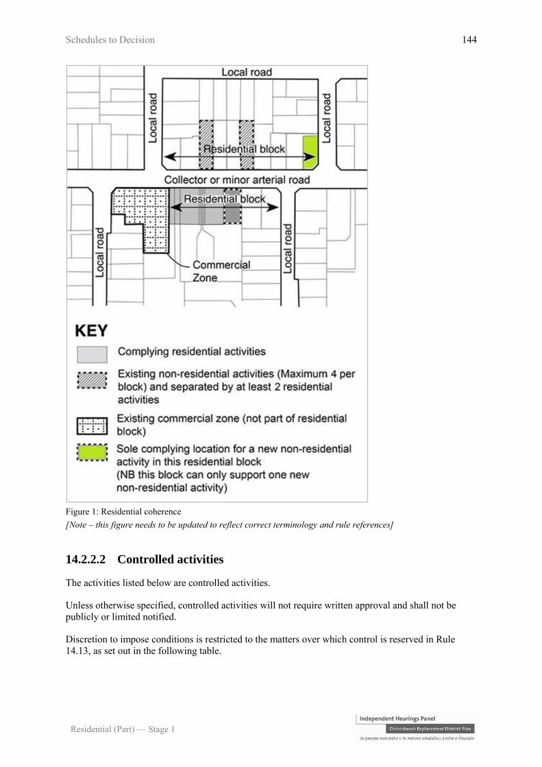
Schedules to Decision 144
Residential (Part) — Stage 1
Figure 1: Residential coherence
[Note – this figure needs to be updated to reflect correct terminology and rule references]
14.2.2.2 Controlled activities
The activities listed below are controlled activities.
Unless otherwise specified, controlled activities will not require written approval and shall not be
publicly or limited notified.
Discretion to impose conditions is restricted to the matters over which control is reserved in Rule
14.13, as set out in the following table.
Schedules to Decision 145
Residential (Part) — Stage 1
The matters over which Council reserves its control:
C1 Fences that do not comply with
Rule 14.2.3.10 – Street scene
amenity and safety - fences
a. Street scene – road boundary building setback, fencing and
planting – 14.13.18
C2 Residential units (including any
sleep-outs) containing more than
six bedrooms in total
a. Scale of activity – 14.13.5
b. Traffic generation and access safety – 14.13.6
C3 Multi-unit residential complexes
and social housing complexes not
complying with Rule 14.2.3.2 –
Tree and garden planting
a. Street scene – road boundary building setback, fencing and
planting – 14.13.18
C4 Multi-unit residential complexes
and social housing complexes not
complying with Rule 14.2.3.12 –
Service, storage and waste
management spaces
a. Service, storage and waste management spaces – 14.13.20
C5 Social housing complexes, where
the complex does not comply with
any one or more of the activity
specific standards in Rule 14.2.2.1
P5 c. or d.
a. Street scene – road boundary building setback, fencing and
planting – 14.13.18
C6 Multi-unit residential complexes in
the Residential Suburban Density
Transition Zone, where the
complex does not comply with any
one or more of the activity specific
standards in Rule 14.2.2.1 P4 c. or
d.
14.2.2.3 Restricted discretionary activities
The activities listed below are restricted discretionary activities.
Discretion to grant or decline consent and impose conditions is restricted to the matters of discretion
set out in 14.13 for each standard, or as specified, as set out in the following table.
Activity The Council’s discretion shall be limited to the
following matters:
RD1 Residential unit in the Residential
Suburban Zone contained within its own
separate site with a net site area between
400 and 450m2
a. Site density and site coverage – 14.13.2
RD2 Residential unit in the Residential
Suburban Density Transition Zone
contained within its own separate site with
a net site area between 300m2 and 330m2
RD3 Minor residential unit where the minor
unit is a detached building and does not a. Minor residential units 14.13.23
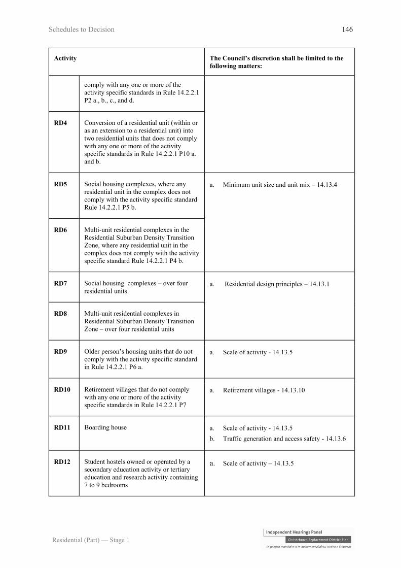
Schedules to Decision 146
Residential (Part) — Stage 1
Activity The Council’s discretion shall be limited to the
following matters:
comply with any one or more of the
activity specific standards in Rule 14.2.2.1
P2 a., b., c., and d.
RD4 Conversion of a residential unit (within or
as an extension to a residential unit) into
two residential units that does not comply
with any one or more of the activity
specific standards in Rule 14.2.2.1 P10 a.
and b.
RD5 Social housing complexes, where any
residential unit in the complex does not
comply with the activity specific standard
Rule 14.2.2.1 P5 b.
a. Minimum unit size and unit mix – 14.13.4
RD6 Multi-unit residential complexes in the
Residential Suburban Density Transition
Zone, where any residential unit in the
complex does not comply with the activity
specific standard Rule 14.2.2.1 P4 b.
RD7 Social housing complexes – over four
residential units a. Residential design principles – 14.13.1
RD8 Multi-unit residential complexes in
Residential Suburban Density Transition
Zone – over four residential units
RD9 Older person’s housing units that do not
comply with the activity specific standard
in Rule 14.2.2.1 P6 a.
a. Scale of activity - 14.13.5
RD10 Retirement villages that do not comply
with any one or more of the activity
specific standards in Rule 14.2.2.1 P7
a. Retirement villages - 14.13.10
RD11 Boarding house a. Scale of activity - 14.13.5
b. Traffic generation and access safety - 14.13.6
RD12 Student hostels owned or operated by a
secondary education activity or tertiary
education and research activity containing
7 to 9 bedrooms
a. Scale of activity – 14.13.5

Schedules to Decision 147
Residential (Part) — Stage 1
Activity The Council’s discretion shall be limited to the
following matters:
RD13 Convenience activities where:
a. the site is located on the corner of a
minor arterial road that intersects
with either a minor arterial road or
collector road;
b. the total area occupied by retailing on
the site is no more than 50m2 public
floor area;
c. the activity does not include the sale
of alcohol;
d. outdoor advertising is limited to no
more than 2m2 and shall be within
the road boundary setback;
e. the hours of operation when the site
is open to business visitors or clients
are limited to between the hours of
0700 – 2200 Monday to Sunday and
public holidays; and
f. there is no provision of on-site
parking area for visitors or service
purposes.
a. Residential design principles - 14.13.1
b. Scale of activity – 14.13.5
c. Non-residential hours of operation – 14.13.22
d. Traffic generation and access safety – 14.13.6
RD14 Integrated family health centres where:
a. the centre is located on sites with
frontage and the primary entrance to
a minor arterial or collector road
where right turn offset, either
informal or formal is available;
b. the centre is located on sites
adjoining a Neighbourhood, District
or Key Activity Centre;
c. the centre occupies a gross floor area
of building of between 301m2 and
700m2;
d. outdoor advertising signage is
limited to a maximum area of 2m2;
and
e. the hours of operation when the site
is open to patients, or clients, and
deliveries is limited to between the
hours of 0700 – 2100.
a. Scale of activity - 14.13.5
b. Traffic generation and access safety - 14.13.6
c. Non-residential hours of operation - 14.13.22
RD15 Animal shelter at 14 and 18 Charlesworth
Street.
Any application arising from this rule
shall only require the written approvals of
directly abutting landowners and
occupiers and shall at most be limited
a. Scale of activity – 14.13.5
b. Traffic generation and access safety - 14.13.6
c. Non-residential hours of operation - 14.13.22
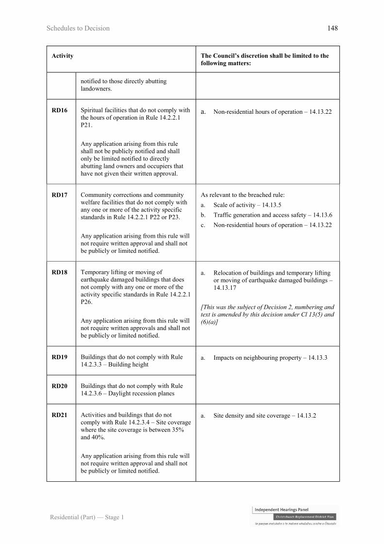
Schedules to Decision 148
Residential (Part) — Stage 1
Activity The Council’s discretion shall be limited to the
following matters:
notified to those directly abutting
landowners.
RD16 Spiritual facilities that do not comply with
the hours of operation in Rule 14.2.2.1
P21.
Any application arising from this rule
shall not be publicly notified and shall
only be limited notified to directly
abutting land owners and occupiers that
have not given their written approval.
a. Non-residential hours of operation – 14.13.22
RD17 Community corrections and community
welfare facilities that do not comply with
any one or more of the activity specific
standards in Rule 14.2.2.1 P22 or P23.
Any application arising from this rule will
not require written approval and shall not
be publicly or limited notified.
As relevant to the breached rule:
a. Scale of activity – 14.13.5
b. Traffic generation and access safety – 14.13.6
c. Non-residential hours of operation – 14.13.22
RD18 Temporary lifting or moving of
earthquake damaged buildings that does
not comply with any one or more of the
activity specific standards in Rule 14.2.2.1
P26.
Any application arising from this rule will
not require written approvals and shall not
be publicly or limited notified.
a. Relocation of buildings and temporary lifting
or moving of earthquake damaged buildings –
14.13.17
[This was the subject of Decision 2, numbering and
text is amended by this decision under Cl 13(5) and
(6)(a)]
RD19 Buildings that do not comply with Rule
14.2.3.3 – Building height a. Impacts on neighbouring property – 14.13.3
RD20 Buildings that do not comply with Rule
14.2.3.6 – Daylight recession planes
RD21 Activities and buildings that do not
comply with Rule 14.2.3.4 – Site coverage
where the site coverage is between 35%
and 40%.
Any application arising from this rule will
not require written approval and shall not
be publicly or limited notified.
a. Site density and site coverage – 14.13.2

Schedules to Decision 149
Residential (Part) — Stage 1
Activity The Council’s discretion shall be limited to the
following matters:
RD22 Multi-unit residential complexes, social
housing complexes, and older person’s
housing units that do not comply with
Rule 14.2.3.4 – Site coverage, where the
site coverage is between 40-45%
(calculated over the net site area of the
site of the entire complex or group of
units).
Any application arising from this rule will
not require written approval and shall not
be publicly or limited notified.
RD23 Market gardens where the site coverage
exceeds 55%.
Any application arising from this rule will
not require written approval and shall not
be publicly or limited notified.
RD24 Residential units that do not comply with
Rule 14.2.3.5 – Outdoor living space.
Any application arising from this rule will
not require written approval and shall not
be publicly or limited notified.
a. Outdoor living space – 14.13.21
RD25 Buildings that do not comply with Rule
14.2.3.9 – Road boundary building
setback.
Any application arising from this rule will
not require written approval and shall not
be publicly or limited notified.
a. Street scene – road boundary building setback,
fencing and planting – 14.13.18
RD26 Buildings that do not comply with Rule
14.2.3.7 – Minimum building setbacks
from internal boundaries and railway
lines, other than Rule 14.2.3.7(6) (refer to
RD28)
a. Impacts on neighbouring properties – 14.13.3
b. Minimum building, window and balcony
setbacks – 14.13.19
RD27 Buildings that do not comply with Rule
14.2.3.8 – Minimum setback and distance
to living area windows and balconies and
living space windows facing internal
boundaries
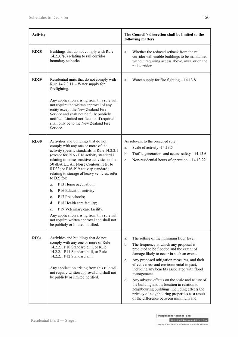
Schedules to Decision 150
Residential (Part) — Stage 1
Activity The Council’s discretion shall be limited to the
following matters:
RD28 Buildings that do not comply with Rule
14.2.3.7(6) relating to rail corridor
boundary setbacks
a. Whether the reduced setback from the rail
corridor will enable buildings to be maintained
without requiring access above, over, or on the
rail corridor.
RD29 Residential units that do not comply with
Rule 14.2.3.11 – Water supply for
firefighting.
Any application arising from this rule will
not require the written approval of any
entity except the New Zealand Fire
Service and shall not be fully publicly
notified. Limited notification if required
shall only be to the New Zealand Fire
Service.
a. Water supply for fire fighting – 14.13.8
RD30 Activities and buildings that do not
comply with any one or more of the
activity specific standards in Rule 14.2.2.1
(except for P16 - P18 activity standard i.
relating to noise sensitive activities in the
50 dBA Ldn Air Noise Contour, refer to
RD33; or P16-P19 activity standard j.
relating to storage of heavy vehicles, refer
to D2) for:
a. P13 Home occupation;
b. P16 Education activity
c. P17 Pre-schools;
d. P18 Health care facility;
e. P19 Veterinary care facility.
Any application arising from this rule will
not require written approval and shall not
be publicly or limited notified.
As relevant to the breached rule:
a. Scale of activity -14.13.5
b. Traffic generation and access safety - 14.13.6
c. Non-residential hours of operation – 14.13.22
RD31 Activities and buildings that do not
comply with any one or more of Rule
14.2.2.1 P10 Standard c.iii, or Rule
14.2.2.1 P11 Standard b.iii, or Rule
14.2.2.1 P12 Standard a.iii.
Any application arising from this rule will
not require written approval and shall not
be publicly or limited notified.
a. The setting of the minimum floor level.
b. The frequency at which any proposal is
predicted to be flooded and the extent of
damage likely to occur in such an event.
c. Any proposed mitigation measures, and their
effectiveness and environmental impact,
including any benefits associated with flood
management.
d. Any adverse effects on the scale and nature of
the building and its location in relation to
neighbouring buildings, including effects the
privacy of neighbouring properties as a result
of the difference between minimum and
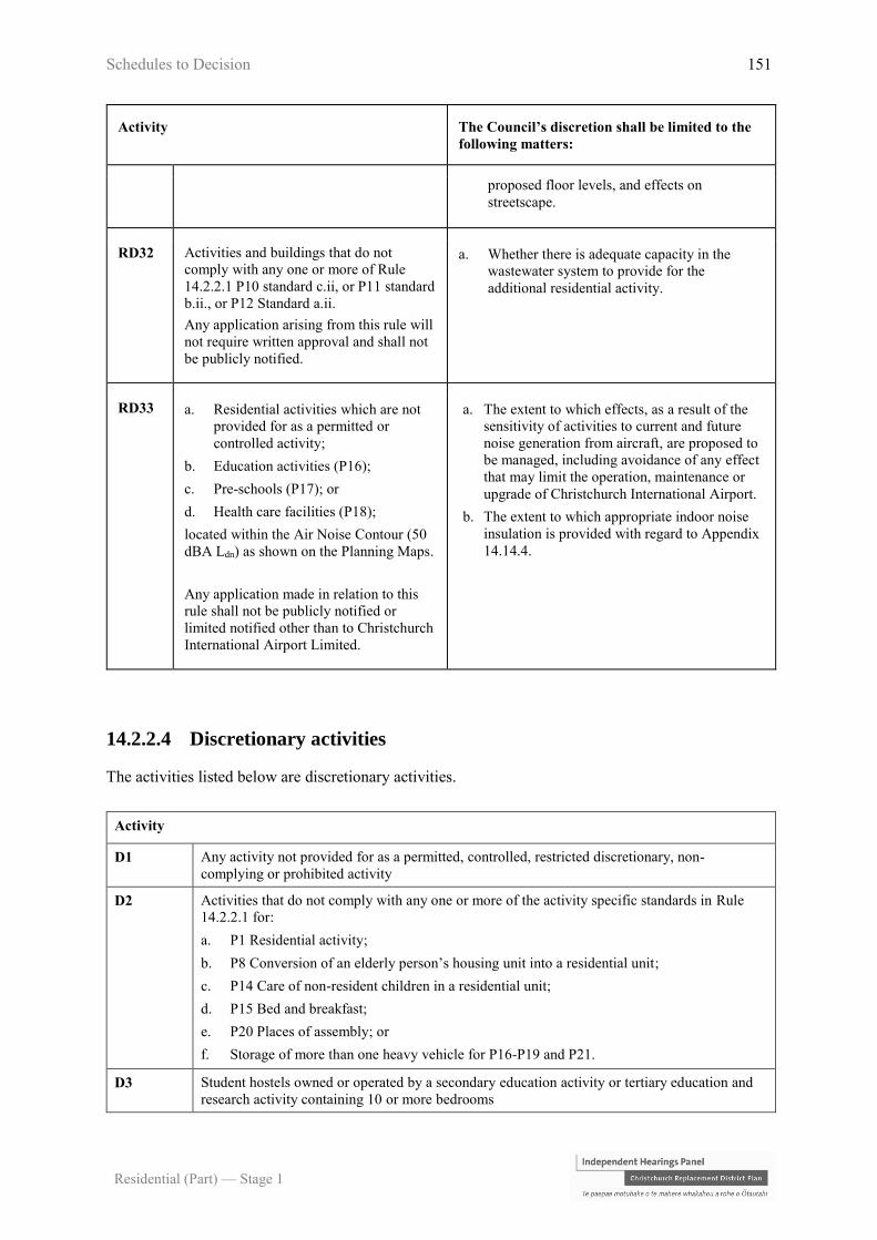
Schedules to Decision 151
Residential (Part) — Stage 1
Activity The Council’s discretion shall be limited to the
following matters:
proposed floor levels, and effects on
streetscape.
RD32 Activities and buildings that do not
comply with any one or more of Rule
14.2.2.1 P10 standard c.ii, or P11 standard
b.ii., or P12 Standard a.ii.
Any application arising from this rule will
not require written approval and shall not
be publicly notified.
a. Whether there is adequate capacity in the
wastewater system to provide for the
additional residential activity.
RD33 a. Residential activities which are not
provided for as a permitted or
controlled activity;
b. Education activities (P16);
c. Pre-schools (P17); or
d. Health care facilities (P18);
located within the Air Noise Contour (50
dBA Ldn) as shown on the Planning Maps.
Any application made in relation to this
rule shall not be publicly notified or
limited notified other than to Christchurch
International Airport Limited.
a. The extent to which effects, as a result of the
sensitivity of activities to current and future
noise generation from aircraft, are proposed to
be managed, including avoidance of any effect
that may limit the operation, maintenance or
upgrade of Christchurch International Airport.
b. The extent to which appropriate indoor noise
insulation is provided with regard to Appendix
14.14.4.
14.2.2.4 Discretionary activities
The activities listed below are discretionary activities.
Activity
D1 Any activity not provided for as a permitted, controlled, restricted discretionary, non-
complying or prohibited activity
D2 Activities that do not comply with any one or more of the activity specific standards in Rule
14.2.2.1 for:
a. P1 Residential activity;
b. P8 Conversion of an elderly person’s housing unit into a residential unit;
c. P14 Care of non-resident children in a residential unit;
d. P15 Bed and breakfast;
e. P20 Places of assembly; or
f. Storage of more than one heavy vehicle for P16-P19 and P21.
D3 Student hostels owned or operated by a secondary education activity or tertiary education and
research activity containing 10 or more bedrooms
Schedules to Decision 152
Residential (Part) — Stage 1
Activity
D4 Show homes
D5 Integrated family health centres which do not comply with any one of more of the requirements
specified in Rule 14.2.2.3 RD14
D6 Multi-unit residential complexes in Residential Suburban Zones
14.2.2.5 Non-complying activities
The activities listed below are non-complying activities.
Activity
NC1 Any non-residential activity located on a site with frontage to Memorial Avenue or Fendalton
Road
NC2 Residential units in the Residential Suburban Zone that do not comply with Rule 14.2.3.1,
where the residential unit is contained within a site with a net site area of less than 400m2 net
site area.
NC3 Residential units in the Residential Suburban Density Transition Zone that do not comply with
Rule 14.2.3.1, where the residential unit is contained within a site with a net site area of less
than 300m2 net site area
NC4 Activities and buildings that do not comply with Rule 14.2.3.4 where the site coverage exceeds
40% (except as provided for in NC5)
NC5 Multi-unit residential complexes, social housing complexes and older person’s housing units
that do not comply with Rule 14.2.3.4, where the site coverage exceeds 45% (calculated over
the net site area of the site of the entire complex or group of units)
NC6 a. Sensitive activities and buildings (excluding accessory buildings associated with an
existing activity):
i. within 12 metres of the centre line of a 110kV or 220kV National Grid transmission
line or within 12 metres of the foundation of an associated support structure; or
ii. within 10 metres of the centre line of a 66kV National Grid transmission line or
within 10 metres of a foundation of an associated support structure; or
b. Fences within 5 metres of a National Grid transmission line support structure foundation.
Any application made in relation to this rule shall not be publicly notified or limited notified
other than to Transpower New Zealand Limited.
Notes:
1. The National Grid transmission lines are shown on the planning maps.
2. Vegetation to be planted around the National Grid should be selected and/or
managed to ensure that it will not result in that vegetation breaching the

Schedules to Decision 153
Residential (Part) — Stage 1
Electricity (Hazards from Trees) Regulations 2003.
3. The New Zealand Electrical Code of Practice for Electrical Safe Distances
(NZECP 34:2001) contains restrictions on the location of structures and activities
in relation to National Grid transmission lines. Buildings and activity in the
vicinity of National Grid transmission lines must comply with NZECP 34:2001.
NC7 a. Sensitive activities and buildings (excluding accessory buildings associated with an
existing activity):
i. within 10 metres of the centre line of a 66kV electricity distribution line or within 10
metres of a foundation of an associated support structure; or
ii. within 5 metres of the centre line of a 33kV electricity distribution line or within 5
metres of a foundation of an associated support structure.
Any application made in relation to this rule shall not be publicly notified or limited notified
other than to Orion New Zealand Limited or other electricity distribution network operator.
Notes:
1. The electricity distribution lines are shown on the planning maps.
2. Vegetation to be planted around electricity distribution lines should be selected
and/or managed to ensure that it will not result in that vegetation breaching the
Electricity (Hazards from Trees) Regulations 2003.
3. The New Zealand Electrical Code of Practice for Electrical Safe Distances
(NZECP 34:2001) contains restrictions on the location of structures and activities
in relation to National Grid transmission lines. Buildings and activity in the
vicinity of National Grid transmission lines must comply with NZECP 34:2001.
14.2.2.6 Prohibited activities
The activities listed below are prohibited activities.
There are no prohibited activities.
14.2.3 Built form standards
14.2.3.1 Site density
Each residential unit shall be contained within its own separate site. The site shall have a minimum
net site area as follows:
Activity Standard
1. Residential Suburban Zone 450m2

Schedules to Decision 154
Residential (Part) — Stage 1
(excluding residential units established under Rule
14.2.2.1 P8, P9, P10, P11 and P12)
2. Residential Suburban Density Transition Zone
(excluding residential units established under Rule
14.2.2.1 P8, P9, P10, P11 and P12)
330m2
3. Social housing complexes There shall be no minimum net site area
for any site for any residential unit or
older person’s housing unit 4. Multi-unit residential complexes
5. Older person’s housing units
6. Retirement village
14.2.3.2 Tree and garden planting
For multi-unit residential complexes and social housing complexes only, sites shall include the
following minimum tree and garden planting:
a. a minimum of 20% of the site shall be provided for landscape treatment (which may include
private or communal open space), including a minimum of one tree for every 250m2 of gross
site area (prior to subdivision), or part thereof. At least 1 tree shall be planted adjacent to the
street boundary;
b. all trees required by this rule shall be not less than 1.5 metres high at the time of planting;
c. all trees and landscaping required by this rule shall be maintained and if dead, diseased or
damaged, shall be replaced; and
d. the minimum tree and garden planting requirements shall be determined over the site of the
entire complex.
14.2.3.3 Building height
The maximum height of any building shall be:
Activity Standard
1. All buildings unless specified below 8 metres
2. Minor dwelling units in the Residential Suburban Zone 5.5 metres and of a single storey only
Note: See the permitted height exceptions contained within the definition of height.

Schedules to Decision 155
Residential (Part) — Stage 1
14.2.3.4 Site coverage
The maximum percentage of the net site area covered by buildings excluding:
a. fences, walls and retaining walls;
b. eaves and roof overhangs up to 600mm in width from the wall of a building;
c. uncovered swimming pools up to 800mm in height above ground level; and
d. decks, terraces, balconies, porches, verandahs, bay or box windows (supported or cantilevered)
which:
i. are no more than 800mm above ground level and are uncovered or unroofed; or
ii. where greater than 800mm above ground level and/or covered or roofed, are in total no
more than 6m2 in area for any one site;
shall be as follows:
Zone/activity Standard
1. All zones / activities unless specified below 35%
2. Multi-unit residential complexes, social housing complexes, and groups of older
person’s housing units where all the buildings are single storey.
The percentage coverage by buildings shall be calculated over the net area of the site
of the entire complex or group, rather than over the net area of any part of the
complex or group.
40%
3. Market gardens 55%
4. Retirement villages 45%
14.2.3.5 Outdoor living space
a. Each residential unit shall be provided with an outdoor living space in a continuous area,
contained within the net site area with a minimum area and dimension as follows:
Activity/area Standard
Minimum
area
Minimum
dimension
1. Residential Suburban Zone 90m2 6 metres

Schedules to Decision 156
Residential (Part) — Stage 1
2. Residential Suburban Density Transition Zone 50m2 4 metres
3. Multi-unit residential complexes, social housing complexes and
older person’s housing units
30m2 4 metres
b. The required minimum area shall be readily accessible from a living area of each residential
unit.
c. The required minimum area shall not be occupied by any building, access, or parking space,
other than:
i. an outdoor swimming pool; or
ii. accessory building of less than 8m2; or
iii. any buildings or parts of a building without walls (other than a balustrade) on at least a
quarter of its perimeter, and occupies no more than 30% of the area of the outdoor living
space.
Note: This rule only applies to structures on the same site.
This rule does not apply to residential units in a retirement village.
14.2.3.6 Daylight recession planes
a. Buildings shall not project beyond a building envelope constructed by recession planes, as
shown in Appendix 14.14.2 Diagram A and Diagram B as relevant, from points 2.3 metres
above:
i. ground level at the internal boundaries; or
ii. where an internal boundary of a site abuts an access lot or access strip the recession plane
may be constructed from points 2.3 metres above ground level at the furthest boundary of
the access lot or access strip or any combination of these areas; or
iii. where buildings on adjoining sites have a common wall along an internal boundary the
recession planes shall not apply along that part of the boundary covered by such a wall.
b. Where the building is located in an overlay that has a permitted height of more than 11 metres,
the recession plane measurement shall commence from points 2.3 metres above ground level at
the internal boundaries and continue on the appropriate angle to points 11 metres above ground
level, at which point the recession plane becomes vertical.
Refer to Appendix 14.14.2 for permitted intrusions.
c. Where a site is located within a Flood Management Area, and a breach of the recession planes
determined in accordance with standards a. or b. above is created solely by the need to raise the
floor level to meet minimum floor levels, the applicable daylight recession plane shall be
determined as follows:
i. within the Fixed Minimum Floor Level Overlay, the daylight recession plane shall be
determined as if the ground level at the relevant boundary was the minimum floor level
set in the activity specific standards for P1 and P2 in Rule 5.3.1.1, or natural ground
level, whichever is higher; or
ii. outside the Fixed Minimum Floor Level Overlay, the daylight recession plane shall be
determined as if the ground level at the relevant boundary was the minimum floor level

Schedules to Decision 157
Residential (Part) — Stage 1
specified in a Minimum Floor Level Certificate calculated in accordance with Rule
5.3.1.2, or natural ground level, whichever is higher.
14.2.3.7 Minimum building setbacks from internal boundaries and railway
lines
The minimum building setback from internal boundaries shall be as follows:
1. All buildings not listed in table below 1 metre
2. Accessory buildings where the total length of walls or parts of the accessory
building within 1 metre of each internal boundary does not exceed 10.1
metres in length
Nil
3. Decks and terraces at or below ground floor level Nil
4. Buildings that share a common wall along an internal boundary Nil
5. All other buildings where the internal boundary of the site adjoins an access
or part of an access
1 metre
6. On sites adjacent or abutting railway lines, buildings, balconies and decks 4 metres from the rail
corridor boundary
Figure 2: Separation from neighbours
[Note – this figure needs to be updated to reflect amended rules]
Schedules to Decision 158
Residential (Part) — Stage 1
14.2.3.8 Minimum setback and distance to living area windows and
balconies and living space windows facing internal boundaries
a. The minimum setback for living area windows and balconies at first floor or above from an
internal boundary shall be 4 metres.
b. At first floor level or above, where a wall of a residential unit is located between 1 metre and 4
metres from an internal boundary, any living space window located on this wall shall only
contain glazing that is permanently obscured.
c. For a retirement village, this rule only applies to the internal boundaries of the site of the entire
retirement village.
Note:
A. This rule shall not apply to a window at an angle of 90 degrees or greater to the
boundary.
B. See sill height in the definition of window.
C. For the purposes of this rule, permanently obscured glazing does not include glazing
obscured by applied means such as film or paint.
14.2.3.9 Road boundary building setback
The minimum road boundary building setback shall be:
1. All buildings and situations not listed below 4.5 metres
2. Where a garage has a vehicle door that generally faces a road or
shared access
5.5 metres from the shared access
or road kerb
Except for:
a. A garage where:
i. the side walls are parallel to the road boundary and no more than 6.5 metres in length;
ii. the side walls facing the road contain a window with a minimum dimension of at least
0.6 metres (including the window frame);
iii. the space between the side wall and the road boundary contains a landscaping strip of at
least 2 metres in width that includes a minimum of two trees capable of reaching four
metres height at maturity; and
iv. where the access to the garage is located adjacent to a side boundary:
A. a landscaping strip of at least 0.6 metres width, planted with species capable of
reaching 1.5 metres height at maturity, is located along the side boundary up to the
line of the existing residential unit.
Where the planting conflicts with required visibility splays the visibility splay rules will prevail
and the planting not be required.
See Figure 3.
b. A garage where:

Schedules to Decision 159
Residential (Part) — Stage 1
i. the garage is a single garage, with the door facing the road boundary, accessed from a
local road;
ii. the garage is a maximum 3.6 metres wide;
iii. the garage is fitted with a sectional door that does not intrude into the driveway when
open and can be operated with an automatic opener. Where the garage is more than 3.5
metres from the road boundary an automatic opener is not required; and
iv. no part of the garage door when opening or shutting extends beyond the site boundary.
See Figure 4.
Figure 3: Side extension
[Note – this figure needs to be updated to reflect amended rules]
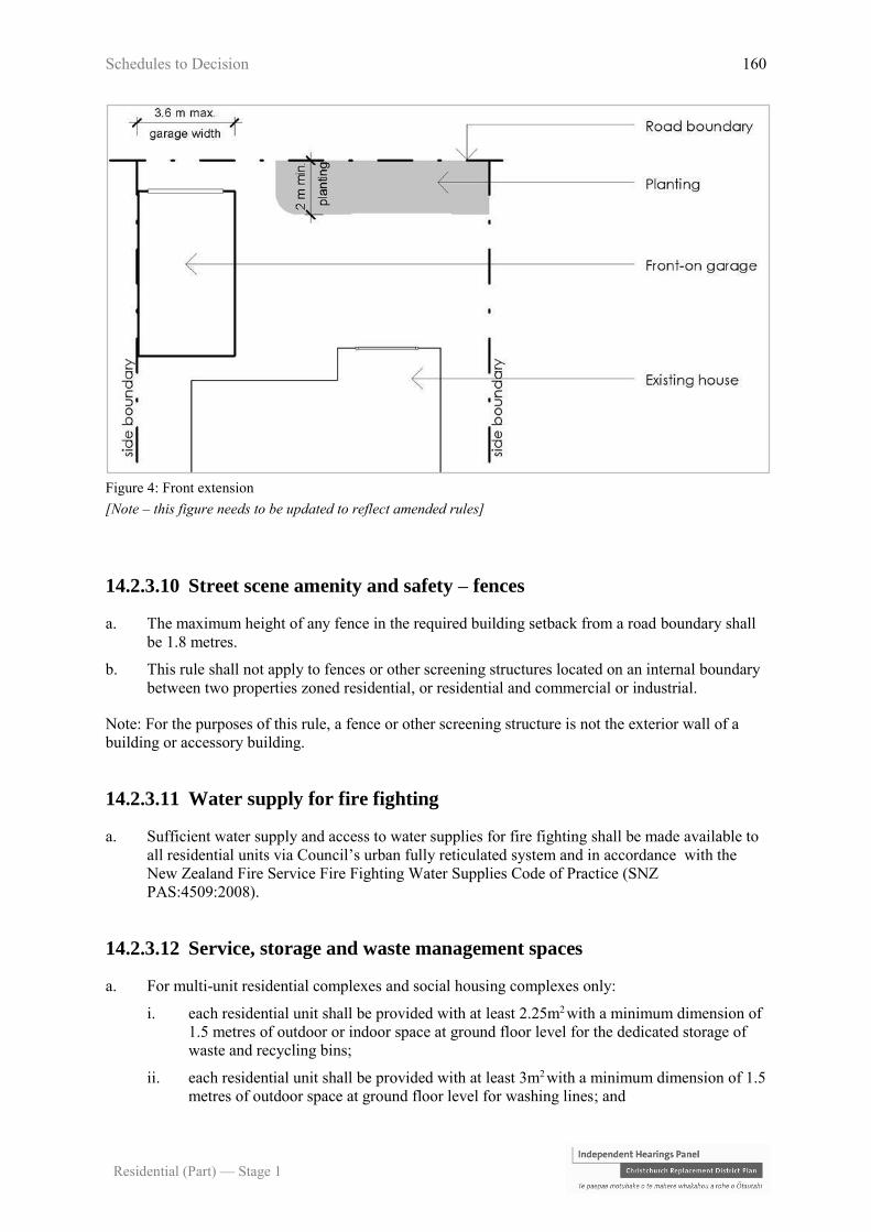
Schedules to Decision 160
Residential (Part) — Stage 1
Figure 4: Front extension
[Note – this figure needs to be updated to reflect amended rules]
14.2.3.10 Street scene amenity and safety – fences
a. The maximum height of any fence in the required building setback from a road boundary shall
be 1.8 metres.
b. This rule shall not apply to fences or other screening structures located on an internal boundary
between two properties zoned residential, or residential and commercial or industrial.
Note: For the purposes of this rule, a fence or other screening structure is not the exterior wall of a
building or accessory building.
14.2.3.11 Water supply for fire fighting
a. Sufficient water supply and access to water supplies for fire fighting shall be made available to
all residential units via Council’s urban fully reticulated system and in accordance with the
New Zealand Fire Service Fire Fighting Water Supplies Code of Practice (SNZ
PAS:4509:2008).
14.2.3.12 Service, storage and waste management spaces
a. For multi-unit residential complexes and social housing complexes only:
i. each residential unit shall be provided with at least 2.25m2 with a minimum dimension of
1.5 metres of outdoor or indoor space at ground floor level for the dedicated storage of
waste and recycling bins;
ii. each residential unit shall be provided with at least 3m2 with a minimum dimension of 1.5
metres of outdoor space at ground floor level for washing lines; and
Schedules to Decision 161
Residential (Part) — Stage 1
iii. the required spaces in a. and/or b. for each residential unit shall be provided either
individually, or within a dedicated shared communal space.
14.2.4 Area specific rules – Residential Suburban Zone
The following rules apply to the areas specified. All activities are also subject to the rules in 14.2.2
and 14.2.3 unless specified otherwise.
14.2.4.1 Area specific restricted discretionary activities
The activities listed below are restricted discretionary activities.
Discretion to grant or decline consent and impose conditions is restricted to the matters of discretion
set out in 14.13 for each standard, or as specified, as set out in the following table:
Location Restricted discretionary Matters of discretion
RD1 Residential area in Wigram
as shown on Figure 6
Activities that do not comply with Rule
14.2.4.4.9 – Outdoor living space at West
Wigram.
Any application arising from this rule will
not require the written approval of any
entity except the New Zealand Defence
Force and shall not be fully publicly
notified. Limited notification if required
shall only be to the New Zealand Defence
Force.
a. Development plans
- 14.13.16
b. Special setback
provision -
Residential
Suburban Zone
Wigram - 14.13.14
RD2 Mairehau Final
Development Area
Any development of land that is not in
accordance with the layout shown in the
development plan in Figure 5.
Any application arising from this rule will
not require written approval and shall not be
publicly or limited notified.
a. Development plans
- 14.13.16
RD3 Prestons Road Retirement
Village Overlay
Residential units that do not comply with
Rule 14.2.4.4.4 - Outdoor living space.
Any application arising from this rule will
not require written approvals and shall not
be publicly or limited notified.
This clause shall cease to have effect on
31st December 2018.
a. Outdoor living
space - 14.13.21
RD4 a. Peat Ground Condition
Constraint Overlay;
Activities and buildings that do not comply
with Rule 14.2.4.4.5 - Minimum building
setbacks from internal boundaries.
a. Minimum building,
window and
balcony setbacks -
14.13.19

Schedules to Decision 162
Residential (Part) — Stage 1
Location Restricted discretionary Matters of discretion
b. Stormwater Capacity
Constraint Overlay; or
c. Prestons Road
Retirement Village
Overlay.
Any application arising from this rule will
not require written approvals and shall not
be publicly or limited notified.
RD5 a. Peat Ground Condition
Constraint Overlay:
b. Stormwater Capacity
Constraint Overlay;
c. Existing Rural Hamlet
Overlay in the area to
the east of the 50 dBA
Ldn noise contour line
shown on Planning
Map 18; or
d. Existing Rural Hamlet
Overlay in the area to
the west of the 50 dBA
Ldn noise contour line
shown on Planning
Map 18.
Residential units that do not comply with
Rule 14.2.4.4.1 - Site density
a. Site density and site
coverage – 14.13.2
b. Whether the
development design
adequately
mitigates any
adverse effects of
the additional
building coverage
on the
environmental
condition giving
rise to the
constraint.
RD6 Preston Road Retirement
Village Overlay
Activities and buildings that do not comply
with Rule 14.2.4.4.2 - Building height
Prestons Road Retirement Village Overlay.
This clause shall cease to have effect on
31st December 2018.
a. Impacts on
neighbouring
property – 14.13.3
RD7 a. Peat Ground Condition
Constraint Overlay;
b. Stormwater Capacity
Constraint Overlay;
c. Existing Rural Hamlet
Overlay; or
d. Prestons Road
Retirement Village
Overlay.
Activities and buildings that do not comply
with Rule 14.2.4.4.3 - Site coverage a. Site density and site
coverage – 14.13.2
b. Whether the
development design
adequately
mitigates any
adverse effects of
the additional
building coverage
on the
environmental
condition giving
rise to the
constraint.

Schedules to Decision 163
Residential (Part) — Stage 1
Figure 5: Mairehau final development area
14.2.4.2 Area specific discretionary activities
The activities listed below are discretionary activities.
Activity
D1 Activities and buildings that do not comply with Rule 14.2.4.4.10 - Use of site and buildings
Prestons Road Retirement Village Overlay.
This clause shall cease to have effect on 31st December 2018.
D2 Activities and buildings that do not comply with Rule 14.2.4.4.6 – Minimum building setback from
zone boundary Russley Road/Memorial Avenue
D3 Activities and buildings that do not comply with 14.2.4.4.8 - Building types and limits Prestons
Road Retirement Village Overlay
D4 Activities and buildings that do not comply with 14.2.4.4.11 – Daylight recession planes Prestons
Road Retirement Village Overlay
14.2.4.3 Area specific non-complying activities
The activities listed below are a non-complying activity.
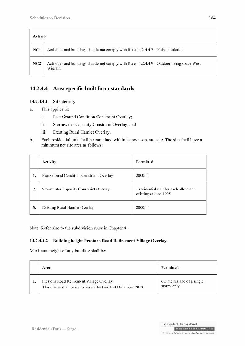
Schedules to Decision 164
Residential (Part) — Stage 1
Activity
NC1 Activities and buildings that do not comply with Rule 14.2.4.4.7 - Noise insulation
NC2 Activities and buildings that do not comply with Rule 14.2.4.4.9 - Outdoor living space West
Wigram
14.2.4.4 Area specific built form standards
14.2.4.4.1 Site density
a. This applies to:
i. Peat Ground Condition Constraint Overlay;
ii. Stormwater Capacity Constraint Overlay; and
iii. Existing Rural Hamlet Overlay.
b. Each residential unit shall be contained within its own separate site. The site shall have a
minimum net site area as follows:
Activity Permitted
1. Peat Ground Condition Constraint Overlay 2000m2
2. Stormwater Capacity Constraint Overlay 1 residential unit for each allotment
existing at June 1995
3. Existing Rural Hamlet Overlay 2000m2
Note: Refer also to the subdivision rules in Chapter 8.
14.2.4.4.2 Building height Prestons Road Retirement Village Overlay
Maximum height of any building shall be:
Area Permitted
1. Prestons Road Retirement Village Overlay.
This clause shall cease to have effect on 31st December 2018.
6.5 metres and of a single
storey only

Schedules to Decision 165
Residential (Part) — Stage 1
2. Prestons Road Retirement Village Overlay in the area identified as
“health facility”.
This clause shall cease to have effect on 31st December 2018.
13 metres
Note:
A. See the permitted height exceptions contained within the definition of height.
B. For the purposes of determining building height in the Prestons Road Retirement
Village Overlay, ground level shall be taken as the level of ground existing when
filling or excavation for new buildings on the land has been completed.
C. Rule 14.2.3.3 - Building height shall not apply in the Prestons Road Retirement
Village Overlay until Rule 14.2.4.4.2 ceases to have effect.
14.2.4.4.3 Site coverage
a. This applies to:
i. Peat Ground Condition Constraint Overlay;
ii. Stormwater Capacity Constraint Overlay;
iii. Existing Rural Hamlet Overlay; and
iv. Prestons Road Retirement Village Overlay.
Note: Rule 14.2.3.4 - Site coverage shall not apply in the Prestons Road Retirement Village
Overlay area until Rule 14.2.4.4.3 ceases to have effect.
b. The maximum percentage of the net site area covered by buildings excluding:
i. fences, walls and retaining walls;
ii. eaves and roof overhangs up to 600mm in width from the wall of a building;
iii. uncovered swimming pools up to 800mm in height above ground level; and
iv. decks, terraces, balconies, porches, verandahs, bay or box windows (supported or
cantilevered) which:
A. are no more than 800mm above ground level and are uncovered or unroofed; or
B. where greater than 800mm above ground level and/or covered or roofed, are in total
no more than 6m2 in area for any one site;
shall be as follows:
Zone/Activity/Area Permitted
1. Peat Ground Condition Constraint, Stormwater Capacity Constraint,
Existing Rural Hamlet and Prestons Road Retirement Village
Overlays: residential activities with garages
40% or 300m2 whichever is
the lesser
2. Prestons Road Retirement Village Overlay. This clause shall cease
to have effect on 31st December 2018.
40% (calculated over the net
site area of the entire complex)

Schedules to Decision 166
Residential (Part) — Stage 1
14.2.4.4.4 Outdoor living space Prestons Road Retirement Village Overlay
a. Each residential unit shall be provided with an outdoor living space in a continuous area,
contained within the net site area with a minimum area and dimension as follows:
Area Permitted
Minimum
Area
Minimum
Dimension
1. Prestons Road Retirement Village Overlay: for any older
person’s housing unit
This clause shall cease to have effect on 31st December
2018.
30m2 3 metres
b. The required minimum area shall be readily accessible from a living area of each residential
unit.
Note: this rule only applies to structures on the same site.
c. The required minimum area shall not be occupied by any building, access or parking space,
other than:
i. an outdoor swimming pool; or
ii. accessory building of less than 8m² in area; or
iii. any buildings or parts of a building without walls (other than a balustrade) on at least a
quarter of its perimeter, which occupies no more than 30% of the area of the outdoor
living space.
Note: Rule 14.2.3.5 Outdoor living space shall not apply to any older person’s housing unit in the
Prestons Road Retirement Village Overlay until Rule 14.2.4.4.4 ceases to have effect.
14.2.4.4.5 Minimum building setbacks from internal boundaries
a. This applies to:
i. Peat Ground Condition Constraint Overlay;
ii. Stormwater Capacity Constraint Overlay;
iii. Prestons Road Retirement Village Overlay.
Note: Rule 14.2.3.7 (other than Rule 14.2.3.7(6)) - Minimum building setbacks to internal boundaries
shall not apply in the Prestons Road Retirement Village Overlay areas until Rule 14.2.4.4.5 ceases to
have effect.
b. Minimum building setback from boundaries shall be as follows:

Schedules to Decision 167
Residential (Part) — Stage 1
Area Standard
1. Peat Ground Condition Constraint and
Stormwater Capacity Constraint Overlays
3 metres
2. Prestons Road Retirement Village Overlay.
This clause shall cease to have effect on 31st
December 2018.
From Prestons Road – 15 metres
From internal boundaries – 1.8 metres
14.2.4.4.6 Minimum building setback from zone boundary Russley Road/Memorial Avenue
At Russley Road/Memorial Avenue, where the eastern boundary of the Residential Suburban Zone
abuts the western boundary of the Industrial Park Zone, the minimum building setback from the
eastern boundary of the zone where it abuts the Industrial Park Zone shall be 5 metres.
14.2.4.4.7 Noise insulation
a. This applies to:
i. the area adjacent to State Highway 73 (Southern Motorway) between Annex and Curletts
Roads;
ii. the area adjacent to State Highway 75 (Curletts Road) between the intersection with State
Highway 73 and Lincoln Road;
iii. Peat Ground Condition Constraint Overlay; and
iv. Existing Rural Hamlet Overlay.
Location Standards
1. On that land which is:
a. adjacent to State Highway
73 (Southern Motorway)
between Annex and Curletts
Roads; and
b. adjacent to State Highway
75 (Curletts Road) between
the intersection with State
Highway 73 and Lincoln
Road.
Building setbacks, or building location, or acoustic barriers,
or other means, either singly or in combination shall be used
such that the following noise insulation standards are met:
Sound levels attributable to traffic from these roads shall not
exceed a level of 57 dBA L10 (18 hour) 54 dBA Leq (24
hour) in any outdoor area of the site and a design level of 60
dBA L10 (18 hour) 57 dBA Leq (24 hour) measured 1 metre
from the façade of any residential unit. All measured in
accordance with NZS 6801:1991 Assessment of Sound.
2. Mairehau Final Development Area
identified in Figure 5 – on land which
is on the western side of Marshlands
Road between Queen Elizabeth Drive
and Briggs Road
a. There shall be no minimum building setback where:
i. mounding or other physical barrier to noise
transmission capable of reducing traffic noise
intrusion to all parts of any site by at least 10dBA is
provided within 20 metres of the road boundary
across the entire width of the site;
ii. the mounding in i. is screened from the adjoining
road by landscaping with a minimum depth of 1.5
metres and a minimum height of 1.8 metres at time
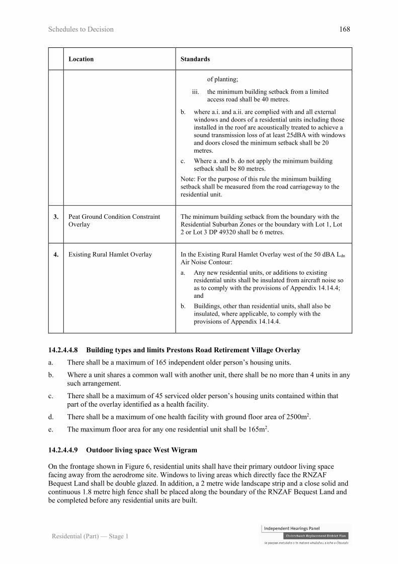
Schedules to Decision 168
Residential (Part) — Stage 1
Location Standards
of planting;
iii. the minimum building setback from a limited
access road shall be 40 metres.
b. where a.i. and a.ii. are complied with and all external
windows and doors of a residential units including those
installed in the roof are acoustically treated to achieve a
sound transmission loss of at least 25dBA with windows
and doors closed the minimum setback shall be 20
metres.
c. Where a. and b. do not apply the minimum building
setback shall be 80 metres.
Note: For the purpose of this rule the minimum building
setback shall be measured from the road carriageway to the
residential unit.
3. Peat Ground Condition Constraint
Overlay
The minimum building setback from the boundary with the
Residential Suburban Zones or the boundary with Lot 1, Lot
2 or Lot 3 DP 49320 shall be 6 metres.
4. Existing Rural Hamlet Overlay In the Existing Rural Hamlet Overlay west of the 50 dBA Ldn
Air Noise Contour:
a. Any new residential units, or additions to existing
residential units shall be insulated from aircraft noise so
as to comply with the provisions of Appendix 14.14.4;
and
b. Buildings, other than residential units, shall also be
insulated, where applicable, to comply with the
provisions of Appendix 14.14.4.
14.2.4.4.8 Building types and limits Prestons Road Retirement Village Overlay
a. There shall be a maximum of 165 independent older person’s housing units.
b. Where a unit shares a common wall with another unit, there shall be no more than 4 units in any
such arrangement.
c. There shall be a maximum of 45 serviced older person’s housing units contained within that
part of the overlay identified as a health facility.
d. There shall be a maximum of one health facility with ground floor area of 2500m2.
e. The maximum floor area for any one residential unit shall be 165m2.
14.2.4.4.9 Outdoor living space West Wigram
On the frontage shown in Figure 6, residential units shall have their primary outdoor living space
facing away from the aerodrome site. Windows to living areas which directly face the RNZAF
Bequest Land shall be double glazed. In addition, a 2 metre wide landscape strip and a close solid and
continuous 1.8 metre high fence shall be placed along the boundary of the RNZAF Bequest Land and
be completed before any residential units are built.
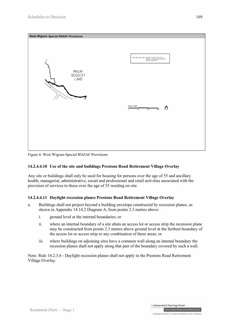
Schedules to Decision 169
Residential (Part) — Stage 1
Figure 6: West Wigram Special RNZAF Provisions
14.2.4.4.10 Use of the site and buildings Prestons Road Retirement Village Overlay
Any site or buildings shall only be used for housing for persons over the age of 55 and ancillary
health, managerial, administrative, social and professional and retail activities associated with the
provision of services to those over the age of 55 residing on site.
14.2.4.4.11 Daylight recession planes Prestons Road Retirement Village Overlay
a. Buildings shall not project beyond a building envelope constructed by recession planes, as
shown in Appendix 14.14.2 Diagram A, from points 2.3 metres above:
i. ground level at the internal boundaries; or
ii. where an internal boundary of a site abuts an access lot or access strip the recession plane
may be constructed from points 2.3 metres above ground level at the furthest boundary of
the access lot or access strip or any combination of these areas; or
iii. where buildings on adjoining sites have a common wall along an internal boundary the
recession planes shall not apply along that part of the boundary covered by such a wall.
Note: Rule 14.2.3.6 - Daylight recession planes shall not apply in the Prestons Road Retirement
Village Overlay.
Schedules to Decision 170
Residential (Part) — Stage 1
14.3 Rules – Residential Medium Density Zone
14.3.1 How to use the rules
a. The rules that apply to activities in the Residential Medium Density Zone are contained in:
i. the activity status tables (including activity specific standards) in Rule 14.3.2; and
ii. built form standards in Rules 14.3.3.
b. Area specific rules also apply to activities within the following specific areas zoned Residential
Medium Density Zone in Rule 14.3.4:
i. Residential Medium Density Zone Higher Height Limit and Site Density Overlay at
Deans Avenue Rules;
ii. Residential Medium Density Zone Wigram (Figure 6);
iii. Sumner Master Plan Overlay (Appendix 14.14.6);
iv. Sites with frontage to Bealey Avenue, Fitzgerald Avenue or Deans Avenue (south of
Blenheim Road); and
v. Residential Medium Density Zone in the Commercial Local Zone (St Albans) Outline
Development Plan shown as Area A in Chapter 15 Appendix 15.10.4.
Note: Area specific rules are also provided for under the built form standards under 14.3.3.
c. The activity status tables and standards in the following chapters also apply to activities in all
areas of the Residential Medium Density Zone:
5 Natural Hazards;
6 General Rules and Procedures;
7 Transport;
8 Subdivision, Development and Earthworks;
9 Heritage and Natural Environment;
11 Utilities, Energy and Infrastructure; and
12 Hazardous Substances and Contaminated Land
d. Where the word “facility” is used in the rules (e.g. spiritual facility), it shall also include the use
of a site /building for the activity that the facility provides for, unless expressly stated
otherwise.
Similarly, where the word/phrase defined include the word “activity” or “activities”, the
definition includes the land and/or buildings for that activity unless stated otherwise in the
activity status tables.

Schedules to Decision 171
Residential (Part) — Stage 1
14.3.2 Activity status tables
14.3.2.1 Permitted activities
In the Residential Medium Density Zone, the activities listed below are permitted activities if they
comply with the activity specific standards set out in this table, the applicable built form standards in
Rule 14.3.3 and the area specific rules in Rule 14.3.4.
Activities may also be controlled, restricted discretionary, discretionary, non-complying or prohibited
as specified in Rules 14.3.2.2, 14.3.2.3, 14.3.2.4, 14.3.2.5, and 14.3.2.6.
Activity Activity specific standards
P1 Residential activity, except
for boarding houses a. No more than one heavy vehicle shall be stored on the site of
the residential activity.
b. Any motor vehicles and/or boats dismantled, repaired or stored
on the site of the residential activity shall be owned by people
who live on the same site.
c. On sites located within the Riccarton Wastewater Interceptor
Overlay, until (date of completion of infrastructure work):
i. the minimum site area for any residential unit shall be
330m2.
P2 Student hostels owned or
operated by a secondary
education activity or
tertiary education and
research activity
containing up to 6
bedrooms
a. Nil
P3 Conversion of an elderly
person’s housing unit
existing at 6 December
2013, into a residential unit
that may be occupied by
any person(s) and without
the need to be encumbered
by a bond or other
appropriate legal
instrument
Each converted unit shall have:
a. a minimum gross floor area, excluding terraces, garages,
sundecks and verandahs, of 35m2; and
b. a separate outdoor living space readily accessible from its living
area that is at least 30m2 with a minimum dimension of 3
metres.
P4 Home occupation a. The gross floor area of the building, plus the area used for
outdoor storage area, occupied by the home occupation shall be
less than 40m2.
b. The maximum number of FTE persons employed in the home
occupation, who reside permanently elsewhere than on the site,
shall be two.

Schedules to Decision 172
Residential (Part) — Stage 1
Activity Activity specific standards
c. Any retailing shall be limited to the sale of goods grown or
produced on the site, or internet-based sales where no customer
visits occur.
d. The hours of operation, when the site is open to visitors, clients,
and deliveries, shall be limited to between the hours of:
i. 0700 – 2100 Monday to Friday; and
ii. 0800 – 1900 Saturday, Sunday and public holidays.
e. Visitor or staff parking areas shall be outside the road boundary
setback.
f. Outdoor advertising shall be limited to a maximum area of 2m2.
P5 Care of non-resident
children within a
residential unit in return
for monetary payment to
the carer
There shall be:
a. a maximum of four non-resident children being cared for in
return for monetary payment to the carer at any one time; and
b. at least one carer residing permanently within the residential
unit.
P6 Bed and breakfast There shall be:
a. a maximum of six guests accommodated at any one time;
b. at least one owner of the residential unit residing permanently
on site; and
c. no guest given accommodation for more than 90 consecutive
days.
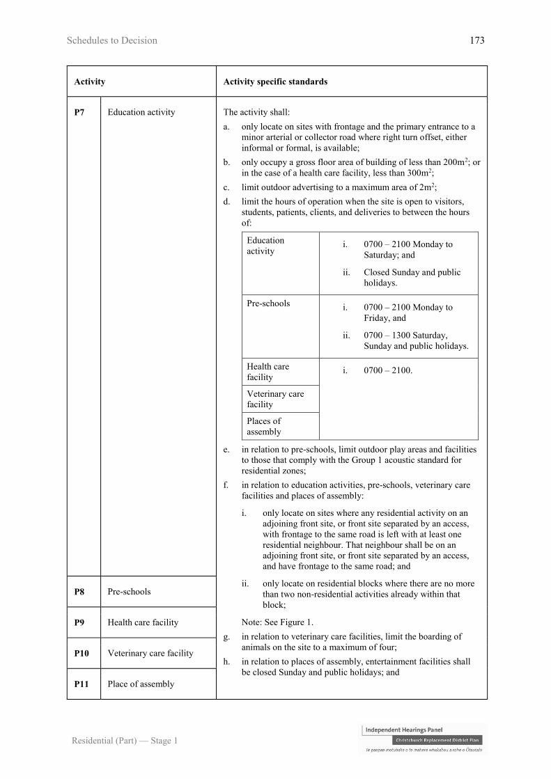
Schedules to Decision 173
Residential (Part) — Stage 1
Activity Activity specific standards
P7 Education activity The activity shall:
a. only locate on sites with frontage and the primary entrance to a
minor arterial or collector road where right turn offset, either
informal or formal, is available;
b. only occupy a gross floor area of building of less than 200m2; or
in the case of a health care facility, less than 300m2;
c. limit outdoor advertising to a maximum area of 2m2;
d. limit the hours of operation when the site is open to visitors,
students, patients, clients, and deliveries to between the hours
of:
Education
activity i. 0700 – 2100 Monday to
Saturday; and
ii. Closed Sunday and public
holidays.
Pre-schools i. 0700 – 2100 Monday to
Friday, and
ii. 0700 – 1300 Saturday,
Sunday and public holidays.
Health care
facility i. 0700 – 2100.
Veterinary care
facility
Places of
assembly
e. in relation to pre-schools, limit outdoor play areas and facilities
to those that comply with the Group 1 acoustic standard for
residential zones;
f. in relation to education activities, pre-schools, veterinary care
facilities and places of assembly:
i. only locate on sites where any residential activity on an
adjoining front site, or front site separated by an access,
with frontage to the same road is left with at least one
residential neighbour. That neighbour shall be on an
adjoining front site, or front site separated by an access,
and have frontage to the same road; and
ii. only locate on residential blocks where there are no more
than two non-residential activities already within that
block;
Note: See Figure 1.
g. in relation to veterinary care facilities, limit the boarding of
animals on the site to a maximum of four;
h. in relation to places of assembly, entertainment facilities shall
be closed Sunday and public holidays; and
P8 Pre-schools
P9 Health care facility
P10 Veterinary care facility
P11 Place of assembly
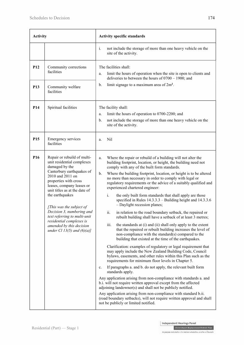
Schedules to Decision 174
Residential (Part) — Stage 1
Activity Activity specific standards
i. not include the storage of more than one heavy vehicle on the
site of the activity.
P12 Community corrections
facilities
The facilities shall:
a. limit the hours of operation when the site is open to clients and
deliveries to between the hours of 0700 – 1900; and
b. limit signage to a maximum area of 2m². P13 Community welfare
facilities
P14 Spiritual facilities The facility shall:
a. limit the hours of operation to 0700-2200; and
b. not include the storage of more than one heavy vehicle on the
site of the activity.
P15 Emergency services
facilities a. Nil
P16 Repair or rebuild of multi-
unit residential complexes
damaged by the
Canterbury earthquakes of
2010 and 2011 on
properties with cross
leases, company leases or
unit titles as at the date of
the earthquakes
[This was the subject of
Decision 3, numbering and
text referring to multi-unit
residential complexes is
amended by this decision
under Cl 13(5) and (6)(a)]
a. Where the repair or rebuild of a building will not alter the
building footprint, location, or height, the building need not
comply with any of the built form standards.
b. Where the building footprint, location, or height is to be altered
no more than necessary in order to comply with legal or
regulatory requirements or the advice of a suitably qualified and
experienced chartered engineer:
i. the only built form standards that shall apply are those
specified in Rules 14.3.3.3 – Building height and 14.3.3.6
– Daylight recession planes;
ii. in relation to the road boundary setback, the repaired or
rebuilt building shall have a setback of at least 3 metres;
iii. the standards at (i) and (ii) shall only apply to the extent
that the repaired or rebuilt building increases the level of
non-compliance with the standard(s) compared to the
building that existed at the time of the earthquakes.
Clarification: examples of regulatory or legal requirement that
may apply include the New Zealand Building Code, Council
bylaws, easements, and other rules within this Plan such as the
requirements for minimum floor levels in Chapter 5.
c. If paragraphs a. and b. do not apply, the relevant built form
standards apply.
Any application arising from non-compliance with standards a. and
b.i. will not require written approval except from the affected
adjoining landowner(s) and shall not be publicly notified.
Any application arising from non-compliance with standard b.ii.
(road boundary setbacks), will not require written approval and shall
not be publicly or limited notified.

Schedules to Decision 175
Residential (Part) — Stage 1
Activity Activity specific standards
P17 Temporary lifting or
moving of earthquake
damaged buildings where
the activity does not
comply with one or more
of Rules:
a. 14.3.3.3 – Building
height and maximum
number of storeys;
b. 14.3.3.4 – Site
coverage;
c. 14.3.3.5 – Outdoor
living space;
d. 14.3.3.6 – Daylight
recession planes; or
e. 14.3.3.7 – Minimum
building setback from
internal boundaries
and railway lines.
[This was the subject of
Decision 2, numbering and
text is amended by this
decision under Cl 13(5)
and (6)(a)]
a. Buildings shall not be:
i. moved to within 1 metre of an internal boundary and/or
within 3 metres of any waterbody, scheduled tree, listed
heritage item, natural resources and Council owned
structure, archaeological site, or the coastal marine area;
or
ii. lifted to a height exceeding 3 metres above the applicable
recession plane or height control.
b. The building must be lowered back or moved back to its
original position, or a position compliant with the District Plan
or consistent with a resource consent, within 12 weeks of the
lifting or moving works having first commenced.
c. In all cases of a building being moved or lifted, the
owners/occupiers of land adjoining the sites shall be informed
of the work at least seven days prior to the lift or move of the
building occurring. The information provided shall include
details of a contact person, details of the lift or move, and the
duration of the lift or move.
d. The Council’s Resource Consents Manager shall be notified of
the lifting or moving the building at least seven days prior to the
lift or move of the building occurring. The notification must
include details of the lift or move, property address, contact
details and intended start date.
P18 Salvation Army Addington
Overlay
P18.1 Family Store a. The activity shall take place in the existing (20 August 2014)
Family Store within the Salvation Army Addington Overlay.
P18.2 Addiction services a. The activity shall:
i. only locate within the Salvation Army Addington
Overlay;
ii. provide for a maximum of 19 overnight beds; and
iii. take place in the existing (20 August 2014) addiction
services buildings, or in upgraded or replacement
buildings complying with the built form standards (Rule
14.3.3).
P18.3 Supportive housing a. The activity shall:
i. only locate within the Salvation Army Addington
Overlay;
ii. provide for a maximum of 85 residents including those on
reintegration programmes, which may be in a mixture of
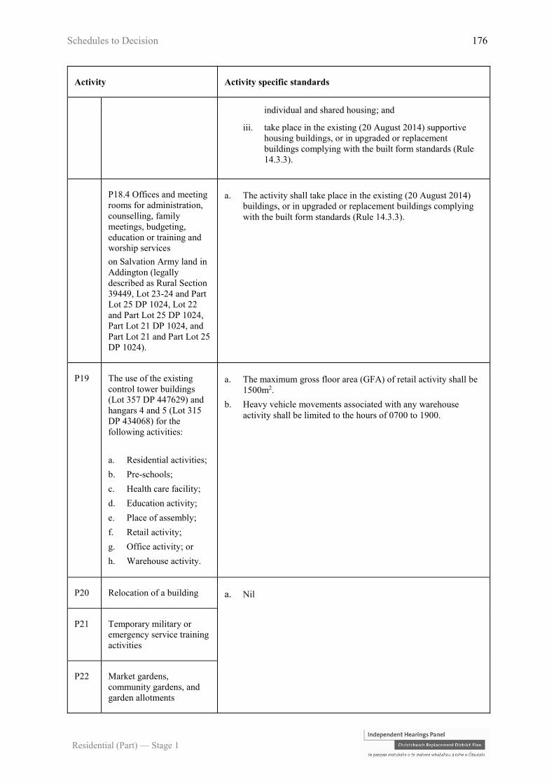
Schedules to Decision 176
Residential (Part) — Stage 1
Activity Activity specific standards
individual and shared housing; and
iii. take place in the existing (20 August 2014) supportive
housing buildings, or in upgraded or replacement
buildings complying with the built form standards (Rule
14.3.3).
P18.4 Offices and meeting
rooms for administration,
counselling, family
meetings, budgeting,
education or training and
worship services
on Salvation Army land in
Addington (legally
described as Rural Section
39449, Lot 23-24 and Part
Lot 25 DP 1024, Lot 22
and Part Lot 25 DP 1024,
Part Lot 21 DP 1024, and
Part Lot 21 and Part Lot 25
DP 1024).
a. The activity shall take place in the existing (20 August 2014)
buildings, or in upgraded or replacement buildings complying
with the built form standards (Rule 14.3.3).
P19 The use of the existing
control tower buildings
(Lot 357 DP 447629) and
hangars 4 and 5 (Lot 315
DP 434068) for the
following activities:
a. Residential activities;
b. Pre-schools;
c. Health care facility;
d. Education activity;
e. Place of assembly;
f. Retail activity;
g. Office activity; or
h. Warehouse activity.
a. The maximum gross floor area (GFA) of retail activity shall be
1500m2.
b. Heavy vehicle movements associated with any warehouse
activity shall be limited to the hours of 0700 to 1900.
P20 Relocation of a building a. Nil
P21 Temporary military or
emergency service training
activities
P22 Market gardens,
community gardens, and
garden allotments
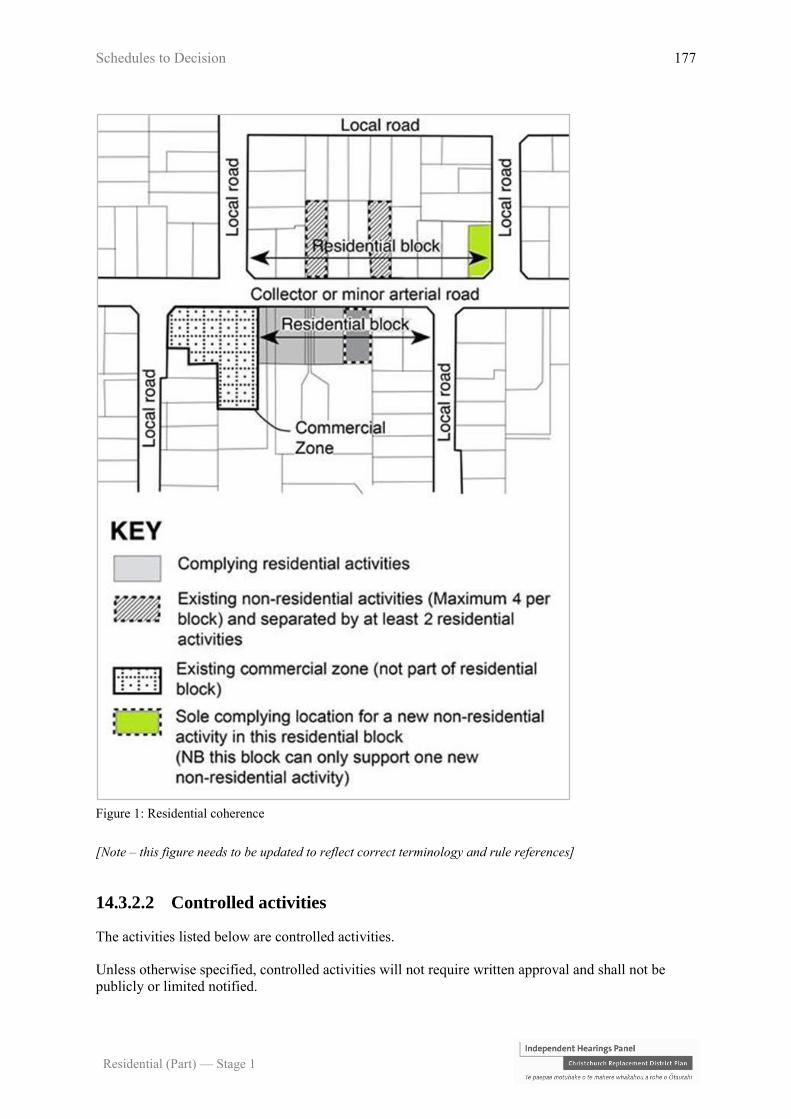
Schedules to Decision 177
Residential (Part) — Stage 1
Figure 1: Residential coherence
[Note – this figure needs to be updated to reflect correct terminology and rule references]
14.3.2.2 Controlled activities
The activities listed below are controlled activities.
Unless otherwise specified, controlled activities will not require written approval and shall not be
publicly or limited notified.

Schedules to Decision 178
Residential (Part) — Stage 1
Discretion to impose conditions is restricted to the matters over which control is reserved in Rule
14.13, as set out in the following table.
Activity The Council’s control is reserved to the
following matters:
C1 Residential units (including any sleep-
outs) containing more than six
bedrooms in total
a. Scale of activity – 14.13.5
b. Traffic generation and access safety –
14.13.6
C2 Activities that do not comply with Rule
14.3.3.2 – Tree and garden planting a. Street scene – road boundary building
setback, fencing and planting –
14.13.18
C3 Activities and buildings that do not
comply with Rule 14.3.3.11 - Building
overhangs
a. Street scene – road boundary building
setback, fencing and planting –
14.13.18
C4 Residential units that do not comply
with Rule 14.3.3.13 - Ground floor
habitable space
a. Street scene – road boundary building
setback, fencing and planting –
14.13.18
C5 Residential units that do not comply
with Rule 14.3.3.14 – Service, storage
and waste management spaces
a. Service, storage and waste
management spaces – 14.13.20
14.3.2.3 Restricted discretionary activities
The activities listed below are restricted discretionary activities.
Discretion to grant or decline consent and impose conditions is restricted to the matters of discretion
set out in 14.13 for each standard, or as specified, as set out in the following table.
Activity The Council’s discretion shall
be limited to the following
matters:
RD1 The erection of new buildings and alterations or
additions to existing buildings including all
accessory buildings, fences and walls associated
with that development, that result in:
a. three or more residential units; or
b. one or two residential units on a site smaller
than 300m2 gross site area (prior to
subdivision); or
a. Residential design principles
- 14.13.1
b. Minimum unit size and unit
mix - 14.13.4
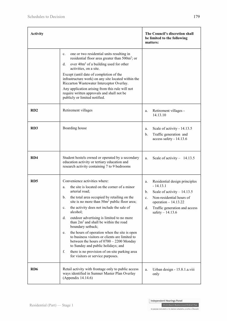
Schedules to Decision 179
Residential (Part) — Stage 1
Activity The Council’s discretion shall
be limited to the following
matters:
c. one or two residential units resulting in
residential floor area greater than 500m2; or
d. over 40m2 of a building used for other
activities, on a site.
Except (until date of completion of the
infrastructure work) on any site located within the
Riccarton Wastewater Interceptor Overlay.
Any application arising from this rule will not
require written approvals and shall not be
publicly or limited notified.
RD2 Retirement villages a. Retirement villages -
14.13.10
RD3 Boarding house a. Scale of activity - 14.13.5
b. Traffic generation and
access safety - 14.13.6
RD4 Student hostels owned or operated by a secondary
education activity or tertiary education and
research activity containing 7 to 9 bedrooms
a. Scale of activity – 14.13.5
RD5 Convenience activities where:
a. the site is located on the corner of a minor
arterial road;
b. the total area occupied by retailing on the
site is no more than 50m2 public floor area;
c. the activity does not include the sale of
alcohol;
d. outdoor advertising is limited to no more
than 2m2 and shall be within the road
boundary setback;
e. the hours of operation when the site is open
to business visitors or clients are limited to
between the hours of 0700 – 2200 Monday
to Sunday and public holidays; and
f. there is no provision of on-site parking area
for visitors or service purposes.
a. Residential design principles
- 14.13.1
b. Scale of activity – 14.13.5
c. Non-residential hours of
operation – 14.13.22
d. Traffic generation and access
safety – 14.13.6
RD6 Retail activity with frontage only to public access
ways identified in Sumner Master Plan Overlay
(Appendix 14.14.6)
a. Urban design - 15.8.1.a.viii
only
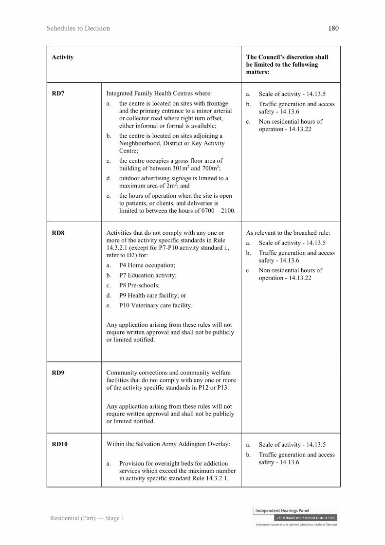
Schedules to Decision 180
Residential (Part) — Stage 1
Activity The Council’s discretion shall
be limited to the following
matters:
RD7 Integrated Family Health Centres where:
a. the centre is located on sites with frontage
and the primary entrance to a minor arterial
or collector road where right turn offset,
either informal or formal is available;
b. the centre is located on sites adjoining a
Neighbourhood, District or Key Activity
Centre;
c. the centre occupies a gross floor area of
building of between 301m2 and 700m2;
d. outdoor advertising signage is limited to a
maximum area of 2m2; and
e. the hours of operation when the site is open
to patients, or clients, and deliveries is
limited to between the hours of 0700 – 2100.
a. Scale of activity - 14.13.5
b. Traffic generation and access
safety - 14.13.6
c. Non-residential hours of
operation - 14.13.22
RD8 Activities that do not comply with any one or
more of the activity specific standards in Rule
14.3.2.1 (except for P7-P10 activity standard i.,
refer to D2) for:
a. P4 Home occupation;
b. P7 Education activity;
c. P8 Pre-schools;
d. P9 Health care facility; or
e. P10 Veterinary care facility.
Any application arising from these rules will not
require written approval and shall not be publicly
or limited notified.
As relevant to the breached rule:
a. Scale of activity - 14.13.5
b. Traffic generation and access
safety - 14.13.6
c. Non-residential hours of
operation - 14.13.22
RD9 Community corrections and community welfare
facilities that do not comply with any one or more
of the activity specific standards in P12 or P13.
Any application arising from these rules will not
require written approval and shall not be publicly
or limited notified.
RD10 Within the Salvation Army Addington Overlay:
a. Provision for overnight beds for addiction
services which exceed the maximum number
in activity specific standard Rule 14.3.2.1,
a. Scale of activity - 14.13.5
b. Traffic generation and access
safety - 14.13.6

Schedules to Decision 181
Residential (Part) — Stage 1
Activity The Council’s discretion shall
be limited to the following
matters:
P18.2 a ii., up to a maximum total of 25
overnight beds.
b. Provision for supportive housing which
exceeds the maximum number of residents
in activity specific standard Rule 14.3.2.1,
P18.3 a ii., up to a maximum total of 100
residents.
c. Any upgrades (including exterior alterations
or additions) to buildings existing on the 20
August 2014, or any replacement buildings
for the activities specified in P18.2, P18.3
and P18.4, that do not comply with any one
or more of the relevant built form standards
Rule 14.3.3.
RD11 Temporary lifting or moving of earthquake
damaged buildings that does not comply with the
standards in Rule 14.3.2.1 P17.
Any application arising from this rule will not
require written approvals and shall not be
publicly or limited notified.
a. Relocation of buildings and
temporary lifting or moving
of earthquake damaged
buildings – 14.13.17
[Note that this was the subject of
Decision 2 and that minor
changes have been made to
numbering and format]
RD12 Buildings that do not comply with Rule
14.3.3.7(6) relating to rail corridor boundary
setbacks
a. Whether the reduced setback
from the rail corridor will
enable buildings to be
maintained without requiring
access above, over, or on the
rail corridor.
RD13 Spiritual facilities that do not comply with the
hours of operation in Rule 14.3.2.1 P14.
Any application arising from this rule shall not be
publicly notified and shall only be limited
notified to directly abutting land owners and
occupiers that have not given their written
approval
a. Scale of activity - 14.13.22
RD14 Buildings that do not comply with Rule 14.3.3.3
up to a maximum height of 14 metres (unless
otherwise provided for in that rule)
a. Impacts on neighbouring
property – 14.13.3
RD15 Buildings that do not comply with Rule 14.3.3.6
– Daylight recession planes

Schedules to Decision 182
Residential (Part) — Stage 1
Activity The Council’s discretion shall
be limited to the following
matters:
RD16 Activities and buildings that do not comply with
Rule 14.3.3.4 – Site coverage a. Site density and site
coverage –14.13.2
RD17 Buildings that do not comply with Rule 14.3.3.7
– Minimum building setback internal boundaries
and railway lines (other than 14.3.3.7(6); refer
RD12)
a. Impacts on neighbouring
property – 14.13.3
b. Minimum building, window
and balcony setbacks –
14.13.19
RD18 Buildings that do not comply with Rule 14.3.3.8
– Minimum setback and distance to living area
windows
RD19 Residential units that do not comply with 14.3.3.5
– Outdoor living space
Any application arising from this rule will not
require written approvals and shall not be
publicly or limited notified.
a. Outdoor living space –
14.13.21
RD20 Buildings that do not comply with Rule 14.3.3.9
– Road boundary building setback
Any application arising from this rule will not
require written approvals and shall not be
publicly or limited notified.
a. Street scene – road boundary
building setback, fencing and
planting – 14.13.18
RD21 Buildings that do not comply with Rule 14.3.3.10
– Street scene amenity and safety – fences
Any application arising from this rule will not
require written approvals and shall not be
publicly or limited notified.
RD22 Residential units that do not comply with Rule
14.3.3.12 – Minimum unit size.
Any application arising from this rule will not
require written approvals and shall not be
publicly or limited notified.
a. Minimum unit size and unit
mix – 14.13.4
RD23 Residential units that do not comply with Rule
14.3.3.15 – Water supply for fire fighting.
Any application arising from this rule will not
require the written approval of any entity except
the New Zealand Fire Service and shall not be
fully publicly notified. Limited notification if
a. Water supply for fire fighting
– 14.13.8

Schedules to Decision 183
Residential (Part) — Stage 1
Activity The Council’s discretion shall
be limited to the following
matters:
required shall only be to the New Zealand Fire
Service.
14.3.2.4 Discretionary activities
The activities listed below are discretionary activities.
Activity
D1 Any activity not provided for as a permitted, controlled, restricted discretionary, non-complying, or
prohibited activity
D2 Activities that do not comply with any one or more of the activity specific standards in Rule 4.3.2.1
for:
a. P1 Residential activity;
b. P3 Conversion of an elderly person’s housing unit into a residential unit;
c. P5 Care of non-resident children in a residential unit;
d. P6 Bed and breakfast;
e. P11 Place of assembly; or
f. Storage of more than one heavy vehicle for activities for P7-P10 and P14.
D3 Student hostels owned or operated by a secondary education activity or tertiary education and
research activity containing 10 or more bedrooms
D4 Show homes
D5 Integrated family health centres which do not comply with any one of more of the requirements
specified in Rule 14.3.2.3 RD7
D6 Redevelopment of brownfield areas for mixed commercial and residential activities on the
following sites:
25 Deans Avenue (Former Saleyards)
14.3.2.5 Non-complying activities
The activities listed below are non-complying activities.
Activity
NC1 Activities and buildings that do not comply with Rule 14.3.3.3 where the height is over 14 metres
(unless otherwise specified in that rule)
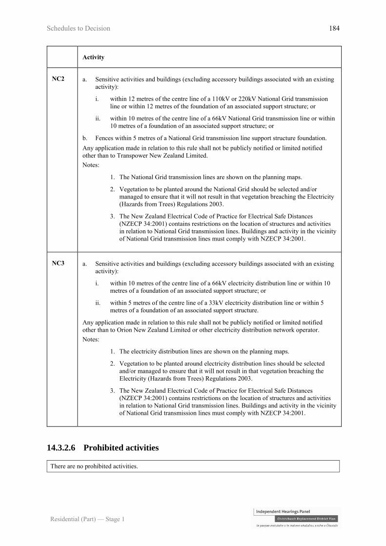
Schedules to Decision 184
Residential (Part) — Stage 1
Activity
NC2 a. Sensitive activities and buildings (excluding accessory buildings associated with an existing
activity):
i. within 12 metres of the centre line of a 110kV or 220kV National Grid transmission
line or within 12 metres of the foundation of an associated support structure; or
ii. within 10 metres of the centre line of a 66kV National Grid transmission line or within
10 metres of a foundation of an associated support structure; or
b. Fences within 5 metres of a National Grid transmission line support structure foundation.
Any application made in relation to this rule shall not be publicly notified or limited notified
other than to Transpower New Zealand Limited.
Notes:
1. The National Grid transmission lines are shown on the planning maps.
2. Vegetation to be planted around the National Grid should be selected and/or
managed to ensure that it will not result in that vegetation breaching the Electricity
(Hazards from Trees) Regulations 2003.
3. The New Zealand Electrical Code of Practice for Electrical Safe Distances
(NZECP 34:2001) contains restrictions on the location of structures and activities
in relation to National Grid transmission lines. Buildings and activity in the vicinity
of National Grid transmission lines must comply with NZECP 34:2001.
NC3 a. Sensitive activities and buildings (excluding accessory buildings associated with an existing
activity):
i. within 10 metres of the centre line of a 66kV electricity distribution line or within 10
metres of a foundation of an associated support structure; or
ii. within 5 metres of the centre line of a 33kV electricity distribution line or within 5
metres of a foundation of an associated support structure.
Any application made in relation to this rule shall not be publicly notified or limited notified
other than to Orion New Zealand Limited or other electricity distribution network operator.
Notes:
1. The electricity distribution lines are shown on the planning maps.
2. Vegetation to be planted around electricity distribution lines should be selected
and/or managed to ensure that it will not result in that vegetation breaching the
Electricity (Hazards from Trees) Regulations 2003.
3. The New Zealand Electrical Code of Practice for Electrical Safe Distances
(NZECP 34:2001) contains restrictions on the location of structures and activities
in relation to National Grid transmission lines. Buildings and activity in the vicinity
of National Grid transmission lines must comply with NZECP 34:2001.
14.3.2.6 Prohibited activities
There are no prohibited activities.

Schedules to Decision 185
Residential (Part) — Stage 1
14.3.3 Built form standards
14.3.3.1 Site density
Note: There is no site density standard in the Residential Medium Density Zone.
14.3.3.2 Tree and garden planting
Sites shall include the minimum tree and garden planting as set out in the below table:
For all activities, except permitted commercial activities in the Sumner Master Plan Overlay
1 a. A minimum of 20% of the site shall be provided for landscape treatment (which may include
private or communal open space), including a minimum of 1 tree for every 250m2 of gross site
area (prior to subdivision), or part thereof. At least 1 tree shall be planted adjacent to the street
boundary.
b. All trees required by this rule shall be not less than 1.5 metres high at the time of planting.
c. All trees and landscaping required by this rule shall be maintained and if dead, diseased or
damaged, shall be replaced.
d. For multi-unit residential complexes, social housing complexes, retirement villages, and groups of
older person’s housing, the minimum tree and garden planting requirements shall be determined
over the site of the entire complex.
2 In the Salvation Army Addington Overlay – a landscape and planting plan be prepared with a method
of implementation and maintenance for the full site area. This plan shall be implemented within two
growing seasons of its approval and thereafter maintained. Attention shall be paid to that area 4 metres
from the boundary with each road and around the stream to enhance the area, create restful space and
encourage bird life.
14.3.3.3 Building height and maximum number of storeys
The maximum height of any building shall be:
Activity Standard
1. All buildings in areas not listed below 11 metres provided there is a maximum of 3
storeys
2. Residential Medium Density Lower Height
Limit Overlay
8 metres
3. Sumner Residential Medium Density Zone 9.5 metres
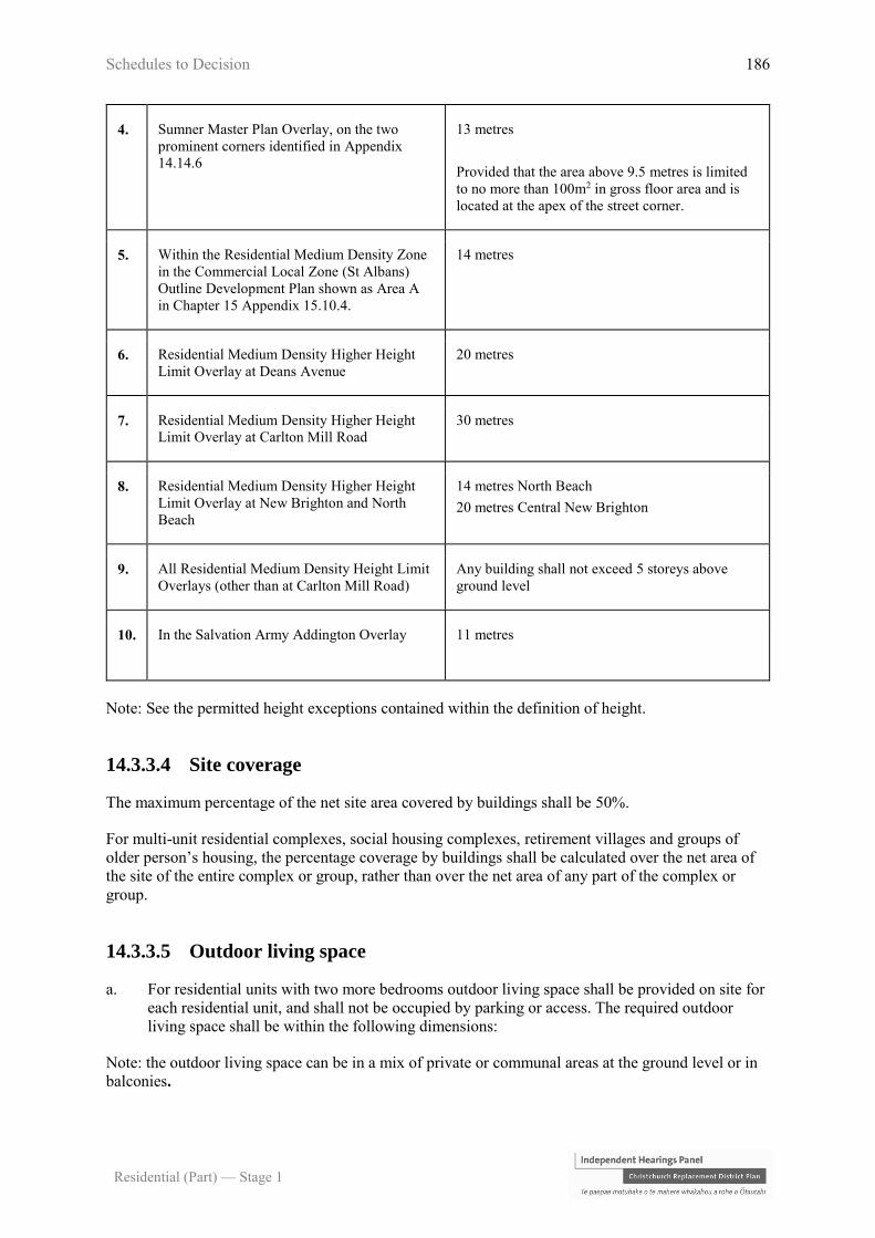
Schedules to Decision 186
Residential (Part) — Stage 1
4. Sumner Master Plan Overlay, on the two
prominent corners identified in Appendix
14.14.6
13 metres
Provided that the area above 9.5 metres is limited
to no more than 100m2 in gross floor area and is
located at the apex of the street corner.
5. Within the Residential Medium Density Zone
in the Commercial Local Zone (St Albans)
Outline Development Plan shown as Area A
in Chapter 15 Appendix 15.10.4.
14 metres
6. Residential Medium Density Higher Height
Limit Overlay at Deans Avenue
20 metres
7. Residential Medium Density Higher Height
Limit Overlay at Carlton Mill Road
30 metres
8. Residential Medium Density Higher Height
Limit Overlay at New Brighton and North
Beach
14 metres North Beach
20 metres Central New Brighton
9. All Residential Medium Density Height Limit
Overlays (other than at Carlton Mill Road)
Any building shall not exceed 5 storeys above
ground level
10. In the Salvation Army Addington Overlay 11 metres
Note: See the permitted height exceptions contained within the definition of height.
14.3.3.4 Site coverage
The maximum percentage of the net site area covered by buildings shall be 50%.
For multi-unit residential complexes, social housing complexes, retirement villages and groups of
older person’s housing, the percentage coverage by buildings shall be calculated over the net area of
the site of the entire complex or group, rather than over the net area of any part of the complex or
group.
14.3.3.5 Outdoor living space
a. For residential units with two more bedrooms outdoor living space shall be provided on site for
each residential unit, and shall not be occupied by parking or access. The required outdoor
living space shall be within the following dimensions:
Note: the outdoor living space can be in a mix of private or communal areas at the ground level or in
balconies.
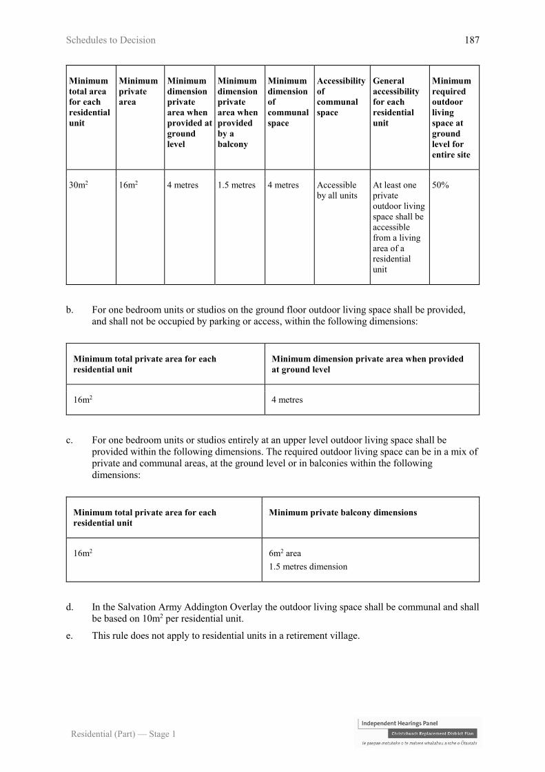
Schedules to Decision 187
Residential (Part) — Stage 1
Minimum
total area
for each
residential
unit
Minimum
private
area
Minimum
dimension
private
area when
provided at
ground
level
Minimum
dimension
private
area when
provided
by a
balcony
Minimum
dimension
of
communal
space
Accessibility
of
communal
space
General
accessibility
for each
residential
unit
Minimum
required
outdoor
living
space at
ground
level for
entire site
30m2 16m2 4 metres 1.5 metres 4 metres Accessible
by all units
At least one
private
outdoor living
space shall be
accessible
from a living
area of a
residential
unit
50%
b. For one bedroom units or studios on the ground floor outdoor living space shall be provided,
and shall not be occupied by parking or access, within the following dimensions:
Minimum total private area for each
residential unit
Minimum dimension private area when provided
at ground level
16m2 4 metres
c. For one bedroom units or studios entirely at an upper level outdoor living space shall be
provided within the following dimensions. The required outdoor living space can be in a mix of
private and communal areas, at the ground level or in balconies within the following
dimensions:
Minimum total private area for each
residential unit
Minimum private balcony dimensions
16m2 6m2 area
1.5 metres dimension
d. In the Salvation Army Addington Overlay the outdoor living space shall be communal and shall
be based on 10m2 per residential unit.
e. This rule does not apply to residential units in a retirement village.

Schedules to Decision 188
Residential (Part) — Stage 1
14.3.3.6 Daylight recession planes
a. Buildings, shall not project beyond a building envelope constructed by recession planes, as
shown in, Appendix 14.14.2 diagram C, from points 2.3 metres above:
i. ground level at the internal boundaries; or
ii. where an internal boundary of a site abuts an access lot or access strip the recession plane
may be constructed from points 2.3 metres above ground level at the furthest boundary of
the access lot or access strip or any combination of these areas; or
iii. where buildings on adjoining sites have a common wall along an internal boundary the
recession planes shall not apply along that part of the boundary covered by such a wall.
b. Where the building is located in an overlay that has a permitted height of 11m or more, the
recession plane measurement shall commence from points 2.3 metres above ground level at the
internal boundaries and continue on the appropriate angle to points 11m above ground level, at
which point the recession plane becomes vertical.
Refer to Appendix 14.14.2 for permitted intrusions.
c. Where sites are located within a Flood Management Area, and a breach of the recession planes
determined in accordance with standards a. or b. above is created solely by the need to raise the
floor level to meet minimum floor levels, the applicable daylight recession plane shall be
determined as follows:
i. within the Fixed Minimum Floor Level Overlay, the daylight recession plane shall be
determined as if the ground level at the relevant boundary was the minimum floor level
set in the activity specific standards for P1 and P2 in Rule 5.3.1.1, or natural ground
level, whichever is higher; or
ii. outside the Fixed Minimum Floor Level Overlay, the daylight recession plane shall be
determined as if the ground level at the relevant boundary was the minimum floor level
specified in a Minimum Floor Level Certificate calculated in accordance with Rule
5.3.1.2, or natural ground level, whichever is higher.
d. Except that:
i. In the Residential Medium Density Zone Higher Height Limit Overlay the recession
plane shall be as shown in Appendix 14.14.2 diagram D, unless the building is higher
than 11 metres, in which case refer to diagram E.
ii. In the Residential Medium Density Lower Height Limit Overlay and Daylight Recession
Plane Overlay the recession plane shall be as shown in Appendix 14.14.2 diagram B.
iii. In the Residential Medium Density Zone 15 metre Higher Height Limit Overlay the
recession plane shall be as shown on Appendix 14.14.2 diagram D, unless the building is
higher than 11 metres, in which case refer to diagram E.
iv. Except that in the Residential Medium Density Lower Height Limit Overlay the
recession plane shall be as shown in Appendix 14.14.2 diagram B.
14.3.3.7 Minimum building setbacks from internal boundaries and railway
lines
The minimum building setback from internal boundaries shall be:
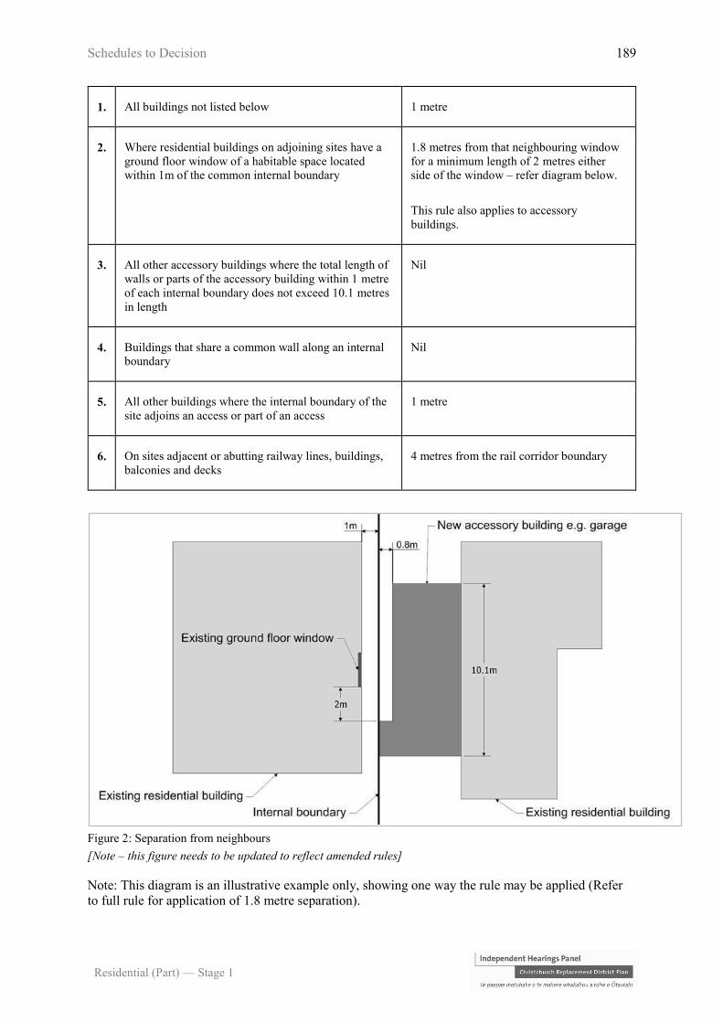
Schedules to Decision 189
Residential (Part) — Stage 1
1. All buildings not listed below 1 metre
2. Where residential buildings on adjoining sites have a
ground floor window of a habitable space located
within 1m of the common internal boundary
1.8 metres from that neighbouring window
for a minimum length of 2 metres either
side of the window – refer diagram below.
This rule also applies to accessory
buildings.
3. All other accessory buildings where the total length of
walls or parts of the accessory building within 1 metre
of each internal boundary does not exceed 10.1 metres
in length
Nil
4. Buildings that share a common wall along an internal
boundary
Nil
5. All other buildings where the internal boundary of the
site adjoins an access or part of an access
1 metre
6. On sites adjacent or abutting railway lines, buildings,
balconies and decks
4 metres from the rail corridor boundary
Figure 2: Separation from neighbours
[Note – this figure needs to be updated to reflect amended rules]
Note: This diagram is an illustrative example only, showing one way the rule may be applied (Refer
to full rule for application of 1.8 metre separation).

Schedules to Decision 190
Residential (Part) — Stage 1
14.3.3.8 Minimum setback and distance to living area windows and
balconies and living space windows facing internal boundaries
a. The minimum setback for living area windows and balconies at first floor or above from an
internal boundary shall be 4 metres.
b. At first floor level or above, where a wall of a residential unit is located between 1 metre and 4
metres from an internal boundary, any living space window located on this wall shall only
contain glazing that is permanently obscured.
c. For a retirement village, this rule only applies to the internal boundaries of the site of the entire
retirement village.
Note:
A. This rule shall not apply to a window at an angle of 90 degrees or greater to the
boundary.
B. See sill height in the definition of window.
C. For the purposes of this rule, permanently obscured glazing does not include glazing
obscured by applied means such as film or paint.
14.3.3.9 Road boundary building setback
a. The minimum road boundary garage and building setback shall be:
Building type and situations Minimum setback
1. For all buildings and situations not listed below 2 metres
2. Where a garage has a vehicle door that does not tilt
or swing outwards facing a road
4.5 metres
3. Where a garage has a vehicle door that tilts or
swings outward facing a road
5.5 metres
4. Where a garage has a vehicle door that does not tilt
or swing outward facing a shared access way
7 metres measured from the garage door to
the furthest formed edge of the adjacent
shared access.
5. Where a garage has a vehicle door that tilts or
swings outward facing a shared access way
8 metres measured from the garage door the
furthest formed edge of the adjacent shared
access.
b. Habitable space front façade
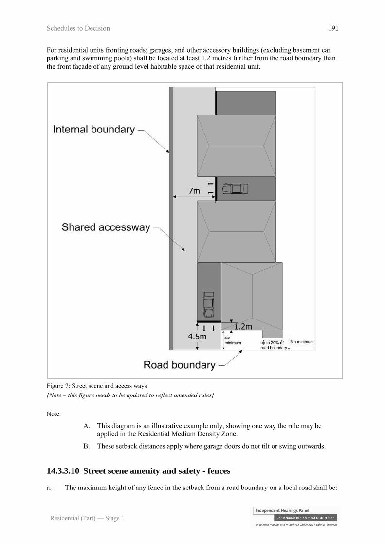
Schedules to Decision 191
Residential (Part) — Stage 1
For residential units fronting roads; garages, and other accessory buildings (excluding basement car
parking and swimming pools) shall be located at least 1.2 metres further from the road boundary than
the front façade of any ground level habitable space of that residential unit.
Figure 7: Street scene and access ways
[Note – this figure needs to be updated to reflect amended rules]
Note:
A. This diagram is an illustrative example only, showing one way the rule may be
applied in the Residential Medium Density Zone.
B. These setback distances apply where garage doors do not tilt or swing outwards.
14.3.3.10 Street scene amenity and safety - fences
a. The maximum height of any fence in the setback from a road boundary on a local road shall be:

Schedules to Decision 192
Residential (Part) — Stage 1
1. Where at least 50% of the fence structure is visually transparent. 1.8 metres
2. Where less than 50% of the fence structure is visually transparent. 1 metre
b. The maximum height of any fence in the setback from a road boundary on any collector road,
or arterial road shall be 1.8 metres.
c. a. and b. shall not apply to fences or other screening structures located on an internal boundary
between two properties zoned residential; or residential and commercial or industrial.
Note: For the purposes of this rule, a fence or other screening structure is not the exterior wall of a
building or accessory building.
d. Parking areas shall be separated from road boundaries, conservation, open space, or adjoining
residentially zoned sites by fencing that meets the requirements in a. above.
Figure 8: Fencing and screening structures
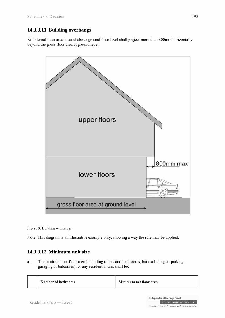
Schedules to Decision 193
Residential (Part) — Stage 1
14.3.3.11 Building overhangs
No internal floor area located above ground floor level shall project more than 800mm horizontally
beyond the gross floor area at ground level.
Figure 9: Building overhangs
Note: This diagram is an illustrative example only, showing a way the rule may be applied.
14.3.3.12 Minimum unit size
a. The minimum net floor area (including toilets and bathrooms, but excluding carparking,
garaging or balconies) for any residential unit shall be:
Number of bedrooms Minimum net floor area

Schedules to Decision 194
Residential (Part) — Stage 1
1. Studio 35m2
2. 1 bedroom 45m2
3. 2 bedrooms 60m2
4. 3 or more bedrooms 90m2
b. This rule does not apply to residential units in a retirement village.
14.3.3.13 Ground floor habitable space
a. Where the permitted height limit is 11 metres or less (refer to Rule 14.3.3.3):
i. any residential unit fronting a road or public space shall have a habitable space located at
the ground level; and
ii. at least 50% of all residential units within a development shall have a habitable space
located at the ground level.
b. Each of these habitable spaces located at the ground level shall have a minimum floor area of
12m2 and a minimum internal dimension of 3 metres and be internally accessible to the rest of
the unit.
c. Where the permitted height limit is over 11 metres (refer to Rule 14.3.3.3), a minimum of 50%
of the ground floor area shall be occupied by habitable spaces and/or indoor communal living
space. This area may include pedestrian access to lifts, stairs and foyers.
d. This rule does not apply to residential units in a retirement village.
14.3.3.14 Service, storage, and waste management spaces
a. Each residential unit shall be provided with:
i. an outdoor service space of 3m2 and waste management area of 2.25m2, with a minimum
dimension of 1.5 metres; and
ii. a single, indoor storage space of four cubic metres with a minimum dimension of 1
metre.
b. Any space designated for waste management, whether private or communal, shall be screened
from adjoining sites, conservation or open space zones, roads, and adjoining outdoor living
spaces to a height of 1.5 metres.
c. If a communal waste management area is provided within the site, the minimum required
outdoor service space is 3m2 or each residential unit.
d. If a communal waste management area is provided, it must be demonstrated to be:
i. of a sufficient size to accommodate the number and dimensions of bins required to meet
the predicted volume of waste generated by the residential units;
ii. accessible and safe for use by all residents; and
iii. easily accessible for the collection of bins by waste management contractors.

Schedules to Decision 195
Residential (Part) — Stage 1
e. This rule does not apply to residential units in a retirement village.
14.3.3.15 Water supply for fire fighting
Sufficient water supply and access to water supplies for fire fighting shall be made available to all
residential units via Council’s urban fully reticulated system and in accordance with the New Zealand
Fire Service Fire Fighting Water Supplies Code of Practice (SNZ PAS:4509:2008).
14.3.4 Area specific rules – Residential Medium Density Zone
The following rules apply to the areas specified. All activities are also subject to the rules in 14.3.2
and 14.3.3 unless specified otherwise.
14.3.4.1 Area specific restricted discretionary activities
The activities listed below are restricted discretionary activities.
Discretion to grant or decline consent and impose conditions is restricted to the matters of discretion
set out in 14.13 for each standard, or as specified, as set out in the following table:
Activity The Council’s discretion shall
be limited to the following
matters:
RD1 Retail activity with frontage only to public access ways
identified in Sumner Master Plan Overlay in Appendix 14.14.6 a. Urban design -
15.8.1.a.viii
RD2 Activities and buildings that do not comply with Rule 14.3.4.3.2
road boundary garage and building setback, for sites with
frontage to Bealey Avenue, Fitzgerald Avenue or Deans
Avenue (south of Blenheim Road), and within the Sumner
Master Plan Overlay (Appendix 14.14.6)
Any application arising from this rule will not require written
approvals and shall not be publicly or limited notified.
a. Street scene - road
boundary building
setback, fencing and
planting - 14.13.19
RD3 Activities that do not comply with Rule 14.3.4.3.1 - Area
specific development plans, Wigram special RNZAF provisions
shown in Figure 6.
Any application arising from this rule will not require the
written approval of any entity except the New Zealand Defence
Force and shall not be fully publicly notified. Limited
notification if required shall only be to the New Zealand
Defence Force.
a. Specific setback
provisions - Residential
Suburban Zone Wigram -
14.13.14

Schedules to Decision 196
Residential (Part) — Stage 1
RD4 Development in Areas A, B and C of the Commercial Local
Zone / Residential Medium Density Zone in the Commercial
Local Zone (St Albans) Outline Development Plan Chapter 15
Appendix 15.10.4
a. Development plans -
14.13.16
RD5 Activities that do not comply with Rule 14.3.4.3.1 – Area
specific development plans, Residential Medium Density
Higher Height Limit and Site Density Overlay at Deans
Avenue, and Sumner Master Plan Overlay (Appendix 14.14.6)
a. Development plans -
14.13.16
14.3.4.2 Area specific discretionary activities
The activity listed below is a discretionary activity.
Activity
D1 Retail and commercial activity in the Sumner Master Plan Overlay that does not have frontage to
public access ways identified in the Sumner Master Plan Overlay in Appendix 14.14.6
14.3.4.3 Area specific built form standards
14.3.4.3.1 Area specific development plans
a. This rule applies to:
i. Residential Medium Density Higher Height Limit and Site Density Overlay at Deans
Avenue;
ii. Residential Medium Density Zone Wigram shown on Figure 6; and
iii. Residential Medium Density Zone in Sumner Master Plan Overlay in Appendix 14.14.6.
Area Standard
1. Residential Medium
Density Higher Height
Limit and Site Density
Overlay at Deans
Avenue
Sites shall not have access to Deans Avenue other than via the proposed
road to be located between 100m and 110m from the intersection of
Moorhouse and Deans Avenue. As shown on Appendix 14.14.3
Development Plan Addington.
2. Residential Medium
Density Zone Wigram
shown on Figure 6
Residential units shall have their primary outdoor living area facing away
from the aerodrome site. Windows to living areas which directly face the
RNZAF Bequest Land shall be doubled glazed. In addition, a 2 metre
wide landscape strip and a close, solid and continuous 1.8 metre high
fence shall be placed along the boundary of the RNZAF Bequest Land and
be completed before any residential units are built.

Schedules to Decision 197
Residential (Part) — Stage 1
3. Sumner Master Plan
Overlay (Appendix
14.14.6)
Retail activities and commercial services shall be located along the
identified road frontages in accordance with the Sumner Master Plan
Overlay (Appendix 14.14.6)
Figure 6: West Wigram Special RNZAF Provisions
14.3.4.3.2 Road boundary garage and building setback
This rule applies to sites with frontage to Bealey Avenue, Fitzgerald Avenue, or Deans Avenue (south
of Blenheim Road), and within the Sumner Master Plan Overlay (Appendix 14.14.6).
Rule 14.3.3.8 Road boundary garage and building setback shall not apply on the above sites.
a. For sites with frontage to Bealey Avenue, Fitzgerald Avenue, or Deans Avenue (south of
Blenheim Road), the road boundary setback shall be 6 metres.
b. Sumner Master Plan Overlay, shown in Appendix 14.14.6; for retail activities and commercial
services with road frontage buildings; buildings shall:
i. be built up to the road frontage with buildings occupying all frontage not needed for
vehicle access to the rear of the site;
ii. provide a minimum of 60% and a maximum of 90% visually transparent glazing at the
ground floor and a minimum of 20% and a maximum of 90% visually transparent
glazing at each floor above the ground floor;
iii. provide pedestrian access directly from the road boundary; and
iv. provide veranda or other means of weather protection along the full width of the building
where it has frontage to a road.
Schedules to Decision 198
Residential (Part) — Stage 1
c. Sumner Master Plan Overlay, shown in Appendix 14.14.6; for retail and commercial services
with frontage only to public access ways; buildings shall:
i. occupy the full public access way frontage of the site;
ii. provide a minimum of 60% and a maximum of 90% of visually transparent glazing at the
ground floor and a minimum of 20% and a maximum of 90% visually transparent
glazing at each floor above the ground floor; and
iii. provide pedestrian access directly from the public access way.
14.3.4.3.3 Building height
The maximum height of a building within the Residential Medium Density Zone in the Commercial
Local Zone (St Albans) Outline Development Plan shown as Area A in Chapter 15 Appendix 15.10.4
shall be 14 metres.
Rule 14.3.3.3 Building height and maximum number of storeys shall not apply within the above area.

Schedules to Decision 199
Residential (Part) — Stage 1
14.4 Rules – Residential Banks Peninsula Zone
14.4.1 How to use the rules
a. The rules that apply to activities in the Residential Banks Peninsula Zone are contained in:
i. the activity status tables (including activity specific standards) in Rule 14.4.2; and
ii. built form standards in Rules 14.4.3.
b. Area specific rules also apply to activities within the following specific areas zoned Residential
Banks Peninsula Zone in Rule 14.4.4:
i. Lyttelton Port Influences Overlay.
c. The activity status tables and standards in the following chapters also apply to activities in all
areas of the Residential Banks Peninsula Zone:
5 Natural Hazards;
6 General Rules and Procedures;
7 Transport;
8 Subdivision, Development and Earthworks;
9 Heritage and Natural Environment;
11 Utilities, Energy and Infrastructure; and
12 Hazardous Substances and Contaminated Land
d. Where the word “facility” is used in the rules (e.g. spiritual facility), it shall also include the use
of a site /building for the activity that the facility provides for, unless expressly stated
otherwise.
Similarly, where the word/phrase defined include the word “activity” or “activities”, the
definition includes the land and/or buildings for that activity unless stated otherwise in the
activity status tables.
14.4.2 Activity status tables
14.4.2.1 Permitted activities
In the Residential Banks Peninsula Zone, the activities listed below are permitted activities if they
comply with the activity specific standards set out in this table, the applicable built form standards in
Rule 14.4.3 and area specific rules in Rule 14.4.4.
Activities may also be controlled, restricted discretionary, discretionary, non-complying or prohibited
as specified in Rules 14.4.2.2, 14.4.2.3, 14.4.2.4, 14.4.2.5 and 14.4.2.6.

Schedules to Decision 200
Residential (Part) — Stage 1
Activity Activity specific standards
P1 Residential activity, except
for boarding houses a. No more than one heavy vehicle shall be stored on the site of
the residential activity.
b. Any motor vehicles and/or boats dismantled, repaired or
stored on the site of the residential activity shall be owned by
people who live on the same site.
Note: for residential activities within the Lyttelton Port Influences
Overlay refer to area specific Rule 14.4.4.
P2 Minor residential unit
where the minor unit is a
detached building and the
existing site it is to be built
on contains only one
residential unit
a. The existing site containing both units shall have a minimum
net site area of 450m2.
b. The minor residential unit shall have a minimum gross floor
area of 35m2 and a maximum gross floor area 70m2.
c. The parking areas of both units shall be accessed from the
same access.
d. There shall be a total outdoor living space on the existing site
(containing both units) with a minimum area of 90m2 and a
minimum dimension of 6 metres. This total space can be
provided as:
i. a single continuous area; or
ii. be divided into two separate spaces, provided that each
unit is provided with an outdoor living space that is
directly accessible from that unit and is a minimum of
30m2 in area.
P3 Retirement villages a. Building façade length – there must be a recess in the façade
of a building where it faces a side or rear boundary from the
point at which a building exceeds a length of 16 metres. The
recess must:
i. be at least 1 metre in depth, for a length of at least 2
metres;
ii. be for the full height of the wall; and
iii. include a break in the eave line and roof line of the
façade.
P4 Conversion of an elderly
person's housing unit
existing at 6 December
2013, into a residential unit
that may be occupied by
any person(s) and without
the need to be encumbered
by a bond or other
appropriate legal instrument
Each converted unit shall have:
a. a minimum gross floor area, excluding terraces, garages,
sundecks and verandahs, of 35m2; and
b. a separate outdoor living space readily accessible from its
living area that is at least 30m2 with a minimum dimension of
3 metres.
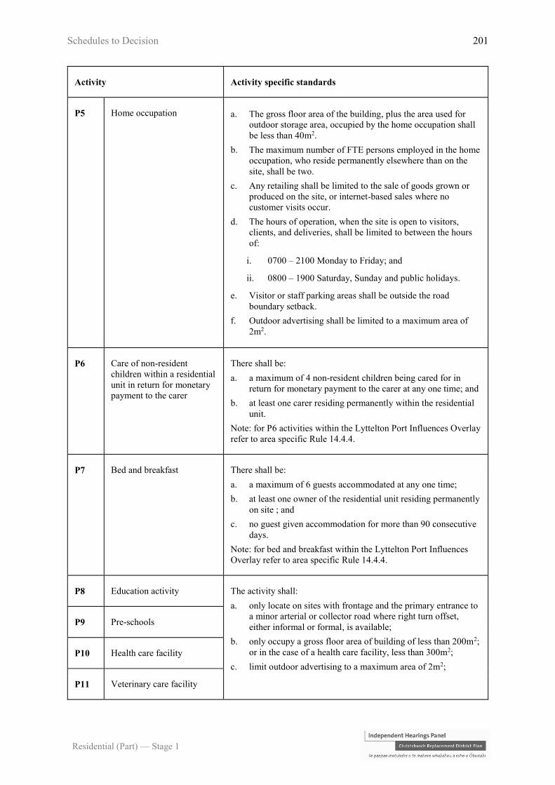
Schedules to Decision 201
Residential (Part) — Stage 1
Activity Activity specific standards
P5 Home occupation a. The gross floor area of the building, plus the area used for
outdoor storage area, occupied by the home occupation shall
be less than 40m2.
b. The maximum number of FTE persons employed in the home
occupation, who reside permanently elsewhere than on the
site, shall be two.
c. Any retailing shall be limited to the sale of goods grown or
produced on the site, or internet-based sales where no
customer visits occur.
d. The hours of operation, when the site is open to visitors,
clients, and deliveries, shall be limited to between the hours
of:
i. 0700 – 2100 Monday to Friday; and
ii. 0800 – 1900 Saturday, Sunday and public holidays.
e. Visitor or staff parking areas shall be outside the road
boundary setback.
f. Outdoor advertising shall be limited to a maximum area of
2m2.
P6 Care of non-resident
children within a residential
unit in return for monetary
payment to the carer
There shall be:
a. a maximum of 4 non-resident children being cared for in
return for monetary payment to the carer at any one time; and
b. at least one carer residing permanently within the residential
unit.
Note: for P6 activities within the Lyttelton Port Influences Overlay
refer to area specific Rule 14.4.4.
P7 Bed and breakfast There shall be:
a. a maximum of 6 guests accommodated at any one time;
b. at least one owner of the residential unit residing permanently
on site ; and
c. no guest given accommodation for more than 90 consecutive
days.
Note: for bed and breakfast within the Lyttelton Port Influences
Overlay refer to area specific Rule 14.4.4.
P8 Education activity The activity shall:
a. only locate on sites with frontage and the primary entrance to
a minor arterial or collector road where right turn offset,
either informal or formal, is available;
b. only occupy a gross floor area of building of less than 200m2;
or in the case of a health care facility, less than 300m2;
c. limit outdoor advertising to a maximum area of 2m2;
P9 Pre-schools
P10 Health care facility
P11 Veterinary care facility
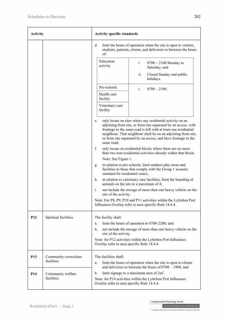
Schedules to Decision 202
Residential (Part) — Stage 1
Activity Activity specific standards
d. limit the hours of operation when the site is open to visitors,
students, patients, clients, and deliveries to between the hours
of:
Education
activity i. 0700 – 2100 Monday to
Saturday; and
ii. Closed Sunday and public
holidays.
Pre-schools i. 0700 – 2100.
Health care
facility
Veterinary care
facility
e. only locate on sites where any residential activity on an
adjoining front site, or front site separated by an access, with
frontage to the same road is left with at least one residential
neighbour. That neighbour shall be on an adjoining front site,
or front site separated by an access, and have frontage to the
same road;
f. only locate on residential blocks where there are no more
than two non-residential activities already within that block;
Note: See Figure 1.
g. in relation to pre-schools, limit outdoor play areas and
facilities to those that comply with the Group 1 acoustic
standard for residential zones;
h. in relation to veterinary care facilities, limit the boarding of
animals on the site to a maximum of 4;
i. not include the storage of more than one heavy vehicle on the
site of the activity.
Note: For P8, P9, P10 and P11 activities within the Lyttelton Port
Influences Overlay refer to area specific Rule 14.4.4.
P12 Spiritual facilities The facility shall:
a. limit the hours of operation to 0700-2200; and
b. not include the storage of more than one heavy vehicle on the
site of the activity.
Note: for P12 activities within the Lyttelton Port Influences
Overlay refer to area specific Rule 14.4.4.
P13 Community corrections
facilities
The facilities shall:
a. limit the hours of operation when the site is open to clients
and deliveries to between the hours of 0700 – 1900; and
b. limit signage to a maximum area of 2m2.
Note: for P14 activities within the Lyttelton Port Influences
Overlay refer to area specific Rule 14.4.4.
P14 Community welfare
facilities
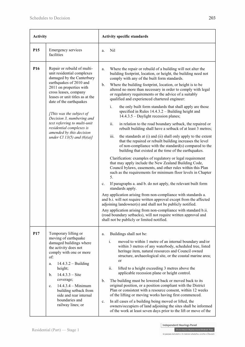
Schedules to Decision 203
Residential (Part) — Stage 1
Activity Activity specific standards
P15 Emergency services
facilities a. Nil
P16 Repair or rebuild of multi-
unit residential complexes
damaged by the Canterbury
earthquakes of 2010 and
2011 on properties with
cross leases, company
leases or unit titles as at the
date of the earthquakes
[This was the subject of
Decision 3, numbering and
text referring to multi-unit
residential complexes is
amended by this decision
under Cl 13(5) and (6)(a)]
a. Where the repair or rebuild of a building will not alter the
building footprint, location, or height, the building need not
comply with any of the built form standards.
b. Where the building footprint, location, or height is to be
altered no more than necessary in order to comply with legal
or regulatory requirements or the advice of a suitably
qualified and experienced chartered engineer:
i. the only built form standards that shall apply are those
specified in Rules 14.4.3.2 – Building height and
14.4.3.5 – Daylight recession planes;
ii. in relation to the road boundary setback, the repaired or
rebuilt building shall have a setback of at least 3 metres;
iii. the standards at (i) and (ii) shall only apply to the extent
that the repaired or rebuilt building increases the level
of non-compliance with the standard(s) compared to the
building that existed at the time of the earthquakes.
Clarification: examples of regulatory or legal requirement
that may apply include the New Zealand Building Code,
Council bylaws, easements, and other rules within this Plan
such as the requirements for minimum floor levels in Chapter
5.
c. If paragraphs a. and b. do not apply, the relevant built form
standards apply.
Any application arising from non-compliance with standards a.
and b.i. will not require written approval except from the affected
adjoining landowner(s) and shall not be publicly notified.
Any application arising from non-compliance with standard b.ii.
(road boundary setbacks), will not require written approval and
shall not be publicly or limited notified.
P17 Temporary lifting or
moving of earthquake
damaged buildings where
the activity does not
comply with one or more
of:
a. 14.4.3.2 – Building
height;
b. 14.4.3.3 – Site
coverage;
c. 14.4.3.4 – Minimum
building setback from
side and rear internal
boundaries and
railway lines; or
a. Buildings shall not be:
i. moved to within 1 metre of an internal boundary and/or
within 3 metres of any waterbody, scheduled tree, listed
heritage item, natural resources and Council owned
structure, archaeological site, or the coastal marine area;
or
ii. lifted to a height exceeding 3 metres above the
applicable recession plane or height control.
b. The building must be lowered back or moved back to its
original position, or a position compliant with the District
Plan or consistent with a resource consent, within 12 weeks
of the lifting or moving works having first commenced.
c. In all cases of a building being moved or lifted, the
owners/occupiers of land adjoining the sites shall be informed
of the work at least seven days prior to the lift or move of the
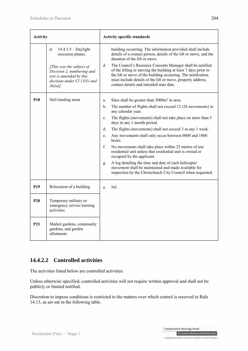
Schedules to Decision 204
Residential (Part) — Stage 1
Activity Activity specific standards
d. 14.4.3.5 – Daylight
recession planes.
[This was the subject of
Decision 2, numbering and
text is amended by this
decision under Cl 13(5) and
(6)(a)]
building occurring. The information provided shall include
details of a contact person, details of the lift or move, and the
duration of the lift or move.
d. The Council’s Resource Consents Manager shall be notified
of the lifting or moving the building at least 7 days prior to
the lift or move of the building occurring. The notification
must include details of the lift or move, property address,
contact details and intended start date.
P18 Heli-landing areas a. Sites shall be greater than 3000m2 in area.
b. The number of flights shall not exceed 12 (24 movements) in
any calendar year.
c. The flights (movements) shall not take place on more than 5
days in any 1 month period.
d. The flights (movements) shall not exceed 3 in any 1 week.
e. Any movements shall only occur between 0800 and 1800
hours.
f. No movements shall take place within 25 metres of any
residential unit unless that residential unit is owned or
occupied by the applicant.
g. A log detailing the time and date of each helicopter
movement shall be maintained and made available for
inspection by the Christchurch City Council when requested.
P19 Relocation of a building a. Nil
P20 Temporary military or
emergency service training
activities
P21 Market gardens, community
gardens, and garden
allotments
14.4.2.2 Controlled activities
The activities listed below are controlled activities.
Unless otherwise specified, controlled activities will not require written approval and shall not be
publicly or limited notified.
Discretion to impose conditions is restricted to the matters over which control is reserved in Rule
14.13, as set out in the following table.

Schedules to Decision 205
Residential (Part) — Stage 1
Activity The Council’s control is reserved to the
following matters:
C1 Residential units (including any sleep-outs) containing
more than 6 bedrooms in total a. Scale of activity - 14.13.5
b. Traffic generation and access safety -
14.13.6
14.4.2.3 Restricted discretionary activities
The activities listed below are restricted discretionary activities.
Discretion to grant or decline consent and impose conditions is restricted to the matters of discretion
set out in 14.13 for each standard, or as specified, as set out in the following table.
Activity The Council's discretion shall be
limited to the following matters:
RD1 Minor residential unit where the minor unit is a
detached building and does not comply with any one
or more of the activity specific standards in Rule
14.4.2.1 P2 a, b, c, or d.
a. Minor residential units 14.13.23
RD2 Temporary lifting or moving of earthquake damaged
buildings that does not comply with any one or more
of the activity specific standards in Rule 14.4.2.1
P17.
Any application arising from this rule will not require
written approvals and shall not be publicly or limited
notified.
a. Relocation of buildings and
temporary lifting or moving of
earthquake damaged buildings -
14.13.17
[This was the subject of Decision 2,
numbering and text is amended by this
decision under Cl 13(5) and (6)(a)]
RD3 Buildings that do not comply with Rule 14.4.3.6 –
Building setbacks from road boundaries.
Any application arising from non-compliance with
this rule will not require written approvals and shall
not be publicly or limited notified.
a. Street scene – road boundary
building setback, fencing and
planting – 14.13.18
RD4 Residential units that do not comply with Rule
14.4.3.1 – Site density
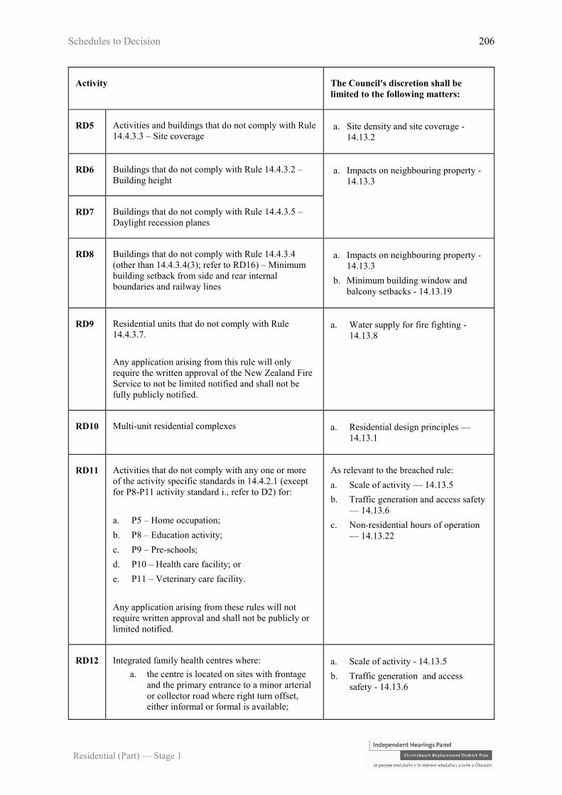
Schedules to Decision 206
Residential (Part) — Stage 1
Activity The Council's discretion shall be
limited to the following matters:
RD5 Activities and buildings that do not comply with Rule
14.4.3.3 – Site coverage a. Site density and site coverage -
14.13.2
RD6 Buildings that do not comply with Rule 14.4.3.2 –
Building height a. Impacts on neighbouring property -
14.13.3
RD7 Buildings that do not comply with Rule 14.4.3.5 –
Daylight recession planes
RD8 Buildings that do not comply with Rule 14.4.3.4
(other than 14.4.3.4(3); refer to RD16) – Minimum
building setback from side and rear internal
boundaries and railway lines
a. Impacts on neighbouring property -
14.13.3
b. Minimum building window and
balcony setbacks - 14.13.19
RD9 Residential units that do not comply with Rule
14.4.3.7.
Any application arising from this rule will only
require the written approval of the New Zealand Fire
Service to not be limited notified and shall not be
fully publicly notified.
a. Water supply for fire fighting -
14.13.8
RD10 Multi-unit residential complexes a. Residential design principles —
14.13.1
RD11 Activities that do not comply with any one or more
of the activity specific standards in 14.4.2.1 (except
for P8-P11 activity standard i., refer to D2) for:
a. P5 – Home occupation;
b. P8 – Education activity;
c. P9 – Pre-schools;
d. P10 – Health care facility; or
e. P11 – Veterinary care facility.
Any application arising from these rules will not
require written approval and shall not be publicly or
limited notified.
As relevant to the breached rule:
a. Scale of activity — 14.13.5
b. Traffic generation and access safety
— 14.13.6
c. Non-residential hours of operation
— 14.13.22
RD12 Integrated family health centres where:
a. the centre is located on sites with frontage
and the primary entrance to a minor arterial
or collector road where right turn offset,
either informal or formal is available;
a. Scale of activity - 14.13.5
b. Traffic generation and access
safety - 14.13.6

Schedules to Decision 207
Residential (Part) — Stage 1
Activity The Council's discretion shall be
limited to the following matters:
b. the centre is located on sites adjoining a
Neighbourhood, District or Key Activity
Centre;
c. the centre occupies a gross floor area of
building of between 301m2 and 700m2;
d. outdoor advertising is limited to a maximum
area of 2m2; and
e. the hours of operation when the site is open
to patients, or clients, and deliveries, is
limited to between the hours of 0700 –
2100.
c. Non-residential hours of operation -
14.13.22
RD13 Community corrections and community welfare
facilities that do not comply with any one or more of
the activity specific standards in Rule 14.4.2.1 P13 or
P14.
Any application arising from these rules will not
require written approval and shall not be publicly or
limited notified.
As relevant to the breached rule:
a. Scale of activity - 14.13.5
b. Traffic generation and access
safety - 14.13.6
c. Non-residential hours of operation -
14.13.22
RD14 Retirement villages that do not comply with any one
or more of the activity specific standards in Rule
14.4.2.1 P3
a. Retirement villages 14.13.10
RD15 Boarding house a. Scale of activity - 14.13.5
b. Traffic generation and access
safety - 14.13.6
RD16 Activities and buildings that do not comply with Rule
14.4.3.4(3) relating to rail corridor boundary
setbacks.
a. Whether the reduced setback from
the rail corridor will enable
buildings to be maintained without
requiring access above, over, or on
the rail corridor.
RD17 Spiritual facilities that do not comply with the hours
of operation in Rule 14.4.2.1 P12.
Any application arising from this rule shall not be
publicly notified and shall only be limited notified to
directly abutting land owners and occupiers that have
not given their written approval.
a. Scale of activity - 14.13.22
14.4.2.4 Discretionary activities
The activities listed below are discretionary activities.

Schedules to Decision 208
Residential (Part) — Stage 1
Activity
D1 Any activity not provided for as a permitted, controlled, restricted discretionary, non-complying
or prohibited activity
D2 Activities that do not comply with any one or more of the activity specific standards in Rule
4.4.2.1 for:
a. P1 Residential activity;
b. P4 Conversion of an older person’s housing unit into a residential unit;
c. P6 Care of non-resident children in a residential unit;
d. P7 Bed and breakfast; or
e. Storage of more than one heavy vehicle for activities for P8-P12.
D3 Show homes
D4 Camping grounds
D5 Place of assembly (except for a Lyttelton Port Noise Sensitive Activity within the Lyttelton Port
Influences Overlay) where:
a. the minimum site area is not less than 30m2 per person;
b. all outdoor areas associated with the activity are screened with a 1.8m high fence or solid
planting which ensures privacy for adjoining sites;
c. the hours of operation are between 0700 – 2200 hours Monday to Sunday and public
holidays; and
d. there is no use of heavy vehicles associated with the activity.
D6 Health care facility (except for a Lyttelton Port Noise Sensitive Activity within the Lyttelton Port
Influences Overlay) where:
a. the maximum floor area used for health care activities on any site does not exceed 100m2; and
b. there is no use of heavy vehicles associated with the activity.
D7 Retail activity where:
a. all outdoor areas associated with the activity are screened with a 1.8 metre high fence or solid
planting which ensures privacy for adjoining sites;
b. the hours of operation are between 0700 – 2200 hours Monday to Sunday and public
holidays;
c. the maximum floor area used for retail activities on any site does not exceed 50m2;
d. the activity does not include trade or yard-based suppliers or service stations; and
e. there is no use of heavy vehicles associated with the activity.
D8 All other non-residential activities not otherwise listed in these tables

Schedules to Decision 209
Residential (Part) — Stage 1
Activity
D9 Integrated family health centres which do not comply with any one of more of the requirements
specified in Rule 14.4.2.3 RD12
14.4.2.5 Non-complying activities
The activities listed below are non-complying activities.
Activity
NC1 a. Sensitive activities and buildings (excluding accessory buildings associated with an existing
activity):
i. within 12 metres of the centre line of a 110kV or 220kV National Grid transmission
line or within 12 metres of the foundation of an associated support structure; or
ii. within 10 metres of the centre line of a 66kV National Grid transmission line or within
10 metres of a foundation of an associated support structure; or
b. Fences within 5 metres of a National Grid transmission line support structure foundation.
Any application made in relation to this rule shall not be publicly notified or limited notified other
than to Transpower New Zealand Limited.
Notes:
1. The National Grid transmission lines are shown on the planning maps.
2. Vegetation to be planted around the National Grid should be selected and/or
managed to ensure that it will not result in that vegetation breaching the Electricity
(Hazards from Trees) Regulations 2003.
3. The New Zealand Electrical Code of Practice for Electrical Safe Distances (NZECP
34:2001) contains restrictions on the location of structures and activities in relation
to National Grid transmission lines. Buildings and activity in the vicinity of
National Grid transmission lines must comply with NZECP 34:2001.
NC2 a. Sensitive activities and buildings (excluding accessory buildings associated with an existing
activity):
i. within 10 metres of the centre line of a 66kV electricity distribution line or within 10
metres of a foundation of an associated support structure; or
ii. within 5 metres of the centre line of a 33kV electricity distribution line or within 5
metres of a foundation of an associated support structure.
Any application made in relation to this rule shall not be publicly notified or limited notified other
than to Orion New Zealand Limited or other electricity distribution network operator.
Notes:
4. The electricity distribution lines are shown on the planning maps.
5. Vegetation to be planted around electricity distribution lines should be selected
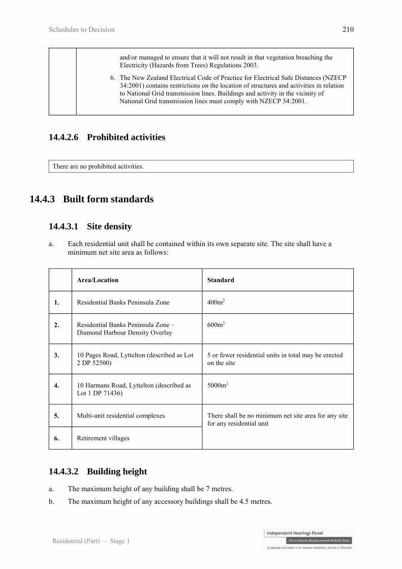
Schedules to Decision 210
Residential (Part) — Stage 1
and/or managed to ensure that it will not result in that vegetation breaching the
Electricity (Hazards from Trees) Regulations 2003.
6. The New Zealand Electrical Code of Practice for Electrical Safe Distances (NZECP
34:2001) contains restrictions on the location of structures and activities in relation
to National Grid transmission lines. Buildings and activity in the vicinity of
National Grid transmission lines must comply with NZECP 34:2001.
14.4.2.6 Prohibited activities
There are no prohibited activities.
14.4.3 Built form standards
14.4.3.1 Site density
a. Each residential unit shall be contained within its own separate site. The site shall have a
minimum net site area as follows:
Area/Location Standard
1. Residential Banks Peninsula Zone 400m2
2. Residential Banks Peninsula Zone –
Diamond Harbour Density Overlay
600m2
3. 10 Pages Road, Lyttelton (described as Lot
2 DP 52500)
5 or fewer residential units in total may be erected
on the site
4. 10 Harmans Road, Lyttelton (described as
Lot 1 DP 71436)
5000m2
5. Multi-unit residential complexes There shall be no minimum net site area for any site
for any residential unit
6. Retirement villages
14.4.3.2 Building height
a. The maximum height of any building shall be 7 metres.
b. The maximum height of any accessory buildings shall be 4.5 metres.
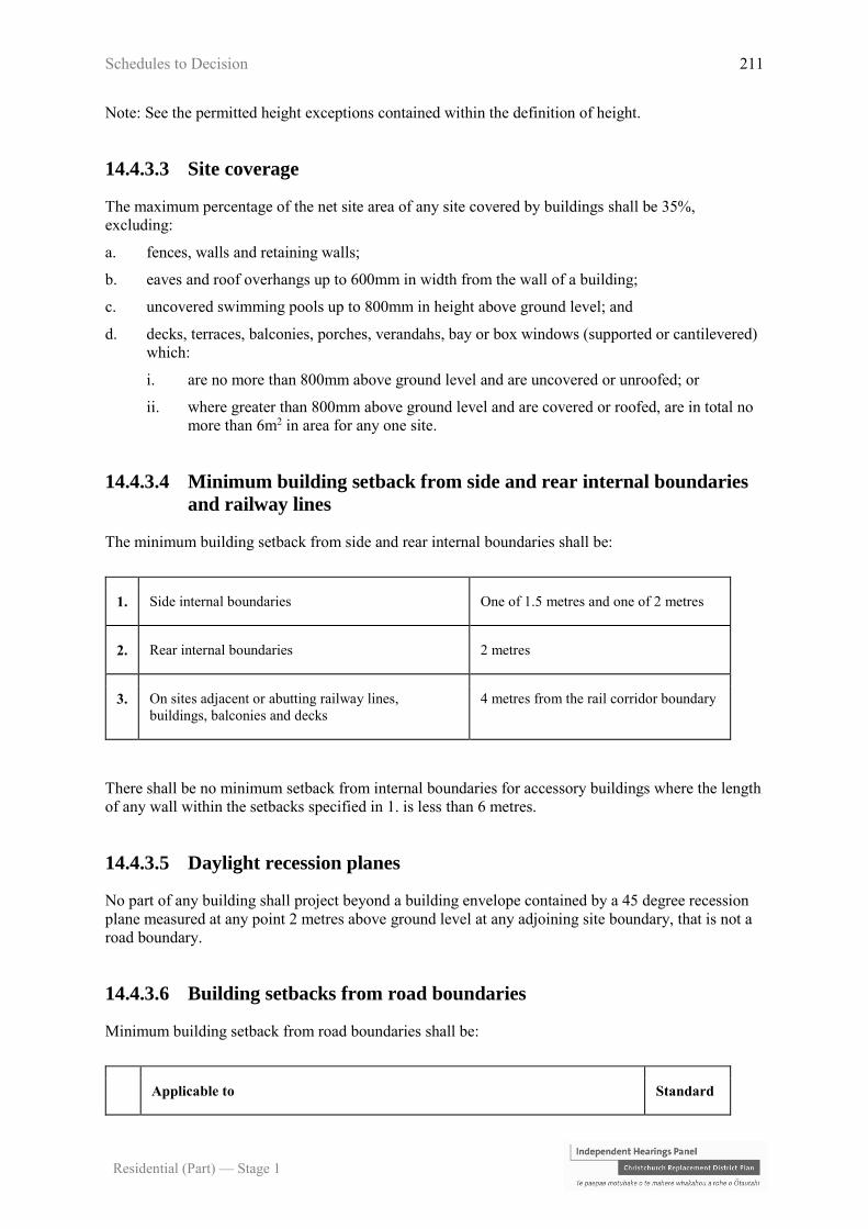
Schedules to Decision 211
Residential (Part) — Stage 1
Note: See the permitted height exceptions contained within the definition of height.
14.4.3.3 Site coverage
The maximum percentage of the net site area of any site covered by buildings shall be 35%,
excluding:
a. fences, walls and retaining walls;
b. eaves and roof overhangs up to 600mm in width from the wall of a building;
c. uncovered swimming pools up to 800mm in height above ground level; and
d. decks, terraces, balconies, porches, verandahs, bay or box windows (supported or cantilevered)
which:
i. are no more than 800mm above ground level and are uncovered or unroofed; or
ii. where greater than 800mm above ground level and are covered or roofed, are in total no
more than 6m2 in area for any one site.
14.4.3.4 Minimum building setback from side and rear internal boundaries
and railway lines
The minimum building setback from side and rear internal boundaries shall be:
1. Side internal boundaries One of 1.5 metres and one of 2 metres
2. Rear internal boundaries 2 metres
3. On sites adjacent or abutting railway lines,
buildings, balconies and decks
4 metres from the rail corridor boundary
There shall be no minimum setback from internal boundaries for accessory buildings where the length
of any wall within the setbacks specified in 1. is less than 6 metres.
14.4.3.5 Daylight recession planes
No part of any building shall project beyond a building envelope contained by a 45 degree recession
plane measured at any point 2 metres above ground level at any adjoining site boundary, that is not a
road boundary.
14.4.3.6 Building setbacks from road boundaries
Minimum building setback from road boundaries shall be:
Applicable to Standard

Schedules to Decision 212
Residential (Part) — Stage 1
1. Where a garage contains a vehicle entrance way which generally faces a road 5 metres
2. All other buildings 3 metres
14.4.3.7 Water supply for fire fighting
Sufficient water supply and access to water supplies for fire fighting shall be made available to all
residential units via Council’s urban reticulated system (where available) in accordance with the New
Zealand Fire Service Fire Fighting Water Supplies Code of Practice (SNZ PAS: 4509:2008). Where a
reticulated water supply compliant with SNZ PAS:4509:2008 is not available, or the only supply
available is the controlled restricted rural type water supply which is not compliant with SNZ
PAS:4509:2008 water supply and access to water supplies for fire fighting that is in compliance with
the alternative firefighting water sources provisions of SNZ PAS 4509:2008 must be provided.
14.4.4 Area specific rules – Residential Banks Peninsula Zone
The following rules apply within the Lyttelton Port Influences Overlay. All activities are subject to
the rules in 14.4.2 and 14.4.3 unless specified otherwise.
14.4.4.1 Area specific permitted activities
Activity Area specific
standards
P1 Extension to an existing habitable space or the erection of a new habitable
space associated with an existing residential unit in the Lyttelton Port
Influences Overlay where the combined gross floor area of the habitable
space does not exceed 40m2 within a 10 year continuous period
a. Compliance with
Rule 14.4.4.4.
P2 Replacement for an existing residential unit in the Lyttelton Port
Influences Overlay where the combined gross floor area of the habitable
space does not exceed the combined gross floor area of the habitable
spaces contained in the previous residential unit by more than 40m2 within
a 10 year continuous period
a. Compliance with
Rule 14.4.4.4.
14.4.4.2 Area specific restricted discretionary activities
Activity The Council’s
discretion shall be

Schedules to Decision 213
Residential (Part) — Stage 1
limited to the
following matters
RD1 Extension to an existing habitable space or the erection of a new
habitable space associated with an existing residential unit in the
Lyttelton Port Influences Overlay where the combined gross floor area
of the habitable space exceeds 40m2 within a 10 year continuous period
with a no complaints covenant, provided that the works comply with
Rule 14.4.4.4.
Any application arising from this rule shall not be publicly notified and
shall only be limited notified to Lyttelton Port Company where it has
not given its written approval.
a. Lyttelton Port
Influences
Overlay -
14.13.15
RD2 Replacement residential unit for an existing residential unit in the
Lyttelton Port Influences Overlay where the combined gross floor area
of the habitable space exceeds the combined gross floor area of the
habitable space contained in the previous residential unit by more than
40m2 within a 10 year continuous period with a no complaints covenant,
provided that the works comply with Rule 14.4.4.4.
Any application arising from this rule shall not be publicly notified and
shall only be limited notified to Lyttelton Port Company where it has
not given its written approval.
14.4.4.3 Area specific non-complying activities
The activities listed below are a non-complying activity
NC1 Extension under Rule 14.4.4.1 (P1) in the Lyttelton Port Influences Overlay that does not comply
with Rule 14.4.4.4.
Any application arising from this rule shall not be publicly notified and shall only be limited
notified to Lyttelton Port Company where it has not given its written approval.
NC2 Replacement under Rule 14.4.4.1 (P2) in the Lyttelton Port Influences Overlay that does not
comply with Rule 14.4.4.4.
Any application arising from this rule shall not be publicly notified and shall only be limited
notified to Lyttelton Port Company where it has not given its written approval.
NC3 Extension to an existing habitable space or the erection of a new habitable space associated with an
existing residential unit in the Lyttelton Port Influences Overlay where the combined gross floor
area of the habitable space exceeds 40m2 within a 10 year continuous period that:
a. does not have a no complaints covenant; and/or
b. does not comply with Rule 14.4.4.4.
Any application arising from this rule shall not be publicly notified and shall only be limited
notified to Lyttelton Port Company where it has not given its written approval.

Schedules to Decision 214
Residential (Part) — Stage 1
NC4 Replacement residential unit for an existing residential unit in the Lyttelton Port Influences Overlay
where the combined gross floor area of the habitable space exceeds the combined gross floor area
of the habitable space contained in the previous residential unit by more than 40m2 within a 10 year
continuous period that:
a. does not have a no complaints covenant; and/or
b. does not comply with Rule 14.4.4.4.
Any application arising from this rule shall not be publicly notified and shall only be limited
notified to Lyttelton Port Company where it has not given its written approval.
NC5 New noise sensitive activities in the Lyttelton Port Influences Overlay.
Any application arising from this rule shall not be publicly notified and shall only be limited
notified to Lyttelton Port Company where it has not given its written approval.
14.4.4.4 Area specific built form standards
14.4.4.4.1 Internal sound design level in the Lyttelton Port Influences Overlay
New habitable space or extensions to existing habitable space in the Lyttelton Port Influences Overlay
shall have an internal sound design level of 40dBA Ldn (5 day) with ventilating windows or with
windows and doors closed and mechanical ventilation installed and operating.
For the purposes of this rule, the design shall achieve an internal design sound level of a habitable
room, the external noise environment will be the modelled level of port noise taken from the predicted
dBA Ldn (5 day) contour closest to the habitable room, in accordance with the methodology of NZS
6809:1999 Port Noise Management and Land Use Planning.
Note: There will be a port noise contour map attached to a Port Noise Management Plan, which is to
be prepared and regularly updated in accordance with Chapter 6 of this plan. This map will show the
dBA Ldn (5 day) contour lines, in 1 dBA increments, across Lyttelton Township and would be
available for a property owner’s acoustic design consultant to use.

Schedules to Decision 215
Residential (Part) — Stage 1
14.5 Rules - Residential Hills Zone
[placeholder]
14.6 Rules - Residential Bach Zone
[placeholder]
14.7 Rules - Residential Large Lot Zone
[placeholder]
14.8 Rules - Residential Small Settlement Zone
[placeholder]
14.9 Rules – Residential New Neighbourhood Zones
[deferred to NNZ Hearing]
14.10 Rules - Residential Guest Accommodation Zone
[deferred to General Rules Hearing]

Schedules to Decision 216
Residential (Part) — Stage 1
14.11 Rules — Enhanced Development Mechanism
14.11.1 How to use these rules
a. The rules that define where the Enhanced Development Mechanism can be used are contained
in the qualifying standards in Rule 14.11.2.
b. The following rules determine the activity status of resource consents applications to use the
Enhanced Development Mechanism:
i. the activity status tables in Rule 14.11.3; and
ii. the built form standards in Rule 14.11.4.
c. The information that is required for resource consent applications is set out in Rule 14.11.5.
d. On any particular site the provisions of the Enhanced Development Mechanism may apply or
the provisions of the zone in which the site is located may apply.
e. Where the word “facility” is used in the rules (e.g. spiritual facility) it shall also include the use
of a site /building for the activity that the facility provides for, unless expressly stated
otherwise. Similarly, where the word/phrase defined include the word “activity” or “activities”,
the definition includes the land and/or buildings for that activities unless stated otherwise in the
activity status tables.
14.11.2 Qualifying standards
Qualifying sites shall comply with the following qualifying standards.
14.11.2.1 Zoning qualifying standards
a. Qualifying sites shall be located in the Residential Suburban Density Transition Zone, or the
Residential Medium Density Zone, or the Cultural 3 Zone or the Residential Banks Peninsula
Zone.
14.11.2.2 Site size qualifying standards
a. Qualifying sites shall be:
i. of a size greater than 1500m2 and less than 10,000m2; and
ii. in one continuous block of land.
14.11.2.3 Housing yield qualifying standards
a. Comprehensive development of a site shall deliver a minimum density of 30 households per
hectare (one unit per 330m2), and a maximum density of 65 households per hectare (one unit
per 150m2).

Schedules to Decision 217
Residential (Part) — Stage 1
14.11.2.4 Location qualifying standards
Accessibility criteria
a. Qualifying sites shall lie fully within all of the following four criteria:
i. 800 metres EDM walking distance of:
A. A Central City Business Zone , or Central City Mixed Use Zone, or a Commercial
Core Zone; or the Commercial Banks Peninsula Zone in Lyttelton; or
B. An EDM Qualifying Supermarket - except that B does not apply to EDM in the
Residential Banks Peninsula Zone;
ii. 800 metres EDM walking distance of either a primary or intermediate school;
iii. 400 metres EDM walking distance of an Open Space 2 Zone or an Open Space 1 Zone
that has an area greater than 4000m2; and
iv. 600 metres EDM walking distance of an EDM core public transport route – except that
iv. does not apply to EDM in the Residential Banks Peninsula Zone.
Note: For ii. – iv. above where the walking route is bisected by an arterial road in Chapter 7 Transport
Appendix 7.12, the EDM walking distance shall be measured at a formal pedestrian crossing point.
Constraint criteria
b. No part of a qualifying site shall lie within:
i. a Special Amenity Area identified in the City Plan as at 6 December 2013; or
ii. 400 metres of the boundary of an Industrial – Heavy Zone; or
iii. the tsunami inundation area as shown in Appendix 14.14.5; or
iv. the Riccarton Wastewater interceptor catchment. In the identified lower catchment this
standard only applies until infrastructure work creating capacity has been completed.
14.11.3 Activity status tables
14.11.3.1 Restricted discretionary activities
The activities listed below are restricted discretionary activities.
Discretion to grant or decline consent and impose conditions is restricted to the matters of discretion
set out in 14.13 for each standard, or as specified, as set out in the following table.
Until 31 December 2018, resource consent applications in relation to these rules shall not be publicly
or limited notified, except as specified in RD3 and RD4 below.

Schedules to Decision 218
Residential (Part) — Stage 1
Activity The Council's discretion shall be limited
to the following matters:
RD1 Residential activities utilising the Enhanced
Development Mechanism that comply with all
qualifying standards in Rule 14.11.2 and are not in
breach of the built form standards in Rule 14.11.4.
a. Residential design principles –
14.13.1
RD2 Residential activities utilising the Enhanced
Development Mechanism that comply with all
qualifying standards in Rule 14.11.2 but do not
comply with one or more of the built form standards
in Rule 14.11.4 (except 14.11.4.13 and 14.11.4.14;
refer to RD3 and RD4 below).
a. Residential design principles –
14.13.1
b. As relevant to the breached built form
standard:
i. Site density and site coverage -
14.13.2
ii. Impacts on neighbouring
property - 14.13.3
iii. Street scene – road boundary
building setback, fencing and
planting – 14.13.18
iv. Minimum building, window and
balcony setbacks - 14.13.19
v. Outdoor living space - 14.13.21
vi. Minimum unit size and unit mix
- 14.13.4
vii. Service, storage and waste
management spaces - 14.13.20
viii. Acoustic insulation - 14.13.9
ix. Traffic generation and access
safety - 14.13.6
RD3 Residential activities utilising the Enhanced
Development Mechanism that comply with all
qualifying standards in Rule 14.11.2 but do not
comply with Rule 14.11.4.13.
Until 31 December 2018, any application arising
from this rule will only require the written approval
of the New Zealand Fire Service to not be limited
notified and shall not be fully publicly notified.
a. Residential design principles –
14.13.1
b. Water supply for fire fighting -
14.13.8
RD4 Residential activities utilising the Enhanced
Development Mechanism that comply with all
qualifying standards in Rule 14.11.2 but do not
comply with Rule 14.11.4.14 relating to rail
corridor boundary setbacks
a. Residential design principles –
14.13.1
b. Whether the reduced setback from the
rail corridor will enable buildings to
be maintained without requiring
access above, over, or on the rail
corridor.

Schedules to Decision 219
Residential (Part) — Stage 1
Activity The Council's discretion shall be limited
to the following matters:
Until 31 December 2018, any application arising
from this rule shall not be publicly notified and
shall only be limited notified to KiwiRail where it
has not given its written approval.
14.11.3.2 Discretionary activities
The activities listed below are discretionary activities.
Activity
D1 Residential activities utilising the Enhanced Development Mechanism where part of the site, but not
all of the site, complies with all of the location qualifying standards in Rule 14.11.2.4, and complies
with all other qualifying standards in Rule 14.11.2
14.11.3.3 Non-complying activities
The activities listed below are non-complying activities.
Activity
NC1 Residential activities utilising the Enhanced Development Mechanism that do not comply with
zoning qualifying standards in Rule 14.11.2.1
NC2 Residential activities utilising the Enhanced Development Mechanism that do not comply with site
size qualifying standards in Rule 14.11.2.2
NC3 Residential activities utilising the Enhanced Development Mechanism that do not comply with
housing yield qualifying standards in Rule 14.11.2.3
14.11.4 Built form standards
For the purpose of this rule, site refers to the entire site area being utilised for the Enhanced
Development Mechanism, which may include a number of titles.

Schedules to Decision 220
Residential (Part) — Stage 1
14.11.4.1 Building height
Within 15 metres of the site boundary, the maximum height of any building shall be 8 metres where
the site adjoins the Residential Suburban Zone. Across the rest of the site area the maximum building
height shall be 11 metres.
14.11.4.2 Daylight recession planes
Buildings shall not project beyond a building envelope constructed by recession planes from points
2.3 metres above boundaries with other sites as shown in Appendix 14.14.2, diagram C except that:
a. where an internal boundary of a site abuts an access lot, access strip, or access to a rear lot, the
recession plane may be constructed from points 2.3 metres above the furthest boundary of the
access lot, access strip, or access to a rear lot or any combination of these areas;
b. where buildings on adjoining sites have a common wall along an internal boundary the
recession planes shall not apply along that part of the boundary covered by such a wall.
Note: The level of internal boundaries shall be measured from filled ground level except where the
site on the other side of the internal boundary is at a lower level, then that lower level shall be
adopted.
14.11.4.3 Street scene
Buildings shall be set back a minimum of 4.5 metres from road boundaries, other than where a site
has a road boundary that is subject to another standard in this Plan, except that:
a. where a garage has a vehicle door facing a road the garage door shall be set back a minimum of
4.5 metres unless the garage door(s) provided tilt or swing outwards, in which case the garage
door shall be set back a minimum of 5.5 metres;
b. where a garage has the vehicle door facing a shared access way, the garage door shall be set
back a minimum of seven metres measured from the garage door to the furthest formed edge of
the adjacent shared access unless the garage door(s) provided tilt or swing outwards, in which
case the garage door shall be set back a minimum of eight metres; and
c. for residential units fronting the street; garages, and other accessory buildings (excluding
basement car parking and swimming pools) shall be located at least 1.2 metres further from the
road boundary than the front facade of any ground level habitable space of that unit.
14.11.4.4 Separation from neighbours
a. Buildings that adjoin an access lot, access strip, or access to a rear site shall be set back a
minimum of 1 metre from that part of an internal boundary of a site.
b. Accessory buildings which face the ground floor window of a habitable space on an adjoining
site shall be set back a minimum of 1.8 metres from that neighbouring window for a minimum
length of two metres either side of the window.
c. In all other instances buildings shall be set back a minimum of 1.8 metres from internal
boundaries of a site, except that:
i. no setback is required from an access lot or access strip on the same site, provided that
any windows on the ground floor facing and within one metre of the access lot or access
strip are non-opening;
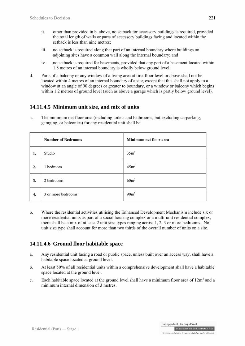
Schedules to Decision 221
Residential (Part) — Stage 1
ii. other than provided in b. above, no setback for accessory buildings is required, provided
the total length of walls or parts of accessory buildings facing and located within the
setback is less than nine metres;
iii. no setback is required along that part of an internal boundary where buildings on
adjoining sites have a common wall along the internal boundary; and
iv. no setback is required for basements, provided that any part of a basement located within
1.8 metres of an internal boundary is wholly below ground level.
d. Parts of a balcony or any window of a living area at first floor level or above shall not be
located within 4 metres of an internal boundary of a site, except that this shall not apply to a
window at an angle of 90 degrees or greater to boundary, or a window or balcony which begins
within 1.2 metres of ground level (such as above a garage which is partly below ground level).
14.11.4.5 Minimum unit size, and mix of units
a. The minimum net floor area (including toilets and bathrooms, but excluding carparking,
garaging, or balconies) for any residential unit shall be:
Number of Bedrooms Minimum net floor area
1. Studio 35m2
2. 1 bedroom 45m2
3. 2 bedrooms 60m2
4. 3 or more bedrooms 90m2
b. Where the residential activities utilising the Enhanced Development Mechanism include six or
more residential units as part of a social housing complex or a multi-unit residential complex,
there shall be a mix of at least 2 unit size types ranging across 1, 2, 3 or more bedrooms. No
unit size type shall account for more than two thirds of the overall number of units on a site.
14.11.4.6 Ground floor habitable space
a. Any residential unit facing a road or public space, unless built over an access way, shall have a
habitable space located at ground level.
b. At least 50% of all residential units within a comprehensive development shall have a habitable
space located at the ground level.
c. Each habitable space located at the ground level shall have a minimum floor area of 12m2 and a
minimum internal dimension of 3 metres.

Schedules to Decision 222
Residential (Part) — Stage 1
14.11.4.7 Outdoor living space
a. For residential units with 2 or more bedrooms a minimum of 30m2 of outdoor living space shall
be provided on site for each residential unit, and shall not be occupied by parking or access.
The required outdoor living space can be in a mix of private and communal areas, at the ground
level or in balconies, provided that:
i. each unit shall have private outdoor living space of at least 16m2 in total. The balance of
the outdoor living space required for each residential unit may be provided as communal
space;
ii. private outdoor living space shall have a minimum dimension of 4 metres when provided
at ground level and a minimum dimension of 1.5 metres when provided by a balcony;
iii. at least one private outdoor living space shall be directly accessible from a living area of
that unit;
iv. outdoor living space provided as a communal space shall be accessible for use by all
units and shall have a minimum dimension of 4 metres; and
v. 50% of the outdoor living space required across the entire site shall be provided at
ground level.
b. For one bedroom residential units on the ground floor a minimum of 16m2 private outdoor
living space with a minimum dimension of 4 metres shall be provided on site for each
residential unit, and shall not be occupied by parking or access.
c. For one bedroom residential units entirely at an upper level at total of 16m2 of outdoor living
space shall be provided on site for each residential unit provided that:
i. one space can be a private balcony with a minimum area of 6m2 and a minimum
dimension of 1.5 metres;
ii. the balance 10m2 can be provided in a communal space.
14.11.4.8 Service, storage, and waste management spaces
a. Each residential unit shall be provided with:
i. an outdoor service space and waste management area of 5m2 with a minimum dimension
of 1.5 metres; and
ii. a single, indoor storage space of 4m3 with a minimum dimension of 1 metre;
unless otherwise provided for in c. below.
b. Any space designated for waste management, whether private or communal, shall not be
located between the road boundary and any habitable space and shall be screened from sites,
conservation or open space zones, roads, and adjoining outdoor living spaces to a height of 1.5
metres.
c. If a communal waste management area is provided within the site:
i. the minimum required outdoor service space may be reduced to 3m2 for each residential
unit; and
ii. it must be demonstrated to be:
A. of a sufficient size to accommodate the number and dimensions of bins required to
meet the predicted volume of waste generated by the residential units;
B. accessible and safe for use by all residents; and
Schedules to Decision 223
Residential (Part) — Stage 1
C. easily accessible for the collection of bins by waste management contractors
14.11.4.9 Landscaping and tree planting
a. A minimum of 20% of the site utilising the Enhanced Development Mechanism shall be
provided for landscape treatment (which may include private or communal open space),
including a minimum of one tree for every 250m2 of gross site area (prior to subdivision), or
part thereof. At least one tree shall be planted adjacent to the street boundary.
b. All trees shall be not less than 1.5 metres high at the time of planting.
c. All trees and landscaping required by this rule shall be maintained and if dead, diseased or
damaged, shall be replaced.
14.11.4.10 Acoustic insulation
Any habitable space within a residential unit which is within:
a. 40 metres of the edge of the nearest marked traffic lane of an arterial road, or a railway line; or
b. 20 metres of the edge of the nearest marked traffic lane of a collector road as defined in Chapter
7 Transportation Appendix 7.12;
shall achieve a minimum internal to external noise reduction of 30dBA (Dtr, 2m, nT)
Note:
A. Compliance with this rule may be achieved by ensuring any construction is in
accordance with the acceptable solutions listed in Appendix 14.14.1 Measurement
and Assessment of Noise. No alternative ventilation is required in situations where
the rule is only met with windows closed. Alternatively, compliance with the rule
can be achieved through certification by a qualified acoustic engineer that the design
is capable of achieving compliance with the performance standard.
B. Where no traffic lane is marked, the distances stated shall be measured from 2
metres on the road ward side of the formed kerb.
14.11.4.11 Parking space numbers
a. A minimum of one car parking space shall be provided for each residential unit.
b. Parking areas shall be screened on internal boundaries by landscaping, wall(s), fence(s), or a
combination of these to a minimum height of 1.5 metres from any adjoining site. Where this
screening is by way of landscaping it shall be for a minimum depth of 1.5 metres.
c. A minimum of one cycle space shall be provided at ground level for each residential unit except
where parking for that unit is provided in a garage.
Note: this development standard applies in place of any equivalent minimum or maximum car or
cycle parking requirement for the underlying zone in Chapter 7 Transportation of this Plan.

Schedules to Decision 224
Residential (Part) — Stage 1
14.11.4.12 Maximum building coverage within Enhanced Development
Mechanism areas
The maximum percentage of the gross area covered by buildings within developments using the
Enhanced Development Mechanism shall be 40%.
14.11.4.13 Water supply for fire fighting
Sufficient water supply and access to water supplies for fire fighting shall be made available to all
residential units via Council’s urban fully reticulated system and in accordance with the New Zealand
Fire Service Fire Fighting Water Supplies Code of Practice (SNZ PAS:4509:2008).
14.11.4.14 Minimum building setbacks from railway lines
The minimum building setback shall:
1. On sites adjacent or abutting rail way lines buildings, balconies
and decks
4 metres from the rail corridor
boundary
14.11.5 Information requirements for applications
Any application for resource consent using the Enhanced Development Mechanism must include a
detailed ‘design statement’ (prepared by an expert suitably qualified in architecture or urban design).
Schedules to Decision 225
Residential (Part) — Stage 1
14.12 Rules - Community Housing Redevelopment Mechanism
14.12.1 How to use the rules
a. The areas that show where the Community Housing Redevelopment Mechanism (CHRM) can be utilised
are shown on Planning Maps 18, 23, 24, 25, 26, 29, 30, 31, 32, 33, 37 and 45.
b. The following rules determine the activity status of resource consent applications to use the Community
Housing Redevelopment Mechanism:
i. the activity status tables in Rule 14.12.2; and
ii. the built form standards in Rule 14.12.3.
c. The information that is required for resource consent applications is set out in Rule 14.12.4.
d. On any particular site the provisions of the Community Housing Redevelopment Mechanism may apply or
the provisions of the zone in which the site is located may apply.
e. Where the word “facility” is used in the rules (e.g. spiritual facility) it shall also include the use of a site
/building for the activity that the facility provides for, unless expressly stated otherwise. Similarly, where
the word/phrase defined include the word “activity” or “activities”, the definition includes the land and/or
buildings for that activities unless stated otherwise in the activity status tables.
14.12.2 Activity status tables
14.12.2.1 Restricted discretionary activities
The activities listed below are restricted discretionary activities.
Discretion to grant or decline consent and impose conditions is restricted to the matters of discretion
set out in 14.13 for each standard, or as specified, as set out in the following table.
Until 31 December 2018, resource consent applications in relation to these rules shall not be publicly
or limited notified, except as specified in RD3 and RD4 below.
Activity The Council's discretion shall be
limited to the following matters:
RD1 Residential activities utilising the Community Housing
Redevelopment Mechanism on sites located within the
CHRM areas shown on Planning Maps 18, 23, 24, 25, 26,
29, 30, 31, 32, 33, 37 and 45 that are not in breach of the
built form standards in Rules 14.12.3
a. Residential design principles –
14.13.1
RD2 Residential activities utilising the Community Housing
Redevelopment Mechanism on sites located within the
CHRM areas shown on Planning Maps 18, 23, 24, 25, 26,
29, 30, 31, 32, 33, 37 and 45 but do not comply with one
or more of the built form standards in 14.12.3 (except
14.12.3.15 and 14.12.3.16.1, refer to RD3 and RD4
a. Residential design principles –
14.13.1
b. As relevant to the breached built
form standard:
i. Site density and site

Schedules to Decision 226
Residential (Part) — Stage 1
below; and 14.12.3.13 and 14.12.3.14; refer to NC2 and
NC3)
coverage - 14.13.2
ii. Impacts on neighbouring
property – 14.13.3
iii. Street scene - road
boundary building setback,
fencing and planting -
14.13.18
iv. Minimum building,
window and balcony
setbacks - 14.13.19
v. Outdoor living space -
14.13.21
vi. Minimum unit size and unit
mix - 14.13.4
vii. Service, storage and waste
management spaces -
14.13.20
viii. Acoustic insulation -
14.13.9
ix. Traffic generation and
access safety - 14.13.6
RD3 Residential activities utilising the Community Housing
Redevelopment Mechanism on sites located within the
CHRM areas shown on Planning Maps 18, 23, 24, 25, 26,
29, 30, 31, 32, 33, 37 and 45 that do not comply with
Rule 14.12.3.15.
Until 31 December 2018, any application arising from
this rule will only require the written approval of the
New Zealand Fire Service to not be limited notified and
shall not be fully publicly notified.
a. Residential design principles –
14.13.1
b. Water supply for fire fighting -
14.13.8
RD4 Residential activities utilising the Community Housing
Redevelopment Mechanism on sites located within the
CHRM areas shown on Planning Maps 18, 23, 24, 25, 26,
29, 30, 31, 32, 33, 37 and 45 that do not comply with
Rule 14.12.3.16.1 relating to rail corridor boundary
setbacks
Until 31 December 2018, any application arising from
this rule shall not be publicly notified and shall only be
limited notified to KiwiRail where it has not given its
written approval.
a. Residential design principles –
14.13.1
b. Whether the reduced setback
from the rail corridor will enable
buildings to be maintained
without requiring access above,
over, or on the rail corridor

Schedules to Decision 227
Residential (Part) — Stage 1
14.12.2.2 Non-complying activities
The activities listed below are a non-complying activity.
Activity
NC1 Residential activities utilising the Community Housing Redevelopment Mechanism on sites not
located within the within the CHRM areas shown on the planning maps
NC2 Residential activities utilising the Community Housing Redevelopment Mechanism that do not
comply with Rule 14.12.3.13 – Community housing site size
NC3 Residential activities utilising the Community Housing Redevelopment Mechanism that do not
comply with Rule 14.12.3.14 - Community housing unit proportion and yield
14.12.3 Built form standards
For the purpose of this rule, site refers to the entire site area being utilised for the Enhanced
Development Mechanism, which may include a number of titles.
14.12.3.1 Building height
Within 15 metres of the site boundary, the maximum height of any building shall not exceed 8m
where the site adjoins the Residential Suburban Zone and the Residential Suburban Density Transition
Zone. Across the rest of the entire site of the Community House Redevelopment Mechanism area the
maximum building height shall not exceed 11 metres.
14.12.3.2 Daylight recession planes
Buildings shall not project beyond a building envelope constructed by recession planes from points
2.3 metres above boundaries with other sites as shown in Appendix 14.14.2, diagram C, except that:
a. where an internal boundary of a site abuts an access lot, access strip, or access to a rear lot, the
recession plane may be constructed from points 2.3 metres above the furthest boundary of the
access lot, access strip, or access to a rear lot or any combination of these areas; and
b. where buildings on adjoining sites have a common wall along an internal boundary the
recession planes shall not apply along that part of the boundary covered by such a wall.
Note: The level of internal boundaries shall be measured from filled ground level except where the
site on the other side of the internal boundary is at a lower level, then that lower level shall be
adopted.
14.12.3.3 Street scene
Buildings shall be set back a minimum of 4.5 metres from road boundaries, other than where a site
has a road boundary that is subject to another standard in this Plan, except that:

Schedules to Decision 228
Residential (Part) — Stage 1
a. where a garage has a vehicle door facing a road the garage door shall be set back a minimum of
4.5 metres unless the garage door(s) provided tilt or swing outwards, in which case the garage
door shall be set back a minimum of 5.5 metres;
b. where a garage has the vehicle door facing a shared access way, the garage door shall be set
back a minimum of 7 metres measured from the garage door to the furthest formed edge of the
adjacent shared access unless the garage door(s) provided tilt or swing outwards, in which case
the garage door shall be set back a minimum of 8 metres;
c. for residential units fronting the street; garages and other accessory buildings (excluding
basement car parking and swimming pools) shall be located at least 1.2 metres further from the
road boundary than the front facade of any ground level habitable space of that unit; and
d. on properties fronting Emmet Street the setback shall be 6.5 metres.
14.12.3.4 Separation from neighbours
a. Buildings that adjoin an access lot, access strip, or access to a rear site shall be set back a
minimum of 1 metre from that part of an internal boundary of a site.
b. Accessory buildings which face the ground floor window of a habitable space on an adjoining
site shall be set back a minimum of 1.8 metres from that neighbouring window for a minimum
length of two metres either side of the window.
In all other instances buildings shall be set back a minimum of 1.8 metres from internal
boundaries of a site, except that:
i. no setback is required from an access lot or access strip on the same site, provided that
any windows on the ground floor facing and within one metre of the access lot or access
strip are non-opening;
ii. other than provided in b above, no setback for accessory buildings is required, provided
the total length of walls or parts of accessory buildings facing and located within the
setback is less than 9 metres;
iii. no setback is required along that part of an internal boundary where buildings on
adjoining sites have a common wall along the internal boundary; and
iv. no setback is required for basements, provided that any part of a basement located within
1.8 metres of an internal boundary is wholly below ground level.
Parts of a balcony or any window of a living area at first floor level or above shall not be
located within four metres of an internal boundary of a site, except that this shall not apply to a
window at an angle of 90 degrees or greater to the boundary, or a window or balcony which
begins within 1.2 metres of ground level (such as above a garage which is partly below ground
level).
14.12.3.5 Minimum unit size, and mix of units
The minimum net floor area (including toilets and bathrooms, but excluding car parking, garaging or
balconies) for any residential unit shall be:
Number of bedrooms Minimum net floor area

Schedules to Decision 229
Residential (Part) — Stage 1
1. Studio 35m2
2. 1 bedroom 45m2
3. 2 bedrooms 60m2
4. 3 or more bedrooms 90m2
14.12.3.6 Ground floor habitable space
a. Any residential unit facing a road or public space, unless built over an access way, shall have a
habitable space located at ground level.
b. At least 50% of all residential units within a comprehensive development shall have a habitable
space located at the ground level.
c. Each habitable space located at the ground level shall have a minimum floor area of 12m2 and a
minimum internal dimension of 3 metres.
14.12.3.7 Outdoor living space
a. For residential units with two or more bedrooms a minimum of 30m2 of outdoor living space
shall be provided on site for each residential unit, and shall not be occupied by parking or
access. The required outdoor living space can be in a mix of private and communal areas, at the
ground level or in balconies provided that:
i. each unit shall have private outdoor living space of at least 16m2 in total. The balance of
the outdoor living space required for each residential unit may be provided as communal
space;
ii. private outdoor living space shall have a minimum dimension of 4 metres when provided
at ground level and a minimum dimension of 1.5 metres when provided by a balcony;
iii. at least one private outdoor living space shall be directly accessible from a living area of
that unit;
iv. outdoor living space provided as a communal space shall be accessible for use by all
units and shall have a minimum dimension of 4 metres; and
v. 50% of the outdoor living space required across the entire site shall be provided at
ground level.
b. For one bedroom residential units on the ground floor a minimum of 16m2 private outdoor
living space with a minimum dimension of 4 metres shall be provided on site for each
residential unit, and shall not be occupied by parking or access.
c. For one bedroom residential units entirely at an upper level at total of 16m2 of outdoor living
space shall be provided on site for each residential unit provided that:
i. one space can be a private balcony with a minimum area of 6m2 and a minimum
dimension of 1.5 metres; and
ii. the balance 10m2 can be provided in a communal space.

Schedules to Decision 230
Residential (Part) — Stage 1
14.12.3.8 Service, storage, and waste management spaces
a. Each residential unit shall be provided with:
i. an outdoor service space and waste management area of 5m2 with a minimum dimension
of 1.5 metres; and
ii. a single, indoor storage space of 4m3 with a minimum dimension of 1 metre;
unless otherwise provided for in c. below.
b. Any space designated for waste management, whether private or communal, shall not be
located between the road boundary and any habitable space and shall be screened from
adjoining sites, conservation or open space zones, roads, and adjoining outdoor living spaces to
a height of 1.5 metres.
c. If a communal waste management area is provided within the site:
i. the minimum required outdoor service space may be reduced to 3m2 for each residential
unit; and
ii. it must be demonstrated to be:
A. of a sufficient size to accommodate the number and dimensions of bins required to
meet the predicted volume of waste generated by the residential units;
B. accessible and safe for use by all residents; and
C. easily accessible for the collection of bins by waste management contractors.
14.12.3.9 Landscaping and tree planting
a. A minimum of 20% of the site shall be provided for landscape treatment (which may include
private or communal open space), including a minimum of one tree for every 250m2 of gross
site area (prior to subdivision), or part thereof. At least one tree shall be planted adjacent to the
street boundary.
b. All trees required by this rule shall be not less than 1.5 metres high at the time of planting.
c. All trees and landscaping required by this rule shall be maintained and if dead, diseased or
damaged, shall be replaced.
14.12.3.10 Acoustic insulation
Any habitable space within a residential unit which is within:
a. 40 metres of the edge of the nearest marked traffic lane of a minor arterial, or major arterial
road, or a railway line; or
b. 20 metres of the edge of the nearest marked traffic lane of a collector road as defined Chapter 7
Transportation Appendix 7.12 shall achieve a minimum internal to external noise reduction of
30 dBA (Dtr, 2m, nT).
Note: Compliance with this rule may be achieved by ensuring any construction is in accordance with
the acceptable solutions listed in Appendix 14.14.1. No alternative ventilation is required in situations
where the rule is only met with windows closed. Alternatively, compliance with the rule can be
achieved through certification by a qualified acoustic engineer that the design is capable of achieving
compliance with the performance standard.

Schedules to Decision 231
Residential (Part) — Stage 1
Where no traffic lane is marked, the distances stated shall be measured from 2 metres on the road
ward side of the formed kerb.
14.12.3.11 Parking space numbers
a. A minimum of one car parking space shall be provided for each residential unit.
b. Parking areas shall be screened on internal boundaries by landscaping, wall(s), fence(s), or a
combination of these to a minimum height of 1.5 metres from any adjoining site. Where this
screening is by way of landscaping it shall be for a minimum depth of 1.5 metres.
c. A minimum of one cycle space shall be provided at ground level for each residential unit.
Except where parking for that unit is provided in a garage.
Note: this development standard applies in place of any equivalent minimum or maximum car or
cycle parking requirement for the underlying zone in Chapter 7 Transportation of this Plan.
14.12.3.12 Maximum building coverage within Community House
Redevelopment Mechanism Areas
The maximum percentage of the gross area covered by buildings within developments using the
Community Housing Redevelopment Mechanism shall be 40%.
14.12.3.13 Community housing site size
Sites utilising the Community Housing Redevelopment Mechanism shall be:
a. of a size greater than 1500m2 and less than 10,000m2; and
b. in one continuous block of land.
14.12.3.14 Community housing unit proportion and yield
a. Residential activity utilising the Community Housing Redevelopment Mechanism shall
demonstrate that community housing units will comprise:
i. at least one third of the residential unit yield; or
ii. a quantity equal to the amount of community housing units on the application site either
occupied or unoccupied at 6 December 2013;
whichever is the greater.
b. Residential activity utilising the Community Housing Redevelopment Mechanism shall deliver
a minimum density of 30 households per hectare (one unit per 330m2), and a maximum density
of 65 households per hectare (one unit per 150m2).
14.12.3.15 Water supply for fire fighting
Provision shall be made for sufficient water supply and access to water supplies for fire fighting
consistent with the New Zealand Fire Service Fire Fighting Water Supplies Code of Practice (SNZ
PAS:4509:2008), where by all residential units must be connected to the Council’s urban reticulated
system that provides sufficient fire fighting water supply.

Schedules to Decision 232
Residential (Part) — Stage 1
Sufficient water supply and access to water supplies for fire fighting shall be made available to all
residential units via Council’s urban fully reticulated system and in accordance with the New Zealand
Fire Service Fire Fighting Water Supplies Code of Practice (SNZ PAS:4509:2008).
14.12.3.16 Minimum building setbacks from railway lines
The minimum building setback shall be as follows:
1. On sites adjacent or abutting rail way lines buildings, balconies
and decks
4 metres from the rail corridor
boundary
14.12.4 Information requirements for applications
Any application for resource consent using the Community Housing Redevelopment Mechanism must
include a detailed ‘design statement’ (prepared by an expert suitably qualified in architecture or urban
design).

Schedules to Decision 233
Residential (Part) — Stage 1
14.13 Controlled and restricted discretionary matters
14.13.1 Residential design principles
New developments shall be assessed against the six residential design principles a.-f. set out below.
Each residential design principle is accompanied by relevant considerations which are a guide to
applicants and consent officers when considering an application against the residential design
principles themselves.
The relevance of the considerations under each residential design principle will vary from site to site
and, in some circumstances, some of the considerations may not be relevant at all. For example, a.ii. is
likely to be highly relevant to a development adjacent to heritage buildings; whereas a.ii. might be
less relevant to a development in an area void of heritage buildings.
City context and character
a. Whether the design of the development is in keeping with, or complements, the scale and
character of development anticipated for the surrounding area and relevant significant natural,
heritage and cultural features.
The relevant considerations are the extent to which the development:
i. includes, where relevant, reference to the patterns of development in and/or anticipated
for the surrounding area such as building dimensions, forms, setbacks and alignments,
and secondarily materials, design features and tree plantings; and
ii. retains or adapts features of the site that contribute significantly to local neighbourhood
character, potentially including existing heritage buildings, site contours and mature
trees.
Relationship to the street and public open spaces
b. Whether the development engages with and contributes to adjacent streets, and any other
adjacent public open spaces to contribute to them being lively, safe and attractive.
The relevant considerations are the extent to which the development:
i. orientates building frontages including entrances and windows to habitable rooms toward
the street and adjacent public open spaces;
ii. designs buildings on corner sites to emphasise the corner; and
iii. avoids street facades that are blank or dominated by garaging.
Built form and appearance
c. Whether the development is designed to minimise the visual bulk of the buildings and provide
visual interest.
The relevant considerations are the extent to which the development:

Schedules to Decision 234
Residential (Part) — Stage 1
i. subdivides or otherwise separates unusually long or bulky building forms and limits the
length of continuous rooflines;
ii. utilises variety of building form and/or variation in the alignment and placement of
buildings to avoid monotony;
iii. avoids blank elevations and facades dominated by garage doors; and
iv. achieves visual interest and a sense of human scale through the use of architectural
detailing, glazing and variation of materials.
Residential amenity
d. In relation to the built form and residential amenity of the development on the site (i.e. the
overall site prior to the development), whether the development provides a high level of
internal and external residential amenity for occupants and neighbours.
The relevant considerations are the extent to which the development:
i. provides for outlook, sunlight and privacy through the site layout, and orientation and
internal layout of residential units;
ii. directly connects private outdoor spaces to the living spaces within the residential units;
iii. ensures any communal private open spaces are accessible, usable and attractive for the
residents of the residential units; and
iv. includes tree and garden planting particularly relating to the street frontage, boundaries,
accessways, and car parking.
Access, parking and servicing
e. Whether the development provides for good access and integration of space for parking and
servicing.
The relevant considerations are the extent to which the development:
i. integrates access in a way that is safe for all users, and offers convenient access for
pedestrians to the street, any nearby parks or other public recreation spaces;
ii. provides for car parking and garaging in a way that does not dominate the development,
particularly when viewed from the street or other public open spaces; and
iii. provides for suitable storage and service spaces which are conveniently accessible, safe
and/or secure, and located and/or designed to minimise adverse effects on occupants,
neighbours and public spaces.
Safety
f. Whether the development incorporates Crime Prevention Through Environmental Design
(CPTED) principles as required to achieve a safe, secure environment.
The relevant considerations are the extent to which the development:
i. provides for views over, and passive surveillance of, adjacent public and publicly
accessible private open spaces;
ii. clearly demarcates boundaries of public and private space;
iii. makes pedestrian entrances and routes readily recognisable; and

Schedules to Decision 235
Residential (Part) — Stage 1
iv. provides for good visibility with clear sightlines and effective lighting.
14.13.2 Site density and site coverage
a. Whether the non-compliance is appropriate to its context taking into account:
i. whether the balance of open space and buildings will maintain the character anticipated
for the zone;
ii. any visual dominance of the street resulting from a proposed building’s incompatible
scale;
iii. any loss of opportunities for views in the Residential Banks Peninsula and Residential
Conservation [defer to Stage 2] Zones; and
iv. the proportion of the building scale in relation to the proportion of the site.
14.13.3 Impacts on neighbouring property
a. Whether the increased height, reduced setbacks, or recession plane intrusion would result in
buildings that do not compromise the amenity of adjacent properties taking into account:
i. overshadowing of adjoining sites resulting in reduced sunlight and daylight admission to
internal and external living spaces beyond that anticipated by the recession plane, and
where applicable the horizontal containment requirements for the zone;
ii. any loss of privacy through being overlooked from neighbouring buildings;
iii. whether development on the adjoining site, such as large building setbacks, location of
outdoor living spaces, or separation by land used for vehicle access, reduces the need for
protection of adjoining sites from overshadowing;
iv. the ability to mitigate any adverse effects of increased height or recession plane breaches
through increased separation distances between the building and adjoining sites, the
provision of screening or any other methods; and
v. within a Flood Management Area, whether the recession plane infringement is the
minimum necessary in order to achieve the required minimum floor level.
14.13.4 Minimum unit size and unit mix
a. When considering under sized units, whether the reduced unit size is appropriate taking into
account:
i. the floorspace available and the internal layout and their ability to support the amenity of
current and future occupants;
ii. other onsite factors that would compensate for a reduction in unit sizes e.g. communal
facilities;
iii. scale of adverse effects associated with a minor reduction in size in the context of the
overall residential complex on the site; and
iv. needs of any social housing tenants.
Schedules to Decision 236
Residential (Part) — Stage 1
14.13.5 Scale of activity
a. Whether the scale of activities and their impact on residential character and amenity are
appropriate, taking into account:
i. the compatibility of the scale of the activity and the proposed use of the buildings with
the scale of other buildings and activities in the surrounding area;
ii. the ability for the locality to remain a predominantly residential one; and
iii. the appropriateness of the use in meeting needs of residents principally within the
surrounding living environment.
b. The adverse effects of additional staff, pedestrian and traffic movements during the intended
hours of operation on:
i. the character of the surrounding living environment; and
ii. noise, disturbance and loss of privacy of nearby residents.
c. For home occupations, whether the non-compliance is an integral and necessary part of the
home occupation.
d. For residential units with more than 6 bedrooms, whether there should be a limit on the number
of bedrooms over 6 bedrooms based on the impact on the surrounding neighbourhood and
residential character.
e. The ability to avoid, remedy or appropriately mitigate any adverse effects of the extended hours
of operation; and other factors which may reduce the effect of the extended hours of operation,
such as infrequency of the activity or limited total hours of operation.
f. The opportunity the activity provides to support an existing nearby commercial centre.
g. The opportunity the activity provides to support and compliment any existing health related or
community activities in the surrounding area.
14.13.6 Traffic generation and access safety
a. Whether the traffic generated is appropriate to the residential character, amenity, safety and
efficient functioning of the access and road network taking into account:
i. in the case of effects on residential character and amenity:
A. any adverse effects in terms of noise and vibration from vehicles entering and
leaving the site or adjoining road, and their incompatibility with the noise levels
acceptable in the respective living environments;
B. any adverse effects in terms of glare from headlights of vehicles entering and
leaving the site or adjoining road on residents or occupants of adjoining residential
sites;
C. any reduction in the availability of on-street parking for residents, occupants or
visitors to adjoining residential sites to the point that it becomes a nuisance;
D. any adverse effects in terms of fumes from vehicles entering or leaving the site, on
residents or occupiers of adjoining residential sites; and
E. the ability to mitigate any adverse effects of the additional traffic generation such as
through the location and design of vehicle crossings, parking and loading areas or
through the provision of screening and other factors that will reduce the effect of the
additional traffic generation, such as infrequency of the activity, or limited total time
over which the traffic movements occur; and

Schedules to Decision 237
Residential (Part) — Stage 1
ii. in the case of the safe and efficient functioning of the road network:
A. any cumulative effect of traffic generation from the activity in conjunction with
traffic generation from other activities in the vicinity;
B. adverse effects of the proposed traffic generation on activities in the surrounding
living environment;
C. consistency of levels of traffic congestion or reduction in levels of traffic safety with
the classification of the adjoining road;
D. the variance in the rate of vehicle movements throughout the week and coincidence
of peak times with peak traffic movements on the wider network; and
E. the location of the proposed access points in terms of road and intersection
efficiency and safety, and the adequacy of existing or alternative access points.
14.13.7 Stormwater ponding areas within three kilometres of Christchurch
International Airport
[deferred to Stage 2 General Rules]
14.13.8 Water supply for fire fighting
a. Whether sufficient fire fighting water supply provision to ensure the health and safety of the
community, including neighbouring properties, is provided.
14.13.9 Acoustic insulation
a. Whether a reduction in acoustic insulation is appropriate taking into account:
i. a reduced level of acoustic insulation may be acceptable due to mitigation of adverse
noise impacts through other means, e.g. screening by other structures, or distance from
noise sources;
ii. there is an ability to meet the appropriate levels of acoustic insulation through alternative
technologies or materials; and
iii. the provision of a report from an acoustic specialist provides evidence that the level of
acoustic insulation is appropriate to ensure the amenity of present and future residents of
the site.
14.13.10 Retirement villages
For the avoidance of doubt, this is the only matter of discretion that applies to retirement villages.
a. Whether the developments, while bringing change to existing environments, is appropriate to
its context taking into account:
i. engagement with, and contribution to, adjacent streets and public open spaces, with
regard to:
A. fencing and boundary treatments;

Schedules to Decision 238
Residential (Part) — Stage 1
B. sightlines;
C. building orientation and setback;
D. configuration of pedestrian entrances;
E. windows and internal living areas within buildings; and
F. if on a corner site is designed to emphasise the corner;
ii. integration of access, car parking and garaging in a way that is safe for pedestrians and
cyclists, and that does not visually dominate the development, particularly when viewed
from the street or other public spaces;
iii. retention or response to existing character buildings or established landscape features on
the site, particularly mature trees, which contribute to the amenity of the area;
iv. appropriate response to context with respect to subdivision patterns, visible scale of
buildings, degree of openness, building materials and design styles;
v. incorporation of Crime Prevention Through Environmental Design (CPTED) principles,
including effective lighting, passive surveillance, management of common areas and
clear demarcation of boundaries and legible entranceways;
vi. residential amenity for occupants and neighbours, in respect of outlook, privacy, noise,
odour, light spill, weather protection, and access to sunlight, through site design,
building, outdoor living and service/storage space location and orientation, internal
layouts, landscaping and use of screening;
vii. creation of visual quality and interest through the separation of buildings, variety in
building form, distribution of walls and openings, and in the use of architectural
detailing, glazing, materials, and colour; and
viii. where practicable, incorporation of environmental efficiency measures in the design,
including passive solar design principles that provide for adequate levels of internal
natural light and ventilation.
14.13.11 Use of site and buildings - Prestons Road Retirement Village
Overlay
a. Whether the use of site and buildings is appropriate taking into account:
i. enhancement of services of value to the older person’s housing complex, or assistance in
retaining the viability of the complex;
ii. the likely effect of any additional activities on traffic generation, and the safety and
efficiency of traffic movement within the older person’s housing complex and the wider
road network; and
iii. the effect of additional activities on residential amenities in the vicinity, particularly
noise, traffic safety, parking congestion and visual amenity.
14.13.12 Concept plan - Prestons Road Retirement Village Overlay
a. Whether the concept plan for the whole site is appropriate taking into account:
i. coordination and integration of road and pedestrian access with adjoining networks;

Schedules to Decision 239
Residential (Part) — Stage 1
ii. provision for landscaping, outdoor living space, passive recreational facilities, and
stormwater systems, swales for stormwater soakage, wetlands and retention basins.
These must be planted with native species (not left as grass) that are appropriate to the
specific use, recognising the ability of particular species to absorb water and filter waste
for 165 independent units and a multi storey health facility including 45 services
apartments;
iii. the provision, and design and layout of pedestrian circulation and connectivity of
pedestrian access to Snellings Drain reserve;
iv. the efficient design and layout of carparking, vehicle manoeuvring, and garaging;
v. the incorporation and enhancement of existing landscape and water features;
vi. the external appearance of the health facility and how it respects the character and
amenity values of the area, including building colours and materials, roof pitch and the
effect and form of façade modulation, while recognising the use and functional nature of
the health facility;
vii. adequacy of provision of planting for amenity and screening, enhancement of ecological
and habitat values, and interface with surrounding areas. The incorporation of a
minimum of 60% indigenous endemic species into new plantings;
viii. the effectiveness, environmental sensitivity of the stormwater management systems; and
ix. the integration of the stormwater management systems with the Council’s drainage
network.
14.13.13 Vehicular access - Prestons Road Retirement Village Overlay
a. Whether vehicle access for the whole site is appropriate taking into account:
i. the actual or potential level of vehicle and pedestrian traffic likely to be generated from
the proposed access;
ii. adverse effects on the traffic use of the access on the traffic function or safety of Prestons
Road or both;
iii. adequate mitigation for the adverse effects of additional vehicle movements on the
access; and
iv. safe ingress and egress in relation to site distances at the access from Prestons Road with
reference to the Austroads Guide.
14.13.14 Special setback provision – Residential Suburban Zone Wigram
a. Whether the location, form and function of the outdoor living area is appropriate taking into
account:
i. adverse effects on the outdoor living needs of the likely future residents of the site;
ii. any alternative provision on, or in close proximity to, the site for outdoor living space to
meet the needs of likely future residents of the site;
iii. adequacy of mitigation of potential adverse reverse sensitivity effects on current Royal
New Zealand Air Force functions and operations through the location of outdoor living
space, windows and the provision of fencing and/or landscaping;
Schedules to Decision 240
Residential (Part) — Stage 1
iv. adequacy of mitigation of adverse effects from current Royal New Zealand Air Force
functions and operations through the location of outdoor living space, windows and the
provision of fencing and/or landscaping; and
v. adequacy of glazing, window design and location in mitigating the potential adverse
effects form current Royal New Zealand Air Force functions and operations.
14.13.15 Lyttelton Port Influences Overlay
a. Whether the development is appropriate taking into account:
i. increased potential for reverse sensitivity effects, including complaints, on the port
activities resulting from residential outdoor living area activities; and
ii. any other methods to reduce the potential for reserve sensitivity effects on the port
operator, other than the required acoustic insulation, that have been or can be
incorporated into the design of the proposal.
14.13.16 Development plans
a. Whether the development need be in accordance with the development plan taking into
account:
i. coordination of development, particularly roading access and cycle linkages, with
adjoining land;
ii. the adequacy and location, of open space areas within the development;
iii. any adverse effects on the visual appearance of development in the zone as seen from
outside the zone, particularly where the land is highly visible;
iv. adverse effects on the strength of definition of the rural urban boundary;
v. any potential adverse effects on the surrounding road network;
vi. any adverse effects on Christchurch International Airport and its approach path,
including any reverse sensitivity complaints;
vii. any adverse effects on the visual amenity of residents in adjoining areas;
viii. any adverse effects in terms of the enhancement of waterways within the development;
and
ix. effective, efficient and economically viable provision of services.
14.13.17 Relocation of buildings and temporary lifting or moving of
earthquake damaged buildings
a. Whether the relocation of the building is appropriate taking into account:
i. the likely appearance of the building upon restoration or alteration;
ii. the compatibility of the building with buildings on adjoining properties and in the
vicinity;
iii. the exterior materials used, and their condition and quality;
iv. the period required for restoration work to be undertaken; and
Schedules to Decision 241
Residential (Part) — Stage 1
v. any requirements to impose a bond or other condition to ensure completion of restoration
work to an acceptable standard.
b. Whether the temporary lifting or moving of the earthquake damaged building is appropriate
taking into account:
i. the effect of reduced proximity on the amenity and/or operation of any neighbouring
sites, water way, coastal marine area, archaeological site, or protected tree;
ii. the duration of time that the building will intrude upon the recession plane;
iii. any adverse effects on adjoining owners or occupiers relating to shading and building
dominance; and
iv. occupancy of the neighbouring properties of the duration of the works, the extent to
which neighbouring properties are occupied for the duration of the works.
14.13.18 Street scene – road boundary building setback, fencing and
planting
a. The extent to which the proposed building will detract from the coherence, openness and
attractiveness of the site as viewed from the street.
b. The ability to provided adequate opportunity for garden and tree planting in the vicinity of road
boundaries.
c. The ability to provide passive surveillance of the street.
d. The extent to which the breach is necessary to enable more efficient, cost effective and/or
practical use of the remainder of the site, or the long term-protection of significant trees or
natural features on the site.
e. For fencing, whether solid fencing is appropriate to provide acoustic insulation of living spaces
where the road carries high volumes of traffic.
f. The ability to provide adequate parking and manoeuvring space for vehicles clear of the road or
shared access to ensure traffic and pedestrian safety.
g. The effectiveness of other factors in the surrounding environment in reducing the adverse
effects.
14.13.19 Minimum building, window and balcony setbacks
a. Any effect of proximity of the building on the amenity of neighbouring properties through loss
of privacy, outlook, overshadowing or visual dominance of the buildings.
b. Any adverse on the safe and effective operation of site access.
c. The ability to provide adequate opportunities for garden and tree plantings around buildings.
d. The extent to which the intrusion is necessary to enable more efficient cost. Effective and/or
practical use of the remainder of the site, or the long term protection of significant trees or
natural features on the site.
14.13.20 Service, storage and waste management spaces
a. The convenience and accessibility of the spaces for building occupiers.
Schedules to Decision 242
Residential (Part) — Stage 1
b. The adequacy of the space to meet the expected requirements of building occupiers.
c. The adverse effects of the location, or lack of screening, of the space on visual amenity from
the street or adjoining sites.
14.13.21 Outdoor living space
a. The extent to which outdoor living areas provide useable space, contribute to overall on-site
spaciousness and enable access to sunlight throughout the year for occupants.
b. The accessibility and convenience of outdoor living space for occupiers.
c. Whether the size and quality of communal outdoor living space or other open space amenity
compensates for any reduction in private outdoor living space.
d. The extent to which a reduction in outdoor living space will result in retention of mature on-site
vegetation.
14.13.22 Non-residential hours of operation
a. Whether the hours of operation are appropriate in the context of the surrounding residential
environment taking into account:
i. traffic or pedestrian movements which are incompatible with the character of the
surrounding residential area;
ii. any adverse effects of pedestrian activity as a result of the extended hours of operation,
in terms of noise, disturbance and loss of privacy, which is inconsistent with the
respective living environments;
iii. any adverse effects of the extended hours of operation on the surrounding residential
area, in terms of loss of security as a result of people other than residents frequenting the
area; and
iv. the ability to avoid, remedy or appropriately mitigate any adverse effects of the extended
hours of operation; and other factors which may reduce the effect of the extended hours
of operation, such as infrequency of the activity or limited total hours of operation.
14.13.23 Minor residential units
a. Whether the minor residential unit is appropriate to its context taking into account:
i. location of the minor residential unit so that it is visually hidden from the road leaving
the site with a similar street scene to that of a single residential unit;
ii. the adverse visual effects associated with parking and access of any additional driveway
to accommodate the minor residential unit on the street-scene;
iii. the size and visual appearance of the minor residential unit and its keeping with the
existing level of buildings in rear gardens or rear sections surrounding the site;
iv. the consistency of the number of bedrooms and level of occupancy with a single large
residential unit;
v. the convenience of the location of outdoor living space in relation the respective
residential units; and

Schedules to Decision 243
Residential (Part) — Stage 1
vi. the adequacy of size and dimension of the outdoor living space to provide for the
amenity needs of future occupants.
Schedules to Decision 244
Residential (Part) — Stage 1
14.14 Appendices
14.14.1 Appendix - Measurement and assessment of noise
a. The measurement of noise shall be in accordance with NZS 6801:1991, ‘Measurement of
Sound’ and assessed in accordance with NZS 6802:1991, ‘Assessment of Environmental
Sound’.
b. For the purposes of administering these rules the following meanings shall apply:
i. dBA means the A-frequency weighted sound pressure level in decibels relative to a
reference sound pressure of 20 micro pascals.
ii. L10 means the L10 exceedance level set in A-weighted decibels which is equalled or
exceeded 10% of the measurement time.
iii. Lmax means the period of time between 10pm and 7am the following day.
iv. Night-time means the period of time between 10pm and 7am the next day.
v. Long-term average sound level shall be the time-average sound level (day-night level)
Ldn and shall be determined from the inverse-logarithmic mean of the measured Ldn
level for each day over any five day period in a week.
vi. The ‘notional boundary’ of any boundary shall be 20 metres from the façade of that
dwelling, or the legal boundary of the site where this is closer to the boundary.
Minimum construction requirements for all central city zones
Building
Element
Minimum Construction Requirement
1. External walls
of habitable
spaces
a. Walls with cladding: Minimum not to be less than 25kg/m 1 being the
combined mass of external and internal linings excluding structural elements
(e.g. window frames or wall studs).
Assumes minimum 100mm wall cavity. Minimum exterior cladding to be 20mm
timber or 9mm compressed fibre cement sheet over timber frame (100mm x
200mm). Fibrous acoustic blanket (Batts or similar) required in cavity for all
exterior walls. Interior: One layer of 13mm gypsum plasterboard.
Mass walls: 190mm concrete block, strapped and lined internally with 9.5mm
gypsum plaster board OR 150mm concrete wall.
Note: 1 (e.g. brick veneer or minimum 25mm stucco plaster), internal wall linings
need to be no thicker than 10mm gypsum plasterboard. 2 Where exterior wall cladding has a mass of greater than 25kg/m.
2. Windows of
habitable
spaces
a. Windows of up to 35% of floor area: 10/12/6 double glazing or 14mm
laminate glass or glazing systems of equivalent acoustic performance.

Schedules to Decision 245
Residential (Part) — Stage 1
Building
Element
Minimum Construction Requirement
b. Window areas greater than 35% of floor area will require a specialist acoustic
report to show conformance with the insulation rule.
c. Frames to be new aluminium window frames with compression seals or
equivalent.
3. Pitched roof a. Cladding: 0.55mm profiled steel or tiles or 6mm corrugated fibre cement.
Frame: Timber truss with 100mm acoustic blanket. Fibrous acoustic blanket (Batts
or similar) required for all ceilings with combined mass of less than 25kg/m2.
Ceiling: 13mm gypsum plaster board.
Note: (e.g. brick veneer or minimum 25mm stucco plaster), internal wall linings
need to be no thicker than 10mm gypsum plasterboard.
4. Skillion roof a. Cladding: 0.55mm profiled steel of 6mm fibre cement.
Sarking: 20mm particle board (no gaps).
Frame: 100mm gap with acoustic blanket.
Ceiling: two layers of 9.5mm gypsum plaster board (no through ceiling lighting
penetrations unless correctly acoustically rated).
Fibrous acoustic blanket (Batts or similar) required for all ceilings with combined
mass 25kg/m2.
Note: (e.g. brick veneer or minimum 25mm stucco plaster), internal wall linings
need to be no thicker than 10mm gypsum plasterboard.
5. External Door
to habitable
spaces
a. Solid core door (min 24kg/m2) with weather seals (where the door is exposed
to exterior noise).
Note: (e.g. brick veneer or minimum 25mm stucco plaster), internal wall linings
need to be no thicker than 10mm gypsum plasterboard.
Note:
1. Compliance with ventilation requirements of any other Act and these District Plan noise
insulation requirements shall be concurrent. Ventilation should be provided in accordance
with the provisions of the New Zealand Building Code G4 in a manner which does not
compromise sound insulation. To this effect, relying on opening windows for ventilation will
compromise the sound insulation performance provided by the District Plan standard.
Alternative ventilation methods such as mechanical ventilation or passive methods should be
considered. Inlets and outlets for passive and mechanical ventilation systems, and ventilation
ductwork, are to be designed to incorporate acoustic insulation to ensure that the acoustic

Schedules to Decision 246
Residential (Part) — Stage 1
Building
Element
Minimum Construction Requirement
performance of the building facade achieves a minimum noise reduction consistent with the
relevant rules.
2. In determining the insulation performance of roof/ceiling arrangements, roof spaces are
assumed to have no more than the casual ventilation typical of the jointing, capping and
guttering detail used in normal construction.

Schedules to Decision 247
Residential (Part) — Stage 1
14.14.2 Appendix - Recession planes

Schedules to Decision 248
Residential (Part) — Stage 1
Note: The following intrusions are permitted:
a. Gutters and eaves by up to 0.2 metres;
b. Solar panels up to two metres in length per boundary;
c. Chimneys, ventilation shafts, spires, poles and masts (where poles and masts are less than nine
metres above ground level), provided that the maximum dimension thereof parallel to the
boundary for each of these structures shall not exceed 1 metre.
d. Lift shafts, stair shafts, and roof water tanks provided that there is a maximum of one intrusion
of a lift shaft or stair shaft or roof water tank (or structure incorporating more than one of these)
permitted for every 20 metre length of internal boundary and the maximum dimension thereof
parallel to the boundary for this structure shall not be 20 metres, and provided that for buildings
over three storeys, such features are contained within or are sited directly against the outside
structural walls.
e. Where a single gable end with a base (excluding eaves) of 7.5 metres or less faces a boundary
and a recession plane strikes no lower than half way between the eaves and ridge line, the gable
end may intrude through the recession plane.
14.14.3 Appendix - Development plan Addington
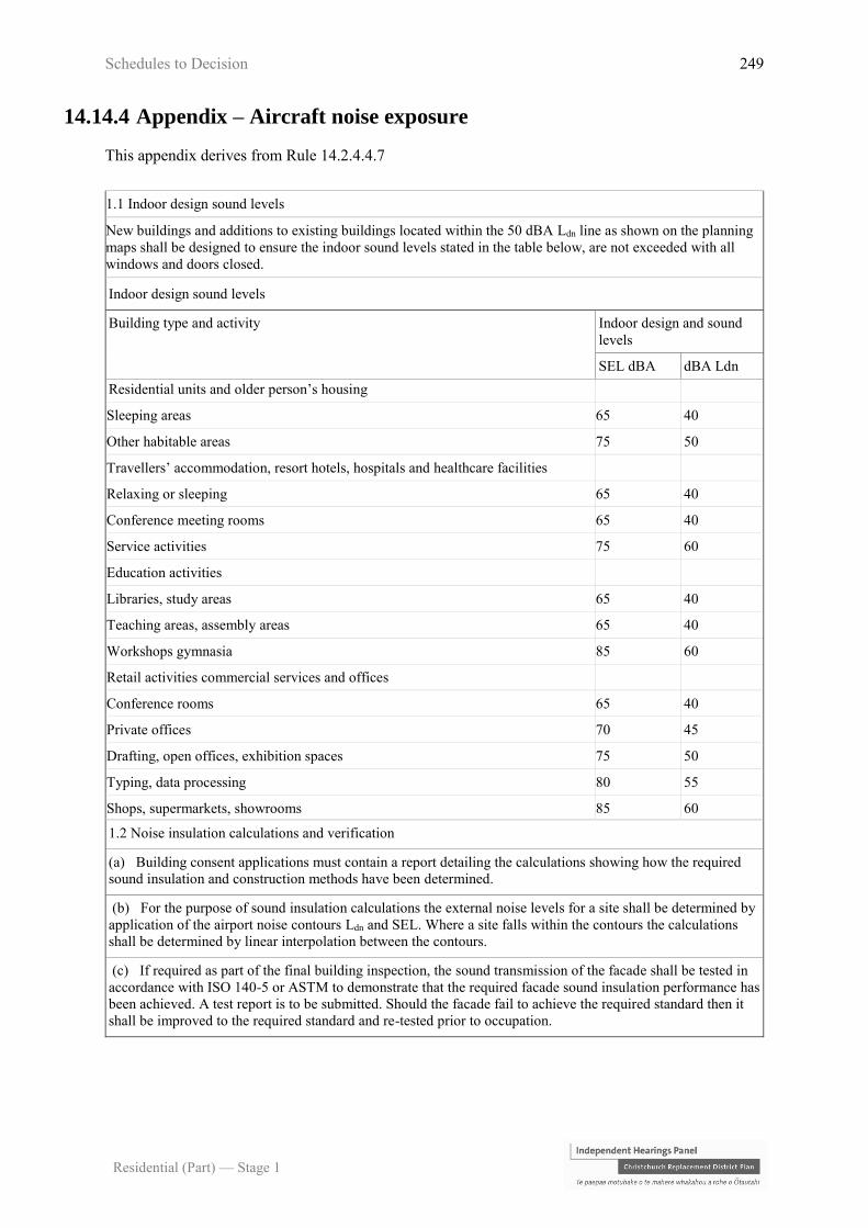
Schedules to Decision 249
Residential (Part) — Stage 1
14.14.4 Appendix – Aircraft noise exposure
This appendix derives from Rule 14.2.4.4.7
1.1 Indoor design sound levels
New buildings and additions to existing buildings located within the 50 dBA Ldn line as shown on the planning
maps shall be designed to ensure the indoor sound levels stated in the table below, are not exceeded with all
windows and doors closed.
Indoor design sound levels
Building type and activity Indoor design and sound
levels
SEL dBA dBA Ldn
Residential units and older person’s housing
Sleeping areas 65 40
Other habitable areas 75 50
Travellers’ accommodation, resort hotels, hospitals and healthcare facilities
Relaxing or sleeping 65 40
Conference meeting rooms 65 40
Service activities 75 60
Education activities
Libraries, study areas 65 40
Teaching areas, assembly areas 65 40
Workshops gymnasia 85 60
Retail activities commercial services and offices
Conference rooms 65 40
Private offices 70 45
Drafting, open offices, exhibition spaces 75 50
Typing, data processing 80 55
Shops, supermarkets, showrooms 85 60
1.2 Noise insulation calculations and verification
(a) Building consent applications must contain a report detailing the calculations showing how the required
sound insulation and construction methods have been determined.
(b) For the purpose of sound insulation calculations the external noise levels for a site shall be determined by
application of the airport noise contours Ldn and SEL. Where a site falls within the contours the calculations
shall be determined by linear interpolation between the contours.
(c) If required as part of the final building inspection, the sound transmission of the facade shall be tested in
accordance with ISO 140-5 or ASTM to demonstrate that the required facade sound insulation performance has
been achieved. A test report is to be submitted. Should the facade fail to achieve the required standard then it
shall be improved to the required standard and re-tested prior to occupation.
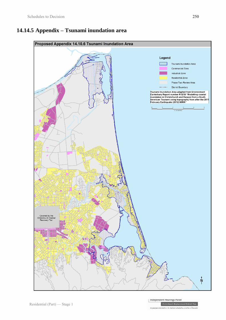
Schedules to Decision 250
Residential (Part) — Stage 1
14.14.5 Appendix – Tsunami inundation area

Schedules to Decision 251
Residential (Part) — Stage 1
14.14.6 Appendix – Sumner Master Plan Overlay
[Image to be updated to amend title and to show Commercial Fringe changing to Commercial Core, refer to
Rebuttal Evidence of Mark Stevenson, Map 48. Clearer image required.]

Schedules to Decision 252
Residential (Part) — Stage 1
SCHEDULE 2
Provisions (and related submissions) in respect of which hearing and determination has been
deferred to Stages 2 and 3:
(a) The notified ‘New Neighbourhood zone’ provisions (‘NNZ provisions’);1
(b) Residential Banks Peninsula Conservation Zone,2 including Policy 14.1.5.6
(Notified Version) Heritage Values in Residential Areas of Lyttelton and Akaroa
and Policy 14.1.5.5 (Notified Version) Neighbourhood Character and Residential
Amenity in Residential Areas of Banks Peninsula;3
(c) New Brighton Density Overlay;4
(d) Kauri Lodge Rest Home Submission (1022);5
(e) The following provisions that were notified in error by the Christchurch City
Council as set out in its Application to set aside land from proposals where the land
was re-notified in Stage 2 proposals (‘Application to set aside’):6
(i) All legal roads on the Stage 1 planning maps that were incorrectly zoned
residential and re-notified in Stage 2 as Transport Zone;
(ii) All of the open space sites shown on the Stage 1 planning maps identified in
Attachment A to Application to set aside that were incorrectly zoned
residential and re notified in Stage 2 as Open Space;
(iii) All of the school and tertiary education sites shown on the Stage 1 planning
maps identified in Attachment C to the Application to set aside that were
1 Minute dated 16 July 2015 and 20 August 2015, and full list of provisions deferred as set out in the Order confirming
allocated provisions dated 3 November 2015. 2 Opening submission for the Council at para 13.4; Closing submissions for the Council at para 7.2; Transcript, page
1109. 3 Updated Statement of Issues for Stage 2 Residential Proposal, 11 August 2015, at paras 2.1(a) and 2.2. 4 Deferred to Stage 2 Commercial and Industrial decision. 5 Direction of Hearings Panel, 11 February 2015. 6 Application to set aside land from Stage 1 proposals, where land has been re notified in Stage 2 proposals, 17 June
2015; and application granted on 26 June 2015.

Schedules to Decision 253
Residential (Part) — Stage 1
incorrectly zoned residential and re-notified in Stage 2 as Specific Purpose
(School) and Specific Purpose (Tertiary Education) Zones;
(iv) All of the cemetery sites shown on Stage 1 planning maps identified in
Attachment E of the Application to set aside that were incorrectly zoned
residential.
(f) As set out in our directions dated 3 November 2015, the following Airport-related
issues are deferred to be heard in conjunction with Chapter 6, General Rules and
Procedures:
(i) Bird strike issues; and
(ii) Airport noise contour issues as to the 50 dBA Ldn and 55 dBA Ldn noise
contour (except as to the related land use restrictions determined by this
decision).

Schedules to Decision 254
Residential (Part) — Stage 1
SCHEDULE 3
Table of submitters heard
This list has been prepared from the index of appearances recorded in the Transcript, and
from the evidence and submitters statements shown on the Independent Hearing Panel’s
website.
Submitter Name Person Expertise or Role Filed/
Appeared
Ken Sitarz 13 Mr K Sitarz Filed/Appeared
Ashley Seaford 15 Mr A Seaford Filed/Appeared
Fendalton Mall Limited 24 Mr G Dewe Planner Filed
Gillian Herrick 56 Ms G Herrick Filed/Appeared
James King 60 Mr J King Filed/Appeared
Robin Curry 88 Mr R Curry Appeared
Nick Blakely 110 Ms H Broughton Appeared
Rachel Malloch 115 Ms R Malloch Filed
Alan and Robyn Ogle 137 Ms H Broughton Appeared
Mike Percasky 138 Mr A Fitzgerald Planner Filed/Appeared
Brett and Elizabeth Rayne 151 Mr B Rayne Appeared
Catherine Spackman 152 Ms H Broughton Appeared
Maria Simmonds 155 Ms M Simmonds Filed/Appeared
Janet Reeves 157 Ms J Reeves Planner and urban
designer
Filed/Appeared
Grant Miles 160 Mr G Miles Architectural designer Filed/Appeared
Richard Jarman 164 Ms H Broughton Appeared
Janette Webber 171 Ms H Broughton Appeared
Ross Divett 181 Mr R Divett Filed
Riccarton Wigram
Community Board
254 Mr M Mora Filed
Marianne and Robin
McKinney
256 Ms H Broughton Appeared
JD & JE Campbell, Fendall
Properties Limited,
Campbell Family Trust
273 Ms H Broughton Appeared
Janet Begg 280 Ms J Begg Filed
Cats Protection League 287 Ms A Brown Filed
Ms P Harte Planner Appeared
Tony Dale 291 Mr T Dale Appeared

Schedules to Decision 255
Residential (Part) — Stage 1
Submitter Name Person Expertise or Role Filed/
Appeared
Denise Bryce 294 Ms D Bryce/ Mr
Church
Filed
Tim & Felicity Scott 297 Ms H Broughton Appeared
Jessie Wells 300 Ms H Broughton Appeared
Tony and Christine Simons 308 Mr T Simons Appeared
Christchurch City Council 310 Mr S Blair Planner Filed/Appeared
Dr D Fairgray Geographer and
economist
Filed/Appeared
Mr A MacLeod Planner Filed/Appeared
Mr G McIndoe Architect and urban
designer
Filed/Appeared
Mr R Norton Planning engineer Filed/Appeared
Ms B O'Brien Planning engineer Filed/Appeared
Mr N Redekar Transportation Planner Filed/Appeared
Ms E Sakin Architect Filed/Appeared
Mr M Teesdale Urban designer Filed/Appeared
Mr C Gregory Engineer Filed/Appeared
John Frizzell 321 Ms E Stewart Planner Filed/Appeared
Mr J Frizzell Filed/Appeared
Mr K Suckling Filed/Appeared
DT King & Co Limited 329 Mr R Edwards Traffic engineer Filed/Appeared
Robert Paton 336 Mr R Edwards Traffic engineer Filed/Appeared
Akaroa Civic Trust 340 Ms J Cook Filed/Appeared
Maurice R Carter Limited 377 Mr J Phillips Planner Filed/Appeared
Oakvale Farm Limited 381 Mr J Phillips Planner Filed/Appeared
JC & H McMurdo Family
Trust
387 Ms H McMurdo Appeared
The Salvation Army 422 Ms W Barney Filed/Appeared
Mr G Parfitt Filed/Appeared
Robin Shatford 445 Mr R Shatford Appeared
Riccarton Bush-Kilmarnock
Residents' Association
462 Mr J Hardie Appeared
Fulton Hogan Land
Development Limited
473 Ms J Comfort Planner Filed/Appeared
Jane Taylor 475 Ms H Broughton Appeared
Siana Fitzjohn 487 Mr R Muir Filed/Appeared
Housing New Zealand
Corporation
495 Mr P Commons General Manager,
Canterbury Recovery and
Redevelopment
Filed/Appeared
Mr M Dale Planner Filed/Appeared

Schedules to Decision 256
Residential (Part) — Stage 1
Submitter Name Person Expertise or Role Filed/
Appeared
Crown 495 Ms V Barker Planner Filed/Appeared
Ms J Doyle Policy Director,
Construction and Housing
Markets
Filed/Appeared
Mr K Gimblett Planner Filed/Appeared
Mr B Klein Life stage, energy and
water efficiency and
consenting issues
Filed/Appeared
Ms Y Legarth RMA policy advisor Filed/Appeared
Mr M McCallum-Clark Planner Filed/Appeared
Ms S McIntyre Planner Filed/Appeared
Ms A McLeod Planner Filed/Appeared
Mr A Merry Manager, Strategic
Development
Filed/Appeared
Mr I Mitchell Planner Filed/Appeared
Mr R Rouse Asset rebuild manager,
horizontal infrastructure
Filed/Appeared
Mr J Schellekens Economist Filed/Appeared
Ms L Taitua District Manager,
Community Probation
Filed/Appeared
Mr M Teesdale Urban designer Filed/Appeared
Mr T Walsh Planner Filed/Appeared
Nurse Maude Association 525 Mr R Nixon Planner Filed/Appeared
Rosalie Souter 540 Mr L Telfer Appeared
Deans Avenue Precinct
Society
549 Ms C Mulcock Filed/Appeared
Retirement Village
Association of New Zealand
Inc
573 Mr J Collyns Filed/Appeared
Mr J Kyle Planner Filed/Appeared
Helen Broughton 592 Ms H Broughton Filed/Appeared
Going Properties Limited 593 Ms P Harte Planner Filed/Appeared
Rosalee Jenkin 601 Mr R Muir Filed/Appeared
Mebo Family Trust 604 Ms M Mullins Filed/Appeared
Catherine Collier 636 Mr R Muir Filed/Appeared
Ruth Deans 643 Ms H Broughton Appeared
Canterbury District Health
Board
648 Dr A Humphrey Medical Officer of Health Filed/Appeared
Catholic Diocese of New
Zealand
656 Mr R Nixon Planner Filed/Appeared
Belgravia Investments
Limited
678 Mr J Clease Planner and urban
designer
Filed/Appeared
Residential Construction
Limited
684 Ms F Aston Planner Filed/Appeared
Mr P de Roo Filed/Appeared

Schedules to Decision 257
Residential (Part) — Stage 1
Submitter Name Person Expertise or Role Filed/
Appeared
Jack Randall 688 Mr R Muir Filed/Appeared
Foodstuffs South Island
Limited and Foodstuffs
(South Island) Properties
Limited
705 Mr D Thorne Filed
Matthew Scobie 711 Mr R Muir Filed/Appeared
Rowan Muir 713 Mr R Muir Filed/Appeared
Bryndwr Community Group 715 Ms M Ainsworth Appeared
Mobil Oil New Zealand
Limited, Z Energy Limited
and Banks Peninsula Oil
New Zealand Limited
723 Ms K Blair Planner Filed/Appeared
Ilam and Upper Riccarton
Residents' Association
738 Mr R English Filed/Appeared
Ryman Healthcare Limited 745 Mr J Kyle Planner Filed/Appeared
Mr A Mitchell Filed/Appeared
Bronwyn Williams 748 Ms B Williams Appeared
Alpine Presbytery 752 Mr R Nixon Planner Filed/Appeared
Christchurch Polytechnic
Institute of Technology
756 Ms L Buttimore Planner Filed/Appeared
Ms A Hanlon Director of Learning
Resources
Filed
Methodist Church of New
Zealand and Christchurch
Methodist Central Mission
763 Mr R Nixon Planner Filed/Appeared
Summerset Group Holdings
Limited
765 Ms P Harte Planner Filed/Appeared
Gayle Cook 773 Ms H Broughton Appeared
Jane Murray 780 Ms J Murray Filed/Appeared
The Order of St John, South
Island Region Trust Board
785 Ms R Hardy Planner Filed/Appeared
K Bush Road Limited and
Brian Gillman Limited
788 Mr W McCall Surveyor Filed/Appeared
Ms K Seaton Planner Filed/Appeared
Mr H Wheelans Filed/Appeared
Church Property Trustees 793 Ms R Hardy Planner Filed/Appeared
Erfort Properties Limited
and Sala Sala Japanese
Restaurant Limited
796 Mr G Ottmann Appeared
University of Canterbury 797 Ms L Buttimore Planner Filed/Appeared
Ms A Hanlon Director of Learning
Resources
Filed/Appeared
AMP Capital Palms Pty
Limited
814 Mr J Phillips Planner Filed/Appeared
R L Broughton 820 Mr R Broughton Appeared

Schedules to Decision 258
Residential (Part) — Stage 1
Submitter Name Person Expertise or Role Filed/
Appeared
Transpower New Zealand
Limited
832 Mr D Campbell Environmental Policy and
Planning group manager
Filed/Appeared
Mr M Copeland Economist Filed/Appeared
Ms A McLeod Planner Filed/Appeared
Mr R Noble Asset engineering
manager
Filed/Appeared
Groovy Costumes Limited 839 Mr S Fletcher Planner Appeared
Ngai Tahu Property Limited 840 Mr J Jones Planner Filed/Appeared
Mr M Timms Surveyor Filed/Appeared
Mr T Watt Architect Filed/Appeared
David Philpott & Associates 841 Mr S Fletcher Planner Filed/Appeared
Kotare Downs Limited 843 Mr S Fletcher Planner Filed/Appeared
Audrey Smith 854 Ms A Smith Appeared
Douglas Horrell 858 Mr R Muir Filed/Appeared
Christchurch International
Airport Limited
863 Mr M Bonis Planner Filed/Appeared
Mr R Boswell Environmental Manager Filed/Appeared
Mr C Day Acoustic Engineer Filed/Appeared
Dr P Harper Ornithologist Filed/Appeared
Mr K McAnergney Manager, Airport
Planning
Filed/Appeared
Mr P Osborne Economist Filed/Appeared
Reefville Properties Limited 866 Mr G Percasky Filed/Appeared
D&S Grimshaw 893 Mr S Fletcher Planner Filed/Appeared
Kiwirail Holdings Limited 897 Ms D Hewett Senior RMA Advisor Filed
Freyberg Development
Limited
907 Ms J Comfort Planner Filed/Appeared
Lyttelton Port Company
Limited
915 Mr M Copeland Economist Filed/Appeared
Mr N Hegley Acoustic Engineer Filed/Appeared
Ms K Kelleher Environmental Manager Filed/Appeared
Mr A Purves Planner Filed/Appeared
Orion New Zealand Limited 922 Ms L Buttimore Planner Filed/Appeared
Mr S Watson Network Assets Manager Filed/Appeared
Milns Road Farm Limited
and Blakesfield Limited
931 Ms J Comfort Planner Filed/Appeared
Richard Batt 937 Mr R Batt Appeared
Katia De Lu 944 Mr R Muir Filed/Appeared
Commercial Vehicle Centre
Limited
961 Mr R Edwards Traffic engineer Filed/Appeared
Barrington Issues Group 964 Mr R Curry Filed/Appeared
Davie Lovell-Smith Limited 969 Ms J Comfort Planner Filed/Appeared

Schedules to Decision 259
Residential (Part) — Stage 1
Submitter Name Person Expertise or Role Filed/
Appeared
Mobil Oil New Zealand
Limited
988 Ms K Blair Planner Filed/Appeared
John Raso 1049 Mr J Raso Filed/Appeared
Fredrik Rohs 1051 Mr F Rohs Appeared
R & H Investments, R & H
Properties Limited and
Sandridge Hotel Limited
1069 Mr R Edwards Traffic engineer Filed/Appeared
Beach Road Tyre and Auto
Centre Limited
1077 Mr T Walsh Planner Filed/Appeared
Terra Dumont 1085 Mr R Muir Filed/Appeared
Christian Jordan 1122
1098
Mr C Jordan Filed/Appeared
Danne Mora Holdings
Limited
1134 Mr M Brown Planner Filed/Appeared
Mr A Hall Engineer Filed/Appeared
Mr A Penny Traffic engineer Filed/Appeared
ADNZ Canterbury/Westland
Region
1142 Mr G Miles Architectural designer Filed/Appeared
Mahaanui Kurataiao Limited
and Te Rūnanga O Ngāi
Tahu
1145 Mr T Vial Planner Filed/Appeared
Generation Zero 1149 Mr R Muir Filed/Appeared
Jeanette Quinn 1174 Ms J Quinn Appeared
Andrew Evans 1181 Mr A Evans Filed/Appeared
Colin Stokes 1182 Mr C Stokes Filed/Appeared
Urbis TPD Limited 1207 Mr R Edwards Traffic engineer Filed
Michael Hughes 1241 Mr M Hughes Appeared
Horticulture NZ 1323 Ms L Wharfe Planner Filed/Appeared