in the united states court of federal claims set forth below, plaintiff has not proven i ts...
TRANSCRIPT

This opinion was originally issued under seal to allow the parties an1
opportunity to offer redactions. Both parties agree that no redactions are
necessary.
In the United States Court of Federal Claims05-249C
(Filed: July 31, 2012)
(Reissued August 23, 2012)1
* * * * * * * * * * * * * * * * * * * * * *
NYCAL OFFSHORE
DEVELOPMENT CORP.,
Breach of contract;
Plaintiff, Oil and gas leases;
Lost profits; Intervening
v. cause
THE UNITED STATES,
Defendant.
* * * * * * * * * * * * * * * * * * * * * *
Jeffrey E. Glen and Philip Raible, New York, NY, for plaintiff.
Gregg M. Schwind, Allison Kidd-Miller, and Kimberly I. Kennedy
United States Department of Justice, Civil Division, Commercial Litigation
Branch, Washington, DC, with whom were Tony West, Assistant Attorney
General, Jeanne E. Davidson, Director, and Patricia M. McCarthy, Assistant
Director, for defendant.
OPINION
BRUGGINK, Judge.
Plaintiff, Nycal Offshore Development Corporation (“Nycal”), is a
partial interest holder in two oil and gas leases, the terms of which we held
earlier were breached when the United States materially changed the statutory
and regulatory scheme under which development of the leases was to take
place. Breach having been established, plaintiff proceeded to trial, seeking to
recover the profits it believes it would have recouped absent the breach. Trial
was held November 30 through December 10, 2011, in Santa Barbara,
California and December 15 and 16, 2011, in Washington, DC. For the
reasons set forth below, plaintiff has not proven its entitlement to expectancy
damages.
PROCEDURAL BACKGROUND
Plaintiff was originally a consolidated party in Amber Resources v.
United States, No. 02-30, in which we established defendant’s breach of the
lease agreements. 68 Fed. Cl. 535 (2005). All other plaintiffs in Amber
Resources elected to receive the return of the lease payments in restitution.
In 1990 and 1991, Nycal’s predecessor in interest acquired a 4.25
percent interest in two of the leases: OCS-P 0460 and 0464. Subsequent
legislation delayed and eventually severely limited commercial exploration and
extraction, essentially rendering these leases worthless. Consequently, many
of the lessees sued here in 2002. We agreed with plaintiffs that the
government’s actions amounted to a total breach, entitling the plaintiffs to
recover. Id. at 548-49. All plaintiffs other than Nycal elected to receive
restitution, i.e., the return of their lease payments. Nycal declined to make an
election at that time and its case was stayed. After further litigation and entry
of partial final judgment in favor of the other plaintiffs, we reactivated Nycal’s
case and deconsolidated it. Nycal elected to seek expectation damages for the
profits, if any, it would have reaped but for the government’s breach.
Prior to trial, defendant moved to limit plaintiff to restitution or force
it to an election prior to trial. It argued that our award of restitution to the
other interest holders in the leases at issues made an award of lost profits
regarding the same indivisible contract untenable. We disagreed, holding that,
in circumstances such as this, with fungible interests in a lease, the co-lessees
neither received nor gave up anything “representative of Nycal’s interest.”
Nycal Offshore Dev. Corp. v. United States, 92 Fed. Cl. 209, 213 (2010).
During oral argument on defendant’s motion, plaintiff foreswore its
entitlement to restitution as a remedy. See id. at 211 n.2.
FACTUAL BACKGROUND
Lease 460 was first issued in 1968 as Lease OCS-P 0186 to Humble
Oil Company, which shortly thereafter became Exxon through a merger.
Humble paid $36,000,000 for the lease. Exxon drilled three test wells on lease
186, none of which produced oil that flowed to the surface. Exxon tendered
MMS was subsequently renamed the Bureau of Ocean Energy Management,2
Regulation and Enforcement. We refer to it as it was named at the time the
events at issue to place, MMS.
We refer to the parties’ exhibits as “DX” for defendant’s exhibit and “PX”3
for plaintiff’s exhibit. Joint exhibits are referred to as “JX.”
Harold Syms from MMS testified that a “discovery” is a well that flows oil4
at a rate sufficient to pay for the cost of drilling the well. After an operator has
made a discovery on a lease, further exploratory wells are called “delineation”
wells.
Samedan was a subsidiary of Noble Energy, Inc., also known as Noble5
Affiliates Inc. Witnesses used the names interchangeably. We refer to them
simply as “Samedan” because it was the named operator of the GCU.
Lease 462 is not at issue in this lawsuit. 6
3
the lease back to Minerals Management Service (“MMS”) at the expiration2
of its five-year term. The lease was later renumbered as lease 460. Leases 460
and 464 were issued by MMS, along with a number of other leases sold to
other companies, in 1982 to Atlantic Richfield Company (“ARCO”) for the
sums of $10,967,500 and $9,737,500.
ARCO proposed drilling four exploratory wells on lease 460 in its 1984
Exploration Plan (“EP”). See DX 27. Both California and MMS approved3
the plan. ARCO then drilled one well on lease 460, enumerated 460-1. It
produced oil to the surface at a rate of 250 barrels of oil per day (“BOPD”),
which qualified as a “discovery” under MMS regulations. ARCO pursued4
no further exploration of either lease. It concluded that there were insufficient
reserves to justify further expenditure. See DX 122 at 2.
In 1987, shortly before lease expiration, ARCO sold the leases to
Samedan Oil Corporation (“Samedan”) and several partners for $500,000.5
Samedan then requested that MMS add leases 460, 462, and 464 to the Gato
Canyon Unit (“GCU”) and that it be designated to serve as operator of the
unit. DX 27 at 23. That request was approved along with a five-year6
suspension of the lease expiration to allow for further exploration.
Samedan drilled the 460-2 well, the final well drilled on lease 460. It
flowed just over 5000 BOPD. The oil was, however, viscous and tar-like with

Oil gravity is a measurement of how heavy oil is compared to water. The7
higher the number of degrees, the lighter the oil is compared to the weight of
water. The lighter the oil, the easier it is to produce to the surface. This is
partially due to the relationship between weight and viscosity. See Tr. 2356
(Ershaghi).
4
an oil gravity of 10-11 degrees API. The GCU unit owners planned to drill7
one or two more delineation wells before making a decision on whether and
where to place a platform to develop the unit.
In 1989, MMS granted a further two-year suspension in order that
Samedan might perform a new interpretation of the previous seismic
information and drill the next well. In 1992, The unit owners agreed to
participate in a project known as the California Offshore Oil and Gas
Resources (“COOGER”) study. MMS directed a suspension for the duration
of the study. Drilling was suspended on the leases pending completion of the
study.
In 1997, anticipating completion of the study, MMS requested revised
suspension requests for the leases. Samedan asked for an additional 41
months, which would have effectively extended the lease term through 2002.
MMS granted the request and listed a number of milestones that it expected
Samedan to achieve by certain dates. The final milestone was the start of
drilling of the next delineation well on May 1, 2003. See DX 52 at 8.
In February 2000, Samedan submitted a Project Description, which it
later revised in September 2000. It described the project as “preliminary and
subject to change” and stated that the plan might be modified when
resubmitted in a Unit Exploration Plan. Id. The Project Description contained
a description of the type and sequence of exploration activities, description of
the process and projected location for the drilling of the next delineation well,
information regarding subsurface geology and environmental impact,
proposed development activities, and a time line of events leading to
production. Included in that production time line were certain major events:
(1) submission of a revised Unit Exploration Plan; (2) procurement and
mobilization of a mobile drilling rig; (3) drilling of well 460-3; (4) submission
of a Development and Production Plan (“DPP”); and (5) installation of a
permanent oil platform.
Samedan explained that the 460-3 well would be drilled in the eastern

5
half of the reservoir because previous wells had all been placed on the western
half. The delineation well would “verify the anticipated reserve volume and
gather additional information critical to the development phase . . . .” Id. at 20.
The owners intended to contract for the services of a mobile drilling rig,
known as a “MODU.” In conjunction with owners of other undeveloped
offshore leases in other units they formed an Offshore Rig Activation Group
(“ORA”) to further that end.
Pursuant to the National Environmental Policy Act (“NEPA”), MMS
published a draft Environmental Impact Statement (“EIS”) in June 2001, DX
257, for the delineation drilling proposed for the GCU and other units. The
final EIS was never issued, however, due to intervening events precipitated by
the state of California’s challenge to MMS’s 1999 grant of lease suspensions.
On June 20, 2001, the United States District Court for the Northern
District of California ruled that MMS had violated the Coastal Zone
Management Act (“CZMA”), as amended in 1990, by not certifying that the
granted lease suspensions were consistent with California’s Coastal
Management Program. California v. Norton, 150 F. Supp. 2d 1046, 1053-54
(N.D. Cal. 2001). It further held that MMS ran afoul of NEPA by granting a
categorical exclusion for lease suspensions from the requirement to prepare an
Environmental Assessment (“EA”) and/ or EIS. Id. at 1057. The district
court ordered MMS to “set aside its approval of the requested suspensions”
and to “direct suspensions of the thirty-six leases, including all milestone
activities, for a time sufficient to provide [California] with a consistency
determination in compliance with CZMA” and for MMS to “provide a
reasoned explanation for its reliance on the categorical exclusion” of lease
suspensions from NEPA-required environmental analysis. Id. at 1057-58.
The Ninth Circuit Court of Appeals affirmed in December 2002. 311 F.3d
1162 (9th Cir. 2002).
Samedan and several other companies filed a claim in this court in
January 2002. A number of companies followed suit in 2004, and Nycal
commenced its action in 2005.
DISCUSSION
Liability having been established prior to trial, we must decide whether
plaintiff is entitled to expectancy damages and, if so, how much. Plaintiff
seeks expectancy damages equal to the profits plaintiff would have earned
absent the breach. Plaintiff is entitled to only those damages that it can prove
6
(1) were foreseeable at the time of contract formation, (2) were actually caused
by the breach, and (3) are reasonably certain. See Cal. Fed. Bank v. United
States, 395 F.3d 1263, 1267 (Fed. Cir. 2005).
The question of foreseeability asks whether the damages sought by
plaintiff were reasonably foreseeable or actually foreseen by the breaching
party at the time of contract. Landmark Land Co. v. United States, 256 F.3d
1365, 1378 (Fed. Cir. 2001); Restatement (Second) of Contracts § 351(1)
(1982). “Loss may be foreseeable as a probable result of a breach because it
follows from the breach (a) in the ordinary course of events, or (b) as a result
of special circumstances . . . that the party in breach had reason to know.” Id.
§ 351(2).
Defendant’s breach also must be the “proximate cause” of plaintiff’s
damages. Old Stone Corp. v. United States, 450 F.3d 1360, 1375 (Fed. Cir.
2006). The Federal Circuit has accepted two different standards in deciding
the issue of causation. The seemingly “lighter” of the two standards requires
that plaintiff show that the breach was “a substantial factor in the damages.”
Ind. Mich. Power Co. v. United States, 422 F.3d 1369, 1373 (Fed. Cir. 2005).
The other approach asks whether, “but for the breach,” plaintiff would have
suffered damages. See Cal. Fed. Bank, 395 F.3d at 1268. Under neither test
does the breach have to be the “sole factor or sole cause in the loss of profits.”
Id. It is within the trial court’s discretion which formulation to follow.
Citizens Fed. Bank v. United States, 474 F.3d 1314, 1318 (Fed. Cir. 2007).
The third element of plaintiff’s burden of proof, reasonably certainty,
calls on Nycal to establish that there would have been profits absent the breach
and that “a sufficient basis exists for estimating the amount of lost profits with
reasonable certainty.” Energy Capital Corp v. United States, 302 F.3ed 1314,
1325 (Fed. Cir. 2002). This can often prove to be a difficult and sometimes
insurmountable obstacle in expectancy damages cases. See Glendale Fed.
Bank, FSB v. United States, 378 F.3d 1308, 1313 (Fed. Cir. 2004). That is not
to say, however, that lost profits are categorically excluded. The Federal
Circuit has noted that “uncertainty as to the amount [of damages] will not
preclude recovery;” the court must be able to “make a fair and reasonable
approximation of damages.” Bluebonnet Sav. Bank, FSB v. United States, 266
F.3d 1348, 1356-57 (Fed. Cir. 2001); Glendale, 378 F.3d at 1313 (quoting
Bluebonnet, 266 F.3d at 1356-57).
Defendant challenges plaintiff’s proof as to all three elements. It argues
that no profits were foreseeable at the time the lease was issued in 1982, in

Plaintiff’s best case scenario is that the leases would have produced $5.28
billion worth of oil and gas, which represents an undiscounted net income for
the 100 percent interest of the leases. Nycal’s share would be its 4.25 percent
interest after it was properly discounted to account for the time value of
money, net of lease royalties.
7
large measure because MMS was skeptical about the amount of reserves.
Even if it could have been foreseen that terminating the lease might interfere
with profitable development, it contends that the breach did not cause any loss
for at least two reasons: plaintiff has not established that the owners were
motivated to proceeded to development and, second, the owners could not
have obtained the necessary environmental permits needed for further
exploration and production of the leases. Defendant also argues that there is
an insuperable level of uncertainty in plaintiff’s claim for three reasons: first,
because of the inherent uncertainty of the volume of reserves, making
development of the unit a new and untested venture; second, because plaintiff
would not have been able to finance its own involvement in further exploration
and development of the lease; and third, defendant argues that the GCU would
not have made any money due to the high costs involved in bringing the unit
to production. We turn now the particulars of this case.
I. Foreseeabilty
Defendant argues that plaintiff has not shown that either the type or the
amount of damages were foreseeable when MMS issued the leases in 1982
because the agency did not actually foresee, nor should it have foreseen, that
the leases would have produced the approximately $5.2 billion of oil and gas
contemplated in plaintiff’s claim. Defendant cites Anchor Savings Bank, FSB8
v. United States, 597 F.3d 1356 (Fed. Cir. 2010), for the proposition that “the
relevant foreseeability inquiry is not whether the leases were issued for the
purpose of producing oil and gas, but whether lost profits, and lost profits on
the order of $5.2 billion, were reasonably foreseeable or actually foreseen by
the breaching party at the time of contracting.” Def.’s Post Trial Br. 44 (citing
Anchor Sav., 597 F.3d at 1361). Defendant points to two particular pieces of
evidence – the industry’s bids on the leases and MMS’s internal estimates of
the value of the leases.
ARCO, Samedan (for a consortium of companies), and Exxon bid on
leases 460 and 464 at the 1982 lease auction. Defendant produced the
following summary of the sale:

8
Lease Bids MMS Estimates MMS Value
460 $10, 967, 500 (ARCO)
$4,636,500 (Samedan et al)
$3,225,00 0 (Exxon)
21.4 MMBO (Oil)
55.7 BCF (Gas)– $12,712,929
464 $9,737,500 (ARCO)
$201,000 (Samedan et al)
$103,500 (Exxon)
1.7 MMBO (Oil)
5.2 BCF (Gas)– $670,310
See DX 685 at 18-20 (bid summaries); DX 743 (MMS’s evaluation data
sheet); DX 1004 (MMS 1982 lease sale summary chart). As the chart shows,
MMS estimated that the leases would ultimately lose money if developed.
Harold Syms, MMS senior geologist and eventual Chief of Resource
Evaluation, testified that MMS would have accepted a minimum bid of just
over $84,000 for lease 460 and just over $24,000 for lease 464, which
translates to $25 per acre. Tr. 3663, 3667-69; see also DX 1004. He explained
that $25 per acre is MMS’s minimum accepted bid even when it values the
leases as unprofitable. Although MMS internal estimates are not released prior
to sale, it is known that $25 per acre is the minimum bid even when the agency
places a negative value on prospects. See Tr. 3667. When asked why MMS
offered these leases for sale even if its internal value estimates were negative,
he explained that certain oil companies had requested that the lands be released
for sale. Tr. 3668.
The result of this evidence, in defendant’s view, is that MMS did not
foresee, nor should it have foreseen, that the leases would ever be profitable.
Therefore, plaintiff’s damages, even if proven, were not foreseeable and
cannot be recovered.
Plaintiff spent little time dealing with the issue of foreseeability, and we
are inclined to see why. There can be no doubt that the leases were issued so
that private oil companies could explore for oil and gas and, if oil and gas was
located in producing quantities, go into production. We can safely assume that
MMS officials understood that possibility even if preliminary data suggested
to MMS that the prospects were not good. ARCO paid almost $21 million for
the leases, by far the largest bid per acre for any of the leases offered at the
1982 sale. MMS was certainly on notice of ARCO’s intent to exploit the

The court in Anchor Savings quoted the following passage from Farnsworth9
on Contracts as support for its holding that damages were foreseeable in that
case: “[t]he magnitude of the loss need not have been foreseeable, and a party
is not disadvantaged by its failure to disclose the profits that it expected to
make from the contract. However, the mere circumstance that some loss was
foreseeable may not suffice to impose liability for a particular type of loss that
was so unusual as not to be foreseeable.” 597 F.3d at 1364 (quoting E. Allan
Farnsworth, Farnsworth on Contracts § 12.14 (3d ed. 2004)).
9
leases to the maximum extent possible. Both parties understood that, if there
were economically viable reserves on the leases, then the oil companies had
earned the right to produce them. Although MMS made no guarantees as to
quantity, at a minimum it was warranting that the government would stand by
the raffle ticket it was selling, no matter how profitable it turned out to be. The
oil companies assumed the risk that the oil and gas were not there. The
government assumed the risk that, if it interfered with that option to explore,
it was on the hook for whatever profits could be established with meaningful
certainty. We presume the government would not have declined to accept its
16 percent royalty payments on the ground that it was an undeserved
lagniappe. In the context of a government oil and gas lease, we believe it is
sufficient to establish foreseeability that there was a reasonable probability of
recoverable reserves. See First Fed. S&L Ass’n of Rochester v. United States,
290 F. App’x. 349, 357 (Fed. Cir. 2008).
The central question in a foreseeability analysis is whether the
breaching party had reason to anticipate that its breach would cause the type
of loss that plaintiff incurred. Anchor Sav. Bank, 597 F.3d at 1364. The fact9
that the breaching party does not anticipate the amount of the loss is not
dispositive. Id. (citing the Restament (Second) of Contracts § 351 cmt. a
(1981)). “The party in breach need not have made a ‘tacit agreement’ to be
liable for the loss. Nor must he have had the loss in mind when making the
contract, for the test is an objective one based on what he had reason to
foresee.” Restatement (Second) of Contracts § 351 cmt. a. The lessor’s
repudiation of an oil and gas lease clearly would cause plaintiff to lose
precisely the benefit it bargained for, namely, profits it might have earned had
the lease been developed. Plaintiff bears the burden of proving that the lease
would been developed and would have ultimately been profitable, but those
are issues of causation and quantum of damages, not foreseeability.
Defendant also offers a third independent obstacle to causation–namely, that10
plaintiff could not have obtained the financing to participate in development.
While defendant raised serious concerns in that regard, because of our
independent finding that environmental problems would have prevented
development, we need not resolve the issue.
Adjacent to the South Ellwood field is the Ellwood field. Both are partially11
producing fields and are both located entirely in state waters.
10
II. Causation
It is so costly to explore for and produce offshore oil and gas that,
without a significant quantity of recoverable oil and gas, plaintiff cannot prove
that breach caused it any damage. Consequently, much of the trial focused on
the parties’ competing views of how much oil (primarily) and gas could have
been recovered in the GCU. Defendant’s experts were of the view that the
volume was not sufficient to make production anything other than marginally
profitable. Plaintiff’s experts took a contrary view, ultimately asserting
damages in the range of $72,000,000. In addition, however, defendant
contends that, even if there were enough oil and gas in the reservoir that it
could have been sold for more than the cost of production, there are two
independent reasons why plaintiff cannot establish causation: first, that it has
not proved that the owners would have gone forward with production, and
second, that further exploration and development would have been blocked by
environmental permitting difficulties unrelated to the breach. Although we10
ultimately find that environmental permitting impediments would have
prevented development, we will proceed to resolve the principal factual
dispute dividing the parties: the question of how much oil and gas could have
been recovered.
The GCU is located between two producing oil and gas fields off the
coast of southern California. The Hondo Field is located in federal waters to
the west of Gato Canyon and is part of the Santa Ynez Unit. The South
Ellwood Field lies in state waters to the east of the GCU. One particular11
strata below the surface is the source of the bulk of the recoverable oil in this
area. It is known as the Monterey Formation, which underlies both the land
and sea surface in Southern California. The offshore fields are often described
in the industry as the “Offshore Monterey.” The offshore Monterey formation
brings with it a host of challenges in estimating reserves, particularly in a field
which has never produced.

The recovery factor from a producing field is calculated by using a decline12
curve to estimate the ultimate recovery and dividing that into the volume of the
reservoir.
11
The various estimates were generated using two different
methodologies. The one used by plaintiff’s experts and in most of the
pre-litigation reports is a gross rock volume method. In this methodology, the
oil reserves are estimated by calculating the gross volume of oil-bearing rock
and then multiplying it by a recovery factor. The rock volume is calculated by
setting the areal bounds of the reservoir and multiplying that by the distance
from the top to the bottom of the productive rock. Both of those inputs are
derived primarily from seismic and well data. The bottom of the reservoir is
normally determined by well tests, from which the depth at which water is
produced in the well bore can be identified. This is known as the oil water
contact (“OWC”) and it represents the bottom of the productive rock. Below
the OWC it is not practicable to recover oil. The recovery factor is generally
selected by reference to one or more analogous fields that are in production,
from which a barrels per acre foot (“BPAF”) factor can be determined.12
Plaintiff went a step further by then using these inputs to conduct a statistical
analysis known as a Monte Carlo simulation to produce what it believes to be
the most likely scenario.
Defendant’s expert, Dr. Iraj Ershaghi, took a different approach because
he was not comfortable using the gross rock volume method. We will examine
his reasons below. Dr. Ershagi instead selected what he believed to be the most
analogous field, South Ellwood, and multiplied the median well performance
by plaintiff’s number of proposed wells (18). He increased the production
numbers for the South Ellwood median to account for the fact that the wells
there are still producing oil and because the Gato Canyon has certain
geological factors that are more favorable for production compared to South
Ellwood.
A. Pre-Litigation Estimates
When MMS initially issued the leases in 1982, it estimated that
approximately 23 million barrels of oil (“MMbbl”) along with 60.2 billion
cubic feet (“BCF”) of natural gas, underlay the leases. See DX 1004. The
natural gas is of considerably less importance than the oil. The same document
showed that MMS estimated an ultimate loss of over $13 million for the two
leases, assuming they went into production. This was based primarily on the
Proved undeveloped reserves are defined by the Securities and Exchange13
Commission as “reserves that are expected to be recovered from new wells on
undrilled acreage, or from existing wells where a relatively major expenditure
is required for completion.” DX 812 at 5 .
12
earlier exploratory work done by Exxon in the 1960s on lease 460.
In May of 1989, a report issued by Norcen, then the largest interest
holder in the GCU, laid out three scenarios for the ultimate recovery at the
GCU. At the bottom of the range, it estimated 65.2 MMbbl, at the top of the
range 81.4 MMbbl, and a “most likely” scenario of 73.3 MMbbl. DX 141 at
15. The three scenarios were based on a recovery factor of 68 BPAF, which
the report states was selected based on the work of Dr. Mannon. Id. at 4.
In a 1995 MMS document, “The Gato Canyon Field Extension Study:
A Project Summary Report,” author Dennis Tayman outlined a strata by strata
analysis of the top four most productive intervals and concluded that Gato
Canyon field contained 47 MMbbl in recoverable oil. See DX 752 at 2-6. The
report also notes that the 47 MMbbl figure appeared in MMS documents as
early as December 1993. Id. at 5. The 47 MMbbl figure reappears in the
Minerals Management Service Pacific OCS Region Field & Reservoir Reserve
Estimates As of December 2008, dated August 26, 2009. DX 745 at 4. This
estimate was the product of the gross rock volume method.
Dr. Mannon produced several estimates prior to his engagement by
plaintiff in this litigation. He and his firm, Mannon & Associates, produced
reports for the lease owners in 1992, 1995, and 1996. In 1992, Dr. Mannon’s
firm produced an economic feasibility study of the GCU, which at that time
included lease 187. Using a recovery factor of 53 BPAF for the segment
below 5800 fee subsea and a factor of 75 above 5800 feet below sea level, Dr.
Mannon calculated a reserve number of 80.7 MMbbl for lease 460 and 1.4
MMbbl for lease 464. DX 70 at 5, 17.
In 1995, Mannon & Associates issued a valuation of the offshore
California federal units. In that report, it estimated oil production for the GCU
at 72.59 MMbbl with 102.65 BCF of gas. DX 812 at 2. The reserves were
classified as “proved undeveloped reserves.” Id. at 1. The 1995 report also13
contained an economic analysis suggesting that development would be
profitable for the GCU owners.

13
In 1996, Mannon & Associates produced a valuation of Nycal’s interest
in the GCU as of July 1, 1996. Dr. Mannon calculated the gross rock volume
of the GCU and applied a 62 BPAF recovery factor for lease 460 and a factor
of 40 for lease 464. Dr. Mannon testified that the lower recovery factor for
lease 464 was due to his lack of well data to act as a control on the seismic
data. Tr. 1518. He explained that the 62 BPAF recovery factor was derived
by looking at the recoveries at three producing neighboring units, Point
Pedernales, Hondo, and Arguello. Id. at 1518. Of the three, “[i]t was mainly
based on Point Pedernales, because even at that point, we saw that there was
a very distinct similarity in the two reservoirs, which would be very
appropriate to use this as an analogous reservoir.” Id. Dr. Mannon arrived at
a estimated ultimate recovery (“EUR”) of 80.6 MMbbl for lease 460 and 8.857
MMbl for lease 464. PX 18 at 3. These reserves, like those in his 1995 report,
were classified as “proved undeveloped.” Id. at 11. Using the inputs
described above and “oil and gas prices of $11.05/B and $1.68/MCF,” Dr.
Mannon estimated the net income for Nycal’s share, discounted to present
value at 8 percent, to be $6.37 million paid out over 9.03 years. Id. at 4.
Discounted to present value at 10 precent, Nycal’s net income would drop to
$4.64 million. At a discount rate of 20 percent, Nycal would net only
$400,000. Id.
In 2001, MMS issued a draft EIS regarding delineation drilling in the
offshore Santa Barbara area, which listed the GCU as holding 77 MMbbl of
oil reserves with an additional 46 BCF of gas. DX 257 at 87. There was much
debate at trial and in the post-trial briefing regarding the source and import of
that figure. Defendant called MMS employee Harold Syms who worked as a
geologist, well log analyist, and eventual supervisor/senior geologist for the
“valuation of undiscovered resources nationwide.” Tr. 3650. He testified on
direct examination that the 77 MMbbl figure was provided to MMS by the
GCU operator, Samedan. He was asked if it was “a new MMS estimate.” Tr.
3730. He answered that “[i]t was not. This is based on information supplied
by the operator.” Id. On cross-examination, Mr. Syms clarified that the 77
MMbbl figure was devloped by an MMS engineer “based on the number of
wells that the operator submitted,” a “production profile for each well,” and
the “timeframe of the project.” Tr. 3799. The operator supplied a number “in
the 80s” and MMS then refined it based on the inputs described above, which
resulted in a 77 MMbbl figure. Id. Mr. Syms was unequivocal in stating,
however, that this was not an MMS reserve estimate but rather represented a
“worse case scenario,” determined for purposes of an environmental impact
statement. Tr. 3802 (“Q: Sort of a worst case? A: Worst or best, depending
on how you look at it.”). The figure, in short, was not an endorsement of any

Though not a MMS reserve estimate as such, the figure did reappear twice14
in subsequent MMS documents. In September 2001, in a presentation made
at Santa Barbara City College entitled “Significance of the Monterey
Formation California OCS,” the GCU was listed as a possible new
development with 77 MMbbl of potential recovery. DX 753 at 12. In 2005,
a Environmental Information Document for Post-Suspension Activities again
referred to 77 MMbbl along with 46 BCF of gas for the GCU. DX 258 at
5.2-11. The environmental information document would presumably be
subject to the same disclaimer as the 2001 EIS: that it was not a reserve figure
but a sort of “worst case” scenario for environmental impact purposes.
14
reserve estimate. 14
B. Estimates Prepared for Litigation
Both parties retained experts to assist them in estimating the reserves
in the GCU. Plaintiff retained the services of Subsurface Consultants and
Associates, LLC (“SCA”) to perform a series of reserve estimates.
1. SCA Reports
SCA generated three reserve estimates in two separate reports. One,
which it characterized as “deterministic,” calculated the reserves using static
inputs for the gross rock method described previously. The two other
estimates were “probabilistic” and were derived by application of a Monte
Carlo Simulation, a method of statistical analysis used in calculating
probabilities of outcomes.
In order to produce its estimates, SCA first conducted a new
interpretation of the 1980s seismic data originally produced by ARCO. This
interpretation was conducted by Alan Cherry. Mr. Cherry holds a bachelors
of science degree in geology from Fredonia State University in New York, and
he completed a three-day course in geophysics in the 1980s. This was his first
experience working in offshore Monterey. He was offered and accepted as an
expert in seismic interpretation and probabilistic analysis. He testified to being
“self taught” in the areas for which he was offered as an expert. Tr. 532.
Although technology and software has come a long way in assisting
seismic interpreters, the quality of the data itself and the intense fracturing
present in the Monterey formation make it difficult to accurately interpret
15
precise data points. “One of the main problems encountered in picking the top
of the Monterey Formation on seismic data is the presence of numerous faults
and distortion of seismic reflectors at the crest of the Gato structure.” PX 42
at 20 (2009 SCA Report). Mr. Cherry testified that the Gato Canyon reservoir
was “one of the most complex structures” he had ever seen. Tr. 541. In fact,
without well data acting as a control, an interpreter cannot readily determine
what particular lithological layer he is viewing in the seismic data. See Tr.
560-64 (Cherry). This presented an additional level of difficultly when Mr.
Cherry was unable to trace one particular feature in the seismic lines from one
well to the next.
Another SCA geologist, Gary Chapman, provided his own
interpretations of the well logs from the GCU and wells on adjacent state
leases in order to pick the top and bottom of the layers, which Mr. Cherry then
incorporated into his mapping. He was chiefly responsible for two very
important pieces of SCA’s mapping and resulting reserve estimates: SCA’s
top of Monterey and the OWC picks, which basically establish the top and
bottom of the reservoir in its estimates. As with Mr. Cherry, Mr. Chapman’s
SCA’s litigation reports were his first experiences working in the Monterey.
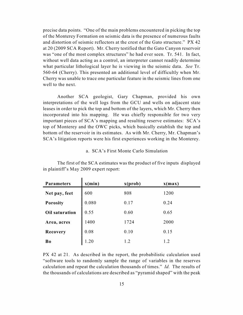
a. SCA’s First Monte Carlo Simulation
The first of the SCA estimates was the product of five inputs displayed
in plaintiff’s May 2009 expert report:
Parameters x(min) x(prob) x(max)
Net pay, feet 600 808 1200
Porosity 0.080 0.17 0.24
Oil saturation 0.55 0.60 0.65
Area, acres 1400 1724 2000
Recovery 0.08 0.10 0.15
Bo 1.20 1.2 1.2
PX 42 at 21. As described in the report, the probabilistic calculation used
“software tools to randomly sample the range of variables in the reserves
calculation and repeat the calculation thousands of times.” Id. The results of
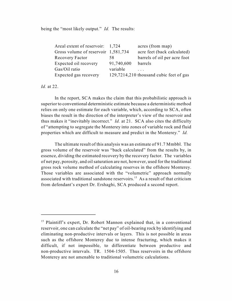
the thousands of calculations are described as “pyramid shaped” with the peak
Plaintiff’s expert, Dr. Robert Mannon explained that, in a conventional15
reservoir, one can calculate the “net pay” of oil-bearing rock by identifying and
eliminating non-productive intervals or layers. This is not possible in areas
such as the offshore Monterey due to intense fracturing, which makes it
difficult, if not impossible, to differentiate between productive and
non-productive intervals. TR. 1504-1505. Thus reservoirs in the offshore
Monterey are not amenable to traditional volumetric calculations.
16
being the “most likely output.” Id. The results:
Areal extent of reservoir: 1,724 acres (from map)
Gross volume of reservoir 1,581,734 acre feet (back calculated)
Recovery Factor 58 barrels of oil per acre foot
Expected oil recovery 91,740,600 barrels
Gas/Oil ratio variable . . .
Expected gas recovery 129,7214,210 thousand cubic feet of gas
Id. at 22.
In the report, SCA makes the claim that this probabilistic approach is
superior to conventional deterministic estimate because a deterministic method
relies on only one estimate for each variable, which, according to SCA, often
biases the result in the direction of the interpreter’s view of the reservoir and
thus makes it “inevitably incorrect.” Id. at 21. SCA also cites the difficulty
of “attempting to segregate the Monterey into zones of variable rock and fluid
properties which are difficult to measure and predict in the Monterey.” Id.
The ultimate result of this analysis was an estimate of 91.7 Mmbbl. The
gross volume of the reservoir was “back calculated” from the results by, in
essence, dividing the estimated recovery by the recovery factor. The variables
of net pay, porosity, and oil saturation are not, however, used for the traditional
gross rock volume method of calculating reserves in the offshore Monterey.
Those variables are associated with the “volumetric” approach normally
associated with traditional sandstone reservoirs. As a result of that criticism15
from defendant’s expert Dr. Ershaghi, SCA produced a second report.
17
b. SCA’s Second Monte Carlo Simulation
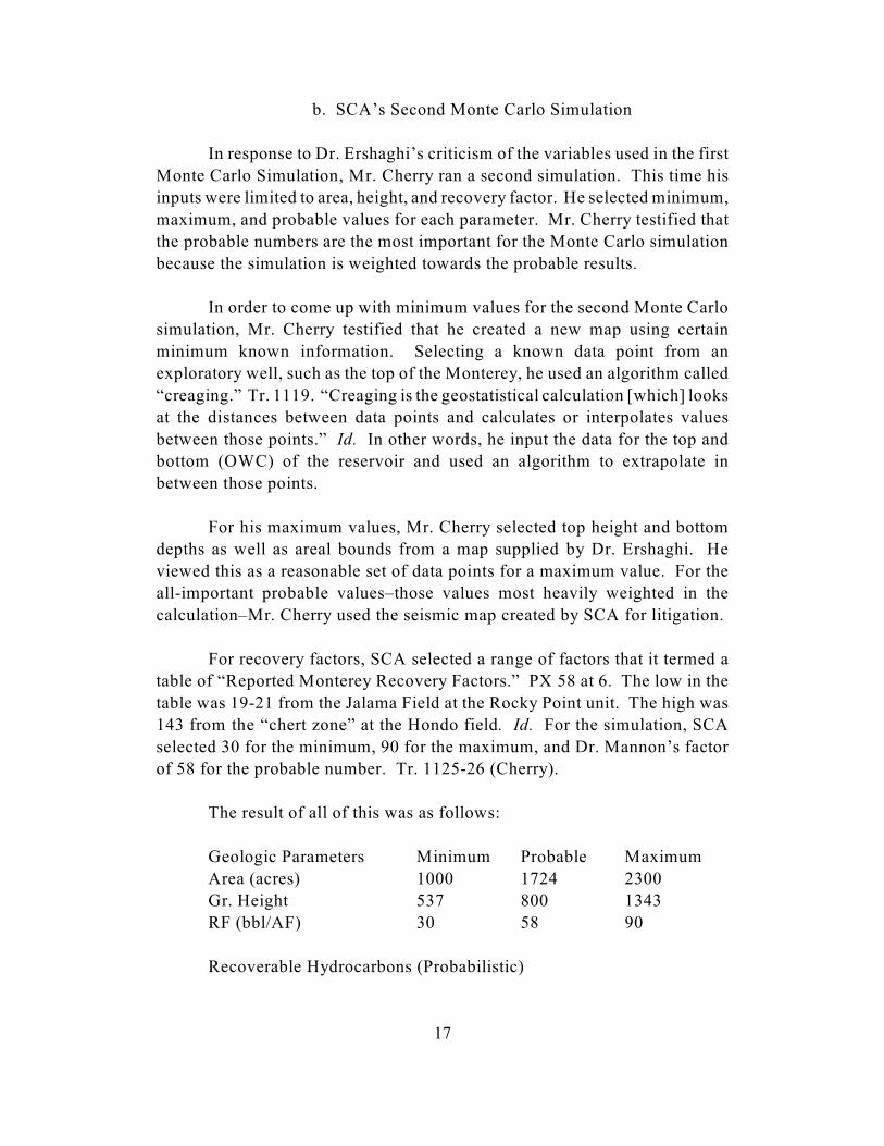
In response to Dr. Ershaghi’s criticism of the variables used in the first
Monte Carlo Simulation, Mr. Cherry ran a second simulation. This time his
inputs were limited to area, height, and recovery factor. He selected minimum,
maximum, and probable values for each parameter. Mr. Cherry testified that
the probable numbers are the most important for the Monte Carlo simulation
because the simulation is weighted towards the probable results.
In order to come up with minimum values for the second Monte Carlo
simulation, Mr. Cherry testified that he created a new map using certain
minimum known information. Selecting a known data point from an
exploratory well, such as the top of the Monterey, he used an algorithm called
“creaging.” Tr. 1119. “Creaging is the geostatistical calculation [which] looks
at the distances between data points and calculates or interpolates values
between those points.” Id. In other words, he input the data for the top and
bottom (OWC) of the reservoir and used an algorithm to extrapolate in
between those points.
For his maximum values, Mr. Cherry selected top height and bottom
depths as well as areal bounds from a map supplied by Dr. Ershaghi. He
viewed this as a reasonable set of data points for a maximum value. For the
all-important probable values–those values most heavily weighted in the
calculation–Mr. Cherry used the seismic map created by SCA for litigation.
For recovery factors, SCA selected a range of factors that it termed a
table of “Reported Monterey Recovery Factors.” PX 58 at 6. The low in the
table was 19-21 from the Jalama Field at the Rocky Point unit. The high was
143 from the “chert zone” at the Hondo field. Id. For the simulation, SCA
selected 30 for the minimum, 90 for the maximum, and Dr. Mannon’s factor
of 58 for the probable number. Tr. 1125-26 (Cherry).
The result of all of this was as follows:
Geologic Parameters Minimum Probable Maximum
Area (acres) 1000 1724 2300
Gr. Height 537 800 1343
RF (bbl/AF) 30 58 90
Recoverable Hydrocarbons (Probabilistic)
Mr. Cherry testified that “the [oil] industry likes the Monte Carlo simulation16
[] because it generates a log normal distribution. And what they found is the
mean result from log normal distribution is usually somewhat significantly
higher than something that went straight from the deterministic.” Tr. 1100.
18
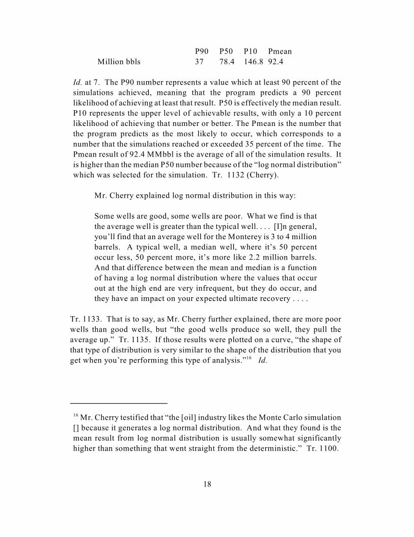
P90 P50 P10 Pmean
Million bbls 37 78.4 146.8 92.4
Id. at 7. The P90 number represents a value which at least 90 percent of the
simulations achieved, meaning that the program predicts a 90 percent
likelihood of achieving at least that result. P50 is effectively the median result.
P10 represents the upper level of achievable results, with only a 10 percent
likelihood of achieving that number or better. The Pmean is the number that
the program predicts as the most likely to occur, which corresponds to a
number that the simulations reached or exceeded 35 percent of the time. The
Pmean result of 92.4 MMbbl is the average of all of the simulation results. It
is higher than the median P50 number because of the “log normal distribution”
which was selected for the simulation. Tr. 1132 (Cherry).
Mr. Cherry explained log normal distribution in this way:
Some wells are good, some wells are poor. What we find is that
the average well is greater than the typical well. . . . [I]n general,
you’ll find that an average well for the Monterey is 3 to 4 million
barrels. A typical well, a median well, where it’s 50 percent
occur less, 50 percent more, it’s more like 2.2 million barrels.
And that difference between the mean and median is a function
of having a log normal distribution where the values that occur
out at the high end are very infrequent, but they do occur, and
they have an impact on your expected ultimate recovery . . . .
Tr. 1133. That is to say, as Mr. Cherry further explained, there are more poor
wells than good wells, but “the good wells produce so well, they pull the
average up.” Tr. 1135. If those results were plotted on a curve, “the shape of
that type of distribution is very similar to the shape of the distribution that you
get when you’re performing this type of analysis.” Id. 16
In the original exhibit, the height figures for the “High side” and “Absolute17
Max” scenarios were reversed. This was a clerical error.
19
c. SCA’s Deterministic Estimate
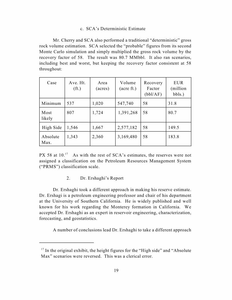
Mr. Cherry and SCA also performed a traditional “deterministic” gross
rock volume estimation. SCA selected the “probable” figures from its second
Monte Carlo simulation and simply multiplied the gross rock volume by the
recovery factor of 58. The result was 80.7 MMbbl. It also ran scenarios,
including best and worst, but keeping the recovery factor consistent at 58
throughout:
Case Ave. Ht.
(ft.)
Area
(acres)
Volume
(acre ft.)
Recovery
Factor
(bbl/AF)
EUR
(million
bbls.)
Minimum 537 1,020 547,740 58 31.8
Most
likely
807 1,724 1,391,268 58 80.7
High Side 1,546 1,667 2,577,182 58 149.5
Absolute
Max.
1,343 2,360 3,169,480 58 183.8
PX 58 at 10. As with the rest of SCA’s estimates, the reserves were not17
assigned a classification on the Petroleum Resources Management System
(“PRMS”) classification scale.
2. Dr. Ershaghi’s Report
Dr. Ershaghi took a different approach in making his reserve estimate.
Dr. Ershagi is a petroleum engineering professor and chair of his department
at the University of Southern California. He is widely published and well
known for his work regarding the Monterey formation in California. We
accepted Dr. Ershaghi as an expert in reservoir engineering, characterization,
forecasting, and geostatistics.
A number of conclusions lead Dr. Ershaghi to take a different approach

It is unclear how Dr. Ershaghi selected 18 as Dr. Mannon’s number of18
proposed wells. Dr. Mannon’s 1996 report lists 16 as the number to be drilled,
PX 18 at 17, and his 2001 report includes 22 initial wells and eight re-drills,
PX 47 at 8. Using 22 wells, Dr. Ershaghi’s approach would yield 48.4
MMbbl.
“And looking . . . at the South Ellwood, roughly about 30 wells with19
somewhere around 3.9 million acre feet, you see the that the drainage volume
per well is around 130,00 acre feet.” Tr. 2413 (Ershaghi). The SCA area
estimate of “roughly 1.5 million [acres] . . . , gives you about 10 [or]12 wells,
not 18 wells.” Id.
20
to his reserve estimation. Looking at the data from the exploratory wells, he
believed that an OWC could not be established with enough certainty because
the seismic data did not allow for an accurate pick of the top of the Monterey
formation in the Gato Canyon field. He testified that the unproductive intervals
in the Monterey, and especially in Gato Canyon, also made the use of a gross
rock volume estimate inappropriate. Tr. 2387-88. In light of those
conclusions, Dr. Ershagi bases his estimate on production from neighboring
wells.
Dr. Ershagi stated that he looked at all of the producing Monterey fields
and their lithologies and selected the South Ellwood field as the “most similar
lithological-wise.” Tr. 2411. He then looked at the well by well production in
that field and selected the median well production as his starting point, which
was approximately 1.1 MMbbl. Accounting for oil yet to be produced from the
field–an additional 10-20 MMbbl–and giving the field the “benefit of the
doubt” because it is located further from shore than the GCU and thus has
“better quality rock,” he bumped the figure to 2.2 MMbbl for median well
production. He stated that this was “very generous in terms of well
productivity.” Tr. 2412.
Dr. Ershaghi then took SCA’s projected number of wells (18) and
multiplied this by his per-well number. The result was 39.6 MMbbl.18
Additionally, he looked at the well spacing at the South Ellwood field and
calculated that an operator of the GCU might only place 12 wells on that field,
which would bring his estimate down to 26.4 MMbbl. Dr. Ershaghi ultimately19
concludes that further exploratory drilling would be necessary to substantiate
any claim of commercial viability.
We reject plaintiff’s volumetric approach taken in its first Monte Carlo20
simulation. Mr. Cherry ultimately rejected that methodology himself in favor
of his gross rock volume approach taken in the second Monte Carlo
simulation. He testified on cross-examination that he recommended that SCA
not include the first volumetric calculation in its report. See Tr. 1177-78.
21
C. Our Finding: The GCU Holds Approximately 60 Million Barrels
of Oil
Defendant criticizes plaintiff’s estimates for a number reasons. It
disagrees with the inputs that SCA and Dr. Mannon used in both the Monte
Carlo simulations and deterministic model, i.e., size of reservoir (areal extent
and OWC) and recovery factor. Defendant further criticizes the Monte Carlo
methodology employed by SCA as subjective in that the results are highly
dependent upon the selection of minimum, maximum, and probable values and
because defendant views the Pmean value produced to be skewed upward as a
result of log normal distribution. Defendant also believes that plaintiff’s choice
not to classify its reserves according to the PRMS system illustrates the
uncertainty in plaintiff’s estimates.
Plaintiff responds that SCA’s work is buttressed by the variety of
pre-litigation estimates produced by Norcen, MMS, and Dr. Mannon. The
Monte Carlo simulation is, in plaintiff’s view, a well respected method for
estimating reserves in oil fields. Plaintiff responds to Dr. Ershaghi by arguing
primarily that Dr. Ershaghi’s median well approach improperly discounts the
effect of the outlier high-producing wells on the ultimate production of fields
in the offshore Monterey region. Plaintiff additionally criticizes Dr. Ershaghi’s
selection of his median well number from the South Ellwood field, arguing that
it is not a useful analog primarily due to geological factors.
We find that both parties’ approaches provide us at least some clue as
to the likely quantity of reserves at the GCU. Neither are without fault,
however, and we cannot therefore adopt either method in whole. For the
reasons set out below, we find that Gato Canyon reservoir holds approximately
60 MMbbl of oil.
Plaintiff’s proffered reserve estimates, though susceptible to criticism,
are not wholly unreliable, with one exception. We take them as the upper20
limit of an optimistic view of the reservoir underlying the GCU. Plaintiff’s
22
deterministic and probabilistic gross rock volume calculations are properly
criticized as products of subjective inputs. Plaintiff’s experts made seismic
interpretations from data that was very difficult to interpret. See Tr. 558-559
(Cherry). This made identifying the top of the Monterey formation speculative.
Much of the GCU reservoir as mapped by SCA has never been tested by wells.
This is not uncommon; oil companies and MMS routinely make reservoir maps
based on seismic data alone. Mr. Heck, in fact, wrote in 1999 that,
detailed mapping of the structure is very difficult due to
extensive faulting. Each of the wells that has been drilled has
penetrated a series of faults that have crumbled and moved the
rock layers into various relationships that can be confusing to the
geologists and geophysicists attempting to map the dimensions
of the accumulations . . . .
DX 10 at 1 (History of Exploration of the Gato Canyon Structure); see also DX
118 at 1, 7; DX 47 at 2; DX 49 at 3; DX 83 at 17. Mr. Heck echoed that
sentiment at trial when he testified that faulting in the structure lowered the
quality of the seismic data and made it difficult to know when drilling “into the
Monterey whether we’re in the middle of the section or the top of where we are
in the Monterey.” Tr. 791-92. Dr. Ershaghi criticized SCA’s work in large
measure because he viewed the seismic data as unreliable in determining the
top of the Monterey and the well data as insufficient to determine the bottom
OWC or bottom of the reservoir.
Mr. Cherry ultimately was forced to use his best judgment to fill in the
gaps in the data or rely on the judgment of others like Dr. Mannon. Samedan
and the other owners, knowing these difficulties, tasked Mr. Heck and Dr.
Mannon to do the same things prior to litigation. Relying on an interpreter’s
experience and judgment does not render an estimate unreliable per se,
however. We are able to take into account the various difficulties and
challenges in the underlying data as well as the interpreter’s experience in
assigning weight to SCA’s estimates.
Plaintiff adds an additional level of complexity to the task at hand by
introducing the probabilistic method. As we explained earlier, the Monte Carlo
simulation calculates probable outcomes based on the input of minimum,
maximum, and probable values and the selected statistical distribution pattern.
Defendant is right to point out that this approach is very susceptible to
manipulation by skewing either of these inputs towards the result desired. That
“A play is a group of geologically related cumulations. . . . So they have a21
similar history, a geologic history of source, of trapping, of creation of the
traps, of preservation, of hydrocarbons . . . .” Tr. 3755-56 (Syms).
We also received testimony in the form of a deposition from Cam22
Countryman, appearing as the Rule 30(b)(6) designee on behalf of Samedan,
in which he indicated that Samedan uses a probabilistic methodology when
estimating the size of a reservoir. See JX 3 at 73-74.
23
is not to say that it is completely unreliable, however.
Mr. Harold Syms, a geologist employed by MMS during the relevant
years, testified that MMS used “Monte Carlo sampling for a quite a few of the
variables” in its “lease sale model.” Tr. 3769. This method was used for the
GCU lease sale in 1982, for example. Mr. Syms explained that “Monte Carlo
sampling” was used to “estimate the range that exists and where the likely
tendency might be.” Id. The determination of the “likely tendency” is in large
part a result of the selection of the distribution pattern: “For instance, when
something is the product of a bunch of things multiplied together, generally log
normal seems to be a good distribution for that, whereas if you don’t know
much about something you would use triangular distribution.” Tr. 3771. He
stated that some variables were “more appropriate for [a] log normal”
distribution pattern.” Id.
Mr. Syms also testified that, on a macro scale, in the Santa
Barbara-Ventura Basin-Monterey Fractured Play, MMS expects a “log normal
distribution of sizes” of the fields within the region. Tr. 3765. “You’ll see a21
few very large ones and a bunch of smaller ones that will form a log normal
distribution.” Id.; see also PX 86 at 12 (MMS 1995 National Assessment of
United States Oil and Gas Resources Assessment of the Pacific Outer
Continental Shelf Region). We cannot reject SCA’s probabilistic estimates
based on the fact that they are probabilistic or that they employ a log normal
distribution. These methods are used by the government and private industry
for the region in which the GCU is located, and we have not heard any
principled reason to reject them. 22
We do, however, view plaintiff’s Monte Carlo estimates as skewed,
primarily, by the selection of recovery factors. Mr. Cherry used Dr. Mannon’s
58 barrels per acre foot as the probable figure, 30 for the low value, and 90 for
the high value. The probable figure is the most important in the calculation of

24
the Pmean, or most likely, result. The 58 figure was the same figure used for
the recovery factor in SCA’s first Monte Carlo simulation. Mr. Cherry testified
that, in response to Dr. Ershaghi’s criticism of the first Monte Carlo, SCA
performed a “research study trying to compile information from various reports
and various studies to compile a range of gross rock volume recovery factors
so that we could have a basis for the reasonableness of that 58 barrels per acre
foot that we used in the first report.” Tr. 1113.
Mr. Hal Miller performed this research and compiled the table of
recovery factors used to buttress SCA’s second Monte Carlo simulation. Mr.
Miller is a Senior Vice President at SCA in operations and was formerly a Vice
President of operations at ConocoPhilips. He is not trained as a geologist or
geophysicist. His resume indicates his area of expertise is primarily human
resources. See PX 67 (Miller Resume); PX 42 at attached exhibit 13. Nor does
he have any relevant experience in the offshore Monterey region. He
principally served to assemble the component parts of SCA’s reports and
forthrightly informed the court that he was not “an expert in the derivation of
a recovery factor other than from a research perspective.” Tr. 144. He testified
that he had done research on prior conventional reservoir projects such as an
offshore African field, but had not previously done so for any Monterey Field.
See Tr. 145.
The product of Mr. Miller’s research is the previously mentioned table
of “Reported Monterey Recovery Factors.” The majority of figures included
were from reports produced for litigation in this case and its former companion
case, Amber Resources. See PX 58 at 6 (10 out of the 12). One figure is from
Dr. Ershaghi’s paper, “A Conceptual Model for Reservoirs Producing from the
Monterey Fields, Offshore California,” and a second is from a Norcen 1989
report regarding Offshore California. The rest are from expert reports or other
exhibits generated in the Amber litigation, mostly by Dr. Mannon, one by Dr.
Ershaghi, and one from SCA’s 2009 report in this case. See id. The lowest
figure is a factor of 19-21 from the Jalama field in the Rocky Point Unit,
derived in the Amber case. The highest figure, 143, is from the “chert zone” in
the Hondo field. The 58 figure is from SCA’s first report in this case. The
number 58 was the “weighted average . . . derived from Dr. Mannon’s 1996
trial report related to Gato Canyon.” Tr. 141-42 (Miller).
Plaintiff points to the testimony of Dr. Mannon and Mr. Chapman who
both stated that the Point Pedernales field was a good analog for the Gato
Canyon field. When asked whether he used any fields as an analog for
Dr. Mannon authored Defendant’s Exhibits 56 and 70 along with Plaintiff’s23
Exhibit 18 regarding the GCU. He produced Plaintiff’s Exhibit 43 concerning
Point Pedernales.
25
determining a recovery factor for the GCU, Dr. Mannon stated that he had been
using “primarily” Point Pedernales. Tr. 1590. He expounded upon the reasons
for that selection:
Because in the terms of the requirements for analogy, it
meets those requirements, I feel, very very well. It’s
approximately the same size in terms of the volume of oil
anticipated to be produced. It’s the same gravity. It’s the same
depth. The producing sections look very similar, as determined
by Mr. Chapman. The fact that it’s the same depth is that you
have the same formation temperature, which is very important in
terms of the effect of temperature on the viscosity of the heavy
oil.
So in terms of lithology, it’s similar. In terms of the
parameters, environment, it’s very similar.
Tr. 1590-91. Mr. Chapman earlier testified that, “based on its depth and . . .
lithology, based on its productive characteristics, it appears very analogous to
[Gato Canyon].” Tr. 426. He acknowledged, however, that Point Pedernales
was “geographically distant” from Gato Canyon and was not on the same
“trend” as Gato Canyon. Id. Despite that, he believed that the rocks were
“deposited [at the two fields] at the same time.” Id. There is no further
explanation or information regarding these lithological similarities contained
in either of SCA’s report nor any of Dr. Mannon’s various reports regarding
Point Pedernales or Gato Canyon. 23
We are not convinced that Point Perdernales is a useful analog for the
Gato Canyon field. Dr. Mannon’s testimony suggests that the tail may be
wagging the dog in his analysis. One of the reasons for his opinion that Point
Pedernales was a good analog for purposes of figuring a recovery factor was
because of its similarity in size “in terms of the volume of oil anticipated to be
produced.” Tr. 1590. The recovery factor is an input into the estimation of the
ultimate recovery. Stating his reasoning another way, a factor in Dr. Mannon’s
estimates of the reserves in Gato Canyon was that Point Pedernales has a EUR
similar to what he believes Gato Canyon contains. That is an assumption of the
Dr. Mannon made some attempt to discredit the results of the tests from the24
460-2 well at trial. We do not afford that testimony much weight, however.
Dr. Mannon reported much lower oil gravities in his pre-litigation reports to
the owners. See DX 43 at 30-35; PX 18 at 6 (reporting an 10.8 degree weight
for the 460-2 well oil and estimating 16 degrees for the whole field); see
also DX 143 at (1989 Norcen Inter-Office memo noting Exxon’s
disappointment with the oil gravity at Gato Canyon). Defendant effectively
showed that the lighter oil produced in several intervals in other tests was
anomalous and due to contamination from diesel fuel pumped into the well to
dilute heavier oil. See DX 277 (Chart of GCU Well Drilling); Tr. 1715
(Mannon); Tr. 2356 (Ershaghi).
Plaintiff also propounded the Hondo field as a useful analog. Dr. Ershaghi’s25
analysis of mud logs from the Hondo field showed similar results to that of
Point Pedernales, meaning that it was not lithologically similar to Gato Canyon
due to the predominance of quartz rock. See Tr. 2403. The Hondo field also
benefits from a quantity of very light oil, which the operator uses to pump back
down the well bore to dilute the very heavy oil present deeper in the formation.
This allows for a greater production of otherwise difficult to produce heavy
26
conclusion and not an exercise in reasoning. Dr. Mannon also stated that the
oil gravity at Point Pedernales is the same as that of Gato Canyon. That
statement is not supported by the evidence. Dr. Mannon reported that the oil
gravity from Point Pedernales was 16 degrees API. Tr. 1642. The oil produced
from the 460-2 well, the only well that flowed significant amounts of oil to the
surface, tested at a much heavier 10-11 degrees API in all tested zones. DX 43
at 30-35 (results of drill stem tests from 460-2 well). Dr. Mannon testified on
cross-examination that this difference in oil gravity “certainly would” affect the
productivity expected from the GCU. Tr. 1642. 24
Dr. Ershaghi testified that Point Pedernales was a poor analog to Gato
Canyon for lithological reasons. He rejected Point Pedernales due to the
dominance of quartz rock in productive zones. See Tr. 2402. Gato Canyon,
by contrast, is “primarily dolomitically controlled.” Id. Dr. Ershaghi compared
Gato Canyon to a number of its neighbors and concluded that South Ellwood
was the best analog. In comparing the results of mud logs between fields, he
found that the rocks produced out of the South Ellwood field best matched
those produced from Gato Canyon: “When you go to the South Ellwood and
when you go to the Gato Canyon you see the limitation of the glassy shards.
You see primarily the dolomitic section, so that’s how you compare them.” 25
oil.
Dr. Ershaghi testified that the approximate recovery factor for South26
Ellwood is 20 BPAF. Dr. Mannon testified that the approximate recovery
factor for Point Pedernales was 67 BPAF. Dr. Ershaghi testified that Point
Pedernales and Point Arguello had recovery factors in the 40-50 BPAF range.
In either case, that is a substantial difference from the recovery factor at South
Ellwood.
DX 153 at 21 (Appendix B-1 to Dr. Ershaghi’s 2010 report, “Effect of27
Monterey Rock Compositon on Fracture Density”); PX 124 at 1, 4 (Union Oil
Company report entitled “Orientation and Origin of Fractures in the Monterey
Formation between Point Pedernales and Government Point”); DX 298 at 3,
8 (Report by Edwin Edwards and Ronald Heck: “Fracture, Fault and Fold
Orientation From Formation Microscanner Data, Samedan OCS P-460 #2”).
27
Tr. 2403. Dr. Ershaghi further testified that quartz rock is preferable for oil
production because the dominance of microfractures in the rock allows for
greater storage and transport of oil, thereby increasing the productivity of a
field, which would presumably at least partially account for the difference in
recovery factor between Point Pedernales and South Ellwood. Other relevant26
factors include oil gravity, distance from shore, and depth of the productive
interval.
Plaintiff challenged Dr. Ershaghi’s conclusion regarding the effect of
dolomitic rock on the productivity of a field. Mr. Chapman conducted a study
of mud logs from five wells at four different fields: Hondo, Point Pedernales,
Gato Canyon, and South Ellwood. PX 93 at 15-15A. He concluded that it is
dolomite rather than Chert (quartz) rock that is most prolific in the Monterey
for oil production. Tr. 412-413; PX 93 at 15-15A. Included in the wells that
Mr. Chapman examined are two from Point Pedernales. In both of those wells,
one with an EUR of 15.1 MMbbl and the other of 7.1 MMbbl, dolomite was the
dominant rock type. Plaintiff also pushed Dr. Ershaghi on cross-examination,
presenting him with several studies conducted in the Monterey, which appear
to indicate no preference for chert over dolomite for oil production. Dr.27
Ershaghi did not attempt to deny the findings of these studies, other than to
disagree that dolomite was as porous as chert, but did warn against drawing the
conclusion that dolomite was as good or better than chert for oil production.
See Tr. 2523-24. Dr. Ershaghi indicated that, despite the larger fractures that
are present in dolomite, it is not better for oil production because those fractures

We also do not reject plaintiff’s estimates because it did not classify them28
under the PRMS system. We took it as a factor in weighing the evidence but
not an independent reason to reject plaintiff’s estimates.
28
were often “choked” by the tight “matrix” of rock. Id. Quartz rock, by
contrast, is more brittle and thus produces more microfractures, which Dr.
Ershaghi testified were preferable for production.
Unlike Dr. Mannon and Mr. Chapman, we cannot conclude that the
Point Pedernales field is the best analog for the Gato Canyon field. The fact
that several wells on Point Pedernales may have a predominance of dolomitic
rock does not change the circumstance that South Ellwood is litholigically more
similar to Gato Canyon. Dr. Ershaghi’s testimony that, on the whole, the rock
at Gato Canyon is more similar to that at South Ellwood than Point Pedernales
was not refuted. Point Pedernales is located in a separate basin, Santa Maria;
Gato Canyon and South Ellwood are located in the same basin, Santa Barbara.
South Ellwood is on the same trend as Gato Canyon. Gato Canyon has a much
lower oil gravity than Point Pedernales. The depth of the productive rock and
distance from shore do give us reason to think that Gato Canyon would have
recovery factor above that of South Ellwood, however.
We also do not find the table produced by Mr. Miller and SCA bolsters
the use of 58 recovery factor in any meaningful way other than to say that 58
lies somewhere in the middle of a range of handpicked figures. We allow for
the unavoidable use of judgment and estimation in the mapping of the field and
interpretation of the seismic data, and we do not find it unreasonable for
plaintiff to have used a log normal distribution in its probabilistic calculations.
The use of a 58 BPAF recovery factor is too high, however. The evidence28
points to South Ellwood as a better analog, and Dr. Mannon’s admission that
the selection of Point Pedernales gets plaintiff to an ultimate number that
supports its claim is telling.
Dr. Ershaghi’s alternative median well approach provides some guidance
to the court, and the selection of South Ellwood as an analog field is backed by
lithological and geological reasons. It does fall short on one key point,
however. The use of a median well figure improperly discounts the possibility
of outlier producers that bring the ultimate recovery of a field up in a
statistically significant way. All the experts agreed that there is tremendous
variance in well production throughout the Monterey fields. As Mr. Cherry
explained with respect to the statistical approach of the Monte Carlo simulation,

In its post-trial brief, plaintiff performed a per well calculation using Dr.29
Ershaghi’s methodology to account for future well production and the Gato
Canyon advantages, but starting with the South Ellwood mean rather than
median well figure for the base, and multiplying by the 22 well number from
Dr. Mannon’s 2001 report. This produced a sum of just over 73 MMbbl.
29
the “difference between the mean and median is a function of having a log
normal distribution where the values that occur out at the high end are very
infrequent, but they do occur, and they have an impact on your expected
ultimate recovery . . . .” Tr. 1333. Dr. Ershaghi’s testimony that selection of
a median number represents a well figure that is more likely to occur with any
one well within a group of wells is unavailing. Defendant’s approach
improperly discounts the existence and influence of those high-side outliers in
its estimate of reserves.29
We are left at the end of the day to make our best estimate from the two
sides’ presentations. Not having been offered a persuasive reason for selecting
a particular recovery factor, we use MMS’ general offshore Monterey factor of
40-50 BPAF, and adopt a figure closer to the 40 number due to the poor oil
gravity evidenced from the 460-2 well, the similarities to the South Ellwood
field, and that the fact that none of plaintiff’s experts’ reserve estimates were
classified under the PRMS scale. A recovery factor of 40, being approximately
one-third smaller than the 58 figure preferred by plaintiff, when applied to
plaintiff’s Monte Carlo results for the volume of the reservoir, produces a rough
estimate of reserves of 60 MMbbl at the GCU.
Sixty million barrels is a not insubstantial figure and, based on plaintiff’s
evidence, there is a plausible scenario under which it could have made a profit
from its 4.25 percent interest in that quantity of oil and attendant natural gas.
It is necessary, therefore, to address the government’s alternative arguments
that there are independent shortcomings in plaintiff’s proof of causation,
namely, that plaintiff has not proved that the other owners would have gone
forward with production, and that the owners could not have overcome the
environmental restrictions on development. If either of those defenses is
established, we need not consider in any detail whether Nycal would have
realized a profit.
D. Whether the Owners Would Have Gone Forward
As an independent bar to recovery, the government argues that the
30
evidence is insufficient to establish with reasonable certainty that the owners
would have proceeded to production of the GCU. The government believes
that, without this piece of the puzzle established, plaintiff cannot prove that the
breach caused a loss. If the GCU would not have gone into production,
plaintiff has not lost any profits. Or, in the alternative, uncertainty about
whether the owners would have gone forward to production means that it would
be speculative to award damages to plaintiff. The key assertion in the
government’s argument is that it would have been necessary for an additional
delineation well to have been drilled and for the results of that well to have
been encouraging before a final decision would have been made to build a
production platform. Its key evidence is testimony to that effect by relevant
decision makers at Samedan.
Plaintiff concedes that a final decision on whether to build a rig and
produce the field had not been made. That is not conclusive in plaintiff’s view,
however, because the events prior to the breach show a series of steps taken by
the owners in furtherance of the ultimate goal of producing the field, making
it more likely than not that it would have been developed. Plaintiff also
disagrees with defendant’s characterization of the importance of the results of
an additional delineation well, pointing to the testimony of Ronald Heck that
poor results from the 460-3 well would not have discouraged further
development.
What we can say with certainty is that the 5000 BOPD results of the
460-2 well were encouraging. We believe it is clear that, with such a positive
result in hand, the owners intended to conduct further exploration of the leases
with the aim of developing the unit. The minutes from the owners’ August 14,
1989 unit meeting are indicative of their intent at that time. The report of the
minutes and attachments thereto contain a great deal of information about the
460-2 drill stem test (“DST”) results and list the immediate steps that the
owners intended to take at that time, namely acquisition and reprocessing of
seismic data and the drilling of an additional delineation well on the eastern
side of the unit. See DX 42. The initial time line from that meeting called for
drilling of the delineation well sometime between 1993 and 1995. Id. at 59.
The notes indicate that at least one owner, Norcen, expressed the desire to
speed up that time line. Id. Amber Resources was noted as suggesting back-to-
back well drilling if more than one additional delineation well was needed. Id.
In 1990, MMS granted a further lease suspension in order to allow the
owners to drill the 460-3 well and perform another interpretation of the seismic
Mr. Heck was testifying as to the state of affairs prior to the COOGER30
study, around 1991. The facts did not materially change because of the
COOGER-caused delay.
31
data. Although no Authorization for Expenditure had been agreed to, the
testimony of the individuals involved is that the 460-3 well would have been
drilled. Samedan did not drill the well, however, because of the COOGER
study, which began in January 1993. MMS suspended operations on all
undeveloped leases for the duration of the study, which did not conclude until
1999.
At the conclusion of the COOGER suspension, Samedan and the other
owners renewed their plan to drill the next well and submitted an updated lease
suspension request to MMS along with a Project Description. Both of those
documents included intended steps leading up to the spudding of the well. Mr.
Heck, a consultant to Samedan, took the court through the steps that the owners
contemplated in furtherance of their goal to drill another delineation well. He
testified that the owners formed a committee of leaseholders, including leases
in other units, to contract for the services of a semi-submersible drilling rig to
drill several new delineation wells, including the well on lease 460. This was
known as the Industry Rig Offshore California Committee. Tr. 855-56. An
additional step necessary for drilling a well would be a shallow hazards study
to look at certain environmental impacts of the delineation well. Mr. Heck
testified that the air gun to shoot the seismic information “was on a truck
heading out from Louisiana” and that a boat was identified to be retrofitted to
handle the equipment. Tr. 721. The hazards study was interrupted by the
district court’s ruling in Norton and never took place.
As to the ultimate fate of the field in the owners’ eyes pre-breach, Mr.
Heck testified that the GCU had adequate reserves to support a decision to go
into production even before drilling the 460-3 well. In his view, the next
delineation well was more important for the placement of the oil rig than
determining whether to produce the field. See Tr. 818. When asked what
would have happened had one or two more delineation wells shown
unfavorable results, Mr. Heck stated that, in his view, such a result would be
unlikely. Nevertheless, “I still think we would have had an adequate reserve to
go forward and recommend a development project.” Tr. 819 (Heck). He30
recognized, however, that he could not “tell . . . what the partners would have
done for sure.” Id. When pressed further as to the weight of his opinion
regarding the viability of the project, he concluded: “I’m not sure, even though
32
if we presented them with a project that could be developed, if it fit their
economic models or not at that point in time, we never got there. So yes, that
would be speculating on what they might think.” Tr. 820.
Dr. Mannon also testified that he did not believe another delineation well
was necessary for a platform decision: “I felt and I have stated that I felt that an
additional delineation well was not necessary in terms of making a platform
decision to move ahead, but I felt that it would be very helpful in terms of
determining and maybe repositioning the location of the platform . . . .” Tr.
1519. He further stated that he gave this same recommendation to Mr. Heck
and to the owners at one of the unit meetings in Santa Barbara. Coming out of
that meeting, Dr. Mannon was summoned to a follow-on meeting with several
individuals from Norcen concerning further information from the 460-2 well.
He testified that, at the time, his impression was that there was a positive
attitude towards proceeding to development of the unit. The weight of that
testimony is, however, tempered by his directly preceding statement that “there
was no indication that the . . . purpose of the delineation well was to validate
the reservoir in terms of go or no go. They didn’t share with me whether they
had made a decision or not.” Tr. 1522. He described his role in the process as
“just kind of a hired hand” as an explanation for why he did not know whether
a development decision had been made. Id.
We find that the owners were committed to drilling a third delineation
well. The question remains, however, whether their commitment went any
further. Plaintiff argues that the commitment to drilling the next delineation
well, coupled with the results of the 460-2 well and the advice of Mr. Heck and
Dr. Mannon, means that, by all industry standards, the GCU would have been
produced. We decline to go so far, although we conclude that this shortcoming
does not preclude plaintiff’s claim.
We have the deposition testimony of Dan Dinges, who was a vice
president and general manager of the business unit at Samedan responsible for
all offshore California assets during the relevant time period. Mr. Dinges’
testimony is the single most probative piece of evidence regarding the owners’
intent to develop the GCU. Mr. Dinges was asked by defense counsel what the
purpose of the 460-3 well was. His answer: “To gather additional information.”
JX 1 at 15. He was then asked whether this information was necessary to
“make a development decision.” Id. He replied “yes.” Mr. Dinges, in fact,
would not give the 5000 BOPD results of the 460-2 well an adjectival
description when invited to do so. He described the result as merely “just one

33
piece of information.” Id. at 13. Mr. Dinges was further asked whether
“Samedan was ready to go forward with or recommend going forward with
full-blown development of the unit” after the 460-2 well. Id. at 19. “Not that
I recall,” was his answer. Id. He was then asked whether any other companies
were prepared to go forward with development at that time. He answered that
he was aware of none:
Generalization, general comment that I can make is that we were
going to continue on to gather information to be able to get to
that decision, but we weren’t there at the time. . . . I think
additional information through drilling was necessary before
final project sanction was necessary or was - not necessary, but
capable.
Id. at 20. When asked hypothetically what options Samedan would have
considered were the results of the next delineation well poor, Mr. Dinges listed
two: drilling another well or abandoning the project. Id. at 27. After further
questioning in this same vein later in the deposition, he added the options of
“shooting additional seismic [and] reprocessing seismic [data].” Id. at 36.
Mr. Dinges was invited by plaintiff’s counsel on cross-examination to
clarify his statements regarding the owners’ intent to develop the field:
Q. Take a look would you, at [Samedan’s 1999 suspension
request], last sentence -- the last paragraph on the first page
which reads: “During the time period of the SOP [suspension of
production], Samedan proposes to drill another delineation well,”
and it gives the number. “The data will be used in final
engineering design and preparation of the plan of development.”
Was it Samedan’s intention to go ahead and propose a plan of
development of the Gato Canyon Unit as of 1999?
A. It would have been dependent upon the results.
Q. Okay. But you certainly intended to continue on with the . .
. plan to develop the field. Right?
A. No, sir. With the plan to drill another delineation well.
Id. at 47-48.

34
Plaintiff points to the deposition testimony of Samedan employee Cam
Countryman. Mr. Countryman stated that, as of 2000, Samedan was “very
committed to drill additional wells and bring [the unit] to production if it drilled
out the way they hoped it would.” JX 2 at 29. Mr. Countryman’s testimony
regarding Samedan’s intention to proceed with development of the GCU is less
conditional than that of Mr. Dinges. Mr. Countryman admitted, however, that
he did not know precisely what impact the results of the next delineation well
would have. See id. 29-30. Mr. Countryman’s testimony, although credible,
is not as probative as that of Mr. Dinges with respect to Samedan’s and the
other owners’ intentions regarding development of the GCU. Mr. Countryman
began his involvement with offshore California projects in 1998. He was a
“landman working offshore, responsible in helping run or oversee any of the
land functions that needed to be dealt with in California as were brought down
to me from upper management.” Id. at 6. Mr. Dinges was Mr. Countryman’s
supervisor. Mr. Countryman testified that he had “very little contact with Dan
[Dinges] on California. Very seldom did we discuss it. He [Dinges] handled
most of the operations.” Id. Mr. Dinges is the best source we have regarding
the intentions of Samedan, and his testimony was unequivocal that a decision
to develop the unit had not been made.
The documentary record from the owners and their consultants echoes
the statements of Mr. Dinges. Minutes from the July 1989, May 1990, and
January 1995 unit owners and representatives meetings all contain notes to the
effect that the owners believed one or two additional delineation wells were
necessary before a decision on development could be made. DX 43 at 58-59
(“It was agreed that at least one and possibly two delineation wells need to be
drilled prior to a platform decision.”); DX 44 (minutes from 1990 meeting); DX
111 (1995 meeting minutes); see also DX 727 (letter from Samedan to MMS);
DX 80 (1999 letter from Samedan to Delta Petroleum Co.).
We thus find that it is uncertain whether the owners would have gone
forward because the results of the next delineation well were not known. The
question thus becomes whether that precludes plaintiff from advancing a lost
profits claim. We think not. The reason we do not know whether the owners
would have gone forward is that the breach prevented drilling of the delineation
well. If the well had been very encouraging, we think it likely the owners
would have gone forward. If the results were discouraging, we think they
would not. If the results were inconclusive, it is impossible to say what would
have occurred. We believe it unfair to burden plaintiff with the obligation to
prove it more likely than not that the owners would have gone forward with
35
production when the reason we will never know the outcome was the
government’s breach. In sum, plaintiff established that a delineation well
would have been pursued. Beyond that, its obligation is limited to offering
evidence of the volume of produceable oil. In other words, the best evidence
of what a delineation well would have shown is our finding as to the reserves.
If 60 million barrels of oil would have been attractive to the owners because it
could be produced at a profit, plaintiff has established as much as it needs to
about the likelihood that the owners would have gone forward.
E. Whether Environmental and Other Obstacles Would Have
Prevented Development
Plaintiff has established that there were significant quantities of oil in the
GCU and, therefore, that the owners would have pursued development if they
could have been produced at a profit. It is unnecessary for us to address the
economics of production, however, because we find that there were
impediments unrelated to the breach which would have precluded development.
First, plaintiff could not have obtained the necessary air pollution permits for
the project from the Santa Barbara Air Pollution Control District
(“SBCAPCD”), and, second, it could not have obtained access to the facilities
at Las Flores Canyon to process the oil, gas, and water produced at the oil rig.
1. Emissions Permits
Exploration and development of offshore California leases requires
regulatory approvals beyond those of MMS and unrelated to the reach of the
CZMA. Particularly relevant to this suit are the environmental permits required
by the SBCAPCD. Defendant urges the court not to assume that any of the
various permits would have been granted and argues that it is unlikely, if not
impossible, that the GCU owners could have met the requirements to garner
these permits. This intervening cause would thus render the government’s
breach neither the “but for” cause nor a substantial factor in plaintiff’s loss of
profits.
In Santa Barbara county, offshore activities are subject to a cap on the
amount of nitrous oxide (“NOx”) and reactive organic compounds (“ROCs”)
that are emitted into the air. If an activity meets or exceeds the limit, it must
offset all of its emissions back to zero. The amount of emission credits
necessary to offset a project also depends upon where in the county the credit

Emissions credits are created through projects and activities that ameliorate31
and/ or reduce NOx and ROCs levels in the air. Excess credits can be traded.
Mr. Peirson has worked in the permitting of oil and gas projects for 32 years.32
He has been involved in projects in California since 1984, during which time
he has worked on permitting nearly every unit currently in production in the
offshore Santa Barbara area. See Tr. 1907-1919 (Peirson). His clients are both
from the oil and gas industry and government regulators. We accepted Mr.
Peirson as a highly experienced expert in permitting, including air pollution
permitting of onshore and offshore California oil and gas projects.
36
was purchased from. Defendant’s chief witness on the subject, John31
Peirson, explained that Santa Barbara County is split into “air basins.” The32
GCU is located in the South Air Basin of Santa Barbara County. South Air
Basin credits can be used in a 1.5 to 1 ratio to offset emissions in the south
basin. Credits from the neighboring North Air Basin offset at a much lower 6
to 1 ratio. Tr. 2018-19 (Peirson).
a. Delineation Well
Samedan planned to drill the next delineation well by utilizing a mobile
drilling rig in conjunction with several other unit operators, known as the ORA
group, to drill wells on several units. Mr. Peirson testified that the SBCAPCD
intended to treat the wells drilled by the ORA group as one project, meaning
that the entire project’s emissions would be treated cumulatively and not on a
well-by-well basis. Tr. 2005. This was echoed by Mr. Heck who stated that the
county “preferred to view it as one project.” Tr. 909; see also DX 39 at 2
(April 2000 letter from Samedan to MMS). Mr. Heck and Mr. Peirson both
testified that the emissions limit for the mobile drilling project would be 25 tons
of NOx and ROCs combined. The aggregating of emissions from all the wells
to be drilled by the ORA group meant that they would have exceeded the 25 ton
limit. See DX 39 at 2; Tr. 909-12 (Heck). MMS estimated in the draft 2001
EIS that the ORA group project would have a cumulative NOx emission of
approximately 88 tons. DX 257 at 149. No other estimate was offered by
either party. Using that estimate, the owners would have been required to offset
88 tons back to zero. Assuming they could purchase credits in the south air
basin at the 1.5 to 1 ratio, 132 tons of credits would have been required. If only
north basin credits were used, 528 tons would be required.
Samedan intended to avoid having its well aggregated with the other
In 1997-1998, a group of owners consorted to use a mobile rig to abandon33
some 23 wells in state waters: Subsea Well Abandonment Project, known as
“SWARS.”
Mr. Heck also explained that the treatment of the SWARS project as a34
unitary project was the subject of litigation that resulted in settlement. The end
result relevant here remains that the county treated it as one project and
intended to treat the ORA project the same way.
37
ORA project wells by demonstrating to the SBCAPCD how the ORA project
was different than an earlier well abandonment project that had been previously
treated by the SBCAPCD as one project. Id. If the owners could convince the33
county that each well to be drilled was a separate project, they anticipated that
no single well would exceed the 25 ton limit. Id. Mr. Heck testified about the
bases on which Samedan could have relied to show how the project was
different. The prior project, known as “SWARS,” involved the abandonment
of 23 wells, whereas the ORA group project was only to drill three or four
wells. Mr. Heck further explained, “it was our intent to make our case that
these projects were geographically a great distance apart, whereas the SWARS
project was in a very much smaller area, if that was a criterion.” Tr. 984. Both
projects involved the use of one mobile drilling rig moved from site to site,
utilizing “big diesel engines” which produce the bulk of the emissions. Tr. 985
(Heck).
If the county stuck to its plan to treat the ORA group wells as one
project, as it did with the SWARS project, the only avenue left for the owners
would be offsets. Tr. 1909-12 (Heck). Mr. Heck testified that the SWARS34
project had to create credits by paying into a fund “because there’s seldom any
offsets available, so you offset them with some project that creates offsets.” Tr.
982. He recalled $750,000 as the amount required for the SWARS project. He
further testified that the ORA group was aware that, failing to convince the
county otherwise, it would likewise have to pay into this credit-creating fund.
No other testimony or evidence was received concerning payments into a fund
to create offsets.
b. The Gato Canyon Platform
Assuming that the owners had succeeded in getting permits for the
delineation well, had completed delineation drilling, and made a decision to
proceed with unit development, it would have been necessary to build and
Mr. Peirson later testified that the Henry platform emitted around “25 tons35
or so a year of NOx, and about 20 or 25 tons per year of ROCs.” Tr. 2027.
Mr. Poulter was accepted as an expert in the administrative and36
environmental permitting processes necessary to bring an oil field to
production in the offshore California region. See Tr. 1275-79. He disclaimed,
however, expertise in the area of air pollution permitting and stated that he
would rely on consultants to assist him in this “very specialized area.” See Tr.
1276; see also Tr. 1278.
As explained by Mr. Peirson, a fully electrified platform is one that is37
powered by drawing electricity from the shore-based electrical grid as opposed
to generating it on the platform or some stand-alone on-shore generation
facility. No emissions are charged to the platform for power drawn from the
38
install a permanent platform from which to drill wells and to which oil would
be produced. As explained by Mr. Peirson, permanent developments, such as
an oil rig, are subject to a stricter 10 ton per year limit for both NOx and ROCs
(10 tons each). The parties disagree as to what emissions from such a platform
would be. Mr. Peirson testified that the range of NOx emissions from the
existing offshore rigs in Santa Barbara County is from 28 or 29 tons at the35
Henry Unit platform to 350 tons at the larger Point Arguello platform. Tr.
2019-20. Mr. Peirson testified that the emissions from the Gato Canyon
platform would be toward the lower end of that range but still above the 10 ton
cap.
In addition, although not yet discussed in any detail in this opinion, it is
likely that, in order to process the oil, gas, and water produced from the Gato
Canyon platform, the owners would have been required to build an onshore
processing facility. We further explore the likelihood of that project in the next
section. Relevant at this point, however, are the likely emissions from such a
facility. Mr. Peirson testified that an onshore processing facility would be
added to the offshore platform for purposes of calculating emissions. The
lowest emitting onshore processing facility in the area emits 8.7 tons of NOx
and 45.2 tons of ROCs. Tr. 2035-38 (Peirson).
Plaintiff offered its own testimony in an attempt to rebut Mr. Peirson.
Plaintiff suggested through its scheduling and permitting expert, Mr. Poulter ,36
that certain steps could be taken to dramatically lower emissions from the
project, such as using a fully electrified platform. Plaintiff also argues that37

grid. That does not mean, however, that a fully electrified platform has no
emissions. For example, a platform normally has two cranes that are
independently powered as well as back-up diesel generators for the drills and
pumps. See Tr. 2027-28 (Peirson). Another source of emissions are the boats
that shuttle men and supplies back and forth from shore.
39
the emissions figures from the existing platforms are not very relevant because
they were built some 20 or more years ago. Mr. Peirson testified, however, that
the platform on the Irene unit, the only fully electrified platform in the area,
emits approximately 58 tons of NOx and 30 tons of ROCs per year. Tr. 2027.
Plaintiff’s more general argument is that, although air pollution
permitting is a problem for owners and operators, “projects, such as offshore
exploration and production, which require air pollution emission credits
continue to be proposed in Santa Barbara, and that such proposal[s] are
predicated on the assumption that the requisite air permits will issue.” P.’s
Post-Trial Reply Br. 133. Plaintiff’s point to Mr. Peirson’s response during
cross-examination that his clients would not undertake new projects if there was
no hope of permitting them:
Q. In your experience as a permitting expert, would you put in
an application for any kind of permit if there wasn’t reason to
believe that you could meet th emissions requirements?
A. No.
Q. You don’t put in applications that are foregone losers, do
you?
A. I wouldn’t think that’s a smart thing to do.
Tr. 2170.
Plaintiff also offered a variety of possible offset-creating projects or
emission-ameliorating activities ranging from retrofitting Santa Barbara county
school buses with natural gas engines to transporting personnel to the platform
using helicopters instead of boats. Neither Mr. Poulter, Mr. Peirson, nor
anyone else, was able to quantify the amount of credits created by any of these

40
hypothetical efforts, however. Mr. Peirson testified more generally that, based
on his discussions with the head of the SBCAPCD, there was not a “substantial
quantity left of offsets that you could create in the South Coast.” Tr. 2172. He
stated the same in his expert report. His conclusion was that “[o]ffsets in Santa
Barbara County are very limited, or non-existent, and it would be very unlikely
that offsets could be obtained for a source of this magnitude.” DX 193 at 16.
Plaintiff’s scheduling expert Mr. Poulter, although not an expert in air pollution
permitting, posited that one potential project would be to further retrofit the
boats used to serve the San Ynez Unit. Those boats, however, had been
previously retrofitted, which Mr. Peirson testified resulted in a 40 percent
reduction of emissions at that time. He further informed the court that a similar
2002 project to retrofit the commercial fishing fleet in the area yielded a
reduction of only 0.4 tons per year per boat. Although he did not state how
many boats were retrofitted, he cited the fishing boat project as an example of
how retrofitting boats was unlikely to result in any meaningful amount of
credits.
In sum, we find that a reasonable range of platform emissions for the
Gato Canyon platform, including those from a newly built processing facility,
would be 34 tons of NOx and 60 tons of ROCs to 67 tons of NOx and 76 tons
of ROCs. On the low end, that level of emissions would require combined
NOx and ROCs offsets in the amounts of 156 tons using all South Basin credits
or, using North Basin credits, 624 tons of offsets. On the high end of the range,
214 tons of combined credits from the South Basin or 857 credits from the
North Basin would be required.
c. Available Credits
The evidence leads us to the conclusion that the owners would have been
unable to significantly ameliorate emissions through electrification or other
means. The only option then would have been to purchase credits from other
sources. Mr. Peirson explained that emissions credits are tradeable. “And then
once you buy it, you now own the certificate, and then you turn it into the
district, and say here is my credit for my project.” Tr. 2013 (Peirson). Mr.
Peirson told the court that, as of the time of trial, there were approximately 30
tons of NOx offsets and 5 tons of ROCs offsets existing in the South Air Basin.
There were 150 tons of NOx offsets and 70 tons of ROCs offsets existing in the

Santa Barbara County publishes a list of emissions credits in its inventory38
on its website.
41
North Air Basin. Tr. 2015-16 (Peirson); DX 1002 at 13. Those credits are,38
for the most part, unavailable, however. Mr. Peirson explained that, in the
North Basin, most credits are held by Vandenberg Air Force Base and “are not
available to be purchase or traded.” Tr. 2016. In the South Basin, “Plains
Exploration owns a lot of the South Coast NOx emission, and they are not on
the market.” Id.
Even giving the owners all of the possible favorable assumptions of a
fully electric platform, a low-emitting processing facility, no emissions from
construction, and that Samedan could have purchased all of the credits in the
inventory, not just those available, the owners would have been well short of
the credits needed for rig operation and the ORA group drilling. We note that
Mr. Peirson’s testimony about number of credits available was based on
SBCAPCD’s current inventory and not the credits available at the time that
plaintiff contends that the platform would have been installed and begun
operating. We do not believe, however, that the numbers would have been
meaningfully different. Mr. Peirson was still confident in his conclusion that
it would have been highly unlikely that the GCU owners could have obtained
the needed credits. We agree. Plaintiff has not proven that the breach was the
cause of its lost opportunity to explore and develop the leases. The owners’
inability to obtain air pollution permits was an intervening cause of the lost
opportunity to develop the lease.
Plaintiff’s answer that time and money would eventually provide a
solution to the permitting dilemma does not overcome the problem. Instead, it
creates a new one for plaintiff: uncertainty as to damages. In order to calculate
damages, we have to have a reasonable basis for estimating costs, as well as
the timing of when those costs would have been incurred. Conjecture that, “we
would have come up with a solution, although we don’t know when, or what
it would have cost”’ injects an intolerable level of uncertainty into calculating
damages. Plaintiff’s burden is one of reasonable certainty. Accepting on faith
that, given enough money and time, the owners could have eventually obtained
the necessary permits means we cannot rely on plaintiff’s schedule of
development, nor would we know how much it would have cost to build and
operate the various facilities. Plaintiff’s costs are not reasonably certain
without a set time line. Likewise, we do not know how much additional cost
would have been incurred in order to create or obtain credits.
We explain below that, while it is theoretically possible that plaintiff could39
have built a new processing facility at Las Flores, the costs of such a facility
would have been very high. Even though we are unwilling to rule out the
possibility it could have obtained a site, as we explain below, construction of
a new facility would multiply the unknowns as to cost.
Plaintiff suggests in its reply brief that such a result would amount to an40
uncompensated taking. This was a theory not put forward in the complaint or
at trial. In any event, the relevant actor would have been the state or the
county.
42
For example, Mr. Heck’s testimony that plaintiff could pay into a fund
for emission-reducing technology, similar to the SWARS project, is merely an
abstraction. We do not know whether such a project would have been available
for the Gato Canyon project or how much it would have cost. Mr. Peirson
opined that purchasing credits, assuming availability, would have cost
approximately $50,000 per ton. See DX 193 at 16-17. That would have added,
for the platform alone, an additional $7.8 to $11 million dollars using all South
Air Basin credits, and, if only North Air Basin credits were purchased, $31.2
million to $42.85 million dollars. In short, if we overlooked the permitting
problems by assuming a solution, we would be unable to quantify damages with
any degree of certainty. 39
The federal government’s actions are thus not the reason the owners
ultimately would have been unable to proceed. Plaintiff’s inability to40
demonstrate that it is more likely than not that it would have obtained the
necessary environmental permits is thus an independent basis for ruling that it
cannot establish lost profits. Nevertheless, the government offers one
additional and potentially independent ground for breaking the causation chain,
which we address below.
2. Processing Facility
The owners faced another major obstacle to the development of the
GCU: the need to process the oil, gas, and water produced from the platform.
There are three existing processing facilities in Santa Barbara County. One of
those, Exxon’s facility at Las Flores Canyon, was within reach by pipeline from
the GCU. The Las Flores facility was designated by the county as a
“consolidated” site, meaning that the county intended for the site to be used by
multiple operators to process their oil, gas, and water. It was owned entirely by
Oil and water are produced from the wells as a mixed emulsion and, if not41
separated on the platform, are transported to a processing facility in that
condition.
43
Exxon, however. The only other option was construction of a new site not
already in use as a processing facility. That, however, would be subject to a
public referendum in the county and was never considered by Samedan as a
viable option.
Samedan’s hope was to process its oil, gas, and water at Exxon’s Las
Flores facility by utilizing existing capacity. See DX 52 at 233 (2000 GCU
DPP). As a condition of Exxon’s permits for the Las Flores facility and in
conjunction with the county’s designation of Las Flores as a consolidated site,
Exxon was required to provide “equitable access” to the site. The full import
of that language was not meaningfully explored at trial. What is known is that
Exxon had some obligation to allow the use of its existing facilities or the
unused land at the site for construction of a new facility. Two questions thus
follow: whether the existing Las Flores facility had the available processing
capacity to accommodate the GCU production and, if not, whether it would
have been feasible and practicable to build a new facility at the site.
a. Samedan Would Not Have Been Able to Utilize
Existing Capacity at Las Flores to Process its Oil, Gas,
and Water
It is clear from the trial testimony and documentary evidence that
Samedan’s preferred option for processing was to use existing capacity at Las
Flores. Defendant challenged that option by eliciting testimony and producing
several documents relating to two unsuccessful attempts by other operators to
use the existing Las Flores facilities for processing oil, gas, and water.
The chief evidence presented by defendant on this issue centered around
an unsuccessful attempt to utilize Las Flores as a processing site by another
operator, Veneco. Veneco explored using Las Flores to process oil and gas
produced from Platform Holly in the Ellwood Field. In 2008, Exxon reported
that its facility was permitted to handle 140,000 barrels of liquid per day, with
a design capacity of 100,000 BOPD and 75,000 barrels of water per day. DX41
944 at 4 (Exxon comments on Veneco Ellwood Full Field Development Project
Draft Environmental Impact Report). Exxon processes only 38,000 BOPD due
to the high volume of water processed. Exxon planned to increase its water

44
processing capability, but it forecast that it would utilize all of that future
capacity itself. The following table appears in the comments to the draft
environmental report (“EIR”):
LFCLiquids
DesignCapacity
CurrentOperations
FutureOperations
HollyProduction(estimated)
Comments
TotalEmulsion[kbbl/day]
140 103 130 19 Venoco
processing
would
exceed
total fluid
. . .
capacity
Total Oil
[kbbl/day]
100 38 40 19
Total
Water
[kkbl/day]
75 ~65 ~90 0* *Water
separation
would
occur at
platform
Holly
Id.
As to gas processing, Exxon was permitted to process 75 million
standard cubic feet per day (“MMSCFD”) at Las Flores. It was, however, “not
always [able] to operate at the permitted maximum rate due to operational and
production limitations.” Id. at 2. In 2008, Exxon was operating below the
permitted limit but at capacity due to mechanical limitations. Exxon further
noted that the gas produced from Ellwood was much more acidic than the gas
that the Las Flores facility had been built to process, meaning that one unit of
Veneco gas would take up over three units of Exxon’s processing capacity at
Las Flores.
Exxon’s conclusion was that its “future operations may be able to
accommodate additional oil from a third-party Operator, but we are limited as

Venoco’s Ellwood Field produces from state waters and Exxon’s Santa42
Ynez Field produces from federal waters.
45
to any additional water and gas processing capabilities.” Id. at 4. Exxon stated
that, although Venoco planned to separate water at the platform, additional
“final water polishing” would likely be necessary “in order to meet oil pipeline
sales quality specifications.” Id. Further, “[u]nder current EPA NPDES
General Permit requirements, there is a likely permit issue with the
commingling of State and Federal produced waters within our oil and water
processing facility.” Id.42
Exxon’s statement of the problems surrounding any attempt to utilize its
spare capacity in 2008 and for the foreseeable future were echoed in Venoco’s
own comments to the Draft EIR, see DX 223 at 9-17, and by defendant’s
expert, Mr. Peirson. Mr. Peirson explained that using Las Flores was an
alternative plan in Venoco’s proposal. Venoco’s preferred solution was to
process its oil and gas at its own existing Ellwood facility. He explained,
however, that such would be a “non-conforming use in the city of Goleta,”
which meant that Venoco faced a problem permitting the project. Tr. 1973.
Venoco agreed with Exxon’s conclusion that the existing Las Flores facilities
could not handle the oil and gas production from the Platform Holly project.
See DX 223 at 10.
Plaintiff views the import of Exxon’s conclusion that it was limited as
to future processing of third-party produced water as having to do primarily
with the issue of commingling state and federal water, which would not be an
issue at the GCU. Even if Exxon did not have the future water processing
capacity needed, plaintiff believes that Venoco’s estimate of $15 million for a
10,000 BOPD water-oil processing facility to be a reasonable baseline from
which to support Dr. Mannon’s cost estimate of $36.15 million for a larger
onshore treatment facility.
As to gas processing, plaintiff points out that its gas is not as acidic as
that which would have been produced from the Ellwood Field, and thus it
would not face as large a hurdle in that regard. Plaintiff extrapolates from
Exxon’s table at page three of its 2008 comments on the draft EIR that Exxon
had future capacity of approximately 20 MMSCFD. The table lists the design
capacity for the two separate gas processing facilities in the Canyon as 75 and
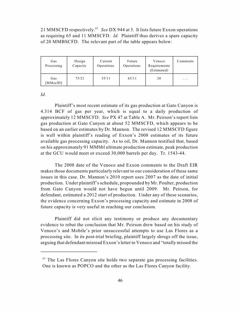
The Las Flores Canyon site holds two separate gas processing facilities.43
One is known as POPCO and the other as the Las Flores Canyon facility.
46
21 MMSCFD respectively. See DX 944 at 3. It lists future Exxon operations43
as requiring 65 and 11 MMSCFD. Id. Plaintiff thus derives a spare capacity
of 20 MMBSCFD. The relevant part of the table appears below:
Gas
Processing
Design
Capacity
Current
Operations
Future
Operations
Venoco
Requirements
(Estimated)
Comments
Gas
[MMscfD]
75/21 55/11 65/11 20 . . .
Id.
Plaintiff’s most recent estimate of its gas production at Gato Canyon is
4.314 BCF of gas per year, which is equal to a daily production of
approximately 12 MMSCFD. See PX 47 at Table A. Mr. Peirson’s report lists
gas production at Gato Canyon at about 52 MMSCFD, which appears to be
based on an earlier estimates by Dr. Mannon. The revised 12 MMSCFD figure
is well within plaintiff’s reading of Exxon’s 2008 estimates of its future
available gas processing capacity. As to oil, Dr. Mannon testified that, based
on his approximately 91 MMbbl ultimate production estimate, peak production
at the GCU would meet or exceed 30,000 barrels per day. Tr. 1543-44.
The 2008 date of the Venoco and Exxon comments to the Draft EIR
makes those documents particularly relevant to our consideration of these same
issues in this case. Dr. Mannon’s 2010 report uses 2007 as the date of initial
production. Under plaintiff’s schedule, propounded by Mr. Poulter, production
from Gato Canyon would not have begun until 2009. Mr. Peirson, for
defendant, estimated a 2012 start of production. Under any of these scenarios,
the evidence concerning Exxon’s processing capacity and estimate in 2008 of
future capacity is very useful in reaching our conclusion.
Plaintiff did not elicit any testimony or produce any documentary
evidence to rebut the conclusion that Mr. Peirson drew based on his study of
Venoco’s and Mobile’s prior unsuccessful attempts to use Las Flores as a
processing site. In its post-trial briefing, plaintiff largely shrugs off the issue,
arguing that defendant misread Exxon’s letter to Venoco and “totally missed the
The Hondo pipeline brings oil, gas, and water from the Santa Ynez unit44
onshore to Las Flores.
47
point” as to the evidence relied on by Mr. Peirson. Pl.’s Reply Br. 94.
Plaintiff instead makes the argument that the letter from Exxon is more
properly viewed as a negotiating tool used by Exxon to exact a maximum
payment from Venoco, rather than an absolute statement of no future spare
capacity. Plaintiff seizes upon Exxon’s statement that it intended to increase
future water processing capabilities and also points to an internal Norcen
memo, dated May 1, 1989, in which Norcen discusses permitting and onshore
processing as they pertain to offshore California development as a whole and
particularly to the GCU. The memo notes the development of the Las Flores
facility, which was scheduled, as of the time of the memo, to go online in 1992.
The memo states that “Exxon is receptive to processing other production if
spare capacity exists.” DX 143 at 3. The memo predicts that spare capacity
will not exist “until several years after start-up of the plant when production for
the Santa Ynez unit starts to decline.” Id. One of Norcen’s conclusions was
that Exxon would be open to allowing “flow through the Hondo pipeline as
long as it would not hinder their operations at the Santa Ynez unit.” Id. at 4.44
Thus, in plaintiff’s view, the question of utilizing Las Flores is one only of cost.
We find that plaintiff would not have been able to utilize existing Las
Flores facilities to process its oil, gas, and water. We take Exxon’s statement
of its then existing capacity at face value and not as a negotiating stance as
plaintiff would have us. Venoco’s comments to the draft EIR are telling in that
they accepted Exxon’s statements as truth. Venoco concluded that Exxon did
not have spare capacity at Las Flores to handle its gas and water processing
needs. Venoco was not successful in gaining access to Exxon’s existing
processing facilities and instead considered building its own facility at Las
Flores. Samedan would have had to consider the same.
Exxon reported the ability to handle up to 140,000 barrels of liquid per
day, which included up to 100,000 barrels of oil and up to 75,000 of water.
Exxon explained that, as the Santa Ynez field matured, the water to oil ratio in
the emulsion produced from the rig increased, which meant that the facility was
already operating at near its water processing capacity. As the table on page 4
of Defendant’s Exhibit 944 shows, Exxon believed it would exceed its existing
water processing capacity in the future. Exxon concluded, and Venoco
accepted, that Las Flores could not handle Venoco’s 10,000 BOPD production

48
even when assuming that water and oil would be separated by Venoco at the
platform. Samedan did not propose to separate its oil from water at the
platform. Needless to say, 30,000 barrels of oil, unsegregated at the platform,
would have greatly exceeded Exxon’s spare capacity. Even if we reduce that
peak daily production in half to over-accommodate our holding regarding the
reserves at the GCU, it would have exceeded the spare capacity at Las Flores.
There is ambiguity concerning Exxon’s capacity to process natural gas
at its facilities at Las Flores. Taken alone, the excerpt of the chart copied above
would seem to indicate that the Las Flores Canyon facilities would have the
necessary spare capacity to handle Dr. Mannon’s most recent estimates of 13
MMSCFD for the GCU. Exxon qualified the chart, however, with this
language that directly precedes it:
ExxonMobil, currently and for the foreseeable future, operates a
continuous rig line, and drilling new wells to produce oil and gas
to effectively manage the reservoir and field life. As shown in
the table below, current and future gas processing operations will
be at or near design limits without consideration for Venoco’s
processing requirements.
Id. at 3. Exxon also stated earlier that it was, at that time, operating below
permitted limits due to mechanical complications, and, although it planned to
remedy those limitations, it would at some future point begin processing gas
currently stored in well bores offshore and not yet brought to shore. See id. at
2. Whether that additional gas is included in the estimates for future operations
in the chart on page three of the exhibit is not clear. We take Exxon at its word,
however, that it did not anticipate being able to accommodate future gas
processing, especially in light of its need to process gas that it was then storing
offshore. Venoco’s comments to the draft EIR indicate that it tried proposing
an alternative scenario in which it sent a lower volume of gas to Exxon to be
commingled with its processing at Las Flores. Exxon answered that it had
“re-confirmed [its] earlier assertion that such capacity does not exist.” DX 223
at 10. We conclude, as Exxon did, that “future operations may be able to
accommodate additional oil from a third-party Operator, but [Exxon is] limited
as to any additional water handling and gas processing capabilities.” PX 944
at 4.
In sum, plaintiff has not demonstrated that it is more likely than not that
it could have utilized Exxon’s existing facility for on-shore processing.
In its briefing, plaintiff also mentioned that it was not foreclosed from45
seeking some unspecified alternate site at which to process its oil, gas, and
water. This was not explored at trial in any way, however, and we do not
consider it an answer to the problem of processing at Las Flores raised by
defendant.
49
Plaintiff offers one other option: construction of a new facility at Las Flores.45
b. Plaintiff Could Not Have Built a New Facility at Las
Flores
Samedan would have been forced to try to build its own facility at Las
Flores or seek processing elsewhere. There are two problems with this
proposed solution, however. We have already examined one. We find that the
SBCAPCD would have aggregated the emissions from an onshore facility with
the emission from the offshore platform. Samedan thus would have been
unable to garner the necessary air pollution permits due to the lack of available
emissions credits in Santa Barbara County. In other words, a new facility would
simply have added to the virtual impossibility of obtaining the necessary
permits.
The second difficulty, although perhaps not an insuperable obstacle, is
that construction of a new facility at Las Flores adds to the uncertainty of the
costs of going forward. This requires a closer examination of plaintiff’s
proposal, as well as Venoco’s earlier efforts to build at Las Flores.
Recognizing its requirement to provide “equitable access,” Exxon
offered to “provide property for co-location” of an additional oil and gas
processing facility at Las Flores Canyon should Venoco decide to pursue this
“alternative siting.” DX 944 at 1. Venoco considered this option and detailed
its consideration, primarily of cost, in its comments on the draft EIR.
Venoco concluded that it would need to build a facility capable of
processing 10 MMSCFD of gas and 10,000 BOPD, along with water utilities
such as boiler feedwater, steam, and firewater, a new power service, oil tankage
for incoming and outgoing emulsions, and an offshore pipeline. In additional,
Venoco would have to procure on the order of 15 to 20 acres from Exxon,
upgrade power cables, and make certain upgrades to Platform Holly. See DX
223 at 11-15. A chart appears at page 15 of Venoco’s comments on the draft
EIR, which summarizes and categorizes its cost estimates for such a project if
50
built in 2008 or 2015. See id. at 15.
2015 was the date Venoco estimated by which it could complete
construction of such a facility. In 2008 dollars, Venoco estimated a total cost
of $223,513,000, which, if actually completed in 2015, Venoco estimated to be
$458,201,000. No agreement between Exxon and Venoco was ever reached,
and, according to Mr. Peirson, Venoco recently withdrew its application to
develop the field.
Mr. Peirson also informed the court of one other attempt to gain access
to the Las Flores canyon in the 1990s. Mobil Oil, before it merged with Exxon,
attempted to gain access to Las Flores. After negotiations with Exxon, Mobil
ultimately concluded it was too expensive, at least in part because Exxon
demanded “payment of costs associated with Exxon’s original building facility
costs.” DX 193 at 20. Although not discussed in any great detail during the
trial or in the Mr. Peirson’s report, it is some evidence of the prohibitive costs
associated with attempting to utilize Exxon’s Las Flores facilities. Mr. Peirson
concluded that he did not believe that Samedan would have had any more
success in utilizing Las Flores than either Venoco or Mobil did.
If plaintiff had found it necessary to build a new facility at Las Flores,
it would have had to adjust its proposed schedule. The one it offered at trial
assumed production beginning in March of 2009. Mr. Poulter, who authored
the schedule, posited the following key dates:
1. Samedan would submit the modified EP in September of 2001;
2. Samedan would have completed the delineation well by the end of
December 2003;
3. The DPP would have been approved by the end of June 2007;
4. Initial production begins no later than the end of March 2009.
PX 54 at 20 (Poulter expert report). There is no line item in the schedule
specifically for constructing onshore facilities. The final item before
production is listed as “Construction of Project Facilities.” Id. The
construction phase was slated to begin the third quarter of 2007 and last until

Defendant disagreed with plaintiff’s schedule and proposed its own46
competing schedule through its expert, Mr. Peirson. That schedule called for
the platform to begin production in 2013. We need not decide which is the
more likely scenario because, as we explain more fully below, the
complications of building an onshore facility casts significant doubt as to
plaintiff’s schedule.
51
production began, a duration of one and a three-quarters years. Although46
plaintiff argued that it would be able to build its own onshore facilities at Las
Flores if necessary, it did not explain when it would begin and how long it
would take. The only piece of evidence that we have on the question comes
from Venoco’s analysis of construction of onshore facilities. Venoco
concluded that: “It is likely that time to design, permit, and construct a process
plant on this order will take a minimum of 7 years. Construction itself is
expected to take 1.5 years.” DX 223 at 15. The actual time to construct would
fit within plaintiff’s window for facility construction. The other necessary steps
of design and permitting, however, add significant amounts of time and doubt
as to when the project could proceed.
Presumably plaintiff would answer that the design and permitting
processes could and would have begun well before the 2007 beginning of
construction. All else being equal, that is true. Nevertheless, in a world in
which so many contingencies are relevant to the decision to move forward with
development of the lease, the question of when that process might have begun
is a difficult, if not impossible, one to answer. We find it unlikely that the
owners would have undertaken any major expense in pursuit of an onshore
facility before the results of the third delineation well were known. The
testimony of Mr. Dinges recited previously in this opinion makes clear that
development beyond the next delineation well was not yet decided on at the
time of breach. Giving plaintiff the benefit of the doubt, presuming favorable
results from the third delineation well and that a decision by the owners would
have then been made to move forward to production, Samedan would only then
have begun the process of seriously inquiring whether Exxon would have spare
capacity and entered negotiations. At what point Samedan would have emerged
from those negotiations is unknown. If it was unsuccessful, only then would
Samedan have begun to consider building an onshore facility.
In addition to the impact on plaintiff’s damages schedule, the need to
build a new facility adds uncertainty to its damages model. Venoco concluded
that constructing its own onshore processing facilities at Las Flores would cost

Mr. Miller did not specify which costs he reduced or eliminated in drawing47
his estimate from Venoco’s.
There is a minor disagreement between the two documents. In his report,48
which is a valuation of plaintiff’s interest, Dr. Mannon states that the onshore
facilities would cost $36.15 million. In the schedule of costs associated with
the 100 percent valuation of the GCU working interests, the cost is listed as
$38.7 million.
52
$223,513,000 in 2008. Defendant’s expert on cost and associated issues, Mr.
Richard Miller, used the Venoco calculation as a basis for his own estimate of
a $125 million dollar cost for the GCU facility at Las Flores. The reduction in
cost resulted from zeroing out those costs that would not have been incurred by
the GCU owners, such as modifications to the platform that the GCU platform
would not have needed. 47
Plaintiff adopted the cost estimates of Dr. Mannon in making its
calculations of economic feasability and profitability. Dr. Mannon assigned
$38.7 million in costs for Las Flores onshore facilities. See PX 47 at 11
(Mannon expert report); PX 80 at 3 (Valuation of 100 percent working interest
of GCU). Dr. Mannon based his estimate on the costs to build onshore48
facilities for the Point Pedernales field at the Lompoc location, which is
operated by Unocal. Dr. Mannon made use of historical operating costs “for
the years 1987-1993 furnished by Unocal as operator of the Pt. Pedernales
Unit.” PX 47 at 10. Based on Dr. Mannon’s understanding of those costs, he
believed that a “$30.00MM plant cost in 2001 would be more than adequate.”
Id. He then escalated those costs to $36.15 million to account for a 2007-2008
time frame for construction of the facility.
We find Richard Miller’s estimate of the cost of construction of a new
processing facility at Las Flores to be more reliable. Mr. Miller based his
estimates on the in-depth analysis performed by Venoco in 2008 as outlined in
its comments to the draft EIR. Venoco’s analysis is more relevant as to when
the cost items were estimated: 2008 (Venoco) versus 1987-1993 (Unocal).
Venoco’s estimates are also specifically associated with a project at Las Flores
Canyon similar in scope to what Samedan would have had to undertake. The
scope of the Unocal facilities is unknown. We do not know whether Unocal
had to negotiate with a third-party for access to the Lompoc site, as Venoco had
to and Samedan would have had to, nor do we know the relative size and
capacity of the Lompoc site as compared to the needs of Samedan at Las Flores.
53
Richard Miller, on the other hand, specifically stated that Venoco’s proposed
facilities were a reasonable analog for those that Samedan would need. See DX
at 29. We agree.
In sum, the most likely scenario facing the owners was an additional cost
of approximately $125 million and an unknown additional amount of delay on
top of the uncertainty generated by the costs of buying pollution credits. While
this degree of imprecision might otherwise seem to doom any certainty as to
damages, it is unnecessary to reach that result, as our finding that a new facility
would not have been permitted is sufficient to preclude the necessary finding
that the breach caused damages.
IV. Summary of Findings
We find that it would have been foreseeable to government officials that
breach of the lease agreement could result in significant lost profits of the type
claimed here. We also find that there were approximately 60 million barrels of
oil in the reservoir. Plaintiff, has not, however, proved that the breach was the
proximate cause of any loss under either standard for causation. Instead,
defendant established that an intervening cause, for which the United States
was not responsible, would have precluded development of the GCU: an
inability on plaintiff’s part to obtain the necessary air pollution permits for its
delineation drilling, its permanent oil rig ,and its associated onshore processing
facility. The number of credits necessary to permit the oil platform itself are
beyond those which exist, let alone which might be available for purchase.
Plaintiff was unable to rebut this overwhelming evidence.
It is therefore unnecessary for us to determine whether plaintiff could
have obtained the necessary financing to participate in the further exploration
and development of the leases. Nor is it necessary for us to determine how
much money plaintiff would have earned if the unit had gone into production,
what the time line for production would have been, or whether damages could
even be calculated with the necessary degree of certainty.
CONCLUSION
Plaintiff has not proven its entitlement to lost profits and has abandoned
restitution as remedy. Accordingly, the clerk of court is directed to enter
judgment for defendant and dismiss the complaint. No costs.

54
s/ Eric G. Bruggink
ERIC G. BRUGGINK
Judge