in this issue: from the administrator - …brucevarner.com/varnergenealogy/varner family genealogy...
TRANSCRIPT

Volume 2 Issue 10
P a g e | 1 11/04/2014
IN THIS ISSUE: From the Administrator …..……….….1 Questions/News….…………………..…..2 Varner/Riggs Update…………………....2 George Varner of Missouri…………...2 Direct Line Tunnel Dam: Natural and Man-made Wonders…………………….4 Images Begin………………………………12
FROM THE ADMINISTRATOR After last month’s newsletter on the Tunnel Dam I received some wonderful information from Linda Cushman about the building of the Tunnel Dam. Linda’s uncle by marriage, Harold Asher provided Linda, before he died, much information about the building of the dam. It was Harold’s father, Amos Asher who was the chief powder blaster for the project. Linda pinned a story based upon this information. That story was published as a magazine article in 2004. Linda has been gracious enough to allow me to reprint it in this month’s newsletter. It appears after the Reading Survey Maps article. Do not miss it! Copies of all issues of this newsletter are downloadable from the website. Varner Genealogy Website: http://home.kc.surewest.net/btvarner/VarnerGenealogy.htm

Volume 2 Issue 10
P a g e | 2 11/04/2014
Some files require a password to open. That password is: VarnerFamily (Case sensitive, no spaces). Please do not provide this password to anyone else. Send them to me so I can keep track of who might access the information.
QUESTIONS / NEWS Do not forget to plan for next year’s family reunion which will be held in May. Specific date, time, and location will be provided in a future newsletter.
Varner /Riggs Connection Update
Work ongoing.
George Varner of Missouri Direct Line DNA
Still looking for help engaging one of more of the people below in bold. George Varner (1789-1861) Samuel Philip Varner (1846-1896) Francis Logan Varner (1874-1939) Norman Walter Varner (1912-1997) Raymond Walter Varner (1942-200xs) Mother Lela Corrnett
Jason Raymond Varner Mother Christine Elizabeth Swillium Micha Dority Varner Mother Nancy Dority
Norman Fredrick (Butch) Varner Mother Alice Ethlene Brown
Michael Logan Varner Michael Lee Varner
Reading Survey Maps I thought this month we would discuss how to read and understand those survey maps that surface as part of genealogy research. A PDF file containing information about using survey maps is available on the website. That file contains more images to help with understanding. Helpful example maps are referred to below and located at the end of the newsletter. Much can be gained from study of survey maps. Such land maps have been produced since land in the US was first settled and continue to be produced periodically at the county level. These maps contain the ownership of each piece of property at the time the map was published. Therefore, study of such maps can provide information to help the genealogist understand ownership of land from the time of government transfer forward. Sometimes even more important is the ability to see who owned surrounding land, to determine location of other relatives or possible close family friends during a given period of time. First one must understand some fundamentals behind the maps. There are two types of townships, political and survey. Political/civil townships are created by local governments to sub-divide county areas into smaller portions identified and used mostly for voting and census purposes. Township used in
Volume 2 Issue 10
P a g e | 3 11/04/2014
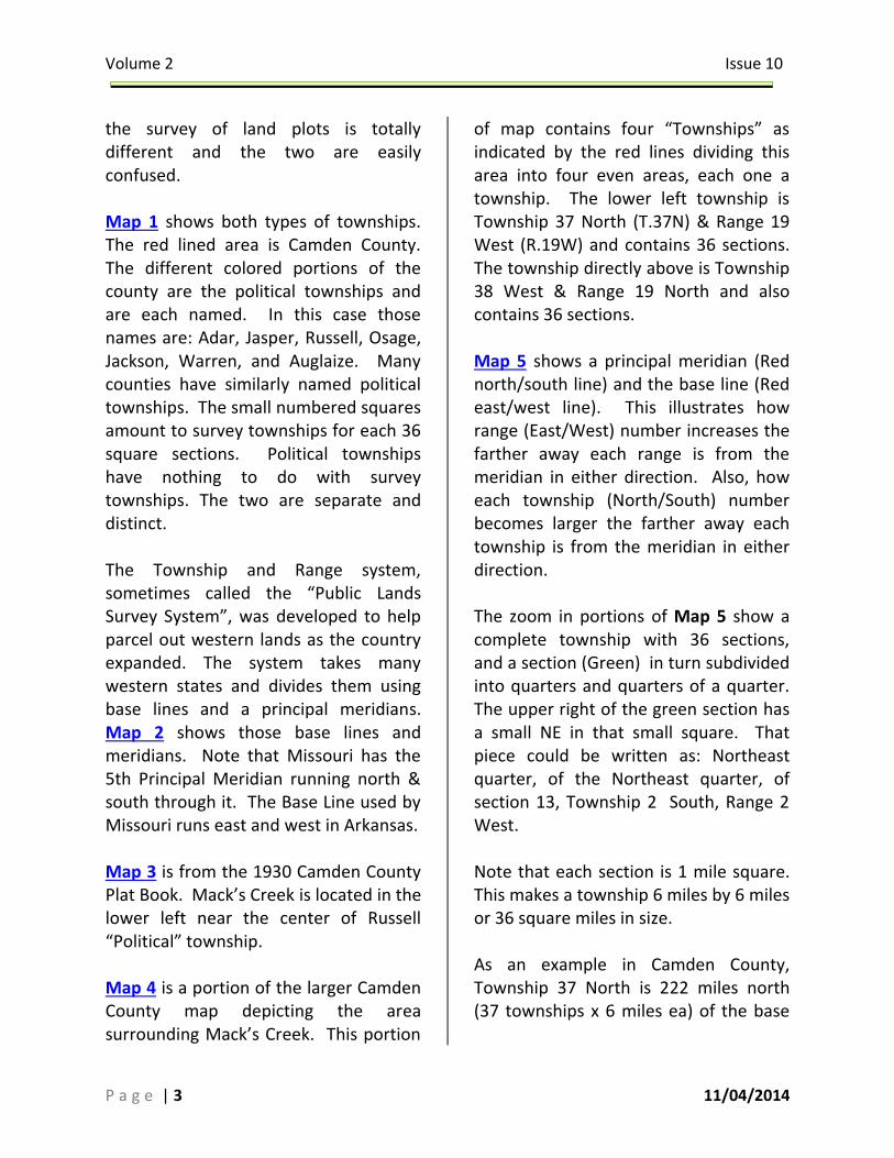
the survey of land plots is totally different and the two are easily confused. Map 1 shows both types of townships. The red lined area is Camden County. The different colored portions of the county are the political townships and are each named. In this case those names are: Adar, Jasper, Russell, Osage, Jackson, Warren, and Auglaize. Many counties have similarly named political townships. The small numbered squares amount to survey townships for each 36 square sections. Political townships have nothing to do with survey townships. The two are separate and distinct. The Township and Range system, sometimes called the “Public Lands Survey System”, was developed to help parcel out western lands as the country expanded. The system takes many western states and divides them using base lines and a principal meridians. Map 2 shows those base lines and meridians. Note that Missouri has the 5th Principal Meridian running north & south through it. The Base Line used by Missouri runs east and west in Arkansas. Map 3 is from the 1930 Camden County Plat Book. Mack’s Creek is located in the lower left near the center of Russell “Political” township. Map 4 is a portion of the larger Camden County map depicting the area surrounding Mack’s Creek. This portion
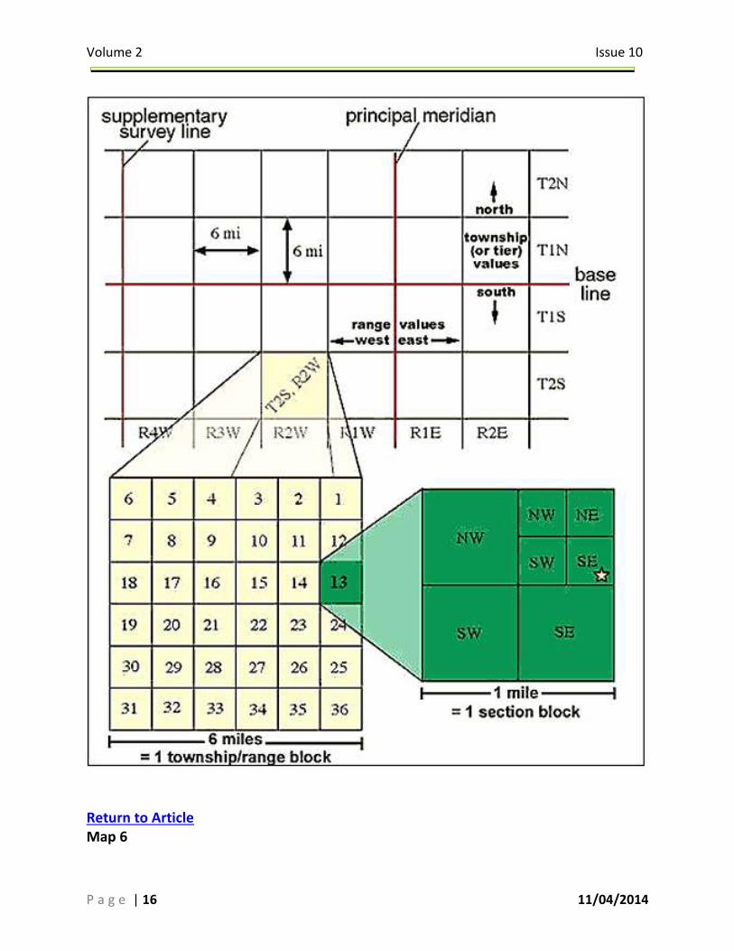
of map contains four “Townships” as indicated by the red lines dividing this area into four even areas, each one a township. The lower left township is Township 37 North (T.37N) & Range 19 West (R.19W) and contains 36 sections. The township directly above is Township 38 West & Range 19 North and also contains 36 sections. Map 5 shows a principal meridian (Red north/south line) and the base line (Red east/west line). This illustrates how range (East/West) number increases the farther away each range is from the meridian in either direction. Also, how each township (North/South) number becomes larger the farther away each township is from the meridian in either direction. The zoom in portions of Map 5 show a complete township with 36 sections, and a section (Green) in turn subdivided into quarters and quarters of a quarter. The upper right of the green section has a small NE in that small square. That piece could be written as: Northeast quarter, of the Northeast quarter, of section 13, Township 2 South, Range 2 West. Note that each section is 1 mile square. This makes a township 6 miles by 6 miles or 36 square miles in size. As an example in Camden County, Township 37 North is 222 miles north (37 townships x 6 miles ea) of the base

Volume 2 Issue 10
P a g e | 4 11/04/2014
line. Range 19 West is 114 miles (19x6) west of the principle meridian. Map 6 is an image of T.37N / R.19W which is the township immediately southwest of Mack’s Creek. It shows property owned in 1930 by W.O. Varner in sections 13 & 24. Map 7 is an image of T.37N / R.18W which is the township immediately east of that just shown on Map 6. It shows property owned in 1930 by Newton’s in sections 35 & 36. This is just some of the survey townships available for Camden County in 1930. All can be found at Missouri Digital Heritage: http://cdm16795.contentdm.oclc.org/cdm/compoundobject/collection/moplatbooks/id/625/rec/1 There are survey maps available for many timeframes covering most areas. This can be of tremendous help in piecing together who was likely were along with possible relationships or associations to nearby folks. I also find that many times just going over such information allows me to think of other possible avenues of genealogical research. The PDF file on the website also contains some links additional links to additional tools that can help with the survey map research.
Tunnel Dam: Natural and Man-made Wonders
By Linda Cushman Water lapped gently at the sides of the dugout as it glided through the water. It had rained the night before and the river was on the rise. The young Osage brave deftly guided the craft into the current, where the water carried it along at a moderate speed. The early morning sun chased the shadows from the hollows, pushing the darkness of night further back into the hills until it slipped through the trees and disappeared. Cardinals chirped and flitted among the dripping limbs. The earth was alive with the sounds and smells of late spring and the youth thrilled at the excitement of making his journey alone down the river. ‘Winding Stream of Many Springs’ snaked through the Ozarks hills, glided under towering bluffs and skirted past fertile lowlands. Ahead of him a beaver lumbered into the water and paddled up a creek that emptied into the river, leaving a silent wake behind him. The river carried the crude dugout around bends until it seemed that the river ended at the base of a towering hill. The Osage was busy looking up at the top of the hill above him and did not notice that part of the current of the river was disappearing into the side of the hill in front of him. The Indian’s eyes grew wide with surprise as he back paddled the canoe. He managed to get the

Volume 2 Issue 10
P a g e | 5 11/04/2014
canoe out of the cavern, but his paddle struck a submerged log and was jarred from his hands. The current pulled the ornately carved paddle into the cave. He watched helplessly as it disappeared. He thought about going in after it but a fear of the dark hole held him back. The paddle was lost. A stout limb served as a paddle as the canoe carried the Indian down the river, making a loop around the towering ridge. The Osage made slower progress without the paddle to aid him in guiding the canoe as it drifted down stream. He regretted losing the paddle, the one his grandfather had used until the handle was smooth and worn from hours of use on the river. Hours later the Osage was on the opposite side of the ridge from the cave. He peered into another dark cavern as water gushed from it. Bats clung to the ceiling of the cave. The top of an old beaver dam caught sticks that were floating in the water. The Indian looked closely at one of the sticks. It looked like the end of a paddle. He used the pole to push the canoe into the swirling water that issued from the cave and struggled to stay in place while he stood up to get a better look. It was a paddle! His paddle! It had traveled all the way through the tunnel and was there, waiting for him when he made the eight mile trip around the loop. He joyfully retrieved his paddle and marveled at the 900 foot natural tunnel, a giant hole through the hill.
The Native Americans were the first to know about the tunnel on the Niangua River. The tunnel was created by the pressure of the river pushing against the side of the hill, hammering against the rocks with the relentless power of gravity and the force of thousands of gallons of water flowing from the springs up-stream. Spring and autumn floods forced the water into the fissures of the rocks. Winter freezes broke the rocks apart as the river constantly worked to find a way through the hill. Over thousands of years the river cut through the hill while part of the water flowed along the base of the hill. During high water the tunnel became a waterway. The main channel made an eight mile loop that came back to the opposite side of the tunnel entrance before flowing on to empty into the Osage River. Many years later, white men came to Missouri and discovered the natural wonder southwest of Camdenton. The Meads and Whitworth families settled along the loop of the river in the early 1830s and the Newton family moved in several miles up river after the Civil War. The settlers lived in harmony with the river but they never controlled the Niangua. The river could be their best friend, providing fish to eat or furs for trade, or it could be their worst enemy by flooding their fields and ruining their crops.

Volume 2 Issue 10
P a g e | 6 11/04/2014
At the turn of the century railroads were snaking across the United States and the demand for ties created a way for the backwoods people to make some money. They cut timber and hewed out ties, or sleepers, and floated them down the Niangua to buying stations at Bagnell or Osage City. The land owners were not paid for the trees until in the 1930s. The money was made in sawing and hewing the ties and was a very hard job. The tie hacker would select a tree about 11 to 13 inches in diameter and use a cross cut saw to cut it down. Then the log was notched to keep it from rolling while the tie was hewn out. It was placed on blocks off the ground and the bark was notched with a double bit ax. Then a broad ax was used to trim the sides off the log, leaving a tie that was 8 feet 6 inches long, smooth and square. It could not have any knot holes or rotten spots or it would be rejected by the buyers. Each man marked his ties by a notch or by a stamped brand that he hammered into the tie. The ties were hauled to a steep hill or bluff and were pushed to the edge of the river. When enough ties were cut they were formed into huge rafts, sometimes hundreds of feet long. The first row of ties were held together by nailing a sapling across the front, loosly holding the ties in place. This allowed the ties to shift when the raft came to a bend in the river.
The tie hackers were not always local men. Some of them were outsiders, strangers to the remote section of Camden County. My grandmother was a young girl when she stood on the river bank and watched the long rafts being floated down the river past the Whitworth farm. She was shy and was afraid of the foreigners. As the years passed, the Indians moved on and the settlers struggled to keep up with civilization in the eastern cities. In the 1920s the citizens of central Missouri wanted the luxury of electricity. The natural fall of water through the tunnel was an excellent place to put a water chute to power a turbine. The Quigley Company was the first to attempt to use the natural tunnel. In 1911, a small dam and powerhouse were built at the upper end and the tunnel was used as a spillway for the turbines. After sinking half a million dollars into the venture, it proved unsuccessful. The Missouri Electric Power Company researched the area in the late 1920s. They planned to use the tunnel as a source of water power and place a hydraulic turbine on the lower end of the tunnel. The Management and Engineering Corporation found that the tunnel had too many caverns where water pressure would be lost. They devised a plan to cut an artificial tunnel through the ridge. The natural level of

Volume 2 Issue 10
P a g e | 7 11/04/2014
the water dropped twenty feet from the west side of the ridge to the east side. The tunnel floor would drop an additional twenty feet, creating a forty foot head, or drop, to power generators which would be placed at the lower end of the new tunnel. Building the tunnel, dam, and power plant was a monumental task during the 1920s. The work sites, on either side of the steep ridge, were almost inaccessible. Plans were drawn up to build houses for the employees, make a road to the dam site, build a temporary bridge across the river, blast a tunnel through the base of the ridge, find a way to reach the powerhouse site, and build the structure to house the generators. The remote section of Camden County was all in astir with the excitement of the project. Fertile fields which had been cleared by the Whitworths, Nations, and other families would be covered by water. Tie hackers would not be able to use the river to float railroad ties down stream. However, the area would have employment for many of the area men during the construction. The Niangua River, which had chosen its own course since the beginning of time, was about to be drastically changed. A small town sprouted up on the south end of the construction area and was named White City. Part of the city was on the wider part of the high ridge. Some of the buildings extended out
onto the top of the narrow ridge and clung to the sides of the steep hill. White City had a post office, commissary and even a hospital. The larger houses were nicknamed ‘millionaire row’ while the smaller cabins were called ‘shacks‘. As many as 400 men lived in the village during the height of the construction, using the shacks as sleeping quarters for the day and night shifts. Amos Asher, a local Camden County man, was hired to be the powder monkey, packing and discharging all the explosives used to blast the road down to the dam site. Part of the road was carved from solid rock from the side of the hill. The trail was just wide enough for a truck and there was no room for mistakes. If the driver got too close to the edge, the truck would drop off the cliff. If he got too close to the hillside, he might bump into the rocks and careen off the hillside. Amos spent ten hours a day setting the dangerous explosives for the princely sum of 70 cents per hour. He worked seven days per week in all kinds of weather without the comfort of good, warm clothing and boots. He was probably the highest paid employee on the job with the exception of the engineers. The common laborers were paid 35 cents per hour. They also worked ten hour days since construction went on around the clock. Many local men were hired to work on the dam project but several were

Volume 2 Issue 10
P a g e | 8 11/04/2014
brought in from other places to work in their specialty fields. Some of the specialists were the surveyors, engineers, concrete foremen, construction foremen, heavy equipment operators, mechanics and electricians. All the employees had to meet strict guidelines. If they were considered a risk to others or to themselves, they were dismissed. Men were given a handbook to read before being hired and were tested on information in the book. Safety was a major issue and a bonus of five dollars was offered to any employee, except foremen, for any of their ideas that could be used to make the work place safer. The preliminary work for all the projects began. The surveyor was in high demand as he plotted the position for the tunnel and the dam. Blasting through the tall, narrow ridge was to begin on the east and west sides simultaneously. Concrete pads were poured on each side of the ridge to use as benchmarks. An arched pathway was mapped through the heart of the hillside and Amos was ready to begin blasting the tunnel. The drilling crews for the tunnel were handpicked men. They worked in teams of three men. One man would hold a drill rod while a right-handed man stood to his left and a left-handed man stood to his right. The rod man would set the drill rod in position while the men on either side would rhythmically swing ten pound mauls and hit the drill rod. The
rod man would turn the drill as the men swung the hammers. When they had drilled down a foot into the rock, the rod was pulled out and replaced with a two foot drill. When the men had hammered and drilled it into the rock, it was replaced with a four-foot piece. When they had drilled down six feet into the rock, the hole was ready to be filled with black powder. Mr. Asher was kept busy packing the holes with the powder. After each hole was filled, he would split one end of the fuse and stick that end into a percussion cap. The cap had to be crimped around the wire to hold it into place. All these steps were very dangerous work. Any excessive force could spark the cap and set off the explosion. Amos and the drilling crew would have been killed in the blast. After the cap was ready, it was carefully tamped into the black powder. When the other men were safely out of the tunnel, Amos would ignite the fuse. While the smoke and dust settled from that blast, Amos climbed up the hill, made his way down the other side, and began filling the holes that the crew on the opposite end of the tunnel had drilled while he was working on the other side. As the paths of the tunnel reached further into the hill, rails were set and cars, pulled by mules, were used to haul out the rocks from the blasts. Just a few feet downstream from the west end of the tunnel, work on the dam was begun by building a temporary

Volume 2 Issue 10
P a g e | 9 11/04/2014
bridge across the river. It was above the place where the dam would be built. Cofferdams were erected to keep water out of the place where cement would be poured for the main dam and to keep water out of the new tunnel when the river was in flood stage. An enormous cement mixer was set up on top of the ridge and chutes were formed to pour cement down to the dam site on the west side and to the powerhouse site on the east side. Rock quarries were started on the hillside north of the dam and rails were set up to transport the rock to the cement mixer. Another quarry worked on a hill west and north of the river. Rock from that quarry was carried to the rock and earthen wall on the west end of the dam. Wooden forms for the dam were built and concrete began pouring down the chutes. The hollow core spillway section of the dam is about 24 feet high and 300 feet long. A section of the hillside was chiseled out and a rock-filled crib was built to reinforce the east end of the dam. The west side of the dam extends 200 feet beyond the spillway, where sheet piling was driven into the earth by steam powered equipment. Trucks carried loads of rock and dirt to form the embankment. Every aspect of the tunnel dam project had its challenges, but probably none had more than the construction of the powerhouse. There was no way to get to the site except by slowly making ones way down the almost perpendicular hill.
A set of rails was set up and a hoist car was devised to transport equipment and people up and down the hill. Large pieces of machinery had to be dismantled and lowered one piece at a time. The car was connected to a large cable and was slowly raised and lowered along the tracks by means of a fifty horsepower electric engine. Electricity for the engine and the temporary lights was provided by a steam powered generator. Tons of concrete were mixed at the top of the hill and poured down chutes to construct the powerhouse. A huge surge chamber and spillway was made which reached up six feet higher than the lake level on the other side of the hill. Heavy floors and walls were built to house the two generators. Concrete retaining walls for the tailrace extended into the stream on each side of the powerhouse. The gauging station was built on the opposite side of the river from the powerhouse and could only be reached by means of a cable car. The cable car had a hand controlled brake and was big enough for two men to ride in at one time. The car, hardly more than a box, dangled 40 or 50 feet above the river as it went down to the small station. For months the area around White City saw a flurry of activity. Occasionally the men had free time and when that happened, they grabbed their fishing poles and headed to the river. The loop

Volume 2 Issue 10
P a g e | 10 11/04/2014
around the base of the ridge provided some great fishing holes. During one snowy winter day, some of the men had good luck hunting rabbits. The various building projects were coming to a close in the fall of 1930. Amos Asher had set thousands of charges of black powder explosives and traveled miles over the ridge and back. When he set the last charge in the heart of the mountain that opened the tunnel, the sides were mismatched by two inches. The precise measuring, drilling and blasting by the tunnel crew was an amazing feat. Forms were built and concrete poured to line the walls and ceiling of the tunnel. The intake area was formed by constructing pillars on each side of the entrance with a space between them above the tunnel intake. Barriers were set in place to keep logs and debris from going into the tunnel. The intake was designed so that during high water the debris would float into the trash sluice and be washed out through a spillway that empties below the dam. At times the debris would build up along the gates enough to restrict the flow to the generators. When that happened the employees used long pike poles to pull up the logs and work them through the trash sluice. When that procedure failed they used another method called ‘bumping the tunnel‘. To ‘bump the tunnel’ the gates at the powerhouse end of the tunnel were quickly closed,
creating an enormous backwash. Thousands of gallons of water dropping about forty feet through the tunnel produced a tidal wave of pressure. The excess water would billow up through the surge chamber, sometimes spilling over the top, while the backwash churned up the tunnel and back out into the lake. The pressure forced logs, tree limbs, leaves and other debris to wash away from the protective grids. The dam was finished and the equipment was moved out of the way as water began to back up, covering fields and old homesteads. The lake covered about 360 acres of land. The chilly spring-fed river water began to warm as it stopped flowing and stayed in one place, trapped by the dam. Fish found new food sources and places to hide and grow to monstrous size. The river was changing, but still it flowed on until it reached the top of the dam and spilled over. Two Allis-Chalmers generators had been eased down the hill and set up in the powerhouse. The generators are powered by 60-inch adjustable blades on water wheels and are rated at 2030 horsepower each. They began generating electricity on November 9, 1930. Some of the men who worked on the project were hired by the electric company as linemen to set poles and string lines across the rugged landscape, bringing electricity to homes in Camden and surrounding counties.

Volume 2 Issue 10
P a g e | 11 11/04/2014
Many things have changed since the dam was completed in 1930, but the tunnel, dam and powerhouse are still the same. Even parts of the old Quigley dam are still there. In 1954, a road was built to reach the powerhouse and the hoist car and cable car were retired. Most of the equipment on the powerhouse is now automatically controlled, which reduced the number of employees at the site. The countryside is crisscrossed with electric lines and every home has electricity. Winding Stream of Many Springs still flows on, year after year, adapting to the changes that man has brought about. The Osage Indians enjoyed the river in all its natural beauty. They saw the river flooded in the spring and fall, clear and cold in the winter, and shallow and sluggish during the dry summer months. They fished and trapped for their needs and left the rest to nature. Then the settlers moved in and lived in harmony with the river. Finally, the need for electricity brought about the construction of the dam and the river adapted to the change. Who knows what the future holds for the Niangua. Someday a new energy source may replace electricity and the dam may be removed to let the river flow in its natural river bed. Or the dam may be enlarged to back the lake for miles upstream, providing thousands of acres of lake surface for recreation. The people living along the Niangua are opposed to the change. They love their
secluded, relatively quiet little lake and river. Change is inevitable. Man changes many things but the Niangua, ‘Winding Stream of Many Springs‘, will continue its endless journey through the hills of the Ozarks, carving its own path or following man’s plans. The Niangua will keep moving. Linda Cushman Please contact me with subject ideas for future newsletters. Winter is about here……. Happy hunting! Bruce Varner (Attached images are below)

Volume 2 Issue 10
P a g e | 12 11/04/2014
Map 1
Return to Article

Volume 2 Issue 10
P a g e | 13 11/04/2014
Map 2
Return to Article
Volume 2 Issue 10
P a g e | 14 11/04/2014
Map 3
Return to Article Map 4

Volume 2 Issue 10
P a g e | 15 11/04/2014
Return to Article Map 5
Volume 2 Issue 10
P a g e | 16 11/04/2014
Return to Article Map 6

Volume 2 Issue 10
P a g e | 17 11/04/2014
Return to Article Map 7

Volume 2 Issue 10
P a g e | 18 11/04/2014
Return to Article