indians and europeans on the northwest coast, 1774–1812 a ... · indians and europeans on the...
TRANSCRIPT
Indians and Europeans on the Northwest Coast, 1774–1812
A Curriculum Project for Washington State Schools
A Curriculum Project for Washington Schools
Developed by Holly Miller & Michael Reese
Center for the Study of the Pacific Northwest University of Washington Department of History
Table of Contents
I. Introduction: How to Use This Curriculum Packet
II. Indians & Europeans on the Northwest Coast: Historical Context
III. Timeline of Events along the Northwest Coast
IV. Suggestions for Further Reading
V. Classroom Activities
VI. Concordance to the Documents
I. Introduction: How to Use this Curriculum Packet
The materials in this packet allow teachers and students to explore the earliest recorded history of the Pacific Northwest. The packet consists of roughly 30 primary documents, along with supplemental materials to help place the primary sources in historical context. These materials document the range of interactions and relationships between Native and Non-Native peoples along the Northwest Coast in the late 18th and early 19th centuries. They permit students to analyze the different cultures and worldviews of the Nuu-chah-nulth people living on Vancouver Island and the Salish peoples living along Puget Sound, as well as the Spanish, English, and Americans who visited their lands. The materials illustrate the various ways—often peaceful but occasionally violent—in which these peoples chose to deal with one another. They show how the fur trade brought Indian and European peoples together, despite their differing cultures and economies. They also illuminate how European mercantilism and imperialism worked in the Northwest, allowing students to investigate the dispute between the English and the Spanish known as the Nootka Controversy. Furthermore, the packet enables students to see how meeting, trading, and living together impacted Indian and European people in the Northwest. Contact was clearly a two-way process that affected the outlooks and economies of all parties involved.
Teachers can use this packet in a variety of ways. They could use a handful of documents to supplement existing readings and lesson plans. They could also use the materials to create a new teaching unit lasting anywhere from a few days to multiple weeks. However, teachers of 8th and 9th grade history courses should be aware that some of the longer primary documents in this packet—especially those which use obtuse 18th-century language—may be difficult for their students to understand. Nonetheless, middle-school teachers will find many documents that can work in their classrooms—such as the logs kept by John Boit, a 16-year old sailor from Boston (document 17 and document 18).
The most important elements of this packet are clearly the primary documents. These sources force students to go beyond hearing about contact, exploration, imperialism, and the fur trade
from a textbook. Reading and analyzing what Europeans and Indians wrote and said about each other enables students to become investigators and explorers of history. The documents in this packet are drawn from a wide variety of sources—explorers' journals and memoirs, Native oral histories, drawings, maps, and even the diary of an American sailor who lived among the Nuu-chah-nulth for two years. Links to the primary documents may be found in the last section of the packet, section VI. This section is a sort of concordance and users' manual. It provides the source of each document, historical background about the documents, and a list of possible discussion questions to ask students when they talk about the materials in class.
The other sections of the packet are designed to help place the documents in historical context. Section II is an interpretative essay that offers a useful overview of the history of contact on the Northwest Coast. It analyzes how Europeans and Indians thought about each other and how they found ways to interact and live together. Teachers (and university-level students) may wish to read this overview essay before they launch into the documents. Section III is a timeline of events along the Northwest Coast. Teachers could pass out this timeline to help students keep track of events. A bibliography of useful secondary sources appears in Section IV. In addition, Section V contains suggestions about how teachers might use the documents in their courses. Some of these suggestions can be used to generate homework assignments, and others propose interesting classroom activities, role-plays, and discussions.
II. Indians and Europeans on the Northwest Coast: Historical Context
The history of the late 18th and early 19th centuries in the Pacific Northwest is in many ways a story of convergence. It is the story of two groups of people—one European and one Indian—converging on the land that we now call home. Each group possessed its own social and political structures, economies, and ways of interacting with the natural environment. In addition, each group had its own ways of thinking about and representing the events that took place. The convergence of different groups, and of different ways of doing and thinking about things, created a diverse community of people who found ways to live together in a new and altered world. This story of convergence took place over many decades, and it continues into the present.
This packet of materials, however, focuses on the period between 1774 and 1812, the first years of contact between Native and European peoples. The year 1774 marked the beginning of documented contact between Europeans and Indians on the Northwest Coast, and the year 1812 marked the beginning of a new phase of development, when overland fur traders took center stage. It was during this brief but pivotal period that Indians and Europeans met and developed a trading relationship that laid the groundwork for future social, political, and economic interactions. This was the era when ships from Spain, England, America, France, Russia and Portugal visited the Northwest Coast and first met the Nuu-chah-nulth, Makah, Salish, Kwakwaka'wakw, and Haida peoples.
This introductory essay is divided into three parts: Imagining, Meeting, and Living Together. The Imagining section provides a glimpse of the ways in which some Europeans and Indians imagined each other before they actually met. The Meeting portion describes some of the cultural baggage that each group brought to their encounters. Essentially, this section explains
why Europeans came to the Pacific Northwest in the first place, and why Indians chose to trade and socialize with Europeans. Because the meeting of these cultures was both enabled and limited by geography, this section also describes some of the different ways in which each group responded to the natural environment. Finally, the Living Together segment gives examples of the ways in which each culture learned about the other. It focuses on economic and political aspects of the process of learning to live together. Sometimes this learning took the form of peaceful accommodation, and sometimes it took more violent forms. Yet by the start of the 19th century, each group had a much more realistic sense of the other than they had possessed a mere 30 years before.
In some respects, the story of cultural contact in the Northwest resembles that of Christopher Columbus's famous voyages to the New World beginning in 1492. But by the time Europeans came to the Northwest almost 300 years had passed, and European explorers had traveled to and mapped nearly all parts of North and South America—except the Pacific Northwest. Here in the Northwest, the story of contact and convergence began around the time of the American Revolution, when American colonists had settled no farther west than the Ohio River valley. While some American colonists certainly cherished dreams of westward expansion, no one yet dreamed of a nation that stretched from sea to sea.
As the movement for independence took hold along the eastern seaboard of what is now the United States, the aboriginal people of the Pacific Northwest went about their business undisturbed. They had little or no knowledge of what was going on in Europe or its American colonies, just as Europeans and American colonists had little or no knowledge that the Pacific Northwest even existed—it was a gaping hole in their maps of the world (see document 2 and document 3). Yet, for many European explorers, entrepreneurs, and heads of state, this blank space on the map held infinite promise. Wealth, fame, and adventure beckoned from that unknown geographic space, and their lure was compounded by legend.
Imagining
The legend of the Northwest Passage particularly enthralled Europeans. This passage, sometimes referred to as the Strait of Anian, was a waterway that supposedly connected the Pacific Ocean to the Atlantic. Such a waterway would have greatly facilitated trade and communication between Europe and eastern Asia because travel between these locations mandated choosing among three unattractive options. One had to undertake either an arduous overland journey along the Silk Road, or a long and hazardous sea voyage westward around either the tip of South America or eastward around Africa and across the Indian Ocean. Thus in the 18th century European traders cherished the hope of finding an easily accessible waterway across North America. They based their hopes on legendary accounts about the Northwest Passage.
One of the most mysterious and influential of these accounts was that of Juan de Fuca (document 1). In 1596 an elderly Greek pilot by the name of Apostolos Valerianus (a.k.a. Juan de Fuca) confided a strange and wonderful tale to Michael Lok, the British ambassador at Aleppo, Syria. Lok subsequently submitted the story for publication. De Fuca claimed that in 1592 he had been a member of a Spanish sea voyage along the Pacific Coast north of Mexico. The expedition had sailed to about 47 degrees north latitude, at which point de Fuca's boat had turned eastward into a
strait that seemed to cut deep into the North American continent. De Fuca said that the expedition had sailed for 20 days in the strait and come out in the Atlantic Ocean, at which point it retraced its route to Mexico. De Fuca claimed that the natives living near the strait were rich in gold, silver, and pearls.
Of course, the Strait of Juan de Fuca does not cross the North American continent, and the Native people of the Northwest were never in possession of large quantities of gold, silver, or pearls. Yet, like the legend of El Dorado, the fabled Northwest Passage caught the imagination of many Europeans and persisted in the minds of explorers. In 1786 Englishman Charles Barkley discovered the entrance to a large strait at approximately the latitude de Fuca described, and he named the Strait of Juan de Fuca after its 16th-century promoter.
Just as Europeans were confused about the geography and natural resources of the land they were so eager to explore, Indians were initially confused by the ships and people who met them on the Pacific coast. While conducting research among the Clatsop people during the late 19th century, ethnographer Franz Boas heard a story about the Clatsops first contact with Europeans (document 7). The storyteller claimed that an old woman was walking along the Oregon coast one day and saw the first European ship to visit the area. Because she had never seen a ship before, she conceived of the strange object as a monster that looked like a whale with two trees sticking out of it. A creature resembling a bear with a human face came out of the monster. She then went home to tell her strange tale. Many Clatsop people came to the ocean to see the strange thing she described, and they met the bear-like Europeans on the beach. The Europeans wanted water, and in the confusion one Clatsop man went aboard the ship, while his relatives set fire to it. The Clatsops were apparently able to salvage much of the copper and iron from the ship, as they became rich by trading these goods with their neighbors inland and along the coast. The riches and celebrity that the Clatsops gained in their encounter with a European ship could have served as incentive for other Indian peoples to greet and trade with ships that came to their homes. In this way, the promise of riches encouraged both Europeans and Indians to trade with each other.
Meeting
In the 1770s, when sustained contact between Europeans and Indians in the Pacific Northwest began, European explorers, traders, entrepreneurs, and national governments were playing a tricky game of international chess. Europeans came to the Northwest intending to claim territory, make a profit, win intellectual glory, convert souls, and maintain peace with their neighbors—all at the same time. The game that they played had certain rules, the most fundamental of which was the right of first discovery and possession. The way in which these two words were defined, however, led to much confusion and diplomatic hedging by all parties.
For example, shortly after Columbus arrived in the New World in 1492, the papacy drew up a document known as the Treaty of Tordesillas. The treaty asserted that Spain had a right to claim all lands west of a certain point in the Atlantic Ocean—basically, most of the unexplored continents of North and South America. At that time, the Pope was a major power broker among the Christian European nations, and he therefore negotiated this treaty not between Spain and the people of the New World, but between Spain and Portugal, the two most avid colonial powers of
the 15th century. Partially as a result of this agreement, Spain became the wealthiest country in Europe in the 16th century because of the gold and silver extracted from its colonies in present-day Mexico and Peru. Because they were busy administering their enormous empire in South America and Central America, Spanish leaders did not deem it necessary to immediately inhabit, or even explore, all the territory allotted to them in the Treaty of Tordesillas. Nearly 300 years later, the Spanish presence in the Pacific Northwest was still negligible. The Spanish were additionally secure in their claim to lands on the Pacific Ocean due to Balboa's 1513 trek across the Isthmus of Panama. Upon sighting the blue waters of the Pacific, Balboa claimed the ocean for Spain. Of course, the Chinook and Makah and Salish and other peoples of the Pacific Northwest in no way considered themselves Spanish subjects, nor did they even know that Spain had laid claim to their land.
The Russians did know about the pretensions of Spanish land claims in the New World, but they had no intention of letting those claims go unchallenged. Backed by Catherine the Great, a Russian expedition led by Vitus Bering set off from St. Petersburg in 1725 and marched toward the Pacific Coast. Sent in part to establish whether or not Asia and North America were actually separate continents, this expedition discovered the Bering Strait in 1728. The explorers then sailed toward Alaska but never landed. Nonetheless, the expedition laid the groundwork for the fur trade with China. Vitus Bering and his successors soon did establishing trading posts at various points along the coast of what is now Alaska. This activity alarmed the Spanish, who had hoped that the Northwest Coast would lie undisturbed by European powers until the Spanish Empire had the time and resources to colonize it. It was in this climate of suspicion that the Spanish launched the Perez Expedition of 1774 from the naval base at San Blas, Mexico, to the Northwest Coast.
Perez and his men were sent to spy on Russian traders, but they were also specifically instructed to take possession of the land as far as 60 degrees north latitude. For the Spanish, taking possession of the land entailed erecting a large wooden cross onshore and burying a glass bottle at its foot, containing written documentation of Spain's claim. Adverse weather prevented Perez from taking these actions, but his expedition did meet with the people of the Northwest at two locations (document 4 and document 5). First, he met the Haida people of the Queen Charlotte Islands (now a part of British Columbia). After spreading feathers on the water near Perez's boat, the Haida proceeded to trade with Perez's crew. The Haida offered sea otter skins, hats, blankets, and other items made from cedar trees in exchange for metal goods from Perez's boat. This boat-to-boat trade was repeated about a month later with some unidentified people (probably the Nuu-chah-nulth) off the coast of Vancouver Island.
Although Perez and his men forged tentative economic bonds with the people of the Northwest Coast, they failed to meet their political objective, which had been to take effective possession of the land in the face of other imperial competitors. In addition to facing competition from the Russians, the Spanish also had to contend with the English, who did not acknowledge the validity of the Treaty of Tordesillas and who were busy looking for lands that seemed outside the realm of actual Spanish control. The Spanish believed that the best way to keep competitors out of their territory was to keep their maps, sea logs, and explorations secret from other European powers. Since the Spanish did not publish records of their explorations, the only way to prove their claims was to leave some sign on the land. Unsatisfied with the results of the Perez
expedition, the Spanish sent the Bodega-Hezeta expedition of 1775 to make landfall and establish Spanish claims to the Pacific Northwest with more authority. This expedition did reach land and plant crosses, fulfilling the Spanish government's goals.
The Spanish had good reason to be nervous about the encroachments of other European powers. In addition to the Russians, who were expanding their Alaska-based fur trade southward, western European nations—such as France, the Netherlands, and especially Great Britain—were becoming stronger colonial powers and threatening Spain's leading role in the colonization of the New World. In 1745, and more extensively in 1774, the British Parliament promised to handsomely reward the person who discovered a Northwest Passage across North America—a passage widely believed to exist smack in the middle of the land claimed by the Spanish throne.
While Europeans fretted and schemed, the Indian people of the Pacific Northwest were concerned with their own affairs. The people of the Northwest coast lived in orderly, hierarchical societies based on extended family groups. Several of these groups might be on particularly friendly terms because of intermarriage, for example, and be allied against other groups. Southern peoples (those near and below the 49th parallel) particularly feared encroachment by their powerful neighbors to the north (especially the Haida). Conflict between various groups occasionally broke out, but these conflicts were not especially bloody by European standards.
Because these Native societies were quite hierarchical, leading families sought to maintain and advance their social positions by accumulating and then distributing material wealth. In addition, accumulation of wealth and displays of power and prestige often prevented encroachment by neighboring groups. Overall, trading for services and material goods was a vital component of Indian life on the Northwest Coast. When Europeans arrived with trade goods, coastal Indians saw the opportunity for advancement within their own societies by accumulating rare and exotic European goods such as copper, beads and iron blades. In return the Europeans sought furs, and it became relatively simple for powerful Native leaders to take control of the acquisition, preparation, and trade of furs within a given area. Leaders such as Chief Maquinna of Nootka Sound and Chief Wickeninish of Clayoquot Sound exercised control over trading empires in the interior, organizing labor and setting the terms for trade at the coast. As their wealth grew, so did their prestige, because they were able to redistribute more and more goods.
For most coastal people of the Pacific Northwest, wealth was acquired and distributed through the potlatch system (document 8).Under this system, extended families would vie for prestige in the community by accumulating vast amounts of trade goods and then giving them away in ceremonies called potlatches. Potlatches were held to commemorate special occasions of importance to the host family. They were generally ceremonial celebrations involving hundreds of people and often lasting up to two weeks. Guests at the potlatch would witness and, by their presence, attest to the importance of the host family and the commemorated event. In return, the host family would give away, its accumulated wealth—the more goods it gave away, the higher its social prestige rose. In this way, wealth was redistributed throughout the community. European goods were perfect for potlatching, and they therefore became quickly integrated into the local economies.
Like the Europeans, the Native people of the Northwest Coast were participants in a materialist, acquisitive, and wealthy economy. By the late 18th century, the exchange of prestige goods (mainly non-food items) among the coastal peoples of the Pacific Northwest was extensive and competitive. For most coastal groups, material wealth and social status were closely linked. The Europeans who came to the Northwest Coast in the late 18th century understood this acquisitiveness because it had parallels in their own economic system. Thus, the exchange of goods over the side of boats made sense to all involved. But here the similarities between the two economic structures ended.
For most Europeans and Americans of the 18th century, wealth was acquired and distributed in a global capitalist economy. This economy was not exactly like the one we know today, where most governments perceive free trade as positive. In the 18th century, global capitalism mostly functioned around the principles of mercantilism, an economic philosophy that held the amount of wealth in the world to be finite. Because there was assumed to be only a certain amount of wealth to be shared by all, nations competed against each other for the largest portion of that wealth. Wealth was often based in natural resources, so nations sought to claim large tracts of land all over the world. Trade was generally tightly controlled by national governments, and trade protection in the form of tariffs, embargoes, and privateering (a polite term for piracy) was the order of the day.
Mercantilist ideas also helped produce a system of colonialism. European nations like Spain, England, France, and Portugal sought to increase their wealth by establishing colonies in Africa, Asia, and the Americas. Some of these colonies were settlement colonies, and some were for trade alone, but all revolved around the central idea of increasing the wealth of the mother country by generating portable raw materials. (Colonies also increased the wealth of mother countries by providing markets for European goods, a function that became increasingly important during the 19th century.) Mother countries often imposed trade restrictions on their colonies, so that their inhabitants could only trade with representatives of the mother country. Naturally, the black market was rather large, as were the number of ways to circumvent trade restrictions.
Mercantilist capitalism and colonialism fueled European nations' interest in the Americas, and the desire to accumulate prestige goods drove coastal Indians to trade with the Europeans. In this way, the common ground of trading brought the two people together.
However, when European travelers traded for furs—and for fish and fresh vegetables to relieve illnesses like scurvy that plagued sailing crews—they unwittingly exposed Indian populations to European diseases like influenza and smallpox. There are various theories about how smallpox was introduced to the Northwest Coast, but most historians agree that this deadly disease first began to ravage Indian populations in the region between the mid-1770s and early 1780s. Because Native peoples had never before been introduced to the disease, they had no natural immunity, and a virgin-soil epidemic ensued. In combination with other diseases such as influenza and malaria, smallpox wiped out roughly 65 to 95% of Northwestern Indian populations by 1840. Though there is a great deal of dispute about precontact Native populations, it seems fair to say that the Indian population of the Pacific Northwest (including present-day Alaska, British Columbia, Washington, and Oregon) fell from over 500,000 in 1750 to
somewhere around 100,000 by 1850. By way of comparison, the 14th-century Black Plague in Europe and Asia claimed the lives of one-third of the population there. Smallpox and other diseases did kill some Europeans in the Pacific Northwest, but not nearly at the same rate as the illnesses decimated Native populations. In addition, the Europeans who died were replaced by a growing stream of travelers and traders from Europe and the United States.
Just as the environment affected Europeans and Indians differently at a biological level, these groups also responded to their surroundings in different ways. Indian groups on the coast made extensive use of cedar trees and salmon, for example. Cedar bark, with its long, malleable fibers, was perfect for weaving baskets, hats, and clothes. Cedar was also used for constructing housing, canoes, and boxes. For coastal peoples, as well as their neighbors in the interior, salmon provided a food staple and functioned in a ceremonial capacity as well. Indian people also actively shaped their environment, often using fire to clear the land and make it more favorable for hunting and gathering food.
For many Indian people of the Northwest, the natural environment was animate. That is to say, the animals and specific locations on the land were alive with meaning and formed the center of an oral literature common to the people of a specific language group. Stories about Coyote, Raven, Eagle, and Beaver are good examples of these types of oral literature (document 10). Though Europeans certainly had some literature describing animate landscapes (the Grimm Brothers' fairy tales, for example), they approached the Pacific Northwest in a different way.
The 18th-century intellectual and cultural movement called the Enlightenment shaped the perspectives and values of many European explorers. Philosophers, scientists, and politicians imagined the world as a giant laboratory in which everything worked according to rational, scientific principles. In this logical world, all ills could be cured by the accumulation of knowledge and the application of logic. One of the goals that Enlightenment thinkers set for themselves was the attainment of complete knowledge of the natural world. To this end, European nations sent botanists, astronomers, cartographers, linguists, and other scientists to the far corners of the world to collect knowledge and to enhance the prestige of their respective states. To these men, the Pacific Northwest was a wilderness to be explored, catalogued, and named (document 19 and document 21). Unlike most Northwest Coast Indian peoples, for whom the land and animals were active participants in daily life, Enlightenment-era scientists viewed the natural world as an object for study. The English, French, Spanish, and Americans all sent scientific exploring expeditions to the Pacific Northwest during the late 18th and early 19th centuries. Additionally, many military expeditions also carried scientists aboard.
The giant tract of unmapped land in the Pacific Northwest appears to have been like a siren song for these scientific explorers—not only would they have the opportunity to discover new plants, animals, languages, climates, and ways of life, but they also harbored hopes of discovering riches as well. These men made detailed maps of the area, noting good anchorages where trade might be facilitated, as well as fertile cropland and the location of abundant game (document 22 and document 23). Their sponsoring governments made use of this information to choose which lands were most valuable and which could be negotiated away to the other European powers. No European power wanted to give away the Northwest Passage inadvertently, simply because no
thorough survey of the land had been made. Therefore, although the pure accumulation of knowledge was their stated goal, scientists also served political ends.
Scientists were not the only Europeans interested in the environment and geography of the Northwest, however. European traders and travelers of all kinds observed and remarked upon the vast forests, the waters thick with marine life, and above all, the weather (document 17). Visitors to the Northwest often described their surroundings in terms of commodities—forests were wood lots where masts for ships could be procured, animals were skins that could be traded in China for tea and silk. Almost all visitors wrote about the Northwest as a wilderness, even though they sometimes stressed its park-like qualities. They did not perceive the ways in which Native peoples managed and shaped the landscape, instead imagining that the Northwest was a wilderness untouched by human intervention.
Living Together
The Indian people of the Northwest Coast and the European travelers to this region both came from materially acquisitive, trade-oriented cultures, and they quickly discovered this common ground. The language of trade was easily comprehensible to all parties, and formed the basis for the earliest relationships between Indian and non-Indian people in the Northwest. Beginning with the Perez Expedition of 1774, trade goods were exchanged over the sides of boats, apparently to the mutual satisfaction of all parties. It seems that for Indians and Europeans alike, the goods that were exchanged were initially curiosities—interesting, decorative, and occasionally useful items, but nothing that drastically changed the lives of parties on either side of the exchange. This type of relatively disinterested trade lasted less than a decade.
Captain James Cook's 1778 visit to the Northwest Coast marked a turning point in the economic and social history of the region. Cook was on a mission of exploration for the English government, and he stopped at Nootka Sound to get fresh water and trade for food. He and his men met the Nuu-chah-nulth people who lived around the sound, and the two sides engaged in trade. As part of these exchanges, Cook's men took aboard several sea otter pelts.Cook's sailors did not perceive the pelts to have any great value, and they used them for bedding on the voyage to China. At the port of Canton, however, it soon became clear that fashionable Chinese women coveted the furs; merchants offered to pay outrageous prices for the suddenly stylish pelts. Cook's men made a small fortune and almost mutinied over their desire to return to Nootka Sound to pick up more furs. Word of the value of sea otter pelts spread among traders, and by 1785 James Hanna had made a fortune trading iron bars for furs in Nootka Sound and then selling the furs in Macao. Other merchants followed in his wake, and the Northwest Coast soon became inundated with traders of many nationalities.
Faced with so many traders seeking to buy their sea otter pelts, the Indian people of the Northwest Coast responded shrewdly. As the demand for furs increased, the prices set by Indian traders skyrocketed in the years after Cook's initial voyage. Just as the influx of gold, silver, and other goods from the New World had transformed the European economy in the 16th century, Native economies in the Pacific Northwest were transformed by contact with European colonialism and capitalism.
At first, the region's Native peoples used European imports within the context of their own economies, saving up trade goods for later potlatches, and bartering for iron tools and ornaments that had preexisting purposes in their societies (document 13 and document 17). But over the course of a few decades, the economies of coastal peoples began to center around the production of furs for export. For example, the Indian people who handed the furs over the sides of European boats were not the same people who went hunting for sea otters, or even the same people who prepared the pelts for trade. Yet because these coastal traders were the first to receive compensation for the furs, they began to organize the production of furs and to compete with other traders for the resources of the hunters and pelt-curers. This reorientation toward the export of raw materials laid the groundwork for future extractive industries that would come to characterize the economy of the Pacific Northwest.
The sea otter trade restructured Native economies, but it impacted whites' economic practices as well. European and American traders had to change their methods to comply with Native norms, because Indians set the terms of the fur trade—both in terms of method and price (as the skyrocketing price of furs indicated). European traders wanted to come to the coast, rapidly take on a full cargo of furs, and depart just as quickly to China, where they could exchange the precious furs for a cargo of silk, tea, and spices before returning to Europe or America. The Indian peoples of the Northwest Coast preferred to trade in the context of an elaborate and more slow-moving establishment of social relations. They often refused to trade substantial quantities of furs unless the European merchants came ashore to their villages, where a celebration of eating, drinking, dancing, and singing ensued. These ceremonies sometimes stretched on over weeks and months, and many European traders were forced to spend the winter on the coast in order to collect enough furs to fill their cargo holds. Indian fur traders also quickly learned that Spanish, English, American, and Dutch merchants competed with one another. Indian traders played these groups off one another, encouraging competition until they had obtained the highest possible price for their furs.
As Europeans and Indians lived together in Nootka Sound and elsewhere in the Northwest, their political activities and hierarchies became intertwined. The infamous Nootka Controversy demonstrated the extent to which Europeans and Indians had become invested in each other's lives. In late 1789, British, American, and Spanish vessels met in Nootka Sound—much to the frustration of the Spanish, who claimed sole possession of the Northwest Coast. The actions of Estéban José Martínez, commander of the Spanish fort at Nootka (document 15), precipitated the crisis. Under orders to keep British or Russian interlopers out of Nootka Sound, Martínez seized an English ship under the command of Captain James Douglas. Douglas protested and argued that because his ship was funded by Portuguese interests, it was therefore nominally Portuguese. He also claimed (falsely) that he had only sought refuge in Nootka Sound to repair his ship. After spending a week under arrest, he was allowed to leave the sound.
These events disturbed Maquinna, Wickeninish, and other aboriginal leaders who were allies of the English. Sighting other English vessels approaching Nootka Sound, Chief Maquinna sent out canoes to warn the approaching traders that trouble was afoot with the Spanish. The warnings fell on deaf ears, and the hotheaded James Colnett sailed his ship directly into the sound. Neither Martínez nor Colnett possessed the diplomatic skills to negotiate a solution to the ensuing confrontation. Colnett's ship was undeniably English, and Martínez's orders clearly stated that he
was to detain all English vessels on the coast. Both men flew into a rage, insulting and threatening one another, and Martínez arrested Colnett and his crew. Some English sailors were allowed to go ashore, and these men complained to Maquinna that the Spanish had no right to prevent the British from trading at Nootka. One of Maquinna's relatives, Chief Callicum, loudly protested against Martínez's actions and asked him to release the captives. Martínez responded by firing a gun at Callicum. Although he missed, one of his crew did not. Callicum fell dead in front of his wife, child, and dozens of European and Native witnesses. Maquinna and his followers responded by withdrawing inland and refusing further contact with the Europeans for many months.
Once news of Colnett's and Martínez's actions reached Europe, Spain and England stood poised for war over Nootka Sound and the Northwest Coast. The Spanish claimed the right of first possession, based on the Bodega-Hezeta Expedition's building of crosses in 1775. The English, citing Spain's tardy publication of these claims, claimed the right of first possession based on buildings constructed onshore by John Meares in 1789 (document 13). Ultimately, the issue was decided by military strength. England had a strong navy and so did its ally, Holland. But when the Spanish turned to their traditional ally, France, they were disappointed. The French Revolution was in full swing, and Louis XVI could not aid the Spanish. French revolutionaries, inspired by the rhetoric of the American Revolution, were in no mood to help the Spanish monarch defend his colonial claims. By 1790 it became clear that Spain had to risk a naval conflict, which it had almost no hope of winning, or accept a diplomatic settlement dictated by the English. This settlement, known as the Nootka Convention, stated that Spain was to turn over to England all lands bought and occupied by Meares. After the location of these lands had been determined, a line would be drawn between lands that were in the sole possession of the Spanish and lands that were open to both nations.
In order to enforce the settlement decided by the Nootka Convention in 1790, representatives of England and Spain met at Nootka Sound in 1792. To investigate and establish their claims in the Pacific Northwest, the Spanish sent Don Juan Francisco de la Bodega y Quadra, and the English dispatched Captain George Vancouver. Unlike Martínez and Colnett, Vancouver and Bodega y Quadra were patient and level-headed men (document 16 and document 24). Nonetheless, the two men had difficulty reaching an agreement since the terms of the 1790 Nootka Convention were ambiguous, partly because so much of the region's geography remained unknown. In addition, Vancouver and Bodega y Quadra heard conflicting reports about recent events from Nuu-chah-nulth and American traders who had been eyewitnesses. For example, Maquinna denied selling any land to Meares at all. Furthermore, Bodega y Quadra wanted to establish a clear boundary between Spanish and English claims, but Vancouver thought the Nootka Convention did not grant him the power to negotiate permanent borders (document 24 and document 25). But instead of arguing, these men spent their time dining on each other's ships and being entertained in Nuu-chah-nulth villages. They reestablished cordial relations with Chief Maquinna, who returned to his home on Nootka Sound after he was assured that Martínez was no longer in command there. The two captains also agreed to explore the region further and to share their geographic knowledge with each other.
Their explorations filled in many of the blank spaces on Europeans' maps (document 22 and document 23). Bodega y Quadra and his party circumnavigated Vancouver Island, proving that it
was not part of the mainland—as many previous explorers had thought. Vancouver's crew charted the Strait of Juan de Fuca and the interior waterways connected to it. His expedition demonstrated that the strait led to the Puget Sound, not to some mythical Northwest Passage. Because Vancouver and Bodega y Quadra shared information, both parties learned that Puget Sound could be a fantastic harbor for large ships. It became apparent that Nootka Sound was not the only good port north of San Francisco and that Nootka's strategic significance had been overrated. Bodega y Quadra subsequently turned the Spanish fort at Nootka over to the English. He moved his men south to Neah Bay to establish a fort signifying the northernmost edge of Spain's possessions. (Although this fort lasted only a few months, it was the first European settlement in the area that would become the State of Washington.) Even though Bodega y Quadra and Vancouver did not resolve the Nootka Controversy themselves, they established the friendly relations and acquired the geographic knowledge that made a final settlement possible.
After the Nootka Controversy concluded, Nootka Sound gradually became less and less important to explorers, diplomats, and traders from Europe and the United States. Spanish and English negotiators ended their disagreement by signing the Second Nootka Convention in 1794. This agreement granted the Spanish sovereignty over the coastline south of Neah Bay. Areas to the north, including Nootka Sound, remained free ports where ships from all nations could land. Substantial numbers of European and American traders continued to visit Nootka until 1803, when violence erupted along the sound. The crew of the American ship Boston killed several Nuu-chah-nulth people, and its captain repeatedly insulted Chief Maquinna. The chief and his followers responded by boarding the Boston and killing its crew, sparing only two men, John Thompson and John Jewitt. Thompson and Jewitt lived as Maquinna's captives until 1806, when another American ship negotiated their release (document 27 and document 28). The attack on the Boston made merchants extremely wary of landing at Nootka. Though trading did resume after Maquinna released Thompson and Jewitt, the trade was never again as vigorous as it had been in the late 18th century. Nootka Sound was once the most important place in the known Northwest, but today it is far removed from the economic centers of the region, and it is accessible only by boat or airplane.
Conclusion
After the Nootka Controversy, the main area of contact between Indians and Europeans moved to the south, centering on the mouth of the Columbia River. In 1792 American Captain Robert Gray became the first non-Indian to navigate and map the Columbia River. After Gray publicized his findings, many American traders began visiting the region around the Columbia. Even though English captains had initiated the maritime fur trade in the Northwest, the English became distracted by their military struggle with France after Napoleon's ascension to power during the late 1790s. Although the Spanish remained an occasional presence on the Northwest Coast, they, too, were distracted by domestic affairs and only dabbled in the fur trade. Thus, American traders came to dominate the maritime fur trade between 1795 and 1814. Americans concentrated on trading and generally stayed out of the political struggles among European nations. Both the Spanish and the English were willing to overlook Americans' presence in the Northwest, and the Americans capitalized on this neglect. In fact, they were so successful in the trade—and Northwest Coast Indians were such skilled hunters—that the sea otter was nearly extinct in the region by the first decade of the 19th century.
The maritime fur trade was only a short chapter in the history of the Northwest, and it gradually became supplanted by the land-based fur trade. Inspired by the overland voyages of Alexander MacKenzie, who became the first person to cross North America by land in 1793, and Lewis and Clark, who reached the mouth of the Columbia in 1805, overland fur traders began to look with interest at the Pacific Northwest. Fur-bearing land mammals, such as beavers and bears, were abundant in this region. During the first and second decades of the 19th century, the Canadian-based North West Company became the area's most powerful fur trading enterprise by establishing a network of trading posts throughout the interior of the Northwest. Seeking a foothold in the fur trade, John Jacob Astor, an American entrepreneur, established a trading company headquartered in what is now Astoria, Oregon. Established in 1811, the company functioned for only a short time because Astor sold out to the North West Company after the War of 1812. Though Astor's operation was short-lived, the overland trade in furs was just beginning. In 1821 the North West Company merged with its rival, the Hudson's Bay Company, and the resulting combination dominated the economy of the Northwest for the next 25 years.
As the overland fur trade replaced the maritime trade, the nature of the relations between Native and European peoples began to change somewhat. Not surprisingly, Indians and whites had learned from their early experiences with each other along the Northwest Coast, and their later relationships built on those forged in the early years of contact. Although episodes of violence periodically strained these relationships, the overland fur trade continued the generally peaceful patterns of interaction established during the maritime fur trade. However, the advent of land-based trading ensured that Europeans and Americans were no longer mere visitors who bought furs and soon returned home: land-based traders often lived in the Northwest for decades at a time. The permanence of their presence brought new twists to the relationships established with Native peoples. Many traders married Native women, and the children of these unions—known as the métis—often became fur traders themselves. Native peoples, Europeans, Americans, and the métis formed new and hybrid ways of trading and living together. These ways of living together persisted until the late 1840s, when the establishment of the Oregon Trail and the arrival of American settlers shattered the world made by the fur trade and opened a new chapter in the history of the Northwest.
III. Timeline of Events Along the Northwest Coast
Date Event Relevant Documents
1494 Pope grants most of the New World to Spain in the Treaty of Tordesillas. 1592 Juan de Fuca allegedly sails through the Northwest Passage. 1
1670 Treaty of Madrid: English and Spanish recognize each other’s claims in the Americas.
1728 Vitus Bering leads a Russian expedition to Alaska. 1745 British Parliament offers a reward for finding the Northwest Passage.
1774 Perez Expedition sent by Spain to claim land along the Northwest Coast of North America. The expedition does not make landfall, but its members trade with the Haida and Nuu-chah-nulth.
4, 5
1775 Bodega-Hezeta Expedition sent by Spain to claim land along the Northwest
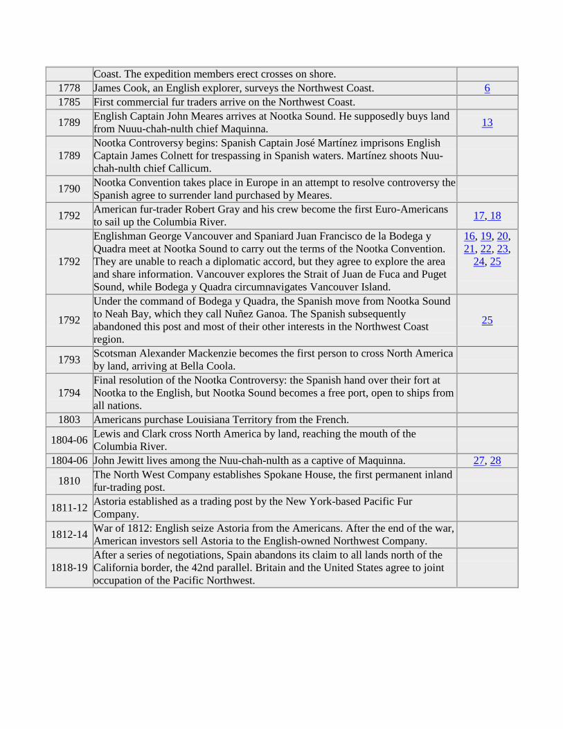
Coast. The expedition members erect crosses on shore. 1778 James Cook, an English explorer, surveys the Northwest Coast. 6
1785 First commercial fur traders arrive on the Northwest Coast.
1789 English Captain John Meares arrives at Nootka Sound. He supposedly buys land from Nuuu-chah-nulth chief Maquinna. 13
1789 Nootka Controversy begins: Spanish Captain José Martínez imprisons English Captain James Colnett for trespassing in Spanish waters. Martínez shoots Nuu-chah-nulth chief Callicum.
1790 Nootka Convention takes place in Europe in an attempt to resolve controversy the Spanish agree to surrender land purchased by Meares.
1792 American fur-trader Robert Gray and his crew become the first Euro-Americans to sail up the Columbia River. 17, 18
1792
Englishman George Vancouver and Spaniard Juan Francisco de la Bodega y Quadra meet at Nootka Sound to carry out the terms of the Nootka Convention. They are unable to reach a diplomatic accord, but they agree to explore the area and share information. Vancouver explores the Strait of Juan de Fuca and Puget Sound, while Bodega y Quadra circumnavigates Vancouver Island.
16, 19, 20, 21, 22, 23,
24, 25
1792
Under the command of Bodega y Quadra, the Spanish move from Nootka Sound to Neah Bay, which they call Nuñez Ganoa. The Spanish subsequently abandoned this post and most of their other interests in the Northwest Coast region.
25
1793 Scotsman Alexander Mackenzie becomes the first person to cross North America by land, arriving at Bella Coola.
1794 Final resolution of the Nootka Controversy: the Spanish hand over their fort at Nootka to the English, but Nootka Sound becomes a free port, open to ships from all nations.
1803 Americans purchase Louisiana Territory from the French.
1804-06 Lewis and Clark cross North America by land, reaching the mouth of the Columbia River.
1804-06 John Jewitt lives among the Nuu-chah-nulth as a captive of Maquinna. 27, 28
1810 The North West Company establishes Spokane House, the first permanent inland fur-trading post.
1811-12 Astoria established as a trading post by the New York-based Pacific Fur Company.
1812-14 War of 1812: English seize Astoria from the Americans. After the end of the war, American investors sell Astoria to the English-owned Northwest Company.
1818-19 After a series of negotiations, Spain abandons its claim to all lands north of the California border, the 42nd parallel. Britain and the United States agree to joint occupation of the Pacific Northwest.

IV. Suggestions for Further Reading
Ballard, Arthur C. Mythology of Southern Puget Sound. Seattle: University of Washington Press, 1929.
Boyd, Robert. The Coming of the Spirit of Pestilence: Introduced Infectious Diseases and Population Decline among Northwest Coast Indians, 1774-1847. Seattle: University of Washington Press, 1999.
Brown, Jennifer S. H. and Elizabeth Vibert, eds. Reading Beyond Words: Contexts for Native History. Peterborough, Ontario: Broadview Press, 1996.
Cook, Warren L. Flood Tide of Empire: Spain and the Pacific Northwest, 1543-1819. New Haven, Conn.: Yale University Press, 1973.
Fisher, Robin. Contact and Conflict: Indian-European Relations in British Columbia, 1774-1890. Vancouver: University of British Columbia Press, 1992.
Fisher, Robin. Vancouver’s Voyage: Charting the Northwest Coast. Vancouver, B.C.: Douglas and McIntyre, 1992.
Gibson, James R. Otter Skins, Boston Ships, and China Goods: The Maritime Fur Trade of the Northwest Coast, 1785-1841. Seattle: University of Washington Press, 1992.
Gough, Barry M. The Northwest Coast: British Navigation, Trade and Discoveries to 1812. Vancouver: University of British Columbia Press, 1992.
Gunther, Erna. Indian Life on the Northwest Coast of North America: As Seen by the Early Explorers and Fur Traders during the Last Decades of the Eighteenth Century. Chicago: University of Chicago Press, 1972.
Harris, Cole R. The Resettlement of British Columbia: Essays on Colonialism and Geographical Change. Vancouver: UBC Press, 1997.
Hays, H. R. Children of the Raven: The Seven Indian Nations of the Northwest Coast. San Francisco: McGraw-Hill Book Company, 1975.
Johansen, Dorothy O. and Charles M. Gates. Empire of the Columbia: A History of the Pacific Northwest. New York: Harper and Row, 1967.
Nokes, J. Richard. Columbia’s River: The Voyages of Robert Gray, 1787-1793. Tacoma: Washington State Historical Society Press, 1991.
Pethick, Derek. First Approaches to the Northwest Coast. Vancouver, B.C.: J. J. Douglas, 1976.
Pethick, Derek. The Nootka Connection: Europe and the Northwest Coast 1790-1795. Vancouver, B.C.: Douglas and McIntyre, 1980.
Ramsey, Jarold, ed. Coyote Was Going There: Indian Literature of the Oregon Country. Seattle: University of Washington Press, 1977.
Wagner, Henry R. "Apocryphal Voyages to the Northwest Coast of America," Proceedings of the American Antiquarian Society, n.s. 41 (1931): 179-234.
V. Classroom Activities
The documents in this packet can be used to supplement existing lesson plans, or they can form the basis of a new teaching unit about contact between Europeans and Indians along the Northwest Coast. The unit could range from a week-long major assignment to a series of projects spanning several weeks. The suggestions presented below are just that—suggestions.
1) Consider a field trip to a local museum. Telephone to see if any nearby museums of anthropology or Native history have any exhibits that document contact between Europeans and Indians or the effect of such contact.
2) Hold an introductory discussion. Ask students to think about how they know what they know about the past. What kinds of sources might provide evidence about past events? How does the evidence provided by a newspaper article differ from that provided by a drawing, or letter?
3) Ask students to think about how the evidence left by Indian peoples differs from the evidence left by European peoples. How does the fact that Indian people in the late 18th and early 19th centuries did not leave written records affect what we know about the history of the period?
4) Have students imagine that they are Tomas de la Peña or Juan Crespi. However, have the students suppose that the Spanish explorers encountered 21st-century American teenagers instead of 18th-century Indian people. Ask them to write a journal account of their first meetings with these strange teenage people.
5) Hold a debate about the Nootka Controversy. Who should retain control over Nootka Sound in the 1790s? Assign students to represent the British, Spanish, Americans, and Nuu-chah-nulth.
6) Tell students to pretend that they are Nuu-chah-nulth living in 1788. Because they are fluent in a European language, Chief Maquinna has assigned them the task of creating a brochure for distribution among European traders. This brochure will explain Maquinna’s vision for the future of Nootka Sound, as well as explaining the Europeans’ role in this future.
7) Stage a talk show in which students portray and interview the major figures of the Nootka Controversy. Martinez, Colnett, Meares, Maquinna, Callicum, Vancouver, Bodega y Quadra, and Kendrick could be represented.
8) Read the accounts of Archibald Menzies and John Boit side by side. Discuss how each man’s training and background affected the things he noticed and recorded.
9) Ask students to imagine things from Chief Maquinna’s perspective. Have them read the two documents written by John Jewitt, and them ask them to write about how Maquinna would have described Jewitt’s stay among his people.
VI. Concordance to the Documents
1 2 3 4 5 6 7 8
9 10 11a 11b 11c 11d 12 13
14 15 16 17 18 19 20 21
22 23 24 25 26 27 28
The source of each document is provided below. Brief explanations of the documents and suggestions for possible discussion questions accompany the citations.
Document 1: The Strange Tale of Apostolos Valerianos (a.k.a. Juan de Fuca)
Samuel Purchas, Hakluyt Posthomous, or Purchas His Pilgrimes, vol. 14 (New York: Macmillan, 1906), pp. 415-18.
Apostolos Valerianos was a Greek sailor who was called Juan de Fuca by his Spanish companions. This document recounts Valerianos’s story of his voyage across the top of North America in 1592. He claimed to be part of an expedition that sailed from the Pacific to the Atlantic Ocean at a latitude of about 48 degrees north. This story, among others, led Europeans to pursue dreams of finding a "Northwest Passage" in the Pacific Northwest.
Possible discussion questions: How did Valerianos describe the land and people he saw on his voyage? How convincing is his description of his expedition? Why did the author believe Valerianos? On a modern map of the Northwest, find 48 degrees north latitude. What body of water did Valerianos probably find on his voyage?
Document 2: One of the First Maps of the Pacific Northwest
Cornelis de Jode, "Quivarae Regnu cum alijs versus Borea," from Speculum Orbis Terrae (Antwerp, 1593), University of Washington Libraries, Special Collections.
The lack of any real geographic knowledge did not stop mapmaker Cornelis de Jode from producing a supposedly detailed map of the west coast of North America. De Jode simply mapped what he thought should be there. "El Streto de Anian" is the Northwest Passage, and
"Quiuira" is one of the legendary cities of gold sought by Spanish explorer Francisco Vasquez de Coronado.
Document 3: Map of North America with the Pacific Northwest Blank
Detail from Eman Bowen, A New and Accurate Map of America: Drawn from the Most Approved and Modern Maps and Charts, and Adjusted by Astronomical Observations; Exhibiting the Course of the Trade Winds Both in the Atlantic & Pacific Oceans (London, no date [ca. 1730]), University of Washington Libraries, Special Collections.
This map is typical of many maps produced in the early 18th century. The Pacific Northwest is a blank, labeled as "Parts Undiscovered." Nonetheless, the cartographer penciled in information on the legend of the Northwest Passage, the "Supposed Strait of Annian." Europeans were intrigued by the blank spaces on maps like this, and that curiosity fueled expeditions of discovery to fill in the gaps. Europeans also wished to claim the blank spaces on the maps for their home nations. This map labels part of the Northwest as "New Albion," thus designating it as English-controlled territory.
Possible discussion questions: How would you characterize Europeans’ geographical knowledge of the Pacific Northwest in the early 18th century? How does this map differ from the 1593 map (document 2)? Do the two maps share any common elements? Why might maps like these have encouraged Europeans to explore the Pacific Northwest?
Document 4: First Contacts, by Father Tomas de la Peña, 1774
"Journal of Fray Tomas de la Peña" in The California Coast: A Bilingual Edition of Documents from the Sutro Collection, edited and translated by Donald C. Cutter and George Griffin Butler (Norman: University of Oklahoma Press, 1969), pp. 121-23, 157-61.
This document consists of excerpts from Father Tomas de la Peña’s journal. Peña was a member of the 1774 Perez Expedition, sent to take possession of the Northwest Coast for the Spanish. These excerpts describe the first documented contact between the Indian people of the Northwest and Europeans. On July 20 the Spanish met the Haida, and on August 8 they met another group of Indian people who were probably the Nuu-chah-nulth.
You might want to compare the accounts of Tomas de la Peña and Juan Crespi. Although these two men sailed on the same expedition, they described events differently. Their varying viewpoints illustrate how the same historical events can be interpreted in different ways
Document 5: First Contacts, by Father Juan Crespi, 1774
"Journal of Fray Juan Crespi" in The California Coast: A Bilingual Edition of Documents from the Sutro Collection, edited and translated by Donald C. Cutter and George Griffin Butler (Norman: University of Oklahoma Press, 1969), pp. 225-41, 255-59.
Like Thomas de la Peña, Juan Crespi was a priest who accompanied the Perez Expedition in 1774. This document consists of excerpts from Crespi’s diaries from July 20, when the expedition met the Haida, and from August 8, when they met the Nuu-chah-nulth. Although Crespi’s journal is similar to de la Peña’s in many ways, the two accounts do reveal some differences. The priests’ differing personal interests shaped what they chose to write about. In addition, they occasionally interpreted the same event in different ways.
Possible discussion questions: In what ways are the two priests’ accounts similar? What did they think of the Haida and the Nuu-chah-nulth? Did they respect these people even though they were "pagans"? How do the two journals differ? How might you explain these differences?
Document 6: John Ledyard’s Impressions of the Northwest Coast, 1778
John Ledyard, A Journal of Captain Cook’s Last Voyage to the Pacific Ocean, and in Quest of a North-West Passage, between Asia & America; Performed in the Years 1776, 1777, 1778, and 1789 (Hartford, Conn.: Printed and sold by Nathaniel Patten, a few rods north of the court-house, 1783), pp. 70-73.
American John Ledyard was a member of Englishman Captain Cook’s third voyage to the Pacific Ocean. In his journal he expressed his feelings at being once again on his home continent. He also described an encounter with the Nuu-chah-nulth people who lived near Nootka Sound. During this encounter Ledyard, and not the Indians, tasted a human arm. The issue of cannibalism was very much at the front of European travelers’ minds. They routinely questioned the people they visited to determine whether or not these people were cannibals. As this example illustrates, much confusion could arise regarding who, in fact, was actually a cannibal.
Possible discussion questions: What were the Nuu-chah-nulth people’s attitudes about private property and trade? What did Ledyard think about the Nuu-chah-nulth? From the evidence presented here, can we conclude that the Nuu-chah-nulth were cannibals? Why or why not?
Document 7: Oral History of the First Ship Seen by the Clatsop
Franz Boas, Chinook Texts, U.S. Bureau of Ethnology Bulletin No. 20 (Washington, D.C.: Government Printing Office, 1894), pp. 275-78.
Ethnographer Franz Boas recorded several tales told by Charles Cultee during the early 1890s. Cultee was one of the last native speakers of the Clatsop and Chinook languages. The first part of this document is Boas’s translation of Cultee’s story into English. This is followed by the
Chinook language version of Cultee’s tale, with a translation of each individual Chinook word. This story describes the way the Clatsop people reacted to the first European ship they had ever seen. Cultee claimed his great-grandfather had witnessed this event over one hundred years earlier. Although oral traditions are not an entirely reliable form of historical evidence, they do offer a fascinating window into Indians’ responses to contact with Europeans. Notice the way in which European trade goods were used to promote the status of the Clatsop among their neighbors.
Possible discussion questions: According to this story, how did the Clatsops respond to the first European ship they saw? In your opinion, was the Clatsop response logical and justified? How reliable is this story as a form of historical evidence? Do you think it is more or less reliable than Ledyard’s journal (document 6)? Why? Why might historians think that oral traditions are important documents even though they may not be accurate in every detail?
Document 8: Clatsop Potlatch
Franz Boas, Chinook Texts, U.S. Bureau of Ethnology Bulletin No. 20 (Washington, D.C.: Government Printing Office, 1894), pp. 266-69.
This story describes a potlatch, a ceremony during which the host family gives away material goods to the guests. The more a host family could give away, the higher its social standing. The potlatch ceremony was common among the Indian peoples of the Northwest Coast.
Possible discussion questions: What is a potlatch? What social functions might a potlatch have served?
Document 9: Dividing a Beached Whale
Franz Boas, Chinook Texts, U.S. Bureau of Ethnology Bulletin No. 20 (Washington, D.C.: Government Printing Office, 1894), pp. 259-63.
This document describes how the Indian peoples that lived near Willapa Bay divided beached whales. The story provides glimpses of the Clatsops’ religious and social values. It also sheds a great deal of light on Clatsop ideas about property and resource use. A beached whale was not "owned" by the group that found it first, but rather by the group in whose territory it landed. The whale was divided among members of the group, but it was not divided equally. This story is a sort of microcosm of Northwest Coast Indian patterns of resource use. Indians had divided up the Pacific Northwest into a complex network of hunting, fishing, and resource rights. However, these rights were generally held by groups or families, rather than by individuals. In addition, the boundaries between different groups’ rights were flexible and could often overlap.
Possible discussion questions: How did Indian people divide up a beached whale? What might this tell us about Northwest Coast Indians’ values and ideas? Is it fair to say that Northwest Coast Indians had no concept of property and ownership; what evidence from the story can you find to justify your position?
Document 10: Raven and Gull Myth
Franz Boas, Chinook Texts, U.S. Bureau of Ethnology Bulletin No. 20 (Washington, D.C.: Government Printing Office, 1894), pp. 88-91.
This is an example of the oral literature of the Northwest Coast people. In this story, Raven and Gull take on human qualities as they vie for control of the beach.
Possible discussion questions: Are Raven and Gull people or animals in this story? What might this myth tell us about how Northwest Coast Indians thought about animals and the natural world? How might they have thought about these topics differently than Europeans did?
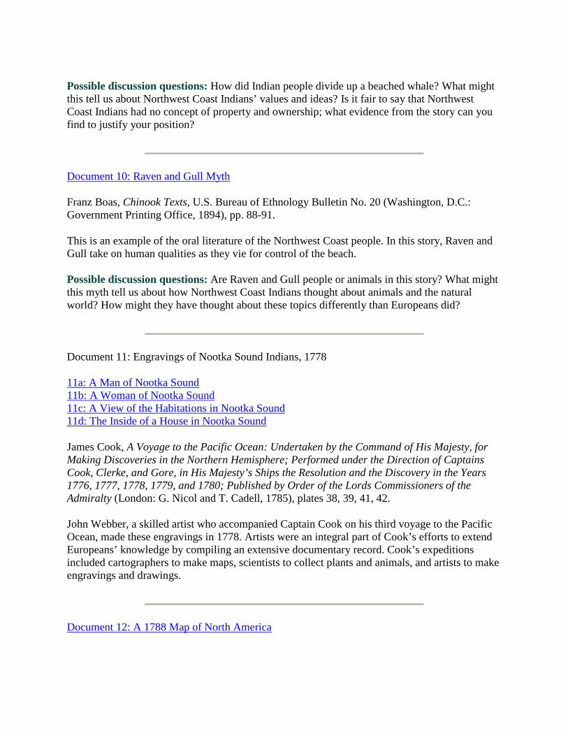
Document 11: Engravings of Nootka Sound Indians, 1778
11a: A Man of Nootka Sound 11b: A Woman of Nootka Sound 11c: A View of the Habitations in Nootka Sound 11d: The Inside of a House in Nootka Sound
James Cook, A Voyage to the Pacific Ocean: Undertaken by the Command of His Majesty, for Making Discoveries in the Northern Hemisphere; Performed under the Direction of Captains Cook, Clerke, and Gore, in His Majesty’s Ships the Resolution and the Discovery in the Years 1776, 1777, 1778, 1779, and 1780; Published by Order of the Lords Commissioners of the Admiralty (London: G. Nicol and T. Cadell, 1785), plates 38, 39, 41, 42.
John Webber, a skilled artist who accompanied Captain Cook on his third voyage to the Pacific Ocean, made these engravings in 1778. Artists were an integral part of Cook’s efforts to extend Europeans’ knowledge by compiling an extensive documentary record. Cook’s expeditions included cartographers to make maps, scientists to collect plants and animals, and artists to make engravings and drawings.
Document 12: A 1788 Map of North America
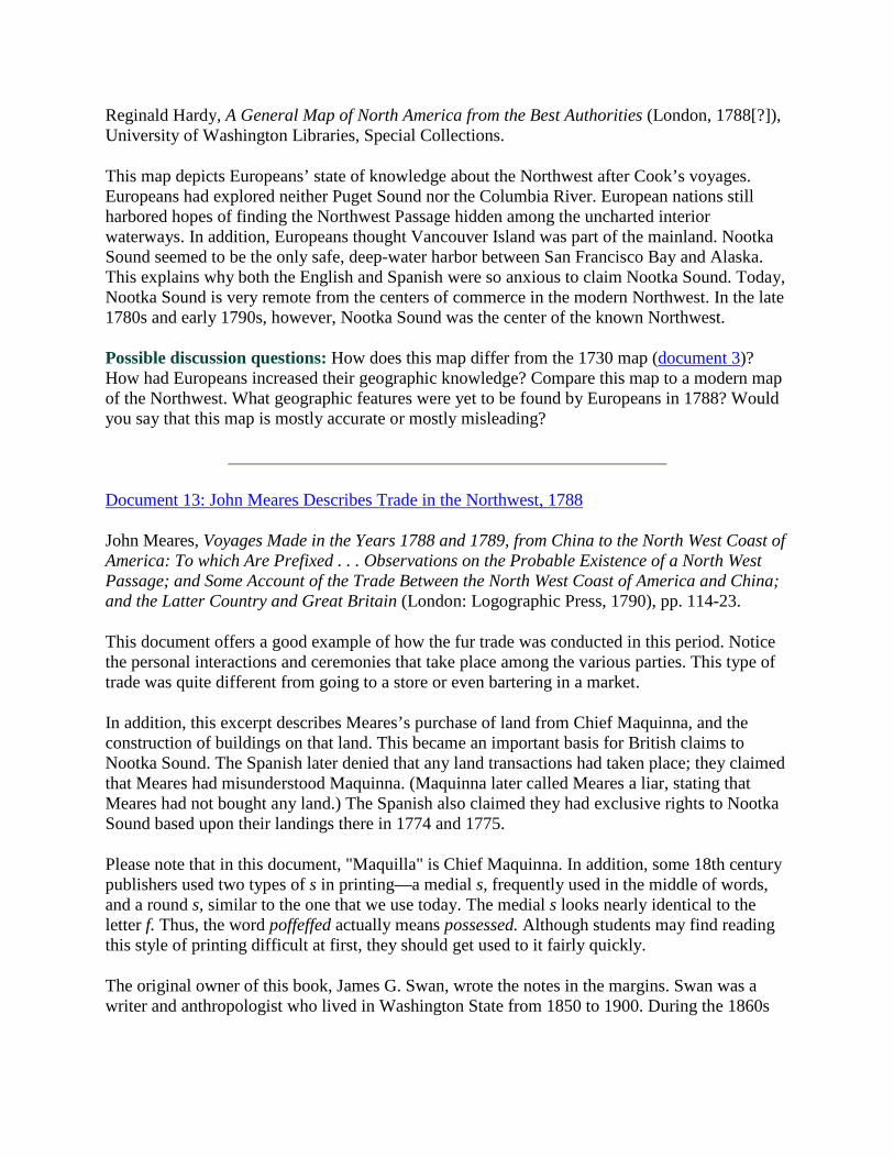
Reginald Hardy, A General Map of North America from the Best Authorities (London, 1788[?]), University of Washington Libraries, Special Collections.
This map depicts Europeans’ state of knowledge about the Northwest after Cook’s voyages. Europeans had explored neither Puget Sound nor the Columbia River. European nations still harbored hopes of finding the Northwest Passage hidden among the uncharted interior waterways. In addition, Europeans thought Vancouver Island was part of the mainland. Nootka Sound seemed to be the only safe, deep-water harbor between San Francisco Bay and Alaska. This explains why both the English and Spanish were so anxious to claim Nootka Sound. Today, Nootka Sound is very remote from the centers of commerce in the modern Northwest. In the late 1780s and early 1790s, however, Nootka Sound was the center of the known Northwest.
Possible discussion questions: How does this map differ from the 1730 map (document 3)? How had Europeans increased their geographic knowledge? Compare this map to a modern map of the Northwest. What geographic features were yet to be found by Europeans in 1788? Would you say that this map is mostly accurate or mostly misleading?
Document 13: John Meares Describes Trade in the Northwest, 1788
John Meares, Voyages Made in the Years 1788 and 1789, from China to the North West Coast of America: To which Are Prefixed . . . Observations on the Probable Existence of a North West Passage; and Some Account of the Trade Between the North West Coast of America and China; and the Latter Country and Great Britain (London: Logographic Press, 1790), pp. 114-23.
This document offers a good example of how the fur trade was conducted in this period. Notice the personal interactions and ceremonies that take place among the various parties. This type of trade was quite different from going to a store or even bartering in a market.
In addition, this excerpt describes Meares’s purchase of land from Chief Maquinna, and the construction of buildings on that land. This became an important basis for British claims to Nootka Sound. The Spanish later denied that any land transactions had taken place; they claimed that Meares had misunderstood Maquinna. (Maquinna later called Meares a liar, stating that Meares had not bought any land.) The Spanish also claimed they had exclusive rights to Nootka Sound based upon their landings there in 1774 and 1775.
Please note that in this document, "Maquilla" is Chief Maquinna. In addition, some 18th century publishers used two types of s in printing—a medial s, frequently used in the middle of words, and a round s, similar to the one that we use today. The medial s looks nearly identical to the letter f. Thus, the word poffeffed actually means possessed. Although students may find reading this style of printing difficult at first, they should get used to it fairly quickly.
The original owner of this book, James G. Swan, wrote the notes in the margins. Swan was a writer and anthropologist who lived in Washington State from 1850 to 1900. During the 1860s
he worked as a schoolteacher on the Makah Indian Reservation, becoming the first white person to live among the Makah.
Possible discussion questions: How would you characterize the relations between Meares’s crew and the Nuu-chah-nulth? Were fur trade negotiations conducted more in accord with British values or with Nuu-chah-nulth customs? Why were these groups so anxious to trade with one another—what benefits did each side derive from trade?
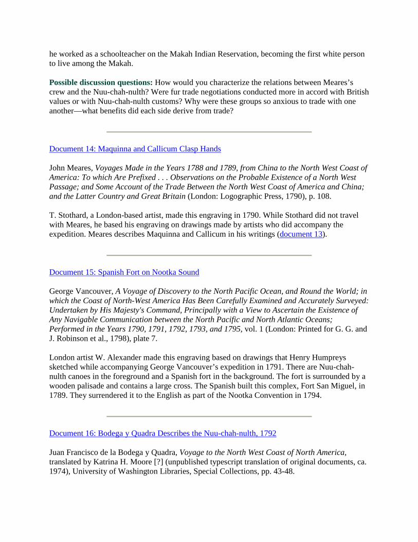
Document 14: Maquinna and Callicum Clasp Hands
John Meares, Voyages Made in the Years 1788 and 1789, from China to the North West Coast of America: To which Are Prefixed . . . Observations on the Probable Existence of a North West Passage; and Some Account of the Trade Between the North West Coast of America and China; and the Latter Country and Great Britain (London: Logographic Press, 1790), p. 108.
T. Stothard, a London-based artist, made this engraving in 1790. While Stothard did not travel with Meares, he based his engraving on drawings made by artists who did accompany the expedition. Meares describes Maquinna and Callicum in his writings (document 13).
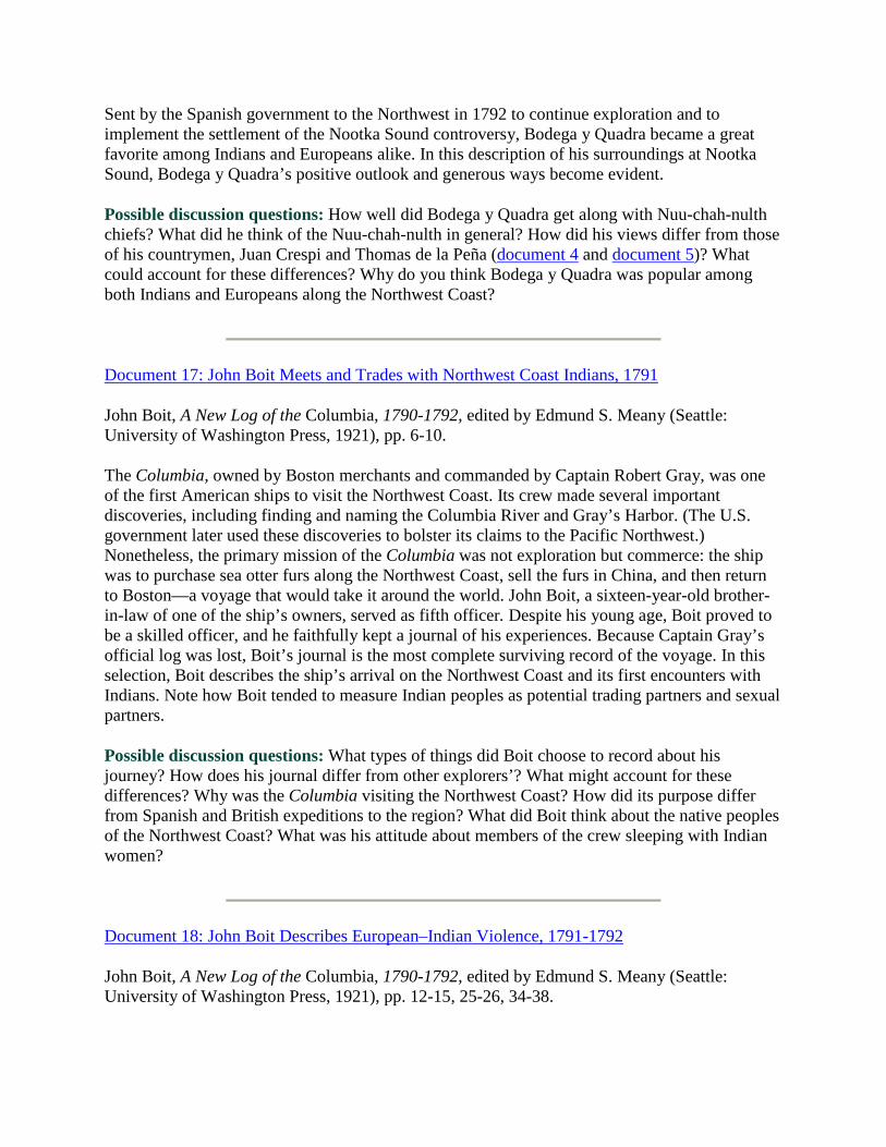
Document 15: Spanish Fort on Nootka Sound
George Vancouver, A Voyage of Discovery to the North Pacific Ocean, and Round the World; in which the Coast of North-West America Has Been Carefully Examined and Accurately Surveyed: Undertaken by His Majesty's Command, Principally with a View to Ascertain the Existence of Any Navigable Communication between the North Pacific and North Atlantic Oceans; Performed in the Years 1790, 1791, 1792, 1793, and 1795, vol. 1 (London: Printed for G. G. and J. Robinson et al., 1798), plate 7.
London artist W. Alexander made this engraving based on drawings that Henry Humpreys sketched while accompanying George Vancouver’s expedition in 1791. There are Nuu-chah-nulth canoes in the foreground and a Spanish fort in the background. The fort is surrounded by a wooden palisade and contains a large cross. The Spanish built this complex, Fort San Miguel, in 1789. They surrendered it to the English as part of the Nootka Convention in 1794.
Document 16: Bodega y Quadra Describes the Nuu-chah-nulth, 1792
Juan Francisco de la Bodega y Quadra, Voyage to the North West Coast of North America, translated by Katrina H. Moore [?] (unpublished typescript translation of original documents, ca. 1974), University of Washington Libraries, Special Collections, pp. 43-48.
Sent by the Spanish government to the Northwest in 1792 to continue exploration and to implement the settlement of the Nootka Sound controversy, Bodega y Quadra became a great favorite among Indians and Europeans alike. In this description of his surroundings at Nootka Sound, Bodega y Quadra’s positive outlook and generous ways become evident.
Possible discussion questions: How well did Bodega y Quadra get along with Nuu-chah-nulth chiefs? What did he think of the Nuu-chah-nulth in general? How did his views differ from those of his countrymen, Juan Crespi and Thomas de la Peña (document 4 and document 5)? What could account for these differences? Why do you think Bodega y Quadra was popular among both Indians and Europeans along the Northwest Coast?
Document 17: John Boit Meets and Trades with Northwest Coast Indians, 1791
John Boit, A New Log of the Columbia, 1790-1792, edited by Edmund S. Meany (Seattle: University of Washington Press, 1921), pp. 6-10.
The Columbia, owned by Boston merchants and commanded by Captain Robert Gray, was one of the first American ships to visit the Northwest Coast. Its crew made several important discoveries, including finding and naming the Columbia River and Gray’s Harbor. (The U.S. government later used these discoveries to bolster its claims to the Pacific Northwest.) Nonetheless, the primary mission of the Columbia was not exploration but commerce: the ship was to purchase sea otter furs along the Northwest Coast, sell the furs in China, and then return to Boston—a voyage that would take it around the world. John Boit, a sixteen-year-old brother-in-law of one of the ship’s owners, served as fifth officer. Despite his young age, Boit proved to be a skilled officer, and he faithfully kept a journal of his experiences. Because Captain Gray’s official log was lost, Boit’s journal is the most complete surviving record of the voyage. In this selection, Boit describes the ship’s arrival on the Northwest Coast and its first encounters with Indians. Note how Boit tended to measure Indian peoples as potential trading partners and sexual partners.
Possible discussion questions: What types of things did Boit choose to record about his journey? How does his journal differ from other explorers’? What might account for these differences? Why was the Columbia visiting the Northwest Coast? How did its purpose differ from Spanish and British expeditions to the region? What did Boit think about the native peoples of the Northwest Coast? What was his attitude about members of the crew sleeping with Indian women?
Document 18: John Boit Describes European–Indian Violence, 1791-1792
John Boit, A New Log of the Columbia, 1790-1792, edited by Edmund S. Meany (Seattle: University of Washington Press, 1921), pp. 12-15, 25-26, 34-38.
Boit paid special attention to instances of conflict between Europeans and Indians, and his journal reminds us that cultural contact was not always peaceful. Tensions between visitors to and residents of the Northwest Coast often erupted into violence. These selections from Boit’s journal describe six separate violent encounters—four that he witnessed first-hand and two that he heard about from the crew of other merchant ships. Though these conflicts do not seem tremendously bloody by modern standards, dozens of people died in the episodes that Boit described. Violent clashes like these were fairly common along the Northwest Coast during the 1790s and early 1800s.
Possible discussion questions: Did Boit view the native peoples of the Northwest Coast as warlike savages? Who did Boit blame for the instances of violence that he describes? In the violent encounters described here, who had the upper hand—Indians or Europeans? Why? Is it fair to say that the Europeans’ technology guaranteed their safety and gave them an overwhelming military advantage? Why or why not? What military advantages did native peoples possess?
Document 19: Archibald Menzies Explores the Strait of Juan de Fuca, 1792
Archibald Menzies, Menzies’ Journal of Vancouver’s Voyage, April to October, 1792 (Victoria, B.C.: W. H. Cullin Printers, Archives of British Columbia Memoirs, vol. 5, 1923), pp. 16-23.
Archibald Menzies, a scientist, traveled to the Northwest with Captain George Vancouver’s expedition of 1792. In this selection, Menzies describes the Strait of Juan de Fuca and the lands on the northern portion of the Olympic Peninsula. His descriptions of the region’s geography and its flora and fauna were especially detailed.
Possible discussion questions: What did Menzies’ think about the northern part of the Olympic Peninsula? What sorts of things did Menzies write about? How does Menzies’ journal differ from Boit’s (document 17) or Vancouver’s (document 22)? How might Menzies’ scientific training have shaped his interests, his thinking, and his journals?
Document 20: List of Ships off the Northwest Coast, 1792
Archibald Menzies, Menzies’ Journal of Vancouver’s Voyage, April to October, 1792 (Victoria, B.C.: W. H. Cullin Printers, Archives of British Columbia Memoirs, vol. 5, 1923), pp. 124-25.
Menzies was surprised when ten different ships visited Nootka Sound during a two-week period in the summer of 1792. He compiled this list of vessels with the help of Captain Vancouver and Captain Bodega y Quadra.
Possible discussion questions: Does this list tell us anything about which nations had the upper hand in the struggle to control the Northwest Coast? Can you list some of the motives that might have drawn so many ships to this region during the 1790s?
Document 21: Catalog of Plants Collected by Menzies, 1792
Archibald Menzies, Menzies’ Journal of Vancouver’s Voyage, April to October, 1792 (Victoria, B.C.: W. H. Cullin Printers, Archives of British Columbia Memoirs, vol. 5, 1923), pp. 132-35.
A large part of Menzies’ duties entailed recording new plant species. This document contains less than one-tenth of the list of plants that he compiled. During the eighteenth century scientific explorers like Menzies fanned out across the globe to collect and catalogue all types of flora and fauna. They found that the Pacific Northwest contained several species they had never seen before.
Document 22: George Vancouver Explores Puget Sound, 1792
George Vancouver, A Voyage of Discovery to the North Pacific Ocean, and Round the World; in which the Coast of North-West America Has Been Carefully Examined and Accurately Surveyed: Undertaken by His Majesty's Command, Principally with a View to Ascertain the Existence of Any Navigable Communication between the North Pacific and North Atlantic Oceans; Performed in the Years 1790, 1791, 1792, 1793, and 1795, vol. 1 (London: Printed for G. G. and J. Robinson et al., 1798), pp. 232-244, 248-57, 284-86.
The British government sent Captain George Vancouver to the Northwest Coast to chart the waterways there in an effort to find a "Northwest Passage" between the Atlantic and Pacific Oceans. Vancouver discovered that the legendary Strait of Juan de Fuca did, in fact, exist. However, the strait did not lead all the way to the Atlantic Ocean, but only to the body of water that Vancouver named Puget’s Sound. The crew spent the spring of 1792 exploring and mapping the Strait of Juan de Fuca and Puget’s Sound. Many of the landmarks that Vancouver named are visible on present-day maps, so it is possible to retrace his steps using a modern map. To help with this task, here are some of the landmarks that Vancouver named: page 234—Port Townshend page 235—Marrow-Stone Point, Mount Rainier page 236—Oak Cove page 237—Foulweather Bluff page 239—Hazel Point page 243—Hood’s Canal
Though Vancouver’s findings seemed to disprove the existence of a Northwest Passage, his expedition was far from a failure. The expedition learned that Puget’s Sound was deep and fairly extensive, yet also calm and sheltered. These traits led Vancouver to conclude that Europeans
could establish trading posts, and even agricultural settlements, along its shores. The Indians living along Puget’s Sound seemed generally friendly and willing to trade. In addition, Vancouver correctly surmised that a smallpox epidemic had greatly reduced the number of Native people living in the area.
A note on the seemingly strange orthography in this document: some 18th century publishers used two types of s in printing—a medial s, frequently used in the middle of words, and a round s, similar to the one that we use today. The medial s looks nearly identical to the letter f. Thus, the word poffeffed actually means possessed. Although students may find reading this style of printing difficult at first, they should get used to it fairly quickly.
Possible discussion questions: What sorts of things was Vancouver looking for when he was exploring? How does his journal differ from other those kept by other explorers, such as Meares (document 13). and Bodega y Quadra (document 16)? What did Vancouver think about the Puget Sound region and its inhabitants? Why did he think the area was so promising and important? Vancouver concluded that the arrival of Europeans along the Northwest Coast had impacted Native peoples living along Puget Sound even though these people had never before seen Europeans. On what evidence did he base this conclusion? Why did he deduce that the population of Puget Sound Indians had suffered a dramatic decline in the recent past?
Document 23: Map Displaying Vancouver’s Discoveries
"A Chart Shewing Part of the Coast of N.W. America . . . Prepared Under the Immediate Supervision of George Vancouver, Esq., by Lieut. Joseph Baker," from George Vancouver, A Voyage of Discovery to the North Pacific Ocean, and Round the World . . ., atlas volume (London: Printed for G. G. and J. Robinson et al., 1798), plate 14.
Bodega y Quadra’s and Vancouver’s expeditions substantially advanced Europeans’ knowledge about the Northwest. The crew of the two expeditions exchanged information and produced the first maps of the Northwest Coast that were mostly accurate. Bodega y Quadra’s party circumnavigated Vancouver Island, demonstrating that Nootka Sound did not lie on the mainland. Vancouver’s expedition learned that the Strait of Juan de Fuca led to the Puget Sound, not to some mythical Northwest Passage. Indeed, European governments grudgingly abandoned the search for the Northwest Passage after they heard Vancouver’s and Bodega y Quadra’s findings. Though Europeans now had accurate maps of the coast, they still knew virtually nothing about the interior of the Northwest.
Possible discussion questions: How does this map differ from the 1788 map (document 12)? How had Vancouver and Bodega y Quadra advanced Europeans’ geographic knowledge? Would you say that this map is mostly accurate or mostly misleading? What geographic features remained to be discovered? How much does this map tell us about parts of the Northwest that are not along the coast?
Document 24: Vancouver and Bodega y Quadra Try to Resolve the Nootka Controversy
George Vancouver, A Voyage of Discovery to the North Pacific Ocean, and Round the World . . ., vol. 1 (London: Printed for G. G. and J. Robinson et al., 1798), pp. 384-407.
Both Vancouver and Bodega y Quadra were expected to be diplomats, as well as explorers. In 1790 England and Spain tried to end their dispute over the Northwest Coast by signing the Nootka Accord. In this accord, the Spanish promised to turn over all lands that John Meares had purchased from Maquinna. The two European governments then dispatched Bodega y Quadra and Vancouver to implement the agreement (and to explore the Northwest Coast, of course). Unfortunately, the Nootka Accord was a vague document, and Vancouver and Bodega y Quadra disagreed about what exactly it meant. But despite their differences of opinion, the two men established cordial relations with each other and with Maquinna. Though the captains were unable to resolve the Nootka Controversy, they helped to create a climate of trust between the English, Spanish, and Nuu-chah-nulth.
Possible discussion questions: What was Vancouver’s opinion of Bodega y Quadra and Maquinna? How did Bodega y Quadra proposed to resolve the Nootka Controversy? Why did Vancouver reject this offer? What did the two captains decide to do instead? Do you think they increased tensions in the region or reduced them? In your opinion, what were the most important consequences of the explorations and diplomacy of Vancouver and Bodega y Quadra?
Document 25: José Moziño Analyzes the Nootka Controversy, 1792
José Mariano Moziño, Noticias de Nutka: An Account of Nootka Sound in 1792, edited and translated by Iris H. Wilson Engstrand (Seattle: University of Washington Press, 1970), pp. 81-84, 87-95.
Moziño was a scientist who accompanied Bodega y Quadra on his mission to the Northwest Coast. This document describes the course of events that led to the Nootka Controversy and tries to refute the claims made by John Meares (see document 13) and George Vancouver (see document 24). But even though Moziño believed that the Spanish had the legal right to keep their outpost at Nootka, he argued that they should abandon it for political and economic reasons. He described the diminished importance of Nootka as a port and contended that the Spanish should concentrate on fortifying and developing California. Spanish officials eventually came to accept this logic. In 1794 they accepted an agreement that made Nootka a "free port," open to all European nations. In 1819 the Spanish ceded all territorial claims north of the 42nd parallel (the present-day border between California and Oregon) in order to concentrate on defending California.
Possible discussion questions: What was Moziño’s opinion of John Meares? What evidence did he present to refute Meares’s claims that the English were the rightful owners of Nootka Sound? What did Moziño think of George Vancouver? According to Moziño, the Spanish had the legal
right to occupy Nootka, so why did he argue that they should abandon their claims there? Why might Nootka Sound have become less important than it once was?
Document 26: Moziño Praises the Nuu-chah-nulth, 1792
José Mariano Moziño, Noticias de Nutka: An Account of Nootka Sound in 1792, edited and translated by Iris H. Wilson Engstrand (Seattle: University of Washington Press, 1970), pp. 84-86.
Moziño believed that Europeans had mistreated the Nuu-chah-nulth who lived near Nootka Sound. He felt that the Nuu-chah-nulth were basically honest people whom the Spanish should have tried to convert to Christianity. However, Catholic and Protestant missionaries did not go to the Northwest and try to convert native peoples there until the 1830s and 1840s. The arrival of missionaries set off a new round of cultural conflict and adaptation in the region.
Possible discussion questions: What did Moziño think of the Nuu-chah-nulth? Did he think that Europeans had treated them fairly? Why or why not? Looking back at all the documents you have read so far, which group of Europeans—the English, the Spanish, or the Americans—had the best relations with the native peoples of the Northwest Coast? What evidence can you present to defend this claim?
Document 27: John Jewitt’s Journal of His Captivity at Nootka, 1804–1805
John Jewitt, A Journal, Kept at Nootka Sound by John Rodgers Jewitt, One of the Surviving Crew of the Ship Boston, of Boston, John Salter, Commander, Who Was Massacred on the 22d of March, 1803; Interspersed with Some Account of the Natives, Their Manners and Customs . . . (Boston: Printed for the author, 1807), pp. 22-27, 44-48.
Although relations between Europeans and Indians along the Northwest Coast were generally peaceful, they were occasionally punctuated by violence. Chief Maquinna had accommodated and befriended European visitors to Nootka Sound for more than 25 years. However, the arrival of the merchant ship Boston in 1803 led to violence. The ship’s crew killed a handful of Indians, and its captain repeatedly insulted the chief. The next day, Maquinna and his followers boarded the Boston and killed its crew, sparing only two men. Maquinna saved John Jewitt because he was a gunsmith; the Nuu-chah-nulth needed someone to maintain and repair the weapons they had acquired from Europeans. Jewitt persuaded the chief to spare John Thompson, a sailmaker, by convincing him that Thompson was his father.
The capture of the Boston profoundly affected the fortunes of the people living near Nootka. Maquinna gave away most of the ship’s cargo in the largest potlatch in the history of the Northwest Coast, and his prestige among native peoples skyrocketed. However, when Europeans learned of the attack, they stayed away from Nootka Sound. When trading stopped, Maquinna’s
popularity waned. It was three years before a European ship dared to return, leaving Jewitt and Thompson stranded during the interval. The pair lived as Maquinna’s servants, and the chief both protected them and exploited them. Once Maquinna allowed the men to leave, traders began returning to Nootka. Nonetheless, during their three-year absence from the area, European sailors had begun to use other harbors that were safer and had more sea otters. Nootka Sound was no longer the most important harbor on the Northwest Coast.
Possible discussion questions: How did Maquinna treat Jewitt and Thompson? Did he exploit them, protect them, or both? What does Jewitt’s journal tell us about politics, society, and daily life among the Nuu-chah-nulth? How might the capture of the Boston have changed life for the Indians living near Nootka Sound? What did Jewitt think about Maquinna and the Nuu-chah-nulth? Did his attitudes seem to change over the course of his captivity?
Document 28: Jewitt Recalls His Escape from Nootka
The Adventures of John Jewitt, Only Survivor of the Crew of the Ship Boston, During a Captivity of Three Years among the Indians of Nootka Sound in Vancouver Island (Boston: 1815; reprinted London: Clement Wilson, 1896), pp. 223-39.
When he finally returned to the United States in 1807, Jewitt decided to make his livelihood by retelling the story of his captivity. He hired writer Richard Alsop to rework his journals into a book, which was published in 1815 as The Adventures of John Jewitt, Only Survivor of the Crew of the Ship Boston. . . . The book’s title, which conveniently ignores the fact that John Thompson also survived, demonstrates some of problems with treating this work as a reliable historical source. Jewitt spent most of the rest of his life peddling copies of the book door-to-door in New England.
Possible discussion questions: Have students reread Jewitt’s journal entry about his release from captivity (document 27). Is the story that Jewitt tells in this document just an embellished version of what he said in his journal, or is it an entirely different story? Which elements of the story have been embellished or changed? Why might Jewitt and his coauthor have changed parts of the story?