indiaspan - seismic services for the oil & gas industry center...ion’s indiaspan™ is the...
TRANSCRIPT

IndiaSPAN
PROGRAM OVERVIEW
ION’s IndiaSPAN™ is the first multi-client seismic
dataset acquired off the east and west coasts of India
to provide a regional framework of the hydrocarbon
potential of the Indian continental margin.
IndiaSPAN was developed by ION’s GeoVentures
group to answer the demand for improved regional
understanding of India’s offshore petroleum systems.
Designed and executed in cooperation with DGH, India, and with active participation
from regional experts, IndiaSPAN is a regional 2D seismic data program and geologic
study covering all the major prospective basins offshore east and west India. Using long
offsets, long record lengths and a uniquely-designed source, this new data is providing
both the fundamental basis for evaluation of India’s vast offshore margin, as well as the
regional framework in depth domain.
The resulting, depth imaged data by ION’s GX Technology experts is resolving the
crustal architecture and basin evolution of the region. Clearly revealed Cretaceous
sediments along both the west and east coasts are providing the basis for postulating
entirely new petroleum systems. The data reveals the influence of several tectonic
events that are the basis for attractive continental material and structure in the
deepwater, of particular significance to the successful exploration of India’s deepwater
frontiers and deep shelf gas plays. The data also shows extensive source rock potential
and good hydrocarbon indicators that reveal the presence of active petroleum systems
in areas currently in production and new acreage released by the government of India.
PROGRAM OBJECTIVES
→ To provide a prestack depth migrated, regional framework for India’s prolific
basins
→ To understand source rock potential and trap mechanisms in all the major
sedimentary basins of the east and west coasts off India
→ To understand the basement structure, rift architecture, basin formation and deep
water fan development
→ To provide a basis for understanding the conjugate fits with ION’s East
AfricaSPAN™ and develop a mechanism for the Mesozoic and Cenozoic
framework for India
→ To develop methodology for uncovering the vast hydrocarbon potential of India
About BasinSPANS™About BasinSPANS™About BasinSPANS™About BasinSPANS™
ION’s BasinSPANS (SPANS) are geologically inspired, basin-scale seismic data programs acquired and depth-imaged by ION’s unmatched GX Technology experts using the most advanced geological and geophysical processing tools available. They provide upstream companies with the ability to evaluate the geologic evolution, deep basin architecture and depositional and structural histories of entire petroleum systems in a region. Unlike conventional multi-client seismic surveys, BasinSPANS are custom designed in collaboration with ION’s GeoVentures group, regional experts and the O&G companies. Once the program objectives are agreed upon, ION serves as project manager and applies the best survey design, acquisition and processing technologies with a proprietary mindset that adds value and achieves exceptional results. Such in-depth data and the associated interpretation tools greatly assists asset managers with portfolio management and provides significant risk mitigation as they develop exploration and appraisal programs with greater confidence. ION owns one of the most up-to-date seismic data libraries in the industry, consisting of 2D, 3D and full-wave (multicomponent) data from around the world.
KEY COMPONENTS
→ Imaging of the Krishna Godavari Basin, the Bay of Bengal Fan, the Mahanadi Basin,
the Cauvery Basin, the West Bombay High, the Indus Fan and the Palar Basin
→ Phase 1 comprises over 17,600 km of new acquisition, collected with 10,000 m
offsets, 18 sec record lengths and a powerful, deep-penetrating source.
→ Phase 2 comprises an additional 9,900 km of new acquisition, with 6,000 km being
acquired on the West coast using Deep Tow Technology to provide additional
penetration below the Basalts.
→ Improved understanding of known petroleum systems
→ Intensive study of Indian Ocean plate tectonics and conjugate ties with East Africa
DELIVERABLES, WITH FULL PARTICIPATION, INCLUDE
→ Navigation merged shot records (SEGY)
→ Post-processed Kirchhoff PreSDM stack (SEGY)
→ Final depth, interval velocity model
→ Final PreSTM gathers (SEGY)
→ Final PreSTM stack (SEGY)
→ Final PreSTM velocity model (SEGY)
→ Structural and stratigraphic interpretation
→ Gravity and magnetic data
→ Final acquisition, processing and interpretation reports
Contact DetailsContact DetailsContact DetailsContact Details
Sujata Venkatraman
Program Director,
Africa, Brazil & South Asia
Mobile: +1 832 647 9564
Email:
Corporate OfficeCorporate OfficeCorporate OfficeCorporate Office
2105 City West Blvd., Suite 900
Houston, TX 77042
Phone: +1 713 789 7250
Fax: +1 713 789 7201
Email: [email protected]
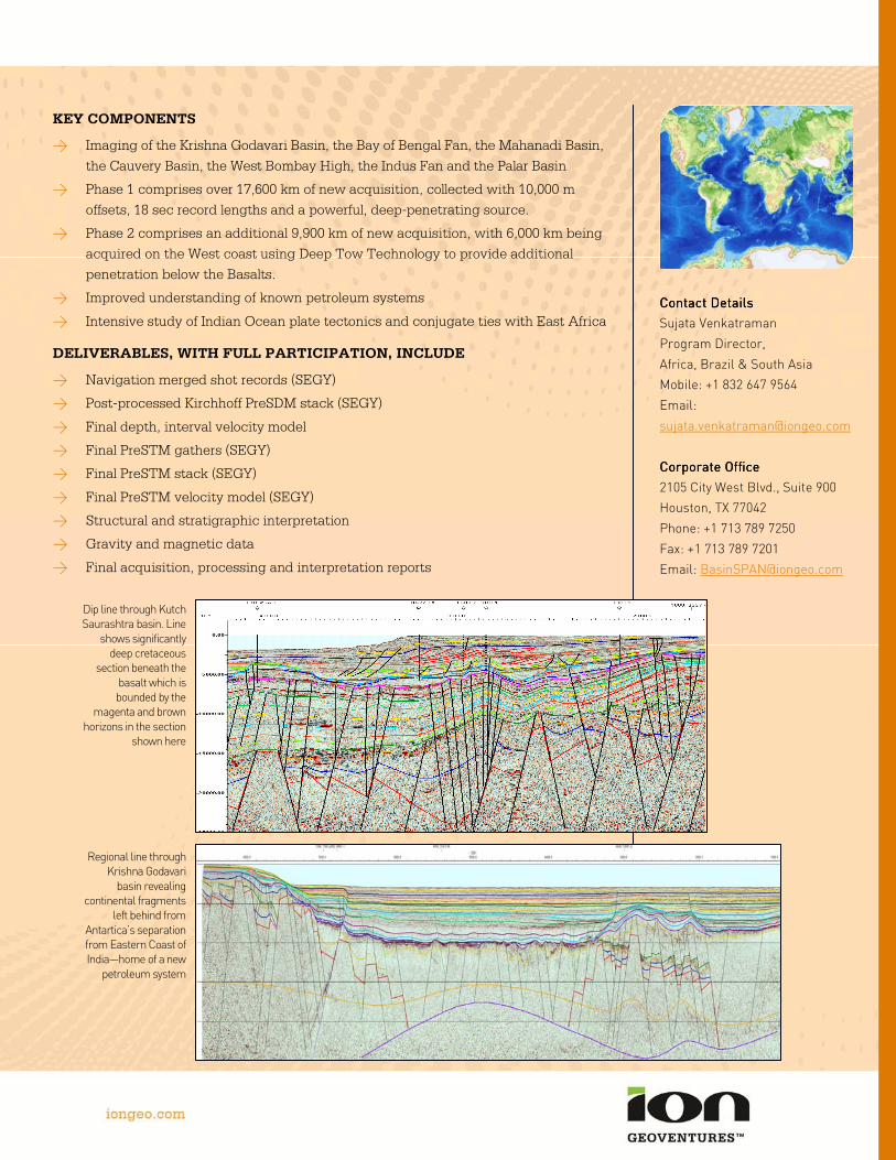
Regional line through Krishna Godavari basin revealing
continental fragments left behind from
Antartica’s separation from Eastern Coast of India—home of a new petroleum system
Dip line through Kutch Saurashtra basin. Line shows significantly deep cretaceous
section beneath the basalt which is bounded by the
magenta and brown horizons in the section
shown here