indigenous peoples monitoring report · this indigenous peoples monitoring report is a document of...
TRANSCRIPT

Indigenous Peoples Monitoring Report Project No. 42248-013 Semestral Report December 2016
2763-BAN (SF): Second Chittagong Hill Tracts Rural Development Project Prepared by Ministry of Chittagong Hill Tracts Affairs for the People’s Republic of Bangladesh and the Asian Development Bank.

This indigenous peoples monitoring report is a document of the borrower. The views expressed herein do not necessarily represent those of ADB's Board of Directors, Management, or staff, and may be preliminary in nature. In preparing any country program or strategy, financing any project, or by making any designation of or reference to a particular territory or geographic area in this document, the Asian Development Bank does not intend to make any judgments as to the legal or other status of any territory or area.

Indigenous People’s Monitoring Report
1 Project Implementation Consultants
Government of the People’s Republic of Bangladesh Ministry of Chittagong Hill Tracts Affairs (MoCHTA)
Indigenous Peoples Safeguards Monitoring Report
July – December 2016
Second Chittagong Hill Tracts Rural Development Project (CHTRDP II) Project No.42248-013
Loan No-2763-BAN (SF)
Prepared by: Project Management Office, CHTRDP-II
With assistance from Euro consult Mott MacDonald / ADSL Ltd.
For Asian Development Bank
Version: March 2017

Indigenous People’s Monitoring Report
2 Project Implementation Consultants
Disclaimer: The report uses ADB terminology ‘indigenous peoples’ for which usually
alternate terminology is used by the Government of Bangladesh; such as ‘tribes’, ‘tribal
peoples’, ethnic minority’, ‘small ethnic groups’, etc. Regardless of this different
nomenclature, these are meant to be understood as ‘indigenous people as defined and
accepted in the Safeguards Policy Statement (SPS) of ADB, as adopted in June 2009.

Indigenous People’s Monitoring Report
3 Project Implementation Consultants
Abbreviations
ADB : Asian Development Bank ADRF : Alternative Dispute Resolution Forum APs : Affected Persons CC : Circle Chief CHT : Chittagong Hill Tracts CCL : Cash Compensation under Law CHTRC : Chittagong Hill Tracts Regional Council CHTRDP-II : Second Chittagong Hill Tracts Rural Development Project CI : Community Infrastructure DC : Deputy Commissioner DPD : Deputy Project Director DPMO : District Project Management Committee EP : Entitled Person FPIC : Free, Prior, Informed Consent FGD : Focus Group Discussion FSR : Feasibility Study Report GoB : Government of Bangladesh GRC : Grievance Redress Committee HDC : Hill District Council HH : Household IGA : Income Generation Activities IP : Indigenous Peoples IPP : Indigenous People’s Plan LARP : Land Acquisition and Resettlement Plan LGED : Local Government & Engineering Department MAD : Micro Agribusiness Development MOCHTA : Ministry of CHT Affairs NGO : Non-Government Organization PDC : Para Development Committee PJSS : Parbatya Chattagram Jana Samhati Samiti PIC : Project Implementation Consultants PMO : Project Management Office R-NGO : Resettlement NGO RR : Rural Roads SAP : Severely Affected Person SES : Socio-economic Survey SPS : Safeguards Policy Statement SQMC : Safeguards Quality Monitoring Cell

Indigenous People’s Monitoring Report
4 Project Implementation Consultants
Note: In this report, “$” refers to US Dollars. This indigenous people’s safeguards monitoring report is a document of the borrower. The views expressed herein do not necessarily represent those of ADB’s Board of Directors, Management or Staff and may be preliminary in nature. In preparing any country program or strategy, financing any report, or by making any designation of or reference to a particular territory or geographic area in this document, the Asian Development Bank does not intend to make any judgments as to the legal or other status of any territory or area.

Indigenous People’s Monitoring Report
5 Project Implementation Consultants
TableofContentsAbbreviations .............................................................................................................................................. 3
Executive Summary ................................................................................................................................... 7
1.Background and Context of the Project ................................................................................................. 12
A. Background .................................................................................................................................................. 12
B. Context of the Project ................................................................................................................................. 12
C. Purpose of the Report ............................................................................................................................ 13
D. Methodology ............................................................................................................................................ 14
E. ADB Policy of IP Safeguards .................................................................................................................... 14
F. IP Safeguards Policy in CHTRDP-II ........................................................................................................ 14
G. Indigenous Peoples of the Chittagong Hill Tracts .............................................................................. 15
2.Institutional Arrangement of the Project ................................................................................................ 16
3.Compliance of Indigenous People’s Plan (IPP) of the Project .............................................................. 17
Land Acquisition for Road Construction under RR component ................................................................... 17
Community Infrastructure (CI) Component ..................................................................................................... 20
Participatory Village Mapping ........................................................................................................................... 21
Micro Agribusiness Component........................................................................................................................ 22
Compliance status of ADB IP Policy Specific Loan Covenant ..................................................................... 22
4.Consultation and Grievance Redress .................................................................................................... 24
Community Consultation & Information Disclosure ....................................................................................... 24
5.Benefit Monitoring & Evaluation: ........................................................................................................... 26
6.Conclusion ............................................................................................................................................. 27
Tables
Table-1: IP and None-IP (NIP) population in CHT by district. ................................................................. 16 Table-2: Status of IP & NIP household and Land Acquisition in Project areas. ...................................... 18 Table-3: Payment of Additional Compensation on top of DC's CCL 18 Table-4: Number of APs, SAPs and Community Consultation 19 Table-5: District wise voluntarily Donated Land and Customary Land requirement for CI Component 21 Table-6: Compliance status with IP specific Loan Covenant ................................................................... 23 Table-7: Number of APs, SAPs and Community Consultation ................................................................. 24 Table-8: Number of ADRF's Meeting ....................................................................................................... 25 Table-9: Pre and post project status of IP structures for Betbunia Road ................................................. 26 Table-10: Comparison of Pre and Post Project IP HHs Income for Betbunia Road ................................. 27

Indigenous People’s Monitoring Report
6 Project Implementation Consultants
Figures
Figure-1: Map of Chittagong Hill Tracts Region showing location of CHTRDP-II ..................................... 11
Figure-2: IP & NIP population (%) Chart in CHT ...................................................................................... 16
Figure-3: Project Implementation Arrangement ....................................................................................... 17
Figure-4: Village Map of Mongjoy Para, Naikhyangchari, Bandarban ...................................................... 22

Indigenous People’s Monitoring Report
7 Project Implementation Consultants
Executive Summary
1. The Chittagong Hill Tracts (CHT), located in the most eastern part of Bangladesh, is geographically isolated and entho-culturally unique from plain-land Bangladesh. Its land area covers 13,000 square km, of which 90% are slopping lands. After a 20-years insurgency, the CHT Accord was signed in December 1997 and immediately following the signing of the Accord, ADB initiated activities under a $30 million loan. After successfully completion of CHTRDP first phase, a Second Chittagong Hill Tracts Rural Development Project (CHTRDP-II) was designed with a total budget of $70.80 million. The project implementation period is 2011-2012 to 2017-2018.
2. There are five components which are as follows: Institutional Development & Capacity Building Component Rural Road (RR) Component Community Infrastructure (CI) Component Micro- Agribusiness Development Component and
Project Management Component.
3. The Ministry of Chittagong Hill Tracts Affairs (MOCHTA) is the executing agency (EA) and Chittagong Hill Tracts Regional Council (CHTRC) is the Lead Implementation Agency (LIA), together with the Local Government Engineering Department (LGED) responsible for Component B-Rural Roads.
4. The project impact will be an increase in rural household incomes in subproject areas in CHT. The key performance target will be an increase in average annual household income in subproject areas by Tk20, 000 at 2010 price level from Tk63, 000 in 2010. The outcome of the project will be increased income generating opportunities for men and women.
5. The purpose of this Indigenous Peoples (IPs) Safeguards Monitoring Report is to inform the main stakeholders and the general public the status and compliance of the respective IP Safeguards Policy.
6. The methodology was adopted for this report includes reviewing records and document, field visits and consultation with relevant stakeholders such as affected persons, beneficiaries, female groups, and meeting with various stakeholders those who involved with implementation of this project.
7. According to the ADB’s Safeguard Policy Statement (SPS), 2009, the project is categorized as “A” for Involuntary Settlement and Indigenous Peoples (IP) and category B for Environment.
8. The CHTRDP-II also ensures IPs protection from adverse impact by the project activities with the four main safeguards;

Indigenous People’s Monitoring Report
8 Project Implementation Consultants
Payment for IP Common lands to usufruct and legal owners of land (through registration with Headmen) taken for the project.
Participatory Village Mapping to delineate boundaries and major land use within villages along CHTRDP II roads, backed up by a proactive grievance Redress System.
Ensuring prioritization of IPs in view of their higher poverty status and monitoring the need to provide targeted assistance to the smaller IP groups in the project areas who are by in large more vulnerable than the large IP groups.
Raising awareness among Government of Bangladesh officials working in the CHT of IP issues, history and customs.
9. In Bangladesh, IPs are often referred to as Adibasi, small ethnic groups, ethnic communities, hill people (paharis) and forest people. Adibasis are referred to here as Indigenous Peoples, in line with ADB terminology. There are twelve ethnicities (11 indigenous and Bengalis) living in the CHT. The eleven ethnic multi-lingual minorities are: Bawm, Chak, Chakma, Khyang, Khumi, Lushai, Marma, Mro, Pankhua, Tangchangya, and Tripura.
10. MoCHTA is the executing agency and CHTRC is the implementing agency of the project. The PMO, headed by a Project Director, has been established within the CHTRC to manage and closely coordinate project activities across all agencies. LGED activities have been coordinate within the overall project by another Project Director. Project implementation consultants (PIC) has been recruited for supporting project implementation. NGOs have also been recruited to provide social mobilization for community infrastructure, Watershed management, MAD support, resettlement planning and implementation. The SQMC has been established to monitor quality of construction works and compliance issues of social and environmental safeguards.
11. A total of 14 Land Acquisition and Resettlement Plan (LARPs) were prepared so far. The project required acquisition of about 136.18 acres land both title and customary for 14 LARPs under RR Component. Total 53.57 acres of land is customary out of 136.18 acres and a number of 410 Households of Indigenous People were affected by these 14 roads.
12. The Land Acquisition section of Deputy Commissioner (DC) collected transacted deed value for preceding 12 months from the date of serving notice under section 3 of CHT LA Ordinance, 1958 for assessment of land value and then averaging the mouza wise rate for different categories of land.
13. As on December 2016, a total number of 534 Feasibility Study Reports out of which 195 in Rangamati, 183 in Khagrachari and 156 in Bandrban have been prepared through multi-level community consultation meetings against the total project target of 600 under Community Infrastructure (CI) Component.
Indigenous People’s Monitoring Report
9 Project Implementation Consultants
14. No land acquisition for CI Component for implementation of various interventions is required due the lands have been voluntarily donated by the land owners.
15. Meaningful Community Consultation and proper communication with the affected IPs
and other project stakeholders have conducted for collecting relevant data for impact assessment, and facilities and development of appropriate options for resettlement of APs. The Project’s IPP and LARF has been disclosed to the affected community.
16. The R-NGO also carried out house to house survey on post project socio economic
status of the Affected IPs (APs) and project benefited communities. The survey result shows that better economic situation of the Affected IP Households and the project benefited communities than the pre-project economic level.
17. The CHTRDP II project has been contributing to change the socio-economic status of
CHT people in the way of creating income opportunities.

Indigenous People’s Monitoring Report
10 Project Implementation Consultants
Box 1: Project at a Glance 1. Project Name: Second Chittagong Hill Tracts Rural Development Project 2. Project Number: 42248‐013
3. Country: Bangladesh 4. Department/Division: South Asia Department/Environment, Natural Resources & Agriculture Division
5. Sector Classification: Sectors Primary Subsectors
Agriculture and naturalresources
√ Agriculture and rural sector development
Irrigation, drainage, and flood protection
Land‐based natural resources management
6. Thematic Classification: Themes Primary Subthemes
Economic growth √ Widening access to markets and economic opportunities
Social development Indigenous people
Gender equity Gender equity in economic opportunities
Capacity development Institutional development
6a. Climate Change Impact 6b. Gender Mainstreaming
Adaptation Low
Gender equity theme (GEN) √
Mitigation Low Effective gender mainstreaming (EGM)
Some gender benefits (SGB) No gender elements (NGE)
7. Targeting Classification: 8. Location Impact:
General Intervention
Targeted Intervention National Low Geographic dimensions of inclusive growth
Millennium development goals
Incomepoverty at household level
Rural High
√ 9. Project Risk Categorization: Complex
10. Safeguards Categorization: Environment B
Involuntary resettlement A Indigenous peoples A
11. ADB Financing: Sovereign/Non‐sovereign Modality Source Amount ($ Million)
Sovereign Project loan Asian Development Fund 55.0 Total 55.0
12. Co‐financing: No Co‐financing available.
13. Counterpart Financing: Source Amount ($ Million)
Beneficiaries 1.4
Government 14.4
Total 15.9
14. Aid Effectiveness:
Parallel project implementation unit No
Program‐based approach No

Indigenous People’s Monitoring Report
11 Project Implementation Consultants
Figure-1: Map of Chittagong Hill Tracts Region showing location of CHTRDP-II

Indigenous People’s Monitoring Report
12 Project Implementation Consultants
1. Background and Context of the Project
A. Background
1. The Second Chittagong Hill Tracts Rural Development Project (CHTRDP-II) has been
implementing in the three Hill District of the Chittagong Hill Tracts (CHT), located in the
most eastern part of Bangladesh, is geographically isolated and entho-culturally unique
from plain-land Bangladesh. Its land area covers 13,000 square km, of which 90% are
slopping lands. Additionally, new Bengali settlers started settings in the area from early
1980s under a government-sponsored transmigration program, which triggered increased
tensions between the indigenous peoples and new settlers.
2. In early 1960s, a hydroelectric dam was constructed at Kaptai in Rangamati District,
inundating about 20,000 ha or 40% of the prime cultivable lands in the CHT. At the time,
the CHT population was estimated to be about 385,000 of which about 100,000 people
(over 25% of the population) were displaced by the reservoir.
3. After a 20-years insurgency the CHT Accord was signed in December 1997 between the
Parbatya Chattagram Jana Samhati Samiti (PJSS) on behalf of the CHT people and
Government of the People’s Republic of Bangladesh. Immediately following the signing of
the Accord, ADB initiated activities under a $30 million loan1, whose objective was to
reduce the incidence of absolute poverty by developing basic physical infrastructure,
primarily rural roads, and expanding income and employment generating activities to
substantially raise standards of living.
4. The Second Chittagong Hill Tracts Rural Development Project (CHTRDP-II) is the
successor of the CHTRDP, which was completed successfully in December 2009”. The
CHTRDP can be considered as a pioneer in the three hill districts, given the rather
complex socio-political circumstances it was operating.
B. Context of the Project
5. As follow up to the Chittagong Hill Tracts Rural Development Project (CHTRDP) first
phase, a Second Chittagong Hill Tracts Rural Development Project (CHTRDP-II) was
designed with a total budget of $70.80 million, On 2nd October 2011 the Loan Agreement
of this Second CHTRDP, (Loan No.2763-BAN), Project No. 42248-013), was signed
between the Government of the Republic of Bangladesh (GoB) and Asian Development
1 ADB Loan 17771‐BAN: Chittagong Hill Tracts Rural Development Project (CHTRDP) approved in 2000 and effective in
October 2002 and implemented throughout 2009.

Indigenous People’s Monitoring Report
13 Project Implementation Consultants
Bank (ADB) for an amount of $55 million and the Government of Bangladesh
contribution is $14.40 million. The project implementation period is 2011-2012 to 2017 -
2018.
6. There are five components which are as follows:
Institutional Development & Capacity Building Component
Rural Road (RR) Component
Community Infrastructure (CI) Component
Micro- Agribusiness Development Component and
Project Management Component.
7. The Ministry of Chittagong Hill Tracts Affairs (MOCHTA) is the executing agency (EA) and
implementation is under the overall responsibility of the Chittagong Hill Tracts Regional
Council (CHTRC) as the Lead Implementation Agency (LIA), together with the Local
Government Engineering Department (LGED) responsible for Component B-Rural Roads,
and the Hill District Councils of Rangamati, Khagrachari and Bandarban Districts as the
implementation agencies (IA) in their respective project districts. The project came into
effect on 13th December 2011 with the establishment of the Project Management Office
(PMO) in Rangmati.
8. The project impact will be an increase in rural household incomes in subproject areas in
CHT. The key performance target will be an increase in average annual household
income in subproject areas by Tk20, 000 at 2010 price level from Tk63, 000 in 2010. The
outcome of the project will be increased income generating opportunities for men and
women in the project areas.
C. Purpose of the Report
9. As the project has been assessed as Category A for indigenous people (IP), and an IP
plan (IPP) has been developed in this project for compliance of ADB requirements in
respect of IP. The purpose of this Indigenous Peoples (IPs) Safeguards Monitoring
Report is to inform the main stakeholders and the general public the status and
compliance of the respective IP Safeguards Policy through the preparation of semi-annual
IP Safeguards Monitoring Reports. This report is also prepared in compliance with the
Project’s Loan Agreement and with ADB’s IP safeguards stipulations as per the SPS,

Indigenous People’s Monitoring Report
14 Project Implementation Consultants
2009. This IPs Safeguards Monitoring Report covers the period from July 2016 –
December, 2016.
D. Methodology
10. The methodology adopted for this report includes reviewing records and document, field
visits and consultation with relevant stakeholders such as affected persons, beneficiaries,
female groups, Para Development Committee (PDC), Karbari, Project Implementation
Consultant (PIC), Project Management Office (PMO) and CHTs Regional Council
(CHTRC), District Project Management Office (DPMO and Local Government Engineering
Department (LGED) at different levels to (a) verify compliance issues pertaining to all IP
safeguards matters related to contracts contained social conditions, land acquisition and
resettlement process, consistent with Government of Bangladesh (GoB) and ADB
requirements; and (b) assess NGO’s claims in terms of skills, staffing, experience,
resources and corporate legality.
E. ADB Policy of IP Safeguards
11. As per the conditions of ADB’s Safeguard Policy Statement (SPS), 2009, the project is
categorized A for Involuntary Settlement and Indigenous Peoples (IP) and category B for
Environment.
12. The objectives of ADB Policy are full respect for Indigenous Peoples’ identity; dignity,
human rights, livelihood systems, and cultural uniqueness as defined by the Indigenous
Peoples themselves so that they receive culturally appropriate social and economic
benefits, do not suffer adverse impacts as a result of projects and can participate actively
in projects that affect them.
F. IP Safeguards Policy in CHTRDP-II
13. The CHTRDP-II also ensures IPs protection from adverse impact by the project activities
with the four main safeguards;
Payment for IP Common lands to usufruct and legal owners of land (through
registration with Headmen) taken for the project.
Participatory Village Mapping to delineate boundaries and major land use within
villages along CHTRDP II roads, backed up by a proactive grievance Redress
System.

Indigenous People’s Monitoring Report
15 Project Implementation Consultants
Ensuring prioritization of IPs in view of their higher poverty status and monitoring the
need to provide targeted assistance to the smaller IP groups in the project areas
who are by in large more vulnerable than the large IP groups.
Raising awareness among Government of Bangladesh officials working in the CHT
of IP issues, history and customs.
G. Indigenous Peoples of the Chittagong Hill Tracts 14. The term Indigenous Peoples (IP) encompasses a generic concept not easily reflected in
a single term. Other terms relating to the concept of indigenous peoples include "cultural
minorities," "ethnic minorities," "indigenous cultural communities, "tribals," "scheduled
tribes," "natives, and "aboriginals. Accepted or preferred terms and definitions vary
country by country, by academic discipline, and even by the usage of groups
concerned. In Bangladesh, IPs are often referred to as Adibasi, small ethnic groups,
ethnic communities, hill people (paharis) and forest people. Adibasis are referred to here
as Indigenous Peoples, in line with ADB terminology.
15. ADB in its Safeguard Policy Statement (2009) d e f i n e s I P s a s a distinct,
vulnerable, social and cultural group possessing the following characteristics in varying
degrees:
Self-identification as members of a distinct indigenous cultural group and
recognition of this identity by others;
Collective attachment to geographically distinct habitats or ancestral territories in
the project area and to the natural resources in these habitats and territories;
Customary cultural, economic, social, or political institutions that are separate
from those of the dominant society and culture; and
A distinct language, often different from the official language of the
country or region.
16. There are twelve ethnicities (11 indigenous and Bengalis) living in the CHT. The eleven
ethnic multi-lingual minorities are: Bawm, Chak, Chakma, Khyang, Khumi, Lushai, Marma,
Mro, Pankhua, Tangchangya, and Tripura. The largest indigenous groups in the CHT are
the Chakma, Marma, Tripura, Mro and Tanchangya, and together they make up about 90
percent of the indigenous population of the region. The other indigenous peoples of
the CHT are the Bawm, Chak, Khumi, Khyang, Lushai and Pankhua. These two
smaller groups are, overall, more vulnerable than the large ones.

Indigenous People’s Monitoring Report
16 Project Implementation Consultants
17. The 2011 national census by Bangladesh Bureau of Statistics (BBS) shown in table-1; total
population in Chittagong hill tracts (CHT) is 1,663,274 where Indigenous People (IP) are
859,938 (52% of total population). On the other hand, Non-Indigenous people (NIP) are
803,336 in population (48%).
Table-1: IP and None-IP (NIP) population in CHT by district.
District IP % NIP % Total %
Khagrachari 316,987 50% 321,980 50% 638,967 100%
Rangamati 363,551 59% 256,663 41% 620,214 100%
Bandarban 179,400 44% 224,693 56% 404,093 100%
Total 859,938 52% 803,336 48% 1,663,274 100% Source: Formulated from Bangladesh Bureau of Statistics (BBS), 2011.
Figure-2: IP & NIP population (%) Chart in CHT
2. Institutional Arrangement of the Project
18. The Ministry of Chittagong Hill Tracts Affairs (MoCHTA) is the executing agency and is
responsible for overall project implementation. The Chittagong Hill Tracts Regional Council
(CHTRC) is the lead implementing agency and the Local Government Engineering
Department LGED) is the implementing agency for the rural roads component.
19. The PMO, headed by a Project Director, has been established within the CHTRC to
manage and closely coordinate project activities across all agencies. LGED activities have
been coordinate within the overall project by another Project Director. One DPMO for each
0%
10%
20%
30%
40%
50%
60%
Khagrachari Rangamati Bandarban Total
50%
59%
44%
52%50%
41%
56%
48%
Chart-01: Percentage of IP & NIP population in CHT
IP (%)
NIP (%)

Indigenous People’s Monitoring Report
17 Project Implementation Consultants
of the three districts has been established headed by a Deputy Project Director (DPD), who
reports directly to the Project Director.
20. Project implementation consultants (PIC) has been recruited for supporting PMO and
DPMO for all aspects of project implementation. Non-Government Organizations (NGOs)
have also been recruited to provide social mobilization for community infrastructure,
Watershed management, MAD support, resettlement planning and implementation. The
Safeguards Quality and Monitoring Cell (SQMC) has been established to monitor quality of
construction works and compliance issues of social and environmental safeguards.
Figure-3: Project Implementation Arrangement
3. Compliance of Indigenous People’s Plan (IPP) of the Project
Land Acquisition for Road Construction under RR component
21. LGED is implementing RR components and as of December 2016, a total of 14 Land Acquisition and
Resettlement Plan (LARPs) were prepared so far. The project required acquisition of about
136.18 acres land both title and customary for 14 LARPs under RR Component. Total 53.57
acres of land is customary out of 136.18 acres and a number of 410 Households of
Indigenous People were affected by these 14 roads. Road wise summary of IP & Non-IP
affected households and required land (title and customary) is provided in following Table-2.

Indigenous People’s Monitoring Report
18 Project Implementation Consultants
Table-2: Status of IP & NIP household and Land Acquisition in Project areas.
SL NO
Roads District IP
Ho
useh
olds
No
n IP
H
ous
ehol
ds
Tot
al H
Hs
Re
quire
d La
nd (
acre
)
Titl
e la
nd
(Acr
e)
Cus
tom
ary
land
(A
cre)
1 Betbunia-Chayeri Bazar – Laxmichari Road via Bormachari
Rangamati 46 0 46 14.8011 1.7184 13.0827
2
Panchari GC – Bhaibonchara GC via Shantipur Aranya Kutir road
Khagrachari 116 0 116 8.37 5.71 2.66
3 Ruma Sadar – Ruma Bazar Road Bandarban 2 3 5 0.2633 0.2633 0
4 Sindukchari Union H/Q – Dullyatali GC via Challyatali Road
Khagrachari 23 0 23 1.29 0.545 0.745
5 Raicha – Goalikhola Bridge only Chittagong Hill Tracts Part
Bandarban 0 1 1 0.4426 0.4426 0
6 Raikhali GC Ferry ghat – Rajasthali HQ Road via Mitingachari (Part I)
Rangamati 60 2 62 9.08 7.921.16
7 Naikhong Chari – Tumru Road (Part I) Bandarban 11 49 60 5.62 1.04 4.58
8 Garitana GC – Batnatali Union H/Q Road via Jogyachola Bazar
Khagrachari 5 78 83 5.45 1.79 3.66
9
Raikhali GC – Ferry Ghat – Rajasthali HQ via Mitingachari,Road (Part II)
Rangamati 1 12 13 30.35 30.35 0
10 Naikhongchari – Tumru Road (Part II) Bandarban 9 158 15.00 9.86 5.14
11 Betbunia Chairy Bazar – Bara Aoulia – Santirhat Road
Bandarban 35 23 58 7.3741 2.36 5.014
12 Lama – Rupashi Para Road
Bandarban 4 28 32 8.24 5.79 2.45
13 Baniarchar-Gozalia Road Bandarban
36 43 79 19.82 9.41 10.41
14
Marishya Bazar-Maynimukh Bazar via Babu Para, Bottola & Dakkhin Saroatoli Road’
Rangamati 62 0 62 10.08 5.4154 4.67
Total 410 397 640 136.181 82.6 53.57
Source: Taungya Survey Report
22. The Land Acquisition Section of Deputy Commissioner (DC) office collected transacted
deed value for preceding 12 months from the date of serving notice under section 3 of CHT
LA Ordinance, 1958 for assessment of land value and then averaging the mouza wise rate
for different categories of land. The DC office came to a consensus and finalizes the
Indigenous People’s Monitoring Report
19 Project Implementation Consultants
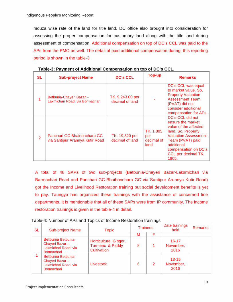
mouza wise rate of the land for title land. DC office also brought into consideration for
assessing the proper compensation for customary land along with the title land during
assessment of compensation. Additional compensation on top of DC’s CCL was paid to the
APs from the PMO as well. The detail of paid additional compensation during this reporting
period is shown in the table-3
Table-3: Payment of Additional Compensation on top of DC’s CCL.
SL Sub-project Name DC’s CCL Top-up
Remarks
1 Betbunia-Chayeri Bazar – Laxmichari Road via Bormachari
TK. 9,243.00 per decimal of land
-
DC’s CCL was equal to market value. So, Property Valuation Assessment Team (PVAT) did not consider additional compensation for APs.
2 Panchari GC Bhainonchara GC via Santipur Arannya Kutir Road
TK. 19,320 per decimal of land
TK. 1,805 per decimal of land
DC’s CCL did not ensure the market value of the affected land. So, Property Valuation Assessment Team (PVAT) paid additional compensation on DC’s CCL per decimal TK. 1805.
A total of 48 SAPs of two sub-projects (Betbunia-Chayeri Bazar-Laksmichari via
Barmachari Road and Panchari GC-Bhaibonchara GC via Santipur Arunnya Kutir Road)
got the Income and Livelihood Restoration training but social development benefits is yet
to pay. Taungya has organized these trainings with the assistance of concerned line
departments. It is mentionable that all of these SAPs were from IP community. The income
restoration trainings is given in the table-4 in detail.
Table-4: Number of APs and Topics of Income Restoration trainings
SL Sub-project Name Topic Trainees
Date trainings held
Remarks
M F
1
Betbunia Betbunia-Chayeri Bazar – Laxmichari Road via Bormachari
Horticulture, Ginger, Turmeric & Paddy Cultivation
8 1 16-17
November, 2016
Betbunia Betbunia-Chayeri Bazar – Laxmichari Road via Bormachari
Livestock 6 2 13-15
November, 2016

Indigenous People’s Monitoring Report
20 Project Implementation Consultants
SL Sub-project Name Topic Trainees
Date trainings held
Remarks
M F
2
Panchari GC Bhainonchara GC via Santipur Arannya Kutir Road
Horticulture, Ginger, Turmeric & Paddy Cultivation
13 10 26-28 April,
2017
Panchari GC Bhainonchara GC via Santipur Arannya Kutir Road
Livestock 6 2 29-30 April,
2017
Total 33 15
Source: Taungya a contracted NGO for Resettlement.
Community Infrastructure (CI) Component:
23. As on December 2016, a total number of 471 Feasibility Study Reports out of which 193
in Rangamati, 161 in Khagrachari and 117 in Bandrban have been prepared through
multi-level community consultation meetings against the total project target of 600 under
Community Infrastructure (CI) Component. Various types of interventions have been
implementing in these selected villages / Paras. Small IP group’s prioritization for
receiving community infrastructure have been ensured during selection of interventions.
24. A small piece of land is required for construction of these interventions but these land
(title land / customary land) have been voluntarily donated. In case of customary land
concerned mouza headman / concerned village Karbari (village chief, as representatives
of Headman) have been provided “No Objection Certificate-NOC” to Para Development
Committee (PDC) and in aspect of title land, land owner has donated voluntarily with
written “Voluntary Land Donation Certificate-VLDC”. Therefore, there is no requirement
for developing “Land Acquisition and Resettlement Plan (LARPs) in the CI component.
The total land requirement for CI Component for 471 para/villages (Sub-projects).is
91.12563 acre of which 21.71820 acre is voluntarily donated land and 69.56872 acre is
customary land. Out of these, 21.88236 acre (.27830 acre voluntarily donated land and
20.7654 acre customary land) is in Rangamati for 193 para / villages, 20.48823 acre
(9.50306 acre voluntarily donated land and 10.9852 acre customary land) is in
Khagrachari for 161 paras / villages and 48.75504 acre (10.93692 acre voluntarily
donated land and 37.81812 acre customary land is in Bandarban for 117 Para/ villages.
Which is shown in the following table-5.

Indigenous People’s Monitoring Report
21 Project Implementation Consultants
Table- 5: District wise voluntarily Donated Land and Customary Land requirement for CI Component.
Sl # District No of Para/
Village
Land Requirement
RemarksCustomary
Land
Voluntary
Donation
Total
1 Rangamati 193 20.76540 1.27830 21.88236
2 Khagrachari 161 10.9852 9.50306 20.48823
3 Bandarban 117 37.81812 10.93692 48.75504
Total 471 69.56872 21.71820 91.12563
Villagers of the subproject areas also confirmed that no standing crops, fruits garden,
human habitat or any structures would be damaged due to construction of the proposed
interventions. No structures or trees were damaged due to implementation of interventions
and no people were also economically displaced or adversely impacted for their income
livelihood due to such construction.
25. A total number of 6 Market sheds (Rangamati-4 & Khagrachari-2) out of 24 market sheds
were constructed in community land and no objection certificates (NOC) were provided by
the concerned Headmen for these land.
26. Watershed management sub-component is a community-based initiative small-scale pilot
intervention which includes 6 subprojects, 2 per Hill District with covering 55.00ha. Land
Acquisition and Resettlement issue is not relevant in the sub-project interventions since the
interventions are being implemented in the common lands owned by the communities and
piloting of techniques in the interested farmers such as System Rice Intensification (SRI)
and Drip irrigation.
Participatory Village Mapping
27. The villagers, with project technical support from SM-NGO, DPMO and PIC carrying out
Participatory Village Mapping exercise in all sub-project areas, marking, in particular,
village boundaries, locating the houses, temples, school, roads, water points, streams,
springs, horticultural orchards, jhum, and bridges, and determining the longitude and
latitude of the village with the help of Global Positioning System (GPS) data and Google
Earth. By this reporting period, out of 600 subproject in /villages, a total number of 534

Indigenous People’s Monitoring Report
22 Project Implementation Consultants
subproject/village mapping have already been prepared in the project area and those maps
were posted in the respective subproject areas. A sample of prepared village Map of
Mongjoy Para is given in Fig-4.
Figure-4: Village Map of Mongjoy Para, Naikhyangchari, Bandarban
Micro Agribusiness Component
28. As on December 2016, a total number 78 trainings were held so far and beneficiaries were
1,560. All of these participants were from IP although there was provision at least 50% from IP.
Compliance status with ADB IP Policy Specific to Loan Covenant:
29. The project has been assessed as Category “A” for IP. Some IP related covenants especially
Schedule 5 was set forth into the Loan Agreement. The compliance status of these covenants
are shown in the following Table 6:

Indigenous People’s Monitoring Report
23 Project Implementation Consultants
Table -6: Compliance status with IP specific to Loan Covenant.
Description Type Reference Timeline Status of
Compliance Remarks /
issues The Borrower shall ensure or cause the Implementing Agencies to ensure that the preparation, design, construction, implementation and operation of the Project and all Project facilities comply with (a) the Borrower’s obligations as a signatory to the ILO Convention 107 on Indigenous and Tribal Populations Convention, 1957; (b) the Indigenous Peoples Safeguards; and (c) all measures and requirements set forth in the IPP, and any corrective or preventative actions set forth in a Safeguards Monitoring Report.
Schedule 5, Para. 10
Throughout the Project life
Being Complied
The Borrower shall make available the necessary budgetary and human resources to fully implement the EMPs, the RPs and the IPP.
Schedule 5, Para. 11
Throughout the Project life
Being Complied
The Borrower, together with the Implementing Agencies, shall (a) submit semi-annual Safeguards
Monitoring Reports to ADB and disclose relevant information from such reports to affected persons promptly upon submission; (b) if any unanticipated environmental and/or social risks and impacts arise during construction, implementation or operation of the Project that were not considered in the IEE, the EMP, the RP or the IPP, promptly inform ADB of the occurrence of such risks or impacts, with detailed description of the event and proposed corrective action plan; (c) no later than 3 months after the Effective Date, engage qualified and experienced external experts or qualified NGOs under a selection process and terms of reference acceptable to ADB, to verify information produced through the Project monitoring process, and facilitate the carrying out of any verification activities by such external experts; and(d) report any actual or potential breach of compliance with the measures and requirements set forth in the EMP, the RP or the IPP promptly after becoming aware of the breach.
Safeguards Schedule 5, para. 13
Throughout the Project life.
(a) Being Complied
(b) Being complied
(c)3 NGOs for social mobilization in Rangamati, Bandarban and Khagrachari. One NGO for resettlement planning and implementation & one NGO-for MAD Component were engaged. (d) Being complied
© It was delayed to start up the project activities due delayed of NGOs engagement

Indigenous People’s Monitoring Report
24 Project Implementation Consultants
4. Consultation and Grievance Redress
Community Consultation & Information Disclosure
30. The consultations followed the principles of ‘free, prior and informed consent’ (FPIC) by
which the APs were provided the relevant information beforehand and subsequently invited
to give their opinions and finally, consent.
31. These principles have been followed during the preparation of FSRs under CI and LARP
under RR component and throughout implementation of CHTRDP-II. This was included in
planning and implementation of LAR as well as IP related activities, monitoring, grievance
redress and as well as information disclosure
32. The Project’s IPP and LARF has been disclosed to the affected community properly in
each of the three CHT Districts to obtain the views of APs and other stakeholders on the
compensation and resettlement provisions as per Government laws and ADB guidelines
during preparation stage of the project and considered the opinions and suggestions of the
participants stakeholders.
33. Subsequently, in all the steps, CHTRDP II worked closely with the relevant institutions in the
region and a broad range of other relevant stakeholders, most important being the
communities and the affected persons at the field as part of the preparations of the LARPs.
The number of APs & formal community consultation is summarized in the following Table-7
Table-7: Number of APs, SAPs and Community Consultation.
Name of Road APs SAPs Female-headed HHS*
Total Affected Households
Number of Formal Community
Consultation Organized
Betbunia Road 32 14 08 46 10 Panchari Road 105 19 08 124 06 Sindukchari Road 23 00 23 02 Raikhali Road 63 10 03 63 03 Ruma Road 05 00 01 05 02 Naikhongchari Road I 60 09 01 60 02Raicha-Goalikhola Road 01 00 00 01 01 Garitana-Batnatali Road 83 00 04 83 02 Raikhali Part II Road 05 00 01 05 02 Naikhongchari Part II Road
81 08 09 98 02
Betbunia Shantirhat - Baja Aolia Road
48 05 05 58 03
Lama Rupasi Para Road
15 03 07 25 02

Indigenous People’s Monitoring Report
25 Project Implementation Consultants
Name of Road APs SAPs Female-headed HHS*
Total Affected Households
Number of Formal Community
Consultation Organized
Marishya Bazar-Maynimukh Bazar via Babu Para, Bottola & Dakkhin Saroatoli Road
81 05 01 62 02
Baniarchar-Gozalia Road
79 15 01 79 02
*This category includes both APs and SAPs
34. There were no serious grievances placed before the Alternative Dispute Resolution Forum
(ADRF) and Grievance Resolution Committee (GRC) till December, 2016. Local people are
known about the process of grievance redress mechanism through group discussion,
consultation meetings and personal contact. During this reporting period, more than 13 ADRF
(lower tier of GRC) committees were formed in 13 sub-projects. The committees met at least
once in each sub-projects without receiving any serious grievance case. Before forming the
committees, RNGO (Taungya) aware the local people of the concerned subproject areas
about the process of grievance redress mechanism through group discussion, consultation
meetings and personal contact. It is mentionable that three GRC were formed for three
districts to resolve the grievances but no complaint was received so far by the GRC.
Table-8: Number of ADRF’s Meeting
SL No
Name of Subproject Number of
Meeting Remarks
1 Betbunia Chairy Bazar-Laxmichari Road via Barmachari 1
2 Raikhali Gc Ferry Ghat - Rajastali HQ via Mitingachari Road (Part-1) 1
3 Raikhali Gc Ferry Ghat - Rajastali HQ via Mitingachari Road (Part-2) 1
4 Betbunia Chairy Bazar-Bara Aoulia Santir Hat Road 1
5 Marishya Bazar( Upazila Sadar)-Mayanimukh Bazar via Babupara,Battoli &Daskin Saraotali Road
1
6 Panchari GC Bhaibonchara GC via Santipur Arunya Kutir Road 1
7 Sindukchari Union HQ Dulahtali GC via Chailyatali Road 1
8 Garitana GC Batnatali Union HQ Road via jogyachola Bazar 1
9 Ruma Sadar - Ruma Bazar Road 1 10 Naikhongchari-Tumbru (Part-1) 1
11 Naikhongchari-Tumbru (Part-2) 1
12 Lama- Rupashipara Road 0 Yet to form

Indigenous People’s Monitoring Report
26 Project Implementation Consultants
SL No
Name of Subproject Number of
Meeting Remarks
13 Baniarchar- Gajalia Road 1
14 Raicha Goaliakhola Road 1
5. Benefit Monitoring & Evaluation:
35. R-NGO carried out house to house post project survey at Betbunia road, interviewed
regards to their relocated structures, investment and income level of the affected people.
They also closely monitored the project implementation activities with frequent site visit,
building close relation with the affected IPs. The survey result shows better economic
situation of the Affected IP Households and the project benefited communities than the pre-
project economic level. The survey report is shown in the Table-9 and 10:
Table-9: Pre and post project status of IP structures for Betbunia Road
SL Name of Affected Person
Fa
the
r's/ H
usb
and
's
Nam
e
Village Sex
Pre- Project Condition Post-project Condition
Pre-Project structure
Yearly Income
Mo
de o
f C
om
mu
nic
atio
n Post-project structure
Yearly Income
Mo
de o
f C
om
mu
nic
atio
n
1 Uching thwai
Marma
Josai Marma
Balu khali M
ale
Shop (Mud / CI Sheet)
96,000 on foot
House (Building) Shop (Mud / Bamboo
/CI sheet)
3,60,000 By vehicle/
on foot
2 Hla Thowi
Marma Suicha U Marma
Dabua Headman Para
Ma
le
House (Half Wall / Bamboo
/ CI Sheet /Shop (Mud / Bamboo / CI
Sheet
1,80,000 on foot House
(Building) 2,40,000
By vehicle/ on foot
3 Aresi
Marma
Late Mong
Yorerui Marma
Dabua Para M
ale
House (Mud/ CI Sheet )
56,000 on foot House
(Building) 1,44,000
By vehicle/ on foot
4 Mantu Marma
Young cha
Marma
Dabua Para M
ale
Rice Machine House (Mud/ Bamboo/CI
Sheet
90,000 on foot None 2,40,000 By vehicle/
on foot
Source: Taungya, R-NGO.
36. According to the analysis of the survey report (Table-6) shows that the majority of the affected
families had low incomes before at pro-project. Less than 20% APs earned. 120,000- Tk.180,
000 per year. Significantly, about 18% had annual income less than TK. 60,000 per year. The

Indigenous People’s Monitoring Report
27 Project Implementation Consultants
survey result shows the increased income level than the post project level of the affected IP
communities.
Table-10: Comparison of Pre and Post Project IP HHs Income for Betbunia Road
Level of income Pre-Project Income Post-Project Income
Number of HH Percent Number of HH Percent (%) Above 180,000 13 28.26% 22 47.83%
120,000-180,000 8 17.39% 12 26.09% 60,000- 120,000 17 36.96% 8 17.39%
Below 60,000 8 17.39% 4 8.69% Total 46 100% 46 100%
6. Conclusion
38. The CHTRDP II project has been contributing to change the socio-economic status of CHT
people in the way of creating income opportunities. The project is not affecting the dignity,
human rights, livelihood systems & culture of IP community. It also not affects any territories or
natural or cultural resources that the IP own, use, occupy, or claim as an ancestral domain or
asset. However, if there any grievances from the IP community regarding the impact of the
project, it would be mitigated following the procedures of Grievance Redress Mechanism
(GRM) described in the Indigenous Peoples Plan of the project.