indigenous peoples planipp - indigenous peoples plan . ipra - indigenous peoples rights act . lgu -...
TRANSCRIPT
Indigenous Peoples Plan
Project Number: 41220-013July 2019
PHI: Integrated Natural Resources and Environmental Management Project
Community Management Plan for Bukidnon Tribe of San Luis, Malitboog, Bukidnon
Prepared by Bukidnon community of Malitbog, Bukidnon for the Department of Environment and Natural Resources and Asian Development Bank.
ii
CURRENCY EQUIVALENTS (as of 31 July 2019)
Currency unit = philippine peso
₱ 1.00 = $ 0.0197 $ 1.00 = ₱ 50.8200
ABBREVIATIONS
ADB - Asian Development Bank ADSDPP - Ancestral Domain Sustainable Development and Protection Plan AFP - Armed Forces of the Philippines CADT - Certificate of Ancestral Domain Title CLUP - Community Land Use Plan CMP - community management plan COE - council of elders DENR - Department of Environment and Natural Resources DepEd - Department of Education DOH - Department of Health DTI - Department of Trade and Industry FPIC - free, prior and informed consent GO - government organizations ICC - indigenous cultural communities IGP - income generating project INREMP - Integrated Natural Resources and Environmental Management Project IP - indigenous peoples IPDF - indigenous people’s development framework IPMR - indigenous people mandatory representative IPO - indigenous people’s organization IPP - indigenous peoples plan IPRA - indigenous peoples rights act LGU - local government unit M&E - monitoring and evaluation Masl - meters above sea level MLGU - municipal local government unit MOA - memorandum of agreement NAMRIA - National Mapping and Resource Information Authority NCIP - National Commission on Indigenous People NGO - non-government organizations NGP - National Greening Program PNP - Philippine National Police PPMO - provincial project management officer RA - republic act RPCO - regional project coordination office SMA - Sabangaan Madasigon Association, Inc. SEC - Securities and Exchange Commission SPS - Safeguards Policy Statement TAKASAMA- Tagmaray, Kalipay, San Luis, Mabuhay Tribal Association, Inc. WMPCO - watershed management project coordination office
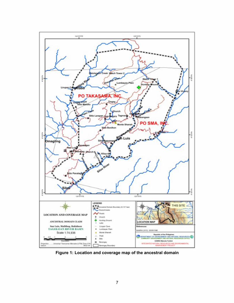
iii
GLOSSARY
Baylan Overall ritualist and he may assign and facilitate in different
types of rituals. Bungkatol Refer to the customary laws of the tribe.
Datu The recognized traditional leader in the community and
facilitate order and harmony within the community often time related to him by blood. He also acts as mediator during conflict and lead in fighting during tribal wars.
Dumagat Refer to other tribes, and not indigent to the area and their
cultures. Gugud Elder’s testimonies, or hearsay.
Habal-habal Refer to hired motorcycle.
Higaonon One of the groups of Indigenous Peoples in the Philippines
and mostly found in the northern and central regions of Mindanao such as the provinces of Bukidnon and Misamis Oriental
Igbabasok/Pangingibasok (The Datu sa Igbabasok)
The Igbabasok is the God of the field/farm lands and good harvest. The Datu sa Igbabasok leads the offering before cultivating a parcel of land, during planting and harvesting the products.
Ilinsaan (Supreme Datu) The Datu who responsible in overseeing the problems and
conditions in the community. He leads his people to settles differences within the tribe or community and initiate discussion process “paglalang” with the Elders/Leaders especially with the Baylan (highest priest of the tribe). He also lead the planning of all community projects and programs introduced to them by some supporters groups (NGO’s/GO’s). He is choose by the people and ordained leaders within the community of tribe.
Limbay and Dasang Limbay is a “Traditional Singing” and Dasang is a “Poetic Discourse”, it is high form of literacy speech of the Higaonon with the combination of chants and dances.
Lumad Indigent/ Native to the area and having their own culture
since time immemorial.
Leaders/Elders Composed of Datu and Bae selected and endorsed by the community. They possess distinct capabilities and expertise to the position and direct accountable to all members of the organization.
Manakot (For Visitors) Responsible to accommodate/ entertain all the visitors in the tribe.
iv
Magbabaya Refer to the Supreme Being or Gods.
Mangunguyamo (Tribal midwife)
She is the teacher of environmental sanitation, health care and cleanliness. She is also in-charge of securing place/rooms for visitors visiting their community.
Mangangapog Responsible for financial and food matters of the tribe or community. He gathers the entire farm produced within the Tribal Communal Farm (Kaluwagan) in the community.
Tagahabol (Bae Tagahabol)
The Bae responsible in Income generating Projects (IGP) identified in the community. She has the expertise in the making and conducting training of indigenous materials such as: baskets, kamuyot, beige, mat, brooms, kudlapi (indigenous guitar) and others. Being a Bae of tagahabol is responsible in the preparation of vests, kamuyot and kerchief for Dang-ol ceremony (installation and ordination of Datus) within the organization.
Paglagun Ritual A form of ritual and feast for thanksgiving.
Pamalayag (Forest Guard) The Datu responsible to instruct the tribal guard in protecting
their forest land, including their sacred and hunting ground.
Pamuhat Referring to the various undertakings that embodies religious and spiritual implications. These include all prayerful activities that require the sacrificial offering of live animals (usually chicken or pig).
Pamulalalaw The responsible Datu for all water concern and water
regulations.
Panalabugta Panalabugta is a form of ritual and it will be done after the site preparation. It is a way of asking permission and protection for the plants and planters to the “Magbabaya”.
Panalikot Refers to God of the forest or tree. The Datu sa panalikot
leads the ritual when the individual member or group in the community opens a small portion of a forested area of cultivation. The Datu sa panalikot offers a prayer when members of the tribe inter into the forest for hunting of wild animals and gatherings of honey.
Pangasuha Refer to Forest resource regulation zone.
Sabandal (Commander In-Chief)
He is the Datu as head of the tribal warriors for peace and order in the domain.
Sala Refer to the conflict resolution through penalty depending on
the weighted violation.
v
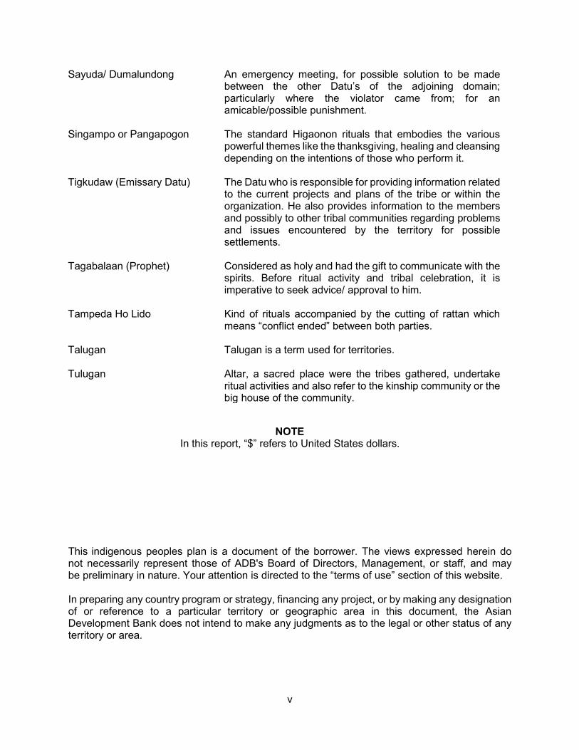
Sayuda/ Dumalundong An emergency meeting, for possible solution to be made between the other Datu’s of the adjoining domain; particularly where the violator came from; for an amicable/possible punishment.
Singampo or Pangapogon The standard Higaonon rituals that embodies the various powerful themes like the thanksgiving, healing and cleansing depending on the intentions of those who perform it.
Tigkudaw (Emissary Datu) The Datu who is responsible for providing information related to the current projects and plans of the tribe or within the organization. He also provides information to the members and possibly to other tribal communities regarding problems and issues encountered by the territory for possible settlements.
Tagabalaan (Prophet) Considered as holy and had the gift to communicate with the spirits. Before ritual activity and tribal celebration, it is imperative to seek advice/ approval to him.
Tampeda Ho Lido Kind of rituals accompanied by the cutting of rattan which means “conflict ended” between both parties.
Talugan Talugan is a term used for territories.
Tulugan Altar, a sacred place were the tribes gathered, undertake ritual activities and also refer to the kinship community or the big house of the community.
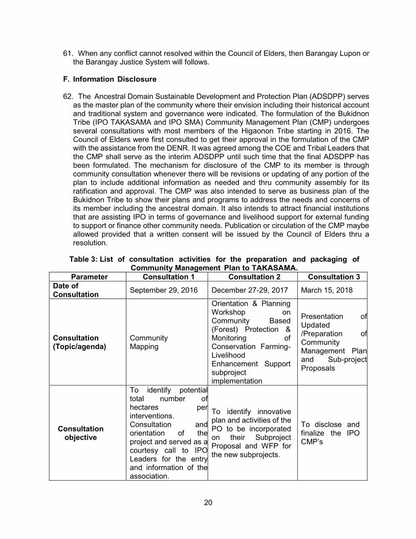
NOTE In this report, “$” refers to United States dollars.
This indigenous peoples plan is a document of the borrower. The views expressed herein do not necessarily represent those of ADB's Board of Directors, Management, or staff, and may be preliminary in nature. Your attention is directed to the “terms of use” section of this website.
In preparing any country program or strategy, financing any project, or by making any designation of or reference to a particular territory or geographic area in this document, the Asian Development Bank does not intend to make any judgments as to the legal or other status of any territory or area.
vi
TABLE OF CONTENTS ABBREVIATIONS .................................................................................................................. ii GLOSSARY .......................................................................................................................... iii EXECUTIVE SUMMARY ....................................................................................................... 1 I. INTRODUCTION ........................................................................................................... 2 II. LEGAL FRAMEWORK .................................................................................................. 2
A. Indigenous Peoples Rights Act of 1997 (RA 8371)...................................................... 2 B. NCIP Administrative Order No. 3, Series of 2012 ...................................................... 3 C. DENR-NCIP Memorandum of Agreement and Implementing Guidelines ................. 3 D. Basic Principles of ADB Safeguard Policy, 2009 ....................................................... 3
III. BACKGROUND OF THE PROJECT AREA ................................................................. 5 A. Location ...................................................................................................................... 5 B. Accessibility ................................................................................................................ 6 C. Land Area and Coverage ........................................................................................... 6 D. Topography and elevation ......................................................................................... 8 E. Landmarks and Areas with Cultural Significance ...................................................... 8
IV. BACKGROUND INFORMATION OF THE ANCESTRAL DOMAIN .............................. 8 A. Historical Background Settlements ............................................................................ 8 B. Tribal/Political Leadership Structure .......................................................................... 9 C. Cultural beliefs and rituals ........................................................................................ 11
V. PRESENT SOCIO-ECONOMIC SITUATION .............................................................. 12 A. Population and Ethnic Groupings ............................................................................ 12 B. Present livelihood or major source of income .......................................................... 13
VI. ENVIRONMENTAL STATUS OF THE AREA ............................................................. 13 A. Biophysical Characteristics ...................................................................................... 13 B. Land Use and Resource Management System ....................................................... 14
VII. SITUATIONAL ANALYSIS .......................................................................................... 16 VIII. OVERALL GOVERNANCE (VISION) OF THE ANCESTRAL DOMAIN ....................... 18
A. Vision ........................................................................................................................ 18 B. Objectives ................................................................................................................. 18 C. Envision and Land Use and Management Prescription ........................................... 18 D. Policy on Non – IP.................................................................................................... 19
vii
E. Grievance Redress Mechanism ............................................................................... 19 F. Information Disclosure ............................................................................................. 20
IX. SUBPROJECT IMPLEMENTATION UNDER INREMP.............................................. 22 X. BENEFICIAL MEASURES (POSITIVE AND NEGATIVE IMPACTS OF SUBPROJECTS) ............................................................................................................... 23 XI. MITIGATING MEASURES .......................................................................................... 23 XII. IMPLEMENTATION ARRANGEMENTS .................................................................... 23 XIII. MONITORING AND EVALUATION ............................................................................. 23 XIV. OTHER TARGETS AND BUDGET ............................................................................. 28
Annex 1: INREMP Subproject Development Map ............................................................ 29 Annex 2: Tenurial Instrument ........................................................................................... 30 Annex 3: Security and Exchange Commission Registration of TAKASAMA, Inc. ............. 31 Annex 4: Security and Exchange Commission Registration of ......................................... 32 Annex 5: List of IPO Officers and Members of TAKASAMA, Inc. ..................................... 33 Annex 6: List of IPO Officers and Members of Sabangaan Madasigon Association, Inc. . 34 Annex 7: List of projects undertaken by the IPOs of TAKASAMA, Inc. and SMA, Inc. ..... 35 Annex 8: IPO Consultations ............................................................................................ 36
List of Tables
Table 1: Biophysical Characteristics of the Area .......................................................................13 Table 2: Summary of Resources and Resource Management per Eco-Zone .........................16 Table 3: List of consultation activities for the preparation and packaging of Community Management Plan to TAKASAMA. ..........................................................................................20 Table 4: List of consultation activities for the preparation and packaging of Community Management Plan to SMA. ......................................................................................................21 Table 5: Natural Resources Management Sub-project of TAKASAMA, Inc. ..............................22 Table 6: Natural Resources Management Sub-project of SMA, Inc. ..........................................23 Table 7: Monitoring and Evaluation Checklist of TAKASAMA, Inc. ............................................24 Table 8: Monitoring and Evaluation Checklist of SMA, Inc. .......................................................26 Table 9: Target activities, estimated budget and concerned agency .........................................28
List of Figures
Figure 1: Location and coverage map of the ancestral domain .................................................. 7 Figure 2: Tribal structure of the community ...............................................................................10
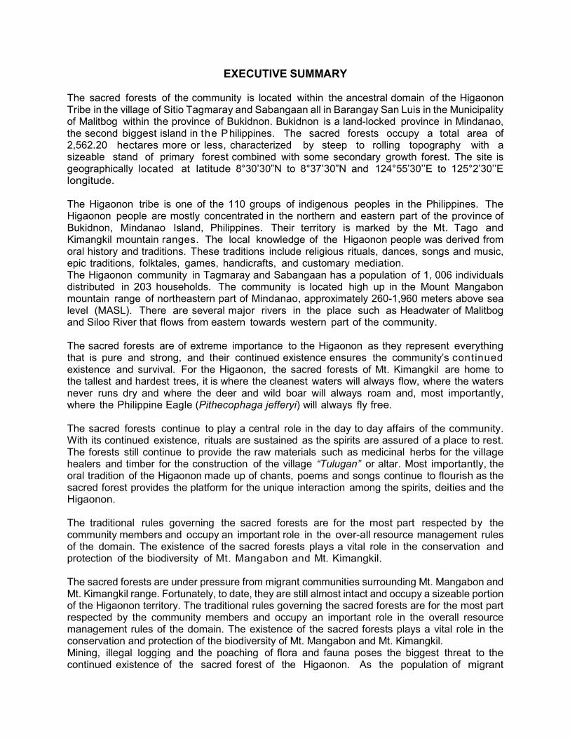
EXECUTIVE SUMMARY The sacred forests of the community is located within the ancestral domain of the Higaonon Tribe in the village of Sitio Tagmaray and Sabangaan all in Barangay San Luis in the Municipality of Malitbog within the province of Bukidnon. Bukidnon is a land-locked province in Mindanao, the second biggest island in the Philippines. The sacred forests occupy a total area of 2,562.20 hectares more or less, characterized by steep to rolling topography with a sizeable stand of primary forest combined with some secondary growth forest. The site is geographically located at latitude 8°30’30”N to 8°37’30”N and 124°55’30’’E to 125°2’30’’E longitude. The Higaonon tribe is one of the 110 groups of indigenous peoples in the Philippines. The Higaonon people are mostly concentrated in the northern and eastern part of the province of Bukidnon, Mindanao Island, Philippines. Their territory is marked by the Mt. Tago and Kimangkil mountain ranges. The local knowledge of the Higaonon people was derived from oral history and traditions. These traditions include religious rituals, dances, songs and music, epic traditions, folktales, games, handicrafts, and customary mediation. The Higaonon community in Tagmaray and Sabangaan has a population of 1, 006 individuals distributed in 203 households. The community is located high up in the Mount Mangabon mountain range of northeastern part of Mindanao, approximately 260-1,960 meters above sea level (MASL). There are several major rivers in the place such as Headwater of Malitbog and Siloo River that flows from eastern towards western part of the community. The sacred forests are of extreme importance to the Higaonon as they represent everything that is pure and strong, and their continued existence ensures the community’s continued existence and survival. For the Higaonon, the sacred forests of Mt. Kimangkil are home to the tallest and hardest trees, it is where the cleanest waters will always flow, where the waters never runs dry and where the deer and wild boar will always roam and, most importantly, where the Philippine Eagle (Pithecophaga jefferyi) will always fly free. The sacred forests continue to play a central role in the day to day affairs of the community. With its continued existence, rituals are sustained as the spirits are assured of a place to rest. The forests still continue to provide the raw materials such as medicinal herbs for the village healers and timber for the construction of the village “Tulugan” or altar. Most importantly, the oral tradition of the Higaonon made up of chants, poems and songs continue to flourish as the sacred forest provides the platform for the unique interaction among the spirits, deities and the Higaonon. The traditional rules governing the sacred forests are for the most part respected by the community members and occupy an important role in the over-all resource management rules of the domain. The existence of the sacred forests plays a vital role in the conservation and protection of the biodiversity of Mt. Mangabon and Mt. Kimangkil. The sacred forests are under pressure from migrant communities surrounding Mt. Mangabon and Mt. Kimangkil range. Fortunately, to date, they are still almost intact and occupy a sizeable portion of the Higaonon territory. The traditional rules governing the sacred forests are for the most part respected by the community members and occupy an important role in the overall resource management rules of the domain. The existence of the sacred forests plays a vital role in the conservation and protection of the biodiversity of Mt. Mangabon and Mt. Kimangkil. Mining, illegal logging and the poaching of flora and fauna poses the biggest threat to the continued existence of the sacred forest of the Higaonon. As the population of migrant
2
communities surrounding Mt. Mangabon and Mt. Kimangkil increases, attempts to illegally cut timber and set- up traps have also doubled. The demand for more lumber as well as the high price for exotic game has encouraged migrants to take the risk and enter the sacred forests. The rights and role of the Higaonon community in the management of the sacred forest must not be sacrificed in the name of collective participation, efficiency and legal mandate of the law. Their relationship and stewardship role with the sacred has been in place since time immemorial handed to them by their ancestors. This must be respected now and in the future. The Council of Elders including sectoral leaders and Organizational Officers are in charge of the overall governance mechanism to ensure all laws and policies are properly implemented, followed and respected. Traditional Conflict resolutions or grievance redress mechanisms are also properly observed to be able to settle issues immediately and not to become uncontrollable.
I. INTRODUCTION
1. This community management plan is a road map for implementing the envision development in the community. It describes what our community wants to accomplish, what activities are required during specified timeline and what resources (money, people and materials) are needed to be successful. This Community Management Plan (CMP) shall become a framework for implementing different livelihood program, conservation farming and protection of the forest land activities that are decided by the community itself. It is important to emphasize that the community members are main actors/authors in preparing this community management plan.
2. We believed that through this document we’ve made covers the dreams and aspirations
of the community comprising the Lumads and the Dumagats living in this Barangay. This document encompasses and declares our objectives of collecting, documenting and describing our indigenous knowledge systems and traditional resource management practices which shall guide us in implementing our sustainable development plans. These indigenous knowledge systems, which includes our traditional and communal view of our resources, the protection and conservation of the environment as well as in conservation and management of our biodiversity. We hope to see that with this plan, we can make an effort in addressing environmental problems even in a little way. We hope to live in peace with each other and implement religiously all the projects that will be entrusted to us by the funding institution either foreign, national, local and non-government organizations.
3. We firmly believe in the importance of this document because it is based on the
“Gugud” or the testimonies of our Elders, which are the basis of the development that we seek for our people in the community. This shall be our guide in forging alliances with like-minded individuals or groups including of course our fellow Indigenous Peoples (IPs) who have also worked for the sustainable development and protection of our own community. It is hoped that through the alliances with all the other stakeholders, we will be able to draw inspiration and strength towards the fulfillment of our dreams and aspirations in the future.
II. LEGAL FRAMEWORK
A. Indigenous Peoples Rights Act of 1997 (RA 8371)
3
4. The Indigenous Peoples (IP) in the Philippines remain as the most marginalized sector of society. This status continues despite the tremendous inroads achieved by communities, partners and advocates through years of struggle. In 1997, as result vigilance and the sustained advocacy of the IP sector and its partners, the Indigenous Peoples Rights Act (IPRA) was enacted. This provided venues and legal backbone for the recognition of the Traditional Rights of communities over their domain.
5. The IPRA provides for the recognition of the traditional rights of Indigenous Peoples
over their ancestral domains through the issuance of Certificates of Ancestral Domain Titles (CADT). It recognizes the rights of ICC’s to define their development priorities through their own Ancestral Domain Sustainable Development and Protection Plan (ADSDPP) and exercise management and utilize the natural resources within their traditional territories.
B. NCIP Administrative Order No. 3, Series of 2012 6. The NCIP AO 3 underscores the policy of the state that no concession, license, permit
or lease or undertaking affecting ancestral domains will be granted or renewed without going through the free, prior and informed consent (FPIC) process, which is needed in the issuance of a Certification Precondition by the National Commission on Indigenous Peoples (NCIP).
C. DENR-NCIP Memorandum of Agreement and Implementing Guidelines 7. The DENR and NCIP entered into a Memorandum of Agreement (MOA) for the
implementation of INREMP to ensure that provisions of the NCIP Administrative Order No. 3, Series of 2012 or the Revised Guidelines on Free and Prior Informed Consent and Related Processes of 2012, are fully considered and complied.
8. Meanwhile, the Implementing Guidelines on the Memorandum of Agreement
between DENR and NCIP for the Implementation of the INREMP in Municipalities with Indigenous People’s Communities” was promulgated with the following objectives:
a. Establish a common understanding and framework for the operationalization of the
Memorandum of Agreement between DENR and NCIP for the implementation of the INREMP in areas with indigenous people’s communities;
b. Set the requirements and procedures in ensuring compliance to NCIP Administrative Order No. 3, Series of 2012 or the Revised Guidelines on Free and Prior Informed Consent and Related Processes of 2012;
c. Provide and ensure compliance with the procedure and the standards in the conduct of the required validation process; and
d. Protect the rights of the ICCs/ IPs in the introduction and implementation of the plans, programs, projects, activities and other undertakings that will affect them and their ancestral domains to ensure their economic, social and cultural well-being.
D. Basic Principles of ADB Safeguard Policy, 2009 9. ADB Policy on Safeguards requirement for Indigenous peoples recognizes the right
of Indigenous People to direct the course of their own development. Indigenous people
4
are defined in different countries in various ways. For operational purpose, the term Indigenous people is used to refer to a distinct, vulnerable, social and cultural group with following characteristics:
a. Self-identification as members of a distinct indigenous cultural group and recognition of this community by others;
b. Collective attachment to geographically distinct habitats or ancestral territories in the project area and to the natural resources in the habitats;
c. Customary, cultural, economic, social or political institutions that are separate from those of dominant society and culture; and
d. A distinct language, often different from the official language of the country or region.
10. According to ADB policy Indigenous people’s safeguards are triggered if a project directly or indirectly affects the dignity, human rights, livelihood systems or culture of Indigenous people or affects the territories, natural or cultural resources that Indigenous people own, use, occupy or claim as their ancestral property.
11. The SPS sets out the following principles for IP safeguards in all projects in which ADB
is involved:
a. Screen early on to determine (i) whether Indigenous Peoples are present in, or have collective attachment to, the project area; and (ii) whether project impacts on Indigenous Peoples are likely.
b. Undertake a culturally appropriate and gender-sensitive social impact assessment or use similar methods to assess potential project impacts, both positive and adverse, on Indigenous Peoples .Give full consideration to options the affected Indigenous Peoples prefer in relation to the provision of project benefits and the design of mitigation measures. Identify social and economic benefits for affected Indigenous Peoples that are culturally appropriate and gender and inter-generationally inclusive and develop measures to avoid, minimize, and/or mitigate adverse impacts on Indigenous Peoples.
c. Undertake meaningful consultations with affected Indigenous Peoples communities and concerned Indigenous Peoples organizations to solicit their participation (i) in designing, implementing, and monitoring measures to avoid adverse impacts or, when avoidance is not possible, to minimize, mitigate, or compensate for such effects; and (ii) in tailoring project benefits for affected Indigenous Peoples communities in a culturally appropriate manner. To enhance Indigenous Peoples’ active participation, projects affecting them will provide for culturally appropriate and gender inclusive capacity development. Establish a culturally appropriate and gender inclusive grievance mechanism to receive and facilitate resolution of the Indigenous Peoples’ concerns.
d. Ascertain the consent of affected Indigenous Peoples communities to the following project activities: (i) commercial development of the cultural resources and knowledge of Indigenous Peoples; (ii) physical displacement from traditional or customary lands; and (iii) commercial development of natural resources within customary lands under use that would impact the livelihoods or the cultural, ceremonial, or spiritual uses that define the identity and community of Indigenous Peoples. For the purposes of policy application, the consent of affected Indigenous Peoples communities refers to a collective expression by the affected Indigenous Peoples communities, through individuals and/or their recognized representatives,
5
of broad community support for such project activities. Broad community support may exist even if some individuals or groups object to the project activities.
e. Avoid, to the maximum extent possible, any restricted access to and physical displacement from protected areas and natural resources. Where avoidance is not possible, ensure that the affected Indigenous Peoples communities participate in the design, implementation, and monitoring and evaluation of management arrangements for such areas and natural resources and that their benefits are equitably shared.
f. Prepare an Indigenous Peoples plan (IPP) that is based on the social impact assessment with the assistance of qualified and experienced experts and that draw on indigenous knowledge and participation by the affected Indigenous Peoples communities. The IPP includes a framework for continued consultation with the affected Indigenous Peoples communities during project implementation; specifies measures to ensure that Indigenous Peoples receive culturally appropriate benefits; identifies measures to avoid, minimize, mitigate, or compensate for any adverse project impacts; and includes culturally appropriate grievance procedures, monitoring and evaluation arrangements, and a budget and time-bound actions for implementing the planned measures.
g. Disclose a draft IPP, including documentation of the consultation process and the results of the social impact assessment in a timely manner, before project appraisal, in an accessible place and in a form and language(s) understandable to affected Indigenous Peoples communities and other stakeholders. The final IPP and its updates will also be disclosed to the affected Indigenous Peoples communities and other stakeholders.
h. Prepare an action plan for legal recognition of customary rights to lands and territories or ancestral domains when the project involves (i) activities that are contingent on establishing legally recognized rights to lands and territories that Indigenous Peoples have traditionally owned or customarily used or occupied, or (ii) involuntary acquisition of such lands.
i. Monitor implementation of the IPP using qualified and experienced experts; adopt a participatory monitoring approach, wherever possible; and assess whether the IPP’s objective and desired outcome have been achieved, taking into account the baseline conditions and the results of IPP monitoring. Disclose monitoring reports.
12. Specific to INREM, the Indigenous People’s Development Framework (IPDF)
“ensures that INREMP subprojects are designed and implemented in a way that fosters full respect for IP identity, dignity, human rights, livelihood systems and cultural uniqueness as defined by the IPs themselves to enable them to (i) receive culturally appropriate social and economic benefits, (ii) do not suffer adverse impacts as a result of the project, and (iii) can participate actively in the project. For this purpose, an IP Plan (IPP) will be prepared in participating areas and an Ancestral Domain Sustainable Development and Protection Plan (ADSDPP) will be enhanced or formulated in areas covered by ancestral domain claims.”
III. BACKGROUND OF THE PROJECT AREA
A. Location 13. The coverage of the Community Management Plan is the ancestral domain of
Bukidnon Tribe, comprising the sitio of Tagmaray, Sabangaan, and Badyangon within Barangay San Luis, in the municipality of Malitbog, Bukidnon and is covered with two
6
Indigenous Peoples Organizations (IPOs) namely; Tagmaray, Kalipay, San Luis, Mabuhay Tribal Association (TAKASAMA), Incorporated (Sitio Tagmaray) and Sabangaan Madasigon Association, Incorporated (Sitio Sabangaan) all within Barangay San Luis. The community is situated at the southwest portion of Mt. Mangabon in the Municipality of Malitbog, and is described by geographical coordinates of latitude 8°30’30”N to 8°37’30”N and 124°55’30’’E to 125°2’30’’E longitude.
B. Accessibility 14. Barangay San Luis, the central settlement of the area, is situated around 11.16
kilometers away from the Poblacion of Malitbog. The town is travelled via junction road at Barangay Sta. Ana, Tagoloan, Misamis Oriental with 31 kilometers distance. Sta. Ana junction is located midpoint of the concrete four (4)-lane national highway from Cagayan de Oro City to Gingoog City, Misamis Oriental. The national highway caters several public transport providers (Jeepneys and Buses) form Cagayan de Oro City to any point in Mindanao such as Butuan City.
15. From Barangay San Luis, Sitio Tagmary is located at 9.5 kilometers away while Sitio
Sabangaan is 17.68 kilometers. The barangay is situated in the eastern part of the municipality of Malitbog with an elevation of approximately 1,045.8 meters above sea level (masl) and is bounded in the west by Barangay Hagpa, and Kalabugao, Impasugong, Bukidnon while in the south by Barangay Mat-i, Claveria, Misamis Oriental and on the north by Barangay Guilang-Guilang, in the municipality of Manolo Fortich.
16. For hauling of community farm products several motorcycle “habal- habal” for hire
are used by the residents since there is no passenger jeepney routing or bound to the barangay proper.
C. Land Area and Coverage 17. The Bukidnon Tribe ancestral domain claim has an estimated area of around 10,915.26
hectares which is 100% timberland with Certificate of Ancestral Domain Claim through the National Commission on Indigenous People (NCIP). The Bukidnon Tribe claim represented by Datu Mahubay Salvador Lugnasan in the sitio’s of Tagmaray, Mabuhay, Sabangaan and Badyangon all in Barangay San Luis in municipality of Malitbog.
18. TAKASAMA, Inc., (Sitio Tagmaray) and SMA, Inc., (Sitio Sabangaan) shares the
responsibility of protecting the Mt. Mangabon and portion of Mt. Kimangkil mountain range as a stronghold of the Higaonon tribe through customary-political arrangements long- established among the council of elders of the adjacent domains.
7
Figure 1: Location and coverage map of the ancestral domain
8
D. Topography and elevation 19. The ancestral domain lies within gently sloping to very steep slopes where around
5, 967.80 has. fall under 50% and above slope with an elevation of around 260-1,960 meters above sea level (masl).
E. Landmarks and Areas with Cultural Significance 20. Confined within the borders of the domain are plenty of rivers, creeks, lakes, water
spring, cliff and caves, namely: headwater of Malitbog River and Siloo River, Mt. Mangabon, portion of Mt. Kimangkil range, Limbayan plain, Lirupan Creek, Tingag creek, Limbayan Falls Palangan, Imbatug, Inlubo, Kibalwa/Pulo and Lake Apu area.
21. It is of cultural importance revered by the tribe as sacred place having geographic and
topographic formations such as the Mt. Mangabon and portion of Mt. Kimangkil ranges that harbors a diverse mix of flora and fauna being ascribed to its numerous rivers and waterfalls that provide habitats for wildlife. It is also considered as critical headwaters where a major tributary of Tagoloan watershed lies.
22. The tribe is dotted with ritual areas found in Palangan, Imbatug, Inlubo where their burial
grounds located, Mt. Halaran, Lake Apu, Mt. Kibalwa/Pulo and Mt. Elyan. These areas are considered as sacred for these are where their ancestors as they believed as their guardian spirits are buried. Through preserving these sacred places and the venue of their tribe’s rituals and sacred activities, they are assured of their connection with the “Magbabaya” (Supreme Being) and the nature.
IV. BACKGROUND INFORMATION OF THE ANCESTRAL DOMAIN
A. Historical Background Settlements 23. Bagyangon all in Barangay San Luis in the Municipality of Malitbog. 24. According to their ancestors, “Apo Malambago” is the first settler in the area which was
passed thru/inherited from his parents. He has four (4) children’s; these were Man-aho-o, Angkabud and Mandago. His son, “Apo Mandago” was the first identified by the villagers to exercise leadership in the tribe. Apo Mandago had several offspring but the most popular was“Datu Lambagan” Porferio Lugnasan as the first Municipal chieftain in the Municipality; who is the Father of “Datu Mahubay” Salvador Lugnasan, Head claimant of the Ancestral Domain.
25. Based on their culture and tradition, they occupied the area since time immemorial for
their strong practices on “Buya” having pairing or arranging their children to whom to marry, and the man should render to the woman’s parents for seven (7) years of “Paninilbe’’ with “Laglaga Ritual”. After tribal wedding, the parent of both sides will provide a tract of land or “Pasalu-an” where the newly wed settle down up to the next generations.
26. Pursuant to Executive Order No. 26 Declaring an Interdepartmental Convergence
Initiative for a National Greening Program on February 24, 2011 implemented by DENR were 1.5 billion trees covering about 1.5 million hectares for a period of six (6) years from 2011-2016. Additionally, the DENR’s implemented Integrated Natural Resources and Environmental Management Project (INREMP) for CY 2015 to CY 2018.
9
27. The strong mechanism and strategy of the community is still recognized nowadays along
with their tradition and customary laws and is being honored by in every project implementation.
B. Tribal/Political Leadership Structure 28. Amidst the modernization and integration of several changes in the government, even
under the registration of the Securities and Exchange Commission (SEC) and the Barangay Local Government Unit, the tribe have managed to pass on and able to retain its traditional governance. The Indigenous People Mandatory Representative (IPMR), sits as an ex- officio member of the Barangay Council. a. The Eight (8) Talugan/Territory. Before the Spanish contact (Rodil, 1994) Higaonon
communities were able to establish a leadership scheme under the Datu System. Each community had a leader called Datu. The leadership system became firmly established over a wide area such that different Datu simultaneously held sway over the communities along eight river bodies and necessitated the determination of boundaries between and among them and their territories. After the deliberation and careful citations of the fine lines of the “bungkatol” (laws), he arrived at a consensus to arrange the area into eight “talugan” (territory). The territorial scheme is oriented to the known big rivers that are found in the area. Within this collective framework, they determined their settlements and communities into the following: Talugan ta Agusan, Talugan ta Balatukan, Talugan ta Cabolig, Talogan ta Badyangon, Talugan ta Gingoog, Talugan ta Pulangi, Talugan ta Tagoloan, and Talugan ta Udyongan. These were the existing eight ancestral territories of the Higaonon communities in Northern Mindanao during the Spanish contact. With the imposition of the American democratic Governance system; in the beginning of the 20th century, the Higaonon traditional scheme was superseded by provinces, municipalities and barrios. Nevertheless, memories and sentiments for the eight Talugan still echoes in the “Limbay” (Traditional singing) and “Dasang” (Poetic discourse) among the Higaonon communities (Lacson).
b. The Datu. Datu is the recognized traditional leader in the Higaonon society. His primary task is to facilitate order and harmony among members of his communities who are also most often time related to him by blood. Most importantly, he acts as mediator during conflicts between his community and their neighbor communities. He is also expected to lead in fighting during tribal wars.
Traditionally, Higaonon society attributed the territorial leadership to only one Datu at a time. Political ascendancy was basically facilitated via two modes: a) by lineage: the oldest son of the Datu is destined to be one, or b) by choice: the next Datu was personally handpicked by the older Datu from among others. The conferred Datu title remains throughout his life and even after death, those who lead exemplary lives and outstanding leadership are considered heroes, they never forgotten and their life stories are told and passed on from one generation to the next (Higaonon Indigenous knowledge, Practices and Stories in Misamis Oriental by Rey Dan C. Lacson with Green Mindanao Association, Inc.).
10
Figure 2: Tribal structure of the community
c. Leaders/ Elders. The council of Elders/Leaders is composed of Datu and Bae selected and endorsed by the community. They possess distinct capabilities and expertise to the position and direct accountable to all members of the organization.
d. Ilin-saan (Supreme Datu). The Datu who is responsible in overseeing the problems and conditions in the community. He leads his people to settles differences within the tribe or community and initiate discussion process “paglalangan” with the Elders/Leaders especially with the Baylan (highest priest of the tribe). He also lead the planning of all community projects and programs introduced to them by some supporters groups (NGO’s/GO’s). He is choose by the people and ordained leaders within the community of tribe. The Kuluba is directly accountable to the organization’s council of Elders/Leaders and all other following Datus and Bae is directly accountable to him.
e. Tigkudaw (Emissary Datu). The Datu who is responsible for providing information related to the current projects and plans of the tribe or within the organization. He also provides information to the members and possibly to other tribal communities regarding problems and issues encountered by the territory for possible settlements.
f. Baylan (Recognized and respected Priest and Healer). He is responsible for the health aspect of the community along with the hilot (other traditional healers) and the health workers. He performs rituals and healing both spiritual and physical context with the aid of the “abyan and diwatas” (good spirit and deities).
ILIN-SAAN Heade of Elder
SABANDAL Tribal Solider
PAMALAYAG Forest Guards
PANALIKO Hunters
PAMULALAKA Water Concern
TAGABALAAN Prophet
PANGIBABASOK Farming
BAYLAN Priest/ Ritualist
MANGUNGOYAMO Midwife
MANGANGABOL Tribal Tailor
MANGANGAPOG Secure Materials for Ritual
MANAKOT Entertainer
TIGKUDAW P.I.O
11
g. Panalikot. The panalikot is the God of of the forest or a tree. The “Datu sa panalikot” provides details and information (Tribal rules and regulations, location of the hunting ground and beehive); further; he leads the ritual/ prayer; when members of the tribe inter into the forest for hunting of wild animals and gatherings of honey.
h. Mangangapog. Responsible for financial and food matters of the tribe or community. He gathers the entire farm produced within the Tribal Communal Farm (Kaluwagan) in the community.
i. Pangingibasok (Datu sa Igbabasok). The Igbabasok is the god of the field/farm lands and good harvest. The Datu sa Igbabasok leads the offering before cultivating a parcel of land, during planting and harvesting the products.
j. Mangangabol (Bae Tagohabol). The Bae responsible in Income Generating Projects (IGP) identified in the community. She has the expertise in the making and conducting training of indigenous materials such as: baskets, kamuyot, beige, mat, brooms, kudlapi (indigenous guitar) and others. Being a Bae of tagahabol, she is responsible in the preparation of vests, kamuyot and kerchief for Dang-ol ceremony (installation and ordination of Datus) within the organizations.
k. Mangunguyamo (The Lady ordained called Bae Mangangapog). She is the teacher of environmental sanitation, health care and cleanliness. She is also in-charge of securing place/rooms for visitors visiting their community.
l. Sabandal (Commander In-Chief). He is the Datu as head of the tribal warriors for peace and order in the domain.
m. Pamalayag (Water Resources). The responsible Datu for all water concern and water regulations.
n. Tagabalaan (Prophet). Considered as holy and had the gift to communicate with the spirits. Before ritual activity and tribal celebration, it is imperative to seek advice/ approval to him.
o. Manakot. Responsible to accommodate/ entertain all visitors of the tribe.
C. Cultural beliefs and rituals 29. Higaonons believe in the “Magbabaya” as the Supreme Being/God. He is respected and
honored as the creator of all things within the Higaonon scheme of reality. With him are eight (8) engkanto (enchanted entities) whom he is tasked to nourish and protect specific earthly domains. They also speak of “pamuhat” (offering) when referring to the various undertakings that embodies religious and spiritual implications. These include all prayerful activities that require the sacrificial offering of live animals (usually chicken or pig).
30. “Singampo or Pangapogon” is the standard Higaonon rituals that embodies the various
powerful themes like the thanksgiving, healing and cleansing depending on the intentions of those who perform it. Operationally, it is much like the Christian prayer service which are perform with specific action and sequence, such as thanks giving mass, wedding mass, graduation mass, burial mass, baptismal mass, etc.
31. The community also observed policies on certain areas and uses, to include:
a. Policy on Sacred Areas. The sacred area of the tribe could only be visited and
exclusive to relatives wherein existing markers were identified through planted species. Upon entering to the sacred ground, everybody is obliges to coordinate to the “Tagiga-op” an elder responsible of the area and to the “Pamalayag” an elder assign as head forest guards for any land-use activity in line with his knowledge from customary law and DENR policies. For the person violated this policy and
12
considered as ignorant, a penalty must be implemented depending on weighted violation.
b. Policy on Resources Management and Land Use. It is an ancient and current practice in the tribe, before site preparation that there should be a ritual, a way of asking permission to the “Magbabaya” the god of the land surface. “Panalabugta” is a form of ritual and it will be done after the site preparation. It is a way of asking permission and protection for the plants and planters to the “Magbabaya”. The participants is exclusive only to the planters and owner. During harvest time “Paglagun Ritual” or feast of thanks shall also performed. The “Kaingin” or slash and burn may execute after a ritual for the permission from the “Magbabaya”, with the confirmation of “Alimokon” bird voice, in the ancient days, yet; today, they perform the ritual but the “kaingin” activity is prohibited.
c. Policy on Forest Protection and Rehabilitation. Everyone is prohibited to enter in the forest/woods without proper coordination with the responsible elder regarding on the location of sacred place, hunting ground, beehive, etc. all the members must participate in any environmental project and at as a group. Before project implementation and conduct of all major activities, a ritual is done to seek asking permission from the “Magbabaya”. It is a regulation for everybody to follow actively the customary laws and project guidelines in order to have a desired project execution and internalized project significance.
d. Policy on Resource use, Harvesting and Hunting. The community have the following beliefs in acquiring resources from the forestland: i. Pharmacy/Herbal. Nobody is allowed to uproot any known or less identified
herbal plant and could only collect leaves, bark or roots depending on dosage prescribed by the tribal pharmacist/doctor “Mangongoyamu”.
ii. Timber/Standing tree. The individual could only fall down timber for shelter purposes, no need to replant as they believe in natural regeneration, but in some cases replanting will be done depending on the number of felled trees.
iii. “Tagigaop”/Caretaker/Elder. The caretaker was authorized to implement for penalty through “Sala”. As practice; usually pig and chicken will be slaughtered depending on the corresponding or weighted violation committed “Sala-on” which is believe to heal the negative effect on natural resources as the source of their livelihood “Ba-ngun”. In case of unsolved violation, an emergency meeting will be called through the “Sayuda/Dumalundong” for possible solution to be made between the other Datu’s of the adjoining domain; particularly where the violator came from; for an amicable/possible punishment.
iv. Hunting ground. Regulated hunting was practice by the tribe in the identified ground, this will be done on special occasions.
V. PRESENT SOCIO-ECONOMIC SITUATION
A. Population and Ethnic Groupings 32. Sitio Tagmaray and Sabangaan is situated in Barangay San Luis in the Municipality of
Malitbog which is within Tagoloan River Basin. Presently, the barangay has a total population of 6, 477 comprising 1,620 households. The community in Sitio Tagmaray and Sabangaan is composed of 90% Higaonon and the populace of the barangay has one
13
ethnic origin composed of Higaonon. Some Dumagats acquired lands through selling and barter system, while some married with Lumads or IPs, and accordingly, they don’t live in the area after buying the said lands. All these people are living harmoniously with each other.
33. The Higaonon tribe is one of the tribal groups in the province of Bukidnon and were
the first inhabitants in Sitio Impahanong and Kagahuman. The term “Higaonon’ comes from the word “higa” which means ‘living’ and the word ‘goan’ which means “mountains” and word “onon” means “people”. It was named as Higaonon or the “people of the wilderness”, least known ethnic groups that inhabit the hinterlands of Northern-Central Mindanao.
34. The community within the domain has developed a community cooperation through
involving community activities and organization.
B. Present livelihood or major source of income 35. Forest resource-based livelihood. The community credits their forest areas as strictly
for conservation to maintain the dynamic and balance of the resources. Hence, despite that some of their needs were derived from the forest such as food resources, water supply, medicine, and others, these areas are not considered as source for their major livelihood.
36. Farm-based livelihood. The major source of income of the locality is farming with two
major high value crops; abaca and corn. Previously the abaca farmers have not received trainings on coffee and abaca production thus they still practice the traditional way of cultivating and processing coffee and abaca which then results to poor quality beans and fiber. Recently, some of the Abaca Farmers undergone training from Nestle Philippines Inc., and Philippine Fiber Industry Development Authority (PhilFIDA). Vegetables, sweet potato and taro are other crops planted in the farm. The income status of the local farmers for the abaca can reached their harvest to 800 kilograms per season while vegetable harvest depends upon the size of the lot cultivated and the quantity produced. The harvested products will be marketed to Trader and/or Nestle Philippines Inc. for green coffee beans and to NewTech for abaca fiber while the different vegetables harvest will be delivered to the local market.
37. Off-farm livelihood. Off – farm livelihood is considered as second source of income for
the community where they engage to animal domestication, small enterprises like “sari-sari” store, driving “habal-habal” and other forms of labor. Due to their poverty status, some youths decided to look for jobs at nearby localities and cities and served as maids and saleslady/man.
VI. ENVIRONMENTAL STATUS OF THE AREA
A. Biophysical Characteristics
Table 1: Biophysical Characteristics of the Area
Land Cover Area (has) Forest Areas (Close & Open Canopy Forest) 2,562.20 Open grassland and Wooded grassland 1,105.43 Shrubs/Brushland 4,620.80
14
Agricultural (Annual Crop & agri-cultivations) 2,495.40 Built-up Areas (settlements, roads) 49.73 Inland Waters 81.70
TOTAL 10,915.26
38. Using a map with reference from National Mapping and Resource Information Authority (NAMRIA) 2015, he above table shows various land cover types existing in the domain. As reflected, it is majorly covered with Shrubs/Brushland areas totaling 42.33% coverage and built-up areas as the least with only 0.45% coverage. Due to anthropogenic causes and activity, the increase in shrublands/brushlnad areas as compared to forestlands is a result of conversion. This implies that the ancestral domain has a threat for possible expansion of shrublands/brushlands in case conversion will continue, but then has a potential for developmental projects especially those that aims to rehabilitate forest areas.
B. Land Use and Resource Management System 39. Forest Area
a. Location and Forest Type. The 2,562.20 has. of tropical rainforest nestle at the
slopes and valley in Mt. Kimangkil. The lower portions generally consist of dipterocarp forest species situated at undulating slopes. As the elevation ascent, the forest type gradually changes to montane forest. The forest are principally montane (lower and upper mossy) dominated by Philippine Oaks locally called as Ulayan.
b. Resources. The whole Mt. Mangabon and portion of Mt. Kimangkil range, harbors a diverse mix of flora and fauna being ascribed to its numerous rivers and waterfalls, a lake and small wetland area, cliffs, caves and rock formations that provide habitats for wildlife.
Furthermore, Mt. Mangabon and Mt. Kimangkil revealed the presence of many endangered, endemic, economically and socially important to the local’s species. Five dominant endemic tree species are present, Katmon (Dillenia philippinensis), White Lauan (Shorea contorta), Red Lauan (Shorea negrosensis), Igem (Podocarpus costalis) and Bagtikan (Parashorea malaanonan) including the highly threatened Almaciga sp.
c. Land and Resource Use. i. Conservation Zone. The upper area of Mt. Mangabon and portion of Mt.
Kimangkil was delineated as “Pamuhata” (strict protection zone) to give due respect to the sacred places that included the burial grounds, heritage sites and places of historical events significant to the culture of the tribe. There were areas allocated as sacred places that aptly function for biodiversity conservation and wildlife sanctuary. It harbors unique landscapes and topographic formations believe as the home of the spirits and deity. The heritage sites and places with historical events narrated as folklore of the ancestors were verified by the findings of archeological artifacts in the site. Customary laws forbid hunting and gathering or harvesting of natural resources except for materials needed for rituals and traditional medicine. Entry of the area is strictly regulated by the council of elders enforced through the Datu and his leaders assigned at specific area of jurisdiction.
ii. Regulation Zone. Certain areas at the lower portion of the forest were allocated as “Pangasuha” (forest resource regulation zone) to sustain the customs and traditions on hunting and gathering. The hunting and gathering
15
area gradually evolves to functions as academy of living culture fostered by nature. Customary laws consider the learning’s from experiences and incorporated some adaptive measures in protecting the sacred grounds with rituals to be followed including the proprieties on resource utilization and warning for violators and trespassers to suffer the consequence of the “Sala” justice system.
iii. Customary Governance. In areas marked as sacred places, use of resource is very limited, if not restricted. Spiritual masters live adjacent to these sacred areas to guard it and to ensure that the required rituals and ceremonies are performed. It is where their ancestors were buried as they believed as their guardian spirits. Through preserving their sacred places and the venue of their tribe’s rituals and sacred activities they are assured the connection with the “Magbabaya” (Supreme Being) and the nature. The traditional resource use management system is anchored on the cultural belief of the divine deity “Magbabaya” as the giver of the bounty of nature and every aspect of the subsistence system is govern by natural laws effected by the guardian spirits of the forest. Forest management and environmental protection practices of the community profoundly follows the cultural belief and traditions narrated in the “Gugud” (testimony of the elders) of the Higaonon tribe. Large area of the forest is revered as sacred grounds and heritage site. The forest is also associated with the subsistence system as the market, pharmacy and academy of ecology of the tribe. The bounty of nature provides food like fruits, root-crops, vegetables, honey and meat from game hunting. It also provides wood, rattan and other materials for their household needs. The “Baylan” as the intermediary of the guardian spirits performs the rituals to ask prior consent to any activities related to forest resource utilization and even on the adapted farming activities of the present generation.
40. Open Grassland, Wooded Grassland and Shrubs. Around 5,726.23 has. of the
domain is grassland and shrubs. Some of these areas are left uncultivated. Firewood needs are gathered from wooded grasslands instead in the forest area.
41. Agricultural Areas. Agricultural areas of the community largely falls under the
production zone. Presently, there is around 2,495.40 has. of areas intended for agricultural purpose within the domain and mostly devoted as annual crops. There is still a presence of animal raising for cattle, goats and pigs but only minimal. Coffee and Abaca is the major crops in Sitio Impahanong and Kagahuman owned by farmers.
42. Settlement and Infrastructure Facility. Built-up and settlement areas are comprising
only 49.73 has. of the domain. Areas for settlement and community purposes is permitted to extend only up to the coverage of alienable and disposable land. There are only few infrastructures and facilities in the community were the road condition in the community also results to quite hassle transportation of goods and products to nearby market.

16
VII. SITUATIONAL ANALYSIS
Table 2: Summary of Resources and Resource Management per Eco-Zone
Eco-Zone Forest Grassland Farm Built-up Water Resources Fauna: Philippine
Eagle (Pithecophaga jefferyi), Philippine Hawk-eagle (Nisaetus philippensis), Katmon (Dillenia philippinensis), Wild pig, Wild Deer
Flora: White Lauan
(Shorea contorta), Red Lauan (Shorea negrosensis), Bagtikan (Parashorea malaanonan) Igem, Almaciga sp.
Falls.
Cogonal area, Wooded Grassland Area,
Vegetables, Cash crops,
Purok/Sitio, Elementary schools, Settlement Areas
Rivers, Creeks, Fish, ricefields
Present Land use
Sacred Area, Heritage Sites, Medicinal Uses, Materials for housing, Habitat for significant flora and fauna species, Maintains dynamic and balance of resources, Aesthetic Value, Research Area
Wooded Grassland, Cogonal Area, INREMP plantation, NGP Plantation,
INREMP plantation Vegetables Garden,
Built-up Areas
Potable water supply, daily needs
Governance Management system is provided for various zones, customary governance is applied to each which is keenly observed by the
Ordinances implemented by Brgy and Local Government Unit
Management system is provided for various zones, customary governance is applied to each
17
Existing and/or Recipient Projects
• Department of Environment and Natural Resources (DENR): Integrated Natural Resources and Environmental Management Project,
• Department of Environment and Natural Resources (DENR): Integrated Natural Resources and Environmental Management Project
43. Identification of Issues, Problem and Opportunities. Presently, the Certificate of
Ancestral Domain Title (CADT) for the community is still on process and anticipated to be issued the soonest possible time. The organization is also fortunate to be able to prepare their Ancestral Domain Sustainable Development and Protection Plan (ADSDPP), which is currently for approval of NCIP that serves as their master plan and determines policies and regulations in every land use and give guidelines and visions of the community in general. The overview of the community and how they stand through time as strong Higaonon community is also detailed in their ADSDPP, hence this is a strong reference that could passed through generations.
44. Forest area of the community is gradually decreasing due to agricultural conversion and
population increase. Lack of sufficient materials in fire suppression when the incidence occur also leads to further destruction. Considering that many resources can be acquired from the forest such as medicine or for pharmaceutical purposes, wood materials for building houses and establishments, and provision of clean unpolluted air and aesthetic value, the customary governance of the community is of great aid in the regulation of resource consumption. This mechanism maintains the balance of resources, hence significant flora and fauna species can still be found in the forest area. The zoning of the forest area together with the established policies and guidelines for its proper uses also assisted to identify on which area are allowed for gathering and hunting and which are strictly for conservation.
45. Local farmers also face some constraints on their farming system for there is unstable
market value of the harvested products, occurrence and attack of pests, unconditional weather condition, inaccessible farm to market road and lack of proper irrigation system. There is also a lack of financial support for agricultural purposes and the community doesn’t have post-harvest facilities.
46. Though the community is experiencing the mentioned hindrances in their agricultural
development, they are not discouraged to produce crops both for subsistence and marketing. Their practices in lined with their customs also showed better farming outputs and they are still enthusiast to continue their farming practices through their traditional ways. With the assistance of different projects which they are recipients, it allows them to adapt other farming strategies and technologies.
47. For educational concern, few youths were given opportunity to be well educated and
most of them were up to elementary level only. The present economic condition of the community leads to fewer youths to be fortunate to reach high school and college education.
18
48. There is a lack of medicine on the community health unit. Since the community is distant to the town proper, there is a difficulty in transporting patients especially the pregnant women. Some diseases acquired are also coming from the sources of their water for drinking. Despite that the water source of the community is unpolluted, its quality is still not safe since its source is from springs and reservoir.
VIII. OVERALL GOVERNANCE (VISION) OF THE ANCESTRAL DOMAIN
A. Vision 49. “Mainotoson Ha Pangauyagan Ho mga Tomindok”. Having a permanent address wherein
the nomadic way of life is left behind and the tribal communities continually benefited from the ecosystem services, thus creating opportunities for the future generation and strengthen the rights and culture of Indigenous People. And, to sustained the cultural activities within the Ancestral Domain.
B. Objectives 50. The objectives are as follows:
a. To continue to protect and preserve our forest land to have continual sources of
water, food and other domestic needs. b. To stress the importance of the rules and regulations governing individual
responsibility. c. To coordinate and participate with other institutions like NGO, LGU, Armed Forces of
the Philippines (AFP), Philippine National Police (PNP) and others to promote people’s participation.
d. To preserve and sustain water sources for domestic, agricultural and industrial use through planting of trees.
e. To sustainable implement projects provided by public and private institutions for the improvement of livelihoods of local community.
f. To improve services on infrastructures, health services and socio-economic aspect. g. To provide incentives to active personnel that made the Income Generating Project
accomplished.
C. Envision and Land Use and Management Prescription 51. Forest Conservation and Rehabilitation. Integrates all people-oriented forestry
activities for strengthening the management and protection of forest resources and at the same time provide livelihood and entrepreneurial capabilities to upland communities involved in the said interventions.
52. To conserve certain species of plants and animals or the rich biodiversity in the area, the
residents in the barangay planted different commodities like coffee, abaca, fruits and other crops that will provide other source of income and divert the pressure on the forest resources. In a way, this will promotes protection, conservation and management of their resources in order to preserve the venue of tribal rituals and sacred activities to ensure connection with “Magbabaya” and the nature/guardian spirits and to continue preserving the culture as it is the venue of its practice and the source of communal and specialized traditional knowledge and to protect the source of tribe’s material need as source of
19
livelihood, medicines, foods, materials for traditional house, equipment, etc. and manage its use to ensure its sustainability for the next generations.
53. Farm Productivity Enhancement. The community depends on the environment for their
source of water, food, medicine, shelter, materials for domestic use as well as for their livelihood activities. Essentially, the residents remain mostly farmers. Cultivation in the farms is multi-cropped. At present, farmers adopted intercropping of different commodities with the application of contour farming applied with organic agricultural inputs. Practice of intercropping bell pepper, sweet potato, corn, upland rice, beans, legumes, coffee, abaca, taro and other traditional crops.
54. Agricultural production is supplemented with fishing, hunting, trapping and gathering of
forest products. The community has developed traditionally unique and practical mechanisms, techniques and equipment for these activities.
55. Development of Settlement Areas and Infrastructure Facility. The community
linkage from health agencies is essential since there is no sufficient facilities for hospitalization in the community. Provision of health – related trainings and seminars are also relevant since this will educate the community on how to be more health concern and what sanitation routines must be practiced by every individual especially for pregnant women and elderly.
56. Currently, there is a weak telecommunication system in the community that also
hinders their negotiations. Fast telecommunication system could provide a better communication for intra and inter-linkaging.
D. Policy on Non – IP 57. For the Non-IP within the Ancestral Domain, particularly those having given a piece of
land by the IP Member; it is necessary for them to coordinate to the Council of Elders and present their documents/paper as a proof of acquiring the land. For a favorable result, the council of elders pass a resolution to the Tribal chieftain to provide a Certificate of Consideration to stay, reside and be a partner in any development within the domain. If they committed a misconduct to the community, then they will still go through the process of “Sala” or the conflict resolution through penalty depending on the weighted violation.
58. Higaonon within the community live in harmony together with the Non – IP settlers. The
latter also follows and respect the customs and traditions of the Higaonon. E. Grievance Redress Mechanism 59. Sala (Conflict resolution through penalty). On the case of boundary
conflict/overlapping of the land area inside the domain, the tribal chieftain “Insaan” will schedule a public hearing in the presence of the Council of Elders for an amicable settlement, considering that the violator/responsible individual would not accept; he would be subject to “Sala” depending on the weighted violation to the customary law.
60. On the domain boundary conflict to the adjoining domain, the tribal chieftain/datu will call
for a settlement to the other datu that overlapped on their domain with the present of council of elders, witness by the other neighboring and adjacent datu’s.
20
61. When any conflict cannot resolved within the Council of Elders, then Barangay Lupon or the Barangay Justice System will follows.
F. Information Disclosure 62. The Ancestral Domain Sustainable Development and Protection Plan (ADSDPP) serves
as the master plan of the community where their envision including their historical account and traditional system and governance were indicated. The formulation of the Bukidnon Tribe (IPO TAKASAMA and IPO SMA) Community Management Plan (CMP) undergoes several consultations with most members of the Higaonon Tribe starting in 2016. The Council of Elders were first consulted to get their approval in the formulation of the CMP with the assistance from the DENR. It was agreed among the COE and Tribal Leaders that the CMP shall serve as the interim ADSDPP until such time that the final ADSDPP has been formulated. The mechanism for disclosure of the CMP to its member is through community consultation whenever there will be revisions or updating of any portion of the plan to include additional information as needed and thru community assembly for its ratification and approval. The CMP was also intended to serve as business plan of the Bukidnon Tribe to show their plans and programs to address the needs and concerns of its member including the ancestral domain. It also intends to attract financial institutions that are assisting IPO in terms of governance and livelihood support for external funding to support or finance other community needs. Publication or circulation of the CMP maybe allowed provided that a written consent will be issued by the Council of Elders thru a resolution.
Table 3: List of consultation activities for the preparation and packaging of
Community Management Plan to TAKASAMA. Parameter Consultation 1 Consultation 2 Consultation 3
Date of Consultation September 29, 2016 December 27-29, 2017 March 15, 2018
Consultation (Topic/agenda)
Community Mapping
Orientation & Planning Workshop on Community Based (Forest) Protection & Monitoring of Conservation Farming- Livelihood Enhancement Support subproject implementation
Presentation of Updated /Preparation of Community Management Plan and Sub-project Proposals
Consultation objective
To identify potential total number of hectares per interventions. Consultation and orientation of the project and served as a courtesy call to IPO Leaders for the entry and information of the association.
To identify innovative plan and activities of the PO to be incorporated on their Subproject Proposal and WFP for the new subprojects.
To disclose and finalize the IPO CMP’s
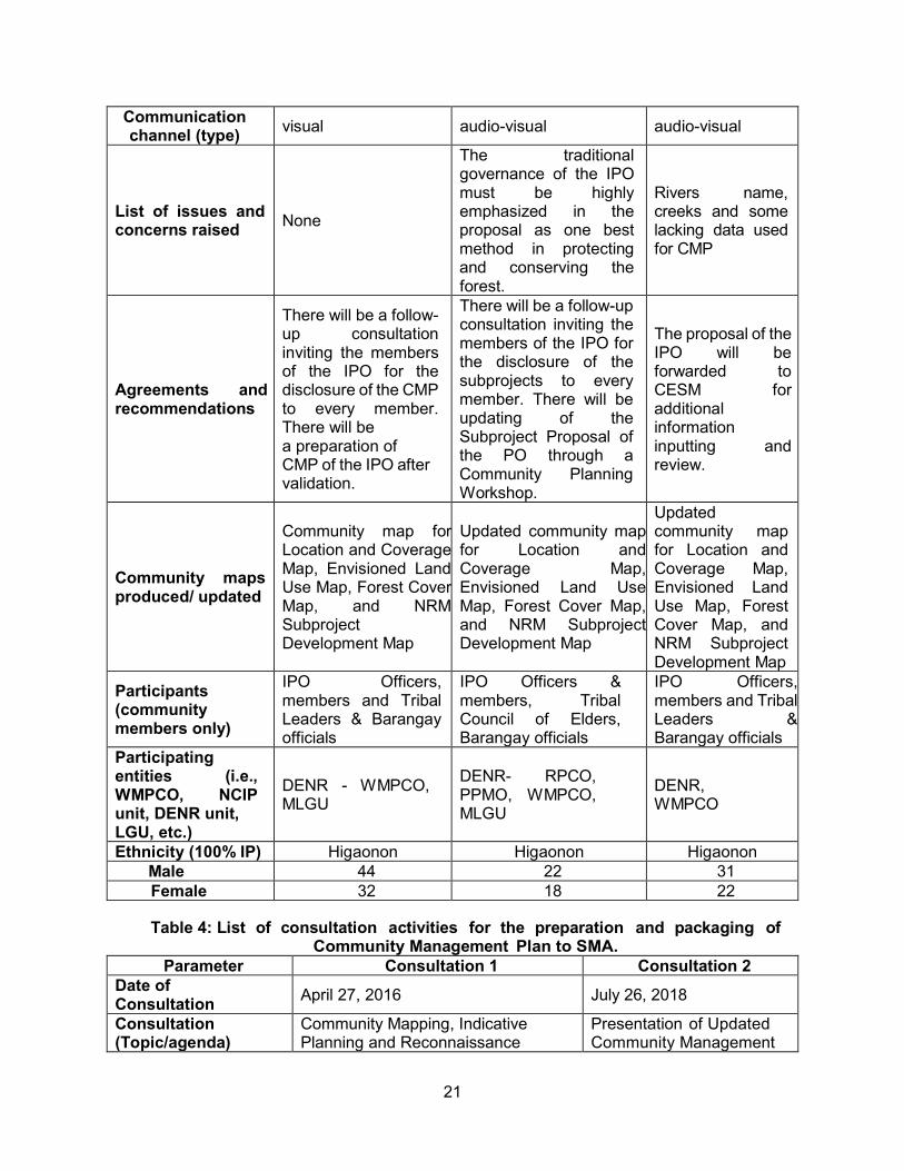
21
Communication channel (type) visual audio-visual audio-visual
List of issues and concerns raised None
The traditional governance of the IPO must be highly emphasized in the proposal as one best method in protecting and conserving the forest.
Rivers name, creeks and some lacking data used for CMP
Agreements and recommendations
There will be a follow-up consultation inviting the members of the IPO for the disclosure of the CMP to every member. There will be a preparation of CMP of the IPO after validation.
There will be a follow-up consultation inviting the members of the IPO for the disclosure of the subprojects to every member. There will be updating of the Subproject Proposal of the PO through a Community Planning Workshop.
The proposal of the IPO will be forwarded to CESM for additional information inputting and review.
Community maps produced/ updated
Community map for Location and Coverage Map, Envisioned Land Use Map, Forest Cover Map, and NRM Subproject Development Map
Updated community map for Location and Coverage Map, Envisioned Land Use Map, Forest Cover Map, and NRM Subproject Development Map
Updated community map for Location and Coverage Map, Envisioned Land Use Map, Forest Cover Map, and NRM Subproject Development Map
Participants (community members only)
IPO Officers, members and Tribal Leaders & Barangay officials
IPO Officers & members, Tribal Council of Elders, Barangay officials
IPO Officers, members and Tribal Leaders & Barangay officials
Participating entities (i.e., WMPCO, NCIP unit, DENR unit, LGU, etc.)
DENR - WMPCO, MLGU
DENR- RPCO, PPMO, WMPCO, MLGU
DENR, WMPCO
Ethnicity (100% IP) Higaonon Higaonon Higaonon Male 44 22 31 Female 32 18 22
Table 4: List of consultation activities for the preparation and packaging of
Community Management Plan to SMA. Parameter Consultation 1 Consultation 2
Date of Consultation April 27, 2016 July 26, 2018
Consultation (Topic/agenda)
Community Mapping, Indicative Planning and Reconnaissance
Presentation of Updated Community Management
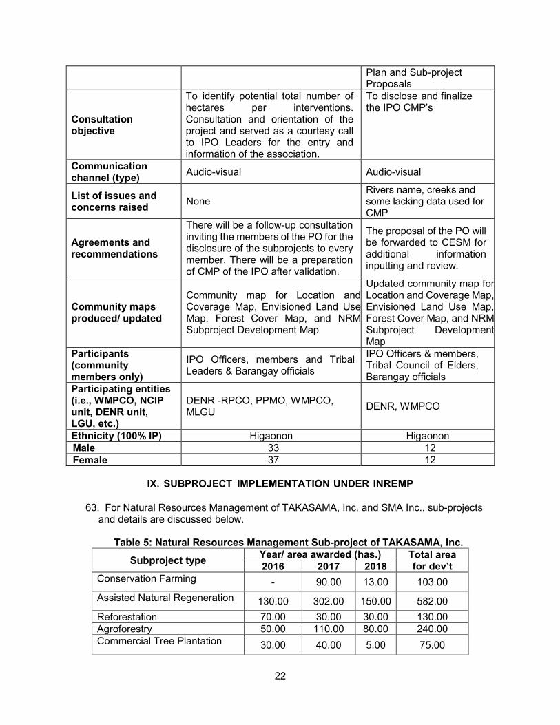
22
Plan and Sub-project Proposals
Consultation objective
To identify potential total number of hectares per interventions. Consultation and orientation of the project and served as a courtesy call to IPO Leaders for the entry and information of the association.
To disclose and finalize the IPO CMP’s
Communication channel (type) Audio-visual Audio-visual
List of issues and concerns raised None
Rivers name, creeks and some lacking data used for CMP
Agreements and recommendations
There will be a follow-up consultation inviting the members of the PO for the disclosure of the subprojects to every member. There will be a preparation of CMP of the IPO after validation.
The proposal of the PO will be forwarded to CESM for additional information inputting and review.
Community maps produced/ updated
Community map for Location and Coverage Map, Envisioned Land Use Map, Forest Cover Map, and NRM Subproject Development Map
Updated community map for Location and Coverage Map, Envisioned Land Use Map, Forest Cover Map, and NRM Subproject Development Map
Participants (community members only)
IPO Officers, members and Tribal Leaders & Barangay officials
IPO Officers & members, Tribal Council of Elders, Barangay officials
Participating entities (i.e., WMPCO, NCIP unit, DENR unit, LGU, etc.)
DENR -RPCO, PPMO, WMPCO, MLGU DENR, WMPCO
Ethnicity (100% IP) Higaonon Higaonon Male 33 12 Female 37 12
IX. SUBPROJECT IMPLEMENTATION UNDER INREMP
63. For Natural Resources Management of TAKASAMA, Inc. and SMA Inc., sub-projects
and details are discussed below.
Table 5: Natural Resources Management Sub-project of TAKASAMA, Inc. Subproject type Year/ area awarded (has.) Total area
for dev’t 2016 2017 2018 Conservation Farming - 90.00 13.00 103.00 Assisted Natural Regeneration 130.00 302.00 150.00 582.00 Reforestation 70.00 30.00 30.00 130.00 Agroforestry 50.00 110.00 80.00 240.00 Commercial Tree Plantation 30.00 40.00 5.00 75.00
23
TOTAL 280.00 572.00 278.00 1,130.00
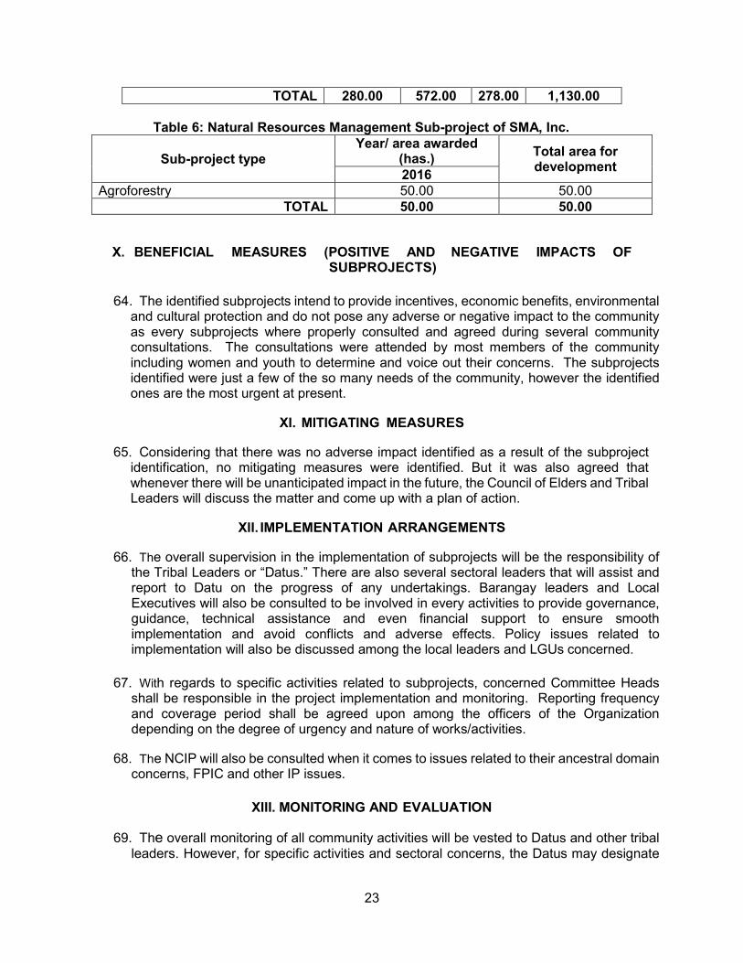
Table 6: Natural Resources Management Sub-project of SMA, Inc.
Sub-project type Year/ area awarded
(has.) Total area for development 2016
Agroforestry 50.00 50.00 TOTAL 50.00 50.00
X. BENEFICIAL MEASURES (POSITIVE AND NEGATIVE IMPACTS OF SUBPROJECTS)
64. The identified subprojects intend to provide incentives, economic benefits, environmental
and cultural protection and do not pose any adverse or negative impact to the community as every subprojects where properly consulted and agreed during several community consultations. The consultations were attended by most members of the community including women and youth to determine and voice out their concerns. The subprojects identified were just a few of the so many needs of the community, however the identified ones are the most urgent at present.
XI. MITIGATING MEASURES
65. Considering that there was no adverse impact identified as a result of the subproject identification, no mitigating measures were identified. But it was also agreed that whenever there will be unanticipated impact in the future, the Council of Elders and Tribal Leaders will discuss the matter and come up with a plan of action.
XII. IMPLEMENTATION ARRANGEMENTS
66. The overall supervision in the implementation of subprojects will be the responsibility of the Tribal Leaders or “Datus.” There are also several sectoral leaders that will assist and report to Datu on the progress of any undertakings. Barangay leaders and Local Executives will also be consulted to be involved in every activities to provide governance, guidance, technical assistance and even financial support to ensure smooth implementation and avoid conflicts and adverse effects. Policy issues related to implementation will also be discussed among the local leaders and LGUs concerned.
67. With regards to specific activities related to subprojects, concerned Committee Heads
shall be responsible in the project implementation and monitoring. Reporting frequency and coverage period shall be agreed upon among the officers of the Organization depending on the degree of urgency and nature of works/activities.
68. The NCIP will also be consulted when it comes to issues related to their ancestral domain
concerns, FPIC and other IP issues.
XIII. MONITORING AND EVALUATION
69. The overall monitoring of all community activities will be vested to Datus and other tribal leaders. However, for specific activities and sectoral concerns, the Datus may designate

24
or assign a particular person to be responsible and accountable. The frequency and nature of monitoring will be agreed upon prior to implementation to set the guidelines in the actual conduct of M&E. Project status and accomplishment reports submission are likewise will be agreed upon by responsible persons and officers of the community.
70. The LGU or its representatives shall be involved in the M&E to be aware of the current
progress in the area which will be useful in planning, budgeting and CLUP updating. 71. The DENR or its representatives shall be involved in the M&E to be aware of the current
progress in the area which will be useful in planning and preparation of their ADSPP. 72. The NCIP shall be likewise involved in the M&E to check and assess if there are
possible or potential IP issues and concerns related or emanating from project implementation.
Table 7: Monitoring and Evaluation Checklist of TAKASAMA, Inc.
Monitoring Indicator Status Issues & challenges
Budget and Timeframe a. Have the capacity building and
training activities been completed on schedule?
Capacity building and training conducted; IPO orientation & assessment, Participatory planning CMP & Subproject Proposal, Seedling Production & Plantation Establishment, Simple bookkeeping and etc.
Needs meaningful and continues consultation and facilitations to limited PO. Technical knowledge with limited INREMP personnel.
b. Are IPP and MOA activities being implemented and targets achieved against the agreed time frame?
Series of discussions and sessions were made, but the FMPA NRM was not implemented on time.
Schedule of fund releases was not followed.
c. Are funds for the implementation of the IPP/ADSDPP allocated to the proper agencies on time?
LGU, NCIP, DTI extended capacity buildings and technical knowledge to PO including simplified financial records.
d. Have agencies responsible for the implementation of the IPP/ADSDPP received the scheduled funds?
N/A
e. Have funds been disturbed according to the IPP/ADSDPP?
N/A
f. Has social preparation phase taken place as scheduled?
All the prior activities to social preparations were conducted before project implementation.
No problem encountered to PO, suggested additional personnel to stay with the community.
g. Have all clearance been obtained from the NCIP
The Community validation were conducted to Tribal
No Timeline or CP issuance to BURB.
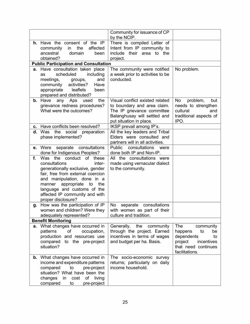
25
Community for issuance of CP by the NCIP.
h. Have the consent of the IP community in the affected ancestral domain been obtained?
There is compiled Letter of Intent from IP community to include their area to the project.
Public Participation and Consultation a. Have consultation taken place
as scheduled including meetings, groups, and community activities? Have appropriate leaflets been prepared and distributed?
The community were notified a week prior to activities to be conducted.
No problem.
b. Have any Aps used the grievance redness procedures? What were the outcomes?
Visual conflict existed related to boundary and area claim. The IP grievance committee Balanghusay will settled and put situation in place.
No problem, but needs to strengthen cultural and traditional aspects of IPO.
c. Have conflicts been resolved? IKSP prevail among IP’s. d. Was the social preparation
phase implemented? All the key leaders and Tribal Elders were consulted and partners will in all activities.
e. Were separate consultations done for Indigenous Peoples?
Public consultations were done both IP and Non-IP.
f. Was the conduct of these consultations inter-generationally exclusive, gender fair, free from external coercion and manipulation, done in a manner appropriate to the language and customs of the affected IP community and with proper disclosure?
All the consultations were made using vernacular dialect to the community.
g. How was the participation of IP women and children? Were they adequately represented?
No separate consultations with women as part of their culture and tradition.
Benefit Monitoring a. What changes have occurred in
patterns of occupation, production and resources use compared to the pre-project situation?
Generally, the community through the project. Earned incentives in terms of wages and budget per ha. Basis.
The community happens to be dependents to project incentives that need continues facilitations.
b. What changes have occurred in income and expenditure patterns compared to pre-project situation? What have been the changes in cost of living compared to pre-project
The socio-economic survey returns; particularly on daily income household.
26
situation? Have Aps’ income kept pace with these changes?
c. What changes have taken place in key social and cultural parameters relating to living standards?
Most of the existing small-scale business including farm were developed.
d. What changes have occurred for IPs?
The IP’s strengthen their political structure, capacitated IP governance with available community management plan of their area.
e. Has the situation of the IPs improved, or at least maintained, as a result of the project?
IPs alleviated their way of life in terms of new technology and practical knowledge and strengthen their cultural and traditional recognition.
f. Are IP women reaping the same benefits as IP men?
All the light labor activities and planning were involved by the IP women.
g. Are negative impacts proportionally shared by IP men and women?
N/A
Table 8: Monitoring and Evaluation Checklist of SMA, Inc.
Monitoring Indicator Status Issues & challenges
Budget and Timeframe a. Have the capacity building and
training activities been completed on schedule?
Forest Management Partnership Agreement approved but it was not implemented on-time.
Releases of funds based on schedule of payment was not realized
b. Are IPP and MOA activities being implemented and targets achieved against the agreed time frame?
N/A
c. Are funds for the implementation of the IPP/ADSDPP allocated to the proper agencies on time?
Prior activities to the project implementations were completely conducted.
The chairman and Treasurer were not staying in the area.
d. Have agencies responsible for the implementation of the IPP/ADSDPP received the scheduled funds?
N/A
e. Have funds been disturbed according to the IPP/ADSDPP?
N/A
f. Has social preparation phase taken place as scheduled?
It was conducted based on annual operation/target activities of the project.
g. Have all clearance been obtained from the NCIP
Validation activities were conducted spearheaded by NCIP.
The project CP was not obtained/on-going.
27
h. Have the consent of the IP community in the affected ancestral domain been obtained?
All the Letter of Intent of the IP community were compiled.
Public Participation and Consultation a. Have consultation taken place as
scheduled including meetings, groups, and community activities? Have appropriate leaflets been prepared and distributed?
Communication Letter were sent a week before the activity.
b. Have any Aps used the grievance redness procedures? What were the outcomes?
N/A
c. Have conflicts been resolved? N/A d. Was the social preparation phase
implemented? Prior activities conducted with the participations of NCIP and LGU’s.
e. Were separate consultations done for Indigenous Peoples?
Public Consultations were done both IPs and Non-IP’s.
f. Was the conduct of these consultations inter-generationally exclusive, gender fair, free from external coercion and manipulation, done in a manner appropriate to the language and customs of the affected IP community and with proper disclosure?
All the consultations planning were done using vernacular dialects to the community.
g. How was the participation of IP women and children? Were they adequately represented?
No separate consultations with women and children as part of their culture and tradition.
Benefit Monitoring a. What changes have occurred in
patterns of occupation, production and resources use compared to the pre-project situation?
Generally, the community earned direct incentives in terms of wages and budget per hectare.
The community needs to be guided not to rely on direct incentives from project.
b. What changes have occurred in income and expenditure patterns compared to pre-project situation? What have been the changes in cost of living compared to pre-project situation? Have Aps’ income kept pace with these changes?
Socio-Economic survey data’s; particularly on household income.
c. What changes have taken place in key social and cultural parameters relating to living standards?
Small scale business sustained and farm areas developed outside the committed areas.
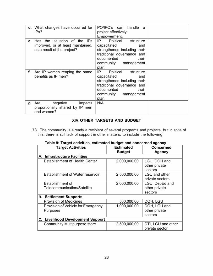
28
d. What changes have occurred for IPs?
PO/IPO’s can handle a project effectively. Empowerment.
e. Has the situation of the IPs improved, or at least maintained, as a result of the project?
IP Political structure capacitated and strengthened including their traditional governance and documented their community management plan.
f. Are IP women reaping the same benefits as IP men?
IP Political structure capacitated and strengthened including their traditional governance and documented their community management plan.
g. Are negative impacts proportionally shared by IP men and women?
N/A
XIV. OTHER TARGETS AND BUDGET
73. The community is already a recipient of several programs and projects, but in spite of this, there is still lack of support in other matters, to include the following:
Table 9: Target activities, estimated budget and concerned agency
Target Activities Estimated Budget
Concerned Agency
A. Infrastructure Facilities Establishment of Health Center 2,000,000.00 LGU, DOH and
other private sectors
Establishment of Water reservoir 2,500,000.00 LGU and other private sectors
Establishment of Telecommunication/Satellite
2,000,000.00 LGU, DepEd and other private sectors
B. Settlement Supports Provision of Medicines 500,000.00 DOH, LGU Provision of Vehicle for Emergency Purposes
1,000,000.00 DOH, LGU and other private sectors
C. Livelihood Development Support Community Multipurpose store 2,500,000.00 DTI, LGU and other
private sector
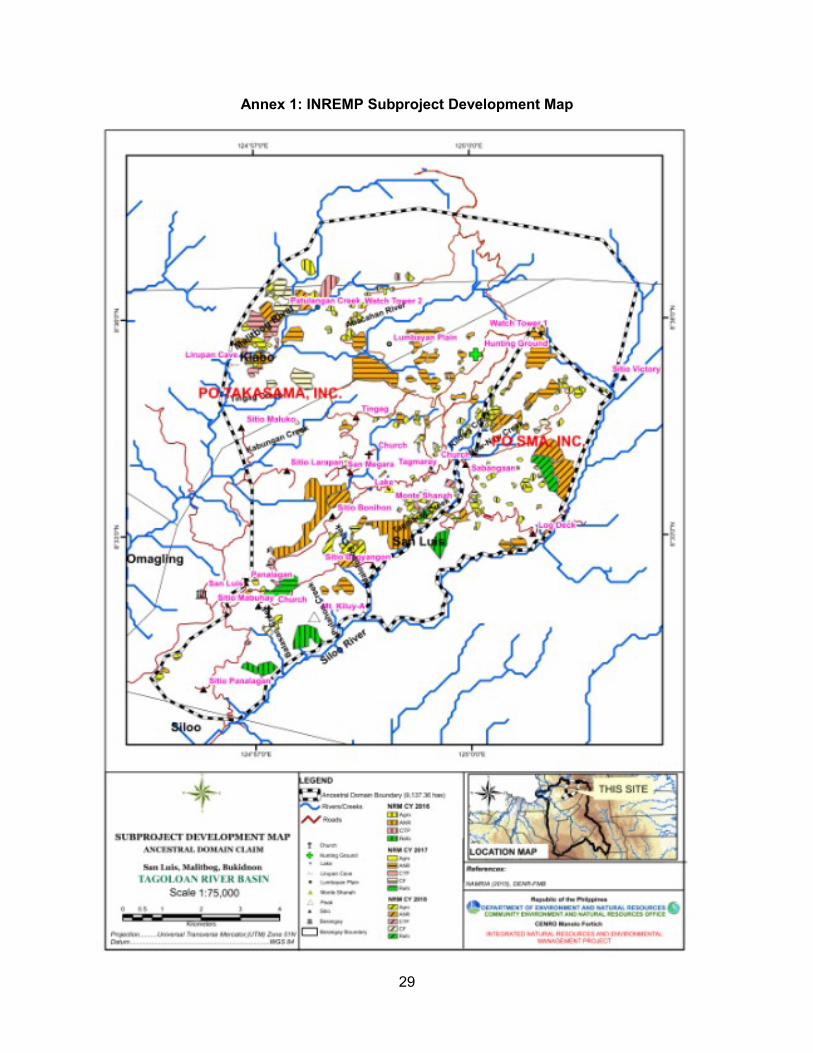
29
Annex 1: INREMP Subproject Development Map
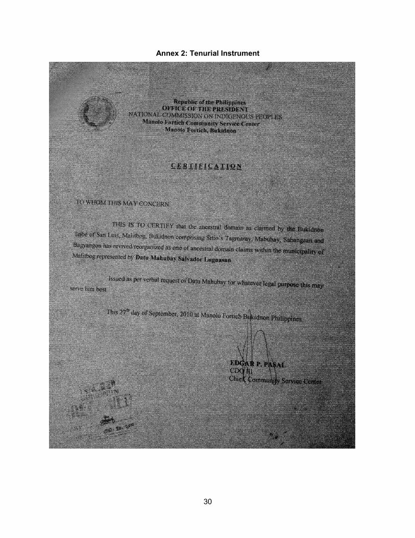
30
Annex 2: Tenurial Instrument

31
Annex 3: Security and Exchange Commission Registration of TAKASAMA, Inc.
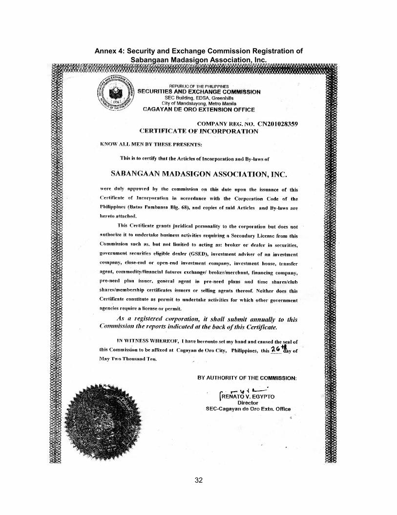
32
Annex 4: Security and Exchange Commission Registration of Sabangaan Madasigon Association, Inc.
33
Annex 5: List of IPO Officers and Members of TAKASAMA, Inc. OFFICERS MEMBERS

34
Annex 6: List of IPO Officers and Members of Sabangaan Madasigon Association, Inc.
OFFICERS and MEMBERS
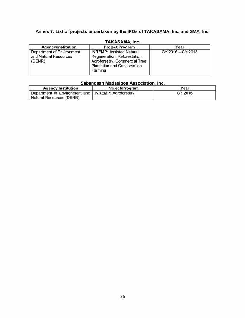
35
Annex 7: List of projects undertaken by the IPOs of TAKASAMA, Inc. and SMA, Inc.
TAKASAMA, Inc. Agency/Institution Project/Program Year
Department of Environment and Natural Resources (DENR)
INREMP: Assisted Natural Regeneration, Reforestation, Agroforestry, Commercial Tree Plantation and Conservation Farming
CY 2016 – CY 2018
Sabangaan Madasigon Association, Inc.
Agency/Institution Project/Program Year Department of Environment and Natural Resources (DENR)
INREMP: Agroforestry CY 2016

36
Annex 8: IPO Consultations
TAKASAMA, Inc (April 29, 2016, December 27-29, 2017 and March 15, 2018)
Sabangaan Madasigon Association, Inc.
(April 27, 2016 and July 26, 2018)