influence of academic abstract variables on geospatial...
TRANSCRIPT

41
Influence of Academic Variables on Geospatial Skills of Undergraduate Students: An Exploratory Study
Kanika VermaDepartment of GeographyTexas State UniversitySan Marcos, TX 78666E-mail: [email protected]
The Geographical Bulletin 56: 41-55©2015 by Gamma Theta Upsilon
ABSTRACT
Spatial thinking and learning are essential components of geography education . The National Research Council’s 2006 report “Learning to Think Spatially” emphasized that people vary with respect to performance on spatial tasks . This pilot study at a large Texas university investigated geospatial thinking variances among undergraduate students based on academic experience of students . This exploratory study uses the Geospatial Thinking Survey (GTS), based on the Spatial Thinking Ability Test (STAT) endorsed by Association of American Geographers (2006) and published by Lee and Bednarz (2012), to assess the geospatial thinking differences of undergraduate students . The results show that academic major, academic classification, and exposure to academic geography influ-ence comprehension of geospatial concepts, use of geospatial representation tools, and application of geospatial reasoning processes .
Key Words: geospatial thinking, geogra-phy, academic major, academic classification
INTRODUCTION
A groundbreaking National Research Council publication, Learning to Think Spatially, offered a new approach to spatial thinking (NRC 2006) . The report defined spatial thinking as a constructive combina-tion of concepts of space, tools of representa-tion, and processes of reasoning, using space to structure problems, find answers, and express solutions . Spatial thinking is a cogni-tive ability to visualize and interpret location, position, distance, direction, relationships, movement, and change over space, in differ-ent situations and at different scales (Sinton et al . 2013) . Geospatial knowledge helps us to make sense of chaotic and diversified envi-ronments (Golledge 2002) . Geospatial think-ing is important for significant everyday life exercises such as remembering a specific map, route planning, following directions to a lo-

42
Kanika Verma
cation, calculating distances and directions, determining spatial patterns among different features on land, visualizing 3-D topography from an alternative perspective, or choosing the best location based on given geographi-cal criteria . The basic building block for spatial thinking is space, and the operations that humans can perform in space form its foundation . Geospatial thinking, focusing on the geography of human life spaces (spatial thinking at the level of Earth), is a subset of spatial thinking in general (Golledge, Marsh, and Battersby 2008b) . Geospatial thinking is using Earth space or geographic space at different scales to frame problems, identify answers, and provide solutions employing geospatial concepts, representation tools, and reasoning processes .
The NRC argued that spatial thinking is universal, malleable, powerful, and pervasive in academic disciplines, the workplace, and everyday problem solving . Spatial thinking is a powerful problem-solving tool (NRC 2006) . Geospatial thinking and reasoning are important because they are fundamental to many aspects of everyday life, to understand-ing the relations between different people and between people and environments, and to understanding differences in various cultures and regions of the world (Golledge, Marsh, and Battersby 2008b) . Spatial and geospatial thinking also improve overall aca-demic performance and increase student par-ticipation in mathematics and science careers (Newcombe 2010; Uttal et al . 2013) . Spatial and geospatial training prepares students for many careers, including logistics, trans-portation, real estate, agriculture, natural resources, and military operations . Ignoring spatial and geospatial thinking education di-rectly implies neglecting one of the key ways with which human brain comprehends and organizes information (Gersmehl 2012) . The NRC (2006) identified its predominant goal as training students to adopt and practice spatial thinking habitually .
The NRC report highlighted that spatial thinking can and should be taught at all levels in the educational system because of its im-
portance in research, academics, workplace, and everyday life situations (NRC 2006) . Reports have claimed that spatial and geospa-tial thinking can be inculcated by education, training, and practice, such as lessons in ge-ography (Liben 2006; NRC 2006) . Scholars have emphasized that geography as a subject relies on spatial concepts as its foundation and thus provides exceptional spatial and geospatial training to students . However, many other disciplines such as physics, art, dance, mathematics, and computer science also focus on spatial concepts . It is impor-tant to confirm with empirical research, and not just theoretical claims, that geography is actually better than other disciplines in improving spatial and geospatial thinking of students . Curriculum and teaching modules should then be designed specifically to im-prove geospatial thinking of students coming from different backgrounds . Liben (2006) and Newcombe (2010) observed that people vary with respect to performance on spatial thinking tasks . Addressing the issue of group differences in geospatial thinking will assist in outlining different learning paths and ways for different groups of students (Anthamat-ten 2010; Gersmehl 2012), such as those belonging to different ethnic groups with varying levels of geospatial thinking .
PURPOSE
Significant differences occur among people as to how, how quickly, and how well they understand and do something . Like differ-ent levels of performance exist in spatial thinking as a function of age, sex, and expe-rience (NRC 2006), students from various academic majors and classifications (year in college) may also demonstrate differences in approaching and assimilating spatial think-ing . “These variations might reflect different progress rates through developmental spatial achievements, different developmental end points, differential access to non-spatial component skills that are needed for spatial processing (e .g . working memory), or dif-ferential success in activating competencies

43
Influence of Academic Variables on Geospatial Skills of Undergraduate Students: An Exploratory Study
in a given test environment (e .g . as a conse-quence of test anxiety)” (Liben 2006, 208) . Investigating the nature of group differences, based on variables such as academic major, academic classification, or academic experi-ence in geography, can lead to a better un-derstanding of the comprehension and use of spatial thinking . Classroom tools, curricula, and assessments could be designed on the ba-sis of any such explored differences to instill geospatial thinking in students (Anthamatten 2010; Gersmehl 2012) .
Scholars in geography and other disciplines have researched extensively about sex and age differences in spatial thinking . Few studies have addressed the issue from a perspective of academic majors, academic classifications, and background in geography of university undergraduates to discern differences in geo-spatial thinking .
The purpose of this study is to investigate group differences in geospatial thinking of undergraduate students at a large Texas university . The primary research question is: Do academic major, academic classification, school geography academic experience, and/or college geography academic experience influence the geospatial thinking of under-graduate students? I examine whether there is a statistically significant difference in geo-spatial thinking ability among students with different academic majors, at different stages in their academic career, and with differing degrees of exposure to academic geography .
LITERATURE REVIEW
Scholars in geography and other disci-plines have studied group differences in spatial thinking but have mostly focused on sex, age, and K-12 school grade-level (Allen 1974; Gilmartin and Patton 1984; Cochran and Wheatley 1988; Lawton 1994; Voyer, Voyer, and Bryden 1995; Henrie et al . 1997; Albert and Golledge 1999; LeVasseur 1999; Montello et al . 1999; Hardwick et al . 2000; Lee 2005; Levine et al . 2005; Battersby, Golledge, and Marsh 2006; Marsh, Golledge and Battersby 2007; Golledge, Marsh, and
Battersby 2008a; Huynh and Sharpe 2009, 2013; Lee and Bednarz 2012) . Other vari-ables, such as academic major, academic classification, and academic background in geography, should also be investigated as well for differences regarding geospatial thinking abilities . Investigating such group differences is important for effective interventions, for example, in the form of properly tailored map and GIS exercises in geography class-rooms . Students in several academic majors and workplaces may have to deal with spatial and geospatial thinking but they may not be equally competent if their geospatial thinking skills are at a lower level than students from other academic majors . This research will highlight students from what academic ma-jors have better geospatial thinking and thus those disciplines may well become vehicles for improving students’ spatial and geospatial thinking skills .
Research on sex differences in spatial abili-ties has been ongoing since 1970s, especially in the field of psychology . Research about geospatial thinking is relatively new in such fields as geography . Although geographers and other scholars have examined many dif-ferent facets of geospatial thinking, including the effects of sex/gender, and age and grade level (progression from novice to expert in school), not a great deal of literature exists for group differences in geospatial thinking based on culture, disability, socioeconomic status, academic major, academic classifica-tion, geography academic experience, ethnic-ity, language, or urban/ rural background .
Researchers such as LeVasseur (1999), Hardwick et al . (2000), and Lee (2005) found no significant sex differences in a va-riety of spatial and geospatial tasks in their research studies . Studies undertaken by Allen (1974), Henrie et al . (1997), Cherry (1991), Cochran and Wheatley (1988), Lawton (1994), and Montello et al . (1999) detected significant sex differences on vari-ous spatial tests with males performing better than females . Gilmartin and Patton (1984) and Franeck et al . (1993) found significant sex differences in younger age groups such

44
as junior high (males outperformed females) but no sex differences in college students on various map use experiments . Voyer, Voyer, and Bryden (1995) found sex differences in-crease significantly with age on six distinct spatial tests . Levine et al . (2005) identified significant sex differences in middle and high socioeconomic groups (boys outperformed girls), but no differences in low socioeco-nomic group on certain spatial tasks . Sev-eral scholars such as Henrie et al . (1997), Newcombe and Huttenlocher (1996), Bat-tersby, Golledge, and Marsh (2006), Marsh, Golledge, and Battersby (2007), Golledge, Marsh, and Battersby (2008), Lee and Bed-narz (2012), and Huynh and Sharpe (2009, 2012) discovered that students’ spatial and geospatial knowledge (for example map us-age and spatial and geospatial vocabulary and concept usage) improves with age and increasing school years .
Hardwick et al . (2000) investigated gen-der differences influencing performance on a standardized test of geography knowledge of 109 undergraduate students in an intro-ductory physical geography course and 85 students in a world geography class . Students majoring in geography did better on the test than did those having other academic majors across all gender categories . Lee and Bednarz (2012) administered the Spatial Thinking Ability Test (STAT) to a sample of 532 junior-high, high school, and university students . The scholars concluded that two universities with more geography majors scored higher than two universities with fewer geography majors .
METHODS
Few standardized tests of spatial think-ing exist (NRC 2006; Huynh and Sharpe 2009, 2013) . I therefore drew geospatial questions from the Spatial Thinking Ability Test (STAT) that Lee (2005) developed and employed . This test has been endorsed by the Association of American Geographers (AAG 2006), and used by researchers such as Lee and Bednarz (2009; 2012) . I undertook an
exploratory study in a large Texas university to gather data to evaluate geospatial think-ing of undergraduate students using what I term the Geospatial Thinking Survey (GTS) . Figures 1-6 in the appendix show example questions from the GTS .
The GTS included demographic and aca-demic questions, collecting data on sex, age, ethnicity, highest educational attainment of parents, annual income of parents, state of high school graduation, academic major, academic classification, number of geography courses taken in high school and college level, and urban/rural background .
Following the demographic and academic questions, the GTS had twelve geospatial thinking questions, which were closed mul-tiple choice questions, encompassing con-cepts about route finding; graph and map usage; 2-d and 3-d terrain models; spatial correlation; geographic information pre-sented as points, lines, and areas; and map overlay . Using a map, the final question asked students to engage in site analysis based on given geographical criteria .
In the fall 2012 semester, I introduced my study to undergraduate students in five general education geography courses to try to obtain as many non-Geography majors in the survey as possible . The students used the URL provided to them to complete the GTS via Survey Monkey . Participation was voluntary and anonymous . Seventy-seven students completed the GTS online . The Institutional Review Board (IRB) approved the GTS as a non-invasive and anonymous instrument for administration to university undergraduate students .
To establish the internal consistency of the GTS, I calculated the Cronbach’s Alpha statistic that measures the intercorrelation of items or the extent to which item responses obtained at the same time correlate with each other (Lee and Bednarz 2012) . The Cron-bach’s Alpha for the GTS was 0 .679, which signifies a low level of internal consistency in social science research . However, the results of the pilot study indicated that if one particular question (3-d terrain question) were removed
Kanika Verma

45
from the GTS, the Cronbach’s Alpha would increase to 0 .708, a value indicating an ac-ceptable level of internal consistency among the items (Lee and Bednarz 2012) . Out of a total of 77 students in the pilot study, only 20 answered the 3-d terrain question correctly . I, therefore, deleted this question from the GTS for analyses .
The dependent variable in my study was geospatial thinking, measured by the score on the GTS . The independent variables were academic major, academic classification and number of college geography courses . To ana-lyze group differences in geospatial thinking for the three independent variables, I used one-way Analysis of Variance (ANOVA) tests to compare means on a quantitative Y outcome variable (GTS score in this case) across two or more categorical groups of X predictor variables (Park 2009) . I carried out three series of ANOVAs incorporating the four predictor variables: academic major, aca-demic classification, number of high school geography courses, and number of college geography courses . For each of these variables in different runs, the ANOVA test compared the means of various categorical groups (e .g . freshman, sophomore, junior, and senior for academic classification) .
ANALYSIS AND DISCUSSION
Table 1 shows the distribution of respon-
dents for academic classification . I deleted the one graduate student because this study focuses on undergraduate students . The ANOVA (sig . value 0 .033) revealed that a sta-tistically significant difference exists among the four academic classifications . The mean score of the senior (fourth-year) students was the highest (8 .82), while that of the freshmen (first year) was the lowest (6 .11) (Table 2) . Academic classification therefore influences geospatial thinking of the students . This re-sult supports the findings of other researchers (Henrie et al . 1997; Battersby, Golledge, and Marsh 2006; Newcombe and Huttenlocher 2006; Marsh, Golledge, and Battersby 2007; Golledge, Marsh, and Battersby 2008a; Lee and Bednarz 2012; and Huynh and Sharpe 2009, 2013) in underscoring that geospatial knowledge and understanding improves as education level progresses .
Table 3 displays the responses for the academic major variable . Because few re-spondents were from social science, natural science, humanities, business, engineering, and teacher certification categories, I com-bined respondents in these academic major categories with the “other” category for the ANOVA analysis . The three groups then be-came: 26 geography students, 18 education, and 33 other . The ANOVA found a statisti-cally significant difference among the three academic major groups (sig . value 0 .001) . The mean score of geography students (8 .88)
Influence of Academic Variables on Geospatial Skills of Undergraduate Students: An Exploratory Study
Table 1 . Distribution of respondents accord-ing to academic classification .Academic Classification
# of Students % of Students
Freshman (First Year) 9 11.69
Sophomore (Second Year) 22 18.57
Junior (Third Year) 28 36.36
Senior (Fourth Year) 17 22.08
Graduate 1 1.3Total 77 100
Table 2 . Group means for academic clas-sification .Academic Classification
Total Possible Score
Highest Score
Lowest Score
Mean
Freshman (First Year) 11 10 0 6.11
Sophomore (Second Year)
11 11 2 7.68
Junior (Third Year) 11 11 3 8.00
Senior (Fourth Year) 11 11 4 8.82

46
was the highest of the three groups (Table 4) . In this pilot study, geography majors show significantly better performance than non-geography majors . In my small sample drawn from one university, science majors tended to score better than education and business majors . This finding confirms the inferences drawn by Hardwick et al . (2000) and Lee and Bednarz (2012) about geography exerting a positive influence on the geospatial thinking of students . Geography students have better spatial and geospatial thinking than other students . This is because geographic thinking and reasoning revolves around such spatial concepts as scale transformation, spatial as-sociation, distance and direction changes, and location identification (Golledge 2002; Cutter, Golledge, and Graf 2002) . My study empirically supports the theoretical asser-tions of such scholars as Blaut (1991), Downs (1994), Uttal (2000), Golledge (2002), and Liben (2006) that geography education is the most important vehicle in instilling spatial
and geospatial thinking skills in students . A large-scale study with a bigger sample size will be necessary to determine the signifi-cance of this finding .
Table 5 displays the number of college ge-ography courses the respondents had taken . The ANOVA (sig . value 0 .017) found a statistically significant difference among the groups of geography academic experi-ence at the college level . The mean score of the students who had taken three-five col-lege geography courses (8 .76) and students who had taken more than five geography courses at the college level (8 .73) differed from students who had taken fewer than three college geography courses (Table 6) . The number of college geography courses taken influences students’ geospatial think-ing . This implies that with higher number of geography courses, students develop expertise in geographical thinking and thus their spa-tial and geospatial thinking skills improve . Higher number of geography classes provides sophisticated spatial understanding, thereby supporting Liben’s (2006) assertion that ge-ography courses have the potential to serve as an intervention in improving geospatial thinking .
Battersby, Golledge, and Marsh (2006) reasoned that, because geography relies on many aspects of spatial thinking, reason-ing, and visualization, lessons in the subject should bring about improvements in geo-spatial thinking skills . The findings of this study strongly suggest that to ensure students
Kanika Verma
Table 3 . Initial distribution of respondents according to academic major .Academic Major
# of Students % of Students
Geography 26 33.77Social Science 3 3.9Natural Science 0 0
Humanities 4 5.19Education 18 23.38Business 3 3.9Engineering 1 1.3Teacher Certification 2 2.6
Other 20 25.97Total 77 100
Table 4 . Group means for academic major .Academic Major
Total Possible
Highest Score
Lowest Score
Mean
Geography 11 11 5 8.88Education 11 9 0 6.22Other 11 11 2 7.82
Table 5 . Distribution of respondents accord-ing to number of college geography courses .# of College Geography Courses
# of Students % of Students
Never had a geography course
6 7.79
1-2 39 50.653-5 21 27.27>5 11 14.29Total 77 100

47
are capable of competing globally in various employment areas (e .g . logistics, transporta-tion, image analysis, GIS, civil engineering, real estate, site analysis, military operations) that require solid geospatial thinking skills, geography must be integrated into funda-mental aspects of K-16 education . Students from other majors, such as nursing, educa-tion, criminal justice, and business, may be confronted with spatial and geospatial think-ing in their work, but they will not be equally competent . Even if a student does not want a career in geography, taking college geography courses is important to prepare students for many other careers that require spatial and geospatial thinking skills .
CONCLUSIONS
An exploratory study with a small sample from one university cannot provide clear re-sults as to which variables significantly influ-ence geospatial thinking of students, although the study serves to guide further research . For example, the findings of this present study must be strengthened and confirmed by con-ducting research with a larger sample size, en-compassing a larger geographical area, includ-ing more variables, and assessing the effect of different variables in combination along with considering them discretely . Geospatial think-ing of American students may be compared with students in other countries for assessing cultural differences at an international scale . Understanding group differences in geospatial thinking will assist in detailing varying learn-ing strategies .
Understanding differences in spatial and geospatial thinking competencies among various groups of students are important con-siderations in geography education research . The findings of this exploratory study sup-port earlier research showing increased spatial and geospatial thinking with increasing years of experience in school and in life in general, and also reinforce the potential of geography learning to improve geospatial thinking of students . Geography students scored higher on the GTS than non-geography majors . Moreover, students who studied more geog-raphy courses performed better on the GTS than students who studied few geography courses . This study underscored the impor-tance of geography education in improving students’ spatial and geospatial thinking . It highlighted that non-geography major students should also take a few geography courses in college so that they will be com-petent both in school and in the workplace with higher geospatial thinking .
REFERENCES
Albert, W . S ., and R . Golledge . 1999 . The Use of Spatial Cognitive Abilities in Geographi-cal Information Systems: The Map Overlay Operation . Transactions in GIS 3 (1): 7-21 .
Allen, M . J . 1974 . Sex Differences in Spatial Problem-solving Styles . Perceptual and Mo-tor Skills, 39: 843–846 .
Anthamatten, P . 2010 . Spatial Thinking Concepts in Early Grade-level Geography Standards . Journal of Geography, 109(5): 169–180 .
Ardila, A . and Moreno, S . 2001 . Neuropsycho-logical Evaluation in Aruaco Indians: An Ex-ploratory Study . Journal of the International Neuropsychological Society, 7: 510–515 .
Association of American Geographers . 2006 . Spatial Thinking Ability Test . [http://home .ewha .ac .kr/~ziriboy/STAT .pdf ] . Last ac-cessed 25 February 2013 .
Baenninger, M . and Newcombe, N . 1989 . The Role of Experience in Spatial Test Performance: A Meta-analysis . Sex Roles, 20: 327–344 .
Influence of Academic Variables on Geospatial Skills of Undergraduate Students: An Exploratory Study
Table 6 . Group means for college geography courses .# of College Geography Courses
Total Possible
Highest Score
Lowest Score
Mean
None 11 10 7 8.171-2 11 11 0 73-5 11 11 3 8.76>5 11 11 7 8.73

48
Battersby, S ., Golledge, R ., and Marsh, M . 2006 . Incidental Learning of Geospatial Concepts across Grade Levels: Map Over-lay . Journal of Geography, 105(4): 139–146 .
Blaut, J . M . 1991 . Natural mapping . Transac-tions of the Institute of British Geographers 16 (1): 55-74 .
Bodzin, A . M . 2011 . The Implementation of a Geospatial Information Technology (GIT)-supported Land Use Change Cur-riculum with Urban Middle School Learn-ers to Promote Spatial Thinking . Journal of Research in Science Teaching, 48(3): 281–300 .
Butt, G . 2001 . Closing the Gender Gap in Geography . Teaching Geography, 26(3): 145–147 .
Carole, M . S . and Golledge, R .G . 1994 . Sex-related Differences in Spatial Ability: What Every Geography Educator Should Know . Journal of Geography, 93(5): 234–242 .
Cherry, S . F . 1991 . Action Research: Factors Influencing Recognition of Geographical Lo-cations on a World Map . ERIC Document Reproduction Service No . ED 343 825 .
Cochran, K . F . and Wheatley, G . H . 1988 . Ability and Sex-related Differences in Cog-nitive Strategies on Spatial Tasks . Journal of General Psychology, 116: 43–55 .
Cutter, S . L ., Golledge, R ., and Graf, W . L . 2002 . The Big Questions in Geogra-phy . The Professional Geographer, 54(3): 305–317 .
Downs, R . 1994 . The Need for Research in Geography Education: It Would be Nice to Have Some Data . Journal of Geography 93 (1): 57-60 .
Franeck, M . A ., Nelson, B . D ., Aron, R . H ., and Bisard, W . J . 1993 . The Persistence of Selected Geographic Misconceptions: A Study of Junior High through Un-dergraduate College Students . Journal of Geography, 93(6): 247–253 .
Geospatial Thinking Survey . 2013 . [https://www .surveymonkey .com/s/QSSQPB3] . Last accessed 25 August 2013 .
Gersmehl, P . J . 2012 . The Spatial Brain and the Common Core . Paper presented at the annual meeting of the National Council
for Geographic Education, San Marcos, TX . October 5 .
Gersmehl, P . J . and Gersmehl, C . A . 2007 . Spatial Thinking by Young Children: Neu-rologic Evidence for Early Development and “Educability” . Journal of Geography, 106(5): 181–191 .
Gilmartin, P ., and Patton, J . C . 1984 . Comparing the Sexes on Spatial Abilities: Map Use Skills . Annals of the Association of American Geographers, 74(4): 605–619 .
Golledge, R . G . 2002 . The Nature of Geo-graphic Knowledge . Annals of the Associa-tion of American Geographers, 92(1): 1–14 .
Golledge, R ., Marsh, M ., and Battersby, S . 2008 . A Conceptual Framework for Facilitating Geospatial Thinking . Annals of the Association of American Geographers, 98(2): 285–308 .
_______ . 2008 . Matching Geospatial Con-cepts with Geographic Educational Needs . Geographical Research, 46(1): 85–98 .
Hardwick, S . W ., Bean, L . L ., Alexander, K . A ., and Shelley, F . M . 2000 . Gender vs . Sex Differences: Factors Affecting Perfor-mance in Geographic Education . Journal of Geography, 99(6): 238–244 .
Henrie, R . L ., Aron, R . H ., Nelson, B . D ., and Poole, D . A . 1997 . Gender-related Knowledge Variations within Geography . Sex Roles, 36(9/10): 605–623 .
Huynh, N . T . and Sharpe, B . 2009 . The Role of Geospatial Reasoning in Effective GIS Problem Solving: K-16 Education Levels . Geomatica, 63(2): 119–128 .
_______ . 2013 . An Assessment Instrument to Measure Geospatial Thinking Expertise . Journal of Geography, 112(1): 3–17 .
Lawton, C . A . 1994 . Gender Differences in Way-finding Strategies: Relationship to Spatial Ability and Spatial Anxiety . Sex Roles, 30(11/12): 765–779 .
Lee, J . W . 2005 . Effect of GIS Learning on Spatial Ability . PhD diss ., Texas A&M University .
Lee, J . and Bednarz, R . 2009 . Effect of GIS Learning on Spatial Thinking . Journal of Ge-ography in Higher Education, 33(2): 183–198 .
_______ . 2012 . Components of spatial thinking: Evidence from a Spatial Think-
Kanika Verma

49
ing Ability Test . Journal of Geography, 111 (1): 15–26 .
LeVasseur, M . L . 1999 . Students’ Knowledge of Geography and Geographic Careers . Journal of Geography, 98(6): 265–271 .
Levine, S . C ., Vasilyeva, M ., Lourenco, S . F ., Newcombe, N . S ., and Huttenlocher, J . 2005 . Socioeconomic Status Modifies the Sex Difference in Spatial Skill . Psychological Science, 16(11): 841–845 .
Liben, L . S . 2006 . Education for Spatial Thinking . In: Renninger, K . A . et al . (ed .) Handbook of Child Psychology, Volume Four, Child Psychology in Practice. New York: John Wiley, pp . 197–247 .
Marsh, M ., Golledge, R ., and Battersby, S . E . 2007 . Geospatial Concept Understanding and Recognition in G6–college Students: A Preliminary Argument for Minimal GIS . Annals of the Association of American Geog-raphers, 97(4): 696–712 .
Montello, D . R ., Lovelace, K . L ., Golledge, R . G ., and Self, C . M . 1999 . Sex-related Differences and Similarities in Geographic and Environmental Spatial Abilities . An-nals of the Association of American Geogra-phers, 89(3): 515–534 .
Mulenga, K ., Ahonen, T ., and Aro, M . 2001 . Performance of Zambian Children on the NEPSY: A Pilot Study . Developmental Neuropsychology, 20: 375–384 .
National Research Council . 2006 . Learning to Think Spatially: GIS as a Support System in the K-12 Curriculum . Washington, D . C .: National Academies Press . [http://www .nap .edu/catalog .php?record_id=11019] . Last accessed 30 January 2013 .
Newcombe, N . S . 2010 . Picture This: In-creasing Math and Science Learning by Improving Spatial Thinking . American Educator, 34(2): 29–43 .
Newcombe, N . S . and Huttenlocher, J . 2006 . Development of Spatial Cognition . In: Renninger, K . A . et al . (ed .) Handbook of Child Psychology, Volume Four, Child Psy-chology in Practice. New York: John Wiley, pp . 734–776 .
Park, H . M . 2009 . Comparing Group Means: T-tests and One-way ANOVA Using STATA,
SAS, R, and SPSS . [http://www .indiana .edu/~statmath/stat/all/ttest] Last accessed 4 June 2013 .
Rosselli, M . and Ardila, A . 2003 . The Impact of Culture and Education on Non-verbal Neuropsychological Measurements: A Critical Review . Brain and Cognition, 52: 326–333 .
Self, C . M . and Golledge, R . G . 1994 . Sex-related Differences in Spatial Ability: What Every Geography Educator Should Know . Journal of Geography, 93(5): 234–242 .
Sinton, D . S ., S . Bednarz, P . Gersmehl, R . Kolvoord, and D . Uttal . 2013 . The People’s Guide to Spatial Thinking . Washington, D . C .: National Council for Geographic Education .
Smith, J . 2007 . Developing a Spatial Think-ing Skills Taxonomy: Are There Important Lessons to Learn from Bloom? Research in Geographic Education, 9(2): 35–40 .
Spence, I ., Yu, J . J ., Feng, J ., and Marshman, J . 2009 . Women Match Men when Learn-ing a Spatial Skill . Journal of Experimental Psychology: Learning, Memory and Cogni-tion, 35(4): 1097–1103 .
Uttal, D . H . 2000 . Seeing the Big Picture: Map Use and the Development of Spatial Cognition . Developmental Science 3 (3): 247-86 .
Uttal, D . H ., N . G . Meadow, E . Tipton, L . L . Hand, A . R . Alden, C . Warren, and N . Newcombe . 2013 . The Malleability of Spatial Skills: A Meta-analysis of Training Studies . Psychological Bulletin 139 (2): 352-402 .
Voyer, D ., Voyer, S ., and Bryden, P . M . 1995 . Magnitude of Sex Differences in Spatial Abilities: A Meta-analysis and Consider-ation of Critical Variables . Psychological Bulletin, 117(2): 250–270 .
Influence of Academic Variables on Geospatial Skills of Undergraduate Students: An Exploratory Study

50
Kanika Verma
1 . The map below shows average annual precipitation of Texas . If you draw a graph showing change of Texas annual precipitation between A and B, The graph will best match which curve?
o Ao Bo Co Do E
Figure 1 . Selected Questions from Geospatial Thinking Survey (GTS): Question 1 focusing on Geospatial Pattern and Transition (Access all questions at https://sites .google .com/site/geospatial2013gts/home/geospatial-thinking-survey)
APPENDIX

51
Influence of Academic Variables on Geospatial Skills of Undergraduate Students: An Exploratory Study
Figure 2 . Selected Questions from Geospatial Thinking Survey (GTS): Question 2 focusing on Map Navigation, Way-finding, Route Planning, and comprehending Orientation and Direction (Access all questions at https://sites .google .com/site/geospatial2013gts/home/geospatial-thinking-survey)
2 . Please answer this question on the basis of the street map below . If you are located at point 1 and travel north one block, then turn east and travel three blocks, and then turn south and travel two blocks, you will be closest to which point?
o 2o 3o 4o 5o 6

52
Kanika Verma
Figure 3 . Selected Questions from Geospatial Thinking Survey (GTS): Question 3 focusing on Geospatial Profile and Transition (Access all questions at https://sites .google .com/site/geospatial2013gts/home/geospatial-thinking-survey)
3 . Imagine you are standing at location X and looking in the direction of A and B . Among five slope profiles (A – E), which profile most closely represents what you would see?
o Ao Bo Co Do E

53
Influence of Academic Variables on Geospatial Skills of Undergraduate Students: An Exploratory Study
Figure 4 . Selected Questions from Geospatial Thinking Survey (GTS): Question 4 focusing on Geospatial Association and Correlation (Access all questions at https://sites .google .com/site/geospatial2013gts/home/geospatial-thinking-survey)
4 . Find a map (A – F) having a strong positive correlation (association or showing similar pattern) with the top map on the right . Choose the closest one .
o Ao Bo Co Do Eo F
54
Kanika Verma
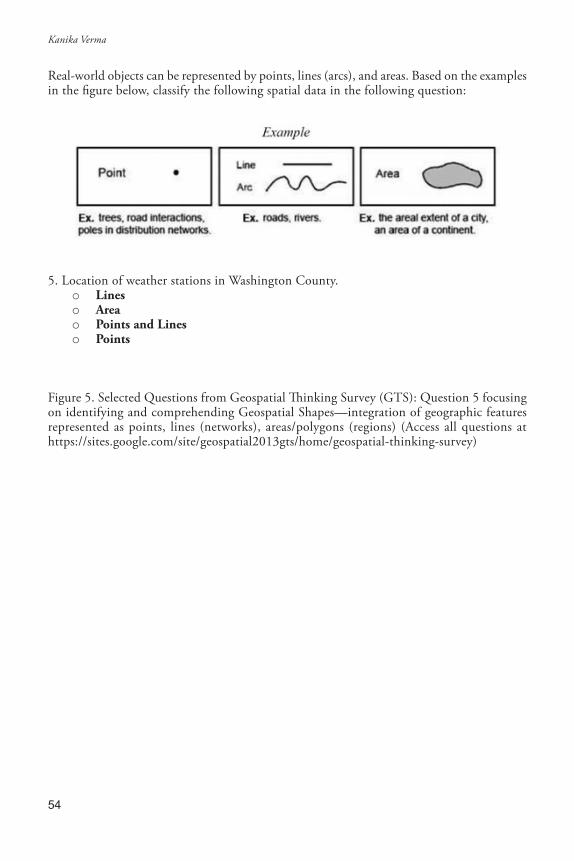
Figure 5 . Selected Questions from Geospatial Thinking Survey (GTS): Question 5 focusing on identifying and comprehending Geospatial Shapes—integration of geographic features represented as points, lines (networks), areas/polygons (regions) (Access all questions at https://sites .google .com/site/geospatial2013gts/home/geospatial-thinking-survey)
Real-world objects can be represented by points, lines (arcs), and areas . Based on the examples in the figure below, classify the following spatial data in the following question:
5 . Location of weather stations in Washington County .o Lineso Areao Points and Lineso Points

55
Influence of Academic Variables on Geospatial Skills of Undergraduate Students: An Exploratory Study
Figure 6 . Selected Questions from Geospatial Thinking Survey (GTS): Question 6 focusing on Geospatial Overlay—comprehending overlaying, aggregating, and dissolving map layers to choose the best location based on various spatial/geographical conditions, connections, distance; inferring a geospatial aura (influence) (Access all questions at https://sites .google .com/site/geospatial2013gts/home/geospatial-thinking-survey)
6 . Find the best location for a flood management facility based on the following conditions .First, a possible site for a flood management facility should be within 60 feet of an existing
electric line .Second, a possible site for a flood management facility should be located less than 220
feet in elevation .And last, a possible site for a flood management facility should be located in state park
or public land .Choose the best site (A E) for the flood management facility on the potential facility
location map .o Ao Bo Co Do E

56