information guidelines for proponents preparing … · web viewinformation guidelines for...
TRANSCRIPT
Information guidelines for proponents preparing coal seam gas and large coal mining development proposals
May 2018
This initiative is funded by the Australian Government
www.iesc.environment.gov.au

© Commonwealth of Australia, 2018.
Information guidelines for proponents preparing coal seam gas and large coal mining development proposals is licensed by the Commonwealth of Australia for use under a Creative Commons Attribution 4.0 International licence with the exception of the Coat of Arms of the Commonwealth of Australia, the logo of the agency responsible for publishing the report, content supplied by third parties, and any images depicting people. For licence conditions see: http://creativecommons.org/licenses/by/4.0/
This report should be attributed as ‘Information guidelines for proponents preparing coal seam gas and large coal mining development proposals, Commonwealth of Australia 2018’.
The Commonwealth of Australia has made all reasonable efforts to identify content supplied by third parties using the following format ‘© Copyright, [name of third party] ’.
ImagesFront and back covers: Warburton Creek | Location: Lake Eyre Basin | © Paul Wainwright and Department of the Environment and Energy
2

Background
The role of the IESC
The Independent Expert Scientific Committee on Coal Seam Gas and Large Coal Mining Development (the IESC) is a statutory body under the Environment Protection and Biodiversity Conservation Act 1999 (Cth) (EPBC Act).
The IESC’s key legislative functions are to:
provide scientific advice to the Commonwealth Environment Minister and relevant state ministers on coal seam gas (CSG) and large coal mining development proposals that are likely to have a significant impact on water resources
provide scientific advice to the Commonwealth Environment Minister on bioregional assessments (CoA 2015a) of areas of CSG and large coal mining development
provide scientific advice to the Commonwealth Environment Minister on research priorities and projects
collect, analyse, interpret and publish scientific information about the impacts of CSG and large coal mining activities on water resources, and
provide scientific advice on other matters in response to a request from the Commonwealth or relevant state ministers.
Further information on the IESC’s role is on the IESC website (CoA 2015b).
Purpose of the Information Guidelines
The Information Guidelines outline what types of information a proposal for a CSG or large coal mining project should include. This information is needed to enable the IESC to provide robust scientific advice to government regulators on the potential water-related impacts of such proposals.
The guidelines were first published in February 2013. The guidelines were reviewed and amended in April 2014, June 2015 and May 2018, to update reference material, cover developments in leading practice and knowledge, take account of the IESC’s recent experience and incorporate comments from users.
Explanatory notes
For some topics, explanatory notes have been written to supplement the IESC Information Guidelines, giving more detailed guidance to help the coal seam gas and large coal mining industry prepare environmental impact assessments. These topics are chosen based on the Committee’s experience of providing advice on over 100 development proposals.
Explanatory notes are intended to assist proponents in preparing environmental impact assessments. They provide tailored guidance and describe up-to-date robust scientific methodologies and tools for specific components of environmental impact assessments on large coal mining and coal seam gas mining developments. Case studies and practical examples of how to present certain information are also discussed.
Explanatory notes provide guidance rather than mandatory requirements and proponents are encouraged to refer to issues of relevance to their particular project.
The IESC recognises that approaches, methods, tools and software will continue to develop. The Information Guidelines and explanatory notes will be reviewed and updated as necessary to reflect these advances.
The nature of advice from the IESC
The IESC provides scientific advice to Australian government regulators on CSG and large coal mining development proposals. The IESC does not make regulatory decisions. Advice is provided in response to a request from a government regulator. The advice and considerations provided by the IESC are designed to support regulators in considering leading-practice science in their decision-making.
3
The Commonwealth and declared state regulators (in accordance with section 505E of the EPBC Act) seek advice from the IESC at appropriate stages in the assessment and approvals process as required in the relevant protocols. More information on protocols can be found at:
Commonwealth: http://iesc.environment.gov.au/committee-advice
New South Wales: http://www.planning.nsw.gov.au/Policy-and-Legislation/Mining-and-Resources/Gateway-Assessment-and-Site-Verification
Queensland:www.ehp.qld.gov.au/management/impact-assessment/national-partnership-agreement.html
Victoria: http://www.dtpli.vic.gov.au/planning/environmental-assessment
South Australia: https://www.waterconnect.sa.gov.au/Industry-and-Mining/CSG-Coal-Mining/SitePages/Home.aspx
In accordance with section 505D of the EPBC Act, the IESC is required to:
provide advice to the regulator within two months of receiving a request, and
publish the advice no more than ten days after it is provided to the regulator.
Regulators can request advice on a project multiple times during the assessment process. The statutory timeframe for the IESC to provide advice (two months) applies. The Chair may agree to expedite supplementary advice in exceptional circumstances.
The IESC’s advice focuses on potential impacts (direct, indirect and cumulative) of CSG and large coal mining proposals on all aspects of water resources. This includes water quantity, water quality, ecosystems and ecological processes that contribute to the state and value of the water resource and water-dependent assets (CoA 2007).
In providing advice, the IESC will consider whether a proponent’s environmental assessment documentation has:
used suitable data and information to identify and characterise all relevant water resources and water-related assets
applied appropriate methods and interpreted model outputs in a logical and reasonable way to investigate the risks to those assets from the project through processes of water movement in the region
considered potential cumulative impacts from past, present and reasonably foreseeable actions
considered mitigation strategies to avoid or reduce the impact to water resources
proposed effective monitoring and management to detect and ameliorate the risk of impact, and to assess the effectiveness of proposed mitigation strategies, and
addressed the inevitable uncertainties in predictions of impacts on water resources and water-related assets.
The advice of the IESC can include but is not limited to an assessment of:
the likely risk to water resources and water-related assets
the adequacy of water and salt balances, local and regional scale groundwater and surface water models, and any implications for water quality
whether the information used and methods applied were leading practice at the time, and whether the assessment of risk and uncertainty is appropriate
critical data and information gaps that need to be addressed to complete an adequate assessment
the cumulative water-related impact of the proposal in the context of past, present, and reasonably foreseeable actions, and
the adequacy of proposed environmental objectives and management measures for mitigating risks, including for legacy issues such as rehabilitation, restoration, closure, final voids and brine management.
4
Information to provide in the proposal
General requirements
The proposal should present sufficient evidence for independent verification of:
the processes of cause and effect between the project and water resources, and
the magnitude of the impacts on water resources.
Enough information should be provided to allow an independent reviewer such as the IESC to consider the appropriateness of the underlying assumptions and conceptual models on which numerical models are based.
An independent reader of the environmental assessment documents should be able to verify all significant conclusions made by the proponent.
Specific requirements
The available information will vary for individual proposals depending on the point in the regulatory assessment process at which the proposal is referred. Whether the project is a new development (greenfield) or an expansion of an existing operation (brownfield) will also affect the type and amount of information provided to the IESC.
The documentation provided to the IESC must include the most comprehensive information possible, based on and including all the available data. For example this could include historical water quality data to demonstrate compliance with existing conditions, bore logs to support geological conceptualisations, or the results of pump tests to support model parameterisation. This is particularly relevant for existing mines undergoing modification/extension or in regions where there is a lot of historical data.
Early in the assessment process (e.g. for Gateway projects in New South Wales), preliminary conceptual and numerical or analytical models should consider all available data and be used to identify further data that may needed. Conceptual models should identify water resources and water-dependent assets in the project area and surrounding areas, including their significance under state and Commonwealth legislation, and identify any potential impacts to water-dependent assets.
At the assessment stage, there is expected to be a clear and evidence-based determination of potential significant impacts to water resources and water-dependent assets, supported by detailed modelling. Modelling should include detailed conceptual and numerical models at spatial and temporal scales suitable to represent physical, chemical and ecological processes associated with each identified water resource or water-dependent asset. The information provided should include a comprehensive assessment of the risks to water resources and water-dependent assets from the proposed project at all phases (construction, operation and post-closure), and details of proposed mitigation measures to manage these risks.
Proposals for expanding or modifying existing mining operations should outline historical and existing operations, current water-related environmental approval conditions and associated approved monitoring and management plans. They should:
clearly identify any impacts to water resources and water-dependent assets from existing operations and from the proposed expansion or modification
use current and historical monitoring data to support assertions about impacts
use existing project data to verify model predictions, and
outline how existing data have been used to assess the potential impacts of the proposed project.
It is expected that all the required information will be provided by proponents in their project assessment documentation. This information may be augmented by further information required or generated by the relevant regulator.
The text below provides general guidance on IESC information needs. A checklist of specific information requirements is at Appendix A. The checklist will assist proponents and regulators to ensure that requests for advice to the IESC are
5
supported by appropriate information. Explanatory notes will be developed progressively to provide further guidance to proponents on the information needs of the IESC. These can be found on the IESC website (CoA 2015b).
1. Description of the proposed project
The proposal should provide a regional overview of the project area including a description of the geological basin, coal resource, surface water catchments, groundwater systems, water-dependent assets, and current and reasonably foreseeable coal mining, CSG developments and other water-intensive activities, including irrigation. This should include any relevant information generated by a bioregional assessment. Where a bioregional assessment has not been initiated and/or completed, the best available information should be used in describing the existing location and condition of water resources and water-dependent assets in the region.
The description of the proposed project should clearly describe the location, purpose, scale, duration, disturbance area, and the means by which it is likely to have a significant impact on water resources and water-dependent assets. For proposals such as mine extensions that will use existing approved infrastructure, the proposal should clearly identify which components are new.
A description of the statutory context, including information on the proposal’s status within the regulatory assessment process, and any applicable water management policies or regulations, including state or Commonwealth regulation of potentially impacted water resources, should also be provided.
2. Risk Assessment
Environmental assessments provide information on environmental risks and how these may be mitigated. Any modelling and technical work should be directed towards assessing and mitigating risks that arise from potential impacts, reducing uncertainty, and communicating this (see Middlemis and Peeters [2018]). The level of analysis of any management objective should be commensurate with the level of risk, as determined by considering the probability and potential consequences of the risk, and the value and condition of the asset.
The risk assessment process should be commenced at an early stage of the proposed project as the progressive results provide important inputs to other stages of the environmental assessment process. Risk assessment should be an iterative process based around causal pathways with progressive results used to continually refine conceptual models, and plans for mitigation, management and monitoring. As the process progresses, effort is expected to focus on those assets at greatest risk.
The proponent will need to determine the scope, likelihood and consequences of all potential impacts. This could include assessment of the risk from drilling and fracturing chemicals, from beneficial reuse of discharges, and from waste (e.g. brines).
The potential cumulative impact of all past, present and reasonably foreseeable actions that are likely to impact on water resources and water-dependent assets should be considered.
The IESC will consider whether the proponent has demonstrated that the risks can be either avoided or suitably mitigated and may suggest further actions to mitigate or manage residual risks.
The IESC will review and evaluate the proponent’s assessment of risk in conjunction with information provided by the relevant regulators in their request for advice. The IESC will consider a proponent’s risk assessment and other assessment documentation in the context of Commonwealth and state water resource plans and schemes (e.g. the Murray-Darling Basin Scheme, Hunter River Salinity Trading Scheme) where these are applicable to the proposed development.
Available bioregional assessments will assist with risk analyses by identifying possible risks and consequences of impacts to water resources and water-dependent assets from CSG and large coal mining development proposals within specific bioregions. The bioregional assessments used a modification of the failure modes and effects analysis (FMEA) method (Ford et al. 2016). This may be an appropriate approach for proponents to use. Where the proposed development occurs within an area with a bioregional assessment, the IESC will consider the bioregional assessment in its review of the proponent’s risk assessment.
6
3. Description of impacts to water resources and water-dependent assets
For all relevant water resources and water-dependent assets the proposal should:
provide descriptions of existing conditions, values and sensitivity to potential impacts (see Doody et al. 2019 in relation to GDEs)
provide conceptual and/or numerical modelling of potential impacts, and
propose mitigation and management measures.
For each causal pathway the impact to the water resource, the resultant impact to any water-dependent assets, and the consequence or significance of the impact, should be clearly articulated.
Impacts on water-dependent assets should be compared with project-specific environmental objectives and the legislated environment values and water quality objectives for surface waters and groundwaters under relevant state environmental legislation.
For brownfield projects, the impacts on water resources and water-dependent assets from the existing project should be described separately from the potential impacts of the project expansion. The potential cumulative impacts of the project in its entirety should also be described.
3.1 Conceptual models
Conceptual models are pictorial or descriptive hydrological, hydrogeological and ecological representations of the project site showing the stores, flows and uses of water, including use of water by ecosystems. Robust hydrological conceptualisations provide the scientific basis for developing analytical and numerical models and site water and salt balances. Conceptual models are also useful in the problem formulation stage of ecological risk assessment to show stressors, sources, exposure pathways and the possibility of multiple cause-effect pathways (see Doody et al. 2019). They also help identify the areas of scientific uncertainty in the risk assessment.
Conceptual models must be based on leading practice and consider relevant field data and investigations, expert advice, scientific literature, and other appropriate information sources. Conceptual models should identify the geological formations, water resources, and water-dependent assets likely to be impacted by the proposed project, and consider how relevant geological features (e.g. faults etc.) could respond to or affect potential causal pathways. They should be developed at appropriate scales which enable clear description of important causal pathways, how these would be influenced by the proposal, and the expected responses in water resources and water-dependent assets.
In some cases, it may be necessary to develop conceptual models for different components of the designated region or several models depicting different spatial and/or temporal scales. The level of detail within a conceptual model should be based on the environmental objectives; risk assessment outcomes; data availability; and knowledge of the water resources, water-dependent assets and processes in the region.
Further information regarding conceptual modelling, including issues of scale and uncertainty, can be found in Modelling water-related ecological responses to coal seam gas extraction and coal mining (CoA 2015c). Relevant research commissioned using the advice of the IESC can also be accessed from the IESC website (CoA 2015b) and may be helpful in the formation and evaluation of project hydrological conceptualisations.
3.2 Analytical and numerical modelling
Numerical models can predict potential impacts on water resources and water-dependent assets from a proposed project and support the exploration of management approaches to mitigate impacts. It is recognised that for projects presented to the IESC early in the assessment process (e.g. Gateway projects in New South Wales), the data needed for detailed modelling may not yet be available.
Models should be developed at an appropriate spatial (local vs regional) and temporal (life-of-project or longer if impacts are predicted) scale to fulfil a specific purpose such as understanding potential impacts to a particular water resource or water-dependent asset. This purpose should inform the model design (e.g. consider the level of model complexity required to achieve the model purpose) and assumptions, which should be clearly described and justified
7
in the project assessment documentation (Middlemis and Peeters 2018). The model(s) should be constructed in accordance with the conceptual model(s), and calibrated and verified with appropriate baseline data (Middlemis and Peeters 2018; Barnett et al. 2012).
Results from modelling should show the range and likelihood of possible outcomes, based on sensitivity and uncertainty analysis. These predictions should be sufficiently robust to support risk analysis and regulatory decision-making. Further discussion of sensitivity and uncertainty analysis in relation to groundwater modelling and the IESC information needs is provided in Middlemis and Peeters 2018.
A detailed description of any methods and evidence (e.g. monitoring data from past and present mining at the site, expert opinion and analogue sites) used in addition to or instead of modelling, should also be provided. Sufficient detail to justify the use of these methods and to provide evidence to support conclusions is needed.
Impact analysis should be based on modelling results, including uncertainty analysis (or other methods, where appropriate), and should clearly articulate the potential causal pathways. The proposal should describe a clear ‘line of sight’ between each potential impact and its cause, so that monitoring and management strategies can be targeted and justified. Details of the proposed monitoring and management plans should be clearly linked to the impact analysis.
3.3 Water and salt balances
The proposal should provide site-specific water and salt balances, for both pre- and post-development scenarios under a range of potential climatic conditions (guided by, for example the Australian Climate Futures Tool (CSIRO 2015)). These should show an understanding of the surface water and groundwater inputs, outputs and diversions in the region.
The water and salt balances should use consistent water metrics and definitions and be accompanied by relevant contextual information and statements of accuracy (see the Water Accounting Framework for the Minerals Industry, (Minerals Council of Australia 2014) and Coal seam gas extraction: modelling groundwater impacts, (CoA 2014a)). The assessment documentation should provide a Water Accounting Framework for the Minerals Industry – input-output statement for each site, including the accuracy table (which provides information on the accuracy of the data and whether the data used were measured, estimated or simulated).
Information is needed about the set of water and salt stores for the site and the movement of water and salt between stores, tasks (e.g. coal handling and processing, dust suppression, underground mining), and treatment plants within the site. This should include:
estimates of water use in transpiration by vegetation, including seasonal and interannual variations
predicted changes to vegetation water use as a result of the project, and
assessment of the potential impact of any changes to any store or flow of water and mass or concentration of salt, including long-term storage, arising from the proposed project on water-dependent assets.
Estimates of the quality and quantity of external water supply and operational discharges under dry, median and wet conditions, and the likely impacts on water-dependent assets should be provided. Volumes and quality of operational discharges, as well as beneficial uses, should be described and predicted over the project life.
For greenfield coal seam gas projects there is a large degree of uncertainty around produced water volumes and salt loads. Despite this, estimates of water and salt volumes are required, and the uncertainty associated with these estimates, should be quantified and communicated in the assessment documentation. Proposed management options for produced salt and brines should consider the uncertainty in these estimates and the potential for, and nature of, possible contaminants in the salt and brines. Management options for salt and brines should be considered with regard to their appropriateness over all time scales from short to long term and after project closure.
4. Baseline Data
Baseline data provide the foundation for developing environmental objectives and outcomes. Baseline measurements are also required to measure changes to water resources and water-dependent assets as a result of the proposed project.
8
Baseline data are needed for all water resources, including contextual information such as dates and locations of measurements, sampling protocols, flow conditions and elevations of the reference points from which water levels were measured.
Baseline monitoring data for physico-chemical parameters, and contaminants (e.g. metals) in surface and groundwaters, should be included. Physico-chemical results should be compared to national/regional guidelines or to site-specific guidelines derived from reference condition monitoring if available. Baseline contaminant concentrations should be compared to national guidelines, allowing for local background correction if required.
To inform ecological risk assessment baseline ecological data should be sufficient to identify all surface water-dependent and groundwater-dependent assets and the current condition of, value of and stressors on these assets to inform ecological risk assessment (see Doody et al. 2019). Results of habitat, fauna (including stygofauna) and flora surveys should be included.
Adequate ecological and hydrological (for quick response systems) baseline data would generally be for a period in excess of two years, at a frequency sufficient to capture likely variability in the system and taking into account seasonal variability. Relevant information generated by a bioregional assessment should be included where applicable.
Key areas of uncertainty identified in conceptual models should be evaluated (e.g. with uncertainty analysis and targeted field programs) to inform the risk assessment. Common uncertainty factors in CSG and coal mining developments are:
connectivity between geological formations and key water-dependent assets
sources of water sustaining GDEs, and
the hydraulic properties of faults and aquitards.
These can be evaluated using a range of approaches, including coring programs, downhole logging, geophysical measurements and environmental tracers.
5. Monitoring and Management
Proposed management and mitigation measures should be detailed, and references provided to previous projects, case studies and scientific literature that support the adequacy of the measure in the project context. The monitoring plan should detail how the performance of the proposed mitigation measures will be assessed. It should also outline contingency plans if the environmental objectives are not met. If offsets are proposed, the potential management options that were considered and investigated prior to proposing offsets should be described.
Plans for ongoing monitoring and management are expected where significant impacts to water resources and water-dependent assets are predicted. These plans should focus on a robust monitoring program to inform the management and mitigation of likely impacts and to reduce the uncertainty of predicted impacts.
The monitoring program should include groundwater, surface water and associated water quality and ecological attributes and be capable of tracking changes from pre-development conditions. There is usually a need for concurrent baseline monitoring from unimpacted control and reference sites to distinguish project-induced impacts from background variation (e.g. induced by other water users and climatic variability) in the region. This can be done using a before-after-control-impact (BACI) model designs (see Downes et al. (2002).
The rationale and design for the monitoring program should be provided, including appropriate quality assurance. These should include the questions to be answered by the monitoring program, the temporal and spatial frequency (or resolution) of monitoring, the potential parameters and indicators to be monitored, and the analytical methods to be applied.
The monitoring program should identify the thresholds associated with environmental objectives and outcomes and the proposed management measures if those guideline values are exceeded. Guideline values should be based on leading-practice science. Any departures from published guidelines or standard monitoring methods should be justified based on site-specific data.
Information is needed on findings from the monitoring program, including monitoring data, data analysis outputs and approaches, quality assurance and quality control measures implemented and the performance of mitigation
9
measures against the environmental objectives. The monitoring and management program should be robust and provide for an adaptive management approach to predicted impacts to water resources and water-dependent assets.
The proposal should specify how the strategies described in the management program address long-term risks, including those persisting after rehabilitation and relinquishment of the site.
6. Cumulative impacts
An assessment of cumulative impacts is needed to determine the risks posed by the proposed project within the region. Local-scale cumulative impact assessments should be undertaken by the proponent. These would ideally be informed by regional assessments such as strategic assessments, Cumulative Management Area models and bioregional assessments.
The assessment of cumulative impacts needs to consider all relevant past, present and reasonably foreseeable actions, including impacts from water-intensive activities other than mining and CSG, and programs and policies that are likely to impact water resources. Even if impacts from a new project are small, when these are considered with the impacts from existing developments a threshold of acceptable total impact may be crossed. This is why water resources are formally managed with total diversion limits that cannot be exceeded, even by a small amount.
The scale of a cumulative impact assessment needs to cover spatial and temporal boundaries large enough to include all potential significant impacts on water resources from the proposed project, when considered with other activities within the region (CoA 2013). For example when predicted impacts from the proposed development (e.g. groundwater drawdown) overlap with those from another operation, that operation will need to be included in the cumulative impact assessment.
A quantitative assessment of cumulative impacts is preferred. However, a qualitative or semi-quantitative approach may be used if data are lacking (e.g. if data for other operations are not publically available and cannot be estimated). Assessments may also require consideration of interactive or synergistic impacts in addition to a summation of individual proposals or impacts, and their changing impacts over time.
There may be a need to further develop groundwater and surface water models to enable the prediction of cumulative impacts.
GlossaryFor the purpose of the Information Guidelines:
Analytical models make simplifying assumptions (for example, properties of the aquifer are considered to be constant in space and time) to enable an exact mathematical solution of a given problem.
Assessment documentation is all documentation required by the relevant regulator to fulfil the requirements of the environmental assessment process at the relevant stage for the proposed project.
BACI design refers to impact assessment using the before-after-control-impact model. At a minimum, a BACI design requires data from two sites: a control site and an impact site. Data are collected from both sites a number of times before and after the impact occurs.
Baseline data, also called pre-operational data, are collected before a development begins to establish conditions against which impacts can be identified when developments commence.
Bioregional assessments are a scientific analysis of the ecology, hydrology, geology and hydrogeology of a bioregion, with explicit assessment of the potential direct, indirect and cumulative impacts of CSG and coal mining development on water resources. The central purpose of bioregional assessments is to inform the understanding of impacts on and risks to water-dependent assets that arise in response to current and future pathways of CSG and large coal mining development.
Coal seam gas development is defined under the EPBC Act as any activity involving CSG extraction that has, or is likely to have, a significant impact on water resources (including any impacts of associated salt production and/or salinity), either in its own right or when considered with other developments, whether past, present or reasonably foreseeable.
10
Conceptual models are descriptive and/or schematic hydrological, hydrogeological and ecological representations of site showing the stores, flows and uses of water, which illustrate the geological formations, water resources and water-dependent assets. They provide the basis for developing water and salt balances and inferring water-related ecological responses to changes in hydrology, hydrogeology and water quality.
Cumulative impact is defined as the total impact of a CSG and/or large coal mining development on water resources when all past, present and reasonably foreseeable actions that are likely to impact on water resources are considered.
Ecological processes are part of the components that contribute to the physical state and environmental value of a water resource and can include processes such as nutrient cycling, eutrophication and carbon metabolism.
Environmental objectives for each water resource or water-dependent asset are the desired goals that, if met, will indicate that the proposal is not expected to have an unacceptable impact on the environment.
Environmental outcomes are statements of an acceptable level of impact to a water resource or water-dependent asset that must not be exceeded, or a level of protection that must be achieved. The outcomes will be aligned with an environmental objective and must be quantitatively measureable and achievable.
Environmental tracers are naturally occurring or artificially constructed compounds dissolved in water (or some property of the water molecule) that can be used to identify the source of groundwater, its ‘age’ or residence time in an aquifer, and preferred groundwater discharge location. The stable isotopes of the water molecule, tritium, carbon-14 and helium-4 are examples of common tracers used in environmental impact assessment.
Groundwater-dependent ecosystems (GDEs) are ecosystems that require access to groundwater on a permanent or intermittent basis to meet all or some of their water requirements so as to maintain their communities of plants and animals, ecological processes and ecosystem services. GDEs include terrestrial vegetation, wetlands (swamps, lakes and rivers) and ecosystems in aquifers and caves.
Guidelines with reference to water quality are a numerical concentration limit or narrative statement recommended to support and maintain a designated water use (ANZECC/ARMCANZ 2000).
Large coal mining development is defined under the EPBC Act as any coal mining activity that has, or is likely to have, a significant impact on water resources (including any impacts of associated salt production and/or salinity), either in its own right or when considered with other developments, whether past, present or reasonably foreseeable.
Numerical models divide space and/or time into discrete pieces. They are similar to analytical models as they make simplifying assumptions. However, features of the governing equations and boundary conditions (for example, aquifer geometry, hydrogeological properties, pumping rates or sources of solute) can be specified as varying over space and time. This enables more complex, and potentially more realistic, representation of a groundwater or surface water system than could be achieved with an analytical model.
Significant impact is defined by the Significant Impact Guidelines (CoA 2013) as an impact which is important, notable or of consequence, having regard to its context or intensity. Whether or not an action is likely to have a significant impact depends upon the sensitivity, value and quality of the water resource which is impacted, and upon the intensity, duration, magnitude and geographic extent of the impacts.
Water balance is a mathematical expression of water flows and exchanges, described as inputs, outputs and changes in storage. Surface water, groundwater and atmospheric components should be included.
Water-dependent assets are entities with characteristics having value and which can be linked directly or indirectly to a dependency on water quantity or quality (amended from Barrett et al. 2013). Examples may include habitat for threatened species and water access rights. Value may include water-dependent ecosystems, drinking water, public health, recreation and amenity, Indigenous and cultural values, fisheries, tourism, navigation, agriculture and industry values.
Water-dependent ecosystems are defined by the Water Act 2007 (Cth) as surface water ecosystems or groundwater ecosystems, and their natural components and processes, that depend on periodic or sustained inundation, waterlogging or significant inputs of water for their ecological integrity and includes ecosystems associated with a wetland, stream, lake or waterbody, salt marsh, estuary, karst system or groundwater system. A reference to a water-dependent ecosystem includes the biodiversity of the ecosystem.
Water resources are defined by the Water Act 2007 (Cth) as:
11
surface water or groundwater or a watercourse, lake, wetland or aquifer (whether or not it currently has water in it); and includes all aspects of the water resource, including water, organisms and other components and ecosystems that contribute to the physical state and environmental value of the water resource.
Broadly, a water resource encompasses the water body itself and all aspects that contribute to its physical state and environmental value, such as the associated water quality, organisms, ecological processes and ecosystems.
Checklist of specific information needsThe following checklist provides specific guidance on IESC information needs. This checklist reflects the approach taken by the IESC when assessing project documentation.
The checklist does not stand alone. It should be considered in addition to the general guidance provided in the main body of the Information Guidelines and any Explanatory Notes available on the IESC website.
A project may not need to address all items included in the checklist. For example a coal mining proposal will not need to address the parts of the checklist related to CSG well construction and operation while a CSG proposal will not need to address the final voids and landforms section. Proponents should provide justification and any supporting data and information if not addressing any sections of the checklist.
The IESC recognises that at the early assessment stage – for example, Gateway projects in New South Wales – project documentation may not contain enough data to allow a robust environmental impact assessment. In cases like this where data and analyses are lacking, it is essential to present a sound conceptualisation of the system, with explicit explanations of underlying assumptions. The proposal must also provide plans to improve the understanding of the system over time, including details of when and how data to support assumptions will be gathered.
Description of the proposal
Provide a regional overview of the proposed project area including a description of the geological basin; coal resource; surface water catchments; groundwater systems; water-dependent assets; and past, present and reasonably foreseeable coal mining and CSG developments.
Describe the proposal’s location, purpose, scale, duration, disturbance area, and the means by which it is likely to have a significant impact on water resources and water-dependent assets.
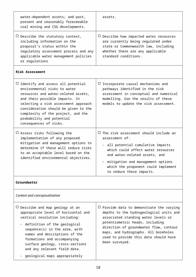
Describe the statutory context, including information on the proposal’s status within the regulatory assessment process and any applicable water management policies or regulations
Describe how impacted water resources are currently being regulated under state or Commonwealth law, including whether there are any applicable standard conditions.
Risk Assessment
Identify and assess all potential environmental risks to water resources and water-related assets, and their possible impacts. In selecting a risk assessment approach consideration should be given to the complexity of the project, and the probability and potential consequences of risks.
Incorporate causal mechanisms and pathways identified in the risk assessment in conceptual and numerical modelling. Use the results of these models to update the risk assessment.
Assess risks following the implementation of any proposed mitigation and management options to determine if these will reduce risks to an
The risk assessment should include an assessment of:
all potential cumulative impacts which could affect
12
acceptable level based on the identified environmental objectives.
water resources and water-related assets, and
mitigation and management options which the proponent could implement to reduce these impacts.
Groundwater
Context and conceptualisation
Describe and map geology at an appropriate level of horizontal and vertical resolution including:
definition of the geological sequence(s) in the area, with names and descriptions of the formations and accompanying surface geology, cross-sections and any relevant field data.
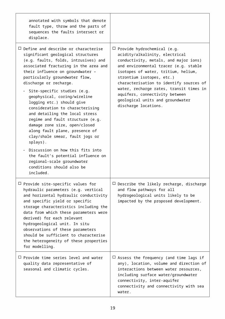
geological maps appropriately annotated with symbols that denote fault type, throw and the parts of sequences the faults intersect or displace.
Provide data to demonstrate the varying depths to the hydrogeological units and associated standing water levels or potentiometric heads, including direction of groundwater flow, contour maps, and hydrographs. All boreholes used to provide this data should have been surveyed.
Define and describe or characterise significant geological structures (e.g. faults, folds, intrusives) and associated fracturing in the area and their influence on groundwater – particularly groundwater flow, discharge or recharge.
Site-specific studies (e.g. geophysical, coring/wireline logging etc.) should give consideration to characterising and detailing the local stress regime and fault structure (e.g. damage zone size, open/closed along fault plane, presence of clay/shale smear, fault jogs or splays).
Discussion on how this fits into the fault’s potential influence on regional-scale groundwater conditions should also be included.
Provide hydrochemical (e.g. acidity/alkalinity, electrical conductivity, metals, and major ions) and environmental tracer (e.g. stable isotopes of water, tritium, helium, strontium isotopes, etc.) characterisation to identify sources of water, recharge rates, transit times in aquifers, connectivity between geological units and groundwater discharge locations.
Provide site-specific values for hydraulic parameters (e.g. vertical and horizontal hydraulic conductivity and specific yield or specific storage characteristics including the data from which these parameters were derived) for each relevant hydrogeological unit. In situ observations of these parameters should be sufficient to characterise the heterogeneity of these properties for modelling.
Describe the likely recharge, discharge and flow pathways for all hydrogeological units likely to be impacted by the proposed development.
Provide time series level and water quality data representative of seasonal and climatic cycles.
Assess the frequency (and time lags if any), location, volume and direction of interactions between water resources, including surface water/groundwater connectivity, inter-aquifer connectivity and connectivity with sea water.
Analytical and numerical modelling
13
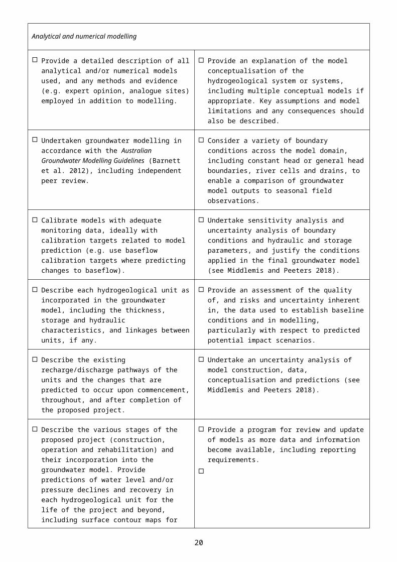
Provide a detailed description of all analytical and/or numerical models used, and any methods and evidence (e.g. expert opinion, analogue sites) employed in addition to modelling.
Provide an explanation of the model conceptualisation of the hydrogeological system or systems, including multiple conceptual models if appropriate. Key assumptions and model limitations and any consequences should also be described.
Undertaken groundwater modelling in accordance with the Australian Groundwater Modelling Guidelines (Barnett et al. 2012), including independent peer review.
Consider a variety of boundary conditions across the model domain, including constant head or general head boundaries, river cells and drains, to enable a comparison of groundwater model outputs to seasonal field observations.
Calibrate models with adequate monitoring data, ideally with calibration targets related to model prediction (e.g. use baseflow calibration targets where predicting changes to baseflow).
Undertake sensitivity analysis and uncertainty analysis of boundary conditions and hydraulic and storage parameters, and justify the conditions applied in the final groundwater model (see Middlemis and Peeters 2018).
Describe each hydrogeological unit as incorporated in the groundwater model, including the thickness, storage and hydraulic characteristics, and linkages between units, if any.
Provide an assessment of the quality of, and risks and uncertainty inherent in, the data used to establish baseline conditions and in modelling, particularly with respect to predicted potential impact scenarios.
Describe the existing recharge/discharge pathways of the units and the changes that are predicted to occur upon commencement, throughout, and after completion of the proposed project.
Undertake an uncertainty analysis of model construction, data, conceptualisation and predictions (see Middlemis and Peeters 2018).
Describe the various stages of the proposed project (construction, operation and rehabilitation) and their incorporation into the groundwater model. Provide predictions of water level and/or pressure declines and recovery in each hydrogeological unit for the life of the project and beyond, including surface contour maps for all hydrogeological units.
Provide a program for review and update of models as more data and information become available, including reporting requirements.
Identify the volumes of water predicted to be taken annually with an indication of the proportion supplied from each hydrogeological unit.
Provide information on the magnitude and time for maximum drawdown and post-development drawdown equilibrium to be reached.
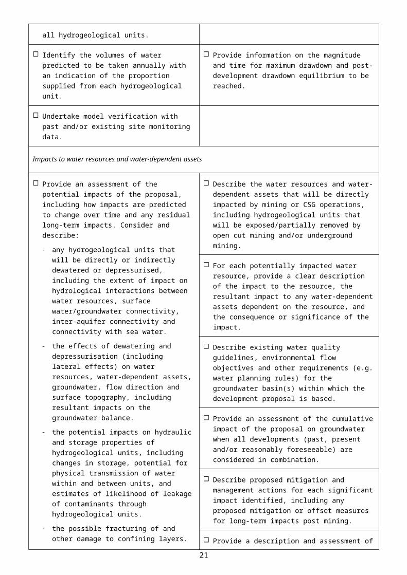
Undertake model verification with past and/or existing site monitoring data.
Impacts to water resources and water-dependent assets
Provide an assessment of the potential impacts of the proposal, including how impacts are predicted to change over time and any residual long-term impacts. Consider and describe:
Describe the water resources and water-dependent assets that will be directly impacted by mining or CSG operations, including hydrogeological units that will be exposed/partially removed by open cut mining and/or underground mining.
14
any hydrogeological units that will be directly or indirectly dewatered or depressurised, including the extent of impact on hydrological interactions between water resources, surface water/groundwater connectivity, inter-aquifer connectivity and connectivity with sea water.
the effects of dewatering and depressurisation (including lateral effects) on water resources, water-dependent assets, groundwater, flow direction and surface topography, including resultant impacts on the groundwater balance.
the potential impacts on hydraulic and storage properties of hydrogeological units, including changes in storage, potential for physical transmission of water within and between units, and estimates of likelihood of leakage of contaminants through hydrogeological units.
the possible fracturing of and other damage to confining layers.
For each relevant hydrogeological unit, the proportional increase in groundwater use and impacts as a consequence of the proposed project, including an assessment of any consequential increase in demand for groundwater from towns or other industries resulting from associated population or economic growth due to the proposal.
For each potentially impacted water resource, provide a clear description of the impact to the resource, the resultant impact to any water-dependent assets dependent on the resource, and the consequence or significance of the impact.
Describe existing water quality guidelines, environmental flow objectives and other requirements (e.g. water planning rules) for the groundwater basin(s) within which the development proposal is based.
Provide an assessment of the cumulative impact of the proposal on groundwater when all developments (past, present and/or reasonably foreseeable) are considered in combination.
Describe proposed mitigation and management actions for each significant impact identified, including any proposed mitigation or offset measures for long-term impacts post mining.
Provide a description and assessment of the adequacy of proposed measures to prevent/minimise impacts on water resources and water-dependent assets.
Data and monitoring
Provide sufficient data on physical aquifer parameters and hydrogeochemistry to establish pre-development conditions, including fluctuations in groundwater levels at time intervals relevant to aquifer processes.
Provide long-term groundwater monitoring data, including a comprehensive assessment of all relevant chemical parameters to inform changes in groundwater quality and detect potential contamination events.
Develop and describe a robust groundwater monitoring program using dedicated groundwater monitoring wells – including nested arrays where there may be connectivity between hydrogeological units – and targeting specific aquifers, providing an understanding of the groundwater regime, recharge and discharge processes and identifying changes over time.
Ensure water quality monitoring complies with relevant National Water Quality Management Strategy (NWQMS) guidelines (ANZG 2018) and relevant legislated state protocols (e.g. QLD Government 2013).
Develop and describe proposed targeted field programs to address key areas of uncertainty, such as the hydraulic connectivity between geological formations, the sources of groundwater sustaining GDEs, the hydraulic properties of significant faults, fracture networks and aquitards in the impacted system, etc., where appropriate.
Surface water
15
Context and conceptualisation
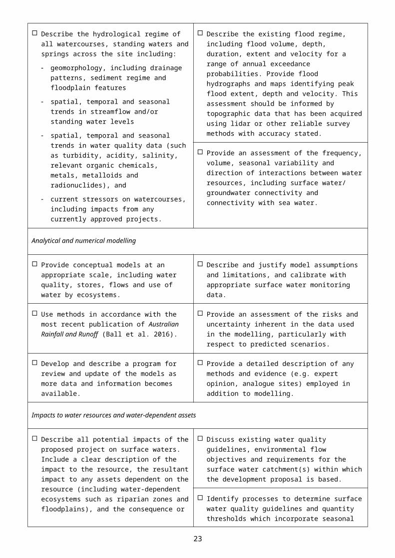
Describe the hydrological regime of all watercourses, standing waters and springs across the site including:
geomorphology, including drainage patterns, sediment regime and floodplain features
spatial, temporal and seasonal trends in streamflow and/or standing water levels
spatial, temporal and seasonal trends in water quality data (such as turbidity, acidity, salinity, relevant organic chemicals, metals, metalloids and radionuclides), and
current stressors on watercourses, including impacts from any currently approved projects.
Describe the existing flood regime, including flood volume, depth, duration, extent and velocity for a range of annual exceedance probabilities. Provide flood hydrographs and maps identifying peak flood extent, depth and velocity. This assessment should be informed by topographic data that has been acquired using lidar or other reliable survey methods with accuracy stated.
Provide an assessment of the frequency, volume, seasonal variability and direction of interactions between water resources, including surface water/ groundwater connectivity and connectivity with sea water.
Analytical and numerical modelling
Provide conceptual models at an appropriate scale, including water quality, stores, flows and use of water by ecosystems.
Describe and justify model assumptions and limitations, and calibrate with appropriate surface water monitoring data.
Use methods in accordance with the most recent publication of Australian Rainfall and Runoff (Ball et al. 2016).
Provide an assessment of the risks and uncertainty inherent in the data used in the modelling, particularly with respect to predicted scenarios.
Develop and describe a program for review and update of the models as more data and information becomes available.
Provide a detailed description of any methods and evidence (e.g. expert opinion, analogue sites) employed in addition to modelling.
Impacts to water resources and water-dependent assets
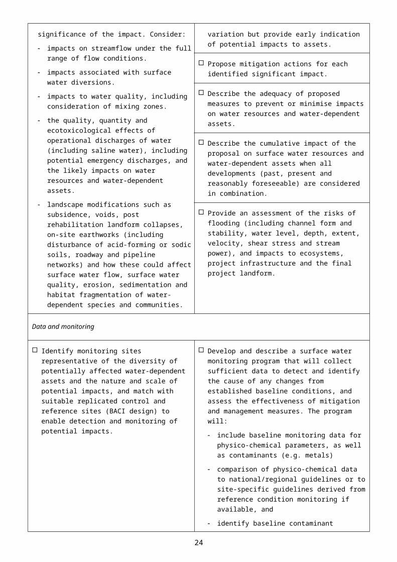
Describe all potential impacts of the proposed project on surface waters. Include a clear description of the impact to the resource, the resultant impact to any assets dependent on the resource (including water-dependent ecosystems such as riparian zones and floodplains), and the consequence or significance of the impact. Consider:
impacts on streamflow under the full range of flow conditions.
impacts associated with surface water diversions.
impacts to water quality, including consideration of mixing zones.
the quality, quantity and ecotoxicological effects of operational discharges of water (including saline water), including potential emergency discharges, and the likely impacts on water resources and water-dependent
Discuss existing water quality guidelines, environmental flow objectives and requirements for the surface water catchment(s) within which the development proposal is based.
Identify processes to determine surface water quality guidelines and quantity thresholds which incorporate seasonal variation but provide early indication of potential impacts to assets.
Propose mitigation actions for each identified significant impact.
Describe the adequacy of proposed measures to prevent or minimise impacts on water resources and water-dependent assets.
Describe the cumulative impact of the proposal on surface water resources and water-dependent assets when all developments (past, present and reasonably foreseeable) are considered in combination.
16

assets.
landscape modifications such as subsidence, voids, post rehabilitation landform collapses, on-site earthworks (including disturbance of acid-forming or sodic soils, roadway and pipeline networks) and how these could affect surface water flow, surface water quality, erosion, sedimentation and habitat fragmentation of water-dependent species and communities.
Provide an assessment of the risks of flooding (including channel form and stability, water level, depth, extent, velocity, shear stress and stream power), and impacts to ecosystems, project infrastructure and the final project landform.
Data and monitoring
Identify monitoring sites representative of the diversity of potentially affected water-dependent assets and the nature and scale of potential impacts, and match with suitable replicated control and reference sites (BACI design) to enable detection and monitoring of potential impacts.
Develop and describe a surface water monitoring program that will collect sufficient data to detect and identify the cause of any changes from established baseline conditions, and assess the effectiveness of mitigation and management measures. The program will:
include baseline monitoring data for physico-chemical parameters, as well as contaminants (e.g. metals)
comparison of physico-chemical data to national/regional guidelines or to site-specific guidelines derived from reference condition monitoring if available, and
identify baseline contaminant concentrations and compare these to national guidelines, allowing for local background correction if required.
Ensure water quality monitoring complies with relevant National Water Quality Management Strategy (NWQMS) guidelines (ANZG 2018) and relevant legislated state protocols (e.g. QLD Government 2013).
Describe the rationale for selected monitoring parameters, duration, frequency and methods, including the use of satellite or aerial imagery to identify and monitor large-scale impacts.
Identify data sources, including streamflow data, proximity to rainfall stations, data record duration and describe data methods, including whether missing data have been patched.
Develop and describe a plan for ongoing ecotoxicological monitoring, including direct toxicity assessment of discharges to surface waters where appropriate.
Identify dedicated sites to monitor hydrology, water quality, and channel and floodplain geomorphology throughout the life of the proposed project and beyond.
Water-dependent assets
Context and conceptualisation
Identify water-dependent assets, including:
water-dependent fauna and flora and provide
Estimate the ecological water requirements of identified GDEs and other water-dependent assets (see Doody et al. 2019).
17
surveys of habitat, flora and fauna (including stygofauna) (see Doody et al. 2019).
public health, recreation, amenity, Indigenous, tourism or agricultural values for each water resource.
Identify the hydrogeological units on which any identified GDEs are dependent (see Doody et al. 2019).
Identify GDEs in accordance with the method outlined by Eamus et al. (2006). Information from the GDE Toolbox (Richardson et al. 2011) and GDE Atlas (CoA 2017a) may assist in identification of GDEs (see Doody et al. 2019).
Provide an outline of the water-dependent assets and associated environmental objectives and the modelling approach to assess impacts to the assets.
Describe the conceptualisation and rationale for likely water-dependence, impact pathways, tolerance and resilience of water-dependent assets. Examples of ecological conceptual models can be found in Commonwealth of Australia (2015).
Describe the process employed to determine water quality and quantity triggers and impact thresholds for water-dependent assets (e.g. threshold at which a significant impact on an asset may occur).
Impacts, risk assessment and management of risks
Provide an assessment of direct and indirect impacts on water-dependent assets, including ecological assets such as flora and fauna dependent on surface water and groundwater, springs and other GDEs (see Doody et al. 2019).
Provide estimates of the volume, beneficial uses and impact of operational discharges of water (particularly saline water), including potential emergency discharges due to unusual events, on water-dependent assets and ecological processes.
Describe the potential range of drawdown at each affected bore, and clearly articulate of the scale of impacts to other water users.
Assess the overall level of risk to water-dependent assets through combining probability of occurrence with severity of impact.
Indicate the vulnerability to contamination (e.g. from salt production and salinity) and the likely impacts of contamination on the identified water-dependent assets and ecological processes.
Identify the proposed acceptable level of impact for each water-dependent asset based on leading-practice science and site-specific data, and ideally developed in conjunction with stakeholders.
Identify and consider landscape modifications (e.g. voids, on-site earthworks, and roadway and pipeline networks) and their potential effects on surface water flow, erosion and habitat fragmentation of water-dependent species and communities.
Propose mitigation actions for each identified impact, including a description of the adequacy of the proposed measures and how these will be assessed.
Data and monitoring
Identify an appropriate sampling frequency and spatial coverage of monitoring sites to establish pre-development (baseline) conditions, and test potential responses to impacts of the proposal (see Doody et al. 2019).
Develop and describe a monitoring program that identifies impacts, evaluates the effectiveness of impact prevention or mitigation strategies, measures trends in ecological responses and detects whether ecological responses are within identified thresholds of acceptable change (see Doody et al. 2019).
Consider concurrent baseline monitoring from unimpacted control and reference sites to
Describe the proposed process for regular reporting, review and revisions to the monitoring program.
18
distinguish impacts from background variation in the region (e.g. BACI design, see Doody et al. 2019).
Ensure ecological monitoring complies with relevant state or national monitoring guidelines (e.g. the DSITI guideline for sampling stygofauna (QLD Government 2015)).
Water and salt balance, and water quality
Provide a quantitative site water balance model describing the total water supply and demand under a range of rainfall conditions and allocation of water for mining activities (e.g. dust suppression, coal washing etc.), including all sources and uses.
Provide estimates of the quality and quantity of operational discharges under dry, median and wet conditions, potential emergency discharges due to unusual events and the likely impacts on water-dependent assets.
Describe the water requirements and on-site water management infrastructure, including modelling to demonstrate adequacy under a range of potential climatic conditions.
Provide salt balance modelling that includes stores and the movement of salt between stores, and takes into account seasonal and long-term variation.
Cumulative Impacts
Context and conceptualisation
Provide cumulative impact analysis with sufficient geographic and temporal boundaries to include all potentially significant water-related impacts.
Consider all past, present and reasonably foreseeable actions, including development proposals, programs and policies that are likely to impact on the water resources of concern in the cumulative impact analysis. Where a proposed project is located within the area of a bioregional assessment consider the results of the bioregional assessment.
Impacts
Provide an assessment of the condition of affected water resources which includes:
identification of all water resources likely to be cumulatively impacted by the proposed development
a description of the current condition and quality of water resources and information on condition trends
identification of ecological characteristics, processes, conditions, trends and values of water resources
adequate water and salt balances, and
identification of potential thresholds for each water resource and its likely response to change and capacity to withstand adverse impacts (e.g. altered water quality, drawdown).
Assess the cumulative impacts to water resources considering:
the full extent of potential impacts from the proposed project, (including whether there are alternative options for infrastructure and mine configurations which could reduce impacts), and encompassing all linkages, including both direct and indirect links, operating upstream, downstream, vertically and laterally
all stages of the development, including exploration, operations and post closure/decommissioning
appropriately robust, repeatable and transparent methods
the likely spatial magnitude and timeframe over which impacts will occur, and significance of cumulative impacts, and
opportunities to work with other water users to
19
avoid, minimise or mitigate potential cumulative impacts.
Mitigation, monitoring and management
Identify modifications or alternatives to avoid, minimise or mitigate potential cumulative impacts. Evidence of the likely success of these measures (e.g. case studies) should be provided.
Identify cumulative impact environmental objectives.
Identify measures to detect and monitor cumulative impacts, pre and post development, and assess the success of mitigation strategies.
Describe appropriate reporting mechanisms.
Propose adaptive management measures and management responses.
Subsidence – underground coal mines and coal seam gas
Provide predictions of subsidence impact on surface topography, water-dependent assets, groundwater (including enhanced connectivity between aquifers) and the movement of water across the landscape (See CoA 2014b; CoA 2014c). Consider multiple methods of predictions and apply the most appropriate method. Consider the limitations of each method including the adequacy of empirical data and site-specific geological conditions and justify the selected method.
Describe subsidence monitoring methods, including the use of remote or on-ground techniques and explain the predicted accuracy of such techniques.
Provide an assessment of both conventional and unconventional subsidence. For project expansions, an evaluation of past or current effects of geological structures on subsidence and implications for water resources and water-dependent assets should be provided.
Consider geological strata and their properties (strength/hardness/fracture propagation) in the subsidence analysis and/or modelling. Anomalous and near-surface ground movements with implications for water resources and compaction of unconsolidated sediment should also be considered.
Final landform and voids – coal mines
Identify and consider landscape modifications (e.g. voids, on-site earthworks, and roadway and pipeline networks) and their potential effects on surface water flow, erosion, sedimentation and habitat fragmentation of water-dependent species and communities.
Provide an assessment of the long-term impacts to water resources and water-dependent assets posed by various options for the final landform design, including complete or partial backfilling of mining voids. Assessment of the final landform for which approval is being sought should consider:
groundwater behaviour – sink or lateral flow from void.
water level recovery – rate, depth, and stabilisation point (e.g. timeframe and level in relation to existing groundwater level, surface elevation).
seepage – geochemistry and potential impacts.
long-term water quality, including salinity, pH, metals and toxicity.
measures to prevent migration of void water off-
Assess the adequacy of modelling, including surface water and groundwater quantity and quality, lake behaviour, timeframes and calibration.
Provide an evaluation of stability of void slopes where failure during extreme events or over the long term (for example due to aquifer recovery causing geological heave and landform failure)
20
may have implications for water quality. site. For other final landform options considered sufficient detail of potential impacts should be provided to clearly justify the proposed option.
Evaluate mitigating inflows of saline groundwater by planning for partial backfilling of final voids.
Assess the probability of overtopping of final voids with variable climate extremes, and management mitigations.
Acid-forming materials and other contaminants of concern
Identify the presence and potential exposure of acid-sulphate soils (including oxidation from groundwater drawdown).
Describe handling and storage plans for acid-forming material (co-disposal, tailings dam, and encapsulation).
Identify the presence and volume of potentially acid-forming waste rock, fine-grained amorphous sulphide minerals and coal reject/tailings material and exposure pathways.
Assess the potential impact to water-dependent assets, taking into account dilution factors, and including solute transport modelling where relevant, representative and statistically valid sampling, and appropriate analytical techniques.
Identify other sources of contaminants, such as high metal concentrations in groundwater, leachate generation potential and seepage paths.
Describe proposed measures to prevent/minimise impacts on water resources, water users and water-dependent ecosystems and species.
CSG well construction and operation
Describe the scale of fracturing (number of wells, number of fracturing events per well), types of wells to be stimulated (vertical versus horizontal), and other forms of well stimulation (cavitation, acid flushing).
List the chemicals proposed for use in drilling and hydraulic stimulation including:
names of the companies producing fracturing fluids and associated products
proprietary names (trade names) of compounds (fracturing fluid additives) being produced
chemical names of each additive used in each of the fluids
Chemical Abstract Service (CAS) numbers of each of the chemical components used in each of the fluids
general purpose and function of each of the chemicals used
mass or volume proposed for use
maximum concentration (mg/L or g/kg) of the chemicals used
chemical half-life data, partitioning data, and volatilisation data
ecotoxicology, and
any material safety data sheets for the chemicals or chemical products used.
Describe proposed measuring and monitoring of fracture propagation.
Identify water source for drilling and hydraulic stimulation, and outline the volume of fluid and mass balance (quantities/volumes).
Describe the rules (e.g. water sharing plans) covering access to each water source used for drilling and hydraulic stimulation and how the project proposes to comply with them.
Quantify and describe the quality and toxicity of flowback and produced water and how it will be treated and managed.
Assess the potential for inter-aquifer leakage or contamination.
The use of drilling and hydraulic fracturing Chemicals for use in drilling and hydraulic fracturing
21

chemicals should be informed by appropriately tiered deterministic and/or probabilistic hazard and risk assessments, based on ecotoxicological testing consistent with Australian Government testing guidelines (see CoA 2012; MRMMC-EPHC-NHMRC 2009).
must be identified as being approved for import, manufacture or use in Australia (that is, confirmed by NICNAS as being listed in the Australian Inventory of Chemical Substances (see CoA 2017b).
Propose waste management measures (including salt and brines) during both operations and legacy after closure.
Supporting documents
ANZG 2018. Australian and New Zealand Guidelines for Fresh and Marine Water Quality. Australian and New Zealand Governments and Australian state and territory governments, Canberra ACT, Australia. Available at www.waterquality.gov.au/anz-guidelines
Ball J, Babister M, Nathan R, Weeks W, Weinmann E, Retallick M and Testoni I (eds) 2016. Australian rainfall and runoff: A guide to flood estimation. Geoscience Australia, Commonwealth of Australia. Available [online]: http://arr.ga.gov.au/arr-guideline accessed April 2018.
Barrett DJ, Couch CA, Metcalfe DJ, Lytton L, Adhikary DP and Schmidt RK 2013. Methodology for bioregional assessments of the impacts of coal seam gas and coal mining development on water resources. Report prepared for the Independent Expert Scientific Committee on Coal Seam Gas and Large Coal Mining Development through the Department of Sustainability, Environment, Water, Population and Communities, Commonwealth of Australia. Available [online]: http://www.bioregionalassessments.gov.au/methods/bioregional-assessment-methodology accessed April 2018.
Barnett B, Townley LR, Post V, Evans RE, Hunt RJ, Peeters L, Richardson S, Werner AD, Knapton A and Boronkay A , 2012. Australian groundwater modelling guidelines. Waterlines report. National Water Commission, Canberra. Available [online]: http://www.groundwater.com.au/media/W1siZiIsIjIwMTIvMTAvMTcvMjFfNDFfMzZfOTYwX0F1c3RyYWxpYW5fZ3JvdW5kd2F0ZXJfbW9kZWxsaW5nX2d1aWRlbGluZXMucGRmIl1d/Australian-groundwater-modelling-guidelines.pdf accessed April 2018.
Commonwealth of Australia (CoA) 2017a. Atlas of groundwater dependent ecosystems. Bureau of Meteorology. Available [online]: http://www.bom.gov.au/water/groundwater/gde/map.shtml accessed April 2018 .
Commonwealth of Australia (CoA) 2017b. Australian Inventory of Chemical Substances. Department of Health. Available [online]: https://www.nicnas.gov.au/chemicals-on-AICS accessed April 2018.
Commonwealth of Australia (CoA) 2015a. Bioregional assessments. Available [online]: http://www.bioregionalassessments.gov.au/ accessed April 2018.
Commonwealth of Australia (CoA) 2015b. Independent Expert Scientific Committee on Coal Seam Gas and Large Coal Mining Development. Available [online]: http://iesc.environment.gov.au/ accessed April 2018.
Commonwealth of Australia (CoA) 2015c. Modelling water-related ecological responses to coal seam gas extraction and coal mining. Prepared by Auricht Projects and the Commonwealth Scientific and Industrial Research Organisation for the Department of the Environment, Commonwealth of Australia. Available [online]: http://www.environment.gov.au/system/files/resources/83770681-a40b-4fa2-bf6e-8d41022873bd/files/modelling-water-related-ecological-responses-csg-extraction.pdf accessed April 2018.
Commonwealth of Australia (CoA) 2014a. Coal seam gas extraction: Modelling the groundwater impacts. Knowledge report, prepared by Coffey Geotechnics for the Department of the Environment, Commonwealth of Australia. Available
22
[online]: https://environment.gov.au/system/files/resources/ee38b672-6faa-452e-979f-d97b7d425333/files/csg-modelling-groundwater-impacts.pdf accessed April 2018.
Commonwealth of Australia (CoA) 2014b. Subsidence from coal seam gas in Australia: Background review. Available [online]: http://www.environment.gov.au/water/publications/background-review-subsidence-coal-seam-gas-extraction-australia accessed April 2018.
Commonwealth of Australia (CoA) 2014c. Subsidence from coal mining activities: Background review. Available [online]: http://www.environment.gov.au/water/publications/background-review-subsidence-from-coal-mining-activities accessed April 2018.
Commonwealth of Australia (CoA) 2013. Significant Impact Guidelines 1.3: Coal seam gas and large coal mining developments—Impacts on water resources. Available [online]: http://www.environment.gov.au/system/files/resources/d078caf3-3923-4416-a743-0988ac3f1ee1/files/sig-water-resources.pdf accessed April 2018.
Commonwealth of Australia (CoA) 2012. Environmental health risk assessment: Guidelines for assessing human health risks from environmental hazards. Department of Health and Ageing and enHealth, Canberra. Available [online]: http://www.eh.org.au/documents/item/916 accessed April 2018.
Commonwealth of Australia (CoA) 2007. Water Act 2007. Available [online]: https://www.legislation.gov.au/Details/C2017C00151/Html/Text accessed April 2018.
Commonwealth Scientific and Industrial Research Organisation 2015. Australian climate futures: Climate change in Australia--Projections for Australia’s NRM regions. Available [online]: http://www.climatechangeinaustralia.gov.au/en/climate-projections/climate-futures-tool/introduction-climate-futures/ accessed April 2018.
Doody TM, Hancock PJ, Pritchard JL 2019. Assessing groundwater-dependent ecosystems: IESC Information Guidelines explanatory note. A report prepared for the Independent Expert Scientific Committee on Coal Seam Gas and Large Coal Mining Development through the Department of the Environment and Energy, Commonwealth of Australia.
Downes BJ, Barmuta LA, Fairweather PG, Faith DP, Keough J, Lake PS, Mapstone BD and Quinn GP 2002. Monitoring ecological impacts: Concepts and practice in flowing waters. Cambridge University Press, Cambridge.
Eamus D, Froend R, Loomes R, Hose G and Murray B 2006. A functional methodology for determining the groundwater regime needed to maintain the health of groundwater-dependent vegetation. Australian Journal of Botany, 54: 97–114.
Ford JH, Hayes KR, Henderson BL, Lewis S, Baker PA and Schmidt RK 2016. Systematic analysis of water-related hazards associated with coal resource development. Submethodology M11 from the Bioregional Assessment Technical Programme. Department of the Environment and Energy, Bureau of Meteorology, Commonwealth Scientific and Industrial Research Organisation and Geoscience Australia, Commonwealth of Australia. Available [online]: http://www.bioregionalassessments.gov.au/methods/systematic-analysis-water-related-hazards-associated-coal-resource-development accessed April 2018.
Middlemis H and Peeters LJM [2018]. Uncertainty analysis in groundwater modelling: IESC Information Guideline Explanatory Note. A report prepared for the Independent Expert Scientific Committee on Coal Seam Gas and Large Coal Mining Development through the Department of the Environment and Energy, Commonwealth of Australia.
Minerals Council of Australia 2014. Water accounting framework for the minerals industry User guide. Available [online]: http://www.minerals.org.au/leading_practice/water_accounting_framework_for_the_australian_minerals_industry accessed April 2018.
NRMMC-EPHC-NHMRC 2009. Australian guidelines for water recycling (Phase 2): Managed aquifer recharge. Natural Resource Ministerial Management Council, Environmental Protection and Heritage Council and National Health and Medical Research Council, Canberra. Available [online]: http://webarchive.nla.gov.au/gov/20130904195601/http://www.environment.gov.au/water/publications/quality/water-
23
recycling-guidelines-mar-24.html accessed April 2018.
Queensland Government 2015. Guideline for the environmental assessment of subterranean aquatic fauna: Sampling methods and survey considerations, Department of Science, Information Technology and Innovation. Available [online]: https://publications.qld.gov.au/dataset/f7e68ccd-8c13-422f-bd46-1b391500423f/resource/ba880910-5117-433a-b90d-2c131874a8e6/download/guideline-subterranean-aquatic-fauna.pdf accessed April 2018.
Queensland Government 2013. Monitoring and sampling manual 2009: Environmental protection (water) policy 2009—Version 2 September 2010 (July 2013 format edits). Department of Environment and Heritage Protection. Available [online]: https://ehp.qld.gov.au/water/pdf/monitoring-man-2009-v2.pdf accessed April 2018.
Richardson S, Irvine E, Froend R, Boon P, Barber S and Bonneville B 2011. Australian groundwater-dependent ecosystem toolbox part 1: Assessment framework. Waterlines report. National Water Commission, Canberra. Available [online]: http://webarchive.nla.gov.au/gov/20160615084626/http://archive.nwc.gov.au/library/waterlines/69-70 accessed April 2018.
24