information management system/gis data centre...
TRANSCRIPT
Final report for the South Atlantic Information Management Centre project
Information Management System / GIS Data Centre for the
South Atlantic region
20 April 2016
To find more about JNCC’s OT and CD programme visit:
http://jncc.defra.gov.uk/default.aspx?page=4079

Overseas Territories and Crown Dependencies Project Report
Contact: Tara Pelembe JNCC TEL: 00 (44) 1733 866919 [email protected]
www.jncc.gov.uk
SECTION 1: BASIC INFORMATION ABOUT THE PROJECT:
Territory: South Atlantic Region
Project Title: IMS/GIS data centre for the South Atlantic region
Project Start Date: 23 September 2013
Project Completion Funding Commitment against plan: 31 March 2014
Project Completion Date: original date 22 September 2015 which has been extended to 30 April 2016
REPORTER FOR GENERAL OVERVIEW AND FALKLAND ISLANDS:
Name Dr iLaria Marengo
Organization, SAERI
Contact Details Stanley Cottage Ross Road Stanley FIQQ1ZZ Falkland Islands
REPORTER FOR SAINT HELENA:
Name Samantha Cherrett
Organization, Environment and Natural Resources Directorate, St Helena Government
Contact Details Essex House, Jamestown, Saint Helena, STHL 1ZZ
REPORTER FOR ASCENSION ISLAND:
Name Sam Weber
Organization: Ascension Island Government Conservation Department
Contact Details: Conservation Office, Georgetown, Ascension Island ASCN 1ZZ
SECTION 2: DELIVERY AGAINST PLAN
According to what stated in the MOA between JNCC and the Falkland Islands Government the
Information Management System and GIS data centre has got the following aims:
1. Establish a Project Management Group;
2. Establish GIS specialist capability within the Falkland Islands with a remit to provide advice, assistance and training to other regional OTs;
Overseas Territories and Crown Dependencies Project Report
Contact: Tara Pelembe JNCC TEL: 00 (44) 1733 866919 [email protected]
www.jncc.gov.uk
3. Purchase the necessary software, hardware and establish necessary satellite access to acquire, share and manipulate data on behalf of the Falklands and other regional OTs;
4. Establish a training programme for OT personnel in the use of GIS systems and other relevant information management techniques;
5. Identify, in collaboration with Government and Non-Government organisations across the five regional OTs, a suite of conservation projects which can benefit immediately from the IMS with initial emphasis on projects supported by UK Government funding.
According to what stated in the MOA between JNCC and the Saint Helena Government the
Information Management System and GIS data centre has got the following aims:
1. As a matter of priority to contribute to GIS support to the Darwin Fund supported marine mapping work currently in progress; 2. Identify terrestrial conservation projects in progress or about to be implemented that will benefit from GIS support and implement such support.
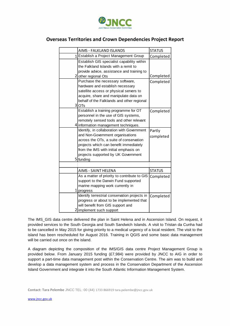
Table 1 provides the final summary of the progressing of the activity of the IMS/GIS data centre.
Overseas Territories and Crown Dependencies Project Report
Contact: Tara Pelembe JNCC TEL: 00 (44) 1733 866919 [email protected]
www.jncc.gov.uk
AIMS - FALKLAND ISLANDS STATUS
1 Establish a Project Management Group Completed
2
Establish GIS specialist capability within
the Falkland Islands with a remit to
provide advice, assistance and training to
other regional Ots Completed
3
Purchase the necessary software,
hardware and establish necessary
satellite access or physical servers to
acquire, share and manipulate data on
behalf of the Falklands and other regional
OTs
Completed
4
Establish a training programme for OT
personnel in the use of GIS systems,
remotely sensed tools and other relevant
information management techniques.
Completed
5
Identify, in collaboration with Government
and Non-Government organisations
across the OTs, a suite of conservation
projects which can benefit immediately
from the IMS with initial emphasis on
projects supported by UK Government
funding
Partly
completed
AIMS - SAINT HELENA STATUS
1
As a matter of priority to contribute to GIS
support to the Darwin Fund supported
marine mapping work currently in
progress
Completed
2
Identify terrestrial conservation projects in
progress or about to be implemented that
will benefit from GIS support and
implement such support
Completed
The IMS_GIS data centre delivered the plan in Saint Helena and in Ascension Island. On request, it
provided services to the South Georgia and South Sandwich Islands. A visit to Tristan da Cunha had
to be cancelled in May 2015 for giving priority to a medical urgency of a local resident. The visit to the
island has been rescheduled for August 2016. Training in QGIS and some basic data management
will be carried out once on the island.
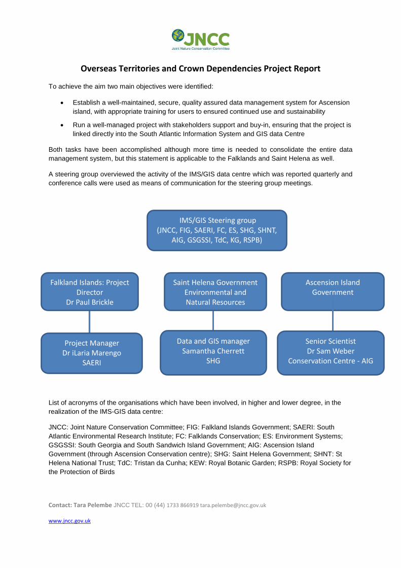
A diagram depicting the composition of the IMS/GIS data centre Project Management Group is
provided below. From January 2015 funding (£7,984) were provided by JNCC to AIG in order to
support a part-time data management post within the Conservation Centre. The aim was to build and
develop a data management system and process in the Conservation Department of the Ascension
Island Government and integrate it into the South Atlantic Information Management System.
Overseas Territories and Crown Dependencies Project Report
Contact: Tara Pelembe JNCC TEL: 00 (44) 1733 866919 [email protected]
www.jncc.gov.uk
To achieve the aim two main objectives were identified:
Establish a well-maintained, secure, quality assured data management system for Ascension
island, with appropriate training for users to ensured continued use and sustainability
Run a well-managed project with stakeholders support and buy-in, ensuring that the project is
linked directly into the South Atlantic Information System and GIS data Centre
Both tasks have been accomplished although more time is needed to consolidate the entire data
management system, but this statement is applicable to the Falklands and Saint Helena as well.
A steering group overviewed the activity of the IMS/GIS data centre which was reported quarterly and
conference calls were used as means of communication for the steering group meetings.
List of acronyms of the organisations which have been involved, in higher and lower degree, in the
realization of the IMS-GIS data centre:
JNCC: Joint Nature Conservation Committee; FIG: Falkland Islands Government; SAERI: South
Atlantic Environmental Research Institute; FC: Falklands Conservation; ES: Environment Systems;
GSGSSI: South Georgia and South Sandwich Island Government; AIG: Ascension Island
Government (through Ascension Conservation centre); SHG: Saint Helena Government; SHNT: St
Helena National Trust; TdC: Tristan da Cunha; KEW: Royal Botanic Garden; RSPB: Royal Society for
the Protection of Birds
IMS/GIS Steering group
(JNCC, FIG, SAERI, FC, ES, SHG, SHNT, AIG, GSGSSI, TdC, KG, RSPB)
Project Manager Dr iLaria Marengo
SAERI
Data and GIS manager Samantha Cherrett
SHG
Falkland Islands: Project Director
Dr Paul Brickle
SAERI
Saint Helena Government Environmental and Natural Resources
Directorate
Ascension Island Government
Senior Scientist Dr Sam Weber
Conservation Centre - AIG
Overseas Territories and Crown Dependencies Project Report
Contact: Tara Pelembe JNCC TEL: 00 (44) 1733 866919 [email protected]
www.jncc.gov.uk
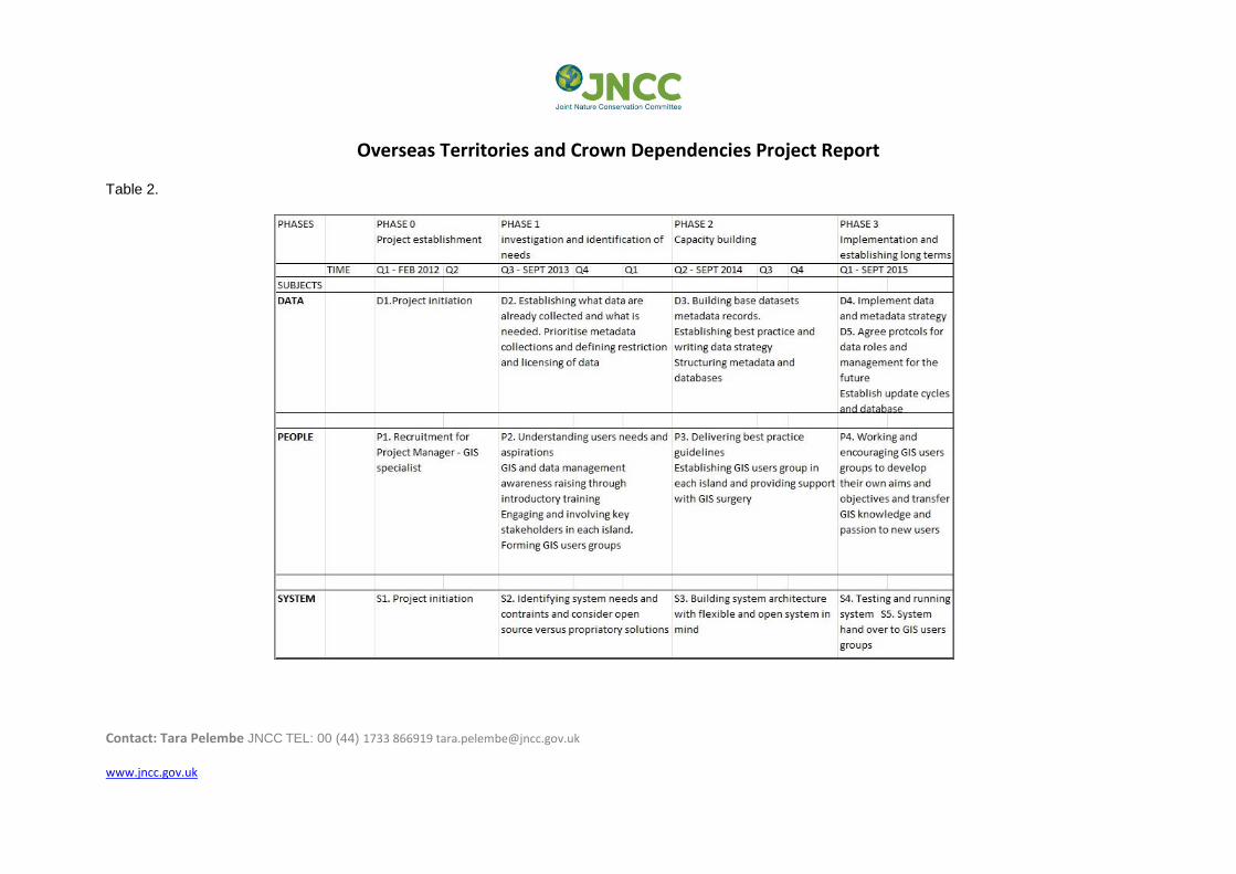
The activity of the IMS/GIS data centre in the Falkland Islands for the first two years (September 2013
to September 2015) was grouped in four main phases and split into the quarters that reflected the
periods when the project reports were issued for updating the steering group. Table 2 illustrates the
calendar of the main activities of IMS/GIS. The goal was to provide a general guideline of what the
IMS/GIS data centre was expected to deliver in order to meet the aims set in table 1.
Since the beginning the activities of the IMS-GIS data centre were focused on three main distinct but
linked areas: people (P), data (D) and systems (S).
Phases 0, 1, 2 and 3 are all completed with the exception of S5 System hand over to GIS users
groups as it was decided that the information technology and systems, when set up and implemented,
would be managed only by the data manager and not handled to users groups. The main reason is
that the system should be managed only by the data manager with the support of the governmental IT
team, if this is in place. The IT systems hand over was considered risky also because it is a fact that
in all the OTs, IT, and telecommunication services are poor, limited and expensive and few people
have strong IT knowledge. Instead, users groups were provided of the online metadata catalogue
facility which was a result from the development of an organized and supervised metadata collection.
The activities of the IMS-GIS data centre have been made publicly available on the internet in a
dedicated section of the SAERI webpage (http://www.south-atlantic-research.org/ims-gis).
From October 2015 to April 2016 the activities of the IMS–GIS data centre ranged from providing:
GIS training support to researchers and PhD students within SAERI
GIS courses for FIG officers
Spatial databases and WebGIS course for data managers
A cloud server for WebGIS services (one cloud for all the territories interested in publishing
data through WebGIS service)
An official (and legal) data agreement between IMS-GIS data centre and data submitter
A general data policy of the IMS-GIS data centre
An data management policy for SAERI
Guideline for writing a data management plan, addressed to researchers who carry out a
research project in the Falkland Islands
Overseas Territories and Crown Dependencies Project Report
Contact: Tara Pelembe JNCC TEL: 00 (44) 1733 866919 [email protected]
www.jncc.gov.uk
Table 2.

Overseas Territories and Crown Dependencies Project Report
7
The activity of the data centre on St Helena for the first eighteen months (June 2014 to December
2015) included supporting marine mapping work and working on developing and supporting GIS
amongst terrestrial conservation projects.
The bulk of the marine mapping work was concluded at the end of November 2014 resulting in a large
amount of raw sonar data, videos and summary GIS data. Following this, attention was turned to
working with SHG, local and international individuals and NGOs to acquire and develop metadata for
data held, improve data quality and investigate issues that restrict the use of GIS data, work with
these organisations to provide support and training to increase GIS use.
From December 2015, activities also included;
GIS training to support GIS users on St Helena
Cleaning and re-projection of key GIS data used in terrestrial conservation projects as well as
wider SHG use
Submission of metadata to the IMS-GIS data centre in the Falklands. Distribution of St Helena
data requested.
The activities of the data centre on Ascension Island took place between January and December
2015 and have largely focused on creating the architecture for data management, including a
metadata catalogue, data archive and a centralized biodiversity recording database, along with
associated policies, forms and guidance notes to ensure that these systems are properly
implemented and maintained.
Additional data management support has been provided for on-going projects, including the Darwin-
funded Ascension Island Marine Sustainability (AIMS) project, through the creation of robust
databases with user-friendly data input and retrieval interfaces. A half-day training course for all local
environmental staff is planned for April 2016 to ensure that users are comfortable with the new IT
systems and data management policies.
SECTION 3: BUDGET
Please provide an updated summary budget showing spend against budget.
The budget presented in the table below has been divided into the codes assigned by FIG treasury.
The money coming out and into the budget has been grouped in the following categories:
1. Expenditure: money spent for activities associated to each code
2. Donations: money donated by or to other projects in order to provide specific services (data
management)
3. Consultancy: money gained from consultancy works
4. Carryovers: money lost from a financial year to the other.
A complete and detailed budget (item by item) is available on request.
Overseas Territories and Crown Dependencies Project Report
8
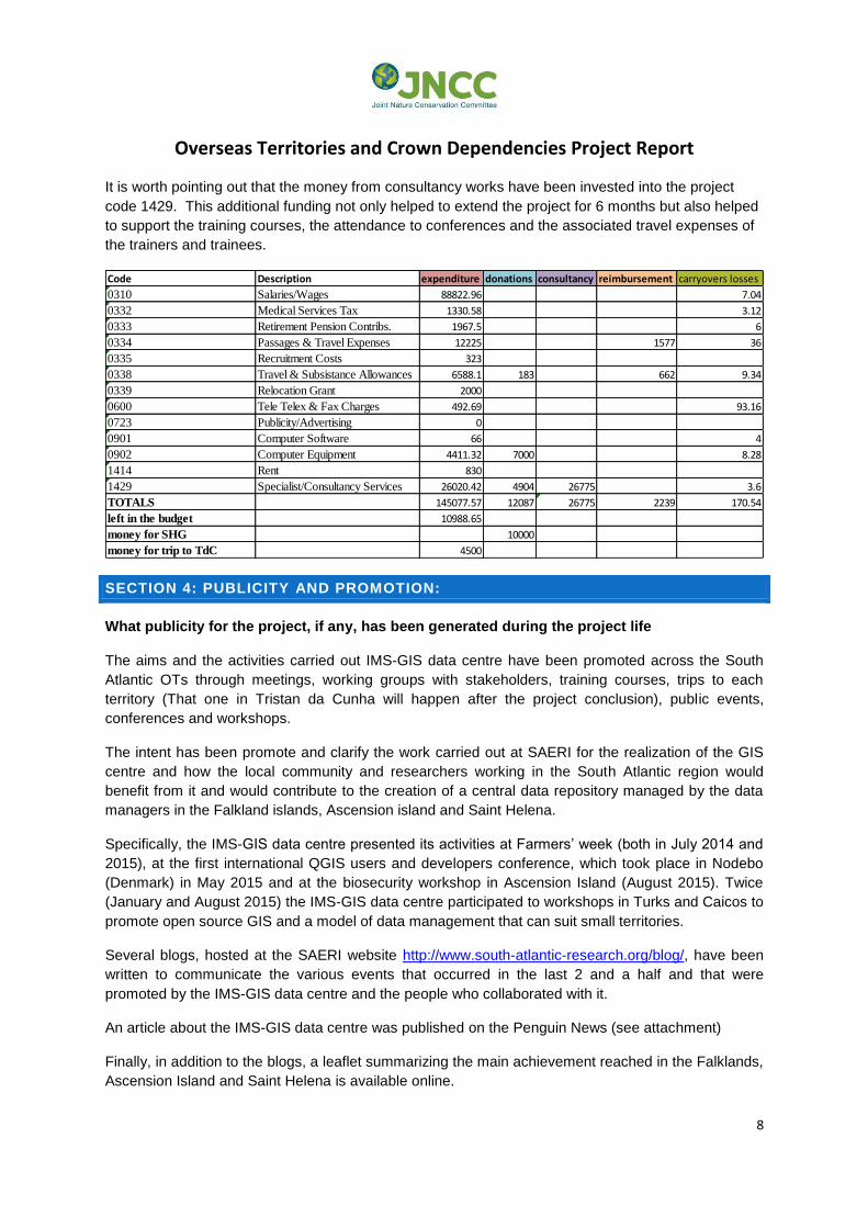
It is worth pointing out that the money from consultancy works have been invested into the project
code 1429. This additional funding not only helped to extend the project for 6 months but also helped
to support the training courses, the attendance to conferences and the associated travel expenses of
the trainers and trainees.
Code Description expenditure donations consultancy reimbursement carryovers losses
0310 Salaries/Wages 88822.96 7.04
0332 Medical Services Tax 1330.58 3.12
0333 Retirement Pension Contribs. 1967.5 6
0334 Passages & Travel Expenses 12225 1577 36
0335 Recruitment Costs 323
0338 Travel & Subsistance Allowances 6588.1 183 662 9.34
0339 Relocation Grant 2000
0600 Tele Telex & Fax Charges 492.69 93.16
0723 Publicity/Advertising 0
0901 Computer Software 66 4
0902 Computer Equipment 4411.32 7000 8.28
1414 Rent 830
1429 Specialist/Consultancy Services 26020.42 4904 26775 3.6
TOTALS 145077.57 12087 26775 2239 170.54
left in the budget 10988.65
money for SHG 10000
money for trip to TdC 4500
SECTION 4: PUBLICITY AND PROMOTION:
What publicity for the project, if any, has been generated during the project life
The aims and the activities carried out IMS-GIS data centre have been promoted across the South
Atlantic OTs through meetings, working groups with stakeholders, training courses, trips to each
territory (That one in Tristan da Cunha will happen after the project conclusion), public events,
conferences and workshops.
The intent has been promote and clarify the work carried out at SAERI for the realization of the GIS
centre and how the local community and researchers working in the South Atlantic region would
benefit from it and would contribute to the creation of a central data repository managed by the data
managers in the Falkland islands, Ascension island and Saint Helena.
Specifically, the IMS-GIS data centre presented its activities at Farmers’ week (both in July 2014 and
2015), at the first international QGIS users and developers conference, which took place in Nodebo
(Denmark) in May 2015 and at the biosecurity workshop in Ascension Island (August 2015). Twice
(January and August 2015) the IMS-GIS data centre participated to workshops in Turks and Caicos to
promote open source GIS and a model of data management that can suit small territories.
Several blogs, hosted at the SAERI website http://www.south-atlantic-research.org/blog/, have been
written to communicate the various events that occurred in the last 2 and a half and that were
promoted by the IMS-GIS data centre and the people who collaborated with it.
An article about the IMS-GIS data centre was published on the Penguin News (see attachment)
Finally, in addition to the blogs, a leaflet summarizing the main achievement reached in the Falklands,
Ascension Island and Saint Helena is available online.

Overseas Territories and Crown Dependencies Project Report
9
On St Helena, some additional promotion has occurred through radio interviews, meetings with local
stakeholders to develop GIS partnerships and encourage data sharing, meetings with visiting
researchers and raising awareness of GIS through GIS day events and in local schools.
On Ascension Island, data management policies and procedures, including integration with the IMS-
GIS centre, are clearly publicized to all researchers wishing to work in the Territory through online
information packs (http://www.ascension-island.gov.ac/government/conservation/).
SECTION 5: ADDITIONAL INFORMATION ON ACHIEVEMENTS – FALKLAND
ISLANDS
Are there any specific successes for the reporting period that you would like to bring attention
to?
Metadata catalogue online: it has proved to be a successful tool for data discovery for instance it
worked very well as support tool for a couple of MSc students from the University of Lausanne.
Interest in the way the catalogue stores metadata has been expressed by a consultancy group based
in the UK. More than 260 metadata records about the Falklands have been logged into the metadata
catalogue.
Research agreement: the document is now used by researchers when they need to apply for a
research permit. The management of the applications and the release of the permit is responsibility of
the Environmental officer within FIG. Both documents are sent to the centre in order to be stored to a
database which is accessible on request.
Data submission agreement: the document is meant to regulate the relationship between the IMS-GIS
data centre, which acts as data custodian, and the data submitter, which deposit the data at the
central data repository for the long term management. The document defines roles and
responsibilities of both parties and ultimately is an agreement between them on how data should be
submitted, managed and made available to data requestors. This document is currently in a draft
copy and at legal services in the FI. It should be transferable to other territories if there is an interest
in adopting the document.
WebGIS services: the first WebGIS portal has been created for the Marine Spatial Planning project
(MSP). WebGIS has been the preferred tool to make the outcomes of the project visible to all. Open
data and easy accessibility to them are requested by the Darwin initiative, sponsor of the project. The
online MSP will be followed by the FI biodiversity database.
Use of open source GIS and familiarization with GIS and spatial databases: compared to two and a
half years ago there is more understanding and interest in what GIS can do to support researchers in
their project deliveries. The presence of data managers in the territories helps greatly as they offer
guidance and technical advice on how to use GIS and above all how to manage data through spatial
databases. The change from excel file, to shape file to database is in progress and working purely
with databases will take still a while to become a reality. GIS for analysis and mapping tools instead
are easier and have been used widely by researchers, above all those within SAERI.
SECTION 5: ADDITIONAL INFORMATION ON ACHIEVEMENTS – ST HELENA
Overseas Territories and Crown Dependencies Project Report
10
Are there any specific successes for the reporting period that you would like to bring attention
to?
Metadata catalogue online: to date, 208 metadata records have been submitted for St Helena,
including non-environmental datasets. These datasets have all been cleaned and stored on a
designated server partition
Research agreement: whilst no research agreement is in place, there has been development in
publishing the contact details of EMD for researchers wishing to visit.
GIS awareness: There is a greater awareness of GIS on St Helena amongst environmental
organisations and departments, with users having a main point of contact relating to environmental
data and open source software training. Those who have expressed interest in learning new
techniques in GIS software to assist their research have benefited from one-to-one training.
Working with SHG GIS department: time has been spent in identifying and testing data management
procedures that both suit the requirements of the IMS-GIS data centre and the remit of the SHG GIS
department. Additional work has been done to ensure other regularly used (non-environmental) base
data is of decent quality and compatible with the new data management procedures developed for
environmental users. Part of this has included the re-projection of key files, development of new base
mapping and investigating long term methods to deal with projection discrepancies that occur on St
Helena. Working closely with the SHG GIS manager has ensured that St Helena data should be
created is fit for purpose and accessible to those who need it.
SECTION 5: ADDITIONAL INFORMATION ON ACHIEVEMENTS – ASCENSION
ISLAND
Data policy and research permitting. An environmental research permitting (ERP) system and data
management policy have been adopted by AIG to ensure that the benefits of scientific research
conducted in the Territory are retained locally. All external researchers visiting Ascension are now
required to deposit copies of relevant datasets and associated metadata within an archive maintained
by AIG Conservation & Fisheries Department.
Data archiving and metadata. A dedicated data archive has been set up on a secure server and AIG
Conservation & Fisheries Department are in the process of consolidating all data assets into this
repository. The data archive is managed by a new metadata catalogue that records the provenance of
each asset. The metadata database routinely scans the data archive to check for unregistered files or
missing items and flags these to the local data manager. All new metadata entries are initially passed
to a holding area to be quality controlled by the local data manager before they are made accessible
via the catalogue. The metadata database is fully integrated with the SAERI IMS-GIS centre and able
to export metadata records in the correct format for upload to the online catalogue. To date, 76
datasets have been registered in the online catalogue and AIG Conservation & Fisheries Department
are currently creating additional records as the new data archive is populated. A metadata submission
form has been developed for external researchers allowing records to be quickly uploaded to the
database. The form is provided with the research permit.
Database development. The Ascension Biodiversity Catalogue (ABC) is one of the key outputs of the
project, providing a centralized repository for listing all species records and associated distribution
and ecological data within a convenient user interface. ABC addresses an important local need,
Overseas Territories and Crown Dependencies Project Report
11
drawing together scattered datasets into a single, easily searchable location. The database contains
built-in mapping capabilities via the MapWindow VBA extension and is also integrated with PostGIS
allowing occurrence data to be easily viewed and manipulated in external GIS software. ABC also
acts as an image management tool, creating a taxonomic filing system for storing and retrieving
images of each species listed in the database. The application is currently in the final stages of testing
and all local users will be trained in its usage shortly.
Several other databases have also been developed during the project, including an inshore fisheries
database for organizing data generated by the Darwin AIMS project. The database has a user-friendly
front end and was designed in conjunction with project staff to ensure it delivers the necessary
functionality.
SECTION 6: ADDITIONAL INFORMATION ON LESSONS LEARNED – FALKLAND
ISLANDS
Are there any matters of concern about the implementation of the project that you would like
to bring attention to?
Little development of GIS in the government departments: despite several training courses and
generally a good attendance from officers working within FIG, GIS are still scarcely utilized. There are
exceptions but these are isolated cases. The lack of use of GIS within the government is because
there is not a real commitment in investing in GIS which means, not only supporting the presence of
the IMS-GIS data centre, but supporting FIG staff in integrating GIS in their everyday job. Indeed, this
proposal is not applicable to everyone in FIG, but can be specifically addressed to those who work
with spatial data (environmental and social). In order to see more FIG people working with GIS is also
necessary consider how and who is going to be in charge of the management of the spatial
databases. The full engagement with who provide IT services to FIG is paramount for the success of
GIS within FIG, as well as it is important that the directors of the departments prioritise GIS in their
annual budget and working plans.
Enacting policies and agreements: the first six months of the new research licence agreement in
place showed some weaknesses that should be addressed promptly. The major problem is the time
elapsed between the visit of a researcher and the actual understanding that the researcher has been
on the island, carried out his/her study and then left.
This “gap” creates two problems:
1) In the majority of the case, the data manager needs to chase the researchers for the
metadata, which they must submit as part of their licence. Perhaps the statement of leaving
metadata before their departure from the islands should be made more explicit. The
suggestion is that it should be written not only in the guidelines but also in the application
form, which is signed by the researcher and therefore acknowledged.
2) There are researchers who have been to the islands without a permit. This is extremely
worrying since it means that the research permit has not credibility to overseas researchers.
The response to this behavior should be firm as mentioned in the guidelines, to the point that
the researcher can compromise entirely his/her future attempt to carry out research in the
islands. The suggestion is to collaborate with Customs and Immigration officers in order to
prevent the entrance of these researches into the islands.

Overseas Territories and Crown Dependencies Project Report
12
Overall, as far as the management of the overseas researchers is concerned, it is recommended to
clarify the roles and the responsibilities of FIG Environmental officer and the IMS-GIS data centre,
ensure that both parties are act accordingly and add more legal power to the research application so
that the researchers can feel obliged to leave the metadata before they leave from the island.
Similarly, all the main stakeholders (governmental departments such as DMR, EPD, FIFD, DOA,
SAERI and the local NGO) should be made aware of the data submission agreement that is currently
under review by FIG legal service. It is important that everyone understands the process of data
acquisition and submission and take the responsibility of adhere to it and use it when approaching
data providers.
Developing an integrated data management with governmental department and the local NGOs:
Although it has been successfully achieved a general agreement on metadata collection, it has been
very difficult to make progresses in terms of data sharing and data management. The main difficulties
encountered have been: lack of human resources within the NGO who could be fully dedicated to
data management and lack of IT infrastructures that can make feasible the realisation of a shared
data server.
Currently SAERI is on the FIG network which cannot be accessed by external organisations such as
the local NGO. To solve the problem of accessing the data server a suggestion would be making the
server dedicated to data storage independent from the FIG network. In this way the server can be
accessed only by SAERI and the NGO. The data server will be managed by the manager of the IMS-
GIS data centre but the submission of data from the NGO will be made on mutual agreement.
Having a supportive information system: across the entire SA region, IT and communication systems
are limited and expensive. In the Falklands the situation is slightly better although more support
toward the realization of an integrated spatial data infrastructure is needed. Data sharing should be
considered a priority but at the moment the environmental data within the government are stored on
independent servers and structured in non-spatial databases. The IT team should play a more direct
role in the development of interoperability within FIG, SAERI and the local NGO. Hence more time
and work should be planned and spent to involve IT into the development of the data infrastructure.
Promote more IMS-GIS data centre: if the centre is presented to the stakeholders, researchers and
data users as the central environmental data repository for the Falkland, then the centre should
receive the highest visibility from the stakeholders’ websites.
SECTION 6: ADDITIONAL INFORMATION ON LESSONS LEARNED – ST HELENA
Are there any matters of concern about the implementation of the project that you would like
to bring attention to?
GIS perception within GIS, its role and development: within SHG the existing GIS team was
developed as part of the Land Registry and Property departments and a large proportion of its work is
surveying rather than GIS. Its funding and core work reflects this and does not allow the ability for
expansion of GIS to accommodate more environmental or other departmental GIS. Additionally, the
day-to-day requirements of the GIS department mean that there is little work with developing,
updating and maintaining key GIS datasets as would be expected on a governmental level. Outside of

Overseas Territories and Crown Dependencies Project Report
13
the GIS department, there are users who wish to use GIS more regularly and have access to data but
are unable to because of software, data restrictions and GIS team funding, although this has been
improved over the last eighteen months. As in the Falklands, there is little commitment to developing
GIS as a government wide resource (financial and staffing restraints) and integrating it into the day-to-
day environmental work as well as other areas of SHG (such as statistics, police, planning, roads,
healthcare etc).
Enacting policies and agreements: As on the Falklands, delays in the development of research
permits have meant that it is possible that new data is and will still be created with no requirement to
submit it to the data centre. St Helena will experience the same issues as the Falklands and other
island without proper research agreements; the legal responsibility for developing these permits now
lies with EMD.
Having a supportive information system: On St Helena there are also hurdles to overcome relating to
IT, primarily multiple servers and restricted computer access (no ability for users to add essential
open source software plugins). As in the Falklands, and integrated spatial data structure would be
beneficial, but again, current financial and staffing restrictions hinder this.
Developing an integrated data management with governmental department and the local NGOs: As
on the Falklands, IT restrictions, funding and resource limitations mean that there are also issues with
data sharing outside of the GIS department, which restricts the ability to expand and improve GIS on
St Helena.
SECTION 6: ADDITIONAL INFORMATION ON LESSONS LEARNED – ASCENSION
ISLAND
Data management capacity: Ascension Island has fewer local agencies involved in biodiversity
conservation and data creation than the other Territories, with a small number of core staff.
Consequently, it is unlikely that Ascension can ever justify full time, specialist data support staff and
this role will need to be incorporated into existing positions. Designing streamlined data management
systems that are easy to use and maintain will therefore be critical to continued uptake in the
Territory. Future aspirations for regional integration of data management will need to recognize these
limitations and ensure that excessive administrative burden is not placed on a small and frequently
changing team.