information sheet - shire of livingstone
TRANSCRIPT

Information sheet
S H A P I N GO U R
CO
MM
UN
IT
Y
LIVINGSTONE PLANNING SCHEME 2018
Information sheet
S H A P I N GO U R
CO
MM
UN
IT
Y
Extractive and Mining Resource Areas
This information sheet provides information to raise awareness and to assist the reader in understanding how the planning scheme interacts with extractive and mining resource areas.
Why is the identification and protection of extractive and mining resources important?A strong resource industry is important to Queensland’s economy. Economical access to essential raw materials is important to support the construction and infrastructure sectors. Extractive resources are also important from a local and regional perspective.
In general, extractive industries predominantly provide materials to their own local and regional communities. The extraction of raw materials such as rock, sand, gravel and clay provides essential raw materials needed to support development such as roads, houses, hospitals, airports and other important infrastructure and facilities.
Because quarry material needs to be sourced locally from particular geological areas, the suitability of a particular extractive resource for its intended purpose can mean that the potential locations of suitable extractive resource deposits are highly limited. Encroaching urban development can also constrain the ability to develop and extract these resources.
How does the planning scheme identify extractive and mining resource areas?Different legislation regulates the extraction of different resources. Local government, via its planning scheme, regulates and is generally the assessment manager for the development of extractive industry (such as a rock quarry, sand quarry, clay quarry and the like), while the State Government usually assesses proposals relating to the extraction and mining of higher value coal, mineral, petroleum and gas resources.
Although not all kinds of development to extract resources are assessed by Local Government, it is important that the planning scheme contains measures to minimise land use conflict and to protect valuable resources from incompatible development which might limit or compromise its current or future extraction. The Livingstone Planning Scheme 2018 does this by the use of extractive and mining resource area overlays and codes to regulate development in specific circumstances.
The overlays used in the planning scheme to identify and regulate development at or in proximity to extractive and mining resource areas include the following:
• Key Resource Area (resource and processing area)• Key Resource Area (separation area)
Local and regional importance of extractive resources
• Key Resource Area (transport route)• Other resource area (historic, current, or potential
mining and extractive resource).
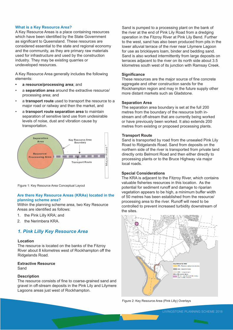
What is a Key Resource Area?A Key Resource Areas is a place containing resources which have been identified by the State Government as significant to Queensland. These resources are considered essential to the state and regional economy and the community, as they are primary raw materials used for infrastructure and used by the construction industry. They may be existing quarries or undeveloped resources.
A Key Resource Area generally includes the following elements:• a resource/processing area; and• a separation area around the extractive resource/
processing area; and• a transport route used to transport the resource to a
major road or railway and then the market, and• a transport route separation area to maintain
separation of sensitive land use from undesirablelevels of noise, dust and vibration cause bytransportation.
Are there Key Resource Areas (KRAs) located in the planning scheme area? Within the planning scheme area, two Key Resource Areas are identified as follows:1. the Pink Lilly KRA; and2. the Nerimbera KRA.
Figure 1: Key Resource Area Conceptual Layout
1. Pink Lilly Key Resource Area
LocationThe resource is located on the banks of the Fitzroy River about 8 kilometres west of Rockhampton off the Ridgelands Road.
Extractive Resource Sand
Description The resource consists of fine to coarse-grained sand andgravel in off-stream deposits in the Pink Lily and Lilymere Lagoons areas just west of Rockhampton.
Sand is pumped to a processing plant on the bank of the river at the end of Pink Lily Road from a dredging operation in the Fitzroy River at Pink Lily Bend. Further to the west, sand has also been produced from pits in the lower alluvial terrace of the river near Lilymere Lagoon for use as bricklayers loam, binder and bedding sand. Sand is also worked intermittently from large deposits on terraces adjacent to the river on its north side about 3.5 kilometres south west of its junction with Ramsay Creek.
SignificanceThese resources are the major source of fine concreteaggregate and other construction sands for the Rockhampton region and may in the future supply other more distant markets such as Gladstone.
Separation Area The separation area boundary is set at the full 200 metres from the boundary of the resource both in-stream and off-stream that are currently being worked or have previously been worked. It also extends 200 metres from existing or proposed processing plants.
Transport RouteSand is transported by road from the unsealed Pink Lily Road to Ridgelands Road. Sand from deposits on the northern side of the river is transported from private land directly onto Belmont Road and then either directly to processing plants or to the Bruce Highway via major local roads.
Special Considerations The KRA is adjacent to the Fitzroy River, which contains valuable fisheries resources in this location. As the potential for sediment runoff and damage to riparian vegetation appears to be high, a minimum buffer width of 50 metres has been established from the resource/processing area to the river. Runoff will need to be controlled to prevent increased turbidity downstream of the sites.
Figure 2: Key Resource Area (Pink Lilly) Overlays
LIVINGSTONE PLANNING SCHEME 2018

LIVINGSTONE PLANNING SCHEME 2018
2. Nerimbera Key Resource Area
LocationThe resource is located in the foothills of the Berserker Range about 8 kilometres east of Rockhampton, north of the Emu Park Road.
Extractive Resource Quarry Rock
DescriptionThe resource consists of hardened argillite and greywacke in the foothills of the Berserker Range to the east of Rockhampton.
The northern part of the resource is the site of a major quarry supplying a full range of crushed rock products. The plant and stockpile area is sited on land on the west side of Black Creek.
Significance The available resource is very large and is the prime source of high quality crushed rock products for the Rockhampton and wider central Queensland region. The volume of material present will enable continuity of this supply for the long term.
Separation AreaThe northern boundary is set at the full 1000 metres away from the existing quarry face because of the exposure of this area to the face. The separation area extends to ridgelines where possible, either their crests or base. It extends down the crest of the ridge to the east of Scholl Lane to Nerimbera School Road, and then continues across Black Creek to the base of the main north-south ridge in the vicinity of Stover Road and Black Creek Road. The southern boundary is the base of the ridge along Black Creek Road about 500 metres from the proposed quarry development. To the southeast the separation distance is the greater of 1000 metres from the proposed resource area or 500 metres from the bund screening the proposed processing area adjacent to Emu Park Road. The eastern boundary largely follows the base or crests of ridges where possible.
Transport RouteThe rock materials are transported from the present operation along the Nerimbera School Road to Emu Park Road. Rail ballast is loaded at the Nerimbera rail siding. The proposed quarry operation on the southern side of the ridge will access the Emu Park-Rockhampton Road directly.
Figure 3: Key Resource Area (Nerimbera) Overlays
Are there other resource areas located in the planning scheme area? The planning scheme does identify other resource areas by overlays. These areas may consist of known resources (historic or current extractive industry or mining) or potential resources (potential future extraction or mining).
The scale and intensity of any established or future operations at these resource areas may vary depending on factors such as the type of resource, its location, and viability to extract or mine. It is important that potential land use conflict is avoided in proximity to these resource areas as much as practicable.
Figure 4: Example of Other Resource Area overlay

LIVINGSTONE PLANNING SCHEME 2018
Figure 5: Magnesite mining operation
Figure 6: Sand and gravel extractive industry
What happens if a lot is affected by an extractive or mining resource area overlay?Having an overlay situated over a lot may or may not trigger assessment against the planning scheme. The overlay maps are to be used in conjunction with the Tables of Assessment contained within Part 5 of the planning scheme. The Tables of Assessment determine the circumstances whether or not an overlay applies, the categories of development and assessment if the lot is affected by an overlay, and also the assessment benchmarks to be used for any development assessment.
In most instances the extractive resource overlay code will be triggered as an assessment benchmark. There are also performance outcomes contained within the Rural Zone Code, General Development Code and Reconfiguring a Lot Code which are likely to apply to development on land affected by extractive and mining resource area overlays.
What type of development is not appropriate?Development that is likely to fragment land or result in a significant increase in the number of people living, working or congregating on a premises that is or may be exposed to adverse impacts associated with extractive industry or mining (now or in the future) is likely to be incompatible and unsuitable.
Examples of unsuitable development include sensitive land uses such as:• accommodation activities (dwelling houses, dual
occupancies, multiple dwellings, rooming accommodation, residential care facilities, retirement facilities, tourist parks, short-term accommodation and the like); and
• community activities (child care centres, community care centres, community use, educational establishments, hospitals, places of worship and the like).
Because of the high level of amenity desired for sensitive land uses, the likelihood of noise, vibration, dust and other emissions resulting from extraction and mining of resources, means that it may be difficult to minimise impacts when they are located in proximity to each other. Development involving the reconfiguration of a lot into small inappropriate lot sizes is also unlikely to be suitable.
What happens if development is not consistent with applicable development assessment codes? A development proposal that is assessed as not complying with the applicable codes means that Council has the ability to refuse the development proposal or to impose conditions if it is considered that the conditions will be suitable for ensuring that the development can comply with the applicable codes.
Disclaimer: The content of this information sheet is a summary and has been prepared to assist the reader to understand the Planning Scheme. This advice given does not bind or fetter the Council in any way in exercising its statutory responsibilities in assessing any development application which might be made to the Council. Please refer to the full Livingstone Planning Scheme 2018 document on Council’s website for further detail.