initial study - department of city...
TRANSCRIPT
City of Los Angeles Department of City PlanningEnvironmental Analysis Section
City Hall 200 N. Spring Street, Room 750 Los Angeles, CA 90012
January 2015
INITIAL STUDY
HOLLYWOOD COMMUNITY PLAN AREA
1311 N. Cahuenga Blvd. Project Case Number: ENV-2014-4280-EIR
Project Location: 1311 N. Cahuenga Blvd., Los Angeles, California, 90037
Council District: 13, Mitch O’Farrell
Project Description: The proposed project would involve the demolition of the existing buildings and construction of a 7-story residential mixed-use building ranging from approximately 82 feet to 110 feet in height, based on relative elevation changes in the existing surrounding terrain, which generally slopes north to south. In addition, the Project would provide two levels of subterranean parking. Existing buildings proposed for demolition include one single-family residence (single-story), a 3-unit apartment building, two office buildings (one 1-story and one 2-story structure), an auto repair facility, and surface parking lots. The Project would provide 369 residential units, including 12 live/work units and 30 micro units, and approximately 2,570 square feet of commercial space on the ground floor. Approximately 40,600 square feet of open space is proposed, which includes space on the ground floor accessible to the public, an outdoor recreation deck on the 2nd floor, a roof terrace on the 7th floor, a covered deck on the 2nd floor, and a gym and recreation room. Parking would be provided in a two-level subterranean garage, at ground level within the building, and in the mezzanine level above-ground. The Project would include approximately 569 parking spaces and 410 bicycle parking spaces.
The project would require ministerial and discretionary approvals, including without limitation: (1) Site Plan Review; (2) Special Zoning Classification Change to modify the “D” Development limitation of 2.0:1 to allow a maximum FAR of 3.7:1; (3) vacation of a four-foot wide strip of the airspace over the public sidewalks on N. Cahuenga Boulevard, Fountain Avenue, and Cole Avenue to allow for balconies; (4) vacation of Homewood Avenue between Cole Avenue and N. Cahuenga Boulevard; (5) Street Designation Change for two-way vehicle operation between Homewood Avenue and Fountain Avenue; (6) Tree Removal Permit; (7) haul route permit; (8) demolition, grading, excavation, and building permits; and (9) other permits, ministerial or discretionary, may be necessary in order to execute and implement the project. Such approvals may include, but are not limited to: landscaping approvals, exterior approvals, permits for driveway curb cuts, storm water discharge permits, and installation and hookup approvals for public utilities and related permits.
APPLICANT:
Rescore Hollywood, LLC
PREPARED BY:
Meridian Consultants LLC 910 Hampshire Rd., Ste. V
Westlake Village, CA 91361
ON BEHALF OF:
City of Los Angeles Department of City Planning
Environmental Analysis Section

1311 Cahuenga Mixed-Use Project Section 1.0-1 Initial Study January 2015
1.0 INTRODUCTION
Project Title: 1311 Cahuenga Mixed-Use Project
Project Location: 1311 N. Cahuenga Boulevard, Los Angeles, California
Project Applicant Rescore Hollywood LLC 11726 San Vicente Boulevard, Suite 235 Los Angeles, CA 90049
Lead Agency: City of Los Angeles Department of City Planning 200 N. Spring Street, Room 721 Los Angeles, CA 90012
PROJECT SUMMARY
The 1311 Cahuenga Mixed-Use Project (“Proposed Project”) is a residential and commercial mixed-use
development proposed on approximately 2.15 acres in Hollywood. The Proposed Project is bounded by
North Cahuenga Boulevard on the north and east, Fountain Avenue to the south, and Cole Avenue to
the west and north.
The Proposed Project would involve demolition of the existing buildings, including one single-family
residence (single-story), a 3-unit apartment building, two office buildings (one 1-story and one 2-story
structure), an auto repair facility, and surface parking lots. Proposed development includes the
construction of a 7-story residential mixed-use building (which ranges from approximately 82 feet to 110
feet in height, based on relative elevation changes in the existing surrounding terrain, which generally
slopes north to south). There will also be two levels of subterranean parking. The Project would provide
369 residential units, including 12 live/work units and 30 micro units, and approximately 2,570 square
feet of commercial space on the ground floor. The Project would also include approximately 40,900
square feet of open space in the form of plazas, recreation amenities, and private balconies.
This Initial Study is a preliminary analysis prepared by and for the City of Los Angeles as the Lead Agency
to determine whether an Environmental Impact Report (EIR), Negative Declaration (ND), or Mitigated
Negative Declaration (MND) must be prepared for a proposed project.

1.0 Introduction
1311 Cahuenga Mixed-Use Project Section 1.0-2 Initial Study January 2015
ORGANIZATION OF INITIAL STUDY ANALYSIS
This Initial Study is organized into six sections as follows:
Section 1.0, Introduction, provides introductory information such as the Proposed Project title, the
Project Applicant, and the lead agency for the Proposed Project.
Section 2.0, Project Description, provides a detailed description of the Proposed Project including the
environmental setting, project characteristics, related project information, project objectives, and
environmental clearance requirements.
Section 3.0, Initial Study Checklist, includes the City CEQA Checklist to determine the significance of
potential environmental impacts of the Project.
Section 4.0, Environmental Analysis, includes a discussion and preliminary analysis for each
environmental topic and threshold listed in the Initial Study Checklist and identifies potential impacts
and whether each topic must be further analyzed in an EIR.
Section 5.0, References, identifies all printed references and individuals cited in this Initial Study.
Section 6.0, List of Preparers, identifies the individuals who prepared this report and their areas of
technical specialty.

1311 Cahuenga Mixed-Use Project Section 2.0-1 Initial Study January 2015
2.0 PROJECT DESCRIPTION
2.1 PROJECT LOCATION
The Project Site consists of approximately 2.15 acres located at 1311 N. Cahuenga Boulevard, bound by
N. Cahuenga Boulevard on the north and east, Fountain Avenue to the south, and Cole Avenue to the
west and north. Homewood Avenue bisects the Project Site. Figure 2.0-1, Project Location Map, shows
the location of the Project Site.
Project Site
The Project Site consists of 14 existing parcels. Homewood Avenue currently extends from N. Cahuenga
Boulevard through the site to Cole Avenue. The net size is approximately 93,789 square feet.
2.2 EXISTING PROJECT SITE CONDITIONS
Existing buildings and uses on the Project Site consist of residential units, office buildings, an auto repair
facility, and surface parking. The Project Site also contains a minimal amount of landscaping primarily
consisting of street trees located along Homewood Avenue. The existing uses are shown in Figure 2.0-2,
Aerial Photograph of the Project Site, and in photographs provided in Figures 2.0-3 through 2.0-8,
Existing Conditions.
Residential uses are located in the southwest portion of the Project Site. A 1-story single-family home,
approximately 1,625 square feet in size, is located on Fountain Avenue near the intersection with Cole
Avenue. A vacant building containing 3 apartment units, approximately 3,217 square feet in size, is
located adjacent to the single-family residence at the corner of Fountain Avenue and Cole Avenue and
along Cole Avenue. The apartments are contained in a 1-story building on the corner of Cole and
Fountain Avenues and a 2-story building on Cole Avenue.
There are two office buildings on-site. One is a single-story building, approximately 4,600 square feet in
size, located on the southeast corner of Cole and Homewood Avenues. The second office building is a 2-
story building, approximately 11,347 square feet in size, located north of Homewood Avenue between
Cole Avenue and N. Cahuenga Boulevard.
An automotive repair facility, including storage and a 1,000-square-foot structure, is located on N.
Cahuenga Boulevard between Homewood Avenue and Fountain Avenue.

2.0 Project Description
1311 Cahuenga Mixed-Use Project Section 2.0-2 Initial Study January 2015
Surface parking lots currently occupy most of the Project Site, with a 21,000-square-foot lot located
south of Homewood Avenue, a 16,200-square-foot lot on the corner of Fountain Avenue and N.
Cahuenga Boulevard, and a smaller lot located north of Homewood Avenue.
2.3 EXISTING SURROUNDING LAND USES
The Project Site is surrounded by a mix of office, commercial, and residential uses. Buildings range from low-rise to high-rise buildings, which are physically separated from the Project Site by secondary and local streets. The 7-story parking structure for the Cinerama Dome/ArcLight Cinemas entertainment complex is located one block to the northeast, and the 14-story CNN office building on Sunset Boulevard is located one block to the north of the Project Site. Other surrounding uses include single- and multifamily residential buildings to the south of Fountain Avenue, the Hollywood City Hall, Los Angeles Fire and Police Departments, and Los Angeles Fire Department Historical Society immediately to the west of Cole Avenue, and commercial buildings to the east of N. Cahuenga Boulevard. A more detailed description of surrounding uses follows:
North: To the north, across De Longpre Avenue, are visual production companies including The Post Group, iO Film, and NT Picture & Sound. Additional commercial buildings including PureLife Alternative Wellness Center and a Fiat auto parts and service warehouse are located to the north along N. Cahuenga Boulevard and Ingvar Avenues. Properties to the north are zoned C4-2D (commercial).
East: To the east of the Project Site and N. Cahuenga Boulevard are surface parking lots and a single-story multifamily residential building on Fountain Avenue. Properties to the east are zoned C4-2D (Commercial).
South: Single- and multifamily residential units are located across Fountain Avenue to the south. Properties are zoned R3-1XL (Residential).
West: The Hollywood Division of the Los Angeles Police Department, Los Angeles Fire Department Station 27, and the Los Angeles Fire Department Historical Society are located to the northwest of the Project Site. The Hollywood City Hall and associated surface parking lots are also located to the west. Properties to the west are zoned PF-1XL (Public Facilities).

Fountain Ave
W Sunset Blvd
Hollywood Blvd.
Santa Monica Blvd
De Longpre Ave
N G
ower
St
N B
rons
on A
ve
Vine
St
N C
ahen
ga B
lvd
N H
ighl
and
Ave
Schr
ader
Blv
d.
Mor
ning
side
Ct
Arg
yle
Ave
N M
cCad
den
Pl
N L
as P
alm
as A
ve N C
hero
kee
Ave
N J
une
St
Sew
ard
St
N H
udso
n A
ve
Wilc
ox P
l
Wilc
ox A
ve
Col
e Pl
Lilli
an W
ay
N E
l Cen
tro
Ave
Lodi
Pl
N B
each
woo
d D
r
Gor
don
St
Tam
arin
d A
ve
Banner Ave
Afton Pl
Leland Way
Selma Ave
Cas
sil P
l
N M
ansf
ield
Ave
N C
itrus
Ave
Hawthorne Ave
Cos
mo
St
Col
e A
ve
Winona Blvd.
Homewood Ave
Project Location Map
FIGURE 2.0-1
070-001-14
SOURCE: Google Earth - 2014
APPROXIMATE SCALE IN FEET
10005000 2000
N
Project Site
Legend:
Project SiteTerminal Island
Los Angeles County
Kern County
Ven
tura
County
Los A
ngeles C
ounty
Sherman Oaks
Calabasas
Malibu
San B
ernard
ino C
ounty
Los
Angel
es C
ounty
Santa Monica
Santa Clarita
Chatsworth
Warner Center
Granada Hills
Porter RanchMission Hills
Sun Valley
Woodland Hills Encino
Culver City
Pasadena
SouthPasadena
Hollywood
Beverly Hills
Inglewood
HuntingtonPark
LosAngeles
El Monte
Montbello
Whittier
Santa Fe SpringsDowney
Monterey Park
La MiradaParamountComptonCerritos
Gardena
CarsonTorranceLakewood
Rancho PalosVerdes
San Pedro
Long Beach
US
66
US
101
US
101
US
101
10INTERSTATE
210INTERSTATE
210INTERSTATE
10INTERSTATE
10INTERSTATE
605INTERSTATE
710INTERSTATE
605INTERSTATE
105INTERSTATE
5INTERSTATE
5INTERSTATE
5INTERSTATE
5INTERSTATE
405INTERSTATE
405INTERSTATE
405INTERSTATE
405INTERSTATE
90CALIFOR NIA
91CAL IFOR NIA
47CA LIFOR NI A
110CALIFOR NIA
110CAL IFOR NIA
159CAL IFOR NIA
107CA LIFOR NIA
1CALIFOR NIA
1CALIFOR NIA
1CAL IFOR NIA
1CALIFOR NIA
2CAL IFOR NIA
27CALIFOR NIA
118CA LIFOR NIA
126CA LIFOR NIA
126CA LIFOR NIA
14CALIFOR NIA
14CA LIFOR NIA
27CAL IFOR NIA
2CALIFOR NIA
2CAL IFOR NIA
2CA LIFOR NI A
138CALIFOR NIA
138CALIFOR NIA
138CALIFOR NIA
138CALIFOR NIA
18CALIFOR NIA
90CALIFOR NIA
42CA LIFOR NI A
213CAL IFOR NIA
39CA LIFOR NI A
60CAL IFOR NIA
60CAL IFOR NIA
57CA LIFOR NIA
72CAL IFOR NIA
134CAL IFOR NIA
19CALIFOR NIA
71CALIFOR NIA
30CAL IFOR NIA
39CALIFOR NIA
P a c i f i cO c e a n
22CAL IFOR NIA
APPROXIMATE SCALE IN MILES
1260 24
N
Project Site
23CALIF RNIAO

Aerial Photograph of the Project Site
FIGURE 2.0-2
070-001-14
SOURCE: Google Earth - 2014APPROXIMATE SCALE IN FEET
100500 200
NLegend:
Project Site
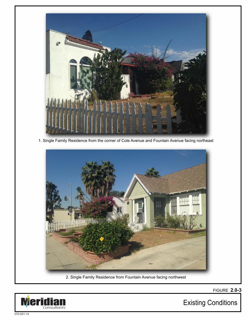
1. Single Family Residence from the corner of Cole Avenue and Fountain Avenue facing northeast
2. Single Family Residence from Fountain Avenue facing northwest
Existing Conditions
FIGURE 2.0-3
070-001-14

3. Three-Unit Apartment Building from Cole Avenue facing east
4. Office building from Cole Avenue facing north
Existing Conditions
FIGURE 2.0-4
070-001-14

5. Office building from Cole Avenue and Homewood Avenue facing south
6. Office building from N. Cahuenga Avenue facing north
Existing Conditions
FIGURE 2.0-5
070-001-14

7. Auto Repair Facility from N. Cahuenga Boulevard facing north
8. Auto Repair Facility from N. Cahuenga Boulevard facing south
Existing Conditions
FIGURE 2.0-6
070-001-14

9. Auto Repair Facility from N. Cahuenga Boulevard facing west
10. Office buildings from N. Cahuenga Boulevard facing northwest
Existing Conditions
FIGURE 2.0-7
070-001-14

11. Auto Repair Facility, Surface Parking Lot on Homewood Avenue,and Office Buildings from N. Cahuenga Boulevard facing southwest
12. Surface parking lot from Fountain Avenue facing north
Existing Conditions
FIGURE 2.0-8
070-001-14

2.0 Project Description
1311 Cahuenga Mixed-Use Project Section 2.0-11 Initial Study January 2015
2.4 LAND USE AND ZONING DESIGNATIONS
Land Use
The Project Site is located within the Hollywood Community Plan (Community Plan) area of the City of Los Angeles. The Community Plan area is generally bound by Griffith Park, the Ventura Freeway (State Route [SR] 134), and the Golden State Freeway (I-5) to the northeast; by Melrose Avenue to the south; and by the Hollywood Hills to the west. The Community Plan designates the Project Site for Regional Center Commercial land uses.1
The Project Site is also located within the Hollywood Redevelopment Plan (Redevelopment Plan) Area. The Redevelopment Plan requires that all projects greater than 250,000 square feet be approved by the City Planning Commission.
Zoning
Figure 2.0-9, Zoning Map, depicts the zoning designations of the Project Site and the surrounding area. The Project Site is zoned C4-2D. The C4 Commercial zone permits a variety of commercial uses, such as retail with limited manufacturing, service stations and garages, office uses, hotels, and hospitals; in addition to residential uses, churches, schools, and childcare. The “2” height designation limits the Project Site’s FAR to 6:1 (there is no height restriction for buildings located within this zoning designation). However, the “D” attached to the C4 designation permits a maximum floor area ratio (FAR) of 2.0:1.
2.5 PROJECT CHARACTERISTICS
The Project would involve the demolition of the existing buildings and the construction of a 7-story residential mixed-use building. The Project would develop a total of 347,019 square feet of floor area. The apartment building would contain approximately 333,089 square feet of floor area between floors two and seven for apartment units. The 2,570-square-foot office component and 790-square-foot leasing office would be at the ground floor. The Project would include 10,570 square feet of residential amenities. The Project’s FAR would be at or below 3.7:1, which would be consistent with the nearby community. A two-level parking garage will be located beneath the ground floor of the building.
As shown in Figure 2.0-10, Floor Plan – Ground Level the ground floor will include residential lobby/amenities, a leasing office, and commercial, residential and bicycle parking. There will also be 12 live/work units located on the ground level facing Fountain Avenue and N. Cahuenga Boulevard.
A mezzanine level, as provided in Figure 2.0-11, Floor Plan – Mezzanine Level; will include the second floor of the street-facing live/work units, in addition to parking.
1 Hollywood Community Plan (1988).
2.0 Project Description
1311 Cahuenga Mixed-Use Project Section 2.0-12 Initial Study January 2015
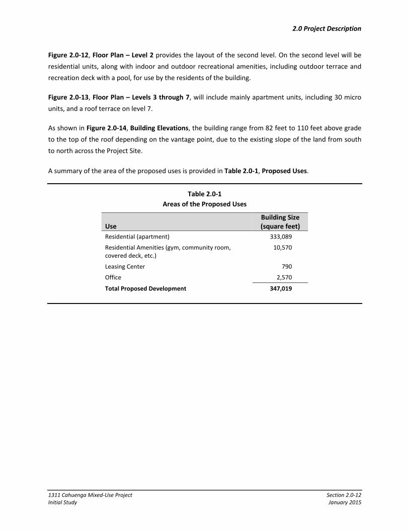
Figure 2.0-12, Floor Plan – Level 2 provides the layout of the second level. On the second level will be residential units, along with indoor and outdoor recreational amenities, including outdoor terrace and recreation deck with a pool, for use by the residents of the building.
Figure 2.0-13, Floor Plan – Levels 3 through 7, will include mainly apartment units, including 30 micro units, and a roof terrace on level 7.
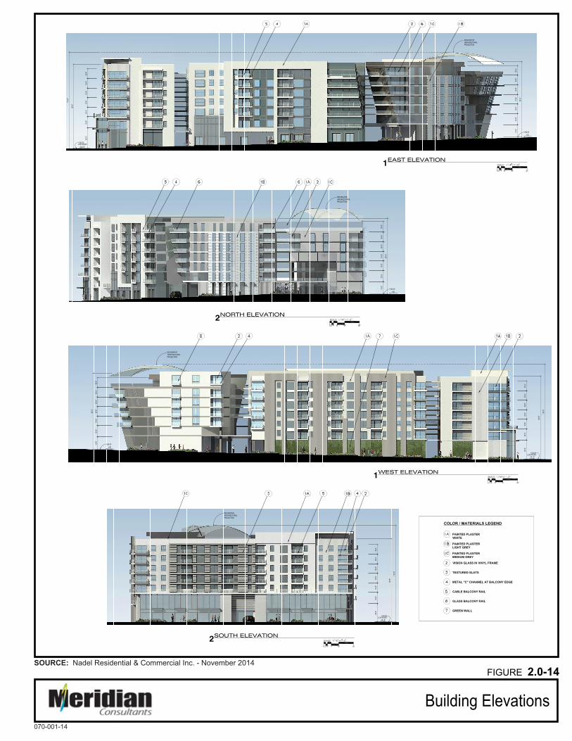
As shown in Figure 2.0-14, Building Elevations, the building range from 82 feet to 110 feet above grade to the top of the roof depending on the vantage point, due to the existing slope of the land from south to north across the Project Site.
A summary of the area of the proposed uses is provided in Table 2.0-1, Proposed Uses.
Table 2.0-1 Areas of the Proposed Uses
Use Building Size (square feet)
Residential (apartment) 333,089
Residential Amenities (gym, community room, covered deck, etc.)
10,570
Leasing Center 790
Office 2,570
Total Proposed Development 347,019

Zoning Map
FIGURE 2.0-9
070-001-14
SOURCE: ZIMAS - 2014
NLegend:
Project Site

FIGURE 2.0-10
Floor Plan - Ground Level070-001-14
SOURCE: Nadel Residential & Commercial Inc. - November 2014
APPROXIMATE SCALE IN FEET
100500 200
N
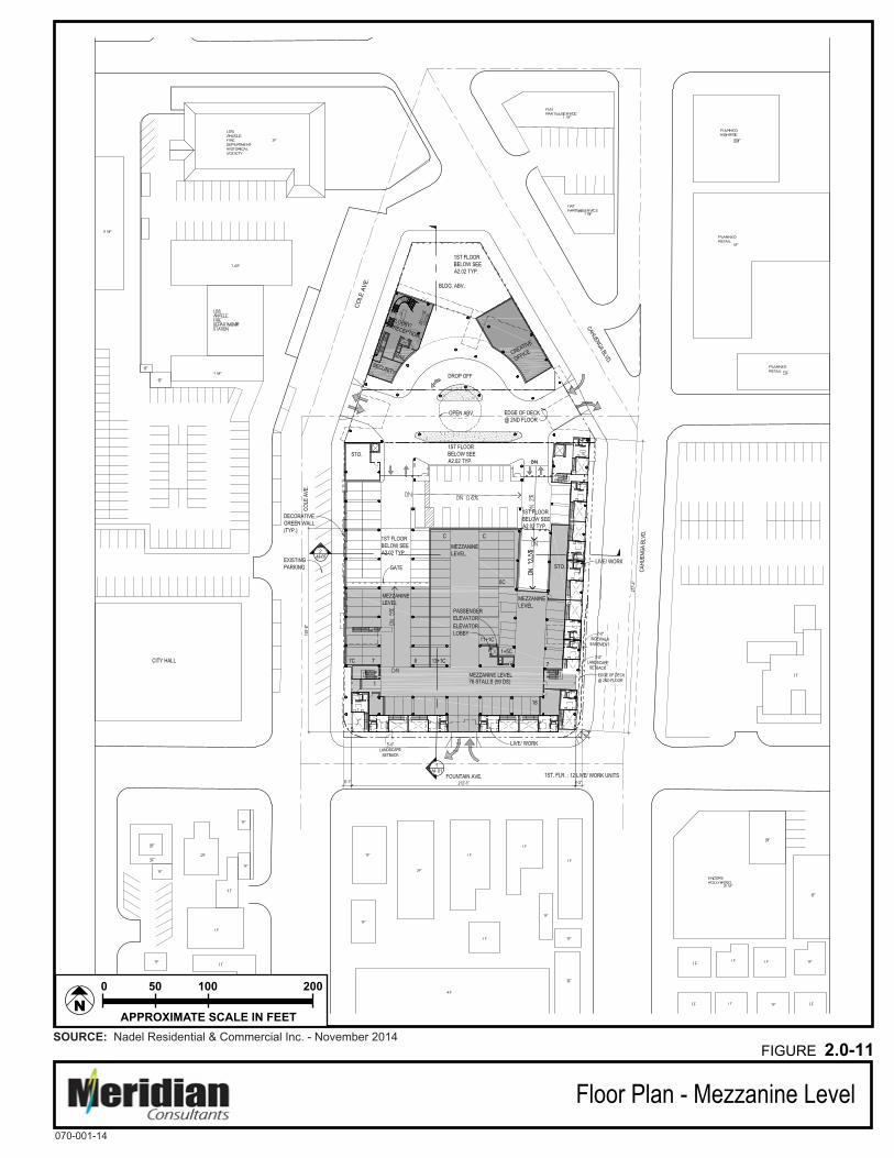
FIGURE 2.0-11
Floor Plan - Mezzanine Level070-001-14
SOURCE: Nadel Residential & Commercial Inc. - November 2014
APPROXIMATE SCALE IN FEET
100500 200
N

FIGURE 2.0-12
Floor Plan - Level 2070-001-14
SOURCE: Nadel Residential & Commercial Inc. - November 2014
APPROXIMATE SCALE IN FEET
100500 200
N

FIGURE 2.0-13
Floor Plan - Levels 3 through 7070-001-14
SOURCE: Nadel Residential & Commercial Inc. - November 2014
APPROXIMATE SCALE IN FEET
100500 200
N
Building Elevations
FIGURE 2.0-14
070-001-14
SOURCE: Nadel Residential & Commercial Inc. - November 2014
2.0 Project Description
1311 Cahuenga Mixed-Use Project Section 2.0-19 Initial Study January 2015
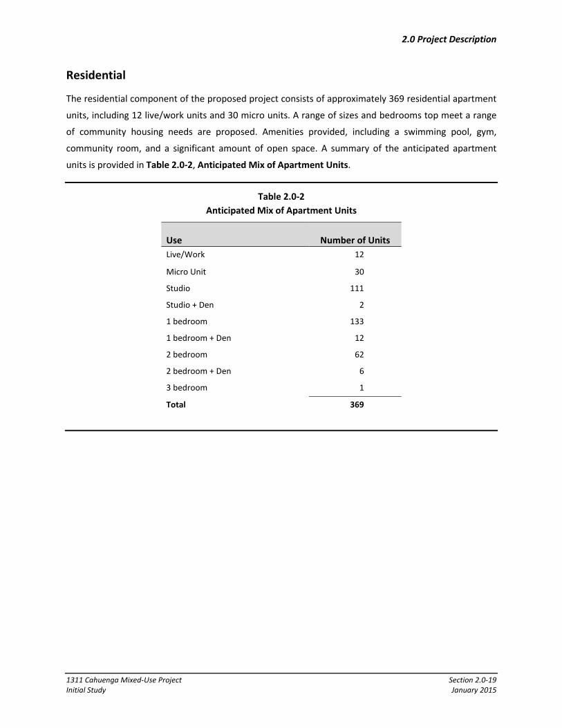
Residential
The residential component of the proposed project consists of approximately 369 residential apartment
units, including 12 live/work units and 30 micro units. A range of sizes and bedrooms top meet a range
of community housing needs are proposed. Amenities provided, including a swimming pool, gym,
community room, and a significant amount of open space. A summary of the anticipated apartment
units is provided in Table 2.0-2, Anticipated Mix of Apartment Units.
Table 2.0-2 Anticipated Mix of Apartment Units
Use Number of Units Live/Work 12
Micro Unit 30
Studio 111
Studio + Den 2
1 bedroom 133
1 bedroom + Den 12
2 bedroom 62
2 bedroom + Den 6
3 bedroom 1
Total 369

2.0 Project Description
1311 Cahuenga Mixed-Use Project Section 2.0-20 Initial Study January 2015
Commercial
The Project would include approximately 2,570 square feet of creative office space, located on N.
Cahuenga Boulevard, north of Homewood Avenue.
Circulation, Access, and Parking
Circulation and Access
Primary vehicular access to the below-grade resident parking will be provided from a driveway accessed
from Fountain Avenue. This will be a right-in/right-out only access. Homewood Drive will be vacated to
allow for the construction of the building above and below the street. However, a public access
easement will be maintained across the surface of Homewood Avenue to allow for vehicle, pedestrian
and emergency vehicle access through the site. Homewood Avenue will also be used for access to the
parking garage for residential and commercial components of the project. Homewood Avenue will
provide for full access at N. Cahuenga Boulevard and ingress and egress to/from Cole Avenue south of
Homewood Avenue and egress only north to Cole Avenue north of Homewood Avenue. Short-term
parking spaces for the building leasing office will also be accessed from Homewood Avenue.
The Applicant is requesting the Cole Avenue be striped to allow for two-way vehicle operation between
Homewood Avenue and Fountain Avenue. Currently Cole Avenue is a one-way street (northbound)
between Fountain Avenue and N. Cahuenga Boulevard. The proposed change between Homewood
Avenue and Fountain would be adjacent to the Project and the Hollywood Community City Hall on the
west side of the Cole. This would improve fire access from the fire station on the west side of Cole
Avenue north of Homewood Avenue and allow for better traffic circulation around the Project site. Five
unmetered parking spaces on the east side of Cole would have to be removed as part of the conversion,
and the applicant has agree to include five parking spaces within the project to make up for the lost on-
street parking.
Finally, a Project Design Feature incorporated into the Project will be the addition of a southbound right-
turn lane at the intersection of N. Cahuenga Boulevard and Fountain Avenue to facilitate traffic
circulation in the area.
Parking
Parking will be provided in a two-level subterranean garage, at ground level within the building, and in
the mezzanine level aboveground. The Project would include approximately 567 parking spaces, which
exceeds the LAMC Code requirement of 528 spaces, and 410 bicycle parking spaces. The bicycle parking
includes 371 long-term and 39 short-term bicycle parking spaces for the residential component and 2
long and 2 short-term spaces for the commercial component. For the 2,570 square foot creative office

2.0 Project Description
1311 Cahuenga Mixed-Use Project Section 2.0-21 Initial Study January 2015
component of the Project, 5 parking spaces are proposed in accordance with LAMC standards. Five of
the total parking spaces may be designated for off-site parking for the Los Angeles Police Station located
on the west side of Cole Avenue to make up for 5 on-street parking spaces that will be removed to
accommodate the restriping of a portion of Cole Avenue from one-way to two-way operations.
Open Space and Landscaping
The Proposed Project would exceed required residential open space for the Project Site. As shown in
Table 2.0-3, Open Space, approximately 40,900 square feet of open space is proposed, which includes
space for an outdoor recreation deck on the second floor, a roof terrace on the seventh floor, a covered
deck on the second floor, and a gym and recreation room. In addition, the Proposed Project would
provide 93 trees on site and in the public right-of-way surrounding the building. This is consistent with
the City of Los Angeles Landscape Ordinance, which requires that at least one tree shall be provided in a
project for every four dwelling units.
Table 2.0-3 Open Space
Open Space Area (sq. ft.) Common Outdoor Open Space
Ground floor plaza 3,800
2nd Floor Outdoor Recreation Deck 13,100
7th Floor Roof Terrace 5,200
Total Outdoor Common Open Space 22,100
Common Indoor Open Space
Gym & Recreation Room 5,900
2nd Floor Covered Deck 3,300
Total Enclosed Common Open Space 9,200
Subtotal common open space 31,300
Private Open Space
Private balconies/patios 9,600
Total open space provided 40,900 Source: Nadel Residential & Commercial, Inc. (September 26, 2014).
Easements and Dedications
A 20-foot wide public access easement will be provided to facilitate the continued use of Homewood
Avenue for public vehicular access (including emergency vehicles) after the street becomes a private
drive.
2.0 Project Description
1311 Cahuenga Mixed-Use Project Section 2.0-22 Initial Study January 2015
Construction
Construction Schedule/Phasing
The Project is would commence demolition activities in late 2015 or early 2016, and construction of the
Project improvements would be completed in 2018.
2.6 REQUESTED APPROVALS
• Site Plan Review pursuant to the provisions of LAMC Section 16.05.C.1(b), to permit a proposed
project that creates or results in an increase of 50 or more dwelling units.
• Special Zoning Classification Change for a Special Zoning Classification Change to modify the “D”
Development limitation of 2.0:1 to allow a maximum FAR of 3.7:1.
• Vacation of a four-foot wide strip of the airspace over the public sidewalks on N. Cahuenga
Boulevard, Fountain Avenue, and Cole Avenue to allow for balconies
• Vacation of Homewood Avenue between Cole Avenue and N. Cahuenga Boulevard.
• Street Designation Change for two-way vehicle operation between Homewood Avenue and
Fountain Avenue.
• Demolition, Grading, excavation, and building permits
• Haul Route Permit for the Project Site for the export of soil.
• Tree Removal Permit for the removal of existing trees on-site and along the parkways.
Federal, state, and regional agencies may have jurisdiction over the Project, including, but not limited to,
the following agencies:
• Regional Water Quality Board.
• South Coast Air Quality Management District


3.0 Initial Study Checklist
1311 Cahuenga Mixed-Use Project Section 3.0-2 Initial Study January 2015
CITY OF LOS ANGELES OFFICE OF THE CITY CLERK
ROOM 395, CITY HALL LOS ANGELES, CA 90012
CALIFORNIA ENVIRONMENTAL QUALITY ACT INITIAL STUDY and CHECKLIST (CEQA Guidelines Section 15063)
LEAD CITY AGENCY:
City of Los Angeles
COUNCIL DISTRICT:
CD 13 – Mitch O’Farrell
DATE:
January 02, 2015
RESPONSIBLE AGENCIES: Department of City Planning
ENVIRONMENTAL CASE:
ENV-2014-4280-EIR
RELATED CASES:
CPC-2014-4279-ZC-HD-SPR PREVIOUS ACTIONS CASE NO.
N/A
DOES have significant changes from previous actions.
DOES NOT have significant changes from previous actions
PROJECT DESCRIPTION:
(1) Site Plan Review; (2) Special Zoning Classification Change to modify the “D” Development limitation of 2.0:1 to allow a maximum FAR of 3.7:1; (3) vacation of a four-foot wide strip of the airspace over the public sidewalks on N. Cahuenga Boulevard, Fountain Avenue, and Cole Avenue to allow for balconies; (4) vacation of Homewood Avenue between Cole Avenue and N. Cahuenga Boulevard; (5) Street Designation Change for two-way vehicle operation between Homewood Avenue and Fountain Avenue; (6) Tree Removal Permit; (7) haul route permit; (8) demolition, grading, excavation, and building permits; and (9) other permits, ministerial or discretionary, may be necessary in order to execute and implement the project. Such approvals may include, but are not limited to: landscaping approvals, exterior approvals, permits for driveway curb cuts, storm water discharge permits, and installation and hookup approvals for public utilities and related permits.
ENV PROJECT DESCRIPTION: Development of a transit-oriented mixed-use project is proposed on the 2.15-acre Project Site. A 7-story residential building (approximately 110 feet in height) with two levels of subterranean parking is proposed, which would include 369 residential units, including 12 live/work units and 30 micro units, and approximately 2,570 square feet of commercial space on the ground level. The Project also includes approximately 40,900 square feet of open space, in the form of plazas, recreation amenities, and private balconies. Existing buildings and site improvements located on the Project Site would be demolished including 1 single-family residence, a 3-unit apartment building, office buildings, an auto repair facility, and surface parking lots.
ENVIRONMENTAL SETTING: The Project Site includes approximately 93,789 square feet (2.15 acres) bound by N. Cahuenga Boulevard on the north and east, Fountain Avenue to the south, and Cole Avenue to the west and north. Homewood Avenue bisects the Project Site from N. Cahuenga Avenue to Cole Avenue. The Project Site is currently developed with 1 single-family residence, a 3-unit apartment building, office buildings, an auto repair facility, and surface parking lots. Further details and photographs of the existing Project Site and surrounding area are provided in the Initial Study (IS) prepared by Meridian Consultants dated November 2014. PROJECT LOCATION: 1331 North Cahuenga Boulevard


3.0 Initial Study Checklist
1311 Cahuenga Mixed-Use Project Section 3.0-4 Initial Study January 2015
EVALUATION OF ENVIRONMENTAL IMPACTS
1. A brief explanation is required for all answers except “No Impact” answers that are adequately supported by the information sources a lead agency cites in the parentheses following each question. A “No Impact” answer is adequately supported if the referenced information sources show that the impact simply does not apply to projects like the one involved (e.g., the project falls outside a fault rupture zone). A “No Impact” answer should be explained where it is based on project-specific factors as well as general standards (e.g., the project will not expose sensitive receptors to pollutants based on a project-specific screening analysis).
2. All answers must take account of the whole action involved, including off-site as well as on-site, cumulative as well as project-level, indirect as well as direct, and construction as well as operational impacts.
3. Once the lead agency has determined that a particular physical impact may occur, the checklist answers must indicate whether the impact is potentially significant, less than significant with mitigation, or less than significant. “Potentially Significant Impact” is appropriate if there is substantial evidence that an effect may be significant. If there are one or more “Potentially Significant Impact” entries when the determination is made, an EIR is required.
4. “Negative Declaration: Less than Significant with Mitigation Incorporated” applies where the incorporation of a mitigation measure has reduced an effect from “Potentially Significant Impact” to “Less Than Significant Impact.” The lead agency must describe the mitigation measures and briefly explain how they reduce the effect to a less than significant level (mitigation measures from “Earlier Analysis,” as described in (5) below, may be cross-referenced).
5. Earlier analysis must be used where, pursuant to the tiering, program EIR, or other CEQA process, an effect has been adequately analyzed in an earlier EIR or negative declaration (Section 15063 (c)(3)(D)). In this case, a brief discussion should identify the following:
6. Earlier Analysis Used. Identify and state where they are available for review.
7. Impacts Adequately Addressed. Identify which effects from the above checklist were within the scope of and adequately analyzed in an earlier document pursuant to applicable legal standards, and state whether such effects were addressed by mitigation measures based on the earlier analysis.
8. Mitigation Measures. For effects that are “Less than Significant with Mitigation Measures Incorporated,” describe the mitigation measures which were incorporated or refined from the earlier document and the extent to which they address site-specific conditions for the project.

3.0 Initial Study Checklist
1311 Cahuenga Mixed-Use Project Section 3.0-5 Initial Study January 2015
9. Lead agencies are encouraged to incorporate into the checklist references to information sources for potential impacts (e.g., general plans, zoning ordinances). Reference to a previously prepared or outside document should, where appropriate, include a reference to the page or pages where the statement is substantiated
10. Supporting Information Sources: A sources list should be attached, and other sources used or individuals contacted should be cited in the discussion.
11. This is only a suggested form, and lead agencies are free to use different formats; however, lead agencies should normally address the questions from this checklist that are relevant to a project’s environmental effects in whichever format is selected.
12. The explanation of each issue should identify:
a. The significance criteria or threshold, if any, used to evaluate each question; and
b. The mitigation measure identified, if any, to reduce the impact to less than significant.

3.0 Initial Study Checklist
1311 Cahuenga Mixed-Use Project Section 3.0-6 Initial Study January 2015
ENVIRONMENTAL FACTORS POTENTIALLY AFFECTED
The environmental factors checked below would be potentially affected by this project, involving at
least one impact that is a “Potentially Significant Impact” as indicated by the checklist on the following
pages.
AESTHETICS
AGRICULTURE AND FOREST RESOURCES
AIR QUALITY
BIOLOGICAL RESOURCES
CULTURAL RESOURCES
GEOLOGY AND SOILS
GREENHOUSE GAS EMISSIONS
HAZARDS AND HAZARDOUS MATERIALS
HYDROLOGY AND WATER QUALITY
LAND USE AND PLANNING
MINERAL RESOURCES
NOISE
POPULATION AND HOUSING
PUBLIC SERVICES
RECREATION
TRANSPORTATION AND TRAFFIC
UTILITIES
MANDATORY FINDINGS OF SIGNIFICANCE
INITIAL STUDY CHECKLIST (To be completed by the Lead City Agency)
Background
PROPONENT NAME: PHONE NUMBER: Rescore Hollywood LLC (310) 544-5900
APPLICANT ADDRESS: 11726 San Vicente Boulevard, Suite 235 Los Angeles, CA 90049
AGENCY REQUIRING CHECKLIST: DATE SUBMITTED: City of Los Angeles December 4, 2014 Department of City Planning PROPOSAL NAME (if applicable):
1311 Cahuenga Mixed-Use Project

3.0 Initial Study Checklist
1311 Cahuenga Mixed-Use Project Section 3.0-7 Initial Study January 2015
Potentially Significant
Impact
Less than Significant with
Project Mitigation
Less than Significant
Impact
No Impact
PLEASE NOTE THAT EACH AND EVERY RESPONSE IN THE CITY OF LOS ANGELES INITIAL STUDY AND CHECKLIST IS SUMMARIZED FROM AND BASED UPON THE ENVIRONMENTAL ANALYSIS CONTAINED IN ATTACHMENT B, EXPLANATION OF CHECKLIST DETERMINATIONS. PLEASE REFER TO THE APPLICABLE RESPONSE IN ATTACHMENT B FOR A DETAILED DISCUSSION OF CHECKLIST DETERMINATIONS.
4.1 AESTHETICS Would the project: a. Have a substantial adverse effect on a scenic vista?
b. Substantially damage scenic resources, including, but not limited to, trees, rock outcroppings, and historic buildings, or other locally recognized desirable aesthetic natural feature within a city-designated scenic highway?
c. Substantially degrade the existing visual character or quality of the site and its surroundings?
d. Create a new source of substantial light or glare which would adversely affect day or nighttime views in the area?
4.2 AGRICULTURE AND FOREST RESOURCES Would the project: a. Convert Prime Farmland, Unique Farmland, or Farmland of
Statewide Importance, as shown on the maps prepared pursuant to the Farmland Mapping and Monitoring Program of the California Resources Agency, to non-agricultural use?
b. Conflict with existing zoning for agricultural use, or a Williamson Act contract?
c. Conflict with existing zoning for, or cause rezoning of, forest land (as defined in Public Resources Code section 1220(g)), timberland (as defined by Public Resources Code section 4526), or timberland zoned Timberland Production (as defined by Government Code section 51104(g))?
d. Result in the loss of forest land or conversion of forest land to non-forest use?
e. Involve other changes in the existing environment which, due to their location or nature, could result in conversion of farmland, to non-agricultural use or conversion of forest land to non-forest use?
4.3 AIR QUALITY Would the project: a. Conflict with or obstruct implementation of the SCAQMD or
congestion management plan?
b. Violate any air quality standard or contribute substantially to an existing or projected air quality violation?
3.0 Initial Study Checklist
1311 Cahuenga Mixed-Use Project Section 3.0-8 Initial Study January 2015
Potentially Significant
Impact
Less than Significant with
Project Mitigation
Less than Significant
Impact
No Impact
c. Result in a cumulatively considerable net increase of any criteria pollutant for which the air basin is non-attainment under an applicable federal or state ambient air quality standard (including releasing emissions, which exceed quantitative thresholds for ozone precursors)?
d. Expose sensitive receptors to substantial pollutant concentrations?
e. Create objectionable odors affecting a substantial number of people?
4.4 BIOLOGICAL RESOURCES Would the project: a. Have a substantial adverse effect, either directly or through
habitat modification, on any species identified as a candidate, sensitive, or special status species in local or regional plans, policies, or regulations by The California Department of Fish and Game or U.S. Fish and Wildlife Service?
b. Have a substantial adverse effect on any riparian habitat or other sensitive natural community identified in the city or regional plans, policies, regulations by the California Department of Fish and Game or U.S. Fish and Wildlife Service?
c. Have a substantial adverse effect on federally protected wetlands as defined by Section 404 of the Clean Water Act (including, but not limited to, marsh vernal pool, coastal, etc.) through direct removal, filling, hydrological interruption, or other means?
d. Interfere substantially with the movement of any native resident or migratory fish or wildlife species or with established native resident or migratory wildlife corridors, or impede the use of native wildlife nursery sites?
e. Conflict with any local policies or ordinances protecting biological resources, such as tree preservation policy or ordinance?
f. Conflict with the provisions of an adopted Habitat Conservation Plan, Natural Community Conservation Plan, or other approved local, regional, or state habitat conservation plan?
4.5 CULTURAL RESOURCES Would the project: a. Cause a substantial adverse change in significance of a
historical resource as defined in State CEQA Section 15064 5?
3.0 Initial Study Checklist
1311 Cahuenga Mixed-Use Project Section 3.0-9 Initial Study January 2015
Potentially Significant
Impact
Less than Significant with
Project Mitigation
Less than Significant
Impact
No Impact
b. Cause a substantial adverse change in significance of an archaeological resource pursuant to State CEQA Section 15064.5?
c. Directly or indirectly destroy a unique paleontological resource or site or unique geologic feature?
d. Disturb any human remains, including those interred outside of formal cemeteries?
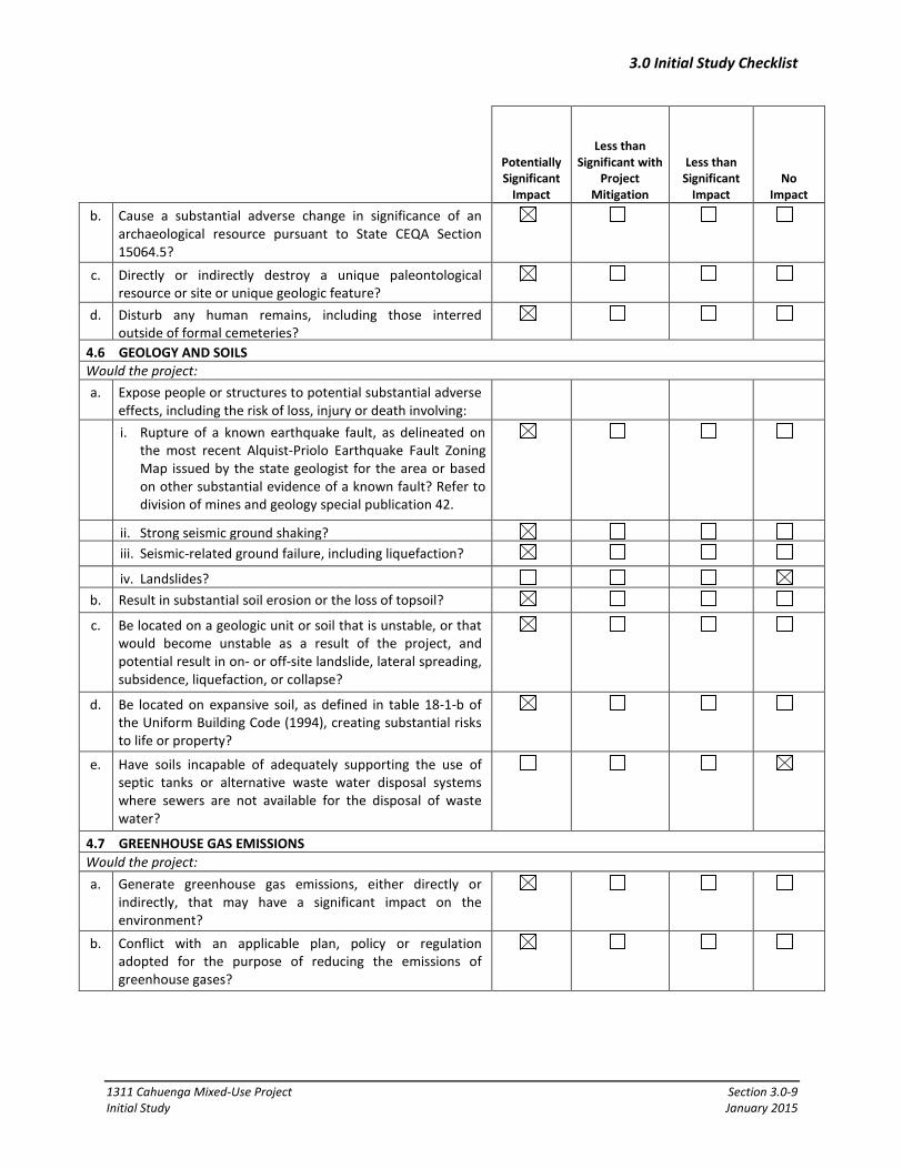
4.6 GEOLOGY AND SOILS Would the project: a. Expose people or structures to potential substantial adverse
effects, including the risk of loss, injury or death involving:
i. Rupture of a known earthquake fault, as delineated on the most recent Alquist-Priolo Earthquake Fault Zoning Map issued by the state geologist for the area or based on other substantial evidence of a known fault? Refer to division of mines and geology special publication 42.
ii. Strong seismic ground shaking? iii. Seismic-related ground failure, including liquefaction?
iv. Landslides? b. Result in substantial soil erosion or the loss of topsoil?
c. Be located on a geologic unit or soil that is unstable, or that would become unstable as a result of the project, and potential result in on- or off-site landslide, lateral spreading, subsidence, liquefaction, or collapse?
d. Be located on expansive soil, as defined in table 18-1-b of the Uniform Building Code (1994), creating substantial risks to life or property?
e. Have soils incapable of adequately supporting the use of septic tanks or alternative waste water disposal systems where sewers are not available for the disposal of waste water?
4.7 GREENHOUSE GAS EMISSIONS Would the project: a. Generate greenhouse gas emissions, either directly or
indirectly, that may have a significant impact on the environment?
b. Conflict with an applicable plan, policy or regulation adopted for the purpose of reducing the emissions of greenhouse gases?

3.0 Initial Study Checklist
1311 Cahuenga Mixed-Use Project Section 3.0-10 Initial Study January 2015
Potentially Significant
Impact
Less than Significant with
Project Mitigation
Less than Significant
Impact
No Impact
4.8 HAZARDS AND HAZARDOUS MATERIALS Would the project: a. Create a significant hazard to the public or the environment
through the routine transport, use, or disposal of hazardous materials?
b. Create a significant hazard to the public or the environment through reasonably foreseeable upset and accident conditions involving the release of hazardous materials into the environment?
c. Emit hazardous emissions or handle hazardous or acutely hazardous materials, substances, or waste within one-quarter mile of an existing or proposed school?
d. Be located on a site which is included on a list of hazardous materials sites compiled pursuant to Government Code Section 65962.5 and, as a result, would it create a significant hazard to the public or the environment?
e. For a project located within an airport land use plan or, where such a plan has not been adopted, within two miles of a public airport or public use airport, would the project result in a safety hazard for people residing or working in the project area?
f. For a project within the vicinity of a private airstrip, would the project result in a safety hazard for the people residing or working in the project area?
g. Impair implementation of or physically interfere with an adopted emergency response plan or emergency evacuation plan?
h. Expose people or structures to a significant risk of loss, injury or death involving wildland fires, including where wildlands are adjacent to urbanized areas or where residences are intermixed with wildlands?
4.9 HYDROLOGY AND WATER QUALITY Would the project: a. Violate any water quality standards or waste discharge
requirements?
b. Substantially deplete groundwater supplies or interfere with groundwater recharge such that there would be a net deficit in aquifer volume or a lowering of the local groundwater table level (e.g., the production rate of pre-existing nearby wells would drop to a level which would not support existing land uses or planned land uses for which permits have been granted)?

3.0 Initial Study Checklist
1311 Cahuenga Mixed-Use Project Section 3.0-11 Initial Study January 2015
Potentially Significant
Impact
Less than Significant with
Project Mitigation
Less than Significant
Impact
No Impact
c. Substantially alter the existing drainage pattern of the site or area, including through the alteration of the course of a stream or river, in a manner which would result in substantial erosion or siltation on or offsite?
d. Substantially alter the existing drainage pattern of the site or area, including through the alteration of the course of a stream or river, or substantially increase the rate or amount of surface runoff in a manner which would result in flooding on or offsite?
e. Create or contribute runoff water which would exceed the capacity of existing or planned stormwater drainage systems or provide substantial additional sources of
f. Otherwise substantially degrade water quality? g. Place housing within a 100-year flood plain as mapped on
federal flood hazard boundary or flood insurance rate map or other flood hazard delineation map?
h. Place within a 100-year flood plain structures which would impede or redirect flood flows?
i. Expose people or structures to a significant risk of loss, inquiry or death involving flooding, including flooding as a result of the failure of a levee or dam?
j. Inundation by seiche, tsunami, or mudflow?
4.10 LAND USE AND PLANNING Would the project: a. Physically divide an established community?
b. Conflict with applicable land use plan, policy or regulation of an agency with jurisdiction over the project (including but not limited to the general plan, specific plan, coastal program, or zoning ordinance) adopted for the purpose of avoiding or mitigating an environmental effect?
c. Conflict with any applicable habitat conservation plan or natural community conservation plan?
4.11 MINERAL RESOURCES Would the project: a. Result in the loss of availability of a known mineral resource
that would be of value to the region and the residents of the State?
b. Result in the loss of availability of a locally---important mineral resource recovery site delineated on a local general plan, specific plan, or other land use plan?
3.0 Initial Study Checklist
1311 Cahuenga Mixed-Use Project Section 3.0-12 Initial Study January 2015
Potentially Significant
Impact
Less than Significant with
Project Mitigation
Less than Significant
Impact
No Impact
4.12 NOISE Would the project: a. Exposure of persons to or generation of noise in level in
excess of standards established in the local general plan or noise ordinance, or applicable standards of other agencies?
b. Exposure of people to or generation of excessive groundborne vibration or groundborne noise levels?
c. A substantial permanent increase in ambient noise levels in the project vicinity above levels existing without the project?
d. A substantial temporary or periodic increase in ambient noise levels in the project vicinity above levels existing without the project?
e. For a project located within an airport land use plan or, where such a plan has not been adopted, within two miles of a public airport or public use airport, would the project expose people residing or working in the project area to excessive noise levels?
f. For a project within the vicinity of a private airstrip, would the project expose people residing or working in the project area to excessive noise levels?
4.13 POPULATION AND HOUSING Would the project: a. Induce substantial population growth in an area either
directly (for example, by proposing new homes and businesses) or indirectly (for example, through extension of roads or other infrastructure)?
b. Displace substantial numbers of existing housing necessitating the construction of replacement housing elsewhere?
c. Displace substantial numbers of people necessitating the construction of replacement housing elsewhere?
4.14 PUBLIC SERVICES Would the project: a. Result in substantial adverse physical impacts associated
with the provision of new or physically altered governmental facilities, need for new or physically altered governmental facilities, the construction of which could cause significant environmental impacts, in order to maintain acceptable service ratios, response times or other performance objectives for any of the public services:
i. Fire protection?
3.0 Initial Study Checklist
1311 Cahuenga Mixed-Use Project Section 3.0-13 Initial Study January 2015
Potentially Significant
Impact
Less than Significant with
Project Mitigation
Less than Significant
Impact
No Impact
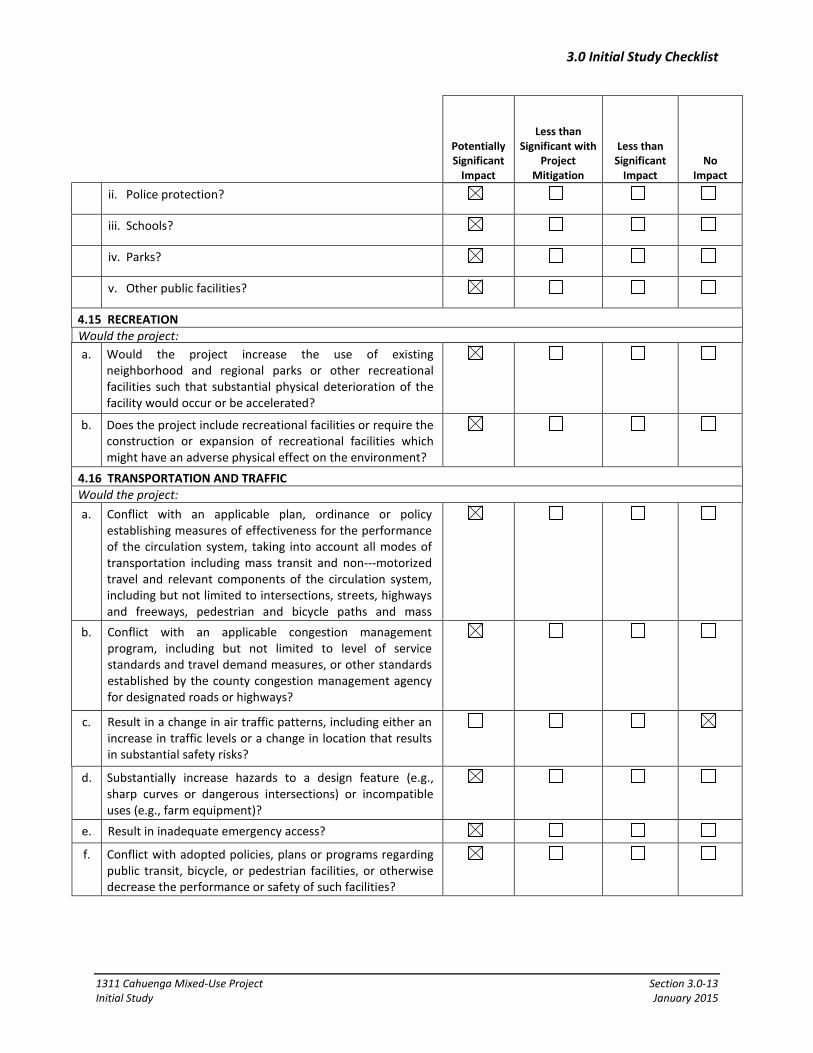
ii. Police protection?
iii. Schools?
iv. Parks?
v. Other public facilities?
4.15 RECREATION Would the project: a. Would the project increase the use of existing
neighborhood and regional parks or other recreational facilities such that substantial physical deterioration of the facility would occur or be accelerated?
b. Does the project include recreational facilities or require the construction or expansion of recreational facilities which might have an adverse physical effect on the environment?
4.16 TRANSPORTATION AND TRAFFIC Would the project: a. Conflict with an applicable plan, ordinance or policy
establishing measures of effectiveness for the performance of the circulation system, taking into account all modes of transportation including mass transit and non---motorized travel and relevant components of the circulation system, including but not limited to intersections, streets, highways and freeways, pedestrian and bicycle paths and mass
b. Conflict with an applicable congestion management program, including but not limited to level of service standards and travel demand measures, or other standards established by the county congestion management agency for designated roads or highways?
c. Result in a change in air traffic patterns, including either an increase in traffic levels or a change in location that results in substantial safety risks?
d. Substantially increase hazards to a design feature (e.g., sharp curves or dangerous intersections) or incompatible uses (e.g., farm equipment)?
e. Result in inadequate emergency access?
f. Conflict with adopted policies, plans or programs regarding public transit, bicycle, or pedestrian facilities, or otherwise decrease the performance or safety of such facilities?

3.0 Initial Study Checklist
1311 Cahuenga Mixed-Use Project Section 3.0-14 Initial Study January 2015
Potentially Significant
Impact
Less than Significant with
Project Mitigation
Less than Significant
Impact
No Impact
4.17 UTILITIES & SERVICE SYSTEMS Would the project: a. Exceed wastewater treatment requirements of the
applicable regional water quality control board?
b. Require or result in the construction of new water or wastewater treatment facilities or expansion of existing facilities, the construction of which could cause significant environmental effects?
c. Require or result in the construction of new stormwater drainage facilities or expansion of existing facilities, the construction of which could cause significant environmental effects?
d. Have sufficient water supplies available to serve the project from existing entitlements and resource, or are new or expanded entitlements needed?
e. Result in a determination by the wastewater treatment provider which serves or may serve the project that it has adequate capacity to serve the project’s projected demand in addition to the provider’s existing commitments?
f. Be served by a landfill with sufficient permitted capacity to accommodate the project’s solid waste disposal needs?
g. Comply with federal, state, and local statutes and regulations related to solid waste?
4.18 MANDATORY FINDINGS OF SIGNIFICANCE a. Does the project have the potential to degrade the quality
of the environment, substantially reduce the habitat of fish or wildlife species, cause a fish or wildlife population to drop below self---sustaining levels, threaten to eliminate a plant or animal community, reduce the number or restrict the range of a rare or endangered plant or animal or eliminate important examples of the major periods of California history or prehistory?
b. Does the project have impacts which are individually limited, but cumulatively considerable? (“Cumulatively considerable” means that the incremental effects of an individual project are considerable when viewed in connection with the effects of past projects, the effects of other current projects, and the effects of probable future projects).
c. Does the project have environmental effects which cause substantial adverse effects on human beings, either directly or indirectly?
3.0 Initial Study Checklist
1311 Cahuenga Mixed-Use Project Section 3.0-15 Initial Study January 2015
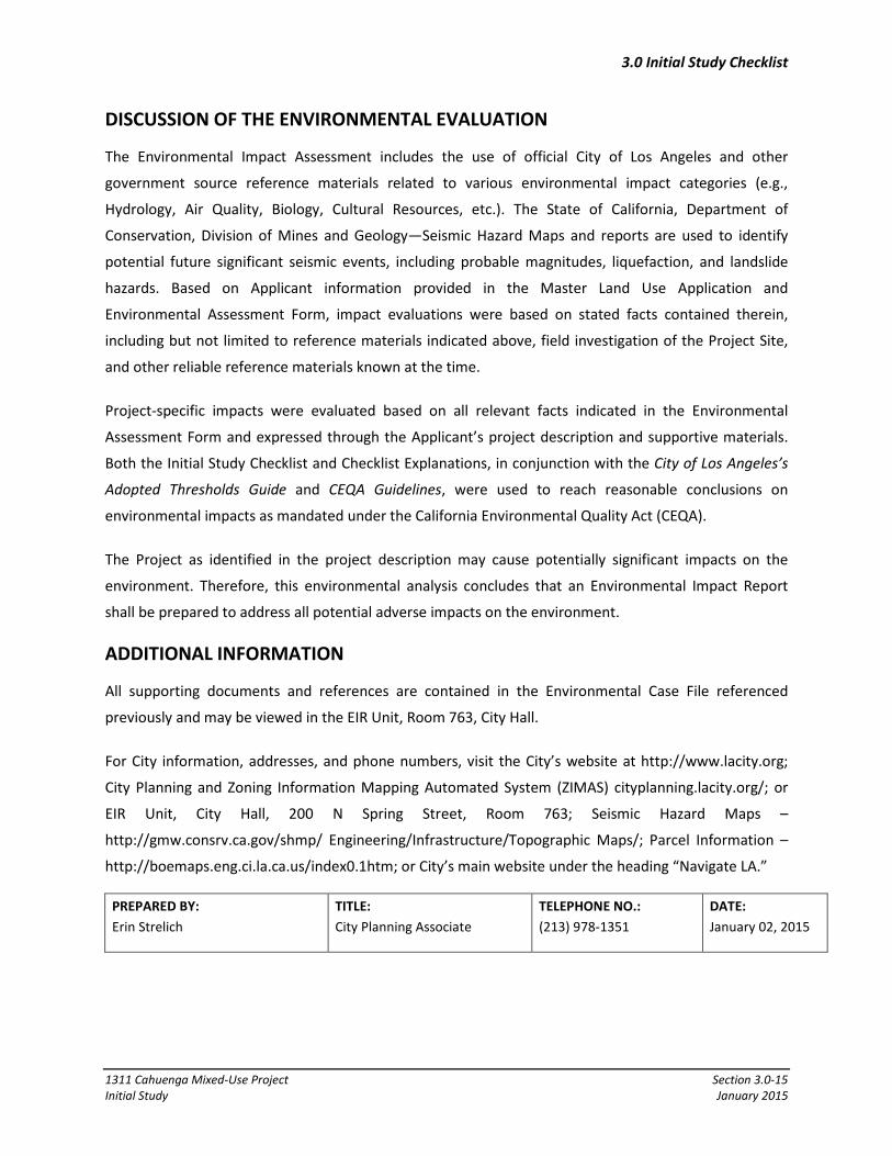
DISCUSSION OF THE ENVIRONMENTAL EVALUATION
The Environmental Impact Assessment includes the use of official City of Los Angeles and other
government source reference materials related to various environmental impact categories (e.g.,
Hydrology, Air Quality, Biology, Cultural Resources, etc.). The State of California, Department of
Conservation, Division of Mines and Geology—Seismic Hazard Maps and reports are used to identify
potential future significant seismic events, including probable magnitudes, liquefaction, and landslide
hazards. Based on Applicant information provided in the Master Land Use Application and
Environmental Assessment Form, impact evaluations were based on stated facts contained therein,
including but not limited to reference materials indicated above, field investigation of the Project Site,
and other reliable reference materials known at the time.
Project-specific impacts were evaluated based on all relevant facts indicated in the Environmental
Assessment Form and expressed through the Applicant’s project description and supportive materials.
Both the Initial Study Checklist and Checklist Explanations, in conjunction with the City of Los Angeles’s
Adopted Thresholds Guide and CEQA Guidelines, were used to reach reasonable conclusions on
environmental impacts as mandated under the California Environmental Quality Act (CEQA).
The Project as identified in the project description may cause potentially significant impacts on the
environment. Therefore, this environmental analysis concludes that an Environmental Impact Report
shall be prepared to address all potential adverse impacts on the environment.
ADDITIONAL INFORMATION
All supporting documents and references are contained in the Environmental Case File referenced
previously and may be viewed in the EIR Unit, Room 763, City Hall.
For City information, addresses, and phone numbers, visit the City’s website at http://www.lacity.org;
City Planning and Zoning Information Mapping Automated System (ZIMAS) cityplanning.lacity.org/; or
EIR Unit, City Hall, 200 N Spring Street, Room 763; Seismic Hazard Maps –
http://gmw.consrv.ca.gov/shmp/ Engineering/Infrastructure/Topographic Maps/; Parcel Information –
http://boemaps.eng.ci.la.ca.us/index0.1htm; or City’s main website under the heading “Navigate LA.”
PREPARED BY: Erin Strelich
TITLE: City Planning Associate
TELEPHONE NO.: (213) 978-1351
DATE: January 02, 2015

1311 Cahuenga Mixed-Use Project Section 3.0-1 Initial Study January 2015
4.0 ENVIRONMENTAL ANALYSIS
This section of the Initial Study contains an assessment and discussion of impacts associated with the
environmental issues and subject areas identified in the Initial Study Checklist. The thresholds of
significance are based on the Los Angeles (LA) CEQA Thresholds Guide.
4.1 AESTHETICS
Impact Analysis
a. Would the project have a substantial adverse effect on a scenic vista?
Potentially Significant Impact. A significant impact may occur if the Proposed Project introduces
incompatible visual elements within a field of view containing a scenic vista or substantially blocks views
of a scenic vista. Scenic vistas are generally described in two ways: panoramic views (visual access to a
large geographic area, for which the field of view can be wide and extend into the distance) and focal
views (visual access to a particular object, scene, or feature of interest). Based on the City of Los Angeles
LA CEQA Thresholds Guide, the determination of whether a project results in a significant impact on a
scenic vista is made considering the following factors:
• The nature and quality of recognized or valued views (such as natural topography, settings, man-made or natural features of visual interest, and resources such as mountains or ocean);
• Whether a project affects views from a designated scenic highway, corridor, or parkway;
• The extent of obstruction (e.g., total blockage, partial interruption, or minor diminishment); and
• The extent to which a project affects recognized views available from a length of a public roadway, bike path, or trail, as opposed to a single, fixed vantage point.
The Project Site is located within a highly urbanized portion of the City of Los Angeles. Visual resources
in the surrounding community include the Hollywood Hills and Santa Monica Mountains, including views
of the Hollywood Sign. Scenic vistas in the Project vicinity are available from area roadways, public
schools, and some private residences and commercial businesses. The Proposed Project would develop
residential and office uses in a building that would be seven stories with a height ranging from 82 feet
(near the north portion of the Project Site) to 110 feet (near the south portion of the Project Site), based
on the differences in elevation of the existing terrain). The Project development would replace existing
buildings and uses on the Project Site, which consist of a single-family residence, a 3-unit apartment
building, office buildings, an auto repair facility, and surface parking lots. The proposed structures could
be visible within and could alter available scenic vistas, such as the Hollywood Hills to the north of the

4.0 Environmental Analysis
1311 Cahuenga Mixed-Use Project Section 4.0-2 Initial Study January 2015
Project Site, which are available from locations within the Project Site vicinity. Further analysis is
required in an EIR to determine the effect of the Project on available scenic vistas.
b. Would the project substantially damage scenic resources, including, but not limited to, trees, rock outcroppings, and historic buildings within a state scenic highway?
No Impact. Based on the LA CEQA Thresholds Guide, a significant impact would occur if scenic resources
within a City-designated scenic highway would be damaged and/or removed by development of a
project. The Project Site is not located within or along a designated scenic highway; the nearest
designated state scenic highway is SR 2 (which is also known as Santa Monica Boulevard). The portion of
SR 2, which is designated as scenic runs from 2.7 miles north of SR 210 at La Cañada to the San
Bernardino County line.2 At its nearest point, the designated scenic portion of SR 2 is located
approximately 11 miles northeast of the Project Site. The portion of SR 2 near the Project Site is not
designated as scenic.
The Project Site is predominately occupied by surface parking lots, a single-family residence and a 3-unit
apartment building on the southwest portion of the site, small office buildings on the north and south of
Homewood Avenue and an auto repair facility on N. Cahuenga Boulevard. These buildings are typical in
scale and character to surrounding development and are not unique or scenic. The site contains a small
amount of ornamental landscaping but does not contain any scenic natural resources, such as native
California trees or unique geologic features on the Project Site. Therefore, the Project would not result
in impacts to scenic resources, including trees; rock outcroppings; and historic structures, within a City-
designated scenic highway. No further evaluation in an EIR is required.
c. Would the project substantially degrade the existing visual character or quality of the site and its surroundings?
Potentially Significant Impact. Based on the LA CEQA Thresholds Guide, a significant impact would occur
if the Proposed Project were to introduce incompatible visual elements on the Project Site or visual
elements that would be incompatible with the character of the area surrounding the Project Site.
As discussed above, the surrounding area is highly urbanized and includes a mix of government
buildings, residential and commercial uses, and surface parking lots. While the Proposed Project is
anticipated to be similar and compatible with the existing visual character and quality of the surrounding
area, the Project would change the visual character and quality of the Project Site and its surroundings
by introducing a 7-story mixed-use building on a Project Site that currently contains limited
2 California Department of Transportation, “Officially Designated State Scenic Highways” (October 2013)
http://www.dot.ca.gov/hq/LandArch/scenic/schwy.htm.
4.0 Environmental Analysis
1311 Cahuenga Mixed-Use Project Section 4.0-3 Initial Study January 2015
development with buildings that are no taller than 2 stories. Further analysis is required in an EIR to
determine the effect of the Project on the existing visual character of the surrounding area.
d. Would the project create a new source of substantial light or glare, which would adversely affect day or nighttime views in the area?
Potentially Significant Impact. A significant impact may occur if the Proposed Project introduces new
sources of light or glare on or from the Project Site which would be incompatible with the areas
surrounding the Project Site, or which pose a safety hazard to motorists utilizing adjacent streets or
freeways. Based on the LA CEQA Thresholds Guide, the determination of whether the Proposed Project
results in a significant nighttime illumination impact shall be made considering the following factors: (a)
the change in ambient illumination levels as a result of Proposed Project sources; and (b) the extent to
which Proposed Project lighting would spill off the Project Site and affect adjacent light-sensitive areas.
The Project Site currently generates low levels of artificial light and glare from sources typically
associated with residential, commercial, and surface parking lot uses. Sources of light and glare that are
typically associated with residential and commercial uses include architectural lighting, signage lighting,
interior lighting, security and way-finding lighting, and building surfaces. The Project would introduce
new development on the site with new sources of lighting. Further analysis is required in an EIR to
determine the potential effect of the Project in light and glare conditions around the site.
Based on the LA CEQA Thresholds Guide, a project shading impact would normally be considered
significant if shadow-sensitive uses would be shaded by project-related structures for more than three
hours between the hours of 9:00 AM and 3:00 PM between the first Sunday in November and the
second Sunday in March, or for more than four hours between the hours of 9:00 AM and 5:00 PM
between the second Sunday in March and the first Sunday in November. The introduction of a new 7-
story structure to the Project Site has the potential to shade adjacent land uses. Further analysis is
required in an EIR to determine the potential effect of the Project on shading conditions around the Site.

4.0 Environmental Analysis
1311 Cahuenga Mixed-Use Project Section 4.0-4 Initial Study January 2015
4.2 AGRICULTURE AND FORESTRY RESOURCES
Impact Analysis
a. Would the project convert Prime Farmland, Unique Farmland, or Farmland of Statewide Importance (Farmland), as shown on the maps prepared pursuant to the Farmland Mapping and Monitoring Program of the California Resources Agency, to non-agricultural use?
No Impact.
The Project Site is located within a developed and heavily urbanized area of the City of Los Angeles. No
farmland or agricultural activity exists on or near the Project Site. According to the California
Department of Conservation “Los Angeles County Important Farmland 2010” map, the Project Site is
designated as “urban and built-up land.”3 No portion of the Project Site is designated as Farmland of
Statewide Importance, Unique Farmland, or Farmland of Local Importance. No impacts would occur and
no further evaluation in an EIR is required.
b. Would the project conflict with existing zoning for agricultural use, or a Williamson Act contract?
No Impact. The Project Site is located within the jurisdiction of the City of Los Angeles and is subject to
the applicable land use and zoning requirements of the LAMC. The Project Site has a land use
designation of Regional Center Commercial and is zoned C4-2D. As such, the Project Site is not zoned for
agricultural production, and there is no farmland at the Project Site. In addition, no Williamson Act
Contracts are in effect for the Project Site.4 No impacts would occur no further evaluation in an EIR is
required.
c. Would the project conflict with existing zoning for, or cause rezoning of, forest land (as defined in Public Resources Code section 12220(g)), timberland (as defined by Public Resources Code section 4526), or timberland zoned Timberland Production (as defined by Government Code section 51104(g))?
No Impact. The Project Site has a land use designation of Regional Center Commercial and is zoned C4-
2D. As such, the Project Site is not zoned as forest land or timberland, and there is no timberland
production at the Project Site. No impacts would occur no further evaluation in an EIR is required.
3 California Department of Conservation, Division of Land Resource Protection, Los Angeles County Important Farmland
2010, map, sheet 2 of 3 (January 2012), ftp://ftp.consrv.ca.gov/pub/dlrp/FMMP/pdf/2010/los10.pdf. 4 California Department of Conservation, Division of Land Resource Protection, “The Land Conservation (Williamson) Act”
(2013), http://www.conservation.ca.gov/dlrp/lca/Pages/Index.aspx.

4.0 Environmental Analysis
1311 Cahuenga Mixed-Use Project Section 4.0-5 Initial Study January 2015
d. Would the project result in the loss of forest land or conversion of forest land to non-forest use?
No Impact. The Project Site is currently occupied by a single-family residence, a 3-unit apartment
building, office buildings, an auto repair facility, and surface parking lots. Although there is some
landscaping on the Project Site in the form of ornamental trees and bushes, no designated forested
lands exist on or near the Project Site. No impacts would occur no further evaluation in an EIR is
required.
e. Would the project involve other changes in the existing environment, which, due to their location or nature, could result in conversion of Farmland, to non-agricultural use?
No Impact. Neither the Project Site, nor nearby properties, are currently utilized for agricultural or
forestry uses. The Project Site is not classified in any “Farmland” category designated by the State of
California. No impacts would occur no further evaluation in an EIR is required.

4.0 Environmental Analysis
1311 Cahuenga Mixed-Use Project Section 4.0-6 Initial Study January 2015
4.3 AIR QUALITY
Impact Analysis
a. Would the project conflict with or obstruct implementation of the applicable air quality plan?
Potentially Significant Impact. The Project Site is located within the South Coast Air Basin (Basin).
Within the Basin, the South Coast Air Quality Management District (SCAQMD) is required, pursuant to
the Federal Clean Air Act, to reduce emissions of criteria pollutants for which the Basin is in non-
attainment (i.e., ozone (O3), particulate matter (PM10), and fine particulate matter (PM2.5)). Based on
the LA CEQA Thresholds Guide, a significant air quality impact could occur if the Proposed Project is not
consistent with the SCAQMD’s applicable Air Quality Management Plan (AQMP) or would in some way
represent a substantial hindrance to implementing the policies or obtaining the goals of that plan. The
most recent AQMP was adopted on December 7, 2012, and contains a comprehensive list of pollution
control strategies directed at reducing emissions and achieving ambient air quality standards. These
strategies are developed, in part, based on regional population, housing, and employment projections
prepared by the Southern California Association of Governments (SCAG). SCAG is the regional planning
agency for Los Angeles, Orange, Ventura, Riverside, San Bernardino and Imperial Counties, and
addresses regional issues relating to transportation, the economy, community development and the
environment.5 With regard to future growth, SCAG has prepared the 2012 Regional Transportation
Plan/Sustainable Communities Strategy (RTP/SCS) which provides population, housing, and employment
projections for cities under its jurisdiction. The growth projections in the 2012 RTP/SCS are based on
growth projections in local General Plans for jurisdictions in SCAG’s planning area. The 2012 RTP/SCS
growth projections are utilized in the preparation of the air quality forecasts and consistency analysis
included in the SCAQMD’s 2012 AQMP.
Construction and operation of the Project may result in an increase in stationary and mobile source air
emissions. Further analysis is required in an EIR to determine the significance of the air emissions that
will be generated by the Project.
b. Would the project violate any air quality standard or contribute substantially to an existing or projected air quality violation?
Potentially Significant Impact. Based on the LA CEQA Thresholds Guide, a project may have a significant
impact where project-related emissions would exceed federal, State, or regional standards or
5 SCAG serves as the federally designated Metropolitan Planning Organization (MPO) for the Southern California region.

4.0 Environmental Analysis
1311 Cahuenga Mixed-Use Project Section 4.0-7 Initial Study January 2015
thresholds, or where project-related emissions would substantially contribute to an existing or projected
air quality violation.
The SCAQMD currently recommends that projects with emissions that exceed any of the following
emissions thresholds be considered to have a significant effect on air quality:
Construction Emissions • 550 pounds per day of carbon monoxide (CO)
• 75 pounds per day of VOC
• 100 pounds per day of nitrogen oxides (NOx)
• 150 pounds per day of sulfur oxides (SOx)
• 150 pounds per day of PM10
Operational Emissions • 550 pounds per day of CO
• 55 pounds per day of VOC
• 55 pounds per day of NOx
• 150 pounds per day of SOx
• 150 pounds per day of PM10
Ambient Air Quality Levels of CO, NOx, and PM10
The SCAQMD recommends that projects that generate emissions within the project site that cause the
state ambient air quality standards for CO and nitrogen dioxide (NO2) to be exceeded at nearby
receptors should be considered significant. Emissions associated with project generated vehicles that
cause localized levels of CO near roadways and intersections to exceed state standards for this pollutant
should also be considered significant. Because the Basin is not in attainment of the state ambient air
quality standard for PM10, the SCAQMD recommends that projects that generate emissions within the
Project Site that cause a substantial increase in 24-hour PM10 levels at nearby sensitive receptors
(receptors where people would be expected to reside for 24 consecutive hours) should be considered
significant. The SCAQMD currently defines a substantial increase in local PM10 Levels as 10.4 μg/m3
during construction and 2.5 g/m3 during operation of a project.
The Project would result in increased air pollutant emissions from the Project Site during construction
(short-term) and operation (long-term). Further analysis is required in an EIR to determine the
significance of the air emissions that will be generated by the Project.

4.0 Environmental Analysis
1311 Cahuenga Mixed-Use Project Section 4.0-8 Initial Study January 2015
Toxic Air Contaminants
The SCAQMD also recommends that projects that could emit carcinogenic or toxic air contaminants that
exceed the maximum individual cancer risk of 10 in one million be considered significant and
cumulatively considerable. Further analysis is required in an EIR to determine if the Project would result
in the generation of any toxic air contaminants.
c. Would the project result in a cumulatively considerable net increase of any criteria pollutant for which the project region is non-attainment under an applicable federal or state ambient air quality standard (including releasing emissions, which exceed quantitative thresholds for ozone precursors)?
Potentially Significant Impact. Based on the LA CEQA Thresholds Guide, a significant impact may occur if
the project would add a considerable cumulative contribution to federal or State non-attainment
pollutants. The Basin is currently in State nonattainment for ozone, O3, PM10 and PM2.5. Further
analysis is required in an EIR to determine if the Project would result in a cumulatively considerable
increase in any criteria pollutant.
d. Would the project expose sensitive receptors to substantial pollutant concentrations?
Potentially Significant Impact. Project construction activities and operations, as described above, may
have to potential to generate localized emissions that may expose sensitive receptors to pollutant
concentrations. With regard to localized emissions from motor vehicle travel, localized high levels of
carbon monoxide (CO) may be generated by traffic congested roadways and intersections.
Sensitive receptors are defined as schools, residential homes, hospitals, resident care facilities, daycare
centers or other facilities that may house individuals with health conditions who would be adversely
impacted by changes in air quality. Sensitive receptors located in the vicinity of the Project Site primarily
include residential uses. Further analysis is required in an EIR to determine if the Project would result in
pollutant concentrations that could affect nearby sensitive receptors.
e. Create objectionable odors affecting a substantial number of people?
Less than Significant Impact. A significant impact would occur if objectionable odors are generated that
would adversely impact sensitive receptors. According to the SCAQMD Air Quality Handbook, land uses
that have the potential it create objectionable odors typically include agricultural uses, wastewater
treatment plants, food processing plants, refineries and industrial manufacturing facilities.
As the Proposed Project will include residential and commercial office uses which do not create the type
of objectionable odors associated with industrial uses. Good housekeeping practices, such as the use of
4.0 Environmental Analysis
1311 Cahuenga Mixed-Use Project Section 4.0-9 Initial Study January 2015
trash receptacles, would be sufficient to prevent nuisance odors. In addition, SCAQMD Rule 402
(Nuisance), and SCAQMD Best Available Control Technology Guidelines would limit potential
objectionable odor impacts from the proposed uses. Impacts would be less than significant and no
further evaluation in an EIR is required.
4.0 Environmental Analysis
1311 Cahuenga Mixed-Use Project Section 4.0-10 Initial Study January 2015
4.4 BIOLOGICAL RESOURCES
Impact Analysis
a. Would the project have a substantial adverse effect, either directly or through habitat modifications, on any species identified as a candidate, sensitive, or special-status species in local or regional plans, policies, or regulations, or by the California Department of Fish and Game or U.S. Fish and Wildlife Service?
Less than Significant Impact. Based on the criteria established in the LA CEQA Thresholds Guide, a
project would normally have a significant impact on biological resources if it could result in: (a) the loss
of individuals, or the reduction of existing habitat of a State- or federal-listed endangered, threatened,
rare, protected, candidate, or sensitive species or a Species of Special Concern; (b) the loss of individuals
or the reduction of existing habitat of a locally designated species or a reduction in a locally designated
natural habitat or plant community; or (c) interference with habitat such that normal species behaviors
are disturbed (e.g., from the introduction of noise or light) to a degree that may diminish the chances for
long-term survival of a sensitive species.
The Project Site is fully developed with residential and commercial uses and contains only limited
amounts of ornamental landscaping. Due to the developed nature of the Project Site and the
surrounding area, species likely to occur on-site are limited to small terrestrial and avian species
typically found in developed settings. The Project Site does not contain any critical habitat or support
any species identified as a candidate, sensitive, or special status species in local or regional plans,
policies, or regulations, or by the California Department of Fish and Wildlife (CDFW) or U.S. Fish and
Wildlife Service (USFWS). Potential impacts would be less than significant and no further analysis is
required in an EIR.
b. Would the project have a substantial adverse effect on any riparian habitat or other sensitive natural community identified in local or regional plans, policies, regulations, or by the California Department of Fish and Game or U.S. Fish and Wildlife Service?
No Impact. The Project Site and the surrounding urban area are fully developed and no riparian or other
sensitive natural community is located on or adjacent to the Project Site. Implementation of the
Proposed Project would not result in any adverse impacts to riparian habitat or other sensitive natural
communities and no further evaluation in an EIR is required.
c. Would the project have a substantial adverse effect on federally protected wetlands as defined by Section 404 of the Clean Water Act (including, but not limited to, marsh, vernal

4.0 Environmental Analysis
1311 Cahuenga Mixed-Use Project Section 4.0-11 Initial Study January 2015
pool, coastal, etc.) through direct removal, filling, hydrological interruption, or other means?
No Impact. Based on the criteria established in the LA CEQA Thresholds Guide, a project would normally
have a significant impact on biological resources if it could result in the alteration of an existing wetland
habitat. The Project Site is entirely developed and generally covered with impermeable surfaces, and
does not contain any wetlands or natural drainage channels. The Project Site does not have the
potential to support any riparian or wetland habitat, as defined by Section 404 of the Clean Water Act
and no further evaluation in an EIR is required.
d. Would the project have a substantial adverse effect on federally protected wetlands as defined by Section 404 of the Clean Water Act (including, but not limited to, marsh, vernal pool, coastal, etc.) through direct removal, filling, hydrological interruption, or other means?
No Impact. Based on the criteria established in the LA CEQA Thresholds Guide, a project would normally
have a significant impact on biological resources if it could result in the interference with wildlife
movement/migration corridors that may diminish the chances for long-term survival of a sensitive
species. The Project Site is located in an area that has been previously developed in a heavily urbanized
area of the City of Los Angeles. Due to the highly urbanized surroundings, there are no wildlife corridors
or native wildlife nursery sites in the Proposed Project vicinity. No impacts will result from the Project
and no further evaluation is required in an EIR.
e. Would the project conflict with any local policies or ordinances protecting biological resources, such as a tree preservation policy or ordinance?
No Impact. Based on the criteria established in the LA CEQA Thresholds Guide, a project-related,
significant adverse effect could occur if a project were to cause an impact that is inconsistent with local
regulations pertaining to biological resources, such as the City of Los Angeles Protected Tree Ordinance.6
There are a variety of street trees that border the site within the public right-of-way that may be
removed, trimmed, or otherwise disturbed during construction. However, these street trees do not
consist of any tree species protected under the Los Angeles Protected Tree Ordinance (i.e., Valley Oak,
California Live Oak, Southern California Black Walnut, Western Sycamore, or California Bay). The
removal and placement of these trees would be subject to the review and approval of the Board of
Public Works, Urban Forestry Division. No impacts will result from the Project and no further evaluation
is required in an EIR.
6 City of Los Angeles Department of City Planning, Los Angeles Tree Ordinance (No. 177404), LAMC sec. 12.21

4.0 Environmental Analysis
1311 Cahuenga Mixed-Use Project Section 4.0-12 Initial Study January 2015
f. Would the project conflict with the provisions of an adopted Habitat Conservation Plan, Natural Community Conservation Plan, or other approved local, regional, or state habitat conservation plan?
No Impact. A significant impact would occur if the Proposed Project would be inconsistent with mapping
or policies in any conservation plans of the types cited. The Project Site is not part of any draft or
adopted Habitat Conservation Plan, Natural Community Conservation Plan, or other approved local,
regional or state habitat conservation plan. No impacts would result from the Project and no further
evaluation in an EIR is required.
4.0 Environmental Analysis
1311 Cahuenga Mixed-Use Project Section 4.0-13 Initial Study January 2015
4.5 CULTURAL RESOURCES
Impact Analysis
a. Would the project cause a substantial adverse change in the significance of a historical resource as defined in §15064.5?
Potentially Significant Impact. Based on the criteria established in the LA CEQA Thresholds Guide, a
significant impact may occur if the Proposed Project would disturb historic resources that presently exist
within the Proposed Project Site. Section 15064.5 of the CEQA Guidelines generally defines a historic
resource as a resource that is: (1) listed in, or determined to be eligible for listing in the California
Register of Historical Resources (California Register); (2) included in a local register of historical
resources (pursuant to Section 5020.1(k) of the Public Resources Code); or (3) identified as significant in
an historical resources survey (meeting the criteria in Section 5024.1(g) of the Public Resources Code).
Additionally, any object, building, structure, site, area, place, record, or manuscript which a lead agency
determines to be historically significant or significant in the architectural, engineering, scientific,
economic, agricultural, educational, social, political, military, or cultural annals of California may be
considered to be an historical resource, provided the lead agency’s determination is supported by
substantial evidence in light of the whole record. Generally, a resource shall be considered by the lead
agency to be “historically significant” if the resource meets the criteria for listing on the California
Register. The California Register automatically includes all properties listed in the National Register of
Historic Places (National Register) and those formally determined to be eligible for listing in the National
Register.
The Project Site is currently developed with a single-family residence, a 3-unit apartment building, office
buildings, an auto repair facility, and surface parking lots. Given the presence of known historic
resources in the Project vicinity and the age of existing structures on and near the Project Site, further
evaluation in an EIR is required to determine if the Project would result in impacts to historic resources.
b. Would the project cause a substantial adverse change in the significance of an archaeological resource pursuant to §15064.5?
Potentially Significant Impact. Based upon the criteria established in the LA CEQA Thresholds Guide, a
significant impact may occur if grading or excavation activities associated with the Proposed Project
would disturb archaeological resources which presently exist within the Project Site. The Project Site is
located within an urbanized area that has been subject to grading and development in the past. There
are no known archaeological sites or archaeological survey areas on or in the vicinity of the Project Site.
However, the Proposed Project would include two levels of subterranean parking, which would require
excavation to greater depths than previously occurred on the Project Site, which could result in

4.0 Environmental Analysis
1311 Cahuenga Mixed-Use Project Section 4.0-14 Initial Study January 2015
disturbance to any archeological resources that may be present on the site. Further evaluation is
required in an EIR to determine the potential for impacts to archaeological resources.
c. Would the project directly or indirectly destroy a unique paleontological resource or site or unique geologic feature?
Potentially Significant Impact. Based upon the criteria established in the LA CEQA Thresholds Guide, a
significant impact may occur if grading or excavation activities associated with the Proposed Project
were to disturb paleontological resources or geologic features which presently exist within the Project
Site. The Project Site has been previously graded and is currently improved with three residential
buildings, as well a paved parking area. The Project Site and immediate surrounding areas do not
contain any known vertebrate paleontological resources. However, the Proposed Project would include
two levels of subterranean parking, which would require excavation to greater depths than previously
occurred on the Project Site, which could result in disturbance to any paleontological resources that may
be present on the site. Further evaluation is required in an EIR to determine the potential for impacts to
paleontological resources.
d. Would the project disturb any human remains, including those interred outside of formal cemeteries?
Potentially Significant Impact. Based on the criteria established in the LA CEQA Thresholds Guide, a
Project-related, significant adverse effect could occur if grading or excavation activities associated with
the Proposed Project would disturb previously interred human remains. As discussed above, the Project
Site is located within an urbanized area and has been subject to grading and development. No known
traditional burial sites have been identified on the Project Site. However, as the Project would require
excavation at depths greater than those having previously occurred on the Project Site, the potential
exists for the Project to uncover human remains during construction and further evaluation is required
in an EIR to determine the potential for impacts.
4.0 Environmental Analysis
1311 Cahuenga Mixed-Use Project Section 4.0-15 Initial Study January 2015
4.6 GEOLOGY AND SOILS
Impact Analysis
a. Would the project expose people or structures to potential substantial adverse effects, including the risk of loss, injury, or death involving:
i. Rupture of a known earthquake fault, as delineated on the most recent Alquist-Priolo
Earthquake Fault Zoning Map issued by the State Geologist for the area or based on other
substantial evidence of a known fault? Refer to Division of Mines and Geology Special
Publication 42.
Potentially Significant Impact. Fault rupture is defined as the surface displacement that occurs along
the surface of a fault during an earthquake. Based on criteria established by the California Geological
Survey (CGS), faults can be classified as active, potentially active, or inactive. Active faults may be
designated as Earthquake Fault Zones under the Alquist-Priolo Earthquake Fault Zoning Act, which
includes standards regulating development adjacent to active faults. These zones, which extend from
200 to 500 feet on each side of the known fault, identify areas where a potential surface fault rupture
could prove hazardous for buildings used for human occupancy. Development projects located within an
Alquist-Priolo Earthquake Fault Zone are required to prepare special geotechnical studies to characterize
hazards from any potential surface ruptures. In addition, the City designates Fault Rupture Study Zones
on each side of active and potentially active faults to establish areas of hazard potential.
Based upon the criteria established in the LA CEQA Thresholds Guide, a significant impact may occur if
the Project Site is located within a State-designated Alquist-Priolo Zone or other designated fault zone.
The Project Site is not within a currently established Alquist-Priolo Earthquake Fault Zone for surface
fault rupture hazards.7 No active or potentially active faults with the potential for surface fault rupture
are known to pass directly beneath the Project Site. However, the closest surface trace of an active fault
is the Hollywood Fault, which is believed to be located approximately 0.8 mile north of the Project Site.
However, based on the Earthquake Fault Zone Map of the Hollywood Quadrangle,8 given the proximity
of the Hollywood Fault, further analysis is required in an EIR.
7 California Geological Survey, “Earthquake Fault Zones: Hollywood Quadrangle” (January 2014).
http://www.consrv.ca.gov/cgs/rghm/ap/Documents/Hollywood_EZRIM.pdf. 8 State of California, California Geological Survey, “Earthquake Zones of Required Investigation: Hollywood Quadrangle”
(November 6, 2014), http://gmw.consrv.ca.gov/SHMP/download/quad/HOLLYWOOD/maps/Hollywood_EZRIM /Hollywood_EZRIM.pdf.

4.0 Environmental Analysis
1311 Cahuenga Mixed-Use Project Section 4.0-16 Initial Study January 2015
ii. Strong seismic ground shaking?
Potentially Significant Impact. Based upon the criteria established in the LA CEQA Thresholds Guide, a
significant impact may occur if a project represents an increased risk to public safety or destruction of
property by exposing people, property, or infrastructure to seismically induced ground shaking hazards
that are greater than the average risk associated with other locations in Southern California. The Project
Site is located within a seismically active region, as is all of Southern California. The intensity of ground
shaking depends primarily upon the earthquake magnitude, the distance from the source, and the site-
response characteristics. The Project Site is not located within a seismic hazard zone for liquefaction or
landsliding.9
As previously discussed, the closest surface trace of an active fault is the Hollywood Fault, which is
believed to be located approximately 0.8 mile north of the Project Site. The location of the Project Site
within a seismically active area in proximity to the Hollywood Fault could expose people or structures to
strong seismic ground shaking and further analysis is required in an EIR.
iii. Seismic-related ground failure, including liquefaction?
Potentially Significant Impact. Based on the criteria established in the LA CEQA Thresholds Guide, a
significant impact may occur if a project site is located within a liquefaction zone. Liquefaction involves a
sudden loss in strength of saturated, cohesionless soils that are subject to ground vibration and results
in temporary transformation of the soil to a fluid mass. If the liquefying layer is near the surface, the
effects are much like that of quicksand for any structure located on it. If the layer is deeper in the
subsurface, it may provide a sliding surface for the material above it. Liquefaction typically occurs in
areas where the soils below the water table are composed of poorly consolidated, fine- to medium-
grained, primarily sandy soil. In addition to the requisite soil conditions, the ground acceleration and
duration of the earthquake must also be of a sufficient level to induce liquefaction. The current standard
of practice requires liquefaction analysis to a depth of 50 feet below the lowest portion of a proposed
structure.10
Based on the State of California’s “Seismic Hazard Zone Maps, Hollywood Quadrangle,” the Project Site
is not located within an area designed as “Liquefiable.”11 This determination is based on groundwater
depth records, soil type, and distance to a fault capable of producing a substantial earthquake.
9 California Department of Conservation, State of California Seismic Hazard Zones for the Hollywood Quadrangle. “Landslide
Zones.” (1999), http://gmw.consrv.ca.gov/shmp/download/quad/HOLLYWOOD/maps/ozn_holly.pdf. 10 Southern California Earthquake Center, University of Southern California, Recommended Procedures for Implementation of
DMG Special Publication 117A, Guidelines for Analyzing and Mitigating Liquefaction in California (March 1999). 11 California Geological Survey, State of California Seismic Hazard Zone Maps for the Hollywood Quadrangle, “Liquefaction
Zones” (2014), http://www.consrv.ca.gov/cgs/rghm/ap/Documents/Hollywood_EZRIM.pdf.

4.0 Environmental Analysis
1311 Cahuenga Mixed-Use Project Section 4.0-17 Initial Study January 2015
Additionally, the Project Site is not located in an area susceptible to liquefaction as mapped by the City
of Los Angeles.12 Therefore, the potential for liquefaction to occur at the Project Site is considered to be
low. Nevertheless, the potential for seismic activity exists, and further analysis is required in an EIR.
iv. Landslides?
No Impact. Based on the criteria established in the LA CEQA Thresholds Guide, a project would normally
have a significant geologic hazard impact if it would cause or accelerate geologic hazards that would
result in substantial damage to structures or infrastructure, or expose people to substantial risk of
injury. A project-related significant adverse effect may occur if the project is located in a hillside area
with soil conditions that would suggest a high potential for sliding. Due to the lack of slopes on the site
and surrounding areas, the probability of seismically induced landslides is expected to be minimal. Also,
based on the State of California’s “Seismic Hazard Zone Maps, Hollywood Quadrangle,”13 the Project
Site is not in a designated earthquake-induced landslide hazard zone and no further evaluation in an EIR
is required.
b. Would the project result in substantial soil erosion or the loss of topsoil?
Potentially Significant Impact. Based upon the criteria established in the LA CEQA Thresholds Guide, a
project would normally have significant sedimentation or erosion impacts if it would: (a) constitute a
geologic hazard to other properties by causing or accelerating instability from erosion; or (b) accelerate
natural processes of wind and water erosion and sedimentation, resulting in sediment runoff or
deposition which would not be contained or controlled on site.
Development of the Project would require grading, excavation, and other construction activities that
have the potential to disturb existing soils and expose soils to rainfall and wind, thereby potentially
resulting in soil erosion. Grading activities would require grading permits from the Los Angeles
Department of Building and Safety (LADBS), which include requirements and standards designed to limit
potential impacts to acceptable levels. In addition, all on-site grading and site preparation would be
required to comply with applicable provisions of Chapter IX, Division 70 of the LAMC, which addresses
grading, excavations, and fills.
The potential for soil erosion during the ongoing operation of the Proposed Project is low due to the
predominantly level topography of the Project Site, and the fact that the Project Site would be mostly
paved over or built upon, so little soil would be exposed. However, although erosion would be reduced
12 Los Angeles General Plan, “Safety Element,” Exhibit B, Areas Susceptible to Liquefaction (November 1996), 49. 13 State of California, California Geological Survey, “Earthquake Zones of Required Investigation: Hollywood Quadrangle”
(November 6, 2014), http://gmw.consrv.ca.gov/SHMP/download/quad/HOLLYWOOD/maps/Hollywood_EZRIM /Hollywood_EZRIM.pdf.

4.0 Environmental Analysis
1311 Cahuenga Mixed-Use Project Section 4.0-18 Initial Study January 2015
by implementation of stringent erosion controls imposed by the City of Los Angeles through grading and
building permit regulations, erosion and siltation could occur during construction and further evaluation
of these potential impacts is required in an EIR.
c. Would the project be located on a geologic unit or soil that is unstable, or that would become unstable as a result of the project, and potentially result in on- or off-site landslide, lateral spreading, subsidence, liquefaction or collapse?
Potentially Significant Impact. Based on the criteria established in the LA CEQA Thresholds Guide, a
project would normally have a significant geologic hazard impact if it could cause or accelerate geologic
hazards causing substantial damage to structures or infrastructure, or expose people to substantial risk
of injury. For the purpose of this specific issue, a significant impact may occur if the Proposed Project is
built in an unstable area without proper site preparation or design features to provide adequate
foundations for buildings, thus posing a hazard to life and property.
As previously discussed, the potential for liquefaction at the Project Site is considered to be low.
Additionally, the Project Site is not located in a landslide area as mapped by the City of Los Angeles, or
within an area identified as having a potential for slope instability. However, the Project Site is
susceptible to ground shaking and may contain geologic units or soils that could be affected by the
Project as proposed. Further evaluation in an EIR is required.
d. Would the project be located on expansive soil, as defined in Table 18-1-B of the Uniform Building Code (1994), creating substantial risks to life or property?
Potentially Significant Impact. Based upon the criteria established in the LA CEQA Thresholds Guide, a
project would normally have a significant geologic hazard impact if it would cause or accelerate geologic
hazards which would result in substantial damage to structures or infrastructure, or expose people to
substantial risk of injury. For the purpose of this specific issue, a significant impact may occur when site
preparation or design features do not account for the presence of expansive soils. Expansive soils
contain significant amounts of clay particles that swell considerably when wetted and shrink when dried.
Foundations constructed on these soils are subject to uplifting forces caused by the swelling. Without
proper mitigation measures, heaving and cracking of both building foundations and slabs-on-grade
could result. Further evaluation is required in an EIR to determine if the Project Site contains expansive
soils.

4.0 Environmental Analysis
1311 Cahuenga Mixed-Use Project Section 4.0-19 Initial Study January 2015
e. Would the project have soils incapable of adequately supporting the use of septic tanks or alternative wastewater disposal systems where sewers are not available for the disposal of wastewater?
No Impact. The Project Site is located in a developed area of the City of Los Angeles, which is served by a
wastewater collection, conveyance, and treatment system operated by the City of Los Angeles. The
Project’s wastewater demand would be accommodated via connections to the existing wastewater
infrastructure. No septic tanks or alternative disposal systems are necessary, nor are they proposed. No
further evaluation in an EIR is required.
4.0 Environmental Analysis
1311 Cahuenga Mixed-Use Project Section 4.0-20 Initial Study January 2015
4.7 GREENHOUSE GAS EMISSIONS
Impact Analysis
a. Would the project generate greenhouse gas emissions, either directly or indirectly, that may have a significant impact on the environment?
Potentially Significant Impact. A significant impact would occur if the project would generate
greenhouse gas emissions, either directly or indirectly, that may have a significant impact on the
environment. The City of Los Angeles has not adopted specific Citywide significance thresholds for
greenhouse gas (GHG) impacts. GHG emissions refer to a group of emissions that have the potential to
trap heat in the atmosphere and consequently affect global climate conditions. Although there is
disagreement as to the speed of global warming and the extent of the impacts attributable to human
activities, most agree that there is a direct link between increased emission of GHGs and long-term
global temperature. The principal GHGs are carbon dioxide (CO2), methane (CH4), nitrous oxide (N2O),
sulfur hexafluoride (SF6), perfluorocarbons (PFCs), hydrofluorocarbons (HFCs), and water vapor (H2O).
CO2 is the reference gas for climate change because it is the predominant greenhouse gas emitted.
Construction emissions represent an episodic, temporary source of GHG emissions. Emissions are
generally associated with the operation of construction equipment and the disposal of construction
waste. GHG emissions would also result from operation of the Proposed Project, which involves the
usage of on-road mobile vehicles, electricity, natural gas, water, landscape equipment, hearth
combustion, and generation of solid waste and wastewater. Further analysis of the potential for the
Project to generate greenhouse gas emissions is required in an EIR.
b. Would the project conflict with an applicable plan, policy or regulation adopted for the purpose of reducing the emissions of greenhouse gases?
Potentially Significant Impact. Because the Project would have the potential to emit GHG emissions, the
Project would have the potential to conflict with an applicable plan, policy, or regulation adopted for the
purpose of reducing the emissions of greenhouse gases; for example, Assembly Bill 32 and/or the City of
Los Angeles Green Building Code. Further analysis of the consistency of the Project with applicable
policies is required in an EIR.

4.0 Environmental Analysis
1311 Cahuenga Mixed-Use Project Section 4.0-21 Initial Study January 2015
4.8 HAZARDS AND HAZARDOUS MATERIALS
Impact Analysis
a. Would the project create a significant hazard to the public or the environment through the routine transport, use, or disposal of hazardous materials?
Potentially Significant Impact. Based upon the criteria established in the LA CEQA Thresholds Guide
2006, a project would normally have a significant impact to hazards and hazardous materials if: (a) the
project involved a risk of accidental explosion or release of hazardous substances (including, but not
limited to oil, pesticides, chemicals or radiation); or (b) the project involved the creation of any health
hazard or potential health hazard.
The types and amounts of hazardous materials that would be used in connection with the Project would
be typical of those used in office and retail developments (e.g., cleaning solutions, solvents, pesticides
for landscaping, painting supplies, and petroleum products). Construction of the Project would also
involve the temporary use of potentially hazardous materials, including vehicle fuels, paints, oils, and
transmission fluids. Although all potentially hazardous materials would be used and stored in
accordance with in compliance with applicable federal, State, and local regulations, the potential for the
accidental release of hazardous materials exists and further evaluation in an EIR is required.
b. Would the project create a significant hazard to the public or the environment through reasonably foreseeable upset and accident conditions involving the release of hazardous materials into the environment?
Potentially Significant Impact. Based upon the criteria established in the LA CEQA Thresholds Guide, a
project would normally have a significant impact to hazards and hazardous materials if (a) A project
involved a risk of accidental explosion or release of hazardous substances (including, but not limited to
oil, pesticides, chemicals or radiation); or (b) A project involved the creation of any health hazard or
potential health hazard. A common list of potentially hazardous materials that may be found the project
site could consist of, but are not limited to, the following:
• Household Products -Common hazardous materials are found or used in many homes and businesses. Also, waste oil is a common hazardous material that is often stored within homes. In addition, the existing vehicles repair shop may store common fluid used for vehicle maintenance. Other common household hazardous wastes (used paint, pesticides, cleaning products, and other chemicals) are often improperly stored in garages and homes.
• Asbestos-Containing Materials -Asbestos was formerly popular in building materials through until the late 1970s. However, it can pose a health risk when very small particles become airborne. Based on the age of the on-site structures (built prior to 1970), there is a potential for asbestos-containing

4.0 Environmental Analysis
1311 Cahuenga Mixed-Use Project Section 4.0-22 Initial Study January 2015
building materials at the Project Site that could be exposed during demolition of the existing structures.
• Lead-Based Paint -Although lead-based paint has been taken off the market, it is estimated that 80 percent of buildings built prior to 1978 contain lead paint. Based on the age of the on-site structures, there is a potential for lead-based paint at the Project Site.
Further analysis of the potential hazardous conditions from the release of hazardous chemicals during
upset or accident conditions will be provided in an EIR.
c. Would the project emit hazardous emissions or handle hazardous or acutely hazardous materials, substances, or waste within one-quarter mile of an existing or proposed school?
No Impact. Based upon the criteria established in the LA CEQA Thresholds Guide, a project would
normally have a significant impact to hazards and hazardous materials if: (a) the project involved a risk
of accidental explosion or release of hazardous substances (including, but not limited to oil, pesticides,
chemicals, or radiation); or (b) the project involved the creation of any health hazard or potential health
hazard. According to the LA CEQA Thresholds Guide, the determination of significance shall be made on
a case-by-case basis considering the following factors: (a) the regulatory framework for the health
hazard; (b) the probable frequency and severity of consequences to people or property as a result of a
potential accidental release or explosion of a hazardous substance; (c) the degree to which project
design will reduce the frequency or severity of a potential accidental release or explosion of a hazardous
substance; (d) the probable frequency and severity of consequences to people from exposure to the
health hazard; and (e) the degree to which project design would reduce the frequency of exposure or
severity of consequences to exposure to the health hazard.
The closest school to the Project Site is the Los Angeles Unified School District’s Vine Street Elementary
School. Located at 955 Vine Street, the school is approximately 0.4 miles south of the Project Site.
The Proposed Project would not create a significant hazard through hazardous emissions or the handling
of hazardous or acutely hazardous materials, substances, or waste within one-quarter mile of an existing
or proposed school. No impacts would result and no further evaluation in an EIR is required.
d. Would the project be located on a site which is included on a list of hazardous materials sites compiled pursuant to Government Code Section 65962.5 and, as a result, would it create a significant hazard to the public or the environment?
Potentially Significant Impacts. California Government Code Section 65962.5 requires various State
agencies to compile lists of hazardous waste disposal facilities, unauthorized releases from underground
storage tanks, contaminated drinking water wells and solid waste facilities where there is known

4.0 Environmental Analysis
1311 Cahuenga Mixed-Use Project Section 4.0-23 Initial Study January 2015
migration of hazardous waste and submit such information to the Secretary for Environmental
Protection on at least an annual basis. A significant impact may occur if a project site is included on any
of the above lists and poses an environmental hazard to surrounding sensitive uses. Further evaluation
in an EIR is required.
e. For a project located within an airport land use plan or, where such plan has not been adopted, within two miles of a public airport or public use airport, would the project result in a safety hazard for people residing or working in the project area?
No Impact. A significant impact may occur if a project is located within a public airport land use plan
area, or within two miles of a public airport, and subject to a safety hazard.
The closest public airports to the Project Site are the Burbank Airport, Santa Monica Airport and the Los
Angeles International Airport (LAX). However, none of these airports are located within two miles of the
Project Site. Due to its distance from these Airports, the Project Site is not located in a designated
Airport Hazard Area. No further evaluation in an EIR is required.
f. For a project within the vicinity of a private airstrip, would the project result in a safety hazard for people residing or working in the project area?
No Impact. A significant impact may occur if a project is located within two miles of a private airport,
and subject to a safety hazard.
The Proposed Project is not within the vicinity of a private airstrip and not within an area which would
expose residents and workers to a safety hazard. The closest private airport is the Goodyear Blimp Base
Airport, located approximately 21 miles south-southeast of the Project Site. No further evaluation in an
EIR is required.
g. Would the project impair implementation of, or physically interfere with, an adopted emergency response plan or emergency evacuation plan?
Potentially Significant Impact. Based on the criteria established in the LA CEQA Thresholds Guide, a
project would normally have a significant impact to hazards and hazardous materials if the project
involved possible interference with an emergency response plan or emergency evacuation plan.
According to the Safety Element of the City of Los Angeles General Plan, the Project Site is not located
along a designated disaster route.14 The nearest disaster routes are Santa Monica Boulevard
approximately 0.3 mile to the south and Highland Avenue approximately 0.5 miles to the west. While it
14 City of Los Angeles General Plan, “Safety Element,” Critical Facilities and Lifeline Systems, Exhibit H (November 26, 1996).
4.0 Environmental Analysis
1311 Cahuenga Mixed-Use Project Section 4.0-24 Initial Study January 2015
is expected that the majority of construction activities for the Project would be confined to the Project
Site, limited off-site construction activities may occur in adjacent street rights-of-way during certain
periods of the day, which could potentially require temporary lane closures.
Additionally, the Project Site is located approximately 0.3 miles southwest of Hollywood Community
Hospital located at 6245 De Longpre Avenue. Environmental impacts may result from project
construction because of limited access to emergency response equipment. Further evaluation in an EIR
is required.
h. Would the project expose people or structures to a significant risk of loss, injury or death involving wildland fires, including where wildlands are adjacent to urbanized areas or where residences are intermixed with wildlands?
No Impact. Although not specified in the City of LA CEQA Thresholds Guide 2006, a significant impact would
occur if the project site is located in proximity to wildland areas and poses a significant fire hazard, which
could affect persons or structures in the areas in the event of a fire.
The Project Site is located in a highly urbanized area of Los Angeles and does not include wildlands or
high fire hazard terrain or vegetation. The Project Site is not located in a Very High Fire Hazard Severity
Zone (VHFHSZ).15 No further evaluation in an EIR is required.
15 City of Los Angeles Department of Planning, “Zone Information and Map Access System (ZIMAS),” http://zimas.lacity.org/,
accessed January 2014.

4.0 Environmental Analysis
1311 Cahuenga Mixed-Use Project Section 4.0-25 Initial Study January 2015
4.9 HYDROLOGY AND WATER QUALITY
Impact Analysis
a. Would the project violate any water quality standards or waste discharge requirements?
Potentially Significant Impact. Based upon the criteria established in the LA CEQA Thresholds Guide, a
project would normally have a significant impact on surface water quality if discharges associated with
the project would create pollution, contamination, or nuisance as defined in Section 13050 of the
California Water Code (CWC) or would cause regulatory standards to be violated, as defined in the
applicable National Pollution Discharge Elimination System (NPDES) stormwater permit or Water Quality
Control Plan for the receiving water body. A significant impact may occur if the Proposed Project would
discharge water which does not meet the quality standards of local agencies which regulate surface
water quality and water discharge into stormwater drainage systems. Significant impacts could also
occur if the Proposed Project does not comply with all applicable regulations with regard to surface
water quality as governed by the State Water Resources Control Board (SWRCB). These regulations
include compliance with the Standard Urban Stormwater Mitigation Plan (SUSMP) requirements to
reduce potential water quality impacts.
The Project could result in water quality impacts during construction and operations. During
construction, stormwater runoff could cause erosion and convey sediments into municipal storm drain
systems. Also, pollutant discharges relating to the storage, handling, use and disposal of chemicals,
adhesives, coatings, lubricants, and fuel could result in adverse effects on water quality. Further analysis
will be provided in an EIR. During operation, the Project would introduce sources of potential
stormwater pollution that are typical of office and retail developments (e.g., cleaning solvents,
pesticides for landscaping, and petroleum products associated with parking and circulation areas). The
parking areas could also contribute additional sources of contaminated runoff. Stormwater runoff from
precipitation events could potentially carry urban pollutants into municipal storm drains. Further
analysis will be provided in an EIR.
b. Would the project substantially deplete groundwater supplies or interfere substantially with groundwater recharge such that there would be a net deficit in aquifer volume or a lowering of the local groundwater table level (e.g., the production rate of pre-existing nearby wells would drop to a level which would not support existing land uses or planned uses for which permits have been granted)?
Potentially Significant Impact. Based on the criteria established in the LA CEQA Thresholds Guide, a
project would normally have a significant impact on groundwater level if it would change potable water
levels sufficiently to: (a) reduce the ability of a water utility to use the groundwater basin for public
4.0 Environmental Analysis
1311 Cahuenga Mixed-Use Project Section 4.0-26 Initial Study January 2015
water supplies, conjunctive use purposes, storage of imported water, summer/winter peaking, or
respond to emergencies and drought; (b) reduce yields of adjacent wells or well fields (public or private);
(c) adversely change the rate or direction of flow of groundwater; or (d) result in demonstrable and
sustained reduction in groundwater recharge capacity.
The Project Site generally consists of impervious surfaces. As such, surface water runoff from the Project
Site is generally directed to adjacent storm drains and does not percolate into the groundwater table
beneath the Project Site. While the Project would introduce new landscaping on the 2nd floor recreation
deck, on the 7th floor terrace, and along the frontages of the Project on Fountain Avenue, Cole Avenue,
and N. Cahuenga Boulevard which would capture stormwater, the surface area of the Project Site would
generally continue to comprise nearly 100 percent impervious surfaces. However, temporary
construction has the potential to remove impervious surfaces, exposing permeable soil. The Project Site
overlies the Central Los Angeles Basin; construction of the Project has the potential to interfere with
groundwater supplies. Finally, the Proposed Project would excavate soil beneath the Project Site to
accommodate the subterranean parking structure. Thus, there is the potential for excavation to impact
the groundwater table. Further analysis will be provided in an EIR.
c. Would the project substantially alter the existing drainage pattern of the site or area, including through the alteration of the course of a stream or river, in a manner which would result in substantial erosion or siltation on- or off-site?
Potentially Significant Impact. Based on the criteria established in the LA CEQA Thresholds Guide, a
project would normally have a significant impact on surface water hydrology if it would result in a
permanent, adverse change to the movement of surface water sufficient to produce a substantial
change in the current or direction of water flow.
State of California regulations for stormwater management in general do not allow the alteration of an
existing drainage pattern without mitigation, the increase of stormwater runoff by more than one
percent above the baseline condition, or the design capacity of existing stormwater facilities to be
exceeded. However, further analysis of the existing drainage patterns of the Project Site is required in
order to determine whether the construction and operation of the Proposed Project would substantially
alter the existing drainage pattern of the site or surrounding area, such that substantial erosion,
siltation, or on- or off-site flooding would occur. Further analysis will be provided in an EIR.
4.0 Environmental Analysis
1311 Cahuenga Mixed-Use Project Section 4.0-27 Initial Study January 2015
d. Would the project substantially alter the existing drainage pattern of the site or area, including through the alteration of the course of a stream or river, or substantially increase the rate or amount of surface runoff in a manner which would result in flooding on- or off-site?
Potentially Significant Impact. Based on the criteria established in the LA CEQA Thresholds Guide, a
project would normally have a significant impact on surface water hydrology if it would result in a
permanent, adverse change to the movement of surface water sufficient to produce a substantial
change in the current or direction of water flow. As described above, further analysis of the existing
drainage patterns of the Project Site is required in order to determine whether the construction and
operation of the Proposed Project would substantially alter the existing drainage pattern of the site or
surrounding area in a manner which would result in flooding on-or off-site. Further analysis will be
provided in an EIR.
e. Would the project create or contribute runoff water which would exceed the capacity of existing or planned stormwater drainage systems or provide substantial additional sources of polluted runoff?
Potentially Significant Impact. Based upon the criteria established in the LA CEQA Thresholds Guide, a
project would normally have a significant impact on surface water quality if discharges associated with
the project would create pollution, contamination, or nuisance as defined in Section 13050 of the CWC
or that cause regulatory standards to be violated, as defined in the applicable NPDES stormwater permit
or Water Quality Control Plan for the receiving water body. For the purpose of this specific issue, a
significant impact may occur if the volume of stormwater runoff from the Project Site were to increase
to a level which exceeds the capacity of the storm drain system serving the Project Site. A Project-
related significant adverse effect would also occur if the Proposed Project would substantially increase
the probability that polluted runoff would reach the storm drain system or that would increase runoff of
any water.
Further analysis of the existing stormwater drainage system is required to determine whether the
Proposed Project would exceed the capacity of stormwater infrastructure. Additionally, as previously
discussed, construction and operation of the Proposed Project could provide additional sources of
polluted runoff. Further analysis will be provided in an EIR.
f. Would the project otherwise substantially degrade water quality?
Potentially Significant Impact. A significant impact may occur if a project includes potential sources of
water pollutants that would have the potential to substantially degrade water quality. Although the
4.0 Environmental Analysis
1311 Cahuenga Mixed-Use Project Section 4.0-28 Initial Study January 2015
Proposed Project would comply with all federal, State, and local regulations governing stormwater
discharge, as previously discussed, construction and operation of the Proposed Project could provide
additional sources of polluted runoff. Further analysis will be provided in an EIR.
g. Would the project place housing within a 100-year flood hazard area as mapped on a federal Flood Hazard Boundary or Flood Insurance Rate Map or other flood hazard delineation map?
No Impact. A significant impact would occur if the Proposed Project were to place housing within a 100-
year flood hazard area. A 100-year flood is defined as a flood which results from a severe rainstorm with
a probability of occurring approximately once every 100 years. According to the Federal Emergency
Management Agency (FEMA) flood insurance rate map for the Project Area, the Project Site is not
located within a designated flood zone.16 The Proposed Project would not place housing within a 100-
year flood hazard area. No further evaluation in an EIR is required.
h. Would the project place within a 100-year flood hazard area structures, which would impede or redirect flood flows?
No Impact. A significant impact may occur if the Project Site was located within a 100-year flood zone,
which would impede or redirect flood flows. The Project Site is not in an area designated as a 100-year
flood hazard area. The Project Site is located in a highly urbanized area and no changes to the local
drainage pattern would occur with implementation of the Proposed Project; therefore, the Proposed
Project would not have the potential to impede or redirect floodwater flows. No further evaluation in an
EIR is required.
i. Would the project expose people or structures to a significant risk of loss, injury, or death involving flooding, including flooding as a result of the failure of a levee or dam?
No Impact. A significant impact may occur if a project exposes people or structures to a significant risk
of loss or death caused by the failure of a levee or dam. Based on the map of Inundation and Tsunami
Hazards in the City of Los Angeles, the Project Site is located on the boarder of a potential inundation
area. The Mulholland Dam is located approximately 2.1 miles north of the Project Site. Based on the
distance of the dam from the Project Site, since water would not flow this far, the Proposed Project
would not expose people or structures to a significant risk of loss, injury or death involving flooding,
including flooding as a result of the failure of a levee or dam. No further evaluation in an EIR is required.
16 Federal Emergency Management Agency, “Flood Insurance Rate Map (FIRM) (2013), http://www.fema.gov/floodplain-
management/flood-insurance-rate-map-firm.

4.0 Environmental Analysis
1311 Cahuenga Mixed-Use Project Section 4.0-29 Initial Study January 2015
j. Would the project expose people or structures to a significant risk of loss, injury, or death involving inundation by seiche, tsunami, or mudflow?
No Impact. A significant impact would occur if the Project Site is sufficiently close to the ocean or other
water body to potentially be at risk of the effects of seismically-induced tidal phenomena (i.e., seiche
and tsunami), or if the Project Site is located adjacent to a hillside area with soil characteristics that
would indicate potential susceptibility to mudslides or mudflows. The Project Site is not located in a
potential seiche or tsunami zone. With respect to the potential impact from a mudflow, the Project Site
is relatively flat and is surrounded by urban development; the Project Site is located greater than one
mile from Griffith Park and the eastern end of the Santa Monica Mountains. Therefore, there are no
sources of mudflow within the vicinity of the Project Site. No further evaluation in an EIR is required.

4.0 Environmental Analysis
1311 Cahuenga Mixed-Use Project Section 4.0-30 Initial Study January 2015
4.10 LAND USE AND PLANNING
Impact Analysis
a. Would the project physically divide an established community?
Less than Significant Impact. A significant impact may occur if the Proposed Project is sufficiently large
enough or otherwise configured in such a way as to create a physical barrier within an established
community. According to the LA CEQA Thresholds Guide, the determination of significance shall be made
on a case- by-case basis considering the following factors: (a) the extent of the area that would be
impacted, the nature and degree of impacts, and the types of land uses within that area; (b) the extent
to which existing neighborhoods, communities, or land uses would be disrupted, divided or isolated, and
the duration of the disruptions; and (c) the number, degree, and type of secondary impacts to
surrounding land uses that could result from implementation of the Proposed Project.
The Project Site is located within an urbanized area of the Hollywood community and is consistent with
the existing physical arrangement of the properties within the vicinity of the site. No separation of uses
or disruption of access between land use types would occur as a result of the Proposed Project.
Implementation of the Proposed Project is not expected to significantly disrupt or divide the physical
arrangement of the established community. No further evaluation in an EIR is required.
b. Would the project conflict with an applicable land use plan, policy, or regulation of an agency with jurisdiction over the project (including, but not limited to, the general plan, specific plan, local coastal program, or zoning ordinance) adopted for the purpose of avoiding or mitigating an environmental effect?
Potentially Significant Impact. A significant impact may occur if a project is inconsistent with the
General Plan or zoning designations currently applicable to a project site, and would cause adverse
environmental effects, which the General Plan and zoning ordinance are designed to avoid or mitigate.
Various local and regional plans guide development of the Project Site. At the local level, the Community
Plan implements land use policies of the Los Angeles General Plan for the Project Site and vicinity. Other
applicable City plans include the Hollywood Community Redevelopment Plan, which sets forth an array
of goals that include encouraging economic development; promoting and retaining the entertainment
industry; revitalizing the historic core; and preserving historically significant structures. In addition, new
project development within the City is subject to the requirements and regulations of the City of Los
Angeles Department of City Planning Walkability Checklist. The Project Site is also subject to the
regulations of the LAMC, which governs land use at the Project Site through development restrictions
and building standards. At the regional level, the SCAG Compass Blueprint Growth Vision Report sets

4.0 Environmental Analysis
1311 Cahuenga Mixed-Use Project Section 4.0-31 Initial Study January 2015
forth a framework with respect to regional growth and through its growth management policies
addresses land use within a broader context. In addition, SCAG’s 2012–2035 Regional Transportation
Plan/Sustainable Communities Strategy presents policies and strategies to improve mobility in the
region and reduce emissions from transportation sources to comply with Senate Bill 375, improve public
health, and meet the National Ambient Air Quality Standards as set forth by the federal Clean Air Act. An
analysis of the Project’s consistency with the LAMC and other applicable land use plans, policies, and
regulations is required. Further analysis is required in an EIR to determine the consistency of the Project
with applicable land use policies.
c. Would the project conflict with any applicable habitat conservation plan or natural community conservation plan?
No Impact. A project-related significant adverse effect could occur if a project site were located within
an area governed by a habitat conservation plan or natural community conservation plan. As discussed
previously, no such plans presently exist which govern any portion of the Project Site. Further, the
Project Site is located within a heavily urbanized area of Los Angeles. Therefore, the Proposed Project
would not conflict with the provisions of an adopted habitat conservation plan or natural community
conservation plan. No further evaluation in an EIR is required.

4.0 Environmental Analysis
1311 Cahuenga Mixed-Use Project Section 4.0-32 Initial Study January 2015
4.11 MINERAL RESOURCES
Impact Analysis
a. Would the project result in the loss of availability of a known mineral resource that would be of future value to the region and the residents of the State?
No Impact. A significant impact may occur if the Project Site is located in an area used or available for
extraction of a regionally-important mineral resource, or if the project development would convert an
existing or future regionally-important mineral extraction use to another use, or if the project
development would affect access to a site used or potentially available for regionally-important mineral
resource extraction. According to the LA CEQA Thresholds Guide, the determination of significance shall
be made on a case-by-case basis considering: (a) whether, or the degree to which, the project might
result in the permanent loss of, or loss of access to, a mineral resource that is located in a State Mining
and Geology Board Mineral Resource Zone 2 (MRZ-2) Area, or other known or potential mineral
resource area, and (b) whether the mineral resource is of regional or Statewide significance, or is noted
in the Conservation Element as being of local importance.
The Project Site is not located within a MRZ-2 Area, an Oil Drilling/Surface Mining Supplemental Use
District, or an Oil Field/Drilling Area.17 No mineral resources are known to exist beneath the Project Site.
No impacts associated with the loss of availability of a known mineral resource would occur. No further
evaluation in an EIR is required.
b. Would the project result in the loss of availability of a locally important mineral resource recovery site delineated on a local general plan, specific plan, or other land use plan?
No Impact. As noted, the Project Site is not located within a MRZ-2 Area.18 The Project Site is not
designated as a locally-important mineral resource recovery site delineated on a local general plan,
specific plan, or other land use plan. No further evaluation in an EIR is required.
17 City of Los Angeles Department of City Planning, Environmental and Public Facilities Map (September 1996). 18 City of Los Angeles Department of City Planning, Environmental and Public Facilities Map (September 1996).

4.0 Environmental Analysis
1311 Cahuenga Mixed-Use Project Section 4.0-33 Initial Study January 2015
4.12 NOISE
Impact Analysis
a. Would the project result in exposure of persons to or generation of noise levels in excess of standards established in the local general plan or noise ordinance, or applicable standards of other agencies?
Potentially Significant Impact. A significant impact may occur if a project would generate excess noise
that would cause the ambient noise environment at the project site to exceed noise level standards set
forth in the City of Los Angeles General Plan Noise Element (Noise Element) and the City of Los Angeles
Noise Ordinance (Noise Ordinance). Implementation of the Proposed Project has the potential to result
in an increase in ambient noise levels during both construction and operation.
Construction-related noise impacts would be significant if, as indicated in Section 112.05 of the LAMC,
noise from construction equipment within 500 feet of a residential zone exceeds 75 decibels (dB[A]) at a
distance of 50 feet from the noise source. As defined in the LA CEQA Thresholds Guide for construction
noise impacts, a significant impact would occur if construction activities lasting more than one day
would increase the ambient noise levels by 10 dB(A) or more at any off-site, noise-sensitive location.
Furthermore, the LA CEQA Thresholds Guide also states that construction activities lasting more than 10
days in a three-month period, which would increase ambient exterior noise levels by 5 dB(A) or more at
a noise-sensitive use, would also normally result in a significant impact. Construction of the Proposed
Project would require the use of heavy equipment for demolition, site clearing, grading, excavation and
foundation preparation, the installation of utilities, paving, and building construction. During each
construction phase there would be a different mix of equipment operating and noise levels would vary
based on the amount of equipment in operation and the location of each activity. Equipment is assumed
to be typical for a Type III residential building with underground parking and would include excavators,
dozers, loaders, paving equipment, etc.
The Project has the potential to increase traffic-related noise on the local roadways due to an increase in
vehicle trips of residents of the Project uses. Also, noise would be generated by activities within the new
parking garage associated with the Proposed Project. Parking would be provided within two
subterranean parking levels under the Project Site. Sources of noise within the parking structure would
include engines accelerating, doors slamming, car alarms, and people talking. In addition, on-site
operational noise would be generated by heating, ventilation, and air conditioning (HVAC) equipment
installed on the new structure. Further analysis will be provided in an EIR.
4.0 Environmental Analysis
1311 Cahuenga Mixed-Use Project Section 4.0-34 Initial Study January 2015
b. Would the project result in exposure of persons to or generation of excessive ground borne vibration or ground borne noise levels?
Potentially Significant Impact. Vibration can result from a source (e.g., subway operations, vehicles,
machinery equipment, etc.) causing the adjacent ground to move, thereby creating vibration waves that
propagate through the soil to the foundations of nearby buildings. This effect is referred to as
groundborne vibration.
The background vibration velocity level in residential areas is usually around 50 VdB. The vibration
velocity level threshold of perception for humans is approximately 65 VdB. A vibration velocity level of
75 VdB is the approximate dividing line between barely perceptible and distinctly perceptible levels for
most people. Most perceptible indoor vibration is caused by sources within buildings such as operation
of mechanical equipment, movement of people, or slamming of doors. Typical outdoor sources of
perceptible groundborne vibration are construction equipment, steel-wheeled trains, and traffic on
rough roads. If a roadway is smooth, the groundborne vibration from traffic is rarely perceptible. The
range of interest is from approximately 50 VdB, which is the typical background vibration velocity level,
to 100 VdB, which is the general threshold where minor damage can occur in fragile buildings.
The City of Los Angeles has not adopted policies or guidelines relative to groundborne vibration. (FTA)
and California Department of Transportation’s (Caltrans) adopted vibration standards for buildings are
used to evaluate potential impacts related to project construction. Construction activities for the
Proposed Project have the potential to generate low levels of groundborne vibration. The construction
activities associated with the Proposed Project could have an adverse impact on both sensitive
structures (e.g., building damage) and populations (e.g., annoyance). After constructed and during
operations, the Proposed Project would not involve the use of stationary equipment that would result in
high vibration levels, which are more typical for large commercial and industrial projects. However, the
Proposed Project would result in an increase in traffic, which may result in increased groundborne
vibration. Further analysis of construction and operational vibration will be provided in an EIR.
c. Would the project result in a substantial permanent increase in ambient noise levels in the project vicinity above levels existing without the project?
Potentially Significant Impact. A significant impact may occur if the Proposed Project were to result in a
substantial permanent increase in ambient noise levels above existing ambient noise levels without the
Proposed Project. As defined in the LA CEQA Thresholds Guide threshold for operational noise impacts, a
significant impact would occur if noise levels associated with operation of the Proposed Project would
increase the ambient noise levels by 3 dB(A) CNEL at homes where the resulting noise level would be at

4.0 Environmental Analysis
1311 Cahuenga Mixed-Use Project Section 4.0-35 Initial Study January 2015
least 70 dB(A) CNEL. In addition, any long-term increase of 5 dB(A) CNEL or more is considered to cause
a significant impact.
Traffic and human activity associated with the daily operation of the Proposed Project, including the
operation of HVAC equipment, has the potential to increase ambient noise levels above existing levels at
off-site sensitive receptors. Further analysis will be provided in an EIR.
d. Would the project result in a substantial temporary or periodic increase in ambient noise levels in the project vicinity above levels existing without the project?
Potentially Significant Impact. As previously discussed, construction activity attributable to the Project
has the potential to temporarily or periodically increase ambient noise levels above existing levels. In
addition, the increase in on-site uses may also result in periodic increases in noise levels. Further
analysis will be provided in an EIR.
e. For a project located within an airport land use plan, or where such a plan has not been adopted, within two miles of a public airport or public use airport, would the project expose people residing or working in the project area to excessive noise levels?
No Impact. A significant impact may occur if a Proposed Project were located within an airport land use
plan and would introduce substantial new sources of noise or substantially add to existing sources of
noise within or near a project site. There are no airports within a 2-mile radius of the Project Site, nor is
the Project Site within any airport land use plan or airport hazard zone. The Proposed Project would not
expose people to excessive noise levels associated with airport uses. No further evaluation in an EIR is
required.
f. For a project within the vicinity of a private airstrip, would the project expose people residing or working in the project area to excessive noise levels?
No Impact. This question would apply to a project only if it were in the vicinity of a private airstrip and
would subject area residents and workers to a safety hazard. The Project Site is not located in the
vicinity of a private airstrip. No further evaluation in an EIR is required.

4.0 Environmental Analysis
1311 Cahuenga Mixed-Use Project Section 4.0-36 Initial Study January 2015
4.13 POPULATION AND HOUSING
Impact Analysis
a. Would the project induce substantial population growth in an area, either directly (for example, by proposing new homes and businesses) or indirectly (for example, through extension of roads or other infrastructure)?
Potentially Significant Impact. The project would provide new homes and commercial space and
infrastructure. Based on the LA CEQA Thresholds Guide, the determination of whether a project results
in a significant impact on population and housing growth shall be made considering the degree to which
a project would cause growth (i.e., new housing or employment generators) or accelerate development
in an undeveloped area that exceeds projected/planned levels for the year of project occupancy/build-
out, and would result in an adverse physical change in the environment. Further analysis will be
provided in an EIR.
b. Would the project displace substantial numbers of existing housing, necessitating the construction of replacement housing elsewhere?
Less than Significant Impact. A significant impact may occur if a project would result in the
displacement of existing housing units, necessitating the construction of replacement housing
elsewhere. Based on the LA CEQA Thresholds Guide, the determination of whether a project results in a
significant impact on population and housing displacement shall be made considering the following
factors:
• The total number of residential units to be demolished, converted to market rate, or removed through other means as a result of the project, in terms of net loss of market-rate and affordable units.
• The current and anticipated housing demand and supply of market rate and affordable housing units in the project area.
• The land use and demographic characteristics of the project area and the appropriateness of housing in the area.
• Whether the project is consistent with adopted City and regional housing policies such as the Framework and Housing Elements, Housing and Urban Development (HUD) Consolidated Plan and Comprehensive Housing Affordability Study (CHAS) policies, redevelopment plan, Rent Stabilization Ordinance, and SCAG’s Regional Comprehensive Plan and Guide RCPG.
Although the Proposed Project would temporarily displace the residents of the existing single-family
residence and the 3-unit apartment building on the Project Site, the Proposed Project involves the
construction of 369 new units, a net increase of 365 units. The Project would provide adequate housing
4.0 Environmental Analysis
1311 Cahuenga Mixed-Use Project Section 4.0-37 Initial Study January 2015
to replace the three apartment units and the single-family residence that would be demolished as a
result of Project development. No further evaluation in an EIR is required.
c. Would the project displace substantial numbers of people, necessitating the construction of replacement housing elsewhere?
Less than Significant Impact. As previously mentioned, the Proposed Project would temporarily displace
the residents of the existing single-family residence and the 3-unit apartment building on the Project
Site. However, the Proposed Project involves the construction of 369 new units, a net increase of 365
units. The Project would provide adequate housing to accommodate the nine residents that would be
displaced as a result of Project development. No further evaluation in an EIR is required.
4.14 PUBLIC SERVICES
Impact Analysis
a. Would the project result in substantial adverse physical impacts associated with the provision of new or physically altered governmental facilities, need for new or physically altered governmental facilities, the construction of which could cause significant environmental impacts, in order to maintain acceptable service ratios, response times, or other performance objectives for any of the public services:
i. Fire Protection
Potentially Significant Impact. Based on the LA CEQA Thresholds Guide, a project would normally have a
significant impact on fire protection if it requires the addition of a new fire station or the expansion,
consolidation, or relocation of an existing facility to maintain service. The City of Los Angeles Fire
Department (LAFD) considers fire protection services for a project adequate if a project is within the
maximum response distance for the land use proposed. Pursuant to LAMC Section 57.09.07A, the
maximum response distance between residential land uses and a LAFD fire station that houses an
engine or truck company is 1.5 miles. If this distance is exceeded, all structures located in the applicable
residential or commercial area would be required to install automatic fire sprinkler systems.
The Proposed Project would include 369 apartment units, generating a net total of approximately 807
new residents after taking the existing single-family residence and 3-unit apartment building into
account.19 Therefore, the Proposed Project could potentially increase the demand for LAFD services.
The Project Site is served by LAFD Station No. 27 located on Cole Avenue, which is directly adjacent to
the northwest of the Project Site.
19 365 units x 2.21 residents (per Hollywood Community Plan) = 807 residents.

4.0 Environmental Analysis
1311 Cahuenga Mixed-Use Project Section 4.0-38 Initial Study January 2015
The required fire flow necessary for fire protection varies with the type of development, life hazard,
occupancy, and the degree of fire hazard. Pursuant to LAMC Section 57.09.06, City-established fire flow
requirements vary from 2,000 gallons per minute (gpm) in low-density residential areas to 12,000 gpm
in high-density commercial or industrial areas. In any instance, a minimum residual water pressure of 20
pounds per square inch (psi) is to remain in the water system while the required gpm is flowing. Further
analysis will be provided in an EIR.
ii. Police Protection.
Potentially Significant Impact. A significant impact may occur if the City of Los Angeles Police
Department (LAPD) could not adequately serve a project without necessitating a new or physically
altered station, the construction of which may cause significant environmental impacts. Based on the LA
CEQA Thresholds Guide, the determination of whether the project results in a significant impact on
police protection shall be made considering the following factors: (a) the population increase resulting
from the project, based on the net increase of residential units or square footage of non-residential floor
area; (b) the demand for police services anticipated at the time the project is completed compared to
the expected level of service available, considering, as applicable, scheduled improvements to LAPD
services (facilities, equipment, and officers) and the project’s proportional contribution to the demand;
and (c) whether the project includes security and/or design features that would reduce the demand for
police services.
The Project Site is located in the Hollywood Area division of the LAPD’s West Bureau. During
construction there is a potential to attract trespassers and/or vandals that would potentially result in
graffiti, excess trash, and potentially unsafe conditions for the public. This could potentially cause public
health and safety concerns, thereby increasing demand upon the local police department. During
operation of the Proposed Project, there would be an increase of residents and visitors, thereby
generating a potential increase in the number of service calls from the Project Site. Responses to thefts,
vehicle burglaries, vehicle damage, traffic-related incidents, and crimes against persons would be
anticipated to escalate as a result of the increased on-site activity and increased traffic on adjacent
streets and arterials. Further analysis will be provided in an EIR.
iii. Schools.
Potentially Significant Impact. A significant impact may occur if a project includes substantial
employment or population growth, which could generate a demand for school facilities that would
exceed the capacity of the Los Angeles Unified School District (LAUSD). Based on the LA CEQA Thresholds
Guide, the determination of whether the project results in a significant impact on public schools shall be
made considering the following factors: (a) the population increase resulting from the project, based on

4.0 Environmental Analysis
1311 Cahuenga Mixed-Use Project Section 4.0-39 Initial Study January 2015
the net increase of residential units or square footage of non-residential floor area; (b) the demand for
school services anticipated at the time of project build-out compared to the expected level of service
available. Consider, as applicable, scheduled improvements to LAUSD services (facilities, equipment, and
personnel) and the project’s proportional contribution to the demand; (c) whether (and to the degree to
which) accommodation of the increased demand would require construction of new facilities, a major
reorganization of students or classrooms, major revisions to the school calendar (such as year-round
sessions), or other actions which would create a temporary or permanent impact on the school(s); and
(d) whether the project includes features that would reduce the demand for school services (e.g., on-site
school facilities or direct support to LAUSD).
The Project area is currently served by several LAUSD public schools. Further analysis will be provided in
an EIR to determine impacts to local schools resulting from the increase in students resulting from the
development of the Proposed Project.
iv. Parks
Potentially Significant Impact. Based on the LA CEQA Thresholds Guide, the determination of whether
the project results in a significant impact on recreation and parks shall be made considering the
following factors: (a) the net population increase resulting from the project; (b) the demand for
recreation and park services anticipated at the time of project build-out compared to the expected level
of service available. Consider, as applicable, scheduled improvements to recreation and park services
(renovation, expansion, or addition) and the project’s proportional contribution to the demand; and (c)
whether the project includes features that would reduce the demand for park services (e.g., on-site
recreation facilities, land dedication, or direct financial support to the Department of Recreation and
Parks). A significant impact would occur if the Proposed Project resulted in the construction of new
recreation and park facilities that creates significant direct or indirect impacts to the environment.
The Public Recreation Plan, a portion of the Service Systems Element of the City of Los Angeles General
Plan, provides standards for the provision of recreational facilities throughout the City and includes
Local Recreation Standards.20 The standard ratio of neighborhood and community parks to population is
4 acres per 1,000 residents, within a 1- to 2-mile radius (for neighborhood and community parks,
respectively). The Project Site is located within a highly urbanized area of the Hollywood community
with many parkland and public recreation facilities within a 2-mile radius. Further analysis is needed to
determine whether existing parkland satisfies the need for parkland for the future population. Further
analysis will be provided in an EIR.
20 City of Los Angeles General Plan, “Service Systems Element.”

4.0 Environmental Analysis
1311 Cahuenga Mixed-Use Project Section 4.0-40 Initial Study January 2015
v. Other public services
Libraries
Potentially Significant Impact. A significant impact may occur if a project includes substantial
employment or population growth that could generate a demand for other public facilities (such as
libraries), that would exceed the capacity available to serve the Project Site. Based on the LA CEQA
Thresholds Guide, the determination of whether the project results in a significant impact on libraries
shall be made considering the following factors: (a) the net population increase resulting from the
project; (b) the demand for library services anticipated at the time of project build-out compared to the
expected level of service available. Consider, as applicable, scheduled improvements to existing library
services (renovation, expansion, addition or relocation) and the project’s proportional contribution to
the demand; and (c) whether the project includes features that would reduce the demand for library
services (e.g., on-site library facilities or direct financial support to the Los Angeles Public Library [LAPL]).
Within the City of Los Angeles, the LAPL provides library services at the Central Library, seven regional
branch libraries, 56 community branches, and two bookmobile units consisting of five individual
bookmobiles. Approximately 6.5 million books and other materials comprise the LAPL collection. The
LAPL branches currently serving the Project Site include the Will & Ariel Durant Branch Library located at
7140 W. Sunset Boulevard, approximately 1.6 miles southwest of the Project Site; and the Cahuenga
Branch Library located at 4591 Santa Monica Boulevard, approximately 1.8 miles southeast of the
Project Site. Further analysis is needed to determine whether existing libraries would be able to meet
the Proposed Project’s demand for library services. Further analysis will be provided in an EIR.

4.0 Environmental Analysis
1311 Cahuenga Mixed-Use Project Section 4.0-41 Initial Study January 2015
4.15 RECREATION
Impact Analysis
a. Would the project increase the use of existing neighborhood and regional parks or other recreational facilities such that substantial physical deterioration of the facility would occur or be accelerated?
Potentially Significant Impact. A significant impact may occur if a project includes substantial
employment or population growth, which would increase the use of existing neighborhood and regional
parks or other recreational facilities, such that substantial physical deterioration of the facility would
occur or be accelerated. Based on the LA CEQA Thresholds Guide, the determination of whether the
project results in a significant impact on recreation and parks shall be made considering the following
factors: (a) the net population increase resulting from the project; (b) the demand for recreation and
park services anticipated at the time of project completion and occupancy compared to the expected
level of service available, considering, as applicable, scheduled improvements to recreation and park
services (renovation, expansion, or addition) and the project’s proportional contribution to the demand;
and (c) whether the project includes features that would reduce the demand for park services (e.g., on-
site recreation facilities, land dedication, or direct financial support to the Department of Recreation and
Parks).
As stated in Section 2.0, Project Description, a total of 40,900 square feet of open space would be
provided on site, including outdoor decks on the 2nd and 7th floors, and an indoor gym and recreation
room. Approximately 31,300 square feet would be common open space. Approximately 6,000 square
feet of the common open space area would be landscaped.
Notwithstanding the availability of on-site recreational amenities and open space areas, it may be
assumed that the 807 net future occupants of the Proposed Project would utilize recreation and park
facilities in the surrounding area that are available to serve future residents. Further analysis is required
to determine potential impacts to these facilities. Further analysis will be provided in an EIR.
b. Does the project include recreational facilities or require the construction or expansion of recreational facilities, which might have an adverse physical effect on the environment?
Potentially Significant Impact. A significant impact may occur if a project includes the construction or
expansion of park facilities and such construction would have a significant adverse effect on the
environment. Additionally, impacts may occur if a project would result in the expansion of existing
recreational facilities. Due to the generation of approximately 807 new residents, the Proposed Project

4.0 Environmental Analysis
1311 Cahuenga Mixed-Use Project Section 4.0-42 Initial Study January 2015
would place additional demands on existing parks and recreational facilities. Further analysis will be
provided in an EIR.

4.0 Environmental Analysis
1311 Cahuenga Mixed-Use Project Section 4.0-43 Initial Study January 2015
4.16 TRANSPORTATION AND TRAFFIC
Impact Analysis
a. Would the project conflict with an applicable plan, ordinance or policy establishing measures of effectiveness for the performance of the circulation system, taking into account all modes of transportation including mass transit and non-motorized travel and relevant components of the circulation system, including but not limited to intersections, streets, highways and freeways, pedestrian and bicycle paths, and mass transit?
Potentially Significant Impact. A significant impact could occur if a project were to result in substantial
increases in traffic volumes in the vicinity of the project such that the existing street capacity
experiences a decrease in the existing volume to capacity ratios, or experiences increased traffic
congestion exceeding the Los Angeles Department of Transportation’s (LADOT’s) recommended level of
service. Based on the LA CEQA Thresholds Guide, the determination of whether the project results in a
significant impact is based on whether an increase in the V/C ratio on the intersection operating
condition would result after the addition of project traffic of one of the following:
V/C ratio increase > 0.040 if final LOS21 is C
V/C ratio increase > 0.020 if final LOS is D
V/C ratio increase > 0.010 if final LOS is E or F
LADOT has developed a sliding scale methodology in which the minimum allowable increase in the V/C
ratio attributable to a project decreases as the V/C ratio of the intersection increases.
The level of service definitions for intersections may be found in Table 4.16-1, Level of Service
Definitions for Intersections.
Table 4.16-1 Level of Service Definitions for Intersections
Level of Service Signalized V/C Ratio Definition
A 0.000 – 0.600 EXCELLENT. No vehicle waits longer than one red light and no approach phase is fully used
B 0.601 – 0.700 VERY GOOD. An occasional approach phase is fully utilized; many drivers begin to feel somewhat restricted within groups of vehicles.
C 0.707 – 0.800 GOOD. Occasionally drivers may have to wait through more than one red light; backups may develop behind turning vehicles.
21 “Final LOS” is defined as projected future conditions, which include project, ambient, and related project growth, but do
not include project traffic mitigation.

4.0 Environmental Analysis
1311 Cahuenga Mixed-Use Project Section 4.0-44 Initial Study January 2015
Level of Service Signalized V/C Ratio Definition
D 0.801 – 0.900 FAIR. Delays may be substantial during portions of the rush hours, but enough lower volume periods occur to permit clearing of developing lines, preventing excessive backups.
E 0.901 – 1.000 POOR. Represents the most vehicles intersection approaches can accommodate; may be long lines of waiting vehicles through several signal cycles.
F > 1.000 FAILURE. Backups from nearby locations or on cross streets may restrict or prevent movement of vehicles out of the intersection approaches. Tremendous delays with continuously increasing queue lengths.
Source: Traffic Assessment for the 1717 N. Bronson Avenue Residential Project, Los Angeles, California (July 2014).
The Project proposes an increase in development which would result in an increase in daily and peak
hour traffic within the Project vicinity. In addition, construction of the Project has the potential to affect
the transportation system through the hauling of excavated materials and debris, the transport of
construction equipment, the delivery of construction materials, and travel by construction workers to
and from the Project Site. Once construction is completed, the Project’s employees and visitors would
generate vehicle and transit trips throughout the day. The resulting increase in the use of the area’s
transportation facilities could impact roadway and transit system capacities and further analysis in an
EIR is required.
b. Would the project conflict with an applicable congestion management program, including, but not limited to level of service standards and travel demand measures, or other standards established by the county congestion management agency for designated roads or highways?
Potentially Significant Impact. The Metropolitan Transportation Authority (Metro) administers the
Congestion Management Program (CMP), a State mandated program designed to address the impacts
urban congestion has on local communities and the region as a whole. The CMP provides an analytical
basis for the transportation decisions contained in the State Transportation Improvement Project. The
CMP for Los Angeles County requires an analysis of any Project that could add 50 or more trips to any
CMP intersection or more than 150 trips to a CMP mainline freeway location in either direction during
either the AM or PM weekday peak hours. Implementation of the Project would generate additional
vehicle trips, which could potentially add more than 50 trips to a CMP roadway intersection or more
than 150 trips to a CMP freeway segment. Further analysis in an EIR is required.

4.0 Environmental Analysis
1311 Cahuenga Mixed-Use Project Section 4.0-45 Initial Study January 2015
c. Would the project result in a change in air traffic patterns, including either an increase in traffic levels or a change in location that results in substantial safety risks?
No Impact. This question would apply to the Proposed Project only if it involved an aviation-related use
or would influence changes to existing flight paths. The Project Site is not located within the vicinity of
any private or public airport or planning boundary of any airport land use plan. Further analysis will be
provided in an EIR.
d. Would the project substantially increase hazards due to a design feature (e.g., sharp curves or dangerous intersections) or incompatible uses (e.g., farm equipment)?
Potentially Significant Impact. A significant impact may occur if a project includes new roadway design
or introduces a new land use or features into an area with specific transportation requirements and
characteristics that have not been previously experienced in that area, or if project site access or other
features were designed in such a way as to create hazard conditions.
The roadways adjacent to the Project Site are part of the urban roadway network and contain no sharp
curves or dangerous intersections. However, the Project would increase traffic levels in the area,
particularly at the locations which provide direct access to the Project Site. In addition, the Project
would include the vacation of Homewood Avenue from a public street to private access. Further analysis
is required to evaluate potential Project impacts at both existing and planned primary access points
along Fountain Avenue, Cole Avenue, and N. Cahuenga Boulevard. Further analysis of this issue is
required in an EIR.
e. Would the project result in inadequate emergency access?
Potentially Significant Impact. A significant impact may occur if a project design would not provide
emergency access meeting the requirements of the LAFD, or in any other way threatened the ability of
emergency vehicles to access and serve the project site or adjacent uses.
While it is expected that construction activities for the Project would primarily be confined on-site, the
Project’s construction activities may temporarily affect access on portions of the adjacent street rights-
of-way for the installation or upgrading of local infrastructure. Construction within the adjacent
roadways has the potential to impede access to adjoining uses, as well as reduce the rate of flow of the
affected roadway. The Project would also generate construction traffic which may affect the capacity of
adjacent streets and highways. Further analysis is required to determine the effects of the Proposed
Project on the ability of police, fire, and emergency medical services to access on- as well as off-site
properties during the construction and operation of the Project. Further analysis of this issue is required
in an EIR.

4.0 Environmental Analysis
1311 Cahuenga Mixed-Use Project Section 4.0-46 Initial Study January 2015
f. Would the project conflict with adopted policies, plans, or programs regarding public transit, bicycle, or pedestrian facilities, or otherwise decrease the performance or safety of such facilities?
Potentially Significant Impact. For the purpose of this Initial Study, a significant impact may occur if a
project would conflict with adopted policies or involve modification of existing alternative
transportation facilities located on- or off-site.
The Project Site is currently served by a variety of transit options. The Project proposes an increase in
development which would increase demand for alternative transportation modes in the vicinity of the
Project Site. Therefore, further analysis of the potential for the Project to conflict with adopted policies,
plans, or programs regarding public transit, bicycle facilities, or pedestrian facilities is required. Further
analysis of this issue is required in an EIR.

4.0 Environmental Analysis
1311 Cahuenga Mixed-Use Project Section 4.0-47 Initial Study January 2015
4.17 UTILITIES AND SERVICE SYSTEMS
Impact Analysis
a. Would the project exceed wastewater treatment requirements of the applicable Regional Water Quality Control Board?
Potentially Significant Impact. A significant impact would occur if a project exceeds wastewater
treatment requirements of the applicable RWQCB. Section 13260 of the California Water Code states
that persons discharging or proposing to discharge waste that could affect the quality of the waters of
the State, other than into a community sewer system, shall file a Report of Waste Discharge (ROWD)
containing information which may be required by the appropriate RWQCB. The RWQCB then authorizes
an NPDES permit that ensures compliance with wastewater treatment and discharge requirements. The
LARWQCB enforces wastewater treatment and discharge requirements for properties in the Project
area.
The wastewater generated by the Project would be typical of residential and office uses; further analysis
is required to determine the quantity of wastewater generated. Wastewater from the Project Site would
be conveyed via municipal sewage infrastructure maintained by the Los Angeles Bureau of Sanitation to
the Hyperion Treatment Plant (HTP). The HTP is a public facility and, therefore, is subject to the State’s
wastewater treatment requirements. Wastewater from the Project Site would continue to be treated
according to the wastewater treatment requirements enforced by the LARWQCB. Further analysis of this
issue is required in an EIR.
b. Would the project require or result in the construction of new water or wastewater treatment facilities or expansion of existing facilities, the construction of which could cause significant environmental effects?
Potentially Significant Impact. A significant impact may occur if a project would increase water
consumption or wastewater generation to such a degree that the capacity of facilities currently serving
the project site would be exceeded. Based on the LA CEQA Thresholds Guide, the determination of
whether the project results in a significant impact on water shall be made considering the following
factors: (a) the total estimated water demand for the project; (b) whether sufficient capacity exists in
the water infrastructure that would serve the project, taking into account the anticipated conditions at
project build-out; (c) the amount by which the project would cause the projected growth in population,
housing, or employment for the Community Plan area to be exceeded in the year of the project
completion; and (d) the degree to which scheduled water infrastructure improvements or project design
features would reduce or offset service impacts.

4.0 Environmental Analysis
1311 Cahuenga Mixed-Use Project Section 4.0-48 Initial Study January 2015
Water Treatment Facilities and Existing Infrastructure
LADWP ensures the reliability and quality of its water supply through an extensive distribution system
that includes more than 7,100 miles of pipes, more than 100 storage tanks and reservoirs within the
City, and eight storage reservoirs along the Los Angeles Aqueducts. Much of the water flows north to
south, entering Los Angeles in Sylmar at the Los Angeles Aqueduct Filtration Plant (LAAFP) in Sylmar,
which is owned and operated by the LADWP. The LAAFP has the capacity to treat approximately 600
million gallons per day (mgd). The average plant flow is approximately 450 mgd during the non-summer
months and 550 mgd during the summer months; thus, the plant operates at between 75 and 90
percent capacity, respectively. Therefore, the LAAFP has a remaining treatment capacity of
approximately 50 to 150 mgd, depending on the season.
Fire flow to the Project would be required to meet City of Los Angeles fire flow requirements. Section
57.09.06 of the LAMC establishes fire flow standards by development type. The Project falls within the
High Density Residential and Neighborhood Commercial Development category, which has a required
fire flow of 4,000 gpm from four hydrants flowing simultaneously.22 Further analysis is required to
determine if the existing fire hydrants located on Cole Avenue, Fountain Avenue, and N. Cahuenga
Boulevard are adequate to meet the fire flow needs for the Proposed Project.
Further analysis is required to determine whether any further water main and/or other infrastructure
upgrades are required for the Proposed Project.
Wastewater Treatment Facilities and Existing Infrastructure
Based upon the criteria established in the LA CEQA Thresholds Guide, a project would normally have a
significant wastewater impact if: (a) the project would cause a measurable increase in wastewater flows
to a point where, and a time when, a sewer’s capacity is already constrained or that would cause a
sewer’s capacity to become constrained; or (b) the project’s additional wastewater flows would
substantially or incrementally exceed the future scheduled capacity of any one treatment plant by
generating flows greater than those anticipated in the Wastewater Facilities Plan or General Plan and its
elements.
The Los Angeles Bureau of Sanitation provides sewer service to the Proposed Project area. Sewage from
the Project Site is conveyed via sewer infrastructure to the HTP. The HTP treats an average daily flow of
22 LAMC sec. 57.09.06, Table 9-A (May 1987).

4.0 Environmental Analysis
1311 Cahuenga Mixed-Use Project Section 4.0-49 Initial Study January 2015
362 mgd, and has the capacity to treat 450 mgd.23 This equals a remaining capacity of 88 mgd of
wastewater able to be treated at the HTP.24
Further analysis is required to determine whether any further updates to wastewater treatment
facilities required for the Proposed Project.
c. Would the project require or result in the construction of new storm water drainage facilities or expansion of existing facilities, the construction of which could cause significant environmental effects?
Potentially Significant Impact. A significant impact may occur if the volume of stormwater runoff would
increase to a level exceeding the capacity of the storm drain system serving a project site, resulting in
the construction of new stormwater drainage facilities. The Proposed Project would be required to
demonstrate compliance with Low Impact Development (LID) Ordinance standards and retain or treat
the first ¾ -inch of rainfall in a 24-hour period. However, further analysis is required to determine
whether the Proposed Project would create or contribute water runoff which would exceed the capacity
of existing or planned stormwater drainage systems. Further analysis of this issue is required in an EIR.
d. Would the project have sufficient water supplies available to serve the project from existing entitlements and resources, or are new and expanded entitlements needed?
Potentially Significant Impact. A significant impact may occur if a project would increase water
consumption to such a degree that new water sources would need to be identified. Based on the LA
CEQA Thresholds Guide, the determination of whether the project results in a significant impact on
water shall be made considering the following factors: (a) the total estimated water demand for the
project; (b) whether sufficient capacity exists in the water infrastructure that would serve the project,
taking into account the anticipated conditions at project completion; (c) the amount by which the
project would cause the projected growth in population, housing, or employment for the Community
Plan area to be exceeded in the year of the project completion; and (d) the degree to which scheduled
water infrastructure improvements or project design features would reduce or offset service impacts.
According to the City’s Urban Water Management Plan (UWMP), the City’s projected demand for water,
during dry seasons would be 2,236,000 acre-feet per year (afy) for 2015 and 2,188,000 afy for 2020.25
The UWMP projects adequate water supplies through 2020.
23 City of Los Angeles Department of Public Works, Bureau of Sanitation, “Hyperion Treatment Plant,”
http://san.lacity.org/lasewers/treatment_plants/hyperion/index.htm. 24 City of Los Angeles Department of Public Works, Bureau of Sanitation, “Hyperion Treatment Plant,”
http://san.lacity.org/lasewers/treatment_plants/hyperion/index.htm.

4.0 Environmental Analysis
1311 Cahuenga Mixed-Use Project Section 4.0-50 Initial Study January 2015
Further analysis is required to determine the Proposed Project’s net increase for water demand and to
determine the Proposed Project’s consistency with growth projections in the UWMP. Further analysis of
this issue is required in an EIR.
e. Would the project result in a determination by the wastewater treatment provider, which serves or may serve the project, that it has adequate capacity to serve the project’s projected demand in addition to the provider’s existing commitments?
Potentially Significant Impact. Based upon the criteria established in the LA CEQA Thresholds Guide, a
project would normally have a significant wastewater impact if: (a) the project would cause a
measurable increase in wastewater flows to a point where, and a time when, a sewer’s capacity is
already constrained or that would cause a sewer’s capacity to become constrained; or (b) the project’s
additional wastewater flows would substantially or incrementally exceed the future scheduled capacity
of any one treatment plant by generating flows greater than those anticipated in the Wastewater
Facilities Plan or General Plan and its elements. The sewage flow will ultimately be conveyed to the
Hyperion Treatment Plant; further analysis is required to determine whether any updates to wastewater
treatment facilities are required. Further analysis of this issue is required in an EIR.
f. Would the project be served by a landfill with sufficient permitted capacity to accommodate the project’s solid waste disposal needs?
Potentially Significant Impact. A significant impact may occur if a project were to increase solid waste
generation to a degree such that the existing and projected landfill capacity would be insufficient to
accommodate the additional solid waste. Based on the LA CEQA Thresholds Guide, the determination of
whether a project results in a significant impact on solid waste shall be made considering the following
factors: (a) amount of projected waste generation, diversion, and disposal during demolition,
construction, and operation of the project, considering proposed design and operational features that
could reduce typical waste generation rates; (b) need for additional solid waste collection route, or
recycling or disposal facility to adequately handle project-generated waste; and (c) whether the project
conflicts with solid waste policies and objectives in the Source Reduction and Recycling Element (SRRE)
or its updates, the Solid Waste Management Policy Plan (CiSWMPP), or the Framework Element of the
Curbside Recycling Program, including consideration of the land use-specific waste diversion goals
contained in Volume 4 of the SRRE.
Solid waste generated within the City is disposed of at privately owned landfill facilities throughout Los
Angeles County. While the Bureau of Sanitation provides waste collection services to single-family and
25 City of Los Angeles Department of Public Works, City of Los Angeles Urban Water Management Plan (2011).
4.0 Environmental Analysis
1311 Cahuenga Mixed-Use Project Section 4.0-51 Initial Study January 2015
some small multifamily developments, private haulers provide waste collection services for most
multifamily residential and commercial developments within the City. Solid waste transported by both
public and private haulers is recycled, reused, transformed at a waste-to-energy facility, or disposed of
at a landfill. Within the City of Los Angeles, the Chiquita Canyon Landfill and the Manning Pit Landfill
serve existing land uses within the City. Both landfills accept residential, commercial, and construction
waste. The Chiquita Canyon Landfill currently has a remaining capacity of 4.9 million tons,26 while the
Manning Pit Landfill has a remaining capacity of 540,000 tons.27 Thus, the Chiquita Canyon Landfill and
Manning Pit Landfill combined have a remaining permitted daily intake of approximately 5.4 million
tons. The Chiquita Canyon Landfill has an estimated remaining life of 4 years. Although an expansion of
the Chiquita Canyon Landfill that would increase capacity by 23,872,000 tons (a 21-year life expectancy)
is currently under proposal, further analysis is required to determine whether this landfill would be
sufficiently able to serve the Proposed Project. Further analysis of this issue is required in an EIR.
g. Would the project comply with federal, State, and local statutes and regulations related to solid waste?
Potentially Significant Impact. A significant impact may occur if a project would generate solid waste
that was not disposed of in accordance with applicable regulations. The Proposed Project would
generate solid waste during both construction and operation that is typical of a mixed-use residential
building. However, further analysis is required to confirm whether the Project would fully comply with
all federal, State, and local statutes and regulations regarding proper disposal. Further analysis of this
issue is required in an EIR.
26 County of Los Angeles Department of Public Works, 2011 Annual Report, Los Angeles Countywide Integrated Waste
Management Plan (Alhambra, CA: County of Los Angeles Department of Public Works, August 2012). 27 County of Los Angeles Department of Public Works, “Spreading Facility Information,”
http://www.ladpw.org/wrd/spreadingground/information/facdept.cfm?facinit=21.

4.0 Environmental Analysis
1311 Cahuenga Mixed-Use Project Section 4.0-52 Initial Study January 2015
4.18 MANDATORY FINDINGS OF SIGNIFICANCE
Impact Analysis
a. Does the project have the potential to degrade the quality of the environment, substantially reduce the habitat of a fish or wildlife species, cause a fish or wildlife population to drop below self-sustaining levels, threaten to eliminate a plant or animal community, reduce the number or restrict the range of a rare or endangered plant or animal or eliminate important examples of the major periods of California history or prehistory?
Potentially Significant Impact. A significant impact may occur only if the Proposed Project would have
an identified potentially significant impact for any of the cited issues. As indicated by the analysis above,
the Project would not substantially reduce the habitat of fish or wildlife species, cause a fish or wildlife
population to drop below self-sustaining levels, threaten to eliminate a plant or animal community, or
reduce the number or restrict the range of a rare or endangered plant or animal. However, the Project
could potentially affect historic resources. Further analysis of this issue is required in an EIR.
b. Does the project have impacts that are individually limited, but cumulatively considerable? ("Cumulatively considerable" means that the incremental effects of a project are considerable when viewed in connection with the effects of past projects, the effects of other current projects, and the effects of probable future projects.)
Potentially Significant Impact. The potential for cumulative impacts occurs when the independent
impacts of the Project are combined with impacts from other development to result in impacts that are
greater than the impacts of the Project alone. Located within the vicinity of the Project Site are other
current and reasonably foreseeable projects whose development, in conjunction with that of the
Project, may contribute to potential cumulative impacts. Impacts of the Project on both an individual
and cumulative basis will be addressed in an EIR for the following subject areas: aesthetics, air quality,
cultural resources, geology and soils, greenhouse gas emissions, hazards and hazardous materials,
hydrology and water quality, land use and planning, noise, population and housing, public services,
recreation, transportation and traffic, and utilities and service systems.
With regard to agricultural resources and mineral resources, no such resources are located on the
Project Site or in the surrounding area. In addition, due to the developed nature of the Project Site area,
no sensitive species or natural communities are present within the Project Site or in the surrounding
area. Further, the Project would have no impact to agricultural, biological, and mineral resources, and
therefore could not combine with other projects to result in cumulative impacts. Further analysis of this
issue is required in an EIR.

4.0 Environmental Analysis
1311 Cahuenga Mixed-Use Project Section 4.0-53 Initial Study January 2015
c. Does the project have environmental effects, which will cause substantial adverse effects on human beings, either directly or indirectly?
Potentially Significant Impact. A significant impact may occur if the Proposed Project has the potential
to result in significant impacts, as discussed in the preceding sections. As indicated by the analysis
above, the Project could result in potentially significant impacts with regard to aesthetics, air quality,
cultural resources, geology and soils, greenhouse gas emissions, hazards and hazardous materials,
hydrology and water quality, land use and planning, noise, population and housing, public services,
recreation, transportation and traffic, and utilities and service systems. Further analysis of this issue is
required in an EIR.

1311 Cahuenga Mixed-Use Project Section 5.0-1 Initial Study January 2015
5.0 REFERENCES
The following documents and information were used in the preparation of this Initial Study:
Air Quality Management District, Final 2012 Air Quality Management Plan, http://www.aqmd.gov/aqmp/2012aqmp/Final/index.html.
California Air Resources Board, Final Supplement to the AB 32 Scoping Plan Functional Equivalent Document (FED), Attachment D, page 11, August 19, 2011.
California Department of Conservation, Division of Land Resource Protection, Farmland Mapping and Monitoring Program, 2010. ftp://ftp.consrv.ca.gov/pub/dlrp/FMMP/pdf/2010/los10.pdf.
California Department of Conservation, Division of Land Resource Protection, “The Land Conservation (Williamson) Act,” 2013, http://www.conservation.ca.gov/dlrp/lca/Pages/Index.aspx.
California Department of Fish and Wildlife Code, Section 3503.
California Department of Forestry and Fire Protection, California Land Cover Mapping and Monitoring Program. 2006. Land Cover Map.
California Department of Forestry and Fire Protection, Fire Hazard Severity Zones In SRA, Western Riverside County (2007).
California Department of Toxic Substances Control. “EnviroStor.” http://www.envirostor.dtsc.ca.gov/public/.
California Department of Transportation, Transportation- and Construction-Induced Vibration Guidance Manual, June 2004.
California Division of Land Resources Protection, Williamson Act Program: ftp://ftp.consrve.ca.gov/pub/dlrp/wa/2012%20Statewide%20Map/WA_2012.pdf.
California Division of Mines and Geology (CDMG), 1986. Special Studies Zones Map of the Hollywood Quadrangle, Alquist-Priolo Special Studies Zones Act, California.
City of Los Angeles Department of City Planning, Central City Community Plan, http://cityplanning.lacity.org/complan/pdf/CCYCPTXT.PDF.
City of Los Angeles Department of City Planning, Environmental and Public Facilities Maps, September 1996.
City of Los Angeles Department of City Planning, Los Angeles Tree Ordinance (No. 177404), LAMC, sec. 12.21.

5.0 References
1311 Cahuenga Mixed-Use Project Section 5.0-2 Initial Study January 2015
City of Los Angeles Department of City Planning, Parcel Profile Reports, Zoning Information and Map Access System (ZIMAS), http://www.zimas.lacity.org.
City of Los Angeles Department of City Planning, Parking Requirements, LAMC, sec. 12.21.A.4
City of Los Angeles Department of City Planning, Demographic Research Unit, Statistical Information, “Local Population and Housing Estimates,” http://cityplanning.lacity.org/DRU/HomeLocl.cfm.
City of Los Angeles Department of Public Works, Bureau of Sanitation, Hyperion Treatment Plant, http://san.lacity.org/lasewers/treatment_plants/hyperion/index.htm.
City of Los Angeles Department of Public Works. City of Los Angeles Urban Water Management Plan. 2011.
City of Los Angeles General Plan, “Housing Element” (2013).
City of Los Angeles General Plan, “Land Use Element.”
City of Los Angeles General Plan, “Open Space and Conservation Element” (2001).
City of Los Angeles General Plan, “Safety Element” (1990).
City of Los Angeles General Plan, “Safety Element,” Exhibit H, Critical Facilities and Lifeline Systems in the City of Los Angeles (1996).
City of Los Angeles General Plan, “Service Systems Element.”
City of Los Angeles General Plan, “Transportation Element” (1999).
Code of Federal Regulations, Title 50, Part 10.
County of Los Angeles Department of Public Works, 2011 Annual Report: Los Angeles Countywide Integrated Waste Management Plan (Alhambra, CA: County of Los Angeles Department of Public Works, August 2012).
Crain & Associates, 1310 Cole Avenue Mixed-Use Project Traffic Impact Sensitivity Analysis Results (June 26, 2014).
South Coast Air Quality Management District, Final Localized Significance Threshold Methodology, June 2003; October 21, 2009.
Southern California Association of Governments, 2012 Regional Comprehensive Plan. (2012).
Southern California Association of Governments, Compass Growth Vision. (2004).
United States Code, Title 33, Section 703 et seq.

5.0 References
1311 Cahuenga Mixed-Use Project Section 5.0-3 Initial Study January 2015
Urban Land Institute, The Role Compact Development Can Play in Reducing Green House Gas Emissions, Evidence from Three Recent Studies (2010).
US Department of Transportation, Federal Transit Administration, Transit Noise and Vibration Impact Assessment (May 2006).
USEPA Report No. EPAA530-98-010. Characterization of Building Related Construction and Demolition Debris in the United States, June 1998, page A-1

1311 Cahuenga Mixed-Use Project Section 6.0-1 Initial Study January 2015
6.0 LIST OF PREPARERS
LEAD AGENCY
Los Angeles Department of City Planning
Erin Strelich, City Planning Associate
INITIAL STUDY PREPARATION
Meridian Consultants
Tony Locacciato, AICP, Principal
Brian McCarthy, Senior Project Manager
Jasmine Hayes, Project Planner
Lisa Maturkanic, Project Coordinator
Bryna Fischer, Editor
Tom Brauer, Graphics Coordinator
Crain & Associates
George Rhyner, Senior Transportation Engineer, Managing Director
Helen Shi, Transportation Engineer