initial study paseo marina project - department of...
TRANSCRIPT

City of Los Angeles Department of City Planning Environmental Analysis Section
City Hall 200 N. Spring Street, Room 750 Los Angeles, CA 90012
JUNE 2017
INITIAL STUDY
PALMS–MAR VISTA–DEL REY COMMUNITY PLAN AREA
Paseo Marina Project
Case Number: ENV-2016-3343-EIR
Project Location: 13400–13450 Maxella Avenue & 4305–4363 Glencoe Avenue, Marina del Rey, California 90292
Council District: 11—Mike Bonin
Project Description: Sares-Regis Group, the Project Applicant, proposes the Paseo Marina Project, a new mixed-use development, on an approximately 6.06-acre (263,811 square feet) portion of the existing Marina Marketplace shopping center located in the Palms–Mar Vista–Del Rey Community Plan area of the City of Los Angeles (Project Site). The Project would replace three existing shopping center-related buildings and associated surface parking areas within the Project Site with the construction of a new mixed-use development consisting of 658 multi-family residential units and an estimated 27,300 square feet of neighborhood-serving commercial uses, including approximately 13,650 square feet of retail space and approximately 13,650 square feet of restaurant space. The proposed multi-family residential and commercial uses would be provided within three seven-story buildings with a maximum height of approximately 77 feet. In accordance with the requirements of the Los Angeles Municipal Code (LAMC), the proposed uses would be supported by 1,217 parking spaces, which would be distributed throughout the Project Site in two subterranean parking levels and in two above-grade parking levels located within each of the three buildings. The Project would include residential lobbies and leasing areas, pools, a spa, and outdoor kitchens with lounges and seating. In addition, per the requirements set forth in the LAMC, the Project would provide approximately 70,175 square feet of open space. Overall, the Project would remove approximately 100,781 square feet of existing commercial floor area and construct approximately 674,329 square feet of new residential and commercial floor area, resulting in a net increase of 573,548 square feet of net new floor area within the Project Site, for a total floor area ratio of approximately 2.6:1.
APPLICANT: Sares-Regis Group
PREPARED BY: Eyestone Environmental
ON BEHALF OF: The City of Los Angeles
Department of City Planning Major Projects Section

City of Los Angeles Paseo Marina June 2017
Page i
Table of Contents
Page
INITIAL STUDY AND APPENDIX G CHECKLIST
ATTACHMENT A: PROJECT DESCRIPTION ................................................................ A-1
ATTACHMENT B: EXPLANATION OF CHECKLIST DETERMINATIONS .................... B-1
APPENDICES
Appendix IS-1 Tree Study
Appendix IS-2 South Central Coastal Information Center Records Search
Appendix IS-3 Natural History Museum Records Search

City of Los Angeles Paseo Marina June 2017
Page ii
List of Figures Figure Page
A-1 Project Location Map ........................................................................................ A-3
A-2 Aerial Photograph of the Project Vicinity ........................................................... A-4
A-3 Conceptual Site Plan ........................................................................................ A-9

City of Los Angeles Paseo Marina June 2017
Page iii
List of Tables Table Page
A-1 Summary of Existing and Proposed Floor Area ................................................ A-8
CITY OF LOS ANGELES
OFFICE OF THE CITY CLERK ROOM 615, CITY HALL
LOS ANGELES, CALIFORNIA 90012
CALIFORNIA ENVIRONMENTAL QUALITY ACT
INITIAL STUDY AND APPENDIX G CHECKLIST
(Article IV B City CEQA Guidelines)
LEAD CITY AGENCY City of Los Angeles Department of City Planning
COUNCIL DISTRICT 11—Mike Bonin
DATE June 9, 2017
RESPONSIBLE AGENCIES Including, but not limited to, the Regional Water Quality Control Board, South Coast Air Quality Management District PROJECT TITLE/NO. Paseo Marina
CASE NO. ENV-2016-3343-EIR
PREVIOUS ACTIONS CASE NO.
DOES have significant changes from previous actions.
DOES NOT have significant changes from previous actions.
PROJECT DESCRIPTION:
Sares-Regis Group, the Project Applicant, proposes the Paseo Marina Project, a new mixed-use development, on an approximately 6.06-acre (263,811 square feet) portion of the existing Marina Marketplace shopping center located in the Palms–Mar Vista–Del Rey Community Plan area of the City of Los Angeles (Project Site). The Project would replace three existing shopping center-related buildings within the Project Site that together comprise approximately 100,781 square feet and associated surface parking areas with the construction of a new mixed-use development consisting of 658 multi-family residential units and an estimated 27,300 square feet of neighborhood-serving commercial uses, including approximately 13,650 square feet of retail space and approximately 13,650 square feet of restaurant space. The proposed multi-family residential and commercial uses would be provided within three seven-story buildings with a maximum height of approximately 77 feet. In accordance with the requirements of the Los Angeles Municipal Code (LAMC), the proposed uses would be supported by 1,217 parking spaces, which would be distributed throughout the Project Site in two subterranean parking levels and in two above-grade parking levels located within each of the three buildings. The Project would include residential lobbies and leasing areas, pools, a spa, and outdoor kitchens with lounges and seating. In addition, per the requirements set forth in the LAMC, the Project would provide approximately 70,175 square feet of open space, including paved plazas with seating, landscaped paseos, and landscaped open space at the ground level that would be privately maintained and publicly accessible. The proposed plazas located along the northwest portion and in the center of the Project Site would connect to a publicly accessible, privately maintained open space area, including a one-story amenity building and additional seating, located along the southwestern portion of the Project Site via an outdoor pedestrian paseo that would run east–west and north–south through the center of the Project Site. Overall, the Project would remove approximately 100,781 square feet of existing commercial floor area and construct approximately 674,329 square feet of new residential and commercial floor area, resulting in a net increase of 573,548 square feet of net new floor area within the Project Site, for a total FloorArea Ratio of approximately 2.6:1.
The entitlements being requested for the Project include, but may not be limited to, the following:
1. Pursuant to LAMC Section 11.5.6 and Section 12.32, General Plan Amendment to the Palms-Mar Vista-Del Rey Community Plan to change the Community Plan land use designation from Limited Manufacturingto General Commercial,
2. Pursuant to LAMC Section 12.32.Q, a Vesting Zone and Height District Change from [Q]M1-1 to (T)(Q)C2-2D,
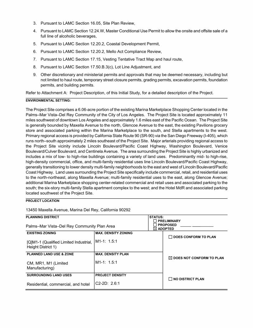
3. Pursuant to LAMC Section 16.05, Site Plan Review,
4. Pursuant to LAMC Section 12.24.W, Master Conditional Use Permit to allow the onsite and offsite sale of a full line of alcoholic beverages,
5. Pursuant to LAMC Section 12.20.2, Coastal Development Permit,
6. Pursuant to LAMC Section 12.20.2, Mello Act Compliance Review,
7. Pursuant to LAMC Section 17.15, Vesting Tentative Tract Map and haul route,
8. Pursuant to LAMC Section 17.50.B.3(c), Lot Line Adjustment, and
9. Other discretionary and ministerial permits and approvals that may be deemed necessary, including butnot limited to haul route, temporary street closure permits, grading permits, excavation permits, foundationpermits, and building permits.
Refer to Attachment A: Project Description, of this Initial Study, for a detailed description of the Project.
ENVIRONMENTAL SETTING:
The Project Site comprises a 6.06-acre portion of the existing Marina Marketplace Shopping Center located in thePalms–Mar Vista–Del Rey Community of the City of Los Angeles. The Project Site is located approximately 11miles southwest of downtown Los Angeles and approximately 1.6 miles east of the Pacific Ocean. The Project Site is generally bounded by Maxella Avenue to the north, Glencoe Avenue to the east, the existing Pavilions grocery store and associated parking within the Marina Marketplace to the south, and Stella apartments to the west. Primary regional access is provided by California State Route 90 (SR-90) via the San Diego Freeway (I-405), whichruns north–south approximately 2 miles southeast of the Project Site. Major arterials providing regional access tothe Project Site vicinity include Lincoln Boulevard/Pacific Coast Highway, Washington Boulevard, VeniceBoulevard/Culver Boulevard, and Centinela Avenue. The area surrounding the Project Site is highly urbanized andincludes a mix of low- to high-rise buildings containing a variety of land uses. Predominantly mid- to high-rise, high-density commercial, office, and multi-family residential uses line Lincoln Boulevard/Pacific Coast Highway,generally transitioning to lower density multi-family neighborhoods to the east and west of Lincoln Boulevard/PacificCoast Highway. Land uses surrounding the Project Site specifically include commercial, retail, and residential uses to the north-northeast, along Maxella Avenue; multi-family residential uses to the east, along Glencoe Avenue;additional Marina Marketplace shopping center-related commercial and retail uses and associated parking to the south; the six-story multi-family Stella apartment complex to the west; and the Hotel MdR and associated parkinglocated southwest of the Project Site.
PROJECT LOCATION
13450 Maxella Avenue, Marina Del Rey, California 90292
PLANNING DISTRICT
Palms–Mar Vista–Del Rey Community Plan Area
STATUS: PRELIMINARY PROPOSED ______ _______ ADOPTED
EXISTING ZONING
[Q]M1-1 (Qualified Limited Industrial, Height District 1)
MAX. DENSITY ZONING M1-1: 1.5:1
DOES CONFORM TO PLAN
PLANNED LAND USE & ZONE
CM, MR1, M1 (Limited Manufacturing)
MAX. DENSITY PLAN M1-1: 1.5:1
DOES NOT CONFORM TO PLAN
SURROUNDING LAND USES
Residential, commercial, and hotel
PROJECT DENSITY C2-2D: 2.6:1
NO DISTRICT PLAN

DETERMINATION (To be completed by Lead Agency)
On the basis of this initial evaluation:
o I find that the proposed project COULD NOT have a significant effect on the environment, and a NEGATIVE DECLARATION will be prepared.
o I find that although the proposed project could have a significant effect on the environment, there will not be a significant effect in this case because revisions on the project have been made by or agreed to by the project proponent. A MITIGATED NEGATIVE DECLARATION will be prepared.
o I find the proposed project MAY have a significant effect on the environment, and an ENVIRONMENTAL IMPACT REPORT is required.
~ I find the proposed project MAY have a "potentially significant impact" or "potentially Significant unless mitigated" impact on the environment, but at least one effect 1) has been adequately analyzed in an earlier document pursuant to applicable legal standards, and 2) has been addressed by mitigation measures based on earlier analysis as described on attached sheets. An ENVIRONMENTAL IMPACT REPORT is required, but it must analyze only the effects that remain to be addressed.
o I find that although the proposed project could have a significant effect on the environment, because all potentially significant effects (a) have been analyzed adequately in an earlier EIR or NEGATIVE DECLARATION pursuant to applicable standards, and (b) have been avoided or mitigated pursuant to that earlier EIR or NEGATIVE DECLARATION, including revisions or mitigation measures that are imposed upon the proposed project, nothing further is required.
SIGNATURE TITLE

EVALUATION OF ENVIRONMENTAL IMPACTS: 1) A brief explanation is required for all answers except “No Impact” answers that are adequately
supported by the information sources a lead agency cites in the parentheses following each question. A “No Impact” answer is adequately supported if the referenced information sources show that the impact simply does not apply to projects like the one involved (e.g., the project falls outside a fault rupture zone). A “No Impact” answer should be explained where it is based on project-specific factors as well as general standards (e.g., the project will not expose sensitive receptors to pollutants based on a project-specific screening analysis).
2) All answers must take account of the whole action involved, including off-site as well as on-site, cumulative as well as project-level, indirect as well as direct, and construction as well as operational impacts.
3) Once the lead agency has determined that a particular physical impact may occur, then the checklist answers must indicate whether the impact is potentially significant, less that significant with mitigation, or less than significant. “Potentially Significant Impact” is appropriate if there is substantial evidence that an effect may be significant. If there are one or more “Potentially Significant Impact” entries when the determination is made, an EIR is required.
4) “Negative Declaration: Less Than Significant With Mitigation Incorporated” applies where the incorporation of a mitigation measure has reduced an effect from “Potentially Significant Impact” to “Less Than Significant Impact.” The lead agency must describe the mitigation measures, and briefly explain how they reduce the effect to a less than significant level (mitigation measures from Section XVII, “Earlier Analysis,” cross referenced).
5) Earlier analysis must be used where, pursuant to the tiering, program EIR, or other CEQA process, an effect has been adequately analyzed in an earlier EIR, or negative declaration. Section 15063 (c)(3)(D). In this case, a brief discussion should identify the following:
a) Earlier Analysis Used. Identify and state where they are available for review. b) Impacts Adequately Addressed. Identify which effects from the above checklist were
within the scope of and adequately analyzed in an earlier document pursuant to applicable legal standards, and state whether such effects were addressed by mitigation measures based on the earlier analysis.
c) Mitigation Measures. For effects that are “Less Than Significant With Mitigation Measures Incorporated,” describe the mitigation measures which were incorporated or refined from the earlier document and the extent to which they address site-specific conditions for the project.
6) Lead agencies are encouraged to incorporate into the checklist references to information sources for potential impacts (e.g., general plans, zoning ordinances). Reference to a previously prepared or outside document should, where appropriate, include a reference to the page or pages where the statement is substantiated
7) Supporting Information Sources: A sources list should be attached, and other sources used or individuals contacted should be cited in the discussion.
8) This is only a suggested form, and lead agencies are free to use different formats; however, lead agencies should normally address the questions from this checklist that are relevant to a project’s environmental effects in whichever format is selected.
9) The explanation of each issue should identify: a. The significance criteria or threshold, if any, used to evaluate each question; and b. The mitigation measure identified, if any, to reduce the impact to less than significance.
ENVIRONMENTAL FACTORS POTENTIALLY AFFECTED:
The environmental factors checked below would be potentially affected by this project, involving at least one impact that is a “Potentially Significant Impact” as indicated by the checklist on the following pages.
Aesthetics Agricultural and Forestry Resources Air Quality
Biological Resources Cultural Resources Geology/Soils
Greenhouse Gas Emissions Hazards & Hazardous Materials Hydrology/Water Quality
Land Use/Planning Mineral Resources Noise
Population/Housing Public Services Recreation
Transportation/Traffic Tribal Cultural Resources Utilities and Service Systems
Mandatory Findings of Significance
INITIAL STUDY CHECKLIST (To be completed by the Lead City Agency)
� BACKGROUND PROPONENT NAME Sares-Regis Group
PHONE NUMBER (949) 809-2502
PROPONENT ADDRESS 18825 Bardeen Avenue, Irvine, California 92612 AGENCY REQUIRING CHECKLIST City of Los Angeles, Department of City Planning
DATE SUBMITTED June 9, 2017
PROPOSAL NAME (If Applicable) Paseo Marina
� ENVIRONMENTAL IMPACTS (Explanations of all potentially and less than significant impacts are required to be attached on separate sheets)
Refer to Attachment B: Explanation of Checklist Determinations, of this Initial Study, for detailed explanations to this Initial Study Checklist.
Potentially Significant
Impact
Less Than Significant
with Mitigation
Incorporated
Less Than Significant
Impact No Impact
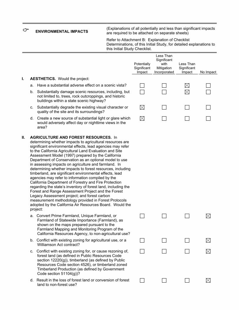
I. AESTHETICS. Would the project:
a. Have a substantial adverse effect on a scenic vista? b. Substantially damage scenic resources, including, but
not limited to, trees, rock outcroppings, and historic buildings within a state scenic highway?
c. Substantially degrade the existing visual character or quality of the site and its surroundings?
d. Create a new source of substantial light or glare which would adversely affect day or nighttime views in the area?
II. AGRICULTURE AND FOREST RESOURCES. In determining whether impacts to agricultural resources are significant environmental effects, lead agencies may refer to the California Agricultural Land Evaluation and Site Assessment Model (1997) prepared by the California Department of Conservation as an optional model to use in assessing impacts on agriculture and farmland. In determining whether impacts to forest resources, including timberland, are significant environmental effects, lead agencies may refer to information compiled by the California Department of Forestry and Fire Protection regarding the state’s inventory of forest land, including the Forest and Range Assessment Project and the Forest Legacy Assessment project; and forest carbon measurement methodology provided in Forest Protocols adopted by the California Air Resources Board. Would the project:
a. Convert Prime Farmland, Unique Farmland, or Farmland of Statewide Importance (Farmland), as shown on the maps prepared pursuant to the Farmland Mapping and Monitoring Program of the California Resources Agency, to non-agricultural use?
b. Conflict with existing zoning for agricultural use, or a Williamson Act contract?
c. Conflict with existing zoning for, or cause rezoning of, forest land (as defined in Public Resources Code section 12220(g)), timberland (as defined by Public Resources Code section 4526), or timberland zoned Timberland Production (as defined by Government Code section 51104(g))?
d. Result in the loss of forest land or conversion of forest land to non-forest use?

Potentially Significant
Impact
Less Than Significant
with Mitigation
Incorporated
Less Than Significant
Impact No Impact
e. Involve other changes in the existing environment which, due to their location or nature, could result in conversion of Farmland, to non-agricultural use or conversion of forest land to non-forest use?
III. AIR QUALITY. Where available, the significance criteria established by the applicable air quality management or air pollution control district may be relied upon to make the following determinations. Would the project:
a. Conflict with or obstruct implementation of the applicable air quality plan?
b. Violate any air quality standard or contribute substantially to an existing or projected air quality violation?
c. Result in a cumulatively considerable net increase of any criteria pollutant for which the project region is non-attainment under an applicable federal or state ambient air quality standard (including releasing emissions which exceed quantitative thresholds for ozone precursors)?
d. Expose sensitive receptors to substantial pollutant concentrations?
e. Create objectionable odors affecting a substantial number of people?
IV. BIOLOGICAL RESOURCES. Would the project:
a. Have a substantial adverse effect, either directly or through habitat modifications, on any species identified as a candidate, sensitive, or special status species in local or regional plans, policies, or regulations, or by the California Department of Fish and Wildlife or U.S. Fish and Wildlife Service?
b. Have a substantial adverse effect on any riparian habitat or other sensitive natural community identified in local or regional plans, policies, or regulations, by the California Department of Fish and Wildlife or U.S. Fish and Wildlife Service?
c. Have a substantial adverse effect on federally protected wetlands as defined by Section 404 of the Clean Water Act (including, but not limited to, marsh, vernal pool, coastal, etc.) through direct removal, filling, hydrological interruption, or other means?
d. Interfere substantially with the movement of any native resident or migratory fish or wildlife species or with established native resident or migratory wildlife corridors, or impede the use of native wildlife nursery sites?
e. Conflict with any local policies or ordinances protecting biological resources, such as a tree preservation policy

Potentially Significant
Impact
Less Than Significant
with Mitigation
Incorporated
Less Than Significant
Impact No Impact
or ordinance?
f. Conflict with the provisions of an adopted Habitat Conservation Plan, Natural Community Conservation Plan, or other approved local, regional, or state habitat conservation plan?
V. CULTURAL RESOURCES: Would the project:
a. Cause a substantial adverse change in the significance of a historical resource as defined in §15064.5?
b. Cause a substantial adverse change in the significance of an archaeological resource pursuant to §15064.5?
c. Directly or indirectly destroy a unique paleontological resource or site or unique geologic feature?
d. Disturb any human remains, including those interred outside of dedicated cemeteries?
VI. GEOLOGY AND SOILS. Would the project:
a. Expose people or structures to potential substantial adverse effects, including the risk of loss, injury or death involving:
i. Rupture of a known earthquake fault, as delineated on the most recent Alquist-Priolo Earthquake Fault Zoning Map issued by the State Geologist for the area or based on other substantial evidence of a known fault caused in whole or in part by the project’s exacerbation of the existing environmental conditions? Refer to Division of Mines and Geology Special Publication 42.
ii. Strong seismic ground shaking caused in whole or in part by the project’s exacerbation of the existing environmental conditions?
iii. Seismic-related ground failure, including liquefaction caused in whole or in part by the project’s exacerbation of the existing environmental conditions?
iv. Landslides, caused in whole or in part by the project’s exacerbation of the existing environmental conditions?
b. Result in substantial soil erosion or the loss of topsoil?
c. Be located on a geologic unit or soil that is unstable, or that would become unstable as a result of the project, and potentially result in on- or off-site landslide, lateral spreading, subsidence, liquefaction or collapse caused in whole or in part by the project’s exacerbation of the existing environmental conditions?
d. Be located on expansive soil, as defined in Table 18-1-B of the Uniform Building Code (1994),

Potentially Significant
Impact
Less Than Significant
with Mitigation
Incorporated
Less Than Significant
Impact No Impact
creating substantial risks to life or property caused in whole or in part by the project’s exacerbation of the existing environmental conditions?
e. Have soils incapable of adequately supporting the use of septic tanks or alternative waste water disposal systems where sewers are not available for the disposal of waste water?
VII. GREENHOUSE GAS EMISSIONS. Would the project:
a. Generate greenhouse gas emissions, either directly or indirectly, that may have a significant impact on the environment?
b. Conflict with an applicable plan, policy or regulation adopted for the purpose of reducing the emissions of greenhouse gases?
VIII. HAZARDS AND HAZARDOUS MATERIALS. Would the project:
a. Create a significant hazard to the public or the environment through the routine transport, use, or disposal of hazardous materials?
b. Create a significant hazard to the public or the environment through reasonably foreseeable upset and accident conditions involving the release of hazardous materials into the environment?
c. Emit hazardous emissions or handle hazardous or acutely hazardous materials, substances, or waste within one-quarter mile of an existing or proposed school?
d. Be located on a site which is included on a list of hazardous materials sites compiled pursuant to Government Code Section 65962.5 and, as a result, would create a significant hazard to the public or the environment caused in whole or in part from the project’s exacerbation of existing environmental conditions?
e. For a project located within an airport land use plan or, where such a plan has not been adopted, within two miles of a public airport or public use airport, would the project result in a safety hazard for people residing or working in the project area?
f. For a project within the vicinity of a private airstrip, would the project result in a safety hazard for people residing or working in the project area?
g. Impair implementation of or physically interfere with an adopted emergency response plan or emergency evacuation plan?

Potentially Significant
Impact
Less Than Significant
with Mitigation
Incorporated
Less Than Significant
Impact No Impact
h. Expose people or structures to a significant risk of loss, injury or death involving wildland fires, including where wildlands are adjacent to urbanized areas or where residences are intermixed with wildlands caused in whole or in part from the project’s exacerbation of existing environmental conditions?
IX. HYDROLOGY AND WATER QUALITY. Would the project:
a. Violate any water quality standards or waste discharge requirements?
b. Substantially deplete groundwater supplies or interfere substantially with groundwater recharge such that there would be a net deficit in aquifer volume or a lowering of the local groundwater table level (e.g., the production rate of pre-existing nearby wells would drop to a level which would not support existing land uses or planned uses for which permits have been granted)?
c. Substantially alter the existing drainage pattern of the site or area, including through the alteration of the course of a stream or river, in a manner which would result in substantial erosion or siltation on- or off-site?
d. Substantially alter the existing drainage pattern of the site or area, including through the alteration of the course of a stream or river, or substantially increase the rate or amount of surface runoff in a manner which would result in flooding on- or off site?
e. Create or contribute runoff water which would exceed the capacity of existing or planned stormwater drainage systems or provide substantial additional sources of polluted runoff?
f. Otherwise substantially degrade water quality?
g. Place housing within a 100-year flood hazard area as mapped on a federal Flood Hazard Boundary or Flood Insurance Rate Map or other flood hazard delineation map?
h. Place within a 100-year flood hazard area structures which would impede or redirect flood flows?
i. Expose people or structures to a significant risk of loss, injury or death involving flooding, including flooding as a result of the failure of a levee or dam?
j. Inundation by seiche, tsunami, or mudflow?
X. LAND USE AND PLANNING. Would the project:
a. Physically divide an established community? b. Conflict with any applicable land use plan, policy, or
regulation of an agency with jurisdiction over the
Potentially Significant
Impact
Less Than Significant
with Mitigation
Incorporated
Less Than Significant
Impact No Impact
project (including, but not limited to the general plan, specific plan, local coastal program, or zoning ordinance) adopted for the purpose of avoiding or mitigating an environmental effect?
c. Conflict with any applicable habitat conservation plan or natural community conservation plan?
XI. MINERAL RESOURCES. Would the project:
a. Result in the loss of availability of a known mineral resource that would be of value to the region and the residents of the state?
b. Result in the loss of availability of a locally-important mineral resource recovery site delineated on a local general plan, specific plan or other land use plan?
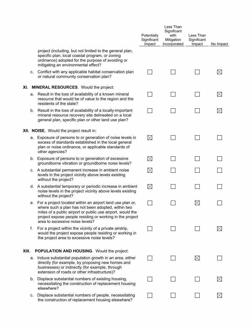
XII. NOISE. Would the project result in:
a. Exposure of persons to or generation of noise levels in excess of standards established in the local general plan or noise ordinance, or applicable standards of other agencies?
b. Exposure of persons to or generation of excessive groundborne vibration or groundborne noise levels?
c. A substantial permanent increase in ambient noise levels in the project vicinity above levels existing without the project?
d. A substantial temporary or periodic increase in ambient noise levels in the project vicinity above levels existing without the project?
e. For a project located within an airport land use plan or, where such a plan has not been adopted, within two miles of a public airport or public use airport, would the project expose people residing or working in the project area to excessive noise levels?
f. For a project within the vicinity of a private airstrip, would the project expose people residing or working in the project area to excessive noise levels?
XIII. POPULATION AND HOUSING. Would the project:
a. Induce substantial population growth in an area, either directly (for example, by proposing new homes and businesses) or indirectly (for example, through extension of roads or other infrastructure)?
b. Displace substantial numbers of existing housing, necessitating the construction of replacement housing elsewhere?
c. Displace substantial numbers of people, necessitating the construction of replacement housing elsewhere?
Potentially Significant
Impact
Less Than Significant
with Mitigation
Incorporated
Less Than Significant
Impact No Impact
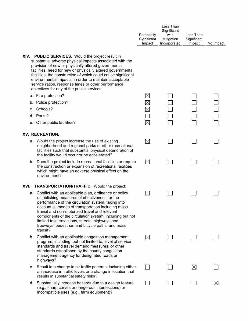
XIV. PUBLIC SERVICES. Would the project result in substantial adverse physical impacts associated with the provision of new or physically altered governmental facilities, need for new or physically altered governmental facilities, the construction of which could cause significant environmental impacts, in order to maintain acceptable service ratios, response times or other performance objectives for any of the public services:
a. Fire protection? b. Police protection? c. Schools? d. Parks? e. Other public facilities?
XV. RECREATION.
a. Would the project increase the use of existing neighborhood and regional parks or other recreational facilities such that substantial physical deterioration of the facility would occur or be accelerated?
b. Does the project include recreational facilities or require the construction or expansion of recreational facilities which might have an adverse physical effect on the environment?
XVI. TRANSPORTATION/TRAFFIC. Would the project:
a. Conflict with an applicable plan, ordinance or policy establishing measures of effectiveness for the performance of the circulation system, taking into account all modes of transportation including mass transit and non-motorized travel and relevant components of the circulation system, including but not limited to intersections, streets, highways and freeways, pedestrian and bicycle paths, and mass transit?
b. Conflict with an applicable congestion management program, including, but not limited to, level of service standards and travel demand measures, or other standards established by the county congestion management agency for designated roads or highways?
c. Result in a change in air traffic patterns, including either an increase in traffic levels or a change in location that results in substantial safety risks?
d. Substantially increase hazards due to a design feature (e.g., sharp curves or dangerous intersections) or incompatible uses (e.g., farm equipment)?

Potentially Significant
Impact
Less Than Significant
with Mitigation
Incorporated
Less Than Significant
Impact No Impact
e. Result in inadequate emergency access? f. Conflict with adopted policies, plans, or programs
regarding public transit, bicycle, or pedestrian facilities, or otherwise decrease the performance or safety of such facilities?
XVII. TRIBAL CULTURAL RESOURCES.
a. Would the project cause a substantial adverse change in the significance of a tribal cultural resource, defined in Public Resources Code section 21074 as either a site, feature, place, cultural landscape that is geographically defined in terms of the size and scope of the landscape, sacred place, or object with cultural value to a California Native American tribe, and that is:
i. Listed or eligible for listing in the California Register of Historical Resources, or in a local register of historical resources as defined in Public Resources Code section 5020.1(k), or
ii. A resource determined by the lead agency, in its discretion and supported by substantial evidence, to be significant pursuant to criteria set forth in subdivision (c) of Public Resources Code Section 5024.1. In applying the criteria set forth in subdivision (c) of Public Resource Code Section 5024.1, the lead agency shall consider the significance of the resource to a California Native American tribe.
XVIII. UTILITIES AND SERVICE SYSTEMS. Would the project:
a. Exceed wastewater treatment requirements of the applicable Regional Water Quality Control Board?
b. Require or result in the construction of new water or wastewater treatment facilities or expansion of existing facilities, the construction of which could cause significant environmental effects?
c. Require or result in the construction of new storm water drainage facilities or expansion of existing facilities, the construction of which could cause significant environmental effects?
d. Have sufficient water supplies available to serve the project from existing entitlements and resources, or are new or expanded entitlements needed?
e. Result in a determination by the wastewater treatment provider which serves or may serve the project that it has adequate capacity to serve the project’s projected demand in addition to the provider’s existing commitments?
f. Be served by a landfill with sufficient permitted capacity
Potentially Significant
Impact
Less Than Significant
with Mitigation
Incorporated
Less Than Significant
Impact No Impact
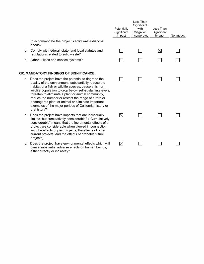
to accommodate the project’s solid waste disposal needs?
g. Comply with federal, state, and local statutes and regulations related to solid waste?
h. Other utilities and service systems?
XIX. MANDATORY FINDINGS OF SIGNIFICANCE.
a. Does the project have the potential to degrade the quality of the environment, substantially reduce the habitat of a fish or wildlife species, cause a fish or wildlife population to drop below self-sustaining levels, threaten to eliminate a plant or animal community, reduce the number or restrict the range of a rare or endangered plant or animal or eliminate important examples of the major periods of California history or prehistory?
b. Does the project have impacts that are individually limited, but cumulatively considerable? (“Cumulatively considerable” means that the incremental effects of a project are considerable when viewed in connection with the effects of past projects, the effects of other current projects, and the effects of probable future projects).
c. Does the project have environmental effects which will cause substantial adverse effects on human beings, either directly or indirectly?

� DISCUSSION OF THE ENVIRONMENTAL EVALUATION (Attach additional sheets if necessary)
PREPARED BY
Eyestone Environmental 2121 Rosecrans Avenue, Suite 3355 El Segundo, CA 90245
TITLE
TELEPHONE #
(424) 207-5333
DATE
June 9, 2017

A. Project Description

City of Los Angeles Paseo Marina June 2017
Page A-1
Attachment A: Project Description
A. Introduction
Sares-Regis Group, the Project Applicant, proposes the Paseo Marina Project (Project), a new mixed-use development, on an approximately 6.06-acre (263,811 square feet) portion of the existing Marina Marketplace shopping center (Project Site) located in the Palms–Mar Vista–Del Rey Community Plan (Community Plan) area of the City of Los Angeles (City). The Project would replace three existing shopping center-related buildings within the Project Site that together comprise approximately 100,781 square feet1 and associated surface parking areas with a new mixed-use development consisting of 658 multi-family residential units and an estimated 27,300 square feet of neighborhood-serving commercial uses, including approximately 13,650 square feet of retail space and approximately 13,650 square feet of restaurant space. The proposed multi-family residential and commercial uses would be provided within three seven-story buildings with a maximum height of approximately 77 feet. In accordance with the requirements of the Los Angeles Municipal Code (LAMC), the proposed uses would be supported by 1,217 parking spaces, which would be distributed throughout the Project Site in two subterranean parking levels and in two above-grade parking levels located within each of the three buildings. The Project would include residential lobbies and leasing areas, pools, a spa, and outdoor kitchens with lounges and seating. In addition, per the requirements set forth in the LAMC, the Project would provide approximately 70,175 square feet of open space, including paved plazas with seating, landscaped paseos, and landscaped open space at the ground level that would be privately maintained and publicly accessible. The proposed plazas located along the northwest portion and in the center of the Project Site would connect to a publicly accessible, privately maintained open space area, including a one-story amenity building and additional seating located along the southwestern portion of the Project Site via an outdoor pedestrian paseo that would run north–south and east–west through the center of the Project Site. Overall, the Project would remove approximately 100,781 square feet of existing commercial floor area and construct approximately 674,329 square feet of new residential and commercial floor area, resulting in a net increase of 573,548 square feet of net new floor area within the Project Site for a total floor area ratio (FAR) of approximately 2.6 to 1.
1 All square-footage numbers represent floor area as defined by LAMC Section 12.03.

Attachment A: Project Description
City of Los Angeles Paseo Marina June 2017
Page A-2
B. Project Location and Surrounding Uses
The Project Site comprises an approximate 6.06-acre portion of the existing Marina Marketplace Shopping Center located in the Palms–Mar Vista–Del Rey Community Plan area of the City of Los Angeles. The Project Site is located approximately 11 miles southwest of downtown Los Angeles and approximately 1.6 miles east of the Pacific Ocean. The Project Site is generally bounded by Maxella Avenue to the north, Glencoe Avenue to the east, the existing Pavilions grocery store and associated parking within the Marina Marketplace to the south,2 and Stella apartments to the west. As shown in Figure A-1 on page A-3, primary regional access is provided by California State Route 90 (SR-90) via the San Diego Freeway (I-405), which runs north–south approximately two miles southeast of the Project Site. Major arterials providing regional access to the Project Site vicinity include Lincoln Boulevard/Pacific Coast Highway, Washington Boulevard, Venice Boulevard/Culver Boulevard, and Centinela Avenue. Public transit service in the vicinity of the Project Site is currently provided by the Los Angeles County Metropolitan Transit Authority (Metro), Los Angeles Department of Transportation Transit Commuter Express, Culver City Bus, and City of Santa Monica Big Blue Bus. There are two bus stops adjacent to the Project Site, along Maxella Avenue. Both bus stops are operated by Culver City Bus while one bus stop is also operated by the City of Santa Monica Big Blue Bus.
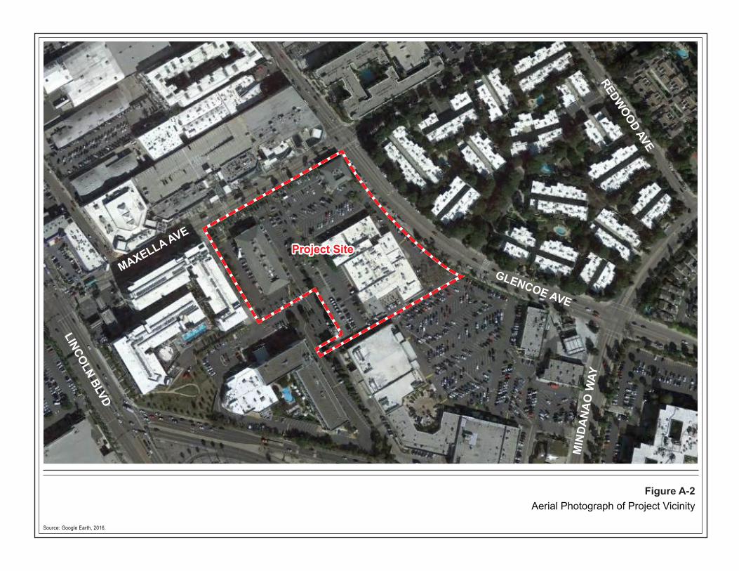
As shown in the aerial photograph provided in Figure A-2 on page A-4, the area surrounding the Project Site is highly urbanized and includes a mix of low- to high-rise buildings containing a variety of land uses. Predominantly mid- to high-rise, high-density commercial, office, and multi-family residential uses line Lincoln Boulevard/Pacific Coast Highway, generally transitioning to lower density multi-family neighborhoods to the east and west of Lincoln Boulevard/Pacific Coast Highway. Land uses surrounding the Project Site specifically include commercial, retail, and residential uses to the north-northeast, along Maxella Avenue; multi-family residential uses to the east, along Glencoe Avenue; additional Marina Marketplace shopping center-related commercial and retail uses and associated parking to the south; the six-story multi-family Stella apartment complex to the west; and the Hotel MdR and associated parking located southwest of the Project Site.
2 The requested approvals include a proposed lot line adjustment that would create a new southern boundary to the north off the existing grocery store. The remnant parcel is not a part of the Project Site, and no new development is proposed on this site.

Venice
Rose
Culve
r
Palms
Walgrove
InglewoodAlla
Ocean Park
PCH
Washington Glencoe
McLaughlin
Lincoln
Marina
Short
Jefferson
Neilson
Abbot Kinney
MindanaoMaxella Ave
23rd
Dolce
Califo
rnia
Beethoven
Grand
ZanjaCentinela
PCH
Abbot Kinney Culve
r
Venice
Lincoln
Centinela
Inglewood
Admiralty
Main
Brad
dock
Marina
Sawtelle
Pacific
Sepulveda187
1
1
405
ProjectSite
Source: Los Angeles County GIS, 2015; Eyestone Environmental, 2016.
0 10.5Miles
N
Figure A-1Project Location Map
NOT TO SCALE
405
101
91
1182
710
1
1
405
10
105
405
210
110
605
5
5
San Pedro
Encino Sherman Oaks
Van Nuys
Chatsworth
Carson
Santa Monica Mtns.
San Gabr ie l Mtns.
Glendale
Hollywood
Santa Monica
Manhattan Beach
Redondo Beach
Torrance
Long Beach
Malibu
Woodland Hills
Simi Valley
Agoura Hills
Los Angeles
Pasadena
Project Site
Source: Google Earth, 2016.
Figure A-2Aerial Photograph of Project Vicinity
MAXELLA AVE
GLENCOE AVE
LINCOLN BLVD
MIN
DANA
O W
AY
REDWOOD AVE
Project Site
Attachment A: Project Description
City of Los Angeles Paseo Marina June 2017
Page A-5
C. Existing Conditions
1. Existing Project Site Conditions
The Project Site is currently occupied by three structures, including a two-story Barnes & Noble bookstore located along the northeast corner of the Project Site, near the Maxella Avenue and Glencoe Avenue intersection; a single-story building providing a variety of retail uses located generally within the southern portion of the Project Site, along Glencoe Avenue; a two-story commercial and retail building located generally within the western portion of the Project Site; and surface parking and circulation areas. The existing surface parking areas within the Project Site include a total of 418 parking spaces. Vehicular access to the Project Site is currently available via driveways on Maxella Avenue and Glencoe Avenue. Pedestrian access is available from the vehicular access points and from other areas along Maxella Avenue and Glencoe Avenue.
Landscaping within the Project Site includes ornamental landscaping and hardscape features. Street trees and trees within the Project Site consist of various non-native species, including palm, pine, fig, gum, fern, cajeput, carrotwood, octopus, strawberry, and olive trees that are not subject to the City’s Protected Tree Regulations.3
2. Land Use and Zoning
The Project Site is located within the planning boundary of the Palms–Mar Vista–Del Rey Community Plan area and is designated for Limited Manufacturing land uses (CM, MR1, and M1 zones).
The Project Site is zoned by the Los Angeles Municipal Code as [Q]M1-1 (Qualified Limited Industrial, Height District 1). The Limited Industrial zone permits a wide array of land uses. Specifically, the M1 zone permits any commercial land use permitted in the MR1 and C2 zones, in addition to other specified uses including (but not limited to) foundry, rental of equipment commonly used by contractors, stadiums, arenas, auditoriums, and indoor swap meets. Residential uses are generally not permitted. Height District 1 within the M1 zone normally imposes no height limitation and a maximum FAR of 1.5:1. However, pursuant to Ordinance No. 167,962, adopted in 1992, the Q conditions for the Project Site restrict building heights to 45 feet. The Q Conditions also provide that if any use not permitted in the MR1 zone is developed on the Project Site, the FAR for such uses
3 The City of Los Angeles Protected Tree Regulations apply to Oak, Southern California Black Walnut, Western Sycamore, and California Bay tree species that are native to Southern California, and excludes trees grown by a nursery or trees planted or grown as part of a tree planting program.

Attachment A: Project Description
City of Los Angeles Paseo Marina June 2017
Page A-6
shall be limited to 0.5 to 1. In addition, per Ordinance No. 167,962, no portion of a building or structure shall exceed 35 feet in height within 50 feet of the Glencoe Avenue right-of-way. The Q conditions also establish recycling and graffiti removal requirements for the Project Site.
The Project Site is also within the boundaries of the Los Angeles Coastal Transportation Corridor Specific Plan established pursuant to Ordinance No. 168,999 from 1993. The intent of the Los Angeles Coastal Transportation Corridor Specific Plan is to:
Provide a mechanism to fund specific transportation improvements generated by new development within the Specific Plan area;
Establish the Coastal Transportation Corridor Impact Assessment Fee process;
Regulate the phased development of land uses, insofar as the transportation infrastructure can accommodate such uses; establish a Coastal Transportation Corridor infrastructure implementation process;
Promote or increase work-related ridesharing and bicycling; avoid peak-hour level of service on streets and intersections from reaching level of service F;
Promote the development of coordinated and comprehensive transportation plans; and
Reduce commute trips; ensure that public transportation facilities will benefit the contributor; and encourage Caltrans to widen the San Diego Freeway for high-occupancy vehicle lanes.
D. Project Characteristics
1. Project Overview
As previously described, the Project would replace three buildings within the existing Marina Marketplace shopping center that together comprise approximately 100,781 square feet and associated surface parking areas with a new mixed-use development consisting of 658 multi-family residential units and an estimated 27,300 square feet of neighborhood-serving commercial uses, including approximately 13,650 square feet of retail space and approximately 13,650 square feet of restaurant space. The proposed multi-family residential and commercial uses would be provided within three seven-story buildings with a maximum height of approximately 77 feet. The proposed uses would be supported by 1,217 parking spaces that would be distributed throughout the Project Site in two subterranean parking levels and in two above-grade parking levels located within each of the three buildings. The Project would include residential lobbies and leasing areas, pools, a spa, and outdoor kitchens with lounges and seating. In addition, per the requirements set
Attachment A: Project Description
City of Los Angeles Paseo Marina June 2017
Page A-7
forth in the LAMC, the Project would provide approximately 70,175 square feet of open space, including paved plazas with seating, landscaped paseos, and landscaped open space at the ground level that would be privately maintained and publicly accessible. The proposed plazas located along the northwest portion and in the center of the Project Site would connect to a publicly accessible, privately maintained open space area, including a one-story amenity building and additional seating, located along the southwestern portion of the Project Site via north–south and east–west pedestrian paseos. Overall, as summarized in Table A-1 on page A-8, the Project would remove approximately 100,781 square feet of existing commercial floor area and construct approximately 674,329 square feet of new residential and commercial floor area, resulting in a net increase of 573,548 square feet of net new floor area within the Project Site. A conceptual site plan of the proposed development is provided in Figure A-3 on page A-9.
2. Project Design
As shown in Figure A-3, the proposed multi-family residential and neighborhood-serving commercial uses would be provided within three buildings (herein referred to as Building 1, Building 2, and Building 3) that would be organized around an outdoor pedestrian paseo that would be orientated both east–west across the Project4 Site and north–south through the center of the Project Site and connect to a public plaza along the northwestern portion of the Project Site and a publicly accessible, privately maintained open space area along the southwestern portion of the Project Site. Building 1 would comprise a seven-story, mixed-use structure located along the western portion of the Project Site, adjacent to an access driveway and the Stella apartments. Building 2 would comprise a seven-story, mixed-use structure located at the southwest corner of Maxella Avenue and Glencoe Avenue. Building 3, located within the southern portion of the Project Site, also along Glencoe Avenue, would comprise a seven-story, mixed-use structure. As shown in Figure A-3, the proposed commercial uses would be concentrated at the ground level within each of the buildings. Also at the ground level, the Project would include townhomes, residential lobbies, and leasing areas. As shown in Figure A-3, above the second story of Building 1, Building 2, and Building 3 would be a podium level, which would include amenities such as pools, a spa, and outdoor kitchens with lounges and seating. The proposed multi-family dwelling units consisting of studio, 1-bedroom, and 2-bedroom units would be distributed from the ground level up to the seventh story of the three buildings. The proposed buildings would reach an approximate height of 77 feet above grade level. Along Glencoe Avenue, Building 2 and Building 3 would feature building step backs to form landscaped terraces on the seventh floor that would, in conjunction
4 The east–west paseo would be pedestrian-orientated, but would also provide emergency vehicle access for the Project.

Attachment A: Project Description
City of Los Angeles Paseo Marina June 2017
Page A-8
Table A-1 Summary of Existing and Proposed Floor Areaa
Land Use Existing Proposed Demolition
Proposed Construction Net New
Commercial (retail/restaurant uses)
100,781 sf (100,781 sf) 27,300 sf (73,481 sf)
Residential 0 0 647,029 sf (658 du)
647,029 sf (658 du)
Total 100,781 sf (100,781 sf) 674,329 sf (658 du)
573,548 sf (658 du)
du = dwelling unit
sf = square feet a Square footage is calculated pursuant to the LAMC definition of floor area for the purpose of
calculating FAR. In accordance with LAMC Section 12.03, floor area is defined as: “[t]he area in square feet confined within the exterior walls of a building, but not including the area of the following: exterior walls, stairways, shafts, rooms housing building-operating equipment or machinery, parking areas with associated driveways and ramps, space for the landing and storage of helicopters, and basement storage areas.”
Source: Eyestone Environmental, 2017.
with the amenity deck at the podium level, serve to reduce the apparent height of these buildings when viewed from Glencoe Avenue.
The proposed mixed-use buildings would be designed in a contemporary architectural style. Cantilevered balcony decks, horizontal overhangs, and canopies would be integrated with vertical fins and other architectural elements, such as balcony and stair railing and shading devices. These architectural elements would provide horizontal and vertical articulation that would serve to break up the building planes and modulate building massing. A variety of exterior finishes, materials, and textures would be integrated into the overall design of the various buildings, including tile or stone veneer, storefront windows, aluminum louvers, wood exterior plaster, glass railings, and integrated signage and lighting.
Building 1 would be set back approximately 43 feet from the property line along Maxella Avenue and approximately 15 feet from the property line on the west. Building 2 would be set back approximately 11 feet from the property line along Maxella Avenue. Building 2 and Building 3 would be set back approximately 15 feet from the property line along Glencoe Avenue. Building 3 would also be set back approximately 20 feet from the primary shopping center access driveway located south of the Project Site ingress and egress to Glencoe Avenue.

0 15’ 30’ 60’
MAXELLA AVE
GLEN
COE
AVE
COMMON OPEN SPACE
PLANTED COMMON OPEN SPACE REQUIRED: 11,072 sfPLANTED COMMON OPEN SPACE PROPOSED: 44,907 sf LEVEL 1: 34,235 sf LEVEL 3: 10,672 sf
TOTAL TREE REQUIRED: 156TOTAL TREES PROPOSED: 294
PASEO MARINAMARINA DEL REY, CALIFORNIA
SARES REGISTCA # 2016-054
SITE PLAN REVIEWAugust 29, 2016
OVERALL ILLUSTRATIVE LANDSCAPE PLANSITE PLAN REVIEWAugust 31, 2016
L-1.0
Source: TCA Architects, Meléndrez, 2016.
Figure A-3Conceptual Site and Landscape Plan

Attachment A: Project Description
City of Los Angeles Paseo Marina June 2017
Page A-10
3. Access, Circulation, and Parking
As previously described, the proposed buildings would be organized around an outdoor pedestrian paseo that would run east–west and north–south through the center of the Project Site. The pedestrian paseo, which would extend to the proposed public plaza along the northwestern portion of the Project Site and the proposed publicly accessible, privately maintained open space area along the southwestern portion of the Project Site, has been designed to connect the Project Site with the Marina Marketplace shopping center uses to the north and south of the Project Site. The east–west paseo would also provide access for emergency vehicles.
As shown in Figure A-3 on page A-9, vehicular access to the Project Site would be provided via five driveways, including two entry/exit driveways along the access driveway located adjacent to Building 1, one entry/exit driveway along Maxella Avenue, one entry/exit driveway along Glencoe Avenue, and one entry/exit driveway located along the southern boundary of the Project Site. Trash collection trucks would access the Project Site primarily from Glencoe Avenue and from Hotel Drive, adjacent to Building 1. The trash collection area would be enclosed and would not be visible to the surrounding uses.
As shown in Figure A-3, new pedestrian access points would be created throughout the Project Site via the pedestrian paseo and internal street. From the pedestrian paseo and the public plaza proposed along the northwestern portion of the Project Site, pedestrians would be able to access Marina Marketplace shopping center-related uses across Maxella Avenue via the existing pedestrian crosswalk along Maxella Avenue. At the southern terminus of the pedestrian paseo, pedestrians would be able to access Marina Marketplace shopping center-related uses south of the Project Site. Bicycle access would also be provided throughout the Project Site, including via the vehicular access points on Glencoe Avenue and Maxella Avenue. Bicycle storage areas would be included in the ground-floor level of the proposed buildings. In total, approximately 724 bicycle parking spaces (658 long-term spaces and 66 short-term spaces) would be provided for the proposed residential uses, and approximately 28 bicycle parking spaces would be provided to support the retail uses.
As described above, the proposed uses would be supported by 1,217 parking spaces that would be distributed throughout the Project Site in two subterranean levels that would extend to a depth of approximately 28 feet and in two above grade parking levels located within each of the three buildings. Parking for residents would be provided primarily within the above- and below-grade parking levels within the buildings while parking for the commercial uses would be provided primarily within the ground floor parking levels. The Project would comply with City requirements for providing electric vehicle charging capabilities and electric vehicle charging stations within the proposed parking.

Attachment A: Project Description
City of Los Angeles Paseo Marina June 2017
Page A-11
4. Landscaping and Open Space
The Project would provide a variety of open space and recreational amenities. Private open space and recreational amenities available to Project residents and guests of residents would include: balconies, paved plazas with seating, landscaped paseos, courtyard areas at the podium level, landscaped open space, pools, a spa, and outdoor kitchens with lounges and seating areas. To enhance the streetscape, a landscaped public plaza would be provided at the northwest corner of the Project Site, along Maxella Avenue, that would connect to a landscaped pedestrian paseo. From here, the pedestrian paseo would extend south to a proposed publicly accessible, privately maintained open space area that would be provided near the southwest corner of the Project Site. Trees and other landscaping features would also be planted throughout the Project Site and along Maxella Avenue and Glencoe Avenue to activate these streets and provide a pedestrian-friendly environment. In total, the Project would provide approximately 70,175 square feet of open space in accordance with the open space requirements set forth in the Los Angeles Municipal Code.
5. Lighting and Signage
The Project would include low-level exterior lights adjacent to the proposed buildings and along pathways for security and wayfinding purposes. In addition, low-level lighting to accent signage, architectural features, and landscaping elements would also be incorporated throughout the Project Site. All lighting would comply with current energy standards and codes as well as design requirements while providing appropriate light levels. Project lighting would be designed to provide efficient and effective on-site lighting while minimizing light trespass from the Project Site, reducing sky-glow, and improving nighttime visibility through glare reduction. Specifically, all on-site exterior lighting, including lighting fixtures on the pool deck, would be automatically controlled via photo sensors to illuminate only when required and would be shielded or directed toward areas to be illuminated to limit spill-over onto nearby residential uses. Where appropriate, interior lighting would be equipped with occupancy sensors and/or timers that would automatically extinguish lights when no one is present. All exterior and interior lighting shall meet high energy efficiency requirements utilizing light-emitting diode (LED) or efficient fluorescent lighting technology. New street and pedestrian lighting within the public right-of-way would comply with applicable City regulations and would be approved by the Bureau of Street Lighting in order to maintain appropriate and safe lighting levels on both sidewalks and roadways while minimizing light and glare on adjacent properties.
Proposed signage would be designed to be aesthetically compatible with the proposed architecture of the Project Site and with the requirements of the Los Angeles Municipal Code. Proposed signage would include identity signage, either blade or

Attachment A: Project Description
City of Los Angeles Paseo Marina June 2017
Page A-12
monument, on the three major Project Site corners, building and tenant signage, and general ground level and way-finding pedestrian signage. No off premises or billboard advertising is proposed as part of the Project. The Project would also not include signage with flashing, mechanical, or strobe lights. In general, new signage would be architecturally integrated into the design of the proposed buildings and would establish appropriate identification for the residential and commercial uses. Project signage would be illuminated via low-level, low-glare external lighting, internal halo lighting, or ambient light. Exterior lighting for signage would be directed onto signs to avoid creating off-site glare. Illumination used for Project signage would comply with light intensities set forth in the LAMC and as measured at the property line of the nearest residentially zoned property.
6. Sustainability Features
The Project’s design is based on principles of smart growth and environmental sustainability, as evidenced by its mixed-use composition, emphasis on walkability and public open space, bike-friendly environment, proximity to public transit including bus stops adjacent to the Project Site as described above, and the presence of existing infrastructure needed to serve the proposed uses. The new buildings would be designed and constructed to incorporate environmentally sustainable design features equivalent to a minimum Silver certification under the U.S. Green Building Council’s LEED® Rating System for new construction. “Green” principles would be incorporated throughout the Project to comply with the City of Los Angeles Green Building Code (Ordinance No. 181,480). Such features would include energy-efficient buildings, a pedestrian- and bicycle-friendly site design, and water conservation and waste reduction measures, among others. The Project would also utilize sustainable planning and building strategies and would incorporate the use of environmentally friendly materials, such as non-toxic paints and recycled finish materials wherever possible. In accordance with CEQA Guidelines Appendix F, the EIR will provide further information as to energy-consuming equipment and processes that would be used during construction and operation of the Project, energy requirements of the Project, energy conservation equipment and design features of the Project, energy supplies that would serve the Project, and total estimated daily vehicle trips that would be generated by the Project. The Project would include the following sustainability features:
Energy Conservation and Efficiency
Meeting or exceeding Title 24, Part 6, California Energy Code baseline standard requirements for energy efficiency, based on the 2016 Building Energy Efficiency Standards requirements.
Compliance with the required measures of CALGreen and implementation of additional efficiency measures to achieve a reduction in energy consumption relative to the American Society of Heating, Refrigerating and Air-Conditioning

Attachment A: Project Description
City of Los Angeles Paseo Marina June 2017
Page A-13
Engineers (ASHRAE) 90.1-2007 standard but no less than minimum compliance with the 2016 California energy efficiency standards (Title 24, Part 6). Some energy efficiency design strategies may include the incorporation of energy-efficient heating, ventilation, and air conditioning (HVAC) systems, lighting and appliances.
Use of Energy Star–labeled products and appliances, including dishwashers in the residential units, where appropriate.
Use of LED lighting or other energy-efficient lighting technologies, such as occupancy sensors or daylight harvesting and dimming controls, where appropriate, to reduce electricity use.
Incorporation of energy-efficient design methods and technologies, when feasible, such as centralized chiller plant with rooftop ventilation; high performance window glazing; undergrounding parking to reduce heat island effects; passive energy efficiency strategies, such as façade shading, roof overhangs, porches, and inner courtyards; high efficiency domestic heaters; and enhanced insulation to minimize solar heat gain.
Inclusion of outdoor air flow, additional outdoor air ventilation, and use of low emitting materials to promote indoor environmental quality.
Use of natural ventilation, when conditions permit, to reduce energy use and carbon emissions, while improving occupant health and productivity.
Incorporation of generous operable windows and high performance window glazing; shading of unit fenestration through balcony overhangs to prevent excess heat; and use of natural light.
Use of insulated plumbing pipes and high efficiency domestic water heaters.
Use of updated boiler controls to improve efficiency.
Use of refrigerants that reduce ozone depletion.
Use of energy-efficient electrical and mechanical equipment.
Provision of conduit that is appropriate for future photovoltaic and solar thermal collectors.
Post-construction commissioning of building energy systems performed on an ongoing basis to ensure all systems are running at optimal efficiency.
Attachment A: Project Description
City of Los Angeles Paseo Marina June 2017
Page A-14
Water Conservation
Inclusion of water conservation measures in accordance with Los Angeles Department of Water and Power requirements for new development in the City of Los Angeles (e.g., high-efficiency fixtures and appliances, weather-based irrigation systems, drought-tolerant landscaping).
Use of drought-tolerant plants and indigenous species, storm water collection through a first flush filtration system of rain gardens where possible, permeable pavement wherever possible, and storm water filtration planters to collect roof water.
Use of high-efficiency toilets, including dual-flush water closets, and no-flush or waterless urinals in all non-residential restrooms, as appropriate.
Use of non-residential restroom faucets and non-residential kitchen faucets (except restaurant kitchens) with a maximum flow rate of 1.5 gallons per minute. Use of restaurant kitchen faucets with pre-rinse self-closing spray heads.
Use of high-efficiency shower heads at 1.8 gallons per minute. Install zero showers with multiple shower heads.
Use of non-residential restroom or non-hotel room faucets of a self-closing design (i.e., that would automatically turn off when not in use).
Use of residential bathroom and kitchen faucets with a maximum flow rate of 1.5 gallons per minute. No more than one showerhead per shower stall, with a flow rate no greater than 2 gallons per minute.
Use of high-efficiency Energy Star–rated clothes washers.
Use of high-efficiency Energy Star–rated dishwashers, where appropriate.
Prohibition of the use of single-pass cooling equipment (i.e., equipment in which water is circulated once through the system and then drains for disposal with no recirculation).
Consideration of individual metering and billing for water use of all residential uses and exploration of metering for commercial spaces.
Use of weather-based irrigation controller with rain shutoff, matched precipitation (flow) rates for sprinkler heads, and rotating sprinkler nozzles or comparable technology such as drip/micro spray/subsurface irrigation where appropriate.
Installation of a separate water meter (or submeter), flow sensor, and master valve shutoff for irrigated landscape areas totaling 5,000 square feet and greater.

Attachment A: Project Description
City of Los Angeles Paseo Marina June 2017
Page A-15
Use of proper hydro-zoning and turf minimization, as feasible.
Use of landscape contouring/bioswales, rain gardens, cisterns, and/or tree pits to minimize precipitation runoff.
Reduction of indoor water use by installing water fixtures that exceed applicable standards.
Water Quality
Installation of pre-treatment stormwater infrastructure for the stormwater runoff tributary to the on-site stormwater treatment system.
Reduce stormwater runoff through the introduction of new landscaped areas throughout the Project Site and/or on the structure.
Installation of catch basin inserts and screens to provide runoff contaminant removal.
Solid Waste
Use of building materials with a minimum 10 percent recycled-content for the construction of the Project.
Implementation of a construction waste management plan to recycle and/or salvage nonhazardous construction debris or minimize the generation of construction waste.
Transportation
Allocation of preferred parking for alternative-fuel vehicles, low-emitting, and fuel-efficient and ride-sharing vehicles.
Provision of electric vehicle charging stations in accordance with City requirements.
Air Quality
Employment of practices that prohibit the use of chlorofluorocarbons (CFCs) in HVAC systems.
Installation of MERV 8 filtration at outside air intakes to improve indoor air quality.
Meeting applicable California and/or Los Angeles air emissions requirements for all heating or cogeneration equipment utilized at the Project Site.

Attachment A: Project Description
City of Los Angeles Paseo Marina June 2017
Page A-16
Installation of landscaping throughout the Project Site, including roof decks, pool decks, and terraces, to provide shading and capture carbon dioxide emissions.
Use of adhesives, sealants, paints, finishes, carpet, and other materials that emit low quantities of volatile organic compounds (VOCs) and/or other air quality pollutants.
E. Project Construction and Scheduling
Project construction is anticipated to occur in one phase and be completed in 2023. Construction of the Project, which would be approximately 37 months, would commence with removal of the existing buildings and the existing surface parking areas, followed by grading and excavation for the subterranean parking garage. Building foundations would then be laid, followed by building construction, paving/concrete installation, and landscape installation. It is estimated that approximately 220,000 cubic yards of soil would be hauled from the Project Site during the excavation phase. The haul route from the Project Site is anticipated to be via Glencoe Avenue to Mindanao Way to SR-90. Incoming haul trucks would be anticipated to access the Project Site via SR-90 to Lincoln Boulevard to Maxella Avenue.
F. Necessary Approvals
The City of Los Angeles has the principal responsibility for approving the Project. Approvals required for development of the Project may include, but are not limited to, the following:
Pursuant to LAMC Section 11.5.6 and Section 12.32, General Plan Amendment to the Palms–Mar Vista–Del Rey Community Plan to change the Community Plan land use designation from Limited Manufacturing to General Commercial;
Pursuant to LAMC Section 12.32.Q, a Vesting Zone and Height District Change from [Q]M1-1 to (T)(Q)C2-2D;
Pursuant to LAMC Section 16.05, Site Plan Review;
Pursuant to LAMC Section 12.24.W, a Master Conditional Use Permit to allow the onsite and offsite sale of a full line of alcoholic beverages;
Pursuant to LAMC Section 12.20.2, Coastal Development Permit;
Pursuant to LAMC Section 12.20.2, Mello Act Compliance Review;
Pursuant to LAMC Section 17.15, Vesting Tentative Tract Map and haul route;

Attachment A: Project Description
City of Los Angeles Paseo Marina June 2017
Page A-17
Pursuant to LAMC Section 17.50.B.3(c), Lot Line Adjustment; and
Other discretionary and ministerial permits and approvals that may be deemed necessary, including but not limited to haul route, temporary street closure permits, grading permits, excavation permits, foundation permits, and building permits.

B. Explanation of Checklist Determinations

City of Los Angeles Paseo Marina June 2017
Page B-1
Attachment B: Explanation of Checklist Determinations
The following discussion provides responses to each of the questions set forth in the City of Los Angeles Initial Study Checklist. The responses below indicate those issues that are expected to be addressed in an environmental impact report (EIR) and demonstrate why other issues would not result in potentially significant environmental impacts and thus do not need to be addressed further in an EIR. The questions with responses that indicate a “Potentially Significant Impact” do not presume that a significant environmental impact would result from the Project. Rather, such responses indicate those issues that will be addressed in an EIR with conclusions of impact reached as part of the analysis within the EIR.
I. Aesthetics
Would the project:
a. Have a substantial adverse effect on a scenic vista?
Less Than Significant Impact. A scenic vista is a view of a valued visual resource. Scenic vistas generally include views that provide visual access to large panoramic views of natural features, unusual terrain, or unique urban or historic features, for which the field of view can be wide and extend into the distance, and focal views that focus on a particular object, scene, or feature of interest. Visual resources in the vicinity of the Project Site include the Santa Monica Mountains to the north and the Pacific Ocean to the west of the Project Site. However, it is noted that existing northerly views of the Santa Monica Mountains are limited as such views are primarily available from area roadways where there are gaps between existing buildings, including along Glencoe Avenue located east of the Project Site and Mindanao Way located south of the Project Site. Accordingly, large panoramic views of the Santa Monica Mountains are not available in the vicinity of the Project Site. Existing westerly views of the Pacific Ocean are obstructed by existing development, particularly the Stella Apartments located immediately west of the Project Site.
As described in Attachment A, Project Description, of this Initial Study, the Project Site is currently occupied by three structures, including a two-story Barnes & Noble
Attachment B: Explanation of Checklist Determinations
City of Los Angeles Paseo Marina June 2017
Page B-2
bookstore located along the northeast corner of the Project Site, near the Maxella Avenue and Glencoe Avenue intersection; a single-story building providing a variety of retail uses located generally within the southern portion of the Project Site, along Glencoe Avenue; a two-story commercial and retail building located generally within the western portion of the Project Site; and surface parking and circulation areas. The Project would replace the three existing buildings and associated surface parking areas within the Marina Marketplace shopping center with three new seven-story buildings, each with an approximate maximum height of 77 feet.
As noted above, northerly views of the Santa Monica Mountains are primarily available from Glencoe Avenue, with very limited views available along Mindanao Way. The Project would be developed west of Glencoe Avenue and within the boundaries of the existing Marina Marketplace shopping center. As such, existing views of the Santa Monica Mountains looking north from Glencoe Avenue would not be obstructed by the Project. In particular, along Glencoe Avenue, the Project would feature building step backs to form landscaped terraces on the seventh floor that would, in conjunction with the amenity deck at the podium level, serve to reduce the apparent height of these buildings when viewed from Glencoe Avenue. Furthermore, while the Project is expected to obstruct a portion of the very limited views of the Santa Monica Mountains available from Mindanao Way looking north across the Project Site, such views are already mostly obstructed by existing development within the Marina Marketplace shopping center and do not represent a scenic vista wherein large expanses of the Santa Monica Mountains are visible. The most prominent views of the Santa Monica Mountains available in the vicinity of the Project Site from Glencoe Avenue would remain with the Project. In addition, as previously discussed, views of the Pacific Ocean across the Project Site to the west are completely obstructed by existing development west of the Project Site, including the Stella Apartments and high-rise towers along Lincoln Boulevard.
Based on the analysis above, the Project would not have a substantial adverse effect on a scenic vista. Impacts would be less than significant, and no mitigation measures are required. No further evaluation of this topic in an EIR is required.
b. Substantially damage scenic resources, including, but not limited to, trees, rock outcroppings, and historic buildings, within a state scenic highway?
Less Than Significant Impact. The Project Site is not located in proximity to a state-designated scenic highway. In addition, street trees and trees within the Project Site consist of various non-native species that are not subject to the City’s Protected Tree Regulations. Therefore, the on-site and off-site trees are not considered scenic resources. Furthermore, there are no permanent structures or unique geologic or topographic features located on the Project Site, such as hilltops, ridges, hill slopes, canyons, ravines, rock
Attachment B: Explanation of Checklist Determinations
City of Los Angeles Paseo Marina June 2017
Page B-3
outcrops, water bodies, streambeds, or wetlands. The Project Site also does not include any historic buildings or other historic resources. As such, construction and operation of the Project would not substantially damage scenic resources, and impacts to scenic resources within a state- or City-designated scenic highway would be less than significant. No further evaluation of this topic in an EIR is required.
c. Substantially degrade the existing visual character or quality of the site and its surroundings?
Potentially Significant Impact. As discussed in Attachment A, Project Description, of this Initial Study, the area surrounding the Project Site is highly urbanized and includes a mix of low- to high-rise buildings containing a variety of land uses. While the proposed buildings would be anticipated to be similar and compatible with the existing visual character and quality of the surrounding area, the Project would change the visual character of the Project Site and its surroundings with the development of three new mid-rise mixed-use buildings on a site that is currently developed with three low-rise commercial buildings and surface parking areas. Furthermore, the Project could cast shadows on surrounding uses, potentially resulting in adverse shading impacts. Therefore, the EIR will analyze the Project’s potential effects on visual character and quality.
d. Create a new source of substantial light or glare which would adversely affect day or nighttime views in the area?
Potentially Significant Impact. The Project Site currently generates moderate levels of artificial light and glare typical of a commercial development. Light sources within the Project Site include low-level security lighting, vehicle headlights, interior lighting emanating from the existing commercial buildings on the Project Site, surface parking lot lighting, and architectural lighting. Glare sources within the Project Site include glass and metal vehicle and building surfaces. The Project would introduce new sources of light and glare associated with the proposed residential and commercial uses, including architectural lighting, signage lighting, interior lighting, and security and wayfinding lighting, which could have the potential to adversely affect daytime and nighttime views. Therefore, further analysis of the Project’s potential impacts with regard to light and glare will be provided in the EIR.
II. Agriculture and Forest Resources
In determining whether impacts to agricultural resources are significant environmental effects, lead agencies may refer to the California Agricultural Land Evaluation and Site Assessment Model (1997) prepared by the California Department of Conservation as an optional model to use in assessing impacts on agriculture and farmland. In determining whether impacts to forest resources, including timberland, are significant environmental

Attachment B: Explanation of Checklist Determinations
City of Los Angeles Paseo Marina June 2017
Page B-4
effects, lead agencies may refer to information compiled by the California Department of Forestry and Fire Protection regarding the state’s inventory of forest land, including the Forest and Range Assessment Project and the Forest Legacy Assessment project; and forest carbon measurement methodology provided in Forest Protocols adopted by the California Air Resources Board. Would the project:
a. Convert Prime Farmland, Unique Farmland, or Farmland of Statewide Importance (Farmland), as shown on the maps prepared pursuant to the Farmland Mapping and Monitoring Program of the California Resources Agency, to non-agricultural use?
No Impact. The Project Site is located in an urbanized area of the City of Los Angeles and is currently developed with commercial uses and surface parking areas and is zoned for commercial and industrial uses. No agricultural uses or operations occur on-site or in the vicinity of the Project Site. In addition, the Project Site and surrounding area are not mapped as Prime Farmland, Unique Farmland, or Farmland of Statewide Importance pursuant to the Farmland Mapping and Monitoring Program of the California Resources Agency Department of Conservation. As such, the Project would not convert farmland to a non-agricultural use. No impacts would occur, and no mitigation measures are required. No further evaluation of this topic in an EIR is required.
b. Conflict with the existing zoning for agricultural use, or a Williamson Act Contract?
No Impact. As discussed in Attachment A, Project Description, of this Initial Study, the Project Site is zoned by the Los Angeles Municipal Code (LAMC) for limited industrial land uses. The Project Site is not zoned for agricultural use under the LAMC. Furthermore, no agricultural zoning is present in the surrounding area. The Project Site and surrounding area are also not enrolled under a Williamson Act Contract.1 Therefore, the Project would not conflict with any zoning for agricultural uses or a Williamson Act Contract. No impacts would occur, and no mitigation measures are required. No further evaluation of this topic in an EIR is required.
c. Conflict with existing zoning for, or cause rezoning of, forest land (as defined in Public Resources Code section 12220(g)), timberland (as defined by Public Resources Code section 4526), or timberland zoned Timberland Production (as defined by Government Code section 51104(g))?
1 City of Los Angeles Department of City Planning, Zone Information and Map Access System (ZIMAS),
Parcel Profile Report, http://zimas.lacity.org/, accessed August 8, 2016.

Attachment B: Explanation of Checklist Determinations
City of Los Angeles Paseo Marina June 2017
Page B-5
No Impact. As previously discussed, the Project Site is located in an urbanized area and is currently developed with commercial uses and surface parking areas. The Project Site does not include any forest or timberland. In addition, the Project Site is currently zoned for limited industrial and commercial land uses. The Project Site is not zoned for forest land and is not used as forest land. Therefore, the Project would not conflict with existing zoning for, or cause rezoning of, forest land or timberland as defined by the Public Resources Code. No impacts would occur, and no mitigation measures are required. No further evaluation of this topic in an EIR is required.
d. Result in the loss of forest land or conversion of forest land to non-forest use?
No Impact. As discussed above, the Project Site is located in an urbanized area and does not include any forest or timberland. Therefore, the Project would not result in the loss or conversion of forest land. No impacts would occur, and no mitigation measures are required. No further evaluation of this topic in an EIR is required.
e. Involve other changes in the existing environment which, due to their location or nature, could result in conversion of Farmland, to non-agricultural use or conversion of forest land to non-forest use?
No Impact. The Project Site is located in an urbanized area of the City and is currently developed with commercial uses and surface parking areas. The Project Site and surrounding area are not mapped as farmland or forest land, are not zoned for farmland, agricultural use, or forest land, and do not contain any agricultural uses or forest land. As such, the Project would not result in the conversion of farmland to non-agricultural use or in the conversion of forest land to non-forest use. No impacts would occur, and no mitigation measures are required. No further evaluation of this topic in an EIR is required.
III. Air Quality
Where available and applicable, the significance criteria established by the applicable air quality management or air pollution control district may be relied upon to make the following determinations. Would the project:
a. Conflict with or obstruct implementation of the applicable air quality plan?
Potentially Significant Impact. The Project Site is located within the 6,700-square-mile South Coast Air Basin (Basin). Within the Basin, the South Coast Air Quality Management District (SCAQMD) is required, pursuant to the federal Clean Air Act, to reduce emissions of criteria pollutants for which the Basin is in non-attainment (i.e., ozone,
Attachment B: Explanation of Checklist Determinations
City of Los Angeles Paseo Marina June 2017
Page B-6
particulate matter less than 2.5 microns in size [PM2.5], and lead2). The SCAQMD’s 2012 Air Quality Management Plan (AQMP) contains a comprehensive list of pollution control strategies directed at reducing emissions and achieving ambient air quality standards. These strategies are developed, in part, based on regional population, housing, and employment projections prepared by the Southern California Association of Governments (SCAG). SCAG is the regional planning agency for Los Angeles, Orange, Ventura, Riverside, San Bernardino and Imperial Counties, and addresses regional issues relating to transportation, the economy, community development, and the environment.3 With regard to future growth, SCAG has prepared the 2016–2040 Regional Transportation Plan/Sustainable Communities Strategy (2016–2040 RTP/SCS), which provides population, housing, and employment projections for cities under its jurisdiction. The growth projections in the 2016–2040 RTP/SCS are based on growth projections in local general plans for jurisdictions in SCAG’s planning area.
Construction and operation of the Project may result in an increase in stationary and mobile source air emissions. As a result, Project development could have a potential adverse effect on the SCAQMD’s implementation of the AQMP. Therefore, the EIR will provide further analysis of the Project’s consistency with the SCAQMD’s AQMP.
With regard to the Project’s consistency with the Congestion Management Program (CMP) administered by the Metropolitan Transportation Authority (Metro), see Response to Checklist Question XVI.b, Transportation/Circulation, below.
b. Violate any air quality standard or contribute substantially to an existing or projected air quality violation?
Potentially Significant Impact. The Project would result in increased air pollutant emissions from the Project Site during construction (short-term) and operation (long-term). Construction-related pollutants would be associated with sources such as construction worker vehicle trips, the operation of construction equipment, site grading and preparation activities, and the application of architectural coatings. During Project operation, air pollutants would be emitted on a daily basis from motor vehicle travel, energy consumption, and other on-site activities. Therefore, the EIR will provide further analysis of the Project’s construction and operational air pollutant emissions.
2 Partial Nonattainment designation for the Los Angeles County portion of the Basin only. 3 SCAG serves as the federally designated metropolitan planning organization for the Southern California
region.

Attachment B: Explanation of Checklist Determinations
City of Los Angeles Paseo Marina June 2017
Page B-7
c. Result in a cumulatively considerable net increase of any criteria pollutant for which the project region is non-attainment under an applicable federal or state ambient air quality standard (including releasing emissions which exceed quantitative thresholds for ozone precursors)?
Potentially Significant Impact. As discussed above, construction and operation of the Project would result in the emission of air pollutants in the Basin, which is currently in non-attainment of federal air quality standards for ozone, PM2.5, and lead, and State air quality standards for ozone, PM10, and PM2.5. Therefore, implementation of the Project could potentially contribute to air quality impacts, which could cause a cumulative impact in the Basin. Therefore, the EIR will provide further analysis of cumulative air pollutant emissions associated with the Project.
d. Expose sensitive receptors to substantial pollutant concentrations?
Potentially Significant Impact. As discussed above, the Project would result in increased air pollutant emissions from the Project Site during construction (short-term) and operation (long-term). Sensitive receptors located in the vicinity of the Project Site include residential uses to the east, west, and northwest of the Project Site and educational facilities associated with the Kid’s Pointe Pre-School located southwest of the Project Site, and Short Avenue Elementary located southeast of the Project Site. Therefore, the EIR will provide further analysis of the Project’s potential to result in substantial adverse impacts to sensitive receptors.
e. Create objectionable odors affecting a substantial number of people?
Less Than Significant Impact. No objectionable odors are anticipated as a result of either construction or operation of the Project. Specifically, construction of the Project would involve the use of conventional building materials typical of construction projects of similar type and size. Any odors that may be generated during construction would be localized and temporary in nature and would not be sufficient to affect a substantial number of people or result in a nuisance as defined by SCAQMD Rule 402.
With respect to Project operation, according to the SCAQMD CEQA Air Quality Handbook, land uses associated with odor complaints typically include agricultural uses, wastewater treatment plants, food processing plants, chemical plants, composting, refineries, landfills, dairies, and fiberglass molding. The Project would not involve these types of uses. In addition, on-site trash receptacles would be contained, located, and maintained in a manner that promotes odor control, and would not result in substantial adverse odor impacts.

Attachment B: Explanation of Checklist Determinations
City of Los Angeles Paseo Marina June 2017
Page B-8
Based on the above, potential odor impacts during construction and operation of the Project would be less than significant, and no mitigation measures are required. No further analysis of this topic in an EIR is required.
IV. Biological Resources
Would the project:
a. Have a substantial adverse effect, either directly or through habitat modification, on any species identified as a candidate, sensitive, or special status species in local or regional plans, policies, or regulations by the California Department of Fish and Wildlife or U.S. Fish and Wildlife Service?
Less Than Significant Impact. The Project Site is located in an urbanized area and is currently developed with commercial uses and surface parking areas. While the Project Site includes ornamental trees and landscaping, the majority of the Project Site consists of paved and developed surfaces. Due to the developed nature of the Project Site and the surrounding area as well as the lack of large expanses of open space in the vicinity of the Project Site, species likely to occur on-site are limited to small terrestrial and avian species typically found in developed settings. Therefore, the Project would not have a substantial adverse effect, either directly or through habitat modification, on any species identified as a candidate, sensitive, or special status species in local or regional plans, policies, or regulations by the California Department of Fish and Wildlife or U.S. Fish and Wildlife Service. Impacts would be less than significant, and no mitigation measures are required. No further evaluation of this topic in an EIR is required.
b. Have a substantial adverse effect on any riparian habitat or other sensitive natural community identified in local or regional plans, policies, regulations by the California Department of Fish and Wildlife or U.S. Fish and Wildlife Service?
No Impact. The Project Site is located in an urbanized area and is currently developed with commercial uses and surface parking areas. The Ballona Creek Significant Ecological Area4 is located approximately 0.5 mile south of the Project Site. No riparian or other sensitive natural community exists on the Project Site or in the immediate surrounding area. Therefore, the Project would not have a substantial adverse effect on
4 City of Los Angeles, Department of City Planning, Los Angeles Citywide General Plan Framework, Draft
Environmental Impact Report, January 19, 1995, Figure BR-1D p. 2.18-6. Available at http://cityplanning.lacity.org/housinginitiatives/housingelement/frameworkeir/FrameworkFEIR.pdf, accessed June 1, 2017.
Attachment B: Explanation of Checklist Determinations
City of Los Angeles Paseo Marina June 2017
Page B-9
any riparian habitat or other sensitive natural community. No impact would occur, and no mitigation measures are required. No further evaluation of this topic in an EIR is required.
c. Have a substantial adverse effect on federally protected wetlands as defined by Section 404 of the Clean Water Act (including, but not limited to, marsh vernal pool, coastal, etc.) through direct removal, filling, hydrological interruption, or other means?
No Impact. The Project Site is located in an urbanized area and is currently developed with commercial uses and surface parking areas. The Ballona Wetlands Ecological Reserve is located approximately 0.5 mile south of the Project Site. No water bodies or federally protected wetlands as defined by Section 404 of the Clean Water Act exist on the Project Site or in the immediate vicinity of the Project Site. As such, the Project would not have an adverse effect on federally protected wetlands. No impacts would occur, and no mitigation measures are required. No further evaluation of this topic in an EIR is required.
d. Interfere substantially with the movement of any native resident or migratory fish or wildlife species or with established native resident or migratory wildlife corridors, or impede the use of native wildlife nursery sites?
Less Than Significant Impact. The Project Site is located in an urbanized area and is currently developed with commercial uses and surface parking areas. In addition, the areas surrounding the Project Site are fully developed, and there are no large expanses of open space areas within and surrounding the Project Site which provide linkages to natural open spaces areas and which may serve as wildlife corridors. Accordingly, development of the Project would not interfere substantially with any established native resident or migratory wildlife corridors or impede the use of native wildlife nursery sites. Furthermore, no water bodies that could serve as habitat for fish exist on the Project Site or in the vicinity of the Project Site. Notwithstanding, although unlikely, the existing on-site 101 ornamental trees that would be removed during construction of the Project could potentially provide nesting sites for migratory birds. However, the Project would be required to comply with the Migratory Bird Treaty Act, which regulates vegetation removal during the nesting season to ensure that significant impacts to migratory birds would not occur. In accordance with the Migratory Bird Treaty Act, tree removal activities would take place outside of the nesting season (February 15–September 15). To the extent that vegetation removal activities must occur during the nesting season, a biological monitor would be present during the removal activities to ensure that no active nests would be impacted. If active nests are found, a 300-foot buffer (500 feet for raptors) would be established until the fledglings have left the nest. With compliance with the Migratory Bird Treaty Act, impacts would be less than significant, and no mitigation measures are required. No further evaluation of this topic in an EIR is required.

Attachment B: Explanation of Checklist Determinations
City of Los Angeles Paseo Marina June 2017
Page B-10
e. Conflict with any local policies or ordinances protecting biological resources, such as tree preservation policy or ordinance?
Less Than Significant Impact. The City’s Protected Tree Regulations included in Section 17.05.R of the LAMC (the Tree Regulations) regulates the relocation or removal of specified protected trees, which include all Southern California native oak trees (excluding scrub oak), California black walnut trees, Western sycamore trees, and California Bay trees of at least 4 inches in diameter at breast height. These tree species are defined as “protected” by the City of Los Angeles. Native trees that have been planted as part of a tree planting program are exempt and are not considered protected.
A survey of the existing onsite and street trees was conducted by LSA Associates, Inc., in July 2016. The results of the survey are provided in the Tree Report for the Project included in Appendix IS-1 of this Initial Study. As discussed in the Tree Report, none of the tree species found within the Project Site are protected under the Tree Regulations.
With regard to non-protected trees, the Project Site includes 101 ornamental trees of varying non-native species, including palm, pine, fig, gum, fern, cajeput, carrotwood, octopus, strawberry, and olive trees. As part of the Project, all existing trees would be removed. In accordance with City policy, all “significant”5 trees to be removed would be replaced on a 1:1 basis.
Based on the above, the Project would not conflict with any local policies or ordinances protecting biological resources, including a tree preservation policy or ordinance. Impacts would be less than significant, and no mitigation measures are required. No further evaluation of this topic in an EIR is required.
f. Conflict with the provisions of an adopted Habitat Conservation Plan, Natural Community Conservation Plan, or other approved local, regional, or state habitat conservation plan?
No Impact. The Project Site is located in an urbanized area and is developed with commercial uses and surface parking areas with limited ornamental landscaping. The Ballona Creek Significant Ecological Area is located approximately 0.5 mile south of the Project Site. The Project Site does not support any habitat or natural community. Accordingly, no Habitat Conservation Plan, Natural Community Conservation Plan, or other approved habitat conservation plans apply to the Project Site. Thus, the Project would not conflict with the provisions of an adopted habitat conservation plan, natural community
5 Significant trees are defined as trees with a trunk diameter that is 8 inches or greater or with a cumulative
trunk diameter that is 8 inches or greater if multi-trunked, as measured 54 inches above the ground.

Attachment B: Explanation of Checklist Determinations
City of Los Angeles Paseo Marina June 2017
Page B-11
conservation plan, or other related plans. No impacts would occur, and no mitigation measures are required. No further evaluation of this topic in an EIR is required.
V. Cultural Resources
Would the project:
a. Cause a substantial adverse change in the significance of a historical resource as defined in §15064.5?
Less Than Significant Impact. Section 15064.5 of the CEQA Guidelines generally defines a historic resource as a resource that is: (1) listed in, or determined to be eligible for listing in the California Register of Historical Resources (California Register); (2) included in a local register of historical resources (pursuant to Section 5020.1(k) of the Public Resources Code); or (3) identified as significant in an historical resources survey (meeting the criteria in Section 5024.1(g) of the Public Resources Code). Additionally, any object, building, structure, site, area, place, record, or manuscript which a lead agency determines to be historically significant or significant in the architectural, engineering, scientific, economic, agricultural, educational, social, political, military, or cultural annals of California may be considered to be an historical resource, provided the lead agency’s determination is supported by substantial evidence in light of the whole record. Generally, a resource shall be considered by the lead agency to be “historically significant” if the resource meets the criteria for listing on the California Register. The California Register automatically includes all properties listed in the National Register of Historic Places (National Register) and those formally determined to be eligible for listing in the National Register.
The Project Site is currently developed and includes three structures, which would be removed with implementation of the Project. According to the parcel profile report included in the City’s Zone Information and Map Access System, the onsite buildings were built between 1973 and 19776. Given the age and unremarkable utilitarian design of the existing buildings, which are not considered to reflect a particular historical or architectural style, the on-site structures are not considered historic resources.
In addition, a records search was conducted for the Project area by the South Central Coastal Information Center (SCCIC) at California State University, Fullerton to identify previously recorded prehistoric and historic resources in and around the Project Site (see Appendix IS-2 of this Initial Study). The records search includes a review of all 6 City of Los Angeles Department of City Planning, Zone Information and Map Access System (ZIMAS),
Parcel Profile Report, http://zimas.lacity.org/, accessed August 8, 2016.

Attachment B: Explanation of Checklist Determinations
City of Los Angeles Paseo Marina June 2017
Page B-12
recorded archeological sites within a 0.5-mile radius of the Project Site as well as a review of cultural resource reports on file. The California Points of Historical Interest, California Historical Landmarks, California Register of Historical Resources, National Register of Historic Places, California State Historic Resources Inventory, and City of Los Angeles Historic-Cultural Monuments listings were also reviewed for the Project Site. The records search indicates that there are no historic resources located on-site. Furthermore, based on the SurveyLA7 report for the Palms–Mar Vista–Del Rey community, which was published in July 2012, there are no historic resources within and adjacent to the Project Site.8 The closest identified off-site historic resource is the SA ANGNA site located at 4235 South Lincoln Boulevard, located approximately 0.1 mile west of the Project Site. This Historical Cultural Moment (HCM) “may be likely to yield information important in prehistory or history”9 as it was a major village and burial site belonging to the Native American Gabrielino Indian Tribe. This HCM will be evaluated further below in Checklist Question V, Cultural Resources. An additional identified historic resource is the Marina Christian Fellowship Church located approximately 1.5 miles southeast of the Project Site.10 However, as no HCM or identified historic resources are located on-site, impacts to historic resources would be less than significant, and no mitigation measures are required. No further evaluation of this topic in an EIR is required.
b. Cause a substantial adverse change in the significance of an archaeological resource pursuant to §15064.5?
Less Than Significant Impact With Mitigation Incorporated. Section 15064.5(a)(3)(D) of the CEQA Guidelines generally defines archaeological resources as any resource that “has yielded, or may be likely to yield, information important in prehistory or history.” Archaeological resources are features, such as tools, utensils, carvings, fabric, building foundations, etc., that document evidence of past human endeavors and that may be historically or culturally important to a significant earlier community. The Project Site is located within an urbanized area of the City of Los Angeles and has been subject to grading and development in the past. Therefore, surficial archaeological resources that
7 The local register of historical resources and SurveyLA (a comprehensive program to identify significant
historic resources throughout the City) are managed by the Los Angeles Historic Resources Office. 8 City of Los Angeles Department of City Planning, SurveyLA, Los Angeles Historic Resources Survey
Report for the Palms–Mar Vista–Del Rey Community Plan Area, July 2012, http://preservation.lacity.org/files/Group%203%20Palms-Mar%20Vista-Del%20Rey%20Survey%20Report%20Final.pdf, accessed August 8, 2016.
9 City of Los Angeles, Department of City Planning, Office of Historic Resources, Historic Places LA. Available at http://historicplacesla.org/reports/1c6e0a4a-a08f-4082-acd4-244e483ab5c3, accessed June 1, 2017.
10 Historic Places LA, City of Los Angeles Historic Resources Inventory, Marina Christian Fellowship Church, www.historicplacesla.org/map, accessed August 8, 2016.

Attachment B: Explanation of Checklist Determinations
City of Los Angeles Paseo Marina June 2017
Page B-13
may have existed at one time have likely been previously disturbed. The records search conducted for the Project Site by the SCCIC (see Appendix IS-2 of this Initial Study) indicates there are no known archaeological resources within the Project Site and two archaeological resources within a 0.5-mile radius of the Project Site. As the Project would require excavations at a depth of approximately 28 feet below ground surface, there is a possibility that archeological artifacts that were not recovered during prior construction or other human activity may be present. In addition, archaeological resources have been uncovered in the vicinity of the Project Site associated with the SA ANGNA site located at 4235 South Lincoln Boulevard, approximately 0.1 mile west of the Project Site. In the event any archaeological materials are unexpectedly encountered during construction, work in the area would cease and the handling of deposits would be required to comply with the regulatory standards set forth in Section 21083.2 of the California Public Resources Code and Section 15064.5(c) of the CEQA Guidelines. The following mitigation measure would also be implemented during construction of the Project to address potential impacts associated with the potential discovery of previously unknown archaeological resources within the Project Site.
CUL-MM-1: During the construction phase and prior to the issuance of building permits, the Applicant shall retain an independent and qualified Construction Monitor who shall be responsible for coordinating with a certified archaeologist to implement and enforce the following:
a. All initial grading and all excavation activities shall be monitored by a Project archaeologist. The Project archaeologist shall be present full-time during disturbances of material with potential to contain cultural deposits and will document activity.
b. The services of an archaeologist, qualified for historic resource evaluation, as defined in CEQA and Office of Historic Preservation (OHP) Guidelines, shall be secured to implement the archaeological monitoring program. The qualified archaeologist shall be listed, or be eligible for listing, in the Register of Professional Archaeologist (RPA). Recommendations may be obtained by contacting the South Central Coastal Information Center (657-278-5395) located at California State University Fullerton.
c. In the event of a discovery, or when requested by the Project archaeologist, the contractor shall divert, direct, or temporarily halt ground disturbing activities in an area in order to evaluate potentially significant archaeological resources.
i. It shall be the responsibility of the Project archaeologist to: determine the scope and significance of the find; determine the appropriate documentation; ensure preservation, conservation, and/or relocation of the find; and determine

Attachment B: Explanation of Checklist Determinations
City of Los Angeles Paseo Marina June 2017
Page B-14
when grading/excavation activities may resume in the area of the find.
ii. Determining the significance of the find shall be guided by California Public Resources Code Division 13, Chapter 1, Section 21083.2, subdivision (g) and (h). If the find is determined to be a “unique archaeological resource”, then the applicant, in conjunction with the recommendation of the Project archaeologist, shall comply with Section 21083.2, subdivisions (b) though (f).
iii. If at any time the Project Site, or a portion of the Project Site, is determined to be a “historical resource” as defined in California Code of Regulations Chapter 3, Article 1, Section 15064.5, subdivision (a), the Project archaeologist shall prepare and issue a mitigation plan in conformance with Section 15126.4, subdivision (b).
iv. If the Project archaeologist determines that continuation of the Project or Project-related activities will result in an adverse impact on a discovered historic resource which cannot be mitigated, all further activities resulting in the impact shall immediately cease, and the Lead Agency shall be contacted for further evaluation and direction.
v. The applicant shall comply with the recommendations of the Project archaeologist with respect to the documentation, preservation, conservation, and/or relocation of the find.
vi. The Construction Monitor shall also prepare and submit documentation of the Applicant’s compliance with the Mitigation Measure CUL-MM-1 during construction every 30 days in a form satisfactory to the Department of City Planning. The documentation must be signed by the Applicant and Construction Monitor and be included as part of the Applicant’s Compliance Report. The Construction Monitor shall be obligated to immediately report to the Enforcement Agency any non-compliance with the mitigation measure within two business days if the Applicant does not correct the non-compliance within a reasonable time of notification to the Applicant by the monitor or if the non-compliance is repeated. Such non-compliance shall be appropriately addressed by the Enforcement Agency.
d. Monitoring activities may cease when:
i. Initial grading and all excavation activities have concluded; or
ii. By written consent of the Project archaeologist, agreeing that no further monitoring is necessary. In this case, a signed and

Attachment B: Explanation of Checklist Determinations
City of Los Angeles Paseo Marina June 2017
Page B-15
dated copy of such agreement shall be submitted to the Dept. of City Planning for retention in the administrative record for Case No. ENV-2016-3343-EIR.
e. At the conclusion of monitoring activities, and only if archaeological materials were encountered, the Project archaeologist shall prepare and submit a report of the findings to the South Central Coastal Information Center (SCCIC), located at:
SCCIC Department of Anthropology McCarthy Hall 477 CSU Fullerton 800 North State College Boulevard Fullerton, CA 92834
f. At the conclusion of monitoring activities, the Project archaeologist shall prepare a signed statement indicating the first and last dates monitoring activities took place, and submit it to the Dept. of City Planning, for retention in the administrative file for Case No. ENV-2016-3343-EIR.
The Construction Monitor, as set forth above, would be responsible for implementing the mitigation measure and would be obligated to provide certification, as identified above, to the appropriate monitoring agency and the appropriate enforcement agency that construction monitoring and coordination with a certified archaeologist has been implemented. The Construction Monitor would maintain records demonstrating compliance with the mitigation measure. Such records shall be made available to the City upon request.
In the event of the discovery of previously unknown archeological resources during construction of the Project, implementation of Mitigation Measure CUL-MM-1 would reduce potential impacts to a less than significant level. Accordingly, no further analysis of this topic in the EIR is required.
c. Directly or indirectly destroy a unique paleontological resource or site or unique geologic feature?
Less Than Significant Impact With Mitigation Incorporated. Paleontological resources are the fossilized remains of organisms that have lived in a region in the geologic past and whose remains are found in the accompanying geologic strata. This type of fossil record represents the primary source of information on ancient life forms, since the majority of species that have existed on earth from this era are extinct. Section 5097.5 of the California Public Resources Code specifies that any unauthorized removal of paleontological remains is a misdemeanor. Furthermore, California Penal Code Section 622.5 includes penalties for damage or removal of paleontological resources.

Attachment B: Explanation of Checklist Determinations
City of Los Angeles Paseo Marina June 2017
Page B-16
Based on the records search conducted by the Natural History Museum, included in Appendix IS-3 of this Initial Study, there are no vertebrate fossil localities that lie directly within the boundaries of the Project Site. However, the records search indicates that within the greater vicinity of the Project Site, there are fossil localities at depth in similar sediments as those underlying the Project Site. The closest vertebrate fossil locality is LACM 7879, located northwest of the Project Site near the intersection of Rose Avenue and Penmar Avenue, which produced fossil specimens of horse (Equus), and ground sloth (Paramylodon), at greater than 11 feet in depth. The next closest vertebrate fossil locality from these deposits is LACM 5462, located further northwest of the Project Site, just south of Olympic Boulevard along Michigan Avenue and east of Cloverfield Boulevard, that produced a fossil specimen of extinct lion (Felis atrox), at a depth of only 6 feet below grade.
According to the records search by the Natural History Museum, shallow grading or shallow excavations in the younger Quaternary Alluvium exposed throughout the Project Site are unlikely to provide significant fossil vertebrate remains. However, deeper excavations in the Project Site that extend down into older Quaternary deposits, may well encounter significant vertebrate fossils. While the Project Site has been subject to grading and development in the past, the Project would require excavations at a depth of approximately 28 feet below ground surface. Therefore, the Project may encounter significant vertebrate fossils at sub-surface levels on the Project Site during excavation. The following mitigation measures would be implemented during construction of the Project to ensure that the Project’s potential impact on paleontological resources is addressed.
CUL-MM-2: During the construction phase and prior to the issuance of building permits, the Applicant shall retain an independent and qualified Construction Monitor who shall be responsible for coordinating with a certified paleontologist to implement and enforce the following:
a. If any paleontological materials are encountered during the course of Project development, the Project Archaeologist, in accordance with CUL-MM-1, shall coordinate with the services of a certified paleontologist, and all further development activity shall halt and the following shall be undertaken:.
i. The services of a paleontologist shall be secured by contacting the Center for Public Paleontology-USC, UCLA, California State University Los Angeles, California State University Long Beach, or the Los Angeles County Natural History Museum-who shall assess the discovered material(s) and prepare a survey, study or report evaluating the impact.
ii. The Construction Monitor shall also prepare and submit documentation of the Applicant’s compliance with the Mitigation Measure CUL-MM-2 during construction every

Attachment B: Explanation of Checklist Determinations
City of Los Angeles Paseo Marina June 2017
Page B-17
30 days in a form satisfactory to the Department of City Planning. The documentation must be signed by the Applicant and Construction Monitor and be included as part of the Applicant’s Compliance Report. The Construction Monitor shall be obligated to immediately report to the Enforcement Agency any non-compliance with the mitigation measure within two business days if the Applicant does not correct the non-compliance within a reasonable time of notification to the Applicant by the monitor or if the non-compliance is repeated. Such non-compliance shall be appropriately addressed by the Enforcement Agency.
iii. The paleontologist's survey, study or report shall contain a recommendation(s), if necessary, for the preservation, conservation, or relocation of the resource.
iv. The Applicant shall comply with the recommendations of the evaluating paleontologist, as contained in the survey, study or report.
b. At the conclusion of monitoring activities, the Project paleontologist shall prepare a signed statement indicating the first and last dates monitoring activities took place, and submit it to the Dept. of City Planning, for retention in the administrative file for Case No. ENV-2016-3343-EIR.
c. Project development activities may resume once copies of the paleontological survey, study or report are submitted to the Los Angeles County Natural History Museum.
CUL-MM-3: Prior to the issuance of any building permit, the Project paleontologist shall submit a letter to the case file indicating what, if any, paleontological reports have been submitted, or a statement indicating that no material was discovered.
The Construction Monitor, as set forth above, would be responsible for implementing Mitigation Measures CUL-MM-2 and CUL-MM-3 and would be obligated to provide certification, as identified above, to the appropriate monitoring agency and the appropriate enforcement agency that construction monitoring and coordination with a certified archaeologist has been implemented. The Construction Monitor would maintain records demonstrating compliance with the mitigation measure. Such records shall be made available to the City upon request.
In the event of the discovery of previously unknown paleontological resources during construction of the Project, implementation of Mitigation Measures CUL-MM-2 and CUL-MM-3 would reduce potential impacts to a less than significant level. Accordingly, no further analysis of this topic in the EIR is required.
Attachment B: Explanation of Checklist Determinations
City of Los Angeles Paseo Marina June 2017
Page B-18
The Project Site is located within an urbanized area of the City of Los Angeles and has been subject to grading and development in the past. The Project Site does not include any known unique geologic features and no unique geologic features are anticipated to be encountered during construction of the Project. Therefore, the Project would not directly or indirectly destroy a unique geologic feature. The impact associated with unique geologic features would be less than significant, and no mitigation measures are required. No further evaluation of this topic in an EIR is required.
d. Disturb any human remains, including those interred outside of cemeteries?
Less Than Significant Impact. While the Project Site has been subject to grading and development in the past, the Project would require excavations at a depth of approximately 28 feet below ground surface. Although no human remains are known to have been found based on previous development on the Project Site, there is the possibility that unknown resources could be encountered during construction of the Project, particularly during ground-disturbing activities such as excavation and grading. In addition, human burials have been uncovered in the vicinity of the Project Site associated with the SA ANGNA site located at 4235 South Lincoln Boulevard, approximately 0.1 mile west of the Project Site. While the uncovering of human remains is not anticipated, if human remains are discovered during construction, such resources would be treated in accordance with state law, including Section 15064.5(e) of the CEQA Guidelines, Section 5097.98 of the California Public Resources Code, and Section 7050.5 of the California Health and Safety Code. Specifically, if human remains are encountered, work on the portion of the Project Site where remains have been uncovered would be suspended and the City of Los Angeles Public Works Department and the County Coroner would be immediately notified. If the remains are determined by the County Coroner to be Native American, the Native American Heritage Commission would be notified within 24 hours, and the guidelines of the Native American Heritage Commission would be adhered to in the treatment and disposition of the remains. Compliance with these regulatory standards would ensure appropriate treatment of any potential human remains unexpectedly encountered during grading and excavation activities. Therefore, the Project's impact on human remains would be less than significant and no mitigation measures are required. No further evaluation of this topic in an EIR is required.
VI. Geology and Soils
In 2015, the California Supreme Court in California Building Industry Association v. Bay Area Air Quality Management District (2015) 62 Cal.4th 369 (CBIA v. BAAQMD), held that CEQA generally does not require a lead agency to consider the impacts of the existing environment on the future residents or users of the project. The revised thresholds provided below are intended to comply with this decision. Specifically, the decision held
Attachment B: Explanation of Checklist Determinations
City of Los Angeles Paseo Marina June 2017
Page B-19
that an impact from the existing environment to the project, including future users and/or residents, is not an impact for purposes of CEQA. However, if the project, including future users and residents, exacerbates existing conditions that already exist, that impact must be assessed, including how it might affect future users and/or residents of the project. Thus, in accordance with Appendix G of the State CEQA Guidelines and the CBIA v. BAAQMD decision, the Project would have a significant impact related to geology and soils if it results in any of the following impacts to future residents or users:
Would the project:
a. Expose people or structures to potential substantial adverse effects, including the risk of loss, injury, or death involving:
i. Rupture of a known earthquake fault, as delineated on the most recent Alquist-Priolo Earthquake Fault Zoning Map issued by the State Geologist for the area or based on other substantial evidence of a known fault, caused in whole or in part by the project’s exacerbation of the existing environmental conditions? Refer to Division of Mines and Geology11 Special Publication 42.
Potentially Significant Impact. Fault rupture occurs when movement on a fault deep within the earth breaks through to the surface. Based on criteria established by the California Geological Survey (CGS), faults can be classified as active, potentially active, or inactive. Active faults are those having historically produced earthquakes or shown evidence of movement within the past 11,000 years (during the Holocene Epoch). Potentially active faults have demonstrated displacement within the last 1.6 million years (during the Pleistocene Epoch) while not displacing Holocene Strata. Inactive faults do not exhibit displacement within the last 1.6 million years. In addition, buried thrust faults, which are faults with no surface exposure, may exist in the vicinity of the Project Site; however, due to their buried nature, the existence of buried thrust faults is usually not known until they produce an earthquake.
The CGS establishes regulatory zones around active faults, called Alquist-Priolo Earthquake Fault Zones (previously called Special Study Zones). These zones, which extend from 200 to 500 feet on each side of a known fault, identify areas where a potential surface fault rupture could prove hazardous for buildings used for human occupancy. Development projects located within an Alquist-Priolo Earthquake Fault Zone are required to prepare special geotechnical studies to characterize hazards from any potential surface ruptures. In addition, the City of Los Angeles designates Fault Rupture Study Areas along
11 Now known as the California Geological Survey.

Attachment B: Explanation of Checklist Determinations
City of Los Angeles Paseo Marina June 2017
Page B-20
the sides of active and potentially active faults to establish areas of potential hazard due to fault rupture.
The Project Site is not located within a Fault Rupture Study Area.12 The closest active faults are the Santa Monica Fault located approximately 4 miles north of the Project Site and the Newport–Inglewood Fault located approximately 4 miles east of the Project Site.13 Given the proximity of the Santa Monica Fault and the Newport–Inglewood Fault to the Project Site, further analysis of this topic will be provided in the EIR.
ii. Strong seismic ground shaking caused in whole or in part by the project’s exacerbation of the existing environmental conditions?
Potentially Significant Impact. The Project Site is located in the seismically active Southern California region and could be subjected to moderate to strong ground shaking in the event of an earthquake on one of the many active Southern California faults. The Project would increase the amount of development onsite, thereby increasing the number of residents, employees, and visitors on-site. Therefore, additional people and structures would be exposed to potential adverse effects from ground shaking than under existing conditions. Project development must comply with the most current Los Angeles Building Code regulations, which specify structural requirements for different types of buildings in a seismically active area. Although the Project would be constructed according to the regulations set forth in the California Building Code, further analysis of the potential for strong seismic ground shaking will be provided in an EIR.
iii. Seismic-related ground failure, including liquefaction caused in whole or in part by the project’s exacerbation of the existing environmental conditions?
Potentially Significant Impact. Liquefaction is a form of earthquake-induced ground failure that occurs primarily in relatively shallow, loose, granular, water-saturated soils. Liquefaction can occur when these types of soils lose their shear strength due to excess water pressure that builds up during repeated seismic shaking. A shallow groundwater table, the presence of loose to medium dense sand and silty sand, and a long duration and high acceleration of seismic shaking are factors that contribute to the potential for liquefaction. Liquefaction usually results in horizontal and vertical movements from lateral spreading of liquefied materials.
12 Los Angeles General Plan Safety Element, Exhibit A, Alquist-Priolo Special Study Zones & Fault Rupture
Study Areas, November 1996, p. 47. 13 Department of Conservation, Fault Activity Map, 2010, http://maps.conservation.ca.gov/cgs/fam/,
accessed August 11, 2016.

Attachment B: Explanation of Checklist Determinations
City of Los Angeles Paseo Marina June 2017
Page B-21
Based on the State of California Seismic Hazards Map, Venice Quadrangle, the Project Site is located in an area that has been identified by the State as being potentially susceptible to liquefaction.14 Therefore, further analysis of this issue will be provided in an EIR.
iv. Landslides, caused in whole or in part by the project’s exacerbation of the existing environmental conditions?
No Impact. Landslides generally occur in loosely consolidated, wet soil and/or rocks on steep sloping terrain. The Project Site and surrounding area are fully developed and generally characterized by flat topography. In addition, based on the State of California Seismic Hazards Map, Venice Quadrangle, the Project Site is not located in a landslide area as mapped by the State,15 nor is the Project Site mapped as a landslide area by the City of Los Angeles.16,17 Furthermore, the Project does not propose substantial alteration to the existing topography. As such, the Project Site would not be susceptible to landslides. No impacts would occur, and no mitigation measures are required. No further evaluation of this topic in an EIR is required.
b. Result in substantial soil erosion or the loss of topsoil?
Potentially Significant Impact. Development of the Project would require grading, excavation, and other construction activities that have the potential to disturb existing soils and expose soils to rainfall and wind, thereby potentially resulting in soil erosion. Therefore, the EIR will include a more detailed analysis of this issue.
c. Be located on a geologic unit or soil that is unstable, or that would become unstable as a result of the project, and potentially result in on- or off-site landslide, lateral spreading, subsidence, liquefaction, or collapse caused in whole or in part by the project’s exacerbation of the existing environmental conditions?
14 State of California Division of Mines and Geology, Seismic Hazard Zones, Venice 7.5-Minute
Quadrangle, March 25, 1999, http://gmw.consrv.ca.gov/shmp/download/pdf/ozn_veni.pdf, accessed August 11, 2016.
15 State of California Division of Mines and Geology, Seismic Hazard Zones, Venice 7.5-Minute Quadrangle, March 25, 1999, http://gmw.consrv.ca.gov/shmp/download/pdf/ozn_veni.pdf, accessed August 11, 2016.
16 Los Angeles General Plan Safety Element, November 1996, Exhibit C, Landslide Inventory & Hillside Areas, p. 51.
17 City of Los Angeles Department of City Planning, ZIMAS, Parcel Profile Report, http://zimas.lacity.org/, accessed August 8, 2016.

Attachment B: Explanation of Checklist Determinations
City of Los Angeles Paseo Marina June 2017
Page B-22
Potentially Significant Impact. As discussed above, based on the State of California Seismic Hazards Map, Venice Quadrangle, the Project Site is located in an area that has been identified by the State as being potentially susceptible to liquefaction. In addition, according to the California Geologic Survey Seismic Hazard Zone Report for the Venice 7.5-minute Quadrangle, the historically highest groundwater level at the Project Site is approximately 5 to 10 feet below ground surface. As described in Section II, Project Description, of this Initial Study, the Project would require excavations at a depth of approximately 27.5 feet below existing ground surface. Thus, lateral spreading, subsidence, liquefaction, and collapse will be addressed in an EIR. As discussed above in Response to Checklist Question VI.a.iv, impacts associated with landslides would not occur as part of the Project.
d. Be located on expansive soil, as defined in Table 18-1-B of the Uniform Building Code (1994), creating substantial risks to life or property caused in whole or in part by the project’s exacerbation of the existing environmental conditions?
Potentially Significant Impact. Expansive soils are typically associated with fine-grained clayey soils that have the potential to shrink and swell with repeated cycles of wetting and drying. Given the groundwater levels beneath the Project Site, the potential for the Project Site to contain expansive soils will be evaluated in an EIR.
e. Have soils incapable of adequately supporting the use of septic tanks or alternative waste water disposal systems where sewers are not available for the disposal of waste water?
No Impact. The Project Site is located within a community served by existing sewage infrastructure. The Project’s wastewater demand would be accommodated via connections to the existing wastewater infrastructure. As such, the Project would not require the use of septic tanks or alternative wastewater disposal systems. Therefore, the Project would have no impact related to the ability of soils to support septic tanks or alternative wastewater disposal systems. No impacts would occur and no mitigation measures are required. No further evaluation of this topic in an EIR is required.
VII. Greenhouse Gas Emissions
Would the project:
a. Generate greenhouse gas emissions, either directly or indirectly, that may have a significant impact on the environment?
Potentially Significant Impact. Gases that trap heat in the atmosphere are called greenhouse gases, since they have effects that are analogous to the way in which a
Attachment B: Explanation of Checklist Determinations
City of Los Angeles Paseo Marina June 2017
Page B-23
greenhouse retains heat. Greenhouse gases are emitted by both natural processes and human activities. The accumulation of greenhouse gases in the atmosphere regulates the earth’s temperature. The State of California has undertaken initiatives designed to address the effects of greenhouse gas emissions, and to establish targets and emission reduction strategies for greenhouse gas emissions in California. Activities associated with the Project, including construction and operational activities, would include associated human activity-related greenhouse gas emissions. Therefore, the EIR will provide further analysis of the Project’s greenhouse gas emissions.
b. Conflict with an applicable plan, policy or regulation adopted for the purpose of reducing the emissions of greenhouse gases?
Potentially Significant Impact. As the Project would have the potential to emit greenhouse gases, the EIR will include further evaluation of Project-related emissions and associated emission reduction strategies to determine whether the Project conflicts with an applicable plan, policy, or regulation adopted for the purpose of reducing the emissions of greenhouse gases (e.g., Assembly Bill 32, City of Los Angeles Green Building Code).
VIII. Hazards and Hazardous Materials
In 2015, the California Supreme Court in CBIA v. BAAQMD, held that CEQA generally does not require a lead agency to consider the impacts of the existing environment on the future residents or users of the project. The revised thresholds provided below are intended to comply with this decision. Specifically, the decision held that an impact from the existing environment to the project, including future users and/or residents, is not an impact for purposes of CEQA. However, if the project, including future users and residents, exacerbates existing conditions that already exist, that impact must be assessed, including how it might affect future users and/or residents of the project. For example, if construction of the project on a hazardous waste site will cause the potential dispersion of hazardous waste in the environment, the EIR should assess the impacts of that dispersion to the environment, including to the project's residents.
Would the project:
a. Create a significant hazard to the public or the environment through the routine transport, use, or disposal of hazardous materials?
Potentially Significant Impact. The types and amounts of hazardous materials to be used for the Project would be typical of those used during construction activities and for residential and commercial uses. Specifically, construction of the Project would involve the temporary use of potentially hazardous materials, including vehicle fuels, paints, oils, and transmission fluids. Operation of the commercial uses would be expected to involve the

Attachment B: Explanation of Checklist Determinations
City of Los Angeles Paseo Marina June 2017
Page B-24
use and storage of small quantities of potentially hazardous materials in the form of cleaning solvents, painting supplies, pesticides for landscaping, and petroleum products. The proposed residential uses would involve the limited use of household cleaning solvents and pesticides for landscaping. Thus, the potential exists for the Project to create a significant hazard to the public or the environment through the routine transport, use, or disposal of hazardous materials. Therefore, further analysis of this topic will be included in an EIR.
b. Create a significant hazard to the public or the environment through reasonably foreseeable upset and accident conditions involving the release of hazardous materials into the environment?
Potentially Significant Impact. The Project Site has been developed with retail uses since the 1970s. As described in Attachment A, Project Description, of this Initial Study, the Project proposes the demolition of the existing buildings on the Project Site. Based on the types and ages of the existing on-site structures, it is possible that demolition and excavation activities would expose asbestos containing materials (ACM) and/or lead-based paints (LBP), or result in other significant hazards to the public. In addition, the Project Site is located within a designated Methane Zone as mapped by the City. Therefore, further analysis of this issue in an EIR is required.
c. Emit hazardous emissions or handle hazardous or acutely hazardous materials, substances, or waste within one-quarter mile of an existing or proposed school?
Potentially Significant Impact. The Project Site is located within 0.25 mile of an existing or proposed school. The nearest schools to the Project Site include: Kids Pointe Pre School located approximately 0.2 mile from the Project Site at 4311 Lincoln Boulevard; Short Avenue Elementary located approximately 0.5 mile from the Project Site at 12814 Maxella Avenue; Venice Senior High School located approximately 1.0 mile from the Project Site at 13000 Venice Boulevard; and Marina Del Rey Middle School located approximately 1.6 miles from the Project Site at 12500 Braddock Drive. Therefore, further analysis of this issue will be provided in the EIR.
d. Be located on a site which is included on a list of hazardous materials sites compiled pursuant to Government Code Section 65962.5 and, as a result, would create a significant hazard to the public or the environment caused in whole or in part from the project’s exacerbation of existing environmental conditions?
Potentially Significant Impact. As discussed above, the Project Site is located within an urbanized area and is developed with commercial uses and surface parking

Attachment B: Explanation of Checklist Determinations
City of Los Angeles Paseo Marina June 2017
Page B-25
areas. The existing buildings on-site were constructed between 1973 and 1977.18 Based on the age of the buildings, it is possible that the Project Site is listed on a hazardous materials site pursuant to Government Code Section 65962.5. The Project Site’s location within a hazardous materials site pursuant to Government Code Section 65962.5 will be addressed in a Phase I Environmental Site Assessment to be prepared for the Project. Therefore, further analysis of this issue will be included in the EIR.
e. For a project located within an airport land use plan or, where such a plan has not been adopted, within two miles of a public airport or public use airport, would the project result in a safety hazard for people residing or working in the project area?
Less Than Significant Impact. The Project Site is not located within an area subject to an airport land use plan or within two miles of an airport. The closest airport to the Project Site, Santa Monica Municipal Airport in Santa Monica, is located approximately 2.15 miles from the Project Site. The Los Angeles International Airport is located approximately four miles south of the Project Site. In addition, the Project Site is not located within a designated Airport Influence Area as designated by the County of Los Angeles Land Use Committee.19 Given the distance between the Project Site and Santa Monica Municipal Airport, the Project would not have the potential to exacerbate current environmental conditions that would result in a safety hazard. No further analysis of this topic in an EIR is required.
f. For a project within the vicinity of a private airstrip, would the project result in a safety hazard for people residing or working in the area?
No Impact. The Project Site is not located within 2 miles of a private airstrip. No impacts would occur, and no mitigation measures are required. Therefore, the Project would not have the potential to exacerbate current environmental conditions that would result in a safety hazard. No further evaluation of this topic in an EIR is required.
g. Impair implementation of or physically interfere with an adopted emergency response plan or emergency evacuation plan?
Potentially Significant Impact. According to the Safety Element of the City of Los Angeles General Plan, the Project Site is not located along a designated disaster
18 City of Los Angeles Department of City Planning, Zone Information and Map Access System (ZIMAS),
Parcel Profile Report, http://zimas.lacity.org/, accessed August 8, 2016. 19 Los Angeles County Airport Land Use Commission. Airport Influence Area, Santa Monica Airport.
Available at http://gismap.santa-monica.org/GISMaps/pdf/airportinfluencearea.pdf, accessed April 25, 2017.

Attachment B: Explanation of Checklist Determinations
City of Los Angeles Paseo Marina June 2017
Page B-26
route.20 The nearest disaster routes are Lincoln Boulevard approximately 0.10 mile to the west and Venice Boulevard approximately 0.77 mile to the north. Project construction would be confined to the immediate vicinity of the Project Site and, therefore, would not interfere with these routes or have a significant impact on the City’s emergency evacuation plan. In addition, although the Project is expected to provide adequate emergency access and comply with Los Angeles Fire Department (LAFD) access requirements, the operation of the Project would generate traffic in the Project vicinity, including along the nearest designated disaster routes. Therefore, further analysis of this issue will be provided in the EIR.
h. Expose people or structures to a significant risk of loss, injury or death involving wildland fires, including where wildlands are adjacent to urbanized areas or where residences are intermixed with wildlands caused in whole or in part from the project’s exacerbation of existing environmental conditions?
No Impact. The Project Site is located in an urbanized area of the City of Los Angeles and is developed with three existing buildings and associated surface parking areas. There are no wildlands located in the Project area. Furthermore, the Project Site is not located within a City-designated Very High Fire Hazard Severity Zone (VHFHSZ).21 Therefore, the Project would not subject people or structures to a significant risk of loss, injury, or death as a result of exposure to wildland fires and, the proposed residential and commercial uses would not create a fire hazard that has the potential to exacerbate the current environmental condition relative to wildfires. No impacts would occur, and no mitigation measures are required. No further analysis of this topic in an EIR is required.
IX. Hydrology and Water Quality
Would the project:
a. Violate any water quality standards or waste discharge requirements?
Potentially Significant Impact. Construction activities associated with the Project would have the potential to result in the conveyance of pollutants into municipal storm drains, particularly during precipitation events. In addition, potential changes in on-site
20 Los Angeles General Plan Safety Element, November 1996, Exhibit H, Critical Facilities and Lifeline
Systems, p. 61. 21 City of Los Angeles Department of City Planning, ZIMAS, Parcel Profile Report for 13450 Maxella
Avenue., http://zimas.lacity.org/, accessed August 8, 2016. The VHFHSZ was first established in the City of Los Angeles in 1999 and replaced the older “Mountain Fire District” and “Buffer Zone” shown on Exhibit D of the Los Angeles General Plan Safety Element.
Attachment B: Explanation of Checklist Determinations
City of Los Angeles Paseo Marina June 2017
Page B-27
drainage patterns resulting from Project implementation and the introduction of new land uses could affect the quality of storm water runoff. Therefore, further analysis of this issue will be included in an EIR.
b. Substantially deplete groundwater supplies or interfere substantially with groundwater recharge such that there would be a net deficit in aquifer volume or a lowering of the local groundwater table level (e.g., the production rate of pre-existing nearby wells would drop to a level which would not support existing land uses or planned uses for which permits have been granted)?
Potentially Significant Impact. With implementation of the Project, there could be changes to existing groundwater recharge. In addition, the proposed excavation activities for the subterranean parking garage would have the potential to encounter groundwater. Therefore, further analysis of this issue in an EIR is required.
c. Substantially alter the existing drainage pattern of the site or area, including through the alteration of the course of a stream or river, in a manner which would result in substantial erosion or siltation on- or off-site?
Potentially Significant Impact. The Project Site is currently developed with buildings, paved areas, and ornamental landscaping. The Project would involve the demolition of an existing use, the construction of new buildings, and the installation of new landscaped areas, which would have the potential to alter the direction of runoff from the Project Site. Therefore, further analysis of this issue in an EIR is required.
d. Substantially alter the existing drainage pattern of the site or area, including through the alteration of the course of a stream or river, or substantially increase the rate or amount of surface runoff in a manner which would result in flooding on- or off site?
Potentially Significant Impact. As discussed above in Response to Checklist Question IX.c, the Project has the potential to affect drainage patterns. Such potential changes in drainage patterns could in turn affect the rate or amount of surface water on-site. Thus, further analysis of this topic will be included in an EIR.
e. Create or contribute runoff water which would exceed the capacity of existing or planned stormwater drainage systems or provide substantial additional sources of polluted runoff?
Potentially Significant Impact. See Response to Checklist Questions IX.a and IX.c, Hydrology and Water Quality, above.

Attachment B: Explanation of Checklist Determinations
City of Los Angeles Paseo Marina June 2017
Page B-28
f. Otherwise substantially degrade water quality?
Potentially Significant Impact. See Response to Checklist Question IX.a, Hydrology and Water Quality, above.
g. Place housing within a 100-year flood hazard area as mapped on a federal Flood Hazard Boundary or Flood Insurance Rate Map or other flood hazard delineation map?
No Impact. The Project Site is not located within a 100-year flood plain as mapped by the Federal Emergency Management Agency (FEMA) or by the City of Los Angeles.22,23 According to FEMA, the Project Site is located within Zone X, which is an area determined to be outside the 0.2 percent annual chance floodplain. Thus, the Project would not place housing within a 100-year flood plain. No impacts would occur, and no mitigation measures are required. No further evaluation of this topic in an EIR is required.
h. Place within a 100-year flood hazard area structures which would impede or redirect flood flows?
No Impact. As discussed above, the Project Site is not located within a designated 100-year flood plain area. Thus, the Project would not place structures that would impede or redirect flood flows within a 100-year flood plain. No impacts would occur and no mitigation measures are required. No further evaluation of this topic in an EIR is required.
i. Expose people or structures to a significant risk of loss, injury or death involving flooding, including flooding as a result of the failure of a levee or dam?
No Impact. As discussed above, the Project Site is not located within a designated 100-year flood plain. In addition, the Safety Element of the City of Los Angeles General Plan does not map the Project Site as being located within a flood control basin or within a potential inundation area.24 Therefore, the Project would not expose people or structures to a significant risk of loss, injury or death involving flooding, including flooding as a result of the failure of a levee or dam. No impacts would occur, and no mitigation measures are required. No further evaluation of this topic in an EIR is required.
22 Federal Emergency Management Agency, Flood Insurance Rate Map, Map Number 06037C1752F,
September 26, 2008, accessed August 9,2016. 23 Los Angeles General Plan Safety Element, November 1996, Exhibit F, 100-Year & 500-Year Flood Plain,
p. 57. 24 Los Angeles General Plan Safety Element, November 1996, Exhibit G, Inundation & Tsunami Hazard
Areas, p. 59.

Attachment B: Explanation of Checklist Determinations
City of Los Angeles Paseo Marina June 2017
Page B-29
j. Inundation by seiche, tsunami, or mudflow?
Less Than Significant Impact. A seiche is an oscillation of a body of water in an enclosed or semi-enclosed basin, such as a reservoir, harbor, lake, or storage tank. A tsunami is a great sea wave, commonly referred to as a tidal wave, produced by a significant undersea disturbance such as tectonic displacement associated with large, shallow earthquakes. Mudflows result from the downslope movement of soil and/or rock under the influence of gravity.
The Project Site is located approximately 0.35 mile east of the Pacific Ocean. The Safety Element of the City of Los Angeles General Plan does not map the Project Site as being located within an area potentially affected by a tsunami.25 In addition, the Project Site is not positioned downslope from an area of potential mudflow. The Project Site’s impact with regard toseiche, tsunami, or mudflow events would be less than significant. No further evaluation of this topic in an EIR is required.
X. Land Use and Planning
Would the project:
a. Physically divide an established community?
Less Than Significant Impact. As shown in the aerial photograph provided in Figure A-2 of Attachment A, Project Description, of this Initial Study, the area surrounding the Project Site is highly urbanized and includes a mix of low- to high-rise buildings occupied by a variety of land uses. Predominantly mid- to high-rise, high-density commercial, office, and multi-family residential uses line Lincoln Boulevard/Pacific Coast Highway, generally transitioning to lower density multi-family neighborhoods to the east and west of Lincoln Boulevard/Pacific Coast Highway. Land uses surrounding the Project Site include commercial and retail uses associated with Marina Marketplace to the north and multi-family residential uses northeast of the Project Site, across Maxella Avenue; multi-family residential uses to the east; additional Marina Marketplace shopping center-related commercial and retail uses and associated parking to the south; and the Stella apartment complex to the west.
The Project would replace the three existing shopping center-related buildings and associated surface parking areas within the Project Site with a new mixed-use development consisting of 658 multi-family residential units and an estimated 27,300 square feet of retail and restaurant space. The proposed uses are consistent 25 Ibid.

Attachment B: Explanation of Checklist Determinations
City of Los Angeles Paseo Marina June 2017
Page B-30
with other land uses in the surrounding area and compatible with the community. In addition, all proposed development would occur within the boundaries of the Project Site as it currently exists. Therefore, the Project would not physically divide, disrupt, or isolate an established community. Rather, implementation of the Project would result in further infill of an already developed community with similar and compatible land uses. Impacts would be less than significant and no mitigation measures are required.
b. Conflict with applicable land use plan, policy or regulation of an agency with jurisdiction over the project (including, but not limited to the general plan, specific plan, local coastal program, or zoning ordinance) adopted for the purpose of avoiding or mitigating an environmental effect?
Potentially Significant Impact. As discussed in Attachment A, Project Description, of this Initial Study, the Project includes several discretionary approvals. Therefore, the EIR will provide further analysis of the Project’s consistency with the LAMC and other applicable land use plans, policies, and regulations.
c. Conflict with any applicable habitat conservation plan or natural community conservation plan?
No Impact. The Project Site is located in an urbanized area of the City of Los Angeles and is developed with three existing buildings and associated surface parking areas. The Ballona Creek Significant Ecological Area is located approximately 0.5-mile south of the Project Site. The Project Site does not support any habitat or natural community. Accordingly, no Habitat Conservation Plan, Natural Community Conservation Plan, or other approved habitat conservation plans apply to the Project Site. Thus, the Project would not conflict with the provisions of an adopted habitat conservation plan or natural community conservation plan. No impacts would occur, and no mitigation measures are required. No further evaluation of this topic in an EIR is required.
XI. Mineral Resources
Would the project:
a. Result in the loss of availability of a known mineral resource that would be of value to the region and the residents of the state?
No Impact. No mineral extraction operations currently occur on the Project Site. The Project Site is located within an urbanized area and has been previously disturbed by development. As such, the potential for mineral resources to occur on-site is low. Furthermore, the Project Site is not located within a City-designated Mineral Resource Zone where significant mineral deposits are known to be present, or within a mineral

Attachment B: Explanation of Checklist Determinations
City of Los Angeles Paseo Marina June 2017
Page B-31
producing area as classified by the California Geologic Survey.26,27 The Project Site is also not located within a City-designated oil field or oil drilling area.28 Therefore, the Project would not result in the loss of availability of a mineral resource or a mineral resource recovery site. No impacts would occur, and no mitigation measures are required. No further evaluation of this topic in an EIR is required.
b. Result in the loss of availability of a locally-important mineral resource recovery site delineated on a local general plan, specific plan or other land use plan?
No Impact. See Checklist Question XI.a, Mineral Resources, above.
XII. Noise
Would the project result in:
a. Exposure of persons to or generation of noise in level in excess of standards established in the local general plan or noise ordinance, or applicable standards of other agencies?
Potentially Significant Impact. The Project Site is located within an urbanized area that contains various sources of noise. The most predominate source of noise in the Project area is associated with traffic from roadways. Existing on-site noise sources primarily include vehicle noises associated with on-site circulation and parking areas, stationary mechanical equipment, and human activity. During Project construction activities, the use of heavy equipment (e.g., bulldozers, backhoes, cranes, loaders, etc.) would generate noise on a short-term basis. In addition, because the Project would introduce new permanent residential and commercial uses to the Project Site, noise levels from on-site sources may also increase during Project operation. Furthermore, traffic attributable to the Project has the potential to increase noise levels along adjacent roadways. Therefore, further evaluation of this topic in an EIR is required.
b. Exposure of people to or generation of excessive groundborne vibration or groundborne noise levels?
26 City of Los Angeles, Department of City Planning, Los Angeles Citywide General Plan Framework, Draft
Environmental Impact Report, January 19, 1995. Figure GS-1. 27 State of California Department of Conservation, California Geologic Survey, Aggregate Sustainability in
California, 2012. 28 Los Angeles General Plan Safety Element, November 1996, Exhibit E, Oil Field & Oil Drilling Areas,
p. 55.

Attachment B: Explanation of Checklist Determinations
City of Los Angeles Paseo Marina June 2017
Page B-32
Potentially Significant Impact. Construction of the Project could generate groundborne noise and vibration associated with demolition, site grading and clearing activities, the installation of building footings, and construction truck travel. As such, the Project would have the potential to generate and expose people to excessive groundborne vibration and noise levels during short-term construction activities. Therefore, further evaluation of this topic in an EIR is required.
c. A substantial permanent increase in ambient noise levels in the project vicinity above levels existing without the project?
Potentially Significant Impact. Traffic and human activity associated with the Project, as described above, have the potential to increase ambient noise levels above existing levels. Therefore, further evaluation of this topic in an EIR is required.
d. A substantial temporary or periodic increase in ambient noise levels in the project vicinity above levels existing without the project?
Potentially Significant Impact. As discussed above in Response to Checklist Questions XII.a and XII.b, construction activities associated with the Project would have the potential to temporarily or periodically increase ambient noise levels above existing levels. Therefore, further evaluation of this topic in an EIR is required.
e. For a project located within an airport land use plan or, where such a plan has not been adopted, within two miles of a public airport or public use airport, would the project expose people residing or working in the project area to excessive noise levels?
Less Than Significant Impact. The Project Site is not located within an area subject to an airport land use plan or within two miles of an airport. The closest airport to the Project Site, Santa Monica Municipal Airport in Santa Monica, is located approximately 2.15 miles from the Project Site, and Los Angeles International Airport is located approximately four miles south of the Project Site. The Project Site is not located within the designated Airport Influence Area of the Santa Monica Municipal Airport as designated by the County of Los Angeles Land Use Committee. The Project would not have the potential to expose people residing or working within and in the vicinity of the Project Site to excessive noise levels from an airport. No further evaluation of this topic in an EIR is required.
f. For a project within the vicinity of a private airstrip, would the project expose people residing or working in the project area to excessive noise levels?
Attachment B: Explanation of Checklist Determinations
City of Los Angeles Paseo Marina June 2017
Page B-33
No Impact. The Project Site is not located within the vicinity of a private airstrip. No impacts would occur, and no mitigation measures are required. No further evaluation of this topic in an EIR is required.
XIII. Population and Housing
Would the project:
a. Induce substantial population growth in an area either directly (for example, by proposing new homes and businesses) or indirectly (for example, through extension of roads or other infrastructure)?
Less Than Significant Impact. The Project would result in the construction of up to 658 new multi-family dwelling units. As such, the Project would increase the residential population of the City of Los Angeles. As discussed above in Response to Checklist Question III.a, Air Quality, SCAG is the regional planning agency for Los Angeles, Orange, Ventura, Riverside, San Bernardino and Imperial Counties, and addresses regional issues relating to transportation, the economy, community development, and the environment. On April 7, 2016, SCAG adopted the 2016–2040 RTP/SCS, which includes growth forecasts through 2040. The Project Site is located in SCAG’s City of Los Angeles Subregion. According to the 2016–2040 RTP/SCS, the forecasted population for the City of Los Angeles Subregion in 2016 is approximately 3,954,629 persons.29 In 2023 the projected occupancy year of the Project, the City of Los Angeles Subregion is anticipated to have a population of approximately 4,145,604 persons.30 According to the City, the average household size for 2010–2014 in the City of Los Angeles area is 2.44 persons per household.31 Applying this factor, development of the 658 units proposed as part of the Project would result in an increase of approximately 1,606 residents. The estimated 1,606 residents generated by the Project would represent approximately 0.84 percent of the population growth forecasted by SCAG in the City of Los Angeles Subregion between 2016 and 2023. Therefore, the Project’s residents would be well within SCAG’s population projection for the Subregion.
29 Based on a linear interpolation of 2012–2040 data. The 2016 extrapolated value is calculated using
SCAG’s 2012 and 2040 values to find the average increase between years and then applying that annual increase to 2016: ((4,609,400 – 3,845,500) 28)*4) + 3,845,500 = 3,954,629.
30 Based on a linear interpolation of 2012–2040 data. The 2023 extrapolated value is calculated using SCAG’s 2012 and 2040 values to find the average increase between years and then applying that annual increase to 2023 ((4,609,400 – 3,845,500) 28)*11) + 3,845,500 = 4,145,604.
31 Per email conversation with Matthew Glesne of the Los Angeles Department of City Planning, January 20 2016. Based on data from the American Community Survey (ACS) 2014 1-Year Estimates, the persons per household for multi-family units was calculated by looking at “units in structure” and “total population in occupied housing units by units in structure.”
Attachment B: Explanation of Checklist Determinations
City of Los Angeles Paseo Marina June 2017
Page B-34
According to the 2016–2040 RTP/SCS, the forecasted housing supply for the City of Los Angeles Subregion in 2016 is approximately 1,377,614 households.32 In 2023, the projected occupancy year of the Project, the City of Los Angeles Subregion is anticipated to have approximately 1,468,814 households.33 Thus, the Project’s new residential units would constitute approximately 0.72 percent of the housing growth forecasted between 2016 and 2023. Therefore, the Project’s housing units would be well within SCAG’s housing projection for the Subregion. As emphasized in many regional and local planning documents, including the City of Los Angeles General Plan Housing Element, the City is in need of new dwelling units to serve both the current population and the projected population. By developing 658 new multi-family dwelling units, the Project would help to fulfill this demand.
With regard to employment, the Project’s 27,300 square feet of commercial uses would generate approximately 74 employees, based on employee generation rates promulgated by the Los Angeles Unified School District (LAUSD).34 According to the 2016–2040 RTP/SCS, the employment forecast for the City of Los Angeles Subregion in 2016 is approximately 1,763,929 employees.35 In 2023, the projected occupancy year of the Project, the City of Los Angeles Subregion is anticipated to have approximately 1,882,104 employees.36 Thus, the Project’s 74 estimated employees would constitute approximately 0.06 percent of the employment growth forecasted between 2016 and 2023. Therefore, the Project would not cause an exceedance of SCAG’s employment projections, nor would it induce substantial indirect population or housing growth related to Project-generated employment opportunities.
As analyzed above, the new population and housing that would be generated by the Project would be within SCAG’s population and housing projections for the City of Los
32 Based on a linear interpolation of 2012–2040 data. The 2016 extrapolated value is calculated using
SCAG’s 2012 and 2040 values to find the average increase between years and then applying that annual increase to 2016: ((1,690,300 – 1,325,500) 28)*4) + 1,325,500 = 1,377,614.
33 Based on a linear interpolation of 2012–2040 data. The 2023 extrapolated value is calculated using SCAG’s 2012 and 2040 values to find the average increase between years and then applying that annual increase to 2023: ((1,690,300 – 1,325,500) 28)*11) + 1,325,500 = 1,468,814.
34 Los Angeles Unified School District, 2012 Developer Fee Justification Study, February 9, 2012, Table 11. Based on the employee generation rate of 0.00271 employee per average square foot for “Neighborhood Shopping Center” (retail and restaurant uses).
35 Based on a linear interpolation of 2012–2040 data. The 2016 extrapolated value is calculated using SCAG’s 2012 and 2040 values to find the average increase between years and then applying that annual increase to 2016: ((2,169,100 – 1,696,400) 28)*4) + 1,696,400 = 1,736,929.
36 Based on a linear interpolation of 2012–2040 data. The 2023 extrapolated value is calculated using SCAG’s 2012 and 2040 values to find the average increase between years and then applying that annual increase to 2023: ((2,169,100 – 1,696,400) 28)*11) + 1,696,400 = 1,882,104.
Attachment B: Explanation of Checklist Determinations
City of Los Angeles Paseo Marina June 2017
Page B-35
Angeles Subregion. Therefore, the Project would not induce substantial population or housing growth.
With regard to construction, the work requirements of most construction projects are highly specialized such that construction workers remain at a job site only for the time in which their specific skills are needed to complete a particular phase of the construction process. Thus, Project-related construction workers would not be anticipated to relocate their household’s place of residence as a consequence of working on the Project, and, therefore, no new permanent residents would be generated during construction of the Project.
Based on the above, the Project would not induce substantial population growth in the vicinity of the Project Site, either directly or indirectly. Impacts would be less than significant, and no mitigation measures are required. No further evaluation of this topic in an EIR is required.
b. Displace substantial numbers of existing housing, necessitating the construction of replacement housing elsewhere?
No Impact. As no housing currently exists on the Project Site, the Project would not displace any existing housing. No impacts related to displacement of housing would occur and no mitigation measures are required. No further evaluation of this topic in an EIR is required.
c. Displace substantial numbers of people, necessitating the construction of replacement housing elsewhere?
No Impact. As no housing currently exists on the Project Site, the development of the Project would not cause the displacement of any persons or require the construction of housing elsewhere. No impacts would occur, and no mitigation measures are required. No further evaluation of this topic in an EIR is required.
XIV. Public Services
Would the project result in substantial adverse physical impacts associated with the provision of new or physically altered governmental facilities, need for new or physically altered governmental facilities, the construction of which could cause significant environmental impacts, in order to maintain acceptable service ratios, response times or other performance objectives for any of the public services:

Attachment B: Explanation of Checklist Determinations
City of Los Angeles Paseo Marina June 2017
Page B-36
a. Fire protection?
Potentially Significant Impact. Development of up to 658 multi-family residential units and 27,300 square feet of commercial uses would generate an increased demand for fire protection services provided by the Los Angeles Fire Department. Therefore, the EIR will provide analysis of this issue.
b. Police protection?
Potentially Significant Impact. Development of up to 658 multi-family residential units and 27,300 square feet of commercial uses would generate an increased demand for police protection services provided by the Los Angeles Police Department. Therefore, the EIR will provide analysis of this issue.
c. Schools?
Potentially Significant Impact. Development of up to 658 multi-family residential units and 27,300 square feet of commercial uses would generate an increased demand for LAUSD schools. The Project Site is located within 0.5 mile of the following schools:
Kids Pointe Pre School located approximately 0.2 mile from the Project Site at 4311 Lincoln Boulevard;
Short Avenue Elementary located approximately 0.5 mile from the Project Site at 12814 Maxella Avenue;
Venice Senior High School located approximately 1.0 mile from the Project Site at 13000 Venice Boulevard; and
Marina Del Rey Middle School located approximately 1.6 miles from the Project Site at 12500 Braddock Drive.
Therefore, the EIR will provide analysis of this issue.
d. Parks?
Potentially Significant Impact. Development of up to 658 multi-family residential units would generate an increased demand for parks and recreational services provided by the Los Angeles Department of Recreation and Parks. Therefore, the EIR will provide analysis of this issue.

Attachment B: Explanation of Checklist Determinations
City of Los Angeles Paseo Marina June 2017
Page B-37
e. Other public facilities?
Potentially Significant Impact. Development of up to 658 multi-family residential units would generate an increased demand for library services provided by the Los Angeles Public Library. Therefore, the EIR will provide analysis of this issue.
No other public services would be notably impacted by the Project. Therefore, the Project would result in a less than significant impact on other governmental services. No further evaluation of other governmental services in an EIR is required.
XV. Recreation
a. Would the project increase the use of existing neighborhood and regional parks or other recreational facilities such that substantial physical deterioration of the facility would occur or be accelerated?
Potentially Significant Impact. Development of up to 658 multi-family residential units would generate an increased demand for parks and recreational services provided by the Los Angeles Department of Recreation and Parks. Therefore, the EIR will provide analysis of this issue.
b. Does the project include recreational facilities or require the construction or expansion of recreational facilities which might have an adverse physical effect on the environment?
Potentially Significant Impact. The Project includes a publicly accessible open space area and amenity building within the Project Site. The potential environmental impacts of the Project, including construction of these facilities are analyzed throughout this Initial Study, and will be further analyzed in the EIR for those topics where impacts could be potentially significant, as part of the overall Project.
XVI. Transportation/Traffic
Would the project:
a. Conflict with an applicable plan, ordinance or policy establishing measures of effectiveness for the performance of the circulation system, taking into account all modes of transportation including mass transit and non-motorized travel and relevant components of the circulation system, including but not limited to intersections, streets, highways and freeways, pedestrian and bicycle paths, and mass transit?

Attachment B: Explanation of Checklist Determinations
City of Los Angeles Paseo Marina June 2017
Page B-38
Potentially Significant Impact. The Project proposes development which has the potential to result in an increase in daily and peak-hour traffic within the Project vicinity. In addition, construction of the Project has the potential to affect the transportation system through the hauling of excavated materials and debris, the transport of construction equipment, the delivery of construction materials, and travel by construction workers to and from the Project Site. Once construction is completed, the Project’s residents, employees, and visitors would generate vehicle and transit trips throughout the day. The resulting increase in the use of the area’s transportation facilities could exceed roadway and transit system capacities. Therefore, further analysis of this issue in an EIR is required.
b. Conflict with an applicable congestion management program including, but not limited to, level of service standards and travel demand measures, or other standards established by the county congestion management agency for designated roads or highways?
Potentially Significant Impact. Metro administers the Congestion Management Program, a State-mandated program designed to address the impacts urban congestion has on local communities and the region as a whole. The CMP provides an analytical basis for the transportation decisions contained in the State Transportation Improvement Project. The CMP for Los Angeles County requires an analysis of any Project that could add 50 or more trips to any CMP intersection or more than 150 trips to a CMP mainline freeway location in either direction during either the A.M. or P.M. weekday peak hours. Implementation of the Project has the potential to generate additional vehicle trips, which could potentially add more than 50 trips to a CMP roadway intersection or more than 150 trips to a CMP freeway segment. Therefore, further analysis of this issue in an EIR is required.
c. Result in a change in air traffic patterns, including either an increase in traffic levels or a change in location that results in substantial safety risks?
Less Than Significant Impact. The Project Site is not located within the vicinity of any private or public airport or planning boundary of any airport land use plan. In addition, the mid-rise structures proposed by the Project would not increase or change air traffic patterns or increase levels of risk with respect to air traffic. Therefore, no impact would occur, and no mitigation measures are required. No further evaluation of this topic in an EIR is required
d. Substantially increase hazards due to a design feature (e.g., sharp curves or dangerous intersections) or incompatible uses (e.g., farm equipment)?

Attachment B: Explanation of Checklist Determinations
City of Los Angeles Paseo Marina June 2017
Page B-39
No Impact. The roadways adjacent to the Project Site are part of the urban roadway network and contain no sharp curves or dangerous intersections. In addition, the residential and commercial uses proposed by the Project would be consistent with the surrounding uses in the Project vicinity and would not introduce any hazards onto or adjacent to the Project Site. Therefore, no impacts would occur, and no mitigation measures are required. No further analysis of this issue in an EIR is required.
e. Result in inadequate emergency access?
Potentially Significant Impact. While it is expected that construction activities for the Project would primarily be confined on-site, the Project’s construction activities may potentially cause the closure of travel lanes in adjacent off-site streets for the installation or upgrading of local infrastructure. Construction within these roadways has the potential to impede access to adjoining uses, as well as reduce the rate of flow of the affected roadway. The Project would also generate construction traffic, particularly haul trucks, which may affect the capacity of adjacent streets and highways. In addition, as part of the Project, existing site access would be modified. Therefore, further analysis of this issue in an EIR is required.
f. Conflict with adopted policies, plans, or programs regarding public transit, bicycle, or pedestrian facilities, or otherwise decrease the performance or safety of such facilities?
Potentially Significant Impact. The Project Site is served by a variety of transit options. Metro, the Culver City Bus, and the Big Blue Bus provide local bus transit service in the Project area. In addition, LADOT’s Commuter Express has a stop near the Project Site. The Project proposes development that has the potential to result in an increased demand for alternative transportation modes. Therefore, further analysis of the potential for the Project to conflict with adopted policies, plans, or programs regarding public transit, bicycle facilities, or pedestrian facilities is required in an EIR.
XVII. Tribal Cultural Resources
Would the project:
a. Would the project cause a substantial adverse change in the significance of a tribal cultural resource, defined in Public Resources Code section 21074 as either a site, feature, place, cultural landscape that is geographically defined in terms of the size and scope of the landscape, sacred place, or object of cultural value to a California Native American tribe, and that is:
Attachment B: Explanation of Checklist Determinations
City of Los Angeles Paseo Marina June 2017
Page B-40
i. Listed or eligible for listing in the California Register of Historical Resources, or in a local register of historical resources as defined in Public Resources Code section 5020.1(k); or
ii. A resource determined by the lead agency, in its discretion and supported by substantial evidence, to be significant pursuant to criteria set forth in subdivision (c) of Public Resources Code Section 5024.1. In applying the criteria set forth in subdivision (c) of Public Resource Code Section 5024.1, the lead agency shall consider the significance of the resource to a California Native American Tribe.
i and ii) Potentially Significant Impact. Approved by Governor Brown on September 25, 2014, Assembly Bill 52 (AB 52) establishes a formal consultation process for California Native American Tribes to identify potential significant impacts to Tribal Cultural Resources, as defined in Public Resources Code Section 21074, as part of CEQA. Effective July 1, 2015, AB 52 applies to projects that file a Notice of Preparation or Notice of Negative Declaration/Mitigated Negative Declaration on or after July 1, 2015. As specified in AB 52, lead agencies must provide notice to tribes that are traditionally and culturally affiliated with the geographic area of a proposed project if the tribe has submitted a written request to be notified. The tribe must respond to the lead agency within 30 days of receipt of the notification if it wishes to engage in consultation on the project, and the lead agency must begin the consultation process within 30 days of receiving the request for consultation.
As discussed above, the Project would require excavations at a depth of approximately 27.5 feet below ground surface. In addition, Native American artifacts were found in the Project vicinity. Therefore, the potential exists for the Project to impact a site, feature, place, cultural landscape, sacred place, or object with cultural value to a California Native American Tribe. In compliance with AB 52, the City will notify all applicable tribes and will participate in requested consultations. Further analysis of this topic will be provided in the EIR.
XVIII. Utilities and Service Systems
Would the project:
a. Exceed wastewater treatment requirements of the applicable Regional Water Quality Control Board?
Potentially Significant Impact. The Project would result in increased wastewater generation from the Project Site. Thus, this topic will be evaluated further as part of the EIR.

Attachment B: Explanation of Checklist Determinations
City of Los Angeles Paseo Marina June 2017
Page B-41
b. Require or result in the construction of new water or wastewater treatment facilities or expansion of existing facilities, the construction of which could cause significant environmental effects?
Potentially Significant Impact. Water and wastewater systems consist of two components, the source of the water supply or place of sewage treatment, and the conveyance systems (i.e., distribution lines and mains) that link the location of these facilities to an individual development site. Given the Project’s increase in the amount of developed floor area on the Project Site and the potential corresponding increase in water demand and wastewater generation, further analysis of this issue in an EIR will be provided.
c. Require or result in the construction of new storm water drainage facilities or expansion of existing facilities, the construction of which could cause significant environmental effects?
Potentially Significant Impact. As discussed in Response to Checklist Question IX.c, Hydrology and Water Quality, above, it is anticipated that the Project would result in a reduced amount of on-site impermeable areas compared to existing conditions due to the nature of the site as predominately impervious. Nonetheless, the potential exists for runoff from the Project Site to increase and potentially exceed the capacity of the existing storm drain systems operating in the Project vicinity. Therefore, further analysis of this issue in an EIR is required.
d. Have sufficient water supplies available to serve the project from existing entitlements and resource, or are new or expanded entitlements needed?
Potentially Significant Impact. The Los Angeles Department of Water and Power supplies water to the Project Site. A Water Supply Assessment will be required for the Project as it is anticipated that the Project would result in a net increase in water use that is greater than the amount of water needed to serve a 500 unit residential development. The Project would increase the demand for water provided by LADWP. Thus, further analysis of this issue in the EIR will be provided.
e. Result in a determination by the wastewater treatment provider which serves or may serve the project that it has adequate capacity to serve the project’s projected demand in addition to the provider’s existing commitments?
Potentially Significant Impact. See Response to Checklist Question XVII.b, Utilities, above.

Attachment B: Explanation of Checklist Determinations
City of Los Angeles Paseo Marina June 2017
Page B-42
f. Be served by a landfill with sufficient permitted capacity to accommodate the project’s solid waste disposal needs?
Potentially Significant Impact. Various public agencies and private companies provide solid waste management services in the City of Los Angeles. Private collectors service most multi-family units and commercial developments, whereas the City Bureau of Sanitation collects the majority of residential waste from single-family and some smaller multi-family residences. The Project would increase the amount of development on-site, which would result in an increase in the amount of waste to be disposed of at landfills that serve the City. Solid waste would be generated during Project construction, as well as long-term Project operations. Construction wastes would be generated by the demolition of existing on-site uses, the export of soil material, as well as from the byproducts of new construction. Once construction is complete, operation of the Project would generate solid waste on a daily basis. This increase in construction and operational solid waste has the potential to exceed permitted capacities. Accordingly, further analysis of this issue in an EIR will be provided.
g. Comply with federal, state, and local statutes and regulations related to solid waste?
Less Than Significant Impact. Solid waste management in the State is primarily guided by the California Integrated Waste Management Act of 1989 (AB 939) which emphasizes resource conservation through reduction, recycling, and reuse of solid waste. AB 939 establishes an integrated waste management hierarchy consisting of (in order of priority): (1) source reduction; (2) recycling and composting; and (3) environmentally safe transformation and land disposal. In addition, AB 1327 provided for the development of the California Solid Waste Reuse and Recycling Access Act of 1991, which requires the adoption of an ordinance by any local agency governing the provision of adequate areas for the collection and loading of recyclable materials in development projects. Further, Assembly Bill 341 (AB 341), which became effective on July 1, 2012, requires businesses and public entities that generate four cubic yards or more of waste per week and multi-family dwellings with five or more units to recycle. The purpose of AB 341 is to reduce greenhouse gas emissions by diverting commercial solid waste from landfills and expand opportunities for recycling in California. More recently, in October 2014, Governor Brown signed AB 1826, requiring businesses to recycle their organic waste37 on and after April 1, 2016, depending on the amount of waste generated per week. Specifically, beginning April 1, 2016, businesses that generate eight cubic yards of organic waste per week shall arrange for organic waste recycling services. In addition, beginning January 1,
37 Organic waste refers to food waste, green waste, landscape and pruning waste, nonhazardous wood
waste, and food-soiled paper waste that is mixed in with food waste.

Attachment B: Explanation of Checklist Determinations
City of Los Angeles Paseo Marina June 2017
Page B-43
2017, businesses that generate four cubic yards of organic waste per week shall arrange for organic waste recycling services. Mandatory recycling of organic waste is the next step toward achieving California’s recycling and greenhouse gas emission goals. Organic waste such as green materials and food materials are recyclable through composting and mulching, and through anaerobic digestion, which can produce renewable energy and fuel. Reducing the amount of organic materials sent to landfills and increasing the production of compost and mulch are part of the AB 32 (California Global Warming Solutions Act of 2006) Scoping Plan. At the local level, the City Council adopted RENEW LA in March 2006, a 20-year plan with the primary goal of shifting from waste disposal to resource recovery within the City, resulting in “zero waste” by 2030. The “blueprint” of the plan builds on the key elements of existing reduction and recycling programs and infrastructure, and combines them with new systems and conversion technologies to achieve resource recovery (without combustion) in the form of traditional recyclables, soil amendments, renewable fuels, chemicals, and energy. The plan also calls for reductions in the quantity and environmental impacts of residue material disposed in landfills.
The Project would be consistent with the applicable regulations associated with solid waste and would promote compliance with AB 939, AB 341, and AB 1826. Specifically, the Project would include clearly marked, source-sorted receptacles to facilitate recycling with a focus on items such as paper, cardboard, glass, aluminum, plastic, and cooking oils. In addition, the Project would provide for source-sorted receptacles for the recycling of organic waste. In accordance with AB 1327, AB 1826, and the City’s Space Allocation Ordinance (Ordinance No. 171,687), the Project would also provide for adequate areas for the collection, loading, and removal of recycled materials, including organic waste. Since the Project would comply with federal, State, and local statutes and regulations related to solid waste, no impacts would occur and no mitigation measures are required. No further evaluation of this topic in an EIR is required.
h. Other utilities and service systems?
Potentially Significant Impact. The Project would generate an increased demand for electricity and natural gas services provided by LADWP and the Southern California Gas Company, respectively. Therefore, further analysis of this issue will be provided in the EIR. In addition, while development of the Project would not be anticipated to cause the wasteful, inefficient, and unnecessary consumption of energy and would be consistent with the intent of Appendix F of the CEQA Guidelines, further analysis of the Project’s consistency with Appendix F will also be provided in the EIR.
Attachment B: Explanation of Checklist Determinations
City of Los Angeles Paseo Marina June 2017
Page B-44
XIX. Mandatory Findings of Significance
a. Does the project have the potential to degrade the quality of the environment, substantially reduce the habitat of fish or wildlife species, cause a fish or wildlife population to drop below self-sustaining levels, threaten to eliminate a plant or animal community, reduce the number or restrict the range of a rare or endangered plant or animal or eliminate important examples of the major periods of California history or prehistory?
Less Than Significant Impact. As discussed above, the Project is located in a highly urbanized area and does not serve as habitat for fish or wildlife species. No sensitive plant or animal community or special status species occur on the Project Site. In addition, the Project would not adversely affect any historical resources. Therefore, impacts would be less than significant, and no mitigation measures are required. No further evaluation of this topic in an EIR is required.
b. Does the project have impacts which are individually limited, but cumulatively considerable? (“Cumulatively considerable” means that the incremental effects of a project are considerable when viewed in connection with the effects of past projects, the effects of other current projects, and the effects of probable future projects).
Potentially Significant Impact. The potential for cumulative impacts occurs when the independent impacts of the Project are combined with impacts from other development to result in impacts that are greater than the impacts of the Project alone. Located within the vicinity of the Project Site are other current and reasonably foreseeable projects whose development, in conjunction with that of the Project, may contribute to potential cumulative impacts. Impacts of the Project on both an individual and cumulative basis will be addressed in an EIR for the following subject areas: aesthetics; air quality; geology and soils; greenhouse gas emissions; hazards and hazardous materials; hydrology and water quality; land use and planning; noise; public services (fire protection, police protection, schools, parks, and libraries); recreation; transportation/traffic; tribal cultural resources; and utilities and service systems (water, wastewater, solid waste, and energy).
With regard to cumulative effects on agricultural resources, biological resources, mineral resources, and population and housing, the Project would not combine with related projects or other cumulative growth to result in significant cumulative impacts. Specifically, with respect to agricultural resources and mineral resources, the Project would have no impact to these resources, and therefore could not combine with other projects to result in cumulative impacts. With respect to biological resources, this resource area is generally site specific and needs to be evaluated within the context of each individual project. Furthermore, related projects would be required to comply with existing regulatory

Attachment B: Explanation of Checklist Determinations
City of Los Angeles Paseo Marina June 2017
Page B-45
requirements and the City’s building permit review and approval process, which address these subjects.
With regard to population and housing, the Project’s incremental contribution to potential cumulative impacts would not be cumulatively considerable. As discussed in the analysis above, the 1,606 net new residents generated by the Project would represent approximately 0.84 percent of the population growth forecasted by SCAG in the City of Los Angeles Subregion between 2016 and 2023. In addition, the Project’s new residential units would constitute up to approximately 0.72 percent of the housing growth forecasted between 2016 and 2023 and the Project’s commercial uses would constitute approximately 0.06 percent of the employment growth forecasted between 2016 and 2023. Thus, cumulative impacts for these subject areas would be less than significant, and no further evaluation of these topics in an EIR is required.
c. Does the project have environmental effects which cause substantial adverse effects on human beings, either directly or indirectly?
Potentially Significant Impact. Based on the analysis contained in this Initial Study, the Project could result in potentially significant impacts with regard to the following subject areas: aesthetics; air quality; geology and soils; greenhouse gas emissions; hazards and hazardous materials; hydrology and water quality; land use and planning; noise; public services (fire protection, police protection, schools, parks, and libraries); recreation; transportation/traffic; tribal cultural resources; and utilities and service systems (water, wastewater, solid waste, and energy). As a result, these potential effects will be analyzed further in an EIR.