inner west walking and cycling improvements feedback … 2017 – curran and sarsfield street...
TRANSCRIPT

July 2017 – Curran and Sarsfield Street intersection improvements consultation 52
Attachment 4: Inner west walking and cycling improvements
Feedback on the Curran and Sarsfield Street intersection improvements
consultation

July 2017 – Curran and Sarsfield Street intersection improvements consultation 53
Summary Key themes in feedback 170 people submitted feedback to improve the intersection of Curran Street and Sarsfield Street. We have identified these major themes in your feedback:
Good support for the project in general. People liked slower traffic speeds, raised tables, wider footpath, pedestrian refuge islands, shared path/footpath and right turn removal. Notable positive response for the proposed design in its entirety (28% of all submitters)
A large proportion of respondents (36%) suggested the addition of more traffic calming treatments to Curran Street in particular
Concerns about and suggestions for improved cycling facility (28%)
Suggestions for improving pedestrian refuge safety (21%).
Outcome We have used your feedback to help us finalise the design of the proposed treatments. As a result, we have decided to:
Install new speed tables on Sarsfield Street, either side of its junction with Curran Street, to calm traffic and signal to drivers that they are entering a lower speed environment. Speed tables will have provision for a pedestrian crossing
Install a new shared path at the north-western corner of the Sarsfield Street and Curran Street intersection to provide a better connection to the existing shared path further north on Curran Street
Install new pedestrian refuge islands on Curran Street, located to the north and south of the Sarsfield Street intersection.
Remove the right-turn bay on Curran Street into Sarsfield Street to accommodate the refuge islands
Investigate installing pedestrian handrail barriers on both Curran Street pedestrian refuges
Next steps Construction is expected to start in late 2017 to June 2018.
July 2017 – Curran and Sarsfield Street intersection improvements consultation 54
Background Project information Auckland Transport (AT) is proposing improvements in the Herne Bay area as part of a wider cycling network from Point Chevalier to the city fringe. Our proposed changes to the Curran Street and Sarsfield Street intersection aim to make it safer for everyone by reducing vehicle speeds and providing a better environment for people walking and cycling, as part of the Herne Bay residential streets traffic calming treatments project that was open for public feedback from 17 Nov to 18 Dec 2016.
Additional consultation was carried out for the proposed Curran and Sarfield Street intersection improvements from 13 April to 14 May 2017 to address concerns raised in the Herne Bay residential streets traffic calming treatments project.
Previous public feedback Feedback we received during previous consultations in the Herne Bay area highlighted the following safety concerns at this intersection:
High traffic speed when approaching the intersection
Dangerous intersection for pedestrians and cyclists
No crossing facility from western Sarsfield Street to Point Erin Park and Point Erin Pool
No crossing facility on Curran Street near the intersection to provide safe access for children from Ponsonby Primary School.
We had also previously considered the inclusion of a cycle lane on the western side of Curran Street. Further investigation revealed that there is not enough road space to accommodate a cycle lane and pedestrian refuge islands. The refuge islands are necessary for pedestrian safety and to slow traffic.
Proposed improvements To address these concerns raised in previous consultation, we proposed the following improvements to the Curran and Sarsfield Streets intersection:
New speed tables on the eastern and western sides of the Sarsfield Street to calm traffic and signal to drivers that they are entering a lower speed environment
A new shared path at the western corner of the intersection to provide a better connection to the existing shared path on Curran Street

July 2017 – Curran and Sarsfield Street intersection improvements consultation 55
New pedestrian refuge islands on Curran Street, located on the northern side of the intersection for pedestrians crossing between Sarsfield Street and Point Erin Pool, and on the southern end of the intersection providing an additional crossing point for Ponsonby Primary School. The refuges are as wide as possible within the available road space to allow parents with prams, small groups of parents and children, people on bikes and wheelchairs to fit more comfortably. The islands also narrow the road to slow traffic approaching the intersection
Removing the right-turn bay on Curran Street into Sarsfield Street to accommodate the refuge islands.
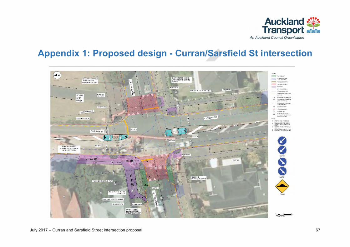
The new design also subsequently includes a shared path, pram ramps, and footpath widening on the north-west end of Curran Street. Please see Appendix 1 for the proposed design for this intersection.

July 2017 – Curran and Sarsfield Street intersection improvements consultation 56
Consultation We consulted on the proposed design from 13 April to 14 May 2017.
Activities to raise awareness To let you know about our consultation, we:
Mailed consultation letters and feedback forms to 2,800 property owners and occupiers surrounding the intersection
Emailed the consultation letter to the Waitematā Local Board, Herne Bay Residents Association, Bike Auckland and Ponsonby Primary School
Set up a project webpage and an online feedback form on our website
Promoted the project on Facebook and posted information on Facebook through the Waitematā Local Board and Auckland Council pages, as well as on Neighbourly, Twitter and LinkedIn.
Giving feedback We asked you what aspects of the proposed design you liked and why, what aspects you would change and why, and any other comments or suggestions you had about the proposed design.
You could provide feedback using an online submission form (on our Have Your Say website) or a hard copy form that we posted to interested parties. See Appendix 2 at the end of this report for a copy of the feedback form.

July 2017 – Curran and Sarsfield Street intersection improvements consultation 57
Your feedback We received public feedback on the proposal from 170 submitters:
90 of these were submitted online and 80 were submitted using the hard copy feedback form.
Themes in comments on proposal We analysed your comments to identify what you liked about the proposed intersection design, as well as your suggestions for changes and improvements. The themes identified in your feedback are addressed in this section, grouped as follows:
Please see Appendix 3 for more information on each theme and for AT responses to the points you raised.
Theme groups
More traffic calming on
Curran Street
Alternative traffic calming
designs or treatments
Alternative placement of traffic calming
elements
Pedestrian refuge & safety improvements
Cycling facility improvements
July 2017 – Curran and Sarsfield Street intersection improvements consultation 58
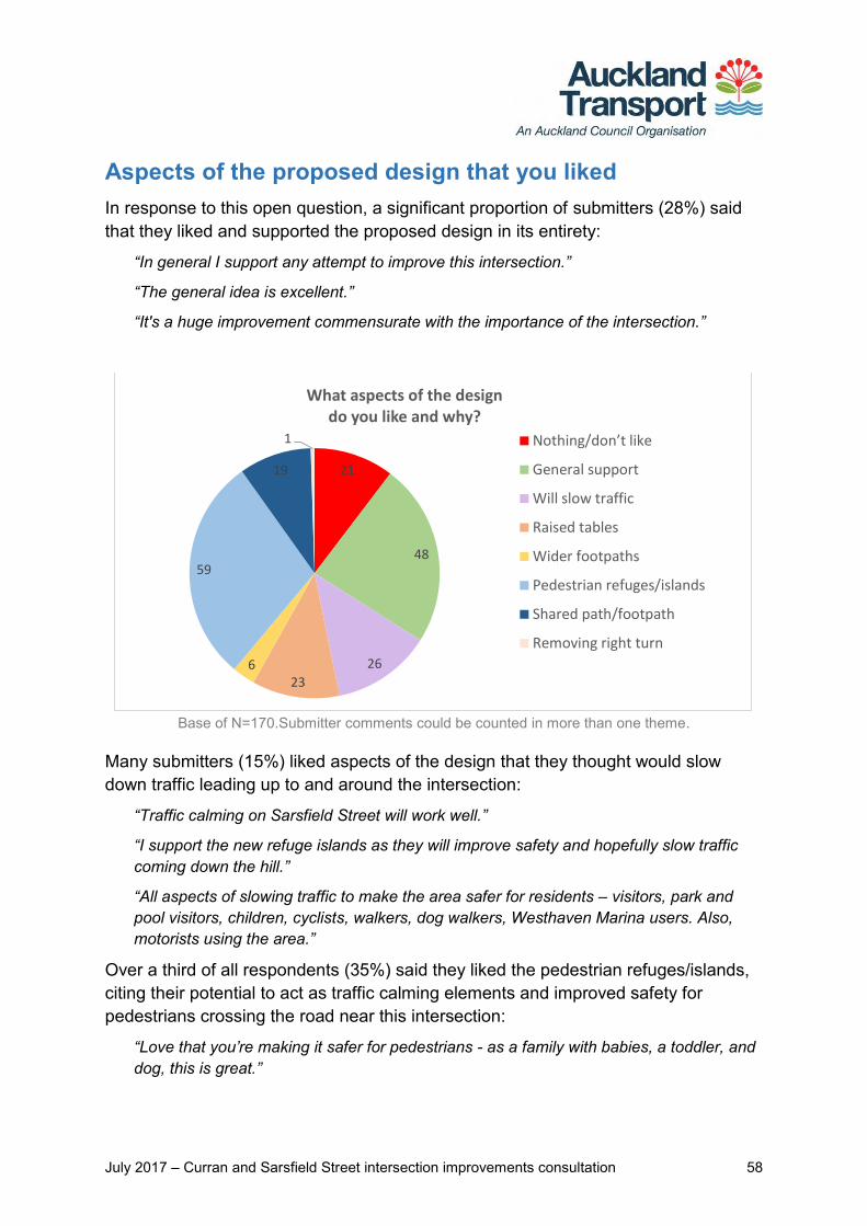
Aspects of the proposed design that you liked In response to this open question, a significant proportion of submitters (28%) said that they liked and supported the proposed design in its entirety:
“In general I support any attempt to improve this intersection.”
“The general idea is excellent.”
“It's a huge improvement commensurate with the importance of the intersection.”
Base of N=170.Submitter comments could be counted in more than one theme.
Many submitters (15%) liked aspects of the design that they thought would slow down traffic leading up to and around the intersection:
“Traffic calming on Sarsfield Street will work well.”
“I support the new refuge islands as they will improve safety and hopefully slow traffic coming down the hill.”
“All aspects of slowing traffic to make the area safer for residents – visitors, park and pool visitors, children, cyclists, walkers, dog walkers, Westhaven Marina users. Also, motorists using the area.”
Over a third of all respondents (35%) said they liked the pedestrian refuges/islands, citing their potential to act as traffic calming elements and improved safety for pedestrians crossing the road near this intersection:
“Love that you’re making it safer for pedestrians - as a family with babies, a toddler, and dog, this is great.”
21
48
26
236
59
19
1
What aspects of the design do you like and why?
Nothing/don’t like
General support
Will slow traffic
Raised tables
Wider footpaths
Pedestrian refuges/islands
Shared path/footpath
Removing right turn
July 2017 – Curran and Sarsfield Street intersection improvements consultation 59
“I like the pedestrian refuges. They will create a safer crossing point from Sarsfield to Point Erin.”
“Use of refuges for pedestrians and to slow down traffic.”
A number of submitters (13.5%) liked the proposed raised tables on Sarsfield Street, to slow down cars driving along this road and entering the Curran Street intersection:
“The raised installations, in my view, are the most effective way of reducing traffic speeds.”
“I also like the 50mm raised table to slow traffic.”
“I like the raised tables; I think this would help cars to slow down (even though there are stop signs at this intersection).”
The shared path was identified by 11% of submitters as a favourable design aspect, supporting both pedestrians and cyclists who use this route and nearby amenities:
“The improvement to the shared pedestrian & cycleway with cycle access away from the main intersection.”
“We will particularly appreciate the new shared path…to provide a better connection to the existing path on Curran Street.”
“Just need to make sure the cycle lane & pedestrian lane are clearly marked please.”
A small portion of submitters liked the proposed wider footpath and removal of the right hand turn from Curran Street into Sarsfield Street:
“The widened footpath and speed table…because the current situation for pedestrians and cyclists using the Curran St-Westhaven path is untenable.”
“Widened footpath on NW corner. I regularly cycle up Curran St cycleway and right turn into Sarsfield, which can often be difficult with pedestrians sharing this space.”
“Taking away the turning lane right from Curran into Sarsfield [Street].”
A smaller but significant proportion of submitters (12%) said they did not like the proposed design. Some said that no changes were needed while others felt the proposed design did not address the main concerns they had with this intersection:
“None. Nothing needs to change at the intersection.”
“I drive around that area often and [I] am yet to see anyone driving too fast around there. Motorists know it's a lower speed environment.”
“It appears to do nothing particularly concrete to manage the amount and speed of traffic on Curran Street…”
July 2017 – Curran and Sarsfield Street intersection improvements consultation 60
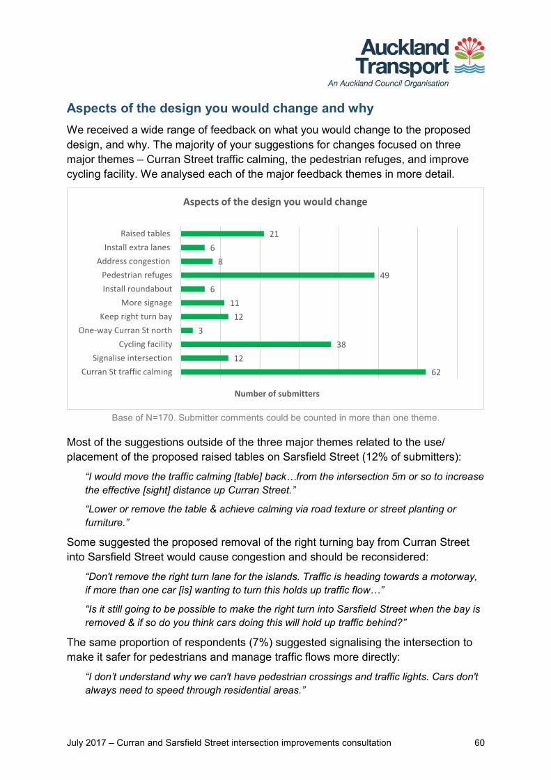
Aspects of the design you would change and why We received a wide range of feedback on what you would change to the proposed design, and why. The majority of your suggestions for changes focused on three major themes – Curran Street traffic calming, the pedestrian refuges, and improve cycling facility. We analysed each of the major feedback themes in more detail.
Base of N=170. Submitter comments could be counted in more than one theme.
Most of the suggestions outside of the three major themes related to the use/ placement of the proposed raised tables on Sarsfield Street (12% of submitters):
“I would move the traffic calming [table] back…from the intersection 5m or so to increase the effective [sight] distance up Curran Street.”
“Lower or remove the table & achieve calming via road texture or street planting or furniture.”
Some suggested the proposed removal of the right turning bay from Curran Street into Sarsfield Street would cause congestion and should be reconsidered:
“Don't remove the right turn lane for the islands. Traffic is heading towards a motorway, if more than one car [is] wanting to turn this holds up traffic flow…”
“Is it still going to be possible to make the right turn into Sarsfield Street when the bay is removed & if so do you think cars doing this will hold up traffic behind?”
The same proportion of respondents (7%) suggested signalising the intersection to make it safer for pedestrians and manage traffic flows more directly:
“I don’t understand why we can't have pedestrian crossings and traffic lights. Cars don't always need to speed through residential areas.”
62
12
38
3
12
11
6
49
8
6
21
Curran St traffic calming
Signalise intersection
Cycling facility
One-way Curran St north
Keep right turn bay
More signage
Install roundabout
Pedestrian refuges
Address congestion
Install extra lanes
Raised tables
Number of submitters
Aspects of the design you would change

July 2017 – Curran and Sarsfield Street intersection improvements consultation 61
“Add lights instead of an island…lights will slow the car down (or stop it) and make it safer for people to cross.”
A smaller proportion suggested changes to signage to, encourage motorists to slow down or modify their behaviour around the intersection:
“Add an electronic, flashing "SLOW" sign visible to traffic approaching the intersection along Sarsfield.”
“[I’d] like to see a sign on Curran St warning traffic that there's a 'Busy Intersection Ahead. Slow Down'.”
“I'd move the 'school zone ends' sign [until] after the intersection…”
Some felt the proposed design may cause congestion for a variety of reasons, and offered solutions to their concerns.
“Pedestrian refuge on Curran St (lower)…could cause unnecessary congestion for traffic queuing for the Harbour Bridge.”
“Ensure two vehicles’ width at Sarsfield Street East so one can turn left whist one turns right.”
Six submitters suggested a roundabout as an alternative to manage traffic from all directions, heading into and exiting the intersection. Three suggested one-waying Curran Street north of the Sarsfield Street intersection and down to the on-ramp.
“Intersection should have a roundabout with compulsory stops from all roads…to stop Curran Street traffic blocking Sarsfield Street and compounding congestion.”
“One-waying Curran Street/ Beach Road was suggested to accommodate cycle lanes and reduce traffic volumes.”
Curran Street traffic calming suggestions
The largest proportion of all respondents (36%) made suggestions to introduce more traffic calming on Curran Street. The majority of these were general suggestions with no specific or preferred solution given:
“Be more aggressive with your approach to speed management on Curran St.”
“Cars routinely speed down Curran St heading for the motorway onramp. Anything to reduce speed here would be welcome.”
“There needs to be some way of slowing the traffic down the Curran Street hill - there are often crashes on the corner of Curran/Sarsfield.”

July 2017 – Curran and Sarsfield Street intersection improvements consultation 62
Key themes of your suggestions for more traffic calming on Curran Street (62 submitters).
Over a fifth of these respondents suggested adding raised tables on Curran Street to manage car speeds:
“I would like to see more changes to limit Curran Street traffic e.g. raised tables…Sarsfield Street traffic is less of an issue than the speed of Curran Street traffic.”
“Further consideration be given to slowing traffic on Curran Street (for example - speed table/cushion treatment), particularly where it passes the school.”
Others suggested installing speed bumps to all or part of Curran Street, to slow cars approaching both the Sarsfield Street intersection and the motorway on-ramp:
“I see people going greater than 50kph down that hill all the time. Add road humps to reduce speed prior to the intersection.”
“Put in [a] series of ‘sleeping policemen’ along the bottom half of Curran Street.”
“PUT IN SPEED BUMPS ALL THE WAY DOWN CURRAN STREET.”
A small proportion suggested a speed limit reduction or installing a speed camera to deter drivers from speeding down Curran Street:
“Drop the speed limit down Curran Street permanently to 40km, which would line it up with Ponsonby Road…”
“A 30kph speed limit from Ponsonby Primary…Extend school slow speed zone to [the] other side of intersection.”
“Why not a speed camera? This design is just window dressing to a problem that is about speed!”
28
14
12
3
5
General support
Install raised tables
Install speed bumps
Install speed camera
Reduce speed limit
0 5 10 15 20 25 30
Curran Street traffic calming suggestions
Number ofsubmitters
July 2017 – Curran and Sarsfield Street intersection improvements consultation 63
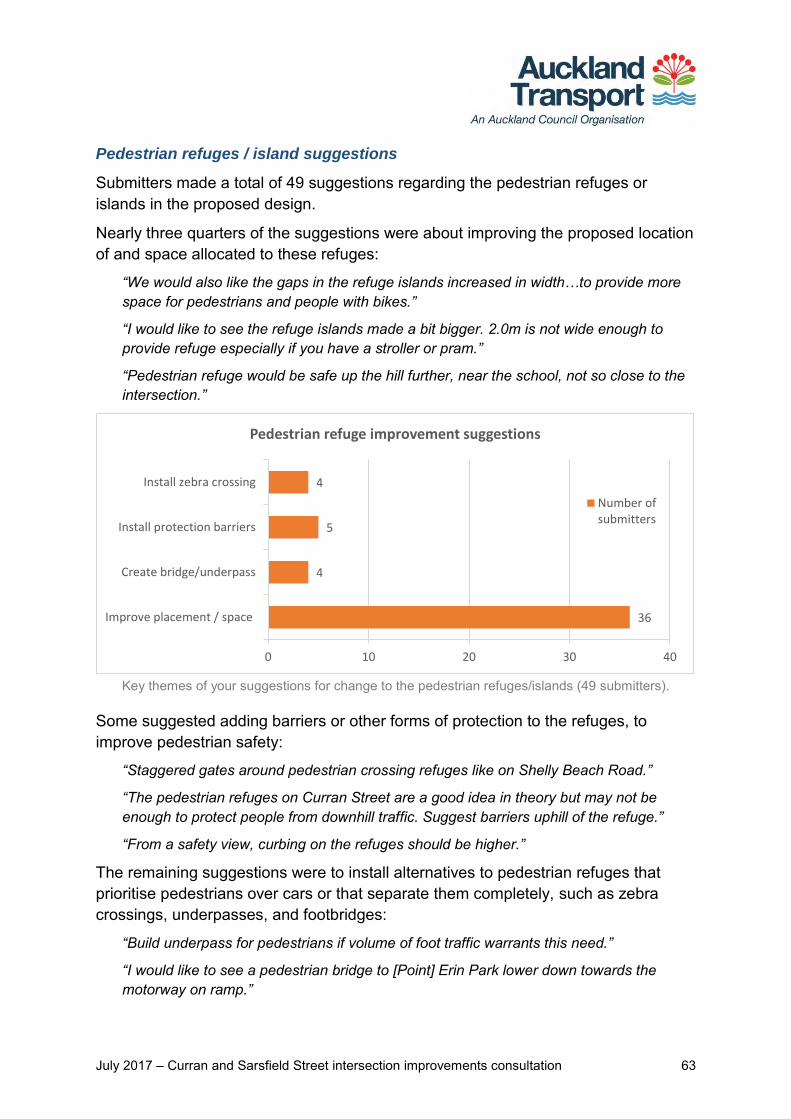
Pedestrian refuges / island suggestions
Submitters made a total of 49 suggestions regarding the pedestrian refuges or islands in the proposed design.
Nearly three quarters of the suggestions were about improving the proposed location of and space allocated to these refuges:
“We would also like the gaps in the refuge islands increased in width…to provide more space for pedestrians and people with bikes.”
“I would like to see the refuge islands made a bit bigger. 2.0m is not wide enough to provide refuge especially if you have a stroller or pram.”
“Pedestrian refuge would be safe up the hill further, near the school, not so close to the intersection.”
Key themes of your suggestions for change to the pedestrian refuges/islands (49 submitters).
Some suggested adding barriers or other forms of protection to the refuges, to improve pedestrian safety:
“Staggered gates around pedestrian crossing refuges like on Shelly Beach Road.”
“The pedestrian refuges on Curran Street are a good idea in theory but may not be enough to protect people from downhill traffic. Suggest barriers uphill of the refuge.”
“From a safety view, curbing on the refuges should be higher.”
The remaining suggestions were to install alternatives to pedestrian refuges that prioritise pedestrians over cars or that separate them completely, such as zebra crossings, underpasses, and footbridges:
“Build underpass for pedestrians if volume of foot traffic warrants this need.”
“I would like to see a pedestrian bridge to [Point] Erin Park lower down towards the motorway on ramp.”
36
4
5
4
Improve placement / space
Create bridge/underpass
Install protection barriers
Install zebra crossing
0 10 20 30 40
Pedestrian refuge improvement suggestions
Number ofsubmitters

July 2017 – Curran and Sarsfield Street intersection improvements consultation 64
“I would remove the refuge and raised tables and put in a zebra crossing so cars have to wait for pedestrians.”
Cycling facility suggestions
A total of 38 suggestions were made by submitters around the theme of cycling facility in response to the proposed design. Most of those suggestions (34%) advocated for improved connectivity to other cycling facility in the area:
“There is little or no connectivity through to St Marys Bay…The cycle path appears to be limited to one direction only.”
“Please consider where any cyclists coming up the cycle path from Westhaven will go.”
“There needs to be better access for bikes to leave Curran St heading towards [the] existing cycle path.”
Key themes of your suggestions to improve cycling facility (38 submitters).
A similar proportion (32%) suggested making general improvements to the cycling facility of this design.
“Please consider bicycle options as there is an emphasis overall on alternative transport in Auckland. Needs to be safe.”
“When I cycle to work (turning left from Sarsfield) I don't ever use the existing shared path, as there are often pedestrians using the space.”
“When the Skypath is built, there will be greatly increased cycle and probably foot traffic here. Any design should be built with that in mind.”
Some suggested improving the visibility of oncoming traffic and providing more space for both cyclists and pedestrians to pass through this area safely:
12
5
13
4
3
1
General support
Corner visibility / space for cyclists
Connectivity to other cycling facility
Cycle/pram ramp
Install cycleway
Out of scope
0 5 10 15
Cycling facility improvement suggestions
Number ofsubmitters

July 2017 – Curran and Sarsfield Street intersection improvements consultation 65
“Add a mirror or something similar to north-west corner [of the intersection] for visibility for cyclists and walkers. Cyclists coming from Sarsfield St west cannot see what traffic or pedestrians are coming…”
“It's a blind corner. Diverting cycle lanes onto footpath is dangerous.”
“The shared cyclist/pedestrian path down to the harbour is too narrow for safe cycling…I would prefer bike lanes on the road…”
Some suggested modifications to the cycle and pram ramps, to help those on wheels to make safer, smoother transitions from one surface to another.
“It would also be nice to have a smooth ramp for cyclists when they are coming down Curran Street and transitioning onto the shared foot/cycle path from the road.”
“If there could be a kerb drop between the pram crossings on the lower/western side of Sarsfield, and the western side of Curran…so that you can access the shared path by bike after coming down Curran St on your bike.”
One submitter’s suggestion fell outside of the scope of this proposed design.
“Get rid of the yellow and black speed bump going into Westhaven, it’s dangerous for bikes and the footpath is too narrow for bunches of cyclists.”
Other comments or concerns In response to the final question, submitters shared 43 comments or concerns about the proposed intersection design. A number of comments related to parking – some advocated for the removal of parking on these streets, and others expressed concern for potential loss of parking space.
“I…strongly object to car parking on Sarsfield Street, it restricts parking for ratepayers on our streets [and] blocks access.”
“I am against current parking places being removed. There is more & more building & less & less parking in the area.”
“The narrowing also removes parking area which is already at a premium.”
A few concerns were raised about both existing and proposed plantings, and how they might impact peoples’ visibility in and around the intersection.
“Please ensure that the planted area has small shrubs or ground cover so that oncoming traffic, bike, pedestrians aren't obscured.”
“Taking down trees (etc.) which are in line with [oncoming] vehicles in all directions… keeping them trimmed back is essential.”
Some submitters had concerns about the level of traffic calming proposed for Sarsfield Street East, suggesting that more measures were needed.

July 2017 – Curran and Sarsfield Street intersection improvements consultation 66
“There needs to be more to moderate the traffic speed on Sarsfield Street between Shelley Beach Road and Curran Street.”
“Traffic from west to east on Sarsfield St is minimal but the traffic travelling from east to west is busy, they think it’s a faster option than going to top of Shelley Beach Rd.”
Two submitters commented on the timing of works on the final design – when it should take place, and speed of completion.
“Only the delays/disruption caused during construction. Please try and do majority of this in school holidays. Perhaps coincide it with the Curran Street on-ramp.”
“Just triple the workmen and get it done in a third of the time. I am sick of being mired in roadworks around the city.
The majority of comments (24 in total) covered no specific theme and ranged from questions about the proposed design to comments on the consultation process, and references to other problem areas outside the scope of this proposal.
“This work should have priority. A cyclist has already very nearly been killed in Sarsfield Street recently & intersections with Sarsfield & Hamilton is dangerous.”
“Great to be consulted in such an easy manner.”
“How has this been prioritised above the need for traffic lights at the Parawai/Richmond Road intersection?”
July 2017 – Curran and Sarsfield Street intersection proposal 67
Appendix 1: Proposed design - Curran/Sarsfield St intersection

June 2017 – Curran and Sarsfield Street intersection proposal 68
Appendix 2: Feedback form

July 2017 – Curran and Sarsfield Street intersection proposal 69
Appendix 3: Key themes and submitter comments with AT responses
Theme Number of submitters Feedback points included in theme AT response
General sentiment
Generally support the design
48
Fully support the proposed design Net effect of proposed treatments will make this busy intersection safer for all
users - Traffic flow maintained - Addresses pedestrians, cyclists, and motorists alike
Thanks for your comments.
Don’t like the proposed design
21
Not enough focus on slowing traffic or managing traffic flows on Curran Street Pedestrian refuges and pram ramps encourage people to cross an unsafe road - Refuges offer no barriers or protection to pedestrians from speeding cars Pedestrians may block visibility of cars coming from Pt Erin on Sarsfield Street
Thanks for your feedback. The proposed improvements to the Curran and Sarsfield Street intersection will make intersection safer for pedestrians, people on bikes and motorists. New speed tables on the eastern and western sides of the Sarsfield Street will help to reduce traffic speed and signal to drivers that they are entering a lower speed environment. These speed tables also provide a pedestrian crossing point thus improving connections to Point Erin park for pedestrians and people on bikes. Pedestrian refuges and pram crossings provide crossing points which are safe which motorists will comply with. Please note that visibility and sightline checks will be done during next stage which is detailed design phase. Appropriate measure will be taken where visibility becomes an issue.

July 2017 – Curran and Sarsfield Street intersection proposal 70
Theme Number of submitters Feedback points included in theme AT response
Post implementation / construction – Auckland Transport will monitor the traffic operations on Curran St. Further investigation and improvements will be undertaken and implemented as necessary.
Aspects of the design that you liked
Will slow traffic 26
Raised tables on east and west ends of Sarsfield Street will slow traffic down Pedestrian refuge / island will slow traffic coming down the hill on Curran Street Will discourage motorway traffic coming up Curran St from speeding into
Sarsfield St
Thanks for your feedback.
Raised tables 23
Raised tables an effective way to slow traffic overall - Support for their use to slow cars on Sarsfield Street in particular - Dampens use of this street to ‘rat race’ to the northbound motorway on-ramp Designed to support foot traffic; provide safety controls for all pedestrians
Thanks for your feedback.
Wider footpaths 6 Support for widened footpath on the north-west corner of the intersection - Enables better shared use of this busy path – space for pedestrians, cyclists,
and possible future cycle paths - Combined with raised table to the west, provides more tenable solution.
Thanks for your feedback
Pedestrian refuges / islands 59
Provides protection to pedestrians crossing near this intersection, particularly - School children before and after school - People walking from Sarsfield St across to Pt Erin
Refuges / islands also act as traffic calming element on Curran Street However barriers similar to those on Shelley Beach Rd also suggested for better
pedestrian safety and refuge to those waiting in the middle of the road to cross.
Thanks for your feedback. Provision to install handrail barrier protection on the central refuges/islands similar to Shelly Beach Rd will be investigated during Detail Design stage.
Shared path / footpath 19
Support for this shared, wider path as long as it is clearly marked for both pedestrians and cyclists
Potentially safer for cyclists coming up the hill and turning into west Sarsfield St.
Thanks for your feedback.

July 2017 – Curran and Sarsfield Street intersection proposal 71
Theme Number of submitters Feedback points included in theme AT response
Removing right turn 1
Supports the removal of the right hand turn from Curran St into Sarsfield St. Thanks for your comments.
Suggestions for design changes
Do more to slow traffic on Curran Street
62
General desire to see more traffic calming measures introduced to Curran Street
- Cars speeding downhill toward the motorway on Curran Street seen as a big contributing factor to poor safety at this intersection
- Proposed design does not do enough to slow traffic on this street in its entirety.
Thanks for your feedback. The focus of the proposal is to make safety improvements at the Curran St and Sarsfield St intersection and enhance pedestrian crossing facilities. The design is intended to slow traffic speed when approaching the intersection. Post implementation – Auckland Transport will monitor the traffic operations on Curran St. Further investigation and improvements will be undertaken and implemented as necessary.
Add raised tables to Curran Street - Continuity with proposed raised tables on Sarsfield St for traffic calming - Install on both sides of Curran Street to slow both motorway-bound traffic and
cars coming uphill / approaching intersection
Thanks for your feedback. During investigation, provision to install raised speed tables on Curran St was assessed. However, it has been discounted due to traffic flow/operational requirement on Curran St which provides direct connection to the Harbour Bridge on-ramp and currently serves as secondary arterial road. Post implementation/construction – Auckland Transport will monitor the traffic flow /operations on Curran St. Further treatments (i.e. speed cushion and others) will be implemented as necessary.
Add speed bumps to Curran Street - All the way down the street; prevent speeding down the street’s entirety - At the bottom of Curran St, to dampen speed of cars heading to the on-ramp
Thanks for your feedback. Post implementation – Auckland Transport will monitor the traffic operations on
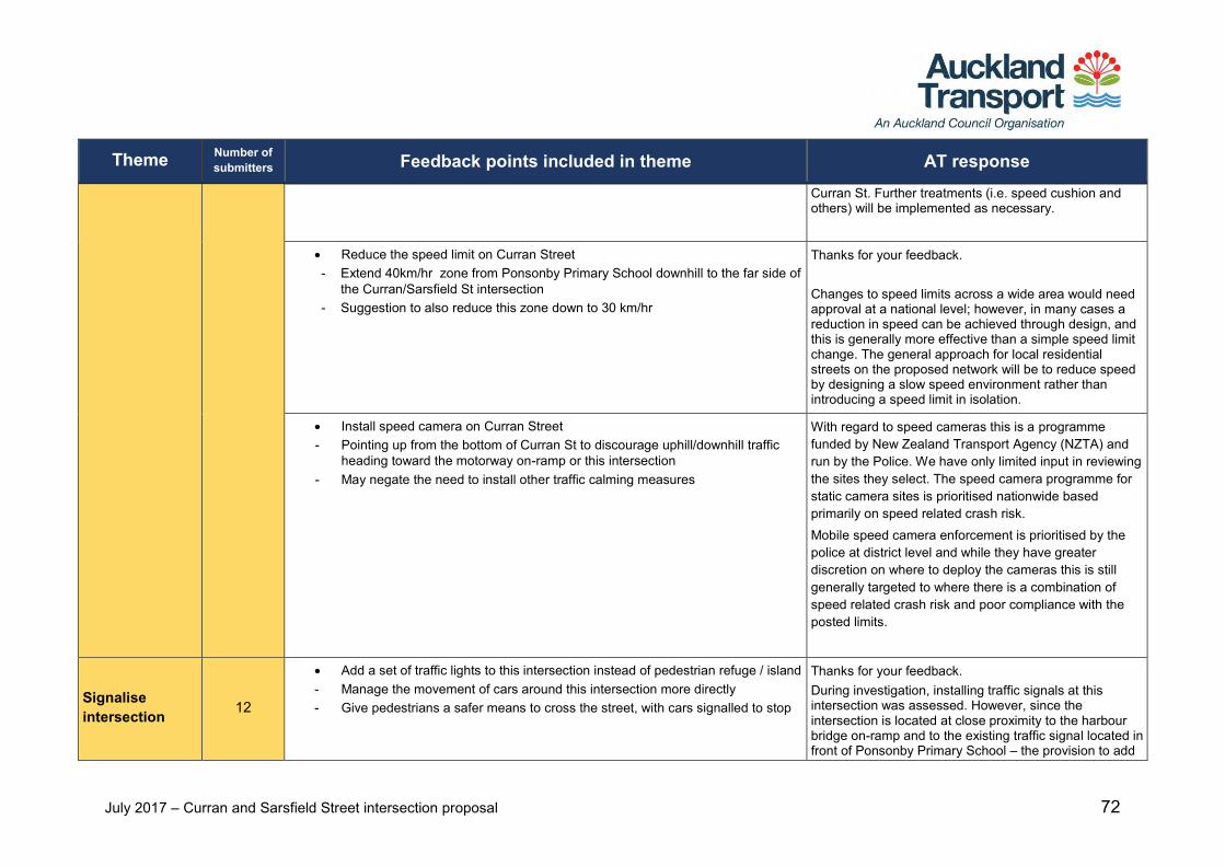
July 2017 – Curran and Sarsfield Street intersection proposal 72
Theme Number of submitters Feedback points included in theme AT response
Curran St. Further treatments (i.e. speed cushion and others) will be implemented as necessary.
Reduce the speed limit on Curran Street - Extend 40km/hr zone from Ponsonby Primary School downhill to the far side of
the Curran/Sarsfield St intersection - Suggestion to also reduce this zone down to 30 km/hr
Thanks for your feedback. Changes to speed limits across a wide area would need approval at a national level; however, in many cases a reduction in speed can be achieved through design, and this is generally more effective than a simple speed limit change. The general approach for local residential streets on the proposed network will be to reduce speed by designing a slow speed environment rather than introducing a speed limit in isolation.
Install speed camera on Curran Street - Pointing up from the bottom of Curran St to discourage uphill/downhill traffic
heading toward the motorway on-ramp or this intersection - May negate the need to install other traffic calming measures
With regard to speed cameras this is a programme funded by New Zealand Transport Agency (NZTA) and run by the Police. We have only limited input in reviewing the sites they select. The speed camera programme for static camera sites is prioritised nationwide based primarily on speed related crash risk. Mobile speed camera enforcement is prioritised by the police at district level and while they have greater discretion on where to deploy the cameras this is still generally targeted to where there is a combination of speed related crash risk and poor compliance with the posted limits.
Signalise intersection 12
Add a set of traffic lights to this intersection instead of pedestrian refuge / island - Manage the movement of cars around this intersection more directly - Give pedestrians a safer means to cross the street, with cars signalled to stop
Thanks for your feedback. During investigation, installing traffic signals at this intersection was assessed. However, since the intersection is located at close proximity to the harbour bridge on-ramp and to the existing traffic signal located in front of Ponsonby Primary School – the provision to add

July 2017 – Curran and Sarsfield Street intersection proposal 73
Theme Number of submitters Feedback points included in theme AT response
another traffic signal at this intersection has been discounted as it would result in congestion to the wider network traffic flow / operations.
Improvements to cycling facility
38
General feedback expressing need for more cycling facility improvements - Accommodate for cyclists moving in different directions across this intersection - Query why design shows one-way movement for cyclists on the shared path
Thanks for your feedback. Movement on shared path is both ways for the cyclists not just one way.
Connectivity to other cycling facility - Connection from Westhaven cycle path to Sarsfield St West needs to be safer
than the design presented - Provide better / safe access for cyclists (mums, dads, families and kids) to
cross onto either Sarsfield St or to head across to Pt Erin Pool.
Thanks for your feedback. The Herne Bay walking & cycling improvements project will connect to the adjacent AT cycling project (i.e. Westhaven to CBD cycle project) via Curran St north.
Provide better corner visibility - Add mirror or similar to north-west corner of the intersection for cyclists and
walkers, to see oncoming people, bikes, and cars - Addition of a warning sign (like the flashing bike sensor sign seen on Tamaki
Drive) to warn drivers approaching Curran St from Sarsfield St to check for bikes approaching from the south
Thanks for your feedback. Sight visibility will be checked at the intersection – if necessary, provision to improve visibility (i.e. add mirror and others) will be implemented accordingly. Signage design details at the intersection will be developed further during Detail Design stage.
Cycle / pram ramp suggestions - Add an extension that makes it easy for bikers to hop onto cycle path. At the
moment you have to cycle onto road and then swivel back onto the footpath - Create a curb drop between the pram crossings on the lower/western side of
Sarsfield, and the western side of Curran. So you can access the shared path by bike after coming down Curran St.
- Move the proposed cycle ramp on Sarsfield St further from the corner, because traffic is very often backed up on Sarsfield St beyond the point shown, making access to and from the street at this point unsafe for cyclists.
The intersection improvement proposal will be delivered as part of Herne Bay walking and cycling improvement which was consulted back in December 2016. The Herne Bay walking and cycling improvement include proposal to install local area traffic management in a form of speed table to reduce traffic speed and volume in the Herne Bay residential area. In addition, it is aiming to address local residents’ concerns with regard to “rat running” during peak period. Once implemented, the local area traffic management is expected to reduce traffic speed and volume – which then creates a safe & friendly environment for people on bikes and pedestrians.

July 2017 – Curran and Sarsfield Street intersection proposal 74
Theme Number of submitters Feedback points included in theme AT response
The location of the proposed cycle ramp on Sarsfield St will be refined further during Detail Design stage.
Install cycleway - Suggested for the full length of Curran Street
Thanks for your feedback. Based on public consultation feedback on AT’s proposed network of cycling routes - completed in March 2016, Curran St is identified as one of the preferred cycling routes. However, it is currently partly unfunded and programmed to be investigated post 2019 and beyond. Please refer to Point Chevalier to City Fringe revised cycle network map.
One-waying of Curran Street 3
Make Curran St one-way from Sarsfield St intersection down to the Bridge Affected residents could travel to city via Westhaven or use the Westhaven
roundabout to access Shelly Beach if travelling west.
Thanks for your suggestion. We are not considering making Currant St one-way at this time. We will be monitoring traffic operations ongoing in the area and will consider all options if operational issues arise.
Right turn bay 12
Removing the right turning bay from Curran St into Sarsfield St will force drivers exiting Ponsonby Primary School to perform dangerous right hand turn back onto Curran St, into oncoming traffic
- Traffic moves down Curran St at high speed + cars park right up to the driveway entrance each day = poor visibility of oncoming traffic
- Currently turn left from the school onto Curran St as it is safer, then right turn into Sarsfield St to go back up Shelley Beach Rd.
The proposal maintains all traffic movements at the intersection. We are not introducing a ‘no right hand turn’ at the intersection and traffic from Curran St is still be able to turn right onto Sarsfield St East The removal of the right turn bay is required to provide space for the pedestrian refuges at the southern side of the intersection.
Signage 11
A sign on Curran St warning traffic - 'Busy Intersection ahead. Slow Down' Having three stop signs creates confusion over priority - make either the
Sarsfield St or Curran St stops into give way signs Move the 'school zone ends' sign until after the intersection Add an electronic, flashing ‘SLOW’ sign visible to traffic approaching the
intersection along Sarsfield St.
Thanks for your suggestions. Signage requirements will be considered at detailed design stage. Please note that signage alone is not effective as physical measures such as these speed tables in reducing traffic speeds.

July 2017 – Curran and Sarsfield Street intersection proposal 75
Theme Number of submitters Feedback points included in theme AT response
Install roundabout 6
Intersection should have a roundabout with compulsory stops from all roads to stop Curran Street traffic blocking Sarsfield Street, compounding congestion.
Install a roundabout, remove the pedestrian refuge below Sarsfield St and replace the one above Sarsfield with a third raised table
- Provides three clear crossings for pedestrians and cyclists - Slows all traffic approaching roundabout without adding to rush-hour traffic
bottleneck.
Thanks for your feedback. A roundabout will require a significantly wider space to accommodate bus/truck tracking movements. The roundabout option has been discounted as it requires land acquisition from the adjacent properties.
Pedestrian refuges / islands 49
Pedestrian refuge north of the intersection unnecessary and may add to congestion
- There is a crossing already in place at the school - On-ramp traffic often backs up to this area; impedes on / restricts this space for
northbound motorway traffic and unsafe for pedestrians
Thanks for your feedback. The main objective of the proposal is to make safety improvements at the intersection and enhance pedestrian crossing movement at the intersection. The design serves to slow traffic speed when approaching the intersection. Without the pedestrian refuges traffic will not slow on the approach to the intersection. Post implementation – Auckland Transport will monitor the operations at the intersection. Further investigation and improvements (will be undertaken and implemented as necessary.
Install barriers or similar form of protection to make pedestrian refuges / islands safer for people crossing the road
- Suggested Shelley Beach Rd pedestrian refuge (by Emmet St) as a good example - Higher curbing on the refuges also suggested to provide more protection
Provision to install handrail barrier protection on the central refuges/islands similar to Shelly Beach Rd will be investigated at Detail Design.
Consider a footbridge or underpass for pedestrians – maintain safety and traffic flows by separating people and cars
Thanks for your feedback. Provision to build a footbridge or underpass for pedestrians has not been investigated. Either option will require significant investment. Post construction/implementation – Auckland Transport will monitor the traffic operations on Curran St. Further investigation and improvements will be undertaken and implemented as necessary.

July 2017 – Curran and Sarsfield Street intersection proposal 76
Theme Number of submitters Feedback points included in theme AT response
Install zebra crossings instead of refuges to give clearer priority to pedestrians Thanks for your feedback. The provision to install central refuges is proposed to achieve two objectives – as follows:
Provides a safe crossing facility for pedestrians and cyclists at the intersection
Creates a road narrowing to slow traffic speed when approaching the intersection.
A zebra crossing will not be as effective as refuges to create a road narrowing to slow traffic speed when entering the intersection.
Address congestion 8
Work with NZTA to reduce the congestion on the on-ramp to SH1 - morning and evening peak queues extend beyond Sarsfield St and Tweed St
- Current design has general support but addressing the above as part of this proposal could make it a more successful solution
Thanks for your feedback. This is outside of the scope of the project, however we will pass this feedback onto the NZTA. We will be monitoring the traffic flow /operations on Curran St ongoing and further investigation and improvements will be assessed and implemented as necessary.
Extra lanes 6
Add a lane on Sarsfield St east to allow separation of left and right/straight ahead traffic
- One lane could left turn up Curran St whilst the other could turn right into two lanes at the start of the Curran St on-ramp
Thanks for your feedback. Adding a lane on Curran St east is not consistent with the objective of the proposal which is to create a safer intersection for pedestrians and people on bikes. An additional lane will create a wider carriageway and increase traffic speed. It also means that pedestrians are required to cross three traffic lanes.
Raised tables 13
Remove narrowing of Sarsfield St westbound - narrowing this to create a choke point (particularly in evenings) means it will be impossible to proceed past right-turning traffic waiting to get onto the bridge.
Inset western Sarsfield Street raised table by one car length – so that cars turning into this street from Curran St don’t block traffic wanting to proceed straight ahead
Put the raised tables on Curran St and not Sarsfield St to address speeding cars
Thanks for your feedback. The main objective of the proposal is to make safety improvement at the intersection and enhance pedestrian safety at the intersection. The design has been developed with consideration given to slowing traffic speed when approaching the intersection. Road narrowing and raised tables slows traffic speed when entering the intersection, creating a safer crossing

July 2017 – Curran and Sarsfield Street intersection proposal 77
Theme Number of submitters Feedback points included in theme AT response
environment for pedestrians and cyclists. In setting the raised table will encourage greater speed. During investigation, provision to implement raised speed tables on Curran St was assessed. However, it has been discounted due to traffic operational requirement on Curran St which provides direct connection to the Harbour Bridge on-ramp and currently serves as secondary arterial road.
Other comments or suggestions
Parking 5
Suggestions to remove parking on Sarsfield Street - Improve visibility for drivers exiting / entering intersection - On both sides of the street to enable space for a cycleway Oppose removal of Sarsfield St parking space
- Narrowing removes parking area which is already at a premium - Negative impact on local residents and ratepayers.
Thanks for your feedback. Sight visibility will be checked at the intersection – if necessary, provision to improve visibility (i.e. add mirror and others) will be implemented accordingly. The design proposal at this intersection does not require any parking removal.
Impact of plantings on visibility
4
Ensure the planted area has small shrubs or ground cover so that view of oncoming traffic, bikes, and pedestrians aren't obscured
Taking down trees which impede view of oncoming vehicles in all directions, and maintain plantings (trim) regularly
Thanks for the feedback. No trees will be removed as a part of this proposal. We will be adding low level planting at the proposed treatment locations. This will create a greener environment and enhance look and feel of local streets. Auckland Council arborist will be consulted on low level plant species that will form a part of planted kerb build-outs and speed tables. This will be determined during Detailed Design stage.
24 General comment on cycleway developments
- Cycleways are very good as long as they are made compulsory and get cyclists off roads in areas like this one
Thanks for your feedback. We are trying to build a cycle network for Auckland. In some places it is a dedicated cycle lane and in other

July 2017 – Curran and Sarsfield Street intersection proposal 78
Theme Number of submitters Feedback points included in theme AT response
Questions / Other / Out of scope
places people on bikes has to merge with normal traffic lane.
Feedback on the consultation process - Great to be consulted in such an easy manner - Awful online form - can’t provide meaningful comment on a single line of text that
will not wrap or scroll
Thanks for your feedback on consultation process. We apologise for error in our feedback form. We will ensure that we check our online forms.
Questions / comments about design implications - Are you removing the pedestrian crossing up the road (near Ponsonby Primary
School)? - Raised table on Hamilton Road at Jervois Road has worn right down, black tyre
marks across top of raised bricks. Could be indicative of how this proposed solution might end up at this busy intersection.
- The marked as “Existing tree to remain” was recently removed.
Thanks for the feedback. The existing pedestrian crossing near the Ponsonby Primary School will not be removed. There is an existing raised table at the intersection of Hamilton Road and Jervois Road which has brick paving and no side ramps. This coloured surfacing treatment indicates to motorist that they are entering a. lower speed zone. We have proposed a boundary speed table for this location which will have side ramps and a flat table top. Speed tables are designed to be driven over comfortably and steep enough to slow traffic. The height of boundary speed table will be assessed to allow motorists on Jervois Rd to gently enter Hamilton Rd without speeding and vice-versa. Please note that Hamilton Rd will have 4 speed table treatments that will slow vehicle speed. Please refer to overview map showing location of traffic calming treatments on Herne Bay project webpage https://at.govt.nz/projects-roadworks/herne-bay-cycling-and-walking-improvements/

July 2017 – Curran and Sarsfield Street intersection proposal 79
Theme Number of submitters Feedback points included in theme AT response
Post implementation / construction – Auckland Transport will monitor the conditions of the speed tables to ensure maintenance is carried out regularly. With regard to the existing tree that was removed in April 2017 – Auckland Transport was made aware by Herne Bay Resident Association Inc. (HBRAI) regarding tree removals work in around April 2017 over the Easter holiday period. Auckland Transport have arranged site investigation on the tree removal works over the Easter long weekend – the streets visited on Friday 14th April 2017 have a number of trees that are marked “Danger” and a number that have been felled. There is a large area in Pt Erin Park (on Sarsfield Street) that is roped off and the crew have been felling trees in the park area. This is out of the road corridor and likely to be a safety measure or protection of power supply by Auckland Council or Vector to take a prudent approach to protect the residence in the area due to severe weather conditions and several cyclones in Auckland over that period. In summary, the tree removal work back in April 2017 is not Auckland Transport activity.
Other comments: - Hopefully this intersection design has taken into account the buses leaving
kerbside from Ponsonby Primary School on Curran St and turning into Sarsfield St to get up to Jervois Rd. Buses are used when there are school outings, etc.
- Very few people stop at the Stop sign turning left out of Sarsfield St to go up Curran St towards Jervois, so is there any point in keeping that Stop sign if you are not going to enforce it?
Thanks for the feedback. The design has been developed with consideration given to the bus movements and bus tracking movements have been checked.