inquiry into the impact of public land management
TRANSCRIPT

INQUIRY INTO THE IMPACT OF PUBL IC LAND MANAGEMENT PRACT ICES ON BUSHF IRES IN V ICTORIA
JUNE 2008
ENVIRONMENT AND NATURAL RESOURCES COMMITTEE
EN
VIR
ON
ME
NT
AN
D N
AT
UR
AL R
ES
OU
RC
ES
CO
MM
ITT
EE
INQ
UIR
Y IN
TO
TH
E IM
PA
CT
OF P
UB
LIC
LA
ND
MA
NA
GEM
EN
T P
RA
CT
ICES
ON
BU
SH
FIR
ES
IN V
ICT
OR
IA F
INA
L RE
PO
RT
JUN
E 2
00
8
ENVIRONMENT AND NATURAL RESOURCES COMMITTEE
PARLIAMENT OF VICTORIA, MELBOURNE VIC 3002 T 8682 2803 F 8682 2818 www.parliament.vic.gov.au/enrc

Environment and Natural Resources Committee
Inquiry into the Impact of Public Land Management Practices on Bushfires in Victoria
June 2008


i
Inquiry into the Impact of Public Land Management Practices on Bushfires in Victoria Report of the Environment and Natural Resources Committee on the Inquiry into the Impact of Public Land Management Practices on Bushfires in Victoria
ORDERED TO BE PRINTED
Victorian Government Printer 2008 Parliamentary Paper No. 116 Session 2006-2008

Parliament of Victoria
Environment and Natural Resources Committee
Inquiry into the Impact of Public Land Management Practices on Bushfires in Victoria
ISBN 978-0-9757811-3-5
This report is printed on 100% recycled paper.

iii
Table of Contents
Committee Members .......................................................................................... vii The Environment and Natural Resources Committee ...................................... ix Terms of Reference ............................................................................................. xi
Chair’s Foreword ........................................................................... xiii
Executive Summary ........................................................................xv Table of Recommendations............................................................................ xxiii Table of Findings............................................................................................ xxvii Definitions and Acronyms .............................................................................. xxxi
Chapter 1: Introduction .................................................................... 1 Background to the Inquiry ................................................................................... 1 Inquiry Process....................................................................................................... 2 Bushfire in Australia............................................................................................. 3 Evolution of the Australian Biota through Fire......................................................... 3 Aboriginal Use of Fire .......................................................................................... 6 Historical and Scientific Evidence of pre-European Fire ......................................... 7 Extent and Use of Fire ............................................................................................ 9 European Arrival and Use of Fire ......................................................................... 10 Stakeholder Evidence........................................................................................... 11 Conclusion............................................................................................................ 13 Bushfire in Victoria............................................................................................. 14 Significant Victorian Bushfires .............................................................................. 16 Causes of Fire on Public Land.............................................................................. 22 Recent Bushfire Inquiries...................................................................................... 23 Inquiry Report ..................................................................................................... 24
Chapter 2: Prescribed Burning in Victoria ..................................... 27 Introduction......................................................................................................... 27 Overview of prescribed burning ............................................................................ 28 The history of fuel reduction burning..................................................................... 29 Prescribed burning on public land ........................................................................ 29 Burning on private land......................................................................................... 31 Legislative and regulatory arrangements for prescribed burning ................. 32 Legislation and the Code of Practice................................................................ 32

Inquiry into the Impact of Public Land Management Practices on Bushfires in Victoria
iv
Discussion ............................................................................................................ 37 Delegations and reporting responsibilities ...................................................... 38 Theoretical foundations ..................................................................................... 50 Planning and conducting the burn......................................................................... 69 The reporting process for prescribed burning................................................. 73 The effectiveness of fuel reduction burning..................................................... 79 The influence of fuel management zones......................................................... 81 Measuring the effectiveness of fuel reduction and ecological burning .................. 83 Environmental factors ........................................................................................ 84 Water quality and quantity ................................................................................. 86 The extent of prescribed burning on public land............................................. 90 The historical extent of prescribed burning ..................................................... 90 The current extent of prescribed burning......................................................... 91 The required extent of prescribed burning....................................................... 91 Prescribed burning in Western Australia............................................................... 92 Conclusion ............................................................................................................ 93 Targets and constraints ..................................................................................... 95 Introduction......................................................................................................... 95 Performance against targets.............................................................................. 96 Constraints.......................................................................................................... 99 Weather and climate ........................................................................................... 100 Funding and personnel ....................................................................................... 101 The risk of escaped burns................................................................................... 110 Smoke................................................................................................................. 112 Forestry and regeneration burning...................................................................... 114 Alternatives to prescribed burning ................................................................. 116
Chapter 3: Biodiversity and Flood ................................................117 Introduction....................................................................................................... 117 Biodiversity impacts......................................................................................... 118 Introduction and background .............................................................................. 118 Stakeholder evidence ......................................................................................... 123 Discussion and conclusion.................................................................................. 125 The Gippsland Flood ........................................................................................ 127 Introduction and background .......................................................................... 127 Environmental impact ......................................................................................... 130 The impact of recent bushfires........................................................................ 132 Background......................................................................................................... 132 Stakeholder evidence ......................................................................................... 134 Discussion and conclusion.................................................................................. 136

v
Chapter 4: Bushfire Suppression Infrastructure.......................... 139 Introduction....................................................................................................... 139 Roads, access tracks and signage ................................................................. 139 Conclusion.......................................................................................................... 146 Fire breaks and containment lines.................................................................. 146 Introduction......................................................................................................... 146 Stakeholder evidence ......................................................................................... 147 Large water points............................................................................................ 152 Other suppression resources.......................................................................... 154 Aerial Resources ................................................................................................ 154 Remote sensing technology ............................................................................... 157
Chapter 5: The Impact of Traditional Land Uses ........................ 161 Introduction....................................................................................................... 161 Overview of stakeholder evidence.................................................................. 161 Introduction......................................................................................................... 161 Stakeholder evidence ......................................................................................... 162 Discussion and conclusion ................................................................................. 168 Timber harvesting............................................................................................. 169 Grazing .............................................................................................................. 177 Four wheel driving............................................................................................ 182 Prospecting and mining................................................................................... 186 Hunting .............................................................................................................. 188 Camping ............................................................................................................ 189 Apiary ................................................................................................................. 190
Chapter 6: Community and Stakeholder Engagement................. 193 Introduction....................................................................................................... 193 Stakeholder evidence....................................................................................... 195 Concerns and suggestions for improvement ...................................................... 195 Support for the current approach to community engagement............................. 198 The importance of community engagement........................................................ 199 Discussion and findings ...................................................................................... 200 Community Engagement by DSE and its Partner Agencies ......................... 201 Introduction......................................................................................................... 201 The Code of Practice .......................................................................................... 202 Fire Management Plans...................................................................................... 202 Fire Operations Plans ......................................................................................... 203 The Country Fire Authority .............................................................................. 209 Resources and programs ................................................................................... 210

Inquiry into the Impact of Public Land Management Practices on Bushfires in Victoria
vi
The interface between public and private land .............................................. 213 Introduction and background .......................................................................... 213 Farming properties in the interface................................................................. 214 A shared zone of management ........................................................................... 214 Fencing compensation........................................................................................ 216 Residential properties in the interface............................................................ 220 Discussion and conclusion.................................................................................. 222 Integrated Fire Management Planning ............................................................ 222 The media .......................................................................................................... 225
Chapter 7: Climate Change and Bushfire .....................................227 Introduction....................................................................................................... 227 What is Climate Change ................................................................................... 228 Climate Change Trends and Predictions ........................................................ 230 International ........................................................................................................ 230 Australia.............................................................................................................. 231 Victoria................................................................................................................ 233 Response........................................................................................................... 238 The Climate Change Debate ............................................................................ 239 Predicted Climate Change Impact on Bushfire Prevention and Suppression............................................................................................................................ 240 Stakeholder Views ............................................................................................ 244 Government Response..................................................................................... 246 Appendix 1 ........................................................................................................ 251 Appendix 2 ........................................................................................................ 259 Appendix 3 ........................................................................................................ 267 Appendix 4 ........................................................................................................ 280 Appendix 5 ........................................................................................................ 281

vii
Committee Members
This Inquiry was conducted during the term of the 56th Parliament. The Members of the Environment and Natural Resources Committee are:
Hon John Pandazopoulos MP (Chair);
Mr Craig Ingram, MP (Deputy Chair);
Ms Joanne Duncan, MP;
Mrs Christine Fyffe, MP;
Ms Tammy Lobato, MP;
Mrs Donna Petrovich, MP;
Mr Matthew Viney, MP; and
Mr Peter Walsh, MP.
Staff For this Inquiry, the Committee was supported by a Secretariat comprising:
Executive Officer: Mr Derek Benjamin
Ms Caroline Williams (March - July 2007)
Research Officer: Mr Nathan Bunt
Research Assistant: Mr Michael Pescott (July – October 2007)
Administrative Officer: Ms Jane Phelan


ix
The Environment and Natural Resources Committee
The Victorian Parliamentary Environment and Natural Resources Committee is constituted under the Parliamentary Committees Act 2003, as amended.
The Committee comprises eight Members of Parliament drawn from both houses and all parties.
Its functions under the Act are to inquire into, consider and report to the Parliament on any proposal, matter or thing concerned with –
1. the environment;
2. natural resources;
3. planning the use, development or protection of land.
Committee Address Address: Parliament House, Spring Street Melbourne, Victoria 3000
Telephone: (03) 8682 2803
Facsimile: (03) 8682 2818
Email: [email protected]
Internet: http://www.parliament.vic.gov.au/enrc


xi
Terms of Reference
The Legislative Council under section 33 of the Parliamentary Committees Act 2003 refers Terms of Reference requiring:
That the Environment and Natural Resources Committee inquire into and report upon the impact of public land management practices on the frequency, scale and intensity of bushfires in Victoria, and in particular —
1. the extent, timing, resourcing and effectiveness of prescribed burning on both crown and freehold land;
2. the manner in which prescribed burning is conducted, including how applicable codes of practice are employed;
3. the impact of prescribed burning and recent wildfires on Victoria’s biodiversity, wildlife and other natural assets including water quality and quantity;
4. the reporting process applicable to prescribed burning programs;
5. the legislative and regulatory arrangements for prescribed burns and bushfire management;
6. the effectiveness of maintaining permanent, strategically placed fire breaks and containment lines throughout public land areas;
7. the provision and maintenance of large water points on crown land to assist with bushfire aerial taskforce operations;
8. the impact of traditional land uses such as timber harvesting, grazing, four-wheel-driving, hunting, camping, mining and prospecting on the scale and intensity of bushfires and the ability of relevant agencies to respond;
9. the provision and maintenance of serviceable access tracks and signage to assist with recreational and emergency requirements;
10. the impact of climate change on bushfires and public land management practices;
11. whether additional measures are required to provide a mechanism for the skills, knowledge and interests of local communities, and appropriate scientific expertise, to be better represented in the management of bushfire risk on public land;
12. the involvement of local communities in the management of fire; and
13. any other matter that impacts on the scale and intensity of bushfires in Victoria.

Inquiry into the Impact of Public Land Management Practices on Bushfires in Victoria
xii
On 18 July 2007, Legislative Council under section 33 of the Parliamentary Committees Act 2003 amended the terms of reference to include:
14. the consequent impact of bushfires on the June/July 2007 Gippsland flood.
The Committee is required to report to Parliament by 30 June 2008.

xiii
Chair’s Foreword I am pleased to present the Environment and Natural Resources Committee’s report on its Inquiry into the Impact of Public Land Management Practices on Bushfires in Victoria.
Bushfire is a natural part of the Australian environment, with many ecological systems dependent upon fire for ecosystem health and biodiversity. However, the 2002/03 and 2006/07 Victorian bushfires were, as described by numerous witnesses, unnatural, and resulted in a level of destruction that will take the bush decades to recover from. The devastation caused by these bushfires is something that no Victorian ever wants to see again.
While I have previously been involved in several Parliamentary Inquiries, the level of interest generated by this Inquiry has been exceptional. The Committee received: 257 submissions; 719 proforma submissions; and evidence from 202 witnesses representing 139 organisations at 17 public hearings. On behalf of the Committee I would like to warmly thank all those people who have shared their time and knowledge with the Committee, particularly those who took the time to impart their personal and family experiences in dealing with the impacts of bushfire. The Committee appreciates these insights and has found them invaluable in preparing this report. In addition, the Committee would also like to extend its gratitude to those who took time out of their lives to assist Members in undertaking site visits throughout Victoria and Western Australia. The ability to see “first hand” the impacts of bushfires, and the land management techniques used to mitigate their impacts, has been invaluable in illustrating and understanding the complexity of this issue.
The Recommendations and Findings presented in this report have been supported by all Members of the Committee. The report contains 20 Recommendations and 17 Findings that the Committee believes will significantly contribute to: mitigating the effects of future bushfire events, such as those experienced in 2002/03 and 2006/07; promoting improved ecological management of our public lands; and ensuring improved community engagement in bushfire management processes. While Government and non-Government Members alike agree that the efforts by every individual involved in fire suppression and fire prevention are to be applauded, the overwhelming view of the Committee is that the management of our public lands can, and must, be improved. In particular, the Committee recognises that the Department of Sustainability and Environment must significantly increase the level of prescribed burning to mitigate the impact of future bushfires.

Inquiry into the Impact of Public Land Management Practices on Bushfires in Victoria
xiv
I would like to express my thanks to my fellow Committee Members for their contributions to this Inquiry – Mr Craig Ingram MP (Deputy Chair), Ms Joanne Duncan MP, Mrs Christine Fyffe MP, Ms Tammy Lobato MP, Mr Peter Walsh MP, Mrs Donna Petrovich MP and Mr Matthew Viney MP.
Finally, on behalf of the Members of the Committee, I wish to express my appreciation to the Secretariat staff for their acumen, advice, support and diligence throughout this Inquiry – Mr Nathan Bunt, Ms Jane Phelan, Dr Caroline Williams, Mr Michael Pescott and Mr Derek Benjamin.
The Hon John Pandazopoulos MP
Chair

xv
Executive Summary
Chapter 1 – Introduction
The Committee received the Terms of Reference for the Inquiry into the Impact of Public Land Management Practices on Bushfires in Victoria on 14 March 2007. The Committee received 257 written submissions; 719 proforma submissions; held 17 public hearings; and participated in 18 site visits and briefings.
Fire is a fundamental part of Australia’s natural environment, history and culture. Many Australian ecological systems are dependent upon some form of “fire regime” to maintain ecosystem health and biodiversity, while organisations such as the Country Fire Authority have become an integral part of Victorian rural culture.
The use of fire in the landscape by Aborigines prior to European settlement is increasingly acknowledged by scientists and commentators. Today it is generally accepted that Aboriginal burning of the landscape was not only used for cultural and religious purposes, but also to deliberately manipulate the function of ecosystems. However, the extent to which Aboriginal people used fire is contentious and remains a topic of debate among pre-historians, scientists and anthropologists.
Contemporary Australian knowledge of bushfire has evolved significantly since the arrival of the first European settlers. Land managers now use fire as a tool in primary production, in biodiversity conservation, and in the protection of life and assets. In particular, the use of fire by forest managers has evolved from a focus on suppression alone, to the use of fire, particularly prescribed burning, as a land management tool.
However, despite an evolving knowledge of fire, Victoria has still experienced over 34 significant fires since 1851 with approximately two-thirds of these fires occurring since the 1950s. On average, Victoria experiences over 600 bushfires every year on public land with lightning and arson accounting for over half of the fires which occur on public land, though lightning accounts for almost half of the total area burnt on public land.
Chapter 2 – Prescribed Burning in Victoria
Prescribed burning is the practice of lighting fires, under specified conditions, to achieve the following land management objectives: fuel reduction to assist in the control of bushfires; the conservation and management of flora and fauna; and the re-regeneration of forest following commercial harvesting operations. There is general consensus within Australian and international literature that prescribed burning does contribute to bushfire suppression, though its effectiveness is difficult to quantify.
Inquiry into the Impact of Public Land Management Practices on Bushfires in Victoria
xvi
The legislative and regulatory arrangements governing prescribed burning, primarily administered by the Department of Sustainability and Environment (DSE), are complex, with several stakeholders noting that this complexity hinders prescribed burning activities. While a degree of complexity appears inevitable if the risks and benefits of prescribed burning are to be appropriately balanced, the Committee considers that a flexible approach to conducting prescribed burning is essential.
The majority of stakeholders argued that the current targeted level of prescribed burning, approximately 130,000 hectares per annum, undertaken by DSE and its partner agencies is insufficient to mitigate the impacts of future bushfires and provide the level of fire needed to promote healthy ecological outcomes. The Committee agrees with these stakeholders and recommends a significant increase in the level of prescribed burning to mitigate the risks associated with future bushfires.
A major reason for the debate surrounding the appropriate extent of prescribed burning on public land is the level of concern within the community about its perceived environmental impacts. For example, a number of stakeholders expressed concerns that current levels and methods of prescribed burning on public land are harmful to the environment. Conversely, other stakeholders argued that Victoria’s biodiversity is threatened by the infrequency of current fire regimes.
Inadequate resource allocation, particularly of personnel, was cited by a number of stakeholders as a constraint on the level of prescribed burning. A related argument was that there has been a loss, from DSE in particular, of the knowledge required to maintain an adequate broad-scale prescribed burning program. The Committee concurs with these stakeholders and recommends a substantial increase in funding to engage skilled fire management personnel dedicated to undertaking prescribed burning activities.
The Committee notes that its recommendation for a substantial increase in prescribed/ecological burning may have a significant impact on the community and require a cultural change in some community attitudes. It believes this increased level of prescribed burning will be of such
benefit to the environment and the Victorian community that a unified commitment to promoting this change is essential.

xvii
Chapter 3 – Biodiversity and Flood
The bushfires of 2002/03 and 2006/07 affected a combined area of approximately 2.3 million hectares (1.19 million and 1.05 million hectares of public land respectively). While a full analysis of the ecological damage caused by the 2006/07 fires has yet to be completed, a significant amount of work has been undertaken for the 2002/03 fires. This work has significantly contributed to the formation of the Committee’s findings and recommendations.
In its submission to the Inquiry, DSE noted that the impact of fires on parks and forests is “generally not unnatural or catastrophic” and that large bushfires burning during very dry conditions “are both natural and inevitable”. DSE referred to the “fire regime” as the key determinant of the influence of fire on ecosystem health and stated that the biodiversity implications of the recent fires will depend on future fire events, and the potential impacts of climate change.
Uncertainty regarding the long-term biodiversity impacts of the recent bushfires was noted by stakeholders. However, a significant number of stakeholders argued that the short term biodiversity impacts of the recent bushfires were severe and may also pose significant threats to biodiversity in the long term.
The Committee received evidence that prescribed burning has a relatively benign impact on biodiversity in comparison to large and intense bushfires of the kind experienced in 2002/03 and 2006/07. A large number of stakeholders also identified current land management practices, including insufficient prescribed burning, as having caused, or contributed to, the scale and intensity of the recent bushfires.
On balance, the Committee finds it is likely that the bushfires of 2002/03 and 2006/07 were both the result, and the most recent examples, of inappropriate fire regimes. The inherent risk to Victoria’s biodiversity posed by bushfires of the scale and intensity of those experienced in 2002/03 and 2006/07 is one that must be mitigated. The Committee finds that an increase in prescribed burning across the landscape represents the best strategy for managing the risks that future bushfires pose to biodiversity and other natural assets.
The Gippsland flood of June/July 2007 caused extensive damage to homes, businesses, farm land, a range of public and private assets, and imposed further hardship on a community still recovering from the 2006/07 bushfires. The flood also caused significant environmental damage including erosion, sedimentation, and threats to aquatic biodiversity.
The Committee recognises that floods are a natural phenomenon and play an important role in maintaining ecosystem health and that the rainfall event which preceded the flood was likely to have made a significant contribution to the flood. However, the Committee finds that the scale and intensity of the

Inquiry into the Impact of Public Land Management Practices on Bushfires in Victoria
xviii
Gippsland floods and its environmental impacts were clearly exacerbated by the preceding bushfires and a lack of prescribed burning.
Chapter 4 – Bushfire Suppression Infrastructure
The Committee received a significant amount of evidence from stakeholders regarding the provision and maintenance of serviceable access tracks and signage for recreational and emergency requirements. A range of stakeholders stated that the existing access track network on public land was insufficiently maintained and had become overgrown with vegetation in many areas. In addition, the Committee was informed that some tracks were substandard, inappropriately signed and unsuitable for larger fire vehicles.
Stakeholders were broadly divided on the effectiveness of permanent and strategically placed fire breaks and containment lines throughout public land. Concerns regarding the financial cost of firebreak construction, maintenance, and the potential impacts on the environment and water quality, were also prominent in the evidence received by the Committee.
The importance of water points was almost universally acknowledged by stakeholders, who typically noted that water points reduce fire-fighting turn around times for both aircraft and ground-based crew, thereby maximising the time spent at the fire edge. In addition, a number of stakeholders were critical of instances where the Government had decided not to replace water taken from some domestic and farm supplies during recent fire suppression operations.
Witnesses to the Inquiry noted the importance and necessity of aircraft use, particularly for rapid attack. Many witnesses agreed that aircraft were important in fire suppression, witnesses also noted that aerial resources should not be viewed as a bushfire panacea.
Chapter 5 – The Impact of Traditional Land Uses
A significant number of stakeholders expressed the view that access to public land had been increasingly restricted over recent decades, resulting in: increased fuel loads in forested areas; the loss of valuable sources of local knowledge; the loss of firefighting experience and equipment; and a decline in the condition of, and access to, vehicle tracks.
Conversely, some stakeholders questioned the view that the restriction of particular traditional uses on public land had adversely impacted land and fire management in Victoria. These stakeholders were notably critical of the view that timber harvesting and grazing also serve as bushfire mitigation strategies.
The Committee considers that there has been a significant decline in traditional land uses on public land in recent decades. While it is difficult to determine whether this decline has had an impact on the severity of bushfires, the Committee finds that the decline has had an obvious impact

xix
on the ability of relevant agencies to respond to bushfires, primarily due to the loss of a permanent workforce in forest areas.
The reduction of timber harvesting on public land in recent decades was commonly identified by stakeholders as having negative implications for bushfire severity and the ability of agencies to respond. Many stakeholders expressed the view that the decline of the workforce previously engaged in timber harvesting and forest management, and the associated vehicle access tracks and heavy machinery that it had maintained, had significantly compromised bushfire prevention and suppression.
The Committee received evidence from a significant number of stakeholders who argued in favour of grazing on public land as an effective fuel reduction tool. A number of these stakeholders were particularly critical of the Government’s decision in 2005 to end grazing in Victoria’s Alpine National Park and argued that this had contributed to an increase in fuel loads and the severity of recent bushfires. The Committee notes the scientific evidence that grazing may not be an effective or preferable bushfire mitigation strategy on its own but believes that in certain circumstances, grazing can be used as a tool to complement other fuel reduction strategies on public land.
The Committee received submissions from a number of Victorian Four Wheel Drive clubs, each of which argued that four wheel driving has a positive impact on bushfire prevention and suppression, primarily by ensuring that access tracks are maintained and remain open for bushfire suppression. However, the view that four wheel drive access is of benefit to bushfire prevention and suppression was not universally shared. Some stakeholders argued that four-wheel driving results in damage to tracks which are required for bushfire suppression, and that four wheel driving has the potential to impact on water quality through increased erosion.
The views of other traditional land users such as hunters, campers, prospectors and miners and apiarists were also received and considered by the Committee. The Committee notes that these land uses had no discernable positive or negative impact on the scale or intensity of bushfires, and that they play an important role in sustaining the network of vehicle access tracks used in fire suppression.
Chapter 6 – Community and Stakeholder Engagement
The importance of effective community engagement in the management of public land for the prevention and suppression of bushfires was emphasised by the vast majority of stakeholders. While a number of stakeholders were supportive of the current community engagement approaches by land management agencies, a significant number of stakeholders were also critical of the limited extent to which the agencies incorporated local input into both fire prevention and suppression practices.

Inquiry into the Impact of Public Land Management Practices on Bushfires in Victoria
xx
The Committee finds that in relation to land and fire management, there is a need to improve the current standard of community and stakeholder engagement by DSE and its partner agencies. Improvements are required to ensure: greater transparency; continuous information transfer between DSE and stakeholders; and to increase opportunities and mechanisms available for stakeholder input.
The Committee identifies that there is significant potential to increase community input into bushfire policy and planning through existing and emerging resources and programs. The Integrated Fire Management Planning (IFMP) framework is notable in this regard, with a number of stakeholders expressing confidence in the potential of the IFMP framework to increase the input of local knowledge into fire planning. Accordingly, the Committee recommends that the Government, and responsible agencies, expedite the implementation of the IFMP framework.
Several stakeholders asserted that private landholders had received an inadequate level of Government assistance for the repair and replacement of fences along the boundary between public and private land following the recent bushfires. Concerns were also expressed that fencing compensation arrangements following the recent fires lacked certainty and consistency. The Committee is mindful of the need for greater certainty, consistency and clarity in the Government response to fencing and other assistance following damage from bushfires, bushfire suppression and prescribed burning. To this end, the Committee recommends that an ongoing Bushfire Fencing Policy which represents a shared commitment to fencing should be developed.
Chapter 7 – Climate Change and Bushfire
While Australia is a relatively small greenhouse gas emitter by international standards, the potential impacts of climate change nevertheless pose a significant risk to Australians. For example, scientific evidence suggests that climate change in Australia may lead to an increase in the frequency and intensity of bushfires.
The Committee is cognisant that though apparently diminishing, there remains a level of scientific debate regarding the extent and causes, anthropogenic or otherwise, of climate change. However, based on the overwhelming majority of scientific evidence, the Committee supports the notion that the climate is changing, and is predicted to worsen in the future.
Scientific projections indicate that south east Australia is likely to experience warmer, drier and longer summers in the future and that this is likely to increase the frequency and intensity of fire weather and bushfires. Possible impacts include: a change to the distribution and composition of ecosystems; and a lowering of the yield and quality of water from fire-affected catchments.

xxi
While not the dominant theme emerging from the evidence provided to the Inquiry, climate change did emerge as a concern for a range of stakeholders. While a large number of stakeholders argued that climate change posed a threat to the management of public land, a small number of stakeholders also strongly disagreed with the notion of climate change, particularly anthropogenic climate change, arguing that the perceived effects associated with climate change are in fact cyclical weather patterns.
Despite this divergence of views on the extent and causes of climate change, a theme which was common to most stakeholder groups was that public land management needed to be improved to mitigate the future impact of bushfire. In this regard, the Committee concurs with those stakeholders and finds that prescribed burning is a key measure by which to mitigate the risks and impacts posed by climate change associated bushfire.


xxiii
Table of Recommendations
PAGE
Recommendation 2.1:..............................................................................................79
That the Department of Sustainability and Environment implement remote sensing imagery as a routine part of its pre-burn and post-burn assessment process for prescribed burning. Maps of every prescribed burn should be produced in a similar format to those used in Western Australia, indicating the boundary of each burn and the varying fire intensities achieved within the burn area. The boundaries of all Fuel Management Zones within each burn should also be indicated.
Each prescribed burn map should be made publicly available on the Department of Sustainability and Environment’s website, together with a map of the same burn area which shows the pre-burn fuel hazard levels and a statement of the total area treated within each Fuel Management Zone by each prescribed burn.
Recommendation 2.2:..............................................................................................95
That in order to enhance the protection of community and ecological assets, the Department of Sustainability and Environment increase its annual prescribed burning target from 130,000 hectares to 385,000 hectares. This should be treated as a rolling target, with any shortfalls to be made up in subsequent years.
Recommendation 2.3:..............................................................................................95
A comprehensive review of the effectiveness of the increased prescribed burning target in meeting ecological and bushfire suppression needs should be conducted every three years.
Recommendation 2.4:..............................................................................................95
The Department of Sustainability and Environment should report its performance against the increased prescribed burning target in its annual report, which should also include the following details:
the total area treated within each fuel management zone for each region;
the total number of burns conducted within each fuel management zone for each region; and
the extent to which planned ecological and fuel reduction outcomes were met for prescribed burns within each fuel management zone for each region (e.g. a summary of the results of the post-burn assessments to be conducted in accordance with recommendation 2.3 above).

Inquiry into the Impact of Public Land Management Practices on Bushfires in Victoria
xxiv
Recommendation 2.5:............................................................................................105
That the Department of Sustainability and Environment, Department of Primary Industries, Parks Victoria & VicForests separately cost, and report, annual expenditure on fuel reduction burning, ecological burning and regeneration burning in their Annual Reports.
Recommendation 2.6:............................................................................................106
That the Victorian Government establish a five year rolling fund which allows unused prescribed burning monies to be rolled over into future financial years for the purpose of subsequent prescribed burning activities.
Recommendation 2.7:............................................................................................110
That the Victorian Government provide recurring funding for a significant increase in regionally-based, permanent, or long-tenured, fire management personnel dedicated to the prescribed burning program. The increase in personnel should be consistent with the level required to achieve an annual prescribed burning target of 385,000 hectares.
The pool of available personnel should be suitably diverse and possess a wide variety of disciplines and skill sets, including practical skills. The Department of Sustainability and Environment and its partner agencies should also increase the proportion of personnel with specialist tertiary qualifications, including fire behaviour specialists, forest scientists, landscape ecologists and conservation biologists.
The Department of Environment and Sustainability and its partner agencies should also prioritise the development of programs to reduce the level of staff turnover and the problem of the ageing workforce, through more effective succession planning.
Recommendation 4.1:............................................................................................154
That the Victorian Government replace or compensate for water taken from domestic, stock and irrigation dams, or water needed for essential use, in the event of a fire, regardless of where the bushfire starts.
Recommendation 5.1:............................................................................................177
That the Department of Sustainability and Environment and its partner agencies conduct or commission research, and a possible trial study, to determine the potential of thinning and other silvicultural practices – whether alone or in combination with prescribed burning – as a means of reducing fuel loads and as a bushfire management strategy in Victoria’s forests.
Recommendation 5.2:............................................................................................186
That the Victorian Government expedite the implementation of its 2006 election commitment to provide four wheel drive clubs with access to management vehicle only tracks.

xxv
Recommendation 5.3:............................................................................................ 191
That the Victorian Government consider all available means, consistent with conservation values, for substantially increasing the access of apiarists to the public land estate.
Recommendation 6.1:............................................................................................ 204
That in relation to Fire Operations Plans, the Department Sustainability and Environment extends the number of community meetings during the public consultation period to a minimum of one meeting for each Fire District, with the possibility of repeat visits to particular areas.
Recommendation 6.2:............................................................................................ 208
That finalised Fire Operations Plans be made publicly available in their entirety (with the exception of any private information) on the Department of Sustainability and Environment’s website and in hard-copy, and that this requirement be clearly stated in future Codes of Practice. This should include the “district burns list”, or its future equivalents, and a map which shows the corresponding burns for each Fire District. Each map should be provided in a format which can be downloaded directly from the Department’s website without the need for further data manipulation by the user. An identical hardcopy version of the map for each Fire District should be also be available to members of the public on request and free of charge.
Recommendation 6.3:............................................................................................ 208
That the details of any variation or amendment of a Fire Operations Plan, including: the carrying forward or postponement of burns within the three-year period covered by a Fire Operations Plan; the carry over, removal or rescheduling of burns between past, present and future Fire Operations Plans; and the alteration of burn boundaries (including alterations of less than 25 per cent); should appear on the Department of Sustainability and Environment’s website at the time of the change and be included in the Fire Operations Plan for the following year.
Recommendation 6.4:............................................................................................ 208
That all information pertaining to current and planned prescribed burns be published more prominently on the Department of Sustainability and Environment’s website, with a single prominent link to this material on the website homepage.
Recommendation 6.5:............................................................................................ 208
That a process of year round community engagement in the preparation of Fire Operations Plans be established. In addition a record of year round community engagement, as contained in the Gippsland Fire Operations Plan, should be a requirement of all Fire Operations Plans.

Inquiry into the Impact of Public Land Management Practices on Bushfires in Victoria
xxvi
Recommendation 6.6:............................................................................................215
That the Integrated Fire Management Planning framework establish zones in the interface between public and private land in which bushfire risk management is the shared responsibility of the Victorian Government and private landholders.
Recommendation 6.7:............................................................................................220
That the Victorian Government establish a clear and consistent Bushfire Fencing Policy for damage caused by all future bushfires and prescribed burns. The Bushfire Fencing Policy should include the following provisions:
the Government contribute half the cost of replacing or repairing for fencing on the boundary between public and private land that is destroyed or damaged by a fire which has emerged from public land, but only where the cost of replacement or repair was not otherwise recoverable;
the Government pay a contribution, of up to 100 per cent, of the cost of restoring fences or other assets destroyed or damaged by backburning conducted during fire suppression operations;
the Government will pay the full cost of fences or other assets destroyed or damaged if prescribed burns on public land escape onto private land;
the Government will pay the full cost of rehabilitation of fire control lines on private property established by the Country Fire Authority or the Department of Sustainability and Environment during wildfire suppression activity for fire originating on public land ; and
the Government will pay the full cost of repairing or replacing fences on private land that are damaged or destroyed by machinery used in controlling bushfires that originate on public land.
Recommendation 6.8:............................................................................................225
That the Victorian Government, and responsible agencies, expedite the implementation of the Integrated Fire Management Planning framework.
That the Integrated Fire Management Planning framework integrate, as far as possible, fire management planning at the municipal level with both Fire Protection Plans (or their future equivalents) and Fire Operations Plans.
Recommendation 6.9:............................................................................................226
That the Department of Sustainability and Environment and its partner agencies continue to develop a proactive approach to engagement with the local and wider media to achieve continuous improvement in the standard of community information and education.

xxvii
Table of Findings
PAGE
Finding 2.1:...............................................................................................................49
The Committee finds that while the legislative, regulatory and reporting structures for the planning and conduct of prescribed burning activities are complex, they provide an appropriate system of risk management for an inherently complex land management practice.
Finding 2.2:...............................................................................................................86
The Committee finds that the frequency and extent of prescribed burning has been insufficient, over a number of decades, for the preservation of ecological processes and biodiversity across the public land estate. An increase in the extent and frequency of prescribed burning for the enhancement of environmental values should therefore be a priority for the Department of Environment and Sustainability and its partner agencies.
Finding 2.3:...............................................................................................................90
The Committee finds that there is a need for an increase in the extent and frequency of prescribed burning in catchment areas to mitigate the risks associated with future bushfires.
Finding 2.4:.............................................................................................................116
The Committee finds that there is no evidence of an adverse impact by forestry operations on the level of prescribed burning.
Finding 3.1:.............................................................................................................126
The bushfires of 2002/03 and 2006/07 were of a scale, intensity and frequency which resulted in an immediate and severe impact on Victoria’s biodiversity.
Finding 3.2:.............................................................................................................126
The scale and intensity of the 2002/03 and 2006/07 bushfires were the result of inappropriate fire regimes, and in particular, of an insufficient level of landscape-scale prescribed burning.
Finding 3.3:.............................................................................................................126
An increase in prescribed burning across the landscape, as recommended in Chapter Two, in a manner which mimics natural fire regimes, represents the most appropriate strategy for minimising the immediate and long-term threats to biodiversity from large and intense bushfires.

Inquiry into the Impact of Public Land Management Practices on Bushfires in Victoria
xxviii
Finding 3.4: .............................................................................................................138
That the bushfires of 2002/03 and 2006/07 significantly exacerbated, and contributed to the extent of the Gippsland flood of June/July 2007.
Finding 3.5: .............................................................................................................138
That previous land management practices, in particular an insufficient level of prescribed burning at a landscape-scale contributed to the scale and intensity of the 2002/03 and 2006/07 bushfires, thereby increasing the severity of the recent flood and its environmental impacts.
Finding 3.6: .............................................................................................................138
That flood risk management is dependent on effective bushfire risk management. Accordingly, an increased level of prescribed burning across the landscape – to regenerate the natural mosaic of burnt and unburnt vegetation which prevents excessive run-off from rainfall events – is integral to mitigating the risk of severe floods of the kind experienced by Gippsland in June/July 2007.
Finding 5.1: .............................................................................................................168
That the decline in local knowledge, skill, resources and infrastructure associated with the restriction of traditional land uses has had a negative impact on the ability of relevant agencies to manage fire on public land.
Finding 5.2: .............................................................................................................174
That the reduction in the extent of timber harvesting on public land and associated loss of local knowledge and expertise, machinery available for fire prevention and suppression, and a decline in the number and accessibility of vehicle access tracks has had a negative impact on land and fire management, particularly the bushfire suppression capacity of relevant agencies.
Finding 6.1: .............................................................................................................201
The Committee finds that there is a need to improve the standard of community and stakeholder engagement by the Department of Sustainability and Environment and its partner agencies in land and fire management, in order to create a culture of continuous engagement. Measures to achieve this should include:
greater transparency and accountability within the Department of Sustainability and Environment and its partner agencies;
an increased emphasis on continuously informing stakeholders and the community of, and the reasons for, specific land and fire management activities; and
an increase in the opportunities and mechanisms for stakeholder and community input.

xxix
Finding 6.2:.............................................................................................................213
That the Integrated Fire Management Planning framework, Country Fire Authority community meetings and the expansion of the Country Fire Authority’s “Community Fireguard”, have significant potential to increase community input into the planning and policy development for bushfire prevention and suppression, including prescribed burning.
Finding 7.1:.............................................................................................................243
That to lessen the impact of more frequent and intense fires, as predicted by climate change projections, a substantial and sustained increase in resources to conduct preventive activities will be needed.
Finding 7.2:.............................................................................................................244
An increase in landscape scale prescribed burning, as recommended in Chapter Two, represents the key strategy for minimising the fire risks associated with climate change.
Finding 7.3:.............................................................................................................249
In order to minimise the future risk of fire and facilitate the development of appropriate fire regimes, key bushfire management documents, for example, the Code of Practice and Fire Ecology Strategies, need to explicitly consider, and if necessary, incorporate, the potential impacts of climate change on bushfire.


xxxi
Definitions and Acronyms
AIIMS-ICS
Australian Interagency Incident Management System - Incident Control System. A nationally adopted structure to formalise a co-ordinated approach by all agencies involved in the management of an emergency. The Incident Control System is a major subsystem.
Backburn A fire lit along the inner edge of a control line to consume the fuel in the path of a wildfire.
Blacking Out The process of extinguishing or removing burning material along or near the fire control line, felling stags, trenching logs to prevent rolling, and the like, in order to make the fire safe. See also Mopping Up.
Burn Plan A DSE plan used to gain approval for the conduct of a prescribed burn.
Burning Program All the prescribed burns scheduled for a designated area over a nominated period of time.
Burning Rotation The period between re-burning of a prescribed area for management purposes.
Bushfire A term used to describe an unplanned fire burning in predominantly native vegetation.
Chief Officer Fire and Emergency Management
DSE officer responsible for fire planning, prevention and operations on public land in Victoria. Previously referred to as Chief Fire Officer.
Code of Practice for Fire Management on Public Land (the Code)
Provides the framework for fire management procedure and practice on public land in Victoria, with appropriate links to private land. The 2006 Code has replaced the 1995 Code, though transition between the Codes has not yet been completed.
Control Line See Fire Control Line.
Controlled Burning See Prescribed Burning.
Country Area of Victoria
A legislative term defined by Section 3 of the Country Fire Authority Act 1958, it includes all that part of the State outside the Metropolitan Fire District that is not Fire Protected Area.
Country Fire Authority (CFA)
The agency responsible for fire prevention and suppression in the Country Area of Victoria.
Crown Land
Land which is, or is deemed to be, un-alienated land of the Crown. It includes:
1. Land of the Crown reserved permanently or temporarily or set aside by or under an Act;
2. Land of the Crown occupied by a person under a lease, license or other right;

Inquiry into the Impact of Public Land Management Practices on Bushfires in Victoria
xxxii
3. Land of the Crown managed by a public authority other than DSE or the Secretary; and
4. Land of the Crown which is, or is part of, a National Park or a park within a meaning of the National Parks Act 1975.
DHS Department of Human Services.
DPI Department of Primary Industries.
Department of Sustainability and Environment (DSE)
The agency responsible for the prevention and suppression of fire in the fire protected area.
Ecological Burning A form of prescribed burning. Treatment with fire of vegetation in nominated areas to achieve specified ecological objectives.
Ecology Fire Strategy
A strategy prepared by the relevant land manager to address the appropriate use or exclusion of fire at a landscape scale. Now referred to as Fire Ecology Strategies.
Emergency Co-ordination Centre (ECC)
A facility from which a strategic response to emergencies is coordinated.
Fire Access Road A track constructed and/or maintained for fire management purposes, which is generally of a standard adequate for all-weather use by two wheel drive vehicles.
Fire Access Track
A track constructed and/or maintained for fire management purposes, which is not generally of a standard adequate for all-weather use by two wheel drive vehicles.
Fire Agencies
Refers collectively to the Country Fire Authority, the Department of Sustainability and Environment and the Metropolitan Fire and Emergency Services Board.
Fire Behaviour
The manner in which a fire reacts to the variables of fuel, weather and topography. Common measures of fire behaviour are rate of spread, flame height, fire spotting distance and intensity.
Fire Break
Any natural or constructed discontinuity in a fuel bed that may be used to segregate, stop and control the spread of a fire, or to provide a fire control line from which to suppress a fire.
Fire Control Line
A natural or constructed barrier, or treated fire edge, used in fire suppression and prescribed burning to limit/prevent the spread of fire.
Fire Danger Index (FDI)
A relative number denoting an evaluation of rate of spread, or suppression difficulty for specific combinations of fuel, fuel moisture and wind speed. See also Forest Fire Danger Index.
Fire Danger Period
The period declared under Section 4 of the Country Fire Authority Act 1958 in respect to the Country Area of Victoria or any part thereof. Fire restrictions apply during this period.

xxxiii
Fire District DSE basic administrative unit for fire management.
Fire Ecology Strategy
A strategy prepared by the relevant land manager to address the appropriate use or exclusion of fire at a landscape scale. Previously referred to as Ecological Fire Strategies.
Fire Management Plan (FMP)
A plan prepared jointly by the DSE, other public land managers, the Country Fire Authority, local governments and the community as appropriate. It contains specific goals, objectives and standards for the use, application, exclusion and control of fire to meet land and resource management objectives in a defined area. Reference to Fire Management Plans may also mean Fire Protection Plans as prepared in accordance with the 1995 Code.
Fire Management Zone (FMZ)
A Fire Management Zone is an area of land upon which fire is managed for specific asset, fuel and ecological objectives. Four Fire Management Zones are established under the 2006 Code, these are: Asset Protection (Zone 1); Strategic Wildfire Moderation (Zone 2); Ecological Management (Zone 3); and Prescribed Burning Exclusion (Zone 4). Previously referred to as Fuel Management Zones under the 1995 Code.
Fire Operations Plan (FOP)
An annual plan prepared to implement strategies contained in the Fire Management Plan. The Fire Operations Plan comprises a three year forward program comprising a schedule and maps for fuel reduction and ecological burning, and a schedule of planned prevention and preparedness works.
Fireplan Publicly available web based application which provides geographical information regarding planned burns within the Fire Operations Plan.
Fire Protected Area
The area defined in Section 3 of the Forests Act 1958, i.e. ‘any land (not being vested in or under the control of the Melbourne and Metropolitan Board of Works [now Melbourne Water]) which is:
a) within any state forest;
b) within any National Park;
c) (unless excised…) within 1.5 km of:
i) any reserved forest or area of unoccupied Crown land proclaimed as a protected forest;
ii) any National Park;
iii) any protected public land;
d) within any protected public land.
Fire Protection Plan A plan prepared by the DSE for the purpose of planning proper and sufficient works for the prevention and suppression of wildfire on public land. Fire Protection Plans have either been previously prepared in accordance with the 1995 Code, or outline a Fire Protection Strategy as described in the 2006 Code.

Inquiry into the Impact of Public Land Management Practices on Bushfires in Victoria
xxxiv
Fire Protection Strategy
A strategy prepared by the DSE for the purpose of planning proper and sufficient works for the prevention and suppression of wildfire on public land. It will address fire protection and a regional level. Note that these are equivalent to a Fire Protection Plan previously prepared in accordance with the 1995 Code.
Fire Regime
The season, intensity, frequency and type of fires (peat or above ground) in a given location over a period of time, representing a number of successive fire events at that location.
Fire Retardant A substance that, by chemical or physical action, reduces the flammability of fuels or slows their rate of combustion.
Fire Suppression The activities connected with restricting the spread of wildfire, following its detection and making it safe.
FireWeb DSE on-line information management system.
Forest Fire A fire burning mainly in forest and/or woodland.
Forest Fire Danger Index (FFDI)
The index related to the chances of a fire starting, its rate of spread, intensity and difficulty of suppression according to various combinations of temperature, relative humidity, wind speed and both long and short term drought effects in a forest. (see also Fire Danger Index)
Fuelbreak A strip of land (not including areas subject to broad area prescribed burning) where vegetation has been reduced or removed.
Fuel Management Zone (FMZ)
A Fuel Management Zone is an area of land upon which fire is managed for specific asset, fuel and ecological objectives. Five Fuel Management Zones were established under the 1995 Code, these are: Asset Protection (Zone 1); Strategic Fuel Reduced Corridors (Zone 2); Broad Area Fuel Reduced Mosaic (Zone 3); Specific Flora and Fauna Management (Zone 4); and Exclusion of Prescribed Burning (Zone 5). The 2006 Code renamed Fuel Management Zones Fire Management Zones and reduced the number of zones to four. See Fire Management Zones.
Fuel Reduction Burning
The planned use of fire to reduce fuel levels in a specified area. (see also Prescribed Burning).
Grassfire An unplanned fire burning in predominantly grassy fuels.
Ha Hectare. Equal to 10,000 square metres.
Incident Control System (ICS)
Incident Control System is a command structure set up under AIIMS to systematically and logically manage emergency incidents, including wildfires from small simple incidents to large difficult or multiple situations. It is designed to expand to ensure effective span of control at all levels.
Integrated Fire Management Planning (IFMP)
IFMP is the process undertaken collaboratively by organisations, agencies and community members to develop fire prevention, suppression and recovery strategies for all types of fire risk occurring within urban, rural and natural environments across

xxxv
private and Crown land.
Interface Place where differing land uses converge.
Metropolitan Fire and Emergency Services Board
The agency responsible for the prevention and suppression of fire in the Melbourne Metropolitan area.
Model of Fire Cover Sets the resource requirements needed to meet the responsibilities of fire suppression on public land.
Municipal Fire Prevention Committee (MFPC)
Committee convened under section 54 of the Country Fire Authority Act 1958 for the purpose of coordination of fire planning within a municipality.
Municipal Fire Prevention Officer (MFPO)
Officer appointed under section 96A of the Country Fire Authority Act 1958 for the purposes of the Act, including issuing of directions to remove hazards or clear firebreaks.
National Park
Land declared to be National Park under Schedule 2 of the National Parks Act 1975.
Networked Emergency Organisations (NEO)
The agencies in partnership with DSE that contribute to fire management on public land. Currently includes: Parks Victoria; Department of Primary Industries; VicForests and Melbourne Water.
Parks Victoria (PV)
Under the Parks Victoria Act 1998, Parks Victoria’s responsibilities are to provide services to the State and its agencies for the management of parks, reserves and other land under the control of the State. For the purpose of the Forests Act 1958, Parks Victoria are considered part of DSE.
Prescribed Burning
The controlled application of fire under specified environmental conditions to a predetermined area and at the time, intensity and rate of spread required to attain planned resource management objectives. Includes Fuel Reduction Burning and Ecological Burning.
Project Firefighters (PFFs)
Firefighters recruited by DSE on a full time basis for several months each fire season to undertake a range of duties including fire suppression and prescribed burning.
Protected Public Land
A legal term. Any lands of the Crown including reserved Crown land, other than State forest or national park, declared to be protected public land under Section 62 of the Forests Act 1958.
Public Land All State forest, national park and protected public land as defined by Section 3 of the Forests Act 1958, except that which is managed by Hancock’s Victorian Plantations (or its successor in law).
Regeneration Burn A burn lit under prescribed conditions for the purpose of achieving regeneration of a particular species or vegetation type.

Inquiry into the Impact of Public Land Management Practices on Bushfires in Victoria
xxxvi
Slip On Unit A tank, a live hose reel or tray, a small capacity pump, and an engine combined into a single one-piece assembly that can be slipped onto a truck bed or trailer and used for spraying water and/or foam on wildfires.
State Forest As defined in Section 3 of the Forest Act 1958. State forest comprises publicly owned land which is managed for the conservation of flora and fauna; for the protection of water catchments and water quality; for the provision of timber and other forest products on a sustainable basis; for the protection of landscape, archeological and historical values; and to provide recreational and educational opportunities.
Water Points Any natural or artificial source of water that can be used for firefighting operations.

Chapter 1: Introduction
1
Introduction
Background to the Inquiry
On 14 March 2007, the Environment and Natural Resources Committee received a reference under the Parliamentary Committees Act 2003 on public land management practices and their impact on Victorian bushfires. The terms of reference require:
That the Environment and Natural Resources Committee inquire into and report upon the impact of public land management practices on the frequency, scale and intensity of bushfires in Victoria, and in particular — (1) the extent, timing, resourcing and effectiveness of prescribed burning on both crown and freehold land; (2) the manner in which prescribed burning is conducted, including how applicable codes of practice are employed; (3) the impact of prescribed burning and recent wildfires on Victoria’s biodiversity, wildlife and other natural assets including water quality and quantity; (4) the reporting process applicable to prescribed burning programs; (5) the legislative and regulatory arrangements for prescribed burns and bushfire management; (6) the effectiveness of maintaining permanent, strategically placed fire breaks and containment lines throughout public land areas; (7) the provision and maintenance of large water points on crown land to assist with bushfire aerial taskforce operations; (8) the impact of traditional land uses such as timber harvesting, grazing, four-wheel-driving, hunting, camping, mining and prospecting on the scale and intensity of bushfires and the ability of relevant agencies to respond; (9) the provision and maintenance of serviceable access tracks and signage to assist with recreational and emergency requirements; (10) the impact of climate change on bushfires and public land management practices; (11) whether additional measures are required to provide a mechanism for the skills, knowledge and interests of local communities, and appropriate scientific expertise, to be better represented in the management of bushfire risk on public land; (12) the involvement of local communities in the management of fire;
Chapter
1

Inquiry into the Impact of Public Land Management Practices on Bushfires in Victoria
2
(13) any other matter that impacts on the scale and intensity of bushfires in Victoria.
On 18 July 2007, the Legislative Council amended the terms of reference under section 33 of the Parliamentary Committees Act 2003 to include:
(14) the consequent impact of bushfires on the June/July 2007 Gippsland flood.
The Committee is required to report to Parliament by 30 June 2008.
This reference was given to the Committee in response to a number of exceptionally large and intense bushfires in Victoria in recent years, most notably the 2002/03 Victorian Alpine Fires and the 2006/07 Great Divide Fires.1
Inquiry Process The Committee advertised the terms of reference and called for written submissions in Victorian newspapers in April 2007. The Committee received 257 written submissions and 719 proforma submissions (see Appendices One and Two).
The Committee held 17 public hearings (see Appendix Three) throughout Victoria, undertook 18 site visits and briefings (see Appendix Five) and took evidence from 202 people representing 139 organisations during the course of the Inquiry including state government departments, non-government organisations, peak industry groups, industry experts, businesses and individuals. Committee members and staff also attended conferences in Sydney, Melbourne and Hobart (see Appendix Four).
Many individuals and organisations contributed to this Inquiry by making written submissions, participating in public hearings and conducting various site visits. The Committee is grateful to these people for generously sharing their experiences, ideas and expertise.
1 Victorian Legislative Council, Parliamentary Debates (Hansard), Book 4, 14 March 2007, p. 573.

Chapter 1: Introduction
3
Bushfire in Australia
Fire is a fundamental part of Australia’s natural environment, history and culture.2 Many Australian ecological systems are dependent upon some form of “fire regime” to maintain ecosystem health and biodiversity while organisations such as the Country Fire Authority have become an integral part of rural culture.◊ While Australia has a long history of natural and anthropogenic fire in the environment, there is a level of uncertainty regarding fire regimes which prevailed before the arrival of Europeans. This issue remains a topic of debate among pre-historians, scientists and anthropologists. In short, many aspects of Australia’s fire history, and fire regimes in particular, remain unclear.
Evolution of the Australian Biota through Fire The Australian continent has been in a state of continual change since its separation from Antarctica approximately 50-65 million years ago.3 The subsequent northward drift of the continent resulted in the evolution of a unique and isolated biota.4
As Australia moved north it experienced a change in climate which resulted in the development of a more arid and variable environment.5 As described by Cary (et al) in Australia Burning:
The northward migration largely offset the cooling involved in the formation of the Antarctic icesheet. However, a consequence of the formation of the Antarctic icesheet was the intensification and northward displacement of the subtropical high-pressure system, triggering the aridification of the continent from the south to the north since the mid Tertiary.6
2 R. Whelan, K. Kanowski, M. Gill and A. Anderson, Living in a Land of Fire, Australian State of the Environment Committee, Department of Environment and Heritage, Canberra, 2006, p. 1. ◊ Plants and animals are adapted to sequences of fire rather than one single event; these sequences are called ‘fire regimes’. 3 Department of the Environment, Water, Heritage and the Arts, 'Marine geology and sedimentology of the Australian continental shelf', viewed 16 April 2008, <http://www.environment.gov.au/coasts/publications/somer/annex1/geology.html>; CSIRO Marine Research, 'Australia's Ocean Facts - the coast', viewed 23 April 2008, <http://www.marine.csiro.au/LeafletsFolder/27ocean/27.html>; Wet Tropics Management Authority, 'Evolution - From the Beginning', viewed 23 April 2008, <http://www.wettropics.gov.au/pa/pa_evolution.html>; Parks and Wildlife Service Tasmania, 'Gondwana - The Southern Supercontinent', viewed 23 April 2008, <http://www.parks.tas.gov.au/geo/gondwana/biogeography.html>. 4 Department of the Environment, Water, Heritage and the Arts, 'Australia's Biodiversity: An Overview of Selected Significant Components', viewed 20 June 2008, <http://www.environment.gov.au/biodiversity/publications/series/paper2/index.html#HDR4>. 5 G. Cary, D. Lindenmayer and S. Dovers, Australia Burning: Fire Ecology, Policy and Management Issues, CSIRO Publishing, Melbourne, 2003, p. 6. 6 G. Cary, D. Lindenmayer and S. Dovers, Australia Burning: Fire Ecology, Policy and Management Issues, CSIRO Publishing, Melbourne, 2003, p. 6.

Inquiry into the Impact of Public Land Management Practices on Bushfires in Victoria
4
Fire is thought to have first become an important part of the Australian environment during the Oligocene period, approximately 30 million years ago.7 During this period lightning was the main ignition source with resulting fires creating a “mosaic of large areas of vegetation in different stages of recovery”.8
The drying of the continent, combined with the onset of a more arid and variable climate, meant that the Nothofagus rainforest, which previously inhabited the majority of the continent, gradually disappeared from most areas of the mainland and was replaced by open forests, woodlands, shrub lands, heaths and grassland.9 By their very nature, these open forests and woodlands were prone to burning.10
The impact of fire on Australia’s native flora is complex, with species responding in varying ways to different fire regimes. These differences may be due to individual species’ characteristics, fire response characteristics, and/or a result of the particular environmental conditions preceding and following fire.11
For example, certain plants need heat and/or smoke to release their seeds, but fire episodes which are too frequent, or infrequent, may lead to the intrusion of other species that are better adapted to frequent or infrequent fire regimes. This is demonstrated by Eucalypts, which now dominate in Australia, but were probably originally restricted to the outskirts of rainforests.12 Eucalypts are well adapted to a dry climate and drought as they have extensive root systems that find water efficiently and thick bark which aids in protecting the living structure of the tree from fire.13 Some Eucalypt species only release seed after fire. 14
7 Dr. K. Tolhurst, 'Bushfire in a Heating World: Learning from the Ecological Evidence', Paper presented at the 6th Bushfire Conference, Nature Conservation Council of NSW, Centenary Lecture Theatre, St Leonards, North Sydney, NSW, 2007, p. 1. 8 G. Cary, D. Lindenmayer and S. Dovers, Australia Burning: Fire Ecology, Policy and Management Issues, CSIRO Publishing, Melbourne, 2003, p. 9. 9 Dr. K. Tolhurst, 'Bushfire in a Heating World: Learning from the Ecological Evidence', Paper presented at the 6th Bushfire Conference, Nature Conservation Council of NSW, Centenary Lecture Theatre, St Leonards, North Sydney, NSW, 2007, p. 1. 10 P. Collins, Burn: The Epic Story of Bushfire in Australia, Allen & Unwin, Sydney, 2006, p. 330; Dr. K. Tolhurst, 'Bushfire in a Heating World: Learning from the Ecological Evidence', Paper presented at the 6th Bushfire Conference, Nature Conservation Council of NSW, Centenary Lecture Theatre, St Leonards, North Sydney, NSW, 2007, p. 1; T. Griffiths, Forests of Ash: An Environmental History, Cambridge University Press, Melbourne, 2001, p. 6. 11 R. Whelan, K. Kanowski, M. Gill and A. Anderson, Living in a Land of Fire, Australian State of the Environment Committee, Department of Environment and Heritage, Canberra, 2006, p. 4. 12 P. Collins, Burn: The Epic Story of Bushfire in Australia, Allen & Unwin, Sydney, 2006, p. 330. 13 P. Collins, Burn: The Epic Story of Bushfire in Australia, Allen & Unwin, Sydney, 2006, p. 330. 14 P. Collins, Burn: The Epic Story of Bushfire in Australia, Allen & Unwin, Sydney, 2006, p. 331.

Chapter 1: Introduction
5
Repeated frequent burning may also significantly alter species diversity and the structure of certain plant communities.15 This may have follow on effects for species such as birds which nest in the understorey. The ability of certain species to gain footholds in new ecosystems may also have a significant effect on the accumulation of fuel loads. For example, the introduction of a highly productive grass to an ecosystem may result in a higher fuel load.
The impact of fire upon fauna also varies according to the individual species, its fire characteristics and the environmental conditions preceding and following the fire. Most species will experience a significant decline in population immediately after a bushfire event. Some animals may die through immediate fire effects such as smoke inhalation or burn related injuries, while others may die shortly afterwards from predation due to loss of habitat or a decline in food availability.16
According to WWF, Australia has the “worst rate of animal extinction in the world” and “almost 40 per cent of mammal extinctions globally, in the last 200 years have occurred in Australia”. WWF claims that this has been caused by a combination of “habitat destruction and alteration, invasive species and altered fire regimes”.17 However, the Committee notes that Australian native flora and fauna has been constantly changing to adapt to Australia‘s changing climate and fire regimes. Indeed, as the Committee discusses in Chapter Two, the deliberate application of fire through an increase in prescribed burning has been identified as a major tool in the future preservation of flora and fauna.
15 Dr. K. Tolhurst, 'Effects of Fuel Reduction Burning on Flora in a Dry Sclerophyll Forest', viewed 14 May 2007, <http://www.environment.gov.au/biodiversity/publications/series/paper8/paper9.html>. 16 Department of Sustainability and Environment, 'The effects of fire on Victorian bushland environments', 2004, viewed 20 April 2007, <http://www.dpi.vic.gov.au/CA256F310024B628/0/23BAEA9A6DC3C740CA2572250020BF50/$File/Effects_of_fire.pdf>. 17 World Wildlife Fund, Australian Species and Climate Change, WWF-Australia, Sydney, 2008, p. 4.

Inquiry into the Impact of Public Land Management Practices on Bushfires in Victoria
6
Aboriginal Use of Fire
Landscape fire is fundamental to a traditional Indigenous society as it has played a key role in natural resource management, as well as serving a variety of cultural and spiritual needs.18
Direct evidence from central and northern Australia, and historical accounts from early European explorers and settlers, indicate that Aborigines applied fire to the landscape.19 Stephen Pyne contends that prior to the arrival of humans on the continent, Australia’s biota relied on lightning’s ‘lottery’ to experience fire, however, this changed with the arrival of Aborigines who made fire a constant on the landscape.20 Eric Rolls extends this argument, claiming that it is “impossible to exaggerate the amount of burning in Aboriginal Australia”.21
Considerable debate still surrounds the exact use of fire by Aboriginal Australians. Until the early twentieth century some commentators suggested that Aboriginal people lacked the knowledge and capability to manage the landscape through the use of fire.22 By the late 1960s, the view that Aborigines were simply “primitive hunter gatherers who wandered across their tribal lands eking out a basic existence, lacking technical expertise to manipulate or impact upon their environment” came under question with the emerging argument that the Aboriginal people used fire prudently as a land management tool, dubbed ‘firestick farming’ by pre-historian Rhys Jones. 23
Today it is generally accepted that Aboriginal burning of the landscape was not only used by Aboriginal people as a cultural and religious symbol, but also to consciously and deliberately manipulate the function of ecosystems for their own purposes. 24 However, the extent to which Aboriginal people used fire remains contentious.
18 R. Whelan, K. Kanowski, M. Gill and A. Anderson, Living in a Land of Fire, Australian State of the Environment Committee, Department of Environment and Heritage, Canberra, 2006, p. 15. 19 B. Esplin, M. Gill and N. Enright, Report of the Inquiry into the 2002-03 Victorian Bushfires, Department of Premier and Cabinet, Melbourne, 2003, p. 117. 20 S. Pyne, The Still-Burning Bush, Scribe Short Books, Melbourne, 2006, p. 16. 21 Rolls cited in: P. Collins, Burn: The Epic Story of Bushfire in Australia, Allen & Unwin, Sydney, 2006, p. 332. 22 Elkin (1938) cited in: D. Bird Rose, Nourishing Terrains: Australian Aboriginal Views of Landscape and Wilderness, Australian Heritage Commission, Canberra, 1996, p. 64. 23 P. Collins, Burn: The Epic Story of Bushfire in Australia, Allen & Unwin, Sydney, 2006, p. 331. 24 D. Bird Rose, Nourishing Terrains: Australian Aboriginal Views of Landscape and Wilderness, Australian Heritage Commission, Canberra, 1996, pp. 64-65; Prof. M. Langton, '"The fire at the centre of each family": Aboriginal traditional fire regimes and the challenges for reproducing ancient fire management in the protected areas of northern Australia', Paper presented at the FIRE! The Australian Experience, Australian Academy of Technological Sciences and Engineering Limited, University of Adelaide, 1999, p. 3; P. Zylstra, Fire History of the Australian Alps: Prehistory to 2003, Australaian Alps Liaison Committee, 2006, p. 28.

Chapter 1: Introduction
7
Historical and Scientific Evidence of pre-European Fire Evidence and analysis of Aboriginal burning practices, and the nature of the pre-European vegetation in the south east of Australia, is predominantly based on written accounts from early European settlers and explorers. There are countless references to fire in these accounts, some of which have been listed below:
• Mr David Evans, referred to Hovell and Hume who in 1824 observed that while moving through north east Victoria that “the land is all on fire around us” and that “we can’t see the hills for the smoke from the Aborigines’ fires”. Mr Evans stated “clearly the Aborigines’ firestick farming was taking place at that time”;25 and
• E.M. Curr, a Victorian grazier in the mid 1800s who noted that
Aborigines were constantly setting fire to the grass and trees, both accidentally and systematically for hunting purposes.26
Many of the early settler’s and explorer’s accounts also note the nature of the vegetation which existed at early settlement. There is a view that at first settlement the Australian bush was largely composed of open woodland with no large sections of forest due to the frequent burning practices of the Aborigines, and that a lack of fire after European settlement resulted in the proliferation of thick regrowth.27 For example, Mr Lhotsky, a nineteenth century explorer notes that:
Australian bushes are (so far as I am acquainted with them) all nearly destitute of shade, the trees of which they are universally composed (I mean the Eucalyptus), growing in the first place only solitary, never in combined tufts.28
Despite the countless references to the burning practices of Aborigines and the nature of the pre-European vegetation in early European explorers and settlers written accounts, there are a number of problems with relying on historical accounts. For example, Benson and Redpath argue that there is little consistency or scientific measurement in historical observations, and that observations do not
25 D. Evans, Transcript of evidence, Mansfield, 26 November 2007; William Hovell, Supplementary evidence, Hovell's Journal - Lake George to Port Phillip, Document Tabled by Mr Rob Evans, 26 November 2008, p. 343. 26 P. Zylstra, Fire History of the Australian Alps: Prehistory to 2003, Australaian Alps Liaison Committee, 2006, p. 11. 27 J. S. Benson and P. A. Redpath, 'The Nature of Pre-European Vegetation in South-eastern Australia: a Critique of Ryan, Ryan and Starr (1995): The Australian Landscape - Observations of Explorers and Early Settlers', Cunninghamia 5, 1997, p. 285. 28 Lhotsky (1834) cited in: P. Zylstra, Fire History of the Australian Alps: Prehistory to 2003, Australaian Alps Liaison Committee, 2006, p. 22.

Inquiry into the Impact of Public Land Management Practices on Bushfires in Victoria
8
provide clear evidence of the prevailing fire regime components such as season, regularity, size or intensity of the fires.29
Other authors have noted that the fire witnessed and documented by the European settlers was possibly used as a defence mechanism by the Aboriginal people against European intrusion, or that the way in which fire has been described by early settlers could be a reflection of the way in which the early settlers themselves viewed fire. 30
…European culture tends to emphasise the dangers of burning and the destructiveness of fire to its material possessions. It is from this cultural background that the early navigators and explorers mentioned the presence of great ‘smokes’ and numerous fires so frequently in their reports. Apparently they assumed that the number and volume of the smokes seen was a measure of the amount of destruction being caused …..31
Benson and Redpath also cast doubt on the extent of the open woodland described previously, noting that some explorers and early settlers were employed to seek out suitable grazing lands, which may account for the numerous references to “grassy woodlands”.32 They also argue that they found “frequent references in the explorers’ journals to vegetation containing a dense understorey including coastal heath, shrub lands, rainforest and dense eucalypt forests”.33
In addition to historical accounts several scientific approaches have been utilised to determine historical fire regimes. These include, dendrochronology, the study of tree rings to “identify events in the history of a tree that can then be given a specific date”34; and the collection of charcoal/pollen deposits from lake sediment.35
During the Committee’s visit to Western Australia, the Western Australian Department of Environment and Conservation demonstrated a form of dendrochronology which is currently used in determining past fire regimes in that state. The technique is based on
29 J. S. Benson and P. A. Redpath, 'The Nature of Pre-European Vegetation in South-eastern Australia: a Critique of Ryan, Ryan and Starr (1995): The Australian Landscape - Observations of Explorers and Early Settlers', Cunninghamia 5, 1997, p. 294. 30 J. S. Benson and P. A. Redpath, 'The Nature of Pre-European Vegetation in South-eastern Australia: a Critique of Ryan, Ryan and Starr (1995): The Australian Landscape - Observations of Explorers and Early Settlers', Cunninghamia 5, 1997, p. 291; NSW Rural Fire Service, 'Fire. The Australian Experience', viewed 4 April 2008, <http://www.bushfire.nsw.gov.au/file_system/attachments/State/Attachment_20050308_44889DFD.pdf>. 31 Nicholson (1978) quoted in: P. Zylstra, Fire History of the Australian Alps: Prehistory to 2003, Australaian Alps Liaison Committee, 2006, p. 12. 32 J. S. Benson and P. A. Redpath, 'The Nature of Pre-European Vegetation in South-eastern Australia: a Critique of Ryan, Ryan and Starr (1995): The Australian Landscape - Observations of Explorers and Early Settlers', Cunninghamia 5, 1997, p. 285. 33 J. S. Benson and P. A. Redpath, 'The Nature of Pre-European Vegetation in South-eastern Australia: a Critique of Ryan, Ryan and Starr (1995): The Australian Landscape - Observations of Explorers and Early Settlers', Cunninghamia 5, 1997, p. 285. 34 P. Zylstra, Fire History of the Australian Alps: Prehistory to 2003, Australaian Alps Liaison Committee, 2006, p. 7. 35 P. Zylstra, Fire History of the Australian Alps: Prehistory to 2003, Australaian Alps Liaison Committee, 2006, p. 25.

Chapter 1: Introduction
9
visible colour banding of leaf bases on the stems of grasstrees (Xanthorrhoea) in south western Australia. This technique was also reported in the Esplin Report which noted the results of a 2001 Western Australian xanthorrhoea dendrochronolgy study. The study suggested fire intervals during Aboriginal occupation of three to five years but of 10 to 15 years from the 1940s onwards.36
While Esplin reported that grasstree findings were a direct source of evidence that was lacking in the Aboriginal fire debate, a report by Miller (et al) argued that while it is clear that grasstree records do reflect fire history, they contain “as many false as true fire records and may tend towards over-reporting the incidence of fire.” 37 Moreover, Miller identified a range of problems with the determination of historic fire regimes though dendrochronology and other scientific techniques:
Current methods for determining historic fire regimes in southern Australia – historical accounts of explorers and settlers, palynology, dendrochronology, forestry records and satellite and air photo imagery, suffer from limited coverage, restricted spatial or temporal resolution, incomplete records, suspect objectivity or other problems.38
Extent and Use of Fire The use of fire in the landscape by Aborigines prior to European settlement is increasingly acknowledged by a range of scientists and commentators. For example, Tim Flannery states that:
… if we look back on the fossil record, it’s not an exaggeration to say that Aboriginal fire and hunting literally made the Australian environment that Europeans first encountered.39
Other commentators suggest that while the pre-European use of fire may have been extensive, its use was unlikely to have been uniform across the continent. Instead it has been suggested that fire was used for different reasons, at different times and across various landscapes. Professor Lindenmayer illustrates this concept below:
…because Indigenous Australians encompassed in excess of 350 distinct languages groups who inhabited a very diverse range of landscapes it seem highly unlikely that a uniform Aboriginal fire regime would have applied continent-wide.40
36 B. Esplin, M. Gill and N. Enright, Report of the Inquiry into the 2002-03 Victorian Bushfires, Department of Premier and Cabinet, Melbourne, 2003, p. 118. 37 B. Miller, T. Walshe, N. Enright and B. Lamont, 'Error in the inference of fire history from grasstrees', Austral Ecology, vol. 32, 2007, p. 908. 38 B. Miller, T. Walshe, N. Enright and B. Lamont, 'Error in the inference of fire history from grasstrees', Austral Ecology, vol. 32, 2007, p. 908. 39 T. Flannery, 'Beautiful Lies: Population and Environment in Australia', Quarterly Essay, no. 9, Black Inc., 2003, p. 41. 40 Lindenmayer (2003) quoted in: B. Schultz, The Misuse of Fire in the Natural Environment: Scientific Evidence Of the Adverse Impacts of Frequent Burning and Spring Burning, Conservation Council of Western Australia, 2007, p. 32.

Inquiry into the Impact of Public Land Management Practices on Bushfires in Victoria
10
The Esplin report found that a lack of uniformity in fire use by Aboriginal societies was due to: variations in vegetation types; different cultural reasons; and the fact that some areas were not regularly occupied by people and therefore were not required to be managed or stimulated by fire.41
For example, the Anangu people of central Australia, used patched burning to protect threatened Nganamara or “Mallee Fowl” populations. Fire was applied to spinifex areas to protect fire sensitive Mulga thickets so that these could provide necessary habitat for the birds.42
Conversely, some areas are thought to have been “deliberately and forcibly” protected from fire. 43 Griffiths states that:
Aborigines probably did burn the margins of the wet sclerophyll forests and may have maintained clearings and pathways in forest areas (particularly along ridge tops), but it seems unlikely that they systematically burnt the mountain forests in the way they did the drier forests and plains.44
This view is supported by Collins who states that the “Alpine areas of New South Wales and Victoria were largely left alone except for moth gathering and spiritual reasons” and that “there was no broad scale or frequent burning in the Alpine areas prior to white settlement”.45
The integration of Indigenous fire management systems and western science appear to have been beneficial and successful in the Northern Territory. However, in the south east of Australia the knowledge of Aboriginal fire regimes is less well known and there are fewer accounts of such practices.
European Arrival and Use of Fire The arrival of European settlers saw the implementation of a fire regime in stark contrast to that used by Aboriginal Australians.46
Aboriginal fire management probably disappeared from the mountains in the first couple of decades after contact as the numbers of Aboriginal people
41 B. Esplin, M. Gill and N. Enright, Report of the Inquiry into the 2002-03 Victorian Bushfires, Department of Premier and Cabinet, Melbourne, 2003, p. 118. 42 P. Zylstra, Fire History of the Australian Alps: Prehistory to 2003, Australaian Alps Liaison Committee, 2006, p. 15. 43 P. Zylstra, Fire History of the Australian Alps: Prehistory to 2003, Australaian Alps Liaison Committee, 2006, p. 15. 44 T. Griffiths, Forests of Ash: An Environmental History, Cambridge University Press, Melbourne, 2001, p. 26. 45 P. Collins, Burn: The Epic Story of Bushfire in Australia, Allen & Unwin, Sydney, 2006, pp. 334-337. 46 R. Whelan, K. Kanowski, M. Gill and A. Anderson, Living in a Land of Fire, Australian State of the Environment Committee, Department of Environment and Heritage, Canberra, 2006, p. 1.

Chapter 1: Introduction
11
dropped very quickly and their introduction of any fire was likely seen as interference with the grazing industry.47
Having had minimal exposure to bushfires, European settlers tended to be wary of bushfires which were suppressed to protect life and property while deliberate fire was used to clear native vegetation for agricultural purposes.48 European settlers are thought to have dramatically altered the frequencies, intensities and seasons of burning although the Committee notes the evidence that some settlers may have preserved pre-existing fire regimes.
Contemporary Australian knowledge of bushfire suppression and management has evolved significantly since the arrival of the first European settlers. Land managers now use fire as a tool in primary production, in biodiversity conservation, and in the protection of life and assets.49 In particular, the use of fire by forest managers has evolved from a focus on suppression alone, to the use of fire as a management tool. Foresters found that protecting forests by excluding fire encouraged the accumulation of fuel.50 Accordingly they developed a low intensity fire regime to reduce fuel loads now known as prescribed burning.51
Stakeholder Evidence As noted by Collins, various commentators advocate a return to the pre-European Aboriginal use of fire in the landscape to mitigate the risk of bushfires as experienced in south east Australia in recent years.52
What has happened is that a coalition has formed including cotton-and grain-growers, beef producers, loggers and big agribusiness, many of whom favour regular burning and large scale land clearance so so-called ‘regrowth’. This coalition has used the fire-stick farming hypothesis to promote extensive burning as a hazard reduction tool…Their argument is that if we can recover the Aboriginal way of ‘managing the landscape’ we will find a convergence of modern theories of land-clearing and regular burning with pre-European Aboriginal fire regimes. 53
47 P. Zylstra, Fire History of the Australian Alps: Prehistory to 2003, Australaian Alps Liaison Committee, 2006, p. 11. 48 R. Whelan, K. Kanowski, M. Gill and A. Anderson, Living in a Land of Fire, Australian State of the Environment Committee, Department of Environment and Heritage, Canberra, 2006, p. 1. 49 R. Whelan, K. Kanowski, M. Gill and A. Anderson, Living in a Land of Fire, Australian State of the Environment Committee, Department of Environment and Heritage, Canberra, 2006, p. 1. 50 B. McCormick, Bushfires: Is Fuel Reduction Burning the Answer, Department of the Parliamentary Library, Canberra, 2002, p. 3. 51 B. McCormick, Bushfires: Is Fuel Reduction Burning the Answer, Department of the Parliamentary Library, Canberra, 2002, p. 3. 52 P. Collins, Burn: The Epic Story of Bushfire in Australia, Allen & Unwin, Sydney, 2006, p. 335. 53 P. Collins, Burn: The Epic Story of Bushfire in Australia, Allen & Unwin, Sydney, 2006, p. 335.

Inquiry into the Impact of Public Land Management Practices on Bushfires in Victoria
12
This view was not shared by the majority of stakeholders who provided evidence to the Inquiry. A number of stakeholders supported the view that Aboriginals played a significant role in pre-European fire regimes. For example, Heather Livingstone states in the Buchan/Gelantipy Branch of the Victorian Farmers Federation submission:
In earliest times the indigenous people used the firestick as a management tool – burning the dry grass, keeping the grassy areas fresh and green and ensuring a plentiful supply of wildlife. These fires were not dangerous – just slow burning and maintaining a balance in the bush. After the limitations on these people, the settlers followed their ways and the country retained its grassland quality. Forestry Officers took over this responsibility of maintaining a balanced public land service. These men had a good understanding of the bush and did a very good management job. Then the regulations began to be more and more restrictive. Public land management and the responsibility of the Minister, have been evaded, over a long time.54
Mr Simon Turner supported Ms Livingstone’s evidence stating:
The timing and the effectiveness of prescribed burning goes hand-in-hand. Where you have had perhaps firestick farming in the past with indigenous communities practising their traditional roles, those attitudes were taken up by the early Europeans and followed through. It did not take them long to realise that the country changed if they did not continue to keep firing the landscape. But with Europeans you obviously had assets coming along. Assets needed protecting, therefore we started to reduce the amount of fire in the environment. 55
Some commentators argue that Aboriginal communities should work with current land management authorities in an effort to combine the two knowledge systems and not only create an inclusive land management system, but in an effort to help in the understanding of the way in which both Aboriginal people and Europeans connect with the landscape.56 Deborah Bird Rose suggests that the “congruence of the two knowledge systems in the field of fire, offers models for how ecological knowledge more generally can be managed on this continent, and for how Aboriginals and settler Australians can share in the work of life”.57
54 Buchan/Gelantipy Branch of the Victorian Farmers Federation, Submission, no. 24, 2 May 2007, p. 5. 55 S. Turner, Mountain Cattleman's Association of Victoria, Transcript of evidence, Omeo, 29 November 2007. 56 S. Ellis, P. Kanowski and R. Whelan, National Inquiry on Bushfire Mitigation and Management, Canberra, 2004, p. 129; B. Gott, 'Fire as an Aboriginal Management Tool in South-Eastern Australia', Paper presented at the Australian Bushfire Conference, Albury, 1999; D. Bird Rose, Nourishing Terrains: Australian Aboriginal Views of Landscape and Wilderness, Canberra, 1996, p. 63; R. Whelan, K. Kanowski, M. Gill and A. Anderson, Living in a land of fire, Australian State of the Environment Committee, Department of Environment and Heritage, Canberra, 2006, pp. 10,15. 57 D. Bird Rose, Nourishing Terrains: Australian Aboriginal Views of Landscape and Wilderness, Australian Heritage Commission, Canberra, 1996, p. 63.

Chapter 1: Introduction
13
This combination has occurred in parts of Australia and as Professor Langton indicates “our knowledge of Aboriginal landscape burning is greatest where Aboriginal affiliation with landscapes continue”.58 For example, in the north of Australia, where Aboriginal people are major land owners, much of the traditional knowledge has been retained, and can be re-applied to landscape management.59
Conclusion There are many obstacles associated with re-creating traditional Aboriginal burning programs in southern Australia particularly in locations such as Victoria where the breadth of traditional knowledge in relation to fire management is extremely limited.
It must be acknowledged that there are fundamental differences between the aims of Aboriginal burning and those of modern land management practices. Contemporary landscapes are very different to pre settlement landscapes and land managers today face issues such as disease, weed and pest invasions, the protection of assets, public opinion, community engagement, resourcing, and occupational health and safety, all of which have impacted upon landscape and fire management.60
Collins argues that Aboriginal people did not “manage” the landscape, “their connectedness to the land and fauna was localised, spiritual and relational” and because of this there are problems with trying to re-create the past. 61 Collins argues that:
What is lacking is an acknowledgement of the immense epistemological, cosmological and spiritual divide between Aboriginal culture and the technologically advanced, but spiritually and ethnologically blinkered eighteenth and nineteenth century settlers.62
Similarly, A Nation Charred the House of Representatives Report on Bushfires notes:
The Committee is not in a position to make definitive conclusions based on suggested methods of Aboriginal burning practices, the debate does bear out that fire, and its absence, is a significant factor in all the varied ecological
58 Prof. M. Langton, '"The fire at the centre of each family": Aboriginal traditional fire regimes and the challenges for reproducing ancient fire management in the protected areas of northern Australia', Paper presented at the FIRE! The Australian Experience, Australian Academy of Technological Sciences and Engineering Limited, University of Adelaide, 1999, p. 4. 59 R. Whelan, K. Kanowski, M. Gill and A. Anderson, Living in a Land of Fire, Australian State of the Environment Committee, Department of Environment and Heritage, Canberra, 2006, p. 15. 60B. Schultz, The Misuse of Fire in the Natural Environment: Scientific Evidence Of the Adverse Impacts of Frequent Burning and Spring Burning, Conservation Council of Western Australia, 2007, p. 5. 61 P. Collins, Burn: The Epic Story of Bushfire in Australia, Allen & Unwin, Sydney, 2006, p. 337. 62 P. Collins, Burn: The Epic Story of Bushfire in Australia, Allen & Unwin, Sydney, 2006, p. 336.

Inquiry into the Impact of Public Land Management Practices on Bushfires in Victoria
14
communities and that fire regimes (including the exclusion of fire from sensitive areas) is a land management consideration of primary importance.63
As concluded by Esplin, while it would be useful to have more traditional local knowledge in the south east of Australia for use in contemporary fire management (as in northern Australia), any use of a traditional Aboriginal burning regime in the south east of Australia “would be an experiment, and should be recognised as such”.64
Bushfire in Victoria
Victoria has an area of approximately 22.7 million hectares (approximately three per cent of Australia’s land mass). Approximately one third of that area (7.7 million hectares) is national park, State forest or other conservation area.65 Of this 7.7 million hectares, State forest comprises approximately 45 per cent (3.4 million hectares)66 with the remainder comprising national and other parks (55 per cent or 4.2 million hectares).67 Victoria's parks and forests contain a wide variety of ecological vegetation groupings which include mallee woodlands, rainforests, grassy woodlands and heath lands.68 Figure 1.1 illustrates the variety of native vegetation groupings which exist in Victoria. Each of these vegetation groupings pose differing challenges for fire management.
63 House of Representatives Select Committee into the recent Australian Bushfires, A Nation Charred: Report on the inquiry into Bushfires, The Parliament of the Commonwealth of Australia, Canberra, 2003, p. 50. 64 B. Esplin, M. Gill and N. Enright, Report of the Inquiry into the 2002-03 Victorian Bushfires, Department of Premier and Cabinet, Melbourne, 2003, p. 122. 65 Department of Sustainability and Environment, 'Victoria's Forests - Forest Fact Sheet', viewed 16 June 2008, <http://www.dse.vic.gov.au>. 66 Department of Sustainability and Environment, 'Visiting State Forests', viewed 21 April 2008, <http://www.dse.vic.gov.au>. 67 Department of Sustainability and Environment, 'Visiting State Forests', viewed 21 April 2008, <http://www.dse.vic.gov.au>. 68 Department of Sustainability and Environment, 'Simplified Native Vegetation Groups', viewed 25 April 2008, <http://www.dse.vic.gov.au>.

Chapter 1: Introduction
15
Figure 1.1: Victoria’s native vegetation groupings.69
69 Department of Sustainability and Environment, 'Simplified Native Vegetation Map of Victoria - Extant', viewed 25 April 2008,

Inquiry into the Impact of Public Land Management Practices on Bushfires in Victoria
16
In addition to the challenges posed by differing ecosystem requirements, the interface area between private and public land, has become a key issue for fire managers. As noted by Esplin, many Victorian’s choose to live or holiday in an area based on its landscape amenity.70 While this has always been the case, when coupled with Victoria’s increasing population density, the bushfire risk posed by people living in close proximity to the bush represents a significant challenge for land managers.
Significant Victorian Bushfires The state has experienced over 35 significant fires since 1851, with approximately two-thirds of these fires having occurred since the 1950s. A list of significant fires to have impacted on Victoria is at Table 1.1. In terms of the quantum of area burnt, the 1939, 1983, 2002/03 and 2006/07 bushfires were the most significant fires in Victoria since the Black Friday fires of 1851.
Figures 1.2, 1.3 and 1.4 illustrate the areas burnt during the 1939, 1983, and 2003 and 2006-07 bushfires.
<http://www.dse.vic.gov.au/CA256F310024B628/0/09AA44AB9509D288CA2570030002B759/$File/Simplified_Native_Vegetation_extant.pdf>. 70 B. Esplin, M. Gill and N. Enright, Report of the Inquiry into the 2002-03 Victorian Bushfires, Department of Premier and Cabinet, Melbourne, 2003, p. 8.

Chapter 1: Introduction
17
Table 1.1: Significant Victorian bushfires.71 Date Localities Impact
Black Thursday 6 February 1851
Wimmera, Portland, Gippsland, Plenty Ranges, Westernport, Dandenong districts, Heidelberg
Approx. 12 people One million sheep Thousands of cattle Approx. five million hectares (a quarter of Victoria)
Red Tuesday 1 February 1898
South Gippsland 12 people 2,000 buildings 260,000 hectares
Early 1900’s (esp 1905, 1906, 1912, 1914)
Gippsland, Grampians, Otway Ranges
Varied (100,000 hectares in 1914)
1926
Noojee. Kinglake, Warburton, Erica, Dandenong Ranges
60 people Many farms and houses
1932
Many districts across Victoria, particularly Gippsland
9 people
Black Friday 13 January 1939 (December 1938–January 1939)
Large areas of the North East and Gippsland, the Otway and Grampian ranges and the towns of Rubicon, Woods Point, Warrandyte, Noojee, Omeo, Mansfield, Dromana, Yarra Glen, Warburton, Erica
71 people More than 650 homes/shops 69 timber mills 1.5–2 million hectares
3-4 March 1942
Hamilton, South Gippsland – Yarram (burning on a 120 km front)
1 person 100 sheep 2 farms 20 homes
22 December 1943 Wangaratta 10 people
Thousands of hectares of grass country
14 January 1944
Central and western districts, 49 people 500 homes Huge stock losses More than one million hectares of grassland and 160,000 hectares of forest.
14 February 1944 Morwell, Yallourn Plant works, open cut mine and buildings
5 February 1952 Benalla area Several people 100,00 hectares
14 January 1962 The Basin, Christmas Hills, Kinglake, St Andrews, Hurstbridge, Warrandyte, Mitcham
8 people 454 homes
17 January 1965 Longwood 7 people (all from the one
family) 6 houses
21 February – 13 March 1965 Gippsland More than 60 homes/shops
More than 4000 stock 750,000 acres of forest 40,000 acres of grassland
19 February 1968 Dandenong Ranges, The Basin, Upwey
64 homes 1,920 hectares
8 January 1969 Lara, Daylesford, Bulgana, Yea, Darraweit, Kangaroo Flat,
22 people 230 homes
71 Department of Sustainability and Environment, 'Major Bushfires in Victoria', viewed 3 April 2007, <http://www.dse.vic.gov.au>; B. Esplin, M. Gill and N. Enright, Report of the Inquiry into the 2002-03 Victorian Bushfires, Department of Premier and Cabinet, Melbourne, 2003, pp. 10-11; Ministerial Taskforce on Bushfire Recovery, 2006 Report from the Ministerial Taskforce on Bushfire Recovery, Victorian Government, Melbourne, 2006, p. 3.

Inquiry into the Impact of Public Land Management Practices on Bushfires in Victoria
18
Korongvale 21schools/churches/halls More than 12,000 stock 250,000 hectares
December 1972 Mt Buffalo 12,140 hectares
12 February 1977 Penshurst, Tatyoon, Streatham, Creswick, Pura Pura, Werneth, Cressy, Rokewood, Beeac, Mingay, Lismore, Little River
4 people 108 houses/shops More than 236,000 stock
15 January 1978 Bairnsdale 2 people
1 house 6,500 stock
28 December 1980 – 6 January 1981
Sunset country and the big desert 119,000 hectares
31 January 1983 Cann River 250,000 hectares
1 February 1983 Mount Macedon 50 Houses 1,864 hectares
Ash Wednesday 16 February 1983
Monivae, Branxholme, Cockatoo, East Trentham, Mt Macedon, Otway Ranges, Belgrave Heights, Warburton, Cudgee, Upper Beaconsfield, Framlingham
47 people Over 2,000 homes/shops More than 27,000 stock 210,000 hectares
14 January 1985 Maryborough, Avoca, Little River 3 people
182 homes 400 farms 46,000 stock
27 December 1990 Strathbogie 1 person
17 homes More than 12,000 stock
21 January 1997 Dandenong Ranges, Creswick, Heathcote, Teddywaddy, Gough’s Bay
3 people 41 houses 1 CFA fire truck
December 31 1997 – 9 January 1998
Caledonia River area of the Alpine National Park, Carey River State Forest
32,000 hectares
2 December 1998 Linton 5 CFA fire fighters
1 CFA tanker 780 hectares
18 December 2000
Dadswells Bridge 1 house damaged 14,500 hectares of crop and pasture 8000 stock (mainly sheep) 500km of fencing
March 2002 Glenaroua 1 house
6,100 hectares of grass and scrub
December 2001-January 2002 Deployment of CFA to NSW and ACT fires
80 trucks and 2794 CFA personnel for 14 days
17–31 December 2002 Big Desert 1 abandoned house 181,400 hectares
7 January – 8 March 2003 Over 80 fires started by lightning, North East Victoria, Gippsland
1 person (indirectly) 41 houses 9,000 livestock 1.1 million hectares
January 2006
Ararat, Baw Baw Shire, Glenelg Shire, Golden Plains Shire, Greater Geelong, Horsham, Latrobe, Moorabool Shire, Moyne Shire, Murrindindi Shire, Northern Grampians Shire, South Gippsland Shire, Southern Grampians Shire.
4 people 57 houses 64,00 stock 160,000 hectares
Summer 2006/07
Alpine Shire, Benalla, Indigo Shire, Mansfield Shire, Corangamite Shire, Golden Plains Shire, Baw Baw Shire, East Gippsland, Latrobe, Wellington Shire, Moyne Shire, Wangaratta
1 person 51 houses 1,741 stock Greater than 1.2 million hectares

Chapter 1: Introduction
19
Figure 1.2: Victorian bushfires 1939.72
72 Department of Sustainability and Environment, personal communication, 14 May 2008.

Inquiry into the Impact of Public Land Management Practices on Bushfires in Victoria
20
Figure 1.3: Victorian bushfires 1983.73
73 Department of Sustainability and Environment, personal communication, 14 May 2008.

Chapter 1: Introduction
21
Figure 1.4: Victorian bushfires 2003, 2006 & 2007.74
74 Department of Sustainability and Environment, personal communication, 14 May 2008.

Inquiry into the Impact of Public Land Management Practices on Bushfires in Victoria
22
Causes of Fire on Public Land Approximately 600 bushfires, caused by both natural and human activities, occur on Victorian public land every year.75 As can be seen in Figure 1.5, in the past 20 years, over 50 per cent of fires on Victorian public land are attributable to lightning strikes and arson (26 per cent and 25 per cent respectively).76 However, lightning strikes contribute 46 per cent of total area burnt (see Figure 1.6).77 Public utilities and arson both provide a 14 per cent contribution to total area burnt.78 The total area burnt as a result of prescribed burn escapes (five per cent) was less than the total area burnt as a result of agricultural burn off escapes (seven per cent).79
Figure 1.5: Causes of fire on Victorian public land by number of fires each year for the past 20 years.80
5%
14%
3%
44%
14%
7%
1%
1%9%
2%
Prescribed burn escapes
Public Utilities
Unknown
Lightning
Deliberate
Agricultural Escapes
Campfires
Cigarettes
Miscellaneous
Machinery
75 Department of Sustainability and Environment, 'What Causes Bushfires on Public Land in Victoria?' viewed 4 May 2007, <http://www.dse.vic.gov.au>. 76 Department of Sustainability and Environment, 'Bushfire Statistics', viewed 4 May 2007, <http://www.dse.vic.gov.au>. 77 Department of Sustainability and Environment, 'Bushfire Statistics', viewed 4 May 2007, <http://www.dse.vic.gov.au>. 78 Department of Sustainability and Environment, 'Bushfire Statistics', viewed 4 May 2007, <http://www.dse.vic.gov.au>. 79 Department of Sustainability and Environment, 'Bushfire Statistics', viewed 4 May 2007, <http://www.dse.vic.gov.au>. 80 Department of Sustainability and Environment, 'Bushfire Statistics', viewed 10 May 2007, <http://www.dse.vic.gov.au>.
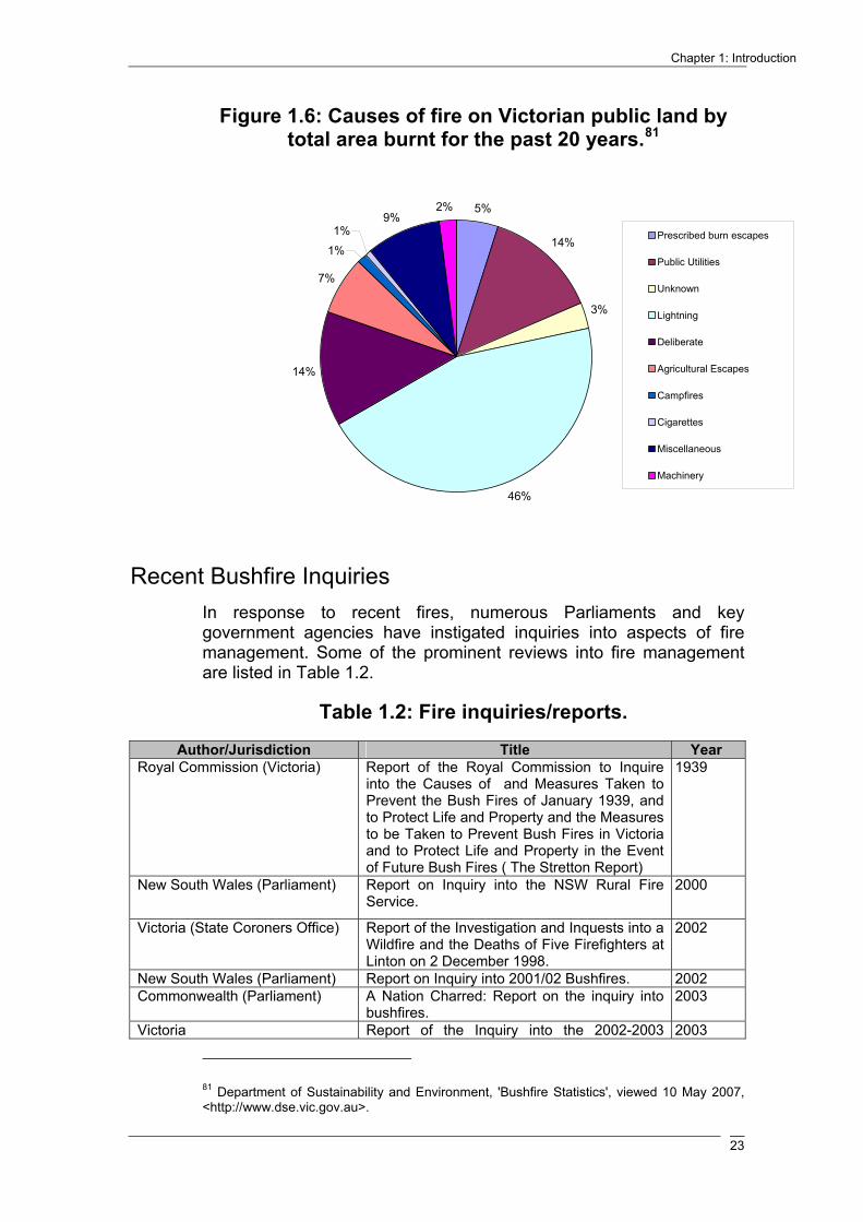
Chapter 1: Introduction
23
Figure 1.6: Causes of fire on Victorian public land by total area burnt for the past 20 years.81
5%
14%
3%
46%
14%
7%
1%
1%9%
2%
Prescribed burn escapes
Public Utilities
Unknown
Lightning
Deliberate
Agricultural Escapes
Campfires
Cigarettes
Miscellaneous
Machinery
Recent Bushfire Inquiries In response to recent fires, numerous Parliaments and key government agencies have instigated inquiries into aspects of fire management. Some of the prominent reviews into fire management are listed in Table 1.2.
Table 1.2: Fire inquiries/reports.
Author/Jurisdiction Title Year Royal Commission (Victoria) Report of the Royal Commission to Inquire
into the Causes of and Measures Taken to Prevent the Bush Fires of January 1939, and to Protect Life and Property and the Measures to be Taken to Prevent Bush Fires in Victoria and to Protect Life and Property in the Event of Future Bush Fires ( The Stretton Report)
1939
New South Wales (Parliament) Report on Inquiry into the NSW Rural Fire Service.
2000
Victoria (State Coroners Office) Report of the Investigation and Inquests into a Wildfire and the Deaths of Five Firefighters at Linton on 2 December 1998.
2002
New South Wales (Parliament) Report on Inquiry into 2001/02 Bushfires. 2002 Commonwealth (Parliament) A Nation Charred: Report on the inquiry into
bushfires. 2003
Victoria Report of the Inquiry into the 2002-2003 2003
81 Department of Sustainability and Environment, 'Bushfire Statistics', viewed 10 May 2007, <http://www.dse.vic.gov.au>.

Inquiry into the Impact of Public Land Management Practices on Bushfires in Victoria
24
Victorian Bushfires (The Esplin report). Victoria (Auditor-General Victoria)
Fire prevention and preparedness. 2003
Australian Capital Territory (ACT Government)
Inquiry into the Operational Response to the January 2003 Bushfires in the ACT.
2003
Council of Australian Governments
National Inquiry on Bushfire Mitigation and Management.
2004
South Australia (Parliament) Eyre Peninsula Bushfire and Native Vegetation.
2005
Victoria (Victorian Government) 2006 Report from the Ministerial Taskforce on Bushfire Recovery.
2006
Victoria (Country Fire Authority) Debrief Outcomes: Significant Fires in Victoria December 2005 and January 2006.
2006
Australian Capital Territory (Coroner’s Office)
The Canberra Firestorm: Inquests and Inquiry into Four Deaths and Four Fires between 8 and 18 January 2003.
2006
Western Australia (Parliament) Inquiry into Fire and Emergency Services Legislation.
2006
Victoria (Victorian Government) 2007 Report from the Ministerial Taskforce on Bushfire Recovery
2007
South Australia Government Inquiry into Bushfire Management 2007
Inquiry Report
Chapter Two of this report considers the role of prescribed burning as a means to both mitigate the future impacts of bushfire and maintain ecosystem health. In doing so, the chapter provides an overview of the legislative and regulatory arrangements governing prescribed burning in Victoria. The chapter also provides an examination of the extent and effectiveness of prescribed burning in Victoria.
Chapter Three provides an overview of the environmental impacts of Victoria’s recent bushfires. The first half of the chapter considers the biodiversity impacts of the 2003 and the 2006/07 bushfires, while the second half of the chapter examines the impact of the 2006/07 bushfires on the June/July Gippsland flood. Both chapters consider the role of prescribed burning, particularly landscape scale prescribed burning, in mitigating the impacts of bushfire on biodiversity and severe flooding.
Chapter Four considers the use of fire breaks and access tracks in suppression activities. The chapter also examines the provision of large water points and the use of aerial resources in fire suppression activities.
Chapter Five provides an examination of the impact of traditional land uses on the scale and intensity of bushfires. The impacts of a number of commercial and recreational activities are considered in this chapter, including timber harvesting, four-wheel driving, grazing and apiary.

Chapter 1: Introduction
25
Chapter Six considers the importance of community engagement in developing appropriate land management practices for the prevention and suppression of bushfire. In doing so, the Committee examines the current standard of community engagement employed by the Department of Sustainability and Environment and its partner agencies.
Chapter Seven provides an examination of climate change highlighting the potential ramifications for bushfire management. In doing so, the chapter provides a brief overview of the science and debate surrounding climate change, followed by an examination of scientific and stakeholder evidence in relation to climate change and bushfire. An analysis of the Government’s response to the potential impacts posed by climate in relation to bushfires is also provided.

Inquiry into the Impact of Public Land Management Practices on Bushfires in Victoria
26

Chapter 2: Prescribed Burning In Victoria
27
Prescribed Burning in Victoria
Introduction
A significant part of the community and Government response to the Victorian bushfires of 2002/03 and 2006/07 has been an increased focus on prescribed burning on public land. This was reflected in the evidence provided to the Committee, an overriding theme of which was the importance of prescribed burning as a means of mitigating the size and intensity of bushfires, and as a tool for achieving appropriate fire regimes for ecological communities.
The importance attached to prescribed burning is also reflected in the fact that it is the subject of the Inquiry’s first five terms of reference and is also relevant to terms of reference eleven and twelve.
Prescribed burning is an issue which has tended to polarise opinion between those in favour of increased “broadscale” burning, particularly for fuel reduction but also for ecological purposes, and those who argue that burning on such a scale does little to reduce the risks associated with large bushfires and can be damaging to the environment. This polarisation was also apparent in the views presented to the Committee during the course of the Inquiry, although the majority of stakeholders argued for an increase in the level of prescribed burning for fuel reduction and forest ecology. The Esplin Report referred to a divergence of values within the community as one basis for this polarisation:
In any society there is a range of held values that determine what constitutes an asset and for whom. Any evaluation of a fuel-reduction program using prescribed burning (or any other technique) will often depend on the assessors own values.82
However, as the Esplin Report also noted, “held values” are merely one of a number of factors that have influenced the prescribed burning debate.83 Other factors include: the various practical constraints on the conduct of prescribed burning; incomplete scientific knowledge; incomplete records; and a lack of certainty regarding the most appropriate way to evaluate the prescribed burning program.84 In the Committee’s view, there is significant 82 B. Esplin, M. Gill and N. Enright, Report of the Inquiry into the 2002-03 Victorian Bushfires, Department of Premier and Cabinet, Melbourne, 2003, p. 75. 83 B. Esplin, M. Gill and N. Enright, Report of the Inquiry into the 2002-03 Victorian Bushfires, Department of Premier and Cabinet, Melbourne, 2003, p. 75. 84 B. Esplin, M. Gill and N. Enright, Report of the Inquiry into the 2002-03 Victorian Bushfires, Department of Premier and Cabinet, Melbourne, 2003, p. 75.
Chapter
2

Inquiry into the Impact of Public Land Management Practices on Bushfires in Victoria
28
potential for ongoing progress in each of these areas to reduce the relative influence of diverging values on the prescribed burning debate.
Overview of prescribed burning Prescribed burning is the practice of lighting fires, under specified conditions, to achieve particular land management objectives, which include:
• fuel reduction to assist in the control of bushfires – also known as “fuel reduction burning”;
• the conservation and management of flora and fauna – also known as “ecological burning”; and
• the re-regeneration of forest following commercial harvesting operations – also known as “regeneration burning”.85
A more detailed definition, which reflects the influence of the range of interrelated factors that affect the planning and conduct of prescribed burning is:
Prescribed burning is the “controlled application of fire to natural or modified fuels under specified environmental conditions that allow the fire to be confined to a predetermined area and at the same time to produce the intensity of heat and rate of spread required to attain planned resource management objectives” (Cheney 1993). Controlling fires in prescribed burns is [achieved]…by carefully exploiting the fire environment. The skilful combination of lighting pattern, timing, use of topography, weather and fuel conditions is the key to successful prescribed burning.86
“Prescribed burning” is clearly a broad term. Moreover, it is sometimes used to refer to any one, or all three, of the land management objectives noted above. “Prescribed burning” is also often used interchangeably with a variety of other terms such as “controlled burning” and “planned fire”.
It should also be noted that an individual prescribed burn may have multiple land management objectives. For example, a goal of the Department of Sustainability and Environment (DSE) in recent years has been the increased use of burns with the goal of achieving fuel reduction and ecological goals simultaneously. The integration of these objectives is a major area of research and development within DSE’s prescribed burning program, which is discussed below.
85Department of Sustainability and Environment, 'Prescribed burning activities', viewed 5 December
2007, <http://www.dse.vic.gov.au>; See also Victorian Government, Submission, no. 168, 4 June 2007, p. 1.; B. Esplin, M. Gill and N. Enright, Report of the Inquiry into the 2002-03 Victorian Bushfires, Department of Premier and Cabinet, Melbourne, 2003, p. 74 and 330; Department of Sustainability and Environment, Ecological effects of repeated low-intensity fire in a mixed eucalypt foothill forest in south-eastern Australia - summary report (1894 - 1999), Department of Sustainability and Environment, Victoria, 2003, p. iii; Department of Sustainability and Environment, Code of Practice for Fire Management on Public Land, Department of Sustainability and Environment, Melbourne, 2006, p. 17; Emergency Services Commissioner, Examination of Prescribed Burning Practices, Office of the Emergency Services Commissioner, Melbourne, 2005, p. 17. 86 Dr. K. Tolhurst and N. P. Cheney, Synopsis of the Knowledge Used in Prescribed Burning in Victoria, Department of Natural Resources and Environment, Melbourne, 1999, p. 79.

Chapter 2: Prescribed Burning In Victoria
29
The types of prescribed burning which are the primary focus of this chapter are fuel reduction burns and ecological burns as these were the issues on which the Committee received the bulk of its evidence. While the Committee recognises that traditional definitions of prescribed burning include regeneration burning, for the purposes of this report prescribed burning will refer only to fuel reduction burns and ecological burns. However, since the practice of regeneration burning has historically caused the diversion of some resources from the fuel reduction and ecological burning programs, regeneration burning will be discussed separately towards the end of this chapter.87
The history of fuel reduction burning Fuel reduction burning, is generally considered to have begun as a silvicultural practice during the early the 20th century. However, as the Committee has noted in Chapter One, the deliberate use of fire to alter the landscape is now widely acknowledged as a practice of Indigenous Australians prior to European occupation. Deliberate fire has also been used extensively in Australia since the arrival of Europeans to clear areas of forest and woodland for agriculture.88
Fuel reduction burning in Australia was developed by forest managers in the jarrah forests of southwest Western Australia during the 1920s as a means of protecting the commercial value of forests from bushfires.89 Prior to the 1950s in Victoria, fuel reduction burning was undertaken in an informal manner by a range of stakeholders including the Government, graziers, foresters, bushman and adjacent private landholders. From the 1950s, the approach towards fuel reduction burning was formalised as the primary Government strategy for reducing the risk of uncontrolled fires.
Prescribed burning on public land Prescribed burning in Victoria is predominantly conducted on public land. Public land comprises about one third of Victoria’s total land area – about 7.7 million hectares out of a total of 22.7 million hectares.90 Approximately 92 per cent of public land is forested, comprising approximately 3.4 million
87 B. Esplin, M. Gill and N. Enright, Report of the Inquiry into the 2002-03 Victorian Bushfires, Department of Premier and Cabinet, Melbourne, 2003, p. 96. 88 Department of Sustainability and Environment, 'History of Fire Management on Public Land', viewed 28 March 2008, <http://www.dse.vic.gov.au>. 89 B. McCormick, Bushfires: Is Fuel Reduction Burning the Answer, Department of the Parliamentary Library, Canberra, 2002, p. 3.; P. Collins, Burn: The Epic Story of Bushfire in Australia, Allen & Unwin, Sydney, 2006, p. 93. 90 Victorian Government, Submission, no. 168, 4 June 2007, p. 2.; Auditor General Victoria, Fire Prevention and Preparedness, Auditor General Victoria, Melbourne, 2003, p. 24; Department of Sustainability and Environment, Fire and Victoria's Parks and Forests, Department of Sustainability and Environment, Melbourne, 2004, p. 1; Geoscience Australia, 'Area of Australia, States and Territories', viewed 25 February 2008, <http://www.ga.gov.au/education/facts/dimensions/areadime.htm>.

Inquiry into the Impact of Public Land Management Practices on Bushfires in Victoria
30
hectares of State forest and 3.7 million hectares of national parks and other reserves.91
The extent of forest on private land is significantly less than on public land. Privately owned forest accounts for around 1.2 million hectares of largely native forest and 360,000 hectares of plantation.92 Victoria’s State of the Forests Report defines “forest” as:
An area, incorporating all living and non-living components, that is dominated by trees with an existing or potential stand height exceeding 5 metres, and with existing or potential projective foliage cover of overstorey strata at least 30 per cent.93
However, the Esplin Report noted a study by Tolhurst, which found that there are two “broad forest types” which would generally be excluded from prescribed burning programs: “wetter forests” such as the south eastern slopes in steeper country; and some native conifer forests where surface fuels do not reach the levels that would trigger fuel reduction burning.94 Tolhurst estimated that the exclusion of these areas would remove around 21 per cent of public land from any prescribed burning program, leaving the area of public land available for prescribed burning at around 6.2 million hectares.95 Figure 2.1 shows the relative extent of: State forest (shaded green); national park and other reserves (shaded pink); and freehold land (shaded yellow).
91 Department of Sustainability and Environment, Victoria's State of the Forests Report, Department of Sustainability and Environment, Melbourne, 2005, p. 7. 92 Department of Sustainability and Environment, Victoria's State of the Forests Report, Department of Sustainability and Environment, Melbourne, 2005, p. 7. 93 Department of Sustainability and Environment, Victoria's State of the Forests Report, Department of Sustainability and Environment, Melbourne, 2005, p. 13. 94 B. Esplin, M. Gill and N. Enright, Report of the Inquiry into the 2002-03 Victorian Bushfires, Department of Premier and Cabinet, Melbourne, 2003, p. 95. 95 B. Esplin, M. Gill and N. Enright, Report of the Inquiry into the 2002-03 Victorian Bushfires, Department of Premier and Cabinet, Melbourne, 2003, p. 95.

Chapter 2: Prescribed Burning In Victoria
31
Figure 2.1: State Forest, National Parks and Other Reserves in Victoria.96
Significant areas of non-forested public land include: areas above the tree line in north east Victoria; heathlands, mallee shrublands; hummock grasslands and wetland areas.
Prescribed burns are generally conducted in Autumn or Spring when the air temperature is lower and fire behaviour is more predictable.97 DSE informed the Committee that more than 75 per cent of Victoria’s prescribed burning is conducted during Autumn, while the Spring burning program is largely restricted to asset protection.98
The Department of Sustainability and Environment is responsible for the management of all prescribed burning on public land. Burns are also conducted with the assistance of other agencies, including Parks Victoria, VicForests, and CFA.
Burning on private land There is no coordinated program of prescribed burning on private land. Private landholders are largely responsible for bushfire prevention and mitigation works on their own land and may engage in “burning off” as one such measure. Landholders may light fires in the open at particular times of the year to burn off grass, stubble, weeds, undergrowth or other
96 Department of Sustainability and Environment, 'Forest Maps and Facts', viewed 26 February 2008, <http://www.dse.vic.gov.au/forests/maps&facts>. 97 Department of Sustainability and Environment, 'Prescribed burning activities', viewed 5 December 2007, <http://www.dse.vic.gov.au>. 98 D. Tainsh, Fire Manager, Gippsland, Department of Sustainability and Environment, Transcript of evidence, Omeo, 29 November 2007.

Inquiry into the Impact of Public Land Management Practices on Bushfires in Victoria
32
vegetation.99 Burning off is prohibited during a total fire ban and can only be conducted under a written permit issued by the Municipal Fire Prevention Officer or CFA Regional office during a fire danger period.100 Private landholders can be held liable for the cost of extinguishing any fires which escape onto public land.101
Management of the interface between public and private land, including community engagement in the planning and conduct of prescribed burning, is discussed further in Chapter Six.
Legislative and regulatory arrangements for prescribed burning
Legislation and the Code of Practice
There are a number of state and Commonwealth legislative provisions of relevance to prescribed burning. The most significant provisions include:
s. 62(1) of the Forests Act 1958 (Vic), under which DSE is responsible for “the prevention and suppression of fire in every State forest and national park and on all protected public…”. The Act defines “protected public land” in section 3, as including State Forests, National and State parks, wilderness areas and Crown Reserve (which include areas managed by Alpine Resort Management Boards);
ss. 63 to 69 of the Forests Act 1958 (Vic), which contain DSE’s general powers in relation of fire suppression and prevention under the Act;
the Flora and Fauna Guarantee Act 1988 (Vic), under which “inappropriate fire regimes causing disruption to sustainable ecosystem processes and resultant loss of biodiversity” are listed as a threatening process;102
the Environment Protection Act 1970 (Vic), which creates a legislative framework for the protection of Victoria’s environment by reference to a range of principles, including:
o the principle of integration of economic, social and environmental considerations, s. 1B;
99 Department of Sustainability and Environment, 'Burning off on Private Land', viewed 15 April 2008, <http://www.dse.vic.gov.au>. 100 Country Fire Authority, 'Can I or Can't I?' viewed 15 April 2008, <http://www.cfa.vic.gov.au/restrictions/documents/can_i_cant_i/can_i_english.pdf>. 101 Department of Sustainability and Environment, 'Burning off on Private Land', viewed 15 April 2008, <http://www.dse.vic.gov.au>. 102 Department of Sustainability and Environment, Code of Practice for Fire Management on Public Land, Department of Sustainability and Environment, Melbourne, 2006, p. 1.

Chapter 2: Prescribed Burning In Victoria
33
o the precautionary principle, s. 1C;
o the principle of intergenerational equity, s. 1D;
o the principle of conservation of biological diversity and ecological integrity, s. 1E; and
o the principle of accountability, s. 1L.
the Environment Protection and Biodiversity Conservation Act 1999 (Cth);103 and
s. 17(2)(b) of the National Parks Act 1975 (Vic).
The primary regulatory instrument for prescribed burning on public land in Victoria is the Code of Practice for Fire Management on Public Land – Revision 1 (February 2006) (“the Code”). The Code is made under section 31(1) of the Conservation, Forests and Lands Act 1987 and is the overarching document for both prescribed burning and bushfire suppression in Victoria. The Code replaces the Code of Practice for Fire Management on Public Land (1995) (“the 1995 Code”).
The Code describes “minimum statewide standards” for the management of fire on public land in Victoria. More specific conditions are contained in a range of plans, instructions, prescriptions and guidelines, each of which must comply with the standards contained in the Code.104 Three important DSE guidelines which are referenced in the Code, are the:
Fire Management Manual 10.1 Prescribed Burning (revised 2005) (‘the Prescribed Burning Manual’);
Synopsis of the knowledge used in prescribed burning in Victoria (1999); and the
Guidelines and Procedures for Ecological Burning on public land in Victoria (2004).
The Code contains the following “general principles” in relation to prescribed burning:
prescribed burning, which is to be directed to the achievement of stated land management objectives, should be thoroughly planned, follow safe working practices, be controlled and have its outcomes monitored and recorded;
DSE will work with communities to promote understanding of the role of fire as a management tool in the Victorian environment; and
103 Department of Sustainability and Environment, Code of Practice for Fire Management on Public Land, Department of Sustainability and Environment, Melbourne, 2006, p. 4. 104 Department of Sustainability and Environment, Code of Practice for Fire Management on Public Land, Department of Sustainability and Environment, Melbourne, 2006, p. 3.
Inquiry into the Impact of Public Land Management Practices on Bushfires in Victoria
34
prescribed burning activities and processes are to be planned in partnership with communities.105
The Code also provides that an approved Burn Plan must be prepared for every prescribed burn, which must include the following details (the full list of requirements are included at Appendix B of the Code):
the primary and secondary objectives of the burn;
the planned area to be burnt, including a map of the planned burn area;
any areas from which fire is to be excluded;
land tenures;
dominant vegetation type;
when the area was last burnt and by what type of fire (if known);
the limits of acceptable fire behaviour, weather and fuel conditions from the burn; and
relevant ecological issues.106
The Code supports a system of planning for fire management at Regional and District levels across Victoria. Fire Protection Plans, which set out overarching strategies for fire prevention and suppression, have been prepared for each DSE Fire District. Fire Protection Plans apply for a period of ten years but may be reviewed after five years and may be amended as required. The Code provides for a process of migration from Fire Protection Plans to Fire Management Plans, which will fulfil a broadly identical role to Fire Protection Plans. Fire Management Plans will, however, contain a number of additional elements, notably:
fire ecology strategies, prepared by public land managers (e.g. Parks Victoria) outlining overarching ecological and cultural protection goals; and
demonstrated links to relevant Municipal Fire Prevention Plans.107
The process of migration from Fire Protection Plans to Fire Management Plans is discussed further below.
105 Department of Sustainability and Environment, Code of Practice for Fire Management on Public Land, Department of Sustainability and Environment, Melbourne, 2006, p. 17. 106 Department of Sustainability and Environment, Code of Practice for Fire Management on Public Land, Department of Sustainability and Environment, Melbourne, 2006, p. 40. 107 Department of Sustainability and Environment, Code of Practice for Fire Management on Public Land, Department of Sustainability and Environment, Melbourne, 2006, p. 10.

Chapter 2: Prescribed Burning In Victoria
35
DSE Fire Regions, Fire Districts, and their associated Fire Protection Plans, are shown in Table 2.1 below. A map of current Fire Districts is shown in Figure 2.2 below.
Table 2.1: DSE Fire Regions, Districts and Fire Protection Plans.108
DSE Fire Region
DSE Fire District Fire Protection Plan
North West
Bendigo
Bendigo Fire Protection Plan
Mildura
Mildura Fire Protection Plan
South West
Bacchus Marsh
Bacchus Marsh Fire Protection Plan
Ballarat
Ballarat Fire Protection Plan
Horsham
Horsham Fire Protection Plan
Otway
Otway Fire Protection Plan
Portland
Portland Fire Protection Plan
North East
Alexandra Broadford
North East Fire Protection Plan - covering Alexandra and Broadford Fire Districts
Mansfield Ovens(Myrtleford) Shepparton (Wangaratta) Upper Murray (Tallangatta)
North East Fire Protection Plan - covering Upper Murray, Ovens, Shepparton and Mansfield Fire Districts
Port Phillip
Port Phillip
East Port Phillip Fire Protection Plan
Gippsland
Bairnsdale Bendoc Cann River Erica Heyfield Noojee Nowa Nowa Orbost Swifts Creek Yarram
Gippsland Fire Protection Plan - covering all 10 Fire Districts
108 Department of Sustainability and Environment, 'Fire Protection Plans', viewed 9 April 2008, <http://www.dse.vic.gov.au>.

Inquiry into the Impact of Public Land Management Practices on Bushfires in Victoria
36
Figure 2.2: Map of DSE Fire Regions and Districts.109
The Code also requires the annual preparation of Fire Operations Plans, which are designed to implement the strategic goals contained in each Fire Protection Plan. Fire Operations Plans contain:
a three-year forward program, comprising a schedule and maps for fuel reduction and ecological burning; and
a schedule of prevention and preparedness works planned for the immediate 12 month budget period.110
Fire Operations Plans identify the priority areas which have been selected for fuel reduction and ecological burning. Fire Operations Plans also provide the flexibility to conduct, during any 12 month burning program, burns which have been identified for the entire three year period.111
Fire Protection Plans and Fire Operations Plans are prepared at District level by DSE, following an advertised period of community engagement.
109 Department of Sustainability and Environment, personal communication, 20 June 2008. 110 Department of Sustainability and Environment, Code of Practice for Fire Management on Public Land, Department of Sustainability and Environment, Melbourne, 2006, p. 13. 111 Department of Sustainability and Environment, personal communication, 29 February 2008.

Chapter 2: Prescribed Burning In Victoria
37
The Code divides all public land in Victoria into four Fire Management Zones as follows:
the asset protection zone (FMZ 1);
the strategic wildfire moderation zone (FMZ 2);
the ecological management zone (FMZ 3); and
the prescribed burning exclusion zone (FMZ 4).
The 1995 Code defined a total of five Fuel Management Zones:
asset protection (FMZ 1);
strategic fuel reduced corridors (FMZ 2);
broad area fuel reduced mosaic (FMZ 3);
specific flora and fauna management (FMZ 4); and
exclusion of prescribed burning (FMZ 5).
At the time of writing, the recently approved Fire Protection Plan for Mildura was the first such plan to employ the revised four Fire Management Zone model. The Committee was advised that the new model would be implemented across DSE’s Fire Regions as existing Fire Protection Plans are revised towards the end of their ten year currency.112
The detailed objectives of prescribed burning within each zone are set out in the Code and in the 1995 Code respectively. In general, more intensive burning has been conducted in zones one and two for the purposes of asset protection, while most ecological burning has been conducted in zones three and four.113 The Committee understands that under the new four zone model, ecological burning would largely be restricted to zone three.
Discussion A common theme in the evidence provided to the Committee was that the legislation and regulations applicable to prescribed burning, and the management of public land in general, are overly restrictive, impractical and detract from the flexibility required for a successful fuel reduction burning program.114
The Committee also notes the observation of the Emergency Services Commissioner that: 112 Department of Sustainability and Environment, Submission, no. 168E, 4 April 2008, p. 3. 113 Department of Sustainability and Environment, personal communication, 29 February 2008. 114 See for example: Buchan/Gelantipy Branch of the Victorian Farmers Federation, Submission, no. 24, 2 May 2007, p. 3; C. Schroeder, Submission, no. 76, 23 May 2007, p. 3; Warrnambool 4WD Club Inc., Submission, no. 126, 25 May 2007, p. 2; Timber Towns Victoria, Submission, no. 113, 25 May 2007, p. 3.

Inquiry into the Impact of Public Land Management Practices on Bushfires in Victoria
38
…the quality of documented information could be further improved to provide greater clarity and accessibility to personnel who need to use it.115
The Committee also found, however, that the legislative and regulatory arrangements are of a high quality and represent a clear hierarchy. In this respect, the Committee agrees with the findings of the Emergency Services Commissioner in 2005 that:
DSE’s requirements for prescribed burning are comprehensively described in legislation, government policy, departmental guidelines and instructions. The review finds no evidence of unsound processes in the documentation that would warrant a significant departure from those policies and procedures.
While the legislative and regulatory arrangements governing prescribed burning in Victoria are complex, the Committee considers that a degree of complexity is inevitable if the risks and benefits of the program are to be appropriately balanced. However, the Committee agrees with the view expressed by a range of stakeholders that a flexible prescribed burning program is essential. The incorporation of local knowledge at every stage of the prescribed burning process is crucial to achieving such flexibility. For example, local knowledge may enable DSE and its partner agencies to conduct a greater number of burns outside of burn prescriptions (discussed below).
The Committee also considers that further integration of the relevant documentation under the Code could be achieved, for example by collation in a single manual and by creating a webpage containing links to all regulatory documentation.
As noted above, the Code provides for the migration from Fire Protection Plans to Fire Management Plans. DSE advised the Committee that the migration to Fire Management Plans was contingent on the development of Fire Ecology Strategies and of linkage documents for Municipal Fire Prevention Plans. DSE advised the Committee that it was aiming to advance the development of Fire Ecology Strategies in cooperation with Parks Victoria over the next three to five years and that the development of linkage documents for Municipal fire prevention plans was subject to the implementation of the Integrated Fire Management Planning Framework (IFMP), currently in its formative stages with primary carriage through the CFA.116 The IFMP is discussed in detail in Chapter 6.
Delegations and reporting responsibilities
DSE has primary responsibility for prescribed burning on public land, which it plans and conducts with the assistance of a number of partner agencies, including DPI, Parks Victoria and VicForests. Within DSE there are a range of positions with defined responsibilities for prescribed burning. This hierarchy of responsibility is set out in DSE’s Fire Management Manual 10.1: 115 Emergency Services Commissioner, Examination of Prescribed Burning Practices, Office of the Emergency Services Commissioner, Melbourne, 2005, p. 5. 116 Department of Sustainability and Environment, Submission, no. 168E, 4 April 2008, p. 4.

Chapter 2: Prescribed Burning In Victoria
39
Prescribed Burning, (2001) (the Manual) and is illustrated in two flowcharts which have been reproduced as Figures 2.3 and 2.4 below. It should be noted, however, that there have been a number of structural and related changes within DSE since the Manual was last revised. For example, the Director Emergency Management is now known as the Chief Officer Fire and Emergency Management and currently reports to the new division of Land and Fire Management (which has assumed a number of the responsibilities of the former Parks and Forests division).117 A further change which was recently proposed by DSE is the establishment of a direct line of accountability between the Regional Manager Fire and the Chief Fire Officer throughout the year. Responsibility for the position of Manager Fire is currently shared between the Chief Fire Officer and Regional Director outside of fire management operations.118
Departmental Secretary
The Secretary is responsible for the provision of fire prevention and suppression works in State forests, national parks and other protected public land in Victoria under Section 62(2) of the Forests Act 1958. The Secretary is also required to ensure that proper measures are taken to protect each national park, State forest and other parks from injury by fire under the National Parks Act 1975.
Fire and Emergency Management
The Chief Officer Fire and Emergency Management (previously known as the Director Emergency Management) holds the delegated responsibility, from the Secretary of DSE, for fire emergencies on public land in Victoria. The Chief Officer Fire and Emergency Management is also responsible for the preparation and amendment of DSE’s Fire Management Manuals and works with relevant DSE divisions and partner agencies (DPI, Parks Victoria and VicForests) to achieve this.119
117 Department of Sustainability and Environment, personal communication, 29 February 2008. 118 P. Harris, Secretary, Department of Sustainability and Environment, Transcript of evidence, Melbourne, 7 April 2008. 119 Department of Sustainability and Environment, Fire Management Manual 10.1: Prescribed Burning, Department of Sustainability and Environment, Melbourne, 2005, p. 2_1.

Inquiry into the Impact of Public Land Management Practices on Bushfires in Victoria
40
Figure 2.3: Departmental responsibilities for fire management on public land in Victoria.120
Note: Solid lines show delegation of authority / responsibility; dotted lines show reporting relationships.
120 Department of Sustainability and Environment, Fire Management Manual 10.1: Prescribed Burning, Department of Sustainability and Environment, Melbourne, 2005, p. 2_2.
Chief Executive Officer VicForests
Senior Forest Officer Forest Coupe Plan
Forest Operations Manager Operations Plan
Chief Operations Officer Timber Release Plan
Secretary Department of Sustainability and Environment
Deputy Secretary Resources and Regional Services Deputy Secretary Land Stewardship and Biodiversity
Executive Director Parks and Forests
Director Parks and Forests Programs
Director Emergency Management
Secretary Department of Primary
Industries
Regional Director
Executive Director Regional Services
Manager Fire Fire Protection Plan
Chief Executive Parks Victoria
Regional Manager Park Management Plan
Forest Officer Forest Coupe Plan
Forest Manager/Forest and Biodiversity
Manager/District Coordinator
Wood Utilisation Plan
Regional Forest Manager Forest Management Plan
Officer in Charge Burn Plan
Fire Management Officer Fire Operations Plan

Chapter 2: Prescribed Burning In Victoria
41
Figure 2.4: Management structure and reporting relationships for prescribed burns.121
Fire and Emergency Management is also responsible for the:
preparation, review, modification and approval of the Prescribed Burning Manual and an associated template for Burn Plans;
defining the skills and authorisation required by those involved in the conduct of prescribed burns;
defining a process for monitoring and recording details of prescribed burning operations; and
recording the annual expenditure on prescribed burning.122◊
121 Department of Sustainability and Environment, Fire Management Manual 10.1: Prescribed Burning, Department of Sustainability and Environment, Melbourne, 2005, p. 2_7. 122 Department of Sustainability and Environment, Fire Management Manual 10.1: Prescribed Burning, Department of Sustainability and Environment, Melbourne, 2005, p. 2_3. ◊ According to the Manual, responsibility for these activities is held by the Manager Preparedness and Response (Emergency Management) on the delegated authority of the Chief Officer Fire and Emergency Management.
Logistics
Fuel
Vehicles
CateringTech Support
Briefing
Weather
Planning
Burn OIC Burn OIC
Operations
Burn OIC
Lighting Crew Leader Patrol Crew Air
Crew Crew
Director Emergency
State Fire Controller
Regional Fire Controller
District Fire Coordinator
Burns Controller

Inquiry into the Impact of Public Land Management Practices on Bushfires in Victoria
42
Figure 2.5: Current structure of DSE.123
The role of the Chief Officer Fire and Emergency Management in the conduct of prescribed burning arises out of the requirement that prescribed burns be managed under the incident control principles of the Australasian Inter-service Incident Management System (AIIMS).124 The Manual states that this arrangement is designed to ensure that there is a management structure in place which is consistent with that for wildfire suppression as a safeguard for prescribed burn escapes which become wildfires.125 The Committee notes that the introduction of the AIIMS approach to structuring the reporting relationships for prescribed burning has effectively implemented a 2005 recommendation of the Emergency Services Commissioner in relation to the improvement of risk management processes
123 Department of Sustainability and Environment, personal communication, 16 April 2008. 124 Department of Sustainability and Environment, Fire Management Manual 10.1: Prescribed Burning, Department of Sustainability and Environment, Melbourne, 2005, p. 2_6. 125 Department of Sustainability and Environment, Fire Management Manual 10.1: Prescribed Burning, Department of Sustainability and Environment, Melbourne, 2005, p. 2_6.
Executive Director
Land Victoria
Executive Director
Environmental Policy &
Climate Change
Executive Director Capital Projects
Executive Director Land
& Fire Management
Executive Director
Public Land Division
Executive Director
Biodiversity &
Ecosystem Services
Executive Director Natural
Resources
Under Secretary and Chief Executive Office of Water
Secretary Department of Sustainability and Environment
General Manager Office of Water
Deputy Secretary Deputy Secretary
General Manager Corporate Services
Manager Infrastructure and Facilities
Director Human
Resources
Chief Finance Officer
Chief Legal
Officer
Director Risk and Insurance
Director Planning &
Performance
Director Communications
Chief Information
Officer Information and
Business Technology
Ministerial Services
Regional Director
Gippsland
Regional Director
South West
Regional Director
North West
Regional Director
North East
Regional Director
Port Phillip

Chapter 2: Prescribed Burning In Victoria
43
for prescribed burning.126 As noted above, however, DSE plans to change the existing reporting relationships to make Regional Managers Fire directly accountable to the Chief Fire Officer at all times.
Regional Director and Manager Fire
The Secretary also delegates responsibility for prescribed burning to Regional Directors who in turn delegate responsibility to the Manager Fire for each region for the following matters:
ensuring relevant land managers are engaged and consulted regarding all burns on public land;
approving Fire Operations Plans;
preparing, distributing, reviewing and modifying Burn Plans;
implementing Burn Plans;
ensuring that all appropriate information and actions are recorded;
reviewing on-ground performance against objectives of Burn Plans;
ensuring corrective action if burns do not achieve their burn objectives;
implementing quality control processes to manage risk, including the internal approval process;
approving burns located near significant private or public assets; burns ignited between November to February inclusive; and burns which are outside of the standard prescriptions;
ensuring the risk mitigation process (Guideline 10.1.10) is satisfactorily completed;
approving the commencement of the seasonal prescribed burning program in the region; and
ensuring mineral earth control lines are in place around the perimeter of the Burning Unit prior to ignition for burns conducted between November and February inclusive unless specific approval is otherwise granted.127
“Manager Fire” is described in the Manual as a “generic” term for the role to which a Regional Director has directly delegated fire management 126 Emergency Services Commissioner, Examination of Prescribed Burning Practices, Office of the Emergency Services Commissioner, Melbourne, 2005, pp. 9-10. 127 Department of Sustainability and Environment, Fire Management Manual 10.1: Prescribed Burning, Department of Sustainability and Environment, Melbourne, 2005, pp. 2_3 to 2_4.

Inquiry into the Impact of Public Land Management Practices on Bushfires in Victoria
44
responsibilities for the region. The actual title of the person fulfilling this role may vary from region to region.128
Fire Management Officer
Managers Fire delegate the following responsibilities to Fire Management Officers:
approving nominated burns and allocating burn numbers;
ensuring Burn Plans are prepared and entered on FireWeb (an intranet system which provides DSE's primary source of integrated fire management information), including fuel reduction burns and land manager-commissioned burns;
ensuring all prescribed burns have an approved Burn Plan before ignition;
ensuring that all areas planned to be burned are first inspected to assess and prescribe any protective measures required to protect persons and assets;
ensuring that appropriate indices are recorded for fuel conditions and fire danger;
ensuring consistency of the proposed burn with the relevant Fire Protection Plan (or Fire Management Plan) and Fire Operations Plan;
ensuring that all prescribed burning is in accordance with the Manual;
consulting with any relevant land manager;
approving all fuel reduction Burn Plans;
ensuring that approval is sought for burns near significant private or public assets, burns ignited between November to February inclusive, and burns outside prescriptions;
ensuring appropriate actions are taken in the event of a burn escape; and
in conjunction with Officer in Charge, ensuring that actions are taken to satisfy rehabilitation requirements.129
Land Manager
128 Department of Sustainability and Environment, Fire Management Manual 10.1: Prescribed Burning, Department of Sustainability and Environment, Melbourne, 2005, p. 2_1.; Department of Sustainability and Environment, personal communication, 29 February 2008. 129 Department of Sustainability and Environment, Fire Management Manual 10.1: Prescribed Burning, Department of Sustainability and Environment, Melbourne, 2005, p. 2_4.

Chapter 2: Prescribed Burning In Victoria
45
For prescribed burning for purposes other than fuel reduction burning, the relevant land manager is responsible for:
ensuring ecological burns meet the objectives of park or forest management plans and ecological burning strategies;
ensuring all burns are nominated on FireWeb;
ensuring that all burns go through a strategic planning process (such as a Wood Utilisation Plan, Timber Release Plan or Fire Operations Plan);
ensuring that all burns go through an operational planning process, i.e. Burn Plans are prepared and entered on FireWeb for all land manager-commissioned prescribed burns;
ensuring consistency of all proposals with the relevant strategic plans;
approving all land manager-commissioned Burn Plans;
ensuring that all areas planned to be burned are inspected prior to burning to assess and prescribe any protective measures required to protect persons and assets in or near the burn area;
obtaining the endorsement of the local Fire Management Officer (otherwise the burn will be considered to be unauthorised);
monitoring the effects of prescribed burning;
in conjunction with the Officer in Charge of the Burn, ensuring that actions are taken to satisfy rehabilitation requirements; and
paying for the conduct of the operation.
Officer in Charge of the Burn (Burn OIC)
This is the person charged with managing a given prescribed burn – he or she may be the Fire Management Officer, Land Manager and/or any other person who meets the required competencies (the required accreditation for the Burn OIC and for any other personnel involved in prescribed burning is set out in Section 2.5 of the Manual).
The Burn OIC is responsible for:
being in possession of the approved Burn Plan on the day of the burn;
meeting all prescriptions and conditions specified in the Burn Plan;
providing “current status” information to the Burns Controller;

Inquiry into the Impact of Public Land Management Practices on Bushfires in Victoria
46
certifying that all notifications and planning requirements have been completed prior to ignition;
verifying and recording that conditions and preparations at the site of the burn are within the appropriate prescriptions and conditions for the burn;
authorising ignitions;
ensuring that the public and assets are protected at all times (including passing traffic);
before leaving, ensuring that the perimeter of the burn is secure from fire escaping and that dangerous trees do not fall or encroach onto roads before the next scheduled patrol;
completing relevant details on FireWeb; and
in conjunction with the Land Manager and Fire Management Officer as appropriate, ensuring that actions are taken to satisfy rehabilitation requirements.130
Burns Controller
The Burns Controller, which is delegated at Regional level, may be the Fire Management Officer, an employee of a land manager, or any other person charged with management of multiple prescribed burns who meets the accreditation standard (detailed in Section 2.5 of the Manual). The Burns Controller is responsible for the overall management of multiple prescribed burning operations and the supervision and coordination of Burn OICs’ prescribed fires within their respective planning area. Specific duties include:
implementing Departmental procedures, policies and regulations for prescribed burning operations and ensuring Burn OICs are conducting their burns in a safe manner according to specific policies and standards;
determining whether or not to give appropriate authorisation for commencement of any particular burn or burning program;
reviewing Burn Plans prior to implementation;
determining sequence for ignition of individual burns and advising Burn OICs as appropriate;
obtaining and interpreting long term weather information;
managing air quality issues and liaison with State Fire Coordinator regarding consideration;
130 Department of Sustainability and Environment, Fire Management Manual 10.1: Prescribed Burning, Department of Sustainability and Environment, Melbourne, 2005, p. 2_5.

Chapter 2: Prescribed Burning In Victoria
47
briefing and instructing Burn OICs on operational procedures, objectives and hazards relevant to the current program;
coordinating resource requests including the requesting, use and release of resources;
acting as liaison/coordinator between DSE and other agencies, State Aircraft Unit, news media, interested public and landowners;
monitoring effectiveness of burns in relation to achievement of stated burn objectives (i.e. ‘secondary objective’);
coordinating the termination of burns if smoke, resource and/or fire management objectives are not being met;
as necessary, declaring escapes from prescribed fires to be wildfires per DSE guidelines, if not already done so by assigned Burn OIC;
maintaining FireWeb Burns & Works record including burn status changes and ensuring completed Burn Plans are returned from Burn OICs and stored appropriately; and
ensuring evaluation and documentation of the achievement of burn objectives, operational procedures and assigned personnel as related to fire and resource management planning.
The Manual provides that authorisation to ignite a burn is to be requested on the day before the burn. Authorisation may be subject to particular conditions and may be overridden or withdrawn by the State Fire Coordinator or Regional Fire Coordinator.131
Authorisation must be given by either the Fire Management Officer (FMO) or the Manager Fire, depending on:
whether the burn meets the standard prescriptions (based on weather forecasts and preparation);
the timing of the burn;
whether the burn is within 500m of significant private or public assets; and
the current wildfire and prescribed burning situation on a State, Regional and District basis.132
The influence of these factors on the required level of authorisation is shown in Figure 2.6.
131 Department of Natural Resources and Environment, Fire Management Manual 10.1: Prescribed Burning, Department of Sustainability and Environment, Melbourne, 2001, p. 3_4. 132 Department of Natural Resources and Environment, Fire Management Manual 10.1: Prescribed Burning, Department of Sustainability and Environment, Melbourne, 2001, p. 3_4.

Inquiry into the Impact of Public Land Management Practices on Bushfires in Victoria
48
Following authorisation, FireWeb is updated by changing the status of the burn to “Ignition Authorised” and entering the details of the burn authorisation.133
Authorisation for prescribed burns which are adjacent to significant private or public assets, or which may impact on public safety, is contingent on the Manager Fire first ensuring that a risk mitigation process has been completed (outlined in Guideline 10.1.10) and that adequate mitigation strategies have been put in place.134
All authorisations to ignite a burn are required to be in writing and the Burn OIC must be in possession of a copy of the authorised Burn Plan at the time of ignition and for the duration of the burn.
The Manual contains a checklist for the planning and conduct of prescribed burns (Guideline 10.1.13), which is required to be completed for each burn on public land and retained as part of the burn record unless advised otherwise.
133 Department of Natural Resources and Environment, Fire Management Manual 10.1: Prescribed Burning, Department of Sustainability and Environment, Melbourne, 2001, p. 3_4. 134 Department of Natural Resources and Environment, Fire Management Manual 10.1: Prescribed Burning, Department of Sustainability and Environment, Melbourne, 2001, p. 3_4.

Chapter 2: Prescribed Burning In Victoria
49
Figure 2.6: Authorisation to ignite a burn.135
The Committee finds that while the reporting structure for the conduct of prescribed burning is complex, it provides an appropriate system of risk management for an inherently complex land management practice. While the Committee appreciates the concerns of a number of stakeholders that there is an unnecessary degree of complexity in the chain of command, the Committee finds that a level of complexity in this regard is inevitable. The Committee notes that, appropriately, the decision to authorise and ignite a burn occurs at Regional level. Moreover, the Committee welcomes the recent statement by DSE that Regional Managers Fire will in future report directly to the Chief Fire Officer year round, rather than being jointly accountable to Regional Directors.136
Finding 2.1:
The Committee finds that while the legislative, regulatory and reporting structures for the planning and conduct of prescribed burning activities are complex, they provide an appropriate system of risk management for an inherently complex land management practice.
135 Department of Natural Resources and Environment, Fire Management Manual 10.1: Prescribed Burning, Department of Sustainability and Environment, Melbourne, 2001, p. 3_5. 136 P. Harris, Secretary, Department of Sustainability and Environment, Transcript of evidence, Melbourne, 7 April 2008.
Additional ‘conditions’ may be added
FMO authorisation required
Within standard prescriptions and constraints
Within standard prescriptions and constraints
Within 500m of significant private or
public assets
Manager Fire authorisation required (may delegate further to
Assistant Manager Fire. No further delegation permitted)
Manager Fire (or approved written
delegate) authorisation required
Prescriptions are the acceptable limits of factors (e.g. temperature, fuel moisture content, wind speed etc.) fore a particular burn class approved by Fire Management Officer. Constraints are additional requirements (i.e. additional to the prescriptions) imposed by the Manager Fire or other officers as appropriate.
Within period Dec 15 to Feb 28
Ready status
Yes
No
No
NoNo
Yes
Yes Yes

Inquiry into the Impact of Public Land Management Practices on Bushfires in Victoria
50
Theoretical foundations
The primary source for the theoretical foundations which underpin prescribed burning in Victoria is DSE’s Synopsis of the knowledge used in prescribed burning in Victoria (1999) (“the Synopsis”).137 The Synopsis provides an overview of the relevant scientific research and field experience and describes the prescribed burning techniques currently in use.138 Broadly, these techniques involve variations in: ignition patterns; ignition times; and ignition tools.
In order to understand how these techniques are applied, an appreciation of the interrelated effects of the following factors is also required:
fire behaviour;
fuels;
fire weather; and
topography.
Each of the above can have a bearing on the planning, conduct and outcome of a prescribed burn. The following outline provides only a broad overview of these factors. For further detail the reader is referred to the Synopsis.
Fire behaviour
Ignition and combustion The main factors affecting ignition are the moisture content of the fuel and the nature of the fuel bed. According to field observations, ignition from extremely small sparks and glowing combustion occurs only when the moisture content of the fuel falls below six per cent.139
The effect of wind on combustion Increases in wind speed cause an increase in the rate of combustion. However, head fires (see below) which consumed less fuel through flaming combustion than backing fires (see below) have also been observed in forest. This is thought to be caused by differences in the way the fuel burns – head fires burn from the top of the fuel bed while backing fires tend to burn
137 Department of Sustainability and Environment, 'Prescribed Burning Activities', viewed 29 March 2008, <http://www.dse.vic.gov.au>. 138 Department of Sustainability and Environment, 'Prescribed Burning Activities', viewed 29 March 2008, <http://www.dse.vic.gov.au>. 139 Dr. K. Tolhurst and N. P. Cheney, Synopsis of the Knowledge Used in Prescribed Burning in Victoria, Department of Natural Resources and Environment, Melbourne, 1999, p. 4.

Chapter 2: Prescribed Burning In Victoria
51
into the fuel bed and may even burn upwards from the bottom of the fuel bed.140
The heat transfer process Combustion is maintained by heat, which is transferred by the processes of radiation, conduction and convection. The dominant heat transfer process in forest fires is convection, which influences fire development and the speed at which a fire spreads. Convection can be used to manipulate prescribed fires to achieve particular results, such as the degree of scorch or damage to the crowns of the overstorey.141
The fire perimeter In level terrain with homogenous fuels and no wind, a fire tends to spread equally in all directions. However, the presence of wind or slope will generally cause the fire to lean towards the unburnt fuels situated uphill or downwind of the fire, increasing the rate at which the fire spreads in those directions. In these conditions, the fastest moving section of the fire perimeter is referred to as the head fire, which is also the area which tends to draw the heat from the other sections of the fire perimeter. The section of the fire perimeter directly opposite the head fire is the back fire, which is the slowest moving part of the fire. The flank fire, which is parallel to the prevailing wind or slope, is the area of the fire perimeter located between the head fire and the back fire. Flames on the flank fire alternate between heading fires and backing fires with changes in the prevailing wind direction. Figure 2.7 illustrates the fire perimeter for fires originating from a point ignition and a line ignition and shows the approximate proportion of the area burnt by head fire, flank fire and back fire.142
140 Dr. K. Tolhurst and N. P. Cheney, Synopsis of the Knowledge Used in Prescribed Burning in Victoria, Department of Natural Resources and Environment, Melbourne, 1999, p. 5. 141 Dr. K. Tolhurst and N. P. Cheney, Synopsis of the Knowledge Used in Prescribed Burning in Victoria, Department of Natural Resources and Environment, Melbourne, 1999, pp. 5-8. 142 Dr. K. Tolhurst and N. P. Cheney, Synopsis of the Knowledge Used in Prescribed Burning in Victoria, Department of Natural Resources and Environment, Melbourne, 1999, p. 8.

Inquiry into the Impact of Public Land Management Practices on Bushfires in Victoria
52
Figure 2.7: Fire perimeter.143
Fire growth phases Fire growth refers to the development of a fire to its maximum potential rate of spread under the prevailing conditions. The process depends on the development of flames into the surface fuel bed, the development of convection, the development of flames into elevated and bark fine fuels, and the development of the width and shape of the head fire. The ignition pattern and the type of ignition used can both influence the rate of fire growth.144
Flame characteristics Flame characteristics include flame height, length, angle and depth. A further characteristic is “residence time”, which refers to the duration of flaming combustion. Relationships between flame height and rate of spread are often used in burning guides but these cannot be applied to fuel types that are structurally dissimilar.145
Fire shape Following the development of a head fire, convection becomes the dominant heat transfer process. The convective updraught from the fire tends to constrain the fire within a roughly elliptical shape (subject to the presence of fuels which are continuous and relatively uniform and a constant wind
143 Dr. K. Tolhurst and N. P. Cheney, Synopsis of the Knowledge Used in Prescribed Burning in Victoria, Department of Natural Resources and Environment, Melbourne, 1999, p. 8. 144 Dr. K. Tolhurst and N. P. Cheney, Synopsis of the Knowledge Used in Prescribed Burning in Victoria, Department of Natural Resources and Environment, Melbourne, 1999, pp. 9-14. 145 Dr. K. Tolhurst and N. P. Cheney, Synopsis of the Knowledge Used in Prescribed Burning in Victoria, Department of Natural Resources and Environment, Melbourne, 1999, pp. 14-16.

Chapter 2: Prescribed Burning In Victoria
53
direction). The proportions of an ellipse shaped fire are determined by the prevailing wind speed, as illustrated in Figure 2.8 below.146
Figure 2.8: The effects of wind speed on fire shape.147◊
Rate of spread The rate at which a fire spreads is affected by a number of variables, including: the type, arrangement and quantity of fuel; the dead fuel moisture content; wind speed at the fire front; the overall width of the fire; and ground slope.148
Spotting Spotting refers to the creation of sparks or embers which are carried by the wind or convective activity to ignite new fires.149 Bark in eucalypt forests can provide the fuel for spotting even in relatively mild conditions. In some cases, spotting can cause the ignition of new fires several kilometres distant. The onset of spotting in many fuel types can make suppression impossible. Guidelines for the suppression limits (i.e. maximum fire intensities) applicable for: fire fighters using hand tools; bulldozers; and air tankers, have been defined by reference to the intensity at which spotting across a constructed fire line can no longer be contained. Massive spotting across short distances and some long distance spotting have been identified as a major reason for the failure of first attack efforts in Victoria. Overcoming discontinuities in fuel and topography has been identified as the most
146 Dr. K. Tolhurst and N. P. Cheney, Synopsis of the Knowledge Used in Prescribed Burning in Victoria, Department of Natural Resources and Environment, Melbourne, 1999, p. 16. 147 Dr. K. Tolhurst and N. P. Cheney, Synopsis of the Knowledge Used in Prescribed Burning in Victoria, Department of Natural Resources and Environment, Melbourne, 1999, p. 16. ◊ The results shown are for wind speeds measured at 1.5 metres above the ground in forest. 148 Dr. K. Tolhurst and N. P. Cheney, Synopsis of the Knowledge Used in Prescribed Burning in Victoria, Department of Natural Resources and Environment, Melbourne, 1999, p. 17. 149 B. Esplin, M. Gill and N. Enright, Report of the Inquiry into the 2002-03 Victorian Bushfires, Department of Premier and Cabinet, Melbourne, 2003, p. 333.

Inquiry into the Impact of Public Land Management Practices on Bushfires in Victoria
54
significant effect of spotting, allowing a bushfire to burn across divided country with apparently minimal impediment under extreme conditions.150 Spotting across control lines is the most common cause of escapes from prescribed burns in Victoria.151
Fire intensity and heat output Fire intensity is defined as the rate of energy release for a given unit of fire perimeter. It is commonly defined mathematically as the heat (measured in kilowatts) that is released per metre of fire perimeter and is classified as: low (<500 kWm-1); moderate (500-3,000 kWm-1); high (3,000-7,000 kWm-1); or very high (7,000-70,000 kWm-1).152
Fire intensity varies at different points around the fire perimeter, with a maximum at the head fire and a minimum at the back fire. Fire intensity is used to describe limits for prescribed fires, although fire intensity limits that have been defined for a particular fuel type should not be applied to fuel types that are structurally dissimilar.153
The total heat output of a fire is expressed as a unit of area – kJ/m2. The amount of heat released from surface fuels is important when considering the effects of fire on soil and plant stems. The amount of heat released from all fuels is important when considering the effects on trees and shrubs and the total convective updraught.154
The equations used to calculate fire intensity and the total heat output are shown in Figure 2.9 below.
150 Dr. K. Tolhurst and N. P. Cheney, Synopsis of the Knowledge Used in Prescribed Burning in Victoria, Department of Natural Resources and Environment, Melbourne, 1999, p. 19. 151 Dr. K. Tolhurst and N. P. Cheney, Synopsis of the Knowledge Used in Prescribed Burning in Victoria, Department of Natural Resources and Environment, Melbourne, 1999, pp. 18-21. 152 B. Esplin, M. Gill and N. Enright, Report of the Inquiry into the 2002-03 Victorian Bushfires, Department of Premier and Cabinet, Melbourne, 2003, p. 325. 153 Dr. K. Tolhurst and N. P. Cheney, Synopsis of the Knowledge Used in Prescribed Burning in Victoria, Department of Natural Resources and Environment, Melbourne, 1999, pp. 21-22. 154 Dr. K. Tolhurst and N. P. Cheney, Synopsis of the Knowledge Used in Prescribed Burning in Victoria, Department of Natural Resources and Environment, Melbourne, 1999, pp. 21-22.

Chapter 2: Prescribed Burning In Victoria
55
Figure 2.9: Fire intensity and heat output.155
Junction zones A junction zone is an area where two fire edges meet, resulting in rapid combustion and a significant increase in flame height and intensity. The intensity and size of junction zones in a prescribed burn can be reduced by spacing the ignition points at a sufficient distance to prevent them joining before weather conditions have moderated. Ignition points can be spaced closer together to have the opposite effect.156
Fire whirls Fire whirls are vortices of ascending hot air and gases, which rise from a fire carrying smoke, debris and flame, and which may pose challenges for both safety and fire containment at prescribed burns. They are common during high intensity prescribed burning if the atmosphere is unstable.157
Smoke Smoke comprises water vapour, particulates (tar, ash, carbon, unburnt fuel fragments), and gases (CO2, N2O, S2O, NH3, CH4, NOx, ozone and other non-methane hydrocarbons). Particulates are the product of incomplete combustion. Over half of the total mass of particulates is made up of tar
155 Dr. K. Tolhurst and N. P. Cheney, Synopsis of the Knowledge Used in Prescribed Burning in Victoria, Department of Natural Resources and Environment, Melbourne, 1999, p. 21. 156 Dr. K. Tolhurst and N. P. Cheney, Synopsis of the Knowledge Used in Prescribed Burning in Victoria, Department of Natural Resources and Environment, Melbourne, 1999, pp. 22-23. 157 Dr. K. Tolhurst and N. P. Cheney, Synopsis of the Knowledge Used in Prescribed Burning in Victoria, Department of Natural Resources and Environment, Melbourne, 1999, pp. 24-36.
Byrams Fireline Intensity I = H.W.R (equation 2.1) where:
I = fireline intensity (kW/m) H = heat content of fuel (kJ/kg) Approximately 18,600 kJ/kg W = weight of fuel burnt per unit area (kg/m2) R = rate of fire spread (m/s)
Total heat released HA = H.W (equation 2.2) where:
HA = total heat released per unit area (Kj/m2) H = heat content of fuel (kJ/kg) W = weight of fuel burnt per unit area (kg/m2)

Inquiry into the Impact of Public Land Management Practices on Bushfires in Victoria
56
droplets with the remainder being crystalline ash and carbon particles which may also contain absorbed hydrocarbons. The proportion of fuel converted to particulates is around 0.44 per cent for high-intensity fires under very dry conditions and around two to four per cent for low-intensity fires during mild weather conditions. An average of around 1.5 to two per cent of the total weight of fuel consumed is converted to smoke.158 The issue of smoke produced from prescribed burning is discussed in further detail later in this chapter.
Fuels
Total fuel The Synopsis describes fuel as “the most important factor” influencing fire behaviour. Total fuel is defined as the maximum quantity of combustible material that is burnt under the most extreme conditions. Available fuel refers to the proportion of the total fuel that is consumed when fuel and weather conditions are less than extreme. Available fuel depends on a range of factors and cannot be measured prior to the occurrence of a fire. Instead, it must be estimated from current and preceding weather and therefore “presents a major problem in quantifying fuels for fire behaviour predictions”.159
Fuel size and arrangement The rate of spread of a fire and its flame dimensions are influenced only by certain components of the total fuel. Fine fuels (e.g. grass, leaves, twigs etc. of <6 mm in diameter) produce the bulk of the flames. In contrast, heavy or coarse fuels are unlikely to ignite in the absence of fine fuels and once ignited, provide only a small contribution to the flame front.160
Fire behaviour also depends on the structure of the fuel bed i.e. the relative arrangement of individual pieces of fuel. However, the Synopsis notes that these characteristics are difficult and time consuming to measure in the field. Accordingly, Australian prescribed burning guides, for specific fuel types, are instead described in terms of characteristic overstorey and understorey vegetation. 161
Fine and coarse fuels The Synopsis divides fuels into the following broad categories:
surface fine fuels;
158 Dr. K. Tolhurst and N. P. Cheney, Synopsis of the Knowledge Used in Prescribed Burning in Victoria, Department of Natural Resources and Environment, Melbourne, 1999, p. 26. 159 Dr. K. Tolhurst and N. P. Cheney, Synopsis of the Knowledge Used in Prescribed Burning in Victoria, Department of Natural Resources and Environment, Melbourne, 1999, p. 29. 160 Dr. K. Tolhurst and N. P. Cheney, Synopsis of the Knowledge Used in Prescribed Burning in Victoria, Department of Natural Resources and Environment, Melbourne, 1999, p. 29. 161 Dr. K. Tolhurst and N. P. Cheney, Synopsis of the Knowledge Used in Prescribed Burning in Victoria, Department of Natural Resources and Environment, Melbourne, 1999, pp. 29-30.

Chapter 2: Prescribed Burning In Victoria
57
near-surface fine fuels;
elevated fine fuels;
bark fine fuels;
canopy fine fuels;
coarse surface fuels; and
coarse standing fuels (usually dead standing trees but includes dead limbs on live trees and hollow live trees).162
The location of fuel components within a forest is illustrated in Figure 2.10 below.
Figure 2.10: Components of forest fuels.163
162 Dr. K. Tolhurst and N. P. Cheney, Synopsis of the Knowledge Used in Prescribed Burning in Victoria, Department of Natural Resources and Environment, Melbourne, 1999, pp. 30-34. 163 Dr. K. Tolhurst and N. P. Cheney, Synopsis of the Knowledge Used in Prescribed Burning in Victoria, Department of Natural Resources and Environment, Melbourne, 1999, p. 31.

Inquiry into the Impact of Public Land Management Practices on Bushfires in Victoria
58
Fuel and fire behaviour According to the Synopsis:
the complexity of forest fuels makes it difficult to identify and measure simple characteristics that can be used to predict fire behaviour. Even with relatively simple fuels such as grasslands, variables that are significant in laboratory experiments have little effect in the field.164
Moreover, the Synopsis notes that fuel of increasing size has a greater influence on forest fire behaviour as fire intensity and wind speed increase, so that:
it is unlikely that a single measure of fuel, e.g. fuel load, will be a good predictor variable over the full range of fire intensities, and over a range of fuel structures as fuels increase with age.165
The Synopsis also notes that studies of the effect of fuel quantity on rate of spread are limited and provide conflicting findings but nevertheless concludes that:
broad area prescribed burning changes a number of fuel characteristics that will result in reduced rate of spread, reduced spotting, reduced flame heights, reduced fire intensity and increased ease of suppression for a period of time following the burn.166
Fuel accumulation The Synopsis outlines the use of fuel accumulation curves, which have been developed for different types of forests. These predict the rate at which surface fine fuels and elevated fuels accumulate following a fire and the time taken to reach equilibrium fuel loads (the point at which the rate of decomposition prevents further fuel build-up). In dry sclerophyll forests fuel loads increase rapidly for the first ten years before reaching an equilibrium fuel load of around 15 tonnes per hectare (although the elevated fuel load may continue to increase for a further 25 years). In wet sclerophyll forests fuel may accumulate for up to 30 years before attaining an equilibrium fuel load of around 30 tonnes per hectare.167
Fuel moisture content The Synopsis defines fuel moisture content as “the proportion of free and absorbed water in the fuel” expressed as a percentage of its “oven dry
164 Dr. K. Tolhurst and N. P. Cheney, Synopsis of the Knowledge Used in Prescribed Burning in Victoria, Department of Natural Resources and Environment, Melbourne, 1999, p. 34. 165 Dr. K. Tolhurst and N. P. Cheney, Synopsis of the Knowledge Used in Prescribed Burning in Victoria, Department of Natural Resources and Environment, Melbourne, 1999, p. 34. 166 Dr. K. Tolhurst and N. P. Cheney, Synopsis of the Knowledge Used in Prescribed Burning in Victoria, Department of Natural Resources and Environment, Melbourne, 1999, p. 34. 167 Dr. K. Tolhurst and N. P. Cheney, Synopsis of the Knowledge Used in Prescribed Burning in Victoria, Department of Natural Resources and Environment, Melbourne, 1999, pp. 37-38.

Chapter 2: Prescribed Burning In Victoria
59
weight” (i.e. the weight of the fuel after being dried at 105°C until any further weight loss has ceased).168
The importance of fuel moisture content is explained in the Synopsis in the following terms:
Fuel moisture content affects the ease of ignition, fire spread rate, fire intensity, smoke properties, fuel consumption, spotting and plant mortality or scorch. Fuel moisture is so important that it forms a foundation for many fire danger rating systems…169
Fuel moisture content also affects the rate at which fuel will burn, while the distribution of moisture in the fuel bed affects the amount of fuel that is available to burn.170
In general, a fire’s rate of spread is most affected by the dead fine fuels. Accordingly, the moisture content of these fuels is critical to the prediction of fire behaviour and to the planning and conduct of prescribed burns.171
Two measurements of the moisture content of surface fine fuels are used when planning a prescribed burn. The first of these is the surface moisture content, the second is the profile moisture content (i.e. the average moisture content of the entire litter bed). The Synopsis explains the way in which these measurements are used when planning prescribed burns of differing intensity as follows:
Low intensity prescribed fire in eucalypt fuels is usually best conducted when the surface moisture content is between 9% and 16%. The lower layers of the litter bed may be much moister than this (>20%), which is usually desirable so that some litter is left to protect the soil from erosion and to protect some of the litter decay organisms (Tolhurst et al, 1992). For high intensity prescribed fires such as regeneration burns, the surface moisture content may be as low as about 6% within the prescribed area, but the surface moisture content in the adjacent undisturbed forest needs to be above 14% to limit the chance of spot fires and the fire escaping outside the prescribed area.172
The fuel moisture content of elevated fuels is also important in areas such as heathlands or forests with a wiregrass understorey. 173
Dead coarse fuel moisture and live fuel moisture are also factors in fire behaviour.174
168 Dr. K. Tolhurst and N. P. Cheney, Synopsis of the Knowledge Used in Prescribed Burning in Victoria, Department of Natural Resources and Environment, Melbourne, 1999, p. 38. 169 Dr. K. Tolhurst and N. P. Cheney, Synopsis of the Knowledge Used in Prescribed Burning in Victoria, Department of Natural Resources and Environment, Melbourne, 1999, p. 38. 170 Dr. K. Tolhurst and N. P. Cheney, Synopsis of the Knowledge Used in Prescribed Burning in Victoria, Department of Natural Resources and Environment, Melbourne, 1999, p. 38. 171 Dr. K. Tolhurst and N. P. Cheney, Synopsis of the Knowledge Used in Prescribed Burning in Victoria, Department of Natural Resources and Environment, Melbourne, 1999, p. 41. 172 Dr. K. Tolhurst and N. P. Cheney, Synopsis of the Knowledge Used in Prescribed Burning in Victoria, Department of Natural Resources and Environment, Melbourne, 1999, p. 44. 173 Dr. K. Tolhurst and N. P. Cheney, Synopsis of the Knowledge Used in Prescribed Burning in Victoria, Department of Natural Resources and Environment, Melbourne, 1999, p. 44.
Inquiry into the Impact of Public Land Management Practices on Bushfires in Victoria
60
A variety of methods have been developed to measure or estimate fuel moisture content. The standard method is oven-dry determination which involves drying to a constant weight at a defined temperature. This method is susceptible to variations of one to two per cent. The two field-based techniques used in Victoria are:
the Speedy Moisture Meter, which measures the moisture content of a soil sample; and
the T-H Fine Fuel Moisture Meter, which measures the electrical resistance of a ground sample.
Other methods of moisture assessment noted in the Synopsis include laboratory based techniques, fuel analogues, meteorological models and remote sensing.175
Assessing the Overall Fuel Hazard The basis for assessing fuel hazards is DSE’s Overall Fuel Hazard Guide (1999) (“the Guide”). The Guide is used by prescribed burn supervisors (and during bushfire suppression operations), to asses the “Overall Fuel Hazard”, which is defined as:
Overall Fuel Hazard = (the sum of the influences of) Bark Hazard+ Elevated Fuel Hazard + Surface Fine Fuel Hazard176
The Guide defines five levels of hazard for each fuel type: low; moderate; high; very high; and extreme, and provides a photographic guide for the purposes of assessment.
Fuel hazard levels are then defined for Fuel Management Zones One to Three, with the protection requirements of each zone to be met by “maintaining each fuel component at or below the following maximum levels”:177
FMZ 1 Moderate Overall
Surface Fine Fuel Moderate (litter bed height 15-25 mm);
Bark Fuel High (unless Surface Fine Low); and
Elevated Fuel High.
FMZ 2 High Overall
174 Dr. K. Tolhurst and N. P. Cheney, Synopsis of the Knowledge Used in Prescribed Burning in Victoria, Department of Natural Resources and Environment, Melbourne, 1999, pp. 46-49. 175 Dr. K. Tolhurst and N. P. Cheney, Synopsis of the Knowledge Used in Prescribed Burning in Victoria, Department of Natural Resources and Environment, Melbourne, 1999, pp. 50-51. 176 G. J. McCarthy, K. G. Tolhurst and K. Chatto, Overall Fuel Hazard Guide: Fire Management Report No: 47, Department of Natural Resources and Environment, Melbourne, 1999, p. iii. 177 G. J. McCarthy, K. G. Tolhurst and K. Chatto, Overall Fuel Hazard Guide: Fire Management Report No: 47, Department of Natural Resources and Environment, Melbourne, 1999, p. 26.

Chapter 2: Prescribed Burning In Victoria
61
Surface Fine Fuel High (litter bed height 25-35 mm);
Bark Fuel High (unless Surface Fine Low); and
Elevated Fuel High.
FMZ 3 High Overall on 50%
Surface Fine Fuel High (litter bed height 25-35 mm) on 50% of the zone
Bark Fuel High on 50% of the zone (unless Surface Fine Low); and
Elevated Fuel High on 50% of the zone.178
The approach set out in the Guide represents a significant change to the way in which fuel hazards and their fire behaviour effects were previously assessed. Previously, surface fine fuel loads (in tonnes per hectare) provided the sole measure of fuel hazard. The new approach places the emphasis on the entire fuel complex, particularly the bark and elevated fuels, the fuel elements which are primarily responsible for both first attack failure and general suppression difficulty.179
Fire weather Fire weather describes the effects of both climate and weather on the probability that a fire will ignite, its subsequent behaviour and the difficulty of suppression. The Synopsis identifies a variety of factors which influence fire weather, including:
long-term weather cycles, produced by variations in weather from year to year, due to phenomena such as the El Nino effect and drought;
seasonal cycles, which produce significant variations in temperature, wind and rainfall patterns;
diurnal (i.e. daily) cycles; and
short term and local weather effects, which include cold fronts, wind gustiness and directional variability, horizontal wind profiles and jets.180
The Synopsis describes diurnal cycles in particular as having:
178 G. J. McCarthy, K. G. Tolhurst and K. Chatto, Overall Fuel Hazard Guide: Fire Management Report No: 47, Department of Natural Resources and Environment, Melbourne, 1999, p. 26. 179 G. J. McCarthy, K. G. Tolhurst and K. Chatto, Overall Fuel Hazard Guide: Fire Management Report No: 47, Department of Natural Resources and Environment, Melbourne, 1999, p. iii. 180 Dr. K. Tolhurst and N. P. Cheney, Synopsis of the Knowledge Used in Prescribed Burning in Victoria, Department of Natural Resources and Environment, Melbourne, 1999, pp. 53-72.

Inquiry into the Impact of Public Land Management Practices on Bushfires in Victoria
62
…profound effects on fire behaviour…[which]…must be understood if fires are to be prescribed or suppressed successfully.181
The factors involved in diurnal cycles include:
temperature and humidity;
wind speed and direction (noted in the Synopsis as having “potentially the most immediate and significant short-term influence on prescribed burns with the exception of rain”);
atmospheric stability, which has an affect on fire intensity and which can include the formation of inversion layers (a stable layer of air where temperature increases with height);
sea breezes and land breezes; and
katabatic and anabatic winds (katabatic winds occur in mountainous areas on cloudless nights and involve the movement of cooler air down slope; anabatic winds are the result of the opposite process during the day – both are used to control prescribed burning in mountainous areas).182
Topography Topography refers to variations in the land surface according to: slope steepness (as a general rule a fire’s rate of spread doubles with each 10 degrees of slope); aspect; elevation; and landscape pattern (such as rockiness and the continuity of fuels). Variations in topography can have dramatic effects on fire behaviour as well as influencing variations in local fuel and weather conditions.183
Prescribed burning techniques With the above outline of the factors influencing bushfires and prescribed burns in mind, an overview of the prescribed burning techniques described in the Synopsis can be now be placed in context. As noted above, the main techniques of prescribed burning in Victoria outlined in the Synopsis include: control lines; ignition patterns; ignition times; and ignition tools.
Control lines Control lines are constructed barriers (e.g. a mineral earth trail built by bulldozer, freshly slashed heath or grass, or a wet line created by foam or a retardant strip) or natural barriers such as rocky outcrops or wet gullies. The location of control lines is described in the Synopsis as one of the most
181 Dr. K. Tolhurst and N. P. Cheney, Synopsis of the Knowledge Used in Prescribed Burning in Victoria, Department of Natural Resources and Environment, Melbourne, 1999, p. 58. 182 Dr. K. Tolhurst and N. P. Cheney, Synopsis of the Knowledge Used in Prescribed Burning in Victoria, Department of Natural Resources and Environment, Melbourne, 1999, pp. 57-68. 183 Dr. K. Tolhurst and N. P. Cheney, Synopsis of the Knowledge Used in Prescribed Burning in Victoria, Department of Natural Resources and Environment, Melbourne, 1999, pp. 73-78.

Chapter 2: Prescribed Burning In Victoria
63
important decisions for a successful prescribed burn. Moreover, a control line is required to prevent the spread of fire under the conditions prescribed for that fire as well as under more severe conditions that may arise on subsequent days. Control lines may also be based solely on a fuel moisture differential but these are most likely to be effective during late Autumn, especially since smouldering logs may cause re-ignitions many weeks after a burn during periods of high fire danger. A prescribed burn that has been well planned will include a contingency plan, consisting of a fallback control line and, in most cases, the capacity to drive fire suppression vehicles along the control line to reach any areas of spotting.184
Buffer zones may also be established in the area beyond the control line to provide additional fuel reduction treatments or vehicle access, although these are more commonly used around high-intensity prescribed burns.185
Edging is a type of buffer zone which is used for large aerially ignited prescribed burns. It involves burning the perimeter of a block during mild conditions such as the Autumn prior to the prescribed burn.186
Ignition patterns The Synopsis describes the ignition pattern as critical to the success of a prescribed burn and notes that fire intensities can be increased or reduced by a factor of five, according to the chosen pattern.187 Ignition patterns are often varied to accommodate weather, fuel and topography, and therefore call for a skilled and disciplined lighting crew and fire controller. The Synopsis notes that there are a number of recognised ignition patterns with “countless” variations. The most common ignition patterns, a number of which are illustrated in Figure 2.11 below, are:
backing fire ignition;
spot fire ignition;
strip head ignition;
chevron fire ignition;
centre fire ignition;
ring or perimeter fire ignition; and
184 Dr. K. Tolhurst and N. P. Cheney, Synopsis of the Knowledge Used in Prescribed Burning in Victoria, Department of Natural Resources and Environment, Melbourne, 1999, pp. 79-80. 185 Dr. K. Tolhurst and N. P. Cheney, Synopsis of the Knowledge Used in Prescribed Burning in Victoria, Department of Natural Resources and Environment, Melbourne, 1999, p. 80. 186 Dr. K. Tolhurst and N. P. Cheney, Synopsis of the Knowledge Used in Prescribed Burning in Victoria, Department of Natural Resources and Environment, Melbourne, 1999, p. 80. 187 Dr. K. Tolhurst and N. P. Cheney, Synopsis of the Knowledge Used in Prescribed Burning in Victoria, Department of Natural Resources and Environment, Melbourne, 1999, p. 80.

Inquiry into the Impact of Public Land Management Practices on Bushfires in Victoria
64
area ignition. 188
Backing fire ignition is used to minimise the fire intensity and maximise the degree of control. It reduces scorch to the overstorey, maximises the proportion of fuel burnt and reduces spotting. A disadvantage of this pattern, however, is its slow burning rate, resulting in a longer time to burn out a given area.189
Spot fire ignition is often used for low-intensity prescribed fires in forests and logging slash on hilly terrain where centre firing cannot be applied. Altering the spacing of the lighting grid allows the intensity of the fire to be adjusted. Fire intensity can also be minimised by the spacing of spots so that fires link up during the evening when conditions are cooler. This ignition pattern results in around 30 per cent of the total area being burnt with the intensity of a head fire. The Synopsis notes that this method allows relatively large areas to be burnt at comparatively low cost. However, a possible disadvantage involves access and safety where ignition is ground based and there is dense understorey or difficult terrain. On the other hand, this ignition pattern is described as especially adaptable to aerial ignition.190
Strip head fire ignition produces a more intense fire than spot fire ignition and may be used when conditions are too mild to enable a fire to run with spot fires or where a higher intensity fire is needed to achieve the management objectives for the burn area. This method results in 80 to 90 per cent of the area being burnt with the intensity of a head fire. In general, increasing the number of lines of fire increases the overall intensity of the fire due to the interaction between the lines. This method is generally conducted on the ground and by hand – it is comparatively more expensive than spot ignition.191
Chevron fire ignition involves the ignition of continuous parallel lines of fire in a path directly into the wind, resulting in the majority of the fire being burnt by flank fires. The intensity of the overall fire can be increased by placing the lines of fire closer together since this increases the area subjected to junction zone fires. However, overall intensity is generally lower than that produced by strip head fire ignition but more intense than spot fire ignitions or backing fires. This method produces a relatively quick burn out of the area with relatively good control, although it can also lead to the formation of head fires which then allow the fire to escape control. A high level of skill is needed to use this method successfully. A variation of this technique may be used to burn out the vegetation on a spur.192
188 Dr. K. Tolhurst and N. P. Cheney, Synopsis of the Knowledge Used in Prescribed Burning in Victoria, Department of Natural Resources and Environment, Melbourne, 1999, p. 81. 189 Dr. K. Tolhurst and N. P. Cheney, Synopsis of the Knowledge Used in Prescribed Burning in Victoria, Department of Natural Resources and Environment, Melbourne, 1999, p. 81. 190 Dr. K. Tolhurst and N. P. Cheney, Synopsis of the Knowledge Used in Prescribed Burning in Victoria, Department of Natural Resources and Environment, Melbourne, 1999, p. 81. 191 Dr. K. Tolhurst and N. P. Cheney, Synopsis of the Knowledge Used in Prescribed Burning in Victoria, Department of Natural Resources and Environment, Melbourne, 1999, pp. 81-82. 192 Dr. K. Tolhurst and N. P. Cheney, Synopsis of the Knowledge Used in Prescribed Burning in Victoria, Department of Natural Resources and Environment, Melbourne, 1999, p. 83.

Chapter 2: Prescribed Burning In Victoria
65
Centre fire ignition is only used in areas of heavy fuel, such as logging slash. It produces a high intensity fire with a strong convection column. 193
Ring or perimeter fire ignition also produces a convection column and has a similar effect to centre fire ignition. It can be used where fuels are too low for centre fire ignition or where access is a problem but it is only successful where the effects of wind or slope are minimal. This method is also most applicable to relatively small areas. 194
Area ignition is also used in areas of heavy fuel, such as logging slash, to remove the maximum amount of fuel possible. Its use is limited to flat terrain during light winds. Area ignition produces a particularly rapid burn and involves relatively less time and expense but has a high risk of escape.195
193 Dr. K. Tolhurst and N. P. Cheney, Synopsis of the Knowledge Used in Prescribed Burning in Victoria, Department of Natural Resources and Environment, Melbourne, 1999, p. 84. 194 Dr. K. Tolhurst and N. P. Cheney, Synopsis of the Knowledge Used in Prescribed Burning in Victoria, Department of Natural Resources and Environment, Melbourne, 1999, p. 84. 195 Dr. K. Tolhurst and N. P. Cheney, Synopsis of the Knowledge Used in Prescribed Burning in Victoria, Department of Natural Resources and Environment, Melbourne, 1999, p. 84.

Inquiry into the Impact of Public Land Management Practices on Bushfires in Victoria
66
Figure 2.11: Common ignition patterns used for prescribed burning.196
Note: small arrows show the direction of lighting.
196 Dr. K. Tolhurst and N. P. Cheney, Synopsis of the Knowledge Used in Prescribed Burning in Victoria, Department of Natural Resources and Environment, Melbourne, 1999, p. 82.

Chapter 2: Prescribed Burning In Victoria
67
Ignition times The behaviour of a prescribed burn is also influenced by the time of day that it is ignited. The intensity and effects of a fire can be altered when ignition time is combined with ignition pattern and burn duration.197
Ignition of a prescribed burn early in the day produces a fire that starts slowly but which gradually builds as the fuels dry out through the day. As a result, the majority of the area is alight during the hottest and driest period of the day, increasing the difficulty of fire control and maximising the intensity of junction zones. The Synopsis notes that:
A major cause of prescribed fires exceeding the desired intensity and causing suppression difficulties is that they are started under poor burning conditions early in the morning. Lighters usually place spots too close together in order to get them burning and then have difficulties as the fuels dry out and wind speeds increase during the day.198
The commencement of ignition around noon or early afternoon can delay the formation of junction zones until the late afternoon or evening, by which time the fire intensity has begun to decline so that canopy scorch is minimised. However, if ignition is delayed until late afternoon, the result can be unburnt patches which can reignite on subsequent days.199
Ignition in the late afternoon or early evening can achieve fires of comparatively low intensity under very dry conditions. However, this method is generally only successful during late Spring / early Summer or late Summer / early Autumn. Although the chance of an escape is minimised by this method, the area must be burnt out before the fire is extinguished by fuel moisture conditions.200
The Synopsis emphasises the following issue in relation to ignition times:
A major problem with area prescribed burning is having areas of fire left within the burn when severe weather conditions are forecast on subsequent days. It is virtually impossible to contain the perimeter of fires inside the burn so all efforts must be made to burn the area out before the onset of severe weather by increasing the intensity of ignition, even if this means exceeding the prescribed intensity.201
Ignition tools Aerial ignition and ground ignition are the two main ignition methods. Ground ignition is generally used where the burn area is under 200 hectares, where there is good access throughout the area and where the 197 Dr. K. Tolhurst and N. P. Cheney, Synopsis of the Knowledge Used in Prescribed Burning in Victoria, Department of Natural Resources and Environment, Melbourne, 1999, p. 85. 198 Dr. K. Tolhurst and N. P. Cheney, Synopsis of the Knowledge Used in Prescribed Burning in Victoria, Department of Natural Resources and Environment, Melbourne, 1999, p. 85. 199 Dr. K. Tolhurst and N. P. Cheney, Synopsis of the Knowledge Used in Prescribed Burning in Victoria, Department of Natural Resources and Environment, Melbourne, 1999, p. 85. 200 Dr. K. Tolhurst and N. P. Cheney, Synopsis of the Knowledge Used in Prescribed Burning in Victoria, Department of Natural Resources and Environment, Melbourne, 1999, p. 85. 201 Dr. K. Tolhurst and N. P. Cheney, Synopsis of the Knowledge Used in Prescribed Burning in Victoria, Department of Natural Resources and Environment, Melbourne, 1999, p. 86.

Inquiry into the Impact of Public Land Management Practices on Bushfires in Victoria
68
costs of aircraft are not justified. A particular advantage of aerial ignition is its applicability where there is a narrow window of opportunity to burn within the prescriptions. The choice of an appropriate ignition tool is determined by the factors of fuel, weather, topography, human and financial resources and management objectives.202
The two primary aerial ignition devices in Victoria are the “Ping-Pong Ball” machine and the “Dragon”.203
The “Ping-Pong Ball” machine releases small plastic incendiary balls, usually from a helicopter, which ignite around the time they reach the ground. This method is used in difficult terrain, for burning large areas and is commonly used to conduct low intensity burns in forests.204
The “Dragon” is an aerial driptorch suspended beneath a helicopter, which is used to ignite and release controlled amounts of jellied petrol. Unlike the “Ping-Pong Ball” machine, this method is used where there is limited surface fine fuel but a large amount of elevated or coarse fuel – it allows the ignition of very intense fires.205
Ground ignition methods include: the hand-held driptorch, fusees (matches which are wind and water proof), and the vehicle-mounted flame-thrower. The choice of device will depend on the conditions and the objectives of the burn.206
The hand-held driptorch allows ignition points to be precisely located and for continuous changes to be made to the lighting pattern. However, it is “easy to use but difficult to use well”.207 The Synopsis notes that:
One temptation when using a driptorch is to light too many spot fires too close together or even to light continuous lines instead of spot fires. Experience and discipline are important attributes of a good operator.208
Fusees are used to achieve a specific pattern of spot fires where there is ample dry surface fine fuel. This method is less likely to result in areas being over-lit and provides the fire supervisor with greater control over the ignition
202 Dr. K. Tolhurst and N. P. Cheney, Synopsis of the Knowledge Used in Prescribed Burning in Victoria, Department of Natural Resources and Environment, Melbourne, 1999, p. 86. 203 Dr. K. Tolhurst and N. P. Cheney, Synopsis of the Knowledge Used in Prescribed Burning in Victoria, Department of Natural Resources and Environment, Melbourne, 1999, p. 86. 204 Dr. K. Tolhurst and N. P. Cheney, Synopsis of the Knowledge Used in Prescribed Burning in Victoria, Department of Natural Resources and Environment, Melbourne, 1999, p. 86. 205 Dr. K. Tolhurst and N. P. Cheney, Synopsis of the Knowledge Used in Prescribed Burning in Victoria, Department of Natural Resources and Environment, Melbourne, 1999, p. 86. 206 Dr. K. Tolhurst and N. P. Cheney, Synopsis of the Knowledge Used in Prescribed Burning in Victoria, Department of Natural Resources and Environment, Melbourne, 1999, p. 86. 207 Dr. K. Tolhurst and N. P. Cheney, Synopsis of the Knowledge Used in Prescribed Burning in Victoria, Department of Natural Resources and Environment, Melbourne, 1999, p. 86. 208 Dr. K. Tolhurst and N. P. Cheney, Synopsis of the Knowledge Used in Prescribed Burning in Victoria, Department of Natural Resources and Environment, Melbourne, 1999, p. 86.

Chapter 2: Prescribed Burning In Victoria
69
pattern. However, fusees are less suitable where the surface fine fuels are patchy or have a relatively high moisture content.209
Vehicle-mounted flame-throwers are attached to the back of a vehicle which is driven along a control line or other form of ignition line. This method is useful where it is necessary to ignite a long perimeter burn and where the fuels are discontinuous (e.g. some heathlands, mallee shrublands and hummock grasslands). This method can be very effective and is relatively inexpensive.210
A further method of ground ignition is the hand-held incendiary launcher. However, the Synopsis notes that this method is used infrequently, for example where there is poor access within the burn area but ground ignition is required.211
Planning and conducting the burn As noted above, the Code requires the planning for prescribed burning operations to be “based on clearly stated objectives” and for each prescribed burn to have a primary objective of either: fuel reduction; silvicultural; or ecological management. 212
The Prescribed Burning Manual identifies two main types of burn which are currently used to achieve these objectives: low-intensity prescribed burning (LIPB); and high-intensity prescribed burning (HIPB).213
Low-intensity prescribed burning (LIPB) is used to modify fuels that have generally resulted from natural accumulation. LIPB uses “spreading fires” to burn only a proportion of the fine fuel in the fuel profile and occasionally a very small proportion of the coarse fuels.214
High-intensity prescribed burning (HIPB) is used to modify generally large accumulations of vegetation debris (e.g. following clear-fell timber harvesting, land clearing, roadworks and wind-throw). The manual states that this involves burning large quantities of fine, coarse and even larger fuels at very high heat levels. HIPB fires are relatively confined in area but have a long burn-out time and usually produce strong convection and inflow winds, fire-whirls and large airborne firebrands. The manual notes that “[s]ome ecological burns, particularly where there is a high quantity of 209 Dr. K. Tolhurst and N. P. Cheney, Synopsis of the Knowledge Used in Prescribed Burning in Victoria, Department of Natural Resources and Environment, Melbourne, 1999, p. 87. 210 Dr. K. Tolhurst and N. P. Cheney, Synopsis of the Knowledge Used in Prescribed Burning in Victoria, Department of Natural Resources and Environment, Melbourne, 1999, p. 87. 211 Dr. K. Tolhurst and N. P. Cheney, Synopsis of the Knowledge Used in Prescribed Burning in Victoria, Department of Natural Resources and Environment, Melbourne, 1999, p. 86. 212 Department of Sustainability and Environment, Code of Practice for Fire Management on Public Land, Department of Sustainability and Environment, Melbourne, 2006, p. 18. See also Department of Natural Resources and Environment, Code of Practice for Fire Management on Public Land, Department of Conservation and Natural Resource, Melbourne, 1995, p. 10. 213 Department of Sustainability and Environment, Fire Management Manual 10.1: Prescribed Burning, Department of Sustainability and Environment, Melbourne, 2005, p. 1_4. 214 Department of Sustainability and Environment, Fire Management Manual 10.1: Prescribed Burning, Department of Sustainability and Environment, Melbourne, 2005, p. 1_4.

Inquiry into the Impact of Public Land Management Practices on Bushfires in Victoria
70
elevated fuel, will also be of a relatively high intensity” but that whether these burns are of a low or high-intensity will depend on the ecological objectives.215
Each Burn Plan must state the primary objective of the burn and the Burn Prescription (the acceptable limits of factors such as temperature, fuel moisture content, wind speed, etc.) that will be used to achieve it.216
The Manual contains a table of standard prescriptions for prescribed burns, which is reproduced as Table 2.2 below.217 These standard prescriptions are based on nine categories of vegetation (defined as “Burn Class”) and are applicable to all Fire Regions across the state.218 The factors included in the standard prescriptions are as follows:
Fire Danger Index (FDI (max)): defined as a “relative number denoting an evaluation of rate of spread, or suppression difficulty for specific combinations of fuel, fuel moisture and wind speed”.219 A Forest Fire Danger Index (FFDI), which includes the long and short term effects of drought, is generally used to calculate the fire danger index in forest areas.220
Air temperature (Temperature (°C)): the air temperature measured in degrees Celsius.
Relative humidity (RH (%)): defined as the “amount of water vapour in a given volume of air, expressed as a percentage of the maximum amount of water vapour the air can hold at that temperature”.221
Wind speed (Wind (km/h @ 10 metres in open): wind speed measured in kilometres per hour (wind direction is also taken into account).
Keetch – Byram Drought Index (KBDI): defined as “a numerical value reflecting the dryness of soils, deep forest litter, logs and living vegetation, and expressed as a scale from 0 – 200”.222
215 Department of Sustainability and Environment, Fire Management Manual 10.1: Prescribed Burning, Department of Sustainability and Environment, Melbourne, 2005, p. 1_4. 216 Department of Sustainability and Environment, Fire Management Manual 10.1: Prescribed Burning, Department of Sustainability and Environment, Melbourne, 2005, p. 1_4. 217 Department of Sustainability and Environment, Fire Management Manual 10.1: Prescribed Burning, Department of Sustainability and Environment, Melbourne, 2005, p. 1_4. 218 Department of Sustainability and Environment, Fire Management Manual 10.1: Prescribed Burning, Department of Sustainability and Environment, Melbourne, 2005, p. 1. 219 B. Esplin, M. Gill and N. Enright, Report of the Inquiry into the 2002-03 Victorian Bushfires, Department of Premier and Cabinet, Melbourne, 2003, p. 327. 220 B. Esplin, M. Gill and N. Enright, Report of the Inquiry into the 2002-03 Victorian Bushfires, Department of Premier and Cabinet, Melbourne, 2003, p. 327. 221 B. Esplin, M. Gill and N. Enright, Report of the Inquiry into the 2002-03 Victorian Bushfires, Department of Premier and Cabinet, Melbourne, 2003, p. 332. 222 B. Esplin, M. Gill and N. Enright, Report of the Inquiry into the 2002-03 Victorian Bushfires, Department of Premier and Cabinet, Melbourne, 2003, p. 329.

Chapter 2: Prescribed Burning In Victoria
71
Fine fuel moisture content (FFMC (%)): defined as “the proportion of free and absorbed water in the fuel expressed as a percentage of its oven dry weight”.223
The revised version of the Prescribed burning Manual provides the following as examples of fuel reduction and ecological burn objectives, and the associated Burn Prescriptions, in a Burn Plan:
Fuel Reduction Burn Burn Operation Objective: To produce a mosaic of burnt surface fuels on 50% of the Burn Area, while protecting timber regrowth in the burn area and adjacent wet gully vegetation. Burn Prescription: DRY SCLEROPHYLL FOREST (MATURE, WITHOUT WIREGRASS) - FDI <10, Day 2 <12. Temp 18-27. RH 35-70%. Wind <20kph (<10kph @ 1.5m in forest). KBDI <50, or <120 (if fallen =>30 from Summer max). FFMC FRB: surface 9-16%. Hypothetical Land Management Objectives could be: Reduce fuel levels so that no more than 50% of area has an Overall Fuel Hazard of High or above. Increase area of vegetation affected by recent fire to bring fire age class distribution closer to that idealised distribution identified through fire ecology studies. Ecological Burn Burn Operation Objective: To burn 80% of the Burn Area at moderate intensity in Summer/early Autumn. Burn Prescription: GRASSLANDS - FDI 8 (Grassland FDI). Temp <30. RH >30%. Wind <15kph. KBDI <100. FFMC curing >80%. Hypothetical Land Management Objectives could be: Reduce overall biomass (dead grass tillers) and to encourage the regeneration of an assemblage of herbaceous inter-tussock species. Reduce fuel hazard so that no more that 80% of the area has an Overall Fuel Hazard above Low.224
The Manual describes the circumstances in which the standard burn prescriptions may be altered but notes that “no single parameter should be allowed to deviate from the standard prescriptions without very careful consideration” and that any variation “should not lead to a FDI greater than the standard prescribed”.225 The Manual also requires that approval of any deviation from the standard prescriptions be obtained from a Manager Fire.226
223 Dr. K. Tolhurst and N. P. Cheney, Synopsis of the Knowledge Used in Prescribed Burning in Victoria, Department of Natural Resources and Environment, Melbourne, 1999, p. 38. 224 Department of Sustainability and Environment, Fire Management Manual 10.1: Prescribed Burning, Department of Sustainability and Environment, Melbourne, 2008, pp. 1-6 to 1-7. This revised version of the Manual was provided to the Committee shortly before the finalisation of the report. 225 Department of Sustainability and Environment, Fire Management Manual 10.1: Prescribed Burning, Department of Sustainability and Environment, Melbourne, 2008, p. 1. 226 Department of Sustainability and Environment, Fire Management Manual 10.1: Prescribed Burning, Department of Sustainability and Environment, Melbourne, 2008, p. 1.
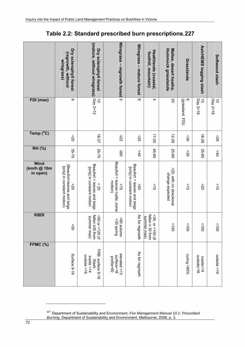
Inquiry into the Impact of Public Land Management Practices on Bushfires in Victoria
72
Table 2.2: Standard prescribed burn prescriptions.227
Dry sclerophyll forest (regrow
th, without
wiregrass)
Dry sclerophyll forest
(mature, w
ithout wiregrass)
Wiregrass – regrow
th forest
Wiregrass – m
ature forest
Heathlands (coastal, foothill, m
ountain)
Mallee, desert heaths,
Hum
mock grasslands
Grasslands
Ash/H
EMS logging slash
Softwood slash
FDI (max)
8
10 D
ay 2<12
5
8
4
20
8 (grassland FD
I)
10 D
ay 2<18
10 D
ay 2<18
Temp (oC) <25
18-27
≤22
<25
17-25
12-28
<30
18-28
<28
RH (%) 35-70
35-70
≥60
>45
45-80
25-60
>30
35-80
>40
Wind (km/h @ 10m
in open) <20
(Beaufort=leaves and tw
igs [only] in constant m
otion)
< 20 B
eaufort = leaves and twigs
[only] in constant motion
<15 B
eaufort = leaves rustle, some
motion)
<20 B
eaufort = leaves and twigs
[only] in constant motion
<15
<25, with no directional
change expected
<15
<20
<10
KBDI
<50
<50 or <120 (if fallen ≥30 from
sum
mer m
ax)
<80 autumn
<30 spring
As for regrow
th
<30, or <100 (if fallen ≥ 30 from
sum
mer m
ax)
<150
<100
<100
<100
FFMC (%)
Surface 9-16
FRB
: surface 9-16 S
lash: inside <14
outside >16
elevated >13 surface>16 profile>60
As for regrow
th
curing >80%
inside<14 outside>16
outside >19
227 Department of Sustainability and Environment, Fire Management Manual 10.1: Prescribed Burning, Department of Sustainability and Environment, Melbourne, 2008, p. 3.

Chapter 2: Prescribed Burning In Victoria
73
The reporting process for prescribed burning
The reporting process for prescribed burning is the subject of the Inquiry’s fourth term of reference. The reporting hierarchy within which the planning, conduct and post-burn assessment of prescribed burning by DSE and its partner agencies occurs has been outlined above. In this section, the Committee outlines the way in which the effectiveness of each prescribed burn is assessed and how the outcomes are reported. The Committee then considers the argument, which was made by a number of stakeholders, that there is a need for greater transparency in the reporting process. The section concludes with a discussion of the use of remote sensing imagery in Western Australia and the potential that exists for the greater use of this technology in Victoria’s prescribed burning program.
Background
Following the completion of a prescribed burn, the officer in charge of the burn (the “burn OIC”) must prepare a record of the burn outcomes, for entry in FireWeb.228 The outcomes recorded, as shown in Figure 2.12 below, include the intensity of the burn and a map showing the areas which were burnt or unburnt.
228 Department of Sustainability and Environment, Fire Management Manual 10.1: Prescribed Burning, Department of Sustainability and Environment, Melbourne, 2005, p. 6_1.

Inquiry into the Impact of Public Land Management Practices on Bushfires in Victoria
74
Figure 2.12: Prescribed burn record.229
Prescribed Burn Operations Record
[FireWeb] The following must be recorded in FireWeb for each prescribed burn by the end of May for Autumn burns and the end of December for Spring burns: • date of the burn; • Fire Danger Index; • weather conditions at appropriate times before and during the burn, including: Drought Index (or equivalent) for the day; air temperature; relative humidity; general wind direction and speed;
• intensity class; • ignition pattern; • whether or not objectives were achieved. *Intensity class: Very High – means crowns removed High – means crowns scorched Medium – means understorey scorched Low – means surface (only) burn Defaults: ‘Medium’ – Fuel Reduction Burn ‘Very High’ – Regeneration Burn In addition to completing the Prescribed Burn Operations Record, the following documents must be produced and stored: • copy of the approved Burn Plan and maps; • list of resources, including personnel, used at the burn (this may be a printout from IRIS); • map of areas burnt and not burnt; • map showing the extent of any escapes beyond the planned control lines; • checklist of tasks completed on the day of the burn; • details of rehabilitation works undertaken; • an electronic record of the burn boundary to update fire history layers in the DSE Corporate Geospatial Data Library (CGDL). This should be forwarded to the Manager, Data Unit, Fire Information & Systems Group, Level 4, 8 Nicholson Street, East Melbourne 3002. For information regarding data collection and formatting standards, refer to Guideline 4.1.1: Collection of Fire History Data in Fire Management Manual 4.1 Fuel Management (DNRE 2002a).
229 Department of Sustainability and Environment, Fire Management Manual 10.1: Prescribed Burning, Department of Sustainability and Environment, Melbourne, 2008, p. 6_1 to 6_2.
Chapter 2: Prescribed Burning In Victoria
75
The Prescribed Burn Operations Record enables the outcome of the burn to be reviewed according to the objectives of the Burn Plan.230 Where objectives are not met, the Manual states that “corrective actions must be taken, and burns rescheduled in Fire Operations Plans if necessary”.231 As noted below, the Committee received evidence from a number of stakeholders that burns are often not rescheduled following a failure to meet the objectives contained in a Burn Plan.
The criteria used by DSE to assess the outcome of a fuel reduction burn are contained in Fire Protection Plans. For example, the Gippsland Fire Protection Plan provides the following in relation to Fuel Management Zones 1, 2 and 3:
Zone 1: Fuel management is to be intensive, i.e. to treat up to 90 % of each fire protection unit in each burning operation. Zone 2: Fuel management is to be strategic and regular and aims to maintain a nominated range of fuel characteristics that are generally broader than those for Zone 1, i.e. to treat up to 80 % of each fire protection unit in each burning operation. Zone 3: Fuel management aims to provide a mosaic of fire frequencies and intensities without large contiguous areas of non-managed fuel, complementing the intensive and strategic fuel management undertaken in Zones 1 and 2. Opportunistic burning may also occur in this zone to link areas burnt by wildfire to other strategic fuel management areas. It is aimed to treat approximately 50 % of each burning unit in any burning operation.232
The majority of post-burn assessments are currently conducted by means of a “walk-through” by personnel from DSE and partner agencies, although aerial and satellite observation may also be used in some cases.233 As indicated in the example above, the aim of the assessment is to determine the proportion of the area within each “fire protection unit” or “burning unit” which has been burnt.
The Mildura Fire Protection Plan, which as noted above, is the first such plan to have implemented the new four "Fire Management Zone" model, has also adopted new fuel reduction benchmarks for its zones. As with the current Fire Protection Plan for Gippsland, the new Mildura plan specifies that each “fuel treatment operation” should result in area treatments of 90 and 80 per cent for zones one and two respectively. However, the Mildura plan also states that the object of each fuel treatment in zones one and two is to achieve an overall fuel hazard rating of “Low”.234 The Committee notes that this introduces a specific requirement to conduct post-burn assessments in zones one and two by reference to overall fuel hazard ratings and therefore, to the level of risk reduction achieved. The Committee 230Department of Natural Resources and Environment, Fire Management Manual 10.1: Prescribed Burning, Department of Sustainability and Environment, Melbourne, 2001, p. 6_1 to 6_2. 231 Department of Natural Resources and Environment, Fire Management Manual 10.1: Prescribed Burning, Department of Sustainability and Environment, Melbourne, 2001, p. 6_2. 232 Department of Sustainability and Environment, Fire Protection Plan - Gippsland Region, Department of Sustainability and Environment, Melbourne, 1999. 233 Department of Sustainability and Environment, personal communication, 29 February 2008. 234Department of Sustainability and Environment, North West Region - Mildura Fire District Fire Protection Plan Department of Sustainability and Environment, 2008, pp. 32, 34.

Inquiry into the Impact of Public Land Management Practices on Bushfires in Victoria
76
welcomes this additional level of detail in assessing the effectiveness of individual prescribed burns and is unaware of any reason why it should not be adopted in future plans for all Fire Districts. In relation to zone three, however, the Committee notes that the Mildura plan specifies neither a percentage for the area to be treated nor an overall fuel hazard rating benchmark. The Committee’s concerns regarding the new approach to zone three in the Mildura plan are discussed below. This issue is also addressed by Recommendation 2.1.
The first stage in the reporting process, following the assessment of a prescribed burn, is the production of a weekly internal report by DSE, which details the net treated area within each zone in each Fire District. This reporting process forms the basis of the final statewide net treated area which is reported by DSE in its Annual Report.
DSE also publishes information on the progress of its prescribed burning program throughout the year on its website, which includes details of planned burns, burns in progress and completed burns.
Evidence received During a site visit to Cann River, the Committee met with a number of local residents who questioned the accuracy of DSE’s post-burn assessments. Residents claimed that the proportion of a planned burn area that is actually treated is often significantly lower than both the area specified prior to the burn and the area that is subsequently reported. The Committee also heard that burns were often not rescheduled following a failure to treat the specified proportion of a burn unit.235
Grampians Asset Protection also claimed that several planned burns in the vicinity of the Grampians National Park were reported as completed when they had in fact not been conducted. Grampians Asset Protection argued that this demonstrated a need for greater transparency in the reporting process:
Some of the maps produced over the years have been very misleading, as they have shown burns allegedly completed, but in fact several of them either never took place or were attempted without success under unsuitable conditions. DSE must be accountable in terms of agreed burns actually being carried out…Objective assessments must be made after each attempted burn, indicating the proportion of the targeted area successfully burnt. This data must be fully and openly reported to all interested parties…236
A further problem with the assessment of individual prescribed burns was noted by Dr Kevin Tolhurst who argued that reporting the total area burnt does not provide an effective measure of the burn outcome. Dr Tolhurst argued that, at a minimum, burns should be assessed by reference to the
235 Cann River Residents, personal communication, 6 March 2008. 236 Grampians Asset Protection, Submission, no. 167, 1 June 2007, p. 3.

Chapter 2: Prescribed Burning In Victoria
77
extent to which the desired fuel hazard level is achieved in each fire management zone.237
During a site visit to Western Australia, the Committee was informed by the Western Australian Department of Environment and Conservation that remote sensing imagery◊, produced by “Landsat” (i.e. satellite), is now used in that state to map both the extent and intensity of prescribed burns.238 An example is shown below at Figure 2.13.
The Committee notes that the adoption of a similar approach to post-burn assessment by DSE, and the publication of the images obtained, may effectively address the stakeholder concerns noted above.
Moreover, the level of post-burn detail possible in such images may also address the concern noted by Dr Tolhurst. The use of a similar indicator to the percentage “biomass change after fire” (shown in Figure 2.13) could provide a more precise indication of the extent to which a prescribed burn had reduced the fuel hazard to desired levels. A post-burn image of this kind could be assessed against a map of the same area showing the pre-burn fuel hazard levels, as measured and recorded using the Overall Fuel Hazard Guide (outlined above).
The Committee notes that the use of Landsat imagery may be more difficult in Victoria’s steep and divided terrain than in Western Australia and that the technology has previously not been cost effective.239 However, DSE has informed the Committee that there is likely to be an increasing use of such satellite imagery in the future as part of the shift to landscape-scale prescribed burning.240
237 Dr. K. Tolhurst, Submission, no. 137, 28 May 2007, p. 4. ◊ Remote sensing refers to the observation of the Earth’s surface using aerial photography and satellites. See: Geoscience Australia, 'About Remote Sensing', viewed 16 April 2008, <http://www.ga.gov.au/acres/referenc/about_remote.jsp>. 238 Department of Environment and Conservation (WA), Fire Management Services, Briefing, Perth, 17 March 2008.; Geoscience Australia, 'About Remote Sensing', viewed 16 April 2008, <http://www.ga.gov.au/acres/referenc/about_remote.jsp>. 239 Victorian Government, Submission, no. 168, 4 June 2007, p. 13. 240 P. Harris, Secretary, Department of Sustainability and Environment, Transcript of evidence, Melbourne, 7 April 2008.

Inquiry into the Impact of Public Land Management Practices on Bushfires in Victoria
78
Figure 2.13: Landsat image of a prescribed burn in Western Australia.241
Conclusion The Committee welcomes DSE’s statement that it anticipates and increase in the use of remote sensing imagery as a means of better assessing the outcomes of individual prescribed burns and the effectiveness of the prescribed burning program.242 The Committee considers that greater use of remote sensing imagery is likely to significantly increase the capacity of both DSE and the public to determine whether the objectives of a burn have been met and whether there is a need for corrective action such as a follow-up burn. Remote sensing technology has the potential to significantly improve the transparency of the prescribed burning assessment and reporting process.
241 Department of Environment and Conservation (WA), Fire Management Services, Briefing, Perth, 17 March 2008. 242 P. Harris, Secretary, Department of Sustainability and Environment, Transcript of evidence, Melbourne, 7 April 2008.

Chapter 2: Prescribed Burning In Victoria
79
Recommendation 2.1:
That the Department of Sustainability and Environment implement remote sensing imagery as a routine part of its pre-burn and post-burn assessment process for prescribed burning. Maps of every prescribed burn should be produced in a similar format to those used in Western Australia, indicating the boundary of each burn and the varying fire intensities achieved within the burn area. The boundaries of all Fuel Management Zones within each burn should also be indicated.
Each prescribed burn map should be made publicly available on the Department of Sustainability and Environment’s website, together with a map of the same burn area which shows the pre-burn fuel hazard levels and a statement of the total area treated within each Fuel Management Zone by each prescribed burn.
The effectiveness of fuel reduction burning
There is a general consensus within the Australian and international literature that fuel reduction burning does contribute to bushfire suppression. This finding was expressed in the Esplin Report in the following terms:
Prescribed burning, for whatever purpose, will reduce the amount of fuel present. If the amount of fuel is less, then the potential heat released in a fire from the remnant fuel is less. If this heat is less, then the chance of controlling any unplanned fire is greater. If the chance of fire control is greater, then the chance of loss of human life and property is smaller.243
In summary, fire intensity, which is a critical factor in bushfire suppression, can be reduced by fuel reduction burning. Moreover, as numerous studies have noted, while the fuel load is one of a number of variables that affect fire intensity, it is the only one that can be modified by human intervention.
In its submission to the Inquiry, DSE also emphasised the overall effectiveness of prescribed burning:
The evidence is that prescribed burning has been of significant assistance in fire suppression operations on public land. Fuel reduction burning has assisted directly in the protection of high-value assets, including townships, and it has played a role in helping firefighters reduce the area burnt by large and severe wildfires.244
DSE cited evidence that the effects of fuel reduction burning may persist for up to 10 to 15 years, while noting that the effects are most significant during the first three to five years. This is explained by the fact that although surface fuels may recover within the first three to five years, the reduction in bark and elevated fuels have longer term effects, such as a decline in the potential for spotting and the formation of crown fires.245
243 B. Esplin, M. Gill and N. Enright, Report of the Inquiry into the 2002-03 Victorian Bushfires, Department of Premier and Cabinet, Melbourne, 2003, p. 75. 244 Victorian Government, Submission, no. 168, 4 June 2007, p. 3. 245 Victorian Government, Submission, no. 168, 4 June 2007, p. 3.

Inquiry into the Impact of Public Land Management Practices on Bushfires in Victoria
80
Meredith (1994) has found that prescribed burning is likely to assist suppression efforts for longer than three years for fires that occur on less severe days. However, he suggested that fires occurring under severe conditions may be the more appropriate ‘yardstick’ given that such fires ‘cause by far the most loss of life and property, as well as environmental damage.’246
DSE also referred the Committee to case studies which suggest that the effectiveness of a given burn is influenced by the proportion of the area burnt within its boundaries, noting that in strategic burning corridors (not to be confused with the fuel management zones outlined above) a minimum of 50 per cent, and perhaps up to 60 to 80 per cent, of an area may need to be burnt for it to be effectively treated.247
In a supplementary submission to the inquiry, DSE provided recent examples of fuel reduction burns which had contributed to the suppression of bushfires across the state.248
Recent confirmation of the effectiveness of fuel reduction burning has also been provided by Project Vesta, a study conducted by the Bushfire CRC and the Western Australian Department of Environment and Conservation. The study found that fuel reduction burning produced reductions in the rate of spread, flame height and intensity of fires.249 The study also found that prescribed burning reduces the number and distance of spot fires by altering the fuel bed structure and reducing the fuel load – effects which may persist for up to 20 years in forests that contain rough-barked trees and shrubby under-storey.250
DSE referred the Committee to recent research from the USA which suggests a link between the placement of fuel reduced areas in space and time and the overall effectiveness of a fuel reduction program.251 DSE concluded that applying the principles of this work to Australia would translate to the treatment of around two to five per cent of the landscape in strategic locations each year to ensure an impact in a large fire situation.252 DSE also concluded that the same research suggested that for randomly positioned treatments, around four to ten per cent of the landscape would need to be treated each year to have the same effect.253
246 C. Meredith, 'Biodiversity Series, Paper No. 8', Paper presented at the Fire and biodiversity: the effects and effectiveness of fire management, Footscray, Melbourne, 1994. 247 Victorian Government, Submission, no. 168, 4 June 2007, p. 3. 248 Department of Sustainability and Environment, Submission, no. 168C, 31 August 2007, pp. 1-4.; Department of Sustainability and Environment, Submission, no. 168D, 9 January 2008, p. 1. 249 Bushfire CRC, 'New Guidelines for Predicting Fire Behaviour', viewed 19 June 2008, <http://www.bushfirecrc.com/news/vesta_launch.html>. 250 Bushfire CRC, 'New Guidelines for Predicting Fire Behaviour', viewed 19 June 2008, <http://www.bushfirecrc.com/news/vesta_launch.html>. 251 Victorian Government, Submission, no. 168, 4 June 2007, p. 4. 252 Victorian Government, Submission, no. 168, 4 June 2007, p. 4. 253 Victorian Government, Submission, no. 168, 4 June 2007, p. 4.

Chapter 2: Prescribed Burning In Victoria
81
Stakeholders also provided the Committee with a range of views regarding the appropriate extent of prescribed burning on public land in Victoria. East Gippsland Wildfire Taskforce Inc. suggested that, after deducting rainforest and timber harvesting areas, 20 per cent of the forested areas east of the Snowy River in Gippsland should be fuel reduced each year.254 Forest Fire Victoria Inc. nominated an annual statewide target of 460,000 hectares (almost six per cent of the public land estate).255 David Packham, a member of Forest Fire Victoria Inc., suggested a minimum annual statewide target of approximately 600,000 hectares (nearly eight per cent of the public land estate).256 The issue of the appropriate extent of prescribed burning on public land is discussed in further detail later in the chapter.
The influence of fuel management zones
While the principle of fuel reduction burning as a bushfire mitigation tool is well established, its effectiveness is influenced by the extent to which fuels are reduced in a given area. One aspect of this is the “management intensity” that is applied to a particular area, which refers to the proportion of each fire protection unit that is treated by a burning operation (e.g. 90 per cent in zone one; 80 per cent in zone two; and 50 per cent in zone three). A further aspect is the level to which fuels are reduced within the treated proportion of each fire protection unit.
A study conducted by McCarthy and Tolhurst (2001) assessed the effectiveness of broadscale fuel reduction burning during the preceding two decades with a focus on the location of fuel management zones. The study concluded that fuel reduction burning in zones one and two did contribute to bushfire suppression but that burning in zone three had only a “random chance” of contributing to bushfire suppression.257 The Committee notes, however, that the finding in relation to zone three is likely a reflection of the approach to prescribed burning in this zone over past decades. That is, a predominantly random placement of burn units – rather than the emerging approach of strategically placed burns – and an insufficient level of prescribed burning within the zone.
Rawson, Billing and Rees (1985) have noted that large fuel-reduced areas, such as those in zone three, have frequently assisted in bushfire suppression. Moreover, the authors concluded that although such burns had sometimes had a minimal effect on spread rates under extreme conditions, this simply demonstrated the need for treatments which achieve greater reductions in fuel quantity:
254 East Gippsland Wildfire Taskforce, Submission, no. 63, 18 May 2007, p. 2. 255 A. Hodgson, Forest Fire Victoria, Transcript of evidence, Melbourne, 27 August 2007. 256 D. Packham, Submission, no. 154B, 1 July 2007, p. 2. 257 Dr. K. Tolhurst, 'Prescribed Burning in Victoria: Policy and Practice', Paper presented at the Bushfire Prevention: Are We Doing Enough? Conference, Institute of Public Affairs, 2003, p. 10.
Inquiry into the Impact of Public Land Management Practices on Bushfires in Victoria
82
The most dramatic examples of the impact of fuel-reduction burning can be found where fires have spread to barriers created by intensive burning [e.g. zones one and two]. Such burns, usually of relatively small area, have played a vital role in settlement protection in particular. Large fuel-reduced areas [e.g. zone three] have also provided substantial assistance during fire control operations although, because the total fuel quantities left are usually greater than after a small-scale operation, their effectiveness is more closely linked with fire intensity. They have frequently helped to minimise the spread of lightning-caused fires and therefore assist fire control in often difficult and remote terrain. However, under conditions of very high to extreme fire danger, where a fire has entered on a broad front, such areas have sometimes had little impact on spread rates. Because it is clear that the present standard of fuel-reduction is not always adequate, operational techniques which achieve greater reductions in fuel quantity need to be implemented.258
DSE’s evidence to the Inquiry suggests a change of approach in the areas in which much of the shift towards landscape-scale prescribed burning would need to occur; that is, zone three (under both the 1995 Code and under the revised Code). Although zone three has been renamed under the revised Code as the “Ecological Management Zone”, fire protection benefits remain a requirement for this zone. The strategy for achieving such benefits in Fire Protection Plans produced under the 1995 Code was broadly the same as for zones one and two; that is, to treat a defined percentage of each burning unit (e.g. 50 percent under the Gippsland Fire Protection Plan). However, the new approach to burning in zone three apparently acknowledges that such targets may not be appropriate, either ecologically or from a fire protection perspective.259
In its submission to the Inquiry, DSE provided the following generic example of a possible prescribed burning regime for zone three:
…the fire management objectives in Ecological Zones could be achieved by burning drier north and westerly aspects (say 20-40% of the burn area) for several rotations (i.e. where more naturally fire prone vegetation types occur) – followed by less frequent burning of wetter easterly and southern aspects.260
A specific example of the new approach to prescribed burning in zone three is provided by the Fire Protection Plan for Mildura, which as noted above, is the first plan to adopt the four Fire Management Zone model under the revised Code.261 The plan does not specify a target percentage for the area to be treated within zone three for each burn unit but instead provides that prescribed burning intensity, frequency, seasonality and patchiness should be determined by applicable fire ecology strategies or, where these do not yet exist, by reference to Appendix 2 of the plan. Appendix 2 sets out environmental principles for Mallee public land and preferred fire regimes for
258 Department of Sustainability and Environment, 'Effectiveness of Fuel Reduction Burning (10 Case Studies)', viewed 6 April 2008, <http://www.dse.vic.gov.au>. 259 Victorian Government, Submission, no. 168, 4 June 2007, p. 4. 260 Victorian Government, Submission, no. 168, 4 June 2007, p. 4. 261 Department of Sustainability and Environment, Submission, no. 168E, 4 April 2008, p. 3.

Chapter 2: Prescribed Burning In Victoria
83
various Mallee vegetation types, based on maximum and minimum tolerable fire intervals for a number of Ecological Vegetation Divisions.262
On the one hand, the Committee notes that the shift away from area treatment targets within zone three may provide DSE with the flexibility needed to increase the level of prescribed burning, and to achieve more strategically placed mosaics of burnt and unburnt vegetation, across the landscape. On the other hand, the Committee is concerned that the removal of area treatment targets for zone three may reduce the accountability and transparency of prescribed burning operations within the zone. For these reasons, the Committee considers it is particularly important that DSE include a statement of the total area treated within each Fuel Management Zone as part of its reporting process for each prescribed burn, as recommended earlier in this chapter; that is, Recommendation 2.1.
Measuring the effectiveness of fuel reduction and ecological burning
The Esplin Report noted that there is currently no “unequivocal and immediate choice of an appropriate measure for the effectiveness of prescribed burning”.263 In other words, there is currently significant uncertainty regarding how the effectiveness of prescribed burning may be quantified. The report devoted an entire chapter (Chapter 11) to this issue and outlined thirteen possible approaches to measuring the effectiveness of prescribed burning. While the Committee considers that efforts to quantify the effectiveness of fuel reduction burning in mitigating the scale and intensity of bushfires is important, it also acknowledges that this is likely to remain an area of ongoing research for some time.
The 2003 Victorian Auditor-General’s report recommended that DSE supplement the use of “area targets” as a measure of fuel reduction burning with “measures that more accurately reflect the level of risk reduction being sought and achieved” and that it report on the results obtained.264
The Committee considers that there are two important aspects to measuring the effectiveness of prescribed burning: cost effectiveness; and improved mapping. These issues are discussed further below.
A number of stakeholders argued that prescribed burning in Victoria is actually increasing the vulnerability of the bush to wildfires.265 The Committee notes that inappropriate fire regimes have been acknowledged
262 Department of Sustainability and Environment, North West Region - Mildura Fire District Fire Protection Plan Department of Sustainability and Environment, 2008, pp. 36, 59. The plan notes that the fifty Ecological Vegetation Classes identified on public land in the Mildura Fire District have been grouped into fourteen Ecological Vegetation Divisions “based on their general ecological similarities and their consistent fire regime responses. 263 B. Esplin, M. Gill and N. Enright, Report of the Inquiry into the 2002-03 Victorian Bushfires, Department of Premier and Cabinet, Melbourne, 2003, p. 108. 264 Auditor General Victoria, Fire Prevention and Preparedness, Auditor General Victoria, Melbourne, 2003, p. 6. 265 R. Weatherly, Submission, no. 118, 25 May 2007, p. 2.

Inquiry into the Impact of Public Land Management Practices on Bushfires in Victoria
84
as having the potential to produce such an outcome i.e. by promoting fire tolerant plant species. However, the Committee also notes that the continuing process of integrating the ecological research findings of DSE, Parks Victoria and the Bushfire CRC within planned fire regimes will reduce the likelihood of inappropriate planned fire regimes.
Environmental factors
A major reason for the controversy surrounding the appropriate extent of prescribed burning on public land is the level of concern within the community about its environmental impacts. A number of stakeholders expressed concerns that current levels and methods of prescribed burning on public land are harmful to the environment.266
However, the Victorian Fire Ecology Working Group (a partnership between DSE and Parks Victoria) has found that biodiversity in Victoria is in fact threatened by the infrequency of current fire regimes:
Inappropriate fire regimes (and in particular too-frequent fire) is commonly regarded as a significant threat to biodiversity in Victoria and indeed, high frequency fire has recently been nominated as a threatening process under the Flora and Fauna Guarantee Act (1988). The results from this analysis indicate, however, that over-burning is not occurring at either a Statewide or at any bioregional scale. These results suggest that the threat which fire frequency poses to species composition and community conservation in Victoria is in fact from under-exposure to fire; i.e. fire frequency is too low across the landscape.267
The challenge of returning fire to the landscape in a way that is consistent with environmental needs has been expressed by David Lindenmayer, Professor of Ecology and Conservation Science at the Fenner School for Environment and Society at the Australian National University, in the following terms:
Most natural fires are very patchy, they leave a very patchy environment and that's critical to the recovery of biodiversity and the environment after fire. The big difference with…back-burning and human fires is that they tend to be very uniform and that creates a very homogeneous environment which is not so good for many species to recover, or recover very quickly from. 268
DSE’s stated approach to solving this problem has been to emphasise the importance of using planned fire in a way that mimics the natural fire regime.269 DSE has adopted a scientific framework to achieve this which is 266 See for example: Wombat Forest Care, Submission, no. 186, 4 June 2007; Otway Conservation Council, Submission, no. 197, 6 June 2007; Goongerah Environment Centre, Submission, no. 195, 5 June 2007; Environment East Gippsland Inc., Submission, no. 225, 4 June 2007; M. Killeen, Submission, no. 235, 1 August 2007; C. Copley, Submission, no. 244, 18 September 2007; J. Whadcoat, Submission, no. 246, 29 August 2007; P. Crisp, Submission, no. 248, 11 September 2007. 267 Department of Natural Resources and Environment and P. Victoria, Analysis of Disturbance of Fire on Public Land in Victoria: Fire Ecology Working Group, Department of Sustainability and Environment, Melbourne, 2002, p. VIII. 268 Australian Broadcasting Corporation, 'Firestorm', viewed 18 April 2008, <http://www.abc.net.au/4corners/content/2007/s1870141.htm>. 269 Department of Sustainability and Environment, Gippsland Burning News: Autumn 2008, Department of Sustainability and Environment, Melbourne, 2008, p. 3.

Chapter 2: Prescribed Burning In Victoria
85
set out in the Guidelines and procedures for ecological burning on public land in Victoria (2004) (“the Guidelines”). The Guidelines are not prescriptive but instead contain a number of “general principles which may be used as a guide to action or decision-making”.270
The approach outlined in the Guidelines involves using the “vital attributes” (also referred to as “life history”) of key plant species to determine the upper and lower tolerable fire intervals for an ecologically appropriate fire management regime. Plant species are categorized according to their Ecological Vegetation Class (EVC), of which there are approximately 300 across the state and which are defined as:
…one or a number of floristic communities that appear to be associated with a recognisable environmental niche, and which can be characterised by a number of their adaptive responses to ecological processes that operate at the landscape scale level.271
In the case of ecological burns (i.e. burns with a primary purpose of one or more conservation or related outcomes), the vital attributes approach is implemented through the use of an “Ecological Burn Plan” which is completed prior to the burn.272
In the case of each Fire District, and therefore presumably for the majority of broad area burns in zone three, the “vital attributes” approach is to be implemented through an Ecological Fire Strategy (since renamed a “Fire Ecology Strategy”).273 At the time of writing, DSE had yet to finalise its Fire Ecology Strategies, although the Committee was advised that a number had been completed to draft stage.274
The Committee understands that the delay in the completion of Fire Ecology Strategies may be due in part to gaps in data collection and in the mapping of EVCs for particular areas. DSE has advised the Committee that the implementation of Fire Ecology Strategies requires “substantial work” and may take a further three to five years.275 The Committee has also been advised, however, that a number of Fire Ecology Strategies are now in draft form and are already having an impact on the planning process for prescribed burning.276 The Committee also notes that DSE has adopted an approach of “adaptive management” to its prescribed burning program to facilitate changes to burning practices in accordance with future research findings.
270 Department of Sustainability and Environment, Guidelines and procedures for ecological burning on public land in Victoria, Department of Sustainability and Environment, Melbourne, 2004, pp. 4-10. 271 Department of Sustainability and Environment, 'Ecological Vegetation Class (EVC) Benchmarks for each Bioregion', viewed 6 April 2008, <http://www.dse.vic.gov.au>. 272 Department of Sustainability and Environment, Guidelines and procedures for ecological burning on public land in Victoria, Department of Sustainability and Environment, Melbourne, 2004, p. 15. 273 Department of Sustainability and Environment, Guidelines and procedures for ecological burning on public land in Victoria, Department of Sustainability and Environment, Melbourne, 2004, p. 21.; Department of Sustainability and Environment, Code of Practice for Fire Management on Public Land, Department of Sustainability and Environment, Melbourne, 2006, p. 10. 274 Department of Sustainability and Environment, personal communication, 15 January 2008. 275 Department of Sustainability and Environment, Submission, no. 168E, 4 April 2008, p. 3. 276 Department of Sustainability and Environment, personal communication, 15 January 2008.

Inquiry into the Impact of Public Land Management Practices on Bushfires in Victoria
86
A limitation of the “vital attributes” approach on which draft Fire Ecology Strategies are based is that it does not currently account for the effects of planned fire regimes on fauna.277 The Committee notes, however, that this issue is likely to be the subject of future research.
The Esplin Report cited a figure of around 3.3 per cent as the proportion of public land in Victoria that should be burnt each year for ecological purposes. This figure was based on research conducted by DSE’s Fire Ecology Working Group, which found that the ideal average interval between fires for Victorian forests is about 30 years.278 Since it is based on an ideal average fire interval for all Victorian forests, this figure apparently accounts for the fact that a proportion of the public land estate is unsuitable for prescribed burning. As noted in the introduction to this chapter, approximately 6.2 million hectares of the total 7.7 million hectares of the public land estate is suited to prescribed burning.
It is important to note that the figure of 3.3 per cent was based on an estimate of the average fire interval for the whole landscape. In many areas, the actual interval between successive fuel reduction/ecological burns is significantly shorter; in some areas it is longer; and in some areas fire is excluded altogether. As the Committee discusses below, the average figure may provide a broad indication of the minimum level of ecological burning required on public land in Victoria, albeit one which may be superseded by future research.
Finding 2.2:
The Committee finds that the frequency and extent of prescribed burning has been insufficient, over a number of decades, for the preservation of ecological processes and biodiversity across the public land estate. An increase in the extent and frequency of prescribed burning for the enhancement of environmental values should therefore be a priority for the Department of Sustainability and Environment and its partner agencies.
Water quality and quantity
The Inquiry’s third term of reference requires the Committee to consider the impact of prescribed burning on water quality and quantity. A reliable and high-quality water supply is of crucial importance for Victoria’s homes, farms, industry and environment. Moreover, the Government has recognised that successive years of low rainfall, population growth, degrading river systems, and the anticipated effects of climate change, all highlight the need for “new and better ways to secure water for the future”.279 The negative impact on water quality and quantity resulting from recent bushfires, and the
277 B. Esplin, M. Gill and N. Enright, Report of the Inquiry into the 2002-03 Victorian Bushfires, Department of Premier and Cabinet, Melbourne, 2003, p. 80. 278 B. Esplin, M. Gill and N. Enright, Report of the Inquiry into the 2002-03 Victorian Bushfires, Department of Premier and Cabinet, Melbourne, 2003, p. 78. 279 Department of Sustainability and Environment, 'Our Water Our Future: Securing Our Water Future Together', viewed 18 April 2008, <http://www.dse.vic.gov.au>.

Chapter 2: Prescribed Burning In Victoria
87
threat posed by future bushfires, must be added to this list of challenges to Victoria’s water supply. In this section, the Committee considers the potential for prescribed burning to mitigate the impacts of bushfires in water catchments through the establishment of appropriate fire regimes.
DSE advised the Committee that a further reason for an increase in prescribed burning is the need to reduce the risks posed by bushfires in and around water catchments.280 DSE referred to the impact of the 2006/07 fires on a number of high value water catchments, historic research in Melbourne’s water catchments and the Australian Capital Territory fires of 2003 as case studies of the impacts of bushfires on catchments.281
In relation to water yield, DSE cited research conducted since the 1950s in Melbourne’s catchment areas which found that there is a significant decline in water runoff and yields following the regeneration of Mountain Ash forests in areas damaged by bushfires. Water yield gradually declines between 10 to 30 years after the fire event and by 25 to 30 years the decline can be as much as 50 per cent. Full recovery to pre-fire water yields can take up to 150 years. Based on a scenario of 100 per cent damage to Melbourne’s catchments, a predicted 30 per cent decline in yield between 10 to 30 years later would represent an overall cost of $520 million per year, or $16 billion over the whole period.282
In relation to water quality, DSE referred to the example of the Australian Capital Territory fires which severely affected Canberra’s water catchment. The subsequent decline in water quality resulted in the need for the rapid construction of a water treatment plant. DSE noted that if Melbourne’s catchments were to be similarly affected by bushfires, the estimated cost of fully treating the city’s water would be $2 billion plus running costs.283
Grampians Wimmera Mallee Water (GWM Water) identified similar problems to those experienced in the ACT. The impact of the 2006 Grampians fires on water quality in the area required GWM Water to shut off the water supply to Stawell for several days to a week after each moderate rain event.284 This continued for approximately 12 months after the fire event. As part of the bushfire recovery process, GWM Water also initiated erosion protection works (rock constructed weirs), a review of water treatment processes and increased water quality sampling.285
280 Victorian Government, Submission, no. 168, 4 June 2007, p. 11. 281 Victorian Government, Submission, no. 168, 4 June 2007, p. 11. 282 Victorian Government, Submission, no. 168, 4 June 2007, p. 12. 283 Victorian Government, Submission, no. 168, 4 June 2007, p. 11. 284 GWM Water, Submission, no. 224, 3 July 2007, p. 2. 285 GWM Water, Submission, no. 224, 3 July 2007, p. 3.

Inquiry into the Impact of Public Land Management Practices on Bushfires in Victoria
88
Wellington Shire, in Gippsland, summarised the impact of the recent fires in the following terms:
Severe erosion has already caused destructive mud slides in the township of Licola and increased the turbidity of local rivers, especially the Dargo, Barkly, Wonnangatta, Macalister and Mitchell. Contamination of these rivers by ash, soil and debris had rendered some town supplies undrinkable and complicated the treatment of water as far downstream as Bairnsdale, with contaminated water also entering Cowwarr Weir Lake Glenmaggie and the Gippsland Lakes.286
East Gippsland Water (EGW) has noted that it may take a number of years for its river catchments to fully regenerate, and for water quality to be restored, following the bushfires of 2006/07. EGW estimated the cost of dealing with the immediate problem of increased sediment loads following significant rain in early 2007 alone, at approximately $6 million.287
EGW also reported that the 2006/07 bushfires had a particularly severe effect on the Mitchell River catchment. The catchment provides drinking water to over 17,000 people in a number of areas including, Bairnsdale, Metung, Paynesville, Bruthen, Nicholson, Lakes Entrance and Lake Tyers.288 The deterioration in the catchment’s water quality required the installation of significant infrastructure, including, water clarifiers, water settlement dams, emergency water bores, an extensive pipeline network, and diesel generators for electricity generation.289
The High Country Councils Coalition informed the Committee that turbidity in the Mitchell River following the 2006/07 fires had necessitated severe water restrictions. The Coalition also stated that it had been advised by the local water authority that:
….. it has incurred considerable costs in terms of providing that immediate response with regard to water treatment, and is likely to require a further $15 million for an additional reservoir and water treatment plant in the short to medium-term. It is a considerable cost associated with water treatment. We are advised that the situation is likely to remain for several years in terms of the turbidity of the water and the issue of the need for water treatment for human consumption.290
The importance of prescribed burning for catchment protection has been recognised by Victoria’s Catchment Management Authorities, which provide input into DSE’s prescribed burning program each year. For example, the North East Catchment Management Authority advised the Committee that it is formally invited by DSE to provide input into the annual development of Fire Operations Plans.291 This input is in addition to the Authority’s
286 Wellington Shire Council, Submission, no. 79, 23 May 2007, p. 3. 287 East Gippsland Water Authority, Annual Report 2006-2007, State of Victoria, Victoria, 2007, p. 2. 288 East Gippsland Water Authority, Annual Report 2006-2007, State of Victoria, Victoria, 2007, p. 38. 289 East Gippsland Water Authority, Annual Report 2006-2007, State of Victoria, Victoria, 2007, p. 38. 290 S. Kozlowski, Chief Executive Officer, East Gippsland Shire Council, High Country Council Coalition, Transcript of evidence, Bairnsdale, 31 July 2007. 291 North East Catchment Management Authority, Submission, no. 27, 4 May 2007, p. 1.

Chapter 2: Prescribed Burning In Victoria
89
participation in community forums held in a number of locations and its examination of Draft Plans.292
An increase in prescribed burning on public land within water supply catchments was specifically endorsed by the East Gippsland Catchment Management Authority. The Authority informed the Committee that the recent fires of 2003 and 2007 had burnt extensive areas of the East Gippsland catchments and predicted that the impacts would persist for many years. The Authority also highlighted the fact that the area contains the majority of the Heritage Rivers in Victoria and referred the Committee to the East Gippsland Regional Catchment Strategy (RCS) which has been endorsed by a number of Victorian Government and former Commonwealth Government ministers, and which strongly supports an increase in prescribed burning on public land in the area.293
A 2004 report by the Council of Australian Governments (COAG) identified a need for further research and monitoring to fully understand the effects of prescribed burning, and large-scale bushfires, in catchment areas.294 However, the report also noted that a number of catchment management agencies in Australia were investigating the use of prescribed burning in water catchments as a means of “reducing the likelihood and magnitude of large bushfires”.295 The Committee also notes the comments of Dr. Dick Williams, Sustainable Ecosystems, CSIRO, who explained the differing impact of wildfires and prescribed burning on water in the following terms:
Water values may be affected substantially by wildfires, with the effects potentially lasting for decades, but are generally relatively little affected by prescribed burning, with exceptions being on sites where there are highly erodible soils.296
The Committee acknowledges the importance of further research in this area but considers that there is sufficient certainty regarding the likely benefits of prescribed burning in Victoria’s catchments. The Committee is particularly mindful of the significant financial and environmental impacts that recent bushfires have had on Victoria’s catchments. Moreover, the possibility of future bushfires of a similar scale and intensity represents a clear risk to the quantity and quality of Victoria’s water supplies and to the ecosystems dependent on them. The Committee concludes that these risks provide a further justification for an increase in the extent of prescribed burning on public land, both in and around catchment areas.
292 North East Catchment Management Authority, Submission, no. 27, 4 May 2007, p. 1. 293 East Gippsland Catchment Management Authority, Submission, no. 165, 30 May 2007, pp. 3-4. 294 S. Ellis, P. Kanowski and R. Whelan, National Inquiry on Bushfire Mitigation and Management, Commonwealth of Australia, Canberra, 2004, pp. 116-117. 295 S. Ellis, P. Kanowski and R. Whelan, National Inquiry on Bushfire Mitigation and Management, Commonwealth of Australia, Canberra, 2004, p. 117. 296 Dr. D. Williams, CSIRO Sustainable Ecosystems, Transcript of evidence, Melbourne, 27 August 2007.
Inquiry into the Impact of Public Land Management Practices on Bushfires in Victoria
90
Finding 2.3:
The Committee finds that there is a need for an increase in the extent and frequency of prescribed burning in catchment areas to mitigate the risks associated with future bushfires.
The extent of prescribed burning on public land
As noted in the introduction to this chapter, the majority of stakeholders who provided evidence to the Committee called for a significant increase in the level of fuel reduction and ecological burning.
In the preceding sections, the Committee has outlined the two main factors which are relevant to determining the appropriate extent of prescribed burning on public land:
the level of burning required to reduce the risk of frequent, large and potentially uncontrollable bushfires; and
the level of burning which is consistent with the preservation of environmental values, including biodiversity.
In this section, the Committee draws on its findings in relation to the above issues to discuss an appropriate minimum level of fuel reduction and ecological burning on public land in Victoria.
The Committee begins this section with an outline of the historical and current extent of fuel reduction and ecological burning.
The historical extent of prescribed burning
A number of stakeholders referred the Committee to evidence of a significant decline in the level of fuel reduction burning in recent years. Data compiled by Tolhurst provides some support for this conclusion.297 Tolhurst found evidence of a decline in the extent of prescribed burning from an annual average of around 200,000 hectares during the 1980s to around 110,000 hectares during the last two decades.298 Tolhurst noted, however, that the actual annual area burnt during the 1980s varied dramatically, with almost 500,000 hectares burnt during 1981 compared to around 34,000 hectares in 1989, and suggested that the fluctuation may have been largely
297 Dr. K. Tolhurst, 'Prescribed Burning in Victoria: Policy and Practice', Paper presented at the Bushfire Prevention: Are We Doing Enough? Conference, Institute of Public Affairs, 2003, p. 4. 298 Dr. K. Tolhurst, 'Prescribed Burning in Victoria: Policy and Practice', Paper presented at the Bushfire Prevention: Are We Doing Enough? Conference, Institute of Public Affairs, 2003, p. 4.

Chapter 2: Prescribed Burning In Victoria
91
due to the number of suitable burning days in a given year and the size of individual burn areas.299
The Esplin report noted an apparent further decline in the annual area treated during the 1990s.300 This is supported by data provided by DSE which shows that the annual average area treated during the last ten years has been around 78,000 hectares.301
The Committee notes that the apparent decline in the extent of prescribed burning may be due, at least in part, to changes in the way that the extent of a burn is measured. DSE advised the Committee that the current method of assessing the “treated” or “net” area burnt differs from that used in previous decades where “large continuous areas within the burn boundary that were not ignited or did not burn” may have been included.302 In other words, part of the apparent decline in the extent of prescribed burning may be due to more accurate measurement. This point has also been noted by Tolhurst.303
The current extent of prescribed burning
While a determination of the true extent of the decline in prescribed burning since the 1980s may not be possible, the question of greatest concern to the Committee is whether the current extent of prescribed burning, particularly across public land, is appropriate for both fire protection and environmental purposes.
In its submission to the Inquiry, DSE noted that the annual program has recently been increased from 100,000 to 130,000 hectares, with a total net area of 138,490 hectares treated during 2006/07.304 Around half of this area was in State forest managed by DSE with the other half (more than 67,000 hectares) located within the Parks Victoria estate.305 The Committee notes that the current annual target of 130,000 hectares represents approximately 1.7 per cent of the 7.7 million hectares of public land.
The required extent of prescribed burning
Determining the appropriate extent of fuel reduction and ecological burning on public land is a complex issue and one which is unlikely to be finally resolved by the current Inquiry. Moreover, the Committee recognises that any conclusions it makes on this issue will be subject to the findings of future research. Nevertheless, the Committee considers that there is 299 Dr. K. Tolhurst, 'Prescribed Burning in Victoria: Policy and Practice', Paper presented at the Bushfire Prevention: Are We Doing Enough? Conference, Institute of Public Affairs, 2003, p. 4. 300 B. Esplin, M. Gill and N. Enright, Report of the Inquiry into the 2002-03 Victorian Bushfires, Department of Premier and Cabinet, Melbourne, 2003, p. 96. 301 Victorian Government, Submission, no. 168, 4 June 2007, p. 2. 302 Victorian Government, Submission, no. 168, 4 June 2007, p. 13. 303 Dr. K. Tolhurst, 'Prescribed Burning in Victoria: Policy and Practice', Paper presented at the Bushfire Prevention: Are We Doing Enough? Conference, Institute of Public Affairs, 2003, p. 12. 304 Department of Sustainability and Environment, Annual Report 2006-07, Department of Sustainability and Environment, Melbourne, 2007, p. 159. 305 Parks Victoria, Annual Report 2006-2007, Parks Victoria, Melbourne, 2007, p. 6.

Inquiry into the Impact of Public Land Management Practices on Bushfires in Victoria
92
sufficient evidence currently available to recommend the minimum annual average extent of prescribed burning required on public land.
As noted above, recent studies suggest that between two to five per cent of the landscape would need to be treated in strategic locations each year for prescribed burning to be effective as a bushfire suppression strategy. The same studies also suggest that for randomly positioned treatments, four to ten per cent of the landscape would need to be treated each year to have the same effect. Research cited in the Esplin Report suggested that around 3.3 per cent of the landscape would need to be treated each year to provide for the persistence of native vascular flora. It is therefore clear that the current level of prescribed burning is significantly lower than is required for both bushfire protection and ecological purposes. In the Committee’s view, a minimum average of five per cent of the public land estate should be treated by prescribed burning each year. This would represent an annual target of 385,000 hectares, which is almost three times the current figure. The Committee believes that such a target strikes an appropriate balance between the ecological needs of the public land estate and the imperative of bushfire mitigation for the protection of communities.
During the Committee’s final public hearing, DSE announced plans to significantly increase the level of fuel reduction and ecological burning. DSE referred to the planned adoption of increased landscape scale burning across “multiple kilometres-wide” areas.306 The new approach was described as involving a focus on particular regions in a given year, during which a two to three month presence would be maintained by DSE and its partner agencies. In some cases, this would involve maintaining a fire in the region for much of that period and, if necessary, repeated efforts to overcome the vagaries of the weather. DSE also announced its intention to move away from reporting the total hectares treated each year as the sole measure of its prescribed burning program, towards the increased use of “multiple measures”. One such measure cited by DSE was the percentage of the area treated within each kilometre-wide burning area (e.g. whether 50, 70 or 80 per cent of such an area was treated).307
Prescribed burning in Western Australia The south west forest regions of Western Australia cover an area of approximately 2.5 million hectares, consisting of Jarrah, Karri, and Marri trees. The broadly similar geographic and climatic conditions between south-west Western Australia and Eastern Victoria are often cited as providing a basis for comparison between the approaches to prescribed burning adopted by the two states.
306 P. Harris, Secretary, Department of Sustainability and Environment, Transcript of evidence, Melbourne, 7 April 2008. 307 P. Harris, Secretary, Department of Sustainability and Environment, Transcript of evidence, Melbourne, 7 April 2008.

Chapter 2: Prescribed Burning In Victoria
93
The level of prescribed burning undertaken in south-west Western Australia is significantly higher than the current level in Victoria, with a nominal 200,000 hectare (eight per cent) target applying across the region.308 While in the 1960s and 1970s the level of prescribed burning ranged from 10 to 15 per cent, this figure dropped dramatically in the late 1990s and early 2000s.309 For example, in 2001/02 only 74,739 hectares (approximately three per cent) of prescribed burning was undertaken in the south-west.310 During this time the incidence of large wildfires increased significantly. As a result, the level of burning was restored to the 200,000 hectare nominal target in the mid 2000s.
In 2006/07, 330,000 hectares was identified for prescribed burning in the south-west forest regions (approximately 13 per cent), though only 138,600 hectares (approximately 5.5 per cent) was achieved due to a low number of suitable burning days.311 However, this figure is only slightly lower than the 10 year rolling average of 151,695 hectares (approximately six per cent) for prescribed burning in the region.312
Fernandes and Botelho note that prescribed burning constraints differ between south-eastern and south-western Australia, citing south-west Western Australia’s drier and more predictable weather; milder topography and relatively uniform forests as allowing “larger, safer, and more effective burns that can be conducted more times per year”.313 The Committee recognises that the constraints in south-west Western Australia differ from those in Victoria and that, as such, prescribed burning programs adopted in Western Australia may not readily lend themselves to direct comparison with Victoria. Despite these differences, the Committee strongly supports the view that Victoria should adopt a similar broadscale approach to prescribed burning as is currently practised in Western Australia. While it may or may not be appropriate to treat a similar proportion of the Victoria public land estate by prescribed fire, the Committee welcomes the recent decision by DSE to adopt the Western Australian approach of landscape scale burns.314
Conclusion The Committee welcomes DSE’s acknowledgement of the need for a significant increase in the level of fuel reduction and ecological burning. The Committee believes that such an increase is certainly supported by its research and the weight of the evidence that it has received. The Committee also welcomes DSE’s plans to introduce a range of measures for its future 308 Department of Conservation and Land Management (WA), Annual Report 2003-04, 2004, p. 21. 309 Department of Conservation and Land Management (WA), Annual Report 2003-04, 2004, p. 22. 310 Department of Conservation and Land Management (WA), Annual Report 2001-02, Department of Conservation and Land Management, Perth, 2002, p. 61. 311 Department of Environment and Conservation (WA), Annual Report 2006-07, Department of Environment and Conservation (WA), Perth, 2007, p. 114. 312 Department of Environment and Conservation (WA), Annual Report 2006-07, Department of Environment and Conservation (WA), Perth, 2007, p. 117. 313 P. M. Fernandes and H. S. Botelho, 'A Review of Prescribed Burning Effectiveness in Fire Hazard Reduction', International Journal of Wildland Fire vol. 12, no. 2, 2003, pp. 121-122. 314 P. Harris, Secretary, Department of Sustainability and Environment, Transcript of evidence, Melbourne, 7 April 2008.

Inquiry into the Impact of Public Land Management Practices on Bushfires in Victoria
94
fuel reduction and ecological burning outcomes but considers that performance against an annual state-wide target, measured in hectares, should remain one such measure. There are two main reasons for this. First, such a measure provides a ready means of gauging the average percentage of public land treated each year. Second, the retention of the current measure will provide a means of assessing future progress in increasing the level of fuel reduction and ecological burning. The Committee considers that the capacity for ready comparison between the current and future extent of prescribed burning may be reduced if the existing performance measure was entirely superseded.
A further reason given by DSE for its decision not to quantify the size of the planned increase in prescribed burning by reference to the current measure, was that it is likely to be partly contingent on the finalisation of research into the ecological effects of planned fire regimes.315 The Committee is particularly mindful of the need to increase the level of prescribed burning on public land in a manner that also establishes ecologically appropriate fire regimes across the state. The Committee considers that the future implementation of DSE’s Fire Ecology Strategies, which are being designed to refine the timing and pattern of prescribed burning in particular areas, is likely to make an important contribution in this regard. The Committee also notes that an annual prescribed burning target of five per cent of the public land estate is likely to support DSE’s planned shift towards significantly larger landscape-scale “mosaic” burns which produce a greater “patchiness” of burnt and unburnt areas.316 The ecological effectiveness of the target recommended by the Committee, and the level of bushfire risk reduction achieved, should also be the subject of a regular review. The Committee considers that such a review should be conducted every three years. For all of the above reasons, the Committee concludes that DSE should adopt an annual prescribed burning target of five per cent of the public land estate of 7.7 million hectares. This is equivalent to a total annual area of 385,000 hectares.
315 E. Waller, Chief Fire Officer, Department of Sustainability and Environment, Transcript of evidence, Melbourne, 7 April 2008. 316 K. King, Executive Director, Land and Fire Management, Department of Sustainability and Environment, Transcript of evidence, Melbourne, 4 June 2007.; P. Harris, Secretary, Department of Sustainability and Environment, Transcript of evidence, Melbourne, 7 April 2008.

Chapter 2: Prescribed Burning In Victoria
95
Recommendation 2.2:
That in order to enhance the protection of community and ecological assets, the Department of Sustainability and Environment increase its annual prescribed burning target from 130,000 hectares to 385,000 hectares. This should be treated as a rolling target, with any shortfalls to be made up in subsequent years.
Recommendation 2.3:
A comprehensive review of the effectiveness of the increased prescribed burning target in meeting ecological and bushfire suppression needs should be conducted every three years.
Recommendation 2.4:
The Department of Sustainability and Environment should report its performance against the increased prescribed burning target in its annual report, which should also include the following details:
▪ the total area treated within each fuel management zone for each region;
▪ the total number of burns conducted within each fuel management zone for each region; and
▪ the extent to which planned ecological and fuel reduction outcomes were met for prescribed burns within each fuel management zone for each region (e.g. a summary of the results of the post-burn assessments to be conducted in accordance with recommendation 2.3 above).
Targets and constraints
Introduction
The Committee has recommended above that the annual area of public land targeted for treatment by fuel reduction and ecological burning should be increased to a minimum of 385,000 hectares. This would represent an approximate tripling of the current annual target of 130,000 hectares. In this section, the Committee begins by reviewing the performance of DSE and its partner agencies against annual targets in previous years. The Committee then considers the constraints that have affected the achievement of previous targets and how these constraints may be managed to achieve the increased program recommended by the Committee and foreshadowed by DSE.

Inquiry into the Impact of Public Land Management Practices on Bushfires in Victoria
96
Performance against targets
The Victorian Auditor-General found in 2003 that there had been a “consistent failure to achieve hazard reduction targets”.317 Performance against annual targets for the period 1996/97 to 2006/07 is shown in Table 2.3 below.
Table 2.3 Fuel reduction burning on public land 1996/97 to 2006/07.318
Year Target (ha)
Completed (ha)
2006/07 130,000 138,490 2005/06 130,000 49,000 2004/05 130,000 127,000 2003/04 100,000 95,000 2002/03 100,000 49,200 2001/02319 100,000 81,140 2000/01320 120,000 65,800 1999/00321 120,000 105,688 1998/99322 120,000 104,584 1997/98323 120,000 40,000 1996/97324 n/a 131,000
The Committee notes that while there have been a number of years in which the total area treated by fuel reduction and ecological burning was significantly below the target for that year, DSE and its partner agencies have achieved, or been within five per cent of achieving, the annual target in three out of the four most recent years. The significantly lower area treated during 2005/06 has been explained as the result of particularly unfavourable weather conditions.325
317 Auditor General Victoria, Fire Prevention and Preparedness, Auditor General Victoria, Melbourne, 2003, p. 6. 318 See: Annual Reports of DNRE and DSE 1996-97 to 2006-07; and Department of Sustainability and Environment, Submission, no. 168D, 9 January 2008. Attachment 2. 319 Department of Natural Resources and Environment, Annual Report 2001-02, Department of Sustainability and Environment, Melbourne, 2002, p. 105. 320 Department of Natural Resources and Environment, Annual Report 2000-01, Department of Sustainability and Environment, Melbourne, 2001, p. 27. 321 Department of Natural Resources and Environment, Annual Report 1999-2000, Department of Sustainability and Environment, Melbourne, 2000, p. 45. 322 Department of Natural Resources and Environment, Annual Report 1997-98, Department of Natural Resources and Environment, Melbourne, 1998, p. 154. 323 Department of Natural Resources and Environment, Annual Report 1997-98, Department of Natural Resources and Environment, Melbourne, 1998, p. 88. 324Department of Natural Resources and Environment, Annual Report 1996-97, Department of Natural Resources and Environment, Melbourne, 1997, p. 72. 325 Department of Sustainability and Environment, Annual Report 2005-06, Department of Sustainability and Environment, Melbourne, 2006, p. 63.

Chapter 2: Prescribed Burning In Victoria
97
There has also been criticism of the performance against prescribed burning targets on a regional basis over a number of years. The achievement against area targets (and burn numbers) for selected regions are shown in Tables 2.4, 2.5 and 2.6. below.
Table 2.4 Gippsland—fuel reduction and ecological burns: total area and number (planned and actual) 2003/04 to
2006/07.326
Area treated (ha) Number of burns Planned
Actual Actual as % of planned
Planned Actual Actual as % of planned
2006/07 51,149 66,844 131% 155 97 63% 2005/06 53,743 14,018 26% 155 34 22% 2004/05 46,606 51,840 111% .. .. .. 2003/04 80,000 22,560 28% 190 96 51%
Table 2.5: North East — fuel reduction and ecological burns: total area and number (planned and actual) 2003/04 to
2006/07.327
Area treated (ha) Number of burns Planned
Actual Actual as % of planned
Planned Actual Actual as % of planned
2006/07 37,125 22,699 61% 140 46 33% 2005/06 35,237 20,882 59% 140 53 38% 2004/05 39,705 26,960 68% .. .. .. 2003/04 35,00 16,207 46% 130 88 68%
Table 2.6: North West — fuel reduction and ecological burns: total area and number (planned and actual) 2003/04 to
2006/07.328
Area treated (ha) Number of burns Planned
Actual Actual as % of planned
Planned Actual Actual as % of planned
2006/07 37,125 22,699 61% 140 46 33% 2005/06 35,237 20,882 59% 140 53 38% 2004/05 23,935 21,460 90% .. .. .. 2003/04 35,00 16,207 46% 130 88 68%
326 Department of Sustainability and Environment, Submission, no. 168D, 9 January 2008, Attachment 2. 327 Department of Sustainability and Environment, Submission, no. 168D, 9 January 2008, Attachment 2. 328 Department of Sustainability and Environment, Submission, no. 168D, 9 January 2008, Attachment 2.

Inquiry into the Impact of Public Land Management Practices on Bushfires in Victoria
98
The performance against area targets in Gippsland has also been significantly lower than the target identified in the relevant Fire Protection Plan for a number of years. The current plan, which dates from June 1999, sets out an average annual target for the region of 119,527 ha.329 However, as shown in Table 2.4 above, the actual area targeted and treated in recent years has been well short of this figure.
DSE informed the Committee that the target contained in the 1999 Gippsland Fire Protection Plan was “almost entirely driven from a fire protection perspective”.330 In other words, the target contained in the current plan does not incorporate the findings of more recent research into the level of burning needed for ecological purposes. As the Committee has noted above, DSE plans to integrate these research findings into future plans, including those for Gippsland. An example of the planned implementation of such increased burning for ecological purposes, which has recently been announced by DSE, is the “Southern Burn” in far East Gippsland which will treat approximately 52,000 hectares in coming years.331
A further aspect of performance against prescribed burning targets is the achievement against targets set for each fuel management zone. Data provided by DSE shows that performance against the target set for each zone also varies significantly between regions and across years. For example the proportion of the area planned for treatment within zone one which was actually treated during 2006/07 ranged from 26 per cent in the North West to 117 per cent in Port Phillip.332 The state-wide performance against targets for each zone for the year 2006/07 is shown in Figure 2.14 below.
While the Committee considers that every effort should be made to meet planned area targets for fuel reduction burning within each zone it also agrees with the finding of the Auditor-General that:
The impact of achievement or underachievement of fuel reduction targets needs to be considered with care. The actual risk reduction achieved through fuel reduction burning is not directly proportional to the area that has been fuel reduced. Successfully reducing fuel loads in 100 hectares in FMZ 1 (the highest risk zone) may achieve a significantly greater reduction in risk than fuel reducing 100 hectares in FMZ 2 or 3.333
329 Department of Sustainability and Environment, Fire Protection Plan - Gippsland Region, Department of Sustainability and Environment, Melbourne, 1999, p. 35. 330 D. Tainsh, Fire Manager, Gippsland, Department of Sustainability and Environment, Transcript of evidence, Omeo, 29 November 2007. 331 Department of Sustainability and Environment, Gippsland Burning News: Autumn 2008, Department of Sustainability and Environment, Melbourne, 2008, p. 3. 332 Department of Sustainability and Environment, Submission, no. 168D, 9 January 2008, Attachment 2. 333 Auditor General Victoria, Fire Prevention and Preparedness, Auditor General Victoria, Melbourne, 2003, p. 56.
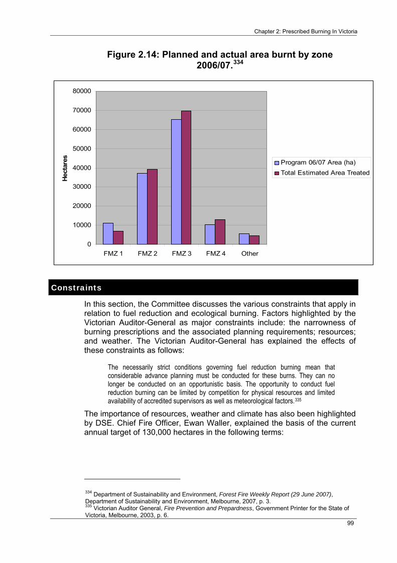
Chapter 2: Prescribed Burning In Victoria
99
Figure 2.14: Planned and actual area burnt by zone 2006/07.334
0
10000
20000
30000
40000
50000
60000
70000
80000
FMZ 1 FMZ 2 FMZ 3 FMZ 4 Other
Hec
tare
s
Program 06/07 Area (ha)Total Estimated Area Treated
Constraints
In this section, the Committee discusses the various constraints that apply in relation to fuel reduction and ecological burning. Factors highlighted by the Victorian Auditor-General as major constraints include: the narrowness of burning prescriptions and the associated planning requirements; resources; and weather. The Victorian Auditor-General has explained the effects of these constraints as follows:
The necessarily strict conditions governing fuel reduction burning mean that considerable advance planning must be conducted for these burns. They can no longer be conducted on an opportunistic basis. The opportunity to conduct fuel reduction burning can be limited by competition for physical resources and limited availability of accredited supervisors as well as meteorological factors.335
The importance of resources, weather and climate has also been highlighted by DSE. Chief Fire Officer, Ewan Waller, explained the basis of the current annual target of 130,000 hectares in the following terms:
334 Department of Sustainability and Environment, Forest Fire Weekly Report (29 June 2007), Department of Sustainability and Environment, Melbourne, 2007, p. 3. 335 Victorian Auditor General, Fire Prevention and Prepardness, Government Printer for the State of Victoria, Melbourne, 2003, p. 6.

Inquiry into the Impact of Public Land Management Practices on Bushfires in Victoria
100
…my understanding was it was worked out through the resourcing we had and what that could achieve. And looking back over the history of the windows of opportunity you get — the number of burning days in this those burning periods — that was the basis.336
Weather and climate The majority of DSE’s prescribed burning is conducted during Autumn rather than the relatively more risky seasons of Summer and Spring. In general, Winters are too cold and wet to allow prescribed burning. The number of suitable days available for fuel reduction and ecological burning is further restricted by variations in weather, with particularly wet Autumns a major reason for those years in which the treated area targets have not been met. DSE has recently reviewed the possibility of increasing the level of burning conducted during Spring and the Committee understands that there has been some increase in the level of burning conducted at this time of the year.337 DSE informed the Committee, however, that a significant increase in the Spring burning program may not be feasible and that it is currently exploring the opportunities for an increased level of burning during Winter.338
In addition to the season, a range of other factors, such as temperature, wind, fuel moisture and other “prescribed conditions”, also affect the number of days suitable for prescribed burning. A study of weather conditions over a seven year period in the Wombat State forest found an average of just under 11 days each year as suitable for prescribed burning.339 Suitable days varied between four days in 1995 to 20 days in 1999.340 A similar study near Omeo found an average of ten days per year, with a range of one to 22 days in each year, as suitable for prescribed burning.341 Similar results have been found for Melbourne and locations in the North East.342 In other words, the number of suitable days for prescribed burning each year is broadly consistent across the state.343
It is important to note, however, that the suitable days in any given year will vary from one region to another, such that there may be many more days suitable for prescribed burning statewide than at any particular location.344 DSE’s capacity to increase the extent of prescribed burning may therefore
336 E. Waller, Chief Officer, Fire and Emergency Management, Department of Sustainability and Environment, Transcript of evidence, Halls Gap, 3 July 2007. 337 See for example: Department of Sustainability and Environment, Burning in Spring: Study Tour November 2005 Report, Department of Sustainability and Environment, Melbourne, 2005. 338 E. Waller, Chief Fire Officer, Department of Sustainability and Environment, Transcript of evidence, Melbourne, 7 April 2008. 339 Dr. K. Tolhurst, 'Prescribed Burning in Victoria: Policy and Practice', Paper presented at the Bushfire Prevention: Are We Doing Enough? Conference, Institute of Public Affairs, 2003, pp. 4-6. 340 Dr. K. Tolhurst, 'Prescribed Burning in Victoria: Policy and Practice', Paper presented at the Bushfire Prevention: Are We Doing Enough? Conference, Institute of Public Affairs, 2003, p. 6. 341 B. Esplin, M. Gill and N. Enright, Report of the Inquiry into the 2002-03 Victorian Bushfires, Department of Premier and Cabinet, Melbourne, 2003, pp. 105-106. 342 B. Esplin, M. Gill and N. Enright, Report of the Inquiry into the 2002-03 Victorian Bushfires, Department of Premier and Cabinet, Melbourne, 2003, p. 106. 343 Dr. K. Tolhurst, 'Prescribed Burning in Victoria: Policy and Practice', Paper presented at the Bushfire Prevention: Are We Doing Enough? Conference, Institute of Public Affairs, 2003, p. 6. 344 Dr. K. Tolhurst, 'Prescribed Burning in Victoria: Policy and Practice', Paper presented at the Bushfire Prevention: Are We Doing Enough? Conference, Institute of Public Affairs, 2003, p. 7.

Chapter 2: Prescribed Burning In Victoria
101
be enhanced by increasing the mobility its operational resources for prescribed burning. It has also previously been noted that the number of suitable prescribed burning days could be increased by encouraging the conduct of burns during weekends and evenings.345
Funding and personnel
Introduction Inadequate resource allocation, particularly of personnel, was cited by a number of stakeholders as a constraint on the level of fuel reduction and ecological burning. A related argument, made by a number of stakeholders, was that there has been a loss, from DSE in particular, of the knowledge required to maintain an adequate broad-scale prescribed burning program. These stakeholders cited the decline in forestry, and the related loss of DSE employees with forestry experience, as a reason for the reduced extent of prescribed burning in recent years.
Funding The level of staff and other resources available for fuel reduction and ecological burning is largely dependent on an allocation of funding from DSE’s annual budget.
DSE is required to record its annual expenditure on prescribed burning under the Code of Practice,346 a requirement which also existed under the 1995 Code of Practice.347 However, DSE was unable to provide the Committee with details of its current or past annual expenditure on prescribed burning. DSE advised that it was unable to provide such expenditure figures because it does not yet have the Information Technology and Human Resources systems capable of distinguishing expenditure on prescribed burning from other expenditure.348
Prescribed burning expenditure reporting has been an issue for some time and has been discussed in two reports by the Auditor-General in 1992 and 2003.
In 1992 the Auditor-General made the following comments in relation to the then Department of Conservation and Environment’s funding of “fire prevention” (which at that time was defined as including both prescribed burning and other preventative activities, such as the preparation of long-term and short-term strategic plans):349
345 Dr. K. Tolhurst, 'Prescribed Burning in Victoria: Policy and Practice', Paper presented at the Bushfire Prevention: Are We Doing Enough? Conference, Institute of Public Affairs, 2003, p. 7. 346 Department of Sustainability and Environment, Code of Practice for Fire Management on Public Land, Department of Sustainability and Environment, Melbourne, 2006, p. 43. 347 Department of Natural Resources and Environment, Code of Practice for Fire Management on Public Land, Department of Conservation and Natural Resource, Melbourne, 1995, p. 14. 348 Department of Sustainability and Environment, personal communication, 29 February 2008. 349 Victorian Auditor General, Special Report No. 16: Fire Protection, Victorian Auditor General, Melbourne, 1992, pp. 15,17,18.

Inquiry into the Impact of Public Land Management Practices on Bushfires in Victoria
102
The allocation of funds for fire prevention in the State's protected areas is not presented for parliamentary sanction within the annual Appropriation Act as a separate line item. Funding for fire prevention is provided from various funding sources across the Department's Land Resource Management program. Consequently, the Parliament and the taxpaying public are not informed of the amount of funds earmarked each year through the budget process for fire prevention.350
The Auditor-General went on to make the following findings in relation to funding for fire prevention:
Audit is of the opinion that fire prevention is far too important an issue for funding decisions to be determined by annual budget negotiations or to be influenced by priorities placed on other activities, whether by government or the Department, in particular budget periods. The overall significance of fire prevention is such that the funds provided for fire prevention activities should be clearly identified in the Department's annual appropriation for the perusal of the Parliament and, subsequently, the public.351
In 2003 the Auditor-General considered the specific issue of DSE’s funding of fuel reduction burning from within its annual budget allocation. The Auditor-General found that there was a lack of transparency in this area, noting that DSE’s fuel reduction burning was “not fully costed internally”. As the Committee has noted above, this remains the case today. Another reason noted by the Auditor-General for the lack of transparency was the practice of borrowing staff from other business units to conduct burns.352
The Auditor-General found that “operational managers setting targets for fuel reduction each year do not have certainty that the resources will be available to achieve targets”.353 To address this lack of transparency and certainty, the Auditor-General recommended that:
DSE fully cost its fuel reduction burning activities within its internal budgeting process;
allocate appropriate funding levels; and
allocate the cost of staff employed from other business units.354
Although the Committee was not able to determine the current level of funding for prescribed burning, the Auditor-General found that the former Department of Natural Resources and Environment (DNRE) (DSE’s predecessor) allocated around $2 million towards a fuel reduction burning
350 Victorian Auditor General, Special Report No. 16: Fire Protection, Victorian Auditor General, Melbourne, 1992, p. 20. 351 Victorian Auditor General, Special Report No. 16: Fire Protection, Victorian Auditor General, Melbourne, 1992, p. 21. 352 Auditor General Victoria, Fire Prevention and Preparedness, Auditor General Victoria, Melbourne, 2003, p. 6. 353 Auditor General Victoria, Fire Prevention and Preparedness, Auditor General Victoria, Melbourne, 2003, p. 6. 354 Auditor General Victoria, Fire Prevention and Preparedness, Auditor General Victoria, Melbourne, 2003, p. 7.

Chapter 2: Prescribed Burning In Victoria
103
target of 100,000 hectares in 2001-02, representing approximately four per cent of DNRE’s fire management budget for that period.355
The Auditor-General noted, however, that this figure did not reflect the total expenditure on fuel reduction burning because the salaries of DSE staff from other business units who assisted with this work were charged against their normal duties to their respective business units.356 However, the Committee also notes that the figure of four per cent was apparently based on the combined cost of fuel reduction burning and fire suppression activities in 2001-02 ($48.5 million) and did not include other activities within DNRE’s then “fire prevention and planning environment” program – such as the completion of District Fire Operations Plans and accreditation of personnel – which were then separately costed (at $16 million).357 If these activities are included as part of the combined total expenditure on fire management for 2001-02 (as they have been in more recent years),358 the proportion of the budget allocated to fuel reduction burning for that year is closer to three per cent.
Mr John Cribbes, Honorary Secretary, Macalister Four-wheel Drive Club, illustrated the apparently disproportionate levels of funding for bushfire prevention and suppression in the following terms:
The fact that it is costing the taxpayers of Victoria millions of dollars to hire Elvis and bring it across the Pacific Ocean does not seem to be unattractive to some people. But the fact of the matter is there is no need for that attitude of fighting fire. You reduce the risk by working at the fire for 12 months of the year, not just 3 months in Summer.359
The Committee also notes that the total cost of fighting the 2002-03 bushfires, at approximately $2 million a day, was apparently greater than the annual expenditure on prescribed burning by several orders of magnitude.360
The Committee was unable to determine whether DSE’s current annual expenditure on fuel reduction / ecological burning remains in the order of around three to four per cent of DSE’s total expenditure on fire management. The Committee notes, however, that although the current target for fuel reduction burning has increased by around one third, to 130,000 hectares, the increase in DSE’s total expenditure on fire
355 Auditor General Victoria, Fire Prevention and Preparedness, Auditor General Victoria, Melbourne, 2003, p. 55. 356 Auditor General Victoria, Fire Prevention and Preparedness, Auditor General Victoria, Melbourne, 2003, p. 55. 357 Department of Sustainability and Environment, Annual Report 2003-04, Department of Sustainability and Environment, Melbourne, 2004, pp. 130-131. 358 Department of Sustainability and Environment, Annual Report 2006-07, Department of Sustainability and Environment, Melbourne, 2007.; 359 J. Cribbes, Honorary Secretary, Macalister 4WD Club, Transcript of evidence, Traralgon, 2 August 2007. 360 K. Simpson, 'Fires: State's $60m bill', viewed 21 April 2008, <http://www.theage.com.au/articles/2003/02/22/1045638541768.html>.

Inquiry into the Impact of Public Land Management Practices on Bushfires in Victoria
104
management has been significantly greater – total budgeted expenditure on fire management in 2006/07 was around $288.9 million.361
The Committee notes that DSE’s annual budget allocation for fuel reduction/ecological burning may vary from year to year according to the relative proportions of the total area that is burnt within each Fire Management Zone. As noted above, the Code of Practice defines four Fire Management Zones (although at the time of writing, fuel reduction and ecological burning continued to be conducted according to the five Fuel Management Zones under the 1995 Code). As has also been noted above, an important measure on which Fuel Management Zones vary is the intensity of fuel management required within the zone. For example, a burn located in Zone 1 would typically be designed to reduce the overall fuel hazard to or below the level of “moderate” across perhaps 90 per cent of the burn, while a burn in Zone 2 would typically be designed to reduce the overall fuel hazard to or below the level of “high” across perhaps 80 per cent of the burn. Accordingly, the financial cost of fuel reduction / ecological burning varies for each zone. This variation, and its potential impact on DSE’s total annual expenditure on prescribed burning, is illustrated in Table 2.7 below.
Table 2.7: Estimate of the cost of fuel reduction and ecological burning 2006/07.
Fuel Management Zone and burning cost per hectare362
Total Estimated Area Treated363
Estimated Cost of Treatment
Zone 1: $50–500 6,954 $ 342,700 - $ 3,477,000 Zone 2: $30–300 39,317 $ 1,179,510 - $ 11,795,100 Zone 3: <$10–50 69,801 < $ 690,801 - $ 3,490,050 Zone 4: $30–300 12,747 $ 382,410 - $ 3,824,100 Zone 5: n.a. – exclusion Total 128,819 < $ 2,252,721 - $ 19,112,727
Notes: 1. The grand total for the total estimated area treated excludes 4,515 ha which was categorised as “other”. This total is also based on the slightly lower state total reported in the Forest Fire Awareness Report for 2006/07, as opposed to the corrected total published in DSE’s 2006/07 Annual Report.
2. The cost per hectare for each of zone is based on data provided to the Auditor-General in 2003 and may have changed.
361 Department of Sustainability and Environment, Annual Report 2006-07, Department of Sustainability and Environment, Melbourne, 2007, p. 83. 362 B. Esplin, M. Gill and N. Enright, Report of the Inquiry into the 2002-03 Victorian Bushfires, Department of Premier and Cabinet, Melbourne, 2003, p. 96. 363 Department of Sustainability and Environment, Submission, no. 168D, 9 January 2008, Attachment 2.

Chapter 2: Prescribed Burning In Victoria
105
Recommendation 2.5:
That the Department of Sustainability and Environment, Department of Primary Industries, Parks Victoria & VicForests separately cost, and report, annual expenditure on fuel reduction burning, ecological burning and regeneration burning in their Annual Reports.
The Committee was unable to obtain any data on the cost-effectiveness of fuel reduction burning, primarily because there do not appear to have been any cost-benefit studies of fuel reduction burning conducted in Australia.364 The Auditor-General has also previously referred to the need for a full cost-benefit analysis to be conducted in relation to prescribed burning:
…any consideration of ways to improve fuel reduction burning levels needs to be accompanied by rigorous risk and cost-benefit analysis. The existing prescriptions, which are essential for the safe conduct of fuel reduction burning, mean that the activity will remain costly, and fully meeting current targets would require a significantly increased outlay. The DSE’s understanding of the relationship between the level of fuel reduction burning and overall wildfire risk is currently limited. Analysing different outlay options, in order to see which gives the best overall reduction in risk, is a complex modelling task. Considerable work needs to be done in this area.365
The Committee agrees with the Auditor-General that there is a need for a full cost-benefit analysis of the prescribed burning program. Such a study would be of particular value in ensuring that future increases in prescribed burning, as recommended by the Committee and foreshadowed by DSE, are implemented in a way that maximises the overall reduction in risk across the State.
A further benefit of such a study would be to demonstrate the reduced costs of fire suppression which flow from increased prescribed burning. Notably, fire suppression activities during 2006/07 necessitated additional funding to DSE, by way of a Treasurer’s Advance, of around $170 million.366 As the Secretary of DSE noted during the Inquiry’s final public hearing, prescribed burning has the potential to significantly lessen budgetary impacts of this nature and magnitude.367
A further recommendation of the Auditor-General’s 2003 report concerned the need for greater flexibility in the funding of fuel reduction burning. The Auditor-General recommended that DSE:
364 Department of Sustainability and Environment, personal communication, 29 February 2008. 365 Auditor General Victoria, Fire Prevention and Preparedness, Auditor General Victoria, Melbourne, 2003, p. 7. 366 P. Harris, Secretary, Department of Sustainability and Environment, Transcript of evidence, Melbourne, 7 April 2008.;Department of Sustainability and Environment, Annual Report 2006-07, Department of Sustainability and Environment, Melbourne, 2007, p. 87. 367 P. Harris, Secretary, Department of Sustainability and Environment, Transcript of evidence, Melbourne, 7 April 2008.

Inquiry into the Impact of Public Land Management Practices on Bushfires in Victoria
106
in consultation with the Department of Treasury and Finance, considers revised funding arrangements that introduce greater flexibility to allow for differing levels of funding to reflect factors such as seasonal variations368
One suggestion made to the Committee as to how this might be achieved was to establish a “prescribed burning trust fund” so that money not spent on prescribed burning in a given year could be carried over for expenditure on prescribed burning in later years, perhaps for a period of up to five years.369 DSE responded to this suggestion by noting that funding is not a major constraint in relation to the conduct of its prescribed burning program.370 While the Committee notes that this may be the case, it also notes that this may be difficult to demonstrate in the absence of reported data on DSE’s annual expenditure on prescribed burning. On balance, the Committee therefore considers that the suggestion of a “prescribed burning trust fund” has merit and should be implemented.
Recommendation 2.6:
That the Victorian Government establish a five year rolling fund which allows unused prescribed burning monies to be rolled over into future financial years for the purpose of subsequent prescribed burning activities.
Personnel A number of stakeholders were critical of the current staffing policies of DSE and its partner agencies, in relation to fire prevention and suppression in general, and to prescribed burning in particular. Areas of concern raised by stakeholders included insufficient staffing levels, the decline in permanent staff, staff turnover, the skills mix of personnel, and the need for more effective succession planning.
A range of stakeholders expressed the view that Victoria has experienced a significant decline in the number of locally based fire management staff.371 Stakeholders also noted that there had been a reduction in permanent staff and a shift towards employing officers primarily for the Summer fire season, who were subsequently unavailable for the prescribed burning program.372 A further disadvantage noted in relation to such seasonally-based employment was the difficulties experienced by staff in becoming part of local communities.373 Under-resourcing of operational regional staff within Parks Victoria was also noted as a particular problem.374
368 Auditor General Victoria, Fire Prevention and Preparedness, Auditor General Victoria, Melbourne, 2003, p. 7. 369 Dr. K. Tolhurst, Submission, no. 137B, 9 October 2007, p. 7. 370 P. Harris, Secretary, Department of Sustainability and Environment, Transcript of evidence, Melbourne, 7 April 2008. 371 See for example: The Bushfire Front, Submission, no. 121, 25 May 2007, p. 7; Community and Public Sector Union, Submission, no. 97, 24 May 2007, pp. 1,9; L. Lasham, Submission, no. 183, 31 May 2007, p. 5; Australian Workers Union Victorian Branch, Submission, no. 10, 24 April 2007, p. 2. 372 See for example, The Bushfire Front, Submission, no. 121, 25 May 2007, p. 7. 373 The Bushfire Front, Submission, no. 121, 25 May 2007, p. 7. 374 Community and Public Sector Union, Submission, no. 97, 24 May 2007, pp. 5,12.

Chapter 2: Prescribed Burning In Victoria
107
The Community and Public Sector Union (CPSU) expressed its members’ concerns regarding fire management staffing levels within DSE, DPI, Parks Victoria and VicForests as follows:
There is an overwhelming belief amongst union membership that government resourcing is inadequate and a major hindrance in the ability to deliver adequate, effective and safe fire management practices within Victoria. This concern also extends in every instance to the government’s ability to deliver adequate public land management throughout Victoria.375
CPSU also reported that its members were concerned that prescribed burning targets may not be realistic given current staffing levels.376 CPSU identified DSE’s “model of cover” as contributing to the problem of seasonally-based staff shortages for prescribed burning. The model of cover is a series of memorandums of understanding and service agreements with DPI, Parks Victoria and VicForests, which is used to determine staffing levels for fire suppression. In addition to noting that the model of cover had been “overwhelmingly criticised” by members for failing to provide sufficient fire suppression personnel, CPSU reported concerns about the lack of a similar inter-agency model for staffing the prescribed burning program throughout the year.377 CPSU recommended both an increase in the level of permanent staff and the development of a model of cover which would provide for fire management across 365 days of each year.378
A related problem is that of staff turnover. Mr Ritchie, Regional Director North East, DSE, referred to the role of an adequate prescribed burning program in preventing the loss of skilled staff:
It was a problem for us a few years ago. I remember 10 years ago we had a long spell with not many fires, and we lost a lot of skilled people. People lost the enthusiasm, the interest and the expertise because of the lack of experience. So the burning program is important.379
A range of stakeholders expressed concerns regarding the typical mix of skills held by fire management staff within DSE and its partner agencies. The loss of practical experience and knowledge associated with the decline in forestry was cited by a number of stakeholders.380
East Gippsland Wildfire Taskforce (EGWT), in common with a number of stakeholders, argued that effective management of the bush requires people with practical forestry and bush skills and sufficient familiarity with a local area.381 EGWT argued that people with such skills are able to deal with the inevitable variations in fuel loads, moisture and related factors and are
375 Community and Public Sector Union, Submission, no. 97, 24 May 2007, p. 5. 376 Community and Public Sector Union, Submission, no. 97, 24 May 2007, p. 12. 377 Community and Public Sector Union, Submission, no. 97, 24 May 2007, pp. 9-10. 378 Community and Public Sector Union, Submission, no. 97, 24 May 2007, p. 10. 379 K. Ritchie, Regional Director North East, Department of Sustainability and Environment, Transcript of evidence, Mount Beauty, 28 November 2007. 380 See for example: The Bushfire Front, Submission, no. 121, 25 May 2007, p. 7.; Plantations North East, Submission, no. 243, 18 September 2007, p. 2. 381 East Gippsland Wildfire Taskforce, Submission, no. 63, 18 May 2007, p. 2.

Inquiry into the Impact of Public Land Management Practices on Bushfires in Victoria
108
therefore best able to make the necessary “on the spot” decisions regarding fuel reduction burning.382
The decline in bush skills was also illustrated by Mr Alan Ashworth, an owner and operator of an earth-moving business in the North East, who referred to the lack of experience in the use of earth-moving machinery within DSE and its partner agencies.383 The Committee notes that this is an issue of particular concern given the specialist skills required to operate such machinery in the steep and timbered terrain where bushfire prevention and suppression activities are often conducted. Mr Ashworth noted that while younger staff were now generally university educated, they lacked experience in the operation of such machinery and the practical experience required to work safely and effectively in the bush.384
The significance of this problem for prescribed burning and fire suppression was confirmed by Mr Ritchie, Regional Director North East:
…getting a good bulldozer driver who knows the bush and can work the bush is a challenge and will be a challenge in the future, because a high proportion of our bulldozer drivers have come up through the long held Forests Commission process and have had a lot of experience.385
Mr Chris Rose, Manager East, Parks Victoria, advised the Committee that the need for personnel with practical skills had been recognised by Parks Victoria and outlined recent developments in this area:
I think there is a need to have a balance. You want some old hard heads who have grown up in the bush and have lived in the bush, and you want some people with different skills. If you have got a mix, then you have probably got it right. We recognise this very much, and the last thing we want are university graduates with no practical experience. We have actually signed a partnership with several universities to provide students with field experience working beside…some of the people that you have met today to ensure that when they do start work with us in the future they have actually got some practical experience as well as the theoretical knowledge. We recognise that and are working on it.386
Dr Kevin Tolhurst also argued for an improvement in the skill mix of public land fire management staff. Dr Tolhurst noted that during the previous 20 years public agencies had tended to recruit generalist staff with generalist tertiary qualifications and that there was a need for more fire behaviour and related specialists:
Maintaining viable fire regimes in the landscape requires the combination of a high level of scientific understanding, good communication skills, and good “bush” skills… DSE is strong on the bureaucratic “process” side, but very weak on the technical / science side. There is a dire need to demand University graduates be well educated in the science behind land management. DSE must then recruit people who are
382 East Gippsland Wildfire Taskforce, Submission, no. 63, 18 May 2007, p. 2. 383 A. Ashworth, Transcript of evidence, Mansfield, 26 November 2007. 384 A. Ashworth, Transcript of evidence, Mansfield, 26 November 2007. 385 K. Ritchie, Regional Director North East, Department of Sustainability and Environment, Transcript of evidence, Mount Beauty, 28 November 2007. 386 C. Rose, Manager East, Parks Victoria, Transcript of evidence, Mount Beauty, 28 November 2007.

Chapter 2: Prescribed Burning In Victoria
109
highly skilled, not just equipped with some generalist science, resource management or environmental science degree…what we need is Forest Scientists, Landscape Ecologists or Conservation Biologists.387
A range of stakeholders expressed concerns regarding the ageing workforce available for prescribed burning and other fire management activities. These stakeholders emphasised the need for more effective succession planning. The Australian Workers Union (AWU) informed the Committee that the average age of its fire management members is approaching 49 years.388
DSE acknowledged the challenges posed by succession planning. Mr Ritchie, Regional Director North East, DSE, outlined the issue in the following terms:
We do have an active process both within this region and across the state looking at succession planning at the moment, particularly at field crew level, where we are trying to make sure that we recruit people to work in the field and, as far as possible, retain their services over a lengthy period of time. People do not stick around as long as they used to, and that is one of the challenges. A lot of our crew succession comes through the Summer firefighters. They provide a good resource. We get a lot of returnees year after year; we have put some of them onto three year contracts to try to encourage them to remain. Often they provide the core of both the next generation of field crew and some of the professional staff as well, because a lot of them come with different backgrounds. It is a real problem; it does not solve the succession problem well or completely by any means. Getting people who know and understand the bush and who are be able to lead crews and to make decisions in the field, to work in it for a long period is one of our big challenges, particularly at that crew leader level.389
Conclusion The Committee was unable to determine the total number of operational staff available for prescribed burning in recent years. However, DSE informed the Committee that there had been an increase in operational and support staff of more than ten per cent between 2002 and 2007. Under the current arrangements between DSE, VicForests, Parks Victoria, and Melbourne Water, around 2,500 fire accredited personnel (and a further 1,000 coordination and support personnel) are available each fire season.390 DSE also informed the Committee that changes to the Project Fire Fighter (PFF) Program, to allow the recruitment of personnel on three year contracts (for the period October to May each year), had boosted the number of operational personnel available for prescribed burning. DSE advised the Committee that under the PFF Program, between 400 and 600 additional personnel were available for the 2006/07 prescribed burning program.391
387 Dr. K. Tolhurst, Submission, no. 137, 28 May 2007, p. 2. 388 Australian Workers Union Victorian Branch, Submission, no. 10, 24 April 2007, p. 2. 389 K. Ritchie, Regional Director North East, Department of Sustainability and Environment, Transcript of evidence, Mount Beauty, 28 November 2007. 390 Victorian Government, Submission, no. 168, 4 June 2007, p. 5. 391 Victorian Government, Submission, no. 168, 4 June 2007, pp. 2-3.

Inquiry into the Impact of Public Land Management Practices on Bushfires in Victoria
110
The Committee considers that the recent increase in the number of DSE personnel is likely to have made a significant contribution to meeting the statewide prescribed burning target for 2006/07. However, the Committee also agrees with the view expressed by a range of stakeholders that the level of permanent, or long-tenured, locally based staff within DSE, DPI, Parks Victoria and VicForests should be further increased to ensure an adequate level of prescribed burning, particularly during years when weather conditions are unfavourable. The need for an additional increase in the level of such staff is further emphasised by the increased annual prescribed burning target that has been recommended by the Committee. Moreover, the Committee agrees that further initiatives are required to address the problems of staff turnover, the current skills mix of personnel, and the problem of an ageing workforce through more effective succession planning.
Recommendation 2.7:
That the Victorian Government provide recurring funding for a significant increase in regionally-based, permanent, or long-tenured, fire management personnel dedicated to the prescribed burning program. The increase in personnel should be consistent with the level required to achieve an annual prescribed burning target of 385,000 hectares.
The pool of available personnel should be suitably diverse and possess a wide variety of disciplines and skill sets, including practical skills. The Department of Sustainability and Environment and its partner agencies should also increase the proportion of personnel with specialist tertiary qualifications, including fire behaviour specialists, forest scientists, landscape ecologists and conservation biologists.
DSE and its partner agencies should also prioritise the development of programs to reduce the level of staff turnover and the problem of the ageing workforce, through more effective succession planning.
The risk of escaped burns The practice of prescribed burning carries with it the risk that a particular burn may escape beyond its planned boundaries. Although this happens in a relatively small number of burns, the consequences can be financially and environmentally significant. However, the consequences of an overly risk averse approach to prescribed burning are likely to be significantly more serious in the long term. Government and community support for an appropriate level of risk is therefore of crucial importance to the success of the prescribed burning program.
Perhaps the best known prescribed burn escape in recent years was the one which occurred in the Wilsons Promontory National Park in March 2005. The escape resulted from a planned burn of 20 hectares at Tidal River, which was ignited by Parks Victoria under DSE’s prescribed burning program. Fire escaped from the area of the planned burn in subsequent days and formed a bushfire which burnt more than 6,000 hectares of the National Park and threatened Tidal River Village. More than $2m was spent on suppressing the fire, which significantly disrupted the Park over a period

Chapter 2: Prescribed Burning In Victoria
111
of weeks and led to the evacuation of around 600 campers. The fire also had a significant impact on tourist activity.392
In 2005 the Office of the Emergency Services Commissioner (OESC) completed a review of the Wilsons Promontory escaped burn and of burn escapes and practices since 2002.
The OESC found the number of burn escapes to be less than two per cent in total.393 Of 2,151 burns undertaken between 1 January and Winter 2005, 48 burns escaped the planned burn area and 12 of these were classified as “significant escapes”. The OESC found that there were common factors across the state which had contributed to burn escapes, and that these included a failure to follow accepted practice or documented policies and procedures – both in the planning and implementation stage of the burn.394 The OESC also found that the majority of burns escaped in the days following ignition during the “control phase” of the burn.395
The OESC found that DSE and its partner agencies had already commenced a number of measures to improve the safety and delivery of the prescribed burning program. These included the appointment of regional fire prevention coordinators, improving the regional burn approvals process, establishing a risk management project and the development of upgraded FireWeb mapping tools.396
The OESC also found that DSE personnel involved in prescribed burning are recognised as highly trained and experienced experts but face pressure to meet targets. Some DSE staff considered that there was a lack of organisation support and noted fatigue management as a further problem. The report also found that personnel and resources at the time of year when prescribed burning is conducted were either not available or at a minimum.397 The OESC concluded that some burn escapes are “inevitable” and that fire management personnel had experienced fire behaviour, due to the current drought, which had not been encountered previously.398
A number of stakeholders told the Committee that the risk of escaped burns had led to the development of a “risk-averse” culture within DSE and its partner agencies. The threat of litigation was also identified as a potential
392 Emergency Services Commissioner, Examination of Prescribed Burning Practices, Office of the Emergency Services Commissioner, Melbourne, 2005, p. 12. 393 Emergency Services Commissioner, Examination of Prescribed Burning Practices, Office of the Emergency Services Commissioner, Melbourne, 2005, p. 3. 394 Emergency Services Commissioner, Examination of Prescribed Burning Practices, Office of the Emergency Services Commissioner, Melbourne, 2005, p. 4. 395 Emergency Services Commissioner, Examination of Prescribed Burning Practices, Office of the Emergency Services Commissioner, Melbourne, 2005, p. 4. 396 Emergency Services Commissioner, Examination of Prescribed Burning Practices, Office of the Emergency Services Commissioner, Melbourne, 2005, pp. 7-8. 397 Emergency Services Commissioner, Examination of Prescribed Burning Practices, Office of the Emergency Services Commissioner, Melbourne, 2005, pp. 5-6. 398 Emergency Services Commissioner, Examination of Prescribed Burning Practices, Office of the Emergency Services Commissioner, Melbourne, 2005, p. 8.

Inquiry into the Impact of Public Land Management Practices on Bushfires in Victoria
112
constraint on prescribed burning in the Esplin Report.399 The Committee considers, however, that an awareness by personnel of the potential for litigation arising from escaped prescribed burns does not necessarily amount to a “risk-averse” culture. Moreover, DSE’s achievement of higher prescribed burning levels in recent years suggests that risk aversion is currently not a significant constraint on this activity.
Smoke The smoke released from prescribed burning, like the smoke caused by bushfires, can have a range of negative impacts on individuals and communities, including “adverse effects on people’s respiratory health, aesthetics, tourism and business”.400
Ms Marion Edwards’ submission highlighted her experiences of the health impacts of smoke from prescribed burning as follows:
The extent of prescribed burning seems too be too hot, too large and too often The smoke haze is extremely thick and we, the community, are suffering health issues with this constant problem.401
Ms Caroline Doolan expressed a similar sentiment, asserting that:
There have been days in this area with all of the prescribed burning where the smoke was worse than what we experienced during the recent bushfires. The windows of our house all had to be kept closed to keep the smoke out. It gets into the back of the throat and makes it sore and we don’t have asthma or bronchial conditions.402
Other stakeholders raised concerns about the scheduling of prescribed burns during peak tourism times. Mansfield Shire expressed the problem as follows:
Fuel reduction burns appear to be inadequate, under resourced and more importantly to Mansfield Shire, inappropriately timed. Mansfield Shire experiences its highest visitation periods during school holidays, long weekends and public holidays. These peak periods have on occasions coincided with the times when DSE and parks Victoria have been undertaking prescribed burns.403
Murrindini Shire expressed similar concerns:
As a matter of principle, council fully supports the ongoing provision of cool weather burns – if conditions allow. Whilst it is acknowledged that there is a narrow window of opportunity to meet the criteria to conduct successful management burns, there is an impact on the municipalities such as Murrindindi Shire that has a large component of public forest and relies on tourism visitation. Wherever possible, the burn strategies
399 B. Esplin, M. Gill and N. Enright, Report of the Inquiry into the 2002-03 Victorian Bushfires, Department of Premier and Cabinet, Melbourne, 2003, p. 95. 400 B. Esplin, M. Gill and N. Enright, Report of the Inquiry into the 2002-03 Victorian Bushfires, Department of Premier and Cabinet, Melbourne, 2003, p. 94. 401 M. Edwards, Submission, no. 82, 23 May 2007, p. 1. 402 C. Doolan, Submission, no. 74, 23 May 2007, p. 1. 403 Mansfield Shire Council, Submission, no. 123, 25 May 2007, p. 1.

Chapter 2: Prescribed Burning In Victoria
113
need to be managed in a way that meets the needs of both forestry and tourism issues.404
The importance of improved communication by agencies regarding the timing and location of prescribed burning was also raised by a number of stakeholders. Wellington Shire Council expressed the importance of such communication to the maintenance of community support for prescribed burning operations as follows:
Local communities are not concerned to see smoke in their area if they area aware that it is from a controlled burn as they know that the aim is to create a safer situation for the future. Having said that, communication to the public and nearby landholders is very important when burns are occurring and Council would like to see better communication by fire authorities when this happens.405
The timing and communication of prescribed burning was raised as a particularly important issue by wine industry stakeholders. The effect of “smoke taint” on growing grapes can render the harvested fruit unusable for the production of wine. The Victorian Wine Industry Association of Victoria advised the Committee that the combined effect of the Victorian bushfires since 2003 had been an estimated loss of $70 million in wine sales due to smoke taint.406 During the Inquiry, the Committee visited the King Valley vineyard region, which was particularly adversely affected by smoke taint during the recent bushfires. During the visit, the Committee was informed that research was being conducted to determine how future prescribed burns may be timed to coincide with periods when grapes may be less vulnerable to smoke taint.
There are a range of factors which have the potential to alter the impacts of smoke from prescribed burning, including: wind direction; weather on subsequent days; fuel moisture; and the time of day that a fire is ignited.407 DSE is also required to determine and periodically review, in consultation with the EPA, guidelines on smoke management issues associated with its prescribed burning operations.408 The Guidelines are required to account for current knowledge of air movements and smoke dispersal.409 The Committee also notes that research into the management of smoke from prescribed burning operations is the subject of two current research programs by the Bushfire CRC:
B2.1: Behaviour of smoke plumes and hazes from rural or urban fires; and
404 Murrindindi Shire Council, Submission, no. 142, 28 May 2007, p. 1. 405 Wellington Shire Council, Submission, no. 79, 23 May 2007, p. 2. 406 Wines of Victoria, Submission, no. 213, 13 June 2007, p. 3. 407 Dr. K. Tolhurst and N. P. Cheney, Synopsis of the Knowledge Used in Prescribed Burning in Victoria, Department of Natural Resources and Environment, Melbourne, 1999, pp. 27-28. 408 Department of Sustainability and Environment, Code of Practice for Fire Management on Public Land, Department of Sustainability and Environment, Melbourne, 2006, p. 18. 409 Department of Sustainability and Environment, Code of Practice for Fire Management on Public Land, Department of Sustainability and Environment, Melbourne, 2006, p. 18.

Inquiry into the Impact of Public Land Management Practices on Bushfires in Victoria
114
B2.2 Smoke composition from prescribed and wildfires and health.410
The Committee also recognises that the media plays a role in influencing public perceptions and attitudes towards prescribed burning. Unfortunately, in relation to smoke from prescribed burning, the media is often critical of the Government’s management of the prescribed burning program. The following editorial opinion piece from the Herald Sun provides such an example:
Choking smoke over Melbourne is ruining some of the best days of Autumn and all because the Department of Sustainability and Environment is doing a year's burning off in a week. Victorians need to feel safe from bushfires that have caused some of the state's greatest catastrophes. But people coughing and spluttering as the smoke drifts over the city are asking why the burnoff cannot be done in stages. Better management is needed. The department responsible for the burnoffs has failed to show concern for people who have no choice but to suffer the smoke. They have also failed to consider those people suffering from respiratory problems who have had to shut themselves indoors.411
Given that the level of prescribed burning is likely to significantly increase in future years, the Committee believes that greater public acceptance of the impacts of prescribed burning will be in some part dependent upon fostering improved relationships with the media. As such, the Committee believes that DSE and its partner agencies should make concerted efforts to increase the media’s understanding of the importance of prescribed burning. This issue is discussed in greater detail in Chapter 6.
In conclusion, the Committee appreciates that prescribed burns will inevitably have immediate negative impacts upon local communities. However, the windows of opportunity to conduct prescribed burns are already narrow, and may become narrower as a result of climate change. When compared to the environmental, economic and social impacts that result from large bushfires, the Committee considers that communities are likely to become increasingly accepting of prescribed burns. However, as will be discussed in Chapter 6, the Committee also considers that there is further scope for DSE to increase community involvement in prescribed burning programs to maximise opportunities to alleviate the impacts due to smoke.
Forestry and regeneration burning Timber harvesting on public land, and the subsequent regeneration burning of harvested coupes, also has the potential to affect DSE’s fuel reduction and ecological burning programs. The revised Code of Practice notes the following benefits of regeneration burning:
410 Bushfire CRC, 'Managing Prescribed Fire in the Landscape', viewed 10 April 2008, <http://www.bushfirecrc.com/research/program/programb.html>. 411 Herald Sun, 'Smoking ban', viewed 1 May 2008, <http://www.news.com.au/heraldsun/story/0,21985,23584717-24218,00.html>.

Chapter 2: Prescribed Burning In Victoria
115
Regeneration burning after timber harvesting provides for the dual purpose of stimulating regeneration as well as reducing the post-harvest fuel hazard. This in turn provides protection for newly established forest and allows for the safe conduct of future prescribed burns in the vicinity.412
The Esplin Report found that regeneration burning had historically involved a significant diversion of resources which would otherwise have been available for fuel reduction and ecological burning.413 For example, the report found that regeneration burns in the Gippsland region represented 63 per cent of all planned fires during the period 1991 to 2003.414 The Committee notes, however, that VicForests has assumed responsibility for regeneration burning in the east of the state (where the majority of timber harvesting occurs) since it began operations in 2004. Although DSE supports regeneration burning operations conducted by VicForests with the provision of planning, personnel and equipment, DSE advised the Committee that costs are subsequently recovered from VicForests.415
A further impact of forestry on the fuel reduction and ecological burning programs is the effect that regenerating forest has on the management of fuel reduction and ecological burning operations. As DSE informed the Committee, the presence of regenerating forest can increase the difficulty of managing prescribed burning for other purposes, particularly at certain stages of the regrowth cycle:
There is no evidence that supports the premise that a reduction in forest management activity has increased the occurrence of fires. Young regrowth (less than 10 years of age) often carries low fuel loads following harvesting (provided the area has been previously slash burnt). As fuel loads increase with time since establishment more moisture is trapped under the developing forest canopy, making these areas relatively safe from fire under moderate, and sometimes high, fire danger conditions. However, more mature regrowth does burn vigorously as fire danger increases, and there are periods in the forest growth cycle where regrowth is both flammable and susceptible to damage by fire. While in this flammable and vulnerable state, the presence of regrowth makes managing prescribed burning more difficult. Patchy regrowth from minor forest uses is most difficult to protect.416
DSE concluded:
The positive and negative impacts arising from forestry activities are manageable if risks and trade-offs are understood and managed. Localised impacts of prescribed fire on future timber resources need to be considered with not achieving broad area fire management outcomes whilst intending to minimise the occurrence and impact of future severe wildfires.417
412 Department of Sustainability and Environment, Code of Practice for Fire Management on Public Land, Department of Sustainability and Environment, Melbourne, 2006, p. 17. 413 B. Esplin, M. Gill and N. Enright, Report of the Inquiry into the 2002-03 Victorian Bushfires, Department of Premier and Cabinet, Melbourne, 2003, p. 96. 414 B. Esplin, M. Gill and N. Enright, Report of the Inquiry into the 2002-03 Victorian Bushfires, Department of Premier and Cabinet, Melbourne, 2003, p. 96. 415 Department of Sustainability and Environment, Submission, no. 168E, 4 April 2008, p. 5. 416 Department of Sustainability and Environment, Submission, no. 168C, 31 August 2007, p. 13. 417 Department of Sustainability and Environment, Submission, no. 168C, 31 August 2007, p. 13.

Inquiry into the Impact of Public Land Management Practices on Bushfires in Victoria
116
The Committee received no evidence of an adverse impact by forestry operations on the opportunities for fuel reduction and ecological burning. Moreover, the Committee notes that the protection of existing timber resources is dependent on an adequate level of prescribed burning. The Committee also notes that the transition to what is essentially a purchaser-provider arrangement between VicForests and DSE for regeneration burning has significantly reduced the financial cost of conducting regeneration burning for DSE. The Committee notes that the savings achieved within DSE through this arrangement would now be available for other initiatives, such as an increase in the level of dedicated personnel for prescribed burning as recommended above.
Finding 2.4:
The Committee finds that there is no evidence of an adverse impact by forestry operations on the level of prescribed burning.
Alternatives to prescribed burning
The Committee notes that in addition to prescribed burning, there are several alternative approaches to fuel management available to land managers. As noted in the Code of Practice, the use of these alternatives must be in accordance with the relevant fire protection strategy.418 Alternative approaches to fuel management include grazing (discussed in Chapter Five); slashing; chaining; ploughing; rolling; mulching; and the application of herbicide.419
The Committee notes that although dependent upon a range of issues, proximity to water bodies and cultural values for example, alternative approaches may be appropriate in certain situations and may be more cost-effective than types of prescribed burning. For example, the Esplin Report noted that in comparison to link burning (a type of prescribed burning), chaining may be a “safer and more cost effective means by which to construct buffers” in the Mallee.420 However, it is the Committee’s view that prescribed burning currently represents the most cost-effective and practical means by which landscape scale fuel reduction can be achieved across the majority of the public land estate.
418 Department of Sustainability and Environment, Code of Practice for Fire Management on Public Land, Department of Sustainability and Environment, Melbourne, 2006, p. 25. 419 Department of Sustainability and Environment, Code of Practice for Fire Management on Public Land, Department of Sustainability and Environment, Melbourne, 2006, p. 25. 420 B. Esplin, M. Gill and N. Enright, Report of the Inquiry into the 2002-03 Victorian Bushfires, Department of Premier and Cabinet, Melbourne, 2003, p. 87.

Chapter 3: Biodiversity and Flood
117
Biodiversity and Flood If you have a look at the hills after our recent fires, because of the build-up of scrub and debris and flammable material on the floor, they have been burnt to bare mineral earth and the water simply runs straight off and contributes to the massive flooding we have had.421
Introduction
This chapter considers the environmental impacts of the recent bushfires in Victoria. The environmental impacts which the Committee is required to consider fall into two categories and arise under terms of reference three and fourteen respectively. The first category concerns the effects of the recent bushfires on Victoria’s biodiversity, including wildlife, and other natural assets, including water quality and quantity. The second category concerns the Gippsland flood of June/July 2007 and the extent to which it was a consequence of the recent bushfires and, ultimately, of public land management practices.
The first part of this chapter considers the biodiversity impacts of the bushfires of 2002/03 and 2006/07. Biodiversity has been defined as “…the variety of all living life-forms including plants, animals and micro-organisms, the genes they all contain and the ecosystems of which they form a part”.422 The importance of biodiversity has been described in the following terms:
Biodiversity encompasses a range of living things and ecosystems, which are constantly evolving and adapting to environmental changes. Our living wealth needs to be maintained and enhanced for our economic, cultural, social and [psychological] well-being. 423
The current scientific uncertainty regarding the long term biodiversity impacts of the 2002/03 and 2006/07 bushfires are discussed, together with the view, which was expressed by a range of stakeholders, that those impacts are likely to be severe. The impact of the recent bushfires on water quality and quantity, which also arises under Term of Reference number three, has been discussed in Chapter Two.
421 N. Barraclough, Gippsland Apiarists Association, Transcript of evidence, Bairnsdale, 31 July 2007. 422 Department of Sustainability and Environment, 'What is Biodiversity?' viewed 19 May 2008, <http://www.dse.vic.gov.au>. 423 Department of Sustainability and Environment, 'What is Biodiversity?' viewed 19 May 2008, <http://www.dse.vic.gov.au>.
Chapter
3

Inquiry into the Impact of Public Land Management Practices on Bushfires in Victoria
118
In the second part of this chapter, the Committee outlines the impact of the Gippsland flood of June/July 2007. The Committee then considers the scientific and stakeholder evidence as to whether the flood was a consequence of the recent bushfires and/or of poor land management practices, particularly a lack of prescribed burning.
Biodiversity impacts
Introduction and background The bushfires of 2002/03 and 2006/07 affected a combined area of approximately 2.3 million hectares, more than the area burnt by the Black Friday fires of 1939. The 2002/03 Alpine fires burnt approximately 1.19 million hectares of public land and 90,000 hectares of private land.424 The 2006/07 bushfires, located primarily to the west and south of the area burnt in 2002/03, affected around 1.05 million hectares of private and public land, and were the longest recorded fires in Victoria’s history, running for 69 days.425 While a full analysis of the ecological damage caused by the 2006/07 fires has yet to be completed, a significant amount of work has been undertaken for the 2002/03 fires. The Committee notes that the findings regarding the environmental impacts of the 2006/07 bushfires, are likely to be similar in kind to the environmental impacts of the 2002/03 fires which are necessarily outlined in greater detail in this report.
DSE’s publication The Recovery Story – The 2003 Alpine Fires (“The Recovery Story”) details the environmental impact of the 2002/03 bushfires and the work done to assist environmental recovery, as well as the support provided to private landholders, in the two and a half years following the fires. According to The Recovery Story, the “scale and intensity of the fires has transformed the environment of the Victorian Alps for decades to come”.426 The Recovery Story also notes that the 2002/03 fires caused “a major impact on the natural biodiversity of the region, particularly critically endangered species” and that the species and vegetation most affected were those which were “already under threat, degraded or low in number before the fires”.427 The impacts of the 2002/03 fires on native flora, fauna and water are considered in turn.
Figure 3.1 shows the fire severity and the area burnt during the 2003 and 2006/07 bushfires. The map also illustrates the 130,000 hectare area which burnt during both the 2003 and the 2006/07 bushfires. The map depicts the following fire severity categories:
424 Department of Sustainability and Environment, The Recovery Story: The 2003 Alpine Fires, Department of Sustainability and Environment, Melbourne, 2005, p. 6. 425 Department of Sustainability and Environment, Key Issues Identified from Operational Reviews of Major Fires in Victoria 2006/07, Department of Sustainability and Environment, Melbourne, 2007, p. 2. 426 Department of Sustainability and Environment, The Recovery Story: The 2003 Alpine Fires, Department of Sustainability and Environment, Melbourne, 2005, p. 9. 427 Department of Sustainability and Environment, The Recovery Story: The 2003 Alpine Fires, Department of Sustainability and Environment, Melbourne, 2005, p. 8.

Chapter 3: Biodiversity and Flood
119
crown burn – 50 to 100 per cent of forest crowns are burnt; 0 to 50 per cent of forest crowns are scorched;
crown scorch – 60 to 100 per cent of forest crowns are scorched; 0 to 50 per cent of forest crowns are burnt;
moderate crown scorch – 30 to 70 per cent of forest crowns are scorched;
light crown scorch – 0 to 35 per cent of forest crowns are scorched; and
unclassified – may include treeless areas with patches that have been burnt or lightly burnt.428
The severity of the 2002/03 bushfires is indicated by the fact that approximately eight per cent of the total area burnt fell within the highest severity category of “crown burn” and around 41 per cent was in the second severity category of “severe crown scorch”.429 The “mixed species eucalypts” was the forest type which was most extensively burnt by the 2002/03 fires, although these were found to be regenerating well within two to three years of the fires.430
However, some species, such as Mountain and Alpine Ash, are killed by intense fires. For example, the Alpine fires burnt almost 160,000 hectares of Alpine Ash forests, with damage to stands in the North East, Tambo and Central Gippsland forest management areas, necessitating extensive salvage operations.431 Similarly, over 75,000 hectares of Snow Gum was also burnt and it is anticipated that it will be decades before these trees regenerate to their pre-fire height and maturity.432
The 2002/03 bushfires also severely burnt alpine moss beds on the Bogong High Plains, necessitating rehabilitation work, such as the installation of weirs and the replanting of thousands of indigenous wetland species.433
428 The fire severity category details are taken from: Department of Sustainability and Environment, The Recovery Story: The 2003 Alpine Fires, Department of Sustainability and Environment, Melbourne, 2005, p. 58. The categories are broadly identical to those depicted in Figure 3.1. 429 Department of Sustainability and Environment, The Recovery Story: The 2003 Alpine Fires, Department of Sustainability and Environment, Melbourne, 2005, p. 58. 430Department of Sustainability and Environment, The Recovery Story: The 2003 Alpine Fires, Department of Sustainability and Environment, Melbourne, 2005, p. 58. 431 Department of Sustainability and Environment, The Recovery Story: The 2003 Alpine Fires, Department of Sustainability and Environment, Melbourne, 2005, p. 8; Department of Sustainability and Environment, The Recovery Story: The 2003 Alpine Fires, Department of Sustainability and Environment, Melbourne, 2005, p. 58. 432 Department of Sustainability and Environment, The Recovery Story: The 2003 Alpine Fires, Department of Sustainability and Environment, Melbourne, 2005, p. 58. 433 Department of Sustainability and Environment, The Recovery Story: The 2003 Alpine Fires, Department of Sustainability and Environment, Melbourne, 2005, p. 46.

Inquiry into the Impact of Public Land Management Practices on Bushfires in Victoria
120
Figure 3.1: Bushfire severity 2003, 2006 & 2007.434
434 Department of Sustainability and Environment, personal communication, 14 May 2008.

Chapter 3: Biodiversity and Flood
121
The impact of the 2002/03 fires on native alpine fauna has been described by DSE as “potentially devastating”, since native fauna in high-altitude environments have a comparatively limited capacity to recover from fire.435 The long-term survival of some species was placed at risk by the fires. Of particular concern are five alpine species which were listed as critically endangered before the fires: the Alpine Water Skink, Alpine Tree Frog, Spotted Tree Frog, Bush-tailed Rock Wallaby and the Mountain Pygmy-possum.436 The loss of hollow-bearing trees, fallen trees and understorey, due to the intensity of the fire, compounded the loss of habitat for native fauna.437
In some cases, the loss of vegetation caused by the 2002/03 fires led to increased predation of native fauna by introduced fauna. For example, over 80 per cent of the habitat of the Mountain Pygmy Possum is estimated to have been affected by the 2002/03 fires, including the destruction of alpine heath vegetation. This has increased the species’ exposure to predation, particularly by foxes and wild dogs. The endangered Long-footed Potoroo has also been subject to increased predation by foxes after eight of the twelve Special Management Areas identified for its protection were burnt during the 2002/03 bushfires.438
A fox control program was one of a number of pest animal programs established across more than 261,000 hectares of national parks, State parks and State forests following the 2002/03 fires.439 In addition, DPI increased the level of trapping and baiting for wild dogs on public land and private properties adjacent to fire-affected areas. By mid June 2005 1,084 wild dogs had been trapped. This was in addition to the 1,899 wild dogs that were trapped as part of the regular ongoing wild dog management program.440 Other pest animals which are the subject of ongoing programs and research include feral horses, pigs, goats and deer.441
As shown in Figure 3.1, the 2006/07 bushfires subjected significant areas to fire severities comparable to those experienced in 2002/03, including “crown burn” and “crown scorch”. As with the 2002/03 fires, the 2006/07 fires destroyed or damaged the habitats of a number of endangered species, including the Long Footed Potoroo, the Mountain Pygmy Possum and the Barred and Mountain Galaxias. The fires also caused further damage to
435 Department of Sustainability and Environment, The Recovery Story: The 2003 Alpine Fires, Department of Sustainability and Environment, Melbourne, 2005, p. 40. 436 Department of Sustainability and Environment, The Recovery Story: The 2003 Alpine Fires, Department of Sustainability and Environment, Melbourne, 2005, p. 40. 437 Department of Sustainability and Environment, The Recovery Story: The 2003 Alpine Fires, Department of Sustainability and Environment, Melbourne, 2005, p. 44. 438 Department of Sustainability and Environment, 'In the North East Forests', viewed 19 May 2008, <http://www.dse.vic.gov.au>. 439 Department of Sustainability and Environment, 'In the North East Forests', viewed 19 May 2008, <http://www.dse.vic.gov.au>. 440 Department of Sustainability and Environment, 'Providing Practical and Financial Assistance for Affected Farmers and Private Industries ', viewed 14 May 2008, <http://www.dse.vic.gov.au>. 441Department of Sustainability and Environment, The Recovery Story: The 2003 Alpine Fires, Department of Sustainability and Environment, Melbourne, 2005, pp. 40-41.

Inquiry into the Impact of Public Land Management Practices on Bushfires in Victoria
122
fragile alpine ecosystems, including the alpine moss beds and ecosystems which were fire affected in 2002/03.442
The uncertainty of the cumulative environmental effects of the 2002/03 and 2006/07 bushfires has been expressed in the following terms:
Large-scale fires in our alpine region have been historically infrequent, but two major fires have now occurred within four years. … the ability of alpine vegetation and fauna to recover from fires in such rapid succession is relatively unknown.443
The Arthur-Rylah Institute (ARI), a leading Victorian centre for ecological research, specialising in flora, fauna and biodiversity issues, conducted extensive environmental field work and analysis following the 2002/03 bushfires. ARI is also conducting assessments of the effects of the 2006/07 bushfires. Current projects include the effects of the fires on Alpine moss beds, including those also burnt in 2002/03, and on two species of Alpine stonefly which was affected by both the 2002/03 and 2006/07 bushfires.444
While the immediate and long term impacts of the 2002/03 and 2006/07 fires have been primarily negative, the fires have also provided opportunities for environmental restoration. Weed control is a notable example. The environmental impact of weeds is significant since they compete with indigenous plants, threaten rare plant species, reduce the habitat and food sources for native fauna and provide shelter for introduced fauna. The Recovery Story details the opportunities for weed control provided to DSE and Parks Victoria by the 2002/03 fires. Since weeds often germinate and re-establish more rapidly than native species following fire, the 2002/03 fires provided DSE and Parks Victoria with an opportunity to eradicate or control major weed infestations.445 Additional funding was provided to facilitate weed control programs across 80,000 hectares of national parks and State forests following the fires, focusing on the control of such species as English Broom, Willow, Orange Hawkweed and Himalayan Honeysuckle.446 This work, which was in addition to the agencies’ regular weed control programs, was carried out over a two and a half year period and included weed control on 350 private properties.447
More generally, Parks Victoria has reported that infestations of 15 of the 18 most commonly reported priority weeds in Victoria had stabilised or reduced in the majority of assessed parks over the period 2000 to 2005.448 At the time of writing, the Committee was advised that additional funding had been 442 Ministerial Taskforce on Bushfire Recovery, 2007 Report from the Ministerial Taskforce on Bushfire Recovery, Victorian Government, Melbourne, 2007, pp. 11, 35. 443 Department of Sustainability and Environment, 'Bushfire Recovery', viewed 20 June 2008, <http://www.dse.vic.gov.au>. 444 Department of Sustainability and Environment, 'Bushfire Recovery', viewed 20 June 2008, <http://www.dse.vic.gov.au>. 445 Department of Sustainability and Environment, The Recovery Story: The 2003 Alpine Fires, Department of Sustainability and Environment, Melbourne, 2005, p. 36. 446 Department of Sustainability and Environment, The Recovery Story: The 2003 Alpine Fires, Department of Sustainability and Environment, Melbourne, 2005, p. 36.; Department of Sustainability and Environment, personal communication, 29 February 2008. 447 Department of Sustainability and Environment, personal communication, 29 February 2008. 448 Parks Victoria, State of the Parks 2007, Parks Victoria, Melbourne, 2007, p. 125.

Chapter 3: Biodiversity and Flood
123
provided for an increase in weed control programs in response to the 2006/07 fires and that this work was ongoing.449
Stakeholder evidence In its submission to the Inquiry, DSE noted that fire has always been, and will continue to be, a key influence on Australia’s landscape, flora and fauna.450 DSE stated that the impact of fires on parks and forests is “generally not unnatural or catastrophic” and that large bushfires burning during very dry conditions “are both natural and inevitable”.451 DSE’s submission did not comment directly on the biodiversity impacts of the recent bushfires but instead noted that:
Fire is a key environmental force influencing our plant and animal communities. … The flora and fauna change continually in response to their various experiences, or absences, of fire – in ways that are often long-term and complex. When inappropriate, fire can cause harm to biodiversity. However, when appropriate, fire can also be critical to the health of our fire adapted and dependent ecosystems.452
DSE referred to “fire regimes” as the key determinant of the influence of fire on ecosystem health. A “fire regime” is the cumulative effect of fire over time and across the landscape, as determined by the frequency, season, intensity and patchiness of fire. DSE concluded that the recent bushfires were “part of a complex fire regime for those and surrounding areas” and that the biodiversity implications of the fires will depend on future fire events, and the potential impacts of climate change in future decades.453
In its submission to the Inquiry, CSIRO also emphasised “fire regimes”, and their interaction with “functional groups” as the main determinant of the biodiversity impacts of fire.454 The functional group concept refers to the life history characteristics of organisms, including their capacity to regenerate following fire, minimum reproduction age and lifespan.455 It is the basis of the “ecological vegetation classes”, which as discussed in Chapter Two, have been defined by DSE for the purposes of determining ecologically appropriate prescribed burning regimes.
Uncertainty regarding the long-term biodiversity impacts of the recent bushfires was also noted by other stakeholders. For example, Environment East Gippsland argued that the severity of the biodiversity impacts of the 2006/07 bushfires are unclear because it is unknown how common or widespread bushfires have been over the course of history.456
449 Department of Sustainability and Environment, personal communication, 29 February 2008. 450 Victorian Government, Submission, no. 168, 4 June 2007, p. 9. 451 Victorian Government, Submission, no. 168, 4 June 2007, p. 9. 452 Victorian Government, Submission, no. 168, 4 June 2007, p. 10. 453 Victorian Government, Submission, no. 168, 4 June 2007, p. 10. 454 CSIRO Sustainable Ecosystems, Submission, no. 166, 31 May 2007, pp. 14-15. 455 CSIRO Sustainable Ecosystems, Submission, no. 166, 31 May 2007, p. 15. 456 Environment East Gippsland Inc., Submission, no. 225, 4 June 2007, p. 1.

Inquiry into the Impact of Public Land Management Practices on Bushfires in Victoria
124
However, a significant number of stakeholders argued that the short term biodiversity impacts of the recent bushfires were severe and may also pose significant threats to biodiversity in the long term. Stakeholders who emphasised the negative biodiversity impacts of the recent bushfires included:
Mr Bruce Esplin, the Emergency Services Commissioner, who argued that “large, very hot fires are having a much more destructive impact on our landscape than any low intensity fuel reduction burn would ever have”;457
East Gippsland Catchment Management Authority, which argued that the impacts of the 2002/03 and 2006/07 fires on biodiversity and catchments would persist many years;458
The Alpine Resorts Co-ordinating Council, which described the significant impact of fire on biodiversity and water quality and quantity at Alpine Resorts;459
Mr Gavin Jamieson, who referred to a range of biodiversity impacts, including those which would affect the livelihood of apiarists, including: the destruction of areas of koala habitat; the loss of “shelterbelts” on farms which would not return to productivity for 10 to 20 years; and the loss of honey and pollen production for an average of five to six years for most trees and shrub species;460
The Buchan/Gelantipy Branch of the Victorian Farmers Federation, which argued that the effect of recent Government policies on wildlife, flora and watersheds had been devastating;461
Mr Norman Endacott, who stated that the combined effects of the 2002/03 and 2006/07 bushfires had seriously compromised biodiversity, and that an estimated 9.5 million birds were killed by the 2002/03 bushfires alone;462
East Gippsland Bird Observers club, which also argued that the scale and intensity of the recent bushfires had caused a dramatic change in the natural habitat of numerous birds and wildlife. The club stated that such dramatic changes can result in the extinction of particular species in an area and sharp population declines for others;463
457 B. Esplin, Emergency Services Commissioner, Emergency Services Commissioner, Transcript of evidence, Melbourne, 4 June 2007. 458 East Gippsland Catchment Management Authority, Submission, no. 165, 30 May 2007, p. 3. 459 Alpine Resort Coordinating Council, Submission, no. 218, 20 June 2007, p. 2. 460 G. Jamieson, Submission, no. 136, 28 May 2007, pp. 1-2. 461 Buchan/Gelantipy Branch of the Victorian Farmers Federation, Submission, no. 24, 2 May 2007, p. 3. 462 N. Endacott, Submission, no. 100, 24 May 2007, p. 1. 463 East Gippsland Bird Observers Club, Submission, no. 164, 30 May 2007, p. 1.

Chapter 3: Biodiversity and Flood
125
Timber Towns Victoria, which argued that some sensitive species may not regenerate following the recent fires and referred to the impact on water quality and to declines in fresh water species caused by ash and soil erosion;464 and
Wellington Shire Council, which emphasised the likely long term impacts of the recent bushfires on biodiversity. The Council also referred to the severe erosion which had occurred following recent fires, causing mudslides in the Dargo, Barkly, Wonnangatta, Macalister and Mitchell rivers, contamination of town water supplies and fish deaths.465
A number of stakeholders, including several of those noted above, concluded that prescribed burning has a relatively benign impact on biodiversity in comparison to large and intense bushfires of the kind experienced in 2002/03 and 2006/07. A number of stakeholders also identified current land management practices, including insufficient prescribed burning, as having caused, or contributed to, the scale and intensity of the recent bushfires. Mr Gary Lyttle, Chair, Volunteer Fire Brigades Victoria (VFBV), stated that the ecological and environmental impact of the 2002/03 and 2006/07 bushfires was insignificant in areas where fuel reduction burning had been conducted compared to areas where it had not.466 The Bushfire Front referred to the recent bushfires as examples of large, high intensity fires which are sometimes referred to as “megafires” and argued that such fires are the product of “failed land management practices”.467
The inherent biodiversity risks of failing to limit large and intense fires through more frequent burning has also been acknowledged by DSE:
Frequent burning does not necessarily result in species loss and tends to establish a more diverse patchwork of burnt and unburnt areas. Maintaining areas with very long inter-fire periods and allowing fuel levels to increase is more likely to support large and destructive fires.468
Discussion and conclusion As the Committee has outlined above, there is a significant level of scientific uncertainty regarding the long-term impact of the recent bushfires on Victoria’s biodiversity. However, the immediate impact on fragile ecosystems and vulnerable wildlife is clear and can only be described as potentially devastating. Moreover, the recent bushfires have placed the survival of
464 Timber Towns Victoria, Submission, no. 113, 25 May 2007, p. 2. 465 Wellington Shire Council, Submission, no. 79, 23 May 2007, p. 3. 466 G. Lyttle, Chairman, Volunteer Fire Brigades Victoria, Transcript of evidence, Melbourne, 19 November 2007. 467 The Bushfire Front, Submission, no. 121, 25 May 2007, p. 2. 468 Department of Sustainability and Environment, 'Land and Biodiversity at a Time of Climate Change: Using and Managing Fire for Biodiversity and Asset Protection', viewed 14 May 2008, <http://www.dse.vic.gov.au/CA256F310024B628/0/25622C614E0AC066CA25743C0018A802/$File/2687_DSE_ManagingFire_2.0.pdf>.

Inquiry into the Impact of Public Land Management Practices on Bushfires in Victoria
126
some ecosystems and wildlife in doubt. The Committee is mindful that the longer term effects of bushfires on biodiversity are explained by particular “fire regimes” and that inappropriate fire regimes may damage biodiversity and other natural assets. On balance, the Committee finds it is likely that the bushfires of 2002/03 and 2006/07 were both the result, and the most recent examples, of inappropriate fire regimes. The inherent risk to the long-term viability of Victoria’s biodiversity posed by bushfires of the scale, intensity and frequency of those experienced in 2002/03 and 2006/07 is one that must be mitigated. As with the protection of the community and its assets, an increase in prescribed burning across the landscape – in a manner which re-establishes mosaics of burnt and unburnt patches of vegetation – represents the best strategy for managing the risk to biodiversity and other natural assets.
As the Committee has noted in Chapter One, there is significant uncertainty regarding the particular fire regimes that existed in different areas of Victoria prior to the arrival of Europeans. In any case, it is highly unlikely that pre-European fire regimes could be re-established given the fragmentation and other environmental changes that have since occurred. In the Committee’s view, it is the Victorian community, as the current custodian of the State’s biodiversity that must bear the responsibility of determining and implementing appropriate fire regimes to meet current and future environmental challenges.
Finding 3.1:
The bushfires of 2002/03 and 2006/07 were of a scale, intensity and frequency which resulted in an immediate and severe impact on Victoria’s biodiversity.
Finding 3.2:
The scale and intensity of the 2002/03 and 2006/07 bushfires were the result of inappropriate fire regimes, and in particular, of an insufficient level of landscape-scale prescribed burning.
Finding 3.3:
An increase in prescribed burning across the landscape, as recommended in Chapter Two, in a manner which mimics natural fire regimes, represents the most appropriate strategy for minimising the immediate and long-term threats to biodiversity from large and intense bushfires.

Chapter 3: Biodiversity and Flood
127
The Gippsland Flood
Introduction and background
The Gippsland flood of June/July 2007 was the worst experienced by the region for many years. The flood caused extensive and widespread damage to homes, businesses, farm land, a range of public and private assets and imposed further hardship on a community still recovering from the Great Divide bushfires of 2006/07. The Committee notes that the North East and Gippsland also experienced significant storm events following the 2002/03 bushfires causing environmental damage and water quality impacts on the catchments.
The 2006/07 flood followed a period of unusually high rainfall in the Great Dividing Range, with a number of locations experiencing rainfall and subsequent flooding of a magnitude which has an “average recurrence interval” of up to 100 years.469 Significant flooding occurred in the Gippsland Lakes and in several river systems, including the Macalister, Mitchell, Avon, Thomson and Snowy.470
Flood severity data for the catchments worst affected by the floods is presented in Table 3.1.
Table 3.1: Flood severity in key catchments.471
Watercourse / lake Flood severity Peak flow
Macalister River (below Lake Glenmaggie)
1 in 100+ year flood 147,000 ML / day
Mitchell River 1 in 75 year flood N/A
Avon River 1 in 45 year flood 83,700 ML / day
Thomson River 1 in 25 year flood 73,800 ML / day
Traralgon Creek 1 in 16 year flood 14,300 ML / day
Gippsland Lakes 1 in 20 to 1 in 50 year flood
(depending on location)
N/A
469 Victorian Government, Submission, no. 168B, 3 December 2007, pp. 1, 6. 470 Victorian Government, Submission, no. 168B, 3 December 2007, pp. 1, 6. 471 West Gippsland Catchment Management Authority, 'Floods and River Rehabilitation', viewed 9 May 2008, <http://www.wgcma.vic.gov.au/mediaLibrary/files/Floodplain_Drainage/Flood_1page_DraftLayout_0807_FINAL.pdf>.; West Gippsland Catchment Management Authority, Annual Report 2006/07, West Gippsland Catchment Management Authority, 2007, p. 34.

Inquiry into the Impact of Public Land Management Practices on Bushfires in Victoria
128
The intensity of the rainfall that preceded the flood is illustrated by Figure 3.2, which show that much of Gippsland received significantly more than the total average rainfall for June during the week ending 3 July 2007.
A number of the highest rainfall totals were recorded in areas of the Gippsland foothills that had been burnt by the 2006/07 bushfires, while less but significant rainfall occurred further east in areas that had been burnt by the 2002/03 bushfires.472 The extent and intensity of the 2002/03 and 2006/07 bushfires has been discussed earlier in this chapter and is illustrated above in Figure 3.1. The impact of the 2002/03 and 2006/07 bushfires on the Gippsland flood of June/July 2007 is considered in detail later in this section.
Figure 3.2: Victorian rainfall distribution for week ending 3 July 2007.473
The flood affected a significant number of communities including Licola, Tinamba, Newry, Sale, Bairnsdale, Stratford, Lakes Entrance, Loch Sport, Paynesville, Raymond Island and a number of smaller Gippsland Lakes communities.474 The geographic extent of the surface water during the flood, as derived from satellite image, is illustrated in Figure 3.3
472 Victorian Government, Submission, no. 168B, 3 December 2007, p. 1. 473 Victorian Government, Submission, no. 168B, 3 December 2007, p. 4. 474 Victorian Government, Submission, no. 168B, 3 December 2007, p. 1.

Chapter 3: Biodiversity and Flood
129
Figure 3.3: June/July 2007 Gippsland flood – extent of surface water.475
The financial cost of the flood was significant. According to Emergency Management Australia, insured and uninsured losses totalled $15 million.476 However, the full financial cost was significantly higher. The flood recovery package announced by the Government included funding for the following measures:
more than $30 million to rebuild flood-damaged roads and bridges;
$20 million for clean-up works by the Department of Sustainability and Environment and local Catchment Management Authorities, including: repairs to roads and tracks; debris removal; and the repair and replacement of fencing;
over $3 million for Local Government infrastructure projects, such as community halls, footbridges, streetscape improvements and pathway upgrades;
475 Geoscience Australia, 'Gippsland Flooding Revealed', viewed 16 May 2008, <http://www.ga.gov.au/image_cache/GA10503.gif>. 476 Emergency Management Australia, 'EMA Disasters Database', viewed 21 May 2008, <http://www.ema.gov.au/ema/emaDisasters.nsf>.

Inquiry into the Impact of Public Land Management Practices on Bushfires in Victoria
130
low interest loans of up to $200,000 for flood-affected farmers, businesses and not-for-profit organisations;
a $545,000 tourism package to assist with encouraging the return of tourists to the region; and
$445,000 for flood warning systems for the McAlister, Avon and Thomson rivers.477
A $1 million joint Commonwealth-State Community Recovery Fund was also established to assist “grass-roots” community groups and organisations with flood recovery activities and projects by providing grants of up to $10,000 and $25,000 respectively.478
The combined recovery expenditure on the June/July 2007 Gippsland flood significantly exceeded the estimated $45 million worth of damage caused by the Gippsland floods of 1998.479
Environmental impact While floods are a natural phenomenon and play an important role in maintaining ecosystem health, the Committee is of the view that the environmental damage caused by the June/July Gippsland flood was not solely the result of natural processes.
The Committee notes that while the immediate environmental damage is clearly evident, a comprehensive assessment of the flood damage will take considerable time. The Committee also notes that a range of major rehabilitation works are underway, but recognises that some effects of the flood may be irreversible.
Following the flood events, the Committee undertook several site visits to flood affected regions and was shown a range of environmental impacts including:
areas where avulsion and/or debris had caused creek/river diversion;
significant levels of creek/river bank erosion;
areas where debris was restricting the natural flow of creeks/rivers;
477 Office of the Premier, 'Over $60 Million Flood Recovery Package for Gippsland', viewed 16 May 2008, <http://www.dpc.vic.gov.au/domino/Web_Notes/newmedia.nsf/bc348d5912436a9cca256cfc0082d800/3d1ae434b9616d5aca257315000311ed!OpenDocument>. 478 Minister for Community Services, 'Funds Now Available for Gippsland Flood Recovery', viewed 16 May 2008, <http://www.dpc.vic.gov.au/domino/Web_Notes/newmedia.nsf/798c8b072d117a01ca256c8c0019bb01/d6c6c8222bedb954ca257338007d936e!OpenDocument>. 479 National Nine News, 'Bushfires influencing Gippsland floods', viewed 16 May 2008, <http://news.ninemsn.com.au/article.aspx?id=275703>.

Chapter 3: Biodiversity and Flood
131
grazing lands where topsoil had been removed and where rock debris had been deposited during the flood;
creeks/rivers laden with unnaturally high sediment loads;
creeks/rivers devoid of riparian vegetation; and
major weed infestations on river banks and grazing lands.
Some of these impacts are discussed in further detail below.
The effects on aquatic life of sedimentation are likely to have been significant. Sedimentation can clog the gills of fish and alter the habitats needed for spawning, resulting in significant fish mortality.480 The effects of sedimentation can also damage the habitat of aquatic invertebrates.481 A study conducted by the EPA found that a flash flood in the Buckland River following the 2002/03 bushfires resulted in a “slug” of sediment which caused a major fish kill in the Ovens River and damage to other aquatic life.482 While the Committee is unaware of any similar studies of the effects of the Gippsland flood of June/July on fish and invertebrates, it notes that this event is likely to have had similar effects.
At the time of writing, the Australian Platypus Conservancy was conducting a study into the effects of the June/July 2007 flood and the preceding bushfires on platypus numbers. The study determined that although relatively mild floods may have a positive effect on platypus habitat, severe flooding is likely to result in mortalities through stress or drowning, and through the effects of erosion on habitat.483
The Committee is mindful that floods occur as part of a natural cycle which is important to the long-term health of ecosystems, species and populations.484 Floods are known to encourage breeding, spawning, the dispersal and germination of seed, and to increase food sources for aquatic birds.485 Floods also have the potential to increase agricultural productivity by depositing soils and nutrients and by providing water for irrigation.486 In
480 Victorian Government, Submission, no. 168B, 3 December 2007, p. 2.; Department of Sustainability and Environment, 'VicFishInfo: Biological Information for Management of Native Freshwater Fish in Victoria, Key Problems and Management Strategies', viewed 21 May 2008, <http://www.dse.vic.gov.au>. 481 Victorian Government, Submission, no. 168B, 3 December 2007, p. 2.; Department of Sustainability and Environment, 'VicFishInfo: Biological Information for Management of Native Freshwater Fish in Victoria, Key Problems and Management Strategies', viewed 21 May 2008, <http://www.dse.vic.gov.au>. 482 Environment Protection Authority Victoria, 'Bushfires and River Health: Effects of the 2003 bushfires', viewed 21 May 2008, <http://www.epa.vic.gov.au/water/rivers/bushfires.asp>. 483 F. Allen, 'Counting Platypus After Fire, Flood', Weekly Times, 7 May 2008, p. 23. 484 Middelmann, M.H. (Ed.), Natural Hazards in Australia: Identifying Risk Analysis Requirements, Geoscience Australia, Canberra, 2007. p. 64. 485 Middelmann, M.H. (Ed.), Natural Hazards in Australia: Identifying Risk Analysis Requirements, Geoscience Australia, Canberra, 2007. p. 64. 486 Middelmann, M.H. (Ed.), Natural Hazards in Australia: Identifying Risk Analysis Requirements, Geoscience Australia, Canberra, 2007. p. 64.

Inquiry into the Impact of Public Land Management Practices on Bushfires in Victoria
132
summary, floods are a natural phenomenon which, like bushfire, can be a benefit or a source of potential devastation for the environment.
As with bushfires, it is the scale and intensity of a flood that determines the nature of its environmental impacts. In the Committee’s view, the Gippsland flood of 2006/07 was of a severity which had both immediate and long-term negative impacts on the environment. Moreover, the environmental impacts of the flood, including erosion, sedimentation and threats to aquatic biodiversity, were clearly compounded by the preceding bushfires.
The impact of recent bushfires
Background In this section, the Committee considers whether the recent bushfires caused, or significantly contributed to, the Gippsland flood of June/July 2007.
The former Standing Committee for Agriculture and Resource Management (SCARM)487 has defined “flood”, in Floodplain Management in Australia: Best Practice Principles and Guidelines, as:
Relatively high water levels caused by excessive rainfall, storm surge, dam break or a tsunami that overtop the natural or artificial banks of a stream, creek, river, estuary, lake or dam.488
In Australia, the majority of floods are caused by heavy rainfall and are divided into the two broad categories of riverine flooding and flash flooding, although as noted below, flash floods may also contribute to riverine floods. Geoscience Australia has categorised the Gippsland flood of June/July 2007 as an example of a riverine flood, which it defines as follows:
Riverine floods occur following heavy rainfall when watercourses do not have the capacity to convey the excess water. They occur in relatively low-lying areas adjacent to streams and rivers. In the flat inland regions of Australia, floods may spread thousands of square kilometres and last several weeks. In the mountain and coastal regions of Australia, flooding is often less extensive and of shorter duration, [but] with higher flow velocities. ... In some cases natural blockages at river mouths may also cause flooding of estuaries and coastal lake systems or exacerbate riverine flooding in tidal sections of
487 SCARM supported the former Agricultural and Resource Council of Australia and New Zealand (ARMCANZ), the predecessor to the Primary Industries Ministerial Council (PIMC), which comprises all Australian / State / Territory and New Zealand government ministers responsible for agriculture, food, fibre, forestry, fisheries and aquaculture and rural adjustment policy, see: Australian Government PIMC - NRMMC, 'PIMC - NRMMC', viewed 19 June 2008, <http://www.mincos.gov.au/>. 488 CSIRO, Floodplain Management in Australia: Best Practice Principles and Guidelines, CSIRO Publishing, Melbourne, 2000, p. 97.

Chapter 3: Biodiversity and Flood
133
rivers. Examples of natural blockages include storm tide, high tide and sand berms which constrict river entrances.489
In contrast, flash flooding can occur in almost any location and is caused by comparatively brief but intense rainfall. The effects of flash floods are generally localised.490
Geoscience Australia has identified a range of factors which may influence the likelihood that a flood will occur including:
the volume, spatial distribution, intensity and duration of rainfall over the catchment;
catchment conditions before the rainfall event (e.g. a wetter catchment will absorb less rain, resulting in increased runoff);
ground cover, topography and groundwater tables;
the carrying capacity of the watercourse or stream network;
the influence of tides;
the degree of urban and rural development within the catchment and floodplain; and
the presence of works designed to slow or confine water flows, such as dams, detention basins and levees.491
Notably, Geoscience Australia has also identified the capacity of bushfires to exacerbate flash flooding:
Flash flooding is exacerbated in areas where there is a high proportion of impervious or near impervious surfaces which promote run-off. …. Areas where loss of vegetation has occurred, because of bushfire or activities such as overgrazing, also have a high amount of near-impervious surfaces.492
The Committee notes that the same or similar effects would apply in the case of some riverine floods and that flash flooding, of the kind experienced in Licola, also contributes to riverine floods downstream. Similar effects occurred during the mud slide and previous flash flooding in Licola preceding the major flood event.493 Licola was inundated with up to a metre
489 Middelmann, M.H. (Ed.), Natural Hazards in Australia: Identifying Risk Analysis Requirements, Geoscience Australia, Canberra, 2007. p. 62. 490 Middelmann, M.H. (Ed.), Natural Hazards in Australia: Identifying Risk Analysis Requirements, Geoscience Australia, Canberra, 2007. p. 64. 491 Middelmann, M.H. (Ed.), Natural Hazards in Australia: Identifying Risk Analysis Requirements, Geoscience Australia, Canberra, 2007. p. 61. These factors are broadly identical to those identified by DSE in its submission to the inquiry, see: Victorian Government, Submission, no. 168B, 3 December 2007, p. 2. 492 Middelmann, M.H. (Ed.), Natural Hazards in Australia: Identifying Risk Analysis Requirements, Geoscience Australia, Canberra, 2007. p. 61. 493 Sydney Morning Herald, 'Mudslides, Floods Damage Homes in Licola', viewed 21 May 2008, <http://www.smh.com.au/news/National/Mudslides-floods-damage-homes-in-

Inquiry into the Impact of Public Land Management Practices on Bushfires in Victoria
134
of water, which contained ash and other debris from the bushfires and which left the town coated in a layer of mud.494 Almost a year later, and despite significant recovery efforts by the local community and land management agencies, the effects of the flood on the town, its surrounding infrastructure and on the banks and tributaries of the Macalister River, remained clearly visible to the Committee during a site visit to the area.
Stakeholder evidence The submission provided by DSE and its partner agencies argued that the “primary cause” of the June/July flood was likely to have been the intensity, volume and duration of the storm event in a catchment that had received rainfall earlier in June.495 The submission was equivocal on the question whether the recent bushfires had contributed to the severity of the June/July 2007 flood. DSE referred to a review sponsored by the Victorian Government following the 2002/03 fires which found “strong evidence that fires can contribute to increased flooding and rates of soil redistribution,” but stated that the limited quantitative data currently available made it, “difficult to attribute the contribution of the fire over and above the effect of high intensity rainfall”.496 DSE also referred to predictive computer modelling of estimated peak flows by the Bureau of Meteorology which had failed to find “any significant differences in the model parameters between burnt and unburnt catchments”.497 However, DSE advised the Committee that it was developing a research program to quantify the impact of the 2006/07 fires on water quality and quantity and that:
…understanding the specific impacts of bushfires on the 2007 Gippsland flood will result from spatial analysis of the bushfire severity and rainfall intensity, taking into account the range of topographical and other factors…498
In summary, the submission reflected a degree of uncertainty regarding the impact of the recent bushfires on the Gippsland flood of June/July 2007 and an acknowledgement of the need for further data and analysis.
Mr Clinton Rodda, General Manager, Water Supply, Southern Rural Water, was also unable to provide the Committee with a definitive view on the impact of the 2006/07 bushfires on the flood:
It is too early for us to give a categorical answer to that because the analysis has not been done in terms of rainfall and run off coefficients. I think it is fair to say that it was a very significant rainfall event. … there is lots of evidence around that bushfire
Licola/2007/02/24/1171734059621.html>.; West Gippsland Catchment Management Authority, Annual Report 2006/07, West Gippsland Catchment Management Authority, 2007, p. 31. 494 Sydney Morning Herald, 'Mudslides, Floods Damage Homes in Licola', viewed 21 May 2008, <http://www.smh.com.au/news/National/Mudslides-floods-damage-homes-in-Licola/2007/02/24/1171734059621.html>. 495 Victorian Government, Submission, no. 168B, 3 December 2007, p. 2. 496 Victorian Government, Submission, no. 168B, 3 December 2007, p. 2. 497 Victorian Government, Submission, no. 168B, 3 December 2007, p. 2. 498 Victorian Government, Submission, no. 168B, 3 December 2007, p. 2.

Chapter 3: Biodiversity and Flood
135
impacts lead to increased run off and potentially faster run off, and that certainly could be the case here, but it is just a bit early for us to actually say.499
In contrast, the vast majority of stakeholders who provided evidence to the Committee were of the view that the 2006/07 bushfires did contribute to the magnitude of the Gippsland flood. A number of stakeholders also identified the bushfires, and ultimately public land practices prior to the bushfires, as a major cause of the flood.
East Gippsland Wildfire Taskforce (EGWT) informed the Committee that it was “in no doubt” that the damage caused by the Gippsland flood was the result of rapid run-off from burnt catchments.500 EGWT provided the following explanation of the effect of the recent bushfires on run-off and the subsequent flooding:
In the June / July [2007] event, the catchment was so denuded over such a wide area that the run-off co-efficient was probably near 100 per cent, whereas in a balanced forest with a mosaic of different age burns and undergrowth, this co-efficient would have been halved at least. This would have spread the discharge into streams over a much longer period and at this rate, the streams would have been able to cope much better.501
Simon Ramsay, President of the VFF, also stated that there was “no doubt that the bushfires contributed to a large part of the damage done due to the East Gippsland floods”.502
While Forest Fire Victoria did not explicitly state that the bushfires of 2006/07 contributed to the Gippsland flood, it did note that the magnitude of the flood was apparently disproportionate to the preceding rainfall events.503 Forest Fire Victoria also referred the Committee to research which suggests that the following interrelated bushfire effects in catchments produce the “probability of greatly accelerated and higher than usual run-off”:
the likelihood of significantly more intense thunderstorms from increased surface heating and updrafts following the death of tree foliage;
soil disturbance, resulting in erosion and the transport of soil particles into streams, rivers and lakes, due to lost buffering capacity from trees and shrubs which otherwise protect catchment soils from the physical impact of rainfall; and
the development of hydrophobic soils – while water is generally able to infiltrate the soil matrix in an unburnt forest, bushfire can increase the tendency of soils to repel water and increase erosion. FFV cited
499 C. Rodda, General Manager, Water Supply, Southern Rural Water, Transcript of evidence, Traralgon, 2 August 2007. 500 East Gippsland Wildfire Taskforce, Submission, no. 63B, 4 September 2007, p. 1. 501 East Gippsland Wildfire Taskforce, Submission, no. 63B, 4 September 2007, p. 1. 502 S. Ramsay, President, Victorian Farmers Federation, Transcript of evidence, Melbourne, 16 July 2007. 503 Forest Fire Victoria Inc., Submission, no. 201C, 25 September 2007, p. 4.

Inquiry into the Impact of Public Land Management Practices on Bushfires in Victoria
136
research conducted in the East Kiewa Catchment following the 2002/03 fires which found flow increases of between 50 and 100 per cent.504
Forest Fire Victoria summarised the effects of bushfire on catchments as follows:
There is incontrovertible evidence that when the canopy of a eucalypt forest is killed or defoliated by a very intense fire, soil on the site is exposed and the quantity and quality of water flowing into watercourses from post-fire rain events are seriously affected.505
Mr Jim Wilson of Wellington Shire Council articulated the view, which was expressed by a number of stakeholders, that the recent bushfires significantly exacerbated the flood:
Our perception is that the fires have made the flood bigger, faster and more destructive because of the lack of coverage in the catchment area. Normally I guess even with a high rainfall event the speed with which the waters would rise would be a bit slower.506
Mr Neville Penrose, Regional Director, Gippsland Region, DSE, acknowledged the impact of the 2006/07 bushfires on run-off and erosion in the following terms:
…it has denuded about 600 hectares of the catchment of the Gippsland Lakes. A lot of the tributary catchments have been denuded of a lot of cover. So the impact of that on run off and on soil erosion has been reasonably significant.507
Discussion and conclusion The Committee is mindful that a complete understanding of the effects of the recent bushfires on the Gippsland flood of June/July 2007 may be contingent on the finalisation of DSE’s spatial analysis of bushfire and rainfall intensity. The Committee also recognises that the rainfall event which preceded the flood was significant and agrees with DSE that rainfall intensity is likely to have made a significant contribution to the flood. However, the Committee also considers that there is sufficient scientific and stakeholder evidence regarding the effects of large and intense bushfires on catchments generally, and on the Gippsland flood in particular, to conclude that the recent bushfires did significantly exacerbate, and may have caused, the flood of June/July 2007.
In reaching this conclusion, the Committee is mindful that the 2002/03 and 2006/07 bushfires affected a combined area of approximately 2.3 million hectares, an area of unprecedented size in the recorded history of the State. While the severity of the fires was not homogenous across the landscape, 504 Forest Fire Victoria Inc., Submission, no. 201C, 25 September 2007, pp. 5-6. 505 Forest Fire Victoria Inc., Submission, no. 201C, 25 September 2007, p. 1. 506 J. Wilson, Director, Corporate Services, Wellington Shire Council, Transcript of evidence, Traralgon, 2 August 2007. 507 N. Penrose, Regional Director, Gippsland, Department of Sustainability and Environment, Transcript of evidence, Bairnsdale, 31 July 2007.

Chapter 3: Biodiversity and Flood
137
large areas were burnt with a high degree of intensity, resulting in significant loss of vegetation and susceptibility to increased run-off and erosion. The Committee notes that there is a significantly smaller risk of such run-off levels, and of subsequent flooding, from smaller and less intense bushfires and from prescribed burning.
As with bushfires, flood management is inherently a risk management process.508 Bushfires, particularly fires of the size and severity of those experienced in recent years, are a major, and increasing, risk factor for the incidence and severity of flooding and erosion. It follows that effective bushfire management, particularly efforts to mitigate the frequency, scale and intensity of bushfires through increased and more strategically placed prescribed burning, must also be seen as a flood risk mitigation tool. This recognition of the role of bushfire management in managing flood risk is also consistent with the “integrated whole of catchment approach” to flood management advocated in the Victoria Flood Management Strategy (“the Strategy”), which recognises that:
Management of land uses in the catchment directly affects its rainfall runoff characteristics and hence the nature of flooding generated from the catchment. In turn, the management of floods and floodplains can have significant impacts on local and downstream environments.509
The Committee agrees with the view expressed in the Strategy that, as with bushfire management, an integrated approach to flood risk management requires governments, land and fire management agencies, Catchment Management Authorities, municipal authorities, and the local community to work together to define priorities, roles and responsibilities and to identify opportunities for cooperation.510
508 See: Department of Natural Resources and Environment, Victoria Flood Management Strategy, Department of Sustainability and Environment, Melbourne, 1998, p. xvi. 509 Department of Natural Resources and Environment, Victoria Flood Management Strategy, Department of Sustainability and Environment, Melbourne, 1998, p. xv. 510 Department of Natural Resources and Environment, Victoria Flood Management Strategy, Department of Sustainability and Environment, Melbourne, 1998, pp. xv-xxi.

Inquiry into the Impact of Public Land Management Practices on Bushfires in Victoria
138
Finding 3.4:
That the bushfires of 2002/03 and 2006/07 significantly exacerbated, and contributed to the extent of the Gippsland flood of June/July 2007.
Finding 3.5:
That previous land management practices, in particular an insufficient level of prescribed burning at a landscape-scale contributed to the scale and intensity of the 2002/03 and 2006/07 bushfires, thereby increasing the severity of the recent flood and its environmental impacts.
Finding 3.6:
That flood risk management is dependent on effective bushfire risk management. Accordingly, an increased level of prescribed burning across the landscape – to regenerate the natural mosaic of burnt and unburnt vegetation which prevents excessive run-off from rainfall events – is integral to mitigating the risk of severe floods of the kind experienced by Gippsland in June/July 2007.

Chapter 4: Bushfire Suppression Infrastructure
139
Bushfire Suppression Infrastructure
Introduction
The Inquiry’s sixth, seventh and ninth terms of reference require the Committee to consider several forms of infrastructure which are of particular importance on public land for bushfire suppression and which also support fire prevention works. These include: permanent and strategically placed fire breaks and containment lines; the provision and maintenance of large water points to assist with aerial suppression; and the provision and maintenance of serviceable access tracks and signage. This chapter considers the impact of each of these strategies in relation to the frequency, scale and intensity of bushfires in Victoria.
It is clearly beyond the scope of the current Inquiry to consider all aspects of bushfire suppression. However, the Committee is mindful that prevention and suppression are effectively two sides of the same coin in relation to bushfire management and cannot be considered in isolation. Moreover, bushfire suppression technology is a field of constant and rapid development, both in Australia and internationally. For this reason, key bushfire suppression technologies, including aerial suppression and remote sensing for the early detection of bushfires, are discussed in the final section of this chapter.
Roads, access tracks and signage
The Committee received a significant amount of evidence from stakeholders regarding the provision and maintenance of serviceable access tracks and signage for recreational and emergency requirements. The Committee has referred to the major recreational use of the public land road and track network by four wheel drive (4WD) users in Chapter Five. Accordingly, this section focuses primarily on the adequacy of the road and track network on public land for the purposes of fire management. As with permanent fire breaks and large water points, the provision of access tracks for fire management requires a balance between the need for access on the one hand, and the environmental impact and financial cost of access tracks on the other hand.
Chapter
4

Inquiry into the Impact of Public Land Management Practices on Bushfires in Victoria
140
A range of stakeholders stated that the existing access track network on public land was insufficiently maintained and had become overgrown in many areas.511 This view was expressed by Mr Kevin Higgins as follows:
The tracks need to be better maintained than they are. They are better than they were and they are cutting out steeper tracks, but there needs to be a bit more money spent on tracks. Certain tracks are not up to scratch, and they never will be as long as every 10 years is the time they run a dozer over it. At one particular time the Heyfield machine used to be run all the time. Now it seems to be here or there, parked doing nothing or over at Dargo, whereas Dargo used to have its own. There needs to be a bit more money thrown at tracks, for recreation as well as everything else.512
The Committee received a number of submissions which emphasised the importance of access tracks to the apiary industry. The Sunraysia Apiarists Association was particularly critical of the closure of access tracks in logging areas:
There seems to be a practice, especially in logging areas, of closing a number of tracks. This is not good as it inhibits fire fighting access and prevents a safe means of exit in times of danger. Several apiarists have come across burnt out trees that have fallen across tracks, completely blocking them for lengthy periods of time.513
The Victorian Apiarists Association (VAA) suggested the construction and/or reopening of “strategically located grids of access tracks”, including in national parks, for fire management purposes. The VAA stated that while it appreciated the important values of nature conservation in such areas:
…access to remote regions in fire emergencies would deliver overall community benefit if it meant nipping potential wildfire events in the bud, in doing so avoiding the sort of trauma experienced when fires developed into major events.514
The VAA also emphasised that the primary value of maintaining such a grid of tracks would be its contribution to bushfire prevention, particularly prescribed burning operations.515
On the other hand, the view that there was a need for an increase in the number of tracks available for fire management was not universally shared by stakeholders.
Mr Barry Clugston, a farmer located near Halls Gap, stated:
Quite often we were walking in, and you could often start off on a vehicle track, then on a walking track, but generally the fires rarely intersected with a track and you had to walk in. You cannot have a mosaic of tracks across a place like the Grampians to cater for something like a bushfire. The point was made today that you only allow foxes in or motorbikes or four wheel drives that should not be there anyway, and it costs an enormous amount. The cost of installing a greater network of tracks in a
511 See for example: M. Dennis, Transcript of evidence, Heyfield, 1 August 2007.; Councillor R. MacInnes, Horsham Rural City Council, Transcript of evidence, Halls Gap, 3 July 2007. 512 K. Higgins, Transcript of evidence, Heyfield, 1 August 2007. 513 Sunraysia Apiarists Association, Submission, no. 220, 19 June 2007, p. 1. 514 Victorian Apiarists Association, Submission, no. 191, 5 June 2007, p. 4. 515 Victorian Apiarists Association, Submission, no. 191, 5 June 2007, p. 3.

Chapter 4: Bushfire Suppression Infrastructure
141
place like this would be greater than its benefit. You are better off to wait for the fire and then have your machinery and crews ready. We can readily walk in or grab a helicopter and drop in. They are the few points I wanted to make, Acting Chair. I am happy to answer questions if you have got any.516
This view was shared by Mr Mike Stevens, who also stated that there was no need for an increase in access tracks in the Grampians region:
The Grampians has over 800 kilometres of tracks already, quite an extensive track network, which is a legacy of the old forest management days. Any more tracks would be just ridiculous.517
Stakeholders also referred to the fact that some tracks were unsuitable for larger fire vehicles. Mr Kevin Erwin, a representative of Volunteer Fire Brigades Victoria, referred the Committee to the apparent disparity between some track widths and fire-fighting vehicles:
The tracks and firebreaks need to take into consideration the clearance factors for CFA vehicles, as previously done by forestry industries — for example, a Halls Gap tanker, a typical appliance for the CFA, holds 3000 litres of water, is a four wheel drive, and needs a clearance height of at least 2.8 metres and a clearance width of 3 metres.518
This point was also made by Mr Anthony Heard of Grampians Asset Protection:
We feel that tracks are not wide enough. Fire trucks have trouble getting down tracks to fight fires as a first attack, and there are not enough turnaround points. A lot of times fire trucks have to go down a track, but there is nowhere for them to turn around, then they have to back up, which is a dangerous practice. There is a chance of leaving firefighters trapped without the ability to turn around.519
A related safety concern regarding access tracks was that of an insufficient number of turning bays for larger vehicles. This issue was illustrated by Kenneth Baxter as follows:
I would suggest that you have a lend of a 3000 litre tanker and go for a drive up the mountain tracks yourself and put yourself in a position where it is full of smoke and you cannot really see where you are going and somebody says, ‘We’ve got to get out’. What do you do? Reverse 5 kilometres down the track? If there is nowhere to turn around, that is the only option. They have to be wide enough and they have to have turnarounds if you are going to use 3000 litre tankers in the bush.520
On the other hand, the Committee notes that DSE maintains a range of different sized tracks, for a range of different purposes in addition to fire protection, including:
hardwood production;
recreation; 516 B. Clugston, Transcript of evidence, Halls Gap, 3 July 2007. 517 M. Stevens, Transcript of evidence, Halls Gap, 3 July 2007. 518 K. Erwin, Volunteer Fire Brigades Victoria, Transcript of evidence, Halls Gap, 3 July 2007. 519 A. Heard, Grampians Asset Protection, Transcript of evidence, Dunkeld, 4 July 2007. 520 K. Baxter, Transcript of evidence, Traralgon, 2 August 2007.

Inquiry into the Impact of Public Land Management Practices on Bushfires in Victoria
142
conservation area access;
softwood production; and
private access.521
In other words, a significant proportion of public land access tracks are not intended for use in fire suppression operations. The Committee also notes that although it may be ideal for all tracks to have the necessary width and number of turning bays to accommodate large fire tankers, this is neither feasible nor affordable given the extent of the track network, which amounts to approximately 40,000 kilometres of roads and tracks on public land, including 26,000 kilometres in State forest and 14,000 kilometres in national parks.522
This was acknowledged by Mr Russell Rees, Chief Officer, Country Fire Authority, who noted that different tracks are suited to different types of fire suppression vehicle and emphasised the importance of collaboration between CFA and DSE to ensure that this knowledge is available at the time of deployment:
The message we get from our people, very loud and clear, is that they know that if there is a fire close and adjacent to them, as in on the public land near a CFA brigade, they are fully prepared to go and put that fire out. What they would desire, and what we are working together with DSE to do, is that they not only have access but they have the right type of vehicle to be able to do that. Generally speaking, some of the big CFA trucks are not quite as suitable as a smaller vehicle to go into the bush to deal with that, and that is that partnering that we are working on DSE to do.523
The Committee also notes the evidence regarding the vital importance of “slip-on” units (smaller four wheel drive vehicles with a flat tray to which a water tank can be readily fitted as needed) as the primary means of utilising access tracks to reach fires on public land, in contrast to tankers which are often effectively used as water points for such units. This is reflected in the relative numbers of the two kinds of vehicles. For example, in the Gippsland Fire District, DSE currently maintains 100 slip-on units and 18 tankers.524
A number of stakeholders emphasised the importance of slip-on units during fire suppression. For example, Mr Michael Dennis stated:
These slip on units are most important because they get into places where big trucks do not. They are mobile, and they are quickly filled and quickly manipulated.525
Several stakeholders also called for an increase in the number of slip-on units. For example, Mr Kenneth Baxter asserted: 521 Department of Sustainability and Environment, Forest Management Plan for Gippsland, Department of Sustainability and Environment, Melbourne, 2004, p. 102. 522 Victorian Government, Submission, no. 168, 4 June 2007, p. 24. 523 R. Rees, Chief Officer, Country Fire Authority, Transcript of evidence, Melbourne, 4 June 2007. 524 N. Penrose, Regional Director, Gippsland, Department of Sustainability and Environment, Transcript of evidence, Bairnsdale, 31 July 2007. 525 M. Dennis, Transcript of evidence, Heyfield, 1 August 2007.

Chapter 4: Bushfire Suppression Infrastructure
143
The other thing with smaller vehicles like slip ons is that I do not think the CFA as a whole has anywhere near enough slip ons or small tankers. They are much easier to crew. There are lots of times when you put five people on a truck, they go away and they cart water for DSE slip ons. … If we had more slip on units we could perhaps send two people away on a slip on instead of sending five away in a tanker, or a smaller tanker that only needs three crew. There would be flexibility there that would make it a lot easier…526
A number of stakeholders were also critical of the standard of access track and road signage on public land, noting the absence of signs in many cases and the problem of signs which were unable to withstand bushfires.527
Mr Russell Rees, Chief Officer, Country Fire Authority, also noted the increased potential for bushfires, due to arson and carelessness, associated with increases in the network of publicly accessible roads and tracks:
An issue to us, of course, is that the more you have the tracks open, the more you invite other people who are not necessarily the type of people you want in the forest — and I call deliberate fire lighters an example, or careless people — so there is a very delicate balancing act between having tracks that are open for general public access versus tracks that are available for firefighters to use to get there, and that is a critical question for us.528
A number of stakeholders were critical of the rehabilitation of fire tracks by DSE and its partner agencies, which typically involves covering tracks with logs and encouraging revegetation. There are two circumstances in which this occurs: the rehabilitation of tracks which were constructed during fire suppression; and the rehabilitation of tracks which have been assessed as no longer required for fire management. The general concern with respect to this issue was expressed by Ms Heather McIntyre, Communications Officer, Victoria Valley Rural Fire Brigade, as follows:
Fire tracks — please do not rejuvenate them. We are pleading, because the next time there is a fire there they will have to bring the bulldozers in so that they can open them up again for the fire trucks. We have a four wheel drive fire truck. It is a fairly big, cumbersome thing to get around. No way can you turn those things in a very small area, so it becomes a safety factor, and I know that has been mentioned today. If we had permanent, well defined fire track areas that the locals know, there would also be a safety factor there; they would know where they are going. Sometimes you go into these places at night time. If you go into an area at night and you do not know the track, and it is fairly overgrown and is fairly rough, you have a safety factor with your crews.529
526 K. Baxter, Transcript of evidence, Traralgon, 2 August 2007. 527 Volunteer Fire Brigades Victoria, Submission, no. 178, 31 May 2007, p. 9. 528 R. Rees, Chief Officer, Country Fire Authority, Transcript of evidence, Melbourne, 4 June 2007. 529 H. McIntyre, Member, Victoria Valley Fire Brigade, Transcript of evidence, Dunkeld, 4 July 2007.

Inquiry into the Impact of Public Land Management Practices on Bushfires in Victoria
144
Mr Ben Rankin, DSE, confirmed that it would be necessary to regrade such rehabilitated tracks if they were needed during subsequent fire suppression operations.530 However, Mr David Tainsh, DSE, explained the rationale for such rehabilitation as follows:
The work that we are currently doing in the planning scheme is to get a strategic network up so that in fact the likely fire control tracks that we might use are either already in place or easily put into place. On the rehabilitation of those tracks, they would therefore be rehabilitated to the network prescribed. … [during the recent fires] we had to get in pretty quickly on 1500 kilometres of control line and try and install good rehabilitation measures to stabilise the soil before we got a major flood event. Of course we did. Of the 1500 kilometres, without a good network prescribed, basically we were blocking off all existing roads and tracks if we did not immediately need them for the future.531
The submission provided by DSE and its partner agencies explained the role of the road and track network as follows:
Roads and tracks have a number of functions from a fire management perspective. They provide access to ground crews for the management of both planned and unplanned fires. They define blocks for prescribed burning, and from the edge of back burning and burning out operations during wildfires. Some form the basis of strategic firebreaks. They are, in many cases, multiple-use assets, maintained for park management, forest operations, water catchment management and recreational and public use.532
Mr Ian Voigt, Regional Manager, South West, DSE, also emphasised the need for prioritisation by DSE in deciding which tracks should be maintained for fire access:
We have a program of maintaining those on a priority basis, fitted in with the planning we have done. There will be a greater need in areas where we will be doing fuel reduction burning in a particular year to have some of those updated, and we always do that immediately, making sure of all of our tracks in and around areas proposed for work. So we have a large network of permanently established lines throughout the Grampians and other areas.533
The Committee was also informed that DSE is currently preparing a Road Management Plan to facilitate the assessment of the network for the various uses that will be required of it into the future.534
Mr David Tainsh, DSE, also emphasised the importance placed by DSE on integrating the access track network with the strategic fire break network as part of the process of determining which tracks would be retained permanently and which would be rehabilitated.
530 B. Rankin, Senior Fire Management Officer, Department of Sustainability and Environment, Transcript of evidence, Omeo, 29 November 2007. 531 D. Tainsh, Fire Manager, Gippsland, Department of Sustainability and Environment, Transcript of evidence, Omeo, 29 November 2007. 532 Victorian Government, Submission, no. 168, 4 June 2007, p. 24. 533 I. Voigt, Regional Manager, South West, Department of Sustainability and Environment, Transcript of evidence, Halls Gap, 3 July 2007. 534 I. Voigt, Regional Manager, South West, Department of Sustainability and Environment, Transcript of evidence, Halls Gap, 3 July 2007.

Chapter 4: Bushfire Suppression Infrastructure
145
Our strategic firebreak network will identify those that we will retain, those we will keep in place and not have to go and revisit. That is what Ben said before: there were two occasions when we have gone in and rehabilitated stuff that we should perhaps have kept open.535
Finally, the Committee is mindful of the fact that much of Victoria’s existing road and track network was established in an “unplanned and incremental” way with the result that the “main thrust of present roading programs is to rationalise and consolidate access within the forest”.536 In addition, the Code of Practice and the various Forest Management Plans all now recognise the importance of planning, constructing, maintaining and, where necessary, closing roads for environmental purposes, including the preservation of water quality and the control of exotic flora and fauna.
These impacts were expressed in CSIRO’s submission as follows:
Roads, trails and firebreaks are a major source of pollution. It is widely recognised that roads, tracks and firebreaks are a major source of pollution to streams in forested catchments (Croke and Hairsine 2006). Runoff from these areas of bare soil may connect into streams resulting in elevated turbidity and other pollutant concentrations. During major bushfires these sources are likely to be increased in their erosive rate because of the removal of litter cover, increased traffic on road and tracks and in some instances the creation of new firebreaks. To mitigate these effects these areas need to be engineered to safely disperse runoff. Most codes of forest practice provide guidelines for such engineering. During the 2003 fires in south east Australia, many hundreds of kilometres of new firebreaks and trails were constructed during fire suppression operations. Until remedial action was taken, these areas of bare ground had a large potential to be the source of sediment and nutrient to streams and rivers.537
The challenge of maintaining an extensive and accessible network of access tracks while preserving the environmental values noted above, is expressed in the Code as follows:
New or upgraded roads are to be designed to a standard capable of carrying anticipated traffic with reasonable safety, and ensuring the protection of water quality and river health, biodiversity conservation values, and Aboriginal cultural heritage.538
Finally, the Committee notes that it is a mandatory action under the Code of Practice for Timber Production that:
Roads no longer required for timber harvesting or other purposes, such as fire management, must be permanently closed and effectively drained.539
535 D. Tainsh, Fire Manager, Gippsland, Department of Sustainability and Environment, Transcript of evidence, Omeo, 29 November 2007. 536 Department of Sustainability and Environment, 'Chapter 10 FOREST ROADS ', viewed 19 June 2008, <http://www.dse.vic.gov.au>. 537 CSIRO Sustainable Ecosystems, Submission, no. 166, 31 May 2007, p. 21. 538 Department of Sustainability and Environment, Code of Practice for Timber Production 2007, Department of Sustainability and Environment, Melbourne, 2007, p. 11. 539 Department of Sustainability and Environment, Code of Practice for Timber Production 2007, Department of Sustainability and Environment, Melbourne, 2007, p. 32.

Inquiry into the Impact of Public Land Management Practices on Bushfires in Victoria
146
Conclusion The Committee welcomes DSE’s announcement of the preparation of a Road Management Plan. If such a plan is prepared with an adequate level of community engagement, the Committee believes it is likely to have significant potential to enhance the management of the road and track network. The Committee is particularly concerned by the evidence of inappropriate roads being used for fire tanker access of a lack of turning points for larger CFA vehicles and considers that these issues should be addressed through the Fire Management Plan process. Finally, the Committee is mindful that the maintenance of a fire access track network will always require a balance between the provision of public access on the one hand and the environmental and financial costs on the other.
Fire breaks and containment lines
Introduction This section addresses the Inquiry’s sixth term of reference, which asks the Committee to consider the effectiveness of maintaining permanent, strategically placed fire breaks and containment lines on public land areas.
A fire break is the most general of a number of terms used to describe a natural or constructed barrier or impediment to the spread of a bushfire. The Esplin Report contains the following relevant definitions:
Fire Break – “any natural or constructed discontinuity in a fuel bed that may be used to segregate, stop and control the spread of a fire, or to provide a fire control line from which to suppress a fire. See also Fire Control Line and Fuel Break”;540
Fuel Break – “a strip of land (not including areas subject to broad area prescribed burning) where vegetation has been removed”; and
Fire Control Line – “a natural or constructed barrier, or treated fire edge, used in fire suppression and prescribed burning to limit/prevent the spread of fire”.541
The Committee notes that the terms “fire break” and “fuel break” are often used interchangeably and that although term of reference number six refers to fire breaks, technically speaking, it is in fact concerned with fuel breaks as defined above. 542 DSE also refers to fuel breaks in describing the network of cleared vegetation that is currently under construction in Melbourne’s
540 B. Esplin, M. Gill and N. Enright, Report of the Inquiry into the 2002-03 Victorian Bushfires, Department of Premier and Cabinet, Melbourne, 2003, p. 324. 541 B. Esplin, M. Gill and N. Enright, Report of the Inquiry into the 2002-03 Victorian Bushfires, Department of Premier and Cabinet, Melbourne, 2003, pp. 324, 328. 542 See for example the definition of a fire break at: Department of Sustainability and Environment, 'A-Z Guide', viewed 12 June 2008, <http://www.dse.vic.gov.au>.

Chapter 4: Bushfire Suppression Infrastructure
147
catchments. However, since stakeholders almost universally referred to fire breaks rather than to fuel breaks, and for the sake of consistency with the term of reference under consideration, the Committee has adopted the former term in this section.
A “containment line” is synonymous with a “fire control line” as defined above.543 The Committee uses the former term in this section, again for the sake of consistency with the term of reference. However, readers are advised that many stakeholders used this term interchangeably with each of the definitions provided above, reflecting the fact that firebreaks are often used as containment lines during major bushfire suppression operations.
Finally, the Committee notes that fire breaks and containment lines are also often used as vehicle access tracks during fire suppression to provide access for ground-based fire-fighting machinery such as bulldozers, slip-on units, and tankers.
Stakeholder evidence As noted above, stakeholders were broadly divided on the effectiveness of permanent and strategically placed fire breaks and containment lines throughout public land. A number of stakeholders also expressed concerns regarding the financial cost of firebreak construction and maintenance and the potential impacts on the environment and water quality.
DSE explained the rationale for the construction of permanent firebreaks as follows:
Firebreaks support detection, patrol, initial attack, and ongoing suppression. Under higher degree fire danger conditions, well located firebreaks assist with containing the lateral fire spread rather than preventing the forward spread. They define blocks for prescribed burning, and form the edge for back-burning and burning-out operations during wildfires. They are, in many cases, multiple-use assets that are part of an overall asset network maintained for park management, forest operations, water catchment management and recreational and public use.544
DSE informed the Committee that it maintains a variety of fire break widths, according to location and anticipated purpose, and that these fire breaks are also used to support prescribed burning operations:
Strategic breaks may range from a single vehicle track as narrow as two to three blade widths (6 to 10 m) which may need to be upgraded prior to use, through to 40 m wide tracks with a fully or partially cleared fuel reduced zones on either side. Fuel reduction may be achieved [in association with breaks] through prescribed burning or physical treatments such as over-story removal and slashing or mulching.545
543 Department of Sustainability and Environment, Fire Management: Glossary of Fire Terminology, Department of Sustainability and Environment, Melbourne, 2007, p. 44. 544 Victorian Government, Submission, no. 168, 4 June 2007, p. 17. 545 Victorian Government, Submission, no. 168, 4 June 2007, p. 17.

Inquiry into the Impact of Public Land Management Practices on Bushfires in Victoria
148
DSE referred the Committee to the example of a fire break located in the Wallaby Creek Water Catchment north of Kinglake (one of Melbourne’s water catchments) which proved effective in the control of a fire in February 2007 and which effectively allowed resources to be deployed to five other fires that were burning in the area at the time.546
The Emergency Services Commissioner expressed strong support for the effectiveness of fire breaks. The Commissioner referred to a review of major fires in Australia between 1939 and 1994, which found that although the inherent effectiveness of firebreaks in suppressing bushfires declines with increasing fire intensity, this is offset by the important role that firebreaks serve as containment lines during the suppression of major bushfires:
The probability of a firebreak stopping a fire decreases with increasing fire intensity…studies of the 1977 Western District fires…observed that almost without exception, the firebreak system failed to have any influence on the suppression of fires during the period of their major run. However, it was also noted that firebreaks could be effective by providing control lines to enable fire fighters to stop side spread of major fires to undertake tactical fuel reduction works ahead of a bushfire.547
The Commissioner also stated that firebreaks assist in the initial/rapid attack on fires and in the protection of vulnerable communities and assets, including water catchments, gas, electricity and fuel supply lines.548
The importance of fire breaks as containment lines during major bushfire operations was also emphasised by Mr Ewan Waller, DSE:
It was always accepted that they would never stop the run of a wildfire. The intent of a firebreak was never that. Particularly with eucalypts, it will be spotted over the break well before and on that type of day. They may be okay on a flanking fire, when the fire is not coming directly at a firebreak, but it was never the intent. The intent was partly about access, partly about safety. The firefighters work off there if they are back burning — it gives you a safety in back burning.549
Other land and fire management agencies and organisations who expressed support for the maintenance of permanent fire breaks and containment lines included:
the Volunteer Fire Brigades Victoria – who, like a number of other stakeholders, emphasised the importance of planning the fire break network in accordance with the Integrated Fire Management Planning (IFMP) framework outlined in Chapter Two;
the Victoria State Emergency Service; and
the Australasian Assembly of Volunteer Fire Brigade Associations Inc..
546 Department of Sustainability and Environment, Submission, no. 168C, 31 August 2007, p. 14. 547 Office of the Emergency Services Commissioner, Submission, no. 143, 28 May 2007, pp. 18-19. References omitted. 548 Office of the Emergency Services Commissioner, Submission, no. 143, 28 May 2007, p. 18. 549 E. Waller, Chief Officer, Fire and Emergency Management, Department of Sustainability and Environment, Transcript of evidence, Halls Gap, 3 July 2007.

Chapter 4: Bushfire Suppression Infrastructure
149
A significant number of stakeholders from outside the land and fire management agencies expressed strong support for the construction of permanent fire breaks and containment lines as a bushfire mitigation strategy. A number of these stakeholders also expressed the view that there is a clear case for an increase in the network of major and permanent firebreaks across public land and were critical of the practice of revegetating firebreaks constructed during bushfire operations. Stakeholders within this broad category included:
the Victorian Farmers Federation;
the Friends of Howqua Hills;
various City and Shire Councils – although a number of these emphasised the importance of integrated planning regarding the placement of fire breaks, while the Shire of Yarra Ranges was critical of the environmental assessment processes which preceded the commencement of work on the firebreaks around the catchments east of Melbourne;550
Timber Communities Australia;
the Victorian Apiarists Association; and
the North East Deerstalkers Association.
Conversely, the Catchment Management Authorities who provided evidence to the Committee were generally critical of the effectiveness of large permanent firebreaks and noted the potential impact on water quality. North Central Catchment Management Authority (NCCMA) was critical of the effectiveness of some fire breaks and control lines and suggested that their inability to contain wildfires had been proven.551 The West Gippsland Catchment Management Authority (WGCMA) stated that it is not possible to maintain effective fire breaks in mountainous country and expressed concern regarding previous efforts to do so. WGCMA also stated that bushfires frequently jump across breaks by spotting hundreds of metres ahead of the fire front.552
A number of stakeholders from outside the land and fire management agencies also suggested that fire breaks and containment lines contributed little, if at all, to the suppression of large bushfires. These stakeholders generally questioned the need for firebreaks and containment lines throughout public land, in some cases stating that such infrastructure should be restricted to the interface between public and private land. Some of these stakeholders also referred to the environmental issues associated with firebreaks, particularly the capacity for breaks to serve as vectors for feral
550 Shire of Yarra Ranges, Submission, no. 180, 1 June 2007, p. 3. 551 North Central Catchment Management Authority, Submission, no. 185, 4 June 2007, p. 2. 552 West Gippsland Catchment Management Authority, Submission, no. 135, 28 May 2007, p. 2.

Inquiry into the Impact of Public Land Management Practices on Bushfires in Victoria
150
animals and weed invasion. Stakeholders within this broad category included:
the Bushfire Front Inc.;
the Institute of Foresters of Australia;
Forest Fire Victoria;
East Gippsland Wildfire Taskforce (EGWT) – who stated that fire breaks are “useless” in a major fire but useful for fuel reduction burns;553
Environment East Gippsland;
the Wilderness Society;
Goongerah Environment Council;
Victorian National Parks Association Inc.;
Friends of Bass Valley Bush Inc. Landcare Group;
the Gippsland Environment Group;
Bushwalking Victoria;
Hamilton Field Naturalist Club; and
Wombat Forestcare.
In its submission to the Inquiry, CSIRO supported the effectiveness of fire breaks but noted the importance of combining fire breaks with prescribed burning in forested areas:
Fire breaks are most effective against grass fires but they are less effective where wooded or forested areas abut the break. Here, firebreaks need to be combined with protective burning along the firebreak sufficient to prevent wildfires spotting over the breaks. Fuel management on the upwind side of the fire break will reduce firebrand production by the wildfire, plus reduce fire intensity and potential lofting height (firebrand transport distance). Fuel management downwind of the break will reduce the probability of spot fire ignitions from firebrands. … High-intensity wildfires will note be stopped form escaping or entering an area, even by significant firebreaks. That does not mean they do not add to the overall level of protection given to an area, but it does mean that care is required when their effectiveness in a major wildfire situation is being considered.554
553 East Gippsland Wildfire Taskforce, Submission, no. 63, 18 May 2007, p. 2. 554 CSIRO Sustainable Ecosystems, Submission, no. 166, 31 May 2007, p. 24.

Chapter 4: Bushfire Suppression Infrastructure
151
CSIRO also stated fire breaks have a number of limitations, including:
They are generally not wide enough to be effective against a high-intensity fire which is throwing spotfires;
They channel the wind flow along the firebreak and cause severe turbulence on the edge of the forest. This often results in a fire increasing in intensity as it approaches the firebreak and increases the chance of spotfires being thrown across the firebreak; and
Wide firebreaks have high maintenance costs.555
On balance, the Committee agrees with the CSIRO, DSE and other stakeholder organisations referred to above that fire breaks have an important role to play as part of the overall bushfire suppression infrastructure on public land.
As noted above, a number of stakeholders were critical of the practice of revegetating fire breaks that are constructed during fire operations.
The importance of such revegetation in catchment areas was explained by Mr Gary Harper, Manager, Assets, Grampians Wimmera Mallee Water, as follows:
Some members of the public may see the firebreaks or whatever as an access track and may come into areas and carry out activities that may lead to erosion and so on, so there is a need to revegetate those areas and limit public access to normal activities in a national park rather than four wheel driving …556
DSE also stated that the revegetation of some fire breaks constructed during suppression operations is necessary both to prevent erosion and to maximise the strategic value of the fire break network:
It is not possible for fire control lines and breaks constructed for direct attack and back burning to be properly formed with adequate drainage lines during fire suppressions operations. Because of this, many of the 2006/07 firelines and breaks have been initially breached and stabilised to reduce run-off and erosion should drought-breaking rains occur. Those that contribute to strategic fire protection requirements will be identified, retained and enhanced to meet necessary standards. High priority construction and upgrading of these and other breaks will be achieved through DSE’s Fire Operations Planning process.557
On balance, the Committee supports the revegetation and rehabilitation of some fire breaks following bushfire suppression but is also mindful of the concerns raised by a number of stakeholders in this regard. The Committee considers, however, that the IFMP framework, discussed in Chapter Six, is likely to improve the level of community input into the revegetation of fire breaks and provides communities with a greater say in determining which breaks remain open.
555 CSIRO Sustainable Ecosystems, Submission, no. 166, 31 May 2007, p. 25. 556 G. Harper, Manager, Assets, Grampians Wimmera Mallee Water, Transcript of evidence, Dunkeld, 4 July 2007. 557 Victorian Government, Submission, no. 168, 4 June 2007, p. 19.

Inquiry into the Impact of Public Land Management Practices on Bushfires in Victoria
152
Finally, the Committee is mindful of the opposition to the current construction of a 600 kilometre network of fire breaks in key Melbourne water catchments, including the view that this project is unlikely to be effective as a bushfire mitigation strategy.558 While the Committee acknowledges the concern that firebreaks may be generally less effective in Mountain and Alpine ash forests,559 it considers that the network is likely to play a significant role in augmenting the suite of fire prevention and suppression strategies and tools available to land and fire management agencies. The network is likely to be of particular value in the conduct of prescribed burning and in enhancing the rapid attack capacity of agencies, which is discussed further below.
Large water points
The Committee received a range of evidence regarding the provision and maintenance of large water points on public land to assist with the aerial suppression of bushfires.
The importance of such water points was almost universally acknowledged by stakeholders, who typically noted that water points reduce fire-fighting turn around times for both aircraft and ground-based crew, thereby maximising the time spent at the fire edge.560
DSE informed the Committee that it maintains a network of approximately 2,200 water points on public land and at its fixed winged airbases, while CFA also maintains water access at many of its stations. DSE also informed the Committee that the Government had recently allocated $3 million towards the upgrade of 220 priority sites throughout Victoria.561 DSE informed the Committee that the upgrade program followed a consultation process which was guided by local steering committees comprising representatives from Rural Water Authorities, Local Government, DSE, DPI, CFA, VFF and CMA.
A number of stakeholders were critical of the number and condition of large water points currently sited on public land. The submission provided by the Victorian Farmers Federation (VFF) encapsulated these concerns as follows:
Authorities responsible for management of public lands have actively decommissioned dams on public land, reducing water resources available for fighting fires. Authorities responsible for monitoring the storage of water must recognise the importance of reliable water storage for fighting fires.
558 See for example: Dr. K. Tolhurst, Submission, no. 137, 28 May 2007, p. 5.; Professor D. Lindenmayer, Submission, no. 115, 25 May 2007, pp. 2-3. 559 Professor D. Lindenmayer, Submission, no. 115, 25 May 2007, p. 2. 560 See for example: CSIRO Sustainable Ecosystems, Submission, no. 166, 31 May 2007, p. 26. 561 Victorian Government, Submission, no. 168, 4 June 2007, p. 21.

Chapter 4: Bushfire Suppression Infrastructure
153
The states fire response relies heavily on water points situated on private land. The government’s policy of reimbursing landholders for water taken ensures landholders continue to make water available. The VFF believe this policy must be maintained into the future. Restrictions on the development of farm dams has reduced the availability of water and subsequently weakened Victoria’s fire preparedness. Farm dams play an important role in helping individual landholders protect their own assets during fire events.562
VFF went on to recommend that, where necessary, public land managers seek to re-commission previous water storages and establish new water storages on crown land. In addition VFF recommended that authorities responsible for regulating the establishment of private dams should take into consideration the need for water points in fire fighting efforts.563
On the other hand, WGCMA stated that it does not support the construction of additional water points because water supplies in most catchments are now fully allocated to consumption needs. WGCMA also stated that it had undertaken environmental flow studies for many waterways and that all studies to date had identified the need to recover water from existing users to attain a minimum level of environmental function. WGCMA concluded that the construction of further storages would only exacerbate this issue.564
Like the VFF, a number of stakeholders were critical of instances where the Government had decided not to replace water taken from some domestic supplies during recent fire suppression operations.565 The submission provided by DSE and its partner agencies outlined the Government’s policy during 2006/07 in this regard as follows:
The Government established a policy for 2006/07 that, in the event of a fire, regardless of where it starts, water taken from domestic and stock or irrigation dams or water needed for essential (not all) use by the community will be replaced.566
The Committee considers that DSE and its partner agencies have established appropriately consultative and effective arrangements for the provision and maintenance of large water points on public land. The Committee appreciates the concerns of those stakeholders who were critical of the extent to which DSE utilised privately owned water supplies during recent fires but considers that these concerns would be best addressed by extending the Government's 2006/07 water replacement policy.
562 Victorian Farmers Federation, Submission, no. 112, 25 May 2007, p. 7. 563 Victorian Farmers Federation, Submission, no. 112, 25 May 2007, p. 7. 564 West Gippsland Catchment Management Authority, Submission, no. 135, 28 May 2007, p. 3. 565 See for example: P. Siddle, Submission, no. 53, 11 May 2007, pp. 1-2.; Councillor B. Flowers, Mayor, Murrindindi Shire Council, Transcript of evidence, King Lake, 18 June 2007. 566 Victorian Government, Submission, no. 168, 4 June 2007, p. 20.

Inquiry into the Impact of Public Land Management Practices on Bushfires in Victoria
154
Recommendation 4.1:
That the Victorian Government replace or compensate for water taken from domestic, stock and irrigation dams, or water needed for essential use, in the event of a fire, regardless of where the bushfire starts.
Other suppression resources
Aerial Resources As with firebreaks, and the other land based elements of Victoria's bushfire suppression infrastructure outlined in the preceding section of this chapter, DSE's capacity to mobilise a fleet of aircraft is an important element in the detection, patrol, initial attack, and ongoing suppression of bushfires.
Coupled with emerging remote sensing technologies, and traditional methods of visual detection provided by a well-planned network of firetowers, aircraft are an increasingly important component within the overall asset network maintained by DSE and its partner agencies for both bushfire suppression and prevention.
Since their use in Victorian fire management operations in 1925, aircraft have come to play an increasingly valuable role in Victorian fire suppression activities, with aircraft used for both rapid attack and campaign fire functions.
In 2006/07, the State Aircraft Unit◊ (SAU) had 32 aircraft under long term contract available for fire operations, two more than the previous year. As shown in Table 4.1, flying time for fire related activities also increased dramatically from previous years, with DSE logging over 6,000 flight hours for fire related activities.
Table 4.1: State Aircraft Unit Flying Times.567
2002/03 2003/04 2004/05 2005/06 2006/07
DSE – Fire 4,648 968 1,717 2,516 6,748
CFA - Fire 462 207 187 609 736
Other∗ 734 771 1,101 1,640 1,242
TOTAL 5,844 1,946 3,005 4,765 8,726
◊ The State Aircraft Unit (SAU) coordinates, manages and delivers a wide range of aviation related services on behalf of the DSE and CFA through the Joint Agencies Aviation Program. 567 State Aircraft Unit Victoria, 'Annual Report 2006/07', viewed 18 June 2008, <http://www.dse.vic.gov.au/fires/updates/report/sau/SAU_External/SAU_home.htm>. ∗ Includes DSE/CFA/DPI/PV and SAU non fire related operations such as training and locust control

Chapter 4: Bushfire Suppression Infrastructure
155
The SAU also manages the rappel and hover exit programs on behalf of DSE. In 2006/07 there were 53 deployments of rappel crews, the second highest since the program commenced in 1985.568
The aircraft contracted to the SAU include fixed winged bombers, helicopters, infra-red linescan aircraft and light fixed wing reconnaissance aircraft.569 Each of these aircraft have different capabilities and as such are used in a range of differing situations. For example, as noted by Mr J. Cayley at the Dunkeld Public Hearing, the Elvis water-bombing helicopter has proven to be successful for attacking fires in bushland, but more specialised aircraft are needed for rapid attack.570
While the use of aircraft for fire suppression in Victoria was noted by Mr Richard Alder, National Aerial Firefighting Centre, as an example of best practice in the field, several witnesses questioned their management and use.571 Indeed, Mr Ewan Waller, DSE, at the Bairnsdale Public Hearing noted that DSE could improve its public land management by the use of more aircraft, though it is unclear whether he was referring to a quantum increase or simply a change in the way in which aircraft are currently utilised by the Department:
Also on targets, when you ask whether it is a resourcing issue, it is too easy to just dump on resourcing. I think one thing we are looking at is efficiencies. I reckon we can get a lot more efficient, using more aircraft than people on the ground maybe, and some of the freeing up of how we are ensuring we have the community onside more than we have right now, and buying in right across the board. If we do that we actually can burn bigger areas and use aircraft more.572
A number of witnesses noted the importance and necessity of aircraft use, particularly for rapid attack. For example, Mr Phil Whiteman of Grandridge Plantations argued that an aerial resource should be deployed as soon as smoke is detected, stating:
Really it is about having many more smaller and cheaper aerial firefighting units. The key, though, is for them to be based regionally and under the immediate dispatch of DSE and CFA in the regions. I will expand a little bit on that. The current situation that I have seen is pretty much in line with what I have written there at the top. The smoke is detected, and that could be from any source. We send ground crews to it. They find the fire; sometimes that takes hours — usually not, but sometimes it does. The crews report. Sometimes they get it out, sometimes they do not. The fire is not controlled, it is getting bad, call in the aerial resources through the centrally controlled system which considers statewide and even national priorities.
568 State Aircraft Unit Victoria, 'Annual Report 2006/07', viewed 18 June 2008, <http://www.dse.vic.gov.au/fires/updates/report/sau/SAU_External/SAU_home.htm>. 569 State Aircraft Unit Victoria, 'State Aircraft Unit', viewed 18 June 2008, <http://www.dse.vic.gov.au/fires/updates/report/sau/SAU_External/SAU_home.htm>. 570 J. Cayley, President, Hamilton Field Naturalists, Transcript of evidence, Dunkeld, 4 July 2007. 571 R. Alder, General Manager, National Aerial Firefighting Centre, National Aerial Firefighting Centre and Australasian Fire Authority Council, Transcript of evidence, Melbourne, 19 November 2007. 572 E. Waller, Chief Officer, Fire and Emergency Management, Department of Sustainability and Environment, Transcript of evidence, Halls Gap, 3 July 2007.

Inquiry into the Impact of Public Land Management Practices on Bushfires in Victoria
156
The alternative that we are much more keen on is this one: smoke detect it, send an aerial resource straightaway, pinpoint the location and the situation, drop the foam, phoscheck, and keep it as a small fire. That is really the key that we see. Once it is a big fire, we are really under the control of the weather. We can make some small impacts on the fire, but really the wind and the weather dominate what happens after that.573
Mr Peter Watkinson, Regional Director, Port Phillip, DSE, agreed with Mr Whiteman on the importance of a rapid response though noted that “flights are routinely conducted following dry lightning events”.574
Several witnesses also noted the difficulties in obtaining aircraft. For example Mr Bernard Barbetti, Regional Fire Manger, Port Philip, DSE, noted difficulties in sharing resources at peak times:
The balance between response resources is a difficult question. You need to have a strong initial attack because you can then get on top of many small fires quickly, and last year we dealt with a series of nine lightning strikes on the same day that the Yarra Junction fire took off. Our argument to Melbourne Water a few years ago was that we had the alpine fire running and we had all our aircraft resources tied up: there was really nothing left to allocate to Melbourne's catchments. So if Melbourne Water could contribute, that would shore up an aerial firefighting appliance just for the catchments and change the balance a bit.575
Expressing similar concerns regarding the availability of aircraft during large fire events, Mr Graham Symons, Omeo Brigade Captain, CFA, stated:
I think from our point of view it is the difficulty in actually getting the aircraft. The times when they could have flown may have been first thing in the morning when there was not a lot of smoke going on, because they were constrained to maybe 8 hours or whatever. The 8 hours might be from 12 o’clock to 6 o’clock or whatever it might have been. When they could have been up first thing in the morning, it was probably not utilised in areas where they maybe could have had a look to see what the fire was doing. The problem seems to be trying to get that aircraft. I think in the 2003 campaign in the Omeo division we probably had four drops of phos-check, and one of them was dropped because he was going back because it was getting dark. We did not see a lot of aircraft activity, whereas I think in 2007 it was probably utilised a lot more and they probably did a lot greater job. We probably did not acknowledge the aircraft in 2006–07 as much as we should have, because they really did a good job. But I think in 2003 we struggled to actually get the aircraft. Even out at Benambra, which is where the air base was situated, just for them to get it up to do aerial bombing was pretty difficult. I think we just need more.576
573 P. Whiteman, Planning Manager, Grand Ridge Plantations, Transcript of evidence, Traralgon, 2 August 2007. 574 P. Watkinson, Regional Manager Port Phillip, Department of Sustainability and Environment, Transcript of evidence, Warburton, 8 October 2007. 575 B. Barbetti, Regional Fire Manager Port Phillip, Department of Sustainability and Environment, Transcript of evidence, Warburton, 8 October 2007. 576 G. Symons, Captain, Omeo Brigade, Country Fire Authority, Transcript of evidence, Omeo, 29 November 2007.
Chapter 4: Bushfire Suppression Infrastructure
157
Mr Gavin Hope echoed the concerns of Mr Symons, informing the Committee that:
It is just that the smoke and the line-scanning was very valuable at night-time, but I think there were some difficulties at times with getting those aircraft or the equipment that had to come from New South Wales to come down to Victoria, so there was a bit of a delay occasionally in getting those line-scans in to where the fire actually was.577
While not explicitly identifying a lack of aircraft an issue, Mr Peter Watkinson, DSE informed the Committee that in addition to the aircraft operated by the SAU, the “region contracts fixed-wing reconnaissance aircraft to assist the fire towers locate fires caused by lightning”.578
While most witnesses agreed that aircraft were important in fire suppression, witnesses also noted that aerial resources should not be viewed as a panacea. For example, Mr Trevor Roche informed the Committee that:
Without ground suppression aerial suppression would generally fail, so we need to have that water supply available for both modes of operation. Aircraft are not the panacea to all of our fire suppression problems in Victoria, and asset protection problems must also be supported by ground crews who need water to be able to do their job.579
Expressing a similar view, Mr Richard Alder noted that:
…it is very important that we do not become over-dependent on tools such as aircraft, recognising that they do have their limitations and are no substitute for effective prevention and preparedness measures and, in the case of aircraft, are effective only when used in conjunction with effective ground forces.580
In conclusion, the Committee considers that aircraft play an important role in bushfire suppression, and that DSE has effective and efficient arrangements in place to ensure an adequate level of deployment. While the Committee acknowledges recent concerns regarding the availability of aircraft at peak times, it considers that this was largely due to the unprecedented size of the fires experienced in 2002/03 and 2006/07.
Remote sensing technology Bushfire suppression technology, in particular remote sensing technology, is a rapidly developing field and although not specifically referred to in the terms of reference, is a tool that may aid in suppression and prevention activities.
577 G. Hope, Operations Officer, Region 11, Country Fire Authority, Transcript of evidence, Omeo, 29 November 2007. 578 P. Watkinson, Regional Manager Port Phillip, Department of Sustainability and Environment, Transcript of evidence, Warburton, 8 October 2007. 579 T. Roche, Project worker, Volunteer Fire Brigades Victoria, Transcript of evidence, Melbourne, 19 November 2007. 580 R. Alder, General Manager, National Aerial Firefighting Centre, National Aerial Firefighting Centre and Australasian Fire Authority Council, Transcript of evidence, Melbourne, 19 November 2007.

Inquiry into the Impact of Public Land Management Practices on Bushfires in Victoria
158
In relation to fire management, remote sensing refers to the science of acquiring information, (spectral, spatial, temporal), without coming into physical contact with the objects, or area, under investigation.581 There are generally two types of remote-sensing technologies:
passive remote sensing which relies on naturally reflected or emitted energy of the imaged surface; and
active remote sensing where the sensor provides its own illumination and measures what comes back e.g. radar.582
While remote sensing technologies have a variety of applications, their use in fire management has increased over recent years. For example, some remote sensing technologies are mounted to fire towers and are able to detect smoke thereby providing early warning to land managers. Other technologies are able to utilise satellite imagery to determine bushfire impact on tree canopy cover or visualise flame through smoke. Importantly, remote sensing technologies can be applied before, during and after a fire.
Several stakeholders noted the potential of remote sensing technologies. For example, at the Grampians Public Hearing, Mr Anthony Heard, Grampians Asset Protection, highlighted the potential importance of satellite technology in facilitating rapid attack:
we need ….. infrared technology and perhaps satellite technology that could find these outbreaks of fire earlier, when they are smaller, so we can attack them more quickly before they become major fires.583
Similarly, Mr John Cayley, Hamilton Field Naturalists, informed the Committee that:
Modern technology such as real-time satellite imagery could be used to detect points of ignition for specialised crews or water-bombing aircraft to be deployed.584
Mr Daryl Scherger informed the Committee that had early detection cameras been installed in the Grampians area, fires would have been detected much earlier.585
However, the Committee was also informed that while remote sensing technology has significant potential, it had yet to be fully proven and should not be viewed as a panacea. For example, Bushwalking Victoria, while noting that remote sensing satellites have a role to play in fire prevention
581 GIS Development, 'Remote Sensing', viewed 12 June 2008, <http://www.gisdevelopment.net/tutorials/tuman008.htm>. 582 GIS Lounge, 'Remote-Sensing Technologies - Dr. Larry Smith, UCLA', viewed 11 June 2008, < http://gislounge.com/remote-sensing-technologies/>.; GIS Development, 'Remote Sensing', viewed 12 June 2008, <http://www.gisdevelopment.net/tutorials/tuman008.htm>. 583 A. Heard, Grampians Asset Protection, Transcript of evidence, Dunkeld, 4 July 2007. 584 J. Cayley, President, Hamilton Field Naturalists, Transcript of evidence, Dunkeld, 4 July 2007. 585 D. Scherger, Submission, no. 4, 20 April 2007.

Chapter 4: Bushfire Suppression Infrastructure
159
and suppression, stated that this technology is “no substitute for qualified DSE staff on the ground who can react quickly”.586
DSE informed the Committee that it recognises the potential and importance of developing remote sensing technologies, and that it has undertaken trials of certain technologies in conjunction with the Western Australia Government. 587 However, DSE also informed the Committee that in some respects, the technology is not yet cost-effective. For example, in relation to mapping of areas burnt, Mr Ken King informed the Committee that:
Mapping all of the area burnt is time-consuming. At the moment remote sensing or doing it with the use of technology is not all that cost-effective.588
The Committee recognises that remote sensing technologies have the potential to aid in prevention, suppression and pre/post fire analysis. However, like other fire related infrastructure, such as aircraft and firebreaks, remote sensing technology should not be viewed as a panacea, but as an increasingly important component of a suite of bushfire management tools.
586 Bushwalking Victoria, Submission, no. 65, 18 May 2007, p. 6. 587 L. Fogarty, Assistant Chief Officer, Fire and Emergency Management, Department of Sustainability and Environment, Transcript of evidence, Melbourne, 2 June 2007. 588 K. King, Executive Director, Land and Fire Management, Department of Sustainability and Environment, Transcript of evidence, Melbourne, 4 June 2007.

Inquiry into the Impact of Public Land Management Practices on Bushfires in Victoria
160
Chapter 5: The Impact of Traditional Land Uses
161
The Impact of Traditional Land Uses
Introduction
The Inquiry’s eighth term of reference requires the Committee to consider the impact of traditional land uses on the scale and intensity of bushfires and on the ability of relevant agencies to respond. The reference provides a number of examples of traditional land uses including timber harvesting, grazing, four-wheel-driving, hunting, camping, and mining and prospecting. The impact of each of these commercial and recreational activities is considered in this chapter.
The Committee recognises that there are a range of activities conducted on public land in Victoria that are not specifically referred to in the terms of reference, such as bushwalking, picnicking, horseriding and birdwatching. While the Committee received little evidence in relation to these activities, it does not consider that they have had an adverse impact on the severity of recent bushfires or on the ability of relevant agencies to respond. The Committee is also mindful that, as with the traditional land uses discussed below, many of these activities have been adversely affected by the recent bushfires.
The Committee is also mindful that Aboriginal people practised a range of traditional land uses prior to the arrival of Europeans, some of which continue to the current day. The issue of Aboriginal land use, and its significance for land and fire management, is discussed in Chapter One.
Overview of stakeholder evidence
Introduction A significant number of stakeholders expressed the view that access to public land had been increasingly restricted over recent decades, resulting in a range of negative impacts on land and fire management. Impacts identified by stakeholders included: increased fuel loads in forested areas; the loss of valuable sources of local knowledge; the loss of firefighting experience and equipment; and a decline in the condition of, and access to, vehicle tracks. On the latter point, stakeholders’ concerns focused on the condition and right of access to management vehicle only tracks and those tracks currently subject to seasonal closure.
Chapter
5

Inquiry into the Impact of Public Land Management Practices on Bushfires in Victoria
162
The creation of national parks and the reduction of timber harvesting in public native forests were the two developments most commonly cited by stakeholders as having contributed to the above impacts. Many stakeholders also expressed the view that such impacts were the cumulative effect of these and other public land access restrictions, including the restriction of grazing, four wheel driving, hunting, mining and prospecting.
The view that public land access restrictions have adversely affected land and fire management in Victoria was not universally shared by stakeholders. Some stakeholders suggested that particular traditional land uses have exacerbated, and in some cases continue to exacerbate, the challenges of fire management on public land. These views are also outlined below.
Stakeholder evidence The view that land and fire management has been compromised by the cumulative impact of various public land access restrictions was expressed by Mr Simon Ramsay, President of the Victorian Farmers Federation. Mr Ramsay described traditional land users as a valuable fire management resource whose capacity had been under-utilised in recent years as a result of both their removal from fire management decision making, and the advent of public land access restrictions:
The involvement of local communities is vital to Victoria’s fire response. However, this resource is often not fully utilised. The VFF believes there are considerable opportunities to utilise those engaged in traditional uses of Crown land to improve the standard of fire management. Groups engaged in traditional uses such as timber harvesting, grazing, four wheel driving, hunting, mining and prospecting by definition all have a strong interest in preventing bushfires on Crown land and carry a significant amount of practical knowledge about fire management. It is disappointing and unfortunate that to varying degrees traditional users of Crown land have been removed from the fire management decision making processes. Over time many of these groups have had their access to Crown land restricted by government authorities. As a result, these users have been disenfranchised.589
This view was echoed by Mr Trevor Roche, Volunteer Fire Brigades Victoria:
From a fire suppression point of view it [access restrictions] disadvantages in a number of ways. In particular it limits access so that people who live in the community are no longer able to move freely within the land, and that has always been an important consideration in terms of them being familiar with the land. A lot of locals used to walk through the land or drive through the land, and when they cannot do that there is a disadvantage that occurs. Lack of maintenance of tracks is another issue. A lot of tracks are now limited in terms of the access, and past access by the public has always ensured that those tracks remain passable.590
589 S. Ramsay, President, Victorian Farmers Federation, Transcript of evidence, Melbourne, 16 July 2007. 590 T. Roche, Project worker, Volunteer Fire Brigades Victoria, Transcript of evidence, Melbourne, 19 November 2007.

Chapter 5: The Impact of Traditional Land Uses
163
Mr Mark Coleman identified the restrictions placed on traditional land uses in national parks in recent years, and the associated loss of land and fire knowledge, as an explanation for the scale and intensity of the recent bushfires:
What has happened now is they have locked the whole thing up, and it is just been a holocaust waiting to happen. We knew it was going to happen, but we just did not know when. …The knowledge just seems to be gone, and what I still cannot understand is with the national parks, yes, we have got park rangers, but why is it that none of the park rangers actually reside in their national parks? …They are basically looking after a vast array of country, the same as the timber industry and the cattlemen did. They lived in those areas for generations, and they knew what was happening, whereas … the park rangers … are probably lucky to be there 20 hours a week.591
Mr Scott Gentle of Timber Communities Australia, stated that there is a need for more “active management” of national parks. Mr Gentle identified existing restrictions on access to national parks, and the way in which parks are currently managed, as particular problems for neighbouring landholders:
Timber Communities Australia really would like to see some more active land management. …locking up forests is just not working. It is great to have national parks, but … they are just becoming … the neighbours from hell. I speak to people out there whose properties border on national parks, from orchardists to viticulturalists, and all of them say the same thing — that is, they are keeping and managing their land responsibly, yet they are seeing Parks Victoria not doing anything about things like trees just bordering their property falling over fences. … They are really frustrated with it.592
Councillor Malcolm Hole of Timber Towns Victoria, a local government association comprising councillors and officers from 22 rural councils, stated that Crown land should be available to traditional land users by virtue of its status as publicly-owned land:
The matter that we would like to raise is in relation to Crown land use — that is one of the things — and particularly with state parks and national parks. We believe, and I am speaking on behalf of councils right across Victoria, that Crown land actually belongs to all the citizens of Victoria, and the use of those parks should be made available to them, regardless of whether it is selective logging or whether it is cattle in the high country or four wheel drives or motorbikes being allowed into that area.593
In common with a number of other stakeholders, Councillor Hole also suggested that a greater degree of access to national parks for traditional land uses would help to control the bushfire risk and recommended grazing, selective timber harvesting, and firewood collection as a means of reducing forest undergrowth.594
591 M. Coleman, Transcript of evidence, Traralgon, 2 August 2007. 592 S. Gentle, Victorian State Manager, Timber Communities Australia, Transcript of evidence, Melbourne, 16 July 2007. 593 Councillor M. Hole, President, Timber Towns Victoria, Transcript of evidence, Traralgon, 2 August 2007. 594 Councillor M. Hole, President, Timber Towns Victoria, Transcript of evidence, Traralgon, 2 August 2007.

Inquiry into the Impact of Public Land Management Practices on Bushfires in Victoria
164
A number of stakeholders expressed the view that the land practices established by the first European Victorians – such as grazing, timber harvesting and prescribed burning – served to regulate the fuel loads in forested areas and minimise the risk of large bushfires, in a similar way to the traditional burning practiced by pre-European Aboriginal Australians.595 These stakeholders suggested that increases in the frequency, scale and intensity of bushfires in Victoria are the result of a decline in such European land practices across large areas of public land. This view was articulated by Mr Gilbert Rothe of the East Gippsland Wildfire Taskforce (EGWFT) in the following terms:
Fire was natural prior to early settlement. The early settlers also carried on a tradition of mosaic burns to protect themselves, and we have had the benefit of that era with the harvesting of timber for the last 100 years from a very resourceful supply. Many thousands of people have also enjoyed the legacy within our national parks, but the former glory that could be appreciated is being eroded by an overgrown, inaccessible floor cover of debris. We acknowledge some fires will still be a problem. But if we reduce the fuel load available, not as much damage will occur to the flora and fauna of our environment. While we respect the views of the DSE, Parks Victoria et cetera, there is little evidence to suggest the way forward is by continuing as we have been for the last 35 years.596
As the Committee has concluded in Chapter One, there is insufficient evidence to determine the exact extent and regional intensity to which Victorian Aboriginals used fire for land management purposes prior to the arrival of Europeans. It is therefore difficult to assess the argument that early European land practices in the forested regions of Victoria, served to maintain pre-existing fuel loads and fire regimes.
A significant number of stakeholders identified land use changes and restrictions as the reason for the decline in a range of forest workers - including timber industry employees and contractors, graziers, miners, prospectors and Government employees – who were previously available as a “first strike response team” in the event of bushfires.597
This loss of a skilled and knowledgeable workforce, with valuable experience in bushfire prevention and suppression was noted by many stakeholders. For example, Mr Bernard Young of Plantations North East stated that:
There simply are not enough people who fully understand and are comfortable working in firefighting situations, as there would have been 20 or 30 years ago. … It has been a long term passage of time that has got us to this situation in relation to the levels of experience and skill that go out and work in the bush, as we call it, on a day to day basis, and it would take a very large effort to turn that around. I think there
595 See for example: G. Rothe, Transcript of evidence, Bairnsdale, 31 July 2007; H. Livingstone, President, Buchan/Gelantipy Branch of the Victorian Farmers Federation, Transcript of evidence, Bairnsdale, 31 July 2007. 596 G. Rothe, Transcript of evidence, Bairnsdale, 31 July 2007. 597 MacAlister Four Wheel Drive Club Inc., Submission, no. 52, 9 May 2007, p. 1.

Chapter 5: The Impact of Traditional Land Uses
165
is a need for a new approach which balances both the need for more experienced people working in the bush as well as, obviously, taking advantage of any of the technologies that were not available 30 years ago that are clearly available now. … Are there enough people working in forested areas now across all public land jurisdictions? In my view there are not.598
Mr David Evans also referred to “the lack of experienced people whose life’s work is in the bush”, and who had previously helped to control the bushfire risk, while providing a pool of local knowledge and fire-fighting experience. Mr Evans stated that the availability of such a resource was critical to the early suppression of bushfires and could also alleviate the burden on volunteers during bushfire suppression.
…the lack of experienced people whose life’s work is in the bush — be it timber getters, be it cattlemen, be it people operating tourism et cetera — who used to be there, who know the bush extremely well, perhaps do things that decrease the fire risk but are available as a pool of experienced people when you do have fires. Again I come back to the fact the sooner you can get onto a fire, the more likely you are to be able to suppress it without having it run for too long. That also reduces the risk of damage to the environment, and it reduces the load, particularly on the volunteer people who have to leave their homes for days and weeks on end, come from one end of the state to the other. But I think that lack of a pool of experienced people is very critical in early suppression of bushfires.599
Dr Kevin Tolhurst also emphasised the importance of maintaining a workforce within forest environments to ensure a sufficient level of experience for subsequent firefighting work:
Part of the effective work on fires is achieved because of familiarity with working in those forest environments, and you do not get that just at fires. That needs to be an ongoing experience, if you like, working in there, whether it be for track maintenance, for clearing drains, for maintaining picnic grounds, for timber harvesting or for whatever. All those incidental experiences are incredibly valuable when it comes to firefighting. Typically volunteers will not have those skills or experiences, so I do not think we should be asking them to suddenly get that experience under severe conditions. … What I am suggesting is that we ought to have a workforce working in land management available to a great extent to work on forest fires…600
The land and fire agencies acknowledged the need for a degree of access to public land for traditional land uses but also noted the bushfire risks associated with some uses and the need for regulation. While the agencies provided little evidence of the extent of the decline in traditional land uses, in general they did not endorse the view that the decline had contributed to the scale and intensity of recent bushfires or that it had detracted from the ability of agencies to respond.
598 B. Young, Executive Officer, Plantations North East, Transcript of evidence, Mansfield, 26 November 2007. 599 D. Evans, Transcript of evidence, Mansfield, 26 November 2007. 600 Dr. K. Tolhurst, Senior Lecturer Fire Ecology and Management, School of Forest and Ecosystem Science, University of Melbourne, Transcript of evidence, Melbourne, 16 July 2007.

Inquiry into the Impact of Public Land Management Practices on Bushfires in Victoria
166
The general position was summarised by Mr David Nugent, Parks Victoria, as follows:
At the end of the day there is no doubt that in terms of fires there are a number of risks and people are a part of that. As I said, we have to manage all those in the best way we can, to try to minimise unnecessary fires.601
Mr Neil Bibby, Chief Executive Officer, Country Fire Authority also highlighted the potential for increased bushfire risks with greater public access:
I have no figures to hand, but what we do know is where there is human intervention within a forest environment, that automatically increases the possibility of fires occurring.602
Mr Ken King, previously Executive Director, Land and Fire Management, DSE, also identified the bushfire risks associated with some traditional land uses:
In terms of traditional uses, the main risks to fire starting have been the accidental escape of campfires; some ignition from the operation of machinery; and some … reckless behaviour associated with recreational activities. … if a track is open, it is open to everyone. We do not have a way of stopping people at the gate through some other means.603
However, the land and fire agencies all acknowledged the important contribution of local knowledge to land and fire management. This point was articulated by Mr King, who also emphasized the role of the recreational industry in the recovery effort following the Grampians fire of 2005/06:
The traditional users of our forests and parks and the industries that rely on them are certainly an important part of our local area knowledge. One of the examples I would use in terms of recovery is the Grampians fire where the recreational industry there helped us to provide some recovery effort. They provided a hell of a lot of input into what was the best way to reopen the park after it was burnt.604
Mr King also highlighted the importance of education and engagement in meeting this challenge:
The agencies have relationships with these users continually to educate them about the risk of fire, and there was some discussion during the CFA questioning. It is about how you get that fire awareness out to everyone…605
Mr Nugent informed the Committee of the value that Parks Victoria places on maintaining partnerships with a range of groups involved in traditional land uses.606 The importance of informal local relationships between Parks 601 D. Nugent, Parks Victoria, Transcript of evidence, Omeo, 29 November 2007. 602 N. Bibby, Chief Executive Officer, Country Fire Authority, Transcript of evidence, Melbourne, 4 June 2007. 603 K. King, Executive Director, Land and Fire Management, Department of Sustainability and Environment, Transcript of evidence, Melbourne, 4 June 2007. 604 K. King, Executive Director, Land and Fire Management, Department of Sustainability and Environment, Transcript of evidence, Melbourne, 4 June 2007. 605 K. King, Executive Director, Land and Fire Management, Department of Sustainability and Environment, Transcript of evidence, Melbourne, 4 June 2007. 606 D. Nugent, Parks Victoria, Transcript of evidence, Omeo, 29 November 2007.

Chapter 5: The Impact of Traditional Land Uses
167
Victoria and traditional land users was emphasised by Mr Ben Rankin, Senior Fire Management Officer, DSE, who stated that it was not unusual to receive feedback from graziers regarding areas requiring fuel reduction burning.607
As noted above, a number of stakeholders questioned the view that the restriction of particular traditional uses on public land had adversely impacted land and fire management in Victoria. These stakeholders were notably critical of the use of timber harvesting and grazing as bushfire mitigation strategies.
The Victorian National Parks Association Inc. expressed the argument against Alpine grazing as a bushfire mitigation strategy, as follows:
…[it] does not reduce blazing by “controlling” the shrubs. Nor do they [cattle] remove the bark and litter in the surrounding woodlands and forests that spot fires into the alpine and sub-alpine areas. Instead grazing steadily increases blazing over the long-term by encouraging the establishment of shrubs within the grasslands.608
The Association also argued that rather than mitigating bushfires, timber harvesting can in fact exacerbate their severity and rate of spread while creating forest types which are more fire-prone:
The 2003 and 2006-07 fires have encompassed an extremely wide range of forest including unlogged and heavily logged areas. There is no evidence that logging retarded fires in any way whatsoever. Indeed some of the more severe and / or rapidly spreading fire occurred in 2003 to the east of Mt Beauty, south of Coryon and to the north-east and east of Benambra all of which had recent logging coupes. Logging has been found to create a drier forest type for at least some forest types in the short to medium term with changes from damp ferny understoreys to more flammable shrubs.609 … The dense regrowth that occurs after clearfelling will also add to fuel loads. Where these regrowth forest are thinned, extreme difficulty has been experienced in conducting fuel reduction burning within them because of the high levels of debris that results from the thinning operations. Thus it is unlikely that logging, especially intensive logging practices, will reduce fire risk – the reverse is more likely.610
Similar views regarding the effectiveness of timber harvesting in mitigating bushfires were expressed by Mr Charlie Schroeder, Ms Elizabeth Knight, Ms Freda Harvey, Ms Robyn Grant, Mr Alistair Traill, the Wilderness Society Victoria Inc., the Gippsland Environment Group, Mr Richard Goonan, and
607 B. Rankin, Senior Fire Management Officer, Department of Sustainability and Environment, Transcript of evidence, Omeo, 29 November 2007. 608 Victorian National Parks Association Inc., Submission, no. 190, 4 June 2007, p. 13. Emphasis in the original omitted. 609 Victorian National Parks Association Inc., Submission, no. 190, 4 June 2007, p. 13. Reference in quotation omitted. 610 Victorian National Parks Association Inc., Submission, no. 190, 4 June 2007, p. 14. Reference in quotation omitted.

Inquiry into the Impact of Public Land Management Practices on Bushfires in Victoria
168
Ms Caroline Copley.611 The majority of the above stakeholders were also critical of grazing as a bushfire mitigation strategy.
Mr Ralph Barraclough stated that the clearfelling of Alpine ash forest can create fire hazards because prescribed burning cannot be conducted in regenerating stands:
Clear felling is really very bad ecologically, but the other thing is it does not lend itself to protective management with fire. I think the science in relation to alpine ash being a single aged stand stems from the fact that it supports clear felling, and that is where the science was directed. You cannot protectively burn the young stands, and that is creating a fire hazard.612
Discussion and conclusion The Committee considers that there has been a significant decline in traditional land uses on public land in recent decades. While it is difficult to determine whether this decline has had an impact on the severity of bushfires, the Committee considers that an insufficient level of fire in the landscape, primarily due to a lack of prescribed burning, is likely to have had a significantly greater impact on the scale and intensity of recent bushfires. However, the Committee is strongly of the view that the decline in traditional land uses has had an obvious impact on the ability of relevant agencies to respond, primarily due to the loss of a permanent workforce in forest areas. The Committee is mindful that the regulation of traditional land uses is likely to continue, given the need to manage Victoria’s public land for a variety of purposes, including the protection of water, flora and fauna. Nevertheless, the Committee believes that traditional land users make a valuable contribution to land and fire management and that this contribution can be enhanced through appropriate regulation. Whether existing levels of regulation are appropriate must be considered on a case by case basis. Accordingly, the particular impacts of specific land uses are considered in the following section.
Finding 5.1:
That the decline in local knowledge, skill, resources and infrastructure associated with the restriction of traditional land uses has had a negative impact on the ability of relevant agencies to manage fire on public land.
611 C. Schroeder, Submission, no. 76, 23 May 2007; E. Knight, Submission, no. 83, 23 May 2007; F. Harvey, Submission, no. 85, 23 May 2007; R. Grant, Submission, no. 96, 23 May 2007; A. Traill, Submission, no. 103, 24 May 2007; The Wilderness Society Victoria Inc., Submission, no. 140, 28 May 2007; Gippsland Environment Group, Submission, no. 145, 28 May 2007; R. Goonan, Submission, no. 159, 29 May 2007; C. Copley, Submission, no. 244, 18 September 2007. 612 N. Barraclough, Gippsland Apiarists Association, Transcript of evidence, Bairnsdale, 31 July 2007.

Chapter 5: The Impact of Traditional Land Uses
169
Timber harvesting
Introduction The reduction of timber harvesting on public land in recent decades was the traditional land use most commonly identified by stakeholders as having negative implications for bushfire severity and the ability of agencies to respond. Many of these stakeholders expressed the view that the consequent decline of the workforce previously engaged in timber harvesting and forest management in these areas, and the associated vehicle access tracks and heavy machinery that it had maintained, had significantly compromised bushfire prevention and suppression. Some stakeholders also advocated particular forms of timber harvesting, thinning for example, as a means of regulating fuel loads in Victoria’s forests and of thereby preventing bushfires of the scale and intensity experienced in recent years.
A detailed analysis of the extent and causes of the decline in the area of public native forest available for timber harvesting is beyond the scope of the current report. The main reason for this decline is the process of land tenure change – that is, an increase in national parks and other conservation reserves – which has occurred in recent decades and which has effectively brought timber harvesting to an end in various areas of public native forest.
Changes to land tenure A significant number of stakeholders cited changes to land tenure, primarily for flora and fauna conservation, as a major explanation for the reduction in the area of Victoria’s public native forest in which timber harvesting is conducted. The Committee notes that over recent decades, a significant proportion of state forest (in which timber harvesting is generally permitted) has been transferred to national parks and conservation reserves (in which timber harvesting is generally prohibited).613◊ Since the 1970s, Victoria’s national parks have expanded from approximately four to 16 per cent of the state.614 It is likely that public native forest previously held as State forest would have accounted for a significant proportion of this increase.
Changes to the management of State forests Changes to the management of Victoria’s State forests have also contributed to the reduction in the area of public native forest available for 613 Department of Sustainability and Environment, Code of Practice for Timber Production 2007, Department of Sustainability and Environment, Melbourne, 2007, p. 3; Melbourne Water, 'Timber Harvesting', viewed 26 May 2008, <http://www.melbournewater.com.au/content/water/water_supply_catchments/timber_harvesting.asp?bhcp=1>. ◊ Public native forest previously held as state forest would have accounted for a significant proportion of the increase in Victoria’s national park estate over this period. 614 Parks Victoria, 'History of Parks Victoria', viewed 26 May 2008, <http://www.parkweb.vic.gov.au/1process_content.cfm?section=16&page=18>.

Inquiry into the Impact of Public Land Management Practices on Bushfires in Victoria
170
timber harvesting. According to the Commonwealth Department of Agriculture, Fisheries and Forestry’s Australia's State of the Forests Report 2008, Victoria has approximately 3.16 million hectares of “multiple-use public forest” legally available for timber harvesting.615 However, like all other states and territories, Victoria has continued to experience “major reductions” in the actual availability of this forest for timber harvesting.616 According to the report, this trend is the result of an increased focus on managing for other values, particularly conservation values, within such forests.617
Some of the more significant developments which have reduced the area of State forest available for timber harvesting in recent decades include:
the Victorian Timber Industry Strategy of 1986, which first implemented Forest Management Plans for state forests;618
the Regional Forests Agreements between the Victorian and Commonwealth governments, signed between 1997 and 2001, which increased reserves in Victoria by more than one third;619
the Victorian Government’s Our Forests, Our Future strategy, which introduced a reduction in sawlog volumes of approximately one third across the state in 2002;620
the phasing out of logging in the Otways in 2008;621 and
the review into timber harvesting in old growth forests in East Gippsland.
Plantation Forestry According to Australia’s State of the Forests Report 2008, plantation forestry now dominates Australia’s forestry and timber industries, having expanded rapidly since the National Plantation Inventory began collecting data in
615 Montreal Process Implementation Group for Australia, Australia's State of the Forests Report 2008, Bureau of Rural Sciences, Canberra, 2008, pp. 54-55. 616 Montreal Process Implementation Group for Australia, Australia's State of the Forests Report 2008, Bureau of Rural Sciences, Canberra, 2008, pp. 54-55. 617 Montreal Process Implementation Group for Australia, Australia's State of the Forests Report 2008, Bureau of Rural Sciences, Canberra, 2008, p. 55. 618 Department of Sustainability and Environment, 'Forest Management Planning Process', viewed 26 May 2008, <http://www.dse.vic.gov.au>. 619 Commonwealth Department of Agriculture Fisheries and Forestry, 'Regional Forest Agreement', viewed 26 May 2008, <http://www.daff.gov.au/rfa/regions/vic-eastgippsland/rfa>. 620 Department of Natural Resources and Environment, 'Our Forests, Our Future: Victorian Government Statement on Forests', viewed 12 June 2008, <http://www.dse.vic.gov.au/dse/nrenfor.nsf/93a98744f6ec41bd4a256c8e00013aa9/31a72d7192e8aa73ca256e6b001f69e7/$FILE/Policystmnt.pdf> ; Department of Sustainability and Environment, 'Our Forests Our Future - Forest Management Area Fact Sheets', viewed 18 June 2008, <http://www.dse.vic.gov.au>. 621 Department of Sustainability and Environment, 'A New Future for the Otways Tourism Initiative', viewed 18 June 2008, <http://www.dse.vic.gov.au>.

Chapter 5: The Impact of Traditional Land Uses
171
1993.622 The cultivation, harvesting and processing of logs into sawn timber, paper, panels and various other products is now a major source of employment, particularly in rural areas.623 Further, although the total area of land used for plantations has continued to increase in all states and territories in recent years, plantations occupy a relatively small proportion of the rural estate with much of the increase in recent years achieved by planting on cleared agricultural land.624 Notably, Victoria has the largest total area of timber plantations, accounting for 22 per cent of the national total of both hardwood and softwood plantations.625
Stakeholder evidence As noted in the overview of stakeholder evidence above, a significant number of stakeholders stated that the restrictions placed on forestry operations in public native forests had increased the risks associated with bushfires, due to the loss of a workforce with a significant degree of local knowledge, skill and experience in bushfire prevention and suppression. Many stakeholders also referred to the associated decline in access roads and tracks which were now becoming overgrown and inaccessible.
The situation was summarised by Mr Kevin Erwin, a representative of Volunteer Fire Brigades Victoria, as follows:
In summary, the reduction and sometimes exclusion of forest industries, with their bushcrafts, and laying and maintenance of tracks, has led to an increase of fire hazards.626
The land and fire management expertise of forestry officers in previous years was also noted by Ms Heather Livingstone, President, Buchan/ Gelanitpy Branch, Victorian Farmers Federation:
After European settlers did their bit, forestry officers took over the responsibility of maintaining a balanced public land service. These men had a good understanding of the bush and mostly did a good management job. They were able to burn when conditions were right, and these slow fires kept the bush clean. These forestry officers lived in places like Orbost; there was a group in Buchan — each place had its group of workmen. They were hands on people; they went out and did what had to be done. Now it is much worse. Fires at the right time do not destroy but rather manage the bush. But they must be regular…627
622 Montreal Process Implementation Group for Australia, Australia's State of the Forests Report 2008, Bureau of Rural Sciences, Canberra, 2008, p. 56. 623 Montreal Process Implementation Group for Australia, Australia's State of the Forests Report 2008, Bureau of Rural Sciences, Canberra, 2008, p. 56. 624 Montreal Process Implementation Group for Australia, Australia's State of the Forests Report 2008, Bureau of Rural Sciences, Canberra, 2008, p. 56. 625 Montreal Process Implementation Group for Australia, Australia's State of the Forests Report 2008, Bureau of Rural Sciences, Canberra, 2008, p. 57. 626 K. Erwin, Volunteer Fire Brigades Victoria, Transcript of evidence, Halls Gap, 3 July 2007. 627 H. Livingstone, President, Buchan/Gelantipy Branch of the Victorian Farmers Federation, Transcript of evidence, Bairnsdale, 31 July 2007.

Inquiry into the Impact of Public Land Management Practices on Bushfires in Victoria
172
The Victorian Association of Forest Industries (VAFI) explained the impact of the decline in the timber industry on the network of vehicle access tracks on public land as follows:
The timber industry either directly or through the revenue it generated has traditionally provided a network of roads that provide good access to fire fighters. Roads suitable for log trucks are suitable for fire tankers. Roads and tracks are used for control lines for wildfires, back burns and controlled burns. The removal of the industry from large parts of the forest estate over the past two decades has reduced this contribution to the construction and maintenance of this road network. The standard of the network needs to be significantly improved.628
Mr Scott Gentle of Timber Communities Australia stated that many local tracks which were established in the Powelltown area following the Ash Wednesday fires, had become overgrown with the decline of forestry in the area.629
A number of stakeholders also emphasized the former effectiveness of the timber industry in maintaining an optimum level of prescribed burning. Mr Killeen, a former forest worker with 45 years experience working with public land management personnel in fire prevention and suppression, outlined the way in which the timber industry and the former Forests Commission had worked together to ensure a sufficient level of prescribed burning:
… going back a few years, all the timber industry worked on a selective logging regime where you would go through a forest, be given an area, go through it, selectively log the trees and then you could go back over that. In our operation from 1939 to 1987 when we were finished up as logging, we would have logged an area three times. … there was much more collaboration with the Forests Commission, which is the DSE today, and those places were burnt off. There were restrictions, but they were cooperative restrictions.630
Mr Killeen also contrasted the continuous presence of the timber industry in forested areas in previous years – and its capacity to maintain a flexible approach to prescribed burning – with DSE’s current reliance on seasonal employees and more restrictive approach to prescribed burning:
We used to have the little depots around and they had their crew of two, three or four crew. They had access to a grader which they shared around with three, four or five areas. They shared a dozer around and they had a plan. They used to go and do the dozing here and the grading there and they were just going all the time. They were in the bush all the time. They might say that that would burn now. They would go back to their superiors and say, ‘We should be looking at burning that area’. Yes, all right, they would set up a little plan to do that. They would shoot up there and burn that, and do a bit out there. If they got up there and found out, ‘If we get down the bottom and let it go up the top, it will be too fierce, so we will just stay at the top and will start burning down. If it doesn’t want to burn much, we will go down further and burn back up again’. They had all those tools at their discretion, but the burns are too
628 Victorian Association of Forest Industries, Submission, no. 174, 4 June 2007. 629 S. Gentle, Victorian State Manager, Timber Communities Australia, Transcript of evidence, Melbourne, 16 July 2007. 630 M. Killeen, Transcript of evidence, Heyfield, 1 August 2007.

Chapter 5: The Impact of Traditional Land Uses
173
prescriptive now. They call them prescription burns. That is exactly what they are, and that is the problem.631
The significant reduction in the permanent workforce available for land and fire management throughout the year as a result of changes to the timber industry was noted by several stakeholders. Mr Trevor Roche, described this as the key factor which needed to be addressed for future land management:
In relation to logging, our concern is more about the loss of human resources from the department which has occurred — and as I said East Gippsland is a good example where significant logging in the past meant a significant distributed resource workforce within the forested areas which were automatically available for fire suppression during the summer period. … logging contractors were available as a part of the conditions for timber being made available to them. That resource is no longer there and it ought to be compensated for in a similar way based again on the department’s assessment of what is actually required.632
The loss of a workforce with specialised skills in the operation of heavy machinery, particularly in steep country, was also identified by many stakeholders as having had a negative impact on bushfire suppression capacity. This impact was illustrated by Mr Gary Moran, a logging contractor based in Warburton, as follows:
Once upon a time we had a Board of Works here in Warburton which employed 80 to 100 blokes. They had their own forestry department, and the pride of the water catchments was their fire lines and their roads. It was a situation where they managed the water catchment areas and Forestry managed the state forests, and that was how we coexisted. If you needed a hand, you needed a hand. Board of Works dozers were always sitting down here. They were working. The Forestry dozers were always working, doing 1,000 to 1,500 hours a year with all this preventative maintenance work. Anyway, things have changed a little bit.633
This issue has been identified as of particular importance in remote areas, such as East Gippsland, where:
historically, there was a strong link between commercial forestry and fire management / protection. … Most bushfires in East Gippsland will continue to be controlled using bulldozers as the primary agent. The bulldozer operator skill is paramount here, taking the lead in achieving fire control, doing this safely and minimising the environmental impact. Operators from the timber industry understand these factors and have proven to be the best at this demanding work relative to, for example, operators from the earth moving sector. While highly skilled, they have less knowledge of the forests, their environments and fire fighting. Other people fighting fires also rely on the bulldozer operators to protect them if the fire situation changes.
631 M. Killeen, Transcript of evidence, Heyfield, 1 August 2007. 632 T. Roche, Project worker, Volunteer Fire Brigades Victoria, Transcript of evidence, Melbourne, 19 November 2007. 633 G. Moran, Transcript of evidence, Warburton, 8 October 2007.

Inquiry into the Impact of Public Land Management Practices on Bushfires in Victoria
174
In remote locations, there are few alternatives for machines or operators outside the forest industry.634
Discussion and conclusion The Committee is strongly of the view that the decline in the timber industry workforce has had a number of impacts including: a loss of expertise in land and fire management; reduced knowledge of local conditions; a reduction in the machinery available for bushfire suppression, particularly in remote areas; and a decline in the number and accessibility of vehicle access tracks. Collectively, these impacts have detracted from the capacity of relevant agencies to respond to bushfires.
This impact should be addressed as a matter of priority through a significant increase in the number of regionally-based, permanent, or long-tenured, fire management personnel – with a wide variety of practical and specialist skills – as per recommendation 2.7.
Finding 5.2:
That the reduction in the extent of timber harvesting on public land and associated loss of local knowledge and expertise, machinery available for fire prevention and suppression, and a decline in the number and accessibility of vehicle access tracks has had a negative impact on land and fire management, particularly the bushfire suppression capacity of relevant agencies.
Management of timber on public land The Victorian Association of Forest Industries (VAFI) and the National Association of Forest Industries (NAFI) referred to the potential of timber harvesting as a bushfire mitigation and ecological enhancement strategy in Victoria’s forests. Other stakeholders who advocated the more active management of Victoria’s forests included the Institute of Foresters in Australia, Mr Peter Attiwill and Push for the Bush.635
The Victorian Association of Forest Industries (VAFI) is the peak industry body for the native hardwood timber processing industry in Victoria. In its submission to the Inquiry VAFI identified two trends in forest management during the past decade as having directly increased the risk of large and intense bushfires: the “passive” management of the forests held in parks and reserves compared to the “active” management of State forests; and the creation of additional parks and reserves in response to election commitments.636 According to VAFI, these trends have “increased the average fuel loads across the state up to the point when they are consumed 634 MBAC Consulting, 'A Socioeconomic Impact of the Timber Industry on Communities within East Gippsland FMA, Victoria', viewed 10 June 2008, <http://www.dse.vic.gov.au/CA256F310024B628/0/333392975706B15FCA2572A00016B4EF/$File/EGFIP+11.3+SocioEconomic+Impact.pdf>. 635 Institute of Foresters Australia, Submission, no. 138, 28 May 2007.; P. Attiwell, Submission, no. 177, 31 May 2007.; Push for the Bush, Submission, no. 187, 4 June 2007. 636 Victorian Association of Forest Industries, Submission, no. 174, 4 June 2007, p. 4.

Chapter 5: The Impact of Traditional Land Uses
175
by mega fires”.637 VAFI defined the concept of “active” forest management as a combination of timber harvesting and prescribed burning across the forested landscape and “passive” management as its opposite.638 VAFI argued that it is possible to “provide an active management regime that will protect Victoria from catastrophic fires and minimise the impacts when they do occur” and suggested the following timber harvesting methods as part of such a regime:
clearfelling and seed tree silviculture, which can also create young forest in strategic and controlled locations;
selective harvesting of dry forests to provide greater access and water yields and scattered regeneration to replace the older trees; and
thinning of dense undergrowth stands, which also produces larger trees in a shorter time period, reduces water usage by trees and increases access to tree stands.639◊
VAFI concluded its submission with nine land and fire management recommendations, two of which are of particular note in the current context:
Integrated active land management [should] be applied to all of the public land in Victoria with continued access to timber yielding stands for the industry in areas where there are important timber values and lesser biodiversity values. Active management should use silviculture and fire to provide a diversity of forest ages and fuel loadings across the forest landscape to reduce the severity and impacts of uncontrolled wildfire and to protect neighbouring communities. … [and] Timber harvesting [should] be allowed in Melbourne’s water catchments so that young forests can be provided in a controlled manner and for ecological purposes.640
VAFI suggested that a “widespread thinning program in the catchments especially in the 1939 regrowth forests and in the future regrowth forests” would be preferable to the ongoing construction of a network of firebreaks in Melbourne’s catchments (discussed in Chapter Four) and could reduce the impacts of bushfires while providing water and timber in the interim.641
The National Association of Forest Industries (NAFI) is the peak national body representing the interests of Australia’s forest and timber industry. Like VAFI, NAFI’s submission to the Inquiry advocated the active management of forested public land in Victoria:
637 Victorian Association of Forest Industries, Submission, no. 174, 4 June 2007, p. 4. 638 Victorian Association of Forest Industries, Submission, no. 174, 4 June 2007, pp. 4-5, 8. 639 Victorian Association of Forest Industries, Submission, no. 174, 4 June 2007, pp. 4-5. ◊ DSE’s Forest Glossary defines thinning as the “removal of part of a stand, with the aim of increasing the growth rate and/or health of the retained trees…”: Department of Sustainability and Environment, 'Forest Glossary', viewed 18 June 2008, <http://www.dse.vic.gov.au>. Definitions of a range of other timber harvesting techniques are also provided. 640 Victorian Association of Forest Industries, Submission, no. 174, 4 June 2007, p. 8. 641 Victorian Association of Forest Industries, Submission, no. 174, 4 June 2007, p. 6.

Inquiry into the Impact of Public Land Management Practices on Bushfires in Victoria
176
With so many variables affecting the functioning of forest ecosystems, and the often ineffective management of reserved areas, it is of concern to the forest industry that governments often believe the only way to protect the forests is to lock them up in reserves. To overcome both of these problems, greater consideration should be given to the possibilities of using selected forest harvesting and thinning techniques together with prescribed burning as complementary active management tools…642
NAFI also cited the recent adoption of an active management approach to forests in the United States under the “Healthy Forests Initiative”, which was developed as a response to large wildfires in that country in recent years.643 The Initiative called for “active forest management…through thinning and prescribed burns, to reduce the unnatural buildup of fuels”.644 According to the Initiative:
The real solution to catastrophic wildfires is to address their causes by reducing fuel hazards and returning our forests and rangelands to healthy conditions. Tree thinning and removal of dense underbrush can ensure thriving forests while reducing risks of catastrophic fires and the dangers they pose to firefighters.645
The Committee was provided with little evidence regarding the effectiveness of timber harvesting in mitigating the scale and intensity of bushfires. The view that timber harvesting represents an effective bushfire mitigation tool has been rejected by leading forest ecologists, such as Professor David Lindenmayer of the Centre for Resource and Environmental Studies at the Australian National University, who has noted:
Despite reading more than an estimated 10,000 papers and reports on forests and forest management over the last 20 years, I have been unable to find any evidence to support the argument that logging is needed to protect forests from fire. There are many examples where major fires have occurred in areas that were previously heavily logged – the 1983 Ash Wednesday fires in Victoria is one of many cases.646
Mr Rod Newnham, Regional Manager West, Parks Victoria, also questioned the effectiveness of timber harvesting as a bushfire mitigation strategy:
I have been involved in managing fires that have gone straight through areas where timber harvesting has been going on for quite a long time as well. Personally I cannot say I have noticed less fires where there has been timber harvesting, if that is what you are actually asking about..647
642 National Association of Forest Industries, Submission, no. 245, 17 September 2007, p. 3. 643 National Association of Forest Industries, Submission, no. 245, 17 September 2007, pp. 10-11. 644 The White House, ' Reducing the Threat of Catastrophic Wildfires and Improving Forest Health', viewed 5 June 2008, <www.whitehouse.gov/ceq/hfi_12-02_wh_fact_sheet.pdf>.. More generally, see: The White House, 'Healthy Forest : An Initiative for Wildfire Prevention and Stronger Communities ', viewed 5 June 2008, <http://www.whitehouse.gov/infocus/healthyforests/sect4.html>. 645 The White House, 'Healthy Forest : An Initiative for Wildfire Prevention and Stronger Communities ', viewed 5 June 2008, <http://www.whitehouse.gov/infocus/healthyforests/sect4.html>. 646 G. Cary, D. Lindenmayer and S. Dovers, Australia Burning: Fire Ecology, Policy and Management Issues, CSIRO Publishing, Melbourne, 2003, p. 85. 647 R. Newnham, Regional Manager, West, Parks Victoria, Transcript of evidence, Halls Gap, 3 July 2007.

Chapter 5: The Impact of Traditional Land Uses
177
Mr Ewan Waller, DSE, noted that the effects of timber harvesting on bushfire severity remains an open question and is the subject of ongoing research by DSE:
It was interesting to observe after the recent fire, with the timber harvesting — and it went through quite a lot of the area around Bruthen that had been logged. It varied a lot. The fire actually went out or moved slowly through some of the regenerated areas, but other areas it ground through, so there is nothing really definitive, I do not think, with logging for or against with the spread of fire. There is some move around, particularly in southern Europe, the thinning of forests to reduce fuel loads, and that is also happening in the United States. It is something we will be looking at in the future — whether actually physically thinning the forest will actually reduce fuel loads. It is not definitive, and there is work going on with it.648
The Committee agrees that there is a need for more active management of Victoria’s forested public land, including forests currently set aside in national parks and reserves, both for bushfire mitigation and for ecological reasons. However, the Committee believes that the active management of ecologically sensitive areas such as national parks and reserves should occur in a way that, as far as possible, reflects natural processes. The Committee therefore concludes that an increase in prescribed burning, as recommended in Chapter Two, is currently the most appropriate tool for the active management of Victoria’s non-production public forests.
Recommendation 5.1:
That the Department of Sustainability and Environment and its partner agencies conduct or commission research, and a possible trial study, to determine the potential of thinning and other silvicultural practices – whether alone or in combination with prescribed burning – as a means of reducing fuel loads and as a bushfire management strategy in Victoria’s forests.
Grazing The Committee received evidence from a significant number of stakeholders who argued in favour of grazing on public land as an effective fuel reduction tool. A number of these stakeholders were particularly critical of the Government’s decision in 2005 to end grazing in Victoria’s Alpine National Park and argued that this had contributed to an increase in fuel loads and the severity of recent bushfires. While the Committee notes that grazing continues in some Alpine areas outside of the Alpine National Park, the timing and duration of grazing access, as in other areas of public land, is significantly more regulated than in previous years.
A number of stakeholders also argued that there is a close association between grazing and effective prescribed burning, both in Alpine and non-Alpine areas. Stakeholders argued that an inadequate level of prescribed burning had altered forest vegetation from a relatively open and grassy
648 E. Waller, Chief Officer, Fire and Emergency Management, Department of Sustainability and Environment, Transcript of evidence, Halls Gap, 3 July 2007.

Inquiry into the Impact of Public Land Management Practices on Bushfires in Victoria
178
condition to a more closed and dense environment which is no longer suitable for grazing. In relation to Alpine areas, stakeholders also argued that grazing had previously maintained Alpine vegetation at a level which allowed the safe conduct of prescribed burning.
Ms Heather Livingstone, President, Buchan/Gelanitpy Branch, Victorian Farmers Federation, outlined the extent of cattle grazing in native forests in previous decades, citing the particular example of Gippsland:
After Europeans arrived the settlers followed the Aboriginal ways and the country was all open, rolling grassland. My father said it was paradise on earth. Orbost right through Gelantipy, Wulgulmerang, Omeo and all that country was rolling grassland, and the settlers came there because it was great for their cattle. Now … [it has] changed it into just scrub land. I can remember driving from Gelantipy to Bairnsdale and there were cattle grazing all through the open, grassy land. There were gum trees, yes, but lots of patches of open grassland — it was really great. That gradually got overtaken with scrub…649
Mr Chris Commins of the Mountain Cattlemen’s Association stated that although the Association had never argued that grazing prevents bushfires, it was strongly of the view that it plays an important role in mitigating its effects:
I also think that cattle — contrary to some evidence that was stated before — do have a very good mitigating effect on fire. It is absolute nonsense — Bruce Esplin’s comment after the 2003 fires — that there is no scientific evidence that grazing prevents blazing. It was a rather curious statement, because we have never, ever said that. We have always said that grazing mitigates the effects of fire.650
Mr Bob Adams of the Alpine Conservation Access Group was also critical of the finding in the Esplin Report that available scientific evidence does not support cattle grazing in Alpine areas for the purposes of bushfire mitigation:
ACAG has no confidence in Mr Esplin’s highly flawed report, especially about high country grazing not reducing blazing. Some people within the scientific community involved in the recent decision making process regarding the banning of high country cattle grazing were biased in their findings to have cattle removed from the high country.651
Mr Adams went on to cite the 2002/03 fires as an example of the effectiveness of grazing in mitigating the severity of bushfires in Alpine areas:
…during the 2003 fires large grazed areas of the Bogong High Plains did not burn. The reason for this was fuel reduction by cattle grazing. Three years later, with cattle grazing excluded, the majority of the alpine grasslands were burnt pitch black, even
649 H. Livingstone, President, Buchan/Gelantipy Branch of the Victorian Farmers Federation, Transcript of evidence, Bairnsdale, 31 July 2007. 650 C. Commins, Mountain Cattleman's Association of Victoria, Transcript of evidence, Omeo, 29 November 2007. 651 B. Adams, Media Officer, Alpine Conservation and Access Group, Transcript of evidence, Mount Beauty, 28 November 2007.

Chapter 5: The Impact of Traditional Land Uses
179
killing snow gum trees several hundred years old. The exception was the brumby grazed areas, which did not burn.652
Similar views were expressed by a number of stakeholders, including Mr Ralph. Barraclough,653 Mr Kevin Higgins,654 Mr David Evans,655 and Mr John O’Brien.656 Mr O’Brien described the effectiveness of grazing in reducing the fine fuel on the forest floor and the associated prescribed burning previously practiced by graziers as follows:
Cattle tended to take out the fines of the base of the forest — that is, the grass. You might not think they did a lot there, but they took out those fines and during the autumn period when the cattlemen returned with their herds in April … they had a great tendency to throw out a match every couple of hundred metres along the ridge lines. They knew they were coming out just about a fortnight ahead of the snow season, so the weather was changing, and those burns just trickled down. The fires might have gone 100 metres or 200 metres and then they stopped because of the wetness and that was coming in. That had a major effect.657
This view was essentially echoed by Mr Jack Hicks of the Alpine Conservation and Access Group, who stated that grazing in Alpine areas previously supported the practice of prescribed burning by maintaining grassy vegetation at a level which minimised the risks associated with subsequent burns:
…pre the 1939 bushfires the cattlemen basically did the fuel reduction burning adjoining the alpine grasslands. So what you saw was the cattlemen actually did the fuel reduction burning straight immediately under those runs, so you did not have the high build up of fuel loads to run out across the grasslands. In extreme weather … if the grasses are grazed, the fire will run out. … the cattle have been taken off the grasslands up here, so there is no way of doing fuel reduction burning on the adjoining forest montane, because it is going to run out into the grass. To effectively manage this high country … we are going to have to find a way of managing the fuel loads. If you take the cattle off the tops, you cannot do fuel reduction burning straight immediately under them.658
Mr Hicks also referred to the effectiveness of cattle grazing in reducing the mid storey of fuel within forests, thereby reducing the subsequent severity of bushfires:
Cattle would go through and selectively take out — they would trample or eat or whatever they do — the trees that did not grow as quickly, so after 10 or 15 years, with the proper stocking rate and the proper fuel reduction, you would find that you would have a more open forest. …you have got to have something there to push them [the smaller trees] onto the floor and trample them down so that you have not got a mid storey of fuel. What
652 B. Adams, Media Officer, Alpine Conservation and Access Group, Transcript of evidence, Mount Beauty, 28 November 2007. 653 R. Barraclough, Transcript of evidence, Heyfield, 1 August 2007. 654 K. Higgins, Transcript of evidence, Heyfield, 1 August 2007. 655 D. Evans, Transcript of evidence, Mansfield, 26 November 2007. 656 J. O'Brien, Volunteer Fire Brigades Victoria, Transcript of evidence, Traralgon, 2 August 2007. 657 J. O'Brien, Volunteer Fire Brigades Victoria, Transcript of evidence, Traralgon, 2 August 2007. 658 J. Hicks, Vice-President, Alpine Conservation and Access Group, Transcript of evidence, Mount Beauty, 28 November 2007.

Inquiry into the Impact of Public Land Management Practices on Bushfires in Victoria
180
selective grazing or selective fuel reduction burning does is take out that fine mid storey fuel. Then when you get a lightning strike that comes through and it is on the ground, there is nothing to take it from that ground area to the treetops, because you have knocked out the mid fuel, and that is hop scrub and dogwood, and it grows as high as your head sitting on a horse and you cannot get through it. But once you put a cool burn through that or some cattle through it, it is not a problem.659
In summary, many stakeholders were of the view that the previously synergistic relationship between grazing and prescribed burning had been lost because: graziers are no longer active on public land to regulate fuel loads through grazing and prescribed burning; much of Victoria’s public land has been altered such that it is now less suitable for grazing and a more difficult environment in which to conduct prescribed burns. These trends were captured by Mr Simon Turner of the Mountain Cattlemen’s Association, who noted that many areas were now:
…ungrazable, not through legislation or any other methods other than due to changes in the forest type. That has been a sort of scrubbing up effect, I suppose, a change in vegetation type where it is just not suitable for cattle to utilise those regions. That highlights the changes we see and therefore reflects the extent of the management [changes] …The timing and the effectiveness of prescribed burning goes hand in hand.660
Mr Turner emphasised that this trend was not restricted to Alpine areas:
If you look at grazing maps of the coastal region, you will find that at Cann River through Mallacoota, that region through there, contains significant amounts of open areas that were suited to grazing. Those licensees were not forced off there by legislation or anything like that. They were forced off there by change in the environment. You had less fire — no fire, in some cases — in the environment and therefore you had the scrubby species. If you do not have a disturbance there to break that cycle of dominance by the dominant growing species in that ecosystem, it takes over. …the evidence in itself was in the grazing licences that are no longer used, purely because they are not useable. The environment has changed. It is not a grassy forest any more; it is a thicket in those regions. That is why they are not used. …You do not have to go into the alpine region to find that sort of a change. It is all related back to fire. 661
In relation to this issue, Mr Howard Crothers advocated the use of grazing in small Crown reserves located near townships as a fuel reduction strategy:
Another area of concern to us is the bushland reserves surrounding the small towns in this region. In many cases native vegetation, introduced grasses and weeds are growing alongside residential properties. … There are a lot of small Crown land reserves in this region most ranging in area from 10 hectares to 200 hectares with no fire management program at all — to our knowledge. Some are trees and scrub, some are open grassland. It is rather difficult to have some sort of a fire management
659 J. Hicks, Vice-President, Alpine Conservation and Access Group, Transcript of evidence, Mount Beauty, 28 November 2007. 660 S. Turner, Mountain Cattleman's Association of Victoria, Transcript of evidence, Omeo, 29 November 2007. 661 S. Turner, Mountain Cattleman's Association of Victoria, Transcript of evidence, Omeo, 29 November 2007.

Chapter 5: The Impact of Traditional Land Uses
181
plan for these small reserves. The fuel load in some of the reserves could be greatly reduced by strategic grazing as controlled burns would be difficult in those reserves.662
Despite the number of submissions provided to the Committee in support of grazing as a bushfire mitigation strategy, agency stakeholders were generally unsupportive of this view.
Mr Ken King, DSE referred to both the Esplin Report and the McLeod inquiry in the ACT in relation to the effectiveness of grazing in bushfire mitigation. Mr King noted the finding of the Esplin Report that grazing by cattle on high country grasslands and herb fields does not reduce the flammability of associated shrubs and the finding of the McLeod Report that while grazing can have some impact in reducing fuel loads, it has little effect on the accumulation of dry forest fuels.663
Dr Dick Williams of CSIRO’s Sustainable Ecosystems was also critical of the view that grazing in Alpine areas is effective as a bushfire mitigation tool:
…the CSIRO has long been involved in research on livestock grazing in alpine environments. This research has shown that livestock grazing in alpine environments is not an effective fire mitigation tool and had no detectable influence on the extent or severity of fire on the treeless vegetation of the Bogong High Plains following the 2003 fires.664
This view was essentially reiterated by Mr David Nugent of Parks Victoria:
On the question about alpine grazing, after the 2003 fires some work was done by the CSIRO to assess the occurrence of burning in those areas that were grazed and ungrazed. It was found that both the areas that were grazed and those that were not grazed were burnt. During 2003, 45 of the licensed areas were burnt, and of those grazed and burnt licences, 93 per cent burnt to varying degrees of severity. Certainly in relation to the high plains area it was found that areas of the grassland did not burn. I think that one of the things that we have found in the fires in the high plains, through some of the work that CSIRO has done for us, is that the things that we call the closed heaths and the open heaths hold very flammable fuels and in fact they are more flammable than the actual grasslands. CSIRO has been able to demonstrate that for us.665
While grazing in Alpine areas and in national parks is generally not endorsed by land and fire management agencies as an effective or appropriate bushfire mitigation strategy, its role in fuel reduction in some circumstances, primarily in State forest, has been recognised by DSE. The Code of Practice provides:
662 H. Crothers, President, Underbool Branch of the Victoria Farmers Federation, Transcript of evidence, Ouyen, 11 September 2007. 663 K. King, Executive Director, Land and Fire Management, Department of Sustainability and Environment, Transcript of evidence, Melbourne, 4 June 2007. 664 Dr. D. Williams, CSIRO Sustainable Ecosystems, Transcript of evidence, Melbourne, 27 August 2007. 665 D. Nugent, Parks Victoria, Transcript of evidence, Omeo, 29 November 2007.

Inquiry into the Impact of Public Land Management Practices on Bushfires in Victoria
182
The Department may authorise grazing regimes by farm animals for fuel management but only where it is the most appropriate means of fuel management consistent with other land management objectives. Grazing is generally appropriate only for significantly modified habitats. All grazing for fuel management must occur within the context of a Fire Management Plan and the areas where it is appropriate will generally be specified in that plan. Any authority issued by the Department to graze for fuel management purposes must specify the type of livestock, intensity, and period of grazing as determined by the fire specialist after consultation with the flora/ fauna, any other relevant specialists and the authorised grazier. The Department must monitor the progress of grazing and suspend it when fuel management objectives have been achieved.666
According to Victoria’s State of the Forests Report, cattle grazing in Victoria’s public forests:
… is usually [allowed] for periods of up to 12 weeks each year in summer and early autumn. Licensed grazing blocks are generally used to supplement the capacity of the private lands used by licence holders. While access to these forested areas is important to individual operators, their economic importance in terms of revenue generated to Victoria is minimal. The majority of ‘bush grazing’ occurs in sub-alpine areas and along river frontages on Crown Land. Cattle grazing can impact on regenerating forest through trampling and browsing of young seedlings. This can reduce regeneration of forest areas, particularly following harvesting. Grazing, therefore, needs to be monitored to ensure that impacts are minimised.667
Conclusion In conclusion, the Committee notes the scientific evidence that grazing may not be an effective or preferable bushfire mitigation strategy alone but believes that it can be used as a tool to complement other fuel reduction strategies on public land.
Four wheel driving The Committee received submissions from a number of Victorian Four Wheel Drive (4WD) clubs, each of which argued that four-wheel driving has a positive impact on bushfire prevention and suppression, primarily by ensuring that access tracks are maintained and remain open for bushfire suppression. The clubs also raised a number of concerns with the current level of access provided for owners of 4WD vehicles and noted that greater use could be made of the maintenance resource which their members represent.
666 Department of Sustainability and Environment, Code of Practice for Fire Management on Public Land, Department of Sustainability and Environment, Melbourne, 2006, p. 25. 667 Department of Sustainability and Environment, Victoria's State of the Forests Report, Department of Sustainability and Environment, Melbourne, 2005, p. 130.

Chapter 5: The Impact of Traditional Land Uses
183
The Victorian Four Wheel Drive Club Inc. was critical of what it described as the Government’s policy of closing fire access tracks and allowing them to re-vegetate, noting that almost 50 tracks had been closed under the Bunyip State Park Recreation Framework. According to the Club:
Access to our State and National Parks is becoming increasingly more difficult to achieve at a time when the Fire Authorities need is greatest. In view of the past cooperation between Four Wheel Drive Clubs and the state authorities it is disappointing that the lessons of the past have not been heeded. It is of further disappointment that the state does not make greater use of this often and willing and experienced volunteer resource to regularly conduct the types of track surveys that the authorities are simply not able to complete.668
Similar concerns regarding the poor condition and closure of access tracks, and the under-utilisation of recreational 4WD owners for track maintenance, were expressed by the Hamilton District Four Wheel Drive Club Inc.669 and the Warrnambool Four Wheel Drive Club Inc.670 The Bushtrek 4WD club also referred to the role of 4WD clubs in ensuring that tracks remain open for firefighting by assisting with the clearance of overgrowth and in providing feedback to DSE regarding track conditions and hazards.671
In its submissions to the Inquiry, the Macalister Four Wheel Drive Touring and Social Club Inc. informed the Committee that its members shared a sense of responsibility for the good management of the State’s public land. The club also stated that its members had adhered to the Seasonal Closure of four wheel drive tracks each year (from the Queen’s Birthday long weekend in June until November on the Melbourne Cup long weekend) since the policy began in 1977 because they accepted that many tracks were unsuitable for Winter use.672
However, the club stated that there are currently no track maintenance workers employed to keep fire access tracks open and that this work is now undertaken by 4WD clubs, the majority of which are based in metropolitan areas and are only available to carry out such work on weekends.673
The club also stated that commercial and recreational users had effectively ensured that fire access tracks had remained accessible and open during the recent fires, in contrast to “management vehicle only tracks” which had become un-roadworthy due to a lack of use:
The effect that commercial and recreation interests have upon public land management is obvious because fire access tracks that were kept open in our recent fires were those used by commerce and recreation.
668 Victorian Four Wheel Drive Club Inc., Submission, no. 189, 4 June 2007, pp. 2-3. 669 Hamilton and District Four Wheel Drive Club, Submission, no. 59, 16 May 2007, p. 1. 670 Warrnambool 4WD Club Inc., Submission, no. 126, 25 May 2007, p. 2. 671 Bushtrek 4WD Club, Submission, no. 226, 18 July 2007, p. 1. 672 MacAlister Four Wheel Drive Club Inc., Submission, no. 52, 9 May 2007. Covering Letter. 673 MacAlister Four Wheel Drive Club Inc., Submission, no. 52, 9 May 2007, p. 1.

Inquiry into the Impact of Public Land Management Practices on Bushfires in Victoria
184
Management vehicle only tracks were inaccessible to fire fighters due to a lack of Management Vehicle use. This lack of management use was due to the lack of management staff [employed in land and fire management].674
The club suggested that allowing trained industry and recreational drivers to access Management Vehicle Only tracks, and an increase in workers on the public land estate, would ensure that such tracks remain open for use during future fires.675 The club also stated that the Government had promised to provide 4WD Clubs with access to Management Vehicle Only Tracks prior to the last State Election but that this had yet to occur.676
The Bendigo Four Wheel Drive Club Inc. referred to the problem of track closures in response to damage caused by users who were not responsible members of a 4WD club and suggested that instead of closing such tracks, it would be preferable to engage 4WD clubs in education and awareness raising within the community. The club also stated that considerate 4WD users provide a basic level of track maintenance by removing debris and fallen branches.677 The club also referred to the repair and recovery assistance provided by 4WD clubs following fires, noting that this activity is coordinated at both a local and state level.678
Finally, the club noted that although the presence of campers can be of concern to land and fire agencies during bushfire suppression operations, 4WD users pose less of a problem in this regard:
…this issue is minimal with an organized group of four-wheel drivers. Our vehicles are all equipped with radios and we travel in convoys; in the event of the detection of a fire or another emergency, the club group is well equipped to deal with the emergency and raise an early alarm.679
A number of other stakeholders also supported increased access to tracks by 4WD owners and clubs as a cost-effective means of maintaining tracks for bushfire suppression, including: Councillor Roslyn MacInnes of Horsham Rural City Council680 and Mr Jack Hicks, Vice President of the Alpine Conservation and Access Group.681
The view that 4WD access is of benefit to bushfire prevention and suppression, however, was not universally shared. Mr Rod Newnham, Parks Victoria, argued that four-wheel driving made only a minor contribution to fire management:
674 MacAlister Four Wheel Drive Club Inc., Submission, no. 52, 9 May 2007, p. 6. 675 MacAlister Four Wheel Drive Club Inc., Submission, no. 52, 9 May 2007, pp. 6-7. 676 MacAlister Four Wheel Drive Club Inc., Submission, no. 52B, 9 August 2007, p. 1. 677 Bendigo 4WD Club Inc., Submission, no. 110, 25 May 2007, p. 1. 678 Bendigo 4WD Club Inc., Submission, no. 110, 25 May 2007, p. 2. 679 Bendigo 4WD Club Inc., Submission, no. 110, 25 May 2007, p. 2. 680 Councillor R. MacInnes, Horsham Rural City Council, Transcript of evidence, Halls Gap, 3 July 2007. 681 J. Hicks, Vice-President, Alpine Conservation and Access Group, Transcript of evidence, Mount Beauty, 28 November 2007.

Chapter 5: The Impact of Traditional Land Uses
185
As to four wheel drives, I would say again there is probably not a great impact either way. We would maintain some tracks quite specifically for the primary function of access for four wheel drives but that allows access for firefighters as well. Four wheel drives would sometimes use tracks that we have maintained for fire access purposes anyway, so there is some synergy there; but if there was no four wheel driving, then probably we would maintain a lot of those tracks at least to the standards that we require for fire access. I do not think there would be too many negative impacts in regard to fire from a four wheel drive perspective, and sometimes there might be some incidental benefits as far as some rubbish being cleared off tracks as vehicles go through the less used tracks.682
Some stakeholders argued that four-wheel driving can in fact damage tracks which are required for bushfire suppression. Mr Gentle of Timber Communities Australia stated that maintenance tracks established following the Ash Wednesday fires, particularly in the Powelltown area, had been “chewed up” by 4WD vehicles, as well as bike riders and other users.683 The potential damage to water quality through increased erosion from four-wheel driving was also cited by some stakeholders.684
The Committee notes that both DSE and PV publish information regarding the accessibility of 4WD tracks on their websites, including maps of existing tracks and details of closure periods. Maps of 4WD tracks are shown on DSE’s website, on Fireplan and on other interactive maps. The DSE website also provides a link to a touring code for 4WD users while the PV website contains a link to the Memorandum of Understanding that it has signed with 4WD Victoria Inc.685
Both PV and DSE are also parties to a Memorandum of Cooperation between Four Wheel Drive Victoria, Parks Victoria & DSE which sets out the responsibilities of both agencies in relation to the network of four wheel drive tracks under their respective administration. Under the Memorandum, both PV and DSE have agreed to:
provide appropriate and equitable access to parks and reserves for a diverse range of recreation and tourism opportunities;
plan and manage four wheel drive use of parks and reserves to conserve, protect and enhance environmental and cultural values; and
682 R. Newnham, Regional Manager, West, Parks Victoria, Transcript of evidence, Halls Gap, 3 July 2007. 683 S. Gentle, Victorian State Manager, Timber Communities Australia, Transcript of evidence, Melbourne, 16 July 2007. 684 G. Harper, Manager, Assets, Grampians Wimmera Mallee Water, Transcript of evidence, Dunkeld, 4 July 2007. 685 Department of Sustainability and Environment and Parks Victoria, 'Memorandum of Cooperation between Four Wheel Drive Victoria and the Department of Sustainability and Environment', viewed 16 June 2008, <http://www.parkweb.vic.gov.au/resources/14_1146.pdf>.

Inquiry into the Impact of Public Land Management Practices on Bushfires in Victoria
186
responsibly meet the needs of four wheel drivers for quality information, services, and experiences.686
Discussion and Conclusion The Committee acknowledges that while there is a need to regulate the access of 4WD vehicles to public land, this recreational activity does have significant potential to contribute to land and fire management. While this potential is increasingly recognised by both DSE and PV, the Committee considers that further efforts could be made to consolidate the agencies’ partnership approach to track management with 4WD clubs. The Committee also considers that four-wheel driving on public land is one of a number of public land uses that could be better managed through increased community engagement. Effectively managed, 4WD access has the potential to play a greater role in ensuring that tracks remain open and accessible for bushfire prevention and suppression, since responsible users do play an important role in minor track maintenance and in providing feedback to agencies regarding track and fire hazards. The ongoing efforts of the agencies to utilise this important resource should therefore be encouraged.
Recommendation 5.2:
That the Victorian Government expedite the implementation of its 2006 election commitment to provide four wheel drive clubs with access to management vehicle only tracks.
Prospecting and mining
Introduction In this section, the Committee focuses on prospecting and small-scale mining as these are the extractive activities that have traditionally occurred on public land in relation to which the Committee received evidence.
Prospecting involves the search for minerals, such as gold nuggets and gemstones, under a Miners Right (available from the Department of Primary Industries) and is primarily conducted using a metal-detector, gold pan or small riffle-box. Prospectors are restricted to the use of hand tools when digging. Prospectors are prohibited from disturbing native vegetation and must rehabilitate any excavations.687 Prospecting is allowed in most State
686 Department of Sustainability and Environment and Parks Victoria, 'Memorandum of Cooperation between Four Wheel Drive Victoria and the Department of Sustainability and Environment', viewed 16 June 2008, <http://www.parkweb.vic.gov.au/resources/14_1146.pdf>. 687 Prospectors and Miners Association of Victoria, Submission, no. 233, 23 June 2007, p. 1. See also: Parks Victoria, 'Prospecting and Fossicking', viewed 12 June 2008, <http://www.parkweb.vic.gov.au/1process_details.cfm?activity=35>.

Chapter 5: The Impact of Traditional Land Uses
187
forests and many reserves but is prohibited in Reference Areas, most state or national parks (with some exceptions) and certain streams and rivers.688
Smaller-scale mining involves the extraction of minerals under a Mining Licence, usually on areas of under five hectares. Mining methods vary but can include the sinking of a mine-shaft, the use of a bulldozer and a metal detector, or the use of a washplant. Miners are also required to rehabilitate and revegetate any excavations.689 In 2002, approximately 800 mining licences were granted in Victoria’s forests, covering a total area of around 360,000 hectares.690
Evidence from stakeholders The Prospectors and Miners Association of Victoria (the peak body representing the interests of prospectors and smaller-scale miners in Victoria) expressed the view that there had been an increase in the frequency and intensity of bushfires on public land as a result of changes to public land management practices.691 In common with a range of other stakeholders, the Association identified the reduced access to public land by traditional land users as having contributed to this trend.
The Association noted that prospecting provides a benefit to land and fire management because prospectors often clear areas that are overgrown with blackberries or other weeds to gain access to sites.692 According to the Association:
There is no valid reason to exclude prospecting; it is a waste of government time and resources. The bush would be better off with prospectors there as eyes and ears contributing to track clearance, albeit maybe just moving the odd fallen tree. To me this is evidence that the whole direction of public land management is definitely askew.693
The Association also noted that although mining provides a comparatively greater contribution to bushfire prevention and suppression than prospecting, this contribution had been significantly reduced by the decline of the industry on public land since the 1980s and the associated loss of its earth-moving machinery for use in bushfire suppression:
Having small-scale mines on Crown land should be seen as a bonus, as small-miners have earth moving machinery which can be called upon during fire-fighting operations. No recognition is ever given to this positive nature of small-scale mining in relation to fighting bushfires. Small miners and their earth moving equipment were, until recent times, able to be called upon to join fire fighters to establish firebreaks,
688 Parks Victoria, 'Prospecting Guide', viewed 11 June 2008, <http://www.parkweb.vic.gov.au/resources/04_0157.pdf>. 689 Prospectors and Miners Association of Victoria, Submission, no. 233, 23 June 2007, p. 1. 690 Department of Sustainability and Environment, Victoria's State of the Forests Report, Department of Sustainability and Environment, Melbourne, 2005, p. 130. 691 Prospectors and Miners Association of Victoria, Submission, no. 233, 23 June 2007. 692 R. Bentley, President, Prospectors and Miners Association of Victoria, Transcript of evidence, Melbourne, 19 November 2007. 693 R. Bentley, President, Prospectors and Miners Association of Victoria, Transcript of evidence, Melbourne, 19 November 2007.

Inquiry into the Impact of Public Land Management Practices on Bushfires in Victoria
188
conduct track clearance or similar activities. With the systematic removal of opportunities for small-scale mining in Victoria, the opportunities for small-miners to contribute are also disappearing.694
Ms Rita Bentley, President of the Prospectors and Miners Association of Victoria, quoted the following comments of a colleague, Mr Neil Saville, who had used mining equipment to assist in fighting the Maryborough fires of 1985:
The Maryborough fires were extensive and we were in all kinds of trouble, as were many other people, trying to fight the fire. … We used our CAT 988 front end loader along with the CFA to cut firebreaks and made our dam water available to the CFA. Our mining activity, along with other people using the bush, put us in a position to fight the fire and reduce the damage to the bush and private property. This defence will never happen in parks and reserves where no one is allowed to do anything any more. This policy will see a disaster one day, beyond our imagination.695
The Association also noted that both prospectors and miners were major users of access tracks and played an important role in ensuring that these remained open and clear of debris.696
As noted in the introduction to this chapter, the land and fire agencies were generally of the view that mining and prospecting, like other traditional land uses, did not have an intrinsically positive or negative effect on the severity of bushfires or the ability of agencies to respond. However, the agencies did acknowledge that, as with a range of other traditional land uses, mining and prospecting on public land do contribute to vehicle track maintenance and access.697
Hunting Hunting is a popular traditional land use in Victoria, in which more than 30,000 licensed hunters currently participate.698 Hunting is managed and administered by DSE, which issues licences to hunt the following species:
ducks;
stubble quail;
sambar deer;
hog deer;
red deer; and
694 J. Malloy, Submission, no. 223, 3 July 2007, p. 2. 695 R. Bentley, President, Prospectors and Miners Association of Victoria, Transcript of evidence, Melbourne, 19 November 2007. 696 R. Bentley, President, Prospectors and Miners Association of Victoria, Transcript of evidence, Melbourne, 19 November 2007. 697 See for example: R. Newnham, Regional Manager, West, Parks Victoria, Transcript of evidence, Halls Gap, 3 July 2007. 698 Parks Victoria, 'Hunting', viewed 11 June 2008, <http://www.parkweb.vic.gov.au/1process_details.cfm?activity=12>.

Chapter 5: The Impact of Traditional Land Uses
189
fallow deer.699
The Committee received comparatively little evidence regarding the impact of hunting on the scale and intensity of bushfires and on the ability of relevant agencies to respond.
The Gippsland Deerstalkers Association Inc. referred to the detailed knowledge of the Alpine terrain and its flora and fauna acquired by its members over many years.700 Both the Gippsland Deerstalkers Association Inc. and the North East Deerstalkers Association expressed support for increased access to public land by various traditional land users. Mr Rod Newnham, Parks Victoria, stated that hunting had a negligible impact on bushfire prevention and suppression.701
In conclusion, the Committee notes the strong interest that recreational hunters have in effective land and fire management and finds that hunting has had a negligible impact upon the scale and intensity of recent fires. The Committee also notes that hunting on public land is a valuable source of local knowledge and, in common with other traditional land uses, plays an important role in sustaining the network of vehicle access tracks used in bushfire suppression.
Camping As with hunting, the Committee did not receive any evidence to suggest that camping contributes directly to the scale and intensity of bushfires or that it detracts from the ability of relevant agencies to respond. However, the Committee did receive evidence regarding the associated risks of campfires. Unlike the traditional land uses discussed above, the Committee received no significant evidence of a decline in access to public land for camping.
The bushfire risks associated with campfires, which are a common but not universal feature of camping and which are not restricted to camping per se, are well recognised and addressed in various publications of land and fire management agencies. Both DSE and Parks Victoria have published Camping Codes which seek to regulate this risk. Parks Victoria has also published the following restrictions in relation to campfires in national parks:
Fires may be lit only in fireplaces provided, or as directed by signs. No fires at all may be lit on days of Total Fire Ban. Gas or fuel stoves have less environmental impact and are preferred. Fires are not permitted in some parks. … No fires at all (including gas or fuel stoves in tents) may be lit on days of Total Fire Ban.
699 Department of Sustainability and Environment, 'What Can I Hunt?' viewed 11 June 2008, <http://www.dse.vic.gov.au>. 700 Gippsland Deer Stalkers Association Inc., Submission, no. 26, 4 May 2007, p. 1. 701 R. Newnham, Regional Manager, West, Parks Victoria, Transcript of evidence, Halls Gap, 3 July 2007.

Inquiry into the Impact of Public Land Management Practices on Bushfires in Victoria
190
Such bans do not necessarily apply to the whole State; it's your responsibility to find out which Fire Ban district you're in, and whether a Total Fire Ban has been declared on a particular day.702
Both Parks Victoria and DSE acknowledged that campfires are a small but significant source of bushfires.703 Mr Ken King, Executive Director, Land and Fire Management DSE, quantified the bushfire risk associated with campfires as follows:
In terms of access, about 10 per cent of fires have been started by campfire escapes over the last 30 years, and that has been relatively consistent; that is in our data. I suppose the measure there is people who go around and use campfires. We do not have any data which would give an indication of whether there has been an increase in the number of people going out and lighting campfires, [and] therefore [whether] in relative terms it has diminished.704
In conclusion, the Committee notes that while campfires are a small but significant source of bushfires, it received no evidence to suggest that camping has had a significant impact on the scale and intensity of bushfires in recent years. While the presence of campers may present some complications for land and fire agencies during bushfire suppression operations, the Committee received no evidence to suggest that this challenge was any greater than that posed by the presence of other land users. Finally, the Committee notes that, as with the range of traditional land uses discussed above, access to public land for the purposes of camping also encourages the maintenance of a network of vehicle access tracks on public land.
Apiary Although not specifically referred to in the terms of reference, apiary is a commercial activity which is especially vulnerable to the environmental damage caused by large bushfires and which was particularly adversely affected by the recent fires.
Honey production in Victoria is largely reliant on access to native flora. Approximately 5,100 tonnes of honey is produced annually in Victoria, around 15.6 per cent of the national total, with a farm gate value of $7.9 million in 1997/98.705
According to the Victorian Apiarists Association Inc. there are nearly 2,000 registered beekeepers currently operating in Victoria, either part-time as hobbyists or as commercial producers of honey.706 The Association notes 702 Parks Victoria, 'Looking After Our Parks', viewed 11 June 2008, <http://www.parkweb.vic.gov.au/1process_content.cfm?main=15&page=2>. 703 R. Newnham, Regional Manager, West, Parks Victoria, Transcript of evidence, Halls Gap, 3 July 2007; K. King, Executive Director, Land and Fire Management, Department of Sustainability and Environment, Transcript of evidence, Melbourne, 4 June 2007. 704 K. King, Executive Director, Land and Fire Management, Department of Sustainability and Environment, Transcript of evidence, Melbourne, 4 June 2007. 705 Department of Sustainability and Environment, Victoria's State of the Forests Report, Department of Sustainability and Environment, Melbourne, 2005, p. 9. 706 Victorian Apiarists Association, Submission, no. 191, 5 June 2007, p. 1.

Chapter 5: The Impact of Traditional Land Uses
191
that the industry is an important source of crop pollination for horticulture and agriculture, with a national benefit to crop yields which has been estimated at $2 billion each year.707 The Association also notes that because around 85 per cent of Victorian honey production is obtained from eucalypt species “native forests on public and freehold land … play a critical role in maintaining prosperous commercial honeybee populations”.708 The Association described the land and fire management knowledge held by Victoria’s apiarists as follows:
Victorian beekeepers spend much of their working life in the forests of the state’s public lands and …[have] considerable experience in dealing with the threat and aftermath of fire events.709
This point was reiterated by the Sunraysia Apiarists Association, which stated that beekeepers are a valuable resource that could be used more extensively in fire management.710
According to the Gippsland Apiarists Association Inc., 201 apiary sites were affected by the Great Divide Complex South fire out of a total of 870 sites.711 The Association stated that the industry “desperately needs greater access to areas we are presently restricted and excluded from such as national and state parks”.712
The Committee received no evidence to suggest that apiarists have had a significant impact on the scale and intensity of bushfires in recent years. The Committee also notes that apiarists play an important role in maintaining the network of vehicle tracks on public land in the same way as general 4WD users outlined above. The Committee is particularly mindful of the pressures faced by apiarists following the recent fires and of the important role that the industry plays in agriculture. For these reasons, the Committee believes that the Government should consider all available means, consistent with conservation values, for increasing the access of apiarists to the public land estate.
Recommendation 5.3:
That the Victorian Government consider all available means, consistent with conservation values, for substantially increasing the access of apiarists to the public land estate.
707 Victorian Apiarists Association, Submission, no. 191, 5 June 2007, p. 1. 708 Victorian Apiarists Association, Submission, no. 191, 5 June 2007, p. 2. 709 Victorian Apiarists Association, Submission, no. 191, 5 June 2007, p. 2. 710 Sunraysia Apiarists Association, Submission, no. 220, 19 June 2007, p. 2. 711 Gippsland Apiarists, Submission, no. 192B, 17 September 2007, p. 2. 712 Gippsland Apiarists, Submission, no. 192B, 17 September 2007, p. 2.

Inquiry into the Impact of Public Land Management Practices on Bushfires in Victoria
192

Chapter 6: Community and Stakeholder Engagement
193
Community and Stakeholder Engagement
…fire management is a shared responsibility, one that must include local knowledge. Victoria’s emergency management arrangements build on a policy position that communities should not be passive recipients of services. They should be very active participants in their own safety planning and in the decision-making processes that surround their safety. This participative approach requires government, land managers and fire services to move beyond being experts to actually becoming facilitators who work with communities to support that community participation. It also requires that communities be responsible for taking up the opportunities to have their voices heard. The time for sitting back and believing that no change will occur, despite whatever input, is gone. There is a process, there is a willingness on the part of the CFA, DSE and Parks Victoria to seek and utilise the input of communities. It is a responsibility of communities to take those opportunities when they are provided.713
Introduction
The majority of stakeholders who provided evidence to the Inquiry emphasised the importance of community engagement in developing appropriate public land management practices for the prevention and suppression of bushfires. A significant number of those stakeholders were also critical of aspects of the current approach to community engagement by DSE and its partner agencies.
Community engagement is the subject of terms of reference 11 and 12. Term of reference number 12 requires the Committee to consider the involvement of local communities in the management of fire. Term of reference number 11 requires the Committee to consider whether additional measures are required to ensure that the skills, knowledge and interests of local communities, and of appropriate scientific expertise, are better represented in managing the bushfire risk on public land.
In relation to scientific expertise, the Committee notes that the fire management processes of DSE and its partner agencies incorporate scientific research and findings from various organisations to a significant degree. Evidence was provided of DSE’s links with a range of scientific organisations including the Bushfire CRC; CSIRO; interstate and
713 B. Esplin, Emergency Services Commissioner, Emergency Services Commissioner, Transcript of evidence, Melbourne, 4 June 2007.
Chapter
6
Inquiry into the Impact of Public Land Management Practices on Bushfires in Victoria
194
international land and fire managers; and key academics. The Committee considers that these links represent an adequate level of scientific input into fire management processes. However, the Committee received evidence from a number of stakeholders questioning the validity of some science and suggesting that it was sometimes applied inflexibly. For example, some stakeholders noted that this was a particular problem with burn prescriptions. These stakeholders also highlighted the need for greater use of local knowledge.714 The Committee notes that a certain level of scientific input is appropriate and necessary. However, the Committee agrees with those stakeholders who suggested that DSE could improve its approach to stakeholder engagement. More so, the Committee believes that the greater use of local knowledge may provide a more robust foundation for scientific analysis.
As such, this chapter focuses on the representation of local communities in managing the bushfire risk on public land and their general involvement in fire prevention and mitigation. A number of measures for improvement in both of these areas are suggested.
Although the Committee received evidence regarding the importance of community engagement in relation to both bushfire prevention and suppression, this chapter focuses primarily on engagement in bushfire prevention. This reflects the fact that the terms of reference focus on public land management practices as opposed to bushfire suppression and that a significant proportion of the evidence received by the Committee on this issue concerned prescribed burning. Moreover, while the Committee is mindful of the importance of community engagement in bushfire suppression, it also notes that the issue has been addressed by recent inquiries, including the Esplin Report and the Auditor-General’s Report of 2003.
This chapter also considers DSE’s current approach to community engagement in the preparation of fire planning documents: the Code of Practice, Fire Management Plans; and Fire Operations Plans and makes suggestions for improved transparency and accountability in relation to Fire Operations Plans.
The crucial importance of the CFA as a conduit for local knowledge and of the need for increased community engagement in the interface between public and private land is also discussed. A number of changes are also suggested which would reinforce the approach which is currently being implemented through the Integrated Fire Management Planning Framework (IFMP).
714 S. Gentle, Victorian State Manager, Timber Communities Australia, Transcript of evidence, Melbourne, 16 July 2007; S. Ramsay, President, Victorian Farmers Federation, Transcript of evidence, Melbourne, 16 July 2007; R. Grant, Transcript of evidence, Bairnsdale, 31 July 2007;A. Hooper, Transcript of evidence, Heyfield, 1 August 2007; B. Noble, Transcript of evidence, Heyfield, 1 August 2008; M. and P. Coleman, Transcript of evidence, Traralgon, 2 August 2007; W. Eggleton, Hattah Association, Transcript of evidence, Ouyen, 11 September 2007.

Chapter 6: Community and Stakeholder Engagement
195
The Committee notes that references to community “engagement” and “consultation” are sometimes used interchangeably. However, the Committee considers that “engagement” more accurately describes the increasingly inclusive approach DSE and its partner agencies need to have in the management of land and fire. Moreover, land and fire management in Victoria is a year-round process which demands an ongoing dialogue between decision-makers, the community and stakeholders.
Stakeholder evidence
The importance of effective community engagement in the management of public land for the prevention and suppression of bushfires was emphasised by the vast majority of stakeholders. While a number of stakeholders were supportive of the current approach by the land management agencies to community engagement, a significant number of stakeholders were also critical of the extent to which the agencies incorporated local input into both fire prevention and suppression practices.
Concerns and suggestions for improvement The Committee begins this section by outlining some of the criticisms made by stakeholders of the current approach to community engagement by DSE and its partner agencies. The criticisms relate to both bushfire prevention and suppression, although as noted above, the subsequent discussion will focus primarily on the role of engagement in bushfire prevention. A number of suggestions for improvement by stakeholders are also outlined.
Dr Tolhurst emphasised the importance of knowledge transfer, both from the community to fire agencies and within fire agencies, and argued that there had been a decline in this area in recent years:
One of the things that I guess has happened in recent times is that the transfer of knowledge has become poorer even though we have got all this electronic transfer, we have got education and so on. But in fact within an organisation the transfer from people living in a community to people working in the forest, to people working in parks, to people in the bureaucracy, the knowledge transfer is in fact very poor, and so I think we need to change that whole paradigm. It is not a matter of having a lifelong experience in a particular area any more, we need to be able to actually transfer that knowledge between people with the knowledge. That comes down to community engagement as well as within organisations such as Parks Victoria or DSE or even the CFA... We really need to look at that knowledge transfer process.715
715 Dr K. Tolhurst, Senior Lecturer Fire Ecology and Management, School of Forest and Ecosystem Science, University of Melbourne, Transcript of evidence, Melbourne, 16 July 2007.

Inquiry into the Impact of Public Land Management Practices on Bushfires in Victoria
196
East Gippsand Wildfire Taskforce (EGWT) made the following criticisms in relation to community engagement by DSE and its partner agencies:
DSE and Parks Victoria have ignored local knowledge and skill regarding fuel reduction burning and wildfire suppression;
incident controllers and fire managers with little local knowledge are often brought in to manage fire events; and
local CFA are often sidelined by DSE managers who prefer to use their own crews.716
Timber Communities Australia argued that the input of the rural community and forest sector is often ignored and that engagement generally involves “telling rather than listening.”717 TTV argued that local communities should have a greater role in the decision making with regard to fire management.
Mr David Packham of the People’s Review of Bushfires argued that fire management planning had become overly centralised in comparison to previous decades. Mr Packham stated that the functional relationships between the CFA and Victorian Forests Commission during the 1950s and 1960s had worked more effectively than the current arrangements because they had allowed a greater influence for local knowledge, particularly in relation to the conduct of prescribed burning.718
The Friends of Howqua Hills described the involvement of local communities in fire prevention and suppression as essential and made the following criticisms in relation to the level and quality of community engagement:
local cattlemen demonstrated a significantly greater knowledge of fire behaviour than DSE or CFA staff during recent fires;
locals have encountered hostility to community input during community meetings with land management agencies;
official attempts to involve the local community were ‘information sessions’, with local experts treated with ‘arrogance and contempt’; and
the response to the recent fires relied heavily on the internet, which overwhelmed the local telephone exchange. When the phone lines were burnt, the community was left without information.
Omeo/Tambo Valley CWA Group emphasized the need to improve the integration of local knowledge in “fire defence plans”. The group noted that the coordination of fire suppression by people who are unfamiliar with an
716 East Gippsland Wildfire Taskforce, Submission, no. 63, 18 May 2007, p. 3. 717 Timber Communities Australia, Submission, no. 214, 16 June 2007, p. 13. 718 D. Packham, The People's Review of Bushfires in Victoria Since 2000, Transcript of evidence, Melbourne, 19 November 2007.

Chapter 6: Community and Stakeholder Engagement
197
area can result in significant delays and lost opportunities. An example provided by the group was the refusal by fire agencies to allow locals to lead crews to known access points to fight the fires.719
Mr Graeme Stoney provided evidence of similar experience by locals in the Howqua Hills, citing reports of local DSE staff with experience and local knowledge being overruled by DSE staff from outside the area.720
Evidence provided by Mr Alex Hooper echoed Mr Stoney’s concerns, arguing that there is minimal opportunity for real input to incident control from local volunteers, with CFA volunteers having little influence on the decisions that are made.721
The Victorian Farmers Federation (VFF) suggested a number of practical measures to increase the level of community engagement in relation to both fire prevention and suppression, including:
that government agencies investigate more efficient methods of alerting the community and affected industry about upcoming prescribed burning;
improved definition of the important assets within a community;
requiring suppression strike teams to listen to residents with local knowledge;
increasing the public availability of fire management plans; and
better support for volunteers and the employers of volunteers.722
The VFF also emphasised the need to improve community engagement with the various groups involved in traditional uses of public land, such as: timber harvesting; grazing; four-wheel driving; hunting; mining; and prospecting. The VFF emphasised the importance of such groups as important repositories of local and practical fire management knowledge and argued that while all of these groups have a strong interest in preventing bushfires on public land, they have each been removed from the relevant decision-making processes, to varying degrees. VFF also argued that access to public land by a number of these groups had been restricted over time, exacerbating the loss of local resources and local knowledge.723
719 Omeo/Tambo Valley CWA Group, Submission, no. 108, 24 May 2007, p. 1. 720 G. Stoney, Submission, no. 252, 26 November 2007, p. 5. 721 A. Hooper, Submission, no. 124, 25 May 2007, p. 1. 722 Victorian Farmers Federation, Submission, no. 112, 25 May 2007. 723 S. Ramsay, President, Victorian Farmers Federation, Transcript of evidence, Melbourne, 16 July 2007.

Inquiry into the Impact of Public Land Management Practices on Bushfires in Victoria
198
Mr Charlie Schroeder argued that there is a need to improve the engagement skills of DSE staff through training to ensure better relations with the local community. Mr Schroeder stated that this would ensure that DSE staff were able to “interact and not react” with the local community.724
A number of stakeholders were critical of the effectiveness of public meetings, particularly in relation to the determination of prescribed burning targets and priorities for a local area.725 The Emergency Services Commissioner also emphasised the need to involve local communities in bushfire mitigation in a way that “goes well beyond public meetings”.726
One suggestion for increasing the level of community input beyond that currently provided by public meetings, which was provided by the People’s Review of Bushfires in Victoria Since 2000 (“the People’s Review”), involved the establishment of a state-wide peak fire forum to give members of the public representation in the decision making process with respect to prescribed burning. This issue is considered in later in this chapter.
Concerns were also raised by some stakeholders regarding the quality of engagement during the post-fire rehabilitation phase. For example, the West Gippsland Catchment Management Authority (WGCMA) argued that the rehabilitation that had been undertaken by departmental staff without engagement with WGCMA was inadequate and needed to be redone.727
Support for the current approach to community engagement A number of stakeholders also expressed support for the current approach to community engagement by DSE and its partner agencies. For example, La Trobe City Council, expressed confidence in DSE’s approach to engagement and collaboration with external stakeholders on the conduct of prescribed burns. The Council also informed the Committee that community engagement had greatly improved in recent times.728 Wellington Shire Council, however, while generally supportive of DSE’s approach to community engagement, argued that local communities require more support.
V/Line was similarly positive in describing its engagement experience with fire management agencies, describing recent prescribed burns in rail areas as having been conducted with a level of professionalism and good engagement.729 Bushwalking Victoria described local communities as well catered for with regard to representation in the management of bushfire risk on public land, but noted that there is always room for improvement.730
724 C. Schroeder, Submission, no. 76, 23 May 2007, p. 3. 725 See for example: Grampians Asset Protection, Submission, no. 167, 1 June 2007, p. 6. 726 Office of the Emergency Services Commissioner, Submission, no. 143, 28 May 2007, p. 25. 727 West Gippsland Catchment Management Authority, Submission, no. 135, 28 May 2007, p. 4. 728 Latrobe City Council, Submission, no. 58, 15 May 2007, p. 5. 729 V/Line Passenger Pty Ltd, Submission, no. 109, 25 May 2007, p. 6. 730 Bushwalking Victoria, Submission, no. 65, 18 May 2007, pp. 5-6.

Chapter 6: Community and Stakeholder Engagement
199
The Committee notes that those stakeholders who expressed support for the current approach to community engagement by land and fire management agencies were generally public institutions and agencies which currently enjoy a level of year-round engagement. The Committee notes that the lower levels of satisfaction expressed by general members of the public may be due in large part to the absence of such year round engagement.
The importance of community engagement A number of stakeholders argued that effective community engagement requires the development of reciprocal relationships, with some problems arising from a lack of involvement by communities.
The Rural City of Wangaratta informed the Committee that it had noted a low level of community attendance at some public meetings organised by DSE.731 Mr Kenneth Baxter, who has been involved with the Stratford CFA for the past 40 years, also informed the Committee that it can be difficult to achieve a sufficient level of involvement from local communities because members of the public are less interested in fire management during times when the community is not in obvious danger.732
Mr John Schauble, a Volunteer Captain with the Sassafras-Ferny Creek Brigade, of the Country Fire Authority expressed the problem as follows:
On balance, I would say we are comparatively well engaged, but for the most part I would still estimate that only something like about 20 per cent of the population is actively involved in thinking about and doing things to do with bushfires…That has important impacts, because one of the critical differences for our area, of course, is that, once fires start, they spread very rapidly and the ridges are quite sharp. In other places they are able to hold community meetings and give other warnings, whereas in our area the reality is that, unless local communities are collectively and individually quite prepared throughout the fire danger period there is significant potential for life and property loss once a bushfire starts.733
Mr John Schauble also referred to the challenges posed by demographic change in maintaining community engagement with fire management:
One of the issues we have is that 25 per cent of the population changes every five years, so it is an ongoing challenge for us to actually maintain levels of community awareness about bushfire.734
The Committee observed a strong desire for, and commitment to, engagement in fire management in country areas. The Committee considers that any lack of community interest in engagement is apparently a greater problem in more urbanized areas and in regions with a higher concentration of “absentee” and “week-end” landowners and of residents who regularly
731 Rural City of Wangaratta, Submission, no. 182, 1 June 2007, p. 2. 732 K. Baxter, Submission, no. 73, 22 May 2007, p. 1. 733 J. Schauble, Captain, Sassafras/Ferny Creek Brigade, Country Fire Authority, Transcript of evidence, Warburton, 8 October 2007. 734 J. Schauble, Captain, Sassafras/Ferny Creek Brigade, Country Fire Authority, Transcript of evidence, Warburton, 8 October 2007.

Inquiry into the Impact of Public Land Management Practices on Bushfires in Victoria
200
commute long distances for employment (as discussed later in this chapter). The Committee also notes that a level of dissatisfaction may have developed in communities which have experienced a particular failure of meaningful engagement by land and fire management agencies in previous years.
Discussion and findings The Committee believes that it is crucial to achieve an appropriate balance between community input and the informed and specialist views of staff within DSE and its partner agencies. The Committee is also mindful that engagement represents a process rather than an outcome, which involves input into decision-making rather than decision-making itself.735 It follows that participants in any engagement process may not always be satisfied with the decisions that are made. However, the Committee notes that community satisfaction in decision-making can be significantly enhanced by maximising the opportunities for meaningful engagement.
The Committee has found that there is a need to improve the current standard of community and stakeholder engagement by DSE and its partner agencies in land and fire management, in order to create a culture of continuous engagement. Improvements are required in a number of areas. First, there should be greater transparency and accountability within DSE and its partner agencies. Second, there should be an increased emphasis by land and fire management agencies on continuously informing and updating stakeholders and the community of, and reasons for, specific land and fire management activities. Finally, DSE and its partner agencies should significantly increase the opportunities and mechanisms available for stakeholder and community input into land and fire management. Such mechanisms should go beyond the current reliance on community meetings and information sessions.
In the remainder of this chapter, the Committee outlines the existing engagement measures employed by DSE and its partner agencies and discusses a number of measures which have the potential to produce significant improvements in each of the above areas.
735 Victorian Local Governance Association, 'Definitions', viewed 20 June 2008, <http://www.vlgaconsultation.org.au/definitions.shtml>.

Chapter 6: Community and Stakeholder Engagement
201
Finding 6.1:
The Committee finds that there is a need to improve the standard of community and stakeholder engagement by the Department of Sustainability and Environment and its partner agencies in land and fire management, in order to create a culture of continuous engagement. Measures to achieve this should include:
• greater transparency and accountability within the Department of Sustainability and Environment and its partner agencies;
• an increased emphasis on continuously informing stakeholders and the community of, and the reasons for, specific land and fire management activities; and
• an increase in the opportunities and mechanisms for stakeholder and community input.
Community Engagement by DSE and its Partner Agencies
Introduction The Code of Practice provides the basis for community engagement by DSE and its partner agencies in relation to fire management planning on public land. It provides that fire management “must be undertaken in a participative manner where the responsibility for reducing the likelihood and consequence of wildfire is appropriately shared between public and private land holders and managers”.736
The Code of Practice also places an obligation on DSE to plan fire management on public land in accordance with the following “community partnership principles”:
community members to be appropriately involved at the local, regional and State level;
processes to be open and accessible to people of different backgrounds and cultures (especially Indigenous communities);
to be transparent and accountable with appropriate reporting back to the community; local community knowledge and information to be actively sought, respectfully
managed, and used to inform decision-making, where appropriate; and recognises that fire management outcomes are maximised when public and private
landholders work cooperatively.737
736 Department of Sustainability and Environment, Code of Practice for Fire Management on Public Land, Department of Sustainability and Environment, Melbourne, 2006, p. 6. 737 Department of Sustainability and Environment, Code of Practice for Fire Management on Public Land, Department of Sustainability and Environment, Melbourne, 2006, p. 7.

Inquiry into the Impact of Public Land Management Practices on Bushfires in Victoria
202
The requirement that DSE involve community members in fire management at State, regional and local levels is reflected in the community engagement arrangements for the Code of Practice, Fire Protection Plans and Fire Operations Plans, respectively, each of which is discussed in this section.
DSE and its partner agencies have also conducted research which has resulted in a range of community engagement resources, such as the Community Engagement about fire on public land: Plan to Improve 2005–2009. These resources are also outlined in this section.
The Code of Practice The preparation of the current Code of Practice was subject to a process of community engagement during a number of months and involved over 30 meetings throughout the State.738 DSE established a Fire Code Review Team which released a draft of the Code of Practice for public comment which received over 170 written submissions from organisations and individuals in response.739 The Review Team worked through the submissions, with the assistance of technical advisers, and incorporated a significant amount of the feedback in the final document.740
Fire Management Plans The Code imposes the following general community engagement obligations on DSE with respect to the preparation of Fire Management Plans:
involve public and private land managers and specialists in flora, pest plants, fauna, park management, forestry, land and water management, historic and Indigenous heritage, and fire management, in accordance with community partnerships principles; and
consult with the Country Fire Authority, and other agencies with a major interest in fire protection, relevant non-government organisations and the wider community.741
The Code also defines the specific procedures to be observed by DSE in the preparation or revision of each Fire Management Plan. As can be seen below, the procedures provide for community engagement at a number of stages:
develop a community engagement plan in accordance with known local concerns and the principles of community partnership;
table the draft Plan for discussion at Regional and Municipal Fire Prevention Committee meetings to ensure it is integrated with planning in the Country Area of Victoria;
738 Department of Sustainability and Environment, Code of Practice for Fire Management on Public Land, Department of Sustainability and Environment, Melbourne, 2006, p. 1. 739 Department of Sustainability and Environment, Code of Practice for Fire Management on Public Land, Department of Sustainability and Environment, Melbourne, 2006, p. 1. 740 Department of Sustainability and Environment, Code of Practice for Fire Management on Public Land, Department of Sustainability and Environment, Melbourne, 2006, p. 1. 741 Department of Sustainability and Environment, Code of Practice for Fire Management on Public Land, Department of Sustainability and Environment, Melbourne, 2006, p. 11.
Chapter 6: Community and Stakeholder Engagement
203
make the draft Plan available on the Department’s website, at the Department’s central office and the field office responsible for preparation, for public comment for a minimum period of eight weeks;
invite public comment by advertising in the State’s major newspapers, local papers in the area covered by the Fire Management Plan, on the Department’s website and by letter to industry and community groups known to be interested in subject and/or location;
consider comments received from the community and respond in accordance with community partnerships principles; and
following analysis of comments received, present a final Plan for endorsement to senior managers with statewide responsibility for fire, forestry, parks, flora, fauna and fisheries, Crown Land, heritage and catchment and land management before final approval is given by the Secretary.742
Fire Operations Plans
Background DSE also conducts a process of community engagement as part of the annual preparation of Fire Operations Plans and, to a lesser degree, when making amendments to the plan. Unlike Fire Management Plans, the public engagement requirements for Fire Operations Plans are not stated in the Code of Practice but in the Fire Operations Plan itself. However, the Code does specify that Fire Operations Plans must be consistent with the applicable Fire Management Plan and that, where possible, DSE must consult with the community and relevant specialists before undertaking any prescribed burns which were not initially included in the Fire Operations Plan.743
Community and stakeholder engagement in the preparation of Fire Operations Plans has two main stages. The first stage involves the preparation of draft Fire Operations Plans by DSE and its partner agencies in consultation with key stakeholders, including: the local and regional CFA; relevant Catchment Management Authorities; relevant municipalities; local indigenous community representatives and registered aboriginal parties (defined in the Aboriginal Heritage Act 2006); and relevant industry representatives (e.g. apiarists).744◊ DSE may also hold one-on-one meetings with key local community groups following the preparation of proposed new burn maps.745
742 Department of Sustainability and Environment, Code of Practice for Fire Management on Public Land, Department of Sustainability and Environment, Melbourne, 2006, p. 11. 743 Department of Sustainability and Environment, Code of Practice for Fire Management on Public Land, Department of Sustainability and Environment, Melbourne, 2006, p. 13. 744 Department of Sustainability and Environment, Gippsland Fire Operations Plan 2007/08 -2009/10 (2007), Department of Sustainability and Environment, Melbourne, 2007, p. 5 and Attachment 1. ◊ The Committee was advised that although there are minor differences between Districts and Regions in the community engagement process for FOPs, this two-stage process is common to all FOPs: DSE, Personal communication (email 14 May 2008). 745 Department of Sustainability and Environment, Gippsland Fire Operations Plan 2007/08 -2009/10 (2007), Department of Sustainability and Environment, Melbourne, 2007., Section 1, Attachment 1.

Inquiry into the Impact of Public Land Management Practices on Bushfires in Victoria
204
During the second stage of engagement, the draft Fire Operations Plans are made available for public comment, which may include: suggested changes to proposed burns; the proposal of additional burns; and comments on related fire management activities such as slashing and works on tracks and bridges.746 In 2007, DSE held a total of 18 community meetings in rural areas across Victoria during the month of August to provide members of the public with an opportunity to comment on the draft Fire Operations Plans for their Fire District and to discuss more general fire planning issues.747 Given the limited number of meetings, the large number of Fire Districts (currently 24), and the short time frame available for public participation, the Committee considers that the number of community meetings during the public consultation period should be increased to a minimum of one meeting for each Fire District, with the possibility of repeat visits for particular areas.
Recommendation 6.1:
That in relation to Fire Operations Plans, the Department Sustainability and Environment extends the number of community meetings during the public consultation period to a minimum of one meeting for each Fire District, with the possibility of repeat visits to particular areas.
The current Fire Operations Plan for Gippsland – a compilation of the plans for the 10 Fire Districts within the Gippsland Region – contains a summary of the annual public consultation process, which includes the following requirements:
draft Fire Operations Plans are to be available for public viewing and comment for a minimum of 28 days (e.g. the month of August);
“appropriate and timely” advertising of the engagement period in local newspapers;
draft and final Fire Operations Plans are to be made available at District and Regional offices and on DSE’s external website;
a range of organisations and representatives are to be advised in writing that the draft Fire Operations Plan is available for comment, including: Regional Managers of PV, DPI and VicForests; the local and regional CFA; relevant Catchment Management Authorities; relevant municipalities; local indigenous community representatives; registered aboriginal parties under the Aboriginal Heritage Act 2006; relevant industry representatives (e.g. apiarists); and others as locally appropriate;
all written public comments must be considered and a response provided (depending on the nature of the comments the response
746 Department of Sustainability and Environment, 'Community Meetings - Fire Operations Planning', viewed 26 April 2008, <http://www.dse.vic.gov.au>. 747 Department of Sustainability and Environment, 'Community Meetings - Fire Operations Planning', viewed 26 April 2008, <http://www.dse.vic.gov.au>.

Chapter 6: Community and Stakeholder Engagement
205
may be written or verbal. The plan also contains a record of community engagement throughout the year, which includes details of issues raised by organisations and members of the public and the actions taken by DSE in response.); and
the preparation process concludes in early October following final endorsement by land managers and the DSE Regional Manager and the subsequent approval and signature of the DSE Regional Director.748
The current Gippsland Fire Operations Plan records a number of amendments to the draft plan in response to public comments received during the engagement period. For example, a number of additional burns were scheduled for fuel reduction in specific areas at the request of community groups.
DSE also engages in community engagement in relation to the amendment of Fire Operations Plans; that is, the modification, rescheduling or addition of burns in an existing plan. The circumstances in which such engagement is required – and those in which it is not – as set out in the Gippsland Fire Operations Plan, include:
additional burns – the addition of burns for the current year which were not included in the current Fire Operations Plan or the plan for the previous year is subject to a period of public engagement unless the burn represents a “substantial and demonstrable benefit”; and there are time constraints that would jeopardise the completion of the burn; and there is a low level of community sensitivity to the burn;
additional “small” burns – for example burns which are expected to have minimal community impact and which are associated with works such as weed removal are not subject to the Fire Operations Plan process and therefore may not involve a community engagement. The Gippsland Fire Operations Plan states that such burns would generally be no larger than 500 metres square in area;
altered burn boundaries – community engagement is not required for increases of less than 25 per cent of the planned burn area. For increases which exceed 25 per cent of the planned area or where the additional area is outside of the original burn area, the Regional Manager Fire has the discretion to decide whether public engagement is required. Relevant indigenous community representatives must be consulted if the planned increases involve any earthworks;
carry over burns – burns from the previous Fire Operations Plan may be included in the current Fire Operations Plan with the approval of
748 Department of Sustainability and Environment, Gippsland Fire Operations Plan 2007/08 -2009/10 (2007), Department of Sustainability and Environment, Melbourne, 2007, pp. Section 1, pp.4-6 & Attachment 1.

Inquiry into the Impact of Public Land Management Practices on Bushfires in Victoria
206
the Fire Management Officer. However, the inclusion of burns from earlier Fire Operations Plans may be subject to public engagement at the discretion of the Regional Manager, Fire;
carrying forward burns – any second or third year burn contained in a Fire Operations Plan may be brought forward to the current year with the approval of the Fire Management Officer. In other words, the entire three years of a Fire Operations Plan may be burnt or treated during the first year. There is no requirement to engage in community engagement in bringing such burns forward; and
removing burns from the Fire Operations Plan / Rescheduling burns – burns may be removed or rescheduled to a future Fire Operations Plan due to: the discovery of significant values such as rare flora or fauna; an under-representation of age classes for fire tolerant EVCs; or following the impact of wildfire on the area in which a burn is proposed. There is no general community engagement requirement for the removal or rescheduling of burns. However, the Fire Operations Plan states that the community member or stakeholder who nominated the burn should be notified and provided with reasons as to why the burn has been removed or rescheduled.749
Discussion and recommendations The Committee notes that Fire Operations Plans are effectively the “delivery tools” for the strategies contained in Fire Management Plans.750 Moreover, since Fire Operations Plans provide the operational template for the implementation of DSE’s fire prevention and preparedness works, they are also the most direct means through which the community may influence the fuel reduction and ecological burning programs.751 In this section, the Committee suggests some measures to enhance the level and effectiveness of community engagement in the preparation of Fire Operations Plans.
Although the Code contains no requirements in relation to the annual engagement process for Fire Operations Plans, it does specify the documentation that is to be made publicly available throughout the year. Under the Code, DSE is required to “make forward planning schedules and maps for prescribed burning and new works available for public inspection at a Departmental office within the planning area (i.e. the District), and on the Department’s website”.752 While it is unclear whether this requirement refers to the finalised Fire Operations Plans in their entirety or to selected components of the plan, the Committee notes that Fire Operations Plans are effectively unavailable on DSE’s website. 749 Department of Sustainability and Environment, Gippsland Fire Operations Plan 2007/08 -2009/10 (2007), Department of Sustainability and Environment, Melbourne, 2007, p. 7. 750 Department of Sustainability and Environment, Gippsland Fire Operations Plan 2007/08 -2009/10 (2007), Department of Sustainability and Environment, Melbourne, 2007, p. 1. 751 Department of Sustainability and Environment, Gippsland Fire Operations Plan 2007/08 -2009/10 (2007), Department of Sustainability and Environment, Melbourne, 2007, p. 1. 752 Department of Sustainability and Environment, Code of Practice for Fire Management on Public Land, Department of Sustainability and Environment, Melbourne, 2006, p. 13.

Chapter 6: Community and Stakeholder Engagement
207
Although it is possible for members of the public to construct a map of the burns planned for a particular Fire District using Fireplan – an interactive software application on DSE’s website – a degree of familiarity with both the Internet and the application itself is required which may effectively limit or prevent access by a significant proportion of the public. The Committee considers that Fireplan is an important tool and is not suggesting that the application be replaced. Rather, the Committee considers that public access would be significantly improved by the provision of small sized additional maps, possibly in PDF format, which show the planned burns for each Fire District and which can be downloaded from a single prominent webpage in a prepared format which requires no data manipulation by the user. The Committee is unaware of any reason why printed copies of such maps could not also be made available in A4 or A3 format to members of the public on request and free of charge.
The second crucial Fire Operations Plan component which is not available on DSE’s website is the forward planning schedules for prescribed burns and associated works, although this is clearly required under the Code.753 In the current Gippsland Fire Operations Plan, the schedules comprise both a “regional summary” and a “district burns list” for the years 2007/08 to 2009/10. The “district burns list” is particularly important in the interpretation of the maps for a given Fire District. While the map shows the location and nominated year for a given burn, the schedules provide: the season; name; further location details; area; fuel management zone; and responsible land manager for a given burn. The Committee is unaware of any reason why the “district burns list”, or its equivalents in other Fire Operations Plans, should not be available on DSE’s website as required by the Code. The Committee is also unaware of any reason why the “district burns list”, or its equivalents, should not also be available to members of the public in hardcopy on request and free of charge.
As such, with the exception of private information provided by members of the community, the Committee believes that finalised Fire Operations Plans should be publicly available in their entirety and that this should be clearly stated in the Code of Practice.
The Committee also notes that the provisions for the variation and amendment of burns planned for any given year in a Fire Operations Plans may have the potential to confuse the public regarding the progress of the prescribed burning program. Examples include the bringing forward of burns, into the current year, which are nominally scheduled for years two and three and the postponement, to subsequent years, of burns scheduled for year one. The Committee considers that in the interests of transparency and accountability, the public should be notified of all such variations to the scheduling of burns under a Fire Operations Plan. All variations should appear on DSE’s website at the time of the change and should be included
753 Department of Sustainability and Environment, Code of Practice for Fire Management on Public Land, Department of Sustainability and Environment, Melbourne, 2006, p. 3.

Inquiry into the Impact of Public Land Management Practices on Bushfires in Victoria
208
in the Fire Operations Plan for the following year as an addition to the information currently provided in the district burns list.
Finally, the Committee received evidence that there is a need for DSE to publish information about planned and impending burns more prominently on its website. The Committee notes that while DSE’s website does contain a webpage which is dedicated to planned and active burns, it would be preferable for a link to this information to be placed in a prominent position on the homepage of the site.
Recommendation 6.2:
That finalised Fire Operations Plans be made publicly available in their entirety (with the exception of any private information) on the Department of Sustainability and Environment’s website and in hard-copy, and that this requirement be clearly stated in future Codes of Practice. This should include the “district burns list”, or its future equivalents, and a map which shows the corresponding burns for each Fire District. Each map should be provided in a format which can be downloaded directly from the Department’s website without the need for further data manipulation by the user. An identical hardcopy version of the map for each Fire District should be also be available to members of the public on request and free of charge.
Recommendation 6.3:
That the details of any variation or amendment of a Fire Operations Plan, including: the carrying forward or postponement of burns within the three-year period covered by a Fire Operations Plan; the carry over, removal or rescheduling of burns between past, present and future Fire Operations Plans; and the alteration of burn boundaries (including alterations of less than 25 per cent); should appear on the Department of Sustainability and Environment’s website at the time of the change and be included in the Fire Operations Plan for the following year.
Recommendation 6.4:
That all information pertaining to current and planned prescribed burns be published more prominently on the Department of Sustainability and Environment’s website, with a single prominent link to this material on the website homepage.
Recommendation 6.5:
That a process of year round community engagement in the preparation of Fire Operations Plans be established. In addition a record of year round community engagement, as contained in the Gippsland Fire Operations Plan, should be a requirement of all Fire Operations Plans.

Chapter 6: Community and Stakeholder Engagement
209
The Country Fire Authority
The CFA is a volunteer-based emergency service organisation with approximately 58,000 volunteer members, who are supported by over 400 career fire fighters and officers, and over 700 career support and administrative staff. CFA’s area of responsibility encompasses rural Victoria, and the provincial cities and towns (with the exception of State forests and national parks). CFA has over 1,200 brigades across nine CFA Areas which are further divided into 20 Regions.754
A number of stakeholders described the CFA as a repository of local knowledge regarding all aspects of bushfire management and an important avenue for local improvement in bushfire prevention and supression.755 The Committee also received evidence regarding the relationship between DSE and CFA in the management of bushfire prevention and suppression in the interface between public and private land. Mr Ewan Waller Chief Officer, Fire and Emergency Management, DSE, informed the Committee that while DSE now regularly utilises local knowledge during the immediate planning and conduct of prescribed burns, there is also an increasing emphasis on the integration of local knowledge through the CFA:
…the other area I am pretty keen to work on in the future, as touched on by Russell Rees from the CFA, is fuel reduction burning, bringing local knowledge, particularly the CFA again into that process as well when we are doing burns. The local people are right beside us when we are doing burns, in the planning and in the actual execution… but I would like to see it reinforced and part of everyday practice.756
Mr Ian Voigt, Regional Manger South West, DSE, informed the Committee of recent collaboration between DSE and the CFA in the conduct of prescribed burning, while noting the importance of adequate preparation as a means of addressing the potential for legal liability in the event of an escaped burn:
We have done more joint work with the CFA, as we heard before, and we have tried some on joint public-private land. There is something of a challenge there around legal responsibilities. It is all very well until something goes wrong. That is when you have to prepare and manage for the event of something not quite working out how you thought it would, not just if it all goes well. But it is something that we would like to do more of, and in fact it is essential because as I said a lot of times the private land is heavy bush, just the same as the public land that we are protecting, and it makes no sense to stop at that line in a lot of cases.757
754 Country Fire Authority, 'About CFA', viewed 14 May 2008, <http://www.cfa.vic.gov.au/about/index.htm>. 755 See for example: E. Waller, Chief Officer, Fire and Emergency Management, Department of Sustainability and Environment, Transcript of evidence, Halls Gap, 3 July 2007; Bushwalking Victoria, Submission, no. 65, 18 May 2007, p. 6; East Gippsland Wildfire Taskforce, Submission, no. 63, 18 May 2007, p. 3. 756 E. Waller, Chief Officer, Fire and Emergency Management, Department of Sustainability and Environment, Transcript of evidence, Halls Gap, 3 July 2007. 757 I. Voigt, Regional Manager, South West, Department of Sustainability and Environment, Transcript of evidence, Halls Gap, 3 July 2007.

Inquiry into the Impact of Public Land Management Practices on Bushfires in Victoria
210
Mr Russell Rees, CFA suggested that local knowledge could be further integrated into the prescribed burning program by increasing the CFA’s role, throughout the state, in identifying those areas which should be subject to prescribed burning and those which should not:
There are some locations across the state where CFA people have been intimately and regularly involved in both the decision-making process of what part of… the bush gets burnt and what part does not, and there are some places where there has been very little engagement up until very recent times…the people who live in the area should be working with the people who are custodians of the land — that is, DSE — to describe, prescribe and undertake the sort of work that is needed to protect everybody, treating the land for the benefit of both public and private estate.758 … I would not see CFA people getting extensively involved in fuel reduction programs deep in the forest, but I would see them being very active participants and indeed taking almost total ownership in some instances of public land fuel reduction activities, depending on where they are.759
The weight of evidence, including the Committee’s various site visits throughout Victoria, reinforced the Committee’s view that the CFA is an invaluable repository of local knowledge. The Committee’s view that the CFA enjoys robust and collaborative relationships with DSE and its partner agencies was also confirmed. The Committee found that overall, DSE and its partner agencies increasingly draw upon the local knowledge held within, and uniquely accessible to, the CFA in managing the bushfire risk in the interface between public and private land, including the planning of prescribed burning.
There are two further areas in which the CFA makes an invaluable contribution to community engagement in land and fire management in Victoria. The first of these is as a provider of information, resources and programs to local communities, a role which is outlined in the following section. The second area, which is likely to significantly enhance community engagement at a local level in the future, is CFA’s role as the lead agency in the implementation of the Integrated Fire Management Planning Framework (IFMP) framework (discussed later in this chapter).
Resources and programs In this section, the Committee outlines some of the community engagement resources and programs which have been developed by Victoria’s land and fire management agencies and the CFA.
The CFA holds community meetings throughout the State each summer to educate the public about the minimisation of bushfire hazards. These meetings also provide an opportunity for members of the community to refer their concerns to the CFA, such as the need for prescribed burning in particular areas. The CFA also conducts a bushfire safety program known 758 R. Rees, Chief Officer, Country Fire Authority, Transcript of evidence, Melbourne, 4 June 2007. 759 R. Rees, Chief Officer, Country Fire Authority, Transcript of evidence, Melbourne, 4 June 2007.

Chapter 6: Community and Stakeholder Engagement
211
as “Community Fireguard”, which is designed to assist residents in planning for bushfires and to manage their own fire risk. The program is designed to encourage residents to work together and includes the following core aspects:
fire behaviour;
personal survival;
house survival;
street walk;
fire protection equipment; and
developing personal and household bushfire survival plans.760
DSE has produced two guidebooks to assist fire staff who work with communities in regional Victoria. Community Engagement About Fire on Public Land – Plan to Improve (“the Plan to Improve”) and A Practical Guide address the recommendations of the Esplin Report for greater input of local knowledge and greater community involvement in fire planning and management.761
The Plan to Improve was prepared by the Fire and Emergency Management Committee, with representatives drawn from DSE, PV and DPI. The Project Team and Reference Group also included representatives of CFA and DHS. It includes research findings into community expectations for effective community engagement with fire agencies. The Plan to Improve includes the following key findings:
the community wants genuine, timely engagement that takes account of local circumstances and issues and allows input before public land fire managers have finalised their position;
community engagement for fire needs to extend beyond its successful response strategies and be part of its activities 365 days of the year;
the Alpine fires showed how effective DSE and Parks Victoria’s communication processes can be during an incident. The organisations need to develop systems that embed this successful model in community engagement for all fire events;
760 Country Fire Authority, 'Community Meetings', viewed 20 June 2008, <http://cfaonline.cfa.vic.gov.au/mycfa/Show?pageId=publicCommMeetings>.;Country Fire Authority, 'Community Fireguard', viewed 9 May 2008, <http://www.cfa.vic.gov.au/residents/programs/cfg.htm.>. 761 Department of Sustainability and Environment, 'Community Engagement About Fire on Public Land', viewed 7 May 2008, <http://www.dse.vic.gov.au>.

Inquiry into the Impact of Public Land Management Practices on Bushfires in Victoria
212
DSE and Parks Victoria’s internal structures and processes can have a significant negative impact on its community relationships by being complex, frustrating and lengthy.762
DSE’s A Practical Guide is designed to provide practical steps to help staff identify the appropriate type of engagement for their activity or project; to understand public expectations in relation to community engagement; and assessment tools for the success of engagement activities.763
Both guidebooks are complemented by DSE’s the Effective Engagement: Building Relationships with Community and Other Stakeholders Kit and the Effective Engagement Planning Tool.764
As the Committee has noted above, a significant number of stakeholders expressed the view that the current approach to community engagement by DSE and its partner agencies involves an over-reliance on public meetings. While the Committee welcomes the obvious improvement in community engagement by DSE and its partner agencies in recent years it has also found that room for improvement remains. One suggestion for increasing the level of community engagement in a way which has the potential to provide greater community input into the decision making process was provided to the Committee by the People’s Review of Bushfires in Victoria Since 2000 (“the People’s Review”). In its submission to the Inquiry, the People’s Review stated that it had found a “major gulf between on-ground local expertise and knowledge on the one hand and DSE, PV and (to a lesser extent) the CFA on the other…[which]…results in some serious problems in fire prevention and suppression”. The People’s Review made the following recommendations to address this situation:
the establishment (by the community rather than Government) of a state-wide peak fire forum for the people, to be known as the People’s Fire Forum;
the formulation and review of fire prevention and suppression policy by a fire policy group, consisting of DSE, CFA, PV and representation by the People’s Fire Forum; and
that prescribed burning groups be established, with a minimum local community membership of 40 per cent, to determine the targets, timing, location and accountability arrangements for prescribed burning.765
762 Department of Sustainability and Environment, A Plan to Improve 2005-2009: Community Engagement About Fire on Public Land, Department of Sustainability and Environment, Melbourne, 2005, p. 17. 763 Department of Sustainability and Environment, 'Community Engagement About Fire on Public Land', viewed 7 May 2008, <http://www.dse.vic.gov.au>. 764 Department of Sustainability and Environment, 'Community Engagement About Fire on Public Land', viewed 7 May 2008, <http://www.dse.vic.gov.au>. 765 T. Barker, Peoples review of Bushfires in Victoria since 2000, Transcript of evidence, Melbourne, 19 November 2007.

Chapter 6: Community and Stakeholder Engagement
213
The Committee considers that the establishment of a state-wide forum for the purposes recommended by the People’s Forum does have merit. However, the Committee also notes that there is significant potential to increase community input into bushfire policy and planning – including prescribed burning – through existing and emerging resources and programs. The IFMP framework (discussed below in this chapter) is notable in this regard since it has a primary goal of facilitating community input into fire prevention and suppression at a municipal, regional and state level. There is also significant scope for increased community input into prescribed burning through the community meetings conducted by CFA and through a possible expansion of CFA’s Community Fireguard” program (both of which are discussed above in this chapter).
Finding 6.2:
That the Integrated Fire Management Planning framework, Country Fire Authority community meetings and the expansion of the Country Fire Authority’s “Community Fireguard”, have significant potential to increase community input into the planning and policy development for bushfire prevention and suppression, including prescribed burning.
The interface between public and private land
Introduction and background
The management of the interface between public and private land was raised as an issue of particular concern by the vast majority of stakeholders who provided evidence to the Committee. Management of the interface is of particular importance for the owners of both farming and residential properties.
The importance of land management practices in interface areas is highlighted in the Code which states that that there is a “need for integrated management of risks and impacts between both public and adjoining private land”.766
As the Committee has previously noted, the Secretary of DSE has a duty to conduct proper and sufficient works for the prevention and suppression of fire in every State forest and national park and on all protected public land (under Section 62(2) of the Forests Act 1958). This duty is supported by various legislated powers for DSE officers, a number of which are relevant to managing the risk of fire in the interface between public and private land. These powers include:
the power to direct in writing that the owner/occupier of property within 1.5 kilometres of the boundary of state forest, national park or
766 Department of Sustainability and Environment, Code of Practice for Fire Management on Public Land, Department of Sustainability and Environment, Melbourne, 2006, p. 3.

Inquiry into the Impact of Public Land Management Practices on Bushfires in Victoria
214
a protected public place remove, destroy or abate a hazard on that land (section 65(1) of the Forests Act 1958);
the power to direct that neighbours carry out (prevention or control) works within 50 metres of the boundary similar to works conducted by DSE on the adjoining public land (section 65(1) of the Forests Act 1958);
the duty to take control of any wildfire on public land and, in the absence of a CFA officer, in the country area of Victoria, (there are reciprocal obligations for CFA officers on public land.) (section 33(2) of the Country Fire Authority Act 1958); and
the power to order the extinguishment of any fire within 3 kilometres of public land (section 63(3) of the Forests Act 1958).767
DSE also has the power to declare a “Prohibited Period” in the “Fire Protected Area”. The period applies to private property within 1.5 kilometres of a park, forest or public land in Gippsland, the North East and South West Victoria (the “Fire Protected Area”). The Prohibited Period is generally declared for these areas at the same time as the Fire Danger Period (which applies to all other land in the Country area of Victoria). During the Prohibited Period no fires, other than campfires, may be lit on any land within the Fire Protected Area without a permit or authority from DSE.768
Farming properties in the interface
Bushfire prevention, and prescribed burning in particular, was the primary issue of concern for stakeholders in relation to the management of the public/private land interface. A number of stakeholders argued that there is an insufficient level of prescribed burning and other hazard reduction measures on public land which adjoins, or is located in proximity to, private land.769 A number of stakeholders were also critical of the existing compensation arrangements for boundary fences which are damaged or destroyed by bushfires which originate on public land or during fire management operations.770
A shared zone of management The Committee was presented with two suggestions for dealing more effectively with the public/private land interface which are of particular note. Dr Tolhurst suggested the establishment of a “marginal kilometre” of 500
767 Department of Sustainability and Environment, 'Legislation and Fire Restrictions', viewed 7 May 2008, <http://www.dse.vic.gov.au>. 768 Department of Sustainability and Environment, 'Legislation and Fire Restrictions', viewed 7 May 2008, <http://www.dse.vic.gov.au>. 769 C. Schroeder, Submission, no. 76, 23 May 2007, p. 1. 770 S. Ramsay, President, Victorian Farmers Federation, Transcript of evidence, Melbourne, 16 July 2007; I. Prentice, Transcript of evidence, Traralgon, 2 August 2007; K. Lamb, Transcript of evidence, Traralgon, 2 August 2007.

Chapter 6: Community and Stakeholder Engagement
215
metres on either side of the boundary between public and private land as a means of sharing the responsibility and workload for managing fire hazards in the public/private land interface. Dr Tolhurst suggested that this would be a zone of “shared responsibility and shared rights” in which private landholders would be able to influence fuel management on the public land side and land management agencies would influence fuel management on the private land side.771
The VFF recommended the establishment of “buffer zones” along the public/private land interface as a means of better protecting private assets. These would consist of a track inside public land which adjoins private property. The VFF stated that this would improve access for a range of fire management purposes and reduce the current risks of damage by fire to fences and pasture. The VFF stated that the size of the buffer zones would vary according to local conditions but suggested that in forested areas of north-east Victoria, the zone should generally extend for a minimum of 30 metres and provide an area which would be largely free of vegetation.772
The Committee is particularly mindful of the risks to private property which adjoins, or is located in proximity to, native vegetation on public land. The Committee also notes that there is no specific onus on land management agencies to reduce the risks to private property from native vegetation under the current legislative arrangements (outlined above). For example, although section 65(1) of the Forests Act 1958 provides DSE officers with the power to direct that neighbours carry out prevention or control works within 50 metres of the boundary between public and private land, there is no specific reciprocal obligation on DSE or its partner agencies to minimise fire hazards on the public land side of the boundary.
In the Committee’s view, the concept of a shared zone of responsibility, similar to that suggested by Dr Tolhurst, does have merit. As Dr Tolhurst has also noted, the IFMP framework may be a suitable tool for the establishment and management of such a shared zone.
Recommendation 6.6:
That the Integrated Fire Management Planning framework establish zones in the interface between public and private land in which bushfire risk management is the shared responsibility of the Victorian Government and private landholders.
771 Dr. K. Tolhurst, Submission, no. 137, 28 May 2007, p. 4. 772 S. Ramsay, President, Victorian Farmers Federation, Transcript of evidence, Melbourne, 16 July 2007.
Inquiry into the Impact of Public Land Management Practices on Bushfires in Victoria
216
Fencing compensation A number of stakeholders stated that private landholders had received an inadequate level of Government assistance for the repair and replacement of fences along the boundary between public and private land following the recent bushfires.773 Concerns were also expressed that fencing compensation arrangements following the recent fires lacked certainty and consistency. The Committee is also mindful of the serious impact on stock, pastures, feed supplies and other farming assets caused by the recent bushfires.
The impact of the recent bushfires on fencing along the boundary between public and private land has been especially severe. The 2002/03 bushfires destroyed approximately 1,500 kilometres of fencing in the north east and east Gippsland.774 The 2005/06 bushfires in the Kinglake, Grampians, Anakie and Moondarra regions caused the destruction of more than 2,500 kilometres of boundary and internal fencing.775 The 2006/07 bushfires destroyed nearly 2,000 kilometres of fencing in Gippsland and the north east.776
The VFF referred the Committee to the fact that although the Fences Act 1968 (Vic) requires adjacent private land-holders to share fencing costs, there is no requirement that the Government contribute to the cost of boundary fencing between public and private land.777 This is because the Government enjoys a general immunity from liability for fencing costs under section 31 of the Fences Act 1968 (Vic). The VFF informed the Committee that the current situation effectively penalises private landholders when the management of public land in interface areas results in increased vulnerability of fences to fire and falling vegetation. The VFF also stated that the cost of purchasing insurance for fencing had increased dramatically as a result of Government taxes and charges on fire insurance. The VFF concluded that there was a need for the Government to adopt a “good
773 See for example: C. Holmes, Transcript of evidence, Halls Gap, 3 July 2007; S. Ramsay, President, Victorian Farmers Federation, Transcript of evidence, Melbourne, 16 July 2007; I. Prentice, Transcript of evidence, Traralgon, 2 August 2007; F. Barry, Transcript of evidence, Omeo, 29 November 2007. 774 Ministerial Taskforce on Bushfire Recovery, 2003 Final Report from the Ministerial Taskforce on Bushfire Recovery, Victorian Government, Melbourne, 2003, pp. viii, 12, 19; Minister for Local Government, 'Flood of Calls for East Gippsland Bushfire Support', viewed 15 April 2008, <http://www.dpc.vic.gov.au/domino/Web_Notes/newmedia.nsf/b0222c68d27626e2ca256c8c001a3d2d/099f312775798f80ca256ce6007d4a80!OpenDocument>. 775 Minister for State and Regional Development, '10.8 M Bushfire Recovery Package Announced Today', viewed 16 April 2008, <http://www.dpc.vic.gov.au/domino/Web_Notes/newmedia.nsf/3981a41eabfaf43bca256d64007ae1a5/be15e963cfe79117ca257130007fcd65!OpenDocument>. 776 Ministerial Taskforce on Bushfire Recovery, 2007 Report from the Ministerial Taskforce on Bushfire Recovery, Victorian Government, Melbourne, 2007, pp. 9, 41. 777 S. Ramsay, President, Victorian Farmers Federation, Transcript of evidence, Melbourne, 16 July 2007.

Chapter 6: Community and Stakeholder Engagement
217
neighbour” policy and to provide more equitable arrangements for boundary fencing.778
The issue of Government immunity from liability under the Fences Act 1968 (Vic), and the reliance of the former Department of Natural Resources and Environment on the immunity, was considered in a 1998 report by the Law Reform Committee of the Victorian Parliament. The Law Reform Committee noted that the majority of Victorian Government departments and public authorities did not invoke the immunity under the Fences Act 1968 and generally contributed fifty per cent of the reasonable cost of replacement fencing.779 However, the Law Reform Committee also found that it was understandable that the then Department of Natural Resources and Environment was one of the few Government departments to rely on the immunity, given the vast area of land under its administration and the potentially significant financial burden of sharing fencing costs.780 The report noted that boundaries between public and private land in Victoria totalled approximately 60,000 kilometres and that the estimated replacement value of existing boundary fencing was around $420 million.781 The Law Reform Committee ultimately recommended that the Government contribute half the cost of replacing or repairing a dividing fence between public and private property following destruction or damage by a natural disaster, but only where the cost of replacement or repair was not otherwise recoverable.782
Following the 2002/03 bushfires, the Esplin Report noted that there was a general lack of consistency in the financial assistance provided for disaster relief, including natural disasters such as bushfires.783 The report concluded that the Government should review the financial assistance and relief measures, including fencing policy, to develop a policy framework that applies in all circumstances. The report suggested that the development of such a framework should incorporate the following two principles:
it should not replace prudent risk management (insurance) by private land holders; and
it should be predictable, equitable, and consistent when applied to different areas, different emergencies and over different years.784
778 S. Ramsay, President, Victorian Farmers Federation, Transcript of evidence, Melbourne, 16 July 2007. 779 Victorian Law Reform Commitee, Review of the Fences Act 1968, Parliament of Victoria, Melbourne, 1998, p. 84. 780 Victorian Law Reform Commitee, Review of the Fences Act 1968, Parliament of Victoria, Melbourne, 1998, pp. 86-87. 781 Victorian Law Reform Commitee, Review of the Fences Act 1968, Parliament of Victoria, Melbourne, 1998, pp. 95-96. 782 Victorian Law Reform Commitee, Review of the Fences Act 1968, Parliament of Victoria, Melbourne, 1998, p. 101. 783 B. Esplin, M. Gill and N. Enright, Report of the Inquiry into the 2002-03 Victorian Bushfires, Department of Premier and Cabinet, Melbourne, 2003, p. 222. 784 B. Esplin, M. Gill and N. Enright, Report of the Inquiry into the 2002-03 Victorian Bushfires, Department of Premier and Cabinet, Melbourne, 2003, p. 222.

Inquiry into the Impact of Public Land Management Practices on Bushfires in Victoria
218
The report concluded that:
The framework should include general policy guidelines that can be flexibly managed where appropriate by local managers, applied in accordance with the above principles and linked with local circumstances and needs. It should also provide an imperative for appropriate land management on public land at the public/private interface.785
Following the 2002/03 fires, the Government announced a $5.75 million fencing package, which included:
$1.2 million to clear areas around fence lines;
$200,000 to coordinate a volunteer / paid workforce for fencing work;
$600,000 for subsidies for temporary stock containment areas; and
up to $3.75 million towards dog fencing the boundary with public land.786
The Government also reimbursed the insurance excess paid by farmers for the replacement or repair of fencing on the boundary with public land, up to a maximum of $400.787
Following the 2006/07 fires, the Government allocated $100,000 for the rebuilding of fences by volunteer groups.788 The Government also released Bushfire Fencing Policy for Landholders, though it is unclear wether its provisions apply solely to the 2006/07 fires or also to future fires. The policy announced that, as in 2003, the Government would reimburse insurance excess costs up to a maximum of $400 for crown land boundary fences destroyed or damaged by bushfires that start on public land.789 Supplementary elements of the package included that the Government:
pay the full cost of fences or other assets destroyed or damaged if prescribed burns on public land escape onto private land;
pay the full cost of rehabilitating fire control lines on private property established by the CFA or DSE during wildfire suppression activity for fire originating on public land; and
785 B. Esplin, M. Gill and N. Enright, Report of the Inquiry into the 2002-03 Victorian Bushfires, Department of Premier and Cabinet, Melbourne, 2003, p. 222. 786 Ministerial Taskforce on Bushfire Recovery, 2003 Final Report from the Ministerial Taskforce on Bushfire Recovery, Victorian Government, Melbourne, 2003, pp. viii,12,19. 787 Minister for Agriculture - Office of the Premier, 'Bushfire Fencing Policy Supports Landholders', viewed 9 May 2008, <http://www.dpc.vic.gov.au/domino/Web_Notes/newmedia.nsf/955cbeae7df9460dca256c8c00152d2b/a9a98585c58a87fdca256e20007942d0!OpenDocument>. 788 Office of the Premier, '$138 Million Bushfire Package to Revitalise Communities', viewed 7 May 2008, <http://www.dpc.vic.gov.au/domino/Web_Notes/newmedia.nsf/955cbeae7df9460dca256c8c00152d2b/e2923c85abcaa60eca2572ae0003ea19!OpenDocument>. 789 Ministerial Taskforce on Bushfire Recovery, 2007 Report from the Ministerial Taskforce on Bushfire Recovery, Victorian Government, Melbourne, 2007, p. 17.

Chapter 6: Community and Stakeholder Engagement
219
pay the full cost of repairing or replacing fences on private land that are damaged or destroyed by machinery used in controlling bushfires that originate on public land.790
While the Committee believes that the supplementary policy initiatives mentioned above represent a fair and suitable Government response, the Committee is concerned that the $400 contribution to landholder insurance excesses was insufficient in some cases, and may not have adequately reflected a commitment to shared responsibility for managing the bushfire risk in the interface between public and private land.
The Committee is mindful of the need for greater certainty, consistency and clarity in the Government response to fencing and other assistance following damage from bushfires, bushfire suppression and prescribed burning. To this end, the Committee believes that an ongoing Bushfire Fencing Policy should be developed which provides that:
the Government contribute half the cost of replacing or repairing for fencing on the boundary between public and private land that is destroyed or damaged by a fire which has emerged from public land, but only where the cost of replacement or repair was not otherwise recoverable; and
the Government pay a contribution, of up to 100 per cent, of the cost of restoring fences or other assets destroyed or damaged by backburning conducted during fire suppression operations. 791
The administrative arrangements necessary to support such a Government policy are beyond the scope of this report. However, the Committee notes that such a policy would presumably require the use of Government endorsed insurers and fencing contractors, and a process of independent assessment of repair or replacement costs. The Committee does not consider that such a measure would remove the incentive for private landholders to maintain adequate insurance. This principle is in accordance with the recommendation in the Esplin Report that any arrangements in relation to fencing and other recovery assistance “should not, replace prudent risk management (insurance) by private land holders”.792 In this respect, the Committee notes that landholders who decided to rely exclusively on such a Government contribution would face the risk of
790 Minister for Agriculture - Office of the Premier, 'Bushfire Management – Bushfire Fencing Policy for Landholders (2007)', <http://www.dpi.vic.gov.au/DPI/nrenfa.nsf/93a98744f6ec41bd4a256c8e00013aa9/496fdece206972d4ca25735b007d9b5f/$FILE/FencingFS.pdf>. 791 The Government committed to the first three items in this list for damage caused by the 2006/07 fires, see: Minister for Agriculture - Office of the Premier, 'Bushfire Management – Bushfire Fencing Policy for Landholders (2007)', <http://www.dpi.vic.gov.au/DPI/nrenfa.nsf/93a98744f6ec41bd4a256c8e00013aa9/496fdece206972d4ca25735b007d9b5f/$FILE/FencingFS.pdf>. 792 B. Esplin, M. Gill and N. Enright, Report of the Inquiry into the 2002-03 Victorian Bushfires, Department of Premier and Cabinet, Melbourne, 2003, p. 222.

Inquiry into the Impact of Public Land Management Practices on Bushfires in Victoria
220
significantly greater out-of-pocket expenses than those who had maintained insurance.
Recommendation 6.7:
That the Victorian Government establish a clear and consistent Bushfire Fencing Policy for damage caused by all future bushfires and prescribed burns. The Bushfire Fencing Policy should include the following provisions:
- the Government contribute half the cost of replacing or repairing for fencing on the boundary between public and private land that is destroyed or damaged by a fire which has emerged from public land, but only where the cost of replacement or repair was not otherwise recoverable;
- the Government pay a contribution, of up to 100 per cent, of the cost of restoring fences or other assets destroyed or damaged by backburning conducted during fire suppression operations;
- the Government will pay the full cost of fences or other assets destroyed or damaged if prescribed burns on public land escape onto private land;
- the Government will pay the full cost of rehabilitation of fire control lines on private property established by the Country Fire Authority or the Department of Sustainability and Environment during wildfire suppression activity for fire originating on public land ; and
- the Government will pay the full cost of repairing or replacing fences on private land that are damaged or destroyed by machinery used in controlling bushfires that originate on public land.
Residential properties in the interface
The problem of bushfire prevention and suppression in the interface between public and private land is further complicated by the fact that, native vegetation does not necessarily end at the border between public and private property. The extent to which this is the case obviously varies depending on the nature of a particular property. The Committee notes however, that the shift to rural and regional areas by particular demographics within Victoria, including “weekend”, non-resident and retired landowners, has been identified as a cause of increasing residential development within, or in close proximity, to native vegetation. This poses particular challenges for the management of the public/private land interface.
This demographic shift, which is referred to popularly as the “tree-change” and “sea-change” movements, is particularly notable in areas such as the Dandenongs, Macedon Ranges, Surf Coast and Gippsland. Its implications for the management of the bushfire risk in public/private land interface areas

Chapter 6: Community and Stakeholder Engagement
221
has been described by Mr Neil Bibby, Chief Executive Officer of the Country Fire Authority as follows:
The sea change and the tree change in movement of the population to places like the Surf Coast, Macedon and the Dandenong Ranges really puts something in the middle of the fire line that we have not had to deal with before — a large number of people and houses. We have spoken about the two fires that have occurred — the 02–03 fires and the 05–06 fires, even the Grampians fires. We may have been lulled into a false sense of security. None of those large fires had the intensity or the speed that the Canberra fires had or Ash Wednesday had. Now you add the demographic changes with tree change and sea change and you see that we have the potential to have a disaster which is significantly like Canberra….What happened in 2002–03 and in 2005–06 in the middle of the Grampians were slow-moving fires — comparatively slow. The Dandenongs, Macedon Ranges, Surf Coast and other interface areas are very, very dangerous.793
Mr Voigt, DSE, has described the problem of native vegetation on private land in the interface areas of the Otways region as follows:
… a lot of times the private land is heavy bush, just the same as the public land that we are protecting, and it makes no sense to stop at that line in a lot of cases. We have found that to be a big challenge. We were working in the Otways this year in our enhanced protection of coastal settlements. A lot of the interface there, despite popular belief, is not public land but is private land bush. So that is a challenge that we will be working on over coming months as we take that process to the next stage…794
Mr Kevin O’Loughlin, Chief Executive Officer, Bushfire Cooperative Research Centre, informed the Committee of current research to improve the safety of house design in or near areas of native vegetation:
One of the things we are doing there is undertaking research on how to make houses safer. This relates to the building materials as well as the house design — what kinds of glass, what kinds of decking material and so on — but also to gardens. As we know from the Canberra fires it was the gardens that transported the fire into the suburbs.795
Mr O’Loughlin also referred to the increasing engagement of fire and land management agencies with state and local government in the planning of residential construction in or near areas of native vegetation.796
The Committee also notes that the CFA has produced a kit which is designed to deal with this issue. CFA’s Building in a Wildfire Management Overlay – Applicant’s Kit 2007 contains a set of guidelines for the appropriate siting and design of buildings and associated risk management strategies in areas vulnerable to bushfires. The kit was developed with the 793 N. Bibby, Chief Executive Officer, Country Fire Authority, Transcript of evidence, Melbourne, 4 June 2007. 794 I. Voigt, Regional Manager, South West, Department of Sustainability and Environment, Transcript of evidence, Halls Gap, 3 July 2007. 795 K. O'Loughlin, Chief Executive Officer, Bushfire Cooperative Research Centre, Transcript of evidence, Melbourne, 16 July 2007. 796 K. O'Loughlin, Chief Executive Officer, Bushfire Cooperative Research Centre, Transcript of evidence, Melbourne, 16 July 2007.

Inquiry into the Impact of Public Land Management Practices on Bushfires in Victoria
222
assistance of councils, the Municipal Association of Victoria, Department of Infrastructure, DSE and the Building Commission. The kit notes that where a property has been adequately prepared, a house may provide a “safe haven to protect residents from the passage of a wildfire”.797 The kit is therefore a significant contribution to public awareness of the importance of making an early decision to either stay and defend a property or to leave early, commonly referred to as the “stay or go” policy, promoted by fire and land management agencies.
Discussion and conclusion The Committee believes that the decision to build and live in or near areas of native vegetation should be made with an awareness of the associated risks from bushfires. It is unrealistic to expect that fire agencies will be able to successfully defend all properties from all bushfires, particularly those which are inappropriately sited and constructed. The Committee welcomes the signs of an increasing recognition within the community of the need for greater self-reliance, preparation and prevention in relation to the risk of bushfire on both public and private land. Finally, the Committee believes that the increase in community engagement under the IFMP framework and the reduction from five to four fire management zones recommended by the Esplin Report as a means of increasing prescribed burning in the asset protection zone (and ecological burning), are also likely to contribute to addressing the challenges of an increasing population in the public/private land interface.
Integrated Fire Management Planning
The Integrated Fire Management Planning (IFMP) framework has been approved by the Government and is now in its implementation stage. The framework is the result of a consultation process through the Integrated Municipal Fire Management Planning (IMFMP) project, which was established by the Government to implement recommendations for improvements to fire prevention, preparation, response, and recovery contained in the Esplin Report and the 2003 Auditor-General’s Performance Audit of Fire Prevention.798 . The goal of the project was the development of a single planning framework for participation in fire management by all municipalities and agencies with a fire management role.799 The framework aims to create “a shift in focus from separate fire prevention and response planing to a more strategic and integrated approach to fire management planning”, and to integrate planning across private and public land.800 The 797 Country Fire Authority, 'Building in a Wildfire Management Overlay: Applicants Kit 2007', viewed 9 May 2008, <http://www.cfa.vic.gov.au/documents/wmo_applicants_kit.pdf>. 798 Integrated Municipal Fire Management Planning, 'Integrated Municipal Fire Management Planning - Planning for a Safer Victoria', viewed 11 April 2008, <http://www.mav.asn.au/imfmp>. 799 Integrated Municipal Fire Management Planning, 'Integrated Municipal Fire Management Planning - Planning for a Safer Victoria', viewed 11 April 2008, <http://www.mav.asn.au/imfmp>. 800 Integrated Municipal Fire Management Planning, 'Integrated Municipal Fire Management Planning Draft Position Paper', viewed 16 April 2008, <http://www.mav.asn.au/imfmpdocs/IMFMPDraftPaper.pdf>.; See also, Integrated Municipal Fire

Chapter 6: Community and Stakeholder Engagement
223
IFMP framework was recently approved by the Premier, following a process of statewide consultation.801 The framework will involve the establishment of planning committees at the State, regional and municipal levels. The approved framework reflects the finding that while municipal fire management planning will remain the focus of the project, planning can only be effective at this level if it is integrated with regional and State level planning.802 This finding is also reflected in the fact that the final planning structure has been named the IFMP framework rather than the IMFMP framework. A new website is also planned which will distinguish the IMFMP project from the IFMP framework. Implementation of the framework has commenced, with the establishment of the State Fire Management Planning Committee. However, regional and municipal committees are yet to be established.803
Some of the key principles of the IFMP project include:
recognition that municipal boundaries (which are land tenure ‘blind’) are the logical platform for integrated fire management planning in Victoria;
recognition that risk-based planning may cut across administrative boundaries and that there will be a need for this to be accommodated by municipal and regional leadership;
commitment to a process of community engagement, which incorporates recognition of local knowledge and experience, as the basis of effective planning; and
an approach to fire management which covers all types of fire risk and which recognises cultural and heritage values and the importance of fire as a tool for land management and cultural applications.804
Management Planning, 'Initial Discussion Paper: October 2005', viewed 20 June 2008, <http://www.mav.asn.au/imfmpdocs/IMFMP_Initial_Discussion_Paper.pdf>. 801 Integrated Municipal Fire Management Project, 'About the Framework', viewed 20 June 2008, <http://www.mav.asn.au/CA256FCC00147FF0/page/about-intro?OpenDocument>. 802 Integrated Municipal Fire Management Planning, 'Integrated Municipal Fire Management Planning Draft Position Paper', viewed 16 April 2008, <http://www.mav.asn.au/imfmpdocs/IMFMPDraftPaper.pdf>. 803 Integrated Municipal Fire Management Project, 'About the Framework', viewed 20 June 2008, <http://www.mav.asn.au/CA256FCC00147FF0/page/about-intro?OpenDocument>. 804 Integrated Municipal Fire Management Planning, 'Integrated Municipal Fire Management Planning Draft Position Paper', viewed 16 April 2008, <http://www.mav.asn.au/imfmpdocs/IMFMPDraftPaper.pdf>.

Inquiry into the Impact of Public Land Management Practices on Bushfires in Victoria
224
The CFA, which has been established as the lead agency for the implementation of the IFMP framework, has described the new framework as ensuring community input into the fire management planning process as well as the establishment of a consistent state-wide approach to planning for fires.805
In its submission to the Inquiry, DSE stated that the IFMP framework will enable CFA, DSE and PV to achieve significantly greater levels of community engagement in the management of public land for the prevention and suppression of fire.806 A number of stakeholders also expressed confidence in the potential of the IFMP project to increase the input of local knowledge in fire planning.807
As the Committee has noted in Chapter Two, the transition from Fire Protection Plans to Fire Management Plans under the Code is currently subject to the development of “linkage documents” between Fire Management Plans and Municipal Fire Prevention Plans.808 (Each municipality is currently responsible for the preparation of a Municipal Fire Prevention Plan (MFPP) under the Country Fire Act 1958. The CFA has an auditing role in relation to MFPPs.809) However, the development of the necessary “linkage documents” is subject to the full implementation of the IFMP framework810 and, as noted above, regional and municipal committees have yet to be established. The Committee welcomes the recent establishment of the State Fire Management Planning Committee under the IFMP framework and considers that the framework has significant potential to improve the standard of community engagement in land and fire management in Victoria. However, the Committee also considers that there is a clear need to expedite the creation of the IFMP’s regional and municipal committees to reduce any further delay in the development of the “linkage documents” required for the transition to Fire Management Plans under the Code. The Committee is mindful that the capacity of the IFMP framework to enhance community engagement at the local level cannot be realised until the framework is fully implemented and the regional and municipal committees become operational.
Finally, the Committee is not aware of any reason why the creation of linkage documents should be restricted to demonstrating the links and alignment between Municipal Fire Prevention Plans and Fire Management Plans, as is currently required under the Code. As the Committee has
805 Country Fire Authority, 'IMFMP - Better Planning for a Safer Victoria', viewed 22 June 2008, <http://www.cfa.vic.gov.au/>. 806 Victorian Government, Submission, no. 168, 4 June 2007, p. 31.. 807 See for example: S. Ramsay, President, Victorian Farmers Federation, Transcript of evidence, Melbourne, 16 July 2007; G. Jack, Municipal Emergency Research Officer, Shire of Yarra Ranges, Transcript of evidence, Warburton, 8 October 2007. 808 Department of Sustainability and Environment, Submission, no. 168E, 4 April 2008, pp. 3-4.; Department of Sustainability and Environment, Code of Practice for Fire Management on Public Land, Department of Sustainability and Environment, Melbourne, 2006, p. 10. 809 Country Fire Authority, 'Municipal Fire Prevention Planning Guidelines', viewed 20 June 2008, <http://www.cfa.vic.gov.au/documents/mfppg.pdf>. 810 Department of Sustainability and Environment, Submission, no. 168E, 4 April 2008, p. 3.

Chapter 6: Community and Stakeholder Engagement
225
outlined in this chapter, Fire Operations Plans offer a significantly greater potential for engagement by local communities in day to day fire management than Fire Management Plans, particularly in relation to prescribed burning. The Committee is therefore unaware of any reason why future linkage documents should not also demonstrate specific links and alignment between Municipal Fire Prevention Plans and Fire Operations Plans.
Recommendation 6.8:
That the Victorian Government, and responsible agencies, expedite the implementation of the Integrated Fire Management Planning framework.
That the Integrated Fire Management Planning framework integrate, as far as possible, fire management planning at the municipal level with both Fire Protection Plans (or their future equivalents) and Fire Operations Plans.
The media
The media plays a significant role in maintaining community engagement and as a tool for community engagement in the management of fire. As noted in Chapter Two, the influence of the media on the public attitude to prescribed burning has been particularly strong. Some reporting has focused on the smoke produced by prescribed burning and has given an inaccurate impression of the damage caused by escaped burns. On the other hand, the media has also played an invaluable role in ensuring that people are informed both before and during prescribed burns and that they are provided with the information needed to properly prepare and respond to bushfires. The role of the ABC, particularly in country areas, is especially important in this regard.
The Institute of Australian Foresters has described the potentially negative influence of the media on public support for prescribed burning, in contrast to bushfire suppression, as follows:
The role of the Australian media is generally not helpful, in that it tends to dramatise and glamorise suppression, while ignoring or denigrating fire prevention. Over many years, the media has (rightly) raised the status of firefighters to the level of saints, while often attacking land management staff engaged in fuel management work.811
There were instances of this approach to reporting during the Wilsons Promontory burn escape, discussed in Chapter Two. Although the media played a significant role in ensuring the safety of the public at the time of the burn, the Committee was informed that a number of reports contained inaccuracies regarding the areas threatened by the burn and exaggerated the risks to tourists and campers.812 A number of reports also inaccurately
811 Institute of Foresters Australia, House Select Commmittee on the Recent Australian Bushfires - A submission of the Institute of Foresters of Australia, Institute of Foresters Australia, Canberra, 2003, p. 21. 812 Department of Sustainability and Environment, personal communication, 5 May 2008.

Inquiry into the Impact of Public Land Management Practices on Bushfires in Victoria
226
described the burn as having caused serious long-term damage to the ecology and amenity of a large area of Wilsons Promontory. However, during a site visit to the Promontory, the Committee observed areas of rapidly regenerating flora throughout the burn area. The Committee was also informed by one of a team of volunteer botanists engaged in post-fire monitoring for DSE and Parks Victoria at the Promontory that the burn had been overwhelmingly beneficial for the biodiversity of the area affected.813
Given the tendency of the media to focus on events that threaten human life and assets, it is understandable that preventative measures, such as the prescribed burning program, have not received the same level of positive media coverage as fire suppression efforts in the past. The Committee notes, however, that there is an increasing recognition by DSE and its partner agencies of the need to fully inform the media of the rationale for, and details of, its fire management activities throughout the year. The Committee believes that this approach is likely to significantly enhance the capacity of the media to inform and engage the community in all aspects of fire management.
Recommendation 6.9:
That the Department of Sustainability and Environment and its partner agencies continue to develop a proactive approach to engagement with the local and wider media to achieve continuous improvement in the standard of community information and education.
813 Department of Sustainability and Environment, personal communication, 5 May 2008.

Chapter 7: Climate Change and Bushfire
227
Climate Change and Bushfire In terms of prevention and mitigation, the scale of the increasing fire management problem, compounded by the impact of climate change, means we must adjust our focus and invest more in mitigation and prevention, but it also has to accompany our recognition that some fires, simply put, will not be suppressed. Our only option is to do more in the way of prevention, mitigation and community engagement to get as much groundwork done before the fire season starts.814
Introduction
Term of reference number ten requires the Committee to consider the impact of climate change on bushfires and public land management practices. Over recent years, Australia, particularly the south east, has experienced significant fire events. The 2002/03 and 2006/07 Victorian bushfires are prime examples. The evidence provided to this Inquiry and others, has highlighted that there is a growing awareness of bushfires in Australia. As Lucas (et al) notes, growing community awareness has been accompanied by a general perception that bushfire seasons are becoming more extreme, with an increase in the number of ‘very high’ and ‘extreme’ fire danger days, and therefore and increased risk of larger, more frequent and less controllable bushfires.815 Some commentators also argue that climate change is one the principal drivers behind the “mega fire◊” phenomenon that has reportedly been occurring around the world over recent years.816
While Australia is a relatively small greenhouse gas emitter by international standards, the impacts of climate change still pose a significant risk to Australians. For example, scientific evidence suggests that climate change
814 B. Esplin, Emergency Services Commissioner, Emergency Services Commissioner, Transcript of evidence, Melbourne, 4 June 2007. 815 C. Lucas, K. Hennessey, G. Mills and J. Bathols, Bushfire Weather in Southeast Australia: Recent Trends and Projected Climate Change Impacts, Bushfire CRC, Melbourne, 2007, p. 39. ◊ The term mega-fire typically refers to fires of extraordinary size, complexity and resistance to control. Such fires are frequently long-lived and require a large sustained resource commitment. 816 G. Lean, 'More 'megafires' to come, say scientists', viewed 12 May 2008, <http://www.independent.co.uk/environment/climate-change/more-megafires-to-come-say-scientists-401196.html>.; S. Pelley, 'Age of Megafires', viewed 12 May 2008, <http://sixtyminutes.ninemsn.com.au/article.aspx?id=309051>.; S. Pyne, 'Mulling Over Megafires: A statement by Stephen J. Pyne', viewed 12 May 2008, <http://www.public.asu.edu/~spyne/MEGAFIRE.pdf>.
Chapter
7

Inquiry into the Impact of Public Land Management Practices on Bushfires in Victoria
228
in Australia may lead to an increase in the frequency and intensity of fires.817 Similarly, Professor Andy Pitman notes that climate change will “increase the risk of forest and grassland fires, and that the higher emissions the higher the increase in the fire risk”.818
The CSIRO confirm the effect of climate change on fire risk, noting that as a result of climate change on the south east of Australia the region is likely to become hotter and drier in the future.819 Studies also suggest that the window available for prescribed burning may shift and narrow, and that it is likely that higher fire-weather risk in spring, summer and autumn will increasingly shift periods suitable for prescribed burning toward winter.820
This chapter initially provides an overview of climate change, highlighting the observed and projected impacts of climate change at the international, national and state levels. An examination of the debate surrounding climate change, highlighting stakeholder views will also be illustrated. The chapter concludes by examining the adequacy of the Government’s response in relation to climate change and forwards recommendations aimed at improving the incorporation and consideration of climate change into fire management planning processes.
What is Climate Change?
The greenhouse effect refers to the naturally occurring process whereby the energy from the sun warms the surface of the planet. The land and water then re-radiates this heat, some of which is trapped by naturally occurring greenhouse gases in the atmosphere, resulting in a warming of the surface and the atmosphere. As such, the surface of the earth is warmer than it would be without greenhouse gases.
However, a variety of human activities, or anthropogenic activities, particularly the burning of fossil fuels such as coal, oil or gas, result in an increase in greenhouse gas concentrations. It is argued that increasing concentrations of greenhouse gases result in a reduction in outgoing radiation thereby causing the surface temperature to rise. This is commonly referred to as the enhanced greenhouse effect and is believed to be responsible for global warming or climate change.
817 B. Pitcock, Climate Change: an Australian Guide to the Science and Potential Impacts, Australian Greenhouse Office, Canberra, 2003, pp. 4-6. 818 A. J. Pitman, G. T. Narisma and J. McAneney, 'The Impact of Climate Change on the Risk of Forest and Grassland Fires in Australia', Climatic Change, vol. 84, 2007, p. 398. 819 CSIRO Sustainable Ecosystems, Submission, no. 166, 31 May 2007.; K. Hennessey, C. Lucas, N. Nicholls, J. Bathols, R. Suppiah and J. Ricketts, Climate change impacts on fire-weather in south-east Australia, Commonwealth Scientific and Industrial Research Organisation, Canberra, 2005, p. 11. 820 K. Hennessey, C. Lucas, N. Nicholls, J. Bathols, R. Suppiah and J. Ricketts, Climate change impacts on fire-weather in south-east Australia, Commonwealth Scientific and Industrial Research Organisation, Canberra, 2005, p. 5.

Chapter 7: Climate Change and Bushfire
229
75%
20%
4%
1%
CO2CH4N2OHFCs & PFCs
Each greenhouse gas varies in its capacity to trap solar radiation. For example, nitrous oxide (N2O) has 310 times the global warming potential (GWP) of carbon dioxide (CO2). By using CO2 equivalents (CO2-e), GWP provides a means by which the potential of different gases to contribute to climate change can be compared.821 For example, if emissions of CO2 were 50 tonnes, and emissions of N2O were one tonne, total CO2-e emissions would be 360 tonnes – that is (50 x 1) + (1 x 310).
Greenhouse gases covered by the National Greenhouse Gas Inventory include: carbon dioxide (CO2); methane (CH4); nitrous oxide (N2O); perfluorocarbons (PFC); hydrofluorocarbons (HFC); and sulphur hexafluoride (SF6).822 Figure 7.1 shows the contribution to Australia’s net CO2-e emissions by greenhouse gas.
Figure 7.1: Contribution to total net CO2- e emissions by greenhouse gas, 2005.823
In 2005, Australia’s national greenhouse gas emissions were over 559 million tonnes.824 Twenty-eight percent of these gases were from New South Wales, 28% from Queensland, 22% from Victoria, 12% from Western Australia, five per cent from South Australia, two per cent from the Northern Territory, two per cent from Tasmania and less than one per cent from the Australian Capital Territory.825
821 Victorian Government, 'Information Sheet: Victorian Greenhouse Gas Inventory - 2004', viewed 15 May 2008, <http://www.climatechange.vic.gov.au/CA256F310024B628/0/16E4B40DBCF70892CA2573840009E82A/$File/VGGI+2004+Information+Sheet.pdf>. 822 Australian Government, National Greenhouse Gas Inventory 2005, Australian Greenhouse Office, Canberra, 2007, p. 2. 823 Australian Government, National Greenhouse Gas Inventory 2005, Australian Greenhouse Office, Canberra, 2007, p. 3. 824 Australian Government, State and Territory Greenhouse Gas Invertories 2005, Australian Greenhouse Office, Canberra, 2007, p. 2. 825 Australian Government, State and Territory Greenhouse Gas Invertories 2005, Australian Greenhouse Office, Canberra, 2007, p. 2.

Inquiry into the Impact of Public Land Management Practices on Bushfires in Victoria
230
Australia’s energy sector, comprising stationary energy, transport and fugitive emissions◊, contributes 69% of Australia’s greenhouse gas emissions.826 Industrial processes, agriculture, land use change and forestry, and waste comprise the remainder.
It is worth noting that Australia’s State of the Forests Report 2008 reported that in 2005, Australia’s CO2-e emissions from bushfire and prescribed burning totalled 1.3 million tonnes.827 In comparison, the 2006/07 Victorian bushfires reportedly emitted 40 million tonnes of CO2-e.828 While 2006/07 greenhouse gas inventory figures are not available, based on the 2005 emissions figure of 559 million tonnes CO2-e, the Victorian bushfires would have contributed approximately seven per cent to Australia’s greenhouse gas emissions for that year.
Climate Change Trends and Predictions
While issues surrounding the debate and contentions regarding climate change will be addressed later in the chapter, it is worth highlighting some of the trends and projected impacts of climate change.
International The International Panel on Climate Change (IPCC) is a scientific intergovernmental body established by the World Meteorological Organization to “assess on a comprehensive, objective, open and transparent basis the latest scientific, technical and socio-economic literature produced worldwide relevant to the understanding of the risk of human-induced climate change, its observed and projected impacts and options for adaptation and mitigation”.829 A 2007 report prepared by one of the IPCCs working groups noted that:
• the average temperature on the Earth’s surface has risen by about 0.7ºC since 1900;
• the 11 warmest years on records since 1850 have occurred in the past 12 years;
◊ Fugitive emissions are greenhouse gas emissions other than those attributable to energy use from coal mining and handling, and oil and natural gas production, processing and transportation. Fugitive emissions typically include emissions from combustion where it does not support a productive activity. For example, flaring of natural gases at oil and gas production facilities. 826 Australian Government, National Greenhouse Gas Inventory 2005, Australian Greenhouse Office, Canberra, 2007, p. 3. 827 Montreal Process Implementation Group for Australia, 'Criterion Five: Maintenance of Forest Contribution to Global Carbon Cycles', in Australia's State of the Forests Report, Bureau of Rural Sciences, Canberra, 2008, p. 121. 828 R. Underwood, D. Packham and P. Cheney, Bushfires, Prescribed Burning and Global Warming: Bushfire Front Inc Occasional Paper No 1, Bushfire Front Inc, 2008, p. 5.; National Association of Forest Industries, Submission, no. 245, 17 September 2007, p. 4. 829 Intergovernmental Panel on Climate Change, 'About IPCC', viewed 16 May 2008, <http://www.ipcc.ch/about/index.htm>.

Chapter 7: Climate Change and Bushfire
231
• global sea level has risen 170mm since 1900; and
• the incidence of extremely high temperatures has increased while incidences of low temperature have decreased.830
The IPCC concluded that:
Most of the observed increase in global average temperature since the mid-20th century is very likely due to the observed increase in anthropogenic greenhouse gas concentrations.831
Based on the work reported by the IPCC, Table 7.1 illustrates a range of projected impacts of climate change.
Australia Australian temperatures have increased by an average 0.9°C since the 1950s with significant regional variations.832 Rainfall patterns during this time period have also changed with rainfall in north west Australia increasing by more than 50mm per decade since the 1950s.833 Conversely eastern and south western Australia have seen decreases in rainfall with decreases in rainfall along parts of the east coast exceeding 50mm since the 1950s.834 Between 1920 to 2000, estimated average relative sea level rise was 1.2mm/year.835
CSIRO and Bureau of Meteorology models predict that Australia will experience a one degree warming by 2030 (relative to 1990), with warmings of around 0.7-0.9ºC in coastal areas and 1-1.2ºC in inland areas.836 By 2050 annual warming projections range from 0.8-2.8ºC, and by 2070 ranges of 1.0-5.0ºC degrees are predicted.837
830 Intergovernmental Panel on Climate Change, 'Summary for Policymakers', in Climate Change 2007: The Physical Science Basis. Contribution of Working Group 1 to the Fourth Assessment Report of the Intergovernmental Panel on Climate Change, S Solomon, et al. (eds), Cambridge University Press, Cambridge, 2007, pp. 1-18; CSIRO, Climate Change in Australia: Technical Report 2007, CSIRO Publishing, Canberra, 2007, p. 7. 831 Intergovernmental Panel on Climate Change, 'Climate Change 2007: Synthesis Report. Summary for Policymakers', viewed 16 May 2008, <http://www.ipcc.ch/ipccreports/ar4-syr.htm>. 832 CSIRO, Climate Change in Australia: Technical Report 2007, CSIRO Publishing, Canberra, 2007, p. 6; R. Suppiah and P. H. Whetton, Projected Changes in Temperature and Heating Degree-Days for Melbourne and Victoria, 2008-2012, CSIRO Publishing, Melbourne, 2007, p. vii. 833 CSIRO, Climate Change in Australia: Technical Report 2007, CSIRO Publishing, Canberra, 2007, p. 18. 834 Garnaut Climate Change Review, Garnaut Climate Change Review Interim Report to the Commonwealth, State and Territory Government of Australia, Commonwealth, State and Territory Governments of Australia, Canberra, 2008, p. 22; CSIRO, Climate Change in Australia: Technical Report 2007, CSIRO Publishing, Canberra, 2007, p. 18. 835 CSIRO, Climate Change in Australia: Technical Report 2007, CSIRO Publishing, Canberra, 2007, p. 7. 836 CSIRO, Climate Change in Australia: Technical Report 2007, CSIRO Publishing, Canberra, 2007, pp. 9-10. 837 CSIRO, Climate Change in Australia: Technical Report 2007, CSIRO Publishing, Canberra, 2007, pp. 9-10.

Inquiry into the Impact of Public Land Management Practices on Bushfires in Victoria
232
Table 7.1: IPCC key findings regarding projected impacts of climate change. 838
Projected increased water availability in moist tropics and high latitudes. Projected decreased water availability and increasing drought in mid-latitudes and semi-arid low latitudes. Water supplies stored in glaciers and snow projected to decline.
Freshwater resources and their management
Drought-affected areas likely to increase in extent. Resilience of many ecosystems likely to be exceeded this century by an unprecedented combination of climate change, and associated disturbances (eg. fire, flood, drought) and other global change drivers (eg pollution). 20-30% of plant and animal species assessed are likely to be at increased risk of extinction if temperatures exceed 1.5-2.5°C. Possible changes to ecosystem structure and function, species’ ecological interactions, and species geographical ranges, with predominantly negative consequences for biodiversity and ecosystem goods and services.
Ecosystems
The progressive acidification of oceans due to increasing carbon dioxide is expected to negatively impact marine-shell forming organisms and their dependent species. Crop productivity at mid to high latitudes is projected to increase slightly for mean temperature increase of up to 1-3°C. Crop productivity at lower latitudes is projected to decrease for even small local temperature increases.
Food, Fibre and Forest Products
Globally, the potential for food production is projected to increase with increases in local average temperature over a range of 1-3°C, but decrease above this temperature. Coasts are projected to be exposed to increasing risks, including coastal erosion and sea-level rise. Increases in sea surface temperatures are of about 1-3°C are projected to result in more frequent coral bleaching events. Coastal wetlands are projected to be negatively affected by sea-level rise
Coasts
Communities are expected to be flooded every year due to sea-level rise by the 2080s. Costs and benefits of climate change for industry, settlements and society will vary widely by locations and scale, with the net effects will tend to be more negative the larger the change in climate. Industries, settlements and societies with close links to climate-sensitive resources will be the most vulnerable. Poor communities may be especially vulnerable due to limited adaptive capacities.
Industry, settlement and society
Where extreme weather events become more intense and/or frequent, the economic and social costs of those events will increase.
Health Projected climate change-related exposures are likely to affect the health status of millions, particularly those with low adaptive capacity through: • increase in malnutrition and consequent disorders; • increased deaths, disease and injury due to heatwaves, floods, storms, fires
and droughts; • the increased burden of diarrhoeal disease; • the increased frequency of cardio-respiratory disease due to higher
concentrations of ground level ozone; and • the altered spatial distribution of some infectious diseases.
838 Intergovernmental Panel on Climate Change, 'Summary for Policymakers ', in Climate Change 2007: Impacts, Adaptation and Vulnerability. Contribution of Working Group II to the Intergovernmental Panel on Climate Change, M.L Parry, et al. (eds), Cambridge University Press, Cambridge, 2007, pp. 11-13.

Chapter 7: Climate Change and Bushfire
233
Estimates for 2030 of annual precipitation indicate little change in the far north and decreases of two per cent to five per cent elsewhere.839 The changes leading into 2050 are more pronounced with models providing figures between -15% to +7.5% in central, eastern and northern areas, with a best estimate of little change in the far north grading southwards to a decrease of five per cent for 2050.840 In 2070, the range of annual precipitation change is -30% to +20% in central, eastern and northern areas, with a best estimate of little change in the far north grading to around -10% in the south.841 Other impacts reported in the CSIRO report include a substantial increase in fire weather, increased wind in most coastal areas and an increase in the occurrence of drought.842
Similar to the impacts reported in the IPCC report, the Garnaut Climate Change Review Interim Report highlights a range of possible climate change impacts for Australia based on a range of temperature increases. For example, as illustrated in Table 7.2, a less than one degree celsius temperature increase may result in the shrinkage of snow covered areas in the Australian Alps by 10-40%, while a two to three degrees celsius temperature increase could result in a 40% reduction in livestock carrying capacity for native pasture systems.843 Of particular interest to this Inquiry is the increased risk of bushfire damage as a result of a one to two degree celsius temperature increase.844 The impact of climate change on bushfires is discussed later in this chapter.
Victoria The Victorian maximum temperature between 1950 and 2005 increased by 0.71ºC while the minimum temperature increased by 0.44ºC, and the average temperature rose by 0.58ºC.845 Greater warming was observed from 1950 to 2005, compared with 1910 to 1950.846
839 CSIRO, Climate Change in Australia: Technical Report 2007, CSIRO Publishing, Canberra, 2007, pp. 9-10. 840 CSIRO, Climate Change in Australia: Technical Report 2007, CSIRO Publishing, Canberra, 2007, pp. 9-10. 841 CSIRO, Climate Change in Australia: Technical Report 2007, CSIRO Publishing, Canberra, 2007, pp. 9-10. 842 CSIRO, Climate Change in Australia: Technical Report 2007, CSIRO Publishing, Canberra, 2007, pp. 9,11-12. 843 Garnaut Climate Change Review, Garnaut Climate Change Review Interim Report to the Commonwealth, State and Territory Government of Australia, Commonwealth, State and Territory Governments of Australia, Canberra, 2008, p. 23. 844 Garnaut Climate Change Review, Garnaut Climate Change Review Interim Report to the Commonwealth, State and Territory Government of Australia, Commonwealth, State and Territory Governments of Australia, Canberra, 2008, p. 23. 845 R. Suppiah and P. H. Whetton, Projected Changes in Temperature and Heating Degree-Days for Melbourne and Victoria, 2008-2012, CSIRO Publishing, Melbourne, 2007, pp. 4-5. 846 R. Suppiah and P. H. Whetton, Projected Changes in Temperature and Heating Degree-Days for Melbourne and Victoria, 2008-2012, CSIRO Publishing, Melbourne, 2007, p. 4.

Inquiry into the Impact of Public Land Management Practices on Bushfires in Victoria
234
Table 7.2: Possible climate impacts in Australia for a range of temperatures.847
Temp Rise above 1990-2000 levels
Biodiversity and Ecosystems
Primary Industries Human Health Settlements and Infrastructure
<1°C Shrinkage of snow-covered area in the Australian Alps by 10-40%
Livestock heat stress leads to decline in milk production
Annual heatwave deaths increase from 134 (today) to 165-189 in Brisbane
Decrease in thermal efficiency of electricity transmission system
1-2°C - Between 60-80% of the Great Barrier Reef is bleached every year - Murray-Darling river flows fall by 10-25% - Significant species extinction in internationally significant environments in north Queensland and Wester Australia
High annual costs of approximately $12million/yr to manage the southward spread of the QLD fruit fly
Southward spread of malaria receptive zones - 1,200-1,400 more heat related deaths a year in major population centres
- Peak energy demand increases - Increased bushfire damage - Storm winds becomes more intense
2-3°C - Almost all of the Great Barrier reef is bleached every year - 80% of Kakadu’s freshwater wetlands lost to sea level rise
40% reduction in livestock carrying capacity for native pasture systems
Southward spread of dengue transmission zone as far as Brisbane
3-4°C Shrinkage of snow-covered area in the Australian Alps by 20-80%
Increases in sea level expected to exponentially affect storm surge height – causing damage to infrastructure
4-5°C 60-90% loss of core habitat for Victorian vertebrate species
25-50% decrease in generic timber yield in north QLD and the Top End
Up to 200% increase in temperature related mortality among people aged over 65 years in capital cities
Coastal settlements and infrastructure to commence relocation due to anticipated extreme sea level rise
A 2004 report prepared by the CSIRO for the Victorian Government predicted that annual average temperatures in the north and east of the State are projected to be between 0.3ºC and 1.6ºC higher by 2030 and between 0.8ºC and 5.0ºC higher by 2070, relative to 1990.848 In the south, the ranges are 0.2ºC - 1.4ºC by 2030 and 0.7 - 4.3ºC by 2070.849 The 847 Garnaut Climate Change Review, Garnaut Climate Change Review Interim Report to the Commonwealth, State and Territory Government of Australia, Commonwealth, State and Territory Governments of Australia, Canberra, 2008, p. 23. 848 R. Suppiah, P. H. Whetton and I. G. Watterson, Climate Change in Victoria. Assessment of Climate Change for Victoria: 2001-2002, Department of Sustainability and Environment; CSIRO, Melbourne, 2004, p. 32. 849 R. Suppiah, P. H. Whetton and I. G. Watterson, Climate Change in Victoria. Assessment of Climate Change for Victoria: 2001-2002, Department of Sustainability and Environment; CSIRO, Melbourne, 2004, p. 32.

Chapter 7: Climate Change and Bushfire
235
relative warming is projected to be greatest in summer and least in winter. The report also projected that annual average rainfalls tend to decrease over most of the state (–15% to +3% in 2030 and –40% to +10% in 2070 in northern Victoria, and –9% to +3% in 2030 and–25% to +9% in 2070 in southern Victoria).850 The predicted decreases in rainfall are strongest in spring through most of the State.851 Similar projections are also forwarded in Suppiah (et al).852
Based on climate change models by CSIRO and the Bureau of Meteorology, Figures 7.2 and 7.3 illustrate projected Victorian temperature and rainfall in 2030 based on a variety of emission scenarios.853 Of particular interest to the Committee is the prediction of decreased rain in winter and spring which may contribute to a “drying out” of fuel prior to the summer bushfire season.
850 R. Suppiah, P. H. Whetton and I. G. Watterson, Climate Change in Victoria. Assessment of Climate Change for Victoria: 2001-2002, Department of Sustainability and Environment; CSIRO, Melbourne, 2004, p. 32 851 R. Suppiah, P. H. Whetton and I. G. Watterson, Climate Change in Victoria. Assessment of Climate Change for Victoria: 2001-2002, Department of Sustainability and Environment; CSIRO, Melbourne, 2004, p. 32. 852 R. Suppiah, K. J. Hennessey, P. H. Whetton, K. McInnes, I. Macadam, J. Bathols, J. Ricketts and C. M. Page, 'Australian Climate Change Projections Derived from Simulations Performed for the IPCC 4th Assessment Report', Aust. Met. Mag., no. 56, 2007, pp. 138-139. 853 Australian Government, 'Victoria Temperature Change', viewed 16 May 2008, <http://www.climatechangeinaustralia.gov.au/victemp17.php>.;Australian Government, 'Victoria Rainfall Change', viewed 16 May 2008, <http://www.climatechangeinaustralia.gov.au/vicrain17.php>.

Inquiry into the Impact of Public Land Management Practices on Bushfires in Victoria
236
Figure 7.2: Victorian temperature change in 2030 based on low, medium and high emissions scenarios.854
854 Australian Government, 'Victoria Temperature Change', viewed 16 May 2008, <http://www.climatechangeinaustralia.gov.au/victemp17.php>.

Chapter 7: Climate Change and Bushfire
237
Figure 7.3: Victorian rainfall change in 2030 based on low, medium and high emissions scenarios.855
While the exact impacts of changes in the Victorian climate are difficult to determine, the range of possible impacts are likely to include:
• increased likelihood of invasion by exotic plant and animal species;
• increased demand on water resources for irrigation purposes;
• changes to soil characteristics, water and nutrient cycling, plant productivity, species interaction, ecosystem function and composition;
855 Australian Government, 'Victoria Rainfall Change', viewed 16 May 2008, <http://www.climatechangeinaustralia.gov.au/vicrain17.php>.

Inquiry into the Impact of Public Land Management Practices on Bushfires in Victoria
238
• increased risk of damage to electricity infrastructure as a result of increased frequency and intensity of rainfall and wind events;
• an increased risk of heat stress to the elderly and vulnerable communities;
• growth in peak summer energy demand, due to air-conditioning use, which may increase the risk of blackouts;
• declines in annual rainfall combined with higher evaporation are likely to reduce run-off into rivers by up to 45 percent in 29 Victorian catchments by 2030;
• more frequent and severe droughts, with a greater fire risk;
• increases in extreme storm events which are expected to cause more flash flooding affecting industry and infrastructure, including water, sewerage and stormwater, transport and communications, and may challenge emergency services;
• frost-sensitive crops, such as wheat, may respond well to some warming however more hot days and less rainfall may reduce yields;
• adverse effects for agriculture include reduced stone fruit yields in warmer winters, livestock stress and an increased prevalence of plant diseases, weeds and pests; and
• CO2 benefits experienced by forestry may be offset by a decline in rainfall, more bushfires and changes in pests.856
Response
There are two broad approaches to responding to the potential impacts of climate change:
• moderating the rate at which climate change is occurring by reducing greenhouse gas emissions. Such measures are commonly referred to as mitigation measures; and
• adopting measures to “reduce the risks and capitalise on any benefits” of climate change. Such measures are commonly referred to as adaptation measures.857
856 Department of Sustainability and Environment, Adapting to Climate Change - Enhancing Victoria's Capacity: Consultation Paper, Department of Sustainability and Environment, Melbourne, 2004, pp. 16-25. 857 K. Hennessey, C. Page, K. McInnes, R. Jones, J. Bathols, D. Collins and D. Jones, Climate Change in New South Wales. Part 1: Past Climate Variability and Projected Changes in Average Climate, Climate Impact Group, CSIRO Atmostpheric Research, 2004, p. 40.

Chapter 7: Climate Change and Bushfire
239
In response to the threat of climate change, a range of public and private organisations have adopted a suite of measures to: reduce the net level of greenhouse gases in the atmosphere; and adapt to the potential impacts of climate change (both positive and negative). These measures include: fiscal measures such as taxation and financial incentives/subsidies; trading systems such as the Kyoto protocol; regulatory instruments such as housing standards and appliance labelling; Government leadership such as green procurement; partnerships; voluntary agreements; and information dissemination.858
Like many other jurisdictions, Victoria has adopted a range of measures to aid in the climate change transition. For example: mandatory five star requirements for new housing; funding for clean coal research; the Victorian Renewable Energy Target; the EPA Greenhouse Program, and the Electricity Wind Energy Development Act all provide direct and/or indirect greenhouse benefits.859
The Climate Change Debate
As evidenced by the work undertaken by the IPCC, CSIRO and others, a significant amount of scientific research has been undertaken in examining climate change. However, it is important to recognise that climate change still remains a contentious issue, particularly the role of humans in climate change.
As noted above, the majority of academics and institutions across the world now refer to the scientific evidence regarding climate change as “irrefutable” and “overwhelming”. However, as noted by Professor Don Aitkin, former Vice Chancellor University of Canberra “the notion that the science is settled is fatuous”.860 Expressing a similar sentiment, the Heartland Institute, argues that the IPCC reports are far from reliable and ignore, or address imperfectly, other science issues that call for discussion and explanation.861
The Committee is cognisant that though apparently diminishing, there remains a level of scientific debate regarding the extent and causes, anthropogenic or otherwise, of climate change.
858 Department of Sustainability and Environment, 'Climate Change Policies and Measures Adopted by Selected Countries', viewed 13 May 2008, <http://www.climatechange.vic.gov.au/CA256F310024B628/0/E355A40A6D24912FCA2573840083AFBB/$File/Policies+and+Measures+Overseas.pdf>. 859 Department of Sustainability and Environment, Our Environment Our Future: Sustainability Action Statement, 2006, Department of Sustainability and Environment, Melbourne, 2006, p. 15. ; Department of Sustainability and Environment, Victorian Greenhouse Strategy Action Plan Update, Department of Sustainability and Environment, Melbourne, 2005, p. 13. 860 D. Aitken, 'A Cool Look at Global Warming', viewed 21 May 2008, <http://onlineopinion.com.au/documents/articles/A_Cool_Look_5-4-08.pdf>. 861 S. Fred Singer, Nature, Not Human Activity, Rules the Climate: Summary for Policymakers of the Report of the Nongovernmental Panel on Climate Change, The Heartland Institute, Chicago IL, 2008, pp. 1-17.

Inquiry into the Impact of Public Land Management Practices on Bushfires in Victoria
240
However, based on the overwhelming majority of scientific evidence, the Committee supports the notion that the climate is changing. As such, and particularly as fire management necessitates a risk management approach, the Committee feels that it is prudent that the proceeding analysis, findings and recommendations, are developed under the assumption that climate change is occurring, and is predicted to worsen in the future.
Predicted Climate Change Impact on Bushfire Prevention and Suppression
Taking some Bureau of Meteorology data from the last fire season — 2006–07 — there were 44 fire weather warnings. The previous highest, no surprise, was in 2002–03 when there were 35. Looking back to 1984, the 22-year average for fire weather warnings was 16 fire weather warning days. In the past seven years that average has increased to 26 fire weather warning days — a 62 per cent increase. Last week the lead author of the intergovernmental panel on climate change, Professor Andy Pitman, told a conference in Sydney that days of extreme fire risk will increase between 25 per cent and 50 per cent by the year 2050 …regardless of any cuts that may be able to be made to carbon emissions in the future.862
The bulk of the scientific evidence received and reviewed by the Committee argues that the magnitude and intensity of bushfires is expected to rise as a result of climate change. For example, Beer and Hennessey note respectively that:
…{there is} a widespread increase in the forest fire danger index as a result of enhanced greenhouse warming.863
and
There is also evidence for anthropogenic climate change being a driver of this upswing {in fire weather danger}.864
Scientific projections indicate that south east Australia is likely to experience warmer, drier and longer summers in the future and that this is likely to increase the frequency and intensity of fire weather and bushfires.865 For example, a 2006 study exploring the impact of climate change on forest and grassland fire risk by Professor Pitman (et al) concluded that there is a “general increase in fire risk over Australia as the climate warms” for both high and low emissions scenarios between the years 2050 and 2100.866
862 B. Esplin, Emergency Services Commissioner, Emergency Services Commissioner, Transcript of evidence, Melbourne, 4 June 2007. 863 T. Beer and A. Williams, 'Estimating Australian Forest Fire Danger Under Conditions of Doubled Carbon Dioxide Concentrations', Climatic Change, vol. 29, no. 2, 1995, p. 186. 864 C. Lucas, K. Hennessey, G. Mills and J. Bathols, Bushfire Weather in Southeast Australia: Recent Trends and Projected Climate Change Impacts, Bushfire CRC, Melbourne, 2007, p. 49. 865 B. Esplin, Emergency Services Commissioner, Emergency Services Commissioner, Transcript of evidence, Melbourne, 4 June 2007. 866 A. J. Pitman, G. T. Narisma and J. McAneney, 'The Impact of Climate Change on the Risk of Forest and Grassland Fires in Australia', Climatic Change, vol. 84, 2007, p. 399.

Chapter 7: Climate Change and Bushfire
241
As noted by Hennessey, an increase in the intensity and frequency of fire weather would:
alter the distribution and composition of ecosystems;
lower the yield and quality of water from fire-affected catchments;
threaten the security of plantation forests;
increase smoke-related respiratory illness;
increase greenhouse gases to the atmosphere;
increase damage to property, livestock and crops;
increase the exposure of insurance companies to loss; and
increase the risk of injury, trauma and death to humans.867
CSIRO have undertaken modelling to provide an indication of fire risk based on temperature, precipitation, humidity and wind speed.868 Using two different models both with a low and high rate scenario for climate change, Table 7.4 illustrates the average number of days when the Forest Fire Danger Index◊ (FFDI) rating is “very high” or “extreme” under present conditions (1974-2003) for the years 2020 and 2050 for five Victorian locations. The table clearly illustrates that fire risk in all the Victorian towns modelled is likely to increase in the future.
867 K. Hennessey, C. Lucas, N. Nicholls, J. Bathols, R. Suppiah and J. Ricketts, Climate change impacts on fire-weather in south-east Australia, Commonwealth Scientific and Industrial Research Organisation, Canberra, 2005, p. 5. 868 K. Hennessey, C. Lucas, N. Nicholls, J. Bathols, R. Suppiah and J. Ricketts, Climate change impacts on fire-weather in south-east Australia, Commonwealth Scientific and Industrial Research Organisation, Canberra, 2005, p. 5. ◊ Forest Fire Danger Index relates to the chances of a fire starting, its rate of spread, intensity and difficulty of suppression according to various combinations of temperature, relative humidity, wind speed and both long and short term drought effects in a forest. The FFDI has five intensity categories: low (less than 5); moderate (5-12); high (13-25); very high (25-49) and extreme (at least 50).

Inquiry into the Impact of Public Land Management Practices on Bushfires in Victoria
242
Table 7.4: Average number of days when the FFDI rating is “very high” or “extreme” under present conditions (1974-
2003) for the years 2020 and 2050 under two differing climate change models for five Victorian locations.869
Site Present Model 1 Model 2 2020
(low) 2020 (high)
2050 (low)
2050 (high)
2020 (low)
2020 (high)
2050 (low)
2050 (high)
Bendigo 17.8 19.5 21.3 21.4 27.3 19.7 21.9 22.0 29.8 Laverton 15.5 16.4 17.3 17.3 21.2 16.6 17.8 17.8 22.3 Melbourne 9.0 9.8 10.7 10.8 13.9 9.8 11.1 11.2 14.7 Mildura 79.5 83.9 89.5 89.9 104.8 84.6 90.7 90.9 107.3 Sale 8.7 9.3 10.0 10.1 12.1 9.6 10.7 10.8 14.0
Similarly, a 2007 study conducted by the CSIRO investigating bushfire weather in south east Australia predicted that:
By 2020 the increase in ∑FFDI is generally 0-4% in the low scenarios and 0-10% in the high scenarios. By 2050 the increase is generally 0-8% in the low scenario and 10-30% in the high scenario. The number of extreme fire days generally increases 5-25% for the low scenarios and 15-65% for the high scenarios for 2020 and by 2050 increase in the low scenario 10-50% and 100-300% for the high.870
The predicted changes in the FFDI suggest that the fire seasons are likely to become longer and start earlier in the year.871 Coupled with increased dryness and the effects of drought it is likely that this will culminate in an overall increase in fire frequency.
It is important to note that while the weather conditions preceding a fire are vitally important, the weather conditions during a fire also play a major role in the ability of agencies to effectively suppress the fire. For example, a significant contributor to the long period for which the 2002/03 bushfires remained active was the absence of any significant rain for several weeks after the ignition of the fire.872
In addition, as FFDI are used to not only monitor fire risk, but also to assist in the scheduling of prescribed burns, any changes in FFDI levels may impact upon DSE’s ability to conduct prescribed burns. As noted in Hennessey (et al):
869 K. Hennessey, C. Lucas, N. Nicholls, J. Bathols, R. Suppiah and J. Ricketts, Climate change impacts on fire-weather in south-east Australia, Commonwealth Scientific and Industrial Research Organisation, Canberra, 2005, p. 24. 870 C. Lucas, K. Hennessey, G. Mills and J. Bathols, Bushfire Weather in Southeast Australia: Recent Trends and Projected Climate Change Impacts, Bushfire CRC, Melbourne, 2007, pp. 48-49. 871 C. Lucas, K. Hennessey, G. Mills and J. Bathols, Bushfire Weather in Southeast Australia: Recent Trends and Projected Climate Change Impacts, Bushfire CRC, Melbourne, 2007, pp. 48-49. 872 Bureau of Meteorology, 'Meteorological Aspects of the Eastern Victorian Fires January - March 2003', viewed 20 June 2008, <http://www.bom.gov.au/announcements/sevwx/vic/eastern_fires_report_final.pdf>.

Chapter 7: Climate Change and Bushfire
243
… the window available for prescribed burning may shift and narrow. It is likely that higher fire-weather risk in spring, summer and autumn will increasingly shift periods suitable for prescribed burning toward winter.873
Furthermore, in addition to the impacts previously described, a report modelling lightning occurrence prepared for the Godard Institute for Space Studies reported that the modelled frequency of lightning double over most of Australia under a doubling of CO2 concentration scenario.874
The potential impacts of climate change on fire management processes, such as more frequent and more intense fire, clearly pose a significant challenge for land managers. In addressing this challenge, the Committee believes that land managers will need to focus their efforts on developing landscape scale fire prevention strategies to lessen the impact of large conflagrations. In this regard, the Committee finds that a substantial and sustained increased in resources to conduct preventative activities will be needed to mitigate the impacts of future bushfires.
Finding 7.1:
That to lessen the impact of more frequent and intense fires, as predicted by climate change projections, a substantial and sustained increase in resources to conduct preventive activities will be needed.
While as previously noted, stakeholders expressed mixed views on the subject of climate change, stakeholder evidence was overwhelmingly in support of improved land management, particularly the need for an increase in the level of prescribed burning. In this regard, the Committee concurs with those stakeholders who described prescribed burning as a key measure by which to mitigate the risks posed by climate change associated wildfire. The Committee supports this notion and has recommended accordingly in Chapter Two.
Underwood (et al) provide further support for an increase in prescribed burning arguing that as low intensity fires typically only burn fine fuels, the amount of CO2 released by prescribed burning is smaller than that released by large bushfires.875 Therefore, in order to prevent large fires and subsequent large emissions, prescribed burning should be viewed as key component in carbon management policy.876
873 K. Hennessey, C. Lucas, N. Nicholls, J. Bathols, R. Suppiah and J. Ricketts, Climate change impacts on fire-weather in south-east Australia, Commonwealth Scientific and Industrial Research Organisation, Canberra, 2005, p. 5. 874 G. Cary, 'Importance of a Changing Climate for Fire Regimes in Australia', in Flammable Australia, R Bradstock, et al. (eds), Cambridge University Press, 2001, p. 41. 875 R. Underwood, D. Packham and P. Cheney, Bushfires, Prescribed Burning and Global Warming: Bushfire Front Inc Occasional Paper No 1, Bushfire Front Inc, 2008, pp. 1-5. 876 R. Underwood, D. Packham and P. Cheney, Bushfires, Prescribed Burning and Global Warming: Bushfire Front Inc Occasional Paper No 1, Bushfire Front Inc, 2008, p. 4.

Inquiry into the Impact of Public Land Management Practices on Bushfires in Victoria
244
The Committee is aware that prescribed burning should not be viewed as a panacea and agrees with DSE’s submission that in certain circumstances inappropriate prescribed burning may threaten ecosystems already struggling with climate change, alpine, wet forest and riparian ecosystems for example.877 However, as noted by Mr Roger Hallam, with similar sentiments expressed by Mr Richard Weatherly, land managers should not be “making allowances because there is climate change”.878 The Committee agrees with this sentiment and notes that climate change should not be used as a reason for a lack of active land management, in particular, a lack of prescribed burning. As such, the Committee finds that, in most situations, prescribed burning remains the most effective method by which the impacts of climate change associated bushfire can be minimised.
Finding 7.2:
An increase in landscape scale prescribed burning, as recommended in Chapter Two, represents the key strategy for minimising the fire risks associated with climate change.
Stakeholder Views
While not the dominant theme emerging from the evidence provided to the Inquiry, climate change did emerge as a concern for a range of stakeholders. While a large number of stakeholders argued that climate change posed a threat to the management of public land, a small number of stakeholders strongly disagreed with the notion of climate change, particularly anthropogenic climate change, arguing that the perceived effects associated with climate change are in fact cyclical weather patterns.
Despite this divergence of views on the extent and causes of climate change, a theme which was common to both stakeholder groups was that public land management needed to be improved to mitigate the future impacts of bushfire. The following section highlights some of the concerns raised by stakeholders:
Mr Athol Hodgson, Forest Fire Victoria, noted that that the warm weather and decreased rainfall predicted under climate change scenarios will enable more prescribed burning.879
Mr Neil Barraclough and Mr David Evans both questioned the science behind climate change with Mr Barraclough labelling climate
877 Victorian Government, Submission, no. 168, 4 June 2007, p. 27. 878 R. Hallam, Transcript of evidence, Dunkeld, 4 July 2007.; R. Weatherly, Submission, no. 118, 25 May 2007, p. 7. 879 A. Hodgson, Forest Fire Victoria, Transcript of evidence, Melbourne, 27 August 2007.

Chapter 7: Climate Change and Bushfire
245
change science as a “pathetic corruption of statistics” while Mr Evans argued that some elements of climate change “don’t stack up”. 880
In a similar vein to Mr Barraclough and Mr Evans, Mr Holmes stated:
On climate change, people talk about climate change; I think it is just a government fallacy. There is no such thing as a climate change. We are in a dry cycle. If you come to our area you will find that there are many salt lakes down there, fenced. These were fenced at the turn of the [previous] century. We have never seen the fences until [they emerged from the receding waters] the last probably five or six years. These fences appeared in these particular lakes. So all we are doing is going right back into a bit of a dry cycle. It will come again. So it is called climate change. I do not believe that is the case.881
Mr Kevin Higgins expressed concern regarding climate change, arguing that climate change is a “load of rubbish” and that the problem lay with the build up of fuel. 882
Ms Joanne Butterworth-Gray, Chief Executive, Victorian Wine Industry Association, stated that winters in Gippsland had tended to be dryer over the last 10 years and challenged claims of a narrow window of opportunity to conduct prescribed burning.883
Mr Fraser Barry highlighted the need for land mangers to be prepared, regardless of their views on climate change:
Living where we live, we are surrounded by the bush. You can see the change in the bush; it has gone. It is that wooding up all the time. The water flows are changing and the riverbeds are changing — everything is changing. We are changing the environment, and I think it is making it harsher. As the place woods up, the fires are going to get more intense. I think we are getting into climate change, but we have also faced a lot of droughts and dry times over the years, and we are going to face them again whether climate change comes or goes, so we need to be prepared.884
Mr Martyn Paterson expressed similar views to Mr Barry, informing the Committee that:
But if we are to accept that drought is a symptom of climate change and that fires are a result of drought — certainly the frequency of fires in our region seems to mirror the predictions about climate change — then we must look to the future, I believe, on the consequences to our region, not only of more drought but of more fires, and we must work towards a plan. This inquiry is timely as temperatures are again heating up. The United Nations experts on climate change are predicting increased dangers as a result of climate change.885
880 N. Barraclough, Gippsland Apiarists Association, Transcript of evidence, Bairnsdale, 31 July 2007.; D. Evans, Transcript of evidence, Mansfield, 26 November 2007. 881 C. Holmes, Transcript of evidence, Halls Gap, 3 July 2007. 882 K. Higgins, Transcript of evidence, Heyfield, 1 August 2007. 883 J. Butterworth-Gray, Chief Executive, Victorian Wine Industry Association, Transcript of evidence, Melbourne, 19 November 2007. 884 F. Barry, Submission, no. 162, 30 May 2007. 885 M. Paterson, Submission, no. 228, 25 July 2007.

Inquiry into the Impact of Public Land Management Practices on Bushfires in Victoria
246
Ms Catherine Murphy, Chief Executive Officer, National Association of Forest Industries, noted a similar concern arguing:
…that climate change is going to be become more of an issue — that we are going to have longer droughts and that we are going to have more lightning strikes, which are the real concern here because, leaving arson aside, most of the fires have been originating through these lightning strikes — governments need to relook at the way our national parks are both created and managed. 886
Mr Bob Adams, Media Officer, Alpine Conservation and Access
Group, argued that the impact of climate change on bushfires is minimal intimating that the climate impacts are cyclical. Mr Adams argued that more fuel reduction is needed including grazing, selective logging, autumn, and sometimes winter, fuel reduction burning.887
Mr Bruce Esplin informed the Committee that the current approach to
fire prevention is no longer viable under the influence of climate change and that planning for climate change is a major challenge. Mr Esplin stated:
In terms of prevention and mitigation, the scale of the increasing fire management problem, compounded by the impact of climate change, means we must adjust our focus and invest more in mitigation and prevention, but it also has to accompany our recognition that some fires, simply put, will not be suppressed. Our only option is to do more in the way of prevention, mitigation and community engagement to get as much groundwork done before the fire season starts.888
Government Response
In its submission to the Inquiry, DSE acknowledged that Victoria’s drought has been “more intense and temperatures hotter from climate change” and that the occurrence of fire is:
… likely to be strongly influenced by climate as drought reduces the presence of usually moist gullies, moisture and water availability, and high temperatures allow fire to ignite more easily and spread.889
886 C. Murphy, Chief Executive Officer, National Association of Forest Industries, Transcript of evidence, Melbourne, 19 November 2007. 887 B. Adams, Media Officer, Alpine Conservation and Access Group, Transcript of evidence, Mount Beauty, 28 November 2007. 888 B. Esplin, Emergency Services Commissioner, Emergency Services Commissioner, Transcript of evidence, Melbourne, 4 June 2007. 889 Victorian Government, Submission, no. 168, 4 June 2007, p. 25.

Chapter 7: Climate Change and Bushfire
247
DSE have also acknowledged that they are aware that a significant change to the way in which fire is managed in Victoria is necessary.890 From the evidence provided by DSE to the Committee it is clear that DSE are beginning to factor climate change into fire prevention and suppression management, though to what extent and rate remains unclear. As stated by Mr King, former Executive Director, Land and Fire Management, DSE:
As part of our planning now we factor in climate change scenarios to all of it. We had the real life benefit of that during 2002 and 03 and the recent fires in 2006–07 where our traditional firefighting mechanisms and the experience of our staff was that they were not necessarily holding it on the bad days when you are getting spotting going up several kilometres.891
While as highlighted below, DSE manage a range of policies and programs that provide incidental climate change benefits, the Committee was unable to locate any specific “climate change and bushfire” policy on the DSE website. Indeed, the Committee was unable to find any policy or planning document (the Code of Practice or the draft Wilsons Promontory Ecological Strategy for example) which explicitly stated how DSE incorporates climate change into their fire prevention and/or suppression management processes.
As previously noted, a range of DSE policies and programs provide indirect climate change benefit, particularly adaptation benefits. For example, as the spread of weeds is predicted to increase under climate change, any weed removal programs aimed at mitigating the threat to biodiversity and social or economic assets, are indirectly a form of adaptation measure. Similarly, climate change scenarios predict longer, drier summers which will increase bushfire risk and subsequently require a higher level of resources for a sustained length of time. While seemingly not in direct response to climate change, DSE’s decision to increase the number and contract duration for Project Fire Fighters enables a greater level of resources to be used for prevention and suppression activities.892 Other initiatives highlighted by DSE which illustrate a commitment, direct or indirect, to combating climate change include:
the use of a risk-based approach targeting high risk communities and value assets – based on the OESC Wildfire Project, and informed through the Integrated Fire Management Planning;
further increasing community awareness and engagement
development of a strategic fire break network;
890 P. Harris, Secretary, Department of Sustainability and Environment, Transcript of evidence, Melbourne, 7 April 2008. 891 K. King, Executive Director, Land and Fire Management, Department of Sustainability and Environment, Transcript of evidence, Melbourne, 4 June 2007. 892 Victorian Government, Submission, no. 168, 4 June 2007, p. Addendum 3.; K. King, Executive Director, Land and Fire Management, Department of Sustainability and Environment, Transcript of evidence, Melbourne, 4 June 2007.

Inquiry into the Impact of Public Land Management Practices on Bushfires in Victoria
248
changing the traditional approach of fire exclusion in Melbourne’s water catchments; and
reviewing existing land use planning arrangements to better incorporate bushfire considerations.893
DSE’s submission noted the Department has initiated a Land and Biodiversity White Paper (expected in 2009).894 The aim of the White Paper is to establish the future policy direction for natural resource management, land health and biodiversity.895 In April, the Government released its Biodiversity Green Paper titled Land and Biodiversity at a Time of Climate Change which synthesised its initial consultation and provided suggested approaches to a range of issues, including bushfire and ecological management. The Green Paper recognises that approaches to fire and ecological management need to be flexible to respond to climate change.896 Suggestions listed in the Green Paper include:
implement strategic fire management to better achieve community protection and ecological outcomes as part of planned burning. This may mean a significant increase in fire in the landscape and, in some circumstances, allowing fires to run their course instead of actively suppressing them;
facilitate community understanding and acceptance of the role of fire in the landscape by improving community preparedness for dealing with wildfire;
broaden the current approach of undertaking more prescribed burning across the landscape, including in Melbourne’s water catchments. This carries some risks such as reduced water quality and yield but is recognised as important to reducing the significant risk of a severe unplanned event;
increase fire access and fuel breaks adjacent to high value areas at risk from inappropriate fire;
consider tighter assessment processes for new and existing settlement growth in areas of high fire risk or biodiversity value;
integrate fire management into planning processes for landscape rehabilitation; and
conduct research to better understand the likely effects of climate change on managed and natural fire regimes.897
The Committee provides in principle support for these suggestions and looks forward to seeing them incorporated in the White Paper as Government Policy.
893 Victorian Government, Submission, no. 168, 4 June 2007, p. 27. 894 Victorian Government, Submission, no. 168, 4 June 2007, p. 27. 895 Department of Sustainability and Environment, 'Land and biodiversity at a time of climate change - Home', viewed 20 May 2008, <http://www.dse.vic.gov.au>. 896 Department of Sustainability and Environment, Land and Biodiversity at a Time of Climate Change: Green Paper, Department of Sustainability and Environment, Melbourne, 2008, p. 55. 897 Department of Sustainability and Environment, Land and Biodiversity at a Time of Climate Change: Green Paper, Department of Sustainability and Environment, Melbourne, 2008, p. 55.

Chapter 7: Climate Change and Bushfire
249
The Committee believes that DSE and its partner agencies recognise and acknowledge the potential threats associated with climate change. However, the Committee notes that DSE has failed to explicitly integrate a requirement for climate change consideration into any major fire planning or fire policy document. This is of concern to the Committee particularly as climate change is likely to require a sustained increase in the level of resources required to conduct prevention and suppression activities in the future. In addition, as previously highlighted, climate change may lead to ecosystem changes which may in turn alter ecosystem fire requirements. For example climate change may result in plant species with a higher level of fire tolerance becoming prevalent in an ecosystem. As such, the Committee is concerned that the potential impact of climate change has not yet been explicitly considered in Fire Ecology Strategies.
Finding 7.3:
In order to minimise the future risk of fire and facilitate the development of appropriate fire regimes, key bushfire management documents, for example, the Code of Practice and Fire Ecology Strategies, need to explicitly consider, and if necessary, incorporate, the potential impacts of climate change on bushfire.
The report was adopted by the Committee on Monday 23 June 2008.

Inquiry into the Impact of Public Land Management Practices on Bushfires in Victoria
250

Appendices
251
Appendix 1
List of Submissions
1. Friends of Bass Valley Inc. Landcare Group
2. Mr Oliver Guthrie
3. Mrs Beatty Blennerhassett
4. Mr Daryl Scherger
5. Mr John McLeish
6. Mr Tim Shannon
7. Mr John William Campbell
8. Building Commission
9. Victoria State Emergency Service
10. The Australian Workers’ Union Victorian Branch
11. Mr Peter Panozzo
12. Mr Albert Kurt Lance AM
13. Robin Taylor
14. Mr Jake de Boer
15. Mr Michael Schmidt
16. Mr Michael Poock
17. Mr Dennis Grundy
18. M. Lacey
19. Mr Stephen Mason
20. Mr Peter Gardner
21. Mr Gordon Rich-Phillips MLC
22. Mr Bill Gardner
23. Mr David Roberts
24. Buchan Gelantipy Branch of the Victorian Farmers Federation
25. Mr Steve Markesic
26. Gippsland Deer Stalkers Association Inc.
27. North East Catchment Management Authority
28. Australian Building Codes Board
29. Ms Lyn Anderson
30. Mr Bruce Anderson

Inquiry into the Impact of Public Land Management Practices on Bushfires in Victoria
252
31. Mr Ted Cox
32. Ms Valerie Lippingwell
33. Ms Frances Ross
34. Mr Don Pinsent
35. Mr Alan Allman
36. Mr Paul La Wilke
37. Mr John Douglas
38. Mr Bill Robinson
39. Mr Mike W. Westbury
40. Mr Graeme Hodges
41. Mr Mieke Smits
42. Mr Joan Heraud
43. Mr John F. Billings
44. Mr Francis Gilbert
45. Ms Renee Gilbert
46. Mr Peter Smits
47. T. Dykstra
48. Mr Robert Dykstra
49. Ms Kathleen M. Ward
50. Mr Barry Noble
51. Mr Malcolm and Mrs Carole Eden
52. MacAlister Four Wheel Drive Touring and Social Club
53. Ms Patricia Siddle
54. Mr Alex Podessor
55. Grand Ridge Plantations
56. J.F. Somerville
57. National Aerial Firefighting Centre
58. LaTrobe City Council
59. Hamilton District 4WD Club
60. Alpine Shire Council
61. Wannon Water
62. Western Port Greenhouse Alliance
63. East Gippsland Wildfire Taskforce Inc.

Appendices
253
64. Bairnsdale and District Field Naturalists Club Inc.
65. Bushwalking Victoria
66. Mitchell River Catchment Agricultural Business Association
67. Bushlinks and Bendigo and District Environment Council
68. Mr Robert Dark
69. Mr John and Mrs June Anwin
70. The Friends of Howqua Hills Inc.
71. Baw Baw Shire Council
72. Mr Paul Carrick
73. Mr Kenneth Baxter
74. Ms Caroline Doolan
75. Hancock Victorian Plantations
76. Mr Charlie Schroeder
77. Mrs Colleen Wood
78. Ms Johanna Jones
79. Wellington Shire Council
80. Hamilton Field Naturalists Club
81. Mr Tom Napier
82. Ms Marion Edwards
83. Ms Elizabeth Knight
84. Mr David Potts
85. Ms Freda Harvey
86. Mr Greg Frantal
87. Mr Peter Kerlin
88. Mr Iwao Yoshizaki
89. Ms Elizabeth Yoshizaki
90. Ms Christine Karanasios
91. Ms Leane Maddren
92. Mr Philip R. Seabrook
93. Mr John Vasil
94. Mr Keith McCullough
95. Mr Ben Johnston
96. Ms Robyn Grant

Inquiry into the Impact of Public Land Management Practices on Bushfires in Victoria
254
97. Community and Public Sector Union
98. Ms Patricia Brown
99. Mr Russell Picton
100. Mr Norman Endacott
101. Mr Bill Taylor
102. Ms Patricia A. Coleman
103. Mr Alastair Traill
104. Ms Jennifer Weatherly
105. J.T. Stone
106. Ms Michele Assoun
107. Mr Karl Beavis
108. Omeo Tambo Valley Country Women’s Association
109. V Line Passenger Pty. Ltd.
110. Bendigo Four Wheel Drive Club Inc.
111. Mr Michael Freshwater
112. Victorian Farmers Federation
113. Timber Towns Victoria
114. Ms Linette Treasure
115. Professor David Lindenmayer
116. Friends of the Box-Ironbark Forests (Mount Alexander Region) Inc.
117. East Gippsland Shire Council
118. Mr Richard Weatherly
119. Ms Eve Andre
120. Moira Shire Council
121. The Bushfire Front Inc.
122. Ms Jo Pocklington
123. Mansfield Shire Council
124. Mr Alex Hooper
125. Benalla and District Fire Brigades Group
126. Warrnambool 4WD Club Inc.
127. Mr David Eagleson
128. N. Franklin
129. Insurance Council of Australia

Appendices
255
130. Bushfire Cooperative Research Centre
131. Ms Ros Ellen
132. Mr Eric Clyde Thomas
133. Tourism Alliance Victoria
134. Mr Leon Azkin
135. West Gippsland Catchment Management Authority
136. Mr Gavin Jamieson
137. Dr Kevin Tolhurst
138. Institute of Foresters Australia
139. Mr Peter Halasz
140. The Wilderness Society Victoria Inc.
141. Mr Mack Stagg
142. Murrindindi Shire Council
143. Office of the Emergency Services Commissioner
144. Barwon Water
145. Gippsland Environment Group
146. Department of Agriculture, Fisheries and Forestry, Australian
Government
147. Mr Ivan T. Prentice
148. Goulburn-Murray Water
149. Ms Helen Gay
150. Mr Henk van Leeuwen
151. Macedon Ranges Shire Council
152. J.L. Tutt
153. Mr Neville G. Ford
154. Mr David Packham OAM
155. Ms Emma Sambrooks
156. Southern Grampians Shire Council
157. Mr Nick Barton
158. Great Southern Limited
159. Mr Richard Goonan
160. Mr Noel Gunn
161. Northern Grampians Shire Council

Inquiry into the Impact of Public Land Management Practices on Bushfires in Victoria
256
162. Mr Fraser and Mrs Penny Barry
163. Mr and Mrs Alan and Heather Stuart
164. East Gippsland Bird Observers Club
165. East Gippsland Catchment Management Authority
166. Commonwealth Scientific and Industrial Research Organisation
167. Grampians Asset Protection
168. Victorian Government
169. Mr and Mrs Bruce and Ann McGregor
170. Mrs Geraldine Ryan
171. Cobboboonee Community Forest Group
172. Royal Society for the Protection of Cruelty to Animals
173. Wildlife Victoria
174. Victorian Association of Forest Industries
175. International Association of Wildland Fire
176. Australasian Fire Authorities Council
177. Mr Peter M. Attiwell
178. Volunteer Fire Brigades Victoria
179. Ms Gillian Rayner
180. Shire of Yarra Ranges
181. Municipal Association of Victoria
182. Rural City of Wangaratta
183. Mr Les Lasham
184. Mr Simon Paton (The Stretton Group)
185. North Central Catchment Management Authority
186. Wombat Forest Care
187. Push for the Bush
188. Mr John Hermans
189. Victorian Four Wheel Drive Club Inc.
190. Victorian National Parks Association
191. Victorian Apiarists Association
192. Gippsland Apiarists
193. Miss Clara Davies
194. Glenelg Hopkins Catchment Management Authority

Appendices
257
195. Goongerah Environment Group
196. North East Deer Stalkers Association
197. Otway Conservation Council
198. Victorian Recreational Fishing
199. Dingo Care Network
200. CGU Insurance
201. Forest Fire Victoria Inc.
202. Ms Annie Marlow
203. Mr Kevin Broome
204. Mr Graeme Birkett
205. Victoria Police
206. Mr Neil Barraclough
207. Australasian Assembly of Volunteer Fire Brigade Associations Inc.
208. Mr David Evans
209. Mr Rod Incoll AFSM
210. Ms Margo Sietsma
211. High Country Councils Coalition
212. Mr Jim Crebbin
213. Victorian Wine Industry Association
214. Timber Communities Australia
215. Mr George Wright
216. Horsham Rural City Council
217. East Gippsland Wildlife Taskforce
218. Alpine Resorts Co-ordinating Council
219. Mr Steve Mathews
220. Sunraysia Apiarists Association
221. Department of Transport and Regional Services, Australian Government
222. Mr David Thompson
223. Ms Jennie Malloy
224. Grampians-Wimmera Mallee Water
225. Environment East Gippsland Inc.
226. Bushtrek 4WD Club
227. J. & S. Garbutt

Inquiry into the Impact of Public Land Management Practices on Bushfires in Victoria
258
228. Mr Martyn Paterson
229. Dr Ben Miller
230. Ms Kellie Gee
231. Dr David A. Hucker
232. Red Eagle
233. Prospectors and Miners Association of Victoria
234. Mr Ken and Mrs Cathryn Lamb
235. Mr Maurie Kileen
236. Mr Michael Dennis
237. Mr Piers Hartley
238. NSW Rural Fire Service
239. Ms Irene Elson-Derry Probert
240. Mr Jim Missen
241. Mr John G. Brown AO
242. Hattah Association
243. Plantations North East Inc.
244. Ms Carolyn Copely
245. National Association of Forest Industries
246. Mr Jack Whadcoat
247. Nillumbik Shire Council
248. Mr Peter Crisp MLA, Member for Mildura
249. Ms Jenny Macmillan and Mr Doug Fraser
250. Lovick Family
251. Mr Rob Martin
252. Mr Graeme Stoney
253. Ms Wendy Jubb Stoney
254. Mr Gilbert Rothe
255. Mr Graeme Connley
256. Mr Ross Walker
257. Mr Daryl Cameron

Appendices
259
Appendix 2
List of Proforma Submissions
1. S. Hayden Absolom 2. Mr Dearne Albert 3. Mr Ian J. Albert 4. Ms Sharon Alexander 5. Mr Doug Alexander 6. Mr Trevor Alexander 7. Ms Carolyn Allan 8. Mr R. Allen 9. Mr Jeff Anderson 10. Ms Jodie Anderson 11. Mr Robert Anderson 12. Ms Nikki Andrews 13. Ms Deb Annis 14. Mr Peter Appleby 15. Ms Adele Armet 16. Mr Jason Ashdown 17. Mr Jim Ashford 18. Ms Tabatha Ashlin 19. Mr Geoff Atkins 20. Mr Peter Ayres 21. Mr David Backman 22. Ms Stacey Bader 23. Mr A. Badge 24. Ms Karen Backman 25. Mr Bruce Bailey 26. Mr Stan Balfour 27. Ms Terina Barbour 28. Ms Jessica Lee Bardebes 29. Ms Julie-Anne Bardebes 30. Ms Sandra Bardebes 31. Mr Hayden Barker 32. Mr Kenneth Barnard 33. Ms Samantha Barnard 34. Mr Warren Barnes 35. Mr Ross L. Baron 36. Mr Matt Beath 37. Ms Robyn Beath 38. Ms Kathleen Beaton 39. Mr Klaus Beck 40. Mr David Beddy 41. Mr Ian Bell 42. Ms Lyn Bell 43. Mr Bruce Bennett 44. Ms Rosey Bennett 45. R. Bennett
46. Mr Darren Birthisel 47. Ms Allison Bishoff 48. Ms Jan Bishop 49. Mrs Louise Boldiston 50. Mr Rob Boldiston 51. Ms Donna Boulton 52. Mr Chris Bourne 53. Ms Kate Bowden 54. Mr Christopher Box 55. Ms Jean Box 56. Ms Kerralee Boxshall 57. Mr P.F. Brennan 58. Ms Michele Bradley-Smith 59. Mr Graeme Bridges 60. Mr R.F. Briggs 61. Mr Josh Blain 62. Mr David Broacota 63. Mr Matthew Broad 64. Mr Alan Broadbent 65. Mr M Brotherton 66. Ms Caroline Brown 67. G.B. Davies Brown 68. Mr Harold Keith Brown 69. Ms Joanne Brown 70. Mr Rob J. Brown 71. Mr Matt Bruce 72. Mr B. Brullo 73. Ms Elaine H. Bruton 74. Mr Peter Bruton 75. Mr Daniel Buckley 76. Mr Owen Budge 77. Ms Sandra Budge 78. Ms Christine Burcombe 79. Mrs Dorothy Burgess 80. Mr S.B. Burgess 81. Ms Sarah Burghardt-Smyth 82. Ms Michelle Burrowes 83. G.N. Bush 84. Dallas Bye 85. Ms Maree Buys 86. Mr Bill Byrne 87. Mr Brian Byrne 88. Mr Martin Byrne 89. Ms Ebony Caccianiga 90. Mr Tom Cahn

Inquiry into the Impact of Public Land Management Practices on Bushfires in Victoria
260
91. Mr Mark Calder 92. Mr Brian Campbell 93. Ms Ruth Campbell 94. Ms Colleen Cane 95. Mr Michael Cane 96. Mr Matthew Carey 97. R. Carmody 98. Mr Benjamin James Carpenter 99. Ms Debbie Carstairs 100. Ms Laura Carstairs 101. Mr Craig Casbolt 102. Ms Marny Casbolt 103. Ms Amy Cashman 104. Mr Rod Castles 105. Ms Dijana Chambers 106. Ms Sasha Chambers 107. Ms Kaye Chapman 108. Ms Theresa Charles 109. Mr Andrew Cherry 110. R. Chmelik 111. Mr Wayne Claridge 112. Mr David Clark 113. Ms Jacky Clark 114. Mr Richard Clark 115. Ms Petrina Clarke 116. Ms Cass Cooksey 117. Mr Adam Clooney 118. Mr Alan Close 119. Mr Alex Coleman 120. Ms Bridgette Coleman 121. Mr Des Coleman 122. Mr James Coleman 123. Ms Julie Coleman 124. Ms Josephine Coleman 125. Mr Mark Coleman 126. Ms Meg Coleman 127. Ms Sandra Coleman 128. Ms Tania Coleman 129. Mr William Coleman 130. Mr Peter Collins 131. Mr Bruce Commins 132. Ms Genevieve Commins 133. Ms Kate Commins 134. Mr David Conway 135. Ms Aleesha Cook 136. Ms Andrea Cook 137. Mr Anthony Cook 138. Mr Danny Cook 139. Ms Jacqui Cook 140. Mr Nick Cook
141. Ms Pauline Cook 142. Ms Sharon Cook 143. Robyn Cooke 144. Mr Chris Cooper 145. Ms Janine Cooper 146. Mr Michael Cormack 147. Franco Corsini 148. Ms Jessica Coster 149. Ms Michelle Coster 150. Ms Kate Coulson 151. Ms Maxine Coulson 152. Mr Michael Cox 153. Ms Maree Crisp 154. Mr Scott Crisp 155. Mr Sam Crispo 156. Mr Gavin Crockford 157. Ms Amanda Crombie 158. Ms Kelly Crombie 159. Ms Maddie Crombie 160. Mr Dave Crone 161. Mr David Cunningham 162. Mr Dennis Curley 163. Mr Phillip Curmi 164. Mr M.T. Dale 165. Mr Richard Dale 166. Ms Shona Davidson 167. Ms Elwyn Davies 168. Mr G.E. Davies 169. Mr Allan Day 170. Mr Geoff Day 171. Mr Joe Delaney 172. Ms Yvette Demir 173. Ms Karen Dentry 174. Mr Steve Deppeler 175. Mr Brenton Deveney 176. Ms Melissa Dobbin 177. Ms Kerry D. Dooley 178. Mr John Douglas 179. Ms Melinda Douglas 180. Mr Mick Donahue 181. Ms Marian Dowling 182. Ms Kylie Downey 183. Les T. Downey 184. Mr Rod Downey 185. Ms Caroline Den Drijver 186. Mr Kevin Duffy 187. Mr David Dalzell 188. Mr Mick Duncan 189. Mr Terry Duncan 190. Ms Roslyn Dunsfarm

Appendices
261
191. Mr Paul Durand 192. Dixie Dwyer 193. Mr Peter Dwyer 194. Mr Bob Dykstra 195. Ms Tia Dykstra 196. Mr Nick Ednie 197. Mr G. Egan 198. Mr Ben Elliot 199. Mr Damien Elliott 200. Mr Scott Elliott 201. Mr David Elphick 202. Mr Greg Elphick 203. Mr Jason Elphick 204. Mr David Endacott 205. C. Escreet 206. Ms Gemma Escreet 207. Mr R. Escreet 208. Mr Jason Evans 209. Mr Anthony Exner 210. Ms Ashlee Exner 211. Ms Jenni Exner 212. Mr Craig Exton 213. Ms Sally Exton 214. Mr S. Failla 215. Mr Ian Fargher 216. Mr David Farrell 217. Mr Richard Fawaz 218. Mr Frank Field 219. Mr Anthony Ferrari 220. Ms Debra Ferrari 221. Mr Michael Ferris 222. Mr Merv Fisher 223. Mr John Fitzgerald 224. Mr Ashley Fletcher 225. Mr Darren Flett 226. Ms Jasmyn Flett 227. Kerry Flett 228. Mr Anthony Fulford 229. Ms Anne-Maree Forge 230. Mr Graham Forge 231. Mr Ian Forge 232. R. Farrell 233. Mr Jay Fowler 234. Ms Bev Fraser 235. Mr John Fraser 236. Mr Mathew Fraser 237. Mr Andrew Frauenfelder 238. Ms Tamara Freeman 239. Ms Marlene Freeman 240. Arch French
241. Mr Michael Fueuly 242. Mr Jason Fulford 243. Ms Julie Fuller 244. Mr Steve Fulton 245. Ms Natalie Furlong 246. Mr Wes Furlong 247. Mr Cody Gair 248. Ms Kylie Gallagher 249. Mr John Galtier 250. Ms Jody Galway 251. Mr Trevor Gatens 252. Ms Cathy Gay 253. Mr Corie Gay 254. Mr Bryan Gell 255. Ms Jessica Gell 256. Mr Murray George 257. Mr Ashley Gephart 258. Mr Justin Gibb 259. Mr Robert Gilder 260. Mr Andrew Giles 261. Mr Kelvyn Gill 262. Mr Tristram Girdler 263. Mr Alan Goldsworthy 264. Ms Melissa Goodman 265. Mr Andrew Graham 266. J.S Gramlid 267. Ms Beth J. Green 268. Ms Christine Green 269. Ms Karen Green 270. Lyndall Green 271. Ms Rebecca Greening 272. Mr Bruce Gregory 273. Mr Malcolm Gregory 274. Mr B. Gay 275. Mr Charlie Gruer 276. Mr Ben Guzzardi 277. Mr John Hague 278. Mr Ben Hall 279. Christine Hall 280. Ms Ebony Hall 281. Mr John Hall 282. Ms Nanette Hall 283. P. Hall 284. Mr Steve Hall 285. Mr Neville Ham 286. Ms Michelle Hampton 287. D. Handley 288. Mr D.J. Hansen 289. Mr Glenn Hardiman 290. Mr Rod Hargreaves

Inquiry into the Impact of Public Land Management Practices on Bushfires in Victoria
262
291. Mr Brett Harrison 292. Ms Beth Harvey 293. K. Harvey 294. Ms Jenny Haw 295. Mr Mark Haxby 296. Mr Gregory Hayes 297. Ms Yvonne Henderson 298. Mr Travis Hetherton 299. Mr Peter Hickey 300. Mr Tim Hickford 301. Mr Graeme Hicks 302. A.J. Higgins 303. Mr Barry Higgins 304. Mr Brian Higgins 305. Ms Emma Higgins 306. Ms Kayla Higgins 307. Mr Kevin Higgins 308. Ms Kylie Higgins 309. Mr M.W. Higgins 310. Mr Michael Higgins 311. Ms Rachel Higgins 312. Ms Sandra Higgins 313. Mr Steven Higgins 314. Ms Terry Higgins 315. Mr John Hill 316. J. Hill 317. Mr Ben Hillman 318. Robyn Hinves 319. Mr Matthew Hoare 320. Mr Clive Hodge 321. Mr Don Hodgkinson 322. Ms Sandra Hodgkinson 323. Mr Eddie Hoffman 324. Ms Faye Hoffman 325. Terry Hogan 326. Mr Andrew Hollows 327. Ms Erin Hooker 328. Ms Jodie Hooker 329. Mr Brendan Hooper 330. Ms Wendy Howe 331. Ms Emily Hunt 332. G.J. Hurley 333. Ms Rachel Ingromille 334. Ms Margaret Iseppi 335. Ms Jayde Jackson 336. Mr Rhys Jackson 337. Ms Karen James 338. Mr Robert James 339. Ms Tracey James 340. Ms Wendy Jamieson
341. Ash Jamieson 342. Mr Neil Jamieson 343. Mr Johnny Jans 344. Chris Jenkins 345. Mr R.L. Jenkins 346. Mr Graham Jensen 347. Mr Rob Johnson 348. Ms Ronda Johnson 349. Pat Johnston 350. Mr Robert Jones 351. Ms Sonja Jones 352. Ms Nadine Jorgensen 353. Mr Daryn Joy 354. Ms Kathy Junor 355. Mr Andrew Kee 356. Mr Bill Kelly 357. Mr Bob Kelly 358. Mr Colin Kelly 359. Mr Dean A Kelly 360. Ms Paula Kelly 361. Mr Peter Kelly 362. Mr Sean Kelly 363. Mr Simone Kelly 364. Mr Wayne Kelly 365. M. Kerr 366. Mr Brendan Ketteringham 367. Mr James Kiely 368. Ms Leanne Kiely 369. Mr Ted Kilner 370. Mr Alex King 371. Mr Paul Kingsmill 372. Ms Sue Kite 373. Mr Robert Klienert 374. Mr David Kneebone 375. Mr Brad Knight 376. Ms Melissa Knight 377. Ms Ros Knight 378. Ms J.M. Koska 379. Mr Ross Kosto 380. Hasso Krueger 381. Vialda Krueger 382. Mr Eddie Lafferty 383. Ms Christine Lakeman 384. Ms Mariah Lakeman 385. Mr Anthony Lamb 386. Mr John Lamont 387. Mr Kane Lamperd 388. Mr Brett Lancaster 389. Mr Rick Land 390. Ms Gemma Laughton

Appendices
263
391. Mr Adrian Leach 392. Mr Andrew Leach 393. Ms Bethany Leach 394. Mr Paul Leadbetter 395. Mr Dwayne Lee 396. Mr Matthew Lee 397. Ms Sophie Leith 398. Mr Jarrod Leontini 399. Mr Daniel Letunica 400. Ms Christine Lindsey 401. Mr Sean Linley 402. Mr Duane Lipman 403. Mr Philip Llewellyn 404. Mr Bill Lockhart 405. Mr Lindsay Lockhart 406. Mr Greg Lockwood 407. Mr Dennis Lowe 408. Ms Suzannah Macbeth 409. Ms Lisa MacDonald 410. Mr Wayne MacDonald 411. Mr Brendan MacGregor 412. Ms Therese Mack 413. Mr Graeme Mackay 414. Mr Greg MacKenzie 415. Bernie MacManus 416. Mr Mick MacManus 417. Mr David Madden 418. Ms Elizabeth Madden 419. Mr Bill Maddren 420. Reg Maher 421. Mr Ben Mahon 422. Mr Julian Mahon 423. Ms Jacki Malady 424. Mr Tony Mapleson 425. Ms Julie Marland 426. Ms Leanne Marriott 427. Mr Vern Marriott 428. Mr Paul Marsden 429. Mr Mick Marshall 430. Mr Chris Martin 431. Mr Izak Martin 432. Ms Lee Martin 433. Mr Paul Mason 434. Ms Kate Matheson 435. Ms Jean Mawhurriey 436. Mr Dennis McBain 437. Ms Zanni McCall 438. Mr Bernard McCarthy 439. Mr Owen McCarthy 440. D. McCauley
441. Ms Joy McCauley 442. Mr Anthony McCluskey 443. Mr Bruce McCormack 444. Mr Rodney McGrath 445. Brooke McInerney 446. Mr Bill McInnes 447. Mr David McIntyre 448. Ms Debra McIntyre 449. Mr Luke McKenzie 450. Ms Sylvia McKenzie 451. Mr Stephen McLean 452. Mr Brad McMahon 453. Mr Peter McMahon 454. Ms Rita McMahon 455. Ms Rhonda McMillan 456. Mr Bob McRae 457. Mr Ken McRae 458. Mr Jon Meany 459. Mr Paul Metcher 460. Ms Lauren Millar 461. Mr Colin Milligan 462. Mr Matt Missen 463. T. Mitchell 464. Mr Cameron Mitton 465. Mr Peter Monds 466. Mr Greg Moon 467. Ms Rhonda Moon 468. Ms Christina Moore 469. Mr David Moore 470. Ms Katherine Moore 471. Ms Lizzie Moore 472. Mr Neil Moore 473. Ms Susan Morgan 474. Ms Laurie Morison 475. Mr Stewart Moroney 476. Mr Frank Moss 477. Mr Jake Mounsey 478. Ms Melissa Mounsey 479. Ms Haylee Munnings 480. Ms Linda Munnings 481. Mr Phil Munnings 482. Mr G.W. Murphy 483. Mr Shane Murphy 484. Mr R. Needham 485. Mr S. Newton 486. Mr Brad Nicholson 487. Mr Fred Nicholson 488. Ms Vanessa Nicholson 489. Ms Joyce Nicolajevo 490. Ms Catherine Noble

Inquiry into the Impact of Public Land Management Practices on Bushfires in Victoria
264
491. Mr Clemens Nota 492. Mr Christopher Notts 493. Ms Diane Oatley 494. Mr Edward O'Brien 495. Mr Donald O'Brien 496. Mr Maurice O'Brien 497. Pat O'Brien 498. Mr Jason Odlun 499. Mr David Olsson 500. Faye Olsson 501. Mr Philip O'Mara 502. Mr Adam Osborne 503. Ms Margaret Owen 504. Mr Ronald Owen 505. Mr & Mrs I. and K. Pahl 506. Mr Peter Pahl 507. Mr John Palmer 508. Ms Belinda Parr 509. Ms Rhiannon Parry 510. Mr Richard Paterson 511. Glen Patten 512. Ms Maureen Pearce 513. Mr Ray Pearson 514. Ms Sharon Pelham 515. S.A. Penny 516. Ms Dorothy Perry 517. Mr Michael Perry 518. Ms Kelly Pettifer 519. Mr Matt Pettifer 520. Mr Simon Pettifer 521. Ms Stacey Pettifer 522. Ms Leonie Phelan 523. Ms Jean Phillips 524. Ms Lyn Phillips 525. Ms Steph Phillips 526. Ms Andrea Pickett 527. Mr Graham Pickett 528. Mr Adrian Pigdon 529. Ms Gemma Pilbeam 530. Ms Lynette Pilbeam 531. Frances Potter 532. Mr Mick Potter 533. Mr Andrew Powell 534. Mr Mark Price 535. Mr Richard Quilford 536. Mr Benn Quine 537. Mr Shane Quine 538. Mr Aaron Ralph 539. Mr Jim Ralph 540. Mr Scott Ray
541. Ms Kate Rees 542. Ms Lynn Rees 543. Ms Lisa Reeves 544. Ms Sharon Reilly 545. Mr David Renkin 546. Ms Kirsty Renkin 547. Mr Ian Richards 548. M Richardson 549. Ms Amy Ridgway 550. Mr Daryl and Ms Karen Ridley 551. Ms Sherie Rigby 552. Mr Greg Robb 553. Mr Kevin Roberts 554. Ms Bronwyn Robinson 555. Ms Cheryl Robinson 556. Mr David Robinson 557. Ms Eleisha Robinson 558. Mr Jamie Robinson 559. Mr Jeff Robinson 560. Mr John Robinson 561. Mr Max Robinson 562. Ms Megan Rodaughan 563. Miss M. Rose 564. Ms Loris Rossit 565. Mr Alex Rouse 566. Mr Jonathan Rowley 567. Ms Sara Rowtes 568. Mr Andrew Russell 569. Ms Julie Rust 570. C. Salmon 571. Ms Heather Saunders 572. Mr Jim Saunders 573. Mr Stephen Savage 574. Ms Annette Schmelzle 575. Mr Stephen Schmelzle 576. Mr Daryl Scott 577. Mr Frank Sedgman 578. Ms Kath Shelton 579. Mr Kevin Shelton 580. Yukiko Shinozuka 581. Ms Clare Shirgles 582. Mr Brad Shirgles 583. Ms Aleshia Sievers 584. Ms Hannah Simkin 585. Mr Craig Sloan 586. Ms Jan Smart 587. Mr Ben Smith 588. Mr Darren Smith 589. Ms Kate Smith 590. Ms Lois Smith

Appendices
265
591. Mr Rick Smith 592. Ms Joan Smyk 593. Ms Pat Smyth 594. Ms Angela and Mr Ian
Sneddon 595. Mr Peter Solovan 596. Ms Joanne Sparey 597. Mr Matt Sporton 598. Mr Luke Stagg 599. Ms Megan Stanton 600. P.J. Steffen 601. Ms Bev Stephens 602. Ms Julie Stephens 603. Mr Noel Stephens 604. Mr David Stevenson 605. Merryn Stevenson 606. Mr Paul Stevenson 607. Ms Karalyn Stewart 608. Ms Melanie Stewart 609. Mr Kevin Stoner 610. Ms Kim Sturgeon 611. Mr Jodi Swan 612. Mr Michael Sweeney 613. Jae Taylor 614. Mr James Thomas 615. Mr George V. Thomas 616. Ms Liz Thomas 617. Mr Jacob Tilley 618. Mr Stephen Tilley 619. Mr Luke Tilly 620. Mr Phillip Tonkin 621. Mr Michael Towan 622. Ms Kylie Traill 623. Mr Wayne Traill 624. Mr Mat Traill 625. Mr Ben Treasure 626. Mr David Treasure 627. Ms Fiona Treasure 628. Ms Jenny Treasure 629. Mr R.M. Treasure 630. Mr Brian Trippett 631. Ms Jenny Tuffen 632. Ms Maria Tulloch 633. Mr Peter Tulloch 634. Ms Donna Tumilson 635. Mr Dave Tumlinson 636. Mr Cory Turp 637. Ms Stacey Turp 638. Mr Wayne Van Den Dolder 639. Mr Mark Van Diemen
640. Mr Eric Vandam 641. Mr Nathan Vanderheyden 642. Mr Ryan Vandervalk 643. Ms Pauline Venn 644. Ms Janina Vikis 645. Ms Alison Vile 646. Mr David Vile 647. Ms Heather Vile 648. Mr Ronald Vile 649. Mr Henry Viles 650. Ms Tricia Vuillermin 651. Col Wadey 652. Mr John Walker 653. Mr Mark Walker 654. Mr Paul Walker 655. Ms Sharon Walker 656. Ms Tracey Wallis 657. W. Walravens 658. Marnie Warek 659. Ms Debbie Warren 660. Mr Graeme Warren 661. Mr Laurence Webb 662. Ms Mary Webb 663. D.J. Wegmann 664. Mr Rick Welch 665. Mr Daniel Wells 666. Mr John Wellsmore 667. J.W. West 668. Ms Frances Westbury 669. Mr Jim Wheeler 670. Ms Nola Wheeler 671. N. Willaton 672. Mr Clive Whitby 673. Ms Helen Whitby 674. Mr Jason White 675. Ms Julie White 676. Ms Courtney Whitehead 677. M.E. Whitten 678. Mr Peter Whittington 679. Ms Terrianne Whittington 680. Ms Barbara Wilcox 681. Mr Russell Wilcox 682. Ms Anne Williams 683. Mr Brendan Williams 684. Ms Cassie Williams 685. Mr Craig Williams 686. Mr D. Williams 687. Ms Kirsty Williams 688. Mr Matt Williams 689. Mr Steve Williams

Inquiry into the Impact of Public Land Management Practices on Bushfires in Victoria
266
690. Mr Trevor Williams 691. Mr Anthony Williamson 692. Ms Kelly Williamson 693. Mr R.M. Williamson 694. Mr Neil Wilson 695. Mr Luke Wishart 696. Mr Alan Witchell 697. Ms Bridie Witchell 698. Mr Jim Witherow 699. Mr Peter Wojcinski 700. Mr Brent Woll 701. Ms Catherine Wood 702. Mr Neil Wood 703. Mr Dean Woodberry 704. Renae Woodford
705. Ms Emma Wylie 706. Mr Ian Wyllie 707. Mr Scott Wylie 708. Ms Kelly Wynne 709. Mr Pascale Yeates 710. Mr Colin Young 711. Mr Dean Young 712. Ms Diane Young 713. Mr John Young 714. Ms Maree Young 715. Mr G.J. Younger 716. Ms Lee Anne Yuill 717. Ms Deanna Zeally 718. Mr Peter Zmood 719. Ms Sharon Zmoo

Appendices
267
Appendix 3
List of Public Hearings
MELBOURNE - 4 June 2007 Mr Neil Bibby, Chief Executive Officer Mr Russell Rees, Chief Officer Country Fire Authority Mr Greg Hayes, Manager, Emergency Management Department of Primary Industries Mr Liam Fogarty, Assistant Fire Officer Mr Peter Harris, Secretary Mr Ken King, Executive Director, Land and Fire Management Mr Ewan Waller, Chief Fire Officer, Fire and Emergency Management Department of Sustainability and Environment Mr Eamonn Kelly, General Manager Melbourne Water Corporation Mr Bruce Esplin, Emergency Services Commissioner Office of the Emergency Services Commissioner Mr Ian Christie, Director, Fire and Emergency Services Parks Victoria Mr Cameron McDonald, Director, Logistics and Operations VicForests
KINGLAKE – 18 June 2007 Mr Geoff Conway, Operations Manager, Region 13 Mr Peter Creak, Operations Manager, Region 12 Country Fire Authority Mr Andy Daly, Municipal Fire Prevention Officer Cr Bob Flowers, Mayor Murrindindi Shire Council

Inquiry into the Impact of Public Land Management Practices on Bushfires in Victoria
268
HALLS GAP – 3 July 2007 Mr John Athorn, Operations Manager, Region 16 Mr Michael Boatman, Manager, Community Safety, Midlands Wimmera Area Mr Colin Andrews, Acting Captain, Halls Gap Rural Fire Brigade Country Fire Authority Mr Brian Hamer, Bushfire Recovery Manager, Grampians Region Department of Human Services Mr Ewan Waller, Chief Fire Officer, Fire and Emergency Management Mr Ian Voigt, Regional Director, South West Department of Sustainability and Environment Cr Roslyn McInnes Horsham Rural City Council Ms Prue Pike, President Mrs Margo Sietsma, Member Friends of the Grampians/Gariwerd Mr Martin Duke, Manager, Infrastructure Development Mr Peter Rogers, Manager, Infrastructure Support Northern Grampians Shire Council Mr Rod Newnham, Regional Manager, West Parks Victoria Mr Kevin Erwin Volunteer Fire Brigades Victoria Mr Barry Clugston Mr Colin Holmes Ms Amanda Stevens Mr Mike Stevens Mr David Thompson

Appendices
269
DUNKELD – 4 July 2007 Ms Heather McIntyre, Communications Officer, Victoria Valley Brigade Country Fire Authority Mr Don Arnold, Land and Biodiversity Program Manager Mr Leigh Heard, Chair, Biodiversity Advisory Committee Glenelg Hopkins Catchment Management Authority Mr Bill Crawford Mr Anthony Heard Mr Simon Armytage Grampians Asset Protection Mr Gary Harper, Manager, Assets Grampians Wimmera Mallee Water Mr Reto Zollinger, Vice President Mr J. Cayley, President Hamilton Field Naturalists Club Cr Coralie Coulson Cr Michael Leeming, Mayor Mr John Maine, Acting Director, Physical Services Cr Don Robertson Southern Grampians Shire Council Mr Noel Gunn Mr Roger Hallam Mr Doug Slattery Mrs Jennifer Weatherley Mr Richard Weatherley

Inquiry into the Impact of Public Land Management Practices on Bushfires in Victoria
270
MELBOURNE – 16 July 2007 Mr Kevin O'Loughlin, Chief Executive Officer Bushfire CRC Mr Norm Free, Policy Advisor Emergency Management Municipal Association of Victoria Mr Scott Gentle, Victorian State Manager Timber Communities Australia Dr Kevin Tolhurst, Senior Lecturer, Fire and Ecology Management University of Melbourne Mr Simon Ramsay, President Victorian Farmers Federation
BAIRNSDALE – 16 July 2007 Mr James Turner, Vice President Ms Pat McPherson, President Bairnsdale and District Field Naturalists Club Inc Ms Heather Livingstone, President, Buchan/Gelantipy Branch Victorian Farmers Federation Mr Greg Flynn, Area HQ & Region 10 HQ Mr Bryan Russell, Operations Manager, Region 11 Mr Peter Schmidt, General Manager, Gippsland Country Fire Authority Mr Neville Penrose, Regional Director, Gippsland Region Mr David Tainsh, Regional Fire Manager, Gippsland Mr Ewan Waller, Chief Fire Officer, Fire and Emergency Management Department of Sustainability and Environment Mr Graeme Dear, Chief Executive Officer East Gippsland Catchment Management Authority Mr Graeme Connley, Member Mr John Mulligan, President Mr Gilbert Rothe, Member Mrs Mary Stevens, Secretary East Gippsland Wildfire Taskforce Mr Neil Barraclough Gippsland Apiarists Association

Appendices
271
Mr Rohan Bilney Mr Roger Bilney Gippsland Environment Group Mr Steve Kozlowski High Country Councils Coalition Mr Chris Rose, Regional Manager, East Parks Victoria Mr Allan McPherson, Acting Executive Director / Water Industry Mr Clinton Rodda, General Manager, Water Supply Southern Rural Water Mr Barry Vaughan, Regional Manager, East Gippsland VicForests Mr Kevin Barling Mr Kevin Broome Mr Rob Grant Mr Ken Stuart Mr Paul Carrick
HEYFIELD – 1 August 2007 Mr Jim Missen, Captain, Winnindoo Fire Brigade Country Fire Authority Mr Ralph Barraclough Mr Michael Dennis Mr Kevin Higgins Mr Alex Hooper, QFSM, ASFM Mr Maurie Killeen Mr Barry Noble

Inquiry into the Impact of Public Land Management Practices on Bushfires in Victoria
272
TRARALGON – 2 August 2007 Mr Neville Penrose, Regional Director, Gippsland Region Department of Sustainability and Environment Mr Phil Whiteman, Planning Manager Grand Ridge Plantations Mr John Cribbes, Honorary Secretary Macalister Four Wheel Drive Club Ms Colleen Wood, Wildlife Carer Southern Ash Wildlife Shelter Mr Clinton Rodda, General Manager, Water Supply Southern Rural Water Cr Malcolm Hole, President Timber Towns Victoria Mr Jim Wilson, Director Corporate Services Wellington Shire Council Mr Geoff Hocking, Chief Executive Officer West Gippsland Catchment Management Authority Mr Kenneth Baxter Mr Mark Coleman Mrs Patricia Coleman Mr Ken Lamb Mr John O'Brien Mr Ivan Prentice

Appendices
273
MACEDON – 20 August 2007 Mr Stuart Fraser, Convenor Mr Stanislaw Pelczynski Bendigo and District Environment Council Mr John Deering, Operations Manager, Region 14 Mr James Fox, Acting General Manager, Outer Metro North West Country Fire Authority Mr Ian Voigt, Regional Director, South West Mr Ewan Waller, Chief Fire Officer - Fire and Emergency Management Department of Sustainability and Environment Mr Frank Panter, Vice President Friends of the Box-Ironbark Forests Inc. Mr Malcolm Tonkin, Manager - Stewardship and Asset Programs, Ballarat District Hancock Victorian Plantations Pty Ltd Mr Lachlan Milne, Environment Resource Officer Macedon Shire Ranges Council Mr Trevor Miles, Regional Manager, Central Parks Victoria Mr Gavin Jamieson Mr Robert McDonald

Inquiry into the Impact of Public Land Management Practices on Bushfires in Victoria
274
MELBOURNE – 27 August 2007 Dr Peter Hairsine CSIRO Land and Water Dr Mick Meyer CSIRO Marine and Atmospheric Research Dr Dick Williams, Research Scientist/Deputy Program Leader CSIRO Sustainable Ecosystems Mr Jim Gould CSIRO/ENSIS Mr Tony Manderson Mr Bill Middleton Mr Athol Hodgson, President Mr Rod Incoll Forest Fire Victoria Inc Mr Simon Paton Mr Stuart McArthur The Stretton Group
OUYEN – 27 August 2007 Ms Bill Johnstone, Operations Manager, Region 18 Mr Pat O'Brien, General Manager, North West Area Mr Trevor Wyatt, Group Officer, Murrayville Group Country Fire Authority Mr Tony Edgar, Regional Director, North West Department of Sustainability and Environment Mr Alec Dowlsey Mr Wayne Eggleton Mr Ray Stone, Secretary Hattah Association Mr Rod Newnham, Regional Manager, West Parks Victoria Mr Peter Crisp, MP, Member for Mildura Parliament of Victoria Mr Howard Crothers, President / Underbool Branch Victorian Farmers Federation Ms Mary Chandler

Appendices
275
WARBURTON – 8 October 2007 Mr John Schauble, Captain, Sassafras - Ferny Creek Brigade Country Fire Authority Mr Bernard Barbetti, Manager Fire & Emergency Services, Port Phillip Region Mr Peter Watkinson, Regional Manager, Port Phillip Region Department of Sustainability and Environment Ms Anna-Marie Shew Ferny Creek Fire Alert Ms Charmaine Quick, Manger Civil Assets Melbourne Water Corporation Ms Annie Volkering, Regional Manger, Melbourne Metropolitan Parks Victoria Dr Patrick Lane, Senior Research Fellow, School of Forest and Ecosystem Science University of Melbourne Mr Glenn Hunt, Executive Officer Emergency and Safety Planning Mr Grant Jack, Manager Asset Maintenance and Services Yarra Ranges Shire Council Mr Gary Moran

Inquiry into the Impact of Public Land Management Practices on Bushfires in Victoria
276
MELBOURNE – 19 November 2007 Mr Richard Alder, General Manager National Aerial Firefighting Centre Mr David de Jongh, Senior Forest Policy Analyst Ms Catherine Murphy, Chief Executive Officer National Association of Forest Industries Mr Tim Barker Mr Ian Hamilton Mr David Packham, OAM Prof. Peter Attiwill People's Review of Bushfires in Victoria Since 2003 & The Australian Centre Ms Rita Bentley, President Prospectors and Miners Association of Victoria Mr Gary Featherston, Chairman, Victorian Division The Institute of Foresters Australia Mr Philip Dalidakis, Executive Director Victorian Association of Forest Industries Ms Jenny Barnett, Research Officer Victorian National Parks Association Ms Joanne Butterworth – Gray, Chief Executive Victorian Wine Industry Association Mr Gary Lyttle, Chairman Mr Trevor Roche, Project Worker Volunteer Fire Brigades Victoria Mr Luke Chamberlain, Forest Campaigner Wilderness Society

Appendices
277
MANSFIELD – 26 November 2007 Mr Graeme Stoney Alpine and General Consultants Mr Andrew Fairley, Chairman Alpine Resort Coordinating Council Mr Bob McNamara, Chairman Alpine Valley Vignerons Mr Roland Walhquist, General Manager Brown Brothers Wines Mr Ken Badham, Member, Mansfield Brigade Mr Doug Bain, Captain, Taminick Rural Fire Brigade Mr Russell Picton, Member, Goughs Bay Brigade Mr Robert Scott, Member, Benalla and District Fire Brigades Group Country Fire Authority Mr Lindsay Ingram, Secretary Howqua Hills Progress Association Mr David Maple, Chairman King Valley Vignerons Mr Charley Lovick Lovick Adventures Cr Sandie Jeffcoat, Deputy Mayor Mr Kevin Murphy, Senior Environmental Health Officer Mr David Roff, Chief Executive Officer Mansfield Shire Council Mr Bernard Young, Chief Executive Officer Plantations North East Mr Allen Ashworth Mr David Evans Mr Steve Lowe

Inquiry into the Impact of Public Land Management Practices on Bushfires in Victoria
278
MT BEAUTY – 28 November 2007 Mr Bob Adams, Media Officer Mr Jack Hicks, Vice President Mr Allan Mull, Member Mr Neville Robinson, Member Alpine Conservation and Access Group Mr John Carter, Manager - Technical Services Mr Darryl Farmer, Fire Prevention Officer Alpine Shire Council Mr Alan Davies, General Manager / North East Mr Paul King, Operations Manager / Region 24 Country Fire Authority Mr Peter Farrell, Fire Manager, North East Mr Kevin Ritchie, Regional Director, North East Mr Ewan Waller, Chief Fire Officer, Fire and Emergency Management Department of Sustainability and Environment Mr Chris Rose, Manager, East Parks Victoria Mr Jim Crebbin Mr Piers Hartley Mr Rob Martin Mr Peter McConachy Mr Martyn Paterson

Appendices
279
OMEO – 29 November 2007 Mr Gavin Hope, Operations Officer, Region 11 Mr Peter Sandy, Ex- Omeo Group Officer Mr Graeme Symons, Group Officer, Omeo Group Mr Mack Stagg, Group Officer, Omeo Group Country Fire Authority Mr Neville Penrose, Regional Director, Gippsland Region Mr Ben Rankin, Senior Fire Management Officer Mr David Tainsh, Regional Fire Manager, Gippsland Mr Ewan Waller, Chief Fire Officer, Fire and Emergency Management Department of Sustainability and Environment Mr Chris Commins Mr John Cook Mr Simon Turner Mountain Cattlemen's Association of Victoria Mr David Nugent, Deputy General Fire Manager, Fire and Emergency Services Parks Victoria Mr Fraser Barry Mr John Somerville
MELBOURNE – 7 April 2008 Mr Russell Rees, Chief Officer Country Fire Authority Mr Peter Harris, Secretary Mr Ewan Waller, Chief Fire Officer, Fire and Emergency Management Department of Sustainability and Environment Mr David Nugent, Deputy General Fire Manager, Fire and Emergency Services Parks Victoria Mr David Pollard, Chief Executive Officer VicForests

Inquiry into the Impact of Public Land Management Practices on Bushfires in Victoria
280
Appendix 4
Seminars and Conferences
Bushfire in a Heating World
Nature Conservation Council of NSW
31 May to 1 June 2007
Sydney, New South Wales
A Southerly Change: Tassie Fire Conference
Bushfire CRC and Australasian Fire Authorities Council
20 September to 21 September 2007
Hobart, Tasmania
Community Participation in Land and Waterways Sustainability
Victorian Employers’ Chamber of Commerce and Industry
23 October 2007
Melbourne, Victoria
Crisis Media Awareness
Tourism Victoria
19 December 2007
Melbourne, Victoria

Appendices
281
Appendix 5
Site Inspections and Briefings
Melbourne, Victoria
Department of Sustainability and Environment and the Country Fire
Authority
21 May 2007
Kinglake, Victoria
Department of Sustainability and Environment, Parks Victoria and the
Country Fire Authority
18 June 2007
Halls Gap, Victoria
Department of Sustainability and Environment, Parks Victoria and the
Country Fire Authority
4 July 2007
Dunkeld, Victoria
Mr and Mrs Weatherly, and Mr Gunn
5 July 2007
Bairnsdale, Victoria
Department of Sustainability and Environment and Parks Victoria
31 July 2007
Creswick, Victoria
Department of Sustainability and Environment, Parks Victoria, the Country
Fire Authority and Dr Kevin Tolhurst
20 August 2007
Inquiry into the Impact of Public Land Management Practices on Bushfires in Victoria
282
Hattah Kulkyne National Park, Victoria Department of Sustainability and Environment, Parks Victoria and the
Country Fire Authority
11 September 2007
Murray-Sunset National Park, Wyperfeld National Park and Big Desert Wilderness Park, Victoria
Department of Sustainability and Environment, Parks Victoria and the
Country Fire Authority
2 September 2007
Warburton, Victoria
Department of Sustainability and Environment, Parks Victoria and the
Country Fire Authority
8 October 2007
Mt Buller, Victoria
Alpine Resort Co-ordinating Council and Country Fire Authority
26 November 2007
Howqua Hills, Victoria
Mr and Mrs Stoney, Mr Lovick and Mr Ingram
26 November 2007
Mansfield/Myrtleford (various inspections), Victoria
Department of Sustainability and Environment, Parks Victoria, the Country
Fire Authority, Hancock Victorian Plantations, SP Ausnet and local wine
growers
27 November 2007

Appendices
283
Myrtleford/Mt Beauty (various inspections), Victoria
Department of Sustainability and Environment, Parks Victoria, the Country
Fire Authority and AGL
28 November 2007
Mt Beauty/Omeo (various inspections), Victoria
Department of Sustainability and Environment, Parks Victoria, the Country
Fire Authority and Falls Creek Resort Management
29 November 2007
Wilsons Promontory National Park, Victoria
Department of Sustainability and Environment and Parks Victoria
5 March 2008
Cann River, Victoria
East Gippsland Wildfire Taskforce
6 March 2008
Licola, Victoria
Licola Community
7 March 20008
Perth, Western Australia
Department of Environment and Conservation
18 March 2008

INQUIRY INTO THE IMPACT OF PUBL IC LAND MANAGEMENT PRACT ICES ON BUSHF IRES IN V ICTORIA
JUNE 2008
ENVIRONMENT AND NATURAL RESOURCES COMMITTEE
EN
VIR
ON
ME
NT
AN
D N
AT
UR
AL R
ES
OU
RC
ES
CO
MM
ITT
EE
INQ
UIR
Y IN
TO
TH
E IM
PA
CT
OF P
UB
LIC
LA
ND
MA
NA
GEM
EN
T P
RA
CT
ICES
ON
BU
SH
FIR
ES
IN V
ICT
OR
IA F
INA
L RE
PO
RT
JUN
E 2
00
8
ENVIRONMENT AND NATURAL RESOURCES COMMITTEE
PARLIAMENT OF VICTORIA, MELBOURNE VIC 3002 T 8682 2803 F 8682 2818 www.parliament.vic.gov.au/enrc