installation of river and drain instrumentation stations ...twri.tamu.edu/reports/2008/tr320.pdf ·...
TRANSCRIPT

TR-320 2008
Installation of River and Drain Instrumentation Stations to Monitor Flow and Water Quality
and Internet Data Sharing
Zhuping Sheng, Texas AgriLife Research and Extension Center at El Paso
Christopher Brown, New Mexico State University Bobby Creel, New Mexico Water Resources Research Institute
Raghavan Srinivasan, Texas A&M University Spatial Sciences laboratory Ari Michelsen, Texas AgriLife Research and Extension Center at El Paso
Michael P. Fahy, El Paso Water Utilities
August 2008

INSTALLATION OF RIVER AND DRAIN INSTRUMENTATION STATIONS TO MONITOR FLOW AND WATER QUALITY AND
INTERNET DATA SHARING
By
Zhuping Sheng, Texas AgriLife Research, Texas A&M University System Christopher Brown, New Mexico State University
Bobby Creel, New Mexico Water Resources Research Institute Raghavan Srinivasan, Spatial Sciences Laboratory, Texas A&M University System
Ari Michelsen, Texas AgriLife Research, Texas A&M University System Michael P. Fahy, El Paso Water Utilities
Technical Completion Report Project ID: 05-FC-40-2392
August 2008
This report was prepared by the Coordinated Water Resources Database Technical Committee on behalf of the Paso del Norte Watershed Council
With funding support in part by the U.S Department of Interior, Bureau of Reclamation El Paso Water Utilities, U.S. Army Corps of Engineers through Texas AgriLife Research and the U.S. Department of Interior, Geological Survey through the New Mexico Water
Resources Research Institute

DISCLAIMER The purpose of the Water Resources Research Institute technical reports is to provide a timely outlet for research results obtained on projects supported in whole or in part by the institute. Through these reports, we are promoting the free exchange of information and ideas and hope to stimulate thoughtful discussions and actions that may lead to resolution of water problems. The WRRI, through peer review of draft reports, attempts to substantiate the accuracy of information contained within its reports, but the views expressed are those of the authors and do not necessarily reflect those of the WRRI or reviewers. Contents of this publication do not necessarily reflect the views and policies of the Department of the Interior, nor does the mention of trade names or commercial products constitute their endorsement by the United States government.

Paso del Norte Watershed Council
Coordinated Water Resources Database and GIS Project USBR Water 2025 Challenge Grant Funding Cycle
Compiled on Behalf of the Paso del Norte Watershed Council Coordinated Water Resources Database Technical Committee
Project ID: 05-FC-40-2392
Texas AgriLife Research Texas A&M University System
Texas AgriLife Research and Extension Center 1380 A&M Circle
El Paso, Texas 79927 (915) 859-9111
New Mexico State University New Mexico Water Resources Research Institute
PO Box 30001 (MSC 3167) Stucky Hall, S. Espina St.
Las Cruces, NM 88003 (575) 646-4337

ii
ACKNOWLEDGEMENTS
This document and the underlying project activities detailed in this report reflect the joint efforts of many people working with the Paso del Norte Watershed Council (PdNWC). Special mention should be made of the members of the Technical Committee listed below who either conducted or supported this work. Zach Edwards, Mark Heil, and Quinn Korbulic of New Mexico State University (NMSU) and Bobby Creel of the New Mexico Water Resources Research Institute (NMWRRI) performed the technical development of the HTML and ArcIMS code on which the project was based and also conducted the majority of the underlying data compilation. Mike Fahy, Zhuping Sheng, Chris Brown, Bobby Creel, and Ari Michelsen provided needed management oversight and coordination of the project, and Bobby Creel saw to the management and oversight of the actual data storage within the data servers housed at NMWRRI. Jennifer Jacobs, Joshua Villalobos and Estrella Herrera of Texas A&M University (TAMU) provided input and technical support in this project. We wish to acknowledge and extend our gratitude to the United States Bureau of Reclamation for funding support received through the Water 2025 Challenge Grant Program under contract # 05-FC-40-2392. In addition, numerous agencies and organizations have provided access to data incorporated in the project, and we wish to acknowledge these contributions by El Centro de Informaciòn Geogràfica at la Universidad Autònoma de Ciudad Juárez, Elephant Butte Irrigation District, El Paso County Water Improvement District #1, El Paso Water Utilities, New Mexico Water Resources Research Institute, Texas A&M University/Texas AgriLife research, United States Bureau of Reclamation, United States Geological Survey, United States Army Corps of Engineers, and the United States Section of the International Boundary and Water Commission (IBWC). The Project is also based on the work in part supported by the Rio Grande Basin Initiative, which is administered by Texas Water Resources Institute and sponsored by the Cooperative State Research, Education, and Extension Service, U.S. Department of Agriculture, under Agreement Numbers 2005-45049-03209.

iii
MEMBERS OF THE TECHNICAL COMMITTEE Paso Del Norte Watershed Council Coordinated Water Resource Database and GIS Project Christopher Brown, New Mexico State University (Co-Chair) Zhuping Sheng, Texas AgriLife Research, Texas A&M University System (Co-Chair) Gilbert Anaya, United States Section, International Boundary and Water Commission Bobby Creel, New Mexico Water Resources Research Institute Michael Fahy, El Paso Water Utilities Alfredo Granados, la Universidad Autónoma de Ciudad Juárez Conrad Keyes, Jr., Consultant to the U.S. Army Corps of Engineers J. Phillip King, New Mexico State University Ari Michelsen, Texas AgriLife Research, Texas A&M University System Raghavan Srinivasan, Texas AgriLife Research, Texas A&M University System Sue Tillery, New Mexico State University Sue Watts, Texas Tech University, PdNWC Chair

iv
TABLE OF CONTENTS
ACKNOWLEDGEMENTS............................................................................................................ ii MEMBERS OF THE TECHNICAL COMMITTEE..................................................................... iii ABSTRACT.................................................................................................................................... v List of Figures and Tables.............................................................................................................. vi I. Introduction to the Region and Related Water Resource Data Issues......................................... 1 II. Details of Work Conducted under USBR Water 2025 Challenge Grant Program .................... 3 III. Incorporated Technical Memoranda ....................................................................................... 10 IV. Closing Comments and Future Work ..................................................................................... 10 References..................................................................................................................................... 12 Appendix I: Technical Memorandum No. 1: Data Sharing and Transfer Tools .......................... 13 Appendix II: Assessment of User Needs Survey.......................................................................... 19 Appendix III: User Needs Survey................................................................................................. 32
v
ABSTRACT
Over the last five years, the Paso del Norte Watershed Council’s Coordinated Water Resources Database and GIS Project (Project) was developed to provide improved access to regional water resources data for regional water stakeholders to make timely decisions in water operations and flood control. This report presents major components of the Project developed from August of 2005 through July of 2007 through funding provided by the United States Bureau of Reclamation (USBR) through the Water 2025 Challenge Grant Program to the El Paso Water Utilities, Texas A&M University, and New Mexico State University. Additional documentation of related Project activities is provided through final project reports being submitted by the City of Las Cruces (CLC) and Elephant Butte Irrigation District (EBID) for the work conducted through linked USBR-funded Projects.
Tasks accomplished in the phase of work funded by the USBR include the following specific outcomes, which are detailed in later sections of the report:
• Continued compilation and inclusion of new data sources identified as relevant by Project partners and users;
• Installation and calibration of additional new monitoring stations and equipment and inclusion of these monitoring sites in web-based GIS map products to fill data gaps and provide additional real-time data;
• Linking to additional monitoring sites being implemented by EBID through their Project work and inclusion of these sites and data in web-based GIS map products;
• Development and implementation of a user needs survey focusing on new data sets of interest, enhanced access mechanisms, and other suggestions to improve the Project website;
• Development and deployment of an online, downloadable Microsoft Access database of Project water resource data to provide search and query functions;
• Development and deployment of an online help facility to make the site easier for users to navigate and use;
• Exploration of new tools to enhance online data sharing and access; and • Implementation of suggestions compiled in the User Needs Assessment, including
resolution of problems related to accessing the Project website using Firefox and Mozilla web browsers.
Keywords: Paso del Norte watershed, water resources database, GIS map, ArcIMS, data sharing and transfer, user needs assessment, Rio Grande, Rio Grande Project, gage station, surface water flow, groundwater, downloadable Microsoft Access database.

vi
List of Figures and Tables Figure Page Figure 1 Screen shot of ArcIMS front end, employing nested Table of Contents of data employed in the Project. .................................................................................................................................. 4 Figure 2 Map showing the locations of the new EBID gages and water quality monitoring sites that have been incorporated into the Project website...................................................................... 5 Figure 3 Screen shot of a typical site served by the Elephant Butte Irrigation District, detailing the data sharing capabilities served for this site.............................................................................. 6 Figure 4 Screenshot of the ArcIMS Help Tool deployed to support the ArcIMS mapping tool served on the Project website.......................................................................................................... 8 Figure I-1 Screenshot of an application developed with ArcGIS Server...................................... 15 Figure I-2 Screen shot detailing some of the enhancement tools of Geocortex IMF described above. ............................................................................................................................................ 16 Figure I-3 A sample application developed with Geocortex. ....................................................... 17 Figure I-4 Screenshot of an ArcGIS Server Application developed at NMSU. ........................... 18 Figure II-1 Nature of participants’ business ................................................................................. 23 Figure II-2 Types of general, water related information that participants interested in accessing23 Figure II-3 Surface water information that participants most interested ..................................... 24 Figure II-4 Groundwater information that participants most interested in ................................... 24 Figure II-5 Graphic/Mapping information that participants most interested in............................ 25 Figure II-6 Usage of the database/website.................................................................................... 26 Figure II-7 Method or mode of use of the database...................................................................... 27 Figure II-8 Type of browser used. ................................................................................................ 28 Figure II-9 Type of internet connection used. .............................................................................. 28
Table Page Table II-1 Summary of User Needs Survey.................................................................................. 30

1
I. Introduction to the Region and Related Water Resource Data Issues
The Rio Grande is the only major source of renewable water in the Paso del Norte region within which El Paso, Texas, Las Cruces, New Mexico, and Ciudad Juárez, Chihuahua, Mexico, lie. Several organizations have responsibility or research interests concerning the monitoring, use, and management of the river, and the goal of Project work is to provide better access to data compiled and served by these agencies and institutions. These organizations include the U.S. Section of the International Boundary and Water Commission (USIBWC), U.S. Bureau of Reclamation (USBR), U.S. Geological Survey, Elephant Butte Irrigation District (EBID), El Paso County Water Improvement District #1 (EPCWID#1), El Paso Water Utilities (EPWU), City of Las Cruces Water Utilities, University of Texas at El Paso (UTEP), Texas A&M University/Texas AgriLife Research and Extension Center at El Paso (TAMU), New Mexico State University (NMSU), New Mexico Water Resources Research Institute (NMWRRI), la Universidad Autònoma de Ciudad Juárez (UACJ), regional health departments, and other water resource management organizations. Many of these entities monitor or gather data on the river, canals, and drains so that they can effectively discharge their responsibilities. In some cases, this information is gathered using near real-time technology, with each organization compiling and using the information it collects solely for achieving its mission. Limited sharing of data does occur in the region, but this transfer and exchange of data is on an ad hoc basis that frequently lacks much coordination. This absence of real-time data sharing and related coordination frequently leads to unnecessary duplication of effort and inefficient use of agency and institutional resources. For example, several sites within the study area see the exact same parameter (i.e., flow) being measured by three different entities.
In the past, the collection and compilation of water quantity and quality data lacked
much coordination or a single point of contact that serves the region. Accordingly, it is very difficult to coordinate data collection and compilation to assess water movement through the Paso del Norte region, from Elephant Butte Reservoir through Southern New Mexico and into Hudspeth and El Paso Counties in Texas. This problem is particularly acute during storm events when floodwaters enter the river below Caballo Dam. During these flash flood episodes, the USBR and IBWC are often faced with reacting to cresting of flood control levees and related spills. The present method of dealing with flood surges involves reaction to these flood flows based on historical evidence. Enhanced collection and coordination of data sharing on the Rio Grande during these events would allow for enhanced preventive actions at diversion dams and spillways to ensure containment of floodwaters.
The monitoring and management of year-round flows that proposed changes in the
operation of the Rio Grande Project (RGP) would entail special data access issues. The El Paso-Las Cruces Regional Sustainable Water Project that was the focus of collaborative efforts of the New Mexico-Texas Water Commission (NMTWC) considered year-round release of some of the water stored in Elephant Butte and Caballo reservoirs. Since the completion of Elephant Butte Dam in 1916, very little water has been released to the river during the non-irrigation season typically from November to March. Consequently, delivering water from Caballo Dam to El Paso for use in the City of El Paso's water treatment facilities or any other proposed surface water treatment facilities in the region during the non-irrigation season will

2
require close monitoring of flow to ensure that proper amounts of water with appropriate quality are delivered at the prescribed times.
Real-time, continuous monitoring of water-quality parameters will also be useful for
both agricultural and municipal planning and for general watershed management activities. However, a comprehensive and coordinated dataset of flow and conductivity data along the Rio Grande is not currently available. This makes it impossible to predict accurately the flow regimes along gaining/losing stretches of the river as water travels more than 100 miles from Caballo Dam to El Paso. It also prevents tracking changes in salinity prior to, during, and after a reservoir release or storm event. An up-to-date system of water flow and real-time water quality monitoring would support the efficient delivery of specific amounts of water to the end users within acceptable water quality limits. Ready and seamless access to flow and conductivity measurements at existing monitoring stations is a logical step in the effort to more efficiently manage and monitor the passage of Rio Grande flows.
With respect to benefits, flood mitigation and water quality management strategies will
become more responsive and less reactionary with enhanced coordinated water resource data, making it possible to better control flood surges or bypass lower quality pulses. This new ability to retrieve flow and quality data for the entire stretch of the Rio Grande Project area will allow for the development of an integrated management plan by the USBR and USIBWC to better handle cresting of levees resulting from storm events. The Federal Emergency Management Agency (FEMA) can utilize this information in their disaster response plans. Surface water treatment diversions can be more carefully planned and controlled. These and many other benefits will result from the open sharing of water quantity and quality information among the primary recipients of Rio Grande Project water: Mexico, EBID, EPCWID#1, and EPWU.
During the past several years, different proposals for an integrated database management
system for water resource data in the Paso del Norte region have been advanced by different stakeholders, water resource managers, and researchers (Keyes 2001a and 2001b). During the time these proposals were being discussed within the New Mexico Texas Water Commission, the Paso del Norte Watershed Council came into existence to provide guidance on environmental mitigation and enhancement activities related to the El Paso-Las Cruces Regional Sustainable Water Project. The Paso del Norte Watershed Council (PdNWC) is a quasi-governmental organization that serves in an advisory capacity to the New Mexico-Texas Water Commission regarding the selection, planning, and implementation of environmental enhancements and mitigations associated with the El Paso-Las Cruces Regional Sustainable Water Project. The Council recommends policies for cooperation, coordination, and the sharing of information concerning planning and management activities of projects affecting the Paso del Norte Watershed, this being defined as the Rio Grande Basin between Elephant Butte Dam/Reservoir in southern New Mexico and Fort Quitman, Texas.1
Past advocates of such a database management system proposed that the PDNWC
undertake such an effort, and a technical committee, representing the watershed council and
1 See http://www.pdnwc.org for additional information on the Paso del Norte Watershed Council and the work it has done in the Rio Grande Project area.

3
including technical expertise from the region, developed a series of proposals.2 In August of 2002, the EPWU granted the funds necessary to undertake Phase I of the development of a Coordinated Water Resources Database Project, and a coalition of staff members from regional universities executed Phase I of the Project (Brown, Sheng, and Rich 2004). In February of 2004, the EPWU generously provided funding for Phase II of the Project, and work on Phase II was conducted from February of 2004 until March of 2005 (Brown, Sheng and, Bourdon 2005).
II. Details of Work Conducted under USBR Water 2025 Challenge Grant Program
In the summer of 2005, the El Paso Water Utilities, Texas A&M University, and New Mexico State University received funding from the United States Bureau of Reclamation through the Water 2025 Challenge Grant Program to continue the enhancement of a system for compiling data on river flow and water quality and serving the data via web-based query tools through the website of the Paso del Norte Watershed Council. Detail on the steps involved in this process as introduced in the Abstract is provided below.
Addition of new data sources and enhanced data management – One of the
enhancements to the Project noted prominently in the results of a User Needs Assessment that was conducted is the addition of new data sources and data handling tools to the Project. Based on input of the technical committee and assistance of Project cooperators, several new data sources and management tools were added to the Project database. These include enhanced digital elevation model data, vegetation and land use data for the project area, new water flow data points related to new flow gauges installed with Project partners, additional attribute labeling of data points, and the use of a dynamic scaling tool within the Web interface to present data more clearly for the user. During the execution of this task, Project staff also did a thorough assessment of all Project data and rectified redundant data and other errors that had developed through service of data from numerous sources. We also developed and deployed a nested Table of Contents tool within the ArcIMS map documents that much more clearly groups and presents data sources and related map icons, as noted in Figure 1.
Installation and calibration of additional new monitoring stations – As detailed in
tasks one to four of the original challenge grant proposal, Project staff collaborated with Elephant Butte Irrigation District (EBID) staff, who installed, calibrated, and brought online fifteen new gauging stations to compile water flow and water quality measurements for various sites in the Project area, as detailed in the Final Project Report being submitted by EBID. A total of 15 water quality monitoring stations were installed in the field and added into the existing EBID monitoring network. Four of those stations, the Del Rel, La Mesa, East Drain, and Montoya Drain discharge points into the Rio Grande, were equipped with metal flumes. Each water quality monitoring station is equipped with electric conductivity (EC) and temperature probes. The EC values are used to calculate the Total Dissolved Solids (TDS) of water. See Figure 2 for specific detail on these sites.
2 See the list of Technical Committee members included at the start of this document for membership of this standing committee.

4
Figure 1 Screen shot of ArcIMS front end, employing nested Table of Contents of data employed in the Project.
5
Figure 2 Map showing the locations of the new EBID gages and water quality monitoring sites that have been incorporated into the Project website.
Linking to additional monitoring sites being implemented by EBID – In conjunction
with this work, EBID staff also completely redeveloped their water flow and water quality database and incorporated the new gauging sites into this new system. Dr. Zhuping Sheng and his team at TAMU in El Paso directed the linking of the field work involved in this task, and Dr. Bobby Creel was directing the integration of the data into the Project database. Project staff at NMSU worked with EBID staff to integrate these new EBID gauges and the related web-based database into the Project website being served through the data servers at the NMWRRI. These new sites are now “live-linked” to the Project server so users can dynamically access the EBID data on a real time basis through the ArcIMS map products being served at NMWRRI. As noted above, Figure 2 shows these sites, and Figure 3 provides a screenshot of one of the EBID sites and the data serving capabilities provided for these gauges.
6
Figure 3 Screen shot of a typical site served by the Elephant Butte Irrigation District, detailing the data sharing capabilities served for this site.
Development and implementation of a User Needs Assessment – Input received from
Project partners and users of the Coordinated Database Project indicated that a comprehensive assessment of user needs and database functionality would be useful. Project staff worked to develop and conduct a formal User Needs Assessment for the Rio Grande Project area focusing on identifying new data sets of interest, enhanced access mechanisms, and other suggestions to improve the CDGIS website. Specific steps involved in this assessment are detailed below:
a. Development of a distribution list (including email addresses, telephone numbers, and physical addresses) for the Assessment to include regional entities with a potential interest in water data. b. Development of the actual User Needs Assessment tool that was deployed to complete this task. The assessment tool includes questions to determine the types of water-related data that would be most useful to the survey respondents and also includes questions to determine the preferred type of data sorting and querying capabilities, the preferred format for downloading queried data, plus requests for any other suggestions
7
for improving the usability of the website. A copy of the assessment tool is available on line at http://www.pdnwc.org (under Interactive GIS project, User Survey). c. Sending of an email invitation to members of the distribution list requesting recipients to visit the CDGIS website. The recipients were asked to fill out an online questionnaire form available on the CDGIS website for documenting their feedback. d. Compilation of the User Needs Assessment data. The online tool that was used was linked to a compilation tool that automatically compiled users’ input into a dynamically updated database file that was then examined to extract assessment results of interest. e. Development of a User Needs Assessment report documenting the results of the survey and recommending improvements to the CDGIS website. Project staff collaborated on the development of this report, which was then distributed at the formal demonstration of the Project website and USBR-funded work that was held on 1 June 2007 at New Mexico State University. A copy of the final User Needs Assessment report is included in the Appendix of this Final Project Report document.
Development of an online, downloadable Microsoft Access database – Input from
users and Project partners also indicated that some form of downloadable and searchable database of Project data would be useful to users, and Project staff researched the best means to do this. During proposal development, we learned of the University of Utah’s “Water Quality/Water Flow Analyst” GIS “Plug-In” module, which was designed to work with the University of Utah’s MapWindow GIS software. Early research showed promise for this software bundle to meet this Project deliverable, but further investigation revealed proprietary restrictions existed that made this an unviable option to pursue.
We then examined the “personal geodatabase” file structure that the Environmental
Systems Research Institute (ESRI) produces as an option to generate a downloadable and searchable database.3 This data management tool is basically a “container” in which a wide range of geo-spatial data can be bundled, transferred, searched, and manipulated, and this file format is fully compatible with the Microsoft Access database format. Early testing indicated that a personal geodatabase containing Project data could be fully accessed by both ESRI’s ArcCatalog data management tool and with Microsoft Access. Project staff then compiled Project data into a personal geodatabase and posted this on the Project website for download at http://www.pdnwc.org (under Interactive GIS project, Downloadable Access Geodatabase).
Development and deployment of an online help facility - The early implementation of
the Coordinated Database Project provided a limited online help utility, but input from the results of the User Needs Assessment indicated that users requested an enhancement of this utility. Project staff researched online help tools and proceeded to revise and update the earlier online help utility; the revised version of this help tool is provided online at http://www.pdnwc.org (under Interactive GIS project, ArcIMS Help). Note should be made that the deliverable for this task deviates from the original Water 2025 Challenge Grant Proposal. In extensive discussions with Project partners, it was determined that this help tool would primarily be the online help screen discussed above, not an extensive hard-copy Users Manual as was initially proposed in
3 The Environmental Systems Research Institute (ESRI) is the company the develops and sells all of the ArcInfo, ArcGIS, ArcView, ArcIMS, and related products. See www.esri.com for additional details on these software modules and related file formats and structures.
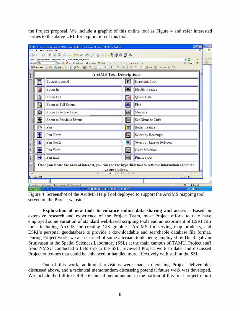
8
the Project proposal. We include a graphic of this online tool as Figure 4 and refer interested parties to the above URL for exploration of this tool.
Figure 4 Screenshot of the ArcIMS Help Tool deployed to support the ArcIMS mapping tool served on the Project website.
Exploration of new tools to enhance online data sharing and access – Based on extensive research and experience of the Project Team, most Project efforts to date have employed some variation of standard web-based scripting tools and an assortment of ESRI GIS tools including ArcGIS for creating GIS graphics, ArcIMS for serving map products, and ESRI’s personal geodatabase to provide a downloadable and searchable database file format. During Project work, we also learned of some alternate tools being employed by Dr. Ragahvan Srinivasan in the Spatial Sciences Laboratory (SSL) at the main campus of TAMU. Project staff from NMSU conducted a field trip to the SSL, reviewed Project work to date, and discussed Project outcomes that could be enhanced or handled more effectively with staff at the SSL.
Out of this work, additional revisions were made to existing Project deliverables
discussed above, and a technical memorandum discussing potential future work was developed. We include the full text of the technical memorandum in the portion of this final project report
9
detailing technical memoranda and related Project documents, and we also summarize the highlights here. Although the ArcIMS software environment has been effective at serving the water resource data compiled in the Project, alternate tools for serving geo-spatial and water resource data offer some added utility worth exploring.
The Geocortex IMF software tool being deployed by the SSL staff at TAMU appears to
offer considerable utility for serving geospatial data.4 Building on existing ArcIMS products, Geocortex allows considerable enhancements to Web-based applications serving geo-spatial data through the use of a graphical user interface to develop program code more efficiently than “cutting code” in HTML or Javascript. Geocortex has the ability to bookmark a location for later viewing, a range of markup and selection tools, and the ability to view and change the representative fraction of your map. Staff members at TAMU’s SSL have had good success using this tool to deliver robust Web applications to deliver geo-spatial data.
Project staff members also explored the ArcGIS Server tool that is a module of ESRI’s
ArcGIS software suite. ArcGIS Server 9.2 has enhanced geoprocessing capabilities, an additional developer framework for both the J2EE and .NET 2.0 environments, the ability to serve data to mobile users that allows field editing and upload, and an improved out-of-the-box Web application development framework. Enhancements to basic serving of GIS and water resource datasets could be executed with limited additional programming, and the end product that is delivered to the users would be much more robust than the current version of ArcIMS can easily deliver. Based on the experience to date of NMSU staff members working on the project and the research we have conducted, we recommend further exploration and deployment of ArcGIS Server for future Project work to serve geo-spatial and water resource data.
Implementation of miscellaneous suggestions and Project enhancements – Results
from the User Needs Assessment, discussions with Project partners and users, and the experience of staff working on the Project highlighted a range of enhancements, and in some cases, “fixes” to problems arising from the distributed development of the Project deliverables. Some of these enhancements have been discussed above, as they were specific tasks included in the Project Proposal, and we summarize other important enhancements below.
Previous versions of the web-based Project outcomes could not be viewed with Firefox or
Mozilla browsers due to coding artifacts left by Microsoft scripting tools. Project staff completely redrafted all HTML code in Dreamweaver to eliminate these problems. Project staff also encountered version problems between ArcGIS 9.2 and ArcIMS 9.1, and this required extensive research and adjustment to related geo-spatial files. To improve the legibility of the web-based products we generated, labeling of map elements in the GIS map products was done with a scale range tool, and some of the related symbology was made transparent to eliminate “map clutter.” All of the geo-spatial data available for viewing and download on the Project website as well were updated, and a thorough quality assurance review was performed by several different members of the Project Team to identify and rectify any errors that occurred in Project development. Extensive efforts were also made to “proofread” the entire set of HTML and GIS
4 Geocortex IMF 5 is a viewer architecture software developed for the government of the Province of British Columbia that uses the object model and Java server pages to provide an extension to ArcIMS for serving geo-spatial data. See http://www.geocortex.com for additional detail on the Geocortex IMF software.

10
files and documents to ensure that the users of the Project website were able to access files and data as seamlessly and easily as possible.
III. Incorporated Technical Memoranda
In addition to the text in the body of this document, members of the technical committee and project staff have also drafted technical memoranda and other supplemental documents that are called for in the scope of work and various task orders for the Project. These are listed below and included in the Appendixes of this document:
Technical Memorandum No. 1 –Technical Memorandum on Data Sharing and
Transfer Tools for Future Project Work, Water 2025 Project: prepared by Z. Edwards, Q. Korbulic, and C. Brown (Appendix I).
This technical memorandum explores additional options for data transfer and sharing,
including the potential use of ArcGIS Server 9.2 or Geocortex IMF 5 (a viewer architecture software). These tools offer considerable utility for serving geo-spatial data on the web and warrant future research for use in the Project. The Geocortex software tool being deployed by the Spatial Sciences Laboratory staff at TAMU appears to offer considerable utility for enhancing ArcIMS to better serve geospatial data. Perhaps of greater interest, ArcGIS Server 9.2 has enhanced geo-processing capabilities, an additional developer framework for both the J2EE and .NET 2.0 environments, the ability to serve data to mobile users that allows field editing and upload, and an improved out-of-the-box web application development framework. Based on the experience to date of NMSU staff members working on the project, we recommend further exploration and deployment of ArcGIS Server for future Project work to serve geo-spatial and water resource data.
Final Report User Needs Assessment, Installation of River and Drain Instrumentation
Stations to Monitor Flow and Water Quality and Internet Data Sharing, compiled by C. Brown, Z. Sheng, B. Creel, A. Michelsen, and M. Fahy (Appendices II and III).
This report summarizes findings from the User Needs Assessment conducted through an
internet survey. A survey form was developed by the project team with input from the Paso del Norte Watershed Council (PdNWC) Technical Committee. The survey covers topics including the types of water-related data that would be most useful to the survey respondents, their type of data sorting and querying capabilities desired, the preferred format for downloading queried data, plus requests for any other suggestions for improving the usability of the website. Survey results yielded specific recommendations for improvements to the Project, including addition of data sorting and query capabilities, and more water flow and quality information, especially for river and agricultural return flows. Project staff implemented the majority of these recommendations in the latter period of work on the Project.
IV. Closing Comments and Future Work
The activities described in this final project report for the Paso del Norte Watershed Council Coordinated Water Resources Database and GIS Project have generated outcomes and results of considerable interest and usefulness to water resource managers and researchers in the Paso del Norte region. Specifically, we have produced an enhanced operational website that

11
effectively serves a wider range of water resource data. USBR funding has allowed Project staff to add new gauging stations, bring these stations online, and link them to the Project database. We have also executed a User Needs Assessment of the Project and implemented a majority of the recommendations generated by this assessment. An enhanced help utility has been developed and added to the Project website, and all related Project data have been compiled and made available for download through Access database files posted to the Project website. The combined activities have helped increase the knowledge base of how to serve more effectively regional water resources in the Paso del Norte region, with these “lessons learned” being documented in this Project final report and related technical memoranda. These accomplishments, while notable, also point to some areas for future database development work.
As this database project progresses and the Upper Rio Grande Water Operations Model
(URGWOM) being developed by the U.S. Army Corps of Engineers extends further into reaches of the Rio Grande below the Elephant Butte Reservoir, Project efforts should continue to explore linkages with URGWOM. To date, limited data collected through the URGWOM project have been loaded into the Paso del Norte Watershed Council Collaborative Water Resources Database through links to the WRRI server. In the future, the Project database could also be directly linked to the URGWOM project website to provide real-time monitoring data once the URGWOM flood control model is in operation for the Rio Grande below Elephant Butte Reservoir. Such configurations will allow interested parties to manage water operations more efficiently with real-time monitoring and model projection and help to coordinate water resources research and data gathering in the Paso del Norte region.
The use of the Geocortex and ArcGIS Server tools discussed above is also an area of
future research that could benefit future Project activities, water resources research, and data sharing in the region. Project partners in the Spatial Sciences Laboratory at TAMU have valuable experience serving geospatial data on the web, and Project staff at NMSU have a keen interest to explore further these tools through a collaborative effort. The ability to harness these tools to support real-time data compilation through field work and subsequent uploading and editing of geo-spatial data on the Project server is an area of special interest. Potential collaboration between NMSU and TAMU could be explored through future joint Project proposals drawing on the strengths of researchers at both institutions.
12
References
Brown C., Z. Sheng, and M. Rich. 2004. Coordinated Water Resources Database and GIS. New Mexico State University, Water Resources Research Institute, and Texas A&M University, Texas Water Resources Institute Joint Technical Report No. 327. Brown C., Z. Sheng, and M. Bourdon. 2005. Coordinated Water Resources Database and GIS: Phase II. Final project report prepared for the Paso del Norte Watershed Council and El Paso Water Utilities. Keyes, C. 2001a. Coordinated Rio Grande Project Source Water Protection Measurements Project. Proposal written for the Paso del Norte Watershed Council. Keyes, C. 2001b. Database Management Program, Middle and Lower Rio Grande of Mexico. Proposal written for the U.S. Army Corps of Engineers/Upper Rio Grande Water Operations Model.

13
Appendix I: Technical Memorandum No. 1: Data Sharing and Transfer Tools
By Z. Edwards, Q. Korbulic, and C. Brown.

14
Technical Memorandum No. 1 Data Sharing and Transfer Tools for Future Project Work
USBR Water 2025 Challenge Grant Project By Z. Edwards, Q. Korbulic, and C. Brown
I. Background to Data Sharing Research
Currently, the Coordinated Water Resource Database and GIS Project website has full data sharing capacity, as we provide access to individual datasets, their corresponding metadata, and GIS maps displaying the spatial distribution of data points. Additionally, we have a page (“Access_Geo.htm”) which allows the user to download an ESRI personal geodatabase containing the majority of datasets seen in the Internet Mapping System (IMS). Furthermore, any basic map navigation and proximity analysis is available through the PDNWC IMS located at the following URL: http://river.nmsu.edu/website/pdnwc/pdnwc_site/viewer.htm. Based on input from the Project partners and members of the technical committee, we have explored alternate tools for serving geo-spatial and water resource data on the web. This involved a field trip to the Spatial Sciences Laboratory at TAMU’s main campus, where Dr. Ragahvan Srinivasan and his staff have deployed a range of tools to serve geo-spatial data on the web. We summarize the results of this research below. II. Options for Future Project Work to Enhance Internet Mapping
The current Project IMS was packaged and housed using ESRI’s server-based product known as ArcIMS. In addition to what ArcIMS provides out-of-the-box, we have customized the interface via a combination of HMTL and JavaScript coding. Depending on how advanced we would like the IMS to be, we may need to move to newer IMS software such as ArcGIS Server 9.2 or Geocortex IMF 5 (a viewer architecture software) or both. Project staff members at NMSU have expressed an interest in ArcGIS Server 9.2 and have a basic understanding of how it works. ArcGIS Server 9.2 has enhanced geoprocessing capabilities, an additional developer framework for both the J2EE and .NET 2.0 environments, the ability to serve data to mobile users that allows field editing and upload, and an improved out-of-the-box web application development framework. Enhancements to basic serving of GIS and water resource datasets could be executed with limited additional programming, and the end product that is delivered to the users would be much more robust that the current version of ArcIMS can easily deliver. It should be noted that ArcGIS Server was not fully deployed at the onset of this Project, this module being a relatively new product from ESRI.5 We include a screenshot of a sample application developed with ArcGIS Server as shown in Figure I-1.
An alternate tool to serve geo-spatial data on the web being deployed by staff at the
TAMU SSL is the Geocortex IMF 5 application. Geocortex IMF has been jointly developed by Moxi Medi and Latitude Geographics to serve geo-spatial data for the Province of British Columbia in Canada.6 The ability to customize ArcIMS with Geocortex is considerable, and it does not require a high degree of training on the developers’ side. Geocortex provides an
5 Please see http://www.esri.com/software/arcgis/arcgisserver/index.html for additional information on the ArcGIS Server product supported by ESRI. 6 Please see http://www.latitudegeo.com/geocortex/imf/ for additional information on the Geocortex IMF 5 tool described above.

15
Figure I-1 Screenshot of an application developed with ArcGIS Server. enhanced set of out-of-the-box features. For example, as noted in Figure I-2, Geocortex has the ability to bookmark a location for later viewing, a range of markup and selection tools, and the ability to view and change the representative fraction of the map. Geocortex is deployed “on top of” an existing ArcIMS application and provides graphical user interface programming tools to enhance IMS applications without the need to “cut code” through extensive HTML or Java programming. We include a screenshot of a sample application developed with Geocortex as Figure I-3. III. Recommendations for Future Project Work to Enhance Internet Mapping
After considerable discussion with Project staff at NMSU and WRRI, we feel that the best option to pursue for future enhancements to data serving capabilities of the Project is that of ArcGIS Server. The front end of Web applications that ArcGIS Server provides “out of the box” is much more robust than our current deployment of ArcIMS, providing online geo-processing tools, several useful “right click” tools, the ability to password protect datasets, and the ability to support mobile access of online datasets that would allow field editing and uploading of real time data. In addition, NMSU is currently licensed to use ArcGIS Server; NMSU staff members are

16
Figure I-2 Screen shot detailing some of the enhancement tools of Geocortex IMF described above.

17
Figure I-3 A sample application developed with Geocortex. currently deploying ArcGIS Server on other projects that require advanced web-based ability to serve and query geo-spatial data; and this work is giving NMSU staff the experience needed to deploy ArcGIS Server on future Project work. We provide an example of a screenshot of an ArcGIS Server application developed at NMSU as Figure I-4.
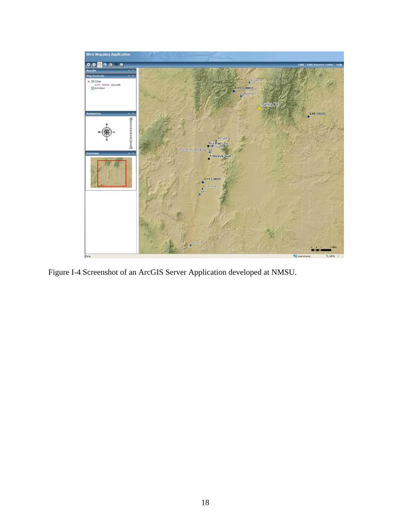
18
Figure I-4 Screenshot of an ArcGIS Server Application developed at NMSU.

19
Appendix II: Assessment of User Needs Survey
Prepared by
Christopher Brown, Zhuping Sheng, Bobby Creel, Ari Michelsen, and M.P. Fahy
20
Assessment of User Needs Survey
Executive Summary
This report fulfills one of the deliverables under the cooperative agreement on the project entitled, Installation of River and Drain Instrumentation Stations to Monitor Flow and Water Quality and Internet Data Sharing, between the El Paso Water Utilities (under U.S. Bureau of Reclamation, Contract No. 05-FC-40-2392) and Texas Agricultural Experiment Station, on behalf of the Paso del Norte Watershed Council.
This report summarizes findings from the user needs assessment conducted through an
internet survey. A survey form was developed by the project team with input from the Paso del Norte Watershed Council (PdNWC) Technical Committee. The survey covers topics including the types of water-related data that would be most useful to the survey respondents, their preferred type of data sorting and querying capabilities, the preferred format for downloading queried data, plus requests for any other suggestions for improving the usability of the website. A total of 225 individuals were invited to participate in the survey, of which 47 responded. Based on the survey results, the Coordinated Database Project (CDP) is used on a regular basis by a nearly even split among representatives from government agencies, academic institutions, and consulting firms. Reference and downloading of water flow and quality information are useful to CDP users, along with groundwater pumping rates and surface flow diversions. The most useful features include the linkage to maps, reporting of “real-time” flows and water quality, and well and river diversion locations. Interactive linking to maps is a definite asset, along with posting of the locations for river diversions and pumping wells. Finally, the majority of the survey respondents are aware of URGWOM. The respondents also provided specific recommendations for improvements to the CDP, including addition of data sorting and query capabilities and more water flow and quality information, especially for river and agricultural return flows. It is anticipated that some of their recommendations will be fulfilled or enhanced by this project and the related project conducted by Elephant Butte Irrigation District (EBID).
The authors generously acknowledge the technical committee members for their
continued support. The project team is in debt to the project manager of El Paso Water Utilities, Mr. Michael Fahy, for his management and support. Special thanks go to Dr. Conrad Keyes, Jr., for his thorough review and valuable comments. Lastly, the project team sincerely thanks the survey respondents for their participation. Project Background
Texas A&M University (TAMU) and New Mexico State University-New Mexico Water Resources Research Institute (NMSU-NMWRRI) entered into a memorandum of agreement (MOA) in 2000 permitting their scientists to collaborate on research dealing with common water resources problems in south-central New Mexico and west Texas. This MOA was extended by mutual consent in November, 2005. Its objective is to facilitate and promote joint and cooperative water resources related research, extension, and outreach programs of mutual interest to both institutions.

21
The Paso del Norte Watershed Council Coordinated Water Resources Database and GIS Project (hereafter referred to as the Coordinated Database Project or CDP) is a specific effort that is being pursued under this cooperative working arrangement. Project cooperators were successful in securing funding from the U.S. Department of Interior Bureau of Reclamation (USBR) under its Water 2025 Challenge Grant Program for a project entitled, Installation of River and Drain Instrumentation Stations to Monitor Flow and Water Quality and Internet Data Sharing. This project is one of three linked projects submitted by water resource management agencies in the Paso del Norte region, and the project seeks to improve the ability of these agencies to generate, store, and share regional water resources data.
As part of the Installation of River and Drain Instrumentation Stations to Monitor Flow
and Water Quality and Internet Data Sharing project, researchers at NMSU and TAMU have cooperated on a user needs assessment effort related to the CDP. Early in the development of the Database project, staff conducted research into how best to compile, store, and share water resource data through the coordinated use of GIS and Web-based technologies, and the current project website (available at http://river.nmsu.edu/wesite/PdNWC_website/) is based on this initial research. During the discussions supporting the USBR project proposals, researchers involved in the Coordinated Database Project decided that a detailed needs assessment of current users of the project website and also other interested parties would be very beneficial to gauge how the current project was being received and how it could be improved. This document reports on the activities undertaken in this effort and also details the outcomes of this assessment effort. Tasks involved in the User Needs Assessment Effort
As was detailed in the initial proposal to the USBR and the relevant task order and scope of work documents between the El Paso Water Utilities, TAMU, and NMSU, the task to be undertaken in this work is to develop and conduct a user needs survey for the Rio Grande project area, focusing on the identification of new data sets of interest, enhanced access mechanisms, and other suggestions to improve the CDP website. The specific activities that were undertaken in the project are detailed below:
1. Develop a distribution list (email addresses and physical addresses) by which the survey was administered, and this list included regional entities with a potential interest in water related data. Early in the discussion of the survey effort, the researchers decided that the most efficient manner to do this would be through a web-based tool that would in turn generate a database of responses, and the project developed an email list of approximately 225 people to whom relevant email communications were sent.
2. CDP researchers met several times to discuss the specifics of the survey instrument, and several versions of the survey were drafted, reviewed by CDP technical committee members, and revised over a two month period of time. Interim drafts of the survey instrument were converted to HTML file format and put up at the CDP website for testing by CDP researchers. Based on input from the PdNWC Technical Committee, the survey tool was finalized; see http://wrri.nmsu.edu/pdnwc/survey/survey.html for the final version, a copy of which is also attached to this document. Dr. Bobby Creel of the NM Water Resources Research Institute then developed the needed computer code that
22
would generate the “mail to” email reply mechanism and compile the survey responses into a database file for further analysis.
3. Project researchers then developed a cover letter for the survey instrument and sent an e-mail to distribution list members detailed above requesting recipients to visit the CDP website and take the survey. Once connected to the CDP website, the recipient can access the survey form, which includes questions on the types of water-related data that would be most useful to the survey respondents, their type of data sorting and querying capabilities, the preferred format for downloading queried data, plus requests for any other suggestions for improving the usability of the website.
4. Project researchers also reached out to other water resource institutions in the region to “market” the survey effort, and prominent among these was the International Boundary and Water Commission Rio Grande Citizens Forum (RGCF) that meets four times a year in the Las Cruces and El Paso region to discuss current water issues. Dr. Christopher Brown gave a formal presentation to the 11 May 2006 meeting of the RGCF in which he updated members on the CDP, gathered contact information on people interested in the CDP, and promoted the survey effort. The researchers followed up on this initial effort by also reminding RGCF members to participate at the 9 August 2006 meeting of the RGCF. Additional email addresses were also obtained at both RGCF meetings for interested parties not originally contacted.
5. The survey form has been available for access on the CDP website since July of 2006, and the researchers also sent out two reminder emails to the members on the distribution list during July and September. The project will keep the form up on the web as part of the CDP website for future access; the results to date are reported below.
Outcomes of the User Needs Assessment Efforts As of November 13, 2006, the project received 47 responses to the survey, which equates
to a response rate of approximately 21%. The charts and tables below summarize the responses obtained, after which the authors provide some discussion of these results.

23
1. What is the nature of your business?
Government36%
Irrigation District2%
Utility9%
Conservation group2%
Consultant19%
General Public0%
other0%
Education/Research32%
Figure II-1 Nature of participants’ business 2. What types of general, water-related information are you interested in accessing (Check all that apply)?
0
5
10
15
20
25
30
35
40
45
Wat
er q
uant
ity
Geo
grap
hic
Info
rmat
ion/
Wat
ersh
edm
aps
Wat
er q
uality
Envi
ronm
enta
l/Rip
aria
n
Num
ber o
f res
pond
ents
Figure II-2 Types of general, water related information that participants interested in accessing

24
3. What water resource information are you most interested in accessing (Check all that apply)? Surface Water Data
0
5
10
15
20
25
30
35
40G
auge
sta
tion
loca
tions
His
toric
rive
rflo
ws
Rea
l-tim
e riv
erflo
ws
Div
ersi
onlo
catio
n/qu
antit
y
Surfa
ce w
ater
qual
ity
Num
ber o
f res
pond
ents
Figure II-3 Surface water information that participants most interested Groundwater Data
0
5
10
15
20
25
30
35
40
Wel
l loca
tions
His
toric
grou
ndw
ater
leve
ls
Pum
page
Rea
l-tim
e w
ater
leve
ls
Gro
undw
ater
qual
ity
Num
ber o
f res
pond
ents
Figure II-4 Groundwater information that participants most interested in
25
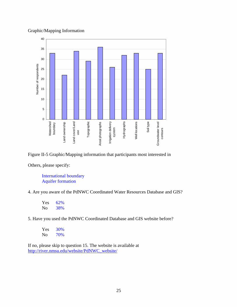
Graphic/Mapping Information
0
5
10
15
20
25
30
35
40
Wat
ersh
edbo
unda
ry
Land
ow
ners
hip
Land
cov
er/L
and
use
Topo
grap
hic
Area
l pho
togr
aphs
Irrig
atio
n de
liver
ysy
stem
Hyd
rogr
aphs
Wel
l loca
tions
Soil t
ype
Gro
undw
ater
leve
lco
ntou
rs
Num
ber o
f res
pond
ents
Figure II-5 Graphic/Mapping information that participants most interested in Others, please specify: International boundary Aquifer formation 4. Are you aware of the PdNWC Coordinated Water Resources Database and GIS?
Yes 62% No 38%
5. Have you used the PdNWC Coordinated Database and GIS website before?
Yes 30% No 70%
If no, please skip to question 15. The website is available at http://river.nmsu.edu/website/PdNWC_website/

26
6. What are you using this database/website for? (Check all that apply).
0
2
4
6
8
10
12
14
Wat
erre
sour
ces
plan
ning
Wat
erop
erat
ions
and
man
agem
ent
Envi
ronm
enta
lin
tere
st
Res
earc
h
Gen
eral
wat
ersh
edin
form
atio
n
Oth
er
Num
ber o
f res
pond
ents
Figure II-6 Usage of the database/website 7. Please describe your experience using the Coordinated Database and GIS website.
Excellent 4% Good 4% Acceptable 6% Difficult 0
Please comment None No experience to date
Difficult to load 8. Please rate the organization of materials on the database/website.
Excellent 6% Good 21% Acceptable 9% Needs Improvement 0
Please comment None

27
9. Which features of the Database and/or GIS do you find most useful? (List or describe).
ArcIMS links to data Clicking on a location and getting data and/or information about the site in question Real time river flows and water quality Interactive mapping Well data from Mexico ArcIMS Well locations One location for water resources data Variety of the data sources Data
10. Which features would you like to see expanded or improved? (List or describe).
More metadata Toggling between data sources is cumbersome Data query Water quality information More datasets Groundwater quality data; aquifer formations Irrigation diversions and return flows More surface and groundwater quality data More data
11. What is your method or mode of use of the Database? (Check all that apply).
0
2
4
6
8
10
12
14
View
dat
a on
line
View
geo
spat
ial
data
onl
ine
Dow
nloa
d da
ta
Dow
nloa
dge
ospa
tial d
ata
Num
ber o
f res
pond
ents
Figure II-7 Method or mode of use of the database

28
12. What browser are you using? (Check all that apply)
0
2
4
6
8
10
12
14
16
18In
tern
etEx
plor
er
Net
scap
e
Moz
illa F
irefo
x
Ope
ra
Oth
er
Num
ber o
f res
pond
ents
Figure II-8 Type of browser used. 13. What type of Internet connection are you using?
0
2
4
6
8
10
12
14
16
Broa
dban
d (T
1lin
e)
DSL
(Dig
ital
Subs
crib
er L
ine)
Dia
lup/
mod
em
Num
ber o
f res
pond
ents
Figure II-9 Type of internet connection used.
29
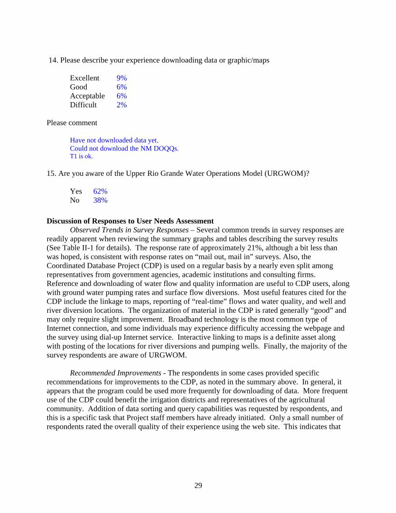
14. Please describe your experience downloading data or graphic/maps
Excellent 9% Good 6% Acceptable 6% Difficult 2%
Please comment Have not downloaded data yet. Could not download the NM DOQQs.
T1 is ok. 15. Are you aware of the Upper Rio Grande Water Operations Model (URGWOM)?
Yes 62% No 38%
Discussion of Responses to User Needs Assessment
Observed Trends in Survey Responses – Several common trends in survey responses are readily apparent when reviewing the summary graphs and tables describing the survey results (See Table II-1 for details). The response rate of approximately 21%, although a bit less than was hoped, is consistent with response rates on “mail out, mail in” surveys. Also, the Coordinated Database Project (CDP) is used on a regular basis by a nearly even split among representatives from government agencies, academic institutions and consulting firms. Reference and downloading of water flow and quality information are useful to CDP users, along with ground water pumping rates and surface flow diversions. Most useful features cited for the CDP include the linkage to maps, reporting of “real-time” flows and water quality, and well and river diversion locations. The organization of material in the CDP is rated generally “good” and may only require slight improvement. Broadband technology is the most common type of Internet connection, and some individuals may experience difficulty accessing the webpage and the survey using dial-up Internet service. Interactive linking to maps is a definite asset along with posting of the locations for river diversions and pumping wells. Finally, the majority of the survey respondents are aware of URGWOM.
Recommended Improvements - The respondents in some cases provided specific
recommendations for improvements to the CDP, as noted in the summary above. In general, it appears that the program could be used more frequently for downloading of data. More frequent use of the CDP could benefit the irrigation districts and representatives of the agricultural community. Addition of data sorting and query capabilities was requested by respondents, and this is a specific task that Project staff members have already initiated. Only a small number of respondents rated the overall quality of their experience using the web site. This indicates that

30
Table II-1 Summary of User Needs Survey (Total of 47 Responses) As of Nov. 13, 2006
Questions Type of Questions Response Description
1. What is the nature of your business?
Choose from Selection
Government, education/research and consultant are three major groups
2. What types of general, water-related information are you interested in?
Choose from Selection
Equal split: maps, water quantity /quality, environ.
3. What water resource information are you most interested in?
Choose from Selection
Evenly split among water quality, diversions, pumpage, and surface flows
4. Are you aware of the PdNWC Coordinated Water Resources Database and GIS? Yes or No
2/3 of participants are aware of the DB and GIS.
5. Have you used the PdNWC Coordinated Database and GIS website before? Yes or No
1/3 of participants used the website
6. What are you using this database/website for?
Choose from Selection
A majority of 1/3 for research
7. Please describe your experience using the Coordinated Database and GIS website. Rated Scale
Half of respondents report good to excellent experience.
8. Please rate the organization of materials on the database/website. Rated Scale
“Good” was the most common response.
9. Which features of the Database and/or GIS do you find most useful? Fill in the Blank
ArcIMS links to data and interactive mapping; access or sharing of real-time flow and water quality data; Well and data locations identified
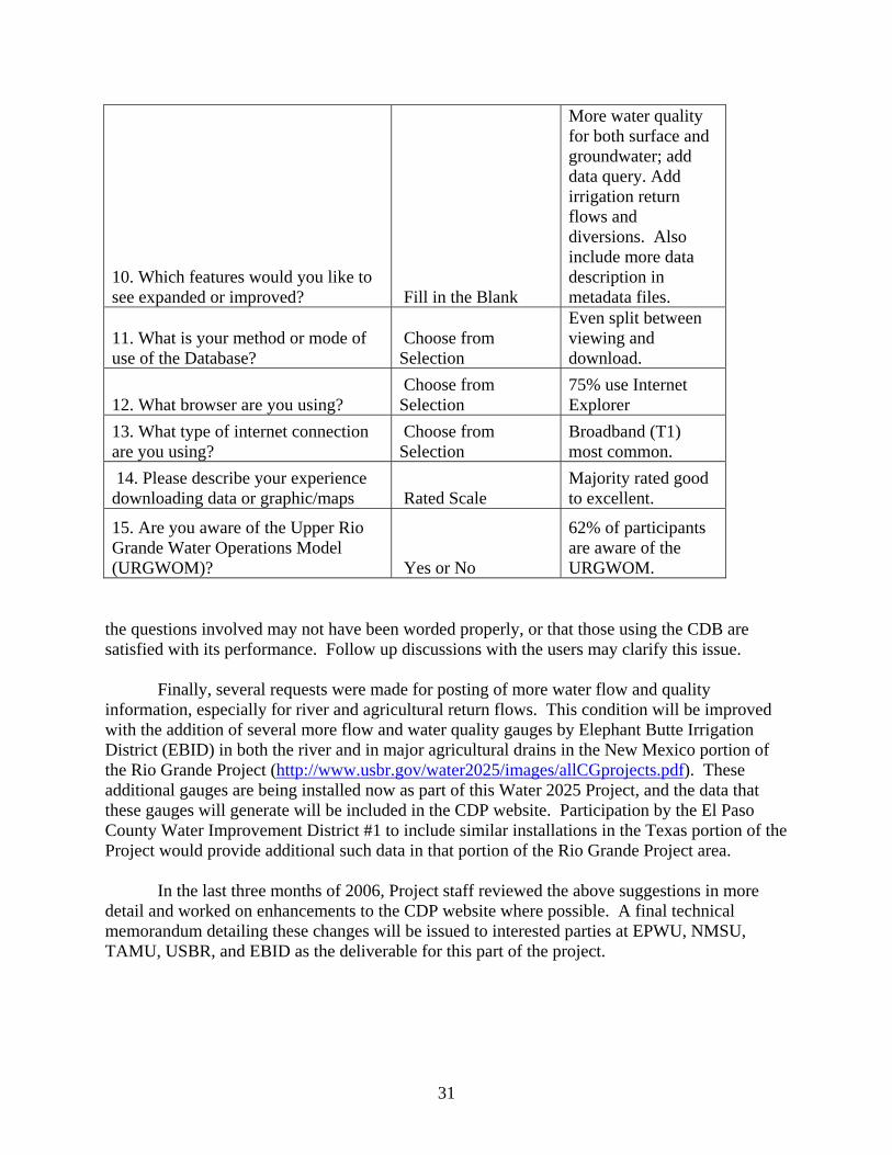
31
10. Which features would you like to see expanded or improved? Fill in the Blank
More water quality for both surface and groundwater; add data query. Add irrigation return flows and diversions. Also include more data description in metadata files.
11. What is your method or mode of use of the Database?
Choose from Selection
Even split between viewing and download.
12. What browser are you using? Choose from Selection
75% use Internet Explorer
13. What type of internet connection are you using?
Choose from Selection
Broadband (T1) most common.
14. Please describe your experience downloading data or graphic/maps Rated Scale
Majority rated good to excellent.
15. Are you aware of the Upper Rio Grande Water Operations Model (URGWOM)? Yes or No
62% of participants are aware of the URGWOM.
the questions involved may not have been worded properly, or that those using the CDB are satisfied with its performance. Follow up discussions with the users may clarify this issue.
Finally, several requests were made for posting of more water flow and quality
information, especially for river and agricultural return flows. This condition will be improved with the addition of several more flow and water quality gauges by Elephant Butte Irrigation District (EBID) in both the river and in major agricultural drains in the New Mexico portion of the Rio Grande Project (http://www.usbr.gov/water2025/images/allCGprojects.pdf). These additional gauges are being installed now as part of this Water 2025 Project, and the data that these gauges will generate will be included in the CDP website. Participation by the El Paso County Water Improvement District #1 to include similar installations in the Texas portion of the Project would provide additional such data in that portion of the Rio Grande Project area.
In the last three months of 2006, Project staff reviewed the above suggestions in more
detail and worked on enhancements to the CDP website where possible. A final technical memorandum detailing these changes will be issued to interested parties at EPWU, NMSU, TAMU, USBR, and EBID as the deliverable for this part of the project.
32
Appendix III: User Needs Survey
Prepared by Christopher Brown, Zhuping Sheng, Bobby Creel, Ari Michelsen, and M.P. Fahy

33
Letter of Invitation Sent to Members of the Distribution List Dear interested party, As you may be aware, the flow and water quality of the Rio Grande is measured and recorded at several points by various groups from Elephant Butte Dam, New Mexico down to Fort Quitman, Texas. Separate measurements are collected by federal agencies (USBR, USGS, USIBWC), irrigation districts (EBID & EPCWID#1), El Paso Water Utilities, City of Las Cruces, and others. Historically, there has been little or no coordination or a convenient method to access data from these numerous sources. This absence of coordinated access and sharing of real-time and historical data may lead to unnecessary duplication of effort and wasted resources. The Paso del Norte Watershed Council (PdNWC) developed the Coordinated Water Resources Database & Geographic Information System (GIS) to coordinate, compile and provide timely Internet access to information for use by water management organizations, stakeholders and scientists. The Coordinated Water Resources Database & GIS is being developed by the Paso del Norte Watershed Council through collaboration of university scientists, and cooperation of Federal and State agencies, irrigation districts and water management and user organizations. Funding for this project has been provided by the El Paso Water Utilities, the U.S. Bureau of Reclamation, and the U.S. Army Corps of Engineers. To better understand the experience of people accessing the Paso del Norte Water Resources Database and GIS and to identify additional user needs for water resources data and information, we ask you to provide your input and comments by taking a short survey. The survey is available on line at http://wrri.nmsu.edu/pdnwc/survey/survey.html and takes just a few minutes to complete. If you are not the appropriate person in your organization to answer this survey, please forward this EMAIL to the appropriate person. If you do not wish to access the survey on line but are still interested in providing feedback, please contact Dr. Ari Michelsen at [email protected] for a hard copy of the survey, which you can then complete and return to the PdNWC via conventional postal service. Thank you in advance for your participation and input. Dr. Christopher Brown ([email protected]) Department of Geography - New Mexico State University Dr. Zhuping, Sheng ([email protected]) Texas A&M Agricultural Experiment Station - El Paso, Texas Co Chairs of the Paso del Norte Watershed Council Coordinated Water Resources Database and GIS Technical Committee

34
Paso del Norte Watershed Council
Water Resources Database and Geographic Information System
User Needs Survey
As you may be aware, the flow and quality of the Rio Grande is measured and recorded at several points by various groups from Elephant Butte Dam, New Mexico down to Fort Quitman, Texas. Separate measurements are collected by federal agencies (USBR, USGS, IBWC), irrigation districts (EBID & EPCWID#1), El Paso Water Utilities, City of Las Cruces, and others. Prior to this collaborative program, there has been little or no compilation, coordination or convenient method to access data from these numerous sources. Each organization collects information for their individual mission. Even when information is shared, it may not be done in a timely manner. This absence of coordinated access and sharing of real-time and historical data may lead to unnecessary duplication of effort and wasted resources. The Paso del Norte Watershed Council (PdNWC) Coordinated Water Resources Database & Geographic Information System is designed to coordinate, compile and provide timely Internet access to information for use by water management organizations, stakeholders and scientists. The Coordinated Water Resources Database & GIS is being developed by the Paso del Norte Watershed Council through collaboration of university scientists, and cooperation of Federal and State agencies, irrigation districts, and water management and user organizations. The purpose of this survey is to better understand awareness and ease of use of the Paso del Norte Water Resources Database and GIS and identify additional user needs for water resources data and information. The survey takes just a few minutes to complete. Thank you for your participation. Sincerely, Dr. Susan Watts, Chair Julie Maitland, Co-Chair Paso del Norte Watershed Council
1. What is the nature of your business?
General Public Government Irrigation District Utility
Education/Research Conservation group Consultant other
2. What types of general, water-related information are you interested in? (check all that apply)

35
Water quantity Geographic Information/Watershed maps
Water quality Environmental/Riparian
3. What water resource information are you most interested in? (Check all that apply) Surface Water Data
Gauge station locations Historic river flows
Real-time river flows Diversion location/quantity
Surface water quality Groundwater Data
Well locations Historic groundwater levels
Pumpage Real-time water levels
Groundwater quality Graphic/Mapping Information
Watershed boundary Land ownership
Land cover/Land use Topographic
Areal photographs Irrigation delivery system
Hydrographs Well locations
Soil type Groundwater level contours
Others, please specify
4. Are you aware of the PdNWC Coordinated Water Resources Database and GIS?
Yes No
5. Have you used the PdNWC Coordinated Database and GIS website before?
Yes No If no, please skip to question 15. If no, the website is available at: PdNWC Data Distribution and Download Site
6. What are you using this database/website for? (Check all that apply)
Water resources planning Water operations and management

36
Environmental interest Research
General watershed information Other, please specify
7. Please describe your experience using the Coordinated Database and GIS website.
Excellent Good Acceptable Difficult Please comment
8. Please rate the organization of materials on the database/website.
Excellent Good Acceptable Needs Improvement Please comment
9. Which features of the Database and/or GIS do you find most useful? (List or describe.)
10. Which features would you like to see expanded or improved? (List or describe.)
11. What is your method or mode of use of the Database?(Check all that apply)
View data online View geospatial data online
Download data Download geospatial data
12. What browser are you using?(Check all that apply)
Internet Explorer Netscape Mozilla Firefox Opera Other
37
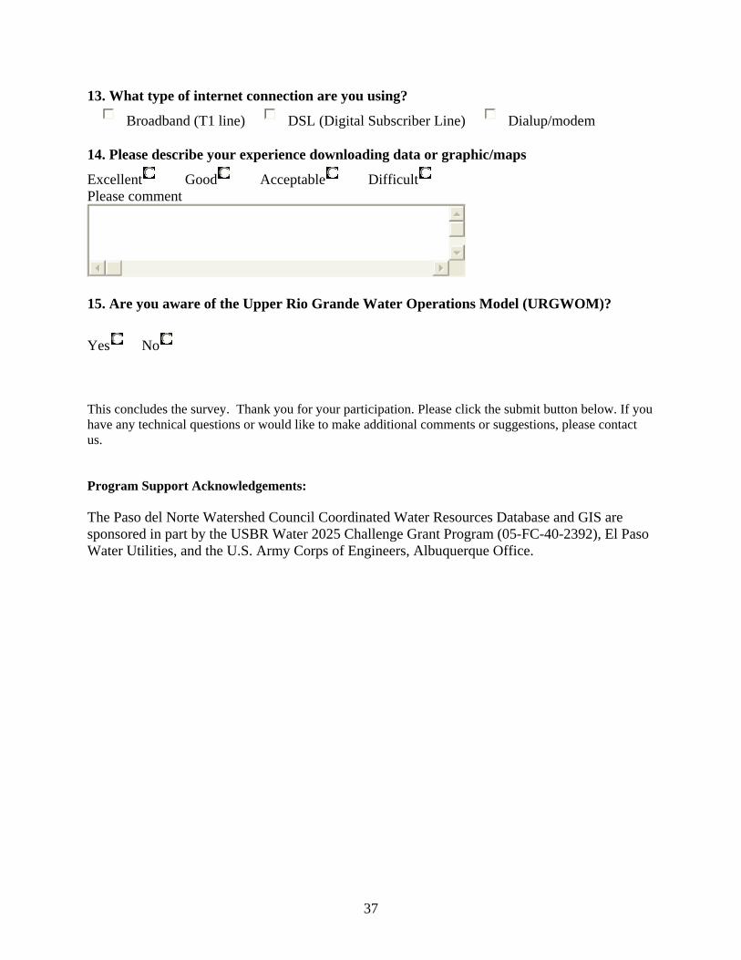
13. What type of internet connection are you using?
Broadband (T1 line) DSL (Digital Subscriber Line) Dialup/modem
14. Please describe your experience downloading data or graphic/maps
Excellent Good Acceptable Difficult Please comment
15. Are you aware of the Upper Rio Grande Water Operations Model (URGWOM)?
Yes No
This concludes the survey. Thank you for your participation. Please click the submit button below. If you have any technical questions or would like to make additional comments or suggestions, please contact us. Program Support Acknowledgements: The Paso del Norte Watershed Council Coordinated Water Resources Database and GIS are sponsored in part by the USBR Water 2025 Challenge Grant Program (05-FC-40-2392), El Paso Water Utilities, and the U.S. Army Corps of Engineers, Albuquerque Office.