institutional development for emerging towns in nepal
TRANSCRIPT

Government of Nepal
Ministry of Urban Development (MoUD)
Department of Urban Development and Building Construction (DUDBC)
INSTITUTIONAL DEVELOPMENT
FOR EMERGING TOWNS IN NEPALURBAN GOVERNANCE AND DEVELOPMENT PROGRAM (UGDP)

The report ‘Institutional Development for Emerging Towns in Nepal’ documents the main contributions of
the Municipal Support Team (MST) to the ‘Urban Governance and Development Program: Emerging Towns
Project’ (UGDP-ETP), which is implemented by the Ministry of Urban Development (MoUD) through the
Department of Urban Development and Building Construction (DUDBC).
MST is part of the technical cooperation provided by the German Government to the Government of Nepal
through the Deutsche Gesellschaft für Internationale Zusammenarbeit (GIZ) within the framework of the Sub-
national Governance Program (SUNAG). GIZ contracted a consortium of GFA Consulting Group, oikos, MULTI
and InLogos to provide the Municipal Support Team (MST) to support the Project Coordination Office (PCO)
at the Department for Urban Development and Building Construction (DUDBC), the Urban Development
Training Center (UDTC) and selected municipalities.
The report has been conceptualized and elaborated by the team members of MST, namely Bandana Sharma,
Arjun Koirala, Iswar Lal Joshi, Sunil Prasad Pradhan, Alexander Jachnow and Carsten Zehner. The team thanks
all partner institutions and external consultants who have contributed to the different work packages.
The content does not necessarily reflect the point of view of all partners involved in UGDP and DUDBC/PCO
cannot be considered liable for the accuracy of information in the report.
Design - Shivendra Shah, Shiven Studio
Maps - Laura Bright-Davies Photographs - MST Copy Editor - Tiku Gauchan June 2014
Supported by Subnational Governance Program (SUNAG)

INSTITUTIONAL DEVELOPMENT
FOR EMERGING TOWNS IN NEPALURBAN GOVERNANCE AND DEVELOPMENT PROGRAM (UGDP)

The spirit of democracy, decentralization and local governance envisaged by the Local Self Governance Act
(1999) and other policies and programs that have followed its line have put Nepal’s local bodies at the focus
of development. This has created an enormous demand for improving institutional capacities on the local
level. Even though significant efforts for capacity development of local bodies have been carried out by
different agencies so far, they are still facing a plethora of challenges in tackling all kinds of technical and
non-technical issues. Thus, intense and appropriate institutional capacity development of local bodies still
remains one of the most pertinent tasks for efficient local development, effective planning, improved service
delivery and sustainable infrastructure development.
In this context, the ‘Urban Governance and Development Program - Emerging Towns Project’ (UGDP-ETP;
duration: 2011-2016) — which is being implemented by the Ministry of Urban Development (MoUD)
through the Department of Urban Development and Building Construction (DUDBC) — plays a significant
role. UGDP works in six municipalities, namely, Lekhnath, Baglung and Tansen, in the Western Development
Region, and Itahari, Mechinagar and Dhankuta, in the Eastern Development Region of Nepal. It combines
the development of infrastructure sub-projects (roads, bridges, public buildings, parks etc.) with technical
assistance focused at capacity building and institutional development. The program provides a broad range
of support measures to municipal officials, enabling them to introduce and implement improved standards
and procedures for local development.
UGDP is financed by the World Bank and technical cooperation is provided by the Deutsche Gesellschaft
für Internationale Zusammenarbeit (GIZ), acting on behalf of the German Federal Ministry for Economic
Cooperation and Development (BMZ), within the framework of the Sub-national Governance Program
(SUNAG). GIZ contracted GFA Consulting Group to provide a Municipal Support Team (MST) working directly
with DUDBC, the selected municipalities and the Urban Development Training Center (UDTC).
FOREWORD

The intensive collaboration between the Project Coordination Office (PCO) within DUDBC and MST
has turned out to be a very fruitful model of cooperation that has resulted in a wide range of successful
outcomes, innovative products and important impacts. Especially in the area of institutional development,
MST has provided crucial support in the following areas: training and capacity development, sub-project
conceptualization and design, social and environmental-safeguard compliance, operation and maintenance,
revenue enhancement, multi-year investment planning, municipal bylaws, resource mapping and others.
This report presents the achievements of this cooperation between December 2011 and June 2014. It aims
to document the results, reflect on the lessons learnt and provide a basis for further dissemination to other
municipalities in Nepal.
(Dr. Horst Matthäus)
Chief Technical Advisor
Deutsche Gesellschaft
für Internationale
Zusammenarbeit (GIZ)
(Er. Ramesh Prasad Singh)
Project Director
Urban Governance
Development
Program (UGDP)
(Er. Shambhu K.C.)
Director General
Department of Urban
Development and Building
Construction (DUDBC)
Foreword by UGDP

ASEM Advisory Services in Environment Management
BPPMS Building Permit Process Management Software
C3 Creating Competence for Competition
CD Capacity Development
CSO Civil Society Organization
CSP City Sanitation Plans
DTCO District Treasury Controller’s Office
DUDBC Department of Urban Development and Building Construction
ECP Environment Code of Practice
EIA Environmental Impact Assessment
EMP Environmental Management Plan
EMF Environmental Management Framework
EO Executive Officer
EoI Expression of Interest
ESMF Environmental and Social Management Framework
ETP The Emerging Towns Project
FM Financial Management
GDP Gross Domestic Product
GIS Geographical Information System
GIZ Deutsche Gesellschaft für Internationale Zusammenarbeit
GoN Government of Nepal
GRC Grievance Redress Committee
ID Institutional Development
LIST OF ABBREVIATIONS

IEC Information Education and Communication
IEE Initial Environmental Examination
IPT Integrated Property Tax
LCCI Lekhnath Chamber of Commerce & Industries
LDTA Local Development Training Academy
LED Local Economic Development
LGCDP Local Governance and Community Development Program
LSGA Local Self Governance Act
MCC Municipal Coordination Committee
MCPM Minimum Condition and Performance Measure
MIS Management Information System
MoFALD Ministry of Federal Affairs and Local Development
MoLD Ministry of Local Development
MoUD Ministry of Urban Development
MPPW Ministry of Physical Planning and Works
MST Municipal Support Team
MSWM Municipal Solid Waste Management
MuAN Municipal Association Nepal
MYIP Multi-Year Investment Plan
NBC National Building Code
NEFIN Nepal Federation of Indigenous Nationalities
NGO Non-Governmental Organization
ODFA Open Defecation Free Area
OSR Own-Source Revenues
O&M Operation and Maintenance
PAD Project Appraisal Document
PCO Project Coordination Office
PIM Project implementation Manual
Table of Contents

PMT Project Management Team
PPP Purchasing Power Parity
PSC Project Steering Committee
PST Project Support Team
REAP Revenue Enhancement Action Planning
RLC Regional Learning Center
SIA Social Impact Assessment
SMF Social Management Framework
SNUSP Support to National Urban Sanitation Policy
SUNAG Sub-National Governance Program
SWM Solid Waste Management
SWMTSC Solid Waste Management Technical Support Center
TDF Town Development Fund
TLO Tole Lane Organization
ToR Term of Reference
UDLE Urban Development through Local Efforts
UDTC Urban Development Training Center
UGDP Urban Governance and Development Program
UN-HABITAT United Nations Human Settlement Program
VDC Village Development Committee
WB World Bank

Preface
1. Introduction 1.1 Urban Situation in Nepal The Six municipalities Baglung Dhankuta Itahari Lekhnath Mechinagar Tansen 1.2 Wrap Up: Urban Challenges for Capacity Development
2. Urban Governance and Development Program (UGDP) 2.1 UGDP in the Context of an Urbanizing Nepal 2.2 Institutional Arrangements 2.3 Project Components 2.4 Stakeholders in UGDP
3. Capacity Development (CD) Activities 3.1 Capacity Development in UGDP 3.2 Dimensions and Processes for Capacity Development 3.3 UGDP Orientation and Training Orientation Workshop on the Project Implementation Manual (PIM) UGDP Orientation at the Local Level Training on Environmental Safeguards Training on Social Safeguards
i
12569
1215192225
2930323336
3940424646474951
Table of Contents
TABLE OF CONTENTS

Institutional Development Report
Training on Procurement 3.4 C3 Training & Learning Circle - Phase I /II 3.5 Developing C3 Modules Project Management Training Revenue Enhancement Action Plan Training Local Economic Development and Resource Mapping 3.6 Training Series for Local Bodies in Nepal 3.7 Learning from Shimla
4 Support in System Development 4.1 Revenue Enhancement Action Plan (REAP) 4.2 Operation and Maintenance Planning in Municipalities 4.3 Multi-Year Investment Plan 4.4 Building and Planning Bylaws Urban Design Framework for the Historic Core of Tansen 4.5 MIS Concept 4.6 Building-Permit System 4.7 Resource Mapping
5 Support in Municipal Service Delivery and Socio-Economic Infrastructure 5.1 Institutional Arrangements at the Local Level 5.2 Block Grant: Service-Delivery Improvement 5.3 Socio-Economic Infrastructures 5.4 Overview of Urban Projects
6 Annex 6.1 MST - List of Documents 6.2 Project Information Brochure (PIB) 6.3 Satellite Images of the Six Municipalities
5254575860616466
697078818386909397
101102105107109
117118123124

The Emerging Towns Project (ETP) under the initiative of the Urban Governance and Development Program
(UGDP) is a first step towards supporting Nepal in the transition brought about by the ongoing urbanization
in the country. The project in its initial phase helps to improve planning, delivery and sustainable provision
of basic services and priority infrastructure in six participating municipalities, while improving systems and
procedures and capacitating personnel of key central agencies associated with the urban sector.
Thus contributing to required changes in the sub-national governments’ setting, UGDP supports the
central level with new concepts and thereby supports the Government of Nepal’s vision for balanced urban
development and strengthened local governance in the country, as outlined in the National Urban Policy.
The following chapter depicts the urban scenario in Nepal and its growing challenges. Urbanization is by far
the biggest driving force for social, economic and cultural change. Intended long-term impacts of the program
depend highly on the successful development of capacities and institutions within the urban sector. UGDP
and its partners are committed to addressing the urban transformation with an adequate strategy, based on
the principles of governance and with a clear vision for Nepal’s urban future. The enhanced capacities of all
participating institutions will ultimately help introduce reforms in the development and implementation of
new policies in the urban sector and enhance their specific roles.
This report is meant to compile the information and knowledge generated and to report the major
achievements in terms of capacity building and institutional development. Moreover, it explains the
approaches and where and how we expect future impacts.
A list of outcomes and products is included in the Annex.
PREFACE
Preface
i

Institutional Development Report
ii

1
1. INTRODUCTION

2
1.1 URBAN SITUATION IN NEPAL
Nepal is both the fastest-urbanizing
and the least-urbanized country in
South Asia. Only about 24 percent of its
population is currently living in towns
and cities, but with an annual growth
rate of more than 5 percent on average
since the 1970s. Consequently by 2025,
one-third and by 2035 half of the nation
will reside in cities. The fastest-growing
urban settlements, with populations below 100,000 and growth
in excess of 4 percent, include Damak and Itahari (eastern Tarai),
Banepa (central hills), Byas, Baglung and Tansen (western hills).
At the same time, Nepal is recognized by the UN as amongst the
world’s 48 least-developed countries in terms of socio-economic
indicators. In 2011, it was ranked 108th in the World Gross
Domestic Product GDP rankings, with a purchasing power parity
(PPP) per capita GDP estimated at US$1,260.
Urbanization and the state of the economy
are thus the major challenges for the country
— and at the same time, part of the solution:
signifi cant contributions to GDP growth and
poverty alleviation have been made in urban
areas. The spatial-demographic transition has
been accompanied by an equally important
spatial-economic transformation. Urban
areas now generate about 65 percent of the
GDP, based on the latest available estimates,
compared to only 29 percent in 1975. Urban
poverty declined from 22 percent to 15 percent
between 1995/96-2010/11. But urbanization
also creates new challenges. UN-HABITAT
reported in 2007 that 59.4 percent of urban
dwellers were living in slum-like conditions,
Itahari, one of the
fastest-growing
cities
Institutional Development Report

3
mainly because they had insuffi cient access to sanitation and other
basic services. The dense urban areas, with an increasing number
of people living within ever-shrinking spatial limits, face many
challenges in terms of quality of life for its citizens.
There have been some important changes in terms of
approaches used to face the urban challenge: the Ministry of
Urban Development was recently founded to address the special
requirements of the towns and cities of Nepal. Many towns have
established good practices and modernized their administration.
And in recent years, new tools, such as the periodic plan, and
structures, such as citizens’ committees to ensure transparency
and participation, were introduced to the urban sector. The
National Urban Policy, passed in 2007, is an important document
that demonstrates the interest of the central government to
support a more sustainable and socially inclusive urban growth.
However, political instability, an unfavorable business climate
for private-sector development, and an internationally
uncompetitive, remittance-dependent economy have suppressed
economic growth. The country is caught in a prolonged period of
political instability which — together with lack of transparency,
weak infrastructure and labor-market failures — is still perceived
as the main constraint for private-sector development. To make
things worse, there have not been local elections in Nepal since
1997. Nepal thus needs to leverage the comparative advantages
of its cities to break the cycle of economic stagnation and use the
cities to gain competitive advantages. Only vibrant and competitive
cities can attract high-return investments and generate the higher-
productivity jobs required to accelerate growth.
In May 2014, to the existent 58
municipalities, another 72 were added,
which led to a sizeabale increase in
urban population, but that spatial
transformation has still not been
captured in the politico-administrative
definition of urban areas. DUDBC, aware
of the challenges when categorizing
the newly characterized urban areas, is
working on a new definition of urban
settlements that also emphasizes urban
geographic features, dominant economic
activities and other urban criteria such as
population density and location.
The public sector in urban areas faces
many challenges. While adequate
infrastructure and services are necessary
for social well-being and local economic
development, in most cases they are
not sufficient. The shortcomings of
municipal infrastructure include water
supply, sanitation and solid-waste
management, which are of utmost
importance to ensure livable cities.
Moreover, these basic infrastructures
and services are important assets
for economic development and
preserve the attractiveness of urban
areas, particularly for tourist cities.
1.1 Urban Situation in Nepal

4
Infrastructure is generally provided only by sector-specific
initiatives and interventions, which help the city acquire the
infrastructure needed — but at the same time, coordination
among central agencies, local authorities and the private
sector causes high-transaction costs instead of strengthening
the local administration.
The lack of sufficient funds at the local level has led to the
creation of a vicious cycle that hampers the desire for local
self-administration, which has been envisaged by the Local
Self-Government Act (LSGA) in 1999. As municipalities are
not sufficiently equipped with budget and staff, many duties
cannot be executed by their own administration. This leads
to a high dependence on the central level. Consequently,
the local staff cannot acquire the needed competencies and
thus continue to be dependent on external support, which
then results in a continual lack of effective planning and in
inadequate infrastructure. This is particularly harmful when
trying to ensure sustainable urban development in light of
the current urban-growth patterns. Rapid urbanization is thus
intensifying the municipal infrastructure-deficit, while urban
planning lags behind the dynamics.
To overcome this vicious cycle, capacities need to be developed
on the ground to ensure that the municipality can enhance its
role as a service provider and as a facilitator of development
while taking the lead in sustainable and inclusive planning.
(based on WB 2013) Figure 1
The six UGDP
municipalities
Institutional Development Report

5
THE SIX
MUNICIPALITIES
1.1 The Six Municipalities

6
BAGLUNG MUNICIPALITYdWokxf8L Jofkfl/s tyf ko{6sLo zx/, ;'Gb/ ;Da[4 ;fF:s[lts afun'ª gu/
Baglung Municipality lies in Baglung District, Dhaulagiri Zone,
of the Western Development Region. It covers an area of 18.35
sqkm. According to the 2011 Census data, its population has
been estimated at 29,360. The population grows annually by 3.48
percent, and along with that growth has come an increase in
commercial activities in Baglung Municipality.
The opening of the
Mid-Hill Highway
has led to increased
migration into
Baglung from the
rural areas. Baglung
is a historic city
and it has religious
importance because
the Kali Gandaki river
passes through it.
The famous temple
of Kalika Bhagwati
also lies within the
municipal area.
Baglung Municipality
has the potential
to develop into a
commercial center for the western
hill regions while still maintaining its
history. The opening of the road to
Jomsom, one of the major trekking
routes and pilgrimage destinations, and
the opening of the Mid-Hill Highway
through Baglung has improved the
municipality’s connectivity at large.
The potential for developing tourism
in Baglung and its surrounding areas
is significant. Baglung’s vicinity to
Pokhara Valley is both an advantage and
a disadvantage because services and
opportunities in Pokhara are relatively
better and thus the city may draw away
potential tourists to Baglung.
Because of its hilly terrain, infrastructure
investment has been difficult in Baglung
Municipality. The condition of the ring
road is very poor and sometimes even
impassable during the rainy season.
Its improvement is of the highest
priority for the municipality and the
people of Baglung, as it will not only
2001 2011
Population 20,852 29,360
Population density (per sqkm) 1,136.3 1,600.0
Households 4,847 7,848
CBS 2001 & 2011
Baglung
Municipality
Institutional Development Report

7
provide access for the poor and deprived communities in the
hinterland but also enhance commercial and touristic activities
by strengthening rural-urban linkages.
The urban core of the municipality is located on the flat land
above the Kali Gandaki river and at the foot of the western hill.
The run-off passes through the town before descending into the
Kali Gandaki, and in the rainy season,
the storm water often floods the
city’s core area.
The municipality was established in
2053 B.S. and it prepared a periodic
plan in 2067 B.S. Exploring its natural
beauty and other potentials, Baglung
aims to be a ‘beautiful, progressive
and culturally enriched commercial
and touristic city’. According to the
last five years’ record, the average
revenue per year was Rs 26,365,257
and the expenditure, Rs 34,767,652.
The municipal administration of
Baglung Municipality was ranked
13th in Nepal for its performance and
was awarded an additional grant
of 25 percent last year. Its citizen
charter is effectively implemented
and has been published on the web.
Communication was improved by
implementing various strategies for
dissemination of information, which
has also helped to incorporate the
needs of the poor and disadvantaged
communities in planning and
implementation. To convey the
municipality’s messages it has used
Figure 2
Map of Baglung
Municipality
1.1 The Six Municipalities - Baglung

8
the radio and local newspapers; the
municipality also invites members of
the public and stakeholders to public
hearings, council meetings, progress-
review meetings, ward meetings and
the like. To improve its communication
capacity even more, Baglung needs to
focus on building platforms to improve
its networks with disadvantaged
communities, women’s and children’s
organizations, and dalit and ethnic
community organizations.
The municipality has shown concern in regards to environmental
protection. It has established a sub-section within the
administration, with a dedicated staff, to look after the
municipality’s solid-waste management; the waste is collected
primarily from the urban-core areas. Furthermore, the municipality
has already conducted pilot ventures for composting, purchased
a landfill site and is currently conducting an environmental-
impact-assessment study.
Recently the office of the municipality has moved into its own
building. The new building will also house a server-based MIS.
Baglung is a historically important region which has the potential to develop its touristic and small-scale and cottage-industry sectors. A forward-thinking approach has been the most important driving force for the development of the municipality. We have already banned black plastics and introduced a participatory approach in solid-waste management. For the improvement of sanitation, hygiene and health, the municipality has asked its citizens to have at least one toilet per house. The municipality is ready to be declared an ‘Open Defecation Free Area’, and to be ranked among the first ten municipalities to be so declared. An urban health clinic is already operating in the municipality. Baglung’s plans and programs focus on including poor and disadvantaged communities into the ongoing development through social mobilization and through a poverty-alleviation fund. Integrated Property Tax (IPT) has also been implemented in the municipality. A ring road, a drainage system, a landfill site, a Sahid Smriti Park and a bus park are the major urban infrastructures required. If these projects are successfully implemented, the future of Baglung municipality will be bright.
Yadu Nath Poudel, Executive Officer of Baglung Municipality, March 2013
Institutional Development Report

9
DHANKUTA MUNICIPALITYwgs'6f gu/ :jR5, ;'Gb/, ;d'Ggt zx/
Dhankuta Municipality is located in the beautiful hilly region
of Dhankuta District, Koshi Zone, of the Eastern Development
Region. It covers an area of 48.21 sqkm and is divided into nine
administrative wards. It is the regional headquarter of the Eastern
Development Region. According to the 2011 Census data,
the population is 26,440. The annual growth rate of Dhankuta
Municipality is 2.49 percent. Among its different ethnic groups,
the Aathpaharia Rai is the major ethnic group.
Dhankuta Municipality encompasses two major market
settlements – Dhankuta and Hile Bazaar – which lie 13 km apart.
Dhankuta Bazaar functions as an important administrative,
educational and health-service center, whereas Hile Bazaar is
a vital trading center. Hile is famous for its scenic beauty and
the panoramic view it offers of Mt Everest, Makalu, Lhotse and
Kumbhakarna. Dhankuta is one of the major nodes in the corridor
that leads from Biratnagar and Itahari via Dhankuta to Terathum
and Sankhuwasabha districts. Thus, it is also one of the major
transit cities between the Tarai and mountain regions of Nepal.
Along with the population growth, the commercial and
construction activities are also growing in Dhankuta Municipality.
Financial activities, such as the opening of bank branches etc.,
are increasing every year. Dhankuta is famous for its traditional
handmade clothes and its tea estates, and Hile is famous for its
tongba, which is a local beer made out
of millet. Thus, the municipality has
the potential to develop even more its
agricultural and commercial sectors.
Due to their scenic beauty and
favorable climatic conditions, both
2001 2011
Population 20,668 26,440
Population Density (per sqkm) 428.7 548.4
Households 4,789 7,204
CBS 2001 & 2011
Dhankuta
Municipality
1.1 The Six Municipalities - Dhankuta

10
Dhankuta and Hile have the potential to
develop as hill stations. Dhankuta could
serve as a tourist hub for trekkers and
mountaineers and as a base station for
the Makalu region.
To develop further, Dhankuta
Municipality needs to overcome
many challenges. The hilly location and sloppy terrain mean
that improving infrastructure and urban development are
difficult. Except for wards 5, 6 and 7 and some parts of ward 1,
the rest of the areas are sparsely populated. Thus, the cost for
providing infrastructure in dispersed settlements is very high.
The unavailability of flat land in Dhankuta limits its expansion.
With regards to providing basic services, the extreme shortage
of drinking water is the major issue. It is both
expensive and technically difficult to construct
drinking-water supply systems from existing
sources because the water needs to be pumped
from source locations that lie at low altitudes.
Dhankuta Municipality was established in 2035
B.S. It has a good collaboration with communities,
TLOs, municipal citizens and other stakeholders.
It holds public hearings and public audits on a
regular basis and facilitates the access to savings
and credit schemes for the urban poor. Dhankuta
Municipality is advanced in using media for the
dissemination of information. The municipality
broadcasts live public hearings and question-and-
answer sessions for citizens unable to participate
in those events. It also has a good network of
women’s organizations. The municipality already
has a capacity-development plan, citizen charter
and urban-information center. The practice of
collecting Integrated Property Tax in Dhankuta
municipality will be strengthened in the near
future. According to the last five years’ record, the
Figure 3
Map of Dhankuta
Municipality
Institutional Development Report
11
average revenue per year is Rs 55,302,431 and the expenditure is
Rs 51,323,000. The average growth rate of its own-source revenue
in the last five years (2007/2008-2011/2012) was 15.81 percent.
Because of the municipality’s good performance in FY 2067/68
B.S., it received an additional 10 percent grant from MoFALD
for the FY 2069/70 B.S. The vision of the municipality defined
in the periodic plan is to make Dhankuta a ‘clean, beautiful and
progressive city’.
In line with this vision, Dhankuta Municipality is dedicated to
keeping the city clean and beautiful. To address the growing
problem of solid-waste management, it has already constructed
a landfill site and has constructed a composting chamber and
recyclables storage facilities that are already operating. The
municipality manages waste collection primarily in the Dhankuta
and Hile market settlements. This intervention and effort from the
municipality has placed Dhankuta ahead of other municipalities
as far as solid-waste management goes. Because of the work
the municipality does and the bazaars’
optimal location, the municipality has
the opportunity to attract more donors
and conduct planned development
activities such as land pooling, building
regulation and local-area planning. The
municipal periodic plan formulated in
2065 B.S. is under implementation.
The municipal periodic plan defined the vision of a ‘clean, beautiful and progressive city of Dhankuta’. To achieve this goal, we have considered the existing potentials and challenges of the municipality and we have scrutinized such diverse aspects as urban infrastructure and physical development, culture, tourism, education, health, poverty alleviation, environment- and disaster- management, economy, finance, and institutional development. Dhankuta municipality aims to implement its sectoral plans and programs comprehensively for the economic and social progress and prosperity of its citizens.
Kumar Koirala, Executive Officer of Dhankuta Municipality, March 2013
1.1 The Six Municipalities - Dhankuta

12
Itahari Municipality is located in a
strategic node along the East-West
Highway and the North-South corridor
of Sunsari District in Koshi Zone of
Nepal’s Eastern Development Region. It
covers an area of 42.37 sqkm within the
Tarai belt. According to the 2011 Census
data, the population is 74,501. It is one of the fastest-growing
cities in Nepal, with an annual growth rate of 6.1 percent, which
is more than four times higher than the national average of 1.4
percent.
Itahari has several geographic advantages. Because Itahari lies
between the major industrial town of Biratnagar and the well-
developed city of Dharan, its economic development can grow
as part of the Dharan and Biratnagar industrial corridor. Due to
the competitive advantage of its strategic location for business
and the availability of fertile land, more and more people are
migrating to the municipality. The influx has changed Itahari
from a predominantly agriculture-based municipality to one
where non-farm-based businesses and industrial activities
are increasing by the day. The dramatic population increase in
Itahari Municipality has had a direct impact on service delivery,
infrastructure and facilities. The municipality is overwhelmed by
different tasks in service delivery, especially the vital registration
section. In light of the population growth and the development
trend of land sub-division and urban sprawl, the municipality
needs to develop growth-control strategies to deal with the
urban densification and to preserve urban agricultural land.
There are other problems that need to be addressed as well. Due
to the flat terrain and the heavy rainfall that the municipality
ITAHARI MUNICIPALITY;Df'Ggt gu/ k|ltsf] xfd|f] lhDd]jf/L — a;f]jf; of]Uo, Aofkfl/s xl/t O{6x/L
2001 2011
Population 41,210 74,501
Population Density (per sqkm) 972.6 1758.3
Households 8,624 18,270
CBS 2001 & 2011
Itahari Municipality
Institutional Development Report
13
experiences, the management of surface run-off has been a major
issue. Some portions of the city, for example, experience serious
water-logging during the rainy season because of the absence
of drainage interceptors along the highway. The lack of proper
drainage systems in the municipality sometimes leads to various
environmental- and health- related problems, such as
outbreaks of waterborne diseases, etc. Apart from this,
there are many infrastructure-related issues that need
to be addressed as well.
The municipality was established in 2053 B.S., with the
municipal area divided into nine wards. The periodic
plan prepared in 2064 B.S. now needs updating.
The vision of Itahari Municipality is to be a ‘livable,
commercial and green progressive city’. According
to the last five years’ record, the average revenue
is Rs 87,169,709 per year and the expenditure is Rs
80,024,444. The growth rate of own-source revenue in
the five years between 2007/8 to 2011/12 was 17.41
percent.
Itahari Municipality has done well in certain areas: for
example, it has taken steps to minimize environmental
degradation by banning plastic bags in the municipal
area; a penalty system is implemented strictly in
case of violation of the rules. Another commendable
achievement is the fact that the municipality has been
practicing an Integrated Property Tax system for the
past nine years.
But there are still challenges that
the municipality needs to overcome.
The opportunities for an ordered
and planned development lie in
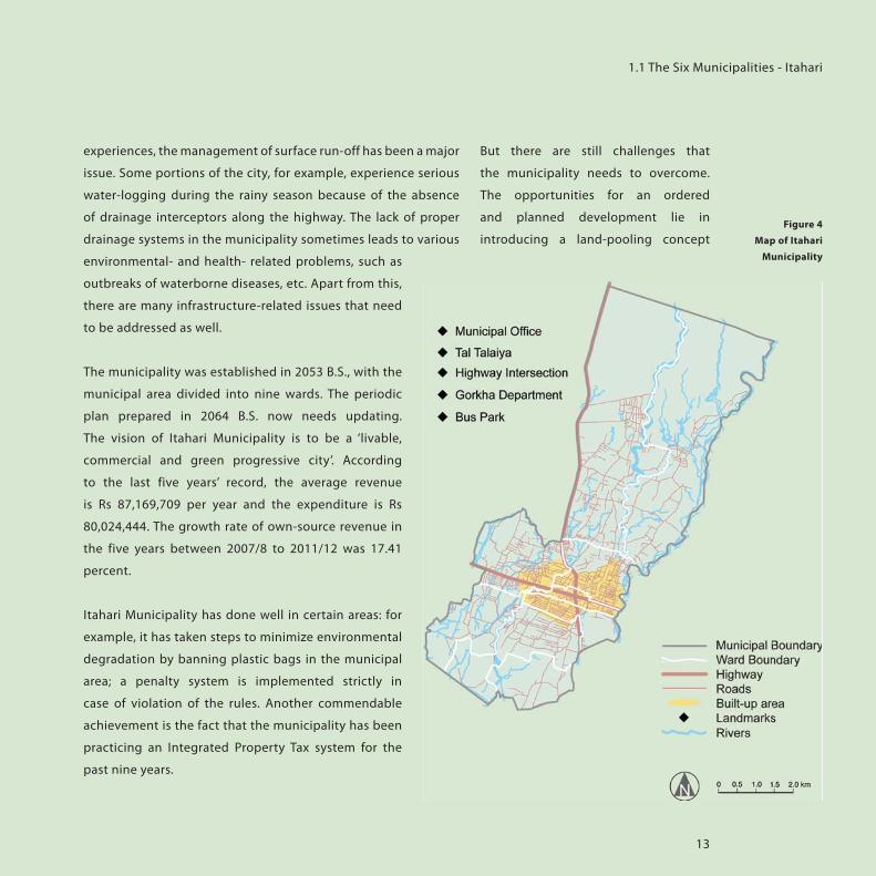
introducing a land-pooling concept Figure 4
Map of Itahari
Municipality
1.1 The Six Municipalities - Itahari
14
municipal MIS and an improved communication- and reporting-
system. The municipality now faces the task of meeting the
growing needs of an increasing population. To do so, adequate
office space, staff and office equipment will be needed.
and implementing new building
regulations: in particular, the issuing
of building permits needs to be
modernized. The municipality can
deliver better and faster services by
introducing new IT technology, such as
With the vision of a ‘livable, commercial and green progressive city’, Itahari municipality is moving forward in its development venture. The municipality, along with citizens, is carrying out the development work through participatory and partnership approaches. The municipality has built the East-West Lokmarga, a drainage system and the Inner Link Road; among its important achievements have been its efforts to improve the agro–market-management system, its conservation efforts and its management of Tal-Talaiya. The municipality hopes to realize its aims of turning Itahari into an ‘open-defecation free area’, where even poor people have access to drinking water. It also hopes to turn Itahari literate, child-friendly and senior-citizen friendly.
The major problem the municipality faces is that there are no local representatives in the municipality and the overall unfavorable political situation of the country makes it hard to conduct local elections, without which it is difficult for citizens to avail of the services provided by the local government. Apart from this, there are difficulties in managing waste, a lack of strategies for mobilizing own sources and difficulties in attracting personnel with new ideas, creativity and skills.
Ganesh Karki, Executive Officer of Itahari Municipality, March 2013
Institutional Development Report

15
Lekhnath Municipality lies in the Pokhara Valley, within Kaski
District, Gandaki Zone, of Nepal’s Western Development Region.
The municipality is named after the famous poet Lekh Nath
Poudyal. It covers an area of 77.45 sqkm, 8 percent of which is
covered by water bodies. According to the 2011 Census data, the
population of the municipality is 58,816. Its annual population
growth rate of 3.58 percent is very high compared to the national
average of 1.4 percent.
Lekhnath Municipality possesses a number of lakes and forests,
which provide it with unique features and rich natural resources.
The periodic plan envisions Lekhnath as the ‘Garden City of
Seven Lakes’. The two biggest lakes, Begnas and Rupa, are already
popular among tourists, while the five smaller lakes, Khaste,
Depang, Maidi, Niureni and Gunde, have still not been explored
for their touristic potential. The municipal populace expects
the lakes to be the spine of the touristic and hence economic
development and hopes they will be conserved even as they are
developed into tourist draws.
Lekhnath, rich in natural resources and bio-diversity, possesses
strong potentials for economic development and income
generation through eco-tourism. Because it has both flat and hilly
landscapes, as well as water bodies, Lekhnath Municipality has a
great diversity of natural features that can be further explored
and used for tourism. It is blessed with
lookout points that provide spectacular
views of the Annapurna range.
Recreational activities such as boating,
trekking, cycling and pony riding are
already on offer by private enterprises.
In combination with the provision of
other facilities, these can contribute
LEKHNATH MUNICIPALITY;ft tfnsf] au}rf+ zx/
2001 2011
Population 41,369 58,816
Population Density (per sqkm) 534.1 759.4
Households 9,362 14,937
CBS 2001 & 2011
Lekhnath
Municipality
1.1 The Six Municipalities - Lekhnath

16
to enhancing the attractiveness for
tourism and enhance public revenues
in the long run. Lekhnath’s proximity
to Pokhara is both an advantage and a
disadvantage: services and opportunities in Pokhara are relatively
better, but due to its uncontrolled proliferation, Pokhara is likely
to gradually lose its charm for tourists.
In 2007, the Lekhnath Chamber of
Commerce & Industries (LCCI) and Lekhnath
Municipality, with support from GIZ initiated
the Local Economic Development Program.
As Lekhnath has the competitive advantage
of fertile land and a unique natural
landscape, six local products (orange,
poultry, fish, coffee, vegetables and honey)
were identified as potentials and further
investments were channeled accordingly.
In addition, there are many potential
resources in Lekhnath Municipality, which
can be further explored and taken into
consideration for LED.
Lekhnath Municipality’s potential for
developing tourism is determined by the
popularity of the tourism services, facilities
and infrastructure provided by Pokhara.
In order to attract visitors and increase
revenue, Lekhnath Municipality needs to
strategically invest in the tourism sector,
for which large investments are required.
If Pokhara and Lekhnath are considered
as one single entity from the sub-regional
development perspective, and development
Institutional Development Report

17
interventions are designed to complement each other – creating
a win-win situation for both — more benefits can be reaped from
their potentials.
But along with developing its touristic places, Lekhnath
must also preserve them. Even though the lakes seem to
be the biggest attraction points, and the resources with the
most potential in the municipality, Lekhnath needs to be
cautious when driving development in the regions near the
lakes, due to the associated environmental implications.
Lekhnath Municipality was established in 2053. For the planned
development venture, the municipality prepared a periodic
plan in 2007, which has already completed its first cycle of five
years and now requires updating. When updating the plan, the
municipality needs to take into account the emerging needs of
the municipality. The vision of the ‘Garden City of Seven Lakes’
confirms the belief that the lakes offer the people of Lekhnath
diverse economic opportunities that can enhance the revenue
of the municipality. According to the last five years’ record, the
average revenue per year is Rs 24,034,985 and the expenditure
is Rs 23,101,531. During the last five years (2007/8-2011/12) the
aggregate growth of its own-source revenue was 25.42 percent.
Lekhnath Municipality is one of the leading municipalities
in local economic development. It has promoted many local
entrepreneurs and has helped poor and disadvantaged groups
to gain access to savings and credit schemes. The partnership-
development section is primarily engaged with communities
in social mobilization, poverty reduction and economic
development.
The municipality building is housed in
spacious premises and is equipped with
a Local Area Network. The municipality
has highly motivated and academically
sound staff , who communicate well
with citizens and other stakeholders and
collaborate with communities (TLOs).
The municipality uses a systematic
approach when issuing building permits
— it issues permits at three different
levels: approval up to the plinth level;
approval for superstructures and a
completion certificate.
But there is much more it needs to
do. The population growth and the
process of urbanization have further
created sub-divisions of the land and
sprawl development is prevalent in
the municipality. In the absence of
land-use plans and policies, haphazard
sprawl is on the rise in Lekhnath. This
1.1 The Six Municipalities - Lekhnath
Begnas Lake

18
within the municipality is yet another challenge that needs to be
addressed urgently. To bring about these developments and to
improve environment protection in general, more institutional
development is required.
will not only cause loss of agricultural
land but also pose a threat to the
lakes. With urbanization and changes
in consumption patterns, there
has also been an increase in waste
generation. The lack of a landfill and
solid-waste-management system
Most of the urban centers have become increasingly congested, resulting in lack of open space, haphazard growth, inadequate infrastructure facilities and unhealthy living conditions. Nonetheless, Lekhnath Municipality is a new and emerging urban centre and still has the scope for planned development.
Lekhnath municipality is a picturesque municipality, which is located in Pokhara valley area and which has been envisioned as The Garden City of Seven Lakes. The lakes are the outstanding resources of the municipality: the peaceful and scenic ambience make Lekhnath a most favorable destination for tourism in the future. Integrating public satisfaction with good governance and expediting infrastructure development to cater the basic needs of the increasing population are the major challenges of the municipality. The municipality has been engaging with different sector-development approaches, with the support of different ministries (MLD, MUD- DUDBC) and donor agencies for physical development, human resource development and institutional development.
The Urban Governance and Development Program fosters the municipal approach of developing the municipality as a garden city and promotes it as a tourist destination. Tourism will be the principal component of the municipal economy in the future. It is believed that UGDP will be a milestone in the sectoral development of the municipality, with physical development, capacity development and institutional development along with the formulation of guidelines for the authorities to direct future growth.
Dambaru Dahal, Executive Officer of Lekhnath Municipality, March 2013
Institutional Development Report
19
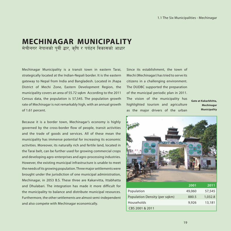
Mechinagar Municipality is a transit town in eastern Tarai,
strategically located at the Indian-Nepali border. It is the eastern
gateway to Nepal from India and Bangladesh. Located in Jhapa
District of Mechi Zone, Eastern Development Region, the
municipality covers an area of 55.72 sqkm According to the 2011
Census data, the population is 57,545. The population growth
rate of Mechinagar is not remarkably high, with an annual growth
of 1.61 percent.
Because it is a border town, Mechinagar’s economy is highly
governed by the cross-border flow of people, transit activities
and the trade of goods and services. All of these mean the
municipality has immense potential for increasing its economic
activities. Moreover, its naturally rich and fertile land, located in
the Tarai belt, can be further used for growing commercial crops
and developing agro-enterprises and agro-processing industries.
However, the existing municipal infrastructure is unable to meet
the needs of its growing population. Three major settlements were
brought under the jurisdiction of one municipal administration,
Mechinagar, in 2053 B.S. These three are Kakarvitta, Ittabhatta
and Dhulabari. The integration has made it more difficult for
the municipality to balance and distribute municipal resources.
Furthermore, the other settlements are almost semi-independent
and also compete with Mechinagar economically.
Since its establishment, the town of
Mechi (Mechinagar) has tried to serve its
citizens in a challenging environment.
The DUDBC supported the preparation
of the municipal periodic plan in 2011.
The vision of the municipality has
highlighted tourism and agriculture
as the major drivers of the urban
MECHINAGAR MUNICIPALITYd]rLgu/ g]kfnsf] k"jL{ 4f/, s[lif / ko{6g ljsf;sf] cfwf/
2001 2011
Population 49,060 57,545
Population Density (per sqkm) 880.5 1,032.8
Households 9,926 13,181
CBS 2001 & 2011
Gate at Kakarbhitta,
Mechinagar
Municipality
1.1 The Six Municipalities - Mechinagar

20
economy. Through the Rural-Urban
Partnership Program, the municipality
has effectively mobilized the
communities for different development
activities. It has established some good
practices such as an NGO Coordination
Committee at the municipality that monitors NGO activities
and thus avoids duplication of efforts. The municipality plans to
declare itself as an ‘Open-Defecation-Free Area’ and towards this
end, it has laid the groundwork for raising awareness about the
need for sanitation and other pilot projects. In order to conduct
an ordered and planned development, the municipality requires
Figure 6
Map of Mechinagar
Municipality
Institutional Development Report

21
1.1 The Six Municipalities - Mechinagar
new building regulations. The issuing of building permits
especially needs to be modernized and with the support of UGDP
the municipality has begun using a software system for managing
the issuing of permits. The municipality is also running a maternal
childcare center and urban health centers. The municipality has
worked towards the banning of plastics within the municipality
and has worked to raise awareness about the 3-R (reduce, reuse,
recycle) principles. Nonetheless, there are still many challenges
in terms of managing waste – especially the hazardous wastes
from hospitals, which is yet another major concern. According to
the last five years’ record, the average revenue of the municipality
per year is Rs 109,773,501 and the expenditure is Rs 99,822,143.
The individual identities and spatial separation of its three major settlements — Kakarvitta Dhulabari and Ittabhatta — within Mechinagar Municipality has created a great challenge to the municipality. Coupled with resource constrains, it is difficult to balance development equally in the three settlements.
As Mechinagar is a strategically located border town, many people from India and Bangladesh come to Dhulabari for shopping. By providing better services and entertainment, the visitors might want to extend their stay in the municipality, which can eventually contribute to the municipality’s revenue generation. Thus, the municipality has to strategically plan for this sector. Another potential for the urban economy is the agriculture sector. Due to the lack of agro-processing plants, agro-products are directly exported to India, without their being further processed. By supporting the establishment of agro-processing plants within the city, the economic development of the municipality can be enhanced.
Bhim Prasad Poudel , Executive Officer of Mechinagar Municipality, March 2013

22
Tansen Municipality is located in
the beautiful hilly area of Palpa
District, Lumbini Zone, of the Western
Development Region. It covers an area
of 21.72 sqkm and is divided into 15
wards. According to the 2011 Census
data, the population is 29,095. It is a
growing city with an annual population
growth rate of 3.6 percent, which is more than double the
national average of 1.4 percent.
Tansen is famous for its pleasant climate, natural beauty and
cultural heritage. In the past, Tansen was well known for its
services in the areas of health and education: the mission hospital
in Bhushaldada, for example, serves not only patients from the
neighboring districts, but also patients from India.
The town, already a tourist destination, has the potential to
develop its tourism industry even more. Shreenagar Dada, located
at a height of 1,331 m, offers a panoramic view of mountains such
as Machhapuchere. The municipality has numerous historical and
religious sites. For example, the Narayansthan area, located in
the core of the city, comprises three tourist draws: Narayansthan
Temple, a sunken stone spout (currently under threat from
encroachment of public space) and a green-belt area, which is
currently unused. Apart from these sites, Tansen is famous for
its Bhagwati Temple, Palpa Durbar, Main Gate, Bijaya Stambha,
Sitalpati, Tudikhel and Birendra Park. A mere 16 km away from
Tansen Municipality lies Rani Mahal, which is located in a
beautiful site along the Kali Gandaki River. This palace, built by
Khadga Shumsher in memory of his dear wife, is often referred
to as the ‘Taj Mahal of Nepal’. Parvas Lake, Satyawati Lake, and
Bhairavsthan – a temple that houses the world’s largest trishul (a
TANSEN MUNICIPALITYko{6sLo gu/L tfg;]g
2001 2011
Population 20,431 29,095
Population Density (per sqkm) 940.7 1339.5
Households 4,813 8,411
CBS 2001 & 2011
Tansen Municipality
Institutional Development Report

23
trident) – are also popular tourist destinations in Palpa District.
Besides tourism, Tansen has potential for growth in other areas
as well. It is famous for its special textile called ‘dhaka’ and bronze
utensils called ‘karuwa.’ To show how important the karuwa is
to Tansen’s identity, a big statue of a karuwa has been has been
erected in front of the municipality building. Apart from this,
Palpa possesses fertile land that is very suitable for coffee and
vegetable production.
Tansen Municipality is the country’s
third-oldest municipality, established
in 2007 B.S. The municipal building
is located in the beautiful foothills
of Tansen Bazaar, in front of an area
of open space called Tudikhel. The
municipality has its own municipal
building, with a large hall, and is
easily accessible to the citizens. For
the planned development venture,
the municipality prepared a periodic
plan and formulated a vision: the
vision of Tansen municipality is to
develop the city as a ‘tourism city’.
In order for the municipality to
achieve its vision, it needs to improve
certain services it provides: it could,
for example, promote home-stay
initiatives and cultural-promotion
activities to attract national as well as
foreigner visitors. The average growth
in own-source revenue over the last
five years (2007/8-2011/12) was 35.60
percent. According to the last five years’
record, its average revenue per year was
Rs 53,199,027 and its expenditure was
Rs 40917337. Out of 15 wards within
the jurisdiction of the municipality, ten
Figure 7
Map of Tansen
Municipality
1.1 The Six Municipalities - Tansen

24
about strengthening its solid-waste-management setup, and it
has already constructed a landfill site, which is in the early stages
of operation. It has also started a European-Commission-funded
‘Towards Zero Waste’ project with support from the Municipal
Association of Nepal (MuAN). But there are other areas of service
delivery it still needs to work on. Among the most pressing issues
that the citizens of Tansen would like the municipality to address
is that of the scarcity of drinking water.
wards have an urban character, and the
rest are more rural.
With the increasing population and
changes in lifestyle, the municipality
is facing new challenges in managing
the town and keeping it clean. The
municipality is extremely concerned
Apart from the challenges of population growth, migration and increasing urbanization, the municipality is facing new challenges such as waste management, market management and provision of infrastructures such as road, drainage, sewerage, drinking water and so on. In order to tackle all these challenges, it is necessary to focus on the institutional-development aspect of the municipality and drive the development according to the spirit of local self-governance. The unparalleled natural beauty of Tansen and its rich art, history and culture can be used to attract foreign as well as domestic tourists and to develop Tansen municipality as a tourist destination. In order to do this, the horizon of physical, social and economic development aspects must be widened by including more women, children, senior citizens, the disabled and marginalized people in the municipality’s development stream.
Because the country is hobbled by political crisis, it is very challenging for the municipal staff to balance the undertaking of their political and administrative tasks. The lack of political representatives is adversely aff ecting the running of the local government, but the municipality is trying its best to provide good governance by putting the people at the center of development. It has been involving its citizen in the planning, implementation, operation and maintenance, and evaluation and monitoring of development ventures. Along with an increase in its own-source revenue, the municipality is also receiving support from donors like the World Bank and European Commission for infrastructure development and solid- waste-management, respectively. These projects have also helped in building the capacity of municipal staff and administration. It is very important for the municipality to develop human resources in order to improve urban planning, management and good governance.
Niran Bhattarai, Executive Officer of Tansen Municipality, March 2013
Institutional Development Report

25
MST supports the six emerging towns with capacity development
that helps them to introduce and implement new systems and
procedures in their municipalities. MST provides local, regional
and central training, which improves knowledge management
while at the same time assisting in local participatory urban
development. MST works with four dimensions of development:
human resources, organizations, networks and systems, which
are the four dimensions that bring about changes in institutional
developments. The main challenge in accomplishing this goal
is to create a better and inclusive urban management plan. This
includes improving information flows and better communication
between multiple stakeholders and between central level and
municipalities.
MST had conducted a Rapid Assessment of the six participating
municipalities to determine the strengths and weakness and
the needs and necessities of these municipalities. As MST’s
focal objective lies in institutional strengthening and capacity
development, the assessment conducted measured the
functionality of municipal administrations and their capacities.
The assessment was done through a questionnaire that assessed
the organizational structure, section-wise terms of reference,
individual assessment of existing staff, working methodology,
existing pace, assets and IT equipment. Due to this assessment by
MST, the planning and designing of required actions for training
concepts, procurement plans for IT
equipment and so on was possible.
One general challenge in the
municipalities is the lack of motivation.
Staff of the municipal office state that
self-motivation is necessary as well
as self-realization of responsibilities,
accountability and ownership towards
their duty. Municipalities are supposed
to have a performance-based reward
system, but this has not been practiced.
The lack of incentives is posing a
challenge for staff to perform at their
best.
The available physical space and
equipment of municipal offices also
hinders efficient implementation of
capacity development. The offices of the
six municipalities are often inadequate
in space to provide a comfortable
working environment. They do not have
enough room for all the staff or are old
and deteriorating. The municipalities
1.2 WRAP UP: URBAN CHALLENGES FOR
CAPACITY DEVELOPMENT
1.2 Wrap Up: Urban Challenges for Capacity Development

26
do not possess individual ward offices
for all their wards, which prevents the
municipality from providing full local
service to all its wards’ residents. IT
equipment are insufficient and barely
working. In Baglung Municipality, at
the time of the Rapid Assessment, there
were only three computers, one of
which was 14 years old.
In terms of work being performed
by the municipality, a format for a
reporting system is missing, thus
the works being accomplished every
day cannot be effectively monitored.
Individual sections of the municipality
need an internal reporting system
which would then be submitted to the
executive officer. Municipalities are also
supposed to develop and implement a
citizen report card system which would
assess an individual citizen’s satisfaction
regarding the service provided by
municipality.
The accounting sections of all the
municipalities need to have their
capacity developed further. The
accounting personnel are often in
need of training on long-term accrual
accounting methods so that this can be better implemented.
At the same time, essential basics are missing in that section.
There is no automatized billing system, the staff members of this
section are not often trained on the computer and the section
often lacks the required accounting software. The sections in the
six municipalities have acquired software but due to the lack of
training and the general lack of human resources these are often
not in use.
In terms of providing training, MST developed a matrix of
necessary skills that should be developed through training for
the municipality, focusing on aspects that directly support the
municipality to tackle administrative, social and managerial
challenges they face. Some of these include: training in
management skills, public service efficiency, conflict resolution,
communication and reporting skills, updating database and
websites, computer training skills (advanced and basic) for staff
and ward secretaries, filing system/management skills, counseling
techniques and GIS, communication and record updating.
Certain tasks needs to be carried out for the planned development
of the municipalities. These tasks are seen as urban challenges
because municipalities often do not have the proper manpower
or the equipment to meet and complete these tasks. Some of
these tasks include: revision of the periodic plan, preparation
of digital maps, the municipal profile, land use and local area
action plan, digitization of building permits, and the revision
of building and planning bylaws. All of these need to take into
consideration the continuous urban growth and new demands
from the citizens.
Institutional Development Report

27
This is only a summary of the challenges that are generally
common amongst all six municipalities participating in UGDP.
It is important to note that these differ from municipality
to municipality. However, the challenges vary according to
the municipality and are unique because of their different
geographical location, different employees, different methods
of working and so forth, making it necessary to provide tailor-
made solutions and the possibility for feedback and monitoring
regarding measures in capacity development. What all
municipalities have in common is their need for intense support
and long/medium term backstopping to improve their capacities.
1.2 Wrap Up: Urban Challenges for Capacity Development

28
Institutional Development Report

29
2. URBAN GOVERNANCE AND DEVELOPMENT PROGRAM
(UGDP)

30
2.1 UGDP IN THE CONTEXT OF
AN URBANIZING NEPAL
The described process of rapid
urbanization has created an immense
pressure to the municipalities of Nepal
to cope with the growing demand for
efficient service delivery and to grant
a sustainable urban development.
However, municipalities are struggling
to address the increasing urban needs,
apart from political instability, due to inadequate financial
resources and technical capacities. During the late 1980s, at a
time when donors’ or other external support was absent in the
urban development arena of Nepal, German Cooperation started
to provide technical support to municipalities in various aspects
by supporting the Urban Development through Local Efforts
Program, UDLE. The German Government continued its support
from 1987 onwards without interruption, while in 2003 the Asian
Figure 8
bridging urban
challenges and
development
strategy
Institutional Development Report
Strategic Approach in the
Core of Urban Development
Emerging Towns Project
growing urban
population
basic urban
services demand
Urban Challenges &
Needs
capacitating personnel
urban plan-ning & man-
agementreforming
procedures
drainage, sewerage
roads
solid waste management
recreational areas
UrbanCapacity
Development
water supply
Improved Public Services & Socio Economic Infrastructure

31
Development Bank joined the urban sector in Nepal. Eventually,
the World Bank after a long absence from the sector, since the
early 1990s, re-entered the area of urban development in 2011.
With the Urban Governance and Development Program (UGDP),
it started a new initiative with intense preparatory work.
This government program is financed by the World Bank,
supported with in-kind technical advisory services by GIZ and
co-financed by the Government of Nepal, with contributions
from the municipalities and communities, consistent with GoN’s
urban policies and priorities. The Emerging Towns Project (ETP) is
a first step to supporting Nepal in its urban transition under the
initiative of the UGDP. The project helps to improve the capacity
of the participating municipalities to plan, implement and fund
urban development activities.
Under the local governments’ responsibilities fall such
crucial services as water supply, drainage, sewerage, roads,
recreational areas, solid waste management and the like. In the
current context of the ongoing urban transition, municipalities
need to be capacitated to face the challenges from a growing
population and demands for basic urban services. The project
therefore intends to improve the capacity of the participating
municipalities in delivery and sustainable provision of basic
services and priority infrastructure, putting local institutional
development at the core of the strategic approach.
The project recognizes that towns and cities are the enabling
environments for social and sound economic development of
Nepal in the 21st century. While urban management and urban
governance are equally important, the
best way forward would be to create
a comprehensive urban management
plan that follows a strategic vision and
uses participatory strategies. Hence,
to be able to face the most pressing
challenges in the municipalities,
adequate capacities are needed to
improve the ways in which urban areas
are planned, equipped and managed.
2.1 UGDP in the Context of an Urbanizing Nepal

32
2.2 INSTITUTIONAL ARRANGEMENT
Project Management Team (PMT)(EO + Section Heads)
Project Executing Agency (MoUD)
Project Steering Committee
CM2 (TDF)Capacity Building for Municipal
Infrastructure Development
CM1 (MoUD)Strengthening Municipal Planning Capacity for Urban Development
CM3 (DUDBC)Institutional Development
Project Coordination Office (PCO) (at DUDBC )Municipal Support Team (MST)
MUN + APM (Existing Structure)
Municipal Coordination Committee (MCC)(Municipalities+ APM+LA+ CSO)
Institutional Development Report
Figure 9
Institutional
Arrangement
for UGDP

33
Component 1: Strengthening Municipal
Planning Capacity for Urban Development
Through this component, municipal grants are provided to
the municipalities for diverse types of small scale activities.
The budget can be assorted to improve municipal services and
infrastructure, operation and maintenance (O&M) of existing
infrastructure, social mobilization, community development and
capacity building. At least 35 percent of capital expenditure has
to be allocated for pro-poor and community-oriented schemes.
As in component 2, all sub-projects under component 1 are
scrutinized thoroughly to ensure that they do not create negative
environmental or social impacts. US$5 million is allocated by the
UGDP-ETP for this component, the executing agency for this
component being originally the Ministry of Federal Affairs and
Local Development (MoFALD). As in the meantime the Ministry
of Urban Development (MoUD) was established, responsibilities
were shifted to this new ministry.
Component 2: Capacity Building for Municipal
Infrastructure Development
The primary objective of this component is to assist municipalities
in developing infrastructure that will lead to improved services
and greater socio-economic benefits
for residents and businesses in the
respective municipality. The three types
of infrastructures under this component
are social infrastructures, urban /utility
infrastructures and revenue generating
/commercial infrastructures for which
the types of sub-projects and loan and
grant distribution varies. The details are
provided in the table below:
2.3 PROJECT COMPONENTS
Figure 10
Loan Grant Mix
2.3 Project Components

34
Institutional Development Report
Basic Urban InfrastructureEconomic/Revenue Generating
InfrastructureSocial Infrastructure
Bus parks and parking spaces for
rikshaws, horse carts, trucks etc.
Cottage, medium and small industries
Tourism
Haat bazaar/market fair centers/
exhibition centers
Land pooling
Supply of electricity and
communication facilities
Generation of electricity/distribution of
electricity
Irrigation
Commercial investments such as
hotels, business centers, shopping
complexes are not prescribed to
municipalities in the LSGA 1999, thus
will not be eligible for TDF financing;
rather they need to be financed fully
by private sector.
Drainage (bridges/culverts if part of
drainage)
Public toilets
Slum area improvement (water, road,
drainage, solid waste, and access roads
to hamlets of the poor communities)
SWM (collection, transportation and
disposal including equipment)
Sanitation programs
Pre-primary schools
Libraries/reading halls (book bank for
poor children)
Health centres/health posts
Fire station
Aged rest-houses/ orphanages
Water pollution (including sewerage,
waste water treatment plants etc.)
Social housing
School buildings (hostels for girls and
physically challenged)
Green zones/parks/ play grounds
Municipal / Ayurvedic hospitals
Roads and bridges
Drinking water
Preservation of natural, cultural,
archaeological, or heritage sites
Slaughter house
Street lightings
Municipal buildings
Community buildings and rest houses
Sports, stadium, recreational area
Crematoriums
Museums
Protection of natural resources,
including controlling air, and noise
pollution, public land protection works,
river cuttings/floods/soil erosion
control, preservation of rivers, streams,
ponds/deep water wells/lakes/stone
spouts; and plantation on road sides

35
2.3 Project Components
The distribution of funds to these municipalities is based on the
evaluation of the preparedness of pipeline sub-projects, project
-management capacities, financial sustainability, loan-carrying
capacities, etc. For the execution and implementation of this
component fund flows through Town Development Fund(TDF).
Component 3: Institutional Development
The main objective of this component is to provide support in
the institutional strengthening of participating municipalities,
Ministry of Federal Affairs and Local Development, Town
Development Fund, Ministry of Urban Development, Department
of Urban Development and Building Construction and various
project-implementing units established for implementing the
projects. The total fund for this component is US$ 6.63 million,
out of which the World Bank and GIZ have contributed US$ 3.63
million and US$ 3.0 million respectively.
The implementing agency for this component is DUDBC. The PCO,
located in the DUDBC, leads this component in consultations,
assessments, drawing up capacity-development plans and
institutionalizing programs and systems with the respective
stakeholders. The GIZ-funded Municipal Support Team, located
in the premises of DUDBC, works in close coordination and
consultation with the PCO primarily for the Institutional
Development of the municipalities.

36
2.4 STAKEHOLDERS IN UGDP
The Urban Governance and
Development Program (UGDP) is based
on the cooperation of two ministries,
MoFALD and MoUD (with DUDBC
and TDF), and two development
partners, the World Bank and GIZ. The
component ‘Institutional Development’
is jointly assisted by the World Bank and
GIZ. GIZ outsourced its contribution
to a consultant consortium, which
established the MST. With six selected
municipalities participating in the
UGDP-ETP, MST works on the challenges
and opportunities of the urban sector
in Nepal. The total population of the six
municipalities — Mechinagar, Itahari,
Dhankuta, Lekhnath, Baglung and
Tansen — was approximately 280,000
in 2010, and a sizable percentage of
these are expected to benefit, directly
or indirectly, from the project.
DUDBC
DUDBC is responsible for the physical planning and development
of urban and urbanizing areas in Nepal. The present-day
DUDBC was constituted in 2000 by merging the Departments
of Housing & Urban Development and Building, which were
the principal government agencies engaged in urban planning
and development for around three decades. Key functions
and responsibilities thus include the formulation, planning
and implementation of urban policies; formulation, planning
and implementation of housing plans and policies; design
construction, repair and maintenance of government buildings;
and supporting the Town Development Committees.
An institutional assessment of the DUDBC has revealed that the
agency is constrained by certain functional overlaps with the
MoFALD in areas of local planning and support to urban local
governments. It attempts to strengthen its policy orientation
with regard to urban development, the coordination with
other entities in the urban sector and the interaction with
municipalities. Over the long term, by recasting its roles and
functions and strengthening its capabilities, the DUDBC is
designated to play the key role in the ongoing urban transition
of Nepal along with urban governments and administrations,
Institutional Development Report

37
especially in urban policy-setting and monitoring. However, the
departmental efforts and investments in urban infrastructure
projects have been limited and isolated in many instances,
requiring a review of its approach. The department is aligned
with the National Urban Policy (2007), but its implementation
is still slow due to the geographical challenges and the lack of
investment for strategic projects.
The DUDBC now belongs to the Ministry of Urban Development
(MoUD), which was established in 2069 B.S. It is responsible for the
policies related to urban development and urban infrastructure
development; for the formulation of urban projects and programs
and their implementation, monitoring and evaluation.
TDF
The provision of loans for improving key
infrastructure is routed through TDF to
strengthen existing institutional systems
for financing municipalities’ infrastructure
requirements. The TDF is an autonomous
agency, set up with GIZ assistance in 2043
B.S. and owned by GoN, and mandated to
provide financing and technical support for
urban infrastructure development. The TDF,
with WB and GIZ support, has developed a
Business Strategy and Action Plan, which
serves as a roadmap for addressing immediate
critical issues and longer term institutional
strengthening. As part of the reforms,
a uniform financing policy has been
developed. To ensure greater local
ownership and sustainability of
investments, the municipalities provide
own or community cash contribution
of about 10 percent of the total sub-
project cost. They will also have to meet
certain standards with regard to key
financial ratios, as well as establish that
they possess or are willing to establish
adequate fiduciary systems.
2.4 Stakeholders in UGDP
DUDBC Office,
Babarmahal

38
from these GIZ-supported projects when supporting UGDP in
developing institutional capacities. SUNAG Program
GIZ’s support to the urban sector in
Nepal has been a significant long-
term commitment. The urban support
components in SUNAG derive essentially
from its predecessor program, Urban
Development through Local Efforts.
UDLE was a joint program of the
Governments of Nepal and Germany
with the main objective to enable
municipalities to initiate and manage
sustainable urban development with
the participation of the local population.
For over two decades GIZ supported
urban programs and contributed to
urban management, primarily in the
areas of financial management, urban
hygiene and environment education,
urban planning, organization
development, social inclusion and
poverty reduction. Moreover GIZ
contributed to policy reforms in the
urban sector at central government
levels, and linked closely with the
Ministry of Local Development and the
Department of Urban Development and
Building Construction. MST, located at
the DUDBC, is meant to feed-in lessons
Institutional Development Report

39
3. CAPACITY DEVELOPMENT (CD) ACTIVITIES

40
Given the current situation of the urban
sector in Nepal, an overall strategy
for sound urban development has
to be both comprehensive and start
from different ends. Three categories
were found relevant for describing
UGDP’s approach for improving the
sector: institutional, structural and
capacity-wise.
Local institutions, though they are
favored by national laws such as the
LSGA, are struggling to cope with their
tasks and depend heavily on support
from the central level.
Structurally, Nepal is well-equipped
with organizations and departments
that look after urban development and
the specific issues within the sector.
However, there is little coordination
among these entities, and most of
them operate on the central level
with weak communication channels
between them and the municipalities.
The central level thus has to also come into the focus of activities
in the field of institutional development. For the successful
implementation of the project, the previous focus on component
3 as the institutional development component was extended
towards also supporting the central agencies in components
1 and 2, namely in terms of the use of the block grant and the
development of infrastructure sub-projects.
Working on long-term institutional development, the project
started initiatives to develop more systematic approaches in the
municipalities, both in regard to the management as well as the
development of capacities and also to improve communication
and reporting with the central level. At the beginning of the
project, the municipalities and central stakeholders were
consulted to prioritize the most important and urgent activities,
following the Institutional Development (ID) related activities as
outlined in the Project Appraisal Document (PAD). Also, the result
framework, especially after its review in 2070 B.S., determined
important outcomes for the development of capacities and for
the enhancement of institutional efficiency.
Based on the most pressing needs in the participating
municipalities, the MST works along five outcome areas, which
are part of two main sectors, i. e. (a) urban management and (b)
financial management.
Institutional Development Report
3.1 CAPACITY DEVELOPMENT IN UGDP

41
Urban Management (UM) includes physical planning,
infrastructure and service provision and the improvement of
administrative performance. Under Financial Management (FM)
fall the areas of revenue enhancement and asset management.
Asset management is closely linked to operation and maintenance
(O&M), strategic planning (e. g. for the preparation of resource
maps) and eventually urban development. Another important
link between UM and FM is the potential increase of revenues
through the improved provision of services.
The revision of the Results Framework recognized the efforts
for improving these aspects in the municipality and set the
preparation of O&M plans and revenue enhancement as core
indicators for the Project Development Objective (PDO).
ID activities have been subject to frequent revisions throughout
the progress of the project. It was found that the capacities at
the municipal level were weaker than it had been assumed when
the project was designed and that the central-level agencies also
lacked institutional capacities to support the local administration.
The lack of capacities on the local level for planning and
implementation of local-level sub-projects demanded that
institutional capacity development also be viewed in the context
of component 2.
3.1 Capacity Development in UGDP

42
Focusing on sustainable long-term
institutional and capacity development,
MST works with 4 dimensions of
development: human resources,
organizations, networks and systems.
These four jointly determine any long-
term changes in institutional
development. MST contributes to the further development of
trainings.
To achieve the desired impacts on institutional development, a
number of levels and processes need to be aligned and combined
with each other. The four dimensions of capacity development,
as shown in the accompanying figure, combine the four different
focuses on development.
Human resources are here understood mainly as local staff;
institutional development pertains to the municipalities
(here: organizations); networking refers to the networking
between partners and independent stakeholders in
the urban sector; and the systems refer to the overall
framework given, modified and monitored by the
national-level bodies.
MST works in the first three dimensions and hence adopts a
multi-level and multi-focus approach. It will be left to other
stakeholders (MoUD, MoFALD and the support through
SUNAG and UGDP) to ensure that positive impacts achieved
locally will contribute to improved urban governance on all
levels.
MST addresses a number of stakeholders and actors in the urban
3.2 DIMENSIONS AND PROCESSES FOR
CAPACITY DEVELOPMENT
Figure 11
The ‘capacity
works butterfly’:
four dimensions
of capacity
development
EMPOWERMENT
Institutional Development Report

43
DIMENSION FOCUS ACTORS Activities
Human Resource
Development
Promote abilities and skills
of municipal staff
Mun. Officers
DUDBC
UDTC / RLCs
LDTA
Develop training modules / curricula
development
Deliver trainings and orientations in
cooperation with training institutions
Document and incorporate feedback
to training modules/curricula
Institutional /
Organizational
Development
Develop systematic
approaches to improve
urban management &
governance
Municipalities
DUDBC
MIS,
Knowledge & process management,
Systematic/periodic review of
positions and responsibilities
Development of
cooperation and networks
between institutions and
partners
Strengthen cooperation
and collaboration among
involved actors
MoUD, MoFALD, DUDBC,
LDTA, UDTC, RLC,
Municipalities , LGCDP,
TDF, Donors
Exchange and communication with
partners
Provision of systematic information
flows
Periodic meetings
Beyond the work of MST, the set-up of UGDP aims at improvements in the sub-national government system, where the
municipalities will play a crucial role. Hence, the fourth dimension will be addressed adequately by other stakeholders.
System Development in
Policy Field
Support improvements
in the sector for national
policies
PCO
MLD
MPPW
(SUNAG/GIZ)
UGDP/WB)
Listed actors contribute to improving
• legal system (laws, bylaws,
ordinances, guidelines) and
• processes (reporting, information
flows)
Table 1
Four dimensions
of capacity
development, their
respective actors
and activities
3.2 Dimensions & Processes for Capacity Development

44
sector with different activities. These
activities can be consecutive or parallel;
they can be based on each other or
mutually impact each other. The
succession of required steps that will be
taken to achieve the desired impacts is
further outlined in Chapter 4.
Processes for Supporting Capacity
Development
In line with the four dimensions of CD
and considering specifically the tasks
of the MST in UGDP and SUNAG, three
core processes have been identified
that require long-term and constant
support.
Training, in its broader sense of
knowledge facilitation, is an essential
part of human-resource development
and it also improves administrative
performance. Training will thus also
help in developing institutions that
deal with the local level and improve
the systems of the central level.
Management Information System
(MIS) is a key for the betterment of
information flows and to promote
efficient and effective management.
The establishment of a functional MIS in each municipality will
have an impact on all levels and especially improve the use of
resources and the planning of outcomes.
Eventually the area of urban development as a process will highly
benefit from both training and MIS. Direct support in this area
shall be given to, for example, committees and other stakeholders
concerned with the urban development of the municipalities.
This process is meant to integrate UGDP’s component 2, i.
e. the improvement of infrastructure, and shall facilitate the
implementation of the planned activities. It specially supports
the implementation and maintenance of infrastructure projects.
Urban development is here understood as an active process that
considers the different stages of planning and implementation,
including decision-making and the allocation of funds. Though
‘urban development’ is a broad term with many connotations, it
is used here to illustrate the importance of this holistic process.
The support of MST, however, is limited to the facilitation of the
required progress and to provide advice to the actors involved.
Ultimately, all municipalities shall develop a rational and
transparent system of capital financing of urban infrastructure
embedded within the overall intergovernmental fiscal framework,
as described in the objective of component 2. It should be
noted that the complex scenario of the municipalities include a
significant amount of pre-designed tools and formats such as the
Periodic Plan, IPT software, now the Accrual Accounting System,
and the like. MST was requested to work with these tools rather
than introducing more templates or model forms. The challenge
is making the existing ones efficient and workable. Institutional
capacities will be developed in line with the given scenario and
Institutional Development Report

45
to support the improvement of standards and processes, e. g.
through linking important sectors through MIS and developing
standardized frameworks.
UGDP activities related to Capacity Development can be clustered
into 5 outcome areas that are part of two main management
sections: (a) urban management and (b) financial management.
Urban Management (UM), including urban planning and service
provision, is an important sector for institutional development
and for improving the municipal administrative performance.
Under financial management (FM) fall the areas of resource
revenue and asset management. Asset management is also
closely linked to strategic planning and urban development.
Another important link between UM and FM is the potential
increase of municipal income through revenue generation with
improved service provision.
3.2 Dimensions & Processes for Capacity Development
Figure 12
Clustered sections
of institutional
development in the
municipalities
Tasks Sections / Sectors
( + goods and equipment)
( + goods and equipment)
Strategic Urban Planning
Own Resource Revenues
Urban Service Provision
Urban Management
Financial Management
Asset Management

46
Orientation Workshop on
the Project Implementation
Manual (PIM)
The Project implementation Manual
(PIM) provides comprehensive
guidelines for the implementation
procedures of the UGDP. At this early
stage, when municipalities were not
fully aware of the procedures, an
introduction to the manual was a
crucial step forward for the Program’s
implementation. Thus, at the outset of
UGDP operation, a workshop provided
a comprehensive orientation on the
PIM to the concerned municipal staff.
The program was organized in February
2012 in the Lainchour/Malla Hotel,
Kathmandu, for two days for a total of
24 participants from all 6 municipalities.
The workshop also served for collecting
feedback and further clarification
among participants and trainers
regarding this central document. As
UGDP is a newly designed program, queries and essential inputs
regarding the PIM and its implications were received during the
workshops that helped its review and improvement afterwards.
The most important aspects of the PIM for the local level include
the preparation and the implementation of sub-projects under
components 1 and 2. Hence, the content disseminated during
the workshop was:
• Guidelines/Rules of Engagement for the Three Components
• Project Management and M&E
• Social and Environmental Safeguards
• Financial Management
• Financial & Economic Analysis of Socioeconomic
Infrastructure Sub-Projects
• Procurement
The participants from the six participating municipalities
were executive officers, engineers, social and environmental
development officer, account/revenue officers. Apart from the
local level participants, central level representatives from DUDBC,
TDF, WB, then MLD, PCO and MST also joined and contributed in
the workshop. The main resource persons were primarily from
the PCO, namely its management and the MST.
Institutional Development Report
3.3 UGDP ORIENTATION AND TRAINING

47
The workshop’s methods were based on interactive
presentations, discussion, group work and hands on exercises,
e. g. for filling out the social and environmental screening
checklists. A Nepali translation of the PIM was distributed to the
municipal participants. After the workshop, a series of reviews
and discussion within the PCO took place to incorporate the
recommendations from participants and UGDP stakeholders and
finally MST provided a fully revised version of the PIM.
UGDP Orientation at the
Local Level
Orientations on UGDP to larger groups
of stakeholders at the local level were
conducted at different stages. As the
major institutional arrangement at
the local level, Municipal Coordination
Committees (MCC) were formed in all
participating municipalities. During
the orientation programs, the purpose
of UGDP and its objectives were
introduced, institutional arrangements
at the local level explained, and the
components under the program and the
respective fund allocations provided.
The three categories for sub-projects
under component II were detailed,
providing all relevant information such
3.3 UGDP Orientation & Training
UGDP orientation in
Tansen Municipality

48
as their respective loan and grant ratio,
interest rate, loan-repayment period and
the conditions to be accepted (technical,
economic, environmental and social
safeguards, fi nancial viability, etc.).
The established Municipal Coordination
Committees, under the chairmanship
of the executive offi cers and including
the Project Management Team
(PMT), functions as the receptor and
disseminator of the information provided.
In the second round, more specific
orientations were provided for selected
members of MCC and PMT in all six
municipalities, and the following
aspects were presented and discussed
in detail:
• Social and environmental
safeguards to be considered for
block grant and sub-projects
under component II;
• Economic and financial analysis;
• Project-wise (as per their priority)
tentative loan amounts and their
installment up to the period based
on the categories of the sub-
projects;
• Alternate financing;
• Monitoring and evaluation;
• Grievances to be addressed during
planning and implementation of sub-projects and structure
of Grievances Redress Committee (GRC) and their role and
responsibility;
Eventually, as another requirements for ensuring the smooth
implementation of the sub-projects, Grievances Redress
Committees (GRC) were formed in all six municipalities.
The third orientation program was organized for the members
of the GRC to make them familiar with the project itself. The role
and responsibility of the GRC were explained and discussed in
more detail.
The series of orientations and short trainings for stakeholders,
municipal staff and members of the newly established institutions
helped develop capacities for various crucial aspects such as the
demands for sub-projects’ approval. Moreover, municipalities
gained insight into the implementation modalities of UGDP and
their own responsibilities in the program. However, as executive
officers are frequently changing and since the representatives
from stakeholder groups change from time to time, there is a
frequent demand from the municipalities to continue and re-
conduct these brief orientations.
Institutional Development Report

49
Training on Environmental Safeguards
Understanding the different environmental aspects when
selecting and implementing projects was the main priority
for a training held on environmental safeguards, including the
Initial Environment Examination (IEE), Environment Impact
Assessment (EA), Environment Management Framework (EMF)
and Environment Code of Practice (ECP). The lessons learned
help the municipal environmental officers and other staff to
use the trained observation skills not only for UGDP, but also
beyond for other municipal projects and interventions of any
scale. This training thus addressed the pertinent global and
national issues on environment protection at the local level. The
Environmental Management Framework (EMF) developed during
the project preparation provides the central aspects
for environmental considerations and guidelines for
implementing all projects under the program.
In order to familiarize the municipalities with the
EMF and to put this framework into practice, a three-
day training course on environmental management
was conducted at the UDTC in November 2069. The
main objective of the training was to capacitate
the concerned municipal staff in applying the EMF
when preparing any sub-project under components
1 or 2. The training, which provided opportunities
for the staff to deepen their knowledge of potential
environmental impacts, also helped to understand
environmental affairs in the municipality and
empowered the staff in charge to meet the UGDP
requirements. The following contents
were delivered in the training:
1. Overview of the EMF;
2. Relevant environmental policies of
the Government of Nepal;
3. Environmental screening in the
context of UGDP;
4. Overview of Initial Environmental
Examination (IEE), Environmental
Impact Assessment (EIA) and
Environmental Code of Practice
(ECP);
5. ToR Preparation for IEE;
6. Environmental Management Plan
(EMP);
3.3 UGDP Orientation & Training
Identifying social
and environmental
issues at Fewa Lake

50
During the training, participants
worked in groups and practiced the
use of the environmental-screening
checklist, prepared environmental-
screening reports for potential socio-
economic infrastructure projects and
also prepared Terms of Reference for
IEEs. In order to provide hands-on
practical training, a case study of Fewa
Lake was taken to allow the participants
to understand the environmental issues
and relate them with the content of the
EMF.
As a direct application of the new
knowledge, the municipalities filled
out environmental checklists for their
potential sub-projects under component 2 after the training
and submitted these to the PCO and TDF. As all infrastructure
interventions in urban areas are highly environmentally sensitive,
it was important to make the municipal administrations aware of
addressing this sensitivity from the very beginning: i. e. during
the project’s identification phase until its implementation. Later,
it was decided that the Component-1 infrastructure interventions
would need environmental and social screening, thus MST
provided a short screening checklist that shall serve for smaller
projects during the implementation of block grant activities.
Institutional Development Report
Presentation of
group work on
Environmental
Management Plan

51
Training on Social Safeguards
The current urban transition is both a challenge for social
development as well as an effective way to overcome poverty.
Urban poverty has been declining significantly during the last
decade, but the municipalities still bear great responsibilities to
contribute to an equitable social development. Hence, capacities
were developed by the project around social and environmental
impacts caused by physical and spatial development activities.
In order to address the social aspects of UGDP adequately, a Social
Management Framework was developed in the preparation stage
of the project. Thus, dissemination of information, incorporated
in the document to the municipalities, was the most crucial task
for minimizing and mitigating potential social impacts that may
occur due to project interventions.
The training on SMF was conducted jointly with the one on
the Environmental Management Framework in November 2069
at the UDTC. The main objective of the training was to deepen
the staff ’s knowledge on the SMF, so that the staff in charge of
social affairs in the municipality would be able to oversee the
compliance of safeguard requirements from the beginning of the
project until its implementation and beyond. The details of the
contents are as follows:
• Overview of SMF;
• Guiding policy and framework ;
• Social screening in the context of UGDP;
• Social Impact Assessment (SIA);
• Resettlement Action Plan, Indigenous People and
Vulnerable Communities Action
Plan;
• Social safeguard steps in project
cycle;
• Grievances Redress Mechanism.
In order to provide hands-on experience
and relate theories to reality, a case
study was selected at Phewa Lake
Side in Pokhara. A site visit to an area
with shops, restaurants, offices and
residences was organized, where
an existing, narrow 3-foot road was
proposed to be widened. Participants
had to observe and discuss what the
conversion of this road into a motorable
road would imply in terms of social
and environmental impacts. Through
this exercise, participants related the
contents of the training with a practical
case and discussed general social
issues triggered by socio-economic
infrastructure and eventually filled out
the screening checklist formats.
The training, along with the hands-on
experience, helped the participants
to understand the importance of
social issues in urban-infrastructure
projects. The participants said that the
3.3 UGDP Orientation & Training

52
knowledge and skills imparted in the
training were not only useful in context
of UGDP, but could also be applied
beyond UGDP for other municipal work.
The municipalities since then have
applied this knowledge by filling out
social- safeguard checklists for the sub-
projects under component 2 as well as
component 1.
Training on Procurement
In order to strengthen the capacities of UGDP municipalities
for procurement, training was conducted in two steps. During
the first one in August 2069, 17 engineers, junior engineers
and sub-engineers from all municipalities and two participants
from DUDBC division offices were trained for two days. This first
training was conducted while all municipalities were on the verge
of submitting the EoI and ToR for the first batch of regular track
projects for the procurement of consulting services. As a result
of the training, the municipalities submitted the ToR, EoI notice,
EoI submission form and EoI evaluation criteria for the regular
track projects to the TDF. This was followed by a second training
on ‘procurement of works and goods’, which again took place in
UDTC, this time in November 2069, jointly with orientation on the
Social and Environmental Management Framework.
The method adopted for these trainings were classroom lectures
followed by exercises and interactions. The sessions were
designed to encourage participants to share their experiences
and build on their knowledge by allowing them to assess their
gaps in the area of procurement.
The following were the major contents of the trainings:
• Procurement planning and process;
• Procurement planning practice;
• Methods of consultant selection;
• Terms of Reference and cost of consulting services;
• Preparing EoI and RFP;
• Evaluation of EoI and RFP;
Institutional Development Report

53
During these sessions, participants undertook exercises in the
preparation of procurement plans, evaluation criteria, and
evaluation of consulting firms. The results of the exercises were
presented and discussed.
The second training aimed at making the municipal participants
capable of procuring consulting services and monitoring the
contractors. It had the following major contents:
• Procurement practice of the Government of Nepal and
World Bank;
• Methods of procurement and types of contract for
contractors;
• Eligibility and qualification of bidders, evaluation criteria;
• Bidding documents;
• Bid opening and evaluation;
• Contract management;
• Process of procurement of goods;
• Eligibility and qualification of suppliers, evaluation criteria;
• Bid opening and evaluation, award;
• Procurement plan;
• Monitoring mechanism;
• Ethics in procurement;
3.3 UGDP Orientation & Training
Training on
‘procurement of
works and goods’ in
UDTC , Nov 2012

54
municipalities. The overall goal of the course was to help the UDTC
build a pool of experts and a base of modules to provide professional
training in the fi eld of urban development in the future.
C³ Training Methodology
The Training product developed and continuously improved
by GFA is called C3, which stands for Creating Competence for
Competition. Initially designed for private sector development
and focuses on the promotion of small and medium-sized
enterprises, this concept has been adapted to other spheres such
as the public sector and to the context of public management with
a strong focus on decentralized planning and the management
of specific sectors such as urban development.
To integrate new skills and behaviors, most exercises follow
a proven action learning cycle (see Figure 13). The facilitator
introduces a new topic briefly and starts the session with a group
exercise, requiring the application of certain information to a case
study or simulation exercise (action). After completing the group
tasks, results are presented (publishing) and discussed (processing).
In a next step, they are then related to the trainees’ working reality,
elements of the new information or technique are elaborated in
a plenary session. New theories are introduced (generalization).
Participants fi nally discuss how to apply newly learned concepts/
techniques in their working environment in the future (application).
C3 training – Creating Competence for
competition was conducted in UDTC
firstly to develop personal training
skills and knowledge about modern
adult-learning principles of a selected
group of local trainers and stakeholders
involved in urban planning in Nepal.
Secondly, to develop three specific
training courses and to prepare training
material following C³’s training method
and finally to pilot the newly developed
course for stakeholders in the UGDP
3.4 C3 TRAINING AND LEARNING CIRCLE
PHASE I /II
Action / experiment
Publishing
ProcessingGeneralisation
Application
Institutional Development Report

55
C3 Training Phase I/II
The C3 Training was provided by C3 experts in Urban Development
Training Center(UDTC), Pokhara, in two phases. The first phase
was held from October 8-11, 2012 focusing on C3 methods and
training curriculum development. Participants from DUDBC,
UDTC, SUNAG and the MST gathered to discuss the current
scenario of capacity development in urban Nepal. An interactive
and participatory training method C³ (Creation of Competence
for Competition) was introduced during the workshop and
the method’s general principles and quality criteria for session
design, manual development and monitoring were presented.
Participants furthermore experienced a C³ simulation exercise
about learning and training adults as an introduction to the
method and the action learning cycle. One of the results of the
training was a comprehensive stock taking and presentation
of over 30 training courses related to the subject held in the
past few years by UDTC, DUDBC, GIZ-SUNAG and MST as well
as a presentation of the results of the training demand analysis
matrix (UDTC) undertaken by the MST-GFA team. As one of the
outcomes of this meeting, consensus was established that there
is a need to better coordinate trainings and the sharing
of experience among the major training stakeholders in
Nepal. Moreover, it was agreed to promote the necessity
of regular trainings in the urban sector, ensuring their
quality and applicability. To assure this, it was decided
to establish a databank for trainers and materials.
As a further major task to be undertaken jointly, the
participants agreed to prepare a training matrix jointly
and improve the urban training curriculum in a modular
structure.
The phase II training was held between
4-14 February by GFA Consulting
Group in UDTC. A pool of local trainers
participated in C³ TRAINER course.
The ten-day program was organized
in three main parts. The first part was
an introduction to the C³ training
methods (C³ TRAINER). In the second
part three modules were developed
for three topics, namely Municipal
Revenue Enhancement Action Planning
(REAP), Local Economic Development
(LED) as well as Project Management
(PM). During this training, participants
prepared three comprehensive modules
on three different subjects, with detailed
sessions and supporting materials,
following a modular approach. The
modular system allows adapting and
combining different trainings and
‘Learning by doing’ is one of the philosophies of the C3 training methodology, which is based on experiential learning. Experiential learning focuses on the active participation of trainees, while the trainer takes a facilitator’s role rather than a traditional front-of-class teaching role. This model strengthens participants’ ability to apply new concepts and techniques to complex situations.( also see www.c3-training.de).
3.4 C3 Training & Learning Circle Phase I /II

56
eventually preparing a training matrix
for an urban training curriculum based
on the demands from the municipalities.
It is based on standard formats and
a framework curriculum and keeps
the modules adaptable in terms of
timing, for adding on potentially new
themes and for the inclusion of cross-
cutting issues and inter-linkages of the
individual modules. In the training,
participants learned to incorporate
the participatory learning cycle,
and training exercises and prepared
materials. The development of modules
and curricula included training exercise
portfolios, training agendas, templates,
a manual for local trainers, designed
as a ‘script’, with detailed activities and
expected outcomes, and a work plan for
the following months. In the third part
these trainings were piloted in Baglung
Municipality, Leknath Municipality
and UDTC-Pokhara. The overview of
developed modules is in the following
part of report.
Institutional Development Report

57
As described in the previous chapter, a ten-day training course
was organized by UGDP jointly with the UDTC following the C3
method.
During this training, participants prepared three comprehensive
modules on three different subjects, with detailed sessions and
supporting materials, following a modular approach. The modular
system allows for adapting and combining different trainings
and eventually preparing a training matrix for an urban training
curriculum based on the demands from the municipalities. It
is based on standard formats and a framework curriculum and
keeps the modules adaptable in terms of timing, for adding on
potentially new themes and for the inclusion of cross-cutting
issues and inter-linkages of the individual modules. In the
training, participants learned to incorporate the participatory
learning cycle, and training exercises and prepared materials.
The development of modules and curricula included training
exercise portfolios, training agendas, templates, a manual for
local trainers, designed as a ‘script’, with detailed activities and
expected outcomes, and a work plan for the following months.
The curriculum ultimately will enable municipalities and other
local stakeholders to better perform their core duties and
improve their capacities, especially in regard to planning and
management. Cooperation with other stakeholders will be sought
in all aspects, i. e. both technical (e. g.
with the SWMTSC) and organizational
(e. g. with DUDBC district offices).
To achieve this aim, trainings also need
to consider cultural sensitivity and
diversity, e. g. that the target group can
engage in a dialogue, giving sufficient
attention to the local ‘discussion
culture’, including decision making and
follow ups e. g. for action planning. As
the modules are outcome- oriented, the
target group has to build its capacity for
clarifying tasks and responsibilities in a
specific subject during the training and
should finish each training at best with
an activity plan they can implement in
their locality.
3.5 Developing C3 modules
3.5 DEVELOPING C3 MODULES

58
training adults, has been found to be more effective than the
conventional methods of conducting training. The learning
objective of the PM training module is to enhance the capacities
of the participants (from the public sector) to steer and supervise
infrastructure project-implementation in their municipalities. The
C3 PM module allows the imparting of knowledge about different
phases of a project-management cycle, i.e. Project Initiation,
Project Planning, Project Execution and Project Closure. As a
metaphor for Project Management, a paper tower is constructed
during the training so that the participants are able to get an
overview of the different phases of a project management cycle
through experimental learning.
This module is more focused on the Project Execution phase. To
teach how projects should be managed during the construction
stage, sessions are delivered on time-scheduling tools, monitoring
and supervision for quality control and the financial-settlement
process used in projects during construction stage.
Monitoring and Supervision (M&S) is a vital component of
project management that is needed for controlling the quality
of construction. As dissemination of knowledge, procedure and
tools for M&S is very useful for engineers and technicians in
the context of infrastructure construction in UGDP, this aspect
has been deemed an area of focus. M&S is an ongoing activity
undertaken by managers, project officers and/or beneficiaries to
keep track of progress made in meeting objectives and to make
improvements as needed. Monitoring a project is vital because
it improves communication among stakeholders, sponsors, and
team members regarding the project status and determines how
Project Management
Training
The ToT on C3 methods for urban
development was held in Pokhara
between 4 -13 February, 2013. During
the course, a three-day training module
on Project Management for Municipal
Engineers and Technicians was
developed.
C3 (Creating Competence for
Competition), an experiential (action-
oriented) learning-cycle method for
Figure 14
Project Management
Cycle
Institutional Development Report

59
closely the initial plan of action resembles reality. It allows for
the validating of any decisions made in regards to implementing
changes. The monitoring results will benefit anyone who has an
interest in the potential outcome of the project. Monitoring of
a project also creates opportunities for making the necessary
adjustments regarding resources or budget. For example, if
there are more people than are required for a certain task, and
a shortage of people in another area, monitoring helps to allow
adjustments to be made. In this M&S session, participants will
prepare the quality-control checklist to be used for different
stages of project execution. The participants will have the
opportunity to work, through group exercises, on preparing the
checklist for monitoring and supervision required for quality
control at different levels in the Project Execution phase. Those
exercises will deal with various sectors of the
fast- track projects being undertaken by UGDP in
six municipalities.
Another session will discuss the time-scheduling
technique. In this session, participants are
introduced to the Gantt Chart technique for
activity scheduling, time-planning and inter-
activity relationship. A Gantt Chart is a type
of bar chart developed by Henry Gantt that
illustrates a project schedule. Gantt Charts,
one of the most common tools used in project
planning, illustrate the start and finish dates of
the elements of a project. Some Gantt Charts also
show the dependency (i.e., precedence network)
relationships between activities. Gantt Charts can
be used to show current schedule status
as well. Gantt Charts offer a wide range
of visibility to each aspect of the project
in relation to its scheduled time and
scheduled resources. The participants
will also have the opportunity to learn
though group exercise how to prepare
Gantt Charts for their selected fast-
track projects.
The last topic of this module discusses
the technical documents required
by the finance section for account
settlements. In this session, participants
Figure 15
Gantt Charts for
time-scheduling
technique
3.5 Developing C3 modules

60
Revenue Enhancement Action Plan Training
A municipality is considered to be at the first layer of government
and is responsible for the provision of infrastructure and
services for its citizens. Hence, sufficient human as well as
financial resources are required and need to be planned for
accordingly. As per the Local Self-Governance Act (LSGA), 1999,
municipalities are authorized to collect taxes and fees, receive
grants and loans, and allocate and use municipal resources for
urban infrastructure and services. The law has specified taxes to
be levied by municipalities, their coverage, bases and rates; and
municipalities can levy a tax with the approval of the municipal
council within the range specified in these laws. It is necessary
to evaluate the base-rate relationship for revenue enhancement
and their optimization.
Revenue Enhancement Action Plans (REAP) seek to strengthen
financial and human capacities for the municipality by exploring
new revenue potentials and by updating existing revenue
sources.
MST used a comprehensive methodology for preparing REAPs by
analysing the data of revenues and expenditures and conducting
workshops with core municipal staff and stakeholders. MST
conducted two workshops in the eastern and western clusters
for exploring potential new revenue areas. All six UGDP
municipalities identified their respective new revenue-potential
areas for the forthcoming years and also identified the existing
revenue sources to be updated. Details of REAP are in section 4.1.
will be taught how to prepare a
checklist of documents required by
the account section of municipalities
for settling the project and to prepare
a format for a measurement book,
interim/final-payment certificate and a
project-completion certificate.
During the training, participants are
also asked to take part in various
physical activities to keep them
energized throughout the training
session. Furthermore, activities such
as the paper-tower construction
activity and quizzes on monitoring and
supervision are carried out in groups
to assess the understanding levels and
brainstorming skills of participants in
project-management settings.
Institutional Development Report

61
3.5 Developing C3 modules
Local Economic Development and Resource
Mapping
In 2065 B.S., the Chamber of Commerce & Industries (LCCI)
and the Municipality of Lekhnath initiated a Local Economic
Development Program with the support of GIZ. Lekhnath has
a competitive advantage in terms of the size of the municipal
area and the fertility and diversity of the land. The six potential
products identified for strategic economic development were
oranges, poultry, fish, coffee, vegetables and honey. On the
basis of the identification, further investments were channeled
accordingly and a number of activities were derived for the
marketing of the products.
Since revenue generation needs to be enhanced in UGDP and
in recognition of the fact that there are many other potential
resources in Lekhnath Municipality that need to be further
explored, the municipality was selected to carry out the first
training course on Local Economic Development (LED).
As a part of the ToT on methods and module development,
a module on LED was developed and delivered in Lekhnath
Municipality on 12-13 February 2069. The one-and-a-half day
program targeted municipal staff, the Lekhnath Chamber of
Commerce and other entrepreneurs involved in economic
activities in Lekhnath Municipality. The module incorporated
a discussion on the past LED strategies and activities and the
spatial mapping of existing and potential resources, reviewed
and prioritized LED sub-sectors, mapped LED stakeholders and
formulated action plans for three prioritized sub-sectors.
Key staff from Lekhnath Municipality,
the Lekhnath Chamber of Commerce
and Industries and some local
entrepreneurs participated in the
training.
Seven resource persons from MST,
UDTC, LDTA, GIZ-SUNAG and one
freelance consultant participated in the
development of the training, following
the C3 Method, and also facilitated the
training.
Results:
As initiatives for LED had already been
undertaken in Lekhnath Municipality
some years ago, the participants were
familiar with the topic. This provided a
good starting point for reviewing the
progress and for identifying further
potentials to expand the scope of LED
in Lekhnath. The following tasks were
carried out with the participants.
Revisiting past strategies and actions
for LED: As Lekhnath Municipality
has already been implementing LED
activities, participants were asked to
revisit past LED strategies and the
activities of this strategy. The first

62
Institutional Development Report
was carried out that took into consideration policy-oriented,
social, economic and technical criteria. The areas identified went
beyond the field of agriculture, and included tourism, strategic-
infrastructure development, lakes and forests. The prioritization
of identified areas helped the participants to re-evaluate their
perceptions of the respective importance of potential-rich areas.
The participants had always considered the lakes as the most
potential-rich area for LED, but the prioritization exercise led to
their ranking this in the fourth place.
Stakeholder documentation: An exercise on documenting the
existing stakeholders involved in LED was carried out with the
participants.
Preparation of Action Plan:
The participants prepared an action plan in the three most
prioritized areas, divided into three groups.
The main aim of the LED training was to help the participants
analyze and guide the municipal investment
on infrastructure that would support or
promote either the investment from the
private sector for economic activities or
help the municipality to act as a catalyst
for economically active groups to further
their economic activities. The stakeholders,
primarily the chamber of commerce, the
municipality and entrepreneurs agreed,
based on their previous experience, that
there was a need to advance the earlier LED
program.
obvious finding was that the six earlier-
mentioned sub-sectors identified as
strategic for LED were all part of the
agricultural sector.
Resource mapping: The geographic
identification of resources was
carried out during the training. The
exercise on resource mapping helped
the participants to identify spatial
advantages and highlight missing
linkages. The participants mapped their
resources and presented the resource
maps in the plenary.
Identification of potential areas
and prioritization: From resource
mapping and other previous exercises,
potential areas for
LED were identified. A
prioritization exercise Potential Areas for
LED

63
3.5 Developing C3 modules
Aspects for Prioritization (Weighting)
Resources
IdentifiedMunicipality
Tourist Service
ChargeBusiness Tax Rent Tax Total Rank
Agriculture Policy orientation
(max. score: 25)
To which level
is this resource
area recognized,
accepted, utilized
or even supported
by local policies /
local administration?
Has there been any
measures to support,
protect or utilize the
resources? Has the
area been mentioned
in the periodic plan
or other planning
documents? Etc.
Social benefit
(max. score: 25)
What is the
share of local
population that
is benefitting
from this
resource area?
Is it beneficial
for marginalized
groups? What
is the social
acceptance of
this resource
area? Etc.
Economic benefit
(max. score: 30)
How much investment is
needed to access / make
use of the resources in
this area? What is the
relation between cost
and benefit? What are
primary and secondary
costs/benefits? How long
is the payback period for
investments? How much
employment is being
created? How much
income is generated?
Etc.
Technical feasibility
(max. score: 20)
Are the measures
necessary to explore,
access and utilize the
resources technically
feasible?
How much of the
cost for realisation,
operation and
maintenance will
be generated? What
capacities are needed
for the handling of
the measure? Are the
necessary materials
available? Etc.
Agriculture 25 25 25 20 95 1
Forest 10 10 10 15 45 5
Urban
Infrastructure 25 20 10 15 70 3
Tourism 25 25 25 15 90 2
Lake 20 20 15 10 65 4
Table 2
Prioritization of Potential Areas for Local Economic Development

64
Institutional Development Report
3.6 TRAINING SERIES FOR LOCAL BODIES
IN NEPAL
clustered as follows:
• Infrastructure: Sub-project Implementation, Operation and
Maintenance, Social Safeguards, Environmental Safeguards,
Technical Training
• Finance: Procurement Plan, Procurement of Services,
Procurement of Works (incl. E-bidding), Revenue-
Improvement Action Plan, Financial Management
• Governance: Good Governance, Participatory Planning and
Budgeting, Civic Oversight and Social Accountability
The training modules follow an activity-centered participatory
approach of adult learning comprising step-by-step procedures
for sessions, presentations, exercises, examples and background
materials; the approach combines theoretical and practical
knowledge as a thorough guide to the trainer. As these training
modules have been developed by taking into consideration local
needs as well as current national and global issues, they will be
very useful for the local bodies to channel their development
interventions towards sustainable development.
An orientation on the training modules will be provided to
the pool of national experts on each theme after finalization.
Eventually, LDTA and UDTC will take ownership of the developed
training modules and will use them for the capacity-building
tasks of the local bodies.
The different activities of MST in the
context of UGDP have resulted in
various training materials on different
topics relevant for local development
in municipalities. Similarly, additional
materials have been developed in the
context of the Sub-national Governance
Program (SUNAG) cooperating with the
Local Development Training Academy
(LDTA).
In order to make the materials widely
available, MST has engaged in the
systematization of training manuals
and has prepared the materials to be
published and disseminated by the
partner institutions.
This demanded a process of
compilation, review and finalization,
which has resulted in the ‘Training
Series for Local Bodies in Nepal’. This
comprehensive training package
comprises a general trainers’ handbook
and 13 thematic training manuals

65
3.6 Training Series for Local Bodies in Nepal
Volumes of the ‘Training Series for Local Bodies in Nepal’:
Training Series for
Local Bodies in
Nepal
Government of NepalMinistry of Urban Development (MoUD)Department of Urban Development and Building Construction (DUDBC)
Training Series for Local Bodies in Nepal
Infrastructure
Module: Subproject Implementation
Government of NepalMinistry of Federal Affairs and Local Development (MoFALD)
Local Development Training Academy (LDTA)
Training Series for Local Bodies in Nepal
GovernanceModule: Good Governance Vol 1

66
Institutional Development Report
3.7 LEARNING FROM SHIMLA
Through the Delhi-based and GIZ-supported SNUSP Program,
the Indian Ministry of Urban Development (MoUD) has taken
proactive measures for implementing the City Sanitation Plans
(CSP) that were developed under the older GIZ-Advisory Services
in Environment Management (ASEM) Program, as GIZ support to
the National Urban Sanitation Policy of the Government of India.
Apart from this, the SNUSP program also works in the fields of
waste-water management, storm-water management and water
supply. It has also provided further support to several states in
preparing State Sanitation Strategies. The program is currently
supporting ten cities in six different states in India.
The GIZ-IGEP program provides technical assistance for managing
municipal solid waste to four selected urban local bodies in
four different states, including the Municipal Corporation of
Shimla. Other fields of work for IGEP include the improvement
of environment considerations in slums and urban climate
change. Shimla possesses topographical features that are similar
to many of the Nepalese hill towns. As a significant milestone
in addressing its sanitation issues, Shimla has developed a City
Sanitation Plan, with the help of GIZ-SNUSP project. The GIZ-
consultants preparing the Shimla CSP were part of a consortium
that included CDD Society, Alchemy Urban Systems Pvt. Ltd.
and CEPT University. The CSP includes various short, medium
and long-term measures with regard to choice of technologies,
A Study Tour to an Indian City in
the Himalayas
As part of the institutional development
for municipalities and central executing
agencies, a field visit to the Indian City
of Shimla was organized, following an
invitation from the programs ‘Support
to National Urban Sanitation Policy’
(SNUSP) and ‘Indo German Environment
Partnership’ (IGEP). MSWM site visit
at Hanjer Biotech
Energies Pvt. Ltd.

67
3.7 Learning from Shimla
operation and maintenance requirements, financial sustainability,
participation and raising awareness.
This CSP and a number of other municipal measures were the core
areas of interest when the MST on behalf of the PCO organized a
regional exchange from March 4-8, 2013. Representatives from
the ministries (MoUD, MoFALD, MoF), the DUDBC and the TDF as
well as from all UGDP municipalities visited the city. Municipal
engineers, practitioners and experts engaged in water and
sanitation, and solid waste management sectors also participated
in the program.
Shimla has set up decentralized waste-water treatment facilities
in order to arrive at a cost-effective and functional solution. In
addition, the municipal solid waste is taken care of by adopting
various methods such as door-to-door collection, separation,
treatment and scientific disposal. These approaches and
practices were presented to the visitors and discussed during
a program that focused on possible solutions in the Himalaya
region for urban sanitation and waste management. Through
the exchange, local capacities of India and Nepal were both
enhanced: while the hosts explained their approaches, both
sides then jointly discussed how best to develop and implement
adequate solutions for the management and treatment of waste-
water and solid waste.
The program was a mix of indoor workshop sessions with field
visits and in-situ studies in order to allow the visitors to gain first-
hand experience and insights to the approaches and technical
aspects.
The major topics dealt with in the
program were:
• Solid waste management in India
and its legal framework;
• National Urban Sanitation Policy
and Shimla’s City Sanitation Plan;
• Solid waste management in
Shimla;
• IEC strategies;
• Service-level benchmarks and
indicators;
• National school-sanitation
initiatives;
• Environmental improvement in
slums in hilly areas.
In addition to other municipalities,
three UGDP municipalities, namely,
Tansen, Lekhnath and Dhankuta, have
now received OBA support for waste
management and for improving the
sanitation situation in their respective
municipalities. Thus the municipalities
have an opportunity to put into
application the things they learned
from the city of Shimla.

68
Institutional Development Report

69
4. SUPPORT IN SYSTEM DEVELOPMENT

70
An important prerequisite for improving
the capacities of municipalities is to
enhance their financial base. In this
context, it is essential to evaluate the
existing revenue situation, plan the
forthcoming revenue-enhancement
actions and implement the planned
actions in order to improve municipal
revenue-mobilization capacity.
Therefore, six Revenue Enhancement
Action Plans (REAP) were prepared
for the municipalities of Mechinagar,
Itahari, Dhankuta, Tansen, Baglung and
Lekhnath.
Objective of REAP
The main objective of REAP is to
assess the own-source revenues
(OSR) of a given municipality and the
potential for increasing them. On this
basis, actions for the enhancement
of OSR mobilization are identified
and integrated in an action plan with
a schedule for implementation. The
objectives of REAP are as follows:
• Identify new potential revenue sources based on the
analysis of the revenue-mobilization situation in the past in
a stakeholders’ workshop
• Prepare a Revenue Enhancement Action Plan to optimize
the utilization of new and existing revenue potentials with
a work-plan schedule
• Revenue projection for the next five years after the
implementation of REAP.
Methodology for REAP
These specific steps are adopted during the preparation of REAP:
• Collection and analysis of information provided by the
municipal staff, data from municipal records
• Consultation with political leaders, former elected officials,
local businessmen, chamber of commerce representative
and municipal officers
• Conduct a city-level workshop and collect the comments
and feedback to finalize this plan.
Final report on REAP
The Revenue Enhancement Action Plans prepared in the context
of UGDP municipalities comprise the following:
• Business tax, rent tax and annual vehicle tax for Mechinagar
municipality
• Business tax, rent tax, advertisement tax and annual vehicle
4.1 REVENUE ENHANCEMENT ACTION PLAN
(REAP)
Institutional Development Report

71
tax for Itahari municipality
• Annual vehicle tax, unclaimed (bitauri) land tax and rent tax
for Dhankuta municipality
• Tourist service charge, business tax and rent tax for Tansen
municipality
• Business tax, rent tax and parking fee for Baglung
municipality
• Business tax, rent tax and parking fee for Lekhnath
municipality.
REAP Workshop:
MST conducted REAP workshops separately for all UGDP
municipalities on C3 module training, which produced a detailed
action plan of at least one revenue source per municipality. The
participants of the workshop were
mainly the core municipality staff from
the revenue section, account section,
administration section, planning section
and the executive officer, municipal
revenue-advisory-committee members,
members from the local chamber of
commerce, civil-society members,
representatives from major political
parties, representatives from the auditor
general office, representatives from the
DUDBC regional office and well-known
local citizens. The workshop was very
effective, saw active participation, and
4.1 Revenue Enhancement Action Plan
LOCAL TAXES FEES AND FINES PROPERTY RENTAL OTHER REVENUES
House & land/IPT Service Fee (Surcharges) Shops/Building Sand gravel sale
Vehicle Tax Parking Fee Bus park Land/building sale
Business Tax Recommendation Fee Fish pond Auction sale
Tenancy (Bitauri) Tax Application Fee Equipment/Others Tender forms sale
Rent Tax Appraisal Fee Confiscation deposit
Contract Tax Building Permit Fee Forms and maps sales
Local Market Tax Registration Fee
Entertainment Tax Tourist Entry Fee
Advertisement Tax Property Valuation Fee
SWM Service Fee
Table 3
Major Own Source
Revenue Items of
Municipality

72
Institutional Development Report
Mechinagar Itahari Dhankuta Tansen Baglung Lekhnath
Rent Tax
Improvement in tax
rates
• Rent tax
• Vehicle tax
• Entertainment tax
• Advertisement tax
Revisit the tax rates/
feesBusiness tax Business tax IPT
Environment
Mgmt. service
Fee
Improvement in fee
rates
• Building permit fee
• Recommendation fee
• Registration fee
Mobile Business Tax
collection - (door to
door)
Tourist Entry
service feeIPT Business tax
Improvement
on Tax
Administration
Improvement in
service charge rates
• Solid waste
management
• Green culture family
card
• Crematory
Management
Income generation
activities in public land
Rent tax to all
house ownersRent tax Lake rental
Rate
modification
(Taxes, fees and
service charge )
Incorporate all
physical infrastructure
without building
permit in municipal
database
Use of public
land for income
generation in
PPT model
Update service
charge on
technical advisory,
building permit
deposit, municipal
forms and others
Revisit service
charge rate
Table 4
List of potential revenue sources identified or improvement on old sources

73
4.1 Revenue Enhancement Action Plan
all the participants were aware of the process of the action plan
and agreed to make implementations according to the plan.
Bottleneck:
Collection efficiency mainly depends on efficient administration.
The main challenge facing implementation is that all
municipalities lack human-resource availability, effective
communication, proper tax- awareness
education for clients, complete
information of a client database and
adequate machines (hardware and
software).
An example of REAP is presented on
pages 74 - 77.
contd....
MechinagarItahari Dhankuta Tansen Baglung Lekhnath
Service charge
on municipal
services such as
Drainage, Road
Update physical
infrastructure of
revenue section
Shreenagar park
on lease Parking fee Rent tax
Tax-payer
awarenessRent tax
Vehicle
registration and
annual vehicle
tax
Vehicle tax
Income
generation
activities in
public land
PPP Model
implementation
Parking
management in
bus terminal
Build shopping
complexParking fees
Cold storage
buildingPark improvement
Introduce lake-
entry fee
Craft village,
Auto village
Solid waste service
fee by volume
Temporary
Vehicle Tax
Promote Home
stay business
Coordinate with
other line agencies
on development
works
Picnic stall fee

74
Institutional Development Report
Activities Timeframe
1. Identification of parking lots as:
a. Bus park area at ward no. 3
b. Jeep park area at ward no. 2
c. Space in front of Nepal Telecom Office
Baishakh 10-20, 2070 B.S.
2. PublicityBaishakh 15- Asadh 31,
2070 B.S.
3. Decide the rate of parking fee :
a. For bus, truck, mini-bus, micro-bus ,tractor and pickup Rs 30 per day
b For cars, taxi and jeep Rs 20 per day
c. Motorbike Rs 5 per day
d. Decide the modality on the rebate for selected vehicles
Baishakh 15-30, 2070 B.S.
4. Issue public notice specially for stakeholders about the rates of parking fee thus fixed Jyestha 01-15, 2070 B.S.
5. Conduct awareness campaign by effective media:
a. Prepare materials of information
b. Exhibit notice at parking sites
c. Broadcast such notice from local f m stations
d. Meet the press
e. Publication of notice by local newspapers
f. Notice scroll through local cable distributors
g. Mobilization of Tole Lane Organizations - TLO
h. Formal request to district traffic police
Jyestha 15-20, 2070 B.S.
Example of one REAP
Revenue Enhancement Action Plan on Parking Fee for Baglung Municipality
Indicator: Proposed parking fee will yield Rs 1,47,000 in the year 2070/71 B.S. (2013/14), excluding all
administrative expenses to be incurred in the collection.
Achievement: From the fiscal year (f/y) 2070/2071 B.S. ( 2013/2014 ) onward parking fee will come into force.

75
4.1 Revenue Enhancement Action Plan
Responsibility Where Cost/Input Means of Verification
Yukta Subedi Municipal area ----Revenue Advisory Committee and Municipal
council
Yukta SubediThroughout municipal
area and at the sites.Rs 3000
Copies of notices, hoarding boards, pamphlets,
local FM radio broadcasting
Hari Narayan
UpadhyayMunicipality Office Rs 7,500
Advisory note of Revenue Advisory Committee
and decision of municipality board and council
Hari Narayan
UpadhyayMunicipality Office Rs 7,500
Register showing attendance of stakeholders and
their minutes
Yukta Subedi Municipality Office Rs 5000
Information materials, notice board at parking
areas, local press coverage, date and time of
information broadcast over FM stations

76
Institutional Development Report
contd.... Activities Timeframe
6. Maintenance work at parking lots for providing minimum service and facility. Jyestha 20-30, 2070 B.S.
7. Print receipt on parking fee Jyestha 1-30, 2070 B.S.
8. Decide modality on how to le collect parking fee
a. by using existing staff or
b. by using private sector by contracting out.
Jyestha 20-30, 2070 B.S.
9. Monitoring on the mentioned activities in the action plan Asadh 01-20, 2070 B.S.
10. Expenses for the payment of 15% income tax if collected through private sector Asadh 01-20, 2070 B.S.
11. Incentive to District Traffic Police Bhadra 1-30, 2070 B.S.
12. Minimum profit to private sector if contracted out Jyestha 1-7, 2070 B.S.
13. Leasing of private land for jeep park Jyestha 1-15, 2070 B.S.
14. Regularize parking fee which has been collecting by Kalika temple governing committee in
the parking area of government landBhadra 15-30, 2070 B.S.
Table 5
Example of one
REAP

77
4.1 Revenue Enhancement Action Plan
Responsibility Where Cost/Input Means of Verification
Trilochan Giri Parking lots Rs 5,00,000 Parking lots to be seen as well organized
Krishna Subedi Municipality Office Rs 11,000 Printed receipt
Executive Officer and
Municipal BoardMunicipality Office Rs 8,00,000 Minutes of Municipal Board
Yukta Subedi Municipality Office Rs 5,000 Monitoring report
Executive Officer Municipality Office Rs 3,30,000 Contract document
Executive Officer Municipality Office Rs 50,000 Debit Ledger
Executive Officer Municipality Office Rs 2,10,000 Contract document
Hari Narayan
UpadhyayMunicipality Office Rs 1,20,000 Lease document
Yukta Subedi and
Executive OfficerMunicipality Office ----
Municipality receipt will be used for parking fee
collection
# Municipality
Tourist
Service
Charge
Business
TaxRent Tax
Parking
Fee
Annual
Vehicle
Tax
Advertise-
ment TaxTotal
1 Tansen x x x 3
2 Baglung x x x 3
3 Lekhnath x x x 3
4 Mechinagar x x x 3
5 Itahari x x x x 4
6 Dhankuta x 1
Total 1 5 6 2 2 1 17
Table 6
List of
REAPs
prepared

78
Institutional Development Report
4.2 OPERATION AND MAINTENANCE
PLANNING IN MUNICIPALITIES
Background
In a context where municipalities
are always short of resources for
addressing pressing developmental
needs, the need for creating a plan for
the operation and maintenance of the
existing assets is often left out. However,
a plan formulating and implementing
operation and maintenance measures
pays in the long run. In due course, it
is good if a municipality can prepare
the O&M plan for all the municipal
assets and operate according to the
timeline prepared for each asset.
Moreover, from the very beginning
of any project design, considering
future O&M requirements is essential
for the sustainable provision of urban
infrastructure.
Operation and maintenance of
municipal assets mean to plan,
organize, supervise and review the
services and local infrastructure such as
buildings, roads, water utilities, storm-
water drainage systems, parks, open spaces, etc. The O&M of
infrastructure and services is vital to ensure that the assets can
reach the maximum of their anticipated service life.
The durability of services and infrastructure as well as the
reduction of maintenance needs depend on both the users
and providers using the facilities. A proper operation includes
all activities involved in the use and the delivery of a service,
while maintenance refers to all activities that ensure that the
infrastructure remains in a serviceable condition; the O&M
covers preventative maintenance, corrective maintenance and
emergency maintenance. Hence, the O&M is expected to perform
all functions necessary to maintain the system to the highest
possible standards of reliability, aesthetics, longevity, safety and
hygiene and to the full satisfaction of users.
Effective O&M practices help to minimize the total cost for
owning the assets. Maintaining the assets will improve the overall
condition and performance of the asset. Depending on the
asset, a municipality can either wait to provide the maintenance
until an asset breaks down or becomes dysfunctional (reactive
approach), or provide routine maintenance to prevent an asset
from breaking down (proactive approach). A key requirement for
the implementation of a proactive maintenance strategy is the
ability to anticipate when a failure will occur. Roughly speaking,

79
planned maintenance costs one-third less than unplanned
reactive maintenance. Lack of timely maintenance leads to costly
rehabilitation and reconstruction works. Moreover, the asset
can sometimes have sudden dysfunctionalities (e. g. a blocked
drainage, an impassable bridge) that have harmful impact on the
users. Only for assets of low value or where the impact of failure is
not significant, is additional maintenance not cost-effective, and
municipalities should adopt a reactive run-to-failure strategy.
However, the municipality’s focus should be on maintaining the
critical assets of priority infrastructure first.
The need for an O&M plan
All assets are subject to deterioration. Deterioration is progressive
and influenced by
• Environmental conditions – terrain, climate and local practice;
• Use of Assets - e.g. traffic volume, axle load (of vehicles);
• Construction design and methods – design considerations
and construction standards and quality.
Therefore, municipal O&M planning helps:
• To provide better and consistent levels of service for public;
• To avoid problems and potential crises;
• To reduce life-cycle costs of an asset;
• To allow for better decisions regarding resource allocation;
• To reduces risks to municipality.
How to plan Operation and Maintenance?
To ensure that operation and maintenance are continuously
considered and also included in the budget, all municipalities
will need an O&M plan that defines the financial and technical
requirements for all municipal assets.
This plan needs to be integrated into the
annual municipal plan and budgeting
and approved by the municipal council.
Municipalities prepare the O&M plan
following the process shown below. The
six major steps include:
1. Consultation with municipal staff
and stakeholders;
2. Data collection: field survey
and reviewing of municipal
information and documentation;
3. Asset-condition survey:
Visual inspection in the field,
classification along five categories
(very good, good, medium/fair,
poor, very poor);
4. Preparation of municipal-asset
inventory;
5. Data analysis
a. Asset-condition analysis;
b. Preparation of O&M matrix;
c. Cost estimation;
d. Prioritization for maintenance
(e.g. classification of roads);
e. Formulation of O&M plan and
budgeting;
6. Formulation of the plan,
considering
4.2 Operation and Maintenance Planning in Municipalities

80
Institutional Development Report
continue this work and reap the long-term benefits of O&M task.
in the future
According to the provision on O&M in
LSGA, the municipality may collect a
service charge for repair, maintenance
and management of a project from
beneficiaries. The O&M of the project
shall be done with the amount of the
service charge collected.
Applying the concept of O&M to
the sustainable urban development
work of municipalities, O&M plans
were prepared in Tansen, Itahari and
Dhankuta municipalities. This included
consultation with municipalities,
inventory preparation and plan
formulation according to the actual
situation of municipal assets. It is
anticipated that municipalities will
Consultation Condition Survey
Implementation
Asset Inventory and O&M Matrices
Monitoring and Evaluation
Formulation of O&M Plan
Prioritization of Municipal Assets
Endorsement by Municipality
Figure 16
Operation &
Maintenance Plan

81
4.3 Multi-Year Investment Plan
Most of the municipalities have prepared their periodic plan
along with a long-term vision and a development strategy that
considers related policies and respective programs/projects.
Most of the strategic and town-level projects that are essential
for achieving the long-term goals of the municipalities are
included in the Multi-Sector Investment Plan (five years) of
the periodic plan. However, due to scarce financial resources,
municipalities are often not in a position to implement the
Multi-Sector Investment Plan. Therefore, municipalities mostly
engage in short-term investment projects, which only solve their
immediate needs/demands. This practice is further reinforced by
the municipalities having to prepare an annual budget plan as
per the LSGA, which due to its yearly scope, results in the practice
of focusing on rather small-scale projects.
With the support of the central government’s or donor agencies’
grants, municipalities sometimes implement strategic and town-
level projects that are of a bigger scale and require substantial
investment. Therefore, municipalities need to take on a multi-
year perspective for planning their investment in strategic
projects. However, as annual transfers provided by the central
government and donors are difficult to predict, this vision is not
yet widely applied.
In this respect, UGDP has been providing
fixed amounts of investment support
for a defined time period (five years),
which has provided municipalities
with the opportunity to invest in larger
projects and practice proper long-term
investment planning. In this context,
the ‘Multi-Year Investment Plan’ (MYIP)
was introduced as a new instrument.
Support was provided through MST and
other stakeholders for the application
and implementation of the MYIP in
three municipalities (Tansen, Dhankuta
and Itahari). Projects that were
incorporated in this plan were selected
on the basis of the municipal periodic
plan, in consultation with the municipal
stakeholders’ representatives (Project
Coordination Committee). Altogether,
the MYIP has provided municipalities
with a new tool to manage their long-
term investment and will contribute
toward more strategic planning and
more realistic budgeting.
4.3 MULTI-YEAR INVESTMENT PLAN

82
Institutional Development Report
Munici-
palityProjects /Program
Tentative
Cost
Implementation Fiscal Years and the cost
2014/ 15 2015/16 2016/17 2017 /18 2018/19
Tansen Improvement of Amar Narayan Temple 38,003 6,081 0 0 0 0
Improvement of Shrinagar Park 13,000 6,500 3,900 0 0 0
Construction of multipurpose building 27,000 13,500 8,100 0 0 0
Improvement of municipal roads’
surfaces
139,000 69,500 41,700 0 0 0
Agriculture Road program 9,293 1,769 1,769 1,790 1,970 1,996
Reserve-fund program 73,498 13,967 13,967 14,164 15,581 15,819
Revenue-enhancement plan
implementation
2,600 1,600 900 0 0 0
Dhankuta Improvement of Haat Bazaar in
Dhankuta
17,846 3,569 0 0 0 0
Improvement of Haat Bazaar in Hile 38,784 23,014 12,257 0 0 0
Construction of social services in Hile
Bus Park
15,000 7,500 4,500 0 0 0
Agriculture Road program 18,342 3,461 3,461 3,807 3,807 3,807
Reserve-fund program 101,217 19,098 19,098 21,007 21,007 21,007
Revenue-enhancement plan
implementation
2,500 1,600 900 0 0 0
Itahari Improvement of link-road surfaces 115,370 57,685 34,611 0 0 0
Construction of bridges 98,014 49,007 29,404 0 0 0
Agriculture Road program 15,037 2,837 2,837 3,121 3,121 3,121
Reserve-fund program 58,360 11,011 11,011 12,112 12,112 12,112
Revenue-enhancement plan
Implementation
3,200 2,500 700 0 0 0
Summary of MYIP (Cost in Rs in thousands’)
Note: The tentative cost is subject to change after the final DPR
Table 7
Summary of MYIP

83
4.4 Building and Planning Bylaws
In many municipalities, buildings are being constructed without
clear guidance and regulation. Often, new construction is
realized without respecting the historic, monumental, residential,
commercial or recreational significance of places and facilities.
Moreover, access to the proposed buildings is not properly taken
care of. Conflicting uses can be found side by side, as facilities like
cinema halls, shopping malls, vehicle-maintenance workshops
or noisy factories are located adjacent to residences, hospitals
or schools. Certain functions are planned without regard for
the spatial characteristics – e.g. when a convenience store in a
narrow road creates regular traffic jams due to the absence of
parking facilities. In many cases, building construction permits
are obtained from the municipality for residential uses but later
the residential buildings are used for commercial purposes,
such as for restaurants, lodges, polyclinics, department stores
or even various kind of small-scale industries, which do not
have the facilities or services required for those uses. Similarly,
the re-plotting (sub-division) of land especially for residential
purposes has been inappropriately taking place in certain
areas, resulting in sub-standard development (small-size plots,
narrow roads incapable of allowing emergency vehicles to pass
through, lack of public open spaces and infrastructure facilities,
etc). Apart from these issues, the minimum physical and social-
infrastructure services essential for city dwellers are also not
adequately available. All these factors have contributed toward
haphazard growth and an unpleasant
built-environment in the cities of Nepal.
The Local Self Governance Act requires
municipalities to prepare and enforce
appropriate strategies, policies,
programs and regulations for their
long-term physical development. This
includes urban-expansion policies
(permissible and non-permissible
areas), infrastructure-investment
policy, zoning, land and building-use
regulations, and bylaws for group
housing and apartments as well as for
defining the right of way of roads.
Apart from the Kathmandu Valley
municipalities, most of the other
municipalities have a building-permit
system with very limited provisions on
the building-construction regulations.
The concept of Integrated Action
Planning introduced bylaws provisions,
and its most common provisions were:
ground coverage, right of way of the
roads (not in a hierarchical order) and
4.4 BUILDING AND PLANNING BYLAWS

84
Institutional Development Report
Mechinagar) were developed while the remaining municipalities
(Baglung, Lekhnath and Itahari) will be supported in the second
phase.
As the most significant characteristic of the approach, MST
has adopted a participatory, bottom-up approach for the
preparation of planning and building bylaws, in order to ensure
local ownership and increase the prospects for implementation.
The methodology (please see the flowchart below) demands a
leading role by the representatives of key municipal stakeholders
in the form of a coordination committee, through which the
provisions of the bylaws are shared with the larger civil society
in the municipality. In addition, technical personnel of the
municipalities are also involved in the preparation process, in
order to increase their knowledge and capacities for defending
and enforcing the bylaws.
Several workshops were conducted in each municipality for
this purpose. Municipalities formed a ‘Bylaws Preparation
Coordination Committee’ of municipal stakeholders and a
‘Technical Team’ of municipal technical staff and consultants.
The committee oversaw and guided the technical team. The
methodology blends the municipal stakeholders’ inputs,
assessment of the field condition and technical requirements
(experts’ inputs). The bylaws primarily recommend various land
uses; permissible, restricted and special permit uses or activities;
minimum plot size; maximum ground coverage; light plane,
floor-area ratio; permissible maximum height and the number
of storeys in buildings and the implementation of the National
Building Code (NBC). It has also provisioned the right of way of
the number of storeys permissible in
buildings. Some of the municipalities
have even developed zoning concepts
and on that basis have defined
provisions like minimum plot size,
maximum ground coverage, setbacks,
margin, maximum floor height and
maximum height of the buildings.
However, due to weak institutional
capacity, political pressure, lack of
awareness and minimal involvement of
the key stakeholders in preparing the
bylaws, its enforcement remains weak.
In this respect, UGDP, with the support
of MST, has provided assistance to
municipalities for the preparation
of planning and building bylaws.
In the first phase, bylaws for three
municipalities (Tansen, Dhankuta and
Bylaws
workshop with
municipal
stakeholders
in Mechinagar

85
4.4 Building and Planning Bylaws
roads, guidelines for land development, land sub-division, group
housing and apartments, etc.
The bylaws take their references from
the Integrated Action Plan, the existing
bylaws of the municipalities and the
Figure 17
Methodology of
bylaws preparation
Preparatory work
Study of the framework of bylaws, model building bylaws and existing bylaws of the municipality, LSGA, etc., collection of digital base map and printing of maps for field work
Orientation and workshop with major stakeholders in the municipality
• Presentation of technical aspects of bylaws and their rationale and existing bylaws implemented in the municipalities
• Group work/exercise: feedback and recommendation on zoning, use regulation, provision of bylaws for residential and other buildings, right of way of the roads, land sub-division regulation and NBC for their particular municipalities
• Formation of a bylaws preparation coordination committee • Formation of a technical team of municipal staff and consultants• Detailed orientation for the committee and technical team
Preparation of preliminary planning and building bylaws
• Preparation of land use and zoning map • Preparation of preliminary provision of the bylaws based on the framework, model bylaws, existing
municipal bylaws, land use, zoning maps and field information• Preparation of land and building use regulation (permissible and non-permissible use) • Preparation of RoW of roads• Regulation for land sub division and housing/ apartments• NBC
Presentation and discussion on the preliminary draft bylaws with the PCO, municipal bylaws preparation coordination committee and receiving their feedback, comments and suggestions
Preparation of the final draft by incorporating committee’s feedback and comments
Methodology of bylaws preparation

86
Institutional Development Report
periodic plan and aim at guiding land
development and building construction
activities towards achieving the vision
set by the particular municipality. In
addition, the framework for bylaws
drafted by the Ministry of Urban
Development, Guidelines for the
preparation of Building Bylaws for Town
Development Committees (under draft,
by DUDBC), and other relevant literature
were also considered as a basis.
Preliminary draft bylaws have been
presented to the PCO at DUDBC and
the coordination committee along
with their stakeholders. Comments,
feedback, suggestions and inputs
are received and relevant inputs are
incorporated in the final drafts.
The final drafts are to be approved by
the municipal board for implementation
and enforcement. After the approval
of the bylaws, municipalities should
prepare an action plan to enforce and
implement the action plan accordingly.
Examples of bylaw maps are on pages
88 and 90.
Urban Design Framework for the Historic Core
of Tansen
The municipality of Tansen is famous for its architectural heritage.
The study ‘Urban Design Framework for Tansen City Core’ was
prepared to help achieve the city’s vision as a tourist town while
at the same time preserving its traditional urban fabric. The
project covered the core of Tansen (i.e the Shittal Pati area and
defined stretches of five roads radiating from it). The five main
road stretches taken for the study lie in the neighborhoods of
Ason, Makhan, Bhagawati and Taksar. These streets lie in the
heart of Tansen and are valued for their traditional architectural
and heritage qualities.
The main objective of the project was to raise awareness about
the value of historical buildings and the threats brought about
by transformation. Hence, the existing cityscape of the defined
stretches and the façades of buildings were illustrated. Moreover,
the study was prepared by conducting a series of field visits,
collecting existing studies, surveying the defined streetscapes
and meeting with relevant stakeholders. Interviews were also
conducted with the community members regarding their views
and concerns.
It was found that out of the 216 houses surveyed, 58 have been
replaced by new construction that do not comply with the
norms of traditional architecture. This trend is increasing. The
study presents pictorial means for the analysis of the changing
scenario of the built form. Basically, the newer constructions have
modifications of roofs, windows and façades that differ from the

87
4.4 Building and Planning Bylaws
traditional architecture Tansen has long possessed.
The report recommends guidelines for urban design, the
architectural design of new buildings and the restoration of old
buildings. On this basis, suggestions for building bylaws were
drafted and it was recommended that the core area be divided
into a preserved monument-zone and a traditional residential
zone.
Streetscape of
Bhagawati Tole
(buildings in grey
are the traditional
buildings replaced
with new ones)
Figure 18
Buildings
highlighted in grey
and red are the ones
surveyed for the
study. The red ones
are the traditional
buildings that have
been replaced with
newer constructions.

88
Institutional Development Report
!.
!
!
!
!
!
!
!
!
!
!
!
!
!
!
!
!
!
!
!
!
!
!
!
!
!
!
!
!
!
!
!
!
!
!
!
!!!
Church
Kagate
Gothgau
Buspark
Kuwapani
Kalchide
Chautara Chuliban
Dadagaun
Debrebas
Sukepokhari
Bi. ka. Tole
Shanti Chowk
Fuckland Tapu
Santang Bajar
Limbuwan Chowk
Deurali School
Dhankuta Campus
Gurase Tea State
Municipality Office
1
3
8
9
2
7
5
4
6
DHO
RAO
DAO
DDC
Jautar
Salleri
Buspark
Tudikhel
Zero Point
Bal Mandir
Madan Chowk
Hile Campus
Municipality
Tribeni Chowk
Sitalpati Chowk
Jaladhar Office
Liberty College
Rameshwor Mandir
Nepal Army (Bahini)
Bishnu Smriti Chowk
530000
530000
531000
531000
532000
532000
533000
533000
534000
534000
535000
535000
536000
536000
537000
537000
538000
538000
2980
000
2980
000
2982
000
2982
000
2984
000
2984
000
2986
000
2986
000
2988
000
2988
000
2990
000
2990
000
2992
000
2992
000
Map 1: UPDATED LAND USE MAP OF DHANKUTA MUNICIPALITY.
Legend!. District Headquarters
Strategic Roads Municipality
Ward Boundary
Cultivation Land
Grass
Bush
Forest
Sand
Barren land
Water Body
Pond/Lake
Municipality Boundary
0 0.6 1.2 1.8 2.40.3Kilometers
Ü
Annex-II
Projected Coordinate System Coordinate System : Modified UTM 87 Projection: Transverse Mercator Datum: Everest Adj 1937 False Easting: 500,000.000 False Northing: 0.0000 Central Meridian: 87.0000 Scale Factor: 0.9999 Latitude of Origin: 0.0000 Units: Meter
Prepared for : DHANKUTA MUNICIPALITY 2014
Supported by: PCO (at DUDBC/GoN) of UGDP (Emerging Towns Project)
Prepared By: Consultant Consortium (GFA, oikos, MULTI, Inlogos) engaged by GIZ
SOURCE : Department of Survey, DoR Scale: As Shown Date: March, 2014

89
4.4 Building and Planning Bylaws
Map 1: Updated land use map of Dhankuta Municipality
Map 2: Proposed land use map of Mechinagar Municipality
Map 3: Road Network Map of Tansen Municipality
Building and Planning Bylaw Maps

90
Institutional Development Report
monitoring, and managing a project. An MIS is essentially a system
that uses formalized procedures to provide management at all levels
with appropriate information from internal and external sources.
The primary purpose of an MIS is to
support management in making timely
and eff ective decisions for planning,
4.5 MIS CONCEPT
Figure 19
Information flow
between MIS Actors
Mun
icip
alit
y M
IS L
evel
Inte
rfac
e M
IS L
evel
Man
agem
ent M
IS L
evel
Website
DUDBC
Baglung
Dhankuta
Lekhnath
Itahari
Tansen
Mechinagar
Improved Public Services & Socio Economic Infrastructure
PCO
MIS
Flow of ID Funds
ID Performance Reports
Perf
orm
ance
Indi
cato
rs
Fund Managing & Funding MIS Level
TDF
Regular Projects
Fast Track Projects
MLD
Block Grants
MPPW
ID Funds
GoN
WB GIZ
Fina
ncia
l & T
echn
ical
Rep
orts
Flow
of C
D F
unds
Flow
of F
unds
Feed
back
Re
port
s
Feed
back
Rep
orts
Feed
back
Rep
orts
Fina
ncia
l &
Tech
nica
l Rep
orts
Fina
ncia
l &
Tech
nica
l Rep
orts
GIS
MST

91
4.5 MIS Concept
Why MIS?
The MIS needs this project as well as municipalities, which
are characterized by the involvement of many actors, have to
consider are that there are several levels of decision-making and
several financial resources; it generally comprises four elements:
a. the actors on different levels who take decisions;
b. the financial, administrative and technical data and
information that is useful for decision-making for the
government institutions and the involved funding
agencies;
c. the different procedures that determine how the actors
relate to the data; and
d. the tools that facilitate the collection, analysis, storage,
and dissemination of the data.
Interaction between municipal sections
The municipalities keep their information with themselves
and disseminate the information to concerned ministries on a
quarterly basis;
p r e p a r i n g
for the
dissemination
of information
can take
municipalities
weeks because
all the sections
keep their
i n f o r m a t i o n
to themselves
until and unless other sections request
the specific information. Although
some of the sections, such as the
Account section and Tax section, and
recently, the Building Permit section are
using computers that have separate,
atomized tailor-made software, they
are not interlinked.
One of the main tasks for creating a
well-established MIS is to interlink the
already operational software modules
with upcoming new modules. Recently
the MST has interlinked two sections
(the Revenue and Building Permit
sections) through the establishment of
a dashboard (report viewer).Figure 20
Interaction between
municipal sections
GIS
Building Permit
StoreUrban
Manage-ment
SWM
Human Resource
Regis-tration
Account-ing
Own Resource Revenue
AAS
Strategic Planning
GIS
Urban Manage-
ment
SWM
Adminis-tration
Resource Revenue

92
Institutional Development Report
Figure 21
The basic information-flow model for the establishment of a
Municipal Information System in all six UGDP-ETP municipalities
Executive Officer Planning Section
Daily, Monthly & Yearly Status Report
Technical
Building Permit
GIS
Financial Management
Accounts
Store
Administration Management
SWM
Revenue
Administration
Community Development
Internal Audit
Registration
Social Development
Approved Status
Municipal Information Center
Open Media
Information Flow Inside a Municipality

93
4.6 Building Permit System
All UGDP municipalities have been receiving technical support
in the building-permit section for effectively implementing the
National Building Code and Building Bylaws. The support is aimed
to automate the process for obtaining building-permit approval,
digital archiving of building drawings and maps, and verification
of adherence to the Building Bylaws and National Building Code.
These measures will enable safe building-construction practices
and planned urban development in the municipality. They will
also provide better services to people and regulate the day-to-
day work of the municipality in the minimum possible time.
MST has developed and implemented the software
applications for Building Permit Process Management
(BPPMS), which include the complete system design, the
development of custom-made software, and its installation
in the municipality, followed by on the-job-training to
selected municipal staff. The specific characteristics of the
developed Building Permit Process Management System
are that it:
• Operates in Devnagari script;
• Transforms all manually processed documents
step-by- step to computerized digital format as a
continuation of the manual process;
• Adds no form or formats to the computerization
process;
• Provides a user interface for
checklist of National Building
Codes and Bylaws and assessment
of compliances for individual
buildings (already built and newly
designed);
• Is capable of storing, retrieving,
and managing electronic
AutoCAD or other images and PDF
formats of building drawings;
• Is integrated with the Municipal
4.6 BUILDING-PERMIT SYSTEM
Figure 22
Land Owner,
House Owner, Land
details with exiting
building details
from taxpayers’
database. (IPT
database)

94
Institutional Development Report
MIS Dashboard reporting program;
• Administrative, system and user level security plan
• Automatic and schedule database backup capability
and integrity
• Flexible enough to be modified without changing its
main architecture if required in the future.
The BPPMS software was tested in Mechinagar
municipality and the updates of the software are uploaded
regularly. A detailed on-the-job training on the operation
of the BPPMS software was conducted in the municipality
with the key staff of building-permit sub-section, revenue
section, planning section, administration section and
accounting section. GIS metric addressing system and
revenue sections;
• Is auto-integrated with Integrated
Property Tax software for
database updating
• Compatible with scanner
hardware and provision of
scanning maps/documents within
the software
• Generate querying, report/
listing and printing functions
as municipality required by the
municipality and is capable of
exporting to HTML, Excel, Word,
PDF and other graphic formats;
• Links with multi-user municipal
Figure 23
Detailed floor
and site plan with
building bylaws
compliance
Figure 24
Floor-wise area
calculation for
building permit fee
and collection by
revenue section

95
4.6 Building Permit System
Figure 25
DPC (Plinth)
level completion
certificate report

96
Institutional Development Report
Figure 26
All major processes
of building
permit from form
registration to
construction
completion
Registration for BP
Check primary design by Technical Section
Collection of BP fee and deposit by Revenue Section
Check legal aspect by Legal Section
Notice to neighboring by Ward Office
Issue construction completion certificate
Issue plinth-level construction approval letter by Technical Section
Field inspection for construction completion by Technical Section
Construction completion inspection report by Technical Section
Issue super structure construction approval letter by Technical Section
Site visit of completion of plinth-level construction by Technical Section
Filed report by Technical Section for super structure construction approval
Check property in IPT and collection of registration fee by Revenue Section
Check detail design, set back, NBC, original documents by Technical Section
Propose site visit by Technical Section
Flowchart of Building Permit Process Management System

97
4.7 Resource Mapping
All municipalities are required as per the Local Self Governance
Act, 1997 to prepare resource maps before commencing periodic
planning. Resource maps provide a systematic approach for the
spatial assessment of a certain municipal area by identifying,
analyzing and evaluating important local resources, and their
potentials and weaknesses as well as further interrelations.
Resource mapping allows for better decision-making and helps
municipalities in subsequent planning activities — e.g. Periodic
planning processes, formulation of infrastructure projects, Local
Economic Development (LED) plans, revenue-enhancement
planning, etc.
Resource Maps are used to:
• identify and locate resources spatially;
• get an overview of the resource potentials of the area;
• identify the advantages and disadvantages of the area;
• visualize the missing infrastructure linkages and formulate
infrastructure investment plans;
• support the successive formulation of strategies and action
plans;
• enable urban development either
in new directions or by enhancing
positive features of the existing
situation.
STEP 1: Selecting Base Maps
• Find out available informative
maps in the municipality;
• Examples: up-to-date satellite
image; Google Maps, digital-base
map, maps from other sources;
approximate scale of 1:15.000.
4.7 RESOURCE MAPPING
1: Selecting the Base Map
2: Defining Characteristics
3: Diagnosis of the Current Situation
4: Identifying Resource Areas (RA)
6: EXTERNAL Assessment of RA
5: INTERNAL Assessment of RA
PROJECTION Towards Urban Planning
Figure 27
Steps for preparing
Resource Maps

98
Table 8
Example of legends
Residential Main road
Commercial Secondary road
Agriculture Minor path
Public Hospital
Mixed (residential-commercial) Post office
Mixed (residential-agricultural) Bus terminal
Mixed (residential-governmental) Police
Industry Restaurant area
Forest Public administration
Water Financial institution
Military complex
Factory
Cultural site
Institutional Development Report
mapping;
• Define/use standard code for mapping e.g: color, lines,
symbols, graphical codes for each feature (DUDBC’s
mapping code that can be the basis)
STEP 3: Diagnosis of the Current Situation
• Overlay transparent paper on base map and identify and
draw dominant zones, land uses and features through site
visits, discussions with local stakeholders and reviews of
available maps;
• Diagnose different elements and their features, such as
topography, flood-prone areas, density,
economic and environmental conditions,etc;
• Identify key economic, social,
environmental functions and infrastructure
facilities;
• Use appropriate color code in map;
• Resource Mapping layer-1 is ready.
STEP 4: Identifying Resource Areas
• Add another layer of transparent
paper and identify particular resource
areas/clusters and their specific locations,
taking into consideration economic, social,
environmental functions;
• Identify territories for the respective
resources and estimate boundaries and map
and number the types of resource areas;
• Resource Mapping layer-2 is ready.
STEP 2: Defining the
Characteristics
• Hold meeting with stakeholders to
discuss the purpose and methods
of preparing resource map;
• Develop common understanding
among local stakeholders on
assessing the local situation;
• Define scale between 1: 5,000
up to 1: 15,000 depending on the
purpose and details required for

99
STEP 5: Internal Assessment of Resource Areas
• Add another layer of transparent paper and assess each
resource area on the basis of internal factors: a) their
importance b) their functions and c) the stakeholders
involved;
• Assign symbols for each criteria accordingly:
• Illustrate these on the map in a new layer;
• Resource Mapping layer-3 is ready.
STEP 6: External Assessment of Resource Areas
• Assess resource areas in regard to external factors: a)
interrelations with other resource areas(positive/negative),
b) their accessibility and c) their vulnerability;
green line - positive interrelations between two resource
areas;
red line - negative interrelations between two resource
areas;
• Resource Mapping layer-4 is ready.
Concluding Step: Projection
After assessment, further development and restriction areas can
be clearly marked:
Protection (P)
• Valuable resource areas to be protected (e.g., natural
conservation areas, environmentally sensitive areas)
through appropriate measures such as land-use control can
be marked with the given symbol;
Containment / Internal Development (C)
• Valuable resource areas that seem to be worthwhile
to intensify development in but have negative effects
on neighboring areas can be
marked with the given symbol.
These areas have to be internally
developed through establishing
growth boundaries, densification
and limiting infrastructural
development beyond the
boundaries;
Extension / growth (E)
• Areas with a high-value and
further potential to be developed,
which can be supported through
measures facilitating and steering
growth through land use and
infrastructure, can be marked with
4.7 Resource Mapping
Importance
medium highless
FunctionEconomic
Social
Environmental
StakeholdersG = Government (government departments)P = Private sector: e.g. companies, land ownersS = Social stakeholders: e.g. neighbors, users
Figure 28
Analysis Technique

100
through construction of infrastructure, improvement of public
transportation, etc:
• Map accordingly and Resource Mapping layer-5 is ready;
• On the basis of this map, further development plans can be
formulated.
the given symbol;
Improving Accessibility and
Connectivity (A)
For resource areas that have a high
potential but whose accessibility/
connectivity has to be improved
Figure 30
A Complete
Resource Map
Figure 29
Projection
P
AC
E
Institutional Development Report

101
5. SUPPORT IN MUNICIPAL SERVICE DELIVERY
AND SOCIO-ECONOMIC INFRASTRUCTURE

102
UGDP-ETP’s objective is to help the
municipalities improve their capacities
for providing services and infrastructure.
This is to be achieved by involving
the municipalities and concerned
stakeholders in the identification,
formulation, implementation,
grievance-redressal and the monitoring
of project activities in all three
components. The institutional set up
ensures that this can be systematically
achieved at the local level:
Municipal Coordination
Committee (MCC)
The MCC is an apex-level body
comprising of the Executive Officer,
representatives from political
parties and civil society, including
NGOs, disadvantaged communities
and representatives of vulnerable
groups, including women and other
stakeholders.
The tasks of the committee includes
coordinating with different stakeholders, ensuring the
participation of a broad range of stakeholders, planning of
preparation and implementation, supporting consensus-building
among key stakeholders and ensuring effective communication
at the municipal level. The MCC meets at least once a trimester
to deliberate on local development issues that need to be
addressed under the UGDP-ETP, to review the progress, to
help resolve major city-level issues and the bottlenecks in the
implementation of larger-scale sub- projects for the benefit of
the municipal population.
Project Management Team (PMT)
The PMT comprises the Executive Officer (EO) as the Project
Coordinator, assisted by four section chiefs: (1) Technical (Planning
and Engineering), (2) Finance/Account, (3) Social/Community,
and (4) Administration; and others as deemed to be required
to facilitate the achievement of the project’s objectives. One of
the section heads acts as a focal person assisting the Project
Coordinator to administer the PMT and ensure coordination,
communication and facilitation of the project works. The PMT
reports to the PCO on behalf of the municipality on the respective
components through the EO. PMT is primarily responsible for the
following tasks:
• Prepare annual work plans and the implementation
schedule for each;
5.1 INSTITUTIONAL ARRANGEMENT AT
THE LOCAL LEVEL
Institutional Development Report

103
• Facilitate the coordination with PCO, other sections and
stakeholders for effective Project Implementation;
• Create partnerships among the stakeholders, particularly
between the private sector, civil society and relevant line
agencies;
• Implementation of activities under Component-1,
Component-2 (socio-economic infrastructure) selection
and screening of the sub-projects, procurement, financial
management, monitoring and evaluation;
• Undertake project promotion and awareness building in
municipalities and their partners in the project.
Project Support Team (PST)
PPST is a small, dedicated team in
each project municipality consisting
of municipal staff and/or consultants/
experts on contract basis to assist the PMT
in the day-to-day project-management
and implementation activities. It
also includes activities relating to
procurement, financial management,
safeguard compliance, monitoring and
reporting, etc. The PST has been formed
in all municipalities.
Grievances Redress Committee
(GRC)
As per the project document, GRC has
been formed in each municipality to
address complaints/grievances related
to social issues that may arise in the
plan-preparation and implementation
phases. All grievances and objections
regarding the social aspects of the
project will be referred to the project
Grievances Redress Committee (GRC).
The composition of the GRC at
Municipal level is:
• Chairperson (non-official and
eminent citizen) nominated by
Municipal Board
Figure 31
Institutions
established in the
municipalities
Municipal Coordination Committee
• Executive officer• Representatives of political parties• Representatives of civil society• Representatives of women
Project Management Team
• Executive Officer• Section Chief
Project Support Team
• Project Engineer• Staff of Municipality• Representatives from the Beneficiaries• Expert/consultant hired by municipalities
Grievances Redress Committee
• Representatives of civil society• Representatives of women, Dalit
and other stakeholders
5.1 Institutional Arrangement at the Local Level

104
• Representative from TLO/User
group
• Representative from NEFIN
• Representative from Dalit
organizations
• Representatives from CSO
• Representative from women’s
organizations
The Executive Officer acts as the
convener and the Social Development
Officer documents the GRC processes
and procedures.
The various committees and teams
mentioned above are entitled to
receive support from PCO, TDF and MST
for program-related affairs.
Institutional Development Report

105
The projects and programs under component 1, such as Service-
Delivery Improvement, are implemented through a block grant.
The block grant is an IDA/WB financed additional municipal
grant for a period of five years. The amount of this grant
allocated to each participating municipality is based on the
government’s detailed formulas and guidelines that take into
account variables such as population, area, poverty, internal-
revenue efforts and performance (MCPM). The main objective of
this component is to provide the six participating municipalities
with additional discretionary funds to expand local investment.
These investments can be used for the creation, repairs and
maintenance of minor capital assets, social-mobilization activities
and capacity building of municipality staff and stakeholders. The
idea behind this is to immediately show improvements in local
service deliveries in the municipalities and encourage them
to participate and strengthen their institutional capacities for
providing improved public service deliveries as envisaged in the
National Urban Policy. This component will, over time, also help
to reform local legislation and will also capacitate the systems
in order to improve transparency, predictability and rationality
of the grant system for municipalities. At least 35 percent of the
capital expenditures under the grant needs to be set aside for
pro-poor and community-oriented schemes targeting vulnerable
groups, women and children.
Previously, the executing agency was
the Municipal Management Division
(MMD) of the Ministry of Federal
Affairs and Local Development. This
responsibility has been transferred
to the newly established Ministry of
Urban Development. The implementing
agencies are the six participating
municipalities.
The IDA/WB financed municipal grant
is transferred to the six municipalities
following the existing Inter-Government
Fiscal Transfer (IGFT) system through the
respective District Treasury Controller’s
Office (DTCO). The fund is utilized in
accordance with the Municipality Grant
Operation Procedure 2067 B.S. (2011),
which stipulates rules for utilization
and reporting of all municipal grants.
The grant can be used for acquisition or
establishment of capital assets, capital
work, maintenance and operation of
these or existing assets — activities that
are in line with the functional mandate
5.2 BLOCK GRANT: SERVICE-DELIVERY
IMPROVEMENT
5.2 Block Grant

106
six municipalities for a five-year period is given in the following
table.
Out of the allocated amount for five years, each municipality
received a grant in each fiscal year for infrastructure and various
programs for targeted groups, such as for women, children,
disadvantaged communities, e. g. through training or others.
Apart from that this, the block-grant amount is used for the salary
of project engineers hired by the municipalities for this program.
of local municipalities. The grant is fully
discretionary within these parameters
and is subject to compliance with
a list of activities prescribed for the
Environmental and Social Management
Framework (ESMF). Municipalities are
also free to use the grant to supplement
finances required for larger sub-projects
they proposed to TDF.
The proposed amount of municipal
grant for each municipality is based
on the existing norms for allocation
of MoLD block grants. The amounts
proposed for allocation to each of the
Municipality
Municipal Grant
Rs million
(approx.)US$ million
Baglung 35.39 0.49
Dhankuta 41.73 0.58
Itahari 72.73 1.01
Lekhnath 74.23 1.03
Mechinagar 98.34 1.37
Tansen 37.58 0.52
Total 360 5.00
Table 9
Municipal grant for
a five-year period
Institutional Development Report

107
UGDP’s support to socio-economic infrastructure development is
geared towards providing improved services and greater socio-
economic benefits for residents and businesses. The support
combines grants and loans for construction and technical-
assistance grants for studies and project management.
For the financing of investment costs, different mixes of loan-
grants are provided, according to different types of infrastructure:
Economic / revenue-generating infrastructure:
• 10 percent municipal contribution
• 60 percent loan
• 30 percent grant
Basic urban infrastructure:
• 10 percent municipal contribution
• 30 percent loan
• 60 percent grant
Social infrastructure:
• 10 percent municipal contribution
• 10 percent loan
• 80 percent grant
As part of the project’s contribution to the improvement of
local institutions, it also aims to lay the foundations for a
rational and transparent system of capital financing of urban
infrastructure embedded within the overall intergovernmental
fiscal framework. It supports expansion
and/or rehabilitation of core service
infrastructure and strategic economic
infrastructure.
For the implementation of this
component, the municipalities
have identified and prioritized the
sub-projects. For the immediate
implementation of some sub-projects,
categorized as Track 1 sub-projects, TDF
has given support to the municipalities
for the Detailed Projects Reports.
For regular track projects (Track 2), GIZ
and MST have taken the responsibility
for the planning of the agreed-
upon infrastructure sub-projects
in the municipalities. This includes
field investigations and surveys,
conceptualization of sub-projects
and developing Detailed Project
Reports (DPR) with technical designs
and drawings, bills of quantities, cost
estimations and bid documents. MST
5.3 SOCIO-ECONOMIC INFRASTRUCTURES
5.3 Socio-Economic Infrastructures

108
facilitated an extensive assessment
and revision process of all documents
in order to ensure full compliance with
requirements from UGDP and the GoN
regulatory framework. In addition to
the sub-project concepts, MST also
developed Environmental Management
Plans (EMP) in order to assess potential
environmental and social impacts and
respective mitigation measures.
Institutional Development Report

109
A. Projects in Itahari
A1. Improvement of the Link Road (Track 2)
Although there is a lot of demand for improving the roads
in Itahari, only a few kilometers are black-topped or have a
permanent surface, owing to the shortage of funds within the
municipality. In this context, the municipality has decided
to improve the 6.11 km Link Road from Gaisar Kholatoli to
Bramhapur, which will be of benefit to many people. The road
surfaces will be improved and the road will have a footpath on
both sides of it, drains on both sides and cross-drainage facilities
with RCC pipes. The objective of this sub-project is to improve
access to different locations, create linkages between rural and
urban areas, contribute to economic development and support
the generation of micro-enterprise activities.
Total project cost: Rs 116.84 million
A2. Construction of Two Bridges (Track 2)
In the context of road improvement, two bridges connecting
all 15 km of the Link Road will be constructed. The bridges are
located over the Tengra Khola and Kheti Khola. Considering
the existing river-bank conditions and the flood levels, a 20 m
single-span bridge has been designed for the Kheti Khola Bridge
and a 25 m one for the Tengra Khola Bridge. The Tengra Bridge
has been designed as a skew bridge
to avoid excessive land acquisition.
The objective of this sub-project
is to improve access to different
locations, create linkages between
rural and urban areas, contribute to
economic development and support
the generation of micro-enterprise
activities.
Total project cost: Rs 53.38 million
5.4 Overview of Urban Projects
Bridge site, Itahari
5.4 OVERVIEW OF URBAN PROJECTS

110
Mechinagar Municipality is improving the entrance gate in order
to enhance the city image and to serve as a landmark of the
municipality.
Total project cost: Rs 14.05 million
B2. Improvements of the Gokul Marga (Track 1)
As in other municipalities of Nepal, the existing infrastructures of
this municipality are also not sufficient to cater to the needs of a
growing population. Investment in road infrastructure has been
a high priority for the municipality, but due to the shortage of
funds that challenge has not been adequately addressed. In this
respect, the municipality has prioritized the improvement of the
Gokul Marga. The Gokul Marga is a strategic road lying almost in
the center of Mechinagar and stretching north-south, connecting
the agro-production areas in the north and south. For many
years, the stretch has attracted migrants, leading to a growth of
settlements along this stretch. The objective of this sub-project
is to improve access between different locations, increase social
amenities, contribute to economic development of the citizens
and provide support in increasing the area’s own-source revenue.
The major components include the black-topping of the road
surface, necessary improvements of the sub-grade and base
courses as well as construction of side drains and cross-drainage
works.
Total project cost: Rs 64.81 million
B. Projects in Mechinagar
B1. Beautification of the City Gate
(Track 1)
Mechinagar Municipality, in the eastern
Tarai, has the advantage of being a
border town with India. Its economy
is governed by the cross-border flow
of people, including tourists and
transit activities and trade of goods
and services. Thus the city is known
as a gateway city as well. The existing
entrance gate to the city is in bad
condition, with a simplistic design
that does not work well enough for
an entrance welcoming tourists and
visitors into Nepal. For that reason,
Institutional Development Report
City Gate,
Mechinagar

111
C. Projects in Dhankuta
C1. Improvement of Haat Bazaar in Dhankuta and Hile
(Track 1)
The weekly market (Haat bazaar) takes place in Dhankuta and
Hile on separate days. Many farmers from the municipality and
adjoining villages bring all kinds of agro and domestic products,
meat etc. to sell in this bazaar. The Haat Bazaar is put up on the
ground, without basic amenities, and during rainy seasons both
customers and sellers face very difficult situations. The objective
of this sub-project is to provide better facilities and services for
sellers and buyers, improve the environmental condition of the
site and its surrounding areas and contribute to local economic
development. Total project cost: Rs 56.55 million
C2. Basic Service Facilities in Hile Bus Park (Track 2)
Direct bus services are available to upper hilly towns, market
centers and village settlements via Hile from many cities of the
country. As Hile also has trading business with five districts and
various other market centers, (in the upper hilly regions) direct
bus services are available from Hile to those settlements. Due
to the absence of parking facilities in Hile, heavy vehicles such
as buses, trucks and mini buses are parked haphazardly and the
market is congested almost all the time. Therefore, a bus-park
facility has been prioritized by the municipality. The project site
is located in the southern part of Tongba Chowk, at an elevation
of 1,920 m. The municipality owns five ropanies of land in the
heart of Hile market, and in this respect the municipality has
planned to construct a bus station with basic service facilities like
a ticket counter, waiting hall, rest rooms for senior citizens, public
toilets, surface-water drainage facilities
and street lights. The objectives of this
project are to provide basic service
facilities to all travellers, avoid haphazard
parking in the market, ensure smooth
traffi c and generate additional own-
source revenue.
Total project cost: Rs 15.04 million
5.4 Overview of Urban Projects
Above: Haat Bazaar,
Hile, Dhankuta
Below: Dhankuta
Haat Bazaar

112
develop the spaces and provide drainage, a waste- management
system and water supply. All these activities will help improve
the local environment, discourage public land encroachment
and provide better services to city dwellers and tourists. The first
construction phase includes the renovation of the Amar Narayan
Temple complex and the development of the green area as a
park. The second phase includes, in the long term, new facilities
such as a guest house for pilgrims (Dharmashala), a museum, a
wedding stage (Bibaha Mandap), Vedashram and a nursery.
Total project cost: Rs 38.02 million
D2. Improvement of Existing Roads (Track 2)
In line with the newly established Operation and Maintenance
Plan, various road stretches in Tansen Municipality will be
improved. The sub-project’s objective is to enhance accessibility
for the municipal population, connect health facilities, market
areas, educational institutions, agro-product collection centers,
and similar facilities. The existing road surfaces of the following
locations will be improved and side drains and cross drainage
structures will be provided: Prabas to Baghkhor (1.01 km),
Bandevi to Laxmi School (1 km), Mission hospital to Eye hospital
(1.61 km), Gauri Shanker to Holandi (0.72 km) and Buspark to
Mission Hospital (1.91 km). The total length of road construction
is around 6.25 km.
Total project cost: Rs 125.52 million
D3. Shrinagar Park Improvement (Track 2)
Shrinagar Park, at a height of 1,525 m, in Tansen, is known as the
crown of the town. There have been some efforts in the past to
develop the park. Now, with the support of UGDP, Tansen plans
D. Projects in Tansen
D1. Amar Narayan Temple Area
Conservation and Development
(Track 1)
The objectives of this sub-project
are to conserve and improve the
Amar Narayan Temple complex
through the renovation of the temple,
Institutional Development Report
Above: Amar
Narayan Temple,
Tansen
Below: Existing
Road, Tansen

113
to develop the area for tourism and recreation, which will then
eventually contribute to the municipal revenue. Construction will
be based on a master plan for the development of Shrinagar, with
features such as a children’s park, a botanical garden, facilities
for picnics and landscaping. Moreover, the view tower, which is
under construction, will be completed and the walkways and the
parking area of the park will be improved.
Total project cost: Rs 13.28 million
D4. Multipurpose Municipal Building (Track 2)
The building, administered by the municipality, will contain
shopping facilities and a guest house as major components. The
building adjoins Birendra Park. The sub-project is expected to raise
municipal own-source revenue. The two- storeyed construction,
on a total land area of 366.45 sqm will be approximately 35 m by
5 m, with commercial space on the ground floor and a meeting
hall with other meeting facilities and a guest house on the first
floor.
Total project cost: Rs 29.03 million
5.4 Overview of Urban Projects
Above: Multi-
Purpose Building,
Tansen
Below: Shreenagar
Park,Tansen

114
an area of about 29 ropanies (14,760 sqm), its scope covers the
Martyr’s Monument (Shahid Stambha), viewing decks, some
shades, a program stage, seven picnic spots, walkways, sanitation
facilities and other services.
Total project cost: Rs 14.81 million
E2. Improvement of Access Road (Track 2)
Baglung Municipality is rapidly growing into its peripheries.
Portions of the Mid-Hill Highway also pass through parts of
Baglung Municipality. Making use this opportunity provided by
the changing times, the municipality has decided to improve
the 18-km-long access road and thereby enhance opportunities
for economic activities and other services for the surrounding
communities. During phase 1, road stretches of 7,23 km will
be improved, including: a) Municipality Access Road (Mid-Hill
Highway to the municipality (0.73 km), b) Municipality Building
to Bholatakura (1.91 km) and c) Thulswara to Sim (4.6 km). The
sub-project improves the access of deprived communities in
particular, in addition to the communities in the remote areas
of the municipality. Other beneficiaries include the people
living in the surrounding villages (VDCs). The sub-project also
contributes to strengthening the rural-urban linkages. The major
components include the black-topping of the road surfaces and
making necessary improvements to the sub- grade and base
courses; construction of a side drain, retaining structures and
cross- drainage works.
Total project cost: Rs 206.05 million
E. Projects in Baglung
E1. Development of Shahid Smriti
Park (Track 2)
The sub-project aims to preserve open
public spaces and provide a recreational
area for the municipal and regional
population and thus promote leisure
and tourism. Based on a master plan for
the development of the park, covering
Institutional Development Report
Above: Sahid Smriti
Park, Baglung
Below: Access Road,
Baglung

115
F. Projects in Lekhnath
F1. Improvement of Mandare Park (Track 2)
The sub-project for improving Mandare Park, the access point
of the southern part of Begnas Lake, will greatly benefit this
area. The objective of the sub-project is to contribute towards
promoting tourism activities in and around Begnas Lake. This will
help enhance the revenue of the municipality as well. The area
of the project is approximately 105 m by 125 m. The scope of the
work includes landscaping, paving and other elements (picnic
spots, fountain etc.) that help to enhance the ambience of park.
Estimated cost: Rs 5.76 million
F2. Improvement of Existing Roads (Track 2)
The existing surface conditions of roads at different locations in
the municipality need to be improved. This includes both inner-
city as well as peri-urban areas where urban growth is taking
place and hence areas in which construction activities have been
increasing. This will help to improve transportation and access to
municipal services for the distant communities. The beneficiaries
of the sub-projects include disadvantaged communities, besides
the adjoining Village Development Committee’s population.
Construction works include black- topping of the road surfaces,
with necessary improvement of the sub-base and base
courses, bituminous pavements, embankments, cross-drainage
works, retaining structures, road fixtures, etc. The proposed
improvement includes improvement along a total of 8.05 km
of the existing roads: Oil Nigam to Rithe Pani (3.19 km), Dahar
No. 3 (1.05 km), Dahar No. 4 (0.87 km), Wada Sewa Kendra To
Deurali Khola (0.79 km), Buddha Tole To Dadapari (0.79 km) and
Universal Chowk to Kholako Chheu
(1.36 km).
Total project cost: Rs 150.34 million
F3. Improvement of Barah
Chhetra (Track 2)
Barah Chhetra is a peninsula located
in the north-east part of Begnas Lake.
The project area is about 24,000 sqm.
Besides having recreational potential,
the small forest hillock has religious
importance. After the implementation
of the project, the area will attract
local people as well as other visitors.
The sub-project aims to promote
tourism in and around Begnas Lake,
which will help enhance the revenue
of the municipality. The sub-project
incorporates picnic sheds, public
toilets, water supply, landscaping,
improvement of docking areas,
5.4 Overview of Urban Projects
Existing Road,
Lekhnath

116
viewing area improvement, shops
etc. This sub-project is also a part of
the greater concept of integrated
development of the seven lakes in
Lekhnath.
Total project cost: Rs 11.74 million
Institutional Development Report
Barah Chhetra,
Lekhnath

117
6. ANNEX

118
Institutional Development Report
6.1 MST - LIST OF DOCUMENTS
WORK PACKAGES AND
ACTIVITIES
PRODUCTS
WORK PACKAGE 1: INSTITUTIONAL DEVELOPMENT
1.2 Support for Improving
Institutional and Procedural
Arrangements in Municipalities
1.1.1 Report: Rapid Assessment of Municipal Administrations in 6 Municipalities
1.2.1 Orientation Material: Project Implementation Manual (PIM)
1.2.2 Orientation Material: Social and Environmental Safeguards
1.2.3 Orientation Material: Urban Governance and Development Program (UGDP)
1.2.4 ToR of UGDP Municipal Committees and Safeguard Focal Persons
1.2.5 Report: Feedback on PIM Orientation
1.3 Municipal Bylaws 1.3.1 Proceedings Report: Planning and Building Bylaws
1.3.2 Planning and Building Bylaws for Mechinagar Municipality
1.3.3 Planning and Building Bylaws for Dhankuta Municipality
1.3.4 Planning and Building Bylaws for Tansen Municipality
1.3.5 Urban Design Framework for Tansen Municipality
1.4 Resource Mapping 1.4.1 Concept for Resource Mapping in Municipalities of Nepal
1.4.2 Draft Formal Guideline for Resource Mapping
1.5 Policy Support 1.5.2 Report: Review of Long-term Planning Strategies
1.6 Municipal Base maps 1.6.1 Municipal Basemap of Lekhnath Municipality
1.6.2 Municipal Basemap of Baglung Municipality
1.6.3 Municipal Basemap of Tansen Municipality
1.6.4 Municipal Basemap of Itahari Municipality
1.6.5 Municipal Basemap of Mechinagar Municipality
1.6.6 Municipal Basemap of Dhankuta Municipality
1.7 Documentation 1.7.1 Institutional Development Report

119
WORK PACKAGE 2: TRAINING
2.1 Identification of Training
Needs
2.1.1 Report: Training Needs Assessment and Concept
2.2.1 Training Material: Social Safeguards
2.2.2 Training Material: Environmental Safeguards
2.2.3 Training Material: Procurement of Works and Goods
2.2.4 Training Material: Procurement of Services
2.2.5 Training Material: Operation and Maintenance of Municipal Assets
2.2.6 Training Material: Project Management
2.2.7 Exercise Material: Sub-project Planning
2.2.8 Report: Training Procurement of Services
2.2.9 Report: Training Revenue Enhancement Action Plan (general and in 6 municipalities)
2.2.10 Report: Project Management and O+M of Municipal Assets
2.2 Trainings Conducted 2.3.1 C3 Modules: Local Economic Development (LED)
2.3.2 C3 Module: Revenue Enhancement Action Plan (REAP)
2.3.3 C3 Modules: Project Management (PM)
2.3 Training of Trainers (C3) 2.4.1 General Trainers’ Handbook
2.4.2 Training Module: Sub-project Implementation
2.4.3 Training Module: Operation and Maintenance
2.4.4 Training Module: Social Safeguards
2.4.5 Training Module: Environmental Safeguards
2.4.6 Training Module: Technical Training
2.4.7 Training Module: Procurement Plan
2.4.8 Training Module: Procurement of Services
2.4.9 Training Module: Procurement of Works
2.4.10 Training Module: Revenue Improvement Action Plan
2.4.11 Training Module: Financial Management
2.4.12 Training Module: Good Governance Vol 1
2.4.13 Training Module: Participatory Planning and Budgeting
2.4.14 Training Module: Civic Oversight and Social Accountability
6.1 MST - List of Documents

120
WORK PACKAGE 3: MUNICIPAL INFRASTRUCTURE SUBPROJECTS
3.1 Pre-appraisal of Sub-Projects 3.1.1 Pre-appraisal Reports for 10 Infrastructure Sub-Projects in 6 UGDP Municipalities
3.1.2 Project Concept Briefs of 22 Infrastructure Sub-Projects in 6 UGDP Municipalities
3.2 Detailed Project Reports
(DPR)
3.2.1 DPR: Baglung Municipality: Road Improvement
3.2.2 DPR: Baglung Municipality: Shahid Smriti Park Development
3.2.3 DPR: Tansen Municipality: Upgrading of Existing Road in Urban Areas
3.2.4 DPR: Tansen Municipality: Multi-Purpose Building
3.2.5 DPR: Tansen Municipality: Shrinagar Park Improvement
3.2.6 DPR: Lekhnath Municipality: Barah Chhetra Improvement
3.2.7 DPR: Lekhnath Municipality: Picnic Spots and Amusement Zone at Mandare Park
3.2.8 DPR: Lekhnath Municipality: Upgrading of Road in Urban and Peri-Urban Areas
3.2.9 DPR: Itahari Municipality: Upgrading of Link Road
3.2.10 DPR: Itahari Municipality: Construction of Bridges on the Link Road
3.2.11 DPR: Dhankuta Municipality: Basic Service Facilities at Hile Bus Park
3.2.12 Draft DPR: Itahari Municipality: Construction of Agro Market
3.2.13 Draft DPR: Mechinagar Municipality: Construction of Mini Market in Dhulabari
3.2.14 Draft DPR: Mechinagar Municipality: Construction of Agro Market
3.2.15 Pre-feasibility Report: Tansen Municipality: Water supply
3.2.16 Pre-feasibility Report: Tansen Municipality: Dewats
3.2.17 Pre-feasibility Report: Dhankuta Municipality: Hile Water Supply Project
3.2.18 Pre-feasibility Report: Dhankuta Municipality: Balmandir-Sitalpati-Yakchana Road
Project
3.3 Environmental Management
Plans (EMP)
3.3.1 EMP: Baglung Municipality: Road improvement
3.3.2 EMP: Baglung Municipality: Shahid Smriti Park Development
3.3.3 EMP: Tansen Municipality: Upgrading of Existing Road in Urban Areas
3.3.4 EMP: Tansen Municipality: Multi-Purpose Building
3.3.5 EMP: Tansen Municipality: Shrinagar Park Improvement
3.3.6 EMP: Lekhnath Municipality: Barah Chhetra Improvement
3.3.7 EMP: Lekhnath Municipality: Picnic Spots and Amusement Zone at Mandare Park
3.3.8 EMP: Lekhnath Municipality: Upgrading of Road in Urban and Peri-Urban Areas
3.3.11 EMP: Dhankuta Municipality: Basic Service Facilities at Hile Bus Park
Institutional Development Report

121
3.4. Social and environmental
Safeguards
3.4.1 Report: Social and Environmental Assessment Report for Municipal Sub-Projects
3.4.2 Report: Field Verification of Safeguard Compliance and Mitigation Plan for Municipal
Block Grant Projects (2068/69 B.S.)
3.4.3 Report: Field Verification of Safeguard Compliance for Municipal Block Grant Projects
(2069/70 B.S.)
3.4.4 Report: Field Verification of Safeguard Compliance for Municipal Block Grant Projects
(2070/71 B.S.)
3.4.5 Report: Scrutinization Report of Safeguard Screening Checklists for Municipal Block
Grant Projects (draft)
3.5 Project Implementation
Brochures
3.5.1 UGDP Project Implementation Brochure: Central Level
3.5.2 UGDP Project Implementation Brochure: Lekhnath
3.5.3 UGDP Project Implementation Brochure: Baglung
3.5.4 UGDP Project Implementation Brochure: Tansen
3.5.5 UGDP Project Implementation Brochure: Mechinagar
3.5.6 UGDP Project Implementation Brochure: Dhankuta
3.5.7 UGDP Project Implementation Brochure: Itahari
WORK PACKAGE 4: MUNICIPAL FINANCE
4.1 Revenue Enhancement
Action Plans (REAP)
4.1.1 Revenue Enhancement Action Plan: Lekhnath Municipality
4.1.2 Revenue Enhancement Action Plan: Tansen Municipality
4.1.3 Revenue Enhancement Action Plan: Baglung Municipality
4.1.4 Revenue Enhancement Action Plan: Mechinagar Municipality
4.1.5 Revenue Enhancement Action Plan: Itahari Municipality
4.1.6 Revenue Enhancement Action Plan: Dhankuta Municipality
4.2 Multi-Year-Investment-Plan
(MYIP)
4.2.1 Multi-Year-Investment-Plan: Itahari Municipality (Integrated Document REP/O+M/
MYIP)
4.2.2 Multi-Year-Investment-Plan: Dhankuta Municipality (Integrated Document REP/O+M/
MYIP)
4.2.3 Multi-Year-Investment-Plan: Tansen Municipality (Integrated Document REP/O+M/
MYIP)
4.2.4 Multi-Year-Investment-Plan: Tansen (full version)
6.1 MST - List of Documents

122
WORK PACKAGE 5: IMPROVEMENT OF MUNICIPAL INFRASTRUCTURE AND SERVICE DELIVERY
5.1 Operation and Maintenance
Plans (O&M)
5.1.1 Operation and Maintenance Plan: Tansen Municipality
5.1.2 Operation and Maintenance Plan: Dhankuta Municipality
5.1.3 Operation and Maintenance Plan: Itahari Municipality
5.1.4 Inventory of municipal Assets for Mechinagar Municipality
WORK PACKAGE 6: MANAGEMENT INFORMATION SYSTEM
6.1 Concept of Management
Information System for
Municipalities
6.1.1 Report: Concept for Management Information System (MIS) in Municipalities
6.2 IT Needs Assessment 6.2.1 Report: General IT Needs Assessment for UGDP
6.2.2 Report: IT Needs Assessment for REAP and O+M
6.3 Building Permit Software (in
Nepali)
6.3.1 Building Permit Process Management Software: Software Code
6.3.2 Building Permit Process Management Software: Operation Manual
WORK PACKAGE 7: MONITORING AND EVALUATION
7.1 Concept for Monitoring and
Evaluation (M&E)
7.1.1 Report: Guidelines for Results-based Monitoring (RbM)
7.1.2 Report: Proposal for Establishing a Monitoring System in Municipalities
7.1.3 Report: M+E and Beneficiary Counting
Institutional Development Report

123
6.2 PROJECT INFORMATION BROCHURE
(PIB)
6.2 Project Information Brochure (PIB)

124
Institutional Development Report
6.3 SATELLITE IMAGES
OF THE SIX MUNICIPALITIES
Baglung

125
Dhankuta
6.3 Satellite Images of the Six Municipalities

126
Institutional Development Report
Itahari

127
Lekhnath
6.3 Satellite Images of the Six Municipalities
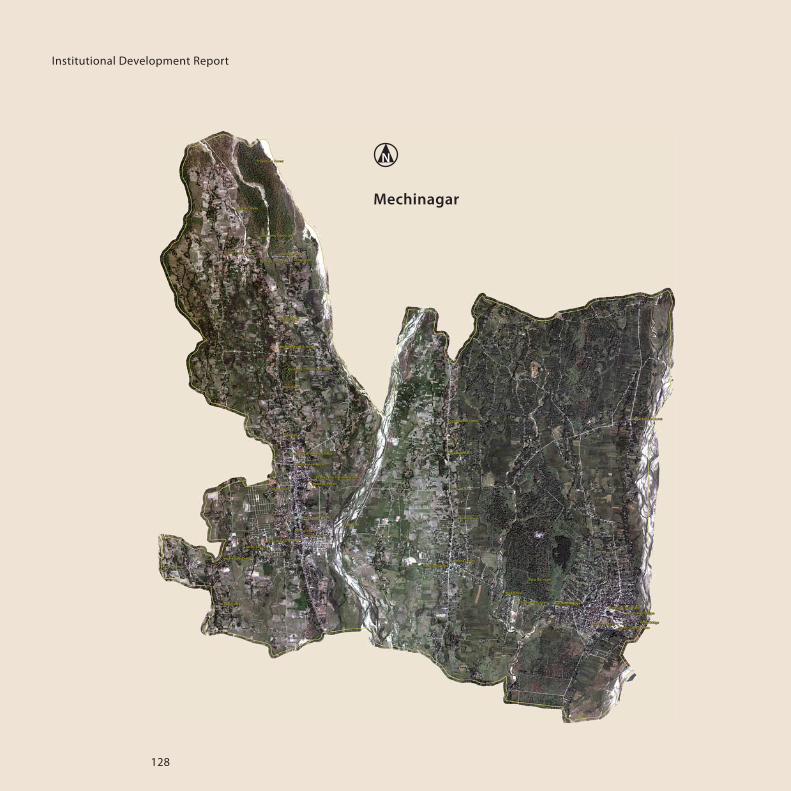
128
Institutional Development Report
Mechinagar

129
Tansen
6.3 Satellite Images of the Six Municipalities

130
Institutional Development Report

131
The Municipal Support Team (MST) is part of Germany’s support
to Good Urban Governance in Nepal and has been engaged by
GIZ on behalf of the German Ministry for Economic Development
and Cooperation (BMZ). The contract for MST was awarded to a
consultant consortium (GFA, oikos, MULTI, Inlogos), to provide
direct support to the Project Coordination Office (PCO) of the
Urban Governance and Development Program, UGDP. The PCO,
located in the Department for Urban Development and Building
Construction, DUDBC, assists emerging towns in implementing
UGDP as a first step of the program. MST, under the guidance of
the PCO, takes a special responsibility for the area of institutional
development (ID) and is part of GIZ’s Sub-National Governance
Program (SUNAG). MST comprises the following members:
Carsten Zehner: Team leader / Urban and Regional Planner
Dr. Alexander Jachnow: Former Team Leader / Architect
Arjun Koirala: Deputy Team Leader, Advisor / Urban Planning and
Infrastructure Development
Iswar Lal Joshi: Advisor / Urban Planning and Land Development
Sunil Prasad Pradhan: Advisor / Municipal Finance, Monitoring
and Evaluation, and Information Technology
Bandana Sharma: Advisor / Urban Planning, Safeguards and
Capacity Development
Pranip Ratna Bajracharya: Finance and Administration Officer
Sila Gole: Office Secretary
Roshan Lama: Office Assistant
Kopila Nepal: Office Support Staff
BBBBBBBBBBBBBBBBBBBBBBBBBBBBBBBAAAAAAAAAAAAAAAAAAAAAAAAAAAAAAAAAAAAAAAAAAAAAAGGGGGGGGGGGGGGGGGGGGGGGGGGGGGGGGGGGGGGGGGGGGGGGGGGGGGGGGGGGGGGLLLLLLLLLLLLLLLLUUUUUUUUUUUUUUUUUUUNNNNNNNNNNNNNNNNNNNNNNNNNNNNNNNNNNNNNNNNNGGGGGGGGGGGGGGGGGGGGGGGGGG
DDDDDDDDDDDDDDDDDDDD HHHHHHHHHHHHHHHHHHHHH AAAAAAAAAAAAAAAAA NNNNNNNNNNNNNNN KKKKKKKKKKKKKKKKKKKKKKK UUUUUUUUUUUUUUUUUUUUUUUUUUUUUUU TTTTTTTTTTTTTTTTTTTTTTTTTTT AAAAAAAAAAAAAAAAAAAAAA
IIIIIIIIIIIIITTTTTTTTTTTTTTTTTTTTTTTTAAAAAAAAAAAAAAAAAAAAAAAAAAAHHHHHHHHHHHHHHHHHHHHHHHHHHHHAAAAAAAAAAAAAAAAAAAAAAAAAARRRRRRRRRRRRRRIIIIIII
LLLLLLLLLLLLLLLLLLLLLLLLLLLLLLEEEEEEEEEEEEEEEEEEEEEEEEEEEEEEKKKKKKKKKKKKKKKKKKKKKKKKKKKKKKHHHHHHHHHHHHHHHHHHHHHHHHHHHHHHHHHHHHHHHHHHHHNNNNNNNNNNNNNNNNNNNNNNNNNNNNNNNNNNNNNNNNNNNNNNNNNNNNNNNNNNNNNNNNNNNNNNNNNNNNNNNNNNNNNNNNNNNNNNNNNNNNNNNNNNNNNNNNNNNNNNNNNNNNNNNNNNNNNNNNNNNNNNNNNNNNNNNNNNNNNNNNNNNNNNNNNNNNNNNNNNAAAAAAAAAAAAAAAAAAAAAAAATTTTTTTTTTTTTTTTTTTTTTTTTTTTHHHHHHHHHHHHHHHHHHHHHHHHHHHHHHHHHH
MMMMMMMMMMMMMMMMMMMMMMMMMMMMMMMMMMMMMMMMMMMMMMMEEEEEEEEEEEEEEEEEEEEEEEEEEEEEEECCCCCCCCCCCCCCCCCCCCCCCCCCCCCHHHHHHHHHHHHHHHHHHHHHHHHHHHHHHHHHHHHHIIIIIIIIIIIIIIIIIIIIIIIIIINNNNNNNNNNNNNNNNNNNNNNNNNNNNNNNNNNNNNNNNAAAAAAAAAAAAAAAAAAAAAAAAAAAAAAAAAAAAAAAAAAGGGGGGGGGGGGGGGGGGGGGGGGGGGGGGGGGGGGGGGGGGGAAAAAAAAAAAAAAAAAAAAAAAAAAAAAAAAAAAAAARRRRRRRRRRRRRRRRRRR
TTTTTTTTTTTTTAAAAAAAAAAAAAAAAAANNNNNNNNNNSSSSSSSSSSSSSSSSSEEEEEEEEEEEEEEEENNNNNNNNNNNNNNNNNNNNNNNNNNNNNNNNNNNNNNN
© DUDBC, June 2014