institutional support to freetown city council and to the urban … · 2019-11-11 · institutional...
TRANSCRIPT
Institutional Support to Freetown City Council and to the Urban Planning Authorities
Sierra Leone Preparatory Components and Studies for the Freetown Development Plan “The Urban Planning Project” Freetown Structure Plan 2013–2028 Main development issues and analysis October 2014
This project is funded by the European Development Fund
A project implemented by the Consortium GOPA-CES

The draft Freetown Structure Plan 2013–2028 has been pre-pared by the Ministry of Land, Country Planning and the Envi-ronment (MLCPE) and Freetown City Council (FCC) as part of the Urban Planning Project 2011–14 financed by the Europe-an Union. The Project Manager has been Mr Abdul Marah, FCC, and the preparation of the Freetown Structure Plan has been monitored by the Urban and Environmental Planning
Advisor, Alphajoh Cham of the MLCPE.
The draft Structure Plan is a pilot project following guidelines from the 2004 Local Government Act promoting the decen-tralisation of the strategic local land-use planning authority to local government. The draft plan has been prepared as on-the-job training of FCC an MLCPE staff, reinforced by eight contracted young professionals: Mohamed Gaima,
Matthew George, Michael James, Sulaiman Kamara, Benrina D. Kanu, Samuel M.G. Lahai, Kanneh Sheku Mark Jr. and Ma-binti Kamara. The project is supported by GOPA-CES Interna-tional Consultants and 3BMD Consulting Engineers repre-sented by the geographic information system (GIS) experts Dr. Christoph Dreiser and Samuel Kamara and the urban
planners, Dr. Joseph M. Macarthy, Dr. Corrado Minervini, Michael A.O. Johnson, Joseph L.K. Muana and Kurt Lange.
The contents of this publication are the sole responsibility of GOPA-CES Consultants and can in no way be taken to reflect the views of the European Union.
Institutional Support to the Freetown City Council and to the Urban Planning Authorities
Freetown Structure Plan 2013–2028
Main development issues and analysis
Sierra Leone Preparatory Components and Studies for the Freetown Development Plan
Support to Freetown City Council and to the Urban Planning Authorities
EuropeAid /SL// Cris. No.: FED/2010/250–190
October 2014 2014
GOPA Consultants Hindenburgring 18
61348 Bad Homburg Germany
Tel.: +49-6172-930 216 Fax: +49-6172-930 200
E-mail: [email protected] i

Institutional Support to the Freetown City Council and to the Urban Planning Authorities
Contents
1 Foreword 9
2 Introduction and summary 10
PART ONE 14
3 Towards a New Land-use Planning System 14
4 Natural Environment and Risk-prone Areas 16
4.1 The natural environment 16
4.2 Disaster risks in Freetown and mitigation 23
5 The Freetown Population 31
5.1 Situation analysis 31
5.2 Planning areas 32
5.3 Population projection 34
5.4 Population density 35
5.5 Demographic characteristics 36
6 The Local Economy of Freetown 37
6.1 Commerce and markets 37
6.2 The financial market 38
6.3 Tourism: hotels, restaurants, and amusement centres 38
6.4 The construction sector 39
6.5 Deep-sea port 40
6.6 Fisheries 42
6.7 Agriculture 42
6.8 Freetown economy development goals 42
7 The Freetown Neighbourhoods 46
7.1 Aberdeen–Murray Town Area (1) 48
7.2 The Lumley–Malama Area (2) 49
7.3 Wilberforce–Hill Station Area (3) 51
7.4 King Tom–Brookfield Area (4 52
7.5 The New England Area (5) 53
7.6 The City Centre Area (6) 54
7.7 Fourah Bay–Cline Town Area (7) 56
7.8 Kissy Men’s Mess Area (8) 58
7.9 Kissy Grass Field–Congo Water Area (9) 59
7.10 Wellington–Pamuronko Area (10) 61
Map 7-1: Wellington–Pamuronko Area 61
7.11 Allen Town Area (11) 62
7.12 Tassoh Island (12) 63
8 Educational and Health Facilities 65
i

Institutional Support to the Freetown City Council and to the Urban Planning Authorities
8.1 Education 65
8.2 Health-care facilities 67
9 Housing 72
9.1 Institutional framework 72
9.2 Housing types, conditions, and densities 74
9.3 Housing needs 75
9.4 Example: the Wellington Centre and Housing Scheme 80
9.5 Urban renovation 80
9.6 Resettlement of communities living in risk-prone areas 83
9.7 Recommendations 86
10 Public Administration and Public Use of Land 89
10.1 Public and municipal administration 89
10.2 Conclusion/findings 89
10.3 Recommendations 90
11 Parks, Recreation Areas, and Cemeteries 93
11.1 Existing parks, recreation areas, and cemeteries 93
11.2 Conclusions and recommendations 97
12 Freetown Tourism and Culture 99
13 Traffic and Transport 107
13.1 Transport, traffic, and road system 107
13.2 Collective personal transport 108
13.3 Transport of goods 113
13.4 Non-motorized transport 114
13.5 Road safety 114
13.6 Road system 114
13.7 Conclusions and recommendations 116
13.8 Traffic and transport management policies 120
14 Solid waste collection and other infrastructure 121
14.1 Institutional responsibilities 121
14.2 Primary and secondary collection 121
14.3 Recycling activities and opportunities 122
14.4 Landfill sites 122
14.5 Lack of urban culture 123
14.6 Hospital (medical) and hazardous waste 123
14.7 Industrial waste 123
14.8 Conclusions and recommendations 124
14.9 Institutional and regulatory changes 126
14.10 Rehabilitation of existing landfill sites 126
14.11 Other Technical Infrastructure in Freetown 126
15 National Policies and Development Projects 127
ii
Institutional Support to the Freetown City Council and to the Urban Planning Authorities
15.1 Health 127
15.2 Traffic planning and road infrastructure improvements 128
15.4 Drinking water plan 128
15.5 Solid-waste management 128
Recommendations 129
PART TWO 130
16 The Freetown Structure Plan 130
16.1 General development guidelines 130
16.2 Guidelines for the planning areas 139
17 Consultation And Participation in the Preparation of the Draft Freetown Structure Plan 160
18 Follow-up on the Draft Freetown Structure Plan 161
18.1 The consultation process 161
18.2 Further urban planning initiatives 161
18.3 Needed planning staff and economical resources 162
18.4 Institutional development 162
18.5 Monitoring and evaluation 163
18.6 SWOT analysis 165
iii

Institutional Support to the Freetown City Council and to the Urban Planning Authorities
Maps Map 4-1: Topography, drainage, mangrove Map 4-2: Current Green areas and reserves 21 Map 4-3: Hazard-prone areas 29 Map 5-1: Planning areas 32 Map 5-2: Population 2012 34 Map 5-3: Projected population 2028 34 Map 6-1: Commerce and industry 41 Map 7-1: Aberdeen–Murray Town Area 49 Map 7-2: Lumley–Malama Area 50 Map 7-3: Wilberforce–Hill Station Area 51 Map 7-4: King Tom–Brookfield Area 52 Map 7-5: The New England Area 53 Map 7-6: The City Centre Area 55 Map 7-7: Fourah Bay–Cline Town Area 56 Map 7-8: Kissy Men’s Mess Area 58 Map 7-9: Kissy Grass Field–Congo Water Area 60 Map 7-10: Wellington–Pamuronko Area 61 Map 7-11: Allen Town Area 62 Map 7-12: Tassoh Island 64 Map 8-1: Education and health facilities 68 Map 9-2: Housing densities 73 Map 9-3: Areas for urban renewal 82 Map 9-4: Slum areas 85 Map 9-5: Sub-centres for urban development 87
Map 11-1: View points 97 Map 11-2: Green areas 97 Map 12-1: Historic area 100 Map 12-2: Historic and religious sites 101 Map 13-1: Land use and road classification 109 Map 15-1: Infrastructure 125 Map 17-2: Freetown Structure Plan 2013–2028 159 Tables
Table 5-1: The historic population growth rates 31 Table 5-2: Wards in the planning areas 35 Table 5-3: Growth rates 1985–2004 2012–28 35 Table 5-4: Population densities for 2012 and 2028 35 Table 5-5: Population: age distribution 36 Table 5-6: Life expectancy in selected cities 36 Table 7-1: Aberdeen–Murray Town: land use 49 Table 7-2: Lumley–Malama: land use 50 Table 7-3: Wilberforce–Hill Station: land use 51 Table 7-4: King Tom–Brookfield: land use 53 Table 7-5: New England: land use 54 Table 7-6: The City Centre:land use 55 Table 7-7: Fourah Bay–Cline Town: land use 57 Table 7-8: Kissy Men’s Mess: land use 59 Table 7-9: Kissy Grass Field–Congo Water: land use 60 Table 7-10: Wellington–Pamuronko: land use 62
iv

Institutional Support to the Freetown City Council and to the Urban Planning Authorities
Table 7-11: Allen Town I and II: land use 63 Table 8-1: Schools and the annual enrolment 66 Table 8-2: Catchment area criteria 66 Table 9-1: Need for land Freetown planning areas 77 Table 10-1: Location of government properties 90 Table 13-1: Cost-effective railways 112 Table 14-1: Volumetric capacity of Kissy dump site 123
Figures Figure 4-1: Coastal flooding sites 25 Figure 4-2: Areas at risk of landslide in Freetown 27 Figure 4-3: Hillsides at risk of mudslide and rockfall 29 Figure 9-1: Proposed land uses in Freetown 78 Figure 9-2: Wellinton Centre and Housing Scheme 81 Abbreviations
Acronyms Expanded Acronyms
CBD Central Business District
CC City Council
CHC community health centres
CHP community health post
DFID Department for International Development
E. coli Escherichia coliform
Acronyms Expanded Acronyms
ECD European Commission Delegation
EIA Environmental Impact Assessment
EPA Environmental Protection Agency, Sierra Leone
AED Estates Department
FCC Freetown City Council
FDP Freetown Development Plan
FIAR Freetown Improvement Act and Rules
FIA Freetown Improvement Act
FIAS Foreign Investment Advisory Service
FIDIC Fédération Internationale des Ingénieurs Conseils (French) International Federation of Consulting Engineers
FST Freetown Structure Plan 2013-28
FT Freetown
FWMC Freetown Waste Management Company
GDP gross domestic product
GIS geographic information system
GIZ (former GTZ) German Agency for Technical Co-operation
GoSL Government of Sierra Leone
GPS Global Positioning System
GVWC Guma Valley Water Company
ICF Investment Climate Facility for Africa
v
Institutional Support to the Freetown City Council and to the Urban Planning Authorities
Acronyms Expanded Acronyms
IE international expert
IFC International Finance Corporation IRCBP Institutional Reform and Capacity Building Project
JICA Japan International Cooperation Agency
LDO Land Development Organisation
LGA Local Government Act
LGDG Local Government Development Grants
MCHP Maternal and Child Health Post
MDGs Millennium Development Goals
MEST Ministry of Education Science and Technology
MEP Ministry of Energy and Power
MoH Ministry of Health
MTA Ministry of Transport and Aviation
MWHI Ministry of Works, Housing and Infrastructure
NALUPA National Land Use Planning Authority
NASSIT National Social Security and Insurance Trust
NMT Non-motorized transport
NPA National Power Authority
NTB National Tourist Board
PV Photovoltaic
PWD Public Works Department
Acronyms Expanded Acronyms
SALHOC Sierra Leone Housing Corporation
SALWACO Sierra Leone Water Company
SL Sierra Leone
SLMA created Sierra Leone Maritime Administration
SLL Sierra Leone Leones (local currency)
SLRA Sierra Leone Roads Authority
SLRTC Sierra Leone Road Transport Corporation
SLPA Sierra Leone Ports Authority
UPP Urban Planning Project 2011-14
VIP ventilated improved pit
WDU waste disposal unit
WHO World Health Organization
WSS water supply and sanitation
vi

Institutional Support to Freetown City Council and to the Urban Planning Authorities
1 Foreword
Freetown City Council (FCC) has, in co-operation with the Ministry of Land, Country Planning and the Environment (MLCPE), prepared a proposal for the development of the city of Freetown for the period 2013–2028. The work has been supported by the European Union. The draft Structure Plan must reflect the development needs for Freetown’s communities and the private sector. Various stakeholders have therefore been consulted during the preparation of the plan. However, the proposed development visions, goals, and initiatives have to be presented for further consultation to the Freetown community. After necessary adjustments, it will be approved by FCC and the MLCPE. The draft plan will thereby be presented to the Freetown community for final comments and contributions. The plan is entitled the Freetown Structure Plan 2013–2028. The draft plan consists of an analysis of the present situation plus a plan proposing devel-opment goals and policies for the city and its neighbourhoods, and how they can develop and improve in the period 2013–2028. Freetown is the national capital of Sierra Leone and a beautiful city. FCC and the Freetown community have to take care to avoid further degradation of the city’s urban environments, neighbourhoods, historic places, trees, hillsides, beaches, rivers, creeks, bays, and coastline. The city is confronted with many challenges. One of these is that the population is expected to grow from 1.0 million to 1.7–1.9 million in the period 2013–2028. Furthermore, the city is currently experiencing rapid urbanization, driven by rural–urban migration, natural population growth and urban expansion. The city has not been able to cope with this rapid urban growth and the result has been precipitous growth of urban slums and squatter settlements, envi-ronmental degradation, poor urban integration, and service delivery. Cities are the engines of wealth and job creation, and provide optimum op-
portunities to improve livelihoods for people. However to achieve this, cities must be well planned and managed. There is, therefore, an urgent need to develop and consolidate a strategic and integrated approach that pre-empts and adequately addresses the urban challenges in Freetown. The Freetown Structure Plan makes proposals for the modernization of the city. The plan suggests a common vision for how Freetown, in phases, can prepare for population growth and improve housing, health and sanitation in its communities, as well as attend to traffic and transport problems, thereby creating opportunities for business development, national administration, services, industry, commerce, fisheries, and tourism. The aim of the Structure Plan is to create general guidelines for development and land use in the city. Further planning will detail the analysis and plans for 12 proposed areas including Tassoh Island. However, as it is difficult to antic-ipate future events, the plan will be revised every 4–5 years or when needed. The demands for improvement are many; therefore progress must take place in a measured fashion. The Structure Plan will guide this process, maintaining the vision and continuity, and ensuring that decisions on concrete develop-ment projects do not contradict this vision, but that they mutually support each other for the benefit of the community. Safeguarding the plan’s under-pinning when new elected members and administrative staff take up office or their respective posts in Freetown City Council is also of consideration. The Freetown Structure Plan with the appropriate implementation strate-gies, might provide guidance for sustainable urban development and human settlements in Freetown. The goals are to develop a functioning and pros-perous city, and to reduce social and spatial inequalities by providing access to affordable basic public services.
9

Institutional Support to Freetown City Council and to the Urban Planning Authorities
2 Introduction and summary
The Freetown Structure Plan has been prepared both as a report containing the main development issues and analysis, and as the Freetown Structure Plan Proposal, presenting the proposed development goals and the Structure Plan for the future development of Freetown. The report is structured in the following way:
PART ONE
Chapter 3 introduces the proposed content of a new urban planning law taking into consideration the 2004 Local Government Act, which decentraliz-es urban planning authority and development control to local government. The MLCPE has prepared the proposal for revision and the proposal is being considered by the National Law Reform Commission.
Chapter 4 concerns the Freetown natural environment and risk-prone areas. The chapter addresses the natural resources surrounding Freetown, which include beaches, creeks, mangrove forest areas, bays, and sea coast: all natu-ral qualities which present an extraordinary landscape of recreational poten-tial for the city and its inhabitants. The chapter also assesses the risk-prone areas which, apart from the flooding, are mainly due to human settlement development and inappropriate construction such as insufficiently strong foundations, constructions located too close to the sea-water or in the water current channel drainage systems. Further complications include deforesta-tion and removal of surface vegetation on the hillsides. The chapter offers mitigation measures, which include improved building construction, refor-estation and resettlement. However, improved building inspection and de-velopment control in Freetown is needed to prevent encroachments in areas no suitable for building and the most efficient way of avoiding future damage from flooding and landslides.
Chapter 5 presents the Freetown Structure Plan population projections for the city. The future population could by 2028 grow to 1,920,000 persons. The population increase means that the city has to provide housing, public ser-vices and jobs for an additional population of 920,000. Further on, if follow-ing present trends, the population will be unevenly distributed in the city. The Freetown Structure Plan proposes dividing the FCC area into 12 planning areas and identifies the expected population growth in each area.
Chapter 6 addresses the productive and economic activities in Freetown, pointing out the need for better distribution of commercial services in the city, as well as points at the potential presented by the tourism sector. The chapter points out the need to improve the functionality of the city centre for administration and commercial businesses. The chapter also points at the potential for modernization of the city´s administration and businesses at New England, with parking spaces and good accessibility from the main roads. The chapter discusses the improvement of the industrial area in Cline Town close to the deep-sea port area with good ferry connectivity to Lungi and the airport. A future industrial area is proposed in Allen Town in front of Crafton, but, in general, the Structure Plan proposes that small businesses and workshops, which produce no negative impact on the residential areas, can be distributed throughout the city in the ground floors of multi-storey buildings.
Chapter 7 presents the 12 Freetown planning areas and describes the popu-lation as well as the development challenges and opportunities in each neighbourhood. Tassoh Island is the twelfth planning area and has been con-sidered a special planning case with its dispersed rural population and partic-ular location in the Sierra Leone River Estuary.
Chapter 8 analyses land-use planning in relation to quality education facilities and health institutions, which in the present situation is limited to only parts of Freetown with inferior service coverage for the population in the south-
10

Institutional Support to Freetown City Council and to the Urban Planning Authorities
east. As the population grows further in these south-eastern neighbour-hoods, and is expected to be the highest in Freetown, more quality educa-tional and health facilities have to be built. The chapter analyses the need for schools and hospitals, and looks at potential urban development areas for the extension of existing facilities and the construction of new infrastructure.
Chapter 9 concerns housing in Freetown and urban renovation. Some hous-ing areas in Freetown are under development with good, but low density housing, being built by developers and the owners. Other parts of the city, such as the old village areas and the central parts of the city, need urban upgrading as crowding is considerable and many dwellings are in poor condi-tions. Furthermore, the neighbourhoods suffer from low urban sanitation standards. The unplanned housing developments on the hillsides and in the vibrant developing south-eastern part of the municipality need urban plan-ning and regulation. The future expected population growth will further em-phasize the considerable need for new dwellings, which will only be possible to satisfy if all owners, communities, other stakeholders and the private sec-tor are involved. As the population increases in the limited FCC urban area renovation strategies must promote higher housing densities and new build-ing designs for good, functional multi-storey buildings with family flats. Ur-ban planning must be consolidated in the municipality and supported by a revised urban planning law, in addition with revised and modernized building regulations. FCC is aware of the need for human resources and staff devel-opment to ensure planning and development control, as well as the need to involve NGOs and the private sector in the urban planning activities. The chapter points out the necessity of planning for the hillsides in the Malama and New England areas and the stretch from Kissy to Allen Town. Develop-ment there is taking place without any urban planning guidance and many dwellings are being built without permits. These areas constitute the only land that Freetown has left for development and it urges the preparation of
area local plans and area action plans. The planning must include the reser-vation of land needed for secondary roads, which will create access to these areas.
Chapter 10 is dedicated to publicly owned land in Freetown. The Structure Plan has registered the available land resources, as well as the actual use of public land at present. Today the FF part of Freetown has no virgin land for development with the exception of areas on the hill sites. Many of the public areas are in need of renovation, underutilized or abandoned. The Freetown Structure Plan proposes these areas be redeveloped and included in the modernization of the city. Some of the areas will serve for modernization of national and international business, others for the development of new, needed education and health facilities. Additionally, the areas will be used for local commercial activities, high-density modern housing, and other uses according to actual local needs.
Chapter 11 focuses on the present existence of parks, recreation areas, and cemeteries, and points to the need to maintain these functions. The chapter refers to periods in the past when green areas and spaces in the town were used for recreation by citizens, and were well maintained and taken care of. Incidental open spaces are a valuable resource for the greening of the city. They should be properly landscaped; planted with trees and provided with seating facilities to offer residents relaxing spots within the city. The inci-dental open spaces offer locations for the siting of appropriately designed licensed kiosks across the municipality; some of these spaces can also be used for bus stops. A particular opportunity is to renovate the old town hall plot to provide a large Municipal Square for people to meet and enjoy in the evenings.
Chapter 12 concerns tourism and culture and makes reference to tourism as a future potential business- and job-generating activity, along with the histor-ical potential of the city centre and other places in the town. The chapter
11

Institutional Support to Freetown City Council and to the Urban Planning Authorities
also refers to the importance of traditional dances and cultural events that take place and foregrounds the inland part of historic Freetown. The area limited by Lightfoot Boston Street, Wallace Johnson Street, Wilberforce Street, and Gloucester Street, could be developed as an attractive city centre for tourists, with specialist fashion and jewellery shops, and pavement cafes. The coastal part of historic Freetown, which includes all the parts north of Wallace Johnson Street, should be developed into a promenade. Govern-ment Wharf can serve as an entry point to central Freetown for tourists com-ing by boat from the Aberdeen and Lungi hotels, or leaving for maritime sightseeing or bird watching at the mangroves in the eastern part of the city or at Tassoh Island.
Chapter 13 presents the traffic and transport situation. The chapter suggests that a minimum of investment in new roads and junctions should be under-taken, and the main emphasis should be given to road and traffic manage-ment. The Structure Plan emphasizes that the different transport systems must be planned to work together and co-ordinated as much as possible regarding terminals, stops, ticketing, and timetables. The Plan emphasizes and proposes the development of a robust Freetown urban bus passenger transport system serving passengers from Hamilton in the west to Hastings and Crafton in the south-east. The chapter mentions that passenger transport on rail will be economically viable in the future and that a railway plan should be prepared and land reserved for future urban railway lines and stations. However, the Structure Plan suggests there is an urgent need to develop access roads to the hillside areas in Malama, New England, and to the area from Kissy to Allen Town combined with urban development plans for these areas. The chapter proposes restrictions parking in the city centre, along with restrictions and building control on the use of streets. A one-way system should consequently be adopted and street trading prohibited where there is traffic and special trading streets provided.
The port is considered an important Freetown economic activity and the renovation of the areas around the port should facilitate modernization and promotion of properly functioning accessibility. Slum areas close to the port should be resettled. The Bai Bureh Road should be renovated and the Old Waterloo road renovated as a distribution route in the south-east. The Struc-ture Plan also points to the possibilities of sea transport along the coast, as well as special consideration to be given to the thousands of pedestrians and the promotion of regulations for safe bicycling.
Chapter 14 concerns the challenges related to solid-waste collection and disposal. The chapter addresses the institutional challenges and collection systems. Furthermore, recycling opportunities are discussed. Concerning final disposal, the Freetown Structure Plan suggests that in Freetown sites are closed and cleaned up, and highlights that modern solid waste dumping sites are being constructed outside Freetown as a common metropolitan project with Waterloo District Council. There are many hazardous environ-mental impacts that affect the population as well as the local ecological sys-tem. The chapter suggests special collections and treatment of hospital waste as well as of industrial waste are necessary. An intensive public aware-ness campaigning is crucial to educate and involve the population in the sol-id-waste collection and disposal processes, including separation of different kinds of waste.
Chapter 14 also presents the Structure Plan mapping of other technical facili-ties in Freetown. During the Urban Planning Project, information on the ex-isting technical infrastructure has been mapped using GIS. This work includes identification and mapping of the present main water distribution pipelines and public water taps in co-ordination with GUMA Water Company and the NGO Goal. Furthermore, the project co-operated with Sierra Tel concerning communication landlines and telecommunication masts. The road system in Freetown has been digitized with support from the SL Road Authorities and
12
Institutional Support to Freetown City Council and to the Urban Planning Authorities
other technical installation has been digitized by the FCC-MLCPE Urban Plan-ning project Geographic Information System Work Group.
Chapter 15 presents other national planning of importance for urban plan-ning development in Freetown. FCC will take into consideration these plans and interact with the corresponding institutions when needed regarding de-velopment goals and projects, and co-ordinate with municipal development and urban planning teams.
PART TWO
Chapter 16 presents the draft Freetown Structure Plan.
Chapter 17 mentions briefly the consultation process which has taken place during the preparation of the Freetown Structure Plan.
Chapter 18 presents thoughts and advice on the follow-up to the draft Free-town Structure Plan.
The present draft Freetown Structure Plan has been considered by FCC and the MLCPE. The next phase is consultation of the plan visions and proposals with Freetown’s communities, Freetown NGOs and private business, as well as the relevant public institutions. After the consultation the plan will be revised and the finally presented to the community before approval.
More detailed Local Plans needs to be prepared for the 12 Freetown plan-ning areas. These should consider the establishment of local future service centres and planning issues addressed in the Freetown Structure Plan. The Structure Plan includes guidelines for monitoring and evaluation and a SWOT analysis of the planning area.
A proposed FCC goal could be the preparation of three Local Plans a year over the next four years prepared by four junior planners, together with a qualified senior urban planner and a GIS expert in a team of six. The prepara-
tion of the Local Plans could also be outsourced to private sector urban plan-ning consultants.
FCC must develop a stronger urban planning department. In the event that FCC or the MLCPE cannot do this, an option might be to create an interim physical development co-operation agency with support from the Sierra Le-onean Government. To further add value to the activity, such an agency might, during the next four years, might have the goal to prepare a Metro-politan Development Master Plan, Structure Plans for the Waterloo and Port Loco Districts and the 12 Local Plans for the FCC area. In 2019 the agency will be dissolved and the planning staff distributed between the MLCPE, FCC, Waterloo and Port Loco Districts, who in the meantime have developed suffi-cient budget to sustain the urban planning activity.
The Urban Planning Project
FCC and the MLCPE implemented the Urban Planning Project between 2011– 14 to enhance the urban planning in local governments and strengthen national policies and guidelines for land-use planning in Sierra Leone.
The Project trained surveyors and started the plot survey of parcels in Freetown; trained local government urban planners and FCC and MLCPE staff in collecting data from 85,500 properties in the city and experiences from urban planning in Ghana, Kenya and Tanzania dur-ing two study tours. The Project prepared a draft FCC housing policy, a proposal for the content in a revised urban planning law; and draft-ed the main goals for a National Spatial Development Framework. The Project was supported by the European Union.
13

Institutional Support to Freetown City Council and to the Urban Planning Authorities
PART ONE
3 Towards a New Land-use Planning System in Sierra Leone
In March 2004 the Local Government Act (LGA 2004), was enacted into law for local government financing and decentralization of decision-making and resource allocation. Among the functions allocated to the local authorities and Freetown City Council (FCC) was responsibility for the development, improvement and management of human settlements and the environment in the Freetown locality. To manage these responsibilities, among others, FCC received powers for strategic local planning, preparation of land-use plans, and issuance of building permits.
According to the LGA 2004, local councils and FCC are to establish Develop-ment Planning Departments (DPD), which currently, among other tasks, pre-pare socio-economic development plans. The DPDs shall also be responsible for the preparation of land-use plans/urban plans. However, the legal base for urban planning and development control needs revision to serve local government planning and revision of the current urban planning law is, pres-ently, being examined by the Law Reform Commission. The Urban Planning Project has proposed that a land-use planning system be prepared by the local governments and the National Land Use Planning Authority (NALUPA) will prepare guidelines for land-use policies, and also guidelines for the prep-aration of the plans.
This draft Structure Plan for Freetown has been prepared as a pilot project by FCC and the MLCPE. The Structure Plan follows the aims of the 2004 Local Government Act and the guidelines being prepared in the above-mentioned
revision of the urban planning law. The Urban Planning Project also prepared a manual to be used by local governments when they will initiate the prepa-ration of the land-use plans. The three land-use plan types are the Structure Plan, the Local Plans, and the Action Area Plans as described below.
All three types of plans have to be consulted with the affected communities before approval. And when approved they are legally binding for all citizens. The plans will be revised every 4 year and adjusted if necessary or revised when needed. However the preparation of the revised plan must follow the same procedures as preparation of new plans with consultations before any approval.
The Structure Plan
The present Freetown Structure Plan is an example of such a structure plan covering the FCC administrative area. The purpose of a structure plan is to define the general guidelines or strategies for the physical development of a city/town or district. A structure plan will be prepared by the local councils. The structure plans should normally be prepared in the scale of 50:000 to 75:000, and plan types must be endorsed by the NALUPA.
Structure plans concern development policies for all land uses within the district or the municipality area. Uses include land reservation related to: production, employment, housing, education, health, mining, recreation, protection of natural resources, the transport and communication infrastruc-ture, among others, as well as their interrelations. A structure plan also re-lates to, and must co-ordinate with, developments and projects in the neigh-bouring districts and/or city council. Structure plans do not consider individ-ual ownership of land when being prepared.
A structure plans must reflect economic and social planning at national, re-gional and local levels and integrate development projects approved by the corresponding national and regional authorities. NALUPA must prepare pro-
14

Institutional Support to Freetown City Council and to the Urban Planning Authorities
cedures to ensure that the local planning authorities, when preparing the structure plan, work within the framework of the requirements of land-use plans at higher levels. The structure plan will consider the development for 15–20 years ahead and will be revised every five years or when is necessary.
The procedures for the revision and modification of the Structure Plan are the same as for the preparation of the plan.
The plan is presented as a report with analysis, policy goals, and the planned development shown on a map. The structure plan also indicates the phasing of the development areas and needs for detailing Local Plans. The structure plan, finally, will present the monitoring methodology for plan implementa-tion. Among the annexes, the plan should include a report on the community consultation process and might include minority expressions of opposition to proposals in the plan.
The stakeholders and the community members must be involved at least twice during the Structure Plan preparation process. The first consultation will concern ideas and proposals for development goals and development options, and the final consultation will give the stakeholders and the com-munity the opportunity to comment on the final draft of the proposed Struc-ture Plan before its approval. A minimum notice of two months must be giv-en by public announcement for the holding of any consultation activities. Stakeholder and community contributions must be recorded and may be annexed to the final plan. The local council must justify any of its decisions taken against the stakeholder and community proposals which have been presented within the prescribed time and according to prescribed proce-dures by the community members.
The Local Plans
The Local Plans are a more detailed type of plan, prepared similarly to a structure plan, but as the scale is different (1:10.000–1:20.000), it will be
more detailed and zoning considerations (the kind of desired land use in spe-cific areas) can be included in the plan. The needs and priorities for preparing local plans should be identified in the structure plan or a decision to make a local plan be taken by the local planning authority or the local government council when a need occurs. A local plan could, for example, be prepared for an entire city centre, a tourist area, or a new development area.
The local plans detail the development policies and goals for a sub-area or part of the city within the context of the development policies and strategy set out in the structure plan. Local plans indicate the following: existing and future road systems; the general decisions of land use identified as zones for housing areas of different density; areas for industry, workshops, private and public services, commercial areas and markets; important district functions; protected areas; and risk-prone areas, etc. The plan is presented as a report with analysis, policy goals, a local-plan map and guidelines, a timetable for the phasing of the implementation plan, and might also include a provisional development budget. The local plan will consider the development planning needs for 15–20 years ahead and will be revised every five years or when necessary.
Where an area in a local plan has been indicated for one or more uses, i.e. that a special development zone, SPZ, has been identified, the local plan it-self can be used as reference for giving building permits for constructions within the area as long as the development does not have a major impact on the surroundings.
The Action Area Plans
The most detailed land-use plan type proposed for the land-use plan system is the Area Action Plan. This detailed plan type must follow the planning goals and requirements made in the local plan and the structure plan for the area. The area action plan will indicate the precise private and public use of
15

Institutional Support to Freetown City Council and to the Urban Planning Authorities
all land and parcels within the ‘action planning area’ and indicate areas re-served for utility services, roads and transport systems, recreation, protec-tion, etc. The area action Plan will indicate street names, parcel numbers, eventual reservation or protection lines, as well as development and building regulations to be followed when using the parcels included in the plan. De-velopment permits as well as building permits will be granted where they do not contradict the information and regulations in the area action plan.
Land Use Plans prepared by the NALUPA
Structure, local and area action plans may also be prepared by the NALUPA when needed for particular national development projects that require spe-cial attention or are of an urgent or special nature.
4 Freetown Natural Environment and Risk-prone Areas
This chapter reviews the Freetown natural environment: sea, streams, creeks, bays and mangrove. It also describes the areas prone to risk from the natural environment and how mitigation measures can be taken.
4.1 The natural environment
The city of Freetown has been developed on the lower part of the slopes adjacent to the Sierra Leone River Estuary. The estuary is around 6 km wide at Freetown and it is a strong and deep navigable waterway to the Port of Freetown and further inland. The tidal range varies from 2.28 m at neap tides to 3.03 m at spring tides, with a flushing ability to dilute the raw sewage ef-fluents discharged into it.
Freetown is surrounded by different types of coast: the western coastal fringe is characterized by long sandy beaches, which for the most part are steep and face directly on to the Atlantic Ocean. The central northern coast area is rocky with a series of small bays. The small embayments along the northern shores are shallower with muddy shores and rocky headlands once populated by mangrove. The south-eastern coastal zone is relatively straight with mudflats and mangrove vegetation for much of its length. The city has a tendency to sprawl southwards to Sussex Bay at the western side and to Hastings on its north-eastern side.
The peninsula hills south of Freetown rise steeply to heights of between 1,000 and 1,500 metres and continue southwards as a once-protected forest
16

Institutional Support to Freetown City Council and to the Urban Planning Authorities
highland, now threatened by an encroachment of uncontrolled urban devel-opment and unplanned leasing out of government land. This forest highland is vital for the current and future water supply to the city.
Although threatened by uncontrolled urban development, mining and pollu-tion, the values of the natural environment surrounding Freetown are ex-traordinarily high and the natural environment is a unique ecological, aes-thetic and recreational resource for the future development of life in the city.
The future land use and development planning for Freetown must, for each planning area, carefully evaluate the values and actual degradation of the natural environment and propose firm measures to maintain and restore the coasts, bays, creeks, rivers, mangrove and forest where necessary.
As part of the Urban Planning Project implemented 2011–14 by FCC and the MLCPE, an environmental assessment of the Freetown natural environment and the natural disaster-prone areas has been prepared. The assessment recommends administrative and concrete protection and mitigation measures to be taken. FCC also wants to strengthen land-use planning concerning protection of natural resources and protection areas. Following on from the Freetown Structure Plan, local plans will be prepared for the different parts of Freetown and these plans will identify in detail forest, mangrove, and creek areas to be protected in co-operation with the corresponding communities.
4.1.1 The forest
The Western Area Peninsula was declared a Forest Reserve in 1916. The for-est covers many rainwater catchment areas, which are vital for the drinking water supply to Freetown. The Guma Valley, Congo and other dams have in the future – if protected – enough capacity to supply the city with good, clean water.
However, the Western Area Peninsula is seriously threatened by deforesta-tion for charcoal burning and farming, stone extraction, and further construc-tion, all leading to decline of water potential, habitat and biodiversity. Fur-thermore, people have had to settle in the upper outskirts of the FCC area due to high land prices in lower Freetown. Forests have been cut down on the hillsides and Freetown city faces severe environmental threats from soil erosion, resulting in an increasing risk of landslides and inland flooding. The situation is not a product of a natural disaster, but is attributable to human activities and the lack of law enforcement of the existing forest protection laws and regulations.
FCC wants to restore the forest in the hillsides and the Freetown Structure Plan has identified areas for forest protection. The forest in the municipality will, in the future, serve as needed and appreciated recreation areas for the population. Furthermore, FCC wants to promote reforestation in neighbour-hoods and in plots on the hillsides to prevent further erosion and landslides. FCC will initiate afforestation programmes and tree planting on private plots on the hillsides seeking co-operation with NGOs and motivate volunteer or-ganizations in tree-planting exercises.
FCC will strengthen the legal enforcement of urban planning and forest pro-tection laws in co-operation with the relevant natural authorities to stop uncontrolled settlement in forest on Freetown’s hillsides.
4.1.2 Mangroves
The Sierra Leone River Estuary is bordered by mangrove forest which estab-lishes a productive ecosystem providing the physical habitat and nursery grounds for birds, marine organisms and animals such as crabs, shrimps, fish, etc. The Sierra Leone River Estuary is also one of the four major sites for win-tering waders in the mangroves found along the banks of the Bunce River,
17
Institutional Support to Freetown City Council and to the Urban Planning Authorities
Aberdeen Creek, Goderich, Orugu/Jui Creek, Allen Town, Foamex, Congo Water, and Oku Water. Once monkeys were common in the mangrove living off the mangrove seeds.
The Freetown mangroves under threat of being eliminated
However, the mangrove areas are presently threatened by a variety of hu-man activities. Mangrove land is acquired for dwellings banked up on depos-ited rubbish. Sand mining activities are common and ongoing in mangrove swamps, especially at Bottom Oku, where the manner and extent of sand mining is alarming. Cutting down of mangrove trees for the smoking of fish and forest clearing for farming takes place at Congo Water and Foamex.
Woodcutters move out in the mangrove from their communities during high tides with their boats and cut strong and mature mangrove poles. In some or areas, young and immature trees are being cut down and used as firewood converted to charcoal.
At Congo Water, a large portion of the mangrove swamp has being cleared for farming. This cleared portion is mostly used for rice farming during the rains, and during the dry seasons women utilize it for vegetable gardens. The
mangrove forest is disappearing and the uprooting of trees and removal of soil expose the land to erosion during high tides and heavy rains.
Poor fishing and hunting practices also harm the mangrove environment as juvenile fish are caught during low tide putting the fish stock in danger for the future. The cutting down of trees to remove oysters and shrimps, which cling to the trunks of the trees, exposes the soil and the organisms embed-ded therein directly to sunrays, which, together with erosion, deteriorate the ecology of the forest.
The dumping of solid waste in the mangrove produces further degradation. Run-off and seepage of sewage is visible in the mangrove and debris from the land is being washed down the swamps, where it is trapped by the roots of the mangroves. Pollution degrades the quality of water and plant life in the swamp. Oil spills from engines cause further pollution. Mangrove protection measures FCC will, in co-ordination with the Ministry of Tourism and Cultural Affairs and the Environmental Protection Agency, EPA, co-operate with the relevant authorities to improve policies, protection laws and guidelines for protection of the mangrove in Freetown. FCC will, furthermore, discuss possible solutions with the involved businesses and communities, promoting restoration and sustainable management of the mangrove resources by also promoting seed and seedling collection and set-ting up mangrove nurseries and planting.
18
Institutional Support to Freetown City Council and to the Urban Planning Authorities
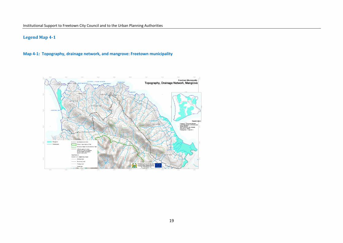
Legend Map 4-1
Map 4-1: Topography, drainage network, and mangrove: Freetown municipality
19

Institutional Support to Freetown City Council and to the Urban Planning Authorities
FCC will also seek co-operation with NGOs and international organisation to set up vocational training and micro-businesses based on sustainable use of the mangrove. FCC will seek support for awareness-raising programmes in schools, on radio and TV on the tourism and recreation opportunities in the mangrove and the importance of maintenance.
4.1.3 Creeks
Creeks are part of a stream affected by the flow of the ocean tides. During high tides, seawater fills the creeks and at low tides, the creeks fall complete-ly dry. The creek areas are important habitats for fish, aquatic insects, birds and mammals, and any change in the biological balance in the creek threat-ens the inhabitants.
There are two major creeks in Freetown: the Aberdeen Creek starts from Aqua in Murray Town, goes through Cockle Bay, Thompson Bay, and along the landward side of Lumley and Aberdeen Beach and ends at Pelican Aber-deen. Wellington Creek is found at the east end of Freetown.
Pollution of the creeks Presently, creeks in Freetown are under pressure from the nearby neigh-bourhoods and communities polluting the creeks through the banking and dumping of waste. Some of the waste is toxic to species in the water and leads to degradation of the species. No mechanisms for wetland protection seem to be present. The Thompson Bay community in Aberdeen Creek lacks toilet facilities and pollutes the bay, and community members suffer from malaria and diarrhoea Wellington Creek is currently an ugly sight with piles of rubbish consisting of mostly kitchen waste, plastic bags, empty containers and scrap materials polluting it, instead of being a clean breeding and spawn-ing ground for marine organisms. Residents also use the solid waste as bank-ing materials and the creek for rearing pigs. The creek has deteriorated to the stage that the EPA found it necessary to intervene with the intention of
restoring the creek. Encroachment and construction of dwellings Part of the Aberdeen Creek mangrove close to Aberdeen has suffered en-croachment and houses are under construction. On the opposite side, next to the bridge, people are banking. Development control should avoid these developments as the areas are too humid and unhealthy, as well as prone to flooding. At the same time encroachment destroys the mangrove and its habitat. The MLCPE has demarcated the area in order to stop people from encroaching into the creek, but development control is presently too weak.
The creek protection strategies Local Plans for the Freetown planning areas will have to identify the sensitive creek area to be protected. The creeks are needed in a future, environmen-tally sustainable Freetown. FCC will enforce development controls and co-
Legend map 4-2
20
Institutional Support to Freetown City Council and to the Urban Planning Authorities
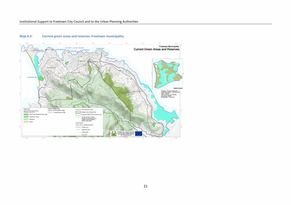
Map 4-2: Current green areas and reserves: Freetown municipality
21

Institutional Support to Freetown City Council and to the Urban Planning Authorities
ordinate with the other authorities the responsibilities related to the protec-tion of the creeks.
Communities living in the creeks on flooding-prone land must, within the short term, be resettled and the creeks protected from further degradation. Communities living close to the creeks on flooding-safe land must be in-volved in the restoration of the creeks. Urban renewal projects shall promote drinking-water supply, sanitary facilities and solid-waste collections systems. Furthermore, awareness-raising, vocational training and introduction of al-ternative income-generating micro projects shall be introduced to communi-ty members in order to stop overexploitation and mismanagement of the resources of the creeks.
4.1.4 Bays
The bays are located along the northern coast and are important elements in the Freetown landscape. Freetown has five prominent bays: Susan’s Bay, Kroo Bay, Destruction Bay, Cockle Bay and Pirate Bay. Once they hosted well-organized port facilities, shipping activities, markets, workshops, and ware-houses.
However, today – while the population is busy with shipping, fishing, trading, food processing and trade – the environment has deteriorated and the bays are inhabited by communities living in difficult situations. Susan’s Bay, De-struction Bay and Kroo Bay all have limited access to urban sanitation, toilet services and good drinking water and are exposed to offensive smells from rotting rubbish, overflowing pit latrines and stagnant water. There are no proper drainage systems in the bays, with the exception of one in Destruc-tion Bay. Health statistics in these communities also shows that malaria is the leading health problem, with 95% of the respondents describing it as the most important health problem affecting the environment.
In Kroo Bay the children are bathing with pigs in the dirty and polluted stream. New dwellings are built in the flooding-prone area on banked solid waste reinforced with sticks. Risk of fire outbreak is high due to the conges-tion of houses.
The bay mitigation strategies
The mitigation strategies are related to an urgently needed development control which avoids the movement of more people into the bay areas as long as the living conditions are as bad as they are. No more dwellings should be constructed and no more land should be banked with rubbish.
Urban upgrading strategies
FCC will prepare special slum-upgrading plans and seek technical and eco-nomic support from NGO and donor institutions to start upgrading the slum settlements in a prioritized and planned manner. The bay communities will be among the communities with most needs.
Resettlement will be necessary where community members are living in flooding risk-prone areas, defined as plots located less than 4 m from the daily mean sea level. The community members to be resettled will, when economic funds are available, be offered relocation within or outside the Freetown municipality area. Resettlement and upgrading schemes will be prepared under the authority of FCC in co-operation with NGOs and the Freetown (FT) communities.
Other actions to improve the living conditions in the short term will be the identification of solid waste collection points in each of the bay and creek communities, and ensuring the delivery of clean drinking water.
22
Institutional Support to Freetown City Council and to the Urban Planning Authorities
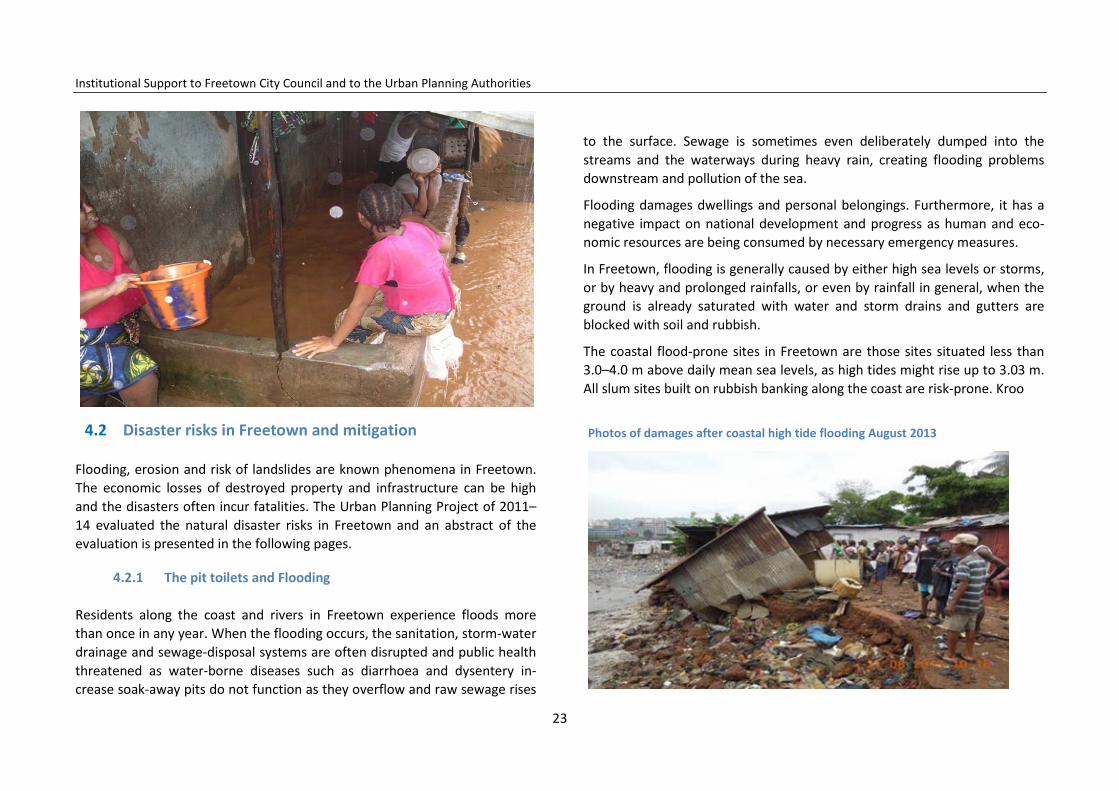
4.2 Disaster risks in Freetown and mitigation
Flooding, erosion and risk of landslides are known phenomena in Freetown. The economic losses of destroyed property and infrastructure can be high and the disasters often incur fatalities. The Urban Planning Project of 2011–14 evaluated the natural disaster risks in Freetown and an abstract of the evaluation is presented in the following pages.
4.2.1 The pit toilets and Flooding
Residents along the coast and rivers in Freetown experience floods more than once in any year. When the flooding occurs, the sanitation, storm-water drainage and sewage-disposal systems are often disrupted and public health threatened as water-borne diseases such as diarrhoea and dysentery in-crease soak-away pits do not function as they overflow and raw sewage rises
to the surface. Sewage is sometimes even deliberately dumped into the streams and the waterways during heavy rain, creating flooding problems downstream and pollution of the sea.
Flooding damages dwellings and personal belongings. Furthermore, it has a negative impact on national development and progress as human and eco-nomic resources are being consumed by necessary emergency measures.
In Freetown, flooding is generally caused by either high sea levels or storms, or by heavy and prolonged rainfalls, or even by rainfall in general, when the ground is already saturated with water and storm drains and gutters are blocked with soil and rubbish.
The coastal flood-prone sites in Freetown are those sites situated less than 3.0–4.0 m above daily mean sea levels, as high tides might rise up to 3.03 m. All slum sites built on rubbish banking along the coast are risk-prone. Kroo
Photos of damages after coastal high tide flooding August 2013
23

Institutional Support to Freetown City Council and to the Urban Planning Authorities
Bay, White Man’s Bay, and Susan’s Bay are high-risk areas, among others.
Inland, the stream water floods the houses along the streams because other uncontrolled developments have narrowed the rainwater stream channels and water cannot escape. The risk of flooding is further exacerbated by community dwellers building within the stream, thereby blocking the water stream.
Other inland flood risks occur in several parts of the city at street junctions, where the storm water from several drainage channels converges. This is common at the junction of Pademba Road–Mend Street (Figure 4-1), Old Railway Line and Bright Street and Brookfield to name a few. Too-narrow drain channels also create flooding, such as that experienced at Berry Street
(Model)–Circular Road junction.
Furthermore, the lack of efficient and planned drainage systems in the urban sprawl areas on the hillsides of Freetown does not allow for a sufficient drainage of the storm water during heavy rains. Consequently, the storm water flows with difficulty, rises, and enters into compounds and houses.
Tsunamis
While high tides and waves can always be expected in Freetown, tsunamis, which are provoked by seismic activities, are impossible to predict. The as-sumptions must be made on the present seismic risk activities in the risk area, and Sierra Leone and the neighbouring countries are not seismic areas. However, Cape Verde islands are, and they are located just 1300 km north-west of Freetown.
Any seismic impact from earthquakes on Cape Verde will not be felt in Free-town due to the distance, but scientists are discussing the risk of a major tsunami being provoked by volcanic activities on the islands, and such a tsu-nami might directly reach Freetown.
The level of risk is impossible to assess and the timing of its occurrence is unpredictable. Obviously, a tsunami would hit Freetown’s coast and bays and penetrate into and flood all creeks, rivers and streams. All low-lying lands would also be flooded. Mitigation measures will be the same as for very high tides and waves, as well as for inland flooding along rivers and streams.
4.2.2 Flooding mitigation strategies
In general, flooding in Freetown is not a product of natural disasters but mainly the product of human unconsidered and damaging behaviour, as well as inappropriate construction activities.
Flood mitigation responses have to focus on inappropriate behaviour and
24
Institutional Support to Freetown City Council and to the Urban Planning Authorities
Figure 4-1: Coastal and inland flooding sites
Coastal flooding sites Kroo Bay and White Man`s Bay environs Susan Bay Madina and Mafenbe, back of the RSLAF Head Quarters Mabella Congo Town Kanikey (back of the Cement Factory &Race Course Ceme-tery and environs) Inland flood sites Lumley/ Babadorie/Amadu Lane areas Wilkinson Road, Cockerill, Indian Temple Congo River (Tengbeh Town to Congo Bridge) Main Motor Road Brookfields and King Harman Road Junction and Bright Street and King Harman Road Junction Hill Cot Road Bridge and immediate vicinity Samba Gutter, Ministry of Works Compound onto Joaque Bridge Pultney Street and Siaka Steven Street Junction Eastern Police – Annie Walsh Roundabout Mountain Cut – Kissy Road junction Africanus Road onto former Shell Company, Kissy Ashobi Corner – Blackhall Road Banana Water , Oloshoro Pademba Road –Mends Street –Dundas Street Junction Fire force – Circular Road – Macauley Street Junction Berry Street (Model) – Circular Road Junction
practices and define the corresponding actions which, first of all, relate to administrative actions, although physical mitigation measures might be con-sidered.
Administrative preventive actions are the most cost efficient, but are serious-ly under-prioritized: FCC, as the future land-use planning and urban devel-opment control authority, will have a crucially important role to play. Preven-tive urban planning and efficient development control are by far the most efficient measures to avoid the negative impacts of natural disasters pro-voked by manmade activities.
Freetown still has many potential flooding areas free of settlements, and such areas must be protected from encroachment and construction. If the flooding along the coast can rise as high as 3.03 m over daily mean sea levels, all construction under this level must be avoided and building regulations, building permits, development control and building inspections must ensure
25
Institutional Support to Freetown City Council and to the Urban Planning Authorities
that house and building construction lower than this level does not occur. The Freetown Structure Plan proposes a norm of 4.40m as minimum con-struction level also considering the expected future sea rise due to the cli-mate change. Information and awareness-raising among the population re-garding this issue is very important.
FCC will emphasize the identification and zoning of the risk-prone areas and prepare, consult, make public and enforce the needed restrictive building regulations for the risk-prone areas. FCC can do this using the current urban planning law in co-operation with the MLCPE, and will, in the future, be able to do it directly when it has full land-use planning and development control authority, as ordered by the Local Government Act 2004, and its later revi-sion.
Administrative mitigation procedures must also be used to keep rivers, stream channels and waterways free of any physical construction or building. Even though the Freetown Improvement Act (FIA) needs revision and mod-ernization, this act and other natural protection laws give sufficient legal and regulatory bases for the maintenance of the waterways and storm-water channels.
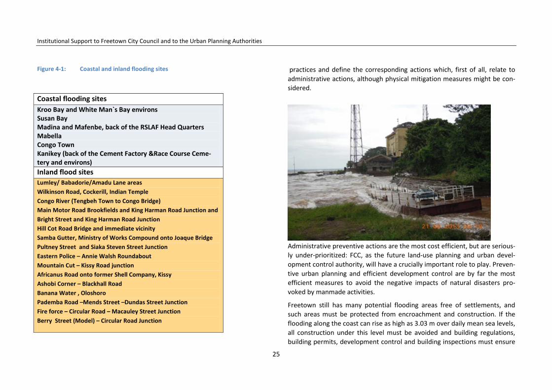
Photos of coastal high tide flooding August 2013
Concerning the maintenance of the storm-water drainage, the strategy must include revision and improvement of the system, routine cleaning and awareness campaigning, combined with an efficient and user-friendly solid-waste collection system. Fines for throwing solid waste into the drainage system should be enforced.
Physical property and building-protection measures could also be used to protect existing buildings that are subject to risk of flood damages; under the condition that the protection measures are efficient and economically feasi-ble compared to resettlement. The property and building-protection measures can be covered partly or fully by the property owners. Property
protection measures include: relocation of exposed or obstructive buildings; change of land use and acquisition of the risk areas for parks and other rec-reation activities; building elevations so that water can flow under the build-ings; or construction of smaller barriers to prevent flood waters from reach-ing a building.
Major structural projects could be considered and constructed specially to control flooding from rivers and streams. However, these solutions are very costly in comparison with preventive planning and development control, which includes resettlement, leaving flooding-prone land for urban agricul-ture, parks, sports fields or recreation grounds only.
FCC will strengthen the preparation of emergency services, which include raising awareness concerning disaster risks, provision of early warning to neighbourhoods, and preparation of plans for emergency actions to be used when flooding occurs.
4.2.3 Erosion, landslides and seismic risk
Erosion
Erosion in Freetown takes place either as a natural phenomenon, or it is man-made. Natural causes include waves, heavy rainfalls and water streams, which during centuries erode soil and sand from the coast from where rivers and creeks transport them as sediments with the current downstream. Hard surfaces and vegetation delay the erosion.
However, man-made interventions take a much shorter time to impact and erosion occurs in Freetown on the denuded hillsides, on steep cut and dan-gerous slopes, such as Moyiba. The construction of foundations for houses and roads on the steep slopes of the Freetown area, cutting into the hills on one side and building up terraces on the other, are the major cause of soil erosion in Freetown and have short-term impacts. Man-made causes of soil
26
Institutional Support to Freetown City Council and to the Urban Planning Authorities
erosion are further on removal of forest cover for gardening, and the com-mercial selling of wood. Soil erosion creates the danger of major and minor landslides and rockfall.
Landslides
Landslides, mudslides and rockfall are all referred to as ‘landslide’ and the same mitigation measures apply to all of them. Landslides can be brought on by natural causes such as groundwater pressure, loss or absence of vertical vegetative structure, erosion of the soil by rivers, ocean waves, and heavy rains.
However, the causes of landslide in Freetown are the uncontrollable con-struction, deforestation and mining activity on the hills. People have settled on the hills and constructed dwellings creating massive erosion; opening and exposing these areas to landslide, which are then being triggered by heavy rainfall.
Moyiba is an area with a particular threat of landslide situated in a hilly area in the eastern part of Freetown. Here trees have been felled to make room for construction. Furthermore, the activities associated with the quarry at the uppermost part of town exacerbate the situation because they also re-move vegetation: severe erosion has started at the top of the town, which causes high silt loads to occur during heavy rains, contaminating the stream and blocking the downstream channels.
Landslide mitigation strategies
As in flood mitigation, the erosion strategies include both administrative and physical actions. Administrative preventive actions are by far the most cost efficient and effective. The land-use planning and building authorities have to co-ordinate and prepare sufficiently clear guidelines for where to build and where not to build. Areas not suitable for construction must daily be checked
for encroachment, and the intruders expelled from the areas given corre-sponding warnings and fines. All new construction and development on al-ready-built slopes, which are considered dangerous and prone to landslide, must be prohibited. Furthermore, all existing dwellings, their foundations and drainage systems must be given guidelines for improvement.
Areas at risk of landslide in Freetown Charlotte Moyiba Tengbeh Town Dworzak New England Ville Ashobi Corner Areas with eventually at risk of landslides Slopes along the Parliament, Tower Hill Kissy Bye pass Juba Barracks
Figure 4-2: Areas at risk of landslide in Freetown
27

Institutional Support to Freetown City Council and to the Urban Planning Authorities
Figure 4-3: Hillsides and slopes at risk of mudslides and rockfall
• Moyiba Quarry • Back of PK Oil Mill (Joshua Street, Mission School) • Hill Cot Road • Portee/Rokupr Wharf • Ashobi Corner, Off Blackhall Road • Kanikay (back of the cement factory) • Moa Wharf (back of PCMH) • Yandama Farm (back of Benz garage) • Falcon Bridge • Omolay Bush (New England Ville) • Congo Town (back of Racecourse Cemetery) • Kissy (back of Independence School)
The authorities must also make available to the public the building regula-tions and guidelines which indicate how to construct drain foundations and plots. They must also increase planting of convenient species of trees on the town’s plots to avoid and reduce erosion. The development control authori-ties must ensure that these regulations are being followed, with no building permits given, and no construction where inappropriate, or if not in accord-ance with the building regulations.
Following local government reform, FCC is now in the process of taking over the administrative responsibility for the protection of hillsides, slopes, riverbanks and coast. FCC will reinforce land-use planning and indicate where to build by enforcing building regulations, as well as inspecting of building activities. FCC will enforce development control as inefficiency in this matter might become extremely expensive if/when the public has to rebuild roads
Legend Map 4-3: Freetown hazard prone areas
28

Institutional Support to Freetown City Council and to the Urban Planning Authorities
Map 4-3: Freetown hazard prone areas
29
Institutional Support to Freetown City Council and to the Urban Planning Authorities
and families have to rebuild their homes as a consequence of landslides To support FCC, the Environmental Protection Agency (EPA) and the Ministry of Forestry are responsible for the preparation of legislation and regulations that safeguard and improve the forest cover which surrounds Freetown.
Finally, mass sensitization of the population to the need for environmental protection has to be given in schools and on radio and TV for the adult popu-lation. The negative effects of deforestation on hill slopes must be communi-cated to communities. They must be informed of the need for re-planting of appropriate areas on the hilltops and slopes in the neighbourhoods and in compounds situated on steep slopes. The Local Plans, which will detail the Structure Plan, must identify the environmental problems and action plans needed in each part of the city. These are to be discussed and consulted in partnership with the communities in the Local Plan preparation process.
Environmental and technical mitigation
Environmental protection measures consist of maintaining vegetation cover and environmental sanitation through cleaning blocked drains, as this fre-quently causes storm water to overflow on to roads and cause disasters.
Technical measures consist of modelling the erosion along the hills and coast of Freetown by studying the eroded materials and tracing the location of their source. The construction of gabions, traps, and graded channels at spe-cific locations can be constructed to minimize sediment transport and depo-sition on to roads and drains.
Education and sensitization of the community is required to remove boulders and rocks at risk of falling. Plus it must be communicated that excavation will further destabilize the slopes.
When preparing the building site for foundations, all earth slopes must be cut in the proportion of 1.5 horizontal to 1.0 vertical to create a stable slope. Any steeper slopes should be reinforced with a supporting wall and founda-tions, which increases the building cost considerably and needs constructive calculations according how steep the slope is. The FCC must have technical guidelines available for the citizens who are building.
The local plans will precisely identify the slopes at risk of landslide, while the communities living in the area must be involved in the discussions where not to build and on how to mitigate disaster risks.
4.2.4 Seismic risks
According to the geological surveys the area of New England in Freetown is located in a quiet zone with regard to seismic activity. However, there is a fault line between Aberdeen and Hastings at Orugu River. Based on this fact, very minor soil instability activity may occur along the Orugu River fault. Spe-cial regulations for reinforced construction must be used in the seismic risk areas and must be applied along this fault line.
As mentioned, Cape Verde, situated around 1320 km north-west of Free-town, is a seismic risk area but due to the distance between Freetown and Cape Verde eventual seismic activities on the islands will not have any nega-tive impact on building in Freetown. However, the activities might provoke waves that could reach Freetown bringing destruction and flooding. In such an event, any dwelling located less than 4 m over the daily mean water level is in great danger of suffering from the flooding.
30

Institutional Support to Freetown City Council and to the Urban Planning Authorities
5 The Freetown Population
Introduction
The number of citizens living in Freetown, their distribution in the different parts of the city, the growth of the population and migration to Freetown, are all important factors to consider when planning the future development of the city. The population is estimated to almost double during the next 15 years, meaning that the FCC administrative area could be inhabited by 1.9 million people in 2028. Such a population increase will be linked to consider-able social and economic development. But the rapid population growth and increased densities might also cause extended slum areas and setbacks in health, sanitation, and livelihoods if no planning and development control actions are being enforced.
5.1 Situation analysis
Population growth in Sierra Leone has averaged 2.5% over the past decade and has been steadily increasing during this period. By 2028 the population could have grown to 9.0 million.
In 2004 Freetown had a population of 773.000.1 The age profile of the coun-try is remarkably young, with 37. 2% of the population estimated to be below the age of 15 and 11.8% below the age of five. The population in 2012 is es-timated to be 998,0002 and might, during the next 15 years, increase to be-tween 1.693 and 1.92 million. The 49 wards within the Freetown municipality
1 Statistics Sierra Leone. 2 FCC/MLCPE Freetown Structure Plan. 3 According to UN, World Urbanization Prospects 2011.
had between 1985–2004 different growth rates ranging from 1.48% to 5.35% per year. To estimate the population in 2028, these various growth rates have been considered, with a few exceptions.
Table 5-1: The historic growth rates in the 49 wards of the municipality
The average growth rate for the Freetown municipality is 3.07%.
31
Institutional Support to Freetown City Council and to the Urban Planning Authorities
5.2 Planning areas
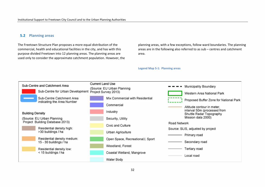
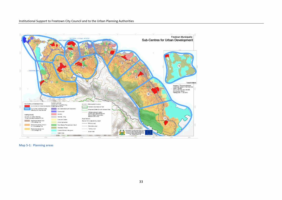
The Freetown Structure Plan proposes a more equal distribution of the commercial, health and educational facilities in the city, and has with this purpose divided Freetown into 12 planning areas. The planning areas are used only to consider the approximate catchment population. However, the
planning areas, with a few exceptions, follow ward boundaries. The planning areas are in the following also referred to as sub – centres and catchment area.
Legend Map 5-1: Planning areas
32
Institutional Support to Freetown City Council and to the Urban Planning Authorities
Map 5-1: Planning areas
33

Institutional Support to Freetown City Council and to the Urban Planning Authorities
5.3 Population projection
In calculating the population projection for 2028 for planning areas with growth rates of more than the average 3.07%, the rates have been main-tained because of an expected need for intensive urban renewal and upgrad-ing in these areas. Planning areas with growth rates of less than 3.07% have been given the average historic growth rate. However, Planning Area 6, which is the city centre, has been given the historic trend (1.25%) as it is as-sumed that the area will continue to develop as mainly a business area. With regard to Planning Area 12, which is Tassoh Island, it has been given a low grow rate of 1.5%, as due to its isolated location it is expected that most of the people will be moving to Freetown or Lungi.
Legend Maps 5-2, 5-3
Map 5-2: Population 2012
Map 5-3: Projected population 2028
34

Institutional Support to Freetown City Council and to the Urban Planning Authorities
Table 5-2: Wards in the planning areas
Table 5-3: Growth rates in planning areas 1985–2004 and estimated growth rates 2012–28
5.4 Population density
Freetown has a very high people density that can be compared with the densest cities in Africa. Freetown had a density of about 12,230 people per km2 in 2012. Based on the projections, it is expected that density will be 23,421 people per km2 in 2028. The Freetown Structure Plan has chosen to use the Urban Planning Project, UPP, higher projection rather than the UN p30 as it has been based on (1) wards and thus might be more precise and (2) because the projection is used to calculate future average housing density in the city planning areas.
Table 5-4: Showing population densities for 2012 and 2028
35

Institutional Support to Freetown City Council and to the Urban Planning Authorities
Table 5-5: Population, age distribution in 2004 and projection in 2028
5.5 Demographic characteristics
The gender split is 94 males to 100 females. The population is youthful (15–39) accounting for 40% of the population with high growth potentials. Only 4.4% are aged 65 years and over. The working-age population (age 15–64) constitutes 54%.4
Table 5-6: Fertility rates and life expectancy in selected African cities
4 Statistics Sierra Leone
36

Institutional Support to Freetown City Council and to the Urban Planning Authorities
6 The Local Economy of Freetown
Introduction
History shows that the larger cities such as Freetown generate economic development and employment, as well as contributes to national develop-ment. Like all big cities, Freetown concentrates economic activities needed for development, such as human resources, a labour force, skills, know-how, business services, infrastructure, government facilities, etc., which all im-prove productivity and reduce the costs of creating.
This functionality should be accepted and endorsed in order to help Free-town to become a major attractive regional city that can serve as a gateway for international trade, investment and business, rather than only attempting to shift industry and services to the provincial centres.
Mainly as a result of its primacy, the Freetown economy continues to ex-pand, with a corresponding increase in small-scale and informal businesses and expansion in the building industry. However, the progress includes chal-lenges of scale, which make business complicated and risky. These challenges include: a limited number of human resources with sufficient professional and vocational skills, poor urban infrastructure and maintenance, congestion, an unstable electricity supply, difficult accessing land, low-level city services, and costly services. The city needs to be renovated to perform its functions more efficiently at all levels.
The FCC municipality, in this context, has an important role to play in pro-moting renovation and economic development in co-ordination with the private sector and the other districts in the metropolitan area.
The economy of Freetown is directly linked to the Sierra Leone economy,
which has recovered significantly since the civil war (2002). The per capita GDP has grown at an average rate of 3.9%,5 while the overall GDP has grown at an average of 6.6% since 2004 to a GDP growth average of around 6% in 2010–2011.
It is, however, difficult to estimate the exact contribution made by the Free-town local economy to the national GDP. Up to 2009, this growth was mainly driven by increased output in the agricultural, construction and service sec-tors and was starting to slow down. Since 2010, however, increased output in the mining sector, especially in iron ore, has led to acceleration in growth rates to reach 15.2% in 2012. This growth is projected to stabilize around 7.2% in 2013.
6.1 Commerce and markets
The Freetown local economy is characterized by a vibrant commercial sub-sector. The Central Business District (CBD) is the main commercial centre and houses the majority of commercial activities in Freetown, including offices for consulting firms, financial offices, banks, and insurance operations. The PZ (Patterson Zochonis) commercial core is at the heart of the CBD. Already, the CBD has the capacity to serve as a high-density employment centre that will attract significant employment opportunities nationally and internation-ally. To the east at the Eastern Police area is another major commercial hub. Along Wilkinson Road in the West End area, and in Lumley, new important commercial activities are competing with the CBD. The city has around 30 well-assorted supermarkets6 and an equal number of stores with imported and locally produced quality furniture.
5 ibid. 6 List of supermarkets in Sierra Leone, by OverAtSia @ 16.3.2011.
37

Institutional Support to Freetown City Council and to the Urban Planning Authorities
However, the commercial activities are dominated by small businesses and the informal economy at a considerable scale. This commercial activity is located in the areas from the CBD to Upgun, as well as new businesses being established along the Bay Bureh Road. The trade activities are mainly small-scale shops and stalls, the selling of goods from street corners, the pave-ments, and petty trade. However, the per-person footprint floor area is esti-mated at under 0.16 m2 which is considered too small to allow any business-es to develop.
Much of the trade in Freetown is also conducted within 29 permanent mar-kets distributed thus: 9 in the East End, 12 in Central and 8 in the West End of Freetown. About 15,000 traders are involved overall with nearly all the mar-kets owned and operated by FCC. The design of several of the buildings is however problematic, with a lack of hygienic infrastructure, appropriate lighting, and ventilation facilities. A number of these markets have evolved spontaneously in places with the demand for the goods and services provid-ed. Some of these markets offer little future possibility for development and at times are inconvenient by being troublesome for traffic circulation. With the city increasingly expanding along with the population, many of the mar-kets now seem to have dispersed with many of the sellers no longer settled in one place.
6.2 The financial market
The financial market of Freetown is concentrated mainly in the CBD where commercial activities are more dominant. It consists of the Central Bank (Bank of Sierra Leone), 11 commercial banks, one co-operative bank, one post office savings bank, five insurance companies, and the Sierra Leone Housing Corporation. Several of these institutions do, however, only invest a little in urban development. As the local economy of Freetown is dominated by the informal economy, the majority of traders are rarely considered for
credit. This is partly because of the unrealistic collateral required for lending and, in general, the traders lack of experience concerning loan mechanisms. Recently, a housing finance company has been established as an important investment outlet of National Social Security and Insurance Trust, NASSIT. This company is yet to fully assert itself in the property market. Loan ar-rangements for economic or social housing provision do not exist.
6.3 Tourism: hotels, restaurants, and amusement centres
Freetown demonstrates nearly all the features of a one-time colonial city that is ready to be showcased. The city is still well known for the historic Cot-ton Tree, the Law Court building, its natural harbour and the beautiful beaches. Its location in the extreme west of Sierra Leone also gives her com-parative advantage in connecting with Lungi, where the country’s interna-tional airport is located. Freetown also has a number of recreational centres and hotels, which provide local services such as entertainment, accommoda-tion, and catering for tourists. The city additionally hosts a large number of restaurants, making dining out a great experience to a good number of visi-tors. Tourism offers an important opportunity to improve the Freetown economy by increasing commerce and by providing employment for a con-siderable percentage of Freetown’s youth.
The number of tourists coming to Sierra Leone has increased. Estimates from the National Tourist Board (NTB), show that the tourist population doubled from 2001 to 2011. Over 75% of all tourists arriving in Sierra Leone reside in Freetown. The Radisson and Hilton Hotels being constructed – though not yet open – evidences the interest from investors who are waiting for the number of tourists to increase. The tourist population is expected to quadru-ple between 2012 and 2028.
Nevertheless, Freetown does need an improved tourism strategy to improve
38

Institutional Support to Freetown City Council and to the Urban Planning Authorities
and diversify offers to tourists at different economic levels. Furthermore, attention must be given to ensure careful improvement and maintenance of the existing tourist attractions, such as the Aberdeen area hotels and the beach area down to Lumley in Murray Town, as well as the coast and man-grove areas and others. Furthermore, a long-term plan should be made to maintain and prepare projects for the restoration of the tourist attractions existing in the city area presently threatened by anarchic and uncontrolled building activity, which unfortunately has little consideration for the historic and cultural values of the city. FCC and the building authorities here play an important role regarding the preparation of guidelines and the enforcement of decided regulations.
6.4 The construction sector
The construction sector provides employment for a significant proportion of Freetown’s working population and is visual proof of the economic progress in the city, both in the formal as well as in the informal sector. However, most employees work in the informal sector. Work in construction sector is generally not place-specific since it is carried out in different neighbour-hoods, frequently involving the construction or repair of buildings. There is no known data on the exact number of workers in the construction sector involved in the informal economy. Most data estimates are limited to work-ers in the formal economy. It is important to have a clear understanding of the number of informal construction workers since most of the housing units and other buildings in Freetown have been built by workers from this catego-ry, and involving small building contractors. There is also no known data on the exact contribution made by this sector to the Freetown local economy.
The building sector as a whole needs improved building regulations to ensure quality, security and investments. The building sector also needs enforced guidelines for occupation of public space for building activities.
Industry and workshops
There are still a few industries operating in Freetown. The majority of these industries are located (mainly in the form of industrial estates) in the Cline Town area near the quay, such as the cement factory and also in Wellington, but others can be found in other parts of the city. The industries in Freetown consist of light industries which produce mainly for the local market. Indus-trial units also exist in parts of Kissy Dockyard, King Tom Dockyard, as well as in Murray Town and along the Wilkinson Road. The oil refinery in Kissy closed down in 1992, but the area still hosts fuel tanks and the potential for indus-trial renovation. The formal industrial area in Freetown is in total 151.3 ha The number of employees in this industry is relatively low.
As available land in the FCC area is limited, the Freetown Structure Plan pro-poses that all future heavy industries are to be located outside of Freetown in the areas identified for development of the Freetown Metropolitan Area, and co-ordinated alongside national economic development projects. How-ever, a limited number of lighter industrial developments could be estab-lished producing for the city or preparing for export in minor quantities.
In addition to the formal industrial sites, there are a number of micro-enterprises which contribute to the economy. Micro-enterprises are wide-spread and are generally in the form of tailoring shops, and metal and car-pentry workshops existing within most residential neighbourhoods.
Legend Map 6-1
39

Institutional Support to Freetown City Council and to the Urban Planning Authorities
As the micro-enterprises will be important for the economic develop-ment of the city, they should continue to be allowed to integrate into the neighbourhoods, on the condition that they do not produce any negative impact on the urban environment.
One criterion must be that the workshops are fully functioning on their own sites and do not occupy any public space. Another criterion must be that special-parking demanding workshops must provide for the parking facilities on their own sites. A third criterion must be that workshops producing noise, smells and dust, or that present a high risk of polluting the environment, must be located accordingly or efficient-ly forced to reduce the negative impacts to an accepted level and avoid pollution. The motor-car workshops, from where oil spill is highly
polluting, should be advised to occupy areas where the spills can be efficiently controlled and any motor-car servicing must be prohibited on public streets where oil spills pollute the public drainage and sew-erage systems.
6.5 Deep-sea port
Queen Elizabeth II Quay is the main seaport in Sierra Leone with an existing plot area of 30.9 ha located almost in the centre of Freetown. The port is Sierra Leone's major international sea link, handling over two-thirds of all the country's imports and exports. Its present opera-tion is reduced to the loading and unloading of cargo. The port was rehabilitated in 2002, followed by a reform transferring the maritime
Legend Map 6-1 The Freetown economy
40
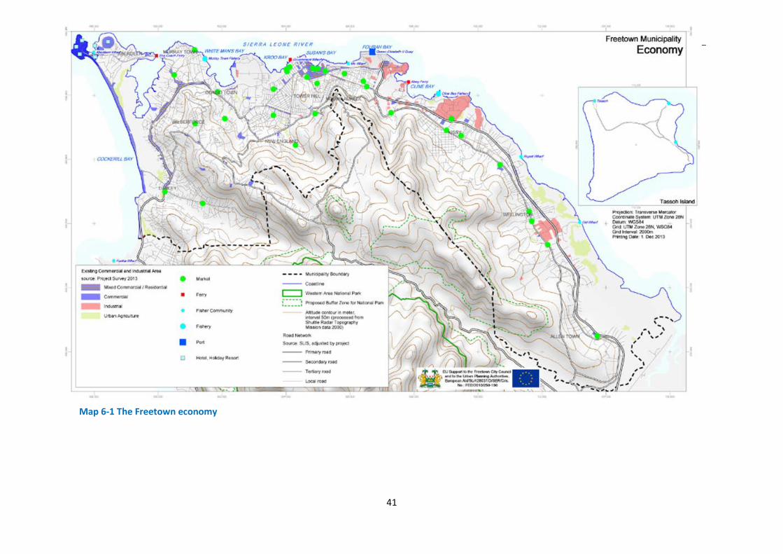
Institutional Support to Freetown City Council and to the Urban Planning Authorities
Map 6-1 The Freetown economy
41
Institutional Support to Freetown City Council and to the Urban Planning Authorities
transport responsibilities from Sierra Leone Ports Authority, SLPA, ), to the newly created Sierra Leone Maritime Administration (SLMA). An-other reform process in 2008 outsourced the cargo handling and pilot-age responsibilities to a private operator Balloré.
The Queen Elizabeth II Quay is an important activity for Freetown, creating employment and business opportunities for many Freetown service companies. FCC sees the port as a vital element in the Free-town industrial economy and wants port activity to recover as much as possible.
To support the port, FCC will ensure the development of an industrial area next to the port for port-supporting and port-related economic activities. This includes ensuring water flow in the creek, and land-claiming parts of the Granville Brook as part of a major effort to clean the area and recover it from being a solid-waste dumping site. To im-prove the traffic to and from the port, FCC will encourage the com-plete upgrading and renovation of Bay Bureh Road as a primary road with four lanes all the way to Hastings. Additional train rails along the highway might further improve the transport to the port by transport-ing containers during the night hours to a complementary container terminal in Hastings.
6.6 Fisheries
Fishery in Freetown can be divided into artisanal fishery, which is car-ried out in the estuaries, and industrial fishing, which takes place off-shore. Freetown has two concentrated, main fish-landing sites (Murray Town and fisheries at Kissy) used by the trawlers involved in industrial fishing. Furthermore, of the 16 existing wharves in the Freetown mu-nicipality, 10 are actively used by artisanal fishermen as the main fish-landing sites.
Fishing is dominated by the small-scale artisanal fishery; this being the most important economic activity in the coastal communities. Fishery
is estimated to have contributed to about 9.4% of Sierra Leone’s GDP in 2003. It is not known how much was contributed to this figure by fishery within the Freetown municipality. However, fishing can im-prove contributions to the Freetown local economy, including daily export potential to European capitals by flight when further vocational training and better infrastructure permit the hygienic handling of the catch demanded by European countries.
6.7 Agriculture
Agriculture as such is not an option for the future in Freetown, as ur-ban areas will be demanded for urban functions. However, market gardening is still an opportunity, providing livelihoods for several households in Freetown cultivating along the creeks and on dumping sites (but without any hygienic control of the products). There is also market gardening on the shoreline areas of Allen Town and in many areas along the foothills of the Peninsular in Eastern Freetown. How-ever, the demand for fresh vegetables is high in the city. Import of fresh good quality vegetables should be encouraged from available farmland on Tassoh Island and other parts of the Peninsula and Lungi; all within short distance from consumers in the city.
6.8 Freetown economy development goals
On the basis of the foregoing discussion, the following recommen-dations are made for development goals:
6.8.1 Commerce and markets
To promote more formality in the commercial sector, it is a goal to extend the commercial area in the city. The minor daily-retail shops can be integrated into the residential areas close to consumers.
The major commercial areas shall, in general, be located with access to
42
Institutional Support to Freetown City Council and to the Urban Planning Authorities
the main traffic system. The wholesale markets shall be located close to the port facilities, and the exit roads to the provinces. The major retail markets shall be in close connection with the public transport hubs and terminals. Parking spaces shall be provided within the com-mercial areas.
6.8.1.1 Areas for wholesale markets The areas recommended for wholesale markets are to be located in mainly five areas: (1) Cline Town, Upgun, Kissy Ferry Terminal, Kissy Men´s Mess and Fisher Lane; (2) in a renovated area where the Public Works Department, PWD, work yard at Pademba Road is today; (3) in Wilberforce Barracks; (4) in Wellington Industrial area; and at (5) Allen Town 3 in adjacent Crafton. These markets will feed the various retail markets that will be provided across Freetown. The concept is inter-modal, i.e. that the major commercial activities are located to be linked with the different modes of transportation. The challenge to this planned renovation, within the context of the development of the metropolitan area, is to find alternative locations for the necessary relocation of the military barracks and the central prison.
6.8.1.2 Retail A key goal is to substitute the widespread uncontrolled street trading currently taking place with permanent retail markets distributed more equally all over the city; in such a way that at least one retail market is provided in each of the wards, being of a size commensurate with the threshold population. One wholesale/retail market with pedestrian access adjacent to the city centre could be located in the vicinity of Guard Street, at Dove Cot, including Old Railway Line, East Brook Street, Fisher Street, across Nichol’s Brook to include Sawpit Wharf and Mabella Wharf. The Fourah Bay Road–Guard Street end of this market will serve as an eastern loading and offloading point for goods/services from the eastern part of the municipality. The central, inland part of this market will be served by both Meheux Street and Malama Thomas Street as entry/exit points. The wharves,
Sawpit/Mabella, will provide landing facilities for cross-river trade. The western part of this market will have transport terminal/entry/loading and offloading facilities to link up with Sani Abacha Street, Wilberforce Street, Siaka Stevens Street, and Lightfoot Boston Street, which to-gether with Fourah Bay Road and Goderich Street, it is suggested will be used exclusively as traffic circulation streets.
6.8.1.3 Retail in the CBD It is proposed that the CBD is redeveloped and renovated with the purpose of attracting national and international fashion and brand shops. More multi- storey buildings with modern shopping facilities (mostly in the form of big box retail stores), mall-style commercial plazas, entertainment services, restaurants, banks, offices, and insur-ance houses will enable this area to enhance its commercial and eco-nomic value. IT access of the highest level must be available in all busi-ness streets and quality conference and meeting facilities must be easily accessed in the centre. However, a Local Plan should be pre-pared for the development of the CBD to ensure that the building de-sign and architecture are dimensioned with consideration taken of the historic urban and building heritage, with the possibility of establishing squares and green boulevards where possible. The renovation must be followed by a strict development-control regime, re-establishing the pedestrian areas and restricting parking.
6.8.1.4 Freetown new city centre As a complementary development option for new larger commercial activities in the city centre such as malls and larger stores, the FSP proposes that the government-owned New England area should be upgraded and renovated to a modern commercial and administration-focused city centre with high-rise modern architecture for malls, stores, offices and even flats, with all new standards and technologies available. Mining companies could have
their head offices here, as well as being a central location for the new
43

Institutional Support to Freetown City Council and to the Urban Planning Authorities
Freetown City Council Hall.
The Jomo Kenyatta Road will provide necessary access, and parking spaces can be provided for inside the area. A Local Plan for the future development of New England including the Pademba Road Prison, and the area around Jomo Kenyatta Road, should be prepared to visualize the possibilities and opportunities for development of this area.
6.8.2 Urban tourism development
The expected quadrupling in visiting tourists requires substantial de-velopment of tourist facilities in Freetown. Priority should be given to develop urban tourism, taking advantage of the existing water, beach and coastal resources. Touristic water transport should be developed to transport visitors along the coast between tourist areas and attrac-tions. A long-term plan should be prepared for cleaner water along the coast. Vocational training shall be enforced in relation to tourist-sector activities, and employment-creating micro-businesses should be pro-moted relating to service provision along the beaches and in tourist areas.
As virgin land is not available within the municipality, tourist facilities have to be created by renovation of the existing restaurant and hotel areas in Aberdeen and along the Lumley Beach. These should follow architectonic guidelines that ensure and improve the quality and land-scape of the area, also taking into account the natural values in the creek. Any unplanned residential settlement along the creek coast should be stopped. The fisher settlement and boats at the bottom of Man of War Bay are a special attraction. The area must be upgraded: hygiene, health, and sanitation must be ensured in relation to housing and sale of fish. Sites for carving are proposed along the main Aber-deen Roundabout and on the empty space at the frontage of Solar Hotel, which is easily accessible for visitors. The establishment of small family hotels and hostels should be supported in Murray Town along the coast.
Priority should be given to the preparation of two Local Plans which can provide guidelines and building regulations for a controlled devel-opment of (1) the Aberdeen and Lumley Beach Area including the Ab-erdeen Creek and old Murray Town and (2) the historic parts of the CBD. These plans should define the development guidelines and build-ing regulations for the area in order to rescue what is left of the histor-ic heritage and landing places. Attention to building permitting the integration of hotels, new restaurants, boutiques, and craft markets is also required.
FCC will encourage agencies and the private sector to invest in new modern museums and craft markets.
FCC will be encouraged to support the development of Tassohh Island for tourism, weekend camping, sport, fishing, and bird watching. Hand-crafted carving and traditional boatbuilding could be activities for de-velopment on the island.
6.8.3 Industry
Cline Bay industrial area, between Cline Town and the pumping station
The FSP identifies two special areas for particular industrial develop-ment. One area is the 178 ha Cline Bay industrial area linking to the Port and cement plant area and located along the coast from Cline Town towards the oil pumping station and access restricted to the city by Bay Bureh Road. The area is reserved for, among other functions, lighter industry thereby avoiding any new residential development in the area. Following the intermodal concept, the area relates to the port, to the ferry connection to Lungi and airport, and is easy accessi-ble from Freetown’s main traffic and transport system. The area will be renovated to meet modern environmental protection measures. In view of the intensive residential development south-west of the
44

Institutional Support to Freetown City Council and to the Urban Planning Authorities
area, it is proposed that the petroleum refinery be changed to petro-leum storage for distribution in Freetown only. The Cline Bay industrial area might be extended by filling up the solid-waste dump-site area and by land reclamation at Granville Brook, leaving sufficient open flow for the creek. A Local Plan should be prepared to visualize the possibilities and opportunities for future use of the area.
6.8.4 New development area including industry in Allen Town
An additional new industrial estate is proposed to be located in the Allen Town II area in front of Crafton for the establishment of both heavy and light industry. This area is 60 ha and it is proposed that 30 ha should be reserved for industry. To support this new functionality, a multi-purpose wholesale market is proposed for location in this area. The area has good road access both to the provinces and to Freetown, and is still not more than 16 km from the port and ferry connection to the airport. A residential area is proposed in the western end. An Area Action Plan should be prepared for the development of the area.
6.8.5 Integration of micro-enterprises
The remaining light industries already operating on the industrial es-tates can be allowed to continue but only in their current form. Only micro-industries (tailoring and carpentry as well as some offices, shops, restaurants, clinics and pharmacies) should be retained in Free-town, operating mainly within residential neighbourhoods, especially on the ground floor of buildings intended for residential purposes. Micro-industries alone are estimated to provide up to 112,134 jobs in Freetown by 2028.
Fishery and agriculture
Fishery makes contributions to economic growth in Freetown at both
industrial and small-scale levels. Fishery industries might be developed in Murray Town with extension possibilities in the Murray Town Bar-racks area nearby. The other possibility is in the existing fishery facili-ties in Cline Bay Industrial Area.
The important small-scale fishery activity can be located in the east of Freetown in six middle-scale fishing centres proposed to be located between Allen Town II and Texaco Junction. The fishing centres will link with established routes along the Old Road, serving as the main distributor road. In western Freetown, six smaller-scale fishing markets will be located in Lumley Beach and Man of War Bay delivering to the West End and hotel sector, and markets in Murray Town, Susan´s Bay, and Destruction Bay, thereby supplying the population in these core city areas.
Small-scale agricultural production is expected to take place along the city´s creeks, and at a larger scale in reclaimed land in the eastern part of the city from Wellington to Allen Town. However, the scale of pro-duction will not satisfy consumption in the capital, and vegetables from outside will need to be brought daily from the surrounding agri-cultural areas to the capital´s markets by boat or lorry. An exception is the possibility of improved agricultural production on Tassoh Island specifically for Freetown’s markets.
45
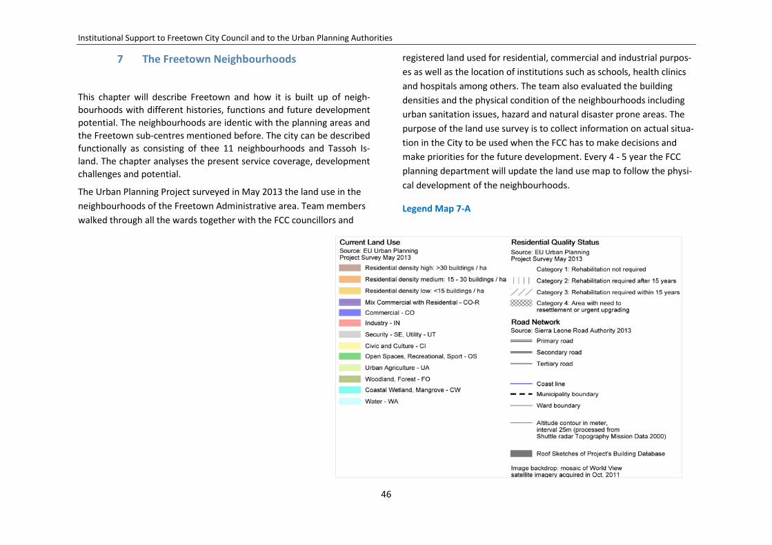
Institutional Support to Freetown City Council and to the Urban Planning Authorities
7 The Freetown Neighbourhoods
This chapter will describe Freetown and how it is built up of neigh-bourhoods with different histories, functions and future development potential. The neighbourhoods are identic with the planning areas and the Freetown sub-centres mentioned before. The city can be described functionally as consisting of thee 11 neighbourhoods and Tassoh Is-land. The chapter analyses the present service coverage, development challenges and potential.
The Urban Planning Project surveyed in May 2013 the land use in the neighbourhoods of the Freetown Administrative area. Team members walked through all the wards together with the FCC councillors and
registered land used for residential, commercial and industrial purpos-es as well as the location of institutions such as schools, health clinics and hospitals among others. The team also evaluated the building densities and the physical condition of the neighbourhoods including urban sanitation issues, hazard and natural disaster prone areas. The purpose of the land use survey is to collect information on actual situa-tion in the City to be used when the FCC has to make decisions and make priorities for the future development. Every 4 - 5 year the FCC planning department will update the land use map to follow the physi-cal development of the neighbourhoods.
Legend Map 7-A
46
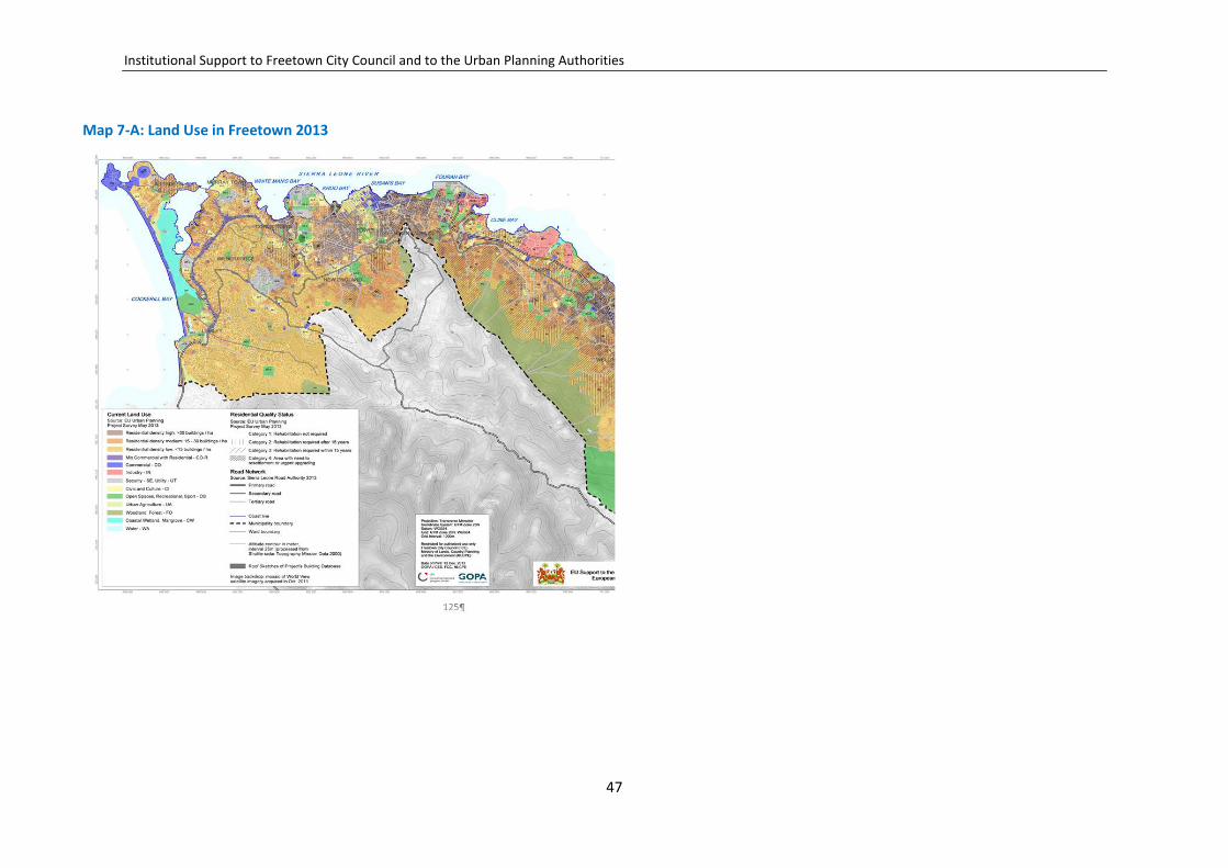
Institutional Support to Freetown City Council and to the Urban Planning Authorities
Map 7-A: Land Use in Freetown 2013
47

Institutional Support to Freetown City Council and to the Urban Planning Authorities
For descriptions of the neighbourhoods, the following considerations, among others, have been used as guidelines:
Improved management of the existing urban areas in Freetown will ensure enhanced performance of the traffic, transport and parking in the central areas, and better access roads to residential communities.
Controlled and guided use of different urban areas, urban planning and de-velopment control will furthermore ensure improved service provision all over the city, with good access to local markets, schools, sports fields and other recreation areas.
Taking into account the expected population growth in a city and the limited access to new virgin land, higher densities in general, and more efficient use of the available land, are necessary all over the city. Many old, small one- and two-storey houses in the central housing areas are already being modernized or rebuilt for more residential flats, and this is a process that will have to be undertaken throughout the different neighbourhoods.
However, the municipality has also a huge potential for re-planning and infill development, particularly in the peripheral areas on the hillsides at Malama, New England and on the hillside from Kissy to Allen Town, where small, new dwellings have been built without planning support and direction.
Consequently, they lack access roads, and community services and facilities. The Structure Plan will identify such areas, as well as the infrastructure needed, to sustain a more intensive and regulated development.
The structure plan has identified 12 different planning zones/ neighbour-hoods taking into account the special characteristics of each area. The neigh-bourhoods are described in the following.
The Freetown neighbourhoods
1) Aberdeen–Murray Town; 2) Lumley–Malama; 3) Wilberforce–Hill Station; 4) King Tom–Brookfield; 5) New England; 6) The city centre;
7) Fourah Bay–Cline Town; 8) Kissy Men’s Mess; 9) Kissy Grassfield–Congo Water; 10) Wellington–Pamuronko; 11) Allen Town and; 12) Tassoh Island;
7.1 Aberdeen–Murray Town Area (1)
The Aberdeen and Murray Town Area covers 712 Hectares (ha). The private and public services in the area support communities in Aberdeen, Murray Town, around Wilkinson Road, and Congo Town. The table below gives a picture of the current land use in the area.
The Aberdeen and Murray Town Area is serviced by a good road network with Wilkinson Road, Murray Town Road, Sir Samuel Lewis Road and the Lumley Beach Road serving as the major trunk roads. The Aberdeen Bridge serves as a pivotal link between Murray Town and Aberdeen, which are high-density areas.
The area at Aberdeen Bridge also hosts the important fast, sea-coach boat transport, which brings passengers to the airport in Lungi. The Area is ser-viced by public transport, an established potable water supply and an elec-tricity network. Facilities such as schools, vocational centres, health centres, recreation, community centres, churches/mosques, and cemeteries are available within the area.
48
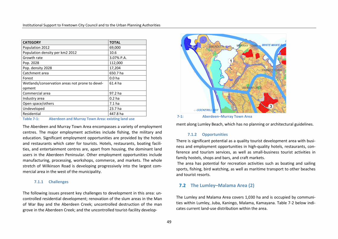
Institutional Support to Freetown City Council and to the Urban Planning Authorities
CATEGORY TOTAL Population 2012 69,000 Population density per km2 2012 10.6 Growth rate 3.07% P.A. Pop. 2028 112,000 Pop. density 2028 17,204 Catchment area 650.7 ha Forest 0.0 ha Wetlands/conservation areas not prone to devel-opment
61.4 ha
Commercial area 97.2 ha Industry area 0.2 ha Open space/others 7.1 ha Undeveloped 23.7 ha Residential 447.8 ha Table 7-1: Aberdeen and Murray Town Area: existing land use
The Aberdeen and Murray Town Area encompasses a variety of employment centres. The major employment activities include fishing, the military and education. Significant employment opportunities are provided by the hotels and restaurants which cater for tourists. Hotels, restaurants, boating facili-ties, and entertainment centres are, apart from housing, the dominant land users in the Aberdeen Peninsular. Other employment opportunities include manufacturing, processing, workshops, commerce, and markets. The whole stretch of Wilkinson Road is developing progressively into the largest com-mercial area in the west of the municipality.
7.1.1 Challenges
The following issues present key challenges to development in this area: un-controlled residential development; renovation of the slum areas in the Man of War Bay and the Aberdeen Creek; uncontrolled destruction of the man grove in the Aberdeen Creek; and the uncontrolled tourist-facility develop-
7-1: Aberdeen–Murray Town Area
ment along Lumley Beach, which has no planning or architectural guidelines.
7.1.2 Opportunities There is significant potential as a quality tourist development area with busi-ness and employment opportunities in high-quality hotels, restaurants, con-ference and tourism services, as well as small-business tourist activities in family hostels, shops and bars, and craft markets. The area has potential for recreation activities such as boating and sailing sports, fishing, bird watching, as well as maritime transport to other beaches and tourist resorts.
7.2 The Lumley–Malama Area (2)
The Lumley and Malama Area covers 1,030 ha and is occupied by communi-ties within Lumley, Juba, Kaningo, Malama, Kamayana. Table 7-2 below indi-cates current land-use distribution within the area.
49
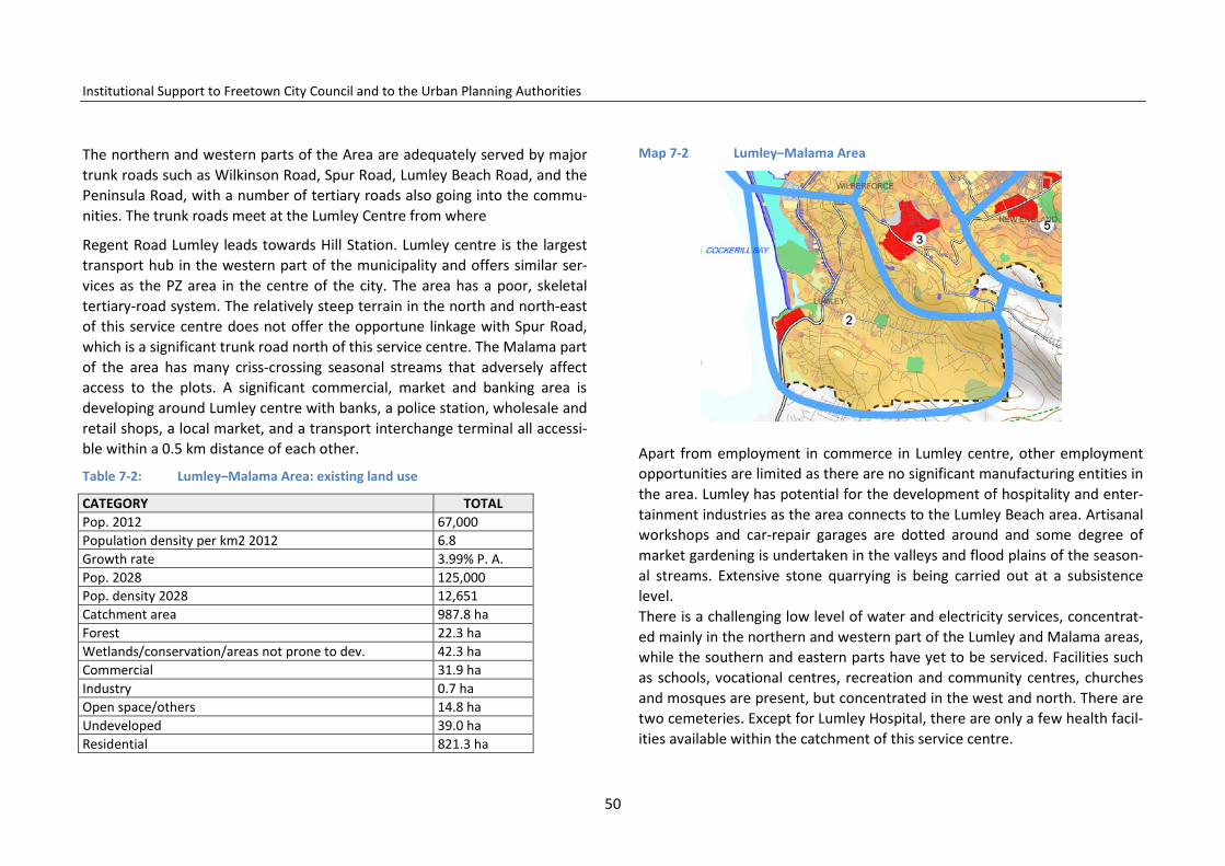
Institutional Support to Freetown City Council and to the Urban Planning Authorities
The northern and western parts of the Area are adequately served by major trunk roads such as Wilkinson Road, Spur Road, Lumley Beach Road, and the Peninsula Road, with a number of tertiary roads also going into the commu-nities. The trunk roads meet at the Lumley Centre from where
Regent Road Lumley leads towards Hill Station. Lumley centre is the largest transport hub in the western part of the municipality and offers similar ser-vices as the PZ area in the centre of the city. The area has a poor, skeletal tertiary-road system. The relatively steep terrain in the north and north-east of this service centre does not offer the opportune linkage with Spur Road, which is a significant trunk road north of this service centre. The Malama part of the area has many criss-crossing seasonal streams that adversely affect access to the plots. A significant commercial, market and banking area is developing around Lumley centre with banks, a police station, wholesale and retail shops, a local market, and a transport interchange terminal all accessi-ble within a 0.5 km distance of each other.
Table 7-2: Lumley–Malama Area: existing land use
CATEGORY TOTAL Pop. 2012 67,000 Population density per km2 2012 6.8 Growth rate 3.99% P. A. Pop. 2028 125,000 Pop. density 2028 12,651 Catchment area 987.8 ha Forest 22.3 ha Wetlands/conservation/areas not prone to dev. 42.3 ha Commercial 31.9 ha Industry 0.7 ha Open space/others 14.8 ha Undeveloped 39.0 ha Residential 821.3 ha
Map 7-2 Lumley–Malama Area
Apart from employment in commerce in Lumley centre, other employment opportunities are limited as there are no significant manufacturing entities in the area. Lumley has potential for the development of hospitality and enter-tainment industries as the area connects to the Lumley Beach area. Artisanal workshops and car-repair garages are dotted around and some degree of market gardening is undertaken in the valleys and flood plains of the season-al streams. Extensive stone quarrying is being carried out at a subsistence level. There is a challenging low level of water and electricity services, concentrat-ed mainly in the northern and western part of the Lumley and Malama areas, while the southern and eastern parts have yet to be serviced. Facilities such as schools, vocational centres, recreation and community centres, churches and mosques are present, but concentrated in the west and north. There are two cemeteries. Except for Lumley Hospital, there are only a few health facil-ities available within the catchment of this service centre.
50

Institutional Support to Freetown City Council and to the Urban Planning Authorities
7.2.1 Challenges The challenges are the major traffic congestion at the centre of Lumley, lack of a planned market place, the lack of land for urban renewal and renova-tion, the slum settlements along the river, and the lack of access roads and services on the hill sites.
7.2.2 Opportunities The opportunities are the location as a traffic and transport meeting point, the tourist potential in the beach and golf course areas, and the very dynam-ic business environment in the centre of Lumley.
7.3 Wilberforce–Hill Station Area (3)
Wilberforce–Hill Station Area covers about 430 ha and includes the hill sites south of Wilkinson Road, Congo Cross, Signal Hill, Wilberforce and Hill Sta-tion. The southern part of the area around Hill Station is less densely popu-lated than Upper Spur Road, Wilberforce, Signal Hill, and Congo Cross. The area is well serviced by secondary and tertiary roads, with lanes as well con-nected to other neighbourhoods in Freetown. There are reasonable transport facilities together with a water distribution network and electricity power lines.
The Wilberforce–Hill Station Area has considerable school facilities including vocational training centres, health and community centres, a playing field, places of worship and cemeteries. The area is predominantly residential with unplanned commerce and services developing along Spur Road and the Wil-berforce Main Motor Road.
The area hosts significant employment opportunities in the military at Wil-berforce, and in telecom offices, motor-repair garages, workshops, and sev-eral high-level hotels.
Map 7-3: Wilberforce–Hill Station Area
Table 7-3: Wilberforce–Hill Station Area: existing land use
CATEGORY TOTAL Catchment area 430 ha Pop. 2012 42,000 Growth rate 3.07% P.A. Population density per km2 2012 9.8 Pop. 2028 69,000 Density 2028 16,046 per km2 Forest 3.4 ha Wetlands/conservation/areas not prone to dev. 0* Commercial 4.5 ha Industry 0.7 ha Open space/others 0.5 ha Undeveloped 4.4 ha Residential 351.5 ha
51

Institutional Support to Freetown City Council and to the Urban Planning Authorities
7.3.1 Opportunities
The opportunities lie in the central location and easy accessibility of the neighbourhood as areas for modern urban business and institutional facili-ties. The military hospital area provides an excellent opportunity for needed modernization of the city’s health and education facilities. The other part of the barracks area has potential for modern high-rise residential buildings, and modern high-quality commercial and administration activities.
7.4 King Tom–Brookfield Area (4)
The King Tom–Brookfield Area has a catchment area of about 360 ha. This includes communities in King Tom, Ascension Town, Krootown Road, Brookfield, Part of Tengbeh Town, Red Pump, and the northern part of Jomo Kenyatta/Hill Cot Road.
Existing land-use distribution within the King Tom–Brookfield Area is: the Area has a generally flat topography and is well endowed with infrastructure and services. The Area is easily accessible through the many secondary and tertiary roads leading to or servicing it, and has a good road network. There is reasonable access to public transport, and there is an existing water supply service and electricity power lines.
The Area has a range of community facilities including schools, vocational training centres, health centres, recreation areas, religious facilities, and cemeteries.
The planning area has a range of employment centres focused largely on education, manufacturing and services. A budding industrial/manufacturing area is developing along Bolling Street.
Commercial activities occur in various locations within the area. Commercial activities line the major roads within this service centre starting from
Krootown Road and continuing on to King Tom Bridge, Campbell Street Dougan, and Heddle Streets. The Krootown Road Market falls within this area.
The employment opportunities are many, and offering nearly all urban activi-ties such as public administration (the Youyi Building) as well as educational institutions such as the Freetown Secondary School for Girls, FSSG, Saint Jo-seph’s Convent, the YWCA, Saint Edward’s Secondary, and the Prince of Wales School, and many other secondary and tertiary training institutions.
The electricity-generating plant at the King Tom Power Station, the large area of the police barracks, and the National Stadium are also within the catch-ment area. More employment opportunities are to be found in the private commercial sector, workshops and industry.
There is extensive market gardening in the flood plains of the rivers that criss-cross the area, and in areas adjacent to the dump site and the cemeter-ies.
Map 7-4: King Tom–Brookfield Area
52

Institutional Support to Freetown City Council and to the Urban Planning Authorities
7.4.1 Challenges
The challenges are: the traffic-management problems around St. John Junc-tion; the slum settlements along the river to be resettled due to flooding or landslide risks; the disposal of solid waste ends at the dump site; and the dumping area requires cleaning up.
Table 7-4: King Tom–Brookfield Area: existing land use
CATEGORY TOTAL Catchment area 360 ha Pop. 2012 71,000 Population density per km2 2012 19.7 Growth rate 3.07% P.A. Pop. 2028 116,000 Density 2028 32,222 per km2 Forest 0.0 ha Wetlands/ conservation/ areas not prone to development 0.2 ha Commercial 10.3 ha Industry 2.0 ha Open space and others 3.1 ha Undeveloped 39.7 ha Residential 234.7 ha
7.4.2 Opportunities
The opportunities are: the location of the area in this vibrant part of the city has many business options; the possibility of urban renewal in partnership with owners and the communities in the housing areas; the possibility of improving the main road-network efficiency by connecting Jomo Kenyatta Road with the Congo Cross Main Motor Road via King Haman Road; and the important potential development areas for urban renovation and develop-ment on publicly owned land on the King Tom Peninsula.
Map 7-5: The New England Area
7.5 The New England Area (5)
The New England Area is 496 ha and located next to the Brookfield and Wil-berforce areas.
The Area has high accessibility from the main secondary-road system. How-ever, the access road network to the housing areas uphill is poorly devel-oped, with some parts inaccessible. The steep terrain in the southern and south-eastern part of the New England Area is a major contributing factor to this poor accessibility.
Generally, the northern and western parts of the Area have relatively easy access to services such as transport, water and electricity, which are not available on the unplanned settlements in the hill sites. Education and health facilities such as schools, vocational centres, health centres, recreation facili-
53

Institutional Support to Freetown City Council and to the Urban Planning Authorities
ties, and places of worship are distributed in the northern and western parts, but not available within short distances in the southern and south-eastern parts of the Area. There is no cemetery in New England.
Table 7-5: New England Area: existing land use
CATEGORY TOTAL Catchment area 496 ha Pop. 2012 49,000 Population density per km2 2012 9.9 Growth rate 3.07% P.A. Pop. 2028 80,000 Density 2028 16,129 per km2 Forest 25.1 ha Wetlands conservation/areas not prone to development 0.4 ha Commercial 1.4 ha Industry 1.2 ha Open space/others 18.6 ha Undeveloped 1.5 ha Residential 425.9 ha
Government institutions in the northern and western parts provide the major source of employment in the area. Government institutions include a range of government offices, including the Special Court for Sierra Leone and the prisons.
The Freetown Bottling Factory at Dworzak Farm is the major manufacturing industry located here. There is nascent commercial and market centres de-veloping in the northern and western parts of the catchment area of this service centre, where there are also workshops and other services. There is intensive market gardening in the river valleys cutting through the area.
7.5.1 Challenges
The challenges are a lack of access roads and services to the residential areas on the hill site, and need for urban renovation.
7.5.2 Opportunities
The location is very central within the municipality, with fast access from both the east and west on main traffic and road systems. The centre is a short distance away with good access to government centres in Youyi Build-ing, close to the CBD.
Furthermore, the New England Area hosts a number of government buildings and institutions, which presents great potential for the renovation of the city. There is the possibility of construction of a new modern infrastructure for public and private administration needs, commercial centres and malls, plus the addition of high-rise modern city flats; all with the possibility of having modern IT and service infrastructure, parking spaces and good access for private and public transport.
7.6 The City Centre Area (6)
The city centre is located in the historic centre of the municipality and en-closes the CBD area. The city centre has an immediate catchment area of 257 ha enclosing communities in central Freetown including parts of Kroo Bay, Circular Road, Sojah (Soldier) Town, Bambara Town, Tower Hill, and Moun-tain Cut.
The city centre also includes the coast area and major slums/depressed areas such as Sawpit Wharf and Moa Wharf. The facilities and services offered in the city centre also reach nearby communities in Kroo Town Road, Congo Market, Sorie Town, and Foulah Town areas. The centre has a history of over
54
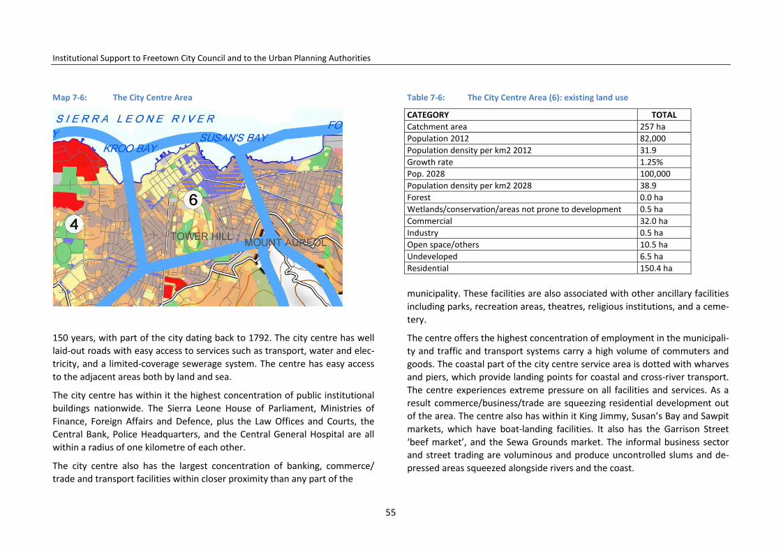
Institutional Support to Freetown City Council and to the Urban Planning Authorities
Map 7-6: The City Centre Area
150 years, with part of the city dating back to 1792. The city centre has well laid-out roads with easy access to services such as transport, water and elec-tricity, and a limited-coverage sewerage system. The centre has easy access to the adjacent areas both by land and sea.
The city centre has within it the highest concentration of public institutional buildings nationwide. The Sierra Leone House of Parliament, Ministries of Finance, Foreign Affairs and Defence, plus the Law Offices and Courts, the Central Bank, Police Headquarters, and the Central General Hospital are all within a radius of one kilometre of each other.
The city centre also has the largest concentration of banking, commerce/ trade and transport facilities within closer proximity than any part of the
Table 7-6: The City Centre Area (6): existing land use
CATEGORY TOTAL Catchment area 257 ha Population 2012 82,000 Population density per km2 2012 31.9 Growth rate 1.25% Pop. 2028 100,000 Population density per km2 2028 38.9 Forest 0.0 ha Wetlands/conservation/areas not prone to development 0.5 ha Commercial 32.0 ha Industry 0.5 ha Open space/others 10.5 ha Undeveloped 6.5 ha Residential 150.4 ha municipality. These facilities are also associated with other ancillary facilities including parks, recreation areas, theatres, religious institutions, and a ceme-tery.
The centre offers the highest concentration of employment in the municipali-ty and traffic and transport systems carry a high volume of commuters and goods. The coastal part of the city centre service area is dotted with wharves and piers, which provide landing points for coastal and cross-river transport. The centre experiences extreme pressure on all facilities and services. As a result commerce/business/trade are squeezing residential development out of the area. The centre also has within it King Jimmy, Susan’s Bay and Sawpit markets, which have boat-landing facilities. It also has the Garrison Street ‘beef market’, and the Sewa Grounds market. The informal business sector and street trading are voluminous and produce uncontrolled slums and de-pressed areas squeezed alongside rivers and the coast.
55
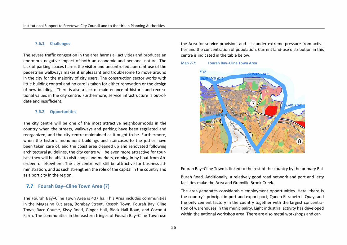
Institutional Support to Freetown City Council and to the Urban Planning Authorities
7.6.1 Challenges
The severe traffic congestion in the area harms all activities and produces an enormous negative impact of both an economic and personal nature. The lack of parking spaces harms the visitor and uncontrolled aberrant use of the pedestrian walkways makes it unpleasant and troublesome to move around in the city for the majority of city users. The construction sector works with little building control and no care is taken for either renovation or the design of new buildings. There is also a lack of maintenance of historic and recrea-tional values in the city centre. Furthermore, service infrastructure is out-of-date and insufficient.
7.6.2 Opportunities
The city centre will be one of the most attractive neighbourhoods in the country when the streets, walkways and parking have been regulated and reorganized, and the city centre maintained as it ought to be. Furthermore, when the historic monument buildings and staircases to the jetties have been taken care of, and the coast area cleaned up and renovated following architectural guidelines, the city centre will be even more attractive for tour-ists: they will be able to visit shops and markets, coming in by boat from Ab-erdeen or elsewhere. The city centre will still be attractive for business ad-ministration, and as such strengthen the role of the capital in the country and as a port city in the region.
7.7 Fourah Bay–Cline Town Area (7)
The Fourah Bay–Cline Town Area is 407 ha. This Area includes communities in the Magazine Cut area, Bombay Street, Kossoh Town, Fourah Bay, Cline Town, Race Course, Kissy Road, Ginger Hall, Black Hall Road, and Coconut Farm. The communities in the eastern fringes of Fourah Bay–Cline Town use
the Area for service provision, and it is under extreme pressure from activi-ties and the concentration of population. Current land-use distribution in this centre is indicated in the table below.
Map 7-7: Fourah Bay–Cline Town Area
Fourah Bay–Cline Town is linked to the rest of the country by the primary Bai
Bureh Road. Additionally, a relatively good road network and port and jetty facilities make the Area and Granville Brook Creek.
The area generates considerable employment opportunities. Here, there is the country’s principal import and export port, Queen Elizabeth II Quay, and the only cement factory in the country together with the largest concentra-tion of warehouses in the municipality. Light industrial activity has developed within the national workshop area. There are also metal workshops and car-
56

Institutional Support to Freetown City Council and to the Urban Planning Authorities
Table 7-7: Fourah Bay–Cline Town Area: existing land use
CATEGORY TOTAL Catchment area 407 ha Population 2012 157,314 Population density per km2 2012 38.7 Growth Rate 3.07% Population density per km2 2028 62.7 Forest 0.6 ha Wetlands/conservation/areas not prone to dev. 0.0 ha Commercial 19.8 ha Industry 33.5 ha Open Space/others 11.9 ha Undeveloped 19.4 ha Residential 265.9 ha repair garages, plus a range of secondary industries concentrated within the Kissy Dockyard area. There is also a transport terminal at Dan Street mainly for vehicles and passengers originating outside the municipality.
The largest National Power Authority (NPA) power-generating plant in the east of the municipality is located at Blackhall Road. The central abattoir, (‘Cow Yard’) for the municipality is located in the area adjacent to Dove Cot Market, an extensive street-trading area. Fishing companies with cold stor-age facilities, commercial centres, markets and ancillary activities are also located here.
The Fourah Bay–Cline Town Area has a range of schools, vocational training and health centres, recreation sites, community centres, places of worship and cemeteries. The educational facilities are Annie Walsh Memorial School, Bishop Johnson Memorial School, and with regard to hospitals, the area has Princess Christian Maternity (Cottage) Hospital and Ola During Children’s Hospital within its catchment area. Playing fields at the Brima Atouga Mini Stadium, Fourah Bay Field, and those within the confines of the various edu-
cational institutions provide recreation facilities in this service centre.
Along the coast is dotted with slums/depressed areas at Moa Wharf, the Cline Town dump site, and the flood plains of Granville Brook. Three ceme-teries, Race Course, Kissy Road, and the Aku-Mohammedan, are located in this service centre. Important historic buildings in the area are the original Fourah Bay College building, which is located in the middle of the port area and the railway museum.
7.7.1 Challenges
Due to the pressure from population density and high levels of activity, the service infrastructure needs urgent intervention and improvement. Traffic circulation is extremely low on Eastern Police, Kissy and Fourah Bay roads because of street trading. The heavy traffic load to and from the port area produces congestion and delays. The area is in need of urban upgrading pro-jects and landslide risk mitigation. The port might change function in the long term. The Cline Town rubbish-dump site is a threat to health in the area and pollutes the creek and Cline Bay.
7.7.2 Opportunities
Upgraded and renovated port and industrial areas provide a centrally located opportunity for business and employment. The commercial tradition and its potential in the area is high. Business is vibrant and a planned urban renova-tion in co-operation with the parcel and businesses might solve many of the problems. The education and health facilities have good accessibility and extension possibilities. The Granville Brook could be regulated and land rec-lamation undertaken to provide additional area for productive development.
57

Institutional Support to Freetown City Council and to the Urban Planning Authorities
7.8 Kissy Men’s Mess Area (8)
Kissy Men’s Mess is 660 ha and includes the communities in Kissy Dockyard, Kissy Bypass, Mamba Ridge, Kissy, Kissy Men’s Mess, Kissy Mental Hospital, and Kissy Low Cost. The north-eastern border falls along the Sierra Leone River. Current land use is indicated in the table below.
The Kissy Men’s Mess Area has a well-established network of roads and jet-ties. The area is easily accessible from the primary Bai Bureh Road and links to Lungi and the airport with a ferry service. The vicinity of the ferry terminal serves as a transport intersection serving the municipality. Furthermore, the area has port facilities and jetties, and public transport facilities are good. Water supply lines and electricity grid-line facilities are available in the lower part of the area, although maintenance is a problem and urban health and sanitation infrastructure is poor.
Employment is available in the ports and marine sector, which have dry dock facilities at Kissy where the ferry terminal provides the principal ferry linkage for passenger, goods and services with the Kaffu Bullom area and with Lungi International Airport across the Sierra Leone River.
Oil storage facilities, petroleum refining and storage, plus gas manufacture provide major employment in this service centre. The present artisanal stone quarrying in the Mamba Ridge area is also a valued source of employment. The Sierra Leone Roads Authority, which has its headquarters in the Area, contributes to the employment possibilities. Market/trading facilities are centred on the ‘Peace Market’ and trading is intense.
In Kissy Dockyard and the Men’s Mess area there is considerable available land for future industrial purposes including manufacturing, workshops and repair garages.
There is a range of educational institutions including vocational training cen-tres, which will also in the future provide possibilities for the location of new
Map 7-8: Kissy Men’s Mess Area
needed education and health infrastructure. Facilities such as health, recrea-tion, playing fields and community centres are available within the Area as well as places of worship and cemeteries. The housing areas are dense along the Bai Bureh Road and in the Kissy housing estate but less dense as the housing climbs up the steep hillsides.
7.8.1 Challenges
The Bai Bureh Road needs upgrading to primary road status with less direct access and commercial activities along the road. Instead the Old Waterloo Road must take over the role as traffic distributor. As the future population
58

Institutional Support to Freetown City Council and to the Urban Planning Authorities
Table 7-8: Kissy Men’s Mess Area: existing land use Table
CATEGORY TOTAL Catchment area 660 ha Population 2012 149,538 Population density per km2 2012 22.7 Growth rate 5.35% Pop. 2028 344,274 Population density per km2 2028 52.2 Forest 70.7 ha Wetlands/conservation/areas not prone to development 4.4 ha Commercial 11.3 ha Industry 75.2 ha Open space/others 16.6 ha Undeveloped 5 ha Residential 445.4 ha
densities are estimated to be high, urban health and sanitation need urgent intervention and improvement in the residential areas. The location of the dense community south-east of the Wellington Creek, within less than 150 m from the oil storage facilities, poses a considerable disaster risk if the tanks were to explode. The residential communities sprawled across the hill site need special attention as the hillside is steep and houses are at risk of slip-page if foundations are not well constructed.
7.8.2 Opportunities
The area has available land for industrial and service activities close to the city´s main road system, plus an export and import deep-sea port and ferry transport linking to Lungi and the airport. The industrial land, in addition, is centrally located close to the city´s high level of service provision and profes-sional
7.8.3
resources. For the Freetown municipality the area is an economically active employment-creation area with further potential. Furthermore, land is avail-able for the future needs of health and education facilities.
7.9 Kissy Grass Field–Congo Water Area (9)
Kissy Grass Field–Congo Area is 783 ha and caters for communities in Kissy Grass Field, Portee, Rokupa, Congo Water, Kuntolor, Thunder Hill, and Jalloh Terrace. The current land-use distribution in this centre is indicated in the table below.
Kissy Grass Field–Congo Area records the highest population concentrated in the northern sector in Congo Water, Portee, Grass Field, and Rokupa. The northern part is easily accessible from the Bai Bureh Road and Freetown Wa-terloo Road.
There are many employment opportunities in this service centre based main-ly on small-scale private enterprises engaged in trade, transport, workshops and vehicle-repair garages. These enterprises stretch in a ribbon along the Bai Bureh Road and the Kissy Bypass Road (Old Road).
The centre is dotted with several jetties and landing points along its northern catchment on the Sierra Leone River, which is a significant trade route for cross-river commerce.
The bulk of the existing services and facilities are also in this northern part of the catchment, such as the government hospital, which provides medical services to the area – it is located in Rokupa. However, the access roads on
59
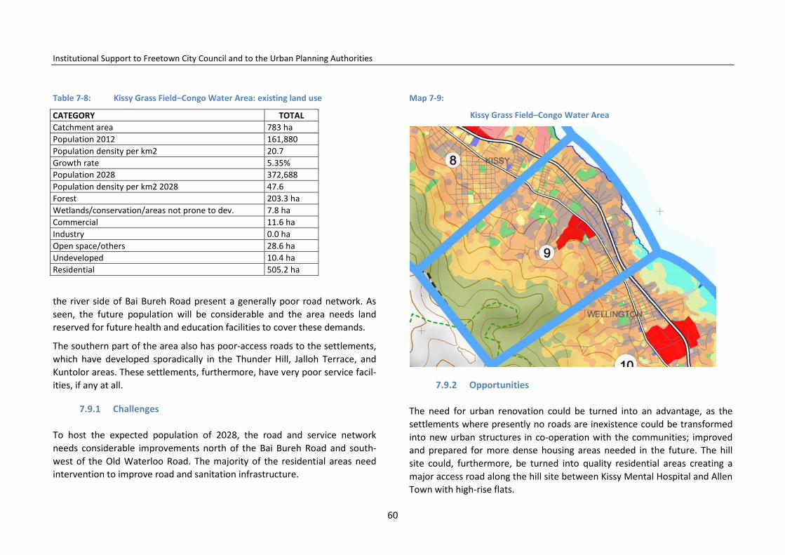
Institutional Support to Freetown City Council and to the Urban Planning Authorities
Table 7-8: Kissy Grass Field–Congo Water Area: existing land use
CATEGORY TOTAL Catchment area 783 ha Population 2012 161,880 Population density per km2 20.7 Growth rate 5.35% Population 2028 372,688 Population density per km2 2028 47.6 Forest 203.3 ha Wetlands/conservation/areas not prone to dev. 7.8 ha Commercial 11.6 ha Industry 0.0 ha Open space/others 28.6 ha Undeveloped 10.4 ha Residential 505.2 ha
the river side of Bai Bureh Road present a generally poor road network. As seen, the future population will be considerable and the area needs land reserved for future health and education facilities to cover these demands.
The southern part of the area also has poor-access roads to the settlements, which have developed sporadically in the Thunder Hill, Jalloh Terrace, and Kuntolor areas. These settlements, furthermore, have very poor service facil-ities, if any at all.
7.9.1 Challenges
To host the expected population of 2028, the road and service network needs considerable improvements north of the Bai Bureh Road and south-west of the Old Waterloo Road. The majority of the residential areas need intervention to improve road and sanitation infrastructure.
Map 7-9:
Kissy Grass Field–Congo Water Area
7.9.2 Opportunities
The need for urban renovation could be turned into an advantage, as the settlements where presently no roads are inexistence could be transformed into new urban structures in co-operation with the communities; improved and prepared for more dense housing areas needed in the future. The hill site could, furthermore, be turned into quality residential areas creating a major access road along the hill site between Kissy Mental Hospital and Allen Town with high-rise flats.
60
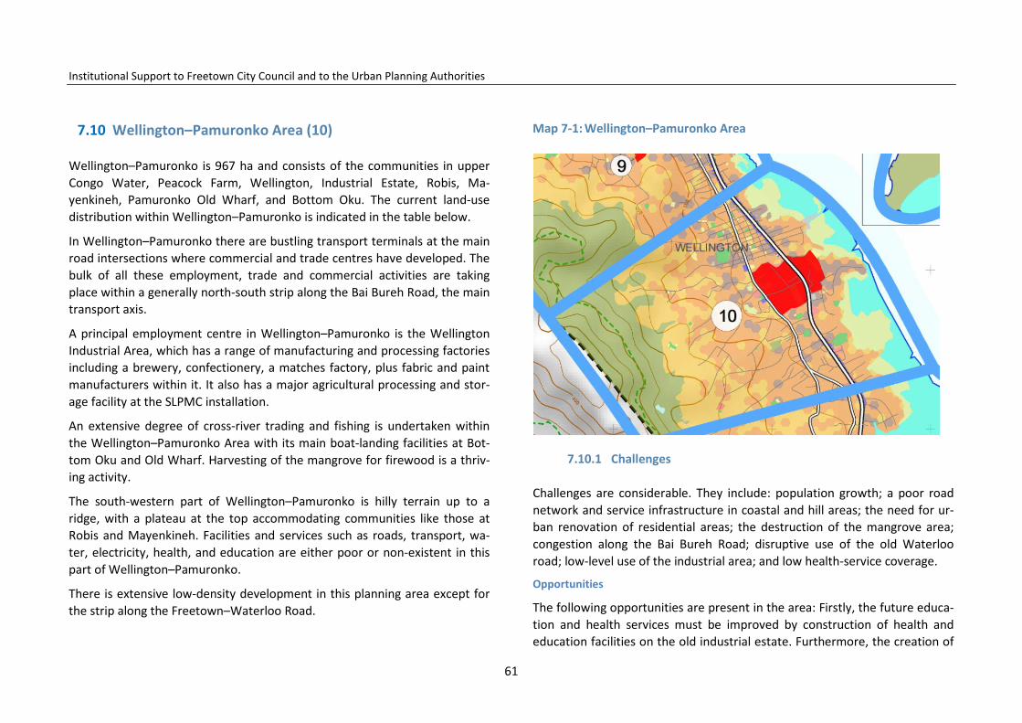
Institutional Support to Freetown City Council and to the Urban Planning Authorities
7.10 Wellington–Pamuronko Area (10)
Wellington–Pamuronko is 967 ha and consists of the communities in upper Congo Water, Peacock Farm, Wellington, Industrial Estate, Robis, Ma-yenkineh, Pamuronko Old Wharf, and Bottom Oku. The current land-use distribution within Wellington–Pamuronko is indicated in the table below.
In Wellington–Pamuronko there are bustling transport terminals at the main road intersections where commercial and trade centres have developed. The bulk of all these employment, trade and commercial activities are taking place within a generally north-south strip along the Bai Bureh Road, the main transport axis.
A principal employment centre in Wellington–Pamuronko is the Wellington Industrial Area, which has a range of manufacturing and processing factories including a brewery, confectionery, a matches factory, plus fabric and paint manufacturers within it. It also has a major agricultural processing and stor-age facility at the SLPMC installation.
An extensive degree of cross-river trading and fishing is undertaken within the Wellington–Pamuronko Area with its main boat-landing facilities at Bot-tom Oku and Old Wharf. Harvesting of the mangrove for firewood is a thriv-ing activity.
The south-western part of Wellington–Pamuronko is hilly terrain up to a ridge, with a plateau at the top accommodating communities like those at Robis and Mayenkineh. Facilities and services such as roads, transport, wa-ter, electricity, health, and education are either poor or non-existent in this part of Wellington–Pamuronko.
There is extensive low-density development in this planning area except for the strip along the Freetown–Waterloo Road.
Map 7-1: Wellington–Pamuronko Area
7.10.1 Challenges
Challenges are considerable. They include: population growth; a poor road network and service infrastructure in coastal and hill areas; the need for ur-ban renovation of residential areas; the destruction of the mangrove area; congestion along the Bai Bureh Road; disruptive use of the old Waterloo road; low-level use of the industrial area; and low health-service coverage.
Opportunities
The following opportunities are present in the area: Firstly, the future educa-tion and health services must be improved by construction of health and education facilities on the old industrial estate. Furthermore, the creation of
61
Institutional Support to Freetown City Council and to the Urban Planning Authorities
a new centre in Wellington strengthening local services and employment by renovating and modernizing the use of the industrial area; improving the capacity of Bai Bureh Road; changing the use of Old Waterloo Road to a dis-tribution road; renovating the road system on the hill site; and intensifying use of the hillside as a housing area, will all add to this area.
Table 8-9: Wellington–Pamuronko Area: existing land use
CATEGORY TOTAL Catchment area 967 ha Population 2012 115,465 Population density 2012 per km2 11.9 Growth rate 5.35% Population 2028 265,829 Population density 2028 per km2 27.5 Forest 185.6 ha Wetlands/conservation/areas not prone to dev. 10.3 ha Commercial 12.4 ha Industry 38 ha Open space/others 4.8 ha Undeveloped 2.8 ha Residential 522.2 ha
7.11 Allen Town Area (11)
Allen Town Area is located at the eastern extremities of the Freetown City
Council administrative boundary, adjacent to the northern boundary of the Western Area District Council, and has a catchment area of 940.5 ha enclos-ing communities in Upper and Lower Allen Town (Allen Town I and II). The services and facilities provided in the Area are intended to cover populations in Upper and Lower Allen Town and parts of the Jui and Grafton areas, both in the Western Area District Council. Current land-use distribution within this service centre is indicated in the table below.
Road infrastructure in this area of Freetown is poor except for the Bay Bureh Road. However, this primary road only has two lanes, which creates conges-tion. SLRA has programmed the renovation of the road for four lanes. The old Waterloo road is well located as a distribution road in this area but needs maintenance. The Crafton road also serves as a distribution road and links to the Regent Valley area. Employment opportunities are to be found in con-struction, transport and trade, as well as mangrove harvesting, market gar-dening, river fishing, and trade.
The population density is highest along the Bai Bureh Road and old Waterloo road, where many low-density middle-class homes have been built. The dom-inant physical features in this service centre are the mangroves to the west and hills to the east.
7.11.1 Challenges
There are limited schools, health and recreation facilities outside the Bay Bureh Road area. Water and electricity services in the Allen Town Area are also concentrated along the Bai Bureh Road and old Waterloo road, with fewer services outside these areas.
7.11.2 Opportunities
The opportunities for development are the low-density areas in Allentown, which under planned urban renovation can be restructured with the neces-sary and corresponding access roads, as well as considerable areas for urban development in the areas of Allen Town opposite Grafton. Here, there are various development options such as possibilities for housing projects, indus-try, transport, and wholesale market projects.
62

Institutional Support to Freetown City Council and to the Urban Planning Authorities
Map 7-2: Allen Town Area
Table 7-10: Allen Town Area I and II: existing land use:
CATEGORY TOTAL Catchment area 940.5 ha Population 2012 29,487 Population density per km2 2012 3.1 Growth rate 5.35% Population 2028 67,886 Population density per km2 2028 7.2 Forest 0 Wetlands/conservation/areas not prone to dev. 359.6 ha Commercial 1.5 ha Industry 0.0 ha Open space/others 386.9 ha Undeveloped 16.6 ha Residential 527.7 ha
7.12 Tassoh Island (12)
Tassoh Island is located across the Sierra Leone River at a distance of around 25 km from Freetown municipality. It covers an area of 761 square hectares and recorded a 2012 population of 4,300. The future population growth rate is estimated to be 1.5%, and the population is expected to be 5,500 in 2028.
The island depends on sea transport and Tassoh Village has the only jet-ty/boat landing facility on the Island. A dirt road allows bikes on the island. The high-tide flood enters in the mangrove areas and divides the island. A bridge – which is in need of repair – connects the main village with the oth-ers.
7.12.1
Employment is mainly artisanal fishing, trading, and boatbuilding. Some young people have managed to get a job at the mining jetty just in front of the island, but lack of vocational training makes it difficult to stay in these jobs. The island has no electricity or piped water supply, but takes drinking water from wells which need better management to ensure the water quali-ty. A major rainwater lagoon feeds the wells in Tassoh but it is periodically flooded with salt water during high tide and storms.
Public services in Tassoh Island are poor and little attended to. The island has two schools; one with basic and secondary levels and another functioning in a private house. Generally, the school infrastructure is poor and the island lacks professional teachers. A very poor clinic has been established in a pri-vate house in Tassoh, while the construction of a new half-built health facility infrastructure was abandoned around 10 years ago.
The island has historic monuments and forests with wild animals cover a major part of Tassoh Island which also has extensive areas of mangrove.
63

Institutional Support to Freetown City Council and to the Urban Planning Authorities
7.12.2 Challenges and Opportunities
There is a low level of infrastructure management and repair coupled with a low level of community activities. There is little support for basic education, vocational infrastructure and training in the relevant fields. There is no sup-port for the production of vegetable produce for the Freetown market.
Tassoh Island has high potential as resort for bird watching and fishing with weekend cabins and restaurants. Potential exists also for nature-related rec-reation activities for Freetown schools and students, including swimming lessons, canoeing, physical exercise, and other types of sporting activity.
Map 7-3: Tassoh Island
64

Institutional Support to Freetown City Council and to the Urban Planning Authorities
8 Educational and Health Facilities
8.1 Education
Education plays the most important role in the future development of the country. The young people who are entering the school system at present are the future generations that that shall carry forward and sustain the mid-dle-economy-country status expected of Sierra Leone in 2035. The small sec-tor of the population, who today manage to send their children to private, quality education centres, inland or abroad, cannot do it alone. To escape poverty, all intellectual resources and qualifications have to be mobilized to turn children into creative, motivated and enterprising teachers, producers, business administrators, entrepreneurs and innovators. Only by massive ef-forts invested in education will Freetown move forward.
Sufficient educational facilities will be necessary to cover the demand. Educa-tion centres have to be of a good standard regarding quality and manage-ment, as education in itself can help to improve homes and neighbourhoods. Education can also improve social behaviour; helping develop a culture of maintenance, organization, health, and sanitation. Good schools with moti-vating learning, sports, and recreation facilities also improve pupils and stu-dents’ mental and physical well-being.
8.1.1 Enrolment and number of schools
In Freetown in 2010–11, in total 307,000 children were enrolled in primary schools. In 2028 Freetown might have more than 600,000 children and young people with needs for enrolment in primary, junior, and senior school educa-tion.
Presently, there are 350 primary schools and 100 junior secondary schools in Freetown, which are mainly supervised and managed by FCC. The senior secondary schools are managed and overseen by the Ministry of Education Science and Technology, MEST. According to the education sector review 2010, Freetown has around an additional 130 schools which are owned and/or operated by private organizations.
However, many schools need improvements and renovation, and are not appropriately serviced according to the standards given by the Ministry of Education Science and Technology.
Using the above-mentioned criteria, there are areas in the eastern part of Freetown which are not serviced correspondingly with secondary (jun-ior/senior) schools. The primary schools are better distributed, apart from the area around the military headquarters at Wilkinson Road and at Allen Town where there is a shortage of schools.
65
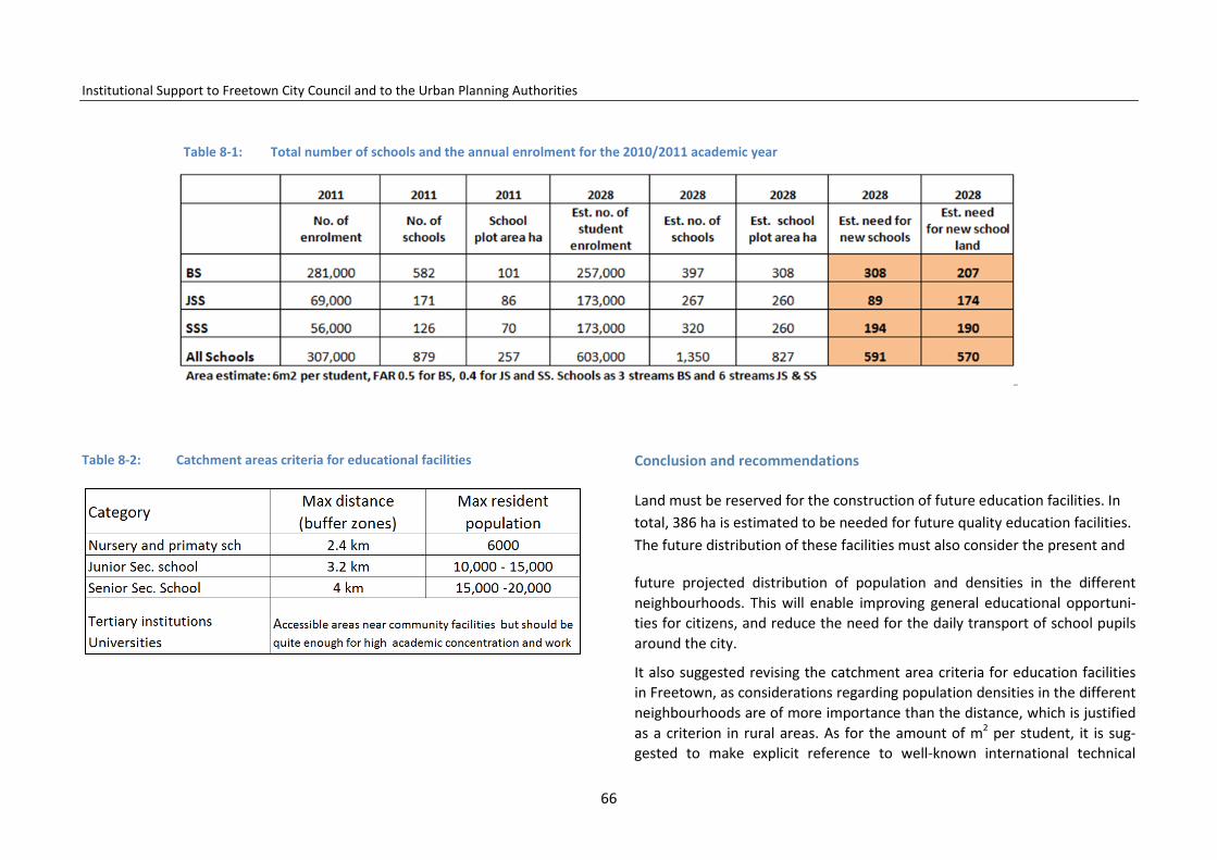
Institutional Support to Freetown City Council and to the Urban Planning Authorities
Table 8-1: Total number of schools and the annual enrolment for the 2010/2011 academic year
Table 8-2: Catchment areas criteria for educational facilities Conclusion and recommendations
Land must be reserved for the construction of future education facilities. In total, 386 ha is estimated to be needed for future quality education facilities. The future distribution of these facilities must also consider the present and
future projected distribution of population and densities in the different neighbourhoods. This will enable improving general educational opportuni-ties for citizens, and reduce the need for the daily transport of school pupils around the city.
It also suggested revising the catchment area criteria for education facilities in Freetown, as considerations regarding population densities in the different neighbourhoods are of more importance than the distance, which is justified as a criterion in rural areas. As for the amount of m2 per student, it is sug-gested to make explicit reference to well-known international technical
66

Institutional Support to Freetown City Council and to the Urban Planning Authorities
manuals, regional best practices and eventually to adapt those standards to the specific local characteristics. Commonly used as a guideline is 2 m2 per schoolchild. The exact area needed for new education facilities shall be de-fined in the Local and Area Action Plans.
Table 8-1 gives a general overview of the future needs of land for education facilities based on population growth. In total, it is neces-sary to reserve 386 ha of well-distributed land close to the served popula-tion.
In calculating the need for land for the education facilities, the FAR (Floor Area Ratio) is useful to have as a tool to control the intensity of the use of land. The FAR expresses the relation between the total floor area in the buildings compared to the plot size. In FAR 1, the floor area is similar to the plot size. In FAR 2, the floor area is double the plot size. In FAR 0.5, the plot area is double the size of the floor area. See table 8-1.
In towns and cities the FAR will always be higher than in small towns and villages where more land is available. For education facilities the needed area
could be defined as 6 m2 per schoolchild and the FAR for BS and JS/SS 0.5 and 0.4 respectively.
Increased quality of the educational infrastructure and its maintenance must be a key concern of citizens, FCC and the education authorities. The func-tionality of the infrastructure impacts directly on the pupils and young peo-ple and their capacity to learn and study. Sports facilities and good sanitation facilities further increase motivation as well as mental and physical health. Consideration is also important in regard to maintenance. FCC will prepare guidelines for the improvement of the existing schools and follow modern-schools design manuals for the construction of new facilities. Good quality and well-managed school infrastructure contributes to teaching pupils and students how to improve their own domestic and urban habitats. However, considerable investment is also necessary at a level of up to €18 million per
year to upgrade the educational infrastructure in the plan period, creating among other benefits direct employment for around 3,000 construction workers per year and for between 4,100 to 8,200 teachers.
8.2 Health-care facilities
Improving the health of the population is a key priority of the government and well-distributed health facilities are a concern for urban planning; ensur-ing that the locations correspond to the demand in the population. Further-more, urban planning must ensure that land is available in the future for renovation of existing facilities and construction of new ones.
Solid waste and clinical waste from hospitals, minor health facilities, clinics, research facilities, and laboratories are a special challenge in the city where no organized system ensures that that medical waste is being handled cor-rectly.
8.2.1 Health-care facilities in Freetown
The health-service infrastructure network in Freetown is fairly significant: the city contains more than 65 health-care facilities. The public facilities are (1) four public main hospitals: Connaught, Rokupa, Prince Christian Maternity and Ola During Children’s Hospital, and the Sierra Leone Psychiatric Hospital; (2) four public secondary hospitals (district hospitals); (3) 52 tertiary public health centre units: the clinics, community health centres (CHC), the com-munity health post (CHP), and the maternal and child health post (MCHP).
Five private hospitals, the Choithram Memorial Hospital, the Davidson Nicol Hospital, Old Dominion Hospital, Aberdeen Women’s Centre, and Marie Stopes Centre, as well as a number of smaller private medical clinics, con-tribute to the increase in the quantity of health-service provision to Free-town citizens. Moreover, just outside the Freetown administrative bounda-
67

Institutional Support to Freetown City Council and to the Urban Planning Authorities
ries the Emergency Hospital (Goderich) and the Chinese Hospital (south-east), both private,7 also have a strong contribution to health care in Free-town as 70% of their patients are living in the capital city. However, the ser-vices are limited to the sectors of the population who can pay for transport and private health care.8
Apparently the entire Freetown area is adequately serviced by the main health centres and healh posts (see map). According to the Ministry of
7 Emergency (chirurgical paediatrics and trauma depts.) does not charge patients; the Chinese Hospital instead charges full tariffs. 8 Information collected by the IE on 06.10.2013.
Health, the 65 health facilities in Freetown accounted for around 1,010 beds in 2013, with an average coverage of one [1] bed per 1,000 inhabitants. If only the main and secondary hospitals are being considered, Freetown has a bed-coverage of, on average, 65 beds per hospital and 0.85 beds per citizen, a standard recommended for excellent health services in tertiary health-care facilities. However, their quality and the overall service are not without seri-ous challenges.
Legend Map 8-1
68

Institutional Support to Freetown City Council and to the Urban Planning Authorities
Map 8-2: (2012) Education and health-care facilities
69
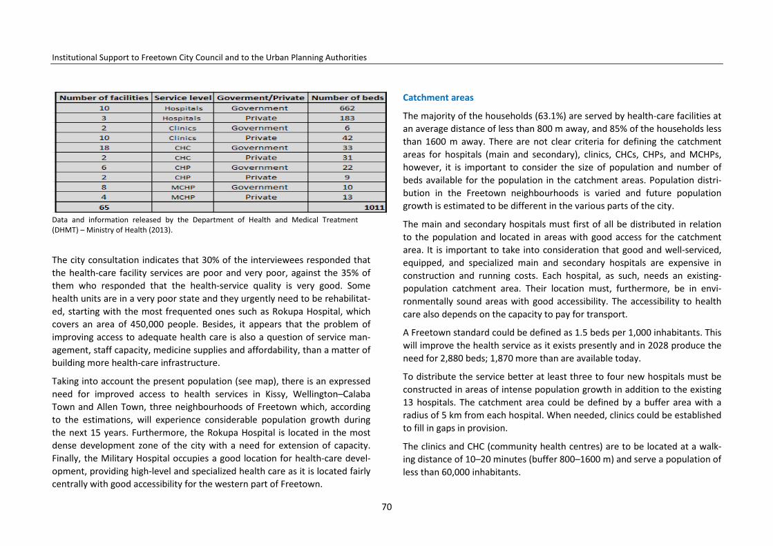
Institutional Support to Freetown City Council and to the Urban Planning Authorities
Data and information released by the Department of Health and Medical Treatment (DHMT) – Ministry of Health (2013).
The city consultation indicates that 30% of the interviewees responded that the health-care facility services are poor and very poor, against the 35% of them who responded that the health-service quality is very good. Some health units are in a very poor state and they urgently need to be rehabilitat-ed, starting with the most frequented ones such as Rokupa Hospital, which covers an area of 450,000 people. Besides, it appears that the problem of improving access to adequate health care is also a question of service man-agement, staff capacity, medicine supplies and affordability, than a matter of building more health-care infrastructure.
Taking into account the present population (see map), there is an expressed need for improved access to health services in Kissy, Wellington–Calaba Town and Allen Town, three neighbourhoods of Freetown which, according to the estimations, will experience considerable population growth during the next 15 years. Furthermore, the Rokupa Hospital is located in the most dense development zone of the city with a need for extension of capacity. Finally, the Military Hospital occupies a good location for health-care devel-opment, providing high-level and specialized health care as it is located fairly centrally with good accessibility for the western part of Freetown.
Catchment areas
The majority of the households (63.1%) are served by health-care facilities at an average distance of less than 800 m away, and 85% of the households less than 1600 m away. There are not clear criteria for defining the catchment areas for hospitals (main and secondary), clinics, CHCs, CHPs, and MCHPs, however, it is important to consider the size of population and number of beds available for the population in the catchment areas. Population distri-bution in the Freetown neighbourhoods is varied and future population growth is estimated to be different in the various parts of the city.
The main and secondary hospitals must first of all be distributed in relation to the population and located in areas with good access for the catchment area. It is important to take into consideration that good and well-serviced, equipped, and specialized main and secondary hospitals are expensive in construction and running costs. Each hospital, as such, needs an existing-population catchment area. Their location must, furthermore, be in envi-ronmentally sound areas with good accessibility. The accessibility to health care also depends on the capacity to pay for transport.
A Freetown standard could be defined as 1.5 beds per 1,000 inhabitants. This will improve the health service as it exists presently and in 2028 produce the need for 2,880 beds; 1,870 more than are available today.
To distribute the service better at least three to four new hospitals must be constructed in areas of intense population growth in addition to the existing 13 hospitals. The catchment area could be defined by a buffer area with a radius of 5 km from each hospital. When needed, clinics could be established to fill in gaps in provision.
The clinics and CHC (community health centres) are to be located at a walk-ing distance of 10–20 minutes (buffer 800–1600 m) and serve a population of less than 60,000 inhabitants.
70

Institutional Support to Freetown City Council and to the Urban Planning Authorities
Using these norms in 2028 in all 32 clinics CHCs will be needed (the same number as in 2012), if distributed evenly in the population.
Community health posts (CHP) and maternal and child health posts (MCHP) will be considered very basic health centres, evenly distributed territory-wise and supporting the activities of the CHCs.
Conclusions
Quantitatively, health-care facilities cover the urban area quite well; howev-er, 15% of the urban population is not appropriately serviced with health-care provision. Despite the fact that health-service facilities are quite well distributed in Freetown, the representatives of the local communities and journalists have pointed out the lack of adequate hospitals and primary health-care centres.1
Furthermore, many health-service units are in a very poor state and urgently need to be rehabilitated, starting with the most frequented ones such as Rokupa Hospital, which covers an area with a population of 450,000 people.
Besides, it appears that the problem of improving access to adequate health care presently is rather a question of upgrading and optimizing what exists rather than a matter of building more health-service infrastructure.
8.2.2 Recommendations
However, taking into account the anticipated population growth for 2013–28 (920,000 new citizens), the number of health-service facilities shall increase to cover demand in the eastern part of the city from Granville Brook to Allen Town with a future population of 1.1 million. In this large part of the city, consideration should be given to building two to three new primary public hospitals which, together with an improved Rokupa Hospital, would be able to provide the 1,580 beds demanded by the expected population in 2028. The constructions would – using the norm 18 m2 per bed – be of a floor area
of 21,300m2 and a need for minimum 4.3 ha of land. The investment would be around €9.8 million during the next 15-year plan period, creating em-ployment at a level of around 100 jobs per year in the construction sector and more than 500 in the health sector.
Furthermore, it is recommended considering the possibility of renovating the Military Hospital to a high-level national specialized hospital due to the cen-tral location in the city and the Peninsula Area.
Health posts also need to cover the hill site area, which is planned to be fur-ther expanded.
71

Institutional Support to Freetown City Council and to the Urban Planning Authorities
9 Housing
This chapter recommends strategies for the FCC housing policy to improve the poor quality housing and insanitary environmental conditions in Free-town’s neighbourhoods. The housing situation in Freetown is far from satis-factory for the majority of households, and the situation has deteriorated over the years, as is revealed by the results of the 1974, 1985 and 2004 Na-tional Population and Housing Censuses and reports prepared by national and international consultants. Recommendations are made for improving housing conditions in general and for low-income households in particular. The base for the used data is the 2004 National Population and Housing Cen-sus (2004 NPHC) supplemented by data from the surveys carried out during the preparation of this structure plan. In 2006 the Government decided to
revise the previous national housing policies. From 2006 the main goal of Government is no longer to actively participate in the delivery of housing, but to assume the role as facilitator for housing provision by communities, pri-vate sector developers, and house owners. The Government will concentrate on formulating the legal and regulatory framework, setting up the housing finance systems, and providing social infrastructural services.
9.1 Institutional framework
There are several public institutions directly and indirectly involved in hous-ing. The Ministry of Works, Housing and Infrastructure (MWHI) is responsible of issuance of building permits. The Ministry of Lands, Country Planning and the Environment carries out the functions of land surveying, land registra-tion, control of illegal sale of land, leasing of Government land, and monitor-ing the local land use planning.
72

Institutional Support to Freetown City Council and to the Urban Planning Authorities
Map 9-1: Residential areas and population densities
73

Institutional Support to Freetown City Council and to the Urban Planning Authorities
Freetown City Council intends to build up a Housing Department (HD) to attend to the housing challenges for its citizens. Today the existing Assets and Estates Department, AED, manages only a few houses.
Other institutions involved in housing development include the Sierra Leone Housing Corporation, SALHOC, which was set up in 1982 to use its financial
resources to provide housing for high (10%), medium (30%), and low-income (60%) households.
A savings and loans scheme was set up to enable households to save and eventually take out loans to construct new dwelling units and re-pair/rehabilitate/ improve their existing dwelling units.
The National Social Security and Insurance Trust (NASSIT) is also investing in housing and has already financed the construction of the Sea View Estate at Goderich.
Legal framework
According to the LGA 2004, the local councils in the neighbourhoods are sup-posed to support or ensure:
• productive activities and social development; • basic infrastructure and services; • improved management of human settlements and the environment; • preparation and implementation of development plans; and • co-ordination and implementation of development projects promoted or
carried out by public corporations and non-governmental organizations (NGOs).
The Freetown Improvement Act and Rules (FIAR), Cap. 66 of 1960, provides the technical basis for development control of housing construction. Howev-er, the FIAR needs revision. FCC will support the appropriate revision of the
FIAR and how to improve in general the enforcement of the laws and regula-tions for development control and housing construction.
9.2 Housing types, conditions, and densities
According to the census 2004, in Freetown the majority of the houses are single-storey houses (82.3%) with only 3.4% more than two storeys.
As seen in Error! Reference source not found., the density of housing varies throughout Freetown. In the western part and New England, the density is mainly low (yellow colour), with medium less dense areas (orange colour).
Low-density residential settlements are found at the hillside slopes, Hill Cot Road, Spur View and Loop and Spur Road. Residential settlements previously considered as low-density residential areas can now be classified as medium density; areas such as Juba Hills, Kissy Dockyard, and the former villages.
The high-density areas (brown colour) are found in the central part of Free-town between St John and Upgun. However the density of the high-density residential settlements, especially in the east, has intensified from Upgun to Allen Town. Freetown has low-density areas on the hillsides and medium areas closer to the Bai Bureh Road with high density-housing areas in Kissy Men´s Mess, Kissy Grass Land–Congo Water, and Wellington–Pamuronko.
9.2.1 Occupancy levels
The 2004 census showed that the occupancy levels are high and overcrowd-ing is serious. In 2004 66.6% of Freetown households lived in only one or two rooms, 43.6% of the households lived with between five and seven family members in one room and in 20% of the households, 10 persons and more are sleeping in one room.
The used information is from the 2004 census, but there is no reason to be-
74

Institutional Support to Freetown City Council and to the Urban Planning Authorities
lieve that the situation as a whole has improved: the population has since increased almost 30% in Freetown. This puts additional pressure on the wa-ter, health and sanitation infrastructure and generates further need for the provision of more homes.
Physical housing conditions
Furthermore, according to the 2004 census the majority of households live in poor-quality housing. Approximately 24% of the dwelling units have their walls and roofs constructed of zinc, so-called ‘pan body’ houses. The pan-body dwelling units get cold during the rainy season and hot during the dry season.
In addition, they do not provide safety against the entrance of insects and snakes, plus 13.2% of the house walls are built of mud blocks, which disinte-grate easily unless they are sufficiently covered by roofing and constantly maintained. Toilet facilities and drinking water supply
The sanitation situation is unsatisfactory with 60% of the houses in 2004 served by pit latrines, and only 6.6% with indoor or outdoor flush toilets. The pit latrine is the most commonly used form. Where population densities are too high, the pit latrines are not regularly emptied, or they are shared by users with different criteria and levels of hygiene standards. The heavy de-pendence on rivers/stream being used as sanitation facilities or outlets of waste water, as well as being sources of domestically used water, contributes seriously to the occurrence of water-borne diseases such as cholera and diar-rhoea.
Water supply
Finally, the lack of access to clean and secure drinking water is a serious problem to be solved as 23% of the households, constituting almost 30,000 households in 2004, depended on unsafe sources of drinking water.
9.3 Housing needs
Freetown faces the challenge of meeting the huge backlog of current housing needs, as well as being confronted with a future demand for housing be-tween 2013 and 2028.
There are no current data to calculate current housing needs, that is, the number of dwelling units that are required to:
1. relieve overcrowding (more than two persons per room); 2. replace non-durable building materials; 3. replace unsatisfactory constructions built of inappropriate building mate-
rials; 4. replace inadequate sources of water such as unprotected and mechanical
wells; 5. renovate unsatisfactory toilet facilities such as pit, bucket, bush (beach);
and 6. improve the current state of repair of dwelling units (due for rehabilita-
tion/ reconstruction.
The Freetown Structure Plan has used a norm of an average of six persons per housing unit and calculated the housing need in Freetown 2012 to be 166,000 housing units based on a population of 998,000 inhabitants. The UPP FCC roof sketch has identified 85,500 roofs in Freetown of which 80,000 might be inhabited. However, many of these houses are of low quality and due for complete or partial renovation. Some sociologists working with slum neighbourhoods have estimated that 60% of Freetown’s housing units are to be considered as slum dwellings and due for renovation; making the 40% of good housing equivalent to 32,000 roofs. Getting the housing deficit down requires the following number of houses: 166,000 − 32,000 = 134,000.
According to the estimates for the population growth in Freetown (see p.5)
75
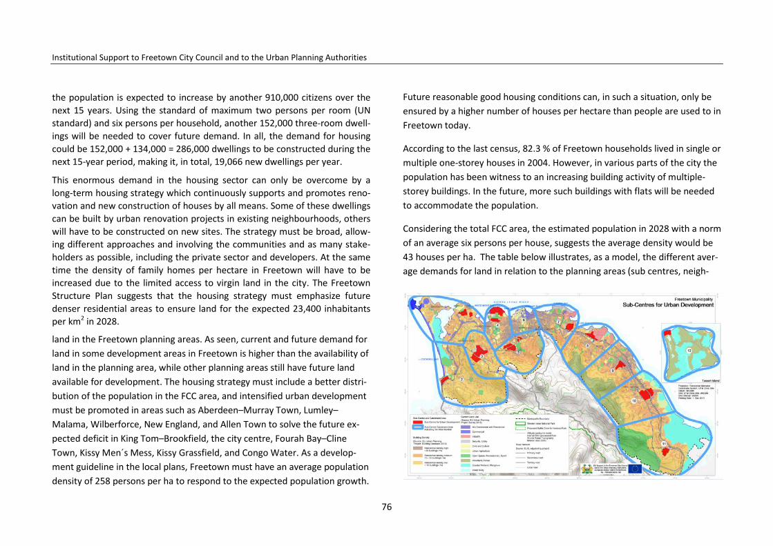
Institutional Support to Freetown City Council and to the Urban Planning Authorities
the population is expected to increase by another 910,000 citizens over the next 15 years. Using the standard of maximum two persons per room (UN standard) and six persons per household, another 152,000 three-room dwell-ings will be needed to cover future demand. In all, the demand for housing could be 152,000 + 134,000 = 286,000 dwellings to be constructed during the next 15-year period, making it, in total, 19,066 new dwellings per year.
This enormous demand in the housing sector can only be overcome by a long-term housing strategy which continuously supports and promotes reno-vation and new construction of houses by all means. Some of these dwellings can be built by urban renovation projects in existing neighbourhoods, others will have to be constructed on new sites. The strategy must be broad, allow-ing different approaches and involving the communities and as many stake-holders as possible, including the private sector and developers. At the same time the density of family homes per hectare in Freetown will have to be increased due to the limited access to virgin land in the city. The Freetown Structure Plan suggests that the housing strategy must emphasize future denser residential areas to ensure land for the expected 23,400 inhabitants per km2 in 2028.
land in the Freetown planning areas. As seen, current and future demand for land in some development areas in Freetown is higher than the availability of land in the planning area, while other planning areas still have future land available for development. The housing strategy must include a better distri-bution of the population in the FCC area, and intensified urban development must be promoted in areas such as Aberdeen–Murray Town, Lumley–Malama, Wilberforce, New England, and Allen Town to solve the future ex-pected deficit in King Tom–Brookfield, the city centre, Fourah Bay–Cline Town, Kissy Men´s Mess, Kissy Grassfield, and Congo Water. As a develop-ment guideline in the local plans, Freetown must have an average population density of 258 persons per ha to respond to the expected population growth.
Future reasonable good housing conditions can, in such a situation, only be ensured by a higher number of houses per hectare than people are used to in Freetown today.
According to the last census, 82.3 % of Freetown households lived in single or multiple one-storey houses in 2004. However, in various parts of the city the population has been witness to an increasing building activity of multiple-storey buildings. In the future, more such buildings with flats will be needed to accommodate the population.
Considering the total FCC area, the estimated population in 2028 with a norm of an average six persons per house, suggests the average density would be 43 houses per ha. The table below illustrates, as a model, the different aver-age demands for land in relation to the planning areas (sub centres, neigh-
76
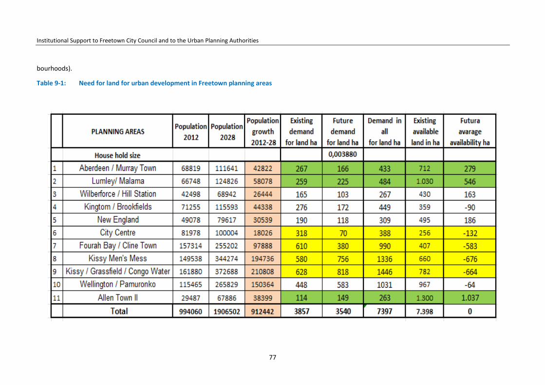
Institutional Support to Freetown City Council and to the Urban Planning Authorities
bourhoods).
Table 9-1: Need for land for urban development in Freetown planning areas
77

Institutional Support to Freetown City Council and to the Urban Planning Authorities
However, the residential neighbourhoods have to be even denser as land is also needed for commercial, industrial and educational activities. The Free-town Structure Plan, therefore, suggests land use in the urban areas is divid-ed as follows: housing 43%; education 19%; sport, recreation, playgrounds 21%; administration, commercial areas and markets 12%; and industry and workshops 4%.
Making the decision to use 43% of the urban land for housing will make it possible to plan and build future residential areas with an average density of 100 housing units per hectare. This can be done in different ways, for exam-ple, by building a minimum of two housing units (12 persons per plot) on plots of 160m2, three housing units (18 persons per plot) on plots of 240m2, four housing units on plots of 320m2 or five families (30 persons) on a tradi-tional town lot in the Freetown CBD. The need for higher housing densities calls for development of new designs of housing in multi-floor residential buildings.
Table 9-1 above shows the need for land to be developed in the planning areas using the described norms. The norms must be seen as general guide-lines as the actual existing land use must be taken into consideration when the plans are being prepared.
The Freetown Structure Plan proposes close to residential areas the planning of additional green areas, which can provide the necessary land for play-grounds, community activities, parks and football fields, among others. To-gether, the residential areas and the green areas are proposed to occupy 64% of the land while the rest, as mentioned, will be reserved for education facilities (19%), commerce and administration (12%), and industry (4%). It is
proposed that the residential areas, on the ground floors, might host shops and workshops as long as these activities do not create a negative impact on the surroundings with odours, noise, dust, oil spills, etc.
The higher densities give advantages such as reduction of cost to road, wa-ter, sewerage and electrical infrastructure in the housing areas. If a hectare of land is occupied by only 40 families, the 40 families have to pay the cost of the roads, water and power supply systems. If one hectare instead is used for two- or three-floor housing blocks with 80 families or more, the cost will be shared among more families and the cost of the housing schemes, the house or the rent, will be reduced and more affordable.
Figure 9-1: Freetown Structure Plan: proposed division of land for different land uses in Freetown
19%
43%
22% 4%
12%
Land Use per Category %
Education, health & publicinstitutionsResidential
Parks, playgrounds andrecreationIndustry and workshops
78

Institutional Support to Freetown City Council and to the Urban Planning Authorities
Table 9-2: Demand for land in Freetown planning areas 2013–2028
79

Institutional Support to Freetown City Council and to the Urban Planning Authorities
9.4 Example: the Wellington Centre and Housing Scheme
The Urban Planning Project has prepared an example for a local renovation and development plan and chosen the industrial area in Wellington for the exercise – thereby showing a modern renovated area with higher housing densities than can be found today. Others areas available for urban renewal could have been chosen, such as the military barracks areas in Lumley, Mur-ray Town, Wilberforce, or the present prison area in Pademba Road.
The area of Wellington is 27 ha in a good location in the middle of the local area, close to public transport on the Bay Bureh Road and the parallel old road to Waterloo, which in the future should serve as an important distribu-tion road to help distribute traffic and avoid congestion. The plan area has been prepared for different purposes such as housing (13.8 ha); education facilities (2.7 ha); market (2.4 ha); and recreation, parks and playgrounds (4.1 ha) (see plan map).
The housing area has been prepared for different types and sizes of blocks of medium- and high-density dwellings with the intention of creating housing opportunities for everyone in a mixed environment. On selected well-distributed locations are ground floors in the housing blocks reserved for shops and clinics. Also workshops, which do not create environmental prob-lems such as dust, noise, danger, odours, etc., might be integrated in the ground floor of the housing blocks. Training facilities and other service func-tions are located in specially designed buildings.
It is suggested the centres be developed as private-partnership projects, where interested landowners, developers, business people, and other inter-ested stakeholders, together with the FCC and other concerned public insti-tution such as the MLCPE, prepare development and investment plan for the
Figure 9-2: 3-D illustration 1 of street and housing block in proposal for Wellinton Centre and Housing Scheme
areas and together identify the financial sources for the implementation of the project. Owners of parcels inside the area could also be involved as part-ners.
9.5 Urban renovation
As mentioned, it is estimated that 60% of Freetown families live in neigh-bourhoods which have to be renovated and upgraded to meet modern urban health and sanitation standards. Today the majority of Freetown residential buildings are privately owned, and private-house owners undertake the re-habilitation/improvement of their properties. Only a few residential buildings are owned by central government and FCC; neither the Government nor FCC are involved in mayor urban renovation projects. Furthermore, hardly any legal, planning or building technical current guidelines are being provided from the corresponding public authorities – in this case the MLCPE, FCC and the MWHI. Actual development and building control is weak.
80
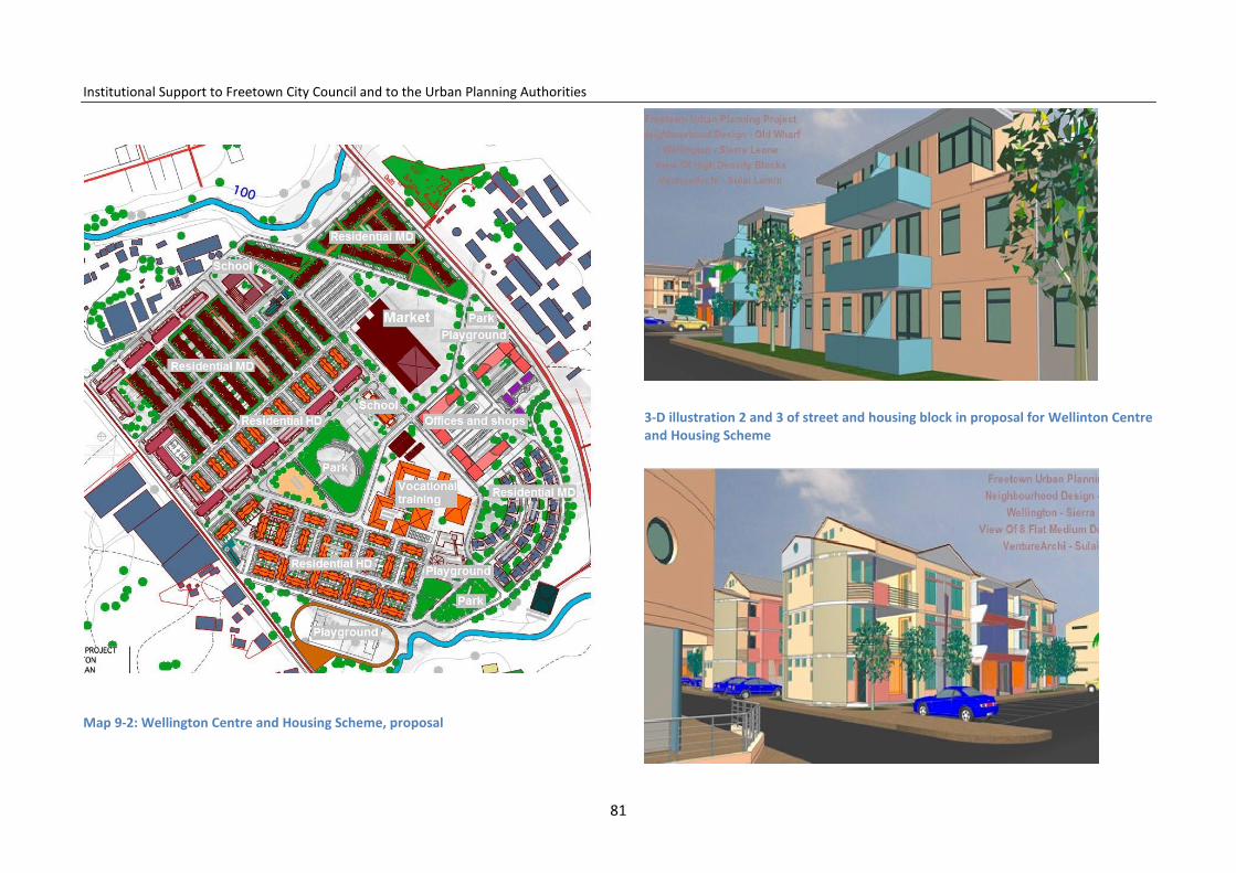
Institutional Support to Freetown City Council and to the Urban Planning Authorities
Map 9-2: Wellington Centre and Housing Scheme, proposal
3-D illustration 2 and 3 of street and housing block in proposal for Wellinton Centre and Housing Scheme
81
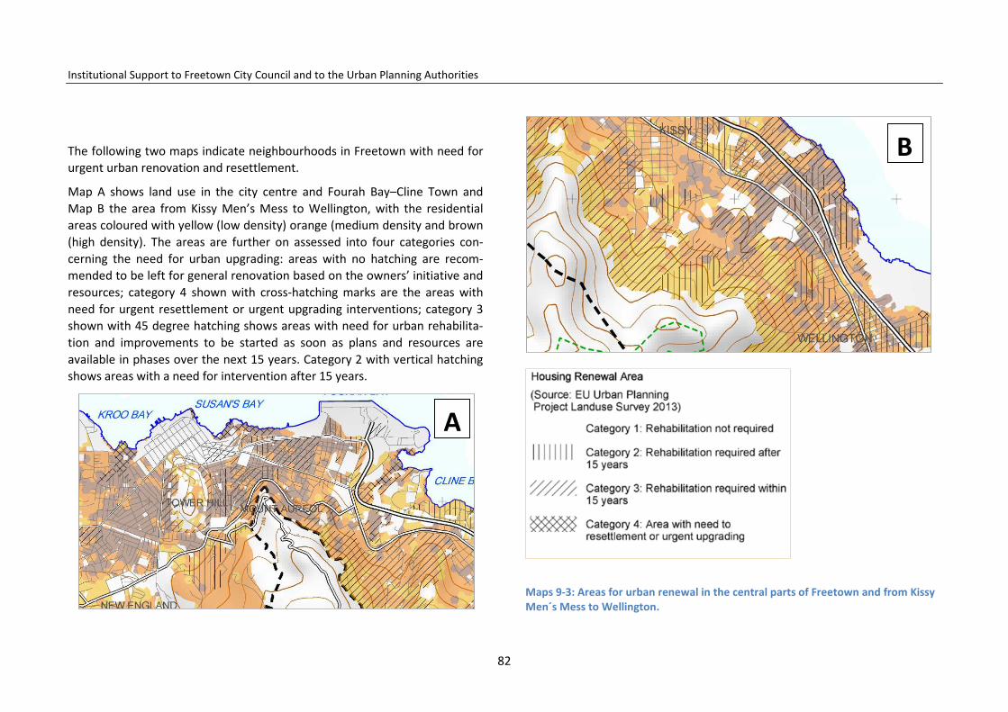
Institutional Support to Freetown City Council and to the Urban Planning Authorities
The following two maps indicate neighbourhoods in Freetown with need for urgent urban renovation and resettlement.
Map A shows land use in the city centre and Fourah Bay–Cline Town and Map B the area from Kissy Men’s Mess to Wellington, with the residential areas coloured with yellow (low density) orange (medium density and brown (high density). The areas are further on assessed into four categories con-cerning the need for urban upgrading: areas with no hatching are recom-mended to be left for general renovation based on the owners’ initiative and resources; category 4 shown with cross-hatching marks are the areas with need for urgent resettlement or urgent upgrading interventions; category 3 shown with 45 degree hatching shows areas with need for urban rehabilita-tion and improvements to be started as soon as plans and resources are available in phases over the next 15 years. Category 2 with vertical hatching shows areas with a need for intervention after 15 years.
Maps 9-3: Areas for urban renewal in the central parts of Freetown and from Kissy Men´s Mess to Wellington.
B
A
82
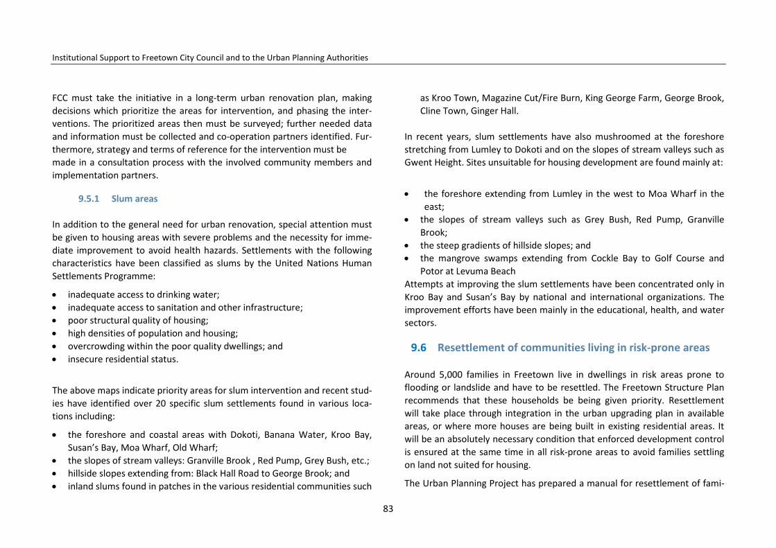
Institutional Support to Freetown City Council and to the Urban Planning Authorities
FCC must take the initiative in a long-term urban renovation plan, making decisions which prioritize the areas for intervention, and phasing the inter-ventions. The prioritized areas then must be surveyed; further needed data and information must be collected and co-operation partners identified. Fur-thermore, strategy and terms of reference for the intervention must be made in a consultation process with the involved community members and implementation partners.
9.5.1 Slum areas
In addition to the general need for urban renovation, special attention must be given to housing areas with severe problems and the necessity for imme-diate improvement to avoid health hazards. Settlements with the following characteristics have been classified as slums by the United Nations Human Settlements Programme:
• inadequate access to drinking water; • inadequate access to sanitation and other infrastructure; • poor structural quality of housing; • high densities of population and housing; • overcrowding within the poor quality dwellings; and • insecure residential status.
The above maps indicate priority areas for slum intervention and recent stud-ies have identified over 20 specific slum settlements found in various loca-tions including:
• the foreshore and coastal areas with Dokoti, Banana Water, Kroo Bay, Susan’s Bay, Moa Wharf, Old Wharf;
• the slopes of stream valleys: Granville Brook , Red Pump, Grey Bush, etc.; • hillside slopes extending from: Black Hall Road to George Brook; and • inland slums found in patches in the various residential communities such
as Kroo Town, Magazine Cut/Fire Burn, King George Farm, George Brook, Cline Town, Ginger Hall.
In recent years, slum settlements have also mushroomed at the foreshore stretching from Lumley to Dokoti and on the slopes of stream valleys such as Gwent Height. Sites unsuitable for housing development are found mainly at:
• the foreshore extending from Lumley in the west to Moa Wharf in the
east; • the slopes of stream valleys such as Grey Bush, Red Pump, Granville
Brook; • the steep gradients of hillside slopes; and • the mangrove swamps extending from Cockle Bay to Golf Course and
Potor at Levuma Beach Attempts at improving the slum settlements have been concentrated only in Kroo Bay and Susan’s Bay by national and international organizations. The improvement efforts have been mainly in the educational, health, and water sectors.
9.6 Resettlement of communities living in risk-prone areas
Around 5,000 families in Freetown live in dwellings in risk areas prone to flooding or landslide and have to be resettled. The Freetown Structure Plan recommends that these households be being given priority. Resettlement will take place through integration in the urban upgrading plan in available areas, or where more houses are being built in existing residential areas. It will be an absolutely necessary condition that enforced development control is ensured at the same time in all risk-prone areas to avoid families settling on land not suited for housing.
The Urban Planning Project has prepared a manual for resettlement of fami-
83

Institutional Support to Freetown City Council and to the Urban Planning Authorities
lies. It takes into account international experience, guidelines and require-ments in the case of unavoidable resettlements, seeking to minimize nega-tive effects on the population to be resettled, and to make the project ac-ceptable to the donor organisations which require the implementation of safeguards before they will release funds.
The manual also includes takes into account experiences from failed reset-tlement in Freetown’s recent history, which include among others: the Bormeh (current Freetown dump site since 1996) resettlement project at Grafton, the Adventist Development And Relief Agency, ADRA, resettlement programme (targeting particularly tenants who had lost their flats as a result of the rebel invasion in Freetown; also those from Bormeh and Grafton in 1996) and the resettlement organized for Internally Displaced Person, IDP, in Freetown, also to Grafton. These locations were abandoned by most of the resettled persons who returned to Freetown to squat again, renting or selling their compensation houses in Grafton to others. The resettlement efforts have partly failed and better solutions need to be found.
Resettlement in urban areas typically results in both physical and economic displacement affecting housing, employment, and enterprise. A major chal-lenge associated with urban resettlement involves the restoration of wage-based or enterprise-based livelihoods that are often tied to location (such as proximity to jobs, customers and markets). Resettlement sites should be selected to maintain connectivity and proximity of the sources of employ-ment and income and to maintain neighbourhood networks. The resettlement is a complex exercise requiring the skills of experienced architects and planners. However, FCC and the MLCPE should also be in-volved in the planning and implementation in order to ensure its co-ordination and dovetailing with their own activities.
84

Institutional Support to Freetown City Council and to the Urban Planning Authorities
Map 9-3: Slum areas
85

Institutional Support to Freetown City Council and to the Urban Planning Authorities
Resettlement is involuntary when it occurs without the informed consent of the displaced persons or, if they give their consent, without having the power to refuse resettlement. A typical example of such displacement is a govern-ment agency’s expropriation of land for a capital development project by eminent domain. People occupying or otherwise dependent on that land for their livelihoods may be offered fair compensation for their losses. However, they have little recourse to oppose the government’s expropriation regard-less of their desire to continue occupying or using the affected land.
The World Bank issued guidelines on resettlement to its staff as long ago as 1990 in its Operational Directive 4.30, which has been adopted by major donors such as International Finance Corporation, IFC, the Asian Develop-ment Bank, Inter-American Development Bank, and the Development Assis-tance Committee of the OECD, DFID, and Japan International Cooperation Agency, JICA (World Bank, 1990). This states that ‘the objective of the Bank's resettlement policy is to ensure that the population displaced by a project receives benefits from it’ (p.1). The guidelines require that proposed reset-tlement in an assessment process addresses the relevant risks and impacts and proposes measures to minimize, mitigate and offset adverse impacts following established standards. These standards are reflected in the pro-posed FCC resettlement manual.
Many local and national governments worldwide have followed this ap-proach in their urban development strategies. In Bogotá, the capital of Co-lombia, for example, resettlement of slum dwellers has, for decades, only taken place when it cannot be avoided; in all other cases slums are subject to on-site upgrading. Typical examples of unavoidable resettlement are house-holds living on slopes vulnerable to landslide or landslip or on riverbanks subject to flooding. However, even in these cases part of the settlement, if not in the risk zone, might be left intact.
9.7 Recommendations
9.7.1 Housing policy and programme
FCC will establish a Municipal Housing Department (MHD) to consult the Municipal Housing Policy and Strategy with the population and direct the preparation of the Freetown Urban Renovation Plan co-ordination with other responsible public authorities. FCC Municipal Housing Department will be staffed with qualified professionals and work closely together with the FCC Development Planning Department.
FCC will ensure that the FCC Municipal Housing Policy and Strategy is further consolidated and FCC will advocate for the establishment of a National Hous-ing Institution, which will further develop national housing provision and rehabilitation strategies. Special attention to strategies will be given to en-sure affordable housing for the population.
The FCC Municipal Housing Policy and Strategy will emphasize FCC as a poli-cymaker, promoter and facilitator of urban renewal and housing provision, leaving the implementation of urban renovation plans and housing projects to national institutions, owners, developers, community initiatives and NGOs, and promote private-public partnerships where possible. FCC will consider international experiences and co-operation concerning housing and urban development.
However, FCC will, as the land-use planning and building authority, support all urban renovation and housing projects with the necessary urban renova-tion policies, plans, guidelines and building permits. FCC will also reinforce urban development control to ensure that settlement only takes place on adequate and permitted land following planning and environmental protec-tion laws and building regulations.
As current national housing policies need to be implemented and urban
86

Institutional Support to Freetown City Council and to the Urban Planning Authorities
planning laws and building regulations urgently need revision, FCC, in co-operation with other local governments, will approach the responsible public authorities and make efforts to promote progress and support the revision of the planning act, and will also support a new urban planning bill to strength-en urban development planning and development control.
Taking into consideration that the decentralization process is ongoing and that FCC still needs considerable improvements concerning resources for urban planning and development control, FCC will promote improvements in the housing sector, co-operate with the relevant public authorities and, if needed, possibly outsource housing-related tasks to the private sector.
FCC will adopt the following housing strategies for the improvement of the housing situation:
• A long-term strategic urban renovation and slum-upgrading plan will be prepared to improve housing quality. The preparation of the plan must involve the Freetown population at all levels and aim at the active partic-ipation and co-ordination in the implementation phases of owners, ten-ants, NGOs, developers and other private sector housing initiatives, as well as government-supported affordable housing schemes.
• FCC will, through an urban renovation strategy, establish new higher densities in the residential and urban areas using and improving the ex-isting infrastructure where possible. FCC will promote the construction of new access roads and planned housing schemes in the areas with sprawl-ing low-density non-permitted settlements on the hill sites of Malama, New England, and also on the hills sites from Kissy to Allen Town.
• FCC and the MLCPE will support such a process with urban renovation plans and guidelines, technical assistance – including good functional de-signs – and solid and supportive development control. In this context, FCC in co-operation with MLCPE and the private sector will be responsi-ble for the preparation of urban renovation plans. FCC will support the
revision and modernization of existing building regulations. • FCC will insure that the long-term urban renovation plan takes into ac-
count the proposed 11 development zones in Freetown and that an ur-ban renovation plan will be prepared for each zone considering priorities, phases and time schedules. Available land in the zones, including the government-owned areas, must be seriously considered for urban reno-vation, and FCC will negotiate will the relevant authorities for the future use of these areas for urban renovation. Each zone might form an urban renovation committee to mobilize local resources and co-operation pro-jects with national and international NGOs.
Map 9-5: Sub-centres for urban development
• FCC will support the promotion of a private-sector loan scheme to pur-chase land, as well as construct and rehabilitate private houses. Further-
87

Institutional Support to Freetown City Council and to the Urban Planning Authorities
more, a special private sector loan component should be promoted to assist especially middle- and low-income Freetown citizens regarding im-provement and rehabilitation of their houses.
• FCC will encourage NGOs to establish micro-loan arrangements to reha-bilitate residential areas in need.
• FCC will advocate for and support a national urban-development policy that creates the conditions for distribution of population growth and de-velopment of newly planned metropolitan residential area outside the FCC area.
• FCC will, in co-operation with other local governments, advocate for and support a national urban renovation policy and funding that strengthen the planning and functionality of the urban areas as well as ensures drinking water provision, good sanitation, green areas, and social infra-structure in denser housing areas.
• FCC will consider how FCC-owned plots and properties might be included in urban renovation projects with the purpose of improving housing con-ditions, densities, and sanitation on the properties.
• FCC will consider and solve eventual land tenure disputes related to oc-cupancy of FCC properties.
• Slum settlements established in risk-prone areas exposed to flooding or landslides will, when funds are available, be transferred to resettlement areas within the municipality, following the principles in the FCC Reset-tlement Manual.
• FCC will promote campaigns to raise awareness on the need to protect the natural environment and the dangers to settle down in natural disas-ter risk prone areas.
• Building and development control will be strengthened and, after the 1st of January 2015, construction of new houses or extensions of existing dwellings in risk-prone areas exposed to flooding or landslides will imme-
diately be demolished. • Houses and residential settlements established after 1st of January 2015
in areas prohibited by the provisions of the National Environmental Pro-tection Act – such as along the coast, in creeks, rivers, and close to water bodies – will be demolished.
• FCC will promote affordable rental housing schemes inside Freetown. • FCC will, in co-operation with other local governments, prepare afforda-
ble sites and service schemes in metropolitan development areas for vol-untary resettlement from natural disaster risk areas in Freetown.
• FCC will, in co-operation with the relevant authorities, promote voca-tional training for building rehabilitation and improved sanitation in the wards.
• FCC will, in co-operation with the relevant authorities, promote voca-tional training for improved building techniques and building materials among Freetown’s young people.
88

Institutional Support to Freetown City Council and to the Urban Planning Authorities
10 Public Administration and Public Use of Land
This chapter assesses the location of national and municipal government administrative offices. The assessment will focus on more than the efficient use of the land by the occupying offices.
10.1 Public and municipal administration
Sierra Leone operates a multi-party system of government. There are three arms of government – the legislature (Parliament), judiciary and the execu-tive. The executive comprises of the offices of the President and Vice Presi-dent and a number of ministers who are assigned to different ministries. In addition to the central government, which operates at the national level, there are local government councils, of which Freetown is one such council.
The national or central government administrative offices are distributed in various parts of Freetown. However, they are more concentrated in the city centre, and the Brookfield and New England areas. A few others, such as the Sierra Leone Road Authorities of the Ministry of Transport and Aviation and the Environmental Health Division in the Ministry of Health and Sanitation are located in Cline Town and Kissy. Table 10-1 shows the location of the government ministries and departments.
Government agencies, comprising of commissions such as the National Social Security and Insurance Trust, NASSIT; the National Revenue Authority, NRA; the National Commission for Social Action, NaCSA etc. are located mainly in the City Centre Area in offices shared by other private offices and from pri-vate housing developers.
At the municipal level, FCC is accommodated in only one location, that is, in Bicentenary House, at Government Wharf. There is no other municipal ad-ministrative building located in any other part of the city. This implies that all local government business activities are centralized in the city centre.
10.2 Conclusion/findings
There is continued concentration of public administrative buildings in the central parts of Freetown, which makes public access to public services more difficult for community members living in the far south-west and far south-east of the city. The situation for community members living in the east is further complicated by the difficult traffic between the east and west of the city, imposing even higher transport costs than their counterparts in the cen-tral parts endure.
Valuable land at some of the public institutions, such as national institutions in the New England area, is not efficiently utilized at present, but still pos-sesses valuable potential for the future development of the capital used by the private as well as public sector. Also, various old public buildings and structures are under-utilized, occupying land that can be more efficiently utilized than is currently the case.
Finally, Freetown is housing public institutions such as the Pademba Road Prison, which need modernization and might find more convenient locations on land within the metropolitan region but outside the FCC administrative area. This also concerns several military and police installations and camps that mainly are used only for housing or activities that cannot be justified as military needs in the capital, and which would be better located on new and larger sites, where land is available.
89
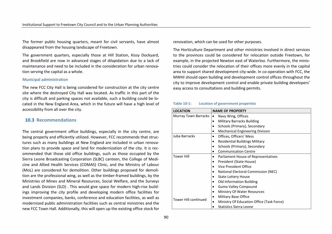
Institutional Support to Freetown City Council and to the Urban Planning Authorities
The former public housing quarters, meant for civil servants, have almost disappeared from the housing landscape of Freetown.
The government quarters, especially those at Hill Station, Kissy Dockyard, and Brookfield are now in advanced stages of dilapidation due to a lack of maintenance and need to be included in the consideration for urban renova-tion serving the capital as a whole.
Municipal administration
The new FCC City Hall is being considered for construction at the city centre site where the destroyed City Hall was located. As traffic in this part of the city is difficult and parking spaces not available, such a building could be lo-cated in the New England Area, which in the future will have a high level of accessibility from all over the city.
10.3 Recommendations
The central government office buildings, especially in the city centre, are being properly and efficiently utilized. However, FCC recommends that struc-tures such as many buildings at New England are included in urban renova-tion plans to provide space and land for modernization of the city. It is rec-ommended that those old office buildings, such as those occupied by the Sierra Leone Broadcasting Corporation (SLBC) canteen, the College of Medi-cine and Allied Health Services (COMAS) Clinic, and the Ministry of Labour (MoL) are considered for demolition. Other buildings proposed for demoli-tion are the professional wing, as well as the timber-framed buildings, by the Ministries of Mines and Mineral Resources, Social Welfare, and the Surveys and Lands Division (SLD) . This would give space for modern high-rise build-ings improving the city profile and developing modern office facilities for investment companies, banks, conference and education facilities, as well as modernized public administration facilities such as central ministries and the new FCC Town Hall. Additionally, this will open up the existing office stock for
renovation, which can be used for other purposes.
The Horticulture Department and other ministries involved in direct services to the provinces could be considered for relocation outside Freetown, for example, in the projected Newton east of Waterloo. Furthermore, the minis-tries could consider the relocation of their offices more evenly in the capital area to support shared development city-wide. In co-operation with FCC, the MWHI should open building and development control offices throughout the city to improve development control and enable private building developers’ easy access to consultations and building permits.
Table 10-1: Location of government properties
LOCATION NAME OF PROPERTY Murray Town Barracks • Navy Wing, Offices
• Military Barracks Building • Schools (Primary), Secondary • Mechanical Engineering Division
Juba Barracks • Offices, Officers’ Mess • Residential Buildings Military • Schools (Primary), Secondary • Communication Centre
Tower Hill Tower Hill continued
• Parliament House of Representatives • President (State House) • Vice President Office • National Electoral Commission (NEC) • State Lottery House • Old Information Building • Guma Valley Compound • Ministry Of Water Resources • Military Base Office • Ministry Of Education Office (Task Force) • Statistics Sierra Leone
90

Institutional Support to Freetown City Council and to the Urban Planning Authorities
LOCATION NAME OF PROPERTY • Sierra Leone Library Board • Institute Of Education
King Tom • Police Barracks Building • Police Band Office • Navy Wing Office • Electricity Power Station • Primary And Secondary School • Hospital
Industrial Area (Estate) • Sierra Leone Navy (Wing Military) • Sierra Leone Brewery (Sl) Ltd • Natco Factory • Match Factory • Mercian Industry, • Primary and Secondary Schools • Banks (Sierra Leone Commercial and Standard Chartered
Bank). Cockerill North and South
• Military Headquarters • Residential Buildings • Government Quarters • Military Dumps
Allen Town • New Stadium Site Residential Buildings • Sierra Leone Police Post
Brookfield • Government Residential Quarters • Special Court • United Nations Mission Building • Youyi Building Complex (Office) • Operations Services Division Headquarter Office • HIV/AIDS Headquarter Office
Table 10-2: Location of Government quarters
Name of quarter Location 1. Escort Crescent Road Quarter 2. Horse Shoe Road 3. Kelsey Road 4. King George Avenue 5. Government Trade Centre
Kissy Dockyard
1. 33 Freetown Waterloo Road 2. 2a Shell New Road 3. 1a Freetown Waterloo 4. 1d Fisher Lane Step 5. Mamba Ridge
Africanus Road, Kissy
1. New Magistrate Court 2. Sierra Leone Police Quarter 3. Dental Clinic (Ministry Of Health)
Ross Road
1. C. T. Reservation Quarters 2. 34 Race Course (Garage) makeshift 3. 34 Race Course (Garage) makeshift 4. 34 Race Course(Garage ) makeshift
Cline Town
1. Bellaire Park Reservation Quarter Reservation For Judi-ciary. 15A to 15 Apt 1 and2
2. Pademba Road P.W.D Quarter (F1 To 25) 3. S. L.B.S now S.L.B.C Quarter (F1)
Pademba Road Back Of P.W.D. Bellair Park
1. Bath Street Quarter 2. Government Rest House (Grh) 3. King Harman Road Quarter (B1 to 47) 4. Babadorie House 5. Hong Kong House 6. Gendarme’s House 7. Passinidi House 8. Tisanes House 9. Matindi House 10. 4 Savage Street Quarter (Apt A & B)
King Harman Road Brookfield
1. 4b Barracks Road Cole Farm 2. 40a Macaulay Street M/Town
Murray Town
91
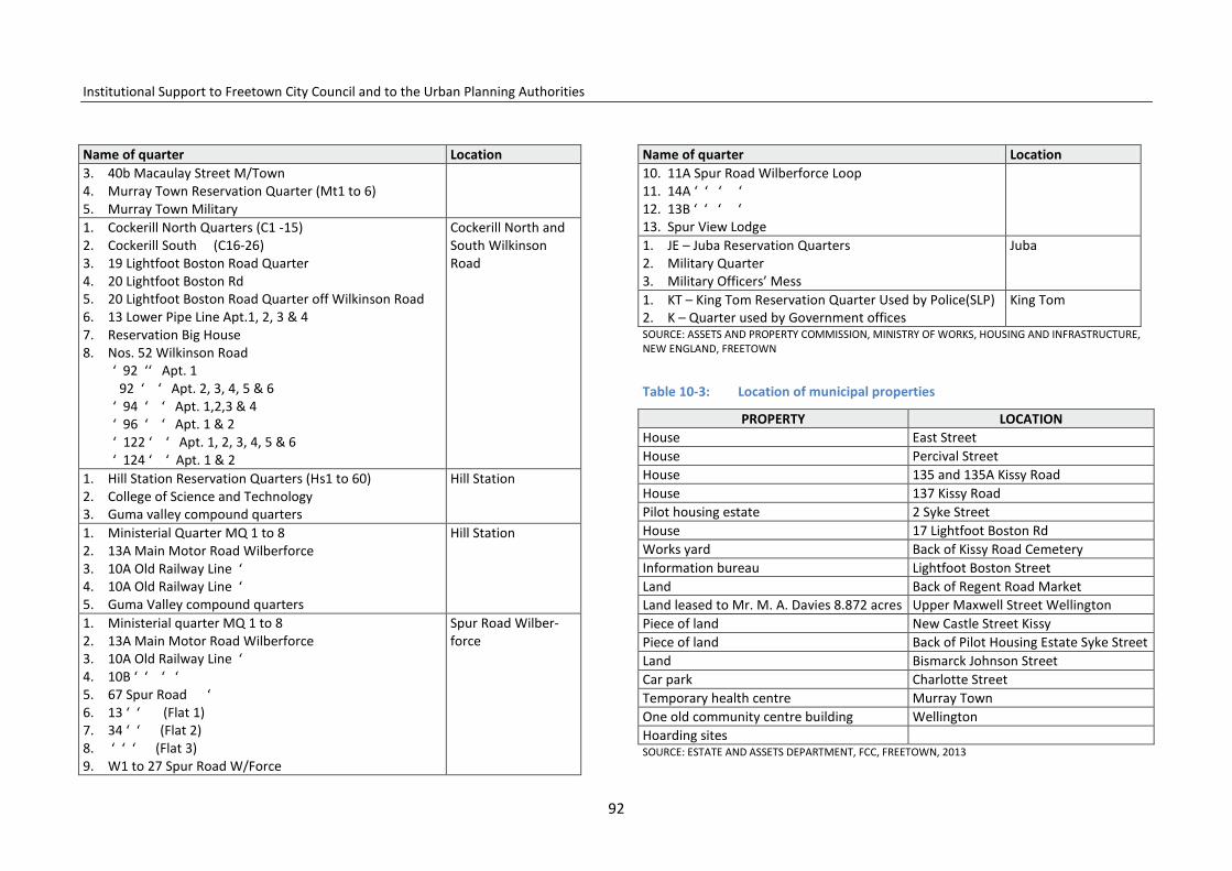
Institutional Support to Freetown City Council and to the Urban Planning Authorities
Name of quarter Location 3. 40b Macaulay Street M/Town 4. Murray Town Reservation Quarter (Mt1 to 6) 5. Murray Town Military 1. Cockerill North Quarters (C1 -15) 2. Cockerill South (C16-26) 3. 19 Lightfoot Boston Road Quarter 4. 20 Lightfoot Boston Rd 5. 20 Lightfoot Boston Road Quarter off Wilkinson Road 6. 13 Lower Pipe Line Apt.1, 2, 3 & 4 7. Reservation Big House 8. Nos. 52 Wilkinson Road
‘ 92 ‘‘ Apt. 1 92 ‘ ‘ Apt. 2, 3, 4, 5 & 6 ‘ 94 ‘ ‘ Apt. 1,2,3 & 4 ‘ 96 ‘ ‘ Apt. 1 & 2 ‘ 122 ‘ ‘ Apt. 1, 2, 3, 4, 5 & 6 ‘ 124 ‘ ‘ Apt. 1 & 2
Cockerill North and South Wilkinson Road
1. Hill Station Reservation Quarters (Hs1 to 60) 2. College of Science and Technology 3. Guma valley compound quarters
Hill Station
1. Ministerial Quarter MQ 1 to 8 2. 13A Main Motor Road Wilberforce 3. 10A Old Railway Line ‘ 4. 10A Old Railway Line ‘ 5. Guma Valley compound quarters
Hill Station
1. Ministerial quarter MQ 1 to 8 2. 13A Main Motor Road Wilberforce 3. 10A Old Railway Line ‘ 4. 10B ‘ ‘ ‘ ‘ 5. 67 Spur Road ‘ 6. 13 ‘ ‘ (Flat 1) 7. 34 ‘ ‘ (Flat 2) 8. ‘ ‘ ‘ (Flat 3) 9. W1 to 27 Spur Road W/Force
Spur Road Wilber-force
Name of quarter Location 10. 11A Spur Road Wilberforce Loop 11. 14A ‘ ‘ ‘ ‘ 12. 13B ‘ ‘ ‘ ‘ 13. Spur View Lodge 1. JE – Juba Reservation Quarters 2. Military Quarter 3. Military Officers’ Mess
Juba
1. KT – King Tom Reservation Quarter Used by Police(SLP) 2. K – Quarter used by Government offices
King Tom
SOURCE: ASSETS AND PROPERTY COMMISSION, MINISTRY OF WORKS, HOUSING AND INFRASTRUCTURE, NEW ENGLAND, FREETOWN
Table 10-3: Location of municipal properties
PROPERTY LOCATION House East Street House Percival Street House 135 and 135A Kissy Road House 137 Kissy Road Pilot housing estate 2 Syke Street House 17 Lightfoot Boston Rd Works yard Back of Kissy Road Cemetery Information bureau Lightfoot Boston Street Land Back of Regent Road Market Land leased to Mr. M. A. Davies 8.872 acres Upper Maxwell Street Wellington Piece of land New Castle Street Kissy Piece of land Back of Pilot Housing Estate Syke Street Land Bismarck Johnson Street Car park Charlotte Street Temporary health centre Murray Town One old community centre building Wellington Hoarding sites SOURCE: ESTATE AND ASSETS DEPARTMENT, FCC, FREETOWN, 2013
92

Institutional Support to Freetown City Council and to the Urban Planning Authorities
11 Parks, Recreation Areas, and Cemeteries
This chapter reviews the current and potential amenities and green areas available within the FCC administrative area. The chapter also discusses the current use and status of the areas and makes recommendations for a FCC policy to improve their use. The amenities include parks, recreation areas and cemeteries, of which one finds both formal and informal types in differ-ent parts of the municipality.
11.1 Existing parks, recreation areas, and cemeteries
11.1.1 City parks, neighbourhood gardens and open spaces
There is only one purpose-built park within the municipal area. This is the Victoria Park, which is located at the centre of Freetown. The park is the property of Freetown City Council and is currently under rehabilitation.
There were two other neighbourhood gardens located in central Freetown. Both were designed to serve as ancillary recreation centres to the then exist-ing railway terminals. One of these, the Taylor Cummings Gardens, which served as an ancillary recreation space for the then Cotton Tree Railway Sta-tion, is still in use as garden space and the existing building currently houses the National Museum. The other neighbourhood garden, the William John-son-Cole garden, which was designed to serve the central railway terminal at the then Water Street, has now been converted to commercial use.
Incidental open spaces are portions of undeveloped land adjacent to build-ings, roads and other infrastructure. Some are under private ownership, some are road reserves, some are under the management of Freetown City Council and some are state land.
This land has been landscaped in some places, as at the back of the Law Courts, and used as relaxation areas, or left unattended and used as dump sites, such as at the road adjacent to the Youyi Building. Adjacent to the Free-town Secondary School for Girls (FSSG), along Hanna Benka-Coker Street, another such space is used for market gardening in part, and a rubbish dump on the other. Adjacent to the Council of Churches in Sierra Leone (CCSL), offices at another space are used as a car-wash.
In general, these incidental open spaces present important potential as rec-reation areas for the population, but at present they are not managed at all and are subject to a range of transient, unauthorized uses including make-shift dwellings and market stalls.
11.1.2 Promenades
There is an existing promenade at the landing of the ‘slave steps’ at Wallace Johnson Street where there is a view to the sea from Government Wharf. This promenade is in an advanced state of disrepair and almost crumbling. The stone benches are extensively weathered and their beddings have been eroded, leaving some of these benches tilting at precarious angles. The walkway itself suffers from the same fate; some of the statues, monuments and plaques have been painted several times over, completely clouding the details of the objects. Many of the trees have decayed and the remaining ones are poorly maintained.
In the future, the promenade could be renovated and, together with urban renovation of the area, be extended to include the areas in front of the FCC and the Sierra Tel buildings, reaching Susan’s Bay landing place in the east and extended towards the west to the hospital.
93

Institutional Support to Freetown City Council and to the Urban Planning Authorities
11.1.3 Sports stadia and playgrounds
Playgrounds in different sizes, varying degrees of maintenance and owner-ship are dotted across the municipality. Within the municipality there is only one purpose-built multi-purpose sports stadium with a public swimming pool; the National Stadium at Brookfield in the central part of the municipali-ty. This stadium is owned by the Government and managed by the Ministry of Sports, as is the National Football Academy at King Tom.
There are playing fields located within military installations such as the Hock-ey Pitch at the Wilberforce Barracks, and the playing field at the King Tom Police Barracks. In central Freetown ‘Parade Grounds’ owned by the military, are currently being used as a multi-purpose playing field.
There are playing fields located within educational institutions like the Prince of Wales school, Saint Edwards’ school in the west, and the Municipal Sec
ondary School and Trade Centre playing field in the east. In general, other educational institutions which do not have playing fields of their own make use of adjacent undeveloped property as playing fields for multiple purposes.
The Brima Atouga ‘mini stadium’ at Cline Town area is one among several playing fields in various communities within the city owned by FCC. Among these are also Fourah Bay Field, the Wilberforce field; and those at Murray Town, Lumley and Aberdeen. There is a golf course under private manage-ment at Lumley in the west and tennis and squash courts at King Tom owned by the Bank of Sierra Leone and privately run tennis courts at Hill Station.
Apart from the National Stadium, the Football Academy, and the Brima Atouga mini stadium, all of the playing fields are only open, undeveloped pieces of land with no supervision, sporting infrastructure, or facilities. They are generally poorly maintained and their varying sizes do not make them easily adaptable to the specifications required in some sporting disciplines. Some communities, such as New England, do not have open spaces or play-
94

Institutional Support to Freetown City Council and to the Urban Planning Authorities
grounds because playing fields have not been defined or located through any formal urban planning guidelines.
11.1.4 Community centres
The community centres are the core for a range of social activities including weddings, other celebratory events, and meetings dealing with issues affect-ing the community as a whole. Some communities in the municipality do not have access to purpose-built community centres and thus make use of pri-vate homes, school or church halls.
11.1.5 Zoos
There are no zoos within the municipality. The former chimpanzee sanctuary adjacent to the juvenile detention centre at King Tom is now defunct. There is, however, a chimpanzee sanctuary located at Regent immediately outside the administrative boundary of FCC.
11.1.6 Beaches, creeks, coastal rocks, lagoons, and mangroves
The municipality is bounded with attractive beaches and wetlands. In the west by the Atlantic Ocean the Lumley–Aberdeen Beach is one of Freetown´s outstanding recreation areas and a tourist asset. Behind the beach is the Aberdeen Creek with mangrove.
To the north the coast is rocky with several built up bays and to the north- east numerous rivers and streams run down from the mountains creating many inlets, lagoons and bays along the coast of the municipality.
An extensive area of mangrove has formed at the mouth of the numerous tributaries that feed into the Sierra Leone River at the north-east of the mu-nicipality and on Tassoh Island. Further along the eastern shores of the mu-
nicipality beyond Wellington Creek, there are extensive areas of mangrove and tidal inlets on to Lower Allen Town and Orogu.
Natural recreation centres and viewpoints
The Freetown municipality encompasses a variety of landforms from the mountains in the south to the raised beaches in the north, interlaced with valleys and mudflats. This terrain offers vantage aesthetic observation points from which one can have panoramic views of the city and of sunset over the Atlantic Ocean. The natural recreation areas include the interweaving tribu-taries of the Sierra Leone River, mud flats and mangrove.
95

Institutional Support to Freetown City Council and to the Urban Planning Authorities
11.1.7 Cemeteries and view points
There are a large number of cemeteries located in various communities with-in the municipality from Allen Town in the east to Lumley in the west. These include cemeteries in Allen Town, Wellington, Kissy, Race Course, and Kissy Road in the east; Circular Road in the central part; King Tom, Ascension Town, Congo Town, Wilberforce, Murray Town, Aberdeen, and Lumley in the west. Located in the east of the central part of the municipality at Fourah Bay is the Aku Mohammedan cemetery especially for Muslim indigenes of Fourah Bay. Some new cemeteries, Mayeimi and Portee for example, are being de-veloped as the municipality grows. There are, however, no cemeteries for the growing population at Hill Station or for the Malama/Kamayama com-munities.
There are viewpoints at Cape Light House Point and Cape Sierra Point, Leices-ter Peak, Mount Aureol/Fourah Bay College overlooking Cline Town and the port area, and Allen Town Ridge overlooking the Sierra Leone River.
Map 11-1 Viewpoints in Freetown
.
96

Institutional Support to Freetown City Council and to the Urban Planning Authorities
Map 11-2: Green areas
97

Institutional Support to Freetown City Council and to the Urban Planning Authorities
11.2 Conclusions and recommendations
There is generally poor management of all the existing cemeteries and ex-tensive encroachment on the allocated land area to the extent that cemetery boundaries in the municipality are continually in dispute. The natural recrea-tion centres are under-exploited; facilities like zoos are non-existent; the number of community centres is inadequate, as are the number of stadia and playing fields. These facilities require attention from FCC in order to improve recreation opportunities and the quality of life for its citizens.
The following recommendations are being made in order to reverse the gen-erally poor management and under-financing of various amenities within the municipality. Incidental open spaces
Incidental open spaces are a valuable resource for the greening of the city. They should be properly landscaped, planted with trees, and provided with seating facilities to afford residents relaxing spots within the city. The inci-dental open spaces offer locations for the siting of appropriately designed licensed kiosks across the municipality; some of these spaces can also be used for bus stops, which presently do not exist within the municipality.
Sports stadia, playgrounds and playing fields
It is recommended that the existing national stadium should be extensively rehabilitated and the capacity of the management enhanced. The existing playing fields should be improved by:
• categorizing the sporting discipline which can be conveniently ac-commodated within the available land area of the playing field in question and expanding the land area where possible;
• providing a basic layout plan for the appropriate sporting discipline that can be accommodated within the field;
• providing basic facilities such as covered stands and toilets; • in the long term a subject/thematic plan should be commissioned to
appropriately allocate sites for playing fields and stadia using objective urban planning standards and guidelines.
Promenade
The existing promenade at Wallace Johnson Street should be completely rehabilitated with special attention being paid to the stone benches and the ‘slave steps’. The statues and monuments, such as old canons and anchors in the vicinity, should be the subject of proper restoration. A new promenade should be designed along State Avenue at Tower Hill overlooking the city.
Municipality Square
It is proposed to consider establishing a Municipality Square on the former town hall plot. Such a square will strengthen the historic qualities in the city centre by binding historic neighbourhoods, buildings, the present town hall, the old train station, the artisan market, the slave steps and waterfront to-gether in a large recreation, tourist and market area. The existing town hall could be transformed into a national museum and centre for culture and tourism. The new town hall planned on the plot should instead be moved to a better location on government land at New England, close to the main traf-fic arteries of Freetown.
Community centres
It is recommended that existing community centres be improved with the provision of facilities that would accommodate cultural activities such as drama and dancing. New multi-purpose community centres should be built using objective urban planning standards.
Zoos
It is recommended that the former chimpanzee rehabilitation centre at King Tom should be rehabilitated and upgraded to accommodate a wider variety
98

Institutional Support to Freetown City Council and to the Urban Planning Authorities
of animals and that the portion of the peninsular forest reserve bordering the FCC administrative area should be set aside as a nature reserve.
Beaches, lagoons, creeks and mangroves
These lagoons and creeks can be developed for both local and international tourists by the building of stilt houses at strategic locations to be used for bird watching, fishing, and canoeing. The lagoons and creeks can be accessed by organized tours or individually rented canoes, in the context of PPP micro-enterprises and juvenile job creation projects including, licensed kiosks for sale of provisions, maintenance, and waste collection.
The potential of the natural recreation centres and aesthetic observation points can be realized by the building of high-rise viewing platforms at loca-tions such as Fourah Bay College, Leicester Peak, and the Allen Town Hills. Piers can be built at King Tom and Murray Town points among others.
Cemeteries
The existing cemeteries should be properly secured with appropriate fencing and maintained through the introduction of more efficient funereal tech-niques and cemetery site management. It should be highlighted that these cemeteries have intrinsic cultural value as they are the repository of de-ceased predecessors of community members. Cemeteries also have high historical, cultural and recreation potential, which can be exploited if such places are properly manicured and maintained.
About five new cemeteries should be created to serve the growing popula-tion and expansion in the following areas: at New England for Dworzak Farm/New England residents; at South Ridge for residents of South Ridge/ Sun Valley/Hill Station; at Plums Heath for Residents of Plums/ Malama/ Ka-mayama.
12 Freetown Tourism and Culture
Tourism is an important contributor to the general growth of the Sierra Le-onean economy. The sector accounted for $41.7 million of government reve-nue generated in 2012 with about 5,600 people employed in the sector. The potential for growth in this sector lies in the range of natural, historical and cultural sights and facilities available in the country. A significant part of the present and potential attractions for tourism is found within the Freetown municipality. These facilities include historic sites and buildings, museums, unique cultural societies, and sites of outstanding natural beauty.
12.1 Tourism and culture facilities
12.1.1 Holiday resorts and hotels
Holiday resorts within the municipality are concentrated in the Lumley and Aberdeen area, exploiting the high potential for tourism implicit in the exten-sive natural beach areas and the opportunities offered for swimming, scuba-diving, fishing, and boating. Business hotels are located both at Aberdeen and Lumley and across the municipality offering both accommodation and conferencing facilities.
Historic sites
Across the country, the Monuments and Relics Commission has identified sixteen sites and immovable objects that are declared as National Monu-ments. Some of these sites and objects found within the municipality in-clude: the original Fourah Bay College building, Heddles Farm, the De Ruyter
99

Institutional Support to Freetown City Council and to the Urban Planning Authorities
Map 12-1: Historic areas
100
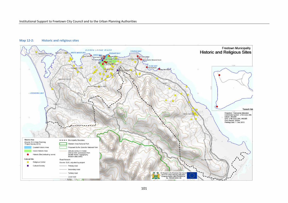
Institutional Support to Freetown City Council and to the Urban Planning Authorities
Map 12-2: Historic and religious sites
101
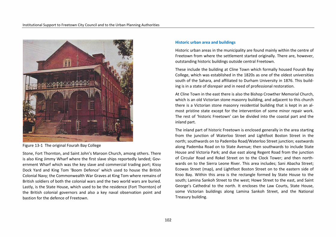
Institutional Support to Freetown City Council and to the Urban Planning Authorities
Figure 13-1 The original Fourah Bay College
Stone, Fort Thornton, and Saint John’s Maroon Church, among others. There is also King Jimmy Wharf where the first slave ships reportedly landed; Gov-ernment Wharf which was the key slave and commercial trading port; Kissy Dock Yard and King Tom ‘Boom Defence’ which used to house the British Colonial Navy; the Commonwealth War Graves at King Tom where remains of British soldiers of both the colonial wars and the two world wars are buried. Lastly, is the State House, which used to be the residence (Fort Thornton) of the British colonial governors and also a key naval observation point and bastion for the defence of Freetown.
Historic urban area and buildings
Historic urban areas in the municipality are found mainly within the centre of Freetown from where the settlement started originally. There are, however, outstanding historic buildings outside central Freetown.
These include the building at Cline Town which formally housed Fourah Bay College, which was established in the 1820s as one of the oldest universities south of the Sahara, and affiliated to Durham University in 1876. This build-ing is in a state of disrepair and in need of professional restoration.
At Cline Town in the east there is also the Bishop Crowther Memorial Church, which is an old Victorian stone masonry building, and adjacent to this church there is a Victorian stone masonry residential building that is kept in an al-most pristine state except for the intervention of some minor repair work. The rest of ‘historic Freetown’ can be divided into the coastal part and the inland part.
The inland part of historic Freetown is enclosed generally in the area starting from the junction of Waterloo Street and Lightfoot Boston Street in the north; southwards on to Pademba Road/Waterloo Street junction; eastwards along Pademba Road on to State Avenue; then southwards to include State House and Victoria Park; and due east along Regent Road from the junction of Circular Road and Rokel Street on to the Clock Tower; and then north-wards on to the Sierra Leone River. This area includes; Sani Abacha Street; Ecowas Street (map), and Lightfoot Boston Street on to the eastern side of Kroo Bay. Within this area is the rectangle formed by State House to the south; Lamina Sankoh Street to the west; Howe Street to the east, and Saint George’s Cathedral to the north. It encloses the Law Courts, State House, some Victorian buildings along Lamina Sankoh Street, and the National Treasury building.
102

Institutional Support to Freetown City Council and to the Urban Planning Authorities
Among the many historic buildings and monuments found within this inland part of historic Freetown are: the Law Courts, State House, the National Mu-seum, the Slave Steps and King Jimmy Market including the ‘De Ruyter Stone’, the Saint George’s Cathedral and the promenade adjacent to it, the old customs buildings and warehouses.
A very important element in ‘historic Freetown’ is the old railway station and offices at Wallace Johnson Street. This cluster of buildings still has its wrought-iron superstructure, which used to be the terminal for the Sierra Leone Railway and the ancillary buildings, whose original Victorian facade still exists although painted over several times.
Many of these historic sites, monuments and buildings have over time dete-riorated extensively as a result of disrepair, improper use or outright neglect. In instances where attempts have been made at rehabilitation (as at the monuments along the promenade at Wallace Johnson Street, the Slave Steps
at both King Jimmy and Government Wharf), workmanship has been devas-tatingly poor.
Scattered across the municipality also are the wooden frame and plank houses referred to as ‘bode ose’, which are typical of colonial era buildings. Of note here is a building located at No. 7 Cline Street, Cline Town, owned by a Mr. Usman Kargbo. It is an old Victorian building, which is to a large extent in its original state.
Museums
There are two museums within the municipality; the Sierra Leone National Museum and the Sierra Leone Railway Museum. The National Museum is located at the junction of Pademba Road and Siaka Stevens Street, adjacent
103

Institutional Support to Freetown City Council and to the Urban Planning Authorities
to the Cotton Tree in central Freetown. The Museum is housed in a historic building that was originally a railway station, then subsequently used as the central post office. After a period of abandonment it was refurbished and commissioned for its current use as the National Museum in 1957.
It houses artefacts ranging from Neolithic stone carvings to relatively recent works of art including wood/stone/ivory carvings, paintings, apparel, and photographs. The management of the National Museum has been in the hands of the Monuments and Relics Commission since 1967.
The Monuments and Relics Commission is a government institution charged with the responsibility to identify, preserve and promote national historic monuments along with objects of cultural and scientific interest, including relics and other archaeological, ethnographical, and historical objects. The Commission was established under the ‘Monuments and Relics Ordinance’ of
June 1947.
The Commission also supervises the running of the National Railway Muse-um, which is located at the former national railway works yard at Cline Town in the east of Freetown. The museum houses train engines, coaches and wagons that were in use during the era of the Sierra Leone Railway, which was closed in 1975.
There are plans currently underway to open a ‘peace museum’ at New Eng-land Ville within the buildings formerly used for the sittings of the Sierra Leo-ne rebel war crimes tribunal. This peace museum will house artefacts from the rebel war and records of the sittings of the war crimes tribunal.
Theatres, centre for the performing arts, art gallery, community centres
There are a few purpose-built cinema halls in the municipality among which are: the Roxy Building cinema, the ‘Odeon’, which is under rehabilitation in central Freetown; the ‘Globe’ cinema at Syke Street and the ‘Lagonda’ cine-ma at Aberdeen in the west; and ‘Starco’ and ‘Saroula’ cinemas in the east. Many of these cinema halls do not function regularly, largely due to the drop in cinema-going and to the poor state of repair of many of the structures. There are also a large number of private makeshift ‘cinema halls’ showing video films across the municipality.
There are no formally built theatres for the performing arts within the munic-ipality. Existing cinema halls are occasionally transformed to accommodate drama and other performing-art activities. Theatre performances are also held at the British Council Hall at Tower Hill in central Freetown and in the many community centres in various communities across the municipality. The Ballantine Academy of Music at Liverpool Street in central Freetown also organizes music performances.
Art exhibitions are held occasionally at the National Museum, the British Council Hall and at the Balmaya Arts Centre at Congo Cross. Plans are cur-
104
Institutional Support to Freetown City Council and to the Urban Planning Authorities
rently under way under the auspices of the Ministry of Tourism and Culture to build an international centre for the performing arts with support from the international NGO Action Aid at the ‘cultural village’ at Aberdeen.
Religious places: churches, mosques
Dotted across the municipality are a variety of religious places/buildings which belong to a range of religious denominations. Many of these plac-es/buildings are of relatively recent development from the 1990s.
Among religious buildings with historic significance are Saint George’s Cathe-dral built in 1817 (holder of the chaplaincy for the Freetown municipality) and the Saint John’s Maroon church built in 1820. Both these churches are often visited by tourists. Some mosques, particularly the ones at Fourah Bay and Fullah Town, also hold long historic traditions. The largest mosque is the relatively recent ‘Gaddafi Mosque’ at Rokupa in eastern Freetown.
Cultural societies/organisations
Freetown municipality has a plethora of cultural societies and organizations (ranging from utilitarian hunting societies to festivity ‘Jorlay’ societies and secretive ‘Egunugu’, ‘Poro’, ‘Wunde’, and ‘Bondo’ societies), with their home bases, (‘Iga’, ‘Ilea’, ‘Igbale’) located in the various communities in the munici-pality. The traditional societies, which number over a hundred, are tightly knit, regimented and cohesive organisations which contribute in no small way towards establishing and maintaining societal cohesion. They are unfor-tunately regarded with some degree of disdain by the general populace mainly because of the membership, the majority of which is drawn from mainly uneducated, low social-status members of the community. Key well-educated members of the community usually form the leadership of these societies, which also form strong political bases and networks. The innate cultural values of these traditional societies have been ignored / lost due to this generally negative perception. It should, however, be noted and appreci-ated that dance movements and drumbeats used during performances by
these societies epitomize opera and ballet movements as performed in western cultures. The traditional societies, therefore, need to be encouraged and better regulated as they could form the basis for the development of an indigenous, particular dance-form and performing-arts genre.
Prominently distinct from these ‘native/traditional’ societies are the various ‘secret’ Freemason ‘lodges’ in the municipality. Due to their foreign origin, quasi-religious posturing, elitist membership and links with worldwide Free-masonry, these ‘lodges’ are evidently distinct from the local traditional socie-ties.
The cultural organizations/societies are formidable pressure groups impact-ing on all facets of life in the municipality. The cultural division of the Minis-try of Tourism and Culture maintains a register of all cultural societies and organizations. The Ministry also organizes and funds cultural festivals be-tween the 19th and 27th of April each year.
Tassoh Island
Tassoh is an island covering about 76 hectare within the municipality and is located about 15 nautical miles (28km) from Freetown. It has huge tourist potential. The entire coastline of this island is laced with a number pristine beaches and coves with sheltered waters. It has a lake (Lake Rogbonka) with extensive areas of mangrove and a rolling plain which is a breeding ground for birds, fishes and crustaceans. The lake and its immediate environs also serve as a transition location for migratory birds. It had been occupied in succession by the Portuguese, Dutch, Danish, French, and British from as early as the sixteenth century as a slave station. Ruins of buildings and entire settlements show evidence of this early occupation. Tombstones dating as far back as 1873 and 1889 can be identified in the Tassoh Island cemetery. There are no motorized vehicles on the island except for one motorbike.
105

Institutional Support to Freetown City Council and to the Urban Planning Authorities
Conclusions and recommendations
Despite the weak and dated legal framework for tourism development, the sector is moving towards more public/private partnership as all five govern-ment owned hotels, (Bintumani, Cape Sierra, Brookfield, Lungi, and Mammy Yoko), have been leased out to private institutions. The 2006 draft strategic development plan for tourism has yet to see the light of day as are the pro-posed amendments to the 1990 ‘Development of Tourism’ Act.
The provisions in the 2004 Local Government Act for the local authorities to assume responsibility for tourism and cultural development in their respec-tive communities have yet to be actualized. Cultural facilities in the munici-pality are generally grossly underfunded and underutilized to the extent that those under current use, such as the National Museum and the Railway Mu-seum, are deteriorating progressively. Tourism information dissemination as well as infrastructure for tourism in the municipality is also very weak. There are hopes that the proposed assistance for tourism under the Enhanced In-tegrated Framework (EIF) in the Ministry of Trade will be able to enhance tourism in the municipality.
The following recommendations are made in view of the assessment of the situation of tourism and culture in the Freetown municipality:
• Place banning orders, as a matter of urgency, on the development of all identified existing sites, buildings and monuments of historic significance within the municipality and demand listed-building consent before the rehabilitation of any one of them.
• Increase information dissemination in order to heighten the cultural awareness of the citizenry in order to engender increased demand for museum and other cultural facilities.
• The peculiar dance forms/patterns and the music of the traditional cul-tural societies should be documented and developed as manuals for training in indigenous music and dance. Bubu music, for example, uses a plethora of local instruments producing orchestral music which can be replicated in a formal manner if written down in traditional music form. The same applies to Orjeh music and dance, which, if documented and choreographed, represent a traditionally performed indigenous form of ballet dancing.
• Develop the inland part of historic Freetown as an attractive city centre for tourists including the area between Lightfoot Boston Street in the south, Wallace Johnson Street in the north, Wilberforce Street in the east and Gloucester Street in the west. The block should have within it curio and jewellery shops, pavement cafes, designer and specialist clothes shops.
• Develop the coastal part of ‘historic Freetown’, which includes all the coastal parts of Freetown north of Wallace Johnson Street, into a prome-nade with Government Wharf serving as a tourist entry point for central Freetown.
• Ensure the development of a Municipality Local Cultural Policy by FCC, which includes guidelines for the development and implementation of
106

Institutional Support to Freetown City Council and to the Urban Planning Authorities
municipal cultural projects. • Prepare thematic plans focusing on historic sites, buildings and monu-
ments with a view to identifying their resuscitation and rehabilitation. • Exploit the nascent tourist potential of Tassoh Island as an eco-tourist
location. This can be done by focusing on its history, different island cul-ture, pristine beaches and sheltered coves, with its attendant features of bird species, flora and fauna, crocodiles and the sacred crocodile pool as attractions. Prepare ecological overnight shelters for tourists and school-children and students from Freetown.
• Improve and standardize the condition and service performance of small guest houses. FCC should see that they provide quality accommodation for short-term/overnight tourists, particularly in central Freetown.
• Formally establish the role of FCC as promoter of metropolitan tourism and tourist management in PPP co-operation as provided for in the 2004 Decentralisation Act.
• Improve vocational training within the tourism industry, with hotel and tourism training schools providing training for core and ancillary hotel personnel and tour guides.
• Initiate and encourage local tourism through guided tours for schools and other institutions, emphasizing eco-tourism as an addition to the current emphasis on beach tourism.
• Standardize place names and develop maps of the municipality in order to enhance its tourism potential.
13 Traffic and Transport
This section concerns traffic and transport and provide guidance to FCC and central government decision-makers as how to respond to and decide upon proposals concerning improvement and maintenance of the road, traffic and transport systems.
Presently, the majority of the traffic- and transport-related decisions are being taken by central government institutions. Thus, the SLRA (Sierra Le-onean Road Authorities) are actually implementing a major rehabilitation and extension of Freetown main roads, while the Ministry of Transport and Aviation in 2012 made a detailed analysis of the traffic and transport situa-tion in Freetown.
However, the majority of population directly served and impacted on is Free-town City Council’s citizens, therefore, FCC in close co-operation with the traffic and transport institutions will attend to the traffic and transport situa-tion in the city and contribute to the solution of its problems.
13.1 Transport, traffic, and road system
The transport in Freetown depends considerably on mechanized transport, both public and private. The informal sector has by far the largest share of the market, but it is disorganized and delivers an expensive and poor quality of service for citizens. The use of collective transport is the most common form of personal transport.
Traffic congestion in Freetown has increased with the rapid growing popula-tion and number of vehicles, degradation of the roads, street parking, street trading, and inefficient traffic management.
Conditions for pedestrians are poor with blocked walkways and damaged or
107

Institutional Support to Freetown City Council and to the Urban Planning Authorities
non-existing pavements. The existing problems of traffic congestion and inef-ficient public transport will become more serious if no action is taken to re-verse present trends.
13.2 Collective personal transport
A count of persons using transport showed in 2012 that around 87% and 65% of travellers used public and private collective means of transportation east
and west of the CBD respectively.9 The collective urban transport services in Freetown are provided almost exclusively by road transport operators with a small contribution by water transport along the coast and to Lungi Interna-tional Airport.
Bus service
The limited urban bus service is mainly provided in Freetown by the state-owned Sierra Leone Road Transport Corporation (SLRTC); SLRTC also
9 Ministry of Transport and Aviation, Adam Smith traffic and transport Analysis 2012
108
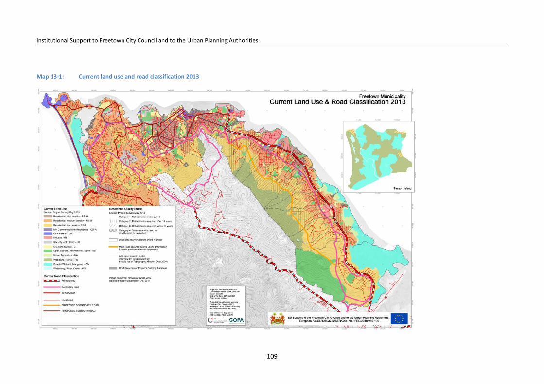
Institutional Support to Freetown City Council and to the Urban Planning Authorities
Map 13-1: Current land use and road classification 2013
109

Institutional Support to Freetown City Council and to the Urban Planning Authorities
operates inter-urban bus services between Freetown and other cities. SLRTC currently has 65 serviceable buses, delivered between 2006 and 2012. The majority are 43-seaters with capacity for 10–15 standing passengers. The corporation expected 20 new buses to be purchased during 2014.
Normally 20–25 bus units are on urban services in Freetown. Some long-distance buses are also deployed on urban services for long-distance trips to augment the level of service in the city.
The effectiveness of the urban buses is impaired by traffic congestion, which limits the number of trips which can be operated, and makes services infre-quent and unreliable.
A small number of private owners operate full-sized buses on city services in Freetown: most of these are allocated to routes running along Kissy Road from Eastern Police to Calaba Town. All were purchased second-hand, mainly
from European operators; most are in very poor condition. Some are city buses but others are coaches designed for long-distance services and are unsuitable for use as urban buses.
13.2.1 Urban passenger transport and railways
Freetown once had a functioning railway system. Yet, today there is no rail-road; only the former routes and bridges can still be recognized in the urban landscape.
However, the use of passenger transport on rails in urban areas in combina-tion with other transport modes may result in efficiency and cost savings in the long term. As the investment is considerable, the planning of railroad lines must be carefully co-ordinated with the urban planning projects and needed population densities to make the use of traditional trains or light trains economically sustainable:
110

Institutional Support to Freetown City Council and to the Urban Planning Authorities
Map 13-2: Main roads, bus stops, and ports
111
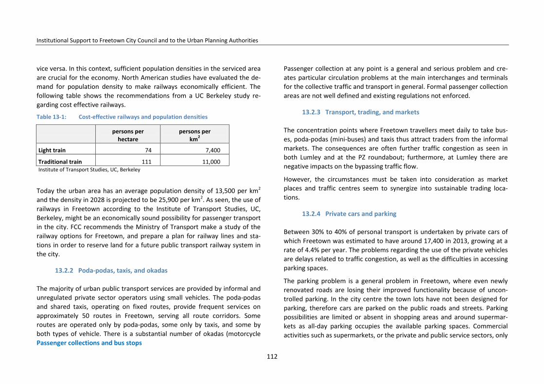
Institutional Support to Freetown City Council and to the Urban Planning Authorities
vice versa. In this context, sufficient population densities in the serviced area are crucial for the economy. North American studies have evaluated the de-mand for population density to make railways economically efficient. The following table shows the recommendations from a UC Berkeley study re-garding cost effective railways.
Table 13-1: Cost-effective railways and population densities
persons per
hectare persons per
km2
Light train 74 7,400
Traditional train 111 11,000 Institute of Transport Studies, UC, Berkeley
Today the urban area has an average population density of 13,500 per km2
and the density in 2028 is projected to be 25,900 per km2. As seen, the use of railways in Freetown according to the Institute of Transport Studies, UC, Berkeley, might be an economically sound possibility for passenger transport in the city. FCC recommends the Ministry of Transport make a study of the railway options for Freetown, and prepare a plan for railway lines and sta-tions in order to reserve land for a future public transport railway system in the city.
13.2.2 Poda-podas, taxis, and okadas
The majority of urban public transport services are provided by informal and unregulated private sector operators using small vehicles. The poda-podas and shared taxis, operating on fixed routes, provide frequent services on approximately 50 routes in Freetown, serving all route corridors. Some routes are operated only by poda-podas, some only by taxis, and some by both types of vehicle. There is a substantial number of okadas (motorcycle Passenger collections and bus stops
Passenger collection at any point is a general and serious problem and cre-ates particular circulation problems at the main interchanges and terminals for the collective traffic and transport in general. Formal passenger collection areas are not well defined and existing regulations not enforced.
13.2.3 Transport, trading, and markets
The concentration points where Freetown travellers meet daily to take bus-es, poda-podas (mini-buses) and taxis thus attract traders from the informal markets. The consequences are often further traffic congestion as seen in both Lumley and at the PZ roundabout; furthermore, at Lumley there are negative impacts on the bypassing traffic flow.
However, the circumstances must be taken into consideration as market places and traffic centres seem to synergize into sustainable trading loca-tions.
13.2.4 Private cars and parking
Between 30% to 40% of personal transport is undertaken by private cars of which Freetown was estimated to have around 17,400 in 2013, growing at a rate of 4.4% per year. The problems regarding the use of the private vehicles are delays related to traffic congestion, as well as the difficulties in accessing parking spaces.
The parking problem is a general problem in Freetown, where even newly renovated roads are losing their improved functionality because of uncon-trolled parking. In the city centre the town lots have not been designed for parking, therefore cars are parked on the public roads and streets. Parking possibilities are limited or absent in shopping areas and around supermar-kets as all-day parking occupies the available parking spaces. Commercial activities such as supermarkets, or the private and public service sectors, only
112

Institutional Support to Freetown City Council and to the Urban Planning Authorities
provide spaces to a limited extent for client parking.
Finally, a considerable number of broken-down vehicles are parked along the streets, and informal car workshops use the public road for client parking and the parking of vehicles left for repair.
13.3 Transport of goods
13.3.1 Goods transport in the city
Supplies of goods to urban customers, goods produced in the towns and cities, and import and export of goods passing through the port, are being transported around Freetown. Part of the commercial sector imports the majority of the sold products, which have to be distributed for wholesale and retail purchase from the port area. Another sector imports from the provinc-es and these commodities enter the city on the Bai Bureh Road.
13.3.2 The Port of Freetown
The main port in Freetown is located in Cline Town on a land reclamation area. The port was rehabilitated in 2005 for commercial, tourist, and trans-shipment purposes. The Port of Freetown is an important activity centre for the city, supporting business opportunities and creating employment. Pres-ently, the port is mainly used for the handling of goods but in the future it might also be hosting tourist cruise ships visiting the city. However, the loca-tion of the port in the centre of Freetown creates various challenges requir-ing attention.
In 2012, 494 vessels entered the Port of Freetown. In the same year a total of 63,000 containers were handled from the Port showing a yearly growth of 7.3% between 2011 and 2012. It must be assumed that future trends will be
mainly upwards due to the redevelopment of the economy, and provision
must be made accordingly.
The Sierra Leonean Port Authorities, SLPA, has prepared a Master Plan for the development of the future activities including: (1) the extension of the Queen Elizabeth Quay westwards; (2) construction of a dry bulk terminal east of the Queen Elisabeth II Quay for handling of dry bulk cargo; (3) installation of a liquefied petroleum gas system; 4) a new oil/fuel terminal; 5) a new oil supply terminal and rehabilitation of the oil/fuel terminal in Kissy; and others such as rehabilitation of the old Fourah Bay College Building, and the ship repair yard. The Government has, moreover, presented plans on the estab-lishment of an inland extended port area close to the new airport for han-dling of containers directly transported to the area from the ships. For transport between the main port and inland, the construction of a railroad has also been considered. The Government´s development plan Agenda for Prosperity mentions the intention to assess the location of an optional port.
A major problem related to the port area is the heavily loaded traffic to and from the site creating long queues of container lorries and severe traffic con-gestion in the area and on the Bai Bureh Road, although container freight to the Port has been restricted during daily hours. One of the main tasks is to ensure sufficient parking space for the container trucks coming to the port. The Port area is in total 27 ha, of which around 14 ha are occupied by exist-ing buildings. Nearby is an area of 11 ha which could be filled up and used for the lorry parking.
Nevertheless, it is also important to assess the negative impact from the port on the surrounding residential areas as the port activities create considerable dust and noise pollution.
113

Institutional Support to Freetown City Council and to the Urban Planning Authorities
Jetties, wharves, and waterway transport
Beside the main port, Freetown counts several jetties and wharves along the peninsula coastline, mainly to link with Lungi and Tassoh Island. Currently, only three of them are used for the purpose: these are Kissy Ferry Terminal and Government Wharf with a ferry service to Lungi, and the Murray Town Wharf used mainly by fishing companies. In general, the wharves and jetties are in bad condition although Government Wharf has been modernized with a roof to cover floating piers.
Berthing can be difficult for larger boats because of the presence of a num-ber of wrecks close to the coastline. However, considerable artisanal transport of goods and building materials takes place along the coast in tradi-tional canoes, which also brings passengers, fish, and agricultural produce to the markets in Freetown.
13.4 Non-motorized transport
Freetown has a considerable number of non-motorised transport carts for transport of goods and collection of solid waste. As the cart speed is lower than the traffic in general the carts provoke overtaking. Bicycles are increas-ingly being used and could be an ideal option for personal transport in the lower part of Freetown. However, little experience and no special traffic rules exist for the use of bicycles, which creates safety problems for their use. Special identified non-motorized routes through the city could be a solu-tion.
Special consideration must be given to improving safety and security for pe-destrians. There are many pedestrians on Freetown streets and roads. How-ever the safety is limited as many footpaths are blocked, in complete disre-pair, or non-existent. Schoolchildren and elderly people move around with considerable risk. Street crossings are few and a lack of urban traffic culture
also increases pedestrian vulnerability.
13.5 Road safety
Freetown has the relative highest number of traffic accidents in the country. Around 70 people are being killed a year in traffic accidents and around 300 seriously injured.10 The most frequent reasons for the accidents are; no safe-ty audits for road construction schemes, the poor and unsafe condition of many vehicles, as well as poor enforcement of traffic regulations and rules. Reporting and analysis of accident statistics is weak.
Okadas (motorbike taxis), present special challenges as they travel at speeds greater than the average traffic, they are many, and they frequently ignore the traffic rules.
However, traffic culture in Freetown seems evolved with much care taken and consideration given towards the other road users. The inner city could, in the future, be considered a special circulation area where all sorts of traffic could mix while taking care of the weakest actor.
13.6 Road system
The road system in Freetown is divided into the following road categories:
• Primary Roads (Class A): main trunk roads characterized by high traffic volumes, long distance inter-regional or international trips
• Secondary Roads (Class B): collector-/distributor-type roads serving ma-jor district or population centres and carrying medium or long distance trips
• Tertiary Roads (Feeders): primarily local land-service roads connecting to
10 Adam Smith Traffic and Transport Analysis 2012
114

Institutional Support to Freetown City Council and to the Urban Planning Authorities
primary and secondary roads • Local Road Network: roads administered by district and town councils;
they are essentially feeder roads and are characterized by low traffic vol-umes
The main road system is under rehabilitation following recommendations from the 1997 Freetown Master Plan. The strategy is to widen and improve the functionality of the primary and secondary roads and to improve im-portant tertiary roads with regard to profile and drainage. A new bypass road Class B is being constructed between Upgun and Jomo Kenyatta Road to im-prove circulation between the west and the east of the city. Furthermore, in the near future the newly constructed West Coast Road and the Hastings– Regent Road will supplement the Bai Bureh Road.
However, some challenges remain in regard to improving the road system functionality on complicated road junctions where the various traffic flows meet. Further serious challenges remain related to: solving traffic manage-ment deficiencies; ensuring continuous maintenance of the existing roads and lanes; solving a lack of parking spaces; and the construction of access roads to neighbourhoods which have developed throughout the city without any planning.
13.6.1 Western Freetown
The western part of Freetown is the best served, and the secondary and ter-tiary road system is, with improved functionality, considered to be more or less defined and functional. However, the parking problem remains and the traffic flow is troublesome at Congo Cross roundabout and the other road junctions along Wilkinson Road.
13.6.2 Central Freetown
In the central part of Freetown the existing road system is well defined but heavily congested. As mentioned, the planned bypass road under construc-tion from Upgun to Jomo Kenyatta Road will decongest the traffic in the cen-tre of the city by avoiding through traffic and transport between east and west, including transport to and from the port area that enters the city cen-tre. However, radical improvement of traffic management is needed in the centre to make traffic circulation functional. Street trading especially is out of control and impedes traffic circulation.
13.6.3 Eastern Freetown
In the eastern part of Freetown the road system needs overall replanning, rehabilitation and improvement. The Bai Bureh Road is presently the primary road connecting Freetown to the provinces. Soon, it will be supplemented by the Regent–Hastings and the west coast primary roads. But Bai Bureh Road also serves as a distribution road for local traffic with many direct access points and therefore the circulation capacity is severely reduced. The rehabil-itation of Bai Bureh Road is planned, including two additional lanes in its eastern part.
Blackhall Road continuing into Kissy Bypass Road and the Wellington Main Motor Road is well located as a distribution road to the local road network in eastern Freetown, but the road lacks the design and capacity to take over distribution road functions. In some places the road is even being taken over by traders and used as a market place, which is the situation in Rokupa and Wellington.
Finally, the eastern part of Freetown still has an available area for urban ex-pansion up the hillside between Kissy and Allen Town where a low dense urban sprawl is taking place. Integrated into a major urban renovation pro-
115
Institutional Support to Freetown City Council and to the Urban Planning Authorities
ject for these areas, a new distribution road should be built from Kissy set-tlement to Allen Town while also linking to a potential future urban devel-opment area in Allen Town opposite Crafton.
13.6.4 Access roads to the neighbourhoods on the hillsides
Specific problems to be solved in all parts of Freetown include a lack of ac-cess roads to the unplanned urban sprawl on the hillsides, which makes ve-hicular access complicated, and therefore difficult to provide citizens with public transport, goods, and emergency services. As mentioned, a distribu-tion road is needed on the hillside from Kissy settlement to Allen Town. An-other distribution road is needed from Lumley to Hill Station continuing in a third mayor hillside road between Hill Station and New England; connecting to the entrance to Four Bay College University at Circular Road.
13.7 Conclusions and recommendations
The transport policies and development goals provided in the Freetown Structure Plan will serve as guidance to FCC and central government deci-sion-makers as to how to respond to and decide upon proposals concerning improvement of the transport system, traffic situation, and maintenance of the road system.
13.7.1 The traffic situation in general
As the population of Freetown grows, the existing problems of traffic conges-tion and inefficient public transport will become more serious if no action is taken to reverse present trends. The FCC transport policy for Freetown in-cludes the need to prevent uncontrolled growth in private transport and ensure that efficient and affordable public transport services are provided. FCC will also work together with the relevant institutions to ensure that the
existing roads are used as rationally as possible, with priority given to traffic and transport.
13.7.2 Improved traffic management
In the short term, efforts should be concentrated on improving the traffic management to overcome the existing bottlenecks and increase the func-tionality of the existing road system. Also, awareness campaigning among citizens concerning traffic regulations and better driving, as well as training of traffic policemen and women in rational and functional guidance of the traf-fic.
A consequent one way street traffic circulation system should be considered in the streets promoting more circulation and less risk of accidents. Parking regulations should be revised and all-day parking in the city-centre business areas avoided.
FCC could, when granting business permits, require establishment of parking places where possible, or contribution to a parking fund to finance the estab-lishment of parking on available sites or in buildings. Parking should not be free.
13.7.3 Improved passenger transport service
Many Freetown transport users have stated that they prefer the bigger buses to poda-podas, taxis, and okadas.11 Although car ownership is low compared to many other cities of comparable size, it is significant. Without considering other forms of transport, the increased use of private car in traffic will aggra-vate the existing problems of traffic congestion.
11 Adam Smith, Ministry of Transport and Aviation 2012.
116
Institutional Support to Freetown City Council and to the Urban Planning Authorities
Furthermore, the feasibility study shows12 that an improved and extended bus service will be economical, sustainable and competitive in Freetown due to the many existing users.
FCC supports the development of an efficient metropolitan bus service with sufficient capacity, and a concentrated network of bus lines and bus ex-change points at strategic locations through the city. The bus service must efficiently connect future Freetown sub-centres and market places. The ser-vice must cover the whole Peninsula, creating bus services to beaches and recreation areas along the coast.
Special air-conditioned bus lines on the strategic routes should be estab-lished as an alternative to the use of private cars.
More planning for and establishment of sub-terminals, bus stops and loading places for taxis must be considered in strategic places, accompanied by strengthened supervision and law enforcement of the stopping regulations. Major bus terminals with necessary facilities and qualified staff for cleaning and mechanical maintenance must be established in Hastings and Hamilton. A light train on rails for passenger transport might be considered in the east-ern part of the city, combining the use of rail with the container transport to and from the port. Land reservations for public transport on rails should be done for the entire FCC area connecting to Waterloo and Sussex.
13.7.4 Transport of goods
With economic development, more goods will be transported through the Freetown areas. This means that there must also be adequate capacity in the transport system to meet the requirements of goods transport. Loading and reloading places must be established and, if needed, in special areas limited
12 Adam Smith, Ministry of Transport and Aviation 2012.
to sudden hours daily or restricted.
However, the need to demolish buildings in order to provide space for wider roads to cater for increasing numbers of large goods vehicles, in addition to other traffic, must be kept to the absolute minimum.
It is important to ensure that cargo traffic causes minimum cost and incon-venience to others and not will be at the expense of the quality of the envi-ronment. As mentioned rail transportation might in medium term be taken into consideration from the port towards Hastings.
13.7.5 Private cars and parking
Uncontrolled on-street parking causes obstructions and results in congestion. Parking awareness campaigns and stricter parking regulation enforcement must be carried out. Parking in the inner city must be restricted to the mini-mum and public investment should be directed towards improved public transport rather than expensive parking lots or buildings.
Free private car parking increases the use of the private car and all-day park-ing. In central areas, and where parking is creating problems for the traffic circulation, parking fees must be introduced together with a more efficient enforcement of parking regulations. Moreover, parking fees serve business activities as fees restrain all-day parking and permit short-term parking for customers and clients.
In areas where parking is needed, off-street parking must be made possible by the establishment of parking lots. Building regulations should also de-mand parking spaces on-site when supermarkets, office buildings, and new housing blocks are being constructed.
FCC is in charge of the parking system and regulation in the city. Via PPP initi-atives the private sector should be involved in establishing and running off-street parking lots where parking is needed.
117

Institutional Support to Freetown City Council and to the Urban Planning Authorities
13.7.6 The Port of Freetown
The Port of Freetown is an important activity for the city supporting business opportunities at many levels and creating employment. FCC wants port activ-ities to be modernized to make the port competitive. It also wants to support key port activities with the future planning of the area. The port needs park-ing areas for the container lorries and FCC suggests that part of the available surrounding area is to be used for such a lorry park.
As the port in the future might receive tourist cruise ships, FCC wants to fur-ther improve the area surrounding the port and find ways to connect it to the city centre.
13.7.7 Waterway transport, wharves, and jetties
The coastal environment has considerable qualities and is a potential resource for development in Freetown. Traditionally, the coastal population has used and is using canoes to arrive in Freetown. A future modern maritime passen-ger transport between the east and the west of the city area is a possibility, with additional tourist potential. In this regard, it is recommended the reha-bilitation of the existing jetties and construction of new ones along the coast and at Tassoh Island is undertaken. Is also recommended that coast is cleared of wrecks and scrap metal. This will enhance passenger transport for national as well as international tourism by freeing the navigation paths from wrecks.
13.7.8 Non-motorized traffic
Pedestrian walkways and footpaths will be re-established in the urban streets and protected from being blocked by parked cars and street trading. Many of these footpaths already exist in Freetown and the network will be improved and expanded, including in the city centre and business streets. A
detailed public walkway, footpaths and space plan is needed to be drafted for the CBD and extended towards all FT areas.
In selected areas planning consideration should be given to the segregation of traffic – a concept whereby particular streets might be reserved entirely for pedestrians and street traders. Local city closures and alternative vehicu-lar travel routes have been provided.
In the long term, certain city centre streets should be developed into pedes-trian promenades and malls, giving citizens the freedom to move about in concentrated business and trading areas with, at places, connections to piers and fish markets along the coast. In situations where it is impractical to have total street closures, existing congested streets with narrow pavements could be remodelled to make provision for wider pavements. This can be accomplished by reducing existing roadway widths or acquiring and demol-ishing buildings along the streets, supported by a system of one-way roads to reduce traffic flows.
A further alternative to complete street closure is limiting vehicular traffic in areas of the city to special classes of vehicles, such as buses, ambulances, fire engines and other emergency vehicles, or limiting closures of certain streets to morning hours only.
13.7.9 Promotion of use of bicycles in Freetown
The possibility of improving the conditions for safe use of bicycles in Free-town will be assessed. The bicycle provides a cheap, fast and healthy alterna-tive to the use of private cars and buses in the city centre and might be espe-cially attractive for the younger generations. The topography along the coast-line provides good conditions for cycling. The use of bicycles could include the concept of giving exclusive priority traffic to pedestrians, bicycles and the citizens living in the streets. Such traffic concepts could be incorporated in the design of the streets and roads running along the coast from Kissy to
118

Institutional Support to Freetown City Council and to the Urban Planning Authorities
Murray Town.
13.7.10 Road safety
Road safety depends to a large extent on respect for traffic regulation and the physical condition of the circulating vehicles, issues attended to by other institutions. However, traffic culture and awareness among citizens is im-portant and FCC will enforce safe traffic behaviour and safety awareness programme to children in Freetown’s schools.
Continuous control of the mechanical condition of vehicles should take place; unsafe vehicles or those in poor condition should be banned from circulation. Testing vehicles’ performance could be decentralized to supervised licensed workshops and made obligatory and not possible to avoid paying escaping fees to the authority. Furthermore, special campaigns will be directed to-wards adult citizens relating to use of alcohol and driving.
13.7.11 The future road system
The future proposed road system will be built upon the plans being imple-mented for the improvement of the Freetown road network. Between the Freetown sub-centres’ prioritized fast traffic links, introducing preferences to public transportation, will be developed by giving priority to the use of the existing renovated roads with minor extensions. Only limited new road con-struction will take place, but the existing road system will be improved for functionality with flyovers where possible and justified.
Three main access roads will be upgraded to lead the traffic with as little intersections as possible to and from Freetown. These are the Bai Bureh Road leading to the city centre and the Port, the newly constructed Hastings–Regent Road, and the renovated west coast road under construction. When these roads are functional, Freetown will be well connected to the whole
Peninsula area.
The secondary road system consists of the renovated Wilkinson Road linking the Lumley and Murray Town/Aberdeen centres to the city centre. The newly renovated Spur Road will connect the Lumley, Hill Station and Regent areas. A connection will be established from the military installation IMATT via Leicester and Fourah Bay College University to Circular Road. The Hill Cut Road will link Hill Station with Jomo Kenyatta Road and the New England Business Centre with further connection by the Hillside Bypass under con-struction to Eastern Freetown, Kissy, Wellington, and Allen Town.
However, the southern part of Eastern Freetown, along the hillside from Kissy to Allen Town, is poorly served and a new distribution road is proposed along the hillside to create access to new three to four-floor residential build-ings along the roads.
An additional link between Jomo Kenyatta Road and Congo Cross Main Road using King Harman Road passing the Youyi Building could connect the Wil-kinson Road area directly with the Hillside Bypass Road. The Hillside Bypass Road under construction is, furthermore, expected to reduce the traffic pres-sure on the city centre.
Moreover, the Hillside Bypass will connect to the Freetown Port area, the Lungi Airport area via ferries and the Bai Bureh Road linking Freetown to Waterloo and the provinces. The Hillside Bypass provides a central nerve in Freetown’s future traffic and transport system, opening the possibility of developing a calmer and ordered traffic environment inside the city centre and creating appropriate conditions for the many pedestrians on foot.
Improved tertiary roads connect the major roads and lead to residential are-as. While the road system in lower western and central Freetown is quite defined, road plans for the hillsides and each sub-centre area in eastern Free-town must be prepared to prepare the road system for future intensive ur-ban development in this part of Freetown.
119
Institutional Support to Freetown City Council and to the Urban Planning Authorities
13.8 Traffic and transport management policies
13.8.1 Traffic management in general
• Movement of people and goods should be provided by the most efficient, safe and affordable means.
• Urban transport planning should take into account environmental sus-tainability and the needs of vulnerable groups including children, stu-dents, the elderly, the disabled, and women.
• Urban transport systems should be designed to support agreed land use and economic development plans for urban areas.
• Collective personal transport should be given priority over private cars. • New private sector organisations should be encouraged to enter the
transport market as formal transport operators. • Such vehicular traffic as is required must be able to move freely, and be
adequately provided for. • Road use must be controlled, in terms of the numbers and categories of
vehicles permitted to use each street for transit or parking, and non-transport uses.
• Non-desired traffic should be discouraged through use of transport-demand management measures.
• Where possible, infrastructure capital costs should be funded by the pri-vate sector, or by government in partnership with the private sector.
13.8.2 Collective passenger transport
Buses, poda-podas, taxis, and okadas
• Urban roads, bus terminals, bus stops, and off-street car parks should be provided by the public sector, although they may be funded and man-aged with private sector participation. Basic minimum-cost services
should be available for all, supplemented by premium services at higher fares.
• Most transport services should be paid for by users. • Public transport fares should be set at levels which enable all costs to be
covered in full. • Urban public transport services should be provided by formal scheduled
bus services, supplemented by taxis and okadas to cater for individual requirements.
• Existing informal transport operators should be encouraged to combine and form co-operatives or companies which would be eligible to bid for licences for formal main bus service lines and get licences to feed these lines from the neighbouring areas.
• Poda-podas should be phased out and replaced by formal buses on the main bus service lines, or taxis as appropriate.
• Taxis should operate on the basis of distance-based fares and the use of taximeters.
• Taxis and okadas may compete in a controlled manner, but market entry should be regulated, with strict safety and quality standards.
• Fare structure should be equitable, and allow fares to vary according to distance, time and direction of the journey and other relevant factors.
13.8.3 Private cars and parking
• Growth in private transport should be restrained through fiscal measures, caps on private vehicle numbers, and other appropriate measures.
13.8.3.1 Goods transport in the city • Movement of goods should be managed to balance the benefits of effi-
cient distribution against the negative impacts of freight vehicle opera-tion.
120

Institutional Support to Freetown City Council and to the Urban Planning Authorities
13.8.3.2 Non-motorized transport, NMT • Walking and cycling should be encouraged and appropriate facilities pro-
vided, e.g. exclusive right of way for pedestrians, cyclists, and other NMT modes.
13.8.3.3 Road safety • Road safety will be enhanced through improvements in capacity, educa-
tion, and enforcement.
13.8.3.4 Road System • A hierarchical roads system for each urban area should be planned with
priorities for road-system development taking into account the needs of public transport and goods transport. The road system is the network of roads and streets that links the several urban functions.
• Support the preparation of a mobility plan together with Ministry of Transport and Aviation, MTA.
14 Solid waste and other infrastructure
Waste management in Freetown is of immense importance to reduce the spread of preventable diseases such as cholera, malaria, diarrhoea, typhoid, etc. At present, greater parts of the city are being cleaned by the Freetown Waste Management Company, FWMC. However, there exist areas with no such service.
The population in general lack awareness of the necessity of solid-waste col-lection and show too little co-operation in keeping the city clean. A major problem is that the final dumping of waste takes place inside the city on dumping sites with little use of modern environmentally sound solid-waste management techniques.
14.1 Institutional responsibilities
In the Agenda for Prosperity the Government outlined its commitment to providing strategic and investment plans for effective implementation of the Environmental Health and Sanitation Policy, Integrated Waste Management Policy and the Public Health Ordinance.
According to the laws, it is very clear that FCC is responsible for cleaning the city and handling the law enforcement related to it. The Health and Sanita-tion Department of FCC has public health inspectors. In the area of enforce-ment, also the Sanitation Unit of the Ministry of Health has sanitary officers and wardens for the enforcement of the Public Health Ordinance Act of 1978.
14.2 Primary and secondary collection
Effective waste management commences with the primary mode of collec-
121

Institutional Support to Freetown City Council and to the Urban Planning Authorities
tion starting from door-to-door and with street-to-street collection, tempo-rary deposit in transit points, and final dumping in a secured site.
In Freetown the door-to-door collection from households is undertaken by wheelbarrows, pushcarts (omorlankay), tricycles, etc. Dump trucks collect rubbish in the streets and take it to the transit points. People pay for the collection of their waste at a price determined by the waste collectors. The city has 46 transit points (see map 4-3).
However, some areas – especially at the extreme east and west of the city and areas on slopes and hilltops – remain uncovered (see map 4-3). Waste is handled by hand from the collection point to the dump trucks.
Secondary collection concerns the transportation of waste from the collec-tion points and industrial rubbish dumps to the landfill sites. Dump trucks transport waste from transit sites to the landfill sites. Maintenance and fuel costs have been a major setback for the effective operation of collections. Consequently, there is always a backlog of waste at the transit collection point, which causes over-accumulation of waste with environmental and sanitary consequences as the effect.
14.3 Recycling activities and opportunities
Presently, some form of recycling occurs at the two formal dump sites. Or-ganic waste is used to produce manure while metallic waste is exported to India and China for recycling. Both activities provide a significant source of income for many people but it is very obvious that manure produced in this way contains intoxicants that cause life-threatening diseases.
Recycling is a resource-recovery practice which includes the collection and reuse of waste materials such as: aluminium containers like beverage cans, copper such as wires, steel, food tins, aerosol cans, old steel furnishing or equipment, polythene, glass bottles and jars, paper board, cartons, newspa-
pers, etc. The material from which the items are made can be reprocessed into new products.
FCC must start shifting away from waste management to resource-recovery practices like recycling, reuse and reduction of waste. The focus on such a drive would be to create job opportunities. Recoverable materials that are organic in nature such as plant materials and food scraps can be recovered through composting and digestive processes to decompose the organic mat-ter. The resulting organic material is then recycled as mulch or compost for agricultural or landscaping purposes.
Incineration, which involves solid organic waste being subject to combustion so as to convert it into residue and gaseous products, reduces the volume of solid waste by 30% of its original volume.
14.4 Landfill sites
Freetown has two formal landfill sites; King Tom in the west and Granville Brook in the east (however solid waste is also being dumped on several other places). The general condition of the two existing dump sites is deplorable and they impose serious environmental consequences on public health. The sites were poorly managed as regards environmental considerations and functionality; such as a lack of control over waste burning, poor control over scavengers, illegal dumping and encroachment, inappropriate tipping and stockpiling, and lack of space for expansion, among other problems.
Based on a volumetric capacity assessment, the Kissy landfill site is the only site with potential for use over a longer period. The King Tom site is due for closure. See results below:
122

Institutional Support to Freetown City Council and to the Urban Planning Authorities
Table 14-1: Volumetric capacity of Kissy dump site
Source: Lancelot A. Lake, Technical Studies for the Relocation of the Two Dump Sites in Freetown/January 2010
Based on the calculations above, the remaining airspace capacity in the Kissy dump site is 288,780 cubic metres. Waste generation is estimated to grow by 73% from 2010 to 2025. The municipality of Freetown is expected to gener-ate a total of 3.2 million tons of waste from 2010 to 2025, of which FWMC expects to collect only 50%. To accommodate this amount of waste, a landfill with a minimum area of 27 hectares of land is required. However, if 100% of collection coverage is predicted, twice the landfill size will be required.
14.5 Lack of urban culture
It is to be noted that a large percentage of the residents of Freetown is made up of recent (past ten years) migrants from relatively small, widely dispersed rural settlements, where the generation of non-biodegradable waste was practically zero in both volume and concentration. Formal waste collection and disposal systems as such do not exist in these settlements.
The effect is that the urban culture of selective waste disposal does not exist in a significant number of Freetown residents. This is unlike the situation in many other cities where, even in the absence of regular law enforcement officers, the general citizenry serve as vanguards in keeping their city clean. Proper solid-waste collection awareness and habits must be key sensitization issues for FCC interaction with the population, and emphasized as an im-portant condition to ensure the development of Freetown into a clean city.
14.6 Hospital (medical) and hazardous waste
The Environmental Health Division of the Ministry of Health and Sanitation (MoHS) is the executive authority for medical waste management in Free-town. This includes pharmaceuticals, radioactive materials, and other infec-tious waste-containing pathogens. There is no official record of the volume of medical waste generated in Freetown hospitals. Anecdotal reports, how-ever, indicate a low level. Medical waste is also being deposited in the landfill sites unsorted and there is the risk of the spread of contagious diseases through vector animals and insects, rainwater percolation, or through direct contact with human beings.
The MoHS has created the Waste Disposal Unit for the treatment of hazard-ous waste within the main hospital in Freetown composing of a shelter for fuel waste storage and a lined twin reinforced concrete pit (one pit for organ-ic waste, the other for the remnant of the incinerator: ashes, glass, and me-tallic parts like needles).
14.7 Industrial waste Industries are responsible for the cleaning of the waste they generate. Since there are very few industries in Freetown, it is estimated that waste generat-ed by this sector is relatively low (about 20 tons per day – FSP: Pre-Identification Study). Many industries remain dependant on processes that
123

Institutional Support to Freetown City Council and to the Urban Planning Authorities
produce waste water. Other forms of industrial waste include oil and grease, sawdust, and construction rubble, which are all recyclable.
14.8 Conclusions and recommendations A major factor for the poor waste management situation in Freetown is the absence of the community understanding and participation in waste man-agement. Development of a sound urban waste collection culture based on international best practice must be the way forward for a clean Freetown and should therefore be actively undertaken. FCC will champion a crusade to positively change the behaviour of Freetown residents and involve the population in the discussions on sound and healthy habits regarding the management of solid waste, which additionally might have some employment- and income-generating opportunities via an effi-cient recycling of waste.
The awareness-raising must also improve understanding on natural re-sources and care for the environment. The general citizenry must serve as custodians in ensuring that their city is clean and healthy. Furthermore, the practice of throwing waste on to the streets and other unsuitable sites must be condemned and viewed as a display of incivility: the municipality must take action against it using the laws and fines available.
As the population grows in Freetown so by consequence does the production of solid waste. FCC solid-waste management strategy will include a diversi-fied strategy to improve solid-waste household collection and the proper functioning of the temporary deposit points. Management structures focus-ing on efficiency, with the involvement of private sector, NGOs, and commu-nity based functional initiatives should be put in place.
124
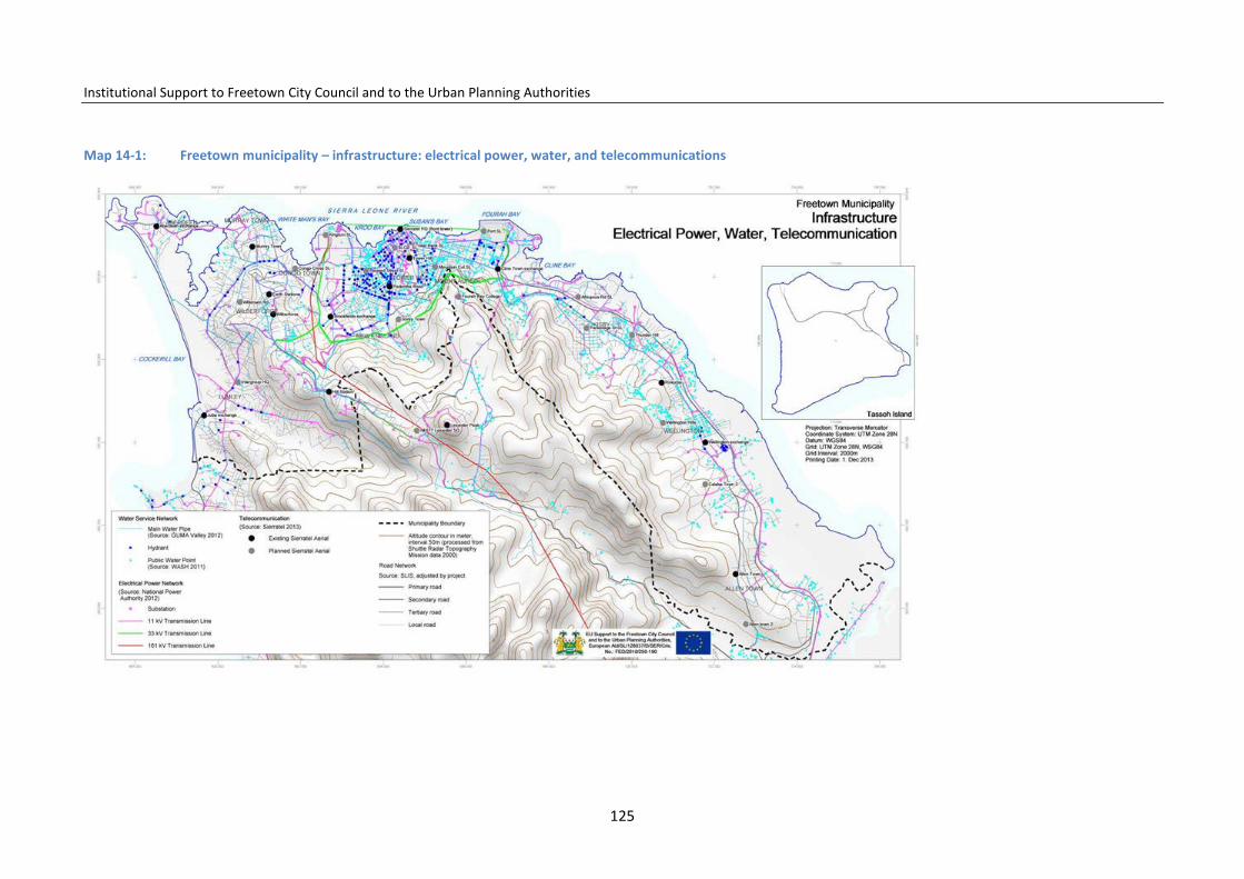
Institutional Support to Freetown City Council and to the Urban Planning Authorities
Map 14-1: Freetown municipality – infrastructure: electrical power, water, and telecommunications
125

Institutional Support to Freetown City Council and to the Urban Planning Authorities
The economic and practical technical possibilities of recycling must be ana-lysed, with concrete pilot projects developed and co-ordinated with em-ployment generation. Also required is development for business activities to handle the commercial and productive bases of the recycled material.
14.9 Institutional and regulatory changes
FCC will develop and strengthen the FCC monitoring and supervision of solid-waste management activities to ensure efficient performance, or outsource the activity to efficient private firms.
In the short term, FCC will make the co-ordination process with MoHS more efficient. This can be done by organizing periodic meetings, workshops, and training sessions.
In the long term, a Freetown Solid Waste Management Authority must be created to harmonize waste management and all aspects of regulation, plan-ning, collection, and final treatment of the collected waste. The waste au-thority will provide a supervisory role to community-based and private con-tractors responsible for solid-waste collection.
14.10 Rehabilitation of existing landfill sites
FCC’s Freetown Waste Management Company recommended the rehabilita-tion of the existing two dump sites. Phase one suggests a move from open dumping to controlled dumping, preventing open burning of waste and en-suring daily covering of solid waste, among others. Phase two recommends the construction of a drainage system and embankment for the collection of storm water from the landfill sites, provision of a clay liner to stop leachate penetration in subsoil strata, installing a weight-bridge, and finally, prohibit-ing scavengers from entering landfill sites. The access to the sludge treat-ment area at King Tom should be rehabilitated and oil tanks should be acces-
sible for vehicles via access ramp for filling and drainage.
14.10.1 Relocation of the dump sites However, solid-waste generation will become an even more serious problem with the expected population growth and a reallocation of the two Freetown final dump sites must have priority. The Freetown Waste Management Company (FWMC) has proposed the clo-sure of the existing sites and to create a new dumping site on a new location in the Western Area outside Freetown. The new dumping site identified will use modern and efficient solid-waste management criteria and techniques. The clean-up of the old dumping sites in the city must also be prepared to recover areas for future urban development, which the city currently lacks. Cleaning of the sites from the seaside using barges should be considered. Also to be considered is the possibility of using sea transport in barges, to move the solid waste to a new dumping site on a suitable off-shore Island.
When identifying the new final deposit sites, public acceptance, health and social criteria need consideration: the proximity to residential areas, recrea-tional facilities; the displacement of residents; visibility; plus safety and health risks such as pollution, dust, noise, and odour should also be taken account of.
An ideal landfill site could be placed in an abandoned quarry, old borrow pit, mining void or in suitable geological area away from faults, wetlands, flood plains, or other restricted areas.
14.11 Further Technical Infrastructure in Freetown
During the preparation of the Freetown Structure Plan information was col-lected on the existing technical infrastructure in Freetown and the data were mapped using GIS. This work includes identification and mapping of a drink-ing water network, electric power network, telecommunication network and
126

Institutional Support to Freetown City Council and to the Urban Planning Authorities
road network, and was carried out in co-operation with GUMA Water Com-pany, the NGO Goal, the National Power Authority, the Sierra Tel, and SL Road Authority respectively. The Map 15-1 on p125 shows the technical in-frastructure.
Map 14-2 Technical infrastructure in the City Centre, see p. 125 for the
legend. Source FCC data base.
15 National Policies and Significant Development Projects
Introduction
Concerning the urban development planning and control in Sierra Leone, important gaps are observed related to overlapping roles of the local councils and the relevant national authorities. This has contributed to delays in the effective transfer and performance of some devolved functions. More im-portantly, FCC has yet to domesticate and mainstream most of the national policies and plans relating to the devolved functions.
This section will point at important national policies that have significance for the execution of the urban planning function in the local governments.
15.1 Health
A new national health policy introduced in 2002 and revised in 2009 set in motion the development of a six-year National Health Sector Strategic Plan (NHSSP 2010–2015). Central to the implementation of this plan is the decen-tralization of health services, with local councils now increasingly taking re-sponsibility for managing the delivery of primary and secondary health-care services. A health compact13 has recently been agreed which provides a framework for joint partnership to increase the effectiveness of aid.
13 A voluntary agreement between the national government and its health development part-ners – an agreement based on the five principles of the Paris Declaration.
127
Institutional Support to Freetown City Council and to the Urban Planning Authorities
15.2 Traffic planning and road infrastructure improvements
A Road Traffic Act was introduced in 2007, entrusting the responsibility for road safety to the Roads Transport Authority (RTA). The act reforms the role of the Sierra Leone Roads Authority (SLRA) to that of planning, monitoring contracting, and maintenance of the road network was established. In the short term, the SLRA will commence the devolution of feeder roads to local councils. This will, however, require the building of capacity to enable local councils to undertake these roles.
Some of the flagship road-infrastructure projects earmarked for implementa-tion include: linking Freetown with the neighbouring regional country capi-tals with tarmacked roads; broadening the road link from Wellington to Ma-mama, which is the proposed site for the new airport; constructing flyovers at appropriate road junctions in Freetown specifically to ease traffic flows; and to assess the possibility of constructing a coastal road from Cline Town to Murray Town.Freetown deep-sea port
Since 2002, the government has been making considerable investments to rebuild and modernize the port system. Plans to improve the efficiency of the Port of Freetown were given added impetus with the involvement of the World Bank through an Infrastructure Development Project Grant.
With this grant, the National Commission for Privatisation (NCP) embarked on an ambitious process of reforming the SLPA with the prime objective of converting its role to a landlord port. This involved the privatization of non-core operations (e.g. ferry operations, stevedores); and the upgrading of port infrastructure.
Some projects already identified for action at the Freetown seaport within the Government´s Poverty Reduction Strategy Paper (PRSP-III) include the installation of cranes, the extension of the seaport, as well as the expansion of the main port entrance/outlet roads. However, the Government also is
considering alternative port facilities in the metropolitan area outside the Freetown administrative area. Such plans, if implemented, might create a competing port to that of Freetown.
15.3 Industrial areas
Given that the industrial sector in Sierra Leone is dominated by small and medium enterprises (SMEs), the government has focused on interventions that address the key challenges to SME growth. These include improving access to funding, and building the entrepreneurship capacity of the private sector.
15.4 Drinking water plan
The Local Government Act launched in 2004 devolves water-supply functions to local councils. This has required amendments to the laws establishing the two water service providers – Guma Valley Water Company (GVWC) and the Sierra Leone Water Company (SALWACO) – to enable the devolution process. Since the war, several actions have been taken by the government to support the delivery of water supply and sanitation services. This has involved the implementation of several projects to either rehabilitate or build new water and sanitation systems in the country.
15.5 Solid-waste management
The Public Health Ordinance is one of the key pieces of legislation in this sector. This and other laws in this sector have usually been in conflict with the municipal waste-management efforts of FCC. FCC is the duly recognized body for providing oversight to the Freetown Waste Management Company, FWMC, which currently has responsibility for solid-waste management in Freetown. Solid-waste management also involves the collection and removal
128

Institutional Support to Freetown City Council and to the Urban Planning Authorities
of medical waste. Medical waste management is, however, not specifically addressed in all the laws and policies relating to environmental health in Sierra Leone. Moreover, there are no by-laws or regulations that specifically address medical waste management nor are there proper control systems for hospital waste.
Recommendations
In the light of the above mentioned, the following specific actions are rec-ommended to FCC.
FCC should strive to incorporate into their core functions important aspects of a number of the laws and policies/plans reviewed in this chapter. Key among these will be the policies, plans, and laws relating to the health, edu-cation, water, environment, and traffic-management sectors.
The FCC should also explore the relevant provisions in the Local Government Act (2004) that allow the setting up of applicable new departments to ad-dress some pertinent issues not covered by the existing departments of FCC.
FCC would need to update and strengthen the proposed by-laws on waste management, considering that FCC is becoming the overall authority in charge of waste management.
FCC should launch a study on the actual contribution local industries make to the local economy of Freetown. Such a study should identify actual number of SMEs and the variety of local products they produce in the municipality. This will be critical in guiding FCC on the kinds of support and strategies to apply in promoting the informal sub-sector and SME growth in Freetown and be seen as an important step to encourage PPP in development.
129
Institutional Support to Freetown City Council and to the Urban Planning Authorities
PART TWO
16 The Freetown Structure Plan
The Freetown Structure Plan was prepared by FCC and the MLCPE during 2013. This is a long-term plan, which proposes a strategy for the physical development of Freetown during the next 15 years, taking into account the existing and future challenges.
The Structure Plan must be put to consultation with the communities, the Freetown private sector, and the public stakeholders before final approval by FCC and the MLCPE. The preparation of the plan has taken into consideration the 2004 Local Government Act, which decentralizes the local urban planning authority and development control to the FCC. The plan is in line with a pro-posal for revision of the urban planning laws in Sierra Leone made by the MLCPE, but must, until a new urban planning law is in place, follow the guidelines from both the 2004 Local Government Act and the existing Town and Country Planning Act. This makes both FCC and the MLCPE responsible for the consultation process of the plan, the plan approval, and its implemen-tation.
The following presents the proposed general land-use planning policy and framework for how Freetown should develop during the next 15 years to adjust to the development challenges and opportunities. The Freetown Structure Plan concerns the use of land, urban renovation, and the moderni-zation of the entire FCC administrative area, which for planning reasons only, has been subdivided into 12 planning areas. The Freetown Structure Plan points out the special planning challenges in each area, as well as proposing the main planning initiatives to be taken.
The Freetown Structure Plan must present common and agreed visions and
development goals for how the city can develop. The Plan, when agreed up-on, is a tool helping FCC and the MLCPE in making decisions on development priorities and projects, which in optimum and co-ordinated ways contribute to a functional and sustainable development of the city.
The general Structure Plan guidelines will constitute the basis for more con-crete and detailed planning of the different parts of the city by Local Plans prepared in a prioritized order or when needed. FCC will be in charge of preparation of the Local Plans, which also could be prepared as FCC–public-private partnership development projects, together with owners or inves-tors. Urban planning consulting firms can help prepare the plans.
The following presents the proposed guidelines for development in Freetown over the next 15 years. Further details and explanations on the guidelines are described in the above chapters.
16.1 General development guidelines
16.1.1 Protection of the natural environment and mitigation in risk-prone areas
The values of the natural environment surrounding Freetown are extraordi-narily high and the natural environment is a unique ecological, aesthetic and recreational resource for the citizens of the city.
The future development and land-use planning for Freetown must, for each planning area, carefully evaluate the values and actual degradation of the natural environment and propose firm measures to maintain and restore where necessary the coast, bays, creeks, rivers, mangrove, and forests.
FCC will promote awareness-raising programmes in schools, radio and TV on the need for protection and sustainable maintenance of the coast, bays, creeks, rivers, mangrove, and forests. See map 4-1 and 4-2 p. 19 and p. 21.
130
Institutional Support to Freetown City Council and to the Urban Planning Authorities
16.1.2 The forest
FCC wants to restore the forest on the hillsides and the Freetown Structure Plan has identified areas for forest protection. The forest in the municipality in the future will serve as needed and appreciated recreation areas for the population. Furthermore, FCC wants to promote reforestation in neighbour-hoods and on plots on the hillsides to prevent further erosion and landslides.
FCC will strengthen the development control and enforcement of urban planning and forest protection laws in co-operation with the relevant natural authorities to stop uncontrolled settlement in the forests on Freetown’s hillsides.
16.1.3 Mangrove
The Sierra Leone River Estuary is bordered by mangrove forest which estab-lishes a productive ecosystem providing the physical habitat and nursery grounds for birds, marine organisms, and other animals such as crabs, shrimps, fish, etc. However, the mangrove areas are presently threatened by a variety of human activities such as banking on deposited rubbish, sand mining, cutting down of mangrove trees for smoking of fish and firewood, among others. The dumping of solid waste in the mangrove produces further degradation and pollution.
FCC will, in co-ordination with the EPA and other relevant authorities, im-prove policies, protection laws, and guidelines for maintenance of the man-grove in Freetown. The FCC will also seek co-operation with NGOs and inter-national organisations to set up vocational training and micro-businesses based on a sustainable use of the mangrove.
16.1.4 Creeks and bays
The creeks are important habitats for fish, aquatic insects, birds, and mam-mals and any change in the biological balance in the creek threatens these habitants. Presently, creeks in Freetown are under pressure from encroach-ment, and nearby neighbourhoods and communities polluting the creeks by banking and dumping waste. Some of the waste is toxic and leads to degra-dation of the species present.
The bays are located along the northern coast, and are important elements in the Freetown landscape for habitats for fish, but are threatened by en-croachment, pollution, banking, and dumping of waste.
The Freetown Structure Plan has identified the sensitive creek and bay areas for protection and the Local Plan must further detail and indicate specific protection measures.
Communities living in the creeks and bays on flooding-prone land must be resettled, and the creeks protected from further settlements and degrada-tion within the plan period. Communities living close to the creeks and bays on flooding-safe land must be involved in the restoration of the creeks. Ur-ban renewal projects shall promote drinking water supply, sanitary facilities, and solid-waste collection systems. Awareness-raising, vocational training, and introduction of alternative income-generating micro projects shall, fur-thermore, be introduced to the community members in order to stop over-exploitation and mismanagement of the creeks’ resources.
16.1.5 Disaster risks in Freetown and mitigation
The risk-prone areas in Freetown result mainly from human settlement de-velopment and inappropriate construction, such as houses built on the hillsides with insufficiently strong foundations and lack of drainage systems, or houses located too close to the water at coasts, rivers, and streams. The
131

Institutional Support to Freetown City Council and to the Urban Planning Authorities
mitigation in response has to focus on the inappropriate behaviour and prac-tices and relate to administrative actions – although physical mitigation measures might be considered. FCC, as future land-use planning and urban development-control authority, will promote preventive urban planning and efficient development control to avoid the negative impact of natural disas-ters. See map 4-3 p.29.
16.1.6 Flooding
Freetown still has many potential flooding areas free of settlements, and such areas must be protected from encroachment and any construction. At the coast the sea could rise as high as 3.03 m over the daily mean tide level. As a logical consequence all construction below this level should be avoided. Development control, including building inspection and building permits, must ensure that any construction lower than 4.0m above the sea does not happen. The additional 0.97 cm should be added due to expected sea rise as a consequence of the climate change.
Administrative mitigation procedures must also be used to keep rivers, streams, channels, and other waterways free of any physical construction or building. FCC will emphasize the identification and zoning of the risk-prone areas and prepare and enforce the needed restrictive building regulation for these areas.
Major structural projects to control flooding from rivers and streams are very costly in comparison with preventive planning and development control, including resettlements. FCC will, as a general development principle, leave flooding-prone land for urban agriculture, parks, sports fields, or recreational grounds only.
FCC will prepare guidelines for protection measures and strengthen the preparation of emergency services, which includes raising awareness con-cerning the disaster risks; provision of early warning to the neighbourhoods;
and preparation of plans for emergency actions to be used when the flooding occurs.
16.1.7 Landslides
The major causes of landslide in Freetown are uncontrollable construction, deforestation, and mining activity on the hills. The administrative preventive actions are by far the most cost efficient and effective.
FCC will co-ordinate the preparation of sufficiently clear guidelines for where to build and where not. Areas not suitable for construction must be checked daily for encroachment, and the intruders expelled from the areas given cor-responding warnings and fines.
All new construction and development on slopes, which are considered dan-gerous and prone to land slide, will be prohibited. Moreover, all existing dwellings on slopes prone to landslides will have their foundations and drainage system revised and guidelines for improvement will be given.
FCC will, in co-ordination with the other responsible authorities, improve and make publicly available necessary guidelines and building regulations for plots, construction and drain foundations, as well as promote the planting of appropriate species of trees on the towns’ plots to avoid and reduce erosion and landslides. The development-control authorities will ensure that these regulations are being followed and no building permits are given and no con-struction being undertaken where not appropriate, or if not following the building regulations.
16.1.8 Freetown must prepare for population growth
The population is estimated to nearly double during the next 15 years, mak-ing the FCC administrative area inhabited by up to 1.9 million people by 2028. Such a population increase will be linked to considerable social and
132

Institutional Support to Freetown City Council and to the Urban Planning Authorities
economic development. But the rapid population growth and increased den-sities could also cause the extension of slum areas, with setbacks in health, sanitation, and livelihoods; unless serious urban planning takes place and development-control actions are enforced. See map 5-1 and 5-2 p.34.
The number of citizens living in Freetown, their distribution in the different parts of the city, the growth of the population, and the migration to Free-town are important factors to consider when planning the future develop-ment of the city. In 2004 Freetown had a population of 773,000.14 The popu-lation in 2012 is estimated to be 998,00015 and over the next 15 years could increase to between 1.7 million16 and 1.9 million.17
16.1.9 Freetown productive and economic development
FCC wants the Freetown economy and the city to be strengthened and im-prove Freetown´s competitiveness in the West African Region. A strong and attractive capital will facilitate development in Sierra Leone and help create better development conditions for the other cities in the country.
Commerce, markets, and retail
FCC wants to promote more formality in the commercial sector by extending the commercial areas in the city. The small daily retail shops can be integrat-ed into the residential areas close to consumers. The major commercial areas shall, in general, be located with good access from the main traffic system.
The wholesale markets shall be located close to the port facilities and the
14 Statistics sierra Leone 15 FCC/MLCPE Freetown Structure Plan 16 According to UN, World Urbanization Prospects 2011 17 The projection has been made by the Freetown Structure Plan using mainly the growth rates in the 49 wards 1985 – 2004.
exit roads to the provinces. The major retail markets shall be in close connec-tion to the public transport hubs and terminals. Parking spaces shall be pro-vided within the commercial areas. See map 6-1 p.41.
These markets will feed the various retail markets that will be provided across Freetown. The concept is intermodal, i.e. that the major commercial activities are located close to and linked with the different modes of trans-portation. The Structure Plan proposes the establishment of local commerce and service centres in each planning area. Underutilized and abandoned land will be made available for urban renovation and economic development.
Urban tourism development
The expected quadrupling in visiting tourist numbers requires substantial development of tourism facilities in Freetown. Priority should be given to developing urban tourism by taking advantage of the existing sea, beach, coast, bays, and historic centre of the city. A tourism water transport system should be developed to take visitors along the coast between the tourist areas and attractions. A long-term plan should be prepared for ensuring cleaner water along the coast.
FCC will encourage agencies and the private sector to invest in new modern museums and craft/artisan markets. Priority will be given to development guidelines and building regulations for the area to rescue what is left of its historic heritage. FCC will support the development of Tassoh Island for in-ternational and national tourism, and for Freetown citizens’ weekend camp-ing, sport, fishing, and bird watching.
Vocational training shall be enforced in relation to tourist sector activities and employment, creating micro-businesses which should be promoted and related to service provision along the beach and in tourist areas.
133

Institutional Support to Freetown City Council and to the Urban Planning Authorities
Industry and micro-enterprises
The Freetown Structure Plan has identified two special areas for special in-dustrial development. One area is the 178 ha Cline Bay Industrial Area linking to the Port and cement plant and located along the coast from Cline Town to the oil pumping station, with a boundary of the Bai Bureh Road. The area will be modernized through urban industrial renovation and prepared for new investment. The remaining light industries already operating on the industrial estates can be allowed to continue but only in their current form. The other area is a new industrial estate of 30 ha to be established in Allen Town in front of Crafton. Both these areas follow the intermodal traffic and transport concept, with good connections to main transport systems, the port, plus the ferry connection to Lungi and the airport.
Only micro-industries (tailoring and carpentry as well as some offices, shops, restaurants, clinics, and drug stores) should be retained and spread over Freetown, operating mainly within residential neighbourhoods, especially on the ground floor of buildings intended for residential purposes. Micro-industries alone are estimated to provide up to 112,000 jobs in Freetown by 2028. See map 7-1 p. 47.
Fishery and agriculture
Fishery makes contributions to economic growth in Freetown at both indus-trial and small-scale levels. Fishery industries could be developed in Murray Town with extension possibilities in the Murray Town Barracks area nearby. The other possibility is in the existing fishery facilities in Cline Bay industrial area. Important small-scale fishery activity can be located in the east of Free-town in six middle-scale fishing centres proposed for location between Allen Town II and Texaco Junction.
Agricultural production on a small-scale is expected to take place along the city´s creeks and streams and on reclaimed land in the eastern part of the city from Wellington to Allen Town. However, the scale of production will not satisfy consumption in the capital, and vegetables from outside will be need-ed daily from the surrounding peninsula agricultural areas. An exception might be larger-scale improved agricultural production on Tassoh Island es-pecially for the Freetown markets.
16.1.10 Educational and health facilities
Education major part
Education plays the most important role in the future development of Sierra Leone. Only by massive efforts invested in education will the society move forward. In Freetown 307,000 children in total were enrolled in primary schools in 2010–11. In 2028 Freetown could have more than 600,000 youths enrolled in primary, junior and senior school education. Good education im-proves social behaviour, helps develop a culture of productivity, organiza-tion, health, and sanitation. A good school infrastructure improves the teachers’ and students’ mental and physical health, ensuring their general well-being. See map 8-2 p.69.
The Freetown Structure plan has calculated that in all 386 ha (2 m2 per citi-zen) is needed for future quality education facilities evenly distributed in planning areas. The future distribution of schools must take into account the future estimated population distribution and density in the different parts of the city.
Health-care facilities
Apparently the entire Freetown area is adequately serviced by the main health centres and health posts. According to the Ministry of Health, the 65 health-care facilities in Freetown accounted for around 1,010 beds in 2013
134

Institutional Support to Freetown City Council and to the Urban Planning Authorities
with an average coverage of one (1) bed per 1,000 inhabitants. However the location of the facilities does not give an evenly distributed service.
Taking into account the present population, there is a need for improved access to health services in Kissy, Wellington–Calaba Town, and Allen Town, three neighbourhoods of Freetown that, according to the population growth projection, will undergo considerable population growth over the next 15 years. The Rokupa Hospital is located in the most densely development zone of the city and will also need extension of its capacity.
The Freetown Structure Plan proposes to build two to three new primary public hospitals which, together with an improved Rokupa Hospital, would be able to provide the 1,580 number of beds demanded by the population in the area in 2028. The constructions would – using the norm of 18 m² per bed – be of a floor area of 21,300m² with need for a minimum 4.3 ha of land.
Moreover, is it recommended considering the possibility of renovating the Military Hospital to a high level national specialized hospital due to its central location in the city and the Peninsula area. Health posts are needed also to cover the hilly area, which is planned for further expansion.
16.1.11 Housing, future densities, and urban renovation
According to the LGA 2004, FCC has responsibility for ensuring basic infra-structure and services, as well as improving management of human settle-ment and the environment. FCC also takes care of the co-ordination and im-plementation of development projects promoted or carried out by public corporations and non-governmental organizations (NGOs).
FCC has prepared a housing policy and is building up a housing department (HD) to attend to the housing challenges in Freetown. See map 9-1 p.73.
Housing types, conditions, and densities
The houses in Freetown are single storey, occupancy levels are high, and overcrowding is serious. The Freetown Structure Plan has estimated the housing demand for 2015–28 in Freetown to be around 285,000 dwellings (see chapter 9), making in total a demand for 19,000 new dwellings per year.
This enormous demand in the housing sector can only be overcome by a long-term housing strategy which continuously supports and promotes reno-vation and new construction of houses by all means. The strategy must be broad, allowing different approaches as well as involving the communities and many stakeholders, including the private sector and developers.
As the population is expected to grow considerably even though Freetown has hardly any virgin land for urbanization, the Freetown Structure Plan has estimated the future average housing density in Freetown and proposes a norm of an average 100 houses per ha in the residential areas to be able to house the future population (see chapter 9). This is a considerably higher density than today, but the higher density also gives advantages such as re-duction in costs of road, water, sewage, and electric infrastructure in these housing areas.
The Freetown Structure Plan proposes that housing improvements and con-struction of new dwellings take place evenly all over the city, and following the general building regulations and density guidelines. As a general rule for planning, 43% of the land will be reserved for residential areas, while 22% will be allotted for green areas, playgrounds, community activities, parks, and football fields, among others. Together the residential and green areas are proposed to occupy 65% of the land, leaving 4% to industry, 12% to commerce and administration, and 19% to education and health facilities. It is proposed that the ground floor of residential buildings could host shops, workshops, clinics, or offices, as long as these activities do not create a nega-tive impact on the surroundings with odours, noise, dust, oil spills, etc.
135

Institutional Support to Freetown City Council and to the Urban Planning Authorities
The Freetown Structure Plan also proposes an even distribution of the popu-lation in the FCC area. Intensified urban development must be promoted in areas such as Aberdeen/Murray Town, Lumley/Malama, Wilberforce, New England, and Allen Town, which today have less population density than King Tom/Brookfield, the city centre, Fourah Bay/ Cline Town, Kissy Men´s Mess, Kissy Grassfield, and Congo Water. As a general development guideline for local planning, Freetown is proposed to have an average population density of 258 persons per ha in response to the expected population growth.
The Local Plans shall identify the future population in the planning areas and identify residential areas.
Urban renovation
As mentioned, it is estimated that 60% of Freetown families live in neigh-bourhoods which have to be renovated and upgraded to meet sound modern urban health and sanitation standards. Today the majority of Freetown resi-dential buildings are privately owned and the private house owners under-take the rehabilitation/improvement of their own properties. FCC will take the initiative to prepare a long-term urban renovation plan making decisions and determining priorities for intervention and phasing. The prioritized areas must be surveyed, further needed data and information must be collected, and co-operation partners identified. Furthermore, a strategy and TOR for the intervention must be made in a consultation process with the involved community members and implementation partners.
A pilot project for urban renovation has been developed using the Welling-ton industrial area. Freetown has several underutilized or abandoned plots and land which must be considered potentially for urban modernization and renovation as PPP projects. See map 9-3 p.82.
Slum areas
In addition to the general need for urban renovation, special attention must
be given to housing areas with severe problems and needs for immediate improvements in order to avoid health hazards. The Freetown Structure Plan has identified more than 20 specific slum settlements found in various loca-tions of the city. See map 9-4 p.85.
Resettlement of communities living in risk-prone areas
Around 5,000 families in Freetown live in dwellings in risk areas prone to flooding or landslide. The Freetown Structure Plan recommends that these households are given priority and that resettlement take place as part of the urban renovation. It will be necessary at the same time to ensure develop-ment control in all risk-prone areas in order to avoid repeated and future encroachment on land not suited for housing.
FCC has prepared a manual for resettlement of families taking into account international experiences, guidelines, and requirements. In the case of una-voidable resettlements, minimizing the negative effects on the population to be resettled is of paramount importance. These guidelines will also ensure the project is acceptable to donor organisations, which require the imple-mentation of safeguards before they will release funds.
16.1.12 Public land a potential for urban renovation
Many central government office buildings, especially in the city centre, are being properly and efficiently utilized. However, public land and buildings in some cases are also underutilized or even abandoned. The Freetown Struc-ture Plan proposes to include this underutilized land in the renovation pro-cess of Freetown. See table 10-1, 10-2 and 10-3 p. 90-92.
An example is the public administrative area at New England. This area is a low dense area with many old buildings in need of maintenance and not very suited for modern administrative functions. However, the area has huge po-tential for the future development and modernization of the city. Other po-
136
Institutional Support to Freetown City Council and to the Urban Planning Authorities
tential areas for urban renewal are, among others, the military and police barrack areas spread over the city and the Pademba Road Prison. These in-stallations were originally established outside the city, but with expansion became surrounded by urban developments.
The Structure Plan proposes that such publicly owned land is reserved and renovated for urban development and modernization. The Structure plan proposes new local centres located in the planning areas with new modern housing estates, commercial centres, and education and health facilities for the population. The city needs these areas and the present military and secu-rity functions could be relocated in much more convenient areas within the metropolitan area. The people living in these areas at present should be in-tegrated in the renovated new housing areas.
16.1.13 Parks, recreation areas and cemeteries
The Structure Plan proposes the improvement of the existing parks, recrea-tion areas, and cemeteries within the FCC administrative area. The facilities require attention in order to improve recreational opportunities for Free-town citizens. The lagoons, creeks, beaches, and coast must be maintained for both local and international tourism. See map 11-2 p. 97.
Incidental open spaces
Incidental open spaces are a valuable resource for the greening of the city. They should be properly maintained and landscaped; planted with trees and provided with seating facilities to afford residents relaxing spots within the city. The incidental open spaces offer locations for the siting of appropriately designed licensed kiosks across the municipality; some of these spaces can also be used for bus stops, which do not presently exist within the municipal-ity.
Sports stadia, playgrounds, and playing fields
It is recommended that the existing national stadium should be rehabilitated, additional sports and recreation activities should be accommodated within the stadium plot, which should be expanded where possible. A long-term sports facility development plan should be prepared for FCC planning areas to reserve well-located land for playing fields and stadia, using objective ur-ban planning standards and guidelines.
Promenades, Municipal Square, community centres, and zoo
The existing promenades, statues and monuments, such as old canons and anchors, in the city centre should be rehabilitated with special attention be-ing paid to the stone benches and the ‘slave steps’. A new promenade should be designed along State Avenue at Tower Hill overlooking the city.
The Freetown Structure Plan proposes the establishment of a Municipality Square on the former town hall plot in the city centre to strengthen the his-toric qualities in the city centre by binding historic neighbourhoods, build-ings, the present town hall, the old train station, and the artisan market to-gether. The existing town hall could be transformed into a national museum and centre for culture and tourism. See map 12-2 p.101.
It is recommended that the community centres be improved with the provi-sion of facilities supporting cultural activities, theatre, and dancing. New mul-ti-purpose community centres should be built using objective urban planning standards.
There are no zoos within the municipality. It is recommended that the former chimpanzee rehabilitation centre at King Tom should be rehabilitated and upgraded to accommodate a wider variety of animals and that the portion of the Peninsular Forest Reserve within the FCC administrative area should be set aside as a nature reserve.
Cemeteries
The existing cemeteries should be properly secured with appropriate fencing
137
Institutional Support to Freetown City Council and to the Urban Planning Authorities
and maintained through the introduction of more efficient funereal tech-niques and cemetery site management. The cemeteries have intrinsic cultur-al value as they are the repository of deceased ancestors and relatives.
16.1.14 Freetown tourism and culture
A significant part of the present and potential attractions for tourism is found in the Freetown municipality as historic sites and buildings, museums, unique cultural societies, and sites of outstanding natural beauty.
The Freetown Structure Plan proposes that historic Freetown, including the coastal part, should be developed as an attractive city centre for tourism and recreation with water transport access. A special place in Freetown should be reserved for the presentation and practising of traditional indigenous music. The nascent tourist potential of Tassoh Island should be exploited, focusing on eco-tourism and its history.
FCC, in co-ordination with the corresponding authorities, will promote the implementation of banning orders as a matter of urgency, which are to be placed on all identified existing sites, buildings, and monuments of historic significance within the municipality, before any rehabilitation permission is granted. Increased information and dissemination of mapped information on historic sites and cultural values should be given to raise awareness.
FCC should improve and standardize the condition and service performance of small guest houses so that they provide quality accommodation for short- term/overnight tourists, particularly in Central Freetown.
16.1.15 Traffic and transport in Freetown
The Structure Plan considered the planned and on-going road renovations in Freetown and suggests that a minimum of investment in new roads and junc-tions should be undertaken, while the main emphasis should be given to
road and traffic management. However, the Structure Plan recommends an urgent need to develop access roads to the hillsides areas in Malama, New England and to the area from Kissy to Allen Town in combination with urban development plans for these areas. See map 13-1 p.109.
The Structure Plan emphasizes the augmentation of a multi-mode transport system, where the services from different transport modes are co-ordinated into one efficient transport system using the same terminals, stops, ticketing, and co-ordinated timetabling schedules.
The Structure Plan emphasizes and proposes the development of a strong Freetown urban bus passenger transport system serving passengers from Hamilton in the west to Hastings and Crafton in the south-east. The option of passenger transport on rail will be a possibility in the future, and a railway plan should be prepared to reserve land for future urban railway lines and stations.
The Plan proposes restrictions on parking in the city centre, as well as re-strictions and building control on the use of the streets. A one-way system should consequently be adopted.
Street trading should be prohibited on the streets with through traffic, and street traders given special trading streets.
The Port of Freetown is considered an important economic activity for the city, and the areas around the port should be renovated to facilitate modern-ization of the port activity, ensuring well-functioning access. Slum areas close to the port should be resettled.
The Bai Bureh Road should be renovated and the old Waterloo Road reno-vated as a distribution road in the south-east. The Structure Plan also points out the possibilities for the use of sea transport along the coast, the promo-tion of bicycling with safety regulations, and special consideration given to pedestrians, as there are thousands in the city.
138
Institutional Support to Freetown City Council and to the Urban Planning Authorities
16.1.16 Solid-waste collection and disposal
The Freetown Structure Plan recommends strongly that the existing final solid-waste dumping sites in Freetown, see map 4-3 p. 29, are closed down, cleaned and prepared for being included in the urban renovation project.
The Plan proposes that a new final modern solid-waste dumping site should be constructed outside Freetown as a common metropolitan project in co-operation with Waterloo District Council. The Plan suggests solid-waste recy-cling and special collection and treatment of hospital waste, as well as special attention to be given to industrial waste.
The Plan proposes an intensive public awareness campaigning to educate and involve the population in the solid-waste collection and disposal process, including the separation and recycling of different kinds of waste.
16.1.17 Other technical infrastructure
During preparation of the Freetown Structure Plan, data on the Freetown technical infrastructure were collected and GIS-mapped for planning purpos-es.
This data-collecting work includes the main water distribution pipelines and public water taps achieved in co-operation with GUMA Water Company and the NGO Goal. Landline communications and communication masts were mapped in co-operation with Sierra Tel. The NPA supported the mapping of the power lines and SL Road Authorities supported the mapping of Free-town’s roads, streets, and lanes. The limited sewerage system was also mapped. See map 141-1 p. 125.
The Freetown Structure plan does not include major recommendations for renovation of the infrastructure in the city apart from the recommendations concerning solid-waste collection and management. However, considering
the challenges concerning the drinking water distribution system, and that Freetown has sufficient water resources from the GUMA Dam, the Structure Plan proposes to identify a neighbourhood close to the main line and imple-ment a well-planned and well-controlled water scheme project with protect-ed distribution pipelines and meters.
Freetown has access to sufficient drinking-water sources. The problem to solve is the inefficient distribution system and the huge loss of water in a more or less openly accessible distribution system.
16.2 Freetown Structure Plan guidelines, the planning areas
Freetown Structure Plan has divided the city into 12 planning areas including Tassoh Island. While this Structure Plan will give the general development guidelines, Local Plans prepared for each planning area will follow detailing the development.
The Structure Plan suggests land-use planning initiatives to be taken in the planning areas to:
(1) Involve the communities in the improvement of the neighbourhoods,
(2) improve the development control in the existing urban areas; and
(3) renovate, rationalize, and intensify where possible the existing land use.
The population growth 2013-28 will demand an increase in the number of dwellings of up to 286,000 units. The majority of these dwellings will be pro-duced in coordination with an urban renovation process which creates the condition for a planned development and ensure urban service facilities needed for a higher housing density. The service facilities will include among others public transport, commercial centres and markets, water and sanita-tion, schools and health centres as well as training centres to support skills and employment.
139

Institutional Support to Freetown City Council and to the Urban Planning Authorities
The municipality has, additionally, considerable potential for replanning and infill development, particularly in the peripheral areas on the hillsides at Malama, New England, and on the hillside from Kissy to Allen Town. The
Structure Plan identifies these areas and the infrastructure needed to sustain a more intensive and regulated development.
The 12 planning areas are:
1) Aberdeen–Murray Town 2) Lumley–Malama 3) Wilberforce–Hill Station 4) King Tom–Brookfield 5) New England 6) The City Centre 7) Fourah Bay–Cline Town 8) Kissy Men’s Mess 9) Kissy Grassfield–Congo Water 10) Wellington–Pamuronko 11) Allen Town and 12) Tassoh Island
140

Institutional Support to Freetown City Council and to the Urban Planning Authorities
16.2.1 Aberdeen–Murray Town Area
The Aberdeen and Murray Town area covers 712 hectares. Private and public services in the area support communities in Aberdeen, Murray Town, around Wilkinson Road, and in Congo Town.
Challenges
The challenges in the area are the uncontrolled residential development, the slum areas in the Man of War Bay and the Aberdeen Creek, ongoing destruc-tion of the mangrove in Aberdeen Creek, and lack of planning for tourist facil-ities being developed along Lumley Beach.
Opportunities
The area is important as a recreation area for Freetown’s population and has great potential as a quality tourist development area with business and em-ployment opportunities in hotels, conference centres, restaurants, and tour-ism services. There are also opportunities for small business tourist activities in family hostels, shops, bars, and including craft markets. Recreation activi-ties could be developed in relation to services for beach visitors, boat and sailing sports, fishing, as well as maritime transport to other beaches, the town centre, and tourist resorts.
The Structure Plan proposals
Population growth in the area is projected at 42,800 in the period 2012–2028. Population growth will make this area considerably less dense than the average density in the city areas. However, newly built housing estates on available land must be high-density housing (see recommendation), and house owners will be encouraged to renovate their properties for multi-family purposes, as people will move to the area from other parts of the city.
The proposed road system is to be regulated by connecting the Murray Town Road to the Aberdeen Bridge Road over the military areas, creating good access to this development area (see Structure Plan Map), and thereby leav-ing Murray Town Village without passing through traffic.
Existing education facilities should be upgraded and a general hospital should be established to serve the Aberdeen, Wilkinson Road, and Murray Town communities. The existing Murray Town Barracks area should be prepared for urban renewal and could host the aforementioned needed functions to-gether with a modern high-density housing estate. Part of the military area might be used for extension of the existing fishing-activity enterprises.
141
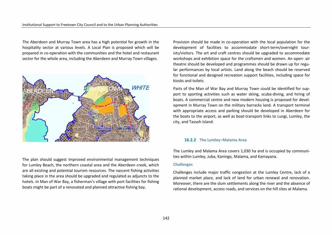
Institutional Support to Freetown City Council and to the Urban Planning Authorities
The Aberdeen and Murray Town area has a high potential for growth in the hospitality sector at various levels. A Local Plan is proposed which will be prepared in co-operation with the communities and the hotel and restaurant sector for the whole area, including the Aberdeen and Murray Town villages.
The plan should suggest improved environmental management techniques for Lumley Beach, the northern coastal area and the Aberdeen creek, which are all existing and potential tourism resources. The nascent fishing activities taking place in the area should be upgraded and regulated as adjuncts to the hotels. In Man of War Bay, a fisherman’s village with port facilities for fishing boats might be part of a renovated and planned attractive fishing bay.
Provision should be made in co-operation with the local population for the development of facilities to accommodate short-term/overnight tour-ists/visitors. The art and craft centres should be upgraded to accommodate workshops and exhibition space for the craftsmen and women. An open- air theatre should be developed and programmes should be drawn up for regu-lar performances by local artists. Land along the beach should be reserved for functional and designed recreation support facilities, including space for kiosks and toilets.
Parts of the Man of War Bay and Murray Town could be identified for sup-port to sporting activities such as water skiing, scuba-diving, and hiring of boats. A commercial centre and new modern housing is proposed for devel-opment in Murray Town on the military barracks land. A transport terminal with appropriate access and parking should be developed in Aberdeen for the boats to the airport, as well as boat-transport links to Lungi, Lumley, the city, and Tassoh Island.
16.2.2 The Lumley–Malama Area
The Lumley and Malama Area covers 1,030 ha and is occupied by communi-ties within Lumley, Juba, Kaningo, Malama, and Kamayana.
Challenges
Challenges include major traffic congestion at the Lumley Centre, lack of a planned market place, and lack of land for urban renewal and renovation. Moreover, there are the slum settlements along the river and the absence of rational development, access roads, and services on the hill sites at Malama.
142
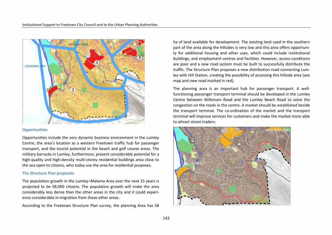
Institutional Support to Freetown City Council and to the Urban Planning Authorities
Opportunities
Opportunities include the very dynamic business environment in the Lumley Centre, the area’s location as a western Freetown traffic hub for passenger transport, and the tourist potential in the beach and golf course areas. The military barracks in Lumley, furthermore, present considerable potential for a high-quality and high-density multi-storey residential buildings area close to the sea open to citizens, who today use the area for residential purposes.
The Structure Plan proposals
The population growth in the Lumley–Malama Area over the next 15 years is projected to be 58,000 citizens. The population growth will make the area considerably less dense than the other areas in the city and it could experi-ence considerable in-migration from these other areas.
According to the Freetown Structure Plan survey, the planning Area has 58
ha of land available for development. The existing land used in the southern part of the area along the hillsides is very low and this area offers opportuni-ty for additional housing and other uses, which could include institutional buildings, and employment centres and facilities. However, access conditions are poor and a new road system must be built to successfully distribute the traffic. The Structure Plan proposes a new distribution road connecting Lum-ley with Hill Station, creating the possibility of accessing this hillside area (see map and new road marked in red).
The planning area is an important hub for passenger transport. A well-functioning passenger transport terminal should be developed in the Lumley Centre between Wilkinson Road and the Lumley Beach Road to solve the congestion on the roads in the centre. A market should be established beside the transport terminal. The co-ordination of the market and the transport terminal will improve services for customers and make the market more able to attract street traders.
143
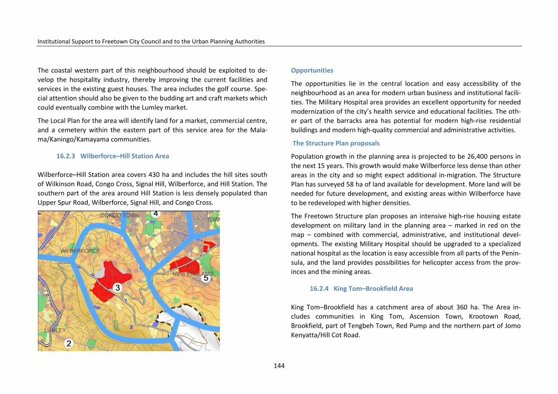
Institutional Support to Freetown City Council and to the Urban Planning Authorities
The coastal western part of this neighbourhood should be exploited to de-velop the hospitality industry, thereby improving the current facilities and services in the existing guest houses. The area includes the golf course. Spe-cial attention should also be given to the budding art and craft markets which could eventually combine with the Lumley market.
The Local Plan for the area will identify land for a market, commercial centre, and a cemetery within the eastern part of this service area for the Mala-ma/Kaningo/Kamayama communities.
16.2.3 Wilberforce–Hill Station Area
Wilberforce–Hill Station area covers 430 ha and includes the hill sites south of Wilkinson Road, Congo Cross, Signal Hill, Wilberforce, and Hill Station. The southern part of the area around Hill Station is less densely populated than Upper Spur Road, Wilberforce, Signal Hill, and Congo Cross.
Opportunities
The opportunities lie in the central location and easy accessibility of the neighbourhood as an area for modern urban business and institutional facili-ties. The Military Hospital area provides an excellent opportunity for needed modernization of the city’s health service and educational facilities. The oth-er part of the barracks area has potential for modern high-rise residential buildings and modern high-quality commercial and administrative activities.
The Structure Plan proposals
Population growth in the planning area is projected to be 26,400 persons in the next 15 years. This growth would make Wilberforce less dense than other areas in the city and so might expect additional in-migration. The Structure Plan has surveyed 58 ha of land available for development. More land will be needed for future development, and existing areas within Wilberforce have to be redeveloped with higher densities.
The Freetown Structure plan proposes an intensive high-rise housing estate development on military land in the planning area – marked in red on the map – combined with commercial, administrative, and institutional devel-opments. The existing Military Hospital should be upgraded to a specialized national hospital as the location is easy accessible from all parts of the Penin-sula, and the land provides possibilities for helicopter access from the prov-inces and the mining areas.
16.2.4 King Tom–Brookfield Area
King Tom–Brookfield has a catchment area of about 360 ha. The Area in-cludes communities in King Tom, Ascension Town, Krootown Road, Brookfield, part of Tengbeh Town, Red Pump and the northern part of Jomo Kenyatta/Hill Cot Road.
144
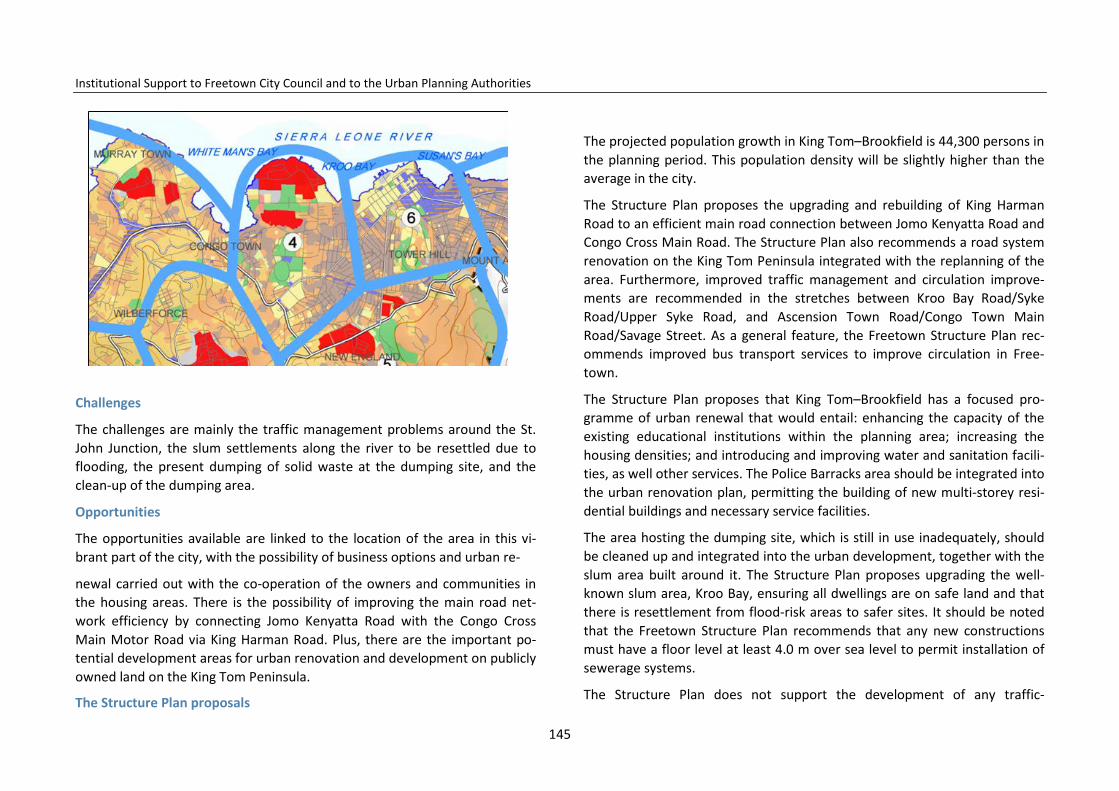
Institutional Support to Freetown City Council and to the Urban Planning Authorities
Challenges
The challenges are mainly the traffic management problems around the St. John Junction, the slum settlements along the river to be resettled due to flooding, the present dumping of solid waste at the dumping site, and the clean-up of the dumping area.
Opportunities
The opportunities available are linked to the location of the area in this vi-brant part of the city, with the possibility of business options and urban re-
newal carried out with the co-operation of the owners and communities in the housing areas. There is the possibility of improving the main road net-work efficiency by connecting Jomo Kenyatta Road with the Congo Cross Main Motor Road via King Harman Road. Plus, there are the important po-tential development areas for urban renovation and development on publicly owned land on the King Tom Peninsula.
The Structure Plan proposals
The projected population growth in King Tom–Brookfield is 44,300 persons in the planning period. This population density will be slightly higher than the average in the city.
The Structure Plan proposes the upgrading and rebuilding of King Harman Road to an efficient main road connection between Jomo Kenyatta Road and Congo Cross Main Road. The Structure Plan also recommends a road system renovation on the King Tom Peninsula integrated with the replanning of the area. Furthermore, improved traffic management and circulation improve-ments are recommended in the stretches between Kroo Bay Road/Syke Road/Upper Syke Road, and Ascension Town Road/Congo Town Main Road/Savage Street. As a general feature, the Freetown Structure Plan rec-ommends improved bus transport services to improve circulation in Free-town.
The Structure Plan proposes that King Tom–Brookfield has a focused pro-gramme of urban renewal that would entail: enhancing the capacity of the existing educational institutions within the planning area; increasing the housing densities; and introducing and improving water and sanitation facili-ties, as well other services. The Police Barracks area should be integrated into the urban renovation plan, permitting the building of new multi-storey resi-dential buildings and necessary service facilities.
The area hosting the dumping site, which is still in use inadequately, should be cleaned up and integrated into the urban development, together with the slum area built around it. The Structure Plan proposes upgrading the well-known slum area, Kroo Bay, ensuring all dwellings are on safe land and that there is resettlement from flood-risk areas to safer sites. It should be noted that the Freetown Structure Plan recommends that any new constructions must have a floor level at least 4.0 m over sea level to permit installation of sewerage systems.
The Structure Plan does not support the development of any traffic-
145
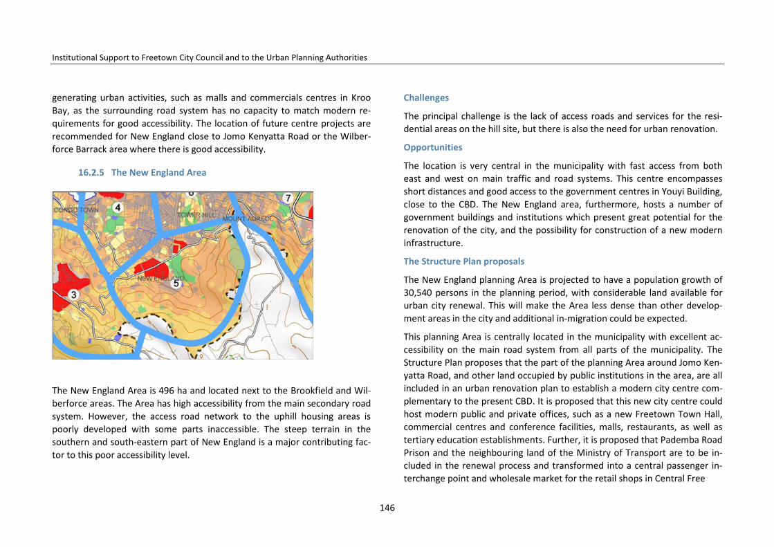
Institutional Support to Freetown City Council and to the Urban Planning Authorities
generating urban activities, such as malls and commercials centres in Kroo Bay, as the surrounding road system has no capacity to match modern re-quirements for good accessibility. The location of future centre projects are recommended for New England close to Jomo Kenyatta Road or the Wilber-force Barrack area where there is good accessibility.
16.2.5 The New England Area
The New England Area is 496 ha and located next to the Brookfield and Wil-berforce areas. The Area has high accessibility from the main secondary road system. However, the access road network to the uphill housing areas is poorly developed with some parts inaccessible. The steep terrain in the southern and south-eastern part of New England is a major contributing fac-tor to this poor accessibility level.
Challenges
The principal challenge is the lack of access roads and services for the resi-dential areas on the hill site, but there is also the need for urban renovation.
Opportunities
The location is very central in the municipality with fast access from both east and west on main traffic and road systems. This centre encompasses short distances and good access to the government centres in Youyi Building, close to the CBD. The New England area, furthermore, hosts a number of government buildings and institutions which present great potential for the renovation of the city, and the possibility for construction of a new modern infrastructure.
The Structure Plan proposals
The New England planning Area is projected to have a population growth of 30,540 persons in the planning period, with considerable land available for urban city renewal. This will make the Area less dense than other develop-ment areas in the city and additional in-migration could be expected.
This planning Area is centrally located in the municipality with excellent ac-cessibility on the main road system from all parts of the municipality. The Structure Plan proposes that the part of the planning Area around Jomo Ken-yatta Road, and other land occupied by public institutions in the area, are all included in an urban renovation plan to establish a modern city centre com-plementary to the present CBD. It is proposed that this new city centre could host modern public and private offices, such as a new Freetown Town Hall, commercial centres and conference facilities, malls, restaurants, as well as tertiary education establishments. Further, it is proposed that Pademba Road Prison and the neighbouring land of the Ministry of Transport are to be in-cluded in the renewal process and transformed into a central passenger in-terchange point and wholesale market for the retail shops in Central Free
146
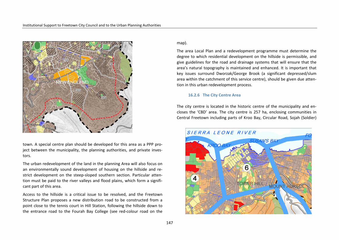
Institutional Support to Freetown City Council and to the Urban Planning Authorities
town. A special centre plan should be developed for this area as a PPP pro-ject between the municipality, the planning authorities, and private inves-tors.
The urban redevelopment of the land in the planning Area will also focus on an environmentally sound development of housing on the hillside and re-strict development on the steep-sloped southern section. Particular atten-tion must be paid to the river valleys and flood plains, which form a signifi-cant part of this area.
Access to the hillside is a critical issue to be resolved, and the Freetown Structure Plan proposes a new distribution road to be constructed from a point close to the tennis court in Hill Station, following the hillside down to the entrance road to the Fourah Bay College (see red-colour road on the
map).
The area Local Plan and a redevelopment programme must determine the degree to which residential development on the hillside is permissible, and give guidelines for the road and drainage systems that will ensure that the area’s natural topography is maintained and enhanced. It is important that key issues surround Dworzak/George Brook (a significant depressed/slum area within the catchment of this service centre), should be given due atten-tion in this urban redevelopment process.
16.2.6 The City Centre Area
The city centre is located in the historic centre of the municipality and en-closes the ‘CBD’ area. The city centre is 257 ha, enclosing communities in Central Freetown including parts of Kroo Bay, Circular Road, Sojah (Soldier)
147
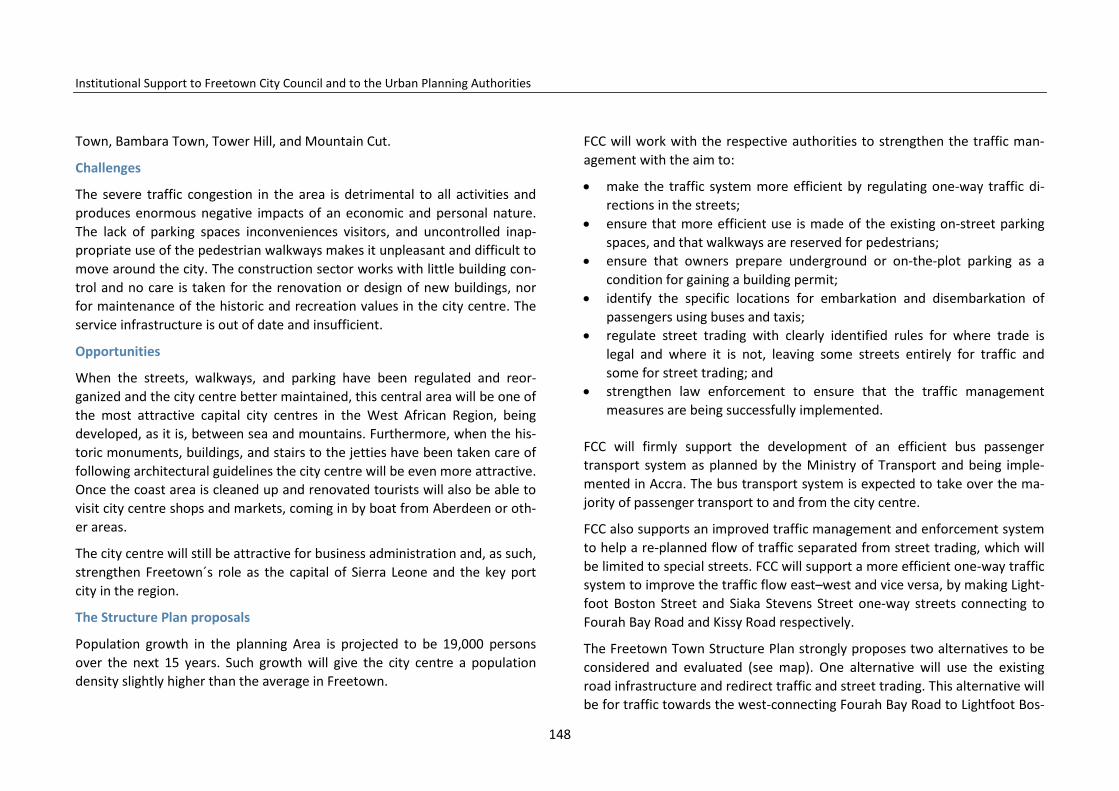
Institutional Support to Freetown City Council and to the Urban Planning Authorities
Town, Bambara Town, Tower Hill, and Mountain Cut.
Challenges
The severe traffic congestion in the area is detrimental to all activities and produces enormous negative impacts of an economic and personal nature. The lack of parking spaces inconveniences visitors, and uncontrolled inap-propriate use of the pedestrian walkways makes it unpleasant and difficult to move around the city. The construction sector works with little building con-trol and no care is taken for the renovation or design of new buildings, nor for maintenance of the historic and recreation values in the city centre. The service infrastructure is out of date and insufficient.
Opportunities
When the streets, walkways, and parking have been regulated and reor-ganized and the city centre better maintained, this central area will be one of the most attractive capital city centres in the West African Region, being developed, as it is, between sea and mountains. Furthermore, when the his-toric monuments, buildings, and stairs to the jetties have been taken care of following architectural guidelines the city centre will be even more attractive. Once the coast area is cleaned up and renovated tourists will also be able to visit city centre shops and markets, coming in by boat from Aberdeen or oth-er areas.
The city centre will still be attractive for business administration and, as such, strengthen Freetown´s role as the capital of Sierra Leone and the key port city in the region.
The Structure Plan proposals
Population growth in the planning Area is projected to be 19,000 persons over the next 15 years. Such growth will give the city centre a population density slightly higher than the average in Freetown.
FCC will work with the respective authorities to strengthen the traffic man-agement with the aim to:
• make the traffic system more efficient by regulating one-way traffic di-rections in the streets;
• ensure that more efficient use is made of the existing on-street parking spaces, and that walkways are reserved for pedestrians;
• ensure that owners prepare underground or on-the-plot parking as a condition for gaining a building permit;
• identify the specific locations for embarkation and disembarkation of passengers using buses and taxis;
• regulate street trading with clearly identified rules for where trade is legal and where it is not, leaving some streets entirely for traffic and some for street trading; and
• strengthen law enforcement to ensure that the traffic management measures are being successfully implemented.
FCC will firmly support the development of an efficient bus passenger transport system as planned by the Ministry of Transport and being imple-mented in Accra. The bus transport system is expected to take over the ma-jority of passenger transport to and from the city centre.
FCC also supports an improved traffic management and enforcement system to help a re-planned flow of traffic separated from street trading, which will be limited to special streets. FCC will support a more efficient one-way traffic system to improve the traffic flow east–west and vice versa, by making Light-foot Boston Street and Siaka Stevens Street one-way streets connecting to Fourah Bay Road and Kissy Road respectively.
The Freetown Town Structure Plan strongly proposes two alternatives to be considered and evaluated (see map). One alternative will use the existing road infrastructure and redirect traffic and street trading. This alternative will be for traffic towards the west-connecting Fourah Bay Road to Lightfoot Bos-
148
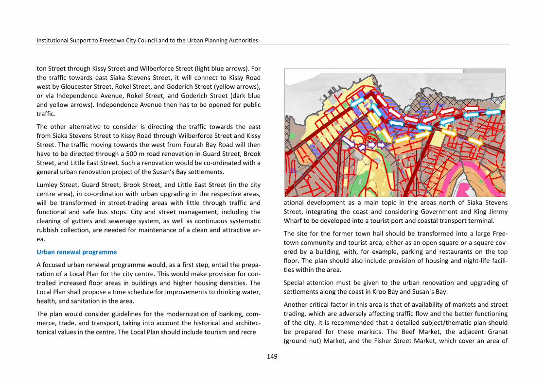
Institutional Support to Freetown City Council and to the Urban Planning Authorities
ton Street through Kissy Street and Wilberforce Street (light blue arrows). For the traffic towards east Siaka Stevens Street, it will connect to Kissy Road west by Gloucester Street, Rokel Street, and Goderich Street (yellow arrows), or via Independence Avenue, Rokel Street, and Goderich Street (dark blue and yellow arrows). Independence Avenue then has to be opened for public traffic.
The other alternative to consider is directing the traffic towards the east from Siaka Stevens Street to Kissy Road through Wilberforce Street and Kissy Street. The traffic moving towards the west from Fourah Bay Road will then have to be directed through a 500 m road renovation in Guard Street, Brook Street, and Little East Street. Such a renovation would be co-ordinated with a general urban renovation project of the Susan’s Bay settlements.
Lumley Street, Guard Street, Brook Street, and Little East Street (in the city centre area), in co-ordination with urban upgrading in the respective areas, will be transformed in street-trading areas with little through traffic and functional and safe bus stops. City and street management, including the cleaning of gutters and sewerage system, as well as continuous systematic rubbish collection, are needed for maintenance of a clean and attractive ar-ea.
Urban renewal programme
A focused urban renewal programme would, as a first step, entail the prepa-ration of a Local Plan for the city centre. This would make provision for con-trolled increased floor areas in buildings and higher housing densities. The Local Plan shall propose a time schedule for improvements to drinking water, health, and sanitation in the area.
The plan would consider guidelines for the modernization of banking, com-merce, trade, and transport, taking into account the historical and architec-tonical values in the centre. The Local Plan should include tourism and recre
ational development as a main topic in the areas north of Siaka Stevens Street, integrating the coast and considering Government and King Jimmy Wharf to be developed into a tourist port and coastal transport terminal.
The site for the former town hall should be transformed into a large Free-town community and tourist area; either as an open square or a square cov-ered by a building, with, for example, parking and restaurants on the top floor. The plan should also include provision of housing and night-life facili-ties within the area.
Special attention must be given to the urban renovation and upgrading of settlements along the coast in Kroo Bay and Susan´s Bay.
Another critical factor in this area is that of availability of markets and street trading, which are adversely affecting traffic flow and the better functioning of the city. It is recommended that a detailed subject/thematic plan should be prepared for these markets. The Beef Market, the adjacent Granat (ground nut) Market, and the Fisher Street Market, which cover an area of
149
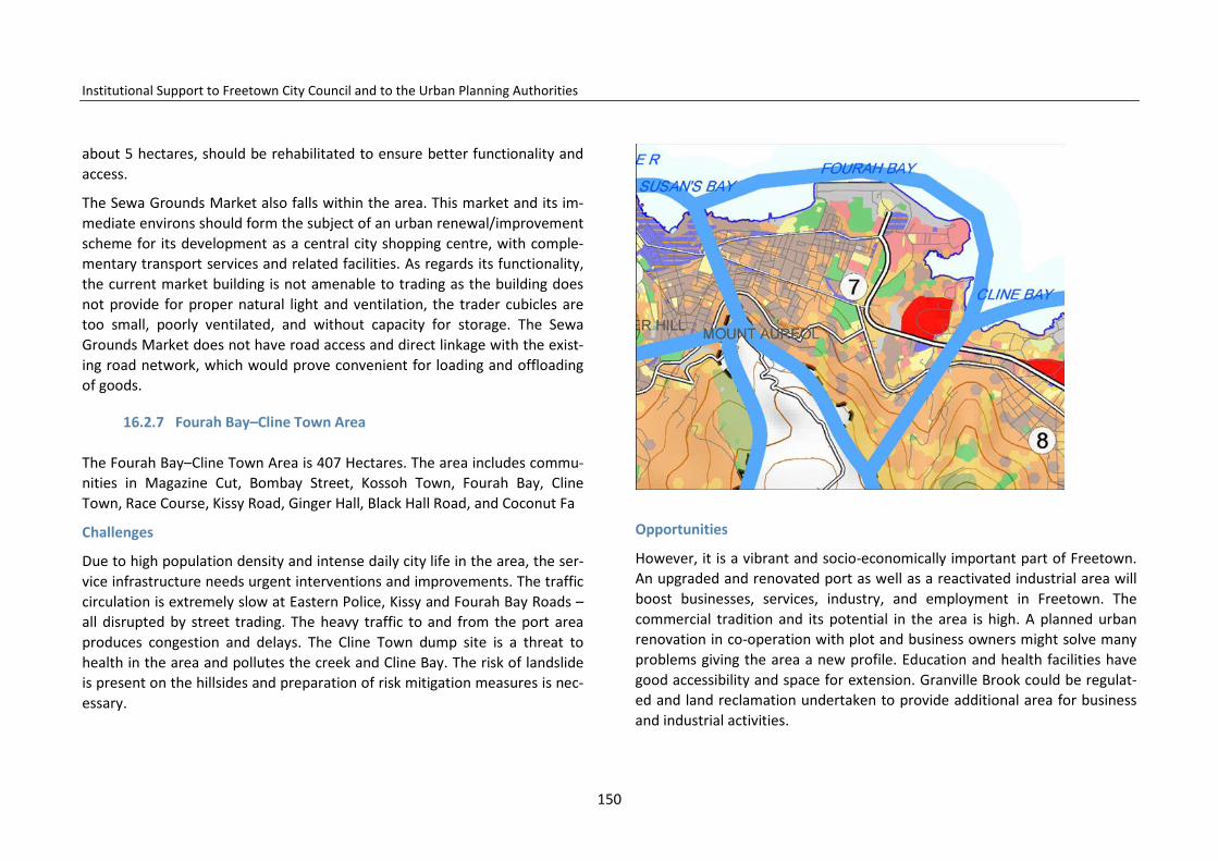
Institutional Support to Freetown City Council and to the Urban Planning Authorities
about 5 hectares, should be rehabilitated to ensure better functionality and access.
The Sewa Grounds Market also falls within the area. This market and its im-mediate environs should form the subject of an urban renewal/improvement scheme for its development as a central city shopping centre, with comple-mentary transport services and related facilities. As regards its functionality, the current market building is not amenable to trading as the building does not provide for proper natural light and ventilation, the trader cubicles are too small, poorly ventilated, and without capacity for storage. The Sewa Grounds Market does not have road access and direct linkage with the exist-ing road network, which would prove convenient for loading and offloading of goods.
16.2.7 Fourah Bay–Cline Town Area
The Fourah Bay–Cline Town Area is 407 Hectares. The area includes commu-nities in Magazine Cut, Bombay Street, Kossoh Town, Fourah Bay, Cline Town, Race Course, Kissy Road, Ginger Hall, Black Hall Road, and Coconut Fa
Challenges
Due to high population density and intense daily city life in the area, the ser-vice infrastructure needs urgent interventions and improvements. The traffic circulation is extremely slow at Eastern Police, Kissy and Fourah Bay Roads – all disrupted by street trading. The heavy traffic to and from the port area produces congestion and delays. The Cline Town dump site is a threat to health in the area and pollutes the creek and Cline Bay. The risk of landslide is present on the hillsides and preparation of risk mitigation measures is nec-essary.
Opportunities
However, it is a vibrant and socio-economically important part of Freetown. An upgraded and renovated port as well as a reactivated industrial area will boost businesses, services, industry, and employment in Freetown. The commercial tradition and its potential in the area is high. A planned urban renovation in co-operation with plot and business owners might solve many problems giving the area a new profile. Education and health facilities have good accessibility and space for extension. Granville Brook could be regulat-ed and land reclamation undertaken to provide additional area for business and industrial activities.
150
Institutional Support to Freetown City Council and to the Urban Planning Authorities
The Structure Plan proposals
The population growth in the planning area is projected to be 98,000 persons over the next 15 years. This estimated population growth is considerably higher than the average in Freetown and the new population will not find dwellings in the area but must move to other parts of Freetown. Additional immigration will make the situation even more complicated.
FCC supports the plans to make the traffic system more efficient, separating traffic from street trading, and identifying more efficient one-way roads to improve the traffic flow. Kissy Road should be the main one-way street carry-ing traffic eastwards, while Fourah Bay Road the main one-way street carry-ing traffic westwards. In between these main roads streets will distribute the traffic.
Access to the Queen Elizabeth II port area will be further regulated and the port expanded by improving berthing and storage facilities, and other port-related services.
The Dove Cot Market should be upgraded and improved to become a prima-ry market for the receiving and distribution of bulk produce for markets in the municipality. The central abattoir adjacent to the Dove Cot Market should be converted into the principal cold-storage facility for meat, fish, and vegetables. There should be the inclusion of more institutional buildings in this service area, as well as the establishment of commercial/banking and ancillary services.
A Local Plan giving guidelines for urban renovation in this Area could include plans for construction of an additional east-west-travelling road to facilitate traffic flow. Bus stops and transport terminals must be located where need-ed, bearing in mind the need for bus stops close to markets and commercial areas, as well as hospitals and education facilities.
A Local Plan must be prepared for the area, identifying intervention areas
and specify a phased schedule. The Local Plan must identify the need for urban renovation plans including phases and priorities to improve the hous-ing conditions in areas such as the upper, habitable landward parts of the depressed coastal settlements of Fourah Bay, Kossoh Town, and Cline Town. The plan should consider higher housing densities and indicate how transport, sewerage, water, sanitary, and health services should be provided. A time frame for the urban renovation plans should be given.
Resettlement will be needed for the depressed settlements in environmen-tally sensitive areas like the Moa Wharf, Cline Bay, the Granville Brook valley, and the flood plain. The Granville Brook dump site should be relocated and a programme devised that would arrange for the eventual use of barges to transport solid waste for deposit at a prepared and safe new final solid-waste deposit site.
16.2.8 Kissy Men’s Mess Area
Kissy Men’s Mess is 660 ha and includes the communities in Kissy Dockyard, Kissy Bypass, Mamba Ridge, Kissy, Kissy Men’s Mess, Kissy Mental and Kissy Low Cost. The north-eastern border falls along the Sierra Leone River.
Challenges
The Bay Bureh Road needs upgrading to primary-road status with less direct access from commercial activities along the road. Instead the old Waterloo road must take over the role as traffic distributor. As the future population densities are estimated to be high, urban health and sanitation need urgent intervention and improvement in the residential areas. The location of the dense community south-east of the Wellington Creek, within less than 150 m from the oil storage facilities, poses a considerable disaster risk if the tanks were to explode. The residential communities sprawled across the hill site
151

Institutional Support to Freetown City Council and to the Urban Planning Authorities
need special attention as the hillside is steep and houses may slide if founda-tions are not well constructed.
Opportunities
The area has available land for industrial and service activities close to the city´s main road system, the export/import deep-sea port, and the ferry transport linking to Lungi and the airport. Furthermore, the industrial land is centrally located close to the city´s high-level service provision and profes-sional resources. For the Freetown municipality, the area is economically active and potentially a strong employment area. Moreover, land is available for future needed health and education facilities.
The Structure Plan proposals
The population growth in the planning Area is projected to be 195,000 per-sons over the next 15 years. This estimated population growth cannot be accommodated and additional immigration to this part of the town will make the situation even more complicated.
People have to move to other areas of Freetown. As the population density in the area is very high, all urban renewal has to prepare for multi-storey housing following the FCC guidelines.
The old Waterloo road must be upgraded and regulated to take over the full role as traffic distributor in the area. It is presently linked to Bay Bureh Road at only three or four junctions. A Local Plan for the area must look into the redefinition of the road system in the area.
Furthermore, the Freetown Structure Plan proposes the construction of a new hillside road leaving from the Kissy area, following Hospital Road, climb-ing the hillside to provide access to the dispersed and sprawling houses along the hillside all the way down to Allen Town.
The Local Plan in addition must focus on improvement and intensification of existing land use where possible and urban renewal in selected areas. The poor condition of the neighbourhood roads and lanes within the catchment area should be addressed through a comprehensive road rehabilitation pro-gramme.
Furthermore, it should be considered how existing institutions could be ren-ovated and developed with more rationality and densities. The institutions are, among others, the “trade centre” and the adjacent schools, the ‘peace market’ and other existing markets, as well as the ferry terminal. The Local Plan shall also consider relocation of the existing polluting industries and workshops and prepare for more environmentally friendly ones.
The Local Plan for the area shall evaluate the current use of land in the indus-trial areas with the intention of determining a more efficient use of land and
152
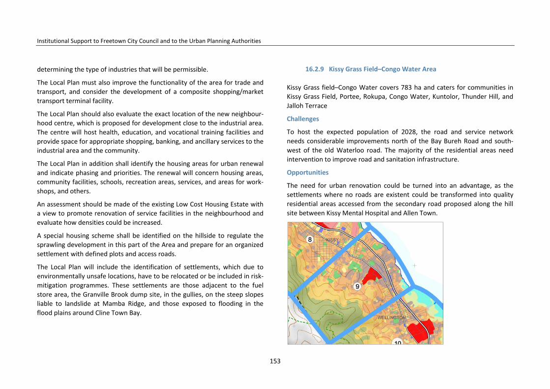
Institutional Support to Freetown City Council and to the Urban Planning Authorities
determining the type of industries that will be permissible.
The Local Plan must also improve the functionality of the area for trade and transport, and consider the development of a composite shopping/market transport terminal facility.
The Local Plan should also evaluate the exact location of the new neighbour-hood centre, which is proposed for development close to the industrial area. The centre will host health, education, and vocational training facilities and provide space for appropriate shopping, banking, and ancillary services to the industrial area and the community.
The Local Plan in addition shall identify the housing areas for urban renewal and indicate phasing and priorities. The renewal will concern housing areas, community facilities, schools, recreation areas, services, and areas for work-shops, and others.
An assessment should be made of the existing Low Cost Housing Estate with a view to promote renovation of service facilities in the neighbourhood and evaluate how densities could be increased.
A special housing scheme shall be identified on the hillside to regulate the sprawling development in this part of the Area and prepare for an organized settlement with defined plots and access roads.
The Local Plan will include the identification of settlements, which due to environmentally unsafe locations, have to be relocated or be included in risk- mitigation programmes. These settlements are those adjacent to the fuel store area, the Granville Brook dump site, in the gullies, on the steep slopes liable to landslide at Mamba Ridge, and those exposed to flooding in the flood plains around Cline Town Bay.
16.2.9 Kissy Grass Field–Congo Water Area
Kissy Grass field–Congo Water covers 783 ha and caters for communities in Kissy Grass Field, Portee, Rokupa, Congo Water, Kuntolor, Thunder Hill, and Jalloh Terrace
Challenges
To host the expected population of 2028, the road and service network needs considerable improvements north of the Bay Bureh Road and south- west of the old Waterloo road. The majority of the residential areas need intervention to improve road and sanitation infrastructure.
Opportunities
The need for urban renovation could be turned into an advantage, as the settlements where no roads are existent could be transformed into quality residential areas accessed from the secondary road proposed along the hill site between Kissy Mental Hospital and Allen Town.
153

Institutional Support to Freetown City Council and to the Urban Planning Authorities
The Structure Plan proposals
The population growth in this planning Area is projected to be 210,000 per-sons over the next 15 years. This population growth will create densities con-siderably higher than the average in Freetown and families could be ex-pected to leave for other less dense parts of the city. Additional immigration into the Area will not be possible. All new housing construction must be en-couraged to follow the FCC guidelines on multi-storey housing, thereby cre-ating denser housing areas.
The short-term improvement strategy for this development area will be ad-dressing the existing basic infrastructure and services gaps. Priority in this context should be directed at the road network and the water distribution system, which are near a state of non-functioning. The road improvement should enhance access to the Rokupa and Portee Wharves, which are the
principal trade ports in the service centre. Given that the economy within this service centre is driven mainly by transport and trade, immediate measures should be taken to provide for better performance of the Rokupa and Portee junctions.
The Local Plan to be developed for the Area will address all key issues relat-ing to: the development of a comprehensive road network to serve commu-nities like those in Thunder Hill, Kuntolor, Robis, and Mayenkineh; the defini-tion of development limits to which development is permissible on the hillsides and an indication of where and how housing, workshop, and market areas, education and health facilities, recreation, and other community func-tions and services can be developed in the area.
16.2.10 Wellington–Pamuronko Area
Wellington–Pamuronko is 967 ha and consists of the communities in upper Congo Water, Peacock Farm, Wellington Industrial Estate, Robis, Ma-
154

Institutional Support to Freetown City Council and to the Urban Planning Authorities
yenkineh, Pamuronko Old Wharf, and Bottom Oku.
Challenges
Challenges include: considerable population growth, poor road networks and service infrastructure in coastal and hill areas, the need for urban renovation of residential areas, the destruction of the mangrove area, congestion along the Bay Bureh Road, inappropriate use of the old Waterloo road, low-level use of the industrial area, and low health-service coverage.
Opportunities
The opportunities include: improving future education and health services by
construction of health and education facilities, as well as housing estates on the old industrial estate. In addition, creating a new centre in Wellington will strengthen local services and employment by renovating and modernizing the use of the industrial area. Improving the capacity of Bay Bureh Road, by
changing the use of the old Waterloo road to that of a distribution road, and renovating the road system on the hill sites and intensifying use of the hillside as a housing area will also be of benefit.
Population growth and future population densities
The population growth in the planning area is projected to be 150,000 per-sons over the next 15 years. This estimated population growth will make the Wellington–Pamuronko Area considerably less dense than the average densi-ty in Freetown. The Area will be able to provide space for dwellers from oth-er parts of Freetown if the FCC recommendations for new densities in hous-ing areas are being followed.
The Structure Plan proposals
The Local Plan for Wellington Pamuronko will be comprehensive. The plan will review the main and access roads with a view to ensuring that the road system is functional and linked up with the housing areas on the higher land.
The Local Plan will evaluate further the possibilities of a major renewal pro-ject such as that proposed for the Wellington Centre and Housing Scheme Pilot Project on the old industrial estate site, creating space for new service facilities and housing. The Local Plan will, furthermore, address the key issues such as housing, education and health facilities, industry and workshops, as well as commercial and market places.
The Wellington Centre and Housing Scheme Pilot
The plan will also identify the limit for physical development in the critical terrain along the coast and on the hilltop, and identify areas for recreation.
155

Institutional Support to Freetown City Council and to the Urban Planning Authorities
Given that a significant proportion of land is covered by mangrove (110.3 hectares) and forest (185.6 hectares), the plan will address environmental issues that will ensure the preservation of such vital resources.
16.2.11 Allen Town Area
Allen Town Area is located at the eastern extremities of the Freetown City Council administrative boundary adjacent to the northern boundary of the Western Area District Council and has a catchment area of 940.5 ha enclosing communities in Upper and Lower Allen Town (Allen Town I and II).
Challenges
There are limited schools, health and recreation facilities outside the Bay Bureh Road area. Water and electricity services in the Allen Town Area are also concentrated in the areas along the Bai Bureh and old Waterloo roads with less service outside these areas.
Opportunities
The opportunities for development are the low density housing which by planned urban renovation can be restructured with the needed and corre-sponding access roads, as well as considerable areas for urban development in the areas of Allen Town opposite Crafton. Here, there are various devel-opment options such as possibilities for housing projects, industry, transport, and wholesale market projects.
Population growth and future population densities
The population growth in Allen Town is projected to be 38,400 persons over the next 15 years. This estimated population growth will make Allen Town far less than the average Freetown population density. Thus, Allen Town togeth-er with Wellington–Pamuronko, Aberdeen–Murray Town, Lumley–Malama, Wilberforce–Hill Station, and New England are all areas where new housing development schemes should be prioritized to prepare Freetown for the future.
The Structure Plan proposals
The Local Plan for Allen Town will be a comprehensive plan including two new important development areas in front of Crafton. The plan will make a review of the main road system and the access roads, as well as identifying the location of the new proposed distribution road at Kissy–Allen Town.
The Local Plan will include the proposed local service centre linked up to the old coast road. The Freetown Structure Plan proposes that an area reserved for sport and recreation will be used for the service centre and that a new site for playing and sports fields will be identified north of the Bay Bureh Road on recovered land, while other recreation areas will be identified be-tween the housing areas. The plan will address the key land-use issues relat-ed to housing, education and health facilities, industry and workshops, as well as commerce and market places.
156
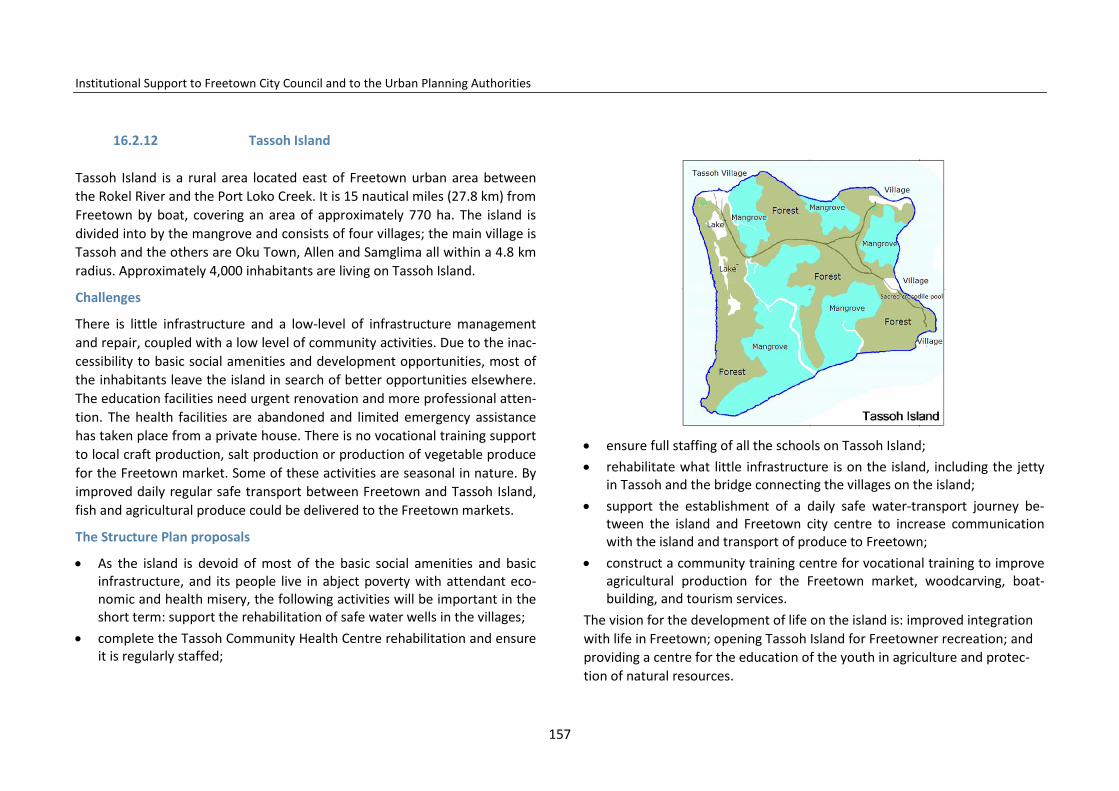
Institutional Support to Freetown City Council and to the Urban Planning Authorities
16.2.12 Tassoh Island
Tassoh Island is a rural area located east of Freetown urban area between the Rokel River and the Port Loko Creek. It is 15 nautical miles (27.8 km) from Freetown by boat, covering an area of approximately 770 ha. The island is divided into by the mangrove and consists of four villages; the main village is Tassoh and the others are Oku Town, Allen and Samglima all within a 4.8 km radius. Approximately 4,000 inhabitants are living on Tassoh Island.
Challenges
There is little infrastructure and a low-level of infrastructure management and repair, coupled with a low level of community activities. Due to the inac-cessibility to basic social amenities and development opportunities, most of the inhabitants leave the island in search of better opportunities elsewhere. The education facilities need urgent renovation and more professional atten-tion. The health facilities are abandoned and limited emergency assistance has taken place from a private house. There is no vocational training support to local craft production, salt production or production of vegetable produce for the Freetown market. Some of these activities are seasonal in nature. By improved daily regular safe transport between Freetown and Tassoh Island, fish and agricultural produce could be delivered to the Freetown markets.
The Structure Plan proposals
• As the island is devoid of most of the basic social amenities and basic infrastructure, and its people live in abject poverty with attendant eco-nomic and health misery, the following activities will be important in the short term: support the rehabilitation of safe water wells in the villages;
• complete the Tassoh Community Health Centre rehabilitation and ensure it is regularly staffed;
• ensure full staffing of all the schools on Tassoh Island; • rehabilitate what little infrastructure is on the island, including the jetty
in Tassoh and the bridge connecting the villages on the island; • support the establishment of a daily safe water-transport journey be-
tween the island and Freetown city centre to increase communication with the island and transport of produce to Freetown;
• construct a community training centre for vocational training to improve agricultural production for the Freetown market, woodcarving, boat-building, and tourism services.
The vision for the development of life on the island is: improved integration with life in Freetown; opening Tassoh Island for Freetowner recreation; and providing a centre for the education of the youth in agriculture and protec-tion of natural resources.
157

Institutional Support to Freetown City Council and to the Urban Planning Authorities
158
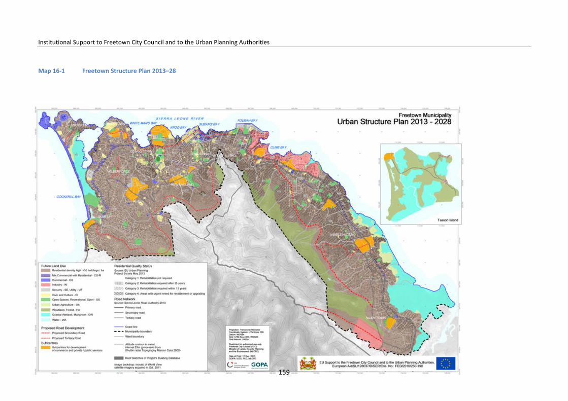
Institutional Support to Freetown City Council and to the Urban Planning Authorities
Map 16-1 Freetown Structure Plan 2013–28
159

Institutional Support to Freetown City Council and to the Urban Planning Authorities
17 Consultation And Participation in the Preparation of the Draft Freetown Structure Plan
The Urban Planning Work Group has been involving the Freetown communi-ties and key stakeholders in the preparation of the Freetown Structure Plan during the plan preparation period February 2012–December 2013.
Community consultation took place when the Urban Planning Work Group in March–April 2012 interviewed 400 families in the Freetown wards asking for Structure Plan relevant information and contributions. Contributions have been analysed and included in this report.
The following stakeholders have further in meetings and interviews contrib-uted to the preparation of the Freetown Structure Plan. They are among others: FCC, Freetown councillors, FCC Chiefs of Departments, the Law Of-fice, the World Bank Office in Freetown, the Registrar’s Office, the Ministry of Education, the Ministry of Health, the EPA, Sierra Leone Ports Authority, Galaxy Radio, the Association of Engineers, SL Import Association, the Asso-ciation of Architects, and the Imam of the Central Mosque. During the meet-ings the stakeholders, they repeatedly pointed out the traffic congestion and street trading as key problems.
FCC councillors have also been kept informed about the on-going Freetown Structure Plan work. One meeting took place in May and the other in Octo-ber 2013. During April–May 2013 each councillor was involved in the review of present land use in their ward. The Urban Planning Work Group has also had two meeting with the councillors, introducing the content and proce-dures of the structure planning and the draft proposals for the Structure Plan´s goals. In May–June 2013 the Urban Planning Project and Freetown Structure Plan´s content and preparation were discussed with development directors from other local governments in Sierra Leone. The Freetown urban
planning development challenges were discussed.
In July 2013 the Urban Planning Work Group visited Tassoh Island and met community leaders and members in three villages. In November Tassoh Is-land was visited again to collect additional data and information on historic cultural places on the island.
In October 2013 the proposals for FSP developing goals were presented to the Directors of the FCC Departments. In November 2013 the Urban Planning Project and the Structure Plan work were presented to Freetown engineers in a meeting of their national association. And in December 2013 the direc-tion and planning staff in the MLCPE were introduced to the main content of the Structure Plan. Finally, in January 2014 the preparation of the plan and draft development main goals were presented to invited representatives from ministries, local governments, universities, donor organisations, and the private sector at the British Council in Freetown.
However, the plan has not been put to consultation yet with the Freetown communities and private sector representatives. The task is due to be im-plemented by FCC and the MLCPE during 2014.
160
Institutional Support to Freetown City Council and to the Urban Planning Authorities
18 Follow-up on the Draft Freetown Structure Plan
18.1 The consultation process
The present draft Freetown Structure Plan has been considered by FCC and the MLCPE. The next phase is the consultation of the plan visions and pro-posals with the Freetown communities, Freetown NGOs, and private busi-ness, as well as the relevant public institutions.
This purpose of the consultation process and the timetable should be public-ly announced and comprehensively communicated to the public and the process will take two to four months. Press releases and appearances for radio and TV will support the process. FCC and the MLCPE should be respon-sible for arranging the meetings and activities, and gathering the documenta-tion of the received comments and proposals from the communities and the consulted stakeholders, which is of paramount importance.
FCC and the MLCPE will consider the received comments and proposals and revise the draft Freetown Structure Plans accordingly. The legal formalities related to the approval of the plan should be revised and the plan formally approved. Then FCC and the MLCPE will have a policy paper and guidelines to be used for decisions on concrete further planning initiatives and concrete development projects.
18.2 Further urban planning initiatives
The Freetown Structure Plan has subdivided the FCC area into minor plan-ning areas as described in the plan proposal. More detailed Local Plans should be prepared for these areas which consider the establishment of local future service centres and, among others, the planning issues for the areas addressed in the Structure Plan. The Local Plans should be prepared accord-
ing to the resources available. The draft Freetown Structure Plan proposes the following priorities. However, special planning issues or actual develop-ment projects might change the priorities.
Tourism: Aberdeen–Murray Town Area (1), Lumley–Malama Area (2), City Centre Area (6), and Tassoh Island.
Administration, business, commerce: malls and multi-storey modern hous-ing: New England Area (5) and Wilberforce Area (3).
Industry: Fourah Bay–Cline Town Area (7), Kissy Men’s Mess Area (8), and Allen Town (11).
Urban renovation and slum upgrading: King Tom–Brookfield Area (4), City Centre Area (5), Fourah Bay–Cline Town Area (7), and Kissy Grass Field–Congo Water Area(9).
Urban sanitation: King Tom–Brookfield Area (4) and Fourah Bay–Cline Town Area (7)
Housing: Lumley–Malama Area (2), New England Area (5), Wellington–Pamuronko Area (10), Kissy Grass Field–Congo Water Area (9), and Allen Town Area.
Disaster mitigation: Aberdeen–Murray Town Area (1), King Tom–Brookfield Area (4), City Centre Area (6), Fourah Bay–Cline Town Area (7) and Welling-ton–Pamuronko Area (10), and Kissy Men’s Mess Area (8).
Protection of the natural urban environment: Aberdeen–Murray Town Area (1), Lumley–Malama Area (2), King Tom–Brookfield Area (4), Fourah Bay–Cline Town Area (7), and Wellington–Pamuronko Area (10).
161
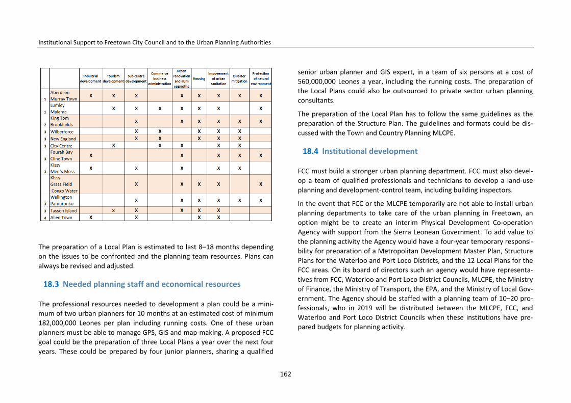
Institutional Support to Freetown City Council and to the Urban Planning Authorities
The preparation of a Local Plan is estimated to last 8–18 months depending on the issues to be confronted and the planning team resources. Plans can always be revised and adjusted.
18.3 Needed planning staff and economical resources
The professional resources needed to development a plan could be a mini-mum of two urban planners for 10 months at an estimated cost of minimum 182,000,000 Leones per plan including running costs. One of these urban planners must be able to manage GPS, GIS and map-making. A proposed FCC goal could be the preparation of three Local Plans a year over the next four years. These could be prepared by four junior planners, sharing a qualified
senior urban planner and GIS expert, in a team of six persons at a cost of 560,000,000 Leones a year, including the running costs. The preparation of the Local Plans could also be outsourced to private sector urban planning consultants.
The preparation of the Local Plan has to follow the same guidelines as the preparation of the Structure Plan. The guidelines and formats could be dis-cussed with the Town and Country Planning MLCPE.
18.4 Institutional development
FCC must build a stronger urban planning department. FCC must also devel-op a team of qualified professionals and technicians to develop a land-use planning and development-control team, including building inspectors.
In the event that FCC or the MLCPE temporarily are not able to install urban planning departments to take care of the urban planning in Freetown, an option might be to create an interim Physical Development Co-operation Agency with support from the Sierra Leonean Government. To add value to the planning activity the Agency would have a four-year temporary responsi-bility for preparation of a Metropolitan Development Master Plan, Structure Plans for the Waterloo and Port Loco Districts, and the 12 Local Plans for the FCC areas. On its board of directors such an agency would have representa-tives from FCC, Waterloo and Port Loco District Councils, MLCPE, the Ministry of Finance, the Ministry of Transport, the EPA, and the Ministry of Local Gov-ernment. The Agency should be staffed with a planning team of 10–20 pro-fessionals, who in 2019 will be distributed between the MLCPE, FCC, and Waterloo and Port Loco District Councils when these institutions have pre-pared budgets for planning activity.
162

Institutional Support to Freetown City Council and to the Urban Planning Authorities
18.5 Monitoring and evaluation
18.5.1 Monitoring
Monitoring aims at following how approved and decided planning activities are being implemented; whether or not deadlines are being met; how the inputs required for the implementation of the planning (resources) are being supplied; and how they are used.
The monitoring covers different levels of concern including monitoring of performance, monitoring of risks and assumptions and monitoring of im-pacts.
18.5.1.1 Recommended approach for monitoring The following are recommended as approaches for the monitoring of the implementation process of this plan,
i. FCC and the MLCPE shall constitute a monitoring team to track pro-gress of work and plan implementation every six months. The rationale is to ensure that proposals and activities are implemented according to schedule through efficient use of resources.
ii. There shall also be routine site visits and inspections by the FCC Devel-opment Planning Committee or its delegation to ensure that ongoing planning activities are in conformity with proposals as contained in the Structure Plan.
iii. FCC Development Planning Committee at their sittings shall review progress reports on resources committed to implementation and re-port to Freetown City Council.
18.5.1.2 Indicators for monitoring The chosen indicators for monitoring should be related to progress in ful-filling the needed planning goals and activities identified in the Structure Plan. The following list mentions examples of recommended indicators that should form the basis for the monitoring of this plan:
1. Has the Structure Plan been distributed and introduced to all municipal departments, stakeholders, and relevant community members?
2. Has the Structure Plan been made publicly accessibly? 3. Has the Urban Planning Department been staffed with sufficiently quali-
fied planners? 4. Has the preparation of the Local Plans been initiated following the priori-
tized working programme? 5. Have measures been taken to revise the projection of population growth
in Freetown? 6. Have local stakeholders, private sector, developers, NGOs, or landown-
ers been invited to discuss opportunities of PPP urban renovation, slum upgrading, or business development projects in the municipality?
7. Have initiatives been taken to establish one-way traffic in the city centre streets?
8. Have initiatives been taken to discuss with the responsible public institu-tions and eventual donor agencies the closure of the final dumping sites in Freetown and establishment of new ones outside the city?
9. Have Area Action Plans been initiated to introduce the protection zones around the creeks and along the coast and rivers?
10. Have mitigation activities started in co-operation with families living in flooding- and landslide-prone areas?
11. Has revision of the Structure Plan been planned? 12. And others.
163
Institutional Support to Freetown City Council and to the Urban Planning Authorities
18.5.2 Evaluation
Evaluation is a half-yearly periodic assessment of the planning and staff per-formance, professionalism, efficiency, effectiveness, sustainability, and im-pact in relation to the approved yearly working agenda for the Urban Plan-ning Department.
18.5.2.1 Agencies/institutions for evaluation The following institutions shall be responsible for the evaluation of all plan-ning projects and development control activities being implemented.
i. The Municipal Development Planning Committee ii. The external audit.
18.5.2.2 The contents of the evaluation i. Review of final reports on all projects and activities implemented by
the Municipal Development Planning Committee; ii. Review of the Structure Plan every four to five years by the Municipal
Development Planning Committee; iii. Review of institutional performance in terms of the respective
roles/responsibilities performed by institutions in the course of im-plementation as contained in the implementation plan.
18.5.2.3 Indicators for evaluation The following are some of the indicators for evaluating the Freetown Struc-ture Plan in terms of how well the proposals, programmes, and projects slat-ed in the plan have been achieved in relation to the set targets.
1. Have Structure Plans been prepared for all the designated areas? 2. Are the Structure Plans in conformity with the MLCPE guidelines for
land-use plans? 3. Is the plan implementation being monitored? 4. Have the required land reservations for future infrastructure and settle-
ment development been negotiated and established? 5. Have any land reservations been encroached upon? 6. Are all new land uses in conformity with the Freetown Structure Plan? 7. Is urban development control following the guidelines for protection of
the coastline and disaster-prone areas?
164
Institutional Support to Freetown City Council and to the Urban Planning Authorities
18.6 SWOT analysis
During the preparation of the Structure Plan a SWOT analysis has been made for the development challenges and opportunities in Freetown. The SWOT analysis is presented in the following.
STRENGTHS
• Beautiful landscape with streams, rivers, coasts, and beaches • Good climate, average 27° Celsius • Topography promotes good natural drainage • Good natural ventilation by breezes • Green areas in the mountains • Existence of educational institutions • Existing service facilities for economic development • Flooding risks from the sea only in limited areas • Good natural deep-sea port • Good soil for construction • Sufficient drinking-water catchment areas close to the city • The belt structure of the city between sea and hills makes possible func-
tional future development • Solid passenger demand for bus transportation • Long coastline which can be used for supplementary transport • Historical places • City with many different qualities and spectacular landscapes • Space available for urban renovation • Availability of existing basic infrastructure that can be used and improved • Funds and technical assistance for the institutional development of urban
planning.
WEAKNESSES
• Areas with topography that is too steep • High potential for landslides and erosion • Uncontrolled deforestation taking place • Many streams and rivers need bridges and culverts built • Only two development directions • Little virgin land for new development • Location of the deep-sea port in the city centre • Lack of urban maintenance • Lack of institutional capacity to plan and control urban development • Lack of qualified professional urban planners • Little investment • Little maintenance of recreation areas • Little preparedness for investments • Low institutional performance regarding
o project management and implementation o monitoring o professional performance
• No attention to historical values, monuments, buildings, and neighbour-hoods
• Too many delays in implementation of urban renovation.
165
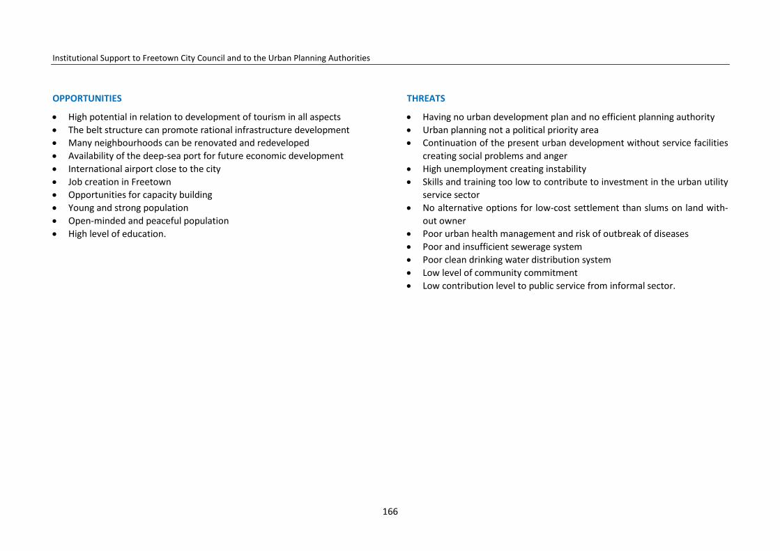
Institutional Support to Freetown City Council and to the Urban Planning Authorities
OPPORTUNITIES
• High potential in relation to development of tourism in all aspects • The belt structure can promote rational infrastructure development • Many neighbourhoods can be renovated and redeveloped • Availability of the deep-sea port for future economic development • International airport close to the city • Job creation in Freetown • Opportunities for capacity building • Young and strong population • Open-minded and peaceful population • High level of education.
THREATS
• Having no urban development plan and no efficient planning authority • Urban planning not a political priority area • Continuation of the present urban development without service facilities
creating social problems and anger • High unemployment creating instability • Skills and training too low to contribute to investment in the urban utility
service sector • No alternative options for low-cost settlement than slums on land with-
out owner • Poor urban health management and risk of outbreak of diseases • Poor and insufficient sewerage system • Poor clean drinking water distribution system • Low level of community commitment • Low contribution level to public service from informal sector.
166