integrate, consolidate and disseminate european flood risk ... · integrate, consolidate and...
TRANSCRIPT
Integrate, Consolidate
and Disseminate
European Flood Risk
Management Research
CRUE Co-ordinator: John Goudie (Defra)
Project Contract No: ERAC-CT-2004-515742
Project Website: www.crue-eranet.net
1st CRUE ERA-Net Common Call Effectiveness and Efficiency of Non-structural Flood Risk Management Measures
CRUE Research Report No I-1:
Systematisation, evaluation and context conditions of structural and non-structural measures for flood risk reduction
FLOOD-ERA Joint Report
Prepared by the Joint Project Consortium consisting of Funded by Jochen Schanze (Joint project co-ordinator) Gérard Hutter, Alfred Olfert Leibniz Institute of Ecological and Regional Development (IOER)
Edmund C. Penning-Rowsell, Dennis Parker, Tim Harries Flood Hazard Research Centre, Middlesex University in co-operation with Alan Werritty, University of Dundee
Hans-Peter Nachtnebel, Hubert Holzmann, Clemens Neuhold Institute of Water Management, Hydrology and Hydraulic Engineering University of Natural Resources and Applied Life Science (BOKU)
Volker Meyer, Christian Kuhlicke, Anne Schildt Helmholtz Centre for Environmental Research - UFZ
Beate Jessel, Philipp Königer Chair for Strategies of Landscape Management Technische Universität München (TUM)

© 2008 CRUE Funding Initiative on Flood Risk Management Research All rights reserved.
DISCLAIMER
Systematisation, evaluation and context conditions of structural and non-structural measures for flood risk reduction (FLOOD-ERA Joint Report) CRUE Research Report No I-1 This report was prepared with the support of the CRUE Funding Initiative on Flood Risk Management Research. While reasonable care has been taken in preparing this publication to ensure that information is appropriate and valid it have to be considered that the views, conclusions and recommendations expressed herein are those of the authors and most not necessarily endorse the views of the CRUE ERA-NET or the respective Funding bodies involved. The intent of the research reports is to provide relevant information and to stimulate discussion of those having an interest in flood risk management. The results and conclusions of all reports produced under the CRUE Funding Initiative on Flood Risk Management Research are made available to policy-makers and stakeholders at all levels, research funding bodies, universities, industries, practitioners, and the general public by way of the CRUE website (http://www.crue-eranet.net). This publication is copyright, but wide dissemination is encouraged. Requests and inquiries concerning reproduction and rights should be addressed to the CRUE Dissemination Manager on [email protected]. Researcher’s Contact Details Project partner #1 (Co-ordinator) ◄ Jochen Schanze Leibniz Institute of Ecological and Regional Development – IOER (DE) [email protected] Project partner #2 ◄ Edmund C. Penning-Rowsell Flood Hazard Research Centre, Middlesex University (UK) [email protected] Project partner #3 ◄ Hans-Peter Nachtnebel Institute of Water Management, Hydrology and Hydraulic Engineering University of Natural Resources and Applied Life Science - BOKU (AT) [email protected] Project partner #4 ◄ Volker Meyer Helmholtz Centre for Environmental Research – UFZ (DE) [email protected] Project partner #5 ◄ Philipp Königer Chair for Strategies of Landscape Management Technische Universität München – TUM (DE) [email protected]
In submitting this report, the researcher’s have agreed to CRUE publishing this material in its edited form.
CRUE Contact Details CRUE Co-ordinator Area 2D, Ergon House Horseferry Road London SW1P 2AL. United Kingdom
Email: [email protected] Web: http://www.crue-eranet.net/
Published in November 2008
ERA-NET CRUE is funded by the ERA-NET Scheme under the 6th Framework Programme General Directorate for Research in the European Commission Contract number: ERAC
Proposed bibliographic citation Schanze J, Hutter G, Penning-Rowsell E, Nachtnebel H-P, Meyer V, Werritty A, Harries T, Holzmann H, Jessel B, Koeniger P, Kuhlicke C, Neuhold C, Olfert A, Parker D, Schildt A (2008), Systematisation, evaluation and context conditions of structural and non-structural measures for flood risk reduction. FLOOD-ERA Joint Report, published by ERA-NET CRUE, http://www.crue-eranet.net.
CRUE FUNDING INITIATIVE ON FLOOD RISK MANAGEMENT RESEARCH FLOOD-ERA
III
ERA-NET CRUE Funding Initiative on Flood Risk Management Research
Risk Assessment and Risk Management: Effectiveness and Efficiency of Non-structural Flood Risk Management Measures
Systematisation, evaluation and context conditions of structural and non-structural measures for flood risk reduction
FLOOD-ERA Joint Report CRUE Research Report No I-1 Prepared by Funded by
Jochen Schanze (Joint project co-ordinator), Gérard Hutter, Alfred Olfert Leibniz Institute of Ecological and Regional Development (IOER) BMBF (DE)
Edmund C. Penning-Rowsell, Tim Harries Flood Hazard Research Centre, Middlesex University in co-operation with Alan Werritty, University of Dundee
Defra, SE-ERAD (UK)
Hans-Peter Nachtnebel, Hubert Holzmann, Clemens Neuhold Institute of Water Management, Hydrology and Hydraulic Engineering, University of Natural Resources and Applied Life Science (BOKU)
BMLFUW (AT)
Volker Meyer, Christian Kuhlicke, Anne Schildt Helmholtz Centre for Environmental Research – UFZ
BMBF (DE)
Beate Jessel, Philipp Königer Chair for Strategies of Landscape Management Technische Universität München (TUM)
BMBF (DE)
CRUE FUNDING INITIATIVE ON FLOOD RISK MANAGEMENT RESEARCH FLOOD-ERA
IV
1st CRUE Funding Initiative on FRM research ERA-Net CRUE is a network of European government departments who directly fund flood risk management programmes and related research actions. In order to tackle the challenge of rising flood risk and to develop effective policies and risk management practices, policy-makers and key stakeholders need a strong evidence base. Evidence-based policy-making is the key to modern, forward-looking strategies for dealing with increasing flood risk. Trans-boundary and trans-national flood risk management issues are becoming more and more important, requiring in particular joint research and development initiatives. The creation and implementation of a European research area in flood risk management – as intended by the CRUE ERA-Net - is an important contribution to an improved trans-national perspective for flood-related research in Europe. Besides co-ordinating research between Member States, CRUE aims to contribute towards the presentation of research needs with its own trans-nationally based funding initiatives. Common trans-national research calls initiated by the partner countries are a principal activity within the CRUE ERA-Net which can be considered as specific actions to respond to current policy and development needs in Europe. With the launch of the first CRUE common call, a first step toward the integration of flood research in Europe was made. The topic “Risk Assessment and Risk Management: Effectiveness and Efficiency of Non-structural Flood Risk Management Measures” was selected by six of the CRUE partner countries through an intensive consultation process and is to a great extent based on developments in European flood risk management policy (e.g. EU Floods Directive). In particular, the call was designed to investigate and critically assess the effectiveness and efficiency of non-structural measures in comparison to structural measures and to identify barriers to implementation of these "soft" techniques. The call was an incentive to develop innovative methodological approaches. Moreover, it challenged researchers across Europe to integrate knowledge across different disciplines such as natural and social sciences, and engineering. Each of the seven successful joint projects within CRUE’s 1st Funding Initiative for FRM research was designed to understand different national approaches to the use and appraisal of non-structural measures, explore what is successful, and what can be improved in terms of efficiency and effectiveness of such measures themselves. The research results presented in this report will provide policy-makers with a better understanding of how FRM as a part of integrated river basin management can deliver multiple benefits, for example reduced flood risk and improved environmental quality. I feel confident that the outcome of this research will be a valuable contribution to national policy development and the improvement of flood risk-related practice. John Goudie ERA-Net CRUE Co-ordinator, Defra, UK
CRUE FUNDING INITIATIVE ON FLOOD RISK MANAGEMENT RESEARCH FLOOD-ERA
V
Summary for Decision Makers
FLOOD-ERA deals with the systematisation, evaluation and comparison of structural measures (SM) and non-structural measures (NSM) and takes context conditions of decision making on both types of measures like risk perception, funding mechanisms, and formal institutions into account. The study is important because up to now there is considerable uncertainty about how NSM can be compared with SM in a consistent way with regard to advantages and disadvantages. The overall aim of the project is to make important steps towards preventive flood risk management strategies in European Member States through (i) improving the comparative evaluation of structural (SM) and non-structural measures (NSM) and through (ii) analysing the influence of context conditions (like risk perception of decision makers) on the choice of measures. FLOOD-ERA begins with the assumption that current flood risk management (FRM) practice does not exploit all potential benefits of NSM. The project therefore is explorative in nature. Five major objectives have been defined as follows:
1) To systemise structural and non-structural measures,
2) To develop a methodology for the evaluation of the effectiveness and efficiency of SM and NSM,
3) To analyse context conditions of decision makers with a potential to influence the choice of SM and NSM,
4) To identify the site-specific effectiveness and efficiency of measures and the influence of selected context conditions,
5) To derive recommendations for the improvement of flood risk management strategies. The scope of FLOOD-ERA objectives requires a combined research design integrating different kinds of approaches. According to the major areas of interest of the project three principal approaches may be distinguished:
• A systematisation of SM and NSM,
• A normative approach to the evaluation of SM and NSM,
• A descriptive approach to analyse the context conditions of decision makers. Since research especially on non-structural measures as part of FRM strategies is still in an early stage, conceptual work on evaluation and identifying the context conditions play an important role. In addition, empirical work should supply real cases for testing draft concepts and for inclusion of empirical findings in the theoretical consideration. For this reason 6 case studies have been chosen within the countries funding the FLOOD-ERA project. They deal with catchments or reaches of the following rivers: Lower Thames River (Teddington, England), Clyde River (Glasgow, Scotland), Raab River (Gleisdorf, Austria), Mulde River (Erlln and Grimma, Germany), Elbe River (Dresden, Germany), Mangfall River (Kolbermoor, Germany). Systematisation of measures The classification depends on the purpose of distinctions and clustering. In terms of flood risk management there seems to be at least three major aspects for sorting measures:
• the construction of measures,
• the effect of measures,
• the function of measures.
CRUE FUNDING INITIATIVE ON FLOOD RISK MANAGEMENT RESEARCH FLOOD-ERA
VI
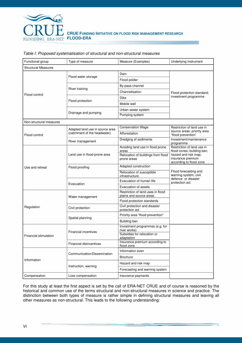
Table I: Proposed systematisation of structural and non-structural measures
Functional group Type of measure Measure (Examples) Underlying instrument
Structural Measures
Dam Flood water storage
Flood polder
By-pass channel River training
Channelisation
Dike Flood protection
Mobile wall
Urban sewer system
Flood control
Drainage and pumping Pumping system
Flood protection standard; investment programme
Non-structural measures
Conservation tillage Adapted land use in source area (catchment of the headwater) Afforestation
Restriction of land use in source areas; priority area “flood prevention” Flood control
River management Dredging of sediments Investment/maintenance
programme Avoiding land use in flood prone areas
Land use in flood-prone area Relocation of buildings from flood prone areas
Restriction of land use in flood zones; building ban; hazard and risk map; insurance premium according to flood zone
Flood proofing Adapted construction
Relocation of susceptible infrastructure
Evacuation of human life
Use and retreat
Evacuation Evacuation of assets
Flood forecasting and warning system; civil defence or disaster protection act
Restriction of land uses in flood plains and source areas Water management Flood protection standards
Civil protection Civil protection and disaster protection act
Priority area “flood prevention”
Regulation
Spatial planning Building ban
Investment programmes (e.g. for river works) Financial incentives Subsidies for relocation or adaptation
Financial stimulation
Financial disincentives Insurance premium according to flood zone
Information even Communication/Dissemination
Brochure
Hazard and risk map Information
Instruction, warning Forecasting and warning system
Compensation Loss compensation Insurance payments
For this study at least the first aspect is set by the call of ERA-NET CRUE and of course is reasoned by the historical and common use of the terms structural and non-structural measures in science and practice. The distinction between both types of measure is rather simple in defining structural measures and leaving all other measures as non-structural. This leads to the following understanding:
CRUE FUNDING INITIATIVE ON FLOOD RISK MANAGEMENT RESEARCH FLOOD-ERA
VII
• Structural measures are interventions in the flood risk system based on works of hydraulic engineering.
• Non-structural measures are all other interventions. In contrast to the previous use of the term structural measures here it is recommended not to include the intended effects of flood control and protection in the definition. One reason for that is that also non-measures like land management and sediment dredging can contribute to lowering the flood discharge or the water level respectively. Another reason is that risk reduction effects cannot be measured on the basis of the hazard only. Since the differentiation of SM and NSM does not allow for further clustering, it is proposed to enhance the systematisation applying the third aspect. The latter refers to intervention mechanisms of measures without specifying their effects. Accordingly no restrictions appear with respect to comparative evaluation of different measures. The following functions are derived from literature: flood control, use and retreat, regulation, financial stimulation, information, and compensation. Normative approach to develop a methodology for SM and NSM Effect indicators, the criteria effectiveness and efficiency and related methods have been tested regarding their applicability for NSM and particularly for the comparison of SM and NSM in the FLOOD-ERA case studies. Based on these finding, an outline methodology is derived. Due to the focus of the project and the limited number of cases in a few EU Member States this methodology is just a step towards a more comprehensive and generic approach.
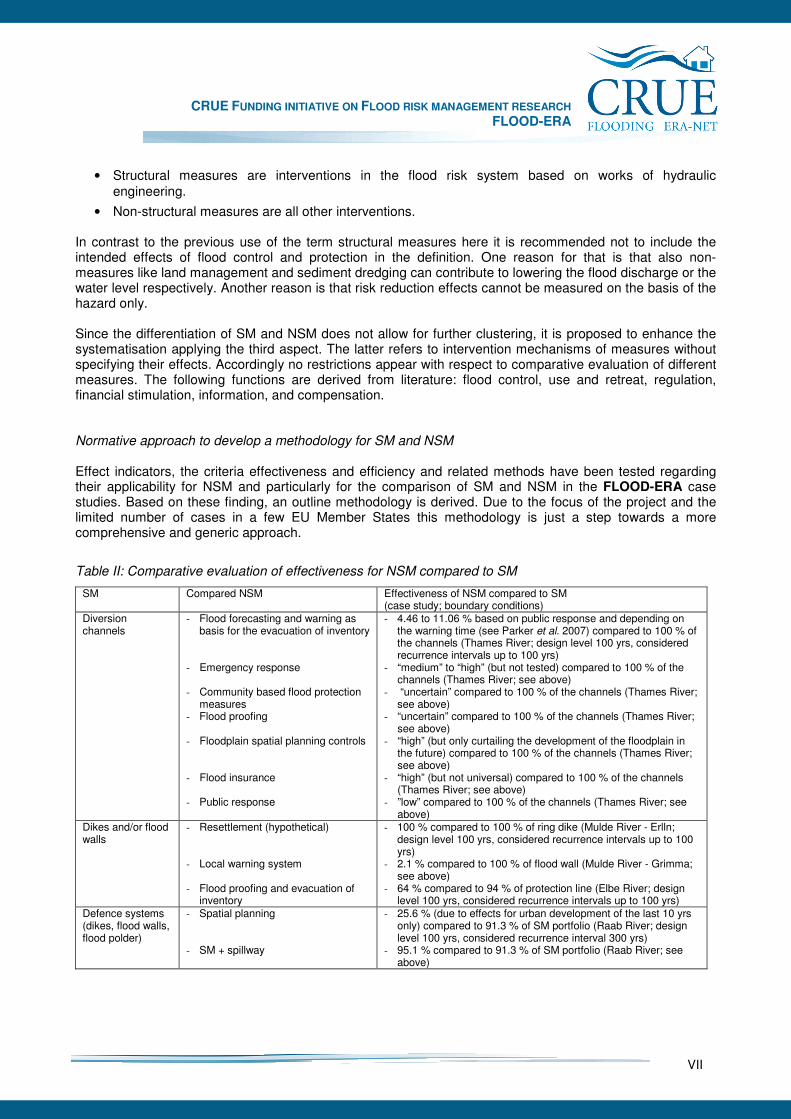
Table II: Comparative evaluation of effectiveness for NSM compared to SM
SM Compared NSM Effectiveness of NSM compared to SM (case study; boundary conditions)
Diversion channels
- Flood forecasting and warning as basis for the evacuation of inventory
- Emergency response - Community based flood protection
measures - Flood proofing - Floodplain spatial planning controls - Flood insurance - Public response
- 4.46 to 11.06 % based on public response and depending on the warning time (see Parker et al. 2007) compared to 100 % of the channels (Thames River; design level 100 yrs, considered recurrence intervals up to 100 yrs)
- “medium” to “high” (but not tested) compared to 100 % of the channels (Thames River; see above)
- “uncertain” compared to 100 % of the channels (Thames River; see above)
- “uncertain” compared to 100 % of the channels (Thames River; see above)
- “high” (but only curtailing the development of the floodplain in the future) compared to 100 % of the channels (Thames River; see above)
- “high” (but not universal) compared to 100 % of the channels (Thames River; see above)
- ”low” compared to 100 % of the channels (Thames River; see above)
Dikes and/or flood walls
- Resettlement (hypothetical) - Local warning system
- Flood proofing and evacuation of
inventory
- 100 % compared to 100 % of ring dike (Mulde River - Erlln; design level 100 yrs, considered recurrence intervals up to 100 yrs)
- 2.1 % compared to 100 % of flood wall (Mulde River - Grimma; see above)
- 64 % compared to 94 % of protection line (Elbe River; design level 100 yrs, considered recurrence intervals up to 100 yrs)
Defence systems (dikes, flood walls, flood polder)
- Spatial planning - SM + spillway
- 25.6 % (due to effects for urban development of the last 10 yrs only) compared to 91.3 % of SM portfolio (Raab River; design level 100 yrs, considered recurrence interval 300 yrs)
- 95.1 % compared to 91.3 % of SM portfolio (Raab River; see above)
CRUE FUNDING INITIATIVE ON FLOOD RISK MANAGEMENT RESEARCH FLOOD-ERA
VIII
Some EU Member States, their countries or professional associations have already developed elaborate practical guidelines for the evaluation of risk reduction projects. In contrast FLOOD-ERA focuses the comparative evaluation of SM and NSM. As it can be shown at least for a certain group of NSM an evaluation and comparison with SM appears to be feasible. Hereby both individual measures as well as portfolios of measures are considered. To meets the requirements for a comparative evaluation the following working steps of the evaluation procedure are proposed:
1. Definition of the scope of the comparative evaluation,
2. Assignment of quantified objective(s),
3. Measurement of effects, benefits and costs of SM and NSM,
4. Determination and comparison of effectiveness,
5. Determination and comparison of efficiency,
6. Sensitivity analysis,
7. Overall comparison of SM and NSM. Empirical results on the comparison of effectiveness are presented in Table II. In essence the examples of this study indicate that flood forecasting and warning in combination with the evacuation of inventory seems to be of minor effectiveness. Instead flood proofing leads to a certain degree of effectiveness at least in one case. For the other case quantitative results are not available so far. Spatial planning could be of high effectiveness if it is used from an early stage of the floodplain development onwards or a resettlement is feasible. The latter will be restricted to small settlements due to high costs. All other measures are either of minor significance or cannot be assessed yet.
Table III: Comparative evaluation of benefit-cost ratios for NSM compared to SM
SM Compared NSM Benefit-cost ratios (BCR) of NSM compared to SM (case study; boundary conditions)
Diversion channels
- Flood forecasting and warning as basis for the evacuation of inventory
- Emergency response - Community based flood protection
measures - Flood proofing - Floodplain spatial planning controls - Flood insurance - Public response
- “low” (BCR likely to be <1.0) compared to “high” (4:1 till 11:1) of the channels (Thames River; design level 100 yrs, considered recurrence intervals up to 100 yrs)
- “very low” (BCR ~1.0) compared to “high” (4:1 till 11:1) of the channels (Thames River; see above)
- “low” to “medium” (BCR 1.75 to 2.2 (8.0)) compared to “high” (4:1 till 11:1) of the channels (Thames River; see above)
- “medium” (to “low”?) compared to “high” of the channels (Thames River; see above)
- probably “very high” compared to “high” of the channels (Thames River; see above)
- “high” (BCR > 1.0) compared to “high” (4:1 till 11:1) of the channels (Thames River; see above)
- ”medium” to “high” compared to “high” of the channels (Thames River; see above)
Dikes and/or flood walls
- Resettlement (hypothetical) - Local warning system
- Flood proofing and evacuation of
inventory
- BCR 0.28 (mean) compared to BCR 0.45 (mean) of ring dike (Mulde River- Erlln; design level 100 yrs, considered recurrence intervals up to 100 yrs)
- BCR 0.97 (mean) compared to BCR 0.58 (mean) of flood wall (Mulde River - Grimma; see above)
- BCR 11.6 compared to BCR 7.2 of protection line (Elbe River; design level 100 yrs, considered recurrence intervals up to 100 yrs)
As a conclusion a comparison of SM and NSM with respect to their effectiveness is methodologically feasible for the measures mentioned before. Results from the cases studies underline that there are at least a few NSM with a potential effectiveness like this can be reached with SM. However knowledge on this is still in its infancy. For future research it is important to also consider recurrence intervals above the common design
CRUE FUNDING INITIATIVE ON FLOOD RISK MANAGEMENT RESEARCH FLOOD-ERA
IX
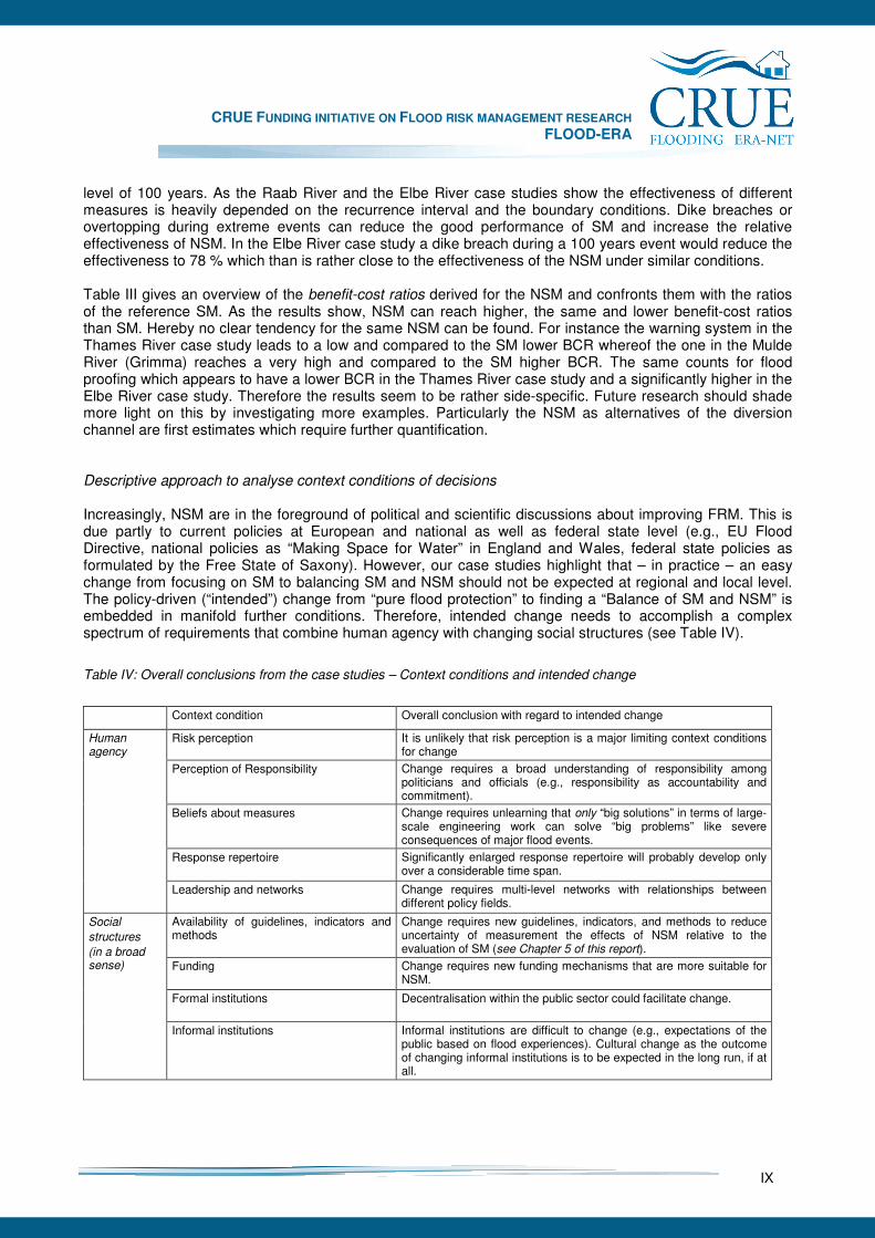
level of 100 years. As the Raab River and the Elbe River case studies show the effectiveness of different measures is heavily depended on the recurrence interval and the boundary conditions. Dike breaches or overtopping during extreme events can reduce the good performance of SM and increase the relative effectiveness of NSM. In the Elbe River case study a dike breach during a 100 years event would reduce the effectiveness to 78 % which than is rather close to the effectiveness of the NSM under similar conditions. Table III gives an overview of the benefit-cost ratios derived for the NSM and confronts them with the ratios of the reference SM. As the results show, NSM can reach higher, the same and lower benefit-cost ratios than SM. Hereby no clear tendency for the same NSM can be found. For instance the warning system in the Thames River case study leads to a low and compared to the SM lower BCR whereof the one in the Mulde River (Grimma) reaches a very high and compared to the SM higher BCR. The same counts for flood proofing which appears to have a lower BCR in the Thames River case study and a significantly higher in the Elbe River case study. Therefore the results seem to be rather side-specific. Future research should shade more light on this by investigating more examples. Particularly the NSM as alternatives of the diversion channel are first estimates which require further quantification. Descriptive approach to analyse context conditions of decisions Increasingly, NSM are in the foreground of political and scientific discussions about improving FRM. This is due partly to current policies at European and national as well as federal state level (e.g., EU Flood Directive, national policies as “Making Space for Water” in England and Wales, federal state policies as formulated by the Free State of Saxony). However, our case studies highlight that – in practice – an easy change from focusing on SM to balancing SM and NSM should not be expected at regional and local level. The policy-driven (“intended”) change from “pure flood protection” to finding a “Balance of SM and NSM” is embedded in manifold further conditions. Therefore, intended change needs to accomplish a complex spectrum of requirements that combine human agency with changing social structures (see Table IV).
Table IV: Overall conclusions from the case studies – Context conditions and intended change
Context condition Overall conclusion with regard to intended change
Risk perception It is unlikely that risk perception is a major limiting context conditions for change
Perception of Responsibility
Change requires a broad understanding of responsibility among politicians and officials (e.g., responsibility as accountability and commitment).
Beliefs about measures Change requires unlearning that only “big solutions” in terms of large-scale engineering work can solve “big problems” like severe consequences of major flood events.
Response repertoire
Significantly enlarged response repertoire will probably develop only over a considerable time span.
Human agency
Leadership and networks
Change requires multi-level networks with relationships between different policy fields.
Availability of guidelines, indicators and methods
Change requires new guidelines, indicators, and methods to reduce uncertainty of measurement the effects of NSM relative to the evaluation of SM (see Chapter 5 of this report).
Funding
Change requires new funding mechanisms that are more suitable for NSM.
Formal institutions
Decentralisation within the public sector could facilitate change.
Social
structures
(in a broad sense)
Informal institutions
Informal institutions are difficult to change (e.g., expectations of the public based on flood experiences). Cultural change as the outcome of changing informal institutions is to be expected in the long run, if at all.
CRUE FUNDING INITIATIVE ON FLOOD RISK MANAGEMENT RESEARCH FLOOD-ERA
X
Implications for and recommendations to Decision Makers FLOOD-ERA focuses on improving FRM with SM and NSM at different spatial levels within the public realm. Implications address what the results mean for decision makers (like politicians and officials) that are involved in deciding about SM and NSM in terms of stand-alone approaches and portfolios of measures. The following gives conclusions on major outcomes for evaluating SM and NSM as content dimension and context dimension of FRM strategies. Considering a broad range of measures in a systematic manner To facilitate communication between decision makers, the need for a unambiguouis terminology of SM and NSM is evident. FLOOD-ERA accordingly provides a consistent systematisation which focuses different functions of risk reduction instead of supposed effects of measures. It therefore allows for an unbiased comparison of different mechanisms of measures like this is the case for NSM and SM. However a number of alternative classifications exist and affect a sound communication of decision makers. Hence it is recommended to strengthen the discussion on the various typologies with the aim to derive an agreed version at least for FRM practice. The CRUE ERA-NET as well as the implementation process of the EU Floods Directive are advantageous opportunities in this respect. Evaluating measures with regard to effectiveness and efficiency The outline methodology of FLOOD-ERA collates the state of the art of evaluating the effectiveness and efficiency in flood risk management and beyond shows how advances can be made by evaluating NSM and comparing them with SM. Empirical findings from the case studies illustrate potential evaluation results. Since a few Member States already introduced guidelines for benefit-cost analyses, the outline methodology can be used for enhancing these approaches particular with respect to a further consideration of NSM and their objective balancing with SM. Methods have been developed and tested to evaluate NSM as prerequisite for their comparison with SM (see section 5.5). A flood forecasting and warning model allows for calculating risk reduction effects. GIS-based approaches as well as hydraulic and damage models have been applied to analyse spatial planning measures in a physical manner. FLOOD-ERA shows that, despite different evaluation traditions in European Member States like England, Scotland, Austria and Germany, there is sufficient coherence to adopt a common approach to effectiveness and efficiency evaluation of SM and NSM. Therefore results justify efforts to attempt a harmonisation on European level while implementing the Floods Directive. Building the team and organising process management Especially the Scottish and the English case studies illustrate the importance of team building with manifold institutional relations from the outset. The likeliness of “fair” and unbiased comparison between SM and NSM increases when representatives of different institutions responsible for the measures under consideration are included into the process right from the beginning. For instance, the task of evaluating strategic alternatives for reducing flood risk in the long view in large catchments like the Elbe river basin would have to include representatives from (i) different policy fields (like water management, spatial planning), (ii) spatial levels (national, regional, local) and (iii) different European Member States (Germany, Czech Republic). Hence, it is important to find a fit between (possible) strategic alternatives for reducing flood risk and the institutions involved from the outset. Evaluation that takes this into consideration can count as institutional approach to evaluating SM and NSM. Furthermore, it is important to organise the process management of evaluating strategic alternatives. This is more difficult than sometimes expected. Process managers should have expertise in evaluating alternatives for reducing flood risk, but they should not be biased towards a specific solution (e.g., SM).
CRUE FUNDING INITIATIVE ON FLOOD RISK MANAGEMENT RESEARCH FLOOD-ERA
XI
Contents
Summary for Decision Makers ......................................................................................................................V
Contents .......................................................................................................................................................XI 1 Introduction ........................................................................................................................................... 1
2 Objectives ............................................................................................................................................. 2
3 Research design ................................................................................................................................... 3
3.1 Systematisation of structural measures (SM) and non-structural measures (NSM).................... 3
3.2 Normative approach of evaluating SM and NSM........................................................................ 4
3.3 Descriptive approach to analyse the context conditions of decision makers.............................. 4
3.4 Combined research design .......................................................................................................... 4
3.5 Case studies................................................................................................................................. 6
4 Systematisation of SM and NSM .......................................................................................................... 7
4.1 Background: The emergence of NSM from a historical viewpoint .............................................. 7
4.2 Systematisation of SM and NSM: Existing classifications .......................................................... 7
4.3 Proposed systematisation of SM and NSM ............................................................................... 10
5 Methodology for evaluating the effectiveness and efficiency of SM and NSM................................ 13
5.1 Indicators of effects .................................................................................................................... 14
5.2 Criteria and methods for evaluating measures: Overview ........................................................ 15
5.3 Evaluating the effectiveness ...................................................................................................... 16
5.3.1 Objectives .............................................................................................................................. 17
5.3.2 Determination of effectiveness............................................................................................... 18
5.4 Evaluating the efficiency ............................................................................................................ 18
5.4.1 Cost-effectiveness ................................................................................................................. 18
5.4.2 Net present value and benefit-cost ratio ................................................................................ 19
5.5 Outline methodology for the comparative evaluation of SM and NSM ...................................... 28
5.5.1 Overall Procedure .................................................................................................................. 28
5.5.2 Definition of the scope of the comparative evaluation ........................................................... 28
5.5.3 Assignment of quantified objectives ...................................................................................... 29
5.5.4 Measurement of effects, benefits and costs of SM and NSM................................................ 29
5.5.5 Determination and comparison of effectiveness.................................................................... 33
5.5.6 Determination and comparison of efficiency.......................................................................... 34
5.5.7 Sensitivity analysis................................................................................................................. 36
5.5.8 Overall comparison of SM and NSM ..................................................................................... 36
5.6 Remaining challenges of evaluating SM and NSM................................................................... 37
6 Context conditions for the choice of SM and NSM ............................................................................ 39
6.1 Context conditions to explain decisions about measures – Approach and initial expectations. 40
6.2 Context conditions to explain decisions about measures in the case studies ........................... 45
6.2.1 Content and context of decisions in the cases ...................................................................... 47
6.2.2 Explaining decisions in the cases .......................................................................................... 49
6.3 Implications for a methodology to evaluate SM and NSM ........................................................ 55
7 European Case Studies ...................................................................................................................... 59
7.1 Lower Thames River (Teddington)............................................................................................. 60
7.1.1 Introduction ............................................................................................................................ 60
7.1.2 The case study area .............................................................................................................. 60
7.1.3 Flood risk management in the case study area ..................................................................... 62
7.1.4 Aims of the case study........................................................................................................... 63
7.1.5 Efficiency analysis of flood risk management measures in England..................................... 63
7.1.6 Evaluation of efficiency and effectiveness of possible flood risk management measures .... 64
7.1.7 Summary: efficiency and effectiveness of possible flood risk management measures......... 71
7.1.8 Transaction costs................................................................................................................... 72
7.1.9 Assessing the Lower Thames ‘context factors’: Applied methodology.................................. 72
CRUE FUNDING INITIATIVE ON FLOOD RISK MANAGEMENT RESEARCH FLOOD-ERA
XII
7.1.10 Supporting the implementation of NSM............................................................................. 74
7.1.11 Conclusions ....................................................................................................................... 74
7.2 Clyde River (Glasgow) ............................................................................................................... 76
7.2.1 Introduction ............................................................................................................................ 76
7.2.2 Background – case study area .............................................................................................. 77
7.2.3 Relative efficiency of SM and NSM ....................................................................................... 82
7.2.4 Results from interviews with senior flood risk managers....................................................... 83
7.2.5 Conclusions............................................................................................................................ 86
7.3 Raab River (Gleisdorf) ............................................................................................................... 88
7.3.1 Description of the project area ............................................................................................... 88
7.3.2 Objectives of the case study.................................................................................................. 88
7.3.3 Methodology........................................................................................................................... 89
7.3.4 SM and NSM.......................................................................................................................... 92
7.3.5 Evaluation of SM and NSM.................................................................................................... 93
7.3.6 Discussion of the evaluation results ...................................................................................... 97
7.3.7 Selected context conditions and their influence on the choice of measures ......................... 98
7.4 Mulde River (Erlln and Grimma)............................................................................................... 104
7.4.1 Introduction and objective .................................................................................................... 104
7.4.2 Introduction to the case studies ........................................................................................... 104
7.4.3 Evaluating SM and NSM...................................................................................................... 110
7.4.4 Context conditions ............................................................................................................... 124
7.4.5 Summary and conclusions................................................................................................... 129
7.5 Elbe River (Dresden)................................................................................................................ 131
7.5.1 Introduction .......................................................................................................................... 131
7.5.2 Approach and case study design......................................................................................... 133
7.5.3 Existing flood risk ................................................................................................................. 135
7.5.4 Strategic alternatives of SM and NSM................................................................................. 137
7.5.5 Effectiveness and efficiency................................................................................................. 140
7.5.6 Descriptive context analysis................................................................................................. 145
7.5.7 Conclusions.......................................................................................................................... 147
7.6 Mangfall River (Kolbermoor) .................................................................................................... 151
7.6.1 Background information ....................................................................................................... 151
7.6.2 Objective of the case study.................................................................................................. 153
7.6.3 Approach.............................................................................................................................. 153
7.6.4 SM and NSM........................................................................................................................ 155
7.6.5 Evaluation of SM and NSM.................................................................................................. 160
7.6.6 Selected context conditions and their influence on the choice of measures ....................... 163
7.6.7 Conclusions.......................................................................................................................... 170
8 Discussion of results ......................................................................................................................... 172
9 Implications for stakeholders ............................................................................................................ 174
10 Recommendations for future work .................................................................................................... 177
References ................................................................................................................................................ 179
Acknowledgements.................................................................................................................................... 188
Appendix ........................................................................................................................................................A
List of figures .............................................................................................................................................A
List of tables ..............................................................................................................................................B
Terms and definitions ................................................................................................................................B
Glossary of acronyms and abbreviations ..................................................................................................C
Project summary ....................................................................................................................................... 4
CRUE FUNDING INITIATIVE ON FLOOD RISK MANAGEMENT RESEARCH FLOOD-ERA
1
1 Introduction
Flood risk management (FRM) has become the new paradigm of reducing flood disasters in Europe. The EU Flood Action Programme 2004 and the recently implemented EU Floods Directive are obvious signs in this respect. The shift from the traditional paradigm of flood protection is based on the recognition that absolute protection against floods is unachievable and unsustainable because of high costs and inherent uncertainties (e.g. Plate 1999, Schanze 2002, Hall et al. 2003, Hooijer et al. 2004). Dealing with risk means to consider both the flood hazard and the flood vulnerability as part of complex flood risk systems with uncertain processes (Schanze 2007a). Risk management beyond is a decision making and development process dedicated to a ‘holistic and continuous societal analysis, evaluation and reduction of risk’ (Schanze 2006, 2007b). A more comprehensive view on floods and according risks also broadens the scope of potential risk reduction efforts. While flood protection mainly rests upon structural measures (SM) on flood control due to dams, dikes, and so forth, a risk-based approach involves all possible prevention and mitigation options. This also brings the so-called non-structural measures (NSM) into play which exceed structural works and cover a wide spectrum of different actions like, for instance, warning tools, flood proofing and planning instruments (e.g. Penning-Rowsell and Peerbolte 1994). Existing criteria, indicators, and methods are fine-tuned to evaluate the effectiveness, efficiency and further consequences of SM. Application of non-structural measures is less common. There could be various reasons for that: (i) their effects are difficult to quantify, (ii) these measures are less effective or efficient than structural measures, or (iii) decision makers are hesitating with their implementation due to certain real-world conditions. In line with flood risk management practice flood research in this area is still in its infancy. The first pilot call of the CRUE Funding Initiative on Flood Risk Management therefore provides an excellent opportunity to shed more light on this topic. The FLOOD-ERA research project puts emphasis on the overall challenge of evaluating non-structural measures and comparing them with structural measures. Hereby it addresses not only the methodological challenges (e.g. Messner et al. 2007) but also considers the decision making context (e.g. Penning-Rowsell 2003, Hutter 2006, Parker 2007), like legal regulations and planning systems. The latter is supposed to have a strong influence on the choice between both types of measures. Research thus encompasses generic work on the systematisation, evaluation and comparison of measures on the one hand and on the context of decision making on the other hand. Moreover it includes specific investigations in European case study sites to provide in-depth knowledge on the performance of measures and their acceptance. Results are presented top down with the generic findings first and the site-specific investigations second. This order should facilitate the uptake for the reader since the key outcomes are derived from conjunctions of theoretical and methodological basics and the empirical outcomes from the case studies. Major products are the (1) systematisation of SM and NSM (Chapter 4), (2) the outline methodology for the evaluation of SM and especially NSM with regard to their effectiveness and efficiency (Chapter 5), and (3) a framework on the influence of context conditions of decision makers regarding the consideration of SM and NSM (Chapter 6) The more elaborate information on individual cases follow in the second part (Chapter 7). Of course the research process itself was iterative relating generic and site-specific aspects. The scope of the study required a comprehensive thematic expertise and regional experience on the flood issues in the case studies. The FLOOD-ERA consortium therefore involves social and natural science competences and focused on FRM projects which scientists were already familiar with for some time.
CRUE FUNDING INITIATIVE ON FLOOD RISK MANAGEMENT RESEARCH FLOOD-ERA
2
2 Objectives
The overall aim of FLOOD-ERA is to show how important steps towards preventive flood risk management strategies in European Member States can be made through (i) improving the evaluation of structural (SM) and non-structural measures (NSM) and (ii) better understanding the influence of context conditions like risk perception of decision makers for choosing certain measures. Its general background is the assumption that current flood risk management (FRM) practice probably does not exploit all potential benefits of NSM (cf. Kundzewicz 2002, Hooijer et al. 2004). To get a specific picture of relevant interrelations with their influence on the choice of certain measures and to prepare guidance for improving the consideration of NSM, FLOOD-ERA has to deal with a number of issues. This is especially true since research on this comprehensive level is still in an early stage. Against this background major objectives of the project are as follows:
1) To systemise structural and non-structural measures,
2) To develop a methodology for the evaluation of the effectiveness and efficiency of SM and NSM,
3) To analyse context conditions of decision makers with a potential to influence the choice of SM and NSM,
4) To identify the site-specific effectiveness and efficiency of measures and the influence of selected context conditions,
5) To derive recommendations for the improvement of flood risk management strategies.
The objectives relate to single measures (“stand-alone approach”) and portfolios of measures on programme and project level. Although the study aims at a contribution to a comprehensive and generic enhancement of theoretical concepts and methodological capabilities, investigations focus measures under the conditions of specific cases at selected sites in Germany, England, Scotland and Austria. Results therefore are derived from real-world issues of FRM and ensure validity for these cases. However, cross-case interpretation allows for first indications of more principal findings which of course need further research on a broader empirical basis than it could be realised under this project. Applicability of the results covers both the enhancement of scientific knowledge and methods on the one hand and the provision of guidance for decision makers of FRM practise on the other hand. The products are:
• A systematisation of SM and NSM,
• An outline methodology for the evaluation of SM and especially NSM with regard to their effectiveness and efficiency,
• A framework on the influence of context conditions like risk perception of decision makers regarding the consideration of SM and NSM with findings from real cases.
They are seen as a contribution to the implementation of the EU Floods Directive particular with respect to Article 4 (2d) and Article 7 (3).
CRUE FUNDING INITIATIVE ON FLOOD RISK MANAGEMENT RESEARCH FLOOD-ERA
3
3 Research design
The scope of FLOOD-ERA objectives requires a combined research design integrating different kinds of approaches. According to the major areas of interest of the project three principal approaches may be distinguished:
• A systematisation of SM and NSM,
• A normative approach to the evaluation of SM and NSM,
• A descriptive approach to analyse the context conditions of decision makers. In the following, firstly the individual approaches are explained (3.1 to 3.3). Secondly, their relation is used to specify the overall research design (3.4). Thirdly, the research design is reflected with regard to the inclusion of empirical work in a number of European case studies (3.5).
3.1 Systematisation of structural measures (SM) and non-structural measures (NSM)
Definition and distinction of structural (SM) and non-structural measures (NSM) are a baseline for the entire FLOOD-ERA project. Both kinds of measures are the subject of developing the evaluation methodology and analysing the choice of decision makers with respect to the influence of context conditions. The categorisation evolved from civil engineering where it indicates structural measures in a “positive” way and summarises all remaining activities as “not structural”. Criterion for this distinction is the mechanism of intervening in the flood risk system by controlling the flood hazard referring to discharge and water level. Applying the SPRC model (Kundzewicz and Samuels 1997, Schanze 2006) SM are restricted to the pathways. Beyond there may be a number of other ways of clustering measures which will be briefly discussed but is not the focus of this project. To support a consistent evaluation of SM and NSM the typology needs to be descriptive referring to the mechanisms of a measure. A classification based also on assumptions about effects of measures would hinder a comparison of different measures with similar effects. Thus, systematisation of measures is clearly distinguished from evaluating the effects of measures in accordance with criteria like “effectiveness”, “efficiency”. Research work is based on a literature survey on existing typologies and criteria for the adoption or further development of these concepts. Since various typologies are already known (e.g. Penning-Rowsell and Peerbolte 1994, Parker 2000, Olfert 2007) the project will not claim to derive an exclusive valid typology. However, results should be generic to ensure harmonisation within the project and to contribute to the external discussion particularly in the CRUE research community. Moreover, they should be applicable for European Member States or at least for the countries involved in FLOOD-ERA.
CRUE FUNDING INITIATIVE ON FLOOD RISK MANAGEMENT RESEARCH FLOOD-ERA
4
3.2 Normative approach of evaluating SM and NSM
In contrast to analysing context conditions, evaluation of SM and NSM is addressed in a normative manner. The question here is how decision maker should evaluate different measures in a consistent, comparative and comprehensive way. As one outcome of the context analysis it is assumed that decision makers do not possess adequate methods to evaluate especially NSM. Investigations in FLOOD-ERA therefore aim at a framework for a consistent evaluation of SM and NSM and its specification based on site-specific testing. The framework covers the identification of criteria, indicators and methods to evaluate SM and NSM. From a scientific viewpoint consistent with the purpose of improving FRM, the criteria effectiveness and efficiency are expected to play a major role regarding the consistency of evaluation across a wide range of measures. Hereby determining effectiveness of NSM and efficiency for both kinds of measures could be seen as major challenges. This especially counts for attempts to compare effectiveness and efficiency for selected SM and NSM. Additional criteria like sustainability, robustness, flexibility and others are introduced to show further aspects of a comprehensive evaluation. However, FLOOD-ERA will not be able to cover all these criteria. It predominately aims at a generic framework for evaluating all kinds of measures dedicated to the reduction of flood risks. Hereby, it will expand current evaluation capabilities with respect to (i) the effectiveness of selected NSM, (ii) a comparison of exemplary measures with analogue effects, (iii) the evaluation of portfolios of measures, and (iv) first steps towards an inclusion of transactions costs in the determination of efficiency. The draft framework will be tested in site-specific investigations. Its final elaboration could serve as a basic methodology which therefore will additional be presented as guideline for FRM practice. This product follows scientific paradigms and will reflect, to some extent, context conditions for an application of the methodology.
3.3 Descriptive approach to analyse the context conditions of decision makers
Context conditions of decision making are one dimension of FRM strategies (Hutter 2006, et al. 2007, Hutter and Schanze 2007). To understand their influence on the choice of SM and NSM (i) a framework of relations between context and contents of strategy development and (ii) an analysis of relevant context factors for the evaluation of and decision on certain measures are required. The framework provides the principal background and propositions for empirical analysis. In turn, empirical work provides concrete findings on how context factors serve as barriers or enablers for the consideration of SM and NSM and, based on this, specify the initial propositions. Both theoretical and empirical work is descriptive and explanative.
3.4 Combined research design
While individual approaches focus on different aspects of SM and NSM, there is a strong relation between them within the combined research design of FLOOD-ERA. The systematisation first of all provides a definition of the types of measures under consideration. The classification in SM and NSM furthermore leads to a differentiation which confronts traditional flood control measures with others and probably alternative interventions in the flood risk system, like the mitigation of vulnerability. Since SM are well
CRUE FUNDING INITIATIVE ON FLOOD RISK MANAGEMENT RESEARCH FLOOD-ERA
5
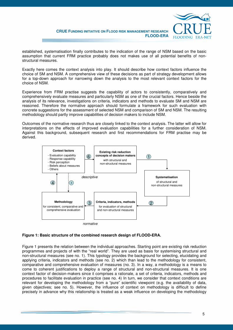
established, systematisation finally contributes to the indication of the range of NSM based on the basic assumption that current FRM practice probably does not makes use of all potential benefits of non-structural measures. Exactly here comes the context analysis into play. It should describe how context factors influence the choice of SM and NSM. A comprehensive view of these decisions as part of strategy development allows for a top-down approach for narrowing down the analysis to the most relevant context factors for the choice of NSM. Experience from FRM practise suggests the capability of actors to consistently, comparatively and comprehensively evaluate measures and particularly NSM as one of the crucial factors. Hence beside the analysis of its relevance, investigations on criteria, indicators and methods to evaluate SM and NSM are reasoned. Therefore the normative approach should formulate a framework for such evaluation with concrete suggestions for the assessment of selected NSM and comparison of SM and NSM. The resulting methodology should partly improve capabilities of decision makers to include NSM. Outcomes of the normative research thus are closely linked to the context analysis. The latter will allow for interpretations on the effects of improved evaluation capabilities for a further consideration of NSM. Against this background, subsequent research and first recommendations for FRM practise may be derived.
Existing risk reduction concepts of decision makers
with structural and non-structural measures
Criteria, indicators, methods
for evaluation of structuraland non-structural measures
Context factors
- Evaluation capability- Response capability- Risk perception- Beliefs about measures - Others
descriptive
normative
Systematisation
of structural andnon-structural measures
Methodology
for consistent, comparative and comprehensive evaluation
1
23
4 5
6
Figure 1: Basic structure of the combined research design of FLOOD-ERA.
Figure 1 presents the relation between the individual approaches. Starting point are existing risk reduction programmes and projects of with the “real world”. They are used as basis for systemising structural and non-structural measures (see no. 1). This typology provides the background for selecting, elucidating and applying criteria, indicators and methods (see no. 2) which than lead to the methodology for consistent, comparative and comprehensive evaluation of measures (no. 3). In a way, a methodology is a means to come to coherent justifications to deploy a range of structural and non-structural measures. It is one context factor of decision-makers since it comprises a rationale, a set of criteria, indicators, methods and procedures to facilitate evaluation in practice (see no. 4) In turn, we consider that context conditions are relevant for developing the methodology from a “pure” scientific viewpoint (e.g. the availability of data, given objectives; see no. 5). However, the influence of context on methodology is difficult to define precisely in advance why this relationship is treated as a weak influence on developing the methodology
CRUE FUNDING INITIATIVE ON FLOOD RISK MANAGEMENT RESEARCH FLOOD-ERA
6
(hence, the dotted line). Finally, context conditions, internal as well as external, influence flood risk management concepts and strategies. The application of document analysis and conducting interviews are here used to elicit the major context factors and further to analyse the influence on the decision (see no. 6).
3.5 Case studies
Since research especially on non-structural measures as part of FRM strategies is still in an early stage, conceptual work on evaluation and identifying the context conditions play an important role. Nevertheless, empirical work should supply real cases for testing draft concepts. For this reason 6 case studies have been chosen within the countries funding the FLOOD-ERA project: England, Scotland, Austria, and Germany. They deal with catchments or reaches of the following rivers:
• Lower Thames River (Teddington, England),
• Clyde River (Glasgow, Scotland),
• Raab River (Gleisdorf, Austria),
• Mulde River (Erlln and Grimma, Germany),
• Elbe River (Dresden, Germany),
• Mangfall River (Kolbermoor, Germany). Due to the consideration of external context factors, these cases partly require a multi-level approach. This means that in addition to the project and programme level national and regional context conditions should be included. The case-study approach does not lead to representative results (Yin 2003). Their purpose within FLOOD-ERA is to test selected components of the evaluation methodology on the one hand and to provide site-specific findings to support the context analysis on the other hand. Empirical work is based on various methods. These are predominately data collection, document analyses, hydraulic modelling and interviews with decision makers. The latter focus several context factors and therefore were well prepared to gather the required information most precisely and within one round. Moreover, selection of decision makers was adjusted with the conceptual work.
CRUE FUNDING INITIATIVE ON FLOOD RISK MANAGEMENT RESEARCH FLOOD-ERA
7
4 Systematisation of SM and NSM
Main contributors: Jochen Schanze, Alfred Olfert, Dennis Parker
4.1 Background: The emergence of NSM from a historical viewpoint
In the past, flood disasters were predominately understood as inevitable natural phenomena or Acts of God (White et al. 2001). Accordingly, the response was, and often still is, largely oriented towards the flood hazard by mainly applying collective measures aiming to control the hazard and to protect against inundation. Understandingly, civil engineering is traditionally the professional field responsible for this task. As a result, all kinds of hydraulic works were carried out to ensure certain flood protection targets in, along and across river channels and at coasts. In the United States structural measures were championed notably by the US Army Corps of Engineers which had been committed to a ‘levees-only’ policy in the first part of the twentieth century (Parker 2000). With reference to Porter (1978) Parker (2007) summaries dikes, floodwalls, channel improvements, floodways, river diversions, reservoirs as flood control and protection. From the 1970th it was becoming clear that many decades of investment into structural flood control and protection measures was failing to stop rising flood losses (Parker 2007). Firstly in the US, in the last 20 years also in Europe, the attitude towards floods has changed. Today, a common understanding do exist that full flood protection is unachievable because of uncertainties of the hydrological system and unsustainable due to high costs and considerable socio-cultural and ecological side effects. The awareness that flood disasters are caused by the interference of a natural event (hazard) with societal vulnerability widens the perspective of possible risk reduction measures. Under the headline living with floods, particularly non-structural measures have been increasingly taken into account (Penning-Rowsell and Peerbolte 1994). However, in contrast to structural measures the term “non-structural measure” is not clearly specified and often used ambiguously. In many different classifications of flood management options the term “non-structural measures” is being used as a pool for all those new or widely unknown measures which are somehow different from the traditional technical approaches. At the same time further classifications have evolved which makes the sorting of measures more difficult.
4.2 Systematisation of SM and NSM: Existing classifications
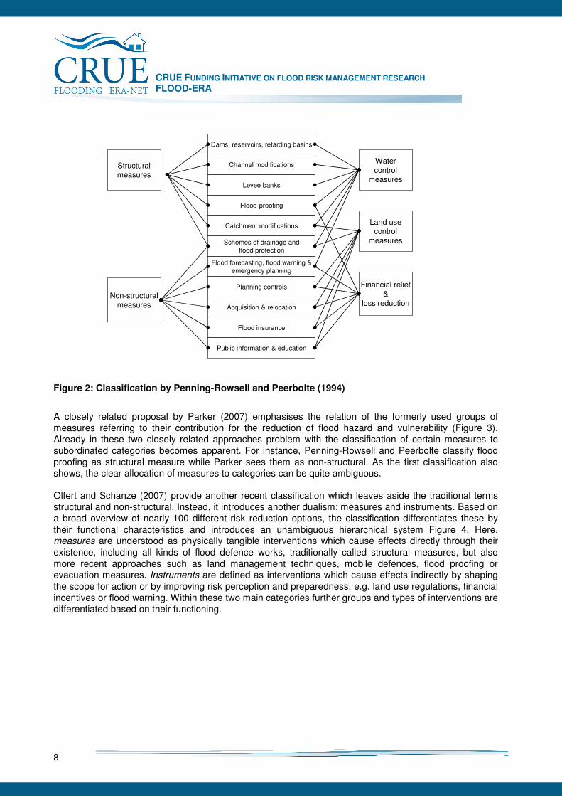
A number of classifications have been developed to give an order to the increasing variety of structural and non-structural measures and to allow more detailed description of risk reduction approaches. Penning-Rowsell and Peerbolte (1994) differentiate known SM and NSM into control measures, land use regulation and financial relief and loss reduction and the traditional differentiation alternatively (Figure 2). This classification extended the perspective on structural measures und non-structural measures by describing basic types of intervention.
CRUE FUNDING INITIATIVE ON FLOOD RISK MANAGEMENT RESEARCH FLOOD-ERA
8
Dams, reservoirs, retarding basins
Channel modifications
Levee banks
Flood-proofing
Catchment modifications
Schemes of drainage andflood protection
Flood forecasting, flood warning &emergency planning
Planning controls
Acquisition & relocation
Flood insurance
Public information & education
Structuralmeasures
Non-structuralmeasures
Watercontrol
measures
Financial relief&
loss reduction
Land usecontrol
measures
Figure 2: Classification by Penning-Rowsell and Peerbolte (1994)
A closely related proposal by Parker (2007) emphasises the relation of the formerly used groups of measures referring to their contribution for the reduction of flood hazard and vulnerability (Figure 3). Already in these two closely related approaches problem with the classification of certain measures to subordinated categories becomes apparent. For instance, Penning-Rowsell and Peerbolte classify flood proofing as structural measure while Parker sees them as non-structural. As the first classification also shows, the clear allocation of measures to categories can be quite ambiguous. Olfert and Schanze (2007) provide another recent classification which leaves aside the traditional terms structural and non-structural. Instead, it introduces another dualism: measures and instruments. Based on a broad overview of nearly 100 different risk reduction options, the classification differentiates these by their functional characteristics and introduces an unambiguous hierarchical system Figure 4. Here, measures are understood as physically tangible interventions which cause effects directly through their existence, including all kinds of flood defence works, traditionally called structural measures, but also more recent approaches such as land management techniques, mobile defences, flood proofing or evacuation measures. Instruments are defined as interventions which cause effects indirectly by shaping the scope for action or by improving risk perception and preparedness, e.g. land use regulations, financial incentives or flood warning. Within these two main categories further groups and types of interventions are differentiated based on their functioning.
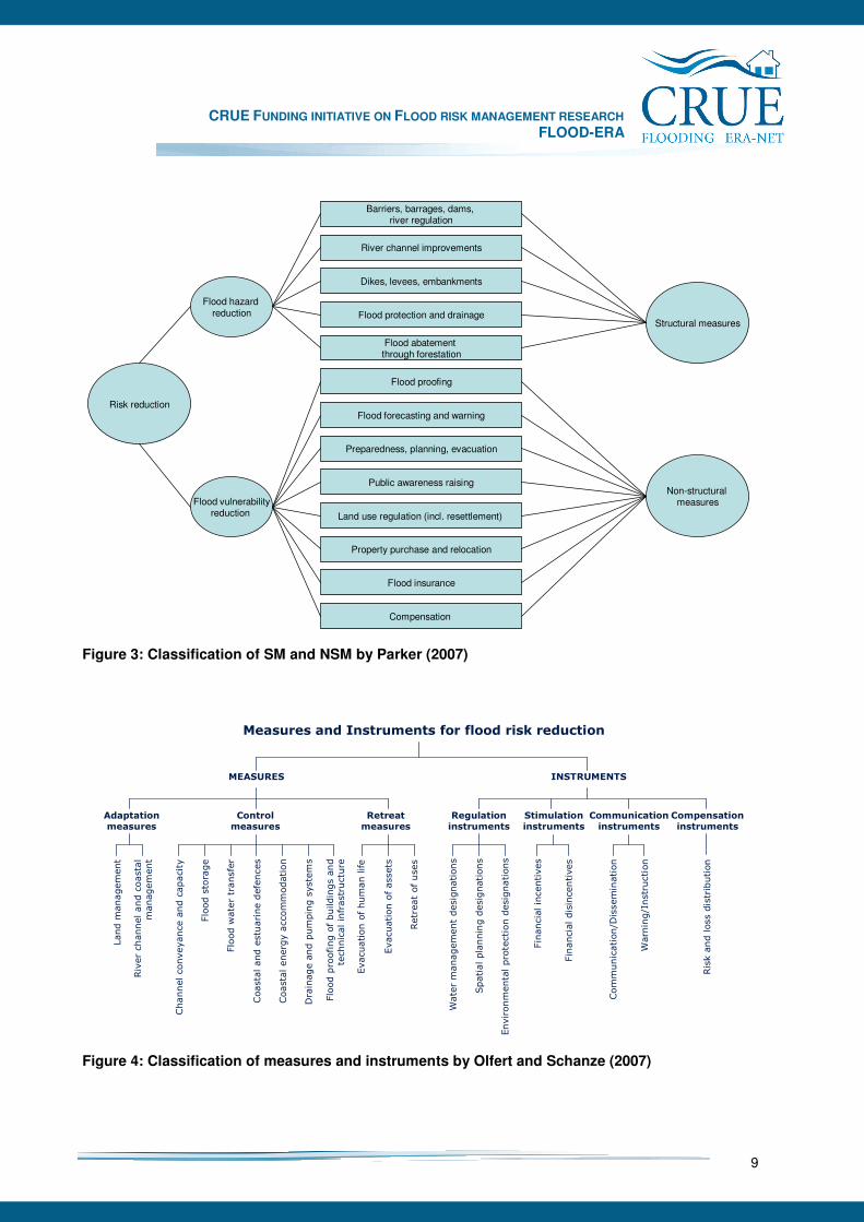
CRUE FUNDING INITIATIVE ON FLOOD RISK MANAGEMENT RESEARCH FLOOD-ERA
9
River channel improvements
Flood protection and drainage
Flood abatement through forestation
Flood proofing
Flood forecasting and warning
Preparedness, planning, evacuation
Public awareness raising
Land use regulation (incl. resettlement)
Property purchase and relocation
Flood insurance
Structural measures
Non-structural measures
Barriers, barrages, dams, river regulation
Dikes, levees, embankments
Compensation
Flood hazard reduction
Flood vulnerabilityreduction
Risk reduction
Figure 3: Classification of SM and NSM by Parker (2007)
Measures and Instruments for flood risk reduction
Stimulation instruments
Communication instruments
Financial incentives
Risk and loss distribution
Regulation instruments
Evacuation of human life
Evacuation of assets
Retreat of uses
Water management designations
Environmental protection designations
Financial disincentives
MEASURES INSTRUMENTS
Spatial planning designations
River channel and coastal
management
Flood proofing of buildings and
technical infrastructure
Land m
anagement
Control measures
Adaptation measures
Retreat measures
Communication/Dissemination
Warning/Instruction
Compensation instruments
Drainage and pumping systems
Channel conveyance and capacity
Flood storage
Flood water transfer
Coastal and estuarine defences
Coastal energy accommodation
Figure 4: Classification of measures and instruments by Olfert and Schanze (2007)
CRUE FUNDING INITIATIVE ON FLOOD RISK MANAGEMENT RESEARCH FLOOD-ERA
10
4.3 Proposed systematisation of SM and NSM
In conclusion of the presented classifications it cannot be expected to find a single valid solution. Instead the classification like in other fields depends on the purpose of distinctions and clustering. In terms of flood risk management there seems to be at least three major aspects for sorting measures:
• the construction of measures,
• the effect of measures,
• the function of measures. The first aspect puts emphasis on the technical design of a measure. It contrasts structural works of hydraulic engineers with other kinds of measures and is the background for the distinction of structural and non-structural measures. The second aspect differentiates water-related and receptor-related risk reduction and thus addresses effects on reducing either the flood hazard or the flood vulnerability (cf. Cooper et al. 2007). It makes especially sense for promoting a risk-based approach including the mitigation of vulnerability. The third aspect reflects the functionality of measures. It indicates the way how the intervention in the flood risk system looks like. On the highest level it distinguishes physical measures and policy instruments, below it clusters different mechanisms such as control, retreat and so forth (Olfert and Schanze 2007). For this study at least the first aspect is set by the call of ERA-NET CRUE and of course is reasoned by the historical and common use of the terms structural and non-structural measures in science and practice. The distinction between both types of measure is rather simple in defining structural measures and leaving all other measures as non-structural (cf. e.g. Petry 2002). This lead to the following understanding:
• Structural measures (SM) are interventions in the flood risk system based on (structural) works of hydraulic engineering.
• Non-structural measures (NSM) are all other interventions. In contrast to the previous use of the term structural measures here it is recommended not to include the intended effects of flood control and protection in the definition. One reason for that is that also non-measures like land management and sediment dredging can contribute to lowering the flood discharge or the water level respectively. Another reason is that risk reduction effects cannot be measured on the basis of the hazard only. Since the differentiation of SM and NSM does not allow for further clustering, it is proposed to enhance the systematisation applying the third aspect. The latter refers to intervention mechanisms of measures without specifying their effects. Accordingly no restrictions appear with respect to comparative evaluation of different measures. The following functions are derived from Olfert and Schanze (2007) and Parker (2007):
• Flood control,
• Use and retreat,
• Regulation,
• Financial stimulation,
• Information,
• Compensation.

CRUE FUNDING INITIATIVE ON FLOOD RISK MANAGEMENT RESEARCH FLOOD-ERA
11
Table 1: Proposed systematisation of structural and non-structural measures
Functional group Type of measure Measure (Examples) Underlying instrument
Structural Measures
Dam Flood water storage
Flood polder
By-pass channel River training
Channelisation
Dike Flood protection
Mobile wall
Urban sewer system
Flood control
Drainage and pumping Pumping system
Flood protection standard; investment programme
Non-structural measures
Conservation tillage Adapted land use in source area (catchment of the headwater) Afforestation
Restriction of land use in source areas; priority area “flood prevention” Flood control
River management Dredging of sediments Investment/maintenance
programme
Avoiding land use in flood prone areas
Land use in flood-prone area Relocation of buildings from flood prone areas
Restriction of land use in flood zones; building ban; hazard and risk map; insurance premium according to flood zone
Flood proofing Adapted construction
Relocation of susceptible infrastructure
Evacuation of human life
Use and retreat
Evacuation Evacuation of assets
Flood forecasting and warning system; civil defence or disaster protection act
Restriction of land uses in flood plains and source areas Water management
Flood protection standards
Civil protection Civil protection and disaster protection act
Priority area “flood prevention”
Regulation
Spatial planning Building ban
Investment programmes (e.g. for river works)
Financial incentives Subsidies for relocation or adaptation
Financial stimulation
Financial disincentives Insurance premium according to flood zone
Information even Communication/Dissemination
Brochure
Hazard and risk map Information
Instruction, warning Forecasting and warning system
Insurance payments Compensation Loss compensation
Public payments

CRUE FUNDING INITIATIVE ON FLOOD RISK MANAGEMENT RESEARCH FLOOD-ERA
12
For each functional group further types of measures can be indentified. Table 1 presents an overview of the resulting systematisation considering the first and third criterion, the types of measures and examples of concrete measures. In addition, the last column indicates relations between measures. Especially the realisation of physical measures normally depends on preceding regulatory, financial and planning instruments (see Olfert and Schanze 2007). Despite the second aspect has not been included in the terminology of this study, it can be a valuable means of communicating different ways of interventions in the flood risk system. It raises public awareness about the numerous options to individually mitigate vulnerability in addition to collective hazards reduction. With other words: Learning to live and deal with water instead of assuming the water to be kept away. However, the aspect has the disadvantage to polarise the water and receptor-related interventions. Under real-world conditions both should be seen as complementary because together they cause the risk. Thus, especially the evaluation and comparison of different SM and NSM with regard to effectiveness and efficiency need to refer to the reduced risk and not just to the hazard or the vulnerability.
CRUE FUNDING INITIATIVE ON FLOOD RISK MANAGEMENT RESEARCH FLOOD-ERA
13
5 Methodology for evaluating the effectiveness and efficiency of SM and NSM
Main contributors: Jochen Schanze and Volker Meyer The evaluation of SM and NSM is the basis for informed and transparent decision making on risk reduction in flood risk management. It helps to reduce the complexity of decisions by delivering structured and comparable information. Overall aim is the support of decision making and ideally their improvement by highlighting rational choices. Results can be important for the selection of alternatives in the short and long term (ex-ante evaluation) or justification of and learning from performance of previous application (ex-post evaluation; cf. Olfert 2008). Evaluation thus requires systematic and methodologically sound approaches which allow for determining pros and cons of each intervention related to relevant societal criteria. With regard to SM, many approaches do exist and have already been applied. In contrast capabilities for the evaluation of NSM at present are rather limited. One reason for the different state of the art in evaluating SM and NSM is certainly the strong historical meaning of SM. Another, and on the practical level perhaps more important reason are substantial methodological challenges which currently restrict a systematic evaluation of most NSM. In particular they origin from complicated intervention mechanisms of legal, planning, financial, communicative and small-scale measures. Moreover, practical experience of these measures is lacking because of rare application and lacking ex-post evaluation. In essence evaluation capabilities for NSM are low which also prevent from systematic comparison of SM and NSM. FLOOD-ERA aims at a step towards systematic evaluation and comparison of the effectiveness and efficiency of SM and NSM. It therefore compiles state of the art evaluation knowledge, enhances methods for the evaluation of NSM and comparison SM and NSM and includes all findings in an outline methodology for the evaluation practice. Hereby evaluation is understood as systematic and transparent way of investigating an evaluand’s worth and merits based on comprehensible, empirical qualitative and/or quantitative data. It is assumed that each evaluation requires:
• Indicators for describing intended and unintended effects,
• Criteria as evaluation concepts,
• Methods for calculating criteria values. The chapter gives an overview of these three elements of evaluation in terms of flood risk management based on a comprehensive literature review (5.2-5.5). It then introduces an outline methodology including results from evaluation of NSM and comparison of SM and NSM in the FLOOD-ERA case studies (5.6). Finally remaining challenges of evaluating particular NSM are indicated (5.7). To ensure detailed evaluation results FLOOD-ERA puts single measures in the foreground of consideration. However, FRM practice often considers portfolios of measures. The study therefore also reflects the requirements of investigating multiple measures as a starting point for further research.
CRUE FUNDING INITIATIVE ON FLOOD RISK MANAGEMENT RESEARCH FLOOD-ERA
14
5.1 Indicators of effects
Indicators are the practical units of evaluation applied for the measurement of obtained effects, mobilised resources or accomplished outputs (European Commission 2007). They describe changes (effects) generated by measures and are thus the basis for the evaluation. In general, measures for risk reduction can influence natural and societal elements of the flood risk system. These effects can be intended or unintended. Unintended effects are referred to as side effects. In accordance with the dimensions of sustainability, both kinds of effects can be classified in three main thematic groups: Socio-cultural, economic and ecological. One further group can be added to represent the physical performance especially of hazard-related measures. This leads to the following indicator groups:
• Hydrological/hydraulic indicators,
• Socio-cultural indicators,
• Economic indicators,
• Ecological indicators.
Hydrological and hydraulic indicators describe the primary services of widespread applied measures for flood control and defence. They refer to effects on the features of the flood hazard, especially the probability of events with certain discharge, water depths, flow velocities, duration, and so forth. Measurement normally is based on hydrological and hydraulic modeling according to the flood hazard at rivers, estuaries and costs. These indicators deal with an intermediate step towards risk reduction without specifying the impacts on the consequences yet. Hazard-related effects can be an important means for quantifying the performance and reliability of mainly structural measures. For example, it can be valuable to know about the protection level of a flood defence measure for different flood events to understand its contribution to loss reduction. However a final judgement of a measure needs the consideration of its contribution to risk reduction. Socio-cultural indicators specify outcomes of risk reduction activities particularly with respect to people, social groups and institutions as well as impacts on cultural heritage. They regard to lowering the social and cultural vulnerability and to the (unintended) impacts of measures on the society. While some effects might be tangible (e.g. casualties, health impacts), other can only be described in a qualitative manner (e.g. stress, disturbance of community structures). Socio-cultural indicators are traditionally little considered in the evaluation of measures even though their importance is increasingly being accepted. For most aspects methods are lacking to specify the vulnerability and to simulate possible impacts of measures. Recent years have shown advancement with respect to loss of life modelling (Penning-Rowsell et al. 2005). Furthermore, approaches are being developed to describe impacts on amenity values of river landscapes (Franklin et al. 2001). However, they remain little applicable at the scale of risk reduction measures. The same is true for cultural heritage which can currently hardly be described in the scope of typical evaluation approaches. Economic indicators specify the reduction of direct and indirect losses as well as the costs of measures. Both are predominately treated with in monetary terms. As far as the indicators on loss reduction are concerned, they address the economic vulnerability with stocks and flows. Effects in this case are avoided economic losses because of the application of measures. They also can include impacts on individual subsistence, competitiveness of businesses and markets which of course are much more difficult to investigate compared to direct costs of damage to buildings for example. In comparison, costs of measures refer to different cost categories such as investment and maintenance or operation costs. Hereby it needs to be considered that financial expenses are always societal resources which can only be spent once and therefore need to be forgone for other purposes if they are used for flood risk reduction (opportunity costs).
CRUE FUNDING INITIATIVE ON FLOOD RISK MANAGEMENT RESEARCH FLOOD-ERA
15
Ecological indicators determine impacts on ecosystems and species with respect to ecosystem services and biodiversity respectively. Since floods are a natural phenomenon, effects are mainly unintended results of risk reduction measures. However, there are also cases where measures intend to reduce flood impacts on ecosystems and wildlife, for instance, due to toxicological substance in the flood water. Ecological effects and therefore indicators require highly specialised approaches for rivers, estuaries and costs. For rivers, moreover a distinction between source areas, water bodies and floodplains is needed. In the source areas, terrestrial ecosystems and wildlife of the catchments stand in the foreground. Indicators on water bodies address the aquatic quality elements of the European Water Framework Directive (CEC 2000) and its implementation procedures (e.g. CIS Guidance documents). Ecological effects in floodplains mainly refer to semi-aquatic habitats with their wildlife and ecosystem services. To ensure a comprehensive evaluation, in principal all indicator groups describing intended and unintended effects should be involved with exception of the hydrological and hydraulic indicators which only provide additional information. A more narrow perspective is acceptable if specific effects could be excluded with sufficient certainty. Furthermore, the scope of indicators also depends on the evaluation criterion. For example, the criterion efficiency cover monetary indicators in the first place whereof the criterion sustainability in principle can refer to all kinds of indicators with different scales.
5.2 Criteria and methods for evaluating measures: Overview
Criteria are the basis for the judgement of a flood risk reduction measure. Evaluation criteria may be defined as “character, property or consequence of a public intervention on the basis of which a judgement will be formulated” (European Commission 2007). Criteria represent different social values and understandings. For the advance of evaluation practice, FLOOD-ERA mainly focuses the commonly applied criteria:
• Effectiveness
• Efficiency Both address a rational choice based on neo-classical economic theory by relating expected outcomes to objectives and estimated benefits or costs respectively. Effectiveness describes the degree of goal achievement. The criterion is closely related to the objectives of a risk reduction measure. The objective describes the intended change of the flood risk system. The criterion is used to analyse the extent to which a measure is expected to produce desired effects or reaching certain targets. Thus, the evaluation of effectiveness only focuses the intended outcomes of measures (Gabler 2000). Efficiency describes, how economically intended effects are achieved (UK Evaluation Society 2007). The criterion implies the input required to achieve the effects. Efficiency is expressed as the ratio of outcomes to spent resources (e.g., money or time). Efficiency can be determined as cost-effectiveness or benefit-cost ratio. The former relates monetary or monetised costs to non-monetary effects. The latter reflects the relationship of overall net-benefits and net-costs. Since there is already some experience in evaluating SM in terms of effectiveness and efficiency, the study puts emphasis on according evaluation of NSM and their comparison with SM. Limited implementation of NSM does not allow for ex-post evaluation yet. Thus, FLOOD-ERA predominately deals with hypothetical applications of NSM and their evaluation ex ante.
CRUE FUNDING INITIATIVE ON FLOOD RISK MANAGEMENT RESEARCH FLOOD-ERA
16
Beyond the criteria effectiveness and efficiency there are criteria which play an increasing role in flood risk management and civil engineering. The study cannot go into further details in this respect. However, a few of these criteria are listed and explained below:
• Sustainability
• Robustness
• Flexibility
• Reliability Sustainability determines all social, economic and ecological effects with specific regard to intergenerational equity (WCED 1987). Particularly the multiple impacts and the long design live of flood control measures require a multi-criteria and long-term consideration. The evaluation of sustainability can be heuristically narrowed to whether an intervention is economically feasible, socially acceptable and environmentally sound (Takeuchie 1998, cited in Kundzewicz 2002). However, methodologically it calls for comprehensive appraisal of measures as operationalisation of the triangle concept of sustainability proposed by Serageldin (1995). This can be achieved by applying multi-criteria evaluation (Munasinghe and Swart 2005) or at least to a certain extent by integrating social, economic and ecological effects in monetary terms within a benefit-cost framework. In flood risk management the term sustainability sometimes is related to social and economic resilience (FIAC 2006, Tobin 1999). Robustness describes the performance of a measure under different conditions (Olfert and Schanze 2007). It currently receives an increasing meaning for FRM under the conditions of climate and societal change. There are no scientific conventions on determining robustness yet. In a very principal way it can be defined as the ability of a measure to sustain the intended performance over different known and unknown (changing) conditions (ibid.). Flexibility describes the adaptability of measures and is also related to changing conditions. In contrast to robustness, flexibility refers to the adaptation of the design, location or functioning of a measure. This can include operational as well as middle and long-term aspects. Flexibility also contains the notion of costs of adaptation and reversibility of effects and thus is closely related to considerations of sustainability. It can be characterised as the potential of measures to be adapted at low effort while leaving little (negative) irreversible consequences. Reliability expresses the probability of failure which is largely determined by the design of a measure. In FRM, the concept of reliability is being applied to structural measures such as dikes and other flood defences. However, it could be valuable to extend the application of this criterion to non-structural measures such as flood warning systems or land use planning.
5.3 Evaluating the effectiveness
Effectiveness serves as evaluation criterion to express the extent to which interventions in a flood risk system achieved or are expected to achieve a given objective. The evaluation only considers intended effects, while unintended effects lacking an objective are disregarded (Messner 2006). Objectives are case specific quantified expectations for certain effects described by indicators. According to most usual objectives of SM and NSM in FRM, primarily hydrological/hydraulic, economic and very few socio-cultural aspects are of interest for the investigation of effectiveness. In the light of the increasing specification of ecological goals and targets (e.g., by the Water Framework Directive – WFD), effectiveness could also become evaluable with regard to ecological (particularly limnological) indicators. For example, goals formulated based on the WFD can be applied to all activities related to water bodies. In this case, they can be seen as (additional) goals for risk reduction measures.
CRUE FUNDING INITIATIVE ON FLOOD RISK MANAGEMENT RESEARCH FLOOD-ERA
17
Effectiveness can be expressed in terms of risk reduction or effects towards risk reduction. For example, warning is essential as trigger for contingent measures, but does not provide risk reduction by itself. Effects can be measured through specific indicators such as the accuracy or penetration of warning (Parker et al. 1994). Effectiveness can clearly be related to certain objectives such as the targeted lead time and the population addressed.
5.3.1 Objectives
Effectiveness is determined against the background of objectives. The latter are described by the margin between a baseline state and the state targeted by an intervention. With other words, an objective describes the intended extent of a certain effect. Thus, the formulation of objectives often is the first task when evaluating effectiveness. Goals of flood risk reduction are not easy to formulate since they are ambiguous given the multitude of risks and their complex distribution. For that reason, hydrological and hydraulic targets are commonly used for example as design standards for flood defences. Risk as an objective depends on the considered negative consequences in addition to the occurrence probability of flood events with their magnitude. In principle, it includes socio-cultural, economic and ecological consequences. In fact objectives up to now predominantly refer to economic damage and people affected. Targets are normally set through formal and informal negotiations between different stakeholders within the political-administrative system. Here, the distribution of gainers and looser plays an important role (Rheinsberger and Weck-Hannemann 2007). The adjustment of risk related objectives usually aims at achieving a tolerable level of risk throughout all societal groups affected. In general, the objective (O) can be described by the margin between the state expected without the intervention (baseline state, bs) and the intended state (target state, ts) (Olfert 2008):
bstsO −= Alternatively, a formulation as intended effect is appropriate. Most cases in FRM comprise of several objectives due to multiple consequences. As a result, objectives need to be aggregated in an overall figure of integral objective. For example, intended effects such as avoided economic losses can be expressed as accumulation or as average of the regarded elements at risk. Other effects, such as the reduction of the flood level can only be treated as average. This can be important, if the intended hydraulic effect is to be defined for different river stretches or coast lines. Analogue, the objective (O) can be addressed either as cumulative or as average: Cumulative objective:
∑=
=n
i
ic OO1
Average objective:
n
O
O
n
i
i
a
∑== 1
with Oi : objective (E) for each element at risk (i) n: total number of elements at risk
Within this study we applied two different methods for the determination of the objectives. The first approach is based on the derivation of objectives top down from existing societal aims such as maximising social welfare. It requires documents analysis and expert interviews. In this way the objectives were identified in the English and Scottish case studies. The second approach is being used in cases where no risk-related objectives have been clearly defined. The research team therefore formulated site-specific
CRUE FUNDING INITIATIVE ON FLOOD RISK MANAGEMENT RESEARCH FLOOD-ERA
18
objectives bottom up for all other cases since they are particularly needed for the comparison of SM and NSM (Hanusch 1994).
5.3.2 Determination of effectiveness
Effectiveness describes the relation of the observed effects to the objectives. Thus it can be determined as the degree of goal achievement in % and is applicable with all issues of effectiveness where required data are at disposition. Since effectiveness is mainly expressed in %, quantitative data are the basis for its determination. If qualitative indicators are used, they partly could be normalised into quantitative scales. A simple formal term for the determination of effectiveness (ETS) is as follows (Olfert 2008):
%100⋅=O
EETS
with E: effect (measured by the same indicator as for the objective)
5.4 Evaluating the efficiency
The criterion efficiency is dedicated to the evaluation of the relationship between input and output. Two main concepts of efficiency with according methods can be differentiated from an economic view point:
• Cost-effectiveness
• Net present value and benefit-cost ratio Cost effectiveness focuses on the costs for achieving a given target or on the output achieved at a given budget. Benefit-cost ratios relate benefits and costs in monetary terms. Both concepts are briefly described in what follows. In addition, the meaning of transaction costs and their inclusion in the criterion is referred to.
5.4.1 Cost-effectiveness
Cost-effectiveness generally compares the relative expenditure (costs) and outcomes (effects) of actions. It is often used where full benefit-cost ratios cannot be derived. A common way of determining cost-effectiveness therefore is the estimation of the input for achieving a set of targets in monetary terms and the outcome in non-monetary quantitative terms (The World Bank 2007). In the case of flood risk management, cost effectiveness states whether a given target of tolerable risk is achieved by minimal costs (cost minimisation) or risk reduction is maximised by a given costs (effect maximisation) (cf. Rheinsberger and Weck-Hannemann 2007). Thus an objective or financial budget has to be defined as threshold likewise to the determination of effectiveness. Cost-effectiveness for this reason is also limited to the measurement of performance to the given objective or financial budget, while other potentially benefits and costs are neglected (Messner 2006). With regard to effects, the previous sub-chapter on objectives already showed the potential wide scope. In terms of costs, economic appraisal demands to consider all relevant capital, maintenance and running costs. These costs are much easier to be collected for most SM such as flood protection schemes than NSM. According to the cost minimisation and effect maximisation, cost-effectiveness analysis (CEA) can be distinguished in two principle approaches as follows:
CRUE FUNDING INITIATIVE ON FLOOD RISK MANAGEMENT RESEARCH FLOOD-ERA
19
Cost minimisation:
min!→=givenE
CCET
Effect maximisation:
max!→=givenC
ECET
with CET: cost-effectiveness C: costs
5.4.2 Net present value and benefit-cost ratio
In contrast to cost-effectiveness, the benefit-cost ratio considers both benefits and costs in monetary terms. All benefits of a decision alternative are related to all associated costs with that alternative. The overall goal is to select the solution with the highest benefit-cost ratio from a list of alternatives (Hanley and Spash 1993). Hereby, economic efficiency (or pareto optimality) is defined as an allocation of resources in a way that no further reallocation is possible that would create gains in production or consumption for some persons without simultaneously imposing losses to others (Young 2005). At least in theory, comparing and ranking benefits and costs should provide evidence for maximising social welfare. It is important to consider only those impacts which results in a change of social utility. In this respect, benefits are referred to as increases in the quantity of goods and services or increases in their prices (Hanley and Spash 1993). For evaluation in terms of flood risk management it means to balance the benefits of reducing risk against costs for implementing measures. Both reduced risk and costs for measures − direct and indirect, and as far as possible tangible and intangible − need to be monetised as far as they are relevant for the decision. Benefit-cost analysis (BCA) consists of two major components, the monetisation of benefits and costs on the one hand and the generation of benefit-cost ratios on the other hand. As follow, both components are presented separately.
5.4.2.1 Monetisation of benefits and costs
Benefits and costs of flood risk reduction measures require different ways of monetisation. While benefits need a calculation of reduced risk and therefore the determination of risk in monetary terms, costs of measures can be investigated like many other investments. For example, a new dike has positive impacts due to the reduction of flood damage on the one hand and requires resources for its construction and maintenance on the other hand. Since benefits and costs appear in a long-term time horizon, discounting is also to be considered. Transaction costs which arise during the decision-making and implementation of measures are up to now not treated with in BCAs (see below). A. Benefits of risk reduction Benefits of measures encompass avoided risks as well as all other contributions to maximise social welfare. Since risk is a comprehensive concept with social-cultural, economic and ecological dimensions, determining the benefits of measures is a major challenge. For that reason, risk and risk reduction up to now is often narrowed to damage of monetary assets such as buildings and inventories (direct and tangible damage). In contrast, intangible negative consequences, like social effects and degradation of the environment, are mostly neglected. Nevertheless, these effects could also have a considerable impact on social welfare. In contrast, production losses due to business interruption during or after the flood should (at least in theory) have no major impact on social welfare, as far as production can be transferred to other sites.
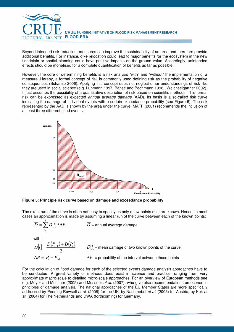
CRUE FUNDING INITIATIVE ON FLOOD RISK MANAGEMENT RESEARCH FLOOD-ERA
20
Beyond intended risk reduction, measures can improve the sustainability of an area and therefore provide additional benefits. For instance, dike relocation could lead to major benefits for the ecosystem in the new floodplain or spatial planning could have positive impacts on the ground value. Accordingly, unintended effects should be monetised for a complete quantification of benefits as far as possible. However, the core of determining benefits is a risk analysis “with” and “without” the implementation of a measure. Hereby, a formal concept of risk is commonly used defining risk as the probability of negative consequences (Schanze 2006). Applying this concept does not neglect other understandings of risk like they are used in social science (e.g. Luhmann 1997, Banse and Bechmann 1998, Weichselgartner 2002). It just assumes the possibility of a quantitative description of risk based on scientific methods. This formal risk can be expressed as expected annual average damage (AAD). Its basis is a so-called risk curve indicating the damage of individual events with a certain exceedance probability (see Figure 5). The risk represented by the AAD is shown by the area under the curve. MAFF (2001) recommends the inclusion of at least three different flood events.
Damage
Exceedance Probability1/51/201/1001/200
D1
D2
D3
D4
Rtotal
Figure 5: Principle risk curve based on damage and exceedance probability
The exact run of the curve is often not easy to specify as only a few points on it are known. Hence, in most cases an approximation is made by assuming a linear run of the curve between each of the known points:
[ ] i
k
i
PiDD ∆=∑=
*1
D = annual average damage
with:
[ ]( ) ( )
2
1 ii PDPDiD
+= − [ ]iD = mean damage of two known points of the curve
1−−=∆ ii PPP P∆ = probability of the interval between those points
For the calculation of flood damage for each of the selected events damage analysis approaches have to be conducted. A great variety of methods does exist in science and practice, ranging from very approximate macro-scale to detailed micro-scale approaches. For an overview of European methods see e.g. Meyer and Messner (2005) and Messner et al. (2007), who give also recommendations on economic principles of damage analysis. The national approaches of the EU Member States are more specifically addressed by Penning-Rowsell et al. (2006) for the UK, by Nachtnebel et al. (2005) for Austria, by Kok et al. (2004) for The Netherlands and DWA (forthcoming) for Germany.
CRUE FUNDING INITIATIVE ON FLOOD RISK MANAGEMENT RESEARCH FLOOD-ERA
21
Most methods of damage analysis concentrate on direct, tangible damage, especially damage on buildings and their contents. Social and environmental consequences are more difficult to quantify in monetary terms, as no market values do exist for them. In order to include them in BCA, shadow prices can be used to reflect the true resource scarcity or to simulate market prices. Methods for the monetary valuation of environmental goods are e.g. the Contingent Valuation approach, the Hedonic Pricing approach or the Travel Cost approach (see e.g. Hanley and Spash 1993, Pearce and Turner 1990). For the application for social effects of flooding such approaches are described by Green (in Messner et al. 2007, chapter 6), the application of the Contingent Valuation approach for the environmental effects of flooding is discussed by van der Veen and Krywkow (ibid., chapter 7). Monetary valuation approaches in the context of flooding are shown by Turner et al. (1995, 2007) and for health effects of flooding by DEFRA and EA (2004). B. Costs of measures Determination of costs requires the identification of all financial resources for the implementation of a measure. This covers the expenses for investments (e.g. land acquisition, construction) and maintenance or operation in the first place. This is normally relatively easy since market prices do exist or can be extracted from comparative risk reduction projects. Additional costs can appear because of negative side-effects of a measure such as impacts on social well being, traffic conditions, ground values, the environment, etc. It is challenging to calculate and especially monetise all these side-effects. It needs the application of the indicators mentioned under sub-chapter 5.1 and their transformation in monetary units. No wonder that these side-effects are often neglected or considered to a limited extent. C. Discounting of benefits and costs
After assessing all benefits and costs in monetary terms they have to be discounted, i.e. converted into their present value in order to make them comparable. The rationale for this is time preference of people: costs as well as benefits are valued higher the sooner they are received or have to be paid, respectively. In order to discount future values to their present value a discount rate is used:
( )[ ]t
tt iXXPV−
+= 1)(
with PV(Xt): present value of Xt Xt: cost or benefit received in time t i: discount rate
Obviously, the choice of the discount rate has a huge influence on the weight given to future benefits and costs: a high discount rate would mean to give only small weight to benefits and costs which occur in the future, whereas a low discount rate gives them a higher weight. There is an ongoing debate about a “right” societal discount rate, but different authors argue against a straight line discount rate (see e.g. Gowdy 2007, Turner et al. 2007) and recommend a declining discount rate. The rationale is that people discount their near future at a higher rate than the distant future. Furthermore, the position of future generations is strengthened by such declining discount rates as future benefits and costs get more influence on the net present value. E.g. the official German methodological guideline for the valuation of environmental damage uses such a declining discount rate by recommending a discount rate of 3% for a timeframe of up to 20 years and a discount rate of 1.5% for impacts occurring after that. In contrast, MAFF (1999) prescribes a constant discount rate of 6 % for flood alleviation projects. The Stern report, estimating the economic impact of climate change, judge discounting as unethical with regard to future generations and applies a discount rate of 0.1 % (Stern 2006).
CRUE FUNDING INITIATIVE ON FLOOD RISK MANAGEMENT RESEARCH FLOOD-ERA
22
D. Transaction costs
“The measurement of transaction costs poses formidable difficulties” (Williamson 1996: 5). Traditionally, Transaction Cost Economics (TCE) has mainly been focused on exchange relationships in the private sector (Coase 1937, Williamson 1985). Transaction cost are defined here as “the cost of carrying out market transactions“ (Coase 1960) or, more broader, “the resources used to define, establish, maintain, and transfer property rights” (McCann et al. 2005). But transaction costs analysis can also be applied in the public sector, i.e. public policies like for instance flood risk management strategies can be investigated in respect of the costs associated with their design and implementation (Williamson 1999, Birner and Wittmer 2004, McCann et al. 2005). The aim of transaction cost analysis is here to 1) improve the comparison of alternative policy instruments, 2) enhance their effective design and implementation, 3) evaluate current policies, and 4) assess the budgetary impacts of policies (McCann et al. 2005, 528). In our case, flood risk management can be considered as the production of safety which can be achieved by either structural measures, like e.g. building dikes, or by non-structural measures, like e.g. the restriction of land use in the floodplain like a relocation measures. The costs arising from conducting these measures, i.e. the construction costs for a dike or the costs of relocating people, can be considered here as production costs. These production costs of policy measures are accompanied by transaction costs which can be divided into 1) transaction costs of decision making and 2) transaction costs of implementing these management decisions (Birner and Wittmer 2004: 669).
1) Transaction costs of decision making can be further differentiated into costs of acquiring the information for decision making (e.g. conducting risk analysis, in order to receive basic information about the current magnitude and spatial distribution of flood risk) and costs of coordinating decision making (e.g. resources spent on meetings, solving conflicts, costs of delayed decisions) (ibid.).
2) According to Birner and Wittmer (ibid.) transaction costs of implementation may arise either from
the implementation of regulatory decisions (e.g. costs for the monitoring and enforcement of land use regulations) or of production decisions (e.g. costs for the organisation of dike construction).
A little bit more detailed, but nevertheless a corresponding typology is given by McCann et al. (2005, 533; see Figure 6): Transaction costs are separated here into costs for 1) research and information, 2) enactment or litigation, 3) design and implementation, 4) support and administration, 5) contracting, 6) monitoring and detection and 7) prosecution and enforcement.1 McCann et al. (2005) furthermore discuss some important problems and questions associated with public policy transaction costs. E.g. the problem of distinction between production and transaction costs, which is not always obvious immediately. Are e.g. the costs of planning a dike or a land-use measure production or transaction costs? Or the issue of explicit versus implicit costs: While time spent in a public participation meeting is working time for an agency member and therefore an explicit cost, it is an implicit cost for a private stakeholder. Moreover the issue is raised who incurs the transaction costs and when in the decision and implementation process they occur (for the latter see Figure 6). 1 The gap between TC of decision making and TC of implementation is here somewhere within 3) design and implementation.
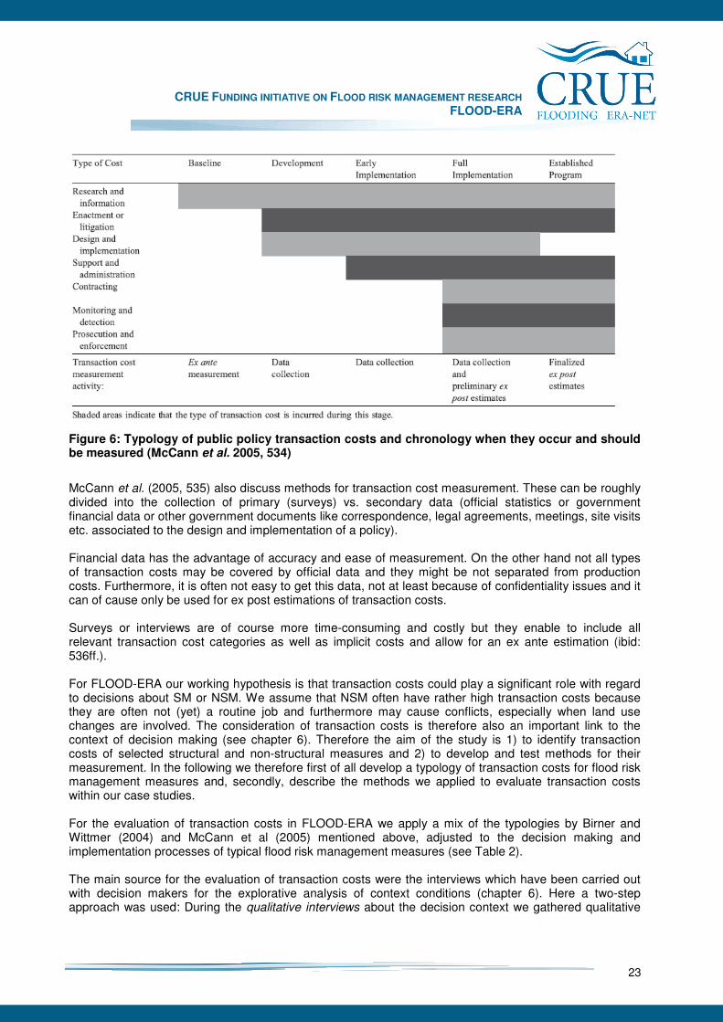
CRUE FUNDING INITIATIVE ON FLOOD RISK MANAGEMENT RESEARCH FLOOD-ERA
23
Figure 6: Typology of public policy transaction costs and chronology when they occur and should be measured (McCann et al. 2005, 534)
McCann et al. (2005, 535) also discuss methods for transaction cost measurement. These can be roughly divided into the collection of primary (surveys) vs. secondary data (official statistics or government financial data or other government documents like correspondence, legal agreements, meetings, site visits etc. associated to the design and implementation of a policy). Financial data has the advantage of accuracy and ease of measurement. On the other hand not all types of transaction costs may be covered by official data and they might be not separated from production costs. Furthermore, it is often not easy to get this data, not at least because of confidentiality issues and it can of cause only be used for ex post estimations of transaction costs. Surveys or interviews are of course more time-consuming and costly but they enable to include all relevant transaction cost categories as well as implicit costs and allow for an ex ante estimation (ibid: 536ff.). For FLOOD-ERA our working hypothesis is that transaction costs could play a significant role with regard to decisions about SM or NSM. We assume that NSM often have rather high transaction costs because they are often not (yet) a routine job and furthermore may cause conflicts, especially when land use changes are involved. The consideration of transaction costs is therefore also an important link to the context of decision making (see chapter 6). Therefore the aim of the study is 1) to identify transaction costs of selected structural and non-structural measures and 2) to develop and test methods for their measurement. In the following we therefore first of all develop a typology of transaction costs for flood risk management measures and, secondly, describe the methods we applied to evaluate transaction costs within our case studies. For the evaluation of transaction costs in FLOOD-ERA we apply a mix of the typologies by Birner and Wittmer (2004) and McCann et al (2005) mentioned above, adjusted to the decision making and implementation processes of typical flood risk management measures (see Table 2). The main source for the evaluation of transaction costs were the interviews which have been carried out with decision makers for the explorative analysis of context conditions (chapter 6). Here a two-step approach was used: During the qualitative interviews about the decision context we gathered qualitative
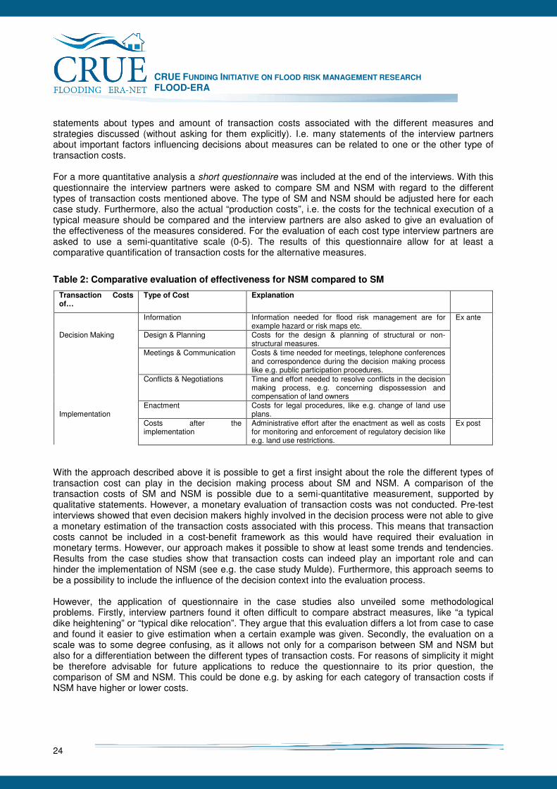
CRUE FUNDING INITIATIVE ON FLOOD RISK MANAGEMENT RESEARCH FLOOD-ERA
24
statements about types and amount of transaction costs associated with the different measures and strategies discussed (without asking for them explicitly). I.e. many statements of the interview partners about important factors influencing decisions about measures can be related to one or the other type of transaction costs. For a more quantitative analysis a short questionnaire was included at the end of the interviews. With this questionnaire the interview partners were asked to compare SM and NSM with regard to the different types of transaction costs mentioned above. The type of SM and NSM should be adjusted here for each case study. Furthermore, also the actual “production costs”, i.e. the costs for the technical execution of a typical measure should be compared and the interview partners are also asked to give an evaluation of the effectiveness of the measures considered. For the evaluation of each cost type interview partners are asked to use a semi-quantitative scale (0-5). The results of this questionnaire allow for at least a comparative quantification of transaction costs for the alternative measures.
Table 2: Comparative evaluation of effectiveness for NSM compared to SM
Transaction Costs of…
Type of Cost Explanation
Information Information needed for flood risk management are for example hazard or risk maps etc.
Decision Making Design & Planning Costs for the design & planning of structural or non-structural measures.
Meetings & Communication Costs & time needed for meetings, telephone conferences and correspondence during the decision making process like e.g. public participation procedures.
Conflicts & Negotiations Time and effort needed to resolve conflicts in the decision making process, e.g. concerning dispossession and compensation of land owners
Implementation
Enactment Costs for legal procedures, like e.g. change of land use plans.
Ex ante
Costs after the implementation
Administrative effort after the enactment as well as costs for monitoring and enforcement of regulatory decision like e.g. land use restrictions.
Ex post
With the approach described above it is possible to get a first insight about the role the different types of transaction cost can play in the decision making process about SM and NSM. A comparison of the transaction costs of SM and NSM is possible due to a semi-quantitative measurement, supported by qualitative statements. However, a monetary evaluation of transaction costs was not conducted. Pre-test interviews showed that even decision makers highly involved in the decision process were not able to give a monetary estimation of the transaction costs associated with this process. This means that transaction costs cannot be included in a cost-benefit framework as this would have required their evaluation in monetary terms. However, our approach makes it possible to show at least some trends and tendencies. Results from the case studies show that transaction costs can indeed play an important role and can hinder the implementation of NSM (see e.g. the case study Mulde). Furthermore, this approach seems to be a possibility to include the influence of the decision context into the evaluation process. However, the application of questionnaire in the case studies also unveiled some methodological problems. Firstly, interview partners found it often difficult to compare abstract measures, like “a typical dike heightening” or “typical dike relocation”. They argue that this evaluation differs a lot from case to case and found it easier to give estimation when a certain example was given. Secondly, the evaluation on a scale was to some degree confusing, as it allows not only for a comparison between SM and NSM but also for a differentiation between the different types of transaction costs. For reasons of simplicity it might be therefore advisable for future applications to reduce the questionnaire to its prior question, the comparison of SM and NSM. This could be done e.g. by asking for each category of transaction costs if NSM have higher or lower costs.
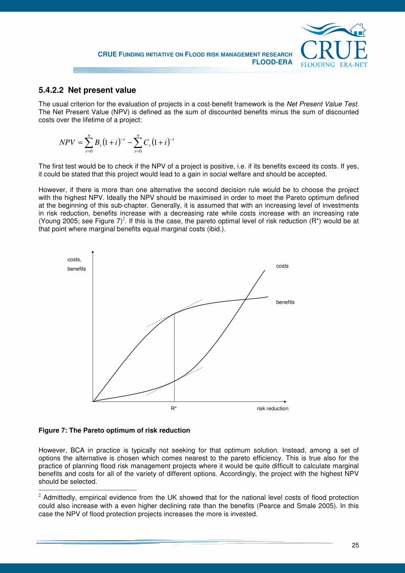
CRUE FUNDING INITIATIVE ON FLOOD RISK MANAGEMENT RESEARCH FLOOD-ERA
25
5.4.2.2 Net present value
The usual criterion for the evaluation of projects in a cost-benefit framework is the Net Present Value Test. The Net Present Value (NPV) is defined as the sum of discounted benefits minus the sum of discounted costs over the lifetime of a project:
( ) ( )∑∑=
−
=
−+−+=
n
t
t
t
n
t
t
t iCiBNPV00
11
The first test would be to check if the NPV of a project is positive, i.e. if its benefits exceed its costs. If yes, it could be stated that this project would lead to a gain in social welfare and should be accepted. However, if there is more than one alternative the second decision rule would be to choose the project with the highest NPV. Ideally the NPV should be maximised in order to meet the Pareto optimum defined at the beginning of this sub-chapter. Generally, it is assumed that with an increasing level of investments in risk reduction, benefits increase with a decreasing rate while costs increase with an increasing rate (Young 2005; see Figure 7)2. If this is the case, the pareto optimal level of risk reduction (R*) would be at that point where marginal benefits equal marginal costs (ibid.).
costs
benefits
costs,
benefits
risk reductionR*
Figure 7: The Pareto optimum of risk reduction
However, BCA in practice is typically not seeking for that optimum solution. Instead, among a set of options the alternative is chosen which comes nearest to the pareto efficiency. This is true also for the practice of planning flood risk management projects where it would be quite difficult to calculate marginal benefits and costs for all of the variety of different options. Accordingly, the project with the highest NPV should be selected. 2 Admittedly, empirical evidence from the UK showed that for the national level costs of flood protection could also increase with a even higher declining rate than the benefits (Pearce and Smale 2005). In this case the NPV of flood protection projects increases the more is invested.
CRUE FUNDING INITIATIVE ON FLOOD RISK MANAGEMENT RESEARCH FLOOD-ERA
26
5.4.2.3 Benefit-cost ratio
An alternative way of expressing the relation between benefits and costs is the cost-benefit ratio or − due to a targeted quotient higher than 1 − more frequently used the benefit-cost ratio (BCR), which is the ratio of discounted benefits to discounted costs:
( )
( )∑
∑
=
−
=
−
+
+
=n
t
t
t
n
t
t
t
iC
iB
BCR
0
0
1
1
A BCR > 1 indicates a positive impact of the project on social welfare, like an NPV > 0 does. But in contrast to the NPV the BCR does not measure the total impact of the project on social welfare but the relation of its benefits to its costs. For example, assuming a run of the benefit and cost curve as shown in Figure 7, the BCR would be highest for relatively small projects, which have on the other side only a relatively little NPV. Hence, the ranking of alternatives would be different when using the BCR instead of the NPV criterion. The choice whether the NPV or the BCR should be used depends on the decision situation: If e.g. one project should be chosen among a set of options then the decision rule would be to choose the one with the highest NPV. If, on the other side, capital budget is fixed and several projects should be carried out with this budget the right decision rule would be rank the projects by their BCR and accept them in order of their ranking until the budget is exhausted.
5.4.2.4 Critics and limitations of benefit-cost analysis
BCA offers a systematic and rational approach to evaluate measures in order to maximise social welfare. However, BCA has its limitations and is often criticised for several reasons. According to Hansjürgens (2004) this criticism can be differentiated in three different strands: 1) Criticism of the efficiency consideration as the underlying normative approach, 2) criticism of the insufficient specification of BCA (methodological shortcomings) and 3) criticism of the way BCA is used in the political decision making process. 1) The criticism on the underlying normative approach can be described as a general scepticism about the efficiency rule as a norm and the weighing up of social, economical and environmental values. However, from economic point of view this kind of criticism seems to be unjustified: As Hansjürgens (2004) states weighing up and ranking are processes which take place in everyday practice in society in order to allocate resources in a more efficient way and not applying them would be to waste resources. BCA has furthermore the advantage that such value judgments are made transparent (ibid.). 2) and 3) focus more on the methodological problems of BCA and its application in politics. With regard to the application of BCA in the flood risk management context we focus on the following aspects (ibid.): - Data uncertainty: Like stated before the calculation of flood damage or risk avoided by a measure is
still highly uncertain. Accordingly, the results of BCA for flood risk management projects contain many uncertainties, too. However, this problem is not rooted in BCA, but in flood risk analysis and assessment. As the estimation of flood probabilities and damage will ever be uncertain to some degree one will have to deal with these uncertain information in the decision making process. BCA at least offers the possibility to make these uncertainties transparent and to deal with them by means of sensitivity analysis (see 5.5.6).
CRUE FUNDING INITIATIVE ON FLOOD RISK MANAGEMENT RESEARCH FLOOD-ERA
27
- Arbitrariness in data selection: BCA ideally should incorporate all economically relevant costs and benefits of a measure, but this is often not the case in everyday practice. E.g. for flood risk management projects the focus is often on benefits due to direct, tangible damage avoided while intangible effects are often neglected. This is presumably not based on a disregard of social and environmental values by the decision makers or analysts. Rather, there is “a danger of emphasising what can be measured rather than what is important” (Smith and Ward 1998) with the consequence that results of BCA could be biased. But again, this is not a problem of BCA in general but a problem of its right execution: Applied correctly, BCA should consider all relevant effects, including intangible effects. Of course the inclusion of such intangibles requires considerable effort as they have to be monetised e.g. by means of techniques like Contingent Valuation. Another way to include non-monetary effects would be the application of multi-criteria evaluation (MCE; see e.g. Turner et al. 2007, Meyer 2007).
- Feigned accuracy: This criticism is closely connected to preceding problems: If it is not documented
which effects are considered in BCA and what uncertainties are associated with the data used, the results of BCA could simulate accuracy to the decision maker which contradicts the actual conditions. Again this problem can be avoided if BCA is applied correctly and transparently. Furthermore, like Turner et al. (2007) state BCA should be considered more as a heuristic aid to the decision maker than choice-prescribing “decision rule”.
- Delays in the regulatory process: Maybe one of the most important criticisms on BCA is that it could be
very time-consuming and costly. If indeed all relevant effects of flooding should be considered and monetised, BCA will require much effort. However, like Green (2000) argues, efficiency indicators should also be applied to the use of BCA. I.e. it is only worth to be more precise and comprehensive if this would lead to any significant changes in the results. Hence, also the execution of BCA is always a trade-off between accuracy and comprehensiveness on the one side and applicability on the other.
- Different spatial and economic scales lead to different benefit-cost ratios. Particularly, in the case of
evaluating flood risk reduction measure alongside a river benefits and costs can be estimate locally, regionally or on the level of the state (national economy). Thus the process and the result of BCA have to be considered in the light of the certain investigation area.
Three other problems of BCA relate to the neoclassical assumptions of BCA which are put into question by representatives of ecological economics: The problem of substitutabilities, of irreversibilities and intergenerational fairness (Hansjürgens 2004). While one neoclassical assumption of BCA is that any negative effect could be in general compensated or substituted by other positive effects. However, some goods and services, like e.g. basic ecosystem services might not be easily substituted. Furthermore, some effects especially on nature could be irreversible. I.e. even if value judgments will change in the future and allocation decisions need to be revised this could not be possible anymore. And finally, BCA is based on the assumption that the losers of regulatory decisions could be compensated by those who take the benefits (Kaldor-Hicks criterion). This assumption is challenged with regard to future generations as they are not able to formulate their interests when such decision are made which may have intergenerational effects and hence, might not be compensated (Turner et al. 2007, Hansjürgens 2004). In this context it is argued that also the sustainability criterion should be considered besides pure efficiency (Pearce and Turner 1990).
CRUE FUNDING INITIATIVE ON FLOOD RISK MANAGEMENT RESEARCH FLOOD-ERA
28
5.5 Outline methodology for the comparative evaluation of SM and NSM
The indicators, criteria and methods explained before have been tested regarding their applicability for NSM and particularly for the comparison of SM and NSM in the FLOOD-ERA case studies. Based on these finding, an outline methodology is derived in what follows. Of course due to the focus of the project and the limited number of cases in a few EU Member States this methodology is just a step towards a more comprehensive and generic approach. Some EU Member States, their countries or professional associations have already developed elaborate practical guidelines for the evaluation of risk reduction projects. The UK Environmental Agency for example introduced the multi-coloured manual of Penning-Rowsell et al. (2005) to assist in economic appraisal. Similar tools exist e.g. in Scotland and Austria and are under preparation in Saxony and Bavaria. In contrast FLOOD-ERA focuses the comparative evaluation of SM and NSM considering the criteria effectiveness and efficiency. As it can be shown at least for a certain group of NSM an evaluation and comparison with SM appears to be feasible. Hereby both individual measures as well as portfolios of measures are considered.
5.5.1 Overall Procedure
To meets the requirements for a comparative evaluation of the effectiveness and efficiency of SM and NSM the following working steps of the evaluation procedure are proposed: 3
1. Definition of the scope of the comparative evaluation,
2. Assignment of quantified objective(s),
3. Measurement of effects, benefits and costs of SM and NSM,
4. Determination and comparison of effectiveness,
5. Determination and comparison of efficiency,
6. Sensitivity analysis,
7. Overall comparison of SM and NSM. Each working step is explained in more detail in the subsequent sections.
5.5.2 Definition of the scope of the comparative evaluation
It is obvious that the kind and extent of an evaluation it crucial for the evaluation result. Therefore requirements have been formulated to ensure a minimum quality. For example, utility, feasibility, propriety and accuracy with a number of sub-criteria are designated as quality criteria by the German Evaluation Society. For the comparison of SM and NSM the following aspects seem to be of special importance: - Description of the flood risk system: The comparison of different types of measures needs a common
and comprehensive understanding of the system where the flood risk occurs and socio-cultural, economic and ecological effects of measures need to be taken into account. Currently, effects considered in evaluation in FRM are often limited to economic impacts, which can be estimated in monetary terms, e.g. avoided damage to property. Thus the challenge is to enlarge the catalogue of appropriate indicators describing the effects more comprehensively. In principle the entire source-
3 More or less different approaches have been developed by Hanley and Spash (1993), Penning-Rowsell et al. (2005).
CRUE FUNDING INITIATIVE ON FLOOD RISK MANAGEMENT RESEARCH FLOOD-ERA
29
pathway-receptor-consequence chain should be taken into account even if the risk reduction measures are supposed to be implemented localised.
- Selection of alternative SM and NSM: Based on the general risk reduction issue, SM and NSM should
be selected which are potentially capable to reach similar effects. For instance, structural flood defense measures for the protection of a vulnerable area can be chosen together with non-structural measures for lowering the vulnerability of this area. Similar effets refer to both the kind of effect as well as their extent. The extent of effects plays a particular role if portfolios of measures are under consideration and cumulative effects should be included. Accordingly all alternatives should be composed in a way which lets assume comparative effects in terms of risk reduction. Since the kind and extent of effects are difficult to anticipate right from the start on, an iteration of alternatives could be helpful even during the evaluation process.
- Choice of the evaluation criteria: As the investigations of FLOOD-ERA confirm, evaluation results are
strongly depended on the applied criteria. Therefore it is recommended to include at least effectiveness as the criterion for the goal achievement and another criterion on the relation of intended and unintended effects. The latter can be efficiency – as in the case of this study – or for example sustainability.
5.5.3 Assignment of quantified objectives
A tolerable level of risk in relation to the current or future risk normally is the basis for decisions and actions towards risk reduction. Hence design and evaluation of SM and NSM needs this agreed tolerable risk or more specific targets as explicit reference of the intended effects. As described under section 5.3.1, there are different ways of quantifying such objectives: single objectives (e.g. maximum risk for an element at risk) or multiple objectives (e.g. maximum risk as accumulation or average for a number of elements at risk). They are either assigned during the initial decision of a risk reduction project (top down) or require specification at the beginning of the evaluation procedure (bottom up). Both ways of quantifying the objectives require legitimacy because of their importance for the evaluation results. In the case of the top-down approach this mostly is ensured due to the official (public) confirmation of the project. For the bottom up approach it can be reached for instance by an additional public involvement during the evaluation procedure. For the comparison of SM and NSM objectives are required, which potentially can be reached by both types of measures. Therefore these objectives should be assigned for common effect indicators. Up to now predominately SM are evaluated referring to hydraulic design standards (e.g. 100 % reliability for all events with a probability <100 years). Since NSM mainly reduce the social, economic and ecological vulnerability, risk is a common indicator for the assignment of objectives for both SM and NSM (see section 5.4.2). A maximum economic risk (e.g. no damage for all events with a probability <100 years) has been proven to be a feasible objective in the Raab River, Mulde River and Elbe River case studies of FLOOD-ERA. Beyond also other indicators mentioned in the subsequent section in principle could serve as a scale for defining thresholds.
5.5.4 Measurement of effects, benefits and costs of SM and NSM
Effects, benefits and costs of SM and NSM are the data base for any evaluation. Their measurement is important in terms of the scope of the considered interrelations between a measure and the system under consideration and the accuracy of their quantification. The meaning of effects as monetary and non-monetary impacts of a measure and benefits and costs as monetised interrelations depend on the applied evaluation criteria. In this study effects play the central role for the criteria effectiveness and cost-effectiveness, whereof costs are relevant for cost-effectiveness and benefit-cost ratio and benefits for the latter only.
CRUE FUNDING INITIATIVE ON FLOOD RISK MANAGEMENT RESEARCH FLOOD-ERA
30
5.5.4.1 Measurement of effects
Likewise to the assignment of a common objective for SM and NSM, measurement of their effects requires the application of common indicators. And again the sociocultural, economic and ecological risk4 is recommended as a common currency. Up to now the peak discharge, water level or inundation width for certain recurrence probabilities play the major role for determining the effects of SM. To meet the common indicators these effects should be additionally calculated as avoided losses for the respective recurrence probabilities. At the same time effects of NSM, which predominately address the vulnerability, require the treatment of both loss and flood recurrence probability. FLOOD-ERA case studies showed that the following indicators are feasible for a comparative measurement of the effects of SM and NSM:
• People at risk (Thames River, Raab River),
• Properties/buildings at risk (Thames River, Raab River),
• Annual average damage (AAD) to structural and installations of residential buildings (Elbe River),
• Annual average damage (AAD) to inventory of residential buildings (Elbe River),
• Annual average damage (AAD) to commercial buildings (Elbe River).
• Annual average damage (AAD) (Thames River, Raab River, Mulde River, Elbe River, Mangfall River),
Since effectiveness is restricted to the intended effects only, the number of indicators does not exceed the quantified objectives. This leads to a rather narrow scope of the included effects and normally does not reflect all effects of both SM and NSM. In contrast efficiency and in particular the benefit-cost ratio allows the inclusion of all relevant interrelations within the flood risk system as far as they could be monetised. Benefits and costs in principle can represent direct and indirect as well as tangible and intangible interrelations (cf. Munasinghe and Swart 2005).
5.5.4.2 Measurement of benefits
Benefits are normally measured as reduced risk. They therefore can be quantified by common monetary effect indicators and the monetisation of all other risk indicators. Economic risk indicators for instance can be measured using state-of-the-art methods (see section 5.4.2.1). Challenges lie in the monetisation of other risk indicators and especially in the determination of impacts mainly of NSM. In the FLOOD-ERA case studies the impacts of NSM has been dealt with in some detail. A number of methods have been developed which allow for a comparative calculation of risk reducing benefits measured as AAD savings. These methods are available for the following NSM (see further details under the respective case studies in chap. 7): - Flood forecasting and warning: calculation based on the EU FHRC warning model of Parker et al.
(2007) (Mulde River),5 - Emergency response during a flood: no benefits could be calculated so far (Thames River), 4 Depending on the scale of the approach either single entities such as e.g. persons, buildings etc. are considered or aggregated units such as e.g. residential areas, industrial areas, farmland etc. 5 The benefits of this measure in the Thames River case study are calculated as public warning response (see under measure “evacuation of inventory”).
CRUE FUNDING INITIATIVE ON FLOOD RISK MANAGEMENT RESEARCH FLOOD-ERA
31
- Evacuation of inventory: calculation based on empirical research of Parker et al. (2007) (Thames River) and on reduction factors according to Olfert (2007) (Elbe River),
- Building ban: avoided AAD due to a hypothetical prevention of a previous urban development in a flood
plain (Raab River), - Resettlement (hypothetical) (Mulde River), - Community based flood protection measures (Thames River), - Flood proofing (dry and wet proofing) (Thames River); calculated based on reduction factors (Elbe
River), - Spillway with inundation area (Raab River).
5.5.4.3 Measurement of costs
Costs cover all monetised efforts for the realisation of either a SM or a NSM. At least the calculation of direct costs for SM is a common step of a benefit-cost analysis. However since the cost structure of SM and NSM could significantly differ, a most comprehensive inclusion of all costs (direct and indirect, tangible and intangible) should be aimed at for the comparison of both types of measures. In the FLOOD-ERA case studies costs of selected NSM have been calculated. Due to the challenge of monetising these measures, the applied approaches need still to been seen as preliminary. Particularly indirect and intangible costs could only be determined and quantified to a minor extent. As a result the costs of the following NSM are provided (see further details under the respective case studies in chap. 7): - Flood forecasting and warning6: costs are measured as annual pro rata expenditure of the entire
warning system for the study area (Thames River) or as investment costs and maintenance costs for a local system (Mulde River),
- Emergency response during a flood7: costs are limited to the additional, marginal costs of planning for
and responding to civil emergencies in general since the costs already appear due to the preparation for other emergencies8 (Thames River),
- Evacuation of inventory: no additional costs need to be charged if a flood forecasting and warning system exists since these measure is carried out by the householders and normally does not require external help (Thames River, Elbe River),
- Building ban or flood zone regulation: no costs could be calculated so far, which of course means a
significant simplification (Raab River, Elbe River, Mangfall River), - Resettlement (hypothetical): costs for compensation payments to property owners are based on
market values or the current housing market (Mulde River), 6 It enables the Environment Agency and other emergency responders to bring themselves to a state of readiness to manage a flood incident, including operating any control or diversion structures that can reduce flood peaks. It also allows the Environment Agency to warn members of the public at risk from flooding (see section 7.1.6). 7 Action taken by official agencies or unofficial bodies, including business companies and individuals, generally aimed at mitigating its adverse impacts by reducing the extent of the flood event, or its severity, or by affecting the ‘receptors’ of the flood. 8 10.7% of the economic property losses are applicable to flood project appraisals.
CRUE FUNDING INITIATIVE ON FLOOD RISK MANAGEMENT RESEARCH FLOOD-ERA
32
- Community based flood protection measures9: costs are measured as capital costs, maintenance costs and other expenditure arising from ground investigation, design, land negotiations and legal costs, calculated over a time period and considering a discount rate (Thames River),
- Flood proofing (dry and wet proofing)10: costs depend firstly upon whether the measures are
incorporated in new builds ab initio, or ‘retrofitted’; secondly, upon the particular design, composition and size of buildings; and thirdly, upon the form of the measure. Some cost surveys (cf. Olfert 2007; see section 7.5.5.2) and general cost estimates (see section 7.1.6) relating to the costs of retrofitting rather than ab initio circumstances are available including material and labour (Elbe River, Thames River),11
- Spillway with inundation area: construction costs, discounted maintenance costs for life expectancy
and opportunity costs based on BMFLUW (2008) and WIFO (2003) (Raab River).
5.5.4.4 Measurement of transaction costs
Transaction costs are supposed to play a particular role if SM and NSM should be compared. It could be expected that both types of measures involve different kinds of transaction costs. SM for instance could cause such costs during the decision making and implementation process for large scale flood defence projects especially when land owners are requested to sell their land. In contrast transaction costs of NSM for example could appear when property owners and householders need to be convinced to proof their assets against floods instead of being protected by SM. As mentioned in section 5.4.2.1, transaction costs can be distinguished as 1) transaction costs of decision making and 2) transaction costs of implementing these management decisions. Despite the size of the FLOOD-ERA research project did not allow to go in details with this type of costs, they were reflected in some case studies. Three different approaches of determining transactions costs have been tested:
• Monetisation (Mulde River),
• Semi-quantitative surveys (Mulde River, Elbe River),
• Qualitative estimates considering results from interviews (Thames River, Mangfall River). As a result the monetisation of transaction costs by interview partners in two pre-tests turned out not to be feasible. Instead a questionnaire for the semi-quantitative appraisal of transactions costs according to section 5.4.2.1 appeared to be a valuable means to specify and compare the costs for alternative SM and NSM. For the Mulde River the transactions costs of dike relocation (4.0) and resettlement (4.6) are “high” and “very high” respectively, whereof a warning system (1.5) and dike heightening (2.4) are classified as 9 Emerging form of flood defence which include a) communal measures including local ground raising, permanent flood wall/bund and demountable barrier protection for groups of properties, and b) individual property protection measures comprising flood boards/gates and orifice capping measures only (these are two types of ‘dry proofing’ measures) (see section 7.1.6). 10 In the UK the term ‘dry proofing’ is also referred to as ‘flood resistance’ which now has become identified with the design and construction of a building in order to prevent floodwater entering and damaging the building and its fabric. The term ‘wet proofing’ is also referred to as ‘flood resilience’ which is the design and construction of a building based upon the principle that floodwater will enter the building but, through careful design, the impact of flooding is reduced to a minimum. This is such that the structural integrity of the building is maintained, services can quickly be restored, and post-flood drying and cleaning are facilitated. 11 This measure also requires a flood forecasting and warning system which in large river systems could reach lead times of 24 hours and more.
CRUE FUNDING INITIATIVE ON FLOOD RISK MANAGEMENT RESEARCH FLOOD-ERA
33
“low”. The application of this approach at the Elbe River led to more or less the same results with “very high” transactions costs for dike relocation (4.6) and “medium” for dike heightening (3.2). Because of the very small number of interviews results from both cases are not representative. However, they provide at least a kind of tendency. Hereby the contexts conditions of the interviewees need to be reflected since rather different reference objects have been included in the transaction cost estimates. Findings more generally show that decision makers evaluate transaction costs to be high especially for measures which are associated with land-use change (e.g. like resettlements but also dike relocations). This is especially due to the high conflicts to be expected during the decision making process and the subsequent implementation. The qualitative estimates result particularly from the Thames River. Here transactions costs turned out to be lower for NSM than for SM. In some cases (public education and insurance) they are even “low”. The interpretation of these results additionally stresses that there is no clear understanding about what transaction costs really mean, especially when so many of these costs are “sunk” in the past. Accordingly further research is required to better understand these kinds of costs and to develop and test approaches for their comparative quantification.
5.5.5 Determination and comparison of effectiveness
The overall aim and approach of the evaluation according to the criterion effectiveness have already been described in section 5.4. Indicators for determining the objectives and measuring the effects are explained in sections 5.5.3 and 5.5.4 respectively. Thus here the emphasis is put on NSM which are supposed to have a potential as alternatives to SM. Of course the scope of this study does not provide a basis for generic conclusions in this respect. Instead FLOOD-ERA case studies give some examples for more or less relevant comparisons under the conditions of these cases. Further research would be required to understand whether the results are applicable more generally in other cases. Table 3 shows the NSM which have been investigated as alternatives to certain SM. Hereby the SM are seen as the reference measures since in all cases the real world approaches are currently focusing this type of measures. For each comparison the table also indicates the degree of effectiveness which could be reached by the NSM. With the exceptions of the Thames River case study where the effectiveness partly has been derived by expert judgement and the Clyde River case study where no detailed evaluation of effectiveness has been carried out, all other results are methodologically based on modelling or at least GIS-based analyses. In essence the examples of this study indicate that flood forecasting and warning in combination with the evacuation of inventory seems to be of minor effectiveness. Instead flood proofing leads to a certain degree of effectiveness at least in one case. For the other cases quantitative results are not available so far. Spatial planning could be of high effectiveness if it is used from an early stage of the floodplain development onwards or a resettlement is feasible. The latter will be restricted to small settlements due to high costs (see section 5.5.6). All other measures are either of minor significance or cannot be assessed yet. As a conclusion a comparison of SM and NSM with respect to their effectiveness is methodologically feasible for the measures mentioned before. Results from the cases studies underline that there are at least a few NSM with a potential effectiveness like this can be reached with SM. However knowledge on this is still in its infancy. For future research it is important to also consider recurrence intervals above the common design level of 100 years. As the Raab River and the Elbe River case studies show the effectiveness of different measures is heavily dependent on the recurrence interval and the boundary conditions. Dike breaches or overtopping during extreme events can reduce the good performance of SM and increase the relative effectiveness of NSM. In the Elbe River case study a dike breach during a 100 years event would reduce the effectiveness of the SM to 78 % which than is rather close to the effectiveness of the NSM under similar conditions.
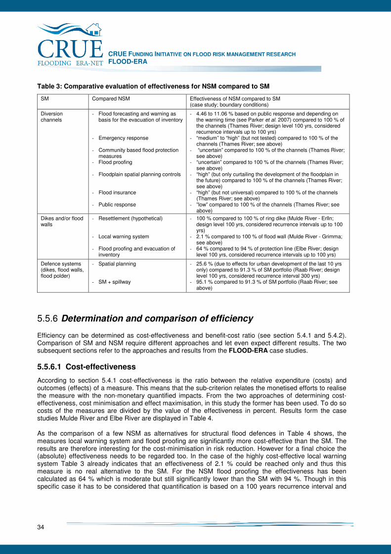
CRUE FUNDING INITIATIVE ON FLOOD RISK MANAGEMENT RESEARCH FLOOD-ERA
34
Table 3: Comparative evaluation of effectiveness for NSM compared to SM
SM Compared NSM Effectiveness of NSM compared to SM (case study; boundary conditions)
Diversion channels
- Flood forecasting and warning as basis for the evacuation of inventory
- Emergency response - Community based flood protection
measures - Flood proofing - Floodplain spatial planning controls - Flood insurance - Public response
- 4.46 to 11.06 % based on public response and depending on the warning time (see Parker et al. 2007) compared to 100 % of the channels (Thames River; design level 100 yrs, considered recurrence intervals up to 100 yrs)
- “medium” to “high” (but not tested) compared to 100 % of the channels (Thames River; see above)
- “uncertain” compared to 100 % of the channels (Thames River; see above)
- “uncertain” compared to 100 % of the channels (Thames River; see above)
- “high” (but only curtailing the development of the floodplain in the future) compared to 100 % of the channels (Thames River; see above)
- “high” (but not universal) compared to 100 % of the channels (Thames River; see above)
- ”low” compared to 100 % of the channels (Thames River; see above)
Dikes and/or flood walls
- Resettlement (hypothetical) - Local warning system
- Flood proofing and evacuation of
inventory
- 100 % compared to 100 % of ring dike (Mulde River - Erlln; design level 100 yrs, considered recurrence intervals up to 100 yrs)
- 2.1 % compared to 100 % of flood wall (Mulde River - Grimma; see above)
- 64 % compared to 94 % of protection line (Elbe River; design level 100 yrs, considered recurrence intervals up to 100 yrs)
Defence systems (dikes, flood walls, flood polder)
- Spatial planning - SM + spillway
- 25.6 % (due to effects for urban development of the last 10 yrs only) compared to 91.3 % of SM portfolio (Raab River; design level 100 yrs, considered recurrence interval 300 yrs)
- 95.1 % compared to 91.3 % of SM portfolio (Raab River; see above)
5.5.6 Determination and comparison of efficiency
Efficiency can be determined as cost-effectiveness and benefit-cost ratio (see section 5.4.1 and 5.4.2). Comparison of SM and NSM require different approaches and let even expect different results. The two subsequent sections refer to the approaches and results from the FLOOD-ERA case studies.
5.5.6.1 Cost-effectiveness
According to section 5.4.1 cost-effectiveness is the ratio between the relative expenditure (costs) and outcomes (effects) of a measure. This means that the sub-criterion relates the monetised efforts to realise the measure with the non-monetary quantified impacts. From the two approaches of determining cost-effectiveness, cost minimisation and effect maximisation, in this study the former has been used. To do so costs of the measures are divided by the value of the effectiveness in percent. Results form the case studies Mulde River and Elbe River are displayed in Table 4. As the comparison of a few NSM as alternatives for structural flood defences in Table 4 shows, the measures local warning system and flood proofing are significantly more cost-effective than the SM. The results are therefore interesting for the cost-minimisation in risk reduction. However for a final choice the (absolute) effectiveness needs to be regarded too. In the case of the highly cost-effective local warning system Table 3 already indicates that an effectiveness of 2.1 % could be reached only and thus this measure is no real alternative to the SM. For the NSM flood proofing the effectiveness has been calculated as 64 % which is moderate but still significantly lower than the SM with 94 %. Though in this specific case it has to be considered that quantification is based on a 100 years recurrence interval and
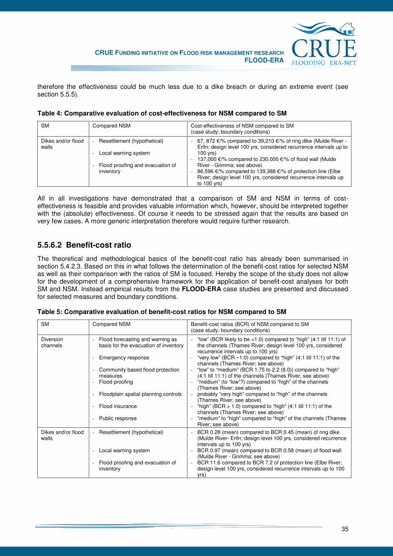
CRUE FUNDING INITIATIVE ON FLOOD RISK MANAGEMENT RESEARCH FLOOD-ERA
35
therefore the effectiveness could be much less due to a dike breach or during an extreme event (see section 5.5.5).
Table 4: Comparative evaluation of cost-effectiveness for NSM compared to SM
SM Compared NSM Cost-effectiveness of NSM compared to SM (case study; boundary conditions)
Dikes and/or flood walls
- Resettlement (hypothetical) - Local warning system
- Flood proofing and evacuation of
inventory
- 67, 872 €/% compared to 39,210 €/% of ring dike (Mulde River - Erlln; design level 100 yrs, considered recurrence intervals up to 100 yrs)
- 137,000 €/% compared to 230,000 €/% of flood wall (Mulde River - Grimma; see above)
- 86,596 €/% compared to 139,388 €/% of protection line (Elbe River; design level 100 yrs, considered recurrence intervals up to 100 yrs)
All in all investigations have demonstrated that a comparison of SM and NSM in terms of cost-effectiveness is feasible and provides valuable information which, however, should be interpreted together with the (absolute) effectiveness. Of course it needs to be stressed again that the results are based on very few cases. A more generic interpretation therefore would require further research.
5.5.6.2 Benefit-cost ratio
The theoretical and methodological basics of the benefit-cost ratio has already been summarised in section 5.4.2.3. Based on this in what follows the determination of the benefit-cost ratios for selected NSM as well as their comparison with the ratios of SM is focused. Hereby the scope of the study does not allow for the development of a comprehensive framework for the application of benefit-cost analyses for both SM and NSM. Instead empirical results from the FLOOD-ERA case studies are presented and discussed for selected measures and boundary conditions. Table 5: Comparative evaluation of benefit-cost ratios for NSM compared to SM
SM Compared NSM Benefit-cost ratios (BCR) of NSM compared to SM (case study; boundary conditions)
Diversion channels
- Flood forecasting and warning as basis for the evacuation of inventory
- Emergency response - Community based flood protection
measures - Flood proofing - Floodplain spatial planning controls - Flood insurance - Public response
- “low” (BCR likely to be <1.0) compared to “high” (4:1 till 11:1) of the channels (Thames River; design level 100 yrs, considered recurrence intervals up to 100 yrs)
- “very low” (BCR ~1.0) compared to “high” (4:1 till 11:1) of the channels (Thames River; see above)
- “low” to “medium” (BCR 1.75 to 2.2 (8.0)) compared to “high” (4:1 till 11:1) of the channels (Thames River; see above)
- “medium” (to “low”?) compared to “high” of the channels (Thames River; see above)
- probably “very high” compared to “high” of the channels (Thames River; see above)
- “high” (BCR > 1.0) compared to “high” (4:1 till 11:1) of the channels (Thames River; see above)
- ”medium” to “high” compared to “high” of the channels (Thames River; see above)
Dikes and/or flood walls
- Resettlement (hypothetical) - Local warning system
- Flood proofing and evacuation of
inventory
- BCR 0.28 (mean) compared to BCR 0.45 (mean) of ring dike (Mulde River- Erlln; design level 100 yrs, considered recurrence intervals up to 100 yrs)
- BCR 0.97 (mean) compared to BCR 0.58 (mean) of flood wall (Mulde River - Grimma; see above)
- BCR 11.6 compared to BCR 7.2 of protection line (Elbe River; design level 100 yrs, considered recurrence intervals up to 100 yrs)
CRUE FUNDING INITIATIVE ON FLOOD RISK MANAGEMENT RESEARCH FLOOD-ERA
36
Table 5 gives an overview of the benefit-cost ratios derived for the NSM and confronts them with the ratios of the reference SM. Benefits and costs have been derived according to sections 5.5.4.2 and 5.5.4.3. A detailed description of the approaches could be found under the respective sections of the case studies. As the results in Table 5 show, NSM can reach higher, the same and lower benefit-cost ratios than SM. Hereby no clear tendency for the same NSM can be found. For instance the warning system in the Thames River case study leads to a low and compared to the SM lower BCR whereof the one in the Mulde River (Grimma) reaches a very high and compared to the SM higher BCR. The same counts for flood proofing which appears to have a lower BCR in the Thames River case study and a significantly higher in the Elbe River case study. Therefore the results seem to be rather side-specific. Future research should shade more light on this by investigating more examples. Particularly the NSM as alternatives of the diversion channel are first estimates which require further quantification.
5.5.7 Sensitivity analysis
Sensitivity analysis is used to check whether the results of the evaluation are stable against changes in the input data. In case of the evaluation of flood risk management measures this is of special importance as some of the effects, benefits and costs data are associated with considerable uncertainties: While cost components like construction costs can be assigned with reasonable certainty, the estimation of flood risk (AAD) and flood risk avoided is still highly uncertain due to data and methodological problems in flood probability estimation, inundation modelling as well as damage evaluation (see e.g. Nachtnebel 2007). This is even truer for monetary estimates of intangible flood damages which are normally not measured in monetary terms. Ideally, such uncertainties in the results of damage and risk assessment should be documented, e.g. by calculating a lower and upper bound besides the mean estimate (USACE 1996, Messner et al. 2007). By applying the mean as well as the minimum and maximum value of damage avoided as input in BCA it can be tested if this would result in a change of the overall ranking of alternatives. This could e.g. lead to a partial order of alternatives, i.e. there might be no final statement if one alternative should be preferred to another with certainty. Sensitivity analysis can be of course also applied to other input parameter of BCA like the discount rate or the project life span. Especially the choice of the discount rate could have a major impact on the results of BCA. Especially in the Mulde River and the Raab River case studies sensitivity analyses cover the determination of the benefits as AAA as well as the discount rate. In both cases this does not change the principle comparison of the SM and NSM under consideration. More important are the conclusions from the Mulde River case study with respect to the arbitrariness of the data. Intangible economic, social and ecological effects could only be discussed but not involved in the quantitative procedures. Despite there could be more detailed approaches even with the potential to significantly influence the preference of SM and NSM, both criteria focused in this study have their limitations in this regard. As already pointed out in sections 5.3 and 5.4, the restrictions on intended effects (effectiveness) and the requirements for monetisation (efficiency) are always challenges for a comprehensive involvement of all relevant interrelations of a measure and its consequences.
5.5.8 Overall comparison of SM and NSM
At the beginning of this study criteria for the evaluation of SM and NSM have been listed without any further reflection of the relation between these criteria. Regarding the two criteria effectiveness and efficiency results from the FLOOD-ERA case studies provide additional evidence that both criteria cannot substitute each other for decision making in flood risk reduction. While effectiveness is important to
CRUE FUNDING INITIATIVE ON FLOOD RISK MANAGEMENT RESEARCH FLOOD-ERA
37
measure the goal achievement efficiency informs about the effort for reducing the risk. Interesting examples in this respect are the flood forecasting and warning systems at the Thames River and Mulde River (Grimma) case studies which are convincing NSM due to their high efficiency but no real alternatives to SM due to their low effectiveness. In contrary the Mulde River case study (Erlln) shows that measures which are 100 % effective are also realised despite their efficiency is rather low. The reason for that is the high public interest after the serious flood event 2002. Beyond the meaning of the relation between the criteria it became obvious that no principal tendency in the preferences of SM and NSM can be found – at least based on the empirical work of this study. Results are rather case specific. In a few cases NSM can be real alternatives for SM particular if a long-term performance is regarded (e.g. Raab River, Mulde River – Erlln). In other case NSM are significantly less effective than SM (Thames River, Mulde River – Grimma). Despite the study did not allow for detailed investigations on optimal portfolios of SM and NSM, it can be expected that a combination of both kinds of measures could be a good means of risk reduction especially if extreme events are considered. However, quantification of this assumption will need further investigations. The meaning of this research lies in the exemplary comparison of the two types of measures and the respective approaches. Findings can be included in the evaluation guidelines of the European Member States and their countries. Since these tools up to now are mainly dedicated to benefit-cost analyses of SM, their enhancement towards the inclusion of effectiveness analyses and the comparison of SM and NSM should be envisaged.
5.6 Remaining challenges of evaluating SM and NSM
As already stated the outcomes of this study are exemplary and therefore were not dedicated to serve as the basis for a generic evaluation framework. However the enhancement of this knowledge base would be valuable to improve the evidence of the current conclusions and to provide further examples and probably a future comprehensive framework for flood risk management practice. This maybe could even lead to a general classification of NSM and SM with a high potential to serve as alternatives. Given the results of this study, especially the following three aspects are seen as major challenges for further research efforts:
• Enhancement of the empirical basis for the comparison of the considered SM and NSM and their evaluation in terms of effectiveness and efficiency,
• Investigations of further NSM measures whose outcomes could not be measured so far,
• Inclusion of further criteria which overcome the limitations particularly of the benefit-cost analysis. The enhancement of the empirical base is obvious due to the small number of cases in this study. For a European view also cases from other Member States should be included. As a first step other results from the First Pilot Call of the CRUE ERA-NET could be analysed and compared. Beyond a broader survey could be undertaken. With regard to the investigation of other NSM this study – mainly the Thames River case study – could be used to derive some helpful indications for relevant measures as follows: - Flood insurance: The potential effects of flood insurances are complex. Graduated premiums could
have a positive influence on a limited development in floodplains. Sums assured in contrast could reduce the risk for householders and thus stimulate them to drive a flood risk. Investigations therefore should include different European insurance policies and there effects, benefits and costs.
CRUE FUNDING INITIATIVE ON FLOOD RISK MANAGEMENT RESEARCH FLOOD-ERA
38
- Emergency response: This NSM designates all actions during a flood taken by official agencies or unofficial bodies, including business companies and individuals, generally aimed at mitigating its adverse impacts by reducing the extent of the flood event, or its severity, or by affecting the ‘receptors’ of the flood. The benefits of this measure are not well understood because no research has been undertaken yet which isolates them.
- Spatial planning: Despite this measure has already been considered in the study, the instruments are
manifold and more complex than the assumption of a physical building ban only. Accordingly different public and private instruments with their mechanisms should be investigated in more detail. Hereby also changing effects over time are relevant.
- Public education and awareness: This communicative area of risk reduction is rather ambiguous and
therefore needs some further differentiation in the first place. The overlaps with the resulting flood proofing and evacuation of inventory by householders are obvious. However, even this measure could have its specific mechanisms and benefits and therefore should be included in the investigation of portfolio of measures.
The limitations of the criteria focused in this study last but not least should be overcome by the involvement of further criteria. Mainly a non-monetary and multi-criteria12 quantification of the suitability of a measure with respect to social, economic and environmental aspects plays a major role in the discussion which is normally covered under the criterion “sustainability”. The advantages of this criterion lie in the potential to consider all positive and negative effects with different scales. For its operationalisation a number of so-called MCE methods are available. The criterion is often recommended to be used in addition to a benefit-cost analysis (see Clyde River case study). It can be expected that its application is particular useful for the quantification and comprehensive comparison of the complex indirect and intangible effects of NSM. 12 Criteria in this context mean effect indicators.
CRUE FUNDING INITIATIVE ON FLOOD RISK MANAGEMENT RESEARCH FLOOD-ERA
39
6 Context conditions for the choice of SM and NSM
Main contributors: Gérard Hutter, Tim Harries and Christian Kuhlicke Decision makers do not necessarily consider all possible SM and NSM to solve problems of pre-flood risk management. Often, decision making in the “real world” is much more focused and limited from the outset than traditional theories of rational decision making want us to assume (e.g., neoclassical theory of economic behaviour). For instance, socio-cultural, economic, legal, and physical context conditions can motivate decision maker (implicitly or explicitly) to put specific measures into the foreground of programme development (e.g., structural measures like flood walls) and others into the background (e.g., spatial planning to reduce vulnerability in flood-prone areas). Empirical studies show that one important factor to explain current strategies for pre-flood risk management is strategy of the past (Johnson et al. 2005, Hutter and Schanze 2008). Thus, history shapes current strategy. However, this does not mean that history determines it. There are possibilities to reshape strategies to consider current problems and future challenges. Whatever the case, the heavy hand of history or effective reshaping of strategy in the present, knowledge about context conditions is necessary for both. Hence, methodologies with the aim of providing a contribution to “real world” decision making should consider the role of context in programme and project development. Unfortunately, one cannot analyse the context of pre-flood risk management in detail and comprehensively. Context conditions are too complex. They differ between European Member States, they differ within Member States, and they differ in one community at local level, for instance, over time when multiple projects are developed. Hence, selection of context conditions is essential. FRM strategies are very complex social endeavours that take place at different spatial levels and that have unique histories in Member States. Hence, a balance has to be struck between considering too much complexity with limited capability of comparing different cases on the one hand and being too simple in analysing the influence of context on content on the other. This chapter seeks to find this balance through blending theoretical arguments (e.g., Makridakis 1990) with results from the case studies. Against this background, this chapter aims at answering two questions: • Which context conditions are important for evaluating SM and NSM? • How should context conditions be considered to develop a methodology for NSM and SM? The chapter is structured as follows: Section 6.1 elucidates the approach to studying the influence of context factors on decisions about measures for FRM. The approach is crucial because it determines the selectivity of empirical analysis. Based on the case studies and theoretical arguments, this chapter does not claim to provide a comprehensive answer to which context factors are important for evaluating SM and NSM. Only a large-scale survey could do this to some extent. The chapter aims to show that context factors that are amenable to change through providing an evaluation methodology are embedded in further case-specific context conditions. Hence, scientific efforts on supporting decisions through methodologies and methods should be aligned with further policies. The chapter makes some suggestions in this respect. Section 6.2 extracts from the case studies a “list” of nine context conditions that explain decisions about measures. Section 6.3 explains implications of these findings for policy and strategy development.
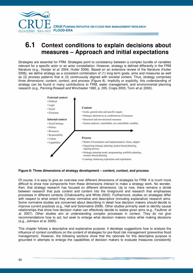
CRUE FUNDING INITIATIVE ON FLOOD RISK MANAGEMENT RESEARCH FLOOD-ERA
40
6.1 Context conditions to explain decisions about measures – Approach and initial expectations
Strategies are essential for FRM. Strategies point to consistency between a complex bundle of variables relevant for a specific actor or an actor constellation. However, strategy is defined differently in the FRM literature (e.g., Hooijer et al. 2004, Hutter 2006). Based on an extensive review of the literature (Hutter 2006), we define strategy as a consistent combination of (1) long-term goals, aims and measures as well as (2) process patterns that is (3) continuously aligned with societal context. Thus, strategy comprises three dimensions: content, context, and process (Figure 8). Implicitly or explicitly, this understanding of strategy can be found in many contributions to FRM, water management, and environmental planning research (e.g., Penning-Rowsell and Winchester 1992, p. 205, Craps 2003, Tonn et al. 2000).
Figure 8: Three dimensions of strategy development – content, context, and process
Of course, it is easy to give an overview over different dimensions of strategies for FRM. It is much more difficult to show how components from these dimensions interact to make a strategy work. No wonder, then, that strategy research has focused on different dimensions. Up to now, there remains a divide between research that puts context and content into the foreground and research that emphasises processes in different contexts (Chakravarthy and White 2002). Furthermore, studies on strategies differ with respect to what extent they stress normative and descriptive (including explanative) research aims. Some normative studies are concerned about describing in detail how decision makers should decide to improve current practices (e.g., Hall and Solomatine 2008). Other studies primarily seek to identify causal relationships that show how decision maker can effectively decide to realise given aims (e.g., Faulkner et al. 2007). Other studies aim at understanding complex processes in context. They do not give recommendations how to act, but seek to enlarge what decision makers notice while making decisions (e.g., Johnson et al. 2005). This chapter follows a descriptive and explanative purpose. It develops suggestions how to analyse the influence of context conditions on the content of strategies for pre-flood risk management (preventive flood management). However, the following sections show that the rationale for this descriptive purpose is grounded in attempts to enlarge the capabilities of decision makers to evaluate measures consistently
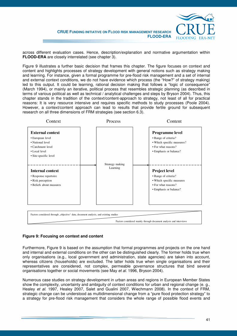
CRUE FUNDING INITIATIVE ON FLOOD RISK MANAGEMENT RESEARCH FLOOD-ERA
41
across different evaluation cases. Hence, description/explanation and normative argumentation within FLOOD-ERA are closely interrelated (see chapter 3). Figure 9 illustrates a further basic decision that frames this chapter. The figure focuses on context and content and highlights processes of strategy development with general notions such as strategy making and learning. For instance, given a formal programme for pre-flood risk management and a set of internal and external context conditions, we do not have evidence which process (the “How?” of strategy making) led to this output. It could be learning, rational decision making that follows a “logic of consequence” (March 1994), or mainly an iterative, political process that resembles strategic planning (as described in terms of various political as well as technical / analytical challenges and steps by Bryson 2004). Thus, this chapter stands in the tradition of the context/content-approach to strategy, not least of all for practical reasons: It is very resource intensive and requires specific methods to study processes (Poole 2004). However, a context/content approach can lead to results that provide fertile ground for subsequent research on all three dimensions of FRM strategies (see section 6.3).
Strategy making
Learning
Context Process Content
Internal context
• Response repertoire
• Risk perception
• Beliefs about measures
External context
• European level
• National level
• Catchment level
• Local level
• Site-specific level
Project level
• Range of criteria?
• Which specific measures
• For what reasons?
• Emphasis or balance?
Programme level
• Range of criteria?
• Which specific measures?
• For what reasons?
• Emphasis or balance?
Factors considered through „objective“ data, document analysis, and existing studies
Factors considered mainly through document analysis and interviews
Figure 9: Focusing on context and content
Furthermore, Figure 9 is based on the assumption that formal programmes and projects on the one hand and internal and external conditions on the other can be distinguished clearly. The former holds true when only organisations (e.g., local government and administration, state agencies) are taken into account, whereas citizens (households) are excluded. The latter holds true when single organisations and their representatives are considered, not complex, permeable governance structures that bind several organisations together or social movements (see May et al. 1996, Bryson 2004). Numerous case studies on strategy development in urban areas and regions in European Member States show the complexity, uncertainty and ambiguity of context conditions for urban and regional change (e. g., Healey et al. 1997, Healey 2007, Salet and Gualini 2007, Wiechmann 2008). In the context of FRM, strategic change can be understood as multidimensional change from a “pure flood protection strategy” to a strategy for pre-flood risk management that considers the whole range of possible flood events and
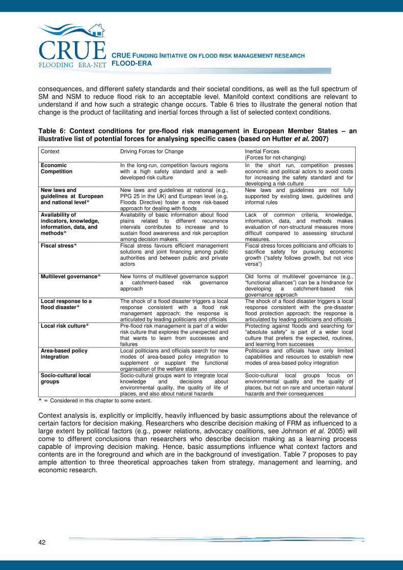
CRUE FUNDING INITIATIVE ON FLOOD RISK MANAGEMENT RESEARCH FLOOD-ERA
42
consequences, and different safety standards and their societal conditions, as well as the full spectrum of SM and NSM to reduce flood risk to an acceptable level. Manifold context conditions are relevant to understand if and how such a strategic change occurs. Table 6 tries to illustrate the general notion that change is the product of facilitating and inertial forces through a list of selected context conditions.
Table 6: Context conditions for pre-flood risk management in European Member States – an illustrative list of potential forces for analysing specific cases (based on Hutter et al. 2007)
Context Driving Forces for Change Inertial Forces (Forces for not-changing)
Economic Competition
In the long-run, competition favours regions with a high safety standard and a well-developed risk culture
In the short run, competition presses economic and political actors to avoid costs for increasing the safety standard and for developing a risk culture
New laws and guidelines at European and national level*
New laws and guidelines at national (e.g., PPG 25 in the UK) and European level (e.g. Floods Directive) foster a more risk-based approach for dealing with floods
New laws and guidelines are not fully supported by existing laws, guidelines and informal rules
Availability of indicators, knowledge, information, data, and methods*
Availability of basic information about flood plains related to different recurrence intervals contributes to increase and to sustain flood awareness and risk perception among decision makers.
Lack of common criteria, knowledge, information, data, and methods makes evaluation of non-structural measures more difficult compared to assessing structural measures.
Fiscal stress* Fiscal stress favours efficient management solutions and joint financing among public authorities and between public and private actors
Fiscal stress forces politicians and officials to sacrifice safety for pursuing economic growth (“safety follows growth, but not vice versa”)
Multilevel governance*
New forms of multilevel governance support a catchment-based risk governance approach
Old forms of multilevel governance (e.g., “functional alliances”) can be a hindrance for developing a catchment-based risk governance approach
Local response to a flood disaster*
The shock of a flood disaster triggers a local response consistent with a flood risk management approach; the response is articulated by leading politicians and officials
The shock of a flood disaster triggers a local response consistent with the pre-disaster flood protection approach; the response is articulated by leading politicians and officials
Local risk culture*
Pre-flood risk management is part of a wider risk culture that explores the unexpected and that wants to learn from successes and failures
Protecting against floods and searching for “absolute safety” is part of a wider local culture that prefers the expected, routines, and learning from successes
Area-based policy integration
Local politicians and officials search for new modes of area-based policy integration to supplement or supplant the functional organisation of the welfare state
Politicians and officials have only limited capabilities and resources to establish new modes of area-based policy integration
Socio-cultural local groups
Socio-cultural groups want to integrate local knowledge and decisions about environmental quality, the quality of life of places, and also about natural hazards
Socio-cultural local groups focus on environmental quality and the quality of places, but not on rare and uncertain natural hazards and their consequences
* = Considered in this chapter to some extent. Context analysis is, explicitly or implicitly, heavily influenced by basic assumptions about the relevance of certain factors for decision making. Researchers who describe decision making of FRM as influenced to a large extent by political factors (e.g., power relations, advocacy coalitions, see Johnson et al. 2005) will come to different conclusions than researchers who describe decision making as a learning process capable of improving decision making. Hence, basic assumptions influence what context factors and contents are in the foreground and which are in the background of investigation. Table 7 proposes to pay ample attention to three theoretical approaches taken from strategy, management and learning, and economic research.

CRUE FUNDING INITIATIVE ON FLOOD RISK MANAGEMENT RESEARCH FLOOD-ERA
43
Table 7: Three theoretical approaches for analysing the influence of context on content
Theoretical approach Problem statement Relevance for context analysis
Cognitive approach to strategy making (e. g. Makridakis 1990, March 1994)
Decision making is biased and limited due to various cognitive restrictions.
Identifies boundary conditions relevant for all cases (e.g., “bounded rationality” of decision makers). Points to possible cognitive problems that influence content of FRM (e. g., “inconsistency”, “selective perception”, “underestimating uncertainty”).
Organisational learning (e. g, March 1999)
Organisational learning suffers from multiple learning problems (e.g., organisations have difficulties to sustain and exploit the results of exploratory activities).
Beliefs can be based on “superstitious” learning. Points out that context cannot be changed easily through learning.
Transaction cost theory (e.g., Ebers and Gotsch 1995)
Problems arise from a mismatch between a specific transaction and its institutional arrangement.
Highlights the influence of external context conditions and governance structures on transaction costs which influence internal context conditions relevant for explaining the content of FRM.
In this chapter, descriptive analysis of context factors on decisions about measures for pre-flood risk management is based primarily on the cognitive approach to decision and strategy making and approaches to organisational learning. This is so for the following main reasons: • Cognitive studies and organisational learning approaches are of growing importance for
understanding and explaining decisions and their outcomes (Mintzberg et al. 1999, March 1994). Both acknowledge the limitations of human decision makers to make decisions (“bounded rationality”). Hence, explaining decisions about measures in the “real world” can benefit from adopting these theoretical approaches (for a similar argument see Penning-Rowsell 1994).
• A methodology to evaluate SM and NSM aims at solving a cognitive problem: the problem of making consistent and informed decisions about very different types of measures based on an appropriate understanding of the complex, uncertain and sometimes ambiguous relationships between measures and consequences. Therefore, theoretical approaches that focus on individual as well as organisational decision and strategy making are appropriate heuristic devices.
• Both, cognitive and learning approaches to decision making, highlight problems and opportunities to make decisions. Therefore, these theoretical approaches can be used flexibly in more explorative research work as intended through conducted case studies in FLOOD-ERA. Information within the case studies can be interpreted either as (1) information about important problems and hurdles (“problem-driven approach”) or as (2) information about decision opportunities and solutions for known and still unknown problems (“solution-driven” approach).
Hence, adopting a cognitive and learning approach to descriptive analysis about context factors that influence decisions about SM and NSM can be justified with regard to specific thematic features of the research problem and for methodological reasons. Based on a context-content approach to strategy development and informed by literature about cognitive limitations and learning problems, a broad literature review in FRM research revealed the following initial expectations for conducting the case studies in different European Member States (see Table 8).
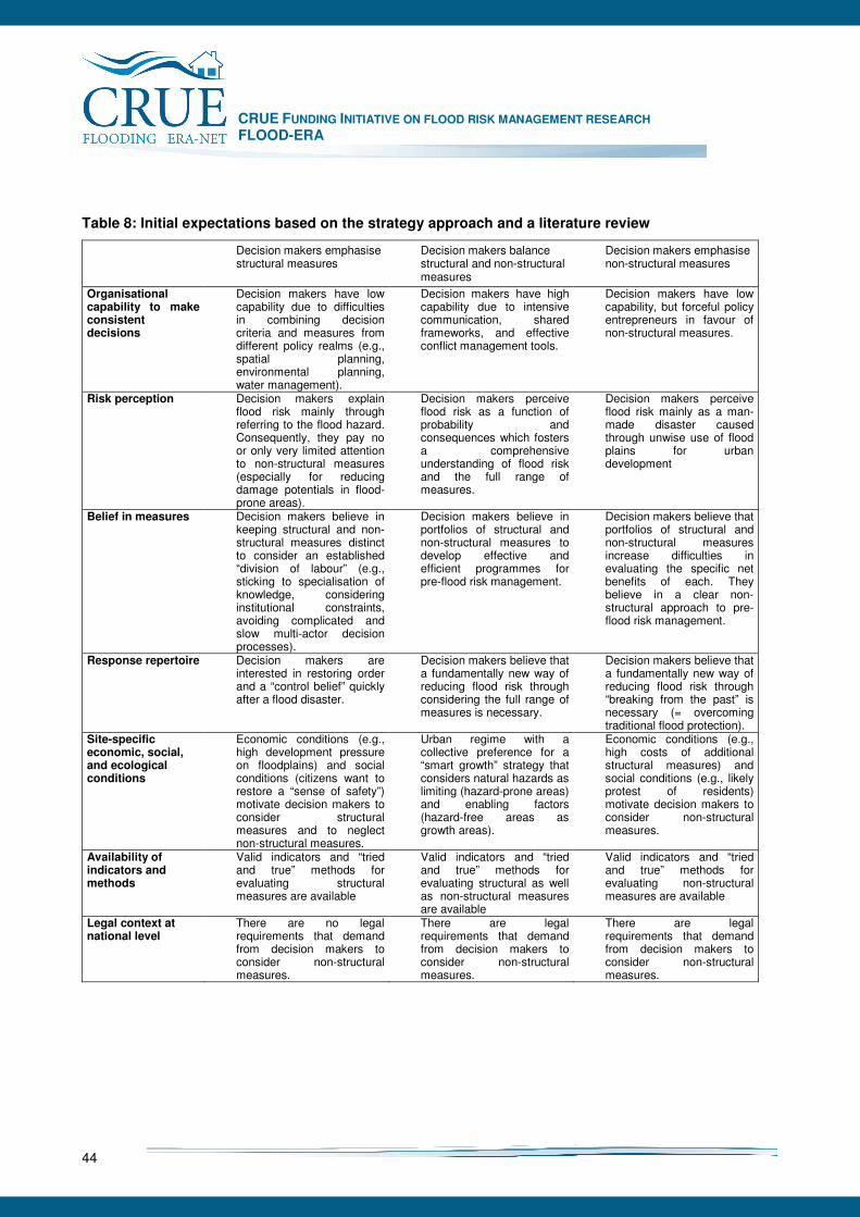
CRUE FUNDING INITIATIVE ON FLOOD RISK MANAGEMENT RESEARCH FLOOD-ERA
44
Table 8: Initial expectations based on the strategy approach and a literature review
Decision makers emphasise structural measures
Decision makers balance structural and non-structural measures
Decision makers emphasise non-structural measures
Organisational capability to make consistent decisions
Decision makers have low capability due to difficulties in combining decision criteria and measures from different policy realms (e.g., spatial planning, environmental planning, water management).
Decision makers have high capability due to intensive communication, shared frameworks, and effective conflict management tools.
Decision makers have low capability, but forceful policy entrepreneurs in favour of non-structural measures.
Risk perception
Decision makers explain flood risk mainly through referring to the flood hazard. Consequently, they pay no or only very limited attention to non-structural measures (especially for reducing damage potentials in flood-prone areas).
Decision makers perceive flood risk as a function of probability and consequences which fosters a comprehensive understanding of flood risk and the full range of measures.
Decision makers perceive flood risk mainly as a man-made disaster caused through unwise use of flood plains for urban development
Belief in measures
Decision makers believe in keeping structural and non-structural measures distinct to consider an established “division of labour” (e.g., sticking to specialisation of knowledge, considering institutional constraints, avoiding complicated and slow multi-actor decision processes).
Decision makers believe in portfolios of structural and non-structural measures to develop effective and efficient programmes for pre-flood risk management.
Decision makers believe that portfolios of structural and non-structural measures increase difficulties in evaluating the specific net benefits of each. They believe in a clear non-structural approach to pre-flood risk management.
Response repertoire Decision makers are interested in restoring order and a “control belief” quickly after a flood disaster.
Decision makers believe that a fundamentally new way of reducing flood risk through considering the full range of measures is necessary.
Decision makers believe that a fundamentally new way of reducing flood risk through “breaking from the past” is necessary (= overcoming traditional flood protection).
Site-specific economic, social, and ecological conditions
Economic conditions (e.g., high development pressure on floodplains) and social conditions (citizens want to restore a “sense of safety”) motivate decision makers to consider structural measures and to neglect non-structural measures.
Urban regime with a collective preference for a “smart growth” strategy that considers natural hazards as limiting (hazard-prone areas) and enabling factors (hazard-free areas as growth areas).
Economic conditions (e.g., high costs of additional structural measures) and social conditions (e.g., likely protest of residents) motivate decision makers to consider non-structural measures.
Availability of indicators and methods
Valid indicators and “tried and true” methods for evaluating structural measures are available
Valid indicators and “tried and true” methods for evaluating structural as well as non-structural measures are available
Valid indicators and “tried and true” methods for evaluating non-structural measures are available
Legal context at national level
There are no legal requirements that demand from decision makers to consider non-structural measures.
There are legal requirements that demand from decision makers to consider non-structural measures.
There are legal requirements that demand from decision makers to consider non-structural measures.
CRUE FUNDING INITIATIVE ON FLOOD RISK MANAGEMENT RESEARCH FLOOD-ERA
45
6.2 Context conditions to explain decisions about measures in the case studies
Case studies conducted in England, Scotland, Austria, and Germany have two main results (Table 9): Firstly, in no case study we found evidence that decision-makers in the policy field of FRM at different levels (local, regional, federal state level) emphasised NSM as dominant measure to reduce flood risk. Not only in theory, but also in our cases SM are important approaches to FRM. This is consistent with the notion that FRM in European Member States is characterised by a tradition of reducing flood risk through engineering works, often, large-scale engineering works for flood protection, often, large-scale engineering works like dykes, dams, barriers, and so forth. Secondly, the case studies show which further context conditions are important to explain decisions about SM and NSM (see above Table 8). They highlight context conditions like perception of responsibility by decision makers, funding mechanisms and informal as well as formal institutions. In contrast, risk perception of decision makers (defined as selective or comprehensive perception of the causes and consequences of floods as natural hazards) seems to be no crucial context conditions to explain decisions about measures. Table 9 gives a stylised summary of the findings from the case studies. It is to be understood as an interpretation of the empirical findings. The table distinguishes between two different phenomena of decision making: (1) Decision makers emphasise SM in line with the traditional approach to FRM. NSM are of less importance here. Decision makers choose NSM if they complement SM (for instance, to reduce residual risk) or if SM are too costly from a national and federal state level perspective. (2) Decision makers balance SM and NSM right from the start of decision making. It is important to note that also in this case decision makers can emphasise SM as means to reduce flood risk in a certain context due especially to physical conditions of the site and the catchment. But this preference is not a general preference in line with a traditional approach to FRM, but the outcome of a systematic evaluation procedure that considers SM and NSM in a “fair” way”. The case studies that are presented in detail in Chapter 7 show evidence that (1) is more likely in reality than (2). All cases – except the sub-case “Grimma” of the Mulde River case and the Scotland case – show decision makers that emphasised SM as means to reduce flood risk. The results of the normative analysis which compare SM and NSM in a fair way and the best data available are in some cases hypothetical (e. g., the sub-case “Erlln” of the Mulde River case or the Austrian case). This means they are not based on evidence about decision-making in practice, but on the outsider perspective of scientists that are interested in developing a methodology to balance SM and NSM. In what follows this empirical result is explained in more detail (Section 6.2.1). The subsequent sections point to selected context conditions that seem important to explain this overall result. Thereby, they compare the conditions for emphasising SM with the (in some respect) hypothetical conditions for balancing SM and NSM. Based on this interpretation of the case study results, Section 6.3 shows some implications for developing a methodology to evaluate SM and NSM and for strategy development. Taken together, this gives rise to the notion that decisions about measures are to be explained through referring to cognitive as well as learning conditions, but also to institutional constraints. An institutional approach to FRM understands and explains decisions about measures as part of multi-level governance episodes, processes, and cultural conditions and through focusing on the interplay of human agency and structural conditions, whereby, structures are understood in a broad sense as every social structures that give order to social processes (e. g., Poole 2004, Healey 2007). Empirical findings from case studies based on cognitive and learning approaches to decision and strategy making can contribute to such an institutional approach, but do not cover the whole set of different conditions and levels of governance episodes, processes, and cultures. Therefore, the empirical findings generated through the case studies are interpreted as exploratory findings that ground the formulation of hypotheses for further empirical research.
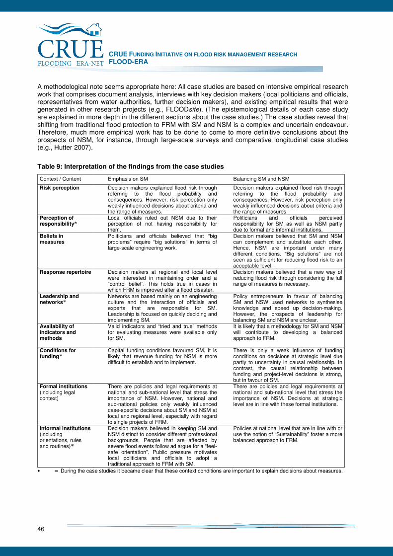
CRUE FUNDING INITIATIVE ON FLOOD RISK MANAGEMENT RESEARCH FLOOD-ERA
46
A methodological note seems appropriate here: All case studies are based on intensive empirical research work that comprises document analysis, interviews with key decision makers (local politicians and officials, representatives from water authorities, further decision makers), and existing empirical results that were generated in other research projects (e.g., FLOODsite). (The epistemological details of each case study are explained in more depth in the different sections about the case studies.) The case studies reveal that shifting from traditional flood protection to FRM with SM and NSM is a complex and uncertain endeavour. Therefore, much more empirical work has to be done to come to more definitive conclusions about the prospects of NSM, for instance, through large-scale surveys and comparative longitudinal case studies (e.g., Hutter 2007).
Table 9: Interpretation of the findings from the case studies
Context / Content Emphasis on SM Balancing SM and NSM
Risk perception
Decision makers explained flood risk through referring to the flood probability and consequences. However, risk perception only weakly influenced decisions about criteria and the range of measures.
Decision makers explained flood risk through referring to the flood probability and consequences. However, risk perception only weakly influenced decisions about criteria and the range of measures.
Perception of responsibility*
Local officials ruled out NSM due to their perception of not having responsibility for them.
Politicians and officials perceived responsibility for SM as well as NSM partly due to formal and informal institutions.
Beliefs in measures
Politicians and officials believed that “big problems” require “big solutions” in terms of large-scale engineering work.
Decision makers believed that SM and NSM can complement and substitute each other. Hence, NSM are important under many different conditions. “Big solutions” are not seen as sufficient for reducing flood risk to an acceptable level.
Response repertoire Decision makers at regional and local level were interested in maintaining order and a “control belief”. This holds true in cases in which FRM is improved after a flood disaster.
Decision makers believed that a new way of reducing flood risk through considering the full range of measures is necessary.
Leadership and networks*
Networks are based mainly on an engineering culture and the interaction of officials and experts that are responsible for SM. Leadership is focused on quickly deciding and implementing SM.
Policy entrepreneurs in favour of balancing SM and NSW used networks to synthesise knowledge and speed up decision-making. However, the prospects of leadership for balancing SM and NSM are unclear.
Availability of indicators and methods
Valid indicators and “tried and true” methods for evaluating measures were available only for SM.
It is likely that a methodology for SM and NSM will contribute to developing a balanced approach to FRM.
Conditions for funding*
Capital funding conditions favoured SM. It is likely that revenue funding for NSM is more difficult to establish and to implement.
There is only a weak influence of funding conditions on decisions at strategic level due partly to uncertainty in causal relationship. In contrast, the causal relationship between funding and project-level decisions is strong, but in favour of SM.
Formal institutions (including legal context)
There are policies and legal requirements at national and sub-national level that stress the importance of NSM. However, national and sub-national policies only weakly influenced case-specific decisions about SM and NSM at local and regional level, especially with regard to single projects of FRM.
There are policies and legal requirements at national and sub-national level that stress the importance of NSM. Decisions at strategic level are in line with these formal institutions.
Informal institutions (including orientations, rules and routines)*
Decision makers believed in keeping SM and NSM distinct to consider different professional backgrounds. People that are affected by severe flood events follow ad argue for a “feel-safe orientation”. Public pressure motivates local politicians and officials to adopt a traditional approach to FRM with SM.
Policies at national level that are in line with or use the notion of “Sustainability” foster a more balanced approach to FRM.
• = During the case studies it became clear that these context conditions are important to explain decisions about measures.
CRUE FUNDING INITIATIVE ON FLOOD RISK MANAGEMENT RESEARCH FLOOD-ERA
47
6.2.1 Content and context of decisions in the cases
One result of the case studies stands out and should be mentioned at the outset of describing the content of decisions about measures in the cases: At national policy level, in all cases there is a shift towards the general notion of balancing SM and NSM. The belief that combination of SM and NSM are, in principle, the appropriate way to reduce flood risk is a common theme. Policy-makers in different policy fields such as water quantity management, spatial planning, and emergency services are aware that a traditional approach to FRM which focuses on engineering work is not sufficient for a “safe world” in the long run. This is consistent, for instance, with the thrust of the Floods Directive of the European Commission. However, if one looks at more specific decisions at project level with regard to a single site, officials, but also politicians, often narrow flood risk down to using SM in terms of small- and large-scale engineering work – at least in the FLOOD-ERA cases. This gives evidence to the expectation that currently a gap is emerging between the “talk” of balancing SM and NSM on the one hand and on the other hand the practices (“actions”) of FRM which are often still dominated by SM. This expectation is based on looking at a few cases. Hence, it is a plausible hypothesis, but not a definitive statement about most cases in practice. It what follows this expectation is based on summary accounts of the case studies. The next section explains this account with regard to a set of nine context conditions. Context conditions do not only restrict practices, they are at the same time “anchors” for improvements. England In the English FLOOD-ERA case study the conclusions are that NSM are less efficient than SM, and are seen as likely to be less effective. The professionals engaged in this work do not see personal advancement coming from implementing NSM, and there are problems with evaluating NSM that make them "suspect". The perception amongst professionals and politicians is that the public wants and deserves full protection, rather than the lesser protection that NSM brings. This contradicts the policy-drive at national level for a more balanced approach. Limitations on revenue expenditure also discourage NSM, which use this kind of finance, and the project appraisal guidance favours SM rather than NSM in its approach and language. In the Lower Thames area, there appears to be a general consensus from our interviewees that what at-risk populations most want and what they deserve is to have are large scale engineered measures that prevent floodwater from coming anywhere near their homes. This belief, it seems, causes non-structural measures to be treated as a second best option and, hence, to be pushed down the list of priorities. Scotland With only 100,000 or so properties at risk, lower levels of coastal flood risk and potentially higher levels of urban flooding, the emergence of a different and distinctive approach to flood risk management in Scotland is to be expected. It also reflects a more pragmatic and even-handed approach to SM and NSM pursued by key public agencies with a deliberate move away from undue reliance on large scale engineered solutions. The small number of well-networked professionals involved in flood risk management in Scotland may also have contributed to a more nimble response to the challenge of learning to live with floods. Whilst not consciously seeking to be different, Scotland’s approach to flood risk management is increasingly divergent from that pursued in England. Although flood risk reduction is only one of five key objectives, it has been a major driver in the design of the master plan for the whole conurbation and more locally in the Strategic Drainage Plan for the east end of Glasgow. Initial disputes over who owned different components of urban flood risk have been replaced by a willingness to address the problem holistically at a strategic as well as local scale. Whilst the relative weights assigned to these solutions across the conurbation will vary, there is general agreement on the need for structural and non-structural measures. Especially the local deployment of structural or non-structural measures is very pragmatic – what works best in given situations – neither being privileged over the other. Engineers are
CRUE FUNDING INITIATIVE ON FLOOD RISK MANAGEMENT RESEARCH FLOOD-ERA
48
not wedded to ‘hard’ structural solutions, but willing to adopt ‘soft’ engineering and non-structural measures where appropriate. Individual agencies are emerging from their silos and looking for mutual benefits and ‘joined up’ solutions. Specialists are increasingly employed in inter-disciplinary teams (for example engineers and planners) in order to develop holistic, catchment wide solutions. Austria The interviewees in the Austrian case study strongly express a balanced approach to FRM. Balance in this case means two things: risk perception is, in principle, comprehensive which means there is balance between considering natural, technical and societal conditions of flood risk. Secondly, decision makers express their belief that very diverse measures (SM and NSM) are important to improve FRM. Examples of this belief in SM and NSM can be found in different respects, for instance, by looking at the huge effort in using natural retention possibilities and in informing the people about flood risk. The most recent technical guideline RIWA-T (e.g. §3 Abs. 2, Chapter 5.3) even prioritises NSM in comparison to SM. Therefore professionals push through innovative pilot projects and already have enhanced their toolbox through using NSM. A sense for NSM is also expressed in new legal requirements to approve spatial planning to control damage potentials on flood plains. Hence, the overall FRM policy in Austria comprises NSM to some extent. However, while looking at the specific case chosen for the study it became clear that in previous years SM dominate due to different reasons (e.g., high investment pressure, joint funding across different administrative levels). Germany The German case study comprises three sub-units: (1) The Mulde river analysis focused on two different sites: a site in the village of Erlln and the historical city centre of Grimma. The normative analysis of the cases develops a hypothetical comparison of SM and NSM (see Chapter 7). In contrast, the descriptive analysis of context conditions looked at external context conditions relevant for both sites (especially funding, formal and informal institutions) and internal conditions that differed between the sites. The study highlights the importance of external conditions to explain decisions about measures. Thereby, it becomes clear that external context conditions favour an approach to reducing flood risk in which SM dominate and NSM play a secondary role. SM dominate due to the informally institutionalised preference of the public for “full and immediate safety” through providing new or adapted SM. Abundant budgets for reducing flood risk in reaction to the flood disaster in August 2002 also facilitate following a strong preference for SM. Efficiency considerations play a role in this context, but mainly to choose between different SM at federal level. At local level, the normative analysis shows (see Chapter 5), SM with high probability of being inefficient go undetected. Furthermore, formal institutions (e.g., the division of labour between organisations responsible for flood protection, flood forecasting, and local authorities responsible for urban development) make a comparison of SM and NSM difficult. In conclusion, the case study shows that NSM based on strong internal context conditions, like commitment to provide not only safety up to the 100-year flood event, but also beyond, will require strong leadership in networks to spread new ideas about a more balanced approach to FRM with SM and NSM around. (2) The Bavarian contribution to the German case study focused on the Mangfall River and the town of Kolbermoor. At this site, flood protection in the responsibility of the water management agency is dominated by SM. These measures comprise dike heightening, the construction of flood walls and the building of a large flood polder upstream. NSM comprise, for instance, measures to provide the public with hazard information. The study analysed a broad range of context conditions to explain the outcomes of decision-making. Many of these conditions were in favour of SM, some were neutral, but the study identified no conditions that pushed decision-makers into the direction of considering NSM more intensively than before. External context conditions emphasise SM (funding, formal institutions, informal institutions). In contrast, internal context conditions (risk perception, beliefs about measures, response repertoire) were more neutral with regard to SM and NSM.
CRUE FUNDING INITIATIVE ON FLOOD RISK MANAGEMENT RESEARCH FLOOD-ERA
49
(3) The German case study also analysed SM and NSM relevant for an urban area within Dresden and prone to flooding by the Elbe River. Analysis compares an actually planned structural solution “protection line” with a hypothetical portfolio of NSM: “Flood-zone regulation and small-scale private measures”. The NSM portfolio combines the currently existing flood zone and measures for flood proofing and evacuation in residentially used buildings. The descriptive analysis is based on interviews with land users (local residents and commercial users) and officials from local administration. Analysis shows that the majority of land users reject own responsibility for risk reduction and claim to be protected primarily through SM provided by federal, state as well as local government. Only a minority of residents are committed to be responsible for flood risk reduction through measures in their own control. These people show an elaborated and highly flood aware approach to private risk reduction.
6.2.2 Explaining decisions in the cases
The case studies conducted in England, Scotland, Austria, and Germany show rich accounts of content and context conditions with regard to SM and NSM. In most cases, there is a bias towards traditional SM and towards treating NSM as complements and not substitutes to SM. Decision makers, as for instance, officials in the German case study on SM in Erlln, consider to some extent SM and NSM at the outset of decision-making. But under pressures from the public and politicians, it can be difficult to maintain an unbiased approach to designing, evaluating and choosing measures in terms of a fair balance between SM and NSM. Which context conditions explain this account of current decision-making in cases of FRM? And what are the implications for developing an evaluation methodology and for strategy-making? Table 6 mentioned nine context conditions to explain why decision makers often follow the intention of balancing SM and NSM and prefer SM in practice. These nine conditions are:
• Risk perception: defined as selective or comprehensive perception of the causal chain of floods and their consequences,
• Perception of responsibility: defined as perceiving responsibility only as responsibility-as-accountability or also as responsibility-as-commitment,
• Beliefs in measures: defined as beliefs about general properties of SM and NSM with regard to flood events,
• Response repertoire: defined as spectrum of action possibilities to deploy SM and NSM especially based on flood experiences,
• Leadership and networks: defined as leadership in the context of homogeneous or heterogeneous networks,
• Availability of indicators and methods: defined as range of valid and legitimate indicators and methods to evaluate SM and NSM,
• Funding: defined as funding mechanisms especially at national and federal state level to fund SM and NSM,
• Formal institutions: defined as “rules of the game” (Douglas North) that are – to some extent – explicit, written, and partly defined through legal procedures,
• Informal institutions: defined as “rules of the game” that are – to some extent implicit, widely acknowledged in society and partly defined through social amplification.
In what follows, these context conditions are elucidated in some detail. Section 6.3 show implications of this approach to explain decisions about SM and NSM in cases at local level. Risk perception There a different approaches for defining and analysing risk perception (e.g., Bradbury 1989, Renn and Rohrmann 2000, Slovic 2001). For pragmatic reasons, we adopt a rather narrow approach: From a “technical” viewpoint, flood risk can be defined as the probability of negative consequences on society and
CRUE FUNDING INITIATIVE ON FLOOD RISK MANAGEMENT RESEARCH FLOOD-ERA
50
nature due to a certain flood hazard and conditions that influence vulnerability (Schanze 2006, Baan and Klijn 2004). Thereby, consequences encompass economic, ecological and social effects. In contrast, the term risk perception relates to cognitions of specific decision makers and actors. “Risk perception is the view of risk held by a person or group and reflects cultural and personal values, as well as experience.” (FLOODsite 2005). In FLOOD-ERA, risk perception is treated as cultural component of specific organisations and their representatives relevant for pre-flood risk management. Therefore, it is an internal context conditions. In contrast, determinants of risk perception can vary across internal as well as external context conditions. To show the linkage between content decisions and risk perception, we propose the following possible characteristic values:
• Perceiving flood risk as a function of both hazard and vulnerability (see FLOODsite 2005) is defined as comprehensive risk perception. Comprehensive risk perception can be understood as a necessary, but not sufficient context conditions for balancing SM and NSM within the process of decision-making. Under further conditions, this motivates decision makers to pay ample attention to non-structural measures (e.g., spatial planning to restrict development in flood-prone areas) which corresponds with striving for a broad response repertoire. We suppose that comprehensive risk perception will be positively related to a broad range of criteria, a broad range of different reasons for justifying measures for pre-flood risk management and a context-driven approach to balance or emphasise structural and/or non-structural measures.
• In contrast, selective perception is associated with the opposite content characteristics of programmes and projects of pre-flood risk management. It is more likely that selective perceptions focus on the hazard while neglecting vulnerability as condition of flood risk (e.g., “Flood disasters are mainly disasters due to physical processes of hazards”) than vice versa.
In general, decisions based on perception with high selectivity lead to problematic outcomes (Makridakis 1990). High selectivity in perceptions limits which dimensions of the problem at stake decision makers notice. Therefore, high selectivity is negatively correlated with the number of perceived dimensions of a problem and with amount of information gathered for problem solving. The case studies show that high selectivity is only of very limited relevance to explain decisions about measures. Decision makers do not follow a “naive”, mainly hazard-oriented perception of flood risk. It is reasonable to assume that this is due to some extent to the fact that the interviewees are involved in decision making about measures to reduce flood risk on a regular basis. They are familiar with the topic of analysing, evaluating and reducing flood risk through SM and NSM. This facilitates perceiving flood risk as complex phenomenon with natural, technical, and societal dimensions. However, comprehensive risk perception among decision makers does not ensure a fair evaluation of SM and NSM. Knowledge and information about the causes and consequences of floods has implications for evaluating measures in a balanced way if further context conditions are in line with comprehensive risk perception. Hence, we propose that comprehensive risk perception has only a weak influence on decision making and its outcomes. Perception of responsibility Perception of responsibility is increasingly an important topic to understand the dynamics of strategy development in the context of urban and regional development. The term perception of responsibility refers to different meanings. For instance, there are surveys on the question how citizens perceive responsibility of local politicians with regard to a certain issue of urban policy (e.g., “family friendly urban development”). In the context of FLOOD-ERA, perception of responsibility refers to the question how decision maker perceive their own responsibility. Thereby, it is possible to distinguish two different values of the variable (Silince and Mantere 2008):
• Perceiving responsibility as responsibility-as-accountability: In this case, decision-makers interpret responsibility mainly as determined by formal institutions. Responsibility means first and foremost
CRUE FUNDING INITIATIVE ON FLOOD RISK MANAGEMENT RESEARCH FLOOD-ERA
51
to be held accountable for decisions and actions and to expect blame from others in case of “wrong” actions and/or “wrong” consequences.
• Perceiving responsibility as responsibility-as-accountability-and-commitment refers to the notion that decision makes take accountability into account, but do not restrict their interpretation of being responsible for effective FRM to formally defined duties. Due to informal institutions and personal commitment, they see themselves as responsible for developing effective FRM in the long run and, under further conditions, for building an effective strategy.
The case studies give rise to the propositions that recent flood experiences and disasters as in the case of Erlln and Grimma trigger a shift from responsibility-as-accountability to the expanded perception of being accountable and committed to effective strategies for pre-flood risk management. However, in practices this perception of responsibility is difficult to sustain when it comes to providing not only strategic concepts and plans, but also “material” outcomes in terms of increased safety infrastructures through deploying SM and NSM. Complex conditions of implementation seem to narrow down strategic concepts which mention SM and NSM to a more SM-focused approach for actually delivering increased safety in society. For instance, in the German case study in Dresden local officials only considered gathering more information about NSM in form of flood-proofing measures after receiving scientific information about the effectiveness and (perceived) efficiency of the measures by citizens. Before, due to assuming of not being responsible for them, information gathering did not take place, no information about effective measures is available which confirms the initial assumption that flood-proofing measures of households can be neglected in the process of decision making to increase safety at a given site. Hence, we propose that perceiving responsibility as accountability and commitment increases the motivation of decision makers to search for a more balanced approach to pre-flood risk management. Beliefs in measures Decision makers decide about measures not necessarily on a case-by-case basis. They also follow rules (e.g., rules of thumb) and general beliefs about the effectiveness and efficiency of measures (March 1994). This is due partly to cognitive limits described as “bounded rationality” and partly a consequence of culturally determined internal context conditions of decision makers. We consider this through asking which beliefs decision makers hold while evaluating a specific set of strategic alternatives and measures for pre-flood risk management. Based on the case studies (especially the study in England/Lower Thames), an interesting contrast emerges between the belief held in public that “big problems” as severe floods require “big solutions” in terms of large-scale engineering work on the one hand and the more scientific and perhaps strategic belief that big problems require combinations of SM and NSM to consider the different dimensions of such problems on the other:
• Case study England/Lower Thames: Big problems require big solutions: “The perception amongst professionals and politicians is that the public wants and deserves full protection, rather than the lesser protection that NSM brings. In the Lower Thames area, there appears to be a general consensus from our interviewees that what at-risk populations most want and what they deserve is to have are large scale engineered measures that prevent floodwater from coming anywhere near their homes. This belief, it seems, causes non-structural measures to be treated as a second best option and, hence, to be pushed down the list of priorities.”
• Big problems require complex/portfolio solutions: “The conceptual inadequacy of any of these approaches (“keep the flood away from people”, “keep people away from floods”, and so forth, the authors) considered in an isolated manner as well as the accumulated past experience demonstrate that sustainable and effective solutions to flood problems have necessarily to incorporate a balanced view of strategy options and the use of an adequate combination of structural and non-structural measures to be implemented before, during, and after the occurrence of floods.” (Petry 2002, p. 62) “Generally, the application of a measure from one of these categories (technical, regulatory, financial, and communicative, the authors) is not effective
CRUE FUNDING INITIATIVE ON FLOOD RISK MANAGEMENT RESEARCH FLOOD-ERA
52
without at least considering a combination with measures from (one or all) other categories as well. The balanced combination of measures and instruments is an essential aspect of “integrated management” (Hooijer et al. 2004, p. 355)
Against this background we propose that decision makers in a context of high public pressure for “big solutions” will bias decision-making towards SM and will neglect NSM either through ignoring them or treating them as measures in the periphery of decision-making. This outcome of decision-making increases in probability if decision makers themselves assume that acceptable levels of flood risk require visible, tangible, large-scale engineering work. Response repertoire Response repertoires of decision makers influence programmes and projects for pre-flood risk management. The response repertoire of an actor can be defined as his or her range of knowledge and information that can be deployed for decisions and actions (Sitkin et al. 1999). In general, it is reasonable to assume that broad response repertoires are necessary to manage natural hazards in general, flood risk in particular (e.g., Handmer and Dovers 1996, Weick and Sutcliffe 2001). However, broad repertoires come at the cost of difficulties in specialisation of knowledge and action possibilities (March 1999). Response repertoires are influenced by various context conditions, especially the history of severe flood events and attempts to learn from flood disasters (Johnson et al. 2005, Hutter and Schanze 2008). Disasters disrupt daily life. People experience high uncertainty (Boin and t´Hart 2003). However, it is difficult to learn unequivocal lessons from flood disasters because these are complex events with uncertain and complex antecedents and consequences. No wonder, then, that we can find both in the literature:
• The hope that disasters motivate decision makers to significantly enlarge their current response repertoire to pave the way to manage flood risk in a fundamentally new way (high capability) and
• The, perhaps more realistic, assertion that disasters motivate decision makers and citizens to “get life back to normal”, to restore pre-disaster order, and to keep lessons learnt as limited as possible (low capability).
Capabilities to enlarge the response repertoire in reaction to a severe flood event and/or in anticipation of coming events are due to a complex bundle of societal (internal and external) context conditions. The case studies show evidence that recent flood experiences and even flood disasters trigger a shift from low capability in building and using response repertoires to high capability in different phases of capability development. The general ideas is this (Carroll et al. 2003): First, there is a shift in “talk” and policies”, then, there are some experiences without an overall (strategic/catalytic) change in practices and culturally embedded assumptions of decision makers. Finally, the intended strategic change occurs under complex conditions. Preconditions for noticing, exploring, evaluating, and acting on the full spectrum of possible SM and NSM develop over time in a complex and situated learning process. This process depends on the starting conditions in the context of flood experiences and how this process is managed with regard to networks and leadership. Leadership and networks The case studies argue that human agency is important for evaluating NSM. If there is lack in methodology, guidelines, indicators, and methods, then there is uncertainty about the benefits and costs of NSM. If there is this kind of uncertainty, decision makers that are committed to NSM and lead others accordingly can make a difference in responsive and malleable contexts. Commitment to NSM and pushing them through in uncertain political and administrative processes is based on the personality and network conditions of decision makers. Up to now, the conditions of leadership and networks to develop a balanced approach to SM and NSM are largely unexplored. However, the case studies give some first ideas about possible values of this context conditions in reality:
CRUE FUNDING INITIATIVE ON FLOOD RISK MANAGEMENT RESEARCH FLOOD-ERA
53
• Case study Scotland: The study shows the importance of organisations being committed to co-operation with other organisations in relatively heterogeneous networks (e.g., the willingness by Glasgow City Council, Scottish Water and SEPA to implement both structural and non-structural flood risk measures within an agreed overall strategy).
• The study German Mulde River show that homogeneous networks across multiple levels of decision-making (federal state, regional, local) and grounded in an engineering culture to deliver improved flood protection facilitate the implementation of SM, but do not necessarily expand and sustain the range of measures considered while making choices.
To manage heterogeneous networks requires strategic planning. Hence, analysing strategic planning for balancing SM and NSM is important (Hutter 2007). Availability of indicators and methods FRM in European Member States, in Austria, England, Germany, and Scotland in particular is shaped by a tradition of protecting against floods through large- and small-scale engineering work. Of course, Member States do not follow a simple and pure flood protection strategy. Even in the Netherlands with its tradition of protection against floods through dykes, NSM and related policies are of growing importance. However, FRM has its roots in engineering work and modern science, especially natural and engineering science. This goes hand in hand with the cultural embedded practice of making choices based on scientific discourses knowledge, methodologies, guidelines, methods, indicators, data bases, and so forth – and not on intuition, feeling, and local knowledge. However, this type of rational decision-making is easier with regard to SM than NSM due to several reasons: SM are often realised as a distinct project with a well-defined beginning and ending (even if large-scale projects take decades to materialise as in case of the Thames Barrier to protect London). Guidelines, standards, indicators, and methods to assess the effectiveness of measures (e.g., in terms of the 100-year flood as safety standard in Germany) have been formulated for SM, but not for NSM. Often, the latter have their origins in policy fields with different histories and ambitions than protecting society against floods (e.g., spatial planning as NSM to ensure a “fair”, economically effective and environmentally vital spatial ordering of activities). Against this background the case study results give way to two propositions:
• All case studies: Non-availability of indicators and methods to evaluate NSM with regard to effectiveness and efficiency (and further criteria) leads to uncertainty of decision makers about the benefits and costs of NSM – especially if decision makers are deeply attached to a traditional “engineering culture”. Decision makers will try to reduce uncertainty in evaluating measures significantly. If strong internal forces (context conditions) are absent that motive decision makers to follow a balanced approach to FRM despite considerable uncertainty, this will lead to ignoring NSM as substitutes to SM or to ruling NSM out at the beginning of the decision-making process.
• The availability of indicators and methods to evaluate NSM reduces uncertainty for decision-makers if these indicators and methods are perceived as valid and legitimate way to evaluate SM and NSM as substitutes to reduce flood risk to an acceptable level.
It follows that it is one important thing to develop a valid methodology and methods for evaluating SM and NSM in a consistent way. It is another to ensure legitimacy of methods and methodologies for evaluating the non-engineering measures in the context of an engineering culture. Up to now, the case studies reflect mainly how decision makers responsible for FRM perceive the potential of NSM to reduce flood risk. They do not provide evidence how decision makers interpret experiences with NSM for learning how to evaluate them in a context of state-approved methodologies and guidelines for using SM and NSM.
CRUE FUNDING INITIATIVE ON FLOOD RISK MANAGEMENT RESEARCH FLOOD-ERA
54
Funding It is no surprise that funding is an important context condition that influences strongly if and how NSM are treated in decision making about measures. Especially within local government the issue of flood risk reduction competes with various other policy issues about allocation of financial resources. Even in more specialised state agencies (like the Dam Authority of Saxony) flood risk reduction competes with issues about water supply, water quality, and leisure. The case studies show that the issue of supporting a balanced approach to FRM through deploying SM and NSM needs much more attention. Thereby, a complex and context-sensitive approach is needed as results from two case studies make clear:
• Case study Germany/Mulde River: The German case study about measures in Erlln and Grimma shows that efficiency is treated differently in times of abundant resources due to a recent flood disaster compared to times in which there is lack of significant and collective flood experiences. After the flood in 2002 many funds were provided for flood protection so that budget scarcity apparently only weakly influences decisions on flood mitigation measures in line with the efficiency criterion. This explains why e.g. the measures in the case studies are conducted even if they seem to be inefficient due to their high costs. The efficiency of measures obviously plays only a secondary role. Instead, the effectiveness with regard to formal institutions like the 1/100-protection goal plays a much more important role.
• Case study England/Lower Thames: One key aspect of the differences between SM and NSM that is shown in the England study is the greater dependency of the latter on revenue funding rather than capital funding. This makes it more difficult to finance NSM (for further information see Chapter 7). Differences in funding of revenues and capital works play an important role in most European Member States and in most policy fields. Aiming at comparing SM and NSM as substitutes to reduce flood risk implies dealing with the different relevance of capital funding (dominant, for instance, for large-scale engineering works) and NSM that are characterised by low capital funding requirements, but high revenue funding requirements due, for example, to the relevance of human resources for delivering services.
We propose that support in applying a methodology to evaluate SM and NSM should first and foremost come from new policies for funding. Methodologies will be widely applied if they make a difference in funding activities and projects. Formal institutions In general, formal institutions are important to explain decisions. This holds also for decisions about measures in FRM. Formal institutions determine to some extent the responsibility of decision makers, the criteria which are used to evaluate decisions and measures, the range of legitimate possible actions, socially acceptable ways of solving problems, and so forth. However, it is difficult to gain a precise picture of how formal institutions influence decisions about SM and NSM. This is not only theoretically plausible, but can be found in the case studies:
• Case study England/Lower Thames: Interviewees expressed the “question of the compatibility of NSMs with the systems, procedures and structures that exist within the Environment Agency and Defra. The general feeling amongst the respondents was that these had been designed with large-scale engineered projects in mind and were not always suitable for NSMs. This, it was argued, hampered the development and implementation of such measures and encouraged a continuing over-dependence on engineered solutions.”
• Case study Germany/Vereinigte Mulde: FRM “is structured in a way in Saxony that there is a clear organisational division of labour between the LTV, responsible for structural flood protection, and the LfUG, responsible for the non-structural warning system. Here, the main responsibility and
CRUE FUNDING INITIATIVE ON FLOOD RISK MANAGEMENT RESEARCH FLOOD-ERA
55
funds are given to the LTV, an organisation with a strong professional engineering background. Our interviews showed that members of the LTV are very open-minded about non-structural measures. However, according to the professional background it is self evident that mainly structural measures were chosen within the flood protection concepts.”
Informal institutions Informal institutions are widely acknowledged rules of the game that are unwritten, only to some extent explicit and culturally embedded. It is evident that informal institutions are important to understand why and how NSM are chosen or not to reduce flood risk to a tolerable level. People that are affected heavily by a flood event focus their attention in regaining order and compensation often on this specific event. Furthermore, they raise their voices and seek influence on public opinion. These voices have high chances of gaining real influence, if they are in line with informal institutions that define responsibility, especially of state and local authorities. For instance, the interviews conducted in the case study in Germany/Vereinigte Mulde show a high demand for SM among the affected population after the 2002 floods. It would be interesting to analyse the relationship between public demand and pressure on decision-making in FRM and informal institutions with regard to perceived responsibility in more detail.
6.3 Implications for a methodology to evaluate SM and NSM
Increasingly, NSM are in the foreground of political and scientific discussions about improving FRM. This is due partly to current policies at European and national as well as federal state level (e.g., Flood Directive of the European Commission, national policies as “Making Space for Water” in England and Wales, federal state policies as formulated by the Free State of Saxony). However, our case studies highlight that – in practice – an easy change from focusing on SM to balancing SM and NSM should not be expected at regional and local level. The policy-driven (“intended”) change from “pure flood protection” to finding a “Balance of SM and NSM” is embedded in manifold further conditions. Therefore, intended change needs to accomplish a complex spectrum of requirements that combine human agency with changing social structures (see Table 10). FLOOD-ERA conducted case studies in England, Scotland, Austria, and Germany to explore which issues are involved in evaluating SM and NSM as complements and substitutes for FRM. These case studies show rich empirical evidence on these issues. However, conclusions should be tentative due to the limited number of cases they are based on. The following provides answers to the two questions outlined at the beginning of this chapter: Firstly, important context conditions to explain decisions about measures are mentioned. This shows that a methodology to evaluate SM and NSM will only influence some context conditions of decision-makers, whereas other conditions have to be influenced by further policies (e.g., new funding policies, local leadership policy). Secondly, to improve strategy development, some suggestions to follow a step-wise approach to FRM are proposed. Change requires human agency (Poole 2004). Agency in general is based on the willingness, the capabilities and resources of policy-makers to change significantly “how things are done around here”. In the context of evaluating SM and NSM, the case studies analysed five context conditions with regard to human agency:
• Risk perception: All case studies are based on interviews with representatives from institutions that are in some way connected professionally to issues of FRM. Because of this it is not a surprise that interviewees do not base their decisions on risk perceptions with high selectivity (which could be the case if decision makers perceive flood risk as mainly due to the flood hazard and ignore man-made conditions that determine the consequences of floods). Based on this
CRUE FUNDING INITIATIVE ON FLOOD RISK MANAGEMENT RESEARCH FLOOD-ERA
56
overall finding we suggest that there is only a weak causal relationship between risk perception and decisions about measures, if decision-makers are involved continuously in decisions to reduce flood risk. However, this relationship needs more elaboration in terms of causal models and empirical evidence. This should lead to a more systematic and holistic understanding how risk perceptions of decision-makers facilitate or hinder intended change to balance SM and NSM in FRM. Thereby, it is crucial to distinguish between decision-makers that are involved in decision about reducing flood risk on a regular basis and those that are not.
• Perception of responsibility: What decision-makers define as their responsibility is not given as an “objective” fact. Decision-makers define to some extent their responsibility based on interpretations of formal and informal institutions. In Dresden, local officials responsible for flood protection “overlooked” possible information about effective NSM (in this case measures for flood-proofing of households) due to the perception of not being responsible for these measures. Only after receiving information about these measures by the scientific investigator did local officials start to think about taking over responsibility to consider NSM as possible measures for reducing flood risk at the specific site of the case study investigation. This gives way to the suggestion that local and regional decision makers should base their decision on a broad understanding of responsibility in the context of FRM and not a narrowly and solely formally defined domain of possible issues and actions.
• Beliefs about measures: In some cases, NSM like spatial planning to control development on flood plains show their full potential only after a considerable time span. Controlling development on flood plains, for instance, deals with numerous planning applications and decisions of single households, firms and planning authorities. In contrast, FRM is often motivated and politically pushed through by referring to major flood events, sometimes disasters. The case study at the Lower Thames shows that people and politicians prefer SM in terms of large-scale engineering work because from their perspective these measures match with the “nature” and cause of the problem – the major flood event. “Learning to live with rivers” requires unlearning – unlearning that only big solutions in terms of large-scale engineering work contribute to significantly reducing flood risk.
• Response repertoires: The conditions for significantly enlarging the response repertoires of decision-makers are largely unexplored. Research up to now sheds more light on why decision-makers only incrementally expand their response repertoires in reaction to flood events (e.g., Johnson et al. 2005). The case study findings within FLOOD-ERA are consistent with the hypothesis that response repertoires develop incrementally. For instance, decision-makers responsible for flood protection at the Mulde River in Germany emphasised SM in decision-making and practices even after the flood disaster in August 2002 which showed the limitations of flood protection through SM. The alternative plausible hypothesis is that flood events trigger strategic change (or catalytic change) which leads to a significant expansion of response repertoires. The conditions for incremental and strategic (catalytic) change need much more systematic empirical research to identify necessary and sufficient conditions for change.
• Leadership and networks: Leadership and networks are important for deploying SM and NSM. For instance, the case study at the Mulde River showed that leadership embedded in networks covering multiple levels of decision-making within flood protection policies facilitated the implementation of decisions to increase the safety standard through SM. However, the case study investigators also conclude from their study that finding a balance between SM and NSM poses specific leadership challenges for using networks for this intended change. For instance, networking for NSM cannot rely as much on institutionalised relationships between actors from different policy fields (e.g., emergency services, water authorities) as in case of networking for SM. Successful networking for NSM is more dependent on the persons that are doing the networking (e.g., “Charisma of the leader or leaders”). This hypothesis can be elaborated using the concept of “negotiations in the shadow of a hierarchy”. Often, in case of NSM there is no overall hierarchy as a “last resort” of actors with different interests and perspectives. Hence, networking and leadership for deploying NSM and balancing SM and NSM should pose specific challenges which have to be elaborated through further case studies focusing on this specific research challenge.
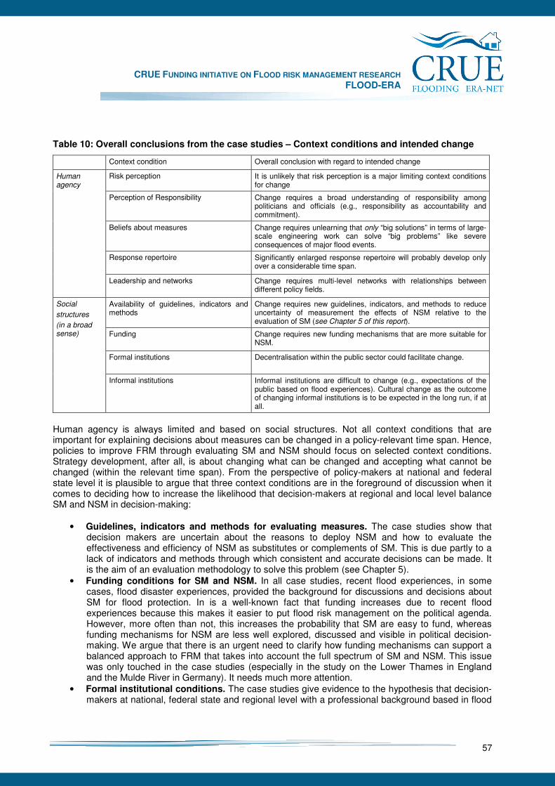
CRUE FUNDING INITIATIVE ON FLOOD RISK MANAGEMENT RESEARCH FLOOD-ERA
57
Table 10: Overall conclusions from the case studies – Context conditions and intended change
Context condition Overall conclusion with regard to intended change
Risk perception It is unlikely that risk perception is a major limiting context conditions for change
Perception of Responsibility
Change requires a broad understanding of responsibility among politicians and officials (e.g., responsibility as accountability and commitment).
Beliefs about measures Change requires unlearning that only “big solutions” in terms of large-scale engineering work can solve “big problems” like severe consequences of major flood events.
Response repertoire
Significantly enlarged response repertoire will probably develop only over a considerable time span.
Human agency
Leadership and networks
Change requires multi-level networks with relationships between different policy fields.
Availability of guidelines, indicators and methods
Change requires new guidelines, indicators, and methods to reduce uncertainty of measurement the effects of NSM relative to the evaluation of SM (see Chapter 5 of this report).
Funding
Change requires new funding mechanisms that are more suitable for NSM.
Formal institutions
Decentralisation within the public sector could facilitate change.
Social
structures
(in a broad sense)
Informal institutions
Informal institutions are difficult to change (e.g., expectations of the public based on flood experiences). Cultural change as the outcome of changing informal institutions is to be expected in the long run, if at all.
Human agency is always limited and based on social structures. Not all context conditions that are important for explaining decisions about measures can be changed in a policy-relevant time span. Hence, policies to improve FRM through evaluating SM and NSM should focus on selected context conditions. Strategy development, after all, is about changing what can be changed and accepting what cannot be changed (within the relevant time span). From the perspective of policy-makers at national and federal state level it is plausible to argue that three context conditions are in the foreground of discussion when it comes to deciding how to increase the likelihood that decision-makers at regional and local level balance SM and NSM in decision-making:
• Guidelines, indicators and methods for evaluating measures. The case studies show that decision makers are uncertain about the reasons to deploy NSM and how to evaluate the effectiveness and efficiency of NSM as substitutes or complements of SM. This is due partly to a lack of indicators and methods through which consistent and accurate decisions can be made. It is the aim of an evaluation methodology to solve this problem (see Chapter 5).
• Funding conditions for SM and NSM. In all case studies, recent flood experiences, in some cases, flood disaster experiences, provided the background for discussions and decisions about SM for flood protection. In is a well-known fact that funding increases due to recent flood experiences because this makes it easier to put flood risk management on the political agenda. However, more often than not, this increases the probability that SM are easy to fund, whereas funding mechanisms for NSM are less well explored, discussed and visible in political decision-making. We argue that there is an urgent need to clarify how funding mechanisms can support a balanced approach to FRM that takes into account the full spectrum of SM and NSM. This issue was only touched in the case studies (especially in the study on the Lower Thames in England and the Mulde River in Germany). It needs much more attention.
• Formal institutional conditions. The case studies give evidence to the hypothesis that decision-makers at national, federal state and regional level with a professional background based in flood
CRUE FUNDING INITIATIVE ON FLOOD RISK MANAGEMENT RESEARCH FLOOD-ERA
58
protection through SM are focused in their practices (not necessarily in talk and policies) on deploying SM whereas local decision-makers are more pragmatic in considering SM and NSM (see, for instance, the case studies in Scotland and England). Therefore, a more balanced approach to FRM is to be expected in case of tendencies to decentralise decision-making in the policy field of FRM. However, this hypothesis has to be elaborated and tested to understand how formal decentralisation and providing guidelines, indicators, methods and funding can be aligned effectively and efficiently.
• Informal institutions and cultural change: FRM is based on informal institutions in terms of widely acknowledged assumptions, values, and rules in society that are deeply ingrained in everyday-life and organisational routines. Therefore, cultural change cannot be produced only through providing new guidelines, indicators, methods, funding and new formal institutions. Cultural change is based on experience and the widely acknowledged belief that certain types of practices are to be followed. Hence, cultural change towards a more balanced approach to FRM will develop after NSM are deployed more intensively than before. We recommend to observe and analyse cultural change first with regard to single organisations (e.g., water authorities, local authorities) and then with regard to networks of organisations and whole societies.
The more process-oriented implication from the case studies for balancing SM and NSM based on an evaluation methodology is to follow a step-wise approach in fostering NSM as complements and substitutes for SM:
• Step 1: Change of available guidelines, indicators and methods for evaluating NSM. This first step can be differentiated in sub-steps. FLOOD-ERA deals with the first sub-step through providing a more systematic problem statement for evaluating SM and NSM and through providing an outline of a methodology that can be used as a starting point for developing guidelines to evaluate SM and NSM in typical contexts and in a consistent way.
• Step 2: Change of funding conditions for SM and NSM. Decisions about measures are strongly influenced by funding mechanisms. Thereby, quantity and quality issues arise (e.g., high budgets for SM in reaction to a flood disaster decrease the relevance of efficiency considerations with regard to NSM). Change of funding can take on the form of changing an existing funding mechanism for flood protection, changing existing funding conditions for NSM (e.g., spatial planning), and creating new funding solutions. A plausible first sub-step would be to compare strategic alternatives for supporting a balanced approach to FRM through funding mechanisms.
• Step 3: Change of formal institutional conditions. The case studies give evidence to the hypothesis that national and federal state practices (not policies!) are more focused on deploying SM due to professional background in an engineering culture and formal institutions, whereas local decision-makers could be more pragmatic in considering SM and NSM. Therefore, a more balanced approach to FRM should be expected in case of tendencies to decentralise decision-making in the policy field of FRM. However, this hypothesis has to be elaborated and tested to understand how decentralisation and providing guidelines, indicators, methods and funding can be aligned effectively and efficiently to improve FRM.
This step-wise approach is based on the well-known assumption in risk management and safety research (e.g., Weick and Sutcliffe 2001) that one should not try to change informal and cultural conditions directly, but indirectly through changing more tangible and well-defined variables as, for instance, existing guidelines for evaluating measures through considering indicators and methods for NSM and funding mechanisms. To put it differently and in a more metaphorical way: Developing a methodology for evaluating SM and NSM is not the whole story, but an important chapter.

CRUE FUNDING INITIATIVE ON FLOOD RISK MANAGEMENT RESEARCH FLOOD-ERA
59
7 European Case Studies
Six case studies in three European Member States have been defined for the evaluation and comparison of NSM and SM under site-specific conditions. The aim of the FLOOD-ERA case studies firstly is to develop and test approaches for the comparative determination of the effectiveness and efficiency of the two types of measures. Secondly it context conditions of decision makers with respect to their preference for either one of them or a certain portfolio should be investigated. Thus the case studies provide the empirical basis for the generic findings of chapters 5 and 6. The selection of the sites is based on the possibility to represent SM by NSM. In addition, because of the small size of the research project existing data and partly even running models also played an important role to facilitate the work progress. Evaluation bears on detailed modelling of effects and calculation of the criteria. However, in a few cases it seemed to be adequate to just use available results and to interpret them in the light of this study (e.g. Clyde River). Table 11 gives an overview of all cases with the considered measures. As it can be seen the scope of the NSM is rather broad. Model-based in-depth comparisons were carried out in the Raab River, Mulde River and Elbe River cases. Interviews with decision makers were conducted in all cases to better understand the context conditions. They led to a rather comprehensive picture on the barriers and enablers for balancing both types of measures and therefore helped to understand how improvements can be made by a more detailed and quantitative evaluation and comparison of NSM and SM.
Table 11: Overview of the case studies with considered SM and NSM
Case study SM NSM
Thames River (England), Reach from Windsor to Teddington
- Diversion channels - Flood forecasting and warning (as basis for the evacuation of inventory)
- Emergency response - Community based flood protection measures - Flood proofing - Floodplain spatial planning controls - Flood insurance - Public response
Clyde River (Scotland), city of Glasgow
- Interceptor tunnel - Offline storage tank
- Sustainable urban drainage - Attenuation ponds - De-culverting buried watercourses - Development planning - Economic instruments - Sand bag delivery - Flood risk emergency plans - Emergency co-ordination group - Dweller with special requirement registers - Resilient communication network
Raab River (Styria, Austria), town of Gleisdorf
- Defence systems (dikes, flood walls, flood polder)
- Spillway - Spatial planning (building ban)
Mulde River (Saxony, Germany), village of Erlln and town of Grimma
- Dikes and/or flood walls - Resettlement (hypothetical) - Local warning system
Elbe River (Saxony, Germany), city of Dresden
- Dikes and flood walls - Flood zone designation - Flood proofing with evacuation of inventory
Mangfall River (Bavaria, Germany), town of Kolbermoor
- Dikes and flood walls - (controllable flood polders) - (controllable weirs)
- Relocation and removal of dikes - Hazard maps with signing the inundation lines - Development planning with building regulation
CRUE FUNDING INITIATIVE ON FLOOD RISK MANAGEMENT RESEARCH FLOOD-ERA
60
7.1 Lower Thames River (Teddington)
Edmund Penning-Rowsell and Tim Harries In this English FLOOD-ERA case study the conclusions are that NSM are less efficient than SM, and are seen as likely to be less effective. The professionals engaged in this work do not see personal advancement coming from implementing NSM, and there are evaluation problems with NSM that make them "suspect". The perception amongst professionals and politicians is that the public wants and deserves full protection, rather than the lesser protection that NSM brings. This contradicts Defra’s policy drive for a more balanced approach. Limitations on revenue expenditure also discourage NSM, which use this kind of finance, and the project appraisal guidance favours SM rather than NSM in its approach and language. Transaction costs appear not be important either way.
7.1.1 Introduction
There is a clear recognition amongst the bodies with lead responsibility for flood risk management in the UK that large engineering projects such as barriers and diversion channels are no longer always an adequate or appropriate response to flood risk. As the Government’s strategy for England puts it, if the concept of sustainable development is to be “firmly rooted” in all decisions about flood risk management, then full account needs to be taken of social and environmental considerations, as well as of economic factors13 (Defra 2005 p14; The Pitt Review 2007; Environment Agency 2007a). As a result, whereas in 1993 the Environment Agency’s flood strategy only listed flood warnings and flood defence as its priority aims14, its sponsoring department, the Department for Environment, Food and Rural Affairs (Defra) now urges the use of an “integrated portfolio of approaches” (ibid p15) that includes smaller-scale engineered solutions as well as non-engineered measures.
7.1.2 The case study area
Maidenhead, Windsor and Eton – protected by a by-pass channel implemented in 2003 - lie in Reach 2 of what is known as the Lower Thames, the non-tidal part of the Thames that is nearest the sea. The subjects of this study, meanwhile, are Reaches 3 and 4, downstream of Reach 2. The most recent search for a solution to the flood risk in these two areas began in 1989 and continues to this day, in what has become known as the Lower Thames Strategic Study, or the “LTSS”. On adjoining parts of the Thames, these two reaches lie in what is an area of major economic growth. Close to Heathrow Airport and London’s orbital motorway (the M25), they have good public transport links into central London and are well served with green open space amenities, such as Runnymede Park, Windsor Great Park, numerous lakes and reservoirs and, of course, the Thames itself. As a result, the area is a popular residential and business zone, containing high value properties occupied by an articulate and politically-connected population, and there is continual pressure for more building and development. Though demographically very similar, Reach 3 and Reach 4 are topographically very different to each other (see Figure 10).
13 Department for Environment, Food and Rural Affairs (2005). Making space for water: Taking forward a new Government strategy for flood and coastal erosion risk management in England. London: Defra Publications. 14 Environment Agency (1993). Strategy for flood and coastal defence in England and Wales: Executive summary. http://www.defra.gov.uk/environ/fcd/pubs/stratsum.htm.
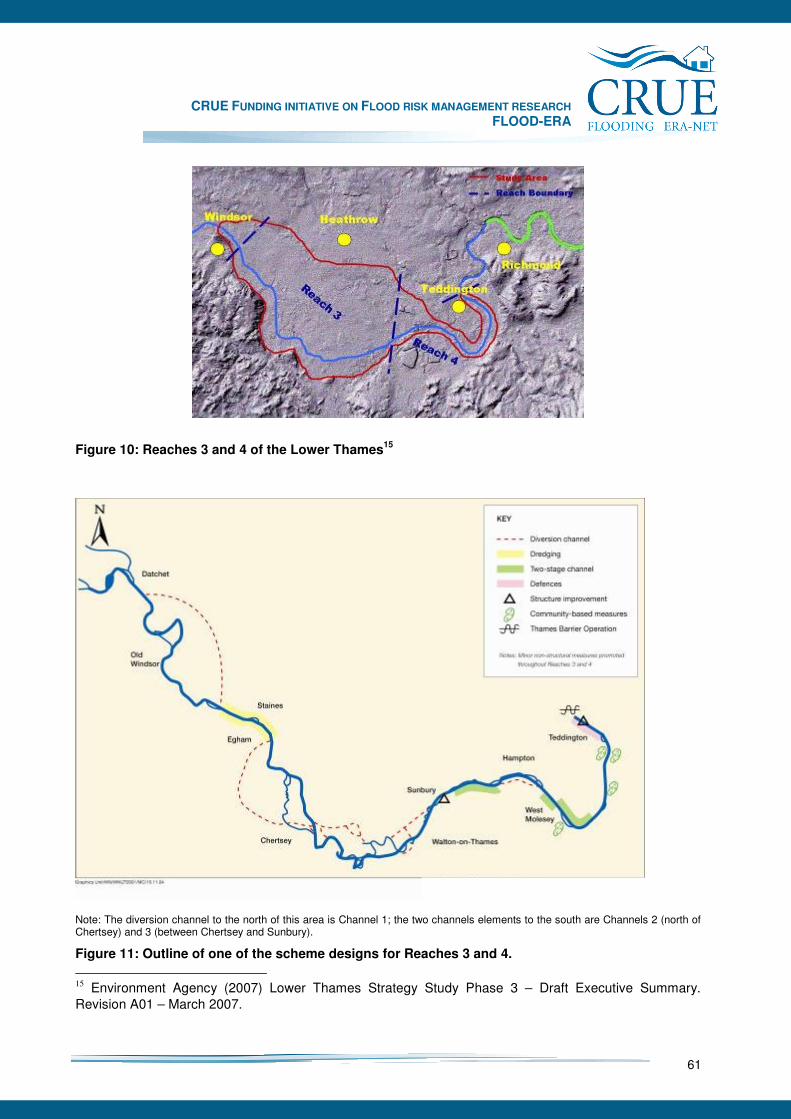
CRUE FUNDING INITIATIVE ON FLOOD RISK MANAGEMENT RESEARCH FLOOD-ERA
61
Figure 10: Reaches 3 and 4 of the Lower Thames15
Note: The diversion channel to the north of this area is Channel 1; the two channels elements to the south are Channels 2 (north of Chertsey) and 3 (between Chertsey and Sunbury).
Figure 11: Outline of one of the scheme designs for Reaches 3 and 4.
15 Environment Agency (2007) Lower Thames Strategy Study Phase 3 – Draft Executive Summary. Revision A01 – March 2007.
CRUE FUNDING INITIATIVE ON FLOOD RISK MANAGEMENT RESEARCH FLOOD-ERA
62
In Reach 3 a one in two hundred year flood (1:200 years) would affect about 14,000 properties and 37,000 residents, and a 1:100 year flood would cause about £400m of damage16, with flood waters lingering for at least a number of days and in some areas for one or two weeks. The situation has been summarised as below:17 • In total 14,500 properties and 36,500 people are at risk of being affected by flooding within the
Lower Thames Floodplain (1:200 years). • Estimated long-term (100 year) present value economic damages throughout the Lower Thames
could be of the order of £0.4bn. If current flood management activities by the Environment Agency were to be discontinued (the so-called do-nothing scenario) some 20,800 properties and 50,000+ people would be at risk from flood effects, with potential long-term economic damages of some £1bn.
• It is considered likely that future flood flows could increase by 5-10% in response to future climate
change over the next 50-100 years... (so that) key threshold levels within the floodplain topography, at which the area affected by flooding rapidly spreads, would be reached more often.
7.1.3 Flood risk management in the case study area
Although approximately £2m has to date been spent on studies for the LTSS, no agreement has yet been reached – for several reasons - on the design of a flood risk management ‘package’ for the two reaches in question. The costs of any structural scheme here are high for several reasons. The areas through which diversion channels would need to run are all densely populated or are Biodiversity Action Plan (BAP) areas or are otherwise environmentally designated. To minimise disturbance of these areas, the proposed channels for Reach 3 were routed through landfill sites, making excavation more expensive and introducing the risk that pollutants might leach into the channels. Furthermore, the Thames itself is environmentally important, parts being inhabited by a rare Red Book listed18 breed of fresh water mussel. In Reach 4, meanwhile, the political, social and economic costs of routing a diversion channel through such densely populated urban areas were deemed unacceptable and it was decided fairly early in the study that some alternative solution needed to be found. In summary, it can be said that the LTSS was, from the very beginning, fraught with problems. As a result of the popular belief that, during the 2003 floods, the Jubilee River had protected Reach 2 at the expense of Reaches 3 and 4, local residents and some politicians in Reaches 3 and 4 wanted their own equivalent diversion channel. At the same time, the £100+m cost of the Jubilee River was deemed expensive and the channel has been seen by many flood risk management professionals as relatively ineffective (vis-a-vis its design standard) and as providing poor value for money.
16 Environment Agency (2007). Lower Thames Strategy Study Phase 3: Draft Executive Summary. Revision A01, March 2007. 17 Lower Thames Strategy Study Phase 3 – Draft Executive Summary. March 2007. 18 The red list is a categorisation created by the World Conservation Union to denote the world’s most threatened species of wildlife (http://www.iucnredlist.org/info/introduction).
CRUE FUNDING INITIATIVE ON FLOOD RISK MANAGEMENT RESEARCH FLOOD-ERA
63
7.1.4 Aims of the case study
The aim of this FLOOD-ERA investigation was to reveal the roles played in the design of the scheme by the consideration of other types of flood risk management measures, and to understand the factors that influenced the allocation of these roles. A range of types of measures was considered in this respect:
• Resilience measures: Property-level measures that would slow the ingress of water into individual homes and businesses (for example, floodgates or airbrick covers) or that would reduce the damage caused by ingress and speed recovery from the flood (for example, flood resistant flooring or kitchen units)
• Community measures: Local level flood defence measures, such as embankments or demountable barriers, which would protect whole streets or groups of properties
• Flood forecasting and warning: Enhancements to the existing flood warning system, for example, by the installation of additional river gauges or by changes to the specificity and delivery of warning messages
• Emergency planning and response: Improvements to plans for evacuation and the maintenance of essential services
• Floodplain spatial planning controls: The introduction of tighter restrictions on building or rebuilding in areas at risk of flooding and, in particular, along known conveyance routes.
In this section, these are the measures that we see as “non-structural”, following more or less normal UK practice in this field (e.g. Penning-Rowsell and Peerbolt 1994). With regard to these NSMs, the specific goals of this case study were:
1. To provide a context to our interview results (“2”, “3” and “4” below) by showing the results of efficiency and effectiveness analysis of (a) the different SMs and NSMs that could be deployed in the Lower Thames area, and (b) comparing theses results between those Structural and Non-Structural measures.
2. To identify the actors who have most influenced the extent of the incorporation of NSMs into the scheme.
3. To identify the personal, institutional, contextual and process issues influencing their position in scheme design.
4. To understand how the effectiveness and efficiency of these measures are perceived by decision makers in the LTSS.
The first of these is now considered, below.
7.1.5 Efficiency analysis of flood risk management measures in England
In England, the use of benefit-cost analysis (BCA) to appraise flood risk management measures is now completely routine, and has been since the late 1970s (HM Treasury 2003). For flood risk management investment appraisal, detailed guidance is provided by Defra (MAFF 2001), and data sets for the benefits of flood risk reduction are available19 to support the necessary analysis by the Environment Agency and others20 of flood risk and the effects on it of different levels or standards of flood risk management at
19 E.g. Penning-Rowsell, E., Johnson, C., Tunstall, S., Tapsell, S., Morris, J., Chatterton, J. and Green, C. The benefits of flood and coastal risk management: A manual of assessment techniques. London: Middlesex University Press. 20 For example local authorities; Internal Drainage Boards.
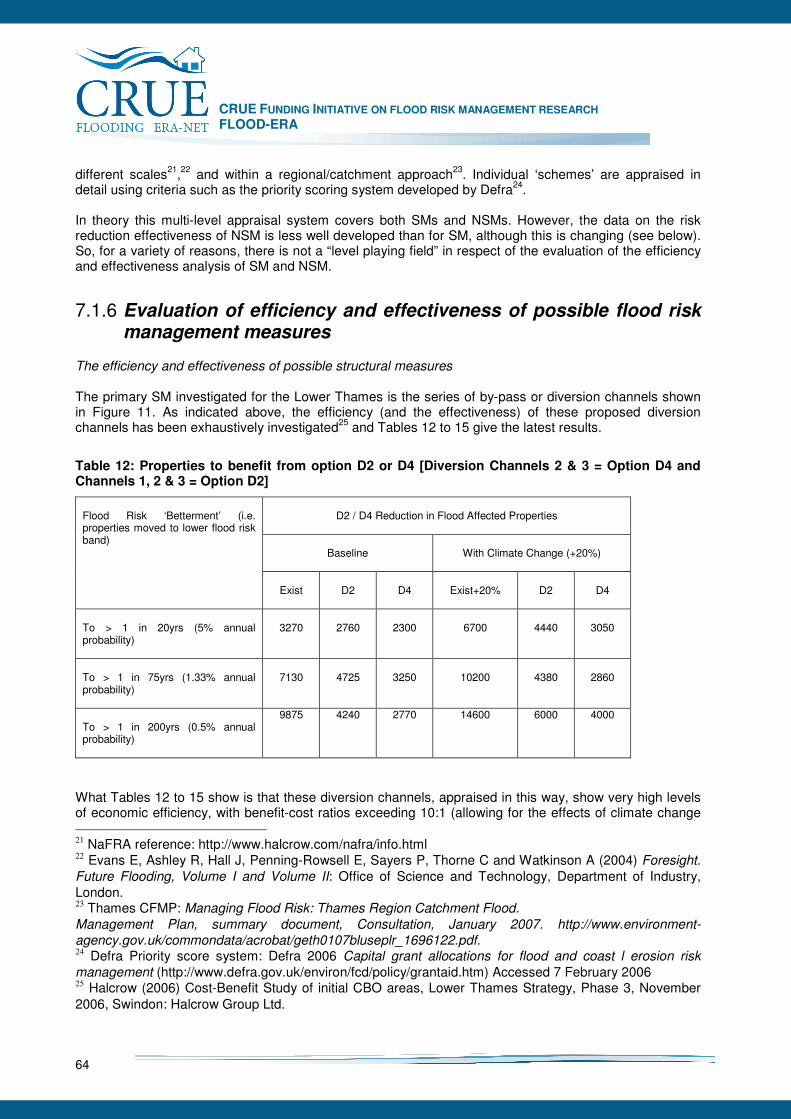
CRUE FUNDING INITIATIVE ON FLOOD RISK MANAGEMENT RESEARCH FLOOD-ERA
64
different scales21,22 and within a regional/catchment approach23. Individual ‘schemes’ are appraised in detail using criteria such as the priority scoring system developed by Defra24. In theory this multi-level appraisal system covers both SMs and NSMs. However, the data on the risk reduction effectiveness of NSM is less well developed than for SM, although this is changing (see below). So, for a variety of reasons, there is not a “level playing field” in respect of the evaluation of the efficiency and effectiveness analysis of SM and NSM.
7.1.6 Evaluation of efficiency and effectiveness of possible flood risk management measures
The efficiency and effectiveness of possible structural measures The primary SM investigated for the Lower Thames is the series of by-pass or diversion channels shown in Figure 11. As indicated above, the efficiency (and the effectiveness) of these proposed diversion channels has been exhaustively investigated25 and Tables 12 to 15 give the latest results.
Table 12: Properties to benefit from option D2 or D4 [Diversion Channels 2 & 3 = Option D4 and Channels 1, 2 & 3 = Option D2]
D2 / D4 Reduction in Flood Affected Properties
Baseline
With Climate Change (+20%)
Flood Risk ‘Betterment’ (i.e. properties moved to lower flood risk band)
Exist
D2
D4
Exist+20%
D2
D4
To > 1 in 20yrs (5% annual probability)
3270
2760
2300
6700
4440
3050
To > 1 in 75yrs (1.33% annual probability)
7130
4725
3250
10200
4380
2860
To > 1 in 200yrs (0.5% annual probability)
9875 4240 2770 14600 6000 4000
What Tables 12 to 15 show is that these diversion channels, appraised in this way, show very high levels of economic efficiency, with benefit-cost ratios exceeding 10:1 (allowing for the effects of climate change 21 NaFRA reference: http://www.halcrow.com/nafra/info.html 22 Evans E, Ashley R, Hall J, Penning-Rowsell E, Sayers P, Thorne C and Watkinson A (2004) Foresight.
Future Flooding, Volume I and Volume II: Office of Science and Technology, Department of Industry, London. 23 Thames CFMP: Managing Flood Risk: Thames Region Catchment Flood.
Management Plan, summary document, Consultation, January 2007. http://www.environment-
agency.gov.uk/commondata/acrobat/geth0107bluseplr_1696122.pdf. 24 Defra Priority score system: Defra 2006 Capital grant allocations for flood and coast l erosion risk
management (http://www.defra.gov.uk/environ/fcd/policy/grantaid.htm) Accessed 7 February 2006 25 Halcrow (2006) Cost-Benefit Study of initial CBO areas, Lower Thames Strategy, Phase 3, November 2006, Swindon: Halcrow Group Ltd.

CRUE FUNDING INITIATIVE ON FLOOD RISK MANAGEMENT RESEARCH FLOOD-ERA
65
on flood flows; see Table 15). They also are effective in reducing the flood risk for many of the people and property otherwise affected.
Table 13: People to benefit from option D2 or D4 [Diversion Channels 2 & 3 = Option D4 and Channels 1, 2 & 3 = Option D2]
D2 / D4 Reduction in Flood Affected Properties
Baseline
With Climate Change (+20%)
Flood Risk ‘Betterment’ (i.e. people moved to lower flood risk band)
Exist
D2
D4
Exist+20%
D2
D4
To > 1 in 20yrs (5% annual probability)
8200
6900
5750
16800
11100
7600
To > 1 in 75yrs (1.33% annual probability)
17800
11800
8100
25500
10950
7150
To > 1 in 200yrs (0.5% annual probability)
24700
10600
6900
36500
15000
10000
Table 14: Economic Benefits* of flood risk reduction in the Lower Thames - Options D2 or D4 (showing increment D4 to D2)
Baseline Scenario
PV Damage
NPV
Av BCR
IBCR
Do Nothing
804
Do Minimum
408
392
112
Asset Replacement
286
509
54
20
Option D2
132
593
4.1
1.46
Option D4a Option D4b
171 184
609 585
6.6 6.3
2.00 1.76
Option D2a Option D2b
132
593
4.1
0.82 0.36
*Benefits and incremental benefits from implementing Diversion Channels 2 & 3 (Option D4) and Channels 1, 2 & 3 (Option D2) Notes: Options D4a and D4b assume range of between 66% (4b) to 75% (4a) of benefits achieved by D2. D2a and D2b relate the increment from D2 to the related D4 (a/b) option alternative. However, any decision based on these results is not an easy one. The most economically efficient of the proposals (D4) is the one that protects fewest people, leaving 75% of the 13,100 1:200 year floodplain properties unprotected and providing virtually no protection to the areas upstream of Staines (where, ironically, the flooding in 2003 was most serious) (Table 15).
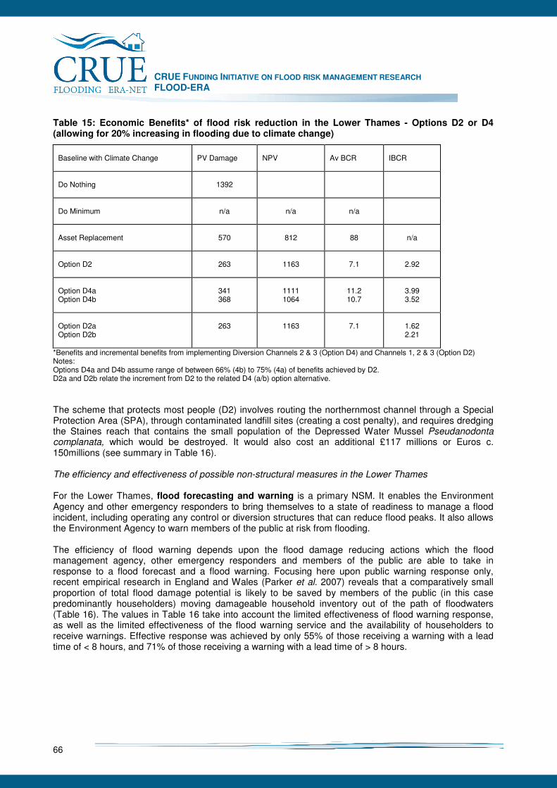
CRUE FUNDING INITIATIVE ON FLOOD RISK MANAGEMENT RESEARCH FLOOD-ERA
66
Table 15: Economic Benefits* of flood risk reduction in the Lower Thames - Options D2 or D4 (allowing for 20% increasing in flooding due to climate change)
Baseline with Climate Change
PV Damage
NPV
Av BCR
IBCR
Do Nothing
1392
Do Minimum
n/a
n/a
n/a
Asset Replacement
570
812
88
n/a
Option D2
263
1163
7.1
2.92
Option D4a Option D4b
341 368
1111 1064
11.2 10.7
3.99 3.52
Option D2a Option D2b
263
1163
7.1
1.62 2.21
*Benefits and incremental benefits from implementing Diversion Channels 2 & 3 (Option D4) and Channels 1, 2 & 3 (Option D2) Notes: Options D4a and D4b assume range of between 66% (4b) to 75% (4a) of benefits achieved by D2. D2a and D2b relate the increment from D2 to the related D4 (a/b) option alternative. The scheme that protects most people (D2) involves routing the northernmost channel through a Special Protection Area (SPA), through contaminated landfill sites (creating a cost penalty), and requires dredging the Staines reach that contains the small population of the Depressed Water Mussel Pseudanodonta complanata, which would be destroyed. It would also cost an additional £117 millions or Euros c. 150millions (see summary in Table 16). The efficiency and effectiveness of possible non-structural measures in the Lower Thames For the Lower Thames, flood forecasting and warning is a primary NSM. It enables the Environment Agency and other emergency responders to bring themselves to a state of readiness to manage a flood incident, including operating any control or diversion structures that can reduce flood peaks. It also allows the Environment Agency to warn members of the public at risk from flooding. The efficiency of flood warning depends upon the flood damage reducing actions which the flood management agency, other emergency responders and members of the public are able to take in response to a flood forecast and a flood warning. Focusing here upon public warning response only, recent empirical research in England and Wales (Parker et al. 2007) reveals that a comparatively small proportion of total flood damage potential is likely to be saved by members of the public (in this case predominantly householders) moving damageable household inventory out of the path of floodwaters (Table 16). The values in Table 16 take into account the limited effectiveness of flood warning response, as well as the limited effectiveness of the flood warning service and the availability of householders to receive warnings. Effective response was achieved by only 55% of those receiving a warning with a lead time of < 8 hours, and 71% of those receiving a warning with a lead time of > 8 hours.
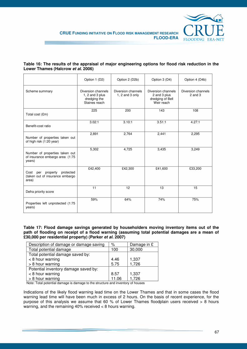
CRUE FUNDING INITIATIVE ON FLOOD RISK MANAGEMENT RESEARCH FLOOD-ERA
67
Table 16: The results of the appraisal of major engineering options for flood risk reduction in the Lower Thames (Halcrow et al. 2006)
Option 1 (D2)
Option 2 (D2b)
Option 3 (D4)
Option 4 (D4b)
Scheme summary
Diversion channels
1, 2 and 3 plus dredging the
Staines reach
Diversion channels
1, 2 and 3 only
Diversion channels
2 and 3 plus dredging of Bell
Weir reach
Diversion channels
2 and 3
Total cost (£m)
225 200 143 108
Benefit-cost ratio
3.02:1 3.10:1 3.51:1 4.27:1
Number of properties taken out of high risk (1:20 year)
2,891 2,764 2,441 2,295
Number of properties taken out of insurance embargo area (1:75 years)
5,302 4,725 3,435 3,249
Cost per property protected (taken out of insurance embargo area)
£42,400 £42,300 £41,600 £33,200
Defra priority score
11 12 13 15
Properties left unprotected (1:75 years)
59% 64% 74% 75%
Table 17: Flood damage savings generated by householders moving inventory items out of the path of flooding on receipt of a flood warning (assuming total potential damages are a mean of £30,000 per residential property) (Parker et al. 2007)
Description of damage or damage saving % Damage in £ Total potential damage 100 30,000 Total potential damage saved by: < 8 hour warning > 8 hour warning
4.46 5.75
1,337 1,726
Potential inventory damage saved by: < 8 hour warning > 8 hour warning
8.57 11.06
1,337 1,726
Note: Total potential damage is damage to the structure and inventory of houses Indications of the likely flood warning lead time on the Lower Thames and that in some cases the flood warning lead time will have been much in excess of 2 hours. On the basis of recent experience, for the purpose of this analysis we assume that 60 % of Lower Thames floodplain users received > 8 hours warning, and the remaining 40% received < 8 hours warning.
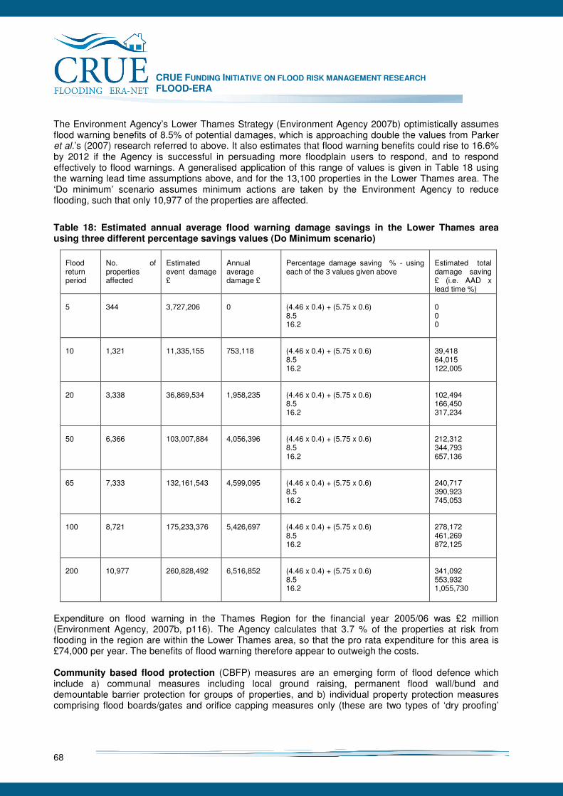
CRUE FUNDING INITIATIVE ON FLOOD RISK MANAGEMENT RESEARCH FLOOD-ERA
68
The Environment Agency’s Lower Thames Strategy (Environment Agency 2007b) optimistically assumes flood warning benefits of 8.5% of potential damages, which is approaching double the values from Parker et al.’s (2007) research referred to above. It also estimates that flood warning benefits could rise to 16.6% by 2012 if the Agency is successful in persuading more floodplain users to respond, and to respond effectively to flood warnings. A generalised application of this range of values is given in Table 18 using the warning lead time assumptions above, and for the 13,100 properties in the Lower Thames area. The ‘Do minimum’ scenario assumes minimum actions are taken by the Environment Agency to reduce flooding, such that only 10,977 of the properties are affected.
Table 18: Estimated annual average flood warning damage savings in the Lower Thames area using three different percentage savings values (Do Minimum scenario)
Flood return period
No. of properties affected
Estimated event damage £
Annual average damage £
Percentage damage saving % - using each of the 3 values given above
Estimated total damage saving £ (i.e. AAD x lead time %)
5
344
3,727,206
0
(4.46 x 0.4) + (5.75 x 0.6) 8.5 16.2
0 0 0
10
1,321
11,335,155
753,118
(4.46 x 0.4) + (5.75 x 0.6) 8.5 16.2
39,418 64,015 122,005
20
3,338
36,869,534
1,958,235
(4.46 x 0.4) + (5.75 x 0.6) 8.5 16.2
102,494 166,450 317,234
50
6,366
103,007,884
4,056,396
(4.46 x 0.4) + (5.75 x 0.6) 8.5 16.2
212,312 344,793 657,136
65
7,333
132,161,543
4,599,095
(4.46 x 0.4) + (5.75 x 0.6) 8.5 16.2
240,717 390,923 745,053
100
8,721
175,233,376
5,426,697
(4.46 x 0.4) + (5.75 x 0.6) 8.5 16.2
278,172 461,269 872,125
200
10,977
260,828,492
6,516,852
(4.46 x 0.4) + (5.75 x 0.6) 8.5 16.2
341,092 553,932 1,055,730
Expenditure on flood warning in the Thames Region for the financial year 2005/06 was £2 million (Environment Agency, 2007b, p116). The Agency calculates that 3.7 % of the properties at risk from flooding in the region are within the Lower Thames area, so that the pro rata expenditure for this area is £74,000 per year. The benefits of flood warning therefore appear to outweigh the costs. Community based flood protection (CBFP) measures are an emerging form of flood defence which include a) communal measures including local ground raising, permanent flood wall/bund and demountable barrier protection for groups of properties, and b) individual property protection measures comprising flood boards/gates and orifice capping measures only (these are two types of ‘dry proofing’

CRUE FUNDING INITIATIVE ON FLOOD RISK MANAGEMENT RESEARCH FLOOD-ERA
69
measures). The Lower Thames Strategy Study identified 661 (in Reach 3) and 190 (in Reach 4) of the most vulnerable properties where these measures are considered to be most appropriate. In Reach 4 these properties are in three ‘pilot sites’ (Environment Agency, Thames Region 2006). The costs and benefits of CBFP measures have been analysed in detail in the Lower Thames Strategy Study, but for ‘pilot sites’ and ‘initial sites’ only (Table 19). Costs are based upon capital costs, maintenance costs and other expenditures arising from ground investigation, design, land negotiations and legal costs, calculated over a 50 year period at a discount rate of 3.5%. Flood damages are assessed using Multi-Coloured Manual data (Penning-Rowsell et al. 2005). Benefits are based upon the average annual damage calculated from the potential flood damages in the 5, 10, 20, 50, 65, 100 and 200 year floods.
Table 19: Benefit-cost analysis of community based flood protection measures in Lower Thames ‘pilot sites’ (Reach 4) and ‘initial sites’ (Reach 3)
Reach CBFP measure type
No. of properties
PV costs £ 000s
PV benefits £ 000s
B:C ratio
3 Communal 96 Individual 565 661 (total) 10,476 23,201 2.21 4 Communal 78 Individual 112 190 (total) 3,400 5,951 1.75
Table 19 indicates that, on the basis of analysis of the pilot and initial sites (comprising a total of 851 properties), CBFP measures are economically efficient, but not as economically efficient as say, flood diversions channels. However, the economic efficiency of these measures varies considerably from area to area within the floodplain and B:C ratios range from 8.6 to 0.42 to 1. Flood insurance is a mechanism for spreading flood risk and its cost over time, and is provided by the private insurance industry in the UK. In the Lower Thames there is a high level of house ownership (87 %) and 67% of 207 sampled residents interviewed in 2005 confirmed that they currently possessed household contents insurance incorporating flood insurance cover (Flood Hazard Research Centre, 2006). The potential effect of flood insurance is complex. Its availability, and the relative security it provides, may generally encourage the continued occupation of inappropriate existing developments, but where availability and/or premiums reflect the true risk of flooding, flood insurance may act in the opposite direction. In theory, the costs of flood insurance should be borne by those choosing to live in floodplains and, generally, the insurance industry is seeking to adjust its availability and price to reflect this (ABI 2002a, b). However, currently there is little to no price differential between most household and business insurance policies containing flood cover, so that to some extent the flood-free are subsidising the flood-prone. The costs to the nation of flood insurance are very difficult to identify, but increasing expenditure on flood defence to enable flood insurance to be continue to be offered appears to be the principal cost. The benefits of providing flood insurance are increased financial security of those living in floodplains, and decreased stress and anxiety as a result. Spatial planning comprises the methods employed largely by Government and the public sector to influence the future distribution of activities in space. Influencing the use of space in and around floodplains is a primary NSM. The Government’s Making Space for Water flood risk management strategy (Department for Environmental, Food and Rural Affairs, 2004) and the Department for Communities and Local Government’s (DCLG) planning policy for development and flood risk (PPS25) (DCLG 2006) are key related policies.
CRUE FUNDING INITIATIVE ON FLOOD RISK MANAGEMENT RESEARCH FLOOD-ERA
70
For spatial planning measures to be effective, a successful partnership is required between flood management and spatial planning agencies at national, regional and local levels, and this partnership needs to extend also to architects, developers and builders. A central plank of PPS25 is flood risk assessments at the regional, strategic (i.e. local) and site-specific levels, as well as the planning application and consent process. Spatial planning is therefore principally concerned with avoiding inappropriate future extra use of flood risk zones. The benefits of spatial planning are likely to be incremental over time, and are likely to be in the form of a) avoidance of an accumulation of future flood damage potential that would be added to existing flood damage potential; b) reduction in all categories (e.g. direct, indirect, intangible) of potential flood losses; c) increased resilience of existing properties and land uses to flooding; and d) reduction of flood peaks where additional areas of flood storage can be found and brought into play. The costs of spatial planning are largely the additional or marginal costs of taking flood risk into account in the strategy and plan decision-making process, and in the development control and planning consent processes. These processes all exist within planning authorities irrespective of flood risk management requirements and therefore taking account of flood risk does not add a great deal of cost. However, the Environment Agency also incurs costs associated with planning consultations, a significant proportion of which are flood related. Over the 3 year period 2004-2006 the Environment Agency (Thames Region, SE Area) incurred £140,000 of costs for dealing with planning applications in Reach 4, and the equivalent cost for Reach 3 is likely to be £280,000 (Environment Agency 2007b). The benefits of a spatial planning approach to flood risk management can be large and relatively short term where a floodplain is largely undeveloped, but this is not the case in the Lower Thames. Here the benefits of spatial planning to flood risk management are only likely to be significant in the medium to long term and relate the life-times of developments (say where a development as a 40 or 50 year life-time), but over the medium to long term the benefits can be appreciable. Emergency response during a flood is action taken by official agencies or unofficial bodies, including business companies and individuals, generally aimed at mitigating its adverse impacts by reducing the extent of the flood event, or its severity, or by affecting the ‘receptors’ of the flood. As with the costs of spatial planning for flood risk management, the costs of flood emergency planning and response are limited to the additional, marginal costs of planning for and responding to civil emergencies in general (i.e. most of the costs are incurred irrespective of the flood threat because of the need to plan for and respond to other types of emergencies). Based upon a detailed analysis of the 2000 floods in England and Wales, Penning-Rowsell and Wilson (2006) calculate that flood emergency costs applicable to flood project appraisals are 10.7% of the economic property losses. In these floods most of the costs were incurred after the flood event, particularly by highway authorities and the Environment Agency, and also during the event where most of the costs fell on local authorities and to a lesser extent on the Environment Agency. The benefits of flood emergency response are unknown because research has not yet been undertaken which isolates them. It seems likely, however, that judgements are made by those managing emergency response services that are likely to keep costs broadly in line with benefits (i.e. a B:C ratio of approximately unity), but currently there is no way of corroborating this. Flood resistance and resilience measures may be applied to houses, buildings used by businesses and infrastructure, such as roads, railway lines or electricity sub-stations. In the UK the term ‘flood resistance’ has now become identified with the design and construction of a building in order to prevent floodwater entering and damaging the building and its fabric. This may also be referred to as ‘dry proofing’. The term ‘flood resilience’ is the design and construction of a building based upon the principle that floodwater will enter the building but, through careful design, the impact of flooding is reduced to a minimum. This is such
CRUE FUNDING INITIATIVE ON FLOOD RISK MANAGEMENT RESEARCH FLOOD-ERA
71
that the structural integrity of the building is maintained, services can quickly be restored, and post-flood drying and cleaning are facilitated. This may also be referred to as ‘wet proofing’. The benefits of adapting developments to flood risk are equivalent to the flood damages and losses avoided when floods occur. The costs of utilising flood resistance and resilience measures depend firstly upon whether the measures are incorporated in new builds ab initio, or ‘retrofitted’; and secondly, upon the particular design, composition and size of buildings. Some general cost estimates relating to the costs of retrofitting rather than ab initio circumstances are available. Installing resistance measures in an existing house is likely to cost from £3,000 to £10,000 according to a Department for Environment, Food and Rural Affairs/Environment Agency (2007) scoping study, although an earlier study by the Association of British Insurers indicated significantly higher potential costs. The ABI concluded that for shallow flooding below the damp proof course, some measures are worthwhile, such as replacing oak floorboards with treated softwood, replacing mineral insulation with closed cell alternatives, and removing ash from below quarry tiled floor and replacing chipboard with treated floorboards. However, most other measures could not be justified in ‘retrofit mode’ in terms of the large number of repeat floods which would be required to repay the initial investment. In deeper floods rising above floor level, many more of the measures were justifiable in terms of benefits and costs. Provisional findings from research being conducted for the Department for Environment, Food and Rural Affairs by ENTEC UK Ltd (2007) indicates that houses need to be in the 1 in 50 (or more frequent) floodplain before B:C ratios rise above unity. Overall, it appears that resistance and resilience measures have a contribution to make to reducing flood risk in the Lower Thames, but economic viability depends very much on local circumstances. The effectiveness of these measures is also partly dependent upon property occupiers maintaining them over time which cannot be guaranteed. Public education and awareness underpins a number of the NS measures discussed above, including flood warning response, individual property flood protection measures, other property level resistance and resilience measures, and flood insurance purchase. The costs of raising public flood risk awareness and improving the public’s knowledge of how best to respond to floods and flood warnings are therefore contributions to the costs of these measures, the benefits of which are already discussed above. The Environment Agency mounts annual public flood awareness campaigns, and a number of complementary measures are being used to raise public flood awareness. The aim of all of these strategies is to encourage members of the public to take practical self-protective action. However, the infrequent nature of flooding makes it difficult to sustain awareness and preparedness. Social surveys undertaken in October/November 2005 indicate that in Reach 4 residents are moderately aware of the risk of flooding, and that this awareness is heightened for those living on islands in the Thames (Flood Hazard Research Centre, 2006). The costs of public flood education and awareness initiatives are difficult to isolate and quantify partly because, as illustrated above, there are now a number of different elements and some of them are integral to other NSMs. It is understood that in recent years the budget for the Environment Agency’s public flood awareness campaign in England and Wales has been approximately £2 million. In comparison to the likely costs, the benefits of public flood education and awareness are likely to be large in an area such as the Lower Thames but such public education and awareness raising needs to be a continuous process.
7.1.7 Summary: efficiency and effectiveness of possible flood risk management measures
It is clear that both SM and NSM can be effective and efficient in the Lower Thames area (Table 20), although in general the SM are more economically efficient that the NSMs, using current standard
CRUE FUNDING INITIATIVE ON FLOOD RISK MANAGEMENT RESEARCH FLOOD-ERA
72
appraisal tools. However this result is bound to be highly site specific, and this research shows that it would be a false conclusion is it were deemed that all SNM were more economically efficient and effective vis-a-vis NSM irrespective of location and geography.
7.1.8 Transaction costs
Doubts over the reliability of evaluation procedures for NSM undermine the potentially favourable impact of a (somewhat surprising) assumption from our interviewees (see below) that set-up costs and transaction costs26 would be lower for non-structural measures than for structural measures. Furthermore, their impact on decisions about strategy design seem to be reinforced by an assumption that non-structural measures would only be moderately effective when compared to the building of diversion channels (where these were viable). Interestingly, both the first of these assumptions match our own evaluation of non-structural measures, which rates the effectiveness of non structural measures as generally mixed and only ‘high’ in the cases of insurance and spatial planning (see Table 20). Our assessment of the transaction costs was that these were indeed lower than for SM, and in some cases “Low” (public education and insurance), although one does wonder whether there is good agreement about what transaction costs really means, especially when so many of these costs are “sunk” in the past (see Table 20).
7.1.9 Assessing the Lower Thames ‘context factors’: Applied methodology
Understanding the ‘context factors’ affecting decisions to review or implement NSM is central to this research. Alongside an analysis of key documents and the economic analysis provided above, the main method used to meet the objectives for this case study was the depth interview (which is also known as the semi-structured interview). This was our main vehicle for teasing out and understanding these context factors. Three key themes were identified in the interviews that appear to adversely influence the likelihood of non-structural measures being adopted: the influence of professional cultures; the influence of external groups; and systems, procedures and structures. In summary, the experience of those involved in the LTSS suggests that the funding and appraisal system is not suitable for non-structural measures. In order to include NSMs in the LTSS, respondents felt that they had to ‘bend’ these systems to a purpose for which they were not designed. Although none of the respondents admitted to being deterred by these difficulties, it is clear that the extra difficulty and complexity involved will have added to the cultural factors that predispose decision-makers to favour large-scale engineered options for flood risk management. Furthermore, it can be argued that the absence of suitable national systems for evaluating NSMs deprives them of the level of oversight and quality control from which more capital intensive SMs benefit. Even if such measures are included in the final scheme for the Lower Thames area, this quality control deficit may undermine their eventual effectiveness.
26 The evidence indicates that in a subjective estimation of the relative transactions costs of structural and non structural measures, only monitoring and enforcement costs are thought to be higher for non structural measures.

CRUE FUNDING INITIATIVE ON FLOOD RISK MANAGEMENT RESEARCH FLOOD-ERA
73
Table 20: Summary economic analysis results for the Lower Thames case study area
Flood risk management element
(SM or NSM)
Effectiveness in Lower Thames context
Efficiency in Lower Thames context (with any BCR results)
Transaction costs in Lower Thames context
Results highly location specific?
Comments
By-pass channels
SM High (they would take many people and properties out of significant risk)
High. BCRs in the region of 1:4 to 1: 11. These results are bound to be highly site specific.
Very high. Major cost of studies, negotiations, etc.
Yes BCA undertaken using standard methods but allowing for climate change (which has a large effect on the results here).
Flood forecasting and warning,
NSM Medium-high
Low (damage saving small). BCR likely to be < 1.0.
Initially high, but not high now (sunk costs high)
No BCA using damage saving may not be the appropriate measure of efficiency. Better perhaps to assess worthwhileness as the number of people warned, rather than the damage saving actions that then follow.
Community based protection
NSM Uncertain Low-Medium. BCRs in a range 1.75 to 2.2 (and up tpom8.0 very locally)
High. Complex local negotiation/persuasion needed
Yes Social surveys indicate public support
Flood insurance
NSM High (but not universal)
High (insurance companies make money out of these policies so effective BCR for them is > 1.0) .
Low No Penetration is not uniform, despite a nationally available flood insurance system ‘bundled’ in with other household cover. Up to 50% of low socio-economic groups do not have insurance
Spatial planning
NSM High (but only for curtailing the development of the floodplain in the future)
Probably very high (i.e. the system is ‘paid for’ in its other uses)
Initially high, but not high now (sunk costs high) but “medium” – annual ‘maintenance’ costs
No Does not assist with inherited risk . BCA under Treasury rules does not allow counting the avoidance of build up of future flood risk which is the raison d’être of the flood risk management role of spatial planning
Emergency planning and response
NSM Medium-high (but untested)
Very low (very little damage saving). BCR assumed to be 1.0.
Medium – annual ‘maintenance’ costs
No Public safety rather than efficiency is the criterion. Better perhaps to assess worthwhileness as the number of people assisted, rather than damage saving actions that then follow.
Resilience measures
NSM Uncertain Medium - low? BCRs only above 1.0 where flooding is frequent (i.e. > risk that 1:50 years)
Medium – high (large numbers of individual negotiations)
No Parallel Defra research under way (Tim Harries) may clarify the benefits and costs more accurately.
Public education and awareness
NSM Low. The pubic appears still slow to react, but this is a low risk area.
Medium-High. The benefits of the awareness raising programme seem high; people are aware of the risks that they face
Low; this is now a routine Environment Agency activity
Yes Many benefits come through via other measures (i.e. the effectiveness and efficiency of forecasting and warning systems build on awareness campaigns)
CRUE FUNDING INITIATIVE ON FLOOD RISK MANAGEMENT RESEARCH FLOOD-ERA
74
7.1.10 Supporting the implementation of NSM
Given this evidence of an intrinsic bias against NSM, what can be done to encourage their adoption? One clear message from this research is that decision-makers require either better empirical evidence of the effectiveness and efficiency of NSMs or else standard, agreed ways of approximating their key performance measures. The engineering culture amongst decision-makers may not change in the near future, but this change to appraisal arrangements would at least enable them to avoid having to make their own estimates of benefits and costs, and to avoid, therefore, the cultural discomfort and exposure to criticism that such estimates appear to carry. Stronger messages in support of NSMs also need to be sent out by Defra and by central components of the Environment Agency. The very language and structure of the appraisal process is said to enshrine, at present, an assumption of the predominance of structural measures, so it is little wonder that this is reflected in the framings and representations used by decision-makers at the scheme level. PAG3 and the other appraisal guidelines, this suggests, should be revised so that they make more allowance for measures whose benefits (a) depend on unpredictable factors such as the agreement of individual householders and (b) will only be realised over a period of time rather than immediately. Some consideration also needs to be given to the rules on revenue and capital funding. Finally, there is the issue of the so-called ‘engineering culture’ and the argument that it inclines decision-makers toward SMs and away from NSMs options. This suggests that intensive, facilitated engagement between the various stakeholders during the design process would make the consideration of non-structural measures more likely.
7.1.11 Conclusions
In the Lower Thames area, there appears to be a general consensus from our interviewees that what at-risk populations most want and what they deserve is to have are large scale engineered measures that prevent floodwater from coming anywhere near their homes. This belief, it seems, causes non-structural measures to be treated as a second best option and, hence, to be pushed down the list of priorities. This view is not surprising. After all, those members of the local population whose voices are most often heard in the debate over flood risk are the ones who have been flooded and who are most keen to be protected. Their view, therefore, is mistaken for the view of the population of the area as a whole, or even for the view of society – a perspective that seems to be supported by at least one of the local Members of Parliament. Not only do decision-makers tend to be intuitively averse to setting aside flood defence in favour of non-structural measures, but the systems and procedures that they rely on encourage them to do so. Funding for capital work is often more difficult to find than funding for revenue-based non-structural measures, the benefit-cost calculations that still dominate option choice are ill-suited to non-structural measures, whose effectiveness is often unpredictable, and which often focus strongly on public safety rather than flood damage reduction, and which have no agreed methods for calculating efficiency. If the principles of the Government’s Making Space for Water strategy are to be successfully implemented, this suggests, then a cultural change is necessary. According to one respondent, however, the current engineering culture is so deeply engrained amongst decision-makers in the Environment Agency that it will take a generation for them to change. In the meantime, it needs to be made easier for those who do want to introduce non-structural measures to be able to do so. Defra’s Outcome Measures, this study suggests, need to be changed so that they incentivise non-structural measures more effectively and restrictions on revenue funding need to be eased. In addition, either standard procedures need to be

CRUE FUNDING INITIATIVE ON FLOOD RISK MANAGEMENT RESEARCH FLOOD-ERA
75
introduced to calculate the efficiency of non-structural measures or the benefit-cost test needs to be seen as just one test of an option, rather than – as at present – as the final arbiter over the implementation of flood risk management schemes.
CRUE FUNDING INITIATIVE ON FLOOD RISK MANAGEMENT RESEARCH FLOOD-ERA
76
7.2 Clyde River (Glasgow)
Alan Werritty and Edmund Penning-Rowsell In this Scottish FLOOD-ERA case study the conclusions are that there appears to be a more pragmatic approach to flood risk management than in England, using whatever measures enhance risk reduction and at the same time meet the parallel goals of pollution reduction, and urban regeneration; the three are inextricably linked. Benefit-cost technique constraints on using NSM are there, but do not seem to dominate. Most flood risk engineers are located in local authorities rather than a stand-alone Agency as in England. As a result they are more flexible in adopting flood risk measures and subject to fewer professional constraints in favour of SM. National policy in Scotland seems to put NSM measures on the same footing as SM, and the target of the Commonwealth Games in Glasgow in 2014 means that pragmatism and "getting things done" appears to be the dominant thought mode.
7.2.1 Introduction
In Scotland the initial responsibility to protect a property from flooding falls on the property owner. Thereafter managing flood risk is widely distributed across a number of public bodies. Local authorities can bring forward and construct flood prevention schemes on non-agricultural land. They must also assess and maintain urban water courses and (with the emergency services) co-ordinate emergency action during and immediately after floods. The Scottish Environmental Protection Agency (SEPA) is responsible for disseminating flood warnings via Floodline and is a statutory consultee on planning applications in flood prone areas. It also maintains the national flood risk map and regulates the impact of engineering works on rivers, including those designed to reduce flood risk. Scottish Water, in partnership with local authorities and the emergency services, manages sewer flooding and its associated impacts. Most of the current statutory powers and duties for these public bodies derive from legislation that was primarily concerned with fluvial flooding caused by rivers over-topping their banks. As a result, most of the flood prevention measures undertaken under the Flood Prevention (Scotland) Act 1961 have comprised structural defences typically on major water courses (Bassett et al. 2007). However, following the Foresight Study (Evans et al. 2004, Werritty with Chatterton 2004) there is now greater recognition of non-fluvial flooding and especially pluvial (or urban) flooding caused by surcharging sewers combined with surface flow following intense localised storms such as that which occurred in Shettleston in the east end of Glasgow in July 2002. However, as noted by the Pitt Review in England (Cabinet Office 2007), the responsibility for managing urban flood risk is unclear. Thus Scottish Water is responsible for managing the discharge of surface water that enters its drainage systems from roofs and paved ground surfaces, but not runoff from roads which is the responsibility of the roads authorities (central and local government). In its current consultation on a Flooding Bill, the Scottish Government “wishes to ensure that urban drainage plans sit within a Local Flood Risk Management Plan and wishes to identify the most effective means to facilitate co-ordination of efforts to reduce flooding from surface water runoff and sewers” (Scottish Government, 2008b, para 3.43). The Glasgow Strategic Drainage Plan (triggered by the Shettleston flood) is viewed by many, including the Scottish Government, as an exemplar of how to achieve this co-ordination of efforts to better manage urban flood risk which is expected to increase significantly under most climate change models (Werritty 2007). The aims of this case study are:
• To outline structural and non-structural flood risk management measures in the Glasgow Strategic Drainage Plan (GSDP),
• To comment on the relative effectiveness and efficiency of structural and non-structural measures,
CRUE FUNDING INITIATIVE ON FLOOD RISK MANAGEMENT RESEARCH FLOOD-ERA
77
• To explore the perceived relative merits of structural and non-structural measures within the GSDP.
7.2.2 Background – case study area
Following the 1 in 100 year storm in July 2002 which caused severe urban flooding in Shettleston, Glasgow City Council and Scottish Water came under intense public pressure to address urban flood risk across the city. However, since the urban flood risk in Glasgow involves sewer flooding as well as surface water flooding, water quality issues are also at stake. SEPA’s most recent survey of water quality across Scotland in 2006 recorded the majority of Glasgow’s water courses as being “moderate”, “poor” or “severely polluted” (SEPA 2008) due in part to stormwater discharges from Combined Sewer Overflows (CSOs). Furthermore, the sewerage system is operating close to capacity severely constraining urban regeneration, especially in the east end of Glasgow. Thus the urban flood risk in Glasgow is inextricably linked to water quality problems and these in turn are impeding vital urban regeneration. The development of the Glasgow Strategic Drainage Plan (GSDP) Within a few months of the Shettleston flood, it was recognised that a partnership and a joint strategy was needed if all three issues were to be addressed concurrently. The result was the GSDP managed by a Steering Group comprising Glasgow City Council, Scottish Water, SEPA and Scottish Enterprise Glasgow, with Glasgow City Council chairing the Group. The objectives of the GSDP were quickly identified as:
• Flood risk reduction • Water quality improvement • Removal of development constraint • Habitat improvement • Integrated investment planning
In formulating the GSDP, the Steering Group gave particular emphasis to reducing the risk of widespread flooding from surcharging sewers and surface runoff. The nature and severity of this risk had been dramatically demonstrated during the 30 July 2002 flood in the east end of Glasgow when over 500 properties were flooded generating losses of around £100 million. It was also accepted that the frequency of such events was likely to increase given climate change. The link between urban flooding and water quality was seen as a direct consequence of open channels being converted into culverts many years ago and the discharge of stormwater from CSOs into these watercourses. As a result many urban watercourses in Glasgow will struggle to achieve “good status” by 2015 as required under the EC Water Framework Directive (European Commission 2000). In terms of urban regeneration, the lack of capacity in the sewerage system and the tendency for piecemeal development has meant that constraints in the drainage system are impeding the development of brownfield sites and much needed regeneration. This in turn has meant fewer new green urban spaces and opportunities for improved habitats. The GSDP is thus exploring the possibilities of “de-culverting” watercourses and installing attenuation ponds which would not only enhance amenity but also provide valuable new habitat for wildlife. Success in achieving these improvements in the urban water environment will require an integrated approach to investment planning by all GSDP partners working to a common timeframe. One of the GSDP’s initial challenges was recognition by Glasgow City Council and Scottish Water that a joint strategy was needed to address urban flood risk. This is graphically illustrated by Scottish Water’s analysis of the flood volumes recorded at Elmvale Row, Springburn during the July 2002 storm estimated at 6000 m3 from overland flow, 6000 m3 from sewer flooding and 1000 m3 due to high ground water levels (Figure 12). Responsibility for managing the resulting urban flooding (in this case inundation to a depth of
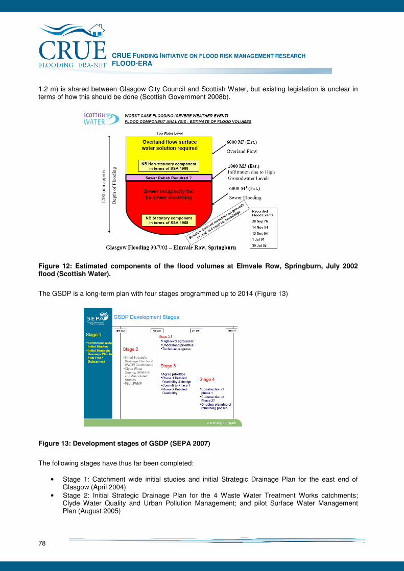
CRUE FUNDING INITIATIVE ON FLOOD RISK MANAGEMENT RESEARCH FLOOD-ERA
78
1.2 m) is shared between Glasgow City Council and Scottish Water, but existing legislation is unclear in terms of how this should be done (Scottish Government 2008b).
Figure 12: Estimated components of the flood volumes at Elmvale Row, Springburn, July 2002 flood (Scottish Water).
The GSDP is a long-term plan with four stages programmed up to 2014 (Figure 13)
Figure 13: Development stages of GSDP (SEPA 2007)
The following stages have thus far been completed:
• Stage 1: Catchment wide initial studies and initial Strategic Drainage Plan for the east end of Glasgow (April 2004)
• Stage 2: Initial Strategic Drainage Plan for the 4 Waste Water Treatment Works catchments; Clyde Water Quality and Urban Pollution Management; and pilot Surface Water Management Plan (August 2005)
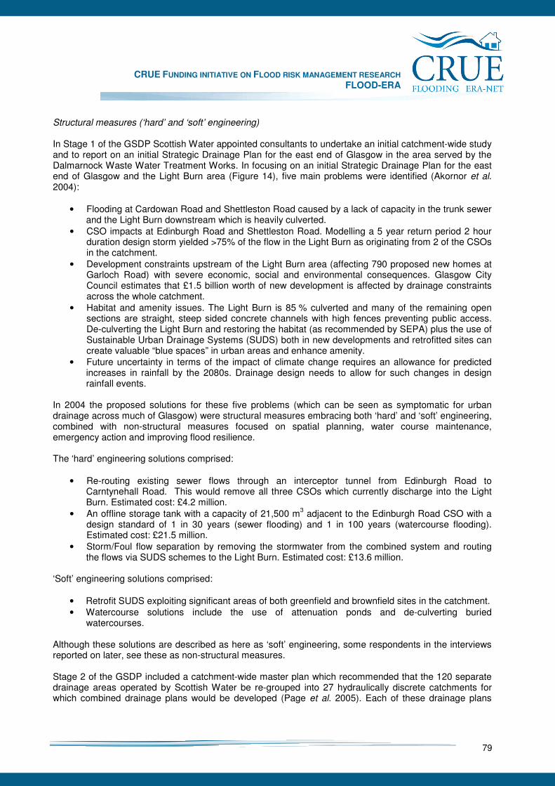
CRUE FUNDING INITIATIVE ON FLOOD RISK MANAGEMENT RESEARCH FLOOD-ERA
79
Structural measures (‘hard’ and ‘soft’ engineering) In Stage 1 of the GSDP Scottish Water appointed consultants to undertake an initial catchment-wide study and to report on an initial Strategic Drainage Plan for the east end of Glasgow in the area served by the Dalmarnock Waste Water Treatment Works. In focusing on an initial Strategic Drainage Plan for the east end of Glasgow and the Light Burn area (Figure 14), five main problems were identified (Akornor et al. 2004):
• Flooding at Cardowan Road and Shettleston Road caused by a lack of capacity in the trunk sewer and the Light Burn downstream which is heavily culverted.
• CSO impacts at Edinburgh Road and Shettleston Road. Modelling a 5 year return period 2 hour duration design storm yielded >75% of the flow in the Light Burn as originating from 2 of the CSOs in the catchment.
• Development constraints upstream of the Light Burn area (affecting 790 proposed new homes at Garloch Road) with severe economic, social and environmental consequences. Glasgow City Council estimates that £1.5 billion worth of new development is affected by drainage constraints across the whole catchment.
• Habitat and amenity issues. The Light Burn is 85 % culverted and many of the remaining open sections are straight, steep sided concrete channels with high fences preventing public access. De-culverting the Light Burn and restoring the habitat (as recommended by SEPA) plus the use of Sustainable Urban Drainage Systems (SUDS) both in new developments and retrofitted sites can create valuable “blue spaces” in urban areas and enhance amenity.
• Future uncertainty in terms of the impact of climate change requires an allowance for predicted increases in rainfall by the 2080s. Drainage design needs to allow for such changes in design rainfall events.
In 2004 the proposed solutions for these five problems (which can be seen as symptomatic for urban drainage across much of Glasgow) were structural measures embracing both ‘hard’ and ‘soft’ engineering, combined with non-structural measures focused on spatial planning, water course maintenance, emergency action and improving flood resilience. The ‘hard’ engineering solutions comprised:
• Re-routing existing sewer flows through an interceptor tunnel from Edinburgh Road to Carntynehall Road. This would remove all three CSOs which currently discharge into the Light Burn. Estimated cost: £4.2 million.
• An offline storage tank with a capacity of 21,500 m3 adjacent to the Edinburgh Road CSO with a design standard of 1 in 30 years (sewer flooding) and 1 in 100 years (watercourse flooding). Estimated cost: £21.5 million.
• Storm/Foul flow separation by removing the stormwater from the combined system and routing the flows via SUDS schemes to the Light Burn. Estimated cost: £13.6 million.
‘Soft’ engineering solutions comprised:
• Retrofit SUDS exploiting significant areas of both greenfield and brownfield sites in the catchment. • Watercourse solutions include the use of attenuation ponds and de-culverting buried
watercourses. Although these solutions are described as here as ‘soft’ engineering, some respondents in the interviews reported on later, see these as non-structural measures. Stage 2 of the GSDP included a catchment-wide master plan which recommended that the 120 separate drainage areas operated by Scottish Water be re-grouped into 27 hydraulically discrete catchments for which combined drainage plans would be developed (Page et al. 2005). Each of these drainage plans

CRUE FUNDING INITIATIVE ON FLOOD RISK MANAGEMENT RESEARCH FLOOD-ERA
80
would then be amalgamated in Waste Water Treatment Works catchment plans for each of the 4 WWTWs (Dalmuir, Dalmarnock, Daldowie and Sheildhall; see Figure 15 for locations). Piecemeal solutions to local problems were deemed to be unviable and uneconomic and a cross-catchment holistic masterplan thought essential if a strategic plan for the whole of Greater Glasgow was to be developed.
Figure 14: Light Burn Case Study Area: east end of Glasgow (Akornor et al. 2004)
Figure 15: Glasgow Strategic Drainage Plan with the four catchments for the Waste Water Treatment Works (Page et al. 2005)
In 2005 the cost of the initial GSDP masterplan was estimated at £1.4 billion for which special funding would be required. Scottish Water’s 8 year investment plan from 2006 (Q&SIII) does not include strategic stormwater infrastructure investment. Glasgow City Council can only bring forward Flood Protection Orders under the 1961 Act for which funding hitherto has favoured traditional structural defences on main rivers. As a result, Glasgow City Council and Scottish Water are pursuing a range of alternative funding
CRUE FUNDING INITIATIVE ON FLOOD RISK MANAGEMENT RESEARCH FLOOD-ERA
81
sources including the Scottish Government which has identified the GSDP as a priority in the second National Planning Framework (Scottish Government 2008a). Since 2005 the Steering Group and Technical Groups have focused on delivering the Clyde Gateway Integrated Water Plan as the first phase of delivering the GSDP. In 2006 it was also agreed that the remit of the GSDP should be widened to include other local authorities in the Glasgow conurbation and the Metropolitan Glasgow Strategic Drainage Partnership now includes other stakeholders including the Scottish Government and the Glasgow and Clyde Valley Structure Plan. This has enabled work on the GSDP to be viewed within the wider contexts of strategic planning for the Glasgow conurbation and delivering the objectives of the EC Water Framework Directive (European Commission 2000) via SEPA’s Clyde Area Advisory Group. Mix of structural and non-structural measures Many of the initial studies undertaken on behalf of Scottish Water focused on structural measures to reduce urban flood risk, but a suite of non-structural measures already exist and new ones are being developed. These non-structural measures have usefully been assessed in the ERA-NET CRUE project on Risk assessment and Risk Management in Small Urban Catchments (Ashley et al. 2007). Some non-structural measures, already implemented by Glasgow City Council, are explicitly embedded in the GSDP (Development Planning; Economic Instruments; Planning and Management; Street storm/drain/culvert/watercourse maintenance). Others are currently operational and relate specifically to emergency planning before and during a flood (Sand Bag Delivery; Flood Risk Emergency Plans; Strathclyde Emergency Co-ordination Group, Dwellers with special requirements register; Resilient Communications Network). A third group of measures currently in place (Weather Warning Systems; Flood Risk Maps; GIS database) are jointly undertaken by SEPA and Glasgow City Council. At present Met Office models provide a 6 hour warning of heavy rainfall on a 4 km grid which is of limited use for predicting urban flooding. But this is set to change with predictions on a 1.5 km grid which, when combined with suitable 2-D inundation models, should improve warnings for urban flooding. Similarly the current SEPA Indicative River and Coastal Flood Map does not include pluvial flooding in urban areas. But again with increasing LiDAR coverage and rapidly improving inundation models, local authorities are increasingly well-equipped to identify hotspots and model surface water flows. Enhancing flood resilience at the level of individual properties is a key element in Scottish Water’s policy on managing sewerage floods. Temporary measures designed to reduce the risk of internal flooding includes the use of flood guards, air vent guards or non-return valves offered to customers in properties at highest risk. By directly dealing with customers, this can also be seen as engaging with the public and raising awareness. But as Ashley et al. (2007) note, more generic measures designed to raise awareness and community engagement are weakly developed in the GSDP at present. This criticism is accepted by the Steering Group which is currently developing a Communication Strategy as part of the GSDP. It is hoped that a higher level of individual awareness of flood risk and better engagement with communities will follow. Increasing the take up of flood insurance (especially amongst in the most vulnerable communities) is being actively promoted by the Scottish Government with the providers of social housing being encouraged to promote ‘pay-with-rent’ schemes. But this also has yet to have a high profile within the GSDP.
CRUE FUNDING INITIATIVE ON FLOOD RISK MANAGEMENT RESEARCH FLOOD-ERA
82
7.2.3 Relative efficiency of SM and NSM
As in England, the efficiency of flood risk measures in Scotland is based upon benefit-cost analysis (BCA) which provides the framework for project appraisal when flood alleviation scheme are brought forward by local authorities. The majority of such schemes are structural defences reflecting current legislation which privileges large scale engineering works. The Scottish Government has recently revised its guidance to local authorities on project appraisal reflecting the recommendations of the National Technical Advisory Group on Flooding (Scottish Executive 2004a) and the recommendations of the report on the social impacts of flooding (Werritty et al. 2007). Whilst continuing to recommend the use of BCA in project appraisal, it is recognised that there are some flood impacts that cannot be “readily valued in economic terms and others which … may not be given their full weight in the analysis” (Scottish Government 2007b, para 2.4). Accordingly, within the constraints of the Treasury’s Green Book (HM Treasury 2003) due regard can be given to environmental impacts which may be assessed by continent valuation or social impacts which can be expressed in non-monetary terms. As others have noted (e.g. Ashley et al. 2007), it is much more difficult to assess non-structural measures in terms of their efficiency. However, a recent project on assessing the benefits of flood warning has used multi-criteria analysis (MCA) to provide SEPA and the EA with a methodology and GIS tool “to capture the benefits of flood warning when appraising proposals for new flood warning services, and for modifying or upgrading existing services (Scottish and Northern Ireland Forum for Environmental Research, 2007, p. 4). The following MCA categories were identified and the following differential weights assigned:
• Risk to life and serious injury reduction (30%): intangible benefit • Social impacts reduction (20%): intangible benefit • Residential property damage reduction (15%): tangible benefit • Business and agriculture damage reduction (15%): tangible benefit • Flood defence operations improvements (15%): tangible benefit • Infrastructure disruption reduction (5%): tangible benefit
The weights attributed to each category were based on the collective judgement of an expert panel and consultation with key stakeholders. Algorithms for deriving benefit scores for each category were provided enabling candidate sites for new or enhanced flood warning schemes to be ranked on a scale from 0-100. The method has been initially validated in pilot studies across 9 catchments in Scotland, England and Wakes. SEPA will be using this new methodology to inform the deployment of its next generation of flood warning schemes. The relative efficiencies of other non-structural measures have yet to be determined At a more strategic level, the National Technical Advisory Group (Scottish Executive 2004a) developed a set of measurement indicators for measuring compliance with the five objectives of sustainable flood management (SFM), namely:
• Overall – meet need for flood resilience • Social – enhance community benefit with fair access for everyone • Environmental – protect and work with the environment, with respect for all species, habitats,
landscapes and built heritage • Economic – deliver resilience at affordable cost and with fair economic outcomes • Future generations – allow for future adaptability, with a fair balance between meeting present
needs and those of future generations. These measurement indicators, which are claimed to be practical, transparent and auditable (Scottish Government 2008b), can be used to prioritise funding when decisions have to be made on alternative proposals in project appraisal. Because of the diversity of metrics involved, the use of individual indicator scores may require the use of multi-criteria analysis, sustainability appraisal and/or social benefit-cost analysis.
CRUE FUNDING INITIATIVE ON FLOOD RISK MANAGEMENT RESEARCH FLOOD-ERA
83
7.2.4 Results from interviews with senior flood risk managers
Semi-structured interviews were held with five flood risk managers representative of the key stakeholders in the GSDP plus two others involved in the development of policy and practice at a national scale and an academic with specialist expertise in urban drainage. The interviews were tape recorded and varied in length between 25 and 90 minutes. Factors influencing the choice of structural or non-structural measures The mix of structural and non-structural measures in the GSDP reflects local circumstances (both threats and opportunities) and the evolution of flood risk management policy at the national level. Both have played a major role in shaping the development of the GSDP. The initial trigger for the GSDP was the Shettleston flood in 2002. Scottish Water and Glasgow City Council came under intense pressure from MSPs, local councillors and flood victims to address the problem of urban flooding which for some communities had been a persistent problem for many years. But this “wake up” call also provided an opportunity to address four other pressing agendas – water quality improvement, removal of development constraint, habitat improvement and integrated investment planning – alongside flood risk reduction. At an early stage in the development of the GSDP a mixture of structural and non-structural measures emerged in order to address all five objectives. For two of the interviewees this balance has shifted over time. In their professional judgement, non-structural measures are capable of delivering improved water quality and flood risk reduction with minimal reliance on structural measures. The more representative view would be that both structural and non-structural measures are needed to deliver the GSDP. The next section explores the circumstances under which both can optimally be deployed. Also influencing the mix of measures adopted in the GSDP was a change in national flood risk management policy (Werritty 2006) triggered by the need to promote sustainable flood management as specified in the Water Environment Water Services (Scotland) Act 2003. Growing dissatisfaction with the Flood Prevention (Scotland) Act 1961 (seen by one interviewee as “moribund” in its privileging of structural measures and flood alleviation schemes) was a major impetus in the development of sustainable flood management. As a result of work on defining and operationalising sustainable flood management (Scottish Executive 2004a, Scottish Government 2007a), non-structural measures have been given an increasingly high profile in the National Flooding Framework which represents current Scottish Government policy on flood risk management. Thus the first three of the 4 ‘As’ (Assistance, Avoidance, Awareness and Alleviation) in the National Flooding Framework are non-structural measures. Several respondents noted that the new EU Floods Directive (European Commission 2007), with its requirement that flood risk management plans focus on prevention, protection and preparedness, also gives non-structural measures a key role in mitigating flood impacts. Given the above, many respondents saw the adoption of non-structural measures as crucial in delivering flood risk management tailored to 21st century needs. Across Scotland, non-structural measures are viewed as an equal partner with structural measures and certainly not second best as reported in the Lower Thames Study. Constraints and opportunities in delivering the GSDP One of the most striking findings from the interviews, echoed by many respondents, was that the GSDP provides a new way of working appropriate for delivering sustainable urban drainage in the 21st century:
CRUE FUNDING INITIATIVE ON FLOOD RISK MANAGEMENT RESEARCH FLOOD-ERA
84
For one respondent the key challenge was that the agencies “come out of their silos” as only then could they develop the necessary joint “long term vision” to deliver a sustainable solution to urban flooding which will “make the land productive for the next 100-150 years”. Whilst this is the aspiration, other respondents noted that this is not easily achieved given the inevitable institutional and funding barriers that inhibit collaborative inter-agency working. Initially after the Shettleston flood there was
“a bit of a fight between Scottish Water and Glasgow City Council on who was responsible. Was it a sewer flooding problem? Was it a water course flooding problem?”
However, once this was resolved, an effective partnership has evolved in which all the stakeholders seek to maximise opportunities for improving urban drainage as they become available. Commenting on what had been achieved by Scottish Water, Glasgow City Council, SEPA and Scottish Enterprise in the GSDP, one respondent claimed that:
“The work they have done together and the investment they have multiplied to do so has proved that this approach can actually work. And in terms of addressing issues in a strategic urban area, it’s really the only way to go forward. There’s no one agency that can do this in isolation”.
One example of this joined-up approach was the joint funding by Glasgow City Council and Scottish Water of a new trunk sewer in the Light Burn Catchment enabling a major CSO to be removed. This has reduced the flood risk, improved water quality and removed a major development constraint. But in other cases budgetary constraints and timetables have inhibited similar opportunities for joint investment. In these situations, funding targeted on addressing acute local problems fails to engage with larger strategic needs and potential synergies from joint working are lost. When asked to comment on the relative merits of structural and non-structural measures within the GSDP most interviewees saw them as complementary:
“I don’t have any preferences for whether we put in big trunk sewers or whether we put in SUDS, the bottom line is there are major known problems and deficiencies ... The strategy will be going to take many components and I … would agree that there must be non-structural elements”.
One interviewee went much further and when asked for his views on the relative merits of structural and non-structural measures replied;
“I see almost no place for structural measures whatsoever. I just don’t think they are particularly relevant.”
But this was an isolated response. More generally the respondents were even-handed and pragmatic in their advocacy of structural and non-structural measures with neither being privileged above the other. Most interviewees felt that sole reliance on either set of measures would not meet the goals of the GSDP as reducing flood risk was only one of five inter-related objectives. A good example of the benefits of combining structural and non-structural measures is Scottish Water’s strategy for reducing the number of properties on its flood risk register. Where a permanent structural solution (upgrading the sewer) is either too costly or likely to be significantly delayed by planning permission, Scottish Water will offer properties at risk temporary solutions based on fitting flood guards, air vent guards or non-return valves to prevent or inhibit sewer flooding. The property is thus made resilient and can be removed from Scottish Water’s flood risk register on the basis of an effective non-structural measure. Delivering the long-term vision of the GSDP is a major challenge and the agencies involved often have to be opportunistic, relying on private investment by developers to achieve the goal of more sustainable urban drainage. It is fortunate that the nature and layout of proposed new developments can be constrained by the use of SPP7 (Planning and Flooding, Scottish Executive 2004b) which covers “flooding
CRUE FUNDING INITIATIVE ON FLOOD RISK MANAGEMENT RESEARCH FLOOD-ERA
85
from all sources” and which requires any new development to be “neutral or better” in reducing flood risk. Several interviewees commented that SPP7 had succeeded in promoting a more sustainable approach to urban drainage, and that spatial planning is now a key component in the GSDP toolkit. As a result, engineers and planners are working together much more closely and effectively in both Glasgow City Council and Renfrewshire Council. For example, instead of delivering urban drainage at the end of the project, engineers are now involved at an early stage developing surface water management plans prior to detailed plot level designs by planners and landscape architects. The result is not only reduced flood risk, but improved water quality, habitat enhancement and greatly improved urban amenity in locations where previously “green space” and “blue space” were strikingly absent. Several interviewees commented positively on the opportunity afforded by the award of the Commonwealth Games to Glasgow and the inclusion of the GSDP in the Second National Planning Framework (Scottish Government 2008a). One respondent argued that this unique opportunity should showcase the best in sustainable urban drainage with demonstration sites and best practice manuals for the rest of urban Scotland. In 2005, as a result of limited additional funding, the GSDP was temporarily “paused”. Instead of advancing the plan across the whole of Glasgow, it was decided to focus on the Clyde Gateway in the east end of the city. Part of the funding problem arises from a lack of flexibility in transferring resources between capital and revenue streams and the expectation that most structural defences have to reach stringent benefit-cost criteria and lengthy delays due to the planning system. Both of these are set to change following a new system of local government funding by the Scottish Government. From April 2008 funding for flood measures will no longer be ring-fenced and largely funded by central government. Instead local authorities will be allocated a block grant which will include an allowance for flood measures. One respondent saw this as “liberating” as it would blur the distinction between structural and non-structural measures, remove the need to hit benefit-cost targets and provide welcome flexibility. However, this removal of ring-fencing and dedicated funding for flood measures also exposes future expenditure on flooding to political horse-trading as it competes at a local level with the budgets for housing, education, social work and roads. One area where Scottish Water’s priorities are potentially at variance with those of the local authorities is in their respective design standards. Whereas sewer systems are designed to accommodate a 1 in 30 year flood, for watercourses this is a 1 in 200 year flood. Major investment in upgrading the sewer infrastructure will mitigate the impact of relatively modest frequent floods, but have little impact of the rare extreme event. Surface water management plans must address the risks imposed by these rare events which, in some parts of the conurbation, represent a much more serious threat than sewer flooding. Managing public opinion Immediately after the Shettleston flood in 2002 flood victims, local politicians and community groups were very vocal in demanding effective action. But, with the passage of time this has become muted and the views of local groups have yet to be formally included in the decision-making process. As a result, those components of non-structural measures which relate to raising awareness and community engagement are under-developed in the GSDP. But as Newman et al. (2007) have noted, local capacity building is essential if non-structural measures are to be effectively delivered and taken up. Several respondents directly involved in delivering the GSDP noted this deficiency and reported that a Communication Strategy was being developed in order to help fill this gap. More generally it was reported that when consulted, the public favours structural over non-structural measures, a finding supported by other studies (Werritty et al. 2007). But when it is explained that such measures will never be justified in benefit-cost terms, there is a willingness by some community groups to accept non-structural measures as a realistic alternative.
CRUE FUNDING INITIATIVE ON FLOOD RISK MANAGEMENT RESEARCH FLOOD-ERA
86
Professional cultures One of the major findings from the Lower Thames Study was a marked antipathy towards non-structural measures by the engineering profession which variously saw them as “second best” and “unproven”. In Scotland the view of the engineering profession is strikingly different:
Interviewer: It’s very interesting to hear an engineer like yourself espousing non-structural measures with the passion that you have used. Do you think across the engineering profession in Scotland there is a greater acceptance of going down the non-structural route? Respondent: Absolutely. I’d be very clear on this. Interviewer: South of the border, engineers think that the only way they can obtain professional esteem is to go for large expensive flood defence schemes. Respondent: I’ve said that if you want to make your name in the EA you build big flood schemes. Interviewer: To make your way in Scotland, what’s the alternative? Respondent: You probably join a consultant and do interesting much smaller scale schemes … with interesting environmental solutions. Interviewer: So in terms of prestige, career development and professional standing, non-structural measures are much more credible in Scotland? Respondent: Yes, now that you say that I think that is the case.
It was clear from all the interviews with chartered engineers that there is a much greater commitment to and enthusiasm for non-structural measures than in the Lower Thames study. In part this reflects the experience of engineers in local authorities who, working alongside planners, have taken up the opportunities for flood risk management provided by SUDS and surface water management plans. It also reflects the impact on flood risk management professionals of the many discussions and consultations on sustainable flood risk management promoted by central government over the last four years. It is now widely accepted in Scotland that a portfolio of sustainable flood risk measures should include non-structural solutions.
7.2.5 Conclusions
The key elements of the GSDP are a commitment to partnership working and a willingness by Glasgow City Council, Scottish Water and SEPA to implement both structural and non-structural flood risk measures within an agreed overall strategy. Although flood risk reduction is only one of five key objectives, it has been a major driver in the design of the masterplan for the whole conurbation and more locally in the Strategic Drainage Plan for the east end of Glasgow. Initial disputes over who owned different components of urban flood risk have been replaced by a willingness to address the problem holistically at a strategic as well as local scale. A mix of structural and non-structural measures are planned with structural improvements in sewer capacity operating alongside the removal of CSOs and the use of SUDS and attenuation ponds to reduce surface water flooding. Whilst the relative weights assigned to these solutions across the conurbation will vary, there is general agreement on the need for structural and non-structural measures. Once water quality issues have been addressed, regeneration can proceed with new sewer systems and surface water management plans ideally bringing the flood risk down to 1 in 30 in the sewers and 1 in 200 in the watercourses.

CRUE FUNDING INITIATIVE ON FLOOD RISK MANAGEMENT RESEARCH FLOOD-ERA
87
Non-structural measures are embedded in the GSDP both in their own right in reducing flood risk and as components in meeting other objectives (notably habitat enhancement and removal of development constraint). The local deployment of structural or non-structural measures is very pragmatic – what works best in given situations – neither being privileged over the other. Engineers are not wedded to ‘hard’ structural solutions, but willing to adopt ‘soft’ engineering and non-structural measures where appropriate. Individual agencies are emerging from their silos and looking for mutual benefits and ‘joined up’ solutions. Specialists are increasingly employed in inter-disciplinary teams (for example engineers and planners) in order to develop holistic, catchment wide solutions. Funding is severely constrained and delivery on the ground is at an early stage. Developer-led opportunities are being seized but financial constraints on both Scottish Water and Glasgow City Council can inhibit strategic investments in new drainage infrastructure. Sometimes temporary measures (e.g. promoting flood resilience) become a substitute for capital investment. With Glasgow hosting the Commonwealth Games in 2014, the pace of delivery in the Clyde Gateway may accelerate, providing additional funding is made available. At present the GSDP is rather technocratic and agency-led with limited public engagement. Whilst some non-structural measures are well advanced (e.g. development planning, emergency action and watercourse maintenance) others (e.g. raising awareness and community engagement) are at a very early stage. At a national scale, Scotland is pursuing a more holistic and sustainable approach to flood risk management at a catchment scale than England (Werritty 2006). With only 100,000 or so properties at risk, lower levels of coastal flood risk and potentially higher levels of urban flooding, the emergence of a different and distinctive approach to flood risk management in Scotland is to be expected. It also reflects a more pragmatic and even-handed approach to structural and non structural measures pursued by key public agencies with a deliberate move away from undue reliance on large scale engineered solutions. The small number of well-networked professionals involved in flood risk management in Scotland may also have contributed to a more nimble response to the challenge of learning to live with floods. Whilst not consciously seeking to be different, Scotland’s approach to flood risk management is increasingly divergent from that pursued in England. In detail the GSDP provides a striking example of Scotland’s new approach to flood risk management. It addresses an important area of flood risk which is likely to become more severe given climate change. In seeking to develop appropriate measures, it also endorses and gives substance to the principles of sustainable flood management currently being promoted by the Scottish Government.
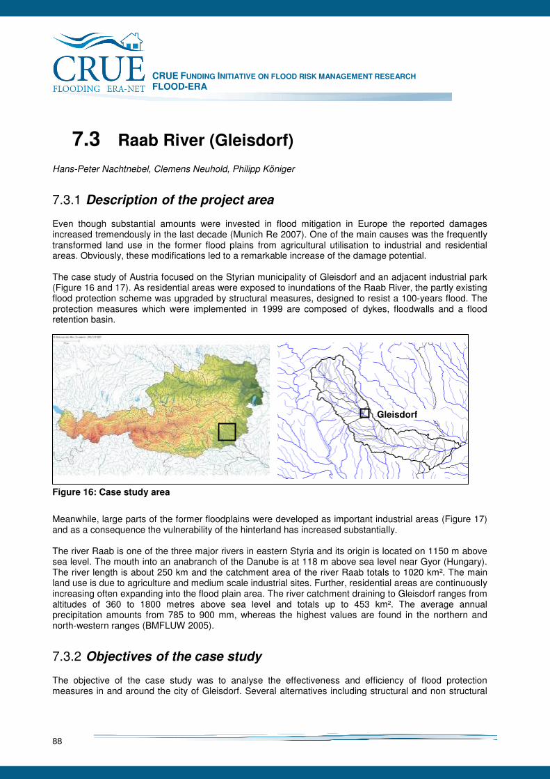
CRUE FUNDING INITIATIVE ON FLOOD RISK MANAGEMENT RESEARCH FLOOD-ERA
88
7.3 Raab River (Gleisdorf)
Hans-Peter Nachtnebel, Clemens Neuhold, Philipp Königer
7.3.1 Description of the project area
Even though substantial amounts were invested in flood mitigation in Europe the reported damages increased tremendously in the last decade (Munich Re 2007). One of the main causes was the frequently transformed land use in the former flood plains from agricultural utilisation to industrial and residential areas. Obviously, these modifications led to a remarkable increase of the damage potential. The case study of Austria focused on the Styrian municipality of Gleisdorf and an adjacent industrial park (Figure 16 and 17). As residential areas were exposed to inundations of the Raab River, the partly existing flood protection scheme was upgraded by structural measures, designed to resist a 100-years flood. The protection measures which were implemented in 1999 are composed of dykes, floodwalls and a flood retention basin.
Figure 16: Case study area
Meanwhile, large parts of the former floodplains were developed as important industrial areas (Figure 17) and as a consequence the vulnerability of the hinterland has increased substantially. The river Raab is one of the three major rivers in eastern Styria and its origin is located on 1150 m above sea level. The mouth into an anabranch of the Danube is at 118 m above sea level near Gyor (Hungary). The river length is about 250 km and the catchment area of the river Raab totals to 1020 km². The main land use is due to agriculture and medium scale industrial sites. Further, residential areas are continuously increasing often expanding into the flood plain area. The river catchment draining to Gleisdorf ranges from altitudes of 360 to 1800 metres above sea level and totals up to 453 km². The average annual precipitation amounts from 785 to 900 mm, whereas the highest values are found in the northern and north-western ranges (BMFLUW 2005).
7.3.2 Objectives of the case study
The objective of the case study was to analyse the effectiveness and efficiency of flood protection measures in and around the city of Gleisdorf. Several alternatives including structural and non structural
Gleisdorf
CRUE FUNDING INITIATIVE ON FLOOD RISK MANAGEMENT RESEARCH FLOOD-ERA
89
measures were compared by conducting both, a cost-effectiveness and a benefit-cost analysis. The alternatives referred to existing and conceivable flood mitigation measures along the river Raab. In this process the structural measures (SM) “dyke”, “flood wall” and “flood retention basin” as well as the non structural measures (NSM) “spatial planning” and “spillway” were evaluated by analysing historical data sets related to land use and simulation runs by means of a coupled 1D-2D hydrodynamic modelling. An enhanced flood risk assessment based on a three-stage-methodology developed by BUWAL (1999 a, b) was conducted. Therefore the catchment of the river Raab was simulated by the semi-distributed precipitation-runoff model COSERO (Nachtnebel et al. 2005) to provide the input data sets for the hydrodynamic model MIKE FLOOD (DHI 2004). The system for the hydrodynamic analysis covered the river network with its bridges and weirs, the dykes, the bank vegetation, the flood retention basin and the floodplain topography. The risk analysis considered all buildings, the transport infrastructure and economic activities.One main focus of the case study was to estimate the damage potential by refining and adjusting published data from flood damages (Buck 1999, BMFLUW 2004, BUWAL 1999 a, b, BWG 2002, Eberstaller et al. 2004, HYDROTEC 2004; Kraus 2004, Merz et el. 2004, Merz 2006, Niekamp 2001, Rodriguez 2001, Schmidke 2000, Statistik Austria 2005 a, b). Two categories of damages are relevant in this case study: first, residential buildings and second, medium scale industrial enterprises. To improve the damage analysis the broad category “residential buildings” had to be subdivided. By considering Austrian micro census data, published data and individual inspections of the objects a refined estimate of the value of properties could be achieved. Several of the SM and NSM alternatives were analyzed for different scenarios. Considering normative scenarios referring to different design floods as well as log jam and dyke breach scenarios (see Table 21). The simulated inundation area, water depths and flow velocities were linked to the land use information to estimate the damage potential of the flood prone area related to different flood events, also including a 5000-years flood (comparable to the August 2002 event on the river Kamp in Lower Austria). By integrating the scenario-based damage estimates and their respective probability the expected annual losses were calculated. In addition to the normative scenarios, relevant context conditions for today’s decision making on different types of flood risk management strategies and flood mitigation measures were analysed. Therefore, numerous expert interviews with decision makers from several hierarchic political levels were held. Related document analysis and oral interviews with chief operating officers of local companies improved the quality of the data base remarkably. Dispatched questionnaires did not contribute effectively to improve the data base. The overall construction, maintenance and opportunity costs, the object related damage functions, the added value estimates for the local economy and the land use data provided the input for cost-effectiveness as well as benefit-cost analysis.
7.3.3 Methodology
Recently an applied research project in the frame of the Austrian River Basin Agenda entitled “Risk analysis of flood protection measures for Gleisdorf and its vicinity” was carried out (Nachtnebel et al. 2005). The content of the project comprises of data analysis (precipitation and runoff), hydrological (semi-distributed: COSERO; Nachtnebel et al. 2005) and hydrodynamic (coupled 1D-2D: Mike FLOOD; DHI 2004) runoff modelling, scenario analysis of flood types as well as mitigation measures and economical analysis by means of damage function estimation (Nachtnebel et al. 2005; Faber 2006). The scenarios are based on different flood events which were generated by the hydrological model simulating the runoff for the upstream part. The propagation of the floods in the Gleisdorf area was simulated by the hydrodynamic model. The project provided a useful data set as well as methodological tools. The results were achieved by detailed analyses of the utilisations in the case study area, the damage potential estimation and assessed loss functions related to potentially affected residential houses, small trade, sensible objects and enterprises.
CRUE FUNDING INITIATIVE ON FLOOD RISK MANAGEMENT RESEARCH FLOOD-ERA
90
7.3.3.1 Precipitation Runoff Model: COSERO
The applied model COSERO is a continuous, semi-distributed rainfall-runoff model developed by the Institute of Water Management, Hydrology and Hydraulic Engineering at the BOKU (Nachtnebel et al. 1993, Fuchs 1998, Kling 2002; among many others). It accounts for processes of snow accumulation and melt, interception, evapotranspiration, infiltration, soil storage, runoff generation and routing. Separation of runoff into fast surface runoff, inter flow and base flow is calculated by means of a cascade of linear and non-linear reservoirs, following the design of the HBV model (Bergström 1995). Spatial discretisation relies on the division of the watersheds into sub-basins and subsequently into hydrologic response units (HRUs) based on available spatial information on sub-catchment boundaries, soil types, land cover and 200m elevation bands (Nachtnebel et al. 2005).
7.3.3.2 Coupled 1D-2D Model Mike FLOOD (DHI 2004)
The DHI Mike Flood package was selected to simulate the flood propagation in the project area. Water tables together with flow velocities were obtained for each grid element. The impact of bridges, gates, weirs and possible log jams at the bridges were simulated by the 1D component of the package (Mike 11) while the flow pattern in the hinterland was modelled by the 2D flow model (DHI 2004a). In Mike 11, the depth-averaged flow computations base on the conservation of mass and momentum, whereas the balancing equations are solved with the implicit finite difference algorithm (Abbott and Ionescu 1967). This algorithm alternately calculates points of flow and water depth. The friction losses were computed by the formula of Gaukler, Manning and Strickler (1923). For bridge computations, the FHWA WASPRO (Federal HighWay Administration, WAter Surface PROgram) method was used, as it accounts for various discharge conditions, ranging from a free water surface to the overflowing of submerged decks. Lateral and inline weirs were computed by means of Poleni’s formula with an adaptation to consider free flow and submerged overflow conditions. Further, there were routines for damping numerical instabilities.
7.3.3.3 Considered Scenarios
To evaluate the effectiveness and efficiency of mitigation measures a set of scenarios was analysed. The scenarios are based on a combination of different mitigation measures, subsequently called alternatives, and different design floods (see Table 21)
Table 21: Set of scenarios
Alternative 1: dyke, flood wall, flood retention basin (structural) Normative 1:30, 1:100 and 1:300 – without mitigation measures Normative 1:100, 1:300, 1:1000, 1:5000 – implemented mitigation measures Dyke break 1:300, 1:1000, 1:5000 Log jam 1:100 Alternative 2: spatial planning (non structural) Normative 1:30, 1:100 and 1:300 – without mitigation measures Alternative 3: spillway (non structural) Normative 1:300 and 1:1000
The structural measures refer to the existing flood protection scheme which comprises dykes, flood walls and a flood retention basin. The non structural measures are characterised by the implementation of a spillway into the existing dyke and the administrative tool of spatial planning, by means of a building ban in the potentially affected flood prone area (1:300 inundation line).
CRUE FUNDING INITIATIVE ON FLOOD RISK MANAGEMENT RESEARCH FLOOD-ERA
91
7.3.3.4 Data base
The data base from the Gleisdorf study (Nachtnebel et al. 2005) was refined by collecting additional details about the objects. Related to residential buildings this was done by refining the classification, mapping and evaluation of attributes of each single object. Emphasis was put on the attributes “structural age”, “equipment”, “heating system” and “size”. These census data evaluated in 2001 and provided by Statistik Austria were implemented into the data set on a 250 m grid base. To cover the areal development a micro scale mapping was conducted for the flood prone area. In the framework of this investigation the attributes “equipment”, “recent state”, “utilisation”, “number of levels”, “basement”, “garage”, “entrance level” and “obvious weak points” of every single object were recorded. This led to a subdivision of the category residential building into eight subcategories with different weights in the context of expected flood damages. An upgrade of data had as well been done of local companies by interviewing chief operating officers, including an informative meeting and by distributing a new questionnaire, to be able to estimate the potential losses of the regional economy considering direct losses and added value losses. Based on the refined data the expected annual losses were calculated as well as cost-effectiveness and benefit-cost analyses were carried out. Furthermore, damage functions for 20 of the most important enterprises were calculated.Combining these refined data sets with damage values of ex-ante and ex-post analysis for small trade, office buildings, retail trade, gastronomy and depots the expected annual losses for different states of utilisation and variations of mitigation measures were calculated.
7.3.3.5 BUWAL approach
The BUWAL (Bundesamt für Umwelt, Wald und Landschaft 1999 a,b) methodology is based on a three-stage procedure. Each stage represents a self-contained step for risk analysis. Stages 1, 2 and 3 are arranged in increasing order of analytical detail. Risk can be analysed in one or more of the stages depending on the desired accuracy. In stage 1, the hazard map is overlayed with a land use map to identify potential objects at risk. In stage 2, the risks for spatial elements (area, linear and point elements) are quantified. Risks can, however, be analysed directly in stage 2 which is based on standardised damage values which were obtained by compiling various damage reports. In stage 3, risks are analysed by specific investigations of individual objects (e.g. a building or section of a transport route at risk) (BUWAL 1999 a,b). Under this case study the evaluation of the expected losses were based on Stage 3.
7.3.3.6 Approach to analyse the context conditions
The analysis of the context conditions was based on qualitative social research methods. Central results were obtained by semi-structured interviews with experts from several administrative bodies and from the analysis of relevant documents. Seven experts from the local administrative level up to the national administrative level have been chosen as interviewees. The experts came from all relevant state departments within the Austrian administration for water management and spatial planning: the Ministry for Agriculture, Forestry, Environment and Water Management, the state government of Styria, the State Agency for Construction Management for the Western Graz Region and the municipalities themselves, represented by two local mayors. The interviewer and the questionnaire were the same as used for the Bavarian case study. The interviewed experts were asked to freely talk about their opinions and thoughts, normally all prepared topics of the questionnaire were discussed. The interview was about the person’s risk perception and engagement in flood risk management, the evaluation of strategies and measures and the crucial context conditions.
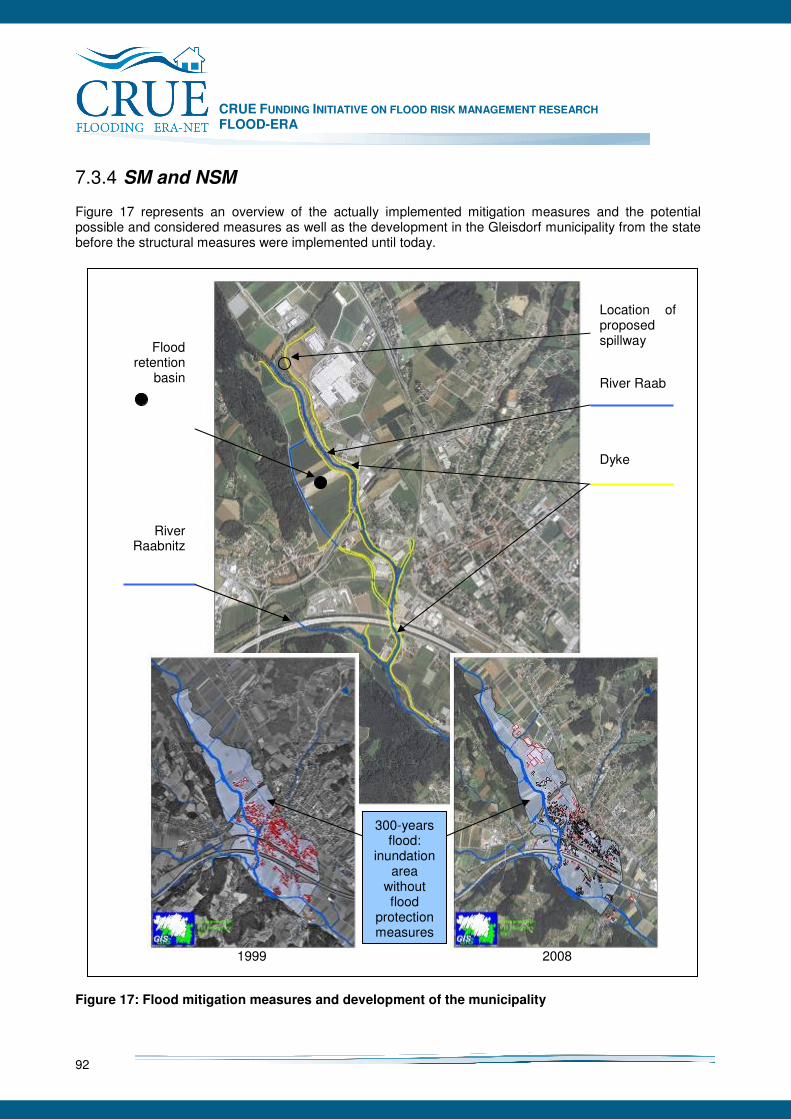
CRUE FUNDING INITIATIVE ON FLOOD RISK MANAGEMENT RESEARCH FLOOD-ERA
92
7.3.4 SM and NSM
Figure 17 represents an overview of the actually implemented mitigation measures and the potential possible and considered measures as well as the development in the Gleisdorf municipality from the state before the structural measures were implemented until today.
Figure 17: Flood mitigation measures and development of the municipality
1999 2008
Location of proposed spillway River Raab
Dyke
Flood retention
basin
River Raabnitz
300-years flood:
inundation area
without flood
protection measures
CRUE FUNDING INITIATIVE ON FLOOD RISK MANAGEMENT RESEARCH FLOOD-ERA
93
7.3.5 Evaluation of SM and NSM
7.3.5.1 Introduction to cost-effectiveness analysis and benefit-cost analysis
Cost-effectiveness analysis and benefit-cost analysis were applied to evaluate the considered mitigation measures. To analyse the cost-effectiveness (section 7.3.5.4) the costs of the measure, or a combination of measures, maintenance costs and opportunity costs were linked to the thereby protected area. The benefit-cost analysis (BCA) (section 7.3.5.5) was based on the directive for BCA of the Federal ministry of Agriculture, Forestry, Environment and Water Management (BMFLUW 2008) which comprises the work steps listed below:
1. Geoinformation of the area of interest
2. Characteristic design floods of different probabilities
3. Simulation of the hydrodynamic flood impact (water level, inundation depth, flow velocity)
4. Land use, population, employees
5. Vulnerability of different types of land use, monetary damage estimation
6. Expectation of loss
7. Estimation of benefits and calculation of net present values of project benefits
8. Estimation of costs and calculation of net present values of project costs
9. Benefit-cost ratio, if necessary sensitivity analysis
10. Evaluation of persons at risk
11. Appraisal of intangible benefits as well as socio cultural and ecologic effects
12. Comprehensive appraisal
13. Comparison of alternatives and choice of the optimal solution
14. Description of residual risks and necessary actions by third parties
15. Report, project data base
Input data for CEA and BCR were obtained by calculating the scenario related damages (section 7.3.5.2). These damages linked to the assessed recurrence intervals were set as supporting points to estimate the expected annual losses (section 7.3.5.3).
7.3.5.2 Scenario related damages
The scenario related damage estimates as well as the expected annual losses (section 7.3.5.3; Figure 18) were calculated by two approaches. The first one considers object related losses based on the enquiry of the number of affected buildings. Each building is linked to a damage function [€/building] depending on the utilisation and the inundation depth. The second approach is based on the specific damages of inundated objects. The damage of a flooded object depends on its base area and the depth of inundation and is multiplied by the assessed specific losses [€/m²]. These enquiries are made for all utilisations except for the local economy, because studies indicated that the damage estimation based on the losses/m² overestimate the damage remarkably if enterprises are included. The local enterprises were assessed separately based on the inundation depth and the flooded area of each scenario supported by the interviews conducted with chief operating officers. This input led to damage functions for 20 enterprises.

CRUE FUNDING INITIATIVE ON FLOOD RISK MANAGEMENT RESEARCH FLOOD-ERA
94
Table 22 outlines the calculated damages for the states of utilisation before the implementation of the mitigation measures (1999) and today (2008). The six scenarios indicated by the recurrence intervals 30, 100, 100 (considering a log jam), 300, 1000 and 5000 represent the damages including the implemented mitigation measures. The scenarios below the heading “spillway” comprising the annualities 300 and 1000 were utilised to assess the influence of a hypothetically implemented spillway into the existing protection scheme. The scenarios for “dyke break” (300, 1000 and 5000) consider the failure of the mitigation measures after being overtopped. On the basis of the scenarios “no mitigation” (30, 100 and 300) the influence and degree of increasing vulnerability due to land development was calculated and accordingly, the non structural measure “building ban” could be evaluated.
Table 22: scenario based damages
1999 2008
SCENARIO object related losses specific losses mean object related losses specific losses mean
30 0 0 0 0 0 0100 53 054 40 455 46 755 53 054 40 455 46 755
100 log jam 672 652 1 464 298 1 068 475 878 585 1 638 329 1 258 457
300 2 901 806 5 550 267 4 226 037 3 277 631 6 297 652 4 787 641
1000 9 903 483 20 735 867 15 319 675 12 113 503 28 637 070 20 375 287
5000 18 349 486 40 047 702 29 198 594 22 760 132 56 071 276 39 415 704
SPILLWAY
300 1 342 693 2 234 918 1 788 805 2 144 910 3 243 501 2 694 205
1000 10 530 673 22 303 404 16 417 038 12 355 695 30 703 800 21 529 748
DYKE BREAK
300 13 237 787 28 065 003 20 651 395 18 236 613 42 794 545 30 515 579
1000 13 873 206 28 699 224 21 286 215 19 280 319 43 876 609 31 578 464
5000 18 568 391 42 224 673 30 396 532 25 029 487 61 322 977 43 176 232
NO MITIGATION
30 8 651 145 14 317 463 11 484 304 11 855 779 19 527 777 15 691 778
100 9 056 737 14 759 981 11 908 359 12 750 223 29 986 937 21 368 580
300 24 390 389 57 343 748 40 867 069 29 290 786 80 582 230 54 936 508 Furthermore, Table 23 refers to the total number of affected buildings and the sum of flooded building area.
Table 23: Scenario related results: affected buildings and flooded area
affected buildings flooded area [m²]
SCENARIO 1999 2008 Increase 1999 2008 Increase
30 0 0 0 0 0 0
100 1 1 0 135 135 0
100 log jam 21 25 4 20142 20614 472
300 71 80 9 36519 38896 2377
1000 187 218 31 77881 116023 38142
5000 291 330 39 113458 175250 61792
SPILLWAY
300 36 41 5 27156 40518 13362
1000 202 235 33 82870 130948 48078
DYKE BREAK
300 240 276 36 95134 154772 59638
1000 241 277 36 95404 155047 59643
5000 291 331 40 115222 177334 62112
NO MITIGATION
30 141 170 29 64899 142961 78062
100 161 196 35 71561 168246 96686
300 388 437 49 141939 233275 91336
7.3.5.3 Expected annual losses
Figure 18 clearly shows the increase of the expected annual losses due to the higher vulnerability triggered by land development. The implementation of a spillway would reduce the loss expectations by 10 to 15% depending on the estimation approach (green line). The black line (SM: scenario no dyke break) represents the calculations where the dyke resists overtopping which has to be seen as very unlikely. The orange line includes the dyke break due to overtopping which leads to a tremendous increase (nearly 3 times) of the calculated damages. If no mitigation measures would have been

CRUE FUNDING INITIATIVE ON FLOOD RISK MANAGEMENT RESEARCH FLOOD-ERA
95
implemented the expected annual losses would be dramatically higher (red line). Considering the development in the past 10 years the increase of the vulnerability is represented by remarkably higher expected annual losses. If this increase of vulnerability would have been avoided by stating a building ban after the implementation of the protection scheme, applied on the former flood prone area, the non structural measure “spatial planning” has to be seen as very effective and efficient.
Expected annual losses for the municipality Gleisdorf Comparison of regional developments and mitigation measures
10000
100000
1000000
10000000
Ex
pecte
d a
nn
ua
l lo
sses
[€/a
]
No mitigation measures 606454 822399 1056831 1597161
SM: scenario dyke break 91593 125830 193497 291778
SM: scenario no dyke break 38775 46379 78834 101566
SM: scenario implemented Spillway 32741 41661 66371 91060
object related losses1999 specific losses 1999 object related losses 2008 specific losses 2008
Figure 18: Expected annual losses for the municipality Gleisdorf
7.3.5.4 Cost-Effectiveness Analysis
As one result of the cost-effectiveness analysis a matrix of protected area related to the utilisations was created (Table 24). Furthermore, the costs for protecting one m² of flood prone land against a 100-years flood were calculated. Due to the implementation of the protection scheme an area of 180 ha is considered of being without damages during a flood event up to a recurrence interval of 100 years. Considering the construction costs of nearly 4.2 million € and the discounted maintenance costs for a life expectancy of 80 years (BMFLUW 2008) of 1.1 million € the protection of 1 m² of land (requirement for protection) will be 6.6 €. Including all utilisations the protection of one m² would cost 3.0 €. Additional opportunity costs have to be included (WIFO 2003). The opportunity costs equal the revenue of the project (construction) costs (WIFO 2003). This leads to additional costs of 26 cent per m² every year (requirement for protection). These values seem to be small but for a typical Austrian property of 1000 m² the investment would equal 6572 € nonrecurring plus opportunity costs of 263 € every year.
CRUE FUNDING INITIATIVE ON FLOOD RISK MANAGEMENT RESEARCH FLOOD-ERA
96
Regarding the overall protected area, the protection of one hectare land would cost 29575 € nonrecurring plus 1183 € opportunity costs every year. Due to the fact that approximately 60% of the protected area is considered as not worth being protected e.g. agricultural land, solely the opportunity costs are equal to 3-10 times the tenancy cost for farming land per year and hectare which is quite expensive and considered as not efficient.
Table 24: Protected area, split into relevant utilisations
building land 22 ha public infrastructure 19 ha technical facilities 04 ha stock ground/factory premises 36 ha requirement for protection 81 ha agriculture 66 ha miscellaneous 33 ha not worth being protected 99 ha
7.3.5.5 Benefit-Cost Analysis
Due to the increasing utilisation in the hinterland during the past 10 years, the vulnerability and accordingly the benefits of mitigation measures increase (Table 25). The remarkably developed industrial park and the increase of residential areas are clearly shown by a tremendous raise of the benefit-cost ratio (utilisation in 1999-2008). Contemplating the evaluated measures the most efficient measure is the existing protection scheme, improved by a spillway. Depending on the enquiry approaches (object related losses [€], specific losses [€/m²]) the BCR are listed in Table 25 below (first number: object related losses, second number: specific losses, third number: average):
Table 25: Benefit-cost ratios of different scenarios
The two states of “Utilisation in 1999” and “Utilisation in 2008” were analyzed to evaluate the efficiency of the non structural measure “spatial planning”. The “Utilisation in 1999” reflects the benefit-cost ratio BCR considering a building ban after the implementation of the mitigation measures. By means of benefit-cost analysis three alternatives were investigated in detail (Table 25):
• The implemented flood mitigation measures improved by a spillway (SM: scenario implemented spillway) where no dyke break will occur because of the enhanced reliability,
• The implemented flood mitigation measures when no dyke break occurs by overtopping (SM: scenario no dyke break),
• The implemented flood mitigation measures considering dyke break due to overtopping (SM: scenario dyke break).
The results of the BCR distinguish that the efficiency of the implemented structural measures dyke, flood wall and flood retention basin could be tremendously improved if construction works in the former flood prone area would have been banned. Furthermore, the implementation of a spillway would lead to an increase of the efficiency, because a dyke break can be avoided and uncontrollable overtopping would be very unlikely.
SM: scenario
implemented Spillway SM: scenario
no dyke break SM: scenario dyke break
Utilisation in 1999 2.88/3.92 average3.40 2.85/3.90 average 3.38 2.59/3.50 average 3.04 Utilisation in 2008 4.98/7.57 average 6.27 4.91/7.51 average 6.21 4.34/6.56 average 5.44
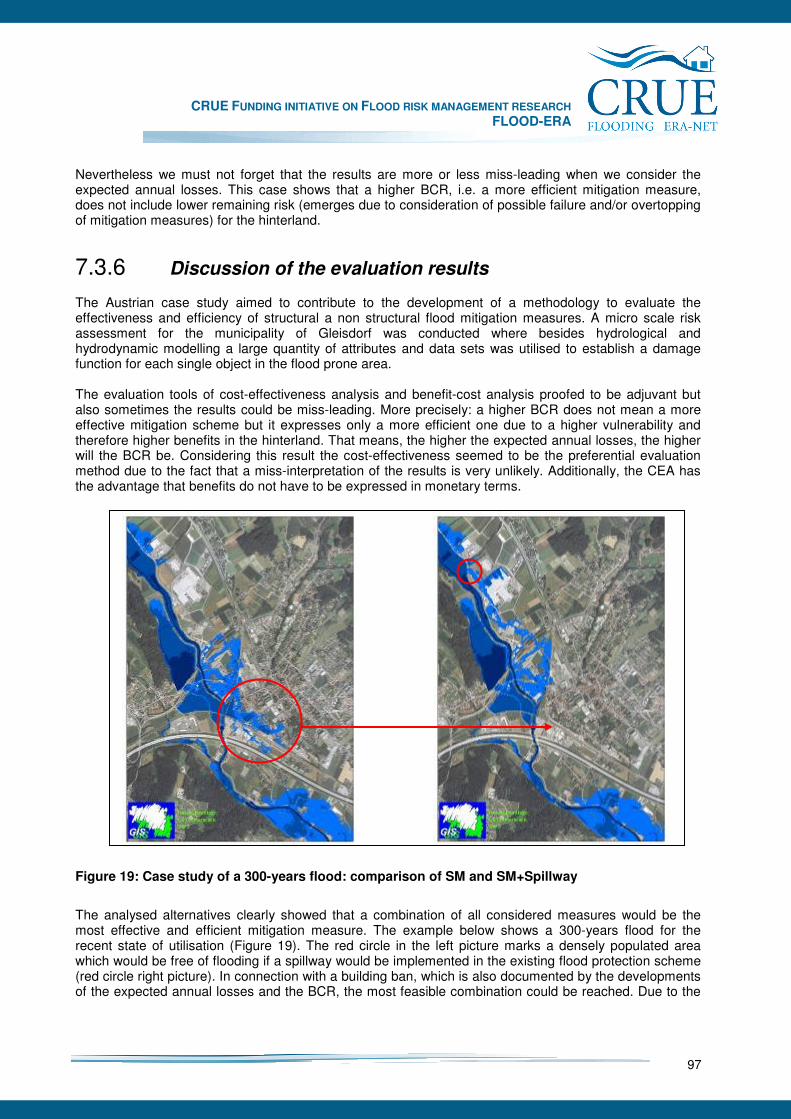
CRUE FUNDING INITIATIVE ON FLOOD RISK MANAGEMENT RESEARCH FLOOD-ERA
97
Nevertheless we must not forget that the results are more or less miss-leading when we consider the expected annual losses. This case shows that a higher BCR, i.e. a more efficient mitigation measure, does not include lower remaining risk (emerges due to consideration of possible failure and/or overtopping of mitigation measures) for the hinterland.
7.3.6 Discussion of the evaluation results
The Austrian case study aimed to contribute to the development of a methodology to evaluate the effectiveness and efficiency of structural a non structural flood mitigation measures. A micro scale risk assessment for the municipality of Gleisdorf was conducted where besides hydrological and hydrodynamic modelling a large quantity of attributes and data sets was utilised to establish a damage function for each single object in the flood prone area. The evaluation tools of cost-effectiveness analysis and benefit-cost analysis proofed to be adjuvant but also sometimes the results could be miss-leading. More precisely: a higher BCR does not mean a more effective mitigation scheme but it expresses only a more efficient one due to a higher vulnerability and therefore higher benefits in the hinterland. That means, the higher the expected annual losses, the higher will the BCR be. Considering this result the cost-effectiveness seemed to be the preferential evaluation method due to the fact that a miss-interpretation of the results is very unlikely. Additionally, the CEA has the advantage that benefits do not have to be expressed in monetary terms.
Figure 19: Case study of a 300-years flood: comparison of SM and SM+Spillway
The analysed alternatives clearly showed that a combination of all considered measures would be the most effective and efficient mitigation measure. The example below shows a 300-years flood for the recent state of utilisation (Figure 19). The red circle in the left picture marks a densely populated area which would be free of flooding if a spillway would be implemented in the existing flood protection scheme (red circle right picture). In connection with a building ban, which is also documented by the developments of the expected annual losses and the BCR, the most feasible combination could be reached. Due to the
CRUE FUNDING INITIATIVE ON FLOOD RISK MANAGEMENT RESEARCH FLOOD-ERA
98
implementation of a spillway to the flood levee system even the persons at risk in residential houses could be reduced from 254 to 53 (status of 2001).
7.3.7 Selected context conditions and their influence on the choice of measures
7.3.7.1 Context Analysis
As the crucial decisions for structural flood mitigation measures at the river Raab at Gleisdorf have been already made some years ago and non structural measures have not been discussed that time (Land Steiermark 2008), the context analyses had to focus on the today’s situation. Therefore the interviewees normally had to refer to the questions about certain types of measures in an abstract way or they had to choose examples from other parts of the region. In the following, the results from the case study will be presented relating to the two main realms in the frame of flood risk management that have been identified.
7.3.7.2 Decision making groups
In the case study two groups of decision makers were pointed out that carry out the main decisions about flood risk management measures. First of all it is the state water management authority and secondly it is the spatial planning authority. Although the first group traditionally relies on structural measures, the integration of non structural measures as a useful alternative has been recognised in the last few years. Beside this, the realm of spatial planning became more and more important for mitigating flood risks through controlling the allocation of valuable facilities in the flood prone areas. The non structural flood risk management through regional planning specifications plays an important role in that context complementing the activities of the water management and engineering authorities. The communities have to deal with both groups: on the one hand, as customers of flood protection measures, with the water management agencies, on the other hand with approval procedures in both realms concerning their development and building intentions. In the following, the most obvious context conditions of this case study are illustrated, regarding their impacts on certain flood risk mitigation strategies or measures. The interpretations are documented with anonymised quotes from the interviews.
7.3.7.3 The water management and water engineering realm
The distribution of responsibilities and duties in the water management and water engineering administration differs among the Austrian federal states. Referring to the case study context there are two administrative bodies in Styria. One is the government and one is the regional agency for construction issues (Baubezirksleitung). By the order of any community acting as contracting body these agencies handle planning, construction and maintenance of the respective projects. The national Ministry has to approve the funding for the project. Planning and constructing is assigned to private offices and companies.
“That is done by a bottom up approach from the municipality. If the municipality identifies a problem, it communicates to the district, (…) the district communicates to the state. At the end the ministry is involved. Including civil engineers and planning bureaus a meeting is conducted (…) to fix it (…).”
There are two aspects that lame the implementation process of structural projects and take time from the developing of new non structural approaches. Within the administration the work load is rising while the

CRUE FUNDING INITIATIVE ON FLOOD RISK MANAGEMENT RESEARCH FLOOD-ERA
99
staff is limited and staffing policy hinders a stocking up with new manpower. Another point is the rather complex system of approving and implementing projects that demands to involve many parties from four hierarchic administrative levels. Noticeable is the fact, that there is a close interaction among the hydraulic engineers within the administration and in the private offices outside. Some change jobs between the offices and the agencies which is generally contemplated as helpful for the professional knowledge of the staff and their certainty on the job. The interviewees from the water management bodies evaluated their personal influence on flood risk management as rather high. They appeared very dedicated to their duties. The national overall goal is generally described as “protection from floods as much as possible.”27 There are some legal specifications that fix this goal to a certain water level: the 100-years flood. Even though the Austrian water law28 still refers to the 30-years flood, for mapping flood inundation areas and regulating the land use within, the 100-years flood is the technical standard for flood protection at higher order rivers.29 Moreover the spatial planning law fixes this norm. The state administration forges to appraise detailed inundation areas all over Styria. For the river Raab at Gleisdorf the inundation areas of the 30-years and the 100-years flood have been modelled in 1997, in forehand to the following implementation of the flood protection measures. As shown in the hydraulic models for this case study there is a remaining risk referring to extreme flood events larger than the 100-years flood event, failure of mitigation measures or influences like log jam, sedimentation and so on. The overall strategy for flood risk management in Austria refers to the idea of sustainability. This strategy is divided into three mitigation strategies30:
• Preventive flood protection (comprises measures that lead to a reduction in run-off peaks and velocities)
• Structural flood protection (involves protective structures within or at the river/stream in areas threatened by floods)
• Provisions (aim to reduce the loss potential through measures such as land use, engineering, behavioural and risk provision)
In the interviews the paradigmatic change of strategies towards a more ecological way of hydraulic engineering in Austria was dated back to the 1980ies. Therefore, non structural flood risk management approaches are centrally positioned.
“Yes, this shows the strategy of flood mitigation, increased flood retention, where it is possible. If dykes or flood walls are necessary, the river should remain as close as possible to its natural state, this is our device: Room for our rivers.”
Besides the natural retention further non structural measures, especially the ones that are less land consumptive, get more and more important as well. Especially in densely settled areas the alternative of dyke dislocation to the hinterland does not exist.
„That means we preferred structural measures for the last years. Nowadays, during the last 3 to 4 years, we are increasingly thinking of non structural measures.
From the perspective of water management, the legal situation for a proper flood risk management is assessed as satisfying and effective.
“By means of the water law we do have all opportunities, to implement the projects. I believe that we do have a good water law in Austria.”
27
Federal Ministry of Agriculture, Forestry, Environment and Water Management (2006): Flood protection in Austria, pp. 10 28 Styrian Law for Water Rights, § 38. 29 Technical Standards for the Federal Water Engineering Authorities (RIWA-T October, 1994), § 3 (2). 30 Federal Ministry of Agriculture, Forestry, Environment and Water Management (2006): Flood protection in Austria, pp. 12.
CRUE FUNDING INITIATIVE ON FLOOD RISK MANAGEMENT RESEARCH FLOOD-ERA
100
Probably because of the impacts of the extreme 2002 and 2005 flood events, the support for these objectives seems to be well founded in the society and in the politics. Funding regulations can be assessed as affirmation of the recent practice in flood risk management. Therefore, the flood risk management realm is one of a few departments in Austria where the budget was enlarged. Furthermore, there are still potentials for innovative pilot projects.
„No, by now we do not suffer on a lack of support by politics. The funds for flood protection were one of a few budgets which were enlarged, not shortened.”
The implementation of the EU flood directive is seen as a future challenge in the legal context. But still it is not predictable how it will effect to the Austrian law. In the 1990ies, by reference to our interviewees, the town council of Gleisdorf had accepted the structural option with a flood retention basin even though it was more area consumptive and affected more land owners than building a higher dyke to compensate the flood retention basin. The citizens of Gleisdorf seem still to be rather content with the structural measures at the river Raab, as former periodical inundations disappeared. Inundations that trouble citizens today are triggered by ground sealing, overloaded waste water channels and flash floods from small creeks in the hinterland.
„…the river Raab as a cause of flooding has reduced remarkably. Due to the discussion about flood mitigation, the awareness raised. In my opinion the river does not cause serious danger.”
Though, there were inundations that mainly caused damages in the industrial park. The reactions on this led to individual precautionary structural measures on the site. According to these events, up to now there was no perceptible discussion in the commune about other solutions than individual flood proofing activities of endangered site owners. Concerning context conditions, the interviewees talked a lot about obstacles of the implementation process and less about their effects on decisions. Serious constraints for the implementation process are seen in the limited willingness of the land owners to provide sufficient land for non structural measures and secondly, in the limited personal resources at the administrative level to satisfy quickly all legal procedures. A crucial context factor mentioned in the interviews is proper data about flood risks. This would be essential as basis for any strategic planning and for stimulating the peoples’ awareness about risks
„In my opinion, lots of discussions dealing with administration would not be necessary, if people would recognise the risk they are facing. For me this is a crucial point, as you have to be serious by communicating with the public.”
An interesting conclusion from the interviews was that the city mayors would very much appreciate more detailed information about the flood risks as well as strict legal building regulations. In Austria, the mayors are the final decision makers for building requests. They need urgently proper information and clear objectives for their decisions. On the other hand, the outcomes from sophisticated models and analytical technique might not be accepted by the public due to a deficit in transparency of the concepts.
„After conducting run-off calculations the awareness of the municipalities raised tremendously. Due to the new methodologies (…) the preciseness can be expected to increase in opposite to the estimated inundation lines located in the old cadastral maps. (…) the Raab area will face similar refinements.”
7.3.7.4 The spatial planning and urban development realm
The town of Gleisdorf is slowly growing together with its neighbouring communities. Although the municipalities are closely interconnected economically they elaborate individual development plans,
CRUE FUNDING INITIATIVE ON FLOOD RISK MANAGEMENT RESEARCH FLOOD-ERA
101
neglecting harmonised approaches. Often, flood plains are in the focus of urban and industrial development without considering the risk they are exposing themselves.
„Styria faces the problem of having a very fine structured system of municipalities. We do have 542 municipalities. (…) that means each municipality is zoning building land to develop the area, 542 times in Styria.”
So, the realm of spatial planning is very important in this context. The government of Styria which has the full responsibility for these issues has two spatial planning departments: one is working on the development of federal and regional plans and thematic programs. The other one is inspecting the communal development plans.
„This problem is known in whole Europe, that the increase of damages is not primarily due to the increase of flood events, but due to the increase of vulnerability in the flood prone areas.“
The regional development plan for the Region of Weiz refers to flood protection issues in a rather general form. It states that „priority zones in the context of water management are the areas within the calculated 100-years flood inundation line that should be kept free from having development and runoff obstacles”31. In the case study area priority zones for “agriculture” and “green zones” at the western side of the Raab and a priority zone for “industry and commercials” on the eastern side of the river are proposed32. The flood protection project from 1999 states that the newly “protected areas” will stimulate the further economic development in the municipality, exactly in an area, where the hydraulic simulations indicate a high flood risk 33. Gleisdorf is seen as one of the most important centres for economy and innovation within eastern Styria34. The prevailing topics are improvements of economy, tourism, traffic and energy. It is rather the second administrative unit, responsible for monitoring regional development, which critically reviews the increase of damage potential in the flood plain. The local development concepts and general development plans have to be approved by the government of Styria. This procedure is presently pending in Gleisdorf and thus, the controlling effect cannot be assessed up to now. Generally building development in flood prone areas is forbidden.35 Anyway, the town is not intending to develop within the area of the 100-years flood that is banned close to the river behind the dikes today. But, there are no legal planning restrictions for a building in the area “with remaining risks”.
“If it is legal that people build houses and firms settle down, nobody will counter this.”
Anyway, the approval authorities have a legal position for rejecting the risk development of the communities in flood prone areas. They affirm to make use of it consequently.
„We often discuss with the municipalities, if it is necessary to create building land in the former flood prone areas. It seems that the ground is cheaper there. I don´t know exactly the trigger why this areas are used. In my opinion the necessity is rarely given.”
There is an important amendment36 that was assessed as a breakthrough in the domain of spatial planning regarding flood risks in the year of 2005. The “program for a flood safe development of
31 The Government of Styria: Regional Development Plan for the Region of Weiz (Draft version; June 2006), § 5 (1).
32 Ibid., Map for the Development Axis Weiz-Gleisorf (with priority zones).
33 The Government of Styria: Project report about the flood protection measures at the river Raab from 1997 to 1999
(http://presentation: www.wasserwirtschaft.steiermark.at).
34 The Board for the Planning Region of Weiz: Overall Concept for Regional Development. Short version (Nov. 1998), pp. 21.
35 Styrian Law for Regional Planning and Development, § 23 (1).
36 Edict of the Federal Government of Styria; September 2005: Program for a Flood Safe Development of Settlements Areas
CRUE FUNDING INITIATIVE ON FLOOD RISK MANAGEMENT RESEARCH FLOOD-ERA
102
settlement areas” was amended as a thematic program of the government of Styria. In §4 (1) the restrictions for any kind of building development within the zones of the 100-years flood are defined and in § 4 (2) the exceptions for this rule are listed.
“The work on the amendment started after the big flood event in 2002. Afterwards a longer period of discussion followed, (...) but after the occurrence of the event in summer 2005 the paper was forwarded to the government within 14 days. (...) it was dedicated unanimously.”
A main intension of the regional planning act was to open the approval procedures. Concerning the accumulation of damage potential within the flood plains, the water law seemed to stick on single cases and to loose overview of the summation effects. The interviewees, throughout, regard this amendment as an effective example for a non structural approach to mitigate flood risks.
„We noticed that zoning change enquiries for the 1:100 to building land decreased remarkably. In more detail I am talking about conflict cases which are mostly easy to manage. In fact the exemption clauses are not excessively utilised, and therefore there are clearly less wishes for land use changes to building land within the inundation line of a 100-years flood.”
7.3.7.5 Conclusions with respect to context conditions
There are two important conclusions from this case referring to the realms of water management and spatial planning. First of all, the involved administrative levels perceive flood risk management within a broader scope, not only emphasising structural measures. This can be confirmed by the efforts in considering natural retention possibilities to mitigate floods and in informing the people about flood risks. The legal framework for water rights and water management, the respective administrative organisation and the community of engineers are based on a tradition of technical standards and structural works. Still, the system is flexible enough for dedicated professionals to conduct innovative pilot projects and to enhance their toolbox of non structural flood risk mitigation measures. The spatial planning law substituted the effort of the hydraulic engineers by new legal specifications and by a new intention for controlling the accumulation of damage potential within the flood prone areas. By this, a very important non structural instrument for flood risk mitigation has been improved. Still the existing flood protection structures within the case study area are structural and structural approaches dominate the contextual framing for decisions. Though, there are some context conditions that should finally be mentioned, as they support a development towards more non structural measures in both of these realms. Above all, it is the general flood risk management policy in Austria that comprises quite a lot of approaches for non structural measures. This attitude continues for the funding regulations and the legal framework, especially referring to the sphere of spatial planning. Finally, it is just the individual attitudes and manifold characteristics, for example the personal risk perception, that play an important role in this context. Besides this, the implementation of flood risk management projects is always bound to context conditions which not necessarily favour certain options, but influence implementation processes. According to the physical situation, the complexity of simulation models, the size of an area and the resistance of land owners any project can be hindered or stopped. Statements about the “internal context conditions” referring to the FLOOD-ERA systematisation (see chapter 6.6.2 of this report) will not succeed for this case study as the sample of respective interviewees was too small and their decision context was too heterogeneous. Though, just referring to the water

CRUE FUNDING INITIATIVE ON FLOOD RISK MANAGEMENT RESEARCH FLOOD-ERA
103
management bodies some tendencies can be shown. The context analysis tends to conditions that balance the preference between structural and non structural measures. The “cultural” aspects as “risk perception” and “belief in measures” can definitely be evaluated as “balanced”, according to the preference of a comprehensive understanding of flood risks and the belief in the appropriateness of different measures (structural as well as non structural). For the “capability” criterion “response repertoire” it is to state, that the decision makers are open to new answers for flood problems and that they are already look for new strategies. The “consistency of decisions” is the most difficult aspect to assess, as we could not investigate a number of different decision processes. Nevertheless, we assume that the decision makers would not have difficulties in using decision criteria from other policy realms, as they clearly documented their interests in interfering subjects to the sphere of flood risk management within the interviews.
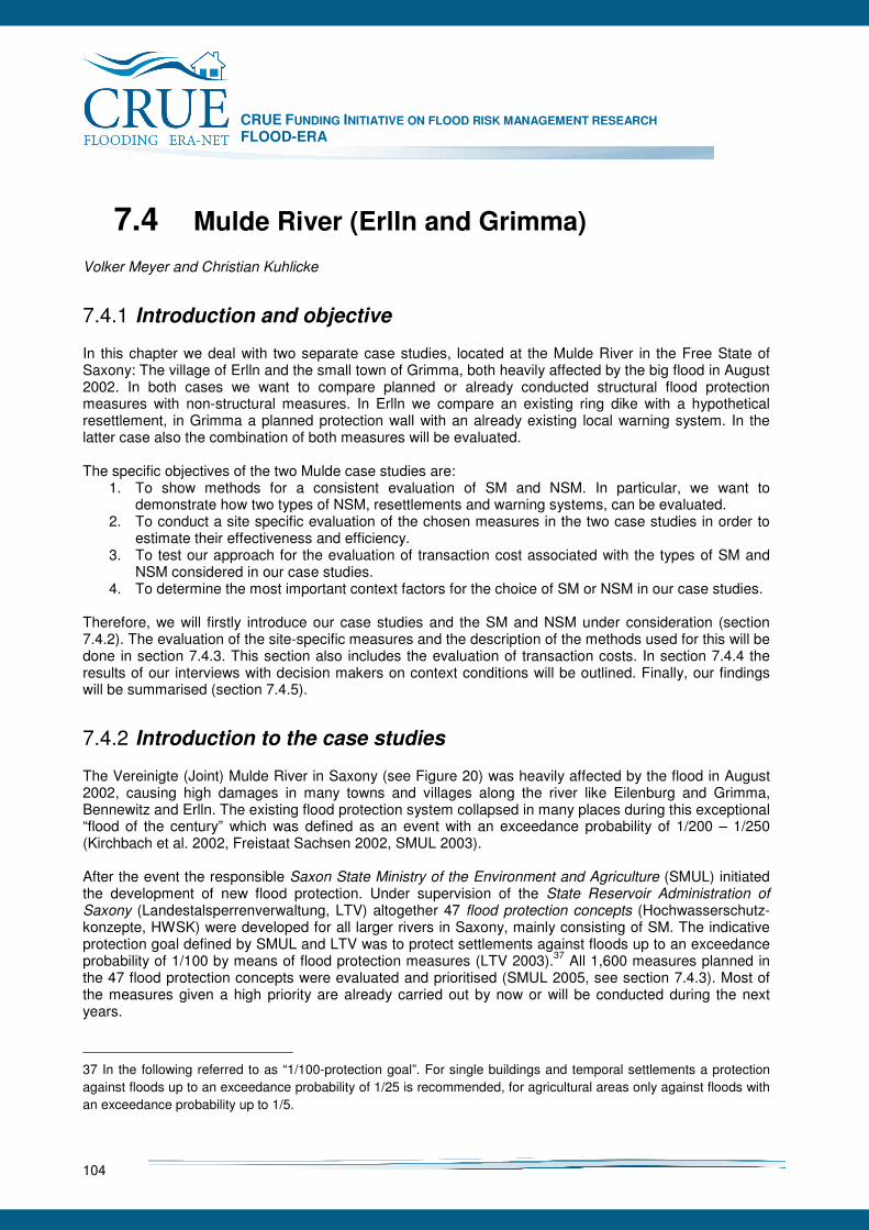
CRUE FUNDING INITIATIVE ON FLOOD RISK MANAGEMENT RESEARCH FLOOD-ERA
104
7.4 Mulde River (Erlln and Grimma)
Volker Meyer and Christian Kuhlicke
7.4.1 Introduction and objective
In this chapter we deal with two separate case studies, located at the Mulde River in the Free State of Saxony: The village of Erlln and the small town of Grimma, both heavily affected by the big flood in August 2002. In both cases we want to compare planned or already conducted structural flood protection measures with non-structural measures. In Erlln we compare an existing ring dike with a hypothetical resettlement, in Grimma a planned protection wall with an already existing local warning system. In the latter case also the combination of both measures will be evaluated. The specific objectives of the two Mulde case studies are:
1. To show methods for a consistent evaluation of SM and NSM. In particular, we want to demonstrate how two types of NSM, resettlements and warning systems, can be evaluated.
2. To conduct a site specific evaluation of the chosen measures in the two case studies in order to estimate their effectiveness and efficiency.
3. To test our approach for the evaluation of transaction cost associated with the types of SM and NSM considered in our case studies.
4. To determine the most important context factors for the choice of SM or NSM in our case studies. Therefore, we will firstly introduce our case studies and the SM and NSM under consideration (section 7.4.2). The evaluation of the site-specific measures and the description of the methods used for this will be done in section 7.4.3. This section also includes the evaluation of transaction costs. In section 7.4.4 the results of our interviews with decision makers on context conditions will be outlined. Finally, our findings will be summarised (section 7.4.5).
7.4.2 Introduction to the case studies
The Vereinigte (Joint) Mulde River in Saxony (see Figure 20) was heavily affected by the flood in August 2002, causing high damages in many towns and villages along the river like Eilenburg and Grimma, Bennewitz and Erlln. The existing flood protection system collapsed in many places during this exceptional “flood of the century” which was defined as an event with an exceedance probability of 1/200 – 1/250 (Kirchbach et al. 2002, Freistaat Sachsen 2002, SMUL 2003). After the event the responsible Saxon State Ministry of the Environment and Agriculture (SMUL) initiated the development of new flood protection. Under supervision of the State Reservoir Administration of Saxony (Landestalsperrenverwaltung, LTV) altogether 47 flood protection concepts (Hochwasserschutz-konzepte, HWSK) were developed for all larger rivers in Saxony, mainly consisting of SM. The indicative protection goal defined by SMUL and LTV was to protect settlements against floods up to an exceedance probability of 1/100 by means of flood protection measures (LTV 2003).37 All 1,600 measures planned in the 47 flood protection concepts were evaluated and prioritised (SMUL 2005, see section 7.4.3). Most of the measures given a high priority are already carried out by now or will be conducted during the next years.
37 In the following referred to as “1/100-protection goal”. For single buildings and temporal settlements a protection against floods up to an exceedance probability of 1/25 is recommended, for agricultural areas only against floods with an exceedance probability up to 1/5.

CRUE FUNDING INITIATIVE ON FLOOD RISK MANAGEMENT RESEARCH FLOOD-ERA
105
Besides these flood protection concepts focusing on SM the SMUL initiated the development of a flood warning system (the Saxon Flood Centre, see www.hochwasserzentrum.sachsen.de). In contrast to the flood protection concepts this federal warning system is not supervised by the LTV but by the Saxon State Agency for Environment and Geology (LfUG).
Figure 20: Flood extent of the Vereinigte Mulde in August 2002 (in blue), location of Grimma and Erlln [Layout: Dagmar Haase]
7.4.2.1 Erlln
Erlln is a small village located near the confluence of Freiberger and Zwickauer Mulde, belonging to the municipality of Zschadrass (Figure 21). Erlln consists of 33 properties and 92 inhabitants (2005; see also Steinführer and Kuhlicke (2007) for a more detailed description of the village). During the flood in August
Grimma
Erlln
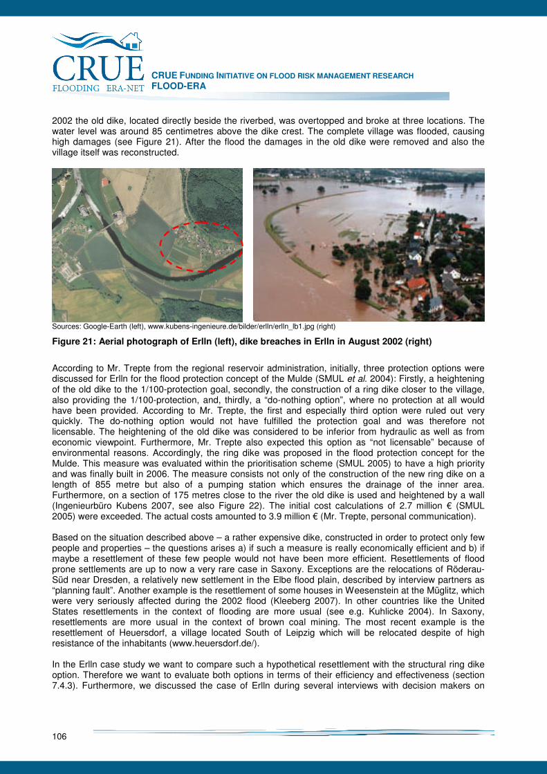
CRUE FUNDING INITIATIVE ON FLOOD RISK MANAGEMENT RESEARCH FLOOD-ERA
106
2002 the old dike, located directly beside the riverbed, was overtopped and broke at three locations. The water level was around 85 centimetres above the dike crest. The complete village was flooded, causing high damages (see Figure 21). After the flood the damages in the old dike were removed and also the village itself was reconstructed.
Sources: Google-Earth (left), www.kubens-ingenieure.de/bilder/erlln/erlln_lb1.jpg (right)
Figure 21: Aerial photograph of Erlln (left), dike breaches in Erlln in August 2002 (right)
According to Mr. Trepte from the regional reservoir administration, initially, three protection options were discussed for Erlln for the flood protection concept of the Mulde (SMUL et al. 2004): Firstly, a heightening of the old dike to the 1/100-protection goal, secondly, the construction of a ring dike closer to the village, also providing the 1/100-protection, and, thirdly, a “do-nothing option”, where no protection at all would have been provided. According to Mr. Trepte, the first and especially third option were ruled out very quickly. The do-nothing option would not have fulfilled the protection goal and was therefore not licensable. The heightening of the old dike was considered to be inferior from hydraulic as well as from economic viewpoint. Furthermore, Mr. Trepte also expected this option as “not licensable” because of environmental reasons. Accordingly, the ring dike was proposed in the flood protection concept for the Mulde. This measure was evaluated within the prioritisation scheme (SMUL 2005) to have a high priority and was finally built in 2006. The measure consists not only of the construction of the new ring dike on a length of 855 metre but also of a pumping station which ensures the drainage of the inner area. Furthermore, on a section of 175 metres close to the river the old dike is used and heightened by a wall (Ingenieurbüro Kubens 2007, see also Figure 22). The initial cost calculations of 2.7 million € (SMUL 2005) were exceeded. The actual costs amounted to 3.9 million € (Mr. Trepte, personal communication). Based on the situation described above – a rather expensive dike, constructed in order to protect only few people and properties – the questions arises a) if such a measure is really economically efficient and b) if maybe a resettlement of these few people would not have been more efficient. Resettlements of flood prone settlements are up to now a very rare case in Saxony. Exceptions are the relocations of Röderau-Süd near Dresden, a relatively new settlement in the Elbe flood plain, described by interview partners as “planning fault”. Another example is the resettlement of some houses in Weesenstein at the Müglitz, which were very seriously affected during the 2002 flood (Kleeberg 2007). In other countries like the United States resettlements in the context of flooding are more usual (see e.g. Kuhlicke 2004). In Saxony, resettlements are more usual in the context of brown coal mining. The most recent example is the resettlement of Heuersdorf, a village located South of Leipzig which will be relocated despite of high resistance of the inhabitants (www.heuersdorf.de/). In the Erlln case study we want to compare such a hypothetical resettlement with the structural ring dike option. Therefore we want to evaluate both options in terms of their efficiency and effectiveness (section 7.4.3). Furthermore, we discussed the case of Erlln during several interviews with decision makers on

CRUE FUNDING INITIATIVE ON FLOOD RISK MANAGEMENT RESEARCH FLOOD-ERA
107
different spatial levels, trying to analyse the case specific context conditions of the decision making process (section 7.4.4).
Figure 22: Plan for the ring dike in Erlln
7.4.2.2 Grimma
Grimma is a small town of about 18,000 inhabitants (2003), located approximately 10 kilometres North of Erlln (see Figure 23). The flood prone town centre (see Figure 24) is inhabited by approximately 2,000 people. Grimma was one of the most heavily affected towns during the flood in 2002. The complete old town centre was flooded with inundation depths of up to 4 metres, causing high damages (see Figure 24). Reconstruction started relatively quickly after the flood and by the end of 2004 the town had been reinstated to its pre-flood state or better.
Source: www.grimma.de
Figure 23: Aerial photograph of the town centre of Grimma
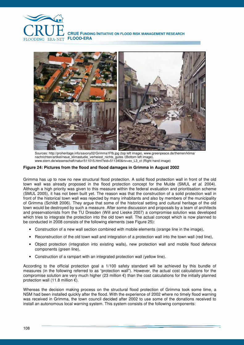
CRUE FUNDING INITIATIVE ON FLOOD RISK MANAGEMENT RESEARCH FLOOD-ERA
108
Sources: http://proheritage.info/saxony02/Grimma1Ffb.jpg (top left image), www.greenpeace.de/themen/klima/ nachrichten/artikel/neue_klimastudie_verheisst_nichts_gutes /(Bottom left image), www.stern.de/wissenschaft/natur/511015.html?eid=511340&nv=ex_L3_ct (Right hand image)
Figure 24: Pictures from the flood and flood damages in Grimma in August 2002
Grimma has up to now no new structural flood protection. A solid flood protection wall in front of the old town wall was already proposed in the flood protection concept for the Mulde (SMUL et al. 2004). Although a high priority was given to this measure within the federal evaluation and prioritisation scheme (SMUL 2005), it has not been built yet. The reason was that the construction of a solid protection wall in front of the historical town wall was rejected by many inhabitants and also by members of the municipality of Grimma (Schildt 2006). They argue that some of the historical setting and cultural heritage of the old town would be destroyed by such a measure. After some discussion and proposals by a team of architects and preservationists from the TU Dresden (Will and Lieske 2007) a compromise solution was developed which tries to integrate the protection into the old town wall. The actual concept which is now planned to be conducted in 2008 consists of the following elements (see Figure 25):
• Construction of a new wall section combined with mobile elements (orange line in the image),
• Reconstruction of the old town wall and integration of a protection wall into the town wall (red line),
• Object protection (integration into existing walls), new protection wall and mobile flood defence components (green line),
• Construction of a rampart with an integrated protection wall (yellow line). According to the official protection goal a 1/100 safety standard will be achieved by this bundle of measures (in the following referred to as “protection wall”). However, the actual cost calculations for the compromise solution are very much higher (23 million €) than the cost calculations for the initially planned protection wall (11.8 million €). Whereas the decision making process on the structural flood protection of Grimma took some time, a NSM had been installed quickly after the flood. With the experience of 2002 where no timely flood warning was received in Grimma, the town council decided after 2002 to use some of the donations received to install an autonomous local warning system. This system consists of the following components:
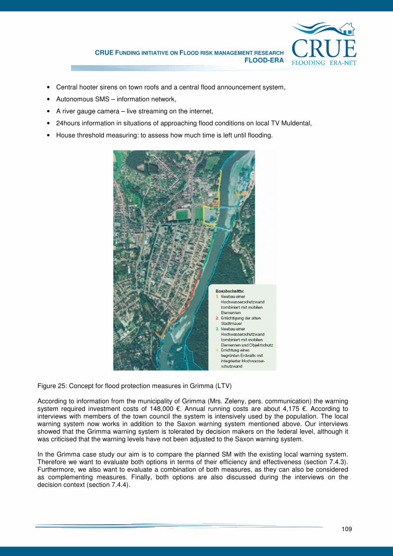
CRUE FUNDING INITIATIVE ON FLOOD RISK MANAGEMENT RESEARCH FLOOD-ERA
109
• Central hooter sirens on town roofs and a central flood announcement system,
• Autonomous SMS – information network,
• A river gauge camera – live streaming on the internet,
• 24hours information in situations of approaching flood conditions on local TV Muldental,
• House threshold measuring: to assess how much time is left until flooding. Figure 25: Concept for flood protection measures in Grimma (LTV) According to information from the municipality of Grimma (Mrs. Zeleny, pers. communication) the warning system required investment costs of 148,000 €. Annual running costs are about 4,175 €. According to interviews with members of the town council the system is intensively used by the population. The local warning system now works in addition to the Saxon warning system mentioned above. Our interviews showed that the Grimma warning system is tolerated by decision makers on the federal level, although it was criticised that the warning levels have not been adjusted to the Saxon warning system. In the Grimma case study our aim is to compare the planned SM with the existing local warning system. Therefore we want to evaluate both options in terms of their efficiency and effectiveness (section 7.4.3). Furthermore, we also want to evaluate a combination of both measures, as they can also be considered as complementing measures. Finally, both options are also discussed during the interviews on the decision context (section 7.4.4).
CRUE FUNDING INITIATIVE ON FLOOD RISK MANAGEMENT RESEARCH FLOOD-ERA
110
7.4.3 Evaluating SM and NSM
For the Mulde case studies the SM and NSM described above are evaluated in terms of their effectiveness, their cost-effectiveness and their net present value and benefit-cost ratio. The focus is laid here on benefit-cost analysis, i.e. the determination of net present value and benefit-cost ratio. In the following the methods and results will be described for both Mulde case studies, Erlln and Grimma. Furthermore, the transaction costs associated with the decisions on SM and NSM are evaluated, based on the interviews on context conditions. As mentioned in section 7.4.2 there also exists an official prioritisation program (SMUL 2005) in which all 1600 measures described in the 47 flood protection concepts have been evaluated. Both SM considered in our case studies were given a high priority. The prioritisation is based on a multicriteria 100-point evaluation scheme. The criteria used in this prioritisation system are the following (Socher et al. 2005, for a description in English language see Meyer and Messner 2005):
1. Cumulative expected damages (up to 25 points) 2. Benefit-cost ratio (25) 3. Effects on Water Management (25)
i. Retention capacity (10) ii. Discharge conditions (10) iii. Water ecology (5)
4. „Vulnerability“ (25) i. Special vulnerability (people, infrastructure, heritage sites) 10 ii. Potential secondary losses (e.g. hazardous substances) 10 iii. Special protection needs (lacking possibility of defence) 5
I.e. flood damage evaluation and benefit-cost analysis were also part of this official evaluation approach. However, as the prioritisation program required evaluating a very large number of individual measures, the damage evaluation approach applied here was a rather approximate approach.38 Furthermore, early cost estimates for the SM in Erlln and Grimma were used which are much lower than the actual costs. In our approach we therefore apply a meso-scale damage evaluation approach which is more detailed in some aspects than the approach used for the prioritisation scheme. Furthermore, we use the actualised cost figures. However, a comparison with the official benefit-cost figures for both projects is not possible as they are not published in detail. Nevertheless, SMUL (2005) gives at least figures for the expected damages for the 100-year event. For Grimma this figure corresponds quite well with our damage estimate (SMUL: 21.3 million €, our mean estimate: 28.5 million €, range between 18.7-40.4 million €). For Erlln the damage estimate from SMUL is higher than ours (SMUL: 2.4 million €, our mean estimate: 1.3 million € in a range between 0.8-1.8 million €).
7.4.3.1 Erlln
Benefits
After the definition of the project a benefit-cost analysis (BCA) requires determining all relevant project impacts and the monetary evaluation of these benefits and costs in monetary terms (see section 5.5.2.1). In order to evaluate the benefits of each measure their risk reducing effect in terms of a reduction of the annual average damage (AAD) compared to a baseline option is calculated (see section 5.5.2.1). As baseline option the “do-nothing option” is assumed, i.e. the status of flood protection in 2002, before the big flood occurred. According to (SMUL 2005) the old dike of Erlln provides protection up to 1/20 flood events. 38 For a discussion of the method applied see Meyer and Messner (2005).

CRUE FUNDING INITIATIVE ON FLOOD RISK MANAGEMENT RESEARCH FLOOD-ERA
111
For the calculation of the AAD flood damages need to be calculated for flood events of different exceedance probability (1/10, 1/25, 1/50, 1/100, 1/200, 1/500). The inundation data for these events was calculated by UFZ (Rode and Wenk) for the FLOODsite project for the situation with and without the planned SM. For the damage evaluation a meso-scale damage evaluation approach is applied (see Meyer 2005). All calculations are carried out for a GIS-grid dataset with a spatial resolution of 10m. The general procedure is the following:
1. The total value of assets at risk and its spatial distribution are estimated based on data from official statistics (the net value of fixed assets for different economic sectors) which is then assigned to corresponding land use categories (ATKIS-DLM).
2. Relative depth/damage curves are then used to calculate the damaged share of these values, depending on inundation depth.
Methodological uncertainties in damage evaluation are considered by applying 1) different spatial modelling keys of asset value to land use categories and 2) different sets of depth/damage curves39. Based on these different damage values a mean damage can be calculated for each grid cell as well as a minimum and maximum damage value. The different damage estimations for the inundation events considered are then used to calculate the AAD according to the formula described in section 5.5.2.1. This is conducted for the mean as well as for the minimum and maximum damage estimations so that the final output is a mean, minimum and maximum AAD per grid cell, accordingly. The mean annual average damage for the baseline option in Erlln is shown in Figure 26.
Source: Topographic map: Landesvermessungsamt Sachsen; damage estimation: own calculations
Figure 26: Annual Average Damage (AAD) (Erlln): mean estimation for the “do-nothing option”, old (orange) and approximate run of new dike line (green)
39 Three different sets of damage functions were applied, taken from the KRIM-project at the German North-Sea coast (Mai et al. 2007), a damage evaluation study from the River Rhine (IKSR 2001), and from the Dutch standard method (Kok et al. 2004)
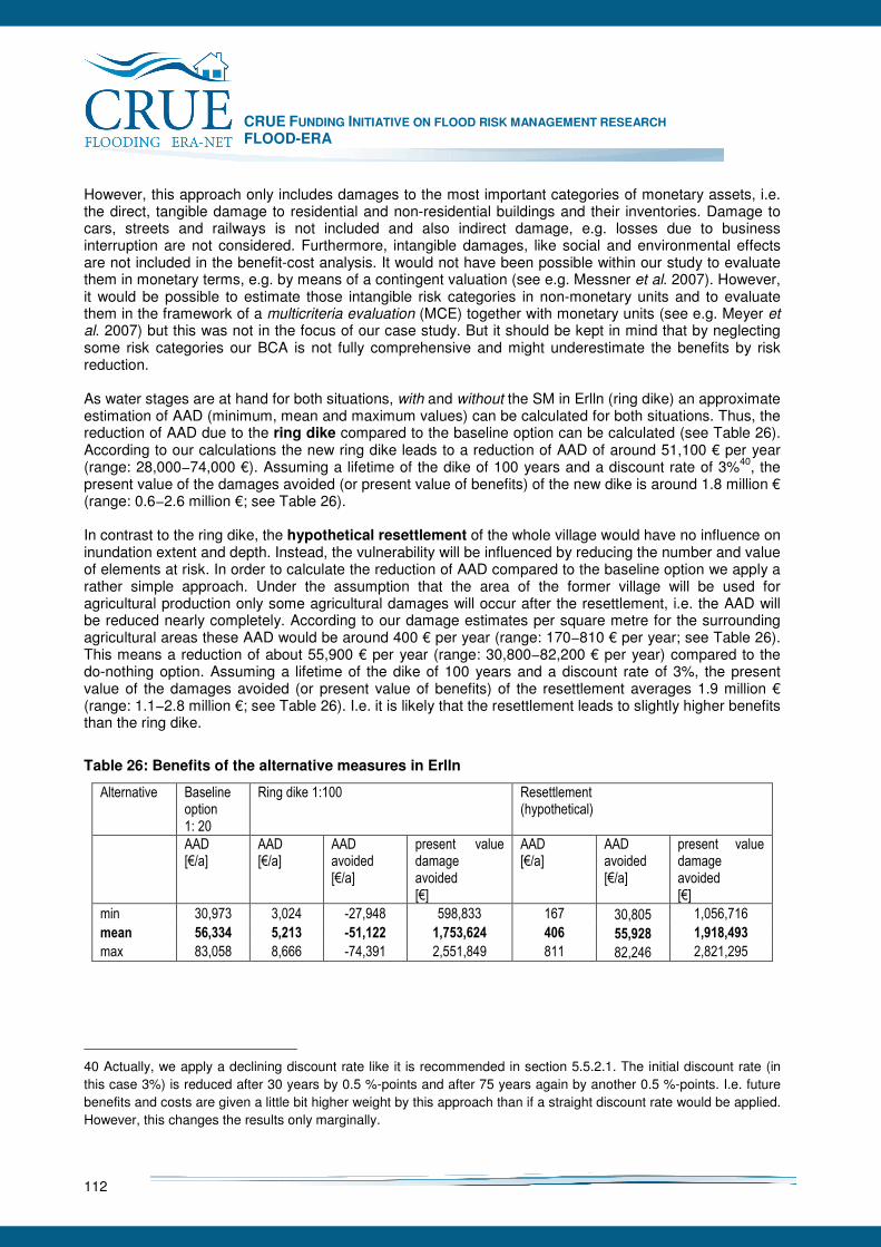
CRUE FUNDING INITIATIVE ON FLOOD RISK MANAGEMENT RESEARCH FLOOD-ERA
112
However, this approach only includes damages to the most important categories of monetary assets, i.e. the direct, tangible damage to residential and non-residential buildings and their inventories. Damage to cars, streets and railways is not included and also indirect damage, e.g. losses due to business interruption are not considered. Furthermore, intangible damages, like social and environmental effects are not included in the benefit-cost analysis. It would not have been possible within our study to evaluate them in monetary terms, e.g. by means of a contingent valuation (see e.g. Messner et al. 2007). However, it would be possible to estimate those intangible risk categories in non-monetary units and to evaluate them in the framework of a multicriteria evaluation (MCE) together with monetary units (see e.g. Meyer et al. 2007) but this was not in the focus of our case study. But it should be kept in mind that by neglecting some risk categories our BCA is not fully comprehensive and might underestimate the benefits by risk reduction. As water stages are at hand for both situations, with and without the SM in Erlln (ring dike) an approximate estimation of AAD (minimum, mean and maximum values) can be calculated for both situations. Thus, the reduction of AAD due to the ring dike compared to the baseline option can be calculated (see Table 26). According to our calculations the new ring dike leads to a reduction of AAD of around 51,100 € per year (range: 28,000−74,000 €). Assuming a lifetime of the dike of 100 years and a discount rate of 3%40, the present value of the damages avoided (or present value of benefits) of the new dike is around 1.8 million € (range: 0.6−2.6 million €; see Table 26). In contrast to the ring dike, the hypothetical resettlement of the whole village would have no influence on inundation extent and depth. Instead, the vulnerability will be influenced by reducing the number and value of elements at risk. In order to calculate the reduction of AAD compared to the baseline option we apply a rather simple approach. Under the assumption that the area of the former village will be used for agricultural production only some agricultural damages will occur after the resettlement, i.e. the AAD will be reduced nearly completely. According to our damage estimates per square metre for the surrounding agricultural areas these AAD would be around 400 € per year (range: 170−810 € per year; see Table 26). This means a reduction of about 55,900 € per year (range: 30,800−82,200 € per year) compared to the do-nothing option. Assuming a lifetime of the dike of 100 years and a discount rate of 3%, the present value of the damages avoided (or present value of benefits) of the resettlement averages 1.9 million € (range: 1.1−2.8 million €; see Table 26). I.e. it is likely that the resettlement leads to slightly higher benefits than the ring dike.
Table 26: Benefits of the alternative measures in Erlln
Alternative Baseline option 1: 20
Ring dike 1:100 Resettlement (hypothetical)
AAD [€/a]
AAD [€/a]
AAD avoided [€/a]
present value damage avoided [€]
AAD [€/a]
AAD avoided [€/a]
present value damage avoided [€]
min 30,973 3,024 -27,948 598,833 167 30,805 1,056,716
mean 56,334 5,213 -51,122 1,753,624 406 55,928 1,918,493
max 83,058 8,666 -74,391 2,551,849 811 82,246 2,821,295
40 Actually, we apply a declining discount rate like it is recommended in section 5.5.2.1. The initial discount rate (in this case 3%) is reduced after 30 years by 0.5 %-points and after 75 years again by another 0.5 %-points. I.e. future benefits and costs are given a little bit higher weight by this approach than if a straight discount rate would be applied. However, this changes the results only marginally.
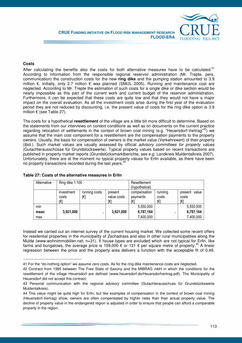
CRUE FUNDING INITIATIVE ON FLOOD RISK MANAGEMENT RESEARCH FLOOD-ERA
113
Costs
After calculating the benefits also the costs for both alternative measures have to be calculated.41
According to information from the responsible regional reservoir administration (Mr. Trepte, pers. communication) the construction costs for the new ring dike and the pumping station amounted to 3.9 million €. Initially, only 2.7 million € was planned (SMUL 2005). Running and maintenance cost are neglected. According to Mr. Trepte the estimation of such costs for a single dike or dike section would be nearly impossible as this part of the current work and current budget of the reservoir administration. Furthermore, it can be expected that these costs are quite low and that they would not have a major impact on the overall evaluation. As all the investment costs arise during the first year of the evaluation period they are not reduced by discounting, i.e. the present value of costs for the ring dike option is 3.9 million € (see Table 27). The costs for a hypothetical resettlement of the village are a little bit more difficult to determine. Based on the statements from our interviews on context conditions as well as on documents on the current practice regarding relocation of settlements in the context of brown coal mining (e.g. “Heuersdorf-Vertrag”42) we assume that the main cost component for a resettlement are the compensation payments to the property owners. Usually, the basis for compensation of owners is the market value (Verkehrswert) of their property (ibid.). Such market values are usually assessed by official advisory committees for property values (Gutachterausschüsse für Grundstückswerte). Typical property values based on recent transactions are published in property market reports (Grundstücksmarktberichte, see e.g. Landkreis Muldentalkreis 2007). Unfortunately, there are at the moment no typical property values for Erlln available, as there have been no property transactions recorded during the last years.43
Table 27: Costs of the alternative measures in Erlln
Alternative Ring dike 1:100 Resettlement (hypothetical)
investment costs [€]
running costs [€]
present value costs [€]
compensation payments [€]
running costs [€]
present value costs [€]
min 5,550,000 5,550,000
mean 3,921,000 . 3,921,000 6,787,164 . 6,787,164
max 7,400,000 7,400,000
Instead we carried out an internet survey of the current housing market. We collected some recent offers for residential properties in the municipality of Zschadrass and also in other rural municipalities along the Mulde (www.wohnimmobilien.net; n=31). If house types are excluded which are not typical for Erlln, like farms and bungalows, the average price is 159,000 € or 131 € per square metre of property.44 A linear regression between the price and the property area delivers a function with the acceptable fit of 0.49.
41 For the “do-nothing option“ we assume zero costs. As for the ring dike maintenance costs are neglected. 42 Contract from 1995 between The Free State of Saxony and the MIBRAG mbH in which the conditions for the resettlement of the village Heuersdorf are defined (www.heuersdorf.de/Heuersdorfvertrag.pdf). The Municipality of Heuersdorf did not accept this contract. 43 Personal communication with the regional advisory committee (Gutachterausschuss für Grundstückswerte Muldentalkreis). 44 This value might be quite high for Erlln, but like examples of compensation in the context of brown coal mining (Heuersdorf-Vertrag) show, owners are often compensated by higher rates than their actual property value. The decline of property value in the endangered region is adjusted in order to ensure that people can afford a comparable property in the region.
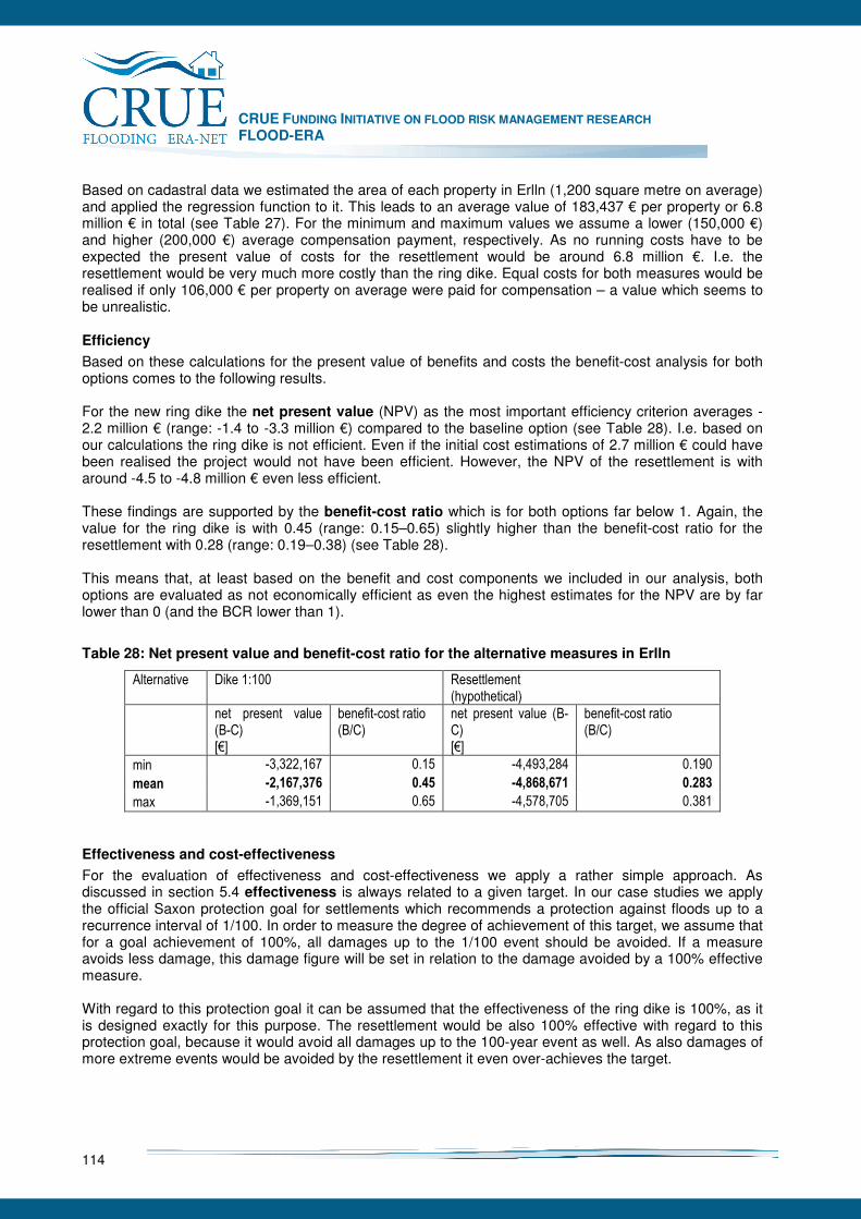
CRUE FUNDING INITIATIVE ON FLOOD RISK MANAGEMENT RESEARCH FLOOD-ERA
114
Based on cadastral data we estimated the area of each property in Erlln (1,200 square metre on average) and applied the regression function to it. This leads to an average value of 183,437 € per property or 6.8 million € in total (see Table 27). For the minimum and maximum values we assume a lower (150,000 €) and higher (200,000 €) average compensation payment, respectively. As no running costs have to be expected the present value of costs for the resettlement would be around 6.8 million €. I.e. the resettlement would be very much more costly than the ring dike. Equal costs for both measures would be realised if only 106,000 € per property on average were paid for compensation – a value which seems to be unrealistic.
Efficiency
Based on these calculations for the present value of benefits and costs the benefit-cost analysis for both options comes to the following results. For the new ring dike the net present value (NPV) as the most important efficiency criterion averages -2.2 million € (range: -1.4 to -3.3 million €) compared to the baseline option (see Table 28). I.e. based on our calculations the ring dike is not efficient. Even if the initial cost estimations of 2.7 million € could have been realised the project would not have been efficient. However, the NPV of the resettlement is with around -4.5 to -4.8 million € even less efficient. These findings are supported by the benefit-cost ratio which is for both options far below 1. Again, the value for the ring dike is with 0.45 (range: 0.15–0.65) slightly higher than the benefit-cost ratio for the resettlement with 0.28 (range: 0.19–0.38) (see Table 28). This means that, at least based on the benefit and cost components we included in our analysis, both options are evaluated as not economically efficient as even the highest estimates for the NPV are by far lower than 0 (and the BCR lower than 1).
Table 28: Net present value and benefit-cost ratio for the alternative measures in Erlln
Alternative Dike 1:100 Resettlement (hypothetical)
net present value (B-C) [€]
benefit-cost ratio (B/C)
net present value (B-C) [€]
benefit-cost ratio (B/C)
min -3,322,167 0.15 -4,493,284 0.190
mean -2,167,376 0.45 -4,868,671 0.283
max -1,369,151 0.65 -4,578,705 0.381
Effectiveness and cost-effectiveness
For the evaluation of effectiveness and cost-effectiveness we apply a rather simple approach. As discussed in section 5.4 effectiveness is always related to a given target. In our case studies we apply the official Saxon protection goal for settlements which recommends a protection against floods up to a recurrence interval of 1/100. In order to measure the degree of achievement of this target, we assume that for a goal achievement of 100%, all damages up to the 1/100 event should be avoided. If a measure avoids less damage, this damage figure will be set in relation to the damage avoided by a 100% effective measure. With regard to this protection goal it can be assumed that the effectiveness of the ring dike is 100%, as it is designed exactly for this purpose. The resettlement would be also 100% effective with regard to this protection goal, because it would avoid all damages up to the 100-year event as well. As also damages of more extreme events would be avoided by the resettlement it even over-achieves the target.
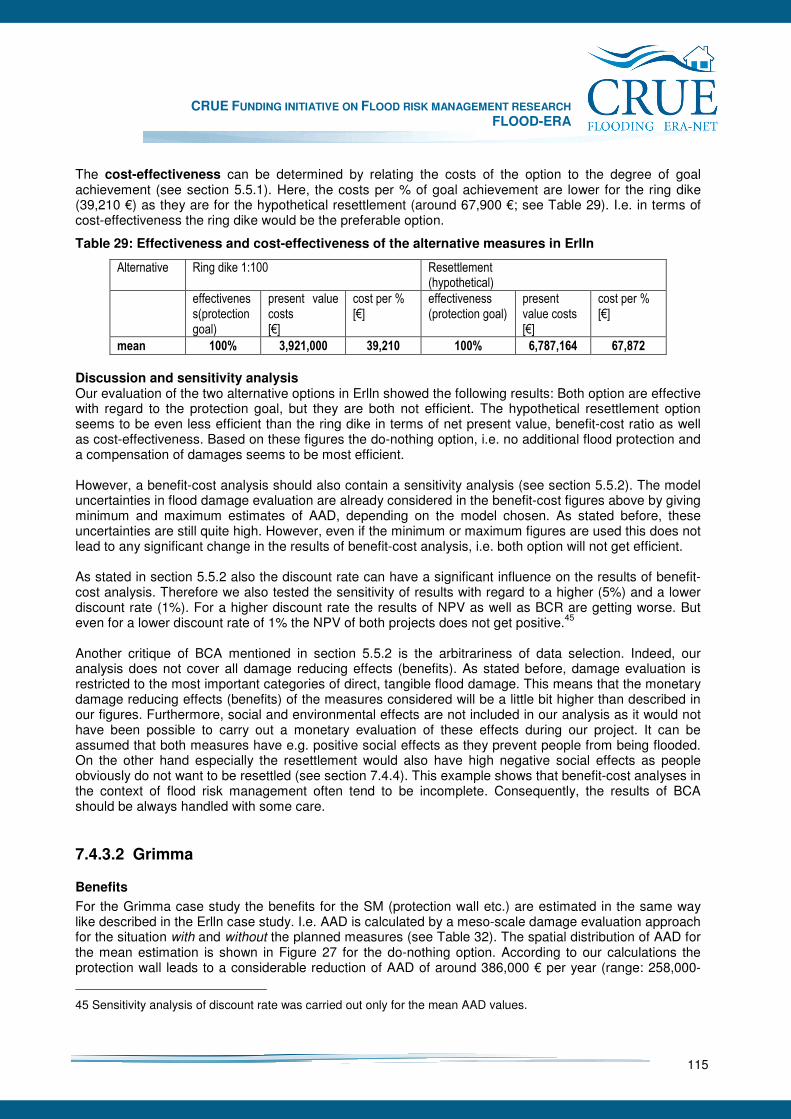
CRUE FUNDING INITIATIVE ON FLOOD RISK MANAGEMENT RESEARCH FLOOD-ERA
115
The cost-effectiveness can be determined by relating the costs of the option to the degree of goal achievement (see section 5.5.1). Here, the costs per % of goal achievement are lower for the ring dike (39,210 €) as they are for the hypothetical resettlement (around 67,900 €; see Table 29). I.e. in terms of cost-effectiveness the ring dike would be the preferable option.
Table 29: Effectiveness and cost-effectiveness of the alternative measures in Erlln
Alternative Ring dike 1:100 Resettlement (hypothetical)
effectiveness(protection goal)
present value costs [€]
cost per % [€]
effectiveness (protection goal)
present value costs [€]
cost per % [€]
mean 100% 3,921,000 39,210 100% 6,787,164 67,872
Discussion and sensitivity analysis Our evaluation of the two alternative options in Erlln showed the following results: Both option are effective with regard to the protection goal, but they are both not efficient. The hypothetical resettlement option seems to be even less efficient than the ring dike in terms of net present value, benefit-cost ratio as well as cost-effectiveness. Based on these figures the do-nothing option, i.e. no additional flood protection and a compensation of damages seems to be most efficient. However, a benefit-cost analysis should also contain a sensitivity analysis (see section 5.5.2). The model uncertainties in flood damage evaluation are already considered in the benefit-cost figures above by giving minimum and maximum estimates of AAD, depending on the model chosen. As stated before, these uncertainties are still quite high. However, even if the minimum or maximum figures are used this does not lead to any significant change in the results of benefit-cost analysis, i.e. both option will not get efficient. As stated in section 5.5.2 also the discount rate can have a significant influence on the results of benefit-cost analysis. Therefore we also tested the sensitivity of results with regard to a higher (5%) and a lower discount rate (1%). For a higher discount rate the results of NPV as well as BCR are getting worse. But even for a lower discount rate of 1% the NPV of both projects does not get positive.45 Another critique of BCA mentioned in section 5.5.2 is the arbitrariness of data selection. Indeed, our analysis does not cover all damage reducing effects (benefits). As stated before, damage evaluation is restricted to the most important categories of direct, tangible flood damage. This means that the monetary damage reducing effects (benefits) of the measures considered will be a little bit higher than described in our figures. Furthermore, social and environmental effects are not included in our analysis as it would not have been possible to carry out a monetary evaluation of these effects during our project. It can be assumed that both measures have e.g. positive social effects as they prevent people from being flooded. On the other hand especially the resettlement would also have high negative social effects as people obviously do not want to be resettled (see section 7.4.4). This example shows that benefit-cost analyses in the context of flood risk management often tend to be incomplete. Consequently, the results of BCA should be always handled with some care.
7.4.3.2 Grimma
Benefits
For the Grimma case study the benefits for the SM (protection wall etc.) are estimated in the same way like described in the Erlln case study. I.e. AAD is calculated by a meso-scale damage evaluation approach for the situation with and without the planned measures (see Table 32). The spatial distribution of AAD for the mean estimation is shown in Figure 27 for the do-nothing option. According to our calculations the protection wall leads to a considerable reduction of AAD of around 386,000 € per year (range: 258,000-
45 Sensitivity analysis of discount rate was carried out only for the mean AAD values.

CRUE FUNDING INITIATIVE ON FLOOD RISK MANAGEMENT RESEARCH FLOOD-ERA
116
535,000 €). Assuming a lifetime of the dike of 100 years and a discount rate of 3%, the present value of the damages avoided (or present value of benefits) by the planned SM lies around 13.2 million € (range: 8.9 – 18.3 million €; see Table 32).
Source: Topographic map: Landesvermessungsamt Sachsen; damage estimation: own calculations
Figure 27: Annual Average Damage (AAD) (Grimma): mean estimation for the “do-nothing option”
For the local warning system it is not possible to determine its damage reducing effects with a conventional damage evaluation approach. Instead, an approach developed by our colleagues from FHRC (Parker 2003) for the estimation of the damage reducing effects to residential inventories is applied. This approach is originally developed for the UK context but is adopted within the FLOODsite-project to other European countries. As one of the case studies Grimma is selected. In close cooperation between FLOOD-ERA and FLOODsite input data like AAD figures are delivered by UFZ to support FHRC, where the model is then applied to the Grimma case study (see Parker et al. 2007).

CRUE FUNDING INITIATIVE ON FLOOD RISK MANAGEMENT RESEARCH FLOOD-ERA
117
Figure 28: Components of the EU FHRC warning model (Parker et al. 2007)
Table 30: Application of the EU FHRC model for the Grimma
Model component
Estimated value for Grimma
Explanation / source
TPD 35% of AAD based on calculations from Meyer et al. (2007)
PID 40% based on analysis of the HOWAS database by Merz et al. (2004)
MID 80% based on analysis of the HOWAS database by Merz et al. (2004)
RAS 58% Percentage of people estimated to receive a warning; based on results from Thieken et al. (2007)
PHR n/a Very low % of elderly and disabled persons or people who would not understand the warning – evidence from UK showed that this component can therefore be neglected.
PHE 31% Estimation based on results from Steinführer and Kuhlicke (2007) and Thieken et al. (2007)
EVAC n/a because of long warning lead time residents are able to rescue possessions even if they going to be evacuated
FDA 2% of AAD product of components: [0.35*0.4*0.8*0.58*0.31] Based on Parker et al. (2007)
Table 31: Components of the Flood Warning Response Benefits Pathway model and its application for Grimma
Component Estimated value for Grimma
Explanation / source
Moving and/or evacuation of contents
2% of AAD or
5.8 % of residential AAD
result of model 1 (see table above)
Flood defence operationalisation
1% of AAD e.g. operation of mobile defences can reduce damages. Only a nominal value of 1% damage saving is assigned to this category prior to the construction of the planned SM
Watercourse maintenance
5% of AAD Clearing watercourses and removing debris e.g. in front of bridges can reduce damages. Parker et al. (2007) estimate this effect to have a damage reduction potential of 5%.
Community based operationalisation
1% of AAD E.g. stop logs can reduce damages. Parker et al. (2007) estimate this effect to have a damage reduction potential of 1%.
Business continuity planning
6% of non-residential AAD
Business emergency plans can avoid damages to non-residential properties. Parker et al. (2007) estimate this effect to have a damage reduction potential of 6% of non-residential damages.
Contingent flood proving
3% of residential AAD private flood proving measures dependent on a warning, like e.g. flood barriers. Estimation of 3% is based on data from Kreibich et al. (2005).
Based on Parker et al. (2007)
The warning model consists of the elements shown in Figure 28 (for a detailed description of the model and its application to the Grimma case study see Parker et al. 2007). For the Grimma case study Parker et al. (2007) come to the values for each of these components shown in Table 30.
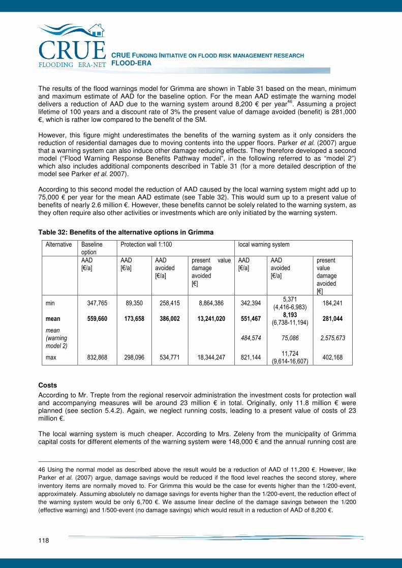
CRUE FUNDING INITIATIVE ON FLOOD RISK MANAGEMENT RESEARCH FLOOD-ERA
118
The results of the flood warnings model for Grimma are shown in Table 31 based on the mean, minimum and maximum estimate of AAD for the baseline option. For the mean AAD estimate the warning model delivers a reduction of AAD due to the warning system around 8,200 € per year46. Assuming a project lifetime of 100 years and a discount rate of 3% the present value of damage avoided (benefit) is 281,000 €, which is rather low compared to the benefit of the SM. However, this figure might underestimates the benefits of the warning system as it only considers the reduction of residential damages due to moving contents into the upper floors. Parker et al. (2007) argue that a warning system can also induce other damage reducing effects. They therefore developed a second model (“Flood Warning Response Benefits Pathway model”, in the following referred to as “model 2”) which also includes additional components described in Table 31 (for a more detailed description of the model see Parker et al. 2007). According to this second model the reduction of AAD caused by the local warning system might add up to 75,000 € per year for the mean AAD estimate (see Table 32). This would sum up to a present value of benefits of nearly 2.6 million €. However, these benefits cannot be solely related to the warning system, as they often require also other activities or investments which are only initiated by the warning system.
Table 32: Benefits of the alternative options in Grimma
Alternative Baseline option
Protection wall 1:100 local warning system
AAD [€/a]
AAD [€/a]
AAD avoided [€/a]
present value damage avoided [€]
AAD [€/a]
AAD avoided [€/a]
present value damage avoided [€]
min 347,765 89,350 258,415 8,864,386 342,394 5,371
(4,416-6,983) 184,241
mean 559,660 173,658 386,002 13,241,020 551,467 8,193
(6,738-11,194) 281,044
mean (warning model 2)
484,574 75,086 2,575,673
max 832,868 298,096 534,771 18,344,247 821,144 11,724
(9,614-16,607) 402,168
Costs
According to Mr. Trepte from the regional reservoir administration the investment costs for protection wall and accompanying measures will be around 23 million € in total. Originally, only 11.8 million € were planned (see section 5.4.2). Again, we neglect running costs, leading to a present value of costs of 23 million €. The local warning system is much cheaper. According to Mrs. Zeleny from the municipality of Grimma capital costs for different elements of the warning system were 148,000 € and the annual running cost are
46 Using the normal model as described above the result would be a reduction of AAD of 11,200 €. However, like Parker et al. (2007) argue, damage savings would be reduced if the flood level reaches the second storey, where inventory items are normally moved to. For Grimma this would be the case for events higher than the 1/200-event, approximately. Assuming absolutely no damage savings for events higher than the 1/200-event, the reduction effect of the warning system would be only 6,700 €. We assume linear decline of the damage savings between the 1/200 (effective warning) and 1/500-event (no damage savings) which would result in a reduction of AAD of 8,200 €.

CRUE FUNDING INITIATIVE ON FLOOD RISK MANAGEMENT RESEARCH FLOOD-ERA
119
about 4,200 €. Assuming a lifetime of 100 years and a discount rate of 3% the present value of costs is 291,000 € (see Table 33).
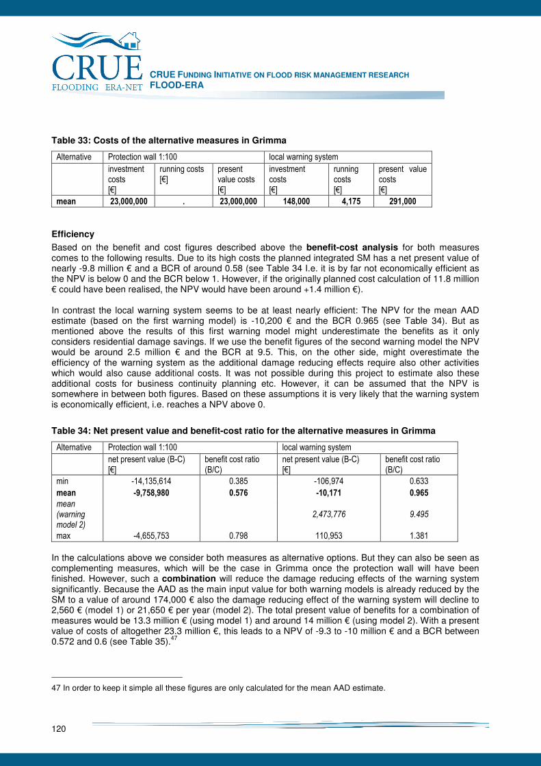
CRUE FUNDING INITIATIVE ON FLOOD RISK MANAGEMENT RESEARCH FLOOD-ERA
120
Table 33: Costs of the alternative measures in Grimma
Alternative Protection wall 1:100 local warning system
investment costs [€]
running costs [€]
present value costs [€]
investment costs [€]
running costs [€]
present value costs [€]
mean 23,000,000 . 23,000,000 148,000 4,175 291,000
Efficiency
Based on the benefit and cost figures described above the benefit-cost analysis for both measures comes to the following results. Due to its high costs the planned integrated SM has a net present value of nearly -9.8 million € and a BCR of around 0.58 (see Table 34 I.e. it is by far not economically efficient as the NPV is below 0 and the BCR below 1. However, if the originally planned cost calculation of 11.8 million € could have been realised, the NPV would have been around +1.4 million €). In contrast the local warning system seems to be at least nearly efficient: The NPV for the mean AAD estimate (based on the first warning model) is -10,200 € and the BCR 0.965 (see Table 34). But as mentioned above the results of this first warning model might underestimate the benefits as it only considers residential damage savings. If we use the benefit figures of the second warning model the NPV would be around 2.5 million € and the BCR at 9.5. This, on the other side, might overestimate the efficiency of the warning system as the additional damage reducing effects require also other activities which would also cause additional costs. It was not possible during this project to estimate also these additional costs for business continuity planning etc. However, it can be assumed that the NPV is somewhere in between both figures. Based on these assumptions it is very likely that the warning system is economically efficient, i.e. reaches a NPV above 0.
Table 34: Net present value and benefit-cost ratio for the alternative measures in Grimma
Alternative Protection wall 1:100 local warning system
net present value (B-C) [€]
benefit cost ratio (B/C)
net present value (B-C) [€]
benefit cost ratio (B/C)
min -14,135,614 0.385 -106,974 0.633
mean -9,758,980 0.576 -10,171 0.965
mean (warning model 2)
2,473,776 9.495
max -4,655,753 0.798 110,953 1.381
In the calculations above we consider both measures as alternative options. But they can also be seen as complementing measures, which will be the case in Grimma once the protection wall will have been finished. However, such a combination will reduce the damage reducing effects of the warning system significantly. Because the AAD as the main input value for both warning models is already reduced by the SM to a value of around 174,000 € also the damage reducing effect of the warning system will decline to 2,560 € (model 1) or 21,650 € per year (model 2). The total present value of benefits for a combination of measures would be 13.3 million € (using model 1) and around 14 million € (using model 2). With a present value of costs of altogether 23.3 million €, this leads to a NPV of -9.3 to -10 million € and a BCR between 0.572 and 0.6 (see Table 35).47
47 In order to keep it simple all these figures are only calculated for the mean AAD estimate.

CRUE FUNDING INITIATIVE ON FLOOD RISK MANAGEMENT RESEARCH FLOOD-ERA
121
Table 35: Net present value and benefit-cost ratio for a combination of both measures in Grimma
Alternative Combination of protection wall and warning system
net present value benefits [€]
net present value costs [€]
net present value (B-C) [€]
benefit cost ratio (B/C)
mean 13,329,000 23,291,000 -9,962,379 0.572
mean (warning model 2)
13,980,000 23,291,000 -9,311,106 0.600
Effectiveness and cost-effectiveness The effectiveness of the planned SM with regard to the protection goal can be expected to be 100% as it is designed to protect against 1/100-floods. For a warning system it seems to be impossible to achieve such a target. If we define the complete prevention of damages up to the 100-year event as the target (AAD reduction of 386,000 € per year which would be exactly the effect of the SM) the warning system achieves this target only to a degree of 2.1%, or, if we use the results of the second warning model, to a degree of 19.5 %.48 This means with regard to the given protection goal the SM is effective whereas the warning system is only partly effective. The evaluation in terms of cost-effectiveness delivers another result. The costs per % of goal achievement are much higher for the SM (230,000 €) than for the warning system (137,000 €). If the results of the second warning model are used the cost per % would be even lower (15,000 €; see Table 36). I.e. in terms of cost-effectiveness the warning system would be ranked first.
Table 36: Effectiveness and cost-effectiveness of the alternative measures in Grimma
Alternative Protection wall 1:100 local warning system combination
effectiveness (protection goal)
cost per % [€]
effectiveness (protection goal)
cost per % [€]
effectiveness (protection goal)
cost per % [€]
mean 100% 230,000 2.1% 137,000 100% 232,910
mean (warning model 2)
19.5% 15,000
Discussion and sensitivity analysis Our evaluation of the alternative options in Grimma showed that the planned structural measure is effective with regard to the protection goal but not efficient, especially due to its high costs. This does not change even for the maximum estimate for AAD (see Table 32). In contrast, the effectiveness of the local warning system is low, but it seems to be likely that it is economically efficient, at least if all possible effects are included. The uncertainties in AAD estimates do not allow for a clear statement in this case. A combination of both measures has more or less the same effectiveness and efficiency values as the SM but it reduces the benefits of the warning system. Again, we also tested the sensitivity of the results of benefit-cost analysis with regard to a change in the discount rate. Applying a higher discount rate of 5% leads for all options to a lower NPV, i.e. all projects are getting even less efficient. A lower discount rate leads to an improvement in the NPV values of the
48 Again, all these figures are calculated only fort he mean AAD estimate.
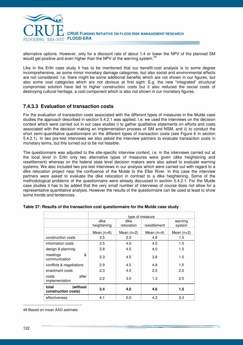
CRUE FUNDING INITIATIVE ON FLOOD RISK MANAGEMENT RESEARCH FLOOD-ERA
122
alternative options. However, only for a discount rate of about 1.4 or lower the NPV of the planned SM would get positive and even higher than the NPV of the warning system.49 Like in the Erlln case study it has to be mentioned that our benefit-cost analysis is to some degree incomprehensive, as some minor monetary damage categories, but also social and environmental effects are not considered. I.e. there might be some additional benefits which are not shown in our figures, but also some cost categories which are not obvious at first sight: E.g. the new “integrated” structural compromise solution have led to higher construction costs but it also reduced the social costs of destroying cultural heritage, a cost component which is also not shown in our monetary figures.
7.4.3.3 Evaluation of transaction costs
For the evaluation of transaction costs associated with the different types of measures in the Mulde case studies the approach described in section 5.4.2.1 was applied. I.e. we used the interviews on the decision context which were carried out in our case studies i) to gather qualitative statements on efforts and costs associated with the decision making an implementation process of SM and NSM, and ii) to conduct the short semi-quantitative questionnaire on the different types of transaction costs (see Figure 6 in section 5.4.2.1). In two pre-test interviews we also asked the interview partners to evaluate transaction costs in monetary terms, but this turned out to be not feasible. The questionnaire was adjusted to the site-specific interview context, i.e. in the interviews carried out at the local level in Erlln only two alternative types of measures were given (dike heightening and resettlement) whereas on the federal state level decision makers were also asked to evaluate warning systems. We also included two pre-test interviews in our analysis which were carried out with regard to a dike relocation project near the confluence of the Mulde to the Elbe River. In this case the interview partners were asked to evaluate the dike relocation in contrast to a dike heightening. Some of the methodological problems of the questionnaire were already discussed in section 5.4.2.1. For the Mulde case studies it has to be added that the very small number of interviews of course does not allow for a representative quantitative analysis. However the results of the questionnaire can be used at least to show some trends and tendencies.
Table 37: Results of the transaction cost questionnaire for the Mulde case study
type of measure
dike
heightening dike
relocation resettlement warning system
Mean (n=6) Mean (n=2) Mean (n=4) Mean (n=2) construction costs 3.5 2.5 4.8 1.5
information costs 2.5 4.5 4.0 1.5
design & planning 2.8 4.5 4.0 1.5
meetings & communication
2.3 4.5 3.8 1.0
conflicts & negotiations 2.9 4.5 4.8 1.5
enactment costs 2.3 4.5 2.5 2.0
costs after implementation
2.2 3.0 1.3 2.0
total (without construction costs)
2.4 4.0 4.6 1.5
effectiveness 4.1 5.0 4.3 3.3
49 Based on mean AAD estimate.
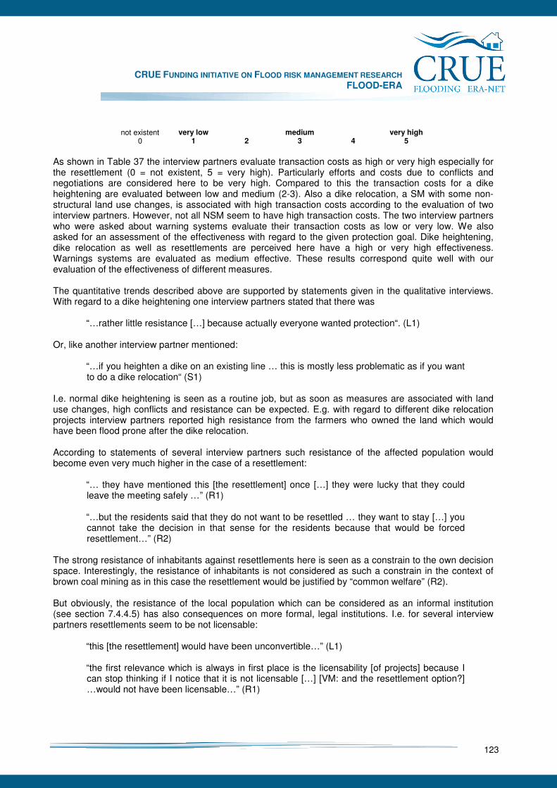
CRUE FUNDING INITIATIVE ON FLOOD RISK MANAGEMENT RESEARCH FLOOD-ERA
123
not existent very low medium very high
0 1 2 3 4 5
As shown in Table 37 the interview partners evaluate transaction costs as high or very high especially for the resettlement (0 = not existent, 5 = very high). Particularly efforts and costs due to conflicts and negotiations are considered here to be very high. Compared to this the transaction costs for a dike heightening are evaluated between low and medium (2-3). Also a dike relocation, a SM with some non-structural land use changes, is associated with high transaction costs according to the evaluation of two interview partners. However, not all NSM seem to have high transaction costs. The two interview partners who were asked about warning systems evaluate their transaction costs as low or very low. We also asked for an assessment of the effectiveness with regard to the given protection goal. Dike heightening, dike relocation as well as resettlements are perceived here have a high or very high effectiveness. Warnings systems are evaluated as medium effective. These results correspond quite well with our evaluation of the effectiveness of different measures. The quantitative trends described above are supported by statements given in the qualitative interviews. With regard to a dike heightening one interview partners stated that there was
“…rather little resistance […] because actually everyone wanted protection“. (L1) Or, like another interview partner mentioned:
“…if you heighten a dike on an existing line … this is mostly less problematic as if you want to do a dike relocation“ (S1)
I.e. normal dike heightening is seen as a routine job, but as soon as measures are associated with land use changes, high conflicts and resistance can be expected. E.g. with regard to different dike relocation projects interview partners reported high resistance from the farmers who owned the land which would have been flood prone after the dike relocation. According to statements of several interview partners such resistance of the affected population would become even very much higher in the case of a resettlement:
“… they have mentioned this [the resettlement] once […] they were lucky that they could leave the meeting safely …” (R1) “…but the residents said that they do not want to be resettled … they want to stay […] you cannot take the decision in that sense for the residents because that would be forced resettlement…” (R2)
The strong resistance of inhabitants against resettlements here is seen as a constrain to the own decision space. Interestingly, the resistance of inhabitants is not considered as such a constrain in the context of brown coal mining as in this case the resettlement would be justified by “common welfare” (R2). But obviously, the resistance of the local population which can be considered as an informal institution (see section 7.4.4.5) has also consequences on more formal, legal institutions. I.e. for several interview partners resettlements seem to be not licensable:
“this [the resettlement] would have been unconvertible…” (L1)
“the first relevance which is always in first place is the licensability [of projects] because I can stop thinking if I notice that it is not licensable […] [VM: and the resettlement option?] …would not have been licensable…” (R1)
CRUE FUNDING INITIATIVE ON FLOOD RISK MANAGEMENT RESEARCH FLOOD-ERA
124
I.e. the great refusal against resettlement among the affected population obviously leads to a quite fast rejection of this alternative in the democratic planning process (see also section 7.5.4). Only in “unusual cases” resettlement is considered as a real option:
“ok, in this case [Weesenstein] the affectedness was clearly to see… […] because of the flood 2002 people recognised in which risky area they have their property…” (S1)
7.4.4 Context conditions
7.4.4.1 Interview partners
In the context of the Mulde case studies eleven interviews have been conducted. Five interviews had an emphasis on the community of Erlln, six on the town of Grimma50. We conducted “problem-centred interviews” (Hopf 2000, 350). This means, we asked a mix of open questions that would allow the narrator to develop their subjective view on flood protection in general and more specific questions that would allow us focusing on specific issues. The duration of the interviews was between 70 to 90 minutes. They were recorded on tape and subsequently verbatim transcribed. The selection of the interview partners was influenced, above all, by the aim to represent the different administrative levels involved in the decision-making process. We therefore decided to interview people from the local level (village of Erlln, town of Grimma), from the regional level (e.g. Regional Reservoir Administration) and from the supra-regional level (The Free State of Saxony). However, it needs to be emphasised that a clear attribution of the single interview partner was not always possible as some represented two levels at the same time. Therefore the following listening should points to the emphasis of the work and function. We interviewed
• On the supra-regional level (The Free State of Saxony) a representative of the “Sächsisches Staatsministerium für Umwelt und Landwirtschaft” (Saxon State Ministry of the Environment and Agriculture) and a representative from the State Reservoir Administration (LTV)
• On the regional level a representative of the Regional Reservoir Administration and of the responsible Regional Planning Association
• On the local level mayors and other important decision-makers (representative of the public order office for instance).
Furthermore, we included two interviews, which we used as pre-test. They were conducted in the State of Saxony-Anhalt. They were of good quality and are therefore used in the analysis for comparative reasons.
7.4.4.2 Special Characteristics of the Mulde case studies
The defining characteristic for the Mulde case studies is the decisive flood of 2002. The current flood protection approach was largely developed under the influence of the experiences of the flood. Two characteristics need to be mentioned in particular. The 2002 flood unravelled many weak points of the established flood protection (von Kirchbach et al. 2002; DKKV 2003). This was according to one interview partner in regard to general constriction of rivers and the hydraulic situation of some dikes (e.g. 90° to flow direction) (R1, 8). Shortly after the flood the decision-makers on the regional level therefore tried to take the bitter “lessons learnt” into account and to improve the flood protection along the Mulde River. During this change new responsibilities have developed, which are meanwhile solidified. Flood protection is currently, above all, the duty of the State Reservoir Administration (LTV), a point we return to in the course of the analysis. 50 The interviews on the city of Grimma were generated in the context of a diploma thesis entitled “Influences of the 2002 flood on the dealing with flood hazards: The example of the city of Grimma” (Schildt 2006).
CRUE FUNDING INITIATIVE ON FLOOD RISK MANAGEMENT RESEARCH FLOOD-ERA
125
A second important characteristic is the availability of considerable financial resources. In the aftermath the affected communities and regions could rely on heavy financial support by the European Union, the Bund (federal state) and The Free State of Saxony. One narrator explicated that about half a billion Euros are available for flood protection until 2013 and stated: “No measure dashes against money” (S2, 20-21). And another underlined: “We have so much money around that it would be really great if needed no authorisation process” (R1, 77). Both aspects, the restructuring of flood protection and the availability of funds, are characteristic for understanding the peculiarity of the case study. They will therefore be further considered in the argument about the context conditions influencing the choice of measures.
7.4.4.3 General results: important context factors in our case studies
Our investigation of the factors influencing the choice between SM and/or NSM identified three important factors: structure, institutions and personal characteristics:
• Structures: They relate, above all, to financial resources as well as to the general organisational set up defining areas of responsibility and hierarchies. They are simply given and hardly changeable by single individuals and are hence an external context factor (cf. chapter 6.2).
• Institutions: Institutions, are defined as a set of rules, which equip actions with generally understandable meanings and which structure and guide them (Meyer et al. 2005, 46). We differentiate between formal and informal institutions. Formal institutions comprise, for instance, laws, which have to be considered when implementing certain flood protection measures. Informal institutions are not laid down in laws, their controlling character is rather inherent, it is prior to or apart from any mechanisms that are based on sanctions specifically set up to support institutions. They control human actions by their very existence.
• Personal characteristics: Comprise the capability of a decision maker to enlarge his or her response repertoire based on experience or the experience of others. It is influenced by the personality of a person (e.g. charisma) and his professional education. They are furthermore influenced by the social networks. They comprise informal ties people have to friends, colleagues or employees of other organisations and they rely on for exchanging knowledge and making decisions.
Apparently the just mentioned context factors can overlap, as formal institutions and structures quite often mutually dependent. But also personal aspects might influence structures as a particular charismatic person may influence or change existing structures. In the following the analysis of the single context factors and their relevance on the influence on the choice of measures are presented.
7.4.4.4 Structures and formal institutions and flood protection
We identified structures and formal institution as important context factors. Both give a priority to the implementation of SM as the following analysis reveals. To favour SM, this decision is made, above all, on the supra-regional level; that is The Free State of Saxony. Generally, flood protection in Saxony follows a top-down approach. It is politically decided how the general approach to flood protection should be organised. This was done, firstly, on the level of the Landtag (The Saxon parliament), which has the possibility to govern by laws and by budget. The second level was the Saxon Government, which also decided how flood protection should be shaped. The subsequent levels (regional and local) have to implement these decisions. Two important formal institutions were designed on the previous mentioned level. That is the flood protection concepts and the 1/100-protection goal for settled areas (cf. section 7.4.2). The flood protection
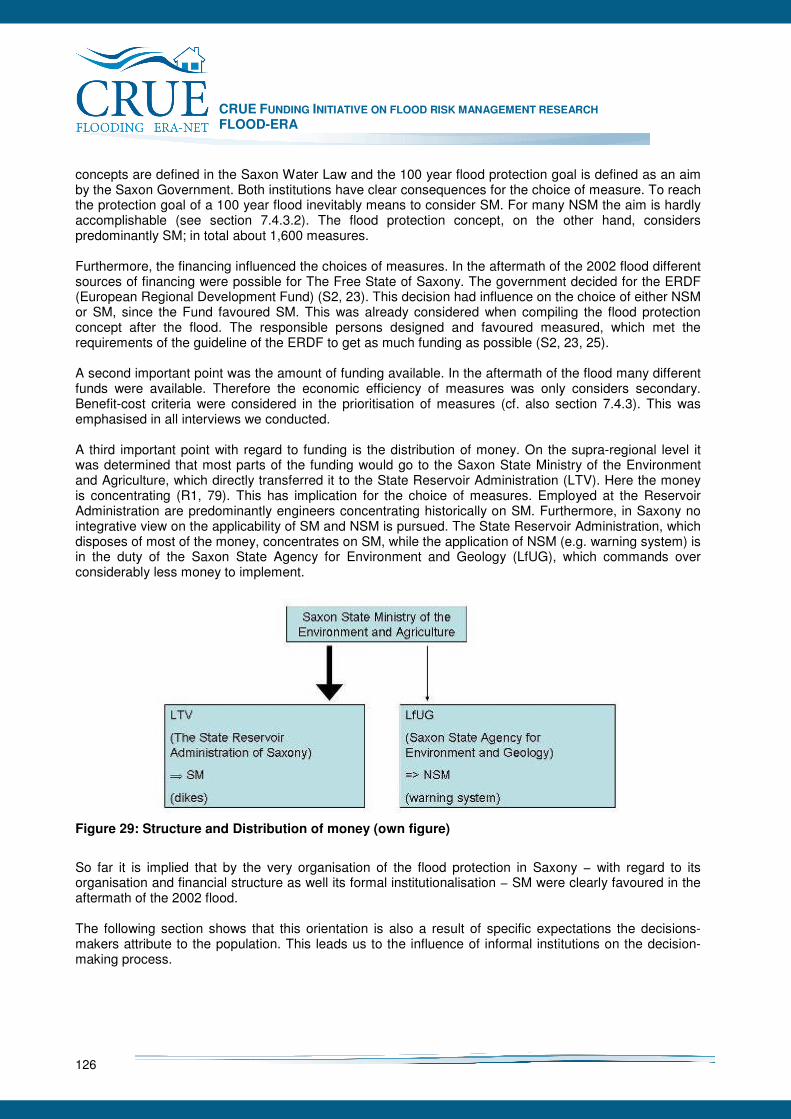
CRUE FUNDING INITIATIVE ON FLOOD RISK MANAGEMENT RESEARCH FLOOD-ERA
126
concepts are defined in the Saxon Water Law and the 100 year flood protection goal is defined as an aim by the Saxon Government. Both institutions have clear consequences for the choice of measure. To reach the protection goal of a 100 year flood inevitably means to consider SM. For many NSM the aim is hardly accomplishable (see section 7.4.3.2). The flood protection concept, on the other hand, considers predominantly SM; in total about 1,600 measures. Furthermore, the financing influenced the choices of measures. In the aftermath of the 2002 flood different sources of financing were possible for The Free State of Saxony. The government decided for the ERDF (European Regional Development Fund) (S2, 23). This decision had influence on the choice of either NSM or SM, since the Fund favoured SM. This was already considered when compiling the flood protection concept after the flood. The responsible persons designed and favoured measured, which met the requirements of the guideline of the ERDF to get as much funding as possible (S2, 23, 25). A second important point was the amount of funding available. In the aftermath of the flood many different funds were available. Therefore the economic efficiency of measures was only considers secondary. Benefit-cost criteria were considered in the prioritisation of measures (cf. also section 7.4.3). This was emphasised in all interviews we conducted. A third important point with regard to funding is the distribution of money. On the supra-regional level it was determined that most parts of the funding would go to the Saxon State Ministry of the Environment and Agriculture, which directly transferred it to the State Reservoir Administration (LTV). Here the money is concentrating (R1, 79). This has implication for the choice of measures. Employed at the Reservoir Administration are predominantly engineers concentrating historically on SM. Furthermore, in Saxony no integrative view on the applicability of SM and NSM is pursued. The State Reservoir Administration, which disposes of most of the money, concentrates on SM, while the application of NSM (e.g. warning system) is in the duty of the Saxon State Agency for Environment and Geology (LfUG), which commands over considerably less money to implement.
Figure 29: Structure and Distribution of money (own figure)
So far it is implied that by the very organisation of the flood protection in Saxony − with regard to its organisation and financial structure as well its formal institutionalisation − SM were clearly favoured in the aftermath of the 2002 flood. The following section shows that this orientation is also a result of specific expectations the decisions-makers attribute to the population. This leads us to the influence of informal institutions on the decision-making process.
CRUE FUNDING INITIATIVE ON FLOOD RISK MANAGEMENT RESEARCH FLOOD-ERA
127
7.4.4.5 Informal institutions and flood protection
Informal Institutions refer to specific norms and values that exist within a society and which appear as simply given and taken for granted. Again to better understand this point it is necessary to refer of the impact of the 2002 flood on this dimension. The flood meant a loss of control for many people and caused considerable damages and this not only in an economic sense but also in an emotional (Steinführer and Kuhlicke 2007). In the aftermath of the flood therefore a need for security developed among the population. All interviewees are aware of this need. However, this need is associated with a specific imagination about how flood protection should be organised. This imagination is understood here as an informal institution and expresses itself in the belief in the superiority in SM. Generally the interviewees underlined that the population wanted after the flood a form of protection, which is visible and which is appears as reliable. This was attributed to SM. This need was taken into account by the decision-makers particularly on the regional and supra-regional level: “The State government works for the citizens and not for itself, from there comes the input and from there a political opinion is developed” (S2, 16). As the overall majority of the population favoured SM − an assumption that is clearly confirmed by empirical investigations (Kuhlicke and Steinführer 2006, Steinführer and Kuhlicke 2007) − the representatives of the political system favoured these measures too. This view is contrasted particularly on the regional level with technical considerations. In the aftermath particularly the Regional Reservoir Administration was considering also measures that had a greater non-structural character (e.g. the slitting of dikes or the relocation at bottlenecks). However, in the course of time they adapted their plans to the dominating belief among the population about how such measures should be conceptualised. This can be exemplified by referring to the village of Erlln. After the flood a ring dike was planned in Erlln offering protection for a 100 year flood (cf. section 7.4.2.1). At the same time the old dike should be slated to create more retention area for the Mulde River. However, quite quickly resistance was forming up among the local population against the slitting of the dikes, as one interviewee recalls (R1, 18). The resistance was organised by two groups: On the one hand the local farmers who feared that their fields would then be flooded twice per year and prone to an increased pollution. A second group is the local soccer players. After the flood a soccer field close by the Mulde was remediated. If the dike would have been slatted the soccer field would also have been regularly flooded. Because of this resistance the Reservoir Administration decided to rebuild the old dike according to its previous level of protection. Furthermore, the ring dike in Erlln could not be put into practice as it was intended by the Reservoir Administration. The new dike meant to change the land use in Erlln. This affected some citizens in Erlln. They considered the compensation payment as not sufficient. Therefore the Reservoir Administration was initiating an intensive dialogue with the local population to convince them of the necessity that every single person has to contribute to the over all aim of protection the community (R1, 43). Some decision-makers use the phrase of “strategic resistance” to underline that some citizens also used the argument to force up the prices for their properties. Because of all these resistances a delay of the construction work and an increase of transaction costs were inevitable (cf. chapter 7.4.3.3). A similar case can be made be referring to the example of Grimma, our second case study. The construction of a protection wall has not yet been started in Grimma at the time the research took place. There are many resistances among the population. However, the argument is not against the construction of a wall per se, but rather about the aesthetic design of the wall. The Free State of Saxony planned to build quickly a new flood protection wall, which was planned as a “bald fairfaced concrete wall” (L4, 13). However, local initiatives and local decision-makers favour another option, namely a wall that assimilates into the aesthetics of the historic town (see chapter 7.4.2.2). Meanwhile a compromise is agreed upon. It is planned to integrate the flood protection wall into the existing historic town wall. The costs, however, for this option are double as high as for the initially
CRUE FUNDING INITIATIVE ON FLOOD RISK MANAGEMENT RESEARCH FLOOD-ERA
128
planned wall. This finding underlines again, that in our case studies, efficiency is not the key variable for decisions-makers, it is rather the acceptance of the measure among the population, which seems to influence the decision-making process. In many interviews it was underlined that the regional and supra-regional level is not able to enforce measures, which encounter the resistance of the population. This point is also underlined by a hypothetical scenario we proposed to interviewed decision-makers. We assumed that NSM are mostly not favoured since they would encounter the resistance of the population already at the design of our case-study. We therefore introduced a thought experiment of a “permanent evacuation” to the decision-makers. Resettlements of communities are surely the most radical form of a NSM. By interviews we conducted in the aftermath of the flood and by a household survey that was conducted we knew that many people abandoned their place of living as they feared the return of another flood. Yet, the taking into account of relocation as an option to reduce the damage potential is not part of any systematic consideration in Saxony as well as in Germany in general (cf. also Kuhlicke and Drünkler 2004, Kuhlicke and Drünkler 2005). This is also mirrored in the interviews: Only sparely the option of relocating parts of a community was discussed with the population. However, the decision-makers were, according to their own estimation, lucky to leave the room in one piece (R1, 32, see also section 7.4.3.3). It is clearly underlined by the decision-makers that a resettlement of an entire community or parts of a community is not realisable. It is assumed a priori that resettlement is not possible as it would not be in accordance with Saxony reason of state. A forced resettlement is not possible because of formal institution, that is by law and it is therefore not approvable (S2, 56, S1 28, R1, 32). However, the narrators also clearly underline that it would not be possible to conduct a resettlement in resistance to the population. Therefore this option was not considered in the aftermath of the flood. So far it was analysed that informal institutions influence the choice of measures considerable. It is above all the need for security expressing itself in the demand for technical solutions as well as the resistance to options that penetrate the private sphere of individuals. As the following section reveal, it is predominantly personal characteristics of decision-makers that facilitate the implementation of NSM.
7.4.4.6 Personal characteristics and flood protection
The third important context factor we identified are personal characteristics of decision-makers, containing two dimensions: On the one hand, personal networks people can rely on and the individual charisma on the other hand. To complete a certain measure the collaboration of many different decision-makers is necessary. The interviews thereby revealed that the better the actors know and trust each other the more likely it is that the measure is quickly completed. Of particular importance is thereby the contact to the local decision-makers. They dispose of the local knowledge that is essential for the implementation of measures. However, more important is their acceptance and embedding within the community. The local decision-maker would dispose over the integrity and acceptance, which regional decision-makers do not dispose over. People trust local decision-makers more than regional, is suggested by our findings. They are therefore important for building a trustful relationship between the executing authorities and the responsible persons on the spot. In Erlln, regional interviewees emphasise, the complementation of the construction of the flood protection would have taken even longer if the mayor would not have constantly tried to persuade people from the necessity of the measure proposed by the Reservoir Administration (R1, 43).
CRUE FUNDING INITIATIVE ON FLOOD RISK MANAGEMENT RESEARCH FLOOD-ERA
129
In Grimma the case is quite differently as the local mayor was resisting to the plans proposed by the Reservoir Administration, since he favoured the more aesthetic option and hence together with local initiatives declined the initial option of the Reservoir Administration. However, more insightful for our research interest − how are decisions made with regard to NSM and SM − is the installation of a local warning system in Grimma, a NSM. The mayor propose after the flood in 2002 along with others on the local level to install a SMS warning system, which was not dependent on the official warning system of the Free State of Saxony. Many people assign the implementation of this measure to the personal interests, charisma and effort of the mayor of Grimma (L4, 9). It hence seems that the consideration and complementation of NSM is in our case study, above all, depended on the personal effort of individuals (and not of the institutionalised effort of flood protection). This assumption is substantiated by our pre-test interviews. In general, it needs to be underlined that decision-makers on the regional and supra-regional level were in favour of NSM. However, the organisational and financial structures as well as the formal institutional setup of flood protection in Saxony promote SM, a tendency, which is reinforced by specific values and expectations of the population (informal institutions). It seems to be, above all, the personal characteristics of decision-makers, their charisma and networks, which facilitate the consideration and eventual complementation of NSM.
7.4.5 Summary and conclusions
In our case studies at the River Mulde in the Free State of Saxony we looked at two different spots which had been both heavily affected by the flood in 2002. For the small village of Erlln we compared the building of a new ring dike as a SM with a hypothetical resettlement as a non-structural alternative. In the town of Grimma a comparison was carried out between a planned structural protection wall and the already existing local warning system, also considering a combination of both. All measures were evaluated by a benefit-cost analysis as well as in terms of effectiveness and cost-effectiveness. The benefits of the SM in terms of damage reduction were evaluated based on a standard meso-scale approach. For the evaluation of the non-structural measures some new approaches were applied: For the evaluation of the benefits of the resettlement we assumed a nearly complete reduction of flood damage. In order to estimate the costs of the resettlement we estimated compensation payments based on market values of properties. The benefits of the warning system were estimated by two different models developed by Parker et al. (2007). For the evaluation of effectiveness and cost-effectiveness we used a rather simple approach which orientates on the official protection goal to protect settlements against floods up to the 1/100-event. For Erlln we found out that both alternative measures are effective as they achieve this protection goal. In contrast, our results of benefit-cost analysis showed that both alternatives are not efficient, i.e. the costs exceed the benefits. However, the SM is evaluated better than the resettlement. For Grimma it turned out that the planned SM would be effective but not efficient, especially due to its high costs. By contrast, the warning system seems to be efficient, at least if the results of the second model are used, but only little effective, i.e. the protection goal is by far not achieved. A combination of both measures has more or less the same effectiveness and efficiency values as the SM but it reduces the benefits of the warning system. The application of the evaluation approaches in our case study showed that especially benefit-cost analysis in the context of flood risk management has to deal with high uncertainties in the input data and results. Furthermore, not all effects could be included as especially the monetary evaluation of social or environmental effects would have caused considerable effort. However, the evaluation in terms of effectiveness with regard to a protection goal seems to be even less satisfying as especially measures which aim to reduce the vulnerability are considered insufficiently. Embedding a BCA into a multicriteria evaluation framework seems to be an advisable solution to evaluate SM an NSM in a comprehensive but also pragmatic way.
CRUE FUNDING INITIATIVE ON FLOOD RISK MANAGEMENT RESEARCH FLOOD-ERA
130
We also tried to evaluate the transaction costs of SM and NSM, i.e. the cost associated with the decision making and implementation process. Findings from qualitative and quantitative interviews showed that decision makers evaluate transaction costs to be high especially for measures which are associated with land use changes, like resettlements but also dike relocations. This is especially due to the high conflicts to be expected during the decision making process. By contrast, transaction costs for dike heightening were considered to be moderate. For warning systems these costs were evaluated to be low. Furthermore, interviews were carried out with decision makers in order to analyse the context conditions for the choice of SM and NSM. The interviews showed first of all a special financial situation for the Federal state of Saxony. After the flood in 2002 many funds were provided for flood protection so that budget scarcity apparently does not influence decisions on flood mitigation measures. This explains why e.g. the measures in our case studies are conducted even if they seem to be inefficient due to their high costs. The efficiency of measures obviously plays only a secondary role. Instead, the effectiveness with regard to formal institutions like the 1/100-protection goal plays a much more important role. This protection goal aims at a provision of safety by containing flood waters and therefore promotes SM. Another important point is that flood risk management is structured in a way in Saxony that there is a clear organisational division of labour between the LTV, responsible for structural flood protection, and the LfUG, responsible for the non-structural warning system. Here, the main responsibility and funds are given to the LTV, an organisation with a strong professional engineering background. Our interviews showed that members of the LTV are very open-minded about non-structural measures. However, according to the professional background it is self evident that mainly structural measures were chosen within the flood protection concepts. However, the tendency towards SM is not only caused top-down, also informal institutions like personal values, demands and resistances influence decisions. Our interviews and other studies indicated a high demand for structural flood protection among the affected population after the 2002 floods. By contrast, resettlements are in most cases rejected by the population. Conducting a resettlement would lead to high conflicts and transaction costs, which would make such solutions even more inefficient. Requests of the local population furthermore influenced also the concrete design of measures in our case studies. Finally, we found out that also the personality of decision makers and their beliefs about measures is an important internal context condition. Our case studies showed that personal interests and personal engagement of decision makers especially on the local level influences decisions on SM and NSM and furthermore facilitates their implementation. This influence can either tend towards SM as well as towards NSM.
CRUE FUNDING INITIATIVE ON FLOOD RISK MANAGEMENT RESEARCH FLOOD-ERA
131
7.5 Elbe River (Dresden)
Alfred Olfert and Jochen Schanze
7.5.1 Introduction
7.5.1.1 Background
The selected case study with its location in the city of Dresden along the Elbe River is a particularly promising example for the developing and testing of an approach for the comparative evaluation of structural and non-structural measures. This applies for both the normative and the descriptive parts of evaluation. The study sites lies in an area, which recently has been affected by two floods. In August 2002 an extreme slow swell flood with a recurrence period of about 1:150 has flooded the area. In January 2003, an about 1:10 flood has just been avoided by an existing defence. In April 2006 an about 1:15 flood has flooded parts of the inundation area. In some areas flooding could be avoided by contingent heightening an existing 1:10 dike line. This all occurred after a several decades long period without any considerable flooding and is accompanied by an intensive discourse of affected and involved stakeholders. Particularly the August 2002 flood has caused massive discussion and changes in the field of flood risk management. The political discourse after the August 2002 flood has brought a tangible change in the approach of flood risk management in Germany. With the new legislation51 a legal requirement is provided for better consideration of non-structural measures with an improvement especially in the field of vulnerability reduction (zoning). While this federal law sets the framework for legislative adaptations in the Länder, also at this regional level innovative solutions are promoted by legislation which goes beyond the traditional engineered solutions summarised under the term “structural measures”. For example, the amended Water Act of Saxony additionally introduces so called “flood source zones” − an instrument for the control of land uses in areas with particularly strong precipitation to avoid increased surface runoff (SächsWG 2004). After the April 2006 flooding, a public outcry for better flood protection has speeded up the decision making process for the implementation of a structural solution in the study area. As a result, a tangible example with intensive current relevance for decision making and the societal discourse exists which can be used as study object for an exemplary comparative evaluation of SM and NSM.
7.5.1.2 Objectives
The case sets out to develop and test an approach for comparative evaluation of effectiveness and efficiency of structural and non-structural measures. The main emphasis of the case is to apply the criteria described in the FLOOD-ERA evaluation methodology to the different alternatives. By doing so, the case study faces several challenges. Firstly, the same evaluation framework is applied to fundamentally different alternatives. Secondly, the considered portfolio is made up of measures which are again fundamentally different with regard to their functionality. Thirdly, the very different functional patterns of the alternatives permit only limited simplification of the case even for the experimental purposes. Thus, the case seeks to deal with a number of issues which come along with functionally very different approaches of risk reduction. As a result, obtained values are expected to reflect the performance of the
51 Hochwasserschutzgesetz (2005), In BundesgesetzblattBundesgestzblatt, pp5, available at
http://www.bmu.de/files/pdfs/allgemein/application/pdf/hochwasserschutzgesetz.pdf.
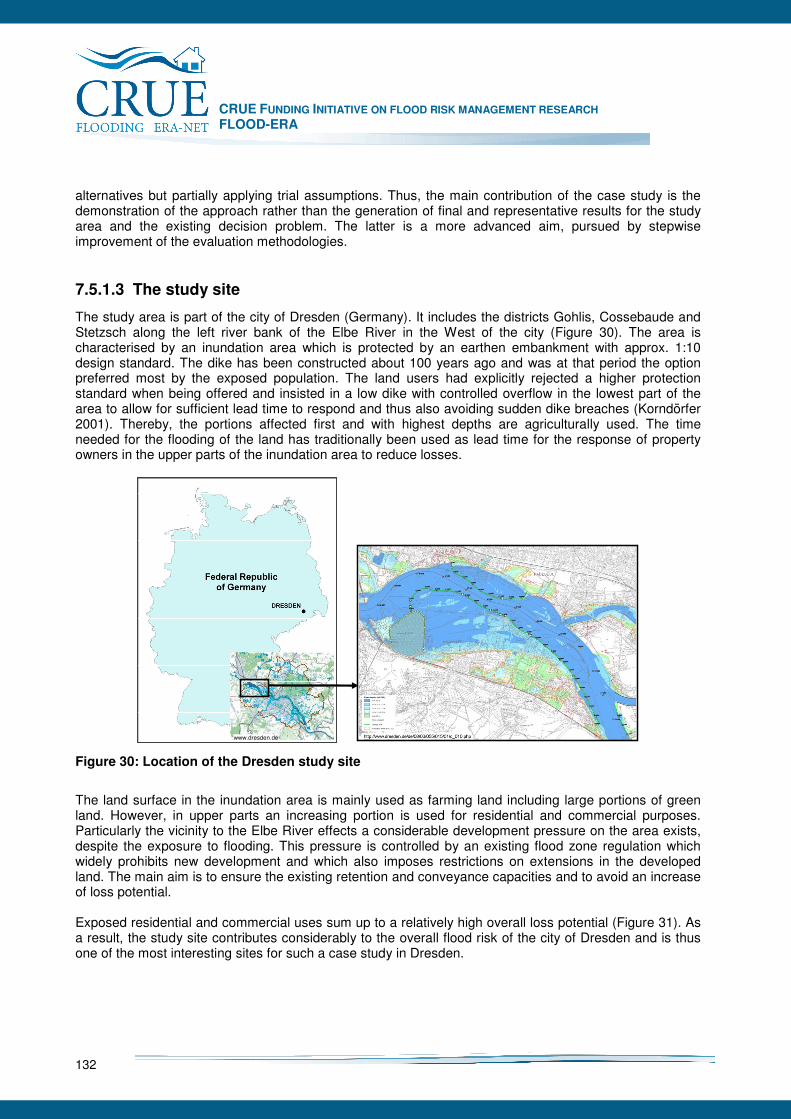
CRUE FUNDING INITIATIVE ON FLOOD RISK MANAGEMENT RESEARCH FLOOD-ERA
132
alternatives but partially applying trial assumptions. Thus, the main contribution of the case study is the demonstration of the approach rather than the generation of final and representative results for the study area and the existing decision problem. The latter is a more advanced aim, pursued by stepwise improvement of the evaluation methodologies.
7.5.1.3 The study site
The study area is part of the city of Dresden (Germany). It includes the districts Gohlis, Cossebaude and Stetzsch along the left river bank of the Elbe River in the West of the city (Figure 30). The area is characterised by an inundation area which is protected by an earthen embankment with approx. 1:10 design standard. The dike has been constructed about 100 years ago and was at that period the option preferred most by the exposed population. The land users had explicitly rejected a higher protection standard when being offered and insisted in a low dike with controlled overflow in the lowest part of the area to allow for sufficient lead time to respond and thus also avoiding sudden dike breaches (Korndörfer 2001). Thereby, the portions affected first and with highest depths are agriculturally used. The time needed for the flooding of the land has traditionally been used as lead time for the response of property owners in the upper parts of the inundation area to reduce losses.
www.dresden.de
Figure 30: Location of the Dresden study site
The land surface in the inundation area is mainly used as farming land including large portions of green land. However, in upper parts an increasing portion is used for residential and commercial purposes. Particularly the vicinity to the Elbe River effects a considerable development pressure on the area exists, despite the exposure to flooding. This pressure is controlled by an existing flood zone regulation which widely prohibits new development and which also imposes restrictions on extensions in the developed land. The main aim is to ensure the existing retention and conveyance capacities and to avoid an increase of loss potential. Exposed residential and commercial uses sum up to a relatively high overall loss potential (Figure 31). As a result, the study site contributes considerably to the overall flood risk of the city of Dresden and is thus one of the most interesting sites for such a case study in Dresden.

CRUE FUNDING INITIATIVE ON FLOOD RISK MANAGEMENT RESEARCH FLOOD-ERA
133
Figure 31: Loss potential for surface and ground water in the city districts of Dresden (city of Dresden 2004)
7.5.2 Approach and case study design
The methodical approach is developed for a single case. It takes recourse to the methodology compiled in the FLOOD ERA project and substantiates it by applying it for the comparative evaluation of SM and NSM. For this purpose, three alternatives, partially with variants, are considered:
1. Do nothing 2. Protection line planned for the area with and without dike breach 3. Portfolio of flood zone designation and small scale private measures considering different cost
estimations The investigation is based on areal data developed in the VERIS-Elbe project52. Used data sets apply to:
• Number, location and surface of potentially exposed buildings in the inundation area • Buildings specific elevation data based on a digital terrain model • Building types and specific damage curves for building structure and installations
These data are used to calculate benefits and costs of measures for each single building and for different flood events. The results are then combined to make statements for the whole area. In order to enable a consequent evaluation certain conditions are simplified. The simplification permits a simple and transparent development and testing of the evaluation methodology. Simplifications are applied applies to following conditions:
• The frequency and magnitude of the flood hazard • The exposed land use in the study area • Applied damage functions • The maximum probable loss of inventory • The dynamics of flooding
52 http://www.veris-elbe.ioer.de.
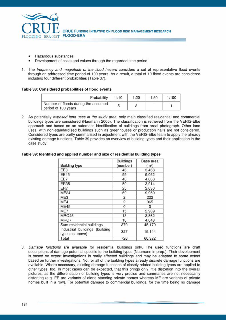
CRUE FUNDING INITIATIVE ON FLOOD RISK MANAGEMENT RESEARCH FLOOD-ERA
134
• Hazardous substances • Development of costs and values through the regarded time period
1. The frequency and magnitude of the flood hazard considers a set of representative flood events
through an addressed time period of 100 years. As a result, a total of 10 flood events are considered including four different probabilities (Table 37).
Table 38: Considered probabilities of flood events
Probability 1:10 1:20 1:50 1:100
Number of floods during the assumed period of 100 years
5 3 1 1
2. As potentially exposed land uses in the study area, only main classified residential and commercial
buildings types are considered (Naumann 2005). The classification is retrieved from the VERIS-Elbe approach and based on an automatic identification of buildings from areal photograph. Other land uses, with non-standardised buildings such as greenhouses or production halls are not considered. Considered types are partly summarised in adjustment with the VERIS-Elbe team to apply the already existing damage functions. Table 39 provides an overview of building types and their application in the case study.
Table 39: Identified and applied number and size of residential building types
Building type Buildings (number)
Base area (m²)
EE3 46 3,468 EE45 99 9,062 EE7 48 4,668 ER35 50 3,914 ER7 25 2,630 ME24 69 9,950 ME3 2 222 ME4 2 365 ME45 0 0 ME7 15 2,989 MRO45 13 3,862 MRO7 10 4,048 Sum residential buildings 379 45,179 Industrial buildings (building types as above)
327 15,144
Total 726 60,322 3. Damage functions are available for residential buildings only. The used functions are draft
descriptions of damage potential specific to the building types (Naumann in prep.). Their development is based on expert investigations in really affected buildings and may be adapted to some extent based on further investigations. Not for all of the building types already discrete damage functions are available. Where necessary, existing damage functions of closely related building types are applied to other types, too. In most cases can be expected, that this brings only little distortion into the overall pictures, as the differentiation of building types is very precise and summaries are not necessarily distorting (e.g. EE are variants of alone standing private homes whereas ME are variants of private homes built in a row). For potential damage to commercial buildings, for the time being no damage
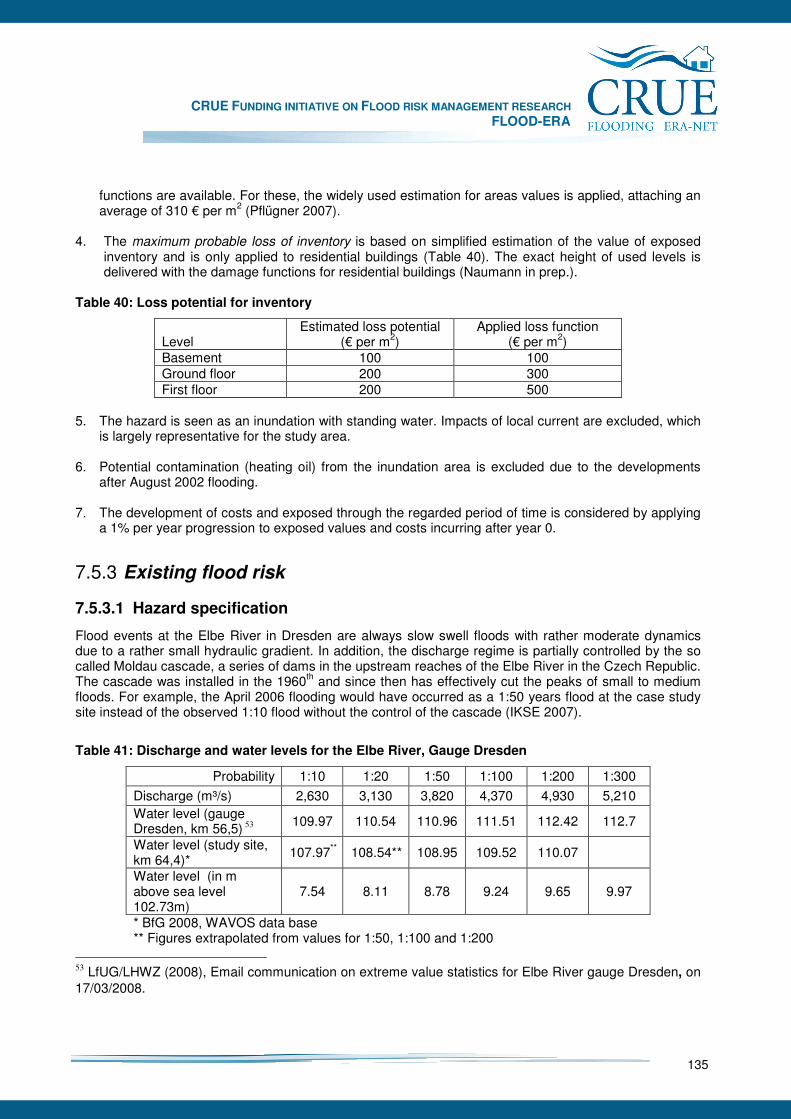
CRUE FUNDING INITIATIVE ON FLOOD RISK MANAGEMENT RESEARCH FLOOD-ERA
135
functions are available. For these, the widely used estimation for areas values is applied, attaching an average of 310 € per m2 (Pflügner 2007).
4. The maximum probable loss of inventory is based on simplified estimation of the value of exposed
inventory and is only applied to residential buildings (Table 40). The exact height of used levels is delivered with the damage functions for residential buildings (Naumann in prep.).
Table 40: Loss potential for inventory
Level Estimated loss potential
(€ per m2) Applied loss function
(€ per m2) Basement 100 100 Ground floor 200 300 First floor 200 500
5. The hazard is seen as an inundation with standing water. Impacts of local current are excluded, which
is largely representative for the study area. 6. Potential contamination (heating oil) from the inundation area is excluded due to the developments
after August 2002 flooding. 7. The development of costs and exposed through the regarded period of time is considered by applying
a 1% per year progression to exposed values and costs incurring after year 0.
7.5.3 Existing flood risk
7.5.3.1 Hazard specification
Flood events at the Elbe River in Dresden are always slow swell floods with rather moderate dynamics due to a rather small hydraulic gradient. In addition, the discharge regime is partially controlled by the so called Moldau cascade, a series of dams in the upstream reaches of the Elbe River in the Czech Republic. The cascade was installed in the 1960th and since then has effectively cut the peaks of small to medium floods. For example, the April 2006 flooding would have occurred as a 1:50 years flood at the case study site instead of the observed 1:10 flood without the control of the cascade (IKSE 2007).
Table 41: Discharge and water levels for the Elbe River, Gauge Dresden
Probability 1:10 1:20 1:50 1:100 1:200 1:300
Discharge (m³/s) 2,630 3,130 3,820 4,370 4,930 5,210 Water level (gauge Dresden, km 56,5) 53
109.97 110.54 110.96 111.51 112.42 112.7
Water level (study site, km 64,4)*
107.97** 108.54** 108.95 109.52 110.07
Water level (in m above sea level 102.73m)
7.54 8.11 8.78 9.24 9.65 9.97
* BfG 2008, WAVOS data base ** Figures extrapolated from values for 1:50, 1:100 and 1:200
53 LfUG/LHWZ (2008), Email communication on extreme value statistics for Elbe River gauge Dresden, on 17/03/2008.

CRUE FUNDING INITIATIVE ON FLOOD RISK MANAGEMENT RESEARCH FLOOD-ERA
136
The current frequency analysis for the representative gauge Dresden is displayed in Table 41. It details discharge and water levels for several recurrence intervals, which are later used for the determination of loss potential. The study site is affected mainly by standing water because of its location in the inner side of a river bend it. Higher flow velocities only occur directly along the main river channel.
7.5.3.2 Maximum Probable Loss (MPL)
The determination of the maximum probable loss (MPL) is based on a set of representative flood events (section 7.5.3.1) and calculations with the HOWAD damage model (Naumann 2005). The flood events are used to construct sub-cases of flooding and loss generation of the building existing in the area (Figure 32) and distributing those over the regarded 100 years period. Consequences are calculated considering specific information for each single building in the inundation area:
• Type, surface area and use of each building, • Inundation depths for the considered frequencies, • Synthetic damage functions for building structure and technical installations, • Where necessary: damage estimations.
Figure 32: Dresden study site: distribution of buildings in the inundation area
Figure 32 shows the range of water depths for a 1:100 year flood from the river ground to the maximum inundation width. Flood risk is derived as probable loss for a flood event of a certain recurrence interval on a yearly basis as Annual Average Damage (AAD). Table 42 summarises losses for individual flood recurrence intervals as well as the integral risk over a period of 100 years. As a result, in total 40 million € MLP is calculated for both the residential and commercial buildings for the 1:100 flood. This differentiates considerably from the estimation mentioned in the planning documentation of the protection line,54 where the damage potential is estimated to be about 22 million € and which is
54 LTV (2007), Erhöhung / Ertüchtigung der Elbdeiche in Stetzsch und Gohlis sowie Neubau 2. Deichlinie
CRUE FUNDING INITIATIVE ON FLOOD RISK MANAGEMENT RESEARCH FLOOD-ERA
137
based on a general area value method. The derived risk information in the following is used for the evaluation of effectiveness and efficiency.
Table 42: Maximum Probable Loss for the different flood frequencies
Flood frequency 1:10 1:20 1:50 1:100 Integral Maximum Probable Loss to structure and installations of residential buildings
11,793,158 15,155,751 19,074,206 28,397,226
Maximum Probable Loss to inventory of residential buildings
3,599,372 5,062,744 6,116,026 8,002,052
Maximum Probable Loss to commercial buildings incl. inventory
2,216,568 2,544,590 2,888,592 3,581,384
Total loss potential in year 0 17,609,098 22,763,084 28,078,824 39,980,662
Assumed number of occurrence in 100 years
5 3 1 1
Maximum Loss Potential (MLP) for the 100 years period
88,045,490 68,289,253 28,078,824 39,980,662 224,394,229
Average Annual Damage (AAD) 880,455 682,893 280,788 399,807 2,243,942
7.5.4 Strategic alternatives of SM and NSM
7.5.4.1 Do nothing
The baseline alternative of the case study is assigned as “Do nothing”. It assumes the current risk reduction measures to be continued in the future. This includes:
• Maintenance of the ca. 1:10 dike, • Further regulation of development in the flood zone, • A progression of values in the area by 1% per year.
Calculated damage and risk of this alternative are used as reference for the other alternatives, e.g. for the determination of avoided losses.
7.5.4.2 Protection line
The strategic alternative “protection line” represents the existing planning which has been recently submitted for permission and is currently in the state of detailed debate mainly in terms of the exact course. For the case study the possible variants of dike location are assumed as equal as only some less intensive commercial land users are affected (Figure 33).
Cossebaude in Dresden, Entwurfs- und Genehmigungsplanung Bericht, Landestalsperrenverwaltung des Freistaates Sachsen (LTV), Dresden, pp113.
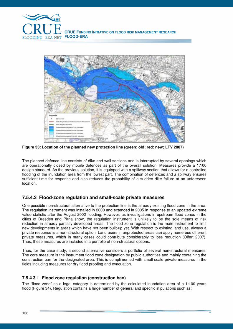
CRUE FUNDING INITIATIVE ON FLOOD RISK MANAGEMENT RESEARCH FLOOD-ERA
138
Figure 33: Location of the planned new protection line (green: old; red: new; LTV 2007)
The planned defence line consists of dike and wall sections and is interrupted by several openings which are operationally closed by mobile defences as part of the overall solution. Measures provide a 1:100 design standard. As the previous solution, it is equipped with a spillway section that allows for a controlled flooding of the inundation area from the lowest part. The combination of defences and a spillway ensures sufficient time for response and also reduces the probability of a sudden dike failure at an unforeseen location.
7.5.4.3 Flood-zone regulation and small-scale private measures
One possible non-structural alternative to the protection line is the already existing flood zone in the area. The regulation instrument was installed in 2000 and extended in 2005 in response to an updated extreme value statistic after the August 2002 flooding. However, as investigations in upstream flood zones in the cities of Dresden and Pirna show, the regulation instrument is unlikely to be the sole means of risk reduction in already partially developed areas. The flood zone regulation is the main instrument to limit new developments in areas which have not been built-up yet. With respect to existing land use, always a private response is a non-structural option. Land users in unprotected areas can apply numerous different private measures, which in many cases could contribute considerably to loss reduction (Olfert 2007). Thus, these measures are included in a portfolio of non-structural options. Thus, for the case study, a second alternative considers a portfolio of several non-structural measures. The core measure is the instrument flood zone designation by public authorities and mainly containing the construction ban for the designated area. This is complimented with small scale private measures in the fields including measures for dry flood proofing and evacuation.
7.5.4.3.1 Flood zone regulation (construction ban)
The “flood zone” as a legal category is determined by the calculated inundation area of a 1:100 years flood (Figure 34). Regulation contains a large number of general and specific stipulations such as:
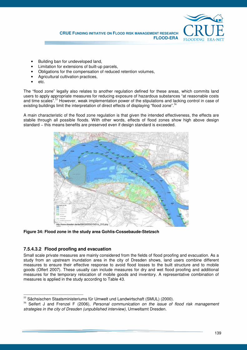
CRUE FUNDING INITIATIVE ON FLOOD RISK MANAGEMENT RESEARCH FLOOD-ERA
139
• Building ban for undeveloped land, • Limitation for extensions of built-up parcels, • Obligations for the compensation of reduced retention volumes, • Agricultural cultivation practices, • etc.
The “flood zone” legally also relates to another regulation defined for these areas, which commits land users to apply appropriate measures for reducing exposure of hazardous substances “at reasonable costs and time scales”.55 However, weak implementation power of the stipulations and lacking control in case of existing buildings limit the interpretation of direct effects of displaying “flood zone”.56 A main characteristic of the flood zone regulation is that given the intended effectiveness, the effects are stabile through all possible floods. With other words, effects of flood zones show high above design standard − this means benefits are preserved even if design standard is exceeded.
Figure 34: Flood zone in the study area Gohlis-Cossebaude-Stetzsch
7.5.4.3.2 Flood proofing and evacuation
Small scale private measures are mainly considered from the fields of flood proofing and evacuation. As a study from an upstream inundation area in the city of Dresden shows, land users combine different measures to ensure their effective response to avoid flood losses to the built structure and to mobile goods (Olfert 2007). These usually can include measures for dry and wet flood proofing and additional measures for the temporary relocation of mobile goods and inventory. A representative combination of measures is applied in the study according to Table 43.
55 Sächsischen Staatsministeriums für Umwelt und Landwirtschaft (SMUL) (2000). 56 Seifert J and Frenzel F (2006), Personal communication on the issue of flood risk management
strategies in the city of Dresden (unpublished interview), Umweltamt Dresden.
CRUE FUNDING INITIATIVE ON FLOOD RISK MANAGEMENT RESEARCH FLOOD-ERA
140
Table 43: Small-scale private measures considered in the Elbe River case study
Type of measure Measure Comment on applicability Dry flood proofing (controlling ingress of water)
• Shielding/Sandbagging • Pumping
• Decreasing effects with increasing flood levels
• Variable measures for different construction materials
Wet flood proofing • Impermeable wall and floor covers
• Decreasing effects with increasing duration of inundation
• Limited effects with respect to contaminants
Evacuation • Relocation of inventory at upper floors
• Very robust through most flood levels
• Potentially lower effects with decreasing lead time below 24h
Flood proofing measures are fundamentally different from the regulation instrument “flood zone”. Most of them are contingent measures highly dependent on flood warning with minimum lead times for their full implementation. Additionally, particular many flood-proofing measures require maintenance during the flood event which can apply to the safeguarding of sand bag constructions, pumps, power supply, and so forth. At the same time, the temporal location of mobile goods at upper levels may require operational adaptation if critical flood levels are achieved. While evacuation measures tend to be very robust due to the complete disconnection values from the hazard (Olfert 2007), the effect of dry flood proofing measures is related to the flood level at the building. The pressure of the water column can achieve critical values beyond which further protection would endanger the structure. Also the resistance of wet flood-proofing measures can be limited by the duration of flooding and may not bring relief against contaminants.
7.5.5 Effectiveness and efficiency
7.5.5.1 Protection line
Benefits In normal operation, the protection line is generally expected to avoid any losses from surface flooding by a total uncoupling of hazard and damage potential. However, surface flooding is only one pathway of flooding in the study area. Another very important type is groundwater flooding due to very dynamic and generally high groundwater body in the area. As a result, while the protection line may show optimum performance, about 5% losses can be expected to materialise despite these provisions. However, alternative 2b is dedicated to the scenario where the protection fails due to any reason during a 1:100 event. For simplicity reason, for this case a full loss of functionality is assumed with no losses avoided. This will not necessarily express reality in case of failure as a full ignorance to the raising flood by the land users at risk can hardly be expected. Nevertheless, lacking any link to possible effects of likely behaviour, the assumption is not changed in this place. Table 44 gives an overview of the expected benefits based on the consideration of different building types, exposure levels and flood frequencies. In the end, all single benefits are summed up to obtain the overall benefit per specific event. The present values of benefits at the end of the 100 years period are summarised in Table 50. Interpretation of the results should reflect that no discount rates have been considered in this case study.

CRUE FUNDING INITIATIVE ON FLOOD RISK MANAGEMENT RESEARCH FLOOD-ERA
141
Table 44: Single event benefits of the protection line in year 0
Flood frequency 1:10 1:20 1:50 1:100 Integral
Total loss potential (year 0, €) 17,609,098 22,763,084 28,078,824 39,980,662 224,394,229 Losses Option 2, Protection line (year 0, €)
880,455 1,138,154 1,403,941 1,999,033 79,850,745
Benefit Option 2, Protection line (year 0, €)
16,728,643 21,624,930 26,674,833 37,981,629 213,174,518
Losses Option 2a, Protection line, breach at 1:100 (year 0, €)
17,609,098 22,763,084 28,078,824 39,980,662 224,394,229
Benefit Option 2a, Protection line, breach (year 0, €)
0 0 0 0 0
Costs For the determination of costs for the alternative “protection line”, three cost categories are considered:
• Capital costs for the initial implementation: 13 million €, based on the estimation provided by the planning documentation (LTV 2007),
• Annual maintenance costs: A rough estimate of 3,000 € per year, • Operation costs during flood events (Table 45).
Table 45: Operation costs of alternative 2 – protection line
Flood frequency 1:10 1:20 1:50 1:100 Operation costs of the protection line (in year 0, €)
3,000 5,000 10,000 20,000
Transaction cost, which would represent costs of public administration for the planning, implementation, maintenance and operation are not considered. As a protection line necessarily requires considerable support by public administration, these costs can be estimated high. However, in this case study, these costs are balanced with the transaction costs of the flood zone in the third alternative. The present values of costs are summarised in Table 51.
7.5.5.2 Flood-zone regulation and small-scale private measures
Benefits Expectable effects of flood zone regulation and small scale private measures are generally different from those of a structural protection line. Many of the small scale measures have a limited capability in disconnecting hazard and damage potential (e.g. sand bags). However, evacuation measures can have a comparable effect, but, as a difference, by reducing exposure of values instead of avoiding flooding. As a result, flood proofing and evacuation require different treatment with regard to the expectable effects. Table 46 provides the benefits calculated based on the argumentation below. For reasons of lucidity, benefits of the flood zone are estimated to meet the full expectation by avoiding any new development. This is not realistic knowing that the instrument only influences the construction of completely new buildings, while the extension of existing buildings is still possible in limited range. This imprecision may be balanced by the fact that for both alternatives the same increase of values is assumed
CRUE FUNDING INITIATIVE ON FLOOD RISK MANAGEMENT RESEARCH FLOOD-ERA
142
(1 %/year.) while it can be expected that the higher exposure in “unprotected” flood zones will lead to slower increase of values. Expectable benefits of flood proofing measures differentiated for different flood levels and thus also for different exposure levels. It is expected that dry flood proofing measures are able to avoid a major portion of losses up to a certain level and may start to fail with raising water levels. However, as flood proofing measures are applied by different stakeholders, a higher failure rate needs to be considered that in case of a collective measure such as a protection line which is professionally planned, implemented, maintained and operated. Therefore, different reduction factors are used to describe the decreasing contribution of flood proofing measures with raising water level (Table 46). The lowest factor is still high paying respect, that the damage curves considered for the building structures include installations, which can be robustly secured by flood proofing and evacuation measures.
Table 46: Reduction factors to derive benefits of flood proofing measures for different flood depths
Flooding depth <=0 1-100 cm 101-150cm >150cm
Reduction factor 0.05 0.1 0.4 0.7 From empirical results of Olfert (2007), evacuation measures can be expected to remain robust through all flood levels. Therefore, for evacuation measures for all flood depths a reduction factor of 0.9 is applied, Differentiating is rather the effort required to achieve the benefits, which are detailed as costs of evacuation measures. Having defined the portfolios as standard combinations including both flood proofing and evacuation measures, benefits in the categories structure/installations and inventory are regarded as benefits of either of the measure types. Avoided losses to structure/installations are regarded as generated by flood proofing measures. Losses avoided to the inventory are regarded as generated by evacuation measures. This not fully reflects reality as, of course, effective flood proofing up to a certain level can reduce losses to the inventory. At the same time, temporal relocation of the heating central is an evacuation measure and means a benefit to installations. This contribution is also the main reason, why the reduction factor for flood proofing measures does not drop below 0.7.
Table 47: Single event benefits of flood proofing and evacuation measures in year 0
Flood frequency 1:10 1:20 1:50 1:100 Integral
Total loss potential (year 0) 17,609,098 22,763,084 28,078,824 39,980,662 224,394,229 Losses Option 3, Portfolio (year 0)
4,673,566 9,363,116 12,248,712 16,144,856 79,850,745
Benefit Option 3, Portfolio (year 0)
12,935,532 13,399,969 15,830,112 23,835,806 144,543,484
Costs Costs of the portfolio is largely based on assumptions motivated by a recent study on small scale private measure in the region (Olfert 2007). Due to the fundamental difference of involved measures, different approaches towards the determination of costs are applied for the regulation instrument, flood proofing measures and evacuation. Flood zone regulation Being an instrument of the public administration, the flood zone designation itself does not cause capital costs. Costs of the instrument are transaction costs. As transaction costs are not considered in case of the
CRUE FUNDING INITIATIVE ON FLOOD RISK MANAGEMENT RESEARCH FLOOD-ERA
143
protection line, they remain disregarded here, too. As a result, costs of the portfolio sum up from those for flood proofing and evacuation measures. Flood proofing measures Little evidence is available on financial costs of small scale private measures. In facts, these costs are particularly difficult to describe as most of these measures are implemented by internal action and without external accountability. As investigations in the city of Dresden shows, costs of private measures usually contain a minor part of capital costs as material expense and seldom services. At the same time, a considerable internal time effort for implementation and operation is made. Capital costs arise for working material such as shielding and sealing material, pumps, power supply units or for services such as the dismantlement and installation of a heating central. The time effort results from the partly enormously time consumptive erection of defences and the installation of other provisions (e.g. pumps) and mainly their maintenance through the flood event. In most cases, no market values are available for the costs – with respect for professional services or at least the purchase prises of the material. In order to roughly describe possible costs, a general value per m2 building surface is assumed, which includes material and labour. The assumption goes considerably beyond what has been described by Olfert (2007) in order to approximate possible cost values for situations where flood proofing becomes a regularly returning task and thus more provisions are made for faster and easier response. The figures derived from the investigation of small scale private measures in Dresden indicate flood proofing costs per building to average below 1,000 € often being estimated close to “0” by the land users. This appears quite singularly after the investigated flood event was the first event that could be responded to after decades of lacking floods and an extreme flood few years before. As a result, higher cost estimations are made for option 3 in this case study. Similar costs are assumed for all building types. However the estimation of costs varies with different flood events and also responds to the exposure levels. It is assumed that measures of dry flood proofing are effective up to a certain flood level and than fully loose their functionality. Thus, with a known higher water level, less or no flood proofing measures are assumed for different flood events and the flood levels at different exposure levels. A differentiated cost pattern emerges if looking in the different magnitudes at the exposure levels (Table 48).
Table 48: Estimation of flood proofing costs per building related to flood depths in year 0
Flood depth 0 -150cm 151-200cm >200cm Estimated flood proofing costs per building
3,000 1,000 0
Evacuation Costs of evacuation measures are dominated by the time effort made to dislocate the potentially exposed inventory. Even more than for flood proofing measures, costs are perceived to be around “0”. From the perspective of the land user this reflects perceived reality. It appears not sensible to calculate market values for private evacuation costs. Looking at the size of inundation areas and the number of potentially exposed properties and land users it becomes comprehendible that there is no market for evacuation services. Given that after irregular periods a different kind of flooding occurs, hardly any professionalisation in this sector is conceivable. However, an attempt is made to describe the time effort in monetary terms in order to give the work a comparable value. Thereby, evacuation effort is regarded smallest for the basement, medium for the ground floor and it strongly raises when the flood reaches the first floor (Table 49). The latter is due to the assumption, that evacuation is still relatively simple as long as it is sufficient to elevate the inventory to the next floor. However, the first floor for most privately used buildings in the area is the highest floor. Higher buildings are usually rental blocks that do not offer the tenants escape to upper
CRUE FUNDING INITIATIVE ON FLOOD RISK MANAGEMENT RESEARCH FLOOD-ERA
144
floors anyway. As a result, with the flood reaching first flood the inventory has to be dislocated from the building which causes a considerable increase in effort and which is reflected by the cost assumption. As compensation for the time effort a used 10 € hourly payment is assumed to describe the monetary value of private evacuation.
Table 49: Evacuation costs
Floor Evacuation effort (hours per m2)
Basement 0.3 Ground floor 0.8 First floor 1.8
Table 50: Single event costs of flood proofing and evacuation measures in year 0
Flood frequency 1:10 1:20 1:50 1:100 Costs flood proofing 793,000 627,000 566,000 691,000 Costs evacuation 137,144 190,916 226,201 299,191 Costs portfolio 930,144 817,916 792,201 990,191 Reduced costs portfolio 310.048 272.639 264.067 330.064
Assumption of reduced costs In Option 3a costs of flood proofing and evacuation measures are cut to 1/3rd of what is used in Option 3 (Table 47). These reduced costs reflect the perception of land users mentioned in the investigations referred to above. Thus, this option tries to draw a picture disregarding a part of the internal time effort as monetary cost factor to reflect that most of the activities have no market and are usually implemented with the assistance of unpaid helpers.
7.5.5.3 Comparison of alternatives
In total, five variants of three options have been included in a comparative assessment:
1. Do nothing 2. Protection line assuming stagnant land development and optimum performance 2a. Protection line assuming stagnant land development and dike breach at 1:100 3. Portfolio of flood zone designation and small scale private measures considering higher cost
assumptions 3a. Portfolio of flood zone designation and small scale private measures considering reduced (1/3)
costs Results or the evaluation criteria for the different options are displayed in Table 51. The differences between the options show clear preferences for the structural options in terms of net present value, while the benefit-cost ratio favours the non-structural solutions. Differences in the valuation of the options arise internally for the different variants of an option. For the protection line these are generated by different benefits, which are considerably lower for the case of an assumed dike breach at 1:100 while costs are identical. In case of the portfolio differences come from different cost assumptions for the same benefits.
CRUE FUNDING INITIATIVE ON FLOOD RISK MANAGEMENT RESEARCH FLOOD-ERA
145
Differences also arise between the alternatives. With respect to NPV, a clear preference for the structural solution “Protection line” is shown. This is true for both variants – without and with breach. The basic SM and NSM options differ by almost 30% at the end of the 100 years period with a clear preference for the structural protection line (NPV 81 million against 59 million). The clear preference remains even if assuming a dike breach during a 1:100 event. Also here, the structural solution remains 10 % ahead of the non-structural portfolio (NPV 65 million against 57 million). The non-structural solution also remains slightly (4%) behind the protection line even if considering only reduced costs of flood proofing and evacuation in option 3a (NPV 65 million against 62 million). With respect to the BCR, the non-structural options are ahead of the structural solutions. The advantage is about 50% if comparing the basic SM and NSM variants (BCR 11.6 against 7.2). If assuming the reduced monetary costs an even larger advantage is calculated (BCR 34.7 against 7.2). The difference against the option with dike reach is even larger (BCR 4.2).
Table 51: Comparing the efficiency of options
Option Criterion
Option 1 Do nothing
Option 2 Protection line
Option 3 Portfolio
Type 2a Protection line,
breach
Type 3a Portfolio
reduced costs
PV costs from estimates 0 13,102,506 5,542,122 13,102,506 1,847,374
PV damage 99,617,159 5,767,157 35,447,860 21,619,232 35,447,860
PV damage avoided 93,850,002 64,169,298 77,997,927 64,169,298
Effectiveness 94% 64% 78% 64%
NPV 80,747,497 58,627,177 64,895,422 62,321,925
Average BCR 7.2 11.6 6.0 34.7
7.5.6 Descriptive context analysis
The context for risk management and the according decision making in the study area is mainly characterised by the exposure of the flood prone area incl. the value of the receptor and its susceptibility, and the distribution of interests and competences of involved parties of land users and public authorities at different administrative levels. The study area is traditionally built up by long existing villages, which in the past decades have seen some new development. During the centuries old history of the area the villages have always been exposed to flooding and villagers always where aware of their risk and their specific options of risk management. As a result, in the beginning of the 20th century, villagers have rejected the offer of receiving a dike which would have protected them against ca. 1:100 flooding in future (Korndörfer 2001). The main reason was the fear of sudden dike breaches which would disable a response. Today, the old village cores have the status of historical monuments and are thus liable to special protection against built modifications. As a result, the protection of these areas against flooding has a particular priority already from the perspective of cultural heritage. Different stakeholder groups at different levels and with different interests are involved in the flood risk management of the study site. A major background for the motivation of these is the recent flood experience in the area. After decades long absence of considerable flooding along the Elbe river an extreme flood occurred in August 2002 (1:150) which had met unprepared most involved officials and land users. A minor flooding in April 2006, carrying a 1:10-20 flood has considerably increased the public claim
CRUE FUNDING INITIATIVE ON FLOOD RISK MANAGEMENT RESEARCH FLOOD-ERA
146
for better protection and apparently leads to an acceleration of the decision making process for the study area. Involved stakeholders show different patterns of consternation and responsibilities towards flood risk. The four mainly regarded stakeholder groups are:
• Saxon Dam Authority • City authority • Residential and commercial land users
Dam Authority The Saxon Dam Authority (Landestalsperrenverwaltung LTV) is the official party actually responsible for flood protection along large waters such as the Elbe River. The authority is centrally organised at Länder level and directly subordinate to the Saxon Ministry of the Environment and Agriculture. As a result, neither private citizens nor sector agencies of the city of Dresden have direct impact on the strategic orientation of alternatives/variants or the planning and implementation process. The dam authority elaborates flood protection works based on a state wide prioritisation of flood protection measures for different location and mainly following the aim of implementing the 1:100 standard for all defences state wide. Background for the priorisation is the official methodology developed in the Saxon Ministry of the Environment and Agriculture (Socher 2006). The purely towards engineering oriented authority considers only solutions which can be achieved by engineering works. Instruments or small scale private measures are out of the range of the actor. Residential and commercial land users Residents and commercial users in the study area clearly desire better protection and claim for at least 1:100 protection standard as well as faster decision making/implementation. They largely appreciate high ranking of the protection line and the principle approach of the structural solution. Land users directly affected by the alignment of protection line oppose the location of defences in their vicinity claiming a loss of life quality due to a close barrier which would hinder the sight and the access to the natural river site (NIMBY – not in my back yard - phenomenon). Commercially used properties are differently affected by the alignment of the defence line. In the western part of the study area, where large surface businesses such as tree nurseries are located, the alignment of the defence system as planned (close to built structures) may separate built infrastructure from the production. There is a large resent against solutions requiring private action. The perception of the own role in flood risk management for the majority is based on a lack of understanding for the own contribution to flood risk. Additionally, a general expectation exists that risk reduction is an obligatory service of the public authorities, private measures are often assumed ineffective. At the same time, a majority of land users is widely aware of the risk and the own responsibility for risk reduction and sees further needs mainly in the provision of information and support for their own action as well as in the strengthening of community networks. (based on interviews conducted in flood zones of the Cities of Dresden and Pirna). However, despite the large stated resent, private land users in “unprotected areas” prove to be very active in risk reduction during flooding. An in-depth review of small scale private flood risk reduction in 24 cases reports of more than 150 measures applied and with achieving very high effectiveness in reducing losses (Olfert 2007). City authorities The city of Dresden and its sector agencies are responsible for Flood risk management of 2. Order rivers and for disaster management for the whole city area. Land users tend to perceive the city authorities as
CRUE FUNDING INITIATIVE ON FLOOD RISK MANAGEMENT RESEARCH FLOOD-ERA
147
the only responsible for flood risk management or overestimate their effect of the State authorities. As a result, the city authorities are heavily challenged by land users with expectations regarding style as well as terms for decision and implementation of risk reduction measures. Responsible sector agencies of the city generally highly welcome the solution presented by the Dam Authority. However, the sector agencies oppose the alignment of the preferred variant claiming it to leave too little retention area and pleading for an alignment closer to the built up area.57 The flood protection concept of the city authorities uses a wide variety of traditional and new measures and instruments including, walls, channels, pumping, flood zone regulations, warning and other. However, for the time being, city authorities do not consider private risk reduction in their concept referring to it being out of their competence. As a result, a wide spectrum of communication measures for the building of awareness and preparedness remain neglected. The detailed and well accessible web-based information system on hazards of surface and ground water flooding obviously is not sufficient to ensure awareness and preparedness as well as the acceptance of the own responsibility by exposed land users. Interviews with the city authority substantiate the traditional consideration of traditional engineering solutions for flood risk management.58 For the study area no other solution were surveyed than the protection by a dike. As a result, the compared alternatives are actually variants of the only alternative “dike”. Recent discussions with responsibles from different sector agencies of the Dresden city authority indicate that substantiated knowledge of additional options and their application in reality may support a further shift from responsibility in terms of accountability towards responsibility in terms of commitment as compliment to the current flood risk management approach. This could foster the involvement of additional, particularly communicative instruments, in order to improve awareness and preparedness of exposed land users supporting their contribution to flood risk management in flood prone areas of the city of Dresden.
7.5.7 Conclusions
Conclusions regarding the evaluation The case study shows that comparative evaluation of structural and non-structural alternatives is principally possible by the use of state of the art methods. However, the evaluation requires additionally resp. adapted steps particularly with respect of the regarded non-structural option. All together, the results of the evaluation of the alternatives from an economic point of view show a tendency in favour of a structural solution. However, several points are important to notice with respect to methods and results of the evaluation: 1. The evaluation concentrates on economic aspects onsite only. Neither economic downstream effects,
nor non-monetary issues which can be highly valued by the society are considered. These could be for example potential adverse ecological effects or additional benefits from the protection of cultural heritage sites. Therefore, it would be helpful to include the economic parameters in a Multi Criteria
57 City of Dresden (2008), Stellungnahme zum Vorhaben "Erhöhung / Ertüchtigung der Elbdeiche in
Stetzsch und Gohlis sowie Neubau 2. Deichlinie Cossebaude in Dresden, Entwurfs- und
Genehmigungsplanung Bericht", City of Dresden, Umweltamt, unpublished, Dresden, available at http://www.dresden.de/ger/02/or/vorgang/ueberschwemmung.pdf. 58 Frenzel, F. (2008). Personal communication on flood risk management strategies for the district of Gohlis in the City of Dresden (unpublished interview). Dresden, Umweltamt Dresden.
CRUE FUNDING INITIATIVE ON FLOOD RISK MANAGEMENT RESEARCH FLOOD-ERA
148
Assessment (MCA) to give consideration to further not necessarily less important but differently expressed issues.
2. While the NPV criterion indicates certain preferences from the economic point of view, it leaves open
the question of societal justice of expenditures. Structural solutions are traditionally implemented from overall budgets at state level and thus from the tax money of the whole society. Non structural measures such as flood proofing or evacuation are implemented at the expense of those actually at risk. It might be open to a societal discourse whether the approach to systematically distribute flood protection costs over the whole society is always rectified by a real lack of alternatives.
3. Lacking empirical evidence, case study takes recourse to many assumptions. While this is natural for
measures where hardly data exist, further investigation on these measures could help to introduce more certainty into the assumptions and thus might support the consideration of these measures as option in practice.
The state of the art methods for efficiency evaluation still seem to favour measures with a high proportion of capital costs incurring in the beginning of the evaluation period and which mainly apply to structural schemes. In other words, the applied discounting procedure bares the danger of favouring solutions such as dikes against flood proofing measures. It is important to keep in mind this danger to find appropriate solutions to avoid misinterpretation from evaluation. Conclusions regarding the context conditions Structural and non-structural measures are differently considered in flood risk management. Structural measures are usually the widely used and preferred options. The practiced flood risk management practiced by official authorities is still quite close to what may be called flood protection concentrating on engineering solutions as the main means of flood risk reduction. On the one hand, this appears natural by the fact that flood risk management with regard to main rivers is the domain of the Saxon Dam Authority which by its mission and the professional competences of the staff is devoted to engineered solutions. On the other hand, also the newly developed and applied prioritisation methodology (Socher 2006) gives clearly advantage to structural measures. The results of the state wide prioritisation of flood protection measures contain statements on about 1600 measures, of which virtually none is to be classified non-structural (full list cf. SMUL 2005). Many non-structural solutions are often not even regarded as alternatives. An important reason for this are methodological difficulties with regard to the comparative evaluation of structural and non-structural measures. This includes difficulties of describing non-.structural measures with established methods as well as a lack of evidence with regard to their performance in practice. Also the relatively differentiated approaches such as the flood protection concept of the city of Dresden apply an only limited spectrum of risk reduction options with a clear emphasis on collective measures and central instruments for land use regulation. Decentralise measures such as private risk reduction (Alternative 2) are not part of the consideration. As main reason for this, the lack of competences is named,59 but also the missing experience with those can be assumed. However, studies conducted in the flood zones of Dresden (Olfert 2007) show, that the issue of private risk reduction as complimentary option to applied measures and instruments is by far more complex and the sheer legal commitment of land users to flood risk reduction by law (SächsWG 2004, §99,3) appears not sufficient. The fact is that none of the queried land users saw this stipulation as motivating for the own response. As a result, a more differentiated conclusion must be drawn from the mentioned survey and the evaluation in this study. Differentiation is necessary in terms of a better interpretation of the roles different
59 Seifert J and Frenzel F (2006), Personal communication on the issue of flood risk management
strategies in the City of Dresden (unpublished interview), Umweltamt Dresden.
CRUE FUNDING INITIATIVE ON FLOOD RISK MANAGEMENT RESEARCH FLOOD-ERA
149
stakeholders play in private risk reduction. Currently, there is a gap between the official requirement for private action and the existing self-understanding of private risk reduction. This gap is due to several obstacles that prevent from private measures becoming a self-understanding part of risk reduction along the Elbe River in Dresden:
1. The requirement for private flood risk reduction has no consequence in the understanding of potentially affected land users. The latter are not used to this sort of responsibility. Flood protection is clearly understood as responsibility, competence and obligation of the public authorities. A large majority understands flood protection as a natural public service. Those, who not only know about their own responsibility but also accept it as a fact are clearly the minority. Instead, the majority while taking private measures understands those as an impertinence following from the neglect by the actually responsible bodies.
2. The legal commitment of land users to private risk reduction fulminates also if seen against the apprehension to lose insurance in case of a next flood loss being claimed.
3. Many land users are not fully aware of the flood hazard. While most vividly remember the extreme flooding from August 2002, flood level and extent of medium and small scale floods is usually not clear to the population. The availability of hazard maps in print and web based versions seems not sufficient to inform the land users. It appears difficult to translate a general water level to the exact level at the building used. Particularly the ground water hazard, its dynamics and the implication for other provisions is widely not understood.
4. Most land users have no systematic knowledge about the possibilities of small scale private measures flood risk reduction. However, most apply different portfolios which can be very effective for lower flood levels. But, as a result of lacking knowledge, most of the applied measures result from the current abilities of the land used and are not necessarily the most appropriate solutions.
While land users state not to know about available information material, public authorities claim that sufficiently information was passed to land users on different ways. Indeed, well elaborate information sources exist on the flood hazard in Dresden as well as on small scale private measures. However, these seem not to find their way to the land users at risk. Several reasons appear reasonable to explain this:
• Most important seems, that residents tend to reject their responsibility and by doing so do not recognise important information as relevant. Something like a lotus-effect can be observed, where essential information rolls off a coat of irresponsibility. As a result, the first step to reach these land users is not to provide information but to shape the acceptance of the own responsibility. This can be then the most important basis for penetrating the helpful information.
• Only few stakeholders seem to systematically approach the gathering of information. Public authorities can play an active role in distributing risk related information. This requires the direct confrontation of the land user with available information by leaflets, public events and other formats. It is obviously not sufficient to distribute information sources at central places and to inform on available publications in the press.
• Supplied information is often too general. For many private land users onsite consultation would be highly valuable to develop the approach which fully responds to the specific situation.
• There are particularly vulnerable stakeholders who need special assistance in understanding the risk as well as in developing the necessary preparedness. These not only need adapted information formats, but also help during flood events.

CRUE FUNDING INITIATIVE ON FLOOD RISK MANAGEMENT RESEARCH FLOOD-ERA
150
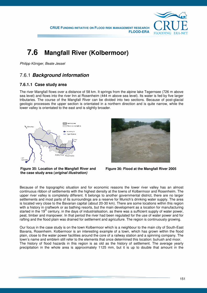
CRUE FUNDING INITIATIVE ON FLOOD RISK MANAGEMENT RESEARCH FLOOD-ERA
151
7.6 Mangfall River (Kolbermoor)
Philipp Königer, Beate Jessel
7.6.1 Background information
7.6.1.1 Case study area
The river Mangfall flows over a distance of 58 km. It springs from the alpine lake Tegernsee (726 m above sea level) and flows into the river Inn at Rosenheim (444 m above sea level). Its water is fed by five larger tributaries. The course of the Mangfall River can be divided into two sections. Because of post-glacial geologic processes the upper section is orientated in a northern direction and is quite narrow, while the lower valley is orientated to the east and is slightly broader.
Because of the topographic situation and for economic reasons the lower river valley has an almost continuous ribbon of settlements with the highest density at the towns of Kolbermoor and Rosenheim. The upper river valley is completely different. It belongs to another governmental district, there are no larger settlements and most parts of its surroundings are a reserve for Munich’s drinking water supply. The area is located very close to the Bavarian capital (about 20-30 km). There are some locations within this region with a history in craftwork or as bathing resorts, but the main development as a location for manufacturing started in the 19th century, in the days of industrialisation, as there was a sufficient supply of water power, peat, timber and manpower. In that period the river had been regulated for the use of water power and for rafting and the flood plain was drained for settlement and agriculture. The region is continuously growing. Our focus in the case study is on the town Kolbermoor which is a neighbour to the main city of South-East Bavaria, Rosenheim. Kolbermoor is an interesting example of a town, which has grown within the flood plain, close to the water power facilities around the core of a railway station and a spinning company. The town’s name and emblem still refer to the elements that once determined this location: bulrush and moor. The history of flood hazards in this region is as old as the history of settlement. The average yearly precipitation in the whole area is approximately 1125 mm, but it is up to double that amount in the
Figure 36: Flood at the Mangfall River 2005 Figure 35: Location of the Mangfall River and the case study area (original illustration)
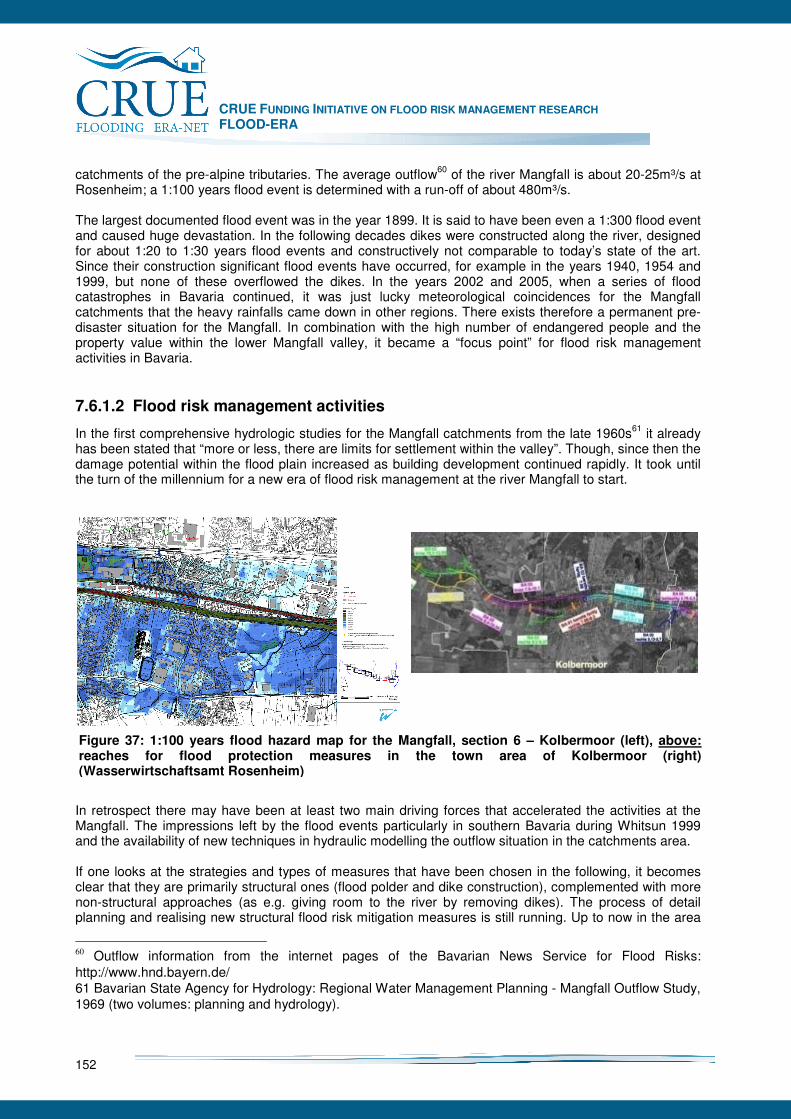
CRUE FUNDING INITIATIVE ON FLOOD RISK MANAGEMENT RESEARCH FLOOD-ERA
152
catchments of the pre-alpine tributaries. The average outflow60 of the river Mangfall is about 20-25m³/s at Rosenheim; a 1:100 years flood event is determined with a run-off of about 480m³/s. The largest documented flood event was in the year 1899. It is said to have been even a 1:300 flood event and caused huge devastation. In the following decades dikes were constructed along the river, designed for about 1:20 to 1:30 years flood events and constructively not comparable to today’s state of the art. Since their construction significant flood events have occurred, for example in the years 1940, 1954 and 1999, but none of these overflowed the dikes. In the years 2002 and 2005, when a series of flood catastrophes in Bavaria continued, it was just lucky meteorological coincidences for the Mangfall catchments that the heavy rainfalls came down in other regions. There exists therefore a permanent pre-disaster situation for the Mangfall. In combination with the high number of endangered people and the property value within the lower Mangfall valley, it became a “focus point” for flood risk management activities in Bavaria.
7.6.1.2 Flood risk management activities
In the first comprehensive hydrologic studies for the Mangfall catchments from the late 1960s61 it already has been stated that “more or less, there are limits for settlement within the valley”. Though, since then the damage potential within the flood plain increased as building development continued rapidly. It took until the turn of the millennium for a new era of flood risk management at the river Mangfall to start.
In retrospect there may have been at least two main driving forces that accelerated the activities at the Mangfall. The impressions left by the flood events particularly in southern Bavaria during Whitsun 1999 and the availability of new techniques in hydraulic modelling the outflow situation in the catchments area. If one looks at the strategies and types of measures that have been chosen in the following, it becomes clear that they are primarily structural ones (flood polder and dike construction), complemented with more non-structural approaches (as e.g. giving room to the river by removing dikes). The process of detail planning and realising new structural flood risk mitigation measures is still running. Up to now in the area
60 Outflow information from the internet pages of the Bavarian News Service for Flood Risks: http://www.hnd.bayern.de/ 61 Bavarian State Agency for Hydrology: Regional Water Management Planning - Mangfall Outflow Study, 1969 (two volumes: planning and hydrology).
Figure 37: 1:100 years flood hazard map for the Mangfall, section 6 – Kolbermoor (left), above: reaches for flood protection measures in the town area of Kolbermoor (right) (Wasserwirtschaftsamt Rosenheim)
CRUE FUNDING INITIATIVE ON FLOOD RISK MANAGEMENT RESEARCH FLOOD-ERA
153
of Kolbermoor two of six reaches have been constructed. In relation to the corresponding Bavarian Action Plan 202062 the Water Management Agency aims at completing the whole project at the latest in about 10 years, depending on funding. Examining the case on its “vulnerability side” it is remarkable that the year 2002 was incisive for the building development of the town Kolbermoor. Along with the publishing of detailed hazard maps for the 1:100 years flood event, juristically so called “factual inundation zones” emerged. Considering a kind of uncertainty in development regulations and the impact of legal practices in other parts of Bavaria this led to a development and building stop within the flood prone areas ordered by the state regulatory authorities of the district. This happened just when the town council of Kolbermoor was about to enact its new general development plan and a further local plan for a large municipal building project. It took some time before a legal basis was established to enable further communal development plans within the flood prone area that covers at least half of the built-up area of Kolbermoor. However, the most endangered building zones remain from former decades, when the flood problem was just not present in the publics’ mind. These can hardly be re-built nowadays. Finally it is to state that a paradigm change occurred in this period, strongly influenced by the big flood events that happened since 1999 in Bavaria.
7.6.2 Objective of the case study
The main objective of this case study was to identify conditions which influence decisions on different flood risk mitigation measures. Further, we tested a new evaluation methodology for SM and extended it to spatial planning effects, as a non structural approach for flood risk management. Thus there is a descriptive approach within this study as well as a normative approach. Both intend to find clues for promoting non structural flood risk mitigation measures. We have chosen the river Mangfall as our case study for several reasons. Firstly, this is one of the most recent Bavarian focus points for flood risk management and the projects applied innovative. Also, this case seemed to be interesting for its pre-disaster situation. It was not a significant local flood experience which launched the flood mitigation activities but the high probability of flooding and the extent of the damage potential. We focussed on the town of Kolbermoor as here there is both high damage potential and a conflict of interest between flood risk management and urban development. Moreover, the case study as a whole intends to give an impression of the physical and political situation of flood risk management on the river Mangfall at Kolbermoor. We identified related strategies and measures, individuals and organisations involved, and relevant context conditions for the decision and implementing processes. The investigated strategies and measures are those both planned and in discussion within the flood mitigation project for the lower Mangfall valley, since the effects of the whole portfolio cannot be viewed in isolation for the town area of Kolbermoor alone. The measures here were linked to the overall strategies in Bavaria. As being the most relevant individuals and organisations we chose experts from the Water Management Administration (from the regional bodies up to the ministry), from the state authorising bodies at the District of Rosenheim and from the town of Kolbermoor. We considered their co-operation and networks. Finally we analysed the factors which influence the choice of measures by the decision makers within their respective organisations.
7.6.3 Approach
As mentioned before, there are two different approaches within this case study. A descriptive approach refers to the case in relation to strategies and measures as well as context conditions for their choice. In a
62 Bavarian Ministry for Federal Development & Environmental Issues: Flood Risk Management in Bavaria - Action Plan 2020, 2002
CRUE FUNDING INITIATIVE ON FLOOD RISK MANAGEMENT RESEARCH FLOOD-ERA
154
normative manner we intended to develop a methodology for evaluating the effectiveness of building ban effects through development planning in combination with structural flood protection measures. Furthermore we conducted a brief survey concerning the evaluation of transaction costs.
7.6.3.1 Evaluation of effectiveness and efficiency
Benefit-cost analyses The former methodology for the prioritisation of flood protection projects run by the Water Management Authorities was based on cost-effectiveness assessments according to the 1:100 years flood event.63 A guideline64 is drafted to regulate the operation of benefit-cost analyses for efficiency evaluation in future. We tested this methodology in our case study area and discussed the results and its practicability. The guideline basically refers to SM. For the lower Mangfall valley communal development planning is an important non structural approach for flood risk mitigation or stabilisation. Thus we extended the original methodology to evaluate its effects complementary to the SM. We regarded the planned realisation of the SM and the status quo of loss potential in the inundation areas as a baseline option (scenario A). In opposite to this, we refer to a hypothetical scenario B which assumes that the town could have totally skipped all its local development plans within the flood prone area since 2002 (which has been a crucial year for the development planning in Kolbermoor, as it will be shown later on in this report). For assessing the respective risk mitigation effects we examined the maximum damage potential of local development plans since 2002 which are located in the inundation areas for the 1:50 and the 1:100 years design flood. The analysis data was provided by the Water Management Agency of Rosenheim and the town administration of Kolbermoor. It comprises the inundation lines from the published hazard maps for the 1:50 and the 1:100 years design flood, data from the digital parcelling map and information from the local development plans since 2002. The acquisition of the damage potential was based on counting and classifying buildings under flood risk. This step was assisted by GIS-applications. Transaction-cost survey In our case study we picked up transaction costs as another interesting methodical approach to improve the evaluation criteria for decisions on flood risk management strategies. We referred to the methodology and the questionnaire described in chapter 5.4.2.1. The query was conducted subsequent to the expert interviews. Due to the questionnaire the transaction costs were categorised in costs for information, planning, communication, conflict resolution, legal procedures and maintenance. They were compared to construction costs and to the assessment of their effectiveness. Referring to our case study situation we chose two well-known types of mitigation measures - dike heightening (structural) and dike relocation/ dike removal (structural/ non structural). As the number of samples from this survey was quite small we could just interpret trends from it. Moreover, we discussed some limitations of this methodology.
7.6.3.2 Analyses of context factors
Expert interviews In total 21 interviews with Bavarian experts in the field of flood risk management were conducted. Eleven of them were selected for further examination; the others showed themselves to be less involved in the case. Most interviewees were selected by a document analysis. Others were brought in during the study. As to their professional position, the interviewees could be assigned to two levels. One group was directly concerned with the case under study (6). Others (5) had some knowledge about the case, but were mainly engaged at higher levels of state administration. Another distinction between the interview partners could
63 The Bavarian Ministry for the Environment (…): Guideline for efficiency analyses of flood protection measures, enacted in 12/2006 64 Ibid.: Guideline for the prioritisation of measures at first order rivers, draft version for an edict from 2007

CRUE FUNDING INITIATIVE ON FLOOD RISK MANAGEMENT RESEARCH FLOOD-ERA
155
be made in relation to their professional backgrounds or responsibilities. Seven had their core activities in the realm of water management; four were focused on spatial planning or urban development issues. The interviews were conducted between June and September 2007. On average, they took slightly more than one hour (with a range from 40 to 100 minutes). The form of the interviews was semi-structured. The conversational partners were asked to talk freely about their general experiences and opinions, with the interviewer referring back to a list of prepared questions. The questionnaire was first developed together with the project partners from the UFZ. For the Mangfall case study it was somewhat modified. It comprises four thematic sections: questions about personal risk perception and responsibilities, strategies and measures, context conditions and the organisation within which the interviewee was working. All interviews were recorded and transcribed for a simplified content analysis. Quotations from these expert interviews were written in this study without a reference to the interviewees. This approach should ensure their anonymity. Document analysis During the case study many different documents concerning the flood risk management strategies in Bavaria and at the Mangfall were collected. This included legal texts, guidelines, programmes, plans, reports or newspaper reports. These documents were either directly related to the case study or they applied at the federal state level but still were closely related to the case study. The identification of relevant documents was greatly assisted by the interviewees. Finally its results were somewhat subordinated to the interview results.
7.6.4 SM and NSM
In the following section measures that were implemented in the Mangfall case are listed. Also, measures which were considered but rejected are included. The main SM used on the Mangfall are the re-building and heightening of dikes and walls. Additionally the re-locating and a removal of dikes (which can be classified as a NSM) were planned. Upstream there are two big projects pending that would clearly effect the hydraulic situation in Kolbermoor even though they are located further away - the construction of a controllable polder at Feldolling and the construction of controllable weirs at the lake Tegernsee. The approaches for NSM are diverse and bundled. This for example comprises public information about flood risks. It includes the release of hazard maps, the signing of inundation lines in the prone areas and the participation of citizens in the detailed planning procedures. A model for dike breach simulations is a further rather special feature. Other non structural approaches are to modify the general development planning and to regulate building in flood prone areas. Almost all of the measures are developed by the Water Management Authorities. The town council has the responsibility for the development plans. The district authorities issue regulations for building restrictions and exceptions in flood prone areas and will in future edict regulations for inundation areas. Overall strategies For a proper understanding of the flood risk management strategy at the river Mangfall one has to consider the “Bavarian Action Plan for Flood Risk Management 2020”65. It was developed after the heavy flood events in 1999 and was enacted by the government in 2001. It covers three main fields of action that represent the Bavarian systematisation of flood risk mitigation types. This systematisation is similar to one developed and published by a federal state’s working group.66 On the one hand the terms “structural” or
65 Bavarian Ministry for Federal Development & Environmental Issues: Flood Risk Management in Bavaria - Action Plan 2020, 2002 66 The Federal State’s Working Group for Water issues (LAWA): Guideline for a sustainable flood risk
CRUE FUNDING INITIATIVE ON FLOOD RISK MANAGEMENT RESEARCH FLOOD-ERA
156
non structural” cannot be unambiguously translated into German, nor did the Bavarian experts from the case study interviews always understand properly them in the way we do. The overall idea behind the action plan is a somewhat holistic and interrelated understanding of the three fields of action.67
“The speciality of the Bavarian way is to approach the problem as a whole and not to break it down into details. (…) with the Action Plan 2020 and the associated steps, we achieved a satisfactory solution.”
In practice this leads to projects for flood risk management that bundle different types of measures in portfolios for parts of river systems or catchments. Every single field of action seems to have limits. Therefore a complementary and comprehensive approach is aimed for.
“The discussion which is often used by those affected, whether either technical measures or natural retention are better, is not correct. Both measures complement one another. They are both components of an integrated management system.”
The funding of measures by the Bavarian federal state follows a system of prioritisation that requests the Water Management Agencies to assess and rank their projects based on efficiency evaluations. The prioritisation should provide a fair, effective and efficient distribution of funds within Bavaria.
“These lists are intended to bring out deficits which need to be approached. (…). That´s one issue and the other is that we are watching which authorities get what in terms of money and which measures are worth to following up on.”
Flood polders Flood polders are a basic element in the governmental flood risk management strategy. Seven of them have been established in the general development program for Bavaria. The Bavarian law for water management had recently been changed in the direction of de-regulation to allow for an easier implementation of the flood polders. The funding for this SM comes completely from the state. The plans for a huge controlled reservoir for water storage at the start of the lower river valley are discussed controversy. There is serious resistance towards these plans from the landowners and their stakeholders. Though, if it is topographically and hydrological possible, flood polders seem to be one of the most preferred hydraulic solutions, despite their environmental impact and their high costs.
„A dam would bring the most benefit, a retention basin of such a large volume that the river below it would be considerably relieved, There are however limits to do this.”
The main arguments for a flood polder at the river Mangfall are: the possibility to retain the peak of extreme flood waves, a compensation for the loss of retention volume which results from the improvement of dikes in the lower valley, and an increased retention potential to account for climate change effects. One interviewee argued that an upstream flood polder might give a wrong feeling of security downstream which could lead to a more intensive building development in the flood plain. This development would prevent further non structural measures which could give room for the river in the future.
„If I build a big reservoir that catches the flood wave upstream, the following happens downstream: the open space in the flood plain will be built upon. There is no chance to avoid this.”
Building/ heightening of dams/ walls The main strategy for mitigating flood risks on the river Mangfall is in improving the dike line alongside the settlements by building new dikes. There are two reasons for this. On the one hand this deals with the actual situation of built-up areas close by and the existing risk management strategy which is based upon management, 1995 67 See also: Bavarian Agency for Water Management: Floods – natural event and hazard, 2004
CRUE FUNDING INITIATIVE ON FLOOD RISK MANAGEMENT RESEARCH FLOOD-ERA
157
dikes. On the other hand, many of the dikes are rather old and do not meet present safety standards. Therefore it is practical to improve them up to the legally defined safety goal - a 1:100 years flood event, Further, dikes are a traditional engineering instrument, a classical tool which is usually well applied.
“Technical flood protection is something which cannot be dismissed. Especially in areas with a high building concentration such measures are absolutely essential. This is a classic tool for flood protection which has been in use for generations and which has to be applied in the future.”
A problem with dikes is that they are designed for a certain safety level. If a flood overflows the dike for a longer period of time the dike will break and cause damage which is comparable in result to a situation without any dike at all. This is why engineers think about designing new dikes with overflow sections to lead the flood water into areas which do not have a large potential for damage.
“We have to consider the case where our flood protection systems and our technical measures are not sufficient. Here we have to consider the possibility of overflow (…) deliberately built into the dike.”
As with the dikes, walls are also a big issue for the protection measures in Kolbermoor. Since buildings are too close to the river and the ground area is much too small for a dike, the chosen constructive solutions are walls. In discussions with representatives of the Water Management Agency, the citizens of rejected this alternative at first, as these high walls would have had a serious impact on the recreational function and the aesthetics of the landscape. By design improvements a compromise was finally reached. Relocating/ removing dikes In the interviews many experts reacted tentatively concerning the effectiveness of removing dikes from the river for flood risk mitigation, even though it is one of the main strategic targets in Bavaria. The hydraulic effects of these measures were seen as rather difficult to calculate and to control. Nevertheless, giving room to the river, wherever possible, would be a natural solution and a very sustainable one as well.
“Retention in the area is important. It has been a highly popular theme since 2002. One can´t say that it is of no use at all, but one shouldn´t overrate it either.”
This approach is only applicable if the topography is suitable and if there is room without significant damage potential to move back the dike line from the river. In the Mangfall valley there are only limited sections were both of these conditions apply.
„ (…) the fast flowing rivers of Bavaria, especially in the south and in respect to topology and water retention in the area, just do not provide to possibilities (…) which are applicable to lowland rivers (…).”
Dike re-location and removing can hardly be separated in the Mangfall case. They are somewhat fuzzy related to the systematisation of SM or NSM. Even if its retention effects were not really included in the calculations for the mitigation potential, they were used at the Mangfall. After all, this is less a real strategy for flood risk mitigation, than more an action for nature conservation and natural river development. These activities usually work in synergy with these objectives from other fields of interests. Spatial planning In this case study spatial planning is defined as the set of formal and informal procedures, methods and instruments that aim at coordinating land use interests on different spatial levels, with an emphasis on building development. The respective programs and plans control the land use and development in the flood prone areas and they arrange flood risk management measures in a spatial context. Together with building regulations they frame the options for the of land use development and control flood risks. In the Mangfall case study all spatial plans up to the Bavarian level were taken into consideration. The Bavarian
CRUE FUNDING INITIATIVE ON FLOOD RISK MANAGEMENT RESEARCH FLOOD-ERA
158
development program68 provides flood polder locations. The regional plan for South-East Upper Bavaria69 comprises inundation areas in combination with priority zones for flood risk management. The town development plans70 have to be adjusted to the regional plans. They determine the functional zoning in detail. In addition, building regulations apply to the development possibilities at the site level. Any kind of spatial planning or building regulation has to deal with the matter of fact, that given building rights can legally almost never be revoked. So, all these instruments have a future perspective. They may prevent a further accumulation of damage potential in the flood plain, but they cannot revise what has been built in the past. So, for mitigating these flood risks some experts refer to SM again.
“In this case regional planning should provide for a reduction of risk exposure in the future. As far the present situation is concerned, we have to approach that with technical measures.”
The basic characters of regional planning or even federal state planning are preparation and control. However, their influence over certain developments is not as significant as those of the subsequent planning levels. The planning authority of the communities is a very important principle of law which is hardly touched by the power of the state government. The municipal planning level contains future plans for a general town development and local development plans which regulate the building limits for individual houses. In the expert interviews from the case study these plans and regulations were assessed as fundamentally important for a control of flood risks.
“This [annotation: spatial planning] is very effective, if the communities do apply it properly.” It has already been pointed out that for the planning development of Kolbermoor in the last years there evoked a temporary planning stop and few persisting building bans. As the spatial situation of the town Kolbermoor is rather constricted and the town council committed to growth and development, legal exceptions were necessary. The town representatives are bound to a much broader range of objectives than just flood risk management. For example they are committed to the criteria of sustainability in their evaluation of development options and to the weighing of urban functions and planning strategies.
“It is really an exceptional situation, when a community has absolutely no room for development. A community has to function. A school or a room for a craftsman is needed and has to fit in somewhere.”
The national legislative allowed for building development in inundation zones under certain conditions e.g. if it is the only possibility for a town development, etc.71 However, this invokes additional risks. Though, the legal exceptions are a consequence of other necessary urban development objectives. However, this is not necessarily satisfactory in relation to the flood mitigation objectives.
“O.K. we say, we´ll let them build, but there are certain things which they will have to consider. And then we once more get into these conflicts, as they do not build as flood proof as they should.”
Land use regulations In our case study the term “land use” refers to an agricultural or forestry cultivation of land. The general influence of cultivation techniques on the water drainage and retention situation in the catchments was admitted by all interviewees. Still, there are limits to this approach in relation to the interests of farmers.
68 Bavarian Development Plan, 2006 69 Regional Plan for the Region of South-East Upper Bavaria, 2001 70 E.g. the General Development Plan for Kolbermoor, 2003 71 German Water Management Law, § 31b (4)
CRUE FUNDING INITIATIVE ON FLOOD RISK MANAGEMENT RESEARCH FLOOD-ERA
159
„The best option for water retention would be when woodland would be everywhere. Following from that are intensive pasture and then arable land. However, to have woodland everywhere is no realistic option.”
Similar to activities like dike removing this mitigation option was mainly seen as a qualitative improvement for the ecology, with less quantitative results. Thus they were not considered as substitutes to SM.
“Changes in land cultivation should accompany the other measures, but this does not negate the need for dike construction."
Land use regulations were never suggested as an effective approach for flood risk management in the lower Mangfall valley. Though, the Water Management Agency implemented some afforestation projects at the tributaries, without directly referring this to the flood protection concept for the river Mangfall.
“This aspect can be significant when applied to small catchments. In total the effect is not so significant.”
The recent demand for renewable primary products intensified crop production, even in flood plains. This partly is significant for environmental impacts and the outflow situation. The water law does however provide possibilities to regulate such agricultural activities when designated inundation zones are affected.
“In respect to the Mangfall, this is something which was never been discussed. It was somehow assumed to be taboo. I am not convinced that it would bring much.”
Here it is significant that the land cultivation does not lie within the responsibility of the water authorities. Any regulation which borders on the field of the Ministry of Agriculture would have to be negotiated within the complex area of agricultural subsidies. Further, there is no responsible institution to inspect and control a correct implementation. For these reasons, this type of measure has no significant meaning for the flood risk management in the context of this case study. Information A further strategic area for the mitigation of flood risks at the Mangfall is that of public information. This should be aimed both at individual precaution options and general information about proposed projects.
“This is the key. The citizen can only protect himself against the dangers which he knows. We have to convince him that he has to protect himself. [This] can only come on the basis of relevant information.”
Interestingly, many interviewees estimated that most people would forget about the risks only three years after a flood. If this is a likely value, it fits well to the periodical occurrence of the largest recent flood catastrophes in Bavaria (1999, 2002 and 2005). Therefore, the population of Bavarian should still be well aware of flood probabilities. In the case of the Mangfall, the Water Management Agency came up with three activities to inform the affected citizens of the risks and the planned mitigation measures. The first was the publishing of hazard maps for the 1:100 years flood event. The legal duty to compile these maps is already taken up from the Bavarian Water Management Authorities. The respective Agency already published hazard maps for the lower Mangfall valley. In general the main delaying factor for this work is the availability of proper digital terrain models that are a prerequisite for any hydraulic model.
“Hazard maps for flood prone areas are an important information base, for which however we need accurate maps based on exact digital landscape models.”
A second step to emphasise the inundation area was to mark it with signs, the so called “blue ribbon”. What seemed to be a good idea for a realistic illustration of local flood risks caused a lot of trouble among the general population and in the town Kolbermoor in particular.
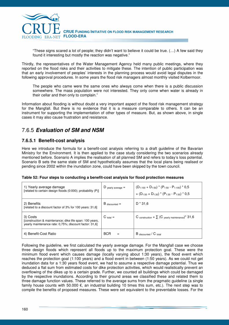
CRUE FUNDING INITIATIVE ON FLOOD RISK MANAGEMENT RESEARCH FLOOD-ERA
160
“These signs scared a lot of people; they didn’t want to believe it could be true. (…) A few said they found it interesting but mostly the reaction was negative.”
Thirdly, the representatives of the Water Management Agency held many public meetings, where they reported on the flood risks and their activities to mitigate these. The intention of public participation was that an early involvement of peoples’ interests in the planning process would avoid legal disputes in the following approval procedures. In some years the flood risk managers almost monthly visited Kolbermoor.
The people who came were the same ones who always come when there is a public discussion somewhere. The mass population were not interested. They only come when water is already in their cellar and then only to complain.”
Information about flooding is without doubt a very important aspect of the flood risk management strategy for the Mangfall. But there is no evidence that it is a measure comparable to others. It can be an instrument for supporting the implementation of other types of measure. But, as shown above, in single cases it may also cause frustration and resistance.
7.6.5 Evaluation of SM and NSM
7.6.5.1 Benefit-cost analysis
Here we introduce the formula for a benefit-cost analysis referring to a draft guideline of the Bavarian Ministry for the Environment. It is then applied to the case study considering the two scenarios already mentioned before. Scenario A implies the realisation of all planned SM and refers to today’s loss potential. Scenario B sets the same state of SM and hypothetically assumes that the local plans being realised or pending since 2002 within the inundation zone, could have been skipped by the town council.
Table 52: Four steps to conducting a benefit-cost analysis for flood protection measures
1) Yearly average damage [related to certain design floods (0:000); probability (P)]
D yearly average = (D1:100 + D1:50) * (P1:50 - P1:100) * 0,5
+ (D1:50 + D1:30) * (P1:30 - P1:50) * 0,5
2) Benefits [related to a discount factor of 3% for 100 years: 31,6]
B discounted = D * 31,6
3) Costs [construction & maintenance; dike life span: 100 years, yearly maintenance rate: 0,75%; discount factor: 31,6]
C total = C construction + ∑ (C yearly maintenance)* 31,6
4) Benefit-Cost Ratio BCR = B discounted / C total
Following the guideline, we first calculated the yearly average damage. For the Mangfall case we choose three design floods which represent all floods up to the maximum protection goal. These were the minimum flood event which causes damage (locally varying about 1:30 years), the flood event which reaches the protection goal (1:100 years) and a flood event in between (1:50 years). As we could not get inundation data for a 1:30 years flood event, we had to assume a respective damage potential. Thus we deduced a flat sum from estimated costs for dike protection activities, which would realistically prevent an overflowing of the dikes up to a certain grade. Further, we counted all buildings which could be damaged by the respective inundations. According to their ground areas we classified these and related them to three damage function values. These referred to the average sums from the pragmatic guideline (a single family house counts with 50.000 €, an industrial building 10 times this sum, etc.). The next step was to compile the benefits of proposed measures. These were set equivalent to the preventable losses. For the

CRUE FUNDING INITIATIVE ON FLOOD RISK MANAGEMENT RESEARCH FLOOD-ERA
161
assumed lifetime of the SM (100 years in the case of dikes) a discount factor was related to the yearly average damage. The next step was the compilation of both the construction costs and subsequent maintenance costs. The latter also had to be discounted over the 100 years life span. Finally the analysis resulted in a ratio of benefit and costs. Further calculations were made concerning the net-present value and the cost-effectiveness. We followed this methodology for both scenarios. The stock of buildings from our data base was dated back to the year of 2002 approximately. So, we applied the relating damage potential to our scenario B. For the calculations for scenario A we thereon added the maximum number of potential buildings from the examined local plans which have been developed since the reference date of 2002.
Table 53: Efficiency evaluation results in comparison of two scenarios with different risk mitigation approaches
Scenario A (SM) - Status quo Scenario B (SM + NSM) Both scenarios refer to the realisation of the planned SM (dikes& walls)
without NSM (complementary development restrictions)
with NSM (complementary development restrictions)
Damage potential (prevented)
D yearly average X Million € X - 0,2 Million €
Benefit (for dike’s life span)
B discounted Y Million € Y - 5,5 Million €
Costs (construction & maintenance
C discounted 28,5 Million € 28,5 Million €
Benefit-Cost Ratio72 BCR 3,01 2,81
Net-Present-Value73 NPV Z Million € Z - 5,5 Million €
weighted Cost-Effectiveness Factor74
wCEF 11,98 11,16
Application of the methodology and results Generally the results of this calculation prove that the basic SM are quite efficient, as the benefits are up to three times greater than the costs. It would be still effective if one includes a certain share of the high costs for the planned flood polder which will also effect to the town area. But this needs not to be further emphasised here, since the 1:100 years flood could be prevented by the dikes alone. A comparison of the two evaluated scenarios (A: SM with an ongoing risk development in the flood plain, B: SM with a complementary stop of a respective communal development) leads to the finding that the benefit-cost ratio for the scenario B which included the non-structural approach is slightly worse, even though the damage potential in the flood plain raised. This is relevant to considering the probability of extreme flood events (over the 1:100 years design flood) or the possibility of a dike breach.75 Our examples showed that if a SM and this type of a NSM were evaluated in combination, this has negative
72 BCR referring to chapter 5.2 of this report 73 NPV referring to chapter 5.2 of this report 74 Referring to Bavarian guideline for efficiency analyses of flood protection measures, enacted in 12/2006 75 The German Water Act, § 31c, signifies these areas as “flood-prone areas”.
CRUE FUNDING INITIATIVE ON FLOOD RISK MANAGEMENT RESEARCH FLOOD-ERA
162
effects to the efficiency in total. Using this methodology a decision maker could now conclude that complementary development restrictions would limit the effectiveness of SM and decide not to make an effort to this. Though, our methodology showed a pragmatic and sufficient way for evaluating communal development decisions in the context of flood risk management. Methodical uncertainties within the case study There remained some uncertainties in the data and the related calculations. These need to be addressed. As said before, there was first of all no data available for inundations smaller than caused by a 1:50 years flood event and a 100-years flood, which narrowed our research perspective. The second area of uncertainty in the calculation concerns the counting of buildings under risk. This was conducted by GIS queries. As we had no information concerning the types of buildings, they were classified according to their ground area. We made some spot tests to verify this classification but this still may have caused counting mistakes. Finally, any real loss will always be higher than that calculated one; our pragmatic approach only considers average building losses. It excludes any damage to infrastructure and social or ecological losses which may as well be very significant in certain cases. Limitations of the methodology The idea behind this new methodology was to couple a relevant parameter from a NSM with an existing evaluation methodology. In our case the link was the number of buildings within the flood prone area. For this reason the methodology could be used in a similar form to evaluate the effects of building approvals. However, for other NSM this would not be a viable approach. Since it was intended to develop a methodology for decision makers to allow them to better evaluate the efficiency of NSM, the question remains whether this goal was reached. The methodical uncertainties of this approach lead to broader ranging results. A true comparison of different measures or even a prioritisation is somewhat difficult under these conditions. It is questionable, if the properties of the methodology could be explained to all decision makers and to the public clearly. As shown in our example, there is a certain danger in neglecting the risk of extreme flood events and other losses such as infrastructure damage which are not includable in the calculations. A further question is if the results are useful for justifying decisions and if slight numeric differences do support decision making. There may be synergy effects with other objectives which are not covered. So, there will always be a certain scope for qualitative arguments in decision making, especially in the realm of urban planning which is touched here.
7.6.5.2 Transaction-cost analysis
Results from the transaction-cost analysis As already mentioned before, in this case study the query for transaction costs was a subordinated goal. Though, we found some interesting trends concerning the evaluation of the respective costs and the differentiations between the compared types of measures. In average the costs for relocating the dike line were graded higher than those for dike heightening. This was based on the assumption that modifications of the dike line would fall on private land and would raise both construction costs and procedural costs. Particularly noticeable is that referring to dike heightening that the transaction costs have been assessed high for “design & planning” and low for “conflicts and negotiations”. The latter was evaluated as a major cost position for dike relocation. All in all, this methodology can be assessed as a fruitful contribution to a broader comprehension of different evaluation criteria.
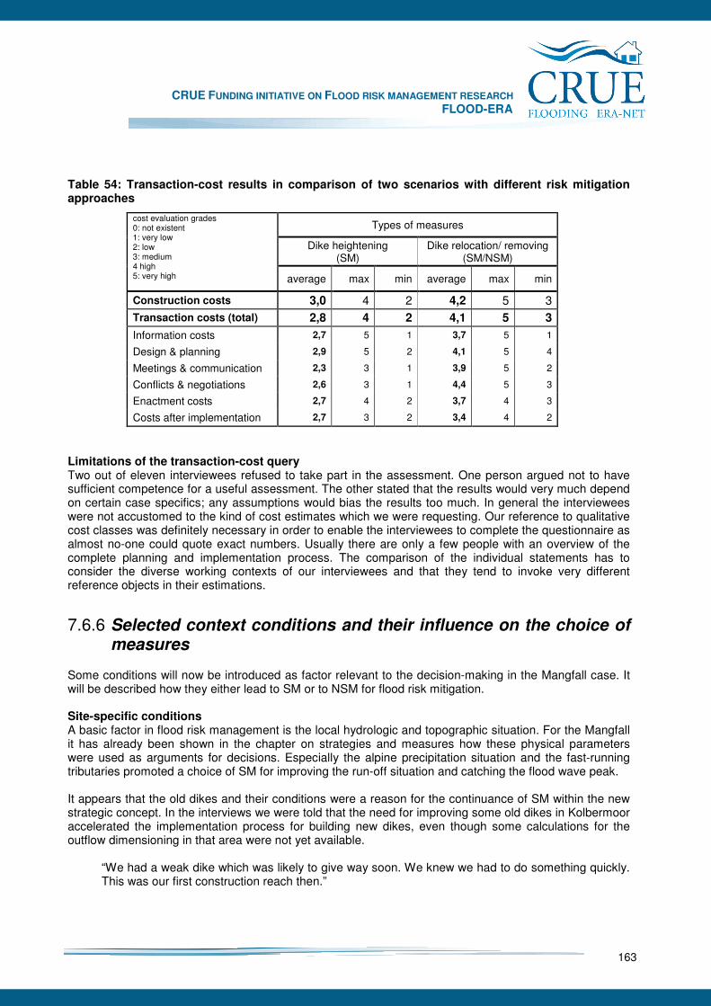
CRUE FUNDING INITIATIVE ON FLOOD RISK MANAGEMENT RESEARCH FLOOD-ERA
163
Table 54: Transaction-cost results in comparison of two scenarios with different risk mitigation approaches
Types of measures
Dike heightening (SM)
Dike relocation/ removing (SM/NSM)
cost evaluation grades 0: not existent 1: very low 2: low 3: medium 4 high 5: very high
average max min average max min
Construction costs 3,0 4 2 4,2 5 3 Transaction costs (total) 2,8 4 2 4,1 5 3
Information costs 2,7 5 1 3,7 5 1
Design & planning 2,9 5 2 4,1 5 4
Meetings & communication 2,3 3 1 3,9 5 2
Conflicts & negotiations 2,6 3 1 4,4 5 3
Enactment costs 2,7 4 2 3,7 4 3
Costs after implementation 2,7 3 2 3,4 4 2
Limitations of the transaction-cost query Two out of eleven interviewees refused to take part in the assessment. One person argued not to have sufficient competence for a useful assessment. The other stated that the results would very much depend on certain case specifics; any assumptions would bias the results too much. In general the interviewees were not accustomed to the kind of cost estimates which we were requesting. Our reference to qualitative cost classes was definitely necessary in order to enable the interviewees to complete the questionnaire as almost no-one could quote exact numbers. Usually there are only a few people with an overview of the complete planning and implementation process. The comparison of the individual statements has to consider the diverse working contexts of our interviewees and that they tend to invoke very different reference objects in their estimations.
7.6.6 Selected context conditions and their influence on the choice of measures
Some conditions will now be introduced as factor relevant to the decision-making in the Mangfall case. It will be described how they either lead to SM or to NSM for flood risk mitigation. Site-specific conditions A basic factor in flood risk management is the local hydrologic and topographic situation. For the Mangfall it has already been shown in the chapter on strategies and measures how these physical parameters were used as arguments for decisions. Especially the alpine precipitation situation and the fast-running tributaries promoted a choice of SM for improving the run-off situation and catching the flood wave peak. It appears that the old dikes and their conditions were a reason for the continuance of SM within the new strategic concept. In the interviews we were told that the need for improving some old dikes in Kolbermoor accelerated the implementation process for building new dikes, even though some calculations for the outflow dimensioning in that area were not yet available.
“We had a weak dike which was likely to give way soon. We knew we had to do something quickly. This was our first construction reach then.”
CRUE FUNDING INITIATIVE ON FLOOD RISK MANAGEMENT RESEARCH FLOOD-ERA
164
Up to the turn of the millennium, flood risk management meant supporting the structural system that had been cemented with the building of the dike line in the early 20th century and with converging settlements. The water management experts were mostly concerned with maintaining the given situation; it can be expected that this influenced the choice of a risk management strategy that follows the existing structures. SM such as dikes or polders could cause a feeling of safety that hinders non structural efforts, for example pushing through building bans in the flood plains. They withdraw the best arguments from development regulations. At the Mangfall the damage potential behind the dikes rose in the last decades, even though the probability of extreme floods and risk always existed. Moreover, the possibilities of making “room for the river” are rather limited today. It can be stated that the physical conditions at the Mangfall as well as the structural safety standards favoured a continuance of these measures. Legal context In the field of water management, the German legislation has up to now built a framework that was gradually filled with the federal state’s specifications. Recently, plans have been made for combining the national water law with other environmental issues. But the legal sphere of flood risk management is even more widespread: it touches the law of regional planning, building, etc. The EU floods directive assigns new duties to the Member States, for example to establish management plans for areas on flood risk.76 Some interviewees mentioned that this is a new challenge concerning the need for more interdisciplinary activities for flood-prone areas and a further advancement of NSM. Still, the national as well as the federal state law is regarded as sufficient and progressive concerning these new demands for a comprehensive flood risk management. Recently the Bavarian law was modified by accelerated approval procedures and prescription regulations for inundation areas.
„We’re getting strong support regarding the legal framework conditions.” Some interviewees complained that the regulations were too complex and allowed for too many exceptions. They would prefer clearer legal statements with less room for crucial decisions. This would bring more certainty to the legal and administrative procedures.
„Sometimes the laws just leave too many loopholes open. (…) Then it would actually be good if the law-maker provided shorter and clearer regulations.”
Especially the interviewees from the Water Management Authorities felt the legislation and the jurisdiction as good support for their tasks. In consequence of the general impressions of the last Bavarian floods, it was well appreciated that the courts are stringent regarding individual objections to SM or NSM. The law and the recent legal modifications do not refer to exclusively either SM or NSM, but rather cover both. On the one hand they intend to facilitate the implementation procedures for flood protection projects. On the other they provide regulations for land use and buildings in inundation areas to mitigate flood risks. Objectives The overall goal in German flood policy is to provide protection from a 1:100 years flood event. This relies on engineering standards that have become law77. The respective standard was also adopted in the federal state’s development program. Due to the debates and reports on climate change effects the Bavarian water management authorities have added a 15% margin to the legally defined design flood.78 Although the plans for the Mangfall were developed too early to reflect this new standard, the capacity of the flood polder will be sufficient to meet it. Until the major flood events of the past 10 years, public opinion regarded the objectives as too high. This changed, however, as a result of personal flood experiences. 76 EU Floods Directive, especially chapters II, II and IV. 77 German Water Act, § 31b; Bavarian Water Act, § 61d 78 Bavarian Environment Agency: Hydrologic annual report 2005. Special issue - climate change factors for flood protection planning

CRUE FUNDING INITIATIVE ON FLOOD RISK MANAGEMENT RESEARCH FLOOD-ERA
165
“Up until 1999 the public reaction that I experienced claimed this to be excessive, such events just would not happen. Now, after the flooding, things look a little different. We have now experienced the 1:100 years flood in a great part of southern Bavaria. (…) Now there has been a clear change in public opinion.”
The calculation of the respective design flood has become a crucial factor for any protection approach. At the Mangfall site, it effectively blocked the implementation of new measures and for the most part an over-dimensioning of projects was avoided.
“The problem was defining the design flood for the Mangfall. That is one reason why it took so long to start planning. The breakthrough only came with the definition of 480 m/s at the end of the 1990´s.”
The benchmark value is now numerically defined and for any optional measures considered it must be proved that they could equally achieve that goal. As pointed out in the chapter on strategies and measures, the experts rejected some approaches since their effectiveness could not be calculated in a reliable way. The flood protection objectives as well as related standards definitely work in favour of SM. Besides this main protection goal, there are further relevant objectives in the water law that refer to flood risk regulations, for example the conservation of open space in the flood plains79. Moreover, competing objectives from other legal sectors have to be considered, mainly regarding urban development planning and nature conservation. Because of the ecologic functions of flood plains the latter field often affects flood protection projects, especially since the establishment of the NATURA-2000 net. However, in the realm of nature conservation the coordination of interests is rather clearly regulated. After all, there were no significant conflicts of this nature in the Mangfall case. It is more complicated in the field of urban planning as there are many different objectives to consider and to weigh against each other for an integrative planning strategy. Referring to the principle of a sustainable development the authorities try to consolidate the centre of Kolbermoor and to avoid significant construction developments in the periphery.
„Urban development doesn’t only have to deal with flood protection. (…) One always has to decide about the importance of several issues. It is difficult to weigh up and to decide.”
These other objectives have not really changed the basic flood risk management strategy. But they did lead to modifications (as e.g. plans for a bigger flood polder in a nature reserve upstream were rejected) and influenced local design matters (as e.g. the construction of walls in the town centre was modified). Organisation and responsibilities The federal state authorities have full responsibility for water and flood protection management regarding the first and second order rivers. Smaller rivers (3rd order) are in the responsibility of the communities, but even here the state agencies are often involved in projects, assisting local decision makers in consulting, planning and accounting issues. At the Mangfall, the state’s responsibility for the flood risk management is held by the Water Management Agency for the Region of Rosenheim, whose plans and programmes have to be approved by the state authorities at the District of Rosenheim and the Regional Government of Upper Bavaria. Their activities and the funds are controlled by the higher Water Management Authorities at the Regional Government and the Ministry for the Environment. There is an analytic and methodological impact on the projects from the Bavarian Environment Agency. The Water Management Agency orders construction plans or hydraulic models from private engineering offices; their main duty is to be the construction supervisor and operator. All interviewees fully accepted the distribution of responsibilities and duties in the realm of flood risk management in Bavaria and at the Mangfall. Moreover, the Water Management Agency was commended 79 German Water Management Law, § 31b (6)
CRUE FUNDING INITIATIVE ON FLOOD RISK MANAGEMENT RESEARCH FLOOD-ERA
166
on its long experiences and a successful work. A recent reform in this administrative realm allowed this organisational structure to be kept. As state agencies are free from any local interests and can push through measures serving the general public welfare. Though, they are checked by other state authorities and the affected citizens and communities.
„The Water Management Agencies are in constant touch with the municipalities and know about the constraints. And there is another benefit as they are independent state Agencies which are not directly submitted to the local conflicts of interests.”
The administrative organisation of flood risk management in Bavaria is rather centralised in the field of water engineering. Other administrative sectors such as building and development planning are involved, but their actions are mainly rather reactions to flood risk developments. As mentioned for the legal context conditions, there may be more interdisciplinary projects in the future, but still the Water Management Agencies determine the overall strategic goals and their implementation. Financial resources The funding for the flood protection measures at the Mangfall comes from several sources including specific national and European funds. The biggest part of this money is provided by the state of Bavaria and its water management administration. In conjunction with the Bavarian action plan, the parliament approved a special fund for flood risk management until the year of 2020. At present all funds together amount to about € 150 million for investments yearly.80
„Our investment plan is unique in Germany. It is an improvement for Bavaria as well. All in all it is sufficient and it has a rather reasonable dimension.”
The yearly funds were distributed to the regional governments. The distribution to certain projects of the Water Management Agency relies on priority lists which are based on efficiency evaluations. Recently, the communities at the Mangfall officially complained about a slow implementation process of measures and demanded the flood protection at the Mangfall should not be disregarded. In the Mangfall case two more resource constraints for a proper implementation of the SM emerged. These are the personnel capacities of the Water Management Agency and private planning offices and also the communities’ financial limitations for paying their required shares. The first aspect concerns the fact that there are ongoing staff reductions within the Agency and a limited number of experienced engineering offices. This did not affect the Mangfall project essentially. Still, there were serious conflicts concerning the communal shares for the SM. Finally, the communities accepted a financial share of 40% for the dike construction measures which takes into consideration that the state would have had to improve the dikes anyway. Due to a rather slow implementation of the single construction reaches, neither of these two limitations shows impacts in the case study.
„If the state administration would now determine to carry out the entire flood protection project in the next two years and we would have to pay all our financial shares directly, we could not afford it.”
Funding influences the decision on SM or NSM in relation to political objectives as it has to be distributed via the respective ministries. Here the distribution touches questions of political power and financial agreements, but these matters are discussed far away from the case study area. It is more crucial that the funding uses a prioritisation system, which is based on benefit-cost analysis and thus favours SM which usually is better to translate into numeric values than NSM. A further notable aspect concerning the prioritisation is that in the methodology it includes maintenance costs for SM, but the state’s budgets up to now do not take this fact into account properly regarding new investments in flood protection structures. Communities and networks
80 The Bavarian Ministry for the Environment (2005): The August-Floods 2005 in Southern Bavaria.
CRUE FUNDING INITIATIVE ON FLOOD RISK MANAGEMENT RESEARCH FLOOD-ERA
167
As already mentioned, in the Mangfall case there is a main acting organisation in the field of precautionary flood risk management, namely the Water Management Agency. Another important organisation is the town of Kolbermoor as represented by the council, the mayor and the administrative bodies. The authorities of the District of Rosenheim are a third player, inspecting both of the other entities. According to the interviews, all of these organisations co-operate well in general, even though sometimes they have contrary opinions. The respective staff members periodically exchange opinions with each other according to their duties and apparently foster trust between each other. The objectives, calculations and strategies worked out and proposed by the Water Management Agency were seldom queried.
„In Bavaria all persons in charge [for flood risk management] share the same objectives.” As opposed to the other relevant acting groups, the water management authorities belong to a far reaching and consistent network within the Bavarian state administration. By their duties and personal exchanges they are very much linked to one another. Almost all of the higher civil servants have the same educational background as civil engineers from the TU München and as state trainees.
„For being in a good know of our business, one should have worked on all hierarchical levels and best on all the different domains as well.”
All the while, many of the interviewees from the water management authorities proudly perceived their agencies as integrative entities that comprise strong knowledge both about certain implementation steps (from planning to maintenance) and concerning different water issues (besides civil engineers there are landscape planners, chemists etc. involved). The interviewees from other organisations that are concerned with spatial planning and building issues had a more diverse professional background usually in the field of public administration. They built rather thematic and spatially linked professional networks. The rather closed professional community of civil engineering in Bavaria and the system of networking tend to give preference to SM. At the same time, the community of water engineers seems to be rather open-minded and has already incorporated other professionals in its agencies who support the producing of new strategies for NSM. Risk experiences Even though in our interviews we focussed on chosen experts as representatives of certain professional or organisational groups, we asked them about their personal experiences with floods as well. None of the interviewees has had river flood damage at home. All of them, however, had personally experienced the big flood events in Bavaria. Additionally, they had all seen pictures from the past German flood hot spots. Some knew photographs and reports from past inundations at the Mangfall. Apart from these private concerns the people from the Water Management Agency had more experiences resulting from their jobs. Some engineers told us that they had watched their structural works holding up under flood conditions. This seems to be important for a professional learning process; it verifies the functionality of SM and affirms the respective professional decisions.
“Until 1999, we have thought that we would have dealt with our major duties for flood protection. These big flood events from the past 7 or 8 years showed us that there still are some significant deficits.”
„Sometimes I watch a flood event and then I am stating satisfied that our flood protection measures were sufficient once again.”
Specific for the Mangfall is the fact that a catastrophic flood has not occurred in the past decades. Most people might only have seen floods without damage and not recognised the efforts to maintain this state.
CRUE FUNDING INITIATIVE ON FLOOD RISK MANAGEMENT RESEARCH FLOOD-ERA
168
In the interviews it was generally assumed that most people forget about flood experiences rather quickly, even though they had incurred minor damage themselves. There seems to be a difference in attitude between the public who want to forget quickly and water engineers who learn from these experiences.
„There is a certain problem relating to the communities and the citizens. They just concern themselves with the subject of floods when they were affected. Before that the danger is much too abstract and they usually don’t care.”
It has also been mentioned earlier in this report that for Bavaria and for the Mangfall, the Whitsun floods of 1999 were initiators for the following flood risk management strategies. The case study offered no indication of any significantly changes of strategies caused by this event, but what is clear is that this flood event accelerated governmental activities concerning a comprehensive flood risk management strategy. The subsequent flood events helped to sustain this strategic process and refreshed its support. Concerning the choice of certain measures by decision makers from the Water Management Agencies, flood experiences may confirm the use of traditional SM, provided that these strategies prove themselves. Regarding other groups of society or politicians, personal flood experiences become drivers for demanding and/or developing for new flood risk prevention activities. Consent of land owners The Mangfall case study showed that single citizens or communities can decelerate approval or implementation procedures, but they do not effect to changes in the overall strategy. The flood protection approach was never generally challenged, but the detailed planning was questioned sometimes due to the use of private land and individual development interests.
“In a moment you reach a consensus on flood protection and retention, if you stick to abstract plans. This is lost immediately, when you state the parcels of land which will be claimed by the measure.”
SM as NSM require the consent of affected land owners. The NSM to giving “room for the river” is certainly one of the most area consumptive approaches. Predominantly, in opposite to SM for most non structural approaches compensation payments could be a better solution as buying the land. But this depends on the future inundation probabilities of the site and the related conflict potential. The respective legal disputes in the Mangfall case mostly concerned the purchased price. Up to now, they all could be solved without a compulsory purchase, but still they blocked the implementation procedure and meant an additional time effort for the planners.
„Almost every type of measure claims land. Here it is very difficult to get the required properties. 95% of them are private and the remedy for the owners is quite effectual.”
Some individual interests that involved a higher number of affected citizens were even carried on by the communities, stakeholders or political parties with short cuts to the parliament. At the Mangfall, for example, there is still that ongoing dispute about the flood polder. The next dispute can be foreseen, if the district authority will take its new opportunity to edict land use regulations for the flood prone areas. All in all, some interviewees stated that these individual interests did not have an influence on decisions on SM or NSM. Otherwise the Water Management Agency would probably have already abandoned certain types of measures which have a high claim to land and a high potential of causing disputes.
“These [people who claim against the project] slow down the whole process. For me, they don’t have any influence – at least not a crucial one – on the choice of measures.”
General conclusions for decisions on SM or NSM The decision and implementation processes in the realm of flood risk management at the river Mangfall are basically operated by a main group of decision makers from the water management authorities. In this case study there were other experts, for example from the field of spatial planning and building issues,

CRUE FUNDING INITIATIVE ON FLOOD RISK MANAGEMENT RESEARCH FLOOD-ERA
169
who appeared more or less as co-players who supported the procedures. They do carry out their own flood risk management activities which though have to be assessed as rather reactive and less effective. It can be stated that there are different decision processes in relation to the respective spheres of influence. Moreover, the examination of decision making within this case study has to deal with the fact that several flood risk mitigation options were bound together and interfering in a comprehensive project. Its basic strategy relied on SM which were not challenged in this case. So, NSM were just subordinated. It was noticeable that many context factors could not be examined as relevant for the choice of measures, but they showed serious effects to the implementation procedures, either blocking or accelerating it. The case study offered a dense web of several formal (as there are objectives, responsibilities, etc.) and informal (as there are professional communities, citizens’ resistance, etc.) context conditions. Because of this it was almost impossible to point out specific impacts which influenced certain decisions or options. Though, some interesting tendencies can be picked up from this study as a basis for deriving principles. Besides the detailed context description in the chapter before, two clusters will be pointed out again. There seems to be an interrelation between SM and the legal objectives for flood protection (mainly the 1:100 years design flood) as well as the economic criteria for project prioritisation (benefit-cost analysis). Referring to most of the realised or planned measures from the Mangfall case which could be classified as non structural there are no adequate methods for calculating their effectiveness or efficiency up to now. Facilitating decisions for NSM could either mean to modify the given flood mitigation objectives and standards or to provide better evaluation criteria which consider the methodical handicap of NSM. This is what we tried with our normative research approach. This is crucial as for example the jurisdiction basically also strongly relies on numeric assessments and traceable argumentations. Still there is the problem of antagonistic objectives of different policy realms which has to be solved for grounding new motivation for the choice of NSM. The legal trend towards more inter-disciplinary project implementation procedures, which we interpret as coming from the EU context, could effect improvements to this situation. Another set of context conditions that favour SM is the stock of flood protection facilities at our rivers which needs to be maintained by the community of engineers. Those continually enhance their set of technical standards with a focus on SM as these sufficiently passed many tests in practice. The given organisational system is quite stable as the water management community relies on a rather closed engineering network, though cooperating with other professionals inside and outside of their authorities. However, a paradigm change of the prevailing strategies is unlikely as these are already including NSM approaches partly. Referring to the internal context conditions which have been distinguished within FLOOD-ERA it is to state that the decision makers within this Mangfall case study had a rather balanced perspective on SM or NSM, even though the final decisions considerably are tending to SM. The cultural attitude according to the context condition “risk perception” is assessed as comprehensive. It regards both the hazard probability and the vulnerability of areas and facilities in the flood plain. Due to the intense discussions with citizens and communal representatives and a common trust in the Water Management Agency’s decisions, this spread out to other people concerned. There is no relevant difference to the assessment of the context condition “beliefs in measures”. From the decision makers’ point of view an effective and efficient flood risk management definitely depends on comprehensive portfolios. In any case the water engineers appreciated other NSM which are located outside of their sphere of influences (as e.g. spatial planning issues) as to be important and worth supporting. In the Mangfall case study the capability conditions of the decision makers, as there are “consistency” and “response repertoire” were more difficult to assess as there were no series of decisions to observe here. Generally, they could be taken as balancing SM or NSM as well. Still, they tend to emphasise on SM. According to the context condition “consistency” our enquiries showed a high homogeneity of decisions within the water management realm in combination with effective communication and cooperation processes. This facilitates a consistent handling of decisions and evaluation methods in a broader range. Referring to our case study, strategies for balancing different objectives and finding compromises seemed to be more important than sharing evaluation criteria. Finally, the context condition “response repertoire” can be interpreted as rather balancing the experts’ decisions on SM or NSM once more. The respective
CRUE FUNDING INITIATIVE ON FLOOD RISK MANAGEMENT RESEARCH FLOOD-ERA
170
experts try both to improve the traditional flood drainage system and to break new ground for further flood risk mitigation by re-locating the dike line, etc. Though the decision makers excluded some NSM in advance and kept others just as complementary options. In the end they basically favour SM.
7.6.7 Conclusions
The Bavarian case study focused on the river Mangfall and the urban area of Kolbermoor. This pre-alpine river is a hot spot of the Bavarian activities in the realm of flood risk management. There is a high potential for damage due to the close settlement. The dikes are inadequate in relation to the current flood protection objective, the 1:100 years flood event. By good fortune, the three large Bavarian flood catastrophes which occurred since 1999 left this region substantially undamaged. The case study was designed along the three main lines of research from the project FLOOD-ERA. Firstly, it outlines the variety of flood risk management approaches in Bavaria within the general systematisation of structural measures and non-structural measures for flood risk mitigation. Secondly, it contributes to the development of new methodologies for an efficiency evaluation of certain measures, especially for NSM. Finally, it identifies and analyses the different factors which influence the process of decision-making, examining the bias toward either or non-structural measures NSM. Within the case study the local flood protection measures which were planned and implemented by the Water Management Agency are basically SM. They comprise dike heightening, the construction of flood walls and the building of a large flood polder upstream. NSM include partly removing or re-locating dikes, providing more room for the river to spread. Accompanying NSM in this context include activities for providing the population with hazard information. These were however not contained in the portfolio of measures for the complete lower Mangfall valley. The Kolbermoor development planning was considered as an additional NSM. As the increase in flood risk is closely related to urban development within the former flood plain, any possible building restriction can be considered as an effective mitigation measure. The development of a methodology for the evaluation of the efficiency of urban development planning as a typical NSM is based on an evaluation methodology which is planned for introduction in the Bavarian Water Management Administration. This methodology contributes to the system of project prioritisation in Bavaria and exchanges the former cost-effectiveness calculations with a benefit-cost analysis. We decided to test this new method for the area of Kolbermoor and linked it with data analyses for the damage potential of recent local development plans. The new method is pragmatic and easy to handle, the link to the local plan’s loss potential values generally works well. There are however still limitations of the extended methodology which have to be considered when it is used as a decision support tool. The questions remain, whether the benefit-cost analyses favour SM and if they could be applied to other NSM. In conjunction with our interviews we conducted a survey on transaction costs, comparing two different types of mitigation measures - dike heightening and dike removal or dike re-location. On average, the re-location of dikes was assessed as being somewhat more expensive in this context. The survey cannot claim to be completely representative, but it does tend to show that besides the construction costs, the consideration of transaction costs is useful for an evaluation of the total estimate. The context analysis was based on eleven interviews with experts and decision makers. Additionally we conducted a survey of relevant documents. A broad range of context factors was identified which could have influenced the choice of certain measures. Some of these factors were found to have more effect on the approval and implementation procedures. Many were in favour of SM, some are neutral, but none was found which clearly influences decisions in the direction of NSM. The context conditions were grouped under the headings; law, objectives, funding and organisation. Other influences were found in local specifications, existing measures, professional communities and personal flood experiences. The external context conditions predominately emphasise SM. For internal context conditions (with reference to the FLOOD-ERA systematisation) the assessment was neutral between SM and NSM.

CRUE FUNDING INITIATIVE ON FLOOD RISK MANAGEMENT RESEARCH FLOOD-ERA
171
Flood risk management on the Mangfall is a dynamic process. Besides a given structural situation and traditional strategies there still is a high potential for new and even more comprehensive approaches. The attempted systematisation (SM/ NSM) of FLOOD-ERA was applied to the Bavarian situation. It contributes to structure the variety of different options. The new evaluation methodology for communal development planning effects was linked to a benefit-cost analysis approach. This enables a further qualified discussion about options. The analysis of context conditions for decision making shows a preference of SM and offers some decisive conditions for choosing NSM. There is clearly a need for further research on the influence of specific context conditions on decisions and procedures for flood risk management in Bavaria. Moreover, it is expectant to compare further case studies for the derivation of generalities.

CRUE FUNDING INITIATIVE ON FLOOD RISK MANAGEMENT RESEARCH FLOOD-ERA
172
8 Discussion of results
In accordance with the major products of FLOOD-ERA, this chapter is structured to indicate important issues for discussion about (1) systematisation of SM and NSM, (2) outline methodology for the evaluation of effectiveness and efficiency, and (3) framework on the influence of context conditions on decisions. Issue “Using the new systematisation of measures” The proposed systematisation especially focuses and facilitates the comparison of SM and NSM considering explicitly similar risk reduction functions such as “Flood control”, “Use and retreat”, “Regulation”, “Financial stimulation”, “Information”, and “Compensation” (see Table 1). However it should not be omitted that other ways of classification can be reasoned too. Thus traditional and alternative systemisations can survive even in case of a superior alternative (a well-known problem in analysing path dependencies and “increasing returns” of technologies depending on their diffusion). And of course it is difficult to scientifically introduce a certain systematisation of risk reduction measures since their usefulness does not only depend on its degree of systematic classification and validity, but also on how many people are using it. The more people use a systematisation, the lower the costs of communicating about the complex issue at hand. Against this background it can be expected that the proposed systematisation of measures will not at once become the dominant systematisation. Nevertheless to support unambiguous communication it would be of particular importance to put one systematisation in the foreground of future FRM in Europe. Therefore it is recommended that maybe the CRUE members and the stakeholders involved in the implementation of the EU Flood Directive could further discuss the proposal and others and finally go for a certain version. Issue “Evaluating SM and NSM based on the outline methodology” Up to now, arguments for NSM are often based on general beliefs about the superiority of such measures compared to SM. Flood disasters trigger such beliefs because during and after a disaster the limitations of traditional flood protection through SM are obvious. But such general beliefs are only based on limited experience with NSM themselves. Furthermore, sound judgement about the comparative advantages and disadvantages of NSM is in short supply, not least of all because of a lack in specific indicators and methods for evaluating NSM. The outline methodology therefore provides a framework for a consistent and comparative evaluation of both types of measures with respect to the criteria effectiveness and efficiency. It proved to be applicable at least for selected NSM taking principle physical processes into account. A more comprehensive evaluation of other measures and a further detailed consideration of social, economic and ecological side-effects need still to be done. The framework thus cannot be the basis for any evaluation task. Moreover, its procedures and thresholds remain on a general level since it would have been a major challenge to try to integrate existing evaluation approaches of the Member States. Empirical findings from the FLOOD-ERA case studies indicate a rather site-specific outcome of the evaluation results. This means that the comparison between SM and NSM very much depends on the boundary conditions of a study as it is already known from the evaluation practice with SM. Thus is seems of high priority to include the principle effects of NSM in the existing evaluation guidelines. FLOOD-ERA offers methods and experiences from 6 European pilot studies. Due to the small number it is just a beginning and should be interpreted with results from parallel research especially in the CRUE programme. However it can already be anticipated that valid indicators and methods are hard to find for many NSM due to the particular features of such measures (e.g., spatial planning for regulating new
CRUE FUNDING INITIATIVE ON FLOOD RISK MANAGEMENT RESEARCH FLOOD-ERA
173
development and its specifics due to the traditions of spatial planning systems in European member states; see Parker and Tapsell 1996 about London). Therefore further empirical research should shed light on this question whether the lack of indicators and methods depends more on measure-specific, objective uncertainties or research-specific uncertainties due to the state of art. The case studies give evidence to the assumption that cases in the “real world” with clear superiority of NSM over SM are as likely as cases with superiority of SM over NSM. Hence, research should start evaluation without a bias towards SM or NSM. Secondly, there will be some cases in which NSM only play a minor, complementary role compared to SM. As a results, it is possible to think of a continuum of cases from “superiority of NSM” to “superiority of SM” to reduce flood risk efficiently to a tolerable level. Such a continuum of typical cases should be developed based on analysing much more cases than in FLOOD-ERA (for instance, through a survey among local and regional decision-makers). Such a continuum as heuristic device could facilitate decision-making about SM and NSM through giving decision makers a sense of direction while beginning to deliberate about possible measures. More and more, heuristic devices are becoming important for research-based policy advice (Michaelis 1996). Issue “How decision makers should decide about SM and NSM” Both, the generic argumentation in Chapter 5 and the case studies in Chapter 7, show that detailed procedures for considering SM and NSM are of similar importance than arguments about the issues that are included into deliberation of decision makers about measures. To put it differently, decision makers should not only think about how to proceed in a precise way and also about which issues they are including into discussion and for what reasons. Agenda setting is thereby influenced heavily by the composition of groups and teams for decision-making. The Scottish case study illustrates this in conjunction with the English case study. A “fair” comparison of SM and NSM depends on a composition of teams that includes representatives from those institutions that are responsible for specific NSM (e.g., spatial planning at local and regional level). Case studies conducted in England, Scotland, Austria and Germany had two main results: Firstly, in no case study we found evidence that decision-makers in the policy field of FRM at different levels (local, regional, federal state level) emphasised NSM as dominant measure to reduce flood risk. Not only in theory, but also in our cases SM are important approaches to FRM. This is consistent with the notion that FRM in European Member States is characterised by a tradition of reducing flood risk through engineering works, often, large-scale engineering works like dykes, dams, barriers, and so forth. Secondly, the case studies show which context conditions are important to explain decisions about SM and NSM. They highlight context conditions like perception of responsibility by decision makers, funding mechanisms and informal as well as formal institutions. In contrast, risk perception of decision makers (defined as selective or comprehensive perception of the causes and consequences of floods as natural hazards) seems to be no crucial context conditions to explain decisions about measures. These results from the context analysis to understand and explain how decisions about measures for FRM actually happen give rise to the issue that change of funding mechanisms and institutions is important to support the dissemination and application of methods for evaluating SM and NSM. However, change of funding mechanisms and institutions is no easy matter. Change in funding requires changes in political and administrative conditions. Change in institutions can take a long time. In the literature on policy change, there are two very different solutions to the problem of complex political and administrative change: the punctuated equilibrium model that depicts change and reform as process of dramatic change and rare event through which decision makers depart from the past and the evolution model that depicts change and reform as process of continuous change in which reforms after significant events (e.g., disasters) still build on the past. Empirical research on policy change in FRM in England and Wales points to the argument that evolution is more likely than dramatic change (see Johnson et al. 2005). However, the conditions for policy change towards FRM with SM and NSM should be analysed based on comparison between European Member States with their different institutional and flood event histories.
CRUE FUNDING INITIATIVE ON FLOOD RISK MANAGEMENT RESEARCH FLOOD-ERA
174
9 Implications for stakeholders
Basically, the notion of stakeholders covers a broad range of actors in the public, private and intermediary sectors of society. Stakeholders are any actors that have a stake in improving FRM in line with criteria like effectiveness, efficiency, robustness, and so forth. More specifically, FLOOD-ERA focuses on improving FRM with SM and NSM at different spatial levels within the public realm. Implications, therefore, address more narrow questions what the results of FLOOD-ERA mean for decision makers (like politicians and officials) that are involved in deciding about SM and NSM in terms of stand-alone approaches and portfolios of measures. The following gives conclusions on major outcomes for evaluating SM and NSM as content dimension and context dimension of FRM strategies. Considering a broad range of measures in a systematic manner Consensus about the overall goal orientation (“reducing flood risk”) should be accompanied by high diversity in considerations about measures to reduce flood risk. Research shows that considering very different ways of solving a problem increases finding a creative and innovative solution (Van de Ven et al. 1999). In contrast, the FLOOD-ERA cases show that, in practice, it is difficult for local and regional decision makers to undertake this step for innovative solutions. In most cases, public opinion, political pressure, administrative routines, funding, conditions, and professional cultures all favoured a biased approach towards SM from the outset. The case study Mulde River (Erlln, Germany) shows that ruling out specific measures at the outset of analysis can be in line with efficiency considerations even when decision makers did not ground their decision on an efficiency analysis. But this happens only in some cases. In other cases, ruling out NSM will have the consequence that the opportunity of a superior solution is not exploited. Therefore, in general, considering a broad range of measures is beneficial to decision making. Considering a broad range of measures is facilitated through conducting an “off-line” project for analysing measures of flood risk reduction. An off-line project is characterized through its distance to daily work. Discussions within an off-line project are supported through systematic moderation (e.g., through involving professional moderators). Members of the team with diverse institutional relations play roles to explore diverse possibilities for reducing flood risk and to avoid thinking only in terms of categories, standards, and rules that are widely acknowledge within the institutions they represent. Thereby, it is useful to follow a step-wise approach in which measures are defined at different levels of abstraction (see Hutter & McFadden 2008): SM and NSM at high level define which specific types of measures are included for what reasons; SM and NSM at medium level specify these types with regard to catchment-specific context conditions; measure at low level consider details of specific sites. To facilitate communication between decision makers, the need for a unambiguouis terminology of SM and NSM is evident. FLOOD-ERA accordingly provides a consistent systematisation which focuses different functions of risk reduction instead of supposed effects of measures. It therefore allows for an unbiased comparison of different mechanisms of measures like this is the case for NSM and SM. However a number of alternative classifications exist and affect a sound communication of decision makers. Hence it is recommended to strengthen the discussion on the various typologies with the aim to derive an agreed version at least for FRM practice. The CRUE ERA-NET as well as the implementation process of the EU Floods Directive are advantageous opportunities in this respect.
CRUE FUNDING INITIATIVE ON FLOOD RISK MANAGEMENT RESEARCH FLOOD-ERA
175
Evaluating measures with regard to effectiveness and efficiency Indicators and methods for evaluating measures to reduce flood risk are less developed in case of NSM than in case of SM. This is largely due to the fact that, in practice, the history of SM for reducing flood risk is much longer than the history of NSM for flood risk reduction. The risk-based approach to dealing with floods – Flood Risk Management (FRM) – makes clear that the overall goal of FRM is reducing flood risk as product of probability of flooding and consequences. “Keeping the water away” and “dealing with the consequences of flooding, for instance, reducing unwanted consequences” both reduce flood risk. Simply speaking, SM are invented for keeping the water away and NSM mainly for dealing with the consequences of flooding. However, up to now, the discussion of goals and more specific aims and targets for flood risk reduction focused on the “probability side” of the equation and not on the whole equation which also covers consequences. This is clearly expressed through the prominence of targets like the 100-year flood events as reference for targets for flood risk reduction (e.g., in Germany). Fostering a “fair” comparison between SM and NSM depends on focusing on reducing flood risk as overall goal of FRM. Specific targets should be derived out of this goal and not out of general preference of decision makers for some specific type of measures. This is an argument for a top-down and goal-oriented approach. Process managers for finding innovative solutions to FRM should ensure a consensus within a highly diverse team of decision makers about this overall goal orientation even if physical characteristics of the catchment make some specific NSM less likely (e.g., spatial planning in steep valleys and therefore low potential for new development). The outline methodology of FLOOD-ERA collates the state of the art of evaluating the effectiveness and efficiency in flood risk management and beyond shows how advances can be made by evaluating NSM and comparing them with SM. Empirical findings from the case studies illustrate potential evaluation results. Since a few Member States already introduced guidelines for benefit-cost analyses, the outline methodology can be used for enhancing these approaches particular with respect to a further consideration of NSM and their objective balancing with SM. Methods have been developed and tested to evaluate NSM as prerequisite for their comparison with SM (see section 5.5). A flood forecasting and warning model allows for calculating risk reduction effects. GIS-based approaches as well as hydraulic and damage models have been applied to analyse spatial planning measures in a physical manner. FLOOD-ERA shows that, despite different evaluation traditions in European Member States like England, Scotland, Austria and Germany, there is sufficient coherence to adopt a common approach to effectiveness and efficiency evaluation of SM and NSM. Therefore results justify efforts to attempt a harmonisation on European level while implementing the Floods Directive. Building the team and organizing process management Especially the Scottish and the English case studies illustrate the importance of team building with manifold institutional relations from the outset. The likeliness of “fair” and unbiased comparison between SM and NSM increases when representatives of different institutions responsible for the measures under consideration are included into the process right from the beginning. For instance, the task of evaluating strategic alternatives for reducing flood risk in the long view in large catchments like the Elbe river basin would have to include representatives from (i) different policy fields (like water management, spatial planning), (ii) spatial levels (national, regional, local) and (iii) different European Member States (Germany, Czech Republic) (see Schanze & Nobis 2006). Hence, it is important to find a fit between (possible) strategic alternatives for reducing flood risk and the institutions involved from the outset. Evaluation that takes this into consideration can count as institutional approach to evaluating SM and NSM (e.g., Healey 2007). Furthermore, it is important to organise the process management of evaluating strategic alternatives. This is more difficult than sometimes expected (see Bryson 2004). Process managers should have expertise in evaluating alternatives for reducing flood risk, but they should not be biased towards a specific solution (e.g., SM).

CRUE FUNDING INITIATIVE ON FLOOD RISK MANAGEMENT RESEARCH FLOOD-ERA
176
Case studies show that institutions involved mainly in structural works have difficulties in organising a process to evaluate SM as well as NSM due to problems in process management (see the Lower Thames study and Hutter & McFadden 2008). Process managers (or “champions”) are responsible for organising the process of analysing and evaluating very different SM and NSM and combinations of these measures. They are responsible to find innovative solutions through a problem-oriented process management. Solutions should not emerge early in this process because this narrows attention and makes finding innovative solutions more difficult (Van de Ven 2007). The focus of these implications for stakeholders is on finding innovative solutions, not on implementing them. However, it is obvious that implementation brings the chance to reassess chosen solutions to reduce flood risk. FRM is a continuous process in which decision makers need to learn from implementation.
CRUE FUNDING INITIATIVE ON FLOOD RISK MANAGEMENT RESEARCH FLOOD-ERA
177
10 Recommendations for future work
Research in FLOOD-ERA was explorative in nature. Hence, there are recommendations for future work to come to more detailed but also generic conclusions about the prospects of evaluating, comparing and deciding on SM and NSM for reducing flood risk. Data related and methodological issues FLOOD-ERA relates to the evaluation criteria effectiveness and efficiency, different measures and spatial levels. The case studies show the heterogeneity of data and methods relevant for evaluating and comparing SM and NSM for flood risk reduction. For instance, to evaluate the efficiency of SM and NSM in a comparative way data formats range from physical variables based on hydraulic modelling, economic risks resulting from risk analysis to semi-quantitative transaction costs applying expert interviews. The two criteria have their limitations regarding this heterogeneity since effectiveness is restricted to intended effects only and efficiency is mainly bound to monetary benefits and costs. Thus there is a need for combining these criteria with non-monetary criteria such as sustainability. The latter allows for the involvement of non-monetary, even fuzzy indicators. Moreover, it overcomes neoclassical assumptions that any negative effect could be compensated by other positive effects and could involve further aspects like intergenerational effects. While according multicriteria methods are already at hand, applicable approaches for flood risk reduction including neoclassical and ecological-economic methods are still at the outset. Further requirements exist with respect to criteria like robustness and flexibility. They will receive an increasing meaning under the conditions of the ongoing climate and social change since they consider the long-term performance of measures under uncertain alternative futures. Of course they will not represent the previously mentioned criteria but provide supplementary guidance. Beyond additional criteria there is a number of NSM where any quantification of effects seems to be difficult and even questionable. The reason for that predominately lies in the complexity and uncertainty of the process involved. This for example is the case for impacts of insurance premiums on land-use development. Another example are building bans of spatial planning, where little knowledge about their long-term performance challenge estimates on their reliability. These limitations restrict the design of complex portfolios of measures where NSM and SM jointly ensure the compliance of locally defined tolerable risks. Scientific Issues Case studies do not have the intention to produce representative results (Yin 2003). It is their aim to explore different dimensions of a problem and to describe complex cases with many variables. In line with these general methodological arguments for case studies, the FLOOD-ERA empirical research focused on selected cases in which SM and NSM are relevant, but without knowing in advance the performance of SM and NSM with regard to different criteria of evaluation. Therefore, some cases are based on hypothetical reasoning which means that comparison of SM and NSM does not reflect decision making in practice, but how the scientific evaluation procedure can be applied to come to a comparison of measures. In future, the FLOOD-ERA approach to evaluation under different context conditions should be based on the analysis of much more cases. For this purpose, a survey that shows under which context conditions decision makers actually are arguing for the superiority of NSM and SM could be very beneficial. Opinions of policy makers and practitioners at different levels (international, national, regional, local) could be compared with scientific effectiveness and efficiency analysis. This would greatly enhance the scientific basis for the FLOOD-ERA approach and would probably lead to some refinements of the approach.

CRUE FUNDING INITIATIVE ON FLOOD RISK MANAGEMENT RESEARCH FLOOD-ERA
178
Policy makers and practitioner issues The empirical work of FLOOD-ERA shows both: On the one hand, policy makers and practitioners are “getting it right” in evaluating measures for flood risk reduction. For instance, practitioners rule out NSM that turn out to be highly inefficient in scientific efficiency analysis (see case study Mulde River – Erlln /Germany). On the other hand, the case studies show that there is political, administrative, and cultural inertia. Therefore, in many of the FLOOD-ERA cases, flood risk reduction is dominated by SM while NSM play no or only a minor role. We recommend that – after having increased the validity of the FLOOD-ERA approach to evaluation and refinement – the prospects of fair comparison between SM and NSM are analysed with more empirical research.
CRUE FUNDING INITIATIVE ON FLOOD RISK MANAGEMENT RESEARCH FLOOD-ERA
179
References
Abbott MB and Ionesco E (1967) On the numerical computation of nearly-horizontal flows. JHydRes 5, 97−117.
Akornor O and Page DW (2004) Glasgow Strategic Drainage Plan Stage 1 – Overview and Case Study. Hyder Consullting Ltd. (UK).
Ashley R, Newman R, Blanksby and Molyneux-Hodgson S (2007) Opportunities to mitigate flood risk in the east end of Glasgow using non-structural responses. Report No 1, Risk Assessment and Risk Management in Small Urban Catchments, DEFRA project FD2603, DEFRA, London.
Association of British Insurers (2002a) Statement of Principles on provision of flood cover, September, ABI, London.
Association of British Insurers (2002b) Renewing the Partnership – how the insurance industry will work with others to improve protection against floods, October, ABI, London.
Baan P J A and Klijn F (2004) Flood Risk Perception and Implications for Flood Risk Management in the Netherlands. International Journal of River Basin Management 2 (2), 113−122.
Banse G and Bechmann G (1998) Interdisziplinäre Risikoforschung. Eine Bibliographie. Westdeutscher Verlag GmbH, Opladen/Wiesbaden.
Bassett D, Pettit A, Anderton C and Grace P (2007) Final Report on Scottish Flood Defence Asset Database. Scottish Government, Edinburgh.
Bergström S (1995) The HBV model. In: Singh VP (Ed.) Computer Models of Watershed Hydrology, Water Resources Publications, Highlands Ranch, CO, 443−476.
Beyene M (1992) Ein Informationssystem für die Abschätzung von Hochwasserschadenspotenzialen. Mitteilungen des Instituts für Wasserbau und Wasserwirtschaft der Rheinisch-Westfälischen Technischen Hochschule Aachen 83, Aachen.
BfG (2008) WAVOS - Wasserstandsvorsagemodell, Datenbank (WAVOS Data Base). Birkmann J (2006) Measuring vulnerability to promote disaster-resilient societies: Conceptual frameworks
and definitions. Birkmann J (Ed.) Measuring vulnerability to natural hazards, United Nations University Press, New York, 9−54.
Birner R and Wittmer H (2004) On the 'efficient boundaries of the state': the contribution of transaction-costs economics to the analysis of decentralization and devolution in natural resource management. Environ.Plann.C 22 (5), 667-685.
BMFLUW (2004) Analyse der Hochwasserereignisse vom August 2002 – Flood RISK, WP Donau TP 05, Operative Maßnahmen Donau.
BMFLUW (2005) Hydrologischer Atlas Österreichst. 3. Lieferung, BMFLUW, Wien. BMFLUW (2008) Kosten-Nutzen-Untersuchung im Schutzwasserbau. Richtlinie, BMFLUW, Wien. Boin A and t´Hart P (2003) Public Leadership in Times of Crisis: Mission Impossible? Public
Administration Review 63 (5), 544−553. Bradbury J A (1989) The Policy Implications of Differing Concepts of Risk. Science, Technology & Human
Values 14 (4), 380-399. Bryson J M (2004) Strategic Planning for Public and Nonprofit Organizations. A Guide to Strengthening
and Sustaining Organizational Achievement. Jossey-Bass, San Francisco. Buck (1999) Auswertung der HOWAS-Datenbank: HY 98/15. Institut für Wasserwirtschaft und
Kulturtechnik, Universität Karlsruhe, Karlsruhe. Bundesgesetzblatt (2005) Gesetz zur Verbesserung des vorbeugenden Hochwasserschutzes,
http://www.bmu.de/files/pdfs/allgemein/application/pdf/hochwasserschutzgesetz.pdf. BUWAL (1999a) Risikoanalyse bei gravitativen Naturgefahren – Methode. Umwelt-Materialien Nr. 107/I,
Naturgefahren, Bundesamt für Umwelt, Wald und Landschaft, Bern. BUWAL (1999b) Risikoanalyse bei gravitativen Naturgefahren – Fallbeispiele und Daten. Umwelt-
Materialien Nr. 107/II, Naturgefahren, Bundesamt für Umwelt, Wald und Landschaft, Bern. BWG (Bundesamt für Wasser und Geologie) (2002) Methode BWG Schadenspotential; Abschätzung des
Schadenspotenzials bei Überschwemmung und Übermurung. Arbeitshilfe 1.2 http://www.bwg.admin.ch/service/download/d/index.htm.
CRUE FUNDING INITIATIVE ON FLOOD RISK MANAGEMENT RESEARCH FLOOD-ERA
180
Cabinet Office (2007) The Pitt Review – Learning Lessons from the 2007 floods, Cabinet Office, London. Carroll JS, Rudolph JW and Hatakenaka S (2003) Learning from Organizational Experience. Easterby-
Smith M and Lyles M (Eds.) Handbook of Organizational Learning and Knowledge Management, Oxford University Press, Oxford, 575-600.
Chakravarthy B S and White R E (2002) Strategy Process: Forming, Implementing and Changing Strategies. Pettigrew A, Thomas H and Whittington R (Eds.) Handbook of Strategy and Management, London, Sage, 182–205.
City of Dresden (2004) Plan Hochwasservorsorge Dresden. City of Dresden, Dresden, http://www.dresden.de/ger/02/or/vorgang/ueberschwemmung.pdf.
Coase R H (1937) The Nature of the Firm. Economica 4, 386–405. Coase R H (1960) The Problem of Social Costs. Journal of Law & Economic 3, 1–44. Cooper J, Mlod C, et al. (2007) Management of residual risk using non-structural responses in the
Thames estuary. Volume 9, DOI, http://www.defra.gov.uk/environ/fcd/conference/2007/06-5.pdf, 9.
Craps M (Ed.) (2003) Social Learning in River Basin Management. Leuven, HarmoniCOP. Defra (2004) Flood and Coastel Defence Project Appraisal Guidance - Supplementary Note to Operating
Authorities. UK - Department for Environment Food and Rural Affairs, http://www.defra.gov.uk/ environ/fcd/pubs/pagn/fcdpag3/default.htm (10.04.07).
Department for Environment Food and Rural Affairs (2004) Making space for water; Taking forward a new Government strategy for flood and coastal erosion risk management in England. Consultation Exercise, DEFRA, London.
Department for Communities and Local Government (2006) Planning Policy Statement 25: Development and Flood Risk. December, DCLG, London.
Department for the Environment Food and Rural Affairs/Environment Agency (DEFRA/EA) (2007) Flood resistance and resilience solutions: an R&D scoping study. Bowker P, R&D Technical Report, DEFRA/EA, London.
DHI (2004) MIKE FLOOD Reference Manual. DKKV (2003) Hochwasservorsorge in Deutschland – Lernen aus der Katastrophe 2002 im Elbegebiet.
Bonn, Deutsches Komitee für Katastrophenvorsorge e.V. EA – Environmental Agency (2003) Strategy for Flood Risk Management (2003/4–2007/8). Version 1.2, ,
EA, London. Ebers M and Gotsch W (1995) Institutionenökonomische Theorien der Organisation. Kieser A (Ed.)
Organisationstheorien, Stuttgart, Kohlhammer, 185–235. Eberstaller et al. (2004) Raumordnung und Hochwasserschutz am Beispiel der Traisen –
Siedlungsentwicklung und Schadensanalyse, TP 02, Naturgefahren BWV. In: BMLFUW (Ed.) Analyse der Hochwasserereignisse vom August 2002 – Flood Risk.
ENTEC UK Ltd. (2007) Developing the Evidence Base for Flood Resilience, FD2607. Preliminary Report, September, DEFRA, London.
Environment Agency (Thames Region) (2006) Community Based Flood Risk Reduction Areas (CBFRRA), Options for Reach 4. Design Report, Lower Thames Strategy Study, March 2006, EA, Reading.
Environment Agency (2007a) Review of summer 2007 floods, EA, Bristol. Environment Agency (2007b) Lower Thames Strategy Study Phase 3. Draft Final Report, EA, London European Commission (2000) Water Framework Directive (2000/60/EC). European Commission,
Brussels. European Commission (2007) The Evaluation of Socio-economic Development – The Glossary.
http://www.evalsed.info (09.04.2007). European Commission (2007) Directive on the Assessment and Management of Floods (2007/60/EC),
European Commission, Brussels. Evans E, Ashley R, Hall J, Penning-Rowsell EC, Sayers P, Thorne C and Watkinson A (2004) Foresight,
Future Flooding, Volume I and Volume II. Office of Science and Technology, Department of Industry, London.
Faber R (2006) Flood risk analysis: residual risk and uncertainties in an Austrian context. Dissertation. Institute of Water Management, Hydrology and Hydraulic Engineering, BOKU, Vienna.
CRUE FUNDING INITIATIVE ON FLOOD RISK MANAGEMENT RESEARCH FLOOD-ERA
181
Faulkner H, Parker D, Green C and Beven K (2007) Developing a Translational Discourse to Communicate Uncertainty in Flood Risk Between Science and the Practitioner. Ambio, 36(7), 692-704.
FIAC (2006) What is sustainable flood management? Flooding Issues Advisory Commitee Scotland (FIAC), http://www.scotland.gov.uk/Resource/Doc/1223/0028633.pdf (10.05.07).
Flood Hazard Research Centre (2006) Lower Thames Strategy Study Phase 3, Report to Halcrow Group Ltd, FHRC, Middlesex University, Enfield.
FLOODsite Consortium (2005) Language of Risk − Project definitions. FLOODsite Report T32-04-01, FLOODsite Consortium, Wallingford.
Franklin J, Gillham A and Braithwaite P (2001) Sustainability Assessment of Flood Alleviation Schemes in the UK. In: DEFRA Flood & Coastal Management Conference (Ed.) Proceedings of the 36th DEFRA conference of river and coastal engineers, Department for Environment, Food and Rural Affairs (DEFRA), London, 12.3.1.−12.3.14.
Freistaat Sachsen (2002) Report of the Saxony Government on the flood catastrophe in August 2002. Dresden.
Fuchs M (1998) Modeling snow-melt runoff in an alpine watershed. Master thesis, Institute of Water Management, Hydrology and Hydraulic Engineering, University of Natural Resources and Applied Life Sciences, Vienna.
Gabler W (2000) Gabler Wirtschaftslexikon. Betriebswirtschaftlicher Verlag Dr. Th. Gabler, Wiesbaden. Green CH (2000) http://www.wca-infonet.org/servlet/BinaryDownloaderServlet?filename= 106681953028
8_flood.pdf. Gowdy J M (2007) Toward an experimental foundation for benefit-cost analysis. Ecological Economics
63(4), 649-655. Halcrow (2006) Cost Benefit Study of initial CBO areas, Lower Thames Strategy, Phase 3. November
2006, Halcrow Group Ltd, Swindon. Hall J W, Meadowcroft I C, Sayers P B and Bramley M E (2003) Integrated Flood Risk Management in
England and Wales, Natural Hazards Review 4 (3), 126−135. Hall JW and Solomatine D (2008) A Framework for Analysing Uncertainty of Flood Risk. International
Journal of River Basin Management (JRBM), 6 (3). Halcrow (2006) Cost Benefit Study of Initial CBO Areas. Lower Thames Strategy. Phase 3, November,
Halcrow Group Ltd, Swindon. Handmer JW and Dovers StR (1996) A Typology of Resilience: Rethinking Institutions for Sustainable
Development. Organization & Environment 9, 482−511. Hanley ND and Spash CL (1993) Cost-Benefit Analysis and the Environment. Edward Elgar Publishing
Ltd, Cheltenham.: Hansjürgens B (2004) Economic valuation through cost-benefit-analysis – possibilities and limitations.
Toxicology 205 (3), 241-252. Hanusch H (1994) Nutzen-Kosten-Analyse. Vahlen, München. Healey P (2007) Urban Complexity and Spatial Strategies. Towards a Relational Planning for Our Times,
Routledge, London. Healey P, Khakee A, Motte A and Needham B (Eds.) (1997) Making Strategic Spatial Plans. Innovation in
Europe, UCL, London. HM Treasury (2003) The Green Book: Appraisal and Evaluation in Central Government. January 2003. Hooijer A, Klijn F, Pedroli B and Van Os A (2004) Towards Sustainable Flood Risk Management in the
Rhine and Meuse River Basins: Synopsis of the Findings of IRMA-SPONGE. River Research and Applications 20, 343−357.
Hopf C (2000) Qualitative Interviews − ein Überblick. Qualitative Forschung: Ein Handbuch. Flick U, von Kardoff E and Steinke I, Rowohlt Taschenbuch Verlag, Reinbeck bei Hamburg, 349-360.
Hutter G (2006) Strategies for Flood Risk Management – A Process Perspective. Schanze J, Zeman E, Marsalek J (Eds.) Flood Risk Management – Hazards, Vulnerability and Mitigation Measures, Springer, Berlin, 229−246.
Hutter G (2007) Strategic Planning for Long-Term Flood Risk Management – Some Suggestions for Learning How to Make Strategy at Regional and Local Level. IPS – International Planning Studies 13 (3), 273-289.
CRUE FUNDING INITIATIVE ON FLOOD RISK MANAGEMENT RESEARCH FLOOD-ERA
182
Hutter G and McFadden (2008) Strategic Planning for Long-Term Flood Risk Management – Findings from Case Studies in Dresden and London. FLOODrisk 2008. Proceedings, London, Taylor & Francis (to appear).
Hutter G, McFadden L, Penning-Rowsell EC, Tapsell S and Borga M (2007) Strategies for Pre-Flood Risk Management – Case Studies and Recommendations. FLOODsite Report T13-07-01, Dresden.
Hutter G and Schanze J (2008) Learning How to Deal with Uncertainty of Flood Risk in Long-Term Planning. JRBM, 6 (3) 175−184.
HYDROTEC (2004): Hochwasser-Aktionsplan Sieg, http://www.stua-si.nrw.de/sieg/b1/. IKSE (2007) Hydrologische Auswertung des Frühjahrshochwassers 2006 im Einzugsgebiet der Elbe
(Hydrological Analysis fo the 2006 Spring Flood in the Elbe River Catchment), Internationale Komission zur Schutz der Elbe (IKSE), Magdeburg, http://www.ikse-mkol.org/uploads/media/IKSE-Hydrol-Auswertung-HW2006.pdf.
IKSR − Internationale Kommission zum Schutz des Rheins (2001) Übersichtskarten der Über-schwemmungsgefährdung und der möglichen Vermögensschäden am Rhein. Abschlußbericht: Vorgehensweise zur Ermittlung der hochwassergefährdeten Flächen, Vorgehensweise zur Ermittlung der möglichen Vermögensschäden, IKSR, Koblenz.
Ingenieurbüro Kubens (2007) Deichbauwerk legt seine Flügel schützend um Erlln – Pumpwerk sichert Entwässerung des eingedeichten Gebietes. In: Hintergrund Magazin Sachsen, Sonderdruck zum Thema Hochwasserschutz in Sachsen.
Johnson C L, Tunstall S M, Penning-Rowsell E C (2005) Floods as Catalysts for Policy Change: Historical Lessons from England and Wales, Water Resources Development 21 (4), 561-575.
Kirchbach H-P, Franke S and Biele H (2002) Report of the independent commission of the Saxony Government on the flood catastrophe in August 2002.
Kleeberg K (2007) Weesenstein im Müglitztal: Ein Ort macht Platz für den Fluss. In: Hintergrund Magazin Sachsen, Sonderdruck zum Thema Hochwasserschutz in Sachsen.
Kling H (2002) Development of tools for a semi-distributed runoff model. Master thesis, Institute of Water Management, Hydrology and Hydraulic Engineering, University of Natural Resources and Applied Life Sciences, Vienna, Austria.
Kok M, Huizinga H J, Vrouwenfelder ACWM and Barendregt A (2004) Standard Methode 2004. Damage and Casualties caused by Flooding.
Korndörfer C (2001) Festgesetztes Überschwemmungsgebiet und Siedlungsentwicklung in der Stadt Dresden (Specified Flood Area and Settlement Activity in the city of Dresden) In: UBA (Ed.) Vorbeugender Hochwasserschutz auf kommunaler Ebene (Preventive Flood Management at Local Level), UBA-Texte 14/01, Umweltbundesamt (UBA), Berlin, 117−122.
Kraus (2004) Wirtschaftlichkeit und Priorisierung von Schutzmaßnahmen vor Wildbächen, Erosion und Lawinen. In: BMFLUW (Eds.) Naturgefahren Wildbach- und Lawinenverbauung (WLV), Teilprojekt (TP) 03, IAN Report 94.
Kuhlicke C (2004) Hochwasser als Chance: Die Umsiedlung Valmeyers nach dem Mississippi Hochwasser von 1993. Diplomarbeit.
Kuhlicke C and Drünkler D (2004) Vorsorge durch Raumplanung? Das Problem der Prävention in zeitlicher und raumplanerischer Hinsicht: Eine Lösungsskizze. RuR 62 (3), 169−176.
Kuhlicke C and Drünkler D (2005) Wenn Deiche weichen - umsiedeln? Warum Umsiedlungen in Deutschland kaum möglich sind. GAIA 14 (4), 307−313.
Kuhlicke C and Steinführer A (2006) Wie vorbereitet ist die Bevölkerung auf ein Hochwasserrisikomanagement? Lehren aus dem Hochwasser 2002. Beiträge zur Konferenz "Strategien und Instrumente zur Verbesserung des vorbeugenden Hochwasserschutzes. R. Jüpner. Shaker, Aachen.
Kundzewicz WZ (2002) Non-structural Flood Protection and Sustainability, Water International 27 (1), 3−13.
Kundzewicz ZW and Samuels PG (1997) Real-time Flood Forecasting and Warning. Conclusions from Workshop and Expert Meeting, Proc. of Second RIBAMOD Expert Meeting, published by DG XII, European Commission.
Land Steiermark (2008) Hochwasserschutz an der Raab (Gleisdorf, Albersdorf-Prebuch, Ludersdorf-Wilfersdorf). www.wasserwirtschaft.steiermark.at.

CRUE FUNDING INITIATIVE ON FLOOD RISK MANAGEMENT RESEARCH FLOOD-ERA
183
Landkreis Muldentalkreis − Gutachterausschuss für die Ermittlung von Grundstückswerten (2007) Grundstücksmarktbericht für den Muldentalkreis im Jahre 2007. Berichtszeitraum 2005-2006, Grimma.
LTV (2003) Erstellung von Hochwasserschutzkonzepten für Fließgewässer; Empfehlungen für die Ermittlung des Gefährdungs- und Schadenpotenzials bei Hochwasserereignissen sowie für die Festlegung von Schutzzielen (unpublished).
LTV (2007) Erhöhung / Ertüchtigung der Elbdeiche in Stetzsch und Gohlis sowie Neubau 2. Deichlinie Cossebaude in Dresden, Entwurfs- und Genehmigungsplanung. Bericht Landestalsperrenverwaltung des Freistaates Sachsen (LTV), Dresden, 113.
Luhmann N (1997) Die Moral des Risikos und das Risiko der Moral (The risk of morale and the morale of risk). Bechmann G (Ed.) Risiko und Gesellschaft. Westdeutscher Verlag, Opladen, 327-338.
MAFF (2001) Flood and coastal defence project appraisal guidance (Four volumes). Ministry of Agriculture, Fisheries and Food, London.
Mai S, Grabemann I, Eppel D-P, Elsner A, Elsner W, Grabemann H-J, Kraft D, Meyer V, Otte C, Yu I, Wittig S and Zimmermann C (2007) KRIM: Methode der erweiterten Risikoanalyse. In: Schuchardt B and Schirmer M. (Eds.) Land unter? Klimawandel, Küstenschutz und Risikomanagement in Nordwestdeutschland: die Perspektive 2050.
Makridakis S (1990) Forecasting, Planning, and Strategy for the 21st Century. The Free Press, New York. March JG (1994) A Primer on Decision Making; How Decisions Happen. The Free Press, New York. March JG (1999) The Pursuit of Organizational Intelligence, Malden, Blackwell. May P J, Burby R J, Ericksen N J, Handmer J W, Dixon J E, Michaels S and Smith D I (1996)
Environmental Management and Governance; Intergovernmental Approaches to Hazards and Sustainability. Routledge, London.
McCann L, Colby B, Easter K W, Kasterine A, and Kuperan K V, (2005) Transaction cost measurement for evaluating environmental policies. Ecological Economics 52, 527-542.
Merz B (2006) Hochwasserrisiken – Grenzen und Möglichkeiten der Risikoabschätzung. E. Schweizerbart´sche Verlagsbuchhandlung (Näglele u. Obermiller), Stuttgart.
Merz B, Kreibich H, Thieken A and Schmidtke R (2004) Estimation uncertainty of direct monetary flood damage to buildings. Natural Hazards and Earth System Sciences 4, 153–163.
Messner F (2006) Applying participatory multicriteria methods to river basin managment: improving the implementation of the Water Framework Directive. Environment and Planning C: Goverment and Policy 24, 159–167.
Messner F, Penning-Rowsell EC, Green C, Meyer V, Tunstall S and van der Veen A (2007) Guidelines for socio-economic Flood Damage Evaluation. FLOODsite-Report T09-06-01.
Meyer JW, J Boli et al. (2005) Ontologie und Rationalisierung im Zurechungssystem der westlichen Kultur. Weltkulturen: Wie die westlichen Prinzipien die Welt durchdringen. In: Meyer JW, Zweite Moderne, Frankfurt a.M., 17-46.
Meyer V (2005) Methoden der Sturmflut-Schadenspotenzialanalyse an der deutschen Nordseeküste. Dissertation Fachbereich Geowissenschaften und Geographie der Universität Hannover, UFZ Dissertation 3/2005.
Meyer V (2007) GIS-based Multicriteria Analysis as Decision Support in Flood Risk Management. UFZ Discussion Papers 6/2007, Leipzig.
Meyer V and Messner F (2005) National Flood Damage Evaluation Methods – A Review of Applied Methods in England, the Netherlands, the Czech Republic and Germany. UFZ Diskussionspapiere 21/2005.
Michaelis P (1996) Ökonomische Instrumente der Umweltpolitik, Physica, Heidelberg. Mintzberg H, Ahlstrand B and Lampel J (1999) Strategy Safari. Eine Reise durch die Wildnis des
Strategischen Managements, Wien. Munasinghe M and Swart R (2005) Primer on Climate Change and Sustainable Development. Cambridge
University Press, Cambridge. Munich Re (2007) Edition Wissen; Zwischen Hoch und Tief, Wetterrisiken in Mitteleuropa. Nachtnebel H-P (2007) Cost-Benefits Evaluation of Risk Reduction Options. Schanze J (Ed.) Schanze J.
(Ed.) Flood Risk Management Research – From Extreme Events to Citizens Involvement. Proc. of European Symposium on Flood Risk Management Research (EFRM 2007), IOER, Dresden, 97−114.
CRUE FUNDING INITIATIVE ON FLOOD RISK MANAGEMENT RESEARCH FLOOD-ERA
184
Nachtnebel H-P, Baumung S and Lettl W (1993) Abflussprognosemodell für das Einzugsgebiet der Enn und Steyr (in German). Report, Institute of Water Management, Hydology and Hydraulic Engineering, University of Natural Resources and Applied Life Sciences, Vienna.
Nachtnebel H-P et al. (2005) Risikoanalyse des bestehenden Hochwasserschutzes Stadt Gleisdorf und Umgebung. River Basin Agenda, IWHW, BOKU, Wien.
Naumann T (2005) Abschätzung von Hochwasserschäden an der Bausubstanz von Wohngebäuden nach einem gebäudetypologischen Ansatz (Loss Estimation for Residential Buildings Following a Building Typologic Approach). In: DWA-Seminar “Hochwasserschadensinformationen“, Deutsche Vereinigung für Wasserwirtschaft, Abwasser und Abfall, Hennef, 10.
Newman R, Ashley R, Blanksby J and Molyneux-Hodgson S (2007) Barriers to mitigation of flood risk in the east end of Glasgow using non-structural responses. Report No 2, Risk Assessment and Risk Management in Small Urban Catchments, DEFRA project FD2603, DEFRA, London.
Niekamp (2001) Hochwasserschäden. In: Patt H (Ed.) Hochwasser-Handbuch; Auswirkungen und Schutz. Springer.
Olfert A (2007) Risk Reduction in Residential and Commercial Buildings During the April 2006 Flood in Dresden − Case study. Contribution to FLOODsite Report T12-07-01, Leibniz Institute for Ecological and Regional Development (IOER), Dresden.
Olfert A (2008) Guideline for Ex-post Evaluation of Measures and Instruments in Flood Risk Management. Leibniz Institute for Ecological and Regional Development (IOER), Dresden.
Olfert A and Schanze J (2007) Methodology for Ex-Post Evaluation of Measures and Instruments for Flood Risk Reduction. FLOODsite Report T12-07-01, Dresden.
Page DW and Fleming N (2005) Glasgow Strategic Drainage Plan – Stage 2. Hyder Consullting Ltd. (UK). Parker DJ et al. (1994) Real-time hazard management: flood forecasting, warning and response. In:
Penning-Rowsell EC and Fordham M (Eds.) Floods across Europe. Hazard assessment, modelling and management. Middlesex University Press, London 1994: 135-166.
Parker DJ (Ed.) (2000) Floods. Rouledge, London. Parker DJ (2003) Designing flood forecasting, warning and response systems from a societal perspective.
Paper presented at the International Conference on Alpine Meteorology and Meso-Alpine Programme, 21 May 2003, Brig, Switzerland.
Parker DJ (2007) Systematisation of Existing Flood Risk Management Concepts. FLOOD-ERA working paper, Flood Hazard Research Centre, Enfield.
Parker DJ, Tunstall S M and McCarthy S. (2007) New insights into the benefits of flood warnings: Results from a household survey in England and Wales. Environmental Hazards 7, 193−210.
Pearce DW, Smale R (2005) Appraising flood control investments in the UK. In: Brouwer R, Pearce DW (Eds.) Cost-benefit analysis and water resources management. Edward Elgar, Cheltenham
Pearce DW and Turner RK (1990) Economics of Natural Resources and the Environment. Harvester Wheatsheaf, New York.
Penning-Rowsell EC (2003) Implementing Flood Protection: Constraints, Limitations, Power and “Reality”. Marchand M, Heynert KV, Most van der H and Penning WE (Eds.) Dealing with Flood Risk. Proc. of an Interdisciplinary Seminar on the Regional Implications of Modern Flood Management, DUP, Delft, 5-16.
Penning-Rowsell EC (2006) Gauging the impact of natural hazards: the pattern and cost of emergency response during flood events. Transaction of the Institute of British Geographers 31 (2), 99-115.
Penning-Rowsell EC and Chatterton JB (1977) The benefit of flood alleviation. Westmead, Farnborogh, Hanst.
Penning-Rowsell EC and Green CH (2000) Enhanced appraisal of flood alleviation benefits. In: Parker DJ (Ed.) Floods. Routledge, London, 216-236.
Penning-Rowsell EC and Peerbolte B (1994) Concepts, Policies and Research. In: Penning-Rowsell EC and Fordham M (Eds.) Floods Across Europe; Flood Hazard Assessment, Modelling and Management. Middlesex University Press, London, 1-17.
Penning-Rowsell EC and Wilson T (2006) Gauging the impact of natural hazards: the pattern and cost of emergency response during flood events. Transactions, Institute of British Geographers 31(2), 9-15.
CRUE FUNDING INITIATIVE ON FLOOD RISK MANAGEMENT RESEARCH FLOOD-ERA
185
Penning-Rowsell EC and Winchester P (1992) Scenario Construction for Risk Communication in Emergency Planning: Six “Golden Rules”. In: Parker D and Handmer J (Eds.) Hazard Management and Emergency Planning. Perspectives on Britain. Earthscan, London, 203−217.
Penning-Rowsell EC, Johnson C, Tunstall S, Tapsell S, Morris J, Chatterton J and Green C (2005) The Benefits of Flood and Coastal Risk Management: A Manual of Assessment Techniques. Middlesex University Press, London (The Multi-Coloured Manual).
Petry B (2002) Keynote Lecture: Coping with Floods: Complementary of Structural and Non-Structural Measures Flood Defence. Science Press, New York, 60−70.
Pflügner W (2007) Behandlung von Schadenspotenzialen bei Wirtschaftsaktivitäten − Werte für die Gewerbematrix. Werkstattbericht 2.5, VERIS-Elbe, IOER, Dresden (unpublished).
Poole MS (2004) Central Issues in the Study of Change and Innovation. Poole MS and Van de Ven A (Eds.) Handbook of Organizational Change and Innovation. Oxford University Press, New York, 3−31.
Renn O and Rohrmann B (Eds.) (2000) Cross-Cultural Risk Perception; A Survey of Empirical Studies. Kluwer, Dordrecht.
Rheinsberger C and Weck-Hannemann H (2007) Economic Approaches To Risk Evaluation. Working paper for the EU-MEDIN book project, Zürich, 1−15.
SächsWG (2004) Sächsisches Wassergesetz (SächsWG) in seiner Fassung vom 18.10.2004 (Saxon Water Act). Sächsisches Gesetz- und Verordnungsblatt 13/2004, Sächsische Staatskanzlei, Dresden, 482-531.
Salet W and Gualine E (Eds.) (2007) Framing Strategic Urban Projects. Learning from Current Experiences in European Urban Regions, Routledge, London.
Schanze, J. (2002): Nach der Elbeflut – Die gesellschaftliche Risikovorsorge bedarf einer trans-disziplinären Hochwasserforschung. GAIA 11(4), S. 247-254.
Schanze J (2006) Flood Risk Management – A Basic Framework. In: Schanze J, Zeman E and Marsalek J (Eds.) Flood Risk Management – Hazards, Vulnerability and Mitigation Measures. Springer, Berlin, 1-20.
Schanze, J. (2007a): A European framework of integration for flood risk management. In: Schumann, A.; Pahlow, M. (Eds.): Reducing the Vulnerability of Societies to Water Related Risks at the Basin Scale. Proceedings of the Third International Symposium on Integrated Water Resources Management, Bochum, Germany, September 2006. Wallingford: IAHS Press, (IAHS Publication; 317), pp. 389-393.
Schanze J (2007b) A Framework for Flood Risk Management Research. In: Schanze J (Ed.) European Flood Risk Management Research – From Extreme Events to Citizens Involvement. Proc. of the European Symposium on Flood Risk Management Research (EFRM 2007), 6th -7th February 2007, Dresden, Leibniz Institute of Ecological and Regional Development (IOER), Dresden, 1-6.
Schanze J and Nobis A (2006) Implementing flood risks in regional and urban plans in the light of the upcoming European Flood Directive - A Czech-German study. Proc. EGU General Assembly, 02-07 April 2006, Vienna.
Schildt A (2006) Einflüsse des Extremhochwassers 2002 auf den Umgang mit Hochwassergefahren. Department of Geography, Martin-Luther University Halle, Diploma Thesis.
Schmidke (2000) Klimaveränderung – sozioökonomische Konsequenzen. Landesanstalt für Umwelt, Messungen und Naturschutz Baden-Württemberg (LUBW), Karlsruhe, http://www.kliwa.de, 269–276.
Scottish Executive (2004a) Final Report of the National Technical Advisory Group on Flooding. Scottish Executive, Edinburgh.
Scottish Executive (2004b) Scottish Planning Policy 7: Planning and Flooding. Scottish Executive, Edinburgh.
Scottish Government (2007a) Final Report of the Flooding Issues Advisory Group. Scottish Government, Edinburgh.
Scottish Government (2007b) Flood Prevention Schemes – Guidance for Local Authorities. Scottish Government, Edinburgh.
Scottish Government (2008a) National Planning Framework 2. Scottish Government, Edinburgh. Scottish Government (2008b) The future of flood risk management in Scotland: a consultation. Scottish
Government, Edinburgh.
CRUE FUNDING INITIATIVE ON FLOOD RISK MANAGEMENT RESEARCH FLOOD-ERA
186
Scottish Environmental Protection Agency (2008) National Water Quality Classification 2006. Scottish Environment Protection Agency, Stirling.
Scottish and Northern Ireland Forum for Environmental Research (2007) Assessing the benefits of flood warning. Final Report UKCC10A, SNIFFER, Edinburgh.
Serageldin I (1995) Promoting Sustainable Development: Toward a New Paradigm. In: Serageldin I and Steer A (Eds.) Valuing the Environment. Proc. 1st Annual In.
Sitkin SB, Sutcliffe K and Weick KE (1999) Organizational Learning. In: Dorf RC (Ed.) The Technology Management Handbook. CRC Press, Boca Raton, 7/70-7/76.
Slovic P (2001) The Risk Game. Journal of Hazardous Materials 86, 17-24. Smith K and Ward R (Eds.) (1998) Mitigating and Managing Flood Losses. Wiley, Chichester. SMUL − Saxon Ministry for Agriculture and Environment (2003) Report of the SMUL on the flood
catastrophe in August 2002. SMUL − Saxon Ministry for Agriculture and Environment (2005) Ergebnisse der landesweiten Priorisierung
von Hochwasserschutzmaßnahmen (Results of the State - Wide Priorisation of Flood Protection Measures). Freistaat Sachsen, Sächsisches Staatsministerium für Umwelt und Landwirtschaft (SMUL), Dresden.
SMUL, LTV and PGS (2004) Hochwasserschutzkonzept für die Mulden im Regierungsbezirk Leipzig (unpublished).
Socher M (2006) Verfahren zur landesweiten Priorisierung von Hochwasserschutzmaßnahmen in Sachsen (Procedure for the State Wide Priorisation of Flood Protection Measures in Saxony). Hydrologie und Wasserbewirtschaftung 50 (3), 123−130.
Statistik Austria (2005a) Ein Blick auf die Gemeinde. http://www.statistik.at/blickgem/gemList.do?bdl=6 Statistik Austria (2005b) Leistungs- und Strukturstatistik 2003. http://www.statistik.at/unternehmen/lse
3_05.pdf. Steinführer A and Kuhlicke C (2007) Social vulnerability and the 2002 flood. Country Report Germany
(Mulde River). FLOODsite Report No. T11-07-08. Stern N (2006) Stern Review on the Economics of Climate Change. Cambridge University Press,
Cambridge. Strickler (1923) Beiträge zur Frage der Geschwindigkeitsformel und der Rauhigkeitszahlen für Ströme,
Kanäle und geschlossene Leitungen. Mitteilung Nr. 16 des Amtes für Wasserwirtschaft, Eidgenössisches Department des Inneren, Bern.
The Pitt Review (2007) Learning lessons from the 2007 floods. An independent review by Sir Michael Pitt, London.
The World Bank (2007) Monitoring & Evaluation. http://www.worldbank.org/oed/ecd/ (03.05.2007). Tobin AG (1999) Sustainability and community resilience: the holy grail of hazards planning?
Environmental Hazards 1, 13−25. Tonn B, English, M and Travis C (2000) A Framework for Understanding and Improving Environmental
Decision Making. Journal of Environmental Planning and Management 43 (2), 163-183. Turner M A, Woolley M, Kingsley GT, Popkin SJ, Levy D and Cove D (2007) Estimating the Public Costs
and Benefits of HOPE VI Investments: Methodological Report. The Urban Institute, Washington, DC.
UK Evaluation Society (2007) Glossary of Evaluation Terms. http://www.evaluation.org.uk/ Pub_library/ USACE − U.S. Army Corps of Engineers (1996) Coast of Florida Erosion and Storm Effects Study, Region
III. Feasibility Report with Final Environmental Impact Statement. Van de Ven AH (2007) Engaged Scholarship, Oxford University Press, Oxford. Van de Ven AH, Polley DE, Garud R and Venkataraman S (1999) The Innovation Journey. Oxford
University Press, New York. WCED (1987) Our Common Future - The Brundland Report. World Commission on Environment and
Development, Oxford. Weichselgartner J (2002) Naturgefahren als soziale Konstruktion; Eine geographische Beobachtung der
gesellschaftlichen Auseinandersetzung mit Naturrisiken. Aachen. Weick KE and Sutcliffe K (2001) Managing the Unexpected. Assuring High Performance in an Age of
Complexity. Jossey-Bass, San Francisco. Werritty A (2006) Sustainable flood management: oxymoron or new paradigm? Area 38, 16-23.
CRUE FUNDING INITIATIVE ON FLOOD RISK MANAGEMENT RESEARCH FLOOD-ERA
187
Werritty A (2007) Assessment of drivers: Scotland. In: Thorne CR, Evans EP and Penning-Rowsell EC (Eds.) Future Flood and Coastal Erosion Risks in the UK. Thomas Telford, London.
Werritty A and Chatterton J (2004) Future Flooding Scotland. Foresight Flood and Coastal Defence Project, Office of Science and Technology, Department of Trade and Industry, London.
Werritty A, Houston D, Ball T, Tavendale A and Black AR (2007) Exploring the social impacts of flooding and flood risk in Scotland. Scottish Executive, Edinburgh.
Wiechmann Th (2008) Planung und Adaption. Strategieentwicklung in Organisationen, Netzwerken und Regionen, Dortmund.
WIFO (2003) Hochwasserschutz in der Wachau: Eine Kosten-Wirksamkeitsanalyse von Baumaßnahme in Dürnstein, Spitz und Weißenkirchen.
Will T and Lieske H (2007) Flood Protection vs Heritage Conservation? An integrated urban and land-scape design approach for Grimma, Saxony. In: Schumann and Pahlow (Eds.) Reducing the Vulnerability of Societies to Water Related Risks at the Basin Scale. IAHS Publication 317, 441-444.
Williamson OE (1985) The economic institutions of capitalism: Firms, markets, relational contracting. Free Press, New York, London.
Williamson OE (1996) The Mechanisms of Governance. New York, Oxford. Williamson OE (1999) Public and private bureaucracies: a transaction cost economics perspective. J.
Law, Econonomics & Organization 15 (1), 306–342. WHG (2005) Wasserhaushaltsgesetz (Bundesrepublik Deutschland). BGBl. I, 1746-1756. White FG, Kates WR, et al. (2001) Knowing better and losing even more: the use of knowledge in hazards
management. Environmental Hazards 3, 81-92. Yin R (2003) Case Study Research. Thousand Oaks, Sage. Zhai G (2006) Public Preference and Willingness to Pay for Flood Risk Reduction. In: Ikeda S, Fukuzono
T and Sato T (Eds.) A better integrated management of disaster risks: Toward resilient society to emerging disaster risks in mega-cities. TERRAPUB and NIED, Tokyo, http://www.terrapub.co.jp/e-library/nied/pdf/057.pdf, 57-87.
CRUE FUNDING INITIATIVE ON FLOOD RISK MANAGEMENT RESEARCH FLOOD-ERA
188
Acknowledgements
The FLOOD-ERA research project has been supported by the CRUE Funding Initiative on Flood Risk Management Research under the first pilot call. Funds have been provided by the Bundesministerium für Bildung und Forschung (BMBF) represented by the Projekttraeger Forschungszentrum Karlsruhe GmbH (PTKA-WTE) and the Forschungszentrum Juelich GmbH (FZJ-PTJ) for the German partners, the Department for Environment, Food and Rural Affairs (Defra) for the English partner, the Scottish Government, Environmental Quality Directorate (SG-EQD) for the Scottisch partner and Federal Ministry of Agriculture, Forestry, Environment and Water Management (BMLFUW) for the Austrian partner. Additional resources have been allocated by the partner institutions. Both the financial aid and fruitful discussions with the representatives of the CRUE Funding Initiative on Flood Risk Management Research in a number of workshops and meetings are very much appreciated by the scientists of the FLOOD-ERA consortium.
CRUE FUNDING INITIATIVE ON FLOOD RISK MANAGEMENT RESEARCH FLOOD-ERA
A
Appendix
List of figures
Figure 1: Basic structure of the combined research design of FLOOD-ERA. ............................................... 5
Figure 2: Classification by Penning-Rowsell and Peerbolte (1994) .............................................................. 8
Figure 3: Classification of SM and NSM by Parker (2007)............................................................................ 9
Figure 4: Classification of measures and instruments by Olfert and Schanze (2007) .................................. 9
Figure 5: Principle risk curve based on damage and exceedance probability ............................................ 20
Figure 6: Typology of public policy transaction costs and chronology when they occur and should be measured (McCann et al. 2005, 534) .................................................................. 23
Figure 7: The Pareto optimum of risk reduction .......................................................................................... 25
Figure 8: Three dimensions of strategy development – content, context, and process.............................. 40
Figure 9: Focusing on context and content ................................................................................................. 41
Figure 10: Reaches 3 and 4 of the Lower Thames ..................................................................................... 61
Figure 11: Outline of one of the scheme designs for Reaches 3 and 4. ..................................................... 61
Figure 12: Estimated components of the flood volumes at Elmvale Row, Springburn, July 2002 flood (Scottish Water)................................................................................................. 78
Figure 13: Development stages of GSDP (SEPA 2007) ............................................................................. 78
Figure 14: Light Burn Case Study Area: east end of Glasgow (Akornor et al. 2004).................................. 80
Figure 15: Glasgow Strategic Drainage Plan with the four catchments for the Waste Water Treatment Works (Page et al. 2005) ......................................................... 80
Figure 16: Case study area ......................................................................................................................... 88
Figure 17: Flood mitigation measures and development of the municipality .............................................. 92
Figure 18: Expected annual losses for the municipality Gleisdorf............................................................... 95
Figure 19: Case study of a 300-years flood: comparison of SM and SM+Spillway .................................... 97
Figure 20: Flood extent of the Vereinigte Mulde in August 2002 .............................................................. 105
Figure 21: Aerial photograph of Erlln (left), dike breaches in Erlln in August 2002 (right) ........................ 106
Figure 22: Plan for the ring dike in Erlln .................................................................................................... 107
Figure 23: Aerial photograph of the town centre of Grimma ..................................................................... 107
Figure 24: Pictures from the flood and flood damages in Grimma in August 2002................................... 108
Figure 25: Concept for flood protection measures in Grimma (LTV) ........................................................ 109
Figure 26: Annual Average Damage (AAD) (Erlln): mean estimation for the “do-nothing option”, old (orange) and approximate run of new dike line (green).......... 111
Figure 27: Annual Average Damage (AAD) (Grimma): mean estimation for the “do-nothing option”....... 116
Figure 28: Components of the EU FHRC warning model (Parker et al. 2007) ......................................... 117
Figure 29: Structure and Distribution of money......................................................................................... 126
Figure 30: Location of the Dresden study site ........................................................................................... 132
Figure 31: Loss potential for surface and ground water in the city districts of Dresden............................ 133
Figure 32: Dresden study site: distribution of buildings in the inundation area ......................................... 136
Figure 33: Location of the planned new protection line (green: old; red: new; LTV 2007)........................ 138
Figure 34: Flood zone in the study area Gohlis-Cossebaude-Stetzsch .................................................... 139
Figure 35: Location of the Mangfall River and the case study area (original illustration).............................. 1
Figure 36: Flood at the Mangfall River 2005 ................................................................................................. 1
Figure 37: 1:100 years flood hazard map for the Mangfall (Wasserwirtschaftsamt Rosenheim).................. 1
CRUE FUNDING INITIATIVE ON FLOOD RISK MANAGEMENT RESEARCH FLOOD-ERA
B
List of tables
Table 1: Proposed systematisation of structural and non-structural measures .......................................... 11
Table 2: Comparative evaluation of effectiveness for NSM compared to SM............................................. 24
Table 3: Comparative evaluation of effectiveness for NSM compared to SM............................................. 34
Table 4: Comparative evaluation of cost-effectiveness for NSM compared to SM..................................... 35
Table 5: Comparative evaluation of benefit-cost ratios for NSM compared to SM ..................................... 35
Table 6: Context conditions for pre-flood risk management in European Member States – an illustrative list of potential forces for analysing specific cases.................................................. 42
Table 7: Three theoretical approaches for analysing the influence of context on content .......................... 43
Table 8: Initial expectations based on the strategy approach and a literature review ................................ 44
Table 9: Interpretation of the findings from the case studies....................................................................... 46
Table 10: Overall conclusions from the case studies – Context conditions and intended change ............. 57
Table 11: Overview of the case studies with considered SM and NSM...................................................... 59
Table 12: Properties to benefit from option D2 or D4.................................................................................. 64
Table 13: People to benefit from option D2 or D4 ....................................................................................... 65
Table 14: Economic Benefits of flood risk reduction in the Lower Thames - Options D2 or D4 ................. 65
Table 15: Economic Benefits* of flood risk reduction in the Lower Thames - Options D2 or D4 ................ 66
Table 16: The results of the appraisal of major engineering options for flood risk reduction in the Lower Thames ................................................................................................................... 67
Table 17: Flood damage savings generated by householders moving inventory items out of the path of flooding on receipt of a flood warning........................................................................ 67
Table 18: Estimated annual average flood warning damage savings in the Lower Thames area using three different percentage savings values (Do Minimum scenario)................................... 68
Table 19: Benefit-cost analysis of community based flood protection measures in Lower Thames ‘pilot sites’ (Reach 4) and ‘initial sites’ (Reach 3) ........................................................................ 69
Table 20: Summary economic analysis results for the Lower Thames case study area ............................ 73
Table 21: Set of scenarios ........................................................................................................................... 90
Table 22: scenario based damages ............................................................................................................ 94
Table 23: Scenario related results: affected buildings and flooded area .................................................... 94
Table 24: Protected area, split into relevant utilisations .............................................................................. 96
Table 25: Benefit-cost ratios of different scenarios ..................................................................................... 96
Table 26: Benefits of the alternative measures in Erlln ............................................................................. 112
Table 27: Costs of the alternative measures in Erlln................................................................................. 113
Table 28: Net present value and benefit-cost ratio for the alternative measures in Erlln.......................... 114
Table 29: Effectiveness and cost-effectiveness of the alternative measures in Erlln................................ 115
Table 29: Application of the EU FHRC model for the Grimma.................................................................. 117
Table 31: Components of the Flood Warning Response Benefits Pathway model and its application for Grimma.......................................................................................................... 117
Table 32: Benefits of the alternative options in Grimma............................................................................ 118
Table 33: Costs of the alternative measures in Grimma ........................................................................... 120
Table 34: Net present value and benefit-cost ratio for the alternative measures in Grimma.................... 120
Table 35: Net present value and benefit-cost ratio for a combination of both measures in Grimma ........ 121
Table 36: Effectiveness and cost-effectiveness of the alternative measures in Grimma.......................... 121
Table 37: Results of the transaction cost questionnaire for the Mulde case study ................................... 122
Table 38: Considered probabilities of flood events ................................................................................... 134
Table 39: Identified and applied number and size of residential building types ........................................ 134
Table 40: Loss potential for inventory........................................................................................................ 135
Table 41: Discharge and water levels for the Elbe River, Gauge Dresden............................................... 135
Table 42: Maximum Probable Loss for the different flood frequencies ..................................................... 137
Table 43: Small-scale private measures considered in the Elbe River case study................................... 140
Table 44: Single event benefits of the protection line in year 0................................................................. 141
Table 45: Operation costs of alternative 2 – protection line ...................................................................... 141
Table 46: Reduction factors to derive benefits of flood proofing measures for different flood depths ...... 142

CRUE FUNDING INITIATIVE ON FLOOD RISK MANAGEMENT RESEARCH FLOOD-ERA
C
Table 47: Single event benefits of flood proofing and evacuation measures in year 0............................. 142
Table 48: Estimation of flood proofing costs per building related to flood depths in year 0 ...................... 143
Table 49: Evacuation costs ....................................................................................................................... 144
Table 50: Single event costs of flood proofing and evacuation measures in year 0 ................................. 144
Table 51: Comparing the efficiency of options .......................................................................................... 145
Table 52: Four steps to conducting a benefit-cost analysis for flood protection measures ...................... 160
Table 53: Efficiency evaluation results in comparison of two scenarios with different risk mitigation approaches ................................................................................... 161
Table 54: Transaction-cost results in comparison of two scenarios with different risk mitigation approaches ................................................................................... 163

CRUE FUNDING INITIATIVE ON FLOOD RISK MANAGEMENT RESEARCH FLOOD-ERA
F
Terms and definitions
This section provides definitions of terms used in the study.
Term Definition
Flood ◄ Temporary covering by water of land not normally covered by water (Art. 2 EU Floods Directive).
Flood risk ◄ Combination of the probability of a flood event and of the potential adverse consequences for human health, the environment, cultural heritage and economic activity associated with a flood event (Art. 2 EU Floods Directive).
Flood risk management
◄ Holistic and continuous societal analysis, evaluation and reduction of flood risk (Schanze 2006)
Structural measures
◄ Interventions in the flood risk system based on works of hydraulic engineering. Non-structural measures
◄ Non-structural measures are all other interventions.
Effectiveness Degree of goal achievement Efficiency Ratio of outcomes to spent resources

CRUE FUNDING INITIATIVE ON FLOOD RISK MANAGEMENT RESEARCH FLOOD-ERA
C
Glossary of acronyms and abbreviations
This section provides acronyms and abbreviations used in the study. Abbreviation Full text
AAD ◄ Annual Average Damage BCR ◄ Benefit-Cost Ratio
BMFLUW ◄ Federal Ministry of Agriculture, Forestry, Environment and Water Management
BUWAL ◄ Bundesamt für Umwelt, Wald und Landschaft BCA ◄ Benefit-Cost Analysis CBFP ◄ Community Based Flood Protection CEA ◄ Cost-Effectiveness Analysis
CRUE ◄ Coordination of the research financed in the European Union on flood management
CSO ◄ Combined Sewer Overflows DCLG ◄ Department for Communities and Local Government’s DEFRA ◄ Department for Environment, Food and Rural Affairs DWA ◄ Deutsche Vereinigung für Wasserwirtschaft, Abwasser und Abfall e.V. EA ◄ Environmental Agency
ERA-NET ◄ Networking of National Research Programmes in the European Research Area
ERDF ◄ European Regional Development Fund EU ◄ European Commission € ◄ Euro ETS ◄ Effectiveness FHRC ◄ Flood Hazard Research Centre FRM ◄ Flood risk management GSDP ◄ Glasgow Strategic Drainage Plan LTSS ◄ Lower Thames Strategic Study LfUG ◄ Saxon State Agency for Environment and Geology LTV ◄ State Reservoir Administration of Saxony (Landestalsperrenverwaltung) MCE ◄ Multi-Criteria Evaluation MPL ◄ Maximum Probable Loss NPV ◄ Net Present Value NSM ◄ Non-Structural measures SEPA ◄ Scottish Environmental Protection Agency SM ◄ Structural Measures SMF ◄ Sustainable Flood Management SMUL ◄ Saxon State Ministry of the Environment and Agriculture SPP7 ◄ Scottish Planning Policy 7 SUDS ◄ Sustainable Urban Drainage Systems UK ◄ United Kingdom US ◄ United States WFD ◄ Water Framework Directive WWTW ◄ Waste Water Treatment Works

CRUE FUNDING INITIATIVE ON FLOOD RISK MANAGEMENT RESEARCH FLOOD-ERA
F
Project summary
Joint project title ◄
Flood risk management strategies in European Member States (FLOOD-ERA) - A methodology to evaluate the effectiveness and efficiency of mitigation measures with regard to different risk perceptions
CRUE Project No.: ◄ I-1
Project partner #1 (Co-ordinator): ◄ Jochen Schanze
Organisation: Leibniz Institute of Ecological and Regional Development – IOER (DE)
Email: [email protected]
Project partner #2: ◄ Edmund C. Penning-Rowsell
Organisation: Flood Hazard Research Centre, Middlesex University (UK)
Email: [email protected]
Project partner #3: ◄ Hans Peter Nachtnebel
Organisation:
Institute of Water Management, Hydrology and Hydraulic Engineering University of Natural Resources and Applied Life Science - BOKU (AT)
Email: [email protected]
Project partner #4: ◄ Volker Meyer
Organisation: Helmholtz Centre for Environmental Research – UFZ (DE)
Email: [email protected]
Project partner #4: ◄ Philipp Königer
Organisation:
Chair for Strategies of Landscape Management Technische Universität München – TUM (DE)
Email: [email protected]
Project website: ◄ http://www.flood-era.ioer.de
Title of the Joint Report ◄ Systematisation, evaluation and context conditions of structural and non-structural measures for flood risk reduction FLOOD-ERA Joint Report
Objectives ◄
(1) To systemise structural (SM) and non-structural measures (NSM), (2) to develop a methodology for the evaluation of the effectiveness and efficiency of SM and NSM, (3) to identify the site-specific effectiveness and efficiency of measures and the influence of selected context conditions, (4) to analyse context conditions with a potential to influence the choice of SM and NSM, and (5) To derive recommendations for the improvement of flood risk management strategies.
Background ◄ While flood protection mainly addresses structural measures (SM) on flood control by dams, dikes, and so forth, flood risk management involves all possible mitigation actions including non-structural measures (NSM).
Research approach ◄ Combined research design integrating three principal approaches: (1) systematising SM and NSM, (2) normative approach to the evaluation of SM and NSM, and (3) descriptive approach to analyse the context conditions of decision makers.
Findings ◄ (1) Proposed systematisation of SM and NSM, (2) outline methodology for the evaluation and comparison of NSM and SM, (3) description of context factors with their meaning for balancing SM and NSM.
Implications (Outcome) ◄
Findings of the FLOOD-ERA project are a step forward to clearly distinguish SM and NSM, to evaluate the effectiveness and efficiency particular of selected NSM and to compare them with SM, as well as to better understand the influence of context conditions for the current choice between both types of measures.
Publications of the project ◄ (see project website)