integrated coastal zone management for south andaman … · international journal of scientific and...
TRANSCRIPT
International Journal of Scientific and Research Publications, Volume 2, Issue 10, October 2012 1 ISSN 2250-3153
www.ijsrp.org
Integrated Coastal Zone Management for South
Andaman Coast Using Remote Sensing and
Geographical Information System
Vazeem Iqbal
Department of Disaster Management, Pondicherry University, Port Blair
Abstract- The purpose of the study was to develop an integrated
coastal zone management plan for South Andaman Island and for
this study, three dimensional elevations models; coastal
biodiversity and landuse/ landcover pattern changes were
analyzed. Spot 1993 and IRS-P6 Jan 2007 Satellite imagery was
used for estimating the landuse changes. Three dimensional
elevations models, drainage pattern and landuse change map
were overlaid for developing an integrated coastal zone
management for South Andaman Island which will enable for the
sustainable development and management of this island.
Index Terms- CRZ, Remote Sensing, GIS, South Andaman
Island.
I. INTRODUCTION
oastal zones occupy less than 15% of the earth‟s land
surface but are inhabited by roughly 60% of the world‟s
population (Bhibhu Prasad Tripathi) Coastal habitats such as
coral reefs, coastal mangroves, sea grass beds maintain a fragile
balance in the ecosystem. The importance of the coastal
ecosystem is to be understood in its interdependence and inter-
relatedness to various other ecosystems. This ecological
complexity is further compounded by the fact that people staying
along the coast have a unique and cultural connection with the
coast.
In addition to farming and fishing, the two major coastal
industries, there are also other development interests in the
coastal region. Then are activities for which foreshore facilities
are essential, for example, ports, harbors, jetties, wharves and
quays. All these new development pressures are in addition to
demands already being made by existing coastal inhabitants.
India‟s lengthy coast stretches over 6000 km, supporting
numerous fishing communities and driving the economies of
coastal villages, towns and cities. The Indian coast-line can
broadly be divided into four areas i.e. the Gujarat Saurashtra-
Kachch Coast, the West Coast, the East Coast, the Andaman
Nicobar and Lakshadweep coast.
There are three broad classes of human intervention that
threaten India‟s marine environment which are maritime trade,
exploitation of ocean resources and on-land coastal development
(Rosencranz and Shyam Diwan , Environmental Law and
Policy in India, (2nd ed., OUP: New Delhi, 2002) at
pg.475)Moreover, population explosion and growing economic
development are the two main components of threats to
ecosystem. Other activities such as aquaculture, coastal mining
and tourism have also been blamed for the pollution of the coast.
The aim of the paper is to understand the scheme of the
Coastal Regulation Zone (CRZ) notification, its efficaciousness
and study and if amendments have diluted the original
notifications from 1991 to 2011. In addition to this, others goals
of this study are demarcating the ecologically sensitive areas,
buffer zoning, sustainability development and management of
South Andaman island.
II. SECTION I
REGULATORY MECHANISM PRIOR TO CRZ
1. Foreshore development was initially regulated by
building rules under local town and country planning laws or the
land revenue code. (Regulating the Coast) Concern for the
coastal eco-system began gathering momentum only in 1981
with the first central initiative on 27 November 1981 when Prime
Minister Indira Gandhi wrote to the state Chief Minister‟s
expressing distress at a degradation and “misutilisation” of
beaches. (A. Rosencranz and Shyam Diwan Environmental
Law and Policy in India, (2nd ed., OUP: New Delhi, 2002) at
pg.475. )In the letter, Mrs. Gandhi suggested that upto 500 m
from water level at maximum tide be kept clear of all activity.
Following this, working groups were set up in 1982, and in July
1983, the MoEF issued the Environment Guidelines for
Development of Beaches.
2. The effect of this was that the states actually took steps
to prevent new projects from coming and several large
government projects re-located away from the coastal zone in
view of the directive. (A. Rosencranz and Shyam Diwan
Environmental Law and Policy in India, 2nd ed., OUP: New
Delhi, 2002) at pg. 477) For a few years Mrs. Gandhi‟s
communication was widely accepted because it came from the
PMO. However after her, due to intense lobbying from the
tourism industry, there was a relaxation in the restrictive coastal
zone ruling.
COASTAL REGULATORY ZONES
In 1991 the Central Government through the Ministry of
Environment and Forests under Section 3(1) and 3(2) of the
EPA, 1986 read with rule 5(3) of the EPA rules drafted the
Coastal Regulation Zone notification in 1991.
The Coastal Regulation Zone (CRZ) Notification operates
on the precautionary principle. Recognizing the rapid
C

International Journal of Scientific and Research Publications, Volume 2, Issue 10, October 2012 2
ISSN 2250-3153
www.ijsrp.org
degradation of the coastline due to unplanned industrialization
and urban development, it is a step taken by the Government to
prevent further de-cay of the coastal eco-system, while allowing
it time to revive. So, under the Notification, certain construction
activities are completely prohibited within the CRZ areas, and
those permitted are to be strictly regulated by the enforcing
authorities.
CONTENT OF CRZ NOTIFICATION The CRZ Notification addresses the problem of coastal
zone management in two ways. (See paras 2 and 3 of the CRZ
notification). First by outright prohibition of certain activities
and second by regulation of certain activities. The notification
depending on varying characteristics, location and intensity of
protection required has classified the coastal areas into four
zones.
CRZ I area according to the notification is the area between
Low Tide Line(LTL) and High Tide Line (HTL) and areas that
are ecologically sensitive and important like national parks,
marine parks, sanctuaries, reserve forests, etc. In the CRZ I area
no new construction activity will be permitted within 500 meters
from the High Tide Line except that needed for carrying treated
effluents and waste water discharges into the sea. This zone is
considered No- development zone.
The CRZ II area consists of areas that have already been
developed upto or close to the shoreline. All cities and other built
substantially built up areas which have infrastructural facilities
such as water supply and have roads etc. fall into this zone. In
these areas building activity is prohibited on both the seaward
and landward sides of existing structures and all existing
structures are to confirm to local building regulations.
In the case of Ramnathan v. State of Tamil Nadu (Appeal
No. 1287/1995, Madras High Court) the Madras High Court
held that the CRZ norm cannot be tested with reference to each
of the building situated on the seashore and, therefore once it is
found that the area is a developed area and there are buildings
and roads in the said area which are nearer to the sea, then the
impugned construction would fall on the landward side.
CRZ III area consists of areas that are relatively
undisturbed and includes rural areas and also areas in legally
designated urban areas which are not substantially built up. In
these areas 200m from the HTL toward the landward side is
declared as NDZ.
CRZ IV category includes Andaman Nicobar,
Lakshadweep and other small islands. In these areas dredging
and under water blasting in and around coral formation are not
permitted.
The CRZ notification provides that in ecologically sensitive
areas construction of beach resorts shall not be permitted.
However it is permitted between 200m and 500m in the CRZ III
area subject to the prior approval of the MOEF and certain
conditions laid down in the notification. The rights of traditional
inhabitants of the coastal areas i.e. fisher folk etc. are recognized
in this notification and they are permitted to construct new or
resurrect old dwellings.
In Goa Foundation v. Diksha Holdings Pvt Ltd. and others
((2001) 2 SCC 97) the construction of a hotel was challenged on
the ground that it would cause ecological or environmental
damage of the coastal area and the pristine beach with sand
dunes. In the facts of the case the plot fell in CRZ-III and was
indicated as settlement under the Goa, Daman and Diu Town and
Country Planning Act. The court found that the resort was not
being constructed on sand dunes. The court held that while
maintaining and preserving ecology and environment the
development of the state also has to be kept in mind.
ENFORCEMENT AUTHORITY UNDER THE
NOTIFICATION
Enforcing the CRZ Notification involved the identification
and demarcation of the CRZ all along the coastline. Under the
CRZ Notification 1991, implementing agencies are the Central
Government through the Ministry of Environment and Forests
(MOEF) and the State or Union Territory Government, through
Department of Forest, Environment and Ecology (DFEE).
In the judgment delivered in Council for Indian Council for
Environ-Legal Action Case (1996 (5) SCC 281)on April 18,
1996, the Supreme Court observed that authorities under whose
jurisdiction the implementation of the CRZ Notification has
fallen were overworked and had limited control. It directed that
Coastal Zone Management Authorities (CZMAs) be set up, in
order to supervise the implementation of the CRZ Notification
and also provide advice to the MoEF and the GoI on issues of
coastal regulation. (MR. SHYAM DIWAN) Consequently, by
Government order dated November 26, 1998, the National
Coastal Zone Management Authority (NCZMA) and the various
State Coastal Zone Management Authorities (SCZMAs) came
into existence.
FUNCTION OF CZMAS
The responsibilities entrusted to the CZMAs included
ensuring compliance of CRZ, supervising and advising on
changes in classification of CRZ, holding inquiries into alleged
violations and taking action against violators. The authority also
has power to review the cases either suo motu or on the basis of
complaint made by an individual or an organization functioning
in the field of environment but does not have the powers to grant
clearances of any kind to development projects.
THE COASTAL ZONE MANAGEMENT PLAN (CZMP)
The CRZ Notification directs the administrations of the
coastal states and union territories to prepare Coastal Zone
Management Plans (CZMPs).( The CRZ notification) Preparing
CZMPs means identifying and classifying CRZ areas along the
coast in accordance to guide-lines laid down in the Notification,
or as specified by the MOEF. This includes demarcation of the
lines of HTL, LTL, 200 m from HTL and 500 m from HTL, and
then a classification of the said areas as CRZI, CRZII, CRZIII or
CRZIV.
CZMPs were to be drawn up to help identify the area
within which the Notification and its restrictions apply. The
various administrations along the coast were given a period of
one year to prepare the CZMPs, according to Para (3) (3) (I) of
the Notification. However, even after three years of the
publication of the Notification, none of the state or union
territory governments had prepared the needed CZMPs which
meant that there was no way of knowing whether land by the sea
was within the CRZ or not, and so whether the prohibitions and
regulation of activities applied there or not. This reflects the lack

International Journal of Scientific and Research Publications, Volume 2, Issue 10, October 2012 3
ISSN 2250-3153
www.ijsrp.org
of inclination on part of the State governments to enforce the
notification.
In the IECLA case the Supreme Court directed all coastal
states to file before it affidavits indicating the steps taken by
them to implement the CRZ notification in their respective states
and also to answer the charges of violation which had been
brought to its notice by concerned citizens. The court further
directed the states to prepare the CZMPs. Within six months of
the decision all the coastal states had prepared their CZMPs.
(The Scheme of CRZ Notification)
III. SECTION II
AMENDMENTS TO CRZ
The coasts are the preferred destination for infrastructure
projects like construction of ports, urban infrastructure,
highways, resorts, oil and gas exploration, reclamation for real
estate development. With development along the coast and the
banks of tidal water bodies being restricted, there was pressure
from industrialists, hoteliers and developers to have the
provisions relaxed. Environmentalists and fisher folk, on the
other hand, wanted the provisions to continue as it protected the
coastal environment. The justification of the government for the
amendments is that difficulties are being faced by the inhabitants
of the areas falling within the CRZ and there is a need for
infrastructural facilities in these areas.
The first amendment, dated August 18, 1994, was the result
of the intense pressure the hotel and tourism lobby put on the
Government of India (Gol) regarding the Notification. Their
contention was that the restrictions under CRZ severely limited
their scope of work. As a consequence, the B.B. Vohra
Committee was set up by the Central Government. (1996 (5)
SCC 281) Acting on the recommendation of the Vohra Committee the
government relaxed the 1991 notification. The amendment:
a) Significantly reduced the mandatory CRZ of 100 m for
rivers, creeks, etc. to 50 m.
b) Gave expansive powers to the Central Government,
which could now grant per-mission for construction on the
landward side within 200 m from HTL according to its
discretion.
However this was challenged later in Indian Council for
Environ-Legal Action v. Union of India. The Supreme Court
held that the amendment reducing the width of the zone from 100
m to 50 m in respect of rivers, creeks and backwaters was
contrary to the object of the EPA and may lead to serious
ecological damage. Also the amendment did not contain any
guidelines as to when the discretion was to be exercised and gave
unbridled power. The court struck down the amendment as being
vocative of Article 21. (1996 (5) SCC 281.)
In 1995 the Supreme Court issued an interim injunction in
the Shrimp Culture Case, prohibiting the setting up of new
shrimp farms or the conversion of agricultural lands for
aquaculture purpose in the coastal stretches of Andhra Pradesh,
Tamil Nadu and Pondicherry. (S. Jagannath Union of India,
1995 ) this injunction was extended to all the coastal states in
August 1995.
On 31 January 1997 the CRZ Regulations were amended a
second time to overcome the practical difficulties faced by the
islanders of Andaman and Nicobar. The second amendment was
the result of complaints from the people of; the Andaman and
Nicobar Islands that they were facing problems due to
restrictions on drawl of ground water and the prohibition of sand
mining in force under this Notification. So, from January 31,
1997, it was decreed that groundwater could be drawn (manually,
for drinking purposes only, and with permission from the
administration) in areas where there existed no other.
A third set of amendments was introduced on 9 July 1997
to reduce „the difficulties being faced by the local people and
also for construction of essential facilities in the coastal zone‟.
This was, supposedly, in answer to difficulties various coastal
people claimed to be facing because of the CRZ restrictions on
construction activities. It can be seen that under the guise of
providing for the problems faced by locals the government
actually took care of a variety of interest groups. The amended
notification sanctioned, inter alia, with conditions:
1. The storing of certain petroleum products within
existing port limits of existing ports
2. Acquisition of landward so that existing fish processing
units could install additional equipment and undertake pollution
control measures
3. The construction of ports, harbors, jetties, wharves,
quays, slipways, bridges and sea-links and other facilities
(necessary for other permissible activities under the Notification)
4. The expansion and modernization of existing ports,
harbors, etc.
5. The manual drawal of groundwater where no other
source of water can be found from 50 to 200 m. From HTL in
case of seas, bays and estuaries, and within 200 m from HTL or
the CRZ, whichever is lesser, in case of rivers, creeks and back-
water
6. The construction of dispensaries, schools, public rain
shelters, community toilets, bridges, roads, jetties and facilities
required to provide for water supply and, drainage and sewerage,
within CRZI, for traditional inhabitants of the Sunderbans Bio-
sphere Reserve area (West Bengal).
7. The reclamation of land for facilities essential for
operational requirements of ports and harbors within existing
port limits, but not for commercial proposes like shopping and
housing complexes, hotels and entertainment activities
8. In addition to repairs of existing structures, construction
for activities permissible under the Notification was also allowed
in CRZ III areas.
Addressing the prohibition of sand mining in the Andaman
and Nicobar Islands, the fourth amendment provided that sand
mining could be allowed in non-degraded areas, upto September
30, 1998.
The Fifth Amendment followed the deadline after which
sand mining in the Andaman and Nicobar Islands was to come to
a complete halt. The date was extended by a year, to September
30, 1999, and consequently annual plans for the years 1999-2000
and 2000-2001 were requested to regulate quantity of sand
mined.
Demarcation of HTL is a fundamental step to implementing
the CRZ Notification. This was however not done even years
after the Notification first stipulated that it be done. In the sixth
amendment, dated December 29, 1998, the responsibility to
International Journal of Scientific and Research Publications, Volume 2, Issue 10, October 2012 4
ISSN 2250-3153
www.ijsrp.org
demarcate the HTL is granted to authority or authorities so
authorized by the Central Government.
In ten years there have been many amendments, directly
relating to the provisions of prohibiting and permissible activities
under the CRZ Notification 1991. Only in two cases has the
MOEF invited public opinion and objections. (Environment
(Protection) Rules)The rest have been promulgated under
Environment (Protection) Rules, 1986, rule 5(4), which states
“Not with-standing anything contained within sub-rule 3,
whenever it appears to the Central Government that it is in public
interest to do so, it may dispense with the requirement of notice
under Clause (a) of sub-rule 3.” In such a case there is no proof
falling on the Central Government when it resorts to Rule (5),
thus leaving large scope for abuse.
The latest amendment brought on May 21, 2002 seeks to
open up CRZ-III areas for industrialization and development. It
allows “non polluting industries” to be set up in the 200-meter
zone from the high tide line (HTL) of the coast in CRZ-III areas
if they fall under special economic zones (SEZs).
It is argued that the CRZ rules should allow for
amendments in individual States to cater to the local needs of
each State. However this made lead to a further dilution of the
law as the state may be more willing to accommodate the builder
and industrial lobby in the name of development. It is apparent
that the government has been trying to dilute the original
Notification in favour of various lobbies. The coalition politics at
the centre has ensured that the regional parties can get greater
concessions for their states.
ENFORCEMENT AUTHORITY UNDER THE
NOTIFICATION Enforcing the CRZ Notification involved the identification
and demarcation of the CRZ all along the coastline. Under the
CRZ Notification 1991, implementing agencies are the Central
Government through the Ministry of Environment and Forests
(MOEF) and the State or Union Territory Government, through
Department of Forest, Environment and Ecology (DFEE).
In the judgment delivered in Council for Indian Council for
Environ-Legal Action Case (1996 (5) SCC 281)on April 18,
1996, the Supreme Court observed that authorities under whose
jurisdiction the implementation of the CRZ Notification has
fallen were overworked and had limited control. It directed that
Coastal Zone Management Authorities (CZMAs) be set up, in
order to supervise the implementation of the CRZ Notification
and also provide advice to the MoEF and the GoI on issues of
coastal regulation. (MR. SHYAM DIWAN) Consequently, by
Government order dated November 26, 1998, the National
Coastal Zone Management Authority (NCZMA) and the various
State Coastal Zone Management Authorities (SCZMAs) came
into existence.
FUNCTION OF CZMAS
The responsibilities entrusted to the CZMAs included
ensuring compliance of CRZ, supervising and advising on
changes in classification of CRZ, holding inquiries into alleged
violations and taking action against violators. The authority also
has power to review the cases either suo motu or on the basis of
complaint made by an individual or an organization functioning
in the field of environment but does not have the powers to grant
clearances of any kind to development projects.
THE COASTAL ZONE MANAGEMENT PLAN (CZMP)
The CRZ Notification directs the administrations of the
coastal states and union territories to prepare Coastal Zone
Management Plans (CZMPs).( The CRZ notification) Preparing
CZMPs means identifying and classifying CRZ areas along the
coast in accordance to guide-lines laid down in the Notification,
or as specified by the MOEF. This includes demarcation of the
lines of HTL, LTL, 200 m from HTL and 500 m from HTL, and
then a classification of the said areas as CRZI, CRZII, CRZIII or
CRZIV.
CZMPs were to be drawn up to help identify the area
within which the Notification and its restrictions apply. The
various administrations along the coast were given a period of
one year to prepare the CZMPs, according to Para (3) (3) (I) of
the Notification. However, even after three years of the
publication of the Notification, none of the state or union
territory governments had prepared the needed CZMPs which
meant that there was no way of knowing whether land by the sea
was within the CRZ or not, and so whether the prohibitions and
regulation of activities applied there or not. This reflects the lack
of inclination on part of the State governments to enforce the
notification.
In the IECLA case the Supreme Court directed all coastal
states to file before it affidavits indicating the steps taken by
them to implement the CRZ notification in their respective states
and also to answer the charges of violation which had been
brought to its notice by concerned citizens. The court further
directed the states to prepare the CZMPs. Within six months of
the decision all the coastal states had prepared their CZMPs.
(The Scheme of CRZ Notification)
IV. SECTION II
AMENDMENTS TO CRZ
The coasts are the preferred destination for infrastructure
projects like construction of ports, urban infrastructure,
highways, resorts, oil and gas exploration, reclamation for real
estate development. With development along the coast and the
banks of tidal water bodies being restricted, there was pressure
from industrialists, hoteliers and developers to have the
provisions relaxed. Environmentalists and fisher folk, on the
other hand, wanted the provisions to continue as it protected the
coastal environment. The justification of the government for the
amendments is that difficulties are being faced by the inhabitants
of the areas falling within the CRZ and there is a need for
infrastructural facilities in these areas.
The first amendment, dated August 18, 1994, was the result
of the intense pressure the hotel and tourism lobby put on the
Government of India (Gol) regarding the Notification. Their
contention was that the restrictions under CRZ severely limited
their scope of work. As a consequence, the B.B. Vohra
Committee was set up by the Central Government. (1996 (5)
SCC 281) Acting on the recommendation of the Vohra Committee the
government relaxed the 1991 notification. The amendment:

International Journal of Scientific and Research Publications, Volume 2, Issue 10, October 2012 5
ISSN 2250-3153
www.ijsrp.org
a) Significantly reduced the mandatory CRZ of 100 m for
rivers, creeks, etc. to 50 m.
b) Gave expansive powers to the Central Government,
which could now grant per-mission for construction on the
landward side within 200 m from HTL according to its
discretion.
However this was challenged later in Indian Council for
Enviro-Legal Action v. Union of India. The Supreme Court held
that the amendment reducing the width of the zone from 100 m
to 50 m in respect of rivers, creeks and backwaters was contrary
to the object of the EPA and may lead to serious ecological
damage. Also the amendment did not contain any guidelines as
to when the discretion was to be exercised and gave unbridled
power. The court struck down the amendment as being vocative
of Article 21. (1996 (5) SCC 281.)
In 1995 the Supreme Court issued an interim injunction in
the Shrimp Culture Case, prohibiting the setting up of new
shrimp farms or the conversion of agricultural lands for
aquaculture purpose in the coastal stretches of Andhra Pradesh,
Tamil Nadu and Pondicherry. (S. Jagannath Union of India,
1995) this injunction was extended to all the coastal states in
August 1995.
On 31 January 1997 the CRZ Regulations were amended a
second time to overcome the practical difficulties faced by the
islanders of Andaman and Nicobar. The second amendment was
the result of complaints from the people of; the Andaman and
Nicobar Islands that they were facing problems due to
restrictions on drawl of ground water and the prohibition of sand
mining in force under this Notification. So, from January 31,
1997, it was decreed that groundwater could be drawn (manually,
for drinking purposes only, and with permission from the
administration) in areas where there existed no other.
A third set of amendments was introduced on 9 July 1997
to reduce „the difficulties being faced by the local people and
also for construction of essential facilities in the coastal zone‟.
This was, supposedly, in answer to difficulties various coastal
people claimed to be facing because of the CRZ restrictions on
construction activities. It can be seen that under the guise of
providing for the problems faced by locals the government
actually took care of a variety of interest groups. The amended
notification sanctioned, inter alia, with conditions:
1. The storing of certain petroleum products within existing
port limits of existing ports
2. Acquisition of landward so that existing fish processing
units could install additional equipment and undertake pollution
control measures
3. The construction of ports, harbors, jetties, wharves,
quays, slipways, bridges and sea-links and other facilities
(necessary for other permissible activities under the Notification)
4. The expansion and modernization of existing ports,
harbors, etc.
5. The manual drawal of groundwater where no other
source of water can be found from 50 to 200 m. From HTL in
case of seas, bays and estuaries, and within 200 m from HTL or
the CRZ, whichever is lesser, in case of rivers, creeks and back-
waters.
6. The construction of dispensaries, schools, public rain
shelters, community toilets, bridges, roads, jetties and facilities
required to provide for water supply and, drainage and sewerage,
within CRZI, for traditional inhabitants of the Sunderbans Bio-
sphere Reserve area (West Bengal).
7. The reclamation of land for facilities essential for
operational requirements of ports and harbors within existing
port limits, but not for commercial proposes like shopping and
housing complexes, hotels and entertainment activities
8. In addition to repairs of existing structures, construction
for activities permissible under the Notification was also allowed
in CRZ III areas.
Addressing the prohibition of sand mining in the Andaman
and Nicobar Islands, the fourth amendment provided that sand
mining could be allowed in non-degraded areas, upto September
30, 1998.
The Fifth Amendment followed the deadline after which
sand mining in the Andaman and Nicobar Islands was to come to
a complete halt. The date was extended by a year, to September
30, 1999, and consequently annual plans for the years 1999-2000
and 2000-2001 were requested to regulate quantity of sand
mined.
Demarcation of HTL is a fundamental step to implementing
the CRZ Notification. This was however not done even years
after the Notification first stipulated that it be done. In the sixth
amendment, dated December 29, 1998, the responsibility to
demarcate the HTL is granted to authority or authorities so
authorized by the Central Government.
In ten years there have been many amendments, directly
relating to the provisions of prohibiting and permissible activities
under the CRZ Notification 1991. Only in two cases has the
MOEF invited public opinion and objections. (Environment
(Protection) Rules)The rest have been promulgated under
Environment (Protection) Rules, 1986, rule 5(4), which states
“Not with-standing anything contained within sub-rule 3,
whenever it appears to the Central Government that it is in public
interest to do so, it may dispense with the requirement of notice
under Clause (a) of sub-rule 3.” In such a case there is no proof
falling on the Central Government when it resorts to Rule (5),
thus leaving large scope for abuse.
The latest amendment brought on May 21, 2002 seeks to
open up CRZ-III areas for industrialization and development. It
allows “non polluting industries” to be set up in the 200-meter
zone from the high tide line (HTL) of the coast in CRZ-III areas
if they fall under special economic zones (SEZs).
It is argued that the CRZ rules should allow for
amendments in individual States to cater to the local needs of
each State. However this made lead to a further dilution of the
law as the state may be more willing to accommodate the builder
and industrial lobby in the name of development. It is apparent
that the government has been trying to dilute the original
Notification in favour of various lobbies. The coalition politics at
the centre has ensured that the regional parties can get greater
concessions for their states.
V. STUDY AREA
South Andaman Island is the southernmost island located at
Bay of Bengal latitude of 11° 47′N 92° 39′E Archipelago Island
and the total area is 1,347.7 km2(520.35 sq mi) Highest
elevation 456.6 m (1,498 ft) Highest point Koiob the Great
Andaman and is home to the majority of the population of the

International Journal of Scientific and Research Publications, Volume 2, Issue 10, October 2012 6
ISSN 2250-3153
www.ijsrp.org
Andaman Islands. Port Blair, the capital of the islands, is located
on the southern part of this island. Some areas of the island are
restricted areas for non-Indians; however, transit permits can be
obtained from the Home Ministry. Like the rest of the
archipelago, it was struck by the 2004 Indian Ocean earthquake,
leading to many deaths on the island. South Andaman is the third
largest island in the island group. It is located immediately south
of Middle Andaman Island, from which it is separated only by a
narrow channel, a few hundred meters wide. The island is 93 km
long and 31 km in width. Its area is 1348 km². It had a population
of 181,949 as of the 2001 census. South Andaman is less
mountainous than the more northerly of the Andaman Islands.
Koiob reaches a height of 456.6 m

International Journal of Scientific and Research Publications, Volume 2, Issue 10, October 2012 7
ISSN 2250-3153
www.ijsrp.org
et
Figure1: Landuse landcove of South Andaman Island 1993

International Journal of Scientific and Research Publications, Volume 2, Issue 10, October 2012 8
ISSN 2250-3153
www.ijsrp.org
Figure2:
Landuse landcove of South Andaman Island 2010
International Journal of Scientific and Research Publications, Volume 2, Issue 10, October 2012 9
ISSN 2250-3153
www.ijsrp.org
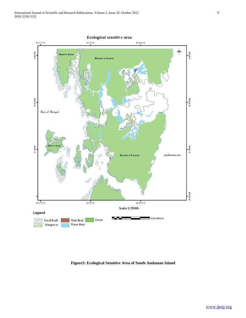
Figure3: Ecological Sensitive Area of South Andaman Island
International Journal of Scientific and Research Publications, Volume 2, Issue 10, October 2012 10
ISSN 2250-3153
www.ijsrp.org
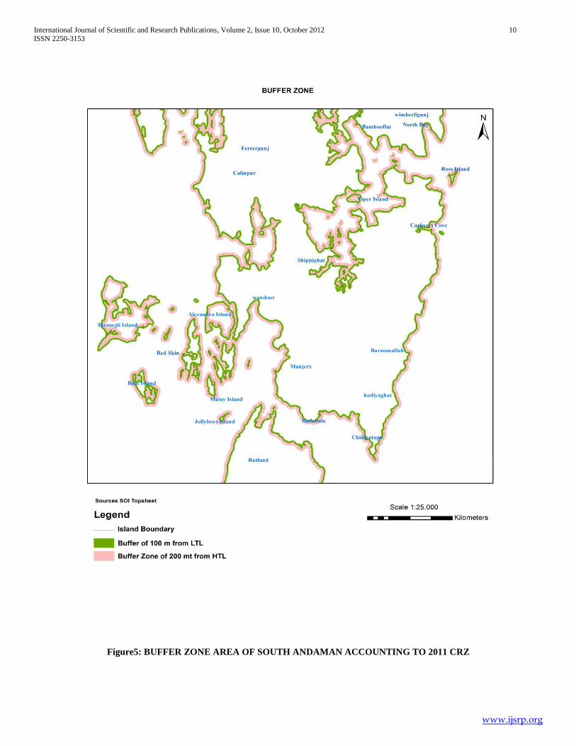
Figure5: BUFFER ZONE AREA OF SOUTH ANDAMAN ACCOUNTING TO 2011 CRZ

International Journal of Scientific and Research Publications, Volume 2, Issue 10, October 2012 11
ISSN 2250-3153
www.ijsrp.org
FIGURE6: Digital Evaluation Model of South Andaman Island
International Journal of Scientific and Research Publications, Volume 2, Issue 10, October 2012 12
ISSN 2250-3153
www.ijsrp.org
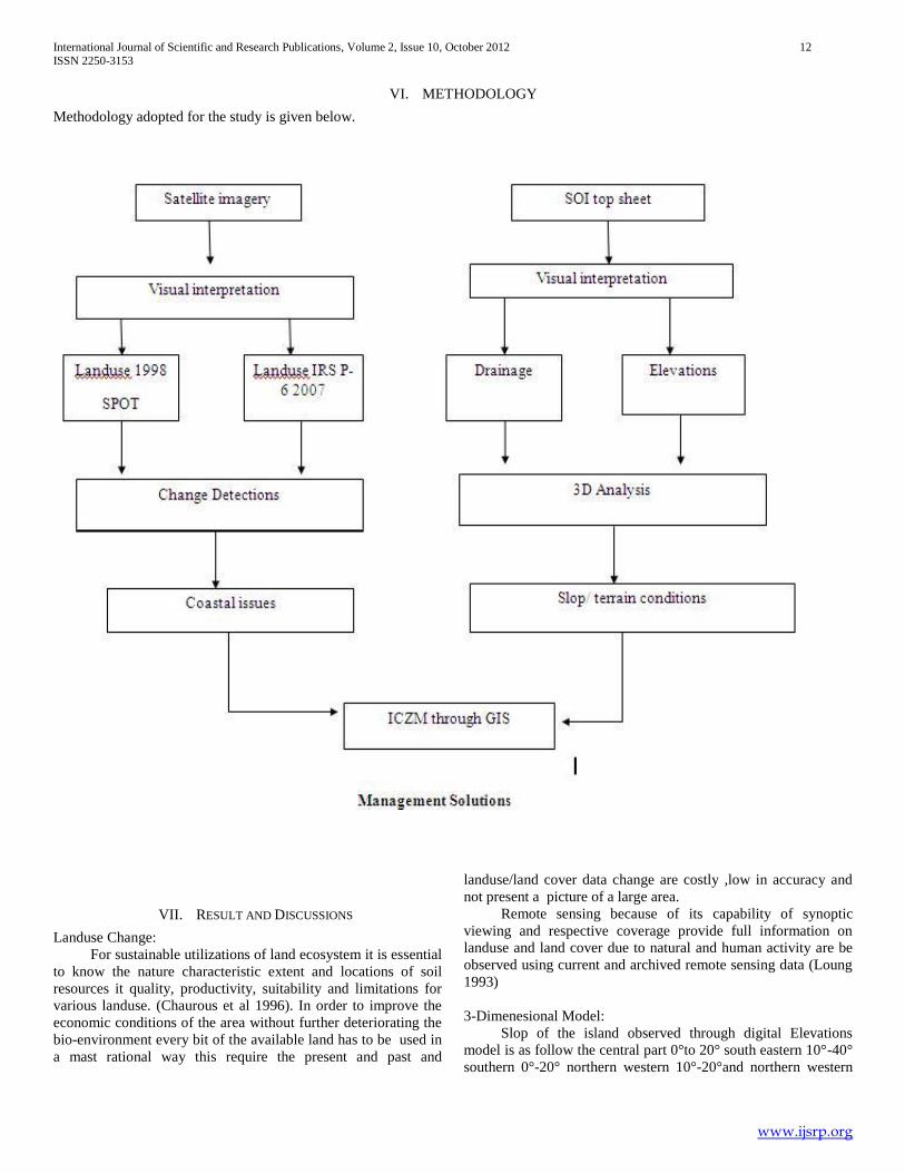
VI. METHODOLOGY
Methodology adopted for the study is given below.
VII. RESULT AND DISCUSSIONS
Landuse Change:
For sustainable utilizations of land ecosystem it is essential
to know the nature characteristic extent and locations of soil
resources it quality, productivity, suitability and limitations for
various landuse. (Chaurous et al 1996). In order to improve the
economic conditions of the area without further deteriorating the
bio-environment every bit of the available land has to be used in
a mast rational way this require the present and past and
landuse/land cover data change are costly ,low in accuracy and
not present a picture of a large area.
Remote sensing because of its capability of synoptic
viewing and respective coverage provide full information on
landuse and land cover due to natural and human activity are be
observed using current and archived remote sensing data (Loung
1993)
3-Dimenesional Model:
Slop of the island observed through digital Elevations
model is as follow the central part 0°to 20° south eastern 10°-40°
southern 0°-20° northern western 10°-20°and northern western
International Journal of Scientific and Research Publications, Volume 2, Issue 10, October 2012 13
ISSN 2250-3153
www.ijsrp.org
10°-20°and north eastern part 25°-80° it is observed that mostly
peak where other part of the island are found moderate slop.
Drainage:
stream process in any terrain are controlled not only by
climatic conditions, but lithology and geology structure also have
grate controlled as influence the nature of flow, erosion and
sediment transportations the degree of dependence varies with
the physical and chemical properties of rock the permeability the
structure characteristic and the degree faulting / fracture also
effected the extent to which the materials can be detached by
fluvial process (Derbyshire et al .,1981) the role of rock type and
geology structure in the development of stream network can be
better for understood by study the nature and type of drainage
pattern observed in South Andaman Island area were dentritic in
nature. The pattern exhibits those mountains in origin. The
stream generally followed a steep slop in northern portions of
the island the stream generally follow a stop in northern
portions but they follow a gentle slop in southern portions as the
island. Depending upon the elevations of terrain drainage patter
and river flow directions, particular site were specified for
erecting dam. However subsurface study is also necessary to find
the exacts locations erecting a dam. South Andaman and has
enough potential for fresh water supply the following locations
are supply for pumping to meet out the demand of south
Andaman.
Coastal Issues:
Degradations in mangrove are observed in northern
portions of the island. Development of settlement area and more
sedimentation in coastal environment are the major issues for the
degradations of mangrove loss in reserved forest as attributed to
the development of settlement area the loss in forest is observed
at northern portions of the island, gently slop and space forest
cover, favour the development of settlement in this portions sand
area was found to have decreased in almost all the part of the
island this may be due to sand mining or due to natural process.
Management issues:
Tourism is a main sector of the world economy accounting
for nearly 11 percent of global (Topfleri 1999) nature based
tourism now comprise 20 percent of the world travel market and
ecotourism 7 percent (TIES 1999) according to report presented
at a WTO seminar Spain early this year 20 million European
consider the environment as their main motive for travel (WTO
1999) there is general agreement that supported conservations
actively contributed to local community development and lead to
garter understanding and appreciations of the nature and culture
environment however conservations is the primary objective of
ecotourism .
Ecotourism is the concept that grew from the need to meet
the objective of nature conservations while recognizing the right
to local people to utilize their locally impositions of the western
model of protected area management in area where local people
relied o nature for their injustice of the western model of
protected area management sight to implement a more
considerate from of conservations.
Tourism was introduces as a tool for natural conservations
to compensate for reduced consumption of forest produced
income for community is grater through the community
involvement in tourism enterprise. The process called ecotourism
(Lincoln International 1998). In South Andaman Ecotourism site
selections was observed based on the criteria where sandy beach
was available slop of the terrine was less than 20° and the ground
water of good quality was available slop of the quality was
available on the criteria site of ecotourism were suggested for the
selected for Indian portions of the island.
The location of site for constructions plays the primary
role in the effectiveness of any artificial recharge structure
(Jothiprakach et. 1997). Extensive studies have been carried out
by several workers in delineating ground water potential /
prospective zone Geographical Information System (GIS) has
been found to be effective tool. In recent year, extensive use of
Indian topographical map collateral information and field cheek
has made it easier to establish the base line information for
ground water prospective zone. (Singh et al 1993; chi and lee,
1994, Hardass et al; 1994 Tiwari and Rai; 1996 Das et al; 1997,
Pradeep,1998,Subba Rao and Prathap Reddy 1999,Thomas et al:
1999,Harinarayan et al 2000,Muraudher et al ,2000, Obi Reddy
et al,2000).
In South Andaman Island the constructions of artificial
recharge structure are suggested based on the criteria where slop
was less than 30°; high drainage density and buried pediment
zone where present based structure were suggested at the
selected portions of the island.
Utilitarian approach is suggested for sustainable management of
the coastal resources in South Andaman.
No development activity should be promoted in wet
land area.
No development activity should be promoted within 10
meter buffer of 1st
2nd and
3rd
order streams and within 20
meter buffer for river.
Erosion activity of the stream should be checked in the
highest elevations by erecting a antierosion structure.
The ICZM plan must strictly follow for the better of
South Andaman Island.
No permanent concrete structure should be develop in
this Island.
VIII. CONCLUSION
In recent years, the country‟s coastal stretches have
become a pressure point for indiscriminate and unsustainable
development pressures. There is considerable debate regarding
the CRZ with the hoteliers etc. lobbying that it is anti-
development and the environmentalists stressing that relaxation
in the CRZ Notification would only en-courage pollution and
asking for its strict enforcement.
The CRZ Notification was promulgated with the intention
bringing a balance between infrastructure development and
preservation of the eco-system along the coastline. However
from the very beginning the enforcement agencies have
extremely apathetic w.r.t. the CRZ Notification. One of the major
criticisms leveled against the CRZ Notification is that it ignores
deliberately issues of public participation and, local contexts and
issues. This neglect, along with the SCZMA inaction, has led to a
clash of functions between the duties of the local bodies like

International Journal of Scientific and Research Publications, Volume 2, Issue 10, October 2012 14
ISSN 2250-3153
www.ijsrp.org
panchayats and municipal corporations and the designated
coastal authorities.
In a paper authored by the Former Secretary, MOEF,
Government of Karnataka, Capt S. Raja Rao has attempted to
address the problems of implementation of the CRZ. He states
categorically that most problems have arisen because the coastal
state authorities have not taken the implementation of the
Notification seriously. According to him hastily prepared CZMPs
and inadequate, non-participate consultations, even among the
government officials themselves are to be blamed for the
problems being faced. it can be seen that the failure of the CRZ
is because of the reluctance of the government to enforce it. The
letter written by Ms. Indira Gandhi which did not have any
authority apart from being the diktat of the Prime Minister
resulted in the development activity being severely restricted. In
the present context the government has been conceding the
demand of the powerful lobbies by diluting the notification
though amendments.
In Goa Foundation v. Konkan Railway Corporation the
central government decided to lay a broad gauge between
Bombay to Mangalore via Goa. The court held that the CRZ
notification prescribes that there would be restriction on the
setting up and expansion of industries operation or processes in
the said areas and land reclamation bunding could not be
considered as industry. So the CRZ notification did apply to this
case. The Court observed that no development is possible
without some adverse on ecology and environment but public
utility projects cannot be abandoned and it is necessary to adjust
the interests of the people as well as the necessity to maintain the
environment. It can be seen from the several decisions on CRZ
that of late the attitude of the judiciary has not been very
supportive of strict enforcement. One tends to come to the
conclusion after looking at the case law that rather effectively
preventing pollution of the coastal areas, the CRZ notification
has become more of a law regulating land use with litigation on
questions of fact as to the category to the CRZ and other such
questions of evidence.
Landuse change detections, 3dimensional modeling and
drainage patter were studies it found that there is decrease in
sand, forest cover and mangrove the decrease is the attribute to
the development of settlement through 3d elevations model and
drainage pattern, site for dam constructions and borehole
locations where identified by integrating landuse, 3d elevation
and drainage map ICZM plan map was prepared and site for
ecotourism and artificial recharge was suggested according to the
ICZM plan map management solutions were also if this plan
implementing this would be immense for South Andaman Island.
ACKNOWLEDGEMENT
I am thankful to S.Balaji Asst.Pros, Disaster Management
Pondicherry University Port Blair Andaman for his support and
encouragement.
REFERENCES
[1] A Rosencranz and Shyam Diwan, Environmental Law and Policy in India, (2nd ed., OUP: New Delhi, 2002) at pg.475.
[2] Achieves, Bombay Environmental Action Group, c.f. A. Rosencranz and Shyam Diwan, Environmental Law, A. Rosencranz and Shyam Diwan, Environmental Law and Policy in India, ( 2nd ed., OUP: New Delhi, 2002) at pg. 477.
[3] Appeal No. 1287/1995, Madras High Court.
[4] Bhibhu Prasad Tripathi, Coasting Away to Disaster: Protection of Coastal Environment Law Policy and Practice in India, LLM Dissertation submitted to National Law School of India University.
[5] Chainani, Coastal Regulation Zone: CRZ Notification and Heritage Conservation, 26 December 1998 (unpublished). Archives, Bombay Environment Action Group c.f. c.f. A. Rosencranz and Shyam Diwan, Environmental Law, A. Rosencranz and Shyam Diwan, Environmental Law and Policy in India, ( 2nd ed., OUP: New Delhi, 2002) at pg. 478.
[6] CRZ notification. (2011)See paras 2 and 3.
[7] CRZ notification Para 3(3)(1)
[8] Chaurasia R.Closhail.Dc,Dhaliwal SS. Manakshi Sharma P.K Kudrat.M and Tiwari A.K(1996) „ Landuse change analysis for agricultural management- a case study of Teheil Talwandi Sabo, Punjab, Journal of Indian society of Remote Sensing vol 24, No-2.pp.115-123.
[9] Chi, K and Lee, B (1994).Extracting potential groundwater area using remotely sense data and Geographical Information System Technique Proc Reg.Sem Integrated application of Remote Sensing and Geographical Information System for Land and Water Resources Management held at Bangalore, India No-16-19 1999, pp64-69 .
[10] Das ,S Behera ,SC, Kar,A Narendra,P and Guha S.(1997) Hydrologeomorphiical Mapping in Ground water using remotely sense data- a case study in Keonjhar District Orissa India Soc. Remote Sensing ,25(4):247-259
[11] Derbyshire, E Gregory, K.J and Hails, JK (1981) Studies in Physical Geography Geomorphology Process. Butterworth, London,101p
[12] Elango, K, and Mohan, S (1997) Technical Report an effectiveness of Percolations Pond, Indian Instituted of Technology, Chennai, submitted to Science and Technology New Delhi.
[13] Haridass, V K; Chandrashekarn, V A. Kumaraswamy K, Rajendran, S. and Unni, K(1994) Geomorphological and liniment Studies of studies of Kanjamalai using IRS – 1 data with special reference to Ground water Potentiality Trans. Insist ,Indian Geographer 16(1):35-41.
[14] Mr. Shyam Diwan in a lecture delivered on 6th November, 2002 in National Law School opined that due to the abysmal failure of the agency led approach in the 1970s, specialised bodies under EPA are being set up to ensure that the rules and regulations are affected..
[15] Norman Alwares, “The Scheme of CRZ Notification”, Environmental Law Reading Material, NLSIU.
[16] Regulating the Coast: The NST Experience” (incomplete). In Karnataka, section 15 of the Land Grant Rules, 1969, unequivocally did not allow the granting of lands near seacoast upto 200 m from the high water mark.
[17] The other amendments have been promulgated under Environment (Protection) Rules, 1986, rule 5(4), which states, “Notwithstanding anything contained within sub-rule 3, whenever it appears to the Central Government that it is in public interest to do so, it may dispense with the requirement of notice under Clause (a) of sub-rule 3.”
[18] S. Jagannath v. Union of India, 1995 (3) SCALE 126. The Aquaculture Authority was set up via Notification dated February 6, 1997, by the Central Government under Section (3) (iii) of Environment (Protection) Act, 1986. The Authority was set up to regulate the shrimp culture industry in coastal areas. The duties of the Authority, as per the Notification, inter alia, were: Ensuring the closure, demolition and removal of all existing aquaculture activities by March 31, 1997, from CRZ areas as indicated in CZMPs .Ensuring no shrimp culture pond can be constructed or set up within CRZ.
AUTHORS
First Author – Vazeem Iqbal, QUALIFICATIONS: BA
Geography M.Sc. Coastal Disaster Management Pondicherry
University Port Blair. Currently pursing my Ph.d on Coastal
Zone Management at Pondicherry University Port Blair.,
ASSOCIATED INSTITUTE: Pondicherry University

International Journal of Scientific and Research Publications, Volume 2, Issue 10, October 2012 15
ISSN 2250-3153
www.ijsrp.org
ADDRESS: Vazeem iqbal , Dept of Disaster Management,
Pondicherry University Brookshabad Campus, Port Blair
(Andaman and Nicobar Island) India, Pin: 744103, Email: