integrated data viewer (idv) - search |...
TRANSCRIPT

Integrated Data Viewer (IDV)Integrated Data Viewer (IDV)a visualization frameworka visualization framework
Yuan HoYuan HoU id U id P CP CUnidata Unidata Program CenterProgram Center
Boulder, COBoulder, CO
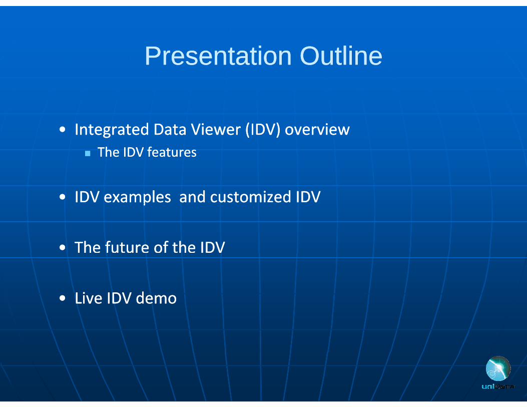
Presentation OutlinePresentation OutlinePresentation OutlinePresentation Outline
•• Integrated Data Viewer (IDV) overviewIntegrated Data Viewer (IDV) overview The IDV featuresThe IDV features The IDV features The IDV features
•• IDV examples and customized IDVIDV examples and customized IDVpp
•• The future of the IDVThe future of the IDV
•• Live IDV demoLive IDV demoLive IDV demoLive IDV demo

UNIDATAUNIDATAUNIDATAUNIDATA
Our Vision:Our Vision:Geoscience at the speed of thought through Geoscience at the speed of thought through p g gp g gaccelerated data discovery, access, analysis, and accelerated data discovery, access, analysis, and visualization.visualization.
Our Mission:Our Mission:T f h i iT f h i iTo transform the geosciences community, To transform the geosciences community, research, and education by providing innovative research, and education by providing innovative d i d ld i d ldata services and toolsdata services and tools

Data Access and VisualizationData Access and VisualizationData Access and VisualizationData Access and Visualization
UNIDATA provides:UNIDATA provides: Visualization:Visualization:
Meteorological display and analysis tools from UWMeteorological display and analysis tools from UW Madison (Madison (M IDASM IDAS XX)) Meteorological display and analysis tools from UWMeteorological display and analysis tools from UW‐‐Madison (Madison (McIDASMcIDAS‐‐XX).). 2D visualization tools from NWS/NCEP (2D visualization tools from NWS/NCEP (GEMPAKGEMPAK).). JavaJava‐‐based 2D and 3D visualization and nextbased 2D and 3D visualization and next‐‐generation collaborative generation collaborative gg
data analyses tools (data analyses tools (IDVIDV)) Data Access:Data Access:
I D Di ib i d M (I D Di ib i d M (IDD/LDMIDD/LDM)) Internet Data Distribution and Management (Internet Data Distribution and Management (IDD/LDMIDD/LDM) system) system Client/server data access model developed for McIDAS, but not Client/server data access model developed for McIDAS, but not
limited to serving McIDAS data (ADDE)limited to serving McIDAS data (ADDE)g ( )g ( ) THematic Realtime Environmental Data Distributed Services (THematic Realtime Environmental Data Distributed Services (THREDDSTHREDDS)) RRepository for epository for AArchiving, rchiving, MManaging and anaging and AAccessing ccessing DDiverse iverse DaData ta
(( ))((RAMADDARAMADDA))

Visualization of GeoscienceVisualization of GeoscienceVisualization of Geoscience Visualization of Geoscience
General purpose 2D/3D displaysGeneral purpose 2D/3D displays
Exploration of data detailsExploration of data details
Quantitative analysisQuantitative analysis Quantitative analysisQuantitative analysis
Integration of data from disparate data sourcesIntegration of data from disparate data sources Integration of data from disparate data sources Integration of data from disparate data sources

IIntegratedntegrated DDataata VViewer (IDV)iewer (IDV)IIntegrated ntegrated DData ata VViewer (IDV)iewer (IDV)
Unidata’s visualization and Unidata’s visualization and analysis tool for geoscience analysis tool for geoscience datadata
Freely available Java™ Freely available Java™ framework and applicationframework and application
Integrated 2D/3D displays of Integrated 2D/3D displays of teg ated /3 d sp ays oteg ated /3 d sp ays oa wide range of dataa wide range of data
Built on VisAD libraryBuilt on VisAD library Built on VisAD libraryBuilt on VisAD library

VisAD library OverviewVisAD library OverviewVisAD library OverviewVisAD library Overview A Java Component Library for interactive analysis and A Java Component Library for interactive analysis and p y yp y y
visualization of numerical data.visualization of numerical data. VisAD objects: data object, display object, cell object, VisAD objects: data object, display object, cell object,
i f bj d d f bj i f bj d d f bjuser interface object, and data reference object.user interface object, and data reference object. All data objects have a All data objects have a MathTypeMathType, which indicates the , which indicates the
type of mathematical object that it approximatestype of mathematical object that it approximatestype of mathematical object that it approximates.type of mathematical object that it approximates.•• The output of a weather model may be described using the The output of a weather model may be described using the
MathTypeMathType::( i ( i (( ((ll ll l ) l ) ( )))( )))(time (time --> ((> ((latlat, , lonlon, alt) , alt) -->(temperature, pressure, u, v, w)))>(temperature, pressure, u, v, w)))
Designing a Typical VisAD ApplicationDesigning a Typical VisAD Application•• Creation of the data objectCreation of the data object•• Creation of the data objectCreation of the data object•• Creation of the display objectCreation of the display object•• Adding interaction and functionalityAdding interaction and functionality

Common Data ModelCommon Data ModelCommon Data ModelCommon Data ModelScientific Feature TypesScientific Feature Types
Point Trajectory Station Profile
GridRadial Swath
Coordinate Systems
Data AccessData AccessnetCDF-3, HDF5, OPeNDAP
BUFR, GRIB1, GRIB2, NEXRAD, NIDS, McIDAS, GEMPAK, GINI, BUFR, GRIB1, GRIB2, NEXRAD, NIDS, McIDAS, GEMPAK, GINI, DMSP, HDF4, HDF-EOS, DORADE, GTOPO, ASCII

IDV Architectural OverviewIDV Architectural OverviewIDV Architectural OverviewIDV Architectural Overview

IDV Architectural OverviewIDV Architectural OverviewIDV Architectural OverviewIDV Architectural Overview

VisADVisAD Data objects in the IDVData objects in the IDVVisADVisAD Data objects in the IDVData objects in the IDV
VisADVisAD data model supports any numerical datadata model supports any numerical data
VisADVisAD data object can be manipulated without data object can be manipulated without converting from one form to anotherconverting from one form to another
The IDV uses the The IDV uses the visadvisad ccoordinateSystemoordinateSystem class to class to provide the necessary transforms for provide the necessary transforms for geolocationgeolocation provide the necessary transforms for provide the necessary transforms for geolocationgeolocation. . These provide onThese provide on--thethe--fly coordinate transforms.fly coordinate transforms.
Creating a new data source in the IDV is to Creating a new data source in the IDV is to transform raw data into transform raw data into VisADVisAD data objectdata objecttransform raw data into transform raw data into VisADVisAD data objectdata object

Supported Data SourcesSupported Data Sources Supported Formats:Supported Formats:
Supported Data SourcesSupported Data Sources Data Types:Data Types: Supported Formats:Supported Formats:
•• netCDF/HDFnetCDF/HDF•• GrADSGrADS
Data Types:Data Types:•• Gridded dataGridded data•• Satellite imagerySatellite imagery
•• GRIB 1/2GRIB 1/2•• ADDEADDE•• Vis5DVis5D
•• Radar dataRadar data•• Point observationsPoint observations•• Balloon soundingsBalloon soundings Vis5DVis5D
•• KML (Google Earth)KML (Google Earth)
Access Methods:Access Methods:
Balloon soundingsBalloon soundings•• NOAA Profiler Network NOAA Profiler Network
windswinds•• ACTF tropical stormACTF tropical storm
•• Local filesLocal files•• HTTP and FTPHTTP and FTP•• ADDE and TDS ADDE and TDS serversservers
•• ACTF tropical stormACTF tropical storm•• GIS GIS data (shape file, data (shape file,
DEM, tiff)DEM, tiff)•• ADDE and TDS ADDE and TDS serversservers•• RAMADDARAMADDA•• WMSWMS
•• Quick Time moviesQuick Time movies•• Web Web CamsCams•• Weather Text ProductsWeather Text Products
•• DatabaseDatabase•• Google Earth (Google Earth (kmlkml, , kmzkmz))
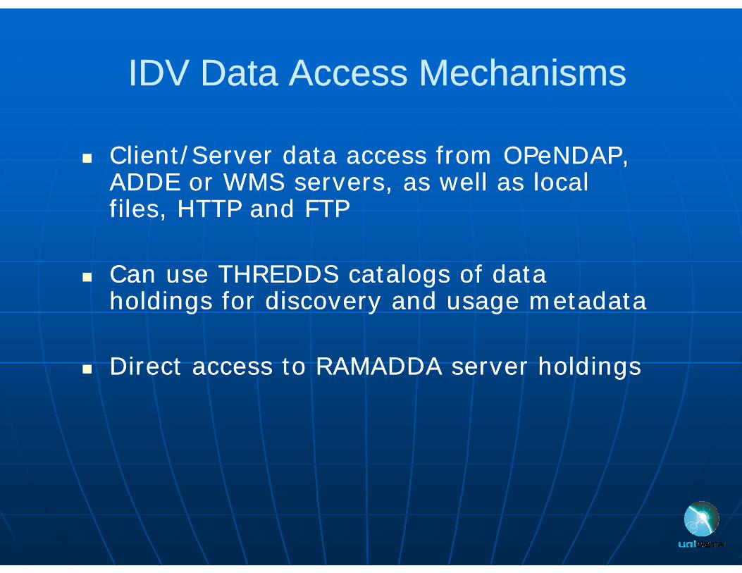
IDV Data Access MechanismsIDV Data Access Mechanisms
Cli t/S d t f OP NDAP Cli t/S d t f OP NDAP
IDV Data Access MechanismsIDV Data Access Mechanisms
Client/Server data access from OPeNDAP, Client/Server data access from OPeNDAP, ADDE or WMS servers, as well as local ADDE or WMS servers, as well as local files, HTTP and FTPfiles, HTTP and FTPes, a des, a d
Can use THREDDS catalogs of data Can use THREDDS catalogs of data ggholdings for discovery and usage metadataholdings for discovery and usage metadata
h ldh ld Direct access to RAMADDA server holdingsDirect access to RAMADDA server holdings

IDV Features OverviewIDV Features OverviewIDV Features OverviewIDV Features OverviewCliCli d fd f ClientClient‐‐server data access from remote systemsserver data access from remote systems
Suite of data probes for interactive exploration (slice and Suite of data probes for interactive exploration (slice and dice)dice)dice)dice)
Animations (temporal and spatial)Animations (temporal and spatial) XML configuration allows customization of UIsXML configuration allows customization of UIsXML configuration allows customization of UIsXML configuration allows customization of UIs Bundling allows collaboration with othersBundling allows collaboration with others JavaJava‐‐based framework supports extensions built via plugbased framework supports extensions built via plug‐‐pp p gpp p g
ins: for example, geosciences network (GEON) solid earth ins: for example, geosciences network (GEON) solid earth communitycommunity

IDV Feature Data AnalysisIDV Feature Data Analysis
F l dF l d
IDV Feature Data AnalysisIDV Feature Data Analysis
Formulas and Formulas and computation using computation using JythonJythonJythonJython
Supports both system Supports both system and local formulasand local formulasand local formulasand local formulas
Automatically generate Automatically generate derived variablesderived variablesderived variables derived variables
Supports both Supports both JythonJythonand ISL scriptingand ISL scriptingand ISL scripting and ISL scripting languageslanguages

IDV Feature: IntegratorIDV Feature: IntegratorIDV Feature: IntegratorIDV Feature: Integrator Integrating data Integrating data Integrating data Integrating data
from disparate from disparate data sources is data sources is easy with the IDVeasy with the IDV•• Data can come Data can come
f l l d f l l d from local and from local and remote locationsremote locations
•• Data on different Data on different •• Data on different Data on different projections are projections are automatically automatically
dd Radar reflectivity Satellite IR, and Surface remappedremapped•• Data from different Data from different
times are synced times are synced
Radar reflectivity Satellite IR, and Surface Observation.
times are synced times are synced

IDV Example: IntegratorIDV Example: IntegratorIDV Example: IntegratorIDV Example: Integrator

IDV Example: 3D DisplayIDV Example: 3D DisplayIDV Example: 3D DisplayIDV Example: 3D Display3D views of 3D data3D views of 3D data3D views of 3D data3D views of 3D data
3D Map view3D Map view

IDV Example: 3D DisplayIDV Example: 3D DisplayIDV Example: 3D DisplayIDV Example: 3D Display

IDV Example: 3D DisplayIDV Example: 3D DisplayIDV Example: 3D DisplayIDV Example: 3D Display 3D views of 2D/3D data3D views of 2D/3D data
•• 3D Map view3D Map view
3D view of 500hPa level 3D view of 500hPa level Geopotential HeightGeopotential Height
Model simulation of wind, Model simulation of wind, isentropic potential vorticity and isentropic potential vorticity and low level moisture flow over the low level moisture flow over the G S l k b iG S l k b iGreat Salt Lake basinGreat Salt Lake basin
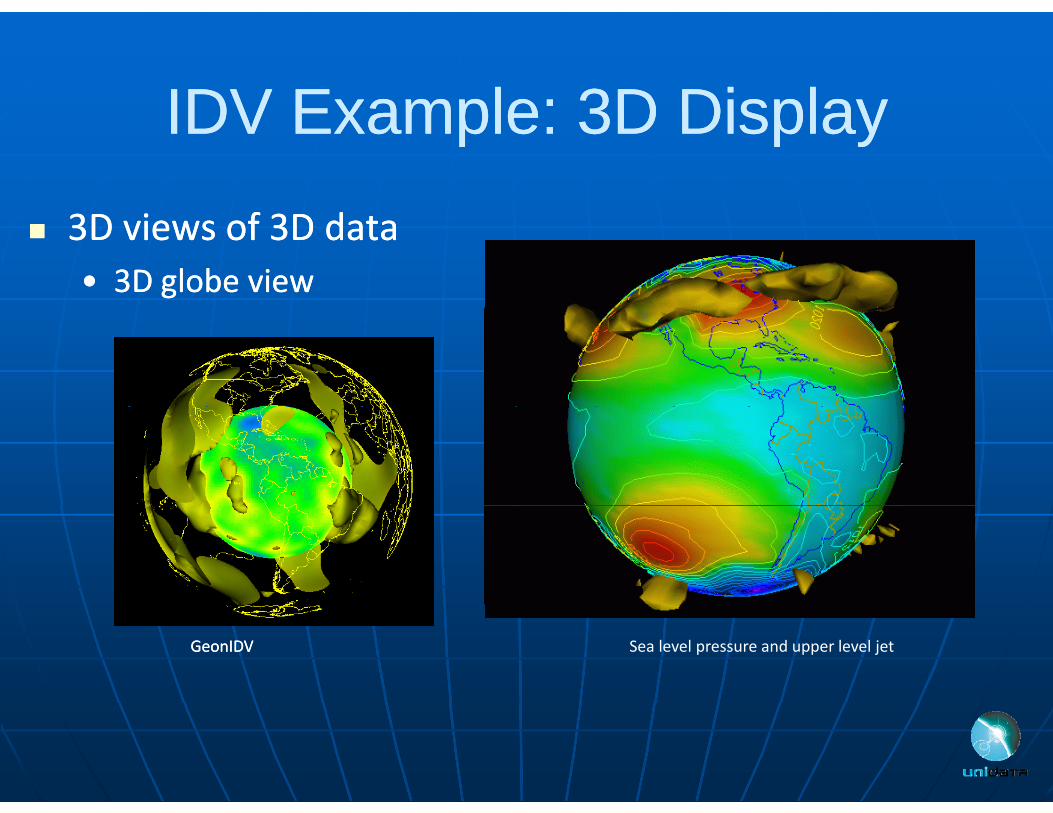
IDV Example: 3D DisplayIDV Example: 3D DisplayIDV Example: 3D DisplayIDV Example: 3D Display 3D views of 3D data3D views of 3D data
•• 3D globe view3D globe view
Sea level pressure and upper level jetGeonIDVGeonIDV

IDV Example: Data InteractionIDV Example: Data InteractionIDV Example: Data InteractionIDV Example: Data Interaction
Versatile data Versatile data interactioninteraction•• Probes to interrogateProbes to interrogate•• Probes to interrogate Probes to interrogate
data data –– time series, vertical time series, vertical profiles, etc.profiles, etc.
S‐POL Radar Cross sectionS POL Radar Cross section
Time Series Data ProbeTime Height Cross sectionNOAA Profiler Network station (time height)

IDV Example: Data InteractionIDV Example: Data InteractionIDV Example: Data InteractionIDV Example: Data Interaction
Displaying COSMIC datasetDisplaying COSMIC dataset

IDV Example: BundlingIDV Example: BundlingIDV Example: BundlingIDV Example: Bundling
State of the application (loaded data State of the application (loaded data sources and data depictions) can be sources and data depictions) can be saved in XML “bundles”saved in XML “bundles”saved in XML bundlessaved in XML bundles
Bundles can be loaded at startup or Bundles can be loaded at startup or i t di t d thth flflimported onimported on‐‐thethe‐‐flyfly
Displays can be annotated and these Displays can be annotated and these p yp ycan be saved in the bundle as can be saved in the bundle as explanationsexplanations
Bundles can be distributed around Bundles can be distributed around the Internet (on web servers or ethe Internet (on web servers or e‐‐mail attachments)mail attachments)
GFS ensemble 8 panels Bundle
mail attachments)mail attachments)

IDV Feature: OutputIDV Feature: Output
I i d iI i d i
IDV Feature: OutputIDV Feature: Output
Interactive and script Interactive and script based generation of:based generation of:
II JPEG GIF PNGJPEG GIF PNG•• Images Images ‐‐ JPEG, GIF, PNG, JPEG, GIF, PNG, PDF, PSPDF, PS
•• MoviesMovies ‐‐ Quick TimeQuick TimeMovies Movies Quick Time, Quick Time, animated GIFanimated GIF
•• Google Earth KML/KMZGoogle Earth KML/KMZ Images, Movies, KML/KMZIDV Scripting KML/KMZ

IDV FeaturesIDV FeaturesIDV FeaturesIDV Features
Easy to installEasy to install Out of the box data accessOut of the box data access Comprehensive user Comprehensive user ppsupportsupport•• Integrated documentationIntegrated documentationgg•• Training workshopsTraining workshops•• Mailing listsMailing listsMailing listsMailing lists
support‐[email protected]

Configuration and Plugins MechanismsConfiguration and Plugins MechanismsConfiguration and Plugins MechanismsConfiguration and Plugins Mechanisms
Highly ConfigurableHighly Configurable•• Multiple UIs & displays Multiple UIs & displays –– 3D 3D
Map 2D Map GlobeMap 2D Map GlobeMap, 2D Map, Globe, Map, 2D Map, Globe, TransectTransect
•• PlugPlug‐‐insins New FeaturesNew Features Language Support Language Support
Transect Display and Map of Airplane Tracks
Chinese language plugin

Configuration and CustomizationConfiguration and CustomizationConfiguration and CustomizationConfiguration and Customization
IDV uses XML to configure the user IDV uses XML to configure the user experienceexperienceC fi ti fil b l l th C fi ti fil b l l th Configuration files can be local or across the Configuration files can be local or across the networknetworkOffers flexibility to adapt the interface to Offers flexibility to adapt the interface to Offers flexibility to adapt the interface to Offers flexibility to adapt the interface to difference:difference:•• LearnersLearnersLearnersLearners•• TasksTasks•• Data setsData sets•• Content areasContent areas

Customized IDV:Customized IDV: GEONGEON--IDVIDVCustomized IDV: Customized IDV: GEONGEON IDVIDV GEON is building GEON is building
cyberinfrastructure to cyberinfrastructure to Yello stone Geophiscs yyallow seamless data and allow seamless data and tool interoperability for the tool interoperability for the geosciences.geosciences.Th GEONTh GEON IDV i IDV i
Yellowstone Geophiscs: Earthquakes and tomography by Univ. Utah; topography from USGS; geology map
The GEONThe GEON--IDV is an IDV is an extension of the Unidata extension of the Unidata IDVIDV•• Supports 2 and 3D displays of Supports 2 and 3D displays of
image provided by Robert L. Christiansentens (UNAVCO)
•• Supports 2 and 3D displays of Supports 2 and 3D displays of subsurface phenomenasubsurface phenomena
•• Uses plugUses plug--in facility to in facility to customize the user interface customize the user interface and add featuresand add featuresand add featuresand add features
•• Additional features include Additional features include GPS velocity vectors, GPS velocity vectors, earthquake focal earthquake focal mechanisms, ray path traces.mechanisms, ray path traces.
Mt. St. Helens siesmic activity 2004
, y p, y p

Customized IDV: Customized IDV: TCTC--IDVIDV
TCTC--IDV is a customized IDV is a customized TCTC IDV is a customized IDV is a customized version of IDV for typhoon version of IDV for typhoon tracking and tracking and analysisanalysis
Being developed for Being developed for Shanghai Typhoon Shanghai Typhoon Institute (STI) Institute (STI)
Access to database of Access to database of storm tracks and storm tracks and forecastsforecasts
Can be combined with Can be combined with satellite and model datasatellite and model data

Customized IDV: GeopodCustomized IDV: GeopodCustomized IDV: GeopodCustomized IDV: Geopod
The Geopod interface us The Geopod interface us The Geopod interface us The Geopod interface us geared toward data geared toward data exploration and teachingexploration and teachingexploration and teachingexploration and teaching
An interactive module for An interactive module for An interactive module for An interactive module for navigating and probing navigating and probing geophysical datageophysical data
Allowing students to Allowing students to ggbecome part of the become part of the exploration process exploration process
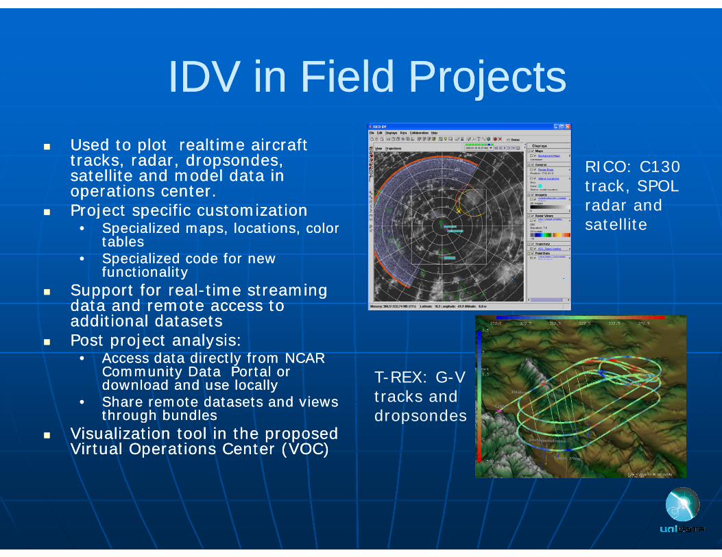
IDV in Field ProjectsIDV in Field ProjectsIDV in Field ProjectsIDV in Field ProjectsUsed to plot Used to plot realtimerealtime aircraft aircraft Used to plot Used to plot realtimerealtime aircraft aircraft tracks, radar, dropsondes, tracks, radar, dropsondes, satellite and model data in satellite and model data in operations center.operations center.
Project specific customizationProject specific customization
RICO: C130 track, SPOL radar and Project specific customizationProject specific customization
•• Specialized maps, locations, color Specialized maps, locations, color tablestables
•• Specialized code for new Specialized code for new functionalityfunctionality
satellite
yy Support for realSupport for real--time streaming time streaming
data and remote access to data and remote access to additional datasetsadditional datasets
Post project analysis:Post project analysis:p j yp j y•• Access data directly from NCAR Access data directly from NCAR
Community Data Portal or Community Data Portal or download and use locallydownload and use locally
•• Share remote datasets and views Share remote datasets and views through bundlesthrough bundles
T-REX: G-V tracks and dropsondesthrough bundlesthrough bundles
Visualization tool in the proposed Visualization tool in the proposed Virtual Operations Center (VOC)Virtual Operations Center (VOC)
dropsondes

IDV ExampleIDV ExampleIDV ExampleIDV Example
Using the IDV to analyze Using the IDV to analyze Marine Coral Stress because Marine Coral Stress because it allowed them to easily it allowed them to easily integrate multidimensionalintegrate multidimensionalintegrate multidimensional integrate multidimensional data into a seamless global data into a seamless global picture showing coral picture showing coral p gp gexposure to environmental exposure to environmental stresses. stresses.

WhoWho UsesUses the IDV?the IDV?Who Who Uses Uses the IDV?the IDV?
Atmospheric science students and Atmospheric science students and faculty at Unidata institutionsfaculty at Unidata institutionsyy
ResearchersResearchersW th th i tW th th i t Weather enthusiastsWeather enthusiasts
OceanographersOceanographersOceanographersOceanographers GeophysicistsGeophysicists Over 10,000 users around the WorldOver 10,000 users around the World

Today’s WeatherToday’s WeatherToday s WeatherToday s Weather


IDV BenefitsIDV BenefitsIDV BenefitsIDV Benefits In Classroom:In Classroom: In Classroom:In Classroom:
•• More sophisticated presentation of concepts More sophisticated presentation of concepts with real datawith real data
•• Better prepares students entering Better prepares students entering the the geoscience geoscience career fieldcareer field
In Research:In Research:•• Easy data accessibilityEasy data accessibility•• High level of interaction with dataHigh level of interaction with data•• Platform independence allows for realPlatform independence allows for real--time time
collaboration between researcherscollaboration between researcherscollaboration between researcherscollaboration between researchers

SummarySummarySummarySummary
IDV, when combined with other Unidata IDV, when combined with other Unidata technologies, provides efficient data access, technologies, provides efficient data access, g , p ,g , p ,effective data usage, and reduces data frictioneffective data usage, and reduces data frictionIDV enables analysis integration andIDV enables analysis integration and IDV enables analysis, integration, and IDV enables analysis, integration, and visualization of heterogeneous geoscience visualization of heterogeneous geoscience datadata
IDV enables realIDV enables real‐‐time collaboration betweentime collaboration betweenIDV enables realIDV enables real time collaboration between time collaboration between researchersresearchers

For more informationFor more informationFor more informationFor more information
IDV Homepage:IDV Homepage:•• http://www.unidata.ucar.edu/software/idvhttp://www.unidata.ucar.edu/software/idv
Download IDV package:Download IDV package:•• http://www unidata ucar edu/downloads/idv/index jsphttp://www unidata ucar edu/downloads/idv/index jspII•• http://www.unidata.ucar.edu/downloads/idv/index.jsphttp://www.unidata.ucar.edu/downloads/idv/index.jspII
IDV SupportIDV Support•• [email protected]@unidata.ucar.edu