integrating landscape ecology in campus planning
TRANSCRIPT

REVIEW OF INTERNATIONAL GEOGRAPHICAL EDUCATION
ISSN: 2146-0353 ● © RIGEO ● 11(5), SPRING, 2021
www.rigeo.org Research Article
Integrating Landscape Ecology in Campus
Planning: Recommendation for the future
Physical development of Shahjalal
University of Science and Technology,
Bangladesh
Gourpada Dey1
Assistant Professor, Department of Architecture,
Shahjalal University of Science and Technology,
Bangladesh [email protected]
Mohammad Tanvir Hasan2
Assistant Professor, Department of Architecture,
Shahjalal University of Science and Technology,
Bangladesh
Abhijit Mazumdar3
Assistant Professor, Department of Architecture,
Shahjalal University of Science and Technology,
Bangladesh
Subrata Das4
Assistant Professor, Department of Architecture,
Shahjalal University of Science and Technology,
Bangladesh
1Corresponding author: Email: [email protected]
Abstract
The rich biophysical elements of Shahjalal University of science and technology (SUST) include diverse
flora and fauna. These are the prominent landscape features that create the identity of the campus.
Organically grown campus ecology needs to be conserved and design under a sweeping landscape
ecological strategy to protect the existing biodiversity and the natural environment. Therefore, the
research aims to identify the potential hotspots for biodiversity and the natural landscape of the campus.
The existing and proposed land-use map has been investigated to generate different network diagrams
to identify the possible impacts of future development works on campus ecology. The potential
ecological conservation areas have been identified by analysing the open space network, green-blue
network, and activity zones. The research concludes with a framework combining the scope of future
extension and conservation strategy of existing landscape features.
Keywords Campus Planning, Biodiversity, Landscape, Ecology, Development
To cite this article: Dey G, Hasan M, T, Mazumdar A, and Das S. (2021). Integrating Landscape Ecology in Campus
Planning: Recommendation for the future Physical development of Shahjalal University of Science and Technology,
Bangladesh. Review of International Geographical Education (RIGEO), 11(5), 3029-3041. Doi: 10.48047/rigeo.11.05.195
Submitted: 02-11-2020 ● Revised: 15-02-2021 ● Accepted: 25-03-2021

© RIGEO ● Review of International Geographical Education 11(5), SPRING, 2021
3030
Introduction
In the global context, we can notice the significant change in the learning process at the university
level worldwide with more social and environmental responsibilities that indicate specific
development on campus morphology. Landscape ecology is a study field that reveals the
interrelationships between the environment and the communities in a specific section of a distinct
landscape (Troll, 1971). It is also defined as “Landscape ecology emphasises broad spatial scales
and the ecological effects of the spatial patterning of ecosystems” (Turner, 1989). Universities have
concentrated on reshaping their campus as a model for environmental sustainability since the
1960s (Schoenfeld, 1979). At that time, ecological priorities as biodiversity conservation, protection
of habitat, the flow of the ecosystem were prime concerns for the physical development of the
universities (Alshuwaikhat & Abubakar, 2008). Though, such ecological priorities are primarily
overlooked in physical planning and documents of the universities (Orenstein et al., 2019). In
addition, hardly any studies focused on integrating landscape ecological strategies in university
design and management.
SUST is one of the dynamic universities with its natural resources, diverse landscape, rich
biodiversity, and animal habitation near a rich natural forest of Malinichora tea state. This 320-acre
campus can be considered one of Sylhet city’s ecological hubs and one of the best places for
public recreation. The current expansion proposal of SUST includes several academic buildings,
student and teacher accommodations, workshops, and other infrastructure facilities that will
occupy approximately 29 acres of land, which is 3.5 times the present footprint. In addition, SUST
holds hilly areas and water bodies, a potential food resource, and a habitat for wildlife. Due to
frequent changes in the master plan, no planning framework in landscape and biodiversity is
maintained. So the question arises how this expansion process could be performed by integrating
natural landscape and biodiversity? This research aims to propose a guideline for SUST to protect
exiting significant natural resources and biodiversity zones to ensure sustainable development. The
campus environment has powerful influences on the psychological and social behaviour of
students (Banning, 1989). During field visits, students get familiar with significant, influential aspects
of campus as the buildings, trees, walkways, and well-kept lawns (Boyer, 1987); get attached to
environments and places that encourage positive stress reduction (Scopelliti & Giuliani, 2004).
Fragmented indoor classrooms or dedicated instructional spaces are not enough to ensure total
learning as it takes place throughout the entire campus with a long continuous procedure
(Strange & Banning, 2001). Spatial planning must respect and co-evolve with landscape ecology
to optimise the learning process and knowledge transfer on campus (Ahern, 2005).
Figure 01: Location map
Location of Bangladesh (Top left), Location of Sylhet city (bottom left)
Lcation of study area SUST campus (right)
Source: Author (modified)
Figure 1 : Location of the study area ( SUST)
Source: Google Map (Modified by Author)

Dey G, Hasan M, T, Mazumdar A, and Das S. (2021). Integrating Landscape Ecology in Campus …
3031
Theoretical Framework
Campus Morphology and physical development
Campus landscape engages people with nature through different forms of participation and
creates opportunities for biodiversity conservation, education and research on urban and
community scale (Orenstein et al., 2019). A sustainable landscape maintains the fundamental
environmental, social and economic activities with strong resilience against ever-changing
conditions mainly from human activities through meaningful integration of people-place and
culture-nature relationships among diverse disciplines as ecology, architecture, economics and
more (Wu, 2013). In the case of responsive spatial planning, morphological analysis creates a
distinctive basis for design in the context of any existing settled place where preexisting boundaries
and patterns that took advantageous positions over time need to be acknowledged on planning
for a new addition (Scheer, 2017). University must run with a long term development plan to guide
and shape campus life and community activity to cope with the increasing number of students
every year (D'Amico & Brooks, 1968). When outdoor recreation and nature use the same space in
a landscape, a designed structure with physical barriers for humans can help construct quiet
ecological corridors alongside trails by separating. Thus, ecological network planning must include
mitigation and compensation of the man-made infrastructure (Wiens & Moss, 2005). By creating
a distinct microclimate for users, open spaces can act as a micro-ecosystem to provide habitat
for vegetation and wildlife in a natural campus, increasing stormwater infiltration for land and soil
(Hamin & Gurran, 2009). Ecologicalizing education interacts with the factors of the inner
education system to bridge education and the external environment (Scholl & Gulwadi, 2018).
Landscape ecology and learning environment
A study reveals that the natural environment results in environmental sensibility to the students
(Nisbet, Zelenski, & Murphy, 2008). Sense of sight, touch, sound and smell guide people to perceive
space; considering these sensations in the design process can enrich people’s experience and
awareness of the place. Different functions along the circulation would avoid monotony and
boringness compared to a rigid linear journey, and accessible courtyards can create interactions
among the users both horizontally and vertically. Open space not only supports various activities
but also can hold large group gatherings during special occasions. Thus, every campus should
provide open spaces in diverse scales to satisfy targeted purposes (Forman, 1995; Yerli et al., 2017).
Seeing and stewarding nature positively results in communities with multiple social and
environmental aspects, including strengthening social ties, sense of competence, ecosystem
services and resilience (Tidball & Krasny, 2013). The participatory design ensures optimum utilisation
with active and meaningful involvement of the stakeholders during the planning and
implementation period (Kang, Choo, & Watters, 2015). Biophilic concepts act as an organisational
metaphor for a campus that breaks down the existing paradigms and drive for integrative campus
sustainability through contemplative spaces, ecological consciousness and reflexive dialogue
across the existing disciplines (Krasny & Delia, 2015). Waterfronts can play a significant role with
unique microclimate through humidity modulation, air quality improvement, environmental
protection enhancing species diversity (Lingyun & Yuncai, 2015).
Complexity, challenge and integration
In recent decades, enormous challenges on campus ecology resulted from the construction and
modification of university campuses (Zhu & Guan, 2018). University poses enormous effort to fund
collection for physical development and involved professionals to develop and expand
masterplan for future betterment, where misguided and vainglorious efforts result negatively in
many cases (Burns, 2001). Conflicting decisions on landscape development count as a significant
mismatch. The expansion of the on-campus area even results in cultural dislocation, whether the
active transfer of historical and cultural spirit can reinforce aesthetical, educational and
environmental value to the campus landscape (Yan, 2015). Intentional fragmentation of natural
areas breaks a habitat or land type into smaller parcels, increasing barriers and diminishing
biodiversity. For practical application, works have to be done in laboratories and reserves and
living landscapes. Often planners did not completely understand the complexity of ecological
models as they have to look after other complex issues as economic and traffic models, land use

© RIGEO ● Review of International Geographical Education 11(5), SPRING, 2021
3032
trends, production, and urbanisation (Naveh, 1991). Compact development has specific
advantages: land use minimisation, encouraging public transport, walking and cycling, reducing
resource consumption and pollution, ensuring accessibility to services and facilities, proper scope
of infrastructure development, and many more (Burton, 2000). An integrative framework can
cover various sustainability issues considering environmental, social and economic factors to
construct a healthy campus (Macintyre, Ellaway, & Cummins, 2002). In general practice,
compactness and connectivity are considered in socio-educational aspects rather than an
ecological framework. Physical planning opens the scope to integrate ecological considerations
with future development work (Liu et al., 2021).
Methods
In this research, a theoretical framework was proposed, which includes case studies from local
and global contexts to prepare the potential design tools for constructing the ecological
framework for the future master plan of SUST. A comprehensive physical survey was conducted to
document the existing scenario of landscape ecology by multilayer mapping. To understand the
campus morphology, questioner and observation of different stakeholders will run to understand
the reaction of user group regarding campus ecology and existing fabric. The study’s
methodology includes applying a range of instruments widely used in urban morphology as a
research method. Physical field survey and measurement, photography and documentation,
collecting historical to contemporary maps and records has been used conscientiously in the
study. An extensive literature review deduced nine indicators: land use, open space, figure-
ground, network and connections, building density, green-blue network, patch matrix corridor,
bio-diversity and landscape, and building typology.
Data collection
The strategy for data collection was conducted in three parts. At the initial phase, the data was
collected in choropleth maps to compare the study area in a diachronic manner. From these
maps, patterns were studied by the researchers. Qualitative methods were also introduced in their
later phases to understand user behavioural patterns. A questionnaire survey is conducted among
different stakeholders. A total of 120 questionnaires are sent through Google online forms. It is
purposive random sampling in nature. To produce the questionnaire Likert scale is used to avoid
the extra response category. Among them, 100 questionnaires were returned to yield a response
rate of 83.3%. Thirdly to have expert opinions, three KIIs (Key informants’ interviews) were done as
faculty members of the studied campus. Five open-ended questions were put to them, and later
researcher himself interpreted experts opinions and triangulated data for a reliability check.
Associated research addresses the potential ecological, cultural, and social benefits of open
space and its contribution to campus. The following steps were taken to address figure-ground
perception in SUST ‘s colour plan. At first, the entire setting was outlined for the research. After that,
a strategy of colour mapping was introduced to identify the colour identity.
Figure-ground relation
Figure 02: Figure-ground map
Source: Author
Figure 03: Land-use map
Source: Author

Dey G, Hasan M, T, Mazumdar A, and Das S. (2021). Integrating Landscape Ecology in Campus …
3033
Moreover, a colour planning strategy was selected to address the recovery of the foreground/
background architectural character. This study applied a tool using the ArcGIS platform to
examine the campus landscape, defining relevant green, blue, and grey spaces and networks
for further analysis, composition and configuration. The research showed that ecological corridors
incorporated with positive planning strategies within an urban setting could distribute organisms
successfully with less dissipation potentiality. The figure-ground map illustrates the relationship
between built and non-built areas in the campus area. The land coverage building areas are
characterised by solid blocks (mass), and other spaces like roads, canals, and open space are
void. The figure-02 exhibits only 7% of land covered by built forms out of 328 acres. Most of the
open spaces are agricultural land and hilly area. There is also a significant amount of area
covered by trees and wetland.
Landuse
The land use map (figure-03) shows some significant land uses of the university campus, including
academic facilities, teacher accommodation, student’s hall, administrative facilities, amenities
and other infrastructural facilities. In SUST, about 29% of the land has broadly been utilised as
academic facilities. There are five academic buildings consist of 4 to 7 stories in SUST. Twenty-five
per cent of land out of 328 acres has been utilised as students accommodation facilities, and
other residential areas, including teacher’s quarters, dormitory, guest house and other temporary
accommodation, comprises 5% of the land. Twenty-three per cent of the land has been used as
amenities facilities which hold prayer space, cafeteria, gymnasium, auditorium, playing field,
teachers club and other facilities. Other land uses like roads, administrative zone, and temporary
settlements comprise 4%, 5%, and 9% of the total land area.
Open space network
The open space map (figure-04) tries to identify the character of vacant spaces, including
planned and non-planned open spaces. The criteria of open space have been named
according to its use and land character. Within 328 acres, about 44% is a hilly area situated on the
north side of the campus. These hills can be considered as natural resources, a natural buffer from
outside and a potential habitat for biotic and abiotic. About 33% of the total area are currently
being used for agricultural purposes. Some of the low vacant lands have been cultivated, and
biodiversity and balance the ecosystem. It also acts as a water reservoir during heavy rainfall.
Besides all, 3% of the land is used as an active playground, including a central playground,
basketball ground, handball ground, and another inner courtyard.
Figure 04: Open space network Figure 05: Green-blue network map
Source: Autho Source: Author
© RIGEO ● Review of International Geographical Education 11(5), SPRING, 2021
3034
Green-blue network
The map (Figure-05) identifies each landscape element, which can be part of the green-blue
infrastructure. Lots of flatlands are located on the western side of the campus. The land has
temporarily been used for agricultural purposes by local farmers. Rain results in the wetland in the
lower area, and sometimes it covers full of water during heavy rainfall. The wetland invites various
birds in a particular season of the year. Two linear canals locally named “Chora” connects with
low land, which performs as the primary water source and system for storm sewerage inside the
campus area. The canal located beside the main entrance road (one-kilometre road) with a row
of large trees is the primary water shade that helps to promote biodiversity and habitation for
aquatic animals. The other canal run from east to west mostly remain dry due to blockage and
insufficient water flow. Although SUST does not have any comprehensive ecological and
landscape master plan, nature has composed itself and create rich biodiversity, including the
green corridor, water infrastructure, informal forest, and wetland. The network of these landscape
elements is well connected organically and creates a potential green-blue campus network.
Network and connection
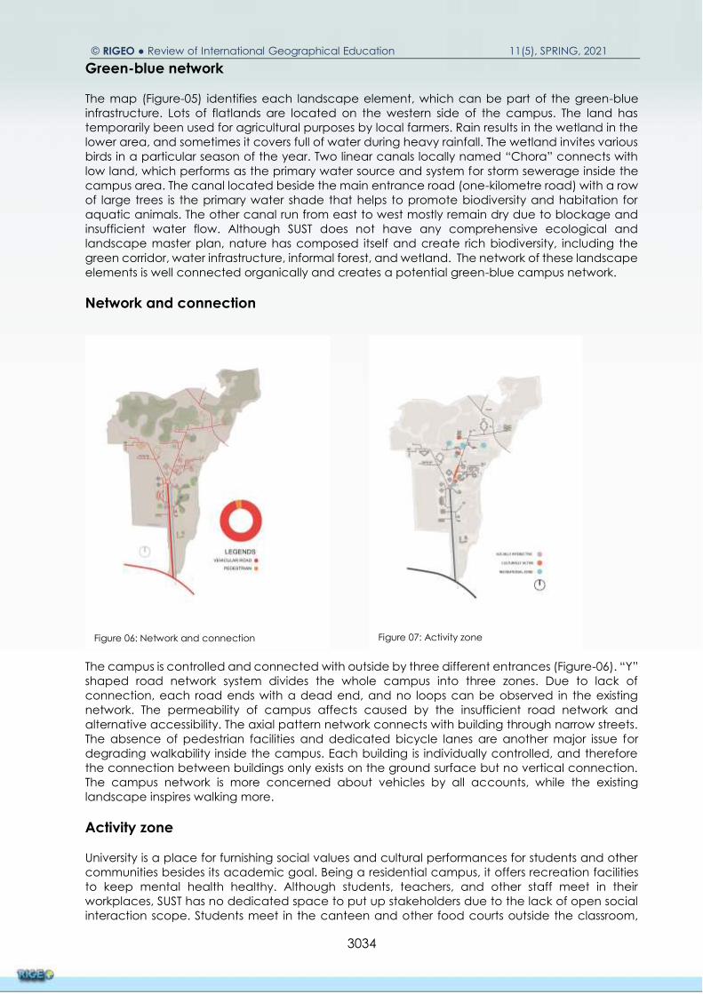
The campus is controlled and connected with outside by three different entrances (Figure-06). “Y”
shaped road network system divides the whole campus into three zones. Due to lack of
connection, each road ends with a dead end, and no loops can be observed in the existing
network. The permeability of campus affects caused by the insufficient road network and
alternative accessibility. The axial pattern network connects with building through narrow streets.
The absence of pedestrian facilities and dedicated bicycle lanes are another major issue for
degrading walkability inside the campus. Each building is individually controlled, and therefore
the connection between buildings only exists on the ground surface but no vertical connection.
The campus network is more concerned about vehicles by all accounts, while the existing
landscape inspires walking more.
Activity zone
University is a place for furnishing social values and cultural performances for students and other
communities besides its academic goal. Being a residential campus, it offers recreation facilities
to keep mental health healthy. Although students, teachers, and other staff meet in their
workplaces, SUST has no dedicated space to put up stakeholders due to the lack of open social
interaction scope. Students meet in the canteen and other food courts outside the classroom,
Figure 06: Network and connection
Source: Author
Figure 07: Activity zone
Source: Author

Dey G, Hasan M, T, Mazumdar A, and Das S. (2021). Integrating Landscape Ecology in Campus …
3035
which is not well equipped and do not acknowledge the natural landscape regarding designing
such places. A proper cultural program can be organised in the auditorium, but other cultural
activities perform beside the streets and playground. The map (Figure-07) shows a significant
activity zone that is interestingly happening beside the roads and buildings.
Patch matrix corridor
Patch, matrix and corridor (Figure-08) are generally used to identify the composition of the
landscape. The patch is a mosaic element in the landscape that can be distributed distinctly. In
this map, patches define as small Holts with various trees, sizeable green canopy and bushes,
sometimes consisting of small contours and wetland. Due to lack of human access and
development, patches secure habitation for wild animals and birds. These characters are also
found on the backside of each building. Corridor represents linear landscape element in the
composition. The central Y shaped street with rows of trees and linear canals beside the road can
be categorised as a corridor for SUST. In addition, the canal running from east to east can be
another element green corridor. In SUST, the corridor accommodates road infrastructure and
green together, turning into a potential green-blue infrastructure. Finally, the matrix represents the
utmost portion of the composition. The map represents the flat agricultural land in the eastern part
of the campus and the sizeable hilly area on the northern side. The flat land areas are more
economical and easier for infrastructure development, while it is more complex and unsustainable
for the hilly area. Besides, the existing hilly areas hold a profound amount of biotic and abiotic
resources features and food resources for wildlife. Although the matrix covers most of the area, all
the land is for agriculture and is effective for future development. Some lands act as for seasonal
wetlands to absorb extra water during heavy rainfall.
Campus biodiversity
SUST holds a rich natural landscape and profound biodiversity among the many Universities of
Bangladesh (Figure-09). To explore these diverse landscapes, a student organisation of SUST called
‘Green Explore Society’ had conducted a comprehensive study on existing flora and fauna in the
campus area (Figure-10). The study had been conducted from 2012 to 2015. The society
concluded with a checklist of sixty tree species, nine amphibian species, fifteen reptile species,
sixty-one butterflies, thirty-five bird species, and nine mammal species. The map has developed
bases on field surveys, and previous findings from green explore society.
Figure 08: Patch matrix corridor
Source: Author
Figure 09: Campus biodiversity
Source: Author

© RIGEO ● Review of International Geographical Education 11(5), SPRING, 2021
3036
The typological analysis aims to classify the built form through a systematic analysis of various
aspects of building like shape, orientation, height, configuration, zoning, circulation, etc. Empirical
study shows that most academic buildings are constructed with a central court like clear story
space. The court facilitates ventilation and concentrates inwards while classrooms are set beside
the corridor and oriented in all directions due to the “O” shape structure. Buildings are three-
storied with two staircases. The classroom has set from the ground floor; therefore, no places are
available for social gatherings on-premises. In addition, the enclosed nature toward inwards keeps
students away from natural views and ventilation. On the other hand, the residential built forms
are more connected with nature due to ample and green open space in the centre of Jahanara
Imam Hall, Shahpoaran Hall, and Sirajunnesa Hall. The single-loaded hostel with an open corridor
allows more natural ventilation and provides scope for enjoying landscape beauty. However, the
buildings on the campus have minimal interaction with outdoor spaces. Integrating green in
building design are mostly absent. Besides, the university does not have any dedicated place to
explore nature more interactively, like a botanical garden, Green Park, lakeside walking street,
etc.
Findings and Results
The analysis has identified some essential landscape elements like water shades, canals, wetland
and green corridors. These are essential for a naturally sustainable campus. This element can be
improved through conservation and can turn into a dynamic landscape. Rows of large trees and
water channels beside the road can be categorised as the significant green-blue network. Some
isolated forests developed organically, especially behind the buildings, and it became the place
for different flora and fauna. The interweaving technique can potentially connect small green
patches and make a green corridor (figure-11). In the same way, a blue corridor can be
developed by connecting the water channels (figure-12). The land-use map shows that the
academic buildings are situated in groups or clusters, which might be a good approach for future
physical development (figure-13). The groups of buildings can share common places and
infrastructure so the carbon footprint can be reduced. Other non-academic zones can also be
proposed in cluster type to increase sharing of resources and reduce hard surfaces. The map
shows massive green land in the eastern part of the ICT building, a new academic zone for SUST.
Besides the agricultural land, some portions of hilly areas of the campus are a significant food
resource and habitation for different spices. These areas can also be utilised directly as resource
labs for some departments, such as forestry, environmental science, geography. The natural
conservation of such areas can help to increase biodiversity. The typological studies show that
academic buildings are enclosed inward and situated in various climatic directions. There are no
sustainable considerations in building design. For the new structure, the building can be more
sustainable with bio-integration technique. Campus masterplan can incorporate ecological
considerations to guide sustainable development (figure-14). Recommendations have been
generated from morphological understanding, expert opinion, and students understanding and
comprehensive literature analysis. Some interventions are more applied, where others are
managerial proposals.
Species Verities
Tree 60
Amphibian 09
Reptiles 15
Mammal 63
Figure 10: Some of the species of SUST campus
Source: Green Explore Society, SUST

Dey G, Hasan M, T, Mazumdar A, and Das S. (2021). Integrating Landscape Ecology in Campus …
3037
Identify and conserve the significant ecological hotspots.
Increase connectivity of green-blue networks.
Promote more pedestrian and bicycle streets.
Specify various zones for development such as academic, residential, recreational zones,
etc.
Some special zone or land use can be arranged to create a sense of place and iconic
identity.
A biophilic approach can be introduced for building design; as a result of this, the building
can be part of nature.
To
explore these diverse landscapes, a student
organisation of SUST called ‘Green Explore
Society’ had conducted a comprehensive
study on existing flora and fauna in the
campus area (Figure-10).
Figure 11: Existing and proposed green network
Source: Author
Figure 12: Existing and proposed blue network
Source: Author
Figure 13: Proposed landuse plan
Source: Author
Figure 14: Proposed master plan
Source: Author

© RIGEO ● Review of International Geographical Education 11(5), SPRING, 2021
3038
Conclusion
This research is a primary attempt to identify the landscape resources and biodiversity richness of
the naturally green university campus of SUST. Continuously increasing demand for adequate
infrastructure and facilities with the increasing number of students each year pushed the authority
to go for extensive development expansion in the campus. In the case of significant scale
development and construction, the existing natural environment is always an important
stakeholder, which often remains unnoticed or neglected in public projects that create a
permanent wound in the landscape. Careless development is a significant threat to the healthy
environment that gradually developed over a long period of time. A wise, planned, participatory,
and responsive approach can successfully balance the natural and built environment. Future
planning should include the necessary steps to protect the existing natural identity and enhance
this for a sustainable future. A comprehensive master plan should be prepared by engaging the
professionals to guide the development work respecting the natural environment. Phase wise
development plan considering biodiversity protection and promotion has become a successful
approach in this field. Further intensive research on various dimensions and possibilities of the
existing landscape elements can create a successive pathway with essential guidelines for the
future sustainable development of the public educational campuses of the country. This research
tried to address major perspectives of landscape ecology mainly to guide the future
development. Detail study on ecological features such as species diversity, complexity and
interrelations was not in the scope of the research. Further intensive research on ecological
pattern and diversity can enrich the field to control any kind of change in natural landscape.
Acknowledgement
SUST Research Centre funds this research work in the 2019-2020 financial period. The researchers
also want to express gratitude to the Department of Architecture, SUST, for all technical support
during the entire journey and the students who worked on different phases through the field survey
and data collection process. The team is grateful to the expert who managed their valuable time
for the interview regarding this research.
References
Ahern, J. (2005). Integration of landscape ecology and landscape architecture: an
evolutionary and reciprocal process. Issues and perspectives in landscape ecology,
311-319.
Alshuwaikhat, H. M., & Abubakar, I. (2008). An integrated approach to achieving campus
sustainability: assessment of the current campus environmental management
practices. Journal of Cleaner Production, 16(16), 1777-1785. doi:
https://doi.org/10.1016/j.jclepro.2007.12.002
Banning, J. H. (1989). Impact of college environments on freshman students. In M. L. Upcraft
& J. N. Gardner (Eds.), The Freshman Year Experience. Helping Students Survive and
Succeed in College (pp. 53-64). San Francisco: Jossey-Bass.
Boyer, E. L. (1987). College: The Undergraduate Experience in America (pp. 117). New York:
Harper & Row.
Burns, R. (2001). Designing the university campus: It matters. Paper presented at the Phi Kappa
Phi Forum.

Dey G, Hasan M, T, Mazumdar A, and Das S. (2021). Integrating Landscape Ecology in Campus …
3039
Burton, E. (2000). The Compact City: Just or Just Compact? A Preliminary Analysis. Urban
Studies, 37(11), 1969-2006. doi: 10.1080/00420980050162184
D'Amico, L. A., & Brooks, W. D. (1968). The Spatial Campus: A Planning Scheme with Selected
and Annotated Bibliography. BULLETIN of the SCHOOL OF EDUCATION Indiana
University, 44(5), 1-117. doi: https://eric.ed.gov/?id=ED031881
Forman, R. (1995). Land Mosaics: The Ecology of Landscapes and Regions. Cambrige:
Cambrige University Press.
Hamin, E. M., & Gurran, N. (2009). Urban form and climate change: Balancing adaptation
and mitigation in the U.S. and Australia. Habitat International, 33(3), 238-245. doi:
https://doi.org/10.1016/j.habitatint.2008.10.005
Kang, M., Choo, P., & Watters, C. E. (2015). Design for Experiencing: Participatory Design
Approach with Multidisciplinary Perspectives. Procedia - Social and Behavioral
Sciences, 174, 830-833. doi: https://doi.org/10.1016/j.sbspro.2015.01.676
Krasny, M. E., & Delia, J. (2015). Natural area stewardship as part of campus sustainability.
Journal of Cleaner Production, 106, 87-96. doi:
https://doi.org/10.1016/j.jclepro.2014.04.019
Lingyun, X., & Yuncai, W. (2015). From the Landscape Urbanism to Ecological Urbanism.
Journal of Chinese Urban Forestry, 13(6), 23-26. doi: 10.1088/1755-1315/167/1/012025
Liu, J., Zhao, Y., Si, X., Feng, G., Slik, F., & Zhang, J. (2021). University campuses as valuable
resources for urban biodiversity research and conservation. Urban Forestry & Urban
Greening, 64, 1-6. doi: https://doi.org/10.1016/j.ufug.2021.127255
Macintyre, S., Ellaway, A., & Cummins, S. (2002). Place effects on health: how can we
conceptualise, operationalise and measure them? Social Science & Medicine, 55(1),
125-139. doi: https://doi.org/10.1016/S0277-9536(01)00214-3
Naveh, Z. (1991). Biodiversity and ecological heterogeneity of Mediterranean uplands. Linea
Ecologica, 4, 47-60.
Nisbet, E. K., Zelenski, J. M., & Murphy, S. A. (2008). The Nature Relatedness Scale: Linking
Individuals' Connection With Nature to Environmental Concern and Behavior.
Environment and Behavior, 41(5), 715-740. doi: 10.1177/0013916508318748
Orenstein, D. E., Troupin, D., Segal, E., Holzer, J. M., & Hakima-Koniak, G. (2019). Integrating
ecological objectives in university campus strategic and spatial planning: a case
study. International Journal of Sustainability in Higher Education, 20(2), 190-213. doi:
10.1108/IJSHE-12-2017-0219
Scheer, B. C. (2017). Urban Morphology as a Research Method Planning Knowledge and
Research (1 ed., pp. 167-181): Routledge.
Schoenfeld, A. C. (1979). The University-Environmental Movement Marriage. The Journal of
Higher Education, 50(3), 289-309. doi: 10.1080/00221546.1979.11779967

© RIGEO ● Review of International Geographical Education 11(5), SPRING, 2021
3040
Scholl, K. G., & Gulwadi, G. B. (2018). College campus landscapes within a learning
ecosystem. Planning for Higher Education, 46(2), 50-64. doi:
http://www1.scup.org/PHE/FMPro?-db=phe.fp5&-Lay=Home&-Format=Home.htm&-
FindAny
Scopelliti, M., & Giuliani, M. V. (2004). Choosing restorative environments across the lifespan:
A matter of place experience. Journal of Environmental Psychology, 24(4), 423-437.
doi: https://doi.org/10.1016/j.jenvp.2004.11.002
Strange, C. C., & Banning, J. H. (2001). Educating by Design: Creating Campus Learning
Environments That Work. The Jossey-Bass Higher and Adult Education Series. San
Francisco: Jossey-Bass.
Tidball, K. G., & Krasny, M. E. (2013). Greening in the red zone: disaster, resilience and
community greening: Springer Science & Business Media.
Troll, C. (1971). Landscape ecology (geoecology) and biogeocenology — A terminological
study. Geoforum, 2(4), 43-46. doi: https://doi.org/10.1016/0016-7185(71)90029-7
Turner, M. G. (1989). Landscape ecology: the effect of pattern on process. Annual review of
ecology and systematics, 20(1), 171-197. doi:
https://doi.org/10.1146/annurev.es.20.110189.001131
Wiens, J. A., & Moss, M. R. (2005). Issues and Perspectives in Landscape Ecology. Cambridge:
Cambridge University Press.
Wu, J. J. (2013). Landscape Ecology. In R. Leemans (Ed.), Ecological systems: selected entries
from the Encyclopedia of sustainability science and technology. New York: Springer
Science & Business Media.
Yan, L. (2015). Study on Optimal Design of University Campus Landscape on the Basis of
Educational Function. Paper presented at the 1st International Conference on Arts,
Design and Contemporary Education (ICADCE 2015).
Yerli, O., Esenturk, A., Demir, S., Muderrisoglu, H., & Ak, M. (2017). An example for landscape
desıgn ın publıc buıldıngs: Duzce unıversıty rectorshıp buıldıng. The Journal of Scientific
and Engineering Research, 4(1), 159-171. doi:
https://www.researchgate.net/publication/313251867
Zhu, L., & Guan, S. P. (2018). Ecological Assessment of University Campus’ Waterfront
Landscape: With Guangzhou Higher Education Mega Center as a Case. IOP
Conference Series: Earth and Environmental Science, 167, 1-7. doi: 10.1088/1755-
1315/167/1/012025

Dey G, Hasan M, T, Mazumdar A, and Das S. (2021). Integrating Landscape Ecology in Campus …
3041
Biography
Gourpada Dey is a teacher and researcher in the Department of Architecture, Shahjalal University
of Science and Technology (SUST), a renowned public university in Bangladesh. His research areas
include ecology, landscape design, waterscape planning, disaster resilience and sustainability,
transportation and facility design, community development and heritage conservation. He
developed an early interest in ecological studies and biodiversity conservation, works with local
environmentalist organizations and teaches ecology and landscape in the academy. As a
professional architect, he was involved in planning and designing large-scale projects, including
university campus design, bus terminal design, and community development. Currently, he is
working on waterscape development and urban design projects.