integration of flood control and basin development in the … · rizal ip enrile pi delfin albano...
TRANSCRIPT


Integration of Flood Control and Basin Development in the Cagayan River Basin
Disasters have occured frequently in the Cagayan river basin : Disaster = Hazards�~VulnerabilityHazards : Flood, Sedimentation and Bank Erosion, Typhoon, DroughtVulnerability : Damage of Casualty and Assets, Low Productivity, Lack of Integrated Organization and Institution, and Low Capability
Target in Year 2020
Direct Measures of Structural and Non-Structural
Supporting Measures
Sustainability of Disaster Prevention Capacity
Implementing Structure
Improvement ofFunding System
AwarenessEducationCapacity BuildingOrganizational
ImprovementInstitutional
Improvement
WatershedMangement
Improvement of Flood Forecastingand Warning System
Improvement of DisasterManagement System ResettlementFlood Control
Operation, Maintenance andRepair
Mitigation of Hazards by Structural Measures Reduction of Vulnerability by Non-StructuralMeasures
Monitoring and UpdatingSystem
Agri.Production
Agro-industry
Fishery
CEZA
AFMAWatershedManagementFlood Control GRDP: National
Average(excluding NCR)
4 th lowest at present
Multi-sectoral OrganizationPMO-DPWH Leading
Active Participation byLGUs, Communities and NGO
Cauayan RegionalAgri-industrialGrowth Center
Landuse/IrrigationDevelopment

Aparri
Lal-lo
Magapit Br.Magapit
Gattaran
Nassiping
Tuao
Alcala
Iguig
Amulung
Solana
Buntun Br.
Enrile
Cabagan
Tumauini
Gamu Br.
Naguilian Br.
Ilagan
Mallig
Tuguegarao
Babuyan Channel
Dummon River
Caga
yan
Rive
r
Pared RiverChic
o Rive
r
Tuguegarao River
Sier
ra M
adre
Mou
ntai
ns
Pinacanauan River
Tumauini River
Caga
yan
Rive
r
Ilaga
n Ri
ver
Siffu River
Mall
ig Rive
r
Cordille
ra Mou
ntains
Scale0 10 20 30 km
N
The Feasibility Study of the Flood Control Projectfor the Lower Cagayan River
in the Republic of the PhilippinesJAPAN INTERNATIONAL COOPERATION AGENCY
Figure 10.4.1 Location of Bank Protection Works in the Lower Cagayan River
Bank erosion
River CourseRoadBasin BoundarySubbasin of MajorTributary
LEGEND
9
10
11
14
18
2021
19
12
13
17
16
15
1
3
4
5
6
7
8
2

The Feasibility Study of the Flood Control Projectfor the Lower Cagayan River
in the Republic of the PhilippinesJAPAN INTERNATIONAL COOPERATION AGENCY
20 m0 5 10 15
Gabion (t=100cm)Gravel fillFilter mattress
1.5
1
1.5
1
3
1
Bank Protection Works Type A
Spur Dike Type D
Cross Section of Spur Dike
Gabion (t=30cm)
Paving with cobble-stone(t=40cm)Ave.dia=15cm
Gravel fill(t=20cm)Filter mattress
Wooden Pile L=3m
Gabion t=30cm
Gabion t=1m
3
1
Bank Protection Works Type B
Bank Protection Works Type C
Minimum thickness 2m
Gabion (t=50 or 30cm)Gravel fill(t=20cm)Filter mattress
Paving with cobble-stone(t=40cm)Gravel fill(t=20cm)Filter mattress
2.5
1
Boulder Riprap (Ave.dia=20cm)
Natural bank
Figure 10.4.2 Standard Design of Bank Protection Works

Babuyan Channel
Dummon River
Pared River
Chico
Rive
r
Tuguegarao River
SIER
RA M
ADRE
MOU
NTAI
NS
SIER
RA M
ADRE
MOU
NTAI
NS
Pinacanauan River
Tumauini River
Caga
yan R
iver
Ilaga
n Rive
r
Siffu River
Mallig River
CORD
ILLE
RA M
OUNT
AINS
Addala
m Rive
r
Caga
yan R
iver
Cagayan
River
Magat River
Magat Dam
Abaca Dam
Denip Dam
Tanudan Hydropower Project
Ibulao Hydropower Project
Diduyon Hydropower Project
CAGAYAN
ISABELA
AURORAQUIRINONUEVA VIZCAYA
IFUGAO
MOUNTAINPROVINCE
APAYAO
KALINGA
Magapit PIS (CIADP)
Iguig-Alcala-Amulung PIS(CIADP)
Villaverde IP
Pinacanauan RIS
Santa Maria CPIS
Lallo West PIP
Zinundungan IEP
Alcala Amulung West PIP
Sto. Niño PIP
Lower Chico RIS
Solana PIS REP
Rizal IPEnrile PIP
Delfin Albano PIPMallig RIS
San Pabro-Cabagan IS
Ilagan PIP
Tumauini Reservoir P
San Mariano PIP
Dibuluan RIP
Dabubu IP
Debibi Groundwater IP
Nueva Vizcaya Bagabag IS
Upper Ilagan Western Barangay PIP
Nassiping PIP
Lower Reach Dike
Gabut COC
San Isidro COC
Alcala-Buntun DikeTuguegarao COC
Enrile Dike
Tuguegarao Dike
Agro-industry Development �by CEZA
CasecnanTransmission Project
Babuyan Channel
Philippine Sea
Aparri
Lal-lo
Magapit
Santa Ana
Alcala
Nassiping
Tuao Iguig
Amulumg
Tuguegarao
Solana
EnrileAparri
Tumauini
Cabagan
Mallig
Ilagan
Gauyan
Echague
Jones
Santiago
Siffu No.1 Dam
Matuno No.1 Dam
K E Y MA P
PHIL IPPIN
E SEALU
ZO
N S
EA
MINDA NA O SE A
Cagayan RiverBasin
Evacuation system (FFWS, evacuation center), Resettlement,Supporting Measures, Reforestation, Sabo Worksare also included in the Reviewed Master Plan.
N
LegendBasin Boundary Provincial Boundary Major Town Dike Cut-off Channel (COC) Bank Protection Existing or On-going Irrigation Area Proposed Irrigation Area Existing or On-goingDam and Reservoir Proposed Dam and Reservoir Transbasin or Headrace Tunnel Powerhouse0 10 20 30 40 50 km
SCALE
MRIIS
Addalam RIP
MRIS Lulutan PIP
UCRIS
Apayao-Abulug ISIP
図8� 見直しマスタープランの�
� プロジェクト位置図
F88
F8
Figure 10.7.1 Location of Projects in Reviewed Master Plan

The Feasibility Study of the Flood Control Project
for the Lower C
agayan Riverin the Republic of the Philippines
JAPA
N IN
TERN
ATION
AL C
OO
PERATIO
N A
GEN
CY
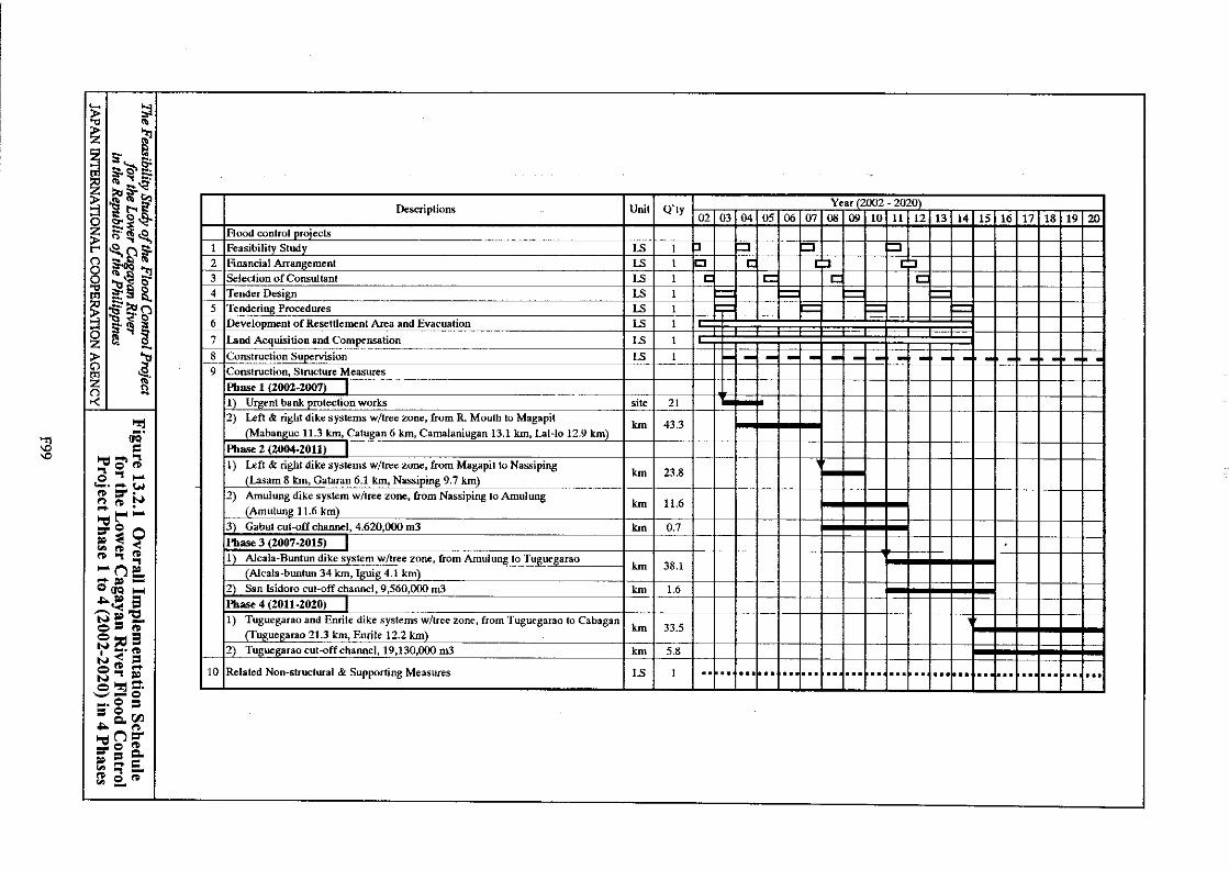
Figure 10.9.1 Im
plementation Schedule for �
Review
ed Master Plan
2002 2003 2004 2005 2006 2007 2008 2009 2010 2011 2012 2013 2014 2015 2016 2017 2018 2019 2020 2021 2022 2023 2024 2025 2026 2027 2028 2029 20301. Multipurpose Dam Project
(1) ○2. Flood Control Project
(1) Lower Reach Dike ○(2) ○(3) ○(4) ○(5) ○(6) ○(7) ○(8) ○(9) Resettlement ○(10) Supporting Measures ○(11) F.C. Pjts between Tuguegarao
3. Irrigation Project3.1 Irrigation Project to be Implemented by New Funding Sources(1) Reh. of CIADP (Iguig-Alcala- ○
Amulung PIS & Magapit PIS)(2) Tumauini Multipurpose P ○(3) ○(4) ○(5) Mallig RIS ○(6) ○(7) Dabubu IP ○(8) Delfin Albano PIP ○(9) ○(10) Sto. Nino PIP ○(11) Pinacanauan RIS ○(12) San Pablo-Cabagan IS ○(13) Zinundungan Irr. Ext. P ○(14) Nassiping PIP ○(15) Lallo West PIP ○(16) ○(17)(18) Santa Isabel PIP3.2 Irrigation Project to be Implemented by NIA and Other Agencies' Regular Fund(1) San Mariano PIP(2) Rizal IP(3) Debibi Groundwater IP(4) Dibuluan RIP(5) Villaverde IP(6) Lower Chico RIS(7) Upper Ilagan Western
Barangay PIP(8) Ilagan PIP(9) Santa Maria CPIS(10) Diversified/permanent Crops
,Pasture Land, Magat O&M(11) Supporting Measures(12) Other Projects
4. Watershed Management Project(1)(2)
5. Hydropower Project(1)(2)(3)(4)
Notes: ○ indicates projects to be implemented under the investment amount of Pesos 30 billion by the target year 2020.
Bank Protection
Diduyon Project
Reforestation
FFWS/Evacuation Center
and Siffu River Confluence
Matuno No.1 Dam Project
Alcala Amulung West PIP
Solana PIS-REP
Enrile PIP
Supporting Measures
Nueva Vizcaya Bagabag IS
Sabo Works
Tanudan Project
Mamil PIP
Ibulao Project
Siffu No.1 Dam Project
Tuguegarao Cut-off Channel
Alcala Buntun Dike
Tuguegarao and Enrile Dike
Gabut Cut-off ChannelSan Isidro Cut-off Channel Construction
D/D ConstructionD/D Construction
D/D Construction
D/D
D/D Construction
Construction
D/D Construction
D/D Construction
D/D ConstructionF/S
F/S D/D Construction
D/D Construction
D/D Construction
D/D Construction
ConstructionD/D
D/D Construction
D/D
D/D
Construction
Construction
ConstructionD/D
D/D Construction
D/D Construction
ConstructionD/D
D/D ConstructionF/S
F/S
F/S
F/S
F/S
F/S
F/S
F/S
F/S
F/S
Construction
Construction
F/S
F/S
D/D Construction
D/D Construction
D/D Construction
D/D Construction
D/D Construction
D/D ConstructionF/S
D/D ConstructionF/S
D/D ConstructionF/S
D/D ConstructionF/S
D/D ConstructionF/S
D/D ConstructionF/S
D/D ConstructionF/S
ConstructionConstructionF/S D/D
F/S D/DF/S D/D
D/D Construction
F89

The Feasibility Study of the Flood Control Project
for the Lower Cagayan River
in the Republic of the Philippines JA
PAN
INTERN
ATION
AL C
OO
PERATIO
N A
GEN
CY
Figure 10.10.1 O
rganization Chart of C
agayan River
Basin D
evelopment
CAGAYAN RIVER BASINDEVELOPMENT AUTHORITY
Project CoordinationCommittee
ProvincialDevelopment Council
RegionalDevelopment Council
City/MunicipalityDevelopment Council
Consultant
PMO WatershedManagement
· DENR· LGUs
PMO Flood Control· DPWH· NWRB· PAGASA· LGUs· OCD
PMO Land Use Management(Irrigation Development)
· DA· NIA
PMO Special Entities· AFMP· CEZA
Sub-PMOResettlement& LivelihoodProgram
LGUs/DA
Sub-PMOLower CagayanFlood ControlProject
DPWH/LGUs
Sub-PMOFlood Forecasting& Warning SystemProject
PAGASA/DPWH/NIA/NPC
Sub-PMOEvacuationSystem
OCD/RDCC/C-MDCC
F90

Alcala Amulung WestPump Irrigation Project
Babuyan Channel
Dummon River
Pared River
Chi
co R
iver
Tuguegarao River
Pinacanauan River
Caga
yan
R.Alcala
Nassiping
Magapit
Aparri
Enrile
Tuguegarao
Lasam
Gattaran
Lal-lo
Catugan Sur
Camalaniugan
Mabanguc
Iguig
Amulung
Solana
Santo Nino
Gabut COC
San Isidro COC
Tuguegarao COC
Alcala-Buntun Dike
Enrile Dike
Tuguegarao Dike
with tree zone
with tree zone
with tree zone
with tree zone
(Stage 1)(Stage 2)
Lal-lo Dike
Camalaniugan Dike
Gattaran Dike
Nassiping Dike
Mabanguc Dike
Catugan Dike
Lasam Dike
Amulung Dike
Iguig Dike
Road
Diking SystemBasin Boundary
LEGEND
Hilly Land
: Non-structural measures (evacuation system and resettlement area development) and supporting measuresare included.
Boundary of MunicipalityMunicipality
Phase 1 ImplementationPhase 2 Implementation
Bank Protection
Phase 3 ImplementationPhase 4 Implementation
N
The Feasibility Study of the Flood Control Projectfor the Lower Cagayan River
in the Republic of the PhilippinesJAPAN INTERNATIONAL COOPERATION AGENCY
Figure 11 Location of Projects for the Feasibility Study
The Feasibility Study of the Flood Control Projectfor the Lower Cagayan River
in the Republic of the PhilippinesJAPAN INTERNATIONAL COOPERATION AGENCY
0 5 10 15 20 25 kmScale
F91
Location of Flood Control Projects Subject to F/S
Figure 11.2.1

Design High Water Level
Dike DimensionsDesign Discharge Free
Board Top Width
(cu.m/s) (m) (m)
5,000 to 10,000 1.5 6
more than 10,000 2 7
Riverbank Tree ZoneFree
Board
Boundary of Administrative River Zone
Low Water ChannelDrain
Dike
Maintenance Road
Note;Riverbank tree zone is recommended in the viewpoints ofnature-oriented river improvment works and ecologicallandscape improvement in the river area.The tree zone is constructed along dike in the upstream ofAlcala provided that proper river management and maintenancesystems are estabilished in the DPWH Region 2 office andrelated LGUs.
7 m
4 m30 m
Visual Image of Earth Dike and Riverbank Tree Zone
10 m

Alcala Amulung WestPump Irrigation Project
Babuyan Channel
Dummon River
Pared River
Chi
co R
iver
Tuguegarao River
Pinacanauan River
Caga
yan
R.Alcala
Nassiping
Magapit
Aparri
Enrile
Tuguegarao
Lasam
Gattaran
Lal-lo
Catugan Sur
Camalaniugan
Mabanguc
Iguig
Amulung
Solana
Santo Nino
Gabut COC
San Isidro COC
Tuguegarao COC
Alcala-Buntun Dike
Enrile Dike
Tuguegarao Dike
with tree zone
with tree zone
with tree zone
with tree zone
(Stage 1)(Stage 2)
Lal-lo Dike
Camalaniugan Dike
Gattaran Dike
Nassiping Dike
Mabanguc Dike
Catugan Dike
Lasam Dike
Amulung Dike
Iguig Dike
Road
Diking SystemBasin Boundary
LEGEND
Hilly Land
Boundary of MunicipalityMunicipality
N
The Feasibility Study of the Flood Control Projectfor the Lower Cagayan River
in the Republic of the PhilippinesJAPAN INTERNATIONAL COOPERATION AGENCY
Figure 11 Location of Projects for the Feasibility Study
The Feasibility Study of the Flood Control Projectfor the Lower Cagayan River
in the Republic of the PhilippinesJAPAN INTERNATIONAL COOPERATION AGENCY
0 5 10 15 20 25 kmScale
Figure 11.2.3 Location of Flood Control Projects � in the Lower Cagayan

The Feasibility Study of the Flood Control Project for the Lower Cagayan River
in the Republic of the Philippines JAPAN INTERNATIONAL COOPERATION AGENCY
Figure 11.3.2 Inundation in Drainage Area 2 of AAWPIP
Qin: Discharge flowing into Drainage Area (DA)Qout: Discharge drained from DA through sluiceWLi, H: Inside inundation water levelWLo: Outside or Cagayan River flood water levelA: Inundated areaV: Inundated volume
Inundation in D2 Area at the time of the Cagayan River flood with 25-year probabilityAlcala Amulung West Pump IrrigationProject
0
2
4
6
8
10
12
14
16
18
20
1 25 49 73 97 121 145 169 193Time (hour)
Qin
Qout
WLi
WLo
A
V
WLi, WLo (masl), Qin, Qout (10m3/s), A (km2), V(million m3)


-30
-25
-20
-15
-10
-5
0
5
10
15
20
25
30
35
40
Ele
va
tio
n (
EL
m)
Gabut COC
San Isidro COC
Tuguegarao
COC
Design River
Bed Slope
Top of Dike
(EL m)
H.W.L.
(EL m)
Design River
Bed (EL m)
Commulative
Distance (km)
Station
Number
HWL Slope
H:1/750000
V:1/750
5
.27
6
.89
8
.14
9.3
0
10
.54
11
.79
12
.89
14
.09
14
.99
15
.80
16
.98
18
.05
19
.11
20
.08
21
.03
21
.62
22
.88
23
.51
24
.17
24
.86
26
.97
3.2
7
4.8
9
6.1
4
7.3
0
8.5
4
9.7
9
10
.89
12
.09
12
.99
13
.80
14
.98
16
.05
17
.11
18
.08
19
.03
19
.62
20
.88
21
.51
22
.17
22
.86
24
.97
-4
.91
-4
.61
-4
.26
-3
.94
-3
.59
-3
.24
-2
.92
-2
.52
-2
.22
-1
.95
-1
.56
-1
.21
-0
.86
-0
.31
1.1
6
2.0
7
4.0
3
4.9
8
6.0
0
7.0
1
9.1
3
1
.19
5
.94
11
.56
16
.80
22
.37
27
.96
33
.04
39
.39
44
.18
48
.52
54
.78
60
.47
65
.99
71
.78
79
.81
84
.84
95
.60
10
0.8
7
10
6.4
5
11
2.0
0
12
3.6
6
12
8.7
2
13
4.5
4
13
9.7
0
14
6.7
8
15
1.6
9
CG
0
+0
00
CG
5
+0
00
CG
1
0+
00
0
CG
1
5+
00
0
CG
2
0+
00
0
CG
2
5+
00
0
CG
3
0+
00
0
CG
3
5+
00
0
CG
4
0+
00
0
CG
4
5+
00
0
CG
5
0+
00
0
CG
5
5+
00
0
CG
6
0+
00
0
CG
6
5+
00
0
CG
8
0+
00
0
CG
8
5+
00
0
CG
10
0+
00
0
CG
10
5+
00
0
CG
11
0+
00
0
CG
11
5+
00
0
CG
13
0+
00
0
CG
13
5+
00
0
CG
14
0+
00
0
CG
14
5+
00
0
CG
15
0+
00
0
CG
15
5+
00
0
1/4500 1/5600 1/8500 1/5300
1/16000 1/5500
1/1300
Elevation of Embankment
H.W.L
25-year Flood Water Level
Left Bank Elevation
Right Bank Elevation
Mean River Bed
Deepest River Bed
Design River Bed
Suction Pipe Level
Cabagan
Sta. Maria Br.
Pinacanauan R.(R)
Tuguegarao R.(R)
Buntun Br.
Alcala
Pared R.(R)
Nassiping
Chico R.(L)
Dummon R.(R)
Zinundungan R.(L)
Magapit Pumping Sta.
Aparri
Magapit Br.
Solana Pumping Sta.
Iguig Pumping Sta.
Amulung Pumping Sta.
0.70
-2.37
-0.12
2.67
Lon
gitu
din
al P
rofile o
f Low
er Cagayan
Riv
er
Th
e F
ea
sib
ility S
tud
y o
f the F
loo
d C
on
trol P
roje
ct
for th
e L
ow
er C
ag
aya
n R
iver
in th
e R
ep
ub
lic o
f the P
hilip
pin
es
JA
PA
N IN
TE
RN
AT
ION
AL
CO
OP
ER
AT
ION
AG
EN
CY
Fig
ure 1
2.2
.2