integration of geographical and statistical information...
TRANSCRIPT

UNITED NATIONS SECRETARIAT SA/STAT/AC.279/P16 Department of Economic and Social Affairs October 2013 Statistics Division English only United Nations Expert Group on the Integration of Statistical and Geospatial Information First Meeting New York, 30 October - 1 November 2013 Agenda: Item 10
Integration of geographical and statistical information: The Brazilian case 1
Prepared by Brazil
1 This document is being produced without formal editing

Integration of geographical and statistical information: The Brazilian case
Claudio StennerCoordinator of Geography
Brazilian Institute of Geography and Statistic ‐ IBGE
UN Expert Group on the Integration of Statistical and Geospatial InformationNew York, 30 October ‐ 1 November 2013

BRASIL
Land area 8 515 767 km2
Sea area 3 600 000 km2
States 27
Municipalities 5 570
Population(2010 Demographic Census)
190 755 799
About Brazil

• Brazilian Institute of Geography and Statistics (IBGE)– Federal Institution responsible for:
• official statistics• Official reference cartography• Geographic and environmental analyses
– IBGE Structure• Headquarters: Rio de Janeiro• 27 state Offices• 583 local offices• About 6. 500 permanent employees• 192 thousands temporary employees during last census operation

IBGE Network

How does geographic and statistic production is articulated in IBGE? – A brief summary
Territorial basis of census
Enviromental information production
Geodetic System
Geographic information and
anayles
Reference cartography
Economic survey, holsehold survey and
census
Address National File

• Use of geographic information to:1. Produce statistics
2. Improve the operation of census and surveys
3. Analyze information
4. Disseminate information (interoperability)

• Use of geographic information to:1. Produce statistics2. Improve the operation of census and
surveys3. Analyze information4. Disseminate information
(interoperability)

Land cover and land use 2000

Land cover and land use 2010


• Use of geographic information to:1. Produce statistics2. Improve the operation of census and
surveys3. Analyze information4. Disseminate information
(interoperability)

The territorial basis of the Census, derived from various sources.
ALOS Image
5.570 Municipalities
316.574 Census sectors 240.382 Urban 76.192 Rural
Orthoimages
Mapping of slums areas
Field Surveys
Local, state and federal laws

Source: Digital Census Mapping Process: a conceptual framework and different implementation approaches
Post-enumerationMaps make it easier to analyze, display and disseminate; also support survey projects during the decade after the Census
EnumerationMaps support data collection, monitoring
Geotechnology contribution to Census operations
Pre-enumerationMaps provide cartographic basis for the delineation of Enumeration Areas
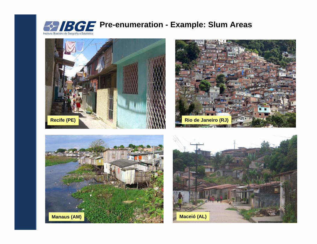
Recife (PE) Rio de Janeiro (RJ)
Maceió (AL)Manaus (AM)
Pre-enumeration - Example: Slum Areas

Pre-enumeration - Example: Slum Areas
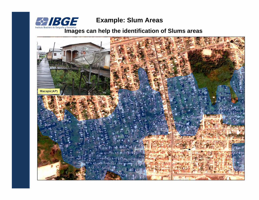
Example: Slum AreasImages can help the identification of Slums areas

New areas to disseminate Census sampleA example of slum area
Pessoas Percent ual Pessoas Percent ual
374 346 24 771 349 575Sem instrução e
fundamental incompleto 57 080 12 981 52,4 44 100 12,6Fundamental completo e
médio incompleto 38 619 5 536 22,3 33 084 9,5M édio completo e
superior incompleto 102 334 5 839 23,6 96 495 27,6Superior completo 174 712 313 1,3 174 400 49,9Não determinado 1 600 103 0,4 1 497 0,4
A glomeradossubnormaisTo t al
Areas de divulgação da amostra para aglomerados subnormais - Rio de Janeiro 4D emaisáreas
Total

Source: Digital Census Mapping Process: a conceptual framework and different implementation approaches
Geotechnology contribution to Census operations
Some advantages of integration of Geography and statistics before the enumeration:
• Identification and delimitation of adequate territories to improve the enumeration, analyzes and dissemination, like:
• Slum areas• Indian territory• Urban and rural areas
• Better cartographic accuracy• Possibility to cross the census data with other sources• Cartography features improve the quality of the census maps

Geotechnology contribution to Census operations
Some advantages of integracion of Geography and statistics during the census enumeration:
Better quality control at the time of survey
Real time monitoring of the collecting data in all municipalities
Georreferencing of rural establishments (farms, schools, health centers, etc.)
Better census maps improve the operation

•Use of geographic information to:1. Produce statistics2. Improve the operation of census and
surveys3. Analyze information4. Disseminate information
(interoperability)

Urban system (geographic network)
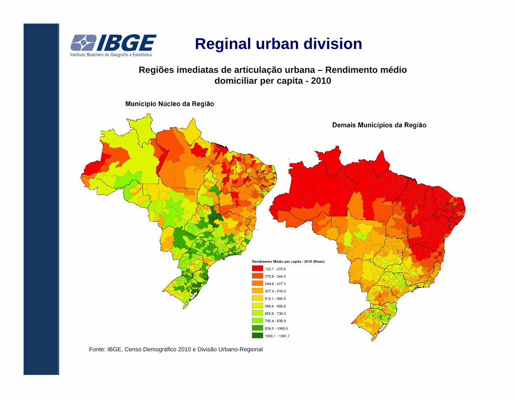
Regiões imediatas de articulação urbana – Rendimento médiodomiciliar per capita - 2010
Fonte: IBGE, Censo Demográfico 2010 e Divisão Urbano-Regional
Reginal urban division

Atlas of Demographic Census

• Use of geographic information to:1. Produce statistics2. Improve the operation of census and
surveys3. Analyze information4. Disseminate information
(interoperability)

National Spatial Data Infrastructure of Brazil ‐ INDE
•Established by Presidential Decree 6.666 of November 27, 2008
To promote the use of standards and specifications certified by the National Commission on Cartography – CONCAR
To avoid duplication of efforts and waste of resources in obtaining geospatial data by public administration bodies
To promote the proper generation, storage, access, share, dissemination and use of geospatial data produced at federal, state, and municipal level

National Spatial Data Infrastructure of Brazil ‐ INDE
Viewer INDE
Geoportal of INDE
INDE Organizations ‐ 20
9.582 metadata in GeoNetwork
592 layers published in geoserver
317 layers published in the viewer

www.visualizador.inde.gov.br
Roads and railroad investments and Gross Domestic Product per capita of Municipalities
INDE Viewer

Atlas of Demographic Census
Atlas of Demographic Census

Atlas of Demographic Census
Atlas of Demographic Census

Atlas of Demographic Census
Atlas of Demographic CensusInteroperability

Atlas of Demographic Census
Atlas of Demographic Census A data table example
http://censo2010.ibge.gov.br/apps/atlas/
