integration of gis and sap – improves business · pdf fileintegration of gis and sap...
TRANSCRIPT
Integration of GIS and SAP – Improves Business Processes
1Prof. N. S. Goje,
Assistant Professor, ITM Institute of Management
& Research, Kamptee, Nagpur – 441002
Abstract: Technology is an important factor to
improve business processes. In previous trend
businesses have been striving to optimize their
processes and improve efficiency by using SAP
systems for workflow management and GIS for
location based information management. Many
advances have been observed in both fields but
no direct integration was accomplished due to
the complexity involved in handling each
system. This resulted in loss of opportunities to
leverage spatial analysis capabilities of GIS
and business transaction management tools
such as SAP. Here we discuss the integration
techniques of SAP system with GIS. This paper
also focuses on the advantages gained from the
Integration of SAP and GIS framework.
Abstract: Geographic Information System,
SAP, Enterprise Resource Planning, SCADA
System.
I. INTRODUCTION
Making decisions based on geography is basic to
human thinking. Where we go, what will it shall
2Dr. U. A. Lanjewar
Professor, Institute of Computer Studies &
Research, VMV Commerce, JMT Arts & JJP
Science College, Wardhaman Nagar, Nagpur –
440008
be like, and what we shall do when we get there
are applied to the simple event of going to the
store or to the major event of designing a global
distribution network. By understanding geography
and people's relationship to location, we can make
informed decisions about how we conduct
activities on our planet. [1]
Geographic concepts and techniques are used to
create a common operation framework for
different disciplines. With ability to combine a
variety of datasets in an infinite number of ways,
from routinely performing work-related tasks to
scientifically exploring the complexities of our
world, GIS gives businesses the geographic
advantage to become more productive, more
aware, and more responsive to daily business
needs. SAP system become key tools in managing
medium to mega size organizations in the past
decade and continues to gain pace. This system
enables businesses to manage workflows;
monitors key business indicators, help manage
resources and material procurements, and help
manage people and information. It provides power
Prof N S Goje et al,Int.J.Computer Techology & Applications,Vol 3 (1), 255-260
IJCTA | JAN-FEB 2012 Available [email protected]
255
ISSN:2229-6093
platform for integrating data from diverse
resources and bring them into one concise
environment where all activities are tracked,
secured and managed properly in addition to
allowing for paperless data exchange. [2]
II. OBJECTIVE
In this paper we study and discuss the possible
integration methodologies between GIS and SAP
systems. It also explains how this integration
benefited to improve business processes. And
finally analyze the benefit of this integration with
the probable conclusion.
III. ABOUT GEOGRAPHIC INFORMATION
SYSTEM (GIS)
A geographic information system (GIS) is a
technological tool for comprehending geography
and making intelligent decisions. GIS organizes
geographic data so that a person reading a map
can select data necessary for a specific project or
task. A thematic map has a table of contents that
allows the reader to add layers of information to a
basemap of real-world locations. [1]
With an ability to combine a variety of datasets in
an infinite number of ways, GIS is a useful tool
for nearly every industry from agriculture to
utilities. A good GIS program is able to process
geographic data from a variety of sources and
integrate it into a map project. Many countries
have an abundance of geographic data for
analysis, and governments often make GIS
datasets publicly available. Map file databases
often come included with GIS packages; others
can be obtained from both commercial vendors
and government agencies. Some data is gathered
in the field by global positioning units that attach
a location coordinate (latitude and longitude) to a
feature such as a pump station. [3]
GIS maps are interactive. Some GIS programs are
designed to perform sophisticated calculations for
tracking storms or predicting buying patterns. GIS
applications can be embedded into common
activities such as verifying an address. From
routinely performing work-related tasks to
scientifically exploring the complexities of our
world, GIS gives people the geographic advantage
to become more productive, more aware, and
more responsive citizens of planet Earth.
In following Fig. 1, GIS brings together graphical
representation of natural objects (e.g. trees,
houses, wells, roads, etc), attributes of objects and
tools to manage behavior of the map objects. This
makes, GIS goes far beyond the management of
“background” mapping as it provides true
positional awareness in support of conducting
analysis across multiple sources of information.
Prof N S Goje et al,Int.J.Computer Techology & Applications,Vol 3 (1), 255-260
IJCTA | JAN-FEB 2012 Available [email protected]
256
ISSN:2229-6093
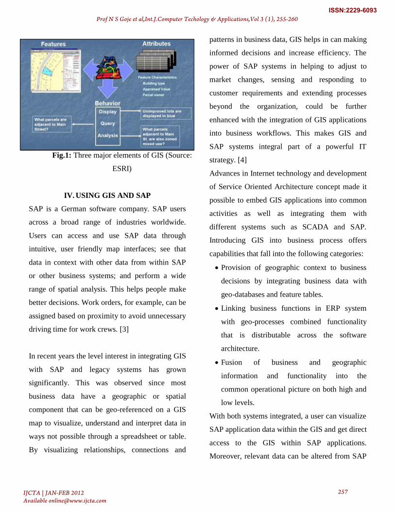
Fig.1: Three major elements of GIS (Source:
ESRI)
IV. USING GIS AND SAP
SAP is a German software company. SAP users
across a broad range of industries worldwide.
Users can access and use SAP data through
intuitive, user friendly map interfaces; see that
data in context with other data from within SAP
or other business systems; and perform a wide
range of spatial analysis. This helps people make
better decisions. Work orders, for example, can be
assigned based on proximity to avoid unnecessary
driving time for work crews. [3]
In recent years the level interest in integrating GIS
with SAP and legacy systems has grown
significantly. This was observed since most
business data have a geographic or spatial
component that can be geo-referenced on a GIS
map to visualize, understand and interpret data in
ways not possible through a spreadsheet or table.
By visualizing relationships, connections and
patterns in business data, GIS helps in can making
informed decisions and increase efficiency. The
power of SAP systems in helping to adjust to
market changes, sensing and responding to
customer requirements and extending processes
beyond the organization, could be further
enhanced with the integration of GIS applications
into business workflows. This makes GIS and
SAP systems integral part of a powerful IT
strategy. [4]
Advances in Internet technology and development
of Service Oriented Architecture concept made it
possible to embed GIS applications into common
activities as well as integrating them with
different systems such as SCADA and SAP.
Introducing GIS into business process offers
capabilities that fall into the following categories:
Provision of geographic context to business
decisions by integrating business data with
geo-databases and feature tables.
Linking business functions in ERP system
with geo-processes combined functionality
that is distributable across the software
architecture.
Fusion of business and geographic
information and functionality into the
common operational picture on both high and
low levels.
With both systems integrated, a user can visualize
SAP application data within the GIS and get direct
access to the GIS within SAP applications.
Moreover, relevant data can be altered from SAP
Prof N S Goje et al,Int.J.Computer Techology & Applications,Vol 3 (1), 255-260
IJCTA | JAN-FEB 2012 Available [email protected]
257
ISSN:2229-6093

applications as well as by using the graphical
functionality of GIS software.
V. INTEGRATION BETWEEN GIS AND
SAP
Following Fig. 2 shows the possible integration
between GIS and SAP. This integration shows the
different functionalities of SAP and GIS which
form composite business processes and services.
The below integrated view of the GIS and SAP
systems supports operative personnel in
processing and monitoring orders, reports and
maintenance plans. In so doing, it creates
automatic references between the map and the
operating resources selected in SAP-ERP. Objects
can be selected in the map and the maintenance
plans added in SAP. The geographical reference
makes it considerably easier for users to search for
and determine selected objects and offers a
completely new and intuitive way of accessing
operations information in SAP-ERP.
Fig. 2: Integration between SAP and GIS (Source:
SAP, 2009)
Organizations that integrate GIS with SAP
software today include
Utilities (water, electric, gas, waste,
recycling)
Local government
Oil and gas production
Defense and public security
Service providers (routing and
logistics)
Real estate
Forestry and forest products
Waterways, airports, ports
All of these organizations have several things in
common:
Assets and infrastructure distributed
over a wide area
Mobile field forces that need access to
corporate data
A need to better utilize assets,
infrastructure, and people in the field
through fast,
accurate, and easy access to data and
tools to efficiently and effectively
execute
business processes and optimize
resource utilization [5]
VI. INTEGRATION BENEFITS
To implement operational GIS pervasively across
the enterprise, project-based point-to-point
Prof N S Goje et al,Int.J.Computer Techology & Applications,Vol 3 (1), 255-260
IJCTA | JAN-FEB 2012 Available [email protected]
258
ISSN:2229-6093
integration approaches must be replaced by
flexible, reusable integration components that
merge SAP and GIS transactions into task-level
enterprise services. Users and applications tap into
these services to deliver information and insights
on demand, transforming SAP and GIS
applications from stand-alone products to
reusable, shared enterprise services that make
integrated applications easier to build and use.
Integrating GIS and SAP contributed following
benefits to improve business processes:
Increase asset data integrity: SAP and
GIS databases reflect same data. It
eliminates lost, duplicate and obsolete
asset data. It also support reliable
reporting and decision making
Increase end-user productivity: It find
SAP asset data instantly from the map. It
views equipment maintenance history
from the map. It also Create/update SAP
assets from the map and it dynamically
link map features to SAP assets in
real‐time
Increase SAP system acceptance and
use: GIS users interact with SAP data
directly from ESRI map using simple
interfaces
Lower asset data maintenance costs:
Data maintained in one system. It
updates and synchronizes data
automatically and eliminates manual data
entry errors. [6]
VII. FINDINGS & RESULTS
The integration of SAP and GIS immensely helps
staff identify work order locations and find related
faults, thereby reducing the resolution time and
increasing customer satisfaction. Decision makers
rely on the GIS for a visual representation of the
network, facility search options, and work order
management.
Because of the GIS/SAP integration, SAP
notifications and work orders can be retrieved
through GIS along with technical data for
equipment maintained in SAP. Customer data can
be retrieved from SAP based on service points
selected in the GIS. Notification of outages and
work orders based on customer calls are also
enabled through this integration.
The integration has given various parameters that,
through a common window, help businesses to
plan and analyze the network, leading to higher
productivity and a reduction in the time required
to execute a task. This allows more effective
problem solving and faster, better service to our
customers.
VIII. CONCLUSION
After reviewing various literature and further
recommendation given by business planners we
came into the conclusion that today, more and
Prof N S Goje et al,Int.J.Computer Techology & Applications,Vol 3 (1), 255-260
IJCTA | JAN-FEB 2012 Available [email protected]
259
ISSN:2229-6093
more non-GIS users want access to GIS
capabilities. Rather than using stand-alone GIS
applications that require setup and training,
business users want to leverage embedded GIS
functionality as an integral part of their SAP
application without shifting application contexts
when moving from SAP-centric views to GIS
views or from operational processes to analytical
ones. GIS becomes assimilated by the primary
SAP applications that users employ to do their
jobs, and they may not even realize that they're
using distinct GIS tools. This operationalization of
GIS is the next wave in enterprise GIS integration.
REFERENCES
[1] Steven Benner, “Using GIS & SAP”, GIS best
practices, ESRI June 2007. PP 1-31
[2] Mostafa Abou-Ghanem & Khalid A. Arfaj,
“SAP/GIS Integration Case Studies &
Techniques”, Saudi Aramco 2008, PP 1-12
[3] Daniela Litan, Aura Mihaela Mocanu,
“Information Systems Integration, a New Trend in
Business”, Recent Researches in
Communications, Electrical & Computer
Engineering, ISBN: 978-960-474-286-8, pp 250.
[4] SAP/GIS Integration SAGRES Project,
ArcNews magazine, ESRI Fall 2006.
[5] SAP ERP Integration Options, ESRI
Literature, ESRI August 2007.
[6] Integrating SAP for defense & security with
geospatial information, SAP Services, 2006.
Prof N S Goje et al,Int.J.Computer Techology & Applications,Vol 3 (1), 255-260
IJCTA | JAN-FEB 2012 Available [email protected]
260
ISSN:2229-6093