integration of the local mitigation strategy into the local comprehensive … · ·...
TRANSCRIPT

INTEGRATION OF THE LOCAL MITIGATION STRATEGY INTO THE LOCAL COMPREHENSIVE PLAN
Draft 12/6/2005 FLORIDA DEPARTMENT OF COMMUNITY AFFAIRS i
MARION COUNTY
Executive Summary
The experiences of the 2004 Hurricane Season epitomize the importance of better integrating hazard mitigation activities into local comprehensive planning. Last fall, residents from all over the state experienced significant damages from Hurricanes Charley, Frances, Jeanne, and Ivan by either winds, tornadoes, surge, or flooding. But this wasn’t the only time we’ve experienced natural disasters, nor will it be the last. In 1992, Hurricane Andrew devastated South Florida. In 1998 and 1999, most counties in Florida experienced wildfires. In some cases, despite fire fighters best efforts, the fires advanced through neighborhoods and homes were loss. Every year in Central Florida, new sinkholes emerge swallowing homes and damaging infrastructure. The cost of recovery for these various disasters ranges from hundreds of thousands to billions of dollars, significantly taxing local, state, and federal financial sources. Losses covered through federal funding as a result of the 2004 hurricanes alone could reach as high as $7 billion. Worst of all, however, are the many lives that, directly or indirectly, are lost due to natural disasters. It is imperative that we reduce the human and financial costs of natural disasters. Through better integration of natural hazard considerations into local comprehensive planning, we can build safer communities. This profile of Marion County has been prepared as part of a statewide effort by the Florida Department of Community Affairs (DCA) to guide local governments on integrating hazard mitigation principles into local comprehensive plans. Through the process outlined in this profile, planners will be able to (1) convey Marion County’s existing and potential risk to identified hazards; (2) assess how well local hazard mitigation principles have been incorporated into the County’s Comprehensive Plan; (3) provide recommendations on how hazard mitigation can better be integrated into the Comprehensive Plan; and (4) determine if any enhancements could be made to the LMS to better support comprehensive planning. Best available statewide level data is provided to convey exposure and risk, as well as, illustrate the vulnerability assessment component of the integration process. In this profile, we present an argument for why hazard mitigation needs to be a part of comprehensive planning through an examination of population growth, the hazards that the county is at risk from, the special needs population and structures that could be affected by these hazards, and the distribution of existing and future land uses in different hazard areas. We hope that this analysis will serve as an example of the issues each jurisdiction should consider as they update their plans to include hazard mitigation. The profile also contains a review of the LMS and the Comprehensive Plan. Based on the analysis and review, we were able to develop specific options for the County on how to incorporate more hazard mitigation into the Comprehensive Plan and how to enhance the LMS so that it is also a better tool for local planners. During our review, we found that Marion County had many strengths regarding hazard mitigation in both its LMS and Comprehensive Plan and these are outlined in the profile. There are always ways to further strengthen such plans, however, and the following is a summary of some of the options for the County to do this.
General Recommendations
• The County can encourage interdepartmental cooperation to improve information sharing and to update the LMS. Information sharing between emergency managers and planners can help tie together hazard mitigation analysis and initiatives. Also, Emergency managers can provide valuable input to Comprehensive Plan amendments and land use decisions.
• The County can support the continual improvement of hazard data and analysis of
hazards that pose a risk to the County in relation to the location and form of existing and

INTEGRATION OF THE LOCAL MITIGATION STRATEGY INTO THE LOCAL COMPREHENSIVE PLAN
Draft 12/6/2005 FLORIDA DEPARTMENT OF COMMUNITY AFFAIRS ii
MARION COUNTY
future development. Consistent spatial land use and hazard data may be used as a tool to form hazard mitigation initiatives in the LMS.
• The County, through the Comprehensive Plan, can reference the LMS and CEMP and
use them as hazard mitigation tools when making amendments and land use decisions. Cross-referencing these documents may create a more unified and consistent hazard mitigation strategy.
• The Comprehensive Plan can prioritize hazard mitigation initiatives found in the LMS
through the 5-year Capital Improvements Schedule. Criteria used to prioritize projects in the Capital Improvement Schedule can include dimensions that involve hazard mitigation. By prioritizing hazard mitigation initiatives in the Capital Improvements Schedule, the LMS goals may be reached by securing funds and providing a timeframe for actions.
• The County can promote educational programs that provide information to the public, the
business community, and County personnel such as hurricane preparedness, evacuation routes and shelter locations, flood hazard mitigation, and wildfire mitigation programs. Education and outreach programs may help create a better informed community and reduce risk to life and property. County personnel can incorporate hazard mitigation issues into existing operations as well as help create new initiatives. Input from "the ground up" may help create better awareness of hazard mitigation issues and provide insight to current County needs.
• The County can educate local site plan reviewers on the importance of flood, wildfire, and
sinkhole mitigation as well as the strategies used to reduce the vulnerability. Plan reviewers could then promote these ideas to local developers and explain their importance during the site plan review process.
• The County can adopt policies that address evacuation routes. The coordination of
evacuations is important in Central Florida due to the number of residents and visitors that may be evacuated during a hurricane. Evacuations often occur on regional levels and on routes shared by numerous jurisdictions. Coordination with the Regional Evacuation Plan and neighboring jurisdictions can facilitate a safe and timely evacuation. Comprehensive Plan polices can also address the impacts of new development on evacuation clearance times and take steps to mitigate any negative effects. As the County is expected to grow, so will the demand for evacuation route capacity. The County can prioritize hazard mitigation initiatives that address evacuation route deficiencies and provide additional capacity on evacuation routes. Also, A Hurricane Evacuation Clearance Time Level of Service standard can act as a quantitative measurement of evacuation route capacity and be used as a goal to improve evacuation clearance times and routes.
• The County can create an Emergency Shelter Capacity Level of Service. LOS standards
can provide a quantitative goal to improve emergency shelter capacity in the County. Also, the County can research alternatives to evacuation shelters such as safe rooms and retrofitting existing community facilities to meet shelter demand. The County can continue cooperation with neighboring jurisdictions and the WRPC to address emergency shelter needs. The LMS can be enhanced by including all residents into the analysis of shelter demand and initiatives rather that solely focusing on mobile home residents.
• Currently, many Comprehensive Plan policies preserve and protect natural resources
and the natural environment. Policies can be updated to include hazard mitigation as a benefit to the conservation and regulation of environmentally sensitive lands, natural resources, and floodplains. The LMS can improve this mitigation strategy by supporting conservation and preservation of natural resources. Also, improving data and analysis in

INTEGRATION OF THE LOCAL MITIGATION STRATEGY INTO THE LOCAL COMPREHENSIVE PLAN
Draft 12/6/2005 FLORIDA DEPARTMENT OF COMMUNITY AFFAIRS iii
MARION COUNTY
the LMS may also help form future mitigation actions to protect natural resources and the natural environment, as well as mitigate the dangers of natural disasters.
• The County should determine whether or not the conserved areas in the County have
lifetime designations. Future land development and regulation can address hazard mitigation issues on land with expiring conservation designations.
• Currently, there are no policies in the Comprehensive Plan that promote the retrofit or
replacement of structures at risk to natural disasters. The County could adopt policies that aim to replace and/or retrofit public and private facility structures in high hazard areas. Also, the County can adopt policies that promote future public facilities and infrastructure outside of hazard areas. The County can also promote education programs that facilitate retrofitting structures to comply or exceed code through grant or loan programs, and encourage and or assist in retrofit, relocation, or demolition of repetitive loss structures.
• The County can evaluate historic structures and sites and analyze their vulnerability to
disaster events. Historic and cultural resources may be reinforced and protected from natural disaster events, especially floods and hurricanes. The County can further support historic preservation by prioritizing initiatives to mitigate these risks.
• The County can adopt policies that address redevelopment after a disaster. Policies
could require consistency with the post-disaster redevelopment plan. The County could reduce risks associated with natural disasters and create a safer place for residents to live and work by employing redevelopment standards that create a disaster resistant community. The County can adopt policies that prohibit or restrict repair or replacement of non-conforming special needs facilities or manufactured / mobile homes if damaged beyond a defined threshold. Non-conformities can be removed in order to reduce the potential of future losses and be replaced with conforming structures. Policies can require redevelopment to occur at intensity / density of the land use designation currently in place. Also, the County can explore the development of a post-disaster recovery strategy for business. Economic vitality of a community may recover from a natural disaster quicker and more affectively with a plan that addresses the needs of the business community.
Wildfire Hazards • The County could explore resources and services offered by the Division of Forestry to
mitigate wildfire hazards. Many neighboring Counties utilize the State to help manage forested areas and carry out prescribed burns. Comprehensive Plan policies could support such an arrangement.
• The County could explore the adoption of firewise building code requirements for defined
high fire risk areas. As shown in this report, many currently vacant acres are designated for DRI development on the future land use map. Development near wildfire hazard areas may be protected by firewise building code enforcement.
• The County can require removal of exotic vegetation and proper management in high fire
risk areas as a condition of development approval. Removing fire fuels prior to development can reduce the risk of wildfire damages.
• The County can continue to cooperation with State and Federal agencies to help reduce
wildfire hazards in the County.

INTEGRATION OF THE LOCAL MITIGATION STRATEGY INTO THE LOCAL COMPREHENSIVE PLAN
Draft 12/6/2005 FLORIDA DEPARTMENT OF COMMUNITY AFFAIRS iv
MARION COUNTY
Sinkhole Hazards
• The LMS may be enhanced by using consistent data used to develop Comp Plan polices. Also, data referenced by the Comp Plan can be used to prepare the HIVA and may help further analyze sinkhole risks and mitigation initiatives. There are strong comprehensive plan polices and supporting these polices through the LMS may better unify the County's hazard mitigation strategy.
• The County can explore the use of overlay zones near karst sensitive areas and require
geological testing prior to development.
Flooding Hazards
• The Comprehensive Plan currently has many policies that address flooding in the County by steering development away from wetlands and the floodplain, protecting and conserving wetlands and water bodies, and regulating development near these resources. Acquisition is also used to purchase ESLs including wetlands. The LMS can support flood mitigation policies in the Comprehensive Plan by adding objectives that protect flood prone areas.

INTEGRATION OF THE LOCAL MITIGATION STRATEGY INTO THE LOCAL COMPREHENSIVE PLAN
Draft 12/6/2005 FLORIDA DEPARTMENT OF COMMUNITY AFFAIRS v
MARION COUNTY
Table of Contents
1. County Overview…………………………………………………………………………………... 1
2. Hazard Vulnerability………………………………………………………………………………. 2
3. Existing Mitigation Measures…………………………………………………………………….. 8
4. Comprehensive Plan Review…………………………………………………………………….. 10
5. Recommendations………………………………………………………………………………… 11
6. Sources…………………………………………………………………………………………….. 12
Attachments……………………………………………………………………………………………
Attachment A: Maps of the Existing and Future Land Uses within the 100-year Floodplain A-1
Attachment B: Maps of the Existing and Future Land Uses within Wildfire Susceptible Areas
B-1
Attachment C: Maps of the Existing and Future Land Uses within Potential Sinkhole Hazard Areas
C-1
Attachment D: Marion County Local Mitigation Strategy Goals and Objectives D-1
Attachment E: Marion County Comprehensive Plan Excerpts Related to Hazard Mitigation E-1
INTEGRATION OF THE LOCAL MITIGATION STRATEGY INTO THE LOCAL COMPREHENSIVE PLAN
Draft 12/6/2005 FLORIDA DEPARTMENT OF COMMUNITY AFFAIRS 1
MARION COUNTY
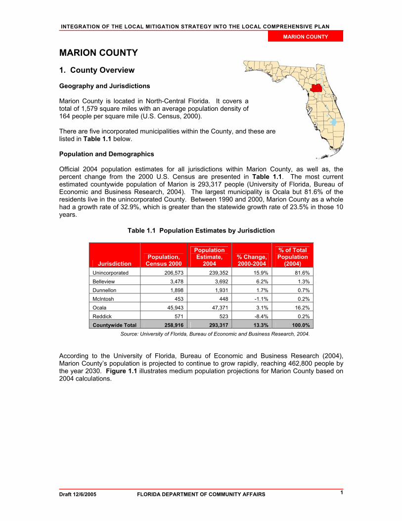
MARION COUNTY 1. County Overview Geography and Jurisdictions Marion County is located in North-Central Florida. It covers a total of 1,579 square miles with an average population density of 164 people per square mile (U.S. Census, 2000). There are five incorporated municipalities within the County, and these are listed in Table 1.1 below. Population and Demographics Official 2004 population estimates for all jurisdictions within Marion County, as well as, the percent change from the 2000 U.S. Census are presented in Table 1.1. The most current estimated countywide population of Marion is 293,317 people (University of Florida, Bureau of Economic and Business Research, 2004). The largest municipality is Ocala but 81.6% of the residents live in the unincorporated County. Between 1990 and 2000, Marion County as a whole had a growth rate of 32.9%, which is greater than the statewide growth rate of 23.5% in those 10 years.
Table 1.1 Population Estimates by Jurisdiction
Jurisdiction Population,
Census 2000
Population Estimate,
2004 % Change, 2000-2004
% of Total Population
(2004) Unincorporated 206,573 239,352 15.9% 81.6% Belleview 3,478 3,692 6.2% 1.3% Dunnellon 1,898 1,931 1.7% 0.7% McIntosh 453 448 -1.1% 0.2% Ocala 45,943 47,371 3.1% 16.2% Reddick 571 523 -8.4% 0.2% Countywide Total 258,916 293,317 13.3% 100.0%
Source: University of Florida, Bureau of Economic and Business Research, 2004. According to the University of Florida, Bureau of Economic and Business Research (2004), Marion County’s population is projected to continue to grow rapidly, reaching 462,800 people by the year 2030. Figure 1.1 illustrates medium population projections for Marion County based on 2004 calculations.

INTEGRATION OF THE LOCAL MITIGATION STRATEGY INTO THE LOCAL COMPREHENSIVE PLAN
Draft 12/6/2005 FLORIDA DEPARTMENT OF COMMUNITY AFFAIRS 2
MARION COUNTY
Figure 1.1 Medium Population Projections for Marion County, 2010-2030
050,000
100,000
150,000200,000
250,000300,000
350,000400,000
450,000500,000
Popu
latio
n
2000 2010 2015 2020 2025 2030
Year
Source: University of Florida, Bureau of Economic and Business Research, 2004.
Of particular concern within Marion County’s population, are those persons with special needs and/or limited resources such as the elderly, disabled, low-income, or language-isolated residents. According to the 2000 U.S. Census, 24.5% of Marion County residents are listed as 65 years old or over, 24.0% are listed as having a disability, 13.1% are listed as below poverty, and 8.8% live in a home with a primary language other than English. 2. Hazard Vulnerability Hazards Identification The hazards for Marion County as identified in the County’s Local Mitigation Strategy (LMS) are hurricanes and tropical storms, floods, sinkholes, and wildfires. This determination was based on historical data and map analysis. Since Marion County is not on the coast, there is minimal risk of storm surge damage from a hurricane or tropical storm. The LMS includes an historical account of hurricanes and tropical storms as well as maps showing wildfire, sinkhole, and flood hazard zones. The analysis in this report shows there are a significant number of structures at risk from these natural disasters. There is a large list of identified sinkholes in the LMS that includes the size of location of each formation. It is noted that between 1851 and 2003, 90 hurricanes passed within 100 miles of the Withlacoochee Region while damage within Marion County was limited. Although past damages from hurricanes have been mild, like all Counties in Florida it is only a matter of time until Marion County is directly hit by strong hurricane or tropical storm. (Marion County. 2005). Hazards Analysis The following analysis looks at three major hazard types: flooding, sinkholes, and wildfire. All of the information in this section, except the evacuation and shelter estimates, was obtained through the online Mapping for Emergency Management, Parallel Hazard Information System (MEMPHIS). MEMPHIS was designed to provide a variety of hazard related data in support of the Florida Local Mitigation Strategy DMA2K revision project. It was created by Kinetic Analysis Corporation (KAC) under contract with the Florida Department of Community Affairs (DCA). Estimated exposure values were determined using FEMA’s designated 100-year flood zones (A, AE, V, VE, AO, 100 IC, IN, AH), levels of concern 5 through 9 for wildfire, and high through adjacent zones for sinkholes. For more details on a particular hazard or an explanation of the

INTEGRATION OF THE LOCAL MITIGATION STRATEGY INTO THE LOCAL COMPREHENSIVE PLAN
Draft 12/6/2005 FLORIDA DEPARTMENT OF COMMUNITY AFFAIRS 3
MARION COUNTY
MEMPHIS methodology, consult the MEMPHIS Web site (http://lmsmaps.methaz.org/lmsmaps/index.html) or your countywide LMS. Existing Population at Risk Table 2.1 presents the countywide population at risk from hazards, as well as, a breakdown of the sensitive needs populations at risk. The first column in the table summarizes the residents of Marion County that live within Federal Emergency Management Agency Flood Insurance Rate Map zones, which signify special flood hazard areas. According to these maps, 9.4% of the population, or 24,220 people, are within the 100-year flood zone. In Marion County, sinkholes are also a risk, with 30.2% of the population living within a high- to adjacent-risk sinkhole zone. The last column of the table shows the amount of people that fall in medium- to high-risk wildfire zones, which is based on many factors, including vegetation and ease of access to the homes. A total of 157,594 people countywide, or 60.9% of the total population, are at medium- to high-risk from wildfire. A total of 43.9% of those at risk are disabled, making a quick evacuation difficult.
Table 2.1 Estimated Number of Persons at Risk from Selected Hazards
Population Flood Sinkhole (high-
adjacent risk) Wildfire (medium-
high risk) Minority 2,505 16,877 27,303
Over 65 5,689 18,348 39,222
Disabled 12,088 31,879 69,157
Poverty 4,178 12,547 20,438
Language Isolated 116 603 2,149
Single Parent 1,466 5,545 9,304
Countywide Total 24,220 78,272 157,594 Source: Florida Department of Community Affairs, 2005a.
Evacuation and Shelters As discussed in the previous sections, population growth in Marion County has been rapid, and this trend is projected to continue. As the population increases in the future, the demand for shelter space and the length of time it takes to evacuate the County is only going to increase. Evacuation clearance times for Marion have not been estimated yet. The data in Table 2.2 was derived from eleven regional Hurricane Evacuation Studies that have been produced by FEMA, the U.S. Army Corps of Engineers, and Florida Regional Planning Councils. The study dates range from 1995 to 2004 and are updated on a rotating basis. According to Rule 9J-5, counties must maintain or reduce hurricane evacuation times. Some experts have suggested that counties should try to achieve 12 hours or less clearance time for a Category 3 hurricane. This is due to the limited amount of time between the National Hurricane Center issuing a hurricane warning and when the tropical storm-force winds make landfall. Storm events requiring evacuation typically impact larger areas, often forcing multiple counties to issue evacuation orders and placing a greater number of evacuees on the major roadways, further hindering evacuation progress. Thus, it is important to not only consider evacuation times for Marion County, but also for other counties in the region as shown in Table 2.2. Marion County’s neighboring counties are at or over 12 hours for a Category 3 hurricane. With continued growth and the limited road network of the region, it will be difficult for them to maintain this evacuation time and may be difficult for Marion County as well.

INTEGRATION OF THE LOCAL MITIGATION STRATEGY INTO THE LOCAL COMPREHENSIVE PLAN
Draft 12/6/2005 FLORIDA DEPARTMENT OF COMMUNITY AFFAIRS 4
MARION COUNTY
Table 2.2 County Evacuation Clearance Times in Hours (High Tourist Occupancy, Medium Response)
County Category 1 Hurricane
Category 2 Hurricane
Category 3 Hurricane
Category 4 Hurricane
Category 5 Hurricane
Citrus 9.75 12 12 19 19 Lake NA NA NA NA NA Levy 7.75 7.75 14.5 14.5 14.5 Marion NA NA NA NA NA Sumter 8 10 12 16 20 NA= Not available Note: Best available data as of 7/05 Source: State of Florida, 2005 (some counties may be in the process of determining new clearance times)
Coupled with evacuation is the need to provide shelters. If adequate space can be provided in safe shelters for Marion County residents, then this could be a partial solution to the ever-increasing clearance times for evacuation. Currently, the State Shelter Plan reports that there is space for 6,970 people in the County’s shelters, and there are 21,218 more people that will need sheltering in the case of a Category 5 hurricane. It is projected that by 2009 the deficit will increase to 24,795 people in need of space (FDCA, 2004). The County will need to address this deficiency but might also try to decrease the demand for public shelters by encouraging new homes to be built with safe rooms if they are outside of flood and surge zones. Residents who are not in a flood zone could shelter in place if they had a safe room that could withstand hurricane-force winds. Safe rooms could at least be a last option for residents who cannot evacuate in time, especially in the case of a tornado. Existing Built Environment While the concern for human life is always highest in preparing for a natural disaster, there also are large economic impacts to local communities, regions, and even the State when property damages are incurred. To be truly sustainable in the face of natural hazards, we must work to protect the residents and also to limit, as much as possible, property losses that slow down a community’s ability to bounce back from a disaster. Table 2.3 presents estimates of the number of buildings in Marion County by structure type that are at risk from each of the three hazards being analyzed. As seen in the estimated population at risk statistics in Table 2.1, the potential for wildfire puts the largest amount of structures at risk as well. Regardless of hazard, the structure type most at risk is single-family homes. Flooding is also a risk to property in the County, with 60,326 structures within a flood zone. According to the latest National Flood Insurance Program Repetitive Loss Properties list, there is one home in unincorporated Marion County that has had flood damage multiple times and received insurance payments. Table 2.2 also shows 33,260 structures with high to adjacent sinkhole risk, with over half of those being single-family homes.

INTEGRATION OF THE LOCAL MITIGATION STRATEGY INTO THE LOCAL COMPREHENSIVE PLAN
Draft 12/6/2005 FLORIDA DEPARTMENT OF COMMUNITY AFFAIRS 5
MARION COUNTY
Table 2.3 Estimated Number of Structures at Risk from Selected
Hazards
Structure Type Flood Sinkhole (high-
adjacent risk) Wildfire (medium-
high risk) Single-Family Homes 23,724 18,758 44,506
Mobile Homes 12,910 3,770 15,591
Multi-Family Homes 6,640 4,042 7,393
Commercial 5,785 3,109 5,237
Agriculture 10,145 1,643 6,360
Gov./Institutional 1,122 1,938 5,148
Total 60,326 33,260 84,235 Source: Florida Department of Community Affairs, 2005a.
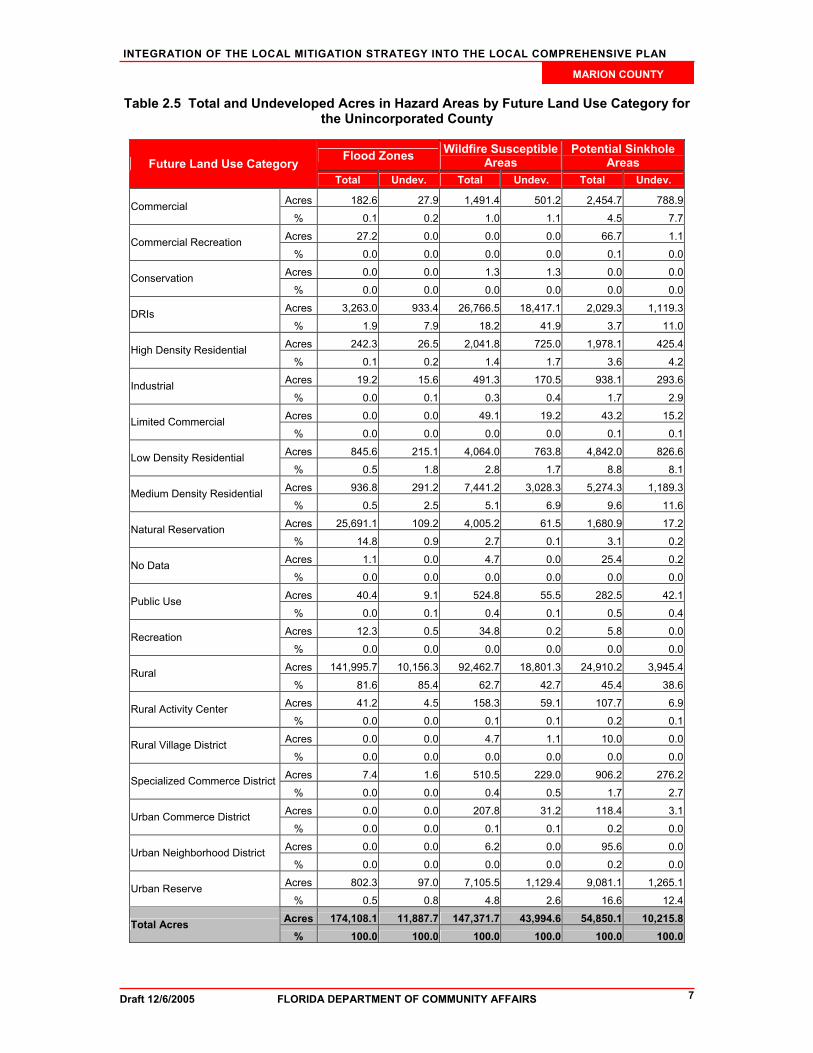
In addition to understanding exposure, risk assessment results must also be considered for prioritizing and implementing hazard mitigation measures. The risk assessment takes into account not only the people and property in a hazard area, but also the probability of occurrence that is necessary to understand the impacts to people and property. Although people and property are exposed to hazards, losses can be greatly reduced through building practices, land use, and structural hazard mitigation measures. The next section of this report examines the existing and future land use acreage in hazard areas. This information can be useful in considering where to implement risk reducing comprehensive planning measures. Analysis of Current and Future Vulnerability The previous hazards analysis section discussed population and existing structures at risk from flooding, sinkholes, and wildfire according to MEMPHIS estimates. This section is used to demonstrate the County’s vulnerabilities to these hazards spatially and in relation to existing and future land uses. The FDCA has provided maps of existing land use within hazard areas based on the 2004 County Property Appraiser geographic information system (GIS) shapefiles. Maps of future land uses in hazard areas were developed using the Marion County future land use map dated December 2002. In Attachment A, two maps present the existing and future land uses within a 100-year flood zone. There are flood-prone areas scattered across the County; however, a majority of the large swaths are to the east of Ocala and in the southwestern corner of the County. The total amount of land in these special flood hazard areas is 174,108 acres. As shown in Table 2.4, 43.9% of these acres are in parks and conservation and 40.5% are in agricultural use. Table 2.5 shows that 85.4% of the undeveloped lands are designated for future rural uses. The lack of development on these flood-prone acres and the designated low intensity use for the future leaves Marion County in a fairly good position for reducing its vulnerability to flooding. In Attachment B, maps present the land uses associated with high-risk wildfire zones. These wildfire risk areas are also scattered across the County, but the largest areas are west of Ocala. A total of 12.4% of the land within these wildfire zones is currently used for single-family homes, according to the data in Table 2.4. Single-family home neighborhoods are usually the most at risk of a wildfire spreading into the neighborhood and destroying homes because of the abundance of vegetative fuels often found between homes on these lots. Of the 43,944 vacant acres in wildfire susceptible areas, 41.9% is shown to be designated for developments of regional impact (DRIs) in the future (Table 2.5). These DRIs may not decrease the risk of wildfire since they will introduce more property and people into the risk zone and may not decrease the high-

INTEGRATION OF THE LOCAL MITIGATION STRATEGY INTO THE LOCAL COMPREHENSIVE PLAN
Draft 12/6/2005 FLORIDA DEPARTMENT OF COMMUNITY AFFAIRS 6
MARION COUNTY
risk fuels. The County does have the opportunity with these future DRIs, however, to regulate the design so that it will not increase the County’s vulnerability to wildfires. Maps showing the sinkhole hazard zones and associated existing and future land uses can be found in Attachment C. A majority of the Ocala area is at risk from sinkholes. Potential sinkhole areas spread out from Ocala along the highways. Table 2.4 shows that 43% of this area is used for agriculture, 18.6% is still vacant, and 16.1% is single-family residential. While it is good that a majority of the potential sinkhole acres are not developed, the 8,831 acres currently with single-family homes is still major vulnerability for the County. Table 2.5 shows that 38.6% of the undeveloped land at risk is designated for rural uses in the future, but 11.6% is designated for medium-density residential. Ideally this hazard zone should be restricted from development or at least regulated so that geological testing can be required before structures are built.
Table 2.4 Total Unincorporated Acres in Hazard Areas by Existing Land Use Category
Existing Land Use Category Flood Zones Wildfire
Susceptible Areas
Potential Sinkhole
Areas
Acres 70,470.80 42,527.90 23,604.30 Agriculture % 40.50 28.90 43.00
Acres 216.50 226.50 276.70 Attractions, Stadiums, Lodging % 0.10 0.20 0.50
Acres 70.00 408.90 458.10 Places of Worship % 0.00 0.30 0.80
Acres 108.10 643.40 1,148.30 Commercial % 0.10 0.40 2.10
Acres 3,883.40 2,538.30 1,310.80 Government, Institutional, Hospitals, Education % 2.20 1.70 2.40
Acres 16.50 340.60 695.30 Industrial % 0.00 0.20 1.30
Acres 76,388.30 26,368.60 3,504.20 Parks, Conservation Areas, Golf Courses % 43.90 17.90 6.40
Acres 28.10 26.50 18.70 Residential Group Quarters, Nursing Homes % 0.00 0.00 0.00
Acres 66.20 182.80 218.30 Residential Multi-Family % 0.00 0.10 0.40
Acres 4,705.40 11,247.00 4,251.50 Residential Mobile Home, or Commercial Parking Lot % 2.70 7.60 7.80
Acres 5,105.80 18,291.40 8,830.70 Residential Single-Family % 2.90 12.40 16.10
Acres 158.30 22.70 3.30 Submerged Land (Water Bodies) % 0.10 0.00 0.00
Acres 14.70 107.70 103.40 Transportation, Communication, Rights-Of-Way % 0.00 0.10 0.20
Acres 988.20 444.70 210.70 Utility Plants and Lines, Solid Waste Disposal % 0.60 0.30 0.40
Acres 11,887.70 43,994.60 10,215.80 Vacant % 6.80 29.90 18.60
Acres 174,108.00 147,371.60 54,850.10 Total Acres % 100.00 100.00 100.00
INTEGRATION OF THE LOCAL MITIGATION STRATEGY INTO THE LOCAL COMPREHENSIVE PLAN
Draft 12/6/2005 FLORIDA DEPARTMENT OF COMMUNITY AFFAIRS 7
MARION COUNTY
Table 2.5 Total and Undeveloped Acres in Hazard Areas by Future Land Use Category for the Unincorporated County
Flood Zones Wildfire Susceptible Areas
Potential Sinkhole Areas Future Land Use Category
Total Undev. Total Undev. Total Undev.
Acres 182.6 27.9 1,491.4 501.2 2,454.7 788.9Commercial % 0.1 0.2 1.0 1.1 4.5 7.7
Acres 27.2 0.0 0.0 0.0 66.7 1.1Commercial Recreation % 0.0 0.0 0.0 0.0 0.1 0.0
Acres 0.0 0.0 1.3 1.3 0.0 0.0Conservation % 0.0 0.0 0.0 0.0 0.0 0.0
Acres 3,263.0 933.4 26,766.5 18,417.1 2,029.3 1,119.3DRIs % 1.9 7.9 18.2 41.9 3.7 11.0
Acres 242.3 26.5 2,041.8 725.0 1,978.1 425.4High Density Residential % 0.1 0.2 1.4 1.7 3.6 4.2
Acres 19.2 15.6 491.3 170.5 938.1 293.6Industrial % 0.0 0.1 0.3 0.4 1.7 2.9
Acres 0.0 0.0 49.1 19.2 43.2 15.2Limited Commercial % 0.0 0.0 0.0 0.0 0.1 0.1
Acres 845.6 215.1 4,064.0 763.8 4,842.0 826.6Low Density Residential % 0.5 1.8 2.8 1.7 8.8 8.1
Acres 936.8 291.2 7,441.2 3,028.3 5,274.3 1,189.3Medium Density Residential % 0.5 2.5 5.1 6.9 9.6 11.6
Acres 25,691.1 109.2 4,005.2 61.5 1,680.9 17.2Natural Reservation % 14.8 0.9 2.7 0.1 3.1 0.2
Acres 1.1 0.0 4.7 0.0 25.4 0.2No Data % 0.0 0.0 0.0 0.0 0.0 0.0
Acres 40.4 9.1 524.8 55.5 282.5 42.1Public Use % 0.0 0.1 0.4 0.1 0.5 0.4
Acres 12.3 0.5 34.8 0.2 5.8 0.0Recreation % 0.0 0.0 0.0 0.0 0.0 0.0
Acres 141,995.7 10,156.3 92,462.7 18,801.3 24,910.2 3,945.4Rural % 81.6 85.4 62.7 42.7 45.4 38.6
Acres 41.2 4.5 158.3 59.1 107.7 6.9Rural Activity Center % 0.0 0.0 0.1 0.1 0.2 0.1
Acres 0.0 0.0 4.7 1.1 10.0 0.0Rural Village District % 0.0 0.0 0.0 0.0 0.0 0.0
Acres 7.4 1.6 510.5 229.0 906.2 276.2Specialized Commerce District % 0.0 0.0 0.4 0.5 1.7 2.7
Acres 0.0 0.0 207.8 31.2 118.4 3.1Urban Commerce District % 0.0 0.0 0.1 0.1 0.2 0.0
Acres 0.0 0.0 6.2 0.0 95.6 0.0Urban Neighborhood District % 0.0 0.0 0.0 0.0 0.2 0.0
Acres 802.3 97.0 7,105.5 1,129.4 9,081.1 1,265.1Urban Reserve % 0.5 0.8 4.8 2.6 16.6 12.4
Acres 174,108.1 11,887.7 147,371.7 43,994.6 54,850.1 10,215.8Total Acres % 100.0 100.0 100.0 100.0 100.0 100.0

INTEGRATION OF THE LOCAL MITIGATION STRATEGY INTO THE LOCAL COMPREHENSIVE PLAN
Draft 12/6/2005 FLORIDA DEPARTMENT OF COMMUNITY AFFAIRS 8
MARION COUNTY
Table 2.6 presents the total numbers of acres in a hazard zone in Marion County’s incorporated areas and how many of those acres are currently undeveloped. Ocala has the most acres in hazardous areas, however, it also is the largest municipality in the County. Ocala contains 95.1% of the sinkhole susceptible areas out of all of the incorporated areas. It still has 30.2% of those acres vacant, which provides the City a chance to regulate how development occurs on these acres to reduce its vulnerability. Ocala also has 81% of the wildfire susceptible areas with only 16.9% of those still undeveloped. The City of Reddick, while having no sinkhole hazard areas and very little potential wildfire problems, does have the most acres at risk from flooding, 735 acres. The other municipalities also have substantial numbers of flood-prone acres, suggesting that flooding may be a countywide issue to work together on.
Table 2.6 Total and Vacant Incorporated Acres in Hazard Areas
Flood Zones Wildfire Susceptible Areas
Sinkhole Susceptible Areas Jurisdiction
Total Vacant Total Vacant Total Vacant Acres 442.5 56.8 172.1 24.1 677.5 85.2
Belleview % 18.7 12.8 3.4 14.0 4.9 12.6
Acres 602.8 76.5 774.7 139.6 0.0 0.0 Dunnellon
% 25.5 12.7 15.5 18.0 0.0 0.0 Acres 354.0 51.7 0.0 0.0 0.0 0.0
McIntosh % 15.0 14.6 0.0 0.0 0.0 0.0
Acres 229.4 38.3 4,058.4 684.4 13,152.2 3,978.4 Ocala
% 9.7 16.7 81.0 16.9 95.1 30.2 Acres 735.2 129.1 5.8 3.6 0.0 0.0
Reddick % 31.1 17.6 0.1 62.1 0.0 0.0
Acres 2,363.9 352.4 5,011.0 851.7 13,829.7 4,063.6 Total Acres
% 100.0 14.9 100.0 17.0 100.0 29.4 3. Existing Mitigation Measures Local Mitigation Strategy The LMS is an ideal repository for all hazard mitigation analyses, policies, programs, and projects for the County and its municipalities due to its multi-jurisdictional and intergovernmental nature. The LMS identifies hazard mitigation needs in a community and structural or non-structural initiatives that can be employed to reduce community vulnerability. Communities can further reduce their vulnerability to natural hazards by integrating the LMS analyses and mitigation objectives into their Comprehensive Plans. An LMS prepared pursuant to the State’s 1998 guidelines has three substantive components (FDCA, 2005b):
Hazard Identification and Vulnerability Assessment (HIVA). This section identifies a community’s vulnerability to natural hazards. Under Florida rules, the HIVA is required to include, at a minimum, an evaluation of the vulnerability of structures, infrastructure, special risk populations, environmental resources, and the economy to any hazard the community is susceptible to. According to FEMA, LMSs revised pursuant to the Disaster Mitigation Act of 2000 (DMA 2000) criteria must include maps and descriptions of the areas that would be affected by each hazard, information on previous events, and estimates of
INTEGRATION OF THE LOCAL MITIGATION STRATEGY INTO THE LOCAL COMPREHENSIVE PLAN
Draft 12/6/2005 FLORIDA DEPARTMENT OF COMMUNITY AFFAIRS 9
MARION COUNTY
future probabilities. Vulnerability should be assessed for the types and numbers of exposed buildings, infrastructure, and critical facilities with estimates of potential monetary losses. Plan updates will be required to assess the vulnerability of future growth and development.
Guiding Principles. This section lists and assesses the community’s existing hazard mitigation policies and programs and their impacts on community vulnerability. The Guiding Principles typically contain a list of existing policies from the community’s Comprehensive Plan and local ordinances that govern or are related to hazard mitigation. Coastal counties frequently include policies from their Post-Disaster Redevelopment Plans (PDRPs).
Mitigation Initiatives. This component identifies and prioritizes structural and non-structural initiatives that can reduce hazards vulnerability. Proposals for amendments to Comprehensive Plans, land development regulations, and building codes are often included. Structural projects typically address public facilities and infrastructure, and buy-outs of private structures that are repetitively damaged by flood. Many of these qualify as capital improvement projects based on the magnitude of their costs and may also be included in the capital improvements elements of the Counties’ and Cities’ Comprehensive Plans. The LMS Goals and Objectives will guide the priority of the mitigation initiatives.
The Marion County LMS (adopted in 2005) was used as a source of information in developing this profile and was also reviewed for any enhancements that could be made to allow better integration with other plans, particularly the local Comprehensive Plans. Hazard Identification and Vulnerability Assessment This section of the LMS was briefly reviewed for its ability to provide hazard data that can support comprehensive planning. The LMS includes limited information and analysis of the natural disasters and risks that the County faces. It is mentioned that damages to the County due to natural disasters in the past have been limited because of its geographical location away from major rivers and the coast line. The maps in the LMS show only the hazard areas and do not attempt to correlate this with population centers or land uses. Incorporating land use and population data into the risk assessment of the LMS provides a better source of data for planners to use in policy making and policy evaluation of the local Comprehensive Plan. The LMS uses detailed data on structures at risk for all of the major hazards discussed in this profile. There is an analysis of potential damages by hazard types for each municipality as well as dollar damage projections by hazard type. The LMS also includes a list of critical facilities, mobile home parks, and hazardous material sites. Guiding Principles The guiding principles listed in the LMS promote cooperation and collaboration between public and private sectors and jurisdictions within the County. Principles also support the formation and implementation of mitigation initiatives based on cooperation and input of stakeholders and the use of valid scientific information. The guiding principles were developed through the review of the comprehensive plans, land development codes, and capital improvement plans for each participating community. The LMS also includes a scored list of mitigation initiatives. LMS Goals and Objectives The LMS Goals and Objectives can be found in Attachment D. The goals and objectives are also summarized in Section 5 as part of the recommendations analysis. The following is a summary of how well the LMS has addressed mitigation issues that coincide with planning concerns.
INTEGRATION OF THE LOCAL MITIGATION STRATEGY INTO THE LOCAL COMPREHENSIVE PLAN
Draft 12/6/2005 FLORIDA DEPARTMENT OF COMMUNITY AFFAIRS 10
MARION COUNTY
There are goals, objectives, and actions that support flood mitigation and water conservation for wildfire suppression while sinkhole hazards are not referenced. Actions site the Land Development Code, Comprehensive Plan, and municipal flood control regulations as a means to address mitigation issues. Goals 4 and 5 directly address mobile home structures and residents in regards to natural disasters. Actions call for improving codes that address evacuation capability and sheltering, replacement or retrofit of mobile home structures used as community facilities, and promoting education mitigation strategies to residents. The goals that address residents and structures that are more vulnerable to natural disasters are positive. Goals that include a wider range of structures and special needs residents may improve hazard mitigation in the County for all residents and stakeholders. Evacuation and shelter needs are important for all residents in the event of a natural disaster. Comprehensive Emergency Management Plan The Mitigation Annex of the Marion County CEMP was reviewed for consistency with the other plans and evaluated in its effectiveness as a tool for planners. Currently the CEMP discusses mitigation very briefly, but instead has more information about post-disaster response and recovery. Having post-disaster recovery covered in the CEMP is good, however, much of the information has more to do with State and Federal responsibilities than with local procedures. There is no mention of a role for comprehensive planning and mitigation planning is barely mentioned. This section needs to be updated since it was obviously written before there was an LMS in place. An update could include LMS responsibilities and the roles of different departments in planning for mitigation and implementing mitigation measures, including emergency management and planners. Post-Disaster Redevelopment Plan A Post-Disaster Redevelopment Plan (PDRP) for Marion County was not available for review at the time this profile was drafted. If Marion County has a current PDRP, this will be obtained and reviewed for the final version of this document. National Flood Insurance Program/Community Rating System The County as well as the Cities of Belleview, Dunnellon, and Ocala participate in the National Flood Insurance Program. In addition, the County and the City of Ocala participate in the Community Rating System and have current classes of 9 and 8 respectively. 4. Comprehensive Plan Review Marion County’s Comprehensive Plan (adopted in 2002) was reviewed in order to see what the County has already done to integrate their LMS policies, and hazard mitigation in general, into their planning process. A list of the goals, objectives, and policies currently in the plan that contribute to hazard mitigation is found in Attachment D. The following is a summary of how well the plan addressed the three hazards of this analysis. The Marion County Comprehensive Plan has many policies that address flooding, wildfire, and sinkhole mitigation. The County has policies that protect natural resources through Land Development Regulations, acquisition of environmentally sensitive areas, the use of transfer of development rights, clustering, buffering, and setbacks. The Parks and Environmentally Sensitive Areas Acquisition Program is used as a strategy to protect surface waters, native vegetative communities, forests, soils and farmlands. The plan also includes a policy that supports future funding of this program.

INTEGRATION OF THE LOCAL MITIGATION STRATEGY INTO THE LOCAL COMPREHENSIVE PLAN
Draft 12/6/2005 FLORIDA DEPARTMENT OF COMMUNITY AFFAIRS 11
MARION COUNTY
Sinkhole Hazards Sinkhole mitigation is addressed in a number of policies. Soil characteristics are reviewed as part of the criteria when making land use changes. Stormwater management efforts also consider soils and karst geology in order to protect groundwater recharge areas and prevent sinkhole collapse. A policy requires the County Emergency Management Division to develop procedures to be used in the event that a sinkhole develops. Flood Hazards Flood mitigation is addressed through the Land Development Regulations (LDRs). Also, natural drainage features, wetlands, and water bodies are protected through the LDRs. Development near water bodies is buffered by natural vegetation and subject to setback requirements as well as elevation requirements and the Southern Standard Building Code. Development within the 100 year flood plain is required to have the lowest floor elevation a minimal of one foot above the base flood elevation. Wildfire Hazards Wildfire mitigation is not directly referenced in the comprehensive plan. Policies that conserve water are indirectly related to wildfire mitigation by managing water supplies during shortages. 5. Recommendations For the LMS to be effective in the decision-making process of growth management, its objectives and policies must be integrated into the Comprehensive Plan. The Plan is the legal basis for all local land use decisions made. If hazard mitigation is to be accomplished beyond the occasional drainage project, these hazards must be addressed in comprehensive planning where development can be limited or regulated in high-risk hazard areas, just as sensitive environments are routinely protected through growth management policies. Mitigation of hazards is considerably easier and less expensive if done when raw land is being converted into development. Retrofitting structure and public facilities after they have been built is significantly more expensive. However, if older neighborhoods or communities are scheduled to be revitalized or redeveloped, hazard mitigation needs to be an aspect considered and integrated into the project prior to the time of development approval. Marion County has begun this process of integrating hazard mitigation throughout its Plan’s elements. The prior section summarized how the major hazards for the County have been for the most part well addressed. There is, however, still some disconnect between the LMS objectives and initiatives and the policies in the Comprehensive Plan. By tightening the connection between these documents, the County will find it easier to implement hazard mitigation, and there will be higher awareness of these issues within more departments of the County government. Table 5.1 presents options for further integration as well as the basis for these recommendations. NOTE: The recommendations set out in this section are only suggestions. Through the workshop process and contact with the local governments, the goal of this project is to end up with specific recommendations tailored and acceptable to each county. While the Profile addresses hurricanes, flooding, wildfire and sinkholes, during the update of the local comprehensive plan, the county should consider other hazards if appropriate such as, tornadoes and soil subsidence.

Draft 12/6/2005 FLORIDA DEPARTMENT OF COMMUNITY AFFAIRS 12
Table 5.1 Options for Integrating LMS Hazard Mitigation Principles into Marion County's Comprehensive Plan
Strategies & Integration Topics LMS Comp
Plan Current LMS Information,
Goals, or Objectives Current Comprehensive
Plan Policies Options for Further Integration into the
Comprehensive Plan
Options for Enhancement of the
LMS Basis For Suggested
Options
Strategy 1 - Collaboration, coordination, and education CE P. 3.3: Supports the development of a map database to catalogue wetlands, sharing information with WMD and other agencies.
CE P. 3.4: Identify and catalog all areas within the 100 year flood plain. All available resources shall be used to develop this data base such as the (FEMA) maps. CE P. 3.5: Utilize floodplain assessment and management systems from the WMDs and other State agencies to identified floodplains and drainage basins. CE P. 3.7: Utilize Soil Conservation Service data, the Locally Important Farmland and Prime Farmland map, and other best available data to identify highly erodible soils and potentially erodible soils. Limit development in these identified areas.
a) Is there information sharing and/or involvement in plan development between planners and emergency managers?
No Yes
NGARSE P. 2.1: The County Engineering and Planning Departments shall utilize info from WMDs and neighboring counties to prepare Stormwater Master Plans.
Include input from emergency managers when making land use decisions. Encourage planning staff to participate on LMS committee.
Enhance the LMS by using information regarding the location of population, infrastructure, future land use, existing development, and natural hazard areas that were used to develop the FLUE and FLUM.
Intergovernmental coordination between emergency managers, planners, other County departments may provide a more unified hazard mitigation strategy.

Draft 12/6/2005 FLORIDA DEPARTMENT OF COMMUNITY AFFAIRS 13
Table 5.1 Options for Integrating LMS Hazard Mitigation Principles into Marion County's Comprehensive Plan
Strategies & Integration Topics LMS Comp
Plan Current LMS Information,
Goals, or Objectives Current Comprehensive
Plan Policies Options for Further Integration into the
Comprehensive Plan
Options for Enhancement of the
LMS Basis For Suggested
Options
b) Do the Comp Plan, LMS, CEMP, and other local and regional plans cross-reference each other and include consistent data on hazardous locations?
Yes Yes
The Comprehensive Plan is mentioned in the LMS Goals and Objectives but only related to stormwater related flood control measures.
NEARS O. 2.0: Implement ground water recharge basin master plans. Policy 8.2: MED shall develop procedures to be used in the event that a sinkhole develops.
Reference the LMS and CEMP in the Comp Plan, promote their use as hazard mitigation tools, and support using these documents when making land use decisions. Support the efforts to continually improve data collection and analysis of elements that pose a risk to the County in relation to the location and form of existing and future development.
Reference the Comprehensive Plan and the CEMP as mechanisms for reaching LMS goals and objectives. Support the efforts to continually improve data collection and analysis of elements that pose a risk to the County in relation to the location and form of existing and future development.
Cross-referencing these documents may create a more unified and consistent hazard mitigation strategy. Sharing and improving data and analysis of hazards may provide insight that produces alternative strategies for hazard mitigation.
c) Are hazard mitigation projects addressed in the 5-year schedule of Capital Improvement Projects?
No No
Prioritize hazard mitigation initiatives found in LMS in the 5 year Capital Improvements Schedule.
Continue to update hazard mitigation initiatives and implement them through the Capital Improvement Schedule.
Hazard mitigation initiatives may be achieved sooner if they are prioritized in the Comp Plan.

Draft 12/6/2005 FLORIDA DEPARTMENT OF COMMUNITY AFFAIRS 14
Table 5.1 Options for Integrating LMS Hazard Mitigation Principles into Marion County's Comprehensive Plan
Strategies & Integration Topics LMS Comp
Plan Current LMS Information,
Goals, or Objectives Current Comprehensive
Plan Policies Options for Further Integration into the
Comprehensive Plan
Options for Enhancement of the
LMS Basis For Suggested
Options
d) Are there measures to educate residents, homeowner/property associations, and the business community of ways they can mitigate against hazards?
Yes No
Action 3.1.1 Create an education program that critical facilities could provide to their employees including directions to constructed in place shelters. Objective 4.2 Provide education to residents of mobile homes.
Promote educational and outreach programs that provide information to the public, the business community, and county personnel involving hurricane preparedness, evacuation routes and shelter locations, flood hazard mitigation, and wildfire mitigation programs.
Create objectives that address specific hazards to all residents as well as mobile home residents.
Education and outreach programs may help create a better informed community and reduce risk to life and property. County personnel can incorporate hazard mitigation issues into existing operations as well as help create new initiatives. Input from "the ground up" may help create better awareness of hazard mitigation issues and provide insight to current County needs. The County can educate local site plan reviewers on the importance of flood, wildfire, and sinkhole mitigation as well as the strategies used to reduce the vulnerability. Plan reviewers could then promote these ideas to local developers and explain their importance during the site plan review process.

Draft 12/6/2005 FLORIDA DEPARTMENT OF COMMUNITY AFFAIRS 15
Table 5.1 Options for Integrating LMS Hazard Mitigation Principles into Marion County's Comprehensive Plan
Strategies & Integration Topics LMS Comp
Plan Current LMS Information,
Goals, or Objectives Current Comprehensive
Plan Policies Options for Further Integration into the
Comprehensive Plan
Options for Enhancement of the
LMS Basis For Suggested
Options
Strategy 2 - Get out of the way: provide evacuation and sheltering services
a) Are there measures to provide adequate evacuation clearance time to support current population and population growth?
No No
Support the Withlacoochee Regional Evacuation Plan. Create a Hurricane Evacuation Clearance Time Level of Service. Analyze the impact of new development on evacuation clearance times and take steps to mitigate any negative effects. Prioritize hazard mitigation initiatives that address evacuation route deficiencies.
Support the Withlacoochee Regional Evacuation Plan. Create a Hurricane Evacuation Clearance Time Level of Service. Identify evacuation route deficiencies and create mitigation initiatives in the LMS.
Evacuations often occur on regional levels and on routes shared by numerous jurisdictions. Coordination with the WREP may ensure a safe and timely evacuation as well as address regional needs. A Hurricane Evacuation Clearance Time Level of Service standard can act as a quantitative measurement of evacuation route capacity and be used as a goal to improve evacuation clearance times and routes.
Draft 12/6/2005 FLORIDA DEPARTMENT OF COMMUNITY AFFAIRS 16
Table 5.1 Options for Integrating LMS Hazard Mitigation Principles into Marion County's Comprehensive Plan
Strategies & Integration Topics LMS Comp
Plan Current LMS Information,
Goals, or Objectives Current Comprehensive
Plan Policies Options for Further Integration into the
Comprehensive Plan
Options for Enhancement of the
LMS Basis For Suggested
Options
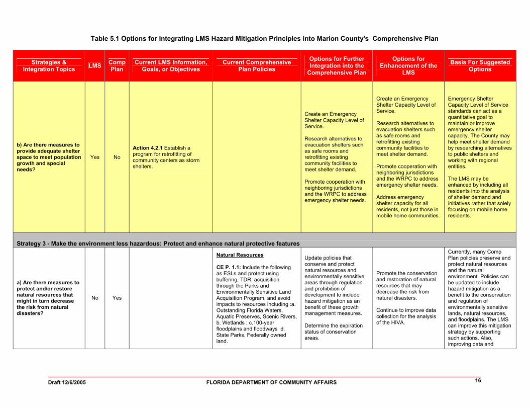
b) Are there measures to provide adequate shelter space to meet population growth and special needs?
Yes No
Action 4.2.1 Establish a program for retrofitting of community centers as storm shelters.
Create an Emergency Shelter Capacity Level of Service. Research alternatives to evacuation shelters such as safe rooms and retrofitting existing community facilities to meet shelter demand. Promote cooperation with neighboring jurisdictions and the WRPC to address emergency shelter needs.
Create an Emergency Shelter Capacity Level of Service. Research alternatives to evacuation shelters such as safe rooms and retrofitting existing community facilities to meet shelter demand. Promote cooperation with neighboring jurisdictions and the WRPC to address emergency shelter needs. Address emergency shelter capacity for all residents, not just those in mobile home communities.
Emergency Shelter Capacity Level of Service standards can act as a quantitative goal to maintain or improve emergency shelter capacity. The County may help meet shelter demand by researching alternatives to public shelters and working with regional entities. The LMS may be enhanced by including all residents into the analysis of shelter demand and initiatives rather that solely focusing on mobile home residents.
Strategy 3 - Make the environment less hazardous: Protect and enhance natural protective features
a) Are there measures to protect and/or restore natural resources that might in turn decrease the risk from natural disasters?
No Yes
Natural Resources CE P. 1.1: Include the following as ESLs and protect using buffering, TDR, acquisition through the Parks and Environmentally Sensitive Land Acquisition Program, and avoid impacts to resources including :a. Outstanding Florida Waters, Aquatic Preserves, Scenic Rivers, b. Wetlands ; c.100-year floodplains and floodways d. State Parks, Federally owned land.
Update policies that conserve and protect natural resources and environmentally sensitive areas through regulation and prohibition of development to include hazard mitigation as an benefit of these growth management measures. Determine the expiration status of conservation areas.
Promote the conservation and restoration of natural resources that may decrease the risk from natural disasters. Continue to improve data collection for the analysis of the HIVA.
Currently, many Comp Plan policies preserve and protect natural resources and the natural environment. Policies can be updated to include hazard mitigation as a benefit to the conservation and regulation of environmentally sensitive lands, natural resources, and floodplains. The LMS can improve this mitigation strategy by supporting such actions. Also, improving data and

Draft 12/6/2005 FLORIDA DEPARTMENT OF COMMUNITY AFFAIRS 17
Table 5.1 Options for Integrating LMS Hazard Mitigation Principles into Marion County's Comprehensive Plan
Strategies & Integration Topics LMS Comp
Plan Current LMS Information,
Goals, or Objectives Current Comprehensive
Plan Policies Options for Further Integration into the
Comprehensive Plan
Options for Enhancement of the
LMS Basis For Suggested
Options
CE P. 1.2: County identifies and protects locally significant natural resources including a. Surface waters b. Native vegetative communities, including forests; c. mineral resources; d. Soils
CE O 2.0: Protect, conserve, appropriately use, and enhance the quality and natural function of the ESLs.
CE P. 2.3: Require designated open space areas within subdivisions by providing incentives such as density bonuses.
CE O 4.0: Continue to purchase ESLs and Cons lands.
CE P. 4.2: Locally significant resources or ESLs shall be considered for acquisition through the Parks and Environmentally Sensitive Land Acquisition Program.
FLUE P. 4.9 Protect ESL by regulating intensity through Environmentally Sensitive Overlay Zone on FLUE.
FLUE P. 4.10 Encourage TDR's and PDR's for ESLs, karst sensitive areas, and open spaces.
FLUE P. 1.3 Regulate development of wetlands outside ESOZs
analysis in the LMS may also help form future mitigation actions to protect natural resources and the natural environment, as well as mitigate the dangers of natural disasters. The County should determine whether or not the conserved areas in the County have lifetime designations. Future land development and regulation can address hazard mitigation issues on land with expiring conservation designations.
Draft 12/6/2005 FLORIDA DEPARTMENT OF COMMUNITY AFFAIRS 18
Table 5.1 Options for Integrating LMS Hazard Mitigation Principles into Marion County's Comprehensive Plan
Strategies & Integration Topics LMS Comp
Plan Current LMS Information,
Goals, or Objectives Current Comprehensive
Plan Policies Options for Further Integration into the
Comprehensive Plan
Options for Enhancement of the
LMS Basis For Suggested
Options
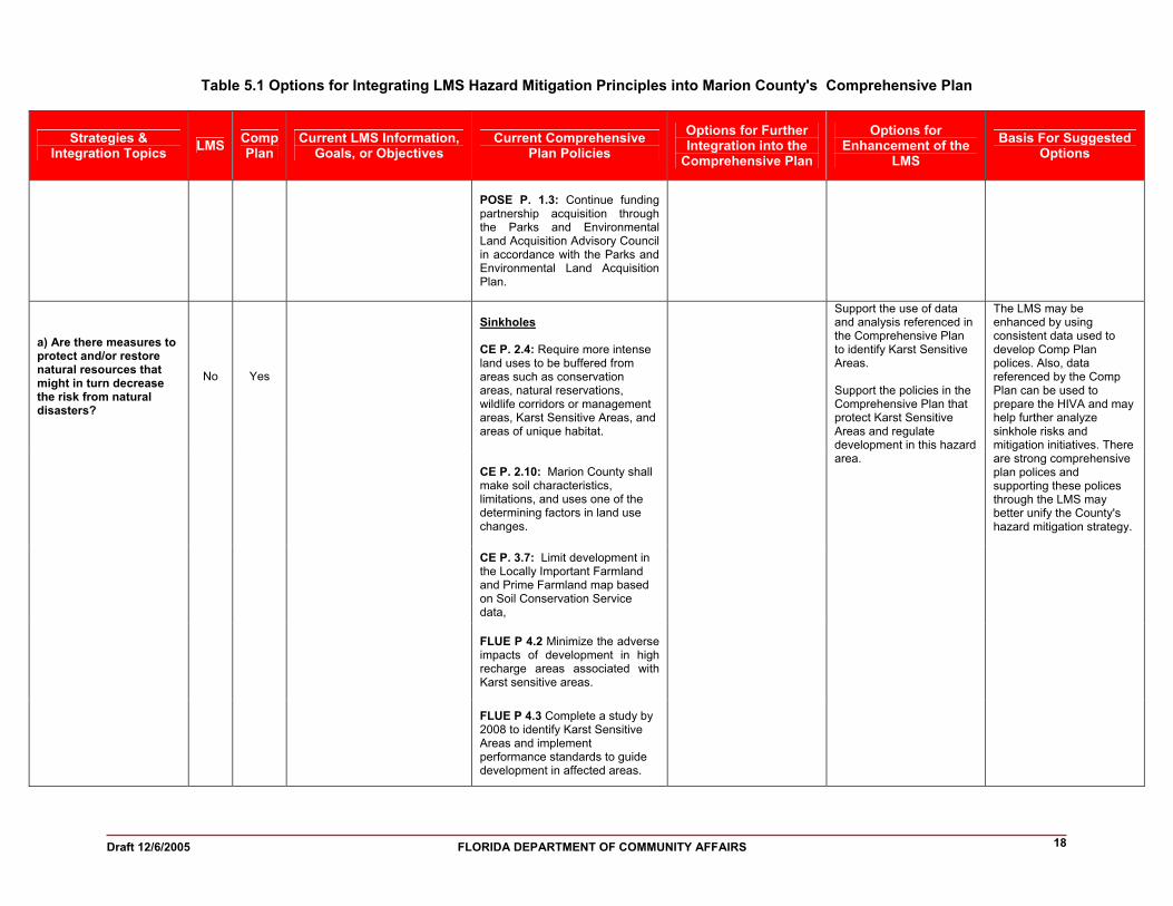
POSE P. 1.3: Continue funding partnership acquisition through the Parks and Environmental Land Acquisition Advisory Council in accordance with the Parks and Environmental Land Acquisition Plan.
Sinkholes CE P. 2.4: Require more intense land uses to be buffered from areas such as conservation areas, natural reservations, wildlife corridors or management areas, Karst Sensitive Areas, and areas of unique habitat.
CE P. 2.10: Marion County shall make soil characteristics, limitations, and uses one of the determining factors in land use changes.
CE P. 3.7: Limit development in the Locally Important Farmland and Prime Farmland map based on Soil Conservation Service data,
FLUE P 4.2 Minimize the adverse impacts of development in high recharge areas associated with Karst sensitive areas.
a) Are there measures to protect and/or restore natural resources that might in turn decrease the risk from natural disasters?
No Yes
FLUE P 4.3 Complete a study by 2008 to identify Karst Sensitive Areas and implement performance standards to guide development in affected areas.
Support the use of data and analysis referenced in the Comprehensive Plan to identify Karst Sensitive Areas. Support the policies in the Comprehensive Plan that protect Karst Sensitive Areas and regulate development in this hazard area.
The LMS may be enhanced by using consistent data used to develop Comp Plan polices. Also, data referenced by the Comp Plan can be used to prepare the HIVA and may help further analyze sinkhole risks and mitigation initiatives. There are strong comprehensive plan polices and supporting these polices through the LMS may better unify the County's hazard mitigation strategy.
Draft 12/6/2005 FLORIDA DEPARTMENT OF COMMUNITY AFFAIRS 19
Table 5.1 Options for Integrating LMS Hazard Mitigation Principles into Marion County's Comprehensive Plan
Strategies & Integration Topics LMS Comp
Plan Current LMS Information,
Goals, or Objectives Current Comprehensive
Plan Policies Options for Further Integration into the
Comprehensive Plan
Options for Enhancement of the
LMS Basis For Suggested
Options
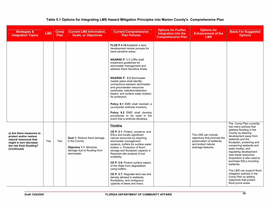
FLUE P 4.19 Establish a land development review process for karst sensitive areas.
NGARSE P. 1.1 LDRs shall implement guidelines for stormwater management and address Karst Sensitive Areas.
NGARSE P. 2.2 Stormwater master plans shall identify connections between stormwater and groundwater resources (sinkholes, retention/detention basins, and surface water bodies) for protection.
Policy 8.1 EMD shall maintain a countywide sinkhole inventory
Policy 8.2 EMD shall develop procedures to be used in the event that a sinkhole develops.
Flooding CE P. 2.1: Protect, conserve, and ESLs and locally significant natural resources by requiring stormwater management systems, buffers for surface water bodies; c. Protection of flood storage and floodplain capacity d. Required site analysis of soil suitability.
CE P. 2.6: Protect surface waters of the State from degradation using buffers.
a) Are there measures to protect and/or restore natural resources that might in turn decrease the risk from flooding? (Continued)
Yes Yes
Goal 1: Reduce flood damage in the County. Objective 1.1: Minimize damage due to flooding from stormwater.
CE P. 2.7: Regulate land use and density allowed in wetlands, floodplains, and contiguous uplands of lakes and rivers.
The LMS can include objectives that promote the preservation of wetlands and protect natural drainage features.
The Comp Plan currently has many policies that address flooding in the County by steering development away from wetlands and the floodplain, protecting and conserving wetlands and water bodies, and regulating development near these resources. Acquisition is also used to purchase ESLs including wetlands. The LMS can support flood mitigation policies in the Comp Plan by adding objectives that protect flood prone areas.

Draft 12/6/2005 FLORIDA DEPARTMENT OF COMMUNITY AFFAIRS 20
Table 5.1 Options for Integrating LMS Hazard Mitigation Principles into Marion County's Comprehensive Plan
Strategies & Integration Topics LMS Comp
Plan Current LMS Information,
Goals, or Objectives Current Comprehensive
Plan Policies Options for Further Integration into the
Comprehensive Plan
Options for Enhancement of the
LMS Basis For Suggested
Options
FLUE P 1.1: Adopt LDRs that shall protect the ESLs and regulate activities having an adverse impact upon areas subject to seasonal and periodic flooding and provide for drainage and stormwater management;
SWE GOAL: To provide adequate stormwater management, afford reasonable protection from flooding, and protect the quality of surface water and groundwater in Marion County.
SWE O 8.0: Marion County shall implement land development regulations to provide protection measures for natural drainage features.
SWE P. 8.3: LDRs shall regulate dredge and fill activities within the 100-year floodplain.
Wildfires CE P. 2.8: LDRs shall protect native vegetation in areas slated for development through the designation of required open space.
CE P. 2.15: Implement water conservation programs.
a) Are there measures to protect and/or restore natural resources that might in turn decrease the risk from natural disasters such as wildfires? (Continued)
Yes Yes
Goal 2 Reduce water use and conservation to control the availability of water during drought for wildfire suppression. Objective 2.1 Minimize damage due over use of water. Action 2.1.1 Adopt conservation regulations regarding types of landscaping allowed as well as type of irrigation systems allowed. CE P. 3.2: Maintain viable native
plant communities by measures such as Transfer of Development Rights, clustering and mitigation banking.
Require removal of exotic vegetation and proper management in high fire risk areas as a condition of development approval. Support wildfire mitigation strategies such as including prescribed burning through cooperation with the Florida Division of Forestry.
Create policy that commits to reduce wildfire risk in the County.
Removing fire fuels prior to development can reduce the risk of wildfire damages. Also, continuing to cooperation with State and Federal agencies may also help reduce wildfire hazards in the County.

Draft 12/6/2005 FLORIDA DEPARTMENT OF COMMUNITY AFFAIRS 21
Table 5.1 Options for Integrating LMS Hazard Mitigation Principles into Marion County's Comprehensive Plan
Strategies & Integration Topics LMS Comp
Plan Current LMS Information,
Goals, or Objectives Current Comprehensive
Plan Policies Options for Further Integration into the
Comprehensive Plan
Options for Enhancement of the
LMS Basis For Suggested
Options
PWE O 7.0: The Marion County Utility Manual shall include to promote water conservation.
PWE P 7.1: Limit impacts of development on natural environment using clustering, attached dwelling units, and other innovative land use techniques to decrease outdoor water use; preservation of the existing native vegetation; limit construction within the 100-year floodplain, ESLs, poor soils, and high recharge areas; d. Limitation of the amount of impervious surfaces.
PWE P 7.2: Water conservation techniques shall be included in the LDRs.
PWE P. 7.4: Use available information from the WMDs to develop and adopt regulations for water use restrictions during shortages.
Strategy 4 - Make structures more resistant to natural hazard forces
a) Are there measures that support retrofitting or relocating private and/or public structures in hazard areas?
Yes No
Goal 4 Reduce risk of mobile home residents to natural disasters. Objective 4.1 Enhance the quality of the homes and specify locations for construction. Action 4.1.2 Replace and/or retrofit mobile structures used in community buildings, schools, and local agency operations.
Replace and/or retrofit public facility structures in high hazard areas. Encourage education programs that facilitate retrofitting structures to comply or exceed code through grant or loan programs. Encourage and or assist in retrofit, relocation, or demolition of repetitive loss structures.
Create a policy that commits to the reduction of repetitive loss structures.
Reinforcing public and critical facilities before a disaster may help insure post-disaster operations and reduce redevelopment costs. Public education of retrofitting techniques can also support mitigation efforts. Addressing repetitive loss structures before flooding events can reduce risk to persons and property.

Draft 12/6/2005 FLORIDA DEPARTMENT OF COMMUNITY AFFAIRS 22
Table 5.1 Options for Integrating LMS Hazard Mitigation Principles into Marion County's Comprehensive Plan
Strategies & Integration Topics LMS Comp
Plan Current LMS Information,
Goals, or Objectives Current Comprehensive
Plan Policies Options for Further Integration into the
Comprehensive Plan
Options for Enhancement of the
LMS Basis For Suggested
Options
FLUE O 4: Use TDR, PDR, and performance standards to prevent further degradation of natural and historic resources.
FLUE P 4.6: Marion County shall continue to identify significant historic resources which are in need of protection, as specified in Objective 5 and its associated policies of the Housing Element of this Plan.
FLUE P 4.11: Land Development Regulations shall protect, and conserve or preserve the identified historic resources.
b) Are there measures to protect cultural resources from natural hazards?
No Yes
HE P. 5.3: Marion County shall assist the rehabilitation and adaptive reuse of historically significant housing by providing technical assistance and information regarding the application and utilization of state and federal assistance programs.
Assess the vulnerability and risk of historical structures to various hazards. Support historic preservation by analyzing risks to historic and cultural resources and prioritizing initiatives to mitigate these risks.
Create policy that commits to the preservation of cultural and historic resources and supports their protection from natural hazards.
Preventive measures to historic structures and sites can be taken and may reduce damage from natural disasters.
FLUE P 4.9: See Attachment E FLUE P 4.13 See Attachment E
c) Are there measures to require compliance with or exceed building codes and/or design standards for certain hazard areas?
Yes Yes Action 1.1.2 Approval of construction will not take place for any facility within a designated flood hazard area unless mitigation measures are identified and installed. These regulations will be found in the adopted flood control regulations.
FLUE P. 8.4: *The County's land development regulations shall regulate finished floor elevations for new structures within the established 100-year floodplain.
Support enforcement of the Florida Building Code and establish higher standards for structures in high risk hazard areas. Adopt firewise building code requirements for defined high fire risk areas.
Support the enhancement of codes that mitigate against flooding and wildfires.
Enforcing a strong building code may create stronger structures that can better withstand natural disasters. A firewise building code can reduce wildfire risk to structures and persons.

Draft 12/6/2005 FLORIDA DEPARTMENT OF COMMUNITY AFFAIRS 23
Table 5.1 Options for Integrating LMS Hazard Mitigation Principles into Marion County's Comprehensive Plan
Strategies & Integration Topics LMS Comp
Plan Current LMS Information,
Goals, or Objectives Current Comprehensive
Plan Policies Options for Further Integration into the
Comprehensive Plan
Options for Enhancement of the
LMS Basis For Suggested
Options
Action 4.1.1 Develop new or enhanced codes regarding the characteristics of mobile home communities to provide enhanced capability in evacuation and/or sheltering from high winds.
HE P. 3.3: Marion County shall review the enforcement procedures to ensure that all housing codes as adopted by Marion County are consistent with the most current applicable state laws and the Southern Standard Building Code, that they are being implemented and shall address determined deficiencies.
Strategy 5 - Manage the development and redevelopment in hazardous areas
FLUE P 2.8: Protect commercial and industrial development from natural hazards by locating development away from areas that have natural hazards or that may contain sensitive natural resources.
FLUE P 2.19: Locate Urban Commerce Districts away from natural hazards.
a) Are there measures to limit population densities in high-hazard areas?
No Yes
FLUE P 3.9: LDRs shall provide for siting of new industrial/commerce parks in Specialized Commerce Districts away from ESL or hazardous soil areas.
Support development and the location of future populations away from hazard areas.
b) Are there measures to limit public expenditures that subsidize development in high-hazard areas?
No No Support the siting public facilities and infrastructure outside hazard areas.
Support the siting public facilities and infrastructure outside hazard areas.
May reduce risk of damages caused by natural disasters.

Draft 12/6/2005 FLORIDA DEPARTMENT OF COMMUNITY AFFAIRS 24
Table 5.1 Options for Integrating LMS Hazard Mitigation Principles into Marion County's Comprehensive Plan
Strategies & Integration Topics LMS Comp
Plan Current LMS Information,
Goals, or Objectives Current Comprehensive
Plan Policies Options for Further Integration into the
Comprehensive Plan
Options for Enhancement of the
LMS Basis For Suggested
Options
CE P. 1.1: Use TDRs and buffering to protect ESLs.
CE P. 2.2: Marion County shall provide for the clustering of development to protect environmentally sensitive lands and locally significant natural resources.
FLUE P 1.2: Innovative land use development patterns including, but not limited to, Traditional Neighborhood Overlay Districts, Hamlets Rural Towns, and clustering shall be permitted and encouraged.
c) Are there creative neighborhood design solutions or development regulations that mitigate hazards, such as clustering or transfer of development rights?
No Yes
FLUE P 4.20: Adopt LDRs which will implement TDR system to protect natural environment.
Support policies in the Comp Plan that promote clustering of development, special overlay districts, and TDRs.

Draft 12/6/2005 FLORIDA DEPARTMENT OF COMMUNITY AFFAIRS 25
Table 5.1 Options for Integrating LMS Hazard Mitigation Principles into Marion County's Comprehensive Plan
Strategies & Integration Topics LMS Comp
Plan Current LMS Information,
Goals, or Objectives Current Comprehensive
Plan Policies Options for Further Integration into the
Comprehensive Plan
Options for Enhancement of the
LMS Basis For Suggested
Options
d) Are there measures to limit redevelopment in hazard areas and procedures for post-disaster recovery that will lead to a more disaster-resistant community?
No No
Develop a post-disaster recovery strategy for business. Prohibit or restrict repair or replacement of non-conforming special needs facilities or manufactured / mobile homes if damaged beyond a defined threshold. Redevelopment must occur at intensity / density of the land use designation currently in place. Approval for repairs and rebuilding should be based on the post-disaster redevelopment plan.
Support the Post Disaster Redevelopment Plan.
Economic vitality of a community may recover from a natural disaster quicker and more affectively with a post-disaster recovery strategy for business. Non-conformities can be removed in order to reduce the potential of future losses and be replaced with conforming structures. Redevelopment in hazard areas may be regulated to conform to existing mitigation strategies. Following the post-disaster redevelopment plan can reduce risks associated with natural disasters and create a safer place residents to live and work.
Abbreviations: G= Goal; O= Objective; P=Policy; PDRP= Post-Disaster Redevelopment Plan; HVZ= Hurricane vulnerability zone; CHHA= Coastal High Hazard Area CE= Conservation Element; HE= Housing Element; FLUE= Future Land Use Element; UE= Utilities Element; CIE= Capital Improvements Element; IE= Infrastructure Element; CME= Coastal Management Element

INTEGRATION OF THE LOCAL MITIGATION STRATEGY INTO THE LOCAL COMPREHENSIVE PLAN
Draft 12/6/2005 FLORIDA DEPARTMENT OF COMMUNITY AFFAIRS 26
MARION COUNTY
6. Sources Florida Department of Community Affairs. 2004. Statewide Emergency Shelter Plan.
Tallahassee, FL. Florida Department of Community Affairs. 2005a. Mapping for Emergency Management,
Parallel Hazard Information System. Tallahassee, FL. http://lmsmaps.methaz.org/lmsmaps/index.html.
Florida Department of Community Affairs. 2005. Protecting Florida’s Communities: Land
Use Planning Strategies and Best Development Practices for Minimizing Vulnerability to Flooding and Coastal Storms. Tallahassee, FL.
Marion County. 2002. Marion County Comprehensive Plan. Marion County. Date Unknown. Marion County Comprehensive Emergency Management
Plan. Marion County. 2005. Local Mitigation Strategy. University of Florida, Bureau of Economic and Business Research. 2004. Florida Statistical
Abstract. Gainesville, FL. U.S. Census Bureau. 2000. State and County Quickfacts. Retrieved in 2005 from
http://quickfacts.census.gov/qfd/index.html.

INTEGRATION OF THE LOCAL MITIGATION STRATEGY INTO THE LOCAL COMPREHENSIVE PLAN
FLORIDA DEPARTMENT OF COMMUNITY AFFAIRS 12/6/2005
A-1
MARION COUNTY
Attachment A
Maps of the Existing and Future Land Uses within the 100-year Floodplain

INTEGRATION OF THE LOCAL MITIGATION STRATEGY INTO THE LOCAL COMPREHENSIVE PLAN
FLORIDA DEPARTMENT OF COMMUNITY AFFAIRS 12/6/2005
B-1
MARION COUNTY
Attachment B
Maps of the Existing and Future Land Uses within Wildfire Susceptible Areas

INTEGRATION OF THE LOCAL MITIGATION STRATEGY INTO THE LOCAL COMPREHENSIVE PLAN
FLORIDA DEPARTMENT OF COMMUNITY AFFAIRS 12/6/2005
C-1
MARION COUNTY
Attachment C
Maps of the Existing and Future Land Uses within Potential Sinkhole Hazard Areas

INTEGRATION OF THE LOCAL MITIGATION STRATEGY INTO THE LOCAL COMPREHENSIVE PLAN
FLORIDA DEPARTMENT OF COMMUNITY AFFAIRS D-1 12/6/2005
MARION COUNTY
Attachment D
Marion County Local Mitigation Strategy Goals and Objectives Goal 1: Reduce flood damage in the County
Objective 1.1: Minimize damage due to flooding from stormwater
Action 1.1.1 Adapt stormwater related flood control measures in the guiding principles including LDC and Comprehensive Plans. Action 1.1.2 Approval of construction will not take place for any facility within a designated flood hazard area unless mitigation measures are identified and installed. These regulations will be found in the adopted flood control regulations.
Objective 1.2: Minimize damage due to pollution from stormwater
Action 1.2.1 Design retention/detention systems to handle stormwater runoff from construction sites, not simply for final construction Action 1.2.2 Create development codes that provide structural mitigation measures to improve existing drainage projects and secondly develop new projects.
Goal 2: Reduce water use and conservation to control the availability of water during drought for wildfire suppression
Objective 2.1: Minimize damage due over use of water
Action 2.1.1 Adopt conservation regulations regarding types of landscaping allowed as well as type of irrigation systems allowed. Action 2.1.2 Approval of construction will not take place of any facility within a designated flood hazard area unless mitigation measures are identified and installed. These regulations will be found in the municipal flood control regulations.
Goal 3: Reduce danger of critical facilities to potential hazardous waste releases
Objective 3.1: Enhance critical facilities of potential danger.
Action 3.1.1 Create an education program that critical facilities could provide to their employees including directions to constructed in place shelters. Action 3.1.2 Have each municipality provide an early detection and warning system to the critical facilities in the event of a release.
Goal 4: Reduce risk of mobile home residents to natural disasters
Objective 4.1: Enhance the quality of the homes and specify locations for construction.
INTEGRATION OF THE LOCAL MITIGATION STRATEGY INTO THE LOCAL COMPREHENSIVE PLAN
FLORIDA DEPARTMENT OF COMMUNITY AFFAIRS D-2 12/6/2005
MARION COUNTY
Action 4.1.1 Develop new or enhanced codes regarding the characteristics of mobile home communities to provide enhanced capability in evacuation and/or sheltering from high winds. Action 4.1.2 Replace and/or retrofit mobile structures used in community buildings, schools, and local agency operations.
Action 4.1.3 Propose other such programmatic improvements that would result in increased protection for residents of mobile and manufactured homes. Action 4.1.4 Improve enforcement of existing requirements for tie downs.
Objective 4.2: Provide education to residents of mobile homes
Action 4.2.1 Establish a program for retrofitting of community centers as storm shelters. Action 4.2.2 Distribute weather radios to mobile home community managers and/or residents of mobile homes for advanced warning of severe weather. Action 4.2.3 Establish a program for financially assisting economically disadvantaged mobile home residents in the repair or placement of tie downs. Action 4.2.4 Provide public education programs in wind and flood mitigation to existing mobile home residents.

INTEGRATION OF THE LOCAL MITIGATION STRATEGY INTO THE LOCAL COMPREHENSIVE PLAN
FLORIDA DEPARTMENT OF COMMUNITY AFFAIRS E-1 12/6/2005
MARION COUNTY
Attachment E
Marion County Comprehensive Plan Excerpts Related to Hazard Mitigation Conservation Element
Policy 1.1: Marion County shall include the following as environmentally sensitive lands due special protection through measures such as buffering from adverse impacts of development, transfer of development rights to lower density in sensitive areas, acquisition through the Parks and Environmentally Sensitive Land Acquisition Program, and requiring development to avoid adverse impacts to these resources :
a. Outstanding Florida Waters, Aquatic
Preserves, Scenic Rivers, and other water bodies receiving local, state or federal designation for protection;
b. Wetlands as defined by Rule 62-40.210(26),F.A.C. (1992); c. 100-year floodplains and floodways as identified in data
sources such as FEMA flood maps and Federal Flood Hazard maps;
Policy 1.2: Marion County shall include the following categories of
resources as locally significant natural resources due special protection through measures such as buffering from adverse impacts of development, transfer of development rights to areas contiguous to these land or water resources, acquisition through the Parks and Environmentally Sensitive Land Acquisition Program, and requiring development to minimize adverse impacts to these resources:
a. Surface waters of the State; b. Native vegetative communities, including forests; c. Commercially valuable mineral resources; d. Soils, including: hydric soils; prime farmland and locally important farmland; and timberland, as determined by soil productivity and crop yield. Prime farmland and locally important farmland as defined by the USDA Soil Conservation Service include the following soil series : Blitchton, Kanapaha, Micanopy, Fellowship, Kendrick, Flemington, Gainesville, Lochloosa, Hague, and Zuber; e. Good quality air; f. Good quality groundwater; and g. Fisheries, wildlife, and wildlifehabitat.
Objective 2.0: Marion County shall protect, conserve, appropriately use, and enhance the quality and natural function of the environmentally sensitive lands, natural reservations, and locally significant resources within Marion County. The Marion County Land Development Code shall include the mechanisms for Marion County to minimize the impact of development upon and protect, conserve, and enhance the quality and natural function of environmentally sensitive lands, natural reservations, and locally significant natural resources.
INTEGRATION OF THE LOCAL MITIGATION STRATEGY INTO THE LOCAL COMPREHENSIVE PLAN
FLORIDA DEPARTMENT OF COMMUNITY AFFAIRS E-2 12/6/2005
MARION COUNTY
Policy 2.1: Marion County shall protect, conserve, and enhance environmentally sensitive lands, and locally significant natural resources as specified under Objective 1.0 of this element. The following categories of regulation shall be applied in regulating development or other activities that may adversely affect these resources and in creating land development regulations:
a. Protection of surface and ground water quality by requiring
stormwater management systems designed to meet the Level of Service standards specified in Policy 4.1 Stormwater Management sub-element, and vegetative buffers for surface waterbodies; and by establishing wellhead protection zones to protect ground water, as specified in Future Land Use Element Policy 4.15 and 4.16 and Natural Ground Water Aquifer Recharge Element Policy 6.2 ;
c. Protection of flood storage and floodplain capacity by restricting land use activities that materially impair floodplain capacity or alter the characteristics of the existing 100-year floodplain;
d. Required site analysis of soil suitability, topographic and geologic characteristics, vegetative communities, and the occurrence of listed species and their habitat to determine the appropriate resource conservation measures and the inherent site limitations to development.
Policy 2.2: Marion County shall provide for the clustering of development
to protect environmentally sensitive lands and locally significant natural resources. To protect and conserve these resources, development will be required to cluster away from these resources when and where they are found on-site. Land development regulations shall be created that require the use of clustering in this manner.
Policy 2.3: Marion County shall further the conservation goals and
objectives of the Comprehensive Plan by requiring designated open space areas within subdivisions and other residential and commercial developments, and by providing incentives such as density bonuses that do not adversely impact environmentally sensitive lands and locally significant natural resources. Land development regulations shall be adopted by Marion County that require designated open space as specified in Policy 3.1 Recreation and Open Space Element and Policies 2.1, 2.2, 3.1, 3.2, and 3.3 of the Future Land Use Element.
Policy 2.4: Marion County shall require more intense land uses to be buffered from areas such as conservation areas, natural reservations, wildlife corridors or management areas, Karst Sensitive Areas, and areas of unique habitat. The width of the required buffers shall be based upon the following considerations, at a minimum: the type and intensity of the encroaching land use; the characteristics of the site such as soil types, topography, and vegetative plant community types;
INTEGRATION OF THE LOCAL MITIGATION STRATEGY INTO THE LOCAL COMPREHENSIVE PLAN
FLORIDA DEPARTMENT OF COMMUNITY AFFAIRS E-3 12/6/2005
MARION COUNTY
and the nature and use of the area being buffered from the encroaching land use. The purpose of buffering areas with conservation significance or natural resource value is to perpetuate those qualities that make an area significant and protect the conservation/resource area from the intense uses and potentially adverse impacts associated with development or more intense land-use activities. To this end, it shall be the function of conservation or resource protection based buffers to:
b. Protect the quality of the conservation/resource area from
being degraded or adversely impacted by activities such as stormwater runoff and nutrient loading, hydrologic modification, erosion, or sedimentation occurring upon areas of more intense land uses. Land development regulations shall be adopted that provide for the above described buffers.
Policy 2.6: Marion County shall protect surface waters of the State from
degradation. Land development regulations shall be adopted that protect these resources. These regulations shall include, at a minimum; a setback of seventy-five (75) feet from the ordinary highwater line, or from the mean annual water line, or from the state jurisdictional line, whichever is greater; buffer areas of no less than fifty (50) feet landward of the ordinary high water line, the mean annual water line, or from wetlands, whichever provides the greater protection for the surface water body; limitations upon hydrologic modification such as channelization and dredge and fill that would materially alter the hydraulic characteristics of the water bodies or the surrounding 100-year floodplain; limitations upon aquatic vegetation removal to that allowed by the Department of Environmental Protection.
Policy 2.7: Marion County shall specify the land use and density allowed
in wetlands, floodplains, and contiguous uplands of lakes and rivers. For areas designated as Urban Area on the Future Land Use Map that are wetlands the base density shall be one (1) unit per five (5) acres. For areas designated as Urban Area on the Future Land Use Map that are within 100-year floodplains, the base density shall be one (1) unit per acre. For areas that are contiguous uplands of lakes, rivers, and other water bodies within Urban Areas as designated on the Future Land Use Map, densities in these areas shall be at no more than two dwelling units per gross acre if aerobic septic systems are used and no more than one dwelling unit per gross acre if conventional septic systems are used. In upland areas where central sewer systems are available and utilized, density may be at the density allowed by the underlying zoning category. Underlying densities specified in Policy 3.1 of the Future Land Use Element shall apply to development in the Rural Areas and clustering away from environmentally sensitive areas shall be required. For purposes of this policy, contiguous parcels of record under common ownership shall be considered in the aggregate and shall be required to aggregate to meet the wetland or floodplain density

INTEGRATION OF THE LOCAL MITIGATION STRATEGY INTO THE LOCAL COMPREHENSIVE PLAN
FLORIDA DEPARTMENT OF COMMUNITY AFFAIRS E-4 12/6/2005
MARION COUNTY
requirements. Land development regulations shall be adopted that implement this policy.
Policy 2.8: Marion County shall adopt land development regulations that
provide for the protection of native vegetation in areas slated for development through the designation of required open space as specified in Policy 3.1 Recreation and Open Space Element and Policies 2.1, 2.2, 3.1, 3.2, and 3.3 Future Land Use Element. Land development regulations shall be adopted that implement this policy.
Policy 2.10: Marion County shall make soil characteristics, limitations, and
uses one of the determining factors in land use changes. The limitations to development as specified in the USDA Soil Conservation Service Soil Survey of Marion County for the given soil types found onsite shall be reviewed for land use changes of increasing density or intensity. If the on-site soil characteristics are such that severe limitations to development are identified, then these limitations shall be considered during the land use change review process and any land use change shall be based upon these limitations. Land development regulations shall be adopted to implement this policy.
Policy 2.11: Marion County shall provide for and encourage conservation of
locally important farm lands and prime farmlands as defined by the USDA Soil Conservation Service and identified in Policy 1.2, through the use of techniques such as clustering of development to protect agricultural lands, transfer of development rights, and density bonuses.
Policy 2.15: Marion County shall implement water conservation programs
and requirements that further and are consistent with the water conservation plans and policies of the St. Johns River Water Management District and the Southwest Florida Water Management District. These programs and requirements include provisions for xeriscape and landscape provisions to conserve water, reclamation and reuse of water, and reduction of per person water use as specified in the Potable Water Sub-Element Policies 6.7, 7.1, 7.1, 7.3, and Objective 7.0 of this plan. An objective of such programs shall be to prevent damage to water dependent ecosystems.
Policy 3.2: Marion County consider data located in A Natural Areas
Inventories of Marion County, Florida regarding native plant communities within Marion County to determine the likelihood of the presence of listed species. This information shall be utilized in the development review process to ensure that land use decisions implement the objectives of protecting, conserving, and enhancing these resources. Marion County shall ensure that all communities listed in the inventory within Marion County are adequately protected to maintain viable native plant communities.
b. By December 2003, the County shall develop and implement positive financial incentives to encourage landowners and developers to protect viable native plant
INTEGRATION OF THE LOCAL MITIGATION STRATEGY INTO THE LOCAL COMPREHENSIVE PLAN
FLORIDA DEPARTMENT OF COMMUNITY AFFAIRS E-5 12/6/2005
MARION COUNTY
communities within developments, by measures such as Transfer of Development Rights, clustering and mitigation banking.
Policy 3.3: Marion County shall continue to develop a map database of and catalog the wetlands within Marion County. All available agency information and data will be utilized. Water Management District wetland maps will be utilized to develop a map data base for Marion County to monitor wetlands and implement actions for their conservation, protection, and enhancement. These actions will include, as appropriate, clustering of development away from wetland areas on site and upland buffers adjacent to wetlands.
Policy 3.4: Marion County shall identify and catalog all of the areas within
Marion County that are within the 100 year flood plain to determine areas inappropriate for intense development. All available resources shall be used to develop this data base such as the Federal Emergency Management Agency (FEMA) maps of the 100-year floodplain.
Policy 3.5: Marion County shall utilize floodplain assessment and
management systems available from the Water Management Districts and other State agencies to determine the flood storage capacity of the identified floodplains and drainage basins. Marion County shall ensure that all proposed development adjacent to floodplains and floodways is required to provide on-site drainage and flood storage facilities.
Policy 3.7: Marion County shall utilize Soil Conservation Service data, the
Locally Important Farmland and Prime Farmland map, and other best available data to identify the areas within Marion County that contain highly erodible soils, potentially erodible soils, locally important farmlands and prime farmlands by May, 1994 to determine areas inappropriate for intense development. Marion County shall limit development in these identified areas.
Objective 4.0: Marion County shall continue to purchase environmentally sensitive and
conservation lands as recommended to and approved by the Board of County Commissioners.
Policy 4.2: Sites that contain or that are adjacent to locally significant
resources or environmentally sensitive land such as Outstanding Florida Waters, Aquatic Preserves, other important water bodies, or unique plant communities or habitat shall be considered for acquisition through the Parks and Environmentally Sensitive Land Acquisition Program.

INTEGRATION OF THE LOCAL MITIGATION STRATEGY INTO THE LOCAL COMPREHENSIVE PLAN
FLORIDA DEPARTMENT OF COMMUNITY AFFAIRS E-6 12/6/2005
MARION COUNTY
Future Land Use Element
Policy 1.1: Adopt land development regulations that shall contain specific and detailed provisions required to implement the adopted Comprehensive Plan, and which as a minimum b. Regulate the use of land and water consistent with this Element and ensure the compatibility of adjacent land uses and provide for permanent open space; c. Protect the environmentally sensitive lands as identified in this Plan. d. Regulate activities having an adverse impact upon areas subject to seasonal and periodic flooding and provide for drainage and stormwater management;
Policy 1.2: Innovative land use development patterns including, but not
limited to, Traditional Neighborhood Overlay Districts, Hamlets Rural Towns, and clustering shall be permitted and encouraged.
Policy 2.8: The following performance criteria shall be followed when
providing for the location of commercial and industrial land uses within the designated urban area:
a. Protection of the development from natural hazards by
locating development away from areas that have natural hazards or that may contain sensitive natural resources;
Policy 2.19: The location of Urban Commerce Districts within an urban or
urbanizing area shall be subject to the following performance criteria: (This policy was adopted as Policy 3.19 in error. The policy number will be changed correctly to Policy 2.19 in the first amendment cycle.)
a. Protection of the development from natural hazards by
locating development away from areas that have natural hazards or that may contain sensitive natural resources;
Policy 3.9: Land Development Regulations shall be adopted by May 1992
which provide for siting of new industrial/commerce parks in Specialized Commerce Districts utilizing the following criteria:
c. The parcel must not be located in an Environmentally
Sensitive or "severe hazard soil" areas.
Objective 4: Prevent further degradation of natural and historic resources by directing development through transfer of development rights (TDR's), purchase of development rights (PDR's), and performance standards specified by the policies accompanying this objective and by the policies concerning environmentally Sensitive Overlay Zones and Karst Sensitive areas.
Policy 4.2: In order to minimize the adverse impacts of development in
high recharge areas associated with Karst sensitive areas, the following criteria will be followed: a. minimizing the amount of impervious surfaces permitted. b. additional stormwater collection and protection measures such as requiring more pre-treatment and shallow drainage retention areas. d.
INTEGRATION OF THE LOCAL MITIGATION STRATEGY INTO THE LOCAL COMPREHENSIVE PLAN
FLORIDA DEPARTMENT OF COMMUNITY AFFAIRS E-7 12/6/2005
MARION COUNTY
requiring native vegetation to remain or be restored to provide vegetative buffers around sinkholes in excess of 50 feet in diameter in Karst sensitive areas. e. requiring, when feasible, alternatives to stormwater retention basins in Karst sensitive areas. f. directing development away from areas with sediment cover that is inadequate to protect the Floridian Aquifer. h. prohibiting nonresidential uses within 200 feet of a sinkhole, solution channel, or other Karst feature.
Policy 4.3: By January of 2008 the County shall complete a special study,
with the technical and financial assistance of the Water Management Districts, to identify Karst Sensitive Areas and implement performance standards to guide development in affected areas. As part of this Karst Area study significant Karst features such as sinkholes, solutions channels, or caves shall be mapped. The Marion County Land Development Code shall be amended by October 1995 to reflect the findings of this Karst study and the applicable water management district regulations in order to prevent adverse impacts from development in Karst Sensitive Areas.
Policy 4.6: Marion County shall continue to identify significant historic
resources which are in need of protection, as specified in Objective 5 and its associated policies of the Housing Element of this Plan.
Policy 4.9: For the purpose of regulating intensity of development where
environmentally sensitive lands may be subject to the adverse impacts of development, or where a specific natural feature or area requires protection, certain lands have been designated as being in an Environmentally Sensitive Overlay Zone (ESOZ) on the Future Land Use Map. Through this policy, standards and procedures will be established for the ESOZ that:
c) Protect flood storage and floodplain capacity;
e) Provide for development mitigation, revegetation,
buffering, and setback measures within the ESOZ;
g) Provide for stormwater management practices;
i) Provide for site analysis to include, but not be limited to; soil suitability, topographic relief, and geologic characteristics.
To achieve the purpose of this policy, the following guidelines and criteria shall be followed in adopting Land Development Regulations for areas within the ESOZ:
6. Stormwater Management: Optimum
design of a stormwater management system shall mimic and use the features and functions

INTEGRATION OF THE LOCAL MITIGATION STRATEGY INTO THE LOCAL COMPREHENSIVE PLAN
FLORIDA DEPARTMENT OF COMMUNITY AFFAIRS E-8 12/6/2005
MARION COUNTY
of natural drainage systems. Existing features such as natural drainage ways, depressions, wetlands, floodplains, highly permeable soils, and vegetation shall be utilized. Each site analysis shall identify the existing natural systems. The use of swales, berms, or detention/retention areas will be required when necessary to prevent direct flow of stormwater runoff to a receiving water body.
7. Building Within the 100-year Floodplain: Structures within the 100-year floodplain shall be elevated at least one foot above the 100-year flood elevation. One to one compensating storage is required. No sewage effluent disposal shall be permitted within the 100-year floodplain. Densities within the 100-year floodplain shall not exceed one dwelling unit per acre. The clearing of floodplain vegetation shall be limited so as to be consistent with Sections 3, 4, 5, 6, 8, 10, and 11 of this Policy. No development shall be allowed within the twenty-five (25) year floodplain except for accessory structures such as docks, boardwalks, boathouses, erosion control structures, and those structures related to water access.
Policy 4.10: For the purpose of preserving environmentally sensitive lands,
agricultural lands, Karst Sensitive areas and permanent open spaces in Marion County, the county shall, by January of 2008 provide mechanisms to encourage utilization of transfer of development rights (TDR's) and purchase of development rights (PDR's) from designated areas, with specified sending and receiving zones.
Policy 4.11: Marion County shall utilize the existing surveys, catalogs, and
studies of the historic, archeological, and cultural resources to identify these resources. Land Development Regulations shall be adopted by January of 2008 to protect, and conserve or preserve the identified resources. The land development regulations will include the following provisions: a. All development plans will be required to identify historic resources and to mitigate adverse impacts of development on the identified resources.
Policy 4.13: Development in wetland areas (as defined by Rule 17-40.210(26),FAC (1992) that are not covered by the Environmentally Sensitive Overlay Zone shall be subject to the following provisions:
a. Where sufficient uplands exists to locate the proposed
development, all development shall be clustered in the upland portion of the site. The County may allow the transfer of development at the future land use densities established on the Future Land Use Map from the

INTEGRATION OF THE LOCAL MITIGATION STRATEGY INTO THE LOCAL COMPREHENSIVE PLAN
FLORIDA DEPARTMENT OF COMMUNITY AFFAIRS E-9 12/6/2005
MARION COUNTY
wetlands to the upland portion of the site. The transfer of density may occur provided all other plan provisions regarding upland and floodplain resource protection, compatibility of adjacent land use, stormwater management and setbacks, etc. are met.
b. Where sufficient uplands do not exist to avoid a taking, development in the wetlands shall be restricted to allow density not to exceed those set for the rural lands, or a maximum of 1 unit per parcel of record. (Reference Policy 2.7 Conservation Element).
c. Prior to construction, all permits must have been issued by the Florida Department of Environmental Protection and the U.S. Army Corps of Engineers, as required by the agency or agencies having jurisdiction.
d. The dwelling unit will be constructed so that the lowest floor elevation is at least one foot above the base flood elevation as established by the FEMA Flood Insurance Rate Maps for those wetlands that also are located within floodplains.
e. No development will be allowed within the twenty-five (25) year floodplain except for structures that are accessory to residential and agricultural uses. Residential uses and non-residential uses that are not water dependent must be out of and away from the twenty-five (25) year floodplain. Where sufficient upland areas do not exist to avoid a taking, a maximum of one unit per non-contiguous parcel of record will be allowed.
For purposes of this policy, contiguous parcels of record under common ownership shall be considered in the aggregate and shall be required to aggregate to meet the wetland or floodplain density requirements.
Policy 4.19: Marion County shall establish a land development review
process for karst sensitive areas to determine the potential problems and environmental impacts of development. The review process shall apply to development orders and permits. The land development review process shall at a minimum require that all applicants provide sufficient data and analysis to define hydrologic and geologic conditions which may limit construction and land use activities on the site. The data and analysis shall be sufficient to insure that the proposed development will not adversely impact on-site or off-site hydrology or the health, safety, and welfare of the County or nearby natural systems. The factors to be examined include, but are not limited to, vegetation, soil types, rock types, observable seeps, depth to the high season water table, predictable function of septic tanks, depressions of all sizes, solution pipes, caves, and sinkholes.
Policy 4.20: * By January of 2008, Marion County shall adopt Land
Development Regulations (LDR) which implement a Transfer of Development Right (TDR) system in a manner which encourages development in areas with no or few environmental limitations to development to purchase development rights from areas within the Rural Lands, ESOZ,

INTEGRATION OF THE LOCAL MITIGATION STRATEGY INTO THE LOCAL COMPREHENSIVE PLAN
FLORIDA DEPARTMENT OF COMMUNITY AFFAIRS E-10 12/6/2005
MARION COUNTY
Greenway management boundary, or from areas with development limitations related to wetlands, protected species habitat, Karst geology, or vulnerability to groundwater contamination based on the DRASTIC Index vulnerability categories. Such LDR's shall coordinate the criteria for establishing densitiesand intensities with the use and encouragement of TDR's.
Housing Element
Policy 3.3:* Marion County shall review the enforcement procedures to
ensure that all housing codes as adopted by Marion County are consistent with the most current applicable state laws and the Southern Standard Building Code, that they are being implemented and shall address determined deficiencies.
Policy 5.3: Marion County shall assist the rehabilitation and adaptive
reuse of historically significant housing by providing technical assistance and information regarding the application and utilization of state and federal assistance programs.
Natural Groundwater Aquifer Recharge Sub-Element
Policy 1.1: The County's land development regulations shall implement the following guidelines for stormwater management consistent with accepted engineering practices: a. Stormwater retention/detention basin depth will be consistent with the water management district's storm water requirements for Karst Sensitive Areas so that sufficient filtration of bacteria and other pollutants will occur. Avoidance of basin collapse due to excessive hydrostatic pressure in Karst Sensitive Areas shall be given special consideration.
Objective 2.0 * Marion County shall implement ground water recharge basin master
plans for stormwater management. Information provided from the ground water recharge basin master plan will be coordinated with the storm water management master plan. [9J-5.011(2)(b)5]
Policy 2.1:* The County Engineering and Planning Departments shall coordinate, by utilizing available information that the water management districts and the adjacent counties have acquired, the preparation of regional comprehensive basin-by-basin Stormwater Master Plans encompassing all of the basins within the County and basins or portions of basins that are outside of the County, but which affect stormwater management within the County.
Policy 2.2: The scope of work for the master plans shall include the
following:
INTEGRATION OF THE LOCAL MITIGATION STRATEGY INTO THE LOCAL COMPREHENSIVE PLAN
FLORIDA DEPARTMENT OF COMMUNITY AFFAIRS E-11 12/6/2005
MARION COUNTY
a. An estimate of the annual amount of groundwater
recharge; b. Identification of areas where groundwater recharge can be
enhanced by additional stormwater infiltration; c. Identification of any adverse water quality impacts in the
cone of influence of existing and proposed wellfield sites; d. Identification of direct connections between stormwater
and groundwater resources (sinkholes, retention/detention basins, and surface water bodies) for protection; and
e. Encouragement of the use of drainage easements and swales.
Potable Water Element Objective 7.0:* The Marion County Utility Manual shall include provisions to ensure that new
development and redevelopment be designed with respect to limitations of the natural environment and designed in such way as to promote water conservation. [9J5-011(2)(b)4; 9J5-011(2)(b)5]
Policy 7.1: * To ensure that new development and redevelopment be
designed with respect to limitations of the natural environment and designed in such a way as to promote water conservation, design and water conservation techniques shall include but not be limited to the following:
a. Use of clustered developments, attached dwelling units,
and other innovative land use techniques to decrease outdoor water use;
b. Preservation of the existing native vegetation; c. Establishment of construction limitations within the 100-
year floodplain, environmentally sensitive areas, poor soils, and high recharge areas;
d. Limitation of the amount of impervious surfaces (such as parking areas) within high recharge areas;
e. Reuse of gray water for irrigation purposes; and f. Reduction of the average per person use of water.
Policy 7.2: * By May 2003, water conservation techniques, such as, but not
limited to, the use of native vegetation, xeriscaping, retrofitting existing structures, leak repair, and metering shall be included in the land development regulations; and, the County shall adhere to the prevailing edition, i.e., the edition adopted by the State of Florida, of the Standard Plumbing Code regarding plumbing issues. In addition, public education about water conservation techniques shall be promoted.
Policy 7.4: * Marion County shall utilize available information from the water
management districts to develop and adopt regulations for water use restrictions during shortages and to implement water conservation procedures that further the water conservation plans and programs of the SWFWMD and SJRWMD.
Stormwater Element
INTEGRATION OF THE LOCAL MITIGATION STRATEGY INTO THE LOCAL COMPREHENSIVE PLAN
FLORIDA DEPARTMENT OF COMMUNITY AFFAIRS E-12 12/6/2005
MARION COUNTY
GOAL: To provide adequate stormwater management, afford reasonable protection from flooding, and protect the quality of surface water and groundwater in Marion County.
Objective 8.0:* Marion County shall implement land development regulations to provide
protection measures for natural drainage features.
Policy 8.1:* The County Emergency Management Division shall maintain a county-wide sinkhole inventory using existing sources such as the Soil Survey for Marion County and the Sinkhole Institute in Orlando and shall update the inventory using information from site plans submitted for the County's development review process, site inspections, and other sources as may become available.
Policy 8.2:* The County Emergency Management Division shall develop
procedures to be used in the event that a sinkhole develops. The procedures should identify who should contacted, what measures should be taken, and under what circumstances the County would become involved in sealing the sinkhole.
Policy 8.3: * The County's land development regulations shall regulate
dredge and fill activities within the 100-year floodplain and require a one-for-one compensating storage when fill is placed within the 100-year floodplain in order to decrease the flood potential to Marion County residents. Site plans, as defined by the Land Development Code, must be submitted prior to any development.
Policy 8.4: * The County's land development regulations shall regulate
finished floor elevations for new structures within the established 100-year floodplain.
Recreation and Open Space Element
Policy 1.3: * Marion County shall continue funding partnership acquisition, including the pursuit of grant funds, through the Parks and Environmental Land Acquisition Advisory Council in accordance with the Parks and Environmental Land Acquisition Plan to assist in the acquisition and development of sites to meet recreation and open space needs.