intelligent infrastructure v052 20101012
TRANSCRIPT

Intelligent Infrastructure Working Group Final Report and Recommendations of the Intelligent Infrastructure Working Group v1.0
Date: October 6, 2010

Intelligent Infrastructure Report version 1.0
2
II W
G Final Report
CONTROL SHEET
Version Date Main author Summary of changes
V0.1 25-11-2009 F. op de Beek First draft V0.11 20-01-2010 F. op de Beek Change of chapter definition;
Add input from partners; The input consists of separate pieces, which still need to be integrated.
V0.12 09-02-2010 F. op de Beek, E. Jonkers
Integration of separate pieces in report
V0.2 03-03-2010 F. op de Beek, E. Jonkers
Changes after Working Group meeting 18-02-2010
V0.21 31-03-2010 F. op de Beek, E. Jonkers, R. Kulmala
Chapters 5-7 edited for consistency
V0.22 12-04-2010 F. op de Beek, E. Jonkers, R. Kulmala
Comprehensive editing from chapter 5 onwards, inputs from M Kloth, W Reinhardt, M Jandrisits, G Pellischek
V0.23 16-04-2010 F. op de Beek, E. Jonkers, R. Kulmala
Further editing on basis of feedback from P. vd Kroon and Rui Camolino to Chapters 5-12
V0.3 20-04-2010 F. op de Beek, E. Jonkers, R. Kulmala
Editing for typos and a paragraph moved for improvement and consistency
V0.31 29-04-2010 R. Kulmala Corrected at the IIWG meeting on 29 April 2010 V0.32 10-05-2010 F. op de Beek, E.
Jonkers, R. Kulmala Marking of duties for updates and additions to the report
V0.4 02-06-2010 F. op de Beek, E. Jonkers, R. Kulmala
Updated on the basis of input from M Kloth, S Hoadley, S Gouvras, T Alkim, M Jandrisits, Peter Jesty, Richard Bossom and editing team
V0.41 10-06-2010 R. Kulmala Updated on the basis of ASECAP input to recommendations
V0.42 14-06-2010 P. van der Kroon, F. op de Beek, R. Kulmala
Editing of the conclusions and recommendations
V0.43 15-06-2010 F. op de Beek Updated on the basis of input from G. Pellischek,
V0.44 14-07-2010 F. op de Beek include recommendations based on the results of the IIWG meeting of 06/07/2010
V 0.45 19-07-2010 P. van der Kroon Rearrange recommendations V 0.46 20-07-2010 F. op de Beek Updated document according to remarks made
in the IIWG meeting and afterwards. V 0.47 24-08-2010 E. Jonkers Updated on basis of input from R. Kulmala, M.
Kloth, G. Pellischek, I. Fraser. V0.48 24-08-2010 E. Jonkers New lay-out, input from W. Reinhardt V0.49 26-08-2010 P. van der Kroon Include a paragraph on Legal Issues; some
small changes V0.50 15-09-2010 F. op de Beek Update on the basis of telcon meeting
08/09/2010 V0.51 28-09-2010 F. op de Beek, E.
Jonkers Update on basis of WG meeting of 20/09/2010

Intelligent Infrastructure Report version 1.0
3
II W
G Final Report
TABLE OF CONTENTS Legal notice............................................................................................................................ 6
Executive summary ................................................................................................................ 7
1 Introduction .................................................................................................................. 12
1.1 Context ................................................................................................................................. 12
1.2 The establishment of the eSafety Forum and IIWG ............................................................. 12
2 Objective of this report .................................................................................................. 14
2.1 Introduction ........................................................................................................................... 14
2.2 Focus is on cooperative systems ......................................................................................... 14
2.3 The key questions to be answered ....................................................................................... 14
3 The Intelligent Infrastructure Working Group ................................................................ 15
3.1 Terms of Reference .............................................................................................................. 15
3.2 Stakeholders ......................................................................................................................... 16
3.3 Working method ................................................................................................................... 17
4 The Definition of Intelligent Infrastructure ..................................................................... 18
5 Identification of Intelligent Infrastructure related services .............................................. 22
5.1 Selected services ................................................................................................................. 22
5.2 Status of services ................................................................................................................. 25
5.3 Service related issues .......................................................................................................... 28
6 Added value of Intelligent Infrastructure ....................................................................... 30
6.1 Potential added value of Intelligent Infrastructure ................................................................ 30
6.2 Socio-economic assessment of II services .......................................................................... 31
6.3 Issues related to added value............................................................................................... 36
7 Road categories and related services per category ...................................................... 38
7.1 Categorisation of urban roads .............................................................................................. 38
7.2 Categorisation of non urban roads ....................................................................................... 40
7.3 Quality of services ................................................................................................................ 44
7.4 Issues related to road categories ......................................................................................... 44
8 (Basic) requirements for Intelligent Infrastructure services ........................................... 45
8.1 User requirements ................................................................................................................ 45
8.2 Prerequisites: business modelling ........................................................................................ 49
8.3 Requirements from cooperation projects ............................................................................. 53

Intelligent Infrastructure Report version 1.0
4
II W
G Final Report
8.4 Issues related to basic requirements .................................................................................... 53
9 Current and future intelligent infrastructure ................................................................... 55
9.1 What is already available ...................................................................................................... 55
9.2 Example of existing intelligent infrastructures ...................................................................... 55
9.3 Issues with current infra/Identification of problems .............................................................. 61
9.4 Future Intelligent Infrastructure ............................................................................................. 63
9.5 How to grow to Intelligent Infrastructure ............................................................................... 64
9.6 Legal issues .......................................................................................................................... 67
9.7 Issues related to future Intelligent Infrastructure .................................................................. 71
10 The Intelligent Vehicle .................................................................................................. 72
10.1 Definition of Intelligent vehicle .............................................................................................. 72
10.2 The II link with Intelligent Vehicles........................................................................................ 73
10.3 Deployment of intelligent vehicles ........................................................................................ 74
10.4 Requirements by electric vehicles ........................................................................................ 77
11 Architecture, protocols and standards .......................................................................... 79
11.1 Introduction to system architecture ...................................................................................... 79
11.2 European ITS Communications Architecture ....................................................................... 82
11.3 Specifications and standards................................................................................................ 85
11.4 Issues related to Architecture and standards ....................................................................... 89
12 Recommendations for the deployment of Intelligent Infrastructure ............................... 90
12.1 Services ................................................................................................................................ 91
12.2 Technologies ........................................................................................................................ 92
12.3 Stakeholders ......................................................................................................................... 93
12.4 Value network and business models .................................................................................... 93
12.5 Assessment .......................................................................................................................... 94
12.6 Development and implementation strategies ....................................................................... 95
Annex 1: Result of questionnaire definition of II Services ..................................................... 97
Colouring: ............................................................................................................................ 97
• EasyWay services are highlighted in light blue ............................................................. 97
• Services with a high total score (result NRA’s + non NRA’s) for being relevant for Intelligent Infrastructure have their score highlighted in yellow (only last table). ................... 97
Annex 2: Relevant developments and projects ................................................................... 101
Annex 3: Definition of services ........................................................................................... 103

Intelligent Infrastructure Report version 1.0
5
II W
G Final Report
Annex 4: References and documents used ........................................................................ 109
Annex 5: 2G and 3G coverage in Europe ........................................................................... 114
The coverage of 2G (GSM) and 3G communications in Europe in 2009. Source: http://www.gsmworld.com/roaming/GSM_EuropePoster2009A.pdf .................................... 115
Annex 6: Participants of IIWG ............................................................................................ 116

Intelligent Infrastructure Report version 1.0
6
II W
G Final Report
LEGAL NOTICE Legal notice by the European Communities, Information Society Directorate-General This report was produced by the eSafety Forum Working Group for Directorate-General Information Society of the European Commission. It represents the view of the experts on the Intelligent Infrastructure in Europe with eSafety systems. These views have not been adopted or in any way approved by the European Commission and should not be relied upon as a statement of the European Commission’s or its Information Society Directorate-General’s view. The European Commission does not guarantee the accuracy of the data included in this report, nor does it accept responsibility for any use made thereof. In addition, the European Commission is not responsible for the external web sites referred to in this publication.

Intelligent Infrastructure Report version 1.0
7
II W
G Final Report
EXECUTIVE SUMMARY This report starts explaining its context, the e-Safety and the Intelligent Infrastructure Working Group (IIWG) creation, and clarifying its objective: define Intelligent Infrastructure. To achieve that, the report analyses the services expected to be delivered and defines the minimum levels of equipments/systems required to supply those services focussing in different cooperative systems, I2V and I2I, always including the infrastructure component. Finally, the main five questions to be answered are identified as being:
- What means Intelligent Infrastructure? - Which services contribute to the implementation of the Intelligent Infrastructure? - Which technological resources are necessary for above referred services and which
business areas need to implement them? - Finally, what needs to be done to assist/promote the implementation of those
technological resources and services? - What is the relation between Intelligent Infrastructure and Intelligent Vehicles?
A reference is made to the IIWG, namely its terms of reference, objectives, focus, organisation and structuring of the work, stakeholders and the working method adopted to achieve this report. It started by getting a common definition of Intelligent Infrastructure as: “The Intelligent road Infrastructure is the organization and technology of the roadside and back office for Information and Communication Technology (ICT) based (cooperative) traffic and transport services beneficial for road users and/or road network operators.” And explaining the understanding of main terminology used and its context. Then a survey was conducted to understand the Intelligent Infrastructure (II) related Services that should be taken into account when dealing with the II and also identifying the main stakeholders involved in them. This has been identified globally for the universe of people answering the questionnaire, but also for CEDR as there are some discrepancies between both, and, finally the same was considered for the Full Electric Vehicles (FEV) thanks to the cooperation of ELVIRE project. Service status is then analysed and a typical roadmap for theses type of services is identified. Finally, it is concluded:
• The list of relevant Intelligent Infrastructure services identified should be used in further work. The use of the list will differ among communities, regions and countries due to differences in traditions, problems and policies.
• The list reflects mainly solutions for ITS for the upcoming five years and mostly considers solutions providing information and warning only. It should be noted that the list is a dynamic, living list, because priorities will change all the time due to changes in economy and policies. Therefore attention should be paid to extension of

Intelligent Infrastructure Report version 1.0
8
II W
G Final Report
the scope to a larger time period and to a wider capability of the eSafety and cooperative systems work in providing active driver support.
• The foreseen growth of electric vehicles associated to their specific demands may lead to the development of special services/applications
The added value of II Services was analysed and allowed to identify that:
• Today, the estimates of the added value of II services are very positive with regard to the policy objectives of safety, environment and throughput. The estimates are, however, largely based on the impacts assessed for autonomous versions of the same services and for individual services. It is likely that cooperative systems will provide substantial impacts, especially when deployed in an integrated manner on the efficiency, safety and energy consumption of the transport system.
• It seems that an individual service will rarely be economically viable, but bundling of services likely makes it possible to reach positive business cases while providing complementary services supporting the policy objectives.
• Demonstrating the added value of cooperative services and systems by means of impact assessment on large-scale FOTs is important for the decision-making processes of all road authorities.
• There is an urgent need to have robust and statistically reliable data on the socio- and private economy impacts of cooperative systems, both for individual services and especially for bundles of services complementing each other in terms of functionalities and impacts.
Following chapter has done the categorisation of urban and inter-urban roads identifying the associated levels of services and their respective services. Two main points came up:
• The services to be provided and their quality will depend on the operating environment or road category. On top of the basic services provided on almost all roads, three main types of services can be distinguished: those provided on roads with frequent flow problems, those provided on roads with safety problems, and those provided on some critical spots or parts of the road network.
• Environment is not specifically used in classifying the road network for intelligent infrastructure. It is, however, embedded in the categories as especially accidents and congestion will increase emissions.
On the identification of user requirements both ETSI and CVIS were used as basis for information of different users, namely:
• Road users; • Road operators/authorities; • System and service providers.
After analysing the pre-requisites for business modelling, and the requirements from cooperation projects the issues related to basic requirements demonstrated that those concerning intelligent infrastructure are determined by the services provided and their related stakeholders, the users and road operators / authorities. There is a wide range of requirements, which focus from the political environment, regulatory framework, future requirements/compatibility and technology. Business and organisational models are of utmost importance as a tool to bring the different stakeholders together. A firm ground is

Intelligent Infrastructure Report version 1.0
9
II W
G Final Report
needed of the benefits and value for money for both public and private sector to start investments needed to start the deployment if the intelligent infrastructure as part of cooperative services. Current and future Intelligent Infrastructures are addressed, firstly, looking for what already exists and giving two examples, the ASFINAG infrastructure after COOPERS project and also a general description of urban networks according to POLIS, before looking into their issues and problem identification. Secondly, after looking into what will be the future Intelligent Infrastructures, the different ways that may be used to achieve it are analysed and also some legal considerations are formulated, before discuss their issues where it was found that:
• The intelligent infrastructure and related services involve many combinations of organisations and technologies. The complex multi-stakeholder deployment and operation require new kind of thinking and new business models.
• At least in a smaller local, regional or national scale, the deployment can be accomplished as illustrated by many examples. The strategy of deployment will differ by country depending on the existing road side equipment - countries with a large installed base of legacy equipment may be much slower than those which can start from scratch.
• Larger-scale European deployment faces many challenges and today, many possible paths exist with different organisational and financial models. These paths will differ by country and by type of system/infrastructure. We need to develop business models capable of dealing with the financial issues during the whole life cycle of the systems.
• Other major deployment issues such as privacy aspects and legal aspects should be solved already in the design phase. When data protection is taken seriously in system design and operational structures, no insurmountable barriers in terms of privacy will be encountered when implementing applications. Electronic security (eSecurity) is an important instrument for this.
• The issue of liability is definitely existent but seems to be manageable for the foreseeable Driver Information Applications and overideable ADAs.
Taking into consideration the current development situation of Full Electric Vehicles, the report analyses the meaning of Intelligent Vehicle and the II link with them, before make a point on its deployment in the market. Resulting requirements from the EV are incorporated and allows concluding that:

Intelligent Infrastructure Report version 1.0
10
II W
G Final Report
• The strong link between intelligent vehicle and intelligent infrastructure means that the development of intelligent vehicles will influence the intelligent infrastructure on one hand by setting requirements to the infrastructure and on the other hand by providing new elements in the infrastructure and replacing some conventional parts of it in the long run.
• In the end, the intelligent vehicle and infrastructure will be fully integrated. • Nomadic and aftermarket devices will have strong roles in the deployment during
the next decade as these facilitate much faster deployment and fleet penetrations than OEM systems. This will influence the deployment strategies considerably.
• It needs to be considered that changes to intelligent vehicles are usually commercially driven and can thereby be quick in comparison to changes in intelligent infrastructure. This in turn will thereby need to be future proof as the stakeholders responsible for the intelligent infrastructure are not willing to remake the infrastructure investments due to each intelligent vehicle technology change.
The systems architecture, protocols and standards are analysed starting with an introduction to systems architecture, before addressing the European ITS Communication Architecture, nowadays already defined as a standard, and the European standards approved and under elaboration mainly under Mandate M/453. Accordingly, CEN and ETSI have already divided the necessary human efforts for defining the required standards and agreed a timetable for their approval. The main issues identified with the architecture and the required standards are:
• A robust architecture is an essential prerequisite in integrating the diverse range of applications and services new technologies can deliver to ensure efficient and managed operation and a satisfactory end user experience. There is a strong need to ensure that full and seamless interoperability exists at each of the organisational, functional, physical, security and communication levels. A sound architecture is key in meeting this objective, both now and for the future.
• These harmonised solutions should be formalised into standards making all stakeholders committed. Road authorities and operators should be more involved in the standardisation process.
• It is essential that different standardisation bodies work in good cooperation and aim towards global standardisation concerning technologies and solutions for intelligent vehicles and infrastructure. Mandate M/453 invited the European Standardisation Organisations - CEN, CENELEC and ETSI – to prepare a coherent set of standards, specifications and guidelines to support European Community wide implementation and deployment of Co-operative Intelligent Transport Systems.
Finally the main recommendations were identified as being the following ones:
1. Cooperative systems/services should be regarded as a tool supporting the policy objectives of public authorities and strategic objectives of the private sector. The choice of the priority services should reflect a balance of both objectives with an emphasis on those of the deployment partners
2. Special attention should be paid to the growth of electric vehicles and their related requirements for the intelligent infrastructure
3. Clustering of services is recommended to introduce cost-efficiency

Intelligent Infrastructure Report version 1.0
11
II W
G Final Report
4. Infrastructure operators and the automobile and device manufacturers need to ensure sound and sustainable solutions for the collaborations
5. Road authorities and/or operators should take a leading role in the intelligent infrastructure deployment
6. Facilitate future deployment of services. It should create a • common vision covering the importance of Cooperative services for each
stakeholder • business models covering the interests of all strategic stakeholders for the
implementation of the various CS and a road map which: • provides understanding of I and V on how each party participates in
the process • explores the common denominators • agrees on converging visions, and Related strategy (ies) • establishes attuned objectives and • selects the first generation joint cooperative services
7. A strategic long-term cooperation platform should be established to facilitate undelayed start of deployment of cooperative services
The report is concluded with some Annexes concerning:
• Annex 1 – Questionnaire Results • Annex 2 – Relevant Developments and Projects • Annex 3 – Definition of Services • Annex 4 – References and Documents Used • Annex 5 – 2G and 3G Coverage in Europe • Annex 6 –Participants of IIWG

Intelligent Infrastructure Report version 1.0
12
II W
G Final Report
1 Introduction 1.1 Context Within the general road safety framework, eSafety is a joint industry-public sector initiative aiming at well-established targets related to safety and efficient management by using Information and Communication Technologies (ICT). Advanced Information and Communication Technologies contribute significantly to road safety and efficiency by enabling the development of sophisticated intelligent vehicle and Infrastructure systems and also taking a more and more important role in energy efficiency and sustainability. 1.2 The establishment of the eSafety Forum and IIWG The establishment of the eSafety Forum was one of the key recommendations of the EC to promote and develop deployment and use of intelligent e-Safety Systems in Europe. It aims at removing the bottlenecks that prevent Intelligent Vehicles and Infrastructure Systems entering the market, through consensus building among stakeholders and recommendations to the Member States and the EU. Constitution of the Intelligent Infrastructure Working Group The e-Safety Forum confirmed in its Plenary Session in Ljubljana on 25th April 2008 as main objectives of the draft EU ITS Action Plan:
A. Green transport
a. Target 1: Optimised use of infrastructure: better European Road Traffic Management including the interaction with other transport modes
b. Target 2: Less congestion on European freight corridors and in cities by developing European solutions for demand management (tolling and road pricing, congestion management).
c. Target 3: Enhancing the use of more environmentally friendly and energy efficient transport solutions
B. Safety and security
a. Target 4: Improve safety/security of commercial transport operations (including control/respect of regulations on the social side, dangerous goods, etc.)
b. Target 5: Improve road safety with Driver Assistance Systems such as ESC, e-Call, ACC, Lateral Support, Driver hypo-vigilance systems, “speed alert”

Intelligent Infrastructure Report version 1.0
13
II W
G Final Report
and “alcohol-lock”.
C. Mobility priority of people and goods
a. Target 6: Providing more reliable real-time traffic and travel information in a safe way.
b. Target 7: Improving the efficiency of logistics chains
These objectives led the e-Safety Forum Steering Group of 28 May 2008 to propose the constitution of an Intelligent Infrastructure Working Group, with co-chairs from CEDR and ASECAP, with the first tasks:
1. To work out the Terms of Reference and elaborate on the organisation and structuring the work
2. To invite representatives from Road Authorities, Road Users and Automotive and ICT Industry to support the working group

Intelligent Infrastructure Report version 1.0
14
II W
G Final Report
2 Objective of this report 2.1 Introduction This report is a first attempt to define ‘what is the Intelligent Infrastructure’. It elaborates on what services one may expect to be delivered by the road infrastructure. It will give the road operators and administrators a definition of the minimum level of required technical infrastructure in order to make the delivering possible of defined cooperative services. The report is largely based on results from other studies and actions. Parts directly taken from such studies have been marked in italics throughout the document. 2.2 Focus is on cooperative systems The Terms of Reference for this Intelligent Infrastructure working group define a focus on the road infrastructure side of cooperative systems. Within this context all aspects related to "Infrastructure" which means V2I (vehicle to infrastructure), I2V (infrastructure to vehicle), I2I (infrastructure to infrastructure systems) and in the near future also the link to nomadic devices (pedestrians and cyclists); With respect to this road infrastructure this means all the ICT systems at the roadside as well as the back-office systems (e.g. traffic management centre, data warehouses, etc.). 2.3 The key questions to be answered The key questions this report should answer are:
- What means Intelligent Infrastructure? - Which services contribute to the implementation of the Intelligent Infrastructure? - Which technological resources are necessary for above referred services and which
business areas need to implement them? - Finally, what needs to be done to assist/promote the implementation of those
technological resources and services? - What is the relation between Intelligent Infrastructure and Intelligent Vehicles?
Following chapters will be devoted to answer as completely as possible these five questions.

Intelligent Infrastructure Report version 1.0
15
II W
G Final Report
3 The Intelligent Infrastructure Working Group 3.1 Terms of Reference The Terms of Reference for the eSafety Forum Intelligent Infrastructure Working Group (IIWG) were discussed and agreed upon at the eSafety Steering Committee of 23 October 2008. A summary of the main items is highlighted in this chapter. 3.1.1 Objectives
1. Contribute to the general objectives of the e-Safety Forum; 2. Identify the expectations towards intelligent infrastructure; 3. Achieve a balance between the goals of the road operators, administrations and the
industry; 4. Identify issues, which need to be solved at infrastructure level, in order to ensure the
implementation of cooperative systems on the road infrastructure side with a focus on the trunk road network and the final objective to improve safety and contribute to clean and efficient mobility;
5. Reach consensus amongst its working group members on discussed issues, and to produce specific, detailed recommendations for the e-Safety Forum Steering Group as well as the Forum Plenary.
6. The IIWG aims at developing detailed recommendations. For this purpose, the IIWG will organise Workshops and Expert Meetings.
3.1.2 Focus
1. On the road infrastructure side of cooperative systems; 2. To all aspects related to "Infrastructure" which means V2I, I2V and I2I and in the
near future also the link to nomadic devices (pedestrians and cyclists); 3. On both the ICT systems on the roadside as well as the back-office systems (e.g.
traffic management centre, data warehouses, etc.). Explanatory remarks:
1. Cooperative means in this context cooperation or communication among systems. This communication can be between vehicles (V2V), between vehicle(s) and Infrastructure (V2I), Infra to Vehicle (I2V) and infra-infra (I2I). The IIWG focus to all aspects related to "I" who means V2I, I2V and I2I.

Intelligent Infrastructure Report version 1.0
16
II W
G Final Report
2. Within the near future the U (User system/device) as nomadic devices brings communication devices also to pedestrians and cyclists (in addition to bringing the system into the vehicle with the driver), enabling them to communicate with vehicle or infrastructure embedded systems. This will significantly improve e.g. intersection safety systems.
3. This will safeguard the future building of a holistic approach of cooperative systems
having as ingredients: the road infrastructure side, the vehicle side and the infrastructure-vehicle communication.
4. The recommendations coming from the eSafety Working Groups, especially the
Implementation Road Maps WG will be considered. Such issues can be technical or related to other deployment aspects, such as regulation, taxes and incentives, standardisation and harmonisation, liability issues, privacy, security and business models.
3.1.3 Organisation and Structuring of the Work The IIWG is co-chaired by the representatives from ASECAP and CEDR. The co-chairs are nominated by the eSafety Forum Steering Group following proposals from ASECAP and CEDR respectively. The IIWG meets three to four times per year. The IIWG will contribute to the setting up of Workshops related to specific topics on the infrastructure side of the cooperative systems. These workshops are organised in coordination with the ongoing R&D projects on cooperative systems and the other eSafety WGs. The IIWG will also organise targeted Expert Meetings, as necessary. The IIWG meetings will normally take place in Brussels; eSafety Support will support the IIWG as the other WGs, as described in its Description of Work. 3.2 Stakeholders The IIWG is a European Group, open to all active participants. It will focus its membership on the Road Authorities/Road Operators, Road Users and Automotive and ICT Industry stakeholders interested in cooperative systems.
• Road Authorities: CEDR members, POLIS members: • Road Operators: ASECAP members; • Road Users: FIA, IRU, IRF/ERF;

Intelligent Infrastructure Report version 1.0
17
II W
G Final Report
• Automotive Industry: ACEA, Clepa and their members; • ICT Industry: Oracle, Arsenal, Vialis, Cobra Automotive
Technologies; • Int’l Laboratories: VTT, INRETS, TNO; • Universities; Madrid and Lisbon Universities • Cooperative Projects: EASYWAY, COOPERS, CVIS, SAFESPOT,
COM E-SAFETY, European Architecture for Cooperative Systems, COM WG, SOA WG, ICT for Clean and Efficient Mobility WG, NEARCTIS;
3.3 Working method The IIWG elaborated on the approach how to achieve the objectives. The agreed approach is rendered in the picture below (Figure 1), and the results of this process are reproduced in this report.
Figure 1: IIWG approach

Intelligent Infrastructure Report version
4 The Definition of Intelligent Infrastructure The terms “Intelligent infrastructures”, “Intelligent Highways”, road experts and managers, car manufacturers, equipment providers largely use “Intelligent Roads” today. Surprisingly, there are not so many explicit definitions of these terms. The need for a definition for Intelligent Infrastructure is in first instance for the Intelligent Infrastructure Working Group (IIWG) itself. To be able to discuss the topics as mentioned in the IIWG Terms of Reference and also to have discussions with external stakeholders it is important understanding and also a common framework. The results of the IIWG, and in this respect the Intelligent Infrastructure definition, can be promoted for further and broader use.
The increasing demand for mobility (both people and goods), and road safety require a high performance road transport system where road users, vehicles and infrastructure are integrated into one reliable, efficient and smart transport system. These objectives can be realised by services aintegrated approach of intelligent vehicles and intelligent infrastructure supporting the driver. These intelligent systems and the interaction between vehicles and roadside are today enabled by advanced information and communicaservices/systems are dealing with:
• Up-to-date traffic information, traffic management, demand management, congestion reduction, improved mobility
• Increased road safety and security,• Reduction of environmental problems, • Development of sustainability.
The intelligent infrastructure is the key component in the support, management and interaction between the road users/vehicles and the network operator. Various steps in the development (roadmap) of the Intelligent Infrastructure candistinguished: from the ‘not intelligent’ infra (only asphalt) via the intelligent roadside (applying sensors, VMS, etc.) till the interactive/integrated intelligent infrastructure (communication with vehicles and back office).
version 1.0
The Definition of Intelligent Infrastructure
infrastructures”, “Intelligent Highways”, road experts and managers, car manufacturers, equipment providers largely use “Intelligent Roads” today. Surprisingly, there are not so many explicit definitions of these terms. The need for a definition for
ligent Infrastructure is in first instance for the Intelligent Infrastructure Working Group (IIWG) itself. To be able to discuss the topics as mentioned in the IIWG Terms of Reference and also to have discussions with external stakeholders it is important to have a common understanding and also a common framework. The results of the IIWG, and in this respect the Intelligent Infrastructure definition, can be promoted for further and broader use.
The increasing demand for mobility (both people and goods), the environmental problems and road safety require a high performance road transport system where road users, vehicles and infrastructure are integrated into one reliable, efficient and smart transport system. These objectives can be realised by services and systems supported by an integrated approach of intelligent vehicles and intelligent infrastructure supporting the driver. These intelligent systems and the interaction between vehicles and roadside are today enabled by advanced information and communication technologies. These services/systems are dealing with:
date traffic information, traffic management, demand management, congestion reduction, improved mobility Increased road safety and security, Reduction of environmental problems,
of sustainability.
The intelligent infrastructure is the key component in the support, management and interaction between the road users/vehicles and the network operator.
Various steps in the development (roadmap) of the Intelligent Infrastructure candistinguished: from the ‘not intelligent’ infra (only asphalt) via the intelligent roadside (applying sensors, VMS, etc.) till the interactive/integrated intelligent infrastructure (communication with vehicles and back office).
18
II W
G Final Report
infrastructures”, “Intelligent Highways”, road experts and managers, car manufacturers, equipment providers largely use “Intelligent Roads” today. Surprisingly, there are not so many explicit definitions of these terms. The need for a definition for
ligent Infrastructure is in first instance for the Intelligent Infrastructure Working Group (IIWG) itself. To be able to discuss the topics as mentioned in the IIWG Terms of Reference
to have a common understanding and also a common framework. The results of the IIWG, and in this respect the Intelligent Infrastructure definition, can be promoted for further and broader use.
the environmental problems and road safety require a high performance road transport system where road users, vehicles and infrastructure are integrated into one reliable, efficient and smart transport
nd systems supported by an integrated approach of intelligent vehicles and intelligent infrastructure supporting the driver. These intelligent systems and the interaction between vehicles and roadside are
tion technologies. These
date traffic information, traffic management, demand management,
The intelligent infrastructure is the key component in the support, management and
Various steps in the development (roadmap) of the Intelligent Infrastructure can be distinguished: from the ‘not intelligent’ infra (only asphalt) via the intelligent roadside (applying sensors, VMS, etc.) till the interactive/integrated intelligent infrastructure

Intelligent Infrastructure Report version 1.0
19
II W
G Final Report

Intelligent Infrastructure Report version 1.0
20
II W
G Final Report
The following definition is proposed for Intelligent Infrastructure: That the Infrastructure is Intelligent and provides ICT based technology results in responsive, interactive and if needed pro-active services and systems. In this definition:
• Organisation means the cooperation between all stakeholders in the service value chain necessary to operate all roadside and back office based services and systems. It also includes the necessary context such as the legal framework, business model etc. in which the organisation should act;
• Technology means all dedicated Intelligent Transport Services/Systems (ITS) along the roadside and in back offices to support the (cooperative) transport services. This includes all ITS systems along the roadside, the communication between fixed systems and service/traffic management/operator centres as well as the system in the back offices providing the necessary information management and support to the services, and the utilised technology platforms such as the future internet;
• Roadside and back office means the fixed infrastructure along and beyond the road not being the in-car technical infrastructure/systems. It includes the road pavement, borders, until the control/service centres (the back-office/end)
• ICT-based road traffic and transport services mean those road traffic/transport services provided from the roadside directly to the road users via roadside systems (e.g. VMS, ramp metering, warning and signalling) and to the vehicle via short/long range communication (as information to the driver or data for the in-vehicle systems). Also data (e.g. sensor data) back from the cars to the roadside is part of this. It also includes data to and from Nomadic devices.
• Cooperative means in this context cooperation or coordination among systems. This coordination is between vehicle(s) and Infrastructure (V2I), Infra to Vehicle (I2V), Nomadic devices to Infrastructure (N2I), Infrastructure to Nomadic devices (I2N) and infra-infra (I2I). Vehicle to Vehicle is not excluded because this communication can, in first instance, be provided via the infrastructure as intermediate step V2I>I2V.
• Communication means both short and long-range communication via all different media.
The definition must be read in the following context and is based on the following characteristics:
• Future intelligent/cooperative vehicle and infrastructure systems necessitate the co-operation of various stakeholders (e.g. public organisations, telecom and service providers, car manufacturers, etc).
The Intelligent road Infrastructure is the organisation and technology of the roadside and back office for Information and Communication Technology (ICT) based (cooperative) traffic and transport services beneficial for road users and/or road network operators.

Intelligent Infrastructure Report version 1.0
21
II W
G Final Report
• The concept of an ‘intelligent infrastructure’ will develop with the integration of in-vehicle technologies and systems that can interact with the already existing roadside and back office infrastructure as well as with technology platforms such as the future internet.
• Collect data from the standard vehicles (measured by on-board sensors), fixed traffic or meteo stations, monitoring devices, etc. via wireless or fixed communications;
• Collect aggregated information from vehicles or fleets of vehicles, fixed traffic or meteo stations, monitoring devices via wireless or fixed communications; and /or
• Access services offered by vehicles or fleets of vehicles (including public transport), fixed traffic or meteo stations, monitoring devices, etc. via wireless or fixed communications
• Store/compute/consume, in a centralised or distributed computing infrastructure including cloud computing, these data/information/services
• Process all these data/information/services to produce relevant aggregated information and value added services;
• Provide new and customized services to all users as well as to the road managing authorities.
• Communicate with all “intelligent vehicles” (based on standardized wireless communication technologies)
• Understand data coming from these vehicles, with their localization (thanks to standardised or otherwise harmonised data format) and/or
• Understand information coming from these vehicles (thanks to standardised or otherwise harmonised information schemes) and/or
• Consume services coming from these vehicles (thanks to standardised or otherwise harmonised service description schemes)
• Process these data together with data coming from other sources (fixed stations, monitoring devices, embedded sensors, etc)
• Use information and services coming from vehicles, or other sources • Generate location-based (relevant for a specific position) aggregated information
and services useable to improve traffic fluidity, safety, security and environmental impact
• Offer to vehicles and other users the relevant services, at the right time and the right location

Intelligent Infrastructure Report version 1.0
22
II W
G Final Report
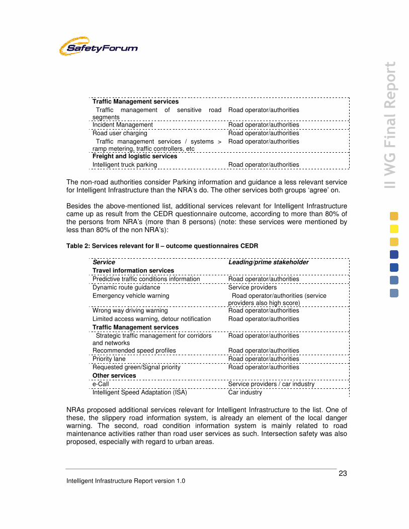
5 Identification of Intelligent Infrastructure related services 5.1 Selected services The IIWG carried out a survey about which services should be taken into account when discussing the current and future Intelligent Infrastructure requirements. It was also asked which stakeholder (road operator/authority, service provider, car manufacturer) is the leading/prime stakeholder. Finally, the views on the maturity of the services were also gathered. A list of services was composed taking into account the services defined within the eSafety Implementation Roadmap studies, the existing list from the EasyWay project and ideas from CEDR and ASECAP themselves. At a later stage of this stocktaking a list with ITS services from ETSI was taken into account. This list was checked with the existing list and those services relevant and in line with the Intelligent Infrastructure definition was included in the list. Finally a survey took place with the members of CEDR Thematic domain Operations. At a final stage the service requirements identified in the EU project ELVIRE for the electric vehicle in the grid were included. Annex 1 presents the results from the two questionnaires. In total 19 persons were interviewed: 11 from NRA’s and 8 not from NRA’s. The following list of services is regarded being relevant for the Intelligent Infrastructure (according to more than 80% of the persons who participated in the questionnaires, so more than 15 persons). In the second column the leading/prime stakeholder (output from the questionnaires) is given. Table 1: Services relevant for II – outcome questionnaires
Service Leading/prime stakeholder
Travel information services
RT (Real Time) event information Road operator/authorities RT traffic condition information Road operator/authorities Travel time information Road operator/authorities (service
providers also high score) Weather information Service providers (road
operator/authorities also high score) Speed limit information Road operator/authorities Parking information and guidance Service providers Local hazard warning Road operator/authorities Multimodal traffic information Service providers
Intelligent Infrastructure Report version 1.0
23
II W
G Final Report
Traffic Management services Traffic management of sensitive road segments
Road operator/authorities
Incident Management Road operator/authorities Road user charging Road operator/authorities Traffic management services / systems > ramp metering, traffic controllers, etc
Road operator/authorities
Freight and logistic services Intelligent truck parking Road operator/authorities
The non-road authorities consider Parking information and guidance a less relevant service for Intelligent Infrastructure than the NRA’s do. The other services both groups ‘agree’ on. Besides the above-mentioned list, additional services relevant for Intelligent Infrastructure came up as result from the CEDR questionnaire outcome, according to more than 80% of the persons from NRA’s (more than 8 persons) (note: these services were mentioned by less than 80% of the non NRA’s): Table 2: Services relevant for II – outcome questionnaires CEDR
Service Leading/prime stakeholder
Travel information services
Predictive traffic conditions information Road operator/authorities Dynamic route guidance Service providers Emergency vehicle warning Road operator/authorities (service
providers also high score) Wrong way driving warning Road operator/authorities Limited access warning, detour notification Road operator/authorities Traffic Management services Strategic traffic management for corridors and networks
Road operator/authorities
Recommended speed profiles Road operator/authorities Priority lane Road operator/authorities Requested green/Signal priority Road operator/authorities Other services e-Call Service providers / car industry Intelligent Speed Adaptation (ISA) Car industry
NRAs proposed additional services relevant for Intelligent Infrastructure to the list. One of these, the slippery road information system, is already an element of the local danger warning. The second, road condition information system is mainly related to road maintenance activities rather than road user services as such. Intersection safety was also proposed, especially with regard to urban areas.

Intelligent Infrastructure Report version 1.0
24
II W
G Final Report
The following list of services addresses the specific requirements for a typical use case of driving and charging a fully electric vehicle within an Intelligent Infrastructure. In essence, the survey covers the “Energy Service Needs”, “Driving Service Needs”, as well as the “Generic Service Requirements”. The discussion about the possible impact of electric vehicles on the Intelligent Infrastructure was taken on board at a later stage and regarded as important. However the consequence was that it was not taken into account at all relevant topics in this document. Table 3: Fully Electric Vehicle (FEV) services
Prime Service Subset Services
Energy Services
Range Extension Quick Charge Allocation Battery Switch Allocation Energy Notification During Driving During Charging Charging Charge Spot Allocation Multiple User Freedom of Choice (CO2, Price,
renewable, provider, contract, roaming, ..) Driving Services Unplanned Drive without defined destination Smart Route Monitoring Planned Journey with defined destination Route Planning Route Guidance incl. Re-routing Call Centre Support Roadside Assistance Emergency Calls Breakdown Services Remote Assistance Safety Notification Generic Services Pre-Trip Services Pre-driving route planning Route adaptation while driving Inclusion of vehicle settings Roaming User roaming Billing models Charging independence Security Authentication Privacy & Data Protection Administrative Services Charging spot registration/booking Billing review Review & saving of travel route User Preferences Constraints/Governmental Incentives No congestion charge on EVs Diamond Lanes (Bus lanes etc.) Congestion-free zones

Intelligent Infrastructure Report version 1.0
25
II W
G Final Report
For future Electric Vehicles their co-existence with conventional (ICE) and Hybrid powered cars has to be taken into account, as well as the considerable additional needs for assisting services during their market introduction phase. 5.2 Status of services The current status was estimated for the services that are indicated to be relevant for Intelligent Infrastructure, including FEV services. This status is based on information from the survey combined with the Monitoring Report 2009 from the Implementation Road Maps Working Group [1] and the roadmap of the Dutch ministry [2]. Note that the estimates deal with the services, as they are today, and not necessarily their cooperative versions. In fact, all of the Intelligent Infrastructure Services listed exist also as a non-cooperative version. Technologies are available and being provided in Europe already today as well as other prerequisites of many of the services. Some are in the development phase, where the practical technology solutions are settled along with the institutional, legal and business model issues. Some services are still in a research phase. Most FEV services are in the research and development phase. Also, since all FEV services will enable environmentally friendly and zero-carbon mobility, they do not easily comply with the classification of the other Intelligent Infrastructure services. Therefore, in the roadmap in Figure 2, FEV services are indicated as a cluster in the upper right part, and they are further illustrated in Figure 3. Some II services are also FEV services, this is indicated with **.

Intelligent Infrastructure Report version 1.0
26
II W
G Final Report
Figure 2: Status of Intelligent Infrastructure services
time
Improve mobility
(throughput,
accessibility,
efficiency)
Deployment Development Research
Parking information
RT traffic information
Multimodal traffic information
Local hazard warning
Freight and logistics services Other servicesTraffic Management servicesTravel information services
Dynamic route guidance
Improve safety
RT event information
Travel time information
Weather information
Speed limit information
Predictive traffic condition information
Emergency vehicle warning
Wrong way driving warning
Limited access warning, detour not.
Traffic Management of sensitive
road segm.
Incident Management
Road user charging
Various TM services
(ramp metering, traffic control)
Strategic TM for networks
Recommended speed profiles
eCall
Priority lane
Requested green
Intelligent truck parking
ISA
InnovationUse
Improve
environment
Route Planning Assistant
User Authentification
Various E-Horizon Services
� E-Charge Spot Indication
� Re-routing Services
� Charge-Spot spotter & Bookiung Assist
Safety Alert & Support Services
Charging & Credit
Authentification
Accounting & Billing Service
Car/Battery Condition Assistant
Mobility Roaming &
Charging Services
Charging Mode Service
(Fast, Optimum, Swap)
Reverse Chanrging Service
Grid Integration Service
Fun Driving Services
FullyElectric Vehicle services
** behind a service indicates that it is also a Fully Electric Vehicle service
**
**
**
**
**
**
**

Intelligent Infrastructure Report version 1.0
27
II W
G Final Report
Figure 3: Status of Fully Electric Vehicle services
Below a figure can be found (based on a figure from the eSafety Forum) which shows a road map for a service. When services are beginning developed into their cooperative version, some services go back into the research and development phase.
Figure 4: road map for a service (eSafety Forum)
Research and Technology Development incl. FOTs
Route Planning Assistant
User Authentification
Various E-Horizon Services
� E-Charge Spot Indication
� Re-routing Services
� Charge-Spot spotter & Bookiung Assist
Safety Alert & Support Services
Charging & Credit
Authentification
Accounting & Billing Service
Pre-Driving Services
Safety/SecurityRelated Services
Effecitiveness
Related Services
Accounting & Grid
Services
Car/Battery Condition Assistant
Mobility Roaming & Charging Services
Charging Mode Service
(Fast, Optimum, Swap)
Fun Driving Services
Reverse Chanrging Service
Grid Integration Service
Charge-spotservices
Post drivingservices
On-trip monitoring & guidance services
Pre-drivingservices
On-trip monitoring & guidance services
DeploymentDevelopmentResearch Use
2010
2015
2020Awareness campaigns
Incentives
Media
Security provisions
Field operational tests
Impact assessment
Pilots
Legal issues
Funding
Standardised interfaces & protocols
Impact Assessment
Organisational frameworks
Business models
Innovation
Overall ITS architectures
Innovation DeploymentDevelopmentResearch Use
2010
2015
2020Awareness campaigns
Incentives
Media
Security provisions
Field operational tests
Impact assessment
Pilots
Legal issues
Funding
Standardised interfaces & protocols
Impact Assessment
Organisational frameworks
Business models
Innovation
Overall ITS architectures
Innovation

Intelligent Infrastructure Report version 1.0
28
II W
G Final Report
5.3 Service related issues
• Cooperative systems are a tool rather than a goal in itself. From this perspective it is important how this tool can contribute to reaching to the strategic objectives of the stakeholders or deployment partners. To public authorities such objectives are usually related to the safety, reliability, throughput, energy consumption or emissions of the transport system, or the promotion of public transport, and non-motorised traffic. The choice of the priority services should naturally reflect the objectives of the deployment partners.
• For many partners, safety is a specific goal, and there should be a division between safety critical features/services and others.
• The functionalities of the services should be described in an illustrative manner highlighting the impacts of the systems on the users as well as on the policy objectives. The technologies are just technical means to realise the functionalities.
• The priority lists of services should be agreed upon by the deployment partners, but with a reservation that any such list is a dynamic living document as priorities will change all the time due to changes in economy and policies as well as regional and country-wide differences between countries having different traditions and transport problems, etc. It seems highly useful to set up a forum or other mechanism to allow the assessment of a new service provided by one stakeholder by all deployment partners including national road authorities and operators, industry partners and user associations. This would facilitate a continuous scrutiny of the different solutions that may come up to the market and a quick adoption by a natural selection of the main deployment stakeholders.
• The foreseen explosive growth of electric vehicles associated to their current limited energy autonomy, may lead to the development of special applications in order to minimise likely problems. These applications could indicate to an electric vehicle, at every place where it may be, its distance to the nearest energy supply points in all possible travelling directions as well as an accurate estimate of the maximum number of Kms possible to reach based on existing battery charge and known traffic conditions. Such applications will require developments from both infrastructure operators and vehicle manufacturers operating in good cooperation.
Conclusions The list of relevant Intelligent Infrastructure services identified should be used in further work. The use of the list will differ among communities, regions and countries due to differences in traditions, problems and policies. The list reflects mainly solutions for ITS for the upcoming five years and mostly considers solutions providing information and warning only. It should be noted that the list is a dynamic, living list, because priorities will change all the time due to changes in economy and policies. Therefore attention should be paid to extension of the scope to a larger time

Intelligent Infrastructure Report version 1.0
29
II W
G Final Report
period and to a wider capability of the e-Safety and cooperative systems work in providing active driver support. The foreseen growth of electric vehicles associated to their specific demands may lead to the development of special services/applications

Intelligent Infrastructure Report version 1.0
30
II W
G Final Report
6 Added value of Intelligent Infrastructure 6.1 Potential added value of Intelligent Infrastructure The CVIS, SAFESPOT and COOPERS projects have compiled the added value of intelligent infrastructure in combination with cooperative services. There are several main mechanisms of added value provision. First, accurate and individual real-time traffic information provided in the car supports safe, efficient and ecological friendly ways of driving. Second, aggregated and interpreted FCD, considering the overall road network, is giving benefit to all road users. Third, with the support from the intelligent infrastructure, vehicle drivers gain benefits irrespective of the penetration rate of equipped cars. Fourth, the cooperative services are more flexible in terms of services offered than those relying on conventional technologies and services like VMS. Fifth, the road operators gain more safety on their roads with the help of information services. The following added values (benefits) of Intelligent Infrastructure are listed in [8] (note that italics illustrate that the text is directly taken form a report):
• increased road network capacity • reduced congestion and pollution • shorter and more predictable journey times • improved traffic safety for all road users • lower vehicle operating costs • more efficient logistics • improved management and control of the road network (both urban and inter-urban) • increased efficiency of the public transport systems • better and more efficient response to hazards, incidents and accidents
Electric vehicles In addition to the current vehicle fleets on the roads, the intelligent infrastructure has added value to the electric vehicles. The number of electric vehicles is increasing, and by 2015 there will be approximately 1.3 Million electric vehicles on European roads. The electric vehicles need intelligent infrastructure to
• allow reliable voyages across European roads free from concerns of getting stranded
• navigate to the next available socket for a quick-charge in case of electricity shortage
• enable the drivers to “Google” the electricity provider (in fact, this needs to be done by the vehicle, automatically) and to pay for the energy via a service provider, who is supported by an intelligent infrastructure
• relate the various service providers with the “Smart Grid” operators, as well as with the utilities

Intelligent Infrastructure Report version 1.0
31
II W
G Final Report
• support the charging and reverse charging processes (as appropriate), as well as the respective communication systems and business models
• operate within a “secure” Intelligent Infrastructure respecting and protecting the privacy and individual rights of the citizen.
6.2 Socio-economic assessment of II services Various projects have assessed the benefits and costs of the existing II services. An overview of these results is given in Table Z.
Table 4: Colour coding Services table
Effect range (negative value means a reduction, so positive effect)
Normative scale Benefit/cost
< -10 % - - likely >3 -10 – -2 % - >1 -2 – +2 % 0 >0.5
no estimates available unknown unknown
Table 5: Estimated impacts of the II services on safety, congestion and greenhouse gases as well as estimates of their benefit-cost ratios. In case of absence of quantitative estimates, a small expected reduction is denoted by “-“ and a considerable expected reduction by ‘—‘.
[20]…[40]
Intelligent Infrastructure services Impact on
fatalities/ injuries
Impact on con-
gestion
Impact on CO2
Benefit/ Cost
Travel information services
RT (Real Time) event information - -1...-15% -1...-10% 1...2.5 RT traffic condition information - -1...-15% -1...-10% 2...6 Travel time information - -1...-15% -1...-10% 2...6 Weather information -2...-4% - - 3...8 Speed limit information -2...-10% -2...-10% -2...-10% Parking information and guidance 0 - - Local hazard warning -2...-10% -2...-10% - Multimodal traffic information - - - 10...72 Predictive traffic conditions info - -1...-15% -1...-10% Dynamic route guidance - - - - - Emergency vehicle warning - - - Wrong way driving warning - - - Limited access warn., detour notif. - - - Traffic Management services
TM of sensitive road segments -6...-30% -5...-10% - 0.7...12

Intelligent Infrastructure Report version 1.0
32
II W
G Final Report
Incident Management - -5...-20% -5...-15% 2-4 Road user charging -- -10...-20% -10...-20% >1 TM services/systems, e.g. ramp ctrl
-10...-20% -10...-30% -10...-30% 4...27
Strategic corridor/network TM - - - - 2...15 Recommended speed profiles - - - - - Priority lane 0 - - - Requesting green/signal priorities - -1...-2% -1...-3% 0.7...7.5 Freight and logistic services
Intelligent truck parking - - - Other services
ECall -1...-8% -0.5...-3% - 0.5...3 Intelligent Speed Adaptation (ISA) -10...-20% -2...-10% -2...-10% 5-17
Note: impacts are for the drivers of the vehicles or for the road sections equipped with the systems or services. Note also that the CO2 impacts are closely related to energy efficiency impacts.
It needs to be noted that the figures above are all based on some detailed specification of the system in question, similar systems with different technology set-up or different content quality may have largely deviating estimates of effectiveness with regard to safety, efficiency, mobility and environment. There are few evaluation studies related specifically to cooperative system technologies so far. However, the methods used to evaluate cooperative systems will follow those used in evaluating all ITS systems. The types of studies that are performed are based on [15]:
• Results from evaluations similar systems or functionalities combined with statistical transport data in desktop studies for ex-ante assessment
• Simulation studies / studies based on models: for example, some small scale examples exist for applications within the CVIS project;
• Studies from driving simulators (for example to test HMI interaction); • Studies from questionnaires: for example, those seen to test user-acceptance
(though for small samples) within the CVIS project; • Field operational tests
All relevant impacts of cooperative systems should be covered. Usually the systems affect safety, traffic flow, mobility, environment, and socio-economy. Existing modelling results are generally from micro simulation. Models will always have to make some assumptions, and in order to model the possible effects of cooperative systems; the penetration rates of equipped vehicles must be estimated. Studies differ in their approach to this, with some deciding on a figure or range (based on other studies, expert guidance) on which to base their study (e.g. CODIA report [5]), and some looking at different penetration rates, and different possible impacts due to the different penetration rates (for example ISA report [16]). Because of the importance of penetration rates, the uncertainty of future rates, and the impact that this has on evaluation, it is important that different values are taken into consideration, or at least good reason is given for why a given rate is used.

Intelligent Infrastructure Report version
Other assumptions used in micro simulation models, as well as in cost benefit analysis are: the costs of the equipment and the effects of the technology on the driver (this is along with standard assumptions used in transpoetc; the classes of users modelled and their value(s) of time; the fact that road users are utility maximises; etc). [15] More ambitious evaluation of cooperative system technology awaits future researas the results of the studies from projects such as iTetris (www.ictaims to develop advanced largetechnologies), and from field operational tests. Restricted field operational tests or rather pilots have already been carried out. The figure below indicates that a cooperative congestion warning would result in a 10reduction of individual vehicles approaching the end of the queue.
Figure 5: Speeds of vehicles approaching end of queue in the case of cooperative congestion
warning on (solid lines) and off (dotted lines). [43]
Currently, very few quantitative estimates of the impacts have been produced concerning cooperative systems and services. The ex[41] projects have studied the potential safety effects of some cooperative systems. The results from CODIA concerning the safety effects of five systems are the following for the whole Europe, if 100% of the vehicles and the relevant infrastructure would be equipped [5]:
version 1.0
Other assumptions used in micro simulation models, as well as in cost benefit analysis are: the costs of the equipment and the effects of the technology on the driver (this is along with standard assumptions used in transport modelling: the costs of injury / death / emissions etc; the classes of users modelled and their value(s) of time; the fact that road users are
More ambitious evaluation of cooperative system technology awaits future researas the results of the studies from projects such as iTetris (www.ict-itetris.eu, a project that aims to develop advanced large-scale computing analysis to analyse wireless technologies), and from field operational tests. [15]
ational tests or rather pilots have already been carried out. The figure below indicates that a cooperative congestion warning would result in a 10-20 km/h speed reduction of individual vehicles approaching the end of the queue.
: Speeds of vehicles approaching end of queue in the case of cooperative congestion warning on (solid lines) and off (dotted lines). [43]
Currently, very few quantitative estimates of the impacts have been produced concerning and services. The ex-ante assessments by CODIA [5] and eIMPACT
[41] projects have studied the potential safety effects of some cooperative systems. The results from CODIA concerning the safety effects of five systems are the following for the
, if 100% of the vehicles and the relevant infrastructure would be equipped [5]:
33
II W
G Final Report
Other assumptions used in micro simulation models, as well as in cost benefit analysis are: the costs of the equipment and the effects of the technology on the driver (this is along with
rt modelling: the costs of injury / death / emissions etc; the classes of users modelled and their value(s) of time; the fact that road users are
More ambitious evaluation of cooperative system technology awaits future research such itetris.eu, a project that
scale computing analysis to analyse wireless
ational tests or rather pilots have already been carried out. The figure 20 km/h speed
: Speeds of vehicles approaching end of queue in the case of cooperative congestion
Currently, very few quantitative estimates of the impacts have been produced concerning ante assessments by CODIA [5] and eIMPACT
[41] projects have studied the potential safety effects of some cooperative systems. The results from CODIA concerning the safety effects of five systems are the following for the
, if 100% of the vehicles and the relevant infrastructure would be equipped [5]:
Intelligent Infrastructure Report version 1.0
34
II W
G Final Report
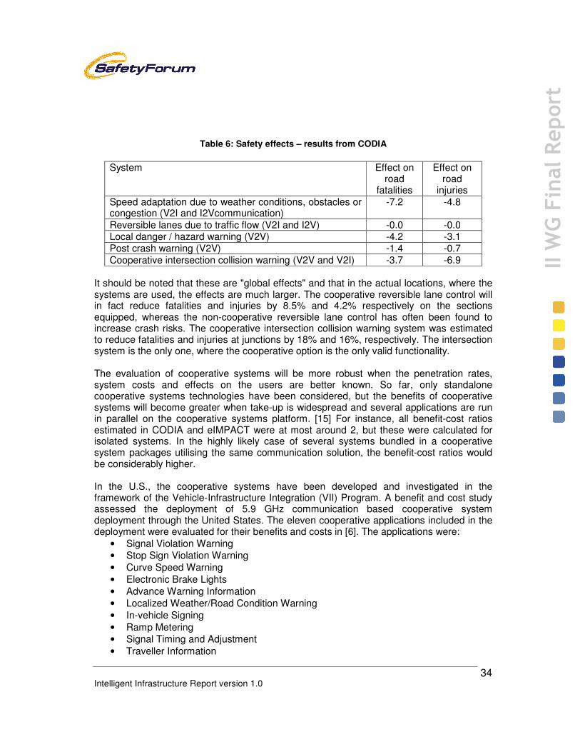
Table 6: Safety effects – results from CODIA
System Effect on
road fatalities
Effect on road
injuries Speed adaptation due to weather conditions, obstacles or congestion (V2I and I2Vcommunication)
-7.2 -4.8
Reversible lanes due to traffic flow (V2I and I2V) -0.0 -0.0 Local danger / hazard warning (V2V) -4.2 -3.1 Post crash warning (V2V) -1.4 -0.7 Cooperative intersection collision warning (V2V and V2I) -3.7 -6.9
It should be noted that these are "global effects" and that in the actual locations, where the systems are used, the effects are much larger. The cooperative reversible lane control will in fact reduce fatalities and injuries by 8.5% and 4.2% respectively on the sections equipped, whereas the non-cooperative reversible lane control has often been found to increase crash risks. The cooperative intersection collision warning system was estimated to reduce fatalities and injuries at junctions by 18% and 16%, respectively. The intersection system is the only one, where the cooperative option is the only valid functionality. The evaluation of cooperative systems will be more robust when the penetration rates, system costs and effects on the users are better known. So far, only standalone cooperative systems technologies have been considered, but the benefits of cooperative systems will become greater when take-up is widespread and several applications are run in parallel on the cooperative systems platform. [15] For instance, all benefit-cost ratios estimated in CODIA and eIMPACT were at most around 2, but these were calculated for isolated systems. In the highly likely case of several systems bundled in a cooperative system packages utilising the same communication solution, the benefit-cost ratios would be considerably higher. In the U.S., the cooperative systems have been developed and investigated in the framework of the Vehicle-Infrastructure Integration (VII) Program. A benefit and cost study assessed the deployment of 5.9 GHz communication based cooperative system deployment through the United States. The eleven cooperative applications included in the deployment were evaluated for their benefits and costs in [6]. The applications were:
• Signal Violation Warning • Stop Sign Violation Warning • Curve Speed Warning • Electronic Brake Lights • Advance Warning Information • Localized Weather/Road Condition Warning • In-vehicle Signing • Ramp Metering • Signal Timing and Adjustment • Traveller Information

Intelligent Infrastructure Report version 1.0
35
II W
G Final Report
• Winter Maintenance The total costs and the benefits of the systems were distributed according to the following tables. Note that the analysis covered a 40 year period 2010-2049, assuming that the decision to implement the VII deployment programme would be taken in 2010. The costs were estimated assuming the current availability of fixed communications and electrical power by the roadside. A useful economic life of seven years was assumed for the roadside equipment. [6] In Europe, this is assumed to be longer.
Table 7: System lifetime costs (1000 M$) in the VII cost-benefit analysis [6]
Total Initial (start-
up) Operations & maintenance
Governance (administration)
1.0 0.3 0.7
Roadside equipment 9.3 3.7 5.6 Network 3.7 3.7 On-board equipment 12.4 9.2 3.2 Applications 0.8 0.8
Table 8: The benefits (1000 M$ of the systems studies in their lifetime [6]
System Benefit
Estimate Curve Speed Warning 14.7 Electronic Brake Lights 13.8 Signal violation Warning 11.2 Stop Sign Violation Warning 2.7 Traveller Information 0.9 Winter Maintenance 0.4 Ramp Metering 0.3 Signal Timing 0.3
The applications would reduce about 1% of all crashes and 1% of all congestion if fully deployed. The basic benefit-cost ratio was 1.6. The estimates were regarded as conservative, because of narrowly defined use cases (e.g. Ramp Metering application envisioned only for existing ramp meters), exclusion of environmental benefits, exclusion of second order effects on economic growth, inventory and logistics costs, etc. [6] It is claimed that ICT/ITS can also contribute to energy savings and related CO2 emission reductions [54]. The iCARS Thematic Network ICT for Energy Efficiency has done studies and collected data. Some of their results are also related to the Intelligent Infrastructure. The following results are mentioned:

Intelligent Infrastructure Report version 1.0
36
II W
G Final Report
• The estimated reduction potential from eco-driving and eco-driving support will be around 20% for 2020 car fleet, based on 2010 figures when 80% of all drivers follow the “golden rules” of eco-driving
• For busses and trucks the reduction potential could stay at a sustainable 10% with ITS solutions and driver feedback systems and corrective actions
• Additional fuel reduction from ITS/ICT solutions related to electrical vehicles are in the magnitude of a few percentage points only
• Public transport services can benefits between 3-10% in overall fuel consumption when implementing a general Fleet Management System
• With a diffused deployment of ITS cooperative systems, traffic management in medium-large cities can save 15% of local total consumptions.
• On EU27 highway (HW) network savings can be of the same order. • Current Access Control (AC) schemes act on limited urban flows; savings < 1%. AC
based on CS and integrated in Control Centres (and Galileo full operative), with appropriate EU27 legislation on urban road charging, can raise savings to significant levels.
• General fleet management & freight logistics can contribute to an overall reduction in fossil fuel in the transportation sector in the range of 20-25% by 2020 when state-of-the art ICT and ITS is adopted
• Model calculations in Slovenia have shown that energy efficiency could be improved by around 8% when information created by modelling and forecasting was transmitted to traffic participants
6.3 Issues related to added value
• Assessment is a key aspect in the deployment of intelligent vehicle and infrastructure systems and services. The assessment will provide the necessary information of the benefits and costs of the systems and services during their life span to facilitate the deployment partners to decide on their investments and other contribution to the deployment of the systems.
• The assessments should cover the impacts of the systems on the mobility, efficiency and safety of the travellers and haulers, as well as on the throughput, energy and environmental impact of the transport system. The assessments should also measure how the new systems perform in comparison to the existing ones with regard to cost, availability, reliability, extra features or services, ease of maintenance, etc.
• The roles of cities should be strengthened in all development and testing activities; including large scale and complex field operational tests (FOTs) to make sure local policy objectives are taken into account both in the applications developed and in the evaluation. The relevance of direct involvement of local authorities in demonstrating the added value for dissemination of benefits of cooperative systems to other cities in Europe should not be underestimated.
• So far, the assessment has focused on stand-alone functionalities and systems. It is essential to assess also and especially integrated systems or system bundles,

Intelligent Infrastructure Report version 1.0
37
II W
G Final Report
combining several functionalities complementing the impacts of individual services while utilising the same basic service prerequisites. This will be a feasible way of deploying the services, and the impacts of such integrated bundles need to be investigated by independent experts.
• The FOTs play an important role in demonstrating the added value of systems and services in large-scale use. An important role of the FOTs is to provide statistically robust and independently produced data on the impacts of the systems and services on travellers, haulers and the society.
Conclusions Today, the estimates of the added value of II services are very positive with regard to the policy objectives of safety, environment and throughput. The estimates are, however, largely based on the impacts assessed for autonomous versions of the same services and for individual services. It is likely that cooperative systems will provide substantial impacts, especially when deployed in an integrated manner on the efficiency, safety and energy consumption of the transport system. It seems that an individual service will rarely be economically viable, but bundling of services likely makes it possible to reach positive business cases while providing complementary services supporting the policy objectives. Demonstrating the added value of cooperative services and systems by means of impact assessment on large-scale FOTs is important for the decision-making processes of all road authorities. There is an urgent need to have robust and statistically reliable data on the socio- and private economy impacts of cooperative systems, both for individual services and especially for bundles of services complementing each other in terms of functionalities and impacts.

Intelligent Infrastructure Report version 1.0
38
II W
G Final Report
7 Road categories and related services per category 7.1 Categorisation of urban roads The situation in the urban road network is very complex and it is difficult to summarise all different possible situations in just a few categories. In urban cases, the roads tend to be classified according to their function rather than the physical road design as often done for inter-urban roads. This was the choice in the categorisation of the table below. Table 9: Road categorisation urban roads
Category Function Infrastructure, types of traffic, and problems Primary distributor roads
Transit function; urban through roads
• often physical segregation between vehicles and cyclists/pedestrians; no frontage access to shops/housing; no on-street stops of public transport, often dedicated bus lanes • including tunnels and bridges • usually traffic flow and/or safety problems due to higher traffic volumes and higher speeds • often high environmental impact (air quality, noise)
District distributor roads
Transit function; links between local districts
• significant movement of public transport vehicles and cyclists (segregated or on-road), and pedestrians crossing at certain spots (shops, schools, etc.); sometimes dedicated bus lanes and/or relevance as freight routes • traffic flow and safety problems occur at certain stretches or spots, e.g. due to on-street un/loading activities or at highly frequented intersections which due to space limitations cannot be designed in the most appropriate way • often high environmental impact (air quality, noise)
Local collector roads
Place function (where neighbourhood and community function dominate, such as retail, recreation) rather than transit function
• all transport modes; significant movement of pedestrians and cyclists; residential and commercial frontage • traffic flow or safety problems only at certain spots
Access roads
Place function; residential roads
• mix of modes, low speeds • no traffic flow problems

Intelligent Infrastructure Report version 1.0
39
II W
G Final Report
From a traffic management perspective however, many cities have defined a strategic road network or a system of road priority, which do not necessarily correspond with these function-based categories. The general mapping of the urban road categories with regard to the Intelligent Infrastructure services to be provided has been carried out in the table below. However, the level of intelligent infrastructure and services that is needed will depend on a variety of factors, which cannot easily be presented in the form of a few categories. These factors include for example the relevance of a road for public transport and freight transport, the mix of transport modes in combination with the physical design of the road (e.g. existence of segregated cycle lanes, one-way roads), and access restrictions (e.g. low-emission zones, areas around hospitals or schools). [Polis]
Table 10: Road categories and the II services for urban roads
Urban road category Intelligent Infrastructure service All road categories TIS: Weather information
TIS: Limited access warning, detour notification TMS: Road user charging Other: eCall Other: Intelligent Speed Adaptation (ISA)
Primary and district distributor roads, local collector roads
TIS: Speed limit information TIS: Parking information and guidance TIS: Multimodal traffic information TIS: Emergency vehicle warning TMS: Traffic management of sensitive road segments
Primary and district distributor roads TIS: RT event information TMS: Recommended speed profiles F&L: Intelligent truck parking
Primary and district distributor roads, local collector roads with 2+2 lanes or more
TMS: Priority lane
Primary and district distributor roads, local collector roads with signal control
TMS: Signal priority/Requested green
Primary and district distributor roads with separated carriageways
TIS: Wrong way driving warning
All roads with local safety problems TIS: Local hazard warning Primary and district distributor roads with flow problems
TMS: Traffic management services / systems > ramp metering, traffic controllers, etc TMS: Strategic traffic management for corridors and networks TIS: Dynamic route guidance
Primary distributor roads with flow or safety problems
TMS: Incident Management
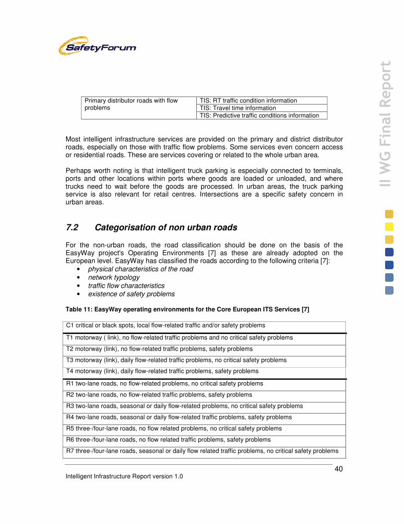
Intelligent Infrastructure Report version 1.0
40
II W
G Final Report
Most intelligent infrastructure services are provided on the primary and district distributor roads, especially on those with traffic flow problems. Some services even concern access or residential roads. These are services covering or related to the whole urban area. Perhaps worth noting is that intelligent truck parking is especially connected to terminals, ports and other locations within ports where goods are loaded or unloaded, and where trucks need to wait before the goods are processed. In urban areas, the truck parking service is also relevant for retail centres. Intersections are a specific safety concern in urban areas. 7.2 Categorisation of non urban roads For the non-urban roads, the road classification should be done on the basis of the EasyWay project's Operating Environments [7] as these are already adopted on the European level. EasyWay has classified the roads according to the following criteria [7]:
• physical characteristics of the road • network typology • traffic flow characteristics • existence of safety problems
Table 11: EasyWay operating environments for the Core European ITS Services [7]
C1 critical or black spots, local flow-related traffic and/or safety problems
T1 motorway ( link), no flow-related traffic problems and no critical safety problems
T2 motorway (link), no flow-related traffic problems, safety problems
T3 motorway (link), daily flow-related traffic problems, no critical safety problems
T4 motorway (link), daily flow-related traffic problems, safety problems
R1 two-lane roads, no flow-related problems, no critical safety problems
R2 two-lane roads, no flow-related traffic problems, safety problems
R3 two-lane roads, seasonal or daily flow-related problems, no critical safety problems
R4 two-lane roads, seasonal or daily flow-related traffic problems, safety problems
R5 three-/four-lane roads, no flow related problems, no critical safety problems
R6 three-/four-lane roads, no flow related traffic problems, safety problems
R7 three-/four-lane roads, seasonal or daily flow related traffic problems, no critical safety problems
Primary distributor roads with flow problems
TIS: RT traffic condition information TIS: Travel time information TIS: Predictive traffic conditions information
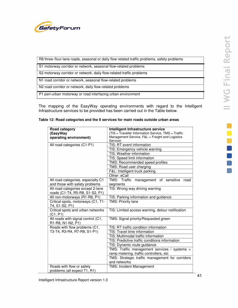
Intelligent Infrastructure Report version 1.0
41
II W
G Final Report
R8 three-/four-lane roads, seasonal or daily flow related traffic problems, safety problems
S1 motorway corridor or network, seasonal flow-related problems
S2 motorway corridor or network, daily flow-related traffic problems
N1 road corridor or network, seasonal flow-related problems
N2 road corridor or network, daily flow-related problems
P1 peri-urban motorway or road interfacing urban environment
The mapping of the EasyWay operating environments with regard to the Intelligent Infrastructure services to be provided has been carried out in the Table below. Table 12: Road categories and the II services for main roads outside urban areas
Road category (EasyWay operating environment)
Intelligent Infrastructure service (TIS = Traveller Information Service, TMS = Traffic Management Service, F&L = Freight and Logistics Service)
All road categories (C1-P1)
TIS: RT event information TIS: Emergency vehicle warning TIS: Weather information TIS: Speed limit information TMS: Recommended speed profiles TMS: Road user charging F&L: Intelligent truck parking Other: eCall
All road categories, especially C1 and those with safety problems
TMS: Traffic management of sensitive road segments
All road categories except 2-lane roads (C1-T4, R5-R8, S1-S2, P1)
TIS: Wrong way driving warning
All non-motorways (R1-R8, P1) TIS: Parking information and guidance Critical spots, motorways (C1, T1-T4, S1-S2, P1)
TMS: Priority lane
Critical spots and urban networks (C1, P1)
TIS: Limited access warning, detour notification
All roads with signal control (C1, R1-R8, N1-N2, P1)
TMS: Signal priority/Requested green
Roads with flow problems (C1, T3-T4, R3-R4, R7-R8, S1-P1)
TIS: RT traffic condition information TIS: Travel time information TIS: Multimodal traffic information TIS: Predictive traffic conditions information TIS: Dynamic route guidance TMS: Traffic management services / systems > ramp metering, traffic controllers, etc TMS: Strategic traffic management for corridors and networks
Roads with flow or safety problems (all expect T1, R1)
TMS: Incident Management

Intelligent Infrastructure Report version 1.0
42
II W
G Final Report
Roads with safety problems (C1, T2, T4, R2, R4, R6, R8, P1)
TIS: Local hazard warning Other: Intelligent Speed Adaptation (ISA)
Many of the services are provided in all road categories or on roads with flow-related problems, i.e. recurring congestion. The relevant road types, for urban and non-urban roads, are shown for each intelligent infrastructure service.

Intelligent Infrastructure Report version 1.0
43
II W
G Final Report
Table 13: Road categories, where each II service is typically provided, within and outside urban areas
Intelligent Infrastructure service (TIS = Traveller Information Service, TMS = Traffic Management Service, F&L = Freight and Logistics Service)
Urban road category Non urban road category (EasyWay operating environment)
TIS: Weather information All road categories All road categories (C1-P1) TMS: Road user charging Other: eCall TIS: Emergency vehicle warning Primary and district distributor
roads, local collector roads All road categories (C1-P1)
TIS: Speed limit information TMS: Traffic management of sensitive road segments
Primary and district distributor roads, local collector roads
All road categories, especially C1 and those with safety problems
TIS: RT event information Primary and district distributor roads
All road categories (C1-P1) TMS: Recommended speed profiles F&L: Intelligent truck parking TIS: Wrong way driving warning Primary and district distributor
roads with separated carriageways All road categories except 2-lane roads (C1-T4, R5-R8, S1-S2, P1)
TIS: Parking information and guidance
Primary and district distributor roads, local collector roads
All non-motorways (R1-R8, P1)
TMS: Priority lane Primary and district distributor roads, local collector roads with 2+2 lanes or more
Critical spots, motorways (C1, T1-T4, S1-S2, P1)
TIS: Limited access warning, detour notification
All road categories Critical spots and urban networks (C1, P1)
TMS: Signal priority/Requested green
Primary and district distributor roads, local collector roads with signal control
All roads with signal control (C1, R1-R8, N1-N2, P1)
TIS: RT traffic condition information Primary distributor roads with flow problems
Roads with flow problems (C1, T3-T4, R3-R4, R7-R8, S1-P1) TIS: Travel time information
TIS: Predictive traffic conditions information TIS: Multimodal traffic information Primary and district distributor
roads, local collector roads Roads with flow problems (C1, T3-T4, R3-R4, R7-R8, S1-P1)
TIS: Dynamic route guidance Primary and district distributor roads with flow problems
Roads with flow problems (C1, T3-T4, R3-R4, R7-R8, S1-P1) TMS: Traffic management services
/ systems > ramp metering, traffic controllers,... TMS: Strategic traffic management for corridors and networks TMS: Incident Management Primary distributor roads with flow
or safety problems Roads with flow or safety problems (all expect T1, R1)
TIS: Local hazard warning All roads with local safety problems Roads with safety problems (C1, T2, T4, R2, R4, R6, R8, P1)
Other: Intelligent Speed Adaptation (ISA)
All road categories Roads with safety problems (C1, T2, T4, R2, R4, R6, R8, P1)
Intelligent Infrastructure Report version 1.0
44
II W
G Final Report
7.3 Quality of services It is obvious that even if the same service is provided in different operating environments or road categories, the quality level of the service will depend on the operating environment as well as other conditions. It is likely that e.g. real-time event information concerning a tunnel or another critical spot or a very busy motorway section is expected to be much more accurate and in real time than similar information concerning a two-lane road with low traffic volumes. On the other hand, a weather information service may be expected to have a higher standard on a two-lane road with less traffic in an area where adverse road weather is the most crucial road safety factor than on busy but safe tunnels and motorways with practically no adverse road weather problems. Such quality recommendations have been proposed e.g. by EasyWay [10]. 7.4 Issues related to road categories Road networks and infrastructure evolve during time, and road categorization may define the steps a road takes to achieve a mature state. The intelligent infrastructure services to be implemented depend primarily on the current category of the road. Different approaches exist according to whether the road is an inter-urban or urban one. This basic characterization of the roads must be considered as a fundamental one, because it makes the pre-assumptions quite different. Conclusions The services to be provided and their quality will depend on the operating environment or road category. On top of the basic services provided on almost all roads, three main types of services can be distinguished: those provided on roads with frequent flow problems, those provided on roads with safety problems, and those provided on some critical spots or parts of the road network. Environment is not specifically used in classifying the road network for intelligent infrastructure. It is, however, embedded in the categories as especially accidents and congestion will increase emissions.

Intelligent Infrastructure Report version 1.0
45
II W
G Final Report
8 (Basic) requirements for Intelligent Infrastructure services 8.1 User requirements The requirements are here addressed from the user point of view. Three types of users can be identified:
• Road user • Road operator / authority • System and service provider
On the basis of ETSI [3] and CVIS [8] user requirements, the following can be identified for the road users: Benefit and value for money
• service provides benefits and value to the user, whereas the costs of purchase and use of the service are reasonable, especially with regard to the value provided for the money. When relevant, the user can select from one of a number of suppliers of the same service.
Consistent and continuing quality • the service meets in a consistent and continuous way its quality levels as indicated
by the service provider with regard to relevant criteria such as e.g. communication performance, positioning performance, availability, coverage, veracity, and timeliness of information, etc.
Understand ability • the services will enable given geographic locations as well as road and traffic
conditions to be understood in the way intended by the road users Privacy and security
• the service respects the privacy of the user and the user can remain anonymous at his/her will. The security of the user is not endangered, and the liabilities of the user and the other stakeholders are made clear
Adaptability and compatibility • when relevant, the service should be adaptable to accommodate for e.g. the needs
of disabled and elderly persons, different topographical domains, geographical regions, service organisations, user interfaces and available communication networks. The services enable their continuous upgrading, and the systems and services can be maintained easily. All systems are able to operate in all potential climatic and traffic conditions
Safety • the system will monitor each safety-related component (including software), warn
the user in case of problems, and disable it, or reduce it to a safe state. The service

Intelligent Infrastructure Report version 1.0
46
II W
G Final Report
operates in a manner that does not generate a safety hazard for its users nor encourage unsafe behaviour. The service is ultimately under the control of the user.
The relevant user requirements for the road operator and/or authority are the following [3], [8]: Benefit and value for money
• the services support the road operators/authorities in reaching their objectives. The service provides societal economies and business value to the road operator/authority. The costs of investment, maintenance and operation of the service are reasonable, especially with regard to the value provided for the money. The service provides a global return on investment in a sufficient time frame. The services use the most cost-effective means of data acquisition and communication available. The services will enable operating costs to be reduced whenever possible, when compared with the systems that they replace.
Consistent and continuing quality • the service meets in a consistent and continuous way its quality levels as indicated
by the service provider with regard to relevant criteria such as e.g. communication performance, positioning performance, availability, coverage, veracity, and timeliness of information, etc.
Well functioning markets • when relevant, the road operator can select from one of a number of suppliers of the
same service or equipment. A good interaction between services provided by private and public bodies exists. The services that require payment from a user are able to manage fees/fares
Organisational and legal framework • current organisational responsibilities and legal liabilities are retained. The services
comply with the traffic laws and regulations that apply in Europe, and conform to relevant MoU, European directives and guidelines, and European (de facto-) standards. The services also comply with current European and National laws concerning data security, user anonymity and the protection of individual privacy. The temporary or permanent use of radio frequencies may require specific licences.
Adaptability and compatibility • when relevant, the service should be adaptable to accommodate for e.g. different
topographical domains, geographical regions, service organisations, user interfaces and available communication networks. The services enable their continuous upgrading, and the systems and services can be maintained easily. Data exchange can be operated easily and securely between different stakeholders while permitting all traffic management systems, existing or future, to receive and to use specific parts of the information. Data exchange will enable given geographic locations as well as road and traffic conditions to be understood by all stakeholders. The services enable their continuous upgrading, and the systems and services can be operated and maintained easily. All systems are able to operate in all potential climatic and traffic conditions
Safety

Intelligent Infrastructure Report version 1.0
47
II W
G Final Report
• the services will provide also the non-equipped users with, as much as possible, safety-related information available in the service. The services neither operate in a manner that does not generate a safety hazard for their users nor encourage unsafe behaviour. The services are able to detect errors in operation, when higher integrity is required, e.g. for financial, security or safety reasons. All safety-related systems are fault-tolerant. All systems are reliable with respect to the legal and/or quality requirements necessary for each application. The systems are capable of surviving accidental and intentional attacks on their integrity and of providing protection against unauthorised access
The requirements of the system and service provider are, based on [3] and [8]: Benefit and value for money
• the service provides business value to the system and/or service provider when considering the investment, maintenance and operation costs of the service. The service provides a global return on investment in a sufficient time frame. The most cost-effective means of data acquisition and communication available are used
Organisational and legal framework • interaction between services provided by private and public bodies exists. The
current organisational responsibilities and legal liabilities are retained. Suitable organisations must be in place to ensure the interoperability of ITS systems, to provide support to security protection and to ensure the distribution of global names and addresses in vehicles. The availability of a legal framework, appropriate standardisation of systems and ITS stations, and the availability of product / service conformance and system interoperability testing should be in order.
Availability of intelligent infrastructure • sufficient capabilities and performance of radio communication, network
communication, vehicle absolute positioning, vehicle interface, sensors and navigation as well as vehicle communication security need to be available as well as a common, consistent applications and use cases naming repository, and applications/use cases addresses directory. The availability of an IPv6 address allocation scheme usable for V2V/V2I communication is required.
Standardisation and interoperability • use of modular and flexible designs, so that manufacturers can produce their own
versions of equipment and systems may be scaled to cover different range of functionality. Various suppliers provide the equipment performing the same service. Data exchange can be operated easily and securely between different stakeholders. Data exchange will enable given geographic locations as well as road and traffic conditions to be understood by all stakeholders
Consistent and continuing quality • all information systems provide data with a stated accuracy, either as additional
information or as part of the documentation, at all times. All systems check all input data for validity, whenever possible, and report any failures. All systems also check data values by comparing different sources, when available, so as to ensure high-accuracy and completeness. All systems manage local/regional/national databases in a consistent way

Intelligent Infrastructure Report version 1.0
48
II W
G Final Report
For manufacturers of electrically chargeable vehicles, there are some additional requirements market penetration depends on [60]:
• Customer acceptance of specific characteristics of new technologies (driving and recharging requirements)
• Build up of recharging infrastructure by energy sector • Fiscal incentives during the introduction phase • Vehicle energy storage systems innovations • Development of battery costs • Attractive vehicle design, safety and comfort standards • Low carbon energy production
For all user groups, implicit user needs are that the systems comply with common system architecture and that a sufficient penetration of the systems and services exists to provide the expected value and benefit to all user groups. Most of the requirements are valid for all II services, but especially the needs of the road users as well as road operators/authorities differ with regard to the benefit and value required or expected from a specific services. For instance, by utilising the results of CVIS [13], we can identify the following requirements for road users and road operators for event information [13]: road users:
• Journey planning (come to a journey plan with an acceptable and reliable travel time and ditto travel costs)
• Preparation of and containing the journey (be well prepared for the conditions which can be expected during the journey annex vehicle trip)
• safeguarding condition of passengers and vehicle during the journey (keep the vehicle, vehicle driver and passengers in an appropriate condition during the trip)
• handle incident situation (have a safe and fluent trip, with no unintentional violation of actual traffic rules; anticipate on the traffic situation on the forthcoming road segments;
• handle incident situation (support the PSAP and traffic manager and thereby incident manager in shortening the time between occurrence and detection & notification of the accident / incident; prevent second order collisions such as e.g. bump into already collided vehicles, bump into cargo fallen of a lorry, run into a ghost driver; prevent the emerge of a shock wave;
road operators (traffic managers):
• Balanced use of the road network (balanced use of the road network in time and space; acceptable and reliable travel times over the road network)
• Enhance situation awareness of vehicle drivers (reduce the number of blockages on roads due to incidents in order to enhance the road safety and reduce the risk for accidents and achieve reliable travel times over the road network)

Intelligent Infrastructure Report version 1.0
49
II W
G Final Report
• Manage incidents and accidents (reduce the number of blockages on roads due to incidents in order to enhance the road safety and reduce the risk for accidents and achieve reliable travel times over the road network)
8.2 Prerequisites: business modelling Cooperation and roles There are many actors involved in the deployment of cooperative systems. For a business model to be created, each stakeholder must see a business opportunity in the deployment of cooperative systems: this makes the business models complicated, to say the least, as different stakeholders have different perspectives. Three primary supporting stakeholder groups can be distinguished:
• road infrastructure providers and operators • in vehicle and nomadic devices providers and operators • commercial service and telecom providers and operators
These primary stakeholder groups support the major stakeholder group of users. The stakeholder groups consist of different stakeholders e.g. lease, freight/fleet and private users. There is a strong need for the sustained cooperation of stakeholders in the development and deployment of cooperative systems. Given the nature of cooperative systems deployment, which often involves long lead times to implementation and the ultimate realisation of benefits, long term commitment of stakeholders is at risk due to several factors, including financial climate and political change. The ITS Action Plan and Directive will no doubt have a strong influence in maintaining momentum. Dependent on the situation one primary stakeholder group is at the helm and the other groups are supporting. This also depends on the stage a service like design, realisation or operation. Business modelling supports the discussion and definition of these roles and responsibilities. Business Modelling Business modelling is a tool for the communication and discussion between stakeholders. It provides insight in the coherence and facilitates in the realisation of the objectives of the various parties involved. It gives structure to all aspects, which need to be discussed and negotiated. The key objective of business modelling is to support the decision (if) regarding an intervention (or launch of a new service) and understand how it is produced (what and how) and what its effects are. In short Business modelling should give answers to

Intelligent Infrastructure Report version 1.0
50
II W
G Final Report
Figure 6: Answers business modelling should provide
The process of business modelling is divided into three phases: business model: A business model describes the way in which an organisation or network of organizations works together, wants to create added-value and achieves its political/strategic objectives and/or earns money by applying technology business case: The term ‘business case’ mostly refers to a financial (cost/benefits) analysis. It applies a business model to a specific situation (location with any existing infrastructure, characteristics, specific partners, etc.) business plan: A ‘business plan’ is the total (step-by-step) approach to bring the service into operation and to convince decision makers and investors.
Figure 7: The three phases of business modelling
A service (or business), and in our context ITS service, comprises four domains which are heavily interrelated. These domains are each part of the three phases in a high or low degree. Service domain describes the service, which is provided to a specific customer/end user in a specific market segment Technology domain describes the technical architecture and functionalities that are required to realise the service Organisation domain describes the roles, activities, responsibilities of the required parties/stakeholders (a value web) to develop and operate the service and to create added value for a customer/road-user Financial domain describes the way an organisation wants to generate business for a specific service. Important elements: revenue/benefits, costs, risks and investments.
Who is the (end) user?Which roles/activities are required to make & deliver the service?What is the added value of each activity/role?
Activities
Who delivers what to whom? (products, information)What is the flow of money, information?
Relations
Which party is best capable to perform a certain role?Are there combination of roles possible that can be performedby one or another party?
Organisation
Where is the power in the web?Which roles are required to get started?Which cooperations are essential for a good service delivery?
Power
What technology is used in what activity / relation? Are there alternatives? What are the implications
Technology
Business Model Business Case Business Plan

Intelligent Infrastructure Report version 1.0
51
II W
G Final Report
Figure 8: The four domains of focus in business modelling and societal outcome
These domains interact: the choice of a specific technology will incur a specific cost, and involvement of particular suppliers. It also incurs the possibility to easily create new services or to collaborate/combine with other services (e.g. combine Real-time Travel and Traffic Information and Incident Management). Another service definition or technology can result in a different organisation with different stakeholders and a possible other (strategic) position for stakeholders to act. In each of the business modelling phases a different level of detail is achieved. In the business model phase the emphasis is on the service and the organisational roles. In the business case phase the focus is more on technology and finance, e.g. in a cost/benefit analysis the cost of production (technology, organisation) is weighed against benefits, e.g. revenues. In the last phase full detail on all of the domains are included to be able to realise and deploy the service. The cost/benefit analysis, especially in the public domain, typically involves outcomes on the societal level, e.g. reduction of lost hours due to traffic jams, reduction of emissions, reduction of accidents and deaths. In the business model phase, the definition of the service, the configuration of technology, organisational roles and business models not only the monetary consequences but also societal outcomes need to be considered, as a kind of service level. Added value of business modelling The output of a business-modelling framework that is particularly useful in the context of development of ITS services from the different stakeholders perspective. The framework is tested on various European and national ITS services. The framework has the following characteristics:
• Strategic support: the conceptual simplicity of the framework helps to pass on policy and strategy towards realisation. At the level of realisation it helps to integrate services that live in the same context (e.g. can use the same technological platform
Service
OrganisationTechnology
Finance
Service
OrganisationTechnology
Finance
Outcome

Intelligent Infrastructure Report version 1.0
52
II W
G Final Report
and/or address the same travellers or stakeholders etc.) (integration of e.g. RTTI and eCall).
• Positioning: At the tactic and realisation level the framework also supports collaboration, because roles and exchanges are addressed in the value web. The value web approach supports a structured way of thinking in determining the position of stakeholders in the development and deployment of ITS services.
• Communication: It supports the discussions and negotiations with other (external) stakeholders public and/or private.
• Holistic: the concepts in the framework help to identify non-technical aspects of developing a service and understanding interactions between them as well as outcomes on a societal level. This supports identifying white spots, relevant trade/off and risk assessment between alternative interventions.
• Process support: The framework identifies the different relevant domains. In each of the phases these domains are addressed with different levels of detail. It will be very helpful in the definition, development, realisation and deployment of future and complex systems, such as cooperative systems.
Business models for cooperative systems Recently, business and service models have been developed and analysed by some projects. In SAFESPOT [44], the models of the following table were used.
Table 14: SAFESPOT Business and service models [44]
Reliance System/configuration Pricing V2V Pricing V2I
Only Public Basic/User will be able to have only SAFESPOT functions, fully paid from general fiscality
free free
Public/ Private
Basic/As above, but partially paid from general fiscality with a user contribution
The user has to pay partially the SAFESPOT system
The user has to pay partially the SAFESPOT system and a toll for the roads equipped with SAFESPOT
Only Private Basic/ only SAFESPOT functions, fully paid by the users
The user has to pay the SAFESPOT system
The user has to pay the SAFESPOT system and a toll for the roads equipped with SAFESPOT.
Public/ Private
Plus/In marketing or commercial point of view, open to new integrations. User will be able to have SAFESPOT functions and other services - partially paid from general fiscality with a user contribution
The user has to pay partially the SAFESPOT system. The user has to pay, according to the pay per use criteria, the connection to the other services like: traffic information, automatic road toll payment and parking reservation
The user has to pay partially SAFESPOT System and a toll for the roads equipped with SAFESPOT. The user has to pay, according to the pay per use criteria, the connection to the other services.
Only Private
Plus/In marketing or commercial point of view, open to new integrations. User will be able to have SAFESPOT functions and other services - fully paid by the users
The user has to pay the SAFESPOT system, and, according to the pay per use criteria, the connection to the other services.
The user has to pay the SAFESPOT system, and, according to the pay per use criteria, the connection to the other services. In addition the user has to pay a toll for the roads equipped with SAFESPOT.

Intelligent Infrastructure Report version 1.0
53
II W
G Final Report
8.3 Requirements from cooperation projects Within the context of the three IPs studies within the 6th Framework Project took place related to the deployment needs for cooperative systems. Experience from projects (CVIS) is input to basic requirements [55]. The overall deployment model and framework for CVIS covers the main elements and stakeholders needed for a working CVIS system equally distributed over the stakeholders of costs, benefits, risks, liabilities and control over policy decisions. Starting from the drivers where external influences such as public demand for safe and efficient traffic of people and goods, to commercial transport needs to the individual need for personal mobility. In the model these are identified as external influences driving the overall need for the cooperative system, while network enabled CVIS services are the link between the users’ needs and the network that enables the services. The technology core of the system is then modelled as separating the roadside equipment from the vehicle equipment, connected through the CVIS-system as defined in the other sub-projects of CVIS. As conclusion this white paper can be used a starting point for continued work to support the deployment for cooperative systems in general. It has been suggested an approach to continue the work in various forums covering the vast number of topics needed to enable the deployment of future services. A pragmatic approach is to start from the already emerging services that are locally deployed providing necessary support and guidance together with clear directives when needed. 8.4 Issues related to basic requirements The intelligent infrastructure needs, typically, to be equipped with an adequate communication typically an optical fibre network covering main road networks and able to interface RSEs (Road Side Equipment) and Operation Control Centre(s). RSE will also include the communication means necessary to establish the communication link with the vehicles platform. Today these communications are mainly based on CALM M5, but they are expected to evolve. Infrastructure operators and the automobile and device manufacturers need to ensure sound and sustainable solutions and cooperation. For monitoring the current and anticipated status of the road network, the road operators need to have systems able to characterize the traffic conditions at any time in both directions and per lane. This requires, in addition to the basic communication infrastructure, back-office equipments and applications to be installed in the Operation Control Centre according to the intelligent infrastructure services requirements. Considering the quick deployment of navigation systems, it is likely that operation control centres can predict with some reliability the final destination of the different vehicles driving on their roads. Based on their information and on the data exchange among different road operators, travel plans could be done to all vehicles and immediate forecast of travel duration and conditions (congested road segments, higher pollution level segments, time

Intelligent Infrastructure Report version 1.0
54
II W
G Final Report
foreseen per segment and/or alternative routes, etc.) may be displayed to the driver when entering the vehicle. There is a clear need for business models for complex multi-stakeholder value networks. These business models should provide sufficient flexibility to permit varying by country and system/service. The business models depend typically on the service provider. Service providers may be:
• Road operators, public and private; • Vehicle manufacturers and sub-suppliers; • Telecom operators, traditional Telco’s and radio diffusion operators; • Value added service providers.
It should be defined clearly which services should be provided by the service provider free of charge to the user, and what can by chargeable services. Typically, services provided by private stakeholders are paid services, except if supported by other means like advertisement. Nevertheless, these other means must be such that they do not interfere with the primary driving task of the drivers. The value networks are becoming very complex and involving a multitude of different stakeholders. This is also a result of the recent trend of both public and private sector stakeholders to focus on their essential tasks and outsource all other tasks. Nevertheless, it is quite clear that today, the primary stakeholder of intelligent and cooperative vehicle systems from the vehicle point of view is the OEM, the vehicle manufacturer. For the intelligent infrastructure side, the road authority or operator has the leading role. The partners of the value networks have to be able to rely on the other partners of the networks so that they feel financially secure enough to invest in the value network for their part. This requires openness of the stakeholders concerning their plans, even commercial ones, and also their commitment to provide their added value for the network for at least a specific time period. Conclusions Basic requirements for the intelligent infrastructure are determined by the services provided and their related stakeholders the users and road operators / authorities. There is a wide range of requirements, which focus from the political environment, regulatory framework, future requirements/compatibility and technology. Business and organisational models are of utmost importance as a tool to bring the different stakeholders together. A firm ground is needed of the benefits and value for money for both public and private sector to start investments needed to start the deployment if the intelligent infrastructure as part of cooperative services.

Intelligent Infrastructure Report version 1.0
55
II W
G Final Report
9 Current and future intelligent infrastructure 9.1 What is already available Currently, the European roads are covered with quite a lot of ICT infrastructure especially with regard to the major roads. The Trans-European Road Network (TERN) is covered by different traffic management systems and traffic, travel time and road weather monitoring systems. Different traffic management services cover in most countries more than 10% of the TERN, and in some countries well over 50% (AT, CH, FR, NL, PT, UK). Traffic status and road weather monitoring systems cover more than 50% of the TERN in most European countries, and travel time monitoring also in some (IE, NL, UK). [1] Traffic centres (i.e. traffic control or management or information centres) are also an important back-office part of the "roadside" infrastructure. Currently, there are ca 100 national or regional traffic centres responsible for operating the TERN and the II services provided on the TERN. In addition, numerous local traffic centres are in operation. The ICT infrastructure systems implemented so far also rely on communications; usually connecting the roadside equipment to the servers and information management systems operated at the traffic centres. A large part of the TERN is equipped with fibre optic cables for quick broadband communications. At the same time, a large part of the ICT infrastructure on the TERN is communications via other fixed communications, and increasingly via cellular communications. The coverage of the TERN by 2G or GSM communications is ca. 100% but so far, the 3G-communication coverage is smaller. In most West-European countries, the TERN is almost totally covered with 3G except for roads in the sparsely populated areas, but in East-European countries, the coverage is very low. For details see Annex 5. The infrastructure for two-way communication based cooperative II services is usually only existing in urban areas for
• floating car data collection combined with taxi or truck/van or bus fleet management systems (often based on 2G/3G communications)
• signal priorities for public transport and emergency vehicles (including usually short-range communications)
9.2 Example of existing intelligent infrastructures In addition, some cooperative II service test sites are in operation in 2010 such as the Helmond test site in the Netherlands, the INNOVITS ADVANCE test site in the UK, the SIM-TD test site in Germany and the COOPERS test site in Austria. The last-mentioned is described in detail to give an example of the roadside infrastructures implemented. The intention of the Helmond test site is to set-up a FOT area available for all national and

Intelligent Infrastructure Report version 1.0
56
II W
G Final Report
international projects related to cooperative systems. Roadside equipment from the Amsterdam showcase 2010 will be shifted to this location. Current projects, which are doing tests, are CVIS, SAFESPOT, SPITS, GCDC, CCC/CACC and planned projects are DRIVE and the development and test of new national RSU, which include the cooperative systems functionality. Note that the ICT infrastructures are mostly implemented due to the provision of II services with one-way communication rather than due to cooperative services utilising two-way communication. COOPERS, Austria The COOPERS test corridor covers the A12 Inntal Motorway (78 km) as well as the A13 Brenner Motorway (36 km) from the Austrian/German border Kiefersfelden/Kufstein via Innsbruck to the Austrian/Italian border on the Brenner pass. On the total corridor a Traffic Management System including traffic and weather sensors, VMS, information panels and Traveller information services is in operation. The 2+2 -lane (at parts 3+3 -lane) corridor includes 3 interchanges, 25 exits, 1 tolling station, 11 tunnels and 16 bridges. The corridor has different types of gantries. Gantries with VMS are equipped with one VMS per lane for the speed limits as well as with one VMS between two lanes for warnings. The gantries with information panels are equipped with one VMS (freely programmable) as well as with 3 lines of text (alphanumeric characters). These gantries are all overhead mounted.
Figure 9: Gantries COOPERS test corridor Austria Infrastructure - Telematics and electronic/electric systems (Inventory) The services are based on the traffic control system TCU Tirol, an important step on the path of ASFINAG in the implementation of the traffic management and information centre. This system was set up for two reasons: First, efficient traffic management in the corridor

Intelligent Infrastructure Report version 1.0
57
II W
G Final Report
has absolute priority, due to the high rate of international traffic. Second, for reasons of environmental and residential protection, it is a priority concern to monitor the rate of traffic flows flexibly, not only dependent on the traffic volume, but also dependent on weather conditions, as well as pollutant and noise emission. All roadside sensors are overhead sensors using three technologies for detecting the traffic (average speed per lane, number of vehicles by class). All existing and planned video systems are integrated in a digital video management, in order to observe particularly critical road sections as well as intersection areas and further to enable future traffic monitoring with the support of automatic video image detection. This centralised video management provides access to all integrated video systems not only from the TMIC, but also from the motorway maintenance agencies, as well as from the command & control centres of the regional police. Furthermore it enables the provision of the video images of all integrated video systems for internal and external users, the distribution of digital video streams to communication networks and the application of Austria wide standardized video subsystems. Cameras have been and are being installed for the introduction of automatic video image detection, in order to register “ghost drivers” (vehicles driving against the traffic), lane blocks, traffic jams and traffic congestions, as well as stop-and go traffic and also in order to refine the camera technology. Current and predicted weather data is provided 24 hours a day by Austro Control – Osterreichische Gesellschaft fur Zivilluftfahrt GmbH. Short-, medium- and long-term road weather prognoses are generated in hourly intervals, in order to provide safe driving conditions to the road users. Currently there are 137 SOS boots along the corridor. The Corporate Network ASFINAG (CN.as) is available on the Brenner Corridor. CN.as is a fibre optical network with SDH implemented. Access points are normally available on the A12 and A13 near the VMS gantries. Currently, no wireless network is available on the A12 and the A13 on the Brenner corridor. Electric power supply is available at all tolling stations, and wherever Variable Message Signs or traffic sensors are installed. An electronic toll system based on the Microwave DSRC technology as free flow multi-lane concept is in operation in the corridor. Every lorry >3,5t needs the so-called GO Box, which is used for the transaction. Tolls for vehicles whose maximum admissible weight exceeds 3.5 t will be collected electronically. Communication of the small unit that is mounted on the inside of the windscreen and the toll gantries is based on microwave technology, while the vehicle that is subject to pay toll passes underneath the gantry. The COOPERS corridor is covered with the free to air RDS-TMC plus service operated by the Austrian broadcaster ORF. ASFINAG is also acting as service provider with its internet based internet services like the “Road Pilot” (www.asfinag.at). The internet-based tool allows to access traffic information services coming from ASFINAG and ORF, web cams can be accessed and furthermore the LOS of certain road segments can be accessed. For the road pilot also a version for mobile devices is available to the public. Furthermore

Intelligent Infrastructure Report version 1.0
58
II W
G Final Report
ASFINAG provides together with the federal railway company ÖBB and the Austrian air traffic controller an intermodal traffic information service under www.verkehrspilot.at. The highway police operate on a “Lander” level and have access to the Traffic Management Centre of ASFINAG (via direct phone connection and can access all the information of ASFINAG TCC). The police can carry out speed measurements, and administer fines when asserting a malfeasance; and they can also directly access the infrastructure of the highway operator (cameras, traffic loops, weather information) for their information. The influencing of the VMS must happen via the TCC of ASFINAG. The police are also involved in incident management. In collaboration with network operators in neighbouring countries, as well as in large cities within Austria, national and international linking of system technology is planned as precondition for the development of cross-border strategies. Therefore the functionalities traffic statistics and traffic prognostics are of substantial importance. In the TCU-areas sub centres are established, from there all data is transferred to the traffic management and information centre (TMIC) in Wien-Inzersdorf. From this central monitoring point, the required algorithms are recalled and then applied at the particular sub centre, the control unit for the route concerned. At first each TCU has to be configured and parameterised according to the local conditions, so that at all times the information panels show the correct traffic signs for an optimum flow of traffic. Due to the ongoing flow of data from the measuring panels, the stored data in the TMIC, the “data warehouse”, grows rapidly. The stored data is processed, analysed and evaluated by data mining to provide short-term forecasts of traffic, road weather, effects of road works and events, etc. The data is displayed in maps. The „data warehouse“ is a significant basis for national and international network monitoring and traffic and co-operation management on the one hand, and for controlling and quality assurance of traffic technology on the other hand. The services and systems are operated by TCU operators (7 days a week, 24 hours) with the help of automatic and semi-automatic operator decision-making support systems. The actual cooperative systems with short-range communication of cooperative service messages are demonstrated on the A12 on a 17 km section with 2+1 configuration (2 lanes and the hard shoulder). This section has 8 overhead VMS gantries. All of these gantries will be short-range communication points for cooperative service messages via the use of CALM-IR infrared transceivers. A single transceiver covers one lane only and has to be placed centred above the lane with a maximum deviation from the middle of one meter. As the transceivers had to be mounted in a front-fire position directly at the passing traffic – something that was not possible in a centred position at the front due to the VMS mounted there – some special mounting equipment had to be used. These Cantilevers together with a pivot arm are attached on the backside of the gantry and allow proper positioning for the infrared transceiver (See figure below).

Intelligent Infrastructure Report version 1.0
59
II W
G Final Report
Figure 10: Fixing of the CALM-IR transceivers on a VMS gantry at the Austrian COOPERS test
site
POLIS, European cities [45] The main transport policy objectives pursued by an urban transport authority are, in typical order of priority, lessening the environmental impact of transport, improving road safety, reducing congestion and enhancing accessibility. More and more cities are introducing demand management measures to restrict car-based journeys in the city centre, through access restrictions, environmental/low emissions zones, parking policy and to a lesser extent, road user charging. These measures are typically enforced using intelligent transport systems such as VMS and CCTV. Road network saturation is no longer confined to the typical morning and afternoon rush hour but can be found at other times of the day. Modal shift from car to sustainable modes (public transport or soft modes) is probably the single-most important transport objective of any city authority and is often accompanied by policies to encourage a reduction in transport demand. More and more city authorities are developing specific strategies and measures to minimise the impact of the transport of goods in urban areas, notably consolidation centres, small electric delivery vehicles and quiet night deliveries. There is a trend towards an improved understanding (and management) of people and goods movement rather than vehicle movement. The traffic management strategies in urban areas are designed to keep traffic flowing, to minimise delay and to maximise vehicle throughput at intersections. Measures to enhance the service performance of public transport are widespread, including bus lanes and bus priority at traffic lights. In order to increase the efficiency of the road network, integrated, multi-modal network management (mobility) centres are being set up which bring together the many agencies with a stake in road transport and mobility services, i.e., the traffic controllers, the public transport controllers, the transport police, travel information service providers, etc.

Intelligent Infrastructure Report version 1.0
60
II W
G Final Report
There is a growing desire among road authorities for traffic management systems to become proactive rather than the current reactive situation, e.g., predicting traffic flow and volume and taking pre-emptive measures to avoid incidents (traffic build up, air pollution peaks, etc) rather that reacting to traffic situations. This requires far greater infrastructure intelligence than currently exists, notably in terms of data collection, fusion and analysis; short-term traffic forecasting, modelling and decision support systems, etc. Traffic is monitored and managed mainly in urban centres and at important junctions in other parts of the city, mainly through roadside equipment such as loops, Automatic Number Plate Recognition and CCTV are used for monitoring, and traffic signals and VMS for traffic management purposes. A large part of the urban road network is not monitored/managed due to the high cost of installing, operating and maintaining infrastructure. Novel ways of gathering traffic data are starting to be implemented to complement and enhance existing tools, including, floating vehicle data (GSM, GPS and probe vehicles), CCTV and Automatic Vehicle Location data from public transport vehicles and taxis. Adaptive traffic management is common in the larger cities. This enables traffic controllers to manage intersections in an optimal way (i.e., maximising throughput) by adapting signal cycles based upon prevailing traffic volume and flow. The public and increasingly private sector are offering a wide range of travel information services. Pre-trip intermodal journey planners are offered by the larger cities and are starting to be taken up in the smaller cites. This service is not real-time (i.e., it is based on static public transport information and does not take account of prevailing traffic conditions). There is a growing interest in adding an emissions calculator to this service to enable travellers to know the CO2 impact of a journey. Real-time public transport information (bus/tram arrivals, etc) is becoming widespread and is mainly delivered to bus/tram stop information displays. Steps are being taken to provide such real-time information for intermodal trips. Information databases are used to establish a base for mobility management measures and Travel Plans (e.g. selection of potential users of car-pools; reservations for car-sharing schemes; creating mobility centres). Information to car drivers on traffic conditions comes in various forms: online congestion maps (provided mainly by the traffic control centre), VMS, radio broadcasts and satellite navigation systems. In order to provide journey time reliability to car drivers, traffic authorities are increasingly delivering travel times on important corridors. This is deemed more useful to drivers than simply saying that there is heavy congestion. In addition to providing information on traffic conditions and travel times, VMS also deliver other useful information including route guidance advice (avoiding environmental zones for instance), parking guidance, dynamic lane management (e.g., bus lane only in the event of heavy traffic) and speed advice (for safety and/or environmental reasons). Other non-information type mobility services using ICT include integrated ticketing and Smart cards, the operation of schemes such as public bicycles and car sharing. ADAS-type applications help drivers to drive more safely also in urban areas, although to identify the impact of these applications in the urban environment more detailed research

Intelligent Infrastructure Report version 1.0
61
II W
G Final Report
are needed. Integration of applications to protect vulnerable road users, detect blind spots, are under development. 9.3 Issues with current infra/Identification of problems CEDR has compiled some basic experiences of national road authorities related to the deployment and operation of intelligent infrastructure and related services from the past. On the basis of this, CEDR has listed a number of "lessons learned" [14]. The CVIS project has identified a number of issues in current intelligent infrastructure and the potential of cooperative systems to solve them [15]. The following problems and issues were identified with also recommendations for addressing them has been compiled below. Corporate steering and view The experience is that the development of ITS was in the beginning a technology driven development. At several place within organizations staff started to deploy forms of ITS applications that meets with local problems. Local/Regional units procured their own developed systems by the industry. This implies in many cases a vendor lock to the supplier that helped in developing the systems in the first place. [14] Infrastructure has been deployed for standalone systems that are designed only for one purpose. [15] When at a later stage one realises that the problems become more (network) wide it appears to be extremely difficult to tune-up the different systems so that they can work together in an integrated way. [14]. The same problems also arise when the infrastructure is to be used for updated or totally different systems. [15] Hence, it is of extremely importance to steer top down and cooperate in the total developments and implementing of ITS. To increase the possibility of compatibility between systems and decrease the danger of a vendor lock one should develop a national and preferably international architecture on ITS. This makes it possible to have the same kind of equipments on the whole network. Another positive element is that there is the possibility to procure in cooperation with other road authorities (economy of scale). [14] The benefit of a cooperative systems platform in comparison to the existing infrastructure is that several applications can be implemented on the same cooperative platform, which require the same infrastructure: thus applications such as routing, tolling, or signal priority etc. currently requiring different infrastructures can all be implemented with the same cooperative platform. Additionally, the platform is designed for easy upgrades and changes to applications. [15] Financial ITS can have a high positive cost benefit rate. However, the systems and services have completely different technical and functional lifespan from what we are used to in our civil

Intelligent Infrastructure Report version 1.0
62
II W
G Final Report
engineering practices. On top of that, the systems and services need to be operated, maintained and up-dated regularly. Consequently for ITS solutions one needs to take into account the whole life-cycle costs of the measures. Normally maintenance and investments of roads and structures are in the budgeting. It is good to realise that due to the relatively high life-cycles costs of ITS application a separate budgeting for ITS applications is to be advised. [14] Improved quality By enabling intelligent infrastructure and the possibility of collecting floating car data, there are possibilities to collect more precise real-time data. Experience with taxis in Vienna shows that benefits for traffic management already become apparent when just 5% of the total fleet act as floating car data. This is in comparison to existing methods, which collect traffic flow data as average values based often on loop data, which provide a less precise picture of the network at specific spots only. Other methods to collect data from static count data provide an even less realistic picture of the network, which ultimately make traffic management more difficult. [15] Currently, video systems are used in order to keep track of traffic conditions in potential problem areas. Cooperative systems can help in this area by supplementing the information to better identify where problems are occurring on the whole network. [15] Vulnerability ITS systems are not made of concrete but ICT based applications. Similar to a desktop computer, they are generally reliable but vulnerable to failure, if they are not properly maintained. The applications operate in the somewhat harsh roadside environment, exposed to extremes of temperature and weather, which is usually when we need then to work at their best. [14] The consequences of the vulnerability of those systems need to be taken into account in the organization and towards the (road) users. [14] Communications Intelligent infrastructure services and the emerging cooperative systems will increase the use of the communications and radio communication frequencies. This may result in inadequate capacity of the communication networks especially in incident and congestion situations and when the services are utilising general-purpose communication networks instead of dedicated networks. As incident situations especially require well-functioning communication networks, the provision of sufficient communications capacity and bandwidth needs to be ensured.
Intelligent Infrastructure Report version 1.0
63
II W
G Final Report
9.4 Future Intelligent Infrastructure The development of new technologies in the areas of location, communications, sensors and control has been fast during the past years and will continue to do so in the next decades. In the domain of tags, sensors and communications, some key technologies being developed and taken into use in the next years are radio-frequency identification devices (RFIDs), smart-dust, 4G communications, mobile ad-hoc networks, wireless sensor networks, and sensors such as electrochemical, optical, semiconductor, bio- and nanodot sensors to be used e.g. for detecting the presence and magnitude of substances of different types on the road surface. Other key technologies are those for satellite, mobile phone and cellular network positioning, use of probe vehicles or Floating Car Data, pattern analysis, data mining, data fusion, information management, short and medium term prediction of transport related phenomena including road weather, artificial and ambient intelligence, driver and vehicle surveillance, real-time multimodal mobile information services, intelligent infrastructure management, autonomous and co-operative vehicle systems. Building on the advances in cooperative systems based on Vehicle-to-Vehicle and Vehicle-to-Infrastructure communications and brought about by the paradigm shift in the connectivity of the vehicles, including wireless broadband and IPv6, we are fast moving towards an ubiquitous society, where everything is connected, through concepts, applications, services and Future Internet technologies, including Internet of Services, Internet of Things, Cloud Computing (Infrastructure as a Service, Platform as a Service and Software as a Service) as well as other, currently abstract to the transport domain. The process is expected to be accelerated by leveraging European research investments on Future Internet technologies through developing comprehensive network infrastructures and service platforms. The all-pervasive comprehensive development should also drive the costs and prices down, allowing more cost-efficient deployment and operation of II services and the infrastructure required by them. This will open new horizons for Intelligent Infrastructure and related new services. The monitoring of the transport systems including the infrastructure, vehicles, goods and travellers as well as the services being operated will become more comprehensive and real-time resulting in more accurate current and forecasted information of the transport system and network status. This in turn will enable increased variety of II services as well as the enhanced quality of the services, which will in the end result in improved safety, mobility and environment for the people and goods. The roles and tasks of back office functions of the intelligent infrastructure such as traffic centres will also change. Currently, traffic management and information centres are the

Intelligent Infrastructure Report version 1.0
64
II W
G Final Report
nerve centres of most intelligent infrastructure services. In the future, many services may be outsourced by the public sector, including some of the traffic centre functions. Network operation by the traffic centres are likely taken to a different level than today, partly higher due to improved comprehensive data on the real time mobility of people and goods on the network level and partly also lower, more detailed due to possibility to target specific road user and traveller groups with cooperative services. We can also expect to see managed access to urban areas become the norm, as well as more focused management of parking and scheduled major events. [46] 9.5 How to grow to Intelligent Infrastructure To deploy the intelligent infrastructure financial and legal issues need to be solved. A big problem with intelligent infrastructure is that the intelligent infrastructure and related services are provided and deployed by several stakeholders in a complex value network, which will change from one service to another. For this reason, an II service will not be deployed until all stakeholders required are willing to take the necessary steps towards deployment. Financing of the intelligent infrastructure is one of the critical issues due to the fact that the deployment will not start before substantial investments have been made to facilitate the communications and to establishing system that can be communicated with. The financing will depend on the value network of the specific service or services in question. This problem of every stakeholder waiting until the other stakeholders have decided to invest, resulting in a stalemate, is known as the chicken-and-egg problem. Some basic strategies from the infrastructure provider point of view can be identified for initiating the deployment of II services by improving the business model and case for the deployment at least for some of the stakeholders considerably, and thereby solving the chicken-and-egg problem:
• start with the locations where the customers are o it is feasible to start a deployment of a service at locations, where many
customers are concentrated in a restricted geographical area such as big cities or urban areas. This offers the possibility for large quantity deployment at a small area.
o These areas are often also attractive for paid services (in combination with free of charge) offering various financial schemes. These area are also attractive to start with the intelligent infrastructure with moderate investments, and in many cases some infrastructure elements are in place already
• start with the infrastructures available o for best cost efficiency, it is feasible to start with services that can utilise the
existing communications and other infrastructures, such as e.g. the existing 2G/3G or GSM+GPRS/UMTS networks and the existing navigation devices and data bases. Often these infrastructures have been deployed where also the customers are, i.e. the first locations will be similar to those from the previous one.

Intelligent Infrastructure Report version 1.0
65
II W
G Final Report
o Investments will initially focus on the development of services itself creating momentum. Based on the created momentum additional services using the II can be developed having less risk and already customers avoiding the chicken and egg for additional investments.
• start with the locations where the problems are o in order to achieve maximum impacts, it is usually feasible to start with
locations having exceptionally severe problems needing to be solved. Examples are intersections, which are accident black spots, tunnels and other sensitive spots where any incident may have critical consequences, and sections with recurrent congestion. This is especially the case for road authority services aimed to achieve policy goals, which are usually related to reducing the extent of road fatalities, congestion, greenhouse gases, mobility problems etc.
o financing schemes within the context of policy objectives and safety give easier a positive cost/benefit ratio needed for road infrastructure investments.
• start with most important roads o road operators and authorities have a network operation policy and a road
hierarchy, where key parts of traffic demand will be served with the most safe and efficient roads. For transport policy reasons, road operators need to attract as many road users to these highest road hierarchies such as the Trans-European Road Network or motorways in general. For private motorway operators, this is a natural policy. II services, which will make the roads equipped more attractive to use, would thereby be feasible to deploy especially on the high-class roads.
o Economic important national and international roads offering services for efficient and reliable traffic should result in a positive business case and investments for the II.
• utilise opportunity linked to infrastructure replacement or development o the additional costs for new intelligent infrastructure are relatively small, if
they are deployed to replace obsolete or faulty existing intelligent or unintelligent infrastructure, which must be replaced anyhow. Hence, in order to minimise deployment costs for new intelligent infrastructure, the deployments should be timed to coincide with the replacement of old infrastructure.
o Building new transport infrastructure, the additional cost of intelligent infrastructure tends to be quite moderate and form only a fractional part of the infrastructure investment, which makes it easier to justify the additional investment.
• start with locations managed by visionaries o some persons and/or organisations are more open towards new ideas than
others, and willing to invest in new solutions, which have the potential of fulfilling their objectives as well as improve their image. In many cases, the deployment has started with piloting and small-scale deployments supported by visionary road operators/authorities, service providers, and industry partners.

Intelligent Infrastructure Report version 1.0
66
II W
G Final Report
Intelligent infrastructure services involve a multitude of stakeholders usually operating in a complex value network. In order for a service to get deployed, a shared responsibility will likely fail or lead to very slow deployment. Hence, there is a need for a leading stakeholder. The leading stakeholder can naturally vary also according to the life-cycle phase of the service in question. Concerning the stakeholders taking the lead, there are also a number of possibilities:
• policy or regulator lead o the policy decision makers (EU, national governments) mandate the
system/service or make the business case for II services more attractive by tax incentives or regulations concerning e.g. the grants or licences for proving communications or other infrastructure. This could be a feasible option for services having a considerable positive impact on policy objectives, but with high initial costs expected to drop drastically with large-scale deployment
• road operator or authority lead o the road operators and authorities decide to invest in intelligent infrastructure
assuming that their initial investment will act as a catalyst for the other stakeholders to invest due to reduced risks and lower costs. This is a feasible option for all services having a considerable impact on the road operator/authority objectives in cases, where the necessary other stakeholders are available and have an interest in the services
• public-private partnership (PPP) lead o the key public and private sector stakeholders in a value network of an II
service or a group of II services decide together to invest in the deployment and operation of the service(s). The grouping of services to reach optimal portfolio of added value to the user as well as having the same infrastructure and main stakeholders is likely very important to a good PPP. PPP could be feasible in cases, where some of the services or parts of the service are essential for public policy objectives whereas the rest of the service(s) provide room for making business.
• private stakeholder lead o a private stakeholder decides to invest in the intelligent infrastructure to
facilitate the stakeholders own service provision and/or to make the infrastructure available to other stakeholders against a fee or royalty. This could be feasible in cases, where the service business potential is very high but the road operators/authorities and public sector actors are unwilling or unable to invest at least in the short term.
In the deployment of intelligent infrastructure in practice, both roadside units and the back office (central system, traffic management centre) need to be looked at in coherence to achieve consistency. [15] In order to reduce costs and take advantage of existing infrastructure, cooperative roadside units can be adapted from existing roadside units. This way, legacy systems can be phased

Intelligent Infrastructure Report version 1.0
67
II W
G Final Report
out, and used until the end of their useful life. It is important to note that cooperative roadside units can be converted – and indeed work alongside – existing roadside units. [15] The different elements of the intelligent infrastructure have different lifecycles, some drastically shorter than the others. To make it trickier, these differences are not always easy to identify as they change on emerging technology solutions, the market penetrations of which can be surprisingly quick and comprehensive. In any case, the maintenance and possible replacement of ageing technology solutions must be prepared for financially. The central system or traffic management centre must be able to collect and process data (including fusion of data from different sources, cooperative and non-cooperative), and to communicate data to the RSU and the vehicles, which is readily usable by the driver. Existing traffic management centres can be upgraded with the necessary components for communication and data processing. [15] It is likely that when cooperative systems are deployed, they will be deployed step-wise as described above, with different starting points. For a local authority, the quick-win solution may be to include a priority application introduced over a particularly problematic stretch of road with several junctions: this way the local authority is required only to equip a few junctions, and thus only to provide a few roadside units. The vehicles, which are to gain priority, must install the equipment on board. This might be the quick-win solution for a local authority, but would be different for other stakeholders such as fleet managers. [15] The coverage of roadside units for cooperative systems depends on [15]:
• The communication media used in the roadside units: communication media differ by price and range of communication e.g. cellular communication is expensive but wide-ranging, infrared is very short range but cheap.
• The applications that are foreseen. • The network / roads in question (this will differ on urban / interurban roads
dependent on the needs for the particular part of the network). • The legacy systems which are in place
9.6 Legal issues Legal issues may also affect the deployment. Three main types of such issues are connected to intelligent infrastructure and related services: contractual, liability and privacy issues. These have been comprehensively analysed by e.g. SAFESPOT [47] and COMeSafety [9], which lists the following reasons for increased risk of legal issues for cooperative systems:
• There are more parties involved, all with their own responsibilities for the proper functioning of elements of a co-operative system.
• Growing technical interdependencies between vehicles, and between vehicles and the infrastructure, may also lead to system failure, including scenarios that may be characterised as an unlucky combination of events (“a freak accident”) or as a

Intelligent Infrastructure Report version 1.0
68
II W
G Final Report
failure for which the exact cause simply cannot be traced back (because of the technical complexity).
• Risks that cannot be influenced by the people who suffer the consequences tend to be judged less acceptable by society and, likewise, from a legal point of view.
Apart from questions of compensation of the losses of road users or other “third parties”, which are governed by non-contractual law (which was the primary focus of previous research projects addressing legal aspects of ADAS), as or even more important is the question of how risks will be distributed between the actors in the chain of manufacturing, service delivery and operation of cooperative systems (system manufacturers, suppliers, service providers, road managers, content providers, etc.) which is mainly governed by contract law and insurance. This question will also relate to types of damages of a more commercial nature such as losses of sales, recall costs, and business interruption. [47] Furthermore, the concept of data communication between vehicles and/or the infrastructure triggers questions about trace ability/storage of data (errors) and accompanying issues of legal evidence and privacy. Although these questions have been flagged in relation to ADAS, they have not been investigated thoroughly and are very relevant for cooperative systems. [47] A key question is how relevant information will be gathered, processed and certified and how ‘intelligence’ will be distributed between vehicles and infrastructure. Ideally, legal aspects should be evaluated based on detailed view of the roles and responsibilities of each actor in each application, what data is exchanged and how they all interact on a technical/functional basis. [47] The development of cooperative systems takes place in an international arena. Although some areas of law have been harmonized to an important extent (for example type approval standards for vehicles and product liability law), other areas such as liability of drivers/car owners (traffic liability) and road managers (liability for public roads) are still the exclusive domains of national law and substantial differences between national liability systems might exist. [47] The privacy issues are currently analysed by the eSafety Forum's eSecurity Working Group in collaboration with experts from the Data Protection Offices of the art. 29 Working Party on Data Protection, in order to produce a Code of Practice with recommendations on how to deal with privacy and data protection issues in the design of in-vehicle telematics and cooperative systems. The eSafety Forum’s eSecurity Working Group has developed a view on the main legal issues affected by cooperative systems [58]. This is a global view because exactly which elements characterize cooperative systems remains unclear at this point and this leads to difficulty of being unable to state exhaustively which legal consequence cooperative systems (also called interactive systems) will create in the future. Furthermore, specific legislation does not currently exist in this new field.

Intelligent Infrastructure Report version 1.0
69
II W
G Final Report
The Privacy Issue of Interactive Systems Some kind of Vehicle-to-Vehicle (V2V) or Vehicle to Infrastructure (V2I) interaction or communication is a main characteristic of future interactive systems. Along with this type of interaction or communication goes the handling of data beyond the boundaries of single vehicles. In such applications, data might thus be collected inside and outside of vehicles, transmitted to and processed in special units in order to, for example, provide the driver or other vehicle systems with additional information not otherwise available. The data processed for this purpose can feature information closely linked to the sphere of the individual driver as well as the passengers. Therefore data protection legislation or rights, generally referred to as privacy issues, must be met during the design process and when running such applications. Use cases on existing in-vehicle road traffic systems therefore illustrate the effect that the principle of ‘privacy by design’ may have on system architecture and circumscribe the legal measures that have been identified or taken in terms of privacy for specific applications in the past. Future applications will increase the number of electronic systems processing data both inside and outside of vehicles. Therefore it is important to consider all personal data processing that a user will be confronted with, in both current and future systems, in order to assess specific demands for “privacy by design" in individual cases. On the other hand, it is important to note that the processing of personal data as such is permissible according to existing data protection regulations. Much, however, depends on how this is realised in an individual case. As long as data protection is taken seriously in system design and operational structures, no insurmountable barriers in terms of privacy will be encountered when implementing applications. In this respect, electronic security (eSecurity) is an important instrument that can improve privacy considerably by securing the processing of personal data against illegitimate access. Non-Privacy Legal Issues Interactive systems serve a number of purposes such as traffic safety, improving mobility, environmental protection, and comfort. In most cases – and this is relevant in terms of applications in the focus of eSafety – the purpose is to influence “driving” in a very broad sense. Such influence can be indirect via information provided to the driver. This is already the case with Driver Information Systems (e.g. navigation devices). Advanced Driver Assistance Systems (ADAS) goes one step further by assisting vehicle control. This assistance currently remains overridable at any time. The legal situation for Driver Information Systems as well as ADAS has mostly been discussed in terms of the hampering effect the product liability risk will have. The PReVENT project1 developed ‘Response3’, a Code of Practice on safe ADAS development that can substantially minimise factual risks in terms of product liability for ADAS. This is achieved by applying knowledge from the past to the design of new technologies. Simply stated, the idea is mainly based on maintaining ‘controllability’ so that the driver can take over control in case of malfunctions. It also proposes an organisationally safe development process, which is described in detail. To a certain extent, this approach can be transferred to
1 http://www.prevent-ip.org

Intelligent Infrastructure Report version 1.0
70
II W
G Final Report
‘interactive’ applications, even though the Response 3 Code of Practice was not initially issued for this purpose. The development of interactive applications will, as is presently foreseeable, take the same development path and start off by simply informing the driver, and then at a later stage contribute to the operation of “assisting” applications. This leads to the strong conclusion that interactive applications in vehicles will not bring about product liability risks too large to be handled. However, what is new in the case of interactive systems is the existence of technical devices beyond the vehicle itself, e.g. computing at the roadside or within service-providing organisations that are possibly integrated into the wireless communication network. These technical structures will probably be at least as subject to failure as current purely vehicle-based systems. In case of failure, depending on the architecture chosen, the provider of these services might well run the risk of being charged with liability. This would, in most cases, be based on a negligent or intentional breach in the execution of a service provider’s duty. For example, in Germany such claims might be based on section 823 paragraph 1 BGB (German Civil Code) [59]. Yet this possibly critical finding must be considered with the above-mentioned experience on Driver Information Systems and ADAS: Until now the driver must be considered responsible for driving. He is therefore obliged to react with attention to information, even if its faults are not immediately recognisable. Therefore any excessive reactions to information provided by ‘interactive’ applications that lead to damage must – as is the case for Driver Information Systems or ADAS – be considered contributory to the negligence of the driver. In most cases, this will, if not achieved otherwise, relieve the manufacturer as well as the service provider completely from being charged with liability. Therefore the issue of liability is definitely existent but can be estimated to be manageable for the foreseeable Driver Information Applications and overridable ADAS. A close assessment of the actual risk should, however, be made on the basis of every specific application’s design and designated architecture, as the rough estimation at hand can only be considered a first approximation. It is therefore recommended to make further investigation on liability issues when interactive applications beyond informing systems, such as those with immediate impact on driving, are considered. This is needed to understand and monitor the effects that system-introduction will have. Enforcement of cooperative systems will become a specific issue and needs to be discussed and studied. It is not experienced in practice how in-car services offering strict guidance/information by authorities can/should be enforced. Experience could be obtained from the German Tolling/Mautsystem. Basically, legal aspects are a basic design element of the intelligent infrastructure and related services. The possible issues should be addressed also in the design phase, depending on the service, its value network and the roles and responsibilities of the stakeholders involved. For instance, if each stakeholder has its won restricted liability, an auditable trace of events should be stored for eventual legal proceedings in case of accidents or malfunctions to detect the responsible stakeholder(s). [52]

Intelligent Infrastructure Report version 1.0
71
II W
G Final Report
9.7 Issues related to future Intelligent Infrastructure As evident from the work of the eSafety Intelligent Infrastructure Working Group, there is not clear single deployment strategy all over Europe. There is a clear need to have some “champions” as the starters up and drivers of the deployment. For the infrastructure operators, the investments tend to have much longer life span than to commercial system and service providers. The current status of infrastructure operator and authority economies emphasise the need to find cost-effective deployment strategies. It is likely very wise to look both locally and nationally for suitable "windows of opportunity" that suddenly may appear facilitating quick start-up of deployment. The "low hanging" fruit should be picked up first, e.g. the systems based on existing technologies and equipment. In this respect, nomadic and aftermarket device based solutions may offer faster deployment potential than other solutions. It seems worthwhile to discuss, develop and try out new effective strategies for the total chain from research to deployment to avoid discontinuities and organisational problems and to achieve a long-term commitment from all key stakeholders in the service development and deployment. New governance and financial structures are essential themes in this context. ELSA is an initiative trying to develop such strategies. Conclusions The intelligent infrastructure and related services involve many combinations of organisations and technologies. The complex multi-stakeholder deployment and operation require new kind of thinking and new business models. At least in a smaller local, regional or national scale, the deployment can be accomplished as illustrated by many examples. The strategy of deployment will differ by country depending on the existing road side equipment - countries with a large installed base of legacy equipment may be much slower than those which can start from scratch. Larger-scale European deployment faces many challenges and today, many possible paths exist with different organisational and financial models. These paths will differ by country and by type of system/infrastructure. We need to develop business models capable of dealing with the financial issues during the whole life cycle of the systems. Other major deployment issues such as privacy aspects and legal aspects should be solved already in the design phase. When data protection is taken seriously in system design and operational structures, no insurmountable barriers in terms of privacy will be encountered when implementing applications. Electronic security (eSecurity) is an important instrument for this. The issue of liability is definitely existent but seems to be manageable for the foreseeable Driver Information Applications and overridable ADAs.

Intelligent Infrastructure Report version 1.0
72
II W
G Final Report
10 The Intelligent Vehicle 10.1 Definition of Intelligent vehicle It is usual to talk about “intelligent” vehicles or “intelligent infrastructures”, when technologies are used, integrated and applied, which can be characterised as “intelligent”. Intelligent vehicle technologies comprise electronic, electromechanical, and electromagnetic devices – usually silicon micro-machined components operating in conjunction with computer controlled devices and radio receivers. These intelligent technologies have precision repeatability, emergency warning validation, communication between vehicles or between a vehicle and an infrastructure, instantaneous road information and they monitor, gather information, measure against thresholds/limits, evaluate, inform, suggest, adapt, or interfere according to how they have been programmed. A key starting point has been safety. The architects of intelligent vehicle have used the time-horizon-to-crash approach of the figure below when classifying the intelligent vehicle and infrastructure applications.
Figure 11: Classification of applications for intelligent vehicle and infrastructure [picture ACEA]

Intelligent Infrastructure Report version 1.0
73
II W
G Final Report
A detailed description of intelligent vehicle and infrastructure related systems has been given in the eSafety Forum's Implementation Road Maps Working Group [1]. Some of the systems are deployed with pure market mechanisms, whereas some of the systems have been mandated or have been targeted for regulations and recommendations. The status of some of the systems is given in the figure below.
Figure 12: The classification of systems according to the regulation mechanisms (green = recommendations for use, brown = regulated when fitted, red = regulation/mandating, (P) =
regulation is planned [picture ACEA] 10.2 The II link with Intelligent Vehicles Intelligent vehicles require an intelligent infrastructure but also an educated and trained driver. A poor physical infrastructure (like many roads in underdeveloped markets but also still in many areas in Europe) can never be compensated by intelligent vehicles and only partly by experienced drivers. Similarly, the benefits of an intelligent infrastructure are not exploited by very simple, robust, and mechanical transport means. Intelligent vehicles and intelligent infrastructure require well-trained and responsible drivers to arrive at safe mobility as misbehaviour and violation of traffic rules can only be indicated but not fully compensated by technologies. Strict control and enforcement of a legal framework are, consequently, also elements of safe mobility.

Intelligent Infrastructure Report version 1.0
74
II W
G Final Report
In the past the vehicle was only communicating to the driver via its on-board systems (e.g. road surface sensor was warning of “ice on the road”). Vehicle sensors first measured the immediate vehicle environment to warn the driver accordingly but are now expanded to cover greater distances (e.g. obstacle warnings, distance warning). Connection to the outside world took place via an integrated or mobile phone or by receiving relevant information via broadcast. Car connectivity is a step further when vehicles form an information- and communication network with parts of an infrastructure or among themselves (V2V, V2I) in order to support the driving task. The connected traveller is guided with real time and dynamic travel and traffic information around the clock in order to reach his destination in less time, with less energy, and less risk based on better information.
In the long-term future the driverless car concept embraces an emerging family of highly automated cognitive and control technologies, ultimately aimed at a full “taxi-like” experience for car users, but without a human driver. Developments, tests and demonstrations are taking place in the field towards automated driving and with the current objective of reducing shockwaves. Example is the experiment, which took place in February 2010 on the A270 highway between Helmond and Eindhoven. The aim of the experiments was to demonstrate the potential of cooperative systems intended to improve the traffic flow on highways. These experiments show that cooperative systems can help reducing congestion. During the experiments a cooperative advisory system is used that communicates between vehicles. The results of the experiments are unique. The traffic flow of the vehicles with the advisory system increases on average with 12%. In some experiments the traffic flow benefit of the vehicles with the advisory system is over 25%! Together with alternative propulsion, it is seen by some as the main technological challenges and advance in car technology in the decades to come.
Many problems are still to overcome in the areas of sensor technologies, navigation, motion planning and control but also in the social acceptance area. 10.3 Deployment of intelligent vehicles Concerning deployment of the applications and services described above no reliable statistics are available. Nevertheless, some trends can be identified. Concerning an intelligent infrastructure the EU is far behind its objectives; Galileo is considerably delayed even though some progress seems to be made in the recent months. Private road operators or PPPs were the first to upgrade infrastructure while most public authorities have been lagging behind. Current EC green and white papers have no real binding character and due to further public budget restriction not much can be expected short-term. Concerning vehicle equipment, the following deployment status information is available [Info ACEA)]:

Intelligent Infrastructure Report version 1.0
75
II W
G Final Report
Table 15: Deployment status vehicle equipment
System Deployment status ABS (Anti-locking Brake System)
Almost 100% penetration in spite of no regulation
ACC (Adaptive Cruise Control), ADAS, Lateral support
Penetration still below 1%, started with higher level vehicles
Adaptive headlight About 15% equipment rate of new vehicles (2007) but strong growth expected
ECall Currently only private service with below 1% car park penetration. Mandatory introduction not expected before 2014
ESC (Electronic Stability Control)
More than 50% of all new vehicles, mandatory by 2012 for new vehicles
Navigation systems 15% of new vehicles with on-board navigation systems (2006) plus 12 million nomadic systems; Strong growth for PNDs (2007 up 46% to 18 million devices sold in Europe) (globally 39 mil. +132%); From RDS TMC -> TPEG* -> TAP (TPEG Automotive Profile)**
Speed Alert Currently mainly speed limiters, CC, ACC systems; Low penetration but growth expected due to speed enforcement cost; Almost all new PNDs have speed warning information
As also indicated in the table above, one way to bring intelligence to the vehicle is to have the driver (or traveller) to bring the intelligence with him/herself in a nomadic device - a navigator, smart phone, etc. It is apparent that such devices will be increasingly applied also in traffic and transport applications. As the prices of such devices are relatively low, the deployment of some intelligent infrastructure services such as the traveller information services is expected to be drastically accelerated via the nomadic devices. So far, nomadic devices are also the only feasible alternative to equip pedestrians and two-wheeled vehicles with many of the intelligent systems and services. Electronic Toll Collection (ETC) allows electronic payment of toll for motorways or allows imposing specific road pricing on mobility in particular urban or interurban areas. ETC was one the first cooperative services ever deployed and nowadays it is, more and more, considered as a mature technology. Today ETC is still the only successful “cooperative” application that was able to reach several million users having an On Board Unit. This kind of technology cuts queues/delays on toll stations and consequently avoids the pollution from the “stop-and-go” traffic. The roadside equipment checks all vehicles, it discriminates whether the cars passing are equipped with on-board units or not and starts the enforcement process for those vehicles

Intelligent Infrastructure Report version 1.0
76
II W
G Final Report
that are not. Vehicles that have a valid on-board unit are charged with the due amount (through the bank accounts of the contract owners) without stopping the vehicle. Figure 13 shows the penetration of ETC in European markets according ASECAP statistics.
Figure 13: Penetration of ETC on-board units in national markets2
Concerning the actual cooperative systems, different deployment road maps have been drafted by different R&D projects. The road map by SAFESPOT is shown below indicating the move from driver support in the strategic level with information and navigation towards driver support in the operational level with time critical systems and services. At the same time, the enabling infrastructures in the form of the cooperative platform must be developed and deployed to facilitate this change. According to this, for example, cooperative safety warning systems may first be provided on nomadic devices using long-range cellular networks for communication.
2 See http://www.asecap.com/english/documents/ASECAP_ENCHIFFRE_000.pdf

Intelligent Infrastructure Report version 1.0
77
II W
G Final Report
Figure 14: Cooperative system deployment road map as proposed by SAFESPOT [57]
10.4 Requirements by electric vehicles Electric vehicles (EV) have specific requirements from the Intelligent Infrastructure. An Intelligent Infrastructure for EVs needs to include:
• the vehicles as such that will emit, process and receive specific information; therefore all on-board systems must be compatible with the II technology and comply with the respective standards
• the service providers in terms of roadside telecommunication installations, process centres, smart grid & service providers, accounting services, navigation-, traffic management and control centres, etc.
• the electric energy providers with particular focus on renewable sources (wind, solar, water, etc.).
At the outset of a journey, the EV needs to communicate the vehicle’s “pre-trip” constellation, such as battery capacity & status, load/weight, and destination to a service provider (via II and Control Centres) in order to initiate a trustworthy Grid to Electric vehicles (G2EV) -inclusion and data transfer from service providers to EVs; traffic navigation & floating car data will seamlessly be transferred via this link. “On-trip”, the II will assist in comparing the battery status and average E-consumption rate against the traffic situation on the selected route and recommend the nearest free socket for a quick-load and book the socket, if necessary (E-Horizon, E-Navigation).
2005 2010 2015 2020
Cellular communication Cellular + short range
Static digital map Local Dynamic Map
GPS (50m/5m) Dual frequency GPS (1m/5cm)
Nomadic + factory fit Factory fit
Cooperative platform
Service centre (centralised) Service centre + intelligent RSU’s
CV
IS &
Co
op
ers
CRASH!
information
wa
rning
time critical
strategic
tacticalopera
tional
min
ute
sseco
nd
s1 s
ec.
msec.
SA
FE
SP
OT
Dynamic speedlimit warning
Local hazard &Incident warning
CooperativeEmergy breaking
Intersection safetywarning
Navigationwith RTTI

Intelligent Infrastructure Report version 1.0
78
II W
G Final Report
After switching-off the motor, the II will provide the requisite dockside services, such as “post-trip” charging, accounting and possible reverse charging (E-Infrastructure, E-Accounting). It is obvious that the II services must be able to operate in real time mode, process multi-parameter information (hierarchical and distributed intelligence) that is distributed in space and time (spatio-temporal signal processing), it must be scalable (varying number of vehicles) and it calls for specific standards regarding operation as well as legal and privacy issues. The II equipment should include self-learning architectures that allow the prediction of the behaviour of system participants. Further specific features of the II for EVs comprise the:
• predictive maintenance of EVs • coupling with the Smart Grid • connection to the energy efficient buildings (where, when, how much) • support the choice of energy (green power, etc.)
Conclusions The strong link between intelligent vehicle and intelligent infrastructure means that the development of intelligent vehicles will influence the intelligent infrastructure on one hand by setting requirements to the infrastructure and on the other hand by providing new elements in the infrastructure and replacing some conventional parts of it in the long run. In the end, the intelligent vehicle and infrastructure will be fully integrated. Nomadic and aftermarket devices will have strong roles in the deployment during the next decade as these facilitate much faster deployment and fleet penetrations than OEM systems. This will influence the deployment strategies considerably. It needs to be considered that changes to intelligent vehicles are usually commercially driven and can thereby be quick in comparison to changes in intelligent infrastructure. This in turn will thereby need to be future proof as the stakeholders responsible for the intelligent infrastructure are not willing to remake the infrastructure investments due to each intelligent vehicle technology change.
Intelligent Infrastructure Report version 1.0
79
II W
G Final Report
11 Architecture, protocols and standards 11.1 Introduction to system architecture The long-term objective is to have intelligent infrastructure services operating and benefiting their users seamlessly across geographical and organisational borders in Europe, and preferably globally. To reach this kind of interoperability, one clear prerequisite is system architecture. System architecture is also helpful in making the systems as future proof as possible. The main objectives for preparation of the system architecture for ITS (called ITS architectures) are the efficient implementation of ITS as an integrated system, securing of the common use of information, system expandability, and promotion of domestic and international standardisation and tools. According to EasyWay [10], the promotion of the importance of using systems architecture in deployment projects aims at:
• Formation of shared views about ITS • Identification and confirmation of stakeholders' aspirations for the services that the
ITS implementation is going to deliver • Study of alternative system configurations that can deliver the services and
identification of any issues surrounding their use in the eventual deployment • Selection of the most appropriate system configuration to deliver the services and
reasoning for it having been chosen • Outline (high-level) plans for ITS development and deployment • Promotion of standardisation activities
A key issue in the deployment of services by European ITS is what makes a service European. Usually the national or regional implementations of such European services must contain a number of common elements at least for the users, but the national deployments would certainly also benefit from other commonalities, which result in standardized or at least harmonised solutions and Europe-wide competition in the provision of such services. In other words, European ITS services require common open systems architecture on a suitable and acceptable level for all major stakeholders. [10] It should be noted that new architectural approaches are assuming a collaborative perspective for European ITS architectures. This emergent perspective is based on a growing expectation for solutions offering integrated services and involving a network of transport related stakeholders. These stakeholders are already organized in collaborative networks (based on ad-hoc or proprietary cooperation mechanisms), and offer added value services promoting the full utilisation of existing infrastructures and systems. As an example, an insurance company might use an advanced on-board-unit (OBU) connected to the vehicle CAN bus to access insurance probe data, supporting thereby innovative insurance models. However, such collaborative networked stakeholders perspectives require further research and development considering the cooperation among multi-vendor systems deployed by the participating stakeholders and considering both road and back-

Intelligent Infrastructure Report version 1.0
80
II W
G Final Report
office operations of the stakeholders. There may also be opportunities for the vehicle related data obtained by the insurance company to be shared with other ITS stakeholders, thus avoiding the same data being collected by different organisations, each using their own form of OBU and roadside infrastructure. Therefore in the future, an innovative intelligent infrastructure should address not only the cooperation among and between roadside and vehicle systems but also the collaboration among transport related stakeholders participating in mobility services on a pan-European basis. Another European development aims at a European-Wide Service Platform (EWSP). The EWSP will potentially fulfil the expectations and needs of all travellers in Europe, wherever they are geographically, whatever access terminal they are using, and whatever the transport mode. The service deployment of the EWSP consists of subsystems like service development, service offerings, service discovery and operations as well as of authorisation/ authentication, subscriptions/ identification, payment/ billing/ charging and CRM in order to have full independence from existing service concepts of today. [48] The framework ITS architecture comprises - to different levels of details typically the following components: [10]
• Assessment of user needs based on stakeholder aspirations • Functional viewpoint with identification of the functionality needed to fulfil the
stakeholder aspirations • Physical viewpoint showing where the functionality will be located and the
components to be used for its implementation • Communication viewpoint that identifies the requirements for the links between the
functionality in the physical locations and with the outside world, which includes the users
• A high-level Information or Data architecture and data management requirements, including such things as the need for security and privacy
• Organisational viewpoint that identifies the issues arising from the ownership, operation and regulation of the components identified in the physical viewpoint
• High-level deployment plan showing when the deployment each component and communications link will be needed and what should happen to any existing components and communications links
• Cost-benefit studies for the ITS implementation, including an outline financial profile based on the high-level deployment plan
• Risk analysis identifying what could go wrong with the whole ITS implementation and who should be responsible for taking action to mitigate the impacts
Some key components of the ITS architecture are described shortly below [12].
Functional Viewpoint
The Functional Viewpoint describes the conceptual structure of the logical behaviour of the system. The overall requirements are analysed and covered by several well-distinguished functionality that fulfil all the user needs that provide a formal description of the stakeholder aspirations. By determining a set of required functionality, duplicated processes are

Intelligent Infrastructure Report version 1.0
81
II W
G Final Report
avoided, and compatibility between all ITS implementations from the ITS architecture is ensured. The Functional Viewpoint also identifies what data should be stored for use by a number of functions and the access to it that these functions will require as well as what data will need to be gathered from the outside world and transmitted between the functions. At the end, ITS with a well-defined Functional Viewpoint is easier to implement, presents less drawbacks to expansion of the services, and covers efficiently all the requirements.
Physical Viewpoint
The Physical Viewpoint describes the allocation of the functionality described in the Functional Viewpoint to physical units (called components), and the communication paths between them. Functional areas are mapped and allocated within specific physical locations that are available for the deployment of ITS. Once the different physical locations needed by the components have been established, the necessity of certain communication links between the physical elements becomes clear. [12]
Communications Viewpoint The Communications Viewpoint describes the requirements for the communications links needed between the components identified in the Physical Viewpoint. The requirements cover not only such things as estimated bandwidth, but also the need for the channels to allow the components to be mobile, required security and data privacy considerations. The Communications Viewpoint should enable the standards to which the links must conform to be identified and if none are suitable the need for the development of new standards.
Organisational Viewpoint
A large and/or complex ITS implementation may need to have an Organisational Viewpoint to identify the key stakeholders and show their relationships and responsibilities. The structure of this Viewpoint should reflect the high-level Functional and Physical Viewpoints so that the division of responsibilities takes place in a natural manner, with no gaps. For any ITS implementation, the key stakeholders can vary depending on local conditions and circumstances. There will invariably be some government involvement, for example, in relation to meeting relevant regulations, health and safety and environmental standards, and building consents etc. But when ITS is implemented on private sites (e.g. airports, leisure parks) it will generally be subject to less government involvement than ITS implemented on transport mechanisms to which the public has access. In addition the different political structures used in different countries will influence which particular authorities are responsible for overseeing that regulations are met, and managing the roads and public transport operations etc. And in most countries, different agencies are responsible for the national roads and the roads in cities. [12]
For European ITS implementations the European ITS Framework Architecture (often called the FRAME Architecture) [49] provides the starting point for the creation of individual national, regional or project ITS architectures. Whilst It conforms to the precepts of subsidiary, and thus does not mandate any structure on a Member State, it covers most ITS applications and services that are currently being used or considered, and now includes the

Intelligent Infrastructure Report version 1.0
82
II W
G Final Report
functionality that supports the implementation of cooperative systems. It, and the tools to support its use, is freely available from www.frame-online.net. It is also important to note Service-Oriented Architectures (SOA). SOAs are software architectures that start with an interface definition and build the entire application topology as a topology of interfaces, interface implementations and interface calls. Such a SOA is also a relationship of services and service consumers, with both software modules large enough to represent a complete business function. Due to its design features like loose coupling, SOA seems especially suited for services deployment and usage from devices only sporadically linked to the Internet. Flexibility in partnering, use of services currently available, update of services to address regional or actual requirements is just some of the features provided by the use of service-oriented architectures. [51] 11.2 European ITS Communications Architecture COMeSafety [9] has described the possible set of services and communications mechanisms that will be needed for the future implementation of ITS across Europe, particularly when it includes cooperative systems. The document [9] combines two approaches which have been performed in parallel: A top-down approach for an overall high level framework of a European ITS Architecture, i.e. the FRAME Architecture [XX], and a parallel technical proof of concept for single system definitions of that framework within the EU research and development projects COOPERS, CVIS and SAFESPOT. These projects are collaborative efforts of project consortia and therefore include varying levels of functionalities, depending on which partners have worked together in each consortium. For this reasons the technical and functional definitions have a “centre of gravity” for each of the projects. Apart from these centres of gravity, there is also in future space for further functionalities and elements of the system definition. The COOPERS project was focussed on bi-directional data network with strong centralized functionality. The operator of the data network (and road infrastructure network) has the main responsibility for collecting, processing, coding and distribution of high quality traffic information for road safety relevant information to the travellers. Therefore the operator assures service quality, continuity and improvements with the data network built and operated for this purpose and extended to be able to communicate traffic management information in the best and direct way to the driver. CVIS focussed on generally a peer-to-peer type of network with changing communications mechanisms, characteristics of responsibility and roles between partners involved. System responsibilities for set-up, service operation and improvement will be defined according to business and deployment models developed in the coming phases of the project. SAFESPOT emphasised a vehicular ad-hoc network (VANET) based on accidental meetings between network nodes (vehicles), which have roles in the data communication depending on the specific scenario. The main responsibilities will generally not be defined

Intelligent Infrastructure Report version 1.0
83
II W
G Final Report
for long periods but rather for short time frames related to a network session classified applications into two different categories. Applications are classified in [9] as vehicle based applications and infrastructure-based applications. In the first case the vehicle is able to elaborate and fuse raw data from infrastructure, other vehicles and own sensors and then to define the warning to the driver. This kind of application could be seen as extended ADAS applications (e.g. cooperative collision warning). In the second case the vehicles are providing raw data to the infrastructure that elaborates specific warnings to be provided to the drivers. This second class is conceptually close to the COOPERS viewpoint. A SAFESPOT vehicle is able to manage contemporarily the two classes of applications. In case of multiple applications providing warnings at the same time it is the responsibility of the vehicle to present the highest priority messages according to a predefined classification. European ITS Communication Architecture components The European ITS Communication Architecture (see Figure 2) is a communication system designed for ITS and made of four physically separated subsystem components:
• The vehicle subsystem component • �The roadside subsystem component • The central subsystem component • The personal or mobile subsystem component
Figure 15: European ITS Communication Architecture - Components These components are inter-linked by a communication network. The communication network is typically made of a backbone network and a number of edge networks and

Intelligent Infrastructure Report version 1.0
84
II W
G Final Report
access networks. Communications are performed over a wide range of wireless or wired communication media. Any number of instances in each of the subsystems can be connected through the communication network. This means that there can be as many vehicles, mobile hand-held devices, roadside and central servers as needed for any specific purpose. Thus, the architecture allows both for direct vehicle-to-vehicle ad-hoc networks as well as infrastructure-based systems or any combination thereof. The ITS Station Each of the four components described in Figure 2 contains an ITS Station (respectively Vehicle Station, Roadside Station, Central Station and Personal Station) and usually a gateway connecting the ITS Station to legacy systems (respectively Vehicle Gateway, Roadside Gateway and Central Gateway). An ITS Station comprises a number of ITS-specific functions and a set of devices implementing these functions (by ITS-specific we mean the necessary functions in order to communicate with other ITS communication architecture components and provide the required services). For the sake of clarity and referring to the bottom-left part of Figure 2 showing an example of an implementation of the ITS Station on-board the vehicle: the functions of a Vehicle Station may in one implementation be split onto several physically separated nodes communicating over a local area network (LAN) e.g. Ethernet within the vehicle. The communication function would be supported by a communication node (a mobile router) in charge of communication with outside the vehicle whereas the applications delivering the services may be supported by a number of other dedicated nodes (vehicle hosts). In another implementation instance, a unique node may support both the communication functions and the applications. Communication Scenarios The communication network allows for any ITS component to communicate with any other ITS component (in theory; in practice some scenarios wouldn't make sense with today's knowledge). The communication could be performed directly between two ITS component instances or indirectly multi-hopping via intermediate ITS component instances. For instance, vehicles could communicate with one another without involving any of the other components (ad-hoc type of communication); in another more general instance, vehicles could communicate with servers either directly reachable through the communication network or reachable through the roadside or even another vehicle (Internet-based type of communication). Each component has to obey to a number of rules in order to communicate with other components in a particular communication scenario. All components must be able to communicate with one another at some point in time in their lifetime in order to exchange some information, such as identifiers, credentials, security key, map update, toll payment, etc. For doing so, it is necessary that all components be inter-linked by a communication network using the same communication language, what is referred to as a protocol. This protocol must be of a widespread reach and use and must be independent from any of the wireless or wired access network technologies and must also accommodate all types of applications.

Intelligent Infrastructure Report version 1.0
85
II W
G Final Report
The Internet Protocol (IP) serves this purpose. Using IP (Internet Protocol) for the European ITS Communication Architecture brings a number of benefits, including the possibility to interoperate ITS components with the legacy Internet. By decreasing costs and increasing revenue, it would ease the deployment of the ITS services. IPv6 (Internet Protocol version 6) is the version to be used due to its many benefits. The deployment of IPv6-based ITS communications is driven by:
• operational and technical reasons, e.g. IPv6 provides the features that meet ITS requirements, and the current IPv4 is not capable of being expended to include the growing number of devices using the Internet,
• economical reasons (interoperability with other communication systems; relatively few currently deployed systems operating in IPv4; off the shelf equipment available in IPv6 and wide-spread know-how in internet technologies as compared to a dedicated ITS network relying on another technology),
• political reasons (incentives to deploy IPv6 in order to boost European competitiveness), and
• societal reasons (the Internet is deployed everywhere and there is no reason why the ITS communication network would not be part of the overall Internet. It will ultimately simplify the living of everyone as it would allow the interoperability of the ITS communication system with other communication systems such as for example healthcare and emergencies).
11.3 Specifications and standards According to CVIS [50], the presence of a consolidated set standards is unanimously recognized as one of the main enablers to make the ITS cooperative systems a deployable reality. Several actors are involved in standard related activities:
• ETSI collaborates with the European Conference of Postal and Telecommunications Administrations (CEPT) and the European Commission to secure the radio spectrum required for Intelligent Transport Systems. In 2008 ETSI created the Technical Committee on Intelligent Transport Systems (ETSI TC ITS)
• In ISO, TC 204 is working on ITS and is linked to CEN TC278 through common working groups;
• Also ISO TC22 is working on in-car equipment. • The European Commission has an eSafety initiative • CEN TC278 has developed the DSRC base standards, upon which the ETSI work is
based. • ITU-R is developing recommendations on ICT use in ITS • ITU-T has a co-ordination group on Intelligent Transport Systems • IEEE is developing IEEE 802.11p (also known as Wireless Access in a Vehicular
Environment (WAVE)), 802.16 • IETF has work on Network Mobility (NEMO)

Intelligent Infrastructure Report version 1.0
86
II W
G Final Report
• The United Nations Economic Commission for Europe (UNECE) Working Party 29 is working on harmonization of vehicle regulations and held a round table on ITS in 2004
The European Commission Mandate M/453 invited the European Standardisation Organisations (ESOs) - CEN, CENELEC and ETSI – to prepare a coherent set of standards, specifications and guidelines to support European Community wide implementation and deployment of Co-operative Intelligent Transport Systems (ITS). CEN and ETSI have formally accepted the Mandate. CEN and ETSI will develop standards (EN) and technical specifications and guidelines requested as far as possible within the timescale required in the Mandate. Mandate M/453 requires standardisation development within a short time frame including standards for,
• technical specifications, • guidelines in the areas of communication • information, applications and security
The first report of the ESOs based on the mandate will include [56]:
• Objective and policy background • Definition of co-operative ITS • Spectrum issues –legal environment • Standardisation environment
o CEN –ETIS activities o Relation to European R&D projects –FOTs and industry o Relation to other standards organisations
• Work program –minimum set of standards
o Allocation of responsibility o Potential functionalities and economic impact o Roadmap for execution of plan o CEN-ETSI cooperation o Liaison and open consultation o Financial support requirements
The minimum set of standards will include
• General Standards (number of standards: 4) o Architecture o Common data dictionary
• Testing conformance and interoperability • Applications –V2V and V2I (10) • Facilities (15)
o CAM and DNM o LDM o HMI support
• Network and Transport (11) • Access and media (5)

Intelligent Infrastructure Report version 1.0
87
II W
G Final Report
• Management (7) • Security (12)
CEN and ETSI have agreed [56] to jointly develop the response and work programme under this Mandate. This work programme also defines an agreed split of responsibility between CEN and ETSI as well as a detailed description of the ongoing cooperation between the two ESOs.
• General standards o Communication architecture > ETSI o Framework architecture > CEN o Common data dictionary > CEN +ETSI
• Application standardisation > CEN with ETSI involvement • Facilities > ETSI with CEN involvement • Network –transport –GeoNetworking > ETSI • Access and media > ETSI • Management and Security > ETSI • Test specifications > ETSI
As requested in the Mandate, the standardisation work will require extensive cooperation and liaisons with European and National R&D projects, European industry and other stakeholders including the automotive industry, road operators and road authorities in order to ensure that the results of ongoing R&D activities and stakeholder knowledge and experience are brought into the standardisation process. [50] ETSI has specified a roadmap for the standardisation process [56].

Intelligent Infrastructure Report version 1.0
88
II W
G Final Report
Figure 16: ETSI standardisation roadmap The European Commission Decision (2008/671/EC) on the harmonised use of radio spectrum in the 5875-5905 MHz frequency band for safety-related applications of Intelligent Transport Systems (ITS) was adopted on 5 August 2008. Its purpose is to harmonise the conditions for the availability and efficient use of the frequency band 5.875-5.905 MHz for safety related applications of Intelligent Transport Systems (ITS) in the European Community. Following the EC Decision, the Member States shall, not later than six months after entry into force of this Decision, designate the frequency band 5.875-5.905 MHz for Intelligent Transport Systems. This EU decision, by creating a regulatory certainty corresponding to market demand and policy makers’ expectations, indirectly, accelerated the ETSI TC ITS standardisation activity with the objective of achieving interoperability by identifying a common ITS network architecture, by consolidating vehicular communications such as geo-networking and by developing profile standards addressing PHY/MAC layers. [50]
Intelligent Infrastructure Report version 1.0
89
II W
G Final Report
11.4 Issues related to Architecture and standards A large-scale deployment of intelligent and cooperative vehicle and infrastructure systems and services will benefit from an agreed upon open service platform for both the vehicle and roadside. The intelligent vehicle domain must work seamlessly together with the intelligent infrastructure domain. Hence, we need the interoperability enabled by a common overall architecture and harmonised solutions. These harmonised solutions should then be formalised into standards committing the industrial partners as well as the authorities. Based on earlier examples such as TMC, we need in addition to the standards also guidelines and regulations on how the standard are to be applied. The technologies already widely available and used should be always utilised, where possible. Proprietary elements should not be used unless absolutely necessary. Technology is evolving continuously and providing improved solutions. This development should not be hindered. Open system architecture with well-defined, future-proof interfaces between service modules and elements will enable future-proof solutions. Conclusions A robust architecture is an essential prerequisite in integrating the diverse range of applications and services new technologies can deliver to ensure efficient and managed operation and a satisfactory end user experience. There is a strong need to ensure that full and seamless interoperability exists at each of the organisational, functional, physical, security and communication levels. A sound architecture is key in meeting this objective, both now and for the future. These harmonised solutions should be formalised into standards making all stakeholders committed. Road authorities and operators should be more involved in the standardisation process. It is essential that different standardisation bodies work in good cooperation and aim towards global standardisation concerning technologies and solutions for intelligent vehicles and infrastructure. Mandate M/453 invited the European Standardisation Organisations - CEN, CENELEC and ETSI – to prepare a coherent set of standards, specifications and guidelines to support European Community wide implementation and deployment of Co-operative Intelligent Transport Systems.

Intelligent Infrastructure Report version 1.0
90
II W
G Final Report
12 Recommendations for the deployment of Intelligent Infrastructure The primary objective is to support stakeholders to achieve their objectives to improve mobility, contribute to energy efficiency and increase road safety by deploying beneficial and cost-efficient Intelligent Infrastructure (II) services. Stakeholders should always keep an eye on the user; in the end these II services are being developed for the user. The recommendations in this chapter aim for large-scale deployment of the II services via the deployment of the II laying the foundation for the services. Without II, the services could not be provided. In order to reap the full potential of the introduction of II such efforts need to be complemented by the development and parallel introduction of intelligent vehicles, meaning intelligent in-vehicle and nomadic systems. The recommendations given in this chapter are not categorized per stakeholder, because most recommendations cover all or at least a number of stakeholders. Road authorities and/or operators should take a leading role in the intelligent infrastructure, but it is important for all stakeholders to find a good way to collaborate. The stakeholders have to cooperate in a strategic way, for example by establishing a platform aimed at the development of a common vision and business models. The figure below illustrates the different elements in the deployment process.
Figure 17: Deployment process elements The recommendations given in this chapter follow this structure to a large extent.
Service
Technology
Business model
Value network Assessment
Agreement
Development and implementation
strategies
Stakeholders
Service
Technology
Business model
Value network Assessment
Agreement
Development and implementation
strategies
Stakeholders
Service
Technology
Business model
Value network Assessment
Agreement
Development and implementation
strategies
Stakeholders

Intelligent Infrastructure Report version 1.0
91
II W
G Final Report
12.1 Services 12.1.1 Cooperative systems/services should be considered as a tool supporting the
policy objectives of public authorities (related to safety, reliability, capacity, energy consumption and/or emissions of the transport system, or the promotion of public transport, and non-motorised travel) and the strategic and commercial objectives of the private sector i.e. stakeholders and deployment partners. The choice of priority services should reflect a balance of both objectives with an emphasis on those of the deployment partners.
12.1.2 The categorisation/characterization of roads should be taken into account as fundamental criteria when providing/implementing Intelligent Infrastructure services
12.1.3 Safety critical services should be implemented in conformity to appropriate safety standards
12.1.4 The functionalities of services should be described in an illustrative manner highlighting the impacts on the users as well as on the policy objectives.
12.1.5 The priority lists of services should be agreed upon at short notice by deployment partners. Currently, the PreDrive/EasyWay list is recommended. However any such list is a dynamic living document as priorities will change all the time due to changes in economy and policies as well as regional and country-wide differences between countries having different traditions and transport problems, etc. Ultimately the market will decide. The development of Nomadic devices will continiously influence the market due to the short lead-time.
12.1.6 It is recommended to set up a forum or other mechanism of public and private actors and stakeholders to ensure the coordination of cooperative ITS development, assessment and deployment across Europe. This forum could be responsible for the assessment and certification of new core services. This would facilitate a neutral scrutiny of potential solutions before they come on the market and facilitate quick adoption by a critical mass of the main deployment stakeholders.
12.1.7 Special attention needs to be paid to the service requirements that enable electric diving. C2C and C2I communication is important for conventional cars to reduce accidents and the number of road victims, but for E-Mobility, C2I is paramount for activating the charging infrastructure, which is the most important service to complement the eSafety services.
12.1.8 Clustering/combining of services is recommended to introduce cost-efficiency, interoperability and widespread deployment. The approach how to cluster should be studied.

Intelligent Infrastructure Report version 1.0
92
II W
G Final Report
12.2 Technologies 12.2.1 The intelligent infrastructure needs to be equipped with adequate cooperative
systems suitable to communicate with vehicles, RSEs, operation control centre(s), among other technical equipments/systems such as an adequate backbone communication network based on a fibre optic and/or other type of network able to support IPv6 and their expected developments
12.2.2 Infrastructure operators, the automobile and device manufacturers and service providers need to ensure sound and sustainable solutions for the cooperation between Road Side Equipment (RSE) and vehicle platforms. Today this cooperation is essentially based on standard communications while needing novel advanced mechanisms to cope with the complexity of underlying distributed systems (cooperative systems). Standard communications today are understood to follow the COM e-Safety Architecture and are expected to rely on 2G, 3G and 4G cellular networks for long-range communication and a fundamental short-range medium such as IEEE 802.11 (mobile wireless LAN) at 5.9GHz. It is recommended to use the ISO CALM standards and, in the future, their further developments to provide for flexible communication management and easy adaptation to new media.
12.2.3 Communication solutions should be formalised into standards committing the industrial partners as well as the authorities. Based on earlier examples such as TMC guidelines and regulations on how the standard should be applied are needed.
12.2.4 Deployment of intelligent infrastructure should be compliant with the common European cooperative ITS Architecture and with international standards. This offers a backbone to bring the worlds of intelligent vehicle and intelligent infrastructure worlds together seamlessly. A requirement for interoperability on the organisational, functional, physical and communication levels must be met in order to ensure implementation of harmonized solutions. The collaborative network organizations (CNO) research area is expected to bring valuable contributions.
12.2.5 An open cooperative systems architecture with well-defined, future-proof interfaces between system modules should be developed to enable future-proof collaborative solutions for the recommended services
12.2.6 Specific attention should be paid to the consistency of requirements for both the roadside infrastructure, communication and operation control centre for specific services. Example is monitoring the current and anticipated status of the road network, the road operators need to have systems able to characterize the traffic conditions at any time in both directions and per lane. This requires, in addition to the basic communication infrastructure, back-office equipments and applications to be installed in the operation control centre, and a coordination strategy for the complex cooperative infrastructure, to guarantee service quality levels.
12.2.7 Technologies widely available and used should be utilised, where possible. The strategy should involve the integration of legacy and innovative proprietary systems providing they cope with architectural requirements and openness for

Intelligent Infrastructure Report version 1.0
93
II W
G Final Report
future use taking into account safety, certification and licensing for revenues. The evolvement of technology should not be hindered.
12.2.8 Special attention should be paid to the growth of electric vehicles and their related requirements for the intelligent infrastructure. Special applications/services are required e.g. for the limited energy autonomy indicating to an electric vehicle, at every place where it may be, its distance to the nearest energy supply points in all possible travelling directions as well as an accurate estimate of the maximum number of Kms possible to reach based on existing battery charge and known traffic conditions.
12.3 Stakeholders 12.3.1 The planning, deployment and organisation of intelligent infrastructure and related
services should involve all interested organisations and technology providers. The area of the Collaborative Network Organizations (CNO) that studies these structures from business, social and technology perspectives might play an important role on the strategy to be defined to cope with the proposed recommendations.
12.3.2 Road authorities and/or operators should take a leading role as provider of the intelligent infrastructure: - Road authorities and/or operators are seen as deployment partners
responsible for promoting and implementing the necessary technologic infrastructures to support the establishment of new cooperative systems
- Car manufacturers, suppliers and nomadic device manufacturers as well as intelligent system providers are important stakeholders playing a major role in the development of cooperative systems and to that extent are also seen as deployment partners
- Remaining stakeholders are followers from deployment/development partners 12.3.3 Four primary supporting stakeholder groups can be distinguished at national,
regional and local level: - road infrastructure providers and operators - in-vehicle and nomadic devices providers - commercial service and telecom providers - private and commercial users.
12.4 Value network and business models 12.4.1 Road authorities and/or operators should take a leading role in the intelligent
infrastructure. There is a recent trend of both public and private sector stakeholders to focus on their core business. For intelligent infrastructure this results in complex value networks and involves a multitude of different stakeholders. The primary stakeholder of intelligent and cooperative vehicle systems from the vehicle point of view is the OEM, the vehicle manufacturer.

Intelligent Infrastructure Report version 1.0
94
II W
G Final Report
12.4.2 A concept should be developed for a value network within which partners can rely on each other and feel financially secure to invest in their part of the network. This requires openness of the stakeholders concerning their plans, even commercial ones, and also their commitment to provide their added value for the network for at least a specific time period.
12.4.3 Business models should be developed for complex multi-stakeholder value networks taking into account the whole life-cycle of the systems. These business models should provide sufficient flexibility to permit sufficient flexibility to take into account specific regional and/or service requirements. .
12.4.4 The user – as well as the deployment partners – should know from start which services are charged and which ones are free. Also, it should be made clear how the information is made accessible. Typically, services provided by private stakeholders are paid services, except if supported by other means like subsidy or advertising.
12.4.5 The strong link between intelligent vehicle and intelligent infrastructure means that the development of intelligent vehicles will influence the intelligent infrastructure on one hand by setting requirements to the infrastructure and on the other hand by providing new elements in the infrastructure and replacing some conventional parts of it in the long run;
12.5 Assessment 12.5.1 Assessment of systems and services should be stimulated to give input to and
accelerate the decision making process. The assessment should provide the necessary information of the benefits and costs of the systems and services during their life span to facilitate the deployment partners to decide on their investments and other contribution to the deployment of the systems and services.
12.5.2 Assessment should have a harmonised approach (such as FESTA) and should cover impacts of the transport system/service on mobility, efficiency, safety and environment. The assessments should also measure how the new systems perform in comparison to the existing ones with regard to cost, availability, reliability, extra features or services, ease of maintenance, etc. Where relevant, the assessment needs to take into account the differences between the described road categories, in particular with view to the urban and inter-urban level.
12.5.3 Assessment should also include integrated/bundled services and systems utilising the same basic service prerequisites. The combination might have a different impact compared to individual systems or services.
12.5.4 Assessment of Field Operational Tests should provide statistically robust and independently produced data on the impacts of the systems and services on travellers, haulers and the society.

Intelligent Infrastructure Report version 1.0
95
II W
G Final Report
12.6 Development and implementation strategies 12.6.1 A clear overall and for specific services deployment strategy for all over Europe
taking into account national/regional differences should be developed with the involvement of some “champions” /key stakeholders as the starters up and drivers of the deployment.
12.6.2 Nomadic and aftermarket devices will have strong roles in the deployment of some services (e.g. parking information) during the next decade as these facilitate much faster deployment and fleet penetrations than OEM systems. This will influence the deployment strategies considerably. However other services (especially safety related) depend more on OEM penetration.
12.6.3 Infrastructure providers and operators should develop cost-effective deployment strategies for roadside equipment. Infrastructure equipment tends to have a much longer implementation process and life span than commercial systems (in-car and Nomads).
12.6.4 Strategic (long term) cooperation platform in the field of cooperative mobility value networks should be stimulated and established among Deployment Partners. This enables future deployment of services in an early stage. It should create a - common vision covering the importance of cooperative services for each
stakeholder, a global architecture and main communication standards to adopt.
- business models covering the interests of all strategic stakeholders for the implementation of the various CS and a road map which:
� provides understanding of I and V on how each party participates in the process
� explores the common denominators � agrees on converging visions, and related strategy (ies) � establishes attuned objectives and � selects the first generation joint cooperative services
12.6.5 The roles of regions and cities should be strengthened in all development and testing activities, including large scale and complex field operational tests (FOTs) to make sure local policy objectives are taken into account both in the service definition and evaluation. The relevance of direct involvement of local authorities for dissemination of benefits to other cities in Europe should not be underestimated
12.6.6 It is recommended to look both locally and nationally for suitable "windows of opportunity" that may appear facilitating quick start-up of deployment. F.i. the additional costs for new intelligent infrastructure are relatively small, if they are deployed to replace obsolete or faulty existing intelligent or unintelligent infrastructure, which must be replaced anyhow
12.6.7 The "low hanging" fruit should be picked up first, e.g. the systems based on existing technologies and equipment
12.6.8 From the infrastructure provider point of view some basic strategies for initiating the deployment of II services can be identified by improving the business case for the deployment considerably, at least for some of the stakeholders. Thereby the

Intelligent Infrastructure Report version 1.0
96
II W
G Final Report
chicken-and-egg problem can be solved, starting with locations where the customers are or where the problems are, or with the infrastructures available.
12.6.9 Safety, security and privacy are important aspects for the users, and should be addressed accordingly in the deployment strategies. Agreed principles should be applied to minimise risks and be cost-effective. Legal and privacy issues for intelligent infrastructure and cooperative ITS should be addressed, and data protection taken seriously already in system design and operational structures.
12.6.10 New effective strategies for the total chain from research to deployment should be discussed and developed to avoid discontinuities and organisational problems and to achieve a long-term commitment from all key stakeholders in the service development and deployment. New governance and financial structures are essential themes in such context of a European large scale action that will cut through the innovation cycle to achieve a pan-European Intelligent Infrastructure.

Intelligent Infrastructure Report version 1.0
97
II W
G Final Report
ANNEX 1: RESULT OF QUESTIONNAIRE DEFINITION OF II SERVICES Colouring:
• EasyWay services are highlighted in light blue • Services with a high total score (result NRA’s + non NRA’s) for being relevant for
Intelligent Infrastructure have their score highlighted in yellow (only last table).

Intelligent Infrastructure Report version 1.0
98
II W
G Final Report
TOTAL RESULT ONLY NRAs part of Intelligent Infrastructure services
Road operators / authorities
service providers car industry existing service
under development
EasyWay services are highlighted in blue
Travel information services
pre-trip travel informationpredictive traffic conditions information 9 7 4 0 5 3
on-trip travel informationRT event information 11 10 4 1 8 0RT traffic condition information 11 10 4 1 8 1traveltime information 11 8 5 0 8 2weather information 11 6 7 1 10 0speed limit information 11 7 4 0 7 2Dynamic route guidance 9 3 6 1 6 2Parking information and guidance 11 6 5 0 7 2Local hazard Warning 9 7 1 1 3 4Curve speed warning 8 6 1 2 1 5Obstacle detection/collision warning 8 1 1 7 2 6In-car incident warning 8 3 0 6 4 3Emergency vehicle warning 9 4 3 1 0 6Wrong way driving warning 10 8 2 0 3 4Limited access warning, detour notification 10 8 1 0 3 3
Co-modal travel informationmultimodal travel planning 8 2 8 0 4 5multimodal traffic information 10 2 8 0 5 4
Traffic Management
Strategic traffic management for corridors and networks 9 9 0 0 4 1Traffic management of sensitive road segments 10 10 0 0 4 2Incident Management 10 9 1 0 6 2Road user charging 11 11 1 0 5 3Traffic management services / systems > rampmetering, traffic controllers, etc 10 10 0 0 8 0Recommended speed profiles 9 6 2 0 1 5eCall 9 2 4 5 0 7Priority lane 10 9 0 0 3 3Requested green (in a cooperative way) 10 9 0 0 3 4
Freight & logistic services
Access to abnormal and hazardous transport 8 9 1 0 4 3Intelligent truck parking 10 5 3 1 1 7
Other services
Cooperative Adaptive Cruise Control (C-ACC) 6 0 1 9 0 6Adaptive cruise control (ACC) 4 0 1 8 7 2Intelligent Speed Adaptation (ISA) 10 3 1 6 6 4Lane Keeping assistent 5 0 1 8 4 2Cooperative intersection collision avoidance 7 1 1 8 1 6Lane changing assistent 4 0 1 7 2 5Near Field Collision Warning 5 0 1 8 4 3Pedestrian detection 6 2 1 5 2 5Blind spot monitoring 4 0 1 7 4 3Emergency Braking/ Collision mitigation braking
4 0 1 7 5 2Decentralized floating car data 8 2 6 3 3 5

Intelligent Infrastructure Report version 1.0
99
II W
G Final Report
TOTAL RESULT NOT NRAs part of Intelligent Infrastructure services
Road operators / authorities
service providers car industry existing service
under development
EasyWay services are highlighted in blue
Travel information services
pre-trip travel informationpredictive traffic conditions information 6 5 2 0 2 3
on-trip travel informationRT event information 6 5 2 0 4 1RT traffic condition information 7 6 2 0 5 0traveltime information 6 4 4 0 5 1weather information 7 3 4 0 5 1speed limit information 7 6 1 0 5 1Dynamic route guidance 5 3 4 1 5 0Parking information and guidance 5 0 6 0 3 3Local hazard Warning 6 4 1 2 4 1Curve speed warning 4 4 1 2 2 3Obstacle detection/collision warning 3 1 0 5 4 1In-car incident warning 4 0 3 5 2 3Emergency vehicle warning 5 3 1 0 1 2Wrong way driving warning 3 4 2 0 3 2Limited access warning, detour notification 4 6 0 0 3 2
Co-modal travel informationmultimodal travel planning 5 0 6 1 4 2multimodal traffic information 6 0 7 0 3 3
Traffic Management
Strategic traffic management for corridors and networks 6 7 0 0 5 1Traffic management of sensitive road segments 6 7 0 0 4 2Incident Management 6 6 1 0 3 2Road user charging 5 6 1 0 3 1Traffic management services / systems > rampmetering, traffic controllers, etc 6 6 1 0 4 1Recommended speed profiles 4 3 1 1 1 4eCall 5 2 5 0 2 3Priority lane 4 6 0 0 3 1Requested green (in a cooperative way) 5 5 1 0 1 3
Freight & logistic services
Access to abnormal and hazardous transport 4 3 1 1 3 2Intelligent truck parking 6 4 3 0 2 3
Other services
Cooperative Adaptive Cruise Control (C-ACC) 5 1 0 6 0 5Adaptive cruise control (ACC) 1 0 0 5 3 1Intelligent Speed Adaptation (ISA) 4 1 2 4 1 3Lane Keeping assistent 2 0 0 5 2 2Cooperative intersection collision avoidance 4 2 0 4 0 4Lane changing assistent 0 0 0 4 2 2Near Field Collision Warning 1 0 0 5 2 1Pedestrian detection 2 1 0 5 1 3Blind spot monitoring 1 0 0 5 2 2Emergency Braking/ Collision mitigation braking
0 0 0 5 3 1Decentralized floating car data 4 1 3 1 0 3

Intelligent Infrastructure Report version 1.0
100
II W
G Final Report
TOTAL RESULT ALL
QUESTIONNAIRES
part of Intelligent Infrastructure services
Road operators / authorities
service providers car industry existing service
under development
EasyWay services are highlighted in blue
Travel information servicespre-trip travel information
predictive traffic conditions information 15 12 6 0 7 6
on-trip travel informationRT event information 17 15 6 1 12 1RT traffic condition information 18 16 6 1 13 1traveltime information 17 12 9 0 13 3weather information 18 9 11 1 15 1speed limit information 18 13 5 0 12 3Dynamic route guidance 14 6 10 2 11 2Parking information and guidance 16 6 11 0 10 5Local hazard Warning 15 11 2 3 7 5Curve speed warning 12 10 2 4 3 8Obstacle detection/collision warning 11 2 1 12 6 7In-car incident warning 12 3 3 11 6 6Emergency vehicle warning 14 7 4 1 1 8Wrong way driving warning 13 12 4 0 6 6Limited access warning, detour notification 14 14 1 0 6 5
Co-modal travel informationmultimodal travel planning 13 2 14 1 8 7multimodal traffic information 16 2 15 0 8 7
Traffic Management
Strategic traffic management for corridors and networks 15 16 0 0 9 2Traffic management of sensitive road segments 16 17 0 0 8 4Incident Management 16 15 2 0 9 4Road user charging 16 17 2 0 8 4Traffic management services / systems > rampmetering, traffic controllers, etc 16 16 1 0 12 1Recommended speed profiles 13 9 3 1 2 9eCall 14 4 9 5 2 10Priority lane 14 15 0 0 6 4Requested green (in a cooperative way) 15 14 1 0 4 7
Freight & logistic servicesAccess to abnormal and hazardous transport 12 12 2 1 7 5Intelligent truck parking 16 9 6 1 3 10
Other services
Cooperative Adaptive Cruise Control (C-ACC) 11 1 1 15 0 11Adaptive cruise control (ACC) 5 0 1 13 10 3Intelligent Speed Adaptation (ISA) 14 4 3 10 7 7Lane Keeping assistent 7 0 1 13 6 4Cooperative intersection collision avoidance 11 3 1 12 1 10Lane changing assistent 4 0 1 11 4 7Near Field Collision Warning 6 0 1 13 6 4Pedestrian detection 8 3 1 10 3 8Blind spot monitoring 5 0 1 12 6 5Emergency Braking/ Collision mitigation braking
4 0 1 12 8 3Decentralized floating car data 12 3 9 4 3 8

Intelligent Infrastructure Report version 1.0
101
II W
G Final Report
ANNEX 2: RELEVANT DEVELOPMENTS AND PROJECTS Starting list of “Relevant developments and projects” I think that at least SIM TD, VII (U.S.) and SMARTWAY (Japan) should be mentioned Development / project name
Source (where it was mentioned)
Relevant links IIWG Contact person
Relevant for e.g. Remarks
CVIS – Cooperative Vehicle-Infrastructure Systems
IIWG meeting #1, 2, 4, 6
http://www.cvisproject.org
Paul Kompfner, René Jacobs
• Service questionnaire
• Added Value of II • Car-roadside
communication • Legal issues
COOPERS – CO-OPerative SystEms for Intelligent Road Safety and
IIWG meeting #1, 2, 6
http://www.coopers-ip.eu
Marko Jandrisits
• Service questionnaire
• Added Value of II
Safespot IIWG meeting #1. 2, 6
http://www.safespot-eu.org
Tom Alkim • Service questionnaire
• Added Value of II • Business models
Also sup-project “SP6 BLADE” was mentioned as input for chapter “business models”
EasyWay IIWG meeting #1, 2, 4, 5
http://www.easyway-its.eu
Jacques Boussuge, Rui Camolino, Risto Kulmala and further colleagues
• Roads categorisation
• Service questionnaire
• Business models
INTRO – Intelligent Road
IIWG meeting #1, 2, 6
http://intro.fehrl.org FEHRL (Stefan Deix)
• Definition of II The aim of INTRO was/is developing innovative methods for increased capacity and safety of the road network.
European ITS Framework Architecture • E-FRAME • KAREN
IIWG meeting #1
http://www.frame-online.net
• IT architecture
Interproject Heavy Road
IIWG meeting #1
COMeSafety IIWG meeting #1, 4
http://www.comesafety.org
• IT architecture • Service
questionnaire • Legal issues
COMeSafety identified a list of technologies for different services
eSafety Working Groups • Service Oriented
Architecture (SOA)
• Implementation Road Map (IRM)
IIWG meeting #2, 3
http://www.esafetysupport.org/en/esafety_activities/esafety_working_groups
Risto Kulmala
• Service questionnaire
Rista Kulmala is co-chair of the IRM group

Intelligent Infrastructure Report version 1.0
102
II W
G Final Report
EU ITS Action Plan IIWG meeting #2, 3
http://ec.europa.eu/transport/its/road/action_plan_en.htm
• Service questionnaire
Pre-DRIVE C2X projects
IIWG meeting #4
http://www.pre-drive-c2x.eu
Paul Kompfner
Mentioned during WG meeting #4 as invitation for a joint workshop between EasyWay and Pre-DRIVE C2X
FESTA – FIELD OPERATIONAL TEST SUPPORT ACTION
IIWG meeting #1
http://ec.europa.eu/information_society/activities/esafety/doc/rtd_projects/fp7/festa_final_report.pdf
FOT NET IIWG meeting #4
http://www.fot-net.eu Melanie Kloth
The FOT-Net project aims to create a networking platform for anyone interested in Field Operational Tests, their set-up and their results.
Information from the Car2Car Consortium
IIWG meeting #6
http://www.car-to-car.org
• Chapter “The intelligent vehicle”
(Service list of) ETSI IIWG meeting #6
http://www.etsi.org
IntelliDrive IIWG meeting #6
http://www.intellidriveusa.org/
Willy Maes • Added value of II (Impact Assessment)
ELVIRE IIWG meeting #6
http://www.elvire-project.org
Gloria Pellischek
• Intelligent vehicles
Cars21 Terms of Reference
http://ec.europa.eu/enterprise/sectors/automotive/competitiveness-cars21/cars21/index_en.htm
TomTom IIWG meeting #1
http://www.tomtom.com The Nomadic device industry becomes more interested and becomes more important for data provision. E.g. TomTom made already contact with the traffic controller industry.
Remarks:
1. During the IIWG meeting #3 Wolfgang Reinhardt proposed a document about already existing projects in the context of service definition.

Intelligent Infrastructure Report version 1.0
103
II W
G Final Report
ANNEX 3: DEFINITION OF SERVICES Definition of “EasyWay services” are copied from document Core European ITS Services and Actions, ver. 0.91 Pre-trip travel information Predictive traffic conditions information services (EasyWay definition The service provides pre-trip forecast of information about the potential road traffic conditions to assist travellers to use the road network in a more efficient manner choice of route and potentially mode of travel). Examples of user interfaces are internet accessible maps displaying how conditions might change on a relevant road network at different time horizons On-trip travel information Real-time event information services. (EasyWay definition) The service provides real-time information about events (incidents, accidents, construction sites, etc.) occurring on the TERN with expected impact on traffic, safety or the environment. An example of user interface is RDS-TMC. Real-time traffic conditions information services (EasyWay definition) The service informs the driver/traveller about the current traffic conditions in order to support him in finding the best way to travel, thus assisting him in using the traffic network in a more efficient and safer way. Examples of user interfaces are maps showing the traffic conditions with colour codes, provided via internet Travel time information services (EasyWay definition) Travel time information services inform the drivers on their expected time to destination, complementary to the traffic situation, thus enabling travellers to optimize and better anticipate their journey ahead. An example of user interfaces is roadside information panels (VMS). Speed limit information services (EasyWay definition) A service which dynamically informs road users about prevailing speed limits, applied as well under normal as under special conditions, like at road work sites, in congestion etc. The service contributes to the reduction of incidents, and can be provided as well by road-side systems (VMS) as a complementary service or on-board navigation systems etc (speed alert). Weather Information services (EasyWay definition) The service provides the traveller with accurate and timely information related to the weather and road conditions. The service can influence the modal choice, route selection and the time of departure for as well long distance journeys as for daily commuting. The service is in general integrated in information services available for pre-trip planning, but

Intelligent Infrastructure Report version 1.0
104
II W
G Final Report
real time weather warning can also be provided by road side systems (e.g. local road surface frost warning) as in-vehicle by radio broadcast and/or RDS-TMC Dynamic route guidance: Due to the explosive growth of portable navigation devices, a high proportion of drivers now use route guidance as an aide for finding their way and, increasingly, also for receiving traffic information and avoiding congestion. All navigation systems, including built-in and portable devices, depend on a digital map of the road network. Most built-in systems and a growing number of portable devices use TMC technology to receive and display information on traffic incidents and suggest alternative routes. Other key features are real-time data about free/full parking facilities and weather information, etc. Parking information and guidance: Parking Guidance and Information (PGI) systems use variable message signs (VMS) to provide drivers with information on the location and the availability of spaces in car parks. A typical PGI system consists of monitoring equipment to establish the flow into and out of the car park, a central computer to process the counts and control the dissemination of information to the public via VMS or other media such as radio or a web site. VMS displays should be located at suitable decision points on the network, so that a driver’s journey time to a vacant space is minimised. Nowadays, advanced PGI systems can present a range of real time information, including waiting times and prices. These systems can also be developed jointly with other aspects related to traffic management that provide users with real-time information on road accidents, traffic congestion, traffic flow restraints and the location of parking facilities Local hazard/danger Warning: The local danger warning system provides in-vehicle, dynamic information to warn drivers of hazardous conditions like low friction and visibility, obstacle on the road or slow/stationary vehicle on highway. Curve speed warning: Curve Speed Warning warns driver if their speed is too high when approaching a curve. The application requires access to map data including information about road curvature. Other relevant parameters are vehicle weight, load point and road friction. These are used to calculate the most suitable vehicle speed for the curve in question. Obstacle detection/collision warning: Continuous supervision of the environment in front of the vehicle is carried out, with the aim to identify situations where a collision is about to occur. If such a situation occurs, the system intervenes by either retarding the vehicle or steering away from the obstacle. In-car incident warning; In-car warnings/information of incidents on the route in front (as direct warning signal) and on the planned route (to be able to plan another route)

Intelligent Infrastructure Report version 1.0
105
II W
G Final Report
Co-modal travel information Multi-modal traffic information portal (EasyWay definition) A service provided to travellers through internet portals, offering a quality approved and well-structured access to multi-modal traffic information at the regional, national and European level. The information provided will foster modal shift and lead to a more efficient network operation as well as a better utilisation of the transport infrastructure. The internet service can be obtained both through static and mobile devices, which means that it can be obtained for planning and for real time information purposes equally. Multi-modal travel planning services (EasyWay definition) The service provides information on travel options by all alternative and combinations of transport modes, including road, rail, public transport and if applicable sea and air transport. Conurbation services can also include walking and cycling (door-to-door relations). Furthermore, cross-border connections can be integrated. The services allow travellers to make better choices as it simplifies the collection of information by providing access points assembling information on several transport modes. Traffic management Strategic traffic management for corridors and networks (EasyWay definition) This European Service provides strategies, plans and consequential physical deployments, at the regional and/or cross-border levels, for networks and key corridors on the TERN to handle a predefined scope of relevant traffic situations and events, including traffic incidents, weather, seasonal traffic, etc. and to control the real-time traffic through pre-defined measures. Traffic management plans contain pre-defined combinations of strategies and measures to cope with different traffic situations in the road network. Traffic Management of Sensitive Road Segments (EasyWay definition) This European Service provides harmonized traffic management to handle traffic on the main road network including urban and interurban interfaces in accordance with operational environment. A sensitive road segment is characterized by being local and subject to tactical actions. Typical examples are tunnels, bridges, road works, areas suffering from congestion, black spots and mountain passes. These roads are sensitive towards congestion, safety, weather conditions and environmental factors. Incident Management (EasyWay definition) This European Service provides access to information on incident management capacities on the TERN. To improve traffic flows and mitigate the negative impacts of incidents, effective incident management is required. Initially, there is a need to map the level of incident detection, notification, clearance, etc. in relation to each operational environment. The driver should know what level of service can be expected on the road. Road user charging: Road pricing generally has as its main objective the reduction of congestion by allocating the traffic to other less congested alternative routes and hours. Drivers have to pay for
Intelligent Infrastructure Report version 1.0
106
II W
G Final Report
entering an area or part of the road network. The intention of the charge of money is to reduce congestion, to improve journey time reliability for car users and to make the distribution of goods and services more efficient. Traffic management services / systems > ramp metering, traffic controllers, etc: This are the (conventional) infrastructure related traffic management and control systems such as traffic controllers, ramp metering, tidal flow, hard shoulder running, measures. Recommended speed profiles: The key idea behind Recommended Speed Profiles for fuel consumption and emission reduction is to identify cases where the driver will have to slow-down or speed-up (e.g. because there is a bottleneck or a stop sign downstream, but the driver cannot see it because the road bends) and issue appropriate speed commands to the driver so that he/she smoothly accelerates or decelerates in order to avoid unnecessary “speed ups” or brakings which are responsible for a large portion of fuel consumption and emissions. eCall: The Pan-European in-vehicle emergency call system is known as eCall. The eCall system is based on either the automatic detection of an accident with a sensor or a manual emergency call made by pushing a button. In both cases a normal voice communication is opened to the emergency centre after a small delay, and accident vehicle location and identification as well as possible accident severity information are transmitted automatically. The automatic detection of an accident is based on the vehicle's sensors or the sensors built into the eCall device. The in-vehicle sensors can detect e.g. the triggering of an airbag, intense deceleration, vehicle roll-over or a sudden temperature increase. The data of the vehicle location and direction at the time of the accident is obtained from satellite positioning. Priority lane: Preferential lanes or roadways and supporting facilities and programs that optimize efficiency, performance and throughput by offering travel time savings and reliability through the application of management strategies including vehicle eligibility, pricing, and access control. Signal priority / Requested green (in a cooperative way): System that, if requested, gives a green light for special vehicles such as buses, ambulances or trucks with dangerous goods. Freight & Logistics services Access to Abnormal and Hazardous Transport Regulations (EasyWay definition) This service will give the hauliers and the truck drivers a single access point to information about abnormal and hazardous goods transport regulations. From this access point the user will be directed to the proper authorities in case a special permit for the transport is required.

Intelligent Infrastructure Report version 1.0
107
II W
G Final Report
Intelligent Truck Parking (EasyWay definition) The service aims at supporting the trucker in his planning of the trip respecting traffic and driving regulations, but also to assist him in finding socially acceptable resting facilities. Truck drivers and logistics planners shall have seamless access to information on available parking places for resting periods and may also make reservations in advance of arrival. In some cases the traffic management can use the parking area as a buffer for optimising access to ports, terminals and border crossing checkpoints. Other services Cooperative Adaptive Cruise Control (C-ACC): CACC is an extension of Adaptive Cruise Control. In CACC, in addition to measuring the distance to a predecessor as it happens in ACC, the vehicle also exchanges information with its predecessor by wireless communication. This enables a vehicle to follow their predecessor at a closer distance under tighter control. With information of this type, the ACC controller is able to better anticipate problems, enabling it to be safer, smoother and more ‘natural’ in response. Adaptive cruise control (ACC): The ACC system keeps a driver-set speed or, in case the vehicle in front is slower, a driver-set time (or distance) to this vehicle. The system is activated by the driver. Intelligent Speed Adaptation (ISA): ISA is a system of in-vehicle speed limitation. ISA is the mandatory version of ISI. The speed of the vehicle is being limited at all times according to the ruling speed limits (e.g. by an intelligent gas pedal, automatic speed limiter). Lane Keeping assistant (LKS): LKA is a Lane Keeping Assistance system with active steering support. A lane keeping system for passenger cars and commercial vehicles supports the driver to stay safely within the “borders” of the lane. It determines the vehicle position relative to lane markings and combines this with recognition of driver intention or behaviour to check for unintentional lane departure. The system is for use on motorways and rural roads, and works under various road and driving conditions. There are two phases of development which reflect different objectives and situations. LKS is Phase 2: the driver is assisted by an active steering wheel trying to intervene in order to keep the vehicle on a correct path within the lane. Cooperative intersection collision avoidance: Cooperative Intersection Collision Avoidance refers only to cases 100% penetration ratios. In such cases, the vehicles (either by communication with infrastructure or through V2V communication) automatically adjust their speeds and trajectories so that they cross urban junctions’ intersections safely (i.e. by keeping their mutual distance larger than a pre-specified bound (which may intersection- or speed-dependent) and, moreover, at a minimum time.
Intelligent Infrastructure Report version 1.0
108
II W
G Final Report
Lane changing assistant: The Lane change assistant (warning) system enhances the perception of drivers in lateral and rear areas and assists them in lane change and merging lane manoeuvres through three functions:
o rear monitoring and warning: to improve driver attention and decrease the risk of collision in the rear area of the vehicle, particularly in case of limited visibility or critical workload of driver attention;
o lateral collision warning: to detect and track (in general moving) obstacles in the lateral area and to warn the driver about an imminent risk of accident (e.g. collision);
o lane change assistance with integrated blind spot detection: to assist the driver in lane change manoeuvres while driving on roads with more than one lane per direction.
Near Field Collision Warning: This system detects vehicles that are in close range such as in the blind spot. Warnings can be visual or audible. Pedestrian detection: The system detects vulnerable road users (vru) and enforces fully automatic emergency braking in a situation where a collision with a vru is unavoidable. Blind spot monitoring: A blind spot monitor is a vehicle-based sensor system that detects other vehicles located to the driver’s side and rear. Warnings can be visual or audible. Increased warnings indicate potentially hazardous lane changes Emergency Braking/ Collision mitigation braking: EBS is a fully automatic system that avoids or mitigates longitudinal crashes by braking. When driver strongly presses the brake pedal, the system enhances the braking effect significantly to mitigate or avoid a crash.

Intelligent Infrastructure Report version 1.0
109
II W
G Final Report
ANNEX 4: REFERENCES AND DOCUMENTS USED [1] eSafety Forum 2009. Implementation Road Maps - Monitoring Report 2009, The Implementation Road Maps Working Group. 28 December 2009 [2] Actielijn 1 uit Beleidskader Benutten – Visie, Strategie, Road Map en Uitvoeringsprogramma, Rijkswaterstaat, ministerie van Verkeer en Waterstaat [3] ETSI 2009. Draft ETSI TR 102 638 v1.0.7 – Technical report, Intelligent Transport Systems (ITS); Vehicular Communications; Basic Set of Applications, June 2009 [4] U.S. DoT 2005. Intelligent Transport Systems – 2005 update, Benefits, Costs and Lessons Learned, US Department of Transportation, Federal Highway Administration, ITS benefits FHWA 2005.pdf [5] Kulmala R., Leviäkangas P., Sihvola N., Rämä P., Francsics J., Hardman E., Ball S.,Smith B., McCrae I., Barlow T. & Stevens A. 2008. Final study report. CODIA Deliverable 5. VTT Technical Resesarch Centre of Finland 2008. http://ec.europa.eu/information_society/activities/esafety/doc/studies/codia/codia_ final_study_report.pdf [6] U.S. DoT 2008. Vehicle-Infrastructure Integration (VII) Initiative, Benefit-Cost Analysis, Version 2.3 (Draft), May 8, 2008. Report for the Intelligent Transportation Systems Joint Program Office of United States Department of Transportation Washington, DC. Prepared by Economic and Industry Analysis Division, RTV-3A of John A. Volpe National Transportation Systems Center, United States Department of Transportation, Cambridge, Massachusetts. http://www.intellidriveusa.org/documents/vii-benefit-cost-analysis-(Draft).pdf [7] Kulmala, R., Nenzi, R., Udin, C. & Sundberg, J. 2009. Operating Environments for EasyWay Services, Ver 1.01, 22 December 2009 [8] CVIS 2006. D.2.2 Use Cases and System Requirements, Andras Kovacs, Zeljko Jeftic, Niclas Nygren, Torben Hilgers, November 30 2006. [9] COMeSafety D31, European ITS Communication Architecture – Overall Framework, Proof of Concept Implementation, March 5 2009. [10] Kulmala, R. et al. 2009. EasyWay VIKING ICT Infrastructure Guidelines 2009, Version 0.95 June 2009, [11] CVIS 2009. Deployment roadmap white paper, D.DEPN.8.1_v2.6.doc, 7/9/2009 [12] CityMobil 2008. D4.2.1, CityMobil project, ‘Operational Architecture’, D4.2.1-Restricted-Open Architecture-Draft v1.1-ETRA-25-03-08.doc [13] Kovacs, A., Jeftic, Z., Nygren, N. & Hilgers, T. 2006. Use Cases and System Requirements. CVIS Cooperative Vehicle-Infrastructure Systems Deliverable D.CVIS.2.2. 30 November 2006
Intelligent Infrastructure Report version 1.0
110
II W
G Final Report
[14] CEDR 2009. Intelligent Transport Systems Workshop, CEDR Governing Board, Cyprus. Backgroung note for ITS Workshop to CEDR Governing Board from Project Group ITS. September 29, 2009 [15] Clark, A. & Kloth, M. 2010. Cooperative Urban Mobility. Exploring the possibilities offered by next generation infrastructure-vehicle communications in tackling urban transport challenges. CVIS project 2010. Page 67 onwards. [16] Carsten, O., Lai, F., Chorlton, K., Goodman, P., Carslaw, D. & Hess, S. 2008. Speed Limit Adherence and its Effect on Road Safety and Climate Change. 2008. [17] Wilmink, I.; Janssen,W.; Jonkers, E.; Malone, K.; van Noort, M.; Klunder, G.; Rämä, P.; Sihvola, N; Kulmala, R.; Schirokoff, A.; Lind, G.; Benz, T.; Peters, H. & Schönebeck, S. 2008. Impact assessment of Intelligent Vehicle Safety Systems, Deliverable D4, 2008. Socio-economic Impact Assessment of Stand-alone and Co-operative Intelligent Vehicle Safety Systems (IVSS) in Europe (eIMPACT) [18] ELVIRE 2010. ELVIRE Position paper, Intelligent Infrastructure Needs for the “Electric Vehicle in the Grid”, Gloria Pellischek, ERPC GmbH, February 7 2010. [19] RWS 2008. Ministerie van Verkeer en Waterstaat, Verkenning Benutten, actielijn 1. Slimme voertuigen en coöperatieve Systemen, March 31 2008. [20] Aittoniemi, E. 2007. Tieliikenteen tietopalveluiden vaikutusmahdollisuudet liikenneturvallisuuteen. [Potential safety impacts of in-vehicle information services] AINO Publications 46/2007. Ministry of Transport and Communications Finland. Helsinki [21] Carsten, O. & Fowkes, M. 2000. External Vehicle Speed Control, Executive summary of Project Results. University of Leeds and the Motor Industry Research Association. [22] Highways Agency 2007. M25 Controlled Motorways. Summary Report March 2007. Highways Agency Publications Group. Iso-Britannia. 20 p. [23] Highways Agency 2009. Ramp metering. Summary Report. http://www.easyway-its.eu/1/index.php?option=com_docman&task=doc_download& gid=867&Itemid=103 [24] Jarlebring, I. 2009. Road weather controlled variable speed limits, Sweden. EasyWay VIKING. http://www.easyway-its.eu/1/index.php?option=com_docman& task=doc_download&gid=593&Itemid=103 [25] Kulmala, Risto 2009. Cost-Benefit Analysis. Presentation given at CEDR T12 meeting, Stockholm 24 September 2009. [26] Kulmala, R. 2010. Assessment of road weather services in Finland for QUANTIS. Unpublished memorandum. VTT Technical Research Centre of Finland, 8 January 2010. [27] Kulmala, R.; Leviäkangas, P.; Sihvola, N.; Rämä, P.; Francics, J.; Hardman, E.; Ball, S.; Smith, B.; McCrae, I., Barlow, T.; Stevens, A. 2008. CODIA Deliverable 5: Final Study Report. CODIA Co-Operative systems Deployment Impact Assessment. Submitted to European Commission DG-INFSO

Intelligent Infrastructure Report version 1.0
111
II W
G Final Report
[28] Laine, T., Pesonen, H., Moilanen, P. 2003. Joukkoliikenteen internet-reittineuvontapalvelun vaikutusten ja kannattavuuden arviointi. [An assessment of the effects and cost-effectiveness of a public transport journey planner.] FITS Publications 22/2003.Helsinki: Ministry of Transport and Communications. 95 p. ISBN 951-723-883-5 [29] Lehtonen, Mikko J.; Kulmala, Risto. 2002. The Benefits of a Pilot Implementation of Public Transport Signal Priorities and Real-Time Passenger Information. Transportation Research Board, 81st Annual Meeting, January 13-17.2002, Washington, D.C., Transportation Research Record. Transportation Research Board, 1799, pp. 18-25 [30] Lund, G.; Lindkvist, A. 2009. Traffic controlled variable speed limits, Sweden. EasyWay VIKING. http://www.easyway-its.eu/1/index.php?option=com_docman& task=doc_download&gid=818&Itemid=103 [31] Masclee, M. 2009. Cross Border Management Evaluation. Eindhoven - Cologne, Rotterdam – Antwerp, Arnhem – Oberhausen. EasyWay CENTRICO. October 2009. http://www.easyway-its.eu/1/index.php?option=com_docman&task=doc_download& gid=1142&Itemid=103 [32] Perrett, K. E. & Stevens, A. 1996. Review of the potential benefits of Road Transport Telematics. Transport Research Laboratory, TRL Report 220. [33] Pesonen, H., Laine, T., Bäckström, J., Granberg, M., Vehmas, A., Niittymäki, J. 2002. Reaaliaikaisen matkustajainformaatiojärjestelmän (ELMI) vaikutusten ja yhteiskuntataloudellisen kannattavuuden arviointi. [Assessment of impacts and socio-economical profitability of real-time passenger information system (ELMI).] FITS Publications 7/2002. Helsinki: Ministry of Transport and Communications. 111 p. ISBN 951-723-767-7. [34] Rijkswaterstaat (2007). Inventarisatie beleidseffecten incident management. Indicatie van de bijdrage van incidentmanagement aan de beleidsdoelstellingen voor bereikbaarheid en veiligheid. Ministerie van Verkeer en Waterstaat. 46 p. [35] Rämä, P. 2001. Effects of weather-controlled variable message signing on driver behaviour. Technical Research Centre of Finland. VTT Publications 447. [36] Rämä, P., Kulmala, R. & Heinonen, M. 1996. The effect of variable road condition warning signs. Helsinki: Finnra Reports 1/1996. 54 p. + apps. 23 p. (ISBN 951-726-178-0. ISSN 0788-3722. TIEL 3200370) (Finnish, English abstract) [37] SERTI 2009. Variable speed limits implementation. EasyWay Region SERTI. Project Location: Motorways A7 and A9. http://www.easyway-its.eu/1/index.php?option=com_docman&task=doc_download& gid=1489&Itemid=103 [38] SERTI 2010. Network Control Leonberg - Walldorf. Project Evaluation Summary. EasyWay Region SERTI. Project Location: Baden-Wuerttemberg (motorways A 5, A 6, A 8, A 81 between Stuttgart, Karlsruhe, Walldorf and Heilbronn). http://www.easyway-its.eu/1/index.php?option=com_docman&task=doc_download& gid=1551&Itemid=103

Intelligent Infrastructure Report version 1.0
112
II W
G Final Report
[39] Stockholms Stad (2006). Fakta och resultat från Stockholmsförsöket – Andra versionen – augusti 2006. Miljöavgiftskansliet, Stockholms Stad. 139 s. [40] Virtanen N. 2005. Automaattisen hätäviestijärjestelmän vaikutukset onnettomuustilanteessa. [Impacts of an automatic emergency call system on accident consequences] AINO Publications 14/2005. Ministry of Transport and Communications Finland. Helsinki [41] Wilmink, I.; Janssen,W.; Jonkers, E.; Malone, K.; van Noort, M.; Klunder, G.; Rämä, P.; Sihvola, N; Kulmala, R.; Schirokoff, A.; Lind, G.; Benz, T.; Peters, H. & Schönebeck, S. 2008. Impact assessment of Intelligent Vehicle Safety Systems, Deliverable D4, EU-project; Socio-economic Impact Assessment of Stand-alone and Co-operative Intelligent Vehicle Safety Systems (IVSS) in Europe (eIMPACT) [42] Öörni, R. 2004. Eräiden joukko- ja tieliikenteen telematiikkasovellusten kannattavuus Suomen oloissa. [Economic feasibility of road and public transport ITS applications in Finnish conditions.] FITS Publications 35/2004. Helsinki: Ministry of Transport and Communications. 115 p. ISBN 951-723-896-7. [43] Jandrisits, M. 2010. Results from COOPERS studies. Paper provided by e-mail on 21 May 2010. [44] Alkim. T. 2010. Excerpt from SAFESPOT BLADE business and service models for the IIWG on 21 May 2010. [45] Hoadley, S. 2010. State of the Art on ICT urban transport. Input to the eSafety RTD vision document. Paper provided by e-mail on 26 April 2010. [46] Barnes, J. 2010. Through new eyes. The Traffic Management Centre of the Future. Draft interview of Frans op de Beek TNO, 15 May 2010. [47] van Wees, K., Robery, M. & Martin-Clark, T. 2008. Analysis of legal aspects. SAFESPOT Integrated Project - IST-4-026963-IP Deliverable. SP6 – BLADE – Business models, Legal Aspects and DEployment. D6.4.2 21/04/2008. [48] ELSA in Transport 2009. European Large Scale bridging Action (ELSA). Report of the Thematic Working Group "Transport" for the Visby Conference, 10-11 November 2009. [49] E-FRAME 2010. The E-FRAME project. http://www.frame-online.net. [50] CEN and ETSI 2010. Joint CEN and ETSI Response to Mandate M/453. CEN/ETSI Task Force on Standardisation Mandate M/453. 1st programming report under M/453. 15 April 2010. http://www.etsi.org/WebSite/document/Technologies/First_Joint_CEN_and_ETSI_Response_to_Mandate_453.pdf [51] eSafety Forum 2010. Final report of the Service Oriented Architectures working group. Report and recommendations (V0.97). eSafety Forum Service Oriented Architectures WG. 14 February 2010. [52] Zwijnenberg, H. 2010. Verbal conclusion of SAFESPOT BLADE results. TNO, Delft, 2 June 2010. [53] Konstantinopoulou, L.; Zwijnenberg, H.; Fuchs, S. & Bankosegger, D. 2010.

Intelligent Infrastructure Report version 1.0
113
II W
G Final Report
Deployment Challenges for Cooperative Systems. SAFESPOT, COOPERS, CVIS.
[54] Wolfgang Reinhardt ACEA; iCARS Thematic Network ICT for Energy Efficiency Busan, 25-29 October 2010 [55] CVIS D.DEPN.8.1 Deployment roadmap white paper [56] Soeren Hess; 2010 Cooperative Mobility conference 2010, ITS Standardisation. [57] Faber, F; de Kievit, M.; Zwijnenberg, H.; Luedeke, A.; Schindhelm, R.; Damiani, S.; Marco, S.; Mortara, P.; Alkim, T.; Robery, M.; van Wees, K.; Geissler, T.; Buehne, J. A. 2010. The SAFESPOT deployment programme. SAFESPOT Integrated Project - IST-4-026963-IP Deliverable. SP6 – BLADE – Business models, Legal Aspects and DEployment. D6.7.1 Draft [58] eSecurity Working Group; Vulnerabilities in Electronics and Communications in Road Transport; Discussion and Recommendations v1.0. 21 June 2010. [59] Section 823 paragraph 1 of BGB (German Civil Code) http://www.gesetze-im-internet.de/englisch_bgb/englisch_bgb.html#BGBengl_000P823 [60] ICT for enhanced energy efficiency in electric vehicles (EVs) and plug in hybrid electric vehicles (PHEVs) (Lindholmen), from the iCars network

Intelligent Infrastructure Report version 1.0
114
II W
G Final Report
ANNEX 5: 2G AND 3G COVERAGE IN EUROPE

Intelligent Infrastructure Report version 1.0
115
II W
G Final Report
THE COVERAGE OF 2G (GSM) AND 3G COMMUNICATIONS IN EUROPE IN 2009. SOURCE: HTTP://WWW.GSMWORLD.COM/ROAMING/GSM_EUROPEPOSTER2009A.PDF

Intelligent Infrastructure Report version 1.0
116
II W
G Final Report
ANNEX 6: PARTICIPANTS OF IIWG
Member Organisation
Rui Camolino ASECAP (Co-chair)
Paul van der Kroon CEDR (Co-chair) Frans Op De Beek TNO Eline Jonkers TNO Risto Kulmala VTT Kallistratos Dionelis ASECAP Roberto Arditi SINA Jacques Boussuge ASFA Marko Jandrisits ASFINAG/COOPERS Manfred Harrer ASFINAG/COOPERS Carlos Fuentes ASETA Ulrich Zorin DARS Wolfgang A. Reinhardt ACEA Daniel Gutiérrez FUNDECYT Jean-Baptiste Lesort INRETS Jean-marc Blosseville INRETS Stefan Deix Arsenal Research Philippe Lepert LCPC Reinhard Pfliegl Austriatech/COOPERS Massimo Pannozzo CALEARO ANTENNE René Jacobs BRRC Michelangelo Ruggiero Cobra Automotive Technologies Ari Sorsaniemi DG INFSO Francisco Ferreira DG INFSO Eva Boethius DG INFSO Elena de la Peña Spanish Road Association Udin Christian SWECO Bengt Hallström Swedish Road Administration Laure Dezes/Chris Nicodemos ERF Fulvio Sansone ORACLE Wim Broeders VIALIS Jörg Ortlepp European Assurance Association/GDV Xavier Cocu BRRC Gerben Bootsma MOT Netherlands Lazlo Ignéczi Hungarian Information Society Attaché Belgium Repres. Jaume Martin ATOS ROSINES Paul Kompfner ERTICO/CVIS
Nele Dedene Afdeling Verkeerscentrum /Departement Mobiliteit en Openbare Werken

Intelligent Infrastructure Report version 1.0
117
II W
G Final Report
Gloria Pellischek ERPC GmbH Martin Pipa CDV (Transport Research Centre) Melanie Kloth POLIS Luís Osório ISEL Manuel Milli MIZAR AUTOMAZIONE S.p.A. Olivier Lenz FIA Willy Maes DG TREN Eric Kenis DG TREN/DG MOVE Mihaela Ostafe/Amélie Ballistreri ERTICO – eSafety Support/iCars Support Fabio Ricci Italian Motorway/ SINA SpA Stefanos Gouvras DG INFSO Lina Konstantinopoula ERTICO/CVIS Tom Alkim Rijkswaterstaat