interagency wildland fire module field guide · constitute an endorsement of any product or service...
TRANSCRIPT

Interagency Wildland Fire Module
Field Guide 2018-2020

TABLE OF CONTENTS This document is intended to supplement, and not replace, existing NWCG approved guides including the Incident Response Pocket Guide (IRPG, NFES 1077) and Fireline Handbook (NFES 0065), among others. In addition, this document is not intended to replace previous editions of the Interagency Fire Use Module Field Guide. Additions/Changes to this document will be considered by the Interagency Wildland Fire Module Steering Committee. The use of copyrighted corporate names in this document is for the information and convenience of the user, and does not constitute an endorsement of any product or service to the exclusion of others that may be equally suitable. Special thanks to all who helped develop this guide over the years: Alex Viktora, Patrick Lookabaugh, Dan Ostmann, and Sarah (Cooper) Hartsburg and everyone else who had any input. Cover Photo: Saguaro WFM - Corral Fire , Six Rivers N.F., August 2013
OPERATIONS Mission and Purpose 1
Chief Of Party Checklist 2
Chainsaw Guides 3-4
Pumps 5
Structure Protection Tips 6-8
Bendix King Radio Programming (DPHx) 9-11
Long Line Remote Hook Set-Up 12
MAPPING Township Range System 13
Lat/Long Conversion 14
Map Scale Conversion, Unit Conversions 15
US UTM Zones and Magnetic Declination 16
Avenza PDF Maps and Mobile Mapping Guide 17
FIRE WEATHER & FIRE BEHAVIOR Cloud Types 18-19
Wind Adjustments 20
ROS Estimator 21
Fire Behavior Terminology & Psychrometer Use 22
Fuel Sampling Guide 23-24
Fuel Models (New 40 and Original 13) 25-27
WEATHER TABLES: RH Tables 28-50
Fine Dead Fuel Moisture 51-53
Probability of Ignition 54
B L A Determination 55
ADMINISTRATION Payroll Calendar 56-61
MEDICAL RESPONSE, FIRELINE LEADERSHIP, & MISC. Air Ambulance Phone List and VMED Life Flight Frequencies (Western US) 62-63
Med-Evac 9-Line Report 64
Fire Line Leader Responsibilities 65
Initial Attack Size-Up Checklist 66
Remote Operations Update Call-In Cheat Sheet 67
Slope; blank pages 68

1
MISSION AND PURPOSE (draft PMS 430 – January 2018)
The MISSION of the Interagency Wildland Fire Module Program is to develop and provide an innovative, safe, highly mobile, logistically independent, and versatile fire module with a commitment to achieving diverse management objectives. The PURPOSE of the Interagency Wildland Fire Module program is to facilitate the use of fire and other management techniques involving planned and unplanned wildland fire events. WFMs are highly skilled and versatile fire crews, which provide technical and ecological based expertise in the areas of prescribed fire and wildfire response such as long-term planning, ignitions, holding, suppression, hazard fuels reduction, and fire effects monitoring; with an emphasis in fire fulfilling its natural or historic role to meet resource and management objectives.

2
CHIEF OF PARTY CHECKLIST General:
o Safety of group at all times is your paramount responsibility o Accept your role as the leader o Be ready at all times. o Work hard, be safe
Mobilization o Obtain copy of Resource Order and make 5 copies o Update crew Manifest and make 5 copies o Update crew Quals sheet and make 5 copies o Document accountable property you are taking (e.g. Radios, GPS units, etc.) o Download GPS Maps for assignment location o Document start mileage for vehicles o Plan travel route and ETA, make hotel reservations if necessary o Collect applicable maps from files o Coordinate with the incident/requesting unit re: Food, Backcountry Gear, etc. o Copies to Office: Manifest, Travel Authorizations, Travel Route, and ETA o Coordinate with incident/requesting unit while en route
At Assignment o Check in: Notify Home Unit/Duty Officer of arrival o Manifest and time records to overhead o Obtain radio freqs and program by hand or computer (Never Clone from Incident Radios!!) o Find out specific assignment, sleeping, food, etc. o Attend all operational briefings. o Fill out and submit signed CTR’s every day o Pass along any and all updates on progress, changes and status o Pre-plan Logistical needs: Place orders by 1300 for next shift o Log chainsaw use and maintenance o Fill-out and submit 214s and all Documentation o AAR every shift
Check-Out o Verify that times on CTRs match times on FTRs for each person o On most incidents, never depart without signed FTRs in hand o Make copies if possible of all reports, assignments, photos and maps o Obtain S #’s for all equipment to be fire replaced, treat supply nicely o Obtain and review crew evaluations o Notify Home Unit/Duty Officer and dispatch of departure and travel plans (ie: routes, ETA, RONs) o If moving between incidents, Start time = Departure time from current incident
Return to Station o Notify Duty Officer and Home Dispatch of return o Tell Dispatch to change status in ROSS for R&R and module availability o Fuel all vehicles o Fill out mileage forms o Clean inside and outside of vehicles o Disinfect all food containers, cook equipment and water coolers o Rehab and log all chainsaws, tools, pumps, etc. o Before departure, all module gear and vehicles are fire ready o Restock the fire monitoring kits o Fill out fire report and make copies and send one to Home Unit o Fire Folder: All reports, trip manifest, resource order, CTR’s collated, Maps, Relevant IAP’s, Travel
documentation, Crew evaluation, fire report, incident replacement requisitions, C of P Guidelines o Documentation to Home Unit: Time records, fire reports, crew evaluations, travel sheets, mileage forms

3
CHAINSAW GUIDES
If your saw fails to start, check the following: 1. Gas ( 50:1 ) 2. On/off switch is turned ON 3. Spark plug has spark 4. Exhaust screen is clean 5. Air filter is clean 6. Jets are adjusted correctly: NEVER OVER TIGHTEN JETS
Turn both jets to the right (clockwise) until snug. Then, back to the left (counter-clockwise) until desired setting.
Stihl: high 3/4 turn, low 1/4 turn 7. Carburetor is flooded:
Tighten high jet until its snug. Pull starter cord until saw starts. Turn jet left to correct setting.
JET and IDLE Field Adjustments
1. Clean or replace air filter. You cannot properly tune the carb unless the air filter is clean and in good condition.
2. Run saw at full throttle. Turn HS screw in (clockwise) slowly. As the HS screw is turned in, saw is being leaned out (more air, less gas). Keep leaning as long as the saw flutters. Go to flat line (no flutter) and back off.
3. Release throttle and let saw idle. If saw idles too fast (chain turning) or too slow (dies), adjust idle screw only. Turn screw counter clockwise to stop chain or clockwise if saw dies.
4. Idle for 30 seconds. Do the dump/roll test. Saw should idle in all positions. If saw fails the dump test, tighten (turn clockwise) the LS screw a quarter turn. Fuel is pooling and flooding out the engine. Repeat.
5. Throttle up saw. Saw should immediately respond. If it stutters, the LS is too lean. Back out (counter clockwise) the LS screw a quarter turn or less. Repeat until saw revs immediately. Adjust Idle as needed, and repeat steps 3 thru 5.
6. TACH TUNE ASAP. HIGH RPMS SHOULD BE 13,500 OR LESS. IDLE RPM~2,500.
Use caution when making chainsaw carburetor adjustments. Instructions below are intended for those who are experienced saw tuners.
If you are unfamiliar with these procedures, seek out someone who is.
Purging Instructions: 1. Drain fuel tank. 2. Run saw until it stops. 3. Attempt restarting with choke on until saw fails to detonate. 4. Remove fuel tank cap and invert saw for 5 minutes. 5. Remove spark plug 6. Pull starter cord until piston is at lowest point in cylinder 7. Spray WD-40 into cylinder and pull cord a few times 8. Replace cap and plug

4
Commonly replaced STIHL Parts
Part Description STIHL/Mfg Part #
E clip 9460 624 0801
7 tooth Rim Sprocket 0000 642 1223
Sprocket Washer 0000 958 1032
HD Air Filter 0000 120 1654
Fuel Filter/Pick-up body 0000 350 3504
Spark Plug (NGK) BPMR 7 A
Spark Plug (Bosch) WSR 6 F
Round File, Box of 1 Dozen 5605 773 5512
91 Driver Full Skip Chisel Chain 3/8" Pitch, .050" gauge
33RSF (specify # of drivers w/ this part #)
28” bar Rollomatic ES Widetip 91 drivers 3/8" pitch, .050" gauge
3003 000 9638
STIHL Bars
3/8” Pitch .050 Gauge
Bar Length # of Drivers
25” 84
28” 91
32” 105
36” 114
2-CYCLE MIX QUANTITIES (Ounces)
Gasoline Quantity Mix
Ratio .5 gal 1.0 gal 2.0 gal 2.5 gal 5 gal
16 : 1 4.0 8.0 16.0 20.0 40.0
24 : 1 2.7 5.4 10.7 13.4 27.0
32 : 1 2.0 4.0 8.0 10.0 20.0
40 : 1 1.6 3.2 6.4 8.0 16.0
50 : 1 1.3 2.6 5.2 6.4 12.8
TACH RPM GUIDE
Model Idle High
Stihl
MS360 2800 13500
MS440 2500 13500
MS460 2500 13500
MS660 2500 13500
Husky
372 XP 2700 13500
385 XP 2700 12500
395 XP 2500 12000
1 CUP = 8 ounces
1 PINT = 2 Cups 16 Ounces
1 QUART = 4 Cups 2 Pints 32 Ounces .946 liters
1 GALLON = 4 Quarts 128 Ounces 3.785 liters 8.33 lbs
MIXING GUIDE: 3:1 SLASH MIX- 5 GALLONS
# of cans
3 Parts Diesel Stop fuel pump@__ gal:
1 Part Gasoline Stop fuel pump@__ gal:
1 3.75 1.25
2 7.5 2.50
3 11.25 3.75
4 15.00 5.00
5 18.75 6.25
6 22.50 7.50
7 26.25 8.75
8 30.00 10.00

5
PORTABLE PUMP OPERATING INSTRUCTIONS
FUEL
Use 24:1 mix (that’s 5 gal. gas / 27 oz. oil) for 2 stroke
Some new “mini pumps” are 4 stoke engines which take straight gas!! Double check fuel requirements!!
Connect fuel can line to tank with quick connect. Loosen lid on tank for venting.
CAUTIONS: 1. Do not run engine at full speed until it is thoroughly warmed up (1 minute). 2. Do not run engine with pump disconnected 3. Do not run pump dry. 4. Do not use suction hose without foot valve strainer 5. Remove and drain pump after final use, and at night if temperatures below freezing.
SETTING UP AND STARTING MARK III AND MARK 26 PUMPS 1. Connect fuel line to fuel can and pump as specified above. 2. Connect suction hose to the pump. Be sure to connect the foot valve to the male end of the suction hose.
Make sure that the rubber gasket or washer is in place before attaching the female end to the pump. Tighten firmly with a spanner wrench. Put the foot valve inside the canvas bucket in the pump kit, and/or use rope or a float to the strainer to keep it from being too close to the water surface or resting on the bottom in the mud.
3. Attach wye valve to discharge side of pump. Hand-tighten only. Twist priming pump onto one leg of the wye and hose on the other. Close valve to the hose, leave primer valve open. Stroke primer till water squirts out the small holes, or until resistance is too great to keep at it. After priming, close valve to primer and open valve to hose.
4. Pull the decompression switch out until it comes to a “click” stop. (New pumps don’t have decompression switches).
5. Put the choke on START, if the engine is cold. 6. Move throttle to “START AND WARM UP” position. 7. Give starter rope several quick, steady pulls until engine starts or pops. Turn choke off immediately after
engine makes any noise to prevent flooding on the next pull. 8. Put choke on RUN and pull engine over until it starts usually 1 to 3 pulls. 9. Push decompression switch fully in as soon as engine starts. 10. Allow engine to warm up fully (hot to the touch) before using full throttle.
**If the pump shuts down automatically, you may need to reset the automatic cutout** Do this by pushing in on the reset rod (yellow circular wire located below stop switch)
STOPPING A MARK III OR MARK 26 PUMP 1. Move throttle lever to “stop” position. 2. Let pump run for about two minutes in this position. 3. Press and hold stop switch until engine is fully stopped.
ORDERING PUMPS:
Order two pump kits (NFES 0870) (one is probably short something you really need).
Hose and appliances: Figure 100 ft. 1” laterals for every 200 ft. 1 ½” trunk line.
Remember: Gated “Y’s”, nozzles, hose clamps, reducers, etc.
Fuel Consumption:
Mark III, 5 gal/ 3 hours
Shindaiwa 5 gal/ 10 hours

6
STRUCTURE PROTECTION TIPS From the Alaska Smokejumper Operations Guide
1. Identify fire hazards that need to be mitigated to protect cabin a) Is the roof clear? b) Are the eaves clear? c) Are there building materials or fire wood stacked against the cabin? d) Are there trees, snags, or other vegetation that pose a direct hazard to the cabin?
2. Sprinkler system set up tips
a) Sprinkler coverage should wet all surfaces of the structure. b) Sprinklers at the structure corners provide the best
coverage c) Vary heights to provide the best coverage. d) Set two sprinklers at opposite corners above the roof line and
the other two below the roof line. e) Adjust sprinklers for long range spray or short range mist.
3. Sprinkler head attachment methods.
a) Set sprinkler heads on poles, tripods, or stands to get them above ground/cabin
Saw cuts for sprinkler attachment - Notches prevent sprinklers from rotating when hose is charged
4. Pumps
a) Shindaiwa type pumps work well close to water sources b) Use 5 gal can and fuel line attachment in Sprinkler Kit for Shindaiwa c) Mark III type pumps work well when the structure is far from, or high above the water source.
5. Misc.
a) Use extra sprinklers on wood piles or surrounding fuels b) Make sure your hose lay is protected c) Take the extra step to prevent water from entering the structure

7
BASIC CABIN PROTECTION ORDER
1 pump kit (#0870)
1 sprinkler kit (either #0920 or #1048)
700’ of 1” hose (#7273)
10 gallon premix (#7358)
SPRINKLER KIT CONTENTS Cache Item: NFES 1048 (new kit as of 2008)
Cache Item Quantity Description
0010 1 REDUCER - 1 1/2" NH-F (9 TPI) TO 1" NPSH-M (11 1/2 TPI)
0136 1 NOZZLE - GARDEN HOSE, 3/4" NH, ADJUSTABLE, BRASS
0137 1 NOZZLE - PLASTIC, 60 GPM, 1 1/2'' NH-F X 4 3/4'' LONG
0235 1 WRENCH - SPANNER, 11", 1 1/2" TO 2 1/2" HOSE SIZE
0321 1 HAMMER - CLAW
0394 12 TIE WRAPS - ONE WAY, 15" - 17"
0402 4 REGULATOR - WATER PRESSURE, R.V.,40-50 PSI, 3/4" M/F-H BRASS
0473 1 WRENCH - ADJUSTABLE, 10"
0538 12 PIN - PANEL, HOLD DOWN, 8" LONG
0721 5 GASKET - GARDEN HOSE, 3/4"
0729 1 FORM, - INSTRUCTIONS SPRINKLER KIT ()
0731 4 TEE - HOSELINE, 1 1/2" NH-F X 1 1/2" NH-M X 1" NPSH-M W/CAP
0733 4 REDUCER - 1'' NPSH-F (11 1/2 TPI) TO 3/4'' NH-M (11 1/2 TPI)
0744 1 PACKSACK - WATERPROOF, W/STRAPS
0808 1 CARTON - FIBERBOARD, 16" X 14" X 12", DOUBLE WALL W/HAND HOLDS
0824 2 BLOCK - WOOD, 2" X 4" X 6"
0835 4 VALVE - SHUT OFF, BRASS, BALL, 3/4" NH
0882 1 NAILS - DUPLEX, DOUBLE HEAD, 16D, 3"
0904 2 VALVE - WYE, GATED, BRASS, 3/4" NH-F X 3/4" NF-M X 3/4" NH-M
0913 8 STAKE - W/CLAMP, SPRINKLER, METAL, 18" X 1" X 1"
0937 1 SAW - PRUNING, 10"
0999 4 SPRINKLER ASSEMBLY - 1/2", SPRINKLER HEAD W/COUPLINGS
1016 5 HOSE - GARDEN, SYNTHETIC, 3/4" NH X 50'
3305 2 CORD - NYLON, 1/8'' X 100'
3318 1 BAG - COTTON, LUNCH OR TOOL, 10'' X 24''

8
WRAPPING STRUCTURES – TIPS & CONSIDERATIONS
Structure wrap (NFES #0881) comes in 54” x 300’ (1350 ft2). Suggested order list:
Ladders (min. 2) tall enough to reach roof peak
Staplers and staples (order extra)
Scissors
Needle-nose pliers
Sharpies/Permanent markers
3” Aluminum tape (avail in rolls of 360’) Things to think about:
Take some time to plan.
Start from the bottom of the building so your seams don’t catch embers.
Consider likely wind/fire-front direction when deciding how to overlap vertical seams.
Using aluminum tape on seams should reduce the number of staples needed.
Draw windows on outside of wrap to prevent breaking them in the process of wrapping & unwrapping.
Can you safely work on the roof (if necessary)? Will it support your weight? Are there other options?
Will you still need access to the inside of the building?
Consider the unwrapping stage when deciding how many staples to use.

9
BENDIX KING DPHX PROGRAMMING AND CLONING INSTRUCTIONS **The instructions below are for analog narrowband frequencies. If you need to program digital frequencies,
See the Digital Programming section below.**
1a. Using a programming plug, hold red plug button then Function [FCN] key until display shows “-- -- -- ID” 1b. If programing a mobile radio, press and hold “HOM/SQL” on the mobile while holding “FCN” on the mike. 2. Enter Password (usually 000000), then press the Enter [ENT] key 3. Display will read “CH 00”. Select a channel by entering the channel you want (1-16) then press the
[FCN]key 4. Display will show “RX” receive frequency. To change, press [CLR], then enter desired frequency (the
decimal will insert automatically). THEN PRESS [ENT]. 5. Display will show “MODE--A”.* DO NOT CHANGE. Press [FCN] 6. Display will show RX CG, the Code Guard or Tone. To change, press [CLR], enter in desired 4 digits (the
decimal will insert automatically), THEN PRESS [ENT]. To skip press [FCN]. 7. Display will show “NAC0000”.* DO NOT CHANGE-Press [FCN] to skip. 8. Display will show “SQL—NRM”.* DO NOT CHANGE- Press [FCN] to skip. 9. Display will show “TX” transmit frequency. To change, press [CLR], then enter desired frequency (the
decimal will insert automatically) THEN PRESS [ENT]. 10. Display will show “MODE--A” DO NOT CHANGE. Press [FCN] to skip. 11. Display will show TX CG, the Code Guard or Tone. To change, press [CLR], enter in desired 4 digits (the
decimal will insert automatically)THEN PRESS [ENT]. To skip press[FCN]. 12. Display will show “NAC0000”.* DO NOT CHANGE. Press [FCN] to skip. 13. Display will show “TG00001”.* DO NOT CHANGE. Press [FCN] to skip. 14. Display will show channel label. See page 9 below for label editing instructions. To skip press [FCN] 15. Display will read “CH XX”. Select next channel (press [PRI] for next channel) to program and repeat steps
1-14. *=DIGITAL FUNCTIONS
CLONING 1. Obtain programmed Master radio. 2. Turn on Master and Slave (your) radios and attach cloning cable between radios. Make sure all scan and
priority switches are OFF for both radios. 3. Select desired group to program in Slave radio 4. Access Programming mode of MASTER radio. (see above) 5. With Master radio display reading “CH 00”, press the * key on the Master radio 6. “PRGM” will appear in screen and flash. 7. Press the Function [FCN] key and “PRGM” will appear without flashing as the slave radio is programmed
(Slave radio’s screen will flash VH-1) 8. Turn off slave, and connect and program the next slave by pressing the [FCN] key once again. If display reads “FAIL” - an error has occurred. Turn off both radios then repeat steps 2-8. If “FAIL” appears
again, seek help. NOTES: If you want to change a frequency from Narrowband to Wide band, here’s what you do:
1. In step 4 above, after you enter in a channel number, 15 for example, you may see 15N. The N means the frequency is Narrowband.
2. Press the # key. You should see the N disappear, and now the channel is Wideband If you have trouble keying in a tone or changing groups, your keypad may be locked. Look at your screen, and if it says
“LOCKED” than press and hold the [FCN] key until you see “UNLOCKED.”

10
BENDIX KING - “ZERO CODES”
The “Zero Codes” control numerous features of your BK radio. USE CAUTION WHEN CHANGING.
Follow programming steps 1-2 above. Press “FCN” 7 times to arrive at zero code group 1, 8 times for group 2, and 9 times for group 3.
Zero Codes are specific to each group.
Common settings are indicated with yellow highlights below.
In the table below, a function is enabled if a particular number is Grey.
In your radio, a function is enabled if the number is flashing. For example, to enable DTMF encoder, the number 5 must be flashing in the Group 2 functions. In the chart, you’ll see that the number 5 is grey next to the DTMF
To change a number from flashing to solid (ie disable a function), simply touch the number on the keypad, THEN PRESS [ENT]. The opposite will also work: to enable a function, touch the number on the keypad, THEN PRESS [ENT].
To change the “LITE” settings (BACKLIGHT OPERATION) touch the [PRI] button to scroll thru your options, THEN PRESS [ENT].
Grey numbers = Flashing numbers= Enabled Function Yellow numbers=Flashing numbers=Common Settings
Group One Functions
Battery Saver Off (If 1 is flashing, Battery Saver is OFF!!) 1 1 2 3 4 5
Group Scan List 1 1 2 3 4 5
Transmit on PRI 1 (old PRI Mode C) 1 1 2 3 4 5
Priority Key Lockout 1 1 2 3 4 5
Scan List Lockout 1 1 2 3 4 5
Group Two Functions
User Code Guard Enabled 2 1 2 3 4 5
Busy Channel Indicator enabled 2 1 2 3 4 5
Busy Channel Lockout enabled (rarely enabled) 2 1 2 3 4 5
Busy Channel Override enabled (rarely enabled) 2 1 2 3 4 5
ANI enabled (rarely enabled) 2 1 2 3 4 5
Manual DTMF Encoder enabled 2 1 2 3 4 5
Group Three Functions
Light on Display Change 3 1 2 3 4 5
Light on Key Press 3 1 2 3 4 5
Alpha-numeric Mode enabled 3 1 2 3 4 5
Back Light Duration CHOOSE LITE OFF!!
Group Label (SEE BELOW)
*Note: If your goal is only to change the Priority settings: 1. Follow programming steps 1-2 above. 2. Press “FCN” 5 or 6 times, to arrive at priority setting 1 or 2, respectively 3. Press “PRI” repeatedly to cycle through “ON” (selected channel), “OFF” (not functional), and the 16 channels to set your first and second priority
COMMON SETTINGS
GROUP FUNCTION
FLASHING (ENABLED)
1 2,3 2 1,3,5 3 5
National Standard Tones / NACs
Std Tone #
Analog Freq
DEC NAC
HEX NAC
1 110.9 1109 455
2 123.0 1230 4CE
3 131.8 1318 526
4 136.5 1365 555
5 146.2 1462 5B6
6 156.7 1567 61F
7 167.9 1679 68F
8 103.5 1035 40B
9 100.0 1000 3E8
10 107.2 1072 430
11 114.8 1148 47C
12 127.3 1273 4F9
13 141.3 1413 585
14 151.4 1514 5EA
15 162.2 1622 656
16 192.8 1928 788
NOAA WX Freqs RX 162.400
RX 162.425
RX 162.450 RX 162.475
RX 162.500 RX 162.525
RX 162.550

11
DIGITAL PROGRAMMING In order to use your DPH as a digital radio, there are several things that you need in order for it to work.
MODE: Must Be D (Digital) or M (Mixed) NAC=Network Access Code: Essentially a digital “tone.” This code will be provided for you, and it is required for digital freqs to work. The code may be either HEX or DECIMAL. MAKE SURE YOU KNOW WHICH ONE: Hand programming requires Decimal inputs. SQ OP: don’t change from default of “Normal” TG=Talk Group ID: provided for you by management unit -usually talk group 1.
Things to remember:
DPH radios can be set up with digital and analog frequencies in a single group.
When transmitting on a digital frequency, key your mic and wait one full second before speaking.
Digital repeaters may not be set up with a transmission “tail” or “kick-back”. An actual voice transmission may be needed to verify contact with the repeater.
If you know you’ll be using digital frequencies, plan ahead- you may have most success programming your radios with the laptop and the BK software.
You can clone digital frequencies between DPH radios, just like analog frequencies.
NACS F7E is what you program in if you want to listen in. F7E will listen to any digital signal F7e is hexadecimal= 3966 is decimal (Hand Programming Mode Requires Decimal) F7e is a receive nac only Convert hexadecimal to decimal and vice-versa with the Microsoft calculator in Scientific Mode.
LABEL EDITING Channel and Group Labels
1. To enter a new label, press the [FCN] key. The display becomes blank. 2. Press the [PRI] key repeatedly to cycle through characters 0-9, A-Z, -, *, $, /, +, %, \, _, <, >, h,
blank, then back to the start again. The characters appear in position eight. (if you pass the desired character, press the [PRI] key repeatedly until you reach that character again).
3. Press the [FCN] key to shift the display left by one position, leaving position eight blank. 4. Press the [PRI] key repeatedly to enter the next character, or press the [FCN] key a second time to
enter a blank space. 5. Press number keys to enter 0-9 in positions one through seven. The digits start in position seven,
then move left. 6. Press the [#] key to toggle a decimal on or off to the right of the character in position seven. The
decimal moves left with the number in position seven as new numbers are entered. 7. To abandon changes, press the [CLR] key, restoring the original label. 8. Press the [ENT] key to store changes and go back to the starting point.

12
Ensure adequate long-lines by providing helibase with accurate tree heights!

13
TOWNSHIP/RANGE SYSTEM OF LAND MEASURE
Township Lines run EAST to WEST six miles apart Range Line run NORTH to SOUTH six miles apart Within each township are 36 sections, each one mile square. Each section contains 640 acres.
Within each section, the land is referred to as half and quarter sections. A one-sixteenth division is called a quarter of a quarter, as in the NW1/4 of the NW1/4.
The descriptions are read from the smallest division to the largest. ↓↓
6 5 4 3 2 1
7 8 9 10 11 12
18 17 16 15 14 13
19 20 21 22 23 24
30 29 28 27 26 25
31 32 33 34 35 36
Section Numbers in a Typical Township

14
CONVERTING LATITUDE LONGITUDE ***BY FAR THE EASIEST WAY TO DO THIS IS WITH A MOBILE APP (AVENZA, MOTION-X, GAIA)***
1. Avenza Maps – in the map view, simply click on the coordinates displayed at the
bottom center of the screen. All possible coordinate formats will be displayed.
Make a selection.
2. Motion X – Menu > Setup > Display > edit “coordinate format”
3. GAIA – Menu > Settings > Coordinate Type
If you do not have that option, do this:
Latitude and Longitude may be shown in three different formats:
FORMAT WHAT IT
LOOKS LIKE HOW YOU SAY IT (Radio Etiquette)
A. Degrees Decimal Minutes (Aircraft)
48° 36.12’ 114° 08.12’
“Four-eight degrees, three six point one two minutes.”
B. Degrees Minutes Seconds (many maps)
48° 36’ 12” 114° 08’ 12”
“Four-eight degrees, three six minutes, and one two seconds.”
C. Degrees Decimal Degree (seldom used)
48.3612° 114.0812°
“Four-eight point three six one two degrees.”
To convert Degrees Minutes Seconds to Degrees Decimal Minutes, divide seconds by 60.
Example: 48° 20’ 30” (30”/60 = .5’ 48° 20.5’
To convert Degrees Decimal Minutes to Degrees Minutes Seconds, multiply hundredths (i.e. .12) by 60.
Example: 48° 20.5’ .5’ x 60 = 30” 48° 20’ 30”
One degree of latitude or longitude = 60 minutes (60’)
One minute of latitude or longitude = 60 seconds (60”)
A 7.5 minute quad covers 7.5 minutes of longitude
and 7.5 minutes of latitude
Aviation Datum=WGS 84
Units: Decimal/Minutes
(dddmm.mmm’)

15
CONVERSION CHARTS
1 CUP 8 ounces
1 PINT 2 Cups 16 Ounces
1 QUART 4 Cups 2 Pints 32 Ounces .946 liters
1 GALLON 4 Quarts 128 Ounces 3.785 liters 8.33 lbs
UNITS OF MEASURE
1 inch 2.54 centimeters
1 foot .3048 meters
1 Meter 3.28 feet 39.37 inches
1 Kilometer .623 miles 1,093.6 yards 3280.8ft
1 Chain 66 feet 20.11 meters
1 Acre 10 square chains 208.7 x 208.7 ft 43,560 sq. feet .405 hectares
1 Mile 5280 feet 80 chains 1.6 kilometers
Township 36 square miles
Section 1 square mile 640 acres
MAP SCALE CONVERSION
MAP SCALE
1 inch on the map=
1 Mile on the Earth=
___inches on map
1:5,000 416.67 feet
127.00 meters 12.67
1:10,000 833.33 feet
254.00 meters 6.34
1:12,500 1,041.66 feet
317.00 meters 5.07
1:20,000 1,666.70 feet
508.00 meters 3.17
1:24,000 7.5” Quad
2,000 feet 609.6 meters
2.64
1:25,000 7.5” Quad
2,083.30 feet 635.00 meters
2.53
1:50,000 4,166.70 feet
1,270.0 meters 1.27
1:62,500 15” Quad
.986 Miles 5206.1 feet
1586.8 meters 1.014
1:63,360 Alaska Maps
5,280.00 feet 1,609.3 meters
1
1:100,000 8,333.30 feet
2,540.0 meters .634
1:250,000 20,833.00 feet 6,350.0 meters
.253
1:500,000 41,667.00 feet
12,700.0 meters .127

16

17
AVENZA & MOBILE MAPPING GUIDE
Recording Waypoints and Tracks
These days there are several apps you can use to easily record points and tracks and easily
share them via AirDrop (IOS), traditional Bluetooth (Android) or email (IOS & Android). The
following apps have all but replaced the GPS for modern day WFM crewmembers
Avenza Maps – Full service GPS App with downloadable basemaps (see below).
Motion-X GPS (IOS only) – Full service GPS App. Needs cell service for basemaps
GAIA GPS - Full service GPS App with downloadable basemaps. Free as NPS employee
ArcGIS Collector – Used by IMT’s for FOBS-like data collection on large incidents
Acquiring Maps (Avenza Specific):
Under the “store” tab, click on the “+” sign at the top right side of the screen
Click “get a map from the store” to download topos, park and forest maps, etc
1) It’s usually best to click “find maps” and filter for “free maps only”, OR
Click on the QR symbol at the top right side of the screen if there’s an incident QR, OR
Go to ftp.nifc.gov/incident_specific_data/ to download maps from large incidents, OR
For iPhone users, AirDrop a map to your friend
1) Open the map you’d like to share and click on the symbol (bottom right)
2) Click on the symbol (bottom right) to export
3) Use a straightforward “filename”, send to “airdrop”, select “custom” data and
make sure you’ve checked the box next to the map. Click “apply”
4) Click “Export” (upper right), make sure your AirDrop is turned on, and wait for
your friend’s AirDrop to show up.
5) *Note: This is also the same process for sharing points and lines in Avenza
Recording Tracks and Calculating Acreage
Avenza
While in the map view where your perimeter will go, click on the “wrench” tool
(bottom right)
Click “record GPS Tracks” and click “Start”. Walk the perimeter. Click “Stop” when
you’ve finished the track or completed the perimeter.
This is the “track” you’ll send to whomever needs it. Unfortunately it won’t give you
acreage directly, so you’ll have to
1) Click on the “wrench” tool again
2) Click on “measure” and click on the “protractor” icon to switch to “area calc”
3) Click on the “+” symbol repeatedly as you trace over your perimeter and watch
as the acreage is calculated on the fly. Relay this info to whomever needs it.
GAIA GPS
Simply record a track, and when you’ve completed the track, click “convert to area”

18

Cloud Base Height (AGL): Temperature – Dew Point/3.5 x 1000

20
Fuel Exposure Fuel Model Adjustment
Factor* Exposed Fuels
Fuel exposed directly to the wind. No or sparse overstory. Fuel beneath timber that has lost its foliage overstory; fuel beneath timber near clearings or clear-cuts; fuel on high ridges where trees offer little shelter from the wind.
4 13
All others*
0.6 0.5
0.4
Partially Sheltered Fuels Fuel beneath patchy timber where it is not well sheltered; fuel beneath standing timber at mid-slope or higher on a mountain with wind blowing directly at the slope
All Fuel Models 0.3
Fully Sheltered Fuels Fuel sheltered beneath standing timber on flat or gentle slope or near base of mountain with steep slopes
All Fuel Models 0.2 Open Stands 0.1 Dense Stands
*Fuel Models 2 and 7 are usually partially sheltered Fuel models 8, 9 and 10 are usually fully sheltered
*NOTE: The adjustment factor is used to reduce the 20-foot wind to eye level wind (e.g. A forecasted 10
mph 20-foot wind in a partially sheltered stand would likely produce a 3 mph eye level wind)

21
RATE OF SPREAD ESTIMATOR
Use this chart as an aid to estimate rate of spread
Here’s how: 1. Measure out 1, 3, 5 or 10 feet. Mark distance with two points. 2. Time fire as it spreads between your two points and record this time. 3. Using the appropriate spread distance column (1, 3, 5 or 10), place your time on the sheet between two times listed, your “bracketed” times. 4. Move to the right with the bracket times. This is your ROS range.
Example: Say you’re monitoring a
backing fire burning in light ponderosa needle cast. You measure out 3 feet, and place two stones at each of the points. You time the fire as it moves between the stones. In this case, say the fire takes 1 minute 6 seconds (1’6”) to move 3 feet. Looking at the 3 column, you move down until you see two times which bracket our time: 1’22” and 55”. You then scroll right and see that the rate of spread is between 2 and 3 chains per hour.
|<--------Flame Zone Depth--------->|
1 3 5 10ROS
ch/hr
3'38'' 10'55" 18'10" 36'22" 0.25
1'49" 5'27" 9'05" 18'10" 0.5
55" 2'44" 4'33" 9'05" 1
36" 1'49" 3'02" 6'04" 1.5
27" 1'22" 2'16" 4'33" 2
18" 55" 1'31" 3'02" 3
14" 41" 1'08" 2'16" 4
11" 33" 55" 1'49" 5
9" 27" 45" 1'31" 6
8" 23" 39" 1'18" 7
7" 20" 34" 1'08" 8
6" 18" 30" 1'01" 9
5" 16" 27" 55" 10
4" 11" 18" 36" 15
3" 8" 14" 27" 20
2" 7" 11" 22" 25
2" 5" 9" 18" 30
2" 5" 8" 16" 35
1" 4" 7" 14" 40
1" 3" 5" 11" 50
Spread distance (ft)
Spread distance (ft)
Time in Minutes(') and Seconds(")
1 3 5 10
Time Key 1’ 49” = 1 minute and 49 seconds
36” = 36 seconds

22
FIRE BEHAVIOR TERMINOLOGY Smoldering – no flame, barely spreading Creeping – low flame, slow spread Running – definite flames, rapid spread in surface fuels with well-defined head Torching – fire runs up ladder fuels into crowns of individual trees with no crown to crown spread Crowning – fire spreading from crown to crown, either dependent or independent of surface fire Flame length – length from base to tip, not vertically Rate of spread – chains per hour = feet per minute Ground fire – fire burning in organic material below surface litter Surface fire – fire that burns surface litter, other loose debris of the forest floor and small vegetation Backing – fire spreading against the wind, or spreading on level or downward-sloping ground with no wind
Flanking – fire spreading perpendicular to the wind Backfire – fire used as an indirect attack method to stop, slow or turn a wildfire Burnout – fire set to fuels inside the control line, to strengthen line, as a part of line construction Flare-up – any sudden acceleration of fire spread or intensification of the fire. A flare-up is of relatively short-
duration and doesn’t radically change existing control plans. Spot Fire – fire outside the perimeter of the main fire started by flying, or rolling sparks or embers
Important Tips: 1. Never sling weather in the black
2. Insure a quality sling (clean wick, non-separated mercury/liquid, clean water, etc)
3. Always use the correct elevation chart for RH & DP.
Rule of thumb: RH in % divided by 5 = estimate of FDFM
SLING PSYCHROMETER USE The following are instructions for determining wet and dry bulb temperatures using the sling psychrometer. These instructions are based on those from page 259 of the S-290 Instructors Manual. Several additional comments have been added.
1. Stand in a shaded, open area away from objects that might be struck during whirling. If in open country, use your body shade to shade the psychrometer. If possible, take your weather observations over a fuel bed that is representative of the fuels that the fire is burning in.
2. If your sling has been in your pack, you may need to hang it in a tree, in the shade, to let it adjust to the outside air temperature.
3. Face the wind to avoid influence of body heat/moisture on the thermometers. 4. Saturate the wick of the wet bulb with clean, mineral free water (distilled). Never touch the wick. 5. Ventilate the thermometers by whirling at full arm’s length. Your arm should be parallel to the
ground. Whirl for 1 minute. 6. Note the wet bulb temperature. Whirl for another 40 or 50 times and read again. If the wet bulb is
lower than the first reading, continue to whirl and read until it will go no lower. Read and record the lowest point. If the wet bulb is not read at the lowest point, the calculated relative humidity will be too high.
7. Read the dry bulb immediately after the lowest wet bulb reading is obtained. If the wet bulb reading increases, you’ve allowed the wick to dry out. Wet the wick and begin again.
8. Determine the relative humidity from the tables.

23
FUEL MOISTURE SAMPLING
General Guidelines
Record site name, date, time, observer name, observed weather, general site description
DO NOT collect samples if water drops or dew are present on samples
Keep samples in a cool and dry location
Seal containers with tape that will not leave residue. Electrical works best Dead Fuels (1-hr, 10-hr, 100-hr, & 1000-hr fuels)
Samples should not be attached to live trees or shrubs
Avoid decayed samples that crumble or splinter when rubbed
Collect samples from several different plants
Ensure container is ¾ full to avoid overfilling/spilling between measurements
Do not collect buried samples
Pick samples of different size within the time lag class
Recently fallen material should be avoided, especially for the larger size classes
Remove all lichen, moss, and very loose bark from sample
1000-hr fuels should be collected at least 1 foot from the end of the downed log, and should ideally be cut with a handsaw, rather than a chainsaw. Storage of the “cookie” should be in an airtight container and “wet” weight should be read as soon as possible. An auger/drill can also be used to collect 1000-hr woodchips, which can be stored in a standard fuel tin.
Duff and Soil
Remove all soil and live tree or plant roots from sample
Avoid any soil particles in duff samples and vice versa Litter
Collect only un-compacted dry litter from both sunny and shady areas Live Fuels (live woody shrub leaves and tree needles/leave)
Only collect foliage and very small twigs and remove flowers, seeds, nuts, or berries
Pack containers loosely to avoid spillage but ensure container is ¾ full
Include stems of herbaceous plants
Replace lid on container immediately after collecting sample and seal with electrical tape Drying Samples: -Preheat drying oven between 60°C (140°F) – 100°C (212°F). Be sure to note temp used. -Place sample cans with closed lids on scale and record “wet” weights (be sure to remove tape first) -Remove lid just prior to placing in oven. If material is lost, re-weigh sample -Dry sample for 24 hours (very wet samples 48 hours)
-Replace Lids immediately after sample is removed from oven and weigh -Calculate fuel moisture using the following formula:

24
Please see example below:
A B C D E F
Gross Weight Container Tare Weight
Water Weight
Dry Weight % Moisture Wet Dry
Calculation Summary
A – B = D B – C = E
( D / E ) x 100 = F
Live Fuel Moisture Estimates Guidelines for estimating live fuel (foliage) moisture content. Live fuel moisture is required for fuel models 2,4,5,7, and 10. If data are unavailable for estimating live fuel moisture the following rough estimates can be used.
Stage of vegetative development Moisture content
Fresh foliage, annuals developing, early in growing cycle 300%
Maturing foliage, still developing with full turgor 200%
Mature foliage, new growth complete and comparable to older perennial foliage
100%
Entering dormancy, coloration starting, some leaves may have dropped from stem
50%
Completely cured Less than 30%, treat
as a dead fuel
FUEL SIZE CLASSES – woody debris

25
SCOTT AND BURGAN FUEL MODELS (2005) - “THE NEW 40” •Determine the general fire-carrying fuel type (grass, grass/shrub, shrub, timber/understory, timber litter, slash). •Determine general climate for your area (arid, semi-arid, sub-humid, humid). TIMBER LITTER Fuel models do not
have climate groupings. •Match fuel model description (fuel depth, fuel load, fuel continuity) with fuels of interest.
1. Nearly pure grass and/or forb type (Grass): Arid to semiarid climate (rainfall deficient in summer). Extinction moisture content is 15%. GR1-Grass is short, patchy and possibly heavily grazed. Spread rate moderate; flame length low. GR2-Moderately coarse continuous grass, average depth about 1ft. Spread rate high; flame length moderate. GR4-Moderately coarse continuous grass, average depth about 2ft. Spread rate very high; flame length high. GR7-Moderately coarse continuous grass, average depth about 3ft. Spread rate very high; flame length very high. Subhumid to humid climate (rainfall adequate in all seasons). Extinction moisture content is 30 - 40 %. GR1-Grass is short, patchy, and possibly heavily grazed. Spread rate moderate; flame length low. GR3-Very coarse grass, average depth about 2 ft. Spread rate high; flame length moderate. GR5-Dense, coarse grass, average depth about 1 - 2ft. Spread rate very high; flame length high. GR6-Dryland grass about 1 - 2 ft tall. Spread rate very high; flame length very high. GR8-Heavy, coarse, continuous grass 3 - 5 ft tall. Spread rate very high; flame length very high. GR9-Very heavy, coarse, continuous grass 5 - 8 ft tall. Spread rate extreme; flame length extreme.
2. Mixture of grass and shrub, up to about 50 percent shrub coverage (Grass-Shrub) Arid to semiarid climate (rainfall deficient in summer). Extinction moisture content is 15 %. GS1-Shrubs are about 1 ft high, low grass load. Spread rate moderate; flame length low. GS2-Shrubs are 1 - 3 ft high, moderate grass load. Spread rate high; flame length moderate. Subhumid to humid climate (rainfall adequate in all seasons). Extinction moisture content is 30 – 40%. GS3-Moderate grass/shrub load, average grass/shrub depth < 2 ft. Spread rate high; flame length moderate. GS4-Heavy grass/shrub load, depth greater than 2 ft. Spread rate high;flame length very high.
3. Shrubs cover at least 50 percent of the site; grass sparse to nonexistent (Shrub) Arid to semiarid climate (rainfall deficient in summer). Extinction moisture content is 15 %. SH1-Low shrub fuel load, fuelbed depth about 1 ft; some grass may be present. Spread rate very low; flame length
very low. SH2-Moderate fuel load (higher than SH1), depth about 1 ft, no grass fuel present. Spread rate low to moderate;
flame length low to moderate. SH5-Heavy shrub load, depth 4 - 6 ft. Spread rate very high; flame length very high. SH7-Very heavy shrub load, depth 4 - 6 ft. Spread rate lower than SH5, but flame length similar. Spread rate high;
flame length very high. Subhumid to humid climate (rainfall adequate in all seasons). Extinction moisture content is 30 – 40% SH3-Moderate shrub load, possibly with pine overstory or herbaceous fuel, fuel bed depth 2 - 3 ft. Spread rate low;
flame length low. SH4-Low to moderate shrub and litter load, possibly with pine overstory, fuel bed depth about 3 ft. Spread rate
high; flame length moderate. SH6-Dense shrubs, little or no herb fuel, depth about 2 ft. Spread rate high; flame length high. SH8-Dense shrubs, little or no herb fuel, depth about 3 ft. Spread rates high; flame length high. SH9-Dense, finely branched shrubs with significant fine dead fuel, about 4 - 6 ft tall; some herbaceous fuel may be
present. Spread rate high, flame length very high.
4. Grass or shrubs mixed with litter from forest canopy (Timber-Understory) Semiarid to Subhumid climate. Extinction moisture content is 20 %. TU1-Fuelbed is low load of grass and/or shrub with litter. Spread rate low; flame length low. TU4-Fuelbed is short conifer trees with grass or moss understory. Spread rate moderate; flame length moderate.

26
TU5-Fuelbed is high load conifer litter with shrub understory. Spread rate moderate; flame length moderate. Humid climate. Extinction moisture content is 30 %. TU2-Fuelbed is moderate litter load with shrub component. Spread rate moderate; flame length low. TU3-Fuelbed is moderate litter load with grass and shrub components. Spread rate high; flame length moderate.
5. Dead and down woody fuel (litter) beneath a forest canopy (Timber Litter) Fuelbed is recently burned but able to carry wildland fire. TL1-Light to moderate load, fuels 1 - 2 in deep. Spread rate very low; flame length very low. Fuelbed composed of broadleaf (hardwood) litter. TL2-Low load, compact. Spread rate very low; flame length very low. TL6-Moderate load, less compact. Spread rate moderate; flame length low. TL9-Very high load, fluffy. Spread rate moderate; flame length moderate. Fuelbed composed of long-needle pine litter. TL8-Moderate load and compactness may include small amount of herbaceous load. Spread rate moderate; flame
length low. Fuelbed not composed broadleaf or long-needle pine litter. TL4-Moderate load, includes small diameter downed logs. Spread rate low; flame length low. TL7-Heavy load, includes larger diameter downed logs. Spread rate low; flame length low. TL3-Moderate load conifer litter. Spread rate very low; flame length low. TL5-High load conifer litter; light slash or mortality fuel. Spread rate low; flame length low. TL9-Very high load broadleaf litter; heavy needle-drape in otherwise sparse shrub layer. Spread rate moderate;
flame length moderate.
6. Activity fuel (Slash) or debris from wind damage. Fuelbed is activity fuel. SB1-Fine fuel load is 10 - 20 tons/acre, weighted toward fuels 1 - 3 in diameter class, depth is <1 ft. Spread rate
moderate; flame length low. SB2-Fine fuel load is 7 -12 tons/acre, evenly distributed across 0 - 0.25 SB3-Fine fuel load is 7 - 12 tons/acre, weighted toward 0 to 0.25 in diameter class, depth is >1 ft. Spread rate high;
flame length high. Fuelbed is blowdown SB2-Blowdown is scattered, with many trees still standing. Spread rate moderate; flame length moderate. SB3-Blowdown is moderate, trees compacted to near the ground. Spread rate high; flame length high. SB4-Blowdown is total, fuel bed not compacted, foliage still attached. Spread rate very high; flame length very
high.
7. Insufficient wildland fuel to carry wildland fire under any condition (Nonburnable) NB1-Urban or suburban development; insufficient wildland fuel to carry wildland fire. NB2-Snow/ice. NB3-Agricultural field, maintained in nonburnable condition. NB8-Open water. NB9-Bare ground.
ANDERSON FUEL MODELS - “THE ORIGINAL 13”
Primary carrier of the fire is GRASS FM1-Grass is fine structured, generally below knee level, and cured primarily. Grass is essentially continuous.
Spread rate moderate; flame length low. Grasslands, savanna, grass tundra FM2-Grass is usually under an open timber or brush overstory. Litter from overstory is involved, but grass carries
the fire. Expected ROS is < FM1 and intensity is < FM3. Spread rate moderate; flame length moderate. Open shrub land and pine stands, some pinon-juniper

27
FM3-Grass is coarse structured, above knee level (average about 3ft. deep) and can be difficult to walk through. 1/3 of stand is dead or cured. Spread rate high; flame length high.
Primary Carrier of the fire is BRUSH or litter beneath the BRUSH. FM4-Brush is head height (>6ft.), with heavy loadings of dead woody fuel. Fire may involve foliage, live and dead
woody material and canopy. Spread rate very high; flame length very high. Mixed chapparal, high pocosins, pine barrens of New Jersey, closed jack pine stands of north central states
FM5-Brush is about 2ft. high, with light loading of brush litter underneath. Litter may carry fire, especially at low wind speeds. Spread rate low to moderate; flame length low to moderate Young green stands with little or no deadwood. Laurel, vine maple, alder, manzanita
FM6-Live fuels are absent or sparse. Brush averages 2 to 4ft. high. Brush requires moderate winds to carry fire. Spread rate high (with wind); flame length high. FM6 may not predict rate of spread accurately in mature PJ or taller oak brush. Chapparal, chamise, oak brush, low pocosin, Alaskan black spruce, taiga, shrub tundra, PJ at high winds (20mph at 20’ level)
FM7-Fires burn through the surface and shrub strata with equal ease and can occur at higher dead fuel moisture contents due to the flammability of live foliage and other live material. Stands of shrubs are generally between 2 and 6ft. high. Spread rate high; flame length high. Palmetto-gallberry understory with pine overstory, Alaskan black spruce with shrub
Primary Carrier of the fire is LITTER beneath a TIMBER stand.
FM8-Dead foliage is tightly compacted, short needle (2 in. or less) conifer or hardwood litter. Spread rate low; flame length low with occasional jackpot of heavy fuels increasing intensity. White and lodgepole pine, spruce, true firs, larches
FM9-Dead foliage litter is loosely compacted long needle pine or hardwoods. Spread rate moderate; flame length moderate. Concentrations of dead-down woody material will contribute to possible torching out of trees, spotting, and crowning. Closed stands of long needle pine- Jeffrey ponderosa, and southern pine plantations
FM10-There is a significant amount of larger fuels with attached branches and twigs, or has rotted enough that it is splintered and broken. The larger fuels are fairly well distributed over the area. Some green fuel may be present. Overall depth of the fuel is primarily below knees, but some fuel may be higher. Any forest type may be considered if heavy down material is present. Crowning out, spotting, and torching of individual trees are more frequent in this fuel situation, leading to potential fire control difficulties. Spread rate moderate to high; flame length high. Insect- or disease-ridden stands, windthrown stands, overmature situations with deadfall, and aged light thinning or partial-cut slash
Primary Carrier of the fire is LOGGING SLASH. FM11-Slash is not continuous. Needle litter or small amounts of grass or shrubs must be present to carry the fire,
but primary carrier is still slash. Live fuels are absent or do not play a significant role in fire behavior. Spread Rate low; flame length moderate. Light partial cuts or thinning ops in mixed conifer or hardwood stands and southern pine harvests
FM12-Slash generally covers the ground (heavier loadings than FM11), though there may be some bare spots or areas of light coverage. Average slash depth is about 2ft. Slash is not excessively compacted. Approximately ½ of the needles may still be on the branches but are not red. Live fuels are absent, or are not expected to affect fire behavior. Spread rate low; flame length moderate to high. Heavily thinned conifer stands, clear cuts and med to heavy partial cuts
FM13-Slash is continuous or nearly so (heavier loadings than FM12). Slash is not extremely compacted and has an average depth of 3ft. Approximately ½ of the needles are still present and are red, or all of the needles are still on the branches but are green. Live fuels are not expected to influence fire behavior. Spread rate low; flame length high. Clear cuts and heavy partial cuts in mature or over mature stands where slash is dominated by >3” material or load like FM12 but with “red” needles still attached

28

29

30

31

32

33

34

35

36

37

38

39

40

41

42

43

44

45

46

47

48

49

50

51
FINE DEAD FUEL MOISTURE TABLES
Reference Fuel Moisture (1) + Fuel moisture correction (2E/2S) = Fine Dead Fuel Moisture (3E/3S)
1+2E= 3E Exposed Fuel Moisture (<50% fuels shaded by clouds/canopy)
1+2S= 3S Shaded Fuel Moisture (>50% fuels shaded by clouds/canopy)
Before you begin: What time is it? What month is it? B, L or A? (see pg 54)
Dry Bulb
Temp. (F)
0 -
4
5 -
9
10 -
14
15 -
19
20 -
24
25 -
29
30 -
34
35 -
39
40 -
44
45 -
49
50 -
54
55 -
59
60 -
64
65 -
69
70 -
74
75 -
79
80 -
84
85 -
89
90 -
94
95 -
99
100
10 - 29 1 2 2 3 4 5 5 6 7 8 8 8 9 9 10 11 12 12 13 13 14
30 - 49 1 2 2 3 4 5 5 6 7 7 7 8 9 9 10 10 11 12 13 13 13
50 - 69 1 2 2 3 4 5 5 6 6 7 7 8 8 9 9 10 11 12 12 12 13
70 - 89 1 1 2 2 3 4 5 5 6 7 7 8 8 8 9 10 10 11 12 12 13
90 - 109 1 1 2 2 3 4 5 5 6 7 7 8 8 8 9 10 10 11 12 12 13
109 + 1 1 2 2 3 4 4 5 6 7 7 8 8 8 9 10 10 11 12 12 12
ReferenceFuel Moisture
Day Time
0800 - 1959
Relative Humidity (%)1

52
B L A B L A B L A B L A B L A B L A
0 - 30% 2 3 4 1 1 1 0 0 1 0 0 1 1 1 1 2 3 4
31%+ 3 4 4 1 2 2 1 1 2 1 1 2 1 2 2 3 4 4
0 - 30% 2 2 3 1 1 1 0 0 1 0 0 1 1 1 2 3 4 4
31%+ 1 2 2 0 0 1 0 0 1 1 1 2 2 3 4 4 5 6
0 - 30% 2 3 3 1 1 1 0 0 1 0 0 1 1 1 1 2 3 3
31%+ 2 3 3 1 1 2 0 1 1 0 1 1 1 1 2 2 3 3
0 - 30% 2 3 4 1 1 2 0 0 1 0 0 1 0 1 1 2 3 3
31%+ 4 5 6 2 3 4 1 1 2 0 0 1 0 0 1 1 2 2
N All 4 5 5 3 4 5 3 3 4 3 3 4 3 4 5 4 5 5
E All 4 4 5 3 4 5 3 3 4 3 4 4 3 4 5 4 5 6
S All 4 4 5 3 4 5 3 3 4 3 3 4 3 4 5 4 5 6
W All 4 5 6 3 4 5 3 3 4 3 3 4 3 4 5 4 4 5
ASPCT Slope
May June July
2E Exposed - Less than 50% shading of surface fuels
0800 to 1000 to 1200 to 1400 to
S
W
EXPOSED
SHADED2S Shaded - Greater than or equal to 50% shading of surface fuels
1600 to 1800 to
N
E
B L A B L A B L A B L A B L A B L A
0 - 30% 3 4 5 1 2 3 1 1 2 1 1 2 1 2 3 3 4 5
31%+ 3 4 5 3 3 4 2 3 4 2 3 4 3 3 4 3 4 5
0 - 30% 3 4 5 1 2 3 1 1 1 1 1 2 1 2 3 3 4 5
31%+ 3 3 4 1 1 1 1 1 1 1 2 3 3 4 5 4 5 6
0 - 30% 3 4 5 1 2 2 1 1 1 1 1 1 1 2 3 3 4 5
31%+ 3 4 5 1 2 2 0 1 1 0 1 1 1 2 2 3 4 5
0 - 30% 3 4 5 1 2 3 1 1 1 1 1 1 1 2 3 3 4 5
31%+ 4 5 6 3 4 5 1 2 3 1 1 1 1 1 1 3 3 4
N All 4 5 6 4 5 5 3 4 5 3 4 5 4 5 5 4 5 6
E All 4 5 6 3 4 5 3 4 5 3 4 5 4 5 6 4 5 6
S All 4 5 6 3 4 5 3 4 5 3 4 5 3 4 5 4 5 6
W All 4 5 6 4 5 6 3 4 5 3 4 5 3 4 5 4 5 6
2S Shaded - Greater than or equal to 50% shading of surface fuels
EXPOSED
SHADED
N
E
S
W
1200 to 1400 to 1600 to 1800 to
ASPCT Slope
0800 to 1000 to
Dead Fuel Moisture Content Corrections
Feb. March April Aug. Sept. Oct.
2E Exposed - Less than 50% shading of surface fuels

53
B L A B L A B L A B L A B L A B L A
0 - 30% 4 5 6 3 4 5 2 3 4 2 3 4 3 4 5 4 5 6
31%+ 4 5 6 4 5 6 4 5 6 4 5 6 4 5 6 4 5 6
0 - 30% 4 5 6 3 4 4 2 3 3 2 3 3 3 4 5 4 5 6
31%+ 4 5 6 2 3 4 2 2 3 3 4 4 4 5 6 4 5 6
0 - 30% 4 5 6 3 4 5 2 3 3 2 2 3 3 4 4 4 5 6
31%+ 4 5 6 2 3 3 1 1 2 1 1 2 2 3 3 4 5 6
0 - 30% 4 5 6 3 4 5 2 3 3 2 3 3 3 4 4 4 5 6
31%+ 4 5 6 4 5 6 3 4 4 2 2 3 2 3 4 4 5 6
N All 4 5 6 4 5 6 4 5 6 4 5 6 4 5 6 4 5 6
E All 4 5 6 4 5 6 4 5 6 4 5 6 4 5 6 4 5 6
S All 4 5 6 4 5 6 4 5 6 4 5 6 4 5 6 4 5 6
W All 4 5 6 4 5 6 4 5 6 4 5 6 4 5 6 4 5 6
EXPOSED
SHADED
Dead Fuel Moisture Content Corrections
Nov. Dec. Jan.
Exposed - Less than 50% shading of surface fuels
ASPCT Slope
0800 to 1000 to 1200 to 1400 to 1600 to
2E
2S Shaded - Greater than or equal to 50% shading of surface fuels
W
1800 to
N
E
S

54

55
B-
A-
56
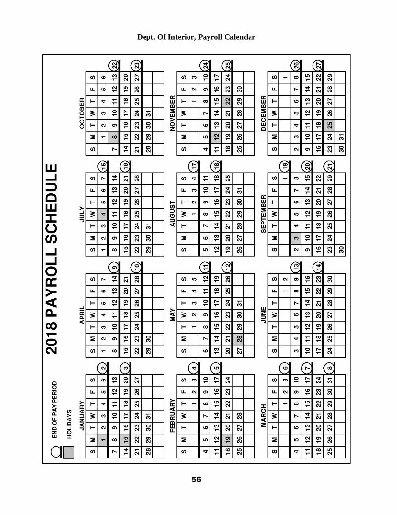
Dept. Of Interior, Payroll Calendar

57
Dept. Of Agriculture, USFS Payroll Calendar

58
Dept. Of Interior, Payroll Calendar

59
Dept. Of Agriculture, USFS Payroll Calendar

60
Dept. Of Interior, Payroll Calendar

61
Dept. Of Agriculture, USFS Payroll Calendar

62
WESTERN AIR AMBULANCE PHONE LIST (NOT GARAUNTEED TO BE CURRENT)
STATE SERVICE NAME HOSPITAL / LOCATION PHONE #’S
ALASKA MAST AK STATE TROOPERS 907-451-5333
ARIZONA GUARDIAN AIR FLAGSTAFF MEDICAL CTR 800-523-9391
CLASSIC LIFE GUARD PAGE 800-444-9223
CALIFORNIA MERCY AIR AMB. MERCY MED CTR, REDDING 530-225-7252
MOUNTAIN LIFEFLIGHT SUSANVILLE 800-926-0801
AIR MED TEAM REDDING MED CTR 800-432-9944
COLORADO ST. MARY’S AIR LIFE ST. MARY’S, GRAND JUNCTION 800-332-4923
YAMPA VALLEY AIR AMB. STEAMBOAT SPRINGS 800-900-6800
FLIGHT FOR LIFE COLORADO SPRINGS 800-4222254
AIR RESPONSE ENGLEWOOD 303-768-8089
FLIGHT FOR LIFE ST ANTHONY’S, DENVER 800-525-3712
TRANSPORT CARE MEMORIAL, COLO SPRINGS 800-763-4373
IDAHO LIFE FLIGHT ST. ALPHONSUS, BOISE 800-367-3230
LIFE FLIGHT BANNOK MED CTR, POCATELLO 800-232-0911
ACCESS AIR BOISE 208-333-9911
MONTANA LIFE FLIGHT ST. PATRICK’S, MISSOULA 800-991-SEND
MERCY FLIGHT/MEDFLIGHT GREAT FALLS 800-972-4000
MEDFLIGHT BILLINGS 800-325-1774
NEVADA MERCY AIR LAS VEGAS 800-842-4431
MEDIC AIR RENO 800-234-3822
ACCESS AIR ELKO 775-738-3493
CARE FLIGHT RENO, GARDNERVILLE, TRUKEE 775-858-5700
NEW MEXICO SOUTHWEST AIR AMB. FAIRACRES/LAS CRUCES 505-525-2660
MED FLIGHT AIR AMB. ALBUQUERQUE 800-842-4431
LIFEGUARD AIR EMERGENCY ALBUQUERQUE 800-633-5438
GALLUP MED FLIGHT GALLUP 505-863-6606
OREGON AIR LIFE OF OREGON BEND 800-522-2828
LIFE FLIGHT PORTLAND 800-452-7434
LIFEGUARD AIR AMB. HILLSBORO 503-640-2927
UTAH AIR MED U OF UT HEALTH CTR, SALT LAKE 800-453-0120
LIFE FLIGHT INTERMT HLTH CARE, SALT LAKE 801-321-1234
WASHINGTON NORTHWEST MEDSTAR SPOKANE 800-422-2440
AIRLIFT NORTHWEST SEATTLE 800-426-2430
WYOMING WYOMING LIFE FLIGHT WY MED CTR, CASPER 800-442-2222

63

64
Medical Incident Report
FOR A NON-EMERGENCY INCIDENT, WORK THROUGH CHAIN OF COMMAND TO REPORT AND TRANSPORT INJURED PERSONNEL AS NECESSARY.
FOR A MEDICAL EMERGENCY: IDENTIFY ON SCENE INCIDENT COMMANDER BY NAME AND POSITION AND ANNOUNCE
"MEDICAL EMERGENCY" TO INITIATE RESPONSE FROM IMT COMMUNICATIONS/DISPATCH.
U s e t h e f o l l o w i n g i t e m s t o c o m m u n i c a t e s i t u a t i o n t o c o m m u n i c a t i o n s / d i s p a t c h .
1. CONTACT COMMUNICATIONS / DISPATCH (Verify correct frequency prior to starting report)
Ex: "Communications, Div. Alpha. Stand-by for Emergency Traffic."
2. INCIDENT STATUS: Provide incident summary (including number of patients) and command structure.
Ex: “Communications, I have a Red priority patient, unconscious, struck by a falling tree. Requesting air ambulance to Forest Road 1 at (Lat./Long.) This will be the Trout Meadow Medical, IC is TFLD Jones. EMT Smith is providing medical care.”
3. INITIAL PATIENT ASSESSMENT: Complete this section for each patient as applicable (start with the most severe patient)
Patient Assessment: See IRPG page 106
Treatment:
4. TRANSPORT PLAN:
Evacuation Location (if different): (Descriptive Location (drop point, intersection, etc.) or Lat. / Long.) Patient's ETA to Evacuation Location:_____________
Helispot / Extraction Site Size and Hazards:
5. ADDITIONAL RESOURCES / EQUIPMENT NEEDS:
Example: Paramedic/EMT, Crews, Immobilization Devices, AED, Oxygen, Trauma Bag, IV/Fluid(s), Splints, Rope rescue, Wheeled litter, HAZMAT, Extrication
6. COMMUNICATIONS: Identify State Air/Ground EMS Frequencies and Hospital Contacts as applicable
Function Channel Name/Number Receive (RX) Tone/NAC * Transmit (TX) Tone/NAC *
COMMAND AIR-TO-GRND
TACTICAL
Severity of Emergency / Transport Priority
☐ RED / PRIORITY 1 Life or limb threatening injury or illness. Evacuation need is IMMEDIATE
Ex: Unconscious, difficulty breathing, bleeding severely, 2o – 3o burns more than 4 palm sizes, heat stroke, disoriented.
☐ YELLOW / PRIORITY 2 Serious Injury or illness. Evacuation may be DELAYED if necessary.
Ex: Significant trauma, unable to walk, 2o – 3o burns not more than 1-3 palm sizes.
☐ GREEN / PRIORITY 3 Minor Injury or illness. Non-Emergency transport
Ex: Sprains, strains, minor heat-related illness.
Nature of Injury or Illness &
Mechanism of Injury
Brief Summary of Injury or Illness
(Ex: Unconscious, Struck by Falling Tree)
Transport Request
Air Ambulance / Short Haul/Hoist Ground Ambulance / Other
Patient Location Descriptive Location & Lat. / Long. (WGS84)
Incident Name Geographic Name + "Medical" (Ex: Trout Meadow Medical)
On-Scene Incident Commander Name of on-scene IC of Incident within an
Incident (Ex: TFLD Jones)
Patient Care Name of Care Provider
(Ex: EMT Smith)
7. CONTINGENCY: Considerations: If primary options fail, what actions can be implemented in conjunction with primary evacuation method? Be thinking ahead...
8. ADDITIONAL INFORMATION: Updates/Changes, etc.
REMEMBER: Confirm ETA's of resources ordered. Act according to your level of training. Be Alert. Keep Calm. Think Clearly. Act Decisively.
65
FIRE LINE LEADER RESPONSIBILITIES
(Establish clear Leader’s Intent and Supervise at the scene of action not in your truck/office) Initial Attack Incident Commander (ICT4/5): also see pages 60-61
Provide for Safety and welfare of assigned personnel
Initiate and maintain Incident Briefing(ICS Form 201)
Size up fire situation and concisely communicate resource needs
Analyze Incident complexity
Plan appropriate method of attack
Brief personnel and keep them informed
Direct and coordinate assigned resources
Monitor weather, fire behavior, and environmental factors to anticipate changes
Adjust tactics to meet changing conditions
Maintain current Unit Log(ICS Form 214)
Solicit Feedback and participate in AARs Task Force/Strike Team Leader:
Obtain briefing from DIVS/IC
Review assignment with assigned resources
Travel to and from line with assigned resources
Monitor and inspect progress; make changes as necessary
Coordinate action with adjacent resources
Keep supervisor informed of status and progress
Obtain logistics/equipment needs from assigned resources
Retain control of assigned resources while off-line
Maintain a current unit log (ICS form 214) Single Resource Boss (CRWB, ENGB, FIRB, FELB):
Responsible for supervising and directing a firefighting module such as: hand crew, engine, dozer, firing team, and fallers.
Obtain briefing from Task Force/Strike Team Leader/IC
Review assignment with module and assign work tasks
Obtain Necessary equipment and supplies
Review current and predicted Wx conditions and expected Fire Bx
Brief module on safety including escape routes and safety zones
Monitor work progress; make changes as necessary
Keep supervisor informed of progress and changes
Inform supervisor promptly of problems
Brief/Debrief with relief personnel on the fireline
Complete and turn in time records

66
INITIAL ATTACK FIRE SIZE-UP 1. FIRE NAME: FIRE NUMBER DOI
USDA
2. IC NAME: STATE
PRIVATE
Descriptive location:
Reported by:
3. ARRIVAL DATE: TIME:
4. LEGAL: Township: Range: Section(s):
Coordinates: Latitude: Longitude:
UTM: E: N:
5. ESTIMATED SIZE (acres): 6. OWNERSHIP:
7. FUELS BURNING: Grass Re-prod Snag Duff Timber (light, heavy)
Brush Slash Logs Hardwood
ADJACENT FUELS: Grass Re-prod Snag Duff Timber (light, heavy)
Brush Slash Logs Hardwood
8. CHARACTER OF FIRE: Smoldering Running Crowning
Creeping Torching Spotting
9. FLAME LENGTH: under 2’ 2-4’ 4-8 8-11 11 plus
10. POSITION ON SLOPE: Bottom 1/3 Middle 1/3 Top 1/3
11. PERCENT SLOPE: 0-30 30-45 45-60 60 plus
12. ASPECT: North East South West Flat/Ridge top
13. WIND SPEED:
WIND DIRECTION: N E S W Upslope
Down Slope
Up Canyon
Down Canyon
14. WIND INDICATORS: Cumulus Lenticular Cold Fronts Other:
15. GROWTH POTENTIAL (estimate acres for next operational period): Acres:
None Low Moderate High Very High
16. VALUES AT RISK (Check all that apply):
Houses T&E Species Water Quality Public Safety
Improvements Cultural/Historical Other:
17. IS FIRE NEAR ANY SENSITIVE AREAS? No Yes - Check Below
Rivers or Streams Surface Waters Aspen Trees 5 Needle Pines
Meadow Forest Edge Other (Specify)
18. HAZARDS OR CONCERNS (Check all that apply):
Snags Hazmat Urban Interface Power Lines
Mine Shafts Evacuation Concerns Cliffs Other
19. CAUSE: Lightning Human Cause (protect origin/consider INVF)
Other
20. PROPOSED ACTION: Resource Benefit Confine Suppress
21. ADDITIONAL RESOURCES: No Yes - Specify Below
Personnel: Equipment: Supplies: Aircraft:

67
REMOTE OPERATIONS UPDATE CALL-IN CHEAT SHEET
When providing an update on a remote portion of a fire, managers may have specific questions about the current status of a fire, and they’ll usually let you know what those are. If not, these items listed below will assist you in painting a decent picture of an ongoing fire’s status.
Estimated (or known) current fire size Growth Overnight/ since last checked % Active Perimeter Active portion / quadrant (N, S, E, W) Fuel Model carrying fire ( pay special attention to FM transitions) Fire Behavior Observed: ROS, Flame Length, torching, spotting, smoke obs. Time of Activity (burning window) Weather highlights: High Temps, Low RH, wind speed and direction Communicate your plan for the shift Ask if any other information is needed (when they’d like the next update, etc) Specific safety or operational concerns/mitigations
When communicating with a dispatch center/ ICP, consider the additional communication SOPs:
Notify Dispatch when you begin your travel to and from the fire, when you begin driving and when you begin hiking. This may get redundant, but they’ll at least know where you are.
Let Dispatch know when you’ve arrived on the fire, and give them an estimate of when you’ll provide a fire update.
Communicate your info only when it’s appropriate to do so: if other radio traffic exists, wait patiently for a break in radio traffic, and be only as a detailed as necessary with your update.
Always be cordial and polite when communicating with dispatch centers.
ONE DAY ORDER AMOUNTS
ITEM QUANTITY
Water, 5 gal cubie ½ per person
MRE’s 4 per person
Batteries, AA 15 per radio
Toilet Paper 1 roll per 8 people
Fuel (unleaded) 5 gal = 20 hours chainsaw use
Bar Oil 10 qts = 20 hours chainsaw use
2 cycle mix 12.8 oz = 20 hours chainsaw use
Fuel (24:1) Mark III 5 gal = 3 hours, Shindawa 5 gal = 10hrs

68
SLOPE